
Ontonagon City Zoning Code
ARTICLE 15
- RULES OF MEASUREMENT AND DEFINITIONS
SECTION 15.1. - RULES OF MEASUREMENT
15.1.1
Height measurement. A building or structure shall adhere to both the maximum story and maximum height regulations as specified in the District standards, except as otherwise provided in this Ordinance.
15.1.1.1
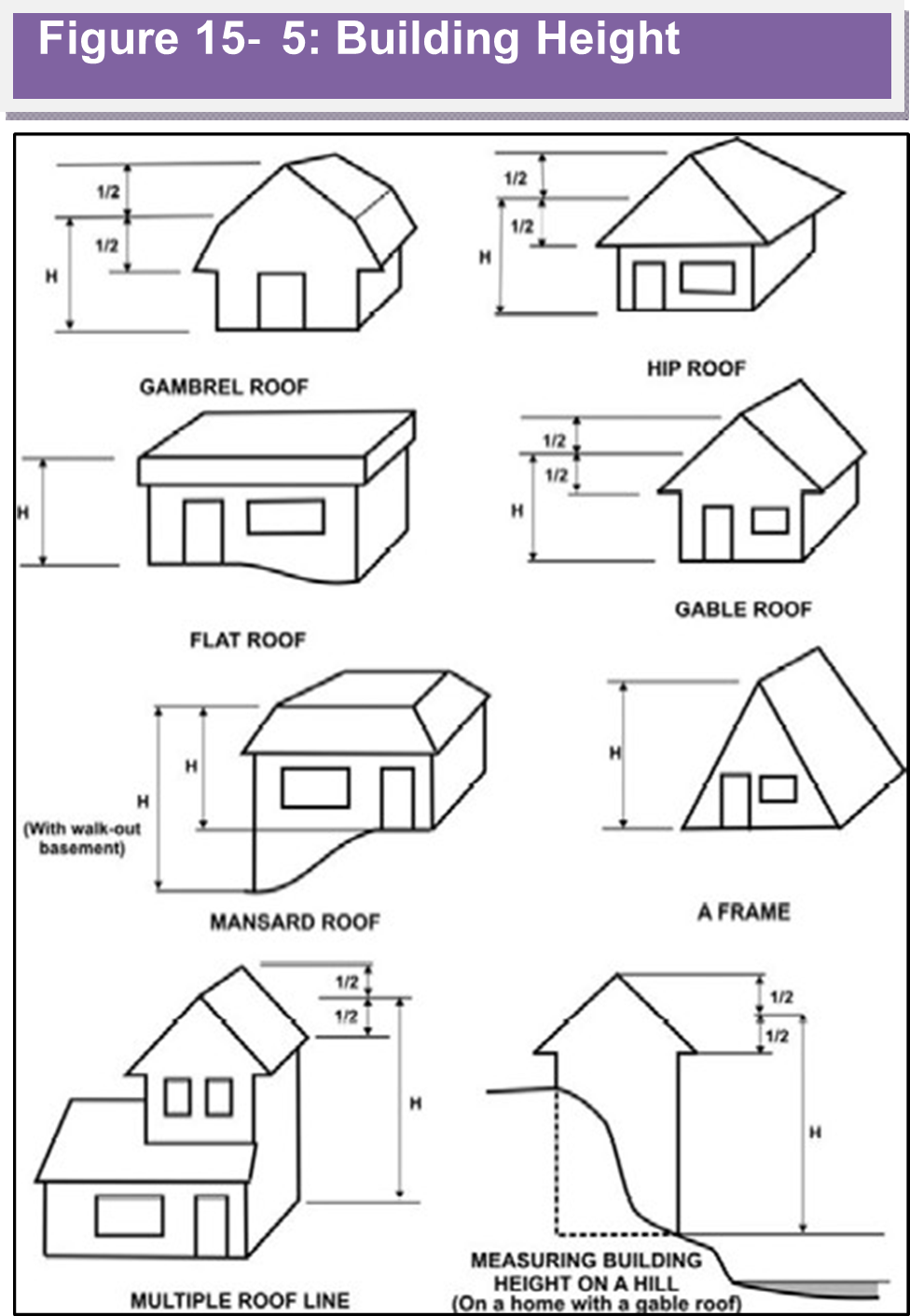
Height in feet. The overall building height shall be measured as the vertical distance in feet from the average grade (measured as the average elevation of the two side lot lines measured at the front setback line) to the highest point of a building. To determine highest point of various roof types, see Figure 15.5 which illustrates height measurement with various roof types. The height of any parapet wall or safety railing enclosing outdoor livability space or decks on a flat roof shall be included in the measurement of overall building height in feet.
15.1.1.2
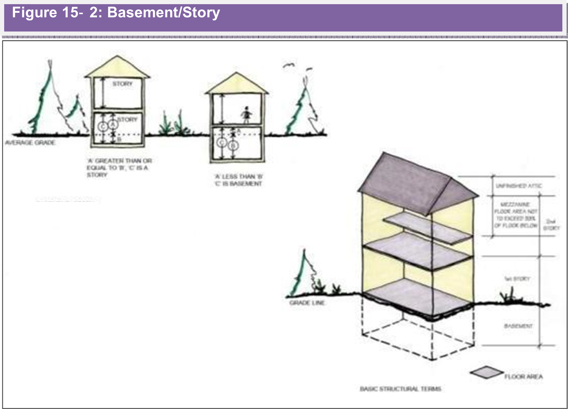
Height in stories. Overall height in stories shall be measured as the total number of stories beginning with the first story having its finished floor surface above the average grade as defined in Section 15.9. A basement shall be considered a "story" for purposes of measuring overall building height in stories if any of the following is true:
15.1.1.2.A
More than fifty (50) percent of the total building perimeter is above finished grade so that the vertical distance from the average grade to the floor is less than the vertical distance from the average grade to the ceiling.
15.1.1.2.B
The basement is a walk-out basement.
15.1.2
Site layout measurements.
15.1.2.1
Lot size. Lot size is the total area within the boundaries of a property's lot lines (parcel area), excluding adjacent or abutting right-of-way areas or public access easements.
15.1.2.2
Lot width. Lot width is the horizontal distance between the side lot lines measured along the front lot line. In the case of a curved front lot line, the horizontal distance as measured on a tangent line running between the two side lot lines where they meet the front lot lines. For corner lots having only one side lot line, the distance shall be measured from that side lot line to the opposing front lot line.
15.1.2.3
Front setback. Front Setback is the minimum distance by which any building or structure must be separated from a street right-of-way or front lot line. The Front Setback is measured from and perpendicular to the front lot line to the nearest foundation or building wall.
15.1.2.4
Required side or rear yards. Required side and rear yards are measured from and perpendicular to the side interior or rear lot line abutting another lot or a public alley. The required yard reflects a minimum distance between the lot line and the nearest foundation or building wall of any structures.
15.1.2.5
Setback or yard exceptions. For lots less than seventy-five (75) feet in width, the Zoning Administrator, upon consultation with the Planning Commission, may reduce required setbacks or yards to reflect the established context within that same zoning district for existing lots of similar size, or to facilitate maximum solar access for the subject lot or residence.
15.1.2.6
Lot coverage (buildings and structures).
15.1.2.6.A
Lot coverage is the percentage of a lot that is covered by buildings and structures. Lot coverage regulations are intended to help preserve open space and privacy.
15.1.2.6.B
Lot coverage shall be measured as the gross area of the actual footprint of the foundations of all principle and accessory buildings on the site, plus the gross area of the footprint of any accessory structure not expressly excluded in Section 15.1.2.6.C, plus the gross area of any enclosed ground floor or upper story projections beyond the actual footprint, divided by the total gross square foot area of the lot.
15.1.2.6.C
Exclusions from the lot coverage calculation include:
(1)
Areas on a lot open to the sky (unenclosed) with a finished surface including:
a.
Vegetation (landscaping, gardens) or paved surfaces (both pervious and impervious); or
b.
Unenclosed area of patios, decks, or gazebos; [or]
c.
Unenclosed areas covered overhead by a pervious material such as lattice, or a trellis.
(2)
Area on a lot occupied by an unenclosed porch or balcony accessory to a principle structure, up to a maximum of four hundred (400) square feet.
(3)
One-half (½) of the area on a lot occupied by a detached accessory dwelling unit to a maximum of five hundred (500) square feet.
15.1.2.7
Total impervious surface coverage. Total impervious surface coverage is the percentage of total area of impervious surfaces on a lot. The intent is to preserve a percentage of open space for the containment of stormwater on the property. Total impervious surface coverage shall be measured as the gross area of the footprint of all impervious surfaces on a lot (including all buildings, structures, and impervious paved or covered areas) divided by the total gross square foot area of the lot (not including areas in the public right-of-way). Site plan review for the purpose of determining mitigation strategies will be triggered by total impervious surface percentages exceeding Ordinance standards.
15.1.2.8
Separation distance.
15.1.2.8.A
Between buildings. Separation shall be measured as the horizontal distance between the two closest portions of each building's exterior walls.
15.1.2.8.B
Between uses. When measuring a required separation between uses, distance shall be determined from the nearest point of a structure or part of a multi-use structure occupied by the use requiring separation to the nearest point of a structure or part of a multiple structure occupied by a use from which the separation is to be effected or established. In case a portion of the use requiring separation is operated outside a building or structure, the separation shall be measured from the nearest point of the lot occupied by the use requiring separation to the nearest point of a structure or part of a multiple structure occupied by a use from which the separation is to be effected or established.
15.1.2.8.C
Between uses and a zone district. When measuring a required separation between a use and a zone district, distance shall be determined from the nearest point of a structure or part of a multi-use structure occupied by the use requiring separation to the nearest point of the zone district boundary from which the separation is to be effected or established. In case a portion of the use requiring separation is operated outside a building or structure, the separation shall be measured from the nearest point of the lot occupied by the use requiring separation to the zone district boundary from which the separation is to be effected or established.
15.1.3
Design measurements.
15.1.3.1
Floor area. Floor area is calculated as the sum of the horizontal areas of each floor of a building or unit intended for occupancy, measured from the interior faces of the exterior walls, excluding basements or attics not intended for occupancy, attached garages or space used for off-street parking or loading, breezeways, and unenclosed porches.
15.1.3.2
Transparency. Transparency is measured as the total amount of transparent surface provided on a street-facing (named or numbered street) building façade (including permitted alternatives to the use of transparent glass), divided by the total length of that same street-facing building façade, provided that:
15.1.3.2.A
Window glazing used to comply with a transparency standards shall be clear and shall transmit at least 65 percent of the visible daylight; and
15.1.3.2.B
No interior or exterior modifications, including temporary and permanent signage, window tinting, furnishings, fixtures, equipment, or stored items within three (3) feet of the windows will be allowed to reduce the effective minimum transparency standards by more than twenty-five (25) percent. Open display of individual merchandise is permitted.
15.1.3.3
Landscape opacity. Landscape opacity is measured as the percentage of a prescribed area to be obscured by plants as observed from the public space such as a street or sidewalk. This is usually used in relation to a specified screening height according to an anticipated growth period.
15.1.3.4
Fence and wall height. Fence and wall height shall be measured from the base of the fence or wall at the higher of the finished grade at the inside or outside of the fence or wall, to the topmost point of the fence or wall.
SECTION 15.2. - ACRONYMS
The following acronyms are used in this Ordinance:
ADT—Annual average two-way daily traffic volume
ATV—All Terrain Vehicle
C—Use Permitted By Right with Conditions
DEQ—Michigan Department of Environmental Quality
ECHO—Elder Cottage Housing Opportunity
EPA—United States Environmental Protection Agency
FCC—Federal Communication Commission
FEMA—Federal Emergency Management Authority
FIRM—Flood Insurance Rate Map
HUD—Housing and Urban Development
HVAC—Heating, ventilation, air conditioning units
kv—Kilovolt
MCL—Michigan Compiled Laws
MDOT—Michigan Department of Transportation
MHP—Mobile Home Park or Manufactured Housing Park
P—Use Permitted by Right
P.A.—Public Act
PUD—Planned Unit Development.
ROW—Right-of-Way
RV Park—Recreational Vehicle Park
S—Special Land Use
SOBS—Sexually Oriented Business
WECS—Wind Energy Conversion System
ZBA—Zoning Board of Appeals
SECTION 15.3. - DEFINITIONS—A
Abutting (same as Adjacent, Contiguous). Next to, touching, having property or district lines in common.
Access. A way or means of approach to provide vehicular or pedestrian entrance or exit to a property from an abutting property or a public roadway.
Accessible. In reference to a parcel, means that the parcel has an area where a driveway provides vehicular access or is served by an existing easement that provides vehicular access to an existing road or street and meets all applicable location standards of MDOT or the County Road Commission under P.A. 200 of 1969, MCL 247.321 to 247.329, and of the Village; or has an area where a driveway can provide vehicular access or is served by a proposed easement that will provide vehicular access to an existing road or street and meet all such applicable location standards. Per the Land Division Act, P.A. 288 of 1967, MCL 560.102 as amended.
Access Management. The process of providing and managing reasonable access to land development while preserving the flow of traffic in terms of safety, capacity, and speed on the abutting roadway system.
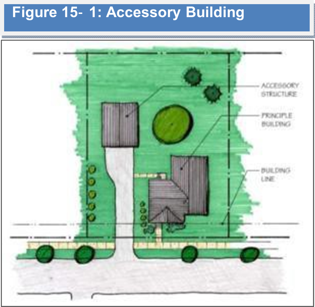
Accessory Building or Structure. A building or structure located on the same lot as the principle building, attached or detached, but customarily incidental and subordinate to the principle building. Except as otherwise permitted by this Ordinance, an accessory building or accessory structure shall not be used for human habitation. (See Figure 15-1)
Accessory Dwelling Unit (see also ECHO housing). A separate and complete dwelling unit established in conjunction with and clearly subordinate to a principle dwelling unit, either within the same structure as the principle dwelling unit or in an accessory structure on the same lot.
Accessory Use (See also Home Occupation). A use that: (1) is subordinate in area, extent, and purpose to the principle use; (2) is customarily found in connection with; (3) is incidental to; and (4) is located on the same lot as the principle use (except in the case of some accessory off-street parking spaces or loading). For example, a retail business is not customarily considered incidental to a residential use. Residential accessory uses may include storage of household goods, gardening, private swimming pools, and other similar uses.
Acre. A land area of 43,650 square feet.
Addition (same as Expansion). Any construction that increases the size of a building or structure in terms of site coverage, height, length, width, or gross floor area.
Adjacent (same as Abutting, Contiguous). Next to, touching, having property or district lines in common.
Affordable Housing. Housing units where the occupant(s) is paying no more than 30 percent of gross household income of low income households (defined to be a household earning less than 80 percent of the median annual income adjusted for household size as determined by the U.S. Department of Housing and Urban Development) for housing costs, including taxes, insurance, and utilities.
Agriculture. Means the production, harvesting, and storage of plants and animals useful to humans, including but not limited to biomass crops, forages and sod crops, grains, feed crops, field crops, dairy and dairy products, poultry and poultry products, livestock including breeding and grazing of cattle, swine, captive deer, and similar animals, berries, herbs, flowers, seeds, grasses, nursery stock, fruits, vegetables, Christmas trees, and other similar uses and activities.
Alley. A public or private right of way shown on a plat which provides secondary access to a lot, block, or parcel of land per the Land Division Act, P.A. 288 of 1967, MCL 560.102, as amended.
Alteration. Any change, addition, enlargement, relocation, repair, remodeling, or modification to a structure. Also any change in the structural members of a building, such as walls or partitions, columns, beams or girders. Also any change, addition, or modification to type of occupancy, number of dwelling units, or use of structure or land. The consummated act of alteration may be referred to herein as "altered" or "reconstructed" or "changed."
Antenna. Means any exterior transmitting or receiving device mounted on a tower, building, or structure and used in communications that radiate or capture electromagnetic waves, digital signals, analog signals, radio frequencies (excluding radar signals), wireless telecommunications signals or other communication signals.
Apartment. One or more rooms with separate kitchen and bathroom facilities comprising an independent, self-contained dwelling unit not owned in fee simple.
Apiary (see also Beehive). One or more structures occupied by bees, but does not include honey houses, extraction houses, warehouses, or appliances.
Applicant. A person who submits an application under one of the procedures set forth in this Ordinance.
Appurtenance. A right, privilege, or improvement belonging to, incident to, and passing with a principle property upon sale or transfer.
Aquaculture. The hatching, raising, and breeding of fish or other aquatic plants or animals for sale or personal use.
Assisted Living Facilities. A residential development that provides room and board, assistance with daily activities, and health care for three or more adult residents.
Attic. That part of a building that is immediately below and wholly or partly within the roof framing.
Awning. A roof-like cover projecting from the exterior wall of a building and composed of non-rigid materials except for the supporting framework which can sometimes be retracted, folded, or collapsed against the face of the supporting building.
SECTION 15.4. - DEFINITIONS—B
Basement. That portion of a building which is partly or wholly below finished grade, but so located that the vertical distance from the average grade to the floor is greater than the vertical distance from the average grade to the ceiling. A basement shall not be counted as a story (see Figure 15-2). A cellar is a basement. See also definition of "story." However, any walk-out basement, regardless of average grade, shall be considered a story.
Bedroom. A room intended for sleeping. Any room designated on building plan submittals as a den, library, study, loft, or other extra room will be considered to be a bedroom for the purpose of this Ordinance.
Berm. A mound of earth graded, shaped and improved with landscaping in such a fashion as to be used for visual and/or audible screening purposes to provide a transition between uses of differing intensity.
Billboard. An off-premises sign.
Block. A unit of land bounded by (but not traversed by) streets or by a combination of streets and public land, unsubdivided acreage, corporate boundary lines, railroad rights-of-way, waterways, or any other physical barrier to the continuity of development.
Buffer. A strip or area of land reserved for plant material, berms, walls, or fencing to serve as a visual and/or sound barrier between properties, often between abutting properties and properties in different zoning districts.
Buildable Area. The portion of a lot remaining after the minimum yard, required open space, and setback requirements of this Ordinance have been met, leaving the area that building(s) may occupy. (See Figure 15-3)
Figure 15-3: Buildable Area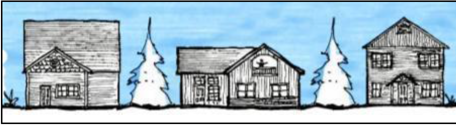
Building (see also Structure). Any structure, either temporary or permanent, having a roof and used or built for the shelter or enclosure of persons, chattels, or property of any kind which shall include vehicles whether mounted or not on wheels and situated on private property and used for the purpose of a building.
Building, Accessory (see Accessory Building)
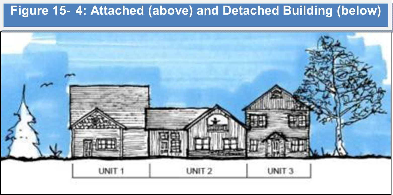
Building, Attached. A building which has at least part of a wall in common with another building, or which is connected to another building by a roof. (See Figure 15-4)
Building Code. Regulations governing the erection and maintenance of buildings as currently enforced pursuant to the laws of the State of Michigan.
Building, Detached. Any structure that does not have a wall or roof in common with another structure. (See Figure 15-4)
Building Envelope. The three-dimensional space within which structures are permitted to be built on a lot as defined by regulations governing building setbacks, required open space, maximum height, and bulk.
Building Footprint. That portion of a lot covered by buildings or structures as measured on a horizontal plane at the surface level.
Building Form Standards. The part of the Form-Based Code that establishes basic parameters regulating building form, including the building envelope, placement (in three dimensions) and certain permitted/required building elements, such as storefronts, balconies, stoops, porches, and doors.
Building Frontage. The distance between two parallel lines, drawn perpendicular to the edges of the right-of-way, which intersect with any part of a building. Where the building is located upon a curve, the lines shall be drawn perpendicular to a tangent drawn through the nearest point of the right-of-way for a convex curve and the furthest point of the right-of-way for a concave curve.
Building Height. The vertical distance between the average grade and the highest point of the roof surface for flat roofs, to the deck line of Mansard roofs; the average height between eaves and ridge for gable, hip and gambrel roofs; and the average height between the lowest point and the highest point on a shed roof. (See Figure 15-5)
Building Line (see also Setback Line). A line parallel to a front, side or rear lot line, established for the purpose of prohibiting the erection of a structure between such line and the corresponding lot line.
Building, Principal (see Principal Building)
Building, Temporary. A building used temporarily for the storage of construction materials and equipment incidental and necessary to on-site permitted construction or as an office until the construction work is complete.
SECTION 15.5. - DEFINITIONS—C
Campground. Defined per the Public Health Code P.A. 368 of 1978, MCL 333.12501, as amended as a parcel or tract of land under the control of a person, in which sites are offered for the use of the public or members of an organization either free of charge or for a fee, for the establishment of temporary living quarters for five or more recreational units such as tents, camper trailers, travel trailers, recreational vehicles, motor homes, or temporary sleeping quarters of any kind. A campground does not include a seasonal mobile home park, mobile home park, or manufactured housing community licensed under the Mobile Home Commission Act, P.A. 96 of 1987, as amended.
Canopy. A permanent roof-like cover, usually of metal, wood, or glass, designed and intended for protection from the weather or as a decorative embellishment, and is free-standing or which projects from a wall or roof of a structure over a window, walkway, door, etc.
Carport. A covered, partially open structure intended to shelter one or more vehicles.
Child. A person under 18 years of age.
Child Care Center(same as Day Care Center). Facility, other than a private residence, receiving one or more preschool or school age children for care for periods of less than 24 hours a day, and where the parents or guardians are not immediately available to the child. Child care center or day care center includes a facility that provides care for not less than two consecutive weeks, regardless of the number of hours of care per day. The facility is generally described as a child care center, day care center, day nursery, nursery school, parent cooperative preschool, play group, before-or after-school program, or drop-in center. Includes the same provisions and exclusions as defined in P.A. 116 of 1973, MCL 722.111, as amended.
Child Caring Institution. A child care facility that is organized for the purpose of receiving minor children for care, maintenance, and supervision, usually on a 24-hour basis, in buildings maintained by the child caring institution for that purpose, and operates throughout the year. An educational program shall not be the primary purpose of the facility. Includes a maternity home for the care of unmarried mothers who are minors. Also includes an agency group home that is a small child caring institution owned, leased, or rented by a licensed agency providing care for more than four but less than 13 minor children. Also includes institutions for mentally retarded or emotionally disturbed minor children. Does not include a licensed hospital, nursing home, or home for the aged, a licensed boarding school, a mental health hospital or facility, a licensed adult foster care family home, or a licensed adult foster care small group home as described in P.A. 116 of 1973, MCL 722.111, as amended.
Church. A building wherein persons regularly assemble for religious worship, meetings and other activities, and which is maintained and controlled by a religious body with tax-exempt status organized to sustain public worship, together with all accessory buildings and uses customarily associated with such primary purpose.
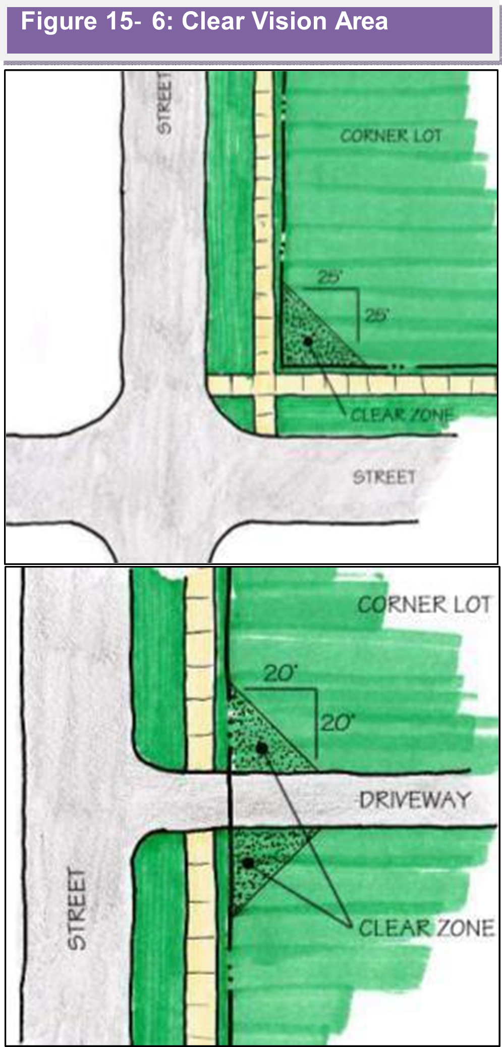
Clear Vision Area. Corner areas at intersecting streets, alleys and driveways in which unobstructed vision of motor vehicle operators is maintained as shown in Figure 15-6. At the intersection of two streets, or where a street intersects with an alley the clear vision triangle is defined by measuring twenty-five (25') feet in length along each street/alley right-of-way line from their point of intersection, the third side being a diagonal line connecting the first two. At the intersection of a driveway and a street, the clear vision triangle is defined by measuring two sides of the triangle each twenty (20') feet in length along the edge of the driveway and along the street right-of-way line and the third side being a diagonal line connecting the first two, and applied to both sides of the driveway. The vertical dimensions of the clear vision triangle include unobstructed areas to be maintained between twenty-four (24) and ninety-six (96) inches above the grade of the lower roadway or driveway.
Cluster Development. An approach to designing a site that maximizes the conservation of open space by placing dwelling units and other structures in closer proximity than usual while retaining the remaining land for recreation, open space, or preservation of sensitive land features.
Commercial. An occupation, employment, or enterprise that is carried on for profit.
Common Area. Land in a development held in common or single ownership and not reserved for the exclusive use or benefit of an individual tenant or owner.
Communication Tower. A structure including but not limited to monopole, skeleton framework, or other design which is attached directly to the ground or to another structure which supports one or more antennas, used for the transmission or reception of radio, television, microwave, or any other form of telecommunications signals.
Community Garden. A private or public facility for cultivation of fruits, flowers, vegetables, or ornamental plants by more than one person or family.
Composting. Processing waste in a controlled environment to produce a stable product by microbiologically degrading organic matter under aerobic conditions.
Conditional Land Use. A use that, owing to some special characteristics attendant to its operation or installation (for example, potential danger, smoke, or noise) is not essentially incompatible with uses permitted in a zoning district, but which possesses characteristics which require individual review in order to avoid incompatibility with the character of the surrounding area, public services and facilities, and adjacent uses of land. A conditional use is permitted by right in a particular district, provided that the use complies with the nondiscretionary standards stated in this Ordinance.
Condominium Project. A plan or project including not less than two condominium units established and approved in conformance with the Condominium Act P.A. 59 of 1978, MCL 559.10, as amended.
Condominium Subdivision. A division of land on the basis of condominium ownership, pursuant to the Condominium Act P.A. 59 of 1978, as amended and which is not subject to the provisions of the Land Division Act, P.A. 288 of 1967, as amended. Also known as a site condominium or site condo. As used in reference to a "Condominium Subdivision" in this Ordinance, the terms below are defined as follows:
1.
Building Envelope: The area of a condominium unit within which the principle building or structure may be constructed, together with any accessory structures, as described in the Master Deed.
2.
Building Site: That portion of a condominium project that shall include the condominium unit and that may also include limited common elements as described in the Master Deed. For purposes of determining compliance with the applicable requirements of the Zoning Ordinance (including, without limitation, area, width, and setback requirements) or with other applicable laws, ordinances, or regulations, "building site" shall be considered to be the equivalent of a "lot."
3.
Condominium Unit: That portion of a condominium project that is designed and intended for separate ownership and use, as described in the master deed, regardless of whether it is intended for residential, office, industrial, business, recreational, use as a time-share unit, or any other type of use. The term "condominium unit" shall be equivalent to the term "lot" or "building site," for purposes of determining compliance of the site condominium subdivision with the provisions of this Ordinance pertaining to minimum lot size, minimum lot width, and maximum lot coverage, and within which a building or other improvements may be constructed by the condominium unit owner. The condominium unit shall not include any limited common elements.
4.
General Common Area: That portion of a site condominium project designed and intended for joint ownership and maintenance by the condominium association as described in the Master Deed.
5.
Limited Common Area: That portion of a site condominium project designed and intended for separate ownership, but outside the building setbacks for the zoning district the property is located in, as described in the Master Deed.
6.
Limited Common Element: That portion of a condominium project other than the condominium unit that is reserved in the master deed for the exclusive use of the owner of the condominium unit.
7.
Master Deed: The document recorded as part of a condominium subdivision that contains the exhibits and incorporates by reference the approved bylaws for the Condominium Subdivision and Plan.
8.
Plan: The drawings attached to the master deed for a condominium subdivision which describes the size, location, area, horizontal and vertical boundaries and volume of each condominium unit contained in the condominium subdivision, as well as the nature, location and size of common elements.
Conservation Easement. The grant of a property right requiring that the described land will remain in its existing natural state in perpetuity. Also means that term as defined in Section 2140 of the Natural Resources and Environmental Protection Act, P.A. 451 of 1994, when applied to a cluster development or open space development as follows: an interest in land that provides limitation on the use of land or a body of water or requires or prohibits certain acts on or with respect to the land or body of water, whether or not the interest is stated in the form of a restriction, easement, covenant, or condition in a deed, will, or other instrument executed by or on behalf of the owner of the land or body of water or in an order of taking, which interest is appropriate to retaining or maintaining the land or body of water, including improvements on the land or body of water, predominantly in its natural, scenic, or open condition, or in an agricultural, farming, open space, or forest use, or similar use or condition.
Contiguous (same as Abutting, Adjacent). Next to, touching, having property or district lines in common.
Convalescent Home (same as Nursing Home and Extended Care Facility). A building having a principle purpose of providing of sleeping, eating, and gathering rooms where infirm persons are housed, often for extended periods of time, and furnished with meals and nursing care.
Cross Access. A service road or driveway providing vehicular access between two or more contiguous sites so the driver need not enter the public road system.
Cul-de-sac. A street with a single common ingress and egress and with a turnaround at the end.
SECTION 15.6. - DEFINITIONS—D
Day Care Center (see Child Care Center)
Deck. An unroofed structure built as an aboveground platform either freestanding or attached to a building and supported by pillars or posts.
Deed Restriction. A private legal restriction on the use of a lot or parcel of land that is set forth in the deed and recorded with the County Register of Deeds. It is binding on subsequent owners and is sometimes also known as a restrictive covenant.
Demolition. Any dismantling, intentional destruction, or removal of public or private structures, sites, surfaces, utilities, or other improvements.
District. A geographic area within the Village within which certain regulations and requirements or various combinations thereof apply uniformly under the provisions of this Ordinance. The terms "district" and "zone" are synonymous.
Division. The partitioning or splitting of a parcel or tract of land by the proprietor thereof or by his or her heirs, executors, administrators, legal representatives, successors, or assigns for the purpose of sale, or lease of more than one year, or of building development that results in one or more parcels of less than 40 acres or the equivalent, and that satisfies the requirements of section 108 and 109 of the Land Division Act, P.A. 288 of 1967, MCL 560.108 to [and] 560.109, as amended. Division does not include a property transfer between two or more adjacent parcels, if the property taken from one parcel is added to an adjacent parcel; and any resulting parcel shall not be considered a building site unless the parcel conforms to the requirements of the Land Division Act, P.A. 288 of 1967, as amended or the requirements of an applicable local ordinance.
Dock. A structure built over or floating upon the water and used as a landing place for boats and other marine transport, fishing, swimming, and other recreational uses.
Driveway. A private means of vehicular access connecting a public right-of-way such as a street or alley to a parking or loading area, garage, dwelling, or other structure or area.
Driveway, Shared. A driveway connecting two or more contiguous properties to the public road system.
Dwelling, Multiple-Family. A residential building containing three or more dwelling units, each with not more than one family.
Dwelling, Single-Family. A detached residential building containing only one dwelling unit, and occupied by not more than one family.
Dwelling, Two-Family (Duplex). A detached residential building containing two dwelling units, each with not more than one family. Also known as a duplex.
Dwelling Unit. One or more rooms connected together but structurally divided from all other rooms in the same structure, constituting a separate, independent housekeeping establishment and containing independent kitchen, bathroom and sleeping facilities.
SECTION 15.7. - DEFINITIONS—E
Earth Material. Any mineral, rock, natural soil, overburden, or fill, or combination of such materials.
Earthwork. The removal of earth materials, clearing of vegetation, mass grading, or re-grading of a site.
Easement. That portion of a lot or lots reserved for present or future use by a person or agency other than the legal fee owner(s) of the property. The easement may be for use under, on, or above said lot or lots.
Eave. The overhanging lower edge of a roof.
ECHO (Elderly Cottage Housing Opportunity) Housing or ECHO Unit. A temporary accessory structure and use on a single residential lot for occupancy only by immediate family members of the occupiers of the principle structure on the lot.
Egress. An exit.
Electrical Code. The electrical code as currently enforced pursuant to the laws of the State of Michigan.
Erected. Includes built, constructed, altered, reconstructed, moved upon, or any physical operations on the premises required for construction. Excavation, fill, drainage, installation of utilities and the like, shall be considered a part of erection.
Erosion. The removal of soil through the actions of water, wind, gravity, or a combination.
Essential Services. Means the erection, construction, alteration or maintenance by public utilities or municipal departments, of overhead, surface, or underground gas, electrical, steam, fuel, or water transmission or distribution systems; collection, communication, supply or disposal systems, including towers, poles, wires, mains, drains, hydrants, and similar accessories in connection therewith, which are necessary for the furnishing of adequate service by such utilities or municipal departments for the general public health, safety, convenience, or welfare. Does not include communication towers or office buildings, substations, or structures for service equipment or maintenance depots.
Expansion (same as Addition). Any construction that increases the size of a building or structure in terms of site coverage, height, length, width, or gross floor area.
Extractive Industries. Industries engaged in excavating and removing rock, stone, ore, soil, gravel, sand, minerals, and similar materials from the surface and/or subsurface.
SECTION 15.8. - DEFINITIONS—F
Façade. That portion of an exterior building elevation facing the street space. Building elevations facing interior courts, common lot lines, and alleys are not facades.
Family. A basic unit having at its nucleus one or two persons who may be providing care for their children (whether related by blood, marriage, guardianship, duly authorized custodial relationship, or adoption) and/or elderly parents plus not more than two other persons; or, not more than four unrelated persons living together as a single housekeeping unit.
Farm. The land, plants, animals, buildings, structures, including ponds used for agricultural or aquacultural activities, machinery, equipment, and other appurtenances used in the commercial production of farm products, per the Michigan Right to Farm Act, P.A. 93 of 1981, MCL 286.472, as amended.
Farm Operation. The operation and management of a farm or a condition or activity that occurs at any time as necessary on a farm in connection with the commercial production, harvesting, and storage of farm products as outlined in the Michigan Right to Farm Act, P.A. 93 of 1981, MCL 286.472, as amended.
Farm Product. Those plants and animals useful to human being produced by agriculture and includes, but is not limited to, biomass crops, forages and sod crops, grains, feed crops, field crops, dairy and dairy products, poultry and poultry products, cervidae, livestock including breeding and grazing, equine, fish, and other aquacultural products, bees and bee products, berries, herbs, flowers, seeds, grasses, nursery stock, fruits, vegetables, trees and tree products, mushrooms, or any other product which incorporates the use of food, feed, fiber, or fur, as determined by the Michigan Commission of Agriculture. Per the Michigan Right to Farm Act, P.A. 93 of 1981, MCL 286.472, as amended.
Farm Stand (same as Food Stand). A building or structure used for the retail sales of agricultural produce.
Farmer's Market. An occasional or periodic market held in an open area or in a structure where individual sellers offer for sale to the public such items as fresh produce, seasonal fruits, fresh flowers, arts and crafts items, and food and beverages.
Fence. A structure of definite height and location to serve as an enclosure in carrying out the requirements of this Ordinance; a barrier designed to bound an area.
Fence Height. The average distance between the top element in the fence and the adjacent grade along any unbroken run of fence.
Fence, Living. A grouping of plants including, but not limited to hedges, shrubs, bushes, or trees, arranged and/or growing in such a manner as to enclose, secure, partially enclose or secure, provide privacy, or mark a boundary for all or any part of a lot.
Fence, Privacy. A solid fence erected or constructed to prevent views across the fence line.
Fill. Any material, including by way of illustration earth material, concrete, rubble, and wood waste, that is placed or deposited on the surface of the ground resulting in a change in natural surface elevation.
Flag. A flexible piece of fabric or other material used as a symbol of a unit of government or political subdivision.
Floodplain. A relatively flat or low land area adjoining a river, stream, lake, or watercourse which is subject to partial or complete inundation; or, an area subject to the unusual and rapid accumulation of runoff or surface waters from any source. This area includes floodway (channel and flood areas with flow), and flood fringe (flood areas with little or no flow).
Floor. The level base of the room, hollow structure, or enclosed area, including basements.
Floor Area. The sum of the total gross area of all floors as measured to the outside surfaces of exterior walls.
Footcandle. A measure of illumination on a surface that is one foot from a uniform source of light of one candle and equal to one lumen per square foot.
Foster Care. The provision of supervision, personal care, and protection in addition to room and board for 24 hours a day, five or more days a week, and for two or more consecutive weeks for compensation.
Foster Family Group Home. A private home in which more than four but fewer than seven minor children, who are not related to an adult member of the household by blood or marriage, or who are not placed in the household pursuant to chapter X of P.A. 288 of 1939, MCL 710.21 to 710.70, are provided care for 24 hours a day, for four or more days a week, for two or more consecutive weeks, unattended by a parent, legal guardian, or legal custodian. Per P.A. 116 of 1973, MCL 722.11, as amended.
Fraternity or Sorority House. A building occupied and maintained exclusively for students affiliated with and formally recognized as a group by an academic or professional college or university or other recognized institution of higher learning.
Frontage (as pertains to sign regulation). A property line shall be said to be a property frontage whenever it is coterminous with the boundary of a public right-of-way.
Frontage Road (same as Front Service Drive). A local street/road or private road typically located in front of principle buildings and parallel to an arterial to give access to abutting properties for the purpose of controlling access to the arterial.
SECTION 15.9. - DEFINITIONS—G
Garage Sale (same as Yard Sale). The sale or offering for sale to the general public of items of personal property by the owner or tenant of a lot on which a dwelling unit is located, whether within or outside the dwelling unit, a garage or other accessory building.
Garden. A tract of land devoted to outdoor cultivation of flowers, fruits, vegetables, or small plants, and unenclosed by any structure other than a fence.
Generally Accepted Agricultural and Management Practices (GAAMP). Those practices as defined by the Michigan Commission of Agriculture.
Glare. The effect produced by brightness sufficient to cause annoyance, discomfort, or loss in visual performance and visibility.
Grade. The vertical elevation of the ground surface.
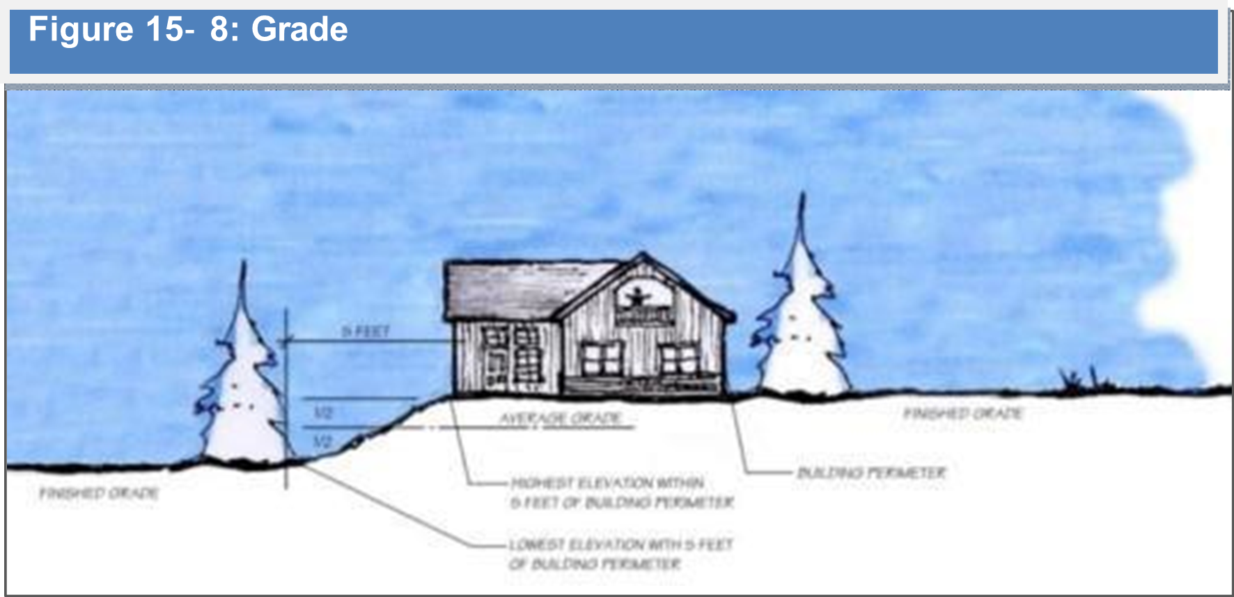
Grade, Average. The arithmetic average of the lowest and highest grade elevations in an area within five feet of the foundation line of a building or structure not including window wells or required basement egress. (See Figure 15-8)
Grade, Finished. The final grade of the site after man-made alterations that conforms to the approved plan.
Grade, Natural or Existing. The elevation of the ground surface in its natural state, before man-made alterations.
Greenhouse (same as Hoop House). A building or structure constructed chiefly of glass, glasslike or translucent material, cloth, or lath, which is devoted to the protection or cultivation of flowers or other tender plants.
Greenway. A contiguous or linear open space, including habitats, wildlife corridors, and trails, that links parks, nature reserves, cultural features, or historic sites with each other, for recreation and conservation purposes. Per P.A. 110 of 2006, MCL 125.3102, as amended.
Ground Cover. Living plants designed to grow low to the ground (generally one foot or less), forming a continuous vegetative surface, and intended to stabilize soils and protect against erosion.
Ground Story. The first level of a building at or above grade.
SECTION 15.10. - DEFINITIONS—H
Hard Surface. Compacted gravel, concrete or asphalt pavement, pavers or other products designed for parking.
Hazardous Substance. Any substance that, because of its quantity, concentration, or physical or chemical characteristics, poses a significant present or potential hazard to the public health, safety, or welfare or to the environment. Includes "Hazardous substance" as defined in the Comprehensive Environmental Response, Compensation and Liability Act of 1980, Public Law 96-510, 94 Stat. 2767, and "Hazardous waste" as defined in the Natural Resources and Environmental Protection Act of 1994, MCL 324.11103, and "Petroleum" as defined in the Natural Resources and Environmental Protection Act of 1994, MCL 324.21303(d)(ii).
Height, Building (see Building, Height)
Height, Sign (see Sign, Height)
Home Occupation. A commercial activity, whether for profit or otherwise, carried on by an occupant of a dwelling unit as a secondary use which is clearly subordinate and incidental to the use of the dwelling unit as a residence, and does not alter the exterior of the property or affect the residential character of the neighborhood.
Hospital. An institution providing health services for inpatient and/or outpatient medical or surgical care of the sick or injured and including related facilities such as, but not limited to, laboratories, outpatient departments, central staff service facilities, and staff offices which are an integral part of the institution.
Hotel. A building in which lodging is provided and offered to the public for compensation, and which is open to transient guests and is not a boarding or rooming house as defined in this Ordinance.
SECTION 15.11. - DEFINITIONS—I
Impervious Surface. Any which prevents, impedes, or slows infiltration or absorption of storm water directly into the ground at the rate of absorption of vegetation-bearing soils, including building roofs, paved asphalt or concrete surfaces, and dense gravel surfaces.
Impervious Surface Coverage. A measure of intensity of land use that represents the portion of a site that is impervious. This portion includes, but is not limited to, all areas covered by buildings, parked structures, driveways, roads, sidewalks, concrete, asphalt, or other hard surface.
Industrial Service Establishment. Establishment engaged in the repair or servicing of industrial, business, or consumer machinery, equipment, products, or by-products, generally not attracting the general public.
Industry. The manufacture, fabrication, processing, assembly, reduction, or destruction of any article, substance, or commodity in such a manner as to change the form, character, or appearance thereof, and may include associated warehousing and/or storage facilities.
Ingress. Access or entry point or entrance.
Institution. A building or premises occupied by a nonprofit corporation or a nonprofit establishment for public use.
Intersection. The location where two or more roadways cross at grade without a bridge.
SECTION 15.12. - DEFINITIONS—J
Junk. Any worn out or discarded materials including but not necessarily limited to scrap metal, inoperable motor vehicles and parts, construction material, household wastes including garbage and discarded appliances, and yard debris, which is collected, stored for salvage, destruction, or conversion to some use.
SECTION 15.13. - DEFINITIONS—K
Kennel. Any premises where domestic animals, such as dogs and cats, are confined, boarded, trained, treated, or groomed for compensation or bred or raised for sale purposes.
SECTION 15.14. - DEFINITIONS—L
Landscaping. An area set aside from structures and parking which is characterized by the installation and permanent maintenance of vegetation and natural features. It includes the preservation of existing vegetation and the continued maintenance thereof and the installation of minor decorative features such as permeable paving materials, walls, fences, and street furniture.
Loading Zone. An off-street area on the same lot with a building, or group of buildings, for temporary access and parking of a commercial vehicle while loading and unloading merchandise or materials.
Lot (same as Parcel). Land described in a recorded plat or by metes and bounds description, including a condominium unit in a condominium subdivision, occupied or to be occupied by a building, structure, land use or group of buildings having sufficient size to comply with the frontage, area, width-to-depth ratio, setbacks, yards, coverage and buildable area requirements of this Ordinance, and having its principle frontage upon a public street or on an approved private road or approved access easement.
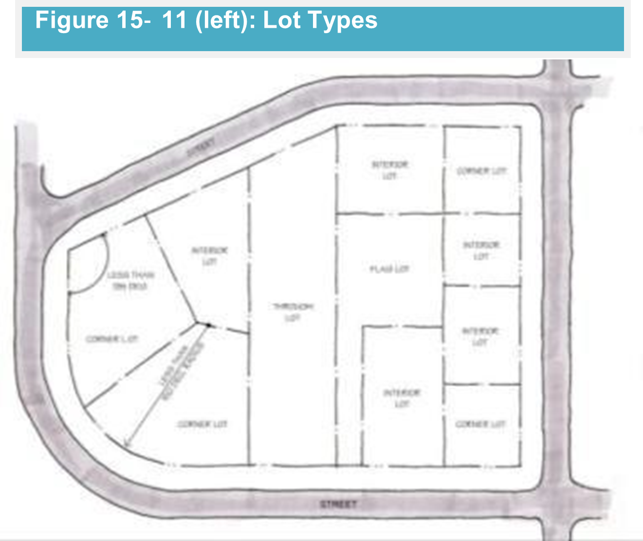
Lot, Corner. A platted parcel of land abutting two road rights-of-way at their intersection, or a lot abutting upon a curved street or streets involving a change of direction. (See Figure 15-11)
Lot, Flag. A lot whose access to the public street is by a narrow, private right-of-way that is either a part of the lot or an easement across another property. (See Figures 15-10 and 15-11)
Lot, Interior. Any lot other than a corner lot which has only one lot line fronting on a street. For this purpose, an alley is not considered a street unless the lot has no lot line fronting on a street. (See Figure 15-11)
Lot Lines, Common. Lot lines shared by adjacent private lots.
Lot Lines, Front. In the case of an interior lot, the line separating that lot from the street, a private road, or other access easement. In the case of a corner lot or through lot, the line separating that lot from either the street, a private road, or other access easement, and bearing the assigned street address for that lot. In the case of a flag lot, the line parallel and nearest to the main roadway. (See Figures 15-9 and 15-10)
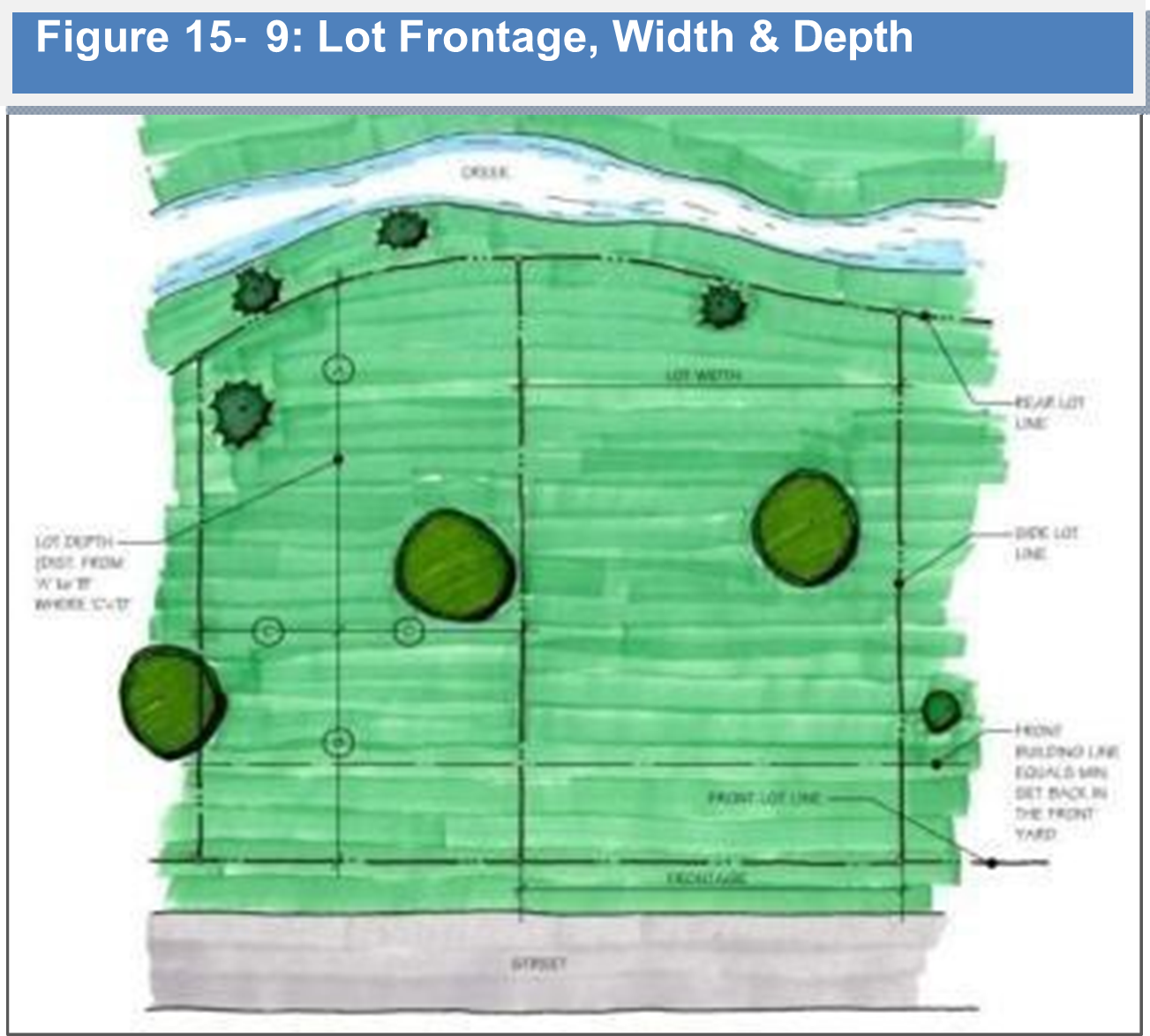
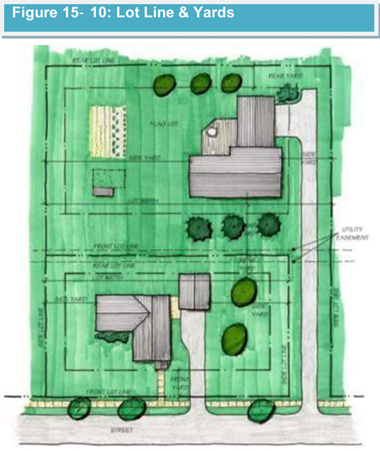
Lot Lines, Side. Any lot line other than the front lot line or rear lot line. (See Figures 15-9 and 15-10)
Lot of Record. A lot which is part of a plat or a lot or parcel described by metes and bounds recorded in the Office of the County Register of Deeds at the time of adoption of this Ordinance.
Lot, Through. An interior lot having frontage on two more or less parallel streets as distinguished from a corner lot. All sides of said lots adjacent to streets shall be considered frontage, and front yards shall be provided as required. (See Figure 15-11)
Lot Width. The horizontal distance between the side lot lines, measured at the front setback, or if no front setback is established, the distance between the side lot lines measured along the lot line abutting a named or numbered street. For corner lots having only one side lot line, the distance shall be measured from that side lot line to the opposing front lot line. (See Figure 15-10)
SECTION 15.15. - DEFINITIONS—M
Major Street. Any street designated as a major street pursuant to P.A. 51 of 1951.
Manufactured Home. Factory-built, single-family dwelling units prefabricated in part or total which meet the HUD Code 42 USC Sec 5401 (Federal Manufactured Home Construction and Safety Standards Act), and is transportable in one or more sections, is built on a permanent chassis, and is used as a place of human habitation; but which is not constructed with a permanent hitch or other device allowing transport of the unit other than for the purpose of delivery to a permanent site, and which does not have wheels or axles permanently attached to its body or frame.
Marihuana Related Business. Any marihuana facility or business, as defined and licensed by the State of Michigan to grow, process, manufacture, test, transport or retail marihuana or marihuana based products as defined by the Michigan Regulation and Taxation of Marihuana Act, the Michigan Medical Marihuana Act and the Medical Marihuana Facilities Licensing Act, as amended.
Master Plan. A compilation of policy statements, goals and objectives, standards, maps, and statistical data for the physical, social, and economic development, both public and private, of the community, and complying with the standards of the Michigan Planning Enabling Act, P.A. 33 of 2008.
Mixed Use Development. The development of a tract of land or building or structure with two or more different uses such as but not limited to residential, office, retail, public, or entertainment, vertically or horizontally integrated, and sharing a common circulation system including both vehicular and pedestrian ways and possibly a system of common open spaces including recreational and natural areas.
Mobile Home. Per the Mobile Home Commission Act P.A. 96 of 1987, MCL 125.2302, a structure, transportable in one or more sections, which is built on a chassis and designed to be used as a dwelling with or without permanent foundation, when connected to the required utilities, and includes the plumbing, heating, air conditioning, and electrical systems contained in the structure. Mobile home does not include a recreational vehicle.
Mobile Home Park. A parcel or tract of land under the control of a person upon which three or more mobile homes are located on a continual, non-recreational basis and which is offered to the public for that purpose regardless of whether a charge is made therefore, together with any building, structure, enclosure, street, equipment, or facility used or intended for use incident to the occupancy of a mobile home, or as otherwise defined in the Mobile Home Commission Act P.A. 96 of 1987, MCL 125.2302, as amended.
Motel. A series of rental units, each containing at least a bedroom and bathroom, provided for compensation to transient guests for overnight lodging, and in which access to and from each room or unit is through an exterior door.
Mural. A graphic displayed on the exterior of a building or structure generally for purposes of decoration or artistic expression, and not containing any brand name, product name, letters of the alphabet spelling or abbreviating the name of any product, company, profession, or business, or any logo.
SECTION 15.16. - DEFINITIONS—N
Native Species. Plant and animal species that occur naturally in aquatic and terrestrial habitats.
Natural Areas. Land or water that is essentially unimproved and characterized by natural features, and devoted to open space or habitat use.
Neighborhood. A subarea of the Village in which the residents share a common identity focused around a school, park, community business center, or other feature which is usually within walking distance of their homes, or which is bounded by physical barriers or natural features that distinguish it from other areas of the community.
Non-Conforming. A condition that occurs when an existing lot, structure, building, sign, development, or use of an existing lot or structure fails to conform to one or more of the regulations currently applicable to the zoning district in which the lot, structure, building, sign, development, or use is located, but which was conforming ("of record") prior to the enactment of this Ordinance and became non-conforming on the effective date of adoption of this Ordinance, or an Ordinance text amendment or rezoning,
Nuisance. Any thing, condition, or conduct that annoys, injures, or endangers the safety, health, comfort, or repose of the public; offends public decency; interferes with, obstructs or renders dangerous any street, highway, navigable lake or stream; or in any way renders the public insecure in life or property is hereby declared to be a public nuisance.
Nursing Home (same as Convalescent Home and Extended Care Facility). A building having a principle purpose of providing of sleeping, eating, and gathering rooms where infirm persons are housed, often for extended periods of time, and furnished with meals and full-time nursing care.
SECTION 15.17. - DEFINITIONS—O
Occupancy. The purpose for which a building is used or intended to be used. Change of occupancy is not intended to include change of tenants or proprietors.
Office. A building or portion of a building wherein services are performed including, predominantly administrative, professional, or clerical operations.
Off-Site. Outside the limits of the area encompassed by the lot or parcel of record on which the principle use is conducted.
On-Site. Within the limits of the area encompassed by the lot or parcel or record on which the principle use is conducted.
Opacity. The degree to which materials or objects block light or view; the degree of nontransparency.
Open Space. Any unoccupied, at-grade area open to the sky and not covered by structures or devoted to vehicular use on the same lot with a building, as well as any parcel or area of land or water essentially unimproved and set aside, dedicated, designated, or reserved for public or private use or enjoyment or for the use and enjoyment of owners, occupants, and their guests of land adjoining or neighboring such open space.
Open Space Preservation. A condition where land zoned for residential development may be developed, at the option of the landowner, with the same number of dwelling units on a smaller portion of the land than specified in the Zoning Ordinance, and as long as a percentage of the land area will remain perpetually in an undeveloped state, and meeting certain conditions as defined in this Ordinance.
Outdoor Sales. The outdoor display and sales of goods or services in parking areas, sidewalks, and other locations outside of an enclosed building (does not apply to farmer's markets, produce stands, or yard sales as defined in this Ordinance).
Outdoor Storage. Keeping of personal or business property in an area outside of a building (does not apply to junk/salvage operations and yards or auto recycling centers as defined in this Ordinance).
Owner. An individual, firm, association, organization, partnership, trust, company, corporation, or any other legal entity who owns or holds title to real property; a mortgagee or vendee in possession; an assignee of rents; one who has control as agent of the owner or as executor, administrator, trustee, or guardian of the estate of the beneficial owner.
SECTION 15.18. - DEFINITIONS—P
Parapet. The extension of the main walls of a building above the roof line.
Parcel (same as Lot). Land described in a recorded plat or by metes and bounds description, including a condominium unit in a condominium subdivision, occupied or to be occupied by a building, structure, land use or group of buildings having sufficient size to comply with the frontage, area, width-to-depth ratio, setbacks, yards, coverage and buildable area requirements of this Ordinance, and having its principle frontage upon a public street or on an approved private road or approved access easement.
Park. Land that is publicly owned or controlled for the purpose of providing recreation or open space for public use.
Parking Lot. A ground level area, other than a street or other public way, improved for the temporary storage of motor vehicles, and available for public or private use whether for a fee or as an accommodation for clients, customers, residents, or employees. Improvements may include hard surface, pavement (impervious or permeable), or other approved, permeable, reinforced system.
Parking, Reserved. Parking not available to the public, but only to specifically identified users (either a single user per space or a set of users for a group of spaces), whether for free or at a fee.
Parking, Shared. The approved use of a public or private parking area jointly by two or more uses.
Parking Space. An area of definite length and width, exclusive of driveways and aisles giving access thereto, and so prepared as to be usable for the parking of permitted vehicles and so located as to be readily accessible to a public street or alley.
Parking Structure. A structure, whether privately or publicly owned, fully or partially enclosed or located on the deck surface of a building, designed to accommodate vehicular parking spaces and access drives, aisles, and ramps. A separate structure that is accessory to a residential use is a garage and is not included as structured parking.
Path. A right-of-way or easement dedicated for non-motorized public pedestrian access.
Path, Multi-Use. An off-street path physically separated from motorized vehicular traffic by an open space or barrier and that can be used by several transportation modes, including bicycles, pedestrians, and other non-motorized modes. Multi-use paths accommodate two-way travel.
Pavement. A uniform, hard, and durable material composed of concrete or asphalt.
Pedestrian Pathway. A public right-of-way or public access easement, separate and protected from vehicular traffic, developed according to standards specified in this Ordinance, that provides pedestrian and bicycle passage through blocks running from a street-space to a building entrance, another street-space, an alley, or through a block interior parking area.
Performance Guarantee. Cash, completion bond, certified check, irrevocable bank letter of credit or other financial security acceptable to the municipality as assurance that required improvements or conditions associated with project approval are properly built and brought to completion or conformance.
Permanent Structure. Any building, structure, or utility/waste system designed, constructed, and intended for more than short-term use. Excluded are recreational vehicles, picnicking shelters, moveable storage sheds, stairways, docks, or erosion control structures.
Permeable (same as Pervious). Surface maintained in its natural condition or covered by a material that permits infiltration or percolation of storm water directly into the ground at the rate of absorption of vegetation-bearing soils.
Person. Any individual, partnership, corporation, joint stock association, organization, association, trust, or any Village or state or any subdivision thereof; and includes any trustee, receiver, assignee, heir, executor, administrator, agent, or personal representative thereof.
Planned Unit Development (PUD). A development of flexible design that is under unified control and is planned and developed as a whole in a single development operation or programmed series of development stages according to the PUD requirements of this Ordinance, other applicable sections of this Ordinance and any additional requirements placed upon it by the Planning Commission. The development shall be based on an approved site plan which allows flexibility of design not available under normal zoning district requirements but meets the goals and criteria of the Planned Unit Development as stated in this Ordinance and as illustrated through the discretionary review process. A PUD shall not be allowed where approval is sought primarily to avoid the imposition of standards and requirements of other zoning classifications rather than to achieve the stated objectives.
Plat. A map of a subdivision of land recorded with the County Register of Deeds pursuant to the Land Division Act, P.A. 288 of 1967, MCL 560.102, or a prior statute.
Pole Barn. A farm or storage building with no foundation and with sides consisting of corrugated steel or aluminum panels supported by poles set in the ground, typically at eight foot intervals.
Porch. A roofed open area, which may be glazed or screened, usually attached to or part of and with direct access to or from a building. A porch becomes a room when the enclosed space is heated or air conditioned and when the percentage of window area to wall area is less than fifty (50) percent.
Practical Difficulty. The circumstances that may prevent a property owner from conforming with the strict letter of the Ordinance and from which a dimensional variance may be granted; provided that doing so will not be contrary with the intent and purpose of the Ordinance, will not cause a substantially adverse effect upon adjacent properties, will not essentially alter the character of the surrounding area, will not increase hazards or traffic congestion, and provided, however, that the plight of the owner is due to unique circumstances of the property and is not self-created.
Premises. A lot, parcel, tract or plot of land together with the buildings and structures thereon.
Principle Building. A building in which is conducted the primary or predominant use of the lot on which it is located.
Principle Use. The primary or predominant use of any lot, building, or structure.
Private. Belonging to, or restricted for the use or enjoyment of particular persons.
Professional Engineer. An engineer registered in the State of Michigan.
Projection. A portion of the main building that projects from the wall or established foundation line, such as overhanging eaves, bay windows, balconies, etc.
Property. A lot, parcel, tract, or plot of land together with the buildings and structures thereon that is owned or possessed.
Public. The people as a whole; belonging or open to members of the community; anything owned or operated by government.
Public Art. Any visual device, element, or feature whose primary purpose is the expression of aesthetic qualities or ideas, accessible to public view on public or private property, but which does not contain characteristics of an advertising sign and does not draw attention to a business, profession, industry, products, or services.
Public Facility. Land and structures providing public services, including, but not limited to transportation, water, wastewater, stormwater, fire, police, emergency, utility, and communication systems or other publicly owned uses such as government offices, schools, libraries, museums, tourist information centers, marinas, and trails.
Public Space. Open space or improved land and facilities commonly open to view by the public or accessible to the public.
Public Use. Government-owned facilities to which the public has access.
Public Utility. Any person, firm or corporation, municipal department, board, or commission duly authorized to furnish and furnishing under Federal, State, or Municipal regulation to the public gas, steam, Electric Village, sewage disposal, communication, transportation, or water services.
SECTION 15.20. - DEFINITIONS—R
Ramp. A sloping walkway, roadway, or passage used to join and provide a smooth transition between two levels of different elevation, including between land and water at a boat launching site or between structures and the ground for handicap access to buildings.
Recreational Vehicle. A vehicle primarily designed and used as temporary living quarters for recreational, camping, or travel purposes, including a vehicle having its own motor power or a vehicle mounted on or drawn by another vehicle per the Mobile Home Commission Act P.A. 96 of 1987, MCL 125.2302, as amended.
Regulating Plan. Part of the Form-Based Code that is the coding key for the regulations that apply to each parcel. The Regulating Plan also shows how each parcel relates to adjacent street-space, the overall Form District, and the surrounding neighborhoods.
Required Building Line (RBL) & Required Building Zone (RBZ). The Required Building Line is a line(s) indicated in each district Building Form Standard and Site Layout. Two RBL lines as specified in the Building Form Standard define a Required Building Zone (RBZ) between which the building Facade shall be placed. The RBZ is a requirement, not a permissive minimum as is a set-back. The minimum length of building that is required to be built within the RBZ is shown on the appropriate Building Form Standard.
Residential. Activities in which occupants regularly use land as a permanent place for dwelling. Residential uses shall be considered to encompass all of the following: Dwelling Units (single-family, two family, multiple family, mobile or manufactured home on an individual lot), Bed and Breakfasts, ECHO unit, Family Child Care Homes, Group Child Care Homes, Adult Foster Care Family Home, Adult Foster Care Small and Large Group Homes, Foster Family Home, Foster Family Group Home, State Licensed Residential Facility, Institutions for Human Care and Habitation, Community Residential Care Facilities, Group Housing, Mobile Home Park or Manufactured Housing Community, PUD with dwelling units, Resorts with Dwelling Units, Open Space or Rural Cluster Development as defined in this Ordinance.
Resort. A place of typically seasonal entertainment, recreation and/or lodging. Resort lodging, if provided, may include hotels, motels, single or multiple-family residential dwelling units, cottages, campgrounds, bed and breakfasts, or some combination, as regulated by appropriate sections of this Ordinance.
Restaurant. A commercial establishment where food and beverages are prepared, served, and consumed primarily within the principle building, but may also include carry-out services for consumption off premises.
Restaurant, Drive Thru. A commercial establishment where food and beverages are served to the public via direct service to vehicular passengers for consumption off premises, even if the premises also include areas where food and beverages are prepared, served, and consumed within the principle building or to vehicular passengers for consumption on premises.
Restoration. The reconstruction or replication of an existing building's original architectural features.
Restrictive Covenant. A restriction on the use of land set forth in a formal binding agreement. Restrictive covenants run with the land and are binding on subsequent owners of the property.
Retail Establishments. An establishment whose principle activity is the purchase and resale, leasing, or renting of goods or merchandise to the public for personal, household, or business use or consumption and rendering of services incidental to the sale of such goods.
Retention. The permanent on-site maintenance of stormwater.
Right-of-Way. A street, alley, or other thoroughfare or easement permanently established for passage of persons, vehicles, or the location of utilities. The right-of-way is delineated by legally established lines or boundaries, and is dedicated or deeded to the public for public use and under the control of a public agency.
Riparian Buffer. A vegetated buffer strip along a watercourse that filters stormwater and provides wildlife habitat.
Road. All property dedicated or intended for public or private vehicular travel, including parking lanes and utility easements that are located in the area between the regularly established curb lines.
Road, Public. A road dedicated to the public, such dedication having been accepted by the appropriate road authority, which meets the minimum construction standards of said road authority.
Roadside (Food) Stand. An accessory structure for the seasonal retail sale of agricultural products.
Roof. The top cover of any building or structure, including the eaves and similar projections but excluding chimneys, antennas, vents, solar collectors, mechanical equipment, and similar structures.
Rooming House (see also Boarding House). A building where sleeping accommodations are available for remuneration for periods of one week or longer. Board may or may not be included with the accommodations.
Runoff. Water that flows at a rate above the infiltration rate of the surface material which causes water to flow over the ground surface.
SECTION 15.21. - DEFINITIONS—S
Salvage. Any article or material that is to be or intended to be reclaimed or saved from destruction.
Sauna. An accessory structure or room utilizing a steam bath or dry heat used for the purpose of bathing, relaxation, or reducing.
Sawmill. A facility where logs or partially processed trees are sawn, split, shaved, stripped, chipped, or otherwise processed to produce wood products, not including the processing of timber for use on the same lot by the owner or resident of that lot.
Screen/Screening. A structure or vegetative barrier meeting the buffer requirements of this Ordinance that provides a visual or noise barrier between the area enclosed and the adjacent property.
Service. A useful labor which does not produce a tangible commodity.
Service Drive (see Frontage Road or Rear Service Drive)
Service Establishment. Any establishment whose primary activity is the provision of assistance, as opposed to products, to individuals, business, industry, government, and other enterprises.
Setback. The minimum distance by which any building or structure must be separated from a street right-of-way or lot line.
Setback Line. A line parallel to and equidistant from the relevant lot line (front, back, and side) between which no buildings or structures may be erected as prescribed in this Ordinance.
Sexually Oriented Businesses (SOB). Business or commercial enterprises engaging in the provision of sexually oriented products and services to adults. Often of an adult entertainment character. SOBs include but are not limited to adult book or video store, adult entertainment establishment, adult mini-theater, adult motion picture theater, and adult novelty business as defined below.
•
Adult Book or Video Store: An establishment having as a substantial or significant portion of its stock in trade, books, magazines, periodicals, films, computer software or video tapes which are distinguished or characterized by their emphasis on matter depicting, describing or relating to "specified sexual activities" or "specified anatomical areas," as defined herein.
•
Adult Entertainment Establishment: A theater, concert hall, auditorium, or similar commercial establishment which regularly features persons who appear in a state of "nudity" or live performances presented for the observations of the patrons which have paid or promised to pay an admission fee, and which are characterized by the exposure of "specified anatomical areas" or by "specified sexual activities."
•
Adult Mini-Theater: A commercial establishment where, for any form of consideration, in an enclosed area with a capacity of less than ten (10) persons, films, motion pictures, video cassettes, slides, or similar photographic reproductions are shown which are characterized by an emphasis on the depiction or description of "specified sexual activities" or "specified anatomical areas."
•
Adult Motion Picture Theater: A commercial establishment where, for any form of consideration, films, motion pictures, video cassettes, slides, or similar photographic reproductions are regularly shown which are characterized by the depiction or description of "specified sexual activities" or "specified anatomical areas," as defined herein.
•
Adult Novelty Business: A business that has as a substantial or significant portion of its activity in the sale of devices which stimulate human genitals or devices designed for sexual stimulation.
•
Nudity or State of Nudity: The appearance or display of specified anatomical areas as defined below.
•
Specified Anatomical Areas Includes:
o
Less than completely and opaquely covered human genitals, pubic regions, buttocks and female breasts below a point immediately above the top of the areola;
o
Human male genitals in a discernibly turgid state, even if completely and opaquely covered.
•
Specified Sexual Activities Includes:
o
Acts of human masturbation, sexual intercourse, or sodomy;
o
Fondling or other erotic touching of human genitals, pubic regions, buttocks or female breasts;
o
Human genitals in a state of sexual stimulation or arousal.
•
Substantial or Significant Portion: A SOB will be deemed to have a substantial or significant portion of its stock in trade or services if it meets at least one of the following criteria:
o
Thirty-five (35) percent or more of the stock, materials, or services provided describes or relates to specified sexual activities, specified anatomical areas, or both.
o
Thirty-five (35) percent or more of the usable floor area of the building is used for the sale, display, or provision of services describing or relating to specified sexual activities, specified anatomical areas, or both.
o
The advertising (on signs, in publications, on television or radio and/or other media forms) associated with the business, describes or relates to specified sexual activities, specified anatomical areas, or both.
Shipping Container. A steel container for shipping cargo and goods. Typically carried on container ship and trains that are repurposed for storage uses.
Shopping Center. A group of five or more separate commercial establishments with separate customer access which is planned, constructed, and managed as a unified entity fronting on privately owned common areas or shared on-site parking rather than a public street.
Shoreline. The area of the shoreland where land and water meet.
Sidewalk Café. An outdoor dining area on a public sidewalk or right of way where patrons consume food and beverages provided by an abutting food service establishment. Such establishments include either table service in the outdoor area or takeout items to be consumed there.
Sight Distance. The distance of unobstructed view for the driver of a vehicle, as measured along the normal travel path of a roadway to a specified height above the roadway.
Sign. Any name, figure, character, image, outline, display, announcement, or illustration which is affixed to or located on, a piece of land, and which is designed to attract public attention from any street, right-of-way, sidewalk, alley, park, or other public property and shall include all parts, portions, units, and materials composing the same, together with the frame, background, and supports or anchoring thereof. Customary displays of merchandise or objects and material placed behind a store window are not signs or parts of signs. A sign shall not include any architectural or landscape features that may also attract attention.
Sign, Abandoned. A sign which for a period of at least ninety (90) consecutive days or more no longer advertises or identifies a legal business establishment, product, or activity.
Sign, Advertising. Any sign which identifies a product, or service or brand name offered to the public.
Sign, Area. Refer to measurement standards in Section 5.7.4.
Sign, Canopy. Any permanent sign attached to or constructed underneath a canopy.
Sign, Changeable Copy. A sign or portion thereof on which the copy or symbols change either automatically through electrical or electronic means (for example, time and temperature units), or manually through placement of letters or symbols on a panel mounted in or on a track system.
Sign, Directional. A permanent instructional sign located on private property at or near the public right-of-way, directing or guiding vehicular traffic onto the property and/or toward parking or other identified uses on the property.
Sign, Entrance. A sign that designates the street entrance way to a residential or industrial subdivision, apartment complex, condominium development, or permitted institution from a public right-of-way.
Sign Face. An exterior display surface of a sign including nonstructural trim exclusive of the supporting structure.
Sign, Freestanding. Any sign which is permanently affixed in or upon the ground, supported by one or more structural members, with air space between the ground and the sign face.
Sign, Flexible. A sign made of fabric, plastic, or other flexible material, two-dimensional in nature.
Sign, Governmental. A sign erected and maintained pursuant to and in discharge of any governmental functions, or required by law, ordinance, or other governmental regulation.
Sign, Height. Refer to measurement standards in Section 5.7.4.
Sign, Identification. A sign containing the name of a business operating on the premises where located, the type of business, owner or resident, and/or the street address, and sets forth no other advertisement display.
Sign, Illuminated. Any sign for which an artificial source of light is used in order to make readable the sign's message, including internally and externally lighted signs and reflectorized, glowing, or radiating signs.
Sign, Informational. A small, non-advertising sign used to identify architectural features of a land use such as building entrances, drop boxes, restrooms, handicapped ramps, and similar features.
Sign, Marquee. Any sign painted on or attached to or supported by a marquee, which is a permanent roof like shelter extending from part or all of a building face and constructed of some durable material which may or may not project over a public right-of-way.
Sign, Nonconforming. A sign lawfully existing on the effective date of this Ordinance which does not conform to one or more of the regulations set forth in this Ordinance.
Sign, Permanent. A sign of durable construction and durable materials designed to remain in one location and position either through attachment to a building element or mounting on a standard secured to a below grade footing.
Sign, Portable. A freestanding sign not permanently anchored or secured to either a building or the ground (such as a sandwich sign), including trailered or similarly mounted signs or signs on parked vehicles where the sign is the primary use of the vehicle or wheeled object while it is parked.
Sign, Projecting. A sign which is affixed to any building or structure other than a marquee and projects in such a way that the message is not parallel to the wall to which it is attached.
Sign, Real Estate. Any nonpermanent sign pertaining to the sale, exchange, lease, rental, or availability of land, buildings, condominium and similar units, or apartments. Such signs may include building name and address, price and amenities, identity of seller or broker, and similar information.
Sign, Roof. Any sign erected upon a roof, parapet, or roof-mounted equipment structure and extending above a roof, parapet, or roof-mounted equipment structure of a building or structure.
Sign, Sidewalk. A portable sign of A-frame or swinging-style construction used during the hours a business is open and stored inside when not in use.
Sign, Special Event. Any temporary or non-permanent sign advertising or pertaining to any civic, patriotic, or special event of general public interest.
Sign, Temporary. A sign intended to be displayed for a limited period of time and one which is without permanent foundations or attachment to a permanent building.
Sign, Wall. Any sign attached or painted on the wall of a building or structure in a plane parallel or approximately parallel to the plane of said wall.
Sign, Window. Any sign viewable through and/or affixed in any manner to a window or exterior glass door such that it is intended to be viewable from the exterior (beyond the sidewalk immediately adjacent to the window), including signs located inside a building but visible primarily from the outside of the building.
Site. One or more lots under the same ownership or control which are proposed to the Zoning Administrator as a whole for the purpose of compliance with the requirements and regulations of this Ordinance.
Site Plan. A plan, to scale, showing existing site conditions and proposed alterations, construction, and uses for a site submitted in compliance with the requirements of this Ordinance.
Site Work. Any of the following:
•
Physical expansion of any principle or accessory building
•
Alteration, replacement, addition, or removal of exterior building features.
•
Alteration of the size, number, or location or curb cuts.
•
Alteration of loading or unloading facilities.
•
Alteration of existing off-street parking spaces or installation of new off-street parking spaces.
•
Modification of landscaping.
•
Relocation of an existing freestanding sign or installation of a new freestanding sign.
Slope. The degree of deviation of a surface from the horizontal, usually expressed in percent or degrees.
Slope, Steep. Slopes of twenty-five percent (25%) or more for a distance of fifty (50) feet or more.
Sod. A section of grass covered surface soil held together by matted roots.
Soil (Topsoil). The top layer of native soil.
Solar Access. The ability to receive sunlight across real property to protect active or passive solar energy systems from shadows blocking exposure to the sun during specific hours.
Solar Energy. Radiant energy (direct, diffuse, and reflected) received from the sun.
Special Land Use. A use that is not essentially incompatible with the uses permitted by right or with conditions in a zoning district, but possesses characteristics which require individual review and discretion in order to assure conformance with other agency standards or licensing requirements, avoid incompatibility with the surrounding area, and provide protection against nuisances or negative traffic, visual, environmental, privacy, and safety impacts. A special use is permitted in a particular district only after review by the Planning Commission and issuance of a permit, in accordance with the standards set forth in this Ordinance.
Special Use Permit. A permit issued by the Planning Commission to a person or persons intending to undertake the operation of an activity upon land or within a structure specifically permitted as a special land use pursuant to standards and procedures established in this Ordinance.
Stoop. A structure that serves as an exterior floor with a finished floor elevation higher than the adjacent ground level, primarily utilized as an access platform to a building or structure.
Story. That part of a building, except a mezzanine, included between the surface of one floor and the surface of the next floor, or if there is no floor above, then the ceiling next above. A basement shall not be counted as a story unless it is a walkout basement. (See Figure 2-3)
Street. A dedicated public right-of-way which affords the principle means of vehicular access to abutting property. A street includes the entire right-of-way and any improvements constructed thereon.
Street Frontage. That portion of the lot or building that is coincident with the RBL as required by this Ordinance.
Street Light. A luminaire installed on both sides of streets.
Streetscape. The visual image of a street, including the combination of buildings, signs, and other various components making up the street right of way area, including pavement, parking spaces, planting areas, street trees, streetlights, sidewalks, public amenities, etc.
Street-Space. Includes all space between fronting RBLs (travel-lanes, sidewalks, squares, pedestrian pathways, pedestrian spines, sidewalks, parks) including any transit service operator passenger platform—but not garage entries or alleys.
Structural Soils. An approved design medium which can meet or exceed pavement design and installation requirements while remaining root penetrable and supportive of tree growth.
Structure. Anything constructed or erected, the use of which requires permanent fixation on the ground or attachment to something having permanent fixation on or in the ground; including but not limited to all buildings, independently supported decks, satellite dishes and free-standing signs; excepting anything lawfully in a public right-of-way including but not limited to utility poles, sewage pumping stations, utility manholes, fire hydrants, electric transformers, telephone boxes, and related public facilities and utilities defined as essential public services. A paved, uncovered parking lot is not considered a structure.
Structure Height. For all structures other than buildings, the vertical distance measured from the finished grade to the highest point of the structure. For buildings, see building height.
Subdivision. The partitioning or splitting of a parcel or tract of land by the proprietor thereof or by his or her heirs, executors, administrators, legal representatives, successors, or assigns for the purpose of sale, or lease of more than one year, or of building development that results in one or more parcels of less than 40 acres or the equivalent, and that is not exempted from the platting requirements of the Land Division Act, P.A. 288 of 1967, MCL 560.108 and 560.109. Does not include a property transfer between two or more adjacent parcels if the property taken from one parcel is added to an adjacent parcel; and any resulting parcel shall not be considered a building site unless the parcel conforms to the requirements of P.A. 288 of 1967, as amended or the requirements of this Ordinance.
Swimming Pool, Private. Any artificially constructed basin or other structure for the holding of water for use by the possessor, his family or guests, for aquatic activity and recreation. Does not include any plastic, canvas, or rubber pool temporarily erected upon the ground holding less than three hundred (300) gallons of water.
SECTION 15.22. - DEFINITIONS—T
Tavern. An establishment serving alcoholic beverages in which the principle business is the sale of such beverages at retail for consumption on the premises and where sandwiches and snacks may be available for consumption on the premises. May also include dancing and musical entertainment.
Telecommunications. Any origination, creation, transmission, emission, storage-retrieval, or reception of signs, signals, writing, images, sounds, or intelligence of any nature, by wire, radio, television, optical, or other means.
Tiny House/Home. Any structure of less than 400 square feet in size that is intended as a permanent or temporary dwelling unit. Tiny homes are typically constructed on a frame with wheels for mobility or may be constructed in a manner that is not a fixed to a foundation.
Thoroughfare, Major. A public street, the principle use or function of which is to provide an arterial route for through traffic, with its secondary function the provision of access to abutting property and which is classified as a Village major street, county primary, state trunkline, or interstate highway.
Topography. The physical land surface relief describing the terrain elevation and slope.
Tourist Home. Any dwelling unit that is leased or rented by the owner for less than thirty (30) days for a short-term rental. Tourist homes are typically rented on a daily or weekly basis.
Tower. Any structure that is designed and constructed primarily for the purpose of supporting one or more antennas for telephone, radio and similar communication purposes, including self-supporting lattice towers, guyed towers, or monopole towers. The term includes radio and television transmission towers, microwave towers, common-carrier towers, cellular telephone towers, alternative tower structures, and the like. The term includes the structure and any support thereto.
Tower Story. An allowable additional Story above the maximum building story height.
Traffic Calming. A concept fundamentally concerned with reducing the adverse impact of motor vehicles on built-up areas. Usually involves reducing vehicle speeds, providing quality space for pedestrians and bicyclists, and improving the visual interest of the public space.
Transit. The conveyance of persons or goods from one place to another by means of a local, public transportation system.
Travel Trailer. A vehicular portable structure mounted on wheels and of a size and weight as not to require special highway movement permits when drawn by a stock passenger automobile or when drawn with a fifth wheel hitch mounted on a motor vehicle, and is primarily designed, constructed, and used to provide temporary living quarters for recreational camping or travel.
SECTION 15.23. - DEFINITIONS—U
Underground Storage Tank. A tank or combination of tanks, including underground pipes connected to the tank or tanks, which is, was, or may have been used to contain hazardous substances, and the volume of which, including the volume of the underground pipes connected to the tank or tanks, is ten percent (10%) or more beneath the surface of the ground.
Undeveloped State. A natural state preserving natural resources, natural features, scenic or wooded conditions, agricultural use, open space, or a similar use or condition. Land in an undeveloped state does not include a golf course, but may include a recreational trail, picnic area, children's play area, greenway, or linear park. Land in an undeveloped state may be, but is not required to be, dedicated to the use of the public per P.A. 110 of 2006, MCL 125.3102.
Use. Any purpose for which a building or other structure or a tract of land may be designed, arranged, intended, maintained or occupied, or any activity, occupation, business or operation carried on or intended to be carried on in a building or other structure or on a tract of land. Uses may be permitted by right (see Use, Permitted by Right), permitted with conditions (see Conditional Land Use), or by special use permit (see Special Land Use).
Use, Accessory(See Accessory Use)
Use, Change of. A use of a building, structure or parcel of land, or portion thereof which differs from the previous use in the way it is classified in this Ordinance.
Use, Civic. Community uses open to the public including: meeting halls; libraries; schools; police and fire stations; governmental offices; places of worship; rooming houses; museums; cultural, visual and performing art centers; transit centers; public buildings; recreational facilities; and government functions open to the public.
Use, Conditional(see Conditional Land Use)
Use, Conforming. Any use of a structure or land that is permitted by right, permitted with conditions, or permitted by special land use permit in the zoning district in which the lot, structure, building, sign, development, or land is located and which conforms to all regulations of this Ordinance.
Use, Non-Conforming. A condition that occurs when a use of an existing structure or land fails to conform to one or more of the regulations currently applicable to the zoning district in which the lot, structure, building, sign, development, or land is located, but which was conforming ("of record") prior to the enactment of this Ordinance and became non-conforming on the effective date of adoption of this Ordinance, or an Ordinance text amendment or rezoning.
Use, Principal (see Principal Use)
Use, Special (see Special Land Use)
Utility. All lines and facilities related to the provision, distribution, collection, transmission, or disposal of water, storm, and sanitary sewage, oil, gas, power, information, telecommunication and telephone cable, and includes facilities for the generation of electricity.
SECTION 15.24. - DEFINITIONS—V
Variance. A modification of the literal provisions of the Zoning Ordinance, granted by the Zoning Board of Appeals, when certain findings have been made as outlined in the Michigan Zoning Enabling Act, P.A. 110 of 2006, as amended. These findings seek to ensure that no variance is granted unless: (a) in the case of non-use variances, strict enforcement of the Zoning Ordinance would cause practical difficulty, as outlined in the aforementioned Act (b) in the case of use variances, the applicant demonstrates an unnecessary hardship exists as outlined in the aforementioned Act, (c) doing so would not be contrary to the public interest or the intent and purpose of the Zoning Ordinance (d) there are circumstances unique to the individual property on which the variance is granted, (e) the variance request is not due to actions of the applicant, (f) doing so will not cause a substantially adverse effect upon adjacent properties, or essentially alter the character of the surrounding area, or increase hazards, or increase traffic congestion.
Vegetation. Grasses, shrubs, trees, ground cover, and other plants which among other functions hold and stabilize soils and provide visual or aesthetic relief.
Vending. Any activity involving the display, sale, offering for sale, offering to give away, or giving away of anything of value including any food, beverage, goods, wares, merchandise, or services from a nonpermanent location or structure.
Vibration (as in nuisance). A rapid oscillation of a particle or elastic surface back and forth across a central position which may produce pulsing, throbbing, reverberation, or resonance.
View (same as View Corridor or View Shed). The route that directs a viewer's attention to a visually sensitive area from a defined observation point.
SECTION 15.25. - DEFINITIONS—W
Waterbody. Any significant accumulation of water, including any creek, stream, canal, river, lake or bay, or any other source, natural or artificial, except a swimming pool or ornamental pool located on a single lot.
Watercourse. Natural or once naturally flowing (perennially or intermittently) water including rivers, streams, and creeks. Includes natural waterways that have been channelized, but does not include manmade channels, ditches, and underground drainage and sewage systems.
Waterfront. The land-water edge and the immediately adjacent property providing access to it.
Wetland. Those areas that are inundated and saturated by surface or groundwater at a frequency and duration sufficient to support, and that under normal circumstances do support, a prevalence of vegetation typically adapted for life in saturated soil conditions, including swamps, marshes, bogs, and similar areas.
Wind Energy Conversion System (WECS). A machine that converts the kinetic energy in the wind into a useable form, commonly known as a "wind turbine," "wind generator" or "windmill"; the WECS includes all parts of the system, including, but not limited to, the tower, pylon or other structure upon which any, all or some combination of components are mounted. The following associated definitions are also pertinent.
•
WECS: A combination of:
o
A surface area, either variable or fixed, for utilizing the wind for generation of electrical power; and
o
A shaft, gearing, belt or coupling utilized to convert the rotation of the surface area into a form suitable for driving a generator, alternator, or other electricity producing device; and
o
The generator, alternator, or other device to convert the mechanical energy of the surface area into electrical energy; and
o
The tower, pylon or other structure upon which any, all, or some combination of the above are mounted.
•
Tower Height:
o
Horizontal Axis Wind Turbine Rotors: The distance between the ground and the highest point of the WECS, as measured from the ground, plus the length by which the rotor blade on a horizontally mounted WECS exceeds the structure which supports the rotor and blades;
o
Vertical Axis Wind Turbine: The distance between the ground and the highest point of the WECS.
•
Survival Wind Speed: The maximum wind speed as designated by the WECS manufacturer, at which a WECS, in unattended operation (not necessarily producing power) is designed to survive without damage to any structural equipment or loss of the ability to function normally.
•
Interconnected WECS: A WECS which is electrically connected to the local electrical power utility system and which could feed power back into the local electrical power utility system.
Whole Food Stands. A temporary or permanent structure for the sale of canned, baked or other goods. This definition does not include prepared foods for immediate consumption.
SECTION 15.27. - DEFINITIONS—Y
Yard. Required open space on the same site as a principal building, unoccupied and unobstructed form the ground upward except as otherwise provided in this Ordinance.
Yard, Front. An open space extending the full width of the lot, the depth of which is the minimum horizontal distance permitted between the front lot line and the nearest point of the building.
Yard, Rear. An open space extending the full width of the lot, the depth of which is the minimum horizontal distance permitted between the rear lot line and the nearest point of the main building. In the case of a corner lot, the rear yard may be opposite either street frontage, but there shall only be one rear yard.
Yard, Side. An open space between the main building and the side lot line, extending from the front yard to the rear yard, the width of which is the minimum horizontal distance permitted between the nearest point on the side lot line to the nearest point of the main building.
Yurt. A generally round domed building constructed of a membrane stretched on a collapsible or rigid frame used for transient recreational activities.
SECTION 15.28. - DEFINITIONS—Z
Zone or Zoning district. A mapped area to which a uniform set of regulations governing the use of buildings and premises applies.
Zoning Administrator. The official hired for the purposes of enforcing and administering this Ordinance, and for carrying out certain duties and responsibilities as defined in this Ordinance.
Zoning Board of Appeals. The body appointed by the Village Council to hear appeals by any aggrieved party by a decision or order of the Zoning Administrator, or where it is alleged that the literal enforcement of this Ordinance would involve practical difficulties or would cause unnecessary hardship to the property owner.
Zoning Permit. A document signed by the Zoning Administrator according to procedures established in this Ordinance, as a condition precedent to the commencement of a use, or the erection, construction, reconstruction, restoration, alteration, conversion, or installation of a structure or building, that indicates that a site plan, and/or other zoning application or request for special zoning approval or variance for a use, structure or building has been reviewed and determined to comply with the requirements of this Ordinance or has been granted a variance therefrom, or has been granted a planned unit development approval or a Conditional or Special Land Use Permit.

