
Orono City Zoning Code
ARTICLE XIII
STORMWATER QUALITY OVERLAY DISTRICT
Sec. 6.12.9010. - Purpose.
The city recognizes through its comprehensive plan that managing stormwater runoff is essential for protection of the water quality of Lake Minnetonka, for preservation of the natural wildlife habitat within marshlands, and for protection against flooding and flood damage. Accordingly, the city has established this stormwater quality overlay district to organize regulations deemed necessary to ensure high quality stormwater runoff throughout the city.
(Code 2003, § 78-1670; Ord. No. 94(3rd series), § 11, 9-24-2012)
Sec. 6.12.9020. - Adoption of the stormwater quality overlay district map.
The map entitled City of Orono Stormwater Quality Overlay District Map, dated September 24, 2012, hereinafter referred to as the "stormwater overlay district map," and all explanatory matters thereon, are hereby adopted and made a part of this article.
(Code 2003, § 78-1671; Ord. No. 94(3rd series), § 11, 9-24-2012)
Sec. 6.12.9030. - District application.
(a)
The provisions of this article shall apply to all parcels within the jurisdiction of the city that are shown to be within one of the stormwater quality protection zones depicted on the stormwater overlay district map.
(b)
All parcels within the stormwater quality overlay district shall adhere to both the general requirements for all overlay district parcels listed in division 2 of this article as well as the specific requirements in division 3 of this article for the stormwater quality protection zone to which the parcel is assigned.
(Code 2003, § 78-1672; Ord. No. 94(3rd series), § 11, 9-24-2012)
Sec. 6.12.9110. - Hardcover restriction zones.
Within 75 feet of the ordinary high-water level (OHWL) of any lake or tributary, and within any bluff or shore impact zone, no hardcover shall be placed, located or constructed, except for driveways, stairways, lifts, landings and lockboxes as regulated by the shoreland overlay district.
(Code 2003, § 78-1680; Ord. No. 94(3rd series), § 11, 9-24-2012)
Sec. 6.12.9120. - Driveways generally.
(a)
All driveways shall comply with the following minimum dimensional standards:
(1)
Driveways serving end loading garages shall maintain a width equivalent to the width of all overhead doors extending 15 feet out from the garage doors.
(2)
Driveways serving side loading garages shall provide a minimum turn around or back up depth of 20 feet, as measured from the garage door.
(3)
Minimum driveway taper ratio shall be 2:1.
(4)
Driveways shall be at least eight feet in width at the street or private road.
(5)
A turnaround shall be provided for a driveway with direct access to an arterial or collector roadway, or for a side load garage as determined necessary by the city planner. The minimum dimensions of the turnaround shall be eight feet in width by 12 feet in depth.
(6)
"Wheel strip" driveways are allowed, but the entire width of the driveway (from outside to outside of the strips) will be considered hardcover.
(b)
Drawing 1 is included for illustrative purposes.
Drawing 1: Minimum Driveway Standards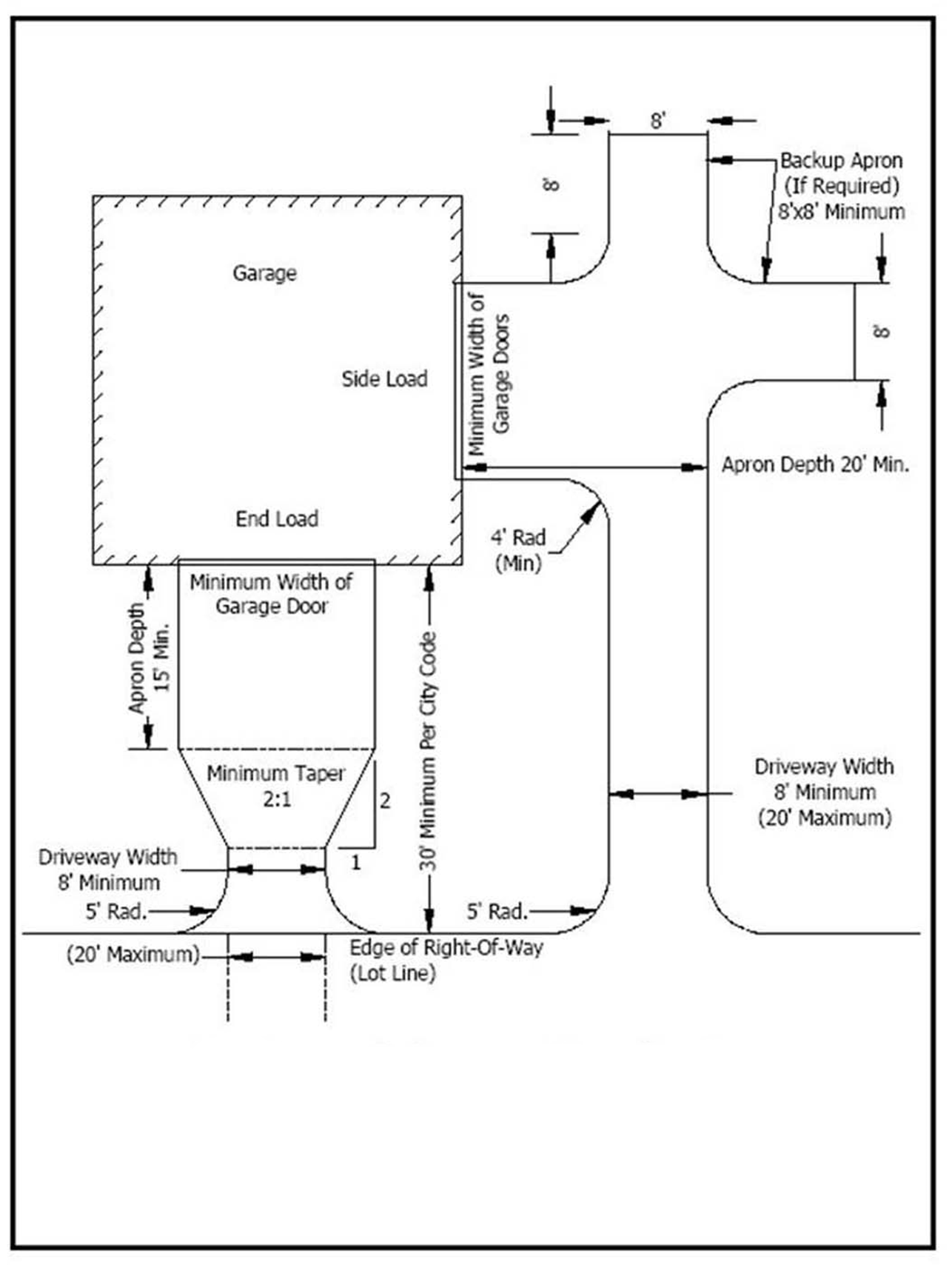
(Code 2003, § 78-1681; Ord. No. 94(3rd series), § 11, 9-24-2012)
Sec. 6.12.9130. - Shared driveways.
Where one or more properties (referred to as secondary property) gain its driveway access from an adjacent property (a primary property) by virtue of a driveway easement, the following shall apply:
(1)
The portion of the shared driveway on the primary property that serves both primary and secondary property shall be considered hardcover for the primary property.
(2)
That portion of the driveway on the primary property that serves only secondary property shall not be considered hardcover for either primary or secondary property.
Drawing 2 is included for illustrative purposes.
Drawing 2: Driveway Easements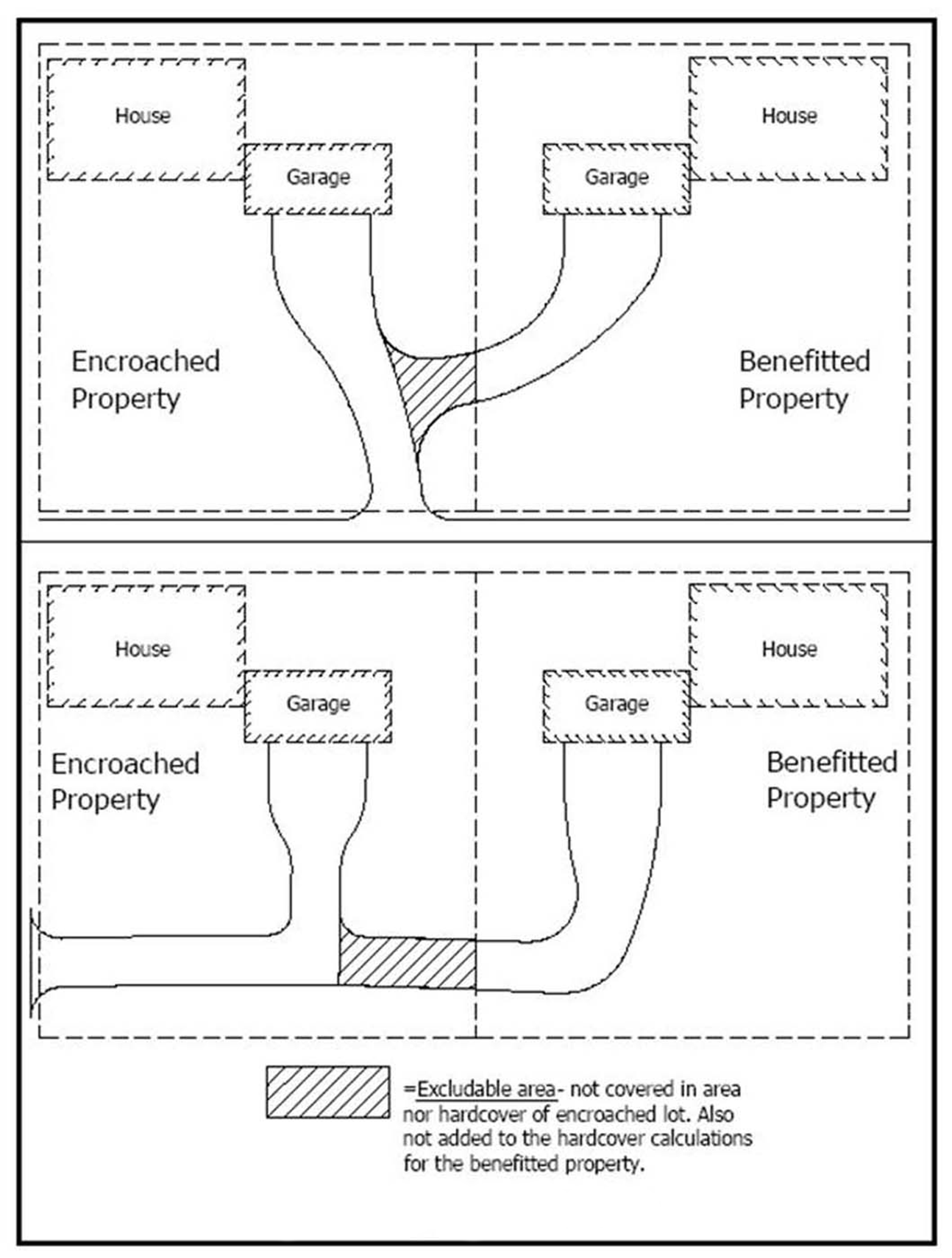
(Code 2003, § 78-1682; Ord. No. 94(3rd series), § 11, 9-24-2012)
Sec. 6.12.9140. - Standard hardcover inclusions.
The following hardcover items shall be included in proposed hardcover calculations regardless of whether the noted features are proposed to be constructed at the time of a building permit application:
(1)
Proof of a two-car garage (detached or attached);
(2)
A driveway for all garages, a minimum of 12 feet in width, subject to the standards in section 6.12.9120;
(3)
A 24-inch wide sidewalk connecting the front door to the driveway;
(4)
The minimum stairway or landing at all exterior doors as required by the building code; and
(5)
Existing hardcover which encroaches (legally or illegally) onto an adjacent parcel.
a.
In such cases of encroachment, the square footage of all encroaching hardcover shall be added to the overall hardcover on the subject lot;
b.
No credit shall be given towards the overall lot size of the subject lot.
(Code 2003, § 78-1683; Ord. No. 94(3rd series), § 11, 9-24-2012)
Sec. 6.12.9150. - Standard hardcover exclusions.
Landscaping with permeable lining shall not be considered hardcover. Additionally, the following hardcover items shall be excluded from hardcover calculations:
(1)
Roads, trails, sidewalks, utilities and other hardcover encroachments intended for the public's benefit;
(2)
Hardcover encroachments created by improvements on adjacent property not owned by the subject landowner;
a.
In such cases of encroachment, the square footage of all encroaching hardcover shall not be added to the overall hardcover counting against the subject lot;
b.
The land area upon which the encroachment rests shall count towards the overall lot area for the subject lot.
(3)
Retaining walls;
(4)
Handicapped ramps with a pervious surface below; and
(5)
The first 100 square feet of pervious paver patios/walkways or the first 100 square feet of deck with a minimum one-fourth-inch spacing between boards and a pervious surface below the decking.
(Code 2003, § 78-1684; Ord. No. 94(3rd series), § 11, 9-24-2012)
Sec. 6.12.9160. - Massing standards.
(a)
Non-industrial zoning districts. Except for parcels zoned industrial, all lots in the stormwater quality overlay district that have a gross acreage of less than two acres shall comply with the following massing standards for structures:
(1)
Maximum total footprints allowed.
a.
On lots equal to or greater than 10,000 square feet in area, the total combined footprints of all principal and accessory structures shall not exceed 20 percent of the gross lot area.
b.
On lots of less than 10,000 square feet in area, the total combined footprints of all principal and accessory structures shall not exceed 2,000 square feet.
(2)
Calculation of massing. The following shall be included in the calculation of the total combined footprints by structures: All roofed structures where the highest point of the roof is more than six feet above existing ground level.
(b)
Industrial zoning district. For parcels zoned industrial, the following massing standards for structures shall apply.
(1)
On lots equal to or less than three acres in area, the total combined footprints of all principal and accessory structures shall not exceed 35 percent of the gross lot area.
(2)
On lots greater than three acres in area, the total combined footprints of all principal and accessory structures shall not exceed 45 percent of the gross lot area; except that when the total building floor area on a site is contained within a single building, and when the total area used for loading terminals, docks and berths is completely enclosed within the same single building, a lot coverage of not more than 60 percent of the gross lot area will be permitted.
(Code 2003, § 78-1685; Ord. No. 94(3rd series), § 11, 9-24-2012; Ord. No. 170(3rd series), § 5, 6-13-2016; Ord. No. 187(3rd series), § 2, 3-13-2017)
Sec. 6.12.9170. - Variances.
Variances to hardcover, if granted on lots within the stormwater quality overlay district, may be subject to mitigation measures deemed appropriate by the city council to offset the impacts generated by the proposed additional hardcover.
(Code 2003, § 78-1686; Ord. No. 94(3rd series), § 11, 9-24-2012)
Sec. 6.12.9210. - Specific tier regulations.
Per the official stormwater quality overlay district map, each property in the stormwater quality protection overlay district is assigned to a protection tier based on its relative distance to receiving waters. This protection tier dictates the specific protection measures that must be implemented.
(1)
Tier 1 parcels. Hardcover shall not exceed 25 percent of the gross lot area.
(2)
Tier 2 parcels. Hardcover shall not exceed 30 percent of the gross lot area.
(3)
Tier 3 parcels. Hardcover shall not exceed 35 percent of the gross lot area.
(4)
Tier 4 parcels. Hardcover shall not exceed 50 percent of the gross lot area.
(5)
Tier 5 parcels. Hardcover shall not exceed 85 percent of the gross lot area.
(Code 2003, § 78-1700; Ord. No. 94(3rd series), § 11, 9-24-2012)
Sec. 6.12.9220. - Tier assignment methodology
(a)
The inclusion of parcels into the stormwater quality overlay district is based on the following methodology.
(1)
Examine each parcel and determine whether or not it abuts a protected lakeshore or stream.
a.
All parcels that abut a protected lakeshore or stream shall be placed into Protection Tier 1.
b.
All parcels that do not abut a protected lakeshore or stream shall be examined under the criteria in subsection (2) of this section.
(2)
Determine the location of the primary building area on the parcel being examined. The primary building area shall be identified by the location of an existing primary structure (if applicable), or by considering required setbacks and/or the average location of structures on adjacent lots.
a.
If the primary building area is wholly within 250 feet of a protected lakeshore or stream, the parcel shall be placed into Protection Tier 1.
b.
If the primary building area is wholly not within 250 feet of a protected lakeshore or stream, the parcel shall continue to be examined under the criteria in subsection (3) of this section.
c.
If the primary building area is divided by the 250-foot delineation line, the following assessment shall guide the designation:
1.
If an adjacent parcel abutting by a side lot line is already assigned to Protection Tier 1, the parcel shall be placed into Protection Tier 1.
2.
If all adjacent parcels abutting by a side lot line have not been assigned to a protection tier, the parcel shall continue to be examined under the criteria in subsection (3) of this section.
(3)
Using the location of the primary building area as identified in subsection (2) of this section, determine the distance between the primary building area and the nearest protected lake or stream. Distances shall be measured from the required setback nearest the protected water body to the OHWL.
a.
If any portion of the primary building area is at a distance of 300 feet or less from a protected stream or is at all touching the landward extent of floodplain from a stream, the parcel shall be placed into Protection Tier 2.
b.
If any portion of the primary building area is at a distance between 250 feet and 500 feet from a protected lakeshore, the parcel shall be placed into Protection Tier 2.
c.
If the primary building area is at a distance greater than 500 feet and up to 1,000 feet from a protected lakeshore, the parcel shall be placed into Protection Tier 3.
d.
If the primary building area is beyond a distance of 1,000 feet from a protected lakeshore or stream, the parcel shall continue to be examined under the criteria in subsection (4) of this section.
(4)
Determine the zoning of the subject parcel.
a.
If the property is zoned residential planned unit development (RPUD), the parcel shall be placed into Protection Tier 4.
b.
If the property is zoned I Industrial, the parcel shall be placed into Protection Tier 5.
c.
If the parcel being examined has not yet been assigned to a protection zone, the parcel shall continue to be examined under the criteria in subsection (5) of this section.
(5)
Determine whether the unassigned parcel (or group of unassigned parcels) is within a gap. A gap is an area of 20 acres or less that is largely surrounded by parcels assigned to protection tiers. Roadways, if present, will be used as a dividing line when identifying gap areas.
a.
Beginning with parcels on an individual basis, if more than half of the border of a parcel is regulated via one of the protection tiers, the parcel shall be placed into the tier which abuts the parcel by the greatest percentage.
b.
Unassigned parcel groupings of 20 acres or less that have more than half of the group's overall border regulated via one of the protection tiers shall be placed into the tier which abuts the group area by the greatest percentage.
c.
Parcels still unassigned to a protection tier following review under subsection (a)(5)b of this section shall be exempt from stormwater quality overlay district regulations.
(b)
As new parcels are created within the city as a result of subdivision, each new parcel shall be examined under this methodology to determine whether it belongs within a protection tier as part of the overlay district, or be exempt from the regulations of this article.
(Code 2003, § 78-1701; Ord. No. 94(3rd series), § 11, 9-24-2012)