
Osceola County Unincorporated
City Zoning Code
City Zoning Code
CHAPTER 3
PERFORMANCE AND SITING STANDARDS
ARTICLE 3.1 - GENERAL PROVISIONS
This Chapter provides for establishment of zoning districts, zoning district standards, and dimensional and area requirements. Permitted uses and siting standards, parking and signage, special planning area criteria for Planned Developments, Activity Centers, and specific Planning Overlays are also provided for herein.
ARTICLE 3.12 - OVERLAY DISTRICT DEVELOPMENT STANDARDS[2]
Editor's note— Ord. No. 2025-10, § 4, adopted March 17, 2025, repealed the former Art. 3.12, §§ 3.12.1, 3.12.2, and enacted a new Art. 3.12 as set out herein. The former Art. 3.12 pertained to Narcoossee Community Development Standards and derived from the original Code.
ARTICLE 3.16 - WEST U.S. 192 DEVELOPMENT AUTHORITY CORRIDOR[3]
Editor's note— See editor's note to Article 3.17.
ARTICLE 3.17 - OUTDOOR SIGN STANDARDS[4]
Editor's note— Ord. No. 2020-07, § 2, adopted Jan. 13, 2020, enacted a new Art. 3.16 and renumbered the prior Art. 3.16, §§ 3.16.1—3.16.13 as Art. 3.17, §§ 3.17.1—3.17.13, as set out herein.
3.1.1 - ZONING DISTRICTS
A.
ESTABLISHMENT OF DISTRICTS. In order to classify, regulate the use of land, water, buildings and structures, to regulate the height and bulk of buildings, and to regulate the area of yards, courts and open spaces about buildings, Osceola County, parts of which are not in any municipality, is divided into zoning districts.
B.
PRECEDING ZONING DISTRICTS. Preceding zoning districts as defined in this Code are those districts that were established prior to October 15th, 2012.
C.
PURPOSE. This Chapter establishes permitted, conditional, accessory and prohibited uses. Some uses may be subject to additional development standards as outlined herein.
D.
DISTRICTS SHOWN ON MAPS. The boundaries of the various zoning districts are shown on the "Official Zoning Map," which is made a part of this Code. Where uncertainty exists with respect to the boundaries of the districts as shown on the Official Zoning Map, the following rules shall apply:
1.
Where district boundaries are indicated as following the center lines of streets, highways or alleys, such center lines shall be construed to be such boundaries.
2.
Where district boundaries are indicated as approximately parallel to the center lines of streets or highways, such district boundaries shall be construed as being parallel thereto and at such distance therefrom as indicated on the Official Zoning Map. If no distance is indicated specifically on the map, the scale of the map shall control, subject to subsection 3 below.
3.
Where district boundaries are indicated as following platted lot lines, such lot lines shall be construed to be the district boundaries.
4.
Where district boundaries run to, but do not extend into water areas, they shall be considered to run into such water areas in a straight line continuing in the prevailing direction of the boundary as it approached the water until they intersect other district boundaries or the geographic limits of the County. Boundaries which run through water-courses, lakes and other water areas shall be assumed to be located midway in such water areas unless otherwise indicated.
5.
Where district boundaries are indicated by specific dimensions, such specific dimensions shall control.
6.
Where district boundaries divide un-subdivided property, and where no specific dimensions are indicated on the Official Zoning Map, the scale of the map shall control.
E.
USES WITHIN PLANNED DEVELOPMENT. Uses allowed within planned development districts shall be established within the development application in accordance with the requirements outlined herein for Planned Developments.
F.
USES WITHIN MIXED USE. Uses allowed within Mixed Use Districts shall be established at the time of Conceptual Master Plan approval and subsequent Concept Plan and Site Development Plan approval, in accordance with the requirements outlined in this Code for Mixed Use District Development Standards.
G.
NEW DEVELOPMENT.
1.
New Single Family Residential Development is hereby defined for single-family or duplex-zoned residential properties as the creation of lots through the subdivision of land, as defined in Florida Statutes. Creation of lots through a lot split, consistent with the requirements and standards of this Code, shall not be considered new residential development. Existing residential structures and any new ancillary structures are not considered new development, are exempt from rezoning, and shall adhere to the preceding zoning district development standards.
2.
New Multi-family Residential Development shall be defined as an increase in the number of units on a property by more than five (5) percent or, where applicable, an approved development plan is changed to qualify as a major deviation based on the criteria established in this Code. Existing multi-family residential developments which are modified so as to be considered a minor deviation shall not be considered new multi-family residential development. For properties located within the East U.S. 192 Community Redevelopment Area or the West U.S. 192 Community Redevelopment Area, as outlined in Sections 3.15 and 3.16 herein, "New Multi-family Residential Development" shall include any building or property proposing a change of the building or property's primary use (or adaptive reuse) from non-residential to residential. See Section 3.8.1(U) for siting standards, as well as applicable regulations in Sections 3.15.3 and 3.15.4, and 3.16.2, for adaptive reuse.
3.
New Non-residential Development shall be defined as an increase of the building square footage on a property by more than five (5) percent, any vertical improvement on a vacant property, or the demolition and reconstruction of existing structures whereby more than fifty (50) percent of the existing structure(s) is removed in the process.
4.
Properties that meet the above criteria (Section 3.1.1.G.1—3) are deemed by the County Manager as New Development or Newly Developed and shall be required to rezone to a zoning designation that is consistent with the Comprehensive Plan as outlined herein. Any properties that do not meet the above criteria are considered existing development. Existing residential structures and any new ancillary structures, that do not meet the above criteria are exempt from rezoning requirement and shall adhere to the preceding zoning district development standards shown in Table 3.5.
5.
Any request for rezoning must choose a zoning designation that is consistent with the Comprehensive Plan as outlined herein in Table 3.3.
6.
Properties that meet the above criteria (Section 3.1.1.G.1—3) for new development are required to meet the standards of the adopted zoning designation. Any nonconforming structures must be brought into compliance or removed upon approval of a Site Development Plan, and prior to scheduling a pre-construction meeting. If no Site Development Plan is required, structures must be brought into compliance or removed prior to issuance of a Building Permit.
H.
NEW DEVELOPMENT TRANSITION STANDARDS.
1.
New development in any zoning district that abuts single family developed lots with an average lot size of one-half (0.5) acre or greater shall provide a fifty (50) foot setback to the new primary structures, as measured from the new subdivision or development boundary. Rear setbacks in the HDR, MDR, or RPB District, if adjacent to commercial, Urban Infill Center, or HDR may be zero (0) feet; if abutting a right-of-way or utility way, shall be five (5) feet; and if abutting a single-family residential district that does not meet the above criteria, shall be twenty-five (25) feet.
2.
New development adjacent to existing or planned single-family detached housing approved by a Preliminary Subdivision plan within LDR future land use shall not exceed two (2) stories within the first one hundred (100) feet as measured from the new development boundary, except for when adjacent to Rights of Way in which case the width shall count toward the measurement. The maximum height between one hundred (100) and one hundred fifty (150) feet shall be three (3) (stories). New development shall be required to demonstrate that sight lines from three (3) stories or higher maintain privacy of existing adjacent single-family property, as measured from the top of the highest transparency to the top of the highest transparency of existing development.
(Ord. No. 2020-07, § 2, 1-13-2020; Ord. No. 2021-78, § 1, 11-1-2021; Ord. No. 2022-125, § 3, 2-20-2023)
3.1.2 - RESTRICTIONS UPON LAND, BUILDINGS AND STRUCTURES
A.
USE.
1.
No building or structure shall be erected and no existing building shall be moved, altered, or enlarged, nor shall any land, building, structure or premises be used or designed to be used for any purpose or in any manner other than as permitted in the district in which such land, building, structure or premises is or are located. All necessary land use, zoning and/or building permits shall be obtained, except when exempt according to Florida Statutes.
2.
All required site improvements and accessory uses for any principal use, including but not limited to off-street parking and loading areas, retention or drainage areas, and private sewer or water systems shall be located on the same lot as the principal use and shall have the same district designation as the principal use, except as permitted elsewhere in this Code.
B.
HEIGHT. No structure or building shall be erected, nor shall any existing building be moved, reconditioned or structurally altered so as to exceed in height the limit, if any, established herein, for the district in which such building or structure is located.
C.
SITE REQUIREMENTS. No building or structure shall be erected, nor shall any existing building or structure be moved, altered, or enlarged, nor shall any open space surrounding any building or structure be encroached upon or reduced in any manner, in size or area, except in conformity with the development or building site requirements and the area and parking space and yard regulations established by this Code for the district in which such building or structure is located.
D.
REQUIRED LOT AND OCCUPANCY. Every building or structure hereafter erected shall be located on a lot or tract as defined herein.
E.
BUILDING FORM. Traditional Neighborhood Development and Smart Growth principles are encouraged for any new development within any of the zoning districts inside the Urban Growth Boundary.
F.
PROPERTIES CONTAINING TWO OR MORE ZONING DISTRICTS. Properties that contain two or more zoning designations shall be developed in accordance with the following. Overlay areas shall not be viewed as an additional district and are exempt from these requirements.
1.
Where developable property contains two or more zoning designations with a different permitted floor area ratio, the permitted floor area ratio shall not exceed the sum obtained by multiplying the permitted floor area ratio for the applicable land area in each zoning designation and adding the products together.
2.
Where developable property contains two or more zoning designations with different allowable density, the density shall not exceed the sum of the maximum number of units that are allowable on individual portions of the property in each zoning district.
3.
Such permitted floor area or density may be distributed throughout the developable property without regard to district boundaries upon application and approval of the County Manager. Such application shall include a site plan showing proposed use placement, bulk and interrelationship of all structures within the developable property. Nothing in this section shall authorize the location of a use in a district where that use is not either a permitted principal or accessory use or an approved conditional use.
G.
REGULATIONS ENCUMBERING LAND. No portion of a lot used in connection with an existing or proposed building, structure or use, and necessary for compliance with the area, height, and placement regulations of this Code, shall, through sale or otherwise, be used again as a part of the lot required in connection with any other building, structure, or use. A part of a yard, area, open space, off-street parking, or off-street loading space required for one structure or use shall not be included as meeting the open space requirements for another, except where specific provisions are made in this Code. Off-street parking or off-street loading space affected by these regulations, which meets all or part of the requirements of this Code for such space, shall not be reduced or eliminated by private action, except where alternative off-street parking or off-street loading space is approved pursuant to this Code.
3.1.3 - APPLICABILITY
A.
The zoning districts consistent with the Osceola County Comprehensive Plan are shown in Table 3.1. In order to implement the Comprehensive Plan, any request for rezoning must choose a zoning designation outlined in Table 3.1.
B.
The preceding zoning districts are shown in Table 3.2. These zoning districts are historic zoning districts and the dimensional and area requirements specified are available for existing development only. No request for rezoning may choose a zoning designation outlined in Table 3.2. Any new development as defined herein is required to rezone in accordance with the zoning districts shown in Table 3.1.
C.
The correlation of zoning districts to future land use designations is shown in Table 3.3. The zoning district and future land use designation for a property shall be compatible with one another. Properties may only rezone to a zoning district category that correlates to the future land use designation for that property.
D.
Permitted, Conditional, Accessory and Prohibited uses are established in the Use Tables, Table 3.4 for new development as defined herein and Table 3.5 for preceding districts as defined herein. The use of all new or existing structures and properties shall conform with the requirements of the Use Tables and with all other applicable requirements of this Code. District standards, permitted uses and other site specific standards shall be established herein.
E.
Bona fide agricultural activities, as defined by Florida Statutes, shall be exempt from the development criteria outlined in this Code unless otherwise mandated by State regulation, and shall not be considered new development.
* Setbacks: Setbacks are measured from existing property line. An unenclosed front porch may encroach into the front setback to accommodate up to a seven (7) foot deep porch.
* Setbacks:
Setbacks are measured from existing property line.
Notes:
1. Corner lots or lots having double road frontage shall measure setbacks from both roads as front yards.
2. Land clearing activity to accommodate the principal use or ancillary structures where "Livestock/Grazing Animals" is the principal use shall be limited to the footprint of the proposed structure and reasonable space to accommodate construction equipment used to place the structure.
3. Lot front determination shall be where the principal vehicular access to the lot abuts the approved public or private right-of-way. If the principal vehicular access is served by alley way design, then the Planning Official shall determine the lot front.
4. Lot width determination shall be measured at the mid-point of the side lot lines.
5. No structure or building shall be erected, nor shall any existing building be moved, reconditioned or structurally altered so as to exceed in height the limit, if any, established in this chapter or amendments thereto, for the district in which such building or structure is located.
6. Accessory uses listed as ancillary in the siting standards, shall be placed at a minimum of five feet (5') behind the front entry of the principal structure and a minimum of five feet (5') from rear and side property lines. Accessory structures such as garage(s), carport(s) or like uses are exempt from this requirement and shall meet the required front and corner setbacks. Uses not listed as ancillary in the siting standards shall meet principal setbacks of the respective zoning district.
7. For lots with AC zoning inside the Urban Growth Boundary and not within a Rural Enclave, the minimum lot size is reduced to two (2) acres and the minimum lot width is reduced to one hundred fifty (150) feet.
1. Limited industrial uses are permitted within alternate land uses and zoning designations as identified in the Use Table.
2. Limited to the Short Term Rental Overlay boundary as identified on the Future Land Use Map 2A.
3. Limited to existing EC zoning districts.
(Ord. No. 2020-07, § 2, 1-13-2020; Ord. No. 2022-125, § 3, 2-20-2023; Ord. No. 2023-52, § 2, 7-17-2023; Ord. No. 2025-10, § 4, 3-17-2025)
3.2.1 - RURAL/AGRICULTURAL DISTRICT DESCRIPTIONS
A.
OBJECTIVE.
1.
Encourage the retention and development of suitable areas for agricultural production, the preservation of open spaces, preserve the rural lifestyle and the conservation and management of soil, water, air, game and other natural resources and amenities; and
2.
Discourage the creation or continuation of conditions which could detract from the function and/or operation, of agricultural lands and the appearance of rural areas; and to allow the opportunity to effectively compete with other regions in production of agricultural products. All development and divisions of land meeting the net residential density in Rural/Agricultural zoning district(s) (AC, RS, or ARE) shall comply with the requirements outlined herein. Specific uses permitted within the Rural/Agricultural Zoning Districts are those generally associated with agricultural uses and their support activities. Those uses that may require specific siting standards are outlined herein.
B.
DISTRICTS.
1.
Agricultural Development and Conservation (AC): The AC District implements the Rural/Agricultural policies of the Osceola County Comprehensive Plan to allow agricultural areas to be developed in a manner consistent with the retention of agriculture, open space and rural character, and typically supports those land uses outside the Urban Growth Boundary. All properties within the AC district shall have a legal access to the property prior to any development activity or use request.
2.
Rural Settlement (RS): The RS District implements the Rural Settlement policies of the Osceola County Comprehensive Plan to allow the preservation of historic rural communities and provide opportunities for a rural lifestyle.
3.
Agricultural Rural Estate (ARE): The ARE District implements the Rural Enclave policies of the Osceola County Comprehensive Plan to allow the preservation of historic rural communities that are surrounded by the Urban Growth Boundary.
C.
LOT SIZING, DENSITY CALCULATIONS AND SETBACK REQUIREMENTS.
1.
Density Requirement: Density requirements are consistent with the Osceola County Comprehensive Plan and are calculated on a net residential development basis and may vary from the maximum density levels for a single lot if the overall density is met for new development.
D.
AGRICULTURAL DEVELOPMENT STANDARDS.
N/A = not applicable
1 Lots as small as one-quarter (0.25) acre may be permitted, upon approval by the County Manager, for up to two (2) splits of a parent parcel, where the overall parcel density requirements are met.
2 Accessory uses listed as ancillary in the siting standards shall be placed a minimum of five (5) feet behind the front entry of the principal structure and a minimum of five (5) feet from rear and side property lines. Accessory structures such as but not limited to garages, sheds, carports, accessory living units, or barns are exempt from this requirement.
3.2.2 - RESIDENTIAL DISTRICT DESCRIPTIONS
A.
OBJECTIVE.
1.
Promote the orderly growth and development of the community, protect the value of property, improve the opportunity for housing various economic groups, and achieve the intent of the land use initiatives; and
2.
Encourage the design and development of suitable areas for residential dwellings; and
3.
Discourage the creation or continuation of conditions which could detract from the function, harmony, tranquility and appearance of residential neighborhoods, or have an adverse effect on adjacent areas.
B.
DISTRICTS.
1.
Single Family Districts. The single family residential zoning districts implement the Rural Enclave and Low Density Residential policies of the Osceola County Comprehensive Plan to allow for preservation of historic communities, provide opportunities for rural residential lifestyle, and provide for newly developing residential areas within the Urban Growth Boundary. The single family zoning districts within the Urban Infill area of the Urban Growth Boundary are Agriculture Rural Estate (ARE), Urban Settlement (US), Urban Settlement Manufactured Product (US-M), and Low Density Residential (LDR). The principal character in single family districts is considered one (1) single family dwelling per lot, including attached products. This shall not prohibit the inclusion of mixed residential product type within newly developed areas implementing the encouraged Traditional Neighborhood Development principles, provided, however, that the maximum density within the specific single family residential zoning district is not exceeded.
2.
Multi-Family Districts. The multi-family zoning districts implement the Medium Density and Intensity and High Density Residential; and the Residential Professional Business policies of the Osceola County Comprehensive Plan and are intended to allow a full range of housing types, lot sizes, and densities to serve different segments of the housing market. The residential components of Residential Professional Business (RPB) and Commercial Tourist (CT) districts are further defined in the higher intensity districts below, recognizing the commercial component of these districts. The multi-family Zoning Districts that occur within the Infill area of the Urban Growth Boundary are: Medium Density Residential (MDR), Medium Density Residential-Manufactured Product (MDR-M), High Density Residential (HDR), and Residential Professional Business (RPB). Within the HDR zoning district, ancillary non-residential uses which support the residents of the development are permitted within High Density Residential future land use. Within Commercial future land use, non-residential uses are permitted up to fifteen (15) percent of the gross square footage of the building(s).
C.
DENSITY CALCULATIONS FOR RESIDENTIAL ZONING DISTRICTS.
1.
Unless otherwise provided in this Code, the calculation of number of units per acre shall be based upon the net residential density for the overall project. Density for new subdivisions shall be within the ranges shown in the Residential Development District standards herein. Parks shall be incorporated into the development program of any new subdivision consistent with the standards outlined herein and within the Comprehensive Plan.
2.
Overall Density. The density requirements for any one (1) parcel within a new development or subdivision may fall below or exceed the desired levels, where the overall development density requirements are met, or if the applicant has incorporated Transfer of Development Rights within the project. Exemptions to the minimum density of a single parcel may be approved by the County Manager if it is determined that environmental site constraints, or parcels of limited scale preclude achieving the net density of the parcel. Density shall not apply nor be calculated for lot splits.
Lower density may be required through implementation of the U.S. zoning district. This provision applies where a rezoning application is required for proposed new development of fifteen (15) acres or less within the Low Density Residential Land Use and is adjacent on two (2) sides to a platted subdivision with lots an average of one-half (0.5) acre or more in size. This provision does not apply where adjacent to approved development consistent with existing LDR zoning or non-residential standards, or where U.S. zoning was approved after October 1, 2023. For new development within U.S. zoning districts, maximum density shall be two (2) dwelling units per acre; however, the minimum lot size is not applicable.
3.
Accessory Living Units. For the purposes of determining compliance with minimum and maximum density requirements, accessory living units meeting the standards provided in this Code are not applied toward density counts.
4.
Calculating Net Density. Net density shall be calculated by multiplying the allowable density by the developable residential acreage. The developable acreage consists of the residential acreage, less road right-of-way (ROW) for Boulevards, Avenues and Multi-Modal Corridors (framework ROW), land dedicated to public use and activities including parks and recreation: stormwater systems designated by a water management district as "works of the district"; natural water bodies; wetlands except as noted in the Osceola County Comprehensive Plan; and any non- residential acreage that does not include vertically mixed residential use. The residential portion of mixed use buildings shall count toward meeting density requirements. Hotel density is calculated to meet minimum density requirements; however, the rooms shall not be counted toward the maximum density unless converted to multifamily through the adaptive reuse standards contained herein.
D.
RESIDENTIAL DEVELOPMENT STANDARDS.
E.
RESIDENTIAL SITING STANDARDS.
For single-family attached and detached residential units in new developments, the following shall apply:
1.
Development Standards. New single family developments shall implement a variety of residential product, with two (2) different product types required for development of up to sixty (60) lots; and three (3) different product types for developments of sixty-one (61) or more lots (e.g., single-family detached, detached structures with rear-loaded garages, townhomes, duplexes, bungalow court, quadraplex, etc.) where each single product type shall account for no less than fifteen (15) percent. There are no restrictions on additional product types. To ensure a variety of residential product type, the number of lots within new residential developments sharing an internal local roadway network with existing or previously approved residential phases shall be aggregated with the existing or previously approved residential phase for the purpose of implementing this provision. For small, infill developments, existing surrounding development may be considered when evaluating product type. No more than three (3) contiguous blocks shall include the same singular product type. Changes to lot width shall not be counted to achieve the provisions of this standard.
2.
Lot Area. Minimum lot area does not apply to attached single family product.
3.
Garages. For front facing garages, the garage door must be placed a minimum of twenty-five (25) feet off the perimeter property boundary, and for lane access garages, twenty-five (25) feet from edge of pavement. Rear garage access shall be required for all single family detached lots with a lot width less than forty-five (45) feet.
4.
Building Separation. For a zero-lot line product or an attached single family product, a minimum ten-foot (10') building separation between structures must be demonstrated.
5.
Accessory Uses/Structures. Accessory uses listed as ancillary in the siting standards shall be placed at a minimum, five (5) feet or three (3) feet, as listed above, behind the front entry of the principal structure and a minimum of five (5) feet from rear and side property lines. Accessory structures such as garage(s), accessory living units, carport(s) or like uses are exempt from this requirement, as are barn(s) in the ARE District.
6.
Driveways. Pavers shall be required for the driveway if the driveway comprises more than sixty (60) percent of the front yard area (area included shall be measured from front of principal structure to front property line). Sidewalks and driveway aprons within the right-of-way shall comply with the applicable Road Construction Specifications Manual guidelines.
7.
Air Conditioners and Mechanical Equipment. Air conditioner pads and condensing units, and other mechanical equipment will be staggered a minimum of ten (10) feet from air conditioner and mechanical equipment units on adjacent properties to provide for drainage and accessibility.
F.
RESIDENTIAL ARCHITECTURAL STANDARDS.
1.
Variety of Product. Architectural elevations and façades shall vary so that the type (model), paint color and elevation (all three (3)) shall not match adjacent structures nor the building site located directly or diagonally across the street. Any façade facing a public right-of-way shall be treated as a primary façade.
2.
Garages. Where the garage door (measurement shall be from each end of the garage door itself) comprises more than forty (40) percent of the front façade, remedies must be taken to reduce the visual impact of the garage mass. This can include recessing the garage, overhangs, trim, or separate door entries. Garages that are side-loaded or rear-loaded are exempt from this provision.
3.
Massing and Composition. Buildings shall have elements that clearly delineate a base, middle, and top through the use of color, materials, banding, and enhanced roofline elements. All walls facing the street or the public realm shall have a level of treatment similar to the front façade. Blank walls shall be reduced by the inclusion of windows, vertical elements with a plane change from the wall surface, shadow-casting elements, material changes, or other methods. Vertical material transitions shall occur at inside corners or wrap at least eighteen (18) inches around an outside corner.
4.
Windows/Doors. Windows and doors shall be accentuated through measures such as: adding trim/sills and lintels or other similar treatment; providing shutters or awnings; framing through the use of façade materials; use of bay windows; and/or recessing the window. Decorative shutters shall be scaled and affixed to have the appearance of functioning shutters.
5.
Roofline Elements. If using roofline elements to meet the requirements for Massing and composition, enhanced roofline elements include but are not limited to: molded or decorative fascia, frieze boards, and gable details and treatments.
6.
Adequate Storage. Where a garage is not provided, a minimum of forty (40) square feet of enclosed storage area shall be constructed so that residents will have space to store bulky personal effects (i.e., recreational equipment).
7.
Reserved.
8.
Compliance. Compliance with this standard is the responsibility of the developer or applicant. At the time of building permit, applicant will provide proof of compliance.
(Ord. No. 2022-125, § 3, 2-20-2023; Ord. No. 2025-10, § 4, 3-17-2025)
3.2.3 - INSTITUTIONAL DISTRICT DESCRIPTION
A.
OBJECTIVE. The Institutional designation is intended to serve those areas within the Urban Growth Boundary Infill Area and is intended to implement the Institutional Future Land Use Classification of the Comprehensive Plan. The Institutional District is for uses pertaining to organized establishments, foundations, societies, or the like, or to the buildings devoted to the work that are solely dedicated to the common benefit.
B.
INSTITUTIONAL DEVELOPMENT STANDARDS. Institutional District Standards may develop up to a 2.0 FAR. This is considered to be habitable space only; structured parking is exempt from this criterion. If the use is intended to be placed adjacent to a residential area, it shall conform to the development patterns surrounding the property.
3.2.4 - COMMERCIAL (RETAIL/OFFICE) DISTRICT DESCRIPTIONS
A.
OBJECTIVE. The commercial designations are intended to serve those areas within the Urban Growth Boundary that are outside Urban Infill Centers and are planned as a tiered approach ranging from high intensity commercial to a mix of commercial and residential uses including, but not limited to:
1.
A Live/Work structure is defined as a structure under single ownership consisting of both a non-residential and residential component.
2.
A Residential over Commercial structure is defined as a structure with non-residential uses on the ground floor and multifamily development which meets minimum density requirements on the upper floors.
Applications seeking to amend a zoning designation from a commercial or industrial district to any residential zoning district identified on Table 3.1; or from any Neighborhood Center Commercial zoning district or Urban Infill Center Core zoning district to Urban Infill Center Perimeter zoning district; or, amending PD zoning districts from commercial entitlements to residential entitlements, or increasing residential entitlements through a major amendment, must demonstrate via a professionally acceptable methodology, as contemplated in F.S. § 163.3177(1)(f)(3), that Osceola County's most recently adopted Comprehensive Plan or Land Development Code will not accommodate medium residential growth projections as published in the Office of Economic and Demographic Research at the designated target year.
B.
COMMERCIAL DISTRICTS INCLUDE:
1.
Residential Professional Business (RPB). The RPB district implements the Medium Density and Intensity as well as the Commercial policies of the Comprehensive Plan. The Residential Professional Business district may contain residential, professional office development and limited commercial uses indicated as permitted on the use table.
2.
Commercial General (CG). The Commercial General district implements the Commercial policies of the Comprehensive Plan and is primarily intended for existing commercial areas where centers are not feasible and allows for a wide range of intensities and uses, including enclosed light industrial, warehouse, and distribution, as appropriate based on proximity to transit and neighboring development.
3.
Commercial Neighborhood (CN). The Commercial Neighborhood district implements the Commercial policies of the Comprehensive Plan and is primarily intended for existing commercial areas where Urban Infill Centers are not feasible and allows for convenience retail and professional business. This district provides a transition zone between residential and more intense commercial development.
4.
Commercial Tourist (CT). The Commercial Tourist district implements the Tourist Commercial and Short Term Rental Overlay policies of the Comprehensive Plan and is primarily intended for intense tourist-related housing, commercial and recreational, and entertainment uses.
5.
Commercial Office (CO). The Commercial Office district is intended to provide workplace and professional services within the Urban Infill area of the County where centers are not feasible. The Commercial uses are limited to lesser intensity office and limited sales and services as indicated on the use table.
6.
Employment Commercial (EC). The Employment Commercial district implements the Commercial policies of the Comprehensive Plan where Urban Infill Centers are not feasible and is intended to expand and diversify employment opportunities within the County.
C.
BUILDING ORIENTATION.
1.
Building Orientation. All Commercial building's primary entrance shall be located on the façade facing the public right-of-way or civic space. Primary entrance is the principal pedestrian access to a building, even if customers or residents may more frequently use a secondary entrance associated with a garage, parking area, driveway, or other vehicle use area. The entrance shall have the architectural detailing that sets it apart from other entrances and allows it to be recognized as the building's primary access point.
D.
COMMERCIAL DEVELOPMENT STANDARDS.
Note: Residential development is not required.
1 For Commercial uses only.
2 For Residential uses only.
3 When a Commercial Neighborhood property is adjacent to another Commercial district, the properties may choose to aggregate and develop under the higher intensity development standards of the adjacent property.
4 Single-family detached is a Permitted Use as indicated in Use Table 3.4. For areas within one-half (0.5) mile of West U.S. 192 (West Irlo Bronson Memorial Highway), residential development shall have a minimum density of eight (8) dwelling units per acre and a maximum density of eighty (80) dwelling units per acre.
5 Hotels have no maximum density.
6 EC parcels with Employment Center Future Land Use designations shall comply with the Urban Infill Center standards contained herein.
7 The lower intensity shall apply to properties within the MDI Future Land Use designation. The higher intensity shall apply to properties within the Commercial Future Land Use.
E.
COMMERCIAL FLOOR AREA RATIO (FAR)/INTENSITY STANDARDS.
1.
Calculating intensity/FAR. FAR shall be calculated by dividing the proposed non-residential square footage by the developable non-residential acreage. The developable acreage consists of the non-residential acreage, less road right-of-way (ROW) for Boulevards, Avenues and Multi-Modal Corridors (framework ROW), land dedicated to public use and activities including parks and recreation; stormwater systems designated by a water management district as "works of the district"; natural water bodies; wetlands except as noted in the Osceola County Comprehensive Plan; and any residential use acreage that does not include vertically mixed residential use. The residential portion of mixed use buildings shall meet all density requirements, and be counted toward meeting minimum FAR requirements. Where there is a maximum FAR, the residential portion of a mixed use building shall not be calculated. Density shall be calculated according to residential district standards contained herein.
(Ord. No. 2020-07, § 2, 1-13-2020; Ord. No. 2022-125, § 3, 2-20-2023; Ord. No. 2024-48, § 1, 8-5-2024; Ord. No. 2025-10, § 4, 3-17-2025)
3.2.5 - INDUSTRIAL DISTRICT DESCRIPTIONS
A.
OBJECTIVE. The Industrial zoning district is intended to implement the Industrial Land Use classification of the Comprehensive Plan and is primarily focused on accommodating intensive industrial land uses within the Urban Infill area inside the Urban Growth Boundary. Commercial uses that are compatible with typical industrial uses shall be allowed according to the provisions of this section and as identified in the Use Tables. Limited industrial uses are permitted within alternate land uses and zoning designations as identified in the Use Table.
B.
INDUSTRIAL DISTRICTS INCLUDE:
1.
Industrial Restricted (IR). The Industrial Restricted district is established to allow for light industrial, warehouse/distribution and in some cases commercial and research and development land uses.
2.
Industrial General (IG). The Industrial General district implements the Industrial policies of the Comprehensive Plan and is intended for establishments engaged in manufacturing and distribution and some commercial uses.
3.
Industrial Manufacturing (IM). The Industrial Manufacturing district is established to allow for higher intensity developments engaged in manufacturing and is consistent with the Comprehensive Plan.
C.
All Industrial uses must have direct access to a paved roadway. Rezoning land to an Industrial District requires at least an acre of contiguous property, except as provided herein. Smaller tracts of less than an acre that are adjacent to existing industrial sites or vacant sites with an Industrial Future Land Use designation may be permitted to rezone to an Industrial District, provided the proposed development conforms to the adjacent site and design standards and cross access is provided where applicable.
D.
Where property zoned IR, IG or IM abuts existing residential development, no building or structure shall be located within seventy-five (75) feet of the residential perimeter property boundary line.
E.
INDUSTRIAL DEVELOPMENT STANDARDS.
(Ord. No. 2022-125, § 3, 2-20-2023; Ord. No. 2025-10, § 4, 3-17-2025; Ord. No. 2025-47, § 2, 8-4-2025)
3.2.6 - SPECIAL PURPOSE DISTRICT AND OVERLAYS DESCRIPTIONS
A.
OBJECTIVE. The purpose of these districts is to promote development of land as deliberate planned communities and the use of creative concepts for development planning that will create places that are set apart and in a manner that is consistent with the Comprehensive Plan. Special Purpose planning districts shall be allowed in all Land Use classifications given that the development patterns are consistent with the criteria outlined herein. As County development initiatives move forward, overlay districts may be incorporated as Special Purpose Districts. One such initiative is the Narcoossee neighborhood planning process and subsequent design intent document that is currently adopted for that area. Special Purpose District development standards shall adhere to or enhance the criteria outlined herein and will be reviewed on a case-by-case basis.
B.
SPECIAL PURPOSE DISTRICTS AND OVERLAYS INCLUDE:
1.
Planned Development (PD). Planned Development Classifications shall exercise greater ingenuity and imagination in the planning and development of tracts of land under a unified control than is generally possible under these regulations. Additional criteria and process for Planned Development approval is outlined herein.
2.
Narcoossee Community Overlay. The Narcoossee Community Overlay encompasses the area from East Lake Tohopekaliga to the western boundary of the Deseret Ranch, south to Highway 192 and Nova Road, and north to the Osceola-Orange County line. This Overlay identifies ways that the area can proactively plan for growth while preserving the community's heritage and unique qualities, providing opportunities for consolidating, expanding and creating new commercial areas along the Narcoossee corridor. The Narcoossee Community Overlay Development Standards can be found herein.
3.
Mixed Use District (MXD). The Mixed Use District is only intended for the Urban Expansion Areas of the Future Land Use Map that are designated as Mixed Use. The Mixed Use District is designed to provide flexibility in development, encourage a mix of residential housing types, and create the sense of community common in coherent and interconnected neighborhoods. Additionally, the design of these mixed use areas shall encourage neighboring landowners to combine projects under joint ownership so that more efficient neighborhoods can result. New development within an MXD Community Center, Urban Center, or Employment Center that complies with the MXD standards, and which is located within one-half (0.5) mile walking distance of a premium transit corridor shall be considered a Transit Oriented Development. Mixed Use District Development Standards can be found herein.
4.
Urban Infill Centers. The Urban Infill Centers are special purpose districts within the Urban Infill Areas of the Growth Boundary of the Future Land Use Map that are designated as Neighborhood Center, Community Center, Employment Center and Urban Center to promote integrated urban environments that encourage walkability and transit. New development within a Community Center, Urban Center, or Employment Center that complies with the Urban Infill Center standards, and which is located within one-half (0.5) mile walking distance of a premium transit corridor shall be considered a Transit Oriented Development. Urban Infill Centers Standard can be found herein.
5.
East U.S. 192 Community Redevelopment Area (CRA). The East U.S. 192 Community Redevelopment Area (CRA) is for the creation of an advanced manufacturing and Research Park located at the Judge Farms property to create an urban environment capable of attracting state-of-the-art manufacturing, research and incubation facilities. The CRA is design to encourage a cohesive, vibrant and efficient development pattern which strives to create a sense of place beyond the individual building. The U.S. 192 Community Redevelopment Area (CRA) can be found herein.
6.
Airport Height Overlay. An Airport Height Overlay Permit must be submitted for development and objects of natural growth over two hundred (200) feet above ground level (AGL) located within all the clear zones identified on TRN6: Air Transportation Facilities and Special Planning Areas 2040. An area located in more than one (1) of the prescribed airport height zones or airspace surfaces must comply with the most restrictive height limit or surface. A separate application for an airport height zoning permit must be submitted for permanent or temporary derricks, draglines, cranes and other boom-equipped machinery to be used during construction or installation at heights greater than the height of proposed structure. The Airport Height Overlay Permit application is in addition to any other required permits before the commencement of development.
7.
West U.S. 192 Development Authority Corridor. The West U.S. 192 Development Authority Corridor (W192 Corridor) is intended to enforce key elements of the W192 Design Guidelines which define a multi-themed vision for the W192 Corridor. In order to achieve the desired character and form for the W192 Corridor, the standards in this Article, paired with the W192 Design Guidelines established by the W192 Development Authority, are intended to guide development and redevelopment to create a sense of place and attract tourism.
8.
Boggy Creek Road Overlay. The Boggy Creek Road Overlay District encompasses land north of East Lake Tohopekaliga, south of the Orange County Line, east of Austin Tindall Park, and west of Fells Cove. The overlay provides for the balanced expansion of industrial, commercial, and more intense residential development by addressing buffers, parking, uses, and appropriate access and circulation.
(Ord. No. 2020-21, § 2, 2-17-2020; Ord. No. 2025-10, § 4, 3-17-2025; Ord. No. 2025-47, § 2, 8-4-2025)
3.3.1 - RESIDENTIAL AND EMPLOYMENT LIVABILITY
The purpose of this section is to establish standards for activities within all zoning districts that have the potential to affect the natural, environmental or livability of residential and employment areas.
A.
IN GENERAL. All uses shall be conducted so as to prevent any nuisance, hazard, or commonly recognized offensive conditions.
B.
MANURE. Manure must be removed regularly or otherwise composted or spread in such a manner as to protect surface and groundwater, to minimize the breeding of flies, and to control odors. In conjunction with uses not associated with bona fide agriculture, manure piles must be located a minimum distance of one hundred feet (100') from a well, stream or waterbody. In residential zoning districts, manure piles must be set back from a perimeter lot line in accordance with the zoning district accessory use setback.
C.
FENCES. Fences may be constructed, placed, or maintained in any yard or adjacent to a lot line in accordance with these requirements.
1.
The owner of the property upon which a fence is located shall be responsible for locating all property lines prior to constructing said fence.
2.
Fences in front yards of single family residential development shall not exceed four (4) feet in height, except for fences placed on properties within platted subdivisions recorded prior to October 15, 2012 or properties legally developed with single-family residences prior to October 15, 2012, which properties shall not be limited in height.
3.
Fence height shall be measured from the average grade adjacent to the bottom of the fence to the top of the fence material. Fence posts may extend an additional six (6) inches.
4.
All fences shall be constructed of durable, uniform, weather-resistant, and rust-proofed materials. Barbed wire fencing is prohibited except in conjunction with bona fide agricultural activities or where mandated by law.
5.
All fences shall be maintained and kept in good condition.
D.
ROOFTOP EQUIPMENT. For all multi-family and non-residential properties, rooftop mechanical equipment, including structures related to elevators, shall be completely screened from eye level ground view from contiguous properties and adjacent streets. Such equipment shall be screened with parapets or other materials similar to and compatible with exterior materials and architectural treatment on the structure being served. Solar and wind energy equipment is exempt.
E.
GARAGE/YARD, ETC., SALES. Garage, yard, tag, patio and apartment sales are specifically permitted, as an accessory use, in all residential and mixed-use districts. Such sales shall be limited to one during each six (6) month period, for duration not to exceed three (3) days.
F.
SOLID WASTE SCREEN ENCLOSURE. Solid waste containers shall be stored in such a manner that the containers are not visible from the public right-of-way. For residential units providing for less than a two (2) car garage or for residential units where the solid waste containers are not stored within an enclosed building, a minimum four-foot (4') high opaque screen enclosure shall be provided for storage of solid waste containers to screen them from the public right-of-way. The enclosure shall not be located within the required twenty-five-foot (25') driveway and shall be designed and constructed with materials that are compatible with the architectural character of the primary structure.
3.4.1 - GENERAL PROVISIONS AND APPLICABILITY
The use of all structures and properties that are new or newly developed as defined herein shall conform with the requirements of the Use Tables and with all other applicable requirements of the Code. All those structures and properties that are not new or newly developed as defined herein shall conform with the requirements of Preceding Use Table 3.5.
3.4.2 - TYPES OF USES
A.
PERMITTED USE BY RIGHT. A "P" in the designated space indicates a use that is permitted by right; some uses are indicated as permitted provided that the use meets the additional siting standards established in the Code.
B.
CONDITIONAL USE. A "CU" in the designated space indicates that a use is permitted only the districts indicated with a conditional use approval by the Board of Adjustment in accordance with the procedures outlined in the Code.
C.
ACCESSORY USE. An "A" in the designated space indicates that a use is permitted as an accessory use supporting a principal use in the respective district. Unless otherwise permitted herein, an accessory use is incidental and subordinate to a principal use within the project development site, and may be subject to additional siting standards established in this Code.
D.
PROHIBITED USE. A blank cell in the designated space indicates that a use is not permitted in the respective district.
(Ord. No. 2022-125, § 3, 2-20-2023; Ord. No. 2025-10, § 4, 3-17-2025)
3.4.3 - STANDARDS FOR USES
A.
SITING STANDARDS. Siting standards are provided herein for uses that are identified in the Use Tables in order to provide for the orderly development of land consistent with the Goals and Policies of the Comprehensive Plan and compatible with the surrounding developments.
B.
SIMILAR USES. A use not specifically listed in the Use Tables but possessing similar characteristics, including but not limited to size, intensity, density, operating hours, demands on public facilities such as water, sewer, traffic or environmental impacts, and business practices, may be allowed upon approval by the County Manager. Such uses will be determined based on the Use Tables and shall be subject to all requirements of the uses to which they are similar.
C.
DEVELOPMENT PLAN REVIEW. A Site Development Plan review is required for all uses that have special siting standards required under this Code. These requirements may be waived should the County Manager deem it appropriate.
3.4.4 - USE TABLES
Refer to Table 3.4 — Use Table for allowable uses and Table 3.5 — Preceding Zoning Use Table for allowable uses in preceding zoning districts, as defined herein. The Preceding Zoning Use Table is not applicable to new development, as defined herein.
Permitted Uses within the AC zoning district which meet the definition for New Development apply only outside the Urban Growth Boundary (UGB). See Preceding Use Table 3.5 for permitted AC uses within the UGB for existing development.
P - Permitted Use or Permitted Provided that Siting Standards are Incorporated into Development. See Overlay District Standards for additional permitted or prohibited uses. Where there is conflict between the overlay district and the Use Table, the Overlay District shall prevail.
A - Accessory or Ancillary Use, Incidental to the Primary Structure or Use and Subject to Siting Standards.
CU - Requires a Conditional Use Permit Approved by the Board of Adjustment
* - Specific Use that has Siting Standards. Siting standards are based on the proposed use within any zoning district.
** - Communication Towers that choose not to adhere to the siting standards will be required to obtain a conditional use permit in accordance with this Code.
*** - Vet Clinic Only.
Notes:
a.
Not permitted within Low Density Residential Land Use.
b.
Permitted only within Live/Work or Residential Over Commercial Structures as defined herein.
c.
The term Manufactured Home refers to mobile homes constructed to HUD standards.
Urban Infill Center Notes:
1.
With the exception of Live/Work Units, residential uses are not permitted in NCC.
2.
Permitted only where existing or new on-site structures meet all architectural design standards for Urban Infill Centers.
3.
Permitted within the Perimeter only.
4.
Permitted within the Core only.
P - Permitted Use or Permitted Provided that Siting Standards are Incorporated into Development.
A - Accessory Use Incidental to the Primary Structure or Use and Subject to Siting Standards.
CU- Requires a conditional use permit approved by the Board of Adjustment.
* - Indicates a specific use that has Siting Standards.
Blank - Prohibited Use.
(Ord. No. 2025-10, § 4, 3-17-2025; Ord. No. 2025-47, § 2, 8-4-2025)
3.5.1 - AGRICULTURAL USES
Items listed in the Agricultural Use Category of the Use Tables are permitted but may be subject to the following siting standards within the zoning districts.
A.
AGRICULTURAL STANDS/AGRICULTURAL PRODUCTS. On-site agricultural product sale is permitted as indicated in the Use Tables, subject to the following standards.
1.
The minimum setback of any structure housing the sale of products shall be one hundred (100) feet from the property line.
2.
The use shall provide for all required off-street parking and loading on private property. Paved parking is not required; however, a surface that will not contribute to erosion or sedimentation, either on-site or off-site, is required. If paved parking is provided, review by the County Engineer shall be required.
3.
The use shall have direct vehicular access to a public street.
4.
At least one (1) fully charged fire extinguisher shall be located on the premises at all times in a visible, accessible location.
5.
Written permission from the owner of the property, when the stand is not located on land owned by the operator, shall be required on-site at all times the site is in use.
6.
No more than one (1) readily removable, temporary structure, smaller than four hundred (400) square feet for storage, display or sales shall be utilized. The structure shall not be for visitor access.
7.
The Agricultural Stand permit issued by Osceola County for the stand shall be displayed in a conspicuous place at all times while stand is operational.
B.
AGRITOURISM OR ECO-TOURISM ACTIVITIES. Agritourism or eco-tourism development (hereinafter collectively referred to as "agritourism") shall be developed to "fit into its specific physical and cultural contexts through careful attention to form, landscaping, color, and the use of vernacular architecture where appropriate." An important part of the authentic cultural history of the Osceola Kissimmee area is the Florida Cowman. The early Florida ranch and farm vernacular style of architecture was designed to take advantage of passive solar and wind attributes found in the natural Florida environment. Agritourism activities are permitted as indicated in the Use Tables subject to the following standards:
1.
Any agritourism development that is intended to be used for overnight lodging shall not be occupied for a period of more than ninety (90) consecutive days, excluding on-site management or staff housing or existing on-site housing.
2.
Property used for agritourism development shall be located with access to a paved boulevard, avenue or framework street or adjacent to a natural resource, consistent with the protection of the resource. The development's interior roads do not need to be paved but should be similar in nature to any existing roads on the property or to a typical Florida ranch road so as to minimize the impact on the character of the area.
3.
Agritourism activities are an emerging industry and may exist on a working farm or ranch or other natural area deemed appropriate. An agritourism development shall be located on a property with minimum of one hundred (100) acres or that is adjacent to preserved lands or active agricultural lands that total the minimum. The maximum density of multi-unit lodge rooms, cabins, tents or tent spaces shall not exceed one (1) unit per five (5) acres. Development shall be encouraged to minimize impacts to existing vegetation.
4.
All principal structures, accessory structures, temporary structures and tent spaces shall be set back a minimum of fifty (50) feet from any perimeter property boundary line.
5.
The agritourism development master plan and architectural design shall fit into its specific physical and cultural contexts through careful attention to form, landscaping, color, and use of vernacular architecture consistent with its setting.
6.
Guest and employee parking area(s) shall be located and designed consistent with the environment in which they are located so as not to detract from the setting in which they are placed. Pervious parking areas are encouraged where appropriate.
7.
The agritourism development may be on the power grid; however, the development shall strive to achieve energy self-sustainability through passive design and renewable energy sources and newly developed technologies.
8.
Within an agritourism development, the following ancillary uses are permitted:
a.
Recreation amenities restricted to use by guests, including recreation rooms, equestrian facilities, nature and walking trails, playgrounds, docks or similar facilities;
b.
Entrance welcome center or gate houses or similar facilities designed to provide information, check in and/or security to the development;
c.
Maintenance facilities and housing for the management and staff;
d.
Administrative office space necessary for operation of the agritourism development; and small conference/educational meeting areas;
e.
Commercial or retail use located internal to the development and restricted to use by guests, including central lodge, restaurants, convenience food and beverage items or other retail usage, and other ancillary support facilities.
9.
The permitted ancillary commercial and retail uses shall, in addition to the requirements of this Section, be located and accessed internally to the agritourism development.
C.
AVIARIES. On-site aviaries are permitted as indicated in the Use Tables subject to the following:
1.
The structure shall be a minimum required by industry standards for the breed housed.
2.
The structure shall be a minimum of fifty feet (50') from the property line and located behind the property's principal structure and be transparent in nature.
D.
COMMERCIAL KENNELS/STABLES OR SIMILAR. Commercial kennels or similar are permitted as indicated in the Use Tables subject to the following:
1.
The minimum lot area shall be two (2) acres and the site must have direct access to a County maintained road.
2.
The method of disposal of all feces and other solid waste generated by the facility shall be reviewed and approved by the Health Department.
3.
All runs and kennel areas shall be fenced with chain link, solid wood fencing or a masonry wall.
4.
The fence or wall shall be of quality material and be neat in appearance. The run or fenced kennel areas shall be set back a minimum of fifteen (15) feet from rear and side property boundaries. The fenced kennel area is not permitted within the front yard.
5.
Use of outdoor areas by the animals shall occur no earlier than 7:00 a.m. and no later than 9:00 p.m.
6.
Any facility or training of animals shall not include the use of loud noises or produce smoke or odor or generate same.
7.
Humane Society of the United States (HSUS) Guidelines shall be used, at a minimum for the flooring, walls between kennels, drainage, heating and cooling, cage sizes and runs.
8.
All outdoor runs shall be a minimum of one hundred fifty (150) feet from any residential zoning district.
E.
COMMUNITY GARDENS. Community gardens are permitted as indicated in the Use Tables subject to the following:
1.
There shall not be an existing dwelling upon the property.
2.
No gardening or farming activities using machinery and equipment shall take place between 9:00 p.m. and 7:00 a.m. at any community garden.
3.
Placement.
a.
Community gardens on residentially zoned property shall have a minimum front yard setback equivalent to that of any adjacent dwelling, or twenty-five (25) feet where there are no adjacent dwellings, and minimum side and rear yard setbacks of five (5) feet. The required front yard setback shall be provided along both street frontages for community gardens located on corner lots.
b.
All required yard setbacks shall be landscaped with grass, ground cover, shrubs, or other natural landscape materials, and shall otherwise comply with the required standards and regulations of this Code, for landscaping, greenbelts, buffers and screening.
c.
Community gardens may also include but are not limited to any of the following accessory uses and/or structures: raised or accessible planting beds; compost bins; picnic tables; fences; garden art; rain barrel systems; rest room facilities or portable toilets; and children's play areas.
d.
All community gardens shall have suitable waste and recyclable containers that are regularly serviced and screened.
e.
Sale of crops shall be in accordance with provision included herein under "Agricultural Stands."
f.
Overhead and/or exterior lighting shall be prohibited at any community garden.
F.
CONSERVATION SUBDIVISIONS. Conservation Subdivisions are permitted as either Single Family Attached or Single Family Detached as indicated in the Use Tables. If there are conflicts between these standards and standards contained elsewhere in the Land Development Code, the standards in this Article shall prevail. Development aspects not covered by these standards shall be governed by the standards contained elsewhere in the Land Development Code.
1.
The purpose of a Conservation Subdivision is to preserve the agricultural opportunities and natural features on site, promote recreational opportunities, and to incorporate the site's historic and cultural features. Conservation subdivisions shall be designed with variations and originality in lot layout to achieve the best relationship between development and open space areas, and to preserve the characteristics of the natural landscape by:
a.
Conserving areas outside the UGB for continued agricultural and/or silviculture use by preserving large blocks of land with sufficient size to allow efficient operations;
b.
Encouraging the maintenance and enhancement of habitat for various forms of wildlife and creating new woodlands through succession and reforestation where appropriate;
c.
Minimizing site disturbance and erosion through retention of existing vegetation and avoiding development in sensitive areas;
d.
Conserving open land, including those areas containing unique and sensitive features such as natural areas and wildlife habitats, streams and creeks, wetlands and floodways;
e.
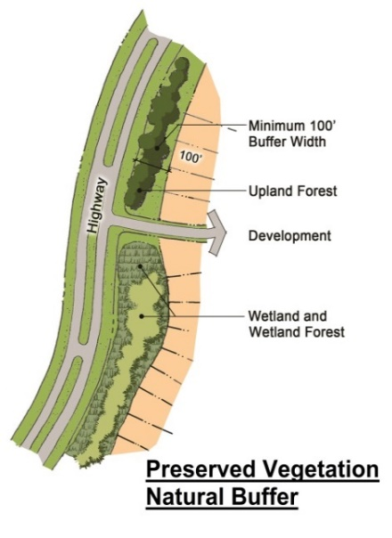
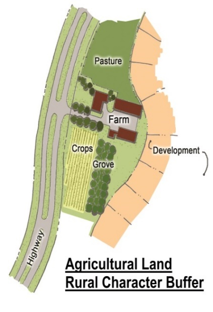
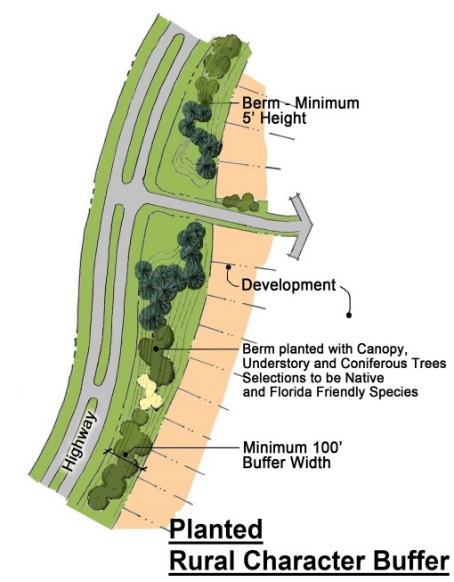
Protecting scenic views and elements of the rural character outside of the UGB by avoiding new development fronting directly onto existing public designated federal, state, or county highways, unless an alternative rural character/natural buffer a minimum of one hundred feet (100') in width is provided. Such buffer shall provide a seamless continuation of surrounding agricultural character as illustrated in Figure 3.5.1a.
Figure 3.5.1a. Rural Character/Natural Buffer Examples
 |  |  |
f.
Preserving and maintaining historic and archeological sites and structures that serve as significant visible reminders of the County's social and architectural history;
g.
Providing for active and passive recreational needs of County residents, including implementation of the Comprehensive Plan;
h.
Providing greater efficiency in the siting of services and infrastructure by reducing road length and the amount of paving for development;
i.
Creating more compact rural neighborhoods accessible to shared open space amenities and with a strong community identity; and
j.
Providing for enhanced public safety through the use of the National Fire Protection Association (NFPA) Firewise recommendations where feasible in the design of home sites and development clusters for protection from potential forest fires, wild fires, and controlled burning activities.
2.
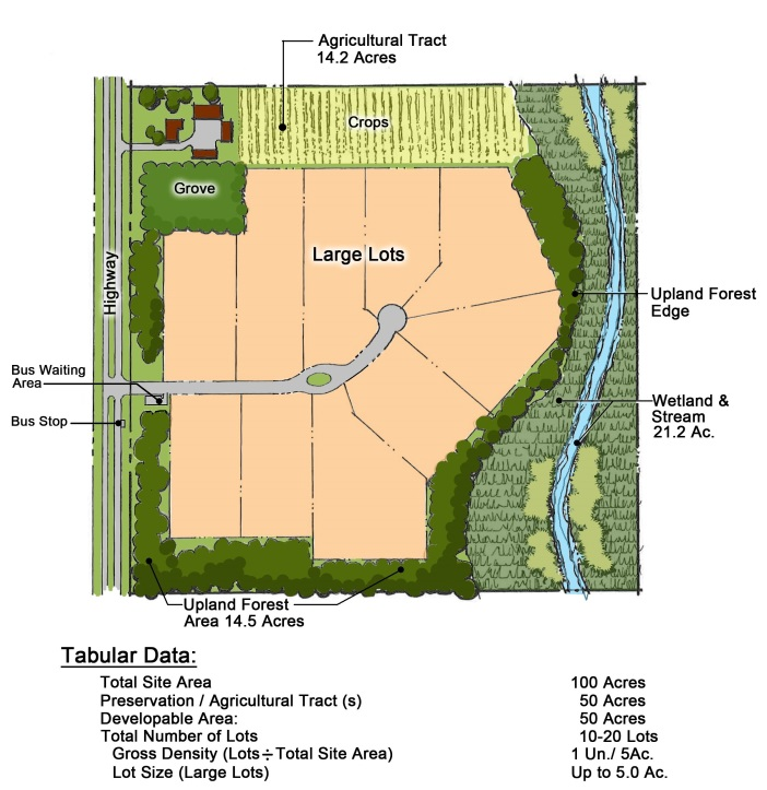
Project Size. The minimum project size shall be one hundred (100) acres, which shall be divided into Preservation/Agricultural Tract(s) and Developable Area Tract(s) as illustrated on Figure 3.5.1b. The project Developable Area Tract(s) consists of Residential Tracts and/or Common Area/Recreation Tracts.
3.
Preservation/Agricultural Tracts. A minimum of fifty (50) percent of the land area within the project shall be set aside as one or more "Preservation/Agricultural Tracts."
a.
A Preservation/Agricultural Tract shall be dedicated for conservation, agricultural, or recreational open space, which shall be permanently preserved via easement and managed by the agricultural owner, homeowners association, property owners association, land trust, conservation organization, public agency, or other ownership and maintenance entity as defined/referenced on the plat. With the exception of non-subdivided ancillary agricultural support residential, the easement dedication shall remove all residential development rights from the open space, be in favor of the management entity, and managed by the same.
b.
Preservation/Agricultural Tracts shall be located in a manner that optimizes the land maintained as open space to retain agricultural functions, promote recreational opportunities, minimize fragmentation of area resources, and/or preserve existing ecological connections.
c.
Significant native habitat shall be designated as part of a Preservation/Agricultural Tract wherever feasible. Native habitat includes, but is not limited to: upland forests, flatwoods, oak scrub, sand pine scrub, and/or sites listed on the Florida Natural Areas Inventory (FNAI) that are part of the ecologically connected matrix of natural areas significant for wildlife habitat and water quality protection.
d.
Preservation/Agricultural Tracts may be made up of agricultural/ranching uses and associated ancillary support residential, public/civic spaces with recreational open space permitted by zoning, upland buffers to wetlands, wetlands, water bodies or watercourses, or trail links, as well as larger areas containing significant native habitat as mentioned above.
e.
Preservation/Agricultural Tracts shall be a minimum of three (3) acres or be sized appropriately for the intended use.
f.
Management Plan: If the Preservation/Agricultural Tract is not preserved for agricultural/ranching uses and maintained by the agricultural/ranch owner, the developer shall, in cooperation with other local, state and federal agencies and entities, create a Management Plan to be approved by the County Manager for the tract. The Plan shall include provisions to provide management activities necessary to preserve, enhance, restore, conserve, maintain, or monitor the land, as appropriate. The Plan shall ensure all uses are consistent with preservation, enhancement, restoration, conservation, and maintenance of the land, and shall estimate the annual capital and operating costs of implementing the Plan. Management activities included in the Plan may include, but are not limited to: exotic/nuisance plant species removal, native vegetative communities' restoration, natural hydrology restoration, natural fire regime restoration, feral hog or livestock removal from natural areas, and similar activities. All Preservation/Agricultural Tracts shall remain in a condition consistent with the approved Management Plan, (if applicable).
4.
Common Area/Recreation Tracts. Within the project Developable Area Tract(s), Common Area/Recreation Tracts may include uses such as open space, active and passive recreation, stormwater management, buffers, and other uses or activities intended for use by residents of the Conservation Subdivision. Common Area/Recreation Tracts shall meet the residential recreation requirements as outlined elsewhere in the LDC.
5.
Residential Tracts. Residential density shall be one (1) dwelling unit per five (5) acres, based on total acreage. Minimum lot size, building height, and building setbacks shall follow the standards for LDR contained elsewhere in the LDC, and may vary depending on the type of potable water well and sewer treatment/disposal systems proposed. These standards shall meet the minimum required by the applicable state or County agencies reviewing the well and sewer treatment/disposal system. Other development standards shall be as follows:
a.
Accessory uses listed as ancillary in the residential siting standards shall be placed a minimum of five (5) feet behind the front entry of the principal structure and a minimum of five (5) feet from rear and side property lines. Accessory structures such as garages, garage apartments, carports, pole barns, stables, or like uses are exempt from this requirement, as are structures within the residential tract which are related to an agricultural exempt use in the Preservation/Agricultural Tract; however, such uses shall not be located within any easement that prohibits obstructions.
b.
Perimeter Buffer: To protect existing rural and agricultural uses, when a Residential Tract is adjacent to lots greater than or equal to five (5) acres, a developer may choose one (1) of the following buffer options:
i.
Separate the proposed Residential Tract from existing uses by a Preservation/Agricultural Tract meeting above requirements.
ii.
Provide a "Medium" buffer as outlined elsewhere in the LDC with fencing constructed of one the following materials: wooden post and horizontal wire; pre-cast concrete post and rail; three rail wooden fence; steel I-beam vertical posts with wooden rails; or Corten steel slatted fence.
Figure 3.5.1b Conservation Subdivision Tract Example
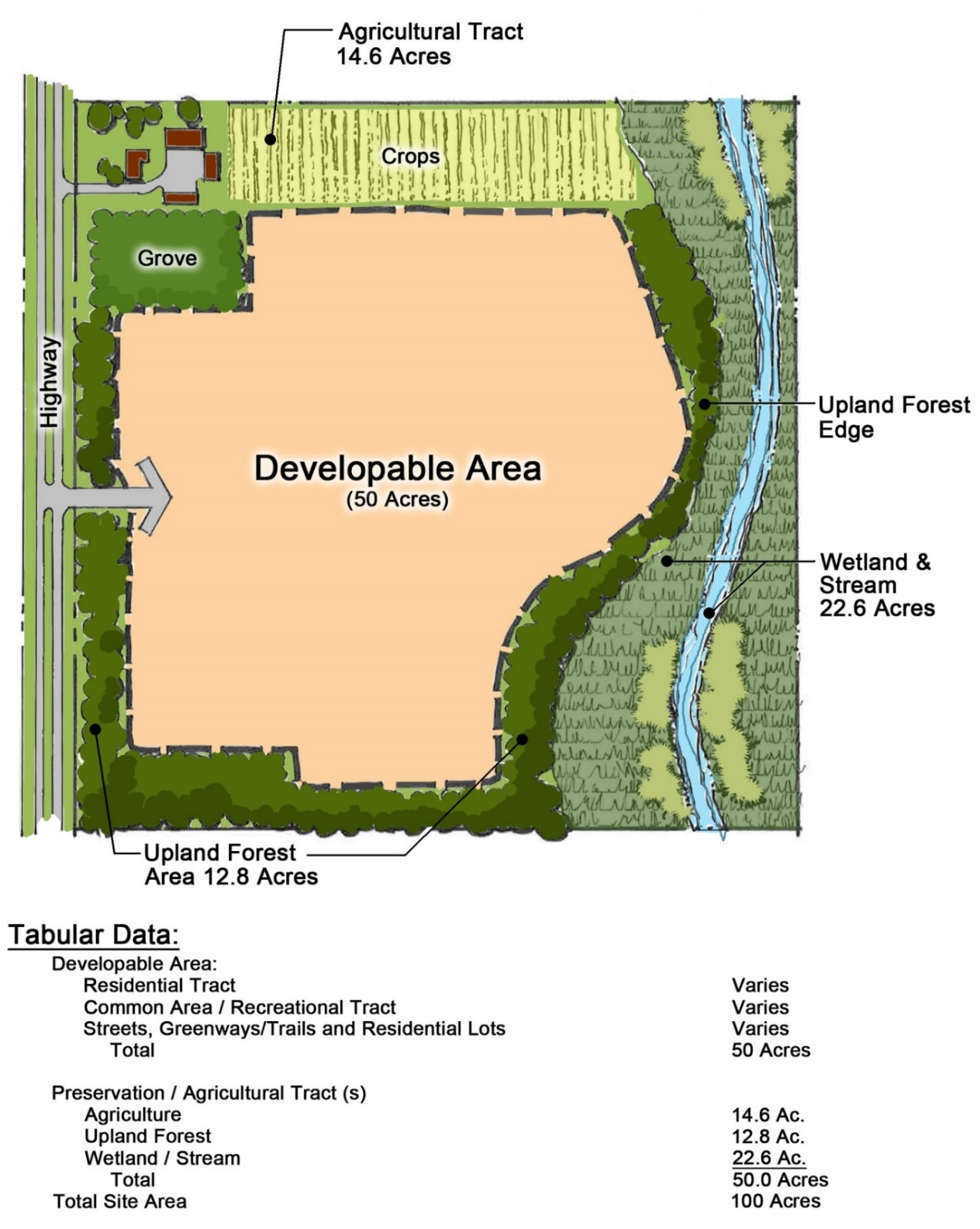
Figure 3.5.1c Small Lot Example
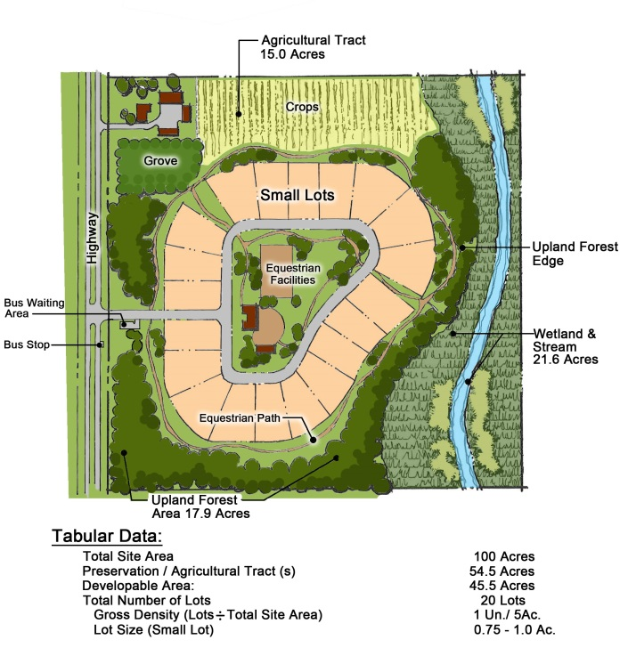
Figure 3.5.1d Large Lot Example
6.
Open Space and/or Recreation. Open space and recreation requirements may be provided in either the Preservation/Agricultural Tracts (in which case it must be available to residents of the development) or Common Area/Recreation Tracts, and shall be calculated as outlined elsewhere in the LDC. Preserved wetlands and water management areas, if designed appropriately with pedestrian access available, may contribute to the open space acreage, but because of their limited open space value, can in no case comprise more than fifty (50) percent of the required open space acreage as calculated on the Developable Area.
7.
Stormwater Management. To the extent that permitting agencies allow, stormwater management shall be governed by the standards contained elsewhere in the LDC. Stormwater management facilities that incorporate Low Impact Development (LID) practices and provide beneficial and functional wildlife habitat as outlined elsewhere in the LDC may be counted at one hundred (100) percent toward open space requirements.
8.
Potable Water. Water shall be obtained through either a public well accommodating the development or private wells accommodating each home, which shall be permitted and maintained through the applicable State or County agency.
9.
On-site Sewer Treatment and Disposal. The extension of central sanitary sewer systems outside the UGB shall be prohibited as outlined in the Comprehensive Plan Sanitary Sewer Element. Residential sewage treatment shall be provided through either a package treatment plant (public system) accommodating the development or through private systems accommodating each home, which shall be permitted and maintained through the applicable State or County agency.
a.
Should a package treatment plant be utilized, the effluent shall be disposed of by appropriate tertiary means other than settling ponds, as outlined elsewhere in the LDC for waste related services (bio-solid disposal).
b.
The use of reclaimed water and/or other non-potable sources of water shall be required as available through above tertiary treatment methods.
10.
Primary Access. Access to the Conservation Subdivision shall be provided from a state or County maintained roadway.
11.
Roadway Design Standards. All roadways within the conservation subdivision shall be governed by the standards contained elsewhere in the LDC and outlined in the Osceola County Road Construction Specifications, except:
a.
Lots smaller than one-half (½) acre and one hundred (100) foot width at the property line shall use an Osceola County Public Local Urban Roadway Section (with curb and gutter).
b.
Lots with a minimum of one-half (½) acre and one-hundred (100) foot width at the property line may use an Osceola County Public Rural Roadway Section.
c.
Private roadways shall be reviewed through Osceola County's subdivision process outlined elsewhere in the LDC. Alternative roadway cross-sections and materials may be approved through Osceola County's subdivision process.
d.
Developments meeting the requirements for a single access shall provide a turnaround at a minimum of every eight hundred (800) feet, based on the largest fire apparatus in the Osceola County Fire Department fleet.
12.
Internal Circulation. An interconnected pedestrian, bicycle, equestrian, and/or All-Terrain Vehicle (ATV)/Off-Road Vehicle (ORV)/Off-Highway Vehicle (OHV) circulation system shall be provided within the Developable Area Tract(s).
a.
If opportunity exists, provide linkages to existing and proposed offsite systems. The pedestrian, bicycle, and/or equestrian systems shall have safe and convenient access to the Preservation/Agricultural Tract from all residential lots. If the Preservation/Agricultural Tract is being utilized strictly for agricultural purposes a linkage may be provided; however, it is not required.
b.
Pedestrian walkways are required to provide pedestrian access to student waiting areas.
c.
ATV, ORV, and OHV connections through the Preservation/Agricultural Tract may be accomplished through the creation of a trail system platted as part of the Common Area/Recreation Tracts.
13.
Public Safety.
a.
Properties located within five (5) miles of an Osceola County Fire Station shall provide a UL listed fire alarm/early warning smoke detection system monitored by a UL approved monitoring company.
b.
Properties located more than five (5) miles from an Osceola County Fire Station shall provide a UL listed fire alarm/early warning smoke detection system monitored by a UL approved monitoring company. Property must also provide an approved NFPA 1142 "Standard on Water Supplies for Suburban and Rural Fire Fighting" water supply.
14.
Student Waiting Areas and School Bus Access.
a.
Though the School District will decide where school bus stops are placed, consideration should be taken in the planning phase to provide safe options. School bus stops are most often placed at the entrance of developments, though they may be placed at a central location such as a clubhouse, park, or trailhead. Locations such as these shall be planned as possible student waiting areas should the School District decide to utilize them, and shall meet the following criteria:
i.
The visibility of waiting students by vehicular traffic shall not be obscured; and
ii.
Parent vehicular waiting area shall be provided if the student waiting area is at the entrance, and is encouraged to be provided if student waiting area is centrally located.
b.
If the community is gated, above standards still apply, as well as the following standards:
i.
The gate opening shall be at least fourteen (14) feet wide to accommodate school buses and meet other County requirements regarding entrance gates as referenced elsewhere in the LDC;
ii.
Gates shall remain open long enough to allow school buses to safely enter and exit;
iii.
If a key pad is used to enter, one (1) shall be placed between six (6) feet and seven (7) feet from the ground to allow the driver to use it without exiting the bus.
Note: Regular buses will seldom enter communities that are gated, but the district may be required under Federal regulations to enter the community for exceptional students.
F.
GREENHOUSE OR NURSERY (COMMERCIAL). Commercial greenhouses or nurseries are permitted as indicated in the Use Tables subject to the following:
1.
Retail operations shall not occupy more than fifty (50) percent of the square footage of the primary wholesale use of the property.
2.
The retail operations shall have direct vehicular access to a boulevard or avenue.
3.
The retail portion of the property shall adhere to the parking requirements contained herein.
G.
HUNTING OR FISHING CAMPS. Hunting camps are permitted as indicated in the Use Tables subject to the following:
1.
Hunt camp permits shall only be approved as a temporary use during hunting seasons as defined by the Florida Fish and Wildlife Conservation Commission.
2.
Fishing camps must be located within five hundred (500) feet of a lake, creek or canal identified on a current tax map.
3.
Hunting or fishing camps must contain a minimum of five (5) acres with two hundred (200) feet of lot width or be adjacent to a hunting preserve.
4.
An application for a Hunt Camp permit must include the following supporting documents:
a.
Description of property providing legal description and confirming acreage.
b.
Photograph of dwelling unit to be used on site (mobile home, motor home, recreational vehicle or cabin).
5.
If an RV is located on the property, documentation from authorized RV dealer or repair facility confirming that a self-contained sewage system is operable, or a copy of a septic tank permit from the Osceola County Environmental Health Department.
6.
Site plan showing access and distance from County or state maintained road.
7.
Applicant to sign affidavit recognizing that emergency services may not be available to the site and stating that the site will not be used for permanent housing.
8.
No property approved as a hunting or fishing camp will be eligible for homestead exemption unless otherwise identified as such.
H.
PACKING HOUSES. Packing Houses are permitted as indicated in the Use Tables subject to the following:
1.
All storage, except for motor vehicles, shall be within completely enclosed buildings or may be located outdoors if it is effectively screened by a "High" buffer with a solid wall or fence at least eight (8) feet high. Minimum site development area shall be ten thousand (10,000) square feet.
2.
Processing plants for non-meat products. Processing plants for non-meat products include the packing of citrus, vegetables and fruits for retail consumption. These plants are permitted as indicated in the Use Tables subject to the following standards:
a.
Access to the plant shall be on a paved avenue, arterial, or framework street.
b.
Loading areas shall be screened using a "High" buffer from adjacent properties.
3.
Processing plants for meat products. Within three hundred (300) feet of a residential zoning or residential future land use district, all business, servicing, processing and product display concerning packing a meat product shall take place within a completely enclosed building. Processing plants for meat products are intended for the packing of meat product for retail consumption. These plants are permitted as indicated in the Use Tables subject to the following standards:
a.
Access to the plant shall be on a paved avenue, arterial, or framework street.
b.
Loading areas shall be screened using a "High" buffer from adjacent properties.
c.
All packing, butchering and related operations shall be conducted within enclosed buildings.
d.
The operation shall meet all Federal and State of Florida requirements and qualify for all Federal, state and local health permits.
I.
SAWMILLS. Sawmills are permitted as indicated in the Use Tables subject to the following:
1.
Mill shall have access to a County maintained paved collector, boulevard, or framework street.
2.
Sawmills shall not operate between the hours of 6:00 p.m. to 8:00 a.m. in the ARE district.
3.
The burning of wood is prohibited.
4.
Operations shall be on five (5) acres or more.
5.
The operation shall be a minimum of one hundred fifty feet (150') from a residential property line.
6.
A dust control containment system shall be installed prior to active operations.
J.
SLAUGHTER HOUSES. Slaughter Houses are permitted as indicated in the Use Tables subject to the following:
1.
All slaughtering, butchering and related operations shall be conducted within enclosed buildings.
2.
All offal shall be stored in water tight and odor tight containers.
3.
The operation shall meet all Federal and State of Florida requirements and qualify for all Federal, state and local health permits.
4.
All animal holding areas shall be located a minimum of one thousand, three hundred twenty (1,320) feet from any residential development or zoning district developed to or permitting a density of five (5) units per acre or greater; a minimum of five hundred (500) feet from any dwelling unit existing on adjacent property developed at less than two (2) units per acre at the time of the development or expansion of the use; and a minimum of three hundred (300) feet from any property line.
K.
TRANSFER OF DEVELOPMENT RIGHTS. Transfer of Development Rights (TDR) are permitted for lands as outlined in herein.
1.
Calculations for the TDR sending sites shall be calculated as follows:
a.
Base TDR Credit. A base TDR credit shall have a ratio of one (1) Base TDR Credit per two point five (2.5) acres of land determined as credit land. This Base TDR Credit applies to all properties as determined eligible in the Sending Areas. The allowable TDR credits that a TDR Sending Site may transfer to a TDR Receiving Site shall be determined eligible by multiplying the applicable TDR Credits to the acres of developable land after retained development rights, if any, have been deducted. Fractions of Base TDR Credits that result from calculations in this Section shall not be included in the final determination of Total TDR Credits available for transfer.
b.
Agricultural Preservation. In order to preserve agricultural land and enhance the ability to produce agricultural product, for every twenty (20) years that a TDR sending site has been maintained in continuous bona fide agricultural use, those lands may re-list their credits with County as if it were a new application.
c.
Multipliers. The following multipliers from the categories one (i) through (iii) below may be applied to the base TDR for each applicable unit. For categories with multiple options, multiple options may be applied per parcel. All calculations shall be added to the Base TDR Credits as calculated from the property's eligible TDR Sending Credits.
i.
Agriculture Multipliers. Continuous bona fide agricultural use shall be determined by the definition used by Florida Statutes in determining agricultural exemption. Base TDR Credits may be increased on TDR Sending Sites below for continuous bona fide agricultural uses as follows:
After ten (10) years that a TDR Sending Site has been maintained in continuous bona fide agricultural use, an additional one-half (0.5) TDR credits per Base TDR Credit can be applied.
ii.
Military Influence. A Sending Site within a Military Operations Area/Military Blast Zone (MOA/MBZ) area shall be eligible for increased TDR credits. A multiplier of one-half (0.5) TDR credits may be applied in addition to the Base TDR Credits.
iii.
Historic and/or Cultural Multiplier. For TDR Sending Sites within the Historic/Cultural Sending Area in unincorporated Osceola County designated on the National Register of Historic Places or by the Comprehensive Plan, local ordinance, or resolution as a significant cultural or historic property to meet the requirements of the Comprehensive Plan, an additional one-half (0.5) TDR credits per Base TDR Credits may be applied.
2.
Calculations for the TDR receiving sites shall be calculated as follows:
a.
The number of residential units on a Receiving Site within the Urban Infill area of the Urban Growth Boundary (UGB) may be increased or decreased above or below that allowed by its future land use designation through the purchase and utilization of TDR credits.
i.
Increasing Density. New development or redevelopment beyond the maximum density of dwelling units per acre designated may increase to a maximum of one hundred fifty (150) percent of the established maximum dwelling units per acre. This increase in density shall only occur through the use of TDR credits acquired from Sending Areas at a rate of one (1) TDR credit per every dwelling unit above the allowable units based on the maximum density.
ii.
Decreasing Density. Development below the minimum net density of dwelling units per acre designated may only decrease to seventy-five (75) percent of the established minimum dwelling units per acre. This decrease in density shall only occur through the use of TDR credits acquired from the Sending Areas at a rate of two (2) TDR credits per every one (1) dwelling unit/acre decrease.
b.
The number of residential units on a Receiving Site within the Urban Expansion area of the Urban Growth Boundary (UGB) may be increased or decreased above or below that allowed by its future land use designation through the purchase and utilization of TDR credits.
i.
Increasing Density. New development or redevelopment beyond the maximum density of dwelling units per acre designated may increase to one hundred seventy-five (175) percent of the established maximum dwelling units per acre. This increase in density shall only occur through the use of TDR credits acquired from Sending Areas at a rate of one (1) TDR credit per every dwelling unit above the allowable units based on the maximum density.
ii.
Decreasing Density. Development below the minimum net density of dwelling units per acre designated may only decrease to eighty (80) percent of the established minimum dwelling units per acre. This decrease in density shall only occur through the use of TDR credits acquired from the Sending Areas at a rate of three (3) TDR credits per every one (1) dwelling unit decrease.
L.
WASTE RELATED SERVICES (INCLUDING BIOSOLIDS TREATMENT FACILITIES). Biosolids Treatment Facilities, and also including but not limited to composting facilities, and other waste related uses shall be permitted as indicated in the Use Tables subject to the following:
1.
Biosolids Treatment Facilities and other waste-related uses shall meet all relevant Federal and state regulations. The minimum standards shall be pursuant to the Florida Administrative Code (FAC), as amended, and as authorized and monitored by the Health Department and the Florida Department of Environmental Protection.
2.
The owner, owner's authorized agent and/or operator of the Biosolids Treatment Facility shall be responsible for using site management practices pursuant to the FAC.
3.
Buffer/setback requirements shall be as provided in the FAC, as amended, with the following additional requirements: any portion of the proposed facility shall be located not less than one thousand five hundred (1,500) feet from any occupied building (except for occupied buildings in the proposed facility) or well, five hundred (500) feet from any property line associated with an existing residential home on adjacent property, water body or wetland, and/or two hundred fifty (250) feet from any non-residential property line.
4.
The Biosolids Treatment Facility or other waste-related use areas shall have direct paved access in fee simple or by private ingress/egress easement to an avenue or boulevard or other adequate access surface and/or design if approved by the County Manager.
5.
For any activity in the AC zoning district, the following additional minimum standards shall apply:
a.
Any activity shall be ancillary to the primary agricultural use.
b.
The owner, applicant and/or owner's authorized agent shall provide operational plan confirming hours of operation, sources of any imported residuals, haul routes, number of trucks entering and exiting the property, and practices for demonstrating compliance with minimum standards, with particular attention to odors, noise, water quality and airborne pathogens.
c.
All activities related to the Biosolids Treatment Facility, including any imported raw materials, processing of partially treated and fully treated materials, and storage, must be conducted inside an enclosed building (building or structure must have a roof and four (4) walls, which fully enclose the interior of the building from the floor to the ceiling, except for doors or mechanical ventilation systems in compliance with this Code) with an impervious floor and system for preventing leachate from leaking into the soils (e.g., approved liner beneath concrete, etc.) and groundwater beneath or surrounding the building. A Biosolids Treatment Facility incorporating a static aerobic pile and/or windrow method of treatment where there is no turning or disturbance within thirty (30) days after initial placement of the compost/biosolid piles or windrows and continuing throughout the active compost phase will be exempt from the requirements of conducting the treatment process inside an enclosed building, but shall be required to provide an impervious surface (e.g., i. synthetic liner such as non-woven PVC, polyethylene, or polypropylene under rigid pavement wearing surface, or ii. natural clay or bentonite clay liner under flexible pavement) for the treatment area and system for preventing leachate from leaking into the soils and groundwater beneath or surrounding the treatment area. The wearing surface must have a minimum structural number of a local street for flexible pavement or minimum thickness for a local street for rigid pavement provided for in the Land Development Code. The liner and impervious wearing surface shall be designed by a Florida Registered Professional Engineer to support pavement loads and protect approved liner from damage.
d.
Any proposed building, surface, or structure to be used for the Biosolids Treatment Facility or other waste related services that is located within the 100-year floodplain shall be constructed at least one (1) foot above the base flood elevation.
e.
The owner, applicant and/or owner's authorized agent shall obtain Site Development Permit, Building Permit, as well as permits from all other entities as required by state, federal and local law, in compliance with approved Conditional Use petition, including any conditions of approval.
f.
The owner, applicant and/or owner's authorized agent shall provide annual monitoring report to the County Manager in order to document compliance with Conditional Use approval, which shall include testing results (public drinking water standards plus lead and nitrates) from Health Department of any existing wells within a one-half (½) mile radius of Biosolids Treatment Facility.
6.
Any application for Federal or State approval, and applications for modification to an approved permit, shall be submitted to the County Manager within three (3) business days of submittal to the applicable agency.
7.
If at any time an approved Biosolids Treatment Facility or other waste related use is deemed to be non-compliant with its Conditional Use approval, including any FAC requirements, the County Manager may suspend the approval until such time as the activity is brought into compliance or revoke the approval, as deemed appropriate. County personnel may access the property to ensure compliance, with reasonable notification to the property owner, applicant and/or owner's authorized agent. This does not prevent the County from enforcing its regulations in any other means deemed consistent with this Code and applicable regulations.
M.
WATER BODIES FOR THE PROPAGATION OF MARINE FOODS. Water bodies for the propagation of fish for personal consumption is permitted as indicated in the Use Tables and subject to requirements of the Florida Fish and Wildlife Conservation Commission and the Florida Administrative Code.
(Ord. No. 2022-125, § 3, 2-20-2023; Ord. No. 2024-40, § 1, 7-15-2024)
3.6.1 - RESIDENTIAL USES
Items listed in the Residential Use Category of the Use Tables that are permitted but may be subject to the following siting standards within the zoning districts.
A.
ACCESSORY LIVING UNIT/GUEST HOME/TEMPORARY RESIDENCE. Accessory living units (ALUs) are permitted to be rented out only if the primary structure has a homestead exemption and, in this instance, shall only be rented out for long-term (not intended for short-term rentals) time periods. Attached or detached housing which does not meet the below criteria is subject to density requirements. Otherwise, accessory living units/guest homes or temporary residences are permitted as indicated in the Use Tables, subject to the following:
1.
Accessory Living Unit or Guest Home.
a.
All applications for guest homes or accessory living units shall provide architectural drawings of the proposed structure and photographs showing the complete front façade of the existing single family home. In addition, all development plans shall provide a property survey performed by a Florida registered land surveyor. The survey must show lot area and location of all existing and proposed structures.
b.
All such dwelling units shall be on a conforming lot, with a minimum lot area as prescribed in these regulations or agreed to under a PD zoning application and shall meet all other applicable building setback requirements unless otherwise exempted by this Code. No more than one accessory living unit or guest home shall be permitted per conforming lot.
c.
Maximum air-conditioned square footage shall be the lesser of the measurements shown in Table 3.6.1a.
d.
Accessory living units, or guest homes shall be architecturally compatible with the primary residential structure.
e.
Accessory living units may be either attached to the primary residential structure or detached from the primary residential structure.
2.
Temporary Residence. Deviations from the siting standards for a temporary residence, including the use of a recreational vehicle as such, must be approved as a variance by the Board of Adjustment. Manufactured homes and mobile homes are approved as a temporary residence and shall comply with the following standards.
a.
Shall be located a minimum of fifteen (15) feet from the principal dwelling.
b.
Manufactured homes shall be skirted.
c.
The setback requirements of the zoning district shall be met.
d.
A building permit must be issued for the setup of the temporary residence.
e.
For a temporary residence while constructing a principal single family residence or while repairing a principal single family residence damaged by fire, flood, hurricane or other catastrophes to the extent the principal single family residence is no longer able to be occupied, the following standards shall apply:
i.
Requires the issuance of a building permit for the principal single family dwelling. The required site plan shall show the location, size and description of the temporary residence.
ii.
Shall be approved for one (1) year or until the remodeling is complete, whichever is the shorter period, with a maximum extension of one (1) additional year. The temporary residence shall be removed from the property within thirty (30) days upon issuance of the Certificate of Occupancy for the principal single family dwelling, regardless of the approval time period.
f.
Temporary residence as a security residence within agricultural, commercial, institutional or industrial zoning district.
i.
The applicant shall provide evidence that a security residence, as opposed to use of periodic security patrols, is necessary to protect the property.
ii.
A security residence shall not be transferred to another owner or lease of the property unless the identical conditions exist and all site conditions remain the same.
iii.
Shall be approved for one (1) year and may be renewed upon application.
g.
Temporary residence for a medical hardship.
i.
The applicant shall provide proof, in the form of a letter from an attending physician that a medical hardship exists which requires that the infirm resident have continuous supervision.
ii.
Shall be approved for one (1) year and may be renewed upon re-application without limitation. If for any reason the infirm resident ceases to reside in the principal dwelling or the temporary residence, the applicant shall notify the Planning and Zoning Office and remove the temporary residence from the property within thirty (30) days upon notification.
B.
ANCILLARY USES/STRUCTURES INCIDENTAL TO THE PRIMARY STRUCTURE. Uses/structures to be considered ancillary are permitted as indicated in the Use Tables. Uses/structures include but are not limited to: canopies, pools, screen rooms, covered patios, bonus room, rumpus room, garages, storage/tool sheds, work rooms, skateboard ramps, sport courts, playing fields, and boat houses. Ancillary structures shall meet the ancillary structure yard setback requirements listed below, or if not listed below, of the district in which they are located. Similar ancillary uses/structures may be permitted upon approval by the County Manager. Specific uses as outlined shall be subject to the following standards:
1.
Skateboard Ramps Located in a Residential District.
a.
Shall be located on lots that have a minimum size of seven thousand five hundred (7,500) square feet.
b.
Shall comply with setback and height requirements for the principal structure, but in no case shall the ramp be located forward of the front building line.
c.
Ramps shall be screened from adjacent properties by a solid opaque fence or wall not less than six (6) feet in height.
d.
A building permit is required for the ramp structure.
e.
Ramps shall not be lit.
2.
Motor Course for ATV, Dune Buggy or Similar Off Road Vehicles.
a.
Shall be located on lots no less than two (2) acres in size.
b.
Shall be screened from adjacent properties by a solid opaque fence or wall not less than six (6) feet in height.
c.
Shall have no exterior site lighting.
3.
Storage Buildings and/Tool Sheds.
a.
An accessory storage shed, less than two hundred fifty (250) square feet and ten (10) feet in height, may occupy required side yards and rear yards, but shall not occupy required front yard unless otherwise provided for herein. An accessory storage shed greater than two hundred fifty (250) square feet shall not be located closer than as indicated in the zoning district standards for which it is placed to the side or rear property line. No accessory storage shed shall be located within a recorded easement.
b.
For lots having street frontage (double frontage) along both front and rear yards, accessory storage sheds shall be located in the yard which functions as the rear yard.
c.
Must be accessory and incidental to the principal dwelling or principal use.
d.
Vehicles, mobile homes, recreational vehicles, tractor trailers, cargo containers, temporary storage units or other structures not designed or constructed for this use shall be prohibited.
4.
Pools/Enclosures.
a.
Fencing shall be in accordance with the Standard Building Code.
b.
Enclosure.
i.
Screen mesh enclosures with or without a solid roof shall not be located closer than five (5) feet to the side or rear lot line. No screen mesh enclosure shall be permitted within a recorded utility easement.
c.
Required Placement. A private pool may occupy required side and rear yards, but shall not occupy required front yards unless otherwise provided for herein. A private pool and decking shall not be located closer than five (5) feet to the side or rear property line. No pool shall be located within a recorded easement.
i.
Corner lots shall require pools and their surrounding decking to be located in the rear yard. However, pools, decking and screen enclosures may be located within the side yard, provided the pool, decking and screen enclosure maintain the principal structure side yard setback required for the residential or commercial building.
ii.
For lots having street frontage (double frontage) along both front and rear yards, pools and their surrounding decking shall be located in the yard which functions as the rear yard, provided the pool is screened from the rear street by a fence, wall or hedge having a minimum six (6) feet of vertical height running along entire length of rear street property line.
iii.
Pools may be located within a front yard when authorized as a variance by the Board of Adjustment, provided the pool is enclosed by an architecturally finished wall.
5.
Sport Courts and Playing Fields, When Located in or Adjacent to a Residential District.
a.
All courts and playing fields shall meet the ancillary structure yard requirements of the district in which they are located.
b.
All outdoor lighting shall be cutoff and shall not shine directly onto adjacent properties.
6.
Pier, Dock or Boathouse. Are permitted as ancillary structures in residential districts and must meet the interior side setbacks for the principal structure.
C.
COMMUNITY RESIDENTIAL HOME. Community Residential Homes are permitted as indicated in the Use Tables subject to the following:
1.
The requirements and standards of the Florida Statutes shall be met. Community residential homes shall not be located as to result in a concentration of community residential homes. Number of residents shall be based on the maximum capacity of the facility.
2.
Community Residential Home A. Homes that otherwise meet the definition of a community residential home shall have no more than six (6) residents and shall be deemed a single family unit for the purposes of this Code. This home, if licensed through the State, shall be a permitted use as indicated in the Use Tables and does not require approval from the County. The home does require the sponsoring agency to notify the County of its existence.
3.
Community Residential Home B. This home shall have between seven (7) and fourteen (14) residents. The location of a community residential home "B" will be in accordance with State Law. Notification requirements of the sponsoring agency are found in Florida Statutes. The facility shall be designed and built in a similar fashion to a single-family home, a single-family townhouse, or a low density garden apartment. The facility shall meet all other provisions of this Code.
D.
DORMITORY, FRATERNITY, SORORITY, STUDENT HOUSING. Dormitory, Fraternity, Sorority or student housing is permitted as indicated on the Use Tables subject to the following standards:
1.
The house shall have a minimum of sixty (60) square feet per occupant.
2.
The house shall provide a minimum of one and one-quarter (1.25) parking spaces for each sleeping room provided.
3.
The house shall provide a "Medium" buffer as outlined herein, on sides and rear of property.
4.
Projects must be located within one (1) mile of the institution which the housing supports; authorization from an accredited educational institution shall be required.
E.
HOME OCCUPATION. A Home Occupation is permitted as indicated in the Use Tables subject to the following:
1.
The County Manager may authorize the operation of a Home Occupation only by approving an owner's/operator's affidavit, on the form approved by the County, which declares an owner's/operator's statement of compliance with all provisions of this section.
2.
A Home Occupation shall include, but not be limited to, the following businesses: domestic crafts, such as sewing, tailoring, washing and ironing, real estate services, bookkeeping, tax preparation, computer input or computer consulting services, telemarketing services, short-term rental property management office, medical transcription, beautician, mail order, internet/web based operations, contractor (office only), interior decorator/designer, products of homemade crafts (such as writer, painter, composer, etc.), private tutoring and instruction (limited to three pupils at any one time), and professional services.
3.
No person shall be employed other than members of the immediate family, all of which must reside on the premises.
4.
The use of the dwelling unit for the Home Occupation shall be clearly incidental and subordinate to its use for residential purposes. Not more than twenty-five (25) percent of the air conditioned floor area of the dwelling unit shall be used in the conduct of the Home Occupation and no more than twenty-five (25) square feet of merchandise may be stored, except for properties that are located within an Agricultural Development and Conservation (AC) zoning district that meet the minimum lot area and lot width requirements. No outside display or storage is permitted, except for properties that are located within an Agricultural Development and Conservation (AC) zoning district that meet the minimum lot area requirements.
5.
A Home Occupation within an Agricultural Development and Conservation (AC) zoning district that is located on a property that meets the minimum lot area and lot width requirements may store merchandise, equipment, vehicles and/or supplies on site when stored within the confines of a totally enclosed building that has been permitted through a building permit.
a.
The building is not limited in size but shall meet the minimum setbacks of the AC zoning district for a single family dwelling.
b.
The building shall be placed a minimum of five (5) feet behind the front entry of the principal dwelling. On properties that front more than one roadway, the building shall be placed a minimum of five (5) feet further from the property line along the roadway than the principal dwelling. The building shall at no time be closer to a roadway than the principal dwelling.
c.
Multiple buildings may be used for storage.
d.
No repair or maintenance of merchandise, equipment, vehicles and/or supplies is authorized on the property.
e.
All other criteria as defined in this section for Home Occupation shall be met within the AC zoning district.
6.
In addition to the above standard, a Home Occupation within an Agricultural Development and Conservation (AC) zoning district that is located on a property that is forty (40) acres or larger may also store merchandise, equipment, vehicles and/or supplies in an outdoor storage area.
a.
Sites located within the Urban Growth Boundary (UGB) shall provide a "High" buffer around the outdoor storage area as defined in Chapter 4 of these regulations.
b.
Sites located outside the Urban Growth Boundary (UGB) shall provide a "Medium" buffer around the outdoor storage area as defined in Chapter 4 of these regulations.
c.
An application for Home Occupation with outdoor storage area shall include a site plan showing the outdoor storage area and location and dimensions of the buffer.
7.
There shall be no change in the outside appearance of the building or premises as a result of such occupation, with the exception of an unlighted sign or nameplate. The sign or combination of signs shall be limited to not more than two (2) square feet in area, attached to and not projecting from the building.
8.
A Home Occupation may be conducted in any accessory building, provided the building is incidental to and subordinate to the primary residential structure except for properties that are located within an Agricultural Development and Conservation (AC) zoning district that meet the minimum lot area and lot width requirements.
9.
Mechanical equipment shall not be used on the premises, except such that is normally used for purely domestic or household purposes, nor shall it create levels of noise, vibration, glare, flumes, odors or electrical interference detectable to the normal senses outside the dwelling unit in excess of that normally associated with household use. In the case of electrical interference, no equipment or process shall be used which creates visual or audible interference in any radio or television sets off the premises, or causes fluctuations in line voltage in excess of that normally associated with household use.
10.
No products other than that produced on site may be sold on site. This does not preclude taking orders for sales or provision of services off-site.
11.
Traffic or parking demands to or from the residence shall not be generated by the residential use and Home Occupation in greater volume, frequency or type than ten vehicle trips per day, as defined by the Institute of Transportation Engineers (I.T.E.). Deliveries related to the home occupation shall not occur more frequently than twice per day, not including any deliveries made by the U.S. Postal Service. Parking demand shall be limited to a maximum of four (4) parking spaces on site.
12.
A Home Occupation shall not be interpreted to include activities such as, but not restricted to, auto repair and tune-up, general offices, clinics, physician's, dentist's and offices (except contractors) of the like, welding shops, animal hospitals, or kennels, catering or other food preparation businesses.
13.
Multiple Home Occupations shall not have a cumulative impact greater than the criteria for one occupation.
14.
A Home Occupation shall not be transferred to another owner or lessee of the property unless the identical conditions exist as to the specific occupation, number of persons operating the occupation, and all site conditions remain the same. Any transfer requires approval of the County, including a new application and affidavit as required herein.
15.
Home Occupation may be approved for up to one (1) year and must be renewed annually by making application to the County Manager. Upon filing a new application or renewing an application, the applicant shall sign an affidavit confirming compliance with the criteria contained in this section. If the applicant is not the property owner, a notarized letter of authorization for the business from the property owner shall be submitted at the time of application.
16.
A Home Occupation approval may be revoked by the County Manager upon any violation of these criteria, after written notice.
17.
Any denial or revocation of a Home Occupation may be appealed to the Board of Adjustment.
F.
MOBILE HOME/MANUFACTURED HOME AND RECREATIONAL VEHICLE PARK. Mobile Home, Manufactured Home and/or Recreational Vehicle Parks are permitted as indicated in the Use Tables subject to the following:
1.
The term parks in this chapter shall apply to sites designed to be rented for manufactured homes, mobile homes and Recreational Vehicles (RV), used as a permanent residence, as defined by the Florida Department of Motor Vehicles. A manufactured home, mobile home or RV shall hereinafter be referred to as a unit.
a.
It shall be unlawful for any person to construct, alter or extend any park within the unincorporated portions of Osceola County unless he or she holds a valid permit for the specific construction, alteration or extension proposed.
b.
Parks in existence prior to adoption of the Osceola County Zoning Regulations, February 22, 1972, and authorized by the Department of Health and Rehabilitative Services may continue to operate in accordance with requirements as governed by the Health Department standards and Florida Statutes. These parks will continue to be governed by the Health Department standards and regulations under which they were approved; however, stipulations of this Ordinance shall apply to new construction, alteration or expansion and may be required to correct substandard existing conditions.
c.
Any subsequent new construction or alteration that changes the basic design of existing lots and/or streets and any expansion of an existing park shall comply with the provisions of this Ordinance. Changes to the existing park, through involuntary action of the owner, shall not necessitate the drafting of a new plan to current standards of this Ordinance.
d.
Parks developed between February 22, 1972, and the date of adoption of this Code, may continue to operate in accordance with the Osceola County Zoning Regulations under which they were approved or the provisions of this Code.
2.
Approval of a park requires review and recommendation of a proposed site plan by Community Development Department's Development Review Committee.
3.
Site Preparation. The site shall be developed consistent with the standards on the proposed site development plan, other provisions of this Code, and the Osceola County Code of Ordinances.
4.
Development Standards.
a.
Access shall be from paved public rights-of-way and with suitable storm drainage. Recreational vehicle parks approved prior to March 26, 1970 are exempt from this requirement.
b.
A parcel containing not less than ten (10) acres of land shall be required for development (excluding wetlands). In the event the proposed site contains wetlands, the parcel must contain a minimum fifty (50) percent uplands.
c.
Individual lots, campsites or parcels within the park shall not be sold.
d.
All units shall be separated from park buildings and other units by a minimum of ten (10) feet. Accessory structures, including detached awnings, carports, and individual storage facilities, shall maintain a minimum of a ten (10) foot setback separation between any unit, like structure and/or park buildings. Attached awnings, carports and or individual storage facilities shall, for the purpose of maintaining required setbacks, be considered as part of the unit.
e.
All park buildings, units and accessory structures shall be set back from property lines abutting collector (avenue), arterial (boulevard), framework and local roads in accordance with Osceola County Ordinance 84-2, as amended by Ordinance 89-25.
f.
There shall be a minimum fifteen (15) foot setback between park boundary lines and all units, park buildings and/or accessory structures.
g.
There shall be a minimum distance of ten (10) feet between units, accessory structures or park buildings and the adjoining pavement of a park road or other common area.
h.
It shall be the responsibility of the park owner or manager to enforce setback requirements for the placement of any accessory structure or attachment to a unit within the park. All building permit applications shall be co-signed by the park management prior to submittal to the County to verify required setback.
5.
Park Buffers. The developer/owner shall provide and maintain a "High" buffer around the perimeter of the park to screen the development from adjacent properties and roadways. The buffer shall be in accordance with requirements of this Code. The requirements for a buffer may be waived by the County Manager where the development abuts a natural buffer area, such as rivers, lakes and marshes, which would effectively screen or separate the park from adjacent areas.
6.
Recreation Areas. All parks shall contain one (1) or more recreation area(s), which shall be easily accessible from all unit sites. Recreation areas shall be provided on the basis of a minimum of one hundred (100) square feet per unit site. Minimum size of recreation area in any park shall be two thousand five hundred (2,500) square feet.
7.
Internal street system. Safe and convenient access shall be provided from abutting park streets or roads to each unit lot.
a.
External public access to parks shall be designed to minimize congestion and hazards at the park's entrance or exit points. All traffic from internal streets shall enter or exit the park through approved entrance or exit points only. Direct external access from a unit lot to an abutting public street shall not be permitted.
b.
Each unit lot or campsite shall be designed so that automotive or RV parking, loading, or maneuvering (incidental to parking) shall not necessitate the use of any public street, sidewalk or right-of-way, or any private lots within the park or grounds that are not part of the park.
c.
All internal park roads shall be paved according to County standards.
8.
All park roads shall be lit and provide an average of 0.6 foot candle, with a minimum of 0.1 foot candle on all parts of the park road systems, and areas of hazard or intersections shall have a foot candle of 0.3.
9.
The size of the unit shall be governed by the size of the lot to be used so that all setbacks can be met. Units or accessory structures may not ingress setbacks.
10.
Accessory Structures. Accessory structures such as, but not limited to, permanent awnings, patio covers, carports, screen porches and or storage buildings shall be permitted only on designated permanent residency lots.
a.
Attachments may not exceed the length of the principal structure and must obtain building permits and be tied down, when required, in accordance with the building code requirements of the County.
b.
Attached awnings, patio covers, carports and screen porches shall be considered as part of the unit when measuring minimum setbacks between structures.
c.
Individual storage buildings may be placed next to the living unit, under a patio cover or awning or detached from the unit provided, if detached, it meets the setbacks from both the living unit and attachments and any surrounding structures or property lines.
11.
Parking. Parking for the park shall be provided as indicated in the Code. Parking on the park roadway system shall be prohibited.
12.
Pedestrian Systems. All parks shall provide safe, convenient, all-season pedestrian access. These facilities shall be of adequate width, and durable. All permanent resident spaces shall be connected to internal walks, streets, driveways or central parking areas.
13.
The park's water and sewer supply system shall be designed, constructed and maintained in accordance with the requirements of County codes and ordinances, the regulations of the County and State Health Department, pursuant to Florida Statute and other appropriate agencies.
14.
It shall be the responsibility of the management to collect and dispose of refuse in the park. The storage, collection and disposal shall be so managed as to create no health hazard, rodent harborage, insect-breeding areas, accident or fire hazards or air pollution. All refuse shall be stored in fly-tight, watertight, rodent-proof containers, which shall be conveniently located to the unit it serves. Containers shall be provided in sufficient number and capacity to properly store all refuse. Garbage shall be collected and disposed of as frequently as may be necessary to ensure that the containers shall not overflow.
15.
In addition to service buildings, watering stations and sanitary stations, other structures may be approved as part of the development review process. Such facilities may include:
a.
Management offices, maintenance buildings, owner or manager's residence;
b.
Swimming pools, recreation buildings or outdoor recreation facilities;
c.
Laundry facilities;
d.
Shops providing merchandise for the convenience of users.
16.
Responsibilities of the Park Management.
a.
The person to whom a permit for a park is issued shall operate the park in compliance with this Ordinance and shall provide adequate supervision to maintain the park, its facilities and equipment in good repair and in a clean and sanitary condition.
b.
The park management shall give the County Manager or his designee free access to all lots, service buildings and other community service facilities for the purpose of inspection.
c.
The management shall maintain a register containing the name, address, current trailer tag and term of occupancy of all park occupants. Such register shall be available to any authorized person inspecting the park.
G.
MODEL HOME AND PRE-CONSTRUCTION SALES OFFICE.
1.
The model dwelling unit shall meet all district requirements for lot and yard dimensions.
2.
Model home and preconstruction sales office signs shall not be illuminated after 9:00 p.m. in residential districts.
3.
The model dwelling unit or pre-construction sales office shall not be used for any business activity later than 9:00 p.m. in residential districts.
4.
At least five (5) off-street parking spaces per development shall be provided, which may be mulched. One (1) of the spaces must meet ADA requirements.
5.
Model dwelling units may be erected or displayed in districts which exclude residential uses, provided that such models shall not be used for residential purposes, but only for display as a means to sell homes in districts in which they are permitted and provided that all other requirements of the district in which the model dwelling unit is erected shall be met. Unit must be repurposed or removed when the development has reached substantial completion.
6.
A model home shall be permitted in conjunction with an active lot sale development.
7.
A temporary structure may be used as a pre-construction sales office for the purpose of displaying a typical dwelling unit arrangement, subject to the following restrictions:
a.
The structure shall be landscaped in accordance with other provisions of this Code.
b.
The structure shall be subject to the same front yard requirements as the principal structure to be erected and shall otherwise be subject to all yard requirements for the district in which it is located.
c.
Signs shall be permitted only in accordance with other provisions of this Code for the specified use.
d.
The structure shall comply fully with all existing building codes and ordinances of the County.
e.
The structure shall be completely and totally removed within six (6) months from the date of issuance of the first building permit for, or upon the completion of, the permanent residential dwelling structure, whichever date is later.
H.
MULTIFAMILY AND ATTACHED UNITS WITHIN LOW DENSITY RESIDENTIAL DISTRICTS. Up to six (6) units on a single lot that have the appearance of a medium to large single family home or duplex of up to five thousand (5,000) gross square feet and appropriately scaled to fit within single family neighborhoods. Cottage or bungalow courts are limited to six (6) per lot and shall only be permitted when integrated within a subdivision plan for new development. Parking lots are not permitted in front of the building façade which faces a public street. A buffer is not required between multifamily and single family structures within the LDR district.
I.
NURSING HOME OR ASSISTED LIVING. Nursing homes, Assisted living or Life Care treatment facilities and similar uses shall be permitted as indicated in the Use Tables subject to the following:
1.
Number of residents shall be based on the maximum capacity of the facility.
2.
Each facility shall provide adequate parking in accordance with other provisions of this Code.
3.
All life care treatment facilities shall have direct access to a paved and dedicated public street.
4.
Buffers and screening shall be as required in accordance with other provisions of this Code.
J.
SEASONAL SALES LOT. A seasonal sales lot permit is permitted in all zoning districts subject to the following siting standards:
1.
The permit may be granted for up to forty-five (45) days during official Federal holiday seasons.
2.
Products shall not be located in any right-of-way.
3.
All parking shall be on-site.
4.
The location of products on the property shall not block visibility for vehicles or pedestrians on or off the lot in a way that would create a safety hazard.
5.
Sales shall be limited to between the hours of 7:00 a.m. and 11:00 p.m.
6.
All trash and debris shall be removed when use permit expires.
7.
Written consent from the owner or authorized agent of the property shall be provided.
8.
A recreational vehicle may be used for security, provided it has all applicable permits.
9.
Signage and tents shall be in accordance with other provisions of this Code.
10.
Products remaining after the holiday shall be removed from the premises no later than seven (7) days after the holiday.
K.
SHORT TERM RENTAL. Short Term Rental is permitted in the Planned Development zoning district subject to the standards outlined for a Planned Development contained herein. The proposed developments must fall within the boundaries of the "Short Term Rental Overlay" as indicated in Exhibit 3.6.
L.
VEHICLE REPAIR IN RESIDENTIAL DISTRICTS.
1.
Only minor repairs and maintenance in residential districts may be undertaken on privately registered vehicles owned by the resident of the lot and having current State of Florida license plates, or motor vehicles designated by the State of Florida as qualifying for an antique or horseless carriage designation. For purposes of this section, activities are limited to the changing and replenishment of fluid levels, such as hydraulic fluid, windshield washer fluid, and lubricating oil; the replacement of spark plugs and ignition points; the rotation of tires and the checking of adequate pressure; and the replacement of drive belts and hydraulic lines, provided all repairs are completed within seven (7) days of commencement.
2.
Any other repairs on the motor vehicle or automobile shall be restricted to a totally enclosed building and only on privately registered vehicles owned by the resident of the lot and having current State of Florida license plates, or motor vehicles designated by the State of Florida as qualifying for an antique or horseless carriage designation.
3.
The automobile or motor vehicles referred to in this Section shall be licensed and registered to the resident of the address at which the limited repairs and maintenance or other repairs are to be performed. Repairs and maintenance shall not be performed on more than two (2) vehicles at a time.
(Ord. No. 2020-73, § 2, 12-14-2020; Ord. No. 2025-10, § 4, 3-17-2025)
3.7.1 - INSTITUTIONAL USES
Items listed in the Institutional Use Category of the Use Tables that are permitted but may be subject to siting standards within the zoning districts.
A.
AIRPORTS. Airports are permitted as indicated in the Use Tables.
B.
AIRCRAFT LANDING FIELDS. Aircraft landing fields are permitted as indicated in the Use Tables subject to the following:
1.
Aircraft landing fields and aircraft operations shall meet all relevant Federal and State regulations.
2.
Aircraft landing fields proposed within a Military Operations Area (MOA) and/or Restricted Airspace shall require notice to the Avon Park Air Force Range (APAFR) Commander, and shall provide demonstration of compatibility with the applicable MOA and/or Restricted Airspace.
3.
Approval of said aircraft landing field shall not significantly limit or prohibit operation of existing or approved airports, aircraft landing fields or ultra-light flight parks.
4.
Aircraft landing fields shall be classed according to landing field capabilities and intended uses as outlined below.
Class I
5.
Privately-owned landing field which meets minimum physical standards for use by small aircraft, and used primarily by licensee for personal use, and not open to public.
a.
Runway dimensions shall be no greater than one thousand, eight hundred (1,800) feet in length.
b.
A maximum of five (5) aircraft shall be based at the landing field at any one time. This number includes aircraft to be stored at the facility.
c.
Primary surface of runway, hangars and repair buildings shall be set back at least one hundred fifty (150) feet from perimeter property boundaries. All other structures shall be set back at least fifty (50) feet from perimeter property boundaries.
d.
Flight operations shall be restricted to V.F.R. (Visual Flight Rules) weather conditions.
Class II
6.
Privately or publicly-owned landing field which meets minimum standards for use by small aircraft and which is open for use by the public are permitted within the AC district subject to the following:
a.
Runway dimensions shall be no greater than three thousand, two hundred (3,200) feet in length.
b.
Primary surface of runway, hangars and repair buildings shall be set back at least two hundred (200) feet from property boundaries. All other structures shall be set back at least seventy-five (75) feet from perimeter property boundaries.
c.
Flight operations shall be restricted to V.F.R. weather conditions.
Class III
7.
Privately or publicly-owned landing field which has a runway in excess of three thousand, two hundred (3,200) feet in length, which has no published instrument approach procedure and which is open for use by the public shall only be permitted in conjunction with a planned development.
a.
Primary surface of runway, hangars and repair buildings shall be set back at least two hundred fifty (250) feet from perimeter property boundaries. All other structures shall be set back at least seventy-five (75) feet from perimeter property boundaries.
b.
Operations shall be restricted to V.F.R. weather conditions unless a specific variance is otherwise granted.
Class IV
8.
Public use landing field which has a published instrument approach procedure shall only be permitted within a planned development.
C.
BROADCASTING TOWERS/CELL TOWERS. See Communication Towers.
D.
BUS OR TRAIN STATIONS.
1.
A station comprises site access, parking (multi-modal access), transition plaza, platform (concourse), tracks and all appurtenances necessary to provide for the public safety, protection from the elements and public information. Multi-modal functions are defined as train, bus, automobile, bike and pedestrian means of travel to the station. The stations shall:
a.
Provide a safe, efficient and convenient configuration for inter-modal transfer at the station.
b.
Provide clear and easily understood transit information that can be referenced quickly and that minimizes disorientation.
c.
Develop operational efficiencies that simplify modal interchange and passenger processing.
d.
Minimize congestion at crossings of inter-modal functions.
2.
Architectural components are encouraged to:
a.
Create a civic identity that is indicative of the heritage and character of Osceola County.
b.
Protect transit passenger from adverse weather conditions, including sun and vehicular traffic.
c.
Provide seating at the shelter and other protected locations on the platform.
d.
Make transit a safe, secure, friendly and enjoyable experience and accessible to all, including the disabled.
e.
Develop systems that use maintainable materials and minimize life-cycle costs.
f.
Provide an architectural and urban form that defines and encourages joint development opportunities.
3.
Station development shall:
a.
Protect, maintain and enhance existing qualities which are valued.
b.
Promote desirable Transit Oriented Development.
c.
Recognize emerging development that can complement station development and increase ridership.
d.
Initiate and coordinate programs with the community that limit local traffic impacts and minimize disruption during and after the implementation phase.
E.
CEMETERIES. Cemeteries are permitted as indicated in the Use Table subject to the following: All requirements of the Florida Statutes regarding the internment of the human dead shall be met. In addition, the following standards shall be met:
1.
A minimum lot size for the entire cemetery site shall be eighty-five thousand (85,000) square feet.
2.
There shall be adequate space within the site for the parking and maneuvering of funeral corteges, parking may be grass.
3.
No interment shall take place within thirty (30) feet of any adjoining lot line.
4.
All structures shall be set back a minimum of twenty-five (25) feet from any boundary line of the cemetery property.
5.
All structures over three (3) stories in height must be set back from any perimeter boundary line of the cemetery a minimum of thirty (30) feet.
F.
COMMUNICATION TOWERS. Communication Towers are permitted as indicated in the Use Table, subject to the following:
1.
Height. Outside the Urban Growth Boundary (UGB), communication towers shall have a maximum tower height of one thousand (1,000) feet. Inside the UGB, the maximum height shall not exceed two hundred (200) feet.
2.
Design. All towers and telecommunications facilities inside the UGB shall be designed as a "camouflaged" design that is appropriate with the surrounding environment. The actual type of camouflage of the tower is at the discretion of the applicant with County approval during the Site Development Plan stage. The design of the building and related structures shall, to the extent possible regardless of in or outside of the UGB, use materials, colors, textures, screening, and landscaping that will blend the tower facilities to the natural setting and built environment. Outdoor storage is not permitted at a tower site.
3.
Within a Planned Development. Communication towers may be permitted within a planned development if the tower requested is being placed on commercial, industrial, or institutional lands within the PD.
4.
Fall Area. All towers shall be designed to fall within the boundaries of the parcel on which the tower is located. The applicant will provide a certified "fall zone" letter or tower design and certification drawing(s) stating same, to be provided at the time of building permit review. All towers shall be designed and certified by an engineer registered by the State of Florida. The Design and certification must establish that the tower is structurally sound and in conformance with the requirements of the County's adopted building and electric codes and all other applicable construction standards, as well as federal and state law. This certification shall be required at the time of building permit review.
5.
Finished Color. Communication towers and associated communication antennas that are not classified as camouflaged and not requiring FAA painting/marking shall have either a galvanized finish or be painted a non-contrasting blue or gray finish. The color should be selected so as to minimize the equipment's visibility. Compliance with these requirements does not mean that the tower is a camouflaged communication tower.
6.
Illumination. All communication towers, within the Urban Growth Boundary, a Military Operations Area (MOA), and/or Restricted Airspace, shall have lighting consistent with the U.S. DOT/FAA Advisory Circular "Obstruction Marking and Lighting."
7.
Landscaping. Landscaping and buffering of the equipment compound shall be considered an "Industrial Use" and provide a buffer as outlined herein located on the outside of the wall or fence provided to comply with the security barrier requirements. Further, existing vegetation shall be preserved to the maximum extent practicable and may be used as a supplement for the landscaping and buffering requirements. Communication towers located within the Rural/Agricultural future land use are exempt from landscaping and buffering requirements.
8.
Screening. Communication antennas and structures on which the communication antennas are mounted and any associated communications equipment shall be screened from view from public rights-of-way and residentially zoned lots in conformance with standards contained herein. The antennas shall be of a non-reflective surface material.
9.
Abandonment. If any tower shall cease to be used for a period of three hundred sixty-five (365) consecutive days, the County shall consider the site abandoned and the owner shall remove all tower structures from the premises.
10.
Clustering. Tower clustering is prohibited.
11.
Co-Location of Communication Antenna. New communication towers shall be engineered and constructed to accommodate the following, unless the applicant can demonstrate that such accommodation is not technologically, structurally, or cost feasible:
a.
A minimum of one (1) additional communication service provider for a total of two (2) or more providers (such as a personal wireless service provider) if the new communication tower extends less than seventy-five (75) feet above the ground.
b.
A minimum of two (2) additional communication service providers, for a total of three (3) or more providers if the new communication tower extends seventy-five (75) feet or more above the ground.
c.
If co-location is determined to be feasible, verification from an engineer registered by the State of Florida shall be submitted which demonstrates that the communication tower is designed to accommodate the required number of service providers.
12.
Co-Location on Existing Towers. If there is an existing permitted tower in the area that allows for opportunity to co-locate; an existing communication tower may be modified or rebuilt to a taller height, not to exceed twenty (20) feet over the tower's existing height, to accommodate the co-location of additional communication antennas. The communication tower's pre-modification height shall be used to calculate such distance separation requirements as outlined herein. The modified or rebuilt tower height may not extend past the maximum height limit. An Administrative permit shall be required for the increase in height. An alteration of the total height may be requested one (1) time per site.
13.
Development Review Committee (DRC). The following shall be provided with the DRC application:
a.
Elevations of the proposed structures showing width, depth, and height of the telecommunications facility as well as the specifications of the antenna and support structure.
b.
Where the telecommunications facility is located on a property with another principal use, the applicant shall present documentation that the owner of the property has granted an easement or entered into a lease for the proposed facility and that the vehicular access is provided to the facility.
c.
If co-location is determined to be feasible, verification from an engineer registered by the State of Florida shall be submitted which demonstrates that the communication tower is designed to accommodate the required number of service providers.
14.
Statement of Need. Proposed communications antennas may, and are encouraged to, co-locate onto existing communication towers or antenna support structures. Provided such co-location is accomplished in a manner consistent with this section, then such co-locations are permitted by right. Prior to approval of a proposed tower, the applicant shall identify all existing towers or antenna support structures within one-half (½) mile of the proposed tower and demonstrate that there is no option to co-locate on one (1) of those existing towers or antenna support structures. The communication tower's pre-modification height shall be used to calculate such distance separation requirements as outlined in Table 3-6 Communication Towers. Evidence submitted to demonstrate that no existing tower or antenna support structure can accommodate the applicant's proposed antenna must be submitted with the application and may consist of any of the following:
a.
No existing towers or antenna support structures are located within the geographic area required to meet applicant's engineering requirements.
b.
Existing towers or antenna support structures are not of sufficient height to meet applicant's engineering requirements.
c.
Existing towers or antenna support structures do not have sufficient structural strength to support applicant's proposed antenna and related equipment.
d.
Co-location of the applicant's proposed antenna would cause electromagnetic interference with the antenna on the existing towers or antenna support structure, or the antenna on the existing towers or antenna support structures would cause interference with the applicant's proposed antenna.
e.
The fees, costs, or contractual provisions required by the owner in order to share an existing tower or antenna support structure or to adapt an existing tower or antenna support structure for sharing are unreasonable. Costs exceeding new tower development are presumed to be unreasonable.
f.
There is a significant gap or dead spot in cellular coverage, and there are no less intrusive means or alternative sites available to fill the service gap, such as Distributed Antenna Systems (DAS).
g.
The applicant demonstrates that there are other limiting factors that render existing towers and antenna support structures unsuitable.
15.
Exemption. Amateur radio operator antennas are exempt from the provisions of this Ordinance.
16.
Miscellaneous Communication Equipment Cabinet Requirements. Communication equipment cabinets must comply with all government health, fire, and safety requirements. Information shall be submitted indicating the types and amount of any flammable, explosive, or other hazardous materials expected to be located in these cabinets. The placement, size, or number of cabinets shall be indicated on the site plan. Any cabinets located on a building must be screened from view from public rights-of-way or camouflaged cabinets shall be less than eight (8) feet tall and camouflaged. Communication equipment cabinets shall not be located on buildings primarily used as a single family dwelling, duplex or triplex.
17.
Miscellaneous Communication Antenna Requirements. Communication antennas shall not be mounted on buildings primarily used as a single family dwelling, duplex, or triplex. Communication antennas mounted on communication towers should utilize the minimum visible area practical and should be mounted in a manner which minimizes the visual impacts on residential areas, public rights-of-way, recreational areas and navigable bodies of water. Communication antennas which are mounted on self-supporting structures other than communication towers and other communication facilities shall only be allowed as an accessory attachment to the structure and shall be designed to blend in with the functional design of the structure.
18.
Noninterference. All communication facilities and communication equipment shall be designed or operated in a manner which complies with Federal statutes, rules and regulations, including but not limited to Federal Communications Commission (FCC) regulations relating to radio frequency interference Compliance with this requirement must be demonstrated by the applicant by using written information prepared by a communications expert or by submitting suitable FCC information which verifies compliance.
19.
Public Safety Exemption. All government communication towers with public safety systems or equipment shall be exempted from the siting standards herein. Any such exemptions shall not be considered as precluding the co-location or other service providers. Any co-location on government communication towers, sites or government property by other than for public safety systems or equipment shall comply with the co-location standards and requirements herein.
20.
Security Barrier. Within the Urban Growth Boundary, each communication tower and communication equipment cabinet shall be surrounded by a masonry wall or visually similar to masonry of at least eight (8) feet high, with a locked security gate. Barbed wire, razor wire, or other similar wire shall not be permitted, unless mandated by law. The height of equipment within the compound shall not exceed eight (8) feet in height. Outside the Urban Growth Boundary, each communication tower and communication equipment cabinet shall be surrounded by a masonry wall or visually similar to masonry, chain-link fence or fencing material approved as part of the site development plan.
21.
Separation Requirements. as measured from the base of a communication tower to boundaries:
Note: Compliance with all separation requirements shall be demonstrated on the SDP.
The separation distance may be reduced if applicant obtains consent from majority of property owners of residential or AC zoned properties located within the current tower height separation distance (the affected property owners). The maximum reduction shall be equal to the fall zone of the tower but in no case shall be less than sixty-five feet (65'). Separation requirements may be waived, for owners of multiple parcels that are adjacent to each other.
22.
Signage. All property with towers must be reasonably posted and secured to protect against trespass. Each structure on which communication antennas are mounted shall be posted with signage warning the general public to stay away from the antennas. The antennas shall contain no advertising or signage of any type, other than governmentally required signage.
23.
Communication Towers Within Military Base Operations. New communication towers proposed within a Military Operations Area (MOA) and/or Restricted Airspace shall require notice to the Avon Park Air Force Range (APAFR) Commander, and shall provide demonstration of compatibility with the applicable MOA and/or Restricted Airspace. If any communication tower is proposed in Osceola County it shall meet the height standards outlined in the JLUS, which puts their maximum height at one hundred (100) feet below the floor of any MOA or restricted airspace, whichever is more restrictive. Height requested in excess of the maximum permitted shall be subject to FAA Determination of No Hazard to Navigation (Letter of authorization from FAA).
G.
CORRECTIONAL FACILITY. The facility shall comply with all applicable Federal, state and local requirements.
1.
Prisons shall adhere to the following development requirements:
a.
The minimum lot size shall be fifty (50) acres.
b.
Structures that contain facility occupants shall be located at least seven hundred fifty (750) feet from the adjacent lot perimeter boundary.
2.
Community Correction Facilities shall adhere to the following development requirements:
a.
The minimum lot size shall be five (5) acres.
b.
Structures that contain facility occupants shall be located at least one hundred fifty (150) feet from the adjacent lot perimeter boundary.
H.
CIVIC/MEMBERSHIP ORGANIZATIONS. See Houses of Worship/Civic Organizations below.
I.
EDUCATIONAL FACILITIES. See Public School Siting Standards.
J.
EDUCATIONAL FACILITIES—PRIVATE. Private Schools are permitted as indicated in the Use Tables and subject to the following:
1.
Shall be permitted in all zoning districts when accessory to the following permitted uses: Houses of Worship, social service agencies, health care facilities or community centers and other similar institutional uses.
2.
Parking shall be provided in accordance with the provisions of this Code.
3.
A pedestrian walkway shall be provided that connects to the external pedestrian system to the facility.
4.
The setback requirements of the zoning district shall be met.
5.
Shall provide a "Medium" buffer as outlined herein, on sides and rear of property.
6.
If a circular driveway is provided for pick-up/drop-off of children, the following shall be required in addition: A one-way direction paved circular driveway, twelve (12) feet in width with a minimum inside turning radius of twenty (20) feet, and an area a minimum of fifteen (15) feet from the designated discharge point where the children are picked up or dropped off. If fire regulations require the designation of a fire lane, then the width of the circular driveway shall be at least twenty (20) feet.
7.
If an outdoor recreation area for the students is provided within one hundred (100) feet of a residential zoning district:
a.
The use of the outdoor area shall be limited to between 7:00 a.m. and 7:00 p.m.
b.
The area shall be fenced.
c.
The recreation area shall comply with setback requirements for accessory structures.
8.
A school containing more than fifty (50) students shall have direct access to a avenue, boulevard, or framework street, as defined under the Osceola County Functional Classification System.
9.
All private schools shall be located on a paved, publicly maintained road. Properties separated from a paved, publicly-maintained road by a utility right-of-way shall be considered to be located on the publicly-maintained road for purposes of this section, provided proof of legal access across the utility right-of-way is provided.
10.
Schools with more than one hundred (100) students shall conduct a detailed traffic study addressing:
a.
Traffic impacts of the project;
b.
All traffic operations requirements of the County; and
c.
Specific recommendations for safe and adequate ingress and egress to and from the site.
d.
Applicants shall meet with Osceola County staff prior to commencing the study, and shall implement the agreed-upon methodology in conducting their study. Osceola County staff shall use best efforts to obtain data from municipalities and other local governments located in close proximity to the project. The owner of a development shall conduct a follow-up review and update of the aforementioned items [listed in] subparagraphs 10a, b, and c no later than five (5) years after the date of issuance of a certificate of occupancy for the development. The results of such review and update shall be submitted to Osceola County for use in evaluating traffic impacts of similar future developments.
e.
In order to ensure pedestrian safety and adequate traffic circulation, a private school development proposing to locate within one thousand (1,000) feet from the nearest property line of any public school shall submit a traffic and pedestrian safety plan for Osceola County's review and approval, unless a physical barrier, such as a water body, wetland, or limited access highway, separates the public school from the private school development, thereby preventing pedestrian access to the private school development from the public school. Such plan shall identify pedestrian safety conflicts and deficiencies; especially that related to walking routes to schools, and other pedestrian generators, such as parks or trails used by children and by children with disabilities. Specific measures shall be identified in the pedestrian safety plan to mitigate each conflict, and the private school applicant shall be solely responsible for implementing the identified measures no later than at the time of issuance by Osceola County of a certificate of occupancy.
f.
In order to maximize efficient traffic circulation and minimize "stacking" at the main vehicular entrance, private school developments with more than one hundred (100) students shall allow a minimum of two hundred (200) feet off the roadway before the first turn within the parking lot; except that a minimum of one hundred (100) feet is allowed if there is a right-hand deceleration lane. A minimum of one hundred (100) feet shall be required for all secondary entrances.
K.
HELIPORTS/HELICOPTER LANDING PADS. Heliports are permitted as indicated in the Use Tables, however, Institutional Districts are exempt from these standards, all other districts are subject to the following:
1.
Heliports shall meet all Federal, state and local regulations.
2.
Landing and take-off areas shall be located a minimum of one hundred fifty (150) feet from any lot boundary and a minimum of one thousand (1,000) feet from any dwelling unit or residentially zoned property.
3.
All storage and repair of the aircraft shall be conducted in an enclosed building.
4.
Hangars and repair facilities shall be set back at least one hundred fifty (150) feet from any lot boundary and all other buildings shall be set back at least fifty (50) feet from any lot boundary.
5.
Parking shall be in accordance with other provisions of this Code.
L.
HOUSES OF WORSHIP/CIVIC ORGANIZATIONS INCLUDING FRATERNAL ORGANIZATIONS. Houses of Worship and Civic Organizations are permitted as indicated on the Use Tables subject to the following:
1.
All principal and accessory buildings shall meet the required setbacks and other building standards for the zoning district.
2.
Buffering and screening shall be provided from adjacent land uses pursuant to the requirements for buffers as outlined in the Code.
3.
Parking areas for civic organizations and Houses of Worship within the residential districts shall be located to the side or rear of the principal building and shall be visually screened from the public rights-of-way.
4.
All civic organizations and Houses of Worship that require more than ten (10) parking spaces shall be located on a paved, publicly maintained avenue, boulevard, or framework street.
M.
LANDING STRIPS. See Aircraft landing strips.
N.
PET RESCUE. Pet rescue organizations are permitted as indicated in the Use Tables, subject to a site development plan review by the DRC and the following standards:
1.
The structure housing the animals shall be completely enclosed and designed to suppress noise. Noise from boarded animals at the property line shall be subject to the County noise regulations.
2.
The structure housing the animals and any outdoor areas allocated for use by such animals shall be located a minimum of twenty-five (25) feet from any property line in the commercial districts and one hundred (100) feet from any property line in the Agriculture district.
3.
Hours of operation, including times for feeding and use of outdoor areas by the animals, shall occur between 7:00 a.m. and 9:00 p.m.
4.
No facility shall accommodate more than fifty (50) of any single species or one hundred twenty-five (125) aggregate species at any one time unless the additional animals are approved by the Board of Adjustment.
5.
Any facility where the animals are boarded overnight shall be considered a private animal shelter and shall be subject to the standards outlined herein.
O.
SOUP KITCHEN AS AN ACCESSORY USE. Soup kitchens as an accessory use to a government building or facility, civic organization, house of worship or hospital are considered a permitted use subject to the following standards:
1.
The service capacity of an accessory soup kitchen shall not exceed the allowable capacity of the structure.
2.
The hours of operation for an accessory soup kitchen shall be limited to between 7:00 a.m. and 8:00 p.m. except in emergency periods such as extended cold weather or natural disaster.
P.
SUB-STATIONS. Utility sub-stations are permitted as indicated in the Use Tables subject to the following:
1.
The uses shall be restricted to water pumping stations, water treatment plants, telephone exchanges, transformer step-down locations, public safety and similar uses required to serve the needs of the surrounding residential, office and commercial districts.
2.
Noise abatement measures or increased setbacks shall be used to ensure that noise levels produced by the facility do not exceed ambient noise levels of the surrounding area as measured at the zoning lot boundary.
3.
The facility shall be adequately screened and buffered from adjoining land uses, which may be of a lower intensity. The facility shall be considered an Institutional Use. Buffers and screening shall be in accordance with the buffer criteria of this Code for new facilities. Expansions to existing facilities shall be screened and/or buffered so that the expanded facility does not have any greater impact on the adjacent properties than prior to the expansion.
Q.
UTILITY PLANTS.
1.
Wastewater Treatment Plant Type 1.
a.
Interim wastewater treatment plants under five hundred thousand (500,000) gallons per day (GPD).
b.
For Type 1 plants there shall be a distance requirement of one hundred fifty (150) feet from the plant to any off-site agriculturally or residentially zoned or used land or to any on-site platted lot or dwelling units.
2.
Wastewater Treatment Plant Type 2.
a.
Permanent wastewater treatment plants under five hundred thousand (500,000) GPD.
b.
For Type 2 plants there shall be a distance requirement of two hundred fifty (250) feet from the plant to any off-site agriculturally or residentially zoned or used land or to any on-site platted lot or dwelling unit.
3.
Wastewater Treatment Plant Type 3.
a.
Wastewater treatment plants of five hundred thousand (500,000) GPD or greater.
b.
For Type 3 plants there shall be a distance requirement of five hundred (500) feet from the plant to the project boundary. There shall be no platted lots or dwelling units within this distance requirement.
4.
Neighborhood Pump/Lift Stations. Serving less than three thousand (3,000) equivalent dwelling units (EDU): There shall be no minimum distance requirement for neighborhood pump/lift stations.
5.
Master Pump/Lift Stations. Serving three thousand (3,000) EDUs or greater. There shall be a distance requirement of fifty (50) feet from the master pump/lift station to the edge of the lot. Only non-residential or agricultural structures and parking may be located within the specified distance. There shall be a distance requirement of one hundred (100) feet from the pump/lift station to any surrounding residential structures or building envelopes. A waiver of distance requirements for wastewater treatment plants and facilities may be approved by the Board of County Commissioners in cases involving practical difficulties, unnecessary hardship, or superior alternatives. These difficulties, hardships, and alternatives, may include, but not be limited to adjacency to environmentally sensitive land, major rights-of-way or retention areas. The waiver request shall be heard using the procedure for conditional use. In instances where the distance requirements are modified, additional conditions of approval may be required.
6.
Wind Farms. Wind farms or wind turbines are permitted as indicated in the Use Table subject to the following:
a.
New wind farms proposed within a Military Operations Area (MOA) and/or Restricted Airspace shall be required to comply with the standards established by the Federal Aviation Administration and/or those recommended within the Osceola County JLUS 2012, as applicable. If any wind farms are proposed in Osceola County they shall meet the height standards outlined in the JLUS, which puts their maximum height at one hundred feet (100') below the floor of any MOA or restricted airspace, whichever is more restrictive. Height requested in excess of the maximum permitted shall be subject to FAA Determination of No Hazard to Navigation (Letter of authorization from FAA).
b.
All wind farms or wind turbines within a Military Operations Area (MOA), and/or Restricted Airspace, shall have marking and lighting consistent with the U.S. DOT/FAA Advisory Circular "Obstruction Marking and Lighting."
3.8.1 - COMMERCIAL USES
Commercial uses are permitted in zoning districts as listed in the Use Tables are permitted with special sighting standards as outlined below:
A.
BED AND BREAKFAST/BOARDING HOUSE LODGING. Bed-and-breakfast establishments are permitted as indicated in the Use Tables subject to the following standards:
1.
Parking shall be provided in accordance with the provisions of this Code.
2.
Buffering and screening shall be provided in accordance with the provisions of this Code.
3.
All bed and breakfast establishments shall meet all applicable state and local regulations.
4.
A boarding house and bed and breakfasts containing more than fifteen (15) residents shall have direct access to an avenue, boulevard, or Framework Street, as is defined under the Osceola County Functional Classification System.
5.
Where boarding houses and bed and breakfasts are located within two (2) lots, or one hundred (100) feet from the boundary of a single family residential zoning district of lesser density than permitted in the zoning district in which said boarding house is located, then said boarding house shall be in scale with the building located within two hundred (200) feet of said boarding house. Said boarding house shall not deviate by more than thirty (30) percent from the median scale of such neighboring buildings as determined by site volume ratio and total building volume.
B.
BIG BOX RETAIL/WHOLESALE STORES. Big box stores are classified as single-tenant-occupied, standalone stores larger than seventy thousand (70,000) square feet of gross floor area, which may include home improvement centers or membership warehouse clubs. Big box stores are permitted as indicated in the Use Tables. Big box stores within an Urban Infill Center must comply with the Urban Infill Centers Standards contained herein.
1.
Parking Lot/Structured Parking.
a.
Off-street parking shall be divided into multiple "sub-lots" through the use of uninterrupted (except at crosswalks) landscaped pedestrian sidewalk pathways. Pedestrian pathways shall connect the sidewalks along the big box structure to parking areas, perimeter right-of-way sidewalks, transit stops, and all outparcel sidewalks. Crosswalks for pedestrian pathways shall be made visually prominent by using an alternative paving material other than asphalt, such as stained and stamped concrete, or pavers.
b.
Parking lot pedestrian pathways shall be installed, at a minimum, between the head-to-head stalls of each fourth row of parking [e.g., may be separated by up to two (2) rows of parking stalls]. The pattern of parking lot pathways shall be arranged so that at least one (1) pathway aligns with and provides a direct connection between the project's right-of-way perimeter sidewalk and the main pedestrian entrance of the big box structure.
c.
Pedestrian pathways shall be a minimum of six (6) feet wide. A landscape planter strip, minimum seven (7) feet wide, shall be installed on at least one (1) side of the pathway along its full length (except at crosswalks). One-third (⅓) of the pathway landscape planter strip shall be planted with shrubs, and one-third (⅓) with ground cover.
d.
Shade shall be provided along the entire length of pedestrian pathways by planting canopy trees at a maximum of forty (40) feet on-center along the pathway. Shade structures (pergolas or gazebos) with seating may substitute for segments of the required pathway canopy tree plantings.
2.
Building Placement. Site layout shall meet one (1) of the following requirements:
a.
The primary street edge shall be defined by the big box structure's front entrance primary façade or side entrance secondary façade;
b.
Outparcels shall front a street edge, with windows and doors along the street and double-sided entrances accessible from the street and the parking area internal to the development; or
c.
A masonry or pre-cast knee wall a minimum of thirty-six (36) inches high (measured from the crown of the road) shall be constructed. Pre-cast knee walls shall incorporate a brick or stone veneer surface architecturally compatible with surface materials used on the principal structure. Pre-cast knee walls that feature only a smooth or stucco finish shall be prohibited.
Knee walls shall include, on the street side, columns or other architectural elements that project a minimum of six (6) inches from the face of adjacent wall segments. Columns or architectural elements shall be spaced no more than forty (40) feet on-center; shall extend above adjacent wall segments between six (6) and eighteen (18) inches; and shall incorporate a flared finial or cap component. Wall segments between elements shall incorporate a continuous, flared cap block (or widened top edge for pre-cast) feature along the entire segment. The masonry wall cap block shall project from the wall face a minimum of three (3) inches. Pre-formed and decorative patterns and indentations shall be incorporated on any pre-cast concrete wall segments. Such pre-cast pattern(s) shall coincide with the principal structure's architectural trim and finish.
3.
Façade Treatments and Building Design. The following façade design standards are intended to ensure that the large buildings typical of big box developments are designed at a human scale; provide visible, attractive, and efficient building entrances; and enhance the character of the building so as to be compatible with the surrounding area. Building elevations, which shall be submitted with a building permit application, must show the following elements. Alternative designs that are demonstrated to meet the intent of this section may be approved by the County Manager.
a.
Building façades shall include jogs to allow for bay windows, shop fronts, balconies, civic spaces, outdoor seating, etc. Such articulation is to encourage the appearance of multiple storefronts, in lieu of one (1) large big box storefront.
b.
The street side and front of the structure will include individually-peaked, forward-projecting, and vertically-oriented exterior architectural forms and features, façades, and rooflines. Such forms will express the individual components (e.g., garden, grocery, pharmacy) on the façade. Façades shall be treated as two-story or three-story structures and articulated as such with shutters, towers, window treatments, or other elements.
c.
The building entry shall maximize the use of pedestrian-scaled windows (avoiding extensive opaque surfaces) along the street-facing façade containing the primary customer entrance. Such primary customer entrance façades shall incorporate a minimum of twenty-five (25) percent transparency (windows). Transparency calculations may include the glass surfaces of the customer entrance window system itself. The area of required transparency shall be calculated by multiplying the structure's linear frontage by a height (above adjacent finished pavement grade) of twelve (12) feet.
d.
The building entry shall be defined with an overhead projecting portico, arcade, or colonnade to extend, at a minimum, over the twenty-five (25) percent transparency area.
e.
As an alternative to (c) and (d) above, street-facing façades shall include covered porticos, arcades, colonnades, or a combination thereof, along a minimum of sixty (60) percent of the façade's horizontal length.
f.
The roof plane of such porticos, arcades, or colonnades shall not extend horizontally for more than fifty (50) linear feet without the substantially and proportionately sized, interrupting vertical architectural forms referenced above. The face (fascia) of such vertical forms shall project upward a minimum of fifteen (15) feet above the horizontal fascia of the portico, arcade, or colonnade lying below. The highest point of the fascia, or gable, of such vertical projections shall extend upward to a point at least as high as the horizontal roof line (parapet edge) of the big box development's principal structure. Such vertical forms shall be a minimum of twenty (20) feet wide, as measured at the base of the gable.
g.
Porticos, arcades, or colonnades shall cover the customer sidewalk below, providing a minimum pedestrian clearance (clear width) of twelve (12) feet between the structure and the supporting columns.
h.
Façades that face an adjacent street, but do not include the primary customer entrance (i.e., a side-street façade), shall provide the above-referenced porticos, arcades, or colonnades, and associated individual roofline vertical projections, along at least forty (40) percent of the façade. Such requirement shall apply only to any segment of a side façade that does not incorporate a garden center decorative perimeter wall system as described in this subsection.
i.
When a garden center is placed along a street-facing façade, a garden center decorative perimeter wall system may be substituted for the porticos, colonnades, arcades, and vertical form required above. Such garden center decorative wall systems shall be constructed of columns (posts) at least thirty-six (36) inches wide [or thirty-six (36) inches in diameter], and spaced no more than twenty-five (25) feet on-center along the garden center's perimeter.
j.
Garden center wall exterior foundations shall adhere to building façade landscaping requirements.
k.
All garden center columns shall be connected across their top portions with a substantial cross member cap. Columns or column cap components may extend above the horizontal cross members up to twenty-four (24) inches. The cap will feature colors, finish, dimensions, proportions, and trim details that are architecturally consistent with adjacent supporting columns and the principal structure. No store merchandise may protrude above the cap.
l.
Garden center wall systems may infill the gaps between columns and the upper horizontal connecting cross members with decorative metal fencing materials (e.g., wrought iron-styled aluminum fencing). Chain link fencing material, including vinyl-clad or other coated fencing, is prohibited.
m.
Black fabric mesh, or similarly opaque and approved materials, shall be installed on the interior side of decorative metal fencing to visually screen any materials that may be stacked or stored inside the garden center decorative wall system.
n.
Conceptual building elevations shall be required with the SDP submittal.
4.
Shopping Cart Retention. Big box developments using shopping carts shall install and maintain a system to retain all shopping carts within property boundaries. Location, type of device, and other pertinent information shall be shown on the big box site development plan. Permitted retention methods may include the following:
a.
Shopping carts equipped with a wheel locking mechanism and anti-tilt bar used in conjunction with an electronic barrier along the perimeter of the area where shopping carts are allowed. The wheel locking mechanism shall activate when the shopping cart crosses the electronic barrier;
b.
A system requiring a refundable deposit to use a shopping cart. Such deposit should be of a reasonable amount that would not deter use of the cart, but would encourage its return;
c.
A toll-free shopping cart recovery service system; or
d.
Any other mechanism or system approved by the County.
5.
Vacant Stores. To avoid the economic impacts of prolonged vacant projects and buildings, and to mitigate the visual blight created by vacant big box structures (e.g., parking lots that are abandoned, poorly lit, and/or barricaded; poorly maintained landscaping; darkened stores; unlit signage; boarded windows; etc.), vacant properties shall be maintained as follows.
a.
Maintenance standards: Big box developments must abide by the maintenance standards contained in Chapter 2.
b.
Barriers: A temporary barrier may be installed to discourage pedestrian and vehicular access onto the property. Barrier materials are limited to the following (Jersey barriers are not allowed):
i.
Temporary vinyl-coated chain link or decorative fencing that is kept in good repair, free of breaks, missing segments or slats, loose or rotting material, mold, mildew, rust, or corrosion.
ii.
Temporary landscaping pots used as barricades, which shall be maintained and kept in good repair. Sight distance and standards per Florida Department of Transportation Road Design Standards shall be met.
C.
CAMPGROUNDS OR RV PARKS. Campgrounds or RV parks are permitted as indicated in the Use Tables subject to the following:
1.
Shall be located with direct access to a paved avenue, boulevard, or framework street or adjacent to a natural resource, consistent with the protection of the resource.
2.
The minimum area allowable for a campground shall be five (5) acres. Parks that are intended solely for RV permanent residential uses shall adhere to the requirements pertaining to Mobile Home parks.
3.
Primitive campsites shall be located, designed and intended to afford the users an opportunity to camp in a quiet, uncongested and natural setting. The campground shall incorporate a continuous pedestrian and bicycle pathway throughout the entire area of the site, and amenities installed for use by guests.
4.
Each RV space, the administrative office, maintenance facilities, security quarters or any other similar use shall provide a connection to central water and wastewater treatment facilities. Common sanitary facilities, including showers, toilets and sinks, shall be provided for use by the visitors to the park.
5.
Within a campground, the following accessory uses are permitted:
a.
Recreation amenities restricted to use by guests, including pools, tennis and shuffleboard courts, recreation rooms, equestrian facilities, nature and walking trails, play grounds, tot lots, docks and similar facilities.
b.
Gate houses or similar facilities designed to provide security to the park and campground.
c.
Maintenance facilities.
d.
Administrative office space necessary for operation of the park and campground; and commercial or retail uses located internal to the park and restricted to use by guests, including convenience food and beverage items and recreational vehicle parts and ancillary commercial uses.
e.
The permitted ancillary commercial and retail uses shall, in addition to the requirements of this Section, comply with the following: The use shall be located and accessed via the internal campground system.
6.
Prohibited Uses. The uses, activities or improvements listed below are prohibited within a campground.
a.
Permanent residential use of any park land, camping cabin, tent, structure or facility is prohibited, excluding occupants of any security quarters that may be established in the park. Residence in any recreational vehicle space shall comply with the requirements established for mobile home parks.
b.
Parking of recreational vehicles in areas not designated for such use is prohibited.
c.
The storage of recreational vehicles is prohibited.
D.
CONSTRUCTION TRAILERS/TEMPORARY OFFICES. Construction trailers or temporary offices are permitted as indicated in the Use Tables subject to the following:
1.
A licensed contractor or land excavation permitted engaged in a construction project for which a building permit or soil excavation operating permit has been issued by Osceola County, may temporarily use a construction trailer/modular office for office facilities in the location where the work is being done; provided such office shall not be placed upon a public street but upon the property on which the permit authorized the activity. The construction trailer/modular office shall be removed within thirty (30) days after completion of the work for which the permit has been issued. Septic tanks may be permitted by the Osceola County Health Department provided all applicable requirements are met.
2.
Use approval may be issued by the County Manager for a one (1) year period for the use of modular facilities as temporary offices while business properties are being remodeled, provided that they are placed upon the property for which there is a building permit issued by Osceola County for the remodeling. The permit shall be for a period of one (1) year or until the remodeling is completed, whichever is the shorter period. The permit may not be renewed after the expiration of the one-year period.
3.
Watch person trailers shall be limited to one (1) per construction site.
4.
Public toilet facilities shall be provided as required by the applicable codes.
5.
The County Manager may permit modular facilities as temporary offices within otherwise required building setbacks provided the applicant can demonstrate:
a.
Site placement will not have an adverse impact on adjacent property.
b.
Can adequately buffer, when required, the proposed site from the adjacent property.
c.
That lacking an alternative placement, in compliance with required setbacks, the applicant would be prohibited the use of such facilities.
E.
CONVENIENCE RETAIL WITH FUEL PUMPS. Convenience retail with fuel pumps are permitted as indicated in the Use Tables subject to the following:
1.
The use shall have direct access to an avenue, boulevard, or framework street in conformance with other provisions of this Code.
2.
Site lighting shall be in accordance with the standards contained herein.
3.
No repair services shall be permitted.
4.
Self-service ice buildings housed on the property shall be subject to the following:
a.
Shall not exceed four hundred (400) square feet in footprint area.
b.
Shall not exceed fifteen (15) feet in overall height as measured from the grade at the base to the top of the structure. The does not include the screening for mechanical equipment.
c.
Shall meet the required setbacks of the principal building(s) on the parcel and shall not be placed greater than fifty (50) feet distance from the principal building unless deemed necessary by the County Manager.
d.
Shall be architecturally compatible with the existing principal building on the parcel. Building elevations shall be required to render a determination. Architectural compatibility may be determined by, but not limited to Exterior materials and colors, style and architectural elements.
5.
Canopies provided over the pump islands shall not exceed the height, and shall meet the setback requirements of the principal structure. The setbacks shall comply with the following:
a.
The outside edge of the canopy may intrude into the required front yard, provided there is a minimum of five (5) feet remaining.
b.
The canopy shall not block visibility at intersections of rights-of-way or drives.
c.
All pump islands, their surrounding structures and the canopy support structures shall meet the zoning district's yard requirement for building setbacks.
d.
Fuel pump stations are comprised of a single or double fueling position.
6.
Convenience stores within an Urban Infill Center must comply with the setback and building placement contain in the Urban Infill Centers Standards. Pump stations shall be located behind the principal structure and shall be limited to the following:
a.
Neighborhood Center Core: Maximum of six (6) fuel pump stations.
b.
Community Center Core: Maximum of six (6) fuel pump stations.
c.
Community Center Perimeter: Maximum of eight (8) fuel pump stations.
d.
Urban/Employment Center Core: Maximum of four (4) fuel pump stations.
e.
Urban/Employment Center Perimeter: Maximum of six (6) fuel pump stations.
F.
DAYCARE/ADULT DAYCARE. Daycare facilities, whether for children or adults are permitted as indicated in the Use Tables subject to the following:
1.
Adult day care facilities shall be a permitted use without regard to subsequent standards set forth in this Section and/or if such uses are accessory to the following permitted uses: houses of worship, social service agencies, health care facilities, community centers, or elderly housing developments in addition to those districts outlined in the Use Tables. Adult daycare facility uses shall:
a.
Be placed such that the location and extent of the facility shall not adversely affect the character of the surrounding development.
b.
Be located in a building that is in scale with the buildings located within two hundred (200) feet of said building or provide a "Low" buffer to the adjacent land use.
c.
The buildings shall not deviate by more than thirty (30) percent from the median scale of neighboring buildings as determined by site volume ratio and total building volume.
d.
No overnight lodging shall be permitted for any type of adult day care facility.
2.
Child day care facilities shall be permitted as indicated in the Use Tables subject to the following:
a.
If a circular driveway is provided for pick-up/drop-off of children, the following shall be required in addition: A one-way direction paved circular driveway, twelve (12) feet in width with a minimum inside turning radius of twenty (20) feet, and an area a minimum of fifteen (15) feet from the designated discharge point where the children are picked up or dropped off. If fire regulations require the designation of a fire lane, then the width of the circular driveway shall be at least twenty (20) feet.
b.
If a fenced outdoor play area for the children shall be provided. The use of the fenced outdoor play area shall be limited to between 7:00 a.m. and 7:00 p.m. if the fenced play area is within one hundred (100) feet of a residential zoning district.
c.
The location and extent of the facility shall not adversely affect the character of the existing neighborhood.
d.
The child care center shall be of a design, intensity and scale to serve the surrounding neighborhood and be compatible with the surrounding land uses and zoning.
e.
Child care centers for more than fifteen (15) children shall have direct access onto an avenue, boulevard, or framework street in conformance with other provisions of this Code.
G.
FLEA MARKET—OPEN AIR. Flea markets shall be permitted as indicated in the Use Tables subject to the following:
1.
Uses authorized for flea markets shall include retail outlets for new and used general merchandise, gift and sundry items, food, produce and bakery, clothing, furniture, books and appliances, tools and automotive parts; shops for personal care services such as barbers and hairdressers; artisans and crafts persons and their wares; retail sales display areas for home improvement items such as screen rooms, spas, etc.; and concession space to include beer sales for consumption on premises only.
2.
The use shall have direct access to a avenue, boulevard, or framework street.
3.
All vendors shall obtain a business tax receipt from Osceola County and shall have said receipt displayed on site.
4.
A minimum of seventy (70) percent of sales display area shall be within covered structures built to building code standards, and a maximum of thirty (30) percent of sales area to be provided as a paved open air display.
5.
Expansion of sales display areas, covered or uncovered, shall require separate County approval.
6.
One temporary storage unit, maximum size eight feet by ten feet (8' × 10'), shall be permitted for each covered sales display area, provided they do not encroach upon parking spaces or walkways, or create safety hazards.
7.
Internal tenants' signage shall not be visible from public roads or sidewalks and do not require a permit from Osceola County.
H.
FOOD TRUCKS/LUNCH TRUCKS. A Food Truck shall be defined as a vehicle (including trailers) operated by a mobile food vendor to prepare and sell food at multiple locations. A Lunch Truck shall be defined as a vehicle operated by a mobile food vendor to sell pre-packaged food, such as ice cream and sandwiches, at multiple locations. Mobile Food Service Operations shall be permitted as indicated in the Use Tables subject to the following:
Food Trucks Temporary Use Standards
1.
Operator shall obtain a special event permit that shall only be permitted on private property.
2.
Operate no later than 10:00 p.m. on weekdays, Sunday to Thursday, 12:00 a.m. (midnight) on weekends, Friday and Saturday.
3.
No permitted sale of alcoholic beverages.
4.
No temporary structures or stages permitted.
5.
Provide notarized letter from the property owner of record or authorizing agent granting permission to use the property for such use.
6.
Provide all parking on private property ensuring that the required spaces for the primary establishment are available.
7.
Where outdoor seating is provided, it shall be secured by fencing or such other means to ensure safety and shall not encroach into required parking spaces, driveways or sidewalks.
8.
Provide and place in full view copies of all required state licenses.
9.
Location of refuse collection and sanitation facilities shall be provided to the County prior to operation.
Food Trucks—Permanent Use (Primary and Accessory Uses)
Food Trucks are permitted on a permanent basis as indicated on the use table. A Site Development Plan (SDP) for the entire property is required for any proposed permanent food truck use. Permanent Food Trucks shall only be permitted as an accessory use within the East U.S. 192 Community Redevelopment Area (CRA). Two (2) or more food trucks is considered a primary use regardless of the presence of other uses on the site.
1.
The food truck operator shall obtain a notarized letter from property owner of record authorizing use of the property and any terms of such use.
2.
Sale of alcoholic beverages may be permitted in accordance with state laws; copies of all required state licenses shall be in full view at all times.
3.
The area occupied by the food truck shall be clearly delineated on a Site Development Plan and demonstrate that parking standards for all approved uses on the property shall be met.
4.
Parking shall adhere to the following:
a.
Accessory use shall ensure that the required spaces for the primary establishment are available.
b.
Primary use shall provide four (4) spaces for the first truck with two (2) spaces per each additional food truck. Where the food trucks are co-located with another primary use, the parking requirement is reduced to one (1) space per each additional truck and must ensure that the required spaces for the co-located primary use are available.
5.
Food trucks shall not operate on fuel-based generators.
6.
Indoor sanitation facilities shall be available on-site to food truck patrons at all hours of operation; entrance to indoor sanitation facilities shall be well lit and easily observable by patrons of the site. An agreement or other writing executed by the property owner of record regarding the use of sanitation facilities must be presented with the submittal of a SDP.
7.
There shall be trash receptacles located near the seating area(s), and trash and debris will be removed from the area daily; food truck vendors shall use commercial on-site refuse collection facilities and services, including the removal of grease in compliance with utility provider requirements.
8.
Six (6) seats shall be available for the first food truck, with an additional three (3) seats for every other truck thereafter. Seating areas shall be clustered and separated from service, vehicular circulation, and parking areas.
Seating for less than four (4) food trucks shall be permanently affixed or stored in an approved location during times the food truck is not in operation. Where four (4) or more trucks are present, seating shall be within an internal courtyard and shall be covered or in a shaded area.
9.
Pedestrian and seating areas shall be delineated from the drive-aisles and vehicular parking spaces through the use of alternative paving or pavement treatments, landscape islands, planters, decorative fence, or other decorative vertical treatment (min. thirty (30) inches/max. thirty-six (36) inches in height).
10.
Where the property abuts the property line of a residential lot(s), Food Trucks shall not operate later than 10:00 p.m. on Sunday to Thursday; and 12:00 a.m. (midnight) Friday and Saturday, unless otherwise approved at a public hearing.
Lunch Trucks
1.
Lunch trucks are allowed in industrial zoning districts and construction sites, regardless of the zoning district, for no more than thirty (30) minutes in any six (6) hour period, unless otherwise approved through a Special Event permit.
2.
Shall only be permitted on private property with the property owner's consent.
3.
No permitted sale of alcoholic beverages.
4.
No temporary structures or temporary signs permitted.
5.
No outdoor seating set-up is permitted.
6.
Provide and place in full view copies of all required state licenses.
I.
GOLF DRIVING RANGES. Golf Driving Ranges not associated with a golf course, are permitted as indicated in the Use Tables subject to the following:
1.
The site shall be of such configuration so as to permit a minimum driving distance of three hundred fifty (350) yards from each proposed tee.
2.
A site plan of the facility shall be submitted showing the layout of the property with all fairways, roughs, greens, structures, off-street parking areas, fencing and proposed plant materials and locations.
3.
Lighting used at the site shall be designed, located and constructed so as to prevent glare and minimize reflection onto neighboring property.
4.
A Minimum required "High" buffer shall be on all sides of a golf driving range.
J.
MARINA AND DOCKING FACILITIES. Marinas and docking facilities are permitted as indicated in the Use Tables subject to the following:
1.
The provisions of these regulations shall establish minimum requirements for the permitting, siting, design, construction, and operation of marinas to serve the needs of boaters, while properly managing the State's natural resources, and protecting public health. For the purposes of determining permitted uses, a marina or docking facility shall be any facility on or adjacent to the water which provides for mooring, berthing, transfer, or storage of vessels, and which includes any or all of the related ancillary structures and functions of marinas such as but not limited to: docks, piers, piles, anchorages, buoys, boat lifts, hoists, shade structures, boathouses, vessel storage areas, boat ramps, anchorages, breakwaters, channels, locks, moorings, basins, vessel repair services, vessel sales, sales of supplies which are normally associated with boating, such as vessel fuel sales, bait and tackle sales, vessel rentals, and parking areas for users of the marina. For the purposes of determining siting standards, marinas are categorized as recreational operations which include planned community marinas, water sports clubs (including those with nominal fee general members) and co-ops for limited customer base; commercial facilities which are operated for the general public; or, public facilities operated by governmental agencies.
2.
Siting standards shall apply to any commercial, public, recreational, or private marina that is on or adjacent to the water and: 1) contains five (5) or more slips, or 2) provides berthing for one or more head boats, any vessel maintenance or repair yard that is on or adjacent to the water, all public, commercial, or recreational boat ramps, or associated upland ancillary facilities such as fueling or vessel maintenance facilities; or, 3) provides a lake access facility that transfers boats from dry land or another water body using a boat lift, hoist, lock, or any similar facility. These standards under Section J shall not apply to: 1) Private marina and docking facilities for personal use only; or 2) Facilities in compliance with an adopted Conceptual Master Plan (or adopted Alternate Conceptual Plan) or Concept Plan approved for a Mixed Use District; or 3) marina and docking facilities on manmade lakes or water management systems without boat access to a natural lake or private or non-navigable water bodies; or 4) repair or replacement of existing marina facilities that does not increase boating capacity.
3.
Commercial Marinas shall be subject to the following standards:
Commercial marinas, operated for profit, are permitted as indicated in the Use Tables subject to the following:
a.
A siting and design study in accordance with the application shall be submitted prior to any permit approval.
b.
Inside the UGB Commercial Marinas may only be allowed on sites which have direct access to a collector (avenue), or arterial (boulevard) road.
c.
When located within the UGB, shall connect to central water and sewer services.
d.
May only be authorized on sites with a minimum of one (1) acre.
e.
Support Facilities may include but are not limited to installations or services that support the functions of a marina, such as utility services, fueling stations, repair and launching facilities, the marina headquarters, parking, picnic areas, recreation areas, retail facilities and eating establishments catering to the boating and aquatic recreational needs of marina users, and restrooms, showers, and laundries.
f.
Vessel Repair/Maintenance and Storage Yards may be authorized as part of the permitted use. All Repair/Maintenance and Storage Yards must be total screened from off-site view and Yard base shall consist of an all-weather surface.
g.
Trip For-Hire, Charter Vessels and other vessels for-hire may operate from Commercial Marinas when approved as part of the Use Permit.
h.
Tournaments may be authorized as a Special Event and will require Special Event permitting through the County. Special Events shall be limited to six (6) times per year.
4.
Public Marinas shall be subject to the following standards:
a.
Public marinas are owned by governmental agencies and operated with their own personnel or through a concession or other agreement with a private entity.
b.
When located within the UGB, shall connect to central water and sewer services.
c.
May only be authorized on sites with a minimum of one (1) acre.
d.
Support Facilities may include, but are not limited to, installations or services that support the functions of a marina, such as utility services, fueling stations, repair and launching facilities, the marina headquarters, parking, picnic areas, community recreation areas, retail facilities and eating establishments catering to the boating and aquatic recreational needs of marina users, and restrooms, showers, and laundries.
e.
Vessel Repair/Maintenance and Storage Yards are prohibited; vessels that provide facility service or maintenance are exempt from the storage provisions.
f.
Tournaments sponsored by the County are exempt from Special Event review and permitting.
g.
Must be in compliance with Osceola County Code of Ordinances - Section 16-28 (Public Boat Ramps).
5.
Recreational or Private Marinas shall be subject to the following standards:
a.
May include residential or planned community marinas, club marinas, and all other marinas which are not commercial marinas or public marinas, co-ops.
b.
When located within the UGB, shall connect to central water and sewer services.
c.
Residential or planned community marinas are part of a single, overall development plan and/or are designed to share common facilities such as docks, walkways, pilings, ramps, lifts, or an entrance channel.
d.
Clubs and co-ops are distinguishable from commercial marinas because they do not have commercial operations or support facilities and are for the exclusive use of the members.
e.
Trip For-Hire, Charter Vessels and other vessels for-hire are prohibited from operating from recreational marinas except for the exclusive use of the residents of the community.
f.
Support Facilities shall be limited to launching facilities, a marina maintenance office, parking, picnic areas, community recreation areas and restrooms, minor convenience retail is permitted.
g.
Vessel Repair/Maintenance and Storage Yards are permitted if screened with a "High" buffer.
h.
Tournaments may be authorized as a Special Event and will require Special Event permitting through the County. Special Events shall be limited to six (6) events per year.
i.
Unless the location of the marina or docking facility has been approved in a PD zoning district, the greater of the following shall be required from the marina or docking facility to each perimeter boundary of the property: 1) two hundred fifty (250) feet; or 2) one-half (½) the quotient of one (1) linear foot of shoreline per ten (10) square feet of preempted submerged lands (as defined by Florida Administrative Code), as illustrated in Figure 3.8.1a.; or 3) if a boat ramp is proposed, one-half (½) the sum of three (3) feet per each lot granted access to the common facility with a minimum of two hundred fifty (250) feet each side and a maximum requirement of five hundred (500) feet each side.
Figure 3.8.1a.
The required shoreline shall be owned by the homeowner's association or similar entity, and placed in a separate tract to restrict individual boat dock access, with a minimum planting of fifteen (15) trees for every one hundred (100) linear feet of shoreline (minimum fifty-foot (50') wide planting area) and a twenty-foot (20') wide area for an environmental swale adjacent landward of the planting area. Credit will be applied for preserved existing vegetation consistent with this Code. No fertilizer or permanent irrigation shall be allowed in the required tract. See Figure 3.8.1b.
Figure 3.8.1b.

j.
Access shall be permitted via manmade lakes, or water management systems, that function as a system of interconnected lakes. Such access through the water management system or manmade lake shall have a minimum average width of one hundred (100) feet.
k.
Facilities which require altering the natural, or existing permitted depth of a lake bottom in order to function shall not be permitted.
i.
Facilities that have direct access to an established natural or manmade depth adequate for navigation purpose (require a de minimis removal of less than four hundred fifty (450) cubic yards of permitted dredging material from sovereign submerged lands) and utilize the least invasive sediment removal process, consistent with Best Management Practices, are exempt from this requirement.
ii.
Dredging operations exempt from permitting consistent with requirements outlined in the Florida Statutes or Florida Administrative Code are exempt from this requirement.
l.
Access for motorized boats using motors over ten (10) horsepower may only be permitted on water bodies that meet one (1) of the following criteria: 1) lakes listed in Appendix E of the Lakes Management Plan; or 2) named Florida lakes with a surface area over two hundred fifty (250) acres; or 3) manmade lakes without connection to a natural lake other than lakes meeting the criteria in 1) or 2) within this paragraph or private or non-navigable water bodies.
6.
Lake access facilities that transfer boats from dry land or another water body using a boat lift, hoist, lock, or any similar facility shall be subject to the following standards in addition to siting standards for Commercial, Public, or Recreational Marinas.
a.
Boat lifts, hoists, or any other means to transfer a boat which includes vertical components shall be covered by a boat shelter or shade structure with materials similar to those used in the principal structures (size shall be limited to cover structure only and shall not create additional functions).
b.
A boat washing component shall be included with each lake access facility, ensuring the runoff from the boat wash is contained within the water body from which the boat is exiting.
i.
The County may require water quality monitoring tests to confirm that the lake access facility, including the boat washing function, is not adversely impacting the lake.
ii.
Any required tests shall be performed by an independent lab licensed to provide the applicable testing.
K.
RESTAURANT WITH A DRIVE-THRU. Restaurants with drive-thru facilities are permitted as indicated in the Use Tables subject to the following:
1.
A solid screening fence or wall, a minimum of six (6) feet in height, shall be required to be placed between any property used for a drive-through facility and any abutting property zoned residential in order to screen vehicular headlight glare from adjacent residential property.
2.
Drive-thru windows shall generally be located to the side or the rear of the property.
3.
Adequate automobile stacking space will be provided from the order box to ensure that any public right-of-way or common vehicular use area will not be blocked by or utilized for vehicular stacking.
4.
Within an Urban Infill Center, drive-thru windows shall be located to the side or the rear of the property. In the event that a drive-thru is visible from a right-of-way a minimum three (3'0") foot-tall, maximum four (4'0") foot-tall planter with low shrubs that screens the drive-through aisles from the abutting public right-of-way shall be used to minimize the visual impact of vehicular stacking. At no time shall this landscape barrier be pruned in a manner that allows the vehicle headlights from the drive-through lane to be visible from abutting street rights-of-way. As an alternative other architectural features consistent with the primary building architecture design may be used to screen vehicles from view.
L.
SELF-SERVE ICE BUILDINGS. Self-service ice buildings are permitted as indicated in the Use Tables subject to the following:
1.
Shall not exceed four hundred (400) square feet in footprint area.
2.
Shall not exceed fifteen (15) feet in overall height as measured from the grade at the base to the top of the structure. This does not include the screening for mechanical equipment.
3.
Shall meet the required setbacks of the principal building(s) on the parcel and shall not be placed greater than fifty (50) feet distance from the principal building unless deemed necessary by the County Manager.
4.
If accessory, structure the Ice House shall be architecturally compatible with the existing principal building on the parcel. Building elevations shall be required to render a determination. Architectural compatibility may be determined by, but not limited to, exterior materials and colors, style and architectural elements.
5.
If the Ice House is a principal use on the property, it shall meet the required commercial SDP criteria.
M.
SERVICE STATIONS. Service Stations with or without a fuel sale or convenience retail component is permitted as indicated in the Use Tables subject to the following:
1.
The use shall have direct access to an avenue, boulevard, or framework street.
2.
All repair services shall be performed within a completely enclosed building.
3.
All storage of vehicles awaiting service shall be within the building or in a yard completely screened from off-site view.
4.
All damaged or non-operable items shall be stored indoors until removed from the premises.
5.
A service station shall store all vehicle parts within a completely enclosed building.
6.
Where the use abuts residentially zoned property, a minimum "Medium" buffer shall be provided. The buffer, buffer wall and landscaping shall be in accordance with other provisions of this Code.
7.
All service stations abutting residentially zoned property shall use the similar architectural style and materials (excluding windows) consistent with residential use.
8.
If canopies are provided over the pump islands at gas stations, service stations and convenience stores they shall meet the setback requirements of a principal structure.
9.
The canopy shall not block visibility at intersections of rights-of-way or drives.
10.
All pump islands, their surrounding structures and the canopy support structures shall meet the zoning district's yard requirement for building setbacks.
N.
SINGLE FAMILY RESIDENTIAL IN COMMERCIAL TOURIST (CT) ZONING DESIGNATIONS. Single family residential uses shall be permitted as indicated in the Use Table 3.4 subject to the following:
1.
Product criteria. For those areas that are within one-half (½) mile of U.S. 192 (Irlo Bronson Memorial Highway), residential development shall have a predominance of attached product.
2.
Parking requirements.
a.
Required number of parking spaces shall be as established in this Code.
b.
Parking spaces may include garage, carport and driveway spaces or the unit may be authorized through alternative parking arrangements to have on-street parking or other approved off-site parking.
c.
Parking areas shall be properly maintained and available for use at all times.
3.
Refuse/trash requirements.
a.
Refuse/trash collection receptacles shall be secured/closed at all times.
b.
There shall be a common refuse/trash collection system such as a dumpster and/or a trash compactor located on the site and it shall be in compliance with dumpster enclosure regulations contained herein.
c.
If alternative refuse/trash daily collection by management/maintenance entity is proposed, item "b" may be waived by County Manager.
O.
SPECIAL EVENT. Private residences are exempt from the provisions of this regulation. The following standards shall apply:
1.
A special event shall be limited to between the hours of 7:00 a.m. and 9:00 p.m. Sunday through Thursday, and 7:00 a.m. and 11:00 p.m. on weekends and holidays, unless otherwise approved by the County Manager prior to the event. The use permit may be granted for forty-five (45) days. A maximum of four (4) Special Event Permits per lot shall be allowed per calendar year, with an overall limitation of one-hundred eighty (180) days per year. Furthermore, no permit shall be issued until a fourteen (14) day period has lapsed from the termination of any preceding special event permit for the subject property. These use permit limitations shall apply unless otherwise approved by the County Manager or designee.
2.
The amount of noise generated shall be in compliance with the County Noise Ordinance.
3.
All parking provided shall be on-site, unless the Sheriff's Office determines that public safety concerns are adequately addressed for off-site parking.
4.
All trash and debris shall be removed when the event is over and/or when the use permit expires and site returned to its pre-existing condition.
5.
All required electrical permits for event shall be obtained by a licensed electrical contractor.
6.
A letter of approval for the event shall be obtained from the Fire Marshal and/or the Health Department should portable toilets be used, prior to the event. An on-site fire extinguisher(s) shall be located within seventy-five (75) feet of any portion of the tent facility.
7.
Written consent from the owner, or authorized agent of the property shall be obtained prior to the issuance of a permit.
8.
A Special Event Permit shall only be granted if staff finds that the parking generated by the event can be accommodated without undue disruption to or interference with the normal flow of traffic. Utilization of off-duty police, sheriff or Highway Patrol officers to direct traffic may be required. Cost of providing same to be incurred by the operator of the special event. In cases where it is deemed necessary, the County Manager may require the applicant to post a bond to ensure compliance with the conditions of the special event permit.
9.
In cases where the County Manager deems it necessary, the applicant may be required to provide special event insurance coverage up to a limit of five million dollars ($5,000,000.00) per occurrence.
10.
If the applicant requests the County to provide extraordinary services or equipment or the County Manager otherwise determines that extraordinary services or equipment should be provided to protect the public health or safety, the applicant shall be required to pay to the County a fee sufficient to reimburse the County for the costs of these services.
11.
Display or meeting tent requests shall adhere to the following criteria in addition to the above:
a.
The use permit may be granted for forty-five (45) days, per lot and may be extended up to ninety (90) days by the County Manager.
b.
When a display/meeting tent is used in conjunction with a seasonal sales lot, only a seasonal sales lot Permit shall be required (a separate display/meeting tent/special event permit shall not be required).
P.
SELF-STORAGE/MINI WAREHOUSE. Such uses shall be permitted as indicated in the Use Tables subject to the following:
1.
Such facilities shall be designed with access to storage units from the interior of the site so that warehouse doors are not visible from adjacent non-industrial property and public rights-of-way.
2.
Such facilities shall be used only for dead storage of materials or articles and shall not be used for assembly, fabrication, processing or repair.
3.
No services or private sales shall be conducted from any storage unit. Garage sales and/or flea market type activities are prohibited. Nonprofit organizations may be authorized by special event permit to hold fund raising events if the owner of the property authorizes such use in writing.
4.
Facilities shall not be used for meeting rooms, or residence except for as provided for in this Code.
5.
Outdoor storage of vehicles, boats, recreational vehicles, etc., shall occur in areas designated on a Site Development Plan. The areas shall be entirely screened from view of adjacent non-industrial property and from public rights-of-way by a minimum eight (8) foot wall with similar architectural details as the primary structure and low landscape buffer.
6.
Storage of explosive, highly flammable, or hazardous material shall be prohibited.
7.
Building exteriors shall include architectural finishes such as stucco, brick, stone, split faced block, or a combination of materials. Use of metal or purlin bearing rib (PBR) panels shall be allowed in combination with stucco, brick, stone, or split face block. Building modulation shall be employed to break up long façades and create a visually unique project. Building modulation may be achieved through the use of horizontal and vertical projections or recesses, including awnings, overhangs, pilasters, or other design elements. Color and textural changes that diminish the perceived horizontal scale and massing of buildings, with particular attention to building corners and primary entrances, may also be used.
8.
Building façades visible from the public right-of-way shall have the appearance of an office and/or retail building through the use of appropriate building and design elements such as transparent windows, doors, awnings, vehicular breezeways, spandrel glass features (without opening into building wall or structure), ledges, shutters, or other architectural elements used to enhance the façade. At least one primary façade shall incorporate the above design elements for a minimum of twenty-five (25) percent of the ground floor. Each primary façade shall incorporate these elements for a minimum of twenty (20) percent on all floors, as applicable.
9.
Conceptual building elevations shall be required with the SDP submittal.
10.
A maximum of two (2) trucks available for rent may be parked for display in designated parking spaces visible from public rights-of-way. These spaces shall not count toward the overall parking requirement. All other inventory shall occur in areas designated on a Site Development Plan and be entirely screened from view of adjacent non-industrial property and public rights-of-way.
11.
Regardless of street frontage, projects shall be limited to two (2) curb cuts on any block face and no more than three (3) curb cuts for any parcel.
12.
Within Urban Infill Centers, development shall comply with the Urban Infill Centers Standards contained herein. Outdoor storage shall be prohibited.
Q.
TICKET SALES. Ticket sales may only be provided to the public within a principal building; sales from ancillary buildings are prohibited.
R.
VEHICLE REPAIR IN NON-RESIDENTIAL DISTRICTS. Vehicle repair facilities are permitted as indicated in the Use Tables subject to the following:
1.
A vehicle repair garage shall include no more than four (4) service bays facing the primary access road. This requirement does not apply to those repair facilities that are located in Industrial zones.
2.
All tires, barrels, discarded auto parts, and other outdoor storage of materials used or sold on the premises must be screened from view from adjacent properties and streets by a "Medium" buffer as defined herein.
3.
The repair of vehicles, including auto body work is permitted, however all work on the vehicles must be performed within an enclosed building.
4.
Compliance with all other federal and state codes and ordinances as it pertains to vehicle repair and the disposal of byproduct is required.
5.
The only vehicles which may be stored outside in connection with an auto repair business are:
a.
Customer vehicles awaiting service may be stored outside for a period not to exceed two (2) months, and a work order or some other written proof must be provided to show that the vehicle is awaiting service.
b.
Employees' personal vehicles used for travel to and from work.
c.
A vehicle used in connection with the auto repair operation, such as a wrecker.
S.
VETERINARY CLINIC. Veterinary Clinics are permitted as indicated in the Use Tables subject to the following:
1.
If completely enclosed with four solid walls, buildings housing animal hospitals or veterinary clinics shall be located no closer than fifty (50) feet from any adjacent residentially zoned property. Buildings housing animal hospitals or veterinary clinics which are not fully enclosed shall be located no closer than one hundred fifty (150) feet from any adjacent residentially zoned district.
2.
Exercise areas shall be no closer than one hundred (100) feet from any dwelling unit on adjacent property and seventy-five (75) feet from any residentially zoned property with the exception of farm animal grazing areas containing a density of less than three (3) farm animals per acre. Such grazing areas may be located anywhere on the lot. The operator of the animal hospital/veterinary clinic shall be responsible for using good management practices to discourage undesirable odors, insects, and excessive noise.
3.
If any overnight boarding activities are done on site they must follow the commercial kennel standards included herein.
T.
ZOO. Zoo facilities are permitted as indicated in the Use Tables and must adhere to all state regulations.
U.
The standards set forth in this Subsection 3.8.1(U) shall apply only to property within the following areas:
(i)
Property located within the East U.S. 192 Community Redevelopment Area,
(ii)
Property located within the West U.S. 192 Community Redevelopment Area,
(iii)
Property located West of Formosa Gardens Boulevard, as further defined herein;
Adaptive Reuse of Commercial Buildings. Adapting the use of non-residential buildings for residential purposes shall be subject to the following:
1.
Development standards to be met for adaptive reuse for all zoning districts within the areas noted in Section 3.8.1(U) (subsections (i),(ii), and (iii) above).
Notes regarding additional development standards applicable to the West 192 Corridor:
a.
West of State Road 535 a minimum of seventy-five (75) percent of the ground floor building façade shall be non-residential.
b.
Residential buildings between Formosa Gardens Boulevard and the Western County boundary that are located three hundred (300) feet or further from the West U.S. 192 right-of-way within the West U.S. 192 CRA are exempt from the private realm development standards but are required to meet the following:
i.
All building interiors shall be upgraded to standard multifamily residential living standards, including fully operable kitchens with sink, refrigerator, and stove/oven.
ii.
Each unit will be required to be served by an individual electric meter.
iii.
Each unit will be required to be served by an individual water meter.
2.
All buildings must front a right-of-way (excluding an alley) or civic space. Buildings sides fronting a right-of-way or civic space shall also comply with the building standards contained herein.
3.
The building's primary entrance shall be located on the façade facing the public right-of-way or civic space. Primary entrance is the principal pedestrian access to a building, even if customers or residents may more frequently use a secondary entrance associated with individual unit access, a garage, parking area, or driveway. The entrance shall have the architectural detailing that sets it apart from other entrances and allows it to be recognized as the building's primary access point.
4.
All building façades shall be architecturally finished with materials such as stucco, brick, stone, finished concrete, wood or other comparable materials.
5.
Building façades shall include jogs of not more than thirty-six (36) inches in depth, except as necessary to allow bay windows, shop fronts, balconies, civic spaces, outdoor seating, etc., in which case jogs of greater than thirty-six (36) inches will be allowed. Jogs of thirty-six (36) inches or less will be considered as being on the build to line (BTL).
6.
Building volumes shall be articulated into three (3) distinct vertical components — a "base," "middle," and a "top." The first-floor height shall consist of a minimum of twelve (12) feet in non-residential uses.
7.
Building façades along BTL's shall be expressed as building modules that do not exceed thirty (30) linear feet in width.
8.
Horizontal masses shall not exceed a height/width ratio of one (1) vertical foot to three (3) horizontal feet without substantial variation in massing that includes a change in height and projecting or recessed elements.
9.
A minimum of sixty (60) percent of the total wall area at the ground floor must include pedestrian entrances or transparent windows.
10.
Windows shall be slightly recessed or project as bays from the main wall of the façade so as to create texture and shadows on the façade for visual interest.
11.
Balconies shall be a minimum size of six (6) feet deep and sixty (60) square feet.
12.
Façades greater than sixty (60) feet in length, but less than one hundred twenty (120) feet in length must exhibit a prominent shift in the façade of the structure so that no greater than seventy-five (75) percent of the length of the building façade appears unbroken. Each shift shall be in the form of either a ten (10) foot change in building façade alignment or a ten (10) foot change in roof line height, or a combined change in façade and roof line totaling ten (10) feet. Shifts meeting this requirement will also be considered as consistent with the build to line (BTL) requirements.
13.
Façades that are one hundred twenty (120) feet in length and larger shall provide a prominent shift in the mass of the structure at each one hundred twenty (120) foot interval, or less if the developer desires, in order to reflect a change in function or scale. The shift shall be in the form of either a fifteen (15) foot change in building façade alignment or a fifteen (15) foot change in roof line. A combination of both a roof line and a façade change is encouraged. To that end, if the combined change occurs at the same location in the building plan, a fifteen (15) foot total change will be considered as full compliance. Shifts meeting this requirement will also be considered as consistent with the build to line (BTL) requirements.
14.
The intent is to ensure that visual interest is also applied to roof treatment. Roof forms may be used to identify different functional areas within the building, to provide for additional light to enter the building, to reduce massing, to screen rooftop equipment, or to create movement along the roof line.
a.
Building façades fronting a BTL must use multiple peaks or roof planes and distinctive roof forms to cover each building mass.
b.
All rooftop equipment must be screened from view from adjacent rights-of-way.
Figure 3.8.1c. Massing Façade Variations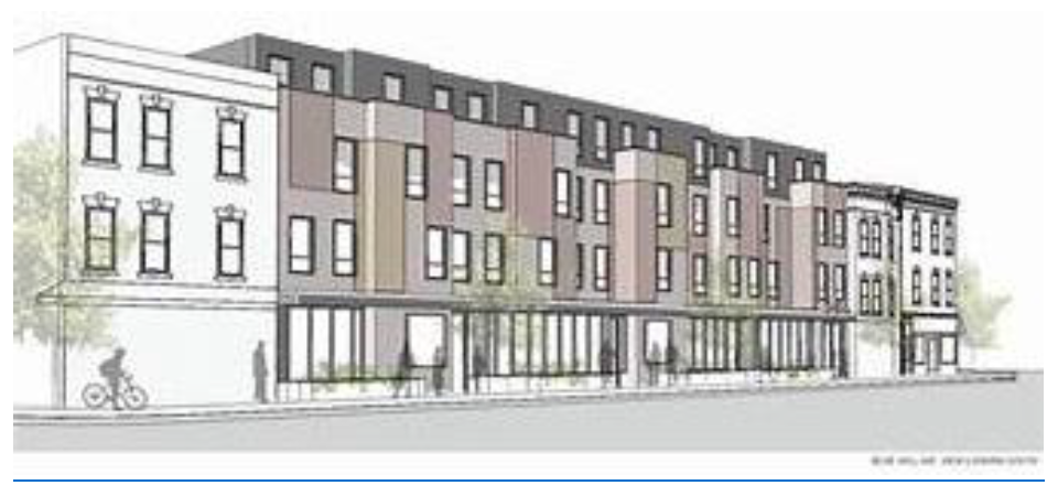
15.
All developments shall be brought into conformance with Article 4.8, Landscape, Streetscape and Treescape to ensure adequate green space for residential tenants, including shade trees in parking areas, usable open space, and attractive landscaping near individual unit entries.
16.
A minimum of twenty (20) percent of developable areas shall be designated as functional open space.
a.
Open space elements shall be available to all residents and users of the development.
b.
Preserved wetlands and water management areas, if designed appropriately with available pedestrian access, may contribute to the open space acreage. Because of their limited open space value, preserved wetlands and water management areas may not in any case comprise more than fifty (50) percent of the required open space acreage.
c.
Buffers, greenways, wildlife corridors, and recreation areas shall be counted towards the required open space acreage.
d.
Civic spaces and outdoor seating areas that are open to the public and provide features that encourage casual public engagement, such as shaded seating areas, art, or gardens shall count toward the open space requirement.
e.
Required parking lot landscaping shall not contribute to the open space requirement.
17.
All developments shall meet the recreation requirements detailed in Section 4.10.2. Common outdoor gathering spaces may contribute to this requirement.
18.
School bus stops shall be coordinated with the Osceola County School Board. Bus stops shall also be consolidated with shared access to adjacent or nearby residential buildings, as coordinated with the School Board and consistent with applicable regulations.
(Ord. No. 2021-78, § 1, 11-1-2021; Ord. No. 2025-10, § 4, 3-17-2025)
3.9.1 - INDUSTRIAL USES
Industrial uses are permitted in varying intensities as indicated in the Use Tables and may have special siting standards.
A.
ADULT ENTERTAINMENT/MEDIA. Adult entertainment and adult media shall be sited in accordance with the criteria outlined in Chapter 13 of the Osceola County Code of Ordinances.
B.
ASPHALT OR CONCRETE BATCHING PLANT OR PUG MILL. The asphalt, batching or pug mill is permitted as indicated in the Use Tables subject to the following standards:
1.
The plant shall be located a minimum of two hundred (200) feet from all perimeter property boundaries.
2.
The plant shall be located a minimum of five hundred (500) feet from any residential dwelling unit and one thousand (1,000) feet from perimeter property boundaries of any school, house of worship, or hospital.
3.
Prior to commencing operation, the plant operator shall provide evidence to the County that the facility has received the required state required permits.
4.
The plant's haul route shall be along facilities that can support the hauling vehicles.
C.
LANDFILL, JUNK, SALVAGE OR RECYCLED METAL YARD. Landfills, junk and salvage yards and the like are permitted as indicated in the Use Tables subject to the following:
1.
Front, rear and side yard setbacks shall be a minimum of fifty (50) feet. When adjacent to residentially zoned property, setbacks shall be a minimum of two hundred (200) feet with a minimum lot area of five (5) acres.
2.
Proof of the ability to meet all applicable local, state and federal environmental standards shall be provided.
3.
The facility shall have direct access to a avenue, boulevard, or framework street in accordance with this Code.
4.
The use shall not be within one thousand (1,000) feet of a school, measured on a straight line along the shortest distance between the perimeter of the landfill and the boundary of the property upon which the school is situated.
5.
The site shall be fenced by a six (6) foot opaque fence or masonry wall.
6.
The following information shall be provided in addition to the general information required:
a.
The yard's haul route shall be along facilities that can support the hauling vehicles.
b.
The proposed data that the land alteration will commence and the projected date of completion.
c.
An explanation of the volume of waste to be received, expressed in cubic yards or tons per day.
d.
An explanation of the type of landfill requested and type of wastes to be received.
e.
A statement specifying the hours of operation.
f.
Evidence of approvals to operate the proposed landfill from the Florida Department of Environmental Protection and the Osceola County Health Department.
g.
Buffers shall be required to be identified as part of the site development plan. Buffers shall be designed to reduce visual impacts, noise impacts and other purposes as determined by the County Manager.
h.
A yard shall comply with all applicable federal, state and County regulations regarding protection of air, ground water, surface water and other environmental and natural resources.
7.
New landfills proposed within a Military Operations Area (MOA) and/or Restricted Airspace shall require notice to the Avon Park Air Force Range (APAFR) Commander, and shall provide demonstration of compatibility with the applicable MOA and/or Restricted Airspace. If any landfill is proposed in Osceola County it shall meet the height standards outlined in the JLUS, which puts their maximum height at one hundred feet (100') below the floor of any MOA or restricted airspace, whichever is more restrictive. Height requested in excess of the maximum permitted shall be subject to FAA Determination of No Hazard to Navigation (Letter of authorization from FAA).
D.
OUTDOOR STORAGE YARD. The outdoor storage of materials shall be permitted as indicated in the Use Tables, subject to the following:
1.
Open storage of stacked materials shall not exceed twenty (20) feet in height. Stacked material over ten (10) feet in height shall be set back fifty feet (50') from the perimeter boundary line.
2.
Entire site shall be contained within a solid fence, wall or opaque buffer a minimum ten (10) feet in height.
3.
All hazardous materials shall be included in a building constructed in compliance with State and Federal requirements.
E.
PAIN MANAGEMENT CLINIC. Pain management clinics may be permitted as indicated in the Use Tables after obtaining a Conditional Use permit from the Board of Adjustment as outlined herein. Pain Management Clinics shall be subject to the follow standards:
1.
Controlled Substances. The on-site sale, provision, or dispensing of controlled substances at a pain management clinic is prohibited except as specifically authorized by applicable federal or state law.
2.
Loitering. The pain management clinic shall provide adequate seating for its patients and business invitees. The pain management clinic shall not direct or encourage any patient or business invitee to stand, sit (including in a parked car), or gather or loiter outside of the building where the clinic operates, including in any parking areas, sidewalks, right-of-way, or neighboring properties for any period of time longer than that reasonably required to arrive and depart. The pain management clinic shall post conspicuous signs on at least three sides of the building that no loitering is allowed on the property.
3.
Queuing of vehicles. The pain management clinic shall ensure that there is no queuing of vehicles in the right-of-way. The pain management clinic shall take all necessary and immediate steps to ensure compliance with this paragraph.
4.
Alcoholic Beverages. No consumption of alcoholic beverages shall be allowed on the premises, including in the parking areas, sidewalks, or right-of-way. The pain management clinic shall take all necessary and immediate steps to ensure compliance with this paragraph.
5.
Separation Distances. A pain management clinic shall not co-locate on the same property as a preexisting pharmacy. Furthermore, a pain management clinic shall not operate within one thousand (1,000) feet of any pre-existing pharmacy, school, as that term is defined in F.S. § 1002.01 or 1003.01, as it may be amended, day care center, day care home, or religious institution. Distance requirements shall be documented by the applicant and submitted to the County with the application. All distance requirements shall be measured by drawing a straight line from the nearest property line of the pre-existing protected use to the nearest property line of the proposed pain management clinic. The applicant may request a variance from the requirements of this paragraph as provided in the Code.
6.
Operating Hours. Pain management clinics shall only be allowed to operate between 7:00 a.m. and 7:00 p.m., Monday through Friday, and between 7:00 a.m. and 12:00 p.m. on Saturdays. Pain management clinics shall not operate on Sundays.
7.
Compliance with Other Laws. All pain management clinics shall at all times be in compliance with all federal and state laws and regulations, and the Osceola County Code, including Article VII, Chapter 14, Osceola County Code, as amended.
8.
Nonconformities. The requirements for separation distances as outlined in this section shall be prospective only from the effective date of this ordinance, and therefore existing clinics in Osceola County which do not meet the separation distance requirements shall be granted nonconforming status. This nonconforming characteristic of use shall be regulated in the same manner as set forth herein. Therefore, no change shall be made by existing clinics which increases the nonconforming characteristics of use of separation distances. Notwithstanding any other provision of the Code, all other characteristics of use (controlled substances, loitering, queuing of vehicles, alcoholic beverages, operating hours, and compliance with other laws) shall be applicable to all existing and future pain management clinics.
F.
PARKING OF TRUCKS, RECREATIONAL VEHICLES AND TRAILERS. Shall be permitted as indicated in the Use Tables subject to the following:
The lots shall be designed in such a way as to minimize visual impact. The parking areas shall be screened from adjoining properties by a minimum six (6) foot high opaque buffer as outlined herein.
G.
RENEWABLE ENERGY CREATION/MANUFACTURING, RESEARCH FACILITIES. Such Industrial Uses are permitted as indicated in the Use Tables subject to the following standards:
1.
The Use shall be adjacent to a paved avenue, boulevard, or framework street.
2.
Large-scale or commercial wind, solar or other renewable energy production facility may be located outside the UGB on five (5) acres or more.
3.
If inside the UGB, then the facility shall:
a.
Have a minimum setback of one hundred fifty (150) feet or a minimum distance so that the level of noise produced during operation shall not exceed fifty-five (55) dbA from 7:00 a.m. to sunset and forty-five (45) dbA after sunset to 6:59 a.m., measured at the property boundaries of the closest parcels, whichever is greater. This shall apply unless a noise variance has been approved by the County.
b.
If the property is located on a lake with known protected species nesting or foraging, the minimum setback shall be two hundred fifty (250) feet or greater from the Safe Development Line or setback line whichever is greater.
c.
Not cause visual obstructions to surrounding properties, and shall incorporate a buffer as outlined herein.
d.
Not interfere with communications, broadcast, transmissions or other like facilities.
e.
Lighting and height requirements shall be adhered to for compliance with the Federal Aviation Administration.
4.
Residential Wind Turbines shall be subject to the following:
a.
Setbacks:
i.
Facilities shall be located at least fifty (50) feet or more the height of the structure from road centerline and lot lines.
ii.
Individual wind turbine towers shall have a minimum setback so that the level of noise produced during operation shall not exceed fifty-five (55) dbA from 7:00 a.m. to sunset and forty-five (45) dbA after sunset to 6:59 a.m., measured at the property boundaries of the closest parcels, whichever is greater. This shall apply unless a noise variance has been approved by the County.
iii.
No turbines shall be permitted within one hundred fifty (150) feet of protected bird nesting and foraging areas including Snail Kite and the American Bald Eagle.
b.
Construction and Accessories:
i.
No wind turbines shall be permitted that lack an automatic braking, governing, or feathering system to prevent uncontrolled rotation, over speeding, and excessive pressure on the tower structure, rotor blades, and turbine components.
ii.
The minimum distance between the ground and any part of the rotor blade system shall be thirty (30) feet.
iii.
The proposed system shall be no larger than necessary to provide one hundred twenty (120) percent of the electrical energy requirements of the structure to which it is accessory, as determined by a contractor licensed to install wind turbine energy systems.
iv.
All power transmission lines from the facility shall be underground.
v.
No part of the facility shall be installed in any location that would substantially detract from or block view of a portion of a recognized scenic view as viewed from any public road right-of-way or publicly owned land within the County.
5.
Residential Solar Panels or Photovoltaic technology shall be subject to the following:
a.
If not roof-mounted, the solar energy system including any appurtenant equipment shall be located to the side or rear of the structure.
b.
Solar panels including any appurtenant equipment shall be subject to the applicable development standards for primary structures, including height and setback restrictions.
c.
The solar panels shall not be visible from a public right-of-way that abuts the lot on which the solar energy system is located unless they are installed within one (1) foot of the natural ground topography.
d.
The proposed system shall be no larger than necessary to provide one hundred twenty (120) percent of the electrical and/or thermal energy requirements of the structure to which it is accessory as determined by a licensed contractor.
e.
The solar panels and supporting framework shall not extend more than six (6) feet above the existing grade.
f.
Reflection angles from collector surfaces shall be oriented away from neighboring windows.
g.
The panels shall be mounted as close as possible to the ground to match the slope of the hillside while allowing adequate drainage and preventing vegetation from shading the panels.
h.
If the solar panels are visible from off-site, there shall be appropriate façades, walls, fences or landscaping to screen the solar panels and supporting framework from view. Landscaping shall not be applicable to roof mounted solar panels.
H.
WHOLESALING, WAREHOUSING, STORAGE AND DISTRIBUTION, AND ENCLOSED/LIGHT MANUFACTURING. Such Industrial Uses are permitted as indicated in the Use Tables subject to the following standards:
1.
Within an Urban Infill Center:
a.
Use shall be adjacent to a paved street which is designed to accommodate the volume of truck traffic associated with the development.
b.
Use shall be conducted inside a building. Within an Employment Center only, outdoor storage may occur as an accessory use in areas designated on a Site Development Plan. The area shall be generally located to the interior or rear of the property, and entirely screened from view of adjacent non-industrial property, from primary frontages, and rights-of-way.
c.
Bay doors shall be located to the interior or rear of the site and not face a primary frontage.
d.
Urban Infill Centers Standards apply, except as follows:
i.
Two (2) rows of parking may be permitted between the structure and primary frontage, when a linear park consistent with Mixed Use District standards is provided at the BTL. More than two (2) rows of parking may be provided when designed as a parking block. A row of parking shall consist of a drive aisle with parking on each side. When a linear park is utilized to meet the BTL requirements, planting shall also include shrubs arranged to provide a visual screen of seventy-five (75) percent opacity and achieve a minimum height of three (3) feet within two (2) years adjacent to the parking area.
ii.
Parking Block. Industrial use parking blocks shall be designed to incorporate pedestrian routes not to exceed block sizes consistent with Urban Infill Centers standards. Routes can consist of pedestrian pathways, internal drive aisles with sidewalk or other like mechanisms. Primary frontages shall provide a linear park consistent with Mixed Use District standards at the BTL, and include shrubs arranged to provide a visual screen of seventy-five (75) percent opacity and achieve a minimum height of three (3) feet within two (2) years adjacent to the parking area.
iii.
A minimum of twenty-five (25) percent transparency (windows) at the ground floor. Transparency calculations may include the glass surfaces of the entrance window system itself. The area of required transparency shall be calculated by multiplying the structure's linear frontage by a height (above adjacent finished pavement grade) of twelve (12) feet. Sixty (60) percent of the ground floor shall include the minimum transparency plus glazing or other features that mimic fenestration such as transparent windows, awnings, spandrel glass features (without opening into building wall or structure), ledges, shutters, or other architectural elements used to enhance the façade. These elements are required for at least thirty-five (35) percent of upper floors.
2.
Noise levels produced by the facility shall not exceed the standards of the Osceola Code of Ordinances.
(Ord. No. 2022-125, § 3, 2-20-2023; Ord. No. 2025-10, § 4, 3-17-2025; Ord. No. 2025-47, § 2, 8-4-2025)
3.10.1 - SCHOOL SITING STANDARDS
A.
INTENT.
1.
Implement the Public School Facilities Element (PSFE) of the Osceola County Comprehensive Plan and the Interlocal Agreement between and among Osceola County, the School District of Osceola County, and the Cities of Kissimmee and St. Cloud (the "Agreement"), as well as all state statutes and rules governing the siting of schools; and
2.
Balance the need for an adequate and timely supply of school sites, well served by infrastructure and services, with the need of the public to preserve adjacent neighborhoods from the impacts of development occasioned by public schools and their accessory uses, buildings and structures; to mitigate off-site impacts associated with new schools or the significant redevelopment of existing schools; and to ensure the safety and convenience of vehicular and pedestrian traffic access to all public school sites; and
3.
Create siting and compliance standards for public schools that shall implement the provisions of the "Agreement" and provide additional assurances to the public that school siting decisions shall advance the urban growth strategy of the Osceola County Comprehensive Plan by promoting the development of healthy, livable neighborhoods; and
4.
Establish a School Siting Review Committee as well as an expedited school siting and compliance review process that is intended to implement the provisions of the "Agreement" associated with a public school site plan review program; and
5.
Utilize a school siting and compliance review process that builds upon the "Agreement" which established protocols for public school siting and planning which include regular consultation among the governing bodies and the creation of a Technical Working Group. The review process will determine the need, timing and responsibility for transportation or other types of off-site improvements and to memorialize the responsibilities and costs of those improvements within a formal agreement between the School District of Osceola County and the Osceola County Board of County Commissioners.
B.
SCHOOL SITING REVIEW COMMITTEE. The County's Development Review Committee (DRC) is the designated School Siting Review Committee and shall be responsible for the conduct of the Compliance Reviews that precede final actions by either the County Manager or Planning Commission pursuant to the requirements of the Land Development Code.
C.
APPLICABILITY.
1.
Public schools, including accessory uses, buildings and structures, are herein defined as a type of land use that is permitted within specific zoning districts subject to a Compliance Review (Permitted Subject to Compliance Review or P-SCR) procedure described herein.
2.
The Compliance Review procedure is applicable to the development of new schools and the significant redevelopment of existing schools. The term "significant" includes either: the addition of permanent student stations that exceeds one hundred twenty-five (125) percent of the existing number of permanent student stations; or the addition of accessory facilities such as outdoor recreation facilities with spectator seating, gymnasiums, auditoriums, and parking facilities with more than fifty (50) spaces.
3.
The Compliance Review for public schools shall be based on the school design and compliance standards provided in this Section as applied to a Compliance Plan submitted to the County by the School District of Osceola County or its duly authorized representative.
4.
The administrative review and approval of a Compliance Plan is a prerequisite to the submittal, review and approval of a required Public School Site Development Plan (PS-SDP) for a proposed new school or significant redevelopment of an existing school. An approved PS-SDP shall be considered the final development order and authorization to construct the proposed public school development. The requirements and process for review and approval of a PS-SIP are as defined herein, and shall apply to all proposed new schools or significant redevelopments of existing schools.
5.
An approved Compliance Plan shall not be a required prerequisite for proposed improvements to an existing school that does not meet the definition of a significant redevelopment.
6.
Osceola County will accept an application for Compliance Review when all of the following criteria have been satisfied for the applicable school site.
a.
The Compliance Plan submittal provides a justification statement that the proposed school development conforms to the provisions of all applicable development orders affecting the site in force at the time of application. These include development orders for Developments of Regional Impact (DRIs) and Developments of County Impact (DCIs); and Binding Letters of Interpretation of Vested Rights (BLIVR) and all subsequent Binding Letters of Interpretation for Modification (BLIMs) if the site is located within the Poinciana Planned Development.
b.
The site appears in the most recently published Annual List of School Priorities of the School Siting Book 1 or its successor document as designated in the "Agreement." 2 If the site does not appear in the Annual List, the School District of Osceola County/applicant will provide a letter committing to add the site at the next opportunity for amendment.
c.
The School District of Osceola County has identified the school site 3 and coordinated with the County with respect to acquisition and development as provided in the "Agreement" relating to school concurrency and the planning and coordination of public school facilities.
d.
For purposes of this Section, elementary schools are presumed to accommodate kindergarten through fifth grade; middle schools are presumed to accommodate grades six through eight; and high schools are presumed to accommodate grades nine through twelve. When other combinations of grades are proposed, the school type will be considered that of the highest grade level (e.g., a school accommodating grades four through seven would be considered a middle school.)
e.
All other requirements of the Land Development Code shall apply where there is no conflict with State law or administrative rule, and when the LDC requirement does not duplicate an SREF requirement for the same subject.
f.
A Compliance Plan shall be prepared in conformance with the criteria and provisions of this Section and, when approved, shall constitute a Preliminary Development Order.
g.
The division of costs for off-site improvements as identified in the letter required by paragraph G(9) below, shall be determined by a site-specific interlocal agreement, or other instrument as appropriate, between the School District and the Board of County Commissioners. Said agreement shall be a prerequisite to the submittal of the PS-SDP, and attached thereto at the time of initial submittal.
D.
DESIGN AND COMPLIANCE CRITERIA FOR ALL PUBLIC SCHOOLS.
1.
In considering the compliance of design of a proposed school site of any type, the following criteria shall be considered.
a.
Transportation access to the proposed site avoids potential high congestion facilities such as expressway interchanges, arterial-to-arterial intersections and active railway crossings.
b.
Site transportation access through road intersections that have been determined by FDOT or the County Traffic Engineer to pose hazards to pedestrians is strongly discouraged. The Compliance Plan will address the mitigation of hazardous conditions associated with this type of access.
c.
The proposed site is located on one (1) or more publicly dedicated, maintained and paved roads and is served by sidewalks fronting any perimeter of the school site that adjoins a public thoroughfare or street.
d.
In addition to the requirements herein, the applicable reviewer or designee (Planning Official, TRC/School Siting Committee, Community Development Administrator and the Planning Commission) shall, in reviewing a Compliance Plan, consider the proposed plan's consistency with public safety requirements and public liability considerations. School recreation areas, facilities, and equipment shall be designed and located to provide maximum public use and accessibility, including direct pedestrian access to nearby existing or planned residential areas wherever possible. When consistent with public safety requirements and public liability considerations, perimeter fences or walls shall include gates or other means of entry which provide pedestrian or bicycle connections to adjoining residential neighborhoods or other pedestrian/bicycle facilities. Access through these points of entry will be managed pursuant to the terms of a Joint Use Agreement between the School Board of Osceola County and Osceola County for a specific school site. This Agreement will address the hours of operation of all access points to the school site and provide for, when applicable, an extended-hour schedule to accommodate passage for pedestrians and bicyclists who utilize after-hour school programs or public park facilities that are integrated with the public school site.
e.
Where proposed school sites abut parks or public recreation areas, interconnecting pedestrian access shall be required for approval of the Compliance Plan.
f.
The minimum school site size shall be that area that is required to satisfy the Florida Department of Education site selection criteria plus any additional acreage necessary to accommodate all design and compliance requirements, including setbacks and stormwater management areas. The minimum school site area may be reduced to the extent that: the stormwater retention and detention requirements for the school site are satisfied through off-site facilities; or the site is located within a designated community or urban center within a "MXD" Future Land Use Classification and the site plan complies with the standards for civic uses in community or urban centers.
g.
The Compliance Plan shall illustrate the location of all active primary and accessory uses including, but not limited to, vehicular and bicycle parking, loading and outdoor equipment storage areas, air conditioning units, refuse collection facilities, site identification signage, lighting, and recreation areas. These uses shall be located away from adjacent residential uses unless site limitations make this infeasible, in which case the site plan must satisfy Active Edge setback requirements as specified elsewhere in this Section.
h.
Off-street parking facilities shall be located within the public school site to accomplish the separation of long-term and short-term users. Access to long-term parking facilities shall be separated from designated student drop-off and pick-up locations. Short-term parking facilities may share access with designated student drop-off and pick-up locations.
i.
The location of school sites shall provide logical focal points for neighborhood and community activities and serve as the cornerstone for innovative urban design standards, including opportunities for shared use and co-location of community facilities and/or services.
j.
In the case of elementary and middle schools located within the Commercial, Office, or Tourist Commercial Future Land Use Map categories, or within the Commercial Restricted, Commercial General, or Commercial Neighborhood zoning districts, the Compliance plan shall provide design features that ensure the site's safety and accessibility, which include, as appropriate, sidewalk and traffic barriers; security fences; and vehicle access controls.
k.
The Compliance Plan shall be consistent with State Requirements for Education Facilities (SREF) as approved and amended, from time to time, by the Florida State Board of Education.
l.
The location of school sites shall be consistent with Land Development Code or Code of Ordinances requirements that address community values and proximity to specific land uses such as drinking, gambling or adult entertainment establishments.
m.
An Active Edge Setback shall be required to separate the active uses and facilities associated with public schools from adjoining developed residential land uses as one means of minimizing the nuisance effects of sound and light associated with school operations or activities. The active edge setback shall not apply if neighboring lands are primarily in non-residential use or if the property has not been subdivided for residential use. A non-residential use may also include stormwater retention/detention ponds.
n.
The determination of an Active Edge Setback requirement shall be based on the adjacent land use and the type(s) of school use or facility that is proposed to be located adjacent to the applicable site boundary.
o.
For purposes of this Section, "active use" includes, but is not limited to: air handling/cooling/heating equipment (ground or building mounted); parking lots; active recreation facilities; service access and loading areas; primary building entrances/exits; solid waste collection facilities; and outdoor storage. Service access and loading areas generally include the vehicular use areas adjoining a building or outdoor storage area where service and delivery vehicles can park while loading or unloading or providing services to the school facilities. It is not intended that the entire length of access drives within the school site be included as part of an "active use," only that portion that is within the immediate area of the primary loading/service access vehicular use area.
p.
A Building and Passive Use Setback shall be required from all property boundaries for all school uses and facilities that are not included in the definition of an Active Use.
q.
For purposes of this part, "passive use" includes, but is not limited to: passive recreation areas that may include trails, sidewalks and bike paths, picnic facilities; landscaped open space; stormwater detention/retention facilities; and other types of non-vehicular areas.
r.
Landscaping within an Active Edge Setback is required when a school site boundary abuts existing residential uses as described in paragraph 1, above.
s.
For purposes of this part, "active recreational facility" shall include: any structures, such as grandstands, concession stands, ticket booths, light poles, tents, and scoreboards which are an integral part of an active recreational use.
t.
Active recreational uses are characterized by such elements as: athletic fields, whether for practice or competition; outdoor courts (basketball, volleyball and tennis); and/or outdoor amenities (skate park, Frisbee golf) that may be used for sport competition.
u.
Where applicable, setbacks from thoroughfares required by the provisions of this Code shall be provided. However, where more than one type of setback requirement may be applicable, the more restrictive one shall apply. The width of the setback shall be the determining factor in which setback is more restrictive.
v.
Unless specifically provided for otherwise, uses and activities within an Active Edge Setback may include landscaped open spaces, natural vegetation, sidewalks, bike paths, stormwater management areas, and passive recreational uses. Parking facilities may be permitted within an Active Edge Setback, but not closer than twenty-five (25) feet to the property boundary, when both of the following conditions are met: lighting standards are located outside the Active Edge Setback; and, parking spaces are oriented as to prohibit vehicular lights from intruding into adjoining residential properties during nighttime use. (See subsection bb. below).
w.
Prohibited uses within required setbacks include all principal school buildings and active uses, except as may be otherwise permitted by these regulations.
x.
Active Edge or Building/Passive Use Setbacks shall be measured from the property line to the closest active use and/or principal school building. Modular and re-locatable classrooms are included in the definition of principal school building. The setback from an active use involving a recreation facility such as a sports field, basketball court, tennis court or swimming pool shall include all aspects of the use to include bleachers, fences and walls.
y.
Where a school site boundary abuts an existing residential use, the minimum Active Edge or Building/Passive Use setback widths shall be as follows unless the Florida Building Code or State Requirements for Education Facilities (SREF) shall specify a greater setback:
i.
Active Edge Setback: Fifty (50) feet.
ii.
Building/Passive Use Setback: Twenty-five (25) feet.
z.
Landscaping is required within an Active Edge Setback and shall consist of a minimum of two (2) canopy trees with a minimum height of twelve (12) to fourteen (14) feet and a three (3) inch DBH (diameter at breast height of fifty-four (54) inches above ground) or three point five (3.5) inch caliper, per one hundred (100) feet of setback length and spaced an average of no more than fifty (50) feet apart; or two (2) canopy trees, each with a minimum height and diameter that is less than eighteen (18) feet four (4) inches, plus four (4) understory trees per one hundred (100) feet of setback length. Canopy trees shall be placed within the Active Edge Setback Area to preclude the majority of the crown of the tree, at maturity, from encroaching into the adjoining properties.
aa.
When parking is proposed perpendicular to a property line bordering an Active Edge Setback, a continuous planting of shrubs that will form an opaque screen six (6) feet in height at maturity may be required along the property boundary.
bb.
All landscape materials shall be native to Central Florida and landscape areas shall be irrigated with non-potable water, when available.
Notes:
1. Public schools are not permitted within these zoning districts. A rezoning approval would be necessary to develop public schools on lands that were formerly included within one (1) of these districts.
2. Each level of administrative review includes the review of the Compliance Plan by the County Traffic Engineer, Development Review Manager, County Engineer, and other members of the Development Review Committee. The final approval by the Planning Official, Community Development Administrator or Planning Commission represents a cumulative approval of all of the applicable administrative officials with responsibility for oversight of specific parts of the Land Development Code.
3. Public school facilities which serve the School District at large, e.g., an administration building, bus barn, or central store, are not addressed in this Table and are not uses that are permitted and subject to Compliance Review.
4. Public school facilities which are planned to be located within the Urban Expansion areas of the County will be reviewed during the Concept Plan stage of development.
E.
DESIGN AND COMPLIANCE CRITERIA SPECIFIC TO ELEMENTARY AND MIDDLE SCHOOLS. In considering the compatibility and appropriateness of a proposed elementary or middle school site the following criteria shall be considered.
1.
The primary transportation access 5 to the site shall be from a local street and/or an avenue or boulevard. Elementary and middle schools may have secondary access to higher classified roads where the principal access is to a local street or (avenue, and the secondary access is consistent with the access management standards of this Code.
2.
Elementary and middle school sites should be located internal or adjacent to residential neighborhoods, and discouraged from sites adjacent to multi-modal corridors.
3.
Schools sites shall not be divided by public roads, canals, electric power transmission facilities, or other facilities that pose a potential hazard to students, faculty and visitors that must traverse the facility in order to utilize school facilities.
F.
DESIGN CRITERIA SPECIFIC FOR HIGH SCHOOLS. In determining compliance of a proposed high school site the following criteria shall be considered.
1.
Preference should be given to a site located within a four-mile driving distance of a majority of the students anticipated to fill permanent student stations within the school. This criterion shall not apply to vocational schools, or special schools, such as high schools for the arts, for which the service area shall be presumed to be countywide.
2.
The site is located with one or more primary vehicular access locations to an avenue, boulevard, or multi-modal corridor. Primary access to a local street shall be prohibited. Secondary access to a local street may be appropriate if controlled for emergency access only.
3.
The site is not located immediately adjacent to existing or planned single-family residences unless the site is of adequate size to provide the building and active use setbacks and buffers required elsewhere in this Section to protect adjacent residences from adverse noise, lighting, or activity impacts.
G.
COMPLIANCE PLAN SUBMITTAL REQUIREMENTS. The following information shall be provided in graphic or written form, as necessary to satisfy the requirements. The County Manager is authorized to waive information requirements when deemed appropriate. The applicant shall provide five (5) paper copies and one (1) digital copy of all submittal information and plans.
General Information.
1.
Legend, including:
a.
Name of the public school;
b.
Legal description of the property (may be submitted on a separate sheet with the application form);
c.
Acreage of the property;
d.
Scale (not more than 1" = 100');
e.
North arrow;
f.
Date of preparation and space for revision dates.
2.
A vicinity map.
3.
A recent aerial photograph of the site.
4.
A tree survey indicating the location, diameter at breast height (DBH), and type of all existing trees with a DBH equal to or greater than two (2) inches. This information may be shown on the aerial photograph, a separate plan sheet or with the site plan. This requirement is applicable only for new school sites and only for the areas of the site where existing trees will be retained as part of the site landscaping or for required active edge buffers.
5.
Name, address, phone number and email address of:
a.
Property owner(s);
b.
Engineer(s);
c.
Surveyor(s);
d.
Architect(s), Planner(s) or Landscape Architect(s); and
e.
Agent(s) of property owner or others involved in the proposal.
6.
Zoning and Future Land Use Information:
a.
Existing FLUM classification(s) applicable to the property;
b.
Existing zoning districts applicable to the property, including any overlay districts.
7.
Information about abutting lands, including:
a.
Names of Recorded Owners of all abutting lots and parcels (only when Level 3 Compliance Review is required).
H.
EXISTING CONDITIONS (SHOWN ON A SEPARATE PLAN SHEET).
1.
Existing thoroughfares/streets, both on and within five hundred (500) feet of the proposed school site, including:
a.
Thoroughfare/street names;
b.
Location of each thoroughfare/street and associated intersections;
c.
Right-of-way of all thoroughfares/streets; and
d.
Median locations, if applicable.
2.
Existing lot lines and easements on the property, indicating the purpose of each easement, and:
a.
Utility poles, overhead power lines and street lighting poles and fixtures.
3.
Existing buildings, structures and active uses, on the property. Any buildings, structures or land areas that have been designated as local landmarks, or are listed on the National Register of Historic Places, should be specifically noted.
4.
A topographic map showing land contours at one-foot (1') intervals. Contour lines shall be shown fifty (50) feet beyond the boundary of the proposed school site.
5.
The 100-year flood elevation and limits of the 100-year floodplain and any floodway.
6.
Existing surface water bodies, wetlands, streams and canals, both on and within fifty (50) feet of the proposed development, including:
a.
Normal high water elevation or boundary;
b.
Attendant drainage areas for each; and
c.
Area, extent and type of wetlands.
I.
PROPOSED DEVELOPMENT.
1.
A site plan delineating proposed buildings, structures, active and passive uses, vehicular use areas such as parking areas and internal access drives, and other plan elements including:
a.
Scaled dimensions;
b.
On and off-site tracts to be publicly dedicated for such purposes as: stormwater management; road right-of-way; pedestrian or bicycle facilities; utilities; conservation; recreation/open space; or other public use; and
c.
Proposed building or structure heights.
2.
Proposed phasing of the school development.
3.
A setback/landscape plan for the site or applicable portion thereof depicting active and passive uses and associated thoroughfare, building or active edge setbacks, landscape plantings required by the provisions of this Section (including type, size and quantities), method of irrigation of all landscaped areas, proposed walls and fences, existing trees to be retained, and methods/procedures for protecting existing trees during construction.
4.
A letter from the Technical Working Group (TWG) certifying that all applicable requirements of Article VIII ("Public School Siting") of the Interlocal Agreement have been satisfied. The TWG report required in Section 8.02(F) shall be attached to the letter; and shall identify off-site improvements which will be required to serve the development, as determined in consultation with the County's Traffic Engineering Director, Planning Official and Development Review Manager. Said letter will be attached to all subsequent development orders.
J.
PUBLIC SCHOOL SITE DEVELOPMENT PLAN (PS-SDP) REVIEW ELEMENTS. The Site Development Permit application shall be submitted for County review following approval of the Compliance Plan. The review shall address, at a minimum, the following elements.
1.
Stormwater system design and operation;
2.
Method(s) of connection of site-related stormwater systems to off-site conveyances and receiving bodies;
3.
Impacts to floodplains and floodways;
4.
Access connections to adjoining streets;
5.
Proposed earthwork if the plan includes the off-site disposal of excess soil generated by the school development;
6.
Fire protection, including spacing of hydrants and fire vehicle access;
7.
Erosion and sediment control;
8.
Conditions and requirements in effect for the school site as a result of a pre-existing development order or developer's agreement.
K.
PUBLIC SCHOOL SITE DEVELOPMENT PLAN (PS-SDP) APPLICATION SUBMITTAL REQUIREMENTS.
1.
Water Management District permit package, including stormwater calculations;
2.
Construction plans for all facilities required for fire protection;
3.
A master layout plan for the entire development site depicting the location and dimensions of all principal and accessory buildings and uses, including vehicular use (parking) areas, access driveways, loading and service areas, and active and passive recreation uses;
4.
Erosion Control Plan;
5.
Approved Compliance Plan, with any required modifications, depicting required building or active edge setbacks, landscaping, irrigation and site lighting standards;
6.
Right-of-way utilization permit application;
7.
If excess soil will be disposed off-site, a Soil Excavation Plan will be required that describes the quantity of soil to be disposed at an off-site location, the route to disposal site(s), hours of operation of the excavation and grading activities, and other information that may be required by the Development Review Manager to evaluate the impacts to the community and haul routes.
8.
Letters from water and sanitary sewer providers indicating that service is available for the proposed public school development;
9.
Environmental Resource Permit (if required);
10.
Compatibility Review Letter from TWG indicating completion of required review process and identifying any required off-site improvements;
11.
Proposed/required off-site improvements to stormwater and other public utility systems necessary for development and operation of the school site.
12.
Proposed/required off-site improvements to the thoroughfare and/or street system necessary to provide safe and adequate site access and/or address level of service deficiencies, including conditions that render an intersection as hazardous to pedestrians or bicyclists;
13.
Interlocal Agreement related to the construction and funding of off-site improvements;
14.
SDP Application Review Fee.
L.
THE PS-SDP REVIEW PROCESS. Shall be conducted by the Development Review Manager and involve the applicable members of the Development Review Committee. The review will be conducted and completed within ten (10) working days of receipt of a complete PS-SDP application with all required submittals and fees.
Notes
1 The Annual List of School Priorities of the School Siting Book is prepared and updated annually by the School District of Osceola County.
2 The "Interlocal Agreement" (ILA) refers to both the 2003 and the 2008 Public Schools and Facilities Interlocal Agreements between Osceola County, School District of Osceola County and the Cities of Kissimmee and St. Cloud, as they may be amended from time to time.
3 School Site refers to the land, buildings, structures, and improvements upon which a school has been constructed, or is proposed for construction, and includes buffers and on-site drainage facilities.
4 A building/passive use or active use setback refers to the setback of a building, passive use, structure or active use from the applicable property line.
5 Primary transportation access would include all vehicular access locations to administrative facilities and parking for faculty and visitors.
3.11.1 - PLANNED DEVELOPMENTS
A.
PURPOSE AND INTENT. It is the intent of this Section to provide a mechanism to promote development of the highest quality. Planned development districts, through flexible design guidelines, are intended to afford a developer the latitude to achieve a design quality superior to that possible through the utilization of standard development practices. By allowing land utilization to be more efficient, planned developments are also intended to result in an increased level of amenities for its inhabitants.
Planned developments are to function as integrated units, not unrelated uses or lots. The development sites within the planned development districts are intended to provide a high quality living and/or working environment by being pedestrian and bicycle friendly, being environmentally sensitive, appearing visually pleasing to the community, containing adequate recreation and functional open space, and being compatible with surrounding land use.
To enable compliance with the aforementioned intent, the County may, through the planned development district, allow deviation from standard zoning requests, including lot size, setbacks, lot coverage and height. Other deviations which may be allowed include signage, parking and infrastructure. Approval will only be granted to provide a vehicle for creativity and innovation, which are necessary to ensure that departure from conventional development standards will result in the quality of design that the County is seeking. Alternatively, planned development districts are not intended to serve as a vehicle which merely allows variances to standard development regulations.
The specific objectives of the planned development districts are as follows:
1.
The clustering of areas of usable open spaces for recreation and the preservation of natural amenities, including threatened and endangered plant and animal species.
2.
Design flexibility to take the greatest advantage of the natural topography, native vegetation, (including both upland and wetlands species) the preservation of existing trees, and the preservation of historical and other cultural and natural features.
3.
The creation of a variety of housing types and compatible neighborhood arrangements that give the home buyer the greatest possible choice in selecting types of neighborhoods and various dwelling units.
4.
Allowance of sufficient freedom for the developer to take a creative approach to the use of land and its related physical development.
5.
The establishment of criteria for the inclusion of compatible associated uses to compliment the commercial, industrial and residential areas within the planned development.
6.
Simplification of the procedure for obtaining approval of proposed developments through simultaneous review by the County of proposed land use, site consideration, lot and setback considerations, public needs and requirements, and health and safety factors.
7.
Utilization of clustering to promote the economical and efficient use of land, utilities and streets with resulting lower costs.
8.
To ensure that development will occur according to limitations of land use, site design, population density, building coverage, improvement standards, and construction phasing authorized through approval of a comprehensive development plan.
9.
The inclusion of adequate buffering and greenbelts within and bordering the planned development.
10.
The integration of sidewalks, walkways and bicycle paths and lanes into the transportation system to provide alternative modes of transportation within the site and to its perimeter.
11.
The inclusion of elementary, middle and high schools and customary ancillary facilities, which include auditoriums, gymnasiums, and sports fields, subject to the applicable Compliance Review requirement prescribed herein.
B.
TYPES OF PLANNED DEVELOPMENT. The following planned development districts are allowed if approved in accordance with the provisions contained within these regulations.
1.
Planned Residential Development (PRD). PRDs must have a minimum of ninety (90) percent of their total land use devoted to residential development. The remaining percentage may be used for various supporting uses such as commercial, or other uses which are complimentary and incidental uses, provided that these non-residential uses are compatible with and integrated into the planned development. The following limitations which are listed below shall apply to business uses in this district.
a.
Provide that the commercial development is internal to the project and located on a collector road.
b.
All business activities and storage of merchandise, equipment and materials shall be within an enclosed building.
2.
Planned Commercial Developments (PCD). This planned commercial development (PCD) district is for the development of commercial centers whose primary uses include retail, office, hotel/motel and restaurant uses, however, supporting non-commercial and special uses of up to ten (10) percent of the gross land area may also be permitted within PCD district when complimentary and compatible with, and integrated into a commercial center. These special uses shall be reviewed by the Planning Official to determine whether they are complementary and compatible with the PCD prior to approval of the concept plan.
3.
Planned Industrial Developments (PID). The planned industrial development (PID) district is intended for the development of industrial and business parks; however, supporting non-industrial uses including eating establishments or supporting commercial uses may also be permitted within an approved PID when complimentary to, compatible with, and integrated into a planned park. These special uses shall be reviewed by the Planning Official to determine whether they are complimentary and compatible with the PID prior to approval of the concept plan.
4.
Planned Mixed Use Development (PMUD). The planned mixed use development (PMUD) district is established for the purpose of developing multi-use complexes which accommodate varied multiple or atypical uses, including recreational, cultural, and educational uses or a combination of residential, commercial and industrial uses. Other supporting uses may also be permitted within a special PMUD district when complimentary to, and compatible with, and integrated into a planned park. These special uses shall be reviewed by the Planning Official to determine whether they are complimentary to and compatible with the PMUD prior to approval of the concept plan.
5.
Planned Affordable Housing Developments (PAHD). This planned development district is primarily intended to create a regulatory mechanism for developers to provide affordable housing to very low, low and moderate income households in areas of the County that can provide urban services, primarily potable water and sanitary sewer facilities. Such households are defined as those having incomes that meet the limits as defined by the U.S. Department of Housing and Urban Development and included in the Osceola County Housing Assistance Plan adopted by the Board of County Commissioners. Planned developments which provide a minimum of twenty (20) percent of their dwelling units to these households may qualify as PAHDs.
Very Low-income persons means one or more natural persons or a family, not including students, that has a total annual adjusted gross household income that does not exceed fifty (50) percent of the median annual adjusted gross income for households within the MSA.
Low-income persons means one or more natural persons or a family, not including students, that has a total annual adjusted gross household income that does not exceed eighty (80) percent of the median annual adjusted gross income for households within the MSA.
Moderate-income persons means one or more natural persons or a family, not including students, that has a total annual adjusted gross household income that does not exceed one hundred twenty (120) percent of the median annual adjusted gross income for households within the MSA.
6.
Short Term Rental Planned Development (STRPD). The short term rental planned development district is established for the purpose of developing short term rental housing in the geographic area described herein. Short term rental housing is a unique land use, exhibiting characteristics common to both commercial, as well as, residential land uses. As a result, the STRPD is established to allow design features which reflect the specific needs and impacts of short term rental housing.
C.
UNIFIED OWNERSHIP OR CONTROL. The applicant for the planned development shall be the owner(s) or an agent authorized to represent all land within the proposed planned development.
The minimum subject area eligible for a future amendment process shall be a distinct or independent phase or stage of a planned development or a contiguous aggregation thereof. Amendments of the planned development may only be submitted with owner authorization of all the properties within the subject area of the proposed amendment.
D.
SIZE REQUIREMENTS. The standards listed below shall be enforced for planned developments within Osceola County.
1.
All developments of regional impact shall be submitted as planned developments.
2.
Lots or parcels legally subdivided prior to the adoption of this Ordinance are exempted from the acreage requirement and may be eligible for other zoning districts as outlined in the Comprehensive Plan.
3.
The foregoing shall not apply to County approved economic development initiatives.
E.
DEVELOPMENT AND DESIGN STANDARDS.
1.
Transportation and Access. Planned development shall be designed to minimize impacts to the County's road system. Safe and adequate access consistent with this Code shall be incorporated into the project design. Alternate access standards may be considered if they provide an equal or higher level of safe and adequate access to those standards contained in this Code. Individual development sites shall be connected by an internal circulation system sensitive to points of safety, convenience and access to dwelling units and non-residential facilities. Internal roadway design shall incorporate sidewalks and bike paths to encourage non-auto oriented travel opportunities. A system of walkways and bicycle paths between neighborhoods, buildings, common open spaces, recreation areas, community facilities, parking areas and off-site walkways and bike paths shall be distinctively designed and, where appropriate for nighttime usage, adequately lighted.
F.
BUFFERS AND GREENWAYS. Landscaped buffers shall be provided on the borders of all planned developments. This requirement may be waived or modified for planned developments upon demonstration that the adjoining land uses are of a similar type and/or intensity. Buffer width and levels of landscaping shall be contingent upon the proposed planned development's compatibility with adjacent property.
Internal greenways shall be developed within planned developments to provide open space opportunities throughout the projects. They may be used for walkways, recreational pathways, bike paths, or wildlife corridors. Greenways which also function as walkways, recreational pathways or bike paths shall link facilities within the projects. Greenways which also function as wildlife corridors shall connect wetlands, preserved upland or other viable wildlife habitat.
G.
PARKING. Parking for planned developments shall be designed pursuant to this Code. Alternative parking ratios may be allowed by the County in those areas where the planned development application includes valid supporting data. Deviation from conventional standards for the physical design of parking lots may also be granted if the alternative proposal promotes the preservation of specimen trees, provides an equivalent amount of green space and vegetation and is designed in a manner which facilitates safe traffic movement and adequate ingress and egress to the parking lots and their individual spaces.
Residential planned developments shall be designed to discourage the parking of vehicles on areas other than on driveways, in garages or on local streets with parking lanes. Requests to deviate from road right-of-way standards will not be considered unless adequate parking is included in the planned development.
H.
SIGNAGE. Signage is one (1) of the most important visual aspects of planned developments. Signs shall be appropriately designed, landscaped and integrated with the overall architectural theme of the development. In addition, the development of billboards within a PD shall require conditional use approval. The planned development shall not be a mechanism used to bring nonconforming signs into conformance by the creation of standards exceeding the standards contained in this Code.
I.
DENSITY AND INTENSITY. For properly designed planned developments, allowable density and intensity will be based on several factors, including the land use designation on the future land use map, existing development in the immediate vicinity and the extent to which the planned development's design minimizes the project's impacts upon other property in its vicinity.
The minimum size of building lots and maximum building height will also relate to the amount of open space included in the design of the development.
J.
UTILITY INSTALLATION. All utilities including telephone, television cable, and electrical system shall be installed underground. Primary facilities providing service to the site of the planned development may be exempted from the requirement. Large transformers shall be placed on the ground and located on pad mounts, and enclosed or located within a vault. The developer must provide landscaping with shrubs and plants to screen all utility facilities permitted above ground.
K.
ADDITIONAL DEVELOPMENT STANDARDS FOR PLANNED AFFORDABLE HOUSING DEVELOPMENTS. The following standards may be used in a PAHD if an agreement has been executed between the developer and the County ensuring that twenty (20) percent of the total project's dwelling units will be reserved for very low, low, or moderate income households. The agreement shall specify the required documentation necessary to guarantee development of affordable housing units for at least twenty (20) percent of the development. This agreement shall be approved prior to or simultaneous with any site development plans (SDPs) of the project. The documentation shall include third party (e.g., bank) affirmation that prospective households meet the very low to moderate threshold for those units which have been established as affordable.
The determination of which standards will be modified are based upon discussions with County staff and hearings before the Planning Commission and Board of County Commissioners. These modifications will be throughout the entire proposed project with the affordable housing units distributed through all phases of the project.
L.
CONFLICT. Where the PD development and design standards conflict with the standards provided in the Land Development Code, the PD alternate standards shall prevail. Alternate development and design standards shall be outlined in the narrative submitted with the PD application.
(Ord. No. 2025-10, § 4, 3-17-2025)
3.12.1 - NARCOOSSEE COMMUNITY DEVELOPMENT STANDARDS
A.
INTENT. The Narcoossee Community Overlay encompasses the area from East Lake Tohopekaliga to the western boundary of the Deseret Ranch, south to Highway 192 and Nova Road, and north to the Osceola-Orange County line. The planning process involved participation from landowners and residents in order to determine what the community should look like in the future. This Overlay identifies ways that the area can proactively plan for growth while preserving the community's heritage and unique qualities. The Narcoossee Community Overlay boundary is identified below in Map 3.12 A, and as described in the legal description adopted as Exhibit A to Ordinance 2025-40.
B.
CENTERS FRAMEWORK. The Economic Development Framework for Narcoossee highlights opportunities for consolidating, expanding and creating new commercial areas along the Narcoossee corridor and interior to new walkable neighborhoods. The Centers Framework is identified on Map 3.12 A below.
Map 3.12 A - Narcoossee Community Plan Centers Framework Map
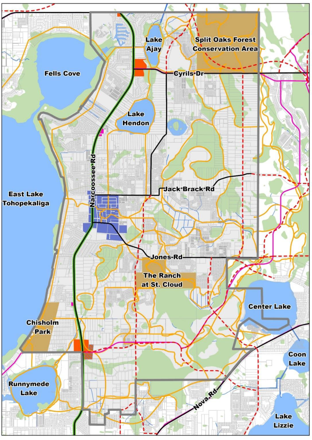
At the heart of the Narcoossee corridor is the Historic Town. This area will serve as the community and cultural center for residents of the area.
At the south end of the corridor lies the existing retail center anchored by Publix. With the opportunity for continued expansion along U.S. Highway 192, this area could serve as an employment base for the community.
Two (2) additional community centers lie at the intersections of Narcoossee Road and Cyrils Drive, and Narcoossee Road and Rummell Road. These centers are anticipated to contain a mix of retail and small businesses to complement the southern commercial and employment center.
Additional neighborhood-scale centers occur along Narcoossee Road at Boggy Creek Road, Tompkins Drive, and Chisholm Park Trail. Additional neighborhood centers are also intended to occur interior to the residential developments within the Narcoossee Community.
1.
CENTERS OVERALL CONTEXT. The Historic Town will establish a focus and identity for the Narcoossee Community, and will center around what could be considered Historic Narcoossee at the northeast corner of Narcoossee Road and Jones Road. This area sites almost at the geographical center for the Narcoossee community, already contains the historic fire station, and most lots are already divided into smaller parcels and zoned commercial, which is more applicable to development of a small downtown area. The Narcoossee Feed Store at the northwest corner of Narcoossee and Jones Roads should be preserved as well.
The preservation of remaining Historic Buildings and structures in Narcoossee is an important consideration in establishing the Historic Town. This may involve the preservation of historic buildings such as the Narcoossee Feed Store, the Narcoossee Schoolhouse, St. Luke's Missioner Baptist Church, the Volunteer Fire Department, and other historic buildings and structures in the area.
The Economic Development Framework for Narcoossee highlights opportunities for consolidating, expanding and creating new commercial areas along the Narcoossee corridor and interior to new walkable neighborhoods.
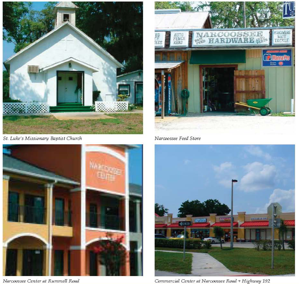
2.
CENTERS OPPORTUNITIES. Residents do not want Narcoossee Road to suffer a similar fate as other corridor in the region. Instead of typical strip commercial development, a series of appropriately spaced and sized neighborhood and commercial centers will be developed. These walkable, unique centers will range from coffee shops to mixed use office complexes to new local restaurants. In key places, they will be surrounded by smaller residential units, creating new complete neighborhoods. Centers located in the mixed use districts will be adjacent to higher density development. A 2011 market analysis infers that long-term market demand exceeds the amount of zoned commercial and employment land, due to high traffic counts along Narcoossee Road and anticipated regional growth. These under-scaled, vibrant centers could experience high retail expenditure per square foot, promoting needed but tempered economic development. The existing commercial big box center at Highway 192 could be expected to transition to a mixed use area over time if adjacent residential densities are increased. Key opportunities include:
•
Creation of lakefront retail areas.
•
Redevelopment of the Community Center at Highway 192.
•
Creation of centers with senior living components, local restaurants and services.
Senior Facility Opportunities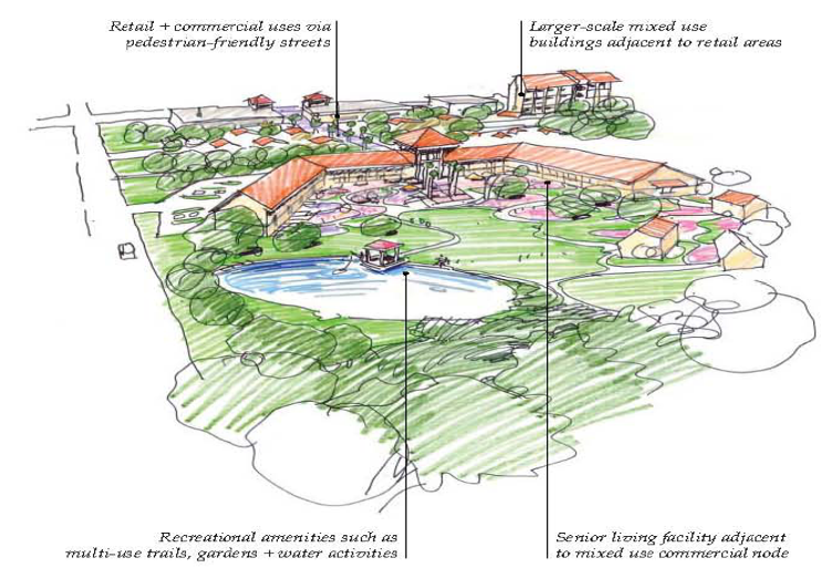
3.
HISTORIC TOWN OPPORTUNITIES.
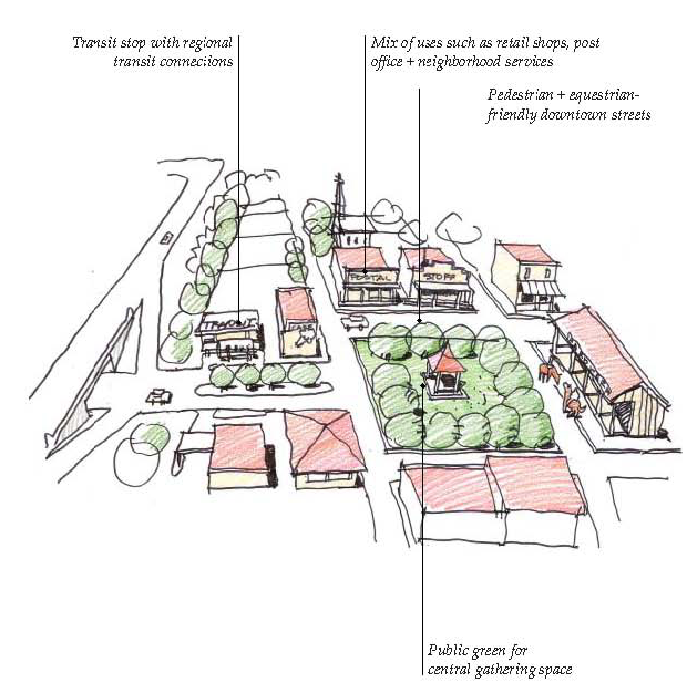
a.
Employment Areas Opportunities.
Residents have expressed interest in new local jobs. When asked the question, "will my children live in the community when they grow older?" the majority answered "no." A primary reason is the lack of high paying jobs. Most residents work outside the area. One (1) method to minimize the impacts of growth is providing employment options closer to where people live. New employment areas are planned in the centers, mixed use areas or as a separation between the Narcoossee community and the Northeast District. These businesses will provide new employment options to the residents. Key opportunities include:
•
New high technology research facilities due to the proximity to Medical City and the Sunbridge Employment District.
•
Office uses, creating appropriate entryways into the area.
•
Sustainable industries that are consistent with the area's values.
Employment Areas Opportunities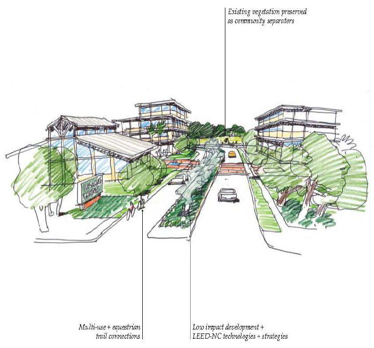
b.
Investment in Historic Town Opportunities.
Residents have chosen to restore and expand the historic gathering place of the community. Historic Town will include mixed use commercial buildings against the street, a small-block quaint downtown, event area and the stabilization and enhancement of the adjacent residential neighborhoods. The development of Historic Town is expected to achieve the following goals:
•
Creation of a gateway into the community and Osceola County.
•
Definition of the character and sense of place of the community.
•
Provision of a mix of commercial and residential development.
•
Creation of a central public gathering area and event areas.
•
Provision of a center for local economic development.
•
Provision of a local and regional recreational resource focused on equestrian amenities.
•
Provision of a cultural center for the community, including a museum, art, local food production, and historic buildings.
•
Provision of transit station options.
•
Preservation of historic buildings and neighborhoods.
Key opportunities include:
•
Well-designed architectural details.
•
Restaurants.
•
Library and/or community centers.
•
Churches and/or meeting areas.
•
Public greens, plazas and farmer's market.
•
Civic buildings/town hall.
•
Public gathering spaces.
•
Equestrian amenities.
Historic Town Opportunities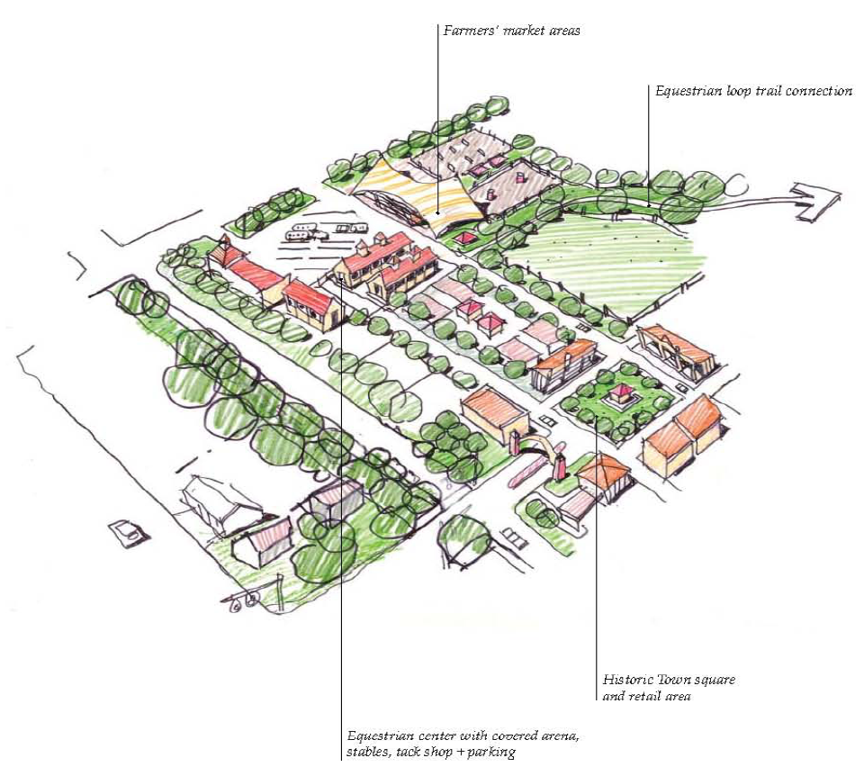
4.
HISTORIC TOWN GOALS + OBJECTIVES. The Historic Town Design guidelines are necessary to create a vibrant, small-scale town center, and are oriented towards five (5) primary objectives:
•
Reflect the rural and agrarian context of the community;
•
Create places for gathering, living, working, and access to daily goods and services;
•
Enhance the existing identity in a cohesive way;
•
Establish a comfortable pedestrian environment; and
•
Plan for transit integration by including transit-oriented features.
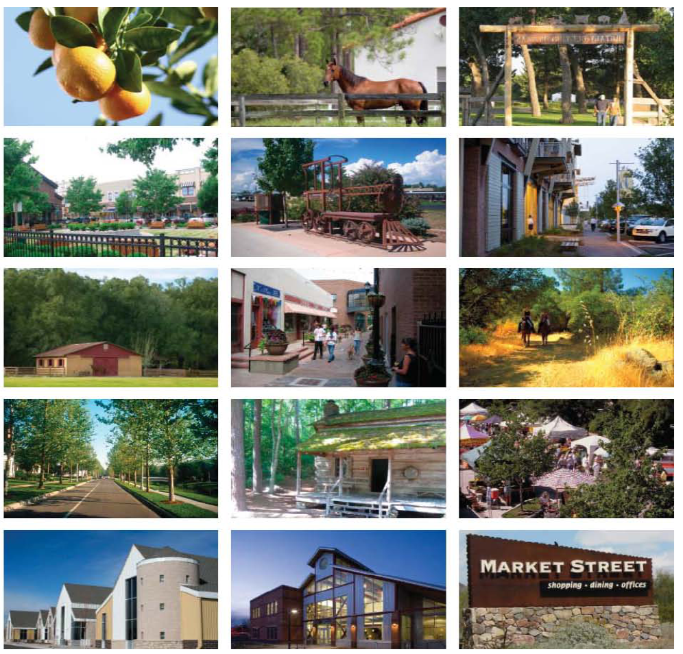
a.
Historic Town Character Areas.
Within the Narcoossee Historic Town, four (4) character areas exist that reflect differing types of use, walkability, road types and usage and transitions. These four (4) zones are described as follows:
Zone 1: Small Block Commercial is characterized by smaller, pedestrian-oriented blocks, narrower streets and central town square.
Zone 2: The Narcoossee Road Transit-Oriented Design (TOD)/Commercial is the area that calls passerby's attention to the Small Block Commercial area. While the rest of the Narcoossee corridor is heavily landscaped, with little or no views to the interior neighborhoods, within this area the buildings will front the highway, creating a more active public space along Narcoossee Road.
Zone 3: Town Residential make up the majority of the area surrounding the Small Block Commercial, and comprises the residential component of the Historic Town. While the block layout relies heavily on existing parcels and rights-of-way, the blocks range in size, with a maximum of six hundred (600) feet by three hundred (300) feet. A new street network through the area increases connectivity and enhances walkability.
Zone 4: The Cultural/Commercial/Event Zone serves as the gathering area and the cultural center for Narcoossee.
b.
Historic Town Guidelines.
i.
Zone 1: Small Block Commercial.
•
Small Block Commercial Architecture.
Building Size, Massing + Use.
All buildings shall be built to a uniform frontage line to define the Small Block Commercial and distinguish it from other centers and surrounding neighborhoods.
Building Use.
•
The Small Block Commercial zone shall have a variety of uses including: housing, and small-scale, neighborhood-oriented retail, commercial and office uses consistent with Commercial Office, with a focus on civic uses and recreational facilities.
•
Sites for future civic buildings shall be preserved as prominent focal points and identifying architectural buildings.
•
This zone should encourage a mix of uses.
Building Size + Massing.
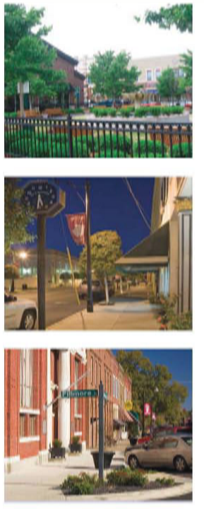
Lot/Building Sites.
•
Large development parcels shall be divided into smaller building sites wherever possible.
•
Building sites for civic buildings may consume an entire block.
•
Maximum building sites for residential and commercial uses shall be five thousand (5,000) square feet.
•
Maximum lot coverage shall be one hundred (100) percent.
Building Height.
•
Building heights shall be varied throughout the Small Block Commercial.
•
Maximum building height shall be two (2) stories for non-residential structures.
•
Maximum height for special element, such as silos, towers or clerestories shall be forty (40) feet.
•
Maximum building footprint shall be five thousand (5,000) square feet.
•
Civic buildings shall be exempt from this limit.
Building Setbacks.
•
Zero-foot front build-to line.
•
Zero-foot minimum and rear setbacks.
Building Frontages.
•
Minimum building façade built to the build-to line shall be eighty-five (85) percent.
Small Block Commercial Area with Town Square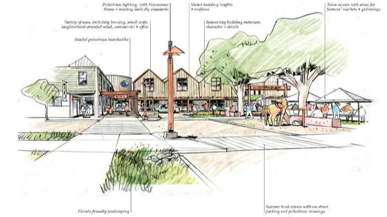
Small Block Commercial Area, Pedestrian Area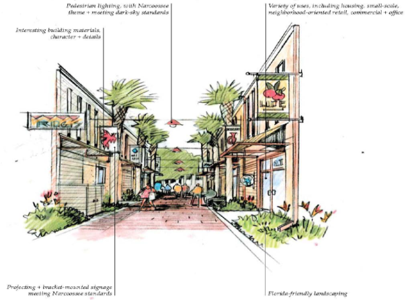
Small Block Commercial Area at Jones Road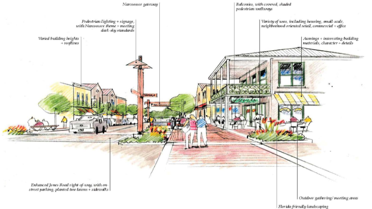
•
Small Block Commercial Exterior Building Materials + Finishes.
Exterior Materials.
Types of materials appropriate to the context of Narcoossee shall be used. Examples are noted as follows:
•
unfinished rough-cut pine cladding.
•
clapboard siding.
•
metal standing seam roofing.
•
perforated metal.
•
wire metal mesh.
Exterior Colors.
Within the Small Block Commercial, natural and earth tone colors such as unfinished wood shall be used, as appropriate, for different architectural styles.
•
Small Block Commercial Building Details/Public/Private Space + Transition.
Entrances.
•
All main entrances shall face the commercial street.
Encroachments.
•
Encroachments include porches, awnings, roof overhangs, covered entries, arcades, boardwalks, balconies.
•
All buildings shall have some type of transitional public/private space.
•
All encroachments may extend into the public sidewalk.
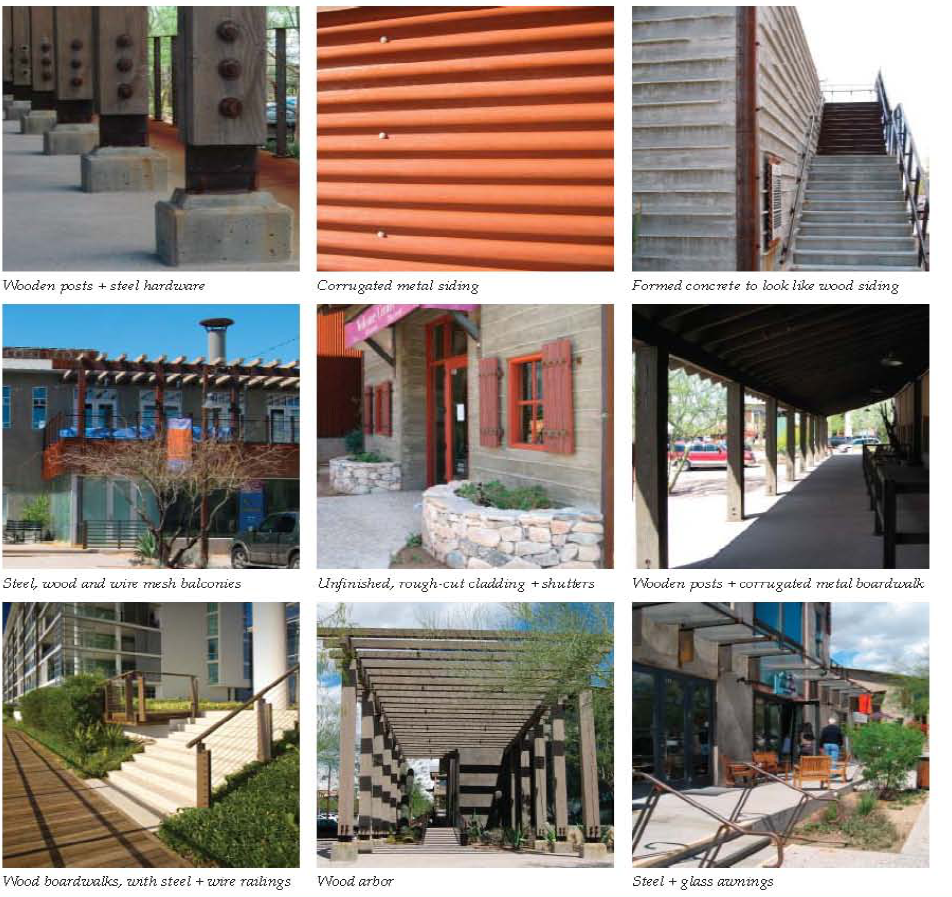
•
Small Block Commercial Building Fenestration + Roofs.
Fenestration/Glazing.
•
Ground level retail storefronts with formal, symmetrical façades, large expanses of display windows flush with the building walls, recessed entrances and decorative glass transoms shall be used in the Small Block Commercial.
•
Windows shall be scaled to remain proportionate with building size.
Roofs.
•
Clerestory windows and/or dual-level roofs shall be used at second levels.
•
Roof forms recalling those of barns, stables or agricultural facilities shall be used.
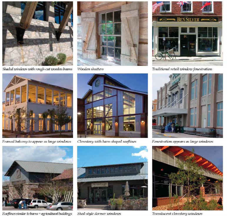
•
Small Block Commercial Building Lighting.
Façade Lighting.
Subtle façade lighting shall enhance the character and ambiance of the Small Block Commercial. Façade lighting can be used to supplement street lighting for improved pedestrian safety. Façade lighting can be used as lighting for wall-mounted signage. All lighting within the area shall meet dark sky requirements.
Subtle wall-washing façade lighting shall be permitted within the Small Block Commercial.
(a)
Fixtures should be directed downward, with emphasis placed on the street level areas of the façade where the lighting will enhance pedestrian safety.
(b)
Fixture styles, finishes and light source should be compatible with the scale and materials of the building façades, and complementary to awnings, signage and other features.
(c)
Use of modern light fixtures is permitted, provided the placement and design is compatible with the character of the Small Block Commercial buildings.
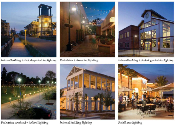
ii.
Zone 2: Narcoossee Road TOD/Commercial.
•
TOD/Commercial Architecture.
Building Size, Massing + Use.
All buildings shall be built to a uniform frontage line to define the TOD/Commercial Area and to distinguish it from the overall Narcoossee corridor.
Building Use.
The TOD/Commercial Area shall have a variety of uses including: housing, retail, commercial and office.
Building Size + Massing.
Lot/Building Sites.
•
Maximum building sites for residential and commercial uses shall be fifteen thousand (15,000) square feet.
•
Maximum lot coverage shall be one hundred (100) percent.
Building Setbacks.
•
Zero-foot front build-to line.
•
Zero-foot minimum and rear setbacks.
Building Frontages.
•
Minimum building façade built to the build-to line shall be eighty-five (85) percent.
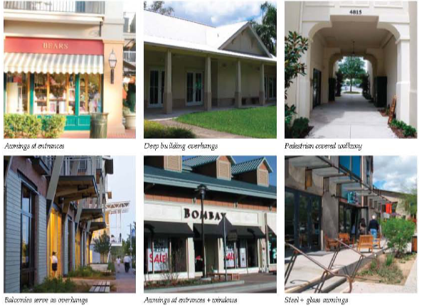
Entrances.
•
All main entrances shall face Narcoossee Road.
Encroachments.
•
Porches, awnings, roof overhangs, covered entries, arcades, boardwalks, balconies.
•
All buildings shall have some type of transitional public/private space.
•
All encroachments may extend into the public sidewalk.
•
TOD/Commercial Building Lighting + Signage.
The TOD/Commercial Area lighting and signage shall be designed similar to those described for the Small Block Commercial Area.
iii.
Zone 3: Town Residential.
Several areas adjacent to the Small Block Commercial, particularly north along Narcoossee Road, are underdeveloped and excellent candidates for redevelopment. A more intensive pattern of development in these transitional areas will provide the Historic Town with an enlarged population of customers, visitors and residents. New development in these areas should encourage mixed use, blending residential housing with traditional commercial and retail businesses and providing downtown live/work opportunities. New development should build on the pattern of one- and two-story buildings organized in traditional block faces, with buildings fronting tree-lined streets.
Infill development within the transitional areas between the Small Block Commercial and rural residential areas to the east and south shall be more "urban" than "suburban" in character, with new buildings constructed to the sidewalks instead of set back with large expanses of lawn. Native landscaping shall be encouraged throughout the area, to reinforce Narcoossee's character.
Design of building scale, massing, façade treatments, materials and details are encouraged to be similar to those recommended within the Small Block Commercial.
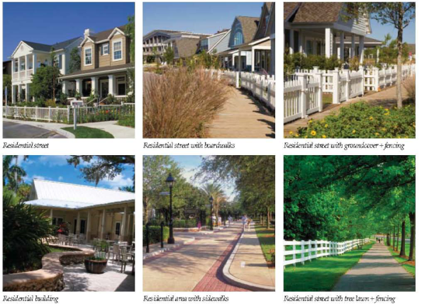
iv.
Zone 4: Cultural/Commercial/Event Zone.
The Cultural/Commercial/Event Zone could include a small public square at a central location, with adjacent streets lined with street trees. As part of this square, an orange grove could be accommodated, or orange trees could line all sides of the square, to reinforce Narcoossee's agricultural history. Hitching posts could be placed around the square as well, separate from parking areas.
A location should be identified and preserved for an Equestrian/Event Center adjacent to the Small Block Commercial, in order to support the retail uses within Historic Town and to support the equestrian community adjacent to the area.
These grounds could serve as both event grounds as well as places for community gatherings such as farmers' markets.
Design of building scale, massing, façade treatments, materials and details are encouraged to be similar to those recommended within the Small Block Commercial.
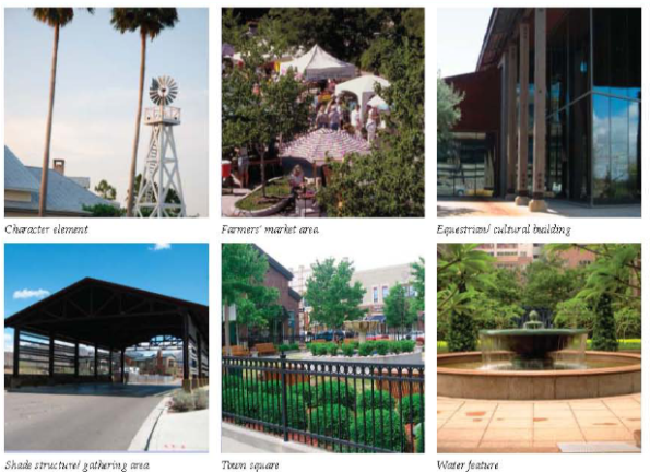
c.
Historic Town Public Art.
A theme should be developed for public art and incorporated around the Small Block Commercial and Cultural/Commercial/Event Zone. Themes could include:
•
Steamer ships
•
Equestrian
•
Orange groves
•
Sugar cane
•
Cattle brands
•
Turpentine industry
•
Railroad
•
Cowboy
•
Wildlife (sandhill cranes, alligators, black bear, fox, deer, turkey, etc.)
•
Natural resource elements (water, wetlands, pines, saw palmetto, wildflowers, etc.)
All commercial and civic buildings built within the Small Block Commercial and Cultural/Commercial/Event Zones shall be required to fund or contribute to one (1) public art project or historical site identification/markers within the area, related to the overall theme.
Zone 5: Whitted Historic Community.
The primary purpose of the Whitted Historic Community is to recognize the long-standing presence of this community and protect the character and lifestyle elements while promoting sustainable, compatible growth.
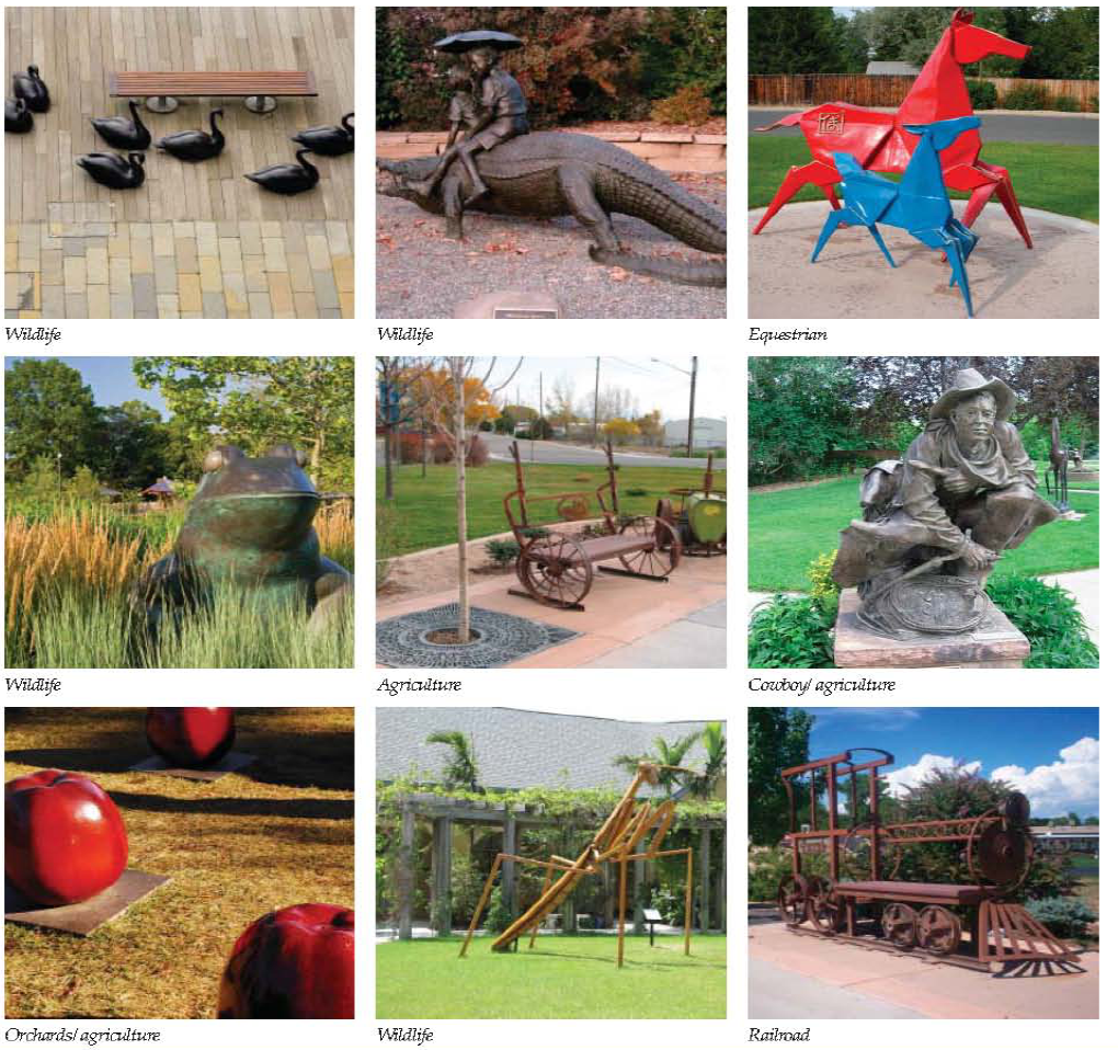
5.
COMMUNITY + NEIGHBORHOOD CENTERS GOALS + OBJECTIVES. These guidelines are intended to create vibrant, small-scale Community and Neighborhood Centers along the Narcoossee Corridor, and are oriented towards the following objectives:
•
Reflect the agrarian context of the community along the Narcoossee Corridor; and
•
Design centers that are interesting and express a different character than currently found in the nearby commercial areas of St. Cloud.
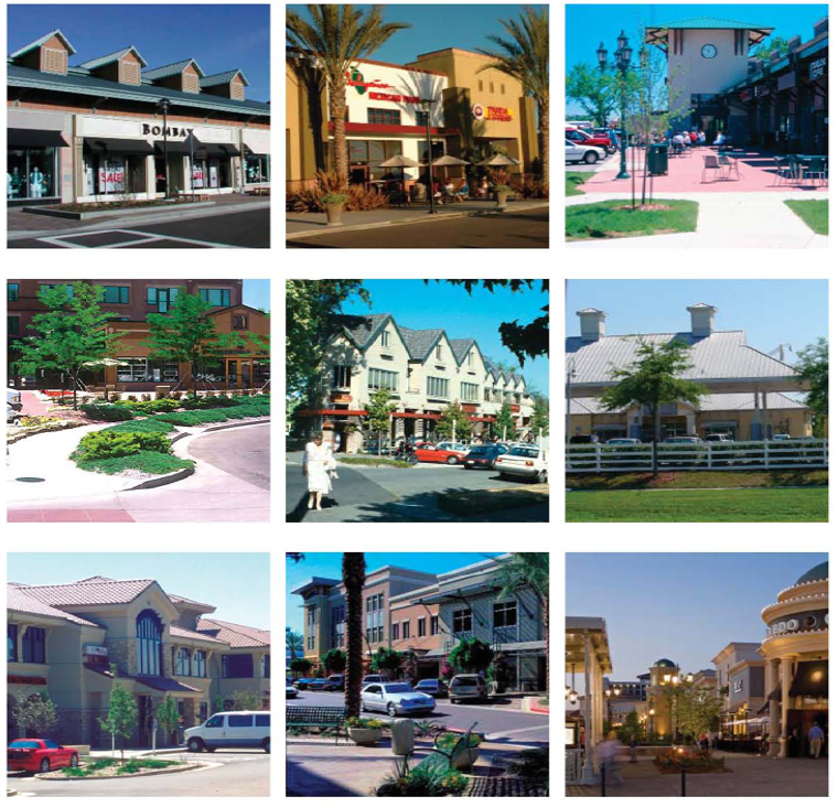
a.
Neighborhood + Community Center Guidelines.
i.
Neighborhood + Community Centers Building Architecture.
•
Building Use, Size + Massing.
Building Use.
•
Neighborhood Centers shall have a variety of uses including: small-scale, neighborhood-oriented retail, office, civic and housing.
•
Community Centers shall have a variety of uses including; small-and large-format retail, commercial, office, and multi-family housing.
•
A mix of uses is encouraged both horizontally and vertically.
Lot/Building Sites.
•
Maximum building sites shall be twenty-five thousand (25,000) square feet within the Neighborhood Centers.
•
Maximum building sites shall be eighty thousand (80,000) square feet within the Community Centers.
•
Maximum building footprint shall be twenty-five thousand (25,000) square feet within the Neighborhood Centers, and
•
Eighty thousand (80,000) square feet within the Community Centers.
•
Civic buildings, such as schools, churches, and/or recreation centers shall be exempt from the building square footage limit, but shall be sized to be compatible with adjacent development.
Building Massing.
•
A single, large, dominant building mass shall be avoided within Neighborhood and Community Centers; changes in mass shall be related to entrances, the integral structure and/or the organization of interior spaces and activities.
•
Horizontal masses shall not exceed a height/width ratio of one (1) vertical to three (3) horizontal without substantial variation in massing that includes a change in height and projecting or recessed elements.
•
Buildings shall relate well to each other, to the site, and adjacent properties by providing transitions in building heights.
•
No façade that faces a street or connecting walkway shall have a blank, uninterrupted length exceeding thirty (30) feet.
ii.
Neighborhood + Community Centers Exterior Building Materials + Finishes + Details.
•
Exterior Materials + Colors.
Exterior building materials shall either be complimentary or draw in part from the materials already being used in the Narcoossee area. If dissimilar materials are being proposed, other characteristics such as scale and proportions, form, architectural detailing, color and texture, shall be utilized to ensure that enough similarity exists for the building to be compatible, despite the differences in materials.
With the exception of windows, building materials shall be natural/indigenous in character, and shall be selected to provide a variety of textures per building façade, visual balance and avoid excessive variety of materials.
Building materials shall provide greater visual and textural interest at building entrances and architectural opportunities and areas that are highly visible to the public. Exterior materials shall be chosen for their suitability, durability, and visual continuity. Recommended building materials include:
•
Brick.
•
Textural concrete block, painted or integral color.
•
Textured architectural precast panels, painted and/or cast-in textures.
•
Site-cast concrete panels, painted and/or cast-in textures.
•
Wood.
•
Natural stone and synthetic stone products.
•
Metal-accents elements only.
•
Glazing.
•
Smooth face concrete block, used in combination with other textural materials.
•
Other similar high quality materials.
The color palette shall consider earth tones indigenous to the region resulting in a cohesive, unified theme throughout the development.
Interesting building details reminiscent of the Narcoossee area's history as an agricultural and ranching area are encouraged, such as clerestories, double-pitch roof forms, barn details, etc.
iii.
Neighborhood + Community Centers Public/Private Space + Transition.
Entrances.
•
Primary building entrances shall be clearly defined to provide greater visual and textural interest at building entries.
Encroachments.
•
All buildings shall have some type of transitional public/private space, such as porches, awnings, roof overhangs, covered entries, arcades and/or balconies. All of these encroachments may extend into the public sidewalk.
iv.
Neighborhood + Community Centers Building Fenestration + Glazing.
Ground level retail storefronts with large expanses of display windows shall be used in both Neighborhood and Community Centers.
Windows shall be scaled and positioned to remain proportionate with building size.
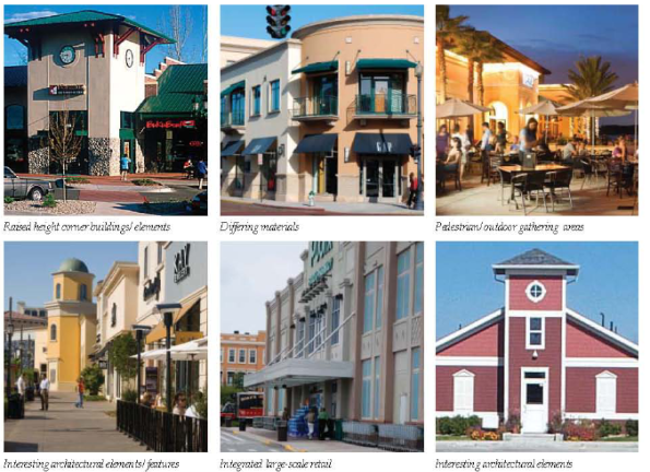
v.
Neighborhood + Community Centers Building Lighting.
Building lighting throughout the Narcoossee area shall be designed to reflect the area's history as an agricultural and ranching area. All lighting is required to meet dark-sky standards, and all lighting shall be directed downward with high cut-off, so as not to reflect light back into the sky. Over-lighting within these areas is not permitted.
•
Store façades, if lighted, must have lighting equipment mounted on the building pointing downwards.
•
Stores must use controls to turn off exterior lights and sign lights after store closing. Only a minimum light level shall remain on past this point.
•
All building mounted security lighting must be pointed down and completely shielded.
•
Floodlighting and uplighting shall not be permitted.
•
Subtle wall-washing façade lighting shall be permitted.
•
Fixtures should be directed downward, with emphasis placed on the street level areas of the façade where the lighting will enhance pedestrian safety.
•
Fixture styles, finishes and light source should be compatible with the scale and materials of the building façades, and complementary to awnings, signage and other features.
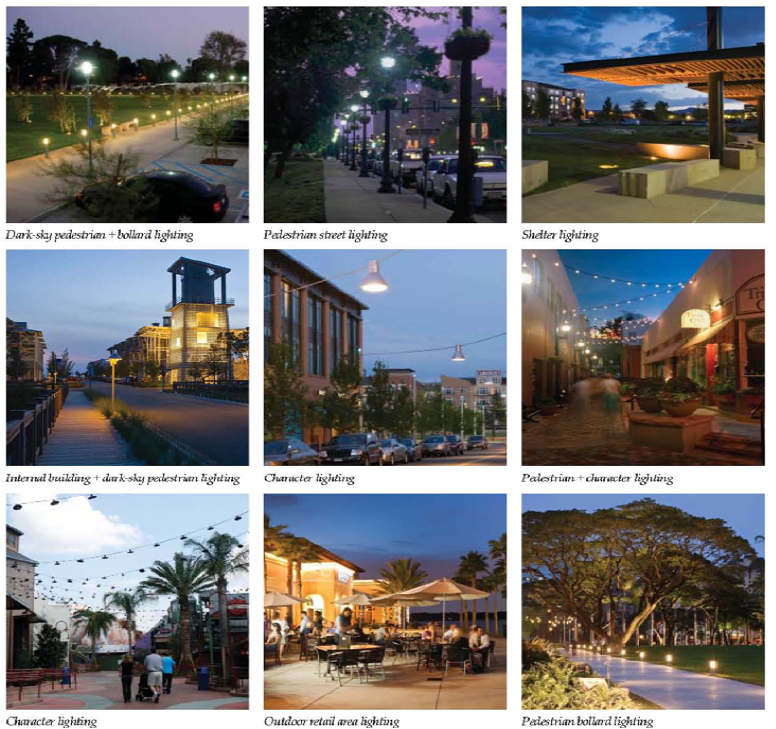
vi.
Neighborhood + Community Centers Convenience Commercial.
Convenience Commercial areas throughout the Narcoossee area should be treated with a higher level of character and architectural detail than typical standards. Gas stations, convenience stores and fast food restaurants shall be designed to the same level of detail as defined on the previous pages, with landscaping and elements such as fencing and signage located to detract from the drive-through character of these establishments, and to enhance pedestrian safety.
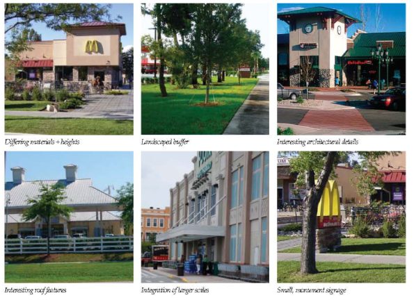
(Ord. No. 2025-10, § 4, 3-17-2025; Ord. No. 2025-40, § 2, 8-18-2025)
3.12.2 - SHORT-TERM RENTAL OVERLAY
SHORT-TERM RENTAL. Short Term Rental is permitted in the Planned Development zoning district subject to the standards outlined for a Planned Development contained herein. The proposed developments must fall within the boundaries of the "Short-Term Rental Overlay" as indicated in Exhibit 3.12.2.
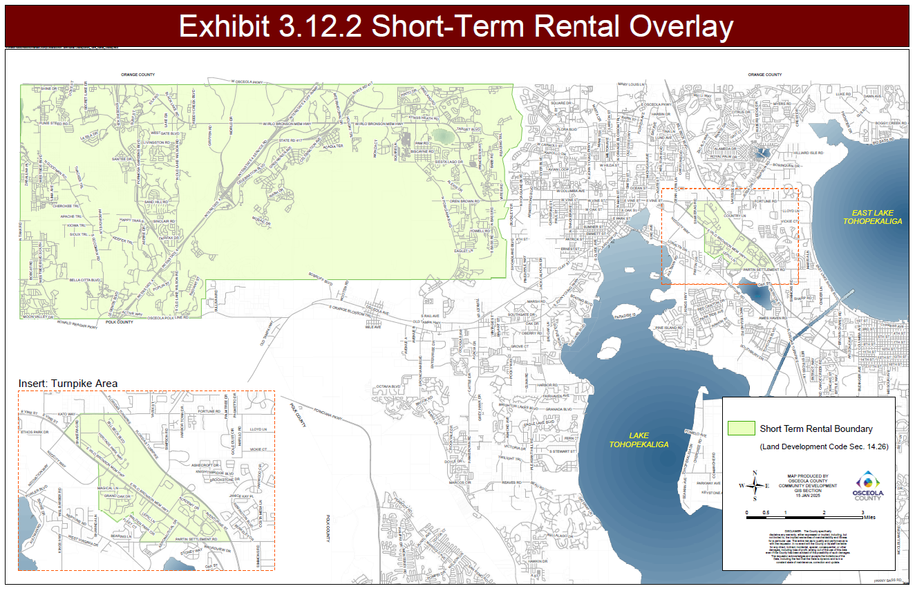
(Ord. No. 2025-10, § 4, 3-17-2025)
3.12.3 - WEST OF INTERCESSION CITY OVERLAY
Within the West of Intercession City Overlay (FLU Map 2A/2B), new non-residential development including, but not limited to, commercial, office and industrial uses outside of 200 feet from central potable water and/or sanitary sewer services may be serviced by on-site potable water and/or wastewater treatment and disposal systems as long as the development meets all applicable Federal, State, regional and local regulations and requirements; and the capacity required for wastewater generation does not exceed the gallons per day identified in the Comprehensive Plan. Non-residential development served with on-site potable water and/or wastewater treatment and disposal systems shall enter into an agreement to connect to central sanitary sewer services when available within 200 feet.
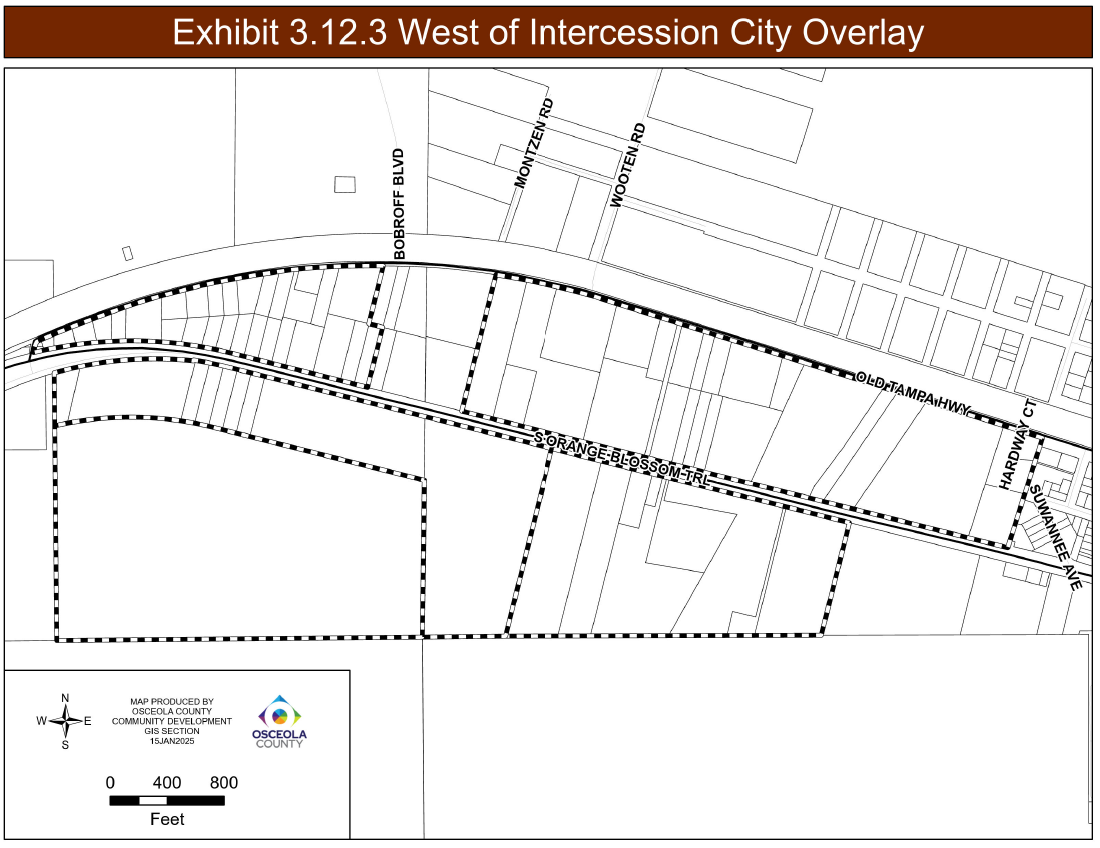
(Ord. No. 2025-10, § 4, 3-17-2025)
3.12.4 - BOGGY CREEK ROAD OVERLAY DISTRICT
A.
INTENT. The Boggy Creek Road Overlay encompasses an area north of East Lake Tohopekaliga, south of the Orange County Line, east of Austin Tindall Park, and west of Fells Cove. The planning process involved participation from landowners to determine standards for future industrial, commercial, and more intense residential development. The Boggy Creek Road Overlay boundary is identified below in Figure 3.12.4A and is described by the legal description adopted in Exhibit A of Ordinance 2025-47.
Figure 3.12.4A — Boggy Creek Road Overlay District
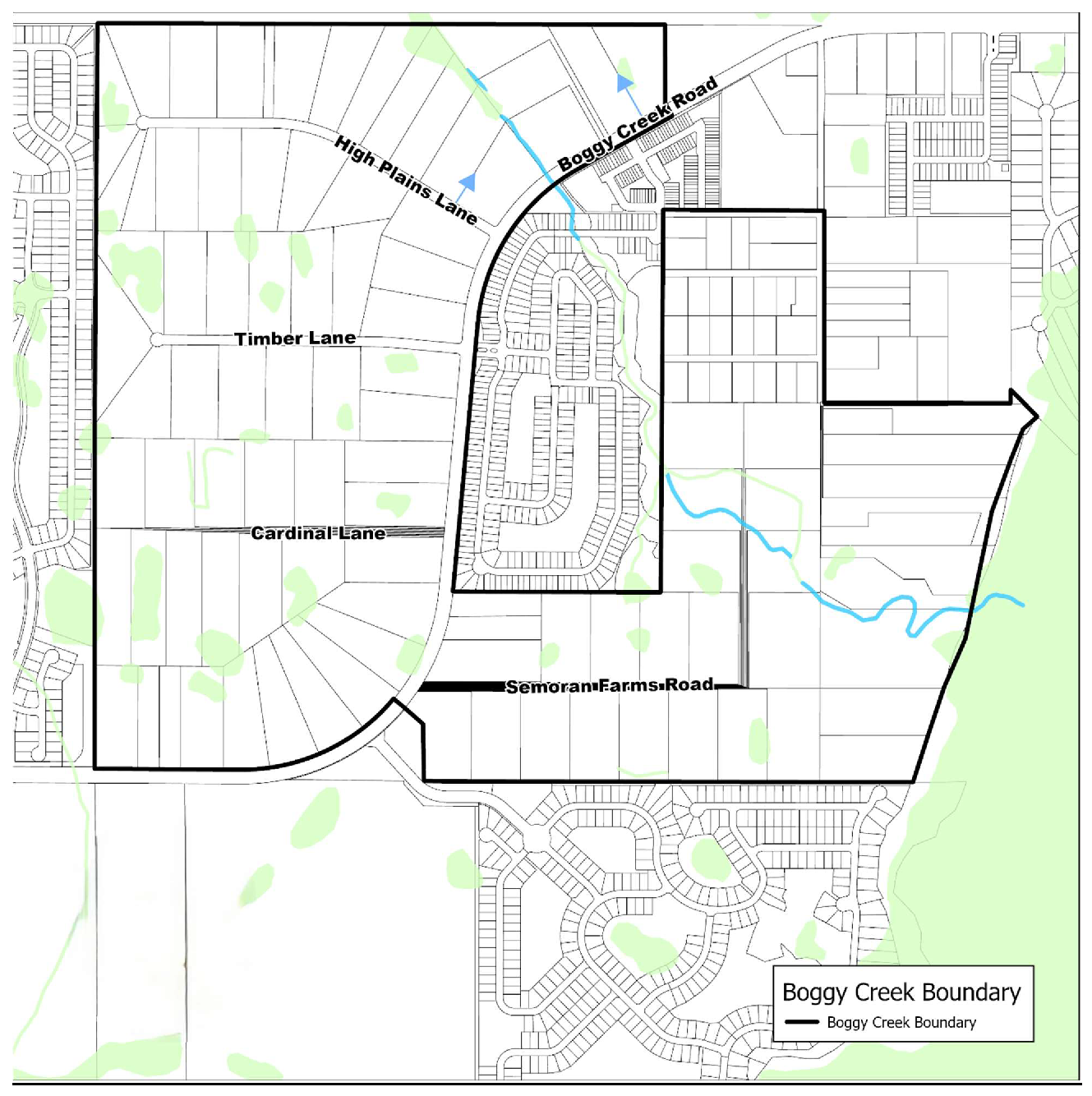
B.
IMPLEMENTATION FRAMEWORK. The overlay is divided into four (4) areas: Zone A and Zone B are located within the Industrial Future Land Use; Zone C lies within the Community Center Future Land Use; and Zone D is comprised of land on the east side of Boggy Creek Road with a Low Density Residential Future Land Use, as shown on Figure 3.12.4B. If there are conflicts between these standards and standards contained elsewhere in the Land Development Code, the standards in this Article shall prevail. Development aspects not covered by these standards shall be governed by the standards contained elsewhere in the Land Development Code.
Figure 3.12.4B — Boggy Creek Road Overlay District Zones A—D
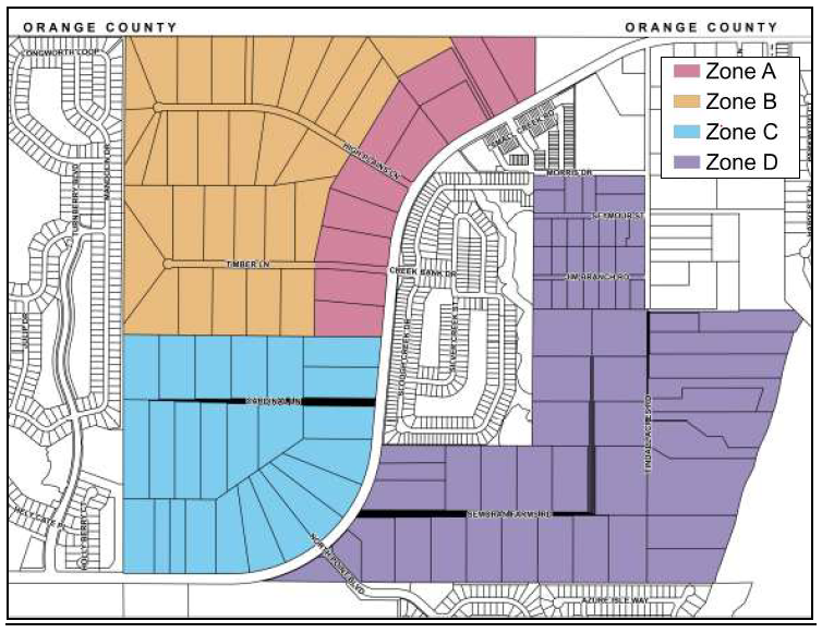
C.
USES AND STANDARDS.
1.
Zone A: Boggy Creek Industrial Corridor.
a.
Uses:
•
Correlating zoning district: Industrial Restricted (IR).
•
Permitted Uses: All uses in IR zoning district, except for the prohibited use(s) named below.
•
Prohibited Use(s): Open storage, parking of trucks, recreational vehicles, and trailers; self-storage.
b.
Required Buffers:
•
Fifteen (15) foot buffer comprised of two (2) large and three (3) medium trees, and fifteen (15) shrubs per one hundred (100) linear feet along Boggy Creek Road for all uses.
•
Low landscape buffer along High Plains Lane and Timber Lane right-of-way.
•
No landscape buffer is required between adjacent uses. Two (2) large and two (2) medium trees per one hundred (100) linear feet shall be planted between the boundary of Zone A and Zone B, see Figure 3.12.4C.
c.
Parking Orientation: Parking along Boggy Creek Road shall be limited to one of the following:
•
Option 1: One (1) drive aisle with two (2) rows of parking shall be required to provide a minimum three-foot-tall, maximum four-foot-tall planter with low shrubs that screens vehicles from the abutting public right-of-way incorporated within the required buffer. At no time shall this landscape barrier be pruned in a manner that allows the vehicle headlights to be visible from abutting street rights-of-way. As an alternative other architectural features consistent with the primary building architecture design may be used to screen vehicles from view.
•
Option 2: One (1) drive-aisle with a single row of parking which does not face Boggy Creek Road.
2.
Zone B: Boggy Creek Industrial.
a.
Uses:
•
Correlating zoning districts: Industrial Manufacturing (IM) and Industrial Restricted (IR).
•
Permitted Uses: All uses in the IM and IR zoning district, except for the prohibited use(s) named below.
•
Prohibited Use(s): Self-storage, slaughterhouse.
b.
Required Buffers:
•
New industrial development adjacent to a single-family developed lot shall be required to provide a "Low" buffer with a minimum six-foot (6') masonry wall or other similar decorative durable wall.
•
Outdoor storage yards shall comply with siting standards contained in the Land Development Code.
•
Low buffer along High Plains Lane and Timber Lane right-of-way.
c.
Parking Orientation:
•
Per the Land Development Code.
3.
Zone C: Boggy Creek Community Center.
a.
Uses:
•
Correlating zoning districts: Community Center Core (CCC)/Community Center Perimeter (CCP).
•
Permitted Uses: All uses in the CCC/CCP zoning districts, except for the prohibited use(s) named below.
b.
Prohibited Use(s): Car wash; convenience retail with gas pumps; restaurant with drive-through; self-storage/warehouse; and wholesaling, warehousing, storage and distribution, enclosed/light manufacturing.
c.
Required Buffers:
•
Medium landscape buffer with no screen adjacent to single-family developed lot.
•
Screening is not permitted.
d.
Parking Orientation:
•
Per the Land Development Code.
4.
Zone D: Boggy Creek Low Density Residential.
a.
Uses:
•
Correlating zoning districts: Urban Settlement (US) and Low Density Residential (LDR).
•
Permitted Uses: All uses in the US/LDR zoning districts.
b.
Required Buffers:
•
Per Land Development Code.
c.
Parking Orientation:
•
Per the Land Development Code.
D.
BOGGY CREEK ROAD ACCESS MANAGEMENT PLAN.
1.
Interim Access: Driveway access for new development on Boggy Creek Road shall be permitted as an interim condition only and said development shall be required to ultimately meet Land Development Code access management standards upon adjacent new development providing the ultimate driveway access. The developer shall enter into a Developers Agreement with the County to eliminate driveways granted for interim access when driveway access per the Boggy Creek access management plan is available. Both the interim and final driveway conditions shall be submitted with Site Development Plan (SDP). The SDP shall be conditioned to require the Developers Agreement. Once the SDP is approved by the County, the County Manager or designee has the authority to execute the Developers Agreement which shall then be recorded in the Public Records of Osceola County, Florida prior to site construction.
Figure 3.12.4C — Boggy Creek Road Overlay District Access Management Plan
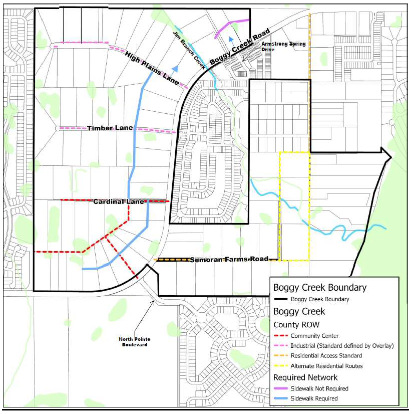
2.
Zone A, B, and C Required Network: Unless otherwise defined herein, the exact specifications of the required network shown on Figure 3.12.4C and described below shall be determined at Preliminary Subdivision (PS) or SDP.
a.
A paved vehicular access route parallel to and offset approximately 600 feet from Boggy Creek Road, coinciding with the rear property line of property with frontage on Boggy Creek Road and extending from Cardinal Lane to High Plains Lane. An additional parallel access is required approximately three hundred thirty (330) feet from Boggy Creek Road within the Community Center Core. Sidewalk(s) shall be constructed on these routes. Perpendicular parking is prohibited along this route.
b.
A single permanent access to Boggy Creek Road for parcels north of Jim Branch Creek shall be located at the intersection of Boggy Creek Road and Armstrong Spring Drive. A paved vehicular access route parallel to Boggy Creek Road shall be provided a minimum of three hundred thirty (330) feet from Boggy Creek Road.
c.
Within the Community Center, the route parallel to and offset approximately six hundred (600) feet from Boggy Creek Road and the access coincident with Cardinal Lane shall be built to County street, access, and operational standards. These roadways shall be considered a primary façade.
d.
Timber Lane and High Plains Lane shall be constructed as an urban section with two (2) twelve-foot (12') travel lanes, a twelve-foot (12') bi-directional center lane, five-foot (5') sidewalks on both sides, and minimum seven-foot-wide parkways on both sides.
3.
Zone D Required Network:
a.
The route shown within Zone D shown on Figure 3.12.4C shall be constructed to two-lane Avenue/Blvd with median standards per the Land Development Code table 4.7.1C with a ten-foot (10') multi-use trail on both sides of the street in lieu of buffered bike lanes and sidewalks. The exact specifications shall be determined at PS or SDP.
b.
Where alternate routes are shown, only one (1) of the routes is required.
(Ord. No. 2025-47, § 2, 8-4-2025)
3.13.1 - GENERAL PROVISIONS
A.
RELATIONSHIP TO OTHER LAND DEVELOPMENT CODE CHAPTERS. The standards in this Chapter apply to properties shown on the County's Future Land Use Map as Mixed Use and identified in the Comprehensive Plan as a Mixed Use District. If there are conflicts between these standards and standards contained elsewhere in the Land Development Code, the standards in this Article shall prevail. Development aspects not covered by these standards shall be governed by the standards contained elsewhere in the Land Development Code.
B.
PURPOSE.
1.
The standards are intended to enable creation of functional mixed use communities consisting of bicycling, pedestrian and transit-oriented centers of commerce and employment that support and are supported by walkable residential neighborhoods.
2.
The following planning principles serve as a guide for interpreting and implementing the standards contained herein. The principles are the basis for the County's Mixed Use policies and they are organized by the scale at which they are functionally relevant.
a.
Community Scale Principles.
i.
Neighborhoods and Centers are compact, bicyclist and pedestrian-oriented and transit-accessible places designed to reduce over-reliance on automotive based travel.
ii.
Centers, having a mix of uses, are the primary urban form for accommodating commercial, office, industrial and institutional development. Special Districts established to accommodate a single use are the exception.
iii.
Ordinary activities are conveniently accessible by bicycling, walking or transit, allowing independence to those who cannot or choose not to drive.
iv.
Interconnected networks of streets are designed to disperse traffic and reduce the length of automobile trips.
v.
A range of housing types and price levels is available within neighborhoods to accommodate diverse ages and incomes.
vi.
Transit supportive building densities and land uses are provided within walking distance of transit stops.
vii.
Civic, public, and private institutional and commercial activities are embedded in mixed use centers, not isolated in remote single-use complexes.
viii.
A range of civic spaces, including parks, squares, and playgrounds are distributed within neighborhoods and centers.
b.
Block and Building Scale Principles.
i.
Buildings and landscaping contribute to the physical definition of streets as public spaces.
ii.
Development respects the pedestrian and the spatial form of public areas, while adequately accommodating bicycles and automobiles.
iii.
The design of streets and buildings reinforces safe pedestrian and bicyclist environments, with building frontages oriented to the street.
iv.
A visual scale is established for each center and neighborhood and coordinated through a consistent application of building form standards.
v.
Civic buildings and public gathering places are provided at locations that reinforce community identity.
vi.
Civic buildings are distinctive and appropriate to their role of importance within the community.
C.
CONCEPT PLANS AND SITE DEVELOPMENT PLANS.
1.
The Comprehensive Plan directs that (a) implementation of the Conceptual Master Plan for a Mixed Use District be through the preparation and approval of a Concept Plan and Site Development Plan; and that (b) adjustments to a Conceptual Master Plan shall become final through approvals of Concept Plans and Site Development Plans.
2.
The Comprehensive Plan further prescribes policies that these Standards are intended to implement, which include:
a.
The build out of lands within a Mixed Use District should occur in a manner that is predictable, but also flexible; and
b.
Uses, densities, and intensities in a Mixed Use District shall be allowed to change over time, evolving in order to realize buildout targets.
3.
For Mixed Use Districts, the County will review and approve Concept Plans and Site Development Plans consistent with the following principles (among other principles):
a.
The Concept Plan shall identify the proposed densities and intensities by reference to affected Centers and Neighborhoods. The proposed program shall be evaluated based on:
i.
The development program's consistency with the FLUE mixed-use policies; and
ii.
The Project's enabling of transit, jobs creation, bicycle accommodations, and walkability within the District's Urban and Community Centers.
b.
Development within Urban, Employment, Community, and Neighborhood Centers, or within one-quarter (¼) mile of rail stations, stations along bus rapid transit routes in exclusive bus-only lanes, and/or transit superstops, shall be developed to allow evolution of the developments to maximum densities and intensities. The Site Development Plan shall clearly illustrate how this will be accomplished, through a series of site designs showing the sequence of development activity over time.
c.
Project designs will incorporate the walkability principles contained in these standards.
D.
CHAPTER ORGANIZATION. The remainder of this Chapter is organized as follows:
1.
Place Type Functions. This article directs different types of activities or uses to the appropriate Place Type, consistent with its defined function. Minimum percentages of uses within a Place Type are set forth for the purpose of ensuring a robust mixture of compatible activities.
2.
Public Realm Standards. This article presents design specifications for establishing and creating public spaces, which include streetscapes and civic spaces.
3.
Site Design and Architectural Standards. This article establishes standards for the development, location, and design of public rights-of-way as well as site design and architectural standards for residential and commercial buildings.
4.
Open Space and Recreation. This article establishes standards and identifies for the quantity and size of different types of parks and open space, presents planting standards, and standards for the interaction with the rest of the public realm.
5.
General Planting Requirements. This article presents planting standards for different place types.
6.
Habitat Conservation and Management Plan. This article establishes standards for the conservation, preservation, and expansion of existing regionally and locally significant natural resources and a process for continuous monitoring and education.
(Ord. No. 2022-125, § 3, 2-20-2023)
3.13.2 - PLACE TYPE FUNCTION
A.
REGULATION OF PLACE TYPE FUNCTION. The requirements of this Article regulate Place Type functions by establishing broad categories of use and requiring their coordination with the building forms required to be identified in each Site Development Plan. Use categories provide a systematic basis for combining mutually supportive and complementary activities so they can be managed appropriately. The intent is not to limit uses, but to allocate them to the appropriate Place Types. Use requirements are outlined for the Place Types discussed below.
B.
EMPLOYMENT CENTER (EC).
1.
An Employment Center functions as a regional jobs center, as well as the principal work place for a Mixed Use District. A center contains high-intensity uses that are designed to meet the needs of a diversifying economy, while maintaining a pedestrian orientation and providing a high level of connectivity to adjacent residential neighborhoods and commercial centers. It is accessible to all modes of travel, to include regional serving facilities capable of providing access to other major employment and commercial centers in the region.
2.
Vertical and horizontal mixed use is allowed. Individual use categories and the minimum percentages to be achieved at build-out, as calculated by developable area, are shown below. The minimums below, as they apply to a specific Mixed Use District, may be modified through the Conceptual Master Plan (CMP), or the Development of Regional Impact (DRI) processes. All modifications shall ensure a mix of uses consistent with the purpose of the Place Type.
a.
Residential: Ten (10) percent
b.
Commercial/Office/Industrial: Sixty-five (65) percent
c.
Public/Park/Civic: Ten (10) percent
C.
URBAN CENTER (UC).
1.
An Urban Center is the location for regional-scale commercial uses having a trade area extending outside the Mixed Use District. An Urban Center is generally served by one or more premium transit corridors and contains a diverse mix of commercial, office, business, residential, and public, park and civic uses. This type of Center has a structure and character resembling traditional downtowns. The buildings should be sized to allow for a rich mixture of building types and sizes that can contribute to a Center's vitality and sustainability.
2.
Vertical and horizontal mixed use is allowed, with individual use categories and the minimum percentages to be achieved at build-out, as calculated by developable area, shown below. The minimums, as they apply to a specific Mixed Use District, may be modified through the CMP or DRI processes. All modifications shall ensure a mix of uses consistent with the purpose of the Place Type.
a.
Residential: Fifteen (15) percent
b.
Commercial/Office: Fifty-five (55) percent
c.
Public/Park/Civic: Ten (10) percent
3.
Urban Centers are the preferred location for High schools. They shall be located adjacent or in close proximity to Urban Centers, served by planned transit stops or station(s), and co-located, where possible, with parks, recreation facilities, community centers, libraries and open space. Schools may offer alternative Public Realm standards as needed to comply with U.S. Department of Education, Florida Department of Education or Osceola County School Board requirements. The particulars shall be determined by Waiver and shall be the minimum necessary for achieving compliance.
D.
COMMUNITY CENTER (CC).
1.
A Community Center contains vertical and/or horizontal mixed use, allowing for commercial, office, public, park, civic, and residential uses. Community Centers shall have a minimum density of eighteen (18) dwelling units per acre and a maximum of forty (40) dwelling uniting per acre. The uses are specific to the civic and daily/weekly needs of the surrounding neighborhoods and the buildings and open spaces are sized to meet those needs. These centers are generally within a short travel distance for the majority of residents in the adjoining neighborhoods.
2.
Individual use categories and the minimum percentages to be achieved at build-out, as calculated by developable area, are shown below. The minimums, as they apply to a specific Mixed Use District, may be modified through the CMP or DRI processes. All modifications shall ensure a mix of uses consistent with the purpose of the Place Type.
a.
Residential: Ten (10) percent
b.
Commercial/Office: Forty (40) percent
c.
Public/Park/Civic: Ten (10) percent
3.
Community Centers are the preferred location for Middle or K-8 schools. They shall be located adjacent or in close proximity to Community Centers, served by planned transit stops or station(s), and co-located, where possible, with parks, recreation facilities, community centers, libraries and open space. Schools may offer alternative Public Realm standards as needed to comply with U.S. Department of Education, Florida Department of Education or School District of Osceola County requirements. The particulars shall be determined by Waiver and shall be the minimum necessary for achieving compliance. Multi-use trails shall connect middle schools to residential neighborhoods and open space systems.
E.
NEIGHBORHOOD CENTER (NC).
1.
A Neighborhood Center is an intrinsic part of a neighborhood and, as the name implies, is generally located at or near the neighborhood's geographic center. A mix of uses is appropriate and desirable—commercial, office, civic, and parks. At a minimum, park land and civic uses are present. By providing a focal point for local activity, a Neighborhood Center helps to define the neighborhood as a specific place. This sense of place can be reinforced by locating Neighborhood Centers and elementary schools adjacent to one another. Structures are built to fit into the scale and design of the neighborhood.
2.
The area attributed to Public/Park/Civic space shall be, at a minimum, twenty-five (25) percent of the Neighborhood Center, as calculated by developable area.
3.
Elementary or K-8 schools shall be located adjacent to Neighborhood Centers or centrally located to two to three (2—3) neighborhoods to maximize walkability. Schools may offer alternative Public Realm standards as needed to comply with U.S. Department of Education, Florida Department of Education or School District of Osceola County requirements. The particulars shall be determined by Waiver and shall be the minimum necessary for achieving compliance. Multi-use trails shall connect elementary schools to residential neighborhoods and open space systems.
F.
NEIGHBORHOOD TYPE 1 (NH 1).
1.
A Neighborhood Type 1 represents the predominant residential district type within the County's Mixed Use Districts. The mix of housing types is oriented towards detached rather than attached units, and is served by a highly-connected street system with sidewalks, and bikeways, with connections to transit facilities. Since neighborhoods consume the greatest amount of developed acreage, they act as the background matrix within which other place types fit. The permeability of this matrix—achieved through the highly connected grid street pattern—allows for movement supportive of the Mixed Use District's functional integrity. Neighborhood Type 1 shall have a minimum density of five (5) dwelling units per acre.
2.
Individual use categories and minimum percentages to be achieved at build-out, as calculated by developable area, are shown below. The minimums, as they apply to a specific Mixed Use District, may be modified through the CMP or DRI. Where a build-out program has been established in a CMP or DRI, the percentages shown shall serve as a guide for evaluating deviations from such program.
a.
Residential: Eighty (80) percent
b.
Public/Park/Civic: Five (5) percent
G.
NEIGHBORHOOD TYPE 2 (NH 2).
1.
A Neighborhood Type 2 is a dense residential area where the focus is on attached housing types rather than detached housing types. Neighborhood Type 2 shall have a minimum density of eight (8) dwelling units per acre. The densities are intended to support transit, as well as adjacent commercial and employment centers. It can provide a transition—in terms of building form—between Employment, Urban and Community Centers and Type 1 Neighborhoods. It has a wide range of building types, such as townhouses, row houses, and apartments, and to a lesser extent patio homes, single-family homes and cottages.
2.
Individual use categories and minimum percentages to be achieved at build-out, as calculated by developable area, are shown below. The minimums, as they apply to a specific Mixed Use District, may be modified through adoption of a CMP or through the DRI process. The percentages shown shall serve as a guide for evaluating deviations from the minimums.
a.
Residential: Eighty (80) percent
b.
Public/Park/Civic: Five (5) percent
H.
OPEN SPACE (OS).
1.
Open Space represents a Place Type where character is defined by the civic and public purposes it implements. It may encompass regional, community and neighborhood parks, natural resources (wetlands, habitat protection areas), stormwater facilities, nature centers and wildlife observation places to include trails, boardwalk, piers, pavilions and gardens. This Place Type defines and connects neighborhoods and centers throughout a Mixed Use District and functions as a greenway and green infrastructure system.
2.
Any improvements involving construction of a building or an activity-based park within the Open Space District shall require review and approval of a Site Development Plan for the area to be improved. Site Development Plans are not required for passive recreational improvements such as trails and boardwalks having minimum impact to the landscape.
I.
SPECIAL DISTRICT.
1.
A Special District is a Place Type intended to serve one (1) of two (2) purposes. The first purpose is to set aside an area for activities providing an essential function, but which should not or cannot be mixed with other types of development because of their operations or expansive space needs. These include industrial operations, airports, correctional facilities, cemeteries, distribution centers, production facilities and major public utilities. The second purpose is to accommodate an economic catalyst. Special Districts established for this second purpose are to be limited in number and in size, so as not to undermine the economic viability of a District's Employment Center or Urban Center.
2.
An economic catalyst is an entity — educational, medical, research or business — capable of stimulating growth of basic businesses and industries within the larger Mixed-Use District. A Special District established as an economic catalyst shall be designed and constructed in a manner that allows it to evolve into an Employment Center where feasible. The Site Development Plan shall clearly illustrate how this will be accomplished, through a series of site designs showing the sequence of development activity over time.
3.
The Public Realm Standards contained herein shall be appropriately adjusted to accommodate the development program approved for a Special District. The changes to the standards shall be outlined in either the Concept Plan or Site Development Plan.
4.
The County Manager can approve a Special District.
(Ord. No. 2022-125, § 3, 2-20-2023)
3.13.3 - PUBLIC REALM STANDARDS
A.
PURPOSE. This section sets forth development standards for the two types of public spaces that make-up the Public Realm—the Streetscape and Civic Space. As the Public Realm is the principal area for public movement, land use access and linkages, its design is key to creating a functional environment that promotes walkability and supportive of various modes of transit.
B.
STREETSCAPE. Figure 3.13.3a depicts the Streetscape's design elements, which consist of the public right-of-way and the private frontage.
For purposes of these Standards, the "frontage" of a building is defined as the surface of an exterior wall which faces a public right-of-way, other than an alley or lane.
Figure 3.13.3a Streetscape
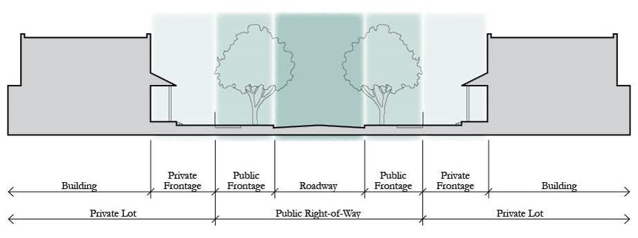
1.
The following standards apply to Primary Frontages:
a.
Build-to-Line (BTL).
i.
The BTL for building façades shall be as shown in Table 3.13.3f. A minimum percentage of the BTL shall be a building façade, as set forth in the table. This percentage shall be calculated for the linear frontage of the building façade at the first floor.
ii.
The BTL shall be consistent along each facing street block. Exceptions to the BTL setbacks or Frontage Build-out percentages may be allowed for the purpose of creating a distinct civic space consistent with the Civic Space Standards or creating space to be used specifically for café table seating.
iii.
The primary façade of buildings shall front the nearest primary street rights-of-way except for those segments adjacent to Open Space.
iv.
The use of double frontage lots shall be prohibited except where essential to overcome disadvantages of topography or environmental characteristics. Exceptions may be allowed upon approval by the County Manager.
*All buildings facing a Multi-Modal Corridor or 4-lane Boulevard/Avenue shall be a minimum of three (3) stories within Urban and Employment Centers, and two (2) stories for all other Place Types.
b.
Building Façades on Multifamily, Mixed Use, Commercial, Office, and Institutional:
i.
The Primary Façade of all buildings must front a public right-of-way, park, or civic space (excluding an alley, lane, or parking lot drive aisle).
ii.
Building façades may include jogs of not more than thirty-six (36) inches in depth, except as necessary to allow bay windows, shop fronts, balconies, civic spaces, outdoor seating, etc., in which case jogs of greater than thirty-six (36) inches will be allowed. Jogs of thirty-six (36) inches or less will be considered as being on the BTL.
iii.
Building volumes shall be articulated into three (3) distinct vertical components — a "base," "middle," and a "top." The first floor height of buildings in Centers shall be a minimum of twelve (12) feet, except Neighborhood Centers within N1 neighborhoods may be ten (10) feet.
iv.
Building façades along BTLs shall be expressed as building modules that do not exceed thirty (30) linear feet in width.
v.
Weather protection features, which may include awnings, overhangs or other treatments providing functional weather protection, are required on building façades fronting a BTL within Employment, Urban, Community and Neighborhood Centers. Weather protection feature shall provide continuous sidewalk coverage for the length of the building, where feasible.
vi.
Awnings or overhangs shall project a minimum of six (6) feet and maintain a clear height of at least eight (8) feet. They may encroach upon the public sidewalk subject to a right-of-way encroachment permit.
vii.
A building's primary entrance shall be located on the façade facing the public right-of-way or civic space. Primary entrance is the principal pedestrian access to a building, even if customers or residents may more frequently use a secondary entrance associated with a garage, parking area, driveway or other vehicle use area. The entrance shall have the architectural detailing that sets it apart from other entrances and allows it be recognized as the building's primary access point.
viii.
Along the primary street within Urban and Employment Centers, buildings shall be at least three (3) stories in height. Along the primary street in Community and Neighborhoods Centers, building height shall be at least two (2) stories in height. Limited exceptions may be made by the County Manager as a way to add variety and architectural interest to a Center. Primary Street is defined as the principal commercial street within a Center. All other streets are considered secondary.
ix.
One-story buildings shall not exceed one hundred twenty-five thousand (125,000) square feet.
x.
Buildings higher than three (3) stories shall use stepbacks, balconies or other architectural treatments to decrease their apparent size and scale.
c.
Streetscreen. A Streetscreen may be permitted to meet BTL requirements along any private frontage that is not otherwise occupied by a building, subject to the following:
i.
Minimum six (6) feet in height but not greater than twelve (12) feet in height.
ii.
Shall only permanently comprise ten (10) percent of the required BTL façade frontage.
iii.
Temporary streetscreens for area of future development, and vehicular areas shall comply with the drive-through screening standards for Urban Infill Centers.
iv.
The Streetscreen shall consist of a wall constructed of material matching or complementary to that of the adjacent building façades. Residential lots within Neighborhood Type 1 are exempt from this requirement. Streetscreen openings for access shall be no larger than necessary to allow vehicular and pedestrian movement. In no event should a vehicular entry be wider than twenty (20) feet. Vehicular entry is not allowed on a primary street, except where approved by the County Manager.
d.
Windows and Doors on Multifamily, Mixed Use and Non-residential Buildings.
i.
For multifamily, mixed use or non-residential buildings within Centers, a minimum of sixty (60) percent of the total wall area at the ground floor must include pedestrian entrances or transparent windows. The ground floor of multifamily buildings may reduce the required transparency through the use of shutters, porches, awnings, or other approved architectural features to mimic fenestration and maintain appropriate privacy.
ii.
Windows shall be slightly recessed or project as bays from the main wall of the façade so as to create texture and shadows on the façade for visual interest, as well as the perception that people or activities are behind the windows.
iii.
Upper floor residential units must have a visible ground floor entrance facing the front or side street, a civic space, or a pedestrian passageway. This may be a common entrance serving multiple units.
C.
UTILITIES.
1.
All new utilities shall be placed underground in public rights-of-way, alley, or lane in easements within a private frontage or in rear service alleys. Their specific placement will be determined as part of the Site Development Plan process.
2.
In furtherance of FLU Policy 1.2.12, the Natural Drainage Module and the Light Imprint Stormwater Matrix Module for SmartCode, Version 9.2 are incorporated into these standards by reference. They shall serve as a menu of stormwater management techniques, appropriately calibrated for the development patterns intended for a specific Mixed Use District.
3.
Communication Tower Standards.
a.
Towers are permitted in Employment Centers only and to be developed consistent with the siting standards addressed in Chapter 3.
b.
Rooftop communication antennas and equipment is permitted in Employment Centers, Urban Centers, Community Centers, and Neighborhood Centers on commercial, institutional, and mixed use buildings, consistent with the siting standards addressed in Chapter 3.
c.
Small cells are permitted in the right of way, regardless of Place Type, consistent with the requirements of Florida Statutes.
(Ord. No. 2022-125, § 3, 2-20-2023)
3.13.4 - SITE DESIGN AND ARCHITECTURAL STANDARDS
For areas zoned MXD, the following standards shall apply.
For properties shown on the County's Future Land Use Map as Mixed Use and identified in the Comprehensive Plan as a Mixed Use District, access management and design standards shall be governed by the adopted Conceptual Master Plan and this Code. If there are conflicts between the Standards identified in this chapter and standards contained elsewhere in this Code, the standards in this article shall prevail. Development aspects not covered by the Standards in this article or elsewhere in this Code shall conform with "The Institute of Transportation Engineers (ITE) Designing Walkable Urban Thoroughfares: A Context Sensitive Approach" handbook (latest edition). Where development occurs within the MXD prior to the adoption of a CMP, access management shall be governed by the design criteria policies of the Osceola County Comprehensive Plan Future Land Use Element Mixed Use Policies, this Code, or the ITE handbook referenced above, and the following criteria:
1.
There shall be at least one hundred (100) local street intersections per net developable square mile, as defined herein.
2.
The foundation of development shall be a "Grid Network" transportation system.
3.
Block lengths on a street must be scaled to create a comfortable walking distance, with shorter blocks designed in the more dense and intense areas of the Centers. Blocks shall be generally scaled at a maximum of three hundred (300) feet by six hundred (600) feet and shall be created to ensure the implementation of a pedestrian scaled neighborhood. Where access management prohibits a street, a mid-block pedestrian break shall be provided for any block over six hundred (600) feet in length.
4.
At least fifty (50) percent of the dwelling units and non-residential buildings shall be within one-half (½) mile of a planned transit route.
5.
Pedestrian and bicycle connections shall provide access to centers and key public facilities. Bicycle parking facilities shall be provided at a rate of 10% of the provided automobile parking for each use, single family attached and detached product types excepted.
6.
Entries to structured parking or delivery bays shall have a maximum clear height of sixteen (16) feet and a maximum clear width of twenty-two (22) feet.
7.
Residential Site Design Standards.
a.
Developments within MXD residential districts (NH-1, NH-2, NH-1E) shall implement a variety of residential product, with two (2) different product types required for development of up to sixty (60) lots; and three (3) different product types for developments of sixty-one (61) or more lots (e.g., single-family detached, detached structures with rear-loaded garages, townhomes, duplexes, bungalow court, quadraplex, etc.) where each single product type shall account for no less than fifteen (15) percent of all units. There are no restrictions on additional product types.
i.
To ensure a variety of residential product type, the number of lots within new residential developments sharing an internal local roadway network with existing or previously approved residential phases shall be aggregated with the existing or previously approved residential phase for the purpose of implementing this provision.
ii.
For small, infill developments, existing surrounding development may be considered when evaluating product type.
b.
No more than four (4) contiguous blocks shall include the same product type, with the exception of linear blocks along a framework roadway. Changes to lot width shall not be counted to achieve the provisions of this standard.
c.
Single-family attached units shall comprise three (3) to eight (8) townhouses and shall be defined as a rowhouse. Front-loaded garages shall be prohibited for rowhouse development. Front-loaded garages are permitted where two (2) attached units are proposed (duplex), provided a minimum thirty-five (35) foot lot width is provided for each unit, and development complies with all requirements of the Land Development Code.
d.
Front-loaded garages on adjacent units shall be alternated to the left or the right side of the lot to provide additional room within the right-of-way for on-street parking where utility and infrastructure conflicts do not prohibit. Units at the end of a block shall be exempt from this requirement.
e.
Concrete pavers on a residential lot shall be required for the driveway and any walkways from the driveway to the entry door or porch if the driveway comprises more than forty-five (45) percent of the front or side yard area, when that area is adjacent to the street. The front yard area calculation extends from the front lot line to a line on the same plane as the front corner façade, and from each side lot line. Sidewalks and driveway aprons within the right-of-way shall comply with the applicable Land Development Code Chapter 4 Road Construction Specifications, latest edition. Picture framing with differing textures or materials shall be required on all concrete driveways. The DRC may allow stamped concrete or decorative pavers in lieu of concrete pavers if determined to be an equivalent surface.
f.
Mechanical equipment pads and mechanical equipment will be staggered a minimum of ten (10) feet from the mechanical equipment on adjacent properties to provide for drainage and accessibility.
g.
All new residential development shall comply with the Toho Efficiency Program and irrigation water budget requirements, as may be amended by Toho Water Authority from time to time. A copy of the completed Toho Water Efficiency Program — Program and Checklist Description, Irrigation Affidavit, and Landscape Affidavit shall be provided to the County with the irrigation permit application. Applications without these documents will not be accepted for review.
h.
Stormwater ponds shall not front a Framework Street for more than six-hundred (600) feet per linear mile. Exceptions may be made adjacent to Framework streets existing at the time of this Ordinance's adoption. Exceptions may be based upon engineering and drainage constraints, and subject County Manager approval.
8.
Residential Architectural Design Standards.
a.
For single-family detached units, architectural facades shall vary so the same exterior house plan, elevation, and exterior paint color shall not match adjacent homes, nor the building site located directly or diagonally across the street, including one (1) home to either side of the home directly across the street. Any single façade cannot comprise more than fifty (50) percent of the housing on a block (houses that face each other on the expanse of street from one (1) intersection to the next). The variation of paint color applies to the main color and accent colors.
b.
Rowhouse architectural facades shall vary so the same rowhouse elevation and exterior paint color shall not match adjacent rowhouses, nor the rowhouse site located directly or diagonally across the street, including one (1) rowhouse to either side of the home directly across the street. Alternatively, individual townhouse facades shall vary so the same townhouse elevation and exterior color shall not match adjacent townhouses within the rowhouse. There shall be no limitation on the percentage of any single rowhouse facades and/or townhouse façade on a block.
c.
Where the front facing garage door (as measured from each end of the garage door itself) comprises more than forty (40) percent of the front façade, the garage door shall be recessed a minimum of two (2) feet behind the building plane of the remaining portion of the unit (including porches). For units with more than one (1) double or two (2) single garage doors, the additional garage door(s) shall be recessed from the others. Adjustments must also be taken to reduce the visual impact of the garage door when located on the front façade of the unit. Adjustments may include overhang architectural features, adding manufacturer approved decorative trim, windows, or creating two (2) separate garage door openings. Side-loaded or rear-loaded garages are exempt from this provision.
d.
For lots less than fifty (50) feet in width a single garage door no wider than nine (9) feet may be permitted; or two (2) single garage doors no wider than nine (9) feet each may be permitted with a minimum of one (1) foot spacing between garage doors. Alternatively, a double wide garage door may be provided only with coach lights on both sides and manufacturer approved hinges and handles to reduce the prominence of the garage door.
e.
All building facades visible from the street or public realm shall have elements that clearly delineate a "base," "middle," and "top" through the use of color, materials, banding, and enhanced roofline elements at a level of treatment similar to the front façade. Blank facades shall be reduced by the inclusion of windows, vertical elements with a plane change from the wall surface, shadow-casting elements, material changes, or other methods. Vertical material transitions shall occur at inside corners or wrap at least eighteen (18) inches around an outside corner where the façade is not visible from the street or public realm. The public realm consists of any area accessible to the public and/or designed for the public.
i.
Banding used to separate the "base," "middle," and "top" of the unit and around the garage doors when visible from the street or public realm shall project out from the wall and be at least six (6) inches in width.
ii.
Banding for windows visible from the street or public realm shall project out from the exterior wall at least three quarters (3/4) of an inch and be at least three (3) inches in width around the entire window, but shall not be required on the sides of the window where shutters are provided.
f.
Windows shall comprise at least fifteen (15) percent for each story of the unit's façade facing the street or public realm. Garage door(s) that face the street or public realm may only be excluded from the unit's façade if coach lights, hinges, and handles are provided. Windows within garage doors and entry doors, and shutters facing the street or public realm in compliance with these standards shall count toward the minimum requirement.
g.
Windows and doors shall be accentuated through measures such as: adding trim/sills and lintels or other similar treatment; providing shutters or awnings; framing through the use of façade materials; use of bay windows; and/or recessing the window. Decorative shutters, if utilized, shall be scaled and affixed to have the appearance of functioning shutters. If simulated mullions are used between adjacent windows they shall be affixed to the exterior of the windows.
i.
Any window visible from the street or public realm shall be recessed a minimum of two (2) inches from the façade on single story units. In lieu of recessing, banding at least three (3) inches in width around the entire window, or a combination of banding and shutters.
h.
Roofline elements used to meet the requirements for massing and composition shall include but are not limited to: exterior trim mold at the soffit, frieze boards, and architectural elements in the gable. Roof eaves/soffits shall project at least twelve (12) inches from the exterior wall of the house where visible from the street or public realm. All asphalt shingle roofs shall be comprised of dimensional shingles, also known as architectural shingles. The use of three-tab shingles in new home construction is prohibited. Declaration of covenants and restrictions shall include the requirement for the property owner to use dimensional grade shingles when replacing or repairing the roof with asphalt shingles.
i.
Primary entrances must face the street or public realm, regardless of lot width and shall be recessed no more than six (6) feet from the wall of the façade that comprises the greatest percentage of the total width of the façade of the home facing the street or public realm. Tunnel like front entrances shall be prohibited. If there is no porch, the main entrance must have a cover separate from the main roof, as well as at least two (2) of the following elements: portico; pilaster/column; crosshead (decorative top molding for door frame); pediment/gable; or sidelight.
j.
Front porches shall have a minimum depth of six (6) feet and minimum width of thirty (30) percent of the building's front façade (not including the garage) or seven (7) feet, whichever is larger. An equivalent area may be considered by the DRC. Porches must be accessed from the driveway, street sidewalk, or public realm sidewalk, shall be visible from the street or public realm, and may extend six (6) feet into the setback.
k.
Where a garage is not provided, a minimum of eighty (80) square feet of enclosed storage area shall be constructed so that residents will have space to store bulky personal items (i.e., recreational equipment). This structure shall be architecturally treated to match the primary structure.
(Ord. No. 2022-125, § 3, 2-20-2023)
3.13.5 - OPEN SPACE AND RECREATION
A.
Open Space shall be properly designed and located and shall function as an amenity to the residents and users of the development.
Open space shall be provided according to the criteria listed in this Article as defined below and consist of Public/Park/Civic Space and Open Space Place Type:
The required open space within NH-1, NH-2, Neighborhood Centers, Community Centers, Urban Centers and Employment Centers shall be comprised of required Public/Park/Civic Space designed to standards contained herein.
1.
A minimum of twenty-five (25) percent of the acreage identified as Open Space Place Type on an approved Concept Plan shall be functional and accessible. Such uses shall be identified at the Preliminary Subdivision or Site Development Plan and may include: shaded and amenitized trails, boardwalks, play fields (formal and informal), and activity-based parks with or without structural amenities. Trails shall connect neighborhoods and centers throughout a Mixed Use District and function as a greenway and green infrastructure system
2.
Open space elements shall be available to all residents and users of the development.
3.
Should a development include a K-8, elementary, or middle school and a park is developed in conjunction with the school, the school's recreation area open to the general public shall also be counted towards the required open space.
4.
Lands designated for preservation in a CMP or Concept Plan shall be preserved in perpetuity through recordation of conservation easements consistent with F.S. § 704.06, with allowance for boundary adjustments based on site-specific permitting requirements. The easements must be effective before or concurrent with the effective date of the Final Plat.
B.
Community recreation facilities shall be provided for all residential development in MXD:
1.
Community recreation sites shall be provided on-site at a minimum ratio of one (1.0) acre of useable recreation per fifty (50) dwelling units. The site may be dedicated to the County, maintained by a Homeowners Association, Community Development District, or any other funding mechanism as approved by the County. A continuous pedestrian circulation system shall be provided throughout the development. The system shall link all units to all designated recreational areas, parking, and transit facilities, and to existing public sidewalks or public right-of-way located adjacent to the development.
2.
If a K-8, elementary, or middle school is included in the project, a recreation site shall be developed adjacent to the school site. The school's recreation area open to the general public shall be counted towards the development's required recreation area.
3.
If a regional trail is identified in the Transportation Map Series of the Comprehensive Plan or an adopted overlay, then the developer shall include the trail with the development.
4.
For residential developments, recreational areas shall be completed with the required infrastructure to coincide with the phases of dwelling units they are intended to serve.
5.
If the developer meets the following standards, a credit of twenty-five (25) percent of the total pond area may be given towards the required active recreational acreage.
a.
The landscape of a pond edge shall consist of lawns, trees, and shrubs planted in a designed manner that is compatible with the intent of the overall community landscape aesthetic.
b.
Paths shall be a minimum of eight (8) feet wide. Shaded areas for seating shall be provided. They can serve as public corridors for pedestrians and cyclists, providing alternate ways to move through place types.
c.
Pond edge trails and pathways shall be designed with optimum shading in mind. Four (4) canopy trees and two (2) understory trees per one hundred (100) linear feet shall be the minimum tree planting requirement.
6.
All Public/Park/Civic acreage shall be credited at a 1:1 ratio towards the recreation acreage requirements of this Code.
7.
Additional recreation credit shall be provided for recreation sites with functional recreational facilities at a ratio of one (1.0) acre per every five thousand (5,000) square feet of recreational building structures and one (1.0) acre per every twenty-five thousand (25,000) square feet of non-building recreational facilities or portion thereof. Functional recreational improvements include all facilities except for infrastructure improvements (i.e., site grading, stormwater management, pavement and parking facilities). This facility based credit-will only be applied toward recreation requirements and cannot reduce Public/Park/Civic or Open Space Place Type overall open space acreage requirements.
8.
If a public park site is included in the project, the recreation area open to the general public shall be counted towards the development's required recreation area.
C.
Civic Space is regulated by this LDC. The development standards provide significant open space and recreational opportunities that are a spatial counter-point to the densities and intensities required of development in Mixed Use Districts. These can be realized through a variety of spaces ranging from large regional and neighborhood-scaled parks to small pocket parks. The open space network will be serviced by an interconnected network of sidewalks, trails and paths for pedestrians and bicyclists alike, providing open space amenities accessible to all neighborhoods and centers within a District.
MINIMUM CANOPY REQUIREMENT.
1.
Canopy trees are defined herein as a tree, when mature, having a minimum height of forty (40) feet and a minimum crown width of thirty (30) feet.
2.
Understory trees are defined herein as a shade tolerant species under thirty (30) feet at maturity that grow under the crowns of larger trees.
The types of spaces allowed are illustrated in Figure 3.13.5a.
Figure 3.13.5a. Civic/Park Spaces
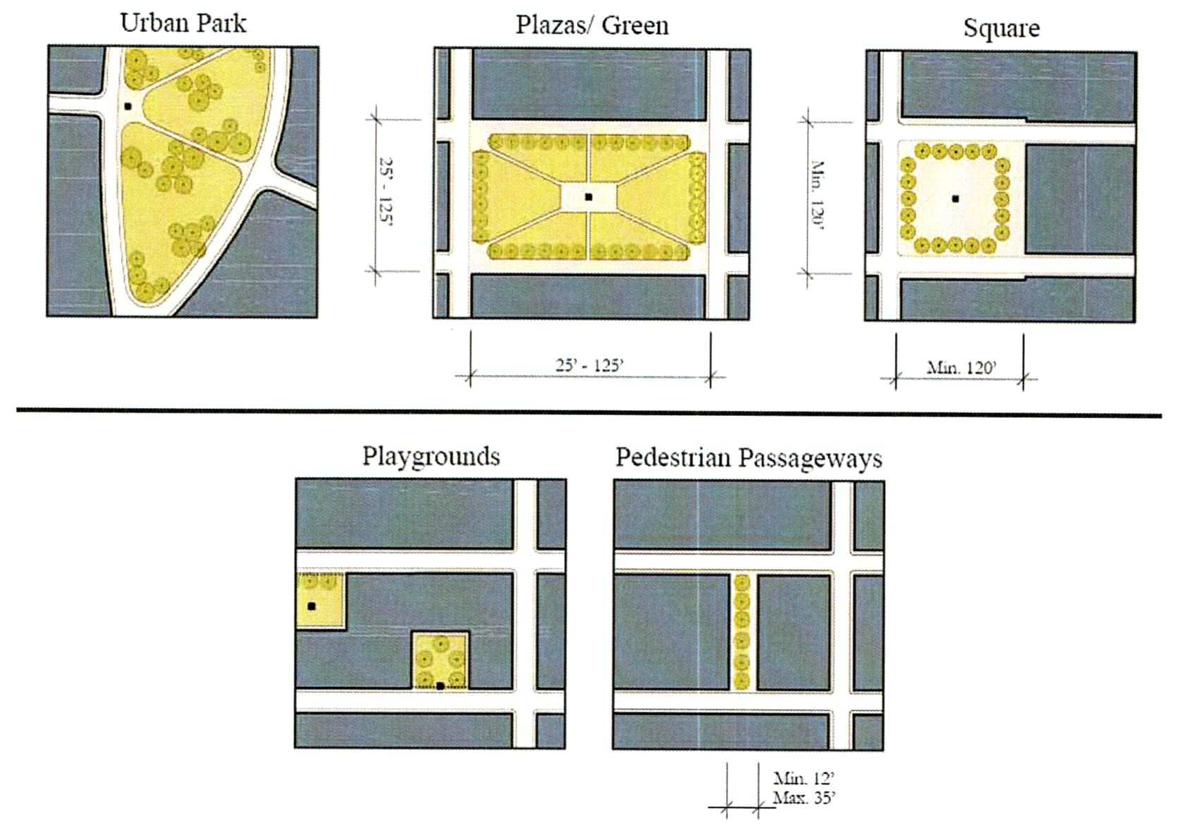
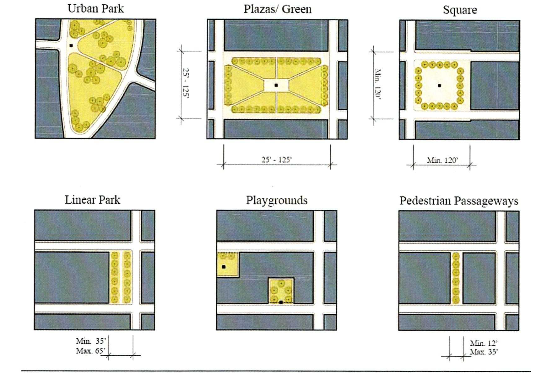
Civic Spaces shall adhere to the following standards:
1.
Urban Parks.
a.
Description. Urban parks include open areas available for a variety of purposes, to include structured and unstructured recreation, commercial activity and other passive uses.
b.
Character. These spaces have a formal urban character being defined by surrounding building frontages and adjacent tree-lined streets. The landscape consists of lawns, trees, and shrubs and amenitized with paths and benches and shade. At least one (1) civic element such as kiosks, open shelters, pergolas, playgrounds or fountains shall be included. Parks shall be located within or proximate to Centers.
c.
Standards.
i.
Width — N/A
ii.
Depth — N/A
iii.
Minimum 5 acres.
iv.
Must front at least two (2) public roadways. All buildings must front this space.
v.
A minimum of sixteen (16) canopy trees and eight (8) understory trees per acre. Trees per acre should exclude that area dedicated to structured, active recreation (purpose built ball fields, courts, etc.) and to fields meant for unstructured, active recreation.
d.
Typical Uses.
i.
Passive/Active Recreation
ii.
Commercial uses, including Farmer's Markets, foot races and concerts
iii.
Playgrounds
iv.
Civic events
2.
Linear Parks.
a.
Description. Linear Parks are urban parks that are much longer than they are wide. They serve as public corridors for pedestrians and cyclists, providing alternate ways to move through place types. These parks serve as open space and shall be located between place types, neighborhoods, blocks, or used as connections between other parks.
b.
Character. The landscape of linear parks shall consist of lawns, trees, and shrubs and furnished with paths and benches. Shaded areas for seating shall be provided. Trails will be designed with optimum shading in mind.
c.
Standards.
i.
Width: Average fifty (50) foot, maximum sixty-five (65) foot, minimum thirty-five (35) foot.
ii.
Length: One thousand, eight-hundred (1,800) foot maximum, One hundred fifty (150) foot minimum
iii.
Uninterrupted linear parks greater than four-hundred (400) feet in length must incorporate a plaza.
iv.
Must front at least one (1) public roadway or be fronted on at least two (2) sides by housing or mixed use buildings.
v.
Five (5) canopy trees and two (2) understory trees per one-hundred (100) linear feet within the park width shall be the minimum tree planting requirement.
d.
Typical Uses.
i.
Primary access
ii.
Casual seating
iii.
Passive recreation and active recreation limited to playground structures, tot-lots, or other similar structures, subject to approval at SDP.
3.
Plazas and Greens.
a.
Description. Plazas and Greens are open areas available for civic purposes, commercial activities, passive recreation, and, for Greens, unstructured active recreation. Numerous Plazas and Greens add to the vibrancy of Centers and Neighborhoods by creating the opportunity for casual public engagement. Building frontages define the space. Pocket Plazas function in a similar manner and follow the same rules as the larger Plazas. These smaller scaled spaces create more intimate places for seating or dining and provide a place where commercial and neighborhood activity can spill into. These Plazas can also be used to create a formal space in front of a prominent building entrance.
b.
Character. Plazas and Greens are purposefully sited gathering areas designed with a percentage of paved surface area appropriate to their pedestrian traffic level. Trees around the perimeter shall be sufficient in number to provide enough shade to help mitigate the heat effect of the hardscape. Tables and chairs shall be provided.
c.
Standards.
i.
Minimum width and depth — twenty-five (25) feet
ii.
Maximum width and depth — one hundred twenty-five (125) feet
iii.
Must front on at least one (1) public roadway
d.
Typical Uses.
i.
Casual seating
ii.
Commercial uses (e.g., retail and food kiosks)
4.
Squares.
a.
Description. Squares provide an important anchor for a Center or Neighborhood, serving as an open space available for civic purposes, commercial activity, unstructured recreation and other passive uses. The Square should have an urban, formal character and be defined by the surrounding building frontages and adjacent tree-lined streets.
b.
Character. All buildings adjacent to the Square must front onto it. Adjacent streets lined with appropriately scaled trees help to define the square. The landscape shall consist of lawns, trees, and shrubs planted in formal patterns and furnished with paths and benches. Shaded areas for seating shall be provided. A civic element or small structure such as a kiosk, open shelter, pergola or fountain may be included.
c.
Standards.
i.
Minimum width — one hundred twenty (120) feet
ii.
Minimum depth — one hundred twenty (120) feet
iii.
Maximum size ten (10) acres.
iv.
Must front on at least two (2) public roadways
v.
A minimum of sixteen (16) canopy trees and eight (8) understory trees per acre within the square.
vi.
Five (5) trees per one-hundred (100) linear feet around the perimeter of the square on the side(s) not adjacent to a street.
d.
Typical Uses.
i.
Unstructured and passive recreation
ii.
Commercial and civic uses
iii.
Casual seating
5.
Playgrounds.
a.
Description. Playgrounds are open areas designed and equipped for the recreation of children. They can be interspersed within neighborhoods, linear parks, or centers. Playgrounds can be freestanding or located within Urban Parks.
b.
Character. Playgrounds serve as safe places protected from the street and typically in locations where children do not have to cross Framework Streets to access. Often Playgrounds, particularly tot-lots, are located in the center of blocks surrounded by residential areas.
c.
Standards.
i.
Minimum width — N/A
ii.
Minimum depth — N/A
iii.
Independent of building frontages
iv.
Fenced with limited access points
v.
Freestanding playgrounds, smaller than the minimum standards for a square, shall have a minimum of one (1) canopy tree. Playgrounds shall provide shading for all equipment through either trees or alternate structures.
d.
Typical Uses.
i.
Passive/active recreation
ii.
Picnic facilities
iii.
Shaded outdoor seating
iv.
Play structures, interactive art, fountains
6.
Pedestrian Passageways.
a.
Pedestrian Passageways provide pathways between buildings and through blocks. They create unique spaces for building frontages to access while allowing for social and commercial activity to spill into the public realm.
b.
Character. Passageways are hardscape areas with frequent entries and frontages. There may be exterior stairways to adjacent buildings that frame and define the passageway. There are minimal plantings and potted plants.
c.
Standards.
i.
Minimum width — twelve (12) feet
ii.
Maximum width — thirty-five (35) feet
iii.
Uninterrupted Pedestrian Passageways greater than one hundred fifty (150) feet in length must incorporate a Pocket Plaza.
iv.
Pedestrian Passageways shall be incorporated into blocks that are longer than four hundred (400) feet in length in Urban Centers.
d.
Typical Uses.
i.
Primary access
ii.
Casual seating
7.
Other Civic Spaces.
a.
Libraries, gyms, pools, community rooms, and other similar indoor or outdoor spaces open to the public and primarily intended for public use.
(Ord. No. 2022-125, § 3, 2-20-2023)
3.13.6 - GENERAL PLANTING REQUIREMENTS
Any landscape, streetscape, and treescape standards not covered herein shall be regulated by Chapter 4.
Landscaping shall be provided on the development parcel for all "New Development" as defined herein, in addition to any landscaping in the public realm, as follows:
A.
MINIMUM PLANTING REQUIREMENTS.
1.
All Centers, Special Districts, and NH2 properties within the MXD, shall contain a minimum of sixty (60) inches per acre of trees (measured in DBH for preserved trees and in caliper for replacement trees).
2.
NH1E and NH1 developments within the MXD shall contain a minimum of thirty (30) inches per acre of trees (measured in DBH for preserved trees and in caliper for replacement trees) on common tracts and/or right-of-way.
B.
PLANT QUALITY. Plant materials shall meet the following minimum standards:
1.
All nursery plants, including trees, shrubs and groundcovers shall conform to standards for Florida Grade #1 or better according to the current edition of "Grades and Standards for Nursery Plants."
2.
All sod shall be certified apparently free of noxious and invasive exotics.
C.
REQUIRED PLANT SIZES AND SPECIES. All plant material shall be selected from "The Florida Friendly Landscaping Guide to Plant Selection & Landscape Design" or other regionally appropriate plant material guide upon approval by the County Manager. The use of native species is encouraged. On sites up to one-half (½) acre in size, minimum two (2) native shrub species and two (2) native tree species shall be planted. Sites greater than one-half (½) acre and up to one (1) acre shall include at least three (3) native species, each, and sites greater than one (1) acre shall include at least four (4) native species each in the planting specification.
1.
Trees.
a.
All trees shall be installed as follows: a minimum of three (3)-inch caliper for large trees; a minimum of two and one-half (2½)-inch caliper for medium trees; and a minimum of two (2)-inch caliper for small trees. A minimum of eighty (80) percent of the required trees shall be large/medium trees. Palm trees may be planted as part of the landscape plan four (4) palm trees equal one (1) large/medium tree) but shall not be credited against the minimum canopy requirement (DBH per acre) herein.
b.
Landscape plans and installation shall incorporate the following minimum diversity standards:
i.
Two (2) genera for up to ten (10) (inclusive) required trees.
ii.
Four (4) genera for between eleven (11) and twenty (20) (inclusive) required trees.
iii.
Five (5) genera for greater than twenty (20) required trees.
c.
No more than fifty (50) percent of the required trees shall be of any one (1) genera.
2.
Shrubs.
a.
Shrubs shall consist of woody plants a minimum of two (2) feet in height. When planted as a hedge, the maximum spacing for twenty-four (24)-inch high shrubs shall be thirty-six (36) inches on center. Shrub species that are significantly larger than the required minimum may be counted as two (2) or more shrubs, on a case-by-case basis. Spacing for the larger size shrubs shall be determined by the County Manager.
b.
Landscape plans and installation shall incorporate the following minimum diversity standards:
i.
One (1) genera for up to and including twenty (20) required shrubs.
ii.
Two (2) genera for twenty-one to one hundred (21—100) required shrubs.
iii.
Three (3) genera for one hundred one to two hundred fifty (101—250) required shrubs.
iv.
Four (4) genera for two hundred fifty-one-plus (251+) required shrubs.
c.
No more than fifty (50) percent of the required shrubs shall be of any one (1) genera.
3.
Turf Grass. Turf grass shall be planted with species normally grown as permanent lawns. Grass areas may be sodded, plugged, sprigged or seeded except that solid sod shall be used in swales or other areas outlined herein. Turf grass in all public rights-of-way and stormwater management ponds shall be sodded as required herein.
a.
St. Augustine Grass shall not be used within the MXD.
4.
Ground Covers. Ground covers shall be planted in such a manner as to present a finished appearance and reasonably complete coverage within one (1) year after planting.
5.
Synthetic Plants. Synthetic or artificial turf, trees, shrubs, ground covers or vines shall not be used in lieu of the plant requirements in this Article unless otherwise permitted by the County Manager due to practical consideration of site conditions.
D.
CREDIT FOR EXISTING PLANTS.
1.
Credit is permitted for existing plant material provided such material meets the minimum standards of this Article.
2.
Credit shall be allocated on a one-for-one basis for shrubs and inch for inches — DBH — preserved for trees where such material meets or exceeds the minimum standards of this Article.
E.
MULCH.
1.
Mulch is any material applied to the soil surface to protect or improve the area covered. Mulches are frequently applied around plants to modify the soil environment and enhance plant growth. They may consist of organic material such as bark, wood chips, leaves, pine needles, or grass clippings; or they can be inorganic material such as gravel, pebbles, or woven ground cloth. Mulch can be applied to the soil surface but should not rest against the stems of landscape plants.
2.
Mulch type should match design needs for the area of use, be installed per green industry best management practices and utilize Florida Friendly Landscaping principles.
3.
The use of large expanses of mulched areas in lieu of planted areas is not acceptable. The use of unplanted mulch areas is acceptable where design can justify use and meet Florida Friendly Landscaping principles.
(Ord. No. 2022-125, § 3, 2-20-2023)
3.13.7 - HABITAT CONSERVATION AND MANAGEMENT PLAN
The conservation and preservation of existing regionally and locally significant natural resources shall be accomplished through the ongoing process described within this section.
A.
APPLICABILITY. Development applications for any developments with the land use designation of Mixed Use as identified in the Osceola County Comprehensive Plan Future Land Use Map shall be required to submit, implement, and fund the required components: based on the findings of the initial Environment Assessment. A change in land use designation within the currently identified Mixed Use area shall not preclude any subsequent development from these requirements. The habitat conservation and preservation activities shall be guided by a Habitat Conservation and Management Plan (HCMP) that: is prepared by the Master Developer and submitted to the County in conjunction with the development application.
B.
PROCESS.
1.
Submittal.
a.
Submittal of the HCMP shall occur concurrently with the Preliminary Subdivision Plan (PS) and approval of the HCMP shall occur prior to final approval of any Site Development Plan (SDP). There is a separate fee, application, and review process for the HCMP aside from the development approval. At no time shall the development application proceed without approval of the HCMP.
b.
The HCMP shall be processed, consistent with all procedures as established within the Land Development Code (LDC).
c.
The County will coordinate with external reviewing agencies as necessary and any comments received from other regulatory reviewing agencies will be incorporated as informational items in the compliance letter issued by the County and may constitute a basis for a determination of noncompliance.
2.
Approval and Compliance. The County shall either issue a compliance letter, indicating that the HCMP has been found to be consistent with the provisions of the Development Order, Conceptual Master Plan, Concept Plan, Planned Development or this Code, as applicable; or shall issue its findings for applicant review and resubmittal.
3.
Exempt. Construction of a single-family home on an existing lot of record shall be exempt from the requirements of this section.
C.
HCMP DOCUMENT.
1.
Species Included in HCMP. The HCMP document will be required to include all applicable species from the Threatened and Endangered Species list and Species of Special Concern for Osceola County derived from the USFWS Endangered Species Program and the FWC; or those species native to or only found in our region, and under threatened status or a management if the Environmental Assessment indicates their presence. All species, regardless of whether they are protected, shall be noted in the HCMP if they are identified to be present on site, or habitat known to have availability of necessary resources to such species is present. However, only the federal and state listed species are required to have protection measures and/or management plans in place.
2.
Site Assessment.
a.
A qualified professional will be required to perform the Environmental Assessment, and determine applicability of each identified species to the HCMP in accordance with this Article.
b.
An assessment of the general and site characteristics of the species and associated habitat areas will be required to include population size, physical location, and extent of habitat associated with the species; criteria for species management and monitoring strategies; evaluation of the on-site habitat and ability/capacity to support its intended function and the known or estimated species population; habitat preservation and enhancement activities; potential habitat restoration; permitted land uses and human activities; and linkages between identified species to the extent of shared habitat and movement corridors.
3.
Exhibits. Exhibits required for the HCMP, shall at a minimum include map illustrations, legal documents, previously issued permits, and educational materials for residents. Requirements for the HCMP will be outlined in detail within the corresponding application.
D.
LONG TERM MANAGEMENT.
1.
Funding. The initial HCMP shall contain a plan for the perpetual funding all aspects of the HCMP, and will provide for the long-term availability of management funds which will not be subject to homeowner or property owner referenda. The Master Developer shall identify a Master Property Owners' Association or other similar entity as the successor to the Master Developer for long-term funding and implementation of the HCMP. Any property maintenance activities determined applicable to the plan should include, at a minimum; the location(s) of the activity, methods, cycles, schedules, and procedures. Conservation easements shall be established and conveyed to a Master Property Owners' Association or other similar entity and, if applicable, other co-grantee entities, with the capacity and capability of conserving the lands and resources contained within a prospective easement. A plan for the education of residents, and how that information will be disseminated shall be included in the HCMP.
2.
Monitoring. In order to support the County's ongoing monitoring and administration responsibilities related to the implementation of the HCMP, the Master Developer shall provide a biennial report to the County which evaluates the performance of the HCMP and the results achieved through the date of the report. All conservation areas shall be monitored on a regular basis to evaluate the general condition, vegetation, security and to identify any other conditions that may conflict with the protection and management goals. A Monitoring Plan shall be submitted with the initial HCMP application and updated thereafter with the HCMP Biennial Performance Report. If no development or modification to conservation areas outlined in the HCMP have occurred during the preceding reporting period, then a letter of no new development will be adequate to meet this requirement. Existing DRI developments within the Mixed Use designation can submit their HCMP Biennial Performance Report as an attachment to the DRI Annual/Biennial Report.
3.
Revisions to the HCMP. Any modifications to the HCMP that are approved via the Environmental Resource Permit (ERP) and/or Final Development Order (FDO) application review and approval process shall be incorporated into all subsequent annual or Biennial HCMP Performance Report, Development of Regional Impact (DRI), or other required development reports, if applicable; as well as including the complete "Revised HCMP."
(Ord. No. 2022-125, § 3, 2-20-2023)
3.14.1 - GENERAL PROVISIONS
A.
RELATIONSHIP TO OTHER LAND DEVELOPMENT CODE CHAPTERS. The Standards in this Chapter apply to properties shown on the County's Future Land Use Map and identified in the Comprehensive Plan as an Urban Infill Centers. If there are conflicts between these Standards and standards contained elsewhere in the Land Development Code, the Standards in this Article shall prevail. Development aspects not covered by these Standards shall be governed by the standards contained elsewhere in the Land Development Code.
B.
PURPOSE. The standards are intended to enable the creation of compact development areas that encourage walkability and transit use. Centers types include Neighborhood, Community, Urban and Employment. Each center will vary in intensity and density scale and shall be exclusive in the Urban Infill Area outside of the Urban Expansion Area.
C.
MIX OF USES. For all projects within Urban Infill Center Core, with the exception of Neighborhood Centers, a minimum of four-thousand (4,000) square feet of non-residential use per acre is required. Uses may be mixed vertically or horizontally with the minimum requirement to be achieved at build-out. Non-residential square footage shall be built at project inception when planned vertically and/or reserved by acreage when planned horizontally. Residential developments within the perimeter must demonstrate direct pedestrian access to existing or planned non-residential development within one-quarter (1/4) mile of the project, or a transit stop; or shall be required to provide a minimum of one thousand (1,000) square feet of non-residential use per acre. Neighborhood support uses such as schools, parks, and houses of worship, as well as self-storage facilities shall not count toward meeting the minimum square feet of non-residential requirements within the Urban Infill Center Core.
D.
CENTER TYPES. Zoning districts shall be determined based on data and analysis. Adjustments to the perimeter and core may be processed with the submittal of a unified plan. Requests shall be evaluated for consistency with the overall policy criteria for core and perimeter areas, and may consider factors such as, but not limited to, adjacency to the perimeter or core, the percentage of change in area, natural and physical limitations, and compatibility with surrounding development.
1.
Neighborhood Center. Primarily intended for small-scale, neighborhood-serving retail and office; recreational, public, or civic uses; entertainment and a supporting mix of residential types, including mixed use buildings.
a.
Neighborhood Center (NCC/NCM) is defined as an area up to ten (10) acres, located within a Neighborhood Center FLUM designation, and adjacent to a local street, avenue, or boulevard.
2.
Community Center. Primarily intended for large-scale retail and office, civic uses, and medium- to high-density residential.
a.
Community Center Core (CCC) is defined as an area greater than ten (10) up to seventy (70) acres, centrally located within a Community Center FLUM designation.
b.
Community Center Perimeter (CCP) is defined as an area generally extending one-half (½) mile outside the center core.
3.
Urban Center. Primarily intended for large-scale retail and office, and intense residential development.
a.
Urban Center Core (UCC) is defined as an area of a minimum of seventy (70) acres, centrally located within an Urban Center FLUM designation.
b.
Urban Center Perimeter (UCP) is defined as an area generally extending one (1) mile outside the center core.
4.
Employment Center. Primarily intended to provide intense workplace developments such as research firms, national headquarters, medical and professional offices, hospitals and, light industrial development; ancillary retail is intended to serve the needs of employees; secondary education facilities including colleges and universities. Residential development is intended to provide a variety of housing types for the employees of the center.
a.
Employment Center Core (ECC) is defined as an area of a minimum of seventy (70) acres, centrally located within an Employment Center FLUM designation.
b.
Employment Center Perimeter (ECP) is defined as an area generally extending one (1) mile outside the center core.
E.
BUILDING ORIENTATION FOR URBAN INFILL CENTERS.
1.
Building Siting for Urban Infill Centers. The following standards apply to principal buildings within the Urban Infill Centers. Single-family properties shall comply with Siting and Architectural standards contained within Article 3.2.
a.
The PS/SDP must identify primary, secondary, and service frontages. Primary frontages shall face each other to the maximum extent feasible. Any given block must be comprised of two (2) primary frontages; only connections which provide shaded and direct pedestrian access shall be considered toward meeting minimum block sizes. Block connections not associated with a street shall consist of a sidewalk or paved pathway a minimum of eight (8) feet wide and shaded with canopy trees an average of forty (40) feet on center.
b.
All buildings must face a primary frontage or civic space. Building sides facing primary or secondary frontage, or civic space shall comply with the architecture standards contain herein. Conceptual elevations shall be required at SDP.
c.
A building's primary entrance shall be located on the façade facing the primary frontage or civic space. Primary entrance is the principal pedestrian access to a building, even if customers or residents may more frequently use a secondary entrance associated with a garage, parking area, driveway or other vehicle use area. The entrance shall have the architectural detailing that sets it apart from other entrances and allows it be recognized as the building's primary access point.
d.
Within Urban Centers, Employment Centers and Community Centers Core, buildings shall be at least two (2) stories in height.
e.
Upper floor residential units must have a visible ground floor entrance facing the front or side street, a civic space, or a pedestrian passageway. This may be a common entrance serving multiple units.
2.
Build-to-Line (BTL).
a.
The BTL for building façades shall be as shown in Table 3.14-1 below. A minimum percentage of each block (the expanse of street from one (1) intersection to the next) facing a primary frontage shall be comprised of building façade, as set forth in the table. This percentage shall be calculated for the linear building façade at the first floor.
b.
The BTL shall be consistent along each facing street block. A civic space or café-table seating area that meets the following standards will be considered part of the BTL setback or Frontage Build-out percentages. Dining areas must be clearly delineated from the public sidewalk through the use of pavement treatments or barriers. Civic areas must be open for public use and provide features that allow for casual public engagement such as shaded seating areas, art, or gardens. Civic areas shall be accessible from and an extension of the primary building and use. Vehicular areas are not permitted within the minimum frontage along the primary façade unless otherwise provided herein.
*Exclusive of access drives, if required for emergency access or in an interim condition.
F.
DEVELOPMENT STANDARDS FOR URBAN INFILL CENTERS.
Note: Institutional uses by public entities for public good are exempt from development standards. Residential development is not required.
1. Minimum FAR requirements, as they apply to specific development or phase development, may be modified through the Preliminary Subdivision (PS) or Site Development Plan (SDP) process only if the proposed first phase building(s) meets siting and BTL requirements, and the applicant can demonstrate that the minimum FAR can be achieved with future phases. For developments with transitional FAR, a Site plan depicting how future development will meet minimum FAR must be provided at the time of Site Development Plan (SDP) process. Urban Infill Centers within the CRA must follow the provisions approval process herein in the East U.S. 192 Community Redevelopment Area herein.
2. Except in UCC and ECC, a building two (2) stories in height is acceptable where it can be demonstrated that minimum FAR can be achieved at build-out.
3. Applies only to non-residential structures, or the non-residential portion of a mixed-use building.
4. Hotels have no maximum density.
G.
ARCHITECTURAL DESIGN STANDARDS FOR URBAN INFILL CENTERS. The following standards apply to multifamily, mixed use and non-residential buildings within the Urban Infill Centers zoning districts NCC, NCM, CCC, CCP, UCC, UCP, ECC, and ECP.
1.
Building Form. The intent is to encourage human scale elements in building design, and to reduce the mass of large buildings. Breaks in mass are required to relate to structural systems and the organization of interior space. Both horizontal and vertical mixed-use designs are highly encouraged.
a.
All building façades shall be architecturally finished with materials such as stucco, brick, stone, finished concrete, wood or other comparable materials.
b.
Building façades shall include jogs of not more than thirty-six (36) inches in depth, except as necessary to allow bay windows, shop fronts, balconies, civic spaces, outdoor seating, etc., in which case jogs of greater than thirty-six (36) inches will be allowed. Jogs of thirty-six (36) inches or less will be considered as being on the BTL.
c.
Building volumes shall be articulated into three distinct vertical components—a "base," "middle," and a "top." The first floor height shall be a minimum of twelve (12) feet.
d.
Building façades along BTLs shall be expressed as building modules that do not exceed thirty (30) linear feet in width.
e.
Horizontal masses shall not exceed a height/width ratio of one (1) vertical to three (3) horizontal without substantial variation in massing that includes a change in height and projecting or recessed elements.
f.
Buildings shall relate well to each other, to the site, and adjacent properties by providing transitions in building heights.
g.
A minimum of sixty (60) percent of the total wall area at the ground floor must include pedestrian entrances or transparent windows. Residential ground floor uses may achieve the requirement through a combination of transparency, entrances, shutters, porches, awnings, or other approved architectural features to mimic fenestration and maintain appropriate privacy.
h.
Windows shall be slightly recessed or project as bays from the main wall of the façade so as to create texture and shadows on the façade for visual interest, as well as the perception that people or activities are behind the windows.
2.
Building Massing. Massing refers to shape and form of the building. The intent is to encourage human scale element in building design, and to reduce the mass or large buildings. Breaks in mass are required to relate to structural systems and the organization of interior space.
a.
Massing requirements: The requirement for the subdivision of masses/volumes in a building shall apply according to the standards established in Table 3.14-2.
b.
When massing subdivision is required per Table 3.14-2 the requirement shall be satisfied by demonstrating that the required number of individual massing elements have been provided from the following options:
Option 1: Setbacks. Setbacks shall occur at the second floor or above the ground floor level, if a building is two (2) floors or more in height.
Figure 3.14-a Massing Setback
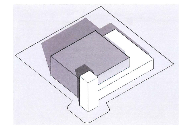
Option 2: Offset. Offsets shall be a minimum of ten (10) feet to break up the foundation line to define each mass. The portion projected or recessed shall extend up to the roof eaves.
Figure 3.14-b Massing Offsets
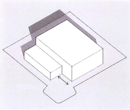
Option 3: Façade Length and Variations. Variations in the façade shall be as follows:
i.
Façades greater than sixty (60) feet in length, but less than one hundred and twenty (120) feet in length must exhibit a prominent shift in the façade of the structure so that no greater than seventy-five (75) percent of the length of the building façade appears unbroken. Each shift shall be in the form of either a ten (10) foot change in building façade alignment or a ten (10) foot change in roof line height, or a combined change in façade and roof line totaling ten (10) feet.
ii.
Façades that exceed one hundred and twenty (120) feet in length shall provide a prominent shift in the mass of the structure at each one hundred and twenty (120) foot interval, or less if the developer desires, reflecting a change in function or scale. The shift shall be in the form of either a fifteen (15) foot change in building façade alignment or a fifteen (15) foot change in roof line. A combination of both a roof line and façade change is encouraged and to that end, if the combined change occurs at the same location in the building plan, a fifteen (15) foot total change will be considered as full compliance.
iii.
The façade length and variation requirement apply to primary and secondary façades.
Figure 3.14-c Massing Façade Variations
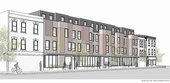
Note: For massing illustration purpose only.
3.
Building Articulation. The intent is to reduce the apparent size of buildings and create visual interest. Articulation elements shall vary to alleviate the appearance of a large building mass, break up along walls, express individuality of each building, and enhance the character of the neighborhood/development. Building façade facing the public right-of-way or civic space must comply with the following articulation elements:
a.
Weather protection features, which may include awnings, overhangs or other treatments providing functional weather protection, are required on building façades fronting a BTL. Awnings or overhangs shall project a minimum of six (6) feet and maintain a clear height of at least nine (9) feet. They may encroach upon the public sidewalk subject to a Right-of-Way encroachment/utilization permit.
b.
In a multifamily residential building, if balconies are provided, a minimum of fifty (50) percent of all units shall incorporate balconies at a minimum size of six (6) feet deep and sixty (60) square feet.
c.
Corner articulation elements such as arched, gabled, stepped or decorative parapet with cornice over building entrances, integrated with the building's massing and style.
4.
Roof Modulation. The intent is to ensure that visual interest also applies to roof treatment. Roof forms may be used to identify different functional areas within the building, to provide for additional light to enter the building, to reduce massing, to screen rooftop equipment, and to create movement along the roof line. The following roof modulation elements are allow:
a.
Building façades fronting a BTL must use multiple peaks or roof planes and distinctive roof forms covering each building mass.
b.
Same roof form with a different orientation of the ridge elements.
c.
Same roof form with the same orientation, but the roof has a minimum change in elevation of two point five (2.5) feet between each subdivision of the building.
d.
Any other treatment that the approving authority determines to be consistent with the intent and is consistent with sound and generally accepted land use planning or architectural practices and principles.
5.
Accessory Structures. The intent is to ensure that accessory structures are located in areas that are not visible from public streets by pedestrians and shall not be visible from adjacent residential properties. Structural screening shall be consistent with the architectural elements, material and colors of the principal structure.
a.
Accessory structures shall be a minimum of one (1) story and a maximum of two (2) story and compliment the architectural style of the primary structure.
b.
Service areas such loading areas, refuse/recycling collection containers (garbage dumpsters) shall be structurally enclosed and screened by a screen (1) one foot greater than the element being screened.
c.
Mechanical equipment shall be placed on the roof, on the side or in the rear of each building. Roof-top equipment shall be completely screened from all ground level views by parapet wall or other architectural feature, which shall be integrated to the building. Ground-mounted equipment screening shall be at a minimum of one (1) foot greater in height than the area/equipment being screened.
d.
Solar panels that are not integrated in the architecture of the façade or roof shall be hidden from sight and shall be treated as mechanical equipment. Solar panels and photovoltaic elements that are integrated into the building architecture shall comply with the architecture articulation and or roof element.
(Ord. No. 2022-125, § 3, 2-20-2023; Ord. No. 2025-10, § 4, 3-17-2025)
3.15.1 - GENERAL PROVISIONS
A.
RELATIONSHIP TO OTHER LAND DEVELOPMENT CODE CHAPTERS. The Standards in this Article apply to properties located within the East U.S. 192 Community Redevelopment Area (CRA) adopted by the Board of County Commissioners, Resolution 12-025R on April 9, 2012. For the NeoCity property, if there are conflicts between the standards in the NeoCity Design Guidelines and the Standards in this Article, the Standards in the NeoCity Design Guidelines shall prevail. If there are conflicts between these Standards and standards contained elsewhere in the Land Development Code, the Standards in this Article shall prevail. Development aspects not covered by these Standards shall be governed by the standards contained elsewhere in the Land Development Code.
B.
PURPOSE.
1.
The Board of County Commissioners for Osceola County in partnership with the State of Florida, University of Central Florida, Orlando Economic Development Commission and other private and public sector partners have committed to the creation of an advanced manufacturing and Research Park located at the Judge Farms property. The Standards contained in this Article are intended to enable creation of the East U.S. 192 corridor reflecting the quality of the development required within the Research Park by adopting design guidelines for applications for new development and redevelopment within the East U.S. 192 CRA.
The Research Park is the location for the Florida Advanced Manufacturing Research Center (FAMRC), a two-hundred-fifty-million-dollar ($250,000,000.00) infrastructure investment designed to improve the competitive positioning of the County and the State of Florida by creating a global center of excellence for commercializing smart sensors.
There is a need to create a global vision for the redevelopment of property located within the East U.S. 192 CRA. Therefore, the necessary design guidelines contained in this Article are consistent with the County's desire to create an urban environment capable of attracting state-of-the-art manufacturing, research and incubation facilities.
In order to achieve the desired character and form of the CRA, the guidelines contained within this Article are intended to inform and guide development and re-development. The intent of these guidelines is to encourage a cohesive, vibrant and efficient development pattern which strives to create a sense of place beyond the individual building.
2.
The following planning principals serve as a guideline for interpreting and implementing the Standards contained herein. The principles are the basis for the County's CRA policies and they are organized by the scale at which they are functionally relevant.
a.
Community Principles.
i.
New development and re-development within the CRA will be compact, pedestrian-oriented and transit accessible places designed to reduce over-reliance on automobile vehicle miles traveled.
ii.
The CRA is the primary urban form for accommodating commercial, office, advanced manufacturing, residential and institutional development.
iii.
Active spaces are conveniently accessible and connected along walkable streets allowing for incidental interaction, collaboration and integration of the employment force, residents and visitors to the CRA.
iv.
Interconnected networks of streets are designed to disperse traffic and reduce the length of automobile trips.
v.
Civic, public, and private institutional and commercial activities are embedded in the CRA and are not isolated in remote single-use complexes.
vi.
A range of civic spaces, including parks, squares, and playgrounds are distributed within the CRA.
vii.
A Boardwalk Boulevard within the FARM Use District will be centralized to a community-wide trail amenity which connects the surrounding neighborhoods as well as local and regional public transit.
viii.
A regional stormwater management facility will create an extended area of waterfront properties to create an integrated amenity for select buildings.
ix.
Increased activity at the heart of the CRA will subtly become appropriately more subdued across the site to create balance and compatibility with neighboring properties.
x.
Both horizontal and vertical mixed-use designs are highly encouraged.
xi.
Incremental lots and superblocks may be allowed when justified by specific user needs and deemed appropriate by the County Manager.
xii.
Specialized security for highly sensitive facilities may be employed when justified and deemed appropriate by the County Manager.
b.
CRA Block and Building Scale Principles.
i.
Buildings and landscaping contribute to the physical definition of streets as public spaces.
ii.
Development respects the pedestrian and the spatial form of public areas, while adequately accommodating the automobile.
iii.
The design of streets and buildings reinforces safe pedestrian environments, with building frontages oriented to the street.
iv.
A visual scale is established and coordinated through a consistent application of building form standards.
v.
Civic buildings and public gathering places are provided at locations that reinforce community identity.
vi.
Civic buildings are distinctive and appropriate to their role of importance within the CRA.
C.
CRA USE DISTRICTS PLAN.
1.
The Use Districts Plan adopted herein in Article 3.15.5 below, shall be implemented through the following:
a.
Implementation of the CRA Use Districts Plan will be through the preparation and approval of a Site Plan (SP), a Site Development Plan (SDP) and a Preliminary Subdivision (PS) and Final Subdivision (FS) where appropriate.
b.
The SP for all new development and redevelopment within the CRA shall be reviewed and approved by the Development Review Committee (DRC) where it is determined that the proposal implements the Community Principles and the Building Scale Principles defined above and upon a finding that the proposed development or redevelopment supports, promotes and enables the overall CRA global vision as defined above. Any appeal of a DRC decision of the SP will be made to the East U.S. Hwy 192 CRA Board. The applicant may propose interim implementation standards with the SP for consideration. However, any interim implementation shall only be considered if the applicant can demonstrate to the DRC that the Community Principals and the Block and Building Scale Principals defined above shall not be compromised for the desired urban block build-out. This could include a conditional approval with the requirement of thresholds for phased implementation and improvements of the plan.
c.
The SP approval shall precede the approval of the required SDP. At the discretion of the applicant the SP may be submitted simultaneously with the required SDP. However, SDP shall be required to be found in compliance with an approved the SP for implementation of the Community Principles and the Block and Building Scale Principles defined above prior to SDP approval.
d.
All SPs and SDPs for development and redevelopment within the CRA shall comply with the development standards defined herein.
e.
The CRA Use Districts Plan is a neighborhood use designation plan and is attached herein in Article 3.15.5. The SP and subsequent development applications shall implement the adopted Use District Plan and the standards herein. Adjustments may be proposed by applicants through the SP process. However, any adjustments must be justified by a demonstration that Community Principles and Block and Building Scale Principles shall not be compromised for the desired urban block build-out.
f.
The CRA includes a reverse direction parking drive along the frontage of U.S. Hwy 192. This parking drive is intended to provide vehicular, pedestrian and bicycle connectivity for the urban blocks proposed in the CRA. The vehicular access is a single lane one-way drive with parallel parking running in the reverse direction from the travel lanes within U.S. Hwy 192. The vehicular access is only to provide vehicular traffic flow for the individual urban block. Vehicular access will be prohibited between blocks along the frontage of U.S. Hwy 192. The pedestrian and bicycle lanes will provide cross access along the frontage of the proposed urban blocks. This facility requires a minimum forty-seven-foot (47') access easement to be dedicated to the County for the benefit of parking, vehicular access, pedestrian access, bicycle access, utilities, landscaping and signage. For the purpose of this Article, this easement shall be referred to as the U.S. Hwy 192 Public Realm and is graphically represented in Figure 3.15.3b below.
g.
A two-way local road shall be located at the rear of the proposed blocks along U.S. Hwy 192. This local road will serve to interconnect the proposed urban blocks along U.S. Hwy 192 for vehicular and pedestrian traffic.
D.
ARTICLE ORGANIZATION. The remainder of this Article is organized as follows:
1.
Public Realm Standards. This article presents design specifications for establishing and creating public spaces, which include urban streetscapes and civic spaces.
2.
Use District Functions. This article directs different types of activities or uses to the appropriate Use Districts as identified on the Use Districts Plan attached hereto in Article 3.15.5 below, consistent with its defined function.
3.
Private Realm Standards. This article presents Private Realm Standards to be implemented within the CRA. These Private Realm Standards are intended for build-out conditions for urban blocks within the CRA. The SP may provide interim development standards based on the applicant demonstrating that alternate standards will be converted to useable space with future development or the interim condition will not otherwise compromise the integrity of the Use District.
(Ord. No. 2022-125, § 3, 2-20-2023)
3.15.2 - USE DISTRICTS FUNCTION
A.
REGULATION OF USE DISTRICTS. The requirements of this Article regulate Use District functions by establishing broad categories of use and requiring their coordination with the Block and Building Scale Principles required to be identified in each SP. Use categories provide a systematic basis for combining mutually supportive and complementary activities so they can be managed appropriately. The intent is not to limit uses, but to allocate them to the appropriate Use Districts. Use requirements are outlined for the Use Districts as identified on the CRA Use Districts Plan attached hereto in Article 3.15.5 below.
B.
FLORIDA TECHNOLOGICAL FARM USE DISTRICT (FARM).
1.
The intended use of the FARM Use District is to create a Mixed-Use Research and Development community implementing Urban Design Principles to create a cutting edge 21 st Century Research and Development community with innovative commercialization to dramatically shift the quality and design of the built environment.
2.
Vertical and horizontal mixed use is encouraged. The minimum standards defined below, as they apply to a specific development or phase of development may be modified through the SP process but only if the applicant can demonstrate that the Community Principles and the Block and Building Scale Principles defined above shall not be compromised for the desired urban block build-out of the FARM Use District. All modifications shall ensure a mix of uses consistent with the purpose of the FARM Use District.
3.
Urban blocks generally scaled at three hundred feet (300') by six hundred feet (600') shall be created to ensure the implementation of a pedestrian scaled neighborhood. Specific block dimensions may be adjusted for specific uses, existing site constraints and the consideration of existing roadways and development.
4.
Special Security measures and incremental lots and super-blocks may be employed for highly sensitive facilities as approved by the County Manager.
5.
General use categories within the FARM Use District to be achieved at build-out are shown below. Specific uses shall be subject to the permitted uses of the particular zoning districts for individual sites.
a.
Residential
b.
Commercial/Office/Advanced Manufacturing
c.
Public/Park/Civic/Institutional
d.
Hotel/Hospitality Lodging
C.
TECHNOLOGICAL TRANSITION USE DISTRICT (TECH).
1.
The intended use of the TECH Use District is to create a Mixed-Use community implementing Urban Design Principles to create a seamless transition from the FARM to frontage along U.S. Highway 192.
2.
Urban Walkable Design Principles will demonstrate opportunities for interaction, networking, creativity and collaboration with the workforce and visitors of the FARM and TECH communities.
3.
Urban blocks generally scaled at three hundred feet (300') by six hundred feet (600') shall be created to ensure the implementation of a pedestrian scaled neighborhood. Specific block dimensions may be adjusted for specific uses, existing site constraints and the consideration of existing roadways and development.
4.
A high-priority will be placed on Class "A" Office space, innovative Commercial support uses and Hotel and Hospitality opportunities.
5.
Horizontal and vertical mixed-use retail, service, office, residential, institutional and hotel will be encouraged.
6.
Existing development may continue in its current form; however, expansion shall be limited by the definition of "New Development" defined in Chapter 3 herein.
7.
New development and redevelopment shall comply with the minimum standards contained herein. However, the minimum standards, as they apply to a specific development or phase of development may be modified through the SP process but only if the applicant can demonstrate that the Community Principles and the Block and Building Scale Principles defined above shall not be compromised for the desired urban block build-out of the TECH Use District. All modifications shall ensure a mix of uses consistent with the purpose of the TECH Use District.
8.
General use categories within the TECH Use District to be achieved at build-out are shown below. Specific uses shall be subject to the permitted uses of the particular zoning districts for individual sites.
a.
Residential
b.
Commercial/Office/Advanced Manufacturing
c.
Public/Park/Civic/Institutional
d.
Hotel/Hospitality Lodging
D.
GENERAL INSTITUTIONAL USE DISTRICT (INST).
1.
The intended use of the INST Use District is to create a Mixed-Use community implementing Urban Design Principles to create a seamless transition from the current Osceola Heritage Park facilities to frontage along U.S. Highway 192 and to the neighboring areas. Other INST Use Districts illustrated on the Use Districts Plan attached hereto in Article 3.15.5 below, recognize existing institutional facilities that will remain to provide civic and service activities to complement and support the CRA.
2.
Urban Walkable Design Principles will demonstrate opportunities for interaction, networking, creativity and collaboration with the workforce and visitors of the CRA.
3.
Urban blocks generally scaled at three hundred feet (300') by six hundred feet (600') shall be created to ensure the implementation of a pedestrian scaled neighborhood. Specific block dimensions may be adjusted for specific uses, existing site constraints and the consideration of existing roadways and development.
4.
A high-priority will be placed on Hotel and Hospitality facilities and innovative Commercial support uses.
5.
Horizontal and vertical mixed-use retail, service, office, residential, institutional and hotel will be encouraged.
6.
Existing development may continue in its current form; however, expansion shall be limited by the definition of "New Development" defined in Chapter 3 herein.
7.
New development and redevelopment shall comply with the minimum standards contained herein. However, the minimum standards, as they apply to a specific development or phase of development may be modified through the SP process but only if the applicant can demonstrate that the Community Principles and the Block and Building Scale Principles defined above shall not be compromised for the desired urban block build-out of the INST Use District. All modifications shall ensure a mix of uses consistent with the purpose of the INST Use District.
8.
General use categories within the INST Use District to be achieved at build-out are shown below. Specific uses shall be subject to the permitted uses of the particular zoning districts for individual sites.
a.
Residential
b.
Commercial/Office/Advanced Manufacturing
c.
Public/Park/Civic/Institutional
d.
Hotel/Hospitality Lodging
E.
GENERAL COMMERCIAL USE DISTRICT (COMM).
1.
The intended use of the COMM Use District is to create a Mixed-Use community implementing Urban Design Principles to create a seamless transition from its frontage along U.S. Highway 192 to the neighboring areas and to create innovative commercialization opportunities to support the CRA. The COMM Use Districts illustrated on the Use Plan attached hereto in Article 3.15.5 below, also recognizes existing commercial facilities that will remain to provide commercial uses to complement and support the CRA.
2.
Urban Walkable Design Principles will demonstrate opportunities for interaction, networking, creativity and collaboration with the workforce, residents and visitors of the CRA and neighboring communities.
3.
Urban blocks generally scaled at three hundred feet (300') by six hundred feet (600') shall be created to ensure the implementation of a pedestrian scaled neighborhood. Specific block dimensions may be adjusted for specific uses, existing site constraints and the consideration of existing roadways and development.
4.
Horizontal and vertical mixed-use retail, service, office, residential, institutional and hotel will be encouraged.
5.
Existing development may continue in its current form; however, expansion shall be limited by the definition of "New Development" defined in Chapter 3 herein.
6.
New development and redevelopment shall comply with the minimum standards contained herein. However, the minimum standards, as they apply to a specific development or phase of development may be modified through the SP process but only if the applicant can demonstrate that the Community Principles and the Block and Building Scale Principles defined above shall not be compromised for the desired urban block build-out of the COMM Use District. All modifications shall ensure a mix of uses consistent with the purpose of the COMM Use District.
7.
General use categories within the COMM Use District to be achieved at build-out are shown below. Specific uses shall be subject to the permitted uses of the particular zoning districts for individual sites.
a.
Residential
b.
Commercial/Office/Advanced Manufacturing
c.
Public/Park/Civic/Institutional
d.
Hotel/Hospitality Lodging
F.
RESIDENTIAL INFILL USE DISTRICT (RES).
1.
The intended use of the RES Use District is to create residential communities by implementing Urban Design Principles to create a seamless and connected transition from current and proposed non-residential facilities to residential neighborhoods within and neighboring the CRA. The RES Use District recognizes existing residential communities that will remain and the need to expand and create new residential product that will support the workforce in the CRA.
2.
The intent of the RES Use District is to create a mix of housing types utilizing Urban Walkable Design Principles that will demonstrate opportunities for interaction, networking, creativity and collaboration with residents, the workforce and visitors of the CRA and neighboring communities.
3.
Urban blocks generally scaled at three hundred feet (300') by six hundred feet (600') shall be created to ensure the implementation of a pedestrian scaled neighborhood. Specific block dimensions may be adjusted for specific uses, existing site constraints and the consideration of existing roadways and development.
4.
Street-Scape provisions will create scale, softening, security and comfort.
5.
Newly developed residential communities shall have residential units fronting framework roadways within the community.
6.
Existing development may continue in its current form; however, expansion shall be limited by the definition of "New Development" defined in Chapter 3 herein.
7.
New development and redevelopment shall comply with the minimum standards contained herein. However, the minimum standards, as they apply to a specific development or phase of development may be modified through the SP process but only if the applicant can demonstrate that the Community Principles and the Block and Building Scale Principles defined above shall not be compromised for the desired urban block build-out of the RES Use District. All modifications shall ensure a mix of uses consistent with the purpose of the RES Use District.
8.
General use categories within the RES Use District to be achieved at build-out are shown below. Specific uses shall be subject to the permitted uses of the particular zoning districts for individual sites.
a.
Residential
b.
Commercial/Office
c.
Public/Park/Civic/Institutional
3.15.3 - PUBLIC REALM STANDARDS
A.
PURPOSE. This section sets forth development standards for the two (2) types of public spaces that makeup the Public Realm—the Streetscape and Civic Space. As the Public Realm is the principal area for public movement, land use access and linkages, its design is key to creating a functional environment that promotes walkability and is supportive of various modes of transit. Additionally, any change of use (adaptive reuse) from non-residential to residential shall meet all of the regulations set forth in Sections 3.8.1, 3.15.3, 3.15.4.
B.
STREETSCAPE. Figure 3.15.3a and Figure 3.15.3b below, depict the Streetscape's design elements of roadways within the CRA, which consist of the public right-of-way or the U.S. Hwy 192 Public Realm and the private frontage. For purposes of these Standards, the "frontage" of a building is defined as the surface of an exterior wall which faces a public right-of-way or the U.S. Hwy 192 Public Realm, other than an alley or lane.
For regulatory purposes, the public roadway is subdivided to include the following: turn lane/median; travel lane; bike lane; parking; parkway; and sidewalk. Tables 3.15.3a—d below, identify the dimensional requirements for each of these elements by roadway type. As shown in the tables, application of the requirements may change to reflect the relationship between the roadway and the use fronting it. Tables 3.15.3a—d below, show the dimensional requirements for private frontages associated with each Use District.
Unless noted otherwise, the dimension shown in the tables represent both the minimum and maximum requirement. In addition, for purposes of these Standards, the "frontage" of a building is defined as the surface of an exterior wall which faces a public roadway, other than an alley or lane. Outdoor seating areas, plazas, civic spaces and other pedestrian oriented facilities that extend from the building are considered part of the building for the purpose of determining "frontage" standards contained herein. Vehicular service areas shall not be permitted to extend from a building within the "frontage" standards contained herein.
Figure 3.15.3a Streetscape
Public Realm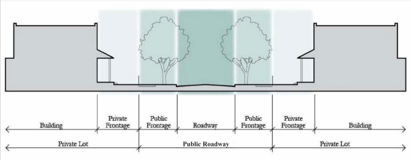
Figure 3.15.3b below, depicts the Streetscape's design elements of the U.S. Hwy 192 Public Realm proposed along the U.S. Hwy 192 frontage within the CRA, which consist of a landscape and signage parkway, a mountable curb, an eight-foot (8') two-way bicycle lane, a reverse direction public parking drive, a seven-foot (7') parallel parking isle, a ten-foot (10') pedestrian sidewalk and the private frontage.
To ensure maintenance is performed on a regular basis, the E192 CRA shall pursue a funding mechanism sufficient to cover the annual maintenance costs for streetscape improvements in the U.S. Hwy 192 Public Realm. Until such time that the funding mechanism is in place, property owners are required to maintain all streetscape improvements within their ownership.
Figure 3.15.3b U.S. Hwy 192 Public Realm
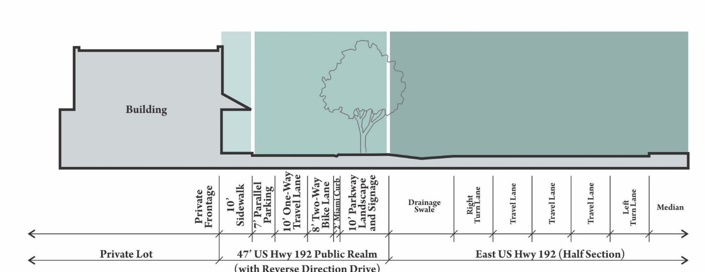
1.
Prototypical Cross Section dimensions for principal roadway types are shown below.
Notes:
a. Only sidewalks, bike lanes and travel lanes shall be required on bridges.
b. Within or adjacent to open space, the sidewalk can be deleted if there is a multiuse trail which connects to the sidewalk network.
c. On-street parking is not required where a street runs through or is adjacent to open space other than parks.
d. Framework Streets shall have bulb-outs at parking areas at intersections. These bulb-outs shall be a minimum of seventy (70) square feet and shall include the planting of at least one (1) canopy tree.
e. Where warranted by the travel demand, a 4-Lane option may be applied to portions of a Boulevard/Avenue by adding two (2) eleven-foot (11') travel lanes and expanding the Turn Lane/Median from eighteen (18) feet to fifty (50) feet in the FARM and TECH Use Districts and from twelve (12) feet to twenty-five (25) feet in other Use Districts.
f. The dimensions for medians and parkways may be modified up to two (2) feet on either side to accommodate the spacing needs for curbs.
Notes:
a. Only sidewalks and travel lanes shall be required on bridges.
b. Where a road runs through or is adjacent to open space the sidewalk can be deleted if there is a multiuse trail which connects to the sidewalk network.
c. On-street parking is not required where a road runs through or is adjacent to open space other than parks.
d. The dimensions for parkways may be modified to accommodate the spacing needs for curbs.
e. An on-street five-foot (5') bicycle lane may be added to the Local Road Cross Section on either side between the parking and travel lane.
f. The sidewalk on either side may be widen to eight (8) feet to accommodate a multi-purpose trail.
g. On street parallel parking may be included within the RES Use District.
Notes:
a. Miami curb or ribbon curb may be used in lieu of curb and gutter.
b. Alley and Lane sections will require stabilized area on both sides of drive to provide a total of twenty (20) feet of unobstructed horizontal clearance.
Notes:
a. U.S. Hwy 192 Public Realm is only applicable to those properties with U.S. Hwy 192 frontage and is intended to provide vehicular access for the individual blocks.
b. The U.S. Hwy 192 Public Realm shall not provide vehicular cross access between urban blocks. The pedestrian and bicycle access will be connected between urban blocks along the U.S. Hwy 192 frontage.
c. On-street parking is not required where a road runs through or is adjacent to open space other than parks.
d. Parallel parking shall include landscaped bulb-outs at all intersections and a landscaped island within the parking spaces. These landscaped islands shall include a minimum of one tree and shall be generally located every one hundred (100) feet.
e. Pavement markings per MUTCD and FDOT Index 17347 shall be included within the bicycle lanes and intersections.
2.
The following standards apply to Private Frontages:
a.
Build-to-Line (BTL).
i.
The BTL for building façades shall be as shown in Table 3.13.3e below. A minimum percentage of each building façade, as set forth in the table, shall be built to the BTL. This percentage shall be calculated for the vertical building façade at the first floor.
ii.
The BTL shall be consistent along each facing street block. Exceptions to the BTL setbacks or Frontage Build-out percentages shall be allowed for the purpose of creating a distinct civic space consistent with the Civic Space Standards or creating space to be used specifically for café-table seating and other pedestrian oriented facilities.
iii.
Buildings shall front all rights-of-way, the U.S. Hwy 192 Public Realm or Civic Space. Environmentally sensitive lands (Open Space) are exempt from this provision.
Notes:
(1) All buildings facing a framework road shall be a minimum of three (3) story.
(2) Hotel and Hospitality facilities shall be a minimum of three (3) story and a maximum of twelve (12) story.
(3) Accessory structures shall be a minimum of one (1) story and a maximum of two (2) story.
b.
Building Façades on Multifamily, Mixed Use, and Non-residential Buildings.
i.
All buildings must front a public right-of-way (excluding an alley or lane), the U.S. Hwy 192 Public Realm or civic space.
ii.
All building façades shall be architecturally finished with materials such as stucco, brick, stone, finished concrete, wood or other comparable materials. Building façades shall include jogs of not more than thirty-six (36) inches in depth, except as necessary to allow bay windows, shop fronts, balconies, civic spaces, outdoor seating, etc., in which case jogs of greater than thirty-six (36) inches will be allowed. Jogs of thirty-six (36) inches or less will be considered as being on the BTL.
iii.
Building volumes shall be articulated into three distinct vertical components—a "base," "middle," and a "top." The first floor height of buildings in the FARM and TECH Use Districts shall be a minimum of twelve (12) feet.
iv.
Building façades along BTLs shall be expressed as building modules that do not exceed thirty (30) linear feet in width.
v.
Weather protection features, which may include awnings, overhangs or other treatments providing functional weather protection, are required on building façades fronting a BTL within the FARM and TECH Use Districts. Weather protection feature shall provide continuous sidewalk coverage for the length of the building, where feasible.
vi.
Awnings or overhangs shall project a minimum of six (6) feet and maintain a clear height of at least nine (9) feet. They may encroach upon the public sidewalk subject to a Right-of-Way encroachment/utilization permit. The U.S. Hwy 192 Public Realm shall not be subject to a Right-of-Way encroachment/utilization permit.
vii.
A building's primary entrance shall be located on the façade facing the public right-of-way, the U.S. Hwy 192 Public Realm or civic space. The primary entrance is the principal pedestrian access to a building, even if customers or residents may more frequently use a secondary entrance associated with a garage, parking area, driveway or other vehicle use area. The entrance shall have the architectural detailing that sets it apart from other entrances and allows it be recognized as the building's primary access point.
viii.
Along primary streets within FARM Use District, buildings shall be at least three (3) stories in height. Along primary streets and the U.S. Hwy 192 Public Realm within the TECH Use District, building height shall be at least two (2) stories in height. Limited exceptions may be made through the SP process as a way to add variety and architectural interest to a development. Primary Streets within the FARM Use District shall be identified on a Master Plan to be approved by the County.
ix.
One-story buildings shall not exceed one hundred twenty-five thousand (125,000) square feet. Exceptions shall be made for civic use facilities within the INST Use District.
x.
Buildings higher than three (3) stories shall use step-backs, balconies or other architectural treatments to decrease their apparent size and scale.
c.
Streetscreen. A Streetscreen not less than six (6) feet in height or greater than twelve feet (12') in height shall be required along any private frontage that is not otherwise occupied by a building or civic space. In the FARM and TECH TRANSITION use districts, the streetscreen shall consist of a wall constructed of material matching or complementary to that of the adjacent building façades. In the INST, COMM and non-residential lots within the RES District the required streetscreen shall consist of a hedge or combination of a hedge and a fence providing a level of screening comparable to that of the wall required above. Residential lots within the RES Use District are exempt from this requirement.
Streetscreen openings for access shall be no larger than necessary to allow vehicular and pedestrian movement. In no event shall a vehicular entry be wider than eighteen (18) feet. Vehicular entry shall be restricted to not exceed twenty (20) percent of any block frontage. In addition, all streetscreens shall be articulated every thirty (30) feet to avoid monotonous appearance. One approach for avoiding monotonous appearance for walls that is encouraged is to integrate living or green walls into a streetscreen's design.
d.
Windows and Doors on Multifamily, Mixed Use and Non-residential Buildings.
i.
For multifamily, mixed use or non-residential buildings within the FARM, TECH and COMM Use Districts, a minimum of sixty (60) percent of the total wall area at the ground floor must include pedestrian entrances or transparent windows.
ii.
Windows shall be slightly recessed or project as bays from the main wall of the façade so as to create texture and shadows on the façade for visual interest, as well as the perception that people or activities are behind the windows.
iii.
Upper floor residential units must have a visible ground floor entrance facing the front or side street, a civic space, or a pedestrian passageway. This may be a common entrance serving multiple units.
e.
Parking and Service/Loading Areas.
i.
For multifamily, mixed use or non-residential buildings within the FARM, TECH and COMM Use Districts, Parking and service/loading areas shall be accessed by a rear alley, rear lane, shared driveway or local street other than a primary street. The U.S. Hwy 192 Public Realm shall also provide available convenience parking and loading areas.
ii.
Within the RES Use District, lots fronting on an Avenue or Boulevard shall be accessed by a rear alley or rear lane.
iii.
Off-street surface parking areas and service/loading areas shall be generally located to the rear and/or side of a structure and screened from the public right-of-way by liner buildings or a streetscreen. Required on-street parking is excluded from this provision.
iv.
Structured parking and surface parking entries and driveways within all Use Districts shall be located at least seventy-five feet (75') away from any block corner or another garage or parking area entry on the same side of the same block.
v.
Driveway width at the sidewalk within the RES Use District shall not exceed eleven (11) feet. For all other Use Districts, maximum driveway width at the sidewalk shall not exceed eighteen (18) feet. Entries to structured parking or delivery bays shall have a maximum clear height of sixteen (16) feet and a maximum clear width of twenty-two (22) feet.
vi.
Street facing parking on private property adjacent to the U.S. Hwy 192 Public Realm shall be prohibited.
f.
Reserved.
g.
Street Trees.
i.
All roadways shall be lined with rows of trees, with each block and its facing block planted in a single species with shade canopies of a height that, at maturity shall be higher than the top of the second story of buildings.
ii.
Trees shall be located within the Parkway and Medians of the public right-of-way and the U.S. Hwy 192 Public Realm.
iii.
Trees shall be planted along an alignment line—generally three (3) feet to three and one-half (3.5) feet from the back of the curb at an average spacing not greater than thirty (30) feet on center. Where necessary, spacing allowances may be made to accommodate curb cuts, fire hydrants and other infrastructure elements. This allowance for spacing may not exceed forty-five feet (45') on center except where necessary for transit stops or stations.
iv.
Trees shall be at grade or not greater than six inches (6") in height above or below the sidewalk. Any unpaved ground area shall be planted with groundcover, flowering vegetation, or climbing vines, not to exceed twelve (12) inches in height.
v.
At planting, trees shall be at least two and one-half (2.5) inches in diameter at designated breast height (DBH) and at least ten (10) feet in overall height. At planting, canopy trees within the U.S. Hwy 192 Public Realm must be at least fourteen (14) feet tall, with at least a four-inch (4") caliper, and have a clear trunk to at least six (6) feet above the ground. In addition to the canopy trees within the U.S. Hwy 192 Public Realm, two (2) understory trees, and thirty (30) shrubs per one hundred (100) linear feet shall be planted.
vi.
Trees must be "limbed up" as they gain appropriate maturity so as to not interfere with pedestrian or truck travel (minimum seven (7) feet clear over the sidewalk and fourteen (14) feet over the travel of the street) and to maintain visibility.
vii.
Maintenance and replacement of trees is the responsibility of the property owner.
h.
Landscape Buffers.
i.
Within the CRA, landscape buffers shall not be allowed between Use Districts, between adjacent neighborhoods or between buildings and roadways.
ii.
Landscape buffers may be provided along the boundary line of the CRA to mitigate any potential conflicts with adjacent development.
C.
UTILITIES.
1.
All new utilities shall be placed underground in the public right-of-way, in easements within a private frontage or in rear service alleys. Their specific placement will be determined as part of the Site Development Plan process. Above ground power lines are allowed within an alley or lane.
2.
The Natural Drainage Module and the Light Imprint Stormwater Matrix Module for SmartCode, Version 9.2 are incorporated into these Standards by reference. They shall serve as a menu of stormwater management techniques, appropriately calibrated for the development patterns intended for a specific Use District.
D.
CIVIC SPACE STANDARDS.
1.
Civic space is the second element of the Public Realm regulated by this Chapter. The development standards provide significant open space and recreational opportunities that are a spatial counter-point to the densities and intensities required of development within the CRA Use Districts. These can be realized through a variety of spaces ranging from large regional and neighborhood-scaled parks to small pocket parks. The open space network will be serviced by an interconnected network of sidewalks, trails and paths for pedestrians and bicyclists alike, providing open space amenities accessible to all developments within the CRA.
The types of spaces allowed are illustrated in Figure 3.15.3D. below.
Figure 3.15.3D. Civic Spaces
2.
Civic Spaces shall adhere to the following standards:
a.
Urban Parks.
i.
Description.
Urban parks include open areas available for a variety of purposes, to include structured and unstructured recreation, commercial activity and other passive uses.
ii.
Character.
These spaces have a formal urban character being defined by surrounding building frontages and adjacent tree-lined streets. The landscape consists of lawns, trees and shrubs and furnished with paths and benches and shade. Civic elements such as kiosks, open shelters, pergolas, playgrounds or fountains may be included. Parks shall be located throughout the CRA at the appropriate scale to serve the intended development.
iii.
Standards.
a)
Width — N/A
b)
Depth — N/A
c)
Must front at least two (2) public roadways. All buildings must front this space.
iv.
Typical Uses.
a)
Passive/active recreation
b)
Commercial uses, including farmer's markets, foot races and concerts
c)
Playgrounds
d)
Civic events
b.
Plazas and Greens.
i.
Description.
Plazas and Greens are open areas available for civic purposes, commercial activities, passive recreation, and, for Greens, unstructured active recreation. Numerous Plazas and Greens add to the vibrancy of developments by creating the opportunity for casual public engagement. Building frontages define the space. Pocket Plazas function in a similar manner and follow the same rules as the larger Plazas. These smaller scaled spaces create more intimate places for seating or dining and provide a place where commercial and neighborhood activity can spill into. These Plazas can also be used to create a formal space in front of a prominent building entrance.
ii.
Character.
Plazas and Greens are purposefully sited gathering areas designed with a percentage of paved surface area appropriate to their pedestrian traffic level. They shall be sufficient in number to provide enough shade to help mitigate the heat effect of the hardscape. Tables and chairs shall be provided.
iii.
Standards.
a)
Minimum width and depth — twenty-five (25) feet
b)
Maximum width and depth — one hundred twenty-five (125) feet
c)
Must front on at least one (1) public roadway
iv.
Typical Uses.
a)
Casual seating
b)
Commercial uses (e.g., retail and food kiosks)
c.
Squares.
i.
Description.
Squares provide an important anchor for a neighborhood, serving as an open space available for civic purposes, commercial activity, unstructured recreation and other passive uses. The Square should have an urban, formal character and be defined by the surrounding building frontages and adjacent tree-lined streets.
ii.
Character.
All buildings adjacent to the Square must front onto it. Adjacent streets lined with appropriately scaled trees help to define the square. The landscape shall consist of lawns, trees, and shrubs planted in formal patterns and furnished with paths and benches. Shaded areas for seating shall be provided. A civic element or small structure such as a kiosk, open shelter, pergola or fountain may be included.
iii.
Standards.
a)
Minimum width — one hundred twenty (120) feet
b)
Minimum depth — one hundred twenty (120) feet
c)
Must front on at least two (2) public roadways
iv.
Typical Uses.
a)
Unstructured and passive recreation
b)
Commercial and civic uses
c)
Casual seating
d.
Playgrounds.
i.
Description.
Playgrounds are open areas designed and equipped for the recreation of children. They can be interspersed within all development where appropriate. Playgrounds can be freestanding or located within Urban Parks.
ii.
Character.
Playgrounds serve as safe places protected from the street and typically in locations where children do not have to cross Framework Streets to get to. Often Playgrounds, particularly tot-lots, are located in the center of blocks surrounded by residential areas.
iii.
Standards.
a)
Minimum width — N/A
b)
Minimum depth — N/A
c)
Independent of building frontages
d)
Fenced with limited access points where appropriate
iv.
Typical Uses.
a)
Passive/active recreation
b)
Picnic facilities
c)
Outdoor seating
d)
Play structures, interactive art, fountains
e.
Pedestrian Passageways.
i.
Pedestrian Passageways provide pathways between buildings and through blocks. They create unique spaces for building frontages to access while allowing for social and commercial activity to spill into the public realm.
ii.
Character.
Passageways are hardscape areas with frequent entries and frontages. There may be exterior stairways to adjacent buildings that frame and define the passageway. There are minimal plantings and potted plants.
iii.
Standards.
a)
Minimum width — twelve (12) feet
b)
Maximum width — thirty-five (35) feet
c)
Uninterrupted Pedestrian Passageways greater than one hundred fifty (150) feet in length must incorporate a Pocket Plaza.
d)
Pedestrian Passageways shall be incorporated into blocks that are longer than four hundred (400) feet in length. Exceptions shall be made for sites requiring special security measures as approved by the County Manager within the FARM Use District.
iv.
Typical Uses.
a)
Primary access
b)
Casual seating
(Ord. No. 2021-78, § 1, 11-1-2021; Ord. No. 2022-125, § 3, 2-20-2023)
3.15.4 - PRIVATE REALM STANDARDS
A.
DENSITY AND INTENSITY STANDARDS. Table 3.15.4.a below demonstrates the targeted density and intensity for the Use Districts within the CRA. The standards defined below, as they apply to a specific development or phase of development, may be modified through the SP process but only if the applicant can demonstrate that the Community Principles and the Block and Building Scale Principles defined above shall not be compromised for the desired urban block build-out of the Use District. Individual sites are subject to the development standards permitted in the specific zoning district for the site.
Notes:
Hotel and hospitality uses may develop up to sixty (60) rooms (keys) per acre.
B.
PARKING STANDARDS. Table 3.15.4.b below demonstrates the parking standards for the Use Districts within the CRA. The standards defined below, as they apply to a specific development or phase of development, may be modified through the SP process but only if the applicant can demonstrate to the satisfaction of the County Manager that the Community Principles and the Block and Building Scale Principles defined above shall not be compromised for the desired urban block build-out of the Use District. This demonstration shall include an assurance by an established development threshold that additional spaces over and above the maximum allowable count for any specific use shall be converted to useable space, shall provide parking for adjacent future development, or shall not otherwise compromise the desired urban block build-out of the Use District.
Notes:
Parking spaces required within the Public Realm of the urban block shall be counted
towards the Parking Standards.
3.16.1 - GENERAL PROVISIONS
A.
RELATIONSHIP TO OTHER LAND DEVELOPMENT CODE CHAPTERS. The standards in this Article apply to properties within the West 192 Redevelopment Area Municipal Service Benefit Unit (MSBU) per Ordinance No. 95-8, hereinafter referred to as the West U.S. 192 Development Authority Corridor (W192 Corridor). The MSBU includes property within the following list of sections that is located less than three-quarters (¾) of a mile from the centerline of Irlo Bronson Memorial Highway (West U.S. 192) and west of Hoagland Boulevard and Airport Road, excluding property located within the Special Districts: Sections 1-2 and 10-12, Township 25, Range 27; Sections 1-14 and 23-24, Township 25, Range 28; and Sections 7, 18, and 19, Township 25, Range 29.
If there are conflicts between these standards and standards contained elsewhere in the Land Development Code, the standards in this Article shall prevail with the exception of the following:
1.
Properties located within the Urban Center future land use designation located in a portion of sections 2, 11, and 12, T25, R28 per the Comprehensive Plan Future Land Use Map, shall adhere to the themed design palette including site furnishing and landscape material defined by the W192 Design Guidelines with mix of uses, building orientation, development standards, and architectural standards per Article 3.14 Urban Infill Centers Standards.
B.
PURPOSE. The standards described herein are intended to enforce key elements of the W192 Design Guidelines which define a multi-themed vision for the W192 Corridor. In order to achieve the desired character and form for the W192 Corridor, the standards in this Article, paired with the W192 Design Guidelines established by the W192 Development Authority, are intended to guide development and redevelopment to create a sense of place and attract tourism.
In order to brand the W192 Corridor, common design elements will be implemented the length of the roadway with specific elements per segment to enforce the eight (8) themes. Common elements include street lighting, signage, primary public sidewalk, building placement, and architectural forms. A palette of design elements specific to each of the eight (8) distinct themes as described in Section 3.16.2 provide for a varied experience along the W192 Corridor represented through theme-specific site furnishings, landscaping, and color schemes.
The following planning principles serve as a guide for interpreting and implementing the standards contained herein.
C.
IMPLEMENTATION.
1.
The standards included herein shall be implemented through the preparation and approval of a Site Plan (SP), a Site Development Plan (SDP), and a Preliminary Subdivision (PS) and Final Subdivision (FS) where appropriate.
2.
The SP shall be reviewed and approved by the Development Review Committee (DRC) where it is determined that the proposal supports, promotes and enables the overall purpose as defined above.
3.
The SP approval shall precede the approval of the required SDP, PS and FS. At the discretion of the applicant the SP may be submitted simultaneously with the required SDP. However, SDP shall be required to be found in compliance with an approved the SP.
4.
Any appeal of a DRC decision of the SP will be made to the County Manager.
5.
The applicant may propose interim implementation standards with the SP for consideration. However, any interim implementation shall only be considered if the applicant can demonstrate to the DRC that the purpose defined above and principles of the Design Guidelines are not being compromised for the desired build-out. This could include a conditional approval with the requirement of thresholds for phased implementations and improvements of the plan.
6.
Standards provided herein such as physical site restrictions and pedestrian access on properties impacted by freeway interchanges may be waived should the County Manager deem it appropriate.
(Ord. No. 2020-21, § 2, 2-17-2020)
3.16.2 - GENERAL DESIGN STANDARDS FOR ALL SEGMENTS
A.
GENERAL. All standards described in this Section apply to the private frontage as depicted in Figure 3.16.2a. For the purpose of these standards, the "frontage" of a building is defined as the surface of the exterior wall which faces the West U.S. 192 right-of-way.
B.
PURPOSE. This section sets forth development standards for the public frontage, private frontage and building realms per Figure 3.16.2a below. Additionally, any change of use (adaptive reuse) from non-residential to residential shall meet all of the regulations set forth in this section in addition to building siting standards in Section 3.8.1.
Figure 3.16.2a. Streetscape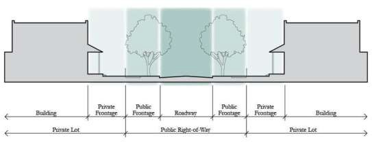
C.
SIDEWALK. The primary public sidewalk running the length of the West U.S. 192 right-of-way within the W192 Corridor, shall be ten (10) feet wide, colored concrete adhering to the existing design and specifications per Figure 3.16.2b. Existing sidewalks shall remain until funding or development triggers the new sidewalk to come into compliance with these standards. All auxiliary walks shall be per Section 4.7.4.
Figure 3.16.2b. Primary Public Sidewalk Detail
D.
INTERSECTIONS. All major street intersections within the West U.S. 192 right-of-way shall be improved with pavers and seat walls adhering to the existing design and specifications per Figure 3.16.2c.
Figure 3.16.2c. Intersection Detail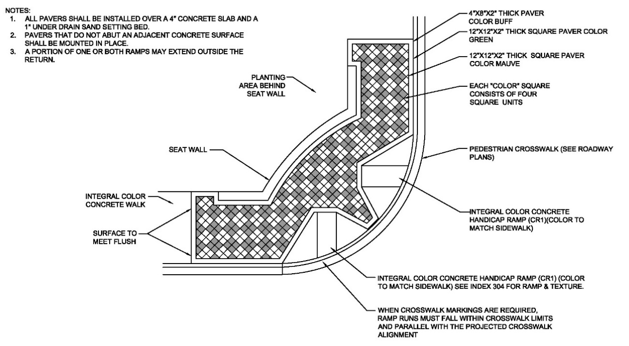
E.
LIGHTING. All street lights and pedestrian lights in the West U.S. 192 right-of-way shall be provided and installed by the County utilizing CRA funds in accordance with the W192 Development Authority standard fixtures per Ordinance 95-8 and agreements on file between FDOT and Osceola County.
F.
LANDSCAPING. All landscaping and street furnishings within the West U.S. 192 right-of-way shall be provided and installed by the County utilizing CRA funds pursuant to the theme of the individual corridor segment per the W192 Design Guidelines. Street trees in the West U.S. 192 right-of-way shall be California Fan Palms, or equal, planted in clusters of three (3) to five (5) trees spaced no more than twenty (20) feet apart with no more than eighty (80) feet between clusters. The County shall develop a Streetscape Master Plan to regulate.
1.
All landscaping shall be consistent of Florida Friendly plant material and the general Landscape Planting and Irrigation Objectives per Section 4.8.2.
2.
Street trees shall be provided per Section 4.8.4.D.
3.
Costs associated with the landscaping within the ROW, will be evaluated at the SP stage.
G.
SITE FURNISHINGS. All benches with a length of four (4) feet or longer, placed within the West U.S. 192 right-of-way, shall include mid-bench arm rests or dividers.
H.
SIGNAGE. All signage shall be per Section 3.17.9.C.
I.
UTILITIES. All new utilities shall be placed underground in the public right-of-way or in easements on private property. Their specific placement shall be determined as part of the SDP process.
J.
FENCING. All non-decorative, security or privacy fencing, upon approval, shall be set back a minimum of twenty-five (25) feet from the West U.S. 192 right-of-way and buffered with landscaping per medium buffer type in Table 4.8.3-2. Chain link fence shall be vinyl coated.
K.
FRONTAGE ROADS. New frontage roads shall be prohibited. Access easements shall be dedicated for either side or rear access, unless site constraints limit feasibility, to accommodate cross access and reduce curb cuts along West U.S. 192. Osceola County shall develop an Access Control Plan to regulate. Easements and dedication shall be consistent with Article 4.4.
L.
USES. Intended or envisioned uses listed in the W192 Design Guidelines shall be in accordance with Article 3.4, Table 3.4 and Table 3.5.
M.
PARKING AND DRIVE-THROUGH PLACEMENT.
1.
All new buildings visible from the W192 Corridor shall be oriented with parking to the side or rear of the building as it relates to the frontage of the W192 Corridor.
2.
Loading areas or "back of house" operations shall be limited in the space between buildings and a public right-of-way. These operations may be approved if additional landscaping, berms or complementary architectural features are utilized to minimize visual impact from public rights-of-way.
3.
In the event that a parking lot or drive-through is visible from the West U.S. 192 right-of-way, landscaping, berms or complementary architectural features shall be utilized to minimize the visual impact of vehicles. Parking spaces shall be oriented so that headlights are not pointed directly at the West U.S. 192 right-of-way.
4.
See additional information within Section 4.7.10 as related to drive-throughs.
N.
BUILD TO LINE (BTL). The BTL for building façades shall be as shown in Table 3.16-1. A minimum percentage of each building façade, as set forth in the table, shall be built to the BTL. This percentage shall be calculated for the vertical building façade at the first floor.
1.
The BTL shall be consistent along each facing street block. Exceptions to the BTL setbacks or Frontage Build-out percentages may be allowed by waiver for the purpose of creating a distinct civic space or creating space to be used specifically for café-table seating. Refer to Table 3.14-1 BTL for Urban Infill Centers Building Façades, for BTL distances specifically for the Urban Center within Segment 6.
0.
BUILDING FORM. The intent is to encourage human scale elements in building design, and to reduce the mass of large buildings. Breaks in mass are required to relate to structural systems and the organization of interior space. Both horizontal and vertical mixed-use designs are highly encouraged.
1.
Building façades shall include jogs of not more than thirty-six (36) inches in depth, except as necessary to allow bay windows, shop fronts, balconies, civic spaces, outdoor seating, etc., in which case jogs of greater than thirty-six (36) inches will be allowed. Jogs of thirty-six (36) inches or less will be considered as being on the build to line (BTL).
2.
Building volumes shall be articulated into three (3) distinct vertical components — a "base," "middle," and a "top." The first floor height shall be a minimum of twelve (12) feet in non-residential uses.
3.
Building façades along BTLs shall be expressed as building modules that do not exceed thirty (30) linear feet in width.
4.
Horizontal masses shall not exceed a height/width ratio of one (1) vertical to three (3) horizontal without substantial variation in massing that includes a change in height and projecting or recessed elements.
5.
A minimum of sixty (60) percent of the total wall area at the ground floor must include pedestrian entrances or transparent windows.
P.
BUILDING ARTICULATION. The intent is to reduce the apparent size of buildings and create visual interest. Articulation elements shall vary to alleviate the appearance of a large building mass and break up long continuous wall surfaces. Building façades facing public right-of-way or civic space must comply with the following articulation elements:
1.
Façades greater than sixty (60) feet in length, but less than one hundred twenty (120) feet in length must exhibit a prominent shift in the façade of the structure so that no greater than seventy-five (75) percent of the length of the building façade appears unbroken. Each shift shall be in the form of either a ten (10) foot change in building façade alignment or a ten (10) foot change in roof line height, or a combined change in façade and roof line totaling ten (10) feet.
2.
Façades that exceed one hundred twenty (120) feet in length shall provide a prominent shift in the mass of the structure at each one hundred twenty (120) foot interval, or less if the developer desires, reflecting a change in function or scale. The shift shall be in the form of either a fifteen (15) foot change in building façade alignment or a fifteen (15) foot change in roof line. A combination of both a roof line and façade change is encouraged and to that end, if the combined change occurs at the same location in the building plan, a fifteen (15) foot total change will be considered as full compliance.
Q.
ROOF MODULATION. The intent is to ensure that visual interest also applies to roof treatment. Roof forms may be used to identify different functional areas within the building, to provide for additional light to enter the building, to reduce massing, to screen rooftop equipment, and to create movement along the roof line.
1.
Building façades fronting a BTL must use multiple peaks or roof planes and distinctive roof forms covering each building mass.
2.
All rooftop equipment must be screened from view from adjacent rights-of-way.
(Ord. No. 2020-21, § 2, 2-17-2020; Ord. No. 2021-78, § 1, 11-1-2021)
3.16.3 - DESIGN GUIDELINES PER SEGMENT
A.
GUIDELINES FOR SEGMENT 1, Osceola County line to State Road 429.

1.
Theme—Four Corners. This Segment shall provide the foundation for the Four Corners and gateway to the W192 Corridor area with a palette of elements that can easily be replicated in adjacent Polk, Orange, and Lake Counties. The landscape shall be characterized by a green plant palette of shade trees and broad sweeping lawns interspersed with organically-shaped planting beds of small shrubs and ornamental grasses.
2.
Site Furnishings. Site furnishings shall be complementary to the segment theme and right-of-way site furnishings pictured below.

B.
GUIDELINES FOR SEGMENT 2, State Road 429 to Formosa Gardens Boulevard.
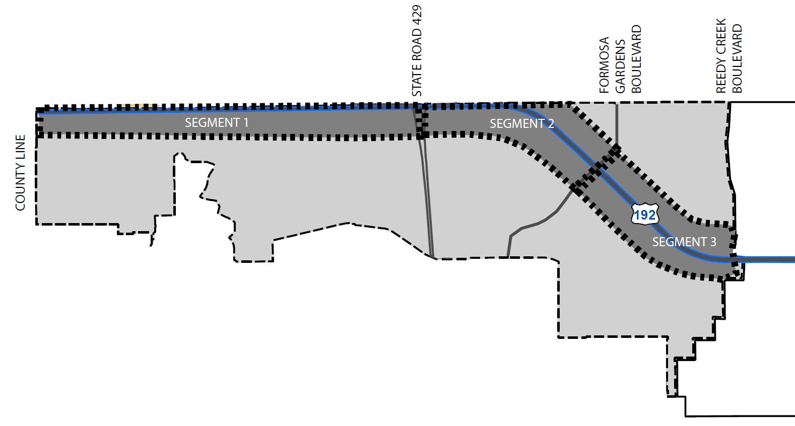
1.
Theme—Paradise. This Segment shall provide a tropical-themed tourist gateway into Osceola County highlighting active public spaces. The landscape shall be characterized by bright colorful plantings including mounded massings of trees, shrubs, ornamental grasses.
2.
Site Furnishings. Site furnishings shall be complementary to the segment theme and right-of-way site furnishings pictured below.
3.
Civic Spaces. Restaurants, cafes, and retail spaces fronting a public right-of-way shall include small-scale, public plazas or outdoor gathering spaces with a minimum size of one hundred twenty (120) square feet. Multi-tenant buildings may consolidate gathering spaces with a total size equal to or greater than the total the cumulative area of one hundred twenty (120) square feet per business or two (2) percent of the total floor area.
C.
GUIDELINES FOR SEGMENT 3, Formosa Gardens Boulevard to Reedy Creek Boulevard.

1.
Theme—Imagination. This Segment shall provide a family-friendly, destination oriented hospitality experience, inspired by local theme parks and adjacent tourist attractions. The landscape shall be characterized by a palette of colorful flowers interspersed with, topiary, sculptures, and public art.
2.
Site Furnishings. Site furnishings shall be complementary to the segment theme and right-of-way site furnishings pictured below.

3.
Civic Spaces. Restaurants, cafes, and retail spaces fronting a public right-of-way shall include small-scale, public plazas or outdoor gathering spaces with a minimum size of one hundred twenty (120) square feet. Multi-tenant buildings may consolidate gathering spaces with a total size equal to or greater than the total the cumulative area of one hundred twenty (120) square feet per business or two (2) percent of the total floor area.
D.
GUIDELINES FOR SEGMENT 4, Interstate 4 to State Road 417.

1.
Theme—Celebration. This Segment shall provide an aesthetically pleasing, soft, vegetated, experience, providing respite from the more vibrant elements in adjacent segments. The landscape shall be characterized by deciduous tree canopy with broad sweeping lawn edged in pastel, green, and white planting borders accented with vibrant pops of color to accentuate the Americana themed architecture, white rail fence with grand stone columns.
2.
Site Furnishings. Site furnishings shall be complementary to the segment theme and right-of-way site furnishings pictured below.

E.
GUIDELINES FOR SEGMENT 5, State Road 417 to Poinciana Boulevard.

1.
Theme—Entertainment. This Segment shall provide a vibrant, lively, pedestrian-oriented, entertainment experience representing the tourist hub of the W192 Corridor through a concentration of amenities. The landscape shall be characterized by terraced landscape beds anchored by large potted plants, and artistic lighting.
2.
Site Furnishings. Site furnishings shall be complementary to the segment theme and right-of-way site furnishings pictured below.

3.
Civic Spaces. Restaurants, cafes, and retail spaces fronting a public right-of-way shall include small-scale, public plazas or outdoor gathering spaces with a minimum size of one hundred twenty (120) square feet. Multi-tenant buildings may consolidate gathering spaces with a total size equal to or greater than the total the cumulative area of one hundred twenty (120) square feet per business or two (2) percent of the total floor area.
F.
GUIDELINES FOR SEGMENT 6, Poinciana Boulevard to Lake Cecile Drive.

1.
Theme—The Lake District. This Segment shall provide a pedestrian-oriented, mixed-use experience with commercial and active public places oriented toward the West U.S. 192 right-of-way. Surrounded by lakes and lake-themed development, the elements to be incorporated into public spaces are largely water- and lake-themed with the landscape characterized by an elegant palette of trees, shrubs and groundcover with decorative pavers for transition into civic spaces.
2.
Site Furnishings. Site furnishings shall be complementary to the segment theme and right-of-way site furnishings pictured below.

3.
Civic Spaces. Restaurants, cafes, and retail spaces fronting a public right-of-way shall include small-scale, public plazas or outdoor gathering spaces with a minimum size of one hundred twenty (120) square feet. Multi-tenant buildings may consolidate gathering spaces with a total size equal to or greater than the total the cumulative area of one hundred twenty (120) square feet per business or two (2) percent of the total floor area. For areas within the Urban Center, refer to Article 3.14 Urban Infill Centers Standards.
G.
GUIDELINES FOR SEGMENT 7, Lake Cecile Drive to Bass Road.
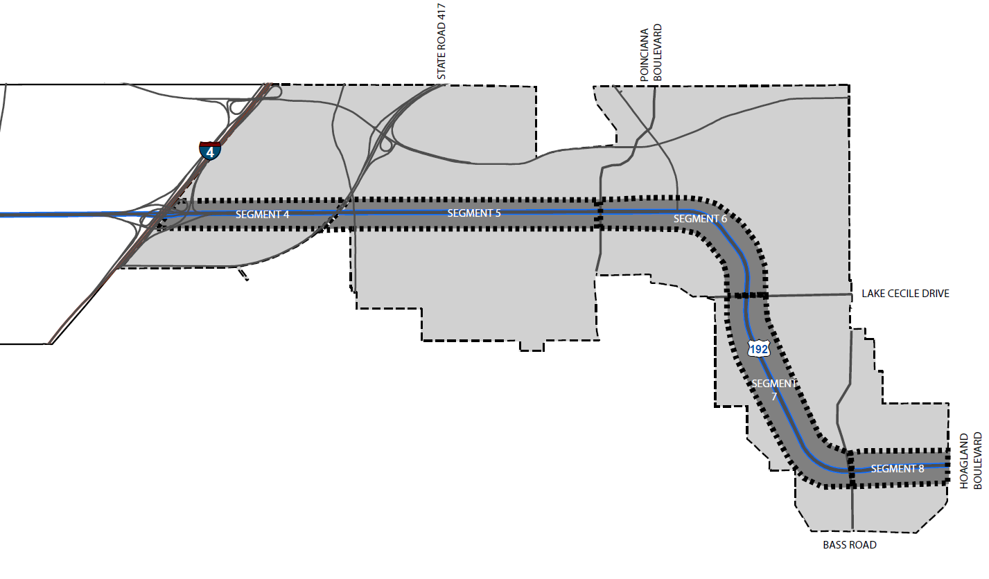
1.
Theme—The Neighborhood District. This Segment shall provide an authentic neighborhood experience with pedestrian and bike-friendly pathways linking homes to services and leisure. The landscape shall be characterized by a residential-scaled plant palette to complement eclectic, brownstone style architecture reminiscent of older Downtown Orlando neighborhoods.
2.
Site Furnishings. Site furnishings shall be complementary to the segment theme and right-of-way site furnishings pictured below.

3.
Civic Spaces. It is intended that this Segment will incorporate small-scale commercial/retail spaces such as corner bakeries or cafes which shall have a small public plaza or enhanced entry and seating area of no less than three hundred (300) square feet associated with the use. Townhomes fronting the W192 Corridor shall have direct access via private sidewalk to the West U.S. 192 right-of-way public sidewalk.
H.
GUIDELINES FOR SEGMENT 8, Bass Road to Hoagland Boulevard.

1.
Theme—The Creek District. This Segment shall define the gateway to the W192 Corridor from the east defined by buildings, landscaping, and public spaces inspired by Florida's natural amenities. With its proximity to Shingle Creek, this Segment shall be characterized by a native plant palette with blue accents.
2.
Site Furnishings. Site furnishings shall be complementary to the segment theme and right-of-way site furnishings pictured below.

3.
Civic Spaces. Connections to the regional trail system along Shingle Creek shall be incorporated where appropriate.
(Ord. No. 2020-21, § 2, 2-17-2020)
3.17.1 - PURPOSE
The purpose of this Article is to permit such signs and/or features that will protect values, enhance the character of the County, protect the public safety and welfare, and support and complement land use objectives. This article shall prohibit signs that by their size, location, construction, or manner of display are not aesthetically pleasing, endanger the public safety of individuals, confuse, mislead, obstruct the vision necessary for traffic safety, or otherwise endanger public health, safety, or welfare.
It is intended to complement the County Comprehensive Plan by relating signage to the major characteristics of street and areas of the County as defined in the plan. This is accomplished by designated "sign zones," within which signs shall conform to individual sign zone standards.
It is intended that the display of signs will be appropriate to the land, building or use, but not excessive.
(Ord. No. 2020-21, § 2, 2-17-2020)
3.17.2 - GENERAL PROVISIONS
A.
Sign means any outdoor sign display comprehensible from any public use, street, road,
highway or public pedestrian way using letters, words, figures, symbols, pictures,
designs or a combination thereof to advertise, attract attention, indicate direction,
announce the purpose of, or identify the purpose of a person or entity, or to communicate
information of any kind to the public within the unincorporated area of Osceola County.
Signs shall
be classified by these regulations as follows:
1.
Signs which are allowed by these regulations.
2.
Non-conforming signs allowed to remain by provisions of these regulations under certain conditions.
3.
Signs that are not in compliance with this Code are prohibited.
B.
Signs no greater than six (6) square feet and not more than three (3) feet tall may be placed at the entrance to a site limited to one (1) per entrance.
C.
It shall hereafter be unlawful for any person to erect, place or maintain, or suffer to be erected, placed, or maintained, any sign in Osceola County except in accordance with the provisions of these regulations.
D.
The administration of the regulations is vested in the office of the County Manager. The administration of enforcement of the Florida Building Code is vested in the office of the County Manager.
E.
All signs shall be designed and constructed in accordance with the requirements of the Florida Building Code.
F.
No sign shall be erected, altered or relocated without a building permit issued by the County, except as otherwise provided herein. An electrical permit shall be required for electrical work. Any activity defined herein as a replacement of a sign shall require a building permit. If the work involved is not regulated by the Florida Building Code and does not require a building permit, approval from the County Manager shall still be required.
G.
In accordance with F.S. § 106.1435, no temporary signs, including but not limited to political campaign advertisements, shall be erected, posted, painted, tacked, nailed, or otherwise displayed, placed or located on or above any county road right-of-way. Any sign placed in violation would be subject to Code Enforcement action and subject to a removal fee of $10.00 per violation.
(Ord. No. 2020-21, § 2, 2-17-2020; Ord. No. 2022-66, § 2, 6-27-2022)
3.17.3 - SIGN ZONES
A.
For the purpose of these regulations, the following sign zones are established within the unincorporated area of Osceola County, Florida. Where a site has frontage on more than one (1) road and said roads are in different sign zones, signage shall be permitted based upon the sign zone where the sign is installed; except, where two (2) signs are allowed based on more than three hundred (300) feet of frontage, one (1) sign must conform to size and height restrictions for qualifying road frontage. The second sign may not exceed sign criteria for the road where installed.
1.
Sign Zone A. Gateway: Sites fronting on U.S. 192 between the western Kissimmee city limits and the western County line and that portion of S.R. 535 from U.S. 192 to the Orange County line.
2.
Sign Zone B. Sites fronting on Osceola Parkway and sites fronting on Premium Transit Corridors, as defined by the Osceola County Comprehensive Plan. Sign zone B shall also include that portion of Donegan Avenue which is located between Michigan Avenue and U.S. 441/Orange Blossom Trail, in addition to the entire length of the following roads: Bill Beck Boulevard, Boggy Creek Road, Buenaventura Boulevard, C.R. 15, Canoe Creek Road, Carroll Street, Hoagland Boulevard, Michigan Avenue, Nova Road, Old Dixie Highway, C.R. 545, C.R. 532, Simpson Road, S.R. 538 And Poinciana Boulevard.
3.
Sign Zone C. Sites which are not included in sign zones A, B, D, E or F.
4.
Sign Zone D. Sites that border Interstate 4, the Florida Turnpike, or State Road 429.
5.
Sign Zone E. Osceola Parkway, S.R. 417, International Drive Extension.
6.
Sign Zone F. Those properties located at the intersection of the Florida Turnpike, Shady Lane and U.S. 192 East and those properties abutting U.S. 192 East, to the eastern boundary of the city limits of the City of Kissimmee.
B.
One (1) freestanding sign structure shall be permitted in unincorporated Osceola County on each site located on a publicly maintained road. Those sites with frontage in excess of three hundred (300) feet shall be permitted two (2) signs; provided, however, only one (1) of those signs may be a billboard.
(Ord. No. 2020-21, § 2, 2-17-2020; Ord. No. 2020-51, § 2, 6-15-2020)
3.17.4 - ILLUMINATION
A.
Unless otherwise specified in these regulations, all signs may be illuminated. However, all lighting shall be restricted as follows:
Signs shall not utilize:
1.
Lights which might create confusion with traffic lights or lights on emergency vehicles.
2.
Lights, or combinations of lights, which because of location, brightness, or other factors, are determined by the County Manager to constitute a traffic hazard.
B.
Signs shall be lighted only with continuous light, except for electronic message centers, which shall be limited to a minimum eight (8) second lighted or display interval.
C.
Properties in non-residential districts which exist contiguous to residential zoning districts may have back lit internally illuminated sign(s) or shielded ground mounted accent lights that do not promote glare which interferes with residential use.
D.
All illuminated signs and billboards shall have electricity provided by underground wiring.
(Ord. No. 2020-21, § 2, 2-17-2020)
3.17.5 - OTHER PROVISIONS
A.
No sign shall be erected which displays any statement, words, characters, or illustrations of any obscene, indecent, or immoral nature.
B.
Signs erected in commercial or industrial districts which abut residential districts, shall not be placed closer than twenty-five (25) feet from any residential boundary line.
C.
In the event an appropriate interlocal agreement is negotiated between Osceola County and the cities of Kissimmee and St. Cloud, those sites which are County enclaves shall be issued sign permits by these respective cities.
D.
When deemed necessary to otherwise protect the health, safety and welfare of the public the County may impose additional restrictions on signage, notwithstanding anything in these regulations to the contrary and the appeal procedures contained herein.
E.
In order to ensure public safety and welfare, any application for a ground mounted sign, including but not limited to a monument sign, which is proposed to have a setback of less than ten (10) feet, will require the approval of the County Engineer based upon safe line of sight criteria.
F.
All signs shall be properly maintained. Exposed surfaces shall be clean and paint thereon shall not be peeling or flaked. Signs shall be structurally sound, kept in a vertical, upright position at all times. Defective parts shall be replaced, landscaping shall be in good condition, and no rubbish which could constitute a fire or health hazard shall be allowed under or near a sign. Signs not maintained in accordance with the above provisions shall be in violation of these regulations.
(Ord. No. 2020-21, § 2, 2-17-2020)
3.17.6 - ALTERNATIVE SIGN STANDARDS
A.
PLANNED DEVELOPMENT. Notwithstanding anything in these regulations to the contrary, regulation of signage may be modified as part of the plan for a Planned Development (PD), to accommodate and support the innovative principles put forth in the PD.
1.
Although innovative design may be requested, the total square footage allowable for any sign shall not exceed one hundred fifty (150) percent of the standards as set by these regulations.
2.
Free-standing signs (pole, pylon, monument) shall be appropriately designed, landscaped and integrated with the overall architectural theme of the development. All Planned Developments sign packages shall incorporate additional landscaping to the site.
a.
Free-standing signs shall be located within a landscaped area at the base of the sign. The landscaped area ratio to the sign's area shall be 2:1. A landscape plan shall be submitted with any application for permitting a free-standing sign. The landscaped area surrounding a sign shall create an aesthetic effect by the combined use of plant material and/or inorganic material including but not limited to grass, trees, shrubs, planters, brick, stone, natural forms, water forms, aggregate and other landscape features, but not including the use of concrete, asphalt or outdoor carpeting.
3.
If the issue of signage is not addressed within the Planned Development, then the provisions of this Article will be applied.
4.
Billboards are not included as part of a Planned Development and shall require separate approval.
5.
Sign packages approved within a Planned Development shall not be invalidated when a property is rezoned as long as the sign package meets the following:
a.
Landscaping is in compliance with this section.
b.
Future changes will require a Conditional Use permit.
B.
CONDITIONAL USE. Notwithstanding anything in these regulations to the contrary, regulation of signage may be modified as part of a Conditional Use plan for a site to accommodate and support the innovative design of the site. Only zoning districts consistent with the Osceola County Comprehensive Plan shall be eligible for a Conditional Use for sign standards. The Conditional Use shall not be a mechanism used to bring nonconforming signs into conformance by the creation of standards which exceed the standards contained in this Article.
1.
Although innovative design may be requested, the total square footage allowable for any sign shall not exceed one hundred fifty (150) percent of the standards as set by these regulations.
2.
Free-standing signs (pole, pylon, monument) shall be appropriately designed, landscaped and integrated with the overall architectural theme of the development. All Conditional Uses shall incorporate additional landscaping to the site.
a.
Free-standing signs shall be located within a landscaped area at the base of the sign. The landscaped area ratio to the sign's area shall be 2:1. A landscape plan shall be submitted with any application for permitting a free-standing sign. The landscaped area surrounding a sign shall create an aesthetic effect by the combined use of plant material and/or inorganic material including but not limited to grass, trees, shrubs, planters, brick, stone, natural forms, water forms, aggregate and other landscape features, but not including the use of concrete, asphalt or outdoor carpeting.
3.
If a specific type of sign is not addressed within the Conditional Use, then the provisions of this Article will be applied.
4.
Billboards are not included as part of a Conditional Use for modification to overall sign standards for a site and shall require separate approval.
C.
INNOVATIVE SIGN PACKAGES. Notwithstanding anything in these regulations to the contrary, an administrative review approval may be granted for an Innovative Sign Package for a site to accommodate and support the innovative design of the site. No site located within a preceding zoning district or non-conforming zoning district shall be eligible for an Innovative Sign Package. The Innovative Sign Package shall not be a mechanism used to bring nonconforming signs into conformance by the creation of standards which exceed the standards contained in this Article.
1.
Sites may request an innovative sign package which demonstrates the following:
a.
A sign plan demonstrating that the total square footage of all building (wall, canopy) and freestanding (pole, pylon, monument) signs added together does not exceed the standards as set by these regulations for other sites.
b.
The allowable building sign square footage may be transferred to the allowed free-standing sign(s) on a site.
c.
The allowable free-standing sign square footage may be transferred to the allowed building signs on a site.
d.
Signs not classified as wall, canopy, pole, pylon or monument signs shall not count toward the cumulative square footage allowable for a site.
2.
Building signs may be included to determine the cumulative square footage allowed for a site.
3.
Free-standing signs (pole, pylon, monument) shall be appropriately designed, landscaped and integrated with the overall architectural theme of the development. All Innovative Sign Packages shall incorporate additional landscaping to the site.
a.
Free-standing signs shall be located within a landscaped area at the base of the sign. The landscaped area ratio to the sign's area shall be 2:1. A landscape plan shall be submitted with any application for permitting a free-standing sign. The landscaped area surrounding a sign shall create an aesthetic effect by the combined use of plant material and/or inorganic material including but not limited to grass, trees, shrubs, planters, brick, stone, natural forms, water forms, aggregate and other landscape features, but not including the use of concrete, asphalt or outdoor carpeting.
4.
If a specific type of sign is not addressed within the Innovative sign package, then the provisions of this Article will be applied.
5.
Billboards are not included as part of an Innovative Sign Package and shall require separate approval.
(Ord. No. 2020-21, § 2, 2-17-2020)
3.17.7 - SIGNS ALLOWED WHICH REQUIRE PERMITS
All applications for permits must be filed in accordance with this Code.
A.
AWNING SIGNS. Shall be permitted and measured as wall signage.
B.
BILLBOARDS. Shall count against the total number of signs for a site and may be permitted in sign zones A, B, D, and F. Electronic message centers shall be permitted on billboards subject to the development standards below. For purposes of this section, the list of approved roadways for sign zone B shall be restricted to those roads identified as follows:
1.
That portion of Old Dixie Highway which is located between the Orange County line and Osceola Parkway;
2.
John Young Parkway north of Carroll Street and John Young Parkway south of U.S. 192 (Vine Street);
3.
C.R. 545;
4.
C.R. 532 (Osceola Polk Line Road);
5.
South Orange Blossom Trail;
6.
U.S. 441/Orange Blossom Trail;
7.
U.S. 192;
8.
Kenansville Road/441;
9.
Holopaw Road/441 South; and
10.
State Road 60.
Billboards shall meet the following criteria and standards:
1.
The number of billboards allowed in sign zones A, B and F shall be limited to the number of legal billboards with permits in sign zones A, B and F as of September 1, 2018 ("the Cap"). The number of allowed billboards shall be automatically reduced to reflect any required billboard demolitions in sign zones A, B and F as part of the approval for digital billboards as required in this Code. In situations where a billboard is removed (not associated with approval for digital billboard), thus creating an opportunity for a new billboard to be installed under the Cap, the owner of the billboard being removed shall be eligible to reserve the ability to replace that billboard with another in a location consistent with applicable regulations. To preserve the ability to replace a removed billboard, a new billboard shall be fully constructed and erected within twelve (12) months from the date a final inspection is completed on a demolition permit for the old billboard. After twelve months, if a new billboard is not fully constructed and erected by the owner of the removed billboard, the availability for a new billboard will become open to the first successful applicant for a billboard permit approved by the County for construction of a billboard consistent with this Code. With the exception of billboards in sign zones A, B and F as set forth herein, billboards are allowed as a conditional use in all institutional, industrial and commercial zoning districts, except for sites designated by the Osceola County zoning regulations as CN (commercial neighborhood) or RPB (residential professional business), and those sites not listed under this Section.
2.
In sign zones A and D, sign may be a maximum size of six hundred seventy-two (672) square feet per sign face.
3.
In sign zone B and F, sign may be a maximum size of four hundred twenty (420) square feet per sign face.
4.
Billboards shall maintain a minimum setback of three hundred (300) feet from any residential zoning district, as measured from the leading edge of the sign to the nearest residential zoning district boundary.
5.
Except for digital billboards, which may have a greater spacing requirement as provided in this Code, minimum spacing between billboards shall be one thousand (1,000) feet measured from supporting pole to supporting pole (on the same side of the roadway). An application for billboard(s) shall include certification by a registered land surveyor that required minimum spacing is met between the proposed billboard and existing billboard site(s).
6.
Billboards shall have a maximum height of fifty (50) feet above the crown of the road it is designed to serve, or fifty (50) feet above the ground, whichever is greater; and except along the Florida Turnpike, shall have a minimum ground clearance of nine (9) feet, unless projecting over an area subject to vehicular traffic where the minimum sign clearance shall be fifteen (15) feet, six (6) inches.
7.
"V" style billboards shall be allowed where the angle sustained at the apex does not exceed fifty (50) degrees and where the width between the poles at the apex does not exceed four (4) feet. "V" style billboards shall have a closed design for the area opposite the apex "V" when abutting residential properties.
8.
Tri-faced billboards shall be allowed. Constructed in a triangular shape, each angle shall be sixty (60) degrees, and the maximum size of each side shall be four hundred forty-eight (448) square feet in sign zones A and D, and three hundred (300) square feet in sign zone B.
9.
Multiple vision billboards shall be allowed. The individual sections containing the copy shall be rotated no more frequently than once every eight (8) seconds.
10.
Billboards shall be plainly labeled on the apron with owner's name, maintenance firm, and Osceola County building permit number. The maximum size of this identification shall be sixteen (16) square feet.
11.
Billboard setbacks shall be a minimum of fifteen (15) feet from the front property line and all public rights-of-way, and a minimum of ten (10) feet from any side or rear property line. All setbacks shall be measured from the leading edge (nearest part) of the sign structure.
12.
Other than as set forth in the regulations regarding digital billboards, billboard lighting must be external.
13.
When there is more than one face on a billboard structure, all faces on a billboard shall be of substantially equal face height and width.
14.
All freestanding signs, including billboards, shall maintain a peripheral spacing of fifty (50) feet between freestanding sign structures.
15.
Embellishments are allowed, provided said embellishment does not exceed fifteen (15) percent of the allowable square feet of sign surface area. Embellishments are allowed to a maximum of five (5) additional feet in overall height of sign, however, shall not allow rectangular extensions which result in additional internal sign surface square footage.
16.
Billboards shall be independent of support from any building and shall be structurally erected as a pole/pylon sign.
17.
Each billboard shall address landscape requirements in one of two ways:
a.
Billboards shall be located within a landscaped area at the base of the sign. The landscaped area ratio to billboard area shall be 1:1. A landscape plan shall be submitted with an application for a billboard sign permit. The landscaped area surrounding the billboard shall create an aesthetic effect through the combined use of plant material and or inorganic material including but not limited to grass, trees, shrubs, planters, brick, stone, natural forms, water forms, aggregate and other landscape features, but shall not include the use of concrete, asphalt or outdoor carpeting. Landscaped areas shall be maintained, as necessary, to promote healthy plant growth without impacting the visibility or access to the sign.
b.
In lieu of subsection a. above, funds may be contributed to the Tree Bank Fund, at a ratio of one (1) large tree as defined in this Code for every one hundred (100) square feet or portion thereof of sign face area, payable at time of permit issuance for new construction requiring a conditional use permit (does not apply to repair or maintenance).
C.
CHANGEABLE COPY SIGN, MANUAL. The sign area of a manual changeable copy sign shall count against the total display area allowed for the site or against the wall sign allowable square footage if used as a wall sign.
D.
ELECTRONIC SIGNAGE.
1.
Electronic Message Centers.
a.
Electronic message center signs provide for periodic changes in the material composing the sign or the message.
b.
Electronic message center signs include computer programmable, microprocessor controlled electronic or digital displays.
c.
Electronic message center signs may include:
i.
A sign or portion thereof that displays electronic information in which each alphanumeric character, graphic, or symbol is defined by a small number of matrix elements using different combinations of light emitting diodes (LEDs), fiber optics, light bulbs or other illumination devices within the display area.
ii.
A sign or portion thereof that displays electronic, static images, static graphics, static pictures, with or without text information, defined by a small number of matrix elements using different combinations of light emitting diodes (LEDs), fiber optics, light bulbs or other illumination devices within the display area where the message change sequence is accomplished immediately or by means of fade, repixalization or dissolve modes.
d.
Shall be permitted as follows:
i.
May be erected in sign zones A and D up to a maximum size of one hundred fifty (150) square feet.
ii.
May be erected in sign zones B, E and F up to a maximum size of one hundred (100) square feet.
iii.
May be erected in sign zone C up to a maximum size of thirty-two (32) square feet.
iv.
One (1) electronic message center sign shall be permitted in unincorporated Osceola County on each site located on a publicly maintained road. Those sites with frontage in excess of three hundred (300) feet shall be permitted two (2) electronic message center signs.
v.
The electronic message center when erected in sign zones A, B, D, E or F shall be permitted to change no more frequently than eight (8) second intervals and shall be limited to changeable messages and not chasing messages.
vi.
The electronic message center when erected in sign zone C shall be permitted to change no more frequently than once per hour. If an emergency declaration is adopted by the Board, then the message may change more frequently than once an hour, but no more frequently than eight (8) second intervals.
vii.
The sign area of an electronic message center sign shall count against the total display area allowed for the site, or against the wall sign square feet allowed if used as a wall sign.
viii.
Electronic message center signs shall not operate at brightness levels of more than 0.3 foot candles above ambient light, as measured using a foot candle meter at a preset distance.
a)
Pre-set distances to measure the foot candles impact vary with the expected viewing distances of each size sign. The measurement distance shall be calculated with the following formula: Measurement Distance = the Square Root of the area of Sign Square Footage × one hundred (100) rounded to the closest whole number. (i.e., a two-hundred (200) square foot sign shall be measured at a distance of one hundred forty-one (141) feet.)
ix.
The intensity of the lights used in the electronic message center sign shall not constitute a visual hazard for vehicular or pedestrian traffic. The sign shall be equipped with and shall use photosensitive equipment which automatically adjusts the brightness and contrast of the sign in direct relation to the ambient outdoor illumination.
x.
The electronic message center sign shall not give the appearance of emergency lighting, emergency vehicles, or traffic control devices.
xi.
No inverse illumination or blinking lights shall be permitted. Background colors or displays shall be allowed to change only when the message changes. Graphics shall be allowed as fixed displays. Moving graphics and scrolling or moving characters are not allowed.
xii.
Electronic message center signs shall have a separate disconnect switch, clearly marked, which will allow power to be disconnected without requiring the power for the primary sign to be disconnected. This disconnect switch may be enclosed within a secured switch box.
xiii.
Electronic message center signs shall be equipped with automatic dimming devices, light diffusers and sun screens, and no external illumination.
xiv.
Electronic message center signs which abut residential zoning districts shall not be placed closer than one hundred (100) feet from any residential property line. If the electronic message center is placed less than three hundred (300) feet from a residential property line, then the electronic message center face shall be facing away from the residential property.
xv.
Upon notification that an electronic message center sign has been in violation of these regulations on three (3) occasions, the County Manager may revoke approval for said sign.
2.
Digital Billboards.
a.
Digital billboard means an off-site sign utilizing digital message technology, capable of changing the static message or copy on the sign electronically. A digital billboard may be internally or externally illuminated. Digital billboards shall contain static messages only, and shall not have animation, movement, or the appearance or optical illusion of movement, on any part of the sign structure. No static message on a digital billboard shall include flashing lighting or the varying of light intensity.
b.
A digital billboard may be internally and/or externally illuminated.
c.
A digital billboard may range in face size area (excluding cabinetry and trim) from three (300) square feet to six hundred seventy-two (672) square feet.
d.
Digital billboards may be permitted subject to the following siting and removal requirements:
i.
Digital billboards shall be permitted if the billboard meets a combined minimum seven-thousand-foot (7,000') separation from any other existing billboards on the same side of the street with no less than a one-thousand-foot (1,000') separation on any one side (e.g., minimum of 6,000-foot separation east and minimum one-thousand-foot (1,000') separation west, measured on the same side of the roadway).
ii.
A new digital billboard shall require the removal of one (1) existing billboard from sign zones A, B or F if the foregoing spacing requirements are met, and the removal of two (2) existing billboards if such spacing is not met from sign zones A, B or F, (in each case including the sign to be converted, if applicable).
iii.
Digital billboards may be erected in sign zones A, B, D, E and F up to the maximum size sign allowed in the sign zone in which the billboard is located (unless restricted to a smaller size through the Conditional Use process for that billboard).
iv.
If the digital billboard is placed less than three hundred (300) feet from a residentially-zoned property line, then the digital billboard face shall be facing away from the residential property. When converting an existing billboard to a digital billboard, and the billboard structure is required to be modified to meet this requirement, a new structure may be constructed in the same location with the same sign face area, which may be approved administratively.
v.
When converting an existing billboard to a digital billboard, the billboard structure shall be required to meet the applicable wind load regulations. Should the structure be required to be replaced to meet this requirement, a new structure may be constructed in the same location with the same sign face area, which may be approved administratively.
e.
Digital billboards may be permitted subject to the following operational limitations:
i.
Such displays shall contain static messages only, and shall not have movement, or the appearance or optical illusion of movement during the static display period, on any part of the sign structure, design, or pictorial segment of the sign, including the movement or appearance of movement.
ii.
Each static message shall not include flashing lighting or the varying of light intensity.
iii.
The digital billboard shall not give the appearance of emergency lighting, emergency vehicles, or traffic control devices.
iv.
Digital billboards shall have a separate disconnect switch, clearly marked, which will allow power to be disconnected without requiring the power for the primary sign to be disconnected. This disconnect switch may be enclosed within a secured switch box.
v.
Each message on the sign must be displayed for a minimum of eight (8) seconds.
vi.
Digital billboards shall not operate at brightness levels of more than 0.3 foot candles above ambient light, as measured using a foot candle meter at a pre-set distance.
Pre-set distances to measure the foot candles impact vary with the expected viewing distances of each size sign. The measurement distance criteria is as follows: shall be calculated with the following formula: Measurement Distance = the Square Root of the area of Sign Square Footage × one hundred (100) rounded to the closest whole number. (i.e., a six-hundred-seventy-two (672) square foot digital billboard shall be measured at a distance of two hundred fifty-nine (259) feet.)
vii.
Each display must have a light sensing device that will adjust the brightness as ambient light conditions change.
viii.
The digital billboard shall be operated with systems and monitoring in place to either turn the display off or show a "full black" image on the display in the event of a malfunction that affects at least fifty (50) percent of the sign area.
f.
Owners of digital billboard sign faces have the sole option to remove the digital units from the outdoor advertising structure at any time, for any reason. During all periods where there are no digital units on the sign structure, the sign owner shall be permitted to operate the sign faces as traditional, printed type billboards.
g.
Upon written notification that a digital billboard has been in violation of these regulations on three (3) separate occasions, which violation has not been cured within five (5) business days, the County Manager may revoke approval for said sign.
E.
FENCE SIGNS. Shall be allowed as follows:
1.
A fence sign up to thirty-two (32) square feet and flush mounted directly to the fence surface and not exceeding one (1) per site may be permitted in lieu of wall sign(s), pole sign(s) or monument signs(s).
2.
A fence sign up to sixteen (16) square feet, flush mounted directly to the fence surface and not exceeding one (1) per site may be permitted in addition to the free-standing sign.
3.
Fence signs shall be constructed of a permanent weather resistant material, e.g., wood, metal or plastic. Fabric material shall not be allowed as a fence sign.
F.
FREE-STANDING ARCHITECTURAL FEATURES. Notwithstanding anything in these regulations to the contrary, Free-Standing Architectural Features that are not attached to a building may be placed on any approved site limited to the following:
1.
All Free-Standing Architectural Features shall be designed and constructed in accordance with applicable requirements of the Florida Building Code.
2.
Shall contain no signs.
3.
Shall not exceed ten (10) feet in overall height.
4.
Shall not exceed fifty (50) percent of the sign area allowed by this Article for free-standing signs.
5.
Shall meet the minimum setbacks required for pole signs on the site and shall not be placed closer than twenty-five (25) feet from any residential boundary line.
6.
Shall not count against the allowable number and against the square footage of signs allowed for the site.
7.
Shall be supported or anchored so that they do not swing, hang, or have movement.
8.
Shall be lighted only with continuous light. No inverse illumination or blinking lights shall be permitted. Shall not utilize:
a.
Lights which might create confusion with traffic lights or lights on emergency vehicles.
b.
Lights, or combinations of lights, which because of location, brightness, or other factors, are determined by the Osceola County Sheriff or the Osceola County Director of Public Safety to constitute a traffic hazard.
9.
Limited to no more than one (1) Free-Standing Architectural Feature allowed per site.
G.
MONUMENT SIGNS. Shall be permitted as follows:
1.
In sign zones A, B, D and F, a monument sign structure up to two hundred (200) square feet may be erected, with a maximum height of twenty (20) feet.
2.
In sign zone C, a monument sign structure up to sixty-four (64) square feet may be erected, with a maximum height of eight (8) feet.
3.
All freestanding monument signs shall maintain a peripheral spacing of fifty (50) feet between sign structures.
4.
Monument signs in all zones shall maintain a minimum ten (10) feet setback from right-of-way. However, a reduction in the minimum setbacks may be approved by the County Manager based on site distance criteria.
5.
Entire sign structure must be no more than fifty (50) percent larger than the total square foot of the copy area of the sign (e.g., two hundred (200) square feet = three hundred (300) square feet maximum overall structure size). Artistic enhancements shall be counted against the allowance for display area.
6.
In sign zone E, monument sign structures up to four hundred (400) square feet may be erected, with a maximum height of fifty (50) feet, in conformance with the following site development standards.
a.
All monument signs shall be ground lighted. Ground lighting shall be shielded to prevent direct view of light source. Ground lighting shall be placed within the required landscaped area.
b.
Exposed outdoor neon signs and flashing or moving lighted signs, including but not limited to electronic message center signs, shall not be permitted on monument signs.
c.
Monument sign construction materials, other than the copy, shall be comprised of stone, cast stone, simulated wood, brick, simulated brick, stucco over concrete block, split face block or materials of similar texture and composition. Exposed beams, poles or similar structural support components of monument signs shall be enclosed or covered with the aforementioned construction materials.
d.
Monument signs shall be located within a landscaped area at the base of the sign. The landscaped area ratio to monument signs area shall be 4:1. A landscape plan shall be submitted with any application for permitting a monument sign. The landscaped area surrounding a sign shall create an aesthetic effect by the combined use of plant material and or inorganic material including but not limited to grass, trees, shrubs, planters, brick, stone, natural forms, water forms, aggregate and other landscape features, but not including the use of concrete, asphalt or outdoor carpeting. Landscaped areas shall be irrigated and maintained, as necessary, to promote healthy plant growth.
H.
PEDESTRIAN SIGNS. Shall be permitted as follows:
1.
One (1) pedestrian sign may be permitted per entrance.
2.
The sign shall be a maximum of four (4) square feet size.
3.
Minimum clearance from bottom of sign to sidewalk shall not be less than nine (9) feet.
4.
The sign shall have rigid support braces.
5.
There shall be a minimum twenty (20) feet spacing between pedestrian signs.
I.
POLE OR PYLON SIGNS. Shall be permitted as follows:
1.
In sign zones A and D, signs shall have a maximum size of four hundred (400) square feet. Maximum height of sign shall be fifty (50) feet, with a minimum fifty (50) feet setback from D.O.T. right-of-way.
2.
In sign zone B and E, signs shall have a maximum size of one hundred (100) square feet. For a multi-tenant building or shopping center with a minimum size of fifty thousand (50,000) square feet, signs shall have a maximum size of two hundred (200) square feet. Maximum height of sign shall be twenty-five (25) feet, with a minimum ten (10) feet setback from the front property line. In sign zone F, signs shall have a maximum size of two hundred (200) square feet. Maximum height of sign shall be forty (40) feet, with a minimum ten (10) feet setback from the front property line.
3.
In sign zone C, signs shall have a maximum size of sixty-four (64) square feet. For a multi-tenant building or shopping center with a minimum size of fifty thousand (50,000) square feet sign shall have a maximum size of one hundred (100) square feet. Maximum height of sign shall be twenty (20) feet, with a minimum ten (10) feet setback from the front property line.
4.
Entire sign structure, including all pylon covers, must be no more than fifty (50) percent larger than the total square foot of the copy area of the sign (i.e., four hundred (400) square feet = six hundred (600) square feet maximum overall structure size). Artistic enhancements shall be counted against the allowance for display area.
5.
All signs shall maintain a minimum setback from side or rear property lines of ten (10) feet.
6.
All freestanding pole or pylon signs shall maintain a peripheral spacing of fifty (50) feet between sign structures.
7.
All signs with an overall height of over ten (10) feet shall have a minimum ground clearance of six (6) feet; where signs project over vehicular driving lanes, minimum ground clearance shall be thirteen feet, six inches (13'6").
8.
All setbacks shall be measured from the nearest part (leading edge) of the sign structure.
9.
All structural framework, except the pole or pylon, shall be concealed.
10.
Signage for independent, recorded sites within an approved shopping center development of a minimum fifty thousand (50,000) square feet may be permitted separate signs for their sites in addition to the sign for the shopping center. These signs may be one-half (½) of the size permittable for the shopping center site; maximum height in sign zone A is thirty-five (35) feet; in sign zone B, C, E and F, twenty (20) feet. Minimum peripheral spacing of freestanding signs shall be fifty (50) feet. Signage for these sites shall be permittable independently from other sites within the shopping center.
11.
Within a multi-tenant building of a minimum size of fifty thousand (50,000) square feet, anchor tenants may be permitted signage in addition to the shopping center sign, as follows: a maximum of one (1) sign for any one (1) business, maximum of two (2) signs per site; maximum size of thirty-two (32) square feet, ten (10) feet height, and setbacks as regulated by sign zone. Minimum peripheral spacing of freestanding signs shall be fifty (50) feet.
J.
RESIDENTIAL SIGNS. Shall be permitted on a site within an approved residential subdivision or multi-family development that is contiguous to an entrance. A subdivision shall be allowed one (1) double-faced, or two (2) single-faced, signs per entrance. Each sign face shall have an area not to exceed one hundred and fifty (150) square feet. Signs shall maintain a minimum five (5) feet setback from the right-of-way, and shall not impede traffic flow and shall provide a safe line of vision. Where sign is attached to a wall, setback as approved for wall shall apply. Maximum height of sign shall not exceed ten (10) feet.
K.
TEMPORARY SIGNS. Temporary signs may be allowed as follows, and when properly permitted, shall not count against the display area allowed for the site. A temporary sign use permit, issued by Osceola County, is required for each temporary sign and is subject to a permit fee. Electrical permits and/or building permits shall be required when applicable. With the exception of feather banner signs and human signs, all temporary signs on display shall be installed braced, secured, or tied down to prevent motion. Feather banner signs, as described herein, shall also be so secured but based on design, may exhibit motion. All temporary signs shall be properly maintained and exposed surfaces shall be clean and not torn or faded.
1.
Two (2) signs up to a maximum of thirty-two (32) square feet and ten (10) feet maximum height, shall be permitted from the beginning of construction of an approved development project until the approved development receives a certificate of occupancy (C.O.).
2.
A portable sign, thirty-two (32) square feet maximum size, may be permitted in conjunction with a produce stand. Sign shall have a minimum ten (10) feet setback from the property line; ten (10) feet maximum height; and must be placed after sunrise and removed prior to sunset each day.
3.
A sign shall be permitted for residential subdivisions, as follows:
a.
A sign may be placed on any undeveloped lot within the subdivision, shall meet applicable setbacks, and must be removed at the time of subdivision buildout or completion. This sign shall not count against the allowable number and against the square footage of other types of signs allowed for the site.
b.
Any such sign may be permitted in all zoning districts.
c.
Any such sign shall maintain a minimum ten (10) feet setback from right-of-way; Signs fronting on a Federal Aid State Highway shall be set back fifteen (15) feet from the right-of-way. However, a reduction in the minimum setbacks may be approved by the County Engineer based on site distance criteria.
d.
Only one (1) such sign may be permitted per parcel.
e.
Only one (1) such sign may be requested per subdivision or up to two (2) may be allowed for subdivisions with more than three hundred (300) linear feet of road frontage.
f.
Any such sign shall be made of a durable, weather resistant material. The sign shall be limited to thirty-two (32) square feet maximum size, ten (10) feet maximum height.
g.
Any such sign shall demonstrate notarized property-owner authorization for placement at the time of submittal of the temporary sign permit.
4.
The following types of temporary signs may be permitted for a limited period of time. All temporary signs must be removed within twenty-four (24) hours of the permit expiration. Only one (1) temporary sign may be displayed at any time. A temporary sign may be displayed for a period of time up to a total of sixty (60) days within a calendar year period. Furthermore, no permit shall be issued and no temporary sign shall be installed until a fourteen (14) day period has lapsed from the termination of any preceding temporary sign use permit for the subject property. For commercial and/or industrial sites that are developed within an approved multi-tenant building, each tenant within the multi-tenant building is allowed the use of one (1) type of temporary sign. In no case shall one (1) tenant use a temporary sign for a period greater than sixty (60) days within a calendar year and, further, no temporary sign use permit shall be issued to another tenant within a multi-tenant building before a minimum fourteen (14) day period has lapsed following termination of a preceding temporary sign use permit.
a.
Setbacks. All temporary signs shall maintain a minimum ten (10) feet setback from any property boundary. Temporary signs shall not be permitted within required open space or buffer areas. Temporary signs shall not be placed within or on any required parking space, private or public road or drive aisle.
b.
Temporary Sign Types. Only temporary signs listed below are allowed and the placement and type of temporary sign shall be in accordance with the standards described herein:
i.
Mobile or portable signs may be up to thirty-two (32) square feet in size. The overall height of the entire sign structure shall not be greater than ten (10) feet.
ii.
Banner signs may be up to forty (40) square feet in size. A banner sign shall be attached to and only supported by the permitted sign structure or the wall of the building. Banner signs shall not be attached to a fence.
iii.
Cold air inflatable balloons may include signage but shall not be placed on building roofs.
iv.
Feather banner signs, which consist of a fabric material not exceeding three and one-half feet (3½) in width and sixteen (16) feet in height, and are attached to a supporting pole not exceeding twenty (20) feet in height, may be allowed.
For sites having up to three hundred (300) linear feet of road frontage, only two (2) feather banner signs shall be allowed at any one time. For properties having more than three hundred (300) linear feet of road frontage, four (4) feather banner signs may be allowed at any one time. If more than one (1) feather banner is allowed, as described herein, they shall count as one (1) in determining the time that a temporary sign has been displayed. If the property owner chooses to display fewer feather banner signs than allowed, as described herein, this does not extend the period of time during which such feather banner sign(s) may be displayed.
v.
A human sign, defined as a sign that is held or worn (including costumes) by a person, may be located on private property. Human signs shall be allowed subject to the following conditions:
a)
The sign shall not be located within twenty (20) feet of another human sign.
b)
The sign shall not be located in a manner that results in the human sign physically interacting with motorists, pedestrians, or bicyclists.
c)
The sign bearer shall not shout at, or otherwise disrupt traffic or endanger pedestrian or traffic safety.
d)
The sign shall be held, worn, or balanced at all times.
e)
The sign or sign bearer shall not utilize any form of illumination, including flashing, blinking, or rotating lights.
f)
The sign or sign bearer shall not utilize animation on the sign itself nor utilize mirrors or other reflective materials.
g)
The sign or sign bearer shall not utilize attachments, including, but not limited to, balloons, ribbons or speakers.
h)
The sign shall be limited to a maximum of twelve (12) square feet in size.
i)
The sign shall not block the visibility of any traffic control device or traffic signal for motorists.
j)
The sign or sign bearer shall not spin, twirl, swing, toss, throw or gyrate.
k)
The sign or sign bearer shall not stand on any other object or use stilts or other means for extending the height of the sign.
l)
Human signs must meet all other provisions set for temporary signs herein.
L.
WALL SIGNS. Shall be permitted as follows:
1.
Shall be allowed a combined surface area of one (1) square foot of wall signage allowed per linear foot of building length measured along any public or private use road, excluding parking lots or driveways. Where a building incorporates the use of a canopy, the frontage shall be measured along the main structure, not the canopy, whether attached or unattached. Wall signage shall not count against the display area for signage allowed for the site.
2.
Up to a total of four (4) wall signs will be allowed per business, provided that the total area of wall signs on any one wall shall not exceed an area equal to one (1) square foot for each linear foot of width for that wall, and provided that the overall wall signage for the building does not exceed the total square footage allowed.
3.
The surface area of any single wall sign shall be inclusive of an entire word or idea.
4.
Lighting or luminous tubing which meets the definition of a sign shall be regulated as wall signs except where such lighting is used solely as an architectural feature.
5.
Wall signs shall be allowed on the parapet of a building, provided the top of the sign shall not extend more than three (3) feet above the point where the exterior wall intersects with the roof.
6.
Wall signage within a building which has an interior courtyard may be addressed as stated in other provisions of these regulations; or, if permitted by the owner of the building, a single cabinet style wall sign with interchangeable sign faces may be permitted on an exterior wall. A space must be provided for each business within the courtyard, and each sign face may accommodate up to fifty (50) percent of the allowable wall signage for each business located within the courtyard. The remaining fifty (50) percent would be permitted only on the wall of the building where the business is actually located.
7.
Signs which are permitted on secondary or incidental structures to the primary structure shall count against the allowable number and against the square footage of wall signs allowed for the site.
(Ord. No. 2020-21, § 2, 2-17-2020)
3.17.8 - SIGNS ALLOWED WHICH DO NOT REQUIRE ZONING PERMITS
A.
FLAGS. Are restricted to an aggregate maximum size not to exceed the total square feet of signage allowed in the applicable sign zone, and are to be displayed according to state regulations or standards. The maximum number of flags allowed is four (4) flags per site. Flag poles shall be limited to the maximum height of the tallest sign allowed within the Sign Zone where the flag pole is to be placed, except in sign zones B and C where flag poles may be up to thirty (30) feet high.
B.
DECORATIONS ON RESIDENTIAL PROPERTIES.
C.
PLAQUES.
D.
RESIDENTIAL SIGNAGE. Every single-family residential parcel is permitted two (2) freestanding yard signs, provided they are located on private property and do not exceed four (4) square feet in area individually, or one (1) sign up to six (6) square feet.
E.
SIGNS REQUIRED BY LAW.
F.
TEMPORARY SIGNS NOT REQUIRING A PERMIT. Shall not count against the display area for the site.
1.
Signs which may be displayed after the last day of qualifying for elective office and up to thirty (30) days before any referendum. Removal must be within thirty (30) days after elections for office or referendum.
a.
Up to four (4) signs not to exceed three (3) square feet and three (3) feet maximum height shall be allowed in residential zoning districts designated for single family development and within Planned Development (PD) zoning districts which are designated for single family development.
b.
Up to ten (10) signs not to exceed thirty-two (32) square feet and ten (10) feet maximum height shall be allowed in zoning districts not designated for single family development and within a Planned Development (PD) zoning district which is not designated for single family development.
2.
Signs which may be displayed upon listing of a property until seven (7) days after sale or lease of property.
a.
For properties having up to three hundred (300) linear feet of road frontage, only one (1) sign shall be allowed at any one time per road frontage. For properties having more than three hundred (300) linear feet of road frontage, two (2) signs may be allowed per road frontage.
b.
Within non-residential zoning districts; sign shall not exceed thirty-two (32) square feet in size.
c.
Within in residential zoning districts; sign shall be limited to four (4) square feet in size.
G.
WINDOW SIGNS. Allowed in addition to wall signage and shall not count against the allowable wall sign square footage; with the exception of one (1) electronic message center window sign with a maximum size of eight (8) square feet that may be allowed per site in commercial or industrial zoning districts.
1.
The electronic message center sign shall not give the appearance of emergency lighting, emergency vehicles, or traffic control devices.
2.
No inverse illumination or blinking lights shall be permitted.
(Ord. No. 2020-21, § 2, 2-17-2020)
3.17.9 - SPECIAL AREA REQUIREMENTS
Any issue relating to signage that is not specifically addressed in this section shall be subject to the requirements outlined in this Article.
A.
NARCOOSSEE COMMUNITY OVERLAY.
1.
Small Block Commercial Building Signage.
a.
Projecting or Bracket-Mounted Signage. Bracket-mounted signage projecting from walls is an effective, historically-sensitive method to provide building signage for the Small Block Commercial area. These signs are more pedestrian in scale, typically mounted on pilasters or walls at a height closer to the sidewalk, and oriented perpendicular to the movement of pedestrians along the sidewalk, a more appropriate and sensitive solution than larger, flush-mounted signs oriented to the automobile.
i.
Use projecting, bracket-mounted signage where possible. Signs should be affixed to, or hung from, brackets such that the bottom of the sign is at least eight feet zero inches (8'0") above the sidewalk.
ii.
Signs should not be mounted higher than twelve feet zero inches (12'0") above the sidewalk, or project above the roof or parapet.
iii.
Sign sizes, styles and mounting heights should be consistent and complementary in order to unify the streetscape.
iv.
Modern signage designs are permitted provided the designs are compatible with the historic building.
v.
Signs can be externally illuminated with small floodlights or similar fixtures, provided the lighting is directed back toward the sign and does not cause glare onto the street, sidewalk or sky.
b.
Flush-Mounted + Wall Signage. Flush wall-mounted signage can also be an effective, historically sensitive method to provide building signage for the Historic Town. Sign placement, sizes and mounting heights are critical in ensuring the compatibility of this type of signage with the Downtown streetscape.
Small, flush-mounted signs should be pedestrian in scale, oriented to pedestrians along the sidewalk instead of to the automobile on the street. Wall-mounted directory signage can be used to identify tenants on upper floors, or in larger, multi-tenant buildings.
i.
Use flush wall signage where bracket-mounted signage is not possible. Signs should be mounted at least eight feet zero inches (8'0") above the sidewalk, but no higher than twelve feet zero inches (12'0").
ii.
Sign sizes, styles and mounting heights should be consistent and complementary in order to unify the streetscape.
iii.
Signs can be externally illuminated with small floodlights or similar fixtures, provided the light is directed back toward the sign and does not cause glare onto the street, sidewalk or sky.
Modern signage designs are acceptable, provided the designs are compatible with the historic building.
c.
Awning + Window Signage. Both window signage and awning valance signage is pedestrian in scale and easily relates information to the visitor along the sidewalk.
i.
Signage on awnings is permitted, either on the sloped body of the awning or on the valance. Valance signage is preferred for its more appropriate scale.
ii.
Window signage is encouraged in conjunction with complementary wall- or bracket-mounted signs.
iii.
Colors and styles for awning signs should be complementary to the awning fabrics.
iv.
Awning signage should not be backlit.
v.
Window signage should be in scale with the window area, not obstructing the view to the interior of the business.
2.
Narcoossee Road TOD/Commercial Signage. The TOD/Commercial Area signage shall be designed similar to those described for the Small Block Commercial Area.
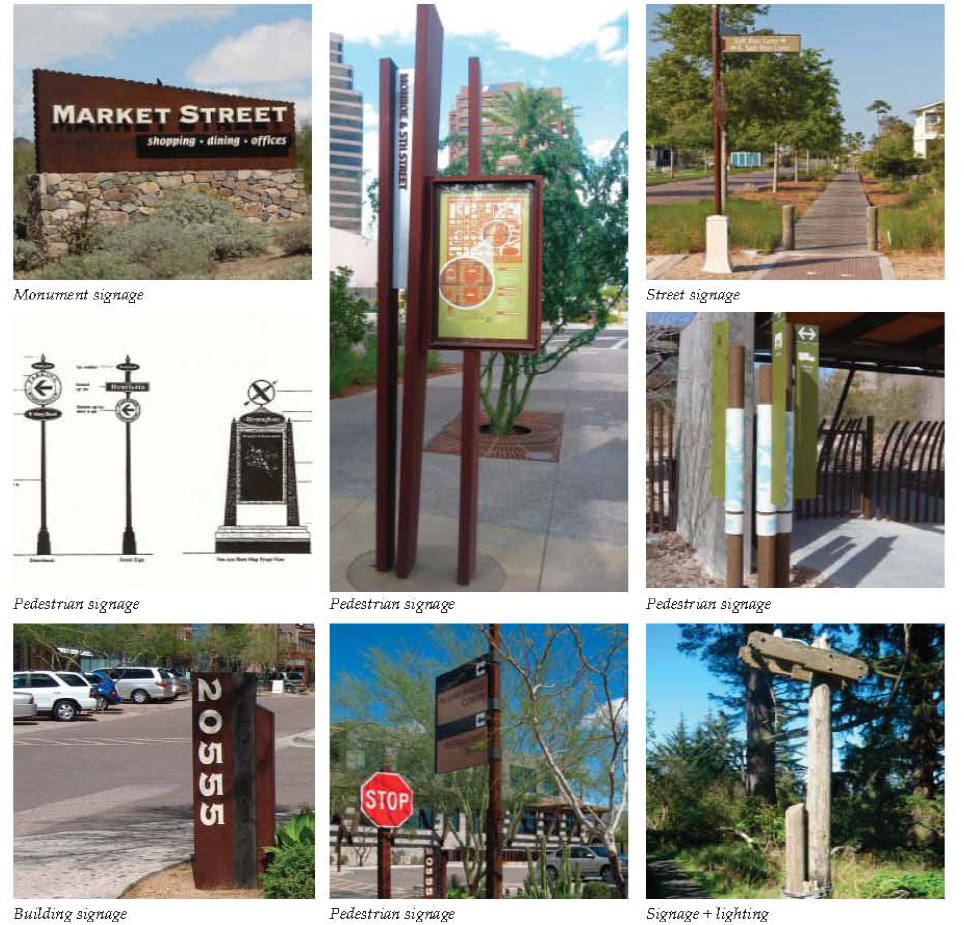
3.
Neighborhood + Community Centers Building Signage. Building signage throughout the Narcoossee area shall be designed and lit to reflect the area's history as an agricultural and ranching area, and respect the immediate context of adjacent uses. Signs shall be designed to be of a low profile, with the majority of signs being building-mounted and not pole-mounted within the road right-of-way.
All signs within Neighborhood and Community Centers shall be architecturally integrated with both building and overall Center, in terms of size, shape, color, texture and lighting, and shall reflect and enhance the character and primary design elements of the building and its use. The number of signs per building façade shall be limited to the fewest necessary. Signs shall be designed with the purpose of enhancing the pedestrian experience, while promoting retail and street activity.
a.
Bracket-Mounted + Projecting Signage. Bracket-mounted or projecting signs are pedestrian in scale, typically mounted on pilasters or walls at a height closer to the sidewalk, and oriented perpendicular to the movement of pedestrians along the sidewalk, a more appropriate and sensitive solution than larger, flush-mounted signs oriented to the automobile.
i.
Use projecting or bracket-mounted signage where possible, and locate adjacent to a building entrance.
ii.
Signs should be affixed to, or hung from, brackets such that the bottom of the sign is at least eight feet zero inches (8'0") above the sidewalk, and not higher than twelve feet zero inches (12'0") above the sidewalk, or project above the roof or parapet.
iii.
Sign sizes, styles and mounting heights shall be carefully and interestingly designed to reflect the character of each building and business as well as fitting comfortable with other adjacent signage to unify the streetscape.
iv.
Projecting signs shall fit within an imaginary rectangle with a maximum area of six (6) square feet. Hanging signs shall fit within an imaginary rectangle with a maximum area of four (4) square feet.
v.
Signs shall be placed within a clear, signable area and should not obscure windows, doors, architectural or ornamental features. Typically, wall signs should be centered on horizontal surfaces (i.e., over a storefront opening).
vi.
Signs can be externally illuminated with small floodlights or similar fixtures, provided the lighting is directed back toward the sign and does not cause glare onto the street, sidewalk or sky.
vii.
Modern signage designs are acceptable, provided the designs are compatible with the historic building.
b.
Wall Signage.
i.
Wall signs shall be designed to be compatible with the storefront in scale, proportion and color, and to create a clearly defined edge, provide shadow relief and a substantial appearance.
ii.
Wall signs are to be mounted flush and fixed securely to a building wall, projecting no more than eighteen (18) inches from the face of the building wall, and not extending sideways beyond the building face or above the highest line of the building which it is attached.
iii.
Wall signs shall not exceed fifteen (15) percent of the building façade (the exterior walls of a building exposed to public view).
iv.
Signs shall be placed within a clear, signable area and should not obscure windows, doors, architectural or ornamental features. Typically, wall signs should be centered on horizontal surfaces (i.e., over a storefront opening).
c.
Plaque Signage. Plaque signs are small versions of wall signs attached to surfaces adjacent to shop front entries at the first floor only. Plaque signs shall be made of a durable material such as cut or etched stone, glass, tile or metal, and are encouraged to include unique designs or irregular outline shapes.
Plaque signs shall be a maximum area of two (2) square feet, with a maximum projection of two (2) inches.
d.
Awning + Window Signage.
i.
Awning Signage. Awning and canopy signs are signs that are printed on, painted on, or attached to an awning or canopy above a business door or window, and are oriented toward pedestrians at the opposite side of the street. Awnings and canopies must be permanently attached to the buildings; and shall be designed to project over individual window and door openings and not as one single continuous feature.
The minimum height of awnings shall be eight feet (8'0") from the lowest point to the sidewalk.
Signage on awnings is permitted at no more than thirty (30) percent of the surface area, either on the sloped body of the awning or on the valance. Valance signage is preferred for its more appropriate scale. Signage should be located either on the main body of the awning or on the overhang, but not on both.
Awning signage shall not be back lit, or lit with other interior illumination.
ii.
Window Signage. Window signs are painted, posted, displayed, sandblasted or etched on an interior translucent or transparent surface, including windows or doors. Window signage is encouraged in conjunction with complementary wall or bracket-mounted signs.
Window signs shall not exceed fifteen (15) percent of the overall window area so that visibility is not obscured.
e.
Monument Signs.
i.
Monument signs are free-standing signs typically usually used for buildings separated from adjacent streets by substantial setbacks.
ii.
Low profile signs shall be constructed out of complementary materials to its associated building and overall Center.
iii.
Monument signs shall be composed of individual lettering that is consistent with the image of the business and the surrounding architectural style. Letter heights shall not exceed twelve (12) inches.
iv.
Maximum sign height, including the sign base, shall not exceed six (6) feet in height. The sign base shall be landscaped on all sides.
v.
Monument signs shall be illuminated by external fixtures designed to complement the appearance of the sign and meet dark-sky standards.
4.
Prohibited Signs. Prohibited signs within the Narcoossee Community Overlay are listed as follows:
a.
Pole signs directed at vehicular travelers, and located at arterials, and not within the pedestrian realm.
b.
Pole signs taller than twelve feet zero inches (12'0") in height.
c.
Neon, LED, electronic, laser or video signs.
d.
Street furniture signs, including bench signs.
e.
Internally lighted, cabinet-style signs.
f.
Animated, flashing or swinging signs.
g.
Roof signs.
h.
Tree/utility pole signs.
i.
Trailer signs.
j.
Search lights.
k.
Pennants or streamers.
l.
Balloons or inflatable signs.
m.
Projected image signs.
B.
MIXED USE DISTRICT STANDARDS FOR OUTDOOR SIGNS.
1.
The following standards apply to Private Frontages.
a.
Signs shall be scaled to the character of the Center or Neighborhood; for pedestrians and slow-moving vehicular traffic in Centers; and for simple, unobtrusive wayfinding in other areas of a Mixed Use District.
b.
The total area of all signage for each building frontage may not exceed one and one-half (1.5) square feet for each foot of lineal street frontage. Temporary signs shall not be included in the total area calculation.
c.
Flush-mounted signs shall be no larger than sixty (60) square feet; may not project more than eight (8) inches from a building wall; and must be located no higher than twenty (20) feet above the sidewalk, below the sill line of the second floor windows, or below the lowest point of the roof, whichever is lowest. In addition, one building sign is permitted per building façade. A building sign shall be no more than one hundred (100) square feet, may be mounted above the second story for maximum viewing, and shall consist of individual letters and/or graphic elements applied directly to the building façade.
d.
Wall plaques of up to six (6) square feet and projecting no more than three (3) inches from a building wall are permitted proximate to building entryways.
e.
Monument signs are permitted.
f.
Blade signs (perpendicular to the BTL) not more than six (6) square feet, minimum nine (9) feet clear height above the sidewalk, may be hung below the second-story level, from the façade or from an overhang or awning. Blade signs in the form of banners may be hung at least fourteen (14) feet above the sidewalk and not above the third story so long as such banners do not project more than third (3) feet into the public right-of-way.
g.
Signs may be suspended from awnings or canopies so long as an eight-foot (8') clear height is maintained.
h.
No more than twenty-five (25) percent of a window may be covered by signage.
i.
Temporary sidewalk easel signs of up to thirty-six (36) inches in height by twenty-four (24) inches in width are permitted within that part of a building façade setback from the BTL.
j.
The following signs are prohibited: billboards, roof signs and free-standing pole signs.
k.
All illumination of signs and buildings shall be by constant light — digital, scrolling, flashing, traveling, animated or intermittent lighting shall not be mounted on the exterior of any building.
C.
WEST U.S. 192 DEVELOPMENT AUTHORITY CORRIDOR as used herein, shall mean the unincorporated portion of the area established by Ordinance #12-23. The provisions below shall apply within the following areas, hereinafter referred to as the W192 Development Authority Corridor (W192 Corridor): all sites fronting Irlo Bronson Memorial Highway (West U.S. 192) between the western county line and the western Kissimmee city limits (Hoagland Boulevard); all sites fronting Osceola Parkway within the W192 Development Authority, all sites fronting SR 535, the Central Florida GreeneWay/SR 417 within the W192 Development Authority, and the International Drive Extension; and all other non-residential sites within the W192 Development Authority established by Ordinance No 12-23, but exclusive of sign zone D, within the W192 Development Authority.
1.
Driveway Signs.
a.
Signs shall be limited to a maximum size of eight (8) square feet, not more than six (6) feet in height, and two (2) signs per driveway.
b.
All driveway signs must be located in a way to provide for clear sight lines at intersections.
2.
Monument Signs.
a.
A monument sign up to one hundred (100) square feet may be erected.
b.
All signs shall maintain a peripheral spacing of fifty (50) feet between sign structures.
c.
One (1) sign is allowed per site, unless site frontage exceeds six hundred sixty (660) feet, in which case, two (2) signs are allowed, but signs shall maintain a minimum spacing of three hundred (300) feet on the same property. At corner lot locations, at least two (2) monument signs may be utilized, regardless of the aforementioned frontage and spacing requirements; provided, however, that if such corner lot location's frontage does not exceed six hundred sixty (660) feet, only one (1) monument sign may be allowed on each of multiple frontages of the corner lot location.
d.
Monument signs for sites fronting Irlo Bronson Memorial Highway (West U.S. 192) shall be located within fifteen (15) feet of the right-of-way, as measured from the leading edge of the sign. Administrative waiver may be granted to accommodate utility easements, access easements, drainage, landscape, and sight distance.
e.
Signs granted Administrative Waiver from the fifteen (15) foot requirement:
i.
All signs for sites fronting Irlo Bronson Memorial Highway that cannot be located within fifteen (15) feet from the highway right-of-way due to utility easements, access easements, drainage, existing landscape, and sight distance, may be granted a larger sign per administrative waiver.
a)
All signs within these sites shall comply with design standards and requirements, including specified materials, as set forth in Subsection 2(g) herein and all specifications as set forth in Figures 3.17.9c and 3.17.9f for a sign that is approximately one hundred fifty (150) percent larger than the standard sign specification.
f.
The top of the stone base of each monument sign shall be aligned between one (1) foot and five (5) feet above the crown of the roadway, as illustrated in Figures 3.17.9b through h.
g.
Monument Sign Design Guidelines.
i.
All signs for sites fronting Irlo Bronson Memorial Highway shall comply with design standards and requirements, including specified materials, as set forth in Subsection 2(g) herein and all specifications as set forth in Figures 3.17.9b through h.
ii.
All monument signs shall be generally centered within the street frontage, where feasible. At corner lot locations, signs shall be generally located at the corner, or, if two (2) signs are utilized, each shall be generally located near the site's access points.
iii.
Monument sign base construction shall be to the size and scale illustrated in Figures 3.17.9b through h.
iv.
One (1) monument sign base option shall be selected for all signs located on the same site.
v.
Copy Area Options:
a)
The copy portion of each monument sign shall be designed to be both durable and low maintenance, and easily detached and reattached upon signage replacement.
b)
LED electronic message centers may be incorporated within the allowable sign copy area, within the maximum overall size, and subject to LDC regulations.
c)
All signs shall utilize LED lighting.
d)
Lighting and sign background color must be consistent within signs.
e)
Street address can be illustrated as a range with a dash between numbers.
vi.
Multi-Tenant Monument Signs:
a)
All signs for sites fronting Irlo Bronson Memorial Highway, consisting of over seventy thousand (70,000) square feet non-residential space, with multiple tenants or outparcels, shall be allowed a larger sign to accommodate the larger amount of signage.
1)
All signs within these sites shall comply with design standards and requirements, including specified materials, as set forth in Subsection 2(g) herein and all specifications as set forth in Figures 3.71.9c and 3.17.9f for signs that are approximately one hundred fifty (150) percent larger than the standard sign specification.
b)
All signs for sites fronting Irlo Bronson Memorial Highway, consisting of over two hundred thousand (200,000) square feet non-residential space, with multiple tenants or outparcels, shall be allowed a larger sign to accommodate the larger amount of signage.
1)
All signs within these sites shall comply with design standards and requirements, including specified materials, as set forth in Subsection 2(g) herein and all specifications as set forth in Figures 3.17.9d and 3.17.9g for a sign that is approximately two hundred (200) percent larger than the standard sign specification.
h.
Specifications for all Monument Signs.
i.
All materials and workmanship shall conform to the most recent edition of the Florida Building Code.
Figure 3.17.9a Three-Dimensional Views
Figure 3.17.9b and b1 Horizontal Option — Standard Size
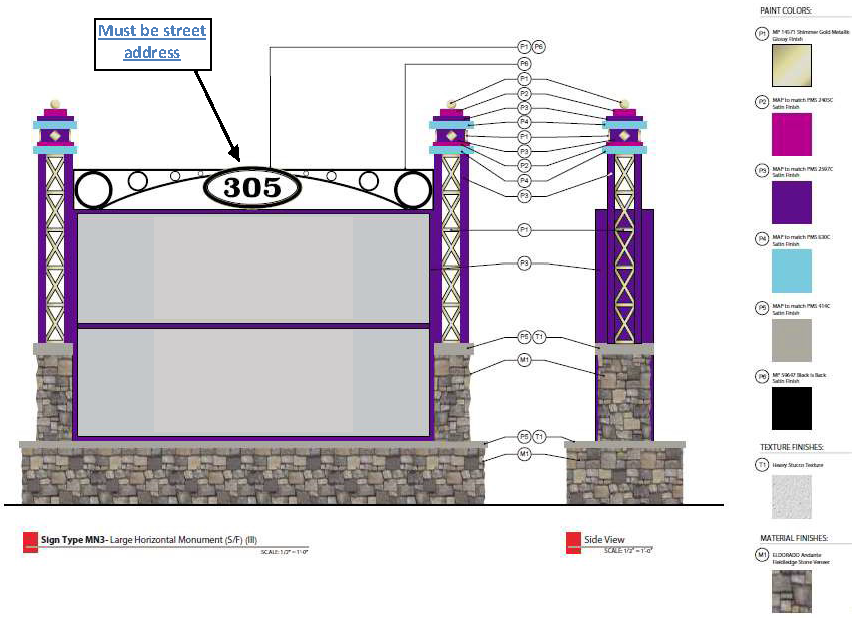
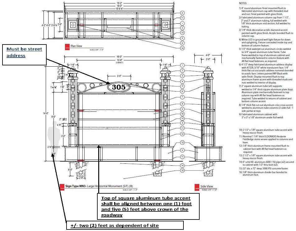
Figure 3.17.9c and c1 Horizontal Option — 150 percent of Standard Size
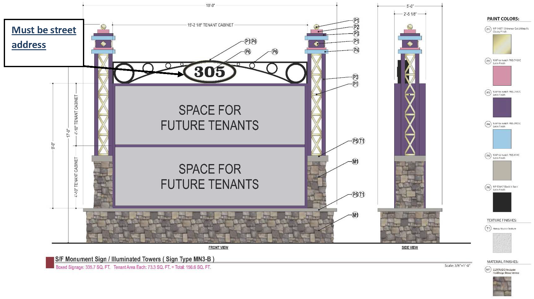
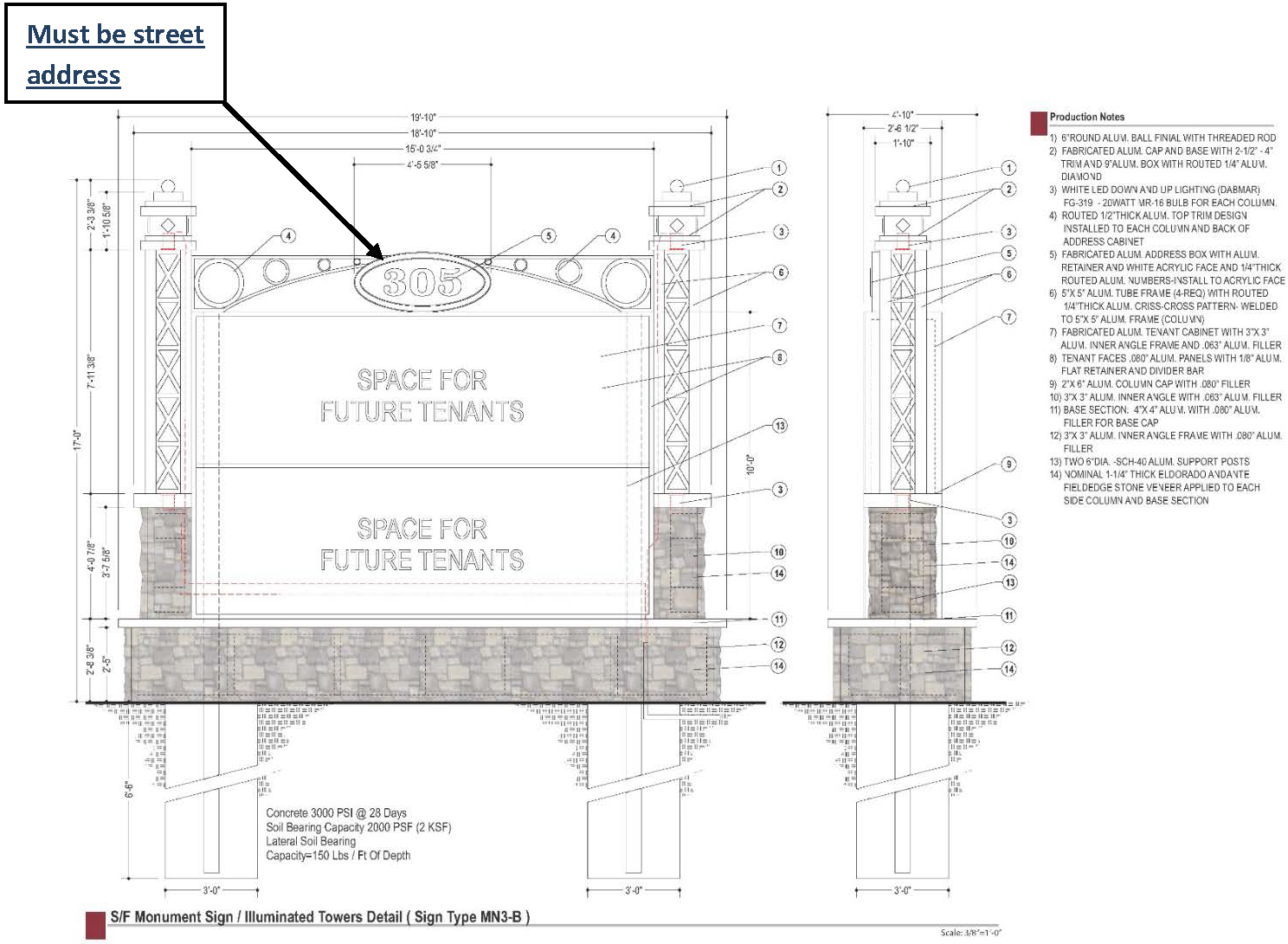
Figure 3.17.9d and d1 Horizontal Option — 200 percent of Standard Size
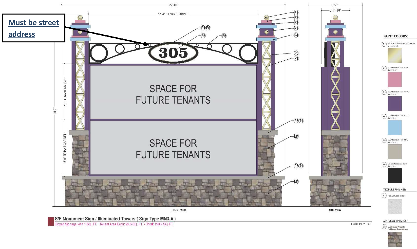
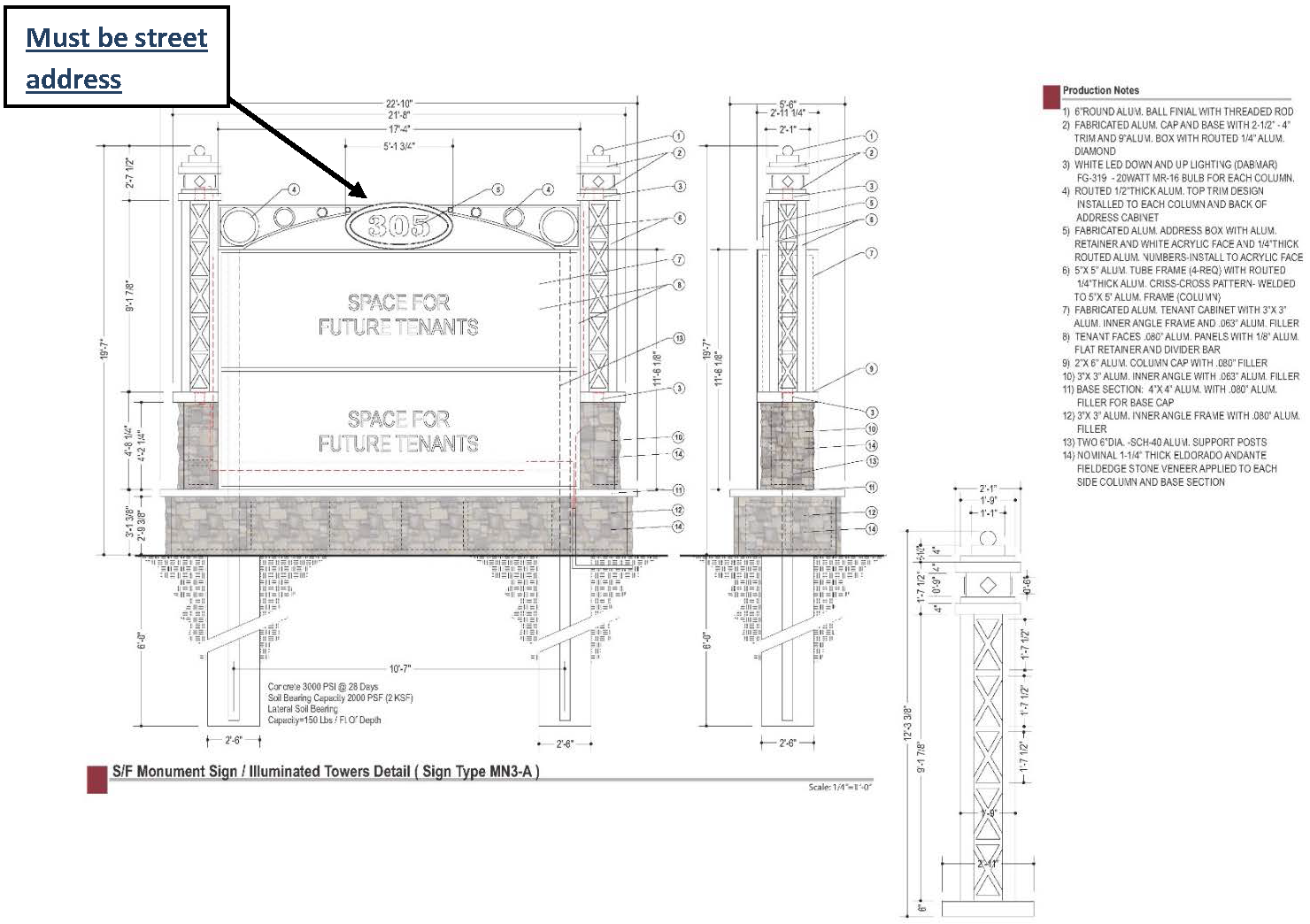
Figure 3.17.9e and e1 Vertical Option — Standard Size
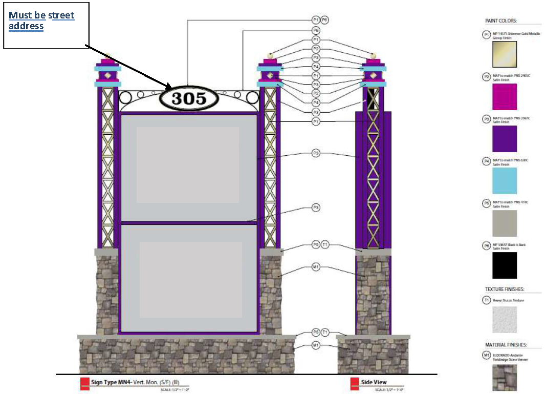
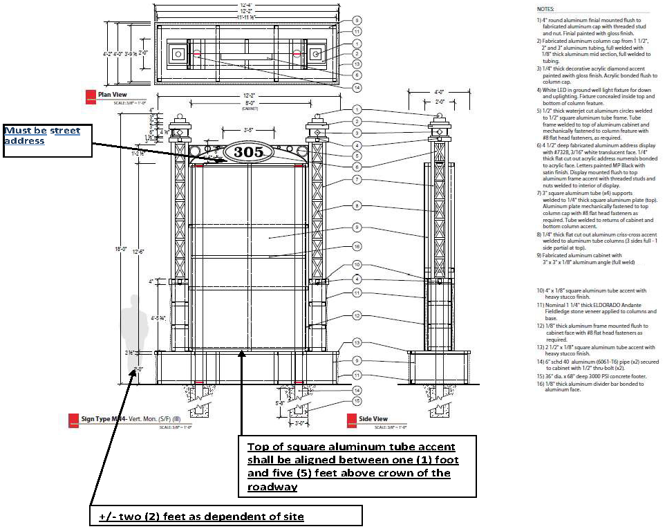
Figure 3.17.9f and f1 Vertical Option — 150 percent of Standard Size
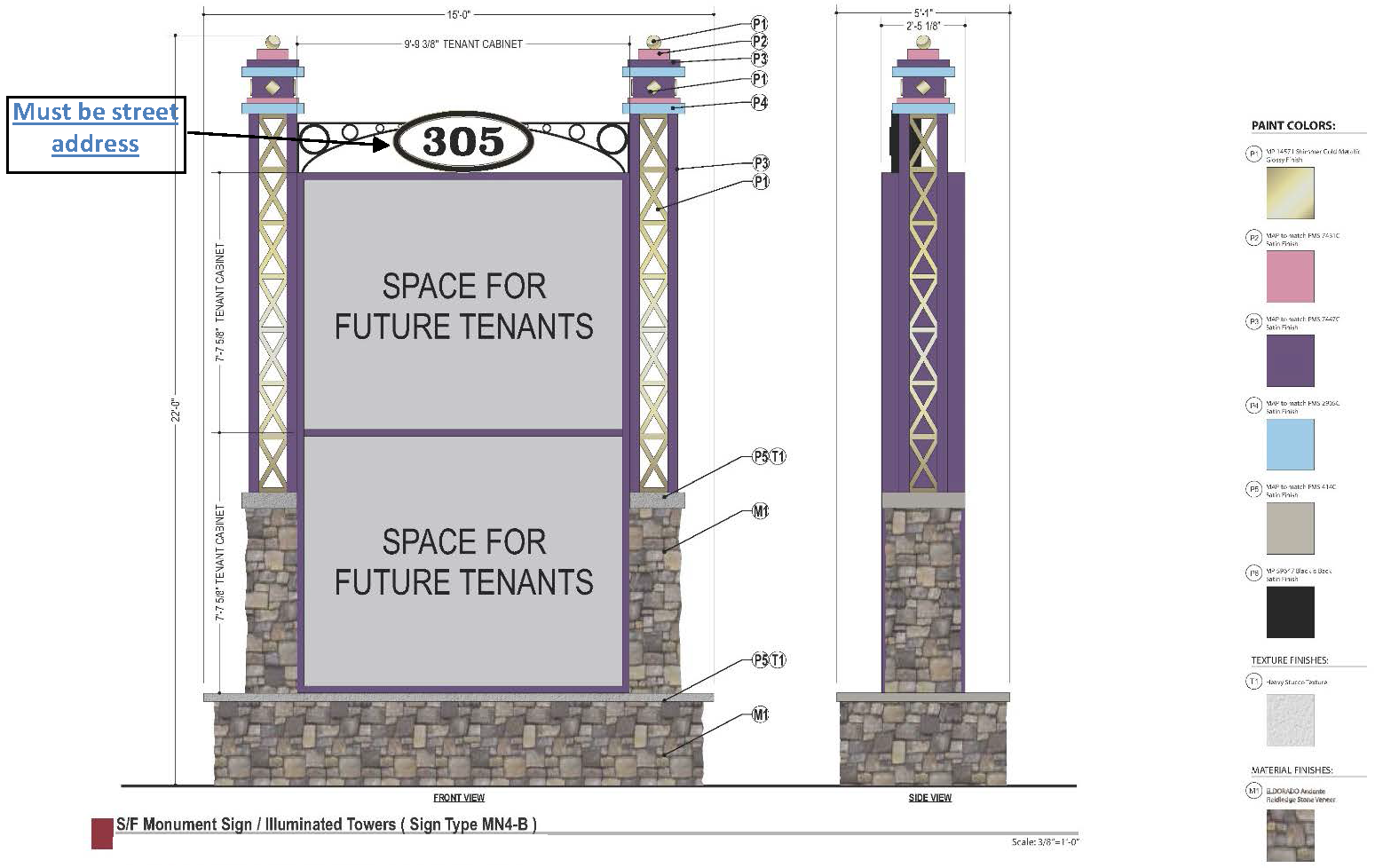
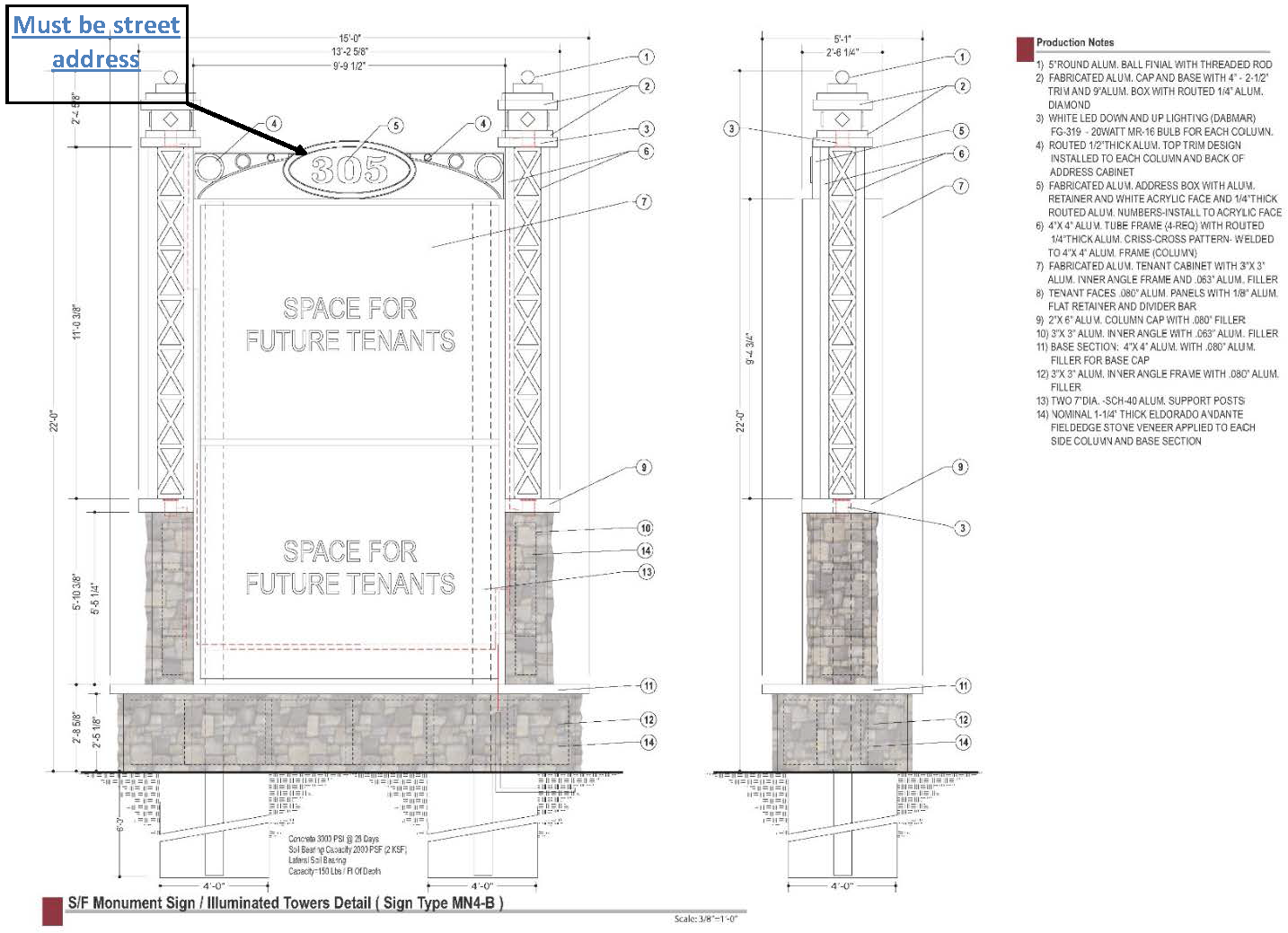
Figure 3.17.9g and g1 Vertical Option — 200 percent of Standard Size
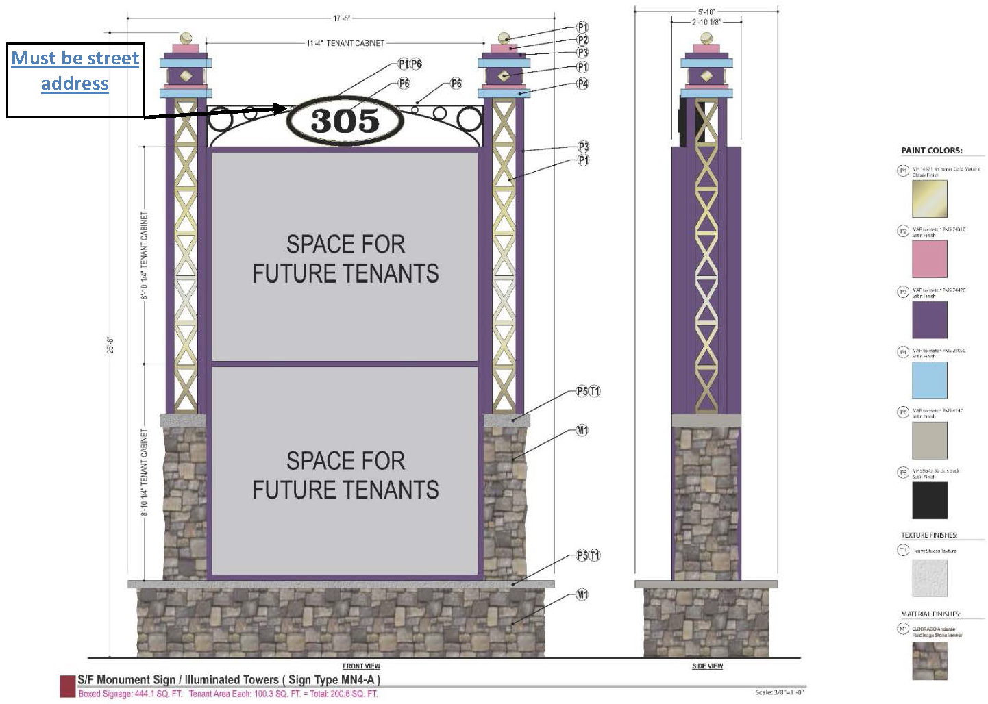
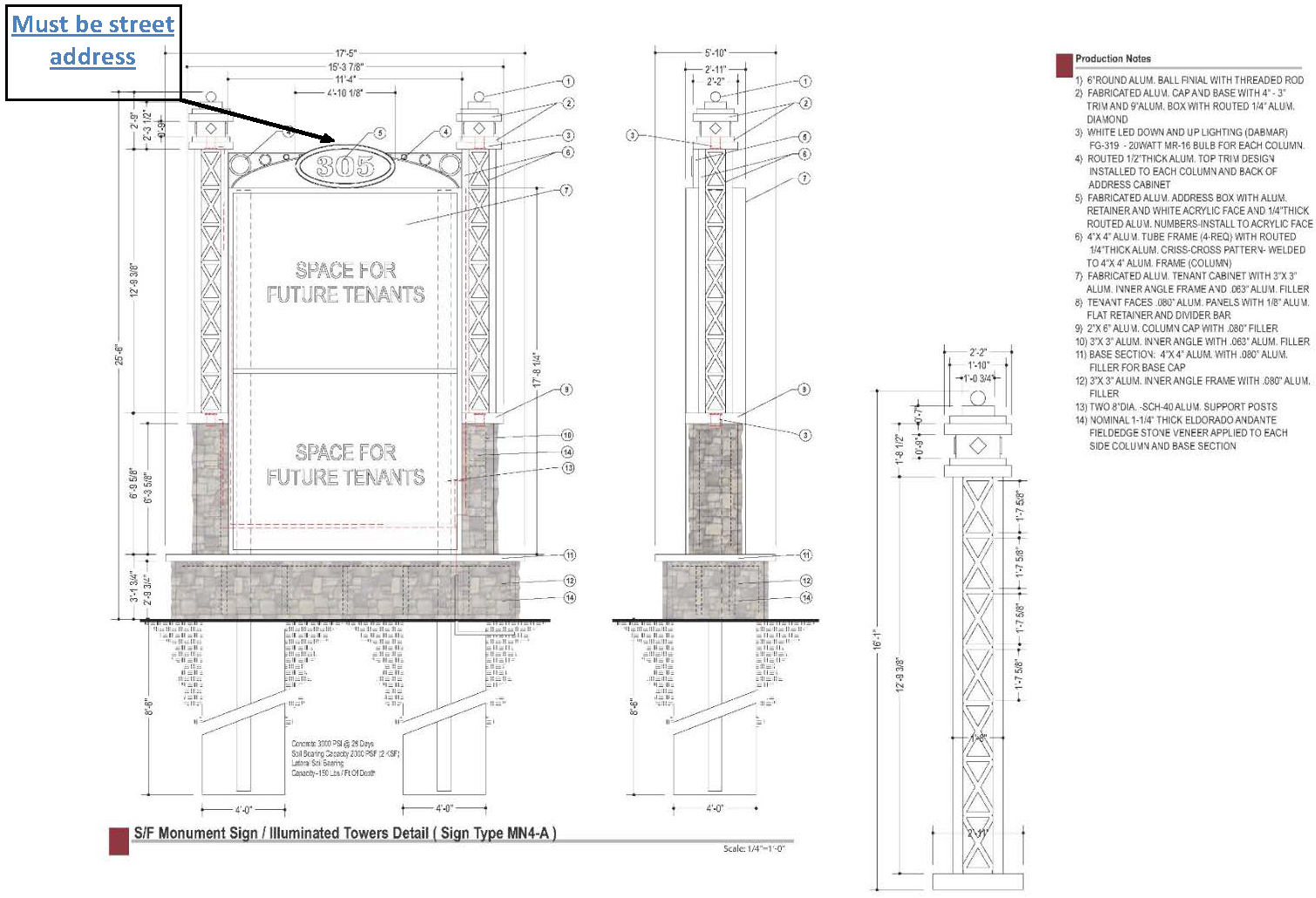
Figure 3.17.9h Mandatory Color Palette for all non-residential properties fronting Irlo Bronson Memorial Highway within the W192 Corridor that exist between Florida State Road 417 and Interstate 4
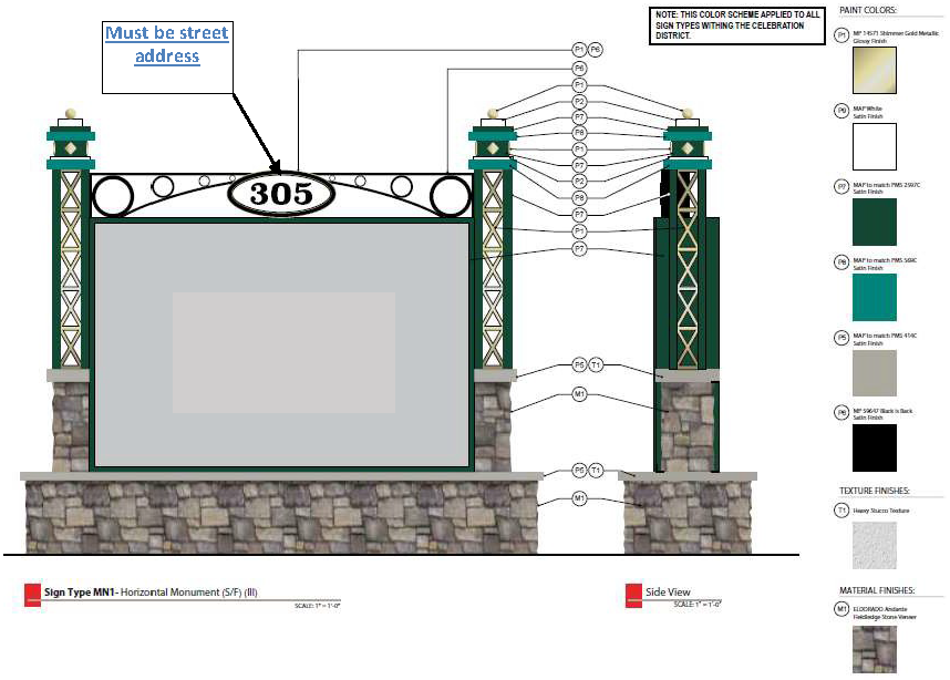
3.
Entertainment Signs. Entertainment Signs are intended for entertainment uses and to serve as an attraction in themselves, located within the West 192 Development Authority Corridor. These signs shall be designed as an extension of the building and site design for the property, and are encouraged to be unique in appearance, color, material, and technology, with the ultimate goal of upgrading and improving the overall aesthetic appearance of properties within the West 192 Development Authority Corridor, and thereby promoting a positive image inviting to tourists.
a.
Location: Segments 1 through 5 of the West 192 Corridor, also defined as the West 192 Development Authority Corridor from the Osceola-Polk County line to the intersection with SR 535.
b.
Applicability: All non-residential sites.
c.
Requirements and Restrictions:
i.
Entertainment signs may be a maximum of fifty (50) feet in height.
ii.
Entertainment signs may be a maximum of six hundred seventy-two (672) square feet in overall structure size.
iii.
Entertainment signs may only be located on parcels of a minimum four (4) acres in size.
iv.
Entertainment signs may only be located on parcels zoned Commercial Tourist (CT) or Planned Developments (PD) with Tourist Commercial land use designation.
a)
Entertainment signs are intended for uses within the Commercial Tourist (CT) zoning district, as included in Table 3.4, and are limited to the following types of uses:
•
Amusement or theme park; entertainment complexes; hotel/motel (large-scale); recreational facilities (commercial); marina; zoo.
v.
A site may apply for either entertainment signs or monument signs, as defined in Section 3.17.9(C). Entertainment signs require ARB approval, as outlined in this Code.
vi.
Entertainment signs may be freestanding or building mounted.
vii.
One (1) entertainment sign shall be allowable per site, unless site frontage exceeds one thousand three hundred twenty (1,320) feet, in which case, two (2) signs are allowed, but shall maintain a minimum spacing of six hundred (600) feet on the same property.
viii.
Ground-mounted entertainment signs for sites fronting Irlo Bronson Memorial Highway shall be located within fifteen (15) feet of the right-of-way, as measured from the leading edge of the sign. Administrative waiver may be granted to accommodate utility easements, drainage, landscape, and sight distance.
ix.
Materials of entertainment signs:
a)
Shall be compatible with the associated buildings and site design within same site;
b)
Shall be of high-quality, low-maintenance and long-lasting materials.
x.
Entertainment signs may utilize electronic copy that is designed and integrated in a cohesive way.
xi.
Entertainment signs are not intended to be pole or pylon signs. A base or pole cover provided to satisfy this requirement shall be integrally designed as part of the sign by use of such things as color, material and texture.
xii.
Entertainment signs shall not be of a temporary nature.
xiii.
Sites located within the West 192 Development Authority Corridor are only eligible for Alternative Sign Standards (as defined in Section 3.17.6) as related to building signage, and not applicable for Entertainment or Monument Signs. Entertainment and Monument signs must meet the requirements set forth in Section 3.17.9. Alternative sign standards that have already been adopted can remain.
d.
Applicable and Related Code Sections and Requirements:
i.
Refer to Section 4.7.11(B), Site lighting, for site lighting requirements.
ii.
Separate freestanding or accessory feature are required to be reviewed and permitted separately and per other sections of Chapter 3 (e.g., architectural features, etc.).
iii.
Prior to, or concurrent with entertainment sign review, any additional site improvements required by Article 3.16 West 192 Development Authority Corridor are to be completed.
iv.
Entertainment signs shall only be reviewed and approved for properties that are in compliance with the West 192 Development Authority Corridor, Section 3.16.2, General design standards for all segments, and their assigned zoning designation, and for properties that have no outstanding code violations or deficiencies.
4.
Wall Signs.
a.
Signs shall be allowed a maximum area of one (1) square foot of signage per linear foot of building frontage.
b.
One (1) sign will be allowed per building face per single tenant, or one (1) per storefront for multi-tenant site. The total area of wall signs on any one wall shall not exceed an area equal to one (1) square foot for each linear foot of that building face frontage, and provided that the overall wall signage for the building does not exceed the total square footage allowed.
5.
Window Signs.
a.
Window signs may not exceed more than twenty-five (25) percent of the window area on which the sign is attached or affixed.
b.
Interior, merchandise displays without signage must not block more than fifty (50) percent of the window area on which the sign is attached or affixed.
c.
No permit shall be required for window signs.
6.
Prohibited Signs. Prohibited signs are listed as follows:
a.
Pole or pylon signs, except as provided for in Section 3.14.9(C)(3)(b)(viii).
b.
Banner signs, except during special events. Banner signs shall comply with this Chapter, Section 3.14.7.K, Temporary signs in regards to size and placement location.
c.
Cold air inflatable balloons.
d.
Feather banner signs.
e.
Human signs.
f.
Mobile or Portable signs, except as provided for in Chapter 4, Section 4.7.6(A)(3)(j) of this Code.
D.
EAST U.S. 192 REDEVELOPMENT AREA, as used herein shall mean properties located within the East U.S. 192 Community Redevelopment Area (CRA) adopted by the Board of County Commissioners, Resolution 12-025R on April 9, 2012.
1.
Signage.
a.
Signs shall be scaled to the character of the Use District; for pedestrians and slow-moving vehicular traffic; and for simple, unobtrusive wayfinding.
b.
The total area of wall signage for each building may not exceed one and one-half (1.5) square feet for each foot of lineal street frontage. Temporary signs shall not be included in the total area calculation. The following signs and shall be considered wall signage and shall be subject to the following standards:
i.
Flush-mounted signs shall be no larger than sixty (60) square feet; may not project more than eight (8) inches from a building wall; and must be located no higher than twenty (20) feet above the sidewalk, below the sill line of the second floor windows, or below the lowest point of the roof, whichever is lowest. In addition, one (1) building sign is permitted per building façade. A building sign shall be no more than one hundred (100) square feet, may be mounted above the second story for maximum viewing, and shall consist of individual letters and/or graphic elements applied directly to the building façade. An address sign no more than two (2) square feet in size is permitted at each address and shall not count against the allowable wall signage.
ii.
Wall plaques of up to six (6) square feet and projecting no more than three (3) inches from a building wall are permitted proximate to building entryways. Wall plaques shall count against the allowable wall signage.
iii.
Awnings and canopies may include logos or signage on the valance or front plain. Signs may be suspended from awnings or canopies so long as a nine-foot (9') clear height is maintained. Awning and canopy signs shall count against the allowable wall signage.
c.
Blade signs (perpendicular to the BTL) not more than six (6) square feet, minimum nine (9) feet clear height above the sidewalk, may be hung below the second-story level, from the façade or from an overhang or awning. Blade signs in the form of banners may be hung at least fourteen (14) feet above the sidewalk and not above the third story so long as such banners do not project more than three (3) feet into the public realm.
d.
No more than twenty-five (25) percent of a window may be covered by signage or merchandise. Window signs shall not count against the available wall signage.
e.
A maximum of two (2) temporary sidewalk easel signs per entrance of up to thirty-six (36) inches in height by twenty-four (24) inches in width are permitted within that part of a building façade setback from the BTL. These temporary sidewalk easel signs shall not require issuance of a sign permit.
f.
The following signs are prohibited: roof signs and free-standing pole signs. Existing signs may remain but shall be subject to the amortization schedule defined in Chapter 3.14.12 herein. Electronic message centers shall be prohibited on buildings within the FARM and TECH Use Districts.
g.
Monument signs are permitted and regulated as follows:
i.
Monument signs are permitted for all non-residential structures. All Monument Signs shall include an address or range of addresses for the properties they are intended to identify.
ii.
The sign structure shall complement the principal structure, with regards to materials, color, finish, and architectural features. This includes the application of materials consistent with the main building to the base and along the sides and top of the sign face or cabinet.
iii.
Monument signs within the U.S. Hwy 192 Public Realm shall be regulated as follows and as illustrated in Figure 3.17.3f(1) and Figure 3.17.3f(2):
a)
Monument signs shall be located within the Parkway of the Public Realm and within landscaped medians of ingress/egress entry drives to U.S. Hwy 192.
b)
Monument signs within the Parkway (Parkway Signs) shall maintain a peripheral spacing of a minimum of one hundred fifty feet (150'). These Parkway Signs are intended for tenants within the urban block served by the Parkway. In regards to multi-tenant buildings and/or multiple buildings within the urban block, allocation of specific signage entitlements shall be at the discretion of the private sector.
c)
Parkway Signs shall be a maximum height of eight feet (8') with a base at least eighteen inches (18") in height measured from the average grade elevation. The sign cabinet shall be mounted on a decorative base.
d)
Parkway Signs shall have a maximum setback of fifteen feet (15') from the right-of-way. Parkway Signs shall maintain safe sight clearance.
e)
Parkway signs shall include a landscaped area around the base a minimum of forty-eight (48) square feet with a minimum of twenty-two (22) shrubs or ground cover plants.
iv.
Monument signs located within a separate landscaped median tract within a public right-of-way entry drive to U.S. Hwy 192 (Entry Signs) shall be permitted for tenants of the adjacent urban blocks and shall be regulated as follows:
a)
Entry Signs shall not exceed a maximum height of fourteen (14) feet with the copy area at a maximum height of twelve feet (12') and a base at least eighteen inches (18") in height measured from the average grade elevation. The sign cabinet shall be mounted on a decorative base. The sign cabinet shall be limited to a maximum of two hundred (200) square feet.
b)
Entry Signs shall have a maximum setback of fifteen feet (15') from the right-of-way. Setback standards shall be subject to safe site clearance.
c)
Entry signs shall include a landscaped area around the base a minimum of forty-eight (48) square feet with a minimum of twenty-two (22) shrubs or ground cover plants.
v.
Excluding Parkway Signs and Entry Signs, the landscaped area surrounding monument signs shall create an aesthetic effect through the combined use of plant material and/or hardscape material including but not limited to ground cover plants, trees, shrubs, planters, brick, stone, natural forms, water forms, aggregate and other landscape features, but not including the use of concrete, asphalt or outdoor carpeting.
Figure 3.17.9.D.g.iii depicts the Parkway Monument Sign permitted within the U.S. Hwy 192 Public Realm.
Figure 3.17.9.D.g.iii. Parkway Monument Signs Within the U.S. Hwy 192 Public Realm
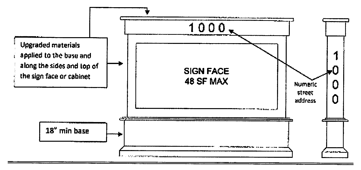
Figure 3.17.9.D.g.iv depicts the Entry Monument Sign permitted within the median of the ingress/egress entry drive to U.S. Hwy 192.
Figure 3.17.9.D.g.iv. Entry Monument Signs Within the U.S. Hwy 192 Public Realm
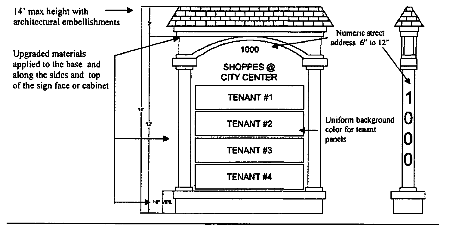
(Ord. No. 2020-21, § 2, 2-17-2020; Ord. No. 2021-75, § 2, 11-15-2021; Ord. No. 2022-125, § 3, 2-20-2023)
3.17.10 - NON-CONFORMING SIGNS
A.
Except as otherwise provided for in herein, any sign, billboard or sign structure which lawfully existed and was maintained at the time these regulations became effective may be continued, although such structures do not conform to all the provisions hereof; provided, that no structural alterations are made thereto.
B.
No sign shall be permitted on a site with an existing non-conforming sign until such non-conforming sign has been removed or brought into conformity. However, legally non-conforming wall signs that exist within a shopping center or multi-tenant building, and which are for a separate business within the center, shall not prohibit new wall signs from being permitted for other businesses within the center.
C.
No permit shall be issued to change the size, design, or structure of a non-conforming sign, except to bring the sign into compliance with these regulations.
D.
A non-conforming sign shall cease to be allowed, and shall be in violation of this Code if any of the following events occur:
1.
A sign that has had the status of an abandoned sign for more than ninety (90) days, unless within that time period the owner has applied for a building permit, other development approval, or manifested some other affirmative act, other than merely obtaining an occupational license, which evidences an intent to maintain said sign.
2.
A sign which, by destruction, obsolescence, or from any other cause whatever, or a sign which is, or becomes, a hazard or danger, and cannot be repaired for less than fifty (50) percent of its structural value.
3.
A sign which has been found to be in violation of any section of these regulations, and the facts giving rise to the violation have occurred after the effective date of these regulations.
4.
A sign which, needing repair, cannot be properly repaired without affecting the structural integrity of the sign.
(Ord. No. 2020-21, § 2, 2-17-2020)
3.17.11 - ENFORCEMENT
Any violation of the provisions of a variance including any conditions and safeguards which are made a part of the terms under which the variance is granted, shall be deemed a violation of the land development code for Osceola County, and shall be punishable and enforceable pursuant to this Chapter of the land development code for Osceola County, and as provided by law.
(Ord. No. 2020-21, § 2, 2-17-2020)
3.17.12 - AMORTIZATION
Notwithstanding any other provisions in these regulations to the contrary, signs which conformed to Ordinance 85-5, as amended, but which were made non-conforming by these regulations, shall cease to have protection after September 1, 2022.
Existing signs within the W192 Development Authority corridor which are made non-conforming by Ordinance 2016-21 shall cease to have protection after September 1, 2022.
Signs within the W192 Development Authority corridor, that are within Planned Development Districts with approved sign packages and/or sites with alternative sign standards shall not be subject to amortization.
Signs within approved Planned Development Districts located outside of the W192 Development Authority corridor shall not be subject to amortization.
(Ord. No. 2020-21, § 2, 2-17-2020)
3.17.13 - NON-CONFORMITY
Signs within the W192 Development Authority corridor, that are within Planned Development Districts with approved sign packages and/or sites with alternative sign standards shall not be made non-conforming by this Ordinance 2016-21.
(Ord. No. 2020-21, § 2, 2-17-2020)