
Osceola County Unincorporated
City Zoning Code
City Zoning Code
CHAPTER 4
SITE DESIGN AND DEVELOPMENT STANDARDS
ARTICLE 4.1 - GENERAL PROVISIONS
This Chapter provides for the establishment of site design and development standards as they relate to the protection of key environmental assets in the County, Flood Damage Prevention, Access Management, Stormwater Management, Lot and Block Design, Transportation, Landscaping, Utilities, Public Service requirements, Soil Excavation and Right-of-Way Utilization requirements. This Chapter also addresses the necessity for Special Area Coordination.
ARTICLE 4.4 - ACCESS MANAGEMENT
This Article adopts an access classification system and standards for the regulation and control of vehicular ingress to, and egress from, the County transportation network, and establishes setbacks and requirements for service roads and sidewalks on County Premium Transit Corridors, Boulevards, and Avenues. The standards and guidelines for the construction and modification of connections to the public street system in Osceola County are essentially identical to those included in the FDOT standards developed for the "State Highway System Access Management Act." Standards and guidelines are also included for roads not fully covered by the FDOT standards. The implementation of the classification system, setbacks, service road and sidewalk requirements are intended to protect public safety and general welfare, provide for the mobility of people and goods, and preserve the functional integrity of the County transportation network.
Controlled access roadways of the County transportation network are assigned class by the County Manager, consistent with the Comprehensive Plan and, Florida Administrative Code (FAC). The County Manager shall maintain a list of applicable roadways and their assigned classifications to implement this Article. Roadways of the state highway system are assigned class by FDOT.
ARTICLE 4.5 - STORMWATER
Site alterations shall be designed so that they do not adversely affect the existing surface water flow pattern. Site alterations shall minimize any degradation of downstream water bodies, maintain the natural retention or filtering capabilities of water bodies, and minimize any contribution to siltation or pollution.
ARTICLE 4.6 - LOT AND BLOCK DESIGN STANDARDS
Lot and block design provides the structure around which the many components of land development are implemented, ensuring the provision of efficient services to promote the health, safety and general welfare of the public. The purpose of this Article is to establish standards by which lot and block design may be accomplished at a minimum for subdivision design and to encourage design to improve the quality of life for the citizens of Osceola County. Standards are included to implement the goals, objectives and policies of the Osceola County Comprehensive Plan in such a way as to be consistent with the other chapters of the Osceola County Land Development Code and to implement the orderly, efficient and economical development of land. This Article also outlines the options for creating or modifying lots through subdivision of land.
ARTICLE 4.13 - SPECIAL AREA COORDINATION
Reserved.
4.1.1 - PURPOSE AND INTENT
The regulations established in this Chapter are intended to provide for the harmonious development of the County and to implement Osceola County's Comprehensive Plan. It is the intent of the County to promote the health, safety, and welfare of existing and future residents, property owners and visitors to the County by establishing minimum standards for site Design and Development and the continued maintenance of development consistent with this Code. The design and development standards contained within this Chapter are intended to complement the Performance and Siting Standards contained in Chapter 3 herein.
4.1.2 - APPLICABILITY
This Chapter applies to all properties within unincorporated Osceola County. Nothing in this Chapter shall be construed to release any property in the County from complying with all applicable regulations of any state or federal regulation. No certificates of occupancy shall be issued unless the site meets the requirements herein provided.
4.1.3 - ERECTION OF BUILDINGS ADJACENT TO UNAPPROVED STREETS
No building shall be erected on a lot or parcel of land, nor shall any use or building permit be issued therefore, unless:
A.
The street giving access to the lot or parcel on which such building is proposed to be placed has been accepted and opened as a public/private street or has otherwise received the legal status of a public street, or such street is shown on a subdivision plat prepared and recorded as provided herein.
B.
The street has been improved to an extent which, in the opinion of the County Manager, meets the minimum standards for roadways as outlined herein, is adequate in the circumstances of the particular situation to serve the needs of such building and protects the public health, safety, economy, convenience and general welfare; provided that, if so authorized by regulations herein, a building permit may be issued for construction of a building concurrently with the installation of required street improvements, but no such permit shall express or imply any right of occupancy and use of such building. No such building shall be occupied or used until the installation of such street improvements has been satisfactorily completed.
4.2.1 - SAFE DEVELOPMENT LINE
The County establishes the safe development line for all lakes at an elevation of one (1) foot above the highest elevation of the regulated high pool state, defined as the controlled high water level as established by applicable Federal or State jurisdiction or ordinary high water level, except Lake Tohopekaliga which will be one and one-half (1½) feet above this level due to its unique characteristics. The following restrictions shall apply:
A.
Non-water dependent structures shall not be permitted lakeward of the safe development line established herein. Lots platted prior to April 22, 1991 shall not be subject to this restriction.
B.
No use of fill shall be permitted below the safe development line, with the exception of permitted pilings.
C.
Lakeward of the safe development line, removal of exotic/nuisance plant species, as defined by the State Agency, shall be by non-mechanical means unless otherwise approved by the applicable State agency permit or exempt from permitting requirements.
4.2.2 - WETLAND BUFFERS
For the purpose of identifying the types, values, functions, sizes, conditions and locations of wetlands within the Urban Growth Boundary (UGB), the County shall use the Uniform Mitigation Assessment Method as established in the Florida Administrative Code. Within the UGB the following wetland protection standards shall apply unless otherwise previously approved by the applicable State agency with an active permit or exempt from permitting requirements: Category I wetlands equate to a score of 0.65 or above, Category II wetlands equate to a score between 0.4 and 0.64, and Category III wetlands equate to those with a score below 0.4.
A.
The removal, alteration, and encroachment of Category I wetlands is limited to only those cases where it is required for installation of public infrastructure or no other feasible or practical alternatives exist that will permit a reasonable use of the land. Maximizing protection, preservation, and continuing viability of these wetlands shall be the principal consideration for determining the amount and the section of a wetland allowed to be removed, altered or encroached upon.
B.
Removal, encroachment, and alteration may be allowed in Category II wetlands where it is required for installation of public infrastructure or no other feasible or practical alternatives exist that will permit a reasonable use of the land, or for the purpose of increasing connectivity between neighborhoods as part of a TND development. The value of enhanced neighborhood or community connectivity will be balanced against the value of the wetlands.
C.
Removal, encroachment, and alteration of Category III wetlands are presumed to be allowed unless determined to be contrary to the public interest by the County.
D.
Any development is required to maintain buffers around wetlands. The required buffers shall remain in native vegetation or, if disturbed, enhanced with Florida Friendly plant material, with impervious surfaces limited to only that allowed herein. The mandatory buffers are as follows:
1.
A minimum of a fifty (50)-foot buffer for Category I wetlands.
2.
An average of a fifty (50)-foot buffer with a minimum of twenty-five (25) feet at any given location for Category II wetlands.
3.
An average of twenty-five (25)-foot buffer with a minimum of fifteen (15) feet at any given location for Category III wetlands.
E.
Adverse impacts to wetlands shall be mitigated and the appropriate amount of mitigation necessary to offset that loss shall be determined using the Uniform Mitigation Assessment Method as described in F.A.C. ch. 62-345.
F.
Development within wetlands or wetland buffers shall be limited to construction and activities which shall not be detrimental to the health and function of protected wetlands, such as the following:
1.
Clearing and/or construction of walking trails.
2.
Construction of timber boardwalks/catwalks for direct access to water bodies, construction of wildlife management shelters, footbridges, observation decks, and similar structures not requiring dredging and/or filling for their placement.
For all Category I and II wetlands outside the UGB, Category I wetland protection policies established for wetlands within the UGB noted herein shall apply. Bona-Fide Agricultural is exempt from this regulation.
4.2.3 - AQUIFER RECHARGE
Reserved.
4.2.4 - PROTECTED SPECIES
Osceola County recognizes the existence and strategic value of habitat within the County for Federal and State listed species of flora and fauna identified as Protected Species. The destruction of known populations of Protected Species is prohibited unless a permit and mitigation plan has been approved and provided by the applicable regulatory agency.
To supplement requirements from applicable agencies, Pedestrian signs shall be posted for the recognized eagle nest sites at the distance/location established by the permitting agencies to designate protected areas and identify the protection requirements within the applicable protection area. During permitted construction activity, a chain link fence (minimum four (4)-foot height) shall be installed on the perimeter of the protected area to avoid encroachment. Further, the contractor and designated site/landscape contractors shall provide a signed affidavit of awareness of the applicable requirements prior to initiating their respective construction activity for the development.
4.2.5 - RESERVED
Editor's note— Ord. No. 2022-125, § 4, adopted February 20, 2023, repealed § 4.2.5, which pertained to habitat conservation and management plan and derived from the original Code.
4.3.1 - SCOPE
The provisions of this Article shall apply to all development that is wholly within or partially within any flood hazard area, including but not limited to the subdivision of land; filling, grading, and other site improvements and above ground utility installations; construction, alteration, remodeling, enlargement, improvement, replacement, repair, relocation or demolition of buildings, structures, and facilities that are exempt from the Florida Building Code; placement, installation, or replacement of manufactured homes and manufactured buildings; installation or replacement of tanks; placement of recreational vehicles; installation of swimming pools; and any other development.
A.
INTENT. The purposes of this Article and the flood load and flood resistant construction requirements of the Florida Building Code are to establish minimum requirements to safeguard the public health, safety, and general welfare and to minimize public and private losses due to flooding through regulation of development in flood hazard areas to:
1.
Minimize unnecessary disruption of commerce, access and public service during times of flooding;
2.
Require the use of appropriate construction practices in order to prevent or minimize future flood damage;
3.
Manage filling, grading, dredging, mining, paving, excavation, drilling operations, storage of equipment or materials, and other development which may increase flood damage or erosion potential;
4.
Manage the alteration of flood hazard areas, watercourses, and shorelines to minimize the impact of development on the natural and beneficial functions of the floodplain;
5.
Minimize damage to public and private facilities and utilities;
6.
Help maintain a stable tax base by providing for the sound use and development of flood hazard areas;
7.
Minimize the need for future expenditure of public funds for flood control projects and response to and recovery from flood events; and
8.
Meet the requirements of the National Flood Insurance Program for community participation as set forth in the Title 44 Code of Federal Regulations, Section 59.22.
B.
COORDINATION WITH THE FLORIDA BUILDING CODE. This Article is intended to be administered and enforced in conjunction with the Florida Building Code. Where cited, ASCE 24 refers to the edition of the standard that is referenced by the Florida Building Code.
C.
DISCLAIMER. The degree of flood protection required by this Article and the Florida Building Code, as amended by this community, is considered the minimum reasonable for regulatory purposes and is based on scientific and engineering considerations. Larger floods can and will occur. Flood heights may be increased by man-made or natural causes. This Article does not imply that land outside of mapped special flood hazard areas, or that uses permitted within such flood hazard areas, will be free from flooding or flood damage. The flood hazard areas and base flood elevations contained in the Flood Insurance Study and shown on Flood Insurance Rate Maps and the requirements of Title 44 Code of Federal Regulations, Sections 59 and 60 may be revised by the Federal Emergency Management Agency, requiring this community to revise these regulations to remain eligible for participation in the National Flood Insurance Program. No guaranty of vested use, existing use, or future use is implied or expressed by compliance with the Article.
D.
DISCLAIMER OF LIABILITY. This Article shall not create liability on the part of the Board of County Commissioners (BCC) of Osceola County or by any officer or employee thereof for any flood damage that results from reliance on this Article or any administrative decision lawfully made thereunder.
4.3.2 - APPLICABILITY
A.
GENERAL. Where there is a conflict between a general requirement and a specific requirement, the specific requirement shall be applicable.
B.
AREAS TO WHICH THIS ARTICLE APPLIES. This Article shall apply to all flood hazard areas within the unincorporated area of Osceola County, as established herein.
C.
BASIS FOR ESTABLISHING FLOOD HAZARD AREAS. The Flood Insurance Study for "Osceola County, Florida and Incorporated Areas" dated June 18, 2013 and all subsequent amendments and revisions, and the accompanying Flood Insurance Rate Maps (FIRM), and all subsequent amendments and revisions to such maps, are adopted by reference as a part of this Article and shall serve as the minimum basis for establishing flood hazard areas. Studies and maps that establish flood hazard areas are on file at Osceola County, located at 1 Courthouse Square, Kissimmee, Florida 34741.
D.
SUBMISSION OF ADDITIONAL DATA TO ESTABLISH FLOOD HAZARD AREAS. To establish flood hazard areas, base flood elevations and design flood elevations, pursuant to Section 4.3.5, the Floodplain Administrator may require submission of additional data. Where field surveyed topography prepared by a Florida licensed professional surveyor or digital topography accepted by the community indicates that ground elevations:
1.
Are below the closest applicable base flood elevation, even in areas not delineated as a special flood hazard area on a FIRM (Flood Insurance Rate Map), the area shall be considered as flood hazard area and subject to the requirements of this Article and, as applicable, the requirements of the Florida Building Code.
2.
Within the special flood hazard area, are above the applicable base flood elevation, the area shall be regulated as special flood hazard area unless the applicant obtains a Letter of Map Change that removes the area from the special flood hazard area.
E.
OTHER LAWS. The provisions of this Article shall not be deemed to nullify any provisions of local, state or federal law.
F.
ABROGATION AND GREATER RESTRICTIONS. This Article supersedes any ordinance in effect for management of development in flood hazard areas. However, it is not intended to repeal or abrogate any existing ordinances including but not limited to land development regulations, zoning ordinances, stormwater management regulations, or the Florida Building Code. In the event of a conflict between the provisions of this Article and any other ordinance, the more restrictive shall govern. This Article shall not impair any deed restriction, covenant or easement, but any land that is subject to such interests shall also be governed by this Article.
G.
INTERPRETATION. In the interpretation and application of this Article, all provisions shall be:
1.
Considered as minimum requirements;
2.
Liberally construed in favor of the governing body; and
3.
Deemed neither to limit nor repeal any other powers granted under state statutes.
4.3.3 - DUTIES AND POWERS OF THE FLOODPLAIN ADMINISTRATOR
A.
DESIGNATION. The County Manager is designated as the Floodplain Administrator. The Floodplain Administrator may delegate performance of certain duties to other employees. The Floodplain Administrator is authorized and directed to administer and enforce the provisions of this Article. The Floodplain Administrator shall have the authority to render interpretations of this Article consistent with the intent and purpose of this Article and may establish policies and procedures in order to clarify the application of its provisions. Such interpretations, policies, and procedures shall not have the effect of waiving requirements specifically provided in this Article without the granting of a variance pursuant to Chapter 2 of the LDC.
B.
APPLICATIONS AND PERMITS. The Floodplain Administrator, in coordination with other pertinent offices of the community, shall:
1.
Review applications and plans to determine whether proposed new development will be located in flood hazard areas;
2.
Review applications for modification of any existing development in flood hazard areas for compliance with the requirements of this Article;
3.
Interpret flood hazard area boundaries where such interpretation is necessary to determine the exact location of boundaries; a person contesting the determination shall have the opportunity to appeal the interpretation;
4.
Provide available flood elevation and flood hazard information;
5.
Determine whether additional flood hazard data shall be obtained from other sources or shall be developed by an applicant;
6.
Review applications to determine whether proposed development will be reasonably safe from flooding;
7.
Issue floodplain development permits or approvals for development other than buildings and structures that are subject to the Florida Building Code, including buildings, structures and facilities exempt from the Florida Building Code, when compliance with this Article is demonstrated, or disapprove the same in the event of noncompliance; and
8.
Coordinate with and provide comments to the Building Official to assure that applications, plan reviews, and inspections for buildings and structures in flood hazard areas comply with the applicable provisions of this Article.
C.
SUBSTANTIAL IMPROVEMENT AND SUBSTANTIAL DAMAGE DETERMINATIONS. For applications for building permits to improve buildings and structures, including alterations, movement, enlargement, replacement, repair, change of occupancy, additions, rehabilitations, renovations, substantial improvements, repairs of substantial damage, and any other improvement of or work on such buildings and structures, the Floodplain Administrator, in coordination with the Building Official, shall:
1.
Estimate the market value, or require the applicant to obtain an appraisal of the market value prepared by a qualified independent appraiser, of the building or structure before the start of construction of the proposed work; in the case of repair, the market value of the building or structure shall be the market value before the damage occurred and before any repairs are made;
2.
Compare the cost to perform the improvement, the cost to repair a damaged building to its pre-damaged condition, or the combined costs of improvements and repairs, if applicable, to the market value of the building or structure;
3.
Determine and document whether the proposed work constitutes substantial improvement or repair of substantial damage; and
4.
Notify the applicant if it is determined that the work constitutes substantial improvement or repair of substantial damage and that compliance with the flood resistant construction requirements of the Florida Building Code and this Article is required.
D.
MODIFICATIONS OF THE STRICT APPLICATION OF THE REQUIREMENTS OF THE FLORIDA BUILDING CODE. The Floodplain Administrator shall review requests submitted to the Building Official that seek approval to modify the strict application of the flood load and flood resistant construction requirements of the Florida Building Code to determine whether such requests require the granting of a variance pursuant to Chapter 2.
E.
NOTICES AND ORDERS. The Floodplain Administrator shall coordinate with appropriate local agencies for the issuance of all necessary notices or orders to ensure compliance with this Article.
F.
INSPECTIONS. The Floodplain Administrator shall make the required inspections as specified in this Article for development that is not subject to the Florida Building Code, including buildings, structures and facilities exempt from the Florida Building Code. The Floodplain Administrator shall inspect flood hazard areas to determine if development is undertaken without issuance of a permit.
G.
OTHER DUTIES OF THE FLOODPLAIN ADMINISTRATOR. The Floodplain Administrator shall have other duties, including but not limited to:
1.
Establish, in coordination with the Building Official, procedures for administering and documenting determinations of substantial improvement and substantial damage made pursuant to Section 4.3.3.C. of this Article;
2.
Require that applicants proposing alteration of a watercourse notify adjacent communities and the Florida Division of Emergency Management, State Floodplain Management Office, and submit copies of such notifications to the Federal Emergency Management Agency (FEMA);
3.
Require applicants who submit hydrologic and hydraulic engineering analyses that support permit applications to submit to FEMA the data and information necessary to maintain the FIRM if the analyses propose to change base flood elevations, flood hazard area boundaries, or floodway designations; such submissions shall be made within six (6) months of County approval of the community acknowledgement form;
4.
Review required design certifications and documentation of elevations specified by this Article and the Florida Building Code to determine that such certifications and documentations are complete; and
5.
Notify the Federal Emergency Management Agency when the unincorporated boundaries of Osceola County are modified.
6.
Floodplain management records. Regardless of any limitation on the period required for retention of public records, the Floodplain Administrator shall maintain and permanently keep and make available for public inspection all records that are necessary for the administration of this Article and the flood resistant construction requirements of the Florida Building Code, including FIRMs; Letters of Change; records of issuance of permits and denial of permits; determinations of whether proposed work constitutes substantial improvement or repair of substantial damage; required design certifications and documentation of elevations specified by the Florida Building Code and this Article; notifications to adjacent communities, FEMA, and the state related to alterations of watercourses; assurances that the flood carrying capacity of altered watercourses will be maintained; documentation related to appeals and variances, including justification for issuance or denial; and records of enforcement actions taken pursuant to this Article and the flood resistant construction requirements of the Florida Building Code. These records shall be available for public inspection at Osceola County, 1 Courthouse Square, Kissimmee, Florida 34741.
4.3.4 - PERMITS
A.
PERMITS REQUIRED. Any owner or owner's authorized agent (hereinafter "applicant") who intends to undertake any development activity within the scope of this Article, including buildings, structures and facilities exempt from the Florida Building Code, which is wholly within or partially within any flood hazard area shall first make application to the Floodplain Administrator, and the Building Official if applicable, and shall obtain the required permit(s) and approval(s). No such permit or approval shall be issued until compliance with the requirements of this Article and all other applicable codes and regulations has been satisfied.
B.
FLOODPLAIN DEVELOPMENT PERMITS OR APPROVALS. Floodplain development permits or approvals shall be issued pursuant to this Article for any development activities whether or not subject to the requirements of the Florida Building Code, including buildings, structures and facilities exempt from the Florida Building Code. Depending on the nature and extent of proposed development that includes a building or structure, the Floodplain Administrator may determine that a floodplain development permit or approval is required in addition to a building permit.
C.
DE MINIMIS AGRICULTURAL PRACTICES. Typical practices within lands located in special flood hazard areas and considered as bona-fide agriculture lands shall be considered de minimis, having no adverse impact on the special flood hazard area, under this Article and do not require floodplain development permits or approvals. Examples of those de minimis activities include but are not limited to:
1.
Fencing outside the floodway boundaries.
2.
General agricultural practices for production, such as disking, laser level, moving soil from one place to another to establish proper grading (outside flood way boundaries).
3.
Equipment stored in open fields or under trees.
4.
Storage of plants and field harvest crops in open fields.
5.
Redefining and maintaining canals and ditches for adequate flow, provided such canals and ditches are not shown with floodways, as approved by the Water Management District.
6.
Re-grading and maintenance of existing dirt and gravel roads.
7.
Pole barn structures used strictly for shade and storage of agriculture-related materials, products, and equipment and that are located outside the boundaries of the floodway.
8.
Access roadways and driveways, provided no encroachment in a floodway occurs.
9.
Other activities as may be determined by the Floodplain Administrator as de minimis.
D.
BUILDINGS, STRUCTURES AND FACILITIES EXEMPT FROM THE FLORIDA BUILDING CODE. Pursuant to the requirements of federal regulation for participation in the National Flood Insurance Program (44 C.F.R. Sections 59 and 60), floodplain development permits or approvals shall be required for the following buildings, structures and facilities that are exempt from the Florida Building Code and any further exemptions provided by law:
1.
Railroads and ancillary facilities associated with the railroad.
2.
Nonresidential farm buildings on farms, as provided in F.S. § 604.50.
3.
Temporary buildings or sheds used exclusively for construction purposes.
4.
Mobile or modular structures used as temporary offices.
5.
Those structures or facilities of electric utilities, as defined in F.S. § 366.02, which are directly involved in the generation, transmission, or distribution of electricity.
6.
Chickees constructed by the Miccosukee Tribe of Indians of Florida or the Seminole Tribe of Florida. As used in this paragraph, the term "chickee" means an open-sided wooden hut that has a thatched roof of palm or palmetto or other traditional materials, and that does not incorporate any electrical, plumbing, or other non-wood features.
7.
Family mausoleums not exceeding two hundred fifty (250) square feet in area which are prefabricated and assembled on site or preassembled and delivered on site and have walls, roofs, and a floor constructed of granite, marble, or reinforced concrete.
8.
Temporary housing provided by the Department of Corrections to any prisoner in the state correctional system.
9.
Structures identified in F.S. § 553.73(10)(k), are not exempt from the Florida Building Code if such structures are located in flood hazard areas established on FIRMs.
E.
APPLICATION FOR A PERMIT OR APPROVAL. To obtain a floodplain development permit or approval the applicant shall first file an application in writing on a form furnished by the County. The information provided shall:
1.
Identify and describe the development to be covered by the permit or approval.
2.
Describe the land on which the proposed development is to be conducted by legal description, street address or similar description that will readily identify and definitively locate the site.
3.
Indicate the use and occupancy for which the proposed development is intended.
4.
Be accompanied by a site plan or construction documents as specified in this Article.
5.
State the valuation of the proposed work.
6.
Be signed by the applicant or the applicant's authorized agent.
7.
Other data and information as required by the Floodplain Administrator.
F.
VALIDITY OF PERMIT OR APPROVAL. The issuance of a floodplain development permit or approval pursuant to this Article shall not be construed to be a permit for, or approval of, any violation of this Article, the Florida Building Codes, or any other ordinance, rule or regulation of Osceola County. The issuance of permits based on submitted applications, construction documents, and information shall not prevent the Floodplain Administrator from requiring the correction of errors and omissions.
G.
EXPIRATION. A floodplain development permit or approval shall become invalid unless the work authorized by such permit is commenced within one hundred eighty (180) days after its issuance, or if the work authorized is suspended or abandoned for a period of one hundred eighty (180) days after the work commences Extensions for periods of not more than one hundred eighty (180) days each shall be requested in writing and justifiable cause shall be demonstrated.
H.
SUSPENSION OR REVOCATION. The Floodplain Administrator is authorized to suspend or revoke a floodplain development permit or approval if the permit was issued in error, on the basis of incorrect, inaccurate or incomplete information, or in violation of this Article or any other chapter, regulation or requirement of this community.
I.
OTHER PERMITS REQUIRED. Floodplain development permits and building permits shall include a condition that all other applicable state or federal permits be obtained before commencement of the permitted development, including but not limited to the following:
1.
The South Florida Water Management District (SFWMD) and the St. Johns River Water Management District (SJRWMD); F.S. § 373.036.
2.
Florida Department of Health for onsite sewage treatment and disposal systems; F.S. § 381.0065, and F.A.C. ch. 64E-6.
3.
Florida Department of Environmental Protection for activities subject to the Joint Coastal Permit; F.S. § 161.055.
4.
Florida Department of Environmental Protection for activities that affect wetlands and alter surface water flows, in conjunction with the U.S. Army Corps of Engineers; Section 404 of the Clean Water Act.
5.
Federal permits and approvals.
4.3.5 - SITE PLANS AND CONSTRUCTION DOCUMENTS
A.
INFORMATION FOR DEVELOPMENT IN FLOOD HAZARD AREAS. The site plan or construction documents for any development subject to the requirements of this Article shall be drawn to scale and shall include, as applicable to the proposed development:
1.
Delineation of flood hazard areas, floodway boundaries and flood zone(s), base flood elevation(s), design flood elevation(s) and ground elevations if necessary for review of the proposed development.
2.
Where base flood elevations, or floodway data are not included on the FIRM or in the Flood Insurance Study, they shall be established in accordance with Section 4.3.5.B.2 or 4.3.5.B.3 of this Article.
3.
Where the parcel on which the proposed development will take place will have more than fifty (50) lots or is larger than five (5) acres and the base flood elevations are not included on the FIRM or in the Flood Insurance Study, such elevations shall be established in accordance with Section 4.3.5.B.1 of this Article.
4.
Location of the proposed activity and proposed structures, and locations of existing buildings and structures.
5.
Location, extent, amount, and proposed final grades of any filling, grading, or excavation.
6.
Where the placement of fill is proposed, the amount, type, and source of fill material; compaction specifications; a description of the intended purpose of the fill areas; and evidence that the proposed fill areas are the minimum necessary to achieve the intended purpose.
7.
Existing and proposed alignment of any proposed alteration of a watercourse.
The Floodplain Administrator is authorized to waive the submission of site plans, construction documents, and other data that are required by this Article but that are not required to be prepared by a registered design professional if it is found that the nature of the proposed development is such that the review of such submissions is not necessary to ascertain compliance with this Article.
B.
INFORMATION IN FLOOD HAZARD AREAS WITHOUT BASE FLOOD ELEVATIONS (APPROXIMATE ZONE A). Where flood hazard areas are delineated on the FIRM and base flood elevation data have not been provided, the Floodplain Administrator shall:
1.
Require the applicant to include base flood and design flood elevation data prepared in accordance with currently accepted engineering practices.
2.
Obtain, review, and provide to applicant's base flood elevation and floodway data available from a federal or state agency or other source or require the applicant to obtain and use base flood elevation and floodway data available from a federal or state agency or other source.
3.
Where base flood elevation and floodway data are not available from another source, where the available data are deemed by the Floodplain Administrator to not reasonably reflect flooding conditions, or where the available data are known to be scientifically or technically incorrect or otherwise inadequate:
a.
Require the applicant to include base flood and design flood elevation data prepared in accordance with currently accepted engineering practices; or
b.
Specify that the base flood elevation is two (2) feet above the highest adjacent grade at the location of the development, provided there is no evidence indicating flood depths have been or may be greater than two (2) feet.
4.
Where the base flood elevation data are to be used to support a Letter of Map Change from FEMA, advise the applicant that the analyses shall be prepared by a Florida licensed engineer in a format required by FEMA, and that it shall be the responsibility of the applicant to satisfy the submittal requirements and pay the processing fees.
C.
ADDITIONAL ANALYSES AND CERTIFICATIONS. As applicable to the location and nature of the proposed development activity, and in addition to the requirements of this section, the applicant shall have the following analyses signed and sealed by a Florida licensed engineer for submission with the site plan and construction documents:
1.
For development activities proposed to be located in a regulatory floodway, a floodway encroachment analysis that demonstrates that the encroachment of the proposed development will not cause any increase in base flood elevations; where the applicant proposes to undertake development activities that do increase base flood elevations, the applicant shall submit such analysis to FEMA as specified in Section 4.3.5.D of this Article and shall submit the Conditional Letter of Map Revision, if issued by FEMA, with the site plan and construction documents.
2.
For development activities proposed to be located in a riverine flood hazard area for which base flood elevations are included in the Flood Insurance Study or on the FIRM and floodways have not been designated, hydrologic and hydraulic analyses that demonstrate that the cumulative effect of the proposed development, when combined with all other existing and anticipated flood hazard area encroachments, will not increase the base flood elevation more than one (1) foot at any point within the community. This requirement does not apply in isolated flood hazard areas not connected to a riverine flood hazard area or in flood hazard areas identified as Zone AO or Zone AH.
3.
For alteration of a watercourse, an engineering analysis prepared in accordance with standard engineering practices which demonstrates that the flood-carrying capacity of the altered or relocated portion of the watercourse will not be decreased, and certification that the altered watercourse shall be maintained in a manner which preserves the channel's flood-carrying capacity; the applicant shall submit the analysis to FEMA as specified in Section 4.3.5.D of this Article.
D.
SUBMISSION OF ADDITIONAL DATA. When additional hydrologic, hydraulic or other engineering data, studies, and additional analyses are submitted to support an application, the applicant has the right to seek a Letter of Map Change from FEMA to change the base flood elevations, change floodway boundaries, or change boundaries of flood hazard areas shown on FIRMs, and to submit such data to FEMA for such purposes. The analyses shall be prepared by a Florida licensed engineer in a format required by FEMA. Submittal requirements and processing fees shall be the responsibility of the applicant.
4.3.6 - INSPECTIONS
A.
GENERAL. Development for which a floodplain development permit or approval is required shall be subject to inspection.
B.
DEVELOPMENT OTHER THAN BUILDINGS AND STRUCTURES. The Floodplain Administrator shall inspect all development to determine compliance with the requirements of this Article and the conditions of issued floodplain development permits or approvals.
C.
BUILDINGS, STRUCTURES AND FACILITIES EXEMPT FROM THE FLORIDA BUILDING CODE. The Floodplain Administrator shall inspect buildings, structures and facilities exempt from the Florida Building Code to determine compliance with the requirements of this Article and the conditions of issued floodplain development permits or approvals.
D.
BUILDINGS, STRUCTURES AND FACILITIES EXEMPT FROM THE FLORIDA BUILDING CODE, LOWEST FLOOR INSPECTION. Upon placement of the lowest floor, including basement, and prior to further vertical construction, the owner of a building, structure or facility exempt from the Florida Building Code, or the owner's authorized agent, shall submit to the Floodplain Administrator:
1.
If a design flood elevation was used to determine the required elevation of the lowest floor, the certification of elevation of the lowest floor prepared and sealed by a Florida licensed professional surveyor; or
2.
If the elevation used to determine the required elevation of the lowest floor was determined in accordance with Section 4.3.5.B.3.b of this Article, the documentation of height of the lowest floor above highest adjacent grade, prepared by the owner or the owner's authorized agent.
E.
BUILDINGS, STRUCTURES AND FACILITIES EXEMPT FROM THE FLORIDA BUILDING CODE, FINAL INSPECTION. As part of the final inspection, the owner or owner's authorized agent shall submit to the Floodplain Administrator a final certification of elevation of the lowest floor or final documentation of the height of the lowest floor above the highest adjacent grade; such certifications and documentations shall be prepared as specified in Section 4.3.6.D of this Article.
F.
MANUFACTURED HOMES. The Building Official shall inspect manufactured homes that are installed or replaced in flood hazard areas to determine compliance with the requirements of this Article and the conditions of the issued permit. Upon placement of a manufactured home, certification of the elevation of the lowest floor shall be submitted to the Floodplain Administrator.
4.3.7 - VARIANCES AND APPEALS
Requirements for variances in special flood hazard areas can be found in Chapter 2 of the LDC.
4.3.8 - VIOLATIONS
A.
VIOLATIONS. Any development regulated by this Article that is not within the scope of the Florida Building Code shall be deemed a violation of this Article if the development is performed without an issued permit, is in conflict with an issued permit, or does not fully comply with this Article. A building or structure without the documentation of elevation of the lowest floor, other required design certifications, or other evidence of compliance required by this Article or the Florida Building Code is presumed to be a violation until such time as that documentation is provided.
B.
AUTHORITY. The Floodplain Administrator is authorized to serve notices of violation or stop work orders to owners of the property involved, to the owner's agent, or to the person or persons performing the work, for development that is determined to be a violation of this Article.
C.
UNLAWFUL CONTINUANCE. Any person who shall continue any work after having been served with a notice of violation or a stop work order, except such work as that person is directed to perform to remove or remedy a violation or unsafe condition, shall be subject to penalties as prescribed by law.
4.3.9 - BUILDINGS AND STRUCTURES
Design and construction of buildings, structures and facilities exempt from the Florida Building Code. Pursuant to Section 4.3.4.D of this Article, buildings, structures, and facilities that are exempt from the Florida Building Code, including substantial improvement or repair of substantial damage of such buildings, structures and facilities, shall be designed and constructed in accordance with the flood load and flood resistant construction requirements of ASCE 24. Structures exempt from the Florida Building Code that are not walled and roofed buildings shall comply with the requirements of Section 4.3.15 of this Article.
4.3.10 - SUBDIVISIONS
A.
MINIMUM REQUIREMENTS. Subdivision proposals, including proposals for manufactured home parks and subdivisions, shall be reviewed to determine that:
1.
Such proposals are consistent with the need to minimize flood damage and will be reasonably safe from flooding;
2.
All public utilities and facilities such as sewer, gas, electric, communications, and water systems are located and constructed to minimize or eliminate flood damage; and
3.
Adequate drainage is provided to reduce exposure to flood hazards; in Zones AH and AO, adequate drainage paths shall be provided to guide floodwaters around and away from proposed structures.
B.
SUBDIVISION PLATS. Where any portion of proposed subdivisions, including manufactured home parks and subdivisions, lies within a flood hazard area, the following shall be required:
1.
Delineation of flood hazard areas, floodway boundaries and flood zones, and design flood elevations, as appropriate, shall be shown on preliminary plats;
2.
Where the subdivision has more than fifty (50) lots or is larger than five (5) acres and base flood elevations are not included on the FIRM, the base flood elevations determined in accordance with Section 4.3.5.B.1 of this Article; and
3.
Compliance with the site improvement and utilities requirements of this Article.
4.3.11 - SITE IMPROVEMENTS, UTILITIES AND LIMITATIONS
A.
MINIMUM REQUIREMENTS. All proposed new development shall be reviewed to determine that:
1.
Such proposals are consistent with the need to minimize flood damage and will be reasonably safe from flooding;
2.
All public utilities and facilities such as sewer, gas, electric, communications, and water systems are located and constructed to minimize or eliminate flood damage; and
3.
Adequate drainage is provided to reduce exposure to flood hazards; in Zones AH and AO, adequate drainage paths shall be provided to guide floodwaters around and away from proposed structures.
B.
SANITARY SEWAGE FACILITIES. All new and replacement sanitary sewage facilities, private sewage treatment plants (including all pumping stations and collector systems), and on-site waste disposal systems shall be designed in accordance with the standards for onsite sewage treatment and disposal systems in F.A.C. ch. 64E-6, and ASCE 24 Chapter 7 to minimize or eliminate infiltration of floodwaters into the facilities and discharge from the facilities into flood waters, and impairment of the facilities and systems.
C.
WATER SUPPLY FACILITIES. All new and replacement water supply facilities shall be designed in accordance with the water well construction standards in F.A.C. 62-532.500, and ASCE 24 Chapter 7 to minimize or eliminate infiltration of floodwaters into the systems.
D.
LIMITATIONS ON SITES IN REGULATORY FLOODWAYS. No development, including but not limited to site improvements, and land disturbing activity involving fill or re-grading, shall be authorized in the regulatory floodway unless the floodway encroachment analysis required in Section 4.3.5.C.1 of this Article demonstrates that the proposed development or land disturbing activity will not result in any increase in the base flood elevation.
E.
LIMITATIONS ON PLACEMENT OF FILL. Subject to the limitations of this Article, fill shall be designed to be stable under conditions of flooding including rapid rise and rapid drawdown of floodwaters, prolonged inundation, and protection against flood-related erosion and scour. In addition to these requirements, if intended to support buildings and structures (Zone A only), fill shall comply with the requirements of the Florida Building Code.
4.3.12 - MANUFACTURED HOMES
A.
GENERAL. All manufactured homes installed in flood hazard areas shall be installed by an installer that is licensed pursuant to section, F.S. § 320.8249, and shall comply with the requirements of F.A.C. ch. 15C-1, and the requirements of this Article.
B.
FOUNDATIONS. All new manufactured homes and replacement manufactured homes installed in flood hazard areas shall be installed on permanent, reinforced foundations that are designed in accordance with the foundation requirements of the Florida Building Code, Residential, Section R322.2 and this Article.
C.
ANCHORING. All new manufactured homes and replacement manufactured homes shall be installed using methods and practices which minimize flood damage and shall be securely anchored to an adequately anchored foundation system to resist flotation, collapse or lateral movement. Methods of anchoring include, but are not limited to, use of over-the-top or frame ties to ground anchors. This anchoring requirement is in addition to applicable state and local anchoring requirements for wind resistance.
D.
ELEVATION. All manufactured homes that are placed, replaced, or substantially improved in flood hazard areas shall be elevated such that the bottom of the frame is at or above the elevation required, as applicable to the flood hazard area, in the Florida Building Code, Residential, Section R322.2 (Zone A).
E.
ENCLOSURES. Enclosed areas below elevated manufactured homes shall comply with the requirements of the Florida Building Code, Residential, Section R322 for such enclosed areas.
F.
UTILITY EQUIPMENT. Utility equipment that serves manufactured homes, including electric, heating, ventilation, plumbing, and air conditioning equipment and other service facilities, shall comply with the requirements of the Florida Building Code, Residential, Section R322.
(Ord. No. 2021-43, § 2, 6-21-2021)
4.3.13 - RECREATIONAL VEHICLES AND PARK TRAILERS
A.
TEMPORARY PLACEMENT. Recreational vehicles and park trailers placed temporarily in flood hazard areas shall:
1.
Be on the site for fewer than one hundred eighty (180) consecutive days; or
2.
Be fully licensed and ready for highway use, which means the recreational vehicle or park model is on wheels or jacking system, is attached to the site only by quick-disconnect type utilities and security devices, and has no permanent attachments such as additions, rooms, stairs, decks and porches.
B.
PERMANENT PLACEMENT. Recreational vehicles and park trailers that do not meet the limitations herein for temporary placement shall meet the requirements of this Article for manufactured homes.
4.3.14 - TANKS
A.
UNDERGROUND TANKS. Underground tanks in flood hazard areas shall be anchored to prevent flotation, collapse or lateral movement resulting from hydrodynamic and hydrostatic loads during conditions of the design flood, including the effects of buoyancy assuming the tank is empty.
B.
ABOVE-GROUND TANKS, NOT ELEVATED. Above-ground tanks that do not meet the elevation requirements of this Section shall be permitted in flood hazard areas provided the tanks are anchored or otherwise designed and constructed to prevent flotation, collapse or lateral movement resulting from hydrodynamic and hydrostatic loads during conditions of the design flood, including the effects of buoyancy assuming the tank is empty and the effects of flood-borne debris.
C.
ABOVE-GROUND TANKS, ELEVATED. Above-ground tanks in flood hazard areas shall be attached to an, elevated to, or above the design flood elevation on a supporting structure that is designed to prevent flotation, collapse or lateral movement during conditions of the design flood. Tank-supporting structures shall meet the foundation requirements of the applicable flood hazard area.
D.
TANK INLETS AND VENTS. Tank inlets, fill openings, outlets and vents shall be:
1.
At or above the design flood elevation or fitted with covers designed to prevent the inflow of floodwater or outflow of the contents of the tanks during conditions of the design flood; and
2.
Anchored to prevent lateral movement resulting from hydrodynamic and hydrostatic loads, including the effects of buoyancy, during conditions of the design flood.
4.3.15 - OTHER DEVELOPMENT
A.
GENERAL REQUIREMENTS FOR OTHER DEVELOPMENT. All development, including man-made changes to improved or unimproved real estate for which specific provisions are not specified in this Article or the Florida Building Code, shall:
1.
Be located and constructed to minimize flood damage;
2.
Meet the limitations of Section 4.3.11.D of this Article if located in a regulated floodway;
3.
Be anchored to prevent flotation, collapse or lateral movement resulting from hydrostatic loads, including the effects of buoyancy, during conditions of the design flood;
4.
Be constructed of flood damage-resistant materials; and
5.
Have mechanical, plumbing, and electrical systems above the design flood elevation, except that minimum electric service required to address life safety and electric code requirement is permitted below the design flood elevation provided it conforms to the provisions of the electrical part of building code for wet locations.
B.
FENCES IN REGULATED FLOODWAYS. Fences in regulated floodways that have the potential to block the passage of floodwaters, such as stockade fences and wire mesh fences, shall meet the limitations of Section 4.3.11.D of this Article.
C.
RETAINING WALLS, SIDEWALKS AND DRIVEWAYS IN REGULATED FLOODWAYS. Retaining walls and sidewalks and driveways that involve the placement of fill in regulated floodways shall meet the limitations of Section 4.3.11.D of this Article.
D.
ROADS AND WATERCOURSE CROSSINGS IN REGULATED FLOODWAYS. Roads and watercourse crossings, including roads, bridges, culverts, low-water crossings and similar means for vehicles or pedestrians to travel from one side of a watercourse to the other side, that encroach into regulated floodways shall meet the limitations of Section 4.3.11.D of this Article. Alteration of a watercourse that is part of a road or watercourse crossing shall meet the requirements of Section 4.3.11.D of this Article.
4.3.16 - DEFINITIONS
A.
GENERAL.
1.
Scope. Unless otherwise expressly stated, the following words and terms shall, for the purposes of this Article, have the meanings shown in this section.
2.
Terms defined in the Florida Building Code. Where terms are not defined in this Article and are defined in the Florida Building Code, such terms shall have the meanings ascribed to them in that code.
3.
Terms not defined. Where terms are not defined in this Article or the Florida Building Code, such terms shall have ordinarily accepted meanings such as the context implies.
B.
DEFINITIONS.
Alteration of a watercourse. A dam, impoundment, channel relocation, change in channel alignment, channelization, or change in cross-sectional area of the channel or the channel capacity, or any other form of modification which may alter, impede, retard or change the direction and/or velocity of the riverine flow of water during conditions of the base flood.
Appeal. A request for a review of the Floodplain Administrator's interpretation of any provision of this Article or a request for a variance.
ASCE 24. A standard titled Flood Resistant Design and Construction that is referenced by the Florida Building Code. ASCE 24 is developed and published by the American Society of Civil Engineers, Reston, VA.
Base flood. A flood having a one-percent (1%) chance of being equaled or exceeded in any given year. The base flood is commonly referred to as the "100-year flood" or the "1-percent-annual chance flood."
Base flood elevation. The elevation of the base flood, including wave height, relative to the National Geodetic Vertical Datum (NGVD), North American Vertical Datum (NAVD) or other datum specified on the Flood Insurance Rate Map (FIRM).
Basement. The portion of a building having its floor subgrade (below ground level) on all sides. [Also defined in FBC, B, Section 1612.2.]
Design flood. The flood associated with the greater of the following two (2) areas:
a.
Area with a floodplain subject to a one-percent (1%) or greater chance of flooding in any year; or
b.
Area designated as a flood hazard area on the community's flood hazard map, or otherwise legally designated.
Design flood elevation. The elevation of the "design flood," including wave height, relative to the datum specified on the community's legally designated flood hazard map. In areas designated as Zone AO, the design flood elevation shall be the elevation of the highest existing grade of the building's perimeter plus the depth number (in feet) specified on the flood hazard map. In areas designated as Zone AO where the depth number is not specified on the map, the depth number shall be taken as being equal to two (2) feet.
Development. Any man-made change to improved or unimproved real estate, including but not limited to, buildings or other structures, tanks, temporary structures, temporary or permanent storage of equipment or materials, mining, dredging, filling, grading, paving, excavations, drilling operations or any other land disturbing activities.
Encroachment. The placement of fill, excavation, buildings, permanent structures or other development into a flood hazard area which may impede or alter the flow capacity of riverine flood hazard areas.
Existing building and existing structure. Any buildings and structures for which the "start of construction" commenced before February 1, 1982.
Federal Emergency Management Agency (FEMA). The federal agency that, in addition to carrying out other functions, administers the National Flood Insurance Program.
Flood or flooding. A general and temporary condition of partial or complete inundation of normally dry land from: [Also defined in FBC, B.]
a.
The overflow of inland or tidal waters.
b.
The unusual and rapid accumulation or runoff of surface waters from any source.
Flood damage-resistant materials. Any construction material capable of withstanding direct and prolonged contact with floodwaters without sustaining any damage that requires more than cosmetic repair.
Flood hazard area. The greater of the following two (2) areas:
a.
The area within a floodplain subject to a one-percent (1%) or greater chance of flooding in any year.
b.
The area designated as a flood hazard area on the community's flood hazard map, or otherwise legally designated.
Flood Insurance Rate Map (FIRM). The official map of the community on which the Federal Emergency Management Agency has delineated both special flood hazard areas and the risk premium zones applicable to the community.
Flood Insurance Study (FIS). The official report provided by the Federal Emergency Management Agency that contains the Flood Insurance Rate Map, the Flood Boundary and Floodway Map (if applicable), the water surface elevations of the base flood, and supporting technical data.
Floodplain Administrator. The office or position designated and charged with the administration and enforcement of this Article (may be referred to as the Floodplain Manager).
Floodplain development permit or approval. An official document or certificate issued by the community, or other evidence of approval or concurrence, which authorizes performance of specific development activities that are located in flood hazard areas and that are determined to be compliant with this Article.
Floodway. The channel of a river or other riverine watercourse and the adjacent land areas that must be reserved in order to discharge the base flood without cumulatively increasing the water surface elevation more than one (1) foot.
Floodway encroachment analysis. An engineering analysis of the impact that a proposed encroachment into a floodway is expected to have on the floodway boundaries and base flood elevations; the evaluation shall be prepared by a qualified Florida licensed engineer using standard engineering methods and models.
Florida Building Code. The family of codes adopted by the Florida Building Commission, including: Florida Building Code, Building; Florida Building Code, Residential; Florida Building Code, Existing Building; Florida Building Code, Mechanical; Florida Building Code, Plumbing; Florida Building Code, Fuel Gas.
Functionally dependent use. A use which cannot perform its intended purpose unless it is located or carried out in close proximity to water, including only docking facilities, port facilities that are necessary for the loading and unloading of cargo or passengers, and ship building and ship repair facilities; the term does not include long-term storage or related manufacturing facilities.
Highest adjacent grade. The highest natural elevation of the ground surface prior to construction next to the proposed walls or foundation of a structure.
Historic structure. Any structure that is determined eligible for the exception to the flood hazard area requirements of the Florida Building Code, Existing Building, Chapter 12 Historic Buildings.
Letter of Map Change (LOMC). An official determination issued by FEMA that amends or revises an effective Flood Insurance Rate Map or Flood Insurance Study. Letters of Map Change include:
a.
Letter of Map Amendment (LOMA): An amendment based on technical data showing that a property was incorrectly included in a designated special flood hazard area. A LOMA amends the current effective Flood Insurance Rate Map and establishes that a specific property, portion of a property, or structure is not located in a special flood hazard area.
b.
Letter of Map Revision (LOMR): A revision based on technical data that may show changes to flood zones, flood elevations, special flood hazard area boundaries and floodway delineations, and other planimetric features.
c.
Letter of Map Revision Based on Fill (LOMR-F): A determination that a structure or parcel of land has been elevated by fill above the base flood elevation and is, therefore, no longer located within the special flood hazard area. In order to qualify for this determination, the fill must have been permitted and placed in accordance with the community's floodplain management regulations.
d.
Conditional Letter of Map Revision (CLOMR): A formal review and comment as to whether a proposed flood protection project or other project complies with the minimum NFIP requirements for such projects with respect to delineation of special flood hazard areas. A CLOMR does not revise the effective Flood Insurance Rate Map or Flood Insurance Study; upon submission and approval of certified as-built documentation, a Letter of Map Revision may be issued by FEMA to revise the effective FIRM.
Light-duty truck. As defined in 40 C.F.R. 86.082-2, any motor vehicle rated at eight thousand five hundred (8,500) pounds Gross Vehicular Weight Rating or less which has a vehicular curb weight of six thousand (6,000) pounds or less and which has a basic vehicle frontal area of forty-five (45) square feet or less, which is:
a.
Designed primarily for purposes of transportation of property or is a derivation of such a vehicle; or
b.
Designed primarily for transportation of persons and has a capacity of more than twelve (12) persons; or
c.
Available with special features enabling off-street or off-highway operation and use.
Lowest floor. The lowest floor of the lowest enclosed area of a building or structure, including basement, but excluding any unfinished or flood-resistant enclosure, other than a basement, usable solely for vehicle parking, building access or limited storage provided that such enclosure is not built so as to render the structure in violation of the non-elevation requirements of the Florida Building Code or ASCE 24.
Manufactured home. A structure, transportable in one (1) or more sections, which is eight (8) feet or more in width and greater than four hundred (400) square feet, and which is built on a permanent, integral chassis and is designed for use with or without a permanent foundation when attached to the required utilities. The term "manufactured home" does not include a "recreational vehicle" or "park trailer."
Manufactured home park or subdivision. A parcel (or contiguous parcels) of land divided into two (2) or more manufactured home lots for rent or sale.
Market value. The price at which a property will change hands between a willing buyer and a willing seller, neither party being under compulsion to buy or sell and both having reasonable knowledge of relevant facts. As used in this Article, the term refers to the market value of buildings and structures, excluding the land and other improvements on the parcel. Market value may be established by a qualified independent appraiser, Actual Cash Value (replacement cost depreciated for age and quality of construction), or tax assessment value adjusted to approximate market value by a factor provided by the Property Appraiser.
New construction. For the purposes of administration of this Article and the flood resistant construction requirements of the Florida Building Code, structures for which the "start of construction" commenced on or after February 1, 1982 and includes any subsequent improvements to such structures.
Park trailer. A transportable unit which has a body width not exceeding fourteen (14) feet and which is built on a single chassis and is designed to provide seasonal or temporary living quarters when connected to utilities necessary for operation of installed fixtures and appliances.
Recreational vehicle. A vehicle, including a park trailer, which is:
a.
Built on a single chassis;
b.
Four hundred (400) square feet or less when measured at the largest horizontal projection;
c.
Designed to be self-propelled or permanently towable by a light-duty truck; and
d.
Designed primarily not for use as a permanent dwelling but as temporary living quarters for recreational, camping, travel, or seasonal use.
Special flood hazard area. An area in the floodplain subject to a one-percent (1%) or greater chance of flooding in any given year. Special flood hazard areas are shown on FIRMs as Zone A, AO, A1-A30, AE, A99, AH, V1-V30, VE or V.
Start of construction. The date of issuance of a County permit or approval for new construction and substantial improvements to existing structures, provided the actual start of construction, repair, reconstruction, rehabilitation, addition, placement, or other improvement is within one hundred eighty (180) days of the date of the issuance. The actual start of construction means either the first placement of permanent construction of a building (including a manufactured home) on a site, such as the pouring of slab or footings, the installation of piles, the construction of columns. Permanent construction does not include land preparation (such as clearing, grading, or filling), the installation of streets or walkways, excavation for a basement, footings, piers, or foundations, the erection of temporary forms or the installation of accessory buildings such as garages or sheds not occupied as dwelling units or not part of the main buildings. For a substantial improvement, the actual "start of construction" means the first alteration of any wall, ceiling, floor or other structural part of a building, whether or not that alteration affects the external dimensions of the building.
Substantial damage. Damage of any origin sustained by a building or structure whereby the cost of restoring the building or structure to its before-damaged condition would equal or exceed fifty percent (50%) of the market value of the building or structure before the damage occurred.
Substantial improvement. Any repair, reconstruction, rehabilitation, addition, or other improvement of a building or structure, the cost of which equals or exceeds fifty percent (50%) of the market value of the building or structure before the improvement or repair is started. If the structure has incurred "substantial damage," any repairs are considered substantial improvement regardless of the actual repair work performed. The term does not, however, include either:
a.
Any project for improvement of a building required to correct existing health, sanitary, or safety code violations identified by the building official and that are the minimum necessary to assure safe living conditions.
b.
Any alteration of a historic structure provided the alteration will not preclude the structure's continued designation as a historic structure.
Variance. A grant of relief from the requirements of this Article, or the flood resistant construction requirements of the Florida Building Code, which permits construction in a manner that would not otherwise be permitted by this Article or the Florida Building Code.
Watercourse. A river, creek, stream, channel or other topographic feature in, on, through, or over which water flows at least periodically.
(Ord. No. 2021-43, § 2, 6-21-2021)
4.4.1 - ACCESS MANAGEMENT—CLASSIFIED ROADWAYS
A.
CONTROLLED ACCESS FACILITIES. Seven (7) classes of access management shall be used for the controlled access facilities on the County transportation network. Access Class 1 pertains to limited access highways of the State Highway System (e.g., I-4, SR 417, Florida's Turnpike). The classification system and standards for access Class 2 through 7 are shown on Table 4.4.1-1. At present time, the FDOT Class 2 is not used within Osceola County. However, several roadways classified Class 3, require service road construction. They are: Osceola Parkway (west of the Florida Turnpike); SR 535 (Vineland Road); US 192 (Irlo Bronson Memorial Highway) from west County line to SR 535 (for the north side) and Poinciana Boulevard (for the south side); and US 192 (Irlo Bronson Memorial Highway) from Kissimmee city limits to St. Cloud city limits. US 192 (Irlo Bronson Memorial Highway) shall be subject to both the East 192 CRA Plan and the West 192 CRA Plan. Where the CRA Plans conflict with the provisions of this Code, the CRA Plans shall govern.
* (Greater than 45 mph/less than or = 45 mph)
Note 1: Section 14-97.003 and 14-97.004, FAC, contain supplementary and more detailed instructions for the use of these standards.
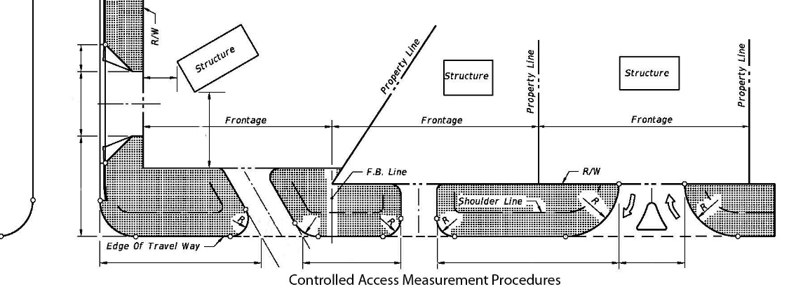
Note 2: Dimensions are measured from the closest edge of pavement of the first connection to the closest edge of pavement of the second connection along the edge of the traveled way. Figure 4.4.1-1 illustrates the typical measurements.
Figure 4.4.1-1 Typical Measurements
The speed criteria referred to in Table 4.4.1-1 is the speed limit posted for the roadway segment at the time of the access classification designation. The County Manager may require greater spacing for safety or operational hazards. In circumstances where legal access requires modification to these standards, the County Manager may approve alternate safe design standards.
B.
EXEMPTIONS. Single minor connections with expected peak hour two-way traffic of five (5) vehicles or less will be exempt from the connection spacing requirements of Table 4.4.1-1, if the proposed connection can be shown to the satisfaction of the County Manager, through the application process, as not creating a safety or operational hazard. This exemption also means that these minor connections will not be considered in measuring the distance to other connections for their compliance with the spacing requirements of this policy. Local roads within subdivisions shall be exempt except where safety or operational hazards are determined to exist by the County Manager.
C.
MINIMUM CONNECTIONS. The minimum number of connections will be permitted which will adequately serve the property. Joint connections are preferred and will be given serious consideration and promotion, especially where there are adjacent properties and minimum access management criteria cannot be met.
1.
Adjacent properties with the same ownership shall construct a joint connection to service both properties. Adjacent properties with different owners may be required to construct a joint connection to serve both properties. Each owner will construct the portion of the joint access on their property to allow existing or future connection.
2.
The County Manager may recommend such joint connections in all circumstances where the County Manager determines the individual connections fail to meet the connection spacing requirements of this policy or interfere with safe and efficient traffic flow.
3.
A recorded easement or dedication will be required for all joint connections, to accomplish the joint connection. The recorded easement or dedication shall be at least fifty feet by fifty feet (50' × 50').
D.
CORNER CLEARANCE. Corner clearance for connection shall meet the minimum connection spacing requirements as set forth in Table 4.4.1-1. Where an existing lot cannot meet the corner clearance requirements, the property shall meet the minimum connection spacing for isolated corner clearance connection as set forth in Table 4.4.1-2. The County Manager may approve an alternative design where the required isolated spacing cannot be met due to the existing property configuration and it can be shown to the satisfaction of the County Manager that safety or operational hazards are not created with the design.
Any such connection built under the preceding exceptions shall be closed at the time the adjacent property comes under the same ownership, whereby the connection(s) shall be reconstructed to meet the requirements herein.
* Access Class 7 shall use minimum spacing in Table 4.4.1-1.
Note: Right in only and right out only connections on roads without restrictive medians, shall by design of the connection, effectively eliminate unpermitted movements.
An outparcel shall not be recognized as an isolated corner lot. During the planning process, the access to an outparcel shall be coordinated with the service road requirements, cross access requirements and access spacing addressed in Table 4.4.1-1. However, the inbound right-in-only access can be considered on a case-by-case basis. It shall be separated from the intersection turn lane and a queuing analysis shall be required. A minimum of two hundred forty-five-foot (245') separation from the intersection (curb) will be required if this entrance is justified by traffic analysis (turn lane queuing).
In cases where connections are permitted under the criteria of the minimum comer measurements (Table 4.4.1-2), no more than one (1) connection will be allowed.
E.
TRAFFIC SIGNAL SPACING. Traffic signals must meet Manual on Uniform Traffic Control Devices (MUTCD) warrants. When signals are proposed at intervals closer than the standard for access class for the roadway segment (Table 4.4.1-1), they shall be considered only where the need for such signals is clearly demonstrated. They shall be evaluated based upon the safe and efficient operation of the roadway.
F.
ADMINISTRATIVE WAIVERS OR VARIANCES TO CLASSIFICATION AND SYSTEM STANDARDS. The specified minimum connection and median opening spacing may in some cases be technically unachievable, whereupon a written request for administrative waiver or variance may be considered. When approving a request, the County Manager or Board of Adjustment may require any of the following:
1.
Restrict the placement of a connection to a particular location along the frontage; or
2.
Require access to other public streets or roads; or
3.
Require site traffic circulation which will allow vehicles to avoid backing onto the street or road from single driveways; or
4.
Keep or require redesign of an existing or proposed connection when the traffic patterns, points of connection, roadway geometry, or traffic control devices are causing undue disruption of traffic or when traffic is creating safety hazards at existing connections, or deny direct connections when such physical and/or partial constraints shall affect space criteria expected to cause disruption or hazards.
4.4.2 - ACCESS MANAGEMENT NONCLASSIFIED ROADWAYS
A.
NONCLASSIFIED ROADWAYS. Minimum standard requests for access on nonclassified boulevards, avenues or premium transit corridors (framework streets) shall comply with Table 4.4.2-1 below.
B.
ADDITIONAL STANDARDS FOR SPECIAL DISTRICTS AND CORRIDORS. For corridors or districts which are identified as being within a special area or classified as a premium transit corridor within the Osceola County Comprehensive Plan the County Manager, after reviewing the entire segment or area, may apply alternate access standards. Such standards shall ensure safe and reasonable access while accomplishing the objectives for the corridor or special district.
C.
RESIDENTIAL ACCESS. Residential driveway access shall not be permitted to any Premium Transit Corridor, Boulevard or Avenue if any other access is available. For new development, residential driveway access is prohibited from any roadway with projected traffic exceeding 4,000 ADT.
D.
NON-RESIDENTIAL ACCESS. Non-residential connections to any Premium Transit Corridor, Boulevard or Avenue shall be limited to one (1) full access connection. Depending on the size and available frontage additional connections may be permitted if in compliance with County spacing standards. Private access to any Premium Transit Corridor, Boulevard or Avenue shall be limited to one (1) connection, except where the connection is a least one hundred twenty-five (125) feet from the intersection of another roadway connection. In these circumstances, an additional connection shall be provided at least three hundred (300) feet from the first connection if it meets the same spacing criteria.
4.4.3 - DRIVEWAY CONNECTION GEOMETRY
A.
ACCESS WIDTH AND RADII. Minimum driveway access/connection design standards shall comply with those shown in Table 4.4.3-1 below.
* The above minimum radii requirements can be satisfied by constructing a flare per FDOT Index 515 as may be amended (ten (10) feet on each side of driveway) or by a minimum three-foot (3') flare on each side within the single-family or/and duplex residential subdivision development.
Within the MXD, driveway width at the sidewalk within Neighborhood Types NH1 and NH2 shall not exceed eleven (11) feet. For Employment, Urban, Community and Neighborhood Centers, maximum driveway width at the sidewalk shall not exceed eighteen (18) feet. Entries to structured parking or delivery bays shall have a maximum clear height of sixteen (16) feet and a maximum clear width of twenty-two (22) feet.
Non-residential driveway access geometry shall be established using FDOT Index 515 as may be amended. The County Manager may require Autoturn or similar analysis to determine lane width requirements and radii.
B.
ACCESS LENGTH AND GEOMETRY. Adequate driveway length (or "throat length") is required to provide uninterrupted traffic flow between the street edge of pavement and the parking lot or first turn from the driveway, and to keep traffic conflicts to an acceptable level for incoming and outbound traffic.
C.
MIMIMUM THROAT LENGTH. The throat length shall be designed based on peak traffic volume as shown in Table 4.4.3-2.
* Or as supported by traffic study access/queuing analyses.
Full access, medium volume and high volume driveways shall approach the street or road with at least two (2) lanes. The area to which the driveway provides access must be sufficiently large to store any vehicles using the driveway and be completely off the right-of-way. It shall also be sufficient size to allow for the necessary functions to be carried out completely on the fronting property. Signalized medium and high volume driveways shall be supported by traffic study access/queuing analyses. These driveways shall be aligned perpendicular with the street median cuts. The County Manager has the authority to allow alternative alignments based on written justification submitted by the developer and if deemed a safe operation. Residential driveways accessing classified roads shall be provided with a turning option to eliminate backing out into the road whenever possible. Driveway gates, if approved, shall be located based on adjacent roadway classification, traffic operations, and any other physical factors which may affect the safety of the operations.
D.
ACCESS ISLANDS. An island or median, constructed within a two-way driveway, shall be curbed. Right-in/right-out separators can be located within right-of-way, a minimum of four (4) feet from the driving lane, and shall be designed with a non-mountable curb. Except for right in/right out separators, islands shall not extend into through street right-of-way. The median extension between the through street right-of-way and pavement shall be striped. Plantings within the right-of-way or other structures must not encroach into the sight triangle. Plantings that will exceed three-point-five (3.5) feet at maturity shall be prohibited in the sight triangle. In a right-in/right-out case, the area separating deceleration lanes shall be painted yellow with eighteen-inch (18") diagonal stripes. An alternative design may be approved by the County Manager upon demonstration of safe operation.
E.
AUXILIARY TURN LANES—WARRANTS AND DESIGN. A development generating more than fifty (50) average daily trips (ADT) may be required to construct auxiliary turn lanes. This requirement depends on a combination of existing and future connection volumes and existing and future roadway volumes. If the future volumes justify the auxiliary lanes, then the developer has the option to enter into an agreement with the County to postpone the improvements until such time as designated by the County.
* These criteria represent the existing posted speed and existing daily traffic. Vehicles per Hour (VPH) represents peak hour, peak direction. Taper (0 to 12') shall be one hundred twenty (120) feet long for thirty-five to forty-five (35—45) mph, one hundred fifty (150) feet long for fifty (50) mph, and one hundred eighty (180) feet long for fifty-five (55) mph.
Notwithstanding the table above, the County Manager has the authority to require turn lanes in special conditions even if the thresholds are not met (for safety and operations). The developer may provide a traffic-gap study based on ten (10) year projected volumes to support varying auxiliary lane requirement.
All of the above improvements require pavement overlay and leveling (as needed) within their limits. Improvements adjacent to the property shall require urban sections within the Urban Growth Boundary. The County Manager, upon a written request from the developer and certification of a safe operation, has authority to accept a payment to the roadway fund in lieu of this requirement. This request must be presented to the County Manager with the application submitted for the applicable permit. Payment shall be based on the proportionate share of the development, consistent with this LDC, for the section of roadway adjacent to the property. The County Manager may require operational improvements to ensure safe operations.
F.
CAPITAL IMPROVEMENT PLAN. If road improvements are included in the County's annual update of the Capital Improvement Element (CIE), then the developer will be required to escrow the necessary funds. This roadway agreement shall be submitted to the County Manager prior to SDP approval and must be supported by a traffic impact analysis (TIA).
G.
SPEED CHANGE LANES. The speed change lanes (auxiliary, deceleration, turning) shall be constructed according to the criteria of the FDOT "Manual of Uniform Minimum Standards for Design, Construction and Maintenance for Streets and Highways." Osceola County access guidelines for construction, geometry, signing and striping shall be followed.
H.
TURN LANE ALIGNMENT—CONTINUOUS TURN LANE. Continuous right turn lanes and left turn lanes shall be constructed if the distance between a lane taper end is closer than the distance traveled during perception and reaction (2—3 seconds). Appropriate striping shall recognize acceleration and deceleration areas. If the taper crosses the existing commercial driveways, right-turn lanes shall be extended a minimum of one hundred (100) feet beyond the driveway. If the distance between the taper end and the next driveway with the turn lane is less than the distance traveled in 2 seconds, then painted bubble and full paved lane width must be used for the auxiliary lanes.
I.
SIGHT DISTANCE. All driveway/access roads shall satisfy Florida Green book standards for sight distance and FDOT Index 546, as applicable.
J.
ACCESS GRADES. Grades of access shall meet the standards of lndex No. 515, FDOT Roadway and Traffic Design Standards, as amended.
K.
ACCESS DRAINAGE. Access shall be constructed in a manner to ensure that the street or road drainage or drainage of adjacent properties is not adversely affected. Connection construction shall cause no impairment to the drainage and stability of the roadway subgrade. No water shall pond on any roadway shoulder or in ditches. Furthermore, no water flow shall result in erosion within the public right-of-way. This may result in the requirement of curb and gutter and adequate drainage designs.
L.
DRAIN CULVERT. All ditches, channels, inlets, culverts and other drainage facilities' within public right-of-way shall be installed according to County standards. The drain culvert size shall be adequate to carry the flow anticipated as determined by the County. Mitered end section shall be provided on side drains, and shall be constructed according to FDOT Standard Index No. 515, as amended.
4.4.4 - ACCESS MODIFICATION
Improvements and upgrading, (which is either defined as "New Development" herein or any improvement that would require a site development plan), of the existing facilities/sites are to conform to the standards contained herein for new roadways of the same functional class. Connection upgrades may include relocation or closing of driveways. This requirement will be based on safety hazards recognized on the roadway or access and changing driveway traffic conditions. If a previously approved access causes conditions which cannot be qualified as a safe and adequate access, the County can, at the County's expense, relocate, modify or close such an access.
4.4.5 - LOCATION AND NUMBER OF ACCESS POINTS
A.
ACCESS ALIGNMENT. Where feasible, access shall be aligned with the development driveway access (existing or submitted for approval) located on the opposite side of the street to be connected or aligned with the cross street. The location of this access will be dependent on the classification of the adjacent roads and overall planning concept. Access to a lower class facility will be given priority over a higher class facility unless the applicant adequately demonstrates by a traffic study or other acceptable documentation that the connection to the lower class facility is not in the best interest of the public. Access shall be to a County-maintained roadway improved to County standards. When adequate ROW does not exist and/or cannot be acquired, alternative design standards may be approved pursuant to this Chapter. Development shall be required to construct improvements needed to improve substandard streets along property frontage(s) from which access is required; improvements shall be extended to the nearest County/City maintained roadway that meets the adopted standard. Improvements adjacent to the property shall be to County standards. For any improvements required on Premium Transit Corridors, Avenues or Boulevards that are not adjacent to the subject property a transitional section may be used subject to the approval of the County Manager, recognizing improvements that will bring the typical section of the substandard road closer to fully compliant standards without the need to rebuild the section at a later date.
B.
SUBDIVISION ACCESS. Subdivision access shall be based on the number of dwelling units. Minimum of one (1) access (subdivision access road) shall be constructed for the first one hundred (100) dwelling units (DU) or fifteen (15) acres of commercial/industrial/institutional property. Thereafter, a minimum of one (1) additional access road or driveway access shall be provided per each one hundred fifty (150) dwelling units (DU) and/or twenty-five (25) acres of commercial/industrial/institutional acreage or the portion thereof. As an example, a development with one hundred seventy-five (175) residential units shall provide at least two (2) access points; a development with twenty (20) acres of commercial/industrial/institutional property shall provide at least two (2) access points; and a development with one hundred (100) dwelling units and twenty-five (25) acres of commercial development shall provide at least three (3) access points. Access roads/driveways shall be designed to distribute traffic efficiently. Adequate access design may be used in lieu of the above requirements if approved by the County Manager. Access roads servicing more than one hundred fifty (150) dwelling units shall have a minimum of three (3) lanes, or minimum two (2)-lane divided facilities with sixteen-foot (16') wide lanes or facility built to framework street standards ensuring the by-pass feature for fire and emergency vehicles (either wide shoulders or parkway) with adequate clear zone and no direct single-family dwelling unit's driveway.
C.
STREET CONNECTIVITY. The proposed street layout shall be coordinated with the street system of the surrounding area. Streets in the proposed subdivision shall be connected to dedicated streets in adjacent areas to provide for proper circulation. In those cases where direct alignment is not possible due to property configuration, a minimum offset to provide for safe operations shall be required.
D.
LOCAL STREET CONNECTIONS. Local street connections providing east/west or north/south connectivity between framework streets will be required. These local connections will generally be spaced no more than one-quarter (¼) mile between framework streets when feasible within the urban infill area. Within the Mixed Use Districts, block length standards as required in Chapter 3, Article 3.13 and as depicted on the Conceptual Master Plan will apply. The design of the local street providing the connectivity should not require numerous turning movements or T-intersections to traverse the street.
E.
FUTURE CONNECTIONS. Provisions for future connections shall be provided to adjacent properties so as not to preclude connectivity, except where abutting land is undevelopable or where the adjacent development pattern renders connection impractical in the future. Where right-of-way has been provided on adjacent property for access to roadways built to County standards, the roadway connection shall be constructed. Otherwise, cross-access easements or public right-of-way stubouts shall be provided to adjacent parcels to improve connectivity to the surrounding roadway system and enhance access to surrounding land uses. Street stubs in excess of one hundred fifty (150) feet shall be provided with a temporary hammerhead turnaround if the street stub is providing access to lots. The developer of the adjoining area shall pay the cost of restoring the street to its original design cross section and extending the street. For public streets, signage indicating the future connection shall be installed at the terminus of the stubout.
F.
INTERSECTION IMPROVEMENTS. Intersections created by construction of commercial subdivision entrances and roads connecting to existing roadways may require improvements, such as but not limited to deceleration/acceleration lanes, left turn lanes, by pass lanes and signalization. The criteria for determining the need for such improvements will include existing and projected traffic on both roads, horizontal and vertical alignment of the road to which the entrance road is to be connected, future road improvement plans, and sight distance along the ROW.
G.
ROADWAY AND MULTIMODAL IMPROVEMENTS. For local streets and avenues/boulevards or Premium Transit Corridors providing access within a development, or adjacent to a development, right-of-way shall be provided and improvements constructed with the development of the project. Required improvements shall include providing a road structural number consistent with the Road Construction Specifications, a curb and gutter closed drainage roadway system, and providing required stormwater treatment and attenuation. The applicant may request from the County Manager relief from constructing the curb and gutter closed drainage system if it is impractical due to existing hydraulics, insufficient frontage, or other site constraints, however, other features, such as shoulder widening or ribbon curb will still be required. Furthermore, where a development abuts or contains an existing or proposed framework street that is identified in the Transportation Element of the County Comprehensive Plan, the developer will be required to construct/dedicate rights-of-way, or other provisions, consistent with this LDC.
Further, the stormwater management capacity for water quality treatment, water quantity attenuation, and compensating storage for fill within the 100-year floodplain, for multi-modal corridors, avenues and boulevards, will be provided and reserved in joint use ponds within the project.
In lieu of constructing equestrian/regional trails or multi-use trails, a contribution of the estimated construction cost of the required equestrian/regional trails or multi-use trails may be paid to the "Sidewalk Bank" prior to the recordation of the final plat and/or the issuance of the Certificate of Completion by the County, whichever is applicable. The contribution shall be based on actual final design approval at the Site Development Plan stage, with the cost estimate, for improvements being approved by the County Manager. Should the developer be required to construct any portion of the equestrian/regional trail or multi-use trail, then the cost of this portion of the required construction shall be deducted from the required contribution.
4.4.6 - RIGHT-OF-WAY, SERVICE ROADS, AND CROSS ACCESS
A.
RIGHT-OF-WAY. Right-of-way shall be the minimum width that can encompass the required elements of the framework road, premium transit corridor, or local road, in accordance with the cross-sections outlined herein.
B.
CROSS ACCESS AND SERVICE ROADS. Service roads and cross access easements shall be used to minimize driveway connections on classified and framework roads as applicable.
1.
Service Roads. Service roads serve as parallel facilities along higher classification roadways that allow access along several properties without the need to re-enter the higher classification roadway. Service roads will be required on Class 3 or higher roadways as identified by the County Manager in accordance with Section 4.4.1. The service road will meet the requirements for minimum spacing connections in accordance with Section 4.4.1, and access width, radii, length and geometry in accordance with Section 4.4.3. The service road shall be built to Avenue standards (bike lanes are optional) and generally located to the rear of the property.
2.
Cross Access. Cross access providing connection between adjacent properties shall be required in commercial and multi-family developments. The cross access easement shall be a minimum thirty-five (35) feet wide, with a paved twenty-four-foot (24') wide vehicular connection. The applicant shall construct a paved vehicular connection to the paved roadway or parking aisle of the adjacent properties, or where a vehicular access agreement is not provided on the adjacent property, to the property line.
If an applicant believes that a site is physically unsuitable for construction of the required service road or cross access easement due to the shape of the property, topographical discrepancies with neighboring properties, or unsuitable soils, wetlands and other major obstacles, the applicant may request relief from the requirement. This request shall be submitted in writing, along with evidence of such unsuitability and providing an alternative solution to the County Manager for evaluation with the applicable permit or development application process. Where construction of a service road or cross access easement is deferred (but a future requirement of the road is probable), the applicant shall dedicate right-of-way or record the cross access easement and pay monies for future construction of the improvement to the County. The fee-in-lieu amount shall be determined by the County Manager after review of the final design and cost estimate submitted by the applicant.
Cross Access and Service Roads will maintain local road continuity and provide access to parcels adjacent to the controlled access facility. The connection of an access/service road to a cross street shall be a minimum of one hundred fifty-foot (150')-separation from the major roadway. If the side road has a local street character, uniform separation of a minimum of one hundred twenty-five (125) feet is required.
4.4.7 - CONNECTION PERMIT
No new driveway access or alteration of an existing right-of-way access shall occur without a right-of-way utilization permit or an approved SDP. The permit shall be issued according to stipulations required by the County. These conditions shall include a requirement that connections be constructed according to the guidelines and current standards published by the Florida Department of Transportation. An alteration shall be considered when a business served by a connection changes, as to cause a change in the traffic patterns on a public street or road, and those changes result in or are reasonably expected to cause, undue disruption to traffic or present a safety hazard. The County Manager may require the alteration, redesign, and reconstruction of, or the elimination of a traffic connection as long as reasonable access is otherwise provided. All costs of redesign and reconstruction or elimination of a connection shall be borne by the property owner served by the connection. The cost shall be borne by Osceola County when the connection change is initiated by the County.
4.4.8 - CONSTRUCTION
All construction shall conform to Osceola County specifications. The contractor is responsible for complying with all other requirements set forth by the County Manager.
The County shall deny access to public streets (by use of a connection) if that connection is constructed or altered without a permit issued by the County. Also, the permit shall be deemed expired and void if the applicant fails to construct or alter a connection according to the requirements of the permit issued for that construction or alteration; or if an owner of the property served by the connection fails to alter, redesign and reconstruct that connection according to instructions issued by the County.
It shall be the responsibility of the applicant during construction or, in the case of existing connections, the owner of property served by a connection, to maintain all portions of that connection located within the public right-of-way in a condition that is comparable to the adjacent public street or road in the area of the connection.
4.4.9 - SPECIAL AREAS
For areas zoned MXD, PD, Urban Infill Centers or within a special overlay area, the County Manager shall require additional standards.
A.
MIXED USE DISTRICTS. For properties shown on the County's Future Land Use Map as Mixed Use and identified in the Comprehensive Plan as a Mixed Use District, access management and design standards shall be governed by the adopted Conceptual Master Plan and this Code. If there are conflicts between the Standards identified in Chapter 3, Article 3.13 herein and standards contained elsewhere in this Code, the standards in Chapter 3, Article 3.13 shall prevail. Development aspects not covered by the Standards in Chapter 3, Article 3.13 or elsewhere in this Code shall conform with "The Institute of Transportation Engineers Designing Walkable Urban Thoroughfares: A Context Sensitive Approach" handbook (latest edition). Where development occurs within the MXD prior to the adoption of a CMP, access management shall be governed by the design criteria policies of the Osceola County Comprehensive Plan Future Land Use Element Mixed Use Policies, this Code, or the ITE handbook referenced above, and the following criteria:
1.
There shall be at least one hundred (100) local street intersections per net developable square mile, as defined herein.
2.
The foundation of development shall be a "Grid Network" transportation system.
3.
Block lengths on a street must be scaled to create a comfortable walking distance, with shorter blocks designed in the more dense and intense areas of the Centers.
4.
At least fifty percent (50%) of the dwelling units and non-residential buildingsshall be within one-half (½) mile of a planned transit route.
5.
Pedestrian and bicycle connections shall provide access to centers and key public facilities.
B.
URBAN INFILL CENTERS. For properties identified in the Comprehensive Plan as Urban Infill Centers and shown on the County's Future Land Use Map as Neighborhood Center, Community Center, Urban Center or Employment Center. If there are conflicts between the standards herein and standards contained elsewhere in this Code, the standards herein shall prevail. Development aspects not covered by the standards herein or elsewhere in this Code shall conform with "The Institute of Transportation Engineers Designing Walkable Urban Thoroughfares: A Context Sensitive Approach" handbook (latest edition). Access management shall be governed by the design criteria policies of this Code.
1.
New development and re-development within Centers shall be compact, pedestrian-oriented and transit accessible places designed to reduce over-reliance on automobile vehicle miles traveled.
2.
Active spaces are conveniently accessible and connected along walkable streets allowing for incidental interaction, collaboration and integration of the employment force, residents and visitors to the Center.
3.
Interconnected networks of streets are designed to disperse traffic and reduce the length of automobile trips.
4.
Development respects the pedestrian and the spatial form of public areas, while adequately accommodating the automobile.
5.
The design of streets and buildings reinforces safe pedestrian environments, with building frontages oriented to the street.
6.
Urban blocks shall be created to ensure the implementation of a pedestrian scaled neighborhood.
7.
Commercial developments shall provide an integrated pedestrian circulation network within the development that shall be extended and integrated into existing developments and public street system. Internal and external circulation connectivity shall be accomplished by providing sidewalk on both sides of the public or private street. Where street connections are not possible, pedestrian and bike paths shall be provided as an alternative.
C.
TRADITIONAL NEIGHBORHOOD DESIGN. Reserved.
4.5.1 - DESIGN CRITERIA
A.
QUALITY.
1.
Development Requirements. The control of pollution, sedimentation and flooding shall be mandatory for all proposed development. All development will be required to provide water quality of the required volume of water, as specified by the applicable water management district's standards and specifications.
2.
Impaired Water Bodies. In order to achieve State or Federally mandated load reduction requirements within impaired water body drainage basins, the post development nutrient and/or pollutant loads shall be less than or equal to the pre-development loads for those items contributing to the impairment as considered by the State or Federal agencies. Where applicable, development shall meet relevant Federal and State requirements for impaired water bodies.
3.
Dewatering. Dewatering of ground water or surface water either directly or indirectly into the County's stormwater system will not be allowed without a County development permit unless the dewatering operations are part of an approved development application.
4.
Discharges to Surface Water. Non-stormwater discharges directly or indirectly into the County's stormwater system shall meet state surface water quality standards and will not be allowed without a development permit.
5.
LID (Low Impact Development). LID practices such as but not limited to shallow bioretention swales, raingardens, pervious pavement, planter boxes and disconnected impervious areas are encouraged to be incorporated into a project's overall stormwater management plan.
B.
QUANTITY.
1.
Design Storm Event. Within the South Florida Water Management District (SFWMD) boundaries, the post-developed peak rate of discharge, permitted from the site, will not exceed the pre-developed peak rate of discharge from the site, during a 10-year—72-hour storm event. Within the St. Johns River Water Management District (SJRWMD) boundaries, the storm event design shall be consistent with applicable St. Johns River Water Management District (SJRWMD) rules. For either Water Management District boundary, if a legal and positive outfall to the ultimate receiving body, as defined below, cannot be provided, additional analysis showing that the post-development discharge volume does not exceed the pre-development discharge volume shall be required.
2.
Compensating Storage. For encroachments into the 100-year floodplain, compensating storage for development is to be accomplished between the average wet season water table within the special flood hazard area, and the estimated 100-year base flood elevation, or as required by the applicable Water Management District.
3.
Disposition of Stormwater. The post-development runoff from any site shall be discharged in the same manner as in the pre-development condition. The discharge shall be either sheet flow in a natural way at natural elevations or into a positive and legal outfall.
A legal outfall as it pertains to this Article, is one which drains to County rights-of-way or drainage easements, to other government regulatory rights-of-way or drainage easements. Discharges to a (manmade or natural) drainage system previously approved by the County, or which preceded or otherwise did not require approval from the County when constructed (e.g., drainage ditch or canal within agricultural property), may be considered a legal outfall if appropriate drainage easements or other rights are demonstrated.
In a closed basin, the volume of runoff for the 100-year—24-hour storm event shall be retained on-site. At least fifty percent (50%) of the 100-year—24-hour storm event volume shall be recovered within fourteen (14) days, unless a stricter requirement is mandated by law.
When discharge is to a closed lake basin, the increased volume of runoff from the 100-year—24-hour storm event (compared to the pre-development volume) shall be retained on-site, and only the pre-development volume of runoff may be discharged at peak rates not to exceed the pre-development peak rates for the 100-year—24-hour storm event.
C.
OPEN DRAINAGE WAYS. All man-made stormwater conveyance systems shall be of the shallow, flat, slow-velocity (maximum two (2) feet/second), open-channel type which shall be designed and constructed within a recorded drainage easement. The side slopes of such conveyance systems shall be fully sodded up to and including five (5) feet beyond the top of ditch or canal slope. An unobstructed maintenance easement shall be provided on one or both sides of these drainage ways as detailed herein.
1.
The minimum easement width (as measured from top of bank) is as follows:
These requirements shall not apply to roadside ditches within the road right-of-way.
2.
Areas adjacent to open drainage ways and ponds shall be designed and constructed to prevent erosion and sedimentation.
D.
PONDS.
1.
Dry Pond — Side Slopes.
No steeper than 4:1 (Horizontal: Vertical); or on commercial sites with pond depth of less than two (2) feet; no steeper than 3:1.
Retaining walls are allowed. A minimum of ten-foot (10')-wide unobstructed access to the control structure shall be provided in all dry facilities.
2.
Wet Ponds — Side Slopes.
No steeper than 4:1 to three (3) feet below control elevation, then no steeper than 2:1 to pond bottom.
Retaining walls or bulkheads shall be allowed for up to forty percent (40%) of the shoreline length, but compensating littoral zone must be provided based on 4:1 side slope. Areas used for excavation during the construction of development shall be shown on the construction plans. No excavation will be permitted into the side slopes of the pond with the exception of structures required for the pond.
3.
Maintenance Berm — Side Slopes.
A ten-foot (10')-wide unobstructed maintenance berm is required around pond perimeter and shall have a slope no steeper than 10:1.
A minimum of a twenty-foot (20')-wide tract may be required by the County to provide stormwater facility access from a right-of-way.
4.
Erosion Protection.
a.
Wet Ponds: Side Slopes and Berms are to be sodded from three (3) feet below the control elevation up to five (5) feet beyond the top of pond bank or outside toe of berm whichever is applicable. Littoral zone plantings are permitted within the littoral zone. This will not preclude the placement of walking paths or other passive recreation within the sodded area.
b.
Dry Ponds: Side slopes and berms are to be sodded and seed pond bottom.
c.
Freeboard: All wet ponds shall have twelve (12) inches minimum freeboard between design high water level and the minimum berm elevation.
d.
Top of pond slope and/or toe of berm slopes to be five (5) feet minimum from the property line.
E.
CONTROL STRUCTURES.
1.
A pond outlet structure shall be designed to skim floating debris, oil, and grease. In wet ponds, the skimmer shall be installed at an elevation six (6) inches below the lowest control structure opening and elevated to an elevation six (6) inches above the design highwater level. Wet detention pond outlet structures shall include a bleeder mechanism such as an orifice or V-notch weir, for returning the water level to the control elevation. If an orifice is used, a turn down elbow extension may be used in lieu of extending the skimmer to six (6) inches below the orifice invert elevation.
2.
In dry detention ponds, the bleeder invert elevation shall be set one (1) foot below the pond bottom. Mosquito control ditches, sump, or other appropriate features for such purpose, shall be incorporated into the design of dry detention ponds. The control structure design and construction shall include a depression and a four-inch (4") thick concrete pad extending two (2) feet each side of the width of the structure and four (4) feet from the face of the structure. The top of the concrete pad shall be at least one (1) foot below the bleeder invert. The purpose of the pad is to prevent encroachment by vegetative matter and obstruction to the free operation of the skimmer.
F.
STORMWATER MODELING. An acceptable peak discharge analysis typically consists of generating pre-development and post-development runoff hydrographs, routing the post-development hydrograph through a detention basin, and sizing an overflow structure to control post-development discharges at or below pre-development rates. Methods of computing run-off volume and peak rate of discharge may be as follows.
1.
Basins or Sub-basins 0—10 acres. The rational method may be used. The use of the methodologies below is preferred and may be required based on site-specific conditions.
2.
Basins or sub-basins 0—300 acres. Hydrographs(s) shall be developed by Soil Conservation Service unit-hydrograph method or by one (1) of the Santa Barbara urban hydrograph methods.
3.
Basins or sub-basins over 300 acres. Computer model TR-20, U.S.D.A. Soil Conservation Service and U.S. Army. Corps of Engineers HEC I, may be used. Other County approved models may be used.
4.
Alternate methods of computation may be approved by the County Manager.
5.
In areas where specific basin plans have been completed, a pro-rata discharge may have been designated. In this case, allowable discharge shall be governed by the specific basin criteria.
6.
Design Storm Minimum Standards.
* Where applicable, roadside swales may be considered for approval by the County Manager upon presentation of a geotechnical report by a qualified geotechnical engineer. A minimum one (1) foot separation between the swale bottom and the seasonal high water table elevation shall be maintained. Roadside ditches are permitted outside the Urban Growth Boundary and are not to be normally considered for retention/detention purposes; rather, they are to be designed for conveying of stormwater runoff only. An area for roadway retention/detention purposes shall be set aside, outside the regular roadway right-of-way limits. Minimum roadside ditch slope shall be zero-point-one percent (0.1%) unless otherwise approved by the County Manager in writing.
4.5.2 - ALTERNATIVE DESIGN
Stormwater management systems such as exfiltration trench, infiltration chambers, pervious pavement, and other LID practices may be considered in conjunction with traditional stormwater ponds to meet water quality and quantity criteria, subject to the approval of the County Manager.
4.5.3 - ROADWAY DRAINAGE DESIGN
A.
GENERAL.
Good pavement drainage design consists of the proper selection of grades, cross slopes, curb types, inlet location, and removal of the storm rainfall from the pavement, in a cost effective way while preserving the safety, traffic capacity and integrity of the highway and street system.
1.
Required Calculations. The peak rates of runoff, for which the drainage system must be designed, shall be determined by methodology approved by FDOT or applicable Water Management District. The time of concentration, individual drainage areas, percent impervious and rainfall intensity amounts, and any information deemed appropriate to evaluate the calculations shall be submitted as part of the drainage calculations and documentation.
2.
Design Discharges. The system shall be designed to handle the flows from the contributory area of the on-site and off-site flows of the development when applicable. This analysis shall consider the relative timing of the on-site and off-site flows in determining the adequacy of the designed system.
B.
HYDRAULIC GRADIENT LINE COMPUTATIONS. Calculations for the hydraulic gradient line for the storm sewer system shall be included to illustrate compliance with applicable requirements. The calculated hydraulic gradient line shall be at or below the design elevation of the gutter.
C.
DESIGN STORM FREQUENCY.
1.
The design storm frequency to be utilized for the design of pavement drainage shall be a ten (10)-year design storm.
2.
For methods other than the rational method, a ten (10)-year twenty-four (24)-hour hydrograph shall be used.
D.
STORMWATER SPREAD INTO TRAVELED LANE. Inlets shall be placed at all low points, intersections and along continuous grades so as to prevent the spread of water from exceeding tolerable limits. The spread resulting from a rainfall intensity of four (4.0) inches per hour shall be limited as follows.
* The criteria in this column apply to travel, turn, or auxiliary lanes adjacent to barrier wall or curb, in normal or super elevated sections.
E.
INLETS.
1.
Inlet Types. The curb inlet types to be used shall be the latest version of the Florida Department of Transportation (FDOT) inlet types as detailed in the FDOT roadway and traffic design standards.
2.
Maximum Inlet Interception Rates. Types 1 and 3 (single) inlets shall be located such that a maximum of five (5) cubic feet per second (cfs) shall be intercepted during the ten (10) year frequency storm. Types 2 and 4 (double) inlets: nine (9) cfs maximum.
3.
Low Point Inlets. All inlets at low points (sumps) shall be designed to intercept one hundred percent (100%) of the design flow, without exceeding the allowable spread of water onto the traveled lanes, as defined above. On Premium Transit Corridors and 4-lane Boulevards or Avenues, multiple inlets at all sump locations may be required to meet the allowable spread.
F.
STORM SEWER AND CULVERT DESIGN.
1.
Minimum Pipe Size.
a.
The minimum size of pipe to be used in storm sewer systems is fifteen (15) inches except for Premium Transit Corridors, Boulevards and Avenues the minimum shall be eighteen (18) inches. Design shall be based upon six (6) inch increments in sizes above eighteen (18) inches.
b.
Pipes to be used for driveway crossings or outfall pipes within County right-of-way shall be minimum fifteen (15) inches with mitered ends.
2.
Design Tailwater. For the determination of hydraulic gradient and the sizing of storm drain pipes, a design tailwater, which can be reasonably expected to coincide with the design storm event, shall be used. Standard design tailwater conditions of the storm drain systems are as follows:
3.
Allowable Headwater. The allowable headwater of a culvert installation should be set by the designer for an economical installation. When end walls are used, the headwater should not exceed the top of the end wall at the entrance. If the top of the end wall is inundated, special protection of the roadway embankment and/or ditch slope may be necessary for erosion protection.
4.
Pipe Grade. All storm sewers shall be designed and constructed to produce a minimum velocity of two-point-five (2.5) fps when flowing full. When outlet velocities for the design storm discharges exceed six (6) feet per second, the need for special channel lining or energy dissipation is required.
5.
Maximum Lengths of Pipe. The following maximum runs of pipe shall be used when spacing access structures of any type:
6.
Maintenance Easement.
a.
An unobstructed maintenance easement shall be provided for all underground stormwater systems located outside of the road right-of-way. The required size of the easement shall be based upon the following formula: width of easement = 2 [X depth of pipe (in feet)] + diameter of pipe (in feet) + 2 feet. The minimum width of maintenance easements for storm sewer pipes located outside the public right-of-way is twenty (20) feet.
b.
A minimum ten-foot (10') unobstructed maintenance access shall be provided to all stormwater systems.
G.
ALLOWABLE MATERIALS. Allowable materials for storm sewers shall be in accordance with the Osceola County Road Construction Specifications.
4.5.4 - CONSTRUCTION POLLUTION PREVENTION
A.
EROSION CONTROL PLAN. The erosion control plan and details and calculations shall document the measures necessary to limit the transport of sediments outside the limits of the project, to the volume and amount of that exist prior to the commencement of construction. This pre-construction condition shall be satisfied for the total anticipated construction period. The Control Plan shall be submitted with final engineering plans for the development. Included with this submittal shall be calculations supporting the effectiveness of the proposed plan. Provision must be made to preserve the integrity and capacity of check weirs, sediment basins, slope drains and grading patterns required to meet this provision throughout the project construction life.
B.
STOCKPILING MATERIAL. No excavated material shall be stockpiled in such a manner as to direct runoff directly off the project site or into any adjacent water body or stormwater collection facility.
C.
EXPOSED AREA LIMITATION. The surface area of open, raw, erodible soil exposed by clearing and grubbing operations or excavation and filling operations shall not exceed ten (10) acres. This requirement may be waived for large projects with a dust control plan which demonstrate that opening of additional areas will not significantly affect off-site deposit of sediments. This waiver will be by written authorization from the County Manager.
D.
INLET PROTECTION. Inlets and catch basins shall be protected from sediment-laden storm runoff until the completion of all construction operations that may contribute to the inlet.
E.
TEMPORARY SEEDING AND MULCHING. Areas opened by construction operations that are not anticipated to be dressed and receive final grassing treatment within thirty (30) days shall be seeded with a quick growing grass species which will provide an early cover during the season in which it is planted and will not later compete with permanent grassing. Slopes steeper than 4:1 shall receive mulching of approximately two (2) inches loose measure of mulch material cut into the soil of the seeded area to a depth of four (4) inches.
F.
TEMPORARY GRASSING. The seed or seeded and mulched area shall be rolled and watered to assure optimum growing conditions for the establishment of a good grass cover.
G.
TEMPORARY REGRASSING. If, after fourteen (14) days the temporary grassed areas have not attained a minimum of seventy-five percent (75%) good grass cover, the area will be reworked and additional seed applied sufficient to establish the desired vegetative cover.
H.
MAINTENANCE. All features of the project designed and constructed to prevent erosion and sediment shall be maintained during the project construction life, so as to function as they were originally designed and constructed.
4.5.5 - PERMANENT EROSION CONTROL
The erosion control facilities of the project shall be designed to minimize the impact on off-site facilities. All stormwater discharge from the project limits shall be routed through stormwater management facilities to trap suspended sediments.
A.
PERMANENT SEEDING. All areas which have been disturbed by construction shall, at a minimum, be fertilized and seeded.
B.
PERMANENT SEEDING AND MULCHING. In addition to the minimum requirements above, slopes of from 6:1 to 3:1, inclusive, will be mulched with a uniform thickness of approximately two (2) inches, loose measure, of mulch material incorporated into the soil by mixing to a depth of four (4) inches.
C.
PERMANENT SODDING. At a minimum, all retention/detention basins side slopes shall be solid sodded. An alternative landscape plan that provides stabilization of the side slope may be considered. All exposed areas including public rights-of-way with slopes steeper than 4:1 will be solid sodded.
D.
STRIP SODDING. Strip sod one-foot (1')-wide or greater shall be placed adjacent to all curbs, walks and pavement. In areas with a sidewalk, the entire area between the sidewalk and the back of curb and/or edge of pavement shall be sodded.
E.
REGRASSING. All grassed areas will be maintained to assure a good stand and sufficient ground cover to minimize erosion. If after sixty (60) days an adequate ground cover has not been established, the area will be regrassed.
4.5.6 - LOT GRADING
A.
FINISHED FLOOR ELEVATION.
1.
For lots that are located outside the Urban Growth Boundary, and created without an approved master lot drainage plan the finished floor elevation shall meet the greater of the following:
a.
Twenty-four (24) inches above the crown of the road on A or B grading in an approved SDP.
b.
Finish floor elevation as determined by the Health Department (State Septic Tank Rule if applicable).
c.
One (1) foot above the determined 100-year flood elevation.
2.
For lots that are located within the Urban Growth Boundary the construction plans shall include a master lot grading plan showing all existing and proposed features.
a.
The slope of fill material shall be no steeper than 3:1 for slopes six (6) feet in length or less. Slopes over six (6) feet in length shall be no steeper than 4:1;
b.
Rear lot swales should be avoided when possible. When the circumstances dictate the need for rear lot swales, ditch bottom inlets shall be added to minimize the drainage basins utilizing these swales; and
c.
Finished floor elevations shall be a minimum of twenty-four (24) inches above adjacent road crown unless otherwise indicated within an approved SDP.
B.
RESIDENTIAL DRIVEWAYS. Driveway location and dimensions shall be submitted along with the building permit. Driveway location shall be constructed at least five (5) feet from either side of the property lines and outside side yard drainage or utility easements unless the driveway is an approved shared driveway access.
C.
DRIVEWAY GRADING ON C TYPE LOTS.
1.
Sidewalk shall be at least six (6) inches above gutter line adjacent to driveway.
2.
Low point of driveway shall be a minimum of four (4) inches below garage floor at five (5) feet from garage door opening.
D.
GRADING REQUIREMENTS ASSOCIATED WITH SWIMMING POOL CONSTRUCTION. All swimming pools including any decks and screened enclosures must be located outside any easements. If any deviations from the original site grading plan result from the placement, then a revised site grading plan shall be submitted.
E.
LOTS OR PARCELS WITH NO PRIOR APPROVED GRADING PLAN. Lots or parcels with no prior approved grading plan will require submittal of a grading plan for approval.
F.
NEW SUBDIVISIONS. The SDP shall include a master lot grading plan in a format as required by the County Manager showing all existing and proposed features.
G.
GENERAL.
1.
All lots shall be graded to prevent entrapment of stormwater on the lot or adjoining properties. Post-construction runoff shall drain into existing County drainage systems or to natural waterways. When such a system is not available, the post-construction runoff must match the pre-construction runoff patterns.
2.
On all lots, the constructed finished floor elevations shall be no more than one (1) inch below the approved finished floor elevation.
3.
On lots for which the side yard setback is less than seven and one-half (7½) feet, the constructed finished floor elevation shall be no more than six (6) inches above the approved finished floor elevation unless stem walls are used to allow side yard slope to remain as designed and shall not adversely impact adjacent lands.
4.
On lots for which the side yard setback is seven and one-half (7½) feet or more, the constructed finished floor elevation shall be no more than one (1) foot above the approved finished floor elevation unless stem walls are used to allow side yard slope to remain as designed.
5.
All finished floor elevations, for all lots, must be a minimum eight (8) inches above the outside finished grade with the exception of an approved step down floor and basement.
4.5.7 - DRAINAGE EASEMENT
Where a proposed subdivision is traversed by, or abuts a water course, drainage canal, or stream, a stormwater easement or drainage right-of-way shall be provided. Where a new drainage way or canal is required, an easement or right-of-way shall be provided for maintenance purposes. No alteration or construction shall occur within the easement without a permit.
4.6.1 - DESIGN STANDARDS
A.
BLOCKS. Blocks shall be designed in compliance with requirements for access management and applicable special districts. If cul de sacs are used, the length of the cul de sac shall not exceed eight hundred (800) feet; however, the County Manager may approve cul-de-sacs over eight hundred (800) feet in length to serve odd-shaped parcels of land which cannot be developed in any other manner. In case of phased development, temporary stabilized hammerhead or cul-de-sac stub outs shall be provided if more than five (5) houses access dead end road/stub-out. Rear garage access shall be required for all single-family detached lots with a lot width less than forty-five (45) feet. Within the Urban Infill Centers, urban blocks shall be generally scaled at three hundred (300) feet by six hundred (600) feet and shall be created to ensure the implementation of a pedestrian scaled neighborhood.
B.
PARKING. In addition to off-street parking requirements contained herein, single-family residential subdivisions shall provide a minimum of one (1) parking space for every two (2) attached or detached dwelling units onstreet and/or in a shared off-site parking lot (within a 1,000-foot radius of the lots it is intended to serve), consistent with the roadway typical sections in this Code. Where roadway typical sections do not accommodate on-street parking, "no parking" regulatory signs shall be posted consistent with the MUTCD.
C.
LOTS.
1.
Lot Size. Lot dimensions and size shall not be less than the minimum established size identified herein and as required by the Health Department or other applicable regulations.
2.
Frontage. Except for flag type lots, each single-family detached lot, shall have a minimum distance of thirty (30) feet abutting a dedicated publicly maintained road or right-of-way built to County standards, or shall have access via a recorded ingress/egress easement to a public right-of-way. Frontage requirements shall not apply to single-family attached dwelling unit lots.
3.
Flag Type Lots. Due to access and safety concerns, the use of flag type lots is discouraged. No more than two (2) flag lot narrow extensions shall be located adjacent to each other. The minimum lot width for the narrow extension of the lot to the right-of-way shall be twenty (20) feet. In cases with two (2) adjacent flag lot narrow extensions, they may have a shared drive which shall be a minimum of thirty-five (35) feet in width if a cross-access easement is also recorded with the instrument of lot recordation. The extension is for access only. The body of the flag shall meet all zoning requirements as to setbacks, lot area and lot width.
4.
Lot Lines. Side lot lines shall be, as nearly as practical, at right angles to straight street lines and radial to curved street lines. In subdivisions which overlap municipal, county, or tax district boundaries, lot lines shall follow the boundary lines. Lots which overlap zoning district boundaries shall be prohibited.
5.
Double Frontage Lots. For lots with frontage on more than one road right-of-way, special designations shall be noted on the plat for setback and build-to requirements, and if access restrictions exist they shall be noted on the plat.
D.
CONSERVATION AREAS. All conservation areas shall be shown on the plat as a separate tract or as an easement which extends over affected portions of a lot and shall be noted as a "Conservation Easement" or "Conservation Tract." Provisions are to be noted on the plats delineating maintenance responsibilities for the conservation areas.
E.
EASEMENTS: UTILITIES AND/OR DRAINAGE. Utility and/or drainage easements on side, rear or front lot lines shall be provided where necessary as determined by the County Manager. Easement width shall be sized to accommodate the function and maintenance of the easements. Encroachments into the required easements may be permitted with permission from the easement holder, if the function and ability to maintain the easement is not diminished.
4.6.2 - LOT CREATION/SUBDIVISION OF LAND
There are two (2) options for creating lots in Osceola County. The first is the formal platting process, which follows the requirements of F.S. ch. 177. The second is a less formal minor subdivision process for lot splits or lot reconfiguration. The following are the guidelines for accomplishing lot creation in Osceola County.
A.
SUBDIVISION OF LAND REQUIRING A PLAT. For the division of land into three (3) or more lots, tracts or other division as defined by Florida Statutes, the property shall undergo three (3) processes: 1) Preliminary Subdivision Plan (PSP), 2) Site Development Plan (SDP) and 3) Final Plat (FS). Where the proposed plans do not require the creation of new streets, or improvements for water, sewer or other public facilities other than those services normally provided for individually platted lots, the County Manager may waive the requirement for the PSP and/or SDP. For a Planned Development or Concept Plan application, the PSP may be consolidated in the process, consistent with the requirements located herein.
B.
PROTECTION AGAINST NON-PERFORMANCE. Whenever platting is proposed prior to completion of construction, a surety or other security, as outlined below, shall be submitted to the County Manager for acceptance and approval in accordance with this Code.
1.
Bond. Developer may provide an executed developer's surety company completion bond, by a company licensed to do business in the State of Florida. This bond shall be in the amount equal to one hundred twenty-five percent (125%) of the County Manager's approved estimated cost of installing the improvements and shall be for a term coinciding with the proposed development covered under the approved plans. This bond shall otherwise be satisfactory to the County Manager.
2.
Cash. Developer may deposit cash in an escrow account controlled by Osceola County or subject to an agreement which shall provide that the monies deposited shall be paid by said financial institution to the BCC of Osceola County upon notification from Osceola County of non-performance in an amount equal, to one hundred twenty-five percent (125%) of the County Manager's approved estimated cost of installing the improvements.
3.
Letter of Credit. Developer may obtain an irrevocable letter of credit from a financial institution licensed to do business in the State of Florida and otherwise be satisfactory to the County Manager. The letter of credit shall be in the amount of one hundred twenty-five percent (125%) of the County Manager's approved estimated cost of installing the improvements and shall be for a term coinciding with the proposed development covered under the approved plans. The letter of credit shall be payable to Osceola County.
4.
Other forms of surety as may be approved by the County Manager.
C.
MAINTENANCE OF DEDICATED AREAS UNTIL FINAL ACCEPTANCE.
1.
As provided below, all facilities and improvements with respect to which the owner makes an offer of dedication to public use, shall be maintained by the owner until such offer of dedication is formally accepted by action of the Osceola County BCC.
2.
Maintenance bond required upon satisfactory completion of construction of subdivision improvements and with initial acceptance of said subdivision improvements, a maintenance bond (in either cash or surety form) from the developer shall be required to be submitted to the County in an amount equal to fifteen percent (15%) of the cost of the construction of the improvements. The maintenance bond shall be drafted so as to cover a one (1)-year period of time after the BCC approves initial acceptance of the improvements which have been certified by the County Manager as having been completed in conformance with these regulations.
3.
An irrevocable letter of credit or a cash escrow agreement or other acceptable instrument, as determined by the County Manager, can be substituted for the maintenance bond described above. These agreements shall comply with all the rules and regulations required for the maintenance bond.
4.
Prior to the end of the maintenance bond period, the improvements shall be inspected by the County Manager. If the improvements after this time are still in conformance with the County's regulations, the bond may be released, in writing, by the County Manager and final acceptance of the improvements will occur by BCC action. If the improvements contain any defects, the bond will guarantee that any defects shall be corrected by the developer prior to final acceptance.
D.
REQUIREMENTS PRIOR TO INITIAL ACCEPTANCE.
1.
At the end of construction the engineer of record shall certify to the County Manager that the slope associated with any stormwater system has met the requirements herein.
2.
The project engineer of record shall certify that all facilities and improvements which are to be dedicated to the County have been constructed in substantial accordance with the approved plans. This certification shall be provided prior to initial acceptance by the County of the offer of dedication of such facilities or improvements.
3.
The County Manager may determine that the improvements have not been constructed in accordance with the approved plans and recommend to the BCC whether to proceed against the surety.
E.
SUBDIVISION OF LAND NOT REQUIRING PLAT. The following activities qualify as minor subdivisions and do not require the formal platting process. Minor subdivisions shall be recorded in public records.
1.
Lot Splits. The subdividing of a tract, lot or parcel into only two (2) lots (one (1) new lot and the remainder) is allowed where each lot abuts a publicly maintained street which has been duly dedicated and accepted (or a privately maintained right-of-way), no new streets are created, and there is no change in the length or alignment of an existing street. If required due to noncompliant or nonconforming conditions, the applicant shall provide the necessary right-of-way to bring the applicable roadway to County standards. No property may be subdivided pursuant to this section more than once per year. For purposes of this section the ownership interest in the portion of the lot which abuts a publicly or privately maintained street must be in fee simple ownership.
2.
Rural Lot Splits. For property of one hundred (100) acres or greater outside of the Urban Growth Boundary, owners may transfer a parcel for use solely as a homestead. The new parcel shall not be required to meet the frontage requirements herein, but shall have at a minimum for access purposes, a non-exclusive easement to a County-maintained road. The survey for the rural lot split may only show the homestead parcel's proposed lot lines in place of the above. A legal description for the parent tract must be submitted to function as a substitute for a survey submittal.
3.
Lot Reconfiguration. The County will recognize the reconfiguration of platted lots as a minor subdivision process. Reconfigured lots shall adhere to the following:
a.
The lot lines are reconfigured to be in compliance with current regulations; and
b.
The number of reconfigured lots is less than or equal to the number of existing lots; and
c.
No easements existing on the subject property would need to be modified, unless approval is granted by the County Manager; and
d.
The combined area of the new lots is equal to the combined area of the existing lots; and
e.
Each new lot abuts a County-maintained street which has been duly dedicated and accepted (or a privately maintained right-of-way); and
f.
No new streets are created and there is no change in the length or alignment of an existing street.
This process does not apply if a property owner is combining whole platted lots to obtain a building permit. If any of the criteria set forth above are not satisfied, a replat is necessary.
F.
ISSUANCE OF BUILDING PERMITS. No building shall be erected on a lot or parcel of land subject to these regulations, nor shall any building or use permit be issued unless the plat or lot split/reconfiguration is recorded. Street signs, improvements constructed as a result of fire protection requirements and stabilized access is required prior to issuance of a building permit. Prior to the issuance of a building or use permit one (1) of the following conditions must exist:
1.
Bonded Subdivisions. Building permits will be issued in a subdivision requiring a plat when a performance bond has been posted in conformance with the criteria herein, and the plat is recorded. However, no certificate of occupancy shall be issued until the infrastructure completed to the satisfaction of the County Manager.
2.
Constructed Subdivisions. Building permits will be issued in a subdivision where the required infrastructure has been completed to the satisfaction of the County Manager and the plat has been recorded.
3.
Model Homes. The County will issue building permits for model homes in a subdivision requiring a plat prior to the plat recordation, provided the model homes comply with the criteria outlined for such herein. At a minimum, a firefighting water system must be complete and operational, a stabilized access must be provided to an existing publically maintained road, and street name signs must be posted in a visible location. No certificate of occupancy shall be issued for any model home unit within the subdivision until the plat is recorded and the infrastructure has been completed to the satisfaction of the County Manager.
4.
Minor Subdivisions. Building permits will be issued in a minor subdivision (i.e., lot splits, rural lot splits, and lot reconfiguration) after the recordation of the appropriate documents.
G.
SPECIAL AREA REQUIREMENT.
1.
All Subdivisions being platted within a Military Influence Planning Area (MIPA) shall be identified with a MIPA I, II, or III mark on the plat.
2.
The County shall require identification on all approved project plans in areas that have High aircraft Noise Levels (>65 dB), Low Level Aircraft Routes, and High Impulse Noise Levels, as identified in the adopted Military Operations Area (MOA) for the Avon Park Air Force Range.
4.7.1 - ROADWAY
A.
ROADWAY DESIGN STANDARDS. All streets shall be designed in accordance with the latest edition of the Osceola County Road Design Construction Specifications manual and applicable regulations. The minimum standards outlined below shall apply. If not specified herein, then applicable provisions of the latest editions of the following shall apply:
•
Florida Department of Transportation Standard Specifications for Road and Bridge Construction
•
Regulations for the Transportation of Natural and Other Gas by Pipelines (Parts 191 and 192, Title 49, of the Code of Federal Regulations)
•
State of Florida Department of Transportation Utility Accommodation Guide
•
United States Department of Transportation Manual on Uniform Traffic Control Devices for Streets and Highways (MUTCD)
•
Manual of Uniform Minimum Standards for Design, Construction and Maintenance for Streets and Highways (Green Book), as published by the Florida Department of Transportation; the Plans Preparation Manual — Vol. I; and FDOT Design Manual
•
"2014 FDOT District 5, Multi-Modal Corridor Planning Guidebook"
•
Florida Department of Transportation Roadway and Traffic Design Standards
•
"An ITE Recommended Practice Manual: Designing Walkable Urban Thoroughfares: A Context Sensitive Approach" (this shall be the guiding document for all Mixed Use, Urban Infill Centers and TND areas)
Other references are acceptable upon County Manager approval. In the event of a conflict, the County Manager shall determine between the provisions of the regulations.
B.
ROADWAY TYPICAL SECTION. Roadways shall consist of the elements as indicated in Figure 4.7.1a, Streetscape Design Elements, which consists of the public right-of-way and the private frontage. Where the Board has adopted a Project Development and Environment (PD&E) or Corridor Study, those roadway design standards shall apply.
For regulatory purposes in this Article, the public right-of-way may be subdivided to include the following components: dedicated transit lane; turn lane/median; travel lane; bike lane; parking; curb; parkway; and sidewalk.
Figure 4.7.1a Streetscape Design Elements
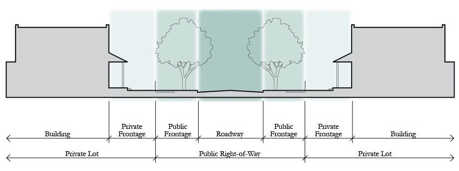
Prototypical Cross Section dimension requirements for the public right-of-way components for principal roadway types are outlined in the Figures and Tables 4.7.1A—E as follows (Landscape in the Figures are for illustration purposes only; landscape shall be designed and installed consistent with the requirements in this Code):
1.
Alleys.
a.
Residential One-Way Alley — Easement twenty-one (21) feet.
b.
Commercial One-Way Alley — Easement thirty-three (33) feet.
c.
Commercial Two-Way Alley — Easement thirty-seven (37) feet.
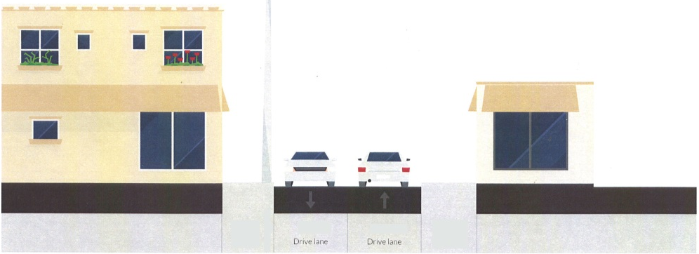
Notes:
For lots within a Mixed Use District and Urban Infill Centers: Off-street parking and service/loading area shall be accessed by a rear alley, shared driveway or local street other than a framework street within Centers.
For lots within a Mixed Use District: Neighborhood lots fronting on a Framework Street shall be accessed from the rear.
For lots not within a Mixed Use District and Urban Infill Centers: Alleys are required when lots front a framework street.
For lots on a Mews: Requires a two-way Alley section.
Demonstrate safe delivery truck movement on Commercial Alleys.
For concrete pavement, curbing not required, but travel lane shall be increased to a minimum of twelve (12) feet for Residential Alley and twenty (20) feet for Commercial Alley.
Miami curb or ribbon curb may be used in lieu of curb and gutter.
Residential alleys may contain two-way traffic if an additional eight (8) feet of pavement is added to the section.
2.
Local Streets.
a.
One-Way Local Street.
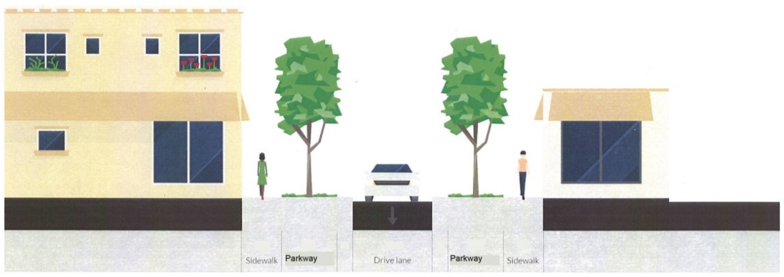
b.
One-Way Local Street with on-street parking on one side.
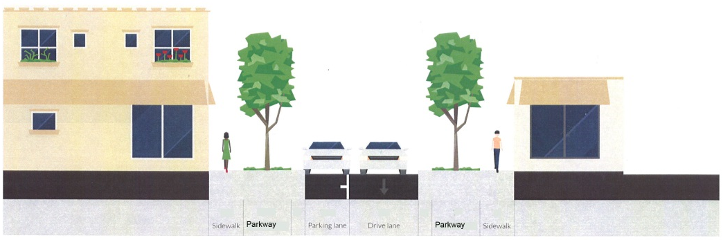
c.
One-Way Local Street with on-street parking on both sides.
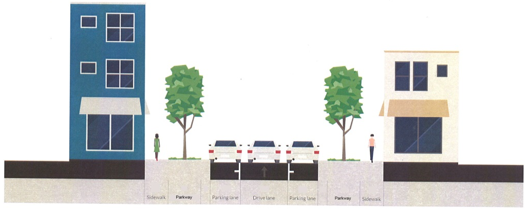
d.
Two-Way Local Street.
e.
Two-Way Local Street w/Optional Median.
f.
Two-Way Local Street w/On-Street Parking.
g.
Two-Way Local Street w/Median and On-Street Parking.
Notes:
1. Table covers half-section. Total right-of-way requirement is based on total number of travel lanes provision for on-street parking and turn lanes, and both halves of the typical cross section.
2. Local streets are exempt from left turn lane requirements.
3. Option: If on-street parking is provided the applicant may alternate (flip) Parkway and sidewalk locations and sidewalk shall then be a minimum of six (6) feet.
4. Minimum eight-foot (8')-wide sidewalk required for Urban Center Core/Perimeter and Employment Center Core/Perimeter.
5. Sidewalks not required outside Urban Growth Boundary or within a Rural Enclave area.
6. Where a road runs through or is adjacent to Open Space, the sidewalk can be deleted if there is a multiuse trail on the same side of the street which connects to the sidewalk network; a sidewalk is required on the opposite side of the roadway, unless the same condition exists.
7. Minimum eight-foot (8') Parkway width for Urban Infill Centers and Mixed Use Districts (except for OS placetype, which varies). For one-way street, where there is only one (1) travel lane, typical section shall include a mountable curb and stabilized parkway to meet requirements for emergency access. In this instance, parkway shall be increased to a minimum of seventeen (17) feet on one side to accommodate stabilized portion and required tree plantings. With two (2) travel lanes on a one-way street section, minimum parkway width shall be seven (7) feet.
8. The dimensions for parkways may be modified to accommodate the spacing needs for curbs.
9. On-street parking is not required where a road runs through or is adjacent to Open Space other than parks, or within NH1 or LDR.
10. Utilities may be approved at any location within the ROW.
11. Only sidewalks and travel lanes shall be required on bridges.
12. Dimensions for medians are measured from edge of travel lane to edge of travel lane. The dimensions for medians may be modified up to two (2) feet on either side to accommodate the spacing needs for curbs.
13. Requires a minimum twenty (20) feet width of unobstructed pavement/stabilized surface (minimum thirty-two (32) tons) for emergency access.
14. Medians shall not exceed seventy-five (75) feet in length, with a minimum of fifty (50) feet of separation between medians, to allow adequate emergency vehicle operations. Signs prohibiting parking or other obstructions shall be posted for areas included to meet this requirement.
3.
Avenues and Boulevards. Existing and planned framework network, shown as Avenues and Boulevards are identified in the Adopted Roadway Network (TRN 1) and Roadway Classification System (TRN 2) map series of the Transportation Element, as well as in the East of Lake Toho (Map ELT3), and South Lake Toho (Map SLT3) Element Maps of the County Comprehensive Plan, and in the Narcoossee Overlay District Mobility Framework Map identified in this Code. The adoption by the Board of other Special Area Plans will include the designation of framework streets where appropriate.
a.
Two-Lane Avenue.
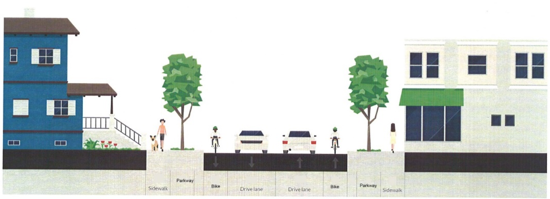
b.
Two-Lane Avenue with On-Street Parking.
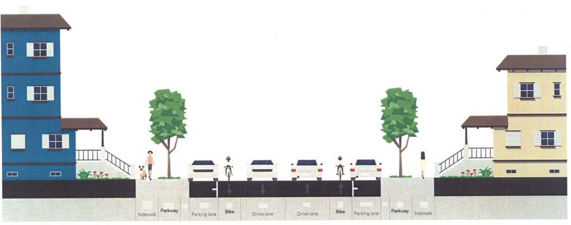
c.
Two-Lane Avenue/Boulevard with Median/Turn Lane.

d.
Two-Lane Avenue/Boulevard with Median and On-Street Parking.
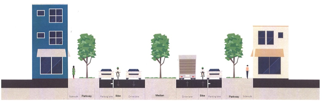
e.
Four-Lane Avenue/Boulevard with Turn Lane/Median.
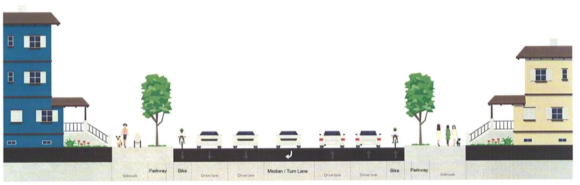
f.
Four-Lane Avenue/Boulevard with Turn Lane/Median and On-Street Parking.

Notes:
1. Table covers half-section. Total right-of-way requirement is based on total number of travel lanes, provision for on-street parking and turn lanes, bicycle facilities and both halves of the typical cross section. A PD&E study may allow for the use of a multi-use trail of at least ten (10) feet in lieu of buffered bike lanes.
2. Developer option: when on-street parking is provided, design may alternate (flip) sidewalk and parkway location. Sidewalk shall be a minimum of six (6) feet when located adjacent to the on-street parking.
3. Ten-foot (10')-wide Multi-Use Path shall be provided at schools and through Urban Infill Centers as well as to connect all civic spaces with schools and centers.
4. Sidewalks not required outside Urban Growth Boundary or within a Rural Enclave area.
5. Where a road runs through or is adjacent to Open Space, the sidewalk can be deleted if there is a multiuse trail which connects to the sidewalk network; a sidewalk is required on the opposite side of the roadway unless the same condition exists.
6. Minimum eight-foot (8') Parkway width for Urban Infill Centers and Mixed Use Districts (except for OS Placetype, which varies).
7. On-street parking is not required where a road runs through or is adjacent to Open Space other than parks, or within NH1 or LDR.
8. On-street parking areas shall have bulb-outs at intersections.
9. For lots within a Mixed Use District: on-street parking only required in Centers and Placetype NH2. Within the Urban Infill area, on-street parking is only required in zoning districts MDR or higher intensity/density according to the Use Table 3.4 (see Note 7 above).
10. Within a Neighborhood Center Core on-street parking will be required.
11. At the developer's discretion, as justified by the travel demand a 4-Lane option may be applied to portions of a Boulevard/Avenue in the Mixed use District by adding two (2) travel lanes and expanding the Turn Lane/Median to fifty (50) feet.
12. Dimensions for medians are measured from edge of travel lane to edge of travel lane. The dimensions for medians may be modified up to two (2) feet on either side to accommodate the spacing needs for curbs.
13. Only sidewalks, bike lanes and travel lanes shall be required on bridges, consistent with requirements for width herein.
14. In the Mixed Use Districts, Avenues and Boulevards shall have medians within the ROW.
15. Rear-loaded Alleys are required when lots fronting an Avenue or Boulevard.
16. Requires a minimum twenty (20) feet width unobstructed travel way, which includes mountable curb, travel lane and bike lane. If median is stabilized to minimum thirty-two (32) tons and unobstructed for required width, median may be used to meet part of requirement. Signs prohibiting parking or other obstructions shall be posted for areas included to meet this requirement.
4.
Premium Transit Corridor. Existing and Planned Premium Transit Corridors are identified in the adopted roadway network (TRN 3) and roadway classification system (TRN 2) map series of the Transportation Element, as well as in the East of Lake Toho (Map ELT3), and South Lake Toho (Map SLT3) Element Maps of the County Comprehensive Plan, and in the Narcoossee Overlay District Mobility Framework Map identified in this Code. Premium Transit corridors have the ability to shift roadway elements within the ROW "envelope" dependent on site and use constraints.
Notes:
1. Table covers half-section. Total right-of-way requirement is based on total number of travel lanes, provision for on-street parking and turn lanes, bicycle facilities, and both halves of the typical cross section. A PD&E study may allow for the use of a multi-use trail of at least ten (10) feet in lieu of buffered bike lanes.
2. Ten-foot (10')-wide Multi-Use Paths shall be provided at schools and through Urban Infill Centers as well as to connect all civic spaces with schools and centers.
3. For the Mixed Use District properties, a minimum eight-foot (8')-wide sidewalk is required for Placetypes NH2, NC and CC. A minimum ten (10')-foot wide sidewalk is required for Placetypes UC and EC.
4. For the Urban Infill Centers, a minimum of eight-foot (8')-wide sidewalk is required for Neighborhood Center Core and Community Center Core/Perimeter. A minimum ten-foot (10')-wide sidewalk is required for Urban Center Core/Perimeter and Employment Center Core/Perimeter.
5. Sidewalks not required outside Urban Growth Boundary or within a Rural Enclave area.
6. Where a road runs through or is adjacent to Open Space, the sidewalk can be deleted if there is a multiuse trail which connects to the sidewalk network.
7. Minimum eight-foot (8')-wide Parkway width for Urban Infill Centers and Mixed Use Districts (except for OS Placetype, which varies).
8. On-street parking is not required where a road runs through or is adjacent to Open Space other than parks, or within NH1 or LDR.
9. On-street parking areas shall have bulb-outs at intersections. Additional curbing may be required to separate transit lane/bike lane from parking/travel lanes.
10. For lots within a Mixed Use District: On-street parking only required in Centers and Placetype NH2. Within the Urban Infill Area, on-street parking is only required in zoning districts MDR or higher intensity/density according to the Use Table 3.4 (see Note 7 above).
11. Within the Neighborhood Center Core, on-street parking will be required.
12. A 4-lane option may be applied to portions of a Premium Transit Corridor by adding two (2) travel lanes.
13. Dimensions for medians are measured from edge of travel lane to edge of travel lane. The dimensions for medians may be modified up to two (2) feet on either side to accommodate the spacing needs for curbs.
14. Only sidewalks, transit lanes, bike lanes and travel lanes shall be required on bridges.
15. Rear-Loaded Alleys are required when lots front a Premium Transit Corridor.
16. Bike lanes shall be a minimum of five (5) feet when adjacent to on-street parking.
17. Requires a minimum twenty (20) feet width unobstructed travel way, which includes mountable curb, travel lane(s) and bike lane. If median is stabilized to minimum thirty-two (32) tons and unobstructed for required width, median may be used to meet part of requirement. Signs prohibiting parking or other obstructions shall be posted for areas included to meet this requirement.
5.
Transit Only Corridor.
Notes:
1. For the Mixed Use District properties, a minimum eight-foot (8')-wide sidewalk is required for Placetypes NH2, NC and CC. A minimum ten-foot (10')-wide sidewalk is required for Placetypes UC and EC.
2. For the Urban Infill Centers, a minimum eight-foot (8')-wide sidewalk is required for Neighborhood Center Core and Community Center/Perimeter. A minimum ten-foot (10')-wide sidewalk is required for Urban Center Core/Perimeter and Employment Center Core/Perimeter.
3. Dimensions for medians are measured from edge of travel lane to edge of travel lane. The dimensions for medians may be modified up to two (2) feet on either side to accommodate the spacing needs for curbs.
C.
MINIMUM GROUNDWATER AND HIGHWATER CLEARANCES. All streets and roadways shall be designed to provide a minimum clearance of two (2) feet between the bottom of the base and the established seasonal high ground water table or as artificially lowered by design. The minimum clearance may be reduced by providing a design pavement and/or base design to allow for the reduction.
D.
CURBS AND GUTTERS. No water valve boxes, meters, portions or manholes, or other appurtenances of any kind, relating to any underground utilities, shall be located in any portion of a curb-and-gutter section. Storm inlets are exempt from this requirement. The minimum allowable flow line grade of curbs and gutters shall be zero-point-three percent (0.3%).
E.
CRITERIA FOR USE OF UNDERDRAINS. The planned use of underdrain systems which control the seasonal high water table, as required, is allowed with the following requirements and limitations.
1.
Underdrains shall be designed and constructed in compliance with the Osceola County Road Construction Specifications.
2.
The underdrain trench bottom shall not be placed below the seasonal low water table elevation. The stormwater facilities shall be designed to accommodate the expected flow contributed by the underdrain system.
3.
Wherever roadway construction reveals unexpected water bearing strata that would cause deterioration of the pavement, underdrains or other acceptable alternative that will provide necessary measures to maintain the structural integrity of the road will be required, even though not shown on the plans.
F.
BRIDGES.
1.
Prior to design of a bridge, the developer's engineer shall submit design load criteria to the County Manager for approval.
2.
Bridge design, as well as the materials and methods of construction, shall conform to the Department of Transportation Standard Specifications for Road and Bridge Construction, latest edition.
G.
CUL-DE-SACS. Cul-de-sacs shall be provided with a paved turn-around with a radius of thirty-six (36) feet. Cul-de-sacs shall incorporate a ribbon curb within their design. In the Urban Infill Centers, cul-de-sacs shall be prohibited unless site constraints make it impossible to connect to adjacent properties and proper justification is provided.
H.
INTERSECTION DESIGN. Streets shall be laid out to intersect as nearly as possible at right angles with a minimum straight tangent depth of one hundred (100) feet. Intersections involving the juncture of more than four (4) legs shall incorporate an appropriate traffic calming alternative. Adequate sight distances must be maintained.
I.
CENTERLINE RADIUS FOR LOCAL STREETS. For local streets, the centerline radius shall be a minimum of fifty (50) feet.
J.
STREET NAMES. All street names shall be approved by the County Manager.
K.
SUBDIVISION ON MULTIMODAL CORRIDOR, AVENUE OR BOULEVARD. To adequately protect abutting residential properties, double-frontage lots in the Urban Infill Area shall be required to have screening walls and/or landscaping buffers, or other treatment as outlined herein unless the adjacent roadway is a section that already includes a buffer. Such walls, landscape screens or other buffer treatments shall be located in separate tracts. These lots shall not have vehicular access onto external roadways and access rights, for these tracts, shall be dedicated to the County. Lots that have rear vehicular access and corner lots are not considered double frontage lots with respect to this paragraph.
L.
HALF STREETS. Where applicant is required to dedicate half of required ROW cross section, the half section shall be permitted where a half street or an existing street abuts a tract to be subdivided. The second half of the street shall be platted within the tract being subdivided and the entire street shall be improved as determined by the County.
(Ord. No. 2025-10, § 5, 3-17-2025)
4.7.2 - PRIVATE ROADS
Private roadway sections are not encouraged within the UGB and Urban Infill Centers however, they may be permitted by the County Manager subject to the following criteria.
A.
Within the Urban Infill Area, local streets may be private so long as the private street network is maintained for public access and pedestrian and bicycle systems are not blocked from public access.
B.
Where private roadways are permitted or necessary, such roadways shall not be required to conform to the standards found in the Osceola County Road Specifications manual.
They shall be required to be certified by a licensed engineer to specifications acceptable to the County Manager that provides for an acceptable level of access management and accommodates emergency service vehicles.
C.
Private roadways shall be required to provide for a financing mechanism acceptable to the County Manager for perpetual maintenance.
D.
Gated access may only be permitted where an applicant can demonstrate that a dead-end roadway network exists or is justified given the site constraints of a subject property. Site constraints include natural systems required to be protected by agency permits or County ordinance, or where feasible connections cannot be made. Where permitted, gates shall be located on private roadways provided that adequate setbacks ensure that no vehicular stacking occurs on public roadways. The location of gates shall maintain local street connection and block standards for the public; and, pedestrian and bicycle systems shall not be blocked from public access. In the event that a gate causes stacking on public roadways, the gates shall be removed or relocated to be consistent with the provisions contained herein. Gated streets within the Mixed Use District and the Urban Infill Centers shall be prohibited.
E.
Private roadways shall not be accepted by the County for maintenance unless they are first brought to public standards. Right-of-way widths less than public standards may be accepted by the County. Required improvements to public standards shall be achieved through private funding prior to acceptance by the County. If private funding is not available as determined by the County Manager, tax assessments of those properties served by the subject roadways may be implemented to bring the roadways to public standards.
(Ord. No. 2025-10, § 5, 3-17-2025)
4.7.3 - TRAFFIC CALMING
Local streets shall be designed to include physical measures and visual cues, to limit excessive speeds of vehicles without relying on compliance of design control devices. Streets within mixed use and residential developments shall be designed for a target design speed of twenty-five (25) mph. The County Manager shall consider the context of an individual street to determine if an adjustment to this base design speed is warranted. Nothing here shall limit the County Manager's ability to install any devices upon County roadway system that is justified for the maximum safety of motorists, transit vehicles and riders, pedestrians or bicyclists.
A.
DESIGN CONTROLS. Traffic calming devices are to be incorporated into the design of the travel way to counter the adverse impact of speeding and non-resident cut-through traffic on residential streets. Traffic calming design controls incorporated shall be consistent with those outlined within the ITE Manual referenced. Boulevards/Avenues with an ADT of less than two thousand (2,000) vehicles per day may be considered for restrictive traffic calming on a case-by-case basis.
The following general policies shall apply:
1.
Less restrictive and the least costly methods should be attempted prior to the application of more restrictive traffic calming.
2.
Installation of restrictive devices on horizontal curvatures, near intersections, or in combination with other safety or regulatory measures is not recommended.
3.
Unwarranted "STOP" signs shall not be used as traffic calming devices.
4.
Traffic calming on unimproved (dirt) roads will not be authorized.
B.
FINDINGS. In order for a travel way location to be considered for traffic calming design controls, the County Manager must determine that the installation of such devices are justified based on a traffic study. A location may be considered for traffic calming if all of the criteria are satisfied:
1.
The roadway is a local street or qualifying avenue or boulevard; and
2.
The average daily traffic (ADT) is less than two thousand (2,000) vpd; and
3.
The candidate roadway length is greater than one thousand five hundred (1,500) feet.
4.
The official posted speed is thirty-five (35) mph or less, and
5.
The median speed is at least twenty-five percent (25%) over the posted speed.
Nothing here shall limit the County's ability to install any devices upon a County roadway system that in the County Manager's sole opinion is justified for the maximum safety of the motorists or the residents.
4.7.4 - PEDESTRIAN SIDEWALKS
A.
Sidewalks shall be required on all non-limited access, premium transit corridors, avenues and boulevards, local roads and all streets within subdivisions inside the urban growth boundary as defined in the Comprehensive Plan and in accordance with the provisions herein. In addition, the County Manager may require connector sidewalks on off-site streets to an existing sidewalk system or roadway and along framework streets or local rural roads if needed for safety, and if a reasonable necessity for the sidewalk is demonstrated and the connection does not exceed two hundred (200) feet. These shall be at the applicant's expense. Should the off-site connector sidewalk exceed two hundred (200) feet in length, the County Manager may still require construction due to safety concerns, with the County reimbursing the applicant for the cost of construction of any part of the sidewalk and ancillary improvements that are beyond the two hundred (200)-foot mark. Where required, sidewalks shall be put in prior to issuance of building certificate of occupancy.
B.
A permanent curb ramp shall be installed at crosswalks at all intersections where curbs and sidewalks are constructed in order to accommodate the Americans with Disabilities Act (ADA) standards at crosswalks.
C.
Sidewalks along roadways shall be constructed consistent with the requirements in the roadway typical sections outlined herein.
The sidewalk shall be separated from the roadway by the minimum width of the road side clear zone (minimum three (3) feet). An exception for this shall be where the sidewalk is constrained to be adjacent to the roadway curb. This sidewalk shall be a minimum of six (6) feet wide and a type F curb is required.
D.
An applicant may request the County Manager to approve a payment to the County in lieu of constructing the required sidewalks. The County Manager may approve such request where physical impairments cause undue hardship or create an unsafe condition. In making the determination, the County Manager may require additional easements/right-of-way or other considerations to ensure a safe sidewalk may be constructed in the future. The payment shall be made into the Osceola County sidewalk fund or account. The County may use this fund to construct sidewalks in other areas where more immediate pedestrian needs exist and where it would eliminate construction of isolated sections of sidewalks.
E.
The amount of money to be paid by the applicant to the County shall be determined by the County Manager after the applicant has submitted final construction plans and cost estimates for the required sidewalks and appurtenances. The payment to the County in lieu of the construction shall be made prior to the issuance of any building permit.
For multi-family, commercial, institutional and industrial developments, sidewalks providing pedestrian access from the building to the right-of-way shall be installed. The sidewalks shall meet accessible route requirements in the Florida Building Code and shall be a minimum of five (5) feet wide.
4.7.5 - MASS TRANSIT
Applications for new developments located within one-half (½) mile of the centerline of the identified Premium Transit Corridors as shown on Map TRN-3 of the Osceola County Comprehensive Plan shall incorporate transportation mitigation strategies from the following alternatives. All selections are subject to the approval of the County Manager. Payments shall be made prior to issuance of SDP permit for any payment option selected. Should the County adopt impact fees or similar exactions for transportation purposes within five (5) years of the payment associated with improvements, and the improvements would be eligible for credits within the exaction ordinance, the contribution (or any construction in lieu of contribution) shall be credited against the fees on a dollar for dollar basis in the following manner: any development occurring prior to the effective date of the exaction but occurring after the contribution or construction (pre-occurring development), shall be credited at the fee rate applied in the exaction; should the credits be used up with the pre-occurring development, then no further credits will be available for the development. There shall be no additional fees for the pre-occurring development. Should credits remain after applying the contribution to the pre-occurring development, then the credits shall be applied to the development occurring after the effective date of the exaction on a dollar for dollar basis until the credits are used up. Credits shall run with the property upon which payments have been made and are not transferable to other properties.
Unless specified otherwise herein, applicants shall be required to select and comply with any three (3) of the following:
A.
Provide a one-time payment to the County for the cost of installing solar lighting, or install with the permission of the transit provider, in any existing transit shelters serving the development site.
B.
Provide a one-time payment to the County or mass transit provider for the cost of constructing transit shelters, located approximately at a one-half (½) mile separation, to serve the proposed development or construct the improvements consistent with approved design specifications.
C.
Provide a one-time payment to the County for the cost of constructing transit turn-out facilities to serve the development or construct the improvements consistent with approved design specifications.
D.
Provide an easement on property to accommodate a super bus stop or transit transfer station and/or a one-time proportionate share payment to the County or other transit provider for the construction of super bus stops or transit transfer station to serve the development.
E.
Provide a one-time payment into the County's sidewalk fund or construct pedestrian connections from a designated transit stop area on the development site to the existing pedestrian system. Sidewalk construction required to meet the LDC requirements along property frontages shall not count as meeting the Multi-modal enhancement criteria.
F.
Install pedestrian crossings that provide enhanced pedestrian signals for vehicular travel.
G.
Provide a one-time payment to County or install an approved landscape enhancement, as defined herein.
H.
Provide shading through awnings or similar enhancement over private sidewalk areas that serve the development to offer protection from the weather so that walking is encouraged. Pedestrian shading shall be provided for the entire length of all private sidewalks adjacent to the development site.
I.
Construct a bike-transit center on the development site to serve the development and, in conjunction with said construction, the developer shall secure the ability to run and maintain the center in perpetuity, in a manner acceptable to the County Manager.
J.
Provide enhancements to the County's trail network to serve the development in a manner which increases its utility as a multi-modal transportation route. Such enhancements may include, but not be limited to: a) trail amenities such as benches or drinking fountains; b) bicycle parking at entry points; c) land acquisition for expansion or better connectivity of the trail network; d) additional entry points to the trail network; and/or e) pedestrian bridges spanning water bodies or wetland areas.
K.
Provide reserved and designated parking spaces closest to the building entrances at the development site (subject to required handicap parking spaces) for car-sharing/pooling program vehicles to encourage participation and visibility.
L.
Provide a transportation demand management plan to serve the development that makes reasonable incentives available for employees and residents to use transportation modes other than single occupant vehicles, in accordance with the goals of the County's Transportation Element. Such a transportation demand management plan shall provide annual operations reports to the County for at least ten (10) years, indicating achievements in the main goal of reducing single occupant vehicle trips.
M.
Any other multimodal enhancement to implement the County's Comprehensive Plan, as approved by the County Manager.
4.7.6 - PARKING LOT/STRUCTURED PARKING
In order to protect the public interest, welfare and safety, Osceola County requires adequate off-street parking, off-street loading and adequate ingress and egress for the users of the development. Such parking shall be maintained and continued as an accessory use so long as the main use is continued. With this intent in mind, parking requirements may be different within the Urban Infill Area, Urban Infill Centers of the County and the Urban Expansion Area (Mixed Use Districts) of the County. The specifics for these areas are outlined herein.
A.
LOCATIONS AND SPECIFICATIONS OF OFF-STREET PARKING AREAS.
1.
Location within Urban Infill Centers. Off-street parking within the Build-to-line is prohibited. Off-street surface parking areas and service/loading areas shall be located to the rear and/or side of a structure and screened from the public right-of-way by liner buildings or a streetscreen. Required on-street parking is excluded from this provision.
2.
Parking Spaces. Minimum dimensional requirements for standard parking spaces are as shown in Figure 4.7.6 below. Handicapped parking spaces shall be in conformity with applicable State and Federal ADA regulations.
Figure 4.7.6 Parking space dimensions
Note: For one-way drive aisles, direction may be changed at the option of the applicant for one-way drive aisles. Landscape islands shown are illustrative only.
3.
Parking Access Aisles. Dimensions shown in Table 4.7.6 below are the requirements for parking aisle access ways within a parking lot.
4.
Specifications. The following specifications shall be applicable to all off-street parking areas. In addition, parking areas for outdoor display of vehicles for sale shall also be subject to the paving, lighting, setback, and drainage specifications outlined herein.
a.
All parking areas, spaces, driving aisles and access points shall be paved and be clearly identifiable by marking, curbing, wheel stops or other alternatives agreed upon by the County Manager. If it can be demonstrated to the satisfaction of the County that alternative parking facility arrangements are necessary based on site constraints and design goals, these may be granted. Alternative parking facilities may include but not be limited to pervious materials, such as gravel, wood chips, or grass surface may be used. For the purpose of this Article, paved shall be defined as a durable all-weather surface consisting of an improved smooth surface, including but not limited to concrete, asphalt, brick, or other materials constructed so as to form a continuous, permanent surface.
b.
All one- and two-family dwellings shall provide parking as required herein and driveways shall be a minimum of eight (8) feet in width and shall have a minimum length of twenty-five (25) feet, measured from the property boundary, if the driveway is being used to satisfy the required parking criteria, and such measurement shall not include width of any required or existing sidewalk. One- and two-family dwellings, which provide garage or carport parking, may count the parking area contained within the carport or garage as part of the required parking area.
c.
A space in a multi-family, commercial, or industrial development shall be designed so that cars are not required to back directly into a public right-of-way.
d.
Except as provided herein, parking areas shall have a minimum seven (7) feet setback from all property lines, measured to the edge of the parking area pavement and parking and loading entrances. These unpaved areas shall be landscaped in accordance with the Code. Single-family residential is exempt from this requirement.
e.
Drainage plans for all parking areas shall be approved by the County Manager.
f.
Parking areas that are lit shall adhere to lighting standards outlined herein.
g.
All spaces may incorporate an overhang into a landscaped area within the front two (2) feet of each parking space, provided secured wheel barriers are placed at the termination of the parking space pavement. If parking overhangs a sidewalk, then the sidewalk shall be increased by two (2) feet or a wheel stop will be incorporated.
h.
Required parking facilities shall be located on the same lot or parcel of land they are intended to serve, except as noted further in this Code.
i.
Vehicle cue within drive through service aisle(s) shall not apply toward compliance with minimum required off-street parking.
j.
Parking for any employee and commercial vehicle which includes a sign, including vehicles used for unloading and loading, shall be located to the side (provided it is not a corner lot) or the rear of the building. Parking/loading shall only be permitted in approved and marked parking spaces for this purpose. This would not pertain to vehicles patronizing the particular business the parking serves and parked in legally marked parking spaces available for patrons. The County Manager may approve alternative locations as long as the parking areas are screened from the public right-of-way by adequate screen walls and landscaping.
4.7.7 - ALTERNATIVE PARKING ARRANGEMENTS
The County Manager has the authority to approve alternative parking arrangements. The applicant shall submit a plan and a narrative documenting the need for the alternative arrangement to be considered by the County. The applicant shall provide sufficient documentation that establishes maximum and minimum parking requirements within the SDP. The County shall review the plans in accordance with the criteria cited below.
A.
OFF-SITE PARKING. As outlined herein, required parking facilities shall be located on the same lot or parcel of land they are intended to serve. The County may allow the establishment of such off-site parking facilities, from the premises they are intended to serve in circumstances in which practical difficulties prevent placing the facilities on the same lot as the premises they are designed to serve. This exception shall meet all of the following conditions:
1.
The owner of the parking area shall enter into a written agreement with the County which will be recorded in the public records of Osceola County at the expense of the applicant. The agreement shall provide that the land comprising the parking area shall never be disposed of, without County approval.
2.
The agreement shall bind the applicant's heirs, successors and assigns. The written agreement may be terminated by the County if other off-street facilities are provided in accordance with this Chapter. The termination of the agreement shall also be recorded in the public records of Osceola County at the expense of the applicant.
3.
The developer provides a sidewalk which connects the parking area and the principal use for which the parking area serves;
4.
For areas where parking is provided further than five hundred (500) feet from the principal use or requires pedestrians to cross streets where pedestrian safety is a concern, alternative arrangements (e.g., valet service, shuttle service, crossing guards) may be required by the County Manager to ensure safe access to the principal use.
5.
Structured parking and surface parking entries and driveways within all Urban Infill Centers shall be located at least seventy-five (75) feet away from any block corner or another garage or parking area entry on the same side of the same block.
B.
COMBINED OFF-STREET PARKING. Two (2) or more owners or building operators, requiring off-street parking facilities or means of ingress and egress, may make collective provision for such accommodation if uses are adjacent to one another and parking is provided to accommodate the requirements for both combined. All combined parking shall be located in an area providing reasonable walkability to all uses which the parking is intended to serve. In cases where parking is requested on lots under different ownership, a cross-parking easement shall be recorded as part of the plat or by separate instrument. Also, provision for ingress and egress shall be made as though all properties involved were under one (1) ownership. Written agreements, covenants, and contracts shall be submitted prior to SDP permit approval, and approved and accepted by the County. These documents shall ensure that the parking area is to be jointly used, and assigns responsibility for maintenance. The County shall review these agreements along with the SDP development plans.
C.
SHARED PARKING. Within the UGB, shared parking is encouraged, whereby the mix of uses sharing the parking facility is conducive to reducing the number of required spaces (e.g., non-overlapping operating hours, support uses for principal tenant, etc.) and impervious surface and supports walkability. The County Manager has the authority to approve shared parking concepts dependent on the mix of land uses requiring the parking. The applicant shall submit a plan documenting the operations of the facilities and covenants or agreements (if necessary) to implement the approach in perpetuity.
D.
ON-STREET PARKING. The provision of on-street parking will count towards satisfying required parking for adjacent properties and will justify a commensurate reduction in off-street parking.
4.7.8 - AMOUNT OF OFF-STREET PARKING
The off-street parking requirements are set forth in Table 4.7.8 below. Each category is also responsible for handicapped parking as set forth in applicable State and Federal guidelines. For any use not specifically enumerated, the requests for off-street parking shall be determined by the County Manager based upon the listed use which is most similar. If there is not a listed use which is similar, the County Manager shall consult other reference sources to determine the appropriate standard for parking requirements. Should adjustments be requested (multiple uses, multiple parking facilities, public parking availability, etc.), the applicant shall provide sufficient documentation that demonstrates reduced or increased parking provided is justified. The County Manager may require covenants, easements, or other documentation to support the request prior to approval.
General Notes:
1. DU = Dwelling Units; GSF = Gross Square Footage.
2. Parking standards above do not apply to properties in the Mixed Use Districts or the East U.S. 192 Community Redevelopment Area. MXD development shall create parking standards and demonstrate parking requirements on individual SDPs. The East U.S. 192 Community Redevelopment Area has established parking requirements specific to the area.
3. Structured parking and surface parking entries and driveways within all Urban Infill Centers shall be located at least seventy-five (75) feet away from any block corner or another garage or parking area entry on the same side of the same block.
4. For single-family residential subdivisions, refer also to Section 4.6.1, subparagraph B., for additional onstreet and/or off-site parking requirements.
4.7.9 - OFF-STREET LOADING
Adequate off-street loading areas shall be provided that will allow for off-street loading, unloading and maneuvering of commercial vehicles that will be servicing commercial buildings. There shall be no loading or unloading of commercial vehicles on public rights-of-way. Ingress and egress for emergency vehicles shall not be impeded. Off-street maneuvering shall be provided so that there is no backing onto or from a public street.
A.
Service/loading areas shall be accessed by a rear alley, rear lane, shared driveway or local street other than a primary street within Centers.
B.
Off-street surface parking areas and service/loading areas shall be screened from the public right-of-way by liner buildings or a landscaping/street screen.
4.7.10 - DRIVE THROUGH FACILITIES
Drive through facilities are permitted as indicated in the Use Table 3.4 herein, with use siting standards as defined in Chapter 3, Article 3.8 of this Code, and as outlined:
A.
Each drive-through aisle shall be separated from the circulation routes necessary for ingress or egress from the property, or access to parking spaces. An escape lane should be provided when the drive through lane length exceeds one hundred (100) feet.
B.
Adequate queuing distance shall be determined based on a queuing study to determine appropriate length.
4.7.11 - STREET LIGHTING AND DEVELOPMENT LIGHTING
Appropriate lighting is desirable for nighttime visibility, crime deterrence and decoration. Lighting that is too bright or intense creates glare, hinders night vision and creates light pollution. It is the intent of these standards to provide outdoor lighting that contributes positively to the pedestrian-oriented environment of urban centers and urban neighborhoods. Dark Sky principles are not required.
A.
STREET LIGHTING.
1.
All streets or vehicular travel ways within the UGB shall be lighted at night with lights providing a minimum average illumination of zero-point-two (0.2) foot candles.
2.
Street lights shall preserve the ambiance of the night and respect the privacy of neighboring properties by applying pedestrian-scaled fixtures. Light poles shall be no higher than eighteen (18) feet within the UGB.
B.
SITE LIGHTING.
1.
Exterior site lighting shall be designed so as not to allow lighting to bleed over to adjacent properties or right-of-way (photometrics at 0.0 or minimum recordable by instrument at property lines) and to prevent direct view of light source or lens from adjacent property boundaries. However, when approved as part of an overall site lighting plan during the SDP review process, direct view of a light source may be permitted, provided the light source utilizes prismatic lens, frosted or amber globe, diffuser or shield, bulb coating, low wattage, or other means of reducing intensity of the light beyond the light source. Photometric testing and report indicating compliance with these requirements shall be required prior to issuance of Certificate of Completion or Certificate of Occupancy for the project.
2.
Canopy lighting fixtures, including lens covers, shall be recessed into the canopy ceiling or designed with fixture shields that prevent direct view of light source from adjacent property boundaries.
3.
Lighting elements shall provide full spectrum light so that colors at night are natural and realistic. Lighting elements that cast a clearly/perceptively unnatural spectrum of light (such as low-pressure sodium) are prohibited.
4.
Lighting and/or electrical plans designed for non-single-family residential developments shall identify the location of all exterior light fixtures. Manufacturers' cut-sheets identifying proposed light fixtures shall accompany all lighting plans.
5.
At no time shall light strips (LED/neon/etc.) be used on the exterior of any structure or interior of any window or door, which lighting is visible from an adjacent property or right-of-way, including but not limited to the framing of windows or doors. Permitted signs, consistent with this Code, are exempt from this requirement.
6.
When site lighting is adjacent to low density residential future land use or zoning districts, light poles and fixtures shall be no higher than eighteen (18) feet. Active sport fields are exempt from this height provision, as long as they meet the applicable requirements herein.
7.
Within the Urban Infill Centers light fixtures should be directed downward, with emphasis placed on the street level areas of the façade where the lighting will enhance pedestrian safety. Fixture styles, finishes and light source should be compatible with the scale and materials of the building façades, and complementary to awnings, signage and other features.
4.7.12 - TRAIL STANDARDS
Consistent with the Transportation Element of the Comprehensive Plan, a developer shall be required to install multi-use or equestrian/regional trails with each new development and may install trails to enhance the development.
A.
TRAILHEADS. Trailheads are public places to enter and exit a trail facility, and often include signage, informal kiosks with trail maps, and trash receptacles.
There are three (3) types of trailheads: trailheads with parking, trailheads with equestrian trailer parking, and non-parking access points. Trailheads that offer parking are typically never heavily utilized trails. The amount of parking offered at these trailheads is dependent on trail usage and available space. Non-parking access points are typically located on lesser-used trail systems.
Following are the elements that shall be located at each trailhead:
1.
Signage: Rules and regulations shall be located at all trailheads, and shall include trail etiquette, warnings about potential safety hazards, and permitted trail uses.
2.
Trash Receptacles: Trash cans shall be located at all County maintained trailheads, and shall be placed along heavily used trails.
3.
Dog Waste Disposal Stations: On trails where dogs are allowed, dog waste stations shall be provided at one (1)-mile intervals and at trailheads.
4.
Shade Structures: Where possible, shade structures shall be located at heavily utilized trailheads to offer relief from the sun and shelter from inclement weather.
5.
Lighting: In areas likely to receive use at night, pathway lighting shall be provided to avoid conflicts at intersections and allow users to better observe trail direction, surface conditions and obstacles.
6.
Restrooms: Where possible, restrooms shall be present at heavily utilized trailheads.
B.
TRAIL CROSSINGS. Trail crossings shall always be located perpendicular to the roadway, and shall be clearly marked. Crossings are encouraged to be located at signalized intersections, especially at major roadway crossings. If this is not feasible, a trail user activated flashing yellow light shall be used at the crossing on framework roads. These crossings shall also be striped, or utilize different paving methods to alert drivers to trail crossing locations. On local streets, trail crossings may be signed with only a stop sign.
C.
SPECIALTY TRAILS.
1.
Narcoossee Community Trails. Trails shall be aligned through the Narcoossee Area as illustrated on TRN5 of the Transportation Element Map Series. The identified trail system includes Planned Equestrian Trails/Multi-use Path; Planned Trail/Multi-use Path; and Existing Trails/Multi-use Path. The trails within the Narcoossee Community correlate as follows with the TRN5 Map and are detailed within the cross sections contained herein:
•
Planned Trail/Multi-use Path—Primary Regional Trail.
•
Planned Equestrian Trails/Multi-use Path—Secondary Off-street Trail.
Trail materials shall consist of integrally colored concrete multi-purpose paths, with striping, and soft surface equestrian paths. With much of the Narcoossee area already developed, the majority of these trails have been aligned within the fifty-foot (50') regulatory wetland buffers and along roadways. Connections between these buffers and the rights-of-way have generally been aligned through abandoned rights-of-way, and along property lines. Trail signage shall be designed to provide directional information and trail mileage.
| 1. Equestrian Trail/Primary Regional Trail — Mowed/cleared corridor |
 |
| 2. Equestrian Trail/Primary Regional Trail — Soft Surface |
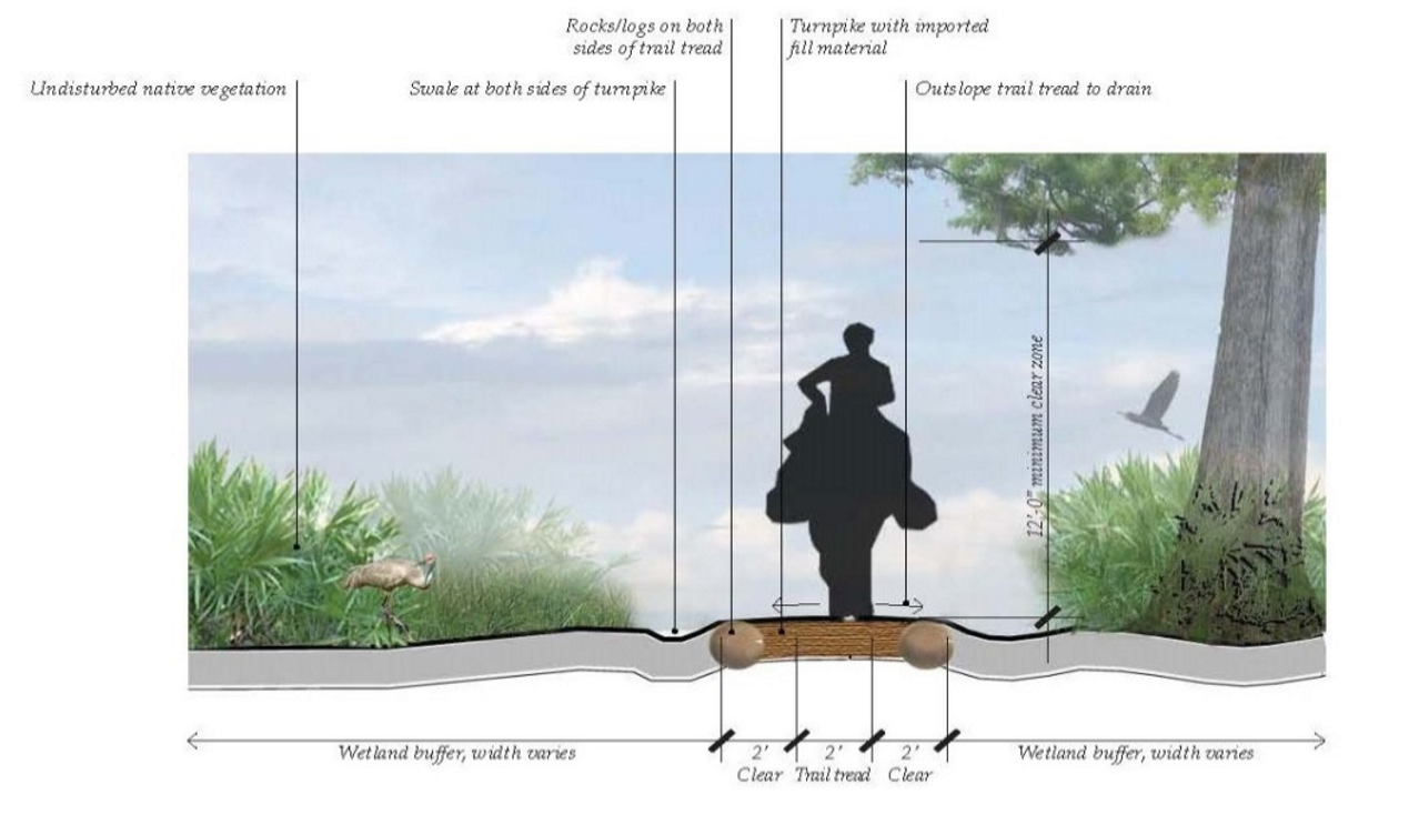 |
| 3. Equestrian Trail/Primary Regional Trail — Wet Areas |
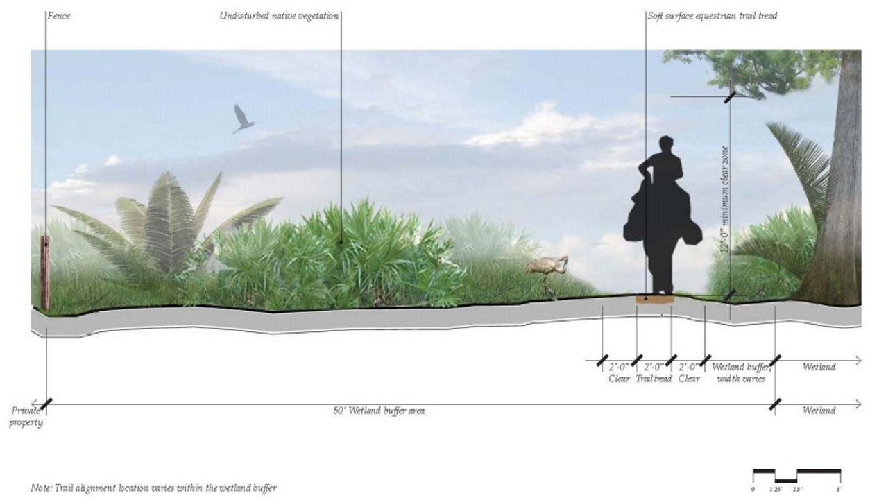 |
| 4. Multi-use Trail with Detached Equestrian Trail/Detached Trail and Bikeway |
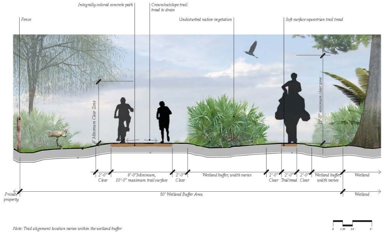 |
(Ord. No. 2025-40, § 3, 8-18-2025)
4.7.13 - INDIVIDUAL CORRIDOR REQUIREMENTS
The County has adopted standards for some of its existing and proposed roadways which may exceed the standards outlined herein. This section outlines some of the standards, which shall be implemented with each new development. Where there is a conflict with standards identified elsewhere in this LDC, the requirements in this Section shall govern.
A.
NARCOOSSEE COMMUNITY OVERLAY. The Narcoossee Community Overlay encompasses the area from East Lake Tohopekaliga to the western boundary of the Deseret Ranch, south to Highway 192 and Nova Road, and north to the Osceola-Orange County line. The planning process involved participation from landowners and residents in order to determine what the community should look like in the future. The Overlay document identifies ways that the area can proactively plan for growth while preserving the community's heritage and unique qualities. Map 4.7.13, Mobility Framework, identifies the framework streets proposed for the Narcoossee Community.
While all Avenues/Boulevards identified on the Mobility Framework are anticipated to have an ultimate cross section as shown, roads through the Equestrian Rural Character District will be constructed in separate, transitional phases. As new development occurs, and roadway traffic increases within the Narcoossee Area, these transitional streets are anticipated to be improved, facilitating more convenient, safer movement throughout the Equestrian Rural District. Jack Brack Road, Jones Road, McMichael Road and Zuni Road are classified as these transitional streets.
Phase I Transitional Cross Section, illustrated in this Section, provides a guideline for acceptable transitional sections in this Overlay Area for the identified framework streets. In order to mitigate impacts to adjacent residential neighborhoods Cyrils Roads will include heavily landscaped medians. All framework streets will include landscape treatments to emphasize the rural character of the community.
Map 4.7.13 Mobility Framework
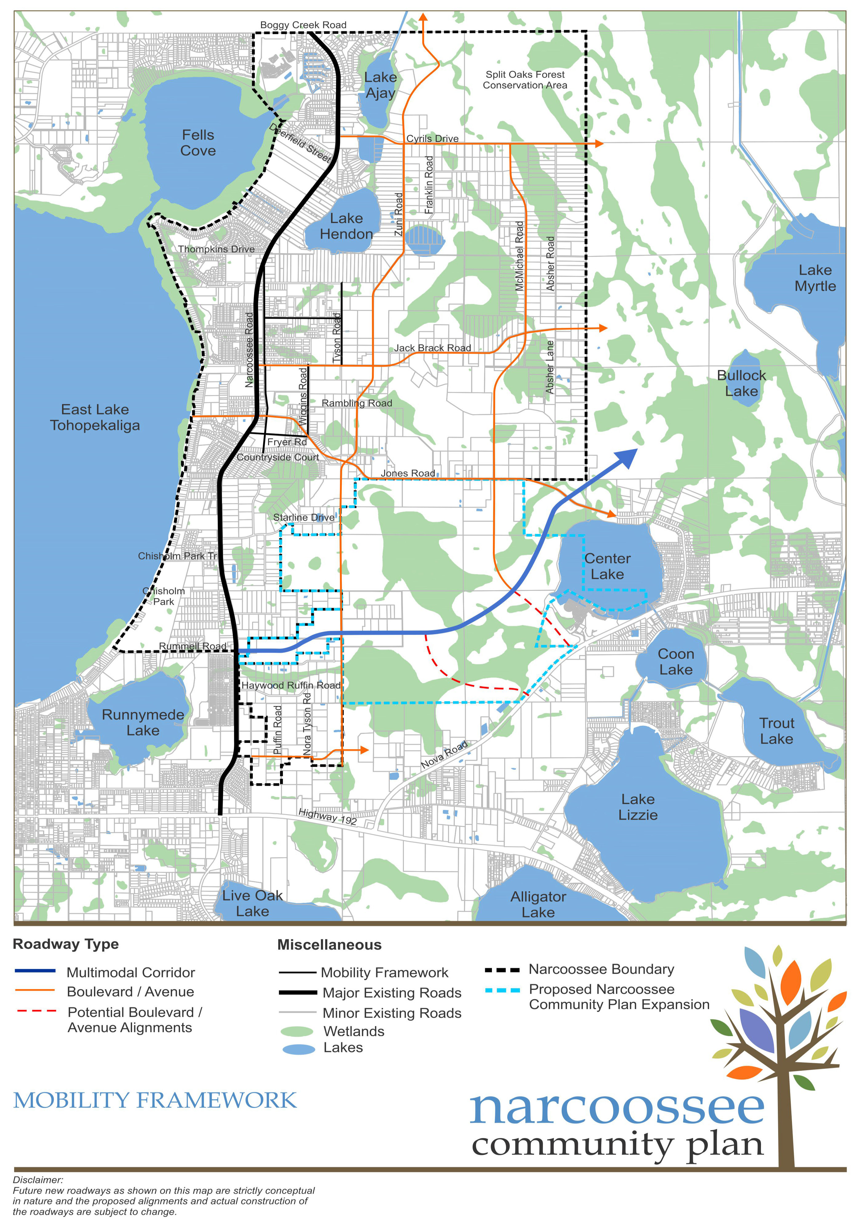
Phase 1 Transitional Cross Section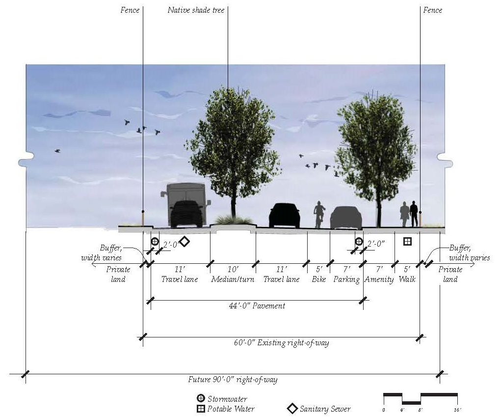
4.8.1 - APPLICABILITY
A.
The standards established in this Article are to be considered the minimum requirements for the design, plant selection, installation and maintenance of landscape elements and shall apply to all new development, within the Urban Growth Boundary.
B.
A development permit, land clearing authorization or tree removal permit is required prior to any activity on the site unless any of the following exemptions apply:
1.
The removal of naturally fallen vegetation.
2.
The limited removal of vegetation necessary to obtain clear visibility between two (2) points for the purpose of performing field survey work.
3.
The removal of trees and/or vegetation that, in the opinion of the County Manager is endangering public health, safety or welfare or the removal of trees and/or vegetation that, in the opinion of the County Manager, is dying, dead or otherwise in poor health, such that its restoration to sound condition is not practical, or there is the presence of a disease which can be transmitted to other trees and/or vegetation. This exemption only applies in those instances where notice has been provided by the County Manager as set forth herein.
4.
The removal of species listed by the Florida Exotic Pest Plant Council (FLEPPC) as Category I invasive species for Central Florida.
5.
The removal of vegetation planted on the premises of a plant nursery or tree farm and grown for the purpose of selling to the general public in the ordinary course of business.
6.
The transplanting of understory vegetation including any tree with a D.B.H. of less than four (4) inches, for use as landscaping material within the site or off the site (D.B.H. = Diameter at Breast Height which is fifty-four (54) inches above existing grade. If there are multiple trunks then the largest trunk shall be used for this measurement). The SDP landscape plan shall indicate the relocation of any plant material.
C.
Prior to the installation of any landscaping within public rights-of-way, if not part of a previously approved SDP, a right-of-way use permit shall be obtained in accordance with the guidelines herein.
D.
In the event that a principal use and some or all of the parking area (required or otherwise) serving the principal use are located on separate parcels, as permitted by this LDC, the open space and landscape required by this Article may be apportioned among all parcels in a cohesive fashion as approved on the SDP.
4.8.2 - LANDSCAPE PLANTING AND IRRIGATION OBJECTIVES
The landscape plan shall be prepared by a qualified professional with knowledge of the natural systems of the region such as a Landscape Architect or Horticulturalist. For development other than single-family and two-family dwellings on individual lots, or other than for new development over one-half (½)-acre in size, qualified professionals can be an engineer, architect or landscape architect registered in the State of Florida or any nurseryman, nursery stock dealer, or agent as defined by F.S. ch. 581, who is required under F.S. ch. 581 to hold a valid license issued by the division of plant industry of the department of agriculture and consumer services and who does hold a valid license to engage in the selling of nursery stock in the State of Florida, insofar as he engages in preparation of plans or drawings as an adjunct to merchandising his product. For new development over one-half (½)-acre in size, the landscape plan shall be prepared by a Landscape Architect registered in the State of Florida. Where applicable, irrigation plans for any permanent irrigation shall be included in all landscape plans in accordance with the requirements of this Article. Single-family detached homes are exempt, as well as bona-fide agricultural uses, from this plan requirement. Landscape, planting and irrigation plans shall be designed to achieve the following objectives:
A.
Continuity of on-site and off-site open space and greenway systems (e.g., wildlife corridors or wetland systems).
B.
Preservation of significant natural systems.
C.
Use of a diversity of native plant material to the extent feasible in conjunction with appropriate soils and moisture regimes.
D.
Integrate the landscape and stormwater management areas of the proposed development with existing topography, hydrology and soils to create amenities into the development.
E.
Conserve water through Florida Friendly Landscaping principles.
F.
Control stormwater pollution, and rate of flow from landscaped areas.
G.
Avoidance of invasive and exotic material.
H.
Limit stormwater management facilities through the reduction of impervious surfaces.
I.
Minimize the impact of utility service installations on trees designated by the County Manager as targeted for preservation.
J.
Address visual privacy, acoustical privacy, noise attenuation and the maintenance of important viewsheds relative to adjacent developed properties.
K.
Reduction of noise, heat, glare, water runoff and other conditions associated with the construction of expanses of building or pavement within the parcel.
4.8.3 - LANDSCAPE BUFFERS
A.
Within a Mixed-Use District, and Urban Infill Centers landscape buffers shall not be allowed between placetypes, between adjacent neighborhoods or between buildings and roadways. Landscape buffers may be provided along the boundary line of a Mixed-Use District or an Urban Infill Center when adjacent to the Urban Infill or Rural Area, to mitigate any potential conflicts with adjacent development.
B.
Landscaped buffers within the infill areas, not including Urban Infill Centers of the UGB shall be developed between differing land uses based on the following. These requirements shall be deemed the minimum necessary to achieve compatibility between land uses. Buffer yards shall be developed by the more intense use based on existing adjacent contiguous uses, zoning or the Site Development Plan whichever is most intense. In addition to the buffer criteria outlined herein, new development shall also adhere to other Landscape requirements within the LDC. The buffer yard criteria described herein does not alleviate any other buffer requirement due to State mandate. Project buffers shall be generally located along the outer perimeter of the parcel to be developed extending inward from the parcel boundaries. Proposed Uses are listed in the order of intensity.
1.
No structures are permitted in buffers except bus shelters, decorative hardscape features or decorative walls/fences. Parking is also prohibited within a buffer area.
2.
Buffer yard requirements: Minimum buffer types required on property boundaries between differing uses shall be as shown in Tables 4.8.3-1 and 4.8.3-2 below.
3.
Existing non-invasive vegetation may be used to fulfill buffering and screening requirements outlined herein, where such existing natural vegetation is of sufficient height and density or can be augmented to reach the requirements for height and opacity.
4.
Except for industrial uses or the service/loading areas of commercial uses, the buffer yard design type for two (2) differing land uses located opposite each other across a right-of-way, shall be reduced to one (1) full degree below the required standard.
5.
Buffer areas on residential developments shall be designated as common areas and shall not be included within lots. Buffers on non-residential sites may be included within lots and counted toward setback and open space requirements. The County Manager may reduce or eliminate the required buffer where it can be shown by the applicant that the reduction is warranted by unique site features or characteristics or by the addition of structural elements (e.g., Masonry walls). Conservation areas, water bodies and open spaces are exempt from this requirement. If a buffer exists on the adjacent property which meets the requirements herein, no additional buffer will be required.
Notes:
1. For Mixed Use Properties within the Urban Infill Area, the category for the Proposed Use shall be based on the proposed use within the development located along the periphery of lot.
2. The County Manager may allow alternative buffer designs. Consideration will be given to preserved natural vegetation, existing buffers on any contiguous development and enhanced landscape.
3. Refer to additional buffer requirements herein.
4. Industrial uses or the service/loading areas of commercial uses shall provide a "Medium" buffer along public rights-of-way.
5. Screening required, with the exception of development located within a Mixed Use District or Urban Infill Center, where screening is prohibited.
Notes:
1. Plant material per one hundred (100) linear feet or fraction thereof.
2. Where screening is required it shall consist of an opaque decorative durable fence/wall (no chain link) in addition to the required width and plantings; or existing dense vegetation; or a berm a minimum of three (3) feet in height located entirely within the buffer and planted with materials that at maturity shall reach the combined height of six (6) feet. The location and accessibility of the wall, fence or berm shall be subject to the determination of the County Manager.
3. Width may include vehicle overhang resulting from wheel stop or back of curb but not vehicle parking. The buffer depth may vary along property lines as long as the total square footage of the selected buffer yard meets or exceeds the required yard area required for the total site and depth is not reduced below the minimum where impacts are deemed to require a visual screen. Breaks for pedestrian access shall be provided along right-of-way.
4. A six (6)-foot masonry wall or other similar decorative durable wall may be utilized in conjunction with a "Low" buffer to meet the requirement for a "Medium" buffer.
5. A six (6)-foot masonry wall or other similar decorative durable wall may be utilized in conjunction with a "Medium" buffer to meet the requirement for a "High" buffer.
C.
ADDITIONAL BUFFER REQUIREMENTS.
1.
Proposed new RS or Conservation Subdivision development that abuts a portion of an existing development that has lot sizes of one (1) acre or more, the lots abutting existing development shall provide a "Low" buffer as defined herein or they shall provide eighty percent (80%) of the existing lot on the periphery, but in no case shall it be required to exceed a lot width of eighty (80) feet or one-half (0.5) acre size on the lots.
2.
Buffers Adjacent to Existing Residential Development. New residential development in a LDR, MDR, MDR-M, HDR or RPB district that abuts a portion of an existing platted lot development with an average lot size of one-half (0.5) acre or greater shall be subject to the following.
a.
New development must provide a "Medium" buffer as defined herein; or,
b.
Maintain eighty percent (80%) of the existing lot width on the lots adjacent to and touching the existing development, but in no case shall it be required to exceed a lot width of eighty (80) feet or one-half (0.5) acre in size.
3.
Buffers adjacent to Rural Enclaves. New development that abuts a portion of an existing platted lot development in a Rural Enclave land use designation, be subject to the following:
a.
Provide a "High" buffer with screen, as defined herein; or,
b.
Provide a "Medium" buffer as defined herein and maintain eighty percent (80%) of the existing lot acreage, but in no case shall it be required to exceed a lot width of eighty (80) feet or one-half (0.5) acre in size on the lots adjacent to and touching the existing development.
4.8.4 - TREE PROTECTION AND PRESERVATION, LANDSCAPING AND STREET TREE PLANTINGS
A.
TREE PROTECTION AND PRESERVATION. For new development, at a minimum, sixty (60) inches DBH (cumulatively per acre) of existing upland tree canopy shall be preserved on the development site, except that for property zoned LDR, or MXD that is not designated as an Open Space placetype, or for low-density residential (up to eight (8) dwelling units/acre) development within the CT zoning district, thirty (30) inches DBH (cumulatively per acre) of existing upland tree canopy shall be preserved. For a tree to qualify as an existing upland tree it must be a minimum of four (4) inches DBH. A tree survey (or inventory) and Preservation/Mitigation Plan shall be submitted for approval with any required Site Development Plan. As an alternative to a tree survey or inventory, the developer may assume the maximum existing tree mitigation requirement. Plans shall promote the health and viability of the trees, with an emphasis on preserving larger tree canopy as well as community aesthetics. The SDP shall be consistent with the approved Preservation/Mitigation Plan. Should any of the required preservation trees be approved for removal, resulting in an existing preserved upland tree canopy of less than the required sixty (60) inches DBH, or thirty (30) inches DBH, as applicable, a replacement tree shall be installed with a mitigation factor of one (1) tree for every three (3) inches DBH removed up to the minimum mitigation requirement stated above.
Replacement trees shall be installed as follows: three (3)-inch minimum caliper for large trees (a minimum of seventy-percent (70%) of replacement trees shall be large trees); two and one-half (2½)-inch caliper for medium trees; and two (2)-inch minimum caliper for small trees. Replacement trees shall not be planted on single-family lots. If the required replacement trees cannot be planted to mitigate the loss and/or replacement trees must be planted at a smaller size due to documented lack of availability of the required larger size, funds shall be provided to the Tree Bank to recompense the imbalance or an alternate mitigation plan may be approved by the County Manager. Likewise, for every tree or cluster of trees preserved in excess of the minimum requirement, the permeable area preserved shall be counted towards the open space requirement for the site at one hundred fifty percent (150%).
B.
HISTORIC/SPECIMEN TREE. A Historic/Specimen Tree is any tree that possesses distinction, with regard to significant historic events, persons and/or places, or is an ecologically significant tree of its species due to its size and/or age. The BCC may designate historic/specimen trees at the County Manager's recommendation based on credible historic/ecological evidence. The County Manager will then notify the property owner, with final approval by the BCC at a public hearing. Upon approval by the BCC, the tree shall be added to the Historic/Specimen Tree Registry map which is maintained by the County Manager. Except for decline in the health of a tree or public safety concerns (as confirmed by the County Manager), one hundred percent (100%) of Historic/Specimen Trees shall be preserved on site with no option to mitigate or remove the tree.
C.
PEDESTRIAN WALKWAYS.
1.
Areas dedicated to pedestrian circulation that are not coincident with a street shall have canopy trees spaced no more than an average of forty (40) feet on-center along its length. Existing vegetation may count toward this requirement.
D.
STREET TREES AND PLANTINGS WITHIN THE RIGHT-OF-WAY.
1.
Any vegetation planted within ten (10) feet of a driveway and/or road intersection, shall be selected to provide for a clear sight triangle. Publicly accessible multi-use trails, bike paths and/or sidewalks may be provided within a roadway ROW provided the character and intent of the streetscape is not diminished.
2.
All roadways except for expressways within the UGB shall be lined with large trees. Street trees (for the purpose of this subsection (4.8.4D.), "Street Trees" shall be large trees unless otherwise specified) shall be provided along both sides of streets and roads or in medians, consistent with the cross sections within Article 4.7, Transportation and shall be spaced no more than an average of forty (40) feet on center.
3.
Trees shall be planted along an alignment line—generally three (3) to three-point-five (3.5) feet from the back of the curb. Where necessary, spacing allowances may be made to accommodate curb cuts, fire hydrants and other infrastructure elements. This allowance for spacing may not exceed fifty-five (55) feet on center except where necessary for transit stops or stations.
4.
At planting trees shall be at grade or not greater than six (6) inches in height above the finished grade. Any unpaved ground area shall be landscaped in compliance with applicable sight clearance requirements.
5.
For local streets, where overhead utilities exist and would be in conflict with required plantings, small trees may be planted in lieu of large trees at a 2:1 ratio.
6.
Boulevards or Avenue Street Planting. All developments located along either a boulevard or avenue shall be required to provide one (1) of the following along the entire street frontage.
a.
Three large trees and groundcover per one hundred (100) linear feet of property frontage; or
b.
Two (2) large trees and two (2) medium/small trees and groundcover per one hundred (100) linear feet of property frontage; or
c.
Under utility lines only, four (4) small trees and groundcover per one hundred (100) linear feet of property frontage.
7.
Alternative planting systems include, but are not limited to, engineered soils, tree grates, and root barriers and may be used to enhance growing conditions and maximize growth potential given site constraints.
8.
Street trees planted in commercial, Urban Infill Centers or mixed-use districts may be planted in tree wells or sidewalk cutouts. Each tree must be provided with a minimum planting area as required herein.
9.
Street trees may be planted in islands or bulb-outs where on-street parking and mid-block pedestrian crossings are present, maintaining the site triangle. Planting islands or bulb-outs shall provide adequate root planting area of suitable soil conditions.
10.
Planting strips, medians, roundabouts, islands, bulb-outs, or other planting areas that may accommodate Low Impact Development stormwater techniques may be depressed to accommodate stormwater runoff. Where curb is required, curb cuts may be used to permit the flow of water into the depressed planting area. Stormwater overflow must be accommodated.
11.
Street trees shall be planted consistent with the cross sections as presented herein and no further than fourteen (14) feet from the back of curb unless it is required to be planted further from the back of curb to meet the clear zone requirement.
12.
Trees planted in the parkway, as indicated in the Cross sections herein serve to protect pedestrians and calm traffic. Adequate root planting area of suitable soil conditions must be provided, including the appropriate Ph scales for the plants being selected.
E.
LANDSCAPING IN PARKING LOTS/FOUNDATION PLANTINGS.
1.
In an effort to conserve existing and desirable vegetation and create significant landscape areas, surface parking areas shall provide a minimum of ten percent (10%) landscape area that includes one (1) large tree for every ninety (90) square feet of landscape area and no greater than twenty percent (20%) of the area may be planted with turf grass.
2.
Screening of Paved Areas—Whenever a surface parking area, drive aisle, paved display area or paved storage area lies within fifty (50) feet of, and is visible from any right-of-way, the street tree planting shall also include shrubs arranged to provide a visual screen of seventy-five percent (75%) opacity and achieve a minimum height of three (3) feet within two (2) years. Plants shall be planted in a strip no less than five (5) feet in width.
3.
Foundation shrubs shall be planted no closer than thirty (30) inches from face of the foundation to center of plant.
F.
ENHANCED LANDSCAPE STANDARDS AT TRANSIT LOCATIONS.
In order for a developer to receive credit as a transit mitigation enhancement two (2) of the following options must be incorporated into the site in a unified manner that does not conflict with the visibility of the transit use:
1.
Variety (more than three (3) types of shrubs/groundcover) of plant material installed at the transit stop;
2.
Enhanced (four-inch (4")-caliper or greater) tree plantings at the transit stop;
3.
Masonry seat/planter walls installed;
4.
Public art/way finding component, in conjunction with the installed plant material;
5.
Alternate options that incorporate enhanced standards as approved by the County Manager.
G.
Landscape islands where provided to meet the minimum requirements, shall contain landscaping materials only and shall not contain utilities or other infrastructure equipment such as fire hydrants, parking lot lights, transformers, air conditioning units or water meters.
4.8.5 - LANDSCAPING IN UTILITY SERVICE AREA
A.
Proposed overhead or underground utility service facilities shall be designed to provide clearance from the mature height of trees and landscaping proposed on the landscape plan.
B.
Existing overhead or underground utility service facilities shall be considered in the design of the landscaping to provide clearance from the mature height of trees and landscaping.
C.
Any vegetation within a public utility easement shall conform to accepted vegetation management standards. In all cases the minimum requirements of this Article shall be met.
4.8.6 - FLORIDA FRIENDLY LANDSCAPING REQUIREMENT
All landscape design shall incorporate the principles of Florida Friendly Landscaping TM for code-required landscaping.
4.8.7 - CRIME PREVENTION THROUGH ENVIRONMENTAL DESIGN STANDARDS (CPTED)
Physical design of all landscaped areas subject to shall include the concept of crime prevention through environmental design (CPTED) by utilizing landscape planting, pavement designs and gateway and entrance treatments to achieve the following:
A.
Natural surveillance, through the placement of physical features and lighting of public spaces and walkways at night, in such a way as to maximize visibility, while maintaining or minimizing impacts to surrounding areas.
B.
Natural access control, through the physical guidance of people coming and going from a space by the placement of fencing, landscaping and lighting.
C.
Territoriality, through the use of physical attributes that express ownership, such as fences, pavement treatments, art, signage and landscaping.
4.8.8 - GENERAL PLANTING REQUIREMENTS
Landscaping shall be provided on the development parcel for all "New Development" as defined herein, in addition to any landscaping in the public realm, as follows:
A.
MINIMUM CANOPY REQUIREMENT.
1.
Multi-Family, Commercial, Institutional, and Industrial properties within the Urban Infill area, shall contain a minimum of sixty (60) inches per acre of trees (measured in DBH for preserved trees and in caliper for replacement trees).
2.
Single-Family, Duplex and Townhome developments within the Urban Infill Area shall contain a minimum of thirty (30) inches per acre of trees (measured in DBH for preserved trees and in caliper for replacement trees) on common tracts and/or right-of-way.
B.
PLANT QUALITY. Plant materials shall meet the following minimum standards:
1.
All nursery plants, including trees, shrubs and groundcovers shall conform to standards for Florida Grade #1 or better according to the current, edition of "Grades and Standards for Nursery Plants."
2.
All sod shall be certified apparently free of noxious and invasive exotics.
C.
REQUIRED PLANT SIZES AND SPECIES. All plant material shall be selected from "The Florida Friendly Landscaping Guide to Plant Selection & Landscape Design" or other regionally appropriate plant material guide upon approval by the County Manager. The use of native species is encouraged. On sites up to one-half (½) acre in size, minimum one (1) native shrub species and one (1) native tree species shall be planted. Sites greater than one-half (½) acre and up to one (1) acre shall include at least two (2) native species, each, and sites greater than one (1) acre shall include minimum three (3) native species each in the planting specification.
1.
Trees.
a.
All trees shall be installed as follows: a minimum of three (3)-inch caliper for large trees; a minimum of two and one-half (2½)-inch caliper for medium trees; and a minimum of two (2)-inch caliper for small trees. A minimum of seventy percent (70%) of the required trees shall be large/medium trees. Palm trees may be planted as part of the landscape plan (three (3) palm trees equal one (1) large/medium tree) but shall not be credited against the minimum canopy requirement (DBH per acre) herein.
b.
Landscape plans and installation shall incorporate the following minimum diversity standards:
i.
Two (2) genera for up to ten (10) (inclusive) required trees.
ii.
Three (3) genera for between eleven (11) and twenty (20) (inclusive) required trees.
iii.
Four (4) genera for greater than twenty (20) required trees.
c.
No more than fifty percent (50%) of the required shrubs shall be of any one (1) genera.
2.
Shrubs.
a.
Shrubs shall consist of woody plants a minimum of two (2) feet in height. When planted as a hedge, the maximum spacing for twenty-four (24)-inch high shrubs shall be thirty-six (36) inches on center. Shrub species that are significantly larger than the required minimum may be counted as two (2) or more shrubs, on a case-by-case basis. Spacing for the larger size shrubs shall be determined by the County Manager. Shrubs shall be chosen from the University of Florida "Florida-Friendly Landscaping Pattern Book: Sample plant lists and designs for four (4) Florida regions — USDA Hardiness Zone 9B, South Central Florida" and selected for proper site location.
b.
Landscape plans and installation shall incorporate the following minimum diversity standards:
i.
One (1) genera for up to and including twenty (20) required shrubs.
ii.
Two (2) genera for twenty-one to one hundred (21—100) required shrubs.
iii.
Three (3) genera for one hundred one to two hundred fifty (101—250) required shrubs.
iv.
Four (4) genera for two hundred fifty-one-plus (251+) required shrubs.
c.
No more than fifty percent (50%) of the required shrubs shall be of any one (1) genera.
3.
Turf grass. Turf grass shall be planted with species normally grown as permanent lawns. Grass areas may be sodded, plugged, sprigged or seeded except that solid sod shall be used in swales or other areas outlined herein. Turf grass in all public rights-of-way and stormwater management ponds shall be sodded as required herein.
4.
Ground covers. Ground covers shall be planted in such a manner as to present a finished appearance and reasonably complete coverage within one (1) year after planting.
5.
Synthetic plants.Synthetic or artificial turf, trees, shrubs, ground covers or vines shall not be used in lieu of the plant requirements in this Article unless otherwise permitted by the County Manager due to practical consideration of site conditions.
D.
CREDIT FOR EXISTING PLANTS.
1.
Credit is permitted for existing plant material provided such material meets the minimum standards of this Article.
2.
Credit shall be allocated on a one-for-one basis for shrubs and inch for inches — DBH — preserved for trees where such material meets or exceeds the minimum standards of this Article.
E.
MULCH.
1.
Mulch is any material applied to the soil surface to protect or improve the area covered. Mulches are frequently applied around plants to modify the soil environment and enhance plant growth. They may consist of organic material such as bark, wood chips, leaves, pine needles, or grass clippings; or they can be inorganic material such as gravel, pebbles, polyethylene film, or woven ground cloth. Mulch can be applied to the soil surface but should not rest against the stems of landscape plants.
2.
Mulch type should match design needs for the area of use, be installed per green industry best management practices and utilize Florida Friendly Landscaping principles.
3.
The use of large expanses of mulched areas in lieu of planted areas is not acceptable. The use of unplanted mulch areas is acceptable where design can justify use and meet Florida Friendly Landscaping principles.
4.8.9 - INSTALLATION
A.
Landscape areas for installed trees shall conform to Table 4.8.9-1 and shall generally use as a guide the University of Florida Publication ENH 1056, "Design Solutions for a More Wind-Resistant Urban Forest."
Note: Tree wells are permitted within the planting area and if designed for the plant/tree consistent with adopted standards and reference documents will serve to meet the requirements of the Table.
B.
Prior to land development activity, the applicant shall be required to erect a suitable protective barrier for all protected vegetation (at a minimum, to cover the dripline of the protected trees). The protective barrier shall remain erected until such time as it is authorized to be removed by the County or upon completion of final lot grading and placement of final ground cover. During construction, no attachments or wires shall be attached to any protected vegetation. Wood, metal or other substantial material shall be utilized in the construction of barriers. No equipment or materials shall be placed within the protected areas.
C.
All landscaping and transplanting of landscape materials shall be installed according to sound horticultural principles. All installations shall be performed specific to type, species, soils, environmental conditions and include establishment through water and maintenance to ensure maximum survivability.
1.
The required planting area/rooting volume shall be free from compacted material to a minimum depth of eighteen (18) inches.
2.
The planting hole for trees shall be a minimum of two (2) times the size of the width of the rootball, and sloped outward to encourage new root growth.
3.
Planting soil shall be native soil, where possible, and shall be protected to a depth of eighteen (18) inches from contamination from construction materials and debris, biologically incompatible products or waste, soil compression, etc. Where potential planting soils that are within active construction areas cannot be protected from adverse factors, they should be stockpiled and protected until a time when the installation of a healthy landscape is possible. Where existing site soils are contaminated, local soils or soil mixes appropriate for the plant selection shall be imported into the site.
4.
Soil tests which certify that plant species and soils are compatible, as specified by the qualified professional who prepared the landscape plan, shall be executed by a certified laboratory.
4.8.10 - IRRIGATION SYSTEMS AND INSTALLATION
Nothing within this Article shall require the installation of a permanent automatic irrigation system.
A.
IRRIGATION SYSTEMS. All required landscaping shall be provided, at minimum, with provisions for a temporary irrigation system sufficient for the establishment and ongoing health of all required landscaping plant material (including hand watering).
1.
The water source for any irrigation system shall be as follows:
a.
Where available, reclaimed water shall be used for landscape irrigation, and design and installation shall be consistent with applicable regulations.
b.
Where reclaimed water is not available, the use of harvested rainwater or stormwater reuse for irrigation is permitted, with the option of potable water as a last resort for temporary systems.
c.
Irrigation wells within the UGB shall only be permitted if approved through the Water Management District or FDEP through rule or CUP (Consumptive Use Permit).
2.
A scaled irrigation plan shall be provided to illustrate compliance with applicable regulations, showing existing features to remain, with proposed site improvements and landscape plantings. Irrigation plans shall indicate at a minimum:
a.
Irrigation water supply size, flow rate, static or operating pressure and location.
b.
Irrigation mainline route and size.
c.
Irrigation controller type, size and location.
d.
Irrigation control valve sizes and locations.
e.
Irrigation heads and nozzles, type, arc, radius and location.
f.
A legend with graphic symbols and descriptions of each piece of irrigation equipment.
B.
IRRIGATION INSTALLATION. The following standards shall apply to all irrigation design and installation:
1.
Use of low volume drip irrigation equipment or micro-spray irrigation emitters is encouraged. Low volume irrigation is defined as a device that emits 0.5 GPM flow of water, or less, per nozzle, bubbler, or emitter.
a.
Trees shall each have individual low flow bubbler, drip emitter, or micro-spray emitter.
b.
High volume irrigation area(s) shall not exceed sixty percent (60%) of total area to be irrigated.
2.
Irrigation control valves, or zones, shall be separated by plant type. Shrub area heads and turf area heads may be blended on the same zone only when eighty percent (80%) of the zone covers one (1) plant type, and twenty percent (20%) covers a different plant type. Otherwise, turf grass and landscape beds shall be irrigated by distinctly separate irrigation zones.
3.
Irrigation control valves, or zones, shall be separated by type of head or emitter to be operated in the zone. This is to be done to achieve the most uniform application rate on each zone. Spray heads, low volume emitters, and rotors shall not be mixed within the same zone.
4.
Irrigation heads, nozzles and emitters shall be selected and arranged to apply water in the most uniform coverage possible. Spray nozzles, rotors and emitters shall be spaced and laid out to achieve head to head coverage, or spacing at one hundred percent (100%) of the sprinkler nozzle radius.
5.
No irrigation risers shall be installed.
6.
The location of irrigation heads, nozzles and emitters are to be designed and laid out to minimize overspray onto impervious surfaces (walls, buildings, roadways, driveways or other paved surfaces). There shall be a minimum of four (4) inches between irrigation heads, nozzles or emitters, and any paved surface, and twenty-four (24) inches from walls and building foundations.
4.8.11 - TREE BANK FUND
A.
CREATION OF THE TREE BANK FUND. There is hereby created the Osceola County Tree Bank Fund for the purpose listed below.
1.
Acquiring, protecting, and maintaining native vegetative communities in Osceola County.
2.
Acquiring, protecting and maintaining land for the placement of trees acquired pursuant to this Chapter.
3.
Purchasing vegetation for placement on public properties in Osceola County.
4.
Mitigating the impact of any damage from violations of this Ordinance.
B.
MAINTENANCE OF THE TREE BANK FUND. Funds may be used as a matching fund contribution toward the acquisition of native vegetative communities in Osceola County, in association with other public land acquisition programs. The tree bank fund shall be kept, maintained and identified by the County solely for the purposes set forth in this Chapter.
C.
SOURCE OF FUNDS FOR THE TREE BANK FUND. The Osceola County Tree Bank Fund shall consist of funds listed below:
1.
All monies collected by the County pursuant to the provisions of this Ordinance which are obtained through civil action and consent agreements.
2.
All monies offered to and accepted by the County for the tree bank fund in the form of federal, state, or other governmental grants, allocations or appropriations, as well as foundation or private grants and donations.
3.
Contributions in lieu of, or in conjunction with, the replacement planting requirements herein, shall be determined by the County Manager, and will be based on the value of the plantings not being replaced. Value shall be based upon cost estimates provided by a landscape architect or other expert retained by the County.
D.
INTEREST. Unless otherwise restricted by the terms and conditions of a particular grant, gift, appropriation or allocation, all interest earned by the investment of all monies in the tree bank fund shall accrue to the fund and shall be disbursed for any project authorized consistent with this Chapter. Tree bank funds shall be invested only in accordance with the laws pertaining to the investment of County funds.
E.
EFFECT ON PERMITTING. Decisions to grant or deny permits provided for by this Article shall be made without consideration of the existence of this fund or offers of donations of monies thereto.
4.8.12 - CERTIFICATE OF COMPLETION
No final certificate of completion shall be issued until the County has granted final approval and acceptance of the installed landscape as well as the protection of existing native vegetation. Final approval shall include a certification letter from a qualified professional (consistent with requirements for preparation of landscape plan outlined herein certifying that the landscaping is installed and functioning as intended, that prohibited and discouraged non-native vegetation has been removed, and that all of the provisions of this Article have been met.
Landscape may be installed in phases, which coincide with infrastructure improvements on the site, if approved by the County Manager prior to certificate of completion. Removal of invasive and noxious species as specified on the FLEPPC as a Category 1 designation shall be conducted prior to certificate of completion and maintained invasive free in perpetuity.
Failure to install or maintain landscaping according to the terms of this Article or any approved plan shall constitute a violation of this Article and subject to the remedies and penalties set forth in Chapter 2 of this LDC.
4.9.1 - INFRASTRUCTURE STANDARDS
During the SDP review process, design calculations must be submitted by a licensed engineer for the required firefighting water flow needed for the proposed site, including an estimate for any future phases of development. The calculations must be in gallons per minute and shall consider the following factors:
A.
Type of construction.
B.
Total square footage.
C.
Occupancy/usage.
D.
Whether or not the building is equipped with an automatic fire sprinkler system coverage.
E.
Existing pressure and flows at the point of connection.
F.
Building separation distance.
(Ord. No. 2023-07, § 2, 7-17-2023)
4.9.2 - SIZING OF WATER MAINS
Fire water mains shall be designed by a licensed professional engineer in the State of Florida.
A.
In sizing distribution piping, the project engineer shall apply the National Fire Protection Association (NFPA) Fire Protection Handbook, latest edition, Water Supply Requirements for Public Supply Systems.
B.
Fire flow shall be determined by the NFPA 1, as adopted in the Florida Fire Prevention Code, current edition.
C.
Private underground fire mains beyond the point of service shall be exclusively dedicated to fire protection use only in accordance with F.S. Ch. 633 and NFPA 24, current edition.
D.
The number of hours during which the required flow should be available varies from two (2) to four (4) hours as indicated in NFPA 1, current edition.
E.
Where not tying into an approved central water supply system, the NFPA 1142, the Standard on Water Supplies for Suburban and Rural Fire Fighting, current edition, shall be utilized.
F.
Where a reliable water source is not available, and fire hydrant(s) cannot be installed, a fire alarm system complying with NFPA 101, Section 9.6, shall be required. The required fire alarm system shall be equipped with complete smoke detection in accordance with NFPA 72, current edition.
G.
Where underground piping becomes exclusively used for water-based sprinkler systems designed to protect interior or exterior of a specific building or buildings, structure, or another special hazard from fire, it must be equipped with a listed underground gate valve equipped with a listed indicator post or a backflow preventer assembly listed for use in fire protection systems.
(Ord. No. 2023-07, § 2, 7-17-2023)
4.9.3 - FIRE HYDRANTS MAINTENANCE, INSTALLATION, REPAIR, AND CODING
A.
PLACEMENT/SPACING. Fire hydrants are to be installed a minimum of four (4) feet behind the back of curb within urban areas and placed a minimum of six (6) feet from the edge of the pavement/back of curb within rural areas. Regardless of location, fire hydrants shall not be installed more that twelve (12) feet from a Fire Department access road.
B.
SINGLE-FAMILY RESIDENTIAL. Hydrants serving new single-family residential subdivisions shall be placed in accordance with NFPA 1, as adopted in Florida Fire Prevention Code, currently adopted edition, measured along an approved route.
C.
MULTI-FAMILY AND NON-RESIDENTIAL. In all new multi-family, commercial, institutional, industrial or other high-density developments, hydrants shall be placed in accordance with NFPA 1, as adopted in Florida Fire Prevention Code, currently adopted edition, measured along an approved route.
D.
MANUFACTURED/MOBILE RESIDENTIAL. In new mobile and/or manufactured home developments, hydrants shall be placed in accordance with NFPA 1, as adopted in Florida Fire Prevention Code, currently adopted edition, measured along an approved route.
E.
DEVIATIONS. Arrangements of hydrants, except for single-family subdivisions, shall maintain a minimum distance of forty (40) feet from any structure. In those cases where a structure is utilizing a Fire Department connection (FDC) for an automatic fire suppression system, a fire hydrant must be located no farther than forty (40) feet from the FDC. Any exception shall be approved on a case-by-case basis by the County Manager upon confirmation that the particular design accommodates Fire Department connection without compromising the operations of the Fire Department.
F.
LOCATION. Fire Department connection (FDC) and fire hydrant shall be located on the same street side to maintain road access for two-vehicular traffic.
G.
INSTALLATION. Fire hydrants shall be installed with a four and one-half (4½)-inch steamer port between eighteen (18) to twenty-four (24) inches above grade facing the roadway with an all-weather access and a clear working distance around the hydrant of seven and one-half (7½) feet on sides and four (4) feet in the back. Fire hydrant shall be so located to assure accessibility for distribution of hose from the hydrant to any portion of any structure on the premises, subject to final approval of the County.
H.
HYDRANT ROADWAY IDENTIFICATION. The fire hydrant and/or alternative water sources shall be identified within the adjacent roadway by a blue reflective marker. The developer/contractor shall be responsible for installing a blue reflective marker in good condition in front of every hydrant and/or water source when the site is developed, redeveloped, or substantially improved. The markers must be installed prior to issuing a certificate of completion, temporary certificate of occupancy, or certificate of occupancy.
I.
HYDRANT CODING. Each required fire hydrant barrel bonnet and caps shall be painted. Privately owned fire hydrants shall have their barrels, bonnets and caps painted red. Flow test data illustrating compliance with applicable regulations and fire hydrant location and GPS coordinate information for each hydrant must be submitted to the County before a certificate of completion or certificate of occupancy will be given for the project. All new fire hydrant testing and painting requirements must be completed by a certified, licensed and insured contractor. The proper color of paint along with the product information shall be requested from the water provider.
J.
FIRE HYDRANT MAINTENANCE, PAINTING AND TESTING. The maintenance, painting and testing of all fire hydrant, blue reflective markers, and fire protection systems, as well as corrective actions on deficient equipment, is the responsibility of the owner of the system, owner of the blue reflective markers or the owner of the fire hydrant, consistent with Florida Statutes. Installation, field testing, and maintenance of fire hydrants shall be completed in accordance with the American Water Works Association (AWWA) Manual of Water Supply Practices (M17), the nationally recognized program consistent with adopted NFPA requirements.
Every effort must be made by the fire hydrant owner to keep their equipment in working condition through proper testing, maintenance, painting and lubrication.
At its discretion, the County may test the flow for each fire hydrant to identify any deficiencies. This practice does not relieve the owner from the painting, testing and maintenance requirements.
(Ord. No. 2023-07, § 2, 7-17-2023)
4.9.4 - CONSTRUCTION REGULATIONS
A.
A permanent water supply for fire protection shall be made available as soon as combustible materials are stored on the construction site.
B.
Where underground water mains and fire hydrants are to be provided, they shall be installed, completed, tested, and in service prior to the vertical construction of any structure.
Note: It is not the intent of this section to prohibit the installation of foundations, footers, or non-combustible elevator shafts or stair enclosures.
(Ord. No. 2023-07, § 2, 7-17-2023)
4.9.5 - FIRE DEPARTMENT ACCESS
A.
There shall be emergency vehicle access for all construction, alteration, and demolition operations. The County Manager shall have the authority to establish access areas (fire department access roads) to new and existing buildings or subdivisions for firefighting or rescue operations.
B.
All buildings shall have Fire Department access to within one hundred fifty (150) feet of all portions of the first story and four hundred fifty (450) feet when the building has been equipped with an automatic fire sprinkler system.
C.
Every building shall be accessible to fire department apparatus by means of roadways and/or bridges having an all-weather driving surface of not less than twenty (20) feet of unobstructed width, having the ability to withstand the live loads of fire apparatus (designed and maintained to support forty-two (42) tons (84,000 pounds), and having a minimum of thirteen (13) feet six (6) inches of vertical clearance. For private driveways and bridges providing access to structures over one hundred fifty (150) feet away from a roadway, the same live load and vertical clearance requirements shall be maintained in order to provide emergency operations.
D.
Where the access roadway cannot be provided as required by NFPA or this Chapter, approved fire protection systems shall be installed as required and approved by the County Manager as an alternative method of fire protection.
E.
Dead-end Fire Department access roads in excess of one hundred fifty (150) feet in length shall provide a cul-de-sac or hammerhead turnaround based on the largest fire apparatus in Osceola County Fire Department fleet.
F.
Access through automatic private gates that limit emergency response shall be provided with a Knox device (electronic switch) or approved alternative switch and siren operated activation sensor (SOS). For manual gates, a Knox padlock is required.
(Ord. No. 2023-07, § 2, 7-17-2023)
4.9.6 - FIRE PROTECTION SYSTEMS
A.
Fire alarm annunciator panel (FAAP) shall be placed within five (5) feet of the publicly recognized main entrance/exit if the fire alarm control panel is located in a different location in the building.
B.
When the fire alarm control panel (FACP) is located within five (5) feet of the front entrance, a FAAP is not required.
C.
A Fire Department lock box shall be provided when a building is equipped with a fire alarm system. The Fire Department lock box shall be mounted on the exterior of the building within ten (10) feet of the publicly recognized main entrance/exit, four (4) to six (6) feet above the finished floor, and send a supervisory signal to the monitored FACP.
D.
Fire sprinkler riser room and fire pump room shall be provided with enclosure and exterior access opening sized to allow removal and installation of equipment required for the room.
E.
Fire alarm control panel and its associated electronic equipment shall be installed within the interior of the building or exterior built enclosure to meet the requirements of NFPA 72, humidity and temperature.
F.
All new and existing buildings must meet the minimum signal strength and minimum radio coverage and delivered audio quality.
1.
Coverage Requirements.
a.
Minimum signal level of -105 dBm, DAQ (delivered audio quality) 3.0 and minimum radio coverage of ninety five percent (95%) of general areas of the building and ninety nine percent (99%) of the critical areas.
b.
All emergency responder communications enhancement systems requiring signal boosters will utilize "Class A" signal boosters tuned to the specific public radio frequencies provided by radio services.
c.
Buildings that fail to meet the minimum signal strength, delivered audio quality, and minimum radio coverage shall install an in-building emergency responder communications enhancement system configured to the public safety radio frequencies.
d.
All in-building emergency responder communications enhancement systems, and any components of such in-building emergency responder communications enhancement systems, shall be installed in a manner that is compliant with: NFPA 72 and NFPA 1225, currently adopted edition; Federal Communications Commission ("FCC") regulations; this section; and any other applicable federal, State, and local laws and regulations.
e.
It shall be a violation of this Article to install or operate an in-building emergency responder communications enhancement system without obtaining all required permits and retransmission agreement(s), including, without limitation, a permit from the Fire Marshal or their designee.
f.
The Fire Marshal or their designee shall complete a final evaluation and validation of the new building or structure. Should the Fire Marshal or their designee determine that the new building or structure fails to comply with NFPA 1 currently adopted edition, and the minimum signal strength and minimum radio coverage for the public safety radio frequencies provided for in this article, the Fire Marshal or their designee shall require the installation of a permitted public safety radio enhancement system.
2.
New Buildings.
a.
No permanent certificate of occupancy shall be issued for new buildings or structures that require an in-building emergency responder communications enhancement system, which shall be deemed a critical life safety system component until the Fire Marshal, or their designee determines that the building complies with NFPA 1, currently adopted edition.
b.
Required Report. The owner will be required to submit an envelope signalization and coverage report no sooner than the completion of the envelope of the new building or structure.
3.
Existing Buildings. The Fire Marshal or their designee may require the owner of an existing building or structure to submit an envelope signalization and coverage report within thirty (30) days should the Fire Marshal or their designee determine that such existing building or structure fails to support the minimum signal strength and minimum radio coverage required by this section and that such failure creates a distinct hazard to life or property pursuant to NFPA 72, currently adopted edition.
4.
Final Evaluation.
a.
Prior to issuing a permanent or temporary certificate of occupancy, the Fire Marshal or their designee shall complete a final evaluation and validation of the new building or structure. The Fire Marshal, their designee, or radio services may conduct additional testing to determine compliance with these regulations at their sole discretion.
b.
Should the Fire Marshal or their designee determine that the new building or structure fails to comply with NFPA 1, the minimum signal strength and minimum radio coverage, and other requirements specified by the Fire Marshal or their designee for the two (2)-way radio communication frequencies, the Fire Marshal, or their designee shall, in writing, notify the building owner of such deficiencies which shall be corrected before the Fire Marshal, or their designee approving and signing off on the permit and releasing the associated "hold" on the issuance of a permanent certificate of occupancy.
c.
All emergency responder communications enhancement systems, regardless of the date of installation, will have features required by Osceola County Radio Services to ensure that the Osceola County Public Safety Radio System is protected from interference and public safety users achieve consistent coverage.
5.
Impairments.
a.
In case of failure, the building owner shall be notified within two (2) hours and schedule an immediate inspection of the public safety radio enhancement system.
b.
If a trouble condition is found, the building owner shall repair the system using an appropriate contractor within forty-eight (48) hours of notification. If such repair proves to be longer in time or is impossible to perform, a notification to the Fire Marshal, or their designee, shall be made that indicates the system's failure so that in case of emergency, the system shall not be relied upon by the first responders.
c.
Any emergency responder communications enhancement system that is causing interference with Osceola County's Public Safety Radio System, as determined by the Fire Marshal, or their designee in coordination with radio services, shall be turned off and adequately repaired in a manner approved by the Fire Marshal, or their designee in coordination with radio services prior to being turned back on.
d.
The Fire Marshal or their designee and radio services shall be notified before any interference tests occur.
e.
Building owners shall maintain a current point of contact with the Fire Marshal or their designee and radio services. This point of contact must have emergency access to the emergency responder communications enhancement system on a 24/7 basis if interference from the building is suspected and emergency access to the building is needed.
f.
All public safety radio enhancement systems testing and documentation must demonstrate that the systems do not interfere with the Osceola County Public Radio System prior to the approval of any system.
g.
Once the system is repaired, the service company shall notify the building owner, the Fire Marshal, or their designee.
6.
Enforcement.
a.
The Fire Marshal or their designee is hereby empowered to enforce this section pursuant to F.S. Ch. 162, Chapter 7 of the Osceola County Code, and any other relevant provisions of state and local law.
b.
Any violation of this section that leads to any first responder failing to have adequate radio coverage is irreparable and irreversible and shall be treated as such.
c.
Violations of this section may be penalized in accordance with general law, including, without limitation, Chapter 7, Osceola County Code.
d.
The provisions of this section are supplemental to any other remedy or enforcement procedure provided for or recognized by ordinance, statutory law, common law, case law, or the Constitution. They shall not be construed as an exclusive remedy or procedure available for enforcement of the codes and ordinances of the County. Nothing in this section shall prohibit the board from enforcing its codes by any other means.
(Ord. No. 2023-07, § 2, 7-17-2023)
4.9.7 - SOLID WASTE COLLECTION
Other than single-family detached dwelling units, individual duplex units surrounded by single-family detached residences, or mobile homes not within a mobile home/RV Park, all new development shall provide dumpsters or compactors. The above exemptions do not apply to the properties in the CT zoning district. For new and existing developments, any valet service operations and equipment for solid waste collection are required to meet all applicable fire codes and standards, and shall be maintained as approved by the County Manager. Further, recycling is encouraged for all developments. All dumpsters shall be provided in accordance with the following criteria:
A.
All dumpsters and recycling bins shall be located within designated areas in the principal building or placed within the rear or side of the property meeting the rear or side setback requirements for ancillary structures.
B.
All dumpsters and recycling bins shall be fully enclosed and have opaque doors. The doors shall be latchable and shall remain closed at all times other than during garbage disposal or collection.
C.
Dumpster enclosure shall be architecturally compatible with the character of the property's principal structure.
D.
Dumpsters shall be easily accessible by a pick-up service without causing a stoppage of vehicular traffic on adjacent roadways.
4.10.1 - OPEN SPACE
Open space shall be properly designed and located and shall function as an amenity to the residents and users of the development.
Open space shall be provided according to the criteria listed in this Article as defined below.
A.
Within the Urban Infill Area of the UGB, a minimum of fifteen percent (15%) of the developable area for a non-residential development, including the non-residential portion of a multiple-use planned development, shall be designated and function as open space. Likewise, a minimum of twenty percent (20%) of the developable area for a residential development or Conservation Subdivisions outside of the UGB, including the residential portion of a multiple-use planned development, shall be designated and function as open space. Further, a minimum of twenty percent (20%) of the developable area of a mixed use development shall be designated and function as open space. If preserved wetlands are included in the open space requirement then the requirements shall be calculated on the gross project area.
B.
Open space within the Urban Expansion Area of the UGB shall be governed by the specific Place Types as regulated by Chapter 3, Article 3.13, Open Space Place Types shall be credited towards the open space requirements for the Urban Expansion Area. If preserved wetlands are included in the open space requirement then the requirement shall be calculated on the gross project area.
C.
Open space elements shall be available to all residents and users of the development.
D.
Areas such as private lot setback yards, right-of-way, and isolated areas not available to the residents and users of the development are not considered open space to meet the requirements stated above. Only parking lots required for civic or recreational uses may be counted towards the open space requirements. General uses of acceptable open space elements to meet the requirement as defined below include preservation of environmentally sensitive areas, passive recreation and active recreation.
E.
Preserved wetlands and water management areas, if designed appropriately with pedestrian access available, may contribute to the open space acreage, but because of their limited open space value, can in no case comprise more than fifty percent (50%) of the required open space acreage.
F.
Buffers, greenways, wildlife corridors and recreation areas shall be counted towards the required open space acreage.
G.
Should a development include a school site, and a park is developed in conjunction with the school, the school's recreation area open to the general public shall also be counted towards the required open space.
H.
Developments which include preservation of significant native vegetation, habitat areas for rare and endangered plant and/or animal species may reduce the open space requirement at a 1:1 ratio up to one-third (⅓) of the total required open space for the development when such preservation is determined by the County to be ecologically viable.
I.
Open space within an Urban Infill Center. Civic spaces and outdoor seating areas that are open to the public and providefeatures that allow for casual public engagement such as, shaded seating areas, art, or gardens shall count toward the open space requirement.
4.10.2 - RECREATION
A.
Community recreation facilities shall be provided for all residential development, including the residential portions of a mixed use planned development in accordance with the criteria listed below:
1.
Community recreation sites shall be provided on-site at a minimum ratio of one (1.0) acre of useable recreation per fifty (50) dwelling units. The site may be dedicated to the County, maintained by a Homeowners Association, Community Development District or any other funding mechanism as approved by the County. For Multi-Family Districts, a minimum of five percent (5%) of the development shall be designated for functional outdoor space, such as community fields, greens, plazas, squares, or other civic areas. A continuous pedestrian circulation system shall be provided throughout the development. The system shall link all units to all designated recreational areas, parking, and transit facilities, and to existing public sidewalks or public right-of-way located adjacent to the development.
2.
If a school site is included in the project, a recreation site shall be developed adjacent to the school site. The school's recreation area open to the general public shall be counted towards the development's required recreation area.
3.
If a regional trail is identified in the Transportation Map Series of the Comprehensive Plan or an adopted overlay, then the developer shall include the trail with the development.
4.
For residential developments, recreational areas shall be completed with the required infrastructure to coincide with the phases of dwelling units they are intended to serve.
5.
If the developer can demonstrate creativity in the design (e.g., meandering bank, flatter slope, etc.) and usage (e.g., docks, gazebos, park benches, pathways, etc.) of the ponds for legitimate recreational uses, a credit of twenty-five percent (25%) of the pond area may be given towards the required active recreational acreage.
6.
All recreation sites (neighborhood, community, regional, etc.) shall be credited at a 1:1 ratio towards the open space acreage requirements of this Code. Additional area of recreation over and above the minimum requirement, shall be credited at a 2:1 ratio towards the open space requirement.
7.
Additional recreation credit shall be provided for recreation sites with functional recreational facilities at a ratio of one (1.0) acre per every five thousand (5,000) square feet of recreational building structures and one (1.0) acre per every twenty-five thousand (25,000) square feet of non-building recreational facilities or portion thereof. Functional recreational improvements include all facilities except for infrastructure improvements (i.e., site grading, stormwater management, pavement and parking facilities). This facility based credit is in addition to the area credit provided above and shall also be applied as an open space credit.
8.
As an alternative, for developments less than one hundred (100) dwelling units, the County may allow the applicant to pay to the County a fee established by the Board of County Commissioners per dwelling unit to provide recreation facilities in the vicinity of the project.
9.
If a regional park site is included in the project, the recreation area open to the general public shall be counted towards the development's required recreation area.
4.10.3 - SPECIAL AREAS
A.
NARCOOSSEE COMMUNITY OVERLAY.
1.
Framework. The Open Space Framework builds on existing recreational amenities such as East Lake Tohopekaliga, the Split Oak Forest Conservation Park, Chisholm Park, Lake Runnymede Conservation Area and the Narcoossee Community Center and is focused on the preservation of existing resources, wildlife corridors and habitat areas. A primary regional trail system links these existing amenities, with new planned parks and cultural amenities. Secondary off-street trails will connect neighborhoods to this primary regional trail system, and detached sidewalks and bike lanes along road rights-of-way will serve as local connections throughout the Narcoossee area.
Parks, open space and trails increase quality of life, and can enhance property values in Narcoossee and throughout the region. The preservation of open space and natural resources ensures a sustainable ecosystem for Narcoossee's diverse vegetation and wildlife species. Trail systems allow a higher quality of life for residences, and other off-street transportation options and recreational opportunities that could extend into Orange County, south to Lake Lizzie Natural Area and eventually to Harmony.
2.
Open Space Goals and Objectives. The Open Space guidelines are needed to preserve the natural resources of the area, while allowing for recreational uses throughout and are oriented towards four (4) primary objectives:
•
Preserve the natural resources of the area;
•
Create destinations for recreation;
•
Establish an efficient and safe trail system to connect these destinations; and
•
Serve a range of users, including hikers, bicyclists and equestrians.
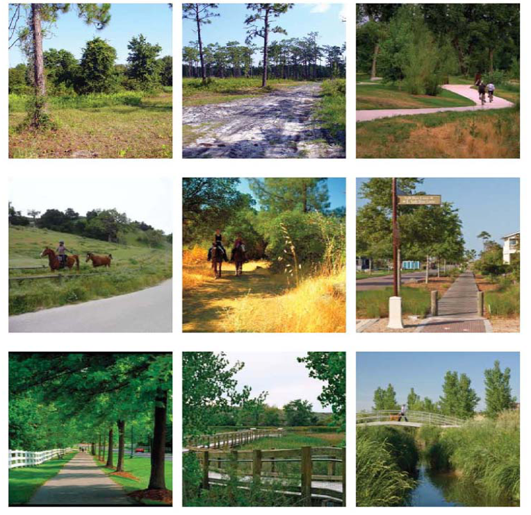
3.
Open Space Overall Context. The western edge of the Narcoossee study area is bounded by East lake Tohopekaliga and Fell's Cove and their associated wetlands. Many additional lakes, including Lake Runnymede, Center Lake, Hinden Lake and are scattered throughout the area, connected by large-scale wetlands systems.
Much of the Narcoossee Community is heavily vegetated with wetlands and forested areas. While many of these natural areas are smaller and disconnected west of Narcoossee Road, eastern areas boast large expanses of undisturbed wetland forests.
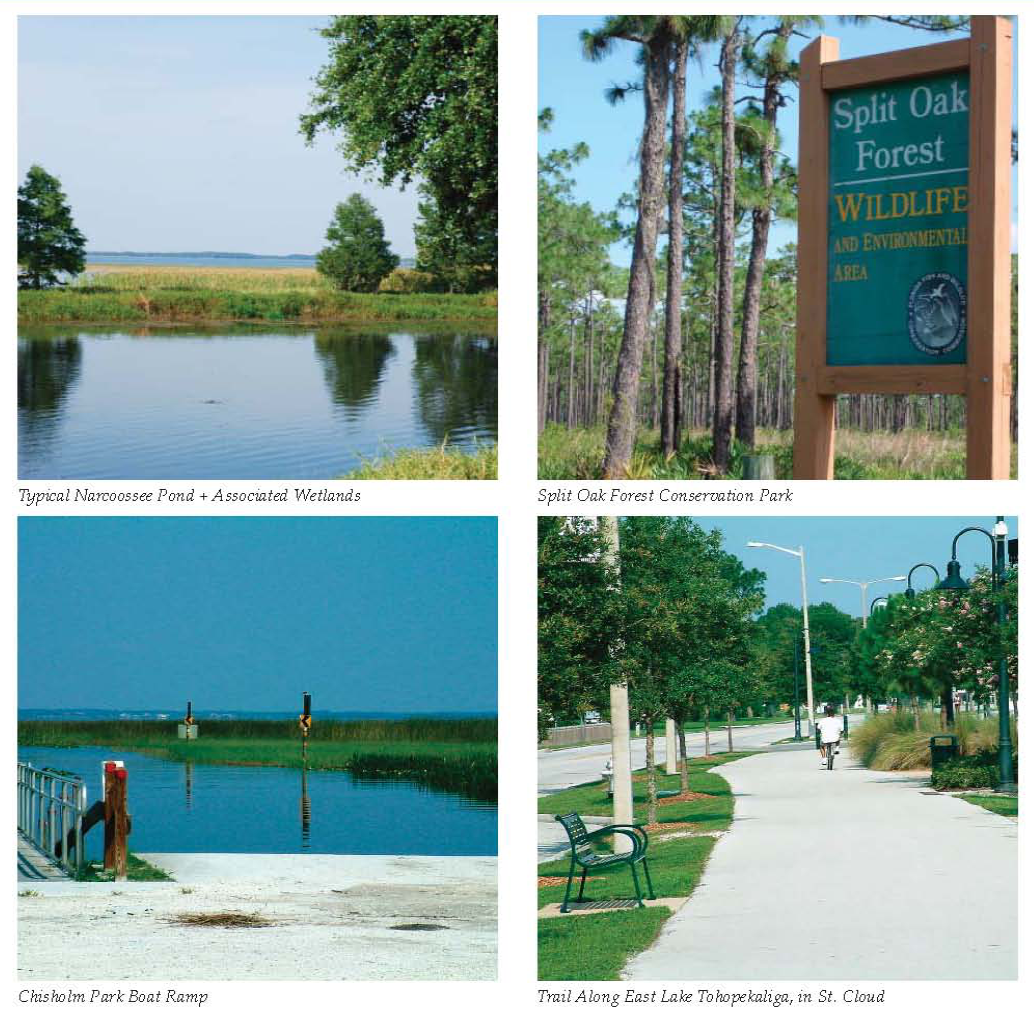
4.
Open Space Opportunities.
a.
Preservation of Natural Resources: Preservation of the natural systems for the Narcoossee Community is considered a core community value. Built on the wetland system, this natural framework helps maintain the open, rural feeling. Opportunities are present for each landowner to be a steward of the natural resources for their property. Other opportunities exist to connect these sensitive areas with additional upland corridors so wildlife can move freely through the area. Wildlife corridors have been planned on adjacent mixed use districts. These wildlife corridors could make connections all the way from East Lake Tohopekaliga to the Econlockhatchee River. These areas will serve additional functions including interpretation; preserving water quality, detention, and retention; and simply reinforcing character features. Key areas of opportunity include:
•
Wetlands
•
Sensitive wildlife areas
•
Floodplain areas
•
Upland wildlife corridors
•
Historic areas
•
Public lands
•
Water bodies
Open Space, Parks + Greenway Network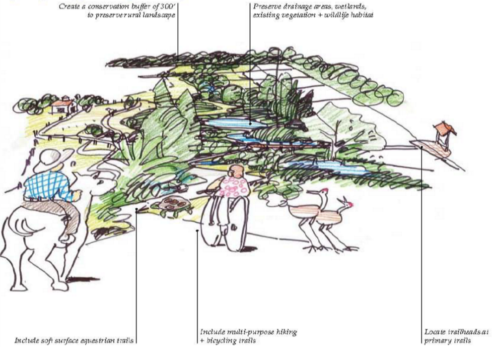
b.
Open Space, Parks + Greenway Networks: Preservation of natural systems is important to the character of the Narcoossee area, and the benefits of this are described throughout this section. These areas also provide the framework for a greenway, parks and trail system, linking the community together within a natural fabric. As demonstrated in the open space framework map in Chapter 4, new parks, the Historic Town, the Narcoossee Elementary and Middle Schools and public lands are planned and connected into one system. Key opportunities include:
•
Regional park system + facilities
•
Lakeside parks
•
Public plazas
•
Community gardens
•
Beach areas with marina/boat slips + water access
•
Recreation center
•
Playgrounds
•
Tree preservation
5.
Separators. The Narcoossee area has a number of character areas consisting of traditional subdivisions to rural estates. The community has acknowledged that portions of the community will continue to grow. New mixed use districts are already expected in the area. In these transitioning areas, separators, transitions and connections can increase the compatibility of all future projects. These techniques come in many forms, from simply preserving and buffering natural features adjacent to new developments to promoting compatible densities on the edge of a development.
Although, one technique is to create a separation between developments, another technique is to connect them. By connecting existing neighborhoods to new neighborhoods, the difference between the two (2) developments are lessened. Through greenway, park, trail and street connections, separate developments appear to be one development with a variety of housing types. Residents benefit from shared amenities and new transportation choices. Key actions and opportunities include:
•
Preserve and buffer natural features such as wetlands, forested areas and water bodies.
•
Create setbacks and separation of uses.
•
Utilize physical features such as trails, fencing, sidewalks, detention ponds and berms.
•
Promote land uses solutions such as feathering, cluster development, height restrictions, stair stepping, and promoting similar densities at the edge of a new development.
•
Connect new and existing neighborhoods using streets, greenways, parks and trails.
Preservation of natural resources + Inclusion of separators
a.
Fencing.
i.
Height. Fencing shall be a minimum of thirty (30) inches in height along roadway rights-of-way; forty-two (42) inches against vertical drops greater than twenty-four (24) inches; and fifty-four (54) inches along equestrian trails.
ii.
Materials. Fencing shall be constructed of one (1) of the following materials: wooden post and horizontal wire; pre-cast concrete post and rail; three (3) rail wooden fence; steel I-beam vertical posts with wooden rails; or Corten steel slatted fence.
b.
Berms. Berms and plantings shall be used to create a buffer between Narcoossee Road and adjacent residential development. Where space is not adequate to provide berming, other structures such as hedges and/or fences shall be used to create a screen, with associated plantings located on the Narcoossee Road side of the structure.
i.
Berms shall be constructed in a non-contiguous fashion, with breaks between berms at appropriate locations (i.e., trail connections to interior neighborhoods, detention pond locations).
ii.
Slopes and overall form are to be natural and smooth; with irregular, organic forms; rounded tops; and varied side and bottom slopes, transitioning gently into adjacent grades.
iii.
Berm height shall be a minimum of six feet (6'-0") and determined by right-of-way width available and adjacent usage and sightlines.
iv.
Berms shall be completely covered with grass, shrubs or other living ground cover. Landscaping shall be used to give additional screening height where necessary and to provide a visually aesthetic treatment to the roadside.
Narcoossee Road berm planting
Narcoossee Road berm cross section
* Graphic intended to illustrate use of berm, and is not intended to enforce any cross-sections.
c.
Natural Features. Preserve existing native vegetation and features where possible, and utilize these areas as buffers between incompatible developments. Wetlands shall be preserved and buffered per the requirements in the Osceola County Comprehensive Plan. Historic trees shall be protected as stated within the Osceola County Land Development Code.
d.
New Physical Features. Built features such as detention ponds, berms, greenways and trail systems and right-of-way elements such as sidewalks and fencing shall also be utilized as separators between incompatible developments.
e.
Land Use Solutions. Land use options such as cluster development and transitioning densities at the edges of existing residential areas can help maintain the Narcoossee community character. Additionally, connections between existing and new residential neighborhoods using greenways and trail systems and/or local street connections can also help mitigate undesirable elements such as larger roads and additional traffic.
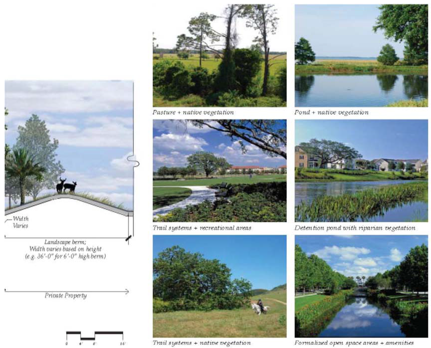
B.
MIXED USE DISTRICT STANDARDS FOR OPEN SPACE AND CIVIC SPACE. Refer to Chapter 3, Article 3.13.
(Ord. No. 2022-125, § 4, 2-20-2023)
4.11.1 - REQUIREMENTS
A.
GENERAL. The Engineer of Record (EOR) shall sign and seal the design of all required improvements including but not limited to streets, drainage facilities, bridges, bulkheads, and water and wastewater facilities.
B.
PRE-CONSTRUCTION CONFERENCE. After the construction plans have been approved by the County, prior to the start of any construction, a pre-construction meeting shall be held with the County. The EOR (or Owner's Representative) and contractor shall attend the meeting.
It will be the Developer's responsibility to arrange the pre-construction meeting. Applicant shall provide a copy of the Sunshine State One-Call ticket to the County prior to the pre-construction conference. The applicant shall verify the notification to other users by completing the section provided in the application for such verification. It is the full and complete responsibility of the applicant to determine that all other users are notified of the proposed work. Any work performed without such notification shall be at the sole risk of the applicant.
C.
INSPECTIONS AND TESTS.
1.
Notification. Inspections during construction shall be as specified by the County and it shall be the responsibility of the developer or contractor to notify the County and arrange for these inspections.
2.
Certification. Required tests specified in this Article shall be performed by a certified engineering testing laboratory acceptable to the County. This testing laboratory shall have a Florida registered engineer on staff in order to certify all tests performed. The developer shall provide and pay for the necessary testing and certified report.
3.
Construction Inspection. The contractor or developer shall schedule inspections prior to each of the stages of construction as required by the County and provided at the pre-construction meeting.
During the construction period, the County shall have the right to enter the property for the purpose of performing the required inspections. At the request of the contractor, an inspection will be conducted, and a County report, listing deficiencies, will be given to the contractor, who shall make the necessary corrections prior to approval and recommendation for initial acceptance or approval by the County. Nothing herein shall be construed to limit the developer's or contractor's responsibility to undertake corrective action if any work is determined not to be in compliance with requirements of this Code.
The County shall have the right to inspect and approve materials and/or phases of work. Final inspection and County acceptance of work must be obtained to document the completion of the work. Work shall be considered incomplete until that portion of the permit indicating final inspection and approval has been signed and dated by the County Manager.
The permittee shall notify the County at least twenty-four (24) hours prior to commencement of any work. The date, time and location regarding the scheduled work must be given at the time of this notification. The County, at its discretion, may check materials.
The County reserves the right to require exposure of installation to inspect correct depth of cover.
Work commenced without a permit, or failure of the permittee to notify the County at least twenty-four (24) hours prior to commencement of work shall incur a fee as prescribed by the Board of County Commissioners Fee Resolution.
Failure of the permittee to notify the County Manager at least twenty-four (24) hours prior to a required inspection shall not relieve the permittee from re-excavation or other measures necessary for inspection of the work.
4.
Compliance and Responsibility. The purpose of these inspections is to ensure compliance with the approved plat or site plan and to advise the Board of County Commissioners whether or not the roads, storm drainage, utilities, and other required improvements being constructed, qualify for acceptance by the County. Osceola County accepts no responsibility or liability for the work, or for any contractual conditions involving acceptance, payment, or guarantees between the various contractors and the developer. The County assumes no responsibility or commitment guaranteeing acceptance of the work, or for subsequent failure, by virtue of any inspections.
5.
Private Facilities. Inspections and verifications of private streets and drainage facilities shall be conducted in the same fashion as facilities intended for public dedication.
6.
Completion of Installation of Required Improvements. Upon completion of the above inspections and prior to final inspection, the following must be provided to the County.
a.
Test results as required;
b.
Maintenance surety for facilities to be conveyed to the County;
c.
As-built survey drawings shall be submitted and shall include the following information as applicable:
i.
Signed and sealed by a Florida Registered Professional Registered Surveyor.
ii.
Show all boundary, right-of-way, easement and lot lines.
iii.
Location, size, top and invert elevations for all inlets, stormwater and control structures.
iv.
Match grade elevations.
v.
Invert and slopes of ditches, canals, swales as applicable.
vi.
Berm elevations (if applicable).
vii.
Retention/Detention pond showing spot elevations at one-hundred (100)-foot intervals and low points, along top of the berm, grade breaks, and sufficient bottom elevations to show conformance to design. Include side slopes, bottom elevation, top of banks, geometrical dimensions, location of out fall, top of weir, width, depth, top of box, invert and bleeder elevation.
viii.
Off-site stormwater connection elevations if applicable.
ix.
Roadway high and low elevations, including spot elevation at all point of vertical intersections (PVI) of center line of roadway.
x.
Number of parking stalls delineated.
xi.
Striping.
xii.
Building setbacks/footprint for commercial structures.
xiii.
Location of perimeter or retaining walls.
xiv.
Show location of all underdrain clean outs (if applicable).
xv.
Any other information that may be deemed necessary by the County Manager.
d.
Record drawings shall be submitted, signed and sealed by a professional engineer registered in the State of Florida. An engineer's certificate of completion indicating that all infrastructure improvements have been constructed in substantial compliance with the approved plans shall be provided. State Plane coordinates and Autocad dwg files shall be provided in a digital format.
e.
Monuments and markers shall be installed for subdivisions as follows:
i.
Permanent Reference Monuments — Permanent reference monuments (PRMs) shall be placed as required by F.S. ch. 177, as amended. Monuments shall be set in the ground so that the top is flush or no more than one (1) foot below the finish grade.
ii.
Permanent Control Points — Permanent control points shall be set at point of curvature (PC), point of tangency (PT), point of reverse curve (PRC), point of compound curve (PCC), permanent reference monument (PRM), and other changes in direction, excluding those points located by PRMs. Permanent control points may be set prior to plat recordation, and shall be set within one (1) year after the plat is recorded, and prior to the performance bond expiration date.
iii.
Permanent Bench Marks — Permanent bench marks shall be installed within the subdivision at locations to be approved by the County, to establish a North American Vertical Datum 1999 (NAVD88) control, unless approved by the County Manager to use the National Geodetic Vertical Datum of 1929 (NGVD29) due to a prevalent control system in an established development. If the NGVD29 is approved, a conversion factor shall be provided.
iv.
Lot Corners — Lot corners, consisting of steel or wrought iron, not less than five-eighths (⅝) inch in diameter, and at least eighteen (18) inches in length, shall be placed at each lot corner. This shall be done after all grading within the right-of-way has been completed but prior to the initial acceptance of improvement.
v.
Markers — A guard stake or flag, with the lot number and number of adjoining lot plainly lettered on the flat face on the stake or flag, shall be placed next to the front corner.
vi.
Surveyor Certificates — At the time of the final inspection of the required improvements, a Florida registered professional surveyor's certificate indicating that permanent reference monuments, permanent control points and lot corners are in place shall be provided.
Upon satisfactory completion of the installation of required improvements, a certificate of completion shall be issued by the County engineer.
7.
Maintenance Responsibility During Warranty Period. All improvements to be owned and operated by the County, or a third party other than the developer, will be covered by a maintenance surety as required herein. During the maintenance period, the developer shall provide any maintenance required, at no cost to the County. This includes, but is not limited to:
a.
Repair and replacement of any deficient improvements.
b.
Control of erosion, replacement of sod, removal of soil washed onto the pavement or into the drainage system.
c.
Upon correction of all deficiencies and at the end of the required warranty period, the maintenance bond will expire.
8.
Final Inspection. Approximately sixty (60) days prior to the expiration of the maintenance period, the County Engineer shall conduct a final inspection.
Prior to release of the maintenance bond, the developer shall be required to correct any deficiencies of said improvements which have occurred during the maintenance period.
4.12.1 - SOIL EXCAVATION
A.
PURPOSE. The purpose of this Article is to protect the public health, safety, and welfare through the establishment of reasonable standards for the review and regulation of the location and operation of soil excavation activities. The County shall fairly and equitably allow the operation of soil excavation while at the same time protecting the needs and interests of the County. The following list attempts to set forth the needs and interests of the County to be protected but is in no way complete or limiting:
1.
Compliance with the Comprehensive Plan,
2.
Reuse of property excavated,
3.
Reclamation of excavated area,
4.
Surrounding land use,
5.
Transportation concerns,
6.
Environmentally sensitive areas, including heavily treed sites,
7.
Water quality,
8.
Water quantity,
9.
Drainage,
10.
Public Safety,
11.
Dust control,
12.
Noise levels, and
13.
Property values.
B.
GENERAL REQUIREMENTS. Unless specifically exempted in this Article, it shall be unlawful for any person, firm, or corporation either individually or through an agent to cause soil excavation within the unincorporated areas of Osceola County without having first obtained a soil excavation permit.
Issuance of a soil excavation permit by Osceola County, or exemption from the requirement thereof, does not abrogate any legal requirement to comply with the regulations of any other local, state or federal agency which may have jurisdiction over the proposed activity. The County reserves the right to impose reasonable conditions upon the soil excavation operation which are intended to mitigate the impacts of excavation.
Soil excavation permits are not required in the following circumstances:
1.
Soil excavation activities pursuant to an order of the BCC. This order shall state the reasons why the soil excavation regulations do not apply.
2.
Soil excavation activities, pursuant to an order of the BCC, which may be requested by a governmental agency, an applicant under another governmental agency, or an order of a court having jurisdiction in Osceola County. The information required for a soil excavation permit shall still be submitted by the applicant for approval unless waived by the County Manager when the applicant shows that such waiver will not adversely impact the public health, safety and welfare.
3.
Soil excavation activities within utility rights-of-way, public rights-of-way or easements necessary to supply electric, gas, water, sanitary or storm sewer, telephone, or cable television service, provided these activities do not adversely impact an environmentally sensitive area and a valid underground utility permit or right-of-way utilization permit has been received. This exemption does not include excavation for the construction of detention basins and/or retention basins which otherwise meet the definition of soil excavation.
4.
Excavation, in conjunction with commercial, industrial or subdivision construction, as part of an approved SDP, provided that excavation activity shall comply with the provisions of this Article. Excavations performed under this section shall be subject to complete restoration of the property if actual construction of the development's infrastructure is not begun prior to the completion of the excavation.
5.
Excavation for foundations and building pads for any building or structure, provided that the excavation or fill will be confined to the permitted property and that a valid building permit has been issued by the County.
6.
Minor landscaping projects, provided they do not encroach in flood prone areas as depicted on the FEMA maps or change the natural drainage pattern of the ground surface at the property line.
7.
Swimming pool construction provided a building permit has been issued by the County for construction of the pool.
8.
Excavation of agricultural use ponds provided the boundaries for the excavation are wholly within one owner's property, the excavated material remains on-site and off-site drainage is not affected.
C.
LOCATION CRITERIA. Soil excavation activities requiring a permit shall be allowed outside the Urban Growth Boundary, as defined in the Comprehensive Plan and within the guidelines established herein. Within the Urban Growth Boundary soil excavation activities requiring a permit may only be allowed for a small excavation as defined herein for properties zoned AC or for a bona fide agricultural operation, participating in a best management practice program, subject to the following criteria.
1.
Pond size is less than one (1) acre,
2.
Only one (1) pond may be permitted per every twenty-five (25) acres of property,
3.
Hauling operation shall not exceed ninety (90) days (may be extended one (1) time for no more than an additional ninety (90) days),
4.
Hours of operation for loading and hauling shall not be earlier than 7:30 a.m. and no later than 4:00 p.m. during the weekdays (Mondays through Fridays),
5.
Loading and hauling operations are prohibited during weekends and holidays, and
6.
Operation shall follow all other requirements and fees herein.
D.
REVIEW CRITERIA. The compatibility of the proposed soil excavation shall be considered in accordance with existing and planned land uses as set forth in the Comprehensive Plan. In making a determination of compatibility, the provisions listed below shall be considered.
1.
The nature of existing and planned land uses.
2.
The size of the proposed soil excavation:
Small — less than one (1.0) acre and generating less than ten thousand (10,000) cubic yards of excavation material to be hauled off-site.
Medium — one (1.0) to five (5.0) acres.
Large — greater than five (5.0) and less than twenty-five (25) acres.
3.
The effect of increased truck traffic generation on existing and planned uses.
4.
The proximity of residences, schools, or hospitals.
5.
The proximity to recreational uses such as parks and playgrounds.
6.
Impact on the roads and bridges located along the proposed haul route.
7.
Adequacy and compatibility of the reclamation plan relative to the natural environment as well as existing and planned uses.
8.
Cumulative impact of all permitted (active and inactive) soil excavations within one (1) mile of the proposed soil excavation.
9.
Whether the proposed haul routes pass schools or hospitals and whether the increased truck traffic, associated with the soil excavation activity, will adversely affect the conduct of the institution's activities. In evaluating the effect of the truck traffic, the County shall consider the capacity of the road(s) designated as the haul route, and the impact of haul route traffic within nearest intersection to a framework roadway (avenue/boulevard/premium transit corridor) of the boundaries of the institution's property, the hours of operation of the soil excavation and of the institution, the estimated volume of truck traffic, and the location of access to the school, or hospital.
10.
Impact on all jurisdictional wetlands within two hundred (200) feet of excavation.
11.
Impact on ground water quality.
12.
Hours of operation for loading and hauling shall not be earlier than sunrise and no later than one (1) hour prior to sunset, unless additional restrictions are required to meet health, safety and/or welfare considerations. The County Manager may approve an alternative schedule of operations where operations do not adversely impact the health, safety and welfare of the community.
E.
SETBACK DETERMINATIONS. There shall be no excavation, with the exception of perimeter ditches and recharge ditches, within the setbacks listed below unless otherwise approved by the County Manager.
1.
Open Area Setbacks. A setback shall be provided in the area lying between the edge of the soil excavation facing the described property and the boundary line of the described property. Prior to establishing the required setback, the County must find that an open area setback is required to ensure the compatibility of the soil excavation operation with a contiguous property. The County shall consider the following factors in making a determination for the additional setback requirement:
a.
Existence of buffering requirements affecting development.
b.
Maximum allowable density of residential development of the contiguous property.
c.
Density of existing residential uses on the contiguous property.
d.
Size of the proposed soil excavation relative to the total size of the soil excavation site.
e.
Location of the proposed soil excavation on the property.
f.
Existence and location of natural and man-made areas such as trees, lakes, ponds, streams, wells, drainage ways, environmentally sensitive areas, and roads.
g.
The reclamation plan.
Other setbacks required by this Code and other applicable rules and regulations as well as existing roads, streets, and other rights-of-way shall be included in the computation of the open area setbacks.
2.
Setback Criteria. The minimum setbacks shall be:
a.
For Small Excavations — twenty-five (25) feet from the right-of-way; for Medium Excavations — one hundred (100) feet from right-of-way; for Large Excavations — two hundred (200) feet from right-of-way.
b.
Twenty-five (25) feet from the boundary line of a publicly owned drainage or utility easement.
c.
Twenty-five (25) feet from any non-residential property line (defined as a zoning district) for small and medium excavations, and one hundred (100) feet for large excavations.
d.
Fifty (50) feet from any residential (defined as a zoning district) property line or mixed use district for small and medium excavations, and two hundred (200) feet for large excavations.
e.
One thousand (1,000) feet from a school or hospital measured on a straight line along the shortest distance between the perimeter of the soil excavation and the boundary of the property upon which the facility is situated.
f.
Two hundred (200) feet from an abandoned dumpsite or landfill.
g.
One thousand (1,000) feet from an existing landfill or dumpsite, a wellhead or a public supply production well of one hundred thousand (100,000) gallons per day or greater.
F.
DEVELOPMENT AND OPERATIONS STANDARDS.
1.
Point and Non-Point Source Discharges. Point and non-point source discharges of water or liquid waste into waters of the State are prohibited unless approved by all applicable local, state and Federal agencies.
2.
Groundwater.
a.
Floridan and Surficial Aquifer Withdrawals. Groundwater withdrawals shall not adversely impact, due to lowering of potentiometric levels, the Floridan or surficial aquifer beyond the boundaries of the excavation.
b.
Monitoring. In order to establish baseline conditions and to evaluate potential impacts, the monitoring of groundwater systems, surficial and Floridan, will be evaluated on a case-by-case basis and the need for on-site sampling or observation wells shall be specified by the County Manager. Wells established for potable water supply or as part of the mining operation will be constructed to enable sampling of the aquifer from which the water is drawn.
c.
Considerations. Soil excavations shall be strictly scrutinized and restricted consistent with the considerations discussed below. A detailed site specific hydro geologic study shall be submitted that would show any potential impact of the excavation on groundwater resources.
i.
Areas susceptible to groundwater contamination with a drastic index of greater than 179 or within a quarter of a mile from a Class I and Class II landfill. A study shall be submitted evaluating the site specific sinkhole potential and groundwater contamination assessment of the proposed soil excavation.
ii.
Areas where potential sinkhole development is likely.
Excavation shall not breach the semi-confining layer beneath the surficial aquifer. A minimum thickness of the semi-confining unit must remain beneath the base of the excavation at all times, as to be determined by a registered professional geotechnical engineer.
3.
Surface Water.
a.
Withdrawals. Water shall not be drawn from surface water bodies unless specifically approved in the permit. Such use shall only be permitted after a thorough analysis of stream flow and surface water conditions, and shall be limited to quantities not detrimental to downstream property owners or the environment, generally.
b.
Stream Relocations. It shall be the general intent of this Chapter not to permit the relocation of natural existing stream channels on or off-site. Under special conditions the County Manager may approve a relocation which then must be documented in the permit.
c.
Discharges. Increases in the flow of water courses leaving the excavation site, shall not adversely affect downstream property owners or the environment generally.
d.
Monitoring. In order to establish baseline conditions and to evaluate potential impacts, the monitoring of surface water systems will be evaluated on a case-by-case basis, and the requirements and duration of on-site monitoring shall be determined by the County Manager and shall be specified in the permit. Monitoring reports shall be submitted to the County Manager, as specified in the permit.
4.
Dewatering. Dewatering operations shall be planned and controlled so as to provide minimum draw down of the groundwater table outside the actual excavation site. Should the County receive complaints that the dewatering operation has resulted in detrimental off-site impacts the County may require the operator to demonstrate by means of a report from a registered professional geotechnical engineer, that such impacts have not occurred as a result of the dewatering operation. Any dewatering operation which, in the determination of the County Manager, results in detrimental fluctuations of water levels in adjacent water bodies, wetland areas or water supply wells, shall be terminated until such time as a satisfactory plan is developed, approved by the County Manager, and implemented in order to maintain natural water levels in such areas. A dewatering permit must be submitted if required from the appropriate water management district.
5.
Other Resources.
a.
Archaeological and historical sites, cemeteries and burial grounds shall be preserved in accordance with applicable Federal, state and local laws and regulations.
b.
Maximum practicable efforts shall be made to protect specimen trees, habitats of protected species of wildlife and vegetation, wetland areas and other environmentally sensitive areas. In accordance with other provisions of this Article and the Comprehensive Plan, these areas shall be designated on the Soil Excavation Permit (SEP) and left undisturbed.
c.
Excavation activity shall be conducted so as to control the generation and off-site migration of dusts and particles. All areas in which such dusts or particles may be generated shall be kept wet, treated with chemical dust detergents, or controlled in another manner to reduce the potential for their off-site migration. Atmospheric discharges from processing and drying equipment shall comply with all applicable state, Federal and local laws. To minimize dust and to prevent the deposit of soil excavation material on paved roads, trucks shall be covered with their tailgates latched. Dirt road segments of the designated haul route shall require regular watering, as necessary, to minimize dust generated by hauling activities.
d.
Soils exposed during site alteration shall be stabilized, and runoff and siltation shall be directed to areas approved in the SEP or operating permit in such a manner as to prevent off-site impacts.
e.
Activity, with the exception of approved peat and muck mining, shall not be conducted within the 100-year flood plain of waterways, lakes or streams, if such excavation activity would have an adverse effect on the 100-year flood plain. Alterations shall only be permitted consistent with the applicable water management district and in compliance with other provisions of this Code.
f.
An operator shall not dump, pile or permit the dumping, piling, or otherwise placing of any earth, overburden, rocks, ore, debris, or other solid waste upon or into any public roadways, or other public property, or water bodies, or upon any adjacent property except as specifically approved in the permit. The operator shall not place these materials in such way that normal erosion or slides, brought about by natural physical causes, will permit such materials to move onto public roadways, or other public property, into water bodies, or upon any adjacent property.
g.
All hazardous waste materials intended to be stored or used on-site, including petroleum based products, shall be reported to the Department of Environmental Protection prior to storage. All hazardous wastes generated by activities at the site shall be disposed of in accordance with local, state and Federal law.
h.
Increases to ambient noises, resulting from excavation operations, shall not cause a public nuisance as measured at the permittee's property line and in accordance with the criteria found in the applicable Osceola County rules, regulations and ordinances. Nor shall excavation activities generate noise in excess of that allowed by local, state or Federal law.
i.
Operations shall be performed in a manner that will prevent vibrations of the soil from reaching a magnitude sufficient to cause damage to persons or property outside the permitted excavation site. Blasting or other use of explosives shall not be performed without proper permits from the state Fire Marshal and shall be fully outlined in the SEP. Should the County receive complaints from adjacent residents or landowners, the County may require measurement by a blast monitoring device and a report of the findings to the County demonstrating that the blast has not and will not cause damage to persons or property outside the operator's property. In addition, the County may require the operator to notify adjacent residents prior to future blasting.
j.
The soil excavation shall comply with the Florida Department of Environmental Protection (DEP) reclamation requirements for solid resources other than phosphate, limestone, heavy minerals, and Fuller's Earth. Prior to permit issuance, the applicant must show proof of notification to DEP in accordance with F.S. ch. 378.
G.
OPERATING STANDARDS.
1.
Prior to excavation, the perimeter of the permitted soil excavation shall be adequately staked to delineate the excavation. These stakes shall be maintained throughout the duration of excavation and reclamation. The County Manager may require a legal description of the soil excavation when necessary for determining staking and location of the land excavation.
2.
The standard slope for the side of a lake creation, including ditches, shall be four (4) feet measured horizontally to one (1) foot measured vertically (4:1) to a depth of six (6) feet below normal water level, then no steeper than two (2) feet measured horizontally to one (1) foot measured vertically (2:1) to the bottom of the excavation. Dry soil excavations shall be no steeper than four (4) feet measured horizontally to one (1) foot measured vertically (4:1) to the bottom of the excavation. Any mitigated wetlands shall be sloped and vegetated in accordance with state, federal law and other provisions of this Code.
3.
Required side slopes shall be constructed and maintained as excavation progresses. Side slopes shall not be excavated and backfilled.
4.
Medium and large soil excavations shall be secured with a fence and gate to prevent unauthorized access to the soil excavation. All points of access shall be secured when activity is not occurring in the soil excavation. The fence shall be posted at five-hundred-foot (500') intervals for "No Trespassing."
5.
Ingress/egress aprons are required for all soil excavations from which material is excavated and transported on a public road. Aprons shall be geometrically designed according to the specifications of the FDOT. The ingress/egress apron shall be maintained throughout the duration of the soil excavation activities and shall be of such length to remove excess earth/mud from tire tread (minimum length to right-of-way line).
6.
A stop sign shall be posted at the soil excavation site access onto a public road, as well as advance warning signs on the public road advising of "Trucks Entering Highway."
7.
On-site, excavated material shall be transported along a course from the soil excavation to the point of ingress/egress access which will have the least adverse impact, if any, on surrounding land uses and/or environmentally sensitive areas. This shall be reviewed and approved on the SEP.
H.
OFFSITE HAULING.
1.
The off-site haul route shall be specifically designated on a map which is to be submitted with the SEP application. Videotaping of the existing road is required to document the existing conditions of the haul route. A bond or fee may be set by the County for the reconstruction of public roads impacted by the excavation operation.
2.
Techniques to mitigate the impacts of off-site hauling on existing neighborhoods, fronting onto a framework roadway, may include restrictions on the hours and days of off-site hauling, contribution by the applicant to the cost of road improvements on the haul route, and development of alternative haul routes. The County may impose reasonable restrictions on the hours and days of operation of any soil excavation, when such reasonable restrictions are necessary to protect the public health, safety and welfare.
3.
In evaluating the effect of the truck traffic, the County shall consider the capacity of the road(s) designated as the haul route, the impact of haul route traffic, especially within five hundred (500) feet of the boundaries of a school or hospital's property, the hours of operation of the soil excavation and of the institution, the estimated volume of truck traffic, and the location of access to the school or hospital.
4.
The placement of hauled excavated soil shall be in accordance with all existing County codes related to construction and protection of the environment and flood prone areas.
I.
RECLAMATION: GRADING AND VEGETATION.
1.
Shall meet requirements in stormwater section of this Code.
2.
All disturbed upland areas within the soil excavation site shall be graded to elevations as approved in the reclamation plan.
3.
All remaining upland disturbed areas within the soil excavation site shall be seeded and mulched or sodded.
4.
All remaining upland disturbed areas within the soil excavation site shall be replanted with a minimum of two hundred (200) one to three (1—3) gallon size trees per acre or an approved alternative reclamation plan, which may include mitigation.
J.
PERMIT AMENDMENT. The permit may be amended as required for reasonable cause and as approved by the County. In order to amend the permit, an application shall be made to the County Manager. The County Manager shall determine whether the proposed amendment is substantial or non-substantial.
1.
The following general criteria will be used to identify a substantial amendment:
a.
A change in acreage or location to be excavated which is outside the approved area for excavation in the original permit.
b.
A change which would require an amendment of the conditions of approval for the SEP.
c.
A change in phasing of the excavation.
2.
Amendments to the SEP which are determined to be substantial shall be submitted with plans and support data (in the same manner as required for the submittal of the original excavation site plan application). The review process shall also be the same.
3.
All non-substantial amendments (including plans and support data shall be reviewed and approved by the County Manager). The review of the non-substantial application for amendment shall be conducted in conformity with those conditions applied to the original SEP.
K.
ANNUAL PROGRESS REPORT, CERTIFICATION, RECLAMATION APPROVAL.
1.
Annual Progress Report. The applicant/owner shall file annually an annual progress report with the County Manager, within forty-five (45) days after each anniversary date of the soil excavation permit approval. This report shall include the following information:
a.
Identification of lands excavated during the preceding year and lands expected to be excavated during the current year;
b.
Discussion of the reclamation progress for each area where reclamation has been completed in the last year, or where reclamation is in progress, a discussion of reclamation planned for the current year;
c.
A survey performed by a licensed professional surveyor shall be submitted showing the limits of the excavation in relation to the property boundaries;
d.
A summary of results of the previous year's environmental monitoring program, if required in the SEP; and
e.
The applicant/owner shall also furnish copies of all related inspection reports not previously furnished which are required by State or Federal regulatory agencies.
2.
Certification. For medium and large excavation permits a Florida registered professional engineer or professional geologist familiar with the operator's excavation activities shall certify in the annual progress report that the project is being developed and operated in strict accordance with the conditions set forth in the approved SEP.
3.
Failure to File. Failure to file the required annual progress report shall be grounds for suspension of the permit. Upon notification by the County of failure to file the annual progress report, the permittee shall have ninety (90) days to file the required report or the SEP shall be suspended. Should the permit expire during the suspension period, it shall lapse and be voided. Failure by the County to send notification at any time shall not cause the County to lose this option.
4.
Reclamation Approval. If necessary, approval of reclaimed areas shall be requested in the annual progress report by identifying the specific reclamation areas for which approval is sought. Reclamation of disturbed lands shall be deemed completed after showing that the reclamation areas have been reclaimed in accordance with the approved SEP.
5.
Financial Security for Reclamation Plan. The soil excavation site owner shall present the County with financial security that the reclamation plan will be completed at the time of permit approval. Acceptable forms of this financial security shall include, but are not limited to, a letter of credit, surety bond, or cash bond that will be held by the County until the reclamation plan is completed for the soil excavation. The amount of financial security shall be equal to one hundred twenty-five percent (125%) of the amount necessary to complete reclamation of the entire excavation or if phased, the two (2) phases with the greatest number of acres as certified by a landscape architect or engineer registered in the State of Florida. The financial security shall extend a minimum of one (1) year beyond permit expiration. The owner shall post the entire financial security prior to the issuance of a soil excavation permit.
Prior to permit issuance the soil excavation site owner shall provide the County Manager with an irrevocable license to enter the soil excavation site to complete the necessary reclamation in the event the soil excavation owner fails to do so.
6.
Release of Financial Security. The permittee shall notify the County Manager in writing to request the release of financial security. Prior to the release, the following steps shall occur:
a.
The County Manager shall complete a final inspection and approve reclamation of the site,
b.
The permittee shall submit a signed, sealed and dated topographic survey to indicate total cubic yards of material excavated or other acceptable calculations of the cubic yards excavated, and
c.
The permittee shall submit the balance of payment in full for the total cubic yards of material excavated.
d.
The released financial security shall be returned to the permittee within thirty (30) days of BCC approval.
7.
Waiver. The County Manager may waive certain provisions and criteria which would impose upon the applicant an unreasonable and unnecessary or exceptional burden. The County Manager shall not recommend any waiver that would adversely affect any adjoining property or the public.
4.12.2 - RIGHT-OF-WAY UTILIZATION
A.
PURPOSE. This Section is established to regulate the location, installation and adjustment of any facility or operation on County right-of-way or easement and the issuance of permits for such work in the interest of safety and for the protection, utilization and future development of the highways and roads, with due consideration given to public service afforded by adequate and economical utility installations, as authorized by the applicable Florida Statutes. While this regulation governs on matters concerning future location, manner and methods for the installation or adjustment and maintenance of utilities on County right-of-way, it does not alter current regulations pertaining to authority for their installation or determination of financial responsibilities for placement or adjustment thereof.
B.
AUTHORITY; SCOPE. The regulations in this Article are enacted for the purpose of providing necessary regulations for use of any County right-of-way and shall apply to all private contractors, private citizens, utility companies, municipalities and to any person or group proposed to install, construct, maintain, operate or repair any facility or structure within any of the existing or planned rights-of-way, or public easements, stormwater tracts, dedicated or planned to be dedicated, to the public, or Osceola County, or maintained by Osceola County, in the interest of the public health, safety and welfare of the citizens and residents of Osceola County. Any activity in the right-of-way shall require a permit from the County. This Article shall apply to and be enforced in all areas of County jurisdiction.
C.
SCOPE OF PERMIT APPROVAL.
1.
The permit issued under this Article is a license for a permissive use only and the placing of facilities upon public property pursuant to this permit shall not operate to create or to vest any property right in the holder thereof and the issuance of a right-of-way utilization permit does not relieve the permit holder of the need for obtaining any other permits that may be required by the appropriate authorities. The permit may be revoked at any time.
2.
The rights and privileges set out in this Article are granted only to the extent of the County's right, title and interest in the land to be entered upon and used by the applicant, and the applicant will at all times assume all risks of and defend the County from and against any and all loss, damage, cost or expense arising in any manner on account of the exercise or attempted exercise by the applicant of the aforesaid rights and privileges.
3.
The construction and/or maintenance of a utility shall not interfere or encroach upon the property and rights of an existing lawful occupant.
4.
Removal and/or relocation of facilities (including but not limited to landscaping, signage and paving). Any facility heretofore or hereafter placed upon, under, over, or along any public road right-of-way that, at the discretion of the County, shall, upon sixty (60) days' written notice to the owner of the facility or its agent, or upon legal notice published in not less than two (2) weekly issues of a newspaper of general circulation in the County, be removed or relocated, and the right-of-way shall be restored to its original condition by, and at the sole expense of, such facility owner (or its agent). The failure of a utility owner or its agent to remove or relocate such facility after the required notice shall absolve the County from any liability for damages that may arise as a result of County's removal of any such utilities. All expenses incurred by the County during this relocation of the subject facilities shall be the sole responsibility of the facility owner.
D.
SUPPORTING REGULATIONS.
1.
When applicable, the provisions of the latest editions of the following shall apply:
a.
Osceola County Land Development Code
b.
Osceola County Road Construction Specifications Manual
c.
Florida Department of Transportation Standard Specifications for Road and Bridge Construction
d.
Regulations for the Transportation of Natural and Other Gas by Pipelines (parts 191 and 192, Title 49 of the Code of Federal Regulations, as amended from time to time.
e.
State of Florida Department of Transportation Utility Accommodation Guide
f.
United States Department of Transportation Manual on Uniform Traffic Control Devices for Streets and Highways (MUTCD)
g.
Manual of Uniform Minimum Standards for Design, Construction and Maintenance for Streets and Highways (Green Book), as published by the Florida Department of Transportation.
h.
Florida Department of Transportation Roadway and Traffic Design Standards
i.
ASCE 38-02: "Standard Guideline for the Collection and Depiction of Existing Subsurface Utility Data," as published by the American Society of Civil Engineers.
2.
In the event of a conflict between the provisions of the regulations and specifications referred to above and these right-of-way utilization regulations, whichever regulation is more restrictive shall apply.
E.
WORKING HOURS. Operations permitted by this Article shall normally be conducted from 7:00 a.m. to 5:00 p.m. Monday through Friday, excluding holidays. Any deviation from these hours requires prior approval from the County Manager. A minimum of two (2) working days' notice, in writing, requesting deviation from normal working hours, must be provided. Additional fees will be required as approved by the County. Emergency repairs are excluded from this time restriction of the two (2) working days' notice. Likewise, time restrictions may be imposed for lane closure.
F.
PERMITS.
1.
Notification to Other Agencies.
a.
Applicant shall apply to Sunshine One who will notify all users within the project limits of the applicant's proposed project. Sunshine One will respond with verification that all users have been notified and provide the applicant a list of all users in the area of the proposed project. Applicant shall provide a copy of the Sunshine One ticket with the permit application.
b.
The applicant shall verify the notification to other users by completing the section provided in the application for such verification. It is the full and complete responsibility of the applicant to determine that all other users are notified of the proposed work. Any work performed without such notification shall be at the sole risk of the applicant.
c.
No permit for excavation of the right-of-way will be issued until the applicant has certified compliance with F.S. § 553.85 1(2)(a) and (c).
2.
Qualifications of Permittee.
a.
Subject to the satisfaction of and compliance with requirements contained in this Article, permits may be issued to the following:
i.
Utility corporations or companies (including County and municipal utilities) that will be servicing the installed facility.
ii.
Contractors responsible for the installation of any utility facility or structure subject to these regulations.
iii.
Private citizens, corporations or organizations with a reasonable and legitimate purpose for using the right-of-way, which purpose poses no threat or danger to the public health, safety or welfare.
iv.
In those cases in which the services to be provided are subject to County regulations relating to underground utility pipelines, the applicant must hold a current state general contractors' license, a current state underground utilities contractor's license, a current state plumbing contractor's license, or a certificate of competency issued by the State Fire Marshal for fire protection systems only.
b.
The Osceola County Road and Bridge Department is exempt from these qualification requirements.
3.
Issuance; Compliance.
a.
The County Manager may approve and/or issue an application for right-of-way utilization. Upon approval by the County Manager, the application form becomes the valid permit.
b.
After payment of the required fee and approval of the application, the County Manager will issue a permit for the proposed work. The work must be performed in accordance with the terms and requirements of this duly issued permit. Additional work, or revisions not authorized by the original terms of the permit, will require a new permit or modification of the existing permit if applicable.
4.
Letter of Credit and Insurance Certificate.
a.
Any permit to construct improvements within an existing County right-of-way shall not be issued until an irrevocable letter of credit, or other assurance acceptable to the County, is provided. It shall be in the amount of one hundred twenty-five percent (125%) of the estimated cost of completion of the improvement or work covered by the permit and shall be issued in favor of the County.
b.
A certificate of insurance acceptable to the County shall be required unless the County Manager deems the insurance requirement unnecessary.
5.
Availability for Examination. A copy of the permit issued under this division must be available at all times at the work site while work is being performed. Any work in progress on, or use of, the right-of-way without a valid permit available at the site shall be suspended until such time as a valid permit is produced on the site.
6.
Inspection, Approval of Work. The County shall have the right to inspect and approve materials and/or phases of work. Final inspection and acceptance of work by the County must be obtained to document the completion of the work. Work will be considered incomplete until that portion of the permit indicating final inspection and approval has been signed and dated by the inspector.
The permittee shall notify the County at least twenty-four (24) hours prior to beginning work.
Underground facilities (buried cable, water lines, etc.) will not be covered until approved by the inspector. Cable facilities need not be left exposed when buried by the direct burial process when the contractor has demonstrated his capability of competence of construction standards. The County reserves the right to require exposure of installation to inspect correct depth of cover.
Work commenced without a permit, or failure of the permittee to notify the County at least twenty-four (24) hours prior to commencement of work will incur a fee as adopted by the Board of County Commissioners. Failure of the permittee to obtain the appropriate inspections or notify the County at least twenty-four (24) hours prior to commencement of work shall not relieve the permittee from re-excavation or other measures necessary for inspection of the work.
All items found not to be in compliance with this Article will be immediately corrected by the permittee.
7.
Duration, Extensions. Every permit issued by the County Manager under the provisions of this Section (4.12.2) shall become null and void if the work authorized is not completed within twelve (12) months from the issuance of the permit. If permit becomes void, before such work can again be commenced or completed, a new permit must first be applied for and obtained. Permit application process must be started anew. Permit fees will be assessed as for an original permit. A singular extension, up to six (6) months, may be granted upon written request of the applicant, at the discretion of the County Manager. Permits for construction of offsite improvements in conjunction with subdivision or site development will remain in effect until completion of the development or phase thereof. All residential driveway permits issued in conjunction with a new single-family or multi-family residence shall not expire as long as a valid build permit for that residence exists.
8.
Responsibility for Compliance. The applicant assumes full and total responsibility for compliance with this Article, supporting regulations, additional requirements of the Board of County Commissioners, any municipal, county, state or federal laws, ordinances, or other directives which may apply to the proposed work.
9.
Warranty.
a.
Permittee shall guarantee all work performed under the terms of the permit for a period of one (1) year from the date of completion as certified on the permit by the County Inspector. A maintenance surety shall be provided at fifteen percent (15%) of the construction cost for projects in excess of one hundred thousand dollars ($100,000.00).
b.
Any failure shall be repaired by the permittee, at the direction of the County Manager, within thirty (30) days, unless the urgency of the problem requires a quicker reaction time.
10.
Bonds. In the event the applicant must bore and jack, and/or open cut, the applicant shall present an executed bond by a company licensed to do business in the State of Florida. This bond shall be in an amount to be determined by the County Manager and for a period of one (1) year. In the event the project is not completed in one (1) year the bond shall be renewed and thereafter renewed on an annual basis until the project is complete. The County Manager shall present a Certificate to the Board of County Commissioners when a project is completed or the permit has expired and the bond may be released.
11.
As-Builts. The Permittee shall provide a complete "As-Built" survey by a professional land surveyor licensed in the State of Florida of the permitted work including horizontal locations based on State Plane Coordinates and vertical data based on Bench Mark information provided by the County on all above and below ground improvements. The as-built survey shall show the improvements related to the right-of-way lines. When obtaining location data, a vertical elevation shall be obtained whenever a horizontal measurement is obtained. For pipe line work vertical and horizontal locations shall be require at a minimum of three hundred (300) feet or change in direction vertically or horizontally. The permittee shall provide one (1) copy of a signed and sealed survey and a digital file in AutoCAD format on a CD prior to release of the bond.
G.
TECHNICAL REQUIREMENTS AND REQUIREMENTS FOR SPECIFIC ACTIVITIES.
1.
Location Standards.
a.
The primary concern in the design and location of utility installations is protection of the right-of-way and the safety of the highway user, and in all cases, full consideration shall be given to sound engineering principles and economic factors.
b.
Where possible, all longitudinal underground utility facilities should be placed within seven (7) feet inside of the outer edge of the right-of-way line. Aboveground facilities should be placed at or as close as practical to the right-of-way line. If sidewalk removal is required, the applicant shall be responsible for its replacement.
c.
Proposed location of poles, fire hydrants, and water meters, and other objects within the right-of-way, should take into consideration future road widening, sidewalk, storm drainage or other construction. Minimum guidelines for roadside recover area are shown in the State of Florida Department of Transportation Manual of Uniform Minimum Standards for Design, Construction and Maintenance for Streets and Highway. Deviations require approval by the County Engineer.
d.
Water meter boxes shall not be placed within the limits of a proposed or existing sidewalk.
e.
Pursuant to the provisions of the applicable Florida Statutes, no person shall place, maintain or display upon any County right-of-way any unauthorized sign, signal, marking or device which purports to be or is an imitation or resembles an official traffic-control device or railroad sign or signal, or which hides from view or interferes with the effectiveness of any official traffic-control device or any railroad sign or signal. The County Manager is empowered to remove every sign, signal or marking prohibited by this subsection or cause it to be removed without notice.
f.
Permittee shall not install fences or gates within County right-of-way. Fences installed in County easements are subject to removal at the owner's expense when it becomes necessary for the County to exercise its rights to that easement. Any unauthorized installation shall be a violation of this section, and after due notice the County Engineer, or his designated representative, is empowered to remove the same or cause it to be removed, and the Board of County Commissioners may institute appropriate legal action.
2.
Wireless and Small Wireless Facilities Standards.
a.
A wireless antenna attached to a permitted and legally maintained vertical structure in the Public Rights-of-Way, such as a light pole or Utility Pole, shall, unless otherwise agreed to by the County in writing: (1) not extend more than ten (10) feet above the highest point of the vertical structure; (2) not have any type of lighted signal, lights, or illuminations unless required by an applicable federal, state, or local rule, regulation or law; (3) comply with any applicable Federal Communications Council Emissions Standards; (4) comply with any applicable local building codes in terms of design, construction and installation; (5) not contain any commercial advertising thereon; and (6) comply with Home owner's Association Restrictions where such restrictions apply.
b.
Minimum Objective Design Standards for At-Grade Facilities, Below-Grade Facilities, Wireline Facilities, and Utility Poles.
i.
Intent and purpose. At-grade Facilities, Below-grade Facilities, Wireline Facilities, and Utility Poles shall be designed in such a manner to ensure such Facilities and Utility Poles are placed in a safe location that do not interfere with the traveling public, and shall be designed to maximize compatibility with the surrounding neighborhood and to minimize any negative visual impact on the surrounding neighborhood. As used in this Section, the term Facility shall be used to collectively refer to At-grade Facilities, Below-grade Facilities, and Wireline Facilities. The following design standards shall apply, unless waived.
ii.
Stealth design. Utility Poles shall be made of substantially the same material, color, and design as other Utility Poles within the same Public Rights-of-way, however, a Utility Pole made of a steel, concrete, or fiberglass, and of a neutral color, shall not require a waiver regardless of the material and color of other Utility Poles within the same Public Rights-of-way. A repurposed structure shall be of substantially similar design, material, and color of the existing structure being replaced by the repurposed structure. The repurposed structure shall be located in approximately the same location as the existing structure. The repurposed structure shall continue to serve its primary function. If the County has a planned future project to replace Utility Poles in the subject Public Rights-of-way, the Repurposed Structure shall conform to the County's updated design, material, and color.
iii.
Concealment. A proposed Facility and Utility Pole shall utilize the following concealment requirements unless waived.
a)
No Signage. Registrants shall not place or maintain Signage on any Facility within Public Rights-of-way, unless otherwise required by State or federal laws or regulations.
b)
Lighting. A Facility shall not have any type of lighted signal, lights, or illuminations unless required by an applicable State or federal laws or regulations or as permitted by the County.
c)
At-grade Facilities shall be located in areas with existing foliage or other aesthetic features to obscure the view of the At-grade Facilities or shall be designed to appear similar to other at-grade facilities in the same Public Rights-of-way. Any additional plantings proposed pursuant to this Subsection shall be approved by the County.
iv.
Maximum height restrictions. A Utility Pole intended to support the Collocation of Small Wireless Facilities is limited to the tallest existing Utility Pole as of July 1, 2017, Located in the same County Public Rights-of-way, other than a Utility Pole for which a waiver has previously been granted, measured from grade in place within five hundred (500) feet of the proposed location of the Utility Pole intended to support the Collocation of Small Wireless Facilities. If there is no Utility Pole within five hundred (500) feet, the Utility Pole intended to support the Collocation of Small Wireless Facilities shall be limited to fifty (50) feet. The Small Wireless Facility, including any attached Antennas, shall not exceed ten (10) feet above the Utility Pole intended to support the Collocation of Small Wireless Facilities.
v.
Location context. A proposed Utility Pole shall utilize the following location context requirements:
a)
Installation at outermost boundary of Public Rights-of-way. At-grade Facilities and Utility Poles shall be placed at the farthest distance practicable from the edge of pavement unless there is a designated corridor within the Public Rights-of-way.
b)
Equidistant requirement. Utility Poles are strongly encouraged to be placed equidistant between existing Utility Poles, if any, within the Public Rights-of-way.
c)
Common property line. For Placement within Residential Blocks, Utility Poles are strongly encouraged to be placed at the common property line of the Parcels that Abut the Public Rights-of-way.
d)
Prohibition against placement that significantly impairs view from principal structures within Residential Blocks. At-grade Facilities and Utility Poles, shall be Placed such that views from principal structures within Residential Blocks are not significantly impaired. Should the County determine that a proposed location does not meet this requirement, the County may offer an alternative location and/or design standard to ensure compliance, consistent with F.S. § 337.401(7)(d)4.
c.
Minimum Objective Design Standards for Small Wireless Facilities.
i.
Purpose and intent. Small Wireless Facilities shall be designed in such a manner that the Small Wireless Facilities are Placed in a safe location that do not interfere with the traveling public, and shall be designed to maximize compatibility with the surrounding neighborhood and to minimize any negative visual impact on the surrounding neighborhood. The following objective design standards regulating the location context, color, stealth design, and concealment of the proposed Small Wireless Facility shall apply, unless waived.
ii.
Stealth design. All proposed Small Wireless Facilities shall meet one (1) of the following Stealth Design standards, unless waived.
a)
Preferred stealth design option 1: No exposed wires or cables; the use of Shrouds; and the use of a slim design wherein the top mounted Antenna shall be limited to the diameter of the supporting Utility Pole at the level of the Antenna attachment plus twelve (12) inches or a twenty (20) inch maximum Antenna diameter whichever is less. Side mounted enclosures, if any, shall not extend more than Twenty-four (24) inches beyond the exterior dimensions of the existing structure, repurposed structure or Utility Pole at the level of Antenna attachment measured from the edge of the pole to the outermost surface of the side mounted enclosures.
b)
Preferred stealth design option 2: No exposed wires or cables; the use of Shrouds; and the use of a street light fixture to camouflage the Small Wireless Facility. Any street light fixture shall be maintained in good working order by the Applicant or pole owner unless the County accepts maintenance responsibility in writing. If the County accepts the maintenance responsibility of a street light fixture on an Authority Utility Pole, the ownership of the street light fixture shall transfer to the County.
iii.
Concealment. A proposed Small Wireless Facility shall utilize the following concealment requirements unless waived.
a)
Applicants shall not place or maintain Signage on Communications Facilities in Public Rights-of-way, unless otherwise required by applicable State or federal laws or regulations, provided however, that existing structures that lawfully supported signage before being repurposed may continue to support signage as otherwise permitted by law.
b)
A Small Wireless Facility shall not have any type of lighted signal, lights, or illuminations unless required by applicable State or federal laws or regulations or as permitted by the County.
c)
Ground-mounted equipment for Small Wireless Facilities shall be located within a ten-foot (10')-radius of the supporting structure for the Small Wireless Facility and, if possible, in areas with existing foliage or other aesthetic features to obscure the view of the ground-mounted equipment. The ground-mounted equipment shall be designed to appear similar to other at-grade facilities in the same Public Rights-of-way and may be further concealed with additional plantings. Any additional plantings proposed pursuant to this subsection shall be approved by the County.
iv.
Maximum height restrictions. A Small Wireless Facility, including any attached Antennas, shall not exceed ten (10) feet above the Existing Structure, Repurposed Structure or Utility Pole upon which the Small Wireless Facility is to be collocated.
v.
Location context. A proposed Small Wireless Facility shall utilize the following location context requirements, unless waived.
a)
Prohibition against Placement within a location subject to Homeowners' Association restrictions. Small Wireless Facilities shall not be collocated in a location subject to covenants, restrictions, articles of incorporation, or bylaws of a Homeowners' Association unless specifically authorized by the Homeowners' Association where such HOA restrictions are applicable to the public rights-of-way. This subsection shall not limit the installation, Placement, Maintenance, or replacement of Micro Wireless Facilities on any existing and duly authorized aerial Wireline Facility.
b)
Prohibition against Placement in location where facilities are placed underground. Small Wireless Facilities and Utility Poles intended to support the Collocation of a Small Wireless Facility in the Public Rights-of-way shall comply with nondiscriminatory undergrounding requirements of the County that prohibit aboveground structures in the Public Rights-of-way. Any such requirements may be waived by the County. This Section does not apply to the installation, Placement, Maintenance, or replacement of Micro Wireless Facilities on any existing and duly authorized aerial Communications Facilities, provided that once aerial facilities are converted to underground facilities, any such Collocation or Construction shall be only as provided by the County's Land Development Code.
H.
UNAUTHORIZED DRAINAGE CONNECTIONS. No person, firm or corporation shall create a drainage connection to any County maintained, dedicated or platted right-of-way or easement without a permit.
Existing drainage connections shall not be utilized to discharge anything other than treated or natural stormwater runoff.
4.12.3 - MINING
A.
PURPOSE. The purpose of this Section is to protect the public health, safety, and welfare through establishment of reasonable standards for review and regulation of the location and operation of mining activities. The County shall fairly and equitably allow mining operations while at the same time protecting the needs and interests of the County.
B.
DEFINITIONS. The following words, terms, and phrases shall apply in the application, interpretation, and enforcement of this Section:
1.
Hydraulic fracturing means the process by which fractures in the earth's subsurface are widened by injection of water, chemicals, or both, under high pressure used in the extraction of oil and gas.
2.
Matrix acidizing means the injection of any acid into a well to break up impediments without fracturing the well.
3.
Well stimulation means all stages of a well intervention performed by injecting water, chemicals, or both into a rock formation as a means of oil and gas exploration:
a.
At pressure that is at or exceeds the fracture gradient of the rock formation where the purpose or effect is to fracture the formation to increase production or recovery from an oil or gas well, such as hydraulic fracturing; or
b.
At pressure below the fracture gradient of the rock formation where the purpose or effect is to dissolve the formation to increase production or recovery from an oil or gas well, such as matrix acidizing.
The term does not include techniques used for routine well cleanout work or maintenance that do not affect the integrity of the well or formation.
4.
Well stimulation waste product means water, hydraulic fracturing fluid, acid, natural gas, steam, air, carbon dioxide, nitrogen, and other chemical substances (including all solutions and mixtures of the same in any combination and concentration) that have been used for well stimulation.
C.
WELL STIMULATION.
1.
Oil and gas exploration that uses Well Stimulation prohibited.
a.
No person or entity may engage in any oil and gas exploration or production that uses well stimulation, including but not limited to hydraulic fracturing and matrix acidizing, within the boundaries of Osceola County.
b.
No person or entity may engage in oil or gas exploration or production using well stimulation techniques, including but not limited to hydraulic fracturing and matrix acidizing, that originates outside the boundaries of Osceola County but in any way enters onto, into, or under the ground within the boundaries or Osceola County.
2.
Storage and/or disposal of Well Stimulation Waste Products prohibited.
a.
No person or entity may store and/or dispose of Well Stimulation Waste Products within the boundaries of Osceola County.
4.12.4 - DEBRIS DISPOSAL
For new development where burning on-site is desired and the proposed burning is to be accomplished a minimum of one thousand (1,000) feet from any existing occupied buildings, burning shall be permitted subject to compliance with an approved permit from the Division of Forestry. Regardless, no burning shall be permitted unless in compliance with an approved permit from the Division of Forestry.