
Ovid City Zoning Code
ARTICLE XII
SUBDIVISION CONTROL8
State Law reference— Land division act, MCL 560.101 et seq.
Sec. 36-627. - Definitions.
The following words, terms and phrases, when used in this article, shall have the meanings ascribed to them in this section, except where the context clearly indicates a different meaning:
Developer means the owner of the property being subdivided, or the owner's heirs, executors, administrators, legal representatives or successors. The word shall be deemed to include the plural as well as the singular and may mean either a natural person, association, partnership, corporation or a combination of any of them.
Improvements means street construction and surfacing, curb and gutter, water mains, storm and sanitary sewers, sidewalks, walkways, graded outlawns and bridges or culverts.
Land division act means Public Act No. 288 of 1967 (MCL 560.101 et seq.), the Act, which regulates the subdivision of land in the state.
Local street means a street dedicated to the public and intended to serve and to provide access to neighborhoods or subneighborhoods.
Municipal standards means standards and specifications of construction and installation as established and administered by the city.
Planner means the planner for the city or the planning consultant designated by the city to provide planning services.
Responsibility means the cost of labor and materials for installation.
(Code 1991, § 19-501; Ord. No. 110, § 1, 8-12-2002)
Sec. 36-658. - Procedure by developer for filing plats.
(a)
Step one (developer's option)—Preapplication review meeting. The developer may wish, at its option, to present a conceptual representation of the entire proposed subdivision to the city for information and feedback. The city is not required to vote to approve or deny, but can give the developer their preliminary recommendations on the proposed subdivision. Recommendations at this stage shall not infer approval at later stages. The following items shall be required if the developer wishes to submit a pre-preliminary plat:
(1)
Lot sizes and lot dimensions;
(2)
Street layout;
(3)
Zoning of the property within the enclosed plat;
(4)
Developer's name and address;
(5)
Property boundary;
(6)
Adjacent property and land use;
(7)
Location map;
(8)
Proposed phases;
(9)
Existing contours;
(10)
Existing natural features (wooded areas, floodplain, wetlands, open water, streams, etc.);
(11)
Existing easements; and
(12)
General proposed utility information.
The developer shall submit ten copies to the city clerk. A preapplication review meeting shall take place not later than 30 days after the written request and concept plan are received.
(b)
Step two—Preliminary plat for tentative approval.
(1)
The purpose of this step is to provide the developer with city approval prior to the effort of obtaining jurisdictional agency approvals. All items required for a final preliminary plat shall be provided at this step, with the exception of the preliminary approvals from other jurisdictional agencies.
(2)
Items required on the preliminary plat for tentative approval.
a.
All items required for pre-preliminary plat review:
1.
Lot sizes and lot dimensions;
2.
Street layout;
3.
Zoning of the property within the enclosed plat;
4.
Developer's name and address;
5.
Property boundary;
6.
Adjacent property and land use;
7.
Location map;
8.
Proposed phases;
9.
Existing contours;
10.
Existing natural features (wooded areas, floodplain, wet open water, streams, etc.);
11.
Existing easements;
12.
General proposed utility information.
b.
Survey of property and legal description.
c.
Name of the proposed development.
d.
Name, address, e-mail address and phone number of the developer and surveyor or engineer that prepared the plat.
e.
Location map of subdivision, including section and range.
f.
Utility layout including connections to existing systems, pipe sizes (storm sewer size can be estimated), fire hydrant locations, sufficient sanitary and storm sewer inverts to ensure adequate depth, storm detention/retention areas, storm sewer outlets and any proposed utility easements. Drainage calculations are not required at this stage.
g.
Names of abutting subdivisions.
1.
Street names, rights-of-way, right-of-way widths and typical road cross sections.
2.
Proposed drainage should be indicated either by proposed contours or by drainage arrows. Drainage arrows should be sufficient to show preliminary drainage direction of the entire development.
3.
Provide complete language for any and all deed restrictions, or state that there are not any proposed.
4.
Indicate all floodplain areas.
5.
Indicate any wetland areas that are regulated by the state department of environmental quality.
6.
Show required zoning setbacks. On corner lots, indicate where the front of the lot is. Verify that the minimum frontage requirements are met at the setback line.
7.
Date, north arrow and scale.
8.
All parcels of land proposed to be dedicated to public use and conditions of such dedication.
(3)
The developer shall submit ten copies of the preliminary plat to the city clerk at least 30 days prior to the next city council meeting. Upon receipt, the city clerk shall submit copies to members of the city council and shall make one copy available to each of the DPW, fire department, and police department, who shall review the preliminary plat and provide written comments to the city council at least two weeks prior to the next meeting.
(4)
Public hearing review of tentative preliminary plat.
a.
Before making a decision on the preliminary plat, the council shall hold a public hearing, notice of which shall contain the date, time and place of hearing, and shall be sent by certified mail to the developer and owners of land immediately adjacent to the proposed subdivision, at least seven days prior to the hearing date.
b.
The preliminary plat and any required accompanying data shall be reviewed by the city council for the purpose of checking its compliance with the master plan, zoning ordinance, other applicable city ordinances, and other specifications of this article, all in accord with sound engineering practice.
(5)
City council review of tentative preliminary plat.
a.
The city council shall tentatively approve and note its approval on the copy of the preliminary plat, or tentatively approve it subject to conditions and note its approval and conditions on the copy of the preliminary plat, to be returned to the proprietor, or set forth in writing its reasons for rejection and requirements for tentative approval, within the following time period, as applicable:
1.
Within 60 days after it was submitted to the clerk, if a preapplication review meeting was conducted.
2.
Within 90 days after it was submitted to the clerk, if a preapplication review meeting was not conducted.
(6)
The city council shall either:
a.
Tentatively approve the preliminary plat; or
b.
Deny the preliminary plat, setting forth reasons for not tentatively approving the preliminary plat and the requirements for tentative approval.
City council approval shall be good for a period of one year. The approval can be renewed upon application by the developer and approval by the city council.
(c)
Step three—Final preliminary plat approval.
(1)
This is the final approval stage prior to the developer producing construction drawings and obtaining construction permits. All items required on the preliminary plat for tentative approval are required on the final preliminary plat.
(2)
Before the final preliminary plat is placed on the city council agenda, the developer must obtain preliminary approvals from:
a.
County road commission (if the proposed subdivision includes or abuts roads under the road commission's jurisdiction).
b.
County drain commissioner.
c.
The state department of environmental quality (if the land proposed to be subdivided abuts a wetland, floodplain, lake or stream).
d.
The developer shall send two copies to the county plat board.
e.
The developer must notify all public utilities in the city by certified mail.
f.
The developer must submit to the Tri-County Regional Planning Division a list of the proposed streets' names.
(3)
City council review of final preliminary plat. The city council shall make a determination on the final preliminary plat within 20 days of their next regularly scheduled meeting. The city council shall either:
a.
Tentatively approve the final preliminary plat; or
b.
Set forth reasons for not tentatively approving the final preliminary plat and the requirements for final approval.
(4)
Final approval of the preliminary plat by city council may be valid for a period of two years. The approval can be renewed upon application by the developer and approval by the city council.
(Code 1991, § 19-515; Ord. No. 110, § 2, 8-12-2002)
State Law reference— Preliminary plats, MCL 560.111 et seq.
Sec. 36-659. - Final plat.
(a)
Filing requirements. The developer shall file with the city council the following, in compliance with the requirements of Public Act No. 288 of 1967 (MCL 560.101 et seq.), and any other requirements stipulated in this article:
(1)
A Mylar copy and five blueprint copies of the final plat.
(2)
Certificate of title prepared by an attorney at law.
(3)
As-builts of each improvement, including streets, sanitary and storm sewers, and water lines along with inspection and testing reports demonstrating compliance with the standard specifications of the city utility ordinance, adopted city infrastructure standards and this article.
(4)
An agreement with the city containing a restriction upon the plat whereby the building inspector will not be permitted to issue a building permit for any structure upon any lot within said subdivision until the improvements as specified have been completed, or satisfactory arrangements have been made with the city for the completion of said improvements. These plat restrictions shall be made a part of all deeds or contracts for any lot within the subdivision.
(5)
Plat restrictions, if such are proposed by the developer, shall be submitted with the final plat. Such restrictions shall not be in contradiction to those of the this chapter or any other ordinance of the city. These restrictions shall become a part of the final record plat and shall be recorded along with the plat in the office of the Clinton County Register of Deeds.
(b)
Final plat approval.
(1)
Final record plat approval will be granted only under the following conditions:
a.
That the developer has submitted the required number of copies of the final plat.
b.
That the developer has submitted necessary engineering drawings, as required by this article, and said drawings have been checked and approved for compliance with engineering standards by the city or other agencies with authority to approve subdivision improvements.
c.
That the developer has installed all improvements. The developer may, at the city's option, post a bond in the amount of the cost of installation of all improvements. The bond shall accrue to the city, and shall be in an amount equal to the total estimated cost for completing construction of the specific public improvement, including contingencies, as estimated by the city council or their engineering consultant. The term length in which the bond is in force shall be for period to be specified by the city council. The bond shall be with a surety company authorized to do business in the State of Michigan and acceptable to the city council. The escrow agreement shall be drawn and furnished by the city.
(2)
Approval by the city council:
a.
Upon receipt of the final plat and other related material, the council shall take action upon said plat in accordance with the requirements of the Land Division Act, and requirements of this article. In case of disapproval, the reasons for such action shall, by written communication, be transmitted to the developer who shall, within a reasonable time, resubmit to the council any changes or alterations stipulated in the council's action of disapproval.
b.
Upon approval of the final record plat, the city clerk shall, in accordance with the land division act and any other applicable requirements, file said plat (eight copies), agreements, restrictions and fees with the office of the county register of deeds.
(Code 1991, § 19-516; Ord. No. 110, § 3, 8-12-2002)
State Law reference— Final plats, MCL 560.131 et seq.
Sec. 36-660. - Construction plans.
(a)
No developer proposing to subdivide land within the territorial limits to which these regulations are applicable shall enter into any contract for the sale of, or shall offer to sell said subdivision or any part thereof until final plat approval has been obtained, and the developer has completed construction of all improvements, or has bonded with the city for the cost of the improvements. The developer shall not proceed with any construction work on the proposed subdivision, including grading, until he or it has obtained from the city council the final approval of the preliminary plat of the proposed subdivision.
(b)
It shall be the responsibility of the developer of every proposed subdivision to have prepared by a professional engineer registered in the State of Michigan, a complete set of construction plans including: profiles, cross-sections, specifications, and other supporting data, for the required streets, utilities and other facilities. Such construction plans shall be based on preliminary plans which have been approved with the preliminary plat. Construction plans are subject to approval by the responsible public agencies shown. All construction plans shall be prepared in accordance with the standards or specifications contained herein.
(c)
Upon completion of the construction of all required streets, utilities and other facilities, the as-built drawings shall be verified by a professional engineer registered in the state and submitted to the city clerk.
(Code 1991, § 19-517; Ord. No. 110, § 4, 8-12-2002)
Sec. 36-661. - Subdivision standards.
(a)
Streets and alleys.
(1)
The subdivision of land or the dedication of land for streets, alleys, highways, parks or other public uses shall conform to the master plan as approved by the city council.
(2)
In the preparation of new subdivisions, provisions shall be made for the continuation of existing or platted streets in adjoining or adjacent subdivisions or parcels of land, insofar as they may be necessary for public requirements. The centerlines of such streets shall coincide with the centerlines of existing streets. In general, the streets shall extend to the boundary of the subdivision to provide proper access to the adjoining property and provide for proper connection with the street system for contiguous and adjacent land.
(3)
Minimum right-of-way widths shall be as follows:
a.
Major thoroughfares, arterial and collector streets and parkways: 80 feet.
b.
Local streets: 66 feet.
c.
Alleys and service drives: 40 feet.
d.
Walkways: Ten feet.
(4)
Intersections of streets shall be at an angle of 90 degrees or as close to such an angle as practicable, but in no case less than 60 degrees. Termination of streets at intersections shall be clearly defined.
(5)
In case of approval of cul-de-sacs (courts) because of topography or other reasons, a turning area having a minimum radius of 50 feet shall be provided, and in no case shall such a street have a length greater than 500 feet.
(6)
Dead-end streets shall be accepted only when the street will be extended in the future.
(7)
Where subdivisions are adjacent to a railroad, a street shall parallel the railroad at a distance of not less than 200 feet.
(8)
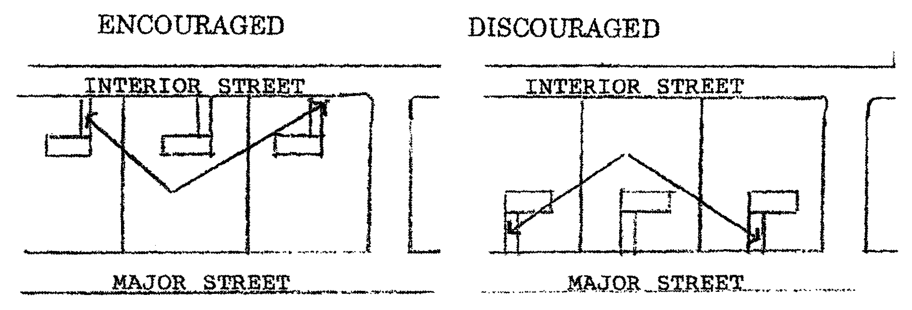
Where subdivisions are adjacent to a major thoroughfare, the subdivision shall be designed to minimize the number of lots fronting onto the major thoroughfare. This is required so as to minimize the number of turning points on the major thoroughfare. For lots which front onto an interior street but back onto a major thoroughfare, driveway access shall be onto the interior street only.
(b)
Utilities. The developer shall make arrangements for all distribution lines for telephone, electrical, television and other similar services distributed by wire or cable, except for feeder lines for said services, to be placed underground entirely throughout a residential subdivision area, and such conduits or cables shall be placed within private easements provided to such service companies by the developer or within dedicated public ways, provided that after receiving a written report from the engineer, planner and city council, overhead lines may be permitted by the city council at the time of final plat approval, where it is determined by the city council that overhead lines will not constitute a detriment to the health, safety, general welfare, plat design and character of the subdivision. All such facilities placed in dedicated public ways shall be planned so as not to conflict with other underground utilities. All such facilities shall be constructed in accordance with standards of construction approved by the state public service commission. All drainage and underground utility installations which traverse privately owned property shall be protected by easements granted by the developer.
(c)
Lots.
(1)
All lots shall face upon a public street.
(2)
The side lines of lots shall be approximately radial to the street upon which the lots face.
(3)
No lot shall be divided by a corporate boundary line. Such boundary line may be the lot line or center line of streets or alleys.
(4)
Lot widths, depths and area shall conform to the stipulations as set forth in the zoning ordinance.
(5)
Interior through lots shall not be allowed. For lots which front onto an interior street but back onto a major thoroughfare, driveway access shall be onto the interior street only.
(d)
Blocks.
(1)
No block shall be more than 1,000 feet in length. In blocks over 900 feet in length, the city council may require a walkway or easement for public utilities at or near the middle of the block.
(2)
The number of intersecting streets along highways and major thoroughfares shall be held to a minimum, wherever practicable. Blocks along such traffic way shall not be less than 1,320 feet in length.
(e)
General requirements.
(1)
In cases where variations and exceptions from the dimensional standards of this chapter are deemed necessary, said variations shall be granted by the zoning board of appeals subject to the procedures and standards outlined in article III of this chapter. Variances from standards contained in article XII of this chapter, subdivision control, shall be granted by the city council.
(2)
Every subdivision shall have a dedicated means of ingress and egress.
(Code 1991, § 19-518; Ord. No. 110, § 5, 8-12-2002)
Sec. 36-662. - Improvements; installation.
The minimum installation standards for improvements are as follows:
(1)
Streets shall meet the standards for streets adopted by the city.
(2)
Sanitary sewer lines shall be installed for all subdivision developments. The sanitary sewer lines shall be so designed and constructed to meet the requirements of the city utility ordinance, city infrastructure standards and the appropriate county, state or other jurisdictional agency. The developer shall be responsible for the installation of sewer lines to adequately serve the proposed development within the subdivision being platted and shall be responsible for any above-normal cost of materials and installation thereof necessarily encountered, as determined by the city.
(3)
Water lines shall be installed for all subdivision developments. The water lines shall be so designed and constructed to meet the requirements of the city utility ordinance, this article, city infrastructure standards and the appropriate county, state or other jurisdictional agency. The developer shall be responsible for the installation of water lines to adequately serve the proposed development. Water lines shall be looped where appropriate, when it can be demonstrated that water pressure and water quality would be significantly impacted were the looping not completed.
(4)
Sidewalks of five-foot width shall be constructed along both sides of the street right-of-way, within all dedicated street and walkway rights-of-way, of which the entire construction shall be the responsibility of the developer and the expense of the developer. Sidewalks shall be constructed to the standards established in the city infrastructure standard.
(5)
Outlawns between each curb and sidewalk shall be graded and seeded, of which the entire construction shall be the responsibility of the developer and at the expense of the developer.
(6)
Culverts and bridges shall be constructed when determined to be necessary by the city and shall be entirely the responsibility of the developer and at the expense of the developer. Culverts and bridges shall be constructed to the standards established by the appropriate county and/or state agency.
(7)
Storm sewer lines and systems (including, but not limited to, catch basins and manholes) shall be entirely the responsibility of the developer and installed at the expense of the developer. If it is necessary to construct a detention or retention pond as part of a proposed development, it is the responsibility of the developer to provide the property for such purposes.
(8)
In those instances where the city determines that it is necessary to install water, sanitary sewer or storm sewer lines larger than those normally needed to serve the area within the limits of the subdivision being platted, the city will assume the additional cost encountered.
(Code 1991, § 19-519; Ord. No. 110, § 6, 8-12-2002)
Sec. 36-663. - Inspection.
Installation of all improvements shall be inspected by a qualified inspector with applicable certification if required by the city. The inspector shall be selected by the city council. The developer shall be responsible for all inspection costs.
(Code 1991, § 19-520; Ord. No. 110, § 7, 8-12-2002)
Sec. 36-664. - Monumentation.
(a)
For every subdivision of land, there shall be a survey complying with the land division act, Public Act No. 288 of 1967 (MCL 560.101 et seq.). The survey of all subdivisions shall be performed by a professional surveyor registered in the State of Michigan.
(b)
All monumentation shall comply with the monumentation requirements of the land division act, Public Act No. 288 of 1967 (MCL 560.101 et seq.).
(c)
If, during the process of the installation of improvements, it is necessary to remove any monuments or benchmarks, the developer or its contractor shall obtain permission to make such removal from the person designated by city council to provide engineering review for the proposed development. All monuments or benchmarks removed, relocated, or destroyed shall be replaced in their proper location, by a professional surveyor registered in the State of Michigan, at the developer's expense.
(Code 1991, § 19-521; Ord. No. 110, § 8, 8-12-2002)
Sec. 36-665. - Fees.
All applicable fees are to be established by resolution of city council.
(Code 1991, § 19-523; Ord. No. 110, § 13, 8-12-2002)

