
Oxford City Zoning Code
ARTICLE II
- ZONING DISTRICTS
Sec. 40-25.- Zoning districts established.
The following zoning districts are hereby established:
(Code 1997, § 40-201; Ord. of 2-6-2012, § 1(40-201))
Sec. 40-26. - Overlay districts established.
There is hereby established the following overlay district: Residential Infill Overlay District.
(Code 1997, § 40-202; Ord. of 2-6-2012, § 1(40-202))
Sec. 40-27. - Official zoning map.
(a)
The boundaries of zoning districts and overlay districts created by this chapter are hereby established as shown on the official zoning map of the City.
(b)
The official zoning map and all explanatory matter thereon accompany and are hereby made a part of this chapter. The official zoning map shall indicate the date of adoption and most recent amendment. The original of the official zoning map shall be kept in the office of the City Clerk.
(c)
The official zoning map shall be considered the same as the official comprehensive zoning map as referenced in the City Charter.
(d)
The official zoning map may be kept electronically in a geographic information system and such electronic data shall constitute an integral part of the official zoning map.
(e)
The City may make copies of the official zoning maps available to the public for a reasonable fee.
(Code 1997, § 40-203; Ord. of 2-6-2012, § 1(40-203))
Sec. 40-28. - Amendment of official zoning map.
If, in accordance with the provisions of this chapter, the City Council approves changes in the district boundaries or other subject matter portrayed on the official zoning map, such changes shall be made promptly after the amendment or change has been approved by the City Council. Once an amendment to the official zoning map has been approved by the City Council, it shall be considered an administrative action to amend the official zoning map to properly depict the map amendment approved by the City Council, and additional approval or action by the council shall not be necessary.
(Code 1997, § 40-204; Ord. of 2-6-2012, § 1(40-204))
Sec. 40-29. - Correction and update of property lines on official zoning map.
(a)
The Zoning Administrator is authorized to correct or update property lines depicted on the official zoning map, as such changes to the tax records of the City are made through land subdivision and combination of lots, without a requirement to seek approval of the City Council, provided that such changes to property lines do not affect a zoning or overlay district boundary except as otherwise specifically provided in this section.
(b)
In any instance where the property lines as shown on the official zoning map deviate from a boundary survey prepared by a registered land surveyor for the lot or tract in question, and such deviation is attributed by the Zoning Administrator to a drafting error or imperfection in the property parcel data base originally used in preparing the official zoning map, the Zoning Administrator is authorized to correct the official zoning map to show the boundaries of the zoning or overlay district to follow the boundaries as shown on the boundary survey. Any such correction shall be considered an administrative action, and additional approval or action by council shall not be necessary to correct the official zoning map.
(Code 1997, § 40-205; Ord. of 2-6-2012, § 1(40-205))
Sec. 40-30. - Rules governing boundaries.
This section shall govern administrative determinations by the Zoning Administrator in cases where there is uncertainty with regard to the zoning or overlay district boundaries shown on the official zoning map. Where such uncertainty exists, the following provisions shall apply:
(1)
City limit lines. Where boundaries are indicated as approximately following the corporate limit line of the City, such corporate limit line shall be construed to be such boundaries.
(2)
Property lines. Where boundaries are indicated as following property lines, such property lines shall be construed to be such boundaries. The boundaries shall be determined on the basis of the legal descriptions or boundary surveys associated with approved map amendments, where available.
(3)
Stream and river beds. Where boundaries are indicated as approximately following the centerline of stream beds or river beds, or the outer edge of such stream bed or river bed, such centerline or edge of stream or river bed shall be construed to be such boundaries.
(4)
Abandonment. Where a public street or other right-of-way is officially vacated or abandoned, and the street or right-of-way is also a zoning district or overlay district boundary, the regulations applicable to the property to which it reverted shall apply to such vacated or abandoned public street or right-of-way.
(5)
Administrative determination. In any case where the exact location of a boundary cannot be determined by the foregoing methods, the Zoning Administrator shall determine the location of the boundary. Any such administrative determination is subject to appeal as an administrative decision in accordance with article IX of this chapter.
(Code 1997, § 40-206; Ord. of 2-6-2012, § 1(40-206))
Sec. 40-31. - Use, occupancy and erection.
No building, structure, land, or water shall hereafter be used or occupied, and no building or structure or part thereof shall be erected, constructed, reconstructed, moved, or structurally altered except in conformity with the regulations of this chapter or amendments thereto, including the use provisions for the zoning district in which it is located, the overlay district provisions if applicable, and any specific use provisions, if applicable.
(Code 1997, § 40-301; Ord. of 2-6-2012, § 1(40-301))
Sec. 40-32. - Use prohibited when not specified.
Any use not specifically permitted as a use by right or specifically indicated as a conditional use in any given zoning district as provided in this chapter shall be prohibited in that zoning district.
(Code 1997, § 40-302; Ord. of 2-6-2012, § 1(40-302))
Sec. 40-33. - Specific use provisions.
In cases where a use is a permitted use in the zoning district in which the use is located but there are specific use regulations for that use specified in this chapter, such regulations shall also apply and must be complied with. It is unlawful to establish a use without conforming to the specific use provisions of this chapter, when applicable.
(Code 1997, § 40-303; Ord. of 2-6-2012, § 1(40-303))
Sec. 40-34. - Minimum requirements.
Within each zoning district, the regulations set forth shall be minimum requirements and shall apply uniformly to each class or kind of building, structure or land, except as may be altered through conditions of zoning applied to specific properties.
(Code 1997, § 40-304; Ord. of 2-6-2012, § 1(40-304))
Sec. 40-35. - Every use must be upon a lot of record.
No building or structure shall be erected or use established unless upon a lot of record as defined by this chapter, except as otherwise unless specifically provided in this chapter.
(Code 1997, § 40-305; Ord. of 2-6-2012, § 1(40-305))
Sec. 40-36. - One single-family dwelling on a lot.
Except as otherwise specifically provided in this chapter, only one single-family dwelling and its accessory buildings may be erected on any one lot intended for such use. This provision shall not be construed to prevent the construction of more than one detached single-family condominium, or multiple-family dwelling on a single lot, in districts where permitted, subject to setbacks and separation as provided in this chapter.
(Code 1997, § 40-306; Ord. of 2-6-2012, § 1(40-306))
Sec. 40-37. - Height limitations.
(a)
Except as otherwise specifically provided in this section, no building or structure shall hereafter be erected, constructed, reconstructed, or altered, to exceed the maximum height of buildings and structures specified in this chapter; provided, however, the City Council may upon application and approval of a conditional use, allow buildings and structures to exceed these height limitations, subject to procedures for conditional uses established in this chapter.
(b)
The height limitations established herein shall not apply to chimneys, smokestacks, church spires and steeples, domes, flag poles, public monuments, observation towers, water towers, electricity transmission towers, utility poles, and similar structures.
(Code 1997, § 40-307; Ord. of 2-6-2012, § 1(40-307))
Sec. 40-38. - Maximum density, minimum lot size, and minimum lot width.
No lot shall hereafter be developed with a number of housing units that exceeds the residential density for the zoning district in which the lot is located as established by this chapter. No lot shall hereafter be developed that fails to meet the minimum lot size and minimum lot width for the zoning district in which the lot is located as established by this chapter, except as otherwise specifically provided. No lot shall be reduced in size, and no principal building shall hereafter be constructed, so that the maximum density, minimum lot size, or minimum lot width of the zoning district, as the case may be, in which the lot and building are located are not maintained, except as otherwise specifically provided in this chapter.
(Code 1997, § 40-308; Ord. of 2-6-2012, § 1(40-308))
Sec. 40-39. - Minimum floor area per dwelling unit.
No new dwelling shall hereafter be constructed or occupied that fails to meet the minimum floor area for a dwelling unit as established by the zoning district in which the property is located as specified in this chapter. No existing dwelling shall be reduced in size so that its floor area fails to meet the minimum floor area for a dwelling unit as established by the zoning district in which the property is located as specified in this chapter.
(Code 1997, § 40-309; Ord. of 2-6-2012, § 1(40-309))
Sec. 40-40. - Build-to lines.
Build-to lines are hereby established as shown on the build-to line map which is hereby adopted and made a part of this chapter. In the case where a build-to line is established by this chapter, no building shall be erected in a manner inconsistent with the established build-to line; provided, however, that the Zoning Administrator may administratively authorize a deviation in accordance with the following table for the erection of any building or structure from an established build-to line.
TABLE 3.1. CITY BUILD-TO LINES
The permitted deviation is the amount of variance allowed from the Build-to-Line that the building may be placed. This is approved administratively. Deviation beyond the limits set in the table above will require a variance under division 5 of this article.
(Code 1997, § 40-310; Ord. of 2-6-2012, § 1(40-310))
Sec. 40-41. - Minimum required yards and building setbacks.
(a)
No building or structure shall hereafter be erected in a manner to have narrower or smaller front yards, side yards, or rear yards than specified for the zoning district in which the property is located. Buffer requirements established by this chapter, where applicable, supersede these minimum required yards. In the case where a build-to line is established, the build-to line provisions of this chapter supersede and replace any front building setback lines, the latter of which shall only be deemed applicable in the absence of an established build-to line.
(b)
No lot shall be reduced in size, and no principal building shall hereafter be constructed, so that the front, side, or rear yards of the zoning district in which the lot and building are located are not maintained.
(c)
This section shall not apply to portions of lots affected by public acquisition of part of the lot.
(d)
No part of a yard shall be included as a part of the yard required for another building.
(Code 1997, § 40-311; Ord. of 2-6-2012, § 1(40-311))
Sec. 40-42. - Principal building separation.
All nonresidential principal buildings (except commercial buildings in town center) shall provide for adequate building separation to allow for sufficient fire access and traffic flow and to meet applicable building code requirements
(Code 1997, § 40-312; Ord. of 2-6-2012, § 1(40-312))
Sec. 40-43. - Maximum building coverage.
No lot shall hereafter be developed to exceed the maximum building coverage specified for the zoning district in which it is located, if applicable.
(Code 1997, § 40-313; Ord. of 2-6-2012, § 1(40-313))
Sec. 40-44. - Minimum landscaped open space.
No lot shall be developed with less than the minimum landscaped open space specified for the zoning district in which the lot is located, if applicable, or as may be established by any other article or section of this chapter, if applicable.
(Code 1997, § 40-314; Ord. of 2-6-2012, § 1(40-314))
Sec. 40-45. - Minimum required landscape strips and buffers.
No lot shall hereafter be developed, and no building or structure shall hereafter be erected or use established in a manner so that the minimum landscape strips and buffers required by this chapter for the zoning district in which the building, structure, or use is located, or for the specific use if buffer and landscape strip requirements are established for the use.
(Code 1997, § 40-315; Ord. of 2-6-2012, § 1(40-315))
Sec. 40-46. - Street frontage requirement.
No building or structure shall hereafter be erected on a lot, and no lot shall hereafter be created or subdivided, that does not abut for at least 30 feet on a public street, or an approved private street, unless specifically provided otherwise by this chapter.
(Code 1997, § 40-316; Ord. of 2-6-2012, § 1(40-316))
Sec. 40-47. - Zoning of annexed lands.
(a)
Property annexed or proposed to be annexed into the city limits shall be zoned in accordance with the Zoning Procedures Law, O.C.G.A. § 36-66, and this chapter. Such property annexed may be zoned by the City Council to any zoning district or districts established in this chapter.
(b)
Lands hereafter annexed into the City limits shall, upon the effective date of such annexation, be subject to all applicable procedural and substantive requirements of this land use management code as now or hereafter amended, except as specifically provided otherwise in this chapter for the NCA, Newton County Annexed Zoning District.
(Code 1997, § 40-317; Ord. of 2-6-2012, § 1(40-317))
Sec. 40-48. - Validity of existing conditions of zoning or use approval.
Notwithstanding the repeal of prior ordinances in conflict with the ordinance from which this chapter is derived upon its adoption, if a property was zoned subject to conditions or use approved subject to certain conditions prior to the adoption of the ordinance from which this chapter is derived by the City Council, the existing zoning conditions or conditions of use approval shall continue to apply to the property.
(Code 1997, § 40-318; Ord. of 2-6-2012, § 1(40-318))
Sec. 40-70.- Purpose and intent.
The CONS district is established to correspond with large tracts of land which are limited in their future development potential by conservation easements or conservation intent as expressed by current owners or by previous owners who stipulated conservation as a condition of sale or gift. Properties in this district have been set aside in their largely undeveloped state for educational or passive recreational use or as buffer zones.
(Code 1997, § 40-401-1; Ord. of 2-6-2012, § 1(40-401-1))
Sec. 40-71. - Permitted and conditional uses.
Permitted and conditional uses shall be as provided in table 4.1, permitted and conditional uses for rural and residential zoning districts. In cases where a use is permitted but there are specific use regulations for that use specified in article III of this chapter, such regulations shall also apply and must be complied with.
(Code 1997, § 40-401-2; Ord. of 2-6-2012, § 1(40-401-2))
Sec. 40-72. - Dimensional requirements.
Dimensional requirements shall be as provided in table 4.2, dimensional requirements for rural and residential zoning districts.
(Code 1997, § 40-401-3; Ord. of 2-6-2012, § 1(40-401-3))
Sec. 40-73. - Design principles and guidelines.
Design criteria to be applied in this zoning district shall be as provided in table 4.3, design criteria for rural and residential zoning districts.
(Code 1997, § 40-401-4; Ord. of 2-6-2012, § 1(40-401-4))
Sec. 40-105.- Purpose and intent.
(a)
AG zoning districts are intended to implement the rural character areas established on the future development map of the city comprehensive plan, community agenda and as described in the community agenda. The prevailing land use pattern in this zoning district is agriculture, forestry, and very low density residential uses mostly incidental to farm operations as the principal use. The maximum density established for this district (one unit per three acres) is the most that can be permitted while still maintaining desired character.
(b)
Sanitary sewer service is generally not available to land in this zoning district, and public water may or may not be available. Conventional suburban subdivisions even at low densities are considered incompatible with desired agricultural and rural residential character.
(Code 1997, § 40-402-1; Ord. of 2-6-2012, § 1(40-402-1))
Sec. 40-106. - Permitted and conditional uses.
Permitted and conditional uses shall be as provided in table 4.1, permitted and conditional uses for rural and residential zoning districts. In cases where a use is permitted but there are specific use regulations for that use specified in this chapter, such regulations shall also apply and must be complied with.
(Code 1997, § 40-402-2; Ord. of 2-6-2012, § 1(40-402-2))
Sec. 40-107. - Dimensional requirements.
Dimensional requirements shall be as provided in table 4.2, dimensional requirements for rural and residential zoning districts.
(Code 1997, § 40-402-3; Ord. of 2-6-2012, § 1(40-402-3))
Sec. 40-108. - Design principles and guidelines.
Design criteria to be applied in this zoning district shall be as provided in table 4.3, design criteria for rural and residential zoning districts.
(Code 1997, § 40-402-4; Ord. of 2-6-2012, § 1(40-402-4))
Sec. 40-130.- Purpose and intent.
(a)
RR zoning districts are intended to implement the estate/rural residential and rural character areas established on the future development map of the city comprehensive plan, as provided in the community agenda. Sanitary sewer service is generally not available to land in this zoning district, and public water may or may not be available. The RR zoning district establishes a minimum lot size of 60,000 square feet (one unit per 1.38 acres) and a minimum lot width of 150 feet. A minimum house size (heated floor area per dwelling unit) of 2,000 square feet is established for new construction (not applicable to reconstruction if a natural disaster or fire occurs).
(b)
The overall intent of this zoning district is to preserve rural and estate residential character, and provide for very low-density rural residential uses. Areas designated as RR zoning are inappropriate for urban development. Future development in this district must observe policies and guidelines for preserving rural character.
(Code 1997, § 40-403-1; Ord. of 2-6-2012, § 1(40-403-1))
Sec. 40-131. - Permitted and conditional uses.
Permitted and conditional uses shall be as provided in table 4.1, permitted and conditional uses for rural and residential zoning districts. In cases where a use is permitted but there are specific use regulations for that use specified in this chapter, such regulations shall also apply and must be complied with.
(Code 1997, § 40-403-2; Ord. of 2-6-2012, § 1(40-403-2))
Sec. 40-132. - Dimensional requirements.
Dimensional requirements shall be as provided in table 4.2, dimensional requirements for rural and residential zoning districts.
(Code 1997, § 40-403-3; Ord. of 2-6-2012, § 1(40-403-3))
Sec. 40-133. - Design principles and guidelines.
Design criteria to be applied in this zoning district shall be as provided in table 4.3, design criteria for rural and residential zoning districts.
(Code 1997, § 40-403-4; Ord. of 2-6-2012, § 1(40-403-4))
Sec. 40-165.- Purpose and intent.
(a)
The R-30 zoning district establishes a minimum lot size of 30,000 square feet (0.688 acre) and a minimum lot width of 100 feet. A minimum house size (heated floor area per dwelling unit) of 2,000 square feet is established for new construction (not applicable to reconstruction if a natural disaster or fire occurs).
(b)
This zoning district is intended primarily to implement the Historic Oxford character area established on the future development map of the city comprehensive plan, community agenda and as described in the community agenda. R-30 zoning districts may also be applicable to the estate/rural character area and parts of the town neighborhood character area. Public water service is available, and sanitary sewer may be available, although minimum lot sizes are large enough to support on site sewage management systems while meeting county health department regulations.
(c)
The primary intent of this zoning district is to protect the existing, low-density residential character of neighborhoods from intrusion by incompatible land uses and from future residential development that fails to respect the prevailing neighborhood patterns and characteristics.
(Code 1997, § 40-404-1; Ord. of 2-6-2012, § 1(40-404-1))
Sec. 40-166. - Permitted and conditional uses.
Permitted and conditional uses shall be as provided in table 4.1, permitted and conditional uses for rural and residential zoning districts. In cases where a use is permitted but there are specific use regulations for that use specified in article III of this chapter, such regulations shall also apply and must be complied with.
(Code 1997, § 40-404-2; Ord. of 2-6-2012, § 1(40-404-2))
Sec. 40-167. - Dimensional requirements.
Dimensional requirements shall be as provided in table 4.2, dimensional requirements for rural and residential zoning districts.
(Code 1997, § 40-404-3; Ord. of 2-6-2012, § 1(40-404-3))
Sec. 40-168. - Design principles and guidelines.
Design criteria to be applied in this zoning district shall be as provided in table 4.3, criteria for rural and residential zoning districts.
(Code 1997, § 40-404-4; Ord. of 2-6-2012, § 1(40-404-4))
Sec. 40-190.- Purpose and intent.
(a)
The R-20 zoning district establishes a minimum lot size of 20,000 square feet (0.459 acre) and a minimum lot width of 100 feet. A minimum house size (heated floor area per dwelling unit) of 1,800 square feet is established for new construction (not applicable to reconstruction if a natural disaster or fire occurs). This zoning district is intended primarily to implement the Historic Oxford and town neighborhood character areas established on the future development map of the city comprehensive plan as described in the community agenda. Public water service is available. Sanitary sewer is also available and required for new lots platted in this zoning district.
(b)
The primary intent of this zoning district is to protect the existing, low to medium density residential character of neighborhoods from intrusion by incompatible land uses.
(Code 1997, § 40-405-1; Ord. of 2-6-2012, § 1(40-405-1))
Sec. 40-191. - Permitted and conditional uses.
Permitted and conditional uses shall be as provided in table 4.1, permitted and conditional uses for rural and residential zoning districts.
(Code 1997, § 40-405-2; Ord. of 2-6-2012, § 1(40-405-2))
Sec. 40-192. - Dimensional requirements.
Dimensional requirements shall be as provided in table 4.2, dimensional requirements for residential zoning districts.
(Code 1997, § 40-405-3; Ord. of 2-6-2012, § 1(40-405-3))
Sec. 40-193. - Design principles and guidelines.
Design criteria to be applied in this zoning district shall be as provided in table 4.3, design criteria for rural and residential zoning districts.
(Code 1997, § 40-405-4; Ord. of 2-6-2012, § 1(40-405-4))
Sec. 40-225.- Purpose and intent.
(a)
The R-15 zoning district establishes a minimum lot size of 15,000 square feet (0.344 acre) and a minimum lot width of 75 feet. A minimum house size (heated floor area per dwelling unit) of 1,500 square feet is established for new construction (not applicable to reconstruction if a natural disaster or fire occurs). This zoning district is intended primarily to implement the town neighborhood character area established on the future development map of the city comprehensive plan, as described in the community agenda. Public water service is available. Sanitary sewer is also available and required for new lots platted in this zoning district.
(b)
The primary intent of this zoning district is to protect the existing, medium density residential character of neighborhoods from intrusion by incompatible land uses.
(Code 1997, § 40-406-1; Ord. of 2-6-2012, § 1(40-406-1))
Sec. 40-226. - Permitted and conditional uses.
Permitted and conditional uses shall be as provided in table 4.1, permitted and conditional uses for rural and residential zoning districts. In cases where a use is permitted but there are specific use regulations for that use specified in article III of this chapter, such regulations shall also apply and must be complied with.
(Code 1997, § 40-406-2; Ord. of 2-6-2012, § 1(40-406-2))
Sec. 40-227. - Dimensional requirements.
Dimensional requirements shall be as provided in table 4.2, dimensional requirements for rural and residential zoning districts.
(Code 1997, § 40-406-3; Ord. of 2-6-2012, § 1(40-406-3))
Sec. 40-228. - Design principles and guidelines.
Design criteria to be applied in this zoning district shall be as provided in table 4.3, design criteria for rural and residential zoning districts.
(Code 1997, § 40-406-4; Ord. of 2-6-2012, § 1(40-406-4))
Sec. 40-250.- Purpose and intent.
(a)
The R-7.5 zoning district establishes a minimum lot size of 7,500 square feet (0.172 acre). The minimum lot width established for this district is 50 feet. A minimum house size (heated floor area per dwelling unit) of 1,200 square feet is established for new construction; however, the average (mean) house size for the district must be equal to or greater than 2,000 square feet. Public water service and sanitary sewer are available and required for new lots platted in this zoning district.
(b)
Generally, R-7.5 districts are within a five-minute walking distance (approximately one quarter mile radius) of the city's town center (TC zoning district). This district does not have an established development pattern, and it is applied to undeveloped areas in the City where higher density, single-family development is encouraged. In order to provide for a diversity of housing opportunities, while maintaining high-quality development standards, this district requires multiparcel development or the subdivision of an existing parcel to provide a variety of lot sizes and house sizes, within the minimum lot size and average (mean) house size standards specified above. In the R-7.5 zoning district, new development must adhere to principles of traditional neighborhood development, including pedestrian orientation and street connectivity.
(Code 1997, § 40-407-1; Ord. of 2-6-2012, § 1(40-407-1))
Sec. 40-251. - Permitted and conditional uses.
Permitted and conditional uses shall be as provided in table 4.1, permitted and conditional uses for rural and residential zoning districts.
(Code 1997, § 40-407-2; Ord. of 2-6-2012, § 1(40-407-2))
Sec. 40-252. - Dimensional requirements.
Dimensional requirements shall be as provided in table 4.2, dimensional requirements for rural and residential zoning districts.
(Code 1997, § 40-407-3; Ord. of 2-6-2012, § 1(40-407-3))
Sec. 40-253. - Design principles and guidelines.
Design criteria to be applied in this zoning district shall be as provided in table 4.3, design criteria for rural and residential zoning districts.
(Code 1997, § 40-407-4; Ord. of 2-6-2012, § 1(40-407-4))
Sec. 40-285.- Purpose and intent.
(a)
The RTH zoning district is established to permit single-family attached dwellings on small lots under fee simple ownership (also called fee simple townhouses). This district establishes a minimum lot size of 2,400 square feet (0.055 acre) and a minimum lot width of 24 feet for fee simple townhouse lots, but townhouse development is also subject to a maximum density threshold of 12 lots (dwellings) per acre. This means that some lots (i.e., those at the end of a building containing attached townhouses) will have to be larger in order to meet the overall density maximum. A house size (heated floor area per dwelling unit) of 1,000 square feet is established for fee simple townhouse dwellings and fee simple homes constructed on zero-lot line lots. Public water service is available. Sanitary sewer is also available and required for new lots platted in this zoning district.
(b)
Rezoning to the R-TH zoning district within established R-7.5 zoned areas may be considered appropriate, in order to provide more affordable housing opportunities, subject to site development and architectural design review. This district is not considered appropriate within established R-30, R-20, and R-15 zoned neighborhoods, nor is it considered appropriate for designation in the Historic Oxford character area established on the future development map of the city comprehensive plan, as described in the community agenda, nor is it considered appropriate in the town neighborhood character area, except for those portions zoned R-7.5 within the residential Infill Development Overlay Zoning District. In the R-TH zoning district, new development must adhere to principles of traditional neighborhood development, including pedestrian orientation and street connectivity.
(Code 1997, § 40-408-1; Ord. of 2-6-2012, § 1(40-408-1))
Sec. 40-286. - Permitted and conditional uses.
Permitted and conditional uses shall be as provided in table 4.1, permitted and conditional uses for rural and residential zoning districts.
(Code 1997, § 40-408-2; Ord. of 2-6-2012, § 1(40-408-2))
Sec. 40-287. - Dimensional requirements.
Dimensional requirements shall be as provided in table 4.2, dimensional requirements for rural and residential zoning districts.
(Code 1997, § 40-408-3; Ord. of 2-6-2012, § 1(40-408-3))
Sec. 40-288. - Design principles and guidelines.
Design criteria to be applied in this zoning district shall be as provided in table 4.3, design criteria for rural and residential zoning districts.
TABLE 4.1. PERMITTED AND CONDITIONAL USES FOR RURAL AND
RESIDENTIAL ZONING DISTRICTS
P = Permitted; C = Conditional Use; X = Prohibited
TABLE 4.2. DIMENSIONAL REQUIREMENTS FOR RURAL AND RESIDENTIAL
ZONING DISTRICTS
(1) The minimum lot size for this district may be varied (reduced) for conservation subdivisions per code.
N/A = Not Applicable
TABLE 4.3. DESIGN CRITERIA FOR RURAL AND RESIDENTIAL
ZONING DISTRICTS
A = applicable; N/A = not applicable
(Code 1997, § 40-408-4; Ord. of 2-6-2012, § 1(40-408-4))
Sec. 40-310.- Purpose and intent.
This zoning district applies to public and private institutional uses now existing or anticipated in the City, such as elementary, middle, and secondary schools, city, county, and state government offices, public utility offices and installations, churches and places of worship.
(Code 1997, § 40-409-1; Ord. of 2-6-2012, § 1(40-409-1))
Sec. 40-311. - Permitted and conditional uses.
Permitted and conditional uses shall be as provided in table 4.4, permitted and conditional uses for nonresidential zoning districts.
(Code 1997, § 40-409-2; Ord. of 2-6-2012, § 1(40-409-2))
Sec. 40-312. - Dimensional requirements.
Dimensional requirements shall be as provided in table 4.5, dimensional requirements for nonresidential zoning districts.
(Code 1997, § 40-409-3; Ord. of 2-6-2012, § 1(40-409-3))
Sec. 40-313. - Design principles and guidelines.
Design criteria to be applied in this zoning district shall be as provided in table 4.6, design criteria for nonresidential zoning districts.
(Code 1997, § 40-409-4; Ord. of 2-6-2012, § 1(40-409-4))
Sec. 40-345.- Purpose and intent.
(a)
The Institutional Campus (IC) District provides opportunity for large public or private, nonprofit institutional uses, including college/university campuses, primary and secondary schools, medical facility complexes, recreational complexes, and similar campus-oriented institutions, to develop and function as holistic campus areas with unique needs and characteristics.
(b)
The IC district shall apply to public and private institutional uses in the following circumstances:
(1)
Total land area under the ownership, management, or control of a single legal entity and its ancillaries is equal to or greater than five acres, and individual parcels are contiguous, or proximate (when bisected by public streets or thoroughfares).
(2)
Multiple principal buildings are located on a single parcel, or on adjacent or proximate parcels, and support a common institutional purpose (i.e., education or recreation).
(3)
Total population of the legal entity's employees, students, members, or patrons is equal to or greater than 500. The Planning Commission may recommend that the City Council apply this district in other circumstances as deemed necessary and appropriate.
(c)
The primary intent of this division is to enable the City to plan for significant development anticipated within the IC District, and, in cooperation and coordination with the institutions within the IC district, ensure infrastructure, utilities, land use, transportation and public safety issues (and other issues that may arise) are adequately addressed. Given the holistic nature and significant scale of institutions within the IC district, development proposals and land uses must be considered in light of the cumulative effect on public facilities, infrastructure and services as well as public health, safety and welfare. Therefore, institutions within the IC district are required to create and maintain a future development plan consistent with the City comprehensive plan.
(d)
The future development plan is programmatic in nature, presenting anticipated needs for development or use of buildings and land within the district, as a holistic campus environment, over a ten year planning horizon. The future development plan provides input necessary for the City to maintain its comprehensive plan in accordance with state minimum standards and procedures.
(e)
The future development plan shall identify options for arrangements of buildings and spaces, and their respective uses, and may be updated and resubmitted at any time, to provide flexibility in its execution and to account for uncertainty within the planning horizon. The future development plan shall be updated, if necessary, when applications for development permits for new projects are submitted, and a development permit shall not be issued if the future development plan has not been reviewed and accepted by the City Council.
(Code 1997, § 40-410-1; Ord. of 2-6-2012, § 1(40-410-1))
Sec. 40-346. - Permitted and conditional uses.
(a)
The principal use within the IC district shall be reserved for public or private nonprofit institutions, including, but not limited to: colleges, universities, primary and secondary schools, technical schools, medical facility complexes, multi-service centers, and similar campus-oriented institutions, as well as uses supporting and ancillary to those institutions.
(b)
Permitted and conditional uses shall be as provided in table 4.4, permitted and conditional uses for nonresidential zoning districts. Additionally, each IC district shall have a transitional area within which uses are limited to minimize adverse impact on neighboring residential areas.
(Code 1997, § 40-410-2; Ord. of 2-6-2012, § 1(40-410-2))
Sec. 40-347. - Dimensional requirements.
(a)
Dimensional requirements shall be as delineated on the future development plan or supporting documentation as required by this section.
(b)
Within the district, a transitional area (TA) shall be established as the land area within 200 feet of the district boundary wherever the district is adjacent or, when bisected by a public street or thoroughfare, proximate to a residential district. The front, side, and rear set back requirement for construction within the TA shall be 30 feet, at a minimum, and the building height within the TA shall not exceed 35 feet.
(Code 1997, § 40-410-3; Ord. of 2-6-2012, § 1(40-410-3))
Sec. 40-348. - Design principles and guidelines.
Design criteria to be applied in this zoning district shall be as provided in table 4.6, design criteria for nonresidential zoning districts.
(Code 1997, § 40-410-4; Ord. of 2-6-2012, § 1(40-410-4))
Sec. 40-349. - Future development plan requirements.
The following elements shall be provided in the future development plan for all new or existing institutions seeking development under the Institutional Campus (IC) district:
(1)
Mission and objectives. The institution shall provide a statement of its organizational mission and objectives, including any services to be provided to residents of adjacent neighborhoods or to the City. The statement shall include the institution's existing and projected population (over a ten-year planning horizon), including employees, students, or patrons.
(2)
Property and uses. The institution shall provide an inventory of existing property and uses, including:
a.
Aerial map, based on the most up-to-date aerial photographs available from the Newton County Geographic Information System (GIS) Center or the office of the county tax assessor, showing the district boundary and all land, buildings and other structures within the IC district as of the date of submission of the future development plan. The map also shall delineate the TA and include other land area and infrastructure within 300 feet of the district.
b.
Narrative keyed to the aerial map with description of footprints and uses of existing land parcels, buildings, structures, roads, sidewalks, parking areas, recreational facilities, and other significant site developments.
c.
Floor area (in square feet), building height (in stories and feet), and current occupant capacities (i.e., number of persons allowed by fire code) of each building, as well as location, land area, and capacity of parking facilities.
(3)
Anticipated institution needs. The institution shall provide a statement of anticipated needs with respect to future development and land use within the district, including projections over a ten-year time horizon for the following:
a.
Number of employees, students, members, or patrons;
b.
Facility needs in assignable square feet (by facility type);
c.
Acreage of athletic or recreational facilities;
d.
Number of parking spaces;
e.
Electricity, water, sewerage capacity, or other utility demand; and
f.
Vehicular and pedestrian circulation along city streets and public spaces.
(4)
Future land use. The institution shall include in the future development plan anticipated future land uses, with an accompanying map drawn to scale, illustrating land use changes and circulation (vehicular and pedestrian) over the ten-year planning horizon. The future land use plan and accompanying map specifically shall illustrate:
a.
Existing and proposed land use, including academic, housing, recreation, ancillary (e.g., dining, maintenance, etc.) and mixed-use, as well as the anticipated location (or alternate locations), size (in square feet) and capacity (in population served) of future facilities;
b.
Existing and proposed conservation areas and open spaces;
c.
Existing and proposed vehicular circulation patterns, including deliveries;
d.
Existing and proposed parking facilities with their capacities.
(5)
Traffic management. The institution shall demonstrate how it will manage or otherwise regulate campus-related vehicular and pedestrian circulation, as well as parking facilities, to mitigate impact on adjacent and proximate residential neighborhoods.
(Code 1997, § 40-410-5; Ord. of 2-6-2012, § 1(40-410-5); Ord. of 4-3-2017, § 1)
Sec. 40-350. - Institutional campus future development plan procedures.
This section sets out the required review and acceptance procedures for the institutional campus future development plan.
(1)
Application. The institution shall prepare and submit the future development plan to the Planning Commission for review. (If the institution's existing master plan meets all of the requirements in this chapter for a future development plan, such master plan may be submitted as the future development plan.)
(2)
Review. The Planning Commission shall review the future development plan and make a recommendation to the City Council as to whether to accept the plan as submitted, to accept the plan with amendments or special stipulations, or to require further revision to the plan.
(3)
Planning horizon and update requirements. The future development plan shall cover a ten-year time horizon, and it shall be updated every years and submitted for review by the Planning Commission at its January meeting. Every five years the full plan shall be submitted for review by the Planning Commission and acceptance by the City Council.
(4)
Amendment procedures. An institution with an accepted future development plan may submit an amendment to the plan at any time. Proposed amendments shall be reviewed by the Planning Commission for acceptance in accordance with the review process outlined in this section.
(Code 1997, § 40-410-6; Ord. of 2-6-2012, § 1(40-410-6); Ord. of 4-3-2017(1), § 1; Ord. of 4-3-2017, § 1)
Sec. 40-351. - Approval criteria.
(a)
In accordance with this chapter, a site and design plan shall be required before a development permit, building permit or other permit, as appropriate, is issued or any improvement, grading, alteration of lands, or construction of buildings commences. acceptance of the future development plan by the City Council shall not constitute approval of a development permit.
(b)
In accordance with this chapter, a development permit shall be required for any proposed use of lands or buildings, and before any improvement, grading or alteration of lands or buildings commences to indicate and insure compliance with all provisions of this chapter and other applicable regulations in this Code.
(c)
The Planning Commission shall review, and the City Council shall accept, future development plans based on one or more of the following policies and standards:
(1)
Whether the future development plan is complete in terms of required content and is consistent with the adopted plans of the City, such as the city comprehensive plan.
(2)
Whether future development proposed (conceptually and concretely) in the future development plan will adversely impact public services and infrastructure.
(3)
Whether the future development plan complies with all applicable standards of this chapter.
(4)
Whether the future development plan will result in significant adverse impacts to other property in the vicinity of the applicant institution, or to the natural environment.
(5)
Whether the plan will have significant adverse impacts on the livability of adjacent or nearby residential zoning districts, especially with respect to:
a.
Noise, glare from lights, late-night operation, odors and litter;
b.
Privacy, traffic, parking and other safety issues; and
c.
Mass, height and overall scale of buildings.
(6)
Whether any differences in appearance or scale from the surrounding area are sufficiently and appropriately mitigated through setbacks, screening, landscaping or other design features.
(7)
Whether the future development plan has adequate mitigation measures for any other identified potential adverse impacts.
(Code 1997, § 40-410-7; Ord. of 2-6-2012, § 1(40-410-7))
Sec. 40-376.- Purpose and intent.
OP zoning districts are intended to encourage and provide suitable areas for professional, medical, and general offices and certain related activities. OP districts apply primarily to individual, freestanding office buildings, frequently conversions of dwellings previously used for residential use. However, this district also permits new, individual office buildings and small office parks.
(Code 1997, § 40-412-1; Ord. of 2-6-2012, § 1(40-412-1))
Sec. 40-377. - Permitted and conditional uses.
Permitted and conditional uses shall be as provided in table 4.4, permitted and conditional uses for nonresidential zoning districts.
(Code 1997, § 40-412-2; Ord. of 2-6-2012, § 1(40-412-2))
Sec. 40-378. - Dimensional requirements.
Dimensional requirements shall be as provided in table 4.5, dimensional requirements for nonresidential zoning districts.
(Code 1997, § 40-412-3; Ord. of 2-6-2012, § 1(40-412-3))
Sec. 40-379. - Design principles and guidelines.
Design criteria to be applied in this zoning district shall be as provided in table 4.6, design criteria for nonresidential zoning districts.
(Code 1997, § 40-412-4; Ord. of 2-6-2012, § 1(40-412-4))
Sec. 40-402.- Purpose and intent.
This district is intended to accommodate limited, small-scale, freestanding commercial uses outside the TC, Town Center Zoning District. Such commercial uses permitted are of a convenience nature serving the scale of city neighborhoods as opposed to a regional market. Highway oriented uses and those with an open-storage characteristic are either restricted or limited to conditional uses, in order to protect the small town character of the City.
(Code 1997, § 40-413-1; Ord. of 2-6-2012, § 1(40-413-1))
Sec. 40-403. - Permitted and conditional uses.
Permitted and conditional uses shall be as provided in table 4.4, permitted and conditional uses for nonresidential zoning districts.
(Code 1997, § 40-413-2; Ord. of 2-6-2012, § 1(40-413-2))
Sec. 40-404. - Dimensional requirements.
Dimensional requirements shall be as provided in table 4.5, dimensional requirements for nonresidential zoning districts.
(Code 1997, § 40-413-3; Ord. of 2-6-2012, § 1(40-413-3))
Sec. 40-405. - Design principles and guidelines.
Design criteria to be applied in this zoning district shall be as provided in table 4.6, design criteria for nonresidential zoning districts.
(Code 1997, § 40-413-4; Ord. of 2-6-2012, § 1(40-413-4))
Sec. 40-424.- Purpose and intent.
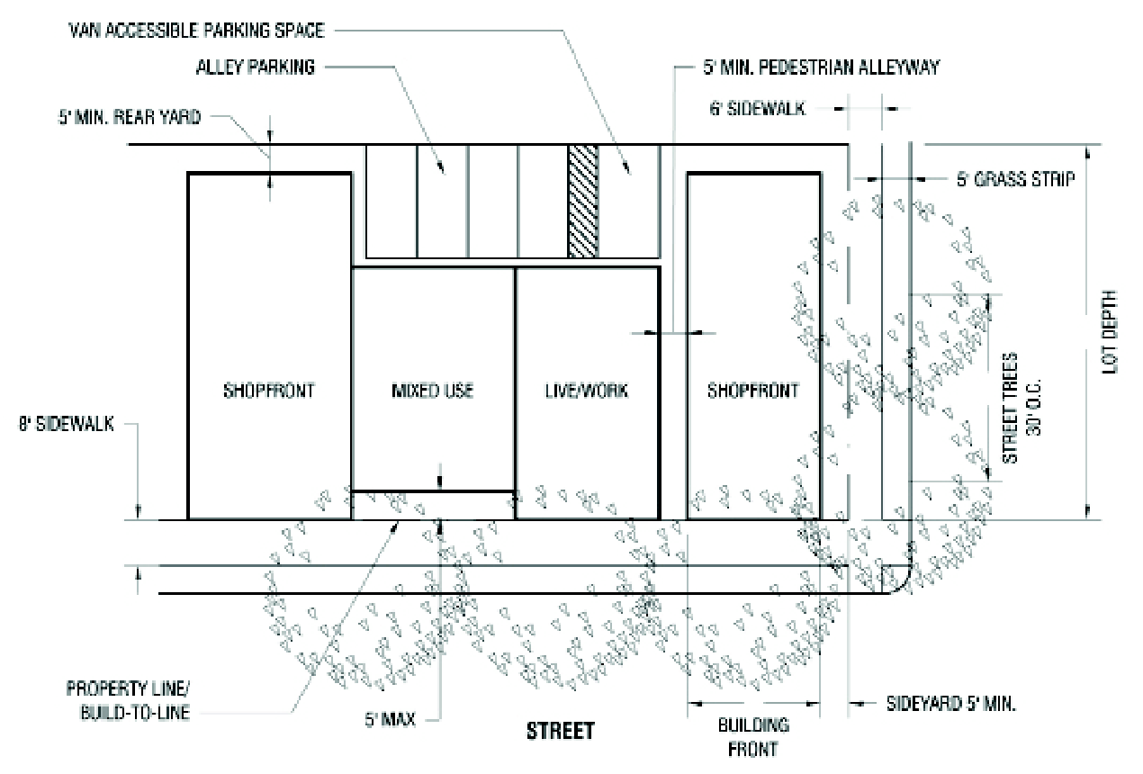
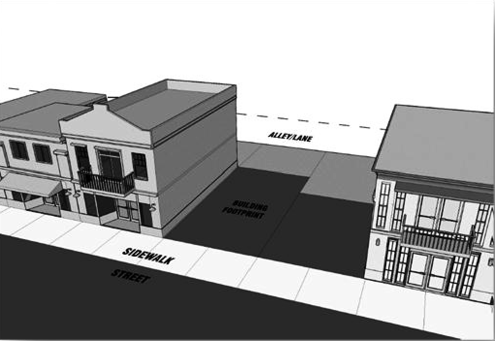
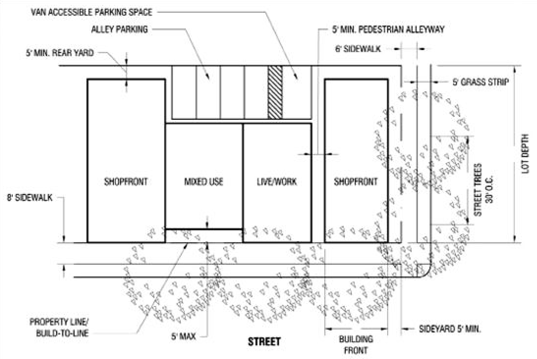
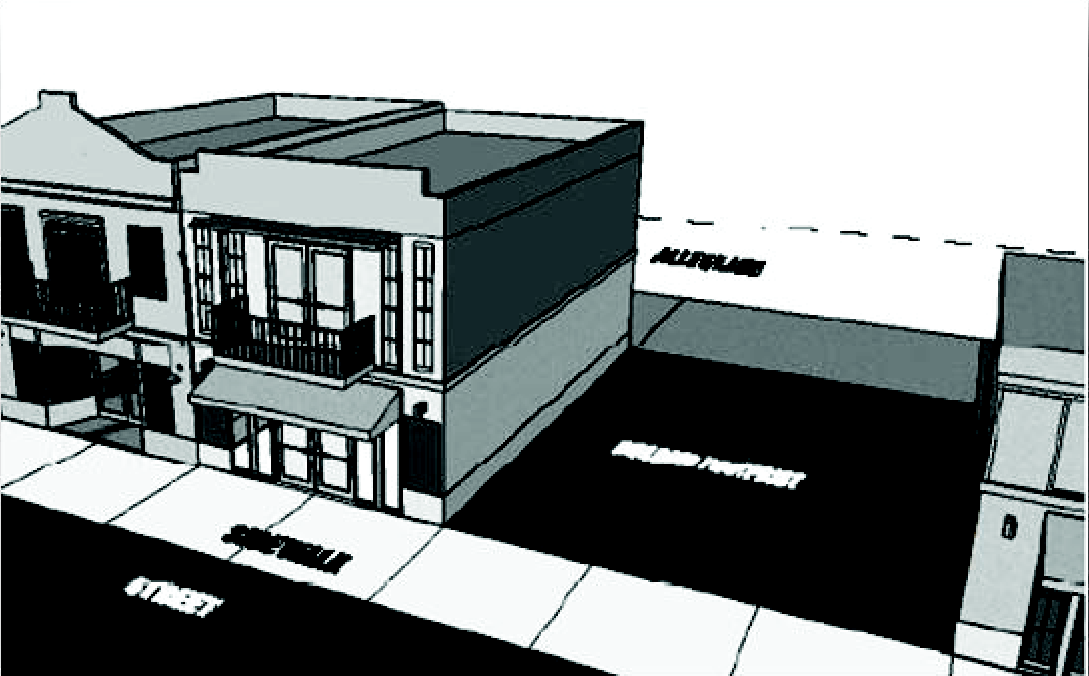
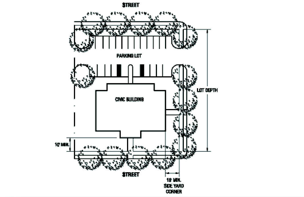
The City has undertaken an effort to revitalize its historic core by creating a conceptual center master plan, shown in this section. The town center master plan shows the potential build-out of parcels within the study area. For the purposes of implementing the development of the town center, it will also serve as the regulating plan for the town center district code. A regulating plan defines the desired physical form and sets development parameters such as land use, street type, building height, siting and setbacks, and parking placement. It will serve as a guide for city officials, property owners, and development professionals as they conceive and implement improvements and development projects within the town center area.
Conceptual Town Center Design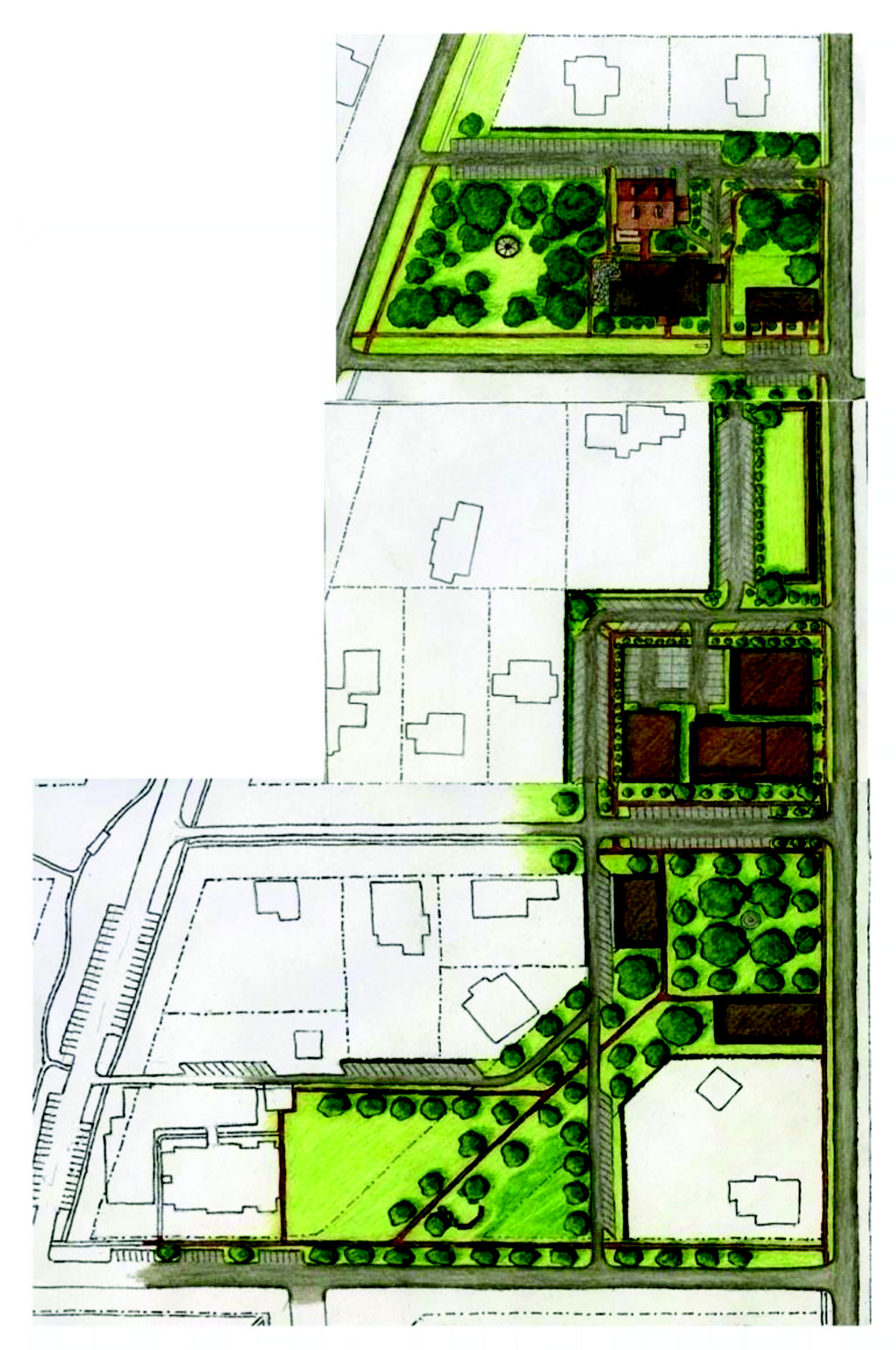
(Code 1997, § 40-414; Ord. of 2-6-2012, § 1(40-414))
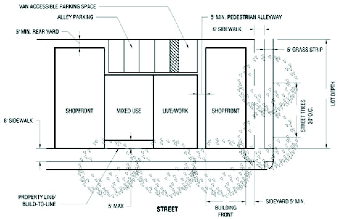
Sec. 40-425. - Regulating framework.
(a)
Town center district build-to-lines. The build-to line is better for "place making" than the standard zoning practice of setting minimum setbacks. It provides uniformity along a street front and lends to pedestrian scale by requiring buildings to be placed at the build-to line (shown in red) in the town center district (area shown in brown), the setback is from the build-to line rather than the right-of-way.
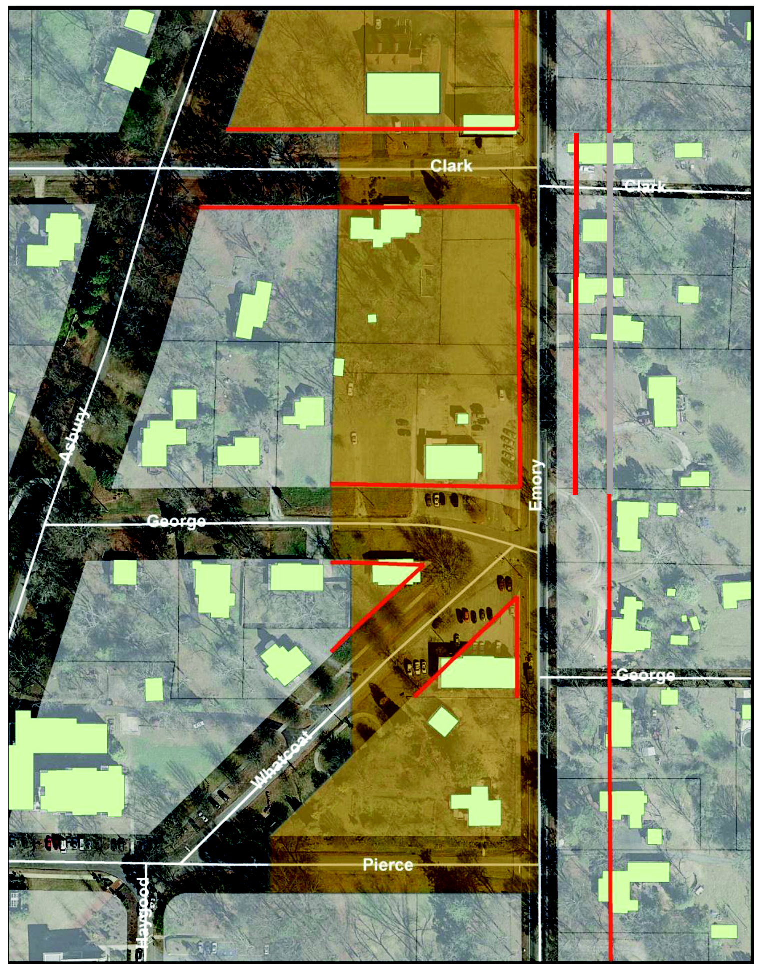
Town Center District


(b)
Description. The town center district code provides a template for establishing a mixed-use, main street character. It is intended to provide the west side of Emory Street (State Route 81) with a consistent ground-floor retail corridor that is both attractive and pedestrian friendly. The ground floor of buildings in this district should be commercial/retail use, with upper floors use for office, retail or residential uses.
(1)
Setbacks from build-to-line or property line. The following table shall be the setbacks from build-to-line or property line:
Shopfront and mixed-use buildings may extend their front setback requirements up to ten feet in order to comply with the outdoor dining requirements. If this is exercised, the extended area may only be used for the purposes of outdoor dining.
(2)
Outdoor dining. Outdoor eating areas are permitted in the town center district where a sidewalk area (private plus public) of at least 12 feet in continuous width is provided. A clear area of at least five feet wide must be provided in the public sidewalk for passage by pedestrians, patrons and servers.
(Code 1997, § 40-414; Ord. of 2-6-2012, § 1(40-414))
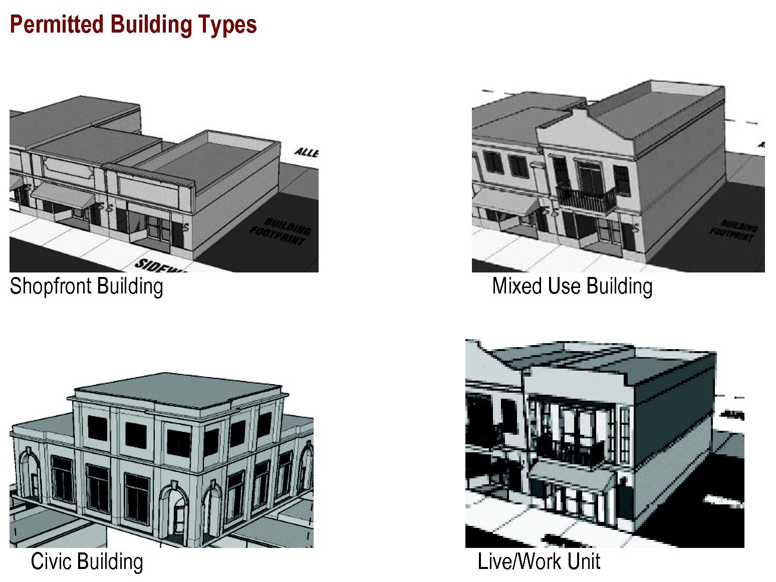
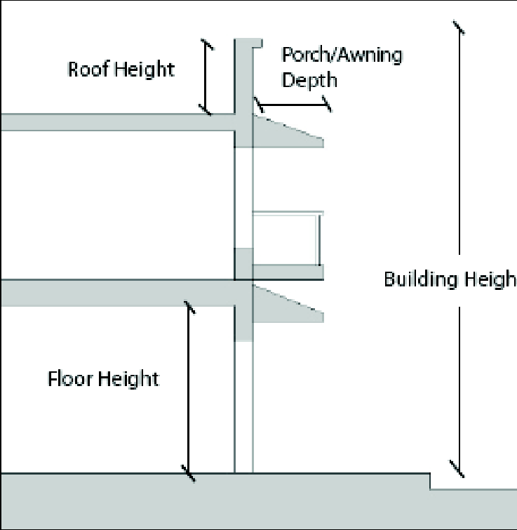
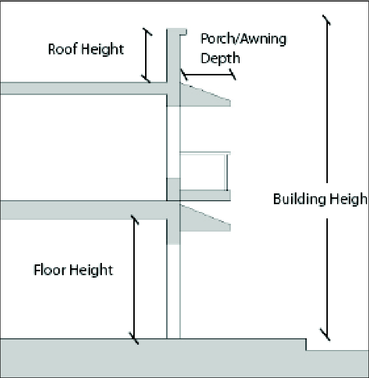
Sec. 40-426. - Building form standards; building type.
(a)
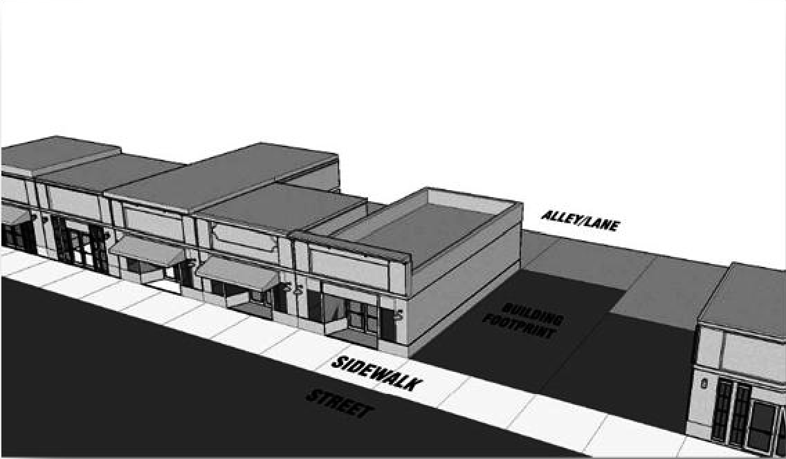
Type 1, shopfront building. The shop-front building is a one-story commercial or retail building that fronts the public sidewalk.
(1)
Height regulations.
a.
Minimum floor height: 12 feet (one story).
b.
Maximum floor height: 15 feet (one-story).
c.
Maximum building height in TC.
d.
District: 20 feet total with roof/parapet wall.
(2)
Building and lot standards.
a.
Lot width.
1.
Minimum: 20 feet;
2.
Maximum: 40 feet.
b.
Setbacks. See sections 40-29 through 40-31.
(3)
Off-street parking requirements. One space per 500 square feet of retail.
(4)
Additional requirements.
a.
Roof height: maximum five feet parapet wall.
b.
Patios permitted for outdoor dining.
c.
Awning depth: four feet, maximum.
(b)
Type 2, mixed-use building.
(1)
Description. A mixed-use building has two or more floors, and allows the flexibility of having a vertical mixture of uses. The ground floor may be used for retail or office uses, while upper floors may be used for office, residential or lodging.
(2)
Mixed-use standards.
a.
Height regulations.
1.
Minimum floor height.
(i)
12 feet, first floor;
(ii)
Ten feet, second floor;
(iii)
Ten feet, third floor;
(iv)
22 feet (two-story);
(v)
32 feet (three-story).
2.
Maximum floor height.
(i)
15 feet, first floor;
(ii)
Ten feet, second floor;
(iii)
Ten feet, third floor;
(iv)
25 feet (two-story);
(iv)
35 feet (three-story);
(v)
Maximum building height in TC district: 40 feet total with parapet wall.
b.
Building and lot standards.
1.
Lot width: minimum 20 feet.
2.
Setbacks: see sections 40-29 through 40-31.
c.
Off-street parking requirements.
1.
One space per dwelling unit.
2.
One space per 500 square feet of retail/office.
d.
Additional requirements.
1.
Parapet wall: five feet maximum
2.
Balcony depth: six feet maximum.
3.
Patios permitted for outdoor dining.
4.
Awning depth: six feet maximum.
(c)
Type 3, live/work building.
(1)
Description. A live/work building is a residential dwelling with a home office or retail component. The office or commercial component of the building is limited to the ground floor.
(2)
Live/work standards.
a.
Height regulations.
1.
Minimum floor height.
(i)
12 feet, first floor;
(ii)
Ten feet, second floor;
(iii)
22 feet (two-story).
2.
Maximum floor height.
(i)
15 feet, first floor;
(ii)
Ten feet, second floor;
(iii)
25 feet (two-story).
3.
Maximum building height in TC district: 30 feet total with parapet wall.
b.
Building and lot standards.
1.
Lot width.
(i)
Minimum: 20 feet;
(ii)
Maximum: 40 feet.
2.
Setbacks: see sections 40-29 through 40-31.
c.
Off-street parking requirements. One space per dwelling unit. One space per 500 square feet of retail/office.
d.
Additional requirement.
1.
Parapet wall: five feet maximum.
2.
Porch depth: six feet maximum; no porch on ground level.
3.
Awning depth: same as porch depth.
(d)
Type 4, civic building.
(1)
Description. A building designed specifically for a civic purpose, such as government offices, schools, libraries, courthouses, or other similar purposes.
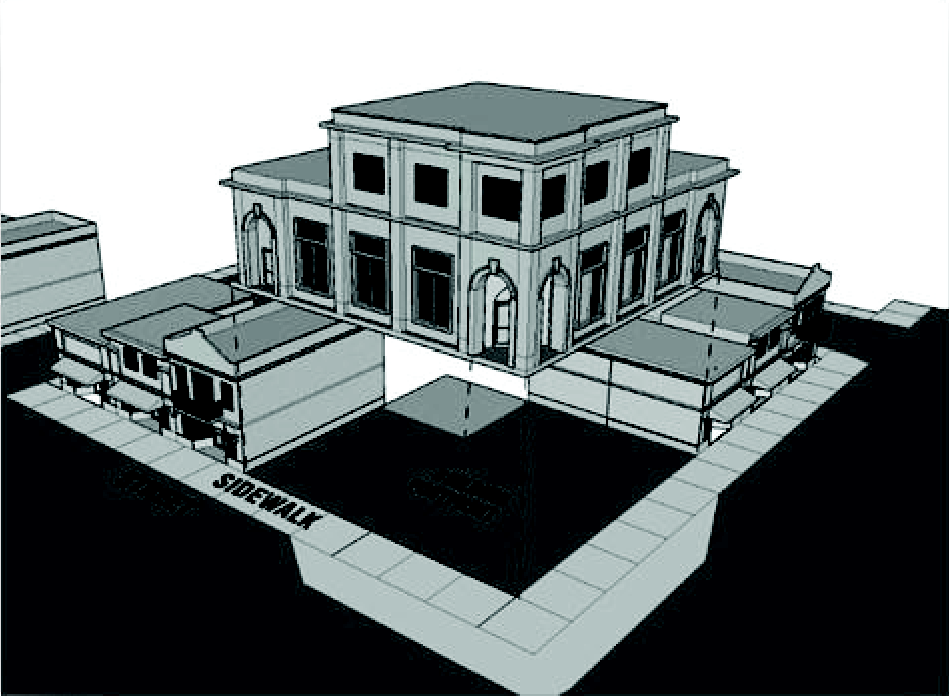
(2)
Civic building standards.
a.
Height regulations.
1.
Minimum floor height.
(i)
12 feet, first floor;
(ii)
Ten feet, second floor;
(iii)
Ten feet, third floor;
(iv)
22 feet (two-story);
(v)
32 feet (three-story).
2.
Maximum floor height.
(i)
15 feet, first floor;
(ii)
Ten feet, second floor;
(iii)
Ten feet, third floor;
(iv)
25 feet (two-story);
(v)
35 feet (three-story).
3.
Maximum building height in TC district: 40 feet total with roof/parapet wall.
b.
Building and lot standards.
1.
Lot width: minimum 30 feet; no maximum.
2.
Setbacks: see sections 40-29 through 40-31.
c.
Off-street parking requirements. One space per 300 square feet of gross floor area.
d.
Additional requirements.
1.
Maximum five feet parapet wall.
2.
Porch depth: ten feet maximum.
(Code 1997, § 40-414; Ord. of 2-6-2012, § 1(40-414))
Sec. 40-427. - Building design standards.
(a)
Building height. Building heights in this district are established by the number of floors and roof height. The maximum height of buildings in the town center district is three floors.
(b)
Parapet walls. Parapet walls shall be required for all flat-roofed buildings in town center district. Parapets shall be of a minimum height adequate to screen all roof top mechanical equipment from the public rights-of-way, and a maximum of five feet in height.
(c)
Floor heights. The minimum height of a ground floor shall be 12 feet. Upper floors shall have a minimum floor height of ten feet. The finished floor elevation of the ground floor relative to the sidewalk shall be either the same or no greater than 1.5 feet higher, except to accommodate requirements of the Americans with Disabilities Act (ADA).
(d)
Fenestration. Fenestration (doors and windows) on the ground floor of a facade shall make up a minimum of 60 percent of the facade area, and a maximum of 85 percent. Fenestration on upper floors shall comprise between 40 percent and 70 percent of the facade area (between three feet and nine feet above each finished floor).
(e)
Projections. Awnings, balconies or upper floor roof overhangs may project a maximum of six feet out from the main facade into the public right of way, with a minimum clearance height of eight feet. Ornamented parapet walls may project outward from the facade up to two feet.
(f)
Materials. Eighty percent of exterior facade materials (not including doors and windows) shall be comprised of brick, stone, cast stone, rock marble, granite, non-synthetic stucco, or tile. Exterior Insulation and Finishing System (EIFS) or synthetic stucco shall only be permitted as an accent material at a maximum of 20 percent of the exterior facade.
(g)
Floor division. An expression line clearly delineating divisions between floors of a building shall be incorporated into the front facade. For flat roofs, a cornice line shall be incorporated to delineate the top of the facade and along the side facades, where sides are visible.
(h)
Transparency. Each floor of a building facade facing a street, park or plaza shall contain transparent windows.
(i)
Utility equipment. Electrical boxes, communication equipment and all other mechanical or utility equipment shall be located on the side or rear of the building and not visible on the front facade. All refuse storage areas shall be located to the rear or side yard of the property and screened from view by a brick or masonry wall tall enough to hide the container.
(Code 1997, § 40-414; Ord. of 2-6-2012, § 1(40-414))
Sec. 40-428. - Public space standards.
(a)
Streets in the City are to be inviting public space and integral components of community design. All streets should connect to help create a comprehensive network of public areas to allow free movement of automobiles, bicyclists and pedestrians. In order for this street network to be safe for motorists and pedestrians, all design elements must consistently be applied to calm automobile traffic.
(b)
Streets should be designed to suit their functions. Many streets, especially local ones, have purposes other than vehicular traffic. The following street designs are provided for non-state-maintained streets within the municipal limits.
(c)
Designs should permit comfortable use of the street by motorists, pedestrians, and bicyclists. Pavement widths, design speeds, and the number of motor travel lanes should be minimized to enhance safety for motorists and non-motorists alike. The specific design of any given street must consider the building types which have frontage and the relationship of the street to the overall town street network.
(d)
The illustrations on the following page present typical examples of ways in which street cross-sections can be assembled. Lane measurements represent the width of travel lanes; adding two feet for standard curb and gutter is required.

(Code 1997, § 40-414; Ord. of 2-6-2012, § 1(40-414))
Sec. 40-429. - Complete streets.
All new or renovated transportation infrastructure in the city's town center should adhere to the concept of complete streets. Complete streets achieve safety, comfort and convenience for all modes of travel, including pedestrians, and bicyclists in addition to automobile traffic. The following is a checklist of elements that should be incorporated into all new developments or transportation projects in the town center district:
(1)
Offer a full range of travel choices.
(2)
Provide sidewalks either separated by a park strip or with ample width to provide pedestrian safety on all new roads.
(3)
Include bicycle facilities on new major roadways and retrofit existing major roadways with reconstruction projects.
(4)
Connect to a network that offers choice.
(5)
Provide safe pedestrian crossings at intersections.
(6)
Provide full accessibility to all, including kids, seniors, and people with disabilities.
(7)
Contribute to the pleasant and convenient pedestrian atmosphere of the downtown area.
(Code 1997, § 40-414; Ord. of 2-6-2012, § 1(40-414))
Sec. 40-430. - Public space standards; street design.
(a)
Emory Street (looking north).
(b)
George/Clark Street (looking northeast).
(c)
Whatcoat Street (looking northeast).
(Code 1997, § 40-414; Ord. of 2-6-2012, § 1(40-414))
Sec. 40-431. - Street standards.
(a)
Intersections.
(1)
Segments of straight streets should be interrupted by intersections designed to:
a.
Disperse traffic flow and reduce speeds, thereby eliminating the creation of de facto collector streets with high speed, high volume traffic; and
b.
Terminate vistas with a significant natural feature, a building, a small park, or other public space.
(2)
Other traffic calming measures such as neckdowns, chicanes, mid-block diverters, intersection diverters, curb bulbs, and related devices will be considered on a case by case basis, based on safety and appropriateness in the proposed location.
(b)
Access management. Access management should be a critical component of thoroughfare design, land subdivision and property development, especially along major thoroughfares. Access management techniques should be used in the town center district wherever possible to keep the area's thoroughfares functioning safely and efficiently. Good access management on major roads should employ one or more of the following:
(1)
Shared driveways or alleyways with inter-parcel access between adjacent commercial properties.
(2)
Minimizing of curb cuts to reduce ingress/egress along major roads.
(3)
Adequate throat length to accommodate stacking of vehicles merging into a thoroughfare from a driveway.
(4)
Landscaped medians to control left turns or U-turns between intersections.
(5)
Road connectivity and circulation increasing the number of alternative routes.
(6)
Alternatively, the following characteristics are contrary to good access management, and should be avoided if at all possible:
a.
Continuous two-way left turn lanes.
b.
Multiple curb cuts for one development or adjacent group or row of businesses.
c.
Individual parking lots for each business or parcel.
(c)
Off-street parking standards.
(1)
Off-street parking areas should be designed to minimize breaks in the pedestrian environment along the public street and create safe and comfortable passage for pedestrians. The following standards shall apply in the City:
a.
Parking lots shall be placed behind buildings; side of the building parking will be permitted only as indicated by building type and shall be measured along the build-to line. Off-street parking is not permitted in front of the primary building facade, except where specified in an adopted street section.
b.
Uninterrupted areas of parking lot shall be limited in size. Large parking lots shall be broken by buildings or landscape features.
c.
Parking lots are to be treated as enclosed rooms for cars, with enclosure provided by tree planting or building walls. For small lots (30 spaces or less), landscaping shall be required at the perimeter; for large lots (more than 30 spaces), landscaping shall include one canopy tree and ten shrubs planted for every ten parking spaces.
d.
Parking lots shall be designed to allow pedestrians to safely move from their vehicles to the building. On small lots, this may be achieved by providing a sidewalk at the perimeter of the lot. On larger lots, corridors within the parking area should channel pedestrians from the car to the perimeter of the lot or to the building. These corridors may be delineated by a paving material which differs from that of vehicular areas and planted to provide shade. Small posts or bollards may be included.
e.
To maintain pedestrian comfort and calm the speed of entering traffic, driveways to parking areas should be no wider than 24 feet. Driveways connecting to state roads shall meet the requirements of the state department of transportation.
f.
To the extent practicable, adjoining parking lots serving non residential buildings shall be inter-connected.
g.
All commercial driveway and parking areas shall be paved with asphalt, concrete, or brick pavers except for areas used for overflow, special events, and peak parking.
(2)
Amount required. While it is expected that on-street parking will contribute substantially to every day parking needs, sufficient off-street parking must also be provided to serve the particular needs of the buildings. The following minimum requirements apply:
a.
Residential.
1.
One bedroom dwelling unit: one space.
2.
Dwelling units with more than one bedroom: 1.5 spaces.
b.
Commercial: one space per 500 square feet.
c.
Office: one space per 500 square feet.
d.
Civic: one space per 300 square feet.
e.
Hotels and inns: one space per room plus one space per 500 square feet of ancillary use.
(3)
Exceptions.
a.
Within the town center district boundaries, existing buildings which were legally constructed without the provision of on site parking, and infill housing on existing lots of record may meet requirements with on-street parking and will be construed conforming as to parking.
b.
Where vehicular access is provided between adjoining non residential sites and the peak operating hours of adjoining uses do not overlap, the uses may share up to 50 percent of required parking spaces. Shared use of parking shall be guaranteed by a contract or other legally binding agreement.
(d)
Sidewalk standards.
(1)
Sidewalks are required on both sides of public streets, except low traffic local roads and alleys.
(2)
Along the west side of Emory Street, sidewalks should be a minimum of eight feet in width in the town center district.
(3)
Sidewalks shall be a minimum be six feet in width in the town center district.
(e)
Street lighting standards.
(1)
The purpose of street lighting is to ensure public safety and welfare and to protect the night sky.
(2)
Street lights shall in all cases use fully shielded fixtures except that decorative street light fixtures shall be designed with caps so that light does not shine upward at more than a 135-degree angle measured above straight down (three-quarters of the way between straight down and straight to the top) from the pole or mounting wall. The Planning Commission may approve the use of decorative light fixtures as an alternative to fully shielded fixtures, where such fixtures would enhance the aesthetics without causing light pollution.
(f)
Street tree standards.
(1)
The purpose of this section is to regulate the protection, installation, and long-term management of trees and shrubs within the City. The regulation of street trees along public and private streets within the City ensures a pedestrian-friendly environment along with providing distinct aesthetic, economic, and environmental significance.
(2)
Street trees are required to be within a minimum four-foot planting strip located between the existing street and proposed sidewalk.
(3)
Street tree planting shall be provided as follows:
a.
Large maturing canopy trees shall be planted at a spacing not to exceed 40 feet on center except that spacing may be altered slightly to accommodate driveways.
b.
Small maturing canopy-like trees shall be planted 30 feet on center where existing overhead utility lines prohibit the use of large maturing canopy trees.
(g)
Public open space.
(1)
A plaza is an open area adjacent to a civic or commercial building. Plazas function as public gathering spaces and may incorporate a variety of non-permanent activities, such as vendors and display stands. Plazas are always paved in brick or another type of paver, or crushed stone. Plazas shall be level, stepped, or gently sloping (less than five percent grade).
(2)
Plazas may not have trees or planted materials. However, trees may form the geometric frame of the plaza space or for the structure the plaza services. Spacing shall be a minimum of ten feet on center and 30 feet on center maximum.
(Code 1997, § 40-414; Ord. of 2-6-2012, § 1(40-414))
Sec. 40-461.- Purpose and intent.
(a)
This zoning district is not intended to apply if one or more of the city zoning districts specified in this article will accommodate the existing or proposed development on the property to be annexed. It is recognized, however, that unincorporated land annexed by the City in the future may consist of uses which are not permitted in any of the city zoning districts established in this division. Therefore, this zoning district is created as a flexible zoning district intended to facilitate application of a variety of zoning regulations to annexed lands which are not otherwise accommodated by the city's base zoning districts. This zoning district is not initially mapped in the City, but may be applied at the time a given property is proposed for annexation into the City if the other city zoning districts established in this article do not accommodate or facilitate the development on land to be annexed.
(b)
Adoption by reference of the Newton County Zoning Ordinance and its base zoning districts provides the flexibility needed to annex property into the City with zoning regulations that are the same as those applicable in the unincorporated County at the time of annexation, but which are otherwise not established and applied within the city limits as they exist on the effective date of the ordinance from which this chapter is derived.
(Code 1997, § 40-415-1; Ord. of 2-6-2012, § 1(40-415-1))
Sec. 40-462. - Adoption of the County zoning ordinance.
(a)
For purposes of assigning zoning in the City to land annexed after the effective date of the ordinance from which this chapter is derived, the City adopts the Newton County Zoning Ordinance. A copy of the county zoning ordinance as adopted and as amended on the effective date of the ordinance from which this chapter is derived shall be adopted by reference as if fully set forth herein, and the City Administrator shall maintain a copy of the ordinance in the permanent records of the City.
(b)
Procedurally, the public hearing and other provisions of this chapter shall govern the public hearing requirements for rezoning, as opposed to those procedures of the county zoning ordinance. The city's adoption of the county zoning ordinance is intended only to facilitate use limitations by base zoning district, specific use standards, and property development standards for specific properties at the time of annexation. However, any other provisions of the county zoning ordinance, such as definitions and general provisions, that are necessarily and reasonably related to the application of these selected provisions of county's zoning ordinance shall be applicable and interpreted to apply to property annexed by the City, except as otherwise specifically modified per this section.
(Code 1997, § 40-415-2; Ord. of 2-6-2012, § 1(40-415-2))
Sec. 40-463. - Zoning application requirements.
(a)
An applicant for annexation shall first determine whether an city zoning district specified in this chapter, other than the Newton County Annexed District established in this section, will accommodate the existing or proposed development on the land to be annexed. If it is determined that another zoning district will accommodate the existing or proposed development, the annexation applicant shall file a rezoning request for one of the city's base zoning districts, rather than this Newton County Annexed District.
(b)
If it is determined the applicant's existing or proposed development cannot be accommodated by the city's base zoning districts established in this chapter, then the applicant shall propose a zoning district or zoning districts from the base zoning districts specified in article 2 of the county's zoning ordinance that will accommodate the existing or proposed development on the property to be annexed.
(Code 1997, § 40-415-3; Ord. of 2-6-2012, § 1(40-415-3))
Sec. 40-464. - Permitted and conditional uses.
Permitted and conditional uses shall be as specified in article 5 of the county's zoning ordinance for the county base zoning district proposed by the applicant, except as may be modified in this subsection. Unless otherwise specifically indicated in the rezoning application and approved by the City Council, the permitted and conditional uses in the county base zoning district applied for and approved as applicable to the annexed land shall govern the property once annexed into the city limits. An applicant for annexation and rezoning may propose and the City Council may approve modifications to the permitted and conditional uses specified for one or more base zoning districts in the county zoning ordinance, as a part of the application for rezoning at the time of annexation.
(Code 1997, § 40-415-4; Ord. of 2-6-2012, § 1(40-415-4))
Sec. 40-465. - Specific use standards.
When the application for annexation and rezoning involves a use for which specific use standards are applicable per article 5 of the county zoning ordinance, those use standards shall be applicable to the uses upon their establishment or continuance in the City, except as may be modified in this subsection. Unless otherwise specifically indicated in the rezoning application and approved by the City Council, the specific use standards of article 5 of the county zoning ordinance shall govern the use of property once annexed into the city limits. An applicant for annexation and rezoning may propose and the City Council may approve modifications to the applicable specific use standards articulated in article 5 of the county zoning ordinance, as a part of the application for rezoning at the time of annexation.
(Code 1997, § 40-415-5; Ord. of 2-6-2012, § 1(40-415-5))
Sec. 40-466. - Dimensional requirements.
Dimensional requirements shall be as specified in the property development standards section of the base county zoning district applied for, as articulated in the county zoning ordinance, except as may be modified in this section. Unless otherwise specifically indicated in the rezoning application and approved by the City Council, the property development standards in the county base zoning district applied for and approved as applicable to the annexed land shall govern the property once annexed into the city limits. An applicant for annexation and rezoning may propose and the City Council may approve modifications to the applicable property development standards articulated in one or more applicable base zoning districts in the county zoning ordinance, as a part of the application for rezoning at the time of annexation.
(Code 1997, § 40-415-5; Ord. of 2-6-2012, § 1(40-415-5))
Sec. 40-467. - Design principles and guidelines.
There are no design criteria specifically applied in this zoning district in advance, since a wide variety of development may be approved for annexation per this section. However, the City may apply any design principles and guidelines articulated in this chapter as conditions of rezoning approval, at the time of annexation and rezoning in Oxford.
TABLE 4.4. PERMITTED AND CONDITIONAL USES FOR NONRESIDENTIAL
ZONING DISTRICTS
P = Permitted; PA = Permitted as Accessory Use; C = Conditional Use;
X = Prohibited
*IC-TA is not a separate zoning district. This represents the 200' foot Transitional Area (TA) between the Institutional Campus (IC) District and all residential districts. Permitted and conditional uses in the IC-TA may vary from those within the IC.
TABLE 4.5. DIMENSIONAL REQUIREMENTS FOR NONRESIDENTIAL ZONING DISTRICTS
(For districts not listed, see specific zoning district section.)
TABLE 4.6. DESIGN CRITERIA FOR NONRESIDENTIAL ZONING DISTRICTS
A = applicable; N/A = not applicable
(For the TC District, see form based provisions.)
(Code 1997, § 40-415-6; Ord. of 2-6-2012, § 1(40-415-6))
Sec. 40-488.- Purpose and intent.
(a)
This division establishes an overlay district superimposed on certain residentially zoned parcels of land in the City which are anticipated to be developed with residences. Small-scale projects on small sites require successful melding into the fabric, architecture, function, and circulation of an existing neighborhood. Infill residential development should not overpower nearby buildings or disrupt other uses. Infill residential dwellings should be similar in height and setbacks to neighboring dwellings. Bulk and scale should be similar to and consistent with the surrounding neighborhood. The overall design strategy for a residential infill dwelling or development should focus on compatible integration with the surrounding area.
(b)
The residential infill overlay district is intended to ensure that new dwellings in the city's residential neighborhoods and the replacement of residential dwellings will not differ dramatically in size, footprint, mass, or height, or change the dominant character of the existing residential neighborhoods. This division contains regulations that are designed to ensure that residential infill development is compatible with existing development and that new residential construction or substantial rehabilitation of detached dwelling units fit within the existing community character in a compatible manner. This division provides detailed design guidance for residentially zoned but vacant properties within the overlay district to encourage quality site design and construction in accordance with the city's comprehensive plan.
(c)
This division is also applied in recognition of the fact that many lots within the residential infill overlay district, while large enough for additional dwellings and lots, pose significant design challenges given the irregular shape of the tract, the lack of sufficient lot frontage on a public street, substantial area within a 100-year floodplain, or other peculiarities and conditions which present practical difficulty in meeting conventional zoning requirements such as minimum lot sizes and minimum lot widths. Furthermore, this division recognizes that conventional zoning regulatory constraints may work against good design, raise roadblocks against innovation, or prevent projects that are otherwise consistent with the character of existing communities or consistent with the city's adopted principles and objectives for residential development.
(d)
In addition, difficult sites and uncertain outcomes and timeframes can reduce developers' economic interest in undertaking infill projects. And, through sensitive design, infill can introduce a new type of housing into the community. A balanced mix of well-designed housing types, sizes and prices for all income levels can be accomplished with similar housing styles on the same street and phase of construction, if economies of scale allow. Infill can inject new life into communities and help neighborhoods become more connected and sociable places, and ultimately increase property values, without altering existing neighborhood and community character.
(e)
Accordingly, significant design flexibility is provided for designers of residential infill development projects and discretion is provided to the City Planning Commission in order to help infill developers meet the challenges that their properties pose while ensuring that density at lot yields are possible in view of the city's objectives for quality infill housing.
(Code 1997, § 40-501; Ord. of 2-6-2012, § 1(40-501))
Sec. 40-489. - Applicability and exemption.
(a)
This division shall apply to any application for development permit within the boundaries of the residential infill overlay district as shown on the official zoning map of the City, except as specifically exempted in this section. It also applies at the time of preliminary plat approval, if required by chapter 30, pertaining to subdivisions, or final plat application if no final plat is required per that chapter.
(b)
When this division applies, no plat of subdivision, including combination plats and boundary line adjustments, shall be approved unless compliance with this chapter is first demonstrated. No development permit for a proposed development to which this division applies shall be approved until compliance with this chapter is demonstrated. No building permit for a new dwelling within the residential infill overlay district shall be issued unless compliance with this division is demonstrated.
(c)
This division shall not apply to applications for building permits for accessory structures 400 square feet or less in area. This division shall not apply to a remodel of an existing dwelling or a permit proposal which would increase the existing ground floor area of a dwelling by less than 250 percent.
(Code 1997, § 40-502; Ord. of 2-6-2012, § 1(40-502))
Sec. 40-490. - Combination of review and approval processes.
(a)
In considering the compatibility and appropriateness of residential development within the residential infill overlay district, it is important that the City consider not only the proposed lot lines and lot platting configurations, but also the specific residential development proposed on the lots. The process for acting on infill residential development projects is accomplished by filing information required for both site design and architectural review and information required for applications for plat approval.
(b)
Therefore, within the overlay district boundary, the process of site design and architectural review for individual developments may be combined with the subdivision platting process required by this Code. At the option of the development applicant, an applicant may submit a conceptual lot platting plan and defer the plat approval process until a later date, but if so, the applicant is still responsible for submitting information required by this chapter with respect to proposed lot boundaries as a part of the site design and architectural review process, so that subdivision lot design and specific residential development proposals can be considered as a whole.
(Code 1997, § 40-503; Ord. of 2-6-2012, § 1(40-503))
Sec. 40-491. - Existing dwellings and infill development comparison.
(a)
The City reviews residential infill development proposals in the context of the surrounding neighborhood. Therefore, in addition to the requirements specified for submission of applications for site design and architectural review, an applicant for development permit or subdivision plat approval in the residential infill overlay district shall submit the following information for existing residential dwellings on abutting residential properties and across the street from the lot on which the residential infill development project is proposed. An applicant may exclude lots abutting the proposed residential infill development project which are developed for institutional uses, such as schools and churches, or other nonresidential uses.
(1)
Number of stories and approximate height.
(2)
Size (gross square feet) in area.
(3)
Front, side, and rear setbacks.
(4)
Lot coverage (amount of lot covered by building).
(5)
Orientation of the dwelling in relation to the street.
(6)
Major architectural features (style, materials, etc.).
(7)
Driveway placement, width, and materials.
(8)
Location of parking (garage, carport, open, yard location, etc.).
(9)
Typical accessory buildings and structures, if any.
(b)
The applicant may submit this information in a combination of forms, including an aerial photograph, tax map, survey plats, photographs, and written narrative, provided all required information is submitted. The applicant must also describe the proposed development and describe systematically how proposed residential dwellings will compare with the existing dwellings in the area. This should be done in the form of a comparison chart in a written narrative.
(Code 1997, § 40-504; Ord. of 2-6-2012, § 1(40-504))
Sec. 40-492. - Lot size averaging.
Where unique site specific conditions exist, such as an irregular shape or other unique conditions, an infill developer or subdivider may propose and the City Planning Commission may approve a flexible development incentive called lot size averaging. This incentive allows development applicants to reduce one or more lots below the minimum lot size established for the zoning district in which the residential infill development project is located. In order to apply this provision, the proposed residential infill development project must meet the following requirements:
(1)
The average lot area of all lots within the subdivision meets the minimum lot size for the zoning district in which the project is located.
(2)
No lot shall be reduced to less than 80 percent of the required minimum lot size for the applicable zoning district.
(3)
For purposes of calculating average lot size, abutting undivided and undeveloped property under the ownership of the infill subdivider at the time of infill subdivision shall not be included in such calculation.
(Code 1997, § 40-505; Ord. of 2-6-2012, § 1(40-505))
Sec. 40-493. - Lot width reductions.
Where unique site specific conditions exist, such as an irregular shape or other unique conditions, an infill developer or subdivider may propose and the City Planning Commission may approve a flexible development incentive called lot width variations. In order to apply this provision, individual lots in the proposed residential infill development project may be decreased as follows:
(1)
To no less than 80 feet in the R-30 or R-20 zoning districts;
(2)
To no less than 60 feet in the R-15 zoning district; and
(3)
To no less than 45 feet in the R-7.5 zoning district.
(Code 1997, § 40-506; Ord. of 2-6-2012, § 1(40-506))
Sec. 40-494. - Front and rear principal building setback adjustments.
Where unique site specific conditions exist, such as an irregular shape or other unique conditions, an infill developer or subdivider may propose and the City Planning Commission may approve a flexible development incentive called building setback adjustments. In order to apply this provision, required minimum building setbacks/required yards for individual lots in the proposed residential infill development project may be decreased as follows:
(1)
Where a build-to line does not apply and the front building setbacks of the zoning district are applicable, such front building setbacks may be reduced by up to five feet from the established minimum.
(2)
Rear building setbacks of the zoning district may be reduced by up to five feet from the established minimum.
(3)
No principal building setback reduction shall be allowed for side yards pursuant to this section, although the variance process shall provide a potential remedy.
(Code 1997, § 40-507; Ord. of 2-6-2012, § 1(40-507))
Sec. 40-495. - Requirements when floodplain exists.
If the tract to be developed as a residential infill development project contains 5,000 square feet or more of land within the designated 100-year floodplain, or if more than 20 percent of the lot lies within the 100-year floodplain, then an infill developer or subdivider may propose and the City Planning Commission may approve flexible development regulations as follows, subject to the following requirements:
(1)
The overall maximum density for the zoning district in which the infill development tract is located cannot be exceeded, but such density calculation may include all land within the 100-year floodplain.
(2)
Minimum lot sizes for the zoning district in which the infill development tract is located may be reduced to as little as 70 percent of the applicable minimum lot size requirement.
(3)
Minimum lot widths for the zoning district in which the infill development tract is located may be reduced to as little as 65 percent of the applicable minimum lot width requirement, except that no lot shall be reduced below a minimum lot width of 45 feet.
(4)
All, or a substantial portion (as determined by the Planning Commission) of that part of the tract containing 100-year floodplain shall be designated and protected via fee simple title or via conservation easement as open space, and each lot and dwelling within the infill residential development project shall have pedestrian access provided to such designated and protected open space.
(Code 1997, § 40-508; Ord. of 2-6-2012, § 1(40-508))
Sec. 40-496. - Street connectivity east of Emory Street (SR 81).
(a)
It is the intention of the City that as residential infill development occurs on tracts east of Emory Street (SR 81), that a continuous connector road be provided so that connectivity among all such tracts can be provided and thus avoid reliance on the state highway for access and connections among developments. Accordingly, each residential infill development project proposed east of Emory Street (SR 81) will be evaluated for and required to provide a road right-of-way from the south and north property lines through the entire tract to be subdivided and development.
(b)
The specifications for the road right-of-way to be dedicated will be as described in chapter 30, pertaining to subdivisions, for local streets, or as may be modified by the City Planning Commission during the process of site design and architectural review for the proposed residential infill project. Any right-of-way dedicated for purposes of this required connector road may be included in calculations of maximum density permitted for the proposed residential infill development project.
(c)
A residential infill development project that does not provide for property line to property line access in a north-south direction and adequate access in an east-west direction shall be grounds for disapproval by the City Planning Commission of site design and architectural review and any subdivision plat for the proposed project.
(Code 1997, § 40-509; Ord. of 2-6-2012, § 1(40-509))
Sec. 40-497. - Driveway and access limitations on Emory Street (SR 81).
Any residential infill development project with property frontage on Emory Street (SR 81) shall be limited to one street exit/entrance onto Emory Street (SR 81), or one shared driveway in the case where a new road is not proposed. Where the tract to be developed also has frontage on a side public street in addition to frontage on Emory Street (SR 81), the Planning Commission may limit access for the residential infill development project to the side public street and preclude access to Emory Street (SR 81).
(Code 1997, § 40-510; Ord. of 2-6-2012, § 1(40-510))
Sec. 40-498. - Architectural building materials.
All exterior wall materials of dwellings within infill residential development projects shall consist of brick masonry, stone masonry, wood clapboards, fiber cement, or weather boarding, and appropriate architectural accents as approved by the City Planning Commission as a part of site design and architectural review. Standing-seam or corrugated metal walls or vinyl siding shall not be permitted on any facade or building wall. Architectural treatments shall occur on all four sides of the building. Roof materials shall be asphalt composition, wood shake, tile, or standing seam metal.
(Code 1997, § 40-511; Ord. of 2-6-2012, § 1(40-511))
Sec. 40-499. - Stormwater treatment and ponds.
Designers should make every effort to employ low impact development methods for stormwater management as specified or approved by the City Planning Commission. In cases where bio-retention or other low impact development methods cannot be employed or will necessitate a detention (dry) or retention (wet) pond, any such pond within the boundaries of an infill residential development project shall meet the following requirements:
(1)
It shall not be located adjacent to a city street or subdivision frontage.
(2)
It shall be located no closer than 15 feet to an exterior property line.
(3)
It shall be sloped so that fencing is not required.
(4)
It shall be landscaped subject to the approval of the Zoning Administrator.
(Code 1997, § 40-512; Ord. of 2-6-2012, § 1(40-512))
Sec. 40-500. - Additional design criteria for approval.
The following design criteria will be considered by the City Planning Commission in the process of consideration applications for site design and architectural review of residential infill development projects within the residential infill overlay district:
(1)
Connectivity. Infill should achieve connectivity between on site and off-site transportation systems, streetscapes, and open space networks. Sidewalks need to be provided which connect to the existing or planned adjacent sidewalk system, and streets need to connect to the adjacent existing or planned street pattern.
(2)
Circulation. If the infill development is large enough, new streets should be laid out as an interconnected, multi-modal network (usually in a grid or modified grid pattern) to maintain continuity of the existing community's circulation system. New street systems should meet the needs of bicyclists, strollers, wheelchairs, pedestrians and motor vehicles. The overall transportation strategy should favor walkability over automobile travel. Access control may be an important component; curb cuts should be minimized whenever possible. Closed street systems and cul-de-sacs shall be avoided. Blocks should be short to increase turning opportunities and heighten pedestrian orientation.
(3)
Alley garages. Garages accessed by alleys can enhance the design and function of infill projects and therefore should be considered and implemented as appropriate.
(4)
Teardowns. Replacement structures that differ dramatically in size, footprint, mass, or height change the dominant character of the neighborhood. Teardowns typically occur in areas with low-cost houses and valuable lots, particularly when smaller, poorly designed, or obsolete structures without modern amenities are not considered historic or quaint. The City Planning Commission may direct an applicant to alter the design of a proposed replacement residence where it is considered grossly out of scale or character with existing homes in the neighborhood. If the replacement structure is proposed to be taller or a larger number of stories than exists on abutting or nearby parcels in the neighborhood, the Planning Commission shall be guided by the following considerations in determining whether such additional height is appropriate and compatible, in addition to compatible neighborhood scale: privacy, light and shadow, views, and architectural compatibility.
(Code 1997, § 40-513; Ord. of 2-6-2012, § 1(40-513))