
Palm Beach Gardens City Zoning Code
ARTICLE V
- SUPPLEMENTARY DISTRICT REGULATIONS
DIVISION 3. - NORTHLAKE BOULEVARD OVERLAY ZONING DISTRICT[2]
Editor's note— Ord. No. 30-2002, § 2, adopted Sept. 4, 2002, provided for the inclusion of a new ch. 78, art. V, div. 3 to read as herein set out. All subsequent divisions of article V, being divs. 3—13, have been renumbered as divs. 4—14. See the Code Comparative Table.
DIVISION 4. - PARKWAY OVERLAY DISTRICT[3]
Editor's note— Formerly, div. 3. See the editor's note to ch. 78, art. V, div. 3.
DIVISION 5. - NATURAL RESOURCES AND ENVIRONMENTALLY SIGNIFICANT LANDS[4]
Editor's note— Formerly, div. 4. See the editor's note ch. 78, art. V, div. 3.
DIVISION 6. - PUBLIC PLACES[5]
Editor's note— Formerly, div. 5. See the editor's note ch. 78, art. V, div. 3.
DIVISION 7. - SIGNS[6]
Editor's note— Ord. No. 21, 2010, § 1(Exh. A), adopted Sept. 30, 2010, repealed former Art. V, Div. 7, §§ 78-271—78-292, and enacted a new Art. V, Div. 7 as set out herein. Former Art. V, Div. 7 pertained to the same subject matter and derived from Ord. No. 17-2000, §§ 122—141, adopted July 20, 2000; Ord. No. 52-2002, § 2, adopted Jan. 16, 2003; Ord. No. 23, 2006, § 3, adopted Feb. 1, 2007 and Ord. No. 29, 2009, §§ 2—4, adopted Dec. 17, 2009. Formerly, div. 6. See the editor's note ch. 78, art. V, div. 3.
DIVISION 8. - LANDSCAPING[7]
Editor's note— Formerly, div. 7. See the editor's note ch. 78, art. V, div. 3.
DIVISION 9. - OFF-STREET PARKING AND LOADING[8]
Editor's note— Formerly, div. 8. See the editor's note ch. 78, art. V, div. 3.
Subdivision IV.- Requirements for Improvements, Reservations and Design
Part I. Generally
Subdivision VI.- Reserved[11]
Editor's note— Ord. No. 18, 2017, § 1, adopted September 25, 2017, repealed Subd. VI, §§ 78-531—78-536 it its entirety. Former Subd. pertained to floodplain regulations and derived from Ord. No. 1-2002, § 4, adopted March 7, 2002; and Ord. No. 17-2004, § 5, adopted June 3, 2004. See art. III, §§ 86-35—86-138, for current floodplain management regulations.
DIVISION 11. - TRAFFIC PERFORMANCE AND TRANSPORTATION STANDARDS[12]
Editor's note— Formerly, div. 10. See the editor's note ch. 78, art. V, div. 3. Ord. No. 9, 2020, § 9, adopted Sept. 10, 2020, changed the title of div. 11 from "Traffic Performance Standards" to read as set out herein.
DIVISION 12. - PERFORMANCE STANDARDS[14]
Editor's note— Formerly, div. 11. See the editor's note ch. 78, art. V, div. 3.
DIVISION 13. - OPEN SPACE[15]
Editor's note— Formerly, div. 12. See the editor's note ch. 78, art. V, div. 3.
DIVISION 14. - NEWSRACK REGULATIONS[16]
Editor's note— Ord. No. 6-2002, § 2, adopted July 17, 2003, repealed § 78-701 in its entirety. Section 3 of said ordinance provided for a new division 14 to read as herein set out. See the Code Comparative Table for a detailed analysis of inclusion.
Sec. 78-181.- Uses.
A building, structure, premise, or land shall not be used or occupied except in conformity with this chapter. A building or structure, or part thereof, shall not be erected, constructed, reconstructed, moved, or altered except in conformity with this chapter.
(a)
Access. Every structure erected or moved shall be located on a building site, lot, or parcel with safe and convenient access for vehicles, pedestrians, public safety protection, and required off-street parking, in accordance with applicable requirements of this chapter and any related ordinances adopted by the city. Access shall be installed in a manner acceptable to the city engineer.
(b)
Limitation on number of principal structures on lots in residential areas. Except as provided herein, only one principal residential structure, except for multifamily structures and cluster developments, may be erected on any lot.
(c)
Accessory structures and uses. An accessory use or structure is clearly incidental and subordinate to the principal use or structure and is located on the same lot or parcel. An accessory use may not be established unless the principal use is present.
(1)
General standards. Any accessory use customarily associated with a principal use that is permitted by right may be established provided such use is consistent with the requirements of this chapter. An accessory use customarily associated with a principal use which requires conditional use approval may be established provided it complies with the standards and criteria associated with the conditional use. Accessory uses shall be consistent with any applicable provision of a development order approved by the city council, and shall comply with any architectural, design, or related standards adopted as part of this chapter.
(2)
Location of attached accessory structures and uses. When an accessory structure is attached to a principal structure by a breeze way, passage, or similar feature, the accessory structure shall comply with the property development regulations, including setbacks and height, applicable to the principal structure.
(3)
Detached accessory uses and structures. Detached uses and structures are permitted in all districts, provided the uses and structures are separated from the main structure by not less than five feet and are of a nature customarily incidental and clearly subordinate to a permitted or permissible principal use or structure. Unless otherwise provided herein, detached accessory structures shall be located on the same lot as the principal structure. Detached accessory structures or uses shall be compatible with the zoning district where located, and shall comply with the standards listed below.
a.
Accessory uses and structures shall not be located in required front, rear, or side setbacks in any residential district, except as provided herein. On double-frontage lots and through lots, accessory uses and structures may only be located in side yards, outside of the required setback. On a corner lot, an accessory structure shall not be allowed in the side yard facing the street right-of-way.
b.
Accessory structures, such as private garages or other similar structures having vertical walls, may be located on or attached to the side or rear of a principal structure, provided all minimum setback requirements are maintained.
c.
Air conditioning compressors or other equipment designed to serve the principal structure may be located in any required side or rear setback. Such equipment shall be located immediately adjacent to the principal structure, and shall allow at least three feet of yard that is free and clear of any machinery. Equipment of this nature shall be screened from view of adjoining properties.
d.
Accessory structures on a corner lot shall not be erected nearer to the side street than the minimum front setback line of the adjoining lot to the rear of the corner lot.
(4)
Residential districts. Accessory uses and structures permitted in any residential district shall include the following:
a.
Noncommercial greenhouses and plant nurseries;
b.
Servants quarters and guesthouses;
c.
Detached private garages, private boathouses, or shelters which do not exceed the square footage of the principal structure and are architecturally compatible with the principal structure;
d.
Individual private boat dock for the exclusive use of the owners or residents of the upland dwelling unit or units;
e.
Toolhouses, garden sheds, and garden work centers which do not to exceed 144 square feet and with no side greater than twelve feet in length;
f.
Recreation areas and equipment;
g.
Private barbecue pits;
h.
Swimming pools/spas;
i.
Nonresidential facilities for security guards and/or caretakers;
j.
Screen enclosures;
k.
Pergolas; and
l.
Similar uses/structures.
(5)
Residential accessory uses shall not:
a.
Involve the conduct of business of any kind;
b.
Attract visitors in larger numbers than would normally be expected in a residential neighborhood;
c.
Involve operations or structures not in keeping with the character of a residential neighborhood; and
d.
Exceed setback requirements applicable to the principal structure, excluding boat docks.
(6)
Illuminated tennis courts, basketball courts, or similar accessory facilities that are accessory uses to a single dwelling unit shall not be illuminated or utilized after 10:00 p.m.
(7)
Residential accessory uses permitted in the AR or AE zoning districts shall include:
a.
Accessory Quarters—A complete, separate living facility equipped with a kitchen and provisions for sanitation and sleeping, located on the same lot as the owner-occupied principal dwelling, subject to the following:
1)
The Accessory Quarters shall be no larger than 1,000 square feet. Additional floor area under a solid roof that is utilized as a porch, patio, porte-cochere, carport, or garage shall not exceed 500 square feet.
2)
The Accessory Quarter shall be architecturally compatible in character and materials with the principal dwelling.
3)
The kitchen equipment shall be removed if the principal dwelling is no longer owner-occupied.
4)
There shall be no separate meters for any utilities. Both the principal dwelling and the accessory dwelling shall be connected to the same utilities.
b.
Estate Kitchen—A second kitchen located within a principal Single-Family residence. Conversion to a duplex is prohibited.
c.
Guest Cottage—Accessory sleeping quarters provided for non-paying guests by the owner-occupant of the principal dwelling unit, subject to the following:
1)
The Guest Cottage shall be no larger than 1,000 square feet. Additional floor area under a solid roof that is utilized as a porch, patio, porte-cochere, carport, or garage shall not exceed 500 square feet.
2)
The Guest Cottage shall be architecturally compatible in character and materials with the principal dwelling.
3)
There shall be no kitchen or cooking facilities in a guest cottage.
4)
There shall be no separate meters for any utilities. Both, the principal dwelling and the guest cottage shall be connected to the same utilities.
(8)
Workforce and/or affordable housing accessory dwelling units (ADUs). See section 78-159, Table 21: Permitted, conditional, and prohibited use chart, and corresponding Note 78 to Table 21.
(9)
Detached accessory structures in the AR zoning district shall have a side yard and rear yard setback of 25 feet. Detached accessory structures in the AE zoning district shall have a side yard and rear yard setback of five feet. Detached accessory structures may not be located within an established easement or required landscape buffer.
(Ord. No. 17-2000, § 94, 7-20-00; Ord. No. 11, 2013, § 7, 9-10-13; Ord. No. 22, 2019, § 8, 2-6-20; Ord. No. 6, 2022, § 8, 7-14-22; Ord. No. 4, 2023, § 9, 6-1-23; Ord. No. 5, 2024, § 10, 7-11-24)
Sec. 78-182. - Lighting regulations.
(a)
Purpose and intent. It is the purpose of this section to establish regulations regarding exterior lighting for development and redevelopment; to integrate lighting within developments to enhance the aesthetic appearance of the city; to ensure the overall safety of residents and visitors; to minimize energy costs; to minimize light pollution; and to minimize adverse visual impacts upon drivers of vehicles. Lighting is not intended to be used as advertising or to draw attention to the building, grounds, or uses associated with such building. This section is applicable for all exterior lighting and lighting within parking garage structures, excluding lighting for signage which is regulated in a separate section of this chapter.
(b)
Height, intensity, and design standards.
(1)
Height standards. For the purposes of these regulations, the mounting height of a light fixture shall be defined as the vertical distance from grade elevation of the surface being illuminated to the bottom of the light fixture.
a.
Light fixtures shall not exceed 25 feet in height in vehicle-use areas.
b.
Light fixtures shall not exceed 12 feet in height in pedestrian areas.
c.
Building and accent light fixtures shall not be installed above the roofline directly above the light fixture.
(2)
Foot-candle standards. The minimum and maximum average foot-candle range and maximum foot-candle permitted for each lighting zone in residential and nonresidential areas shall be those listed in Table 1.
Table 1
Foot-candle Standards (1)
(1)
Unless mandated by other state or federal standards, or as determined by the city engineer.
(2)
These standards shall only apply under the service station canopy and up to 15 feet from the outside edge of the canopy.
(3)
Pathways, pedestrian areas, and outdoor seating abutting another lighting zone with a greater foot-candle requirement may include lighting levels consistent with the adjacent zone. Underpasses are required to illuminate a minimum of 2.0 fc.
(4)
No more than 0.5 foot-candle light spillover shall be permitted on any point inside the adjacent residential property.
(5)
During the daytime, the vehicular and pedestrian exits and entrances must maintain a minimum average of 50 fc. Stairwells must maintain a minimum average of 20 fc 24 hours a day. Ramps, drive aisles, and all other areas of the garage must maintain a minimum average of 3.0 fc.
(6)
Outdoor lighting for city public facilities and sport facilities such as tennis courts, stadiums, soccer and ball fields are exempt from the foot-candle standards in Table 1; however, lighting at sports facilities shall not exceed IESNA-recommended practices for the type of field and use, and shall meet standards for light spillover and glare for residential properties in this section.
(7)
In those areas designated as recreational areas, or within preserves, pedestrian paths or multi-purpose paths, or other areas that are either gated or secured or are closed after dusk, lighting requirements shall be determined, as part of a development order approval, by the growth management director with mandatory consultation with the police department in order to provide the adequate security lighting in the context of the recreational area.
(8)
Shall be subject to review for crime prevention through environmental design (CPTED) principles for uniformity of lighting distribution per IESNA across a vehicular use area.
(3)
Design standards.
a.
Street lighting for public and private rights-of-way may be designed in accordance with either FPL, DOT, or IESNA-recommended practices, provided the lighting meets the minimum requirements set forth in Table 1.
b.
The location and design of lighting for parking garages shall be consistent with IESNA standards.
c.
Proposed lighting installations that are not covered by the provisions in this section may be approved only if the city council finds that they are designed to minimize glare, do not direct light beyond the boundaries of the area being illuminated or onto adjacent properties or streets, and do not result in excessive lighting levels. IESNA standards shall be used to determine the appropriate lighting design.
(c)
General standards.
(1)
Light fixtures. Light fixtures shall be installed in such a manner that the source of light does not shine directly into adjacent residential districts, as provided below:
a.
Freestanding light poles. Freestanding light poles located within 100 feet of a residential zoning district or the residential portion of a PUD or PCD shall be a cutoff luminaire, or equivalent, with a maximum angle of 90 degrees (see Figure 1).
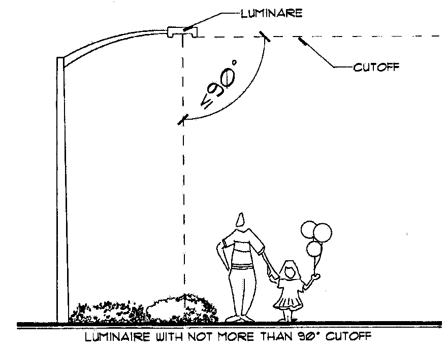
Figure 1
b.
House shields. House shields, or equivalent, shall be required for all fixtures located within 25 feet of a residential district.
c.
Flood lights and security lighting. Flood lights, security lighting, or similar equipment, whether or not wall-mounted, shall not be directed toward any residential district.
(2)
Glare. Off-site light spillover shall not produce a glare which creates a safety or traffic hazard.
(3)
Landscaping. Conflict between landscaping and lighting installations shall be minimized or eliminated. Light fixtures shall not be installed in parking lots where the location or future height of existing or proposed trees or other landscaping will obscure the operation of the light fixture.
(4)
Canopy lighting. Canopy light fixtures, such as service station lighting, shall be aimed downward and shall be fully recessed or fully shielded so as to ensure that the light fixture is not visible from public rights-of-way or adjacent properties and does not cause glare. All light emitted by an under-canopy fixture shall be substantially confined to the ground surface directly beneath the perimeter of the canopy. As an alternative to recessed lighting, indirect lighting may be used when light is directed upward and then reflected down from the underside of the canopy. In this case, light fixtures shall be shielded so that direct illumination is focused exclusively on the underside of the canopy. No lighting shall be permitted on the top or sides of the canopy, excluding internally-illuminated signs.
(5)
Flag poles. A flag pole may be illuminated by fully-shielded spotlight light fixture or fixtures which shall not create off-site glare or light spillover above the limits established in Table 1. The light fixture(s) shall be placed as close to the base of the flag pole as possible.
(6)
Maintenance. Fixtures and lighting systems used for safety and security shall be in good working order and shall be maintained in a manner that serves the original intent of the system at all times. Accent and building lighting shall be maintained to keep the desired aesthetic appearance.
(d)
Building and accent lighting.
(1)
Lighting of buildings. All exterior lighting of buildings, including entry, facade, security, and accent lighting shall conform to the requirements provided below:
a.
Permitted lighting. Exterior lighting may be used to illuminate a building and its grounds for safety purposes, so long as the lighting is done in a manner that is aesthetically pleasing and compatible with the overall surroundings.
b.
Compatibility. Lighting shall be installed in a manner that is compatible with the neighborhood and adjacent development.
c.
Fixtures. All fixtures used in exterior building lighting are to be selected for functional and aesthetic value. Light fixtures shall not be directly beamed toward adjacent properties and pedestrian areas.
d.
Accent lighting for nonresidential, multi-family, and mixed-use buildings. Accent lighting of a building facade for architectural, aesthetic, or decorative purposes is permitted subject to the following restrictions:
1.
All upward-aimed lights shall be fully shielded from projecting into the sky by eaves, roofs, or overhangs.
2.
Strings of lights or other similar accent lighting may be installed on trees and landscaping and on buildings below the roofline provided:
i.
Strings of lights shall not be suspended horizontally between any buildings, walls, fences, trees, or shrubs.
ii.
Strings of light shall contain only low wattage clear bulbs (less than 100 lumens) without interior or exterior frosting, colors, or reflectors.
3.
Lighting of artwork shall be approved by city council as part of the art in public places approval.
4.
Integration with form. Lighting following the form of the building or part of the building, unless otherwise permitted in this section, shall only be permitted by approval of an administrative petition.
(2)
Exemptions. Single-family residential homes shall be exempt from the requirement for the approval by the city for accent uplighting, so long as the lighting does not create adverse light spillover or glare on adjacent residential properties or rights-of-way.
(e)
Winter holiday lighting.
(1)
Nonresidential, multi-family, and mixed-use zoning districts. The installation of winter holiday exterior lighting shall be permitted from November 1 through January 31. Such exterior lighting shall not be suspended horizontally between any buildings, walls, fences, trees, or shrubs.
(2)
Single-family residential zoning districts. Illumination of winter holiday exterior lighting shall be permitted from November 1 through January 31.
(f)
Lighting plans. Plans for illumination of buildings and lighting zones shall be submitted at the time a building permit is submitted or as otherwise required herein. Lighting plans shall comply with the standards listed below:
(1)
Design. Plans shall be prepared and sealed by an engineer registered in the State of Florida.
(2)
Plans. Lighting plan or plans, including photometric plans, shall include the following information:
a.
Overall site plan.
b.
Vehicular and pedestrian access and circulation.
c.
Location of parking stalls.
d.
Adjacent property lines, including existing uses and future land use map and zoning district designations.
e.
Plan view of all fixtures, including pole and wall-mounted.
f.
Height of all fixtures.
g.
Photometric data and statistical analysis, including foot-candle values, the maximum to minimum uniformity ratio, the average initial or average maintained foot-candles, the minimum foot-candles, the maximum foot-candles, points of calculation for foot-candles, and similar information required by the city engineer.
h.
The location and description, including the mature height of all existing and proposed trees, and the location of light fixtures on both adjacent properties and the street rights-of-way within ten feet of the subject property.
i.
Light fixture data, including height, manufacturer, wattage, and lighting type.
j.
All plans shall be certified by a registered architect or engineer as providing illumination in accordance with the applicable minimum standards set forth in this section and that subsequent construction will comply with the approved lighting plan.
k.
Lighting installation shall not be placed in permanent use until a letter of compliance from a registered professional architect or engineer has been provided stating that the installation has been field checked and meets the specification set forth on the approved photometric plan.
(g)
Method of measurement. The light meter sensor shall be read at ground level or the established grade in a horizontal position. Readings shall be taken only after the light source has been exposed long enough to provide a constant reading. Measurements shall be taken after dark with the light sources to be measured on and subsequently off. The difference of the two readings shall be compared to the permitted illumination level for each lighting zone.
(h)
Security lighting. In order to utilize crime prevention through environmental design (CPTED) principles, security lighting shall be required on all nonresidential, multi-family residential, and mixed-use developments and in certain common areas of single-family developments. Security lighting may not produce glare or off-site light spillover above the maximum limits set forth in Table 1.
(1)
Open parking lots, parking garages, loading zones, and access roads and paths in nonresidential, multi-family residential, and mixed-use developments shall maintain a lighting level at least 50 percent of the minimum average lighting requirements set forth in Table 1 from dusk to dawn or outside of normal business hours.
(2)
Security lighting installations shall include timers, dimmers, and/or sensors to reduce the overall energy consumption and eliminate unneeded lighting.
(3)
Automatic teller machines (ATMs) shall at all times, maintain the following security lighting:
a.
There shall be a minimum of ten foot-candles of lighting intensity at the face of the ATM and extending in an unobstructed direction outward five feet.
b.
There shall be a minimum of two foot-candles of lighting intensity within 50 feet in all unobstructed directions from the face of the ATM. If the ATM is located within ten feet of the corner of the building and the ATM is generally accessible from the adjacent side, there shall be a minimum of two foot-candles of lighting intensity along the first 40 unobstructed feet of the adjacent side of the building.
c.
There shall be a minimum of two foot-candles of lighting intensity in that portion of the defined parking area within 60 feet of the ATM.
(i)
Street lighting.
(1)
Decorative lighting. The city council, as part of a development order approval, may require installation of decorative street lighting consistent with the style of existing fixtures on roadways adjacent to the property.
(2)
Parkway system. Street lighting shall be required to illuminate public sidewalks along roads identified as part of the parkway system to the level established for pathways in Table 1.
(3)
Private streets. Street lighting shall be required to meet the public and private street lighting standards set forth in Table 1 for all streets within and adjacent to the private development, unless the applicant adequately addresses security through an alternative means during the development review process.
(j)
Prohibited lighting. The following types of permanent outdoor light fixtures are prohibited:
(1)
Mercury vapor lamps.
(2)
Blinking, flashing, moving, revolving, flickering, changing color or intensity, and chase lighting.
(3)
Any light fixture that may be confused with or construed as a traffic control device.
(4)
Any upward-oriented lighting unless otherwise provided for in this section.
(5)
Searchlights, beacons, and laser-source light fixtures.
(6)
Any lamp or bulb not within a light fixture (except for seasonal, accent, building lighting, or landscape ornamental lighting) visible beyond the property line on which it is located.
(7)
Exposed or visible neon light tubing.
(k)
Applicability. All exterior light fixtures installed after September 20, 2006, (the effective date of this ordinance) shall be installed, operated, and maintained in compliance with this section. All exterior lighting fixtures with a development order approval that has not been installed may be installed according to the approved photometric plan. All exterior lighting that is rendered nonconforming by the adoption of this ordinance must comply with the provisions of this section as provided below:
(1)
All exterior lighting on a site must comply with the provisions of this section at the time repairs, reconstruction, or improvements of a structure on a site occurs, the cost of which equals or exceeds 50 percent of the estimated market value of the structure. The estimated value of a structure shall mean the assessed value of the structure prior to the start of the initial repair or improvement.
(2)
All exterior lighting on a site must comply with the provisions of this section at the time repairs, reconstruction, or improvements of site lighting occurs, the cost of which equals or exceeds 50 percent of the estimated market value of the total site lighting on the site.
(3)
All exterior lighting on a site must comply with the provisions of this section within 30 days of a determination by the city staff that the site lighting does not meet the minimum average foot-candle standard set forth in Table 1 and is inconsistent with CPTED principles or produces glare hazardous to vehicular traffic.
(l)
Approval process for lighting.
(1)
Building and accent lighting shall be approved as part of the development order approval for a project, or by an administrative approval consistent with this section.
(2)
Modifications to building and accent lighting for developed properties shall require administrative approval.
(3)
Lighting of artwork shall be approved the city council as part of the art in public places approval.
(4)
Seasonal and permanent lighting of individual single-family homes shall not require approval or a permit from the city, but shall otherwise be subject to the provisions of this section.
(5)
No permit shall be required for the installation of seasonal lighting on nonresidential, multi-family residential, or mixed-use properties, except that the installation of seasonal lighting on a roof shall require administrative approval.
(Ord. No. 17-2000, § 95, 7-20-00; Ord. No. 26, 2006, § 2, 9-20-06; Ord. No. 11, 2013, § 8, 9-10-13; Ord. No. 7, 2017, § 9, 3-2-17)
Sec. 78-183. - Lot area.
(a)
Lot size and occupancy. A lot shall not be reduced in size such that compliance lot width, size of yards, lot area per dwelling, or any other property development requirement is not maintained. This section shall not apply when a portion of a lot is acquired for a public purpose.
(b)
Nonconforming lots. On the effective date of this chapter, if a lot located in any zoning district does not conform to the property development regulations, including lot size and lot width, and such lot:
(1)
was lawfully existing and of record; and
(2)
is held under separate and different ownership from any lot immediately adjoining and having continuous frontage; then such lot may be used as the building site for any use permitted in the district, subject to the district regulations in article IV.
(Ord. No. 17-2000, § 96, 7-20-00)
Sec. 78-184. - Height of buildings.
(a)
Height. A building or structure shall not be erected, constructed, reconstructed, or altered to exceed the height limits established in the property development regulations for the applicable zoning district.
(b)
Exceptions. The height limitations of this section shall not apply to church spires; barns, silos; monuments; antennas; penthouses and domes not used for human occupancy; nor to chimneys, water tanks, and necessary mechanical appurtenances usually carried above the roof level. These features, however, shall be erected only to a height as is necessary to accomplish the purpose they are to serve and shall not exceed 20 percent of the ground floor area of the building.
(c)
Obstructions. All obstructions, as defined by the Federal Aviation Administration, shall be marked and lighted in accordance with applicable federal or state regulations.
(Ord. No. 17-2000, § 97, 7-20-00)
Sec. 78-185. - Utility easements.
(a)
Easement construction. Paved driveways, fences, and patios without walls or screen enclosure, may be constructed upon or across any public utility easement which is located within the front, side, or rear yard of any lot.
(b)
Building permit. A building permit shall not be issued for structures or improvements in public utility and drainage easements until the applicant obtains a waiver from all utilities possessing easement rights and submits the waivers to the building division. The waiver must be a written authorization executed by an officer of the utility company or easement owner entitled to use such easement, and must state there are no objections to the construction of such driveway or patio thereon. A waiver is not required for similar use of a front yard utility easement.
(c)
Damages. Prior to the issuance of a building permit for any improvements, the applicant shall acknowledge in writing that the owner shall be responsible for any damage to the utility company's improvements.
(d)
Acknowledgment. When a building permit is issued, the applicant shall execute a written certificate of acknowledgment, in a form prescribed by the city, that improvements have been constructed on the utility easement.
(Ord. No. 17-2000, § 98, 7-20-00)
Sec. 78-186. - Yards.
(a)
Yards and other spaces. Any part of a yard, open space, or off-street parking or loading space required for the purpose of complying with this chapter shall not be included as a part of the yard, open space, or off-street parking or loading space required for another building or use.
(b)
General regulations.
(1)
Porches. Any attached porch or carport having a roof shall be considered a part of the principal building for the determination of the size of a required yard.
(2)
Patios. A paved patio or paved deck shall not be considered in the determination of required yard size or lot coverage, provided the patio or deck is not roofed, enclosed, or elevated more than six inches above the surrounding grade within 18 inches of the patio or deck. The patio or deck, however, may have an open guard railing not more than three feet high and may extend to the side or rear property line.
(3)
Front yard building setbacks for corner lots. Corner lots located at the intersection of a collector or arterial street in a residential district shall have two (2) front building setbacks from property lines adjacent to the streets. Corner lots located at the intersection of two (2) local streets shall have a front building setback along the shortest frontage of one (1) street and a corner setback from the other street. However, functional orientation may also be considered by the growth management director with coordination of the addressing committee for a site-specific condition of property.
(4)
Yard encroachments. Every part of a required yard shall be open and unobstructed from the ground to the sky, except as otherwise permitted in this chapter, and as provided below:
a.
Projecting architectural features, including, but not limited to, awnings, hoods, roof overhangs, canopies, or marquees may project not more than four feet into a required setback.
b.
Required off-street parking shall not be located in any required front yard in the RL-1, RL-2, and RL-3 zoning districts, except upon an approved driveway serving a single-family residence.
c.
Hardscape elements may be permitted in a required yard.
(5)
Special front setback requirements. As indicated below, special front setback requirements are established for the following roadways: PGA Boulevard, west of Prosperity Farms Road; Alternate A-1-A (S.R. 811); Military Trail, north of PGA Boulevard; Central Boulevard; Hood Road; and Donald Ross Road.
a.
Paved areas. Structures or paved parking areas for motor vehicles, other than for ingress and egress, shall not be installed or constructed within 55 feet of the existing road right-of-way or future expanded right-of-way, whichever is greater. This requirement may be varied by the city council to allow art in public places, transit stops and pedestrian amenities such as meandering sidewalks, kiosks, or signage within the setback.
b.
Landscaping. The entire area within the required front setback shall be fully grassed and landscaped consistent with the requirements of division 8 of article V.
c.
Nonconforming properties. Any lands affected by this section that were improved with structures or parking prior to the effective date of these requirements shall be deemed a valid nonconforming use. The city shall not issue any building permits which would increase the nonconformity created by this section.
d.
Application. This section shall apply to any use permitted by the city, including permitted and conditional uses as well as to uses permitted under a planned unit development, a planned community district, and a mixed used development.
(6)
Street frontage. Buildings shall not be erected on a lot which does not possess at least 25 feet of street frontage on a public or private right-of-way, or other legal means of access.
(7)
Fences and walls.
a.
Residential zoning districts. Fences and walls in residentially zoned districts may be erected and maintained to a maximum height of six (6) feet. However, perimeter fencing and walls for residential PUDs may be erected and maintained to a maximum height of eight (8) feet. Fences or walls shall not be erected forward of the established or existing front building setback lines.
1.
Athletic facilities. Fences for tennis, racquetball, baseball, and softball shall not exceed a height of fifteen (15) feet. Fences for all other athletic facilities shall not exceed a height of ten (10) feet. Backstops are exempt from fence height requirements.
2.
Fences and walls may be erected in the front and side yard setbacks within the AR or AE zoning districts. Fences or walls within the front setback shall be no higher than four (4) feet.
b.
Nonresidential zoning districts. Fences and walls in nonresidential zoning districts may be erected or maintained to a height not exceeding eight (8) feet.
1.
Fences or walls shall not be erected forward of the required front setback lines.
2.
Barbed wire, not exceeding three (3) horizontal or vertical strands, may be installed at the top of a fence in industrial zoning districts or industrial portions of a PUD or PCD. The barbed wire shall be located within the required height of the fence or wall.
3.
Use of razor wire, concertina wire, or similar wire is prohibited, unless allowed by the PZAB subject to the requirements of section 78-53.
4.
Athletic facilities. Fences for tennis, racquetball, baseball, and softball facilities shall not exceed a height of fifteen (15) feet. Fences for all other athletic facilities shall not exceed a height of ten (10) feet. Backstops are exempt from fence height requirements.
c.
Measurement of height. The height of fences and walls, including landscape berms and other means of increasing elevation, shall be measured from the average elevation of the property line where the improvements are to be installed.
d.
Chain-link fences. Chain-link fences shall be vinyl coated, utilizing black or dark green colors, excluding single-family and duplex dwelling units.
e.
Variances. The PZAB may grant variances to the height of fences or walls in any residential or nonresidential zoning district. In addition to the variance criteria of section 78-53, the PZAB may consider certain other specific circumstances when considering a variance request, including the items listed below:
1.
When property abuts on a limited access highway or on a railroad right-of-way.
2.
When property abuts any public or private road right-of-way.
3.
When property abuts an area which shall be used or maintained in an obnoxious manner.
4.
When property abuts an area which is considered an eyesore or nuisance to an abutting property owner. However, the BZA shall determine that the use of property shall be obnoxious or when use of property shall constitute an eyesore or nuisance.
f.
Barbed wire. The use of barbed wire is prohibited in residential zoning districts or residential portions of a PUD or PCD. The use of barbed wire is allowed in industrial zoning districts or industrial portions of a PUD or PCD. The use of barbed wire in areas zoned PDA is prohibited, unless permitted agricultural use is made of a site or sites. Barbed wire may be used in the AR or AE zoning districts in conjunction with Bona Fide Agriculture operations. Barbed wire fences in conjunction with Bona Fide Agriculture operations must be setback a minimum of 25 feet from any property line.
g.
Fence height exemptions. Fences located within the city's athletic facilities are exempt from the fence height limitations of this section.
h.
Electrified fencing shall only be permitted as accessory to a Bona Fide Agriculture operation subject to the following:
1.
All electrified fences are to be designed, installed, operated, and maintained in a manner not to be injurious to individuals.
2.
Electrified fences and gates shall be attached to the interior of, or completely surrounded on the side facing the property exterior by, a non-electrified fence or wall that meets the following:
i.
Minimum of six (6) feet in height, and
ii.
The separation between the exterior, non-electrified fence or wall and the electrified fence shall be a minimum of four (4) inches and a maximum of eight (8) inches;
3.
Provide and maintain signage, subject to prior review by the Building Department, which satisfied the intent of the requirements contained in ISO-3864 or a current equivalent internationally accepted standard, and that such signage be placed within ten (10) feet of all corners, not more than 45 feet apart, so as to be plainly visible.
(8)
Corner visibility. On a corner lot, fences, walls, hedges, structures, or plantings, or other obstructions to vision shall not be placed between the heights of 2½ feet and eight feet above the crown of the road within the triangular area formed by the intersecting street centerlines and a straight line joining the street lines at points which are 25 feet distant from the point of the intersection.
(9)
Swimming pools.
a.
An in-ground pool/spa may be located in a required side or rear yard, unless pool/spa setbacks have been established by the approved site plan for a PUD/PCD, in which case setbacks for the pool/spa shall be measured from the water's edge.
b.
An above-ground pool/spa, or any vertical portion of an in-ground pool/spa which extends more than three feet above the surrounding grade within 18 inches of the pool/spa shall be required to meet the minimum building setbacks established for the zoning district or established by the approved site plan for a PUD/PCD.
(Ord. No. 17-2000, § 99, 7-20-00; Ord. No. 17-2004, § 5, 6-3-04; Ord. No. 25-2004, § 2, 8-19-04; Ord. No. 11, 2013, § 9, 9-10-13; Ord. No. 16, 2014, § 3, 11-6-14; Ord. No. 7, 2017, § 10, 3-2-17; Ord. No. 22, 2019, § 9, 2-6-20; Ord. No. 5, 2024, § 11, 7-11-24)
Sec. 78-187. - Special events.
(a)
Permit required for special event. No person, firm, group, corporation, or institution shall participate in, advertise for, or in any way promote, organize, control, manage, solicit, or induce participation in a special event, as defined in section 78-751, unless a special event permit has first been obtained from the city as provided herein. No person, firm, group, corporation, or institution shall violate any terms of a special event permit issued under this article, nor in any manner interfere with the progress or orderly conduct of a special event.
Any person, firm, group, corporation, or institution seeking to conduct a special event in the city shall file a complete application for a special event permit with the planner as designated by the growth management director, or designee, on forms provided by the city. Unless waived by the growth management director, or designee, for good cause and for the public interest of the city, a complete application for a special event permit shall be filed on or before the following deadlines prior to the event to allow sufficient time for the review process:
The applicant shall provide all information solicited on the special event permit application form, unless waived by the planner upon finding that such information is not necessary.
(b)
Permit requirements.
(1)
Authority. Notarized evidence the property owner/managing agent authorizes the use on the site for the special event reflected on the special event permit application.
(2)
Site plan. A detailed site plan for the event, including, but not limited to, property boundaries; road access; location of trash receptacles, sanitary facilities, tents, or other structures; location of rides if applicable; location of parking; location of temporary dwellings, offices, and equipment; location of any live entertainment, outdoor music, or stages; and proposed setbacks of activities, fences, tents, booths etc., from adjacent properties.
(3)
Statement of use. A detailed statement of use, including, but not limited to, sponsor(s), vendors(s), band(s) and/or other musical operations, planned activities, duration of event, hours of operation, anticipated attendance, temporary lighting to be provided on site, security, utilities, and use of generators.
(4)
Signage. Signs are permitted only if related to a special event.
a.
On-site signs.
1.
One (1) on-site sign is permitted for each side of the property that fronts a public right-of-way for no less than fifty (50) linear feet, up to a maximum of three (3) signs. However, in all cases at least one (1) on-site sign per event shall be permitted.
2.
Any on-site sign related to a special event shall be illustrated in a detailed on-site sign plan, including, but not limited to, the proposed location, size, type, copy area, graphics, and color, including the dates of installation and removal of the sign for the event in accordance with section 78-290, temporary signs allowed.
3.
No signs shall be permitted in the safe-site visibility triangles as described in section 78-315(i), visibility triangles.
4.
Traffic control sign, as set forth in section 78-289, exempt signs, may only be used for purposes to direct traffic and/or as deemed necessary for the safety of the public, and/or for public events held by the city, and approved by the growth management director, or designee.
b.
Right-of-way banners.
1.
Any right-of-way banners related to a regional, national, city, and/or city co-sponsored special event shall be illustrated in a detailed sign plan that shall indicate on a site plan the location, copy area, graphics, size, type, and colors of the sign(s) for the event. Such plan shall be submitted with the special event permit. All signs located on public property or right-of-way other than city property shall be submitted with the authorization of the applicable agency and approved by the growth management director, or designee.
2.
Right-of-way banners may be displayed no more than thirty (30) calendar days before the scheduled event and must be removed within two (2) calendar days after the conclusion of the event.
3.
No right-of-way banners shall be permitted in the safe-site visibility triangles as described in section 78-315(j), visibility triangles.
4.
Installation and removal. The applicant shall be responsible for the maintenance and restoration of the city facilities and/or city-maintained light poles during the installation and removal of the right-of-way banners.
c.
Traffic-control signage related to a special event shall be permitted at the discretion of the growth management director, or designee, subject to the review and approval of a traffic-control sign plan illustrating the number, copy area, location, and graphics of all signs proposed. All signs located on public property or right-of-way other than city property shall be submitted with the authorization of the applicable agency.
(5)
Food service. If food service will be available at the event, the applicant shall provide a complete list of food service vendors, their respective Palm Beach County mobile occupational license permit if applicable, Florida State health certificates, and a list of the type of food service proposed. The use of mobile food vending vehicles within the city limits shall be subject to the requirements of section 78-187.
(6)
Alcohol. Applicants may provide alcoholic beverages in accordance with chapter 6 of the city Code: Alcoholic beverages, provided that a copy of the permit issued from the Florida Department of Beverages and Tobacco is attached to the special event permit application.
(7)
Live entertainment. Any special event that is proposing to include live entertainment shall adhere to the following:
a.
Submit a copy of the most recently-approved live entertainment permit in accordance with section 78-194, live entertainment permit, if applicable, or submit a sound management plan as a part of the special event application for review.
b.
The special event must meet the requirements of section 78-661(b), noise.
c.
The growth management director, or designee, may require the applicant to hire an acoustical engineer, may request a certified acoustical engineering plan, a cash-refundable surety, or the applicant may be required by the city to hire code enforcement personnel consistent with the fees and charges schedule, to monitor the noise levels for compliance.
(8)
Insurance. The operator of an event shall provide evidence of insurance acceptable to the city in an amount of at least one million dollars ($1,000,000.00), and shall provide the city with a certificate of insurance showing the city as an additional insured. Events with an expected attendance over ten thousand (10,000) people shall submit a certificate of insurance evidencing coverage of at least two million dollars ($2,000,000.00), with the city named as an additional insured. Proof of additional insurance may be required by the city. Insurance shall not be cancelled or reissued without a twenty-day written notice to the city.
(9)
Bond. A refundable security bond, or similar financial pledge acceptable to the city, will be required, at the discretion of the growth management director, or designee, to ensure that any damage is repaired and the premises returned to its previous condition prior to the event, including the removal of any signs or banners, including right-of-way banners, within two (2) calendar days of the event.
(10)
Indemnification. The applicant shall submit an indemnification agreement, as approved by the risk manager and the city attorney, including any and all such claims, suits, actions, damages, or causes of action arising as a result of the special event, or of the condition of the premises on which the special event is held, including any personal injury or loss of life, or damage to or loss of property, and from and against any order, judgments, or decrees which may be entered, and from and against any costs, attorneys' fees, expenses, and liabilities incurred in and about the defense or settlement of any claims and the investigation thereof.
(11)
Other materials. Other materials and documentation as may be required by the growth management director, or designee.
(c)
Review.
(1)
All special events permits, including city co-sponsored events, shall be reviewed by the Development Review Committee (DRC) in accordance with section 78-46(d)(1), application procedures.
(2)
All city events shall be approved by the community services administrator, or designee.
(3)
All city co-sponsored events shall be administered and implemented by Standard Operating Procedures (SOP). A copy of the most current city co-sponsorship SOP shall be kept on file with the city clerk and shall be available for public inspection during normal working hours.
(d)
General standards.
(1)
Location. Special events may occur only on properties possessing the following nonresidential zoning district designations: CN, CG-1, CG-2, CR, P/I, M-1, M-1A, M-2, PDA, and PO. In residential zoning districts or residential portions of PUD, PCD, or MXD overlays, special events may occur on public or private schools, churches and houses of worship, public parks, and public or private property.
(2)
Duration. A special event shall not exceed seven consecutive days. The growth management director, or designee, may authorize one (1) administrative time extension of up to three days for good cause and for the public interest of the city. Any event more than ten days in length must be submitted to the city council for approval. Pumpkin sales and Christmas tree sales shall not exceed 45 days. Emergency medical testing and/or vaccination site, drive-through or walk-up, established in response to a medical emergency, such as a disease outbreak, identified through an emergency declaration by the Florida Governor or upon the recommendation of the Centers for Disease Control and Prevention shall not exceed 30 days. The growth management director, or designee, may authorize one administrative time extension of up to 45 days for good cause and for the public interest of the city.
(3)
Number per year.
a.
No more than four (4) special events every calendar year shall be held by any applicant at one (1) location, unless otherwise approved by the city council following a recommendation by the growth management director, or designee.
b.
No events shall occur consecutively, except for those with city council approval, and if approved shall require a separate permit and fee for each event.
c.
Tenants located in commercial/office plazas are permitted four (4) special events per tenant each calendar year; however, this number of permitted special events shall exclusively apply to each tenant and cannot be transferred to another tenant or party.
d.
Sub-tenants within commercial/office plazas are not permitted any special events.
e.
Commercial/office plazas with ten (10) tenants or less shall be limited to a maximum of eight (8) events per calendar year. Commercial/office plazas with eleven (11) tenants or more are permitted twelve (12) special events per calendar year.
f.
Anchor tenants are each permitted three (3) events per calendar year exclusive of the limitation in subsection e. above.
g.
No more than two (2) special events at any given time may occur simultaneously at any commercial/office plaza. Special event applications will be reviewed and approved by the city on a first-come, first-served basis.
h.
City-sponsored and city co-sponsored events are hereby exempt from the limitation on the number of events per year.
(4)
Access. With the exception of block parties, all efforts shall be made to provide vehicular access from a collector or arterial roadway.
(5)
Traffic control. Use of city police or acceptable alternative to direct and control traffic may be required.
(6)
Sanitation. Plans for sanitation, including temporary bathroom facilities, inspection of food facilities, drainage, garbage and litter control, and recycling shall be approved by the growth management director, or designee.
(7)
Compliance. If a violation occurs at an event permitted by the city, the growth management director, or designee, may deny permits to the operator for future temporary events for a period of no more than eighteen (18) months.
(8)
Vendors. Outdoor sales are prohibited, notwithstanding seasonal sales such as Christmas trees, pumpkin sales, sparklers, and flower sales, for specific holiday celebrations or similar events. The display of merchandise by a sponsor for a special event may be allowed, provided the merchandise is not for sale, the displays are shown on the site plan, and it does not block public access.
(e)
Denial of special event permit. A special event permit shall be denied under the following conditions:
(1)
The application is not complete in all material respects and/or accurate within the knowledge of the planner. The planner may allow for any additional materials to be submitted within seven (7) days of the denial notification by the planner.
(2)
All of the conditions set forth in section 78-187, special events, and all contractual requirements imposed by the city, if any, have not been met.
(3)
The special event will interfere with or unduly burden municipal services, including, but not limited to, police, fire, and emergency medical protection, water and sanitary sewer service, and solid waste removal.
(4)
The public benefit has not been demonstrated.
(5)
The permit fee has not been paid.
(f)
Conditions for granting a special event permit. All special events permit applications approved pursuant to this article shall be subject to the following conditions:
(1)
The public areas utilized shall be cleaned within two (2) calendar days following any special event and in all respects restored to its former condition.
(2)
All city ordinances, rules, or regulations applicable to the special event shall be observed unless indicated in such section or waived by the growth management director, or designee, for good cause and the public interest of the city.
(3)
The special event permit may be revoked by the city if any conditions listed in [subsection] (f) arise anytime after the issuance of the permit and prior to or during the special event.
(g)
Exemption of public right-of-way closures. Any special event or block party that is temporarily blocking off, fencing, or in any way appropriating any publicly-dedicated street, sidewalk, or alley within the city for a special event or block party is hereby exempt from section 62-2, obstructions prohibited of the city Code of Ordinances; however, such permit application shall be subject to review in accordance with section 78-187(d). Closure of any public right-of-way not within the city's jurisdiction shall require approval from the appropriate authority. A "block party" is defined in section 78-751, definitions; a majority of residents must consent to closure, and the event must be sponsored solely by such residents and not be for any commercial or for-profit purpose.
(h)
Special event contract and city service fees. The city may require, as a condition of a special event permit, that the applicant enter into a contract with the city relative to the duties and responsibilities of the permit holder as a condition of the special event. By such contract, the city shall require that the applicant pay to the city the municipal costs in providing services in support of the special event. The city may require that the applicant pay to the city a user fee for the use of public property.
(i)
Police services. The police department shall review the permit application and assess the need for police services. If police services are required, the applicant will be informed of such and will take the responsibility for contacting the police department directly. The applicant is responsible for the cost of these services. The police chief, or designee, is the final authority on the need for police service, including the number of officers required and the hours assigned.
(j)
Fire rescue services/emergency medical services. The fire rescue department shall review the permit application and assess the need for fire rescue services and/or emergency medical services. If such services are required, the applicant will be informed of such and will take responsibility for contacting the fire rescue department directly. The applicant is responsible for the cost of such services. The fire chief, or designee, is the final authority on the need for fire rescue and/or emergency medical services.
(k)
Community services. The community services department shall review the permit and assess the need for community services. If services of the department are required, the applicant will be informed of such and will take the responsibility for contacting the community services department directly. The applicant is responsible for the cost of such services. The community services administrator, or designee, is the final authority on the need for community services.
(l)
Appeal of permit application. The applicant may appeal, by written request, the denial of a special event permit to the city manager's office, or designee, within ten (10) days of the growth management director's, or designee's, decision. The written request shall specifically state what portion of the denial is being appealed. The city manager's office, or designee, shall have thirty (30) days to make a decision and to notify the applicant. The city shall reserve the right to charge a nonrefundable filing fee to offset all, or a portion of, the costs involved in handling the appeal.
(m)
Enforcement. Any violations of any provision of this article shall be enforced by the code enforcement special magistrate consistent with section 78-741(b), violations, of the Code of Ordinances.
(Ord. No. 19, 2010, § 2(Exh. A), 10-21-10; Ord. No. 16, 2014, § 4, 11-6-14; Ord. No. 4, 2022, § 1, 3-3-22)
Editor's note— Ord. No. 19, 2010, § 2(Exh. A), adopted Oct. 21, 2010, repealed former § 78-187, and enacted a new § 78-187 as set out herein and subsequently amended. Former § 78-187 pertained to the same subject matter and derived from Ord. No. 17-2000, § 100, adopted July 20, 2000 and Ord. No. 49, 2002, § 2, adopted Jan. 16, 2003.
Sec. 78-188. - Garage, yard, and rummage sales.
(a)
Purpose. Garage, yard, and rummage sales are intended, as provided herein, to be infrequent events that do not detract from the residential character or other predominate characteristics of the area in which the events are held. The purpose of such events is to allow for the sale of used goods by families and organizations which normally do not sell such goods on a regular basis or as a business.
(b)
Permitted locations. Garage, yard, or rummage sales may be located within any of the following locations: any residential zoning district, any residential development, any public or private school, or any place of worship.
(c)
Approval and fees.
(1)
Approval. An owner, tenant, operator, or authorized agent of a residential dwelling, school, or place of worship must obtain approval from the growth management department prior to conducting a garage, yard, or rummage sale. If a permit for such event is not obtained, the city may require the event to be closed or may institute code enforcement action pursuant to article VII.
(2)
Fees. The city shall not charge a fee for a garage, yard, or rummage sale.
(d)
Limitations.
(1)
Consecutive days. A garage, yard, or rummage sale shall not be permitted for more than three consecutive calendar days.
(2)
Number. A garage, yard, or rummage sale shall not be conducted more than three times during any calendar year at the same address or general location. At least 120 calendar days must elapse between each garage, yard, or rummage sale conducted at the same location.
(e)
Signs. Signs for an event of this nature shall be limited as provided below.
(1)
Location. One sign may be located along the street frontage of the address or location where the event is held. One sign may be located at the intersection closest to the location of the event.
(2)
Size. Signs shall not exceed four square feet in size.
(3)
Installation. Signs may be installed one day prior to the event. All signs must be removed on the last day of the event.
(f)
Parking and vehicular circulation. Tables and display areas for garage, yard, or rummage sales shall not block access to parking spaces or vehicle circulation aisles for any multifamily residential development, school, or place of worship. This requirement may be waived by the growth management department.
(Ord. No. 17-2000, § 101, 7-20-00; Ord. No. 7, 2017, § 11, 3-2-17)
Sec. 78-189. - Fill material.
Fill material utilized on a building site, lot, or parcel shall be clean material, approved by the city engineer. Use of construction debris as fill material is prohibited.
(Ord. No. 17-2000, § 102, 7-20-00)
Sec. 78-190. - Brick pavers.
Brick pavers may be use for sidewalks, open spaces, and vehicle use areas, subject to approval by the city engineer.
(Ord. No. 17-2000, § 103, 7-20-00)
Sec. 78-191. - Outdoor seating.
For the purpose of this section, serve or service shall mean the act of a waiter, waitress, or employee of the food service establishment taking food or beverage orders and providing delivery of food or beverages to the patrons seated area.
(a)
Applicability. Outdoor seating shall be permitted as an accessory use to a restaurant, business, or institution serving food or beverages in an enclosed area, subject to the standards listed below.
(1)
Access. The outdoor seating area is adjacent to, and has direct access through, a doorway to that portion of the business or institution which is enclosed.
(2)
Location. The outdoor seating is located adjacent to the restaurant or food service establishment and is owned or leased for this purpose.
(3)
General circulation. The outdoor seating can be accommodated without impeding the access of the general public to one (1) or more of the following:
a.
The enclosed portion of the restaurant or food service establishment;
b.
Any other use located within the same building or structure; or
c.
Any unauthorized common elements shared by the restaurant or food service establishment and any other users of the same building or structure.
(4)
Safety. Outdoor seating shall comply with all building, fire, and safety code requirements.
(5)
Parking. Parking for areas utilized for outdoor seating, with or without service, shall be calculated and provided as outlined below. Outdoor seating shall not be established if required parking cannot be provided on site or if a nonconformity is created.
a.
Outdoor seating areas, without service, which constitute no more than twenty-five (25) percent of the gross floor area of the restaurant, business, or institution serving food or beverages, shall be exempt from the parking requirements set forth at division 9 of article V. Outdoor seating areas, without service, consisting of more than twenty-five (25) percent of the GFA shall provide parking for the entire outdoor seating area at a rate of 1 space per 250 SF GFA of the outdoor seating area.
b.
Outdoor seating areas, with service, shall provide parking at a rate of 1 space per 250 SF GFA of the outdoor seating area.
c.
Reduced parking may be requested for outdoor seating with the provision of alternatives that reduce the need for the parking spaces. Such alternatives may include providing additional ride-share drop-off/pick-up spaces, micro-mobility technology spaces, or similar technologies that may be developed in the future. A mobility study shall be provided for staff review to demonstrate the reduced parking need.
d.
An indoor seating area may be restricted to be replaced by an outdoor seating area on a per-square-foot basis without increasing the required number of parking spaces as approved with the outdoor dining permit and indicated on the site plan.
(6)
Outdoor furniture. Furniture that is designed as outdoor furniture, which can withstand the elements, rain and intense sun, shall be used.
(b)
Review. Outdoor seating may be included as an element of an overall application for development order approval or as an amendment to an existing development order through an Outdoor Dining Permit application. Any outdoor bars that are visible from any public right-of-way must receive approval from city council. In addition to any other requirements contained herein, each application for approval of outdoor seating shall include the information listed below.
(1)
Site plan. A site plan, at a scale acceptable to the city, illustrates how the outdoor seating may be reasonably accommodated and indicates the following:
a.
The building for which the outdoor seating is proposed;
b.
The location of the restaurant or food service establishment;
c.
The proposed location of the outdoor seating, including number of tables and chairs, any fencing, screening, or materials to separate the seating area;
d.
The location of any sidewalks or other pedestrian walkways or passageways adjacent to or affected by the proposed outdoor seating, and the location of all existing or additional parking to be provided for the seating; and
e.
If applicable, a copy of a valid and current state alcoholic beverage license to serve alcohol where the proposed outdoor seating will be, or any other license or permit required by the city for operation.
f.
The location of any indoor seating area that is being restricted and replaced by an outdoor seating area.
(2)
Consent. A copy of the written consent of the individual, corporation, or other entity that owns the property upon which the outdoor seating will be located.
(3)
Indemnification. The applicant shall provide, in a form acceptable to the city attorney, indemnification of the city for any liability for personal injury and property damage due to the approval or existence of the outdoor seating.
(4)
Renderings. Photographs, renderings, elevations, samples, and other materials as may be required by the city which illustrate the following: the style and color of all furnishings and menu boards, and the color, style, and materials used for storage, fencing, screening, or otherwise separating the outdoor seating.
(5)
Alcohol. Alcoholic beverages may be consumed in the outdoor seating area provided the primary operation is licensed to serve alcoholic beverages in accordance with chapter 6, alcoholic beverages.
(c)
Minimum standards. Outdoor seating shall, at a minimum, comply with the standards listed below.
(1)
Walkways. Outdoor seating shall be arranged, when in use, in a manner that provides pedestrian accessibility, maintains compliance with the Americans with Disabilities Act (ADA), and meets all building codes.
(2)
Multiple tenants. Outdoor seating located on a pedestrian walkway which provides access to more than one (1) occupant of a building shall provide an unobstructed passageway of at least six (6) feet in width. The unobstructed passageway shall be located adjacent to, but not through, the outdoor seating area.
(3)
Location. Outdoor seating shall be located only adjacent to the affected restaurant or food service establishment, and shall not be located in front of or adjacent to any other user or tenant, unless otherwise approved by the growth management director.
(4)
Prohibited location. Outdoor seating shall not be located within any area designated for parking.
(5)
Fencing or screening. Fencing or screening may be required as a means to physically separate such use from any adjacent public passageway, street, or community as a means for public safety and to avoid nuisance. When outdoor seating is proposed adjacent to parking spaces or drive aisles, safety elements such as bollards or reinforced planters shall be utilized to prevent vehicle intrusion. In areas located within a courtyard or developments that are designed to accommodate the outdoor seating in a safe manner, fencing or screening may not be necessary.
(6)
Compatibility. Outdoor seating, including fencing and screening materials, shall be compatible in color and style with the exterior of the building. Signs, lettering, or advertising, excluding permitted menu board, shall not be attached to outdoor seating. Small labels may be permanently attached to the furnishing to identify ownership for security purposes.
(7)
Storage. Outdoor seating and furnishings shall be stored in a secure manner when not in use. If seating and furnishings are stored outside, solid colored tarps shall be used to cover. Heaters and other seasonal equipment shall not be visible from the public right-of-way when not in use.
(8)
Hours of operation. Excluding outdoor seating located in inner courtyards, outdoor seating, with or without service, shall comply with the hours of operation noted below.
a.
Sunday through Wednesday. All sales and service of food and beverages are prohibited between the hours of 10:30 p.m. and 7:00 a.m.
b.
Thursday through Saturday. All sales and service of food and beverages are prohibited between the hours of 11:30 p.m. and 7:00 a.m.
(9)
Dog-Friendly Dining. Restaurants may allow patrons' dogs within outdoor seating areas with a dog-friendly dining permit pursuant to Chapter 14 - Animals, Article III. - Dog-Friendly Dining of the City's Code of Ordinances.
(10)
Live Entertainment. Live entertainment in outdoor seating areas may be allowed with a live entertainment permit pursuant to Section 78-194. Live entertainment permit. of the City's Code of Ordinances.
(d)
Exemptions. The following are exempt from formal review of outdoor seating but shall comply with section 78-191(a), applicability:
(1)
Casual seating without service. Businesses, institutions, or uses that serve food or beverages solely inside may have outdoor casual seating, such as a bench or a maximum of three tables (12 seats) or no more than 200 square feet, whichever is less, provided all accessibility standards are met.
(2)
De minimus standard. Businesses, institutions, or uses that serve food or beverages may be approved to serve food for outdoor seating by a maximum of three tables (12 seats) or no more than 200 square feet, whichever is less, provided all accessibility standards are met.
(Ord. No. 19, 2010, § 3(Exh. B), 10-21-10; Ord. No. 16, 2014, § 5, 11-6-14; Ord. No. 10, 2021, § 1, 9-22-21; Ord. No. 6, 2022, § 9, 7-14-22)
Editor's note— Ord. No. 19, 2010, § 3(Exh. B), adopted Oct. 21, 2010, repealed former § 78-191, and enacted a new § 78-191 as set out herein and subsequently amended. Former § 78-191 pertained to the same subject matter and derived from Ord. No. 17-2000, § 104, adopted July 20, 2000.
Sec. 78-192. - Design guidelines for nonresidential development.
(a)
Purpose and intent. Architectural design guidelines for nonresidential development have been developed in order to communicate the city's desire to establish and maintain high standards of design and aesthetics for future growth, development, and redevelopment within the city. The guidelines are not intended to direct architects and developers towards specific design solutions, especially those that are depicted as illustrative examples within this document. While these guidelines are advisory, it is the city's desire to strongly encourage all development and redevelopment projects to use them as a reference in all site, landscape, and elevation plans.
(b)
Adoption of guidelines The city council shall, by resolution, adopt the architectural guidelines for nonresidential development.
(c)
Scope, applicability, and effect. The adopted guidelines shall apply to all nonresidential development or redevelopment proposed throughout the City of Palm Beach Gardens. For the areas within the PGA Boulevard Overlay Corridor and Northlake Boulevard Overlay Zone, the guidelines shall apply to the maximum extent possible where there is no conflict. Whenever a conflict exists, the applicable overlay zone applies.
For purposes of this section, nonresidential development shall be construed to mean any building that is not intended as full-time, year-round living quarters. Nonresidential development shall include the following:
a.
Retail;
b.
Office;
c.
Industrial;
d.
Civic;
e.
Institutional;
f.
Recreational;
g.
Hotel;
h.
Performing facility;
i.
Movie theatre;
j.
Hospital.
(d)
Existing approvals. Existing development and approvals granted prior to the effective date of these design guidelines are not subject to these guidelines. However, any substantial changes to previous approvals, redevelopment, or development approvals which have been granted time extensions for a previously-approved development plan or the continuation of a partially-developed development plan are encouraged to conform to these guidelines to the extent feasible.
(Ord. No. 20-2003, § 2, 8-7-03)
Sec. 78-193. - Convenience business security.
(a)
Definition. As used in this section, the term "convenience business" means any place of business that is primarily engaged in the retail sale of groceries, or both groceries and gasoline, and that is open for business at any time between the hours of 11:00 p.m. and 5:00 a.m. The term "convenience business" does not include:
(1)
A business that is solely or primarily a restaurant.
(2)
A business that always has at least five employees on the premises after 11:00 p.m. and before 5:00 a.m.
(3)
A business that has at least 10,000 square feet of retail floor space.
The term "convenience business" does not include any business in which the owner or members of his or her family work between the hours of 11:00 p.m. and 5:00 a.m.
(b)
Every convenience business shall be equipped with the following security devices and standards:
(1)
A security camera system capable of recording and retrieving an image to assist in offender identification and apprehension.
(2)
A drop safe or cash management device for restricted access to cash receipts.
(3)
A lighted parking lot illuminated at an intensity of at least two footcandles per square foot at 18 inches above the surface.
(4)
A conspicuous notice at the entrance which states that the cash register contains $50.00 or less.
(5)
Window signage that allows a clear and unobstructed view from outside the building and in a normal line of sight of the cash register and sales transaction area.
(6)
Height markers at the entrance of the convenience business which display height measures.
(7)
A cash management policy to limit the cash on hand at all times after 11:00 p.m.
(c)
A convenience business shall not have window tinting that reduces exterior or interior view in a normal line of sight.
(d)
Every convenience business shall be equipped with a silent alarm to law enforcement or a private security agency.
(e)
Every convenience store shall have a red three-ring binder which will serve as an inspection book, readily available and kept in the transaction area, hereinafter referred to as the "Red Book", which shall include, but not be limited to, the following documents in the following order:
(1)
A copy of the current business license which provides the corporation/owner information, including, but not limited to, current address.
(2)
An annual test photograph from the security camera system which shows an identifiable image to assist in offender identification and apprehension.
(3)
A maintenance log of the security camera system verifying maintenance performed at least once every four consecutive months.
(4)
A written cash management policy which limits cash on hand at all times between the hours of 11:00 p.m. and 5:00 a.m.
(5)
Documented proof which confirms that robbery prevention and deterrence training has been provided to all employees within 60 days of their employment, including, but not limited to, date of training.
(6)
A copy of the Convenience Business Security Act, F.S. §§ 812.1701—812.176.
(f)
If a murder, robbery, sexual battery, aggravated assault, aggravated battery, kidnapping, or false imprisonment, as those crimes are identified and defined by Florida Statutes, occurs or has occurred at a convenience business and arises out of the operation of the convenience business, that convenience business shall implement at least one of the following security measures between the hours of 11:00 p.m. and 5:00 a.m.:
(1)
Provide at least two employees on the premises at all times after 11:00 p.m. and before 5:00 a.m.
(2)
Install for use by employees at all times after 11:00 p.m. and before 5:00 a.m. a secured safety enclosure of transparent polycarbonate or other material that meets at least one of the following minimum standards:
a.
American Society for Testing and Materials Standard D3935 (classification PC110 B 3 0800700) and that has a thickness of at least 0.375 inches and has an impact strength of at least 200-foot pounds;
or
b.
Underwriters Laboratory Standard UL 752 for medium power small arms (level one), Bullet Resisting Equipment.
(3)
Provide a security guard on the premises at all times after 11:00 p.m. and before 5:00 a.m.
(4)
Lock the business premises throughout the hours of 11:00 p.m. to 5:00 a.m., and only transact business through an indirect pass-through trough, trapdoor, or window.
(5)
Close the business at all times after 11:00 p.m. and before 5:00 a.m.
(g)
For purposes of this section, any convenience business that by law implemented any of the security measures set forth in paragraphs (f)(1)—(5) and has maintained said measures without any occurrence or incidence of the crimes identified by subsection (f) for a period of no less than 24 months immediately preceding the filing of a notice of exemption, may file with the department of legal affairs a notice of exemption from these enhanced security measures. In no event shall this exemption be interpreted to preclude full compliance with the security measures set forth in subsection (f) should any occurrence or incidence of the crimes identified by subsection (f) cause subsection (f) to be statutorily applicable.
(Ord. No. 15, 2008, § 2, 8-21-08)
Sec. 78-194. - Live entertainment permit.
The purpose of this section is to provide regulations which govern the provision of live entertainment at commercial establishments while protecting the quiet enjoyment of adjacent properties. This section and all of the requirements set forth herein shall be effective May 1, 2011.
(a)
Applicability of permit.
(1)
A live entertainment permit is required for all new and existing restaurants, bars, cocktail lounges, or other commercial establishments in order to provide or use the following:
a.
Outdoor live entertainment, with or without amplified sound; and
b.
Indoor live entertainment with amplified sound.
(2)
A live entertainment permit is valid only for the specific establishment, location, and operator of establishment to whom it was issued.
(3)
A live entertainment permit is not required for conducting a special event in accordance with section 78-187, special events.
(b)
Permit required; submittals.
(1)
Applications for a permit under this section shall be made to the business services division on a form provided for such purpose by the city, and shall include, along with any other such information deemed reasonably necessary by the reviewing parties in order to implement and enforce the provisions of this section, the following:
a.
The applicant shall submit the application for live entertainment with an application fee and cash surety in amounts as set forth in the city's fees/charges schedule;
b.
The name, location, and mailing address of the property or tenancy proposing to host live entertainment;
c.
The name, mailing address, and telephone contact information of the applicant and the written authorization of the property owner;
d.
A location plan indicating the location of the live entertainment, stage/area for entertainment, speakers, and/or location of any other equipment/facilities that will be used as a part of the entertainment activities; and
e.
A sound management plan which sets forth the methods to be utilized to ensure compliance with the requirements of section 78-661, performance standards, and any other requirements set forth in the city's standard operating procedures (SOP) for live entertainment permitting. A copy of the most recent SOP shall be kept on file with the city clerk and shall be available for public inspection during normal working hours.
(c)
Transferability. A live entertainment permit may be transferred in accordance with the following provisions:
(1)
When a sale or change in ownership occurs to an establishment that has an existing valid live entertainment permit, a request to transfer the permit may be made with the new business tax receipt to the business services division;
(2)
The transfer request shall not include any proposed changes to the previously-approved sound management plan. If changes are proposed, the applicant shall apply for a new live entertainment permit;
(3)
The cash surety requirements as set forth in subsection 78-194(b)1.a. shall be provided by the new holder of the business tax receipt;
(4)
Any violations previously issued by the special magistrate in accordance with subsection (f), enforcement/revocation of permits, during the twelve-month period immediately preceding the date of transfer approval shall be applicable to the new permit holder; and
(5)
Upon the issuance of any new live entertainment permit, a new twelve-month period shall commence in accordance with subsection (e) below.
(d)
Standard conditions of approval for all permits. The following are standard conditions of approval for ALL live entertainment permits.
(1)
Sound generated by or emanating from establishments that are hosting live entertainment shall comply with the sound level standards as set forth in section 78-661, performance standards;
(2)
Hours of live outdoor entertainment shall not extend beyond 11:00 p.m. unless:
a.
Specifically approved to do so through the issuance of a special events permit in accordance with section 78-187, special events; or
b.
The applicant submits a sound management plan, certified by an acoustical engineer, which verifies that sound levels generated will remain within the city's performance standards as set forth in section 78-661, performance standards, and comply with any other requirements set forth in the city's standard operating procedures (SOP) for live entertainment permitting. A copy of the most current city SOP shall be kept on file with the city clerk and shall be available for public inspection during normal working hours.
(e)
Standards for review. When considering applications for a live entertainment permit, the city shall consider the following:
(1)
The amount and type of screening, buffering, or separation between the establishment and adjacent properties, with reference to type, dimensions, and character, shall be fully and clearly depicted on the submitted plans and must be adequate to mitigate sound impacts upon adjacent properties; and
(2)
The land and buildings which are the subject of the application must be of sufficient size, shape, type of building, and the like to ensure the proposed live entertainment can be accommodated.
(f)
Enforcement/revocation of permits. If a code enforcement officer has reason to believe that the holder of a live entertainment permit has violated or is in violation of the city's noise performance standards or any of the conditions imposed upon the specific permit holder's permit, the code enforcement officer shall notify the alleged violator by issuing a citation and notice of hearing before the city's code enforcement special magistrate in accordance with the procedures set forth in Chapter 162, Florida Statutes. At the hearing, if the special magistrate finds that the permit holder did violate the city's noise performance standards or remains in violation of the conditions of his/her permit, the maximum penalties shall be as follows within a twelve-month period:
1st violation—Two hundred fifty dollars ($250.00) fine (to be deducted from permit surety, if any) and permit suspension for up to thirty (30) days and until permit surety has been replenished to the full amount;
2nd violation—Five hundred dollars ($500.00) fine (to be deducted from permit surety, if any) and permit suspension for no less than thirty (30) days and until permit surety has been replenished to the full amount; and
3rd violation—Up to five thousand dollars ($5,000.00) fine, forfeiture of any posted surety, and permit revocation for no less than twelve (12) months.
(Ord. No. 19, 2010, § 4(Exh. C), 10-21-10)
Sec. 78-195. - Mechanical and service equipment screening.
Roof, wall, and ground-mounted mechanical equipment shall be screened from public view. Mechanical equipment screening enclosures or structures shall be constructed and installed in a manner consistent with the architectural style, color, and materials of the principal use. Landscape screening must include a dense planting and/or earth berming in accordance with article V, division 8 of this chapter.
(Ord. No. 11, 2013, § 10, 9-10-13)
Sec. 78-196. - Operation and sale of food from mobile food trucks.
(a)
Definitions. (for the purpose of this chapter):
(1)
Mobile food truck means a vehicle, including trailers and other conveyances regardless of the means of propulsion, that is used to vend food and/or beverage products and is classified as one (1) of the following:
a.
Class I - Mobile Kitchens. These vehicles may cook, prepare, and assemble food items on or in the unit and serve a full menu. These vehicles may also vend the products permitted for Class II - Canteen Trucks.
b.
Class II - Canteen Trucks. These vehicles vend pre-cooked foods, pre-packaged foods, pre-packaged drinks, and incidental sales of pre-packaged frozen dairy or frozen water-based food products, fruits, and vegetables. No preparation or assembly of food or beverage may take place on or in the vehicle; however, the heating of pre-cooked food is permitted. (Open flame and/or grease laden vapor is strictly prohibited.)
(2)
Mobile food vendor means a person who prepares, dispenses, or otherwise sells food from a mobile food truck.
(b)
Administrative rules and regulations. The city shall enact and amend Standard Operating Procedures (SOP) to cover mobile food truck operations. A copy of the most recent SOP shall be kept on file with the city clerk and shall be available for public inspection during normal working hours.
(c)
Exemptions. Mobile food truck - Class II - canteen trucks, provided such vehicles are only parked for a maximum of fifteen (15) minutes or less, are exempt from the provisions of this section.
(d)
Requirements.
(1)
The mobile food vendor shall have the consent of the property owner(s) prior to setting up operations on the property.
(2)
Any person engaged in the selling, preparation, or dispensing of food from a Class I - Mobile Kitchens shall obtain a mobile food truck fire safety inspection in accordance with this section and the standard operating procedures promulgated by the city.
(3)
The mobile food vendor shall provide copies of all applicable approvals and licenses from the State of Florida Department of Business and Professional Regulations (DBPR), Florida Department of Health, and Florida Department of Agriculture and Consumer Services.
(4)
The mobile food vendor shall make the mobile food truck available for inspection by the City of Palm Beach Gardens Fire Rescue Department at a location determined by the fire department. The fire department shall ensure compliance with all applicable federal, state, and local fire safety statutes, regulations, ordinances, and codes. Subsequently, every Class I - Mobile Kitchens shall undergo an annual fire safety inspection by the City of Palm Beach Gardens Fire Rescue Department.
(5)
All mobile food vendors shall display the mobile food truck fire safety inspection sticker issued by the city in a prominent and visible manner. The annual fire safety inspection will be performed at no cost to the mobile food vendor.
(e)
Prohibitions. Class I - Mobile Kitchens are prohibited from the following:
(1)
Selling or distributing alcoholic beverages;
(2)
Operating in a city park or city parking lots and public rights-of-way, except as may be permitted by a special event permit issued by the city;
(3)
Operating in a residentially zoned and/or the residential portion of mixed use zoning neighborhoods, except as may be permitted by obtaining a no-cost special event permit issued by the city;
(4)
Operating on unimproved surfaces and abandoned business locations or as otherwise approved;
(5)
Using any sound amplification regardless of the intended purposes;
(6)
Using balloons, banners, streamers, large flashing lights, or other similar devices to attract customers;
(7)
Selling or dispensing food to customers in a moving vehicle or otherwise engaging in drive-up sales;
(8)
Parking a mobile food truck:
a.
On the public right-of-way, in a fire lane or blocking fire hydrants, or Americans with Disabilities Act (ADA) accessible parking spaces and/or accessible ramps;
b.
In any driveway aisles, no parking zones, loading areas; and
c.
Mobile operation may not impede the on-site circulation of motion of vehicles.
(f)
Class I - Mobile Kitchens - General Regulations.
(1)
Mobile food vendors shall remove all waste and trash prior to vacating their location.
(2)
Under no circumstances shall grease or any waste materials be released into the stormwater system, tree pits, sidewalks, streets, parking lots, or private/public property. Mobile food vendors shall be responsible to properly discard any waste material in accordance with federal, state, county, municipal, or any laws, rules, regulations, orders, or permits.
(3)
In accordance with the Florida Department of Business and Professional Regulation guidelines, all necessary control measures shall be used to effectively minimize, or eliminate when possible, the presence of rodents, roaches, and other vermin and insects on the premises of all mobile food trucks. Each mobile food vendor shall maintain a log containing a written record of the control measures performed by exterminators or other pest control businesses on the mobile food truck. This log shall be open to inspection by the city.
(4)
Mobile food vendors shall not engage in food preparation if the vehicle does not provide water and waste systems as required by the Florida Department of Business and Professional Regulation or otherwise fails to meet sanitation and safety requirements.
(5)
All food service equipment utilized by the mobile food vendor shall be maintained in good repair and a clean condition.
(6)
Routine inspections may be conducted by code enforcement inspectors, building code inspectors, fire inspectors, or police officers on each mobile food truck at any time and at any frequency deemed appropriate by the city.
(7)
In accordance with the city's Code section 78-285, one A-frame or "sandwich" menu board is permitted to be placed by or within the immediate vending area of the mobile food truck. The sign can only be displayed during the hours of operation. Menu signs are also permitted to be affixed to the mobile food truck.
(g)
Operating requirements.
(1)
Mobile food trucks shall be self-contained when operating, except for the required trash and/or recycling receptacles that shall be attached to the mobile food truck and shall not impede free movement of automobiles or pedestrians.
(2)
No more than two mobile food trucks shall operate on any property at any one time, except as may be permitted by obtaining a no-cost special event permit issued by the city.
(3)
Mobile food trucks shall be operated only by the mobile food vendor or by an authorized employee of the vendor.
(4)
If at any time the Florida Department of Business and Professional Regulation revokes or suspends the mobile food vendor's license, the city's mobile food truck annual fire safety inspection sticker shall be deemed to have been simultaneously invalidated.
(5)
Mobile food trucks shall be prohibited from operating or parking overnight in any residential or nonresidential zoning districts, except as provided below:
a.
Overnight parking is permitted in commercial and industrial zoning districts (including commercial and industrial portions of PUD/PCD overlays and MXD projects) if parked in compliance with subsection 78-394(g) and/or screened from public view.
(Ord. No. 17, 2017, § 1, 9-7-17; Ord. No. 6, 2022, § 10, 7-14-22; Ord. No. 5, 2024, § 12, 7-11-24)
Sec. 78-221.- PGA Boulevard corridor overlay.
(a)
Scope. The planning and design regulations established in this division shall apply to all lands within the PGA Boulevard corridor overlay.
(b)
Purpose and intent. The purpose and intent of this division is provided below.
(1)
Main Street character. The character, magnitude, aesthetics, and uses to be developed or redeveloped on PGA Boulevard are of special interest to the city because it is the city's "Main Street." Accordingly, the purpose and intent of this division is to implement policies regarding the PGA Boulevard corridor as recognized by the city's comprehensive plan. Policy 1.1.6.5 of the city's comprehensive plan states that PGA Boulevard shall be developed using the techniques indicated below.
a.
Following completion of the PGA Boulevard/Alternate A1A urban interchange, a new CRALLS (Constrained Road way at a Lower Level of Service) level of service standard for PGA Boulevard shall be determined in coordination with the county, the regional planning council and the state department of transportation, with the maximum number of lanes being six.
b.
The city shall maintain the PGA design guidelines as regulations which require utilization of landscaping, boulevard strips, pedestrian walkways, bikeways, buffers, and setbacks to emphasize the various functions of PGA Boulevard as a divider of different land uses and as a center of the city.
(2)
Planning and design guidelines. The city seeks to encourage the development of specific commercial retail and office uses along PGA Boulevard because it is the city's "Main Street." Because the PGA Boulevard corridor acts as a divider between land uses, it is necessary that the city ensure that adequate buffering is provided along this corridor in a consistent manner. In recognition of the city's desire to create special character and aesthetics for this corridor, planning and design guidelines and particular uses are established for the PGA Boulevard corridor. The planning and design guidelines are intended to achieve the objectives listed below.
a.
Create a special identity for PGA Boulevard through the use of planning and design standards.
b.
Ensure high quality, architecturally compatible, consistently landscaped development along the corridor
c.
Regulate uses within the corridor which will create a specific character and aesthetic quality for the corridor.
d.
Ensure that new development or redevelopment projects preserve and enhance the existing visual character of the corridor.
e.
Promote and protect the health, safety and general welfare of the city.
(3)
Use regulations. The use regulations in this division are intended to create an urban environment that displays the highest quality private and public-sector development. Further, innovative and alternative provisions which lend a sense of integration and connection to the properties along the corridor shall be encouraged.
(4)
Waivers. The city shall not grant any waiver which permits the establishment of a use not authorized by this division. The city shall not grant any waiver of intensity which would allow a theater in excess of 500 seats.
(c)
Applicability and effects.
(1)
Applicability.
a.
Standards. The standards contained in this division shall apply to all property which fronts upon or is considered by the city to be functionally oriented to PGA Boulevard. These standards may apply regardless of whether or not a property is primarily accessed via PGA Boulevard or where property may not be accessible via PGA Boulevard.
b.
Existing approvals. While existing development and approvals granted prior to August 18, 1994, are not required to comply with the standards of this division, any major amendments to previous approvals, or any redevelopment shall conform with these regulations.
c.
Affect on nonconformities. Nonconforming buildings, lots, or uses shall be subject to the provisions of the overlay should they seek any expansion or modification, or should they suffer damage in excess of 50 percent of their appraised value.
(2)
Boundaries. The PGA Boulevard corridor overlay consists of those lands fronting or abutting PGA Boulevard, including access drives, for a depth of 1,000 feet from the edge of right-of-way, within the city limits. If a PUD fronts or abuts PGA Boulevard and any portion is within 1,000 feet from the edge of right-of-way, then all parcels within said PUD shall be included in the overlay regardless of property depth. All nonresidential components of a PCD that front or abut PGA Boulevard shall be included within the boundaries of the PGA Boulevard Corridor Overlay regardless of the depth of the parcel.
(3)
Conflicts. To the extent that any conflicts occur between the standards of the overlay and this chapter or other regulations, the provisions of the overlay shall prevail. Additionally, where provisions of this overlay are not in conflict with other regulations, that which is more strict shall prevail.
(d)
Site development guidelines.
(1)
District uses.
a.
Application. The city wishes to continue to preserve and promote the unique character of the PGA Boulevard corridor, and to this end some uses shall be prohibited within the overlay which might be permitted in other zoning districts which are not subject to the overlay.
b.
Permitted and prohibited uses. Those uses permitted, conditionally permitted, and prohibited within the PGA Boulevard corridor overlay are listed below:
1.
Permitted uses shall consist of the following:
(i)
Cultural, entertainment, and recreational uses: private club or lodge*; public park; and theater** (500-seat max.)
(ii)
Office uses: medical or dental office, clinic or supply sales; optician or optometrist office; and professional and business office.
(iii)
Personal services that are not wholesale or discount in nature: bank/financial institution (drive-thru lanes shall not face PGA Boulevard); banquet facility*; beauty salon (excluding stand-alone nail salons); catering service*; commercial marinas (waterfront only); convenience stores with gas sales and auto service stations that existed prior to September 20, 2006***; day spa; dry cleaning (pick-up and drop-off only); health, physical fitness, weight reduction, and spa**; photo studio and processing; picture framing; studio* (instructional or professional); and travel agency.
(iv)
Public and institutional facilities: churches and places of worship**; college or university, public or private**; governmental uses; hospital, public or private**; post office**; and schools, public or private**.
(v)
Research and light industrial uses: laboratory** (general, dental, or medical, or industrial research and development); minor utilities and accessory uses; self-storage**; and passenger and transit stations**.
(vi)
Residential uses: hotel; multifamily dwelling; and single-family dwelling.
(vii)
Specialty retail uses that are not wholesale or discount in nature: antique shop; appliance and/or electronics store; art gallery, museum, and/or studio; bakery; bookstore; bridal/formalwear store; camera and photography sales and service; candy, nuts, and confectionary sales; card store; clothing store; department store (specialty or full line); drug store (drive-thru lanes shall not face PGA Boulevard, provided stand-alone drug stores do not front upon PGA Boulevard; floral or florist shop; furniture store; gift shop; grocery store (specialty); ice cream shop; interior design (including sales); houseware sales; jewelry store (including repair of jewelry and clocks); leather goods and luggage store; microbrewery/craft brewery/brew pub**; music and musical instrument sales; news and magazine sales; office equipment sales; optical retail sales; specialty pet boarding**; pottery shop; restaurant (no drive-thru; no exterior take-out windows); shoe store; sporting goods sales; telecommunication equipment sales (for personal use only); tobacco shop; and toy store.
* Minor conditional use approval required.
** Major conditional use approval required.
Note: The conditional use criteria and additional standards for specific uses established in this chapter shall apply to the uses established above.
*** A convenience store with gas sales or an auto service station that existed prior to September 20, 2006 shall be permitted to expand its size provided the expansion does not result in more than a one percent traffic impact or an expansion of the existing land area of the site. Further, an auto service station shall be permitted to change its use to convenience store with gas sales.
2.
A use not listed in paragraph 1 but possessing similar characteristics as defined in subsection 78-159(f) may be established upon approval by the growth management director. Appeals to such determinations shall be made to the planning, zoning, and appeals board.
3.
The following uses are prohibited:
(i)
Any use not listed as a permitted use, minor conditional use, or major conditional use in [subsection] 1. above.
(ii)
Any use not recognized as a similar use as provided in [subsection] 2. above.
(iii)
Any use not listed as a permitted use, minor conditional use, or major conditional use in the underlying zoning district.
(iv)
By example, but without limitation, any of the following uses: Auto, recreational vehicle, truck, and similar vehicle sales, storage, and repair; electric automobile showroom; membership club, retail or wholesale; wholesale, discount, and outlet stores; self-storage buildings that directly front upon PGA Boulevard; outdoor self-storage; stores having a tenant space equal to or greater than 40,000 gross square feet; single-entity retail establishments, unless otherwise provided in this division; intense commercial and industrial activities characteristic of the CG-2 and M-2 districts; mobile home parks; drive-in facilities unless as an accessory use to a bank or drug store; and night clubs, bars, and lounges as defined in section 78-751.
4.
This section shall not be construed or held to affect the rights of (1) any existing established business, its successors, or assigns, to continue in a use or structure that may otherwise become a legal nonconformity as a result of the passage of Ordinance 18, 2004, Ordinance 25, 2006, or Ordinance 29, 2007, or (2) any use specifically approved by a development order granted by the City prior to the effective date of Ordinance 18, 2004, Ordinance 25, 2006, or Ordinance 29, 2007.
c.
Single-entity retail users. Single-entity retail users may be permitted in the PGA Boulevard corridor overlay, subject to the requirements of this division and the additional requirements listed below:
1.
The building within which the single-entity retail use is proposed to be located, and the exact nature of the use, shall be approved by the city council.
2.
If located within a larger development, the single-entity retail building shall be integrated into the overall site plan for the parcel and shall be designed and constructed in a manner that reflects the same architectural style, color, materials, and treatments of the other buildings within the parcel.
3.
If planned, located, and approved as a freestanding building on a separate parcel, a single entity retail building shall be designed in a manner that is consistent with the following standards:
(i)
The building shall be designed to appear as a structure containing multiple tenants or users;
(ii)
The design is compatible with the objectives of the PGA Boulevard corridor overlay;
(iii)
The design is consistent with the architectural style of adjacent buildings;
(iv)
The design enhances the appearance of the entire PGA Boulevard corridor;
(v)
The design provides great visual interest through such techniques as multiple roof lines, architectural details, use of pedestrian amenities, use of exterior facade treatments, and similar elements which avoid the creation of monolithic structures;
(vi)
The design of the structure provides open space, landscaping, and similar amenities of a nature and extent that greatly exceeds the requirements of this chapter; and
(vii)
The design provides architectural treatments on all sides of a structure, and screens or buffers all facilities such as loading zones, mechanical equipment, and trash and garbage containers.
4.
The building within which the single-entity retail use is located shall not have an area greater than or equal to forty thousand (40,000) gross square feet, excluding grocery stores. Additionally, no individual tenant space within a multi-tenant building shall have an area greater than or equal to forty thousand (40,000) gross square feet. No grocery store, whether a single entity or within a multi-tenant building, shall have an area greater than or equal to fifty-five thousand (55,000) gross square feet.
5.
If located within a larger development, a single-entity retail building shall, at a minimum, share the following elements with all other buildings located within the same development:
(i)
Common adherence to all conditions of development approval adopted by the city;
(ii)
Shared use of common areas;
(iii)
Shared use of pedestrian and vehicular circulation facilities;
(iv)
Shared use of all parking facilities and cross access with all vehicular use areas; and
(v)
Shared maintenance responsibilities for all common areas.
d.
Site development. Site development regulations shall incorporate design criteria required by section 78-48 of this chapter to enhance and protect the health, safety and general welfare of the city.
e.
Nonresidential development. Nonresidential development shall blend into the landscape, deferring to open spaces, existing natural features and vegetation.
f.
Commercial strip development discouraged. Minimum lot sizes and limited access drives shall be used to reduce the potential for commercial strip development. Neighboring properties are encouraged to link their parking lots together and to share common driveways.
g.
Pedestrian amenities. Uses shall contribute to pedestrian-friendly focal spaces through the provision of well-designed walking paths, pedestrian spaces with furnishings, public art, generous plantings, marked crosswalks, and vehicular parking and circulation areas clearly separated from such pedestrian amenities.
(2)
Special regulations. The city comprehensive plan establishes special regulations to guide the growth, development and redevelopment of the city. These regulations, pertaining to minimum size, gross density, and rezoning requirements, apply to properties within the PGA Boulevard corridor overlay. Development shall only be permitted within the overlay consistent with the objectives and policies of the comprehensive plan.
(3)
Parkway. The portion of PGA Boulevard located between Central Boulevard and the Beeline Highway has been designated a parkway in the comprehensive plan and on the future land use map. The PGA Boulevard parkway shall have a minimum right-of-way/easement requirement of 400 feet. This right-of-way/easement shall be reserved by the abutting landowner or dedicated to the city within the overlay district. Within this right-of-way/easement sidewalks and pathways shall be provided. These pedestrian and bike facilities shall be provided as components of the city's linkage plan, as described in section 78-231.
(4)
Special front setback requirements.
a.
Consistent with subsection I herein, all lands west of Prosperity Farms Road having frontage on PGA Boulevard shall be subject to the special front setback requirements listed below.
1.
Structures and paved areas for motor vehicles, other than for ingress and egress, shall not be installed or constructed within 55 feet of the road right-of-way or future expanded right-of-way, whichever is greater. This requirement may be varied by the city council to allow for art in public places, transit stops, pedestrian amenities such as meandering sidewalks, kiosks, or signage within the setback, and outdoor seating with or without service for restaurants. Outdoor seating for restaurants shall be located north of the public sidewalk on the north side of PGA Boulevard and south of the public sidewalk on the south side of PGA Boulevard. At no time shall outdoor seating for restaurants encumber the public sidewalk.
2.
The entire area within the required front setback shall be fully grassed and landscaped consistent with the requirements of division 8 of article V.
3.
Within the 400-foot parkway portion of the corridor, if a greenbelt area at least 55 feet in width is provided, the 55-foot special setback shall not apply.
(e)
Rezonings. Every property owner seeking a development order within the PGA Boulevard corridor overlay shall rezone the property to a PUD or PCD overlay zoning district. Property owners of existing developments shall undertake this rezoning at the time a major amendment of an existing approval, time extension, or major site plan amendment is initiated or after suffering damage in excess of 50 percent of the appraised value. Uses permitted within the PUD or PCD shall conform with the comprehensive plan land use category, the underlying zoning district, and any development order approved by the city council where not in conflict with the provisions of this overlay.
(f)
Boulevard landscape theme and parkway guidelines.
(1)
Tree preservation.
a.
Vegetation preservation. In an effort to preserve expansive open spaces and native vegetative communities, development shall be clustered to preserve large areas of open space and the existing natural vegetation shall be preserved whenever possible, except invasive exotic plant species.
b.
Infrastructure design. Infrastructure design shall integrate existing trees, understory vegetation, and the natural character of the land. During construction, existing natural vegetation shall be protected by the developer's implementation of best management practices consistent with divisions 4 and 7 of article V. Drainage or elevation changes occurring during infrastructure installation shall not adversely impact tree preservation. The greenbelt of the PGA Boulevard corridor can be a relocation site for trees and other plants being moved from adjacent development. After construction, emphasis shall be placed on the replacement of dead and unhealthy trees and plants to ensure in perpetuity that a substantial tree canopy remains.
c.
Tree credits. Trees which have been preserved within the PGA Boulevard corridor shall not be credited toward meeting the city's environmental preservation requirements unless approved for credit by the growth management director, consistent with the standards of section 78-250. Retention and detention drainage and stormwater control facilities shall not be located within the landscape/buffer areas of the PGA Boulevard corridor. Existing natural vegetation shall be maintained or managed with the same standards set for new landscaping. The requirement of 100 percent irrigation may be waived by the city council within large clusters or stands of natural vegetation where it can be demonstrated that such coverage is not necessary. There shall be no construction within native vegetation areas without the city's express approval.
(g)
Landscaping theme.
(1)
Installation and maintenance. Landscaping shall be installed and maintained consistent with division 7 of article V and the general guidelines in the city's "Landscape Work Manual."
(2)
Materials. Landscaping within the greenbelt shall be free form design using the following plant list: live oak, slash pine, saw palmetto, wax myrtle, sabal palm, common grasses, and other materials approved by the department.
(3)
Design. Free form design means new trees and shrubs should duplicate natural patterns with multiple plant sizes, spacing, plant clusters, and single plantings. Grass shall be planted in all open areas. Mulch shall be used around all trees and plants. The greenbelt shall have undulating berms, located generally along rights-of-way. Windows or voids in the landscaping, if not in excess of 60 feet, are acceptable for scenic views of lakes, art in public places, or signage. Nonmountable curbs shall be used to ensure the installation and preservation of landscape materials by separating landscape materials from roads or vehicular circulation areas.
(4)
Materials and installation. All trees, plants and any other associated landscape or outdoor material shall be of Florida No. 1, or better, as classified by the Florida Department of Agriculture and Consumer Services. All new landscaping shall be 100 percent irrigated. The water source for irrigation shall be approved by the city prior to installation. All backflow preventers, electrical boxes, lift stations and any other utility structure shall be screened with landscaping. Intersections, entrances, and building frontage can be enhanced with additional landscaping not listed in this subsection with site plan approval.
(5)
Pathways and sidewalks. Multiuse pathways and sidewalks shall meander around vegetation and berms throughout the greenbelt. However, sidewalks shall be setback at least ten feet from the exterior edge of curbing or paving, as determined by the growth management director. Nature trails may connect to the sidewalks. Pathways shall be illuminated pursuant to specifications approved during site plan approval. All landscaping, irrigation, berms, sidewalks, and lighting within road rights-of-way shall be approved by the appropriate jurisdiction.
(6)
Maintenance. The responsibility for and cost of maintenance of the greenbelt, including right-of-way and medians, and buffer areas, shall be the responsibility of the fronting property owner unless otherwise determined prior to site plan approval.
(7)
Corridor landscaping theme. The conceptual landscaping theme is illustrated in Figure 2. Additional intersection/entrance landscaping, which is required consistent with division 7 of article V, also shall be installed.
(8)
Berms. Berming and mounding of the site shall utilize long and gentle slopes. As a rule, the higher the berm, the gentler the slope shall be. Berms five feet or less in height shall have a maximum slope of 2:1. Berms greater that five feet in height shall not exceed 3:1 in slope.
(9)
Fences and walls. Fences and walls shall not be visible from any public rights-of-way. All fences and walls shall be screened with vegetation from public view.
(10)
Buffer areas between uses. Buffers shall be provided between uses consistent with requirements of this chapter. Natural vegetation and environmentally sensitive preserve areas, where appropriate, are encouraged to be utilized as buffers between uses.
(11)
Parkway and boulevard greenbelt.
a.
Vegetation protection. Within parkway rights-of-way or easements, preservation of all significant vegetation, wetlands, and wildlife habitat shall be encouraged. The parkway rights-of-way or easements shall serve the functions noted below.
1.
Preservation of significant native ecological communities.
2.
Location of bicycle and pedestrian circulation paths.
3.
Mitigation areas for natural areas disturbed elsewhere.
4.
Buffering of adjacent land uses and developments.
b.
Design concepts. Consistent with comprehensive plan policy 1.1.6.5 and the corridor concept, a boulevard greenbelt including median landscaping shall be provided to produce the feeling of masses of trees forming green arbors interrupted by occasional views to open spaces and environmentally sensitive lands. As a general design principle, the density of vegetation should increase with the density of development. Priority should be given to retaining existing natural resources and mature trees.
c.
Perimeter landscaping. Landscaping along the parcel perimeter and major road edges shall be installed consistent with the provisions of division 7 of article V. Interruptions in perimeter landscaping shall be permitted only by access driveways and pathways. Structures or parking areas are not to be located in this landscape area.
d.
Pedestrian and bicycle facilities. Pedestrian and bicycle facilities shall be located throughout the corridor and, wherever possible, shall be located within the boulevard greenbelt.
e.
Median landscaping. Median landscaping shall be provided to continue and enhance the aesthetics and character of the corridor. Median landscaping shall meet the requirements listed below.
1.
Landscape design, materials and plants shall meet the specifications of division 7 of article V and approval of the department. The use of flowering trees, that are consistent with the overall corridor landscaping theme, is encouraged.
2.
Landscaped areas shall be regularly maintained in a neat, orderly and healthy appearance consistent with section 78-329.
f.
Prohibited elements. The following elements are prohibited within the boulevard greenbelt: chain-link fences in public view, unfinished concrete or concrete masonry walls excluding architectural concrete, dumpsters, trash receptacles excluding city-approved street furniture, artificial plants or turf, decorative or commercial display objects, visible neon, elements with highly reflective or bright colored surfaces and other objects which are frivolous, distracting or not in harmony with the overlay landscape and design goals.
g.
Transit stops. Transit stops, where applicable, shall be provided by the property owner within the boulevard greenbelt. These transit stops shall provide a 144-foot taper in and out of the travel lane, on either side of a 12-foot by 50-foot transit vehicle stall. Transit stops shall include accessory structures such as kiosks, sheltered benches or other features.
(12)
Pedestrian and bicycle facilities.
a.
Facilities. Facilities for bicycles and pedestrians shall be provided along and within the corridor. These facilities shall be designed consistent with the standards adopted by the American Association of State Highway and Transportation Officials or other applicable agency.
b.
Parkway pathway. Within the parkway, a continuous, interconnected pathway at least 12 feet wide subject to the following:
1.
the overall intent to maintain existing native vegetation
2.
the overall intent to re-establish native vegetation;
3.
to allow pathways to meander within the required 55 feet corridor area, provided the pathways are located at least ten feet from the edge of curbing or pavement, as determined by the growth management director;
4.
to generally maintain a pathway located as far as possible from vehicular traffic; and
5.
to allow installation of amenities such as benches, fountains, and arbors which enhance the pathway. This requirement shall be applied to adjacent properties not located with the parkway, as permitted by right-of-way and easement widths, to allow extension of the pathways.
c.
Shade trees. The pathway shall be landscaped with shade trees to provide a continuous canopy. These shade trees shall be supplemented with ground cover to provide visual and physical buffers between traffic and pedestrians.
d.
Street furniture. A bench or resting place shall be provided every 800 feet along the pathway. Every mile, further amenities such as drinking fountains, benches and shelters or kiosks shall be provided and are encouraged to be supplemented with small open spaces.
(h)
Building design guidelines.
(1)
General design.
a.
General design. Buildings shall be designed to be compatible with the surrounding environment, both manmade and natural. A building shall provide a positive impact on the surrounding environment.
b.
Visible facades. All building facades visible from public rights-of-way and adjacent properties shall be designed to create a harmonious effect with its surroundings. This should not be construed as creating look-alike buildings. Harmony shall be achieved through the proper use of scale, proportions, form, materials, texture, and color.
c.
Unity of character and design. Buildings or structures which are part of an existing or future complex shall have a unity of character and design.
d.
Design character. The design character of buildings shall be such that it is aesthetically pleasing and without cluttered forms having no apparent system of organization.
e.
Building materials and color. Building materials and color selection shall achieve visual order through the consistent use of compatible color palettes.
f.
Building elevations. All building elevations shall be treated equally as if all sides were the front of the building. This requirement includes but is not limited to architectural elements, facade treatment, and landscaping.
(2)
Identical buildings. Buildings and structures which, in the opinion of the city council, are identical or similar in design shall not be permitted. This does not prohibit the duplication of floor plans and exterior treatments in a planned unit or planned community development where identical buildings can be used to create an aesthetically pleasing environment. The intent is to prevent the same building form and elevation repeated from one development to another and to encourage diverse architectural expressions along the PGA Boulevard corridor.
(3)
Trademark forms and colors. Buildings and structures which use trademark or symbolic forms and colors and which have a negative impact on the visual environment of the area, as determined by the city council, shall not be permitted.
(4)
Architectural detail. Architectural design shall prohibit large expanses of blank walls with limited or no windows or architectural embellishments.
(5)
Roof overhangs. Unless specifically designed otherwise, roof overhangs including mansard roof overhangs shall wrap around the building so that there is visual continuity around the entire building.
(6)
Mechanical equipment screening. The highest portion of mechanical equipment, such as backflow preventers, meters and valves for public utilities operations, satellite antennas, heating and ventilating, air-conditioning, or other utility hardware on roofs, ground, or buildings shall be installed at or below the lowest elevation or level of screening materials. Materials used for screening purposes shall be compatible with the architectural style, color, and materials of the principal building. This equipment shall be located so as not to be visible from any street or adjoining property. Landscape screening must include a dense planting or earth berming or both, as established in sections 78-313 and 78-314.
(7)
Gutters and down spouts. Gutters and down spouts shall be painted to match the surface to which they are attached. Gutters and down spouts may, however, be painted in such a way so as to become a design element if the color is consistent with the color scheme of the building.
(8)
Service yards, storage yards, and loading docks. All refuse and waste containers, recycling or compacting containers, dumpsters, oil tanks, bottled gas tanks, service yards, storage yards, and loading docks shall be located in the rear or side yard. All such service equipment and service areas shall be screened from view from any street or adjoining property by means of a wall, landscaping, or other methods approved by the city council.
(9)
Shopping carts. If shopping carts are permitted, shopping cart corrals shall be required, subject to the standards listed below.
a.
Screening. Outdoor cart storage areas shall be screened from view by means of a wall, substantial landscaping or other methods approved by the city council.
b.
Materials. The corrals shall be constructed of solid walls, and constructed of materials compatible with the primary structure.
c.
Landscaping. Shopping cart corrals shall be landscaped in a manner compatible with the overall landscape theme.
d.
Operations. Shopping carts shall not be allowed to accumulate in any outside area, including parking lots and loading areas, and shall be removed from cart corrals in a timely manner and relocated to storage areas.
(10)
Mailboxes. Mailboxes, including special drop boxes, may be clustered within buildings, grouped under a kiosk, or individually freestanding. In all cases, the design and installation of mailboxes shall comply with the standards listed below.
a.
Approval. Mail boxes shall be approved by the city council and the U.S. Postal Service as to size, type, and location.
b.
Design and landscaping. Mail boxes shall be landscaped consistent with and architecturally compatible to the development.
(11)
Satellite dishes. Satellite dishes may be installed in any zoning district, provided the dishes are not visible from any street, and the color is compatible with the surrounding environment. Communication equipment, such as dishes and antennas, is encouraged to be accommodated during the planning phase of a project.
(12)
Telephones, vending machines, newspaper racks, etc. All public telephones, vending machines, newspaper racks, and facilities dispensing merchandise or services on private property shall be enclosed within a building, enclosed within a structure, attached to a building, or enclosed in a separate area. Attached and freestanding buildings shall be landscaped consistent with and architecturally compatible to the principal structure.
(i)
Underground utilities. All new, reconstructed, or relocated utilities within the PGA Boulevard corridor occurring as a result of development, including but not limited to electric, telephone and television cable utilities shall be placed underground. Costs for underground installation shall be borne by the developer.
(j)
Signage and lighting standards.
(1)
Signage. All signage proposed shall meet the requirements of division 7 of article V unless restricted further herein.
(2)
Building lighting. Building lighting shall be installed consistent with the standards listed in section 78-182.
(k)
Access/entry drives.
(1)
Limited access. Access, including curb cuts, median openings, signalization, or entry drives shall, at a minimum, be limited to state department of transportation or Palm Beach County controlled access criteria. The city engineer may provide additional standards or criteria to limit access within the corridor.
(2)
Shared access. Parcels and adjacent developments shall be encouraged to share access. This shall be accomplished through shared access agreements, service roads, or other means approved by the city engineer.
(Ord. No. 17-2000, § 105, 7-20-00; Ord. No. 18-2004, § 2, 8-5-04; Ord. No. 25, 2006, § 2, 9-20-06; Ord. No. 29, 2007, § 2, 10-18-07; Ord. No. 6, 2012, § 1, 5-3-2012; Ord. No. 12, 2014, § 1, 7-10-14; Ord. No. 11, 2017, § 2, 6-1-17; Ord. No. 21, 2017, § 3, 12-7-17; Ord. No. 5, 2019, § 2, 6-6-19; Ord. No. 6, 2022, § 11, 7-14-22; Ord. No. 27, 2023, § 1, 12-6-23; Ord. No. 5, 2024, § 13, 7-11-24)
Sec. 78-222. - Transit oriented development (TOD) overlay district.
(a)
Scope. The development regulations established in this division shall apply to all lands within the transit oriented development (TOD) overlay district, herein referred to as the "TOD district."
(b)
Location. The TOD district shall consist of those projects or parcels within one-half mile of the proposed train station site(s) that are proposed to be generally located on the west side of the Florida East Coast railroad at the intersection of Alternate A1A and Lake Victoria Gardens Avenue, as more specifically described in policy 1.3.9.2 of the future land use element of the comprehensive plan.
(c)
Purpose and intent. The purpose and intent of this division are as follows:
(1)
Encourage development that is compact, walkable, pedestrian-oriented, and mixed-use centered around a regional train station. The TOD district shall employ site development guidelines, as further described in subsection (f) below, that emphasize the pedestrian experience through a creative and intelligent combination of uses within a one-quarter-mile walking distance to discourage automobile dependence. Densities within the TOD district should be sufficient to support a variety of transit options.
(2)
To implement policies regarding the TOD district recognized by the city's comprehensive plan. Objective 1.3.9. and the associated policies establish the TOD district and provide that the TOD district shall meet development and design standards that provide sufficient densities, intensities, and a mix of uses that will support transit and mobility options as well as creating a lively and vibrant community.
(d)
Waivers. Waivers to the height, lot coverage, open space, and other development standards may be granted by the city council as part of a PUD or PCD within the TOD district in accordance with section 78-158 of the city's land development regulations. The city shall not grant any waiver that permits a use not authorized by this division.
(e)
Applicability and effects.
(1)
Applicability.
a.
Standards. The standards contained in this division shall apply to all properties within the TOD district.
b.
Existing approvals. Projects approved prior to October 16, 2022, are not required to comply with the standards of this division. Major amendments to previous approvals, as defined in section 78-49, or any redevelopment, shall conform with these regulations.
c.
Effect on nonconformities. Nonconforming buildings, lots, and/or uses shall be subject to the provisions of article VI, Nonconformities of the this chapter.
(2)
Conflicts. In the event that a conflict exists between the standards of the TOD district, this chapter, or any other regulations, including the PGA corridor overlay, the provisions of the TOD district shall prevail.
(f)
Site development guidelines.
(1)
TOD district uses.
a.
Applicability. Permitted uses, conditional uses, and prohibited uses within the TOD district shall be consistent with the following:
b.
Passenger station.
1.
Passenger station shall be allowed as a permitted use within the TOD district.
2.
Stand-alone parking, garage, or surface lot may be permitted as an accessory use to a passenger station and may be located on a lot separate from the passenger station.
c.
Prohibited uses. Walkability and mobility are encouraged within the TOD district. Certain uses shall be prohibited that might be permitted in other zoning districts not subject to the overlay.
1.
Unless specifically listed as a prohibited use, uses shall be permitted in accordance with section 78-159, Table 21: Permitted, Conditional, and Prohibited Use Chart for the underlying zoning or section 78-221, PGA Boulevard corridor overlay, as applicable. Uses not listed may be reviewed for inclusion with city council approval.
2.
Prohibited uses.
i.
Convenience stores with gas sales * ;
ii.
[Reserved;]
iii.
Auto-repair shops;
iv.
[Reserved;]
v.
Restaurant with drive-through;
vi.
[Reserved;]
vii.
Bank/financial institution with drive-through;
viii.
[Reserved;]
ix.
Drug store with drive-through;
x.
[Reserved;]
xi.
Auto, recreational vehicle, truck, and similar vehicle sales, storage, and repair;
xii.
Automatic/self-service car wash, or auto detailing services;
xiii.
Membership club, retail or wholesale;
xiv.
Wholesale, discount, thrift, consignment, and outlet stores;
xv.
Self-storage facilities;
xvi.
Outdoor self-storage;
xvii.
Stores having tenant space equal to or greater than 40,000 gross square feet.
* A convenience store with gas sales that existed prior to September 20, 2006, shall be permitted to remain in operation consistent with subsection 78-221(d)(1)b.1.
(2)
Vertical and horizontal integration of uses is encouraged with commercial uses on the ground floor.
(3)
Residential uses.
a.
Density. The established base density for residential land uses and mixed-use land uses within the TOD district is 15 dwelling units per gross acre with opportunities for density bonuses.
b.
Density bonuses. Residential and mixed-use land uses shall be eligible for density bonuses granted by the city council as provided herein:
1.
Provision of affordable/workforce housing. Projects that provide affordable housing units or workforce housing units may be allowed a density bonus. The provided units shall remain restricted for a minimum of 30 years after the issuance of the certificate of occupancy. A qualified third-party reporting firm shall monitor the workforce housing unit reservation and provide an annual report to the city for the restriction period. A minimum of ten percent of the total number of gross units must be provided as affordable/workforce housing units to qualify for a density bonus of up to six dwelling units per acre. Workforce housing shall be governed pursuant to section 78-59.
2.
Environmentally friendly design. Projects that qualify for LEED certification from the U.S. Green Building Council, or equivalent certification, or provide environmentally-friendly design elements are eligible for a density bonus of up to two units per acre upon demonstration of the following:
i.
An affidavit from the applicant detailing the proposed environmentally friendly components to be provided with the project shall be submitted with the development application for review.
ii.
LEED certification level of silver or better, or equivalent green building rating system shall be utilized. A checklist of the items to be provided to qualify for the certification shall be provided for staff review.
iii.
Elements provided to meet Code requirements, such as mobility QOS standards, may not be counted towards density bonuses unless specifically listed in this section.
3.
Art in public places. Projects are eligible for a density bonus of two dwelling units per acre by providing art in public places on site, valued in an amount equaling two percent of the total vertical construction costs (VCC) for the PUD/PCD, or a payment in lieu of art, in accordance with section 78-261. Notwithstanding the foregoing, if the project has previously provided art, or payment in lieu of art, equaling one percent of the VCC, then art, or payment in lieu of art, equaling one additional percent must be provided or paid in order to qualify for a density bonus.
4.
Active ground-floor uses. A density bonus of up to two dwelling units per acre may be approved in exchange for providing and maintaining active ground-floor uses as described in subsection (8).
(4)
Height. Buildings and structures within the TOD district shall be limited to a height of 135 feet. However, the height may be increased to a maximum of 180 feet subject to approval by the city council. Projects proposing height exceeding 135 feet must provide 15 percent additional open space above that which would be required for projects with structures less than 135 feet in height. Such open space shall be located on site and contain amenities to activate and enhance the TOD district.
(5)
Setbacks. Setbacks for projects within the TOD district may be established for MXD and non-mixed use projects in accordance with the project's design guidelines approved by the city council pursuant to subsection 78-157(e).
(6)
Parking. Mobility options over vehicle dependence are encouraged within the TOD district. Off-street parking and loading within the TOD district shall be governed by the following criteria:
a.
Surface parking lots are discouraged and shall be screened from sight where possible by either buildings or landscaping pursuant to section 78-315 of the City Code.
b.
Parking garages should incorporate commercial uses on the ground-floor facades that face road rights-of-way.
c.
Shared parking is encouraged pursuant to section 78-346 of the City Code.
d.
Reduction in the number of required parking spaces. The growth management director may reduce the number of required parking spaces by no more than ten percent of the spaces required by section 78-345. Requests for a decrease in required parking spaces greater than ten percent shall only be considered as a waiver by the city council as part of a PUD or PCD. Reduction in required parking spaces in addition to shared parking pursuant to section 78-346 may be considered as a waiver by the city council as part of a PUD or PCD.
e.
Standards for reduced parking. A use wishing to provide fewer parking spaces than the number required by section 78-345 shall comply with the following standards:
1.
Provide a parking study demonstrating that the reduced parking will satisfy the parking requirements for the development.
2.
Provide an enhanced site appearance by including elements such as additional landscaping and pedestrian amenities that enhance the visual appearance and increase the walkability of the improved site. All such enhancements will be indicated in the application for development approval.
(7)
Design guidelines. Projects within the TOD district shall adhere to the same design guidelines as the PGA Boulevard overlay as set forth at subsection 78-221(h), unless otherwise noted in this section. Projects within the TOD district are encouraged to provide project-specific design guidelines to establish design principles and development regulations. Such design guidelines are subject to approval by the city council.
(8)
Active ground-floor uses. Pedestrian-oriented activities are encouraged within the TOD district on the first floor of buildings fronting road rights-of-way and pedestrian plazas. Buildings with less active uses, such as multi-floor office buildings or parking garages, should include active ground-floor uses to activate the frontages.
Projects requesting a density or height bonus based upon active ground-floor uses shall develop according to the following:
a.
A minimum of 40 percent of each building façade with frontage on a road or pedestrian plaza shall be comprised of active ground-floor uses accessible directly to/from the street.
b.
Ground-floor use spaces will be designed to allow for varied bay widths that facilitate a variety of uses. Examples of this include column spacing at sufficient widths to accommodate smaller users, smaller storefronts, and the provision for microbusinesses.
c.
A variety of uses is encouraged within the same building. Uses that are active at different times of the day encourage activity throughout the day.
d.
Residential buildings are encouraged to incorporate active ground-floor uses that service the residents of the building as well as the surrounding buildings. Additionally, residential buildings within the TOD district are encouraged to provide units with direct street access.
(Ord. No. 10, 2022, § 2, 11-3-22; Ord. No. 4, 2023, § 10, 6-1-23; Ord. No. 5, 2024, § 14, 7-11-24)
Sec. 78-223. - Marina district overlay.
(a)
Scope. The development regulations established in this section shall apply to all lands within the marina district.
(b)
Location. The marina district generally consists of properties along PGA Boulevard having frontage along the Intracoastal Waterway, as more specifically described in policy 1.3.10.2 of the future land use element of the comprehensive plan.
(c)
Purpose and intent. The purpose and intent of this section are as follows:
(1)
Establish development strategies to emphasize and encourage the use of the Intracoastal Waterway consistent with established environmental policies.
(2)
Establish permitted uses and include tiering standards to address compatible development adjacent to residential uses.
(3)
Require projects within the marina district to be developed consistent with the provisions of the coastal management element of the city's comprehensive plan.
(d)
Waivers. Waivers to the site development guidelines in subsection (f) of this section may be granted by the city council as part of a PUD or PCD within the marina district in accordance with section 78-158 of the city's land development regulations.
(e)
Applicability and effects.
(1)
Applicability.
a.
Standards. The standards contained in this section shall apply to all properties within the marina district.
b.
Existing approvals. Projects approved prior to June 1, 2023, are not required to comply with the standards of this section. Major amendments to previous approvals, as defined in section 78-49, or any redevelopment, shall conform to these regulations.
c.
Effect on nonconformities. Nonconforming buildings, lots, and/or uses shall be subject to the provisions of article VI. Nonconformities of this chapter.
(2)
Conflicts. In the event that a conflict exists between the standards of the marina district, this chapter, or any other regulations, including the PGA Boulevard corridor overlay, the provisions of the marina district shall prevail.
(f)
Site development guidelines.
(1)
Marina district uses. Uses shall be permitted in accordance with section 78-159, Table 21: Permitted, Conditional, and Prohibited Use Chart for the underlying zoning district and section 78-221, PGA Boulevard corridor overlay, as applicable.
(2)
Encouraged uses. Projects in the marina district are encouraged to provide a mix of uses that support active public use and enjoyment of the Intracoastal Waterway, such as retail, personal services, marinas, public parks, and public recreation centers.
(3)
Amenities. Projects within the marina district are encouraged to provide public open space, parks, and active outdoor amenities with access to the Intracoastal Waterway to activate and enhance the marina district.
(4)
Height. Within the marina district, the maximum building height shall be 90 feet, subject to all required setbacks and tiering outlined in this section and subject to approval by the city council.
(5)
Setbacks and tiering. Projects in the marina district shall conform with all property development standards for the project's underlying zoning district, in addition to the standards established in this section, including the following:
a.
Projects adjacent to single-family residential parcels shall provide an additional ten-foot setback and enhanced landscape buffers and architecture to address compatible development.
b.
Projects adjacent to single-family residential parcels are required to tier any portion of the building(s) above 75 feet an additional ten feet to provide for vertical relief in order to mitigate the impact of the project's height both internally and externally.
(6)
Environmental impacts. Projects within the marina district shall implement development strategies that protect water quality and marine habitats, promote resiliency, and reduce negative environmental impacts such as erosion and pollution.
(Ord. No. 5, 2024, § 15, 7-11-24)
Sec. 78-225.- General provisions.
(a)
Purpose and intent. The purpose and intent of the Northlake Boulevard Overlay Zoning District (NBOZ) is to implement the objectives of the Northlake Boulevard Corridor Conceptual Streetscape Plan adopted by the Northlake Boulevard Corridor Task Force. These objectives include:
(1)
Redevelopment of the corridor in order to build community pride, retain and attract commercial activity, and improve the area's economic condition.
(2)
Reinforcement of the unique opportunities and long-term stability of the corridor by the implementation of urban design guidelines for future development.
(3)
Improvement of signage along the corridor.
(4)
Initiation of design improvements for the community through the implementation of the proposed design guidelines.
(5)
Development of a unifying community design and development theme to work in conjunction with the proposed corridor streetscaping.
(6)
Preparation of development regulations to enable refurbishment of properties within the corridor.
(7)
Creation of the opportunity for new development to respect existing scale, style, and character, while preserving the positive aspects of the corridor.
(b)
Scope.
(1)
Boundaries. The NBOZ includes the public right-of-way for Northlake Boulevard and all properties along Northlake Boulevard from Military Trail to U.S. Highway One for one property depth north and south of Northlake Boulevard, including the street intersection properties at U.S. Highway One and at Military Trail. The NBOZ encompasses approximately three and one-third miles.
a.
Lake Park. Incorporated portions of the Northlake Boulevard corridor include portions of Section 20, Township 42, Range 43; Section 21, Township 42, Range 43; Section 17, Township 42, Range 42; and Section 19, Township 42, Range 43 as indicated on the official zoning map.
b.
North Palm Beach. Incorporated portions of the Northlake Boulevard corridor include portions of Section 16, Township 42, Range 43; Section 21, Township 42, Range 43; and Section 17, Township 42, Range 43 as indicated on the official zoning map.
c.
Palm Beach County. Unincorporated portions of the Northlake Boulevard corridor include portions of Section 18, Township 42, Range 43; Section 17, Township 42, Range 43; Section 24, Township 42, Range 42; and Section 19, Township 42, Range 43 as indicated on the official zoning map.
d.
Palm Beach Gardens. Incorporated portions of the Northlake Boulevard corridor include portions of Section 18, Township 42, Range 43; Section 13, Township 42, Range 42; Section 24, Township 42, Range 42; and Section 19, Township 42, Range 43 as indicated on the official zoning map.
(2)
Districts. Because Northlake Boulevard was developed at different times and under varying jurisdictions, the commercial intensity, layout and physical characteristics of the structures differ from one area to the next. Therefore, the overlay has been divided into three districts, which reflect these differences. The east, west and central districts were created to regulate the type of uses permitted in each district. The east and west districts are neighborhood serving, while the central district services the region. The physical boundaries of these districts are as follows:
a.
West: From Military Trail to Interstate 95.
b.
Central: From Interstate 95 to Alternate A1A (north side) and Prosperity Farms Road (south side).
c.
East: From Alternate A1A (north side) and Prosperity Farms Road (south side) to U.S. Highway One.
(3)
Minimum requirements. The following provisions of the NBOZ district are the minimum requirements necessary to accomplish the purposes of the NBOZ and implement and ensure consistency with the Comprehensive Plan. Development shall not be undertaken without prior authorization pursuant to the NBOZ.
(c)
Applicability.
(1)
Applicability. The provisions of the NBOZ district shall apply to all existing and future development within the boundaries of the NBOZ district as follows:
a.
All new development.
b.
All renovations, additions, or redevelopment to existing structures where the cost of such is GREATER than 50 percent of the assessed improvement value of the parcel, indicated on the most recent tax roll of Palm Beach County Property Appraiser, or an increase of greater than 20 percent of the square footage of the existing structure shall conform to 100 percent of the NBOZ regulations.
c.
When the use of an existing structure ceases for 180 consecutive days, or as otherwise determined to be a discontinued or abandoned use by the local zoning code.
(2)
Invalid approvals. Invalid development orders or permits of projects, which have been revoked or have expired shall be subject to all applicable provisions of the NBOZ.
(3)
Conflict with other applicable regulations.
a.
When the provisions of the NBOZ district conflict with other jurisdictional regulations applicable to the site, the most restrictive provisions shall prevail.
b.
Provisions addressed within the individual jurisdiction regulations that are not addressed within the NBOZ district remain applicable in the development or redevelopment of a site in the NBOZ.
(d)
Procedure and regulations.
(1)
Submittal procedure. Development or redevelopment within the Corridor shall adhere to the regulations imposed by the NBOZ district. Compliance with the standards of the NBOZ shall be demonstrated by submittal of architectural drawings and a site development plan or site improvement plan in accordance with the governing jurisdiction. The development order shall reflect the restrictions imposed by the NBOZ.
(2)
Use regulations. Restrictions which may be imposed in the NBOZ district shall be limited to the following:
a.
Reducing the number of land uses permitted by right and permitted by conditional use within the NBOZ;
b.
Eliminating inappropriate land use within the NBOZ;
c.
Limiting maximum building or impervious coverage permitted;
d.
Management of access to abutting and nearby roadways, including specific design features intended to reduce adverse traffic impacts; or
e.
Any other specific site development regulations required or authorized by these provisions.
(3)
Review procedures. Unless otherwise stated within these provisions, the review procedures for development and redevelopment of applicable sites within the NBOZ district shall be pursuant to the governing jurisdiction's review procedures and approval process.
(4)
Waivers and variances. Waivers and variances from the NBOZ regulations may be granted by the individual jurisdiction reviewing projects which are subject to the NBOZ regulations.
a.
Waivers from the NBOZ regulations may be granted by the applicable reviewing jurisdiction in accordance with the applicable jurisdiction's procedures for granting waivers from its own code.
b.
Variances may be granted by the applicable reviewing jurisdiction using the same procedures, which the applicable jurisdiction uses in granting variances from its own code.
(Ord. No. 30-2002, § 2(Exh. A, §§ 1-1—1-4), 9-4-02)
Sec. 78-226. - Zoning regulations.
(a)
Development review regulations.
(1)
Conditional use and special permit use. Conditional use and special permit use are generally compatible with the other uses permitted in the district, but which require individual review as to their location, design, configuration, intensity and/or density of use, buildings and structures, and may require the imposition of conditions in order to ensure the appropriateness of the use at a particular location. The supplemental regulations outlined in subsection 78-226(c) of this division are to be considered in addition to the existing jurisdiction standards, however the most restrictive regulations apply. These uses may be approved, approved with conditions, or denied after review by the appropriate reviewing agency or board, in accord with the procedures, standards, and limitations of the applicable codes. Special permit uses are generally temporary for a specified fixed period of time.
(2)
Prohibited uses. Uses not listed in the use chart are prohibited unless it is determined by the jurisdiction in accordance with the customary procedures utilized by the jurisdiction that the requested use is similar in nature to a listed use and not contrary to the intent of the NBOZ.
(3)
Existing planned development districts. Properties within the jurisdiction of the municipalities, which have a PUD or PCD designation at the time of adoption of the NBOZ, shall be permitted to have uses and design guidelines in accordance with the development order for that planned development district so long as the development order is in affect. Any amendment to the PUD will have to comply with the design guidelines of the NBOZ.
(4)
Variances. A variance from the supplementary use standards established in this division shall not be granted by the affected jurisdiction.
(5)
Accessory use. An accessory use is customarily associated with the principal use, incidental to the principal use, and subordinate in area, extent or purpose, and serves only the principal use. Accessory uses shall be subject to the following:
a.
All accessory uses shall be located on the same lot as the principal use.
b.
A use that is an accessory to a nonresidential principal use shall not exceed 30 percent of the floor area or business receipts of the principal use.
(6)
Parking and loading. All parking and loading standards are governed by the appropriate jurisdiction.
(7)
Measuring distances. All required distances between structures and/or uses within this division shall be measured and determined irrespective of existing municipal boundaries.
(b)
Land use chart.
Note: Numbers in the "Note" column refer to supplementary use standards applicable to a particular use in one or more of the districts in which such use is allowed.
Industrial land uses apply to the existing/underlying industrial zoning districts located within the NBOZ central district only.
CU: Conditional use
SP: Special permit
P: Permitted
(c)
Use definitions and supplemental regulations.
(1)
Adult entertainment shall have the definition ascribed to it by the jurisdiction in which it is located and shall be regulated by the jurisdiction.
(2)
Automotive service station means an establishment engaged in the retail sale of gasoline or other motor fuels, which may include accessory activities such as the sale of automotive accessories or supplies, the lubrication of motor vehicles, the minor adjustment or minor repair of motor vehicles. An automotive service station shall be subject to the following supplementary use standards:
a.
Bay doors shall not be oriented toward residential zoning districts. If oriented to a public right-of-way, bay doors must be completely and permanently screened from the right-of-way by a building, opaque masonry wall or similar fixed structures.
b.
All repair work shall occur within an enclosed structure.
c.
There shall be a minimum separation distance of 500 feet from the nearest points of property lines for a parcel developed for use as an automobile service station and a parcel occupied by a church, school or hospital.
d.
There shall be no outdoor storage or display of merchandise, use of outdoor speakers, nor vehicular testing on residential streets.
e.
The following accessory uses shall be permitted at an automotive service station:
1.
Convenience store subject to the convenience store regulations.
2.
Automatic car wash subject to the car wash regulations.
(3)
Broadcast studio means an establishment engaged in the provision of commercial broadcasting services accomplished through the use of electronic mechanisms.
(4)
Car wash, automatic, full or self-service means a building or area, which provides facilities for washing and cleaning motor vehicles. An automatic, full-or self-service car wash shall comply with the following supplementary use standards:
a.
In approving a car wash, the reviewing board shall make a finding that the use is appropriately located, considering the following guidelines.
1.
Proper functioning of the site as related to vehicular stacking, circulation, and turning movements.
2.
Adequate buffering from residential areas.
3.
Adequate access, ingress and egress.
b.
The use of outdoor speakers shall be prohibited.
c.
Car washes/detailing shall be located at least 100 feet from any residential district, use, or structure.
d.
Car wash openings must be oriented away from residential zoning districts or public rights-of-way. If oriented to a public right-of-way, bay doors must be completely and permanently screened from the right-of-way by a building, opaque masonry wall or similar fixed structures.
(5)
Church or place of worship means a premises or structure used primarily or exclusively for religious worship and related religious services on a permanent basis by a tax-exempt religious group, sect, or denomination registered as a not-for-profit organization pursuant to Section 501(c)(3) of the United States Internal Revenue Code, as amended. A church or place of worship may include retreat site camp, convent, seminary or similar facilities operated for religious activities. A church or place of worship shall comply with the following supplementary use standards:
a.
Churches or places of worship, which include accessory uses such as a rectory, day care center, school, academy, congregate living facility, community center, or similar accessory facilities shall be subject to approval as a conditional use.
(6)
College/university means an institution of higher learning offering undergraduate or graduate degrees and including the buildings required for educational or support services such as classrooms, laboratories, dormitories, and the like. In approving a university or college, the reviewing board shall make a finding that the use is appropriately located, based on the following guidelines.
a.
Proper functioning of the site as related to parking;
b.
Adequate buffering from residential areas; and
c.
Adequate access, ingress and egress.
(7)
Commercial recreation, indoor means an establishment offering entertainment or games of skill to the general public for a fee or charge and wholly enclosed in the building. Typical uses include bingo parlors, pool halls, indoor swimming pools, billiard parlors and video game arcades, but excluding gun clubs.
(8)
Commercial recreation, outdoor means an establishment providing entertainment or games of skill to the general public for a fee or charge where any portion of the activity takes place in the open, excluding golf courses and public parks. Typical uses include: archery ranges, athletic fields, batting cages, golf driving ranges, miniature golf, swimming pools, and tennis courts. An outdoor commercial recreation use shall be subject to the following supplementary use standards:
a.
An outdoor commercial recreation facility shall not be located within 500 feet of an existing residential district, use or structure.
b.
Access to such facilities shall be from an arterial or major collector road.
c.
The reviewing board may require additional buffers, safety fences or walls, or limitation on hours of operation in order to protect neighboring property and residential activity. In approving a conditional use for an outdoor commercial recreation use, the reviewing board shall make a finding that the use is appropriately located such that neighboring property is protected from potential loss of use, noise or other diminution of land value.
(9)
Convenience store means an establishment not exceeding 3,000 square feet of gross floor area serving a limited marketed area and primarily engaged in the retail sale of food, beverages and other frequently or recurrently needed items for household use. The following accessory uses shall be permitted:
a.
Gasoline sales subject to the use regulations governing automotive service stations, however automobile repairs, including oil change are prohibited where the convenience store is the principle use.
b.
Automatic car washes subject to the use regulations governing car washes.
(10)
Day care, adult and child means an establishment licensed by the Florida Department of Children and Family Services. An adult or child day care center shall comply with the following supplementary use standards:
a.
A pickup and drop off area shall be provided, as well as a sufficient number of parking spaces for drop off located outside of the main travel way. Drop off parking stalls shall be a minimum of 12 feet wide × 20 feet in length. A minimum four-foot wide sidewalk running from the drop off parking spaces to the day-care entrance shall be provided. The number of parking drop-off spaces shall be determined by the review board, but shall, in no case, be less than two spaces.
b.
In making an approval for an adult or child day care center the jurisdiction shall make a finding that the use is appropriately located, based on the following guidelines:
1.
Proper functioning of the site as related to vehicular stacking, circulation and turning, including pickup and drop off areas;
2.
Adequate screening and buffering from residential districts, uses and structures; and
3.
Adequate access, ingress and egress.
(11)
Drug store with drive-through means a retail store with a drive-through window, which sells or dispenses drugs, pharmaceuticals, medical supplies, items for personal hygiene, and a wide variety of convenience or consumer goods such as beverages, prepackaged foods, books and magazines, beauty products, tobacco products, and alcoholic beverages. A drug store with drive-through facilities shall comply with the following supplementary use standards:
a.
A drug store with drive-through shall be permitted with conditional use approval subject to a finding by the reviewing board that the use is appropriately located, based on the following guidelines:
1.
Proper functioning of the site as related to vehicular stacking, circulation and turning movements;
2.
Adequate buffering from residential areas; and
3.
Provision of adequate access, ingress and egress.
(12)
Dry cleaning means an establishment that provides for cleaning of fabrics with solvents.
(13)
Dwelling unit.
a.
In the east district a dwelling unit shall not be located on the ground floor of any building or structure.
b.
In the east district, parking shall be provided at a minimum of one and one-half spaces per dwelling unit, exclusive of parking required for nonresidential uses.
c.
In the central district, dwelling units shall be approved as part of an approved mixed-use development.
(14)
Emergency health care facility means an establishment not affiliated with a hospital or hospital emergency room, providing walk-up emergency medical care.
(15)
Financial institution means an establishment open to the general public and engaged in deposit banking. Typical uses include commercial banks, savings institutions and credit unions, and may include outdoor automated teller machine and drive-through facilities. A financial institution shall comply with the following supplementary use standards:
a.
A financial institution with more than three drive-up units or two drive-up units and a drive-up automated teller machine shall be approved only as a conditional use. In approving a conditional use, the reviewing board shall make a finding that the use is appropriately located, considering the following guidelines:
1.
Proper functioning of the site as related to vehicular stacking, circulation and turning movements;
2.
Adequate buffering from residential areas; and
3.
Provision of adequate ingress, egress, and access.
(16)
Funeral home means an establishment engaged in preparing deceased human beings for burial, and managing and arranging funerals. A funeral home shall comply with the following supplementary use standards:
a.
In the east and west districts, a funeral home use shall not include a crematory.
b.
In the central district, a funeral home use may include a crematory if located within the principal building.
c.
In approving a conditional use for a funeral home, the jurisdiction shall make a determination the use is appropriately located, considering the following guidelines;
1.
Proper functioning of the site as related to vehicular stacking, circulation and turning movements;
2.
Adequate buffering from residential areas; and
3.
Provision of adequate ingress, egress, and access.
(17)
Hospital or medical center means a facility which provides primary, secondary or tertiary medical care, emergency medical services, including preventive medicine, diagnostic medicine, treatment and rehabilitative service, medical training programs, medical research, and may include association with medical schools or medical institutions. A hospital or medical center shall be subject to the following supplementary use standards:
a.
The minimum lot area shall be three acres;
b.
The number of patient rooms for the hospital or medical center shall not exceed one patient room for each 1,000 feet of lot area; and
c.
If ambulance service is required, access shall be from an arterial or major collector road.
(18)
Hotel/motel means a commercial establishment used, maintained or advertised as a place where sleeping accommodations are supplied for short term rent to tenants. The establishment may be constructed in a building or a group of buildings and may include one or more accessory uses such as dining rooms or convenience stores. A hotel/motel use shall comply with the following supplementary use standards:
a.
In the east district, the number of sleeping units shall not exceed one per 1,000 square feet of lot area.
b.
Accessory uses, including lounges, dining and retail sales shall not exceed 30 percent of the entire gross floor area of the principal structures.
(19)
Laboratory, general means a facility used for testing, research, experimentation, quality control or prototype construction, excluding routine manufacturing, repair, maintenance, or similar activities.
(20)
Laboratory, medical or dental means an establishment which performs medical tests, or the construction or repair of prosthetic devices, provided such testing or work is performed at the written order of a licensed physician or dentist.
(21)
Laundry service means an establishment that provides home type washing, drying, dry-cleaning, or ironing machines for hire to be used by customers on the premises, or that is engaged in providing laundry and dry-cleaning service with customer drop-off and pickup.
(22)
Marina/private mooring means a dock or basin supplying secure moorings for boats. Marinas shall comply with the following supplementary use standards.
a.
A marina shall provide at each boat slip an individual sewer and water hook-up that shall be connected to a sewage and potable water supply system approved by the Palm Beach County Health Department.
b.
All docks shall extend beyond the shallow water depth.
c.
An accessory marine store shall be permitted.
(23)
Medical or dental office or clinic means an establishment offering patients medical services, examinations, and treatments by licensed professional, trained in healing or health related practices including medical doctors, dentists, chiropractors, naturopaths, optometrists, or any other similar profession as is legal in the State of Florida. These uses shall not include establishments where patients are lodged overnight.
(24)
Motion picture production studio means the use of a lot or building for the production of films or videotapes for exhibition, sale or distribution. Outdoor motion picture production activities including filming shall be located at least 350 feet from a residential district or residential use.
(25)
Nightclub, bar or lounge means an establishment engaged in the preparation and retail sale of alcoholic beverages for consumption on the premises, including taverns, bars, cocktail lounges and similar other uses. A nightclub, bar or lounge may include live entertainment. The establishment shall not sell liquor or alcoholic beverages for off-premises consumption. The restrictions of this section shall not apply to any bona fide restaurant as defined and licensed under Florida Statutes as a restaurant with full kitchen facilities. A nightclub, bar or lounge shall be subject to the following supplementary use standards:
a.
A nightclub, bar or lounge shall not be located within 250 feet of a residential district, use or structure, nor within 750 feet of another nightclub, bar or lounge use as measured by the nearest points of property lines on any two parcels of land occupied or to be occupied for a nightclub, bar or lounge.
1.
In the east district, the distance to residential may be reduced for those properties adjacent to the Earman River upon application to the jurisdiction as part of the conditional use application.
2.
Conditional use approval may be subject to additional site design requirements to reduce impacts on neighboring residential districts or uses.
b.
Outdoor or open areas shall be permitted subject to a finding by the reviewing board that the location or design of the outdoor or open area shall not have a negative impact on neighboring residential districts, uses or structures.
c.
In the east and west district, a nightclub, bar or lounge contained within an office, hotel or motel structure shall be considered as an accessory use and shall not exceed 30 percent of the gross floor area of the entire structure.
(26)
Nursery, retail and garden supplies means an establishment which sells trees, shrubs, groundcover, sod, and other types of plants, tools, lawnmowers and related power equipment, fertilizer and pesticides, garden furniture, mulch and other types of groundcover and similar items used for landscape lawn maintenance and landscape purposes. Retail landscape nursery and garden supplies shall comply with the following supplementary use standards:
a.
Aerial application of any pesticides, fungicides, fertilizer or any other chemical shall be prohibited.
b.
Operation of heavy equipment shall be prohibited.
c.
Outdoor storage and display of landscape plant materials (excluding elements such as mulch, pebbles, gravel stone, fertilizer, wood, sculptures, furniture, etc.) is permitted, but shall not be located in the required setbacks. Chain link fences, with black or green vinyl covering, are permitted for security purposes.
d.
Stored materials other than landscape plant materials shall be completely screened by walls or buildings and shall not protrude above the height of the enclosing walls or buildings or be visible from a public right-of-way or adjacent residential districts or use and shall not be located in any of the required setbacks.
(27)
Nursing or convalescent facility means a facility licensed and regulated by the State of Florida that provides lodging and long term skilled nursing care for aged, chronically ill or convalescent patients, but excluding hospitals, clinics, or similar institutions devoted primarily to the diagnosis and treatment of the sick or injured. A nursing or convalescent facility shall be subject to the following supplementary use standards:
a.
The minimum lot area for a nursing and convalescent center shall be two acres.
b.
The number of patient rooms shall not exceed one for each 1,000 square feet of lot area.
c.
Access required for ambulance service shall be from an arterial or major collector so as to minimize the adverse effects on adjacent or nearby residential property.
(28)
Office, business and professional means an establishment providing executive management, administrative, business or professional services, but not involving medical or dental services or the sale of merchandise except as incidental to a permitted use. A business or professional office may have a convenience store not exceeding 500 square feet or 25 percent of the gross floor area, whichever is less. All such uses shall be completely internal to the office and shall not have a separate entrance or any exterior signage.
(29)
Personal services means an establishment engaged in the provision of frequently or recurrently needed services of a personal nature, but excluding those services specifically classified and regulated in the use chart as a separate use. Personal services as may include, but are not limited to, barber shops, beauty salons, nail salons, and tanning salons, and art and music schools. Such services may include the accessory retail sales of items related to the services rendered.
(30)
Restaurant means an establishment where food and beverages are prepared, served and consumed primarily on the premises. The restaurant may include cafeteria or buffet style service. A restaurant shall be subject to the following supplementary use standards:
a.
Outdoor dining areas under a solid roof shall be considered a part of the gross floor area and shall comply with district setback requirements for structures.
b.
Catering may be permitted as an accessory use to a restaurant.
(31)
Restaurant, fast food means an establishment where food and beverages are primarily precooked, prepackaged, served in disposable wrapping and containers and where orders are taken at a counter or drive-through. A fast food restaurant shall be subject to the following supplementary use standards:
a.
Outdoor dining areas under a solid roof shall be considered a part of the gross floor area and shall comply with district setback requirements for structures.
b.
A fast food restaurant with a drive-through shall be approved as a conditional use. In approving a conditional use for fast food restaurant, the reviewing board shall make a finding that the use is appropriately located, based on the following guidelines:
1.
Proper functioning of the site as related to vehicular stacking, circulation and turning movements;
2.
Adequate buffering from residential areas; and
3.
Provision of adequate ingress, egress and access.
(32)
Retail sales means the sale, incidental repair and rental of goods on a retail basis excluding those uses specifically classified and regulated as a separate use in the use chart. Uses shall include the sale of bulky goods such as household appliances. Outdoor storage or display of merchandise shall be prohibited.
(33)
School, public or private means an institution of learning which conducts regular classes and courses of study required for accreditation as an elementary or secondary school by the State Department of Education of Florida. In approving a conditional use for a school, the reviewing board shall make a finding that the use is appropriately located, based on the following guidelines:
a.
Proper functioning of the site as related to vehicular stacking, circulation and turning movements;
b.
Adequate buffering from residential areas; and
c.
Provision of adequate ingress, egress and access.
(34)
Temporary sales, amusements, and special events means an activity, which includes amusements, food, games, crafts, performances or retail sales outside of permanent structures. Typical uses include: carnivals, circuses, temporary auctions and tent revivals. A temporary sales and amusement use shall comply with the following supplementary use standards:
a.
The temporary amusement or special event use shall not be permitted for a period exceeding seven consecutive calendar days. A site shall be issued no more than three permits per year.
b.
All mobile homes, trailers, vehicles, tents, mechanical devices, carnival rides or animals related to the use shall comply with the following minimum setbacks:
1.
50 feet from a public right-of-way.
2.
200 feet from any property line adjacent to a residential district, use or structure; and
3.
100 feet from any right-of-way for carnival rides.
c.
Access for a temporary sales, amusement or special event use shall be from an arterial or major collector road.
(35)
Theater, indoor means an establishment for showing motion pictures or live performances in an enclosed structure.
(36)
Tire sales and installation means an establishment engaged primarily in the sale and installation of tires for automobiles, trucks, sport utility vehicles and similar vehicles and may include minor adjustments and repairs. Tire sales and installation uses shall be subject to the following supplementary use standards:
a.
All activities related to tire sales and installation shall be conducted within an enclosed structure.
b.
Outside storage or display of tires or other products or merchandise shall be prohibited.
c.
Overhead bay doors shall not be oriented toward any adjacent property in a residential district or adjacent public street.
d.
Repair activities and tire installation shall be located at least 100 feet from any residential district, use, or structure.
e.
Outdoor speakers are prohibited.
(37)
Utility, public and private (minor) means one or more elements of utility distribution, collection or transmission, networks or facilities, which provide utility service to a relatively limited geographical area. Typical uses include: electrical distribution substations, sewage lift stations, manned or unmanned telephone exchange buildings and substations. A utility, public, and private (minor) use shall comply with the following supplementary use standards:
a.
The use shall be located within a reasonable proximity of the area to be served by the facility;
b.
Structures, buildings and appurtenances shall not exceed 2,500 square feet of gross enclosed floor area.
(38)
Vehicle sales and rental means an establishment engaged in the sale or rental from the premises of motor vehicles or equipment, watercraft, recreational vehicles or mobile homes, with or without incidental service, maintenance or repair. Typical uses include new and used automobile sales, automobile rental, boat sales, boat rental, mobile home. The sale or rental of industrial or agricultural vehicles is prohibited. Vehicle sales and rental uses shall be subject to the following supplementary use standards:
a.
The minimum lot area for vehicle sales and rental is three acres.
b.
Repair facilities, paint and body, and sales of parts may be provided as accessory uses.
1.
Repair facilities shall be located at least 100 feet from any residential district, use or structure.
2.
Service bay doors shall not be oriented towards any adjacent property in a residential district or adjacent public street.
3.
All repair and maintenance shall be conducted in a completely enclosed structure. Outside storage or display of disassembled vehicles or parts shall be prohibited.
c.
A mobile home, recreational vehicle or other vehicle shall not be used as a sales office, storage space, or for sleeping purposes. Sales offices and storage shall be contained in buildings in conformance with applicable building codes.
d.
If an accessory car wash facility is installed, it shall adhere to the regulations governing car washes.
e.
Outdoor speakers or public address systems that are audible from the exterior of the site shall be prohibited.
f.
Outdoor display and storage of motor vehicles is permitted provided that the vehicles are not elevated or mechanically rotated nor parked with their hoods or trunks open.
(39)
Veterinary clinic means an establishment engaged in providing medical care and treatment for animals, and which may provide overnight facilities. Outdoor runs or facilities are prohibited.
(40)
Self-service storage. Self-service storage facilities shall comply with the standards listed below:
a.
Individual storage areas shall not exceed 400 square feet.
b.
The outdoor storage of boats, watercraft, recreational vehicles, commercial vehicles, trailers, trucks, portable storage units, and other commercial vehicles is strictly prohibited.
c.
The on-site rental of moving trucks, trailers, vans, or equivalent is strictly prohibited.
d.
All self-storage bays shall be 100 percent indoor. Outdoor storage is prohibited within CG-1 and CG-2 zoning districts.
e.
No outdoor paging or other outdoor loudspeakers shall be permitted.
f.
Spacing. No self-storage facility shall be permitted within 2,500 feet of another self-storage facility as measured by the shortest airline measurement between the nearest points of the parcel(s) on which the self-storage facility is located.
g.
Roll-up exterior doors may only provide access to interior corridors or refuse areas and shall not be visible from any public right-of-way.
h.
Self-storage buildings shall have architectural features and patterns that provide visual interest. Facades shall be designed to reduce the mass/scale of the self-storage building. Building wall articulation, including fenestrations, projections, recesses, and changes in floor level shall be used to add architectural interest and variety, and to relieve the visual effect of blank walls or large areas of a plain appearance.
i.
If other buildings exist on site, or are proposed to be located on site, the self-storage building shall provide massing elements to provide a transition between the existing buildings of lower height. The self-storage building shall consist of the same architectural style of the existing or proposed building.
j.
Variations in roofline shall be required to reduce the mass of the self-storage building. Roof features shall be in scale with the mass of the building and complement the character of adjoining and/or adjacent buildings and neighborhoods.
k.
Gutters and downspouts, if utilized, shall be painted to match the surface to which they are attached.
l.
Self-storage buildings shall meet a minimum of five of the following design treatments:
1.
Canopies or porticos, integrated with the buildings massing styles;
2.
Overhangs proportional in size to the mass of the building;
3.
Arcades, with a minimum eight-foot width;
4.
Pitched roof forms over substantial portions of the building's perimeter including gable and hip roofs;
5.
Ornamental and structural architectural details;
6.
Decorative tower features;
7.
Appreciable vertical and horizontal breaks of the plane of the building;
8.
Exterior arched treatment on at least two sides of the building.
(Ord. No. 30-2002, § 2(Exh. A, §§ 2-1—2-3), 9-4-02; Ord. No. 5, 2020, § 1, 7-16-20)
Sec. 78-227. - Architectural elements.
(a)
General provisions.
(1)
Intent. The provisions of this section are established to provide the NBOZ with an overall architectural style that is consistent with the area and will assist in revitalization and redevelopment of the entire area.
(2)
Applicability.
a.
New buildings or structures constructed within the NBOZ shall conform to 100 percent of the overlay design guidelines.
b.
All renovations, additions, or redevelopment to existing structures where the cost of such is greater than 50 percent of the assessed improvement value of the parcel, indicated on the most recent tax roll of Palm Beach County Property Appraiser, or an increase of greater than 20 percent of the square footage of the existing structure shall conform to 100 percent of the NBOZ regulations.
c.
All renovations, additions, or redevelopment of existing structures where the cost of such is less than 50 percent of the assessed improvement value of the parcel, indicated on the most recent tax roll of Palm Beach County Property Appraiser, or an increase of less than 20 percent of the square footage of the existing structure shall conform with section 78-227, architectural elements, to the greatest extent possible.
d.
Minor repairs, maintenance, or similar improvements are exempt from the NBOZ regulations.
(3)
Compatibility with setting. Buildings shall be designed to be compatible with the surrounding manmade and natural environment to achieve an overall, unified design and character for the NBOZ. Design shall consider:
a.
The massing of buildings to encourage and allow pedestrian access between sites and structures;
b.
The avoidance of blank walls or similar features without architectural interest;
c.
The variety of protective features, such as arcades and awnings, building overhangs, landscaping;
d.
And the size, location, and shape of windows and doors.
(4)
Alternative architectural styles. The governing jurisdiction may authorize the use of an alternative architectural style if determined to be consistent with the surrounding architectural character and design intent of the NBOZ.
(5)
Facade/wall height transition. New developments that are located within 150 feet of an existing building, and are more than twice the height of any existing building within 150 feet shall provide massing elements to provide an appropriate structure transition.
a.
The transitional massing element can be no more than 100 percent taller than the average height of the adjacent buildings.
b.
Facades shall have architectural articulation at the pedestrian level and at the roofline.
Facades
(6)
Illustrative architectural elements. Drawings found in Attachment A represent architectural elements that are appropriate and/or inappropriate for the NBOZ as per this section. They are intended for illustrative purposes only, to guide the property owner and jurisdiction through the design intent of the overlay and are not to regulate or suggest specific architectural design.
(b)
Design treatments.
(1)
Building design. Structures shall be required to provide three of the following minimum design treatments:
a.
The main facades shall incorporate architectural elements, which create a better human scale, such as:
1.
Canopies or porticos integrated with the building's massing and style;
2.
Overhangs proportional in size to the mass of the building; and
3.
Arcades.
b.
Pedestrian amenities such as benches, sculptures, tables with umbrellas, and trash receptacles;
c.
Peaked roofs with minimum 12 inch overhangs;
d.
Ornamental and structural architectural details, which are integrated into the building structure and overall design; and
e.
Architectural treatment on all four facades/elevations.
1.
Articulation of individual storefronts or facades greater than 50 feet wide;
2.
Window and door openings expressed as individual units as opposed to window wall strips;
3.
Uniform design; and
4.
Any other treatment determined by the jurisdiction to meet the intent of this section.
Design Treatments-1
(2)
Unity of character. Buildings or structures, which are part of an existing or future complex shall have a unity of character and design.
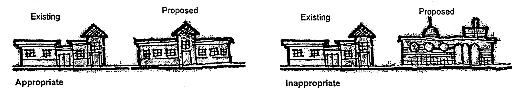
Design Treatments-2
(3)
Style. Appropriate historical "themes" as defined by this section are permitted.
(4)
Identical buildings. Buildings and structures that are identical or similar in design shall not be permitted throughout the corridor unless each building is part of an overall development with uniform architectural themes.
(5)
Scale. New structures shall relate to the form and scale of surrounding architecture. Buildings taller than two stories shall be evaluated as to their visual impacts upon adjacent structures.
(6)
Compatible exterior materials and architectural elements.
a.
Lattice work, decorative moldings.
b.
Covered porches with columns and railings.
c.
Arbors, trellises, gazebos, picket fences.
(7)
Incompatible architectural elements. Unarticulated, flat, or blank facades are not permitted within the NBOZ.
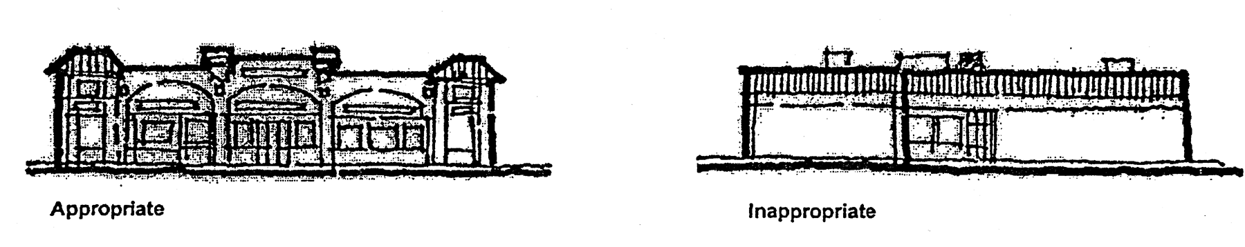
Design Treatments-3
(8)
Proportion. The proportion of the major elements of a development such as windows, doors and storefront design shall be consistent throughout the development.
(c)
Building facade/elevation.
(1)
Building features and ornamentation. The following building features and ornamentation are encouraged:
a.
Cornices and parapets, moldings, pilasters, window surrounds, asymmetrical facades, multi-level roofs, and similar elements;
b.
Tile, plaster, poured concrete, or brick materials, consistent with design and style;
c.
Functional and ornamental balconies and balustrades located on the walls or facades facing public rights-of-way, excluding alleys.
d.
Arcades designed with arches; and
e.
Exterior detail elements such as banding and other applied stucco detailing.
(2)
Preferred exterior materials. Preferred building exterior siding materials shall include stucco and brick, however cast stone, split blocks, ceramic tiles, high quality coated metal panel systems, and stone are acceptable. Materials including woods, metal siding, fluted block and glass window systems are discouraged within the NBOZ.
(3)
Recesses/projections. Facades greater than 50 feet in length shall incorporate recesses and projections a minimum of 12 inches in depth along a minimum of 20 percent of the total length of the facade. The recesses or projections shall be distributed along the facade with a maximum spacing of 100 feet between each recess or projection.
(4)
Visible facades. All building facades visible from public rights-of-way and adjacent properties shall be designed with regard to their surroundings and should not be construed as creating look-alike buildings. Harmony shall be achieved through the proper use of scale, proportions, form, materials, texture, and color.
(5)
Trademark forms and colors. Buildings and structures which use trademark or symbolic forms and colors and which have a negative impact on the visual environment of the area, as determined by the jurisdiction, are prohibited.
(6)
Blank walls. Blank walls shall not exceed ten feet in height or 20 feet in length. Control and expansion joints shall constitute a blank wall, unless used in a decorative pattern with varied materials or textures and spaced a maximum of ten feet on center. Relief and reveal depth shall be a minimum of three-quarter inch. Building wall offsets, including projections, recesses and changes in floor level, shall be used to add architectural interest and variety.
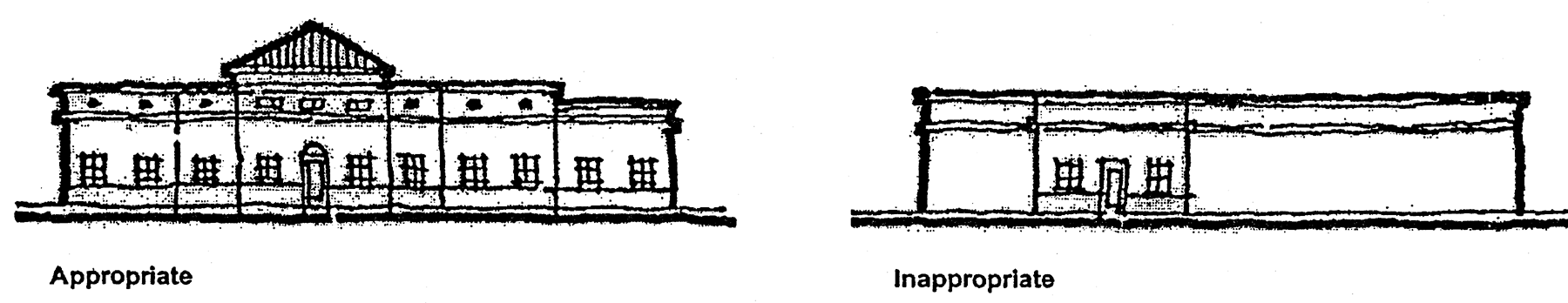
Building Facade—Elevation
(7)
Other features. Other features, such as gutters, down spouts, vent stacks, vent pipes, and flashing shall be painted in such a way so the color is consistent with the color scheme of the building.
(8)
Storefronts. Individual storefront elements of 50 to 100 foot widths shall be incorporated into the front facade to create a smaller scale for the building. Individual ground-level retail uses with exterior public access that are part of a larger freestanding building shall have display windows along a minimum of 20 percent of the facade length. Windows shall be defined with details such as frames, sills, shutters, planters, relief trims, or lintels.
(d)
Building color and finish.
(1)
General. Building materials and color selection shall achieve visual order through the consistent use of compatible color palettes.
a.
All storefronts within a development shall utilize a consistent palette of materials and textures.
1.
Variation of individual storefronts within a given palette of materials may be permitted, however principal walls and facades must maintain a uniform color.
2.
Different colors for individual storefronts within a complex are permitted as long as overall design integrity is not compromised.
b.
Color should be chosen to add to the retail environment of these buildings.
c.
The use of color to attract attention to a business from a distance is discouraged.
(2)
Color palette. Colors of the structures within the NBOZ are to reflect the following characteristics:
a.
Primary colors for structures must be white, light gray, eggshell, pale blue, pale green, coral, peach, pale yellow, buff, beige, and sand.
b.
Secondary building colors should be limited to 25 percent of the wall area. These colors may consist of a medium intensity of the base building color or a complimentary color.
c.
Trim colors shall be limited to ten percent of any single wall area. Trim colors are used for accent and identifying purposes and are the brightest group of colors allowed. These colors include greens, blues, yellows, and others that are found in our lush landscape and natural features.
d.
Ornamentation, trim, courses, window frames, and door frames may be painted white or a contrasting color such as dark brown, dark gray, blue, light green, brown, plum, black;
e.
Roof materials may be brown, gray, white or other color consistent with the overall color scheme of the structure.
(e)
Architectural elements.
(1)
Pedestrian walkways. Pedestrian walkways with arcades, awnings or colonnades shall be provided along the front and sides of buildings and be integrated with adjacent properties. Arcades or colonnades shall have a minimum clearance width of six feet and minimum clearance height of 12 feet. Awnings shall have a minimum clearance width of six feet and minimum clearance height of eight feet.
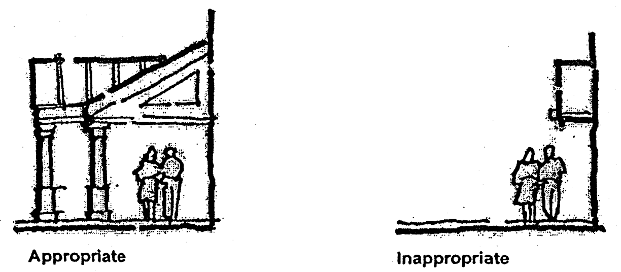
Architectural Elements-1
(2)
Building height. Building height is defined by the applicable building code. Maximum building heights for each district is subject to a finding of compatibility of adjacent structures as follows:
a.
East district: a maximum height of 40 feet;
b.
Central district: the maximum height of 55 feet;
c.
West district: a maximum height of 40 feet.
(3)
Entrances. Entrance design elements that are intended to give protection from the sun and adverse weather conditions shall be integrated into a design style for the building. Each freestanding principal structure shall have a minimum of one clearly defined primary public entrance feature. The primary entrance shall incorporate a minimum of one design element each from Tables 3-5A and 3-5B below:
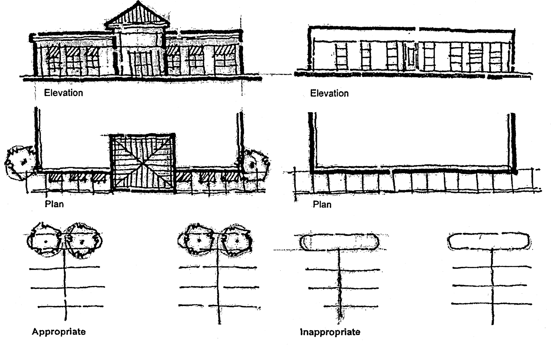
Architectural Elements-2
Table 3-5A
Primary Entrance Feature Design Element
(1)
Canopies, porte-cochere, or portices
(2)
Wall recess or projection of a minimum of 12 inches in depth
(3)
Covered arcades, a minimum of eight feet clearance in width
(4)
Peaked roof forms
(5)
Arches, columns, or pilasters
Table 3-5B
Secondary Decorative Treatment
(1)
Overhangs, cornices and eaves
(2)
Decorative moldings or trims around windows and doors
(3)
Covered public outdoor patio or plaza incorporated with entrance area which are not part of a tenant space
(4)
Special pavers, bricks, decorative concrete, or other similar pavement treatment
(5)
Architectural details such as tile work or moldings
(6)
Benches or other seating components
(7)
Decorative landscape planters or wing walls that incorporate landscaped areas; and
(8)
Structural or vegetative shading.
(4)
Mechanical equipment screening. All rooftop mechanical equipment shall be located at a distance from the edge of the building and properly screened so as not to be visible from any street or adjoining property. Materials used for screening purposes shall be compatible with the architectural style, color, and materials of the principal building.
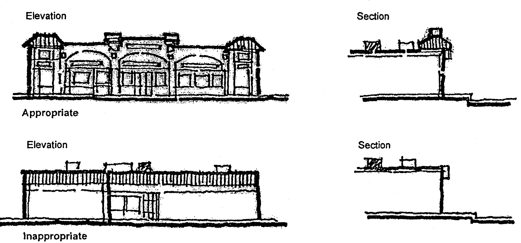
Architectural Elements-3
(5)
Cornices. Existing cornices should be retained and preserved.
(f)
Window/door treatments.
(1)
Windows. The following major design characteristics are encouraged:
a.
Arches integrated into window designs;
b.
Trim color in contrast with principal color of structure;
c.
Large ground level store front windows, consisting of at least 50 percent of the wall area of the storefront:
1.
The windows of all ground floor businesses open to the public shall remain clear of curtains, shutters, or similar visual barriers, which would obscure interior displays or activities.
2.
Reflective or darkly tinted glass, which prevents seeing into the building is not permitted on the ground level.
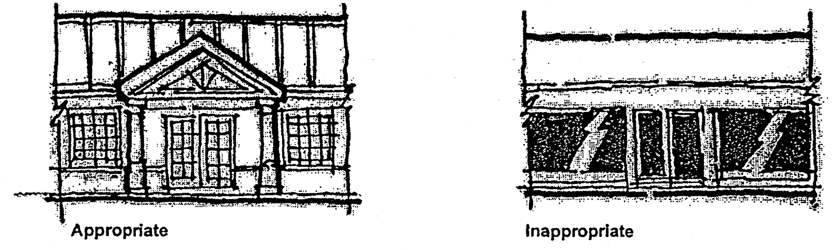
Window—Door Treatments-1
d.
Recessed openings;
e.
Hurricane/security panels or shutters which are removable, recessed, or architecturally compatible with overall design, and consistent with wind load resistance standards; and
f.
Replacement windows should fill the entire opening and duplicate the original pattern. Surrounding trim should be retained in the proper style and proportion.
(2)
Doors. The following major design characteristics are encouraged:
a.
Recessed openings;
b.
Scaled and proportionate to balance of structure;
c.
Articulated and ornamental door design; and
d.
Use of materials to convey mass and strength.
(3)
Awnings. Awnings shall reflect colors that compliment the existing architecture and not detract from the storefront or from adjacent storefronts.
a.
All awning supports should be attached to the building, not placed in the sidewalk or extending into the parking lot. Additionally, awning frames should be simple pipe frames, well concealed by canvas covers or attachments.
b.
Plastic backlit awnings or awnings constructed of shiny materials are not permitted.
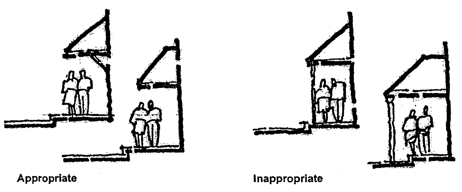
Window—Door Treatments-2
(4)
Fenestration and details. Architectural features or details such as windows, awnings, covered arcades, sills, shutters, reliefs, trims, columns, pilasters, quoins, reveals, cornices, horizontal banding, arches, decorative vents, and/or accent tile, shall be integrated into the facade to avoid the appearance of a blank wall and shall be provided along a minimum of 60 percent of the facade length of the front and side facades, and rear facades if continuous to a public street or residential zoning district.
(5)
Materials. Doors and windows should be glass and aluminum (painted) storefront, high quality steel and glass systems, high quality woods such as plantation grown teak or mahogany, and brass, bronze or stainless steel.
(6)
Exterior treatment. The exterior treatment of the front elevation shall consist of a minimum of two different building materials, textures, or finishes at a ratio of a maximum of 80 percent for the primary treatment and a minimum of 20 percent total for the secondary treatment. Exterior finishes such as stucco, brick, wood, coquina, or cut stone are encouraged. The surfaces of multiple exterior storefronts within a building, except regional commercial facilities, shall complement contiguous storefronts.
(7)
Kick plates. Kick plates protect windows by raising the glass area to a safer and more easily viewed height. New storefront can have simplified kick plates, or have an all-glass front that creates a kick plate line and proportion by use of a framing bar or painted line.
(g)
Preferred roof materials/styles.
(1)
Design types. The following major design characteristics are encouraged.
a.
Flat roofs with an articulated parapet of four feet in height necessary to screen mechanical equipment.
b.
Hip or gable roofs, minimum of 1:3 pitch, positioned so that the hip-roof end is facing the street.
c.
Exposed rafter tails.
d.
Pitched roofs or shed-style arcades of flat, S-shape, or barrel vaulted cement or clay tiles are encouraged.
e.
Standing seam metal roofs made of copper, stainless steel or galvanized steel are acceptable. Other metal roof types including industrial rib roofs are prohibited.
f.
Mansard roof, which shall wrap around the building so that there is visual continuity around the entire building. Vertical roofs and mansard roofs used on a portion of the building perimeter only are prohibited.
g.
Overhangs over pedestrian walkways are encouraged to provide shade and rain protection. All overhangs shall wrap around the building so that there is visual continuity around the entire building.
(2)
Treatments. Roof features shall be in scale with the building's mass and complement the character of adjoining and or adjacent buildings.
(3)
Edge and parapet treatment. A minimum of two locations, the roof edge and/or parapet shall have a vertical change from the dominant roof condition a minimum of four feet. At least one such change shall be located on a primary facade adjacent to Northlake Blvd. Designers are encouraged to articulate the parapet wall as a means of adding interest to the building facade and to screen any mechanical equipment.
(4)
Preferred materials for pitched roofs. Roofing material should be constructed to enhance the appearance of the community. Materials shall include glazed or unglazed ceramic tiles, metal shingle, concrete tile, or slate barrel, "s" shape, or similar style clay or cement tiles.
(5)
Large, unarticulated roofs. The roofline at the top of the structure shall not run continuously for more than 100 feet without offsetting or jogging the roof plane.
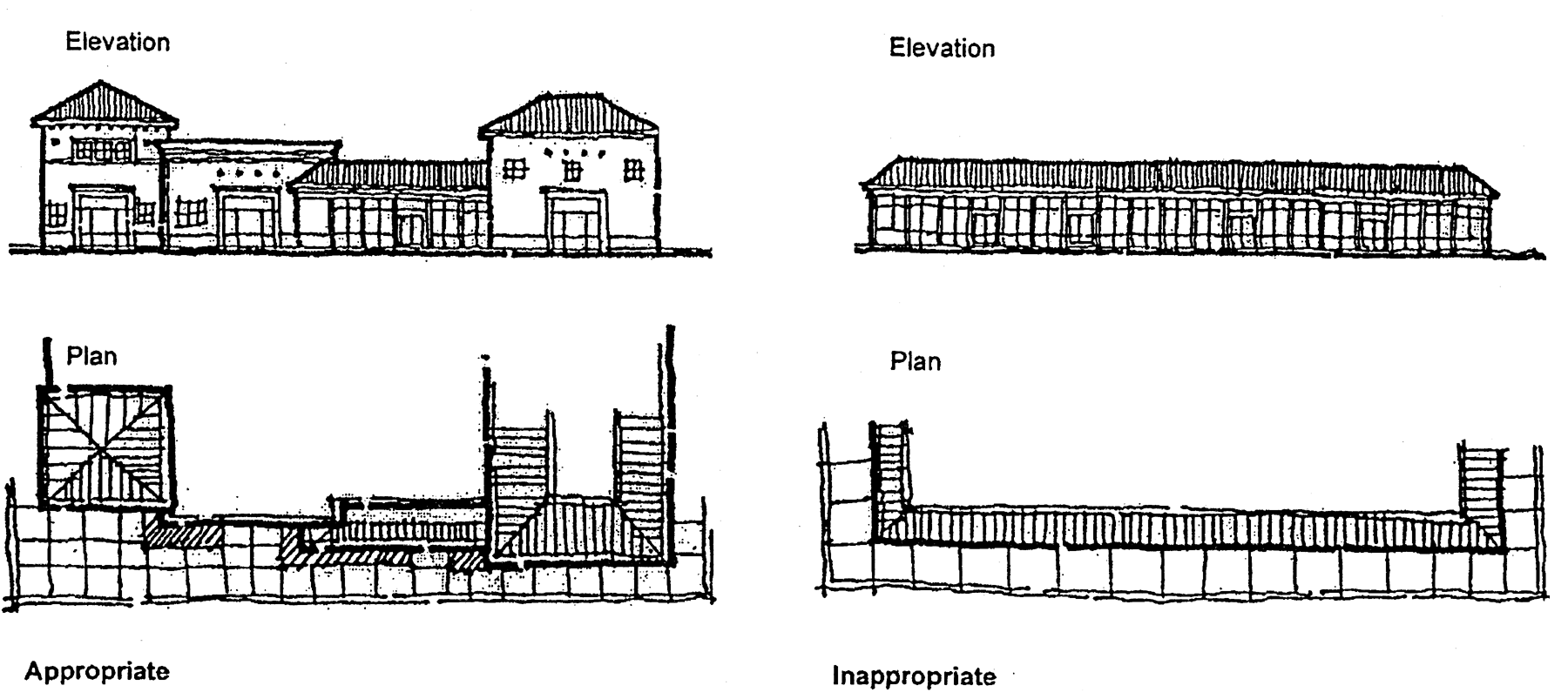
Preferred Roof Materials—Style
(h)
Definitions. The definitions set forth in this section shall be construed to be the same as if incorporated in the jurisdictions' development regulations.
(1)
Architectural composition. The scale, height, mass, proportion, color, form, style, detail, treatment, texture, construction material, and roof design of a project or building.
(2)
Articulated parapet. A parapet with a height variation proportional to the building height.
(3)
Balustrade. A series of balusters with a top and bottom rail.
(4)
Bracket. A decorative support feature located under eaves or overhangs
(5)
Canopy. An ornamental roof-like structure used on commercial buildings, which provide advertisement space, shade, and protection for the storefront and pedestrian traffic.
(6)
Compatible/compatibility. Design that utilizes accepted site planning (e.g. building placement, orientation and siting) and the elements of architectural composition within the context of the surrounding area. Similar adjacent land uses or square footage shall not necessarily constitute architectural compatibility.
(7)
Complement/complementary. Having similar architectural composition.
(8)
Dormer. A secondary feature of a building housing a window or vent, which is set upon the slope of a roof surface. Dormers may provide ventilation, lighting, or auxiliary living space.
(9)
Eave. The projecting overhang at the bottom edge of a roof surface.
(10)
Exposed beam. A decorative wooden beam that appears to support eaves, prevalent on bungalow-style residences.
(11)
Frieze. A wide facing board located at the junction of the exterior wall and roof eaves.
(12)
Gable roof. A triangular section at the end of a pitched roof.
(13)
Historical "themes". Any building, structure, or other architecture which is historically or architecturally significant. Recognized architectural styles such as Spanish Eclectic, Mediterranean Revival, Florida Vernacular, Bermuda/Island is appropriate for the NBOZ.
(14)
Hip roof. A roof with sloping sides and ends.
(15)
Lattice. A panel of criss-crossed diagonal or perpendicular slats often utilized as decorative infill between masonry foundation piers.
(16)
Lintel. A horizontal beam located above a window or door.
(17)
Louver. A door or window comprised of overlapping downward sloping slats, which shed rain while admitting light and air.
(18)
Masonry. Brick, block, or stone, which is secured with mortar.
(19)
Massing. A term used to define the over all volume or size of a building.
(20)
Molding. A continuous decorative strip of material applied to a surface.
(21)
Parapet. A solid protective or decorative wall located along the outside edge of a roof.
(22)
Rafter. A wooden member of a roof frame, which slopes downward from the ridgeline.
(23)
Scale. A term used to define the proportions of a building in relation to its surroundings.
(24)
Shed roof. A roof with a single sloping pitch.
(25)
Stucco. A masonry material applied as exterior wall fabric.
(26)
Substantial renovation. Any expansion, alteration, renovation, addition, or redevelopment to existing structures where the cost of such is greater than 50 percent of the assessed improvement value of the parcel, indicated on the most recent tax roll of Palm Beach County Property Appraiser, or an increase of greater than 20 percent of the square footage of the existing structure.
(Ord. No. 30-2002, § 2(Exh. A, §§ 3-1—3-8), 9-4-02; Ord. No. 6, 2022, § 12, 7-14-22)
Sec. 78-228. - Landscape elements.
(a)
Purpose and intent. The provisions of this section are intended to ensure that properties within the NBOZ meet minimum landscaping standards in order to:
(1)
Improve and sustain the aesthetic appearance of the jurisdiction through creative landscaping which helps to harmonize and enhance the natural and built environment.
(2)
Promote water conservation by encouraging xeriscaping and utilization of native and drought tolerant landscape material and utilization of water conserving irrigation practices;
(3)
Provide a visual buffer between otherwise incompatible types of land uses and adjacent rights-of-way.
(4)
Encourage innovative and cost-effective approaches to the design, installation, and maintenance of landscaping.
(b)
Administration.
(1)
Applicability. The provisions of this section shall apply to all existing and future development within the boundaries of the NBOZ as follows:
a.
New development. All new development.
b.
Existing development. All existing development shall conform with the provisions of this section in accordance with section 78-225 and sections 78-714 through 78-717 of the city's land development regulations.
(2)
Exemptions. All licensed plant or tree nurseries or tree farms shall be exempt from the terms and provisions of this section, but only with respect to those trees planted and growing which are for sale to the general public in the ordinary course of the business. The landscaping required for buildings and parking lots shall be provided.
(3)
Waiver. The landscape regulations may be waived in whole or part by the jurisdiction when a property owner has demonstrated that the requirements contained in this section will reduce required parking, or substantially restrict the operation of the existing business or property's use.
(4)
Compliance. Failure to install, maintain, or preserve landscaping or native vegetation required in accordance with the terms of this section shall constitute a violation of this section.
a.
Failure to comply. If the property fails to meet the requirements of this section, or if the existing trees, shrubbery, grass, or groundcover are permitted to die, and such materials are not replaced within 30 days of the event, the code enforcement officer shall notify, in writing, the person responsible for the maintenance or replacement of such property of the need to comply with the requirements of this section within 30 days from the date of delivery of the notice.
b.
Extensions. The 30-day rule for compliance may be extended when necessary by the jurisdiction to recover from acts of nature such as a hurricane or a drought.
c.
Temporary exemptions. Temporary exemptions from compliance of this section may be granted as per the jurisdiction, if the violation is a direct result of a natural disaster occurrence or drought.
d.
Relocation or replacement for redevelopment. The site plan approved to remedy any violation of this section shall include landscaping replacement or relocation to comply with all requirements herein. Relocation or replacement shall comply with the standards listed below.
1.
Trees having a three-inch or greater caliper at diameter at breast height (DBH) which are to be replaced shall be replaced by the sum of three caliper inches to every one inch lost and are of like or similar species. Replacement trees shall be a minimum of three inches in caliper. For example, if an existing five-inch caliper tree is removed from the subject property, 15 inches in caliper are required for replacement. A combination of tree sizes may be utilized as long as no tree is less than three inches in caliper.
2.
If the site cannot support the total number of required replacement trees as determined herein, the jurisdiction may permit the owner to donate excess trees to the jurisdiction for planting on public lands at the owner's expense; contribute to the jurisdiction the monies equivalent to such required replacement trees; or permit the required replacement trees to be placed upon other lands owned by the same property owners.
3.
The jurisdiction may require alternative landscape solutions such as additional aesthetic hardscaping, site amenities, or specimen landscaping as per the intent of this section.
(c)
Nonconforming landscape areas. See subsection 78-228(b)(1)b. above.
(d)
Tree and plant installation.
(1)
Minimum plant quality. Plant quality for all required landscaping shall be Florida No. 1 or better, as provided in Grades and Standards for Nursery Plants, Part 1 and Part 2, as amended, as published by the Florida Department of Agriculture and Consumer Services. All vegetation shall be clean and free of noxious pests or disease.
(2)
Preferred species list. The preferred species list contained in subsection 78-228(f) periodically revised, as needed. To the greatest extent possible, the species list shall represent plants that are drought tolerant plants; noninvasive; not destructive to native plants; and strong wooded, non-brittle plants.
(3)
Installation.
a.
All landscaping shall be installed with sound workmanship and sound nursery practices in a manner that will encourage vigorous growth.
b.
A plant or tree's growth characteristics shall be considered before planning to prevent conflicts with views, lighting, or signage.
(4)
Root barriers. The jurisdiction shall require root barriers for trees planted within 15 feet of any road right-of-way, sidewalk, or utility. In determining the appropriateness of particular protection techniques, the jurisdiction shall use the current edition of the Tree Protection Manual for Builders and Developers, published by the State Division of Forestry, Florida Department of Agriculture and Consumer Services.
(e)
New construction and substantial revision.
(1)
Landscape area. At least 15 percent of the total parcel area shall be landscaped, excluding any area utilized for required parking.
(2)
Overall landscaping. The required area to be landscaped may include any of the following:
a.
Entry features;
b.
Massing of landscaping to produce focal points;
c.
Foundation plantings;
d.
Trellises, arbors, and similar structures;
e.
Planter and flower boxes;
f.
Freestanding planters and pottery;
g.
Sidewalk plantings;
h.
Landscaped courtyards, loggias, patios, and similar open areas available for public use; and
i.
Materials installed within publicly owned lands.
(f)
Prohibited and standard invasive plants.
(1)
Prohibited plantings.
a.
Artificial plants or vegetation shall be prohibited.
b.
Prohibited plants shall not be planted within the NBOZ, and existing prohibited plants shall be removed if determined to be invading adjacent native plant communities. The list of prohibited plant species, include, but are not limited to Casuarina spp. (Australian Pine), Ficus bengalensis (Banyan), Supaniopsis anacardioides (Carrotwood), Acacia auriculiformis (Earleaf Acacia), Pueraria montana (Kudzu), and Melaleuca quinquenervia (Melaleuca/Punk Tree/Pepper Tree).
(2)
Controlled plant species. The following species may be planted or maintained under controlled conditions and shall not exceed a maximum of ten percent of the total number of required trees.
a.
Black olives. Black olives shall not be installed within 15 feet of any parking area.
b.
Ficus species. Ficus species may be planted as individual trees or hedge material provided that individual trees are no closer than 30 feet from any public road right-of-way, utility, or structure. Hedges shall not exceed eight feet in height and be regularly maintained.
(g)
Preferred landscape palette.
(1)
Preferred trees. 50 percent of the required trees shall be selected from the list presented below.
Table 4-7A
Preferred Tree Species
(2)
Preferred shrubs and groundcovers. 50 percent of the required shrubs and groundcovers shall be selected from the list presented below:
Table 4-7B
Preferred Shrub/Groundcover Species
(h)
Minimum landscape requirements.
(1)
Required. The following uses within nonresidential developments shall be required to provide landscaping, as required herein.
a.
Vehicular use areas as required in section 78-228(h);
b.
Building foundation as required by section 78-228(l); and
c.
Signs as required by section 78-229.
(2)
Natural form. New trees and shrubs should duplicate natural patterns with multiple plant sizes, spacing, plant clusters, and single plantings.
(3)
Minimum landscape standards. All landscape installed shall meet the requirements of Table 4-8A and as otherwise provided herein.
Table 4-8A
Minimum Landscape Requirements
Notes
(1)
Measured from grade to average end of branches, not the tallest of one or two branches and a minimum crown of five feet.
(2)
Measured as gray trunk height.
(3)
Palms not classified as specimen palms and planted in perimeter buffer areas shall be installed in groups of not less that three.
(4)
Support shall be provided consistent with sound horticultural practices to encourage future growth.
(4)
Minimum landscape points. Tables 4-8B and 4-8C shall be used to determine the minimum landscape points per open space a project shall be required to provide. Achieving the minimum open space landscape point requirement does not exempt a project from compliance with other requirements of this section.
Table 4-8B
Minimum Landscape Requirements for Point System Delineation
Notes
*Example: 15% project open space requires 22 points/100 square feet
< = Equal to or less than
> = Equal to or greater than
Table 4-8C
Required Landscape Installation Points
Notes
(1)
Abused trees, as determined by the jurisdiction, shall not count toward required points.
* = Justification to be provided consistent with definition.
DBH = Diameter at Breast Height. (4½ feet above grade)
< = Less Than.
> = Greater Than.
(5)
Total landscaping points. Achieving the total points per open space for an entire project within one or more areas does not exempt one from complying with all other requirements, even if that means exceeding the minimum required.
(6)
Water conservation.
a.
Landscape plans shall be required to use minimum water conservation techniques such as the following:
1.
Moisture-sensing controller (other than rainswitch)
2.
Drip/trickle/micro irrigation system
3.
Quality effluent irrigation
b.
Water conservation may also be obtained through the use of the following:
1.
Florida native landscaping.
2.
Very drought-tolerant trees, shrubs and groundcovers
3.
Native wildflowers, meadow grasses or groundcover in lieu of allowable sodded area.
(7)
Specimen trees. Specimen trees shall be considered as existing native trees if in good health and over 13 inches at diameter at breast height (DBH) or larger.
(8)
Canopy trees.
a.
Canopy trees shall be installed in the landscape buffer at a maximum of 30 feet on center.
b.
The canopy trees, at maturity, shall be of a species, which possess an average spread of at least 25 feet and a clear trunk of at least six feet.
c.
Approval of the use of trees with a lesser mature canopy, provided that groupings of such species are utilized to achieve the average spread.
(9)
Palm trees.
a.
Palms must attain a minimum 12 feet in height at maturity.
b.
Palms must be resistant to lethal yellowing.
(10)
Tree species mix. When more than 15 trees are required to be planted to meet the standards of this section, a mix of species shall be provided according to the overall number of trees required to be planted. Species shall be planted in proportion to the required mix. The minimum number of species to be planted is indicated in Table 4-8D.
Table 4-8D
Required Species Mix
(11)
Native and drought-tolerant trees.
a.
A minimum of 50 percent of all trees used to satisfy the standards of this section shall be classified as native.
b.
In addition, 50 percent shall be classified as drought-tolerant by the most recent edition of the South Florida Water Management District's "Xeriscape Plant Guide."
(12)
Shrubs and groundcovers.
a.
At least 50 percent of all required hedges and shrubs shall be classified as native or drought tolerant by the most recent edition of the South Florida Water Management District's "Xeriscape Plant Guide."
b.
At the time of installation, required hedges and shrubs shall be a minimum of 24 inches in height, or 18 inches in height for native species, spaced at a maximum of 24 inches on center.
c.
Required hedges shall form a solid, continuous visual screen of at least three feet in height within two years of planting.
d.
Hedges used in combination with nonliving landscape barriers to meet the six feet screen requirements shall be installed the height necessary to provide the total six foot screen within two years of planting.
(13)
Sod or grass. Not more than 40 percent of the total landscape area shall be covered with sod or grass.
(14)
Ground treatment.
a.
The ground area within required landscaped areas which is not dedicated to trees, or the preservation of existing or new vegetation, shall receive appropriate landscape treatment such as grass, groundcover, mulch or shrubs and present a finished appearance upon planting.
b.
Sand, gravel, shellrock, or pavement shall not be considered appropriate landscape treatment.
c.
The following standards shall apply to the design of ground treatment.
1.
Ground cover. Live material used as ground cover shall provide a minimum of 50 percent coverage immediately upon planting and 100 percent coverage within one year.
2.
Mulch. Mulch shall be installed and maintained at a minimum depth of three inches at all times, in all planted areas not containing ground cover. All mulch material shall be seed and weed-free to prevent tree sprouting and regrowth.
3.
Pebble and egg rock. Pebble or egg rock may be used in a limited amount as a ground treatment in areas where drainage is a problem.
4.
Lawn and turf grass. Grass areas shall be planted with species suitable as permanent lawns. Use of drought-tolerant groundcover instead of lawn and turf grass is encouraged.
(15)
Flowers. Flower boxes and hanging pots should complement the overall architecture of the facade and not obscure architectural details. The boxes should be well constructed, and accommodate watering needs without allowing water to drip or leak onto the building or sidewalk.
(16)
Redevelopment and nonconforming projects. If a redevelopment and nonconforming project is unable to meet the point system or open space requirements of this section, required landscape points may be transferred to other public lands, parks, road, road rights-of-way or other similar public space, up to a maximum of 25 percent reduction of points per 100 square feet.
(17)
Landscape in easements.
a.
Landscaping may be permitted in easements with the written permission of the easement holder. Trees planted within any easement with overhead utilities shall be consistent with FP&L's suggested tree list "Plant the Right Tree in the Right Place," taking into consideration the mature height and spread of the species beneath or adjacent to existing overhead utilities.
b.
Easements may overlap a landscape buffer a maximum of five feet provided that there remains a minimum of five clear feet for planting, or if a wall with a continuous footer is used, a minimum of ten clear feet for planting.
c.
The landscape buffer may be traversed by easements or access ways as necessary to comply with the standards of this section.
(18)
Perimeter landscaping. Only access ways and easements shall be permitted as interruptions in perimeter landscaping and shall be included in the calculation of linear dimension. No structures or parking are to be located in this landscape area.
(19)
Landscaping in public road right-of-way. Maintenance of landscaped rights-of-way shall be the responsibility of the project's property owner or, as agreed upon in the development order approving the project, by special districts created for unified maintenance.
(i)
Miscellaneous landscape elements.
(1)
Alternative landscape materials. A landscape plan may utilize one or more materials not specifically authorized in this section and must be demonstrated to be consistent with the purposes and intent of this section.
(2)
Screening required. Uses within the overlay zone that shall be required to be screened from public view include mechanical equipment areas, parking areas, satellite dishes mounted on the ground, chain-link or other non-opaque fence or wall type, accessory use structures, and other elements as defined by this section.
(3)
Perimeter walls and fences.
a.
Perimeter walls, metal or wood fences, or other nonliving landscape materials may be used in conjunction with vegetation to meet required landscaping.
b.
Approved walls or fences shall be set back from property lines sufficiently to include landscape on the outside of the wall or fence. Chain link fences shall have a green or black vinyl covering.
c.
Maintenance of the wall or fence and associated landscaping by the property owner is required.
(4)
Storage and garbage collection sites. All outside storage and trash or garbage collection sites shall be completely screened from view, utilizing any approved combination of hedge (a minimum of three feet in height) structural barriers, berms or any combination thereof to 100 percent screen the area from view.
(5)
Service areas.
a.
Service areas of nonresidential buildings, when visible from the street right-of-way or adjacent residential land use, shall have barriers and a hedge at a minimum of six feet in height to screen the service area from this use.
b.
Service areas may include interior or exterior work bays associated with full service gas stations, tire repair, auto repair business, as well as any business proposing loading or unloading docks.
(6)
Backflow preventers. Backflow preventer systems shall be screened from public view, utilizing any combination of trees, palms, hedges, or other barriers.
(7)
Mulch.
a.
All tree and shrub beds shall receive at least three inches of mulch. Where mulch is to be installed permanently, it shall be renewed and maintained at three inches of depth.
b.
Mulch shall be temporarily applied to areas not immediately covered by groundcover.
c.
Mulch will be thoroughly wet at the time of application to prevent wind displacement.
(8)
Pavers. The use of pavers or similar impervious material, excluding sidewalks, shall not exceed 30 percent coverage of an open space area, and shall not be wider than 12 feet if used in a required landscape buffer area.
(9)
Signs. Landscaping around ground/monument signs is required and shall be provided pursuant to section 78-230.
(10)
Advertising. At no time shall a landscaped area be used for advertising display or sales. Temporary signs may not be placed in landscaped areas.
(11)
Earth berms. Earth berms shall use long and gentle slopes and as non-living landscape barriers only when installed in conjunction with plant materials.
a.
Berms five feet or less in height shall have a maximum slope of 2:1. Berms greater than five feet in height shall not exceed a ratio of 3:1 in slope.
b.
Hedges used in combination with earth berms to meet the six foot screen requirements shall be installed at the height necessary to provide the total six-foot screen at time of planting.
(j)
Landscape requirements for off-street parking areas.
(1)
Minimum spacing.
a.
The minimum shade tree spacing for interior parking areas shall be such that the center of any parking space is not more than 40 feet from the center of the shade tree.
b.
A shade tree may be replaced by a minimum of three palms clustered together, as long as the affected parking bays are more than 50 feet from a public street.
(2)
Landscape islands.
a.
A landscape island shall be required for every nine parking spaces located in a row.
b.
The use of landscape diamonds for interior parking lot tree planting is permitted as per this section, excluding islands at the end of parking rows.
c.
Each planter island shall contain at least one canopy tree for each 100 square feet of area or fraction thereof, in addition to shrubs and ground cover.
d.
Terminal and landscape islands. Each row of parking spaces shall be terminated by landscape islands, which measure a minimum of eight feet in width, excluding required curbing, and 15 feet in length. A minimum of 120 square feet of pervious surface areas shall be provided. A minimum of one tree shall be planted in each terminal island.
e.
Interior landscape islands. A minimum of one interior landscape island shall be provided for every nine parking spaces or fraction thereof and shall be spaced a maximum of 90 feet apart. Interior islands shall measure not less than eight feet in width, excluding required curbing, and 15 feet in length. A minimum of 120 square feet of pervious surface areas shall be provided. A minimum of one tree shall be planted in each interior island.
f.
Lots equal to or less than one acre. For lots equal to or less than one acre, terminal and interior landscape islands shall be a minimum of five feet in width, excluding required curbing, and 15 feet in length.
(3)
Divider median.
a.
Divider medians shall be installed between rows of parking and between all parking/vehicular use areas.
b.
One tree shall be planted for each 30 linear feet of a divider median, or fraction thereof.
c.
The minimum width shall be five feet of un-encroached landscape area.
(4)
Minimum size for landscape areas.
a.
The minimum landscape area shall contain no dimension less than five feet in width, measured from the inside of the curb.
b.
There shall be no landscape area smaller than 25 square feet.
c.
Landscape areas within interior parking areas may be reduced if the areas shall constitute an obstruction in use of a building structure, providing the reduced square footage is relocated so as to emphasize entrance corridors or special landscaped areas within the general parking area.
(5)
Protection of landscape areas. All landscape areas shall be protected by curbs or wheel stops from vehicular encroachment and from the damages caused by vehicles overhanging into landscape areas.
a.
Landscaping. In addition to grass, landscaping shall be required to be at least 30 inches from the edge of the wheel stop or curbing.
b.
Overhang areas. Vehicle parking areas designed to permit vehicles overhanging into landscaped areas shall not be permitted to count the first 30 inches of landscape area as open space.
c.
Curbing. All landscape areas subject to vehicular encroachment shall be separated from vehicular use areas by six inch, non-mountable, FDOT-type "D" or FDOT-type "F", concrete or asphalt curbing. The curbing shall be machine-laid, formed-in-place or integral with the pavement.
d.
Wheel stops.
a.
Wheel stops shall have a minimum height of six inches above finished grade of the parking area, shall be properly anchored, and continuously maintained in good condition.
b.
The space between the wheel stop and the end of the parking space may be paved as required by the building division for anchoring and maintenance purposes.
c.
Wheel stop anchor rods shall be set through the pavement and the bottom of the wheel stop must rest fully on the pavement to prevent rocking.
(6)
Hedges.
a.
All parking, loading, or storage areas adjacent to the right-of-way, including driveways to parking lots, shall include a continuous hedge that is maintained at a minimum of three feet at maturity.
b.
"Dwarf" hedges may be installed and maintained at a minimum height of 18 inches when adjacent to an automobile sales display area.
(7)
Maintenance. Regular maintenance of vehicular use areas adjacent to all landscape areas shall include replacement of broken curbs or curb stops as needed to keep the general appearance in good condition and safe.
(8)
Safe sight distance triangles. Safe sight distance triangles shall be provided in accordance with the County Design Manual, published by the Palm Beach County Department of Engineering and Public Works, to restrict placement of visual obstructions.
a.
Landscape limitations.
1.
Safe sight distance triangle areas shall be maintained to provide unobstructed visibility at a level between 30 inches and eight feet above the crown of the adjacent roadway and in a way that does not create a traffic hazard.
2.
Landscaping on state roads shall be installed in accordance with the roadside clear zone provisions of the State of Florida Department of Transportation's Manual of Uniform Minimum Standards for Design, Construction, and Maintenance of Streets and Highways, as amended.
3.
All landscaping within the safe sight distance triangle area shall be planted and perpetually maintained by the property owner, in accordance with this section.
b.
Landscape area around signs.
1.
A three-foot wide planting area shall be required around the base of all signs.
2.
One shrub for each ten square feet of sign surface area shall be installed within the three foot planting area at the base of the sign.
3.
Ground/monument signs may be surrounded by ground cover instead of shrubs.
4.
Landscaping and trees which interfere with signage may be relocated to the rear of the sign planting area.
(9)
Landscape diamonds.
a.
Landscape diamonds may be distributed throughout the interior of an off-street parking area to provide shading of parked motor vehicles as an alternative to interior landscape islands.
b.
Tree planting areas shall be located only at the common intersection of four parking spaces and spaced no greater than four spaces apart.
c.
The ground within the tree planting area shall receive appropriate landscape treatment, including mulch or groundcover.
d.
The minimum tree planting area shall be 25 square feet and the minimum dimension shall be five feet by five feet, not including curb treatment.
(k)
Minimum landscape buffer and planting requirements.
(1)
Minimum buffer required. A landscape buffer shall be a minimum of eight feet in width around the perimeter of a parcel. However, additional buffer width shall be provided as indicated below:
a.
A minimum landscape buffer of ten feet in width shall be required on lands located adjacent to public rights-of-way that are 110 feet wide or less;
b.
A minimum landscape buffer of at least 15 feet in width shall be required on lands located adjacent to public rights-of-ways that are 111 to 150 feet wide;
c.
A minimum landscape buffer of at least 20 feet in width shall be required on lands located adjacent to public rights-of-way that are greater than 150 feet wide; and
d.
A landscape buffer, at least five feet in width, shall be provided along all sides of the parking lot, excluding that side or sides, which abut a building.
(2)
Mature height. Vegetation should be planted taking into consideration the mature height and spread of the species.
(3)
Spacing. The maximum spacing of planting trees shall be 30 feet on center along any perimeter buffer.
(4)
Perimeter landscape requirements. Perimeter landscape buffers shall be installed and maintained in accordance with the following standards. Easements and access ways, which traverse required perimeter landscape buffers, shall be included in the calculation of linear dimension.
a.
Palm trees.
1.
Within the landscape buffer, a group of three palm trees may be substituted for one required canopy tree; however, not more than 50 percent of the required canopy trees may be replaced by palm trees.
2.
In right-of-way buffers only, Royal or Phoenix palms, excluding Phoenix roebellini, may be counted as one required canopy tree. These palms shall:
(i)
Not exceed a maximum of 30 percent of all trees required in the buffer;
(ii)
Be spaced a maximum of 20 feet on center; and
(iii)
Be a minimum of either six feet of gray wood for Royal palms or eight feet clear trunk for Phoenix palms.
b.
Slash pines.
1.
Slash pines planted in perimeter buffers shall be installed in groups of no less than three.
2.
Each group of slash pines shall average a minimum of ten feet in height and may be counted as one required canopy tree.
c.
Hedges and shrubs.
1.
At the time of installation, required hedges and shrubs shall be a minimum of 24 inches in height, and spaced at a maximum of 24 inches on center.
2.
Required hedges shall form a continuous solid opaque visual screen of at least 36 inches in height within two years of planting.
d.
Canopy tree and palm clustering.
1.
Canopy trees and palms may be clustered in right-of-way buffers if the clusters are spaced a maximum of 30 feet apart, and/or consist of trees of varied height, which when averaged, equal the minimum tree height requirements and are located on property containing a minimum of 300 linear feet along the right-of-way.
e.
Walls and fences within right-of-way buffer.
1.
If a wall or fence is used, the required landscaping shall be located between the wall or fence and the right-of-way.
2.
Walls and fences shall not encroach upon easements, unless approved in writing by the easement holder.
3.
Wall or fences shall be setback a minimum of ten feet from the edge of the ultimate right-of-way unless a wall with a continuous footer is used, then the wall shall be setback to provide a minimum of ten clear feet for planting.
(l)
Foundation landscaping and plantings.
(1)
Location.
a.
There shall be foundation landscaping within five feet of all buildings and structures and shall be provided along all four facades of all commercial structures, excluding rear service areas not visible by a public road right-of-way or not generally traveled by the public or visible from adjacent structures.
b.
The combined length of the required foundation planting shall be no less than 40 percent of the total length of the applicable side of the structure.
(2)
Irrigation. All foundation areas shall be irrigated and of the appropriate size to accommodate the mature size of the vegetation to be planted.
(3)
Minimum standards. The minimum standards for foundation landscaping shall be determined by the building height and function; and extend along the portions of a facade that directly abut a parking area or vehicular use area, excluding entryways, doorways or other building improvements.
a.
The foundation planting area for a one-story building shall be at least five feet wide, unless foundation landscaping would interfere with the intended use and function of a building.
b.
The foundation planting area for a building of two or more stories shall be not less than 30 percent of the height of the adjacent wall.
c.
At least one shade tree or palm cluster shall be installed for each 30 linear feet, or fraction thereof, of facade width.
1.
A minimum of one tree per facade shall be planted, and the remainder of the landscape area shall be treated appropriately with plantings and pedestrian accessways.
2.
Trees and palms shall be of an installed size relating to the height of the adjacent wall or facade, as indicated in Table 4-12.
Table 4-12
Minimum Foundation Planting Dimensions
(m)
Maintenance.
(1)
Minimum requirements. The land owner shall be responsible for the following:
a.
The maintenance of required landscape structures (e.g., walls, fences) in a structurally-sound condition.
b.
Tree maintenance, which shall be limited to periodic trimming to maintain healthy trees, removal of diseased limbs, or removal of limbs or foliage that present a hazard.
1.
All trees shall be allowed to grow to their natural mature height and a full canopy.
2.
Large and medium canopy trees shall be required to attain a minimum 20-foot canopy spread prior to pruning. In no case shall the canopy spread be reduced to less than 20 feet in width.
c.
Landscape buffers shall be maintained and preserved along the entire length of the property.
d.
All landscape areas which shall be maintained on a regular basis, to include weeding, watering, fertilizing, pruning, mowing, edging, mulching, replacement of dead or missing landscaping, removal of prohibited plants, and other horticultural practices that are needed to keep landscaping in good condition, free from disease, insect pests, weeds, refuse, and debris.
e.
Landscape maintenance shall be carried out in a manner that will not disrupt, inconvenience or endanger any member of the public, or pedestrian, or motor vehicles.
(n)
Irrigation.
(1)
General. All landscape areas, except those areas composed of existing native plant communities, shall provide an irrigation system plan. The irrigation system shall be designed and installed in accordance with the Florida Irrigation Society Standards and Specifications for Turf and Landscape Irrigation Systems, as amended from time to time. Irrigation systems shall be designed and maintained to obtain the following results:
a.
Eliminate the wasteful use of water;
b.
Eliminate staining of buildings, walks, walls and other site improvements including landscaping;
c.
Provide a minimum of 100-percent coverage, including the capability of applying water onto turf areas on a different saturation level than that used to irrigate shrub-planting beds; and
d.
Eliminate water overthrow onto non-pervious areas.
(2)
Standards. Irrigation systems shall comply with the following standards.
a.
Irrigation systems shall be continuously maintained in working order and shall be designed so as not to overlap water zones or to water impervious areas.
b.
Irrigation systems shall not be installed or maintained abutting any public street which causes water from the system to spray onto the roadway or to strike passing pedestrian or vehicular traffic, where feasible.
(3)
Rain sensors. A rain sensor, to switch off irrigation during wet periods, shall be required on all new irrigation systems.
(o)
Pruning,
(1)
Crown reduction.
a.
Crown reduction of shade trees shall be prohibited until the tree canopy has reached at least 20 feet in diameter. Exceptions include:
1.
The removal of limbs or foliage presenting a hazard or in conflict with a crime prevention program;
2.
Removal of dead or diseased limbs;
3.
The reinforcement strength of form, or
4.
In association with tree or palm relocation work.
b.
After a tree canopy reaches 15 feet in diameter, crown reduction shall only be permitted as incidental when correct pruning standards are used and when there are constraints such as, but not limited to, views, power lines, structures, lighting, or signage.
c.
A maximum of one-fourth of tree canopy may be removed from a tree within a one year period, provided that the removal conforms to the standards of crown reduction, crown cleaning, crown thinning, crown raising, vista pruning, and crown restoration pruning techniques.
1.
The crown of a tree required by this code or condition of approval shall not be reduced below the minimum spread or height requirements of this section or specific jurisdictional conditions of approval.
2.
A tree that is pruned in excess of these requirements shall be replaced with a tree that meets the minimum requirements of this section or equal specifications of the tree that has been pruned, whichever is greater.
(2)
Plant characteristics. Unless otherwise approved by the jurisdiction during the approval process, trees shall be allowed to grow to a shape and size typical of their species throughout their life cycle.
(3)
Pruning standards. The following are general pruning standards and requirements established for the overlay zone.
a.
Hat-racking. Hat-racking is prohibited. For the purposes of this section, hat-racking is defined as flat-cutting the top or sides of a tree, severing the leader or leaders; making internodal cuts (cutting back of limbs to a point between branch collars/buds) prune a tree by stubbing off mature wood larger than one inch in diameter within the tree's crown; or reducing a mature tree's total circumference or canopy spread by one-third or more.
b.
Palm trees. Pruning palm trees shall be limited to dead fronds and up to one-third of the green fronds and seed pods.
c.
Maximum limb pruning. Severely cutting back lower branches to increase sight visibility from underneath a tree's canopy, shall not exceed 13 feet six inches from the ground level to the collar of the first limb.
(4)
Alternative canopy shapes. If other than the normal expected tree canopy shade and size is desired by the owner of the trees, the desired shape and size shall be indicated on the approved landscape plan. If a desired shape and size is not noted on the approved landscape plan, trees shall be allowed to grow to their natural shape and size.
(5)
Performance. Pruning shall be performed by a person or tree service that is knowledgeable with the latest standards of the National Arborist Association.
(6)
Exemptions. The following shall be exempt from this section.
a.
Trees which interfere with safe site triangles, utility lines, or utility structures.
b.
Trees having crown die-back or decay greater than one-third the tree canopy.
c.
Trees having suffered damage due to natural or accidental causes.
d.
Trees having insect or disease damage greater than one-third of the tree crown.
(Ord. No. 30-2002, § 2(Exh. A, §§ 4-1—4-15), 9-4-02; Ord. No. 10, 2011, § 1, 6-2-11; Ord. No. 7, 2014, § 1, 6-5-14)
Sec. 78-229. - Signage and outdoor displays.
(a)
General provisions.
(1)
Intent. It is the intent of this section to:
a.
Regulate and limit the existing and proposed posting, display, erection, use and maintenance of signs and other advertising structures within the NBOZ.
b.
Protect property values, create a more attractive economic and business climate, enhance and protect the physical appearance of the community and preserve the scenic and natural beauty of the NBOZ.
c.
Secure and preserve the right of free expression guaranteed by the First Amendment of the Constitution of the United States.
(2)
Nonconforming signs. A nonconforming sign is any sign which was established pursuant to the issuance of a sign permit on or before the effective date of these regulations, and which is rendered nonconforming by the provisions of this section.
a.
All accessory signs, wall signs, freestanding signs, awning signs, pole signs, and ground signs erected within the corridor that do not conform to the regulations of this section shall conform in accordance with section 78-225 and sections 78-714 through 78-717 of the city's land development regulations.
(5)
Prohibited signs. It shall be unlawful to erect or keep any sign not expressly authorized by, or exempted from, this section.
(6)
Non-commercial messages. Any sign erected pursuant to the provisions of this section may, at the option of the applicant, contain either a non-commercial message unrelated to the business located on the premises where the sign is erected or a commercial message related to the business and located on the business premises pursuant to the following regulations:
a.
The non-commercial message may occupy the entire sign face or portion thereof.
b.
The sign face may be changed from commercial to non-commercial messages as frequently as desired by the owner of the sign, provided that the following is true:
1.
The size and design criteria conform to the applicable portions of this article,
2.
The sign is allowed by this section,
3.
The sign conforms to the requirements of the applicable zoning designation; and
4.
The appropriate permits are obtained.
c.
For the purposes of this Sign Code, non-commercial messages shall never be deemed off-premises.
(b)
Appearance.
(1)
General. All permanent signs shall comply with the requirements and procedures of the NBOZ and individual jurisdiction regulations and shall be part of the architectural concept and character of the site. Lighting, materials, size, color, lettering, location and arrangement shall be harmonious with the building design.
a.
If external spot or flood lighting is used, the light fixtures and light source shall be arranged so that the light source is shielded from view.
b.
Excessive brightness and brilliant colors shall be avoided.
(2)
Maintenance. All signs, including their supports, braces, guys and anchors, electrical parts and lighting fixtures, and all painted and display areas, shall present a neat and clean appearance. The vegetation around the base of ground signs shall be neatly trimmed and free of unsightly weeds, and no rubbish or debris that would constitute a fire or health hazard shall be permitted under or near the sign. Examples of unacceptable maintenance and repair include the following:
a.
Cracked, ripped, or peeling paint present on more than ten percent of the surface area of a sign;
b.
Bent, broken, loose, or otherwise insufficiently attached supports, struts, or other appendages;
c.
Partial illumination for more than 14 days;
d.
Obstruction of sign face by weeds, vines, or other vegetative matter; and
e.
Maintaining a position that is more than 15 degrees from vertical for more than ten successive days.
(c)
Exempt signs.
(1)
General. The following signs are exempt from these sign regulations and applicable permit fees, provided they are not placed or constructed so as to create a hazard of any kind:
a.
Political signs. Political signs shall comply with the regulations of the respective jurisdictions.
b.
Holiday lights and decorations. The display of holiday lights and decorations shall comply with the regulations of the respective jurisdictions.
c.
Manufacturer signs. Signs incorporated into machinery or equipment by a manufacturer or distributor, which identify or advertise only the product or service dispensed by the machine or equipment, such as signs customarily affixed to newspaper racks, telephone booths, and gasoline pumps.
d.
Merchandise displays. Merchandise displays behind storefront windows so long as no part of the display moves or contains flashing lights.
e.
Religious displays. Religious displays as permitted by law.
f.
Works of art. Works of art, ornamental figurines and the like, both two and three-dimensional, used for decorative purposes and not related to the operation of a commercial enterprise.
(d)
Temporary signs.
(1)
Generally. Temporary signs do not require a building permit and are allowed throughout the corridor, subject to the restrictions imposed by the NBOZ and individual jurisdiction's regulations. The sign shall not be an electric/illuminated sign.
(2)
Removal of illegal temporary signs. Any temporary sign not complying with the requirements of this section is illegal and subject to immediate removal by the jurisdiction at the expense of the owner and/or individual responsible for the illegal placement.
(3)
Restrictions. Advertising for the following purposes may be displayed:
a.
Construction signs. To identify development construction in progress.
1.
Such message shall not be displayed more than 60 days prior to the beginning of actual construction of the project, and shall be removed when construction is completed.
2.
If a message is displayed pursuant to this section, but construction is not initiated within 60 days after the message is displayed, or if construction is discontinued for a period of more than 60 days, the message shall be removed, pending initiation or continuation of construction activities.
3.
Upon final certificate of occupancy of a completed residential or nonresidential structure, such sign shall be removed.
b.
For-sale signs. Such signs shall comply with the regulations of the respective jurisdictions.
c.
Grand opening signs. To announce the opening of a new business or the change of ownership of an established business shall be permitted in addition to other signs, which may be permitted by this regulation.
1.
Signs shall not remain in place for more than seven days commencing immediately upon the opening of a new business or the change of ownership of an established business.
d.
Special event signs. Such signs shall be placed no more than 15 days prior to the beginning of the event and provided further that all such signs shall be removed within 48 hours after the event. Approval of the size and locations of the signs by the jurisdiction is required.
(4)
Permissible size, height, location and number of temporary signs.
Table 5-4
Permitted Temporary Signs
(e)
Accessory signs.
(1)
Permitted. A permanent accessory sign may be a ground or monument sign with one or two faces or wall signs with one face.
(2)
Content. Signs permitted pursuant to this section may contain any noncommercial message, which has not been declared by a court of competent jurisdiction to be obscene, defamatory or otherwise contrary to law. A permanent accessory sign may only display any combination of the following:
a.
Street address number and/or name.
b.
A logo symbol for the building or the building occupant, which does not exceed 50 percent of the allowable sign area.
c.
Letters depicting the nature of the business and that are a maximum of 50 percent of the height of the letters depicting the name of the building or building occupant.
(3)
Sign type and criteria.
a.
Gasoline signs.
1.
One gasoline price sign shall be permitted per gasoline station to provide the price of gasoline only and shall be attached to permanent sign structure or to a building. The price sign shall not be included in the total area of signage otherwise permitted.
2.
Signs providing information needed for motorists to locate the proper service station pump site shall be permitted. Such signs shall include those identifying the type of fuel sold at individual service station pumps, the location of full service and self-service pump islands and other similar information. Such signs shall be of a size, which can be seen by motorists once on the site, but shall not be sized to attract attention of motorists on public rights-of-way.
b.
Flags. A maximum of three flags or insignias of governmental, religious, charitable, fraternal, corporate, or other organizations may be displayed on any one parcel of land. However, flags bearing commercial messages including corporate insignias, trademarks, and logos are considered a sign and therefore counted as part of the permitted business sign square footage as defined by this section.
c.
Parking area directional signs. Parking area directional signs may be erected at each point of ingress and egress to a parking lot or parking area shall not be counted as part of an occupant's allowable sign area. Directional signs shall be subject to the following:
1.
Such signs shall not exceed two square feet in background area nor extend to a height greater than three feet above ground.
2.
Only one such sign shall be allowed at each point of ingress and egress, and such signs shall not create a traffic or pedestrian hazard.
3.
No names or logos are permitted on the sign.
d.
Parking area instructional and related signs. The direction of traffic flow within a parking or loading area, ingress and egress points, areas where no parking is permitted, identification of parking spaces reserved for other specific groups or for individuals, and other similar information.
e.
Vehicle signs. The following vehicle signs are not permitted within the NBOZ:
1.
Signs in excess of ten square feet. Vehicle signs with a total sign area on any vehicle in excess of ten square feet, when the vehicle is parked on the same property as the business being advertised and:
(i)
Is parked for more than 60 consecutive minutes within 100 feet of any street right-of-way; and
(ii)
Is visible from the street right-of-way that the vehicle is within 100 feet of; and is parked on commercially zoned property.
2.
Vehicle signs less than or equal to ten square feet. Vehicle signs visible from any street right-of-way with a total sign area less than or equal to ten square feet, when the vehicle is parked for more than 60 consecutive minutes on a commercially zoned property and on which the business being advertised is located and:
(i)
Is parked within the front two-thirds of the area between the front building line and the front lot line; or
(ii)
In the case of corner lots, is parked within the front two-thirds of the area between the side building line and the side lot line; or
(iii)
Is parked within 30 feet of any street right-of-way.
(4)
Permissible size, height, location and number of permitted accessory signs.
Table 5-5
Permitted Accessory Signs
(f)
Business signs.
(1)
Permitted. A permanent sign advertising a business or establishment shall consist of the following:
a.
A canopy or awning sign;
b.
A ground or monument sign with one or two faces;
c.
A wall sign with one face; and/or
d.
A window sign not to exceed 20 percent of the total window area covered.
(2)
Content. A permanent sign may only display any combination of the following:
a.
Street address number and/or name of the business or occupant.
b.
A logo symbol for the building or the building occupant which does not exceed 50 percent of the allowable sign area.
c.
Letters depicting the nature of the business and that are a maximum of 50 percent of the height of the letters depicting the name of the building or building occupant.
d.
These restrictions (a., b. and c. above) shall not apply to permitted noncommercial messages.
(3)
Sign type and criteria.
a.
Canopy or awning signs. Notwithstanding limitations of this article on the projection of signs from the wall of a building, signs shall be permitted on canopies and awnings.
1.
The sign shall indicate only the name of the building or the name of the principal occupant of the building;
2.
The sign shall be painted or printed directly on the canopy or awning; and
3.
The sign shall be counted in determining the area of wall-mounted signs permitted on the wall from which the canopy or awning projects.
b.
Ground signs. The name, logo, and address of a parcel of land shall be permitted on a ground sign as per the following standards:
1.
East district. A minimum of one sign for parcel of land.
2.
Central and west districts. One sign per parcels with a minimum of 300 linear feet of street frontage to include intersecting roadways.
3.
Overall. For parcels with greater than 300 linear feet of street frontage, one additional sign for each additional 700 linear feet of street frontage to include intersecting roadways.
4.
Outparcels. Outparcels of a commercial center are permitted to have one ground sign as per the following:
(i)
East district. If the outparcel has direct access to Northlake Boulevard.
(ii)
Central and west district. If the outparcel has direct access to Northlake Boulevard and has a minimum of 300 linear feet of street frontage to include intersecting roadways.
(iii)
Overall.
A.
If the outparcel is entitled to a ground sign, street frontage calculations for the outparcel should not be included in the street frontage calculations for the adjacent commercial center.
B.
Outparcel information may be provided in the permitted commercial center ground signs if internally accessed pursuant to regulations of this section.
5.
The maximum area of a ground sign is 60 square feet.
6.
The maximum height of a ground sign is eight feet.
7.
Minimum setbacks. The minimum setbacks for ground signs are as follows:
(i)
200 feet between signs located within the same parcel of land.
(ii)
50 feet from sign to a non-right-of-way property line.
(iii)
Five feet from the public right-of-way.
(iv)
Eight feet from utility transmission lines.
(v)
Four feet from the edge of pavement or curb when placed in an ingress/egress median.
8.
Street frontage. Street frontage is measured as the linear length of a property line adjacent to a public right-of-way.
c.
Wall signs. The name, logo and address of the business to which the sign is accessory and other related information. No wall sign shall be painted directly onto the building.
d.
Window signs.
1.
A maximum of 20 percent of the total window area of each business may be covered with signage or other opaque material such as display racks, merchandise or other items.
2.
Window signs shall be permanent, identifying or informative in nature and such signage shall be included when calculating the allowable square footage for the business.
(4)
Permissible size, height, location and number of permitted business signs.
Table 5-6
Permitted Business Signs
(g)
Street numbers.
(1)
General. The regulations of this section are as per Palm Beach County's Bureau of Safety Services Regulations:
a.
Approved numerical and/or alphabetical addresses shall be posted for all new and existing buildings in such a fashion that it is plainly visible and legible from the street or roadway.
b.
All address related numbers/letters shall be posted on contrasting backgrounds and clearly visible from the street.
c.
All building numbers and/or letters shall be a minimum of six inches in height.
d.
Numerals shall be affixed at center or on either end of the building and clearly visible from the street. Multi-unit buildings, in addition, shall have numerical or letter unit designations clearly visible from the street.
e.
All street numbers shall be a contrasting color with the building or background field.
(2)
Multi-unit buildings, two stories and up. In multi-unit buildings, two stories and up, directional unit identification signs shall be posted outside of each elevator and stairwell. This will apply only when there is an option for direction of travel.
(3)
Additional posting. All multi-unit buildings that can be accessed from the rear, shall have the address and unit numbers posted at the rear of the building. When property layout, landscaping, or driveway design limits the visibility of the address, additional signs shall be posted to identify buildings or direction of travel to reach buildings.
(h)
Measurement determinations.
(1)
Facade area. The facade area shall be measured by determining the area within a two-dimensional geometric figure coinciding with the edges of the walls, windows, doors, parapets, marquees, and roof slopes of greater than 45 degrees that form a side of a building or unit.
(2)
Sign area. The area of a sign shall be the area within the smallest square, rectangle, parallelogram, triangle, circle or semicircle, the sides of which touch the extreme points or edges of the sign face.
a.
Computation of sign area.
1.
The area of a sign permissible for each classification of sign, as herein set forth, shall include all areas of the sign containing informational and/or directional wording or symbols, and shall include background area of the wording or symbols, as measured by inscribing a continuous line around all the letters or symbols contained thereon.
2.
Sign area for signs not covered by sections herein and except as provided below shall be the area of each face of a sign including the area of the smallest circle, triangle or parallelogram which contains all content, background and structural elements of the sign.
3.
Where a sign is composed of letters attached directly to a facade, window, door, or marquee, and the letters are not enclosed by a border or trimming, the sign area shall be the area within the smallest rectangle, parallelogram, triangle, circle or semicircle, the sides of which touch the extreme points of the letters or pictures.
b.
Exempted from computation of area of freestanding signs. The area of each face of a freestanding sign shall be computed as described herein except that individual support structures shall not be considered to be part of the sign if they:
1.
Support structures which are part of a decorative landscape wall or screen wall shall not be considered to be part of the sign; and
2.
Do not contain letters, symbols or other sign content.
(3)
Number of signs. In general, the number of signs shall be the number of non-contiguous sign faces. Multiple non-contiguous sign faces may be counted as a single sign if all the sign faces are included in the geometric figure used for determining the sign area.
a.
Where two sign faces are placed back to back in a single sign structure and are at no point more than three feet apart, it shall be counted as one sign.
b.
If a sign has four faces arranged in a square, rectangle or diamond, it shall be counted as two signs, and shall be the areas of the two largest faces.
(4)
Sign height. The height of a sign shall be measured as the vertical distance from the finished grade, excluding berms, at the base of the supporting structure to the top of the sign, or its frame or supporting structure, whichever is higher.
(i)
Design, construction, and location standards.
(1)
Illumination standards.
a.
All signage less than ten feet in height shall provide lighting that in no manner blinds or shines on adjacent vehicular or pedestrian circulation.
b.
All wall-mounted signs over ten feet in height shall be internally lit (if lighting is utilized).
c.
Appropriate light shields shall be utilized to insure protection.
d.
All illuminated signs shall be internally lighted and only by lights placed inside a cabinet sign with an opaque background and translucent copy; lights placed inside individual channel letters with a translucent face; or by "halo" lights placed behind individual reverse pan-channel letters.
(2)
Placement standards.
a.
Supports for signs or sign structures shall not be placed in, upon, or project over a public right-of-way or public easement.
b.
Sign or sign structures shall not be erected that impedes use of any fire escape, emergency exit, or standpipe.
c.
All ground or freestanding signs shall be erected within landscaped areas.
1.
Minimum distance from the edge of the landscaped area to the sign base shall be three feet.
2.
The landscaping shall consist of shrubbery a minimum of 30 inches high creating a hedge or individual shrubs of the same or varying species 30 inches high spaced not more than 18 inches apart at their base.
(3)
Clearance standards. All signs shall provide a minimum of nine feet of vertical clearance over pedestrian ways and 14 feet over vehicular ways. Florida Department of Transportation (FDOT) standards shall control on all roadways.
(4)
Relationship to building features. A wall sign shall not extend beyond any edge of the surface to which it is attached; disrupt a major architectural feature of the building; or project no more than 18 inches perpendicularly from the surface to which it is attached.
(5)
Format for multiple occupancy complexes. A sign format or master signage program for wall signs to be placed on multiple occupancy complexes shall be approved by the jurisdiction prior to a wall sign being permitted to be constructed, altered or remodeled after the effective date of the NBOZ. As a minimum, the sign format shall specify the types, dimensions, placement, colors, and shape of the signs and the style of lettering which shall lend a unified appearance to the signs of the occupants in the complex.
(6)
Signs required to be designed. The following signs shall be designed by a Florida-registered architect, landscape architect, or engineer:
a.
Wall signs that project perpendicularly from the surface to which it is attached and that are more than 12 square feet in area; and
b.
Ground signs of more than 40 square feet in area.
(j)
Exterior architectural lighting.
(1)
General. The term "exterior lighting," as used in this section, shall mean any variety of lighting forming an integral part of a building. Such lighting shall meet the following requirements and shall be subject to final approval by the jurisdiction.
(2)
Limitations. Exterior lighting shall not:
a.
Flash, revolve, flutter or be animated;
b.
Obstruct the vision of pedestrians.
c.
Project into or over any public street right-of-way including the sidewalk;
d.
Obstruct or interfere with any door, fire exit, stairway, ladder or opening intended to provide light, air, ingress or egress;
e.
Constitute a traffic hazard or be a detriment to traffic safety.
(k)
Definitions. The definitions set forth in this section shall be construed to be the same as if incorporated in the jurisdictions development regulations.
Accessory sign. A permanent ground or building wall sign that is permitted under this article as incidental to an existing or proposed use of land.
Advertising. Sign copy intended to directly or indirectly promote the sale or use of a product, service, commodity, entertainment, or real or personal property.
Advertising structure. Any structure installed for advertising purposes, with or without any advertisement display thereon, situated upon or attached to real property upon which any poster, bill, printing, painting, device or other advertisement of any kind whatsoever may be placed, posted, painted, tacked, nailed, or otherwise fastened, affixed or displayed; provided, however, that said term shall not include buildings.
Animated sign. A sign with action or motion using electrical energy, electronic or manufactured sources of supply, or wind actuated elements, including rotating, revolving or flashing signs.
Awning sign. A sign painted on, printed on or attached flat against the surface of the awning. An awning is comprised of a lightweight, rigid or retractable skeleton over which an approved cover is attached that provides weather protection, identity and/or decoration and is wholly supported by the building to which it is attached.
Background area of sign. The entire background area of a sign upon which copy could be placed. In computing the area of a sign background, only that face or faces which can be seen from any one direction at one time shall be counted.
Billboard (off-premises sign). A sign advertising an establishment, merchandise, service or entertainment, which is not sold, produced, manufactured or furnished at the property on which said sign is located.
Building facade. All windows, doors and wall areas of a building exterior in one place or elevation thereof.
Construction sign. A temporary sign, which identifies those engaged in construction on any building site, including the builder, contractor, developer, or other persons or artisans concerned in such construction.
Copy. The linguistic or graphic content of a sign.
Copy area of a sign. The actual area of the sign copy applied to any background. The copy area is computed by straight lines drawn closest to the copy extremity.
Development sign. A temporary sign advertising the sale or rental of structures under construction upon land, which has been legally assembled into one development location.
Directional sign. An on premises sign designed to guide or direct pedestrians or vehicular traffic.
Frontage. The length of the property line of any one parcel along the main street on which it borders.
Frontage street facade. That portion of an exterior elevation of a building extending from grade to the top of the parapet wall or eaves and the entire width of the building wall elevation which fronts on a street, unless such parapet wall or eaves shall be over 30 feet high, in which case only the first 30 feet shall be considered the frontage street facade for purposes of this section. Only one street facade shall be designated as frontage street facade.
Ground sign. A sign that is supported by a three-foot high maximum base, independent of support by a building; sign and base shall be solid and uniform; shall generally have a columnar line; shall essentially have the same contour (parallel) from grade to top of the sign; and shall be independent of any building for support.
Height of a sign. The height of a sign shall be measured as the vertical distance from the finished grade, excluding required berms, at the base of the supporting structure to the top of the sign, or its frame or supporting structure, whichever is higher. A berm exceeding three feet in height shall be included in the overall measurement of the height of the sign.
Identification sign. A sign at a business location used to identify the name of the business located thereon and/or its principals and address.
Logo. Any symbol, trademark, picture or other graphic representation which is used to signify or identify the particular business or organization.
Monument sign. See "ground sign."
Multiple occupancy complex. Any use consisting of a parcel of property, or parcel of contiguous properties, existing as a unified or coordinated project, with a building or buildings housing more than one occupant.
Neon tube sign. A sign electrically lighted by exposed tubes containing inert gas.
Nonconforming sign. A sign existing at the effective date of the adoption of this section, which could not be built under the terms of this section.
Occupant (occupancy). The use of a building or structure for commercial transactions.
Off-premise sign. A sign advertising an establishment, merchandise, service or entertainment, which is not sold, produced, manufactured or furnished at the property on which said sign is located.
Painted wall sign. A sign painted on a wall or on any other surface or part of a building or structure.
Parapet. That portion of the facade, which extends above the roofline.
Pole sign. A sign that is supported by one column, upright, or brace in or upon the ground and which is not attached nor a part of the building.
Political sign. Any advertising sign used in connection with a local, state, or national election campaign.
Roof sign. Any outdoor advertising display sign, installed, constructed or maintained on or above the roof of any building.
Sign. An object or device which is designed, intended, used or located so as to be visible by the public from outdoors for the purpose of advertising the property, establishment or enterprise, including goods and services; upon which the sign is located. This definition shall include all parts, portions, frame, background, structure, support and anchorage thereof.
Snipe sign. Any sign of any size, made of any material, including paper, cardboard, wood and metal, when such sign is tacked, nailed, posted, pasted, glued, or otherwise attached to trees, poles, fences or other objects, and the advertising matter appearing thereon is not applicable to the premises upon which said sign is located.
Temporary sign. A sign which is constructed of cloth, canvas, light, fabric, cardboard, wallboard, plywood, metal or plastic which is intended to be displayed for a limited period of time.
Vehicular sign. A sign affixed to or painted on a transportation vehicle or trailer, for the purpose of business advertising; however, not to include signs affixed to vehicles or trailers for identification purposes as required by town regulations.
Wall sign. A sign displayed upon or attached to any part of the exterior of a building, including walls, windows, doors, parapets, awnings and roof slopes of 45 degrees or steeper.
Window sign. Any sign installed or maintained in the window of any building, visible from any public right-of-way.
(Ord. No. 30-2002, § 2(Exh. A, §§ 5-1—5-11), 9-4-02; Ord. No. 10, 2011, § 1, 6-2-11; Ord. No. 7, 2014, § 2, 6-5-14; Ord. No. 5, 2024, § 16, 7-11-24)
Sec. 78-230. - Site plan elements.
(a)
General design.
(1)
Screening of residential. Commercial and mixed-use sites abutting a residential zoning district shall provide screening consisting of the following:
a.
An opaque concrete or masonry wall a minimum of six feet in height.
b.
A buffer area of at least ten feet, including the required opaque wall; and
c.
Landscaping, as per the NBOZ.
(2)
Screening of mechanical equipment.
a.
All mechanical equipment shall be screened from public view.
b.
Such screening may include any combination of landscaping and non-living opaque materials.
c.
If building materials are to be utilized for screening purposes, such materials shall be consistent with the architectural design of the principal structure.
d.
Screening shall extend at least one foot above the object to be screened.
(3)
Illustrative site plan elements. Drawings found this section represent site plan elements that are appropriate and/or inappropriate for the NBOZ as per this section. They are intended for illustrative purposes only, to guide the property owner and jurisdiction through the design intent of the overlay and are not to regulate or suggest specific architectural design.
(b)
Building orientation and placement.
(1)
Continuity of design. Buildings shall reflect a continuity of design within the NBOZ obtained by:
a.
Maintaining the building scale or by gradual changes in form;
b.
Maintaining designated building setbacks;
c.
Extending horizontal line of fenestration; and
d.
The reflection of architectural styles and details, design themes, building materials and colors found in surrounding buildings.
(2)
Building mass impacts. Design techniques that lessen development impacts along the corridor are encouraged. Such design techniques include the following:
a.
Placing the structure perpendicular to the public right-of-way;
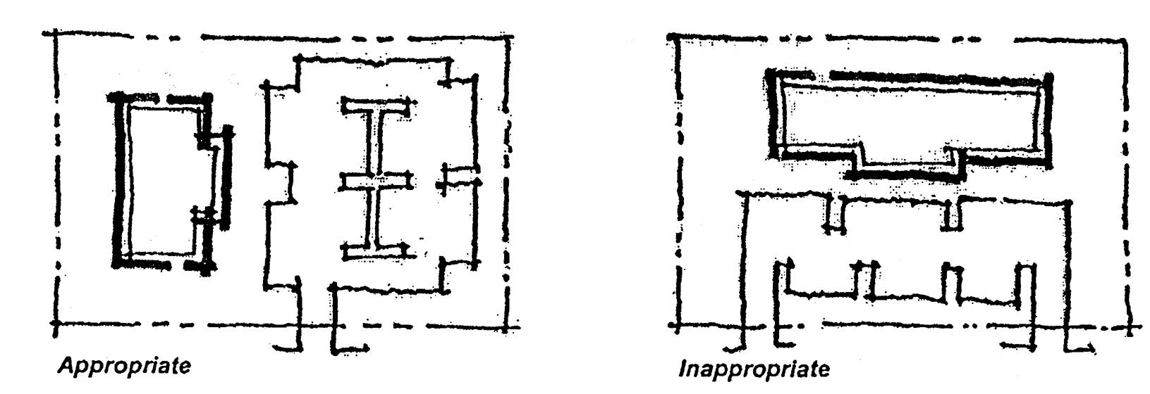
Building orientation-1
b.
Creating a courtyard/plaza effect between structures;
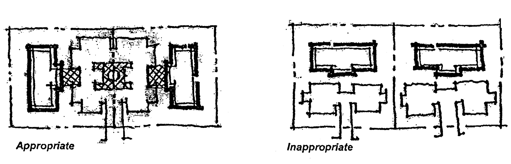
Building orientation-2
c.
Opening up views between structures with greater setbacks; and
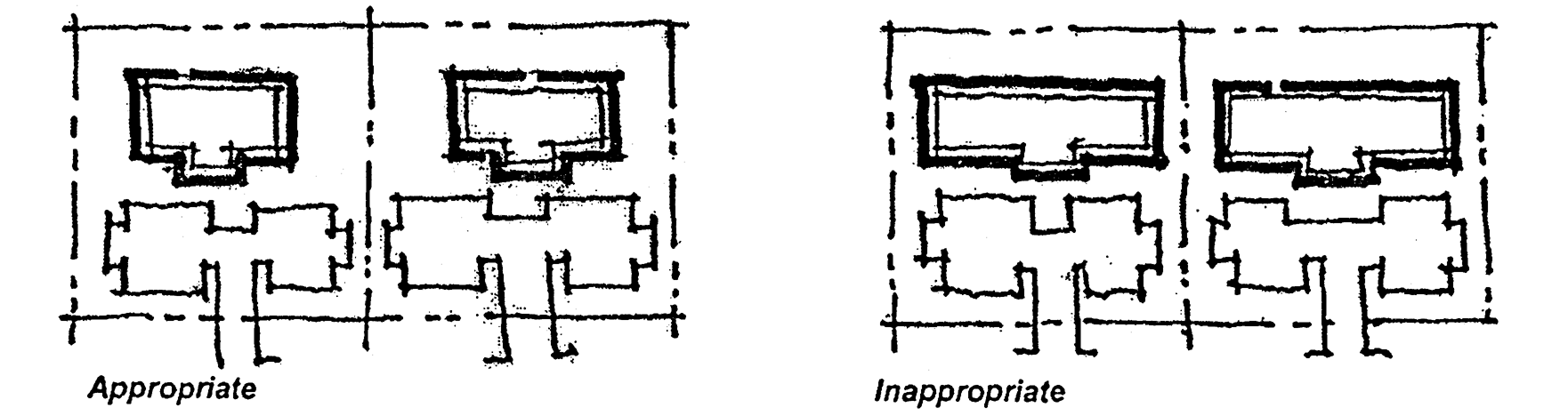
Building orientation-3
d.
Provision of wider landscape buffers along Northlake Boulevard.
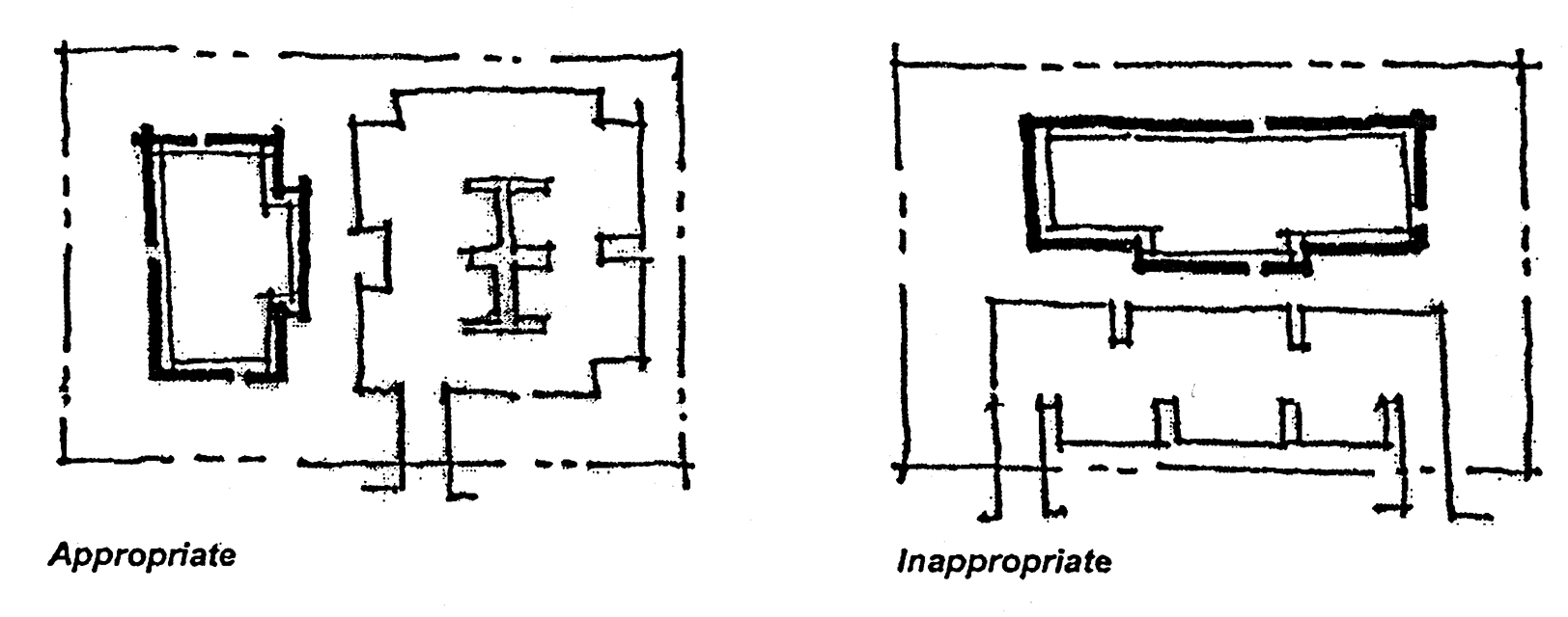
Building orientation-4
(3)
Corner lots. On corner lots at an intersection of two or more arterial or major collector roads, buildings and structures shall be designed with additional architectural embellishments such as towers, or other design features, to emphasize their locations as gateways and transition points within the community.
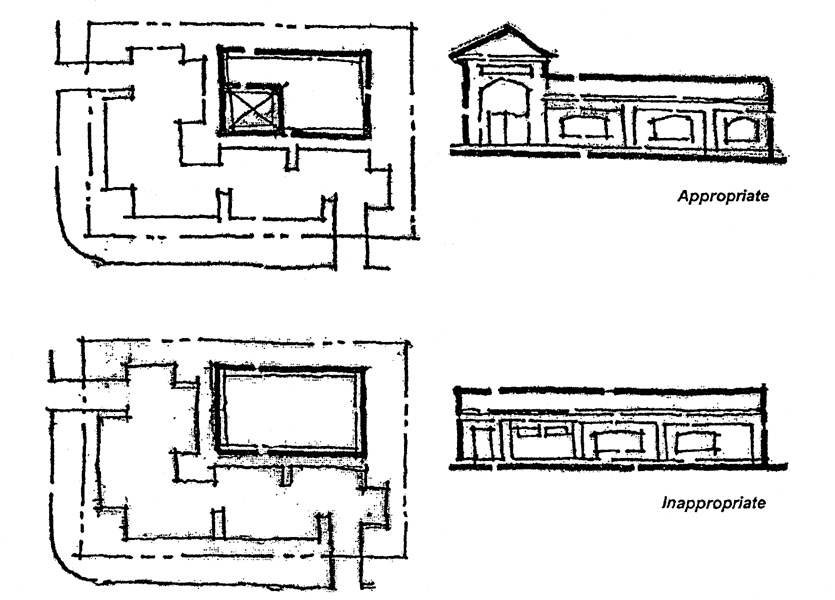
Building orientation-5
(4)
Building envelope, bulk and setback requirement. In order to establish overall building envelope, bulk, and setback provisions within the NBOZ, the following regulations are established for the purposes of this section.
Table 6-2
Proposed Setbacks
Notes:
1.
Building height is defined by the applicable building code.
2.
If one-half the height of the proposed structure is greater than the minimum setback shown, the greater number shall prevail.
3.
If the minimum landscape buffer required (subsection 78-228(k)(1)) is greater than the parking setback outlined above, the more restrictive shall apply.
A—H. Indicate dimension locations on the diagrams found in Section 78-230.
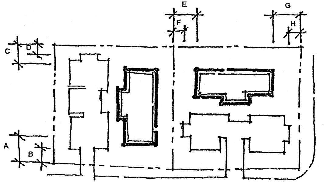
Building orientation-5
(5)
Commercial strip development discouraged. Minimum lot sizes and limited access drives shall be used to reduce the potential for commercial strip development. Neighboring properties are encouraged to link their parking lots together and to share common driveways.
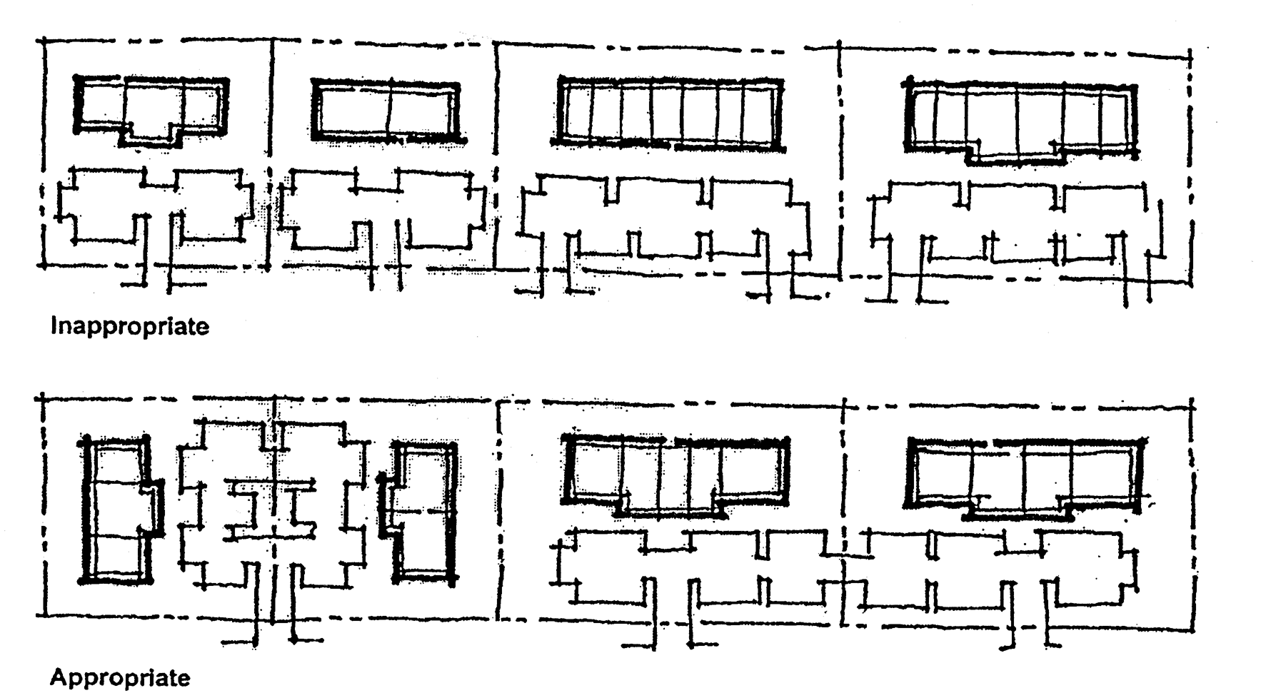
Building orientation-6
(6)
Prohibited elements. The following elements are prohibited:
a.
Chainlink fences in public view;
b.
Unfinished concrete or concrete masonry walls excluding architectural concrete;
c.
Artificial plants or turf;
d.
Decorative or commercial display objects;
e.
Visible neon;
f.
Elements with highly reflective or bright colored surfaces; and
g.
Other objects that are not consistent with the NBOZ design goals as per the jurisdiction.
(c)
Off-street parking areas.
(1)
Shared parking. As part of an approval of a new or expanded use, new construction, substantial renovation, or alteration or expansion of an existing structure, the use of shared parking to reduce overall parking requirements is permitted. The criteria for approval of an application to establish shared parking includes the following factors:
a.
Use of a building or structure for two or more uses, which possess complementary, rather than competing, peak hours of usage.
b.
Preparation of a shared parking study by a qualified professional engineer, architect, or planner.
c.
Execution of an agreement, in a form acceptable to the jurisdiction, between the owners and tenants of buildings or structures affected by the shared parking. This agreement shall provide:
1.
A means to re-address the shared parking in the event future parking problems or changes in use occur;
2.
A legal description of the land and structures affected;
3.
For a term of at least five years;
4.
A site plan to indicate uses, hours of operation, parking, etc.;
5.
Assurance of the availability of all parking spaces affected by the agreement.
(2)
Offsite parking. Offsite parking not included in a shared parking agreement is not permitted within the NBOZ.
(3)
Valet parking. The jurisdiction may authorize the use of valet parking for any use within the NBOZ subject to the following criteria.
a.
Valet parking shall not utilize more than 30 percent of the onsite parking of a use providing such service.
b.
A request to establish valet parking shall contain the following information:
1.
The location of the valet parking booth or area;
2.
The location and number of parking spaces to be utilized for valet parking;
3.
Evidence that the business owns the parking spaces proposed for valet use or a copy of any agreement, lease, etc. which provides the business with the right to use spaces owned by another individual or entity for valet parking;
4.
The impact of the valet parking service on users who do not patronize the service;
5.
The hours of operation;
6.
Location and text of any signage associated with the valet parking, spaces; and
7.
Buffering or screening that is necessary to mitigate any visual or noise-related impacts on any adjacent residential properties.
(4)
Pedestrian circulation in parking facilities. Parking facilities and driveways shall be designed to maximize the safety and convenience of pedestrians walking between parked cars and business entrances as well as between external points and locations on site delineated with special pavement. Pedestrian walkways shall be integrated as follows:
a.
Into the interior and/or perimeter landscaping of parking lots;
b.
Constructed with a specialty paving or similarly firm and decorative surface; and
c.
At least five feet in width; and separated from vehicular and parking areas by grade, curbing and/or vegetation, except for necessary ramps.
(5)
Loading facilities. Loading spaces shall not be located within 100 feet of Northlake Boulevard or other public rights-of-way, excluding alleys.
a.
Loading docks, solid waste facilities, recycling facilities and other service areas shall be placed to the rear or side of buildings and screened from adjacent residential uses.
b.
Screening and landscaping shall prevent direct views of the loading areas and their approaches from adjacent properties or from the public right-of-way.
1.
Screening and landscaping shall also prevent spillover glare, noise, or exhaust fumes.
2.
Screening and buffering shall be achieved through walls, fences and landscaping and shall be opaque and completely obscure the contents and facilities.
3.
Recesses in the building, or depressed access ramps may be used.
c.
Service access shall be behind the building or from secondary streets wherever possible, and screened from general view.
(6)
Drive-throughs. In the event that drive-throughs are permitted by use or as a conditional use, the jurisdiction shall review the site plan for the following minimum standards:
a.
Adequate stacking for six vehicles per lane at 20 feet per vehicle;
b.
Proper ingress/egress to the facilities so as to preclude entering and exiting directly from a public right-of-way;
c.
Adequate space for a by-pass lane; and
d.
Any other design deemed appropriate by the jurisdiction.
(d)
Pedestrian amenities.
(1)
General design. Uses shall contribute to pedestrian-friendly focal spaces through the provision of aesthetic walking paths, pedestrian spaces with furnishings, public art, generous plantings, marked crosswalks, and vehicular parking and circulation areas clearly separated from such pedestrian amenities.
a.
Sidewalks shall be of barrier-free design to the greatest extent possible.
b.
Pedestrian circulation systems shall include gathering/sitting areas.
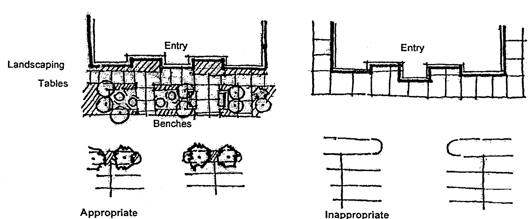
Pedestrian amenities
(2)
Width and materials. Sidewalks shall be a minimum of five feet in width and shall be constructed of stone, textured cement, concrete pavers, or brick.
(3)
Pedestrian entrances.
a.
Major public entrances shall be located along Northlake Blvd.
b.
A clearly designated pedestrian walkway and similar pedestrian-oriented facilities shall be provided from public sidewalks to public entrance or walkways within a commercial site, as well as between abutting commercial properties.
(e)
Site and street furniture.
(1)
Exterior lighting. All fixtures used for exterior lighting (building and site) are to be selected for functional and aesthetic value. Decorative pedestrian-scale lighting shall be provided at a height of no more than ten feet with standards constructed from steel, cast iron, aluminum or spun concrete. Lighting standards shall be of a consistent architectural style and shall complement the predominant architectural theme.
(2)
Street furniture. Additional amenities such as drinking fountains, benches and shelters or kiosks shall be provided and supplemented with open spaces.
(3)
Dumpsters and similar containers. Dumpsters and similar containers, including recycling bins, compactors, etc., shall be screened in a manner consistent with the following:
a.
Similar containers shall be located only at the rear of a building or structure.
b.
Enclosures shall be constructed in a manner consistent with the architectural style, color, materials, etc., of the principal building, and shall screen the dumpsters on all four sides of the enclosure from public view.
1.
An opaque concrete wall or similar material shall screen both sides and the rear of such facilities.
2.
The front of a screen enclosure shall be gated and shall consist of durable opaque materials consistent with the overall design of the project.
3.
Dependent upon the location of an enclosure on the site, landscaping may be required in addition to the opaque screening material.
c.
Alternative dumpster location. When it is not possible to locate the enclosure in the rear of the site, the dumpster shall be enclosed by landscaping to the greatest extent possible.
d.
Access to the dumpster should be provided from a secondary street.
e.
Enclosures are to be designed to provide space to accommodate recycling bins.
(4)
Sidewalks. Sidewalks shall be provided along all roadways on both sides of the street. At comers handicapped ramps shall be provided and sidewalks shall continue across driveway and parking lot surfaces using decorative paving materials to delineate crosswalks. All new construction or substantial renovation of existing buildings and structures shall include one or more clearly delineated walkways from the public sidewalk to the private sidewalk, arcade, pedestrian way, etc. Examples of other complementary materials include the following:
a.
Paver blocks or alternative style or color;
b.
New and used brick; and
c.
Concrete stamped with a pattern.
(5)
Retaining walls. Retaining walls shall be constructed as necessary, provided such walls are constructed utilizing the same architectural style, materials, and color of the principle structure.
(6)
Alley screening walls. All new construction or substantial renovation of existing buildings and structures shall construct or reconstruct a solid masonry or concrete wall a minimum of six feet in height.
a.
The wall shall be located along the rear property line of the parcel being improved.
b.
Chain link and wooden fences are prohibited.
c.
Properties within the Marine District of the NBOZ are exempt from this requirement.
(7)
Underground utilities. The jurisdiction may require existing overhead utilities to be placed underground when located on properties subject to new construction or substantial renovation.
(8)
Shopping carts. If a use requires shopping carts, they shall not be allowed to accumulate in any outside area including parking lots and loading areas, and shall be removed from cart corrals in a timely manner and relocated to designated storage areas near the principle structure.
(9)
Mailboxes. Mailboxes, including special drop boxes, may be clustered within buildings, grouped under a kiosk, or individually freestanding. In all cases the design and installation of mailboxes shall comply with the following standards:
a.
The jurisdiction and the U.S. Postal Service shall approve the size, type, and location of mailboxes.
b.
Mailboxes shall be landscaped consistent with and architecturally compatible to the development.
(10)
Satellite dishes. Satellite dishes may be installed provided the dishes are not visible from any street, and the color is compatible with the surrounding environment. Plans for the installation of communication equipment, such as dishes and antennas, shall be submitted for review during the planning phase of a project.
(11)
Telephones, vending machines, and newspaper racks. All public telephones, vending machines, newspaper racks, and facilities dispensing merchandise or services on private property shall be enclosed within a building, enclosed within a structure, attached to a building, or enclosed in a separate area.
a.
Attached and freestanding structures shall be landscaped consistent with and architecturally compatible with the principal structure.
b.
Public telephones. Wall-mounted and freestanding public telephones visible from a public right-of-way shall be fully or partially enclosed.
c.
Vending machines.
1.
Vending machines dispensing beverages, food, ice, and related consumer products shall not be visible from a public right-of-way.
2.
Vending machines may be located in outdoor enclosures, provided such enclosures are constructed utilizing the same architectural style, materials, and colors as the principal structure.
(Ord. No. 30-2002, § 2(Exh. A, §§ 6-1—6-5), 9-4-02)
Sec. 78-231.- Parkway overlay district.
(a)
Scope. The parkway system requirements in this division shall apply to all roadways designated as parkways within the comprehensive plan or by the City of Palm Beach Gardens Official Zoning Map.
(b)
Parkway system. Objective 2.1.7, and policies 2.1.7.1, 2.1.7.2, and 2.1.7.3 of the city's comprehensive plan require the development of a parkway system to provide city residents with an alternative mode of transportation which is safe and aesthetic, as well as to beautify the city's arteries and protect residential areas from the impacts of highly-traveled arteries.
(1)
Parkway objectives. The objectives of the parkway overlay are established to accomplish the following:
a.
Preserve urban beauty through right-of-way landscaping requirements;
b.
Provide residents with a safe and aesthetic multiuse pathway system;
c.
Provide a buffer between designated roadways and the adjacent development;
d.
Eliminate a perceived need of using strip commercial as a buffer between arterials and residential areas; and
e.
Promote and protect the peace, health, safety and general welfare of the city.
(c)
Standards and waivers. Specific standards have been created for the parkway overlay which are intended to provide a buffered multiuse pathway and landscaped roadway system. Although these standards are intended as a benchmark for development and shall be applied to the fullest extent possible, it is recognized that in some situations it will not be possible to comply with all of the standards. Therefore, the physical constraints of a particular site will be considered in determining which standards are applicable and the extent of compliance with the specific standards for each particular project. The standards may be waived only with the approval of the city council, subject to section 78-158.
(d)
Applicability and effects.
(1)
Applicability. The standards contained in this division shall apply to all roadways designated as a parkway by the city council, including all of the following:
a.
PGA Boulevard west of Central Boulevard;
b.
Central Boulevard;
c.
Donald Ross Road;
d.
Beeline Highway north of PGA Boulevard;
e.
Hood Road west of Central Boulevard;
f.
A future (yet unnamed) north-south artery between PGA Boulevard and Hood Road; and
g.
A future (yet unnamed) east-west artery between Central Boulevard and the future north-south artery.
(2)
Prior approvals. While existing development and approvals granted prior to August 18, 1994, are not affected, major amendments to prior approvals, redevelopment, and new development shall conform with the provisions of this overlay.
(3)
Conflicts. Where conflicts occur between the standards and requirements of the overlay district, this chapter, or other regulations, the provisions of the overlay district shall prevail. Additionally, where provisions of this overlay are not in conflict with other regulations, that which is more strict shall prevail.
(e)
Location. The parkway overlay shall consist of the road segments and dimensions as provided in Table 23.
Table 23: Parkway Overlay District
Note:
* Width of overlay measured from centerline of roadway.
(f)
Parkway development guidelines.
(1)
Parkway concept.
a.
Right-of-way and easements. Each parkway shall include a parkway right-of-way and easement as described below in conceptual cross sections. Installed within the parkway and easement shall be a multiuse pathway, pedestrian path, landscaped medians, linear parks, greenbelts and landscaping buffers. Conceptual cross sections of a parkways are illustrated in Figures 3 through 12. The city council shall approve the ultimate cross section of each parkway link.
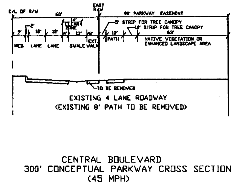
Figure 3
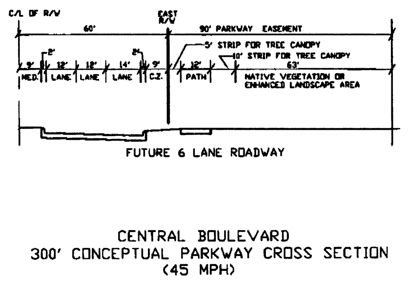
Figure 4
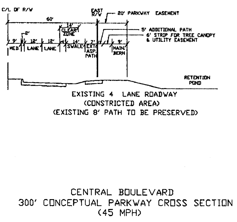
Figure 5
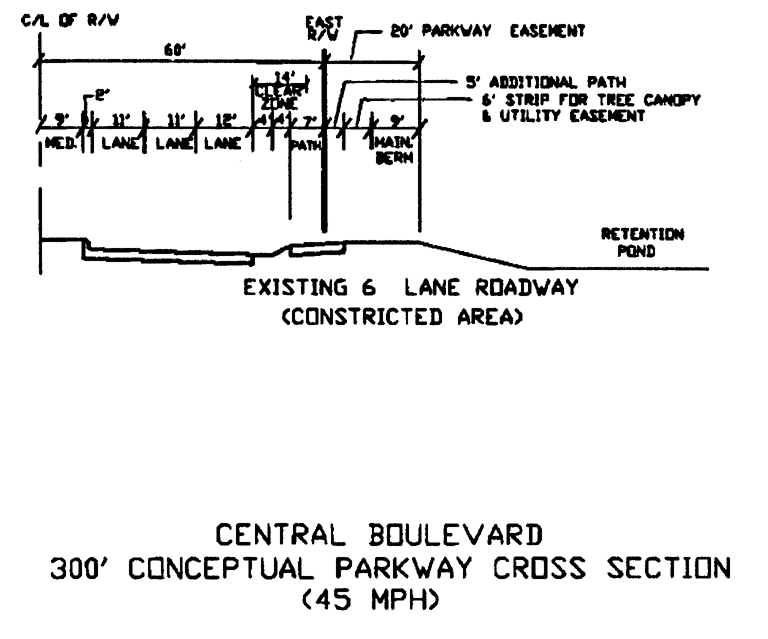
Figure 6
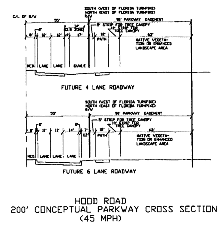
Figure 7
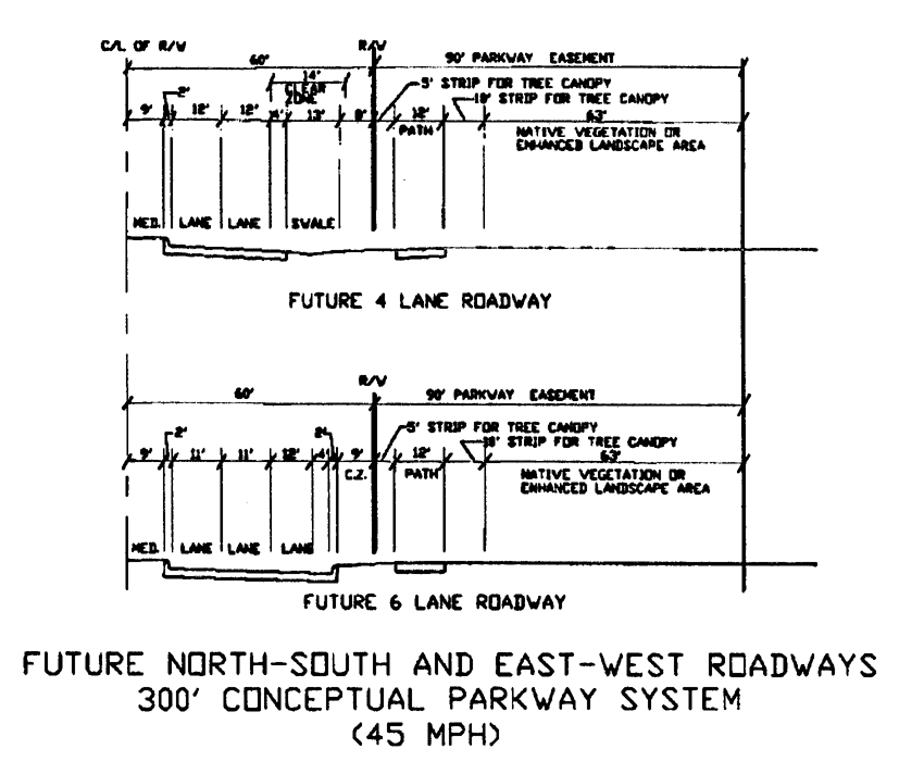
Figure 8

Figure 9
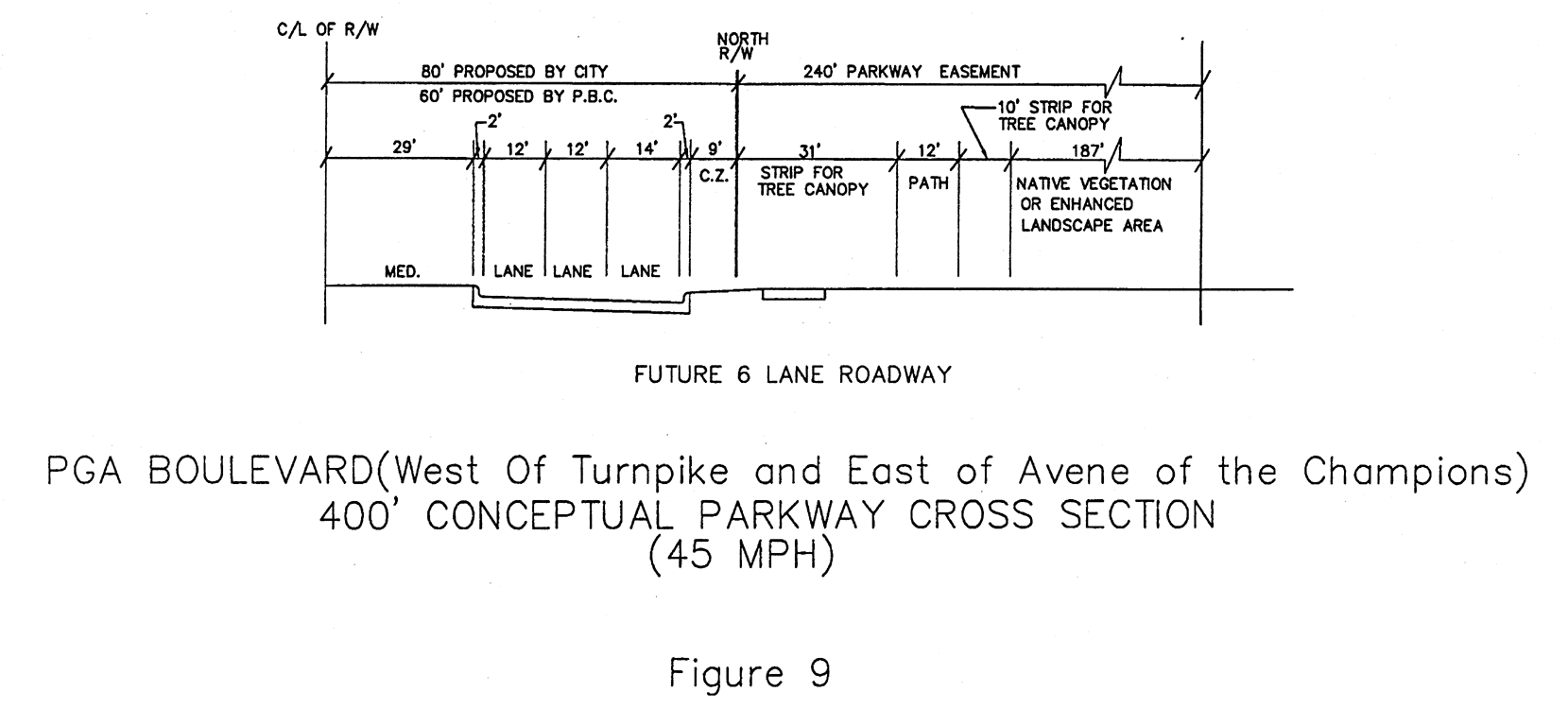
Figure 9A
Figure 10
Figure 11
Figure 12
b.
Implementation. Implementation of the parkway concept shall require installation of the improvements specified below:
1.
Nonmountable curbing, acceptable to the city engineer, to allow landscaping buffers to be installed between the roadway and the pedestrian/bicycle pathways;
2.
A meandering 12-foot multiuse pathway;
3.
A six-foot pedestrian sidewalk on the opposite side of the artery from the pathway;
4.
Landscaping of medians;
5.
Preservation of native vegetation or installation of landscaping to buffer the artery and pathway from adjacent development and to provide a canopy for pedestrians and bicyclists;
6.
Irrigation, where necessary, to ensure the viability of landscaping; and
7.
Dedication of a parkway easement for those areas outside of the formal road right-of-way but within the 200- to 400-foot parkway.
c.
Views. Special views along the road and special public features such as fountains, art in public places, and pedestrian parks may also be provided within the parkway with city council approval.
(2)
Landscape theme. A native pine-oak vegetative community shall constitute the landscaping theme of the parkway system. Plantings shall include but not be limited to live oak, slash pine, saw palmetto, wax myrtle, sabal palm, as well as grass. Clusters of vegetative communities as well as individual trees shall be provided, consistent with clear zone and sight distance criteria, in landscape medians to buffer the pathways from the roadway and adjacent land uses, and to provide a canopy.
(3)
Parkway improvements.
a.
All new development fronting along a parkway shall be required to install, develop, or otherwise provide for the implementation of the parkway system, as illustrated in the conceptual cross sections and described in this division.
b.
The city shall coordinate the installation of the parkway system with the development approval process. Proposed development fronting along a parkway shall prepare plans for the necessary improvements and install the facilities/elements or provide the city with the appropriate amount of funds or surety to cover the costs of such improvements.
c.
For determination as to whether improvement of the parkway shall be conducted concurrent with development, or whether there shall be provision of funding or surety to the city in an amount equal to 110 percent of the cost of the needed improvements, the city hereby establishes a guideline threshold of one-half mile (2,640 linear feet).
1.
Any property possessing at least one-half mile frontage shall install the required parkway improvements concurrently with development.
2.
Any property possessing less than one-half mile frontage may be required to install the improvements concurrently with development, or may be allowed to furnish surety as provided herein.
3.
If monies in lieu of improvement are provided, the city will install the required improvements at a time in the future when a "link" or segment of the parkway can be achieved or when roadway improvements or development activities allow implementation of the parkway system.
4.
The city council shall determine when parkway improvements are to be installed.
d.
The one-half-mile threshold is a guideline and shall be used on a case-by-case basis to ascertain whether the adjacent land uses or characteristics of the development require or warrant installation of the necessary improvements concurrent with development.
(4)
Maintenance. Unless otherwise approved by the city council, the owner of the property, or successor thereto, with frontage along the parkway shall be responsible for the perpetual maintenance and irrigation of the parkway. In like manner, the owner of property with frontage along one side of the parkway shall share the responsibility of maintaining that portion of the median, median landscaping, and irrigation, with the owner or owners of property along the other side of the parkway.
(5)
Other entities. If the city establishes a special district or other entity to assume responsibility of the parkway system, the owner of property with frontage along the parkway shall automatically become a member of the district. This requirement shall also be made a part of any property owners' association documents for property affected by creation of a parkway.
(Ord. No. 17-2000, § 106, 7-20-00; Ord. No. 26-2002, § 1(Exhs. A, B), 7-18-02)
Sec. 78-232. - Scripps Florida Phase II—Design guidelines.
(a)
Purpose and intent. The purpose and intent of the Scripps Florida Phase II Overlay Design Guidelines (SFDG) are to incorporate design guidelines for the Scripps Florida Phase II/Briger PCD into the city's land development regulations. The subject guidelines shall be approved by the city council and shall establish development standards within the Scripps Florida Phase II/Briger PCD. The intent of the guidelines is to encourage the development of a pedestrian-oriented mixed-use community centered on bioscience, research and development, and other related uses.
(b)
Applicability. The design guidelines shall apply to all districts within the PCD. In the event of a conflict between the SFDG and any other city land development regulations, the SFDG shall prevail. However, in those cases where the SFDG are silent, the underlying land development regulations shall prevail.
(c)
Use regulations. Permitted uses shall be as set forth in the "list of permitted uses" attached to and incorporated in the Scripps Florida Phase II/Briger PCD development order. No amendment to the list of permitted uses shall occur without approval by the city council.
(d)
Height regulations. Height restrictions shall be in accordance with Table 19a in section 78-157 of the city's LDRs. However, for all buildings and/or structures within the employment center district when measuring building height, roof mounted equipment shall not be included in such measurement. All buildings and/or structures within the employment center district within the Scripps Florida Phase II/Briger PCD shall adhere to the following additional restrictions:
(1)
All buildings and/or structures located more than 55 feet but less than 100 feet from the northern boundary of the employment center district shall be limited to a maximum height of 75 feet.
(2)
All buildings and/or structures located more than 100 feet but less than 150 feet from the northern boundary of the employment center district shall be limited to a maximum height of 100 feet.
(3)
All buildings and/or structures located 150 feet, or more, south of the northern boundary of the employment center district shall be limited to a maximum height of 150 feet.
(4)
No buildings and/or structures shall be located within the 55 feet of the employment center district's southern boundary.
(5)
All buildings and/or structures located more than 55 feet but less than 100 feet from the southern boundary of the employment center district shall be limited to a maximum height of 75 feet.
(6)
All buildings and/or structures located more than 100 feet but less than 150 feet from the southern boundary of the employment center district shall be limited to a maximum height of 100 feet.
(7)
All buildings and/or structures located 150 feet, or more, north of the southern boundary of the employment center district shall be limited to a maximum height of 150 feet.
(8)
In order to be eligible for the 150-foot maximum building height a building and/or structure must be satisfy the location requirements of both subsection 78-232(d)(3) and subsection 78-232(d)(7).
(e)
Amendments to design guidelines. Amendments to the design guidelines are permitted. For the purpose of this section, two types of amendments shall be allowed:
(1)
Major amendments; and
(2)
Minor amendments.
(f)
Major amendments. Major amendments shall be approved by the city council by resolution. Major amendments to the design guidelines shall include the following:
(1)
Character and appearance. Any amendment which would negatively impact the character or the appearance of those standards within the design guidelines.
(2)
Amenities. Any reduction that would materially decrease the net number or size of amenities, including, but not limited to, parks, open space areas, and pedestrian linkages contained within the design guidelines.
(3)
Architectural style. Any change in the architectural styles listed that result in a reduction of standards contained within the design guidelines.
(4)
Other changes. Any change to the standards when considered cumulatively with prior minor amendments which, as determined by the growth management administrator, deviates materially from the approval granted by the planning, zoning, and appeals board or city council.
(g)
Minor amendments. Minor amendments are changes to the approved design guidelines that are not considered major amendments as previously defined. Minor amendments may be approved by the growth management administrator in consultation with other city staff and the development review committee.
(h)
Targeted Expedited Permitting Program (TEPP).
(1)
All development applications that are submitted that are within the boundary of the employment center district as delineated on the Scripps Florida Phase II/Briger PCD plan, including, but not limited to, plat approvals, site plans, PCD amendments, and administrative approvals, shall be reviewed under those standards set forth in section 78-57 of the city's land development regulations relating to targeted expedited permitting.
(2)
Unless otherwise determined by the growth management administrator, all other development applications, including, but not limited to, plat approvals, site plans, PCD amendments, and administrative approvals that are submitted for the area outside the employment center district shall be processed by the growth management department under those standards set forth in section 78-57 of the city's land development regulations relating to targeted expedited permitting.
(Ord. No. 33, 2009, § 2, 4-1-10)
Sec. 78-241.- Purpose and intent.
The purpose and intent of this division is to preserve and protect the ecological values and functions of the city's natural resources and environmentally significant lands from alterations that would result in the loss or significant degradation of these habitats, thereby increasing the amount and quality of open space, and to ensure the protection and conservation of these natural resources and environmentally significant lands in perpetuity. In addition, the purpose and intent of this division is to:
(1)
Recognize certain native Florida ecosystems within the City of Palm Beach Gardens and Palm Beach County are unique, or of limited local occurrence, and are inadequately protected through public ownership;
(2)
Recognize the city's comprehensive plan includes goals, objectives, and policies to encourage the protection of native wetland and upland habitant, sound land planning, orderly growth, and concurrency in the provision of public facilities, all of which are dependent upon a healthy tax base, a sound economy, and respect for private property rights in the regulation of land uses and development;
(3)
Recognize the city's native wetlands and upland habitat contain natural resources, and environmentally significant lands have unique ecological, scientific, educational, and aesthetic values, the protection of which is in the best interests of the citizens of Palm Beach Gardens;
(4)
Recognize the environmentally significant lands provide important habitat for a variety of plant and wildlife species considered to be endangered, threatened, or of special concern; and
(5)
Recognize the City of Palm Beach Gardens desires to protect its environmentally significant lands from degradation and loss.
(Ord. No. 17-2000, § 107, 7-20-00)
Sec. 78-242. - Applicability.
(a)
Application. All sections of this division shall be effective within the incorporated area of the city and shall set restrictions, constraints, and requirements to preserve and protect natural resources and environmentally significant lands. All proposed development, including agricultural development, that contains environmentally significant lands, as defined in this division, shall set aside upland native plant communities as preserve areas and/or select one (1) or more of the mitigation options as outlined in this division.
(b)
Alteration and conservation of lands. This chapter shall apply to the alteration and conservation, as defined in this chapter, of all lands in the city.
(Ord. No. 17-2000, § 108, 7-20-00; Ord. No. 4, 2011, § 3, 5-5-11)
Sec. 78-243. - Violations, enforcement, and penalties.
(a)
Violations and separate offenses. Any violation of this chapter shall constitute an offense punishable as provided in this section and in article VII. A continuing violation shall be a separate violation each day the violation occurs.
(b)
Replacement. If a violation of this division or order of the city council results in irreparable harm to the environment which cannot be resolved or mitigated entirely by imposition of fines, the city council may require the replacement of destroyed listed species. Except for trees, including palm trees, the listed species shall be replaced on a three-to-one basis. However, any tree that is a listed species is destroyed, replacement shall occur at a minimum of three times the caliper or diameter at breast height (DBH) of the tree that is destroyed. If the replacement cannot be accomplished, a cash reimbursement to the city shall be made in money equivalent to the value of the listed species destroyed. Value shall be based on the average two estimates at wholesale prices, provided the vendors providing the estimates shall be acceptable to the city.
(c)
Destruction of protected species or lands. If destruction of the plant, wildlife or lands protected in this chapter occurs after work has commenced on a parcel of land prior to or after a building permit has been issued, the building official shall have the right and power to enter an order enjoining or terminating any work or activity on site with such order remaining in effect until removed by the city manager or by a court of competent jurisdiction. However, the building official shall present to the city manager within ten days of date such order is entered all facts sustaining the order with a copy thereof furnished to the offender, and the city manager shall resolve the issues no later than 25 days from the date the original order is entered. The decision of the city manager shall be conveyed in writing to the individual or firm charged with the destruction.
(d)
City manager powers. The city shall have the power to enforce the requirements of this division. The city manager may request other governmental agencies to intervene if a violation of this division constitutes a violation of statutory or administrative rule or regulation adopted by another governmental agency.
(Ord. No. 17-2000, § 109, 7-20-00)
Sec. 78-244. - Penalties.
(a)
Additional penalties. In addition to article VII, a further penalty may be imposed by a court of competent jurisdiction for violation of this chapter as provided in section 1-18 of the City Code.
(b)
Implementation of enforcement. All of the enforcement procedures in this division shall be implemented as determined by the city manager.
(c)
Funds from mitigation and fines. All of the monies received by way of mitigation or fines shall be held in a separate account and used by the city solely for the restoration of native communities and acquisition of environmentally significant lands.
(Ord. No. 17-2000, § 110, 7-20-00)
Sec. 78-245. - Appeals.
(a)
Appeal of administrative decisions. An applicant can appeal any administrative order or decision made by the city manager to the city council. The appeal shall be made in writing and shall be filed with the city clerk within 15 weekdays, excluding holidays, of the date of the administrative order or decision.
(b)
Form of appeal. The appeal of an administrative order or decisions shall include the following information:
(1)
A written description of the reason for the appeal;
(2)
The issues involved;
(3)
A brief statement of facts as to why errors have been committed by the department;
(4)
Any exhibits or materials relevant to the issues forming the basis of the appeal, such as vegetative surveys, environmental assessments, and relevant permits issued by other governmental agencies;
(5)
The name, address, and telephone number of the property owner;
(6)
A legal description of the property;
(7)
A boundary survey of the property, completed within twelve months of the appeal; and
(8)
Such other information as may reasonably be requested by the department.
(c)
City council action. The city council shall have the authority to affirm, revoke, or modify the order entered by the growth management department. The city council shall, within 60 days of the filing of the appeal, hold a hearing to consider the administrative order. Based upon the evidence presented, the city council shall render a decision within 30 days after the hearing.
(d)
Appeal of city council order. Any appeal of an order by the city council shall be made within 30 days from date of the such order to the Circuit Court of the 15th Judicial Circuit by writ of certiorari.
(Ord. No. 17-2000, § 111, 7-20-00)
Sec. 78-246. - Designation of environmentally significant lands.
(a)
Criteria for designation. Lands shall be designated as environmentally significant if they contain one or more of the native habitat types listed below, as defined by the Guide to the Natural Communities of Florida, published by the Florida Department of Environmental Protection:
(1)
Coastal scrub;
(2)
Xeric hammock or xeric scrub;
(3)
Tropical hammock;
(4)
Low hammock, temperate hammock or mesic hammock
(5)
Mixed hardwood swamp or hydric hammock;
(6)
Pond apple slough;
(7)
Cypress swamp;
(8)
Freshwater marsh;
(9)
Mangrove swamp;
(10)
Oak forest;
(11)
Pine flatwoods, mesic and hydric;
(12)
Scrubby flatwoods;
(13)
Coastal dune and strand;
(14)
Wet prairies;
(15)
Functioning and jurisdictional wetlands and deepwater habitats;
(16)
Any part of the Loxahatchee Slough Sanctuary; and
(17)
Sites of historical or archaeological significance.
(b)
Additional habitats. Native habitats other than those listed in subsection (a) of section 78-246 may also be designated as environmentally significant if they are actively used by or likely to support or contain species listed as endangered, threatened, or of special concern by applicable laws or regulations adopted by the U.S. or State of Florida.
(Ord. No. 17-2000, § 112, 7-20-00; Ord. No. 4, 2011, § 4, 5-5-11)
Sec. 78-247. - Exemption for vested development rights.
(a)
Exemption. An exemption from this division may be granted for any project for which, as of May 3, 1990, has been granted or has maintained a valid development order for any of the following:
(1)
A building permit;
(2)
A site plan approval;
(3)
A master plan approval;
(4)
A letter of sufficiency issued by the department for an application for any development order listed in subsection (a)(1), (2), or (3) of this section; or
(5)
A valid development of regional impact order.
(b)
Application for exemption. Any property owner desiring to be exempt from this chapter must submit an application for exemption to the department. The application must include evidence that the applicant is entitled to the exemption pursuant to subsection (a) of this section. This application must include copies of supporting documentation evidencing the applicable approval under subsections (a)(1) through (5) of this section. The department shall make a determination of the applicant's eligibility for the exemption. A written decision on the request for exemption shall be issued within 30 weekdays, excluding holidays, following receipt of the application and all necessary information.
(c)
Annexed properties. The owner of any property that has been annexed into the city and desires an exemption from this chapter based on permits, site plans, master plans, or a DRI previously approved by the city, county, or any other jurisdiction may submit an application as provided in this division. Such requests will be determined by the department, as provided herein. Appeal of such determination by the department shall be made to the city council.
(d)
Other development orders. Where development orders granted by another governmental agency do not address preservation or environmental standards, the comprehensive plan, land development regulations, and policies of the city shall apply.
(e)
Issuance of development orders. Development orders, land alteration permits, and permits for development and redevelopment activities shall be issued only if the protection and conservation of wildlife, marine life, and natural systems are ensured consistent with the goals, objectives, and policies of the comprehensive plan.
(Ord. No. 17-2000, § 113, 7-20-00)
Sec. 78-248. - Review procedures for proposed land alterations.
(a)
Pre-application meeting. Prior to application for development or land alteration, the applicant shall meet with the department for the preliminary review and determination of potential environmentally significant lands.
(b)
Initial designation of environmental significance. If potential environmentally significant lands are designated by the department, the applicant shall provide an environmental assessment as a component of the formal application, prior to the initiation of formal review. Three complete copies of the environmental assessment shall be provided, and shall include the information listed below.
(1)
Site map. Site location map, with the specific property clearly indicated.
(2)
Aerial photograph. Aerial photograph, at a scale of one inch equals 300 feet or less, with property boundaries and acreage clearly indicated.
(3)
Vegetation map. Map and transparent overlay of existing terrestrial and aquatic vegetation, including exotic species and native plant community types, at the same scale as the aerial photograph. A description of each native plant community shall be included, indicating type, canopy, understory and ground cover.
(4)
Preservation plan. A preservation plan and transparent overlay, at the same scale as the aerial photograph, which identifies those environmentally significant areas to be protected and preserved as natural preserve areas and maintained to ensure no further intrusion of exotic or nuisance plant species. The plan shall indicate those areas that may possibly require transfer of existing density rights to more suitable areas or other lands for development. The proposed preservation plan should indicate the location of preserve areas, buffer areas, mitigation, and listed species location or relocation areas.
(5)
Soils. Soil types and conditions.
(6)
Endangered species. A complete list of endangered or threatened species, and species of special concern known or likely to be present on the site. This list shall be accompanied by a map which denotes the location of the species on site. The map should be at the same scale as the vegetation map.
(7)
Nesting and roosting areas. Colonial bird nesting or roosting area or areas in which migratory species are known to concentrate.
(8)
Inventory. An on-site inventory of existing vegetation and wildlife, referenced and exhibited on a field survey.
(9)
Assessment. A written assessment of the site, identifying the location of all environmentally significant habitats or vegetation, and containing a mitigation plan to protect the resource.
(10)
Habitats. An analysis of the functional viability and quality of the various habitats on site.
(11)
Preserve area viability. A discussion of the proposed preserve area's viability.
(12)
Environmental damages. A discussion concerning whether there will be a loss of any irreplaceable or irretrievable resources or irreversible environmental damage.
(13)
Mitigation plan. A mitigation plan that describes actions to be taken that replace those functions and values of the ecological community or communities lost as a result of proposed land alteration or utilization.
(14)
Existing alterations. Areas of previous alteration or degradation, including present and past uses of site
(15)
Land uses. The future land use designation, zoning designation, and existing land uses surrounding the affected site.
(16)
Other agencies. At the discretion of the department or city council due to the environmental sensitivity of the site, appropriate written sign-offs, permits, consents, or similar authorizations from the other agencies that follow as to whether such agency is exempt or has jurisdiction thereof over wetland or environmentally significant areas may be required. The applicant shall be responsible for obtaining this information and submitting written verification to the city. Such agencies include but are not limited to the following:
a.
Army Corps of Engineers (ACOE);
b.
United States Department of the Interior, Fish and Wildlife Service (USFWS);
c.
Florida Department of Environmental Protection (DEP);
d.
Florida Fish and Wildlife Conservation Commission (FFWCC);
e.
Florida Department of Community Affairs (DCA);
f.
Florida Department of Agriculture and Consumer Affairs (DACS);
g.
Florida Committee on Rare and Endangered Plants and Animals (FCREPA), or successor body;
h.
South Florida Water Management District (SFWMD);
i.
Treasure Coast Regional Planning Council (TCRPC);
j.
Palm Beach County Department of Environmental Resources Management (ERM); and
k.
Any other governmental agencies possessing jurisdictional controls over the site.
(c)
Submission of management plan. The management plan required by section 78-251 shall be submitted as an addendum to the environmental assessment, prior to approval of construction drawings or commencement of land alteration, whichever occurs first.
(d)
Completion of environmental assessment. It is recommended that the environmental assessment be conducted prior to preparation of the site development plan.
(e)
Assessment of mitigation plans. Upon receipt and review of the environmental assessment, the department shall assess mitigation plans in detail as such considerations relate to possible loss of habitat or impact on endangered or threatened species or species of special concern.
(f)
Expert assistance. In order to resolve any issues regarding this division, the city shall have the right to hire or retain an agency or person at the applicant's expense to verify or resolve any pending issues. Payment to such agency or expert shall comply with the requirements of this chapter.
(g)
Certification of application materials. All drawings, illustrations, maps, surveys, and similar documents associated with the application requirements of this division, other than work on a private single-family residential lot, shall be sealed or certified by the following:
(1)
A state-registered professional engineer;
(2)
A state-registered professional surveyor;
(3)
A state-registered professional landscape architect; or
(4)
An environmental professional certified by the National Association of Environmental Professionals.
(h)
A discussion of each criterion of section 78-250 of this division as it may relate to the preservation plan.
(Ord. No. 17-2000, § 114, 7-20-00)
Sec. 78-249. - Approval criteria for proposed land alteration.
Approval of land alteration requests. The growth management department may approve requests for land alteration consistent with the approved development order. The decision regarding such lands shall be based upon application of the criteria listed below.
(a)
Value. The project design provides for the protection and preservation of 25 percent of the most valuable or unique existing natural resources, listed species, and environmentally significant lands on site, or on-site restoration or creation of native upland environments or habitats. If environmental restoration or creation is proposed in total or in part, the applicant must demonstrate that the area to be improved is equal in size to the preservation area required by this chapter.
(b)
Upland mitigation. If listed species do not exist on the site or on-site preservation would yield a preserve area that is less than the preferred minimum of ten acres, an alternative form of mitigation may be implemented in accordance with section 78-252.
(1)
Minimum preservation area. A preserve area consistent with section 78-250 and section 78-252 shall be the basis for any consideration of mitigation of minimum preservation area requirements.
(2)
Preservation area alternatives—Guidelines.
a.
When, based on environmental assessments, off-site lands may better advance the purposes of this division due to the characteristics of a particular site, such as the specific location, invasions of nonnative or exotic species, prior alteration or disturbance of vegetation, or other similar circumstances, off-site mitigation or cash in lieu of on-site preservation may be utilized, if approved by city council.
b.
The property owner of a platted upland preserve shall not be permitted to utilize off-site preservation or cash in lieu of preservation options in order to justify modification of the platted upland preserve.
(c)
Wetlands mitigation. If land alteration would result in unavoidable impacts to wetlands, as determined by the agency having jurisdiction over the subject wetlands, such impacts may be mitigated as determined by the agency having jurisdiction.
(1)
Preservation. Wetlands are to be preserved and development activity is not allowed in wetlands, except under the following circumstances, consistent with adopted Treasure Coast Regional Planning Council policies as indicated below.
a.
Such an activity is necessary to prevent or eliminate a public hazard.
b.
Such an activity would provide direct public benefits which would exceed those lost as a result of the development or modification of the wetland areas.
c.
Such an activity is proposed for habitats in which the functions and values currently provided are significantly less than those typically associated with such habitats and cannot be reasonably restored.
d.
Due to the unique geometry of the site, it is the unavoidable consequence of development for uses which are appropriate, given site characteristics.
e.
The functions and values provided by wetland habitats to be destroyed are already completely and fully replaced prior to occurrence of the proposed impact to existing habitat.
(2)
Density transfers. Wetlands shall be protected by use of clustering or similar site development techniques to transfer development to upland areas on the same site. Where development occurs within jurisdictional wetlands, the developer must mitigate the function and value of those wetlands as determined by the agency having jurisdiction over the subject wetlands. Development activities within wetland areas shall:
a.
Occur at a density of no more than one (1) dwelling unit per five (5) acres in the urban area and one (1) dwelling unit per twenty (20) acres in the rural area;
b.
Be clustered to the least environmentally sensitive portion of the site; and
c.
Include design considerations to protect the wetland functions of the rest of the site.
(d)
Listed species. For a site on which listed species are known or suspected to be present, one (1) or more of the criteria listed below shall be satisfied.
(1)
The applicant successfully demonstrates that the proposed action will not preclude the continued survival and viability of those listed species located on the site.
(2)
The applicant presents a plan for relocation, either on site or off site, for those listed species, which has been reviewed and approved by all agencies possessing jurisdiction in such matters.
(Ord. No. 17-2000, § 115, 7-20-00; Ord. No. 4, 2011, § 5, 5-5-11; Ord. No. 12, 2023, § 1, 11-2-23)
Sec. 78-250. - Preserve area requirements.
(a)
Minimum requirements. The minimum requirements listed below shall apply to all required preserve areas for environmentally significant lands.
(1)
Preserve area designations.
a.
The minimum of twenty-five (25) percent of the total upland native plant communities shall be set aside as a preserve on site, unless city council approves mitigation as set forth in this division. The twenty-five (25) percent set aside acreage and/or mitigation acreage shall be based on the total of all the upland native plant communities on site as determined by the environmental assessment.
b.
The city council shall designate that portion of the upland native plant community that will be preserved in order to achieve the twenty-five (25) percent preservation requirement. All lands to be preserved shall be protected and managed such that they are kept in a viable condition with native plant canopy, understory, and ground cover.
c.
Any decisions regarding the designation of preserve areas made by the city council shall be based on a recommendation from the growth management department.
d.
The city council shall have the authority and flexibility to define the preserve area boundaries or adjust the size of such boundaries.
e.
Any administrative decisions regarding the designation of required preserve areas may be appealed in writing to the city council. The appeal shall be made consistent with section 78-245.
f.
Any preserve area modifications resulting from the permit approval process involving other federal or state agencies with environmental jurisdiction shall be reviewed and approved by the city council or department, as applicable, prior to commencement of land alteration or construction.
(2)
Lands to be set aside in preserve areas. Lands to be set aside in preserve areas shall be identified and selected based upon the criteria listed below.
a.
The quality of habitats, the presence of listed species, proximity to other natural areas, and other related environmental factors.
b.
Preserved in viable condition, with intact canopy, understory, and ground cover, and maintained without infringement by drainage or utility easements, notwithstanding limited alterations pursuant to section 78-250(b)(1)c.
c.
Platted as separate parcels of land, including conservation easements pursuant to F.S. Section 704.06, or as otherwise approved by the city council.
d.
Of highest quality, capable of functioning within itself or in conjunction with manmade features.
e.
Clearly defined, protected, and managed in such a way that it serves a purpose, such as habitat protection, to the ecological and vegetative communities adjacent to such area.
f.
Contiguous, wherever possible, to an adjacent preserve, public park, school site, or other permanent open space, or combination thereof.
g.
Maintained as large open or green areas with the intent of preserving such areas to promote self-sustaining, balanced plant growth, biodiversity, and wildlife enhancement
h.
Connected with other preserve areas to conceptually function as wildlife corridors.
i.
100 percent protected from alteration during site construction.
j.
Compact in nature, avoiding strip or noncontiguous patterns, and arranged in a continuous fashion where possible. The use of long, narrow preservation areas is discouraged.
k.
Protecting and preserving of the following: all endangered and threatened plant, animal, and marine populations. and the habitat of critical value to regional populations of endangered and threatened species.
l.
Consistent with applicable South Florida Water Management District regulations, including the following:
1.
A minimum 15-foot upland buffer, composed of native vegetation, shall be preserved or established around wetland areas landward from the edge of the wetland in all places; and,
2.
The upland buffer shall average 25 feet of width from the landward edge of the wetland.
m.
Removal of invasive nonnative vegetation, except phased removal as otherwise authorized by the city council, at the time of development or redevelopment of a site. Species to be removed include, but are not limited to, such species as Brazilian pepper, Australian pine, and Melaleuca, and are identified in section 78-318.
(3)
Minimum dimension and total area.
a.
The minimum length or width dimension of all required preserve areas shall be at least 100 feet, except for preserve areas for historic or specimen trees when a smaller size may be appropriate.
b.
The preferred minimum total cumulative land area for preserve areas is ten (10) acres.
c.
The city council may consider forms of mitigation for any size development, as described in sections 78-249 and 78-252.
(4)
Conditions of approval. Any approved preservation plan, and accompanying development order, shall, at a minimum, include the requirements listed below.
a.
The applicant shall identify, flag, and survey wetland areas to be impacted for review by regulatory agencies and the department at the time of environmental permit application.
b.
The applicant shall file, as applicable, environmental permit applications with USACOE, PBC DERM, DEP, and SFWMD. The applicant shall provide findings, permits, or other official actions of such agencies to the department for reference and review prior to approval of construction drawings or commencement of land alteration, whichever occurs first.
c.
When a development order application includes a golf course, the applicant shall provide to the department, prior to approval of construction drawings or commencement of land alteration, whichever occurs first, all information listed below.
1.
A management plan for golf course construction to ensure best management practices are incorporated to eliminate the potential for nutrient-laden runoff into the wetlands. Techniques may include spreader-swale, inverted fairways, and similar improvements.
2.
Development POD, golf course and cart path topographic elevations.
d.
The applicant shall take extreme caution when filling in and around preservation areas to ensure the protection of the root zone and canopy drip line area. Changes in pH, topography, or drainage shall not occur which may result in disturbance or destruction of the preserve area. Protection of preserve and buffer areas shall be monitored by the applicant during all land alteration and construction activities.
e.
The proposed project shall be managed to ensure the following:
1.
The protection of all listed plant and animal species;
2.
The highest quality wetlands and uplands are preserved intact; and
3.
To ensure that an adequate buffer is maintained around all preserved wetlands.
Written certification shall be provided by the applicant's landscape architect or environmental consultant stating the highest quality preserve areas, buffer areas, and all listed plant and animal species have been maintained on-site within a functional ecosystem. This certification shall be submitted prior to commencement of land alteration or construction.
(b)
Alteration within the preserve.
(1)
Permitted alterations. The following alterations within a city-approved preserve shall require approval in accordance with section 78-49 and section 78-249.
a.
The construction of boardwalks, pervious walkways, public sidewalks, infrastructure which serves the preserve, including drainage structures/berms approved by other agencies having jurisdiction, and other passive recreational or educational facilities.
b.
The construction of firebreaks, fire lanes, or fence lines and the removal of invasive nonnative species and their replacement with native species. The use of native plant communities, existing roads and trails, etc., as firebreak is preferred to the construction of new access roads or fire lanes, which could result in the introduction and spread of invasive nonnative plant species.
c.
The limited expansion of existing public infrastructure by a public utility company. The infrastructure shall provide benefits to the public at large and not to an individual property owner. Any alteration shall be designed to have a minimal impact on the preserve, and any new required utility easements shall be planted with native grasses and groundcovers to avoid the introduction and spread of invasive nonnative plant species.
(c)
Density bonus. Additional density. Any property possessing a future land use designation of residential high (RH) may have densities permitted up to 15.0 units per gross acre. The additional density allowance is based on one additional unit per acre allowed for every ten percent of native ecological habitat put into a preserve within a PCD, up to a maximum of 15.0 units per gross acre. These preserve areas shall be over and above the minimum preservation and open space areas provided in accordance with standard PCD requirements and must be incorporated into the pedestrian and nature trailways system described in the comprehensive plan.
(Ord. No. 17-2000, § 116, 7-20-00; Ord. No. 4, 2011, § 6, 5-5-11; Ord. No. 12, 2023, § 2, 11-2-23)
Sec. 78-251. - Management plan.
(a)
Management plan required. A management plan for the preserve area or any other conservation areas within the city shall be prepared by the property owner or entity responsible for management of the area, as determined by the growth management department. The management plan shall include but not be limited to the following items:
(1)
Long term protection of the preserve or conservation area;
(2)
Removal of and protection on a permanent basis from litter and debris;
(3)
Avoidance of activities or land alteration which may disturb the preserve area;
(4)
Ongoing eradication, removal, and monitoring of invasive nonnative plant species;
(5)
Control of off-road vehicles; and
(6)
Maintenance of hydrological requirements.
(b)
Prescribed burning. Periodic prescribed burning or other mechanical methods that would simulate the natural processes of the natural historic fire regime may be required by the city or department for some preserve or conservation areas.
(c)
Approval of management plans. Each management plan shall be approved, pursuant to this division, by the growth management department before final approval of construction drawings or commencement of land alteration, whichever occurs first. Each management plan shall be approved by the city prior to incorporation of such plan as part of a conservation area, open space, greenway, or wildlife corridor.
(d)
Deed restrictions and similar requirements.
(1)
Application. For those lands identified for preserve status, deed restrictions shall be approved by the city attorney and placed on the lands and recorded in the public records of the county. Alternatives to recording the deed restrictions include the following:
a.
Dedication of the preserve area to a public entity or private conservation group approved by the city for the purposes of preservation,
b.
Granting in perpetuity of appropriate restrictive conservation easements consistent with the requirements of F.S. Chapter 706; or
c.
Adoption of such other similar protective measures may be established as may be approved by city council, upon completion of all review processes.
(e)
Single-family dwellings. A conservation easement shall be established for a preserve area on a single-family residential lot five acres or greater in size. The deed restriction or conservation easement shall be dedicated to the city.
(f)
Perpetual maintenance. The perpetual maintenance and protection of designated preserve areas shall be established by a legally binding, recorded instrument, which shall be reviewed and approved by the city attorney. Such instruments shall include the provisions listed below.
(1)
State law. Utilization of F.S. Section 704.06, regarding the use of conservation easements, provided a suitable means for maintenance and protection of such areas is established.
(2)
Dedication to the city. Dedication of the preserve area or a conservation easement in perpetuity to and with acceptance by the city.
(3)
Dedication to public agency. Dedication of the preserve area to a suitable public agency, with approval of the city council.
(4)
Density transfer. Utilization of the density transfer provisions in section 78-249 to allow retention of preserve areas in an undisturbed manner, provided suitable means for maintenance and protection of such areas are established.
(5)
Retention by owners. Retention of the preserve area by a homeowners' or property owners' association subject to the restrictions listed below.
a.
Such preserve area shall remain undivided, and a lot unit owner or any other person shall not be able to bring any action for partition or division of any part thereof. Each lot or unit owner's undivided interest shall be preserved, protected, and maintained through recorded covenants running with the land or a developer's agreement. Title of such area shall be encumbered for the perpetual benefit of the public generally, and all future use shall be consistent with the intent and purpose of the preservation of open space, as provided in the city's comprehensive plan and herein.
b.
A stated obligation on behalf of the association to pay for the cost of care and maintenance of all preserve areas; and
c.
A management plan, approved by the city, shall be incorporated into the association documents prior to final approval of construction drawings or commencement of land alteration, whichever occurs first.
(Ord. No. 17-2000, § 117, 7-20-00)
Sec. 78-252. - Forms of mitigation.
(a)
Purpose and intent. The purpose and intent of allowing mitigation in lieu of on-site preservation is to provide a public benefit to the city that equals or exceeds the expected benefit that would have been derived from on-site preservation.
(b)
Mitigation programs. Forms of mitigation that may be approved by the city include the programs or a combination of the programs listed below.
(1)
Off-site preservation.
a.
The city council may require up to three (3) acres of off-site preservation for every one (1) acre required to be preserved on site depending upon the size of the proposed off-site preserve, the quality of the habitat or vegetation being lost or gained, and the location of the proposed off-site preserve. The proposed off-site preserve shall be within the corporate limits of the City of Palm Beach Gardens. The applicant shall submit environmental assessments for both the on-site and off-site preservation areas for comparison purposes.
b.
Neither jurisdictional nor non-jurisdictional wetlands shall be used as mitigation for uplands.
c.
Off-site preserve must be approved by city council. After receiving city council approval for off-site preserve, the developer shall provide property containing similar or better quality native plant communities than those present on the development property, or the developer may restore, reestablish, or create native plant environment which exist within the limits of the proposed development. The developer/applicant shall provide evidence sufficient to demonstrate that such mitigation will be beneficial to species designated as endangered, threatened, or of special concern. The city shall bear no costs associated with the acquisition, including, but not limited to, surveying, platting, or maintenance of an off-site preserve.
d.
Following city council approval and acceptance of the location of the off-site preserve, but prior to the issuance of any land clearing/alteration permits for the development property, a deed restriction shall be recorded in the public records of Palm Beach County such that no transfer, conveyance, sale, or alienation of the off-site preserve property may occur without city council approval. Additionally, the parcel's maintenance program shall be completed prior to the issuance of any land clearing/alteration permit for the development property, unless otherwise approved by city council.
(2)
Payment in lieu of preservation.
a.
Cash payments in lieu of preservation of environmentally significant uplands shall be made to a city fund established for the acquisition and management of land containing similar native vegetation, other environmentally significant lands, or any ecological or environmental improvements to public lands, including, but not limited to, construction of nature centers and trails within the city's publicly owned lands.
b.
The cash payment shall be equivalent to the average per-acre appraised value of the development property, after issuance of development approval by city council, multiplied by the number of acres required to be preserved. The appraised value shall be determined by an independent certified Florida appraiser, who is acceptable to the city. The developer shall pay all costs associated with this option. The city shall bear no cost in determining the appraised value and retains the option to request a second appraisal, if deemed necessary, at the developer's expense. However, if the city requires a second appraisal and the property value as determined by the second appraisal is equal to or less than that of the first appraisal, the city shall pay the second appraiser's fee. Approval of payment in lieu of preservation shall be at the city council's sole discretion. The timeline for payment shall be made part of the development order for the project.
(Ord. No. 17-2000, § 118, 7-20-00; Ord. No. 17-2004, § 5, 6-3-04; Ord. No. 4, 2011, § 7, 5-5-11)
Editor's note— Ord. No. 4, 2011, § 7, adopted May 5, 2011, amended § 78-252 title to read as herein set out. Former § 8-252 title pertained to alternative forms of mitigation.
Sec. 78-253. - Removal of invasive nonnative plants and vegetation relocation.
Nonnative plants and vegetation relocation. The standards listed below shall apply to invasive nonnative plant species and to vegetation relocation.
(1)
Nonnative species prohibited. The installation of invasive nonnative species into any preserve area in the city is prohibited.
(2)
Removal. Prior to the issuance of the first certificate of occupancy, all invasive nonnative plant species, as defined in section 78-318, shall be removed from the entire site, including the preserve area.
(3)
Verification of removal. A certificate of occupancy or other official acceptance of completed work shall not be issued until all required removal of invasive species has been completed and is in accordance with the approved development order or management plan.
(4)
Removal of native vegetation. Removal of native vegetation shall be minimized in the land development process. When feasible, native material shall be relocated on site. Native vegetation which cannot be transplanted or relocated on-site is encouraged to be offered for donation or to be sold by the applicant.
(Ord. No. 17-2000, § 119, 7-20-00)
Sec. 78-271.- Intent and purpose.
(a)
The purpose of this division is to create the legal framework for a comprehensive and balanced system of signage to facilitate the effective use of signs as a means of communication in the city and to avoid the visual clutter that is harmful to traffic and pedestrian safety, property values, business opportunities, and community appearance. With these purposes in mind, it is the intent of this division to enable the fair and consistent enforcement of these sign regulations and to promote the implementation of the city's comprehensive future land use plan. Additionally, it is the intent of this division to provide regulations which achieve the following:
(1)
Property value protection. Signs should not create a nuisance to the occupancy or use of other properties as a result of their size, height, brightness, or movement. Signs shall be in harmony and compatible with the buildings, uses, and other conforming signs in the zoning district.
(2)
Communication. Signs shall not deny other persons the use of sight lines on public rights-of-way, shall not obscure important public messages, and shall not overwhelm or distract the traveling public.
(3)
Preservation of community's beauty. Palm Beach Gardens includes numerous planned developments with large landscaping buffers consisting of small and large office, retail, residential, and industrial uses, and relies heavily on its natural surroundings and beautification efforts to retain the city's economic viability. This concern is reflected by the active and objective regulations of the appearance and design of signs.
(4)
Protection of the public health, safety, and welfare. It is the specific intent of this division to provide objective, content-neutral regulations of time, place, and manner in order to preserve and protect the public health, safety, and welfare.
(b)
Regulations strictly enforced. It shall be unlawful for any persons to post, display, change, or erect a sign or sign structure that requires a permit without first having obtained a permit in accordance with section 78-276. Signs or sign structures erected without a valid permit shall be deemed in violation of this chapter, and it shall be mandatory to obtain the applicable permit, or remove the sign or sign structure immediately. All signs not expressly permitted by this chapter are strictly prohibited.
(c)
Severability.
(1)
Generally. It is the declared legislative intent of the city council of the City of Palm Beach Gardens that if any part, section, subsection, paragraph, subparagraph, sentence, phrase, clause, term, or word of division 7, signs, is declared unconstitutional by the final and valid judgment or decree of any court of competent jurisdiction, this declaration of unconstitutionality or invalidity shall not affect any other part, section, subsection, paragraph, subparagraph, sentence, phrase, clause, term, or word of this division.
(2)
Severability where less speech results. This subsection (c)(2) shall not be interpreted to limit the effect of subsection (c)(1) above, or any other applicable severability provisions in the land development code or any adopting ordinance. The city council specifically intends that severability shall be applied to these sign regulations even if the result would be to allow less speech in the city, whether by subjecting currently exempt signs to permitting or by some other means.
(3)
Severability of provisions pertaining to prohibited signs. This subsection (c)(3) shall not be interpreted to limit the effect of subsection (c)(1) above, or any other applicable severability provisions in the land development code or any adopting ordinance. The city council specifically intends that severability shall be applied to section 78-284, prohibited signs and prohibited sign locations, so that each of the prohibited sign types listed in that section shall continue to be prohibited irrespective of whether another sign prohibition is declared unconstitutional or invalid.
(4)
Severability of prohibition on off-premises signs. This subsection (c)(4) shall not be interpreted to limit the effect of subsection (c)(1) above, or any other applicable severability provisions in the land development code or any adopting ordinance. If any or all of division 7, signs, or any other provision of the city's land development code is declared unconstitutional or invalid by the final and valid judgment of any court of competent jurisdiction, the city council specifically intends that that declaration shall not affect the prohibition on off-premises signs in section 78-284.
(Ord. No. 21, 2010, § 1(Exh. A), 9-30-10)
Sec. 78-272. - Application.
The regulations of this division shall apply to all signs within the city.
(Ord. No. 21, 2010, § 1(Exh. A), 9-30-10)
Sec. 78-273. - Nonconforming signs.
(a)
Retention of existing signs. Every legal sign existing as of September 30, 2010, and which is a type of sign not permitted in this division or is not consistent with the requirements of this division shall conform in accordance with article VI, nonconformities.
(b)
Expiration, removal, and exempt signs. All affected signs shall be removed immediately by the property owner. Signs exempt from this requirement are listed below.
(1)
PUD signs. Signs which have been specifically approved as part of a PUD, PCD, or site plan within a PCD.
(2)
Flat wall signs. Existing flat wall signs below the third floor of a multiple-story building or the roof line of two-story office buildings shall be allowed to remain indefinitely. However, these signs are subject to the nonconforming structure provisions of section 78-715.
(3)
Residential development signs. Signs located within residential zoning districts which indicate the name of a residential subdivision or development.
(4)
Certain nonconforming signs. Signs made nonconforming by sign regulation revisions adopted by Ordinance 21, 2010, are subject to the nonconforming structure provisions of section 78-715.
(5)
Annexation.
a.
Any permanent sign existing on property annexed into the city, not permitted under this division but lawful at the time of annexation, shall be removed, or otherwise brought into compliance, no later than six (6) years from the date the city comprehensive land use plan change affecting the property is adopted by the city council.
b.
Temporary signs which are not permitted by this division shall be removed within sixty (60) days from the date of adoption of the comprehensive land use plan amendment which pertains to such property.
(c)
Amortization. The time period provided in this subsection is for the purpose of amortizing the costs of a sign created or existing on or prior to adoption of the ordinance from which this section originally derived by virtue of lease of location or sign space, or through annexation into the city.
(Ord. No. 21, 2010, § 1(Exh. A), 9-30-10; Ord. No. 7, 2017, § 14, 3-2-17)
Sec. 78-275. - Addresses.
All residential and nonresidential structures shall post the building address in a location viewable, readable, and unobstructed from the adjacent public or private right-of-way. The size of residential address numbers shall not be less than four (4) inches, or exceed six (6) inches in height, or as otherwise approved by the addressing committee based on setback from or width of right-of-way. The size of nonresidential address numbers shall not be less than eight (8) inches or exceed twelve (12) inches in height, or as otherwise approved by the addressing committee or the master signage program based upon the specific height of the building to which the numbers and letters are attached, or setback from or width of right-of-way. In cases where there is no adjacent right-of-way, or for other reasons of public health, safety, or welfare, the addressing committee may use its discretion to determine the appropriate location and size of addresses.
(Ord. No. 21, 2010, § 1(Exh. A), 9-30-10)
Sec. 78-276. - Permits required, fees, and revocation.
(a)
Building permit required. It shall be unlawful for any person to erect, repair, alter, relocate, or maintain any permanent sign defined in this division without obtaining a building permit and paying the required fee.
(b)
Revocation. The building official is authorized to revoke any building permit if a sign is erected or installed that does not comply with the requirements of this division.
(c)
Maintenance and inspection.
(1)
Maintenance. All signs for which a permit is required, together with all supports, braces, guys, anchors, sign faces, and other structural and nonstructural members, shall be maintained in good condition and appearance and in compliance with applicable building codes. The city may order the removal of any sign that is not maintained in accordance with this section. The removal shall be at the expense of the owner or lessee. Examples of unacceptable maintenance and repair include the following:
a.
Cracked, ripped, or peeling paint present on more than ten (10) percent of the surface area of a sign;
b.
Bent, broken, loose, or otherwise insufficiently attached supports, struts, or other appendages;
c.
Partial illumination for more than fourteen (14) days;
d.
Obstruction of sign face by weeds, vines, tree branches, or other vegetative matter; and
e.
Maintaining a position that is more than fifteen degrees (15°) from vertical for more than ten (10) successive days.
(2)
The building official and/or code enforcement officers shall reinspect all signs erected within the city as often as deemed necessary.
(Ord. No. 21, 2010, § 1(Exh. A), 9-30-10)
Sec. 78-277. - Design requirements.
All permanent signs shall be designed and constructed in compliance with applicable building codes. All electric wiring shall be installed underground, within building walls, or otherwise located so as not to be visible.
(Ord. No. 21, 2010, § 1(Exh. A), 9-30-10)
Sec. 78-278. - Variances.
(a)
Variance allowed. The PZAB, consistent with the requirements of section 78-53, may grant a variance from the strict application of this division. However, in no event shall a variance be granted to allow a sign type listed in section 78-284.
(b)
Exceptions.
(1)
PUDs and PCDs. The city council may, at time of development order approval or development order amendment, grant one (1) or more waivers to the requirements of this division applicable to a PUD, PCD, or site plan within a PCD.
(2)
Compliance with intent and purpose. The city council may vary the size, setback requirements, number, and type of signs in a PUD, provided the city council determines a PUD application complies with the general intent and purpose of this division.
(Ord. No. 21, 2010, § 1(Exh. A), 9-30-10)
Sec. 78-279. - Removal of abandoned signs.
Any sign which no longer is used to advertise a licensed business or a product sold on premises shall be removed by the owner of the property, building, or structure upon which the sign is located within ten (10) days after written notification from the building official. Upon failure to comply with the notice within the time specified in the order, the building official is authorized to cause removal of the sign. Any expense associated with the sign removal shall be paid by the owner of the property, building, structure, or premises to which the sign is attached or on which the sign is located.
(Ord. No. 21, 2010, § 1(Exh. A), 9-30-10)
Sec. 78-280. - Removal of unsafe signs.
If the building official determines any sign regulated in this division is unsafe, insecure, a menace to the public health, or constructed, erected, or maintained in violation of this division, a written notice of such determination shall be provided to the property owner. The owner of the property has ten (10) days following receipt of the written notice to remove, repair, or otherwise alter the sign so as to comply with this division. If the sign is not removed, repaired, or otherwise altered to comply, the necessary removal or improvements shall be carried out by the building division at the expense of the owner of the property. The building division shall cause any sign which is an immediate peril to persons or property to be removed summarily and without notice.
(Ord. No. 21, 2010, § 1(Exh. A), 9-30-10)
Sec. 78-281. - Owner to be charged for cost of removal by city.
When the city has caused or paid for the removal of a sign, the actual cost of the removal shall be paid by the owner of property on which the sign is located. The cost of removal shall include accrued interest at the rate of ten percent (10%) per annum from the date of the completion of the work.
(Ord. No. 21, 2010, § 1(Exh. A), 9-30-10)
Sec. 78-282. - Lien for costs of removal.
After the removal of such sign, the city shall cause to be recorded in the official record books a lien against the property. The lien shall remain in full force and effect for the amount due in principal and interest, plus costs of court, if any, for collection, until final payment has been made.
(Ord. No. 21, 2010, § 1(Exh. A), 9-30-10)
Sec. 78-283. - Obstructions.
Signs shall not be erected, installed, constructed, attached, or maintained so as to serve as an obstruction as noted below.
(a)
Ingress and egress. A sign shall not block any fire escape, or any window, door, or opening used as a means of ingress or egress.
(b)
Fire escapes and ventilation. A sign shall not be attached to a fire escape or be placed in such manner as to interfere with any opening required by the building code for ventilation.
(c)
Visibility triangles. A sign shall not be placed in such a manner as to obscure sightlines within the visibility triangle at the intersection of two (2) roads or a road and a private driveway in accordance with the city's intersections regulations in section 78-508(d). No sign located within a visibility triangle shall exceed thirty (30) inches in height as measured from the surface of the nearest vehicular traffic area.
(d)
City property. Signs shall not be allowed on city property or rights-of-way within the city unless specifically authorized by the city council. Any signs not authorized on city property or rights-of-way shall be immediately removed by the city, and the costs of such removal shall be borne by the parties responsible for the installation.
(e)
Other governmental agencies. Other governmental entities which have jurisdiction or control of public rights-of-way may install signs within such rights-of-way. Any signs that are not authorized on such rights-of-way shall be immediately removed by the city or governmental agency, and the costs of such removal shall be borne by the parties responsible for the installation.
(Ord. No. 21, 2010, § 1(Exh. A), 9-30-10)
Sec. 78-284. - Prohibited signs and prohibited sign locations.
(a)
General. The signs described below, unless otherwise provided in this section, are prohibited and shall not be installed or constructed within the city.
(b)
Off-premises signs. Off-site or off-premises signs are prohibited. Off-site or off-premises signs are signs that direct attention to a commercial business, commodity, service, product, or activity not conducted, sold, offered, or available on the premises where such sign is located, the copy of which may be intended to be changed periodically.
(c)
Traffic regulation signs. Any sign which resembles, is similar to, or may be confused with any sign or device to control vehicular, bicycle, or pedestrian traffic is prohibited.
(d)
Obstruction of vision. Any sign installed or erected in a location, or at a street intersection, or in any street right-of-way so as to obstruct free and clear vision is prohibited.
(e)
Prohibited sign characteristics. Only passive-type signage shall be permitted. Unless otherwise permitted in section 78-285, signs which incorporate animation or flashing lights, movement or motions caused by the wind, electrical, or mechanical means, flashing messages, or other real or apparent forms of motion are prohibited.
(f)
Prohibited illumination. Illumination of signs utilizing flashing, intermittent, rotating, revolving, oscillating techniques is prohibited.
(g)
Other prohibited signs. In addition to the prohibited signs listed hereinabove, the following signs are also prohibited in the city:
(1)
Awning signs, unless otherwise provided herein;
(2)
Bunting, pennants, streamers, and other similar signs or devices normally but not always installed in a series, designed to move with the wind, and usually attached to buildings, trees, ropes, poles, and similar structures; provided, however, the use of pole-mounted banners may be permitted in accordance with section 78-292;
(3)
Murals, unless approved by city council;
(4)
Painted wall signs;
(5)
Signs created by illumination or shadow casting;
(6)
Changeable copy signs, with the exception of the following, which may be displayed as set forth in this division:
a.
Gasoline price signs located on pump islands or on monument signs;
b.
Menu pricing signs;
c.
Building directory signs; and
d.
Ground signs for government uses, public/private schools, and colleges/universities located in nonresidential zoning districts and the nonresidential portions of mixed-use developments. In either case, the development upon which the ground sign is located must have a minimum site area of at least five acres; however, this acreage requirement does not apply to developments in public/institutional zoning districts.
(7)
Signs with extruded figures or elements;
(8)
Portable signs;
(9)
Balloons, balloon signs, or inflatable shapes or figures with or without copy;
(10)
Copies or imitations of official signs;
(11)
Beacons or searchlights;
(12)
Signs attached to an accessory structure, unless otherwise specifically permitted by this chapter 78;
(13)
Signs which emit sounds;
(14)
Exposed neon tubing, neon signs, and LED signs that emulate the general appearance of traditional neon signs, except as provided in section 78-286;
(15)
Signs which emit visible smoke, vapor particles, or odor;
(16)
Sandwich board, "A"-frame, and pole signs, except as otherwise provided herein;
(17)
Signs which express obscene, pornographic, or illegal messages or material;
(18)
Snipe signs attached, posted, located on or to or posted on, any tree, light pole, utility pole, street light, sidewalk, curb, fire hydrant, bridge, on public property, except for public utility, convenience, and warning signs;
(19)
Signs placed upon benches, bus or transit shelters, or waste receptacles, unless specifically approved by the city council;
(20)
Signs and sign structures which are not properly maintained or have been abandoned; and
(21)
Any other sign, device, or equipment not specifically permitted by this division.
(22)
Banner signs, except as otherwise permitted by this chapter 78.
(Ord. No. 21, 2010, § 1(Exh. A), 9-30-10; Ord. No. 11, 2013, § 11, 9-10-13; Ord. No. 6, 2022, § 16, 7-14-22; Ord. No. 5, 2024, § 19, 7-11-24)
Sec. 78-285. - Permitted signs
Permanent signs shall be permitted as provided in Table 24.
Table 24: Permanent Signs
Notes to Table 24.
*Nonresidential includes commercial portion of residential PUDs or PCDs.
ROW = Public road right-of-way.
NMT = Not more than.
(1)
Height measured from average grade unless otherwise noted.
(2)
Ground sign must be landscaped as provided below.
a.
Front: minimum width shall be not less than the height of the sign.
b.
Side: minimum width shall be not less than the height of the sign.
c.
Rear: minimum width shall be three feet.
(3)
For commercial, retail, or commercial portions of projects within mixed use land use designations that front directly on a major roadway (arterial or collector) with no front parking, one (1) additional sign is allowed on the rear elevation of buildings, as long as the customer parking and access is located in the rear.
(4)
Only for buildings existing as of September 30, 2010.
(5)
If any retail fuel vendor offers a discounted price for cash purchases of fuel they shall adhere to the following regulations on or before September 1, 2015:
a.
Prominently and continuously display the cash price of fuel for each type of motor vehicle fuel posted on the sign as "CASH".
b.
In a prominent location adjacent to "CASH" price, the credit price shall be displayed as, "CREDIT ADD ___ PER GALLON" (actual price difference must be displayed).
c.
Letters shall be a minimum of six (6) inches in height for both the "CASH" and "CREDIT ADD ___ PER GALLON".
d.
The sign shall be clearly visible and legible to motorists of approaching motor vehicles on the adjacent streets and shall be kept free from vegetation or other obstructions that may block the view of the advertised price on the sign from the adjacent street.
e.
Gasoline pricing information may be displayed on the ground sign base.
(Ord. No. 21, 2010, § 1(Exh. A), 9-30-10; Ord. No. 11, 2013, § 12, 9-10-13; Ord. No. 3, 2015, § 1, 3-5-15; Ord. No. 7, 2017, § 15, 3-2-17; Ord. No. 6, 2022, § 17, 7-14-22; Ord. No. 5, 2024, § 20, 7-11-24)
Sec. 78-286. - Illumination.
(a)
Permitted illumination.
(1)
Nonresidential zoning districts. Ground, flat, or wall signs shall be illuminated utilizing the following: backlighting, internal lighting, or permanently fixed and encased lighting from below, and external to, the sign surface. External lighting greater than fifteen (15) watts is prohibited unless properly shielded to prevent glare upon adjacent public rights-of-way or adjacent property. The department may require photometric or other studies to ensure sign lighting will not adversely affect the public health, safety, and welfare.
(2)
Residential zoning districts. Only backlighting with opaque lettering and permanently fixed and encased face lighting from below the sign surface shall be permitted in residential zoning districts.
(b)
Neon signs and LED signs. Neon and/or LED signs are permitted within a building, provided such signage is not visible from a public right-of-way, except as otherwise provided herein.
(c)
Permitted neon signs. An exposed neon sign or LED design which emulates the appearance of a neon sign may be displayed and be visible from a public right-of-way so long as the total sign area is three (3) square feet or less.
(Ord. No. 21, 2010, § 1(Exh. A), 9-30-10)
Sec. 78-287. - General standards.
The following standards are applicable to all permitted signs.
(a)
Sign materials. All lettering, logos, and other such identification markings on signage shall be permanent and not interchangeable, unless otherwise provided herein.
(b)
Landscaping. Ground signs shall be landscaped. The minimum landscape area dimensions are indicated below.
(1)
Front: Minimum width of the landscape area shall be the height of the sign.
(2)
Side: Minimum width of the landscape area shall be the height of the sign.
(3)
Rear: Minimum width shall be three (3) feet. Landscape areas associated with ground shall be irrigated, unless waived by the growth management department, and shall be maintained as required by section 78-329.
(c)
Flags. Not more than three (3) flags and three (3) flag poles shall be located on any single property. Flag poles shall not exceed twenty-five (25) feet in height. One (1) flag per pole is permitted. The area of a flag shall conform to the requirements listed below. Additionally, no flag pole shall be located any closer to any property line than the height of the flag pole as installed. The number, size, and height of flags and flag poles may be increased with city council approval.
(d)
Logos. Logos or any federally-registered trademark may be permitted as part of a sign as follows:
(1)
If designed as an integral part of the advertising copy;
(2)
If consistent with an approved color scheme of the master sign plan; and
(3)
If displayed as registered.
Figure 13a
[(e)
Reserved.]
(f)
Calculation of sign area.
(1)
Sign area. Sign area shall be calculated as illustrated in Figures 13a and 13b. The area of a sign face shall be calculated by means of the smallest rectangle that will encompass the entire area of a sign, including all letters, numbers, characters, logos, emblems, information, or other display. The sign area shall include any materials or colors utilized to differentiate the sign from the backdrop or structure on which it is placed, including all materials to form the cabinet or other structural members of the sign. Sign area shall not include any supporting framework, bracing, or decorative fence or wall when such wall is consistent with the requirements of section 78-285.
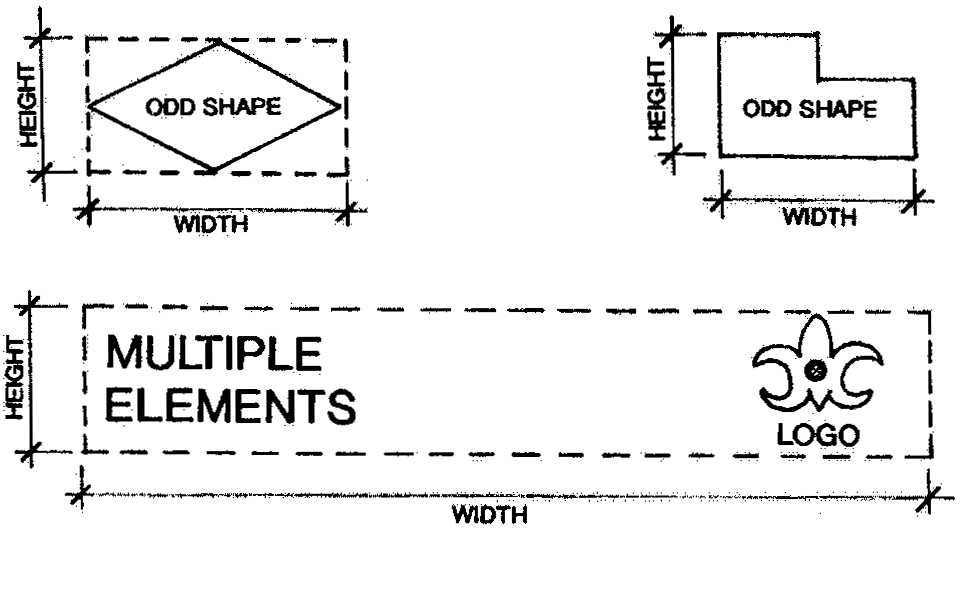
Figure 13b
(2)
Sign area of multi-faced signs. Sign area for multi-faced signs shall be calculated as indicated below and in Figure 14.
a.
The area of a double-faced sign with sign faces that are parallel or the interior angle of the two (2) faces is fifteen degrees (15°) or less shall be calculated using the area of only one (1) sign face.
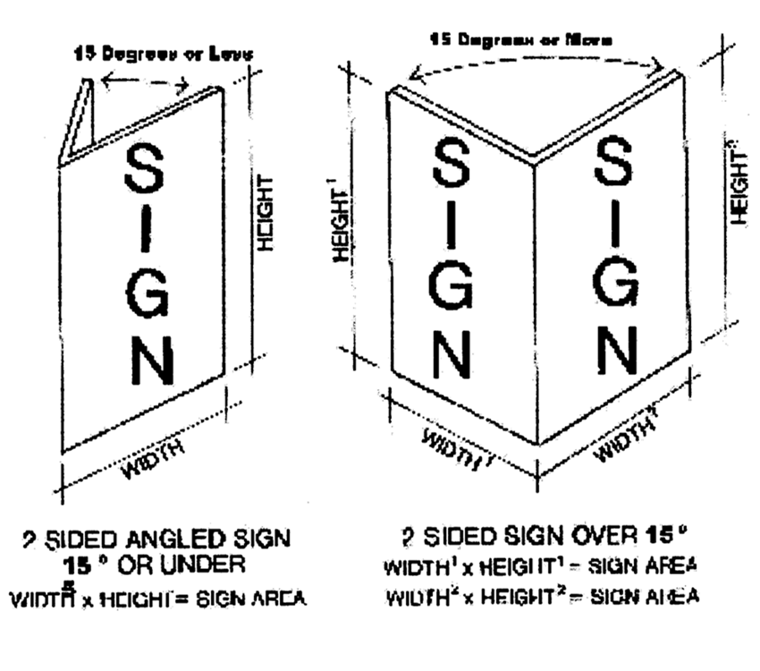
Figure 14
b.
The area of a double-faced sign with sign faces having an interior angle of more than fifteen degrees (15°), the area of both sign faces shall be added together to determine total area of a sign.
c.
The sign area of multi-faced signs is calculated based on the principle that all sign elements that can be seen at one (1) time or from one (1) vantage point should be considered in measuring that particular sign face.
(Ord. No. 21, 2010, § 1(Exh. A), 9-30-10)
Sec. 78-288. - Sign program.
The growth management department may require any development order application for a PUD, PCD, MXD, or conditional use to submit an overall master sign program. The master sign program shall indicate location, number, size, font, type of sign, landscaping, and illumination of proposed signs.
(Ord. No. 21, 2010, § 1(Exh. A), 9-30-10)
Sec. 78-289. - Exempt signs.
(a)
The signs listed below are permitted signs and are exempt from the requirements of this division.
(1)
Mailboxes. Roadside mailboxes.
(2)
Residential identification signs. Residential building identification, displaying the name or property occupant or street address, provided such sign is less than four (4) square feet.
(3)
Warning signs. Signs prohibiting peddlers or solicitors, indicating security such as burglar alarms, or "beware of bad animal" signs. Signs of this nature shall be located at the entrance of the building or residence, or adjacent to fenced areas.
(4)
Traffic control/traffic information. Traffic control, directional, and public information/warning signs placed in public rights-of-way by federal, state, county, city, and other public agencies or at the direction of or as required by same.
(5)
Interior signs. Signs located within a building and not visible from a public right-of-way.
(6)
Courtyard signs. Signs located on the exterior elevation of an interior courtyard, provided such signs are not visible from a public right-of-way or abutting residential zoning district.
(7)
Vehicle advertising. Motor vehicles with business names, business addresses, telephone numbers, contractor certification numbers, logos, and similar information painted or embossed on vehicle surfaces, when otherwise permitted or required by law. Parking of such vehicles shall be limited as provided below.
a.
Motor vehicles, including, but not limited to, trucks, vans, and automobiles, and any trailer towed by such vehicles, with business signage shall not be parked in any location for the primary purpose of advertising a business or service.
b.
The owners of commercial or industrial properties, or their legal tenants, whose vehicles are registered, licensed, and fully operational for company use are exempt from section 78-289(a)(7)a., for the purpose of parking such vehicles on site in the normal course of business.
(Ord. No. 21, 2010, § 1(Exh. A), 9-30-10)
Sec. 78-290. - Temporary signs allowed.
(a)
Permitted temporary signs. Temporary signs allowed within the city are listed in Table 25.
(b)
Approval. Temporary signs shall be approved by the city. Signs not approved by the city are subject to immediate removal by the city, at the expense of the owner. Temporary signs shall comply with the standards listed below.
(1)
Illumination and/or animation. Temporary signs shall not be illuminated nor shall they incorporate any of the characteristics set forth in section 78-284(e).
(2)
Setbacks. Temporary signs shall be setback at least eight (8) feet from the right-of-way line and side property lines, and must comply with section 78-283(c).
(3)
Maximum height. A temporary sign shall not be higher than five (5) feet above the average grade at the property line nearest the sign, except for "human signs", which shall not exceed eight (8) feet in height above the grade upon which any such sign is located.
(4)
Permitted sign types. Only post, banner, or human signs shall be used for temporary signs as specified by Table 25.
Table 25: Temporary Signs
Notes Table 25:
Should any definition, regulation, or provision set forth in section 78-290 and/or Table 25 or any paragraph, sentence, or word be declared by a court of competent jurisdiction to be invalid, such decision shall not affect the validity of the remainder of section 78-290 and/or Table 25.
(*) Exempt from fees and permit registration provided the sign complies with the requirements set forth in Table 25 and the Florida Building Code, as applicable.
(**) A written request for a 30-day extension may be granted administratively provided the permanent sign is not completed but is in the process of completion.
(5)
Human signs (living signs). Upon the issuance of a permit, a living or human sign may be allowed on the premises of the property that is being advertised or within eight (8) feet of the right-of-way immediately adjacent to the property that is being advertised for a maximum of six (6) times per calendar year for no more than two (2) consecutive days. The sign area shall not exceed three (3) square feet in size, and the living or human sign shall not be permitted off site, within the right-of-way, or closer than eight (8) feet from the right-of-way immediately adjacent to the property being advertised. Any failure to comply with these regulations will result in the administrative suspension or revocation of the sign permit and/or enforcement proceedings pursuant to Chapter 162, Florida Statutes. Notwithstanding the foregoing, the city may also pursue any remedy available under the law.
(6)
Maximum sign faces. A maximum of two (2) faces will be allowed for each temporary sign. Maximum size as set forth in Table 25 applies to each sign face individually.
(7)
Maintenance. All signs shall be kept in good condition, present a neat appearance, and be maintained free of debris, stains, mold, discoloration, or deterioration.
(8)
Hazard. A sign shall not directly or indirectly create a traffic or fire hazard or interfere with the free and unobstructed use of streets or sidewalks.
(9)
Permit.
a.
A city temporary sign permit is required for all temporary signs except those exempt as shown in Table 25.
b.
Nonresidential sale of portion of building, rental, or lease permit.
1.
An application for temporary signage will be made with the city. All applications will be issued and renewed administratively by the city.
2.
If approved, a permit for temporary signage will be issued for a period of no longer than one (1) year, or until one hundred (100) percent of the building is sold, rented, or leased. A renewal permit may be submitted annually if the applicant is in compliance with the city's standards.
3.
An administrative fee will be charged for the issuance of the temporary signage permit as regulated by the fees and charges schedule on file.
4.
Standards. Signage must be in compliance with all temporary signage standards and meet the criteria below.
i.
Size. Maximum square footage of the sign is sixteen (16) square feet.
ii.
Sign post. Post shall be a four (4) by four (4) treated-wood post or other acceptable material. The minimum number of posts shall be two (2). The posts shall be directly buried into the ground at a minimum of two (2) feet. Use of concrete is prohibited.
iii.
Backing. Sign shall be installed on a one-half-inch plywood. Plywood shall be attached with weather-resistant screws.
iv.
Color. The entire sign must be painted and have no more than two (2) colors, including the letters. The colors of the sign must be consistent with the approved principal color of the development and/or building.
c.
An additional leasing sign not exceeding twelve (12) square feet may be incorporated into the project's monument sign within the three-foot required base, if provided. Letter size shall be no less than five (5) inches for ground signs. Must have no more than two (2) colors and be consistent with the general design of the monument sign. A sign permit must be submitted and approved by the city. A leasing sign on a monument sign does not require annual renewal and may remain even if one hundred (100) percent of the property is leased.
(c)
Removal.
(1)
Hurricane watch. Any temporary sign installed within the city shall be removed by the owner or city if a hurricane watch is posted. The city shall not be responsible for the replacement of such signage after a hurricane watch is discontinued.
(2)
Violations. The city shall have the right to remove any temporary signage in violation of this section. Any failure to comply with these regulations will result in the administrative suspension or revocation of the sign permit and/or enforcement proceedings pursuant to Chapter 162, Florida Statutes. Notwithstanding the foregoing, the city may also pursue any remedy available under the law.
(d)
Number. Each side of a property facing a public right-of-way is allowed one (1) temporary sign as permitted in Table 25. Each side of a property facing a private right-of-way may be allowed one (1) temporary sign as permitted in Table 25 at the discretion of the growth management director, or designee. Notwithstanding the foregoing, only one (1) human sign (or living sign) shall be permitted per property.
(e)
Prohibited materials. Paper, cardboard, or other such material subject to rapid deterioration shall not be used for any sign that is to be displayed for more than thirty (30) consecutive days.
(Ord. No. 1, 2015, § 1, 3-5-15; Ord. No. 5, 2024, § 21, 7-11-24)
Editor's note— Ord. No. 1, 2015, § 1, adopted March 5, 2015, repealed § 78-290, and reenacted a new section as set out herein. Former § 78-290 pertained to similar subject matter and derived from No. 21, 2010, § 1(Exh. A), adopted Sept. 30, 2010 and Ord. No. 11, 2013, § 13, adopted Sept. 10, 2013.
Sec. 78-291. - Noncommercial messages.
(a)
Notwithstanding anything in this article to the contrary, any sign erected pursuant to the provisions of this article may, at the option of the applicant, contain either a noncommercial message unrelated to the business located on the premises where the sign is erected or a commercial message related to the business and located on the business premises pursuant to the following regulations:
(1)
The noncommercial message may occupy the entire sign face or portion thereof.
(2)
The sign face may be changed from commercial to noncommercial messages as frequently as desired by the owner of the sign, provided that the following is true:
a.
The size and design criteria conform to the applicable portions of this article;
b.
The sign is allowed by this article;
c.
The sign conforms to the requirements of the applicable zoning designation; and
d.
The appropriate permits are obtained.
(3)
For the purpose of this sign code, noncommercial messages shall never be deemed off-premises signs.
(Ord. No. 21, 2010, § 1(Exh. A), 9-30-10)
Sec. 78-292. - Pole-mounted banner criteria.
Pole-mounted banners shall only be permitted in public institutional, commercial, or mixed-use zoned areas for the limited purposes of brand identification or as a holiday decoration; provided the following conditions are met:
(a)
A miscellaneous plan approval by city council is required for all pole-mounted banner programs, except those installed on city property by the city. Any additional pole-mounted banners, graphics, locations, or increase of sign square footage other than what was previously approved by city council requires a new miscellaneous plan review approval. As part of the application process, the applicant must complete a detailed sign program to include:
1.
A copy of a current site plan showing all the proposed locations where the pole-mounted banners are to be placed;
2.
The light pole detail upon which the pole-mounted banner is to be located;
3.
The pole-mounted banner's copy shall be limited to the name of the development, the development's logo, and the development's branding, which does not include any individual business name, tenant, or individual business' logo.
4.
All graphic designs, variations, and/or seasonal sets of the banners must be provided for city council review and approval in accordance with the criteria set forth herein. City council may prescribe specific time periods during which a particular seasonal set of banners may be displayed if approval of more than one (1) set of banners is sought by the applicant.
(b)
The program must satisfy the following requirements:
1.
Pole-mounted banners must be located on an existing light pole;
2.
One (1) pole-mounted banner per light pole may be permitted;
3.
Pole-mounted banners on light poles shall be two-sided with the identical design on each side;
4.
Trees, palms, or shrubs shall not be pruned beyond the limits of the city codes or accepted maintenance standards in order to facilitate the placement of any banners;
5.
Banners shall not interfere or block any existing or future traffic or pedestrian controls or signage;
6.
Within twenty-four (24) hours of announcement of a tropical storm or hurricane watch by the National Hurricane Center, which places the city within the "3-day cone of probability" all pole-mounted banners shall be removed;
7.
The city may require the removal of any pole-mounted banner should the city find that the pole-mounted banner is in a state of disrepair or is not being maintained appropriately with respect to accepted maintenance standards (e.g., not faded, free from rips and tears, properly attached, untattered, and generally in a state of good repair). The applicant shall either remove or replace the banner within ten (10) calendar days of being noticed;
8.
All poles holding or supporting pole-mounted banners shall require a building permit in order to verify the safety and wind loads of the banners;
9.
Pole-mounted banners shall only be interior to a particular site or development and shall not be placed in an area immediately adjacent to a public right-of-way;
10.
Light poles with pole-mounted banners shall be a minimum of fifteen (15) feet from the property line, and no portion of the pole-mounted banner shall extend into or be visible from a public right-of-way immediately adjacent to the property or development upon which such pole-mounted banners are located;
11.
The minimum clearance of banners above the finished grade shall be eight (8) feet;
12.
Non-rectangular pole-mounted banners shall conform only to the maximum banner area criteria providing that a minimum clearance of eight (8) feet above the finished grade is maintained;
13.
Banner size:
a.
Pole-mounted banners on light poles shall meet the following dimensions:
b.
A banner's highest point shall not exceed the highest point of the pole upon which it is mounted.
(Ord. No. 21, 2010, § 1(Exh. A), 9-30-10)
Sec. 78-301.- Purpose and intent.
(a)
The purpose and intent of this division is to protect, preserve, and enhance the natural environment and beauty of the city by creating minimum standards for installing and maintaining landscaping and for vegetation protection. Landscaping that meets these standards provide the benefits listed below.
(1)
Appearance. Improve and sustain the aesthetic appearance of the city.
(2)
Air and water quality. Improve air and water quality by such natural processes as transpiration and the maintenance of permeable land areas for aquifer recharge and surface water filtration.
(3)
Noise and pollution reduction. Buffer noise and reduce pollution through the filtering capacity of living trees and vegetation.
(4)
Energy conservation. Promote energy conservation through:
a.
The creation of shade which reduces heat gain in or on buildings and paved areas; and
b.
The channeling and control of breezes to facilitate the natural cooling of buildings.
(5)
Soil erosion. Reduce erosion by stabilizing the soil.
(6)
Habitat provision. Provide habitat for urban wildlife and a planned transition of the city's green space and open space to the city's conservation areas.
(7)
Water resources. Conserve freshwater resources through the use of drought-tolerant plants and mulch, promoting the planting of less sod and water efficient irrigation systems.
(8)
Buffering. Provide a visual buffer between otherwise incompatible types of land uses.
(9)
Economics. Increase the economic value of land by serving as a capital asset when properly incorporated into site design.
(10)
Public health, safety, and welfare. Provide for the public health, safety and welfare.
(b)
General provisions. In order to fulfill these goals, this division establishes the procedures and standards listed below.
(1)
Procedures.
a.
Procedures to evaluate new landscape plans and existing vegetation protection plans using:
1.
Minimum standards for new landscape installations;
2.
Minimum standards for the preservation of existing vegetation; and
3.
General standards for landscape maintenance.
b.
Procedures for administration and enforcement of these standards.
(2)
Minimum standards. The provisions of this division shall be considered minimum standards and shall apply to all development, as defined in section 78-751.
(Ord. No. 17-2000, § 142, 7-20-00)
Sec. 78-302. - Violations and penalties.
Violations of this division shall be enforced as provided in article VII.
(a)
Failure to comply. Failure to comply with the requirements of this division or any permit or approval granted or authorized hereunder shall constitute a violation of this division. Each of the following shall constitute a separate violation:
(1)
Each square yard containing a tree, shrubbery or groundcover which is destroyed, removed, cleared or grubbed without a permit;
(2)
Each tree, shrub or groundcover which is not properly installed, protected or maintained as required by this division or development order; or
(3)
Each tree which is abused or improperly pruned or hatracked, as set forth in this article.
(b)
Additional remedies. In addition to any other remedies provided in this division, the city shall have the option of pursuing civil actions in a court of competent jurisdiction for violation of any provision of this division or any special condition which may be imposed in a permit or other development order.
(Ord. No. 17-2000, § 143, 7-20-00)
Sec. 78-303. - Approval required.
Approval required. Unless otherwise provided within this division, land shall not be landscaped, cleared, or grubbed within the city unless written permission is first obtained by site plan approval and a permit as outlined in this division. Furthermore, any tree, except as provided for in this division, shall not be cut down, destroyed, removed, or effectively destroyed as a result of damaging the tree or changing the natural grade within the drip line of a tree, without first obtaining site plan approval and a permit. The city may grant permission to remove, add to, relocate, or plant vegetation on land within the limits of the city through a procedure that requires an application and permit as described in section 78-304 herein. With the exception of sections 78-314(d) and 78-321, property owners of residential property as defined in section 78-326 are exempt from the provisions of this division. Landscape easements located on single-family and duplex lots are not exempt from the provisions of this division. Approved landscape and tree protection plans may not be altered in any way, unless otherwise provided for by this division.
(Ord. No. 17-2000, § 144, 7-20-00; Ord. No. 7, 2017, § 16, 3-2-17; Ord. No. 18, 2019, § 2, 10-3-19)
Sec. 78-304. - Application and permit required.
Any person applying for a site plan approval and requesting to landscape or clear existing vegetation, grub, or remove (destroy) a tree or in any way alter existing plant communities or alter previously-cleared land shall submit a complete development application to the growth management director or designee.
(a)
Change to approved plan. If a change to an approved landscape plan is needed by the landowner or agent, an amendment to the development application, specifically the landscape plan, shall be filed with and approved by the city.
(b)
Application fees. Each development application and amendments, including changes to the landscape plan, shall be accompanied by a fee imposed by the city council.
(c)
Land clearing fees. Each permit for the clearing of property shall be accompanied by a fee approved by the city council.
(d)
Inspection and review. Prior to any application work or permit, the growth management department shall make its services available for review or inspection of the site, provided there is at least seven working days' notice thereof. The intent of the pre-application inspection is to identify specific areas of concern and protection in order to plan for tree protection, relocation, grading, drainage, building location, and road alignment prior to preparation of site plan submission.
(Ord. No. 17-2000, § 145, 7-20-00)
Sec. 78-305. - Development application.
(a)
Application required. Any person who does not have a site plan or landscape plan approval pursuant to section 78-304, and who desires to clear vegetation, plant vegetation, grub, or remove (destroy) a tree or in any way alter a plant community or previously cleared land shall make a written application to the growth management department as provided herein.
(b)
Approval required. The actions listed below require approval from the city council or other duly authorized city board or committee and will only be reviewed upon submittal of a development application and other necessary information.
(1)
Installation, land clearing and removal. Installation of new landscaping, land clearing, site vegetation grubbing, or removal of trees or other vegetation consistent with an approved site plan, planned unit development, planned community district, or development of regional impact.
(2)
Clearing and removal. Clearing, grubbing, or removing trees or plants for the expansion of a permitted use within a particular land use or zoning district.
(3)
Major amendments. Proposing or making major changes, those changes that have been deemed not minor by the growth management director, to the landscaping or preserve area within a previously approved site development plan to the extent that plant quantity or design is affected.
(4)
Other changes or amendments. Changing the landscape area or preserve area of an approved site plan due to restraints, conflicts or conditions put on the applicant or agent by the state department of transportation, a utility company or a governmental agency with multijurisdictional authority prior to starting work.
(c)
Application evaluation. Evaluation of the development application will be based upon the application package prepared by the property owner or designee. A pre-application field inspection by the city forester is available. The application package shall include, but shall not be limited to the information listed below.
(1)
Application. The development application, which is available in the growth management department.
(2)
Fees. Payment of applicable fee.
(3)
Waiver. The application shall include any requested waiver, pursuant to section 78-158, from this division, in writing, with the specific section noted and a justification of the waiver request.
(4)
Location map. Location map, including but not limited to location within the city, the nearest road, and water bodies.
(5)
Vegetation and habitat map. A drawing to scale or aerial photo to scale of the site that maps the existing terrestrial and aquatic vegetation and significant wildlife habitat, including exotic invasive species and native plant communities at the same scale as the site plan. This map shall also include the information listed below.
a.
Within the plant communities, the location of all three-inch caliper trees or greater.
b.
Location of large groups of trees in close proximity can be designated as clusters within predominant communities if approximate tree count and the largest and average caliper in the cluster is indicated on the map. Use of plot samples to acquire this information is acceptable.
c.
Description of each plant community, including species within the canopy, understory and ground cover and a written statement to indicate the removal, relocation or preservation of all or part of such community.
d.
Soil types and conditions.
e.
Drawing to scale or aerial photo to scale that maps the species, location or possible location of any federal- or state-listed plant or animal species that are endangered, threatened, or species of special concern, and a written statement to indicate the removal, relocation, or preservation of all or part of the habitat at the same scale as the site plan. This requirement shall be consistent with division 4 of article V, pertaining to natural resources and environmentally significant lands.
f.
Features of archaeological, historic, or geological importance found on site.
g.
Areas of previous alteration or degradation including present and past human use, at the same scale as the site plan.
h.
Surrounding landscaping or plant communities within 50 feet of the property.
i.
Protected trees, as designated by the city council, will be located on a survey map signed and sealed by a registered surveyor. This survey will be used in the project design to help protect the trees through the planning stages of development.
j.
Data table with specific values for acreage of each plant community, including total upland and wetland areas before and after land alteration.
(6)
Project design plan. A project design plan including the information listed below.
a.
Site plan showing existing or proposed buildings, roadways, parking areas, utility easements, dumpster enclosures, water features, flood control structures, backflow preventers, wellfield locations, stormwater systems, landscaped areas, buffer areas, preserve areas and other open space areas at the same scale as an overlay of the vegetation map. A series of site plan or landscape plan sheets may be required in order to indicate sufficient detail.
b.
Elevation (contour) or grade maps for the existing grades and grades at the same scale as the vegetation map. All berms, swales, detention and retention areas shall be indicated on the landscape plan.
c.
Mitigation proposals as they relate to loss of wetlands or actual occupied habitat of endangered, threatened species or species of special concern for plants and wildlife.
(7)
Detailed landscape plan. All landscape plans except individual single-family and duplex lots or areas of one acre or less, which are required by this article shall be sealed by a landscape architect licensed to practice in the state or be prepared by another licensed professional authorized to prepare landscape plans by F.S. Chapter 481. Detailed landscape plans shall include but not be limited to the information listed below.
a.
Clearly delineated and keyed landscape areas, square footage of open space and impervious areas, landscape materials with specifications, such as caliper, height, species name, size and the like, and quantities to be used.
b.
Data table including the following information: specific values for trees, shrubs, sod, palms, and specimen tees, plants, or palms clearly delineated and calculated open space points per 100 square feet for the total project, and percent of open space that is preservation area. This shall include necessary justification for why a species should be considered a specimen.
c.
Description of hardscapes, defined herein as nonliving landscape materials, including heights, widths, type, and location of all barriers, including, but not limited to, gravel and stone, concrete, pavers, clay products including brick, wood decks, and vertical walls and fences.
d.
Landscaping requirements for signs as required in division 7 of article V.
e.
Typical plan view drawings and cross-section details of any perimeter buffer area, road right-of-way, or parking lot landscaping.
f.
Landscaping shall be shown as an overlay of the site plan including all new trees, shrubs, grass, open areas, preservation areas and hardscapes.
1.
All landscape plans shall depict existing trees or areas of existing trees to be protected or relocated during construction.
2.
Landscaping symbols representing new trees shall indicate the canopy spread of the trees at the time of planting, to the greatest extent possible.
3.
A future canopy spread at five years after planting may be depicted for illustration purposes only, and shall be a separate landscape plan.
4.
Landscaping depicted in any building elevation or rendering shall accurately correspond to the landscape plan and shall depict the landscaping at time of planting.
g.
A narrative plan to eradicate and prevent the reestablishment of prohibited plant species listed in section 78-318 herein.
h.
Landscape protection measures, such as curbing and wheel stops, shall be shown on the landscape plan.
i.
Location of all temporary trailers and sales centers.
j.
Landscape plans shall indicate all overhead lighting.
k.
Conceptual irrigation system plan, including main lines, backflow preventer, and water source. Also refer to subsection 78-329(c) herein for more information.
(8)
Alternative landscape improvement plan. Applicants shall be entitled to demonstrate more effective compliance with the intent of this article, in whole or in part, through use of an alternative landscape improvement plan. An alternative landscape improvement plan shall be reviewed as part of the development review process and, if approved, shall be substituted, in whole or in part, for a landscape plan meeting the express terms of this article.
a.
The applicant shall provide an alternative landscape improvement plan which clearly delineates and identifies the deviations from any of the minimum landscaping standards of this article, and the landscape design or designs that make the alternative plan better than a plan that would meet all the requirements of this article. The alternative landscape improvement plan shall be labeled as an "alternative landscape improvement plan."
b.
In reviewing an alternative landscape improvement plan, the city shall give favorable consideration to exceptional landscape designs which attempt to preserve and incorporate existing native vegetation, in excess of minimum standards, and plans that demonstrate innovative design and use of plant materials for foundation landscaping, to buffer incompatible land uses, and to resolve landscape conflicts with utilities.
c.
The city shall not approve an alternative landscape improvement plan if such plan:
1.
Results in planting or preservation of fewer trees than the minimum number required by this division; or
2.
Is not an improvement over a landscape plan prepared in strict compliance with the other standards in this article; or
3.
Is otherwise inconsistent with the intent of this article to encourage exceptional or unique landscape design.
(9)
Project operations. The information listed below regarding project operations shall be provided.
a.
Description of construction methodology to be performed on site, including use, storage, handling or production of substances known to be harmful to plants or wildlife.
b.
Description of any anticipated soil, water, or air pollution produced or generated by the project and known to be harmful to plants or wildlife.
c.
Description of the project phasing. Any project that will require multiple building permits due to the methodology or construction sequence caused by off-site improvements, staging building by building, increasing square footage, restructuring finances or changing market strategies will be considered phased. There shall be a narrative and/or map depicting the projected phasing submitted that describes when areas will be cleared and landscaped.
d.
Prior to approval and, if applicable, revised site plans shall be accompanied by a written description of all changes made since the last site plan review.
e.
After approval and prior to any city permit, the site plan shall have all conditions of approval located on the site plan, and this information will be available on the site during construction. A reduced copy shall be provided to the city clerk's office for attachment to the respective ordinance or resolution documents.
(Ord. No. 17-2000, § 146, 7-20-00)
Sec. 78-306. - Construction plan review.
(a)
Landscape plan required. Any person applying for a building permit or requesting review and approval of a construction plan that is based on a city-approved site plan or any other plan which contains landscape improvements shall submit a landscape plan and irrigation plan with the construction documents for a building permit.
(b)
Conceptual plans prohibited. Landscape and irrigation plans submitted as part of a building permit application shall not be conceptual in nature. Plans submitted shall be final plans, to be utilized for construction and installation of landscaping, irrigation, and related improvements.
(c)
Utility services. Landscape plans shall indicate locations of all water, sewer, cable, electric, telephone, drainage, including catch basins and detention or retention areas, or other above ground or underground service. Backflow preventers, transformers, gas lines, all underground tanks and similar types of equipment that conflict with the installation of landscaping shall be indicated on the landscape plan.
(d)
Easements encroachment. If utility or drainage easements are publicly recorded, prior to construction plan permitting, they shall be indicated on the landscape plan. Otherwise, a maximum of five feet of a required buffer may be overlapped by a utility easement or encumbered by a utility not in an easement, provided that a minimum of five feet of the required buffer remains free and clear of any overlap for the plant material installation.
(e)
Approval for easement encroachments. Utility or drainage easements that overlap or transverse buffers and any other open space containing landscaping may be permitted with written permission of the easement holder, prior to construction plan approval.
(f)
Minor landscape plan changes. If for any reason minor changes, as defined in section 78-307 of this article, occur in the landscape plan submitted for a building permit, an administrative approval shall be required. Minor landscape plan changes should not affect the permitting of a project. Major changes could delay a building permit application or require formal approval by the planning, zoning, and appeals board or the city council, as determined by the growth management director or designee.
(Ord. No. 17-2000, § 147, 7-20-00; Ord. No. 17-2004, § 5, 6-3-04)
Sec. 78-307. - Administrative approval.
(a)
Permitted administrative approvals. The following actions may be approved by the growth management director or designee upon request for a permit. Administrative approvals may include conditions of approval, as deemed necessary to meet the intent of a development order.
(1)
Clearing and grubbing. Clearing, grubbing, root pruning, or removal and relocation of trees or other vegetation pursuant to an approved site plan or inclusion as common elements within an approved planned development district master plan. Vegetation clearing will not be permitted until a written land clearing permit is issued and the permit fee is paid.
(2)
Removal and replacement. Removing and replacing dead, diseased, damaged, or insect-infested vegetation, including trees.
(3)
Hazards. Removing or relocating vegetation, including trees, that are a hazard to existing buildings, utilities, infrastructure or within a road right-of-way.
(4)
Health and safety threats. Removing vegetation, including trees that may cause a health or safety problem.
(5)
Minor alterations.
a.
Minor alterations or changes to approved landscape plans, or minor alterations to existing landscaping if an approved landscape plan is not on file with the city, within all districts to improve or remove proposed or existing landscape. Minor alterations shall be defined as a change of type, quantity, or location that affects not more than a combined total of 25 percent of shrubs, groundcover, palms, or trees on a site.
b.
Developers shall submit construction plans that are consistent with the approved landscape plan of record. The city recognizes that adjustments to approved landscape plans may be necessary, due to changes to utility locations or due to plant material availability. Minor changes, as described above, shall be approved by the growth management director or designee and properly documented in city records.
(6)
Fences. Installations of fences, if no expansion of an existing or proposed use is intended.
(7)
Temporary landscaping. Temporary landscaping, considered as landscaping other than what was originally approved, if such installation does not result in the removal of native vegetation.
(8)
Exotic vegetation. Removal of exotic vegetation, including prohibited species.
(b)
Verification required. Verification of proper landscaping installation shall include the following:
(1)
Species, including quality, type, quantity, and any other original plant specifications;
(2)
Design or location;
(3)
Irrigation; and
(4)
All other landscape structures and material used or installed in accordance with the site plan.
(c)
Review. The city's landscape inspector will review the project for compliance after the documentation has been received from the landscape architect.
(d)
Deviation. Any deviation from the approved landscape plan will be relayed to the growth management director or designee for further review prior to the issuance of the certificate of occupancy. If landscape plan deviations cannot be corrected prior to the issuance of a certificate of occupancy, a letter of credit or bond shall be posted by the owner, general contractor, or principal for the remaining work to be accomplished.
(Ord. No. 17-2000, § 148, 7-20-00)
Sec. 78-308. - Compliance.
(a)
Violation. Failure to install, maintain, or preserve landscaping or native vegetation required in accordance with the terms of this article shall constitute a violation of this chapter.
(1)
Failure to comply. If the owner, tenant, or agent, including owner associations, shall fail to meet the requirements of this article, or if the existing trees, shrubbery, grass, or ground covering shall be permitted to die, either intentionally or unintentionally, and such materials are not replaced within 30 days of the event, the city forester or a code enforcement officer shall notify, in writing, the person responsible for the maintenance or replacement of such property of the need to comply with the requirements of this section within 30 days from the date of delivery of the notice.
(2)
Extensions. The 30-day rule for compliance may be extended when necessary by the city manager or his designee to recover from acts of nature such as a hurricane or a freeze.
(3)
Relocation or replacement. The plan approved to remedy any violation of this article shall require that landscaping or habitat be replaced or relocated where practicable or feasible to comply with all requirements herein. Relocation or replacement shall comply with the standards listed below.
a.
Trees having a three-inch or greater caliper which are to be replaced on the same site shall be replaced by the sum of three caliper inches to every inch lost. Replacement trees shall be a minimum of three inches in caliper.
b.
The city may require that trees having a three-inch or greater caliper be relocated elsewhere on site or, if not practicable or feasible as determined by the approval entity, to be replaced on the same site by trees, the sum of whose calipers are equivalent to three times the caliper of the tree being removed.
c.
If the site cannot support the total number of required replacement trees as determined herein, the city may permit the owner to:
1.
Donate excess trees to the city for planting on public lands at the owner's expense;
2.
Contribute to the city the monies equivalent to such required replacement trees; or
3.
Permit the required replacement trees to be placed upon other lands owned by the same property owners.
d.
Replacement trees shall have shade, environmental, or aesthetic qualities comparable to or better than the replaced trees.
(Ord. No. 17-2000, § 149, 7-20-00)
Sec. 78-309. - Performance bond.
The building division may enter into an agreement with the developer, the owner, or owner's agent that will allow issuance of the certificate of occupancy before the landscape installation required by this article is completed, provided that a performance surety or guarantee shall be posted. The guarantee shall consist of a performance bond or other surety agreement approved by the city attorney in an amount equal to 110 percent of the direct costs of materials and labor, and other costs incidental to the installation of the required landscaping as certified by the landscape architect. The guarantee shall specify the time for the completion of the landscaping requirements, and shall be accompanied by a site plan identifying the plant material covered by the surety.
(Ord. No. 17-2000, § 150, 7-20-00)
Sec. 78-310. - Appeal.
(a)
Procedure. Any person, property owner, agent, or representative thereof, aggrieved by a decision of the building division, growth management department, code enforcement officer, or planning, zoning, and appeals board, in the enforcement of any terms or provisions of this article, may appeal to the city council.
(1)
Period for filing appeal. The appeal shall be filed in writing within 15 days after the date of the decision with the city manager, with a copy to the city clerk.
(2)
Form of appeal. The written appeal shall set forth concisely the nature of the appeal and the reasons or grounds for the appeal.
(3)
City council decision. The city council shall hear and consider all facts material to the appeal and render a decision promptly. The city council may affirm, reverse, or modify the decision being considered on appeal.
(4)
Further appeals. An appeal may be made to the circuit court from any final decision of the city council, provided the appeal shall be filed within 30 days from the date of the decision.
(Ord. No. 17-2000, § 151, 7-20-00; Ord. No. 17-2004, § 5, 6-3-04)
Sec. 78-311. - Variances and waivers.
(a)
Variances. An applicant submitting a landscaping plan or landscape plan amendment for a site that is not within a planned unit development or planned community district and that does not meet the minimum standards of this division shall submit a variance application for review by the planning, zoning, and appeals board pursuant to section 78-53. The planning, zoning, and appeals board shall consider the variance application before the site plan application or other development order application is considered for approval.
(b)
Waivers. A waiver of one or more requirements of this division may be granted by the city council for any PUD or PCD. The request shall be considered pursuant to waiver provisions applicable to a PUD or PCD.
(Ord. No. 17-2000, § 152, 7-20-00; Ord. No. 17-2004, § 5, 6-3-04)
Sec. 78-312. - Land clearing permit.
(a)
Issuance. The city shall not issue a permit for land clearing until:
(1)
The property owner has submitted a building permit application to the city for paving and drainage or other infrastructure improvements, at a minimum, or unless otherwise approved by the growth management director, and
(2)
All tree protection work has been satisfied pursuant to this article.
(b)
Phasing. Permits for land clearing may be phased, depending on the project design.
(c)
Conditions. Permits for land clearing shall have conditions of approval imposed by the city. The conditions of approval addressed in a clearing permit may include the following: hours and days of operation, dust and particulate matter control, and control of rodents, vermin, and other nuisances that may be created by the clearing.
(Ord. No. 17-2000, § 153, 7-20-00)
Sec. 78-313. - Minimum landscape requirements for nonresidential development.
(a)
Minimum open space requirements. The minimum open space requirement for all new nonresidential development shall be 15 percent land development regulations.
(b)
Minimum landscape requirements. Not more than 40 percent of the total landscape area shall be covered with sod or grass. Those projects proposing playgrounds, ballfields, golf courses, dry detention areas or similar uses may subtract the open space square footage of these grassy areas from the landscape area calculation for a corrected total.
(c)
Minimum landscape points. Tables 26 and 27 shall be used to determine the minimum landscape points per open space a project shall be required to provide. Achieving the minimum open space landscape point requirement does not exempt a project from compliance with other requirements of this division.
Table 26: Minimum Landscape Requirements - Nonresidential Development
Notes:
*Example: 15% project open space requires 22 points/100 square feet
< = Equal to or less than
Table 27: Required Landscape Installation Points Chart
Notes:
(1)
Preferred and coastal species are listed in the city's "Landscape Work Manual."
(2)
Abused trees, as determined by the city forester, shall not count toward required points.
(3)
Coastal areas shall be planted with 90% native species as listed in PBG
*=
Preferred Tree Species list.
*=
Justification to be provided consistent with definition.
DBH=
Diameter at Breast Height.
PBG=
Palm Beach Gardens.
<=
Less Than.
>=
Greater Than.
W/=
With
(d)
Specimen trees. Specimen trees shall be considered existing native trees in good health and 13 inches at diameter at breast height (DBH) or larger, or trees at least 25 percent of the DBH for the respective champion tree in the state.
(1)
Minimum protection requirements. A minimum of 25 percent of all specimen trees are to be protected in place or relocated on site.
(2)
Exception. This requirement shall not apply if a planned upland preserve is set aside, pursuant to division 4 of article V, or as provided below.
a.
A specimen tree or trees may be substituted with replacement trees on site, or replacement trees may be donated to the city. The minimum replacement shall be the sum of three caliper inches for every caliper inch of a specimen tree that is to be removed. Donated trees shall be planted by the donor and guaranteed by the donor, in a written agreement or by a surety bond, for 180 days.
b.
An applicant may remove a specimen tree or trees if a contribution of the equivalent value of the replacement tree or trees, as calculated in paragraph (d) above, is made to a city beautification account. The value of the tree replacement shall be determined by averaging cost estimates from two landscape architects or similar professional; one selected by the applicant and one selected by the city. The applicant shall pay the fees for both cost estimates. The city's community aesthetics board shall advise the city council on the expenditure of these monies. These funds shall be used for tree programs on public lands.
(e)
Screening required. The following uses within nonresidential developments shall be required to be screened from public view:
(1)
Backflow preventer systems;
(2)
Trash or dumpster containers, compactors, recycling containers, and similar types garbage and refuse disposal equipment;
(3)
Storage or mechanical equipment areas;
(4)
Outside display or sales areas;
(5)
Parking areas;
(6)
Service bays; and
(7)
Satellite dishes mounted on the ground.
(f)
Landscaping required. The following uses within nonresidential developments shall be required to have landscaping, as required herein.
(1)
Vehicular use areas;
(2)
Building foundations excluding rear areas not visible by a public road right-of-way or not generally traveled by the public or visible from adjacent structures;
(3)
Signs, as required by section 78-287;
(4)
Multilevel parking garages;
(5)
Berms or perimeter walls;
(6)
Temporary trailers and sales centers, excluding construction trailers.;
(7)
Swales, ditch banks, including any transition between land and a water body and littoral zones, in accordance with all applicable rules of the South Florida Water Management District, the Northern Palm Beach County Improvement District and the Palm Beach County Department of Engineering and Public Works; and
(8)
Littoral planting zones.
(g)
Planting in swales and maintenance areas. Trees and shrubs shall not be planted in swale areas and in maintenance easements for canals.
(h)
Redevelopment and nonconforming projects.
(1)
Alternatives. Redevelopment projects or nonconforming projects unable to meet the point system or open space requirements of this section may utilize the alternatives contained herein.
(2)
If a redevelopment or nonconforming project is subject to a development order amendment, required landscape points may be:
a.
Transferred to other public lands, parks, road, road rights-of-way, or other similar public space, up to a maximum of 25 percent reduction of points per 100 square feet; or
b.
An assessment of $25.00 per point can be contributed to the city's beautification account by the applicant.
(Ord. No. 17-2000, § 154, 7-20-00; Ord. No. 7, 2017, § 17, 3-2-17; Ord. No. 6, 2022, § 18, 7-14-22)
Sec. 78-314. - Minimum landscape requirements for residential development.
(a)
Minimum open space. The minimum required open space in residential districts shall be 35 percent of the entire site. Those projects proposing playgrounds, ballfields, golf courses, dry detention areas and similar uses may subtract the open space square footage of such areas when required open space is calculated. Landscaping shall be achieved with a combination of trees, shrubs, ground cover, grass or sod, and nonliving landscape material. One hundred percent of all open space shall be landscaped. A minimum number of points per 100 square feet of open space shall be required as indicated in Table 28, based on the amount of open space for landscaped areas within common or publicly dedicated open space.
Table 28: Minimum Landscape Requirements - Residential Development
Notes:
*Example: 35—44% project open space requires
10 points/100 square feet.
< = Less Than.
> = More Than.
(b)
Required screening. The following uses within residential developments shall be required to be screened with landscaping:
(1)
Parking areas;
(2)
Berms and perimeter walls;
(3)
Lift stations;
(4)
Cable television, telephone or other ground-mounted utility equipment or service boxes;
(5)
Backflow preventers, ground-mounted air conditioning units;
(6)
Recreational vehicle (RV) parking areas;
(7)
Boat storage areas;
(8)
Maintenance and storage areas;
(9)
Dumpster or trash pickup areas; and
(10)
Temporary trailers and sales centers, excluding construction trailers.
(c)
Point values. Trees and plants shall have the same point value as is specified in Table 28 herein. In addition to the landscaping required in section 78-313 herein, the same requirements for protecting existing trees outlined in this division shall apply.
(d)
Minimum requirements for single-family and duplex residences. Single-family and duplex lots will have a minimum of one tree or two palms and six shrubs per 1,000 square feet of open space or fraction thereof. A shade tree from the city's preferred tree list is required as a street tree, located within the road right-of-way or within 15 feet of the property line. Street trees are to be replaced if removed for any reason by the landowner.
(e)
Credit. Trees located on the property required to be preserved by any other requirement or section may be used to satisfy requirements within this division. The trees are to be protected during construction in a manner consistent with standard practices and acceptable to the city forester.
(Ord. No. 17-2000, § 155, 7-20-00)
Sec. 78-315. - Landscaping and screening for vehicular parking areas.
(a)
Minimum spacing. The minimum shade tree spacing for interior parking areas shall be such that the center of any parking space is not more than 40 feet from the center of the shade tree. A shade tree may be replaced by a minimum of three palms clustered together, as long as the affected parking bays are more than 50 feet from a public street.
(b)
Landscape islands. A landscape island shall be required for every nine parking spaces located in a row.
(c)
Minimum size for landscape areas. The minimum landscape area shall contain no dimension less than five feet in width, measured from the inside of the curb. There shall be no landscape area smaller than 25 square feet. Landscape areas within interior parking areas may be reduced if the areas shall constitute an obstruction in use of a building structure, providing the reduced square footage is relocated so as to emphasize entrance corridors or special landscaped areas within the general parking area.
(d)
Protection of landscape areas. All landscape areas, except in fee simple residential lots, shall be protected by curbs or wheel stops from vehicular encroachment and from the damages caused by vehicles overhanging into landscape areas. Landscaping, except grass, shall be required to be at least two feet six inches from the edge of the wheel stop or curbing. The curbing shall be at least six inches in height above grade.
(e)
Overhang areas. Vehicle parking areas designed to permit vehicles overhanging into landscaped areas shall not be permitted to count the first two feet six inches of landscape area as open space.
(f)
Hedges and berms. The perimeter of vehicle use areas abutting public road rights-of-way, including driveways to parking lots, shall include a continuous berm and hedge. The berm shall be constructed at a minimum elevation of two feet above the grade of the parking lot, and the hedge shall be maintained at a minimum height of three feet at maturity.
(g)
Multilevel parking garages. Multilevel parking garages shall have planters installed to permit installation of trees on the top level of the structure. These areas shall apply toward the required points per open space. The top parking area shall have trees as required in section 78-313.
(h)
Grass parking. Grass parking shall be required to meet the same standards as established herein.
(i)
Maintenance. Regular maintenance of vehicular use areas adjacent to all landscape areas shall include replacement of broken curbs or curb stops as needed to keep the general appearance in good condition and safe.
(j)
Visibility triangles. When a point of driveway or other point of ingress or egress intersects a public right-of-way or when the subject property abuts the intersection of two or more public rights-of-way, all landscaping within the areas described in subsections (a) and (b) of this section shall allow visibility between 30 inches above the established grade and six feet above the established grade. However, trees or palms shall be permitted such area, provided they are trimmed so as to allow visibility at the levels indicated in above, and further provided the palms or trees are located so as not to create a traffic hazard. This visibility area shall be provided as indicated below.
(1)
Intersection with public right-of-way. The area of property on both sides of a driveway formed by the intersection of each side of the driveway and the public right-of-way line for a distance of 15 feet in length and five feet in width along the public right-of-way.
(2)
Intersections of rights-of-way. The area of property located at a corner formed by the intersection of two or more public rights-of-way with two sides of the triangular area being 20 feet in length along the abutting public rights-of-way measured from their point of intersection and the third side being a line connecting the ends of the other two lines.
(Ord. No. 17-2000, § 156, 7-20-00)
Sec. 78-316. - Preserve areas.
(a)
Credit for existing vegetation. All plants, including trees, shrubs, and ground cover within a preserve area that meet or exceed the minimum landscape requirements as set forth in this article can be counted toward the points per open space required to meet landscape requirements as provided herein.
(b)
Minimum width. The minimum width of a preserve area to be used to meet landscape requirements shall be 25 feet.
(c)
Screening. The preserve area may screen any area that requires screening with the same minimum planting requirements as does new landscape material as required herein. Infilling new vegetation within preserve areas or around preserve areas shall be required if existing vegetation does not provide required screening. Infilling or installation of additional material within preserves shall be accomplished by relocating existing on-site native plants or adding appropriate new native plants to the voids or bare areas of the preserve to accomplish the required screening.
(d)
Irrigation. Irrigation is not required within preserve areas. The area shall be preserved in such a way that the transition of new landscaping or open space to existing vegetation duplicates nature. The preserve area shall not be adversely impacted by surrounding drainage or elevation changes resulting from or caused by development.
(e)
Maintenance. Preserve areas shall be maintained or managed with the same standards set forth in section 78-251, except there shall be no pruning of vegetation or trees within preserve areas without written approval from the city forester. Preserve areas shall be cleared and kept clean of any exotic plants, including, but not limited to, melaleuca, Brazilian pepper, and Australian pine.
(f)
Construction prohibited. There shall be no construction within preserve areas unless otherwise approved during site plan approval.
(g)
Walls or barriers. Walls or other barriers shall not be constructed in such a manner that impedes or restricts the function of preserve areas that also act as habitat corridors or pathways, unless otherwise approved during site plan approval.
(h)
Replacement. Trees and shrubs used to meet landscape requirements that die within preserve areas shall be replaced once it is determined by the city that landscape screening requirements have dropped below minimum standards.
(i)
Violations. Code enforcement regulations shall apply to preserve areas that are used to meet landscape requirements.
(j)
Minimum separation. In an effort to create a safe zone for protection from a wild fire, structures shall be no closer than ten feet to a preserve area, as defined in division 4 of article V.
(Ord. No. 17-2000, § 157, 7-20-00; Ord. No. 6, 2022, § 19, 7-14-22)
Sec. 78-317. - Tree replacement during construction.
During construction, all required landscaping that dies shall be replaced with the same species within 30 days or before issuance of the certificate of occupancy. The minimum replacement specifications will be one for one at the minimum size standard set forth in the approved landscape plan. Trees that die during construction shall be replaced with the same species within 30 days or before issuance of the certificate of occupancy. The minimum replacement specifications and minimum size standard are set forth in sections 78-313 or 78-314.
(Ord. No. 17-2000, § 158, 7-20-00)
Sec. 78-318. - Prohibited plants and invasive nonnative plants.
Prohibited plants shall not be planted anywhere in the city, and in some cases must be removed. The official list of prohibited plant species, species to be removed, and species that may remain if planted is provided in Table 29.
Table 29: Plant Species Prohibited or Required to be Removed
(a)
Removal. Upon issuance of a building permit, a property owner shall remove or cause to be removed the plant species listed in Table 29. Certain existing prohibited plants shall be removed or be allowed to remain in place as provided in Table 29.
(b)
Certificates of occupancy. A certificate of occupancy or other official acceptance of completed work shall not be issued for development until verification is provided, through inspection by the city forester or by certification by a state-licensed landscape architect, that all required removal of prohibited plants or invasive nonnative plants has been completed and is in accordance with the development plan or phasing plan, and permit conditions. The eradication of prohibited plants and invasive nonnative plants, as applicable, shall be completed prior to the final landscape inspection.
(c)
Use of ficus species. Ficus species may be planted as individual trees or hedge material, subject to the standards listed below.
(1)
Location. Individual ficus spp. trees shall not be planted within 15 feet of any public road right-of-way or other public utility.
(2)
Hedges. Ficus spp. hedges shall be regularly maintained, shall be of cold-tolerant variety, and shall not exceed eight feet in height.
(Ord. No. 17-2000, § 159, 7-20-00; Ord. No. 7, 2017, § 18, 3-2-17)
Sec. 78-319. - Minimum landscape buffer and planting requirements.
(a)
Minimum buffer required. A landscape buffer shall be a minimum of eight feet in depth around the perimeter of a parcel. However, additional buffer depth shall be provided as indicated below:
(1)
A minimum landscape buffer of 15 feet in depth shall be required on lands located adjacent to public street rights-of-ways and railroad rights-of-way that are less than 100 feet wide;
(2)
A minimum landscape buffer of at least 20 feet in depth shall be required on lands located adjacent to public street and railroad rights-of-way that are 100 feet wide or greater; and
(3)
A minimum landscape buffer of at least 25 feet in depth shall be required on lands located adjacent to Interstate 95 or the Florida Turnpike.
(b)
Buffer areas required where commercial or industrial use abuts residential use.
(1)
Required buffers. Whenever a commercial or industrial use abuts an existing or future residential use, as depicted on the future land use map of the city's comprehensive plan, a landscape buffer as described hereinbelow shall be installed.
a.
A landscape buffer having a minimum width of 15 feet shall be provided on the commercial or industrial parcel along the property line that abuts the neighboring residential property. Such buffer shall create a completely opaque visual barrier which may include a fence or wall with a maximum height of eight feet. Any such fence or wall shall be setback no less than five feet from the property line and shall be substantially skewed from view from the adjacent residential use.
b.
Alternatively, a berm with sufficient landscaping to create a minimum combined height of eight feet adjacent to the abutting property line or at a sufficient distance from the property line to allow maintenance of such buffer.
(2)
Approval. The use of a fence, wall, or berm as a visual barrier shall be approved by the growth management director.
(3)
Exceptions. If the commercial or industrial property line is a part of or abuts a public access easement or road right-of-way, a ten-foot buffer shall be required. An eight-foot fence, wall, or berm with landscaping shall not be required unless the city council determines that such a fence or berm is necessary as a visual barrier for the protection of the adjacent residential area.
(4)
Other limitations. Buffer areas required by this section shall be in addition to any required building setback areas and shall not be used for parking or any other vehicular use.
(c)
General. The following general standards shall apply to all landscape materials installed within a landscape buffer:
(1)
Mature height. Vegetation, especially trees and palms, should be planted taking into consideration the mature height and spread of the species.
(2)
Areas prohibited in landscape buffers. Stormwater detention or retention areas, and lake maintenance easements shall not be located within landscape buffers.
(3)
Spacing. The maximum spacing of planting trees shall be 60 feet along any perimeter buffer so long as all point requirements have been met.
(4)
Preferred plant installation. A minimum of 75 percent of the total quantities of trees and plants shall be included within the preferred plant list, as provided in the city's "Landscape Work Manual." Coastal areas as designated by the comprehensive plan shall be required to have 90 percent native species.
(5)
Storage and garbage collection sites. All outside storage and trash or garbage collection sites shall be completely screened from view, utilizing any approved combination of hedge a minimum of three feet in height, structural barriers, berms or any combination thereof to 100 percent screen the area from view.
(6)
Service areas. Service areas of nonresidential buildings, when visible from the street right-of-way or adjacent residential land use, shall have barriers and a hedge at a minimum of six feet in height to screen the service area from this use. Service areas may include interior or exterior work bays associated with full service gas stations, tire repair, auto repair business, as well as any business proposing loading or unloading docks.
(7)
Backflow preventers. Backflow preventer systems shall be screened from public view, utilizing any combination of trees, palms, hedges, or other barriers as approved by the growth management director.
(8)
Total landscaping points. Achieving the total points per open space for an entire project within one or more areas does not exempt one from complying with all other requirements, even if that means exceeding the minimum required total points per open space.
(9)
Signs. Landscaping around ground signs is required and shall be provided pursuant to section 78-287.
(10)
Advertising. At no time shall a landscaped area be used for advertising display or sales, unless specifically approved by the city.
(Ord. No. 17-2000, § 160, 7-20-00; Ord. No. 11, 2013, § 14, 9-10-13)
Sec. 78-320. - Foundation landscaping and plantings.
Plantings required. Foundation plantings for nonresidential buildings shall be installed as provided herein.
(a)
Location, purpose, and general standards.
(1)
Location. There shall be foundation landscaping within ten feet of all buildings and structures.
(2)
Purpose. The location and size of this foundation landscaping shall be of a height and quantity to visibly soften bare walls, accent building facades, and help direct pedestrian traffic to building entrances.
(3)
Irrigation. All foundation areas shall be irrigated and of the appropriate size to accommodate the mature size of the vegetation to be planted.
(4)
Minimum standards. The minimum standards for foundation landscaping shall be determined by the building height and function, and as set forth below. Building foundation landscaping may be reduced or eliminated by action of the city. Street trees or road right-of-way landscaping cannot be eliminated without city approval.
a.
The foundation planting area shall:
1.
Be at least five feet wide, unless foundation landscaping would interfere with the intended use and function of a building; and
2.
Extend along the portions of a facade that directly abut a parking area or vehicular use area, excluding entryways, doorways or other building improvements, as determined by the city.
b.
The foundation planting area for a building of two or more stories shall also:
1.
Be not less than 30 percent of the height of the adjacent wall; and
2.
Extend along the portions of a facade that directly abut a parking or vehicular use area, excluding entryways, doorways or other building improvements, as determined by the city.
c.
At least one shade tree or palm cluster shall be installed for each 30 linear feet, or fraction thereof, of facade width. A minimum of one tree per facade shall be planted, and the remainder of the landscape area shall be treated appropriately with plantings and pedestrian accessways. Trees and palms shall be of an installed size relating to the height of the adjacent wall or facade, as indicated in Table 30.
Table 30: Minimum Foundation Planting Dimensions
d.
The tree heights in this section are minimum tree heights and the palm heights are minimum palm cluster heights. As the minimum tree and palm cluster height increases, some smaller trees or palms may be allowed, as opposed to all trees or palms being a minimum size.
(Ord. No. 17-2000, § 161, 7-20-00; Ord. No. 6, 2022, § 20, 7-14-22)
Sec. 78-321. - Minimum landscape and hardscape standards.
(a)
Minimum landscape standards. All landscape installed shall meet the requirements of Table 31 and as otherwise provided herein.
Table 31: Minimum Landscape Requirements
Notes:
(1)
Measured from grade to average end of branches, not the tallest of one (1) or two (2) branches and a minimum crown of five (5) feet.
(2)
Measured as gray trunk height.
(3)
Palms not classified as specimen palms and planted in perimeter buffer areas shall be installed in groups of not less than three (3).
(4)
Support shall be provided consistent with sound horticultural practices to encourage future growth.
(b)
Lawn grass. Lawn grass shall be solid sod, unless otherwise approved in the landscape plans. Lawn grass shall not be allowed to grow higher than six (6) inches in height. Sod shall not be placed closer than eighteen (18) inches from the trunk of a tree.
(c)
Artificial turf. Up to one hundred (100) percent of the recreational use (e.g., playground, athletic field) of artificial turf shall be permitted to count toward open space requirements. Artificial turf shall consist of green lifelike individual blades of grass that emulates natural turf. The installation of artificial turf shall not restrict or compromise the health or maintenance of natural vegetation required by any other section of this Code. The location of artificial turf shall be limited to the following:
(1)
In residential lots, the quantity of artificial turf is restricted by the maximum percentage of impervious surface for the subject property permitted within the applicable zoning district.
(2)
Artificial turf is not permitted within required landscape buffers, parkways, or preserve areas.
(Ord. No. 17-2000, § 162, 7-20-00; Ord. No. 16, 2014, § 6, 11-6-14)
Sec. 78-322. - Hardscape and nonliving landscape materials installation requirements.
(a)
Use of perimeter walls and fences. Perimeter walls, metal or wood fences, or other nonliving landscape materials may be used in conjunction with vegetation to meet required landscaping. Approved walls or fences shall be set back from property lines sufficiently to include landscape on the outside of the wall or fence. Maintenance of the wall or fence and associated landscaping by the property owner is required. If nonliving barriers are used, 50 percent of the barrier shall be covered or screened by vegetation on the street side along public rights-of-way and interior perimeter areas visible to the public.
(b)
Berms. Earth berms may be used only when installed in conjunction with sufficient plant material which shall be installed and spaced to satisfy the requirements of this article. The slope of a berm shall not exceed a ratio of 3:1. Earth berms may not be installed over underground public utilities without written consent from all applicable utility companies.
(c)
Mulch. All tree and shrub beds shall receive at least three inches of mulch. Mulch shall be temporarily applied to areas not immediately covered by ground cover. Where mulch is intended to be installed permanently, it shall be renewed and maintained at three inches of depth. Mulch will be thoroughly wet at the time of application to prevent wind displacement.
(d)
Pavers. The use of pavers or similar impervious material, excluding sidewalks, shall not exceed 30 percent coverage of an open space area, and shall not be wider than 12 feet if used in a required landscape buffer area.
(e)
Palms. Nonspecimen palms planted in perimeter buffers shall be installed in groups of no less than three, and shall receive planting credits or points as provided in section 78-313 or section 78-314.
(f)
Artificial turf. Artificial turf shall be designed for the intended use and meet the appropriate industry standards for installation, drainage, and aesthetics. Artificial turf shall resemble a natural turf/sod/grass look at all times. Artificial turf shall be visually level, with the grain pointing in a single direction. The improper maintenance or disrepair of artificial turf shall be a violation of the city's Code, which may include, but not be limited to, unanchored areas, water pooling, and/or unsightly or unclean areas.
(Ord. No. 17-2000, § 163, 7-20-00; Ord. No. 16, 2014, § 7, 11-6-14)
Sec. 78-323. - Soil erosion.
Soil erosion shall be controlled and held to a minimum during all development activities. Areas in which vegetation or ground cover has been allowed to be removed pursuant to an approved site plan and subsequently abandoned for any reason for more than six months shall be seeded with a ground cover or grass immediately upon request by the city, or the city shall have the work done at the owner's expense.
(Ord. No. 17-2000, § 164, 7-20-00)
Sec. 78-324. - Roadway beautification plan.
(a)
Applicability.
(1)
The standards contained in this section shall apply to all public rights-of-way which are adjacent, contiguous or internal to existing and proposed residential and nonresidential developments. Landscaping and irrigation are required within roadway medians and road shoulders. All approved planned unit developments or planned community developments that are subject to major amendments, in accordance with section 78-49 of the land development regulations, shall be required to landscape, irrigate and maintain improvements within adjacent and/or contiguous public rights-of-way. If a development order requires road improvements not adjacent and/or contiguous to the development, the petitioner of the development shall landscape and irrigate said road. The intent of this section is to beautify public roads and keep the public roads aesthetically pleasing with landscaping and other enhancements. Unless otherwise approved through a development order or other agreement, developers and their successors or assigns shall be responsible for the installation and maintenance of roadway landscaping, including irrigation. Where roads have been landscaped and enhanced, but become nonconforming due to safety standards implemented by this section, nonconformities may be rectified during future road improvements by the person or entity making the improvements.
(2)
As new developments are approved, it is the intent of this section to require adjacent property owners on both sides of the road to share the cost of landscape and irrigation maintenance for medians and/or road shoulders based on the linear frontage of each development or by the square footage of the area to be maintained.
(b)
Landscape plans. Landscape plans for rights-of-way shall be submitted by the applicant and approved with each development approval. Landscape plans shall be as detailed as required in section 78-305(c)(7) of this division. A cross-section of the road right-of-way, soil profile, drainage plan, irrigation plan and root barrier details are required. The community aesthetics board may assist city staff in the review of all public roadway landscape plans that are not otherwise approved by resolution or ordinance.
(c)
Design.
(1)
Unless otherwise approved by city council, roadway landscaping shall be designed with characteristics similar to the nearest existing roadway beautification project on that road, in accordance with the landscape theme provided in section 78-201 or section 78-231, as applicable; or using a landscape plan approved by the city for a particular road, e.g. seven cities plan for USI or Northlake Boulevard overlay district. The same landscape theme shall be used in all four quadrants of any intersection. The landscape design shall be based on the ultimate roadway configuration if road improvements shall commence prior to the last certificate of occupancy for the entire project. If no road improvements are planned within the build-out date of the development, the landscape design may be based on the existing roadway configuration. Each of the following specific standards shall apply to all median designs:
a.
Future city roads and public access easement roads indicated on the city of palm beach gardens' linkage plan or thoroughfare plan shall have medians wide enough to accept a tree or palm species.
b.
The median design may be enhanced or changed within 75 feet of a curb cut that directly, leads into a development entrance to emphasize or compliment the entry.
c.
No more than 40 percent of the total landscape area contained in a median shall be covered with sod or grass.
d.
Windows or voids in the landscaping (other than sod), if not in excess of 60 feet, are acceptable for scenic views of lakes, art in public places, or signage.
e.
All trees and/or palms proposed within a median, which are outside of the safe sight distance triangle, shall be installed at the same or greater height as the trees and/or palms proposed within the safe sight distance triangle.
(2)
The plant palette for roadway landscaping is provided in the city's landscape handbook, unless otherwise approved by city council. Illustrations of existing roadway landscaping within the city have been incorporated into the landscape handbook. These illustrations are representative of the desired landscape design.
(d)
Installation.
(1)
Landscaping installation shall be in accordance with applicable state and/or county engineering standards stated in section 62-215 of the City Code. All landscaping and irrigation within the right-of-way shall be installed and completed within six months from the issuance of the clearing permit for said project or as otherwise approved by the city council. The preparation of the soil within the road right-of-way shall include excavation of material detrimental to plant growth. Best management practices shall be used for proper soil preparation and drainage of the site. The water source for the roadway landscaping may originate from the developer's project so long as there is a publicly recorded access easement in favor of the City of Palm Beach Gardens to the water source. The electrical service shall have its own meter.
(2)
The developer shall be responsible for obtaining all permits through the appropriate agencies. If necessary, the city shall act as the permittee on behalf of the developer to facilitate any required permit with the state or the county.
(e)
Maintenance. The developer and its successors, or assigns shall be responsible for the roadway landscaping maintenance. Landscaping maintenance shall be performed in accordance with applicable state and/or county engineering standards stated in section 62-215 of the City Code. In addition to these standards, the city's landscape maintenance code, section 78-329, and maintenance standards provided within the landscape handbook, shall control. Where these standards conflict, the stricter standard shall control. The intent of this section is to have the roadway maintained to the same standard as the adjacent development landscaping, including weeding the median concrete bullnose areas. As new developments or major amendments to approved developments occur adjacent to existing roadway beautification projects, the cost to maintain the common median shall be shared between the property owners on both sides of the roadway, per conditions of development approval or separate agreements, unless otherwise provided in the development order. The city shall disclose to all parties any maintenance agreements between developments upon request, but it shall be the property owner's responsibility to coordinate the maintenance and the shared cost thereof.
(f)
Enforcement. Failure to install and maintain roadway landscaping, including plant replacement, shall be a violation of this section as well as development order conditions, if applicable. Roadway landscaping and maintenance occurring within state, county or city rights-of-way shall be enforced as provided in article VII.
(g)
Nonconformities on city-owned roads. Any landscaped public road right-of-way dedicated to the City of Palm Beach Gardens after May 1, 2002, which falls into a nonconforming status due to changes to Palm Beach County's Streetscape Standards in the future, shall be corrected during regularly scheduled roadway improvements for said road, unless otherwise approved by the city council. Future roadway designs shall attempt to incorporate existing vegetation, including trees and palms, into the road improvements through creative engineering and/or new landscaping to replace removed vegetation.
(Ord. No. 17-2000, § 165, 7-20-00; Ord. No. 26-2002, § 3, 10-17-02; Ord. No. 6, 2022, § 21, 7-14-22)
Sec. 78-325. - Enforcement.
The code enforcement board is granted jurisdiction for enforcement of this article.
(Ord. No. 17-2000, § 166, 7-20-00)
Sec. 78-326. - Exemptions.
(a)
Nurseries. All licensed plant or tree nurseries or tree farms shall be exempt from the terms and provisions of this article, but only with respect to those trees planted and growing which are for sale or intended sale to the general public in the ordinary course of the licensee's business. The buildings and parking lots shall adhere to all requirements of this division.
(b)
Surveyors. The limited removal of understory vegetation by a state-licensed land surveyor in the performance of duties is exempt from the terms and provisions of this article. The swath cleared to perform such shall not exceed five feet in width. The surveyor shall not have the right to cut a tree three inches in diameter or greater without written consent from the city.
(c)
Emergencies. The requirements of this article may be waived by the city manager to facilitate the removal of trees or vegetation when a state of emergency has been issued for the city.
(d)
Soiling borings and percolation tests. The clearing of a path to provide vehicular access necessary to conduct soil percolation or soil bore tests on land is exempt from the terms and provisions of this article. However, the path shall not to exceed ten feet in width. The clearing or removal necessary to create the path shall be conducted under the direction of a state-registered surveyor or engineer.
(e)
Residential Property. As referenced in F.S. § 163.045, residential property shall be defined as fee-simple, single-family, attached or detached, or duplex lots. Development orders for developments that were approved prior to July 1, 2019, which contain provisions that conflict with F.S. § 163.045, shall prevail to the extent of such conflict. Those parcels or lots that comprise the common elements or community property, in whole or in part, within a PCD, PUD, and/or MXD shall not be defined as or deemed to be "residential property" for the purposes of F.S. § 163.045.
(Ord. No. 17-2000, § 167, 7-20-00; Ord. No. 18, 2019, § 3, 10-3-19)
Sec. 78-327. - Tree and plant installation.
(a)
Minimum plant quality. Plant quality for all required landscaping shall be Florida No. 1 or better, as provided in Grades and Standards for Nursery Plants, Part I and Part II, as amended, as published by the Florida Department of Agriculture and Consumer Services. An alternative landscape improvement plan, as permitted by this article, may propose to use plant materials that do not meet the Florida No. 1 or better standard in order to relocate trees, create a transition area between landscaped areas and preserve areas, or for design effect. All vegetation shall be clean and free of noxious pests or disease.
(b)
Preferred species list. A preferred species list shall be prepared by the city, periodically revised, and distributed to the public upon request. This species list shall, to the greatest extent possible, represent plants that are:
(1)
Drought tolerant;
(2)
Adapted to cold weather;
(3)
Commercially available;
(4)
Native or naturalized;
(5)
Noninvasive and not destructive to native plants; and
(6)
Strong wooded, and not brittle.
(c)
Installation. All landscaping shall be installed with sound workmanship and sound nursery practices in a manner that will encourage vigorous growth.
(d)
Root barriers. The city shall require root barriers for trees planted within 15 feet of any road right-of-way, sidewalk, or utility. The intent of this requirement is to protect infrastructure, including sidewalks, from street trees shown on approved plans and from trees that are known to create root problems in South Florida. An applicant for a building permit may provide written justification to waive the requirement for root barriers. Such waivers shall be approved or denied administratively by the growth management department. Waivers that are denied may be appealed to the planning, zoning, and appeals board.
(Ord. No. 17-2000, § 168, 7-20-00; Ord. No. 17-2004, § 5, 6-3-04)
Sec. 78-328. - Pruning.
The pruning standards in this article shall apply only to all nonresidential uses and to common areas in all planned developments and within developments of regional impact.
(a)
Crown reduction. Crown reduction of shade trees shall be prohibited until the tree canopy has reached at least 15 feet in diameter, excluding the following:
(1)
To remove limbs or foliage presenting a hazard or in conflict with a crime prevention program;
(2)
To remove dead or diseased limbs;
(3)
To reinforce strength of form, or
(4)
In association with tree or palm relocation work.
After a tree canopy reaches 15 feet in diameter, crown reduction shall only be permitted as incidental when correct pruning standards are used and when there are constraints such as but not limited to power lines and structures.
(b)
Plant characteristics. Plant characteristics shall be reviewed during the approval process for landscape plans to prevent conflicts with building design, signage, utilities, and drainage. Unless otherwise approved by the city, trees shall be allowed to grow to a shape and size typical of their species throughout their life cycle.
(c)
Pruning standards and requirements. The following are general pruning standards and requirements established for the city.
(1)
Hatracking. Hatracking is prohibited. For the purposes of this article, hatracking is defined as one or more of the following actions:
a.
Flat-cut the top or sides of a tree, severing the leader or leaders;
b.
Make internodal cuts; prune a tree by stubbing off mature wood larger than three inches in diameter; or
c.
Reduce a mature tree's total circumference or canopy spread by one-third or more.
(2)
Palm trees. Pruning palm trees shall be limited to dead fronds and up to one-third of the green fronds and seed pods.
(3)
Maximum limb pruning. Maximum limb pruning, or severely cutting back lower branches to increase sight visibility from underneath a tree's canopy, shall not exceed 13.5 feet from the ground level to the collar of the first limb.
(d)
Alternative canopy shapes. If other than the normal expected tree canopy shade and size is desired by the owner of the trees, the desired shape and size shall be indicated on the approved landscape plan. If a desired shape and size is not noted on the approved landscape plan, trees shall be allowed to grow to their natural shape and size. Landowners can request that their approved site plans be amended to allow tree shaping if any of the following conditions apply:
(1)
A tree or trees are located in a constraining situation, such as under power lines; or
(2)
A tree or tree's unnatural shape is to be used as an accent or focal point in a landscape design, but not for the total landscape design. A maintenance commitment must be clearly outlined on the landscaping plan to explain the care and upkeep of unnaturally shaped trees.
(e)
Performance. Pruning shall be performed by a person or tree service that is knowledgeable with the latest standards of the National Arborist Association. Copies of these standards are included in the city's landscape handbook. All tree service companies shall obtain a city occupational license, or applicable countywide license.
(f)
Violations. Excessive pruning, such as hatracking, may be considered tree abuse and a code violation by the city's code enforcement board. Each tree hatracked shall be considered a clear and separate violation, with a maximum fine of $250.00 for the first tree and a maximum fine of $250.00 for each additional tree. If the city's code enforcement board has made a previous determination that a person has violated this article, then such person may be charged with a repeat violation. A maximum fine of $500.00 for the first tree and a maximum fine of $500.00 for each additional tree shall be set by the city's code enforcement board for repeat violation of this article. In determining the correctness of particular tree pruning techniques, the city shall use the current edition of the "Pruning Standards for Shade Trees," published by the National Arbors Association, or any future national standard on shade tree pruning. Tree replacement may be required by the code enforcement board.
(Ord. No. 17-2000, § 169, 7-20-00)
Sec. 78-329. - Maintenance.
(a)
Required. All landscape areas shall be maintained on a regular basis, to include weeding, watering, fertilizing, pruning, mowing, edging, mulching, replacement of dead or missing landscaping, removal of prohibited plants, and other horticultural practices that are needed to keep landscaping in good condition, free from disease, insect pests, weeds, refuse, and debris. Landscape maintenance shall be carried out in a manner that will not disrupt, inconvenience or endanger any member of the public, or pedestrian, or motor vehicles. City recommendations for general maintenance specifications are contained in the City of Palm Beach Gardens Landscape Handbook.
(b)
Condition at installation. Plants shall be alive and in good condition at the time of issuance of the certificate of occupancy. It shall be the responsibility of the property owner to replace landscaping and maintain landscaping throughout the life of the project.
(c)
Irrigation.
(1)
Standards. All landscape areas, except those areas composed of existing native plant communities, shall provide an irrigation system plan. The irrigation system shall be designed and installed in accordance with the Florida Irrigation Society Standards and Specifications for Turf and Landscape Irrigation Systems, as amended from time to time. Irrigation systems shall be designed and maintained to obtain the following results:
a.
Eliminate the wasteful use of water;
b.
Eliminate staining of buildings, walks, walls and other site improvements including landscaping;
c.
Provide a minimum of 100 percent coverage, including the capability of applying water onto turf areas on a different saturation level than that used to irrigate shrub-planting beds; and
d.
Eliminate water overthrow onto nonpervious areas.
(2)
Irrigation plan. An irrigation plan, unless otherwise provided herein, shall be required as part of an overall landscaping plan. The irrigation system plan shall be a minimum scale of one inch equals 30 feet.
(3)
Rain sensors. A rain sensor, to switch off irrigation during wet periods, shall be required on all irrigation systems.
(4)
Xeriscape. The city encourages the proper choice of plants for water conservation in landscaping as set forth in the South Florida Water Management District Xeriscape Plant Guide.
(d)
Ponds and water management areas. The maintenance of ponds, or any water management area and retention or detention area shall be the responsibility of the landowner. Such areas shall be kept in a neat and clear appearance, free of exotic aquatic vegetation and algae, and lakes shall contain fountain(s) as necessary to circulate the water, as approved by the city engineer. Fountains and/or aerators shall be reviewed as part of the development review process.
(e)
Maintenance of hazardous landscaping.
(1)
Notice and removal. A property owner shall remove a tree or palm after receiving written notice from the city indicating that the tree or palm has died and all or part of the tree or palm could fall and cause harm to persons or property. If the tree or palm is not removed within 30 days, the city shall consider or declare the tree or palm a public nuisance and shall take appropriate action to remove the tree or palm. The full cost of removing a tree or palm shall be paid by the property owner.
(2)
Hazards to buildings. Landscaping removed due to a potential hazard to a building shall be replaced to comply with the approved landscape plan or with the requirements of this division, or to the greatest extent possible if an approved landscape plan is not on file with the city.
(3)
Hazards to persons. Landscaping removed due to a health or safety problem to persons shall be replaced to meet the intent of the approved landscape plan, or with the requirements of this division to the greatest extent possible. For example, if a concept from Crime Prevention Through Environmental Design (CPTED) could prevent a problem, alternative plants could replace existing landscaping to create a safer environment.
(4)
Replacement of dead or diseased landscaping. Landscaping removed due to its death, disease, damage or insect-infestation shall be replaced to comply with the approved landscape plan, or with the requirements of this division to the greatest extent possible if an approved landscape plan is not on file with the city.
(Ord. No. 17-2000, § 170, 7-20-00; Ord. No. 6, 2022, § 22, 7-14-22)
Sec. 78-330. - Protection of root systems.
(a)
Protection. The root system of existing trees shall be protected during construction by barricades acceptable to the city forester.
(1)
Protective barriers. Prior to land clearing or construction, the developer shall erect and maintain protective barriers constructed of metal, wood, or other durable material around the drip line of all trees, clusters of trees, or preserve areas to be protected.
(2)
Storage of materials. Storage of material, equipment, debris, or fill shall not be permitted within the protected barrier.
(3)
Toxic materials. Cleaning or storage of equipment, disposal of liquid or solid wastes, including paint, oil solvents, asphalt, concrete, mortar, and similar toxic materials, shall not be permitted within the protective barrier.
(4)
Wires. Attachments or wires, other than those of a protective nature, shall not be attached to any protected tree.
(5)
Standards. In determining the appropriateness of particular protection techniques, the city shall use the current edition of the Tree Protection Manual for Builders and Developers, published by the State Division of Forestry, Florida Department of Agriculture and Consumer Services.
(Ord. No. 17-2000, § 171, 7-20-00)
Sec. 78-331. - Clear cutting of trees.
(a)
Prohibited. Clear cutting of trees, including agriculture, timber or pulpwood harvesting, is strictly prohibited. For the purposes of this section, clear cutting is the removal, in total or in part, of a stand of trees from a parcel or tract of land. Forestry practices known to provide substantial benefits or protection and that conform to the city's environmental preservation standards may be allowed with a plan prepared by the state forest service or professional forester, and with the approval of the city council.
(Ord. No. 17-2000, § 172, 7-20-00)
Sec. 78-332. - Littoral planting zones.
(a)
Required. Littoral planting is required on lakes whose water surface is larger than one acre in size. The littoral planting zone is, at a minimum, an area that extends ten feet into a lake from the shoreline and extends a maximum of five feet upland from the shoreline.
(1)
Minimum planting area. At least 50 percent of the shoreline shall be planted with wetland trees and/or aquatic plants at ten square feet of littoral zone for every one linear foot of shoreline.
(2)
Minimum planting standards. There shall be a minimum of one tree for every 80 square feet, and plants shall be on a minimum of three-foot centers.
(3)
Slope. Shelf slope and size shall be noted on the landscape plan in the form of a cross section drawing and respective specifications based on actual plant and tree requirements.
(4)
Fountain(s). Lakes shall contain fountain(s) as necessary to circulate the water, as approved by the city engineer. Fountain(s) shall be reviewed as part of the development review process.
(Ord. No. 17-2000, § 173, 7-20-00; Ord. No. 6, 2022, § 23, 7-14-22)
Sec. 78-333. - Variance procedure.
(a)
Intent. This article is not intended to cause undue hardship to those individuals or corporations who can demonstrate that the requirements contained in this article will reduce required parking, or substantially restrict in any way the operations of the business or property's use.
(b)
Procedure. The variance procedure for standards of this article shall be the same as contained in section 78-53.
(Ord. No. 17-2000, § 174, 7-20-00)
Sec. 78-334. - Nonconforming landscape areas.
(a)
Legal nonconformities established. With the exception of sites that have been modified without city approval, any parcel of land which is the subject of a current valid development order or upon which a structure has been erected prior to the effective date of the ordinance from which this section derives and does not meet all or part of the minimum landscape requirements in this division shall be considered a legal nonconformity.
(1)
Requirements for existing sites.
a.
The city shall use approved landscape plans or development orders as the minimum landscape installation standard and requirement for a developed site.
b.
If an approved landscape plan is not on file with the city, the existing landscaping becomes a living plan of record and as such has the same standards and protection as allowed under provisions set forth in this article, similar to a landscape filed with and approved by the city.
(b)
Maintenance. Nonconforming areas are not exempt from minimum maintenance standards.
(c)
Development order amendments. If an applicant for an amendment to a development order, including a site plan, PUD, PCD, or site plan within a PCD requests an amendment to the approved site plan, the city shall at the time of the final development order approval require the nonconforming landscaping and open space to comply with this division, or through approval of a variance or waiver meet the intent of landscaping requirements contained herein. The following types of amendments to the site plan shall require the review of the landscape plan for the entire site using the minimum landscape standards in this article:
(1)
Increase the total square footage of any building by more than five percent;
(2)
Increase the number of structures;
(3)
Increase the number of residential dwelling units;
(4)
Increase the building height of any building; or
(5)
Increase the traffic impact,
(6)
Alter required parking; or
(7)
Change in traffic circulation.
(d)
Nonconformities established. All nonresidential development constructed prior to November 1, 1999, or annexed after November 1, 1999, which does not have a landscape plan approved by Palm Beach Gardens or Palm Beach County on record with the City of Palm Beach Gardens shall be considered nonconforming.
(1)
Notice of nonconforming status. Upon the effective date of this article or upon the future annexation of properties, the city shall contact the owners of all properties developed for nonresidential purposes that do not possess an approved landscape plan. The notice shall inform the property owners that the property is being placed in a nonconforming status due to the lack of an approved landscape plan. The owner of nonconforming property shall have two years from the date of the nonconforming notice to comply with the requirements set forth in this article. Written notice to the property shall be provided by certified mail.
(2)
Failure to comply. If after two years the nonconforming property has not been brought into compliance with the requirements set forth in this section, the city manager or designee shall mail a certified letter to the owner of the property stating the violation. If the property owner shall refuse or fail to comply within 30 days from the date of receipt of the violation letter, at the discretion of the city manager, the code enforcement division shall institute code enforcement proceedings.
(3)
Variance. The owner of any property which is placed in a nonconforming status pursuant to this section shall have the right to petition for a variance as set forth in section 78-53. The requirements of the city manager to enforce this section shall be abated during the pendency of a petition for a variance.
(e)
Minimum landscape requirements. Minimum landscape requirements for nonconforming landscaping areas are established below.
(1)
Landscape strip. A landscape strip or buffer is required along the entire perimeter of all storage, parking, display, sale or accessory vehicular use areas.
a.
A landscape strip or buffer shall be a minimum of five feet in depth, provided that a landscape strip of 15 feet in depth shall be required on property located along the frontage which is contiguous to public street rights-of-way.
b.
Landscape strips or buffers adjacent to public rights-of-way shall contain one tree for each 20 linear feet or fraction thereof, with a minimum of two trees on any one street frontage. Landscape strips or buffers not adjacent to public streets shall contain one tree for each 40 linear feet or fraction thereof.
c.
A hedge shall be planted within a landscape strip or buffer along the outside perimeter of all storage, parking, display, sales, and interior parking within 50 feet of a public street or right-of-way or any portion thereof. The balance of the area shall contain grass.
(2)
Palms. Palms planted in perimeter landscape strips or buffers shall be installed in groups of no less than three. Each palm used in interior planting shall be considered to be one tree.
(3)
Off-street parking areas. Off-street parking areas providing 12 or more interior parking spaces shall be landscaped with a minimum of 20 square feet of landscape area for each parking space. Each landscape areas installed pursuant to this requirement shall comply with the following:
a.
Each area shall contain a minimum of 50 square feet;
b.
Each area shall contain a minimum of one tree; and
c.
The balance of the area shall contain grass.
To the extent possible, landscape areas shall be located uniformly throughout the parking area. All landscape areas, strips, or buffers shall, when a parking space lies immediately adjacent thereto, be protected by curbs or wheel stops.
(4)
Specifications. The minimum plant specifications and landscaping maintenance requirements as provided elsewhere in this article shall apply to all landscaping materials installed pursuant to this division.
(Ord. No. 17-2000, § 175, 7-20-00)
Subdivision IV. - Parking and Storage of Commercial Vehicles, Buses, Trailers, Trucks, Recreational Vehicles, Watercraft, and Portable Storage Units[9]
Editor's note— Ord. No. 7, 2017, § 24, adopted March 2, 2017 changed the title of subdivision IV from "Parking and Storage of Commercial Vehicles, Boats, Buses, Trailers, Trucks, and Recreational Vehicles" to "Parking and Storage of Commercial Vehicles, Buses, Trailers, Trucks, Recreational Vehicles, Watercraft, and Portable Storage Units"
Sec. 78-421.- Policy.
(a)
Comprehensive plan. The subdivision of land and the subsequent development of the subdivided property shall be consistent with the city's comprehensive plan.
(b)
Concurrency. Any subdivision of land, as defined in these regulations, shall comply with the concurrency requirements of division 3 of article III.
(c)
Other requirements. This division shall supplement and facilitate the enforcement of the provisions and standards contained in the city's building and housing codes, the land development regulations, and the capital facilities element of the city's comprehensive plan. The standards and provisions of this division shall apply equally to the subdivision of land and creation of boundary plats.
(d)
Prior subdivisions. Land that has been subdivided prior to August 18, 1994, should, whenever possible, be brought into conformance with the standards of this division.
(Ord. No. 17-2000, § 209, 7-20-00)
Sec. 78-422. - Purpose and intent.
The purpose and intent of this division is to protect the public health, safety, and welfare by ensuring compliance with the standards and criteria listed below.
(a)
Health, safety, and welfare. Protect and provide for the public health, safety and general welfare of the city.
(b)
Future growth. Assist with guiding the future growth and development of the city consistent with the adopted comprehensive plan.
(c)
Light, air, and privacy. Provide for adequate light, air, and privacy.
(d)
Public safety. Secure safety from fire, flood, and other danger, and to prevent overcrowding of the land.
(e)
Orderly development. Protect the character of the city and encourage the orderly and aesthetic development of the city.
(f)
Protect property values. Protect and conserve the value of land, buildings, and improvements, and minimize conflicts among uses of land and buildings.
(g)
Public facilities. Ensure the adequate and efficient provision of public facilities, such as transportation, potable water supply, wastewater collection and treatment, drainage, surface water management, solid waste, parks and recreation, are available concurrent with impacts of development.
(h)
Conflicts. Avoid traffic congestion on streets, and eliminate conflicts between pedestrian and vehicular movements.
(i)
Design standards. Establish reasonable standards of design and procedures for subdivisions and resubdivisions in order to further the orderly layout and use of land, and to ensure proper legal descriptions of subdivided land.
(j)
Cost of new development. Ensure that new development will be required to bear its fair share of the cost of providing the public facilities and services needed at the time of development.
(k)
Natural resource protection. Prevent the pollution of air and water resources; ensure the adequacy of surface water management facilities; safeguard the groundwater resources; and encourage the conservation, protection and management of natural resources.
(l)
Open space and recreation. Provide for open spaces and passive or active recreation facilities through efficient design and layout of subdivisions.
(m)
Prevention. Prevent the premature subdivision of lands, and partial or incomplete subdivisions.
(Ord. No. 17-2000, § 210, 7-20-00)
Sec. 78-423. - Authority.
The city council is vested with the authority to designate the planning and zoning department as the administrative authority to review plat submittals and the city manager as the administrative official to approve, conditionally approve, or deny subdivision plats.
(Ord. No. 17-2000, § 211, 7-20-00; Ord. No. 14, 2025, § 2, 10-9-25)
Sec. 78-424. - Jurisdiction.
(a)
Application. This division applies to all subdivisions of land, as set forth in subdivision II of this division and all lands which are the subject of an approved development order.
(b)
Plat approval required. Land within the city shall not be subdivided or developed through the use of any legal description, other than with reference to a plat approved by the city manager in accordance with this division.
(Ord. No. 17-2000, § 212, 7-20-00; Ord. No. 14, 2025, § 3, 10-9-25)
Sec. 78-425. - Interpretations and conflicts.
(a)
Interpretation. In their interpretation and application, the provisions of this division shall be the minimum requirements for the promotion of the public health, safety, and general welfare. The regulations in this division shall be construed broadly to promote the purposes for which they are adopted.
(b)
Conflict with other public provisions. This division is not intended to interfere with, abrogate, or annul any other ordinance, rule or regulation, statute or other provision of law, except as provided in this division. Where any provision of this division establishes restrictions different from those established by any other provision of this division or any other ordinance, rule, regulation, or other provision of law, the provision which is more restrictive or imposes higher standards shall control.
(Ord. No. 17-2000, § 213, 7-20-00)
Sec. 78-426. - Variances.
Requests for a variance from one or more provisions of this division shall be reviewed by the planning, zoning, and appeals board (PZAB) pursuant to section 78-53.
(Ord. No. 17-2000, § 214, 7-20-00; Ord. No. 36, 2009, § 3, 1-7-10)
Sec. 78-427. - Enforcement, violations and penalties.
(a)
Enforcement and prohibited acts. Violations of this division shall be enforced as provided in article VII.
(b)
Prohibited acts.
(1)
Plat approval required.
a.
It shall be unlawful to transfer or sell any parcel of land located in a proposed land development project or subdivision before a plat of the project or subdivision has been approved by the city manager and recorded with the clerk of the circuit court of the county.
b.
If a parcel of land is to be developed other than as a subdivision, a plat shall be prepared, approved by the city manager, and recorded with the Clerk of the Circuit Court of Palm Beach County. All applicable permits and required agreements from other agencies to undertake the proposed land development shall be obtained prior to presenting a proposed plat for approval by the city manager.
c.
Any plat or plats for a proposed development or subdivision must be approved by the city manager prior to issuing a building permit to commence site construction for any vertical construction.
(2)
Metes and bounds. The subdivision of any lot or any parcel of land by the use of metes and bounds description for the purpose of sale, transfer, lease, or development is prohibited, except as set forth in section 78-592.
(3)
Permits and certificates of occupancy. Building permits or certificates of occupancy shall not be issued for the construction or occupancy of any building or structure located on a lot or plat subdivided or sold in violation of this division.
(4)
Recordation. A boundary plat or plat of a subdivision shall not be offered for recording by the clerk of the circuit court of the county until the plat has been approved by the city manager and signed by the city engineer.
(5)
Misrepresentation. A property owner or agent for the property owner shall not falsely represent to a prospective purchaser of real estate that roads and streets, wastewater systems, water supply systems, surface water management facilities, or other public facilities will be built, constructed, or maintained by the city.
(c)
Remedies. Violation of this division shall be enforced pursuant to article VII. Each day the violation continues shall constitute a separate offense. The city council shall have recourse to other remedies in law and equity as may be necessary to ensure compliance with this division.
(Ord. No. 17-2000, § 215, 7-20-00; Ord. No. 36, 2009, § 4, 1-7-10; Ord. No. 14, 2025, § 4, 10-9-25)
Sec. 78-428. - Exceptions.
(a)
Pre-application meeting. The developer/property owner shall submit a pre-application in the manner prescribed in this chapter. The growth management department and the city engineer shall review the pre-application to determine if the pre-application satisfies the requirements for a platting exception, as set forth herein below. If the pre-application qualifies for a platting exception, the developer/property owner may apply for approval of a platting exception.
(b)
Applicability. No subdivision, PUD, PCD or site plan shall be platted or recorded nor shall any building permit be issued unless such subdivision meets all the provisions of this chapter and those of any applicable laws of the State of Florida, and has been approved in accordance with the requirements as herein set forth, except that the following shall be exempt and not subject to the platting requirement of this chapter.
(1)
The combination or recombination of portions of previously-platted lots where no new parcels or residual parcels result in lots of less area, width, or depth than the original platted lots or the existing replatted lots, where no new street is created and where all current district regulations can be met for the zoning district in which the property is located.
(2)
The sale or exchange of parcels of land to or between adjoining property owners where such sale or exchange does not create additional lots and does not reduce any lot to an area less than the zoning district in which the property is located, permits and no dedications or improvements are required under this chapter.
(3)
The division of real estate property is for the conveyance of land to a federal, state, county, or municipal governmental agency, entity, political subdivision, or a public utility as defined herein.
(4)
The division of land into parcels of more than ten acres not involving the need to create any new access, change in existing access, public easements, utility easements, or public infrastructure improvements is not to be deemed a subdivision within the meaning of these regulations.
(c)
Process. Applications for platting exceptions shall be processed as plat applications to the planning and zoning department and shall require the applicable fees.
(Ord. No. 36, 2009, § 5, 1-7-10; Ord. No. 14, 2025, § 5, 10-9-25)
Editor's note— Ord. No. 36, 2009, § 5, adopted Jan. 7, 2010, repealed former § 78-428, and enacted a new § 78-428 as set out herein. Former § 78-428 pertained to similar subject matter. See the Code Comparative Table for complete derivation.
Sec. 78-429. - Requirements in lieu of platting.
If in accordance with section 78-428 platting is not required, a certified survey shall be submitted to the growth management department along with the application for the platting exception prior to planning and zoning department review. The planning and zoning department shall reserve the right to require deeded rights-of-way and easements, reservations, or improvements required in connection with platting under this chapter, including the posting of a performance and maintenance bond, as may be necessary to carry out the intent and purpose of this chapter.
(Ord. No. 36, 2009, § 6, 1-7-10; Ord. No. 14, 2025, § 6, 10-9-25)
Sec. 78-430. - Other platting requirements.
(a)
Other platting sections. In addition to those provisions contained herein above, the following sections shall also apply to subdivisions and platting:
(1)
See section 78-43, Table 1, for plat and subdivision development order review.
(2)
See section 78-572 for requirements for dedication of lands for recreational purposes.
(3)
See section 78-575 for dedication of land for other public uses.
(4)
See section 78-591 for preservation requirements for environmentally significant lands.
(5)
See section 78-592 for metes and bounds subdivision requirements.
(6)
See section 78-593 for plat vacation requirements.
(Ord. No. 36, 2009, § 7, 1-7-10)
Sec. 78-441.- General application procedure.
(a)
Plan and plat approval required. Before any land is subdivided, the owner of the property proposed to be subdivided or owner's authorized agency shall apply for and secure approval of the items listed below:
(1)
Subdivision plan;
(2)
Engineering plans; and
(3)
Plat.
(b)
Coordination with other development order applications. Plat approval of the subdivision of land shall be required whenever an application for development approval includes or anticipates the subdivision of land. Upon city council approval of a PUD, PCD site plan, conditional use, or other development order necessitating a subdivision, an applicant shall proceed with the preparation of the plat and engineering plans for the area to be subdivided, as described in these regulations, unless modified by the city council for a PUD or PCD.
(c)
Boundary plat required. All lands not otherwise subdivided which are the subject of an approved development order shall be designated by a boundary plat. The boundary plat shall be approved by the city manager and recorded in the official records of the county prior to the issuance of a building permit for the subject property. If the property contained within the boundary plat is part of an approved subdivision plan, no vertical construction shall be permitted until the property within the boundary plat is properly subdivided by re-plat. All development projects that provide a boundary plat shall be required to re-plat prior to any further subdivision of land.
(Ord. No. 17-2000, § 217, 7-20-00; Ord. No. 36, 2009, § 8, 1-7-10; Ord. No. 14, 2025, § 7, 10-9-25)
Sec. 78-442. - Concurrency.
All applications for subdivision approval shall comply with the concurrency requirements of division 3 of article III.
(Ord. No. 17-2000, § 218, 7-20-00)
Sec. 78-443. - Pre-application conference.
Before preparation of subdivision plan, an applicant shall meet with the growth management department to review a proposed development, the procedure for approval of the proposed subdivision, applicable regulations, and the proposed installation of public facilities and improvements such as streets, water supply, wastewater collection and treatment, drainage, surface water management, and parks and recreation facilities.
(Ord. No. 17-2000, § 219, 7-20-00)
Sec. 78-444. - Subdivision plan review and approval process.
(a)
Application procedure and requirements. The applicant shall submit a subdivision plan to the department for approval pursuant to this section below.
(1)
Schedule. The applicant shall submit the required application form and information to the growth management department, and the application shall be reviewed pursuant to the schedule indicated in Table 39.
Table 39: Development Review Schedule
Notes:
*Working days are Monday through Friday, excluding city holidays.
— = Not Applicable
DRC = Development Review Committee
MAX = Maximum
MIN = Minimum
(2)
Public meetings. All applications for development orders to consider a subdivision request may be subject to a public hearing by the planning, zoning, and appeals board and the city council. Prior to scheduling a public hearing, the growth management department staff may schedule one or more workshops to review the application with the planning, zoning, and appeals board or city council.
(3)
Joint workshops. The growth management director may schedule a joint planning, zoning, and appeals board/city council workshop to review any request for approval of a subdivision of such size, nature, or complexity as to require timely consideration and direction from both bodies.
(b)
Planning, zoning, and appeals board meetings or workshops.
(1)
Meetings or workshops. The planning, zoning, and appeals board shall consider the comments and recommendations from the development review committee and growth management department staff at a public meeting or one or more workshop meetings.
(2)
Request for additional information. When an application is considered by the planning, zoning, and appeals board at a workshop or public meeting, additional information regarding the application may be requested. The requested information shall be submitted by 12:00 noon at least ten working days, excluding holidays, prior to next scheduled planning, zoning, and appeals board meeting. When the additional information requires the review of any development review committee member, the information shall be submitted by 12:00 noon at least 12 working days, excluding holidays, prior to the next scheduled planning, zoning, and appeals board meeting. At the meeting when the additional information is requested, the response period may be reduced to ten working days, excluding holidays, by the planning, zoning, and appeals board.
(3)
Public meeting. After completion of a workshop, if scheduled, to consider an application, the growth management department staff shall schedule a public meeting to consider the application.
(c)
Record of proceedings. The planning, zoning, and appeals board shall hold a public meeting and shall prepare a record of the proceedings on each application for approval of a subdivision. The record shall be filed in the growth management department and shall be a public record.
(d)
Transmission of recommendation to city council. For each application for subdivision approval, the planning, zoning, and appeals board shall act as indicated below.
(1)
Recommendations. Adopt a recommendation to approve, deny, or approve with conditions. The recommendation shall be transmitted to the city council.
(2)
Approval. Approve, deny, or approve with conditions those development order applications subject to their jurisdiction.
(e)
City council consideration.
(1)
Workshop meeting. The city council may consider the comments and recommendations from the planning, zoning, and appeals board, the growth management department staff, and the development review committee staff at one or more workshop meetings.
(2)
Request for additional information. When an application has been considered by the city council at a workshop or public meeting, additional information regarding the application may be requested. The requested information shall be submitted by 12:00 noon at least ten working days, excluding holidays, prior to the next scheduled city council meeting. When the additional information requires the review of any development review committee member, the information shall be submitted by 12:00 noon at least 12 working days, excluding holidays, prior to the next scheduled city council meeting. At the meeting when the additional information is requested, the response period may be reduced to ten working days by the city council.
(3)
Public meeting. After completion of a workshop or workshops to consider an application, the growth management department staff shall schedule a public meeting to consider the application.
(4)
City council decisions. Following the required public meeting or meetings, the city council shall approve, deny, or approve with conditions all applications for subdivision approval. For any action, the decision shall be adopted in resolution form. The resolutions adopted hereunder shall indicate the following:
a.
the city council decision;
b.
the reasons supporting the decision;
c.
a statement that the approval included reliance on all representations made by the applicant or applicant's agents at any workshop or public hearing;
d.
all conditions of approval included within the decision; and
e.
specific reference to all documents, including but not limited to the name of preparer, title of the document, and date of preparation of all studies, subdivision plans, plats, and materials which are the basis of or are to implemented as part of the development order approval.
(f)
Denial. If the subdivision plan was denied by the city council, a copy of the plan shall be returned to the applicant with reasons supporting the action of the city council within ten working days from the date of the final city council meeting at which the plan was reviewed. The applicant will have the option of revising the plan or submitting a new plan for review. Substantial changes to the revised plan or the submittal of the new plan shall require review by the planning, zoning, and appeals board and the city council.
(g)
Effective period of subdivision plan approval. Unless extended by the city council as provided in subsection (h) of this section, the approval of a subdivision plan shall be effective for a period of 24 months from the date that the plan is approved by the city council.
(1)
Required submissions. Prior to the expiration of the 24 months, the applicant must have submitted construction plans and plat for approval and secured the first building permit.
(2)
Failure to submit. If construction plans and plat are not submitted for approval and the first building permit is not secured within the 24-month period, the subdivision plan approval shall be null and void. If a subdivision plan is determined to be null and void, the applicant shall be required to submit a new subdivision plan for review subject to existing zoning and subdivision regulations.
(h)
Extensions of time. Prior to the expiration of the 24-month approval period, an applicant may apply for a time extension by filing an application with the growth management department in accordance with the procedures established in division 2 of article III.
(i)
Zoning and subdivision regulations. A subdivision plan shall conform to the zoning, subdivision, and other land development regulations applicable at the time the proposed plan is submitted for the approval of the city. All property being subdivided shall have the appropriate zoning designation for the land uses being proposed.
(Ord. No. 17-2000, § 220, 7-20-00; Ord. No. 17-2004, § 5, 6-3-04; Ord. No. 36, 2009, § 9, 1-7-10; Ord. No. 4, 2020, § 5, 5-7-20)
Sec. 78-445. - Engineering plans review and approval process.
Upon approval of the subdivision plan by the city council, the applicant shall submit engineering plans. The engineering plans must be submitted prior to or simultaneous with the plat, as described in section 78-446 and must conform to the following requirements:
(a)
Engineering plans.
(1)
Prior to construction and final platting of a subdivision, four sets of engineering plans on paper, electronic medium, or other medium authorized by the city engineer and growth management department shall be submitted to the city for review. Engineering plans shall be approved by the city prior to the construction phase and prior to plat approval.
(2)
The engineering plans shall be prepared by a professional engineer registered and licensed in the State of Florida. Each sheet of the engineering plans shall be signed by and shall bear the seal of such engineer.
(3)
Each sheet of the engineering plans shall be the same size and shall be no larger than 24 inches by 36 inches. The sheets of the engineering plans shall be numbered consecutively and attached together.
(4)
The scale of the engineering plans shall be one inch equals not more than 60 feet.
(5)
The engineering plans shall designate the location of all water, sewer, and reuse lines within existing easements or rights-of-way held by the city or other appropriate government agency or within proposed rights-of-way or easements as depicted on the preliminary plat.
(6)
The following are required to be shown on the final engineering drawings:
a.
The location of all proposed water, sewer, and reuse facilities, both on-site and off-site, including size and grades, main and/or line routes, line sizes, manholes, fire hydrants, service connections, valves, laterals, and lift stations. Standard details for the water, sewer, and reuse systems, including type of pipe, service connections, manholes, fire hydrants, and lift stations, shall be provided. The water system shall be sized so as to provide adequate fire protection in compliance with the recommendations of the National Fire Protection Association.
b.
A surface and stormwater drainage system, including location and elevation of all structures and culverts with sizes and grades and typical cross sections of drainage facilities, canals, and waterways. All pertinent calculations pertaining to retention/detention areas utilizing the applicable permitting agency's requirements shall also be included.
c.
Sidewalks, including location, elevations, and typical cross sections.
d.
Streets, including plan and profile views, typical cross sections of proposed grading, and pavement and curbing details with compaction under pavement.
e.
Bulkheads, if applicable.
f.
If deemed necessary by the city, subsurface conditions of the parcel, including the location and results of tests performed to ascertain the conditions of subsurface soil, rock, and groundwater, and the existing depth to groundwater.
g.
Lot grading plan.
h.
Cross sections showing the proposed layout for all private utilities, including electric, telephone, gas, and cable television.
i.
Location of all traffic control devices, markers, and required signs, including stop signs, traffic signals, crosswalks, street signs, and the like.
(7)
The city staff shall review the engineering plans and shall provide written comments to the applicant regarding compliance with code requirements and the technical aspects of the plans.
(8)
If changes to the plans are required, four sets of revised plans shall be submitted to the city. In addition to the revised plans, the applicant shall submit written responses to the city staff's review comments.
(Ord. No. 36, 2009, § 10, 1-7-10)
Editor's note— Ord. No. 36, 2009, § 10, adopted Jan. 7, 2010, repealed former § 78-445, and enacted a new § 78-445 as set out herein. Former § 78-445 pertained to similar subject matter. See the Code Comparative Table for complete derivation.
Sec. 78-446. - Plat review and approval process.
(a)
Generally. Where proposed development includes the subdivision of land or land development requires a boundary plat, the final approval of a subdivision plan or development permit application shall be made contingent upon subsequent approval by the city manager of a plat, as applicable, conforming to the approved subdivision plan. All plats not considered boundary plats shall depict all other subdivisions of property in compliance with the approved development order.
(b)
Application requirements. During the effective period of the subdivision plan approval or planned development order approval, the applicant shall file with the city an application for approval of a plat. The application shall include the items and information listed below, in such number as required by the growth management department. All plat submittals, including boundary plat submittals, shall include the following:
(1)
Application form. Application forms as provided by the growth management department.
(2)
Fee. Payment of the required application fee and any applicable inspection fees.
(3)
Area included. Indicate the entire subdivision or phase thereof which derives access from an existing state, county, or city street or highway.
(4)
Compliance. Comply in all respects with the approved subdivision plan.
(5)
Surety. The development order and surety, if required, shall be provided in a form satisfactory to the city engineer, city attorney, and city manager in an amount established by these regulations.
(6)
State law. Demonstrate compliance with F.S. ch. 177.
(7)
Additional information. Provide, in a form acceptable to the city engineer, the following documents:
a.
A certificate of cost estimate prepared by a registered engineer; and
b.
A certificate from the city and county showing up-to-date payment of city and county property taxes, and an absence of any outstanding city or county liens, assessments, or other county taxes against the property.
(8)
Inspection fee. Payment of an inspection fee in the amount established by the city council.
(9)
Permits. Provide evidence of all permits or agreements that authorize the construction of all required improvements.
(10)
Boundary plat. A boundary plat shall be reviewed and approved as provided in this subdivision. In addition to other required information, at a minimum, a boundary plat shall contain the information listed below:
a.
Boundary. Proposed boundaries of the plat.
b.
Access. Legal access to the parcel and all easements interior to the parcel.
c.
Easements. Utility, drainage, and other easements necessary for required improvements.
d.
Water management. Water management tracts.
e.
Phasing. Phasing lines or tracts affecting the parcel.
f.
Encumbrances. Any encumbrances of record affecting the parcel.
g.
Limits of any subdivision of the property.
(c)
Standards for approval of plats. The purpose of this subsection is to set forth the standards and criteria that the city shall consider in determining whether to approve or deny an application for plat approval. A plat for a proposed subdivision or boundary plat for a proposed development permit shall not be approved unless the application complies with the standards and criteria listed below.
(1)
Compliance. The application complies with the requirements of these regulations regarding the form and content of the plat, timely submittal, offers of dedication, and requirements of the development order.
(2)
Compliance with state law. The application complies with the requirements of F.S. ch. 177, regarding the form and content of plats offered for recording prepared by a land surveyor licensed in the state. If the city chooses to verify the survey data shown on the plat, the city shall utilize a surveyor at the expense of the applicant.
(3)
Surety. Adequate surety has been provided in a form acceptable to the city engineer and city attorney for the completion of required improvements in accordance with subdivision III of this division.
(4)
Land development regulations. The application complies in all respects to the requirements of the land development regulations of the city.
(5)
Subdivision plan. The plat conforms to the approved subdivision plan.
(d)
Plat submission and review.
(1)
Copies. The required number of copies of the plat shall be provided as required by the growth management director.
(2)
Review. The plat shall be reviewed by the planning and zoning department and the development review committee to determine that the plat meets the requirements of this division.
a.
Plat review process. Upon receipt of a complete plat application in accordance with subsection (b) hereinabove, the plat and plat application shall be transmitted to the various reviewers. Within 7 business days of receipt of the plat application, the applicant will be sent any request for additional information and comment regarding certification items. All requests for additional information or certification items must be satisfactorily addressed by the applicant prior to receiving technical compliance approval from the planning and zoning department.
b.
Upon determination by the department that the plat meets the requirements of this division, an original mylar of the plat, pursuant to F.S. ch. 177, shall be transmitted to the city manager for approval.
c.
Technical compliance review (TCR). TCR is review of the proposed plat in order to ensure compliance with all applicable conditions of approval, the engineering and legal requirements of this chapter, the approved final subdivision plan (including any special conditions of approval), PUD, PCD, and/or site plan approvals. All plats must pass TCR prior to the issuance of a land development permit and prior to the submittal of the plat for recordation.
d.
Technical compliance approval (TCA). Upon successful completion of TCR, the planning and zoning department shall issue a written TCA of preliminary plat approval, to the applicant as part of the final plat application review process. The TCA shall contain the following conditions and information:
1.
A list of the documents reviewed;
2.
The amount of surety for the construction of the required improvements in accordance with the city's land development regulations;
3.
Requirements for submittal of supplementary documentation deemed necessary by the city engineer, such as deeds, easements, covenants and other recording instruments creating rights or obligations for access, drainage or utility services, which rights or obligations could not be established through dedications or reservations on the plat; and
4.
If in the opinion of the growth management director it is determined that infrastructure installation or construction undertaken pursuant to a TCA has precipitated revisions to the engineering or plat plans, the TCA shall be automatically rendered null and void. The applicant/developer/owner shall be notified within ten business days of such determination. All construction or work on site shall cease until such time as the necessary plans are amended and a new TCA is issued.
(e)
Use of technical compliance approval (TCA). Technical compliance approval of the preliminary plat shall authorize the following options prior to submitting the final plat:
(1)
Prepare engineering plans, detailed cost breakdowns, and specifications for all required improvements which meet the approval of the city and install all required improvements in accordance with the approved plans and specifications. All work, as installed, shall be inspected and subject to the approval of the city.
(2)
TCA is not plat approval and does not constitute the authority or approval of the city for the recordation of the plat in the Public Records of Palm Beach County. TCA is not a legal subdivision or approval of the subdivision of lots and may not be used or relied upon to sell, transfer, or alienate property in reference thereto.
(3)
If a building permit or an infrastructure permit is not obtained within one year of the date of the TCA, it shall automatically become null and void and of no further force and effect.
(4)
The applicant shall obtain approval of the plat or boundary plat within 180 calendar days from the issuance of technical compliance approval. In the event that a TCA is deemed null and void, a new plat application must be submitted along with the associated application fees.
(Ord. No. 17-2000, § 222, 7-20-00; Ord. No. 36, 2009, § 11, 1-7-10; Ord. No. 14, 2025, § 8, 10-9-25)
Sec. 78-447. - Signing and recordation of plat.
(a)
Signing of plat. Signing of the subdivision plat or boundary plat is subject to the provisions listed below.
(1)
City engineer. The city engineer shall sign the final plat prior to the city manager.
(2)
Manager. City manager's signature. The city manager shall endorse approval on the plat after all the conditions of the approval of the plat have been satisfied.
(3)
Required improvements. When installation of improvements is required prior to recordation of the plat, the city manager shall endorse approval on the plat after all applicable conditions of the development order have been satisfied and all improvements satisfactorily completed. There shall be written evidence that the required improvements have been installed in a manner satisfactory to the city as evidenced by certificate of completion signed by the applicant's engineer and approved by the city engineer.
(b)
Submission of digital files.
(1)
Electronic media. Prior to plat recordation, the property owner or owner's engineer shall submit on city-approved electronic media digital files for final construction plan data and final plat survey data. The files provided to the city shall show all final plat survey data and line annotations, including, but not limited to the following:
a.
Lots;
b.
Roadways/rights-of-way;
c.
Easements;
d.
Preserve areas;
e.
Buffer areas;
f.
Maintenance areas; and
g.
Other specified information which appears on the map portion of the plat. The files shall also contain all final construction plan data as stated above. The coordinate positions within this file are to be rotated and translated to the currently approved datum, based upon the required tie-in to geodetic control.
(c)
Recordation of plat.
(1)
Execution. The city manager and city engineer shall execute the original plat.
(2)
Filing. The city clerk shall file the plat in accordance with F.S. ch. 177.
(d)
Phasing of plats. Prior to granting final approval of the plat, the city may permit the plat to be divided into two or more phases. The city manager may impose such conditions upon the filing of the phases as may be deemed necessary to ensure the orderly development of the plat. The city may require that the development order and surety be commensurate with the phases of the plat to be filed and may defer the remaining amount of the surety until the remaining phases of the plat are offered for filing.
(e)
Plat preparation. A plat shall be prepared by a land surveyor licensed in the state pursuant to F.S. ch. 177. The plat shall be submitted for initial review. Upon revision, one mylar of the revised plat shall be submitted for signatures and recordation.
(Ord. No. 17-2000, § 223, 7-20-00; Ord. No. 14, 2025, § 9, 10-9-25)
Sec. 78-448. - Submission requirements for subdivision approval.
(a)
Application. Applications for subdivision plan approval shall submit the information as required in this section and described herein.
(1)
Application. Application form as provided by the growth management department.
(2)
Area location map. Located on the front cover sheet of the subdivision plan, indicating the following:
a.
General vicinity or location map drawn to scale, both stated and graphic;
b.
The position of the proposed development in the section, township, and range; and
c.
The principal roads, city limits, and other pertinent orientation information as may be required by the city engineer or growth management department.
(3)
Authority. A statement of the applicant's interest in the property and:
a.
If joint and several ownership, a written consent to petition by all owners of record, or written authorization by the master association;
b.
If a contract purchase, written consent of the seller or owner;
c.
If an authorized agent, a copy of the agent's authorized agreement or written consent of the owner;
d.
If a lessee, a copy of the lease agreement and written consent of the owner;
e.
If a corporation, partnership, or other business entity, the name of the officer or person responsible for the application and written proof that the representative has authority to represent the corporation, partnership, or business entity or, in lieu thereof, written proof that such person is in fact an officer of the corporation; or
f.
If a group of contiguous property owners are requesting an individual amendment only affecting their specific lots and not impacting property owned by the master association, all the owners of the property described in the petition must provide written consent.
(4)
Subdivision plans. Subdivision plans submitted pursuant to this section shall contain the information listed below and in such number as required by the growth management department. The subdivision plan shall be prepared in sufficient detail to illustrate the proposed development such that, once approved, the plan can be used as a basis for the preparation of construction plans and plat.
a.
All plans shall be drawn to a scale that is sufficient or necessary for proper review of the proposal.
b.
A description of the future land use and zoning designations and boundaries, and development characteristics surrounding the site of the proposed development.
c.
A statement indicating the consistency of the proposed land uses with the future land use plan and zoning designations.
d.
The front cover sheet of each plan shall include:
1.
A complete legal description of the property;
2.
The area of the property shown in acres;
3.
The name, address and telephone number of the applicant; and
4.
The name, business address, and telephone number of those individuals responsible for the preparation of the drawings.
e.
Each sheet shall contain a title block with the name of the development stated and graphic scale, a north arrow, and date.
f.
Boundary survey.
g.
Physical and environmental conditions.
1.
Existing contours at one-foot intervals based on field surveys or photogrametric surveys using county data for the tract to be subdivided and extending a minimum of 100 feet beyond the tract boundary.
2.
Identification of on-site soils using the U.S. Soil Conservation Service classification system.
3.
The anticipated wet season water table, as determined by a registered engineer.
4.
The location, depth, and extent of all soils defined as unsuitable for development where development is proposed to encroach into those areas, as determined by a registered engineer.
5.
Identification of all native habitats and environmentally significant areas, including but not limited to freshwater marsh, cypress domes and strands and wetland hardwood vegetative communities. Wetland jurisdictional boundaries should be shown. All identified conservation areas which are to be retained will be shown and noted as a "conservation easement."
6.
The 100-year flood elevation data for the proposed development site as indicated on the flood insurance rate map (FIRM), prepared by the Federal Emergency Management Agency. Where the 100-year flood elevation has not been established, the applicant shall conduct the necessary drainage basin studies to establish the 100-year flood elevation to the satisfaction of the city engineer.
h.
Names of all abutting subdivisions and location of adjoining platted lots and parcel lines within 100 feet. Identification of all abutting unplatted property.
i.
Existing roads, utilities, drainage, easements and improvements, including buildings located within 100 feet of the boundaries of the site.
j.
The proposed residential, commercial and industrial land use types, development density and intensity, and minimum lot size. If residential, the number, height and type of residential units.
k.
Lot design, including the following:
1.
Total number of lots;
2.
Lots, drawn to scale, and typical lot dimensions;
3.
Tracts for multifamily development; and
4.
Setbacks from streets and highways.
l.
Approximate phasing and acres in each phase of the project, if applicable.
m.
Location of all sites for multifamily, commercial, industrial, utility, institutional, or recreational uses, and other public and nonpublic uses exclusive of single-family residential lots.
n.
Required improvements, including the information listed below.
1.
The name, location, and right-of-way width of all existing streets, rights-of-way and platted streets within 500 feet in each direction of the proposed entrances to the proposed subdivision.
2.
Proposed streets including:
(i)
The name or temporary designation and right-of-way width;
(ii)
Typical design cross section indicating pavement type, width, drainage features, sewer and water main locations, utility locations, and sidewalks and bikeways;
(iii)
Separate cross sections for all entrance roads featuring medians, with a note explaining maintenance and ownership responsibility;
(iv)
Any streets in the county thoroughfare improvement plan and the comprehensive plan of the city; and
(v)
Proposed ownership and maintenance of streets.
3.
Statement regarding any proposed vacation of rights-of-way or easements.
o.
The proposed method and source of water supply and wastewater treatment shall be shown. The subdivision plan shall show the points of connection to the existing systems.
p.
A stormwater management plan will be provided with a schematic diagram of the proposed stormwater collection system, method of pollution control, and stormwater retention and detention with preliminary calculations
The direction of flow for all surface drainage and existing storm sewers on or abutting the tract shall be shown.
1.
Proposed stormwater retention and detention areas shall be shown on the plan.
2.
Basin analyses for "pass through" drainage shall be provided, and for larger development, the city engineer may require approval of a conceptual environmental resources permit (ERP) from the South Florida Water Management District.
q.
The location of landscape buffers or screening walls along external collector and arterial roads, with landscape plans for entrance features, subdivision streets, buffers and common areas in compliance with division 7 of article V.
r.
The location and nature of any proposed shoreline vegetation alteration.
s.
The location, width, purpose, and maintenance responsibilities for all proposed easements, facilities, or rights-of-way other than for streets.
t.
Compliance with division 4 of article V pertaining to natural resources and environmentally significant lands, and other ordinances included in the land development regulations.
u.
Compliance with the comprehensive plan, including a determination the subdivision plan complies with the city's concurrency requirements.
(5)
Construction plans. Construction plans shall be prepared for required improvements containing the minimum requirements as indicated below.
a.
Complete horizontal control of the project sufficient to construct the project and determine the dimensions of all site improvements.
b.
Grading plan showing original and final contours at one-foot intervals. Final contours may be omitted if sufficient information such as pad elevations and spot elevations are provided to show final detailed elevations of all improvements including the periphery of the property and areas around lakes and along watercourses.
c.
Plan showing the location and typical cross sections of street pavement including the following:
1.
Concrete curbing, sidewalks, utility and drainage easements, rights-of-way, manholes, and catch basins;
2.
The location, size and invert elevations of existing and proposed wastewater sewers and storm sewers; and
3.
Location and size of existing and proposed water, gas and other underground utilities or structures.
d.
All specifications and requirements described in article IV, including a drainage plan.
e.
Engineering calculations in support of proposed plans and specifications. All construction plans and supporting documents submitted to the city engineer for review and approval shall bear the date, seal and signature of the engineer of record responsible for the plans.
(6)
Presentation of information. The information required may be presented textually, graphically, or on a map, plan, aerial photograph, or by other means, whichever most clearly conveys the required information. It is the responsibility of the applicant to submit the information in a form that allows ready determination of compliance with the requirements of this division.
(Ord. No. 17-2000, § 224, 7-20-00; Ord. No. 31, 2009, § 4, 10-15-09)
Sec. 78-461.- Required subdivision improvements.
(a)
Platting prior to completion of subdivision improvements. When platting is proposed prior to completion of construction of required public infrastructure improvements, the applicant shall submit a surety to the city in a form and in an amount acceptable to the city, so as to guarantee construction of the required site landscaping, entry feature, and public infrastructure improvements proposed for development, including applicable fees. Any surety provided pursuant to this article shall be provided in an amount equal to 110 percent of said improvements.
(b)
Forms of surety. Acceptable forms of surety may include but are not necessarily limited to the following:
(1)
Cash escrow;
(2)
Irrevocable letter of credit from a solvent financial institution authorized to do business in the state; and
(3)
Any other form of surety acceptable to the city manager, city attorney, and city engineer.
(c)
Costs of improvements. Prior to the issuance of a building permit, all developers shall post a surety in an amount determined by the city engineer to be sufficient to ensure that required public improvements shall be completed if the developer does not or cannot make the public improvements in accordance with the phasing plan established for a development. Where allowed under state law, a special district to construct and finance the construction of required public improvements may be formed. If a special district is formed, the city shall not release the developer from obligations under the development order nor shall the city release any surety, in whole or in part, until the special district has sold bonds and provided an irrevocable guarantee acceptable to the city that the required public improvements are funded and shall be constructed.
(d)
Public improvements. Public improvements shall mean those improvements which are for use by the public or constructed to serve a public need, regardless of the ownership. Public improvements include the items listed below.
(1)
Drainage. Drainage or stormwater improvements.
(2)
Streets. Streets and landscaping for public street.
(3)
Streetscape. Streetscape improvements.
(4)
Landscaping. Landscaping of public areas.
(5)
Parking. Parking for public purposes.
(6)
Site landscaping. Site landscaping, entry features, and similar aesthetic improvements.
(7)
Utilities. Public utilities.
(e)
Governmental units. Governmental units to which these surety provisions apply may file, in lieu of the surety, a certified resolution or ordinance evidencing the governmental unit's compliance with this section.
(f)
Failure to complete required improvements and remedies. If a development order has been executed or surety posted, and required improvements have not been installed within the terms thereof, the city may take any or all of the actions listed below.
(1)
Declaration of default. Declare the development order or surety to be in default and require that all of the required improvements be installed regardless of the extent of development at the time of default.
(2)
Utilize surety. Obtain funds pursuant to the surety and complete improvements itself or through a third party.
(3)
Assignment of rights. Assign its right to receive funds under the surety to any third-party, including a subsequent owner of the subdivision for which improvements were not constructed, in whole or in part. Such assignment shall be in exchange for that subsequent owner's binding commitment to complete the required improvements.
(4)
Other rights. Exercise any other legal or equitable rights or remedies available.
(g)
Acceptance of dedication offers. Formal offers of dedication to the city of rights-of-way, public areas, easements, parks and other tracts or parcels of land shall be shown on the plat and shall be deemed to have been accepted by the city by the city manager approving the plat. The city manager may require the plat to be endorsed with appropriate notes to this effect.
(Ord. No. 17-2000, § 225, 7-20-00; Ord. No. 14, 2025, § 10, 10-9-25)
Sec. 78-462. - Inspection of improvements.
(a)
General procedure and fees. The city shall provide for the inspection of required subdivision improvements and confirm their completion in accordance with all applicable city standards, codes, requirements, and the certification of completion by the engineer of record. The applicant shall pay the city the applicable inspection fee as determined by the city. Building permits or certificates of occupancy shall not be issued until all fees are paid. If the city engineer finds that any required improvement has not been constructed in accordance with the city's codes, standards, or requirements, the applicant shall be notified of the deficiency and shall promptly and properly complete the improvements. The city may withhold the issuance of building permits and certificates of occupancy until the improvements are properly completed.
(b)
Release or reduction of surety.
(1)
Certificate of satisfactory completion. The city council shall not accept dedication of public improvements or release or reduce the amount of any surety posted by the applicant until the city engineer has determined that all required improvements have been completed in accordance with all applicable city codes, standards, or requirements. Additionally, the city engineer must determine the documents listed below have been received.
a.
The applicant's engineer has certified to the city engineer that all improvements are in compliance with construction plans and specifications for the subdivision. The certification shall include "as-built drawings" prepared and certified by the engineer of record or a land surveyor registered in Florida, and such other completion documents as may be required by the city engineer.
b.
A guarantee has been furnished to and approved by the city attorney, indicating the public improvements can be dedicated to the city free and clear of any and all liens and encumbrances, excluding any current real estate taxes for the current year.
(2)
Reduction of escrowed funds and surety. If the applicant posted surety in the form of a cash escrow, an irrevocable letter of credit, or bond, the amount of the surety may be reduced upon certification of completion of part of the required improvements by the applicant's engineer and recommendation of approval by the city engineer of the completed improvements. However the reduction of surety shall be only in the ratio that the cost of the improvements completed and certified bears to the total cost of required improvements for the subdivision, less ten percent.
(3)
Release of escrowed funds and surety. Funds held in the escrow account shall not be released to the applicant, except upon the approval of the city engineer in consultation with the city manager. At the end of the maintenance period, all unused escrowed funds, if any, shall be released to the applicant. If the surety provided by the applicant was a letter of credit, the city attorney may execute waivers of the city's right to draw funds on the letter of credit upon certification of completion of the required improvements by the applicant's engineer and recommendation of approval by the city engineer.
(Ord. No. 17-2000, § 226, 7-20-00)
Sec. 78-463. - Escrow deposits for lot improvements.
(a)
Acceptance of escrow funds. If any lot improvements required by this division, in the judgment of the building official, cannot be performed, the building division may issue a certificate of occupancy, subject to the following:
(1)
The certificate of occupancy shall not be issued if there is danger to health, safety, or general welfare; and
(2)
Acceptance of a cash escrow deposit or irrevocable letter of credit in an amount of 100 percent of the estimated cost of the lot improvements; and the development order and surety covering the lot improvements shall remain in full force and effect.
(b)
Procedures for use of an escrow fund.
(1)
Time limits. All required lot improvements for which escrow funds have been accepted by the city at the time of issuance of a certificate of occupancy shall be installed by the applicant within nine months from the date of issuance of the certificate of occupancy.
(2)
Notice. If the lot improvements have not been properly installed at the end of the nine months, the building official shall provide written notice to the responsible party, requiring the installation of the improvements.
(3)
Failure to install. If the improvements are not installed within ten days following receipt of the written notice, the building official may request the city council to enter into a contract, in a sum not to exceed the amount of the escrow deposit, for the completion and installation of the improvements.
(4)
Authorization to proceed. Prior to the issuance of the certificate of occupancy for which escrow monies have been deposited, the responsible party shall obtain and file with the building official a notarized statement from the purchaser of the affected premises. The notarized statement shall authorize the city to install or compete the lot improvements at the end of the nine-month period if the improvements have not been duly installed by the responsible party.
(Ord. No. 17-2000, § 227, 7-20-00)
Sec. 78-464. - Maintenance of improvements.
The responsible party shall be required to maintain all required public improvements in the subdivision until acceptance of the improvements by the city. Following the city's acceptance of the improvements, the city shall require the responsible party to maintain the improvements for a period of up to one year from the date of acceptance. In addition, the responsible party shall post a maintenance bond satisfactory to the city in the amount of ten percent of the original surety.
(Ord. No. 17-2000, § 228, 7-20-00)
Sec. 78-465. - Deferral of required improvements.
Whenever it is deemed necessary by the city council to defer the construction of any required improvement due to incompatible grades, future planning, inadequate or nonexistent connecting facilities, or similar reasons, the responsible party shall pay or otherwise provide surety acceptable to the city council for such improvements. The mayor, or city engineer if so authorized, shall not sign the plat until the responsible party has executed a development order secured by a cash escrow deposit or other surety acceptable to the city council, guaranteeing completion of the deferred improvements.
(Ord. No. 17-2000, § 229, 7-20-00)
Sec. 78-466. - Issuance of building permits and certificates of occupancy.
When a development order and surety has been required for public improvements, a certificate of occupancy for any building in the subdivision shall not be issued prior to completion of the required public improvements, and evidence that all required utilities have been released for operation.
(Ord. No. 17-2000, § 230, 7-20-00)
Sec. 78-481.- Compliance.
In addition to the requirements established in this chapter and division, all applications for subdivision approval shall demonstrate compliance with the requirements listed below.
(a)
Statutes. All applicable state statutes.
(b)
Land development regulations. All zoning and land development regulations, building and housing codes, and other applicable laws of the city.
(c)
Comprehensive plan. The city comprehensive plan and the county thoroughfare improvement map.
(d)
Soil conservation. Guidelines of the county soil and water conservation district.
(e)
Public health. All applicable requirements, laws, or rules of the county health department.
(f)
FDOT. The rules of the state department of transportation if the subdivision or any lot contained therein abuts a state highway.
(g)
Additional city requirements. Any standards, regulations or conditions recommended by the city staff and city engineer and adopted by the city council.
(h)
Other applicable laws. All applicable codes, laws, or rules of any other appropriate county and state agencies.
(Ord. No. 17-2000, § 231, 7-20-00)
Sec. 78-482. - Monuments.
The responsible party shall place permanent reference monuments (PRM) and permanent control points in the subdivision as required in this division and by F.S. ch. 177, including any surety required by state law. An onsite PRM inspection may be required prior to plat recording.
(Ord. No. 17-2000, § 232, 7-20-00; Ord. No. 14, 2025, § 11, 10-9-25)
Sec. 78-483. - Subdivision name.
(a)
Duplication. Every subdivision shall be given a name by which it shall be legally known. For the purpose of this section, that name is the "subdivision name." The subdivision name shall not be the same or in any way so similar to any name appearing on any recorded plat within the city or one mile of the city boundary as to confuse or mislead the public as to the identity of the subdivision, except when the subdivision is further divided as an additional unit or section by the same developer or the developer's successors in title.
(b)
Approval. Subdivision names shall be approved by the addressing committee.
(Ord. No. 17-2000, § 233, 7-20-00; Ord. No. 23, 2006, § 4, 2-1-07)
Part II. Lot Improvements
Sec. 78-484. - Lot arrangement.
The lot arrangement in a subdivision shall be such that there will be no foreseeable difficulties, for reasons of topography or other conditions, in securing building permits to build on all lots in compliance with all applicable land development regulations and in providing driveway access to buildings from an approved street.
(Ord. No. 17-2000, § 234, 7-20-00)
Sec. 78-485. - Lot dimensions.
(a)
Minimum standards.
(1)
Compliance with zoning district. Lot dimensions shall comply with the minimum standards of the zoning district regulations in which such property is located. If subdivided lots are more than double the minimum area required area for a particular zoning district, the city may require that such lots be arranged so as to allow further subdivision consistent with the requirements of this chapter.
(2)
Lots affected by water.
a.
Unless otherwise provided herein, the minimum area of a lot required by applicable land development regulations shall not include land which is under water.
b.
For lots one-half acre or larger, water bodies and lake maintenance easements may be included in the lot area. However, water bodies and easements shall not amount to more than 25 percent of total lot area.
(b)
Lot lines and dimensions. In general, side lot lines shall be at right angles to street lines or radial to curving street lines. Dimensions of corner lots shall be large enough to allow for construction of buildings, observing the minimum setbacks from both streets. Lots for commercial and industrial purposes shall possess adequate dimensions to provide for required off-street parking and loading facilities, required landscaping, and any other improvements that may be required by the city.
(Ord. No. 17-2000, § 235, 7-20-00)
Sec. 78-486. - Double frontage lots.
Double frontage lots or through lots shall be avoided in a subdivision, except where necessary to provide separation of residential development from traffic arterials or to overcome specific limitations such as topography, property orientation, required improvements, required preservation, or protection of vegetation and natural resources.
(Ord. No. 17-2000, § 236, 7-20-00)
Sec. 78-487. - Water bodies.
(a)
Dedication. If a tract being subdivided contains a water body or portion thereof, such water body shall be dedicated to a homeowners' association, the Northern Palm Beach County Improvement District, or any other special district approved by the city.
(b)
Ownership and maintenance. The ownership of and responsibility for maintenance of the water bodies created by subdivision shall not become a city responsibility, unless approved by the city council.
(Ord. No. 17-2000, § 237, 7-20-00)
Part III. Streets
Sec. 78-488. - Frontage on improved streets.
(a)
Frontage required. A subdivision shall not be approved unless the property possesses frontage on and access from an existing public street or highway.
(b)
Street improvements. A street or highway providing access shall be suitably improved or committed for improvement as required by the city and county traffic performance standards and this division. Streets providing access shall possess the minimum width, right-of-way, and applicable roadway landscaping and parkway improvements as required by these regulations and the county thoroughfare improvement map.
(c)
Legal access. If access to the land to be subdivided is provided by a private street, such street must have the width and improvements as required by these regulations. Legal access to the property to be subdivided must be provided in a manner acceptable to the city engineer and city attorney.
(Ord. No. 17-2000, § 238, 7-20-00; Ord. No. 26-2002, § 4, 10-17-02)
Sec. 78-489. - Grading and improvements.
Subdivision streets shall be graded and improved in conformance with the city's construction standards and specifications.
(Ord. No. 17-2000, § 239, 7-20-00)
Sec. 78-490. - Street connection.
(a)
Connections. All subdivision streets shall be properly integrated with the existing and proposed system of thoroughfares and dedicated rights-of-way as established on the county thoroughfare improvement map and the city comprehensive plan.
(b)
Queuing and stacking. All subdivisions with gated entrances providing direct access between subdivision streets and public streets or highways shall provide minimum queuing or vehicle stacking capacity of 100 feet.
(Ord. No. 17-2000, § 240, 7-20-00)
Sec. 78-491. - Blocks.
(a)
Block dimensions. The lengths, widths, and shapes of blocks in a subdivision shall be appropriate for the location and the type of development contemplated.
(1)
Residential development. The desirable block lengths in residential areas should not exceed 1,200 feet or 12 times the minimum lot width required in the zoning district and should be not less than 600 feet in length. Wherever practicable, blocks along arterials and collector streets shall be not less than 800 feet in length.
(2)
Industrial uses. Blocks designed for industrial uses shall be of such length and width as may be determined suitable by the city.
(b)
Easements. In blocks more than 800 feet long, the city may require the reservation of an easement through the block to accommodate utilities, drainage facilities, or pedestrian traffic.
(c)
Pedestrian amenities. Pedestrian walks or easements, not less than ten feet wide may be required by the city through the center of blocks more than 800 feet in length. Such walks or easements may be required or deemed essential to provide circulation or access to schools, playgrounds, shopping centers, transportation, or other community facilities.
(Ord. No. 17-2000, § 241, 7-20-00)
Sec. 78-492. - Access to arterial streets.
If a subdivision is adjacent to or contains an existing or proposed arterial roadway, the city may require that access to such streets be limited by one of the methods indicated below.
(a)
Screening. Subdividing the property such that lots front on a local street and are screened from the arterial street by a landscaped limited access easement not less than 15 feet in width.
(b)
Marginal access. Installing a marginal access street, separated from the arterial by a planting or grass strip, allowing access at appropriate locations.
(Ord. No. 17-2000, § 242, 7-20-00)
Sec. 78-493. - Street names.
(a)
Duplications. Street names for a subdivision which will duplicate or be confused with the names of existing streets in the city or surrounding areas shall not be used.
(b)
Extensions. New streets which are an extension of or in alignment with existing streets shall bear the same name as the existing streets. Each road shall have the same name throughout its entire length, when feasible, as determined by the addressing committee.
(c)
Approval. All street names, street numbers, and address numbers shall be approved by the city's addressing committee prior to approval of the preliminary plat.
(d)
Street signs. Street name signs are to be placed at all intersections within or abutting a subdivision.
(e)
Change or modifications of street names. Changes or modifications to street names are strictly prohibited.
(Ord. No. 17-2000, § 243, 7-20-00; Ord. No. 23, 2006, § 5, 2-1-07; Ord. No. 11, 2013, § 17, 9-10-13; Ord. No. 14, 2025, § 12, 10-9-25)
Sec. 78-494. - Street regulatory signs.
A certificate of occupancy shall not be issued for any residence located on a street without required street regulatory signs and pavement markings. Subject to the city's approval, the responsible party shall install all signs and pavement markings.
(Ord. No. 17-2000, § 244, 7-20-00)
Sec. 78-495. - Streetlights.
Streetlights in a subdivision shall, where required, be installed in accordance with design and specification standards approved by the city engineer.
(Ord. No. 17-2000, § 245, 7-20-00)
Sec. 78-496. - Arrangement of streets and dead-end streets.
(a)
Arrangement of streets. The arrangement of streets shall provide for the continuation of principal streets between adjacent properties when deemed necessary for convenient movement of traffic, provision of effective public safety, efficient provision of utilities, and consistency with the comprehensive plan, provided the continuation of streets is not detrimental to the neighborhood.
(b)
Undeveloped property. If the adjacent property is undeveloped and the street must be a temporary dead-end street, the right-of-way shall be extended to the property line. A temporary turnabout shall be provided on all temporary dead-end streets, with the notation on the plat that land outside the normal street right-of-way shall revert to the abutting property owners whenever the street is continued. The city may limit the length of temporary dead-end streets in accordance with the design standards of section 78-498, or other applicable sections.
(c)
Permanent dead-end streets. Where a street does not extend to the boundary of the subdivision and its continuation is not required by the city for access to adjoining property, the street terminus shall normally be located at least 50 feet from the boundary. However, the city may require the reservation of an appropriate easement to accommodate drainage facilities, pedestrian traffic, or utilities. For greater convenience to traffic and more effective police and fire protection, permanent dead-end streets shall, in general be limited in length in accordance with the design standards of section 78-501.
(Ord. No. 17-2000, § 246, 7-20-00)
Part IV. Design Standards
Sec. 78-497. - Established.
(a)
Establishment. Design standards are established for the following purposes:
(1)
Provide for subdivision streets of suitable location, width, and improvements to accommodate prospective traffic;
(2)
Afford satisfactory access to police, firefighting, sanitation, and road-maintenance equipment; and
(3)
Coordinate streets so as to compose a convenient system and avoid undue hardships to adjoining properties.
(b)
Classification. Street classification will be established utilizing the county's thoroughfare improvement map, the city's comprehensive plan, or other standards or policies adopted by the city.
(Ord. No. 17-2000, § 247, 7-20-00)
Sec. 78-498. - Road surfacing and improvements.
(a)
Planned developments. For street rights-of-way and dead ends in planned development projects, see "Minimum Engineering Guidelines for Planned Developments" in section 78-502, and as may be required by the city engineer.
(b)
Installation. Roadways shall be constructed and paved consistent with the requirements of this section. Public roadways shall be landscaped in accordance with the city roadway beautification plan, as set forth in section 78-324 of the City Code. Private roads shall be landscaped per the Landscaping Code, Division VII.
(c)
Underground utilities. Required subdivision roadways shall be constructed following installation of all underground utilities have been installed by the responsible party.
(d)
Required surface. The surfacing and paving shall be suitable for the expected traffic and in harmony with similar improvements in the surrounding areas. Flexible pavement shall be designed to meet the minimum structural numbers (SNs) required in section 78-499, as determined by the layer coefficients listed in the FDOT Flexible Pavement Design Manual and the various layer thicknesses. All road pavement, shoulders, drainage improvements and structures, curbs, turnarounds, and sidewalks shall conform to all construction standards and specifications adopted by the city. The city standards and specifications shall be incorporated into the construction plans required to be submitted by the applicant prior to or concurrently with plat approval applications.
(e)
Excess right-of-way. Excess width required. Right-of-way widths in excess of the standards designated in these regulations shall be required whenever, due to topography, landscape buffers, additional traffic lanes, etc., additional width is requested by the city.
(f)
Minimum rights-of-way and pavement widths. The minimum rights-of-way and pavement widths in a subdivision, or as otherwise required by the city's comprehensive plan or land development regulations, shall be as required in Table 40 and Figures 18 through 20. The city council may waive minimum requirements for rights-of-way and minimum pavement widths in planned developments, PUDs, or PCDs pursuant to section 78-158.
Table 40: Minimum Rights-of-Way
Notes:
(1)
Lane widths shall be measured exclusive of curbs.
(2)
For streets included in the county thoroughfare improvement map or the city's comprehensive plan, street rights-of-way shall be as shown in the map or plan.
(3)
For street rights-of-way and dead ends in planned development projects, see "Minimum Engineering Guidelines for Planned Developments" in section 78-502 as provided herein.
(4)
See section 78-231 pertaining to requirements in the parkway overlay zoning district.
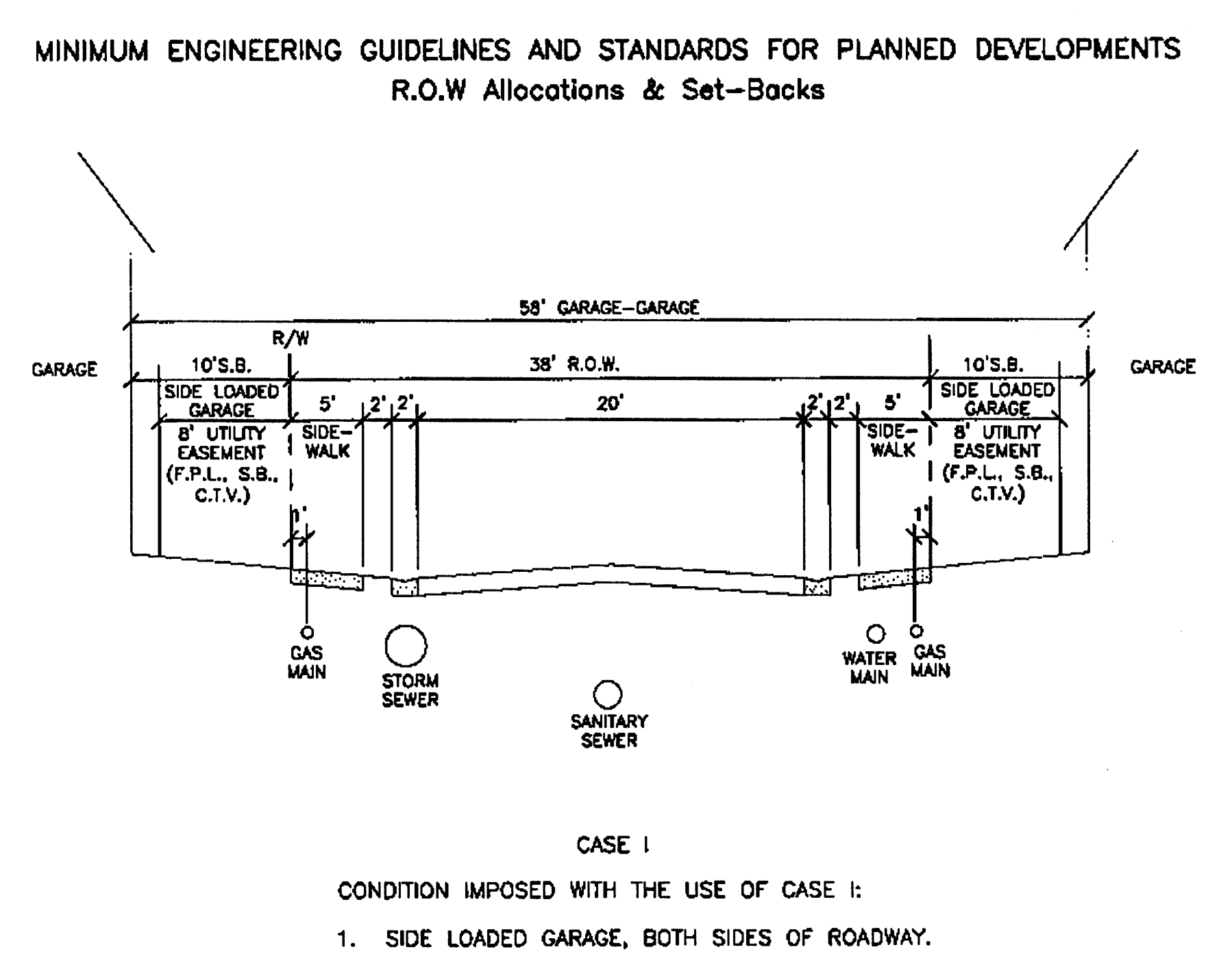
Figure 18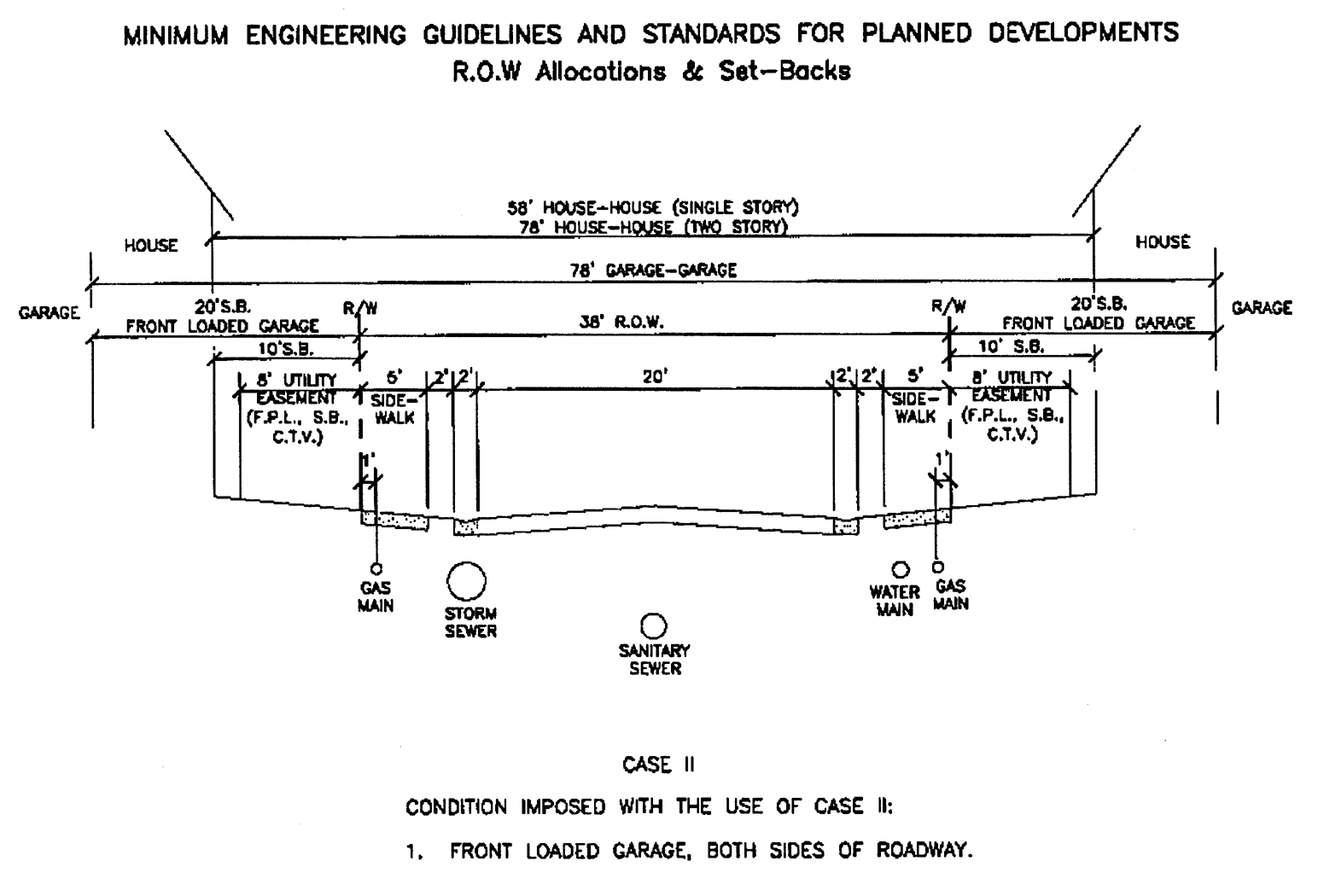
Figure 19
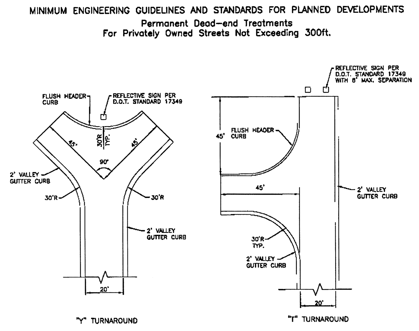
Figure 20
(Ord. No. 17-2000, § 248, 7-20-00; Ord. No. 36-2002, § 5, 10-17-02)
Sec. 78-499. - Flexible pavement.
Minimum standards for flexible pavement in a subdivision are established in Table 41.
Table 41: Minimum Standards for Flexible Pavement
(Ord. No. 17-2000, § 249, 7-20-00)
Sec. 78-500. - Railroads and limited access highways.
The standards listed below shall be applied when railroad rights-of-way and limited access highways are located so as to affect the subdivision of adjacent lands.
(1)
Buffer strip. In residential districts, each lot abutting railroad right-of-way or limited access highway shall include a buffer strip at least 25 feet in depth. The buffer strip shall be in addition to the normal width or depth of a lot required by property development regulations, and vegetation shall be installed pursuant to applicable portions of the landscaping requirements of section 78-319.
(2)
Intersections. Intersections of streets which parallel a railroad right-of-way and intersect with a street that provides a grade level crossing shall, to the extent practicable, be located a distance of at least 150 feet from the right-of-way. The actual distance of such intersections shall be determined with due consideration of the minimum distance required for future separation of grades by means of appropriate approach gradients.
(Ord. No. 17-2000, § 250, 7-20-00)
Sec. 78-501. - Culs-de-sac.
The minimum standards listed below are established for culs-de-sac.
(a)
No center island. A cul-de-sac without a center island shall have a minimum outside surfaced radius of 45 feet. The surface area shall consist of 43 feet of pavement and two feet of valley gutter.
(b)
Center island. A cul-de-sac with a center island shall have the same requirements as a cul-de-sac without a center island, but with the additional requirement that the maximum radius of the center island shall be 20 feet.
(c)
Larger outside radii. Pavement width for a cul-de-sac with larger outside radii will be reviewed on a case-by-case basis.
(d)
Terminating streets. Streets terminating in a cul-de-sac shall have a maximum length of 1,500 feet as measured from the intersecting right-of-way line. The city may approve a cul-de-sac more than 1,500 feet in length to serve odd-shaped parcels of land which cannot be developed in any other manner. Any cul-de-sac greater than 1,500 feet in length shall provide intermediate turnaround facilities acceptable to the city engineer.
(Ord. No. 17-2000, § 251, 7-20-00)
Sec. 78-502. - Privately-owned dead-end streets within planned developments.
(a)
Truncated dead-end streets.
(1)
Minimum standards. A truncated dead-end street may be used as a private street in a planned development, subject to the standards listed below.
a.
The street length shall not exceed 120 feet, as measured from the intersecting right-of-way lines.
b.
The street shall have a minimum pavement width of 24 feet or a minimum pavement width of 20 feet of pavement with two feet of valley gutter on both sides.
c.
The right-of-way width for the street shall comply with the minimum engineering guidelines and standards for planned developments.
d.
The street shall provide legal access to a group of not more than four residential lots.
e.
The street shall be subject to the approval of the growth management director and the city engineer.
(2)
Criteria for approval. The following criteria will be used to evaluate requests for approval of truncated dead-end streets.
a.
Lots situated adjacent to a curve or a corner where the lots would otherwise have no reasonable means of access to or required frontage on the adjacent street.
b.
Provision of adequate garbage and trash pickup services.
c.
Provision of adequate fire and rescue services.
d.
Conditions of the connecting intersection.
e.
Vertical and horizontal sight distances.
f.
Presence or absence of site lighting.
(b)
Streets not more than 300 feet in length. As an alternative to a cul-de-sac, dead-end streets not exceeding 300 feet in length, as measured from intersecting right-of-way lines and providing legal access to not more than 15 residential lots, will be permitted with a "T" or "Y" turnaround.
(c)
Streets more than 300 feet in length. Dead-end streets exceeding 300 feet in length and not exceeding 1,500 feet, shall be constructed with a cul-de-sac at the terminus. Culs-de-sac shall comply with the requirements provided herein.
(Ord. No. 17-2000, § 252, 7-20-00)
Sec. 78-503. - Maximum and minimum grade.
The grades on all streets in a subdivision shall comply with the standards listed below.
(a)
Maximum grade. Maximum grade shall not exceed 8.00 percent.
(b)
Minimum grade. Minimum grade shall be at least 0.30 percent.
(Ord. No. 17-2000, § 253, 7-20-00)
Sec. 78-504. - Vertical alignment.
(a)
Vertical curves required. Vertical curves of subdivision streets shall be required where the algebraic difference in intersecting grades equals or exceeds values listed in Table 42.
Table 42: Vertical Curves
(b)
Minimum length. All vertical curves shall be of sufficient length to provide a safe stopping sight distance compatible to the design speed of the roadway. Minimum length of all vertical curves shall be 100 feet.
(c)
Minimum slopes. Minimum cross slopes or super-elevation rates of 0.02 feet per foot (two percent feet per foot) shall be utilized for the design of all roadways.
(Ord. No. 17-2000, § 254, 7-20-00)
Sec. 78-505. - Horizontal alignment.
To ensure adequate sight distance and safe execution of the curve of a street in a subdivision, the minimum centerline radii for horizontal curves shall be as established by the FDOT Manual of Uniform Minimum Standards for Design, Construction, and Maintenance for Streets and Highways, as amended.
(Ord. No. 17-2000, § 255, 7-20-00)
Sec. 78-506. - Sidewalks.
Concrete sidewalks, at least five feet wide, shall be provided on each side of all streets in a subdivision and around the full circumference of all cul-de-sacs.
(Ord. No. 17-2000, § 256, 7-20-00; Ord. No. 5, 2024, § 26, 7-11-24)
Sec. 78-507. - Pathways.
Pathways within the parkway overlay zone or connected to it shall be of concrete and a minimum of 12 feet wide.
(Ord. No. 17-2000, § 257, 7-20-00)
Sec. 78-508. - Intersections.
(a)
General standards. Subdivision streets shall be laid out so as to intersect as nearly as possible at right angles. A proposed intersection of two new streets at an angle of less than 75 degrees shall not be acceptable unless specifically approved by the city engineer. An oblique street should be curved approaching an intersection and should be approximately at right angles for at least 100 feet therefrom. Not more than two streets shall intersect at one point.
(b)
New intersections. Proposed new intersections along one side of an existing street shall, wherever practicable, coincide with any existing intersections on the opposite side of such street. Street intersections with centerline separations of less than 150 feet shall not be permitted. Intersection of collector and arterial streets shall be at least 800 feet apart, centerline to centerline, wherever practicable.
(c)
Minimum curb cut radius. Minimum curb radius at the intersection of two local streets shall be at least 30 feet, and minimum curb radius at an intersection involving a collector street or industrial street shall be at least 40 feet.
(d)
Visibility. If visibility at a street intersection is limited by vegetation, berms, earth banks, or similar obstructions so as to create a traffic hazard, a visibility triangle shall be provided as indicated in Figures 21 and 22.
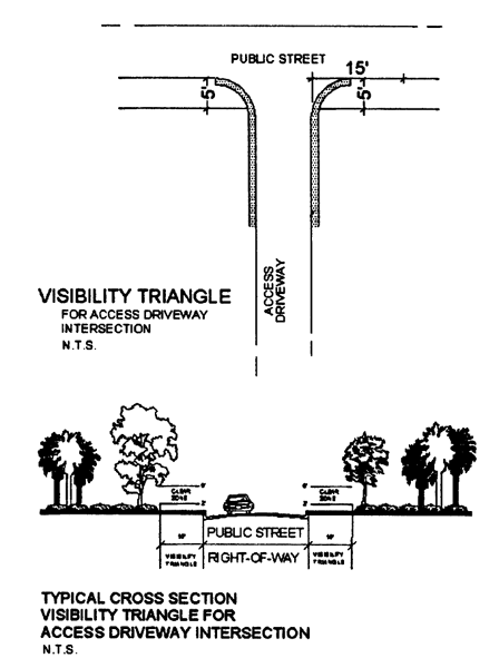
Figure 21
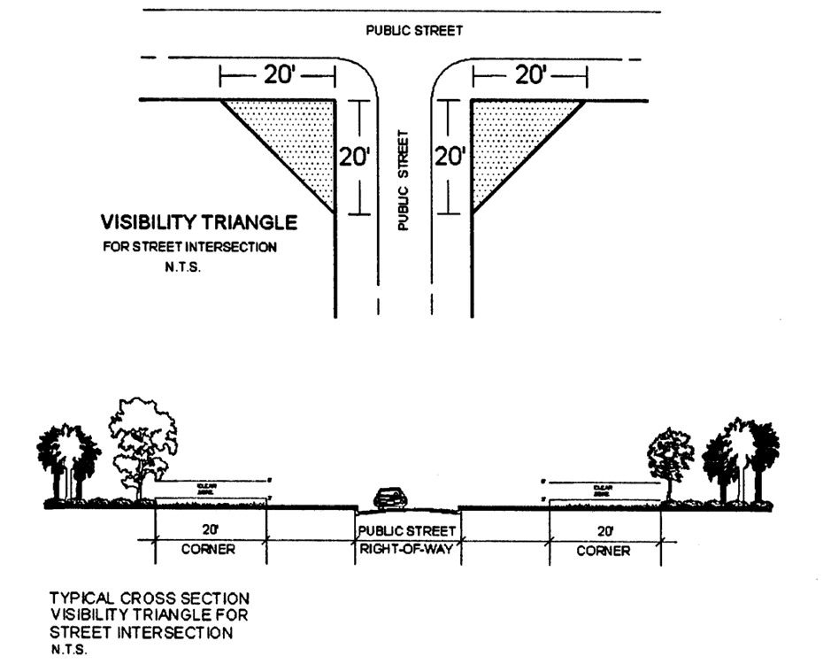
Figure 22
(Ord. No. 17-2000, § 258, 7-20-00)
Sec. 78-509. - Bridges.
In a subdivision, bridges of primary benefit to the property owner, as determined by the city, shall be constructed at the full expense of the owner without reimbursement from the city. A contribution by the city, if any, for the construction of bridges not of primary benefit to the applicant shall be established by an agreement between the city and the property owner.
(Ord. No. 17-2000, § 259, 7-20-00)
Sec. 78-510. - Utilities.
All new, reconstructed, or relocated utilities installed within a subdivision or any development, including but not limited to electric, telephone, and cable television, shall be placed underground.
(Ord. No. 17-2000, § 260, 7-20-00)
Part V. Street Dedications and Reservations
Sec. 78-511. - New perimeter streets.
Street systems in new subdivisions shall be laid out so as to eliminate the creation of perimeter half-streets. Where an existing half-street is adjacent to a new subdivision, the other half of the street shall be improved and dedicated by the responsible party.
(Ord. No. 17-2000, § 261, 7-20-00)
Sec. 78-512. - Widening and realignment of existing street.
(a)
Substandard street. When a subdivision borders an existing substandard street.
(b)
County road plan. When the county thoroughfare improvement map indicates long range plans for realignment or widening a street.
(c)
City comprehensive plan. When the city's comprehensive plan or zoning regulations indicate long range plans for realignment or widening a street.
(Ord. No. 17-2000, § 262, 7-20-00)
Sec. 78-521.- General requirements.
(a)
Design and installation. Each new development shall include a stormwater management system designed and installed that provides for pollution abatement and protection from flooding. Pollution abatement shall be accomplished by retention, detention, or other means, according to applicable regulations of the SFWMD, and as required by the city engineer. All project designs shall accommodate any "pass through" drainage as required from a basin analysis.
(b)
Maintenance. Each new residential or nonresidential development approval following the effective date of these land development regulations shall provide, in a form acceptable to the city attorney, for the perpetual maintenance of all drainage and stormwater management systems.
(Ord. No. 17-2000, § 263, 7-20-00)
Sec. 78-522. - Disposition of stormwater runoff.
(a)
All developments shall treat stormwater runoff as required by the SFWMD, as provided in section 78-521 herein. Treatment of stormwater runoff shall occur through one of the methods listed below.
(1)
Retention. Retention is defined as allowing no surface discharge.
(2)
Detention. Detention is defined as allowing delayed surface discharge prior to release.
(3)
Other. Other means that may be approved by the SFWMD and the city.
(b)
Allowable stormwater discharge.
(1)
Ten or more acres. The rate of stormwater discharge from a developed site shall be based upon a 25-year/three-day frequency storm event for developments greater than or equal to ten acres.
(2)
Less than ten acres. The rate of stormwater discharge from a developed site shall be based upon a 25-year/one-day frequency storm event for developments less than ten acres in size and meeting the qualifications for a permit exemption from SFWMD.
(c)
Legal positive outfall. When pollution abatement volumes and detention volumes to reduce the peak rate of discharge are incorporated into one facility, the volume of water impounded to reduce peak discharges in excess of the pollution abatement volume must be conveyed off site by a positive, legal, outfall system. Maximum allowable discharges shall be as determined by the SFWMD. Reduced discharge may be required by the city engineer. If a development is exempt from SFWMD permit requirements, the city engineer will determine allowable discharge.
(d)
Off-site easements. Off-site easements for stormwater management facilities shall be required in either of the two circumstances listed below.
(1)
Lack of easement or right-of-way. The stormwater discharge is directed or is proposed to be directed into any manmade facility for which the city does not have either a surface water management easement or right-of-way.
(2)
Character of discharge. The stormwater discharge or proposed to be directed into a natural system is of such nature that the rate or character of the flow, such as sheet flow as opposed to concentrated flow, at the property line has been changed. The easement will be required to a point at which natural conditions are approximated.
(3)
Debris and erosion control. Special engineering features to minimize the transport of floating debris, oil, and grease remaining in the detention volumes to reduce peak discharges shall be incorporated into the design of the outlet control structure. The design of this control system shall make adequate provision to minimize erosion.
(Ord. No. 17-2000, § 264, 7-20-00)
Sec. 78-523. - Design storm.
(a)
Design storm frequency. The design storm frequency for structures and facilities in a subdivision are established in Table 43.
Table 43: Design Storm Frequency for Structures
(b)
Increase in design frequency. The design frequency and storage requirements for surface water management systems may be increased at the discretion of the city engineer to protect upstream or downstream properties or to comply with other regulations.
(Ord. No. 17-2000, § 265, 7-20-00; Ord. No. 1-2002, § 3, 3-7-02)
Sec. 78-524. - Hydraulic design criteria.
Hydraulic design criteria for subdivisions is established below.
(1)
Roadway and pavement surface water management design.
a.
Generally. Good pavement surface water management design consists of the proper selection of grades, cross slopes, curb types, inlet location, etc., to remove the design storm rainfall from the pavement in a cost effective manner while preserving the safety, traffic capacity and integrity of the highway and street system. These factors are generally considered to be satisfied, provided that excessive spreads of the water are removed from vehicular travel ways and that siltation at pavement low points is not allowed to occur. The guidelines included in this section will accomplish these objectives.
b.
Swales. Swale drainage shall be permitted only when the wet season water table is a minimum of one foot below the invert of the swale. Swales are not permitted around any cul-de-sac.
c.
Curb and gutter types. All roadway storm runoff not considered suitable for swale or ditch type drainage shall be designed as one of the following:
1.
Valley gutter curb section; or
2.
Standard curb and gutter section.
d.
Design storm frequency. The design storm frequency to be utilized for the design of pavement drainage is established below.
1.
Arterial streets. Three-year FDOT zone 10, hydraulic gradient line one foot below inlet grate line.
2.
Collector and local streets. Three-year FDOT zone 10, hydraulic gradient line six inches below inlet grate line.
e.
Runoff determination. The peak rates of runoff, for which the pavement drainage must be designed, shall be determined by the rational method. The time of concentration, individual drainage areas, and rainfall intensity amounts shall be submitted as part of the drainage plan.
(2)
Storm sewer design. Storm sewer system design shall be based upon a three-year FDOT zone 10 frequency event. The system shall be designed to handle the flows from the contributory area within and outside of the proposed subdivision. All storm sewer pipe within public or private rights-of-way shall be reinforced concrete pipe and comply with applicable FDOT standards.
(Ord. No. 17-2000, § 266, 7-20-00)
Sec. 78-525. - Drainage plan requirements.
(a)
Drainage map. The project engineer shall include in the subdivision construction plans a master drainage map showing all existing and proposed features. The features and information listed below shall be included on the master drainage map.
(1)
Boundaries. Drainage bounds, including all off-site areas draining to the proposed subdivision.
(2)
Topography. Sufficient topographical information to verify the location of all elevations, streams, and similar features at one-foot contour intervals.
(3)
Highwater data. Highwater data on existing structures upstream and downstream of the subdivision.
(4)
Data source. Notes indicating sources of highwater data. If the development borders tidal waters, the mean high water line shall be established.
(5)
Notes. Notes pertaining to existing standing water, areas of heavy seepage, or springs.
(6)
Existing drainage. Existing drainage of the area and relationship to the overall basin.
(7)
Horizontal and vertical delineation. Subdivision layout with horizontal and vertical delineation.
(8)
Drainage features. Drainage features, including location of inlets, swales, retention/detention areas, and related features.
(9)
Subareas. Delineation of drainage subareas.
(10)
Retention/detention. Identification of retention/detention areas and ingress/egress areas for retention/detention facilities.
(11)
Soils. Delineation of type of soils on a soils map of the project using the United States Department of Agriculture (USDA) Soil Conservation Service (SCS) soil type classification system.
(12)
Flood hazard. Flood hazard classification.
(13)
Ground cover. Description of existing ground cover or land uses.
(14)
Turbidity control. Description of turbidity control and stabilization of disturbed areas during the construction process.
(b)
Stormwater calculations. Stormwater calculations for storm sewer pipes shall include but not be limited to the tabulations listed below.
(1)
Structures. Location and types of structures.
(2)
Lines. Types and lengths of line.
(3)
Subareas. Drainage subarea tributary to each structure.
(4)
Coefficients. Runoff coefficient per subarea.
(5)
Concentration. Time of concentration to structure.
(6)
Hydraulic gradient. Hydraulic gradient for the three-year, FDOT zone 10 frequency storm event.
(7)
Tailwater. Estimated receiving water (tailwater) elevation with sources of information, if available.
(8)
Pipes. Diameters of pipe.
(9)
Velocities. Outlet and other pipe velocities.
(Ord. No. 17-2000, § 267, 7-20-00)
Sec. 78-541.- General requirements.
(a)
Potable water.
(1)
Public water supply not available. When a public water supply main is not accessible to a subdivision, the responsible party shall take necessary action to extend the main or create a private entity for the purpose of providing a water supply system capable of providing for domestic water supply use and fire protection. Extension of the main and connection to the public water system shall be required consistent with standards of the Palm Beach County Health Department or Seacoast Utilities Authority, as may be applicable.
(2)
Public water supply available. When a public water supply main is accessible, the applicant shall install adequate water supply facilities, including fire hydrants, subject to the specifications of Seacoast Utilities and the Palm Beach County Health Department.
(b)
Extensions. Water supply main extensions shall be consistent with the extension policy of Seacoast Utilities Authority.
(c)
Location of improvements. The location of all fire hydrants and all water supply improvements shall be shown on the utilities construction plans.
(d)
Cost of installation. The cost of installing fire hydrants and water supply improvements shall be borne by the responsible party. The estimated costs of installation shall be included in the surety to be furnished by the responsible party.
(Ord. No. 17-2000, § 274, 7-20-00)
Sec. 78-542. - Individual wells.
In residential projects with a minimum lot size of one acre, excluding roads, drainage, and utility easements, and where a public water supply system is not available, individual wells may be used to provide an adequate supply of potable water supply to each lot. Individual wells shall be approved by the Palm Beach County Health Department or as otherwise required by state law. Approvals by the health department of individual wells shall be submitted to the city prior to plat approval. Individual wells shall not be permitted as a source of water supply in nonresidential subdivisions.
(Ord. No. 17-2000, § 275, 7-20-00)
Sec. 78-543. - Fire protection water supply.
(a)
Fire protection water supply. The water supply system of the subdivision shall be designed and constructed to satisfy both the domestic potable requirements and the fire protection requirements in effect at the time of subdivision plan or plat review.
(b)
Residential fire hydrants.
(1)
Connections. Hydrants located within single-family and duplex or two-family residential subdivisions shall be connected to water mains at least eight inches in diameter. Connection to dead-end stubs may be acceptable, providing the required fire flow can be achieved.
(2)
Spacing. In no case shall residential hydrant spacing exceed 500 feet, measured along the roadway. Buildings intended for occupancy shall not be located more than 250 feet in distance from the nearest hydrant.
(c)
Nonresidential and multifamily residential requirements.
(1)
Connections. The hydrant shall connect to water mains of adequate size, as determined by the city engineer, to meet the design flow demand.
(2)
Spacing. Hydrants located in commercial, multifamily, industrial, or other nonresidential areas shall be spaced no further than 300 feet apart as measured along the roadway.
(Ord. No. 17-2000, § 276, 7-20-00)
Sec. 78-551.- Central system design.
The development of new wastewater facilities and mains in the subdivision and the expansion of existing wastewater systems shall be designed by the applicant's engineer in accordance with all applicable state and local criteria.
(Ord. No. 17-2000, § 277, 7-20-00)
Sec. 78-552. - Individual system.
(a)
Individual systems allowed. Where permitted by the Palm Beach County Health Department, individual wastewater treatment systems may be allowed where public wastewater collection and treatment systems are not available. Individual wastewater systems shall comply will all requirements of the appropriate health authorities. Septic tanks or drainfields shall not be located in rights-of-way or easements.
(b)
Public wastewater treatment not available. When a public wastewater collection is not accessible to a subdivision, the responsible party may install individual treatment systems, as provided in this section. Extension of the collection system and connection to the public wastewater treatment system shall be required consistent with standards of the Palm Beach County Health Department or Seacoast Utilities Authority, as may be applicable.
(c)
Public wastewater treatment system available. When a public wastewater collection system is accessible, the applicant shall install adequate collection facilities, subject to the specifications of Seacoast Utilities and the Palm Beach County Health Department.
(d)
Extensions. Water supply main extensions shall be consistent with the extension policy of Seacoast Utilities Authority.
(Ord. No. 17-2000, § 278, 7-20-00)
Sec. 78-553. - Wastewater reuse.
Wherever possible, irrigation of landscaped areas in a subdivision shall be accomplished by use of treated effluent or reclaimed water from wastewater treatment systems.
(Ord. No. 17-2000, § 279, 7-20-00)
Sec. 78-561.- Utility easements.
Utility easements of adequate width shall be provided in the subdivision, where necessary, to accommodate all required utilities and shall be provided with convenient access for maintenance.
(Ord. No. 17-2000, § 280, 7-20-00)
Sec. 78-562. - Drainage easements.
(a)
Easement required. When a subdivision is traversed by a canal, watercourse, drainage way, channel, or stream, a drainage easement or right-of-way shall be provided. The easement shall substantially conform to the lines of the canal or watercourse. The easement shall be of such width and construction or both as will be adequate for the purpose. Wherever possible, surface water runoff should be maintained by an open channel with adequate width for access and maintenance. The open channel shall be of an adequate width for maximum potential volume of flow, plus required areas for operations and maintenance.
(b)
Street rights-of-way. If drainage facilities are located within street rights-of-way, perpetual unobstructed easements of adequate width for such drainage facilities shall be provided across property outside the right-of-way lines and with satisfactory access to the right-of-way. Easements shall be indicated on the plat. Drainage easements shall be carried from the street to a natural watercourse or to other drainage facilities.
(c)
Private property. When a proposed drainage system will carry water across private land outside the subdivision, drainage rights must be secured and indicated on the plat.
(d)
Dedication. The responsible party shall dedicate, by fee simple title, by drainage easement, by conservation easement, or other means acceptable to the city, land on both sides of existing canals or watercourses, to a distance to be determined by the city.
(e)
Surface water management areas. Low-lying lands along watercourses subject to flooding or overflowing during storm periods, whether or not included in areas for dedication, shall be preserved and retained in their natural state as surface water management ways. Surface water management areas subject to periodic flooding shall not be included in land area necessary to comply with minimum lot dimensional requirements.
(Ord. No. 17-2000, § 281, 7-20-00)
Sec. 78-563. - Lake maintenance tracts.
(a)
Purpose. A lake maintenance tract shall be provided along the edge of all permanent lakes and water bodies included in a subdivision or plat as a common feature. The purpose of the tract is to provide permanent access for all operational, repair, or maintenance activities related to such water bodies.
(b)
Creation as a separate tract. Within all subdivisions or plats, a lake maintenance tract shall be created as a separate parcel around all lakes and water bodies created as a common feature. However, the city council may approve a reduction in the required lake maintenance tract to allow such improvements as the installation of permanent recreational facilities.
(c)
Minimum dimensions. A lake maintenance tract shall be at least 20 feet wide, with a minimum slope of 8:1 or as required by the city engineer.
(d)
Access to lake maintenance tract. In addition to creation of separate lake maintenance tracts, each subdivision or plat shall create a permanent means of access to such tracts. The access shall be provided in a manner acceptable to the city engineer.
(e)
Improvements prohibited. Owners of property abutting a lake maintenance tract are prohibited from installation of permanent improvements within a lake maintenance easement. The easement holder may allow, subject to removal agreements, the installation of nonpermanent improvements such as recreational equipment, excluding pools and similar improvements, which can be easily moved to allow maintenance and repair activities.
(Ord. No. 17-2000, § 282, 7-20-00)
Sec. 78-571.- Recreation standards.
(a)
Dedication required. All residential developments shall dedicate park and recreation areas as required in the comprehensive plan and this subdivision.
(b)
General requirements. Park and recreation sites shall comply with the general requirements listed below.
(1)
Character. Each site shall be of suitable size, dimension, topography, and general character for the purpose intended.
(2)
Access. Each site shall have adequate road access, parking, utilities, and drainage available for the purpose intended.
(3)
Restrictions. Each site shall not be subject to restricted easements.
(4)
Location on plat. The area to be dedicated shall be specifically located on a plat as "reserved for park or recreation purposes."
(Ord. No. 17-2000, § 283, 7-20-00; Ord. No. 1, 2011, § 1(Exh. A), 2-3-11)
Sec. 78-572. - Recreation sites.
(a)
Purpose and intent. The City of Palm Beach Gardens desires to provide its current and future citizens with a broad range of parks, open space, and recreational areas. In the interest of personal health, quality of life, and entertainment, it is important that both passive and active recreation opportunities are provided within residential developments.
(b)
Applicability. All sections of this division shall be effective within the incorporated area of the city for all new multifamily residential developments and zero lot line residential homes after February 3, 2011.
(c)
Character. Land reserved for dedication for recreation purposes shall be of a character and location suitable for use as a playground, play field, ball field, or for other public recreation purposes. Land reserved for dedication shall be relatively level and dry.
(d)
Improvements. Land dedicated for park purposes shall be improved by the responsible party to standards established by the city. Required improvements may be established by the comprehensive plan, the requirements of this division, or by condition of development order approval.
(e)
Development regulations.
(1)
At least one (1) neighborhood park shall be located within one-quarter (¼) mile radius of each residential home within the proposed development. Adjustments to the one-quarter (¼) mile standard may be considered during the site plan review process.
a.
Minimum size. Each neighborhood park shall be no less than one (1) acre in size.
b.
Urban area parks. Those neighborhood parks proposed within dense mixed-use centers that include a mix of vertical integration shall be allowed to provide a reduced acreage of one-third (⅓) acre within a one-quarter (¼) mile radius of each residential home within the proposed development. Evaluation of these areas shall be done at the site plan review level and approved at the discretion of the growth management administrator.
c.
Preserve areas and natural park credit. Up to fifty (50) percent of the neighborhood park requirement can be satisfied using the provided preserve acreage, so long as internal pedestrian amenities, such as walking trails, are incorporated into the preserve area in accordance with section 78-250. Preserve area requirements of the LDRs.
d.
Lake area credit. Up to forty (40) percent of the neighborhood park requirement can be satisfied using lake areas that have incorporated linear pedestrian trails and other hardscape amenities that engage the views of the lake.
e.
Clubhouse facilities credit. Clubhouse facilities and other similar type amenities which provide recreational opportunities to the surrounding residents can be counted towards the neighborhood park requirement. The clubhouse facility acreage shall be calculated by the total building footprint, including covered areas with a permanent roof, pool area, and any area around the clubhouse facilities that includes a patio and/or deck area.
f.
Golf course credit. Up to thirty-five (35) percent of the neighborhood park requirements can be satisfied using any provided golf course acreage.
(2)
Maintenance, ownership, and operation of all parks provided within the project shall be the responsibility of the master property owners association or other entity as approved by the city attorney. Prior to the first plat approval of the proposed development, the applicant shall demonstrate this requirement has been met.
(Ord. No. 17-2000, § 284, 7-20-00; Ord. No. 1, 2011, § 1(Exh. A), 2-3-11)
Sec. 78-573. - Payment in lieu of land.
(a)
Payment in lieu of land. If a proposed subdivision, due to size or location, cannot provide an appropriate or desirable dedicated park or recreation area, the responsible party shall be required, prior to approval of the plat, to provide the city with a cash payment in lieu of land dedication.
(b)
Payments. Cash payments in lieu of land dedication shall be placed in the recreational land fund of the city. The funds shall be used by the city for improvement of a park, playground, or recreation area, including the acquisition of property. The deposit must be used for facilities that will mitigate the recreational impacts of the submission.
(c)
Amount of payment. The city shall determine the amount of payment. The payment amount shall be based upon the report of a qualified appraiser appointed jointly by the city and the responsible party, or by any other method acceptable to both parties. The responsible party shall be pay all costs associated with determining the amount of payment. Value of the land shall reflect development approvals granted by the city.
(Ord. No. 17-2000, § 285, 7-20-00)
Sec. 78-574. - Other recreation reservations.
(a)
Minimum requirements. The recreational requirements of this section are the minimum standards for providing recreational facilities based upon anticipated demand. Nothing in this section shall be construed as prohibiting a responsible party from dedicating other land, reserving other land, increasing the acreage of existing parks, or increasing the facilities at the existing parks, in addition to the requirements contained herein.
(b)
Nonresidential requirements. The city may require nonresidential developments to dedicate land or payment in lieu of land for recreational facilities.
(Ord. No. 17-2000, § 286, 7-20-00)
Sec. 78-575. - Other public uses.
(a)
Other public uses. Except when an applicant utilizes a PUD in which land is dedicated or reserved as required by the operation of these land development regulations, a subdivision plan may include a school site, recreation uses in excess of the requirements of division 2 of article III, or other public use as indicated in the comprehensive plan. The land area for such public uses shall be incorporated into the subdivision plan or plat after one of the following occurs:
(1)
A determination of public need or necessity by the city;
(2)
A determination of public need or necessity by other public agencies involved in the potential acquisition and use of such site; and
(3)
A determination has been made to acquire the site by the city or by the affected public agency or agencies.
(b)
Referral to public body. The city shall refer the subdivision plan to the public body concerned with acquisition of a site for its consideration and report. The city may propose alternate areas for such acquisition and shall allow the public body or agency 30 days for reply. The agency's recommendation, if affirmative, shall include a map showing the boundaries and area of the parcel to be acquired and an estimate of the time required to complete the acquisition.
(c)
Notice to property owner. Upon a receipt of the public agency's recommendation, the city shall notify the property owner and shall designate on the plat that area proposed to be acquired.
(d)
Duration of land reservation. The acquisition of land reserved by a public agency on a plat shall be initiated within 12 months following written notification by the property owner of the intent to develop all or a portion of the reserved parcel. The written notification shall be accompanied by a proposed plat of the property and a tentative schedule of construction. Failure on the part of the public agency to initiate acquisition within the prescribed 12 months shall result in the removal of the "reserved" designation from the property involved. Once the "reserved" designation is removed, the property may be developed consistent with this chapter.
(Ord. No. 17-2000, § 287, 7-20-00)
Sec. 78-581.- Preservation.
Existing natural resources which are within the area of the proposed subdivision and which are environmentally sensitive or significant shall be preserved through the design of the subdivision as provided in division 4 of article V and subdivision IV of this division. Examples of these natural resources or features are specimen trees, groves, designated conservation areas, waterways, scenic points, community landmarks, archaeological and historic sites, historical buildings, and similar irreplaceable physical assets.
(Ord. No. 17-2000, § 288, 7-20-00)
Sec. 78-591.- Resubdivision of land.
Resubdivision shall be subject to the same procedures prescribed for the subdivision of land.
(a)
Required. Resubdivision shall be required when the applicant proposes to make any of the changes listed below.
(1)
Streets and improvements. Changes to an approved street layout or the provision of public improvements.
(2)
Lot lines. Changes to existing lot lines.
(3)
Public or common lands. Changes in the amount or location of land reserved for public use or land reserved for the common use of lot owners.
(4)
Dedicated lands. Changes in the amount or location of land proposed to be dedicated to the city or other public entities.
(5)
Easements. Changes in the width, location, use, or other factors affecting the potential use of easements.
(b)
Resubdivision procedures. If a plat shows one or more lots containing more than one acre of land and there is reason to believe that such lots will likely be resubdivided, the city may require that the applicant allow for the future opening of streets and the ultimate extension of adjacent streets and provide easements for same.
(Ord. No. 17-2000, § 289, 7-20-00)
Sec. 78-592. - Metes and bounds subdivisions.
Following approval of a boundary plat affecting a nonresidential use or a nonresidential portion of a planned development, PUD, or PCD, the property owner may further subdivide the site by metes and bounds. Further subdivision of a boundary plat by a metes and bounds description does not require approval by the city council. However, creation of one or more additional parcels shall require approval by the growth management director and city engineer. Creation of an additional parcel or parcels within a PUD or PCD shall include the items listed below.
(a)
Unity of control. Creation of a unity of control, in a form acceptable to the city attorney, to ensure the parcel or parcels remain included within the overall development.
(b)
Conditions of approval. Execution of an affidavit, in a form acceptable to the city attorney, that the parcel or parcels will be subject to all applicable conditions of approval.
(c)
Common access and maintenance. Acknowledgment, in a form acceptable to the city attorney, that:
(1)
The parcel or parcels will remain a portion of an overall approved master plan or site plan;
(2)
The owners of the parcel or parcels will retain perpetual access to all common areas, vehicular access, parking, pedestrian and vehicular circulation areas, vehicular use areas, and similar common elements; and
(3)
The owners of the parcel or parcels will retain responsibility for participation in common area maintenance of the development in which such properties are located.
(Ord. No. 17-2000, § 290, 7-20-00)
Sec. 78-593. - Plat vacation.
(a)
Owner-initiated plat vacation. The owner or owners of lots in an approved subdivision may submit a development order application to the city council for vacation of the plat with respect to their properties.
(1)
Criteria. The city manager may approve the application for vacation on such terms and conditions as are reasonable to protect public health, safety and welfare. However, the city manager shall not approve a petition for vacation if the approval will materially injure any public rights or the rights of a property owner who does not consent to the plat vacation.
(2)
Recordation of revised plat. When a plat vacation is approved, a revised plat shall be prepared consistent with the requirements of this section. The revised plat shall be recorded pursuant to the procedure established for an original plat, or as otherwise approved by the city engineer and growth management director.
(b)
Developer-initiated plat vacation. The developer or owner of all of the lots in a subdivision may submit a development order application for vacation of the plat. The application may be approved, approved with conditions, or denied by the city manager subject to the criteria of subsection 78-593(c) herein. Notwithstanding the city manager's action on the application, the developer or owner shall have no right to a refund of any monies, fees, or charges paid to the city nor to the return of any property dedicated to the city or other public entity.
(c)
Government-initiated plat vacation.
(1)
Conditions. The city council, on its own motion, may order the vacation of all or any part of the plat of approved subdivision subject to all of the conditions listed below.
a.
No lots in the subdivision have been sold within five years from the date that the plat was signed by the mayor or city manager.
b.
The developer has breached the development order and the city is unable to obtain the funds to complete construction of required public improvements. However, the vacation shall apply only to lots owned by the developer or successor.
c.
The plat has been of record for more than five years and the city council determines that the further sale of lots within the subdivision presents a threat to public health, safety, and welfare. However, the vacation shall apply only to lots owned by the developer or successor.
(2)
Procedure. Prior to any action by the city council to order vacation, in whole or in part, of the plat of an approved subdivision, a notice in a newspaper of general circulation shall be published and personal notice by certified mail to all property owners in the subdivision shall be provided. The notice shall state the time and place for a public hearing on the vacation of the plat. The city council shall approve the plat vacation pursuant to the criteria in subsection 78-593(c) herein.
(3)
Recordation of notice. If the city council vacates a plat, in whole or in part, on its own initiative, a copy of the resolution shall be recorded with the clerk of the circuit court. If the vacation is for part of the subdivision, the city shall prepare and record a revised plat indicating both the portion of the original plat that has been vacated and the portion that has not been vacated.
(Ord. No. 17-2000, § 291, 7-20-00; Ord. No. 14, 2025, § 13, 10-9-25)
Subdivision III. - Transportation Studies[13]
Editor's note— Ord. No. 9, 2020, § 19, adopted Sept. 10, 2020, changed the title of subdiv. III from "Traffic Impact Studies" to "Transportation Studies".
Sec. 78-661.- Performance standards.
(a)
Applicability. The performance standards in this section shall apply to all uses in the city. Each use shall be constructed, maintained, and operated to protect occupants of adjacent premises from injurious or obnoxious effects from the emission or creation of noise, vibration, smoke, dust or other particulate matter, toxic or noxious waste materials, odors, fire and explosive hazards, or glare.
(b)
Noise. Equivalent sound levels shall not exceed the standards listed below when measured at the property line.
(1)
Residential. If the source creating the noise is residential:
a.
Between 8:00 a.m. and 11:00 p.m.: 60 dBA; and
b.
Between 11:00 p.m. and 8:00 a.m.: 50 dBA.
(2)
Non-residential. If the source creating the noise is non-residential:
a.
Between 8:00 a.m. and 11:00 p.m.: 65 dBA; and
b.
Between 11:00 p.m. and 8:00 a.m.: 60 dBA.
(3)
Industrial. If the use receiving noise is industrial: anytime, 75 dBA.
(4)
Exemption. Noises from temporary construction and maintenance activities between 7:00 a.m. and 9:00 p.m., except Sundays and federal holidays, are exempt from this standard.
(c)
Odor. A use or activity shall not generate any odor which is offensive at the property line and beyond. Odors from temporary construction and maintenance activities between 7:00 a.m. and 9:00 p.m., except Sundays and federal holidays, are exempt from this standard.
(d)
Glare or heat. Any operation producing intense glare or heat shall be performed within a completely enclosed building. Such operation will not produce heat or glare beyond the property line of the lot on which the operation is located.
(e)
Radiation. Any activity involving ionizing radiation shall not be permitted which will cause radiation at any point at or beyond any lot line in excess of limits contained in United States Department of Energy rules and regulations.
(f)
Vibration. Every use shall be operated in such a manner that the ground vibrations inherently and recurrently generated are not perceptible without instruments at any point at or beyond any lot line on which the use is located. Vibrations from temporary construction and maintenance activities between 7:00 a.m. and 9:00 p.m., except Sundays and federal holidays, are exempt from this standard.
(g)
Smoke. Every use shall be operated in such manner as to prevent the emission of smoke as specified in the applicable air quality and related provisions of the Florida Administrative Code, as administered by the Palm Beach County Health Department and the Florida Department of Environmental Protection.
(h)
Dust and dirt. Every use shall be operated in such manner as to prevent the emission into the air of dust or other solid matter, which may cause damage to property or discomfort to persons or animals at or beyond the lot line of the property on which the use is located. Dust and dirt emission from temporary construction and maintenance activities between 7:00 a.m. and 9:00 p.m., except Sundays and federal holidays, are exempt from this standard.
(i)
Toxic or noxious matter. Toxic or noxious matters shall not be discharged in such concentration so as to be detrimental to or endanger the public health, safety, comfort or welfare or cause injury or damage to property or business.
(j)
Fire and explosion hazard. All industrial and commercial activities shall occur in such a manner and with such precautions against fire and explosion hazards as to produce no explosion hazard to a use on adjacent property. Storage of combustible materials shall comply with all building and fire prevention codes. Materials or products which produce flammable or explosive vapors under ordinary weather temperatures shall be adequately safeguarded.
(k)
Liquid or solid waste.
(1)
Liquid wastes. Liquid materials shall not be discharged into a wastewater treatment system, septic tank, body of water, or into the ground if such discharge is of a nature or temperature that will result in water supply contamination or emit dangerous or objectionable elements. Discharge of all liquid materials shall comply with applicable federal, state, county, or city laws.
(2)
Solid waste. The accumulation of solid waste conducive to the breeding of rodents or insects is prohibited. Solid waste shall be stored and disposed of in a manner consistent with federal, state, county, or city laws.
(3)
Treatment plants. Effluent from water or wastewater treatment plants shall comply with applicable federal, state, or county laws.
(l)
Electromagnetic interference. Activities shall not be permitted, except domestic household appliance use, which produce electromagnetic interference in excess of standards adopted by the Federal Communications Commission.
(Ord. No. 17-2000, § 306, 7-20-00; Ord. No. 19, 2010, § 5(Exh. D), 10-21-10; Ord. No. 7, 2017, § 28, 3-2-17)
Sec. 78-681.- Open space.
(a)
Intent. Pursuant to the city comprehensive plan and these land development regulations, open space shall be provided within all developments approved by the city. The policies of the comprehensive plan require the protection of designated conservation areas and the creation of parks and recreation facilities.
(b)
Open space criteria. The following areas listed below qualify wholly or partially as open space.
(1)
Recreation facilities. Recreation facilities may be calculated as a portion of open space requirements subject to the criteria listed below.
a.
If a recreation facility is located or concentrated in a single or localized section of a PUD or other approved development, and less than 30 percent of the residential dwelling units abut the facility, only 50 percent of the area contained in the facility may count toward complying with open space requirements.
b.
If the recreation facility or facilities are dispersed throughout a PUD or other approved development, and between 30 percent and 60 percent of the residential dwelling units abut such facilities, 75 percent of the area contained in the facility may count toward complying with open space requirements.
c.
If more than 60 percent of the residential dwelling units abut the recreation facility of facilities, 100 percent of the area contained in the facility may count toward complying with open space requirements.
(2)
Water bodies. Water bodies may be calculated as a portion of open space requirements subject to the criteria listed below.
a.
50 percent of the area contained in manmade water bodies and canals with average water widths less than 60 feet may count toward complying with open space requirements.
b.
100 percent of the area contained in manmade canals or water bodies with average water width wider than 60 feet may count toward complying with open space requirements.
c.
Manmade water bodies and canals, however, shall not account for more than 50 percent of the required open space in a development.
d.
Public waterways, water bodies, and canals shall not be used to comply with open space requirements.
e.
If a water body is natural and the shoreline vegetation will not be disturbed by the development, 100 percent of the portion of the water body located on the development site may be counted to comply with open space requirements.
(3)
Environmentally sensitive lands. Environmentally sensitive areas, including natural habitats of unique and significant value, may be calculated as a portion of open space requirements subject, to the criteria listed below.
a.
If natural habitats of unique and significant value are determined to exist, such areas shall be identified and left in an undisturbed state. These areas shall be adequately protected or incorporated into the design of the PUD as a preserve area with a minimum of improvements permitted, consistent with division 4 of article V. The total area so preserved may be counted as complying with open space requirements.
b.
Preserved lands shall not make up more than 50 percent of the required open space, unless otherwise approved by the city council.
(4)
Pedestrian areas. The total area in a continuous open space pedestrian system consisting of permanently maintained walks and trails six to 12 feet wide leading to a natural amenity, recreation facility, or commercial use, and allowing non-motorized vehicular transportation may be counted as complying with open space requirements
(5)
Public parks. The total area contained in public parks may be counted as complying with open space requirements.
(6)
Private lands. Private lands may be calculated as a portion of open space requirements subject to the criteria listed below.
a.
Private lands include any privately maintained or privately owned exterior open space adjacent to and for the exclusive use by the residents of the individual dwelling unit.
b.
Private open space may be enclosed or partially enclosed by walls, hedges, buildings or structures.
c.
Private open space includes, but is not limited to, balconies, terraces, porches, decks, patios, and atriums, and may be counted toward complying with open space requirements.
d.
The total area contained in private exterior open spaces shall not exceed five percent of the gross area of the PUD and shall not decrease the amount of ground level open space below that acreage equal to 35 percent of the gross area of the PUD.
e.
All pervious land areas between the property or lot lines and the buildings within the development shall count as open space, except as otherwise provided.
f.
The area contained in public or private street rights-of-way is not considered as open space and receives no credit toward complying with open space requirements.
(c)
Management and maintenance. Legal instruments, acceptable to the city attorney, which ensure adequate management and maintenance of an open space area and all areas subject to common ownership must be provided by the developer prior to initial building permit approval. Legal instruments provided for dedications, covenants, community associations, and subdivision controls shall include all provisions listed below.
(1)
Title. Place title of common property in a form of common ownership by the fee simple property owners of the PUD, such as a duly constituted and legally responsible community association, cooperative, and the like.
(2)
Community property. Regulate the use of common property.
(3)
Management and maintenance. Place responsibility for management and maintenance of common property. The city council, at its discretion, may require the applicant to enter into a contract with the city for maintenance of commonly held properties.
(4)
Enforcement. Place responsibility for enforcement of covenants.
(5)
Assessments. Provide for the assessment of each lot by the governing association for its proportionate share of maintenance costs.
(d)
Parkway system. Any development fronting on a road designated as a parkway shall install or develop a buffered multi-use pathway as provided in the comprehensive plan and division 3 of article V. The parkway shall include landscaped medians, a 12-foot pathway, and landscaped greenbelts. Preservation of native vegetation is encouraged.
(Ord. No. 17-2000, § 307, 7-20-00; Ord. No. 1, 2011, § 1(Exh. A), 2-3-11)
Sec. 78-682. - Historical and archaeological sites.
(a)
Designation. The criteria listed below shall be used to designate a site of historical or archaeological significance in the city.
(1)
National listing. A site located in the city that is listed in the National Register of Historic Places maintained by the U.S. Department of the Interior pursuant to the Historic Preservation Act of 1966, as amended.
(2)
State listing. A site located in the City that is listed in the state master file maintained by the Bureau of Archaeological Research, Florida Department of State.
(3)
A site that is located in the city that has been officially designated by city council as a historic and/or archaeological site. In making such a designation, city council shall consider, but not be limited to, the following standards:
a.
The significance of the site as a landmark.
b.
The role of the site in the city's history or archaeological past.
The city shall encourage that these sites be maintained in their historic and/or archeologically significant state, and not be altered, threatened, or removed.
(4)
The following is a list of sites, which have been designated as historic and/or archaeological sites per the standards herein:
a.
MacArthur Banyan Tree, located in the median on MacArthur Boulevard, just north of Northlake Boulevard.
(b)
Application. Any development activity on a property that contains a site of historical and archaeological significance as defined in this subsection shall be subject to the prevailing city, state and federal regulations.
(Ord. No. 17-2000, § 308, 7-20-00; Ord. No. 3-2003, § 2, 2-6-03)
Sec. 78-683. - MacArthur Banyan Tree Historic Overlay Protection Zone.
(a)
Purpose and intent. The MacArthur Boulevard Banyan Tree is actually two trees that have grown together. The trees are located at the entrance to the City of Palm Beach Gardens and have a unique history. City Founder John D. MacArthur had these trees planted at their current location in the early 1960's, and they have become an identifying landmark of the city. The first tree dates back to approximately 1881, and was planted at its current location in April of 1961. The second tree was planted at its current location a couple of years later. The intent of this section is to implement protective measures that preserve and enhance the MacArthur Banyan Tree for current residents and future generations.
(b)
Protection zone established. The MacArthur Banyan Tree Historic Overlay Protection Zone is hereby established and shall encompass the area located within 200 feet of the drip line of the MacArthur Banyan Tree located in the median of MacArthur Boulevard approximately 150 feet north of Northlake Boulevard.
(c)
Protection zone guidelines.
(1)
For the purposes of this section, the term "kill or damage" will include, but not be limited to, the following:
a.
Killing or removing the MacArthur Banyan Tree (the "tree"); or
b.
Damaging the body of the tree or its root structure through modifications of existing drainage patterns, water table, road, hydro period, or existing grade; or
c.
Causing the tree or its branches to come in contact with any structure, vehicle, or utility facility.
(2)
No clearing or development shall occur within the MacArthur Banyan Tree Historic Overlay Protection Zone unless approved by city council. Applications to clear or develop within the MacArthur Banyan Tree Historic Overlay Protection Zone shall not be considered complete unless submitted with comprehensive analysis, prepared by a duly authorized environmental consultant, arborist or related landscape specialist, detailing the impact of the proposed clearing or development on the MacArthur Banyan Tree. The city may, in its discretion, obtain an independent analysis at the applicant's expense.
(3)
Pruning of the MacArthur Banyan Tree is prohibited unless expressly authorized by the city.
(4)
Any activity which kills or damages the MacArthur Banyan Tree, whether intentional or not, shall be considered a violation of this section. Such activity may include, but is not limited to, improvements or maintenance to roads or drainage systems.
(5)
Road widening shall be prohibited within the MacArthur Banyan Tree Historic Overlay Protection Zone unless it can be demonstrated that such widening will not kill or damage the tree. Any road improvements conducted within the MacArthur Banyan Tree Historic Overlay Protection Zone shall use pervious concrete in the resurfacing of the roadway (unless otherwise approved the city engineer).
(6)
No utilities (above ground or below ground) shall be permitted above or within the crown of the MacArthur Banyan Tree, or within the root zone of the MacArthur Banyan Tree.
(7)
Development which occurs within the MacArthur Banyan Tree Historic Overlay Protection Zone shall provide for a substantial gateway design to the entrance of the city at that location, on both sides of MacArthur Boulevard, including, but not limited to, the use of hardscapes and landscaping.
(d)
Enforcement. The city shall enforce violations of this section by any and all means available.
(Ord. No. 3-2003, § 3, 2-6-03)
Sec. 78-701.- Purpose.
The purpose of these newsrack regulations is to promote the public health, safety, and welfare through the regulation of placement, type, appearance, servicing, and insuring of modular newsracks within the public rights-of-way so as to:
(a)
Provide for pedestrian and driving safety and convenience.
(b)
Restrict unreasonable interference with the flow of pedestrian and vehicular traffic, including ingress into and egress from any residence or place of business, or from the street to the sidewalk by persons exiting or entering parked or standing vehicles.
(c)
Provide for the safety of persons and property during hurricane conditions.
(d)
Provide reasonable access for the use and maintenance of any facility within the public rights-of-way and access to locations used for public transportation purposes.
(e)
Replace newsracks which cause visual blight or excessive space allocation within the public rights-of-way or which unreasonably detract from the aesthetics of store window displays, adjacent landscaping, and other improvements with modular newsracks.
(f)
Remove abandoned, inoperable, damaged, or defective newsracks and modular newsracks.
(g)
Maintain and protect the value of surrounding properties and prevent damage to grassed areas within the rights-of-way.
(h)
Reduce unnecessary exposure of the public to personal injury or property damage.
(i)
Treat all newspapers and periodicals equally regardless of their size, circulation, or frequency of publication.
(j)
Maintain and preserve the freedom of the press.
(k)
Cooperate to a reasonable extent with the newspaper and periodical distributors.
(Ord. No. 6-2002, § 3, 7-17-03)
Sec. 78-702. - Definitions.
The following words, terms, and phrases listed below shall have the meanings ascribed to them in this subsection, except where the context clearly indicates a different meaning:
Advertising circular: any publication that contains only advertising and not news reports.
Bike path: that portion of a right-of-way improved, designed, or ordinarily used for bicycle traffic.
Block: the surface on a sidewalk or swale of a public right-of-way between two consecutive corners on the same side of that public right-of-way.
Cell: any individual module within a modular newsrack.
City: the City of Palm Beach Gardens, a Florida municipal corporation.
Controlling entity: the person or entity responsible for placing and maintaining a modular newsrack or newsrack, the owner of the modular newsrack or newsrack, the lessee or licensee of the owner of the modular newsrack or newsrack, or the publisher of the newspaper vended within a modular newsrack or newsrack. The city may be a controlling entity if it purchases, leases or lease/purchases, and maintains or subcontracts the maintenance of modular newsracks or newsracks.
Modular newsrack: a connected grouping of four to 12 cells, pockets, or modules within a single structure and mounted on a pedestal base, either self-service or coin-operated, which is installed as a single unit and used for the display, sale, or distribution of newspapers, news periodicals, or advertising circulars.
Newsrack: any type of unattended device, including any self-service or coin-operated box, container, storage unit, or other dispenser installed, used, or maintained for the display and sale of newspapers or other written periodicals, or for the vending or free distribution of newspapers or written periodicals.
Periodical: any advertising circular or newspaper that is published with a fixed interval between the issues or numbers.
Public right-of-way: that area dedicated to public use or otherwise owned by a public agency for public street purposes and shall include, but not be limited to, roadways, swales, alleys and bike paths, and sidewalks.
Roadway: that portion of the right-of-way improved, designed, or ordinarily used for vehicular traffic.
Sidewalk: any surface within a right-of-way provided primarily for the use of pedestrians.
Swale: any area within a right-of-way which is not a bike path, sidewalk, or roadway. The term shall also include any graded area or area improved with sod material which is designed to convey stormwater runoff and retain water for a brief period following a rainfall event.
(Ord. No. 6-2002, § 3, 7-17-03)
Sec. 78-703. - Certificate of compliance required.
(a)
The controlling entity of any newspaper, written periodical, or advertising circular seeking to distribute from a modular newsrack location within a public right-of-way within the city shall notify the code enforcement supervisor, or his/her designee, of the location or proposed change of location of each such modular newsrack by filing a certificate of compliance in accordance with the provisions of this section no later than 14 days before the placement or relocation of the modular newsrack. Certificate of compliance forms may be obtained from the code enforcement supervisor, or his/her designee.
(b)
The code enforcement supervisor, or his/her designee, shall be responsible for reviewing the certificates of compliance to verify compliance with the provisions of this division.
(c)
The controlling entity shall file with the code enforcement supervisor a written certificate of compliance for each modular newsrack, which shall contain the following information:
(1)
The name, address, e-mail address, fax number, and telephone number of the controlling entity responsible for the modular newsrack(s).
(2)
The name, address, and telephone number of a responsible party whom the city may notify or contact at any time concerning the controlling entity's modular newsrack(s), including notification for enforcement purposes.
(3)
The proposed location of the modular newsrack and reason for the proposed change of location, if applicable.
(4)
The names of newspapers or periodicals to be contained in each modular newsrack.
(5)
A certification that the modular newsrack is installed in conformance with the provisions of this division in its entirety.
(6)
An executed indemnification agreement and insurance certificate which shall be in form and content acceptable to the city and which certificate shall be renewed annually by the controlling entity at no cost or expense to the city and provide, among other things, that the policy shall not be cancelled, terminated, or be subject to a notice of nonrenewal without at least 30 days' written notice to the city, with the city as certificate holder and additional insured in compliance with section 78-707.
(d)
If a certificate of compliance for a modular newsrack location is incorrect, or the modular newsrack is not located, maintained, or installed in conformity with the certification of this section, the certificate of compliance shall be deemed denied, and an order to correct the violation shall be issued pursuant to section 78-709.
(Ord. No. 6-2002, § 3, 7-17-03)
Sec. 78-704. - Standards for size, installation, maintenance, and colors of modular newsracks.
(a)
Individual newsracks are prohibited within the public rights-of-way within the city. Only modular newsracks that comply with the standards contained in this division are permitted in the public rights-of-way within the city.
(1)
A modular newsrack shall not exceed 54 inches in height, including the pedestal base, and 24 inches in depth. A modular newsrack shall not exceed the width of its concrete base.
(2)
The modular newsrack shall be painted forest green. The pedestal base shall be painted gloss black.
(3)
Modular newsrack cells shall be arranged to provide an overall square or rectangular shape to the entire modular newsrack and shall be mounted on a pedestal base. The pedestal base shall be securely affixed to the swale or sidewalk in a safe and secure manner which meets the standards contained in the Florida Building Code so as to prevent the modular newsrack from being stolen or becoming a hazard in severe weather.
(4)
Modular newsracks shall carry no advertising except for the name of the publication being distributed and a cardholder kept in a clean, neat, and untorn condition describing the publication being distributed.
(5)
Coin-operated modular newsracks shall be equipped with a coin-return mechanism to allow an immediate refund in the event the modular newsrack is inoperable. The coin return mechanism shall be maintained in good working order by the controlling entity at no cost or expense to the city.
(b)
Each controlling entity shall permanently affix to its modular newsrack a legitimate label which provides a 24 hour operable telephone number of a working telephone service which the customer may call to report a malfunction or to secure a refund in the event of a malfunction of the coin return mechanism. The label shall feature clearly on its face the name and address of the controlling entity to give the notices provided for in this division.
(c)
The controlling entity shall maintain each modular newsrack in a neat, clean, and safe condition and in good repair at all times. Each modular newsrack shall be maintained so that:
(1)
It is free of graffiti.
(2)
It is reasonably free of dirt and grease.
(3)
It is reasonably free of chipped, faded, peeling, and cracked paint in the visibly painted areas thereof.
(4)
The clear plastic or glass parts thereon, if any, through which the publications are viewed are unbroken and reasonably free of scratches, crack, dents, blemishes, and discoloration.
(5)
It is reasonably free of rust and corrosion of the visible metal parts thereon.
(6)
The paper or cardboard parts or inserts thereof are reasonably free of tears and are not peeling or tearing.
(7)
The structural parts are not broken or unduly misshapen.
(8)
The surrounding area upon which the modular newsrack is placed is maintained in a clean, neat, and orderly condition.
(d)
Modular newsracks shall not be placed on the sidewalk in a manner that would obstruct other modular newsracks on the same sidewalk nor may they extend beyond any other applicable dimensions set forth in this division.
(Ord. No. 6-2002, § 3, 7-17-03)
Sec. 78-705. - Administrative and inspection fees.
(a)
All modular newsracks shall be inspected annually based upon the date they were installed in any city right-of-way.
(b)
The controlling entity of any modular newsrack located on any city right-of-way shall pay an annual administrative fee as established by resolution of the city council. The administrative fee payable under this section is intended to defray the costs of administering this division and inspection of modular newsracks located in the city.
(Ord. No. 6-2002, § 3, 7-17-03)
Sec. 78-706. - Locations and site regulations.
(a)
Modular newsracks may be installed only in locations agreed upon by mutual consent of the city and the controlling entity, subject to the site regulations contained herein.
(b)
Modular newsracks shall not be placed, installed, or erected on any landscaped area within an improved public right-of-way or property. The landscaped areas include, but are not limited to, those areas in which the following ground cover material is placed:
(1)
Decorative plants.
(2)
Native plants maintained to match the surrounding flora.
(c)
The placement of all modular newsracks within the city shall comply with all Americans with Disabilities Act (ADA) requirements.
(d)
Modular newsracks shall not be physically attached, chained, or bolted, in any manner, to any physical object within the rights-of-way.
(e)
Modular newsracks shall not be located within 15 feet of a fire hydrant, fire call box, or other emergency facility.
(f)
Modular newsracks shall not be physically erected to obstruct the function of traffic control signals, traffic signs, or pavement markings.
(g)
Modular newsracks shall not be placed in such a manner that obstructs the free pedestrian flow to and from a pedestrian traffic signal push button. In order to allow for the free pedestrian flow and handicap access to and from the pedestrian traffic signal push buttons, modular newsracks shall be placed at least 36 inches away from such pedestrian traffic signal buttons.
(h)
Modular newsracks shall not be placed, installed, or erected directly on a paved surface that is intended primarily for the use of motor vehicles or bicyclists.
(i)
Modular newsracks that are installed on a sidewalk shall leave a clear area for pedestrian traffic of not less than 36 inches in width.
(j)
Modular newsracks shall not be placed within the visibility triangle as defined in the City's Code of Ordinances.
(k)
Modular newsracks shall not be placed, installed, or erected:
(1)
Within 50 feet of any railroad track.
(2)
On any city property unless the location has been specifically designated by the city manager or his/her designee. The city manager, or his/her designee, shall designate locations at city facilities for the placement of modular newsracks. The city may prepare a map for each facility illustrating the designated locations for the placement of modular newsracks. The location maps shall be available for inspection at the office of the city clerk.
(3)
Within the medians of a divided roadway.
(4)
Within a 1,000 foot radius of another modular newsrack containing the same newspaper, news periodical, or advertising circular, except where separated by an intersection, a median, or on the opposite side of a road.
(l)
If more than one placement requirement, restriction, or if more than one prohibition or enforcement provision applies, the more restrictive requirement, restriction, enforcement provision, or prohibition shall apply.
(Ord. No. 6-2002, § 3, 7-17-03)
Sec. 78-707. - Insurance, indemnification, and hold harmless.
(a)
Every controlling entity that places or maintains a modular newsrack on a public right-of-way, public sidewalk, street, or swale in the city shall furnish to the code enforcement supervisor, or his/her designee, a current certificate of insurance on September 1 of each year. Such insurance shall be comprehensive general liability or commercial general liability coverage establishing minimum limits of total coverage of $300,000.00 per occurrence combined single limit for bodily injury liability and property damage liability and shall name the city as an additional insured party. Such controlling entity may substitute reasonable evidence of equivalent self-insurance coverage or cash bond for the above certificate of insurance, subject to the prior written approval of the risk manager and city attorney. Insurance under this section shall run continuously with the presence of modular newsracks on city rights-of-way, and any termination or lapse of such insurance shall be a violation of this division and result in revocation of the certificate of compliance.
(b)
Every controlling entity of a modular newsrack who wishes to place or maintain a modular newsrack on a public right-of-way, public sidewalk, street, or swale in the city shall first execute a written indemnification agreement supplied by the city under which the controlling entity agrees to indemnify, hold harmless, and defend the city, its officers, agents, and employees from any loss, liability, or damage, including expenses and costs, for bodily or personal injury and for property damage sustained by any person as a result of the installation, use, and/or maintenance of the controlling entity's modular newsracks within the city. The requirements contained in this subsection shall not be construed to affect in anyway the city's rights, privileges, and immunities as set forth in Section 768.28, Florida Statutes.
(Ord. No. 6-2002, § 3, 7-17-03)
Sec. 78-708. - Disposition of abandoned modular newsracks.
(a)
If 51 percent or more of the total cells in a modular newsrack remain empty for 30 continuous days, it shall be deemed abandoned and posted as such.
(b)
If the controlling entity is not identified on the modular newsrack or newsrack, it shall be considered abandoned and posted as such.
(Ord. No. 6-2002, § 3, 7-17-03)
Sec. 78-709. - Enforcement and penalties.
(a)
If a modular newsrack is or has been installed, used, or maintained in violation of this division, a notice of violation shall be issued to the controlling entity. In addition, a copy of the notice shall be posted on the offending modular newsrack. If the offending modular newsrack is not properly identified as to the controlling entity under subsection (c) of this section, and the controlling entity is otherwise unknown, a notice of violation shall be deemed delivered when posted thereon.
(b)
If the controlling entity of a modular newsrack fails to comply with the above notice of violation, a notice of hearing before the code enforcement special master shall be issued to the controlling entity. In addition, a copy of the notice of hearing shall be posted on the offending modular newsrack. If the offending modular newsrack is not properly identified as to the controlling entity under subsection (c) of this section, and the controlling entity is otherwise unknown, a notice of violation shall be deemed delivered when posted thereon.
(c)
The city may remove a newsrack or modular newsrack whose controlling entity fails to correct a violation within the time specified by order of the code enforcement special master without cost or liability to the city.
(1)
If the violation is not corrected within the time specified in the order of the special master, the city shall remove the modular newsrack. Any modular newsrack so removed shall be stored by the city at the distributor's expense for a period of 30 days. The modular newsrack shall be released to the controlling entity upon a proper showing of ownership and payment of all storage charges.
(2)
If the modular newsrack is not claimed within the 30-day period, it may be sold at public auction in compliance with Chapter 705.103, Florida Statutes.
(3)
The code enforcement supervisor, in addition, shall provide the controlling entity, if known, with written notice of the auction by certified mail, return receipt requested.
(4)
If a controlling entity has been ordered by the code enforcement special master to correct a violation of this division, the removal of the modular newsrack shall be stayed pending final disposition of an appeal, if any, to the circuit court as provided for in section 2-240 of the City's Code of Ordinances and Chapter 162, Florida Statutes.
(d)
Any violation of this division shall be subject to penalties imposed under article VII of the city's land development regulations and under the provisions of code enforcement contained in chapter 2 of the City's Code of Ordinances.
(Ord. No. 6-2002, § 3, 7-17-03)
Sec. 78-710. - Nonconforming newsracks.
(a)
Individual newsracks that were lawfully installed within the city on the effective date of this division may be continued for a period of six months from July 17, 2003, except as provided herein.
(1)
Individual newsracks shall not be enlarged or altered in any way.
(2)
If an individual newsrack is destroyed by any means to an extent of 60 percent or more of its replacement costs at the time of destruction, the newsrack shall not be replaced.
(3)
If any newsrack is removed for any reason, other than maintenance or name change of occupant, from its location and reinstalled, the newsrack shall conform to the requirements of this division.
(b)
Upon expiration of the time period stated in subsection (3) herein, each affected newsrack shall be brought into compliance with the requirements of this division.
(c)
Any newsrack existing on property annexed into the city that was lawful at time of annexation but does not conform to the requirements of this division shall comply with the standards of this division within six months. The six months shall commence on the date the annexation ordinance is adopted.
(d)
The time periods provided in this subsection are for the purpose of amortizing the costs of a newsrack and any property rights created by virtue of lease of location and/or newsrack space.
(Ord. No. 6-2002, § 3, 7-17-03)
Sec. 78-261. - Art in public places requirements.
(a)
Application requirements. The applicant shall provide the information described below and any additional information requested by the growth management department necessary to review the application pursuant to the standards of the Code.
(1)
Application forms. The application shall be made on forms provided by the growth management department.
(2)
Artist information. Portfolio containing photographs of the artist's existing work, exhibition and sales history, and biography.
(3)
Miscellaneous plans, renderings, and details. Artist's color renderings and/or photographs of proposed artwork; materials sample board; site plan depicting the proposed location of the artwork; landscape plan, if necessary, depicting additional landscaping or modifications to existing landscaping; architectural elevations, if necessary, depicting structures associated with the artwork; lighting location plan and light fixture details; or other information requested by staff, the art in public places advisory board, or the city council. All submittals shall be required to provide an accurate representation of the proposed artwork.
(4)
Narrative. An overview of the project, artist information, description and explanation of the proposed art, breakdown of the cost estimates of the art, proposed location of the art on the site, and maintenance guidelines for the art.
(b)
Violations. Violation of this chapter shall be subject to enforcement as provided in article VII.
(c)
Requirements for art or fee in lieu of art. All new nonresidential development, except city projects, where total vertical construction costs of all buildings on a project site are equal to or greater than $1,000,000.00 shall provide art valued in an amount of one percent of the total vertical construction costs, as provided in this section and section 78-262. All buildings within planned unit developments and planned community districts shall be assessed cumulatively towards the art in public places requirement, even if they are permitted separately. If the aggregate cost of the entire project exceeds the $1,000,000.00 threshold, each phase of development shall contribute the required one percent of construction cost towards art in public places for the building project. The art fee for redevelopment of an existing building shall be calculated based on the construction costs of the new development, excluding the assessed value of the existing buildings that are replaced or redeveloped. All residential or mixed-use developments within the TOD district seeking a density bonus shall comply with the requirements set forth at subsection 78-222(f)(3)b.3.
(1)
Private development. A private developer may choose either to provide artwork on the project site or to contribute one percent of the total vertical construction costs to the city's art impact fund. The city's art impact fund shall be interest bearing with all interest to be retained by the city.
a.
Contribution of art. If the developer chooses to provide artwork, the art in public places advisory board shall review the proposed artwork and shall recommend to the city council whether to approve, deny, or approve with conditions the selection and location of the artwork according to the standards of this division. The artwork shall be provided as follows:
1.
Deposit of funds. The developer shall submit documentation to the city showing that a deposit was made with the developer's attorney into an escrow account in an amount of money equal to the art fee prior to the issuance of the first building permit. The developer's attorney will furnish the city documentation of the withdrawals for payment of art fees in accordance with the terms of the contract between the developer and the artist or artists, or the developer's arts consultants. The developer and/or the developer's attorney will provide the city a final written certification and accounting of the payment of art and consulting fees at the conclusion of the placement of artwork. This certification shall be provided in a manner acceptable to the city.
2.
Surplus balance. Any surplus balance existing in the escrow accounts after the developer has installed the required artwork shall be collected by the city. The surplus balance shall be held in a segregated, interest-bearing fund (the "art impact fund"), and shall be used for the provision of additional art work at the construction site or another site within the city. Use of such funds shall be determined by the city council, following a recommendation by the art in public places advisory board, and shall be in accordance with further provisions of this division.
3.
Artist selection. The selection and commissions of the artists shall be by written contract between the developer and artists.
4.
Art consultant. The developer may utilize up to 12 percent of the required fee to retain an art consultant to assist in the selection and procurement of required artwork; an additional three percent of the required fee shall be used to pay the city for administering the art in public places program. The art consultant shall have no financial relationship with the artist, nor any ownership in artwork purchased by the developer. The artist shall be allowed to act as the art consultant for the art petition, but shall be precluded from receiving the art consultant fee.
5.
Vertical construction cost overruns. Prior to the issuance of the final certificate of occupancy for a project, the developer shall submit a revised construction cost certification. If the final cost of the vertical construction for the entire project is higher than the cost figure used to calculate the preliminary art budget, the art budget shall be increased as necessary to equal one percent of the actual defined total vertical construction cost for the project. The art budget shall be revised within 30 calendar days of any such changes. The increase in the art budget due to the final increase of the vertical construction cost for the entire project shall be placed in the city art impact fund, or shall be used for the provision of art on site, at the option of the developer.
6.
Appraisal. To establish the value of art submitted to comply with this division, the city may employ an independent art appraiser to provide a written appraisal of the art submitted. Such appraisal will be paid for by the developer as part of the overall art contribution.
7.
Artwork purchased pursuant to the requirements of this section belongs to the property owner, and shall be insured and maintained in good condition at all times as determined by the city's code enforcement official. Maintenance shall include any associated landscaping or related improvements. The city has the right to maintain any art it deems improperly maintained and charge the owner the cost of such maintenance, including cost of collection, interest, and attorney's fees.
8.
Unless an alternative deadline is established in a development order, or a time extension is granted by the growth management administrator, no certificate of occupancy for the project shall be issued until the artwork is installed and the final certification and accounting of the payment of the escrow fees has been provided. Artwork installed in accordance with this division cannot be altered or removed from the site without approval of the city council.
9.
The artist of approved artwork shall grant to the City of Palm Beach Gardens an unlimited, perpetual, non-exclusive, royalty-free, irrevocable license to reproduce and distribute two-dimensional reproductions of the artwork for city-related purposes, and grant to the city the exclusive irrevocable ownership rights in any trademark, service mark, or trade dress rights regarding the artwork, pursuant to a license that shall be approved by the city attorney. City approval of the artwork shall be deemed to be a grant of the artist for authorization by third parties to review and reproduce documents provided by the artist to the city which are deemed to be public records pursuant to public record laws of the state. The city shall also have the option of referring to the name and title of the artist and artwork in reproductions.
10.
Review by the art in public places advisory board.
A.
Workshop. The applicant may appear before the art in public places advisory board in order to receive guidance in the initial stages of the review. In this case, the applicant may choose between two types of review described below:
i.
The applicant may appear before the board in order to receive more detailed direction, if the applicant does not have a set direction, prior to receiving a final recommendation by the board. The applicant is strongly encouraged to submit the portfolios of up to three artists. The portfolios shall contain photographs of the artists' existing works, as well as the artists' biographies; or
ii.
The applicant may have a set direction regarding the artwork and may appear before the board for preliminary comments prior to receiving the board's final recommendation. The applicant shall submit the portfolio of the proposed artist which shall contain photographs of the artist's existing works, as well as the artist's biography.
B.
AIPP board meeting. Upon the development review committee certification of the petition, the petition shall be scheduled for an art in public places board meeting for a recommendation to city council.
C.
Criteria for review of artwork by the board. In making its recommendation to the city council, the board shall consider the quality of the artwork; the exhibition and sales history of the artist; the artist's works in public collections and previous public art purchases or commissions; the ability of the artist to complete the project within a specified schedule; and the compliance with the standards of this division.
D.
Guidelines. The art in public places advisory board may adopt art in public places implementation guidelines to assist both the public and private sector planning activities.
11.
Review by staff. In making recommendations to the art in public places advisory board and to the city council, staff shall consider the standards of this division in association with sound planning principles.
12.
In the case of redevelopment of a property which has contributed artwork on the site pursuant to this article, the artwork may be replaced, at the option of the developer, with new artwork pursuant to this article, or the existing artwork may remain on the site. In the latter case, the value of the existing artwork and its placement must comply with this article as if it were new artwork.
b.
Fee in lieu of artwork. Instead of providing artwork on the project site, a developer may choose to contribute one (1) percent of the total vertical construction costs as the required art fee. If the contribution is made, the contribution shall be placed in the city's art impact fund and used as provided in subsection 78-261(c)(2). The contributor shall have no input in the use of such funds.
(2)
Art impact fund. When the developer provides a fee in lieu of artwork as set forth in this section 78-261, the following shall apply to the use of the funds:
a.
The fee shall be placed in the city's art impact fund. Funds from the art impact fund may be spent anywhere in the city, and such funds may be spent on any art or art-related costs such as, but not limited to, lighting, consulting, landscaping, aesthetic features or enhancements, maintenance of art work, and to promote public art and the public art process in the city.
b.
Artist selection. The city council may choose either to select an artist through a call-to-artist process or to procure works of art through commission via written contract with a specific artist for a specific work of art.
i.
Call to artists. If a preferred artist has not been determined, the city may issue a call to artists to procure a work or works of art. A selection committee will review the submitted proposals and shall select at least two finalists for consideration by the art in public places advisory board. The art in public places advisory board shall review the finalists' proposals and make a recommendation to the city council on the selection and commission of the artist and the artwork. The selection and commission of the artist and artwork shall be by written contract between the city and the artist. Final decision-making authority regarding the artwork and artist shall be at the sole discretion of the city council.
ii.
Artist/artwork selection. The city may utilize funds allocated from the art impact fund to retain a specific artist for a specific artwork on city-owned land, a city-owned building, a facility that is leased or rented by the city or on any property where the city has granted permission by the property owner. The selection and commission of the artist and artwork shall be by written contract between the city and artist. Final decision-making authority regarding the artwork and artist shall be at the sole discretion of the city council.
iii.
Contracts for artwork. Artists, as a part of any commission or contract with the city for the provision of artwork, shall be required to submit to the city a "maintenance and inventory sheet," which shall include an annual cost estimate for the annual maintenance necessary in order to properly preserve and maintain the artwork in substantially the same condition that it was in when accepted by the city.
c.
Use of purchased art. All artwork purchased by the city-required art fee contribution shall be displayed on city-owned land, a city-owned building, or a city-leased or rented facility unless otherwise approved by the city on any public or private property, so long as the property owner's consent is provided. Such consent shall be in the form acceptable to the city attorney. The artwork shall be displayed in a visually accessible location, which shall be suitable to the design of the site, in order for the public to receive the most enjoyment and benefit from the art.
d.
Art consultant. The city may utilize funds allocated from the art account to retain an art consultant. The artist shall be allowed to act as the art consultant, but shall be precluded from receiving the art consultant fee.
e.
Proper insurance coverage shall be maintained by the city on artwork purchased with funds generated by this article or on artwork whose ownership has been transferred to the city. The artwork owned by the city shall be maintained by the city.
f.
Maintenance of artwork. The art impact fund shall be utilized to cover the costs of acquiring and maintaining public works of art purchased for display on city-owned, -leased, or -rented property/buildings, or on any property where the city has been granted permission by the property owner.
i.
Art impact maintenance fund. The city council shall designate portions of the art impact fund in order to provide for the maintenance and upkeep of all publicly-owned works of art in order to ensure that proper preservation and maintenance is provided.
ii.
Art maintenance requirement. When the city council approves the acquisition of a public work of art, the city council shall designate funds from the art impact fund dedicated to the continual maintenance and preservation of the subject work of art for a period of no less than 25 years.
iii.
Maintenance funds. Maintenance funds may be expended to cover any and all expenses reasonably associated with the maintenance and preservation of public works of art.
(Ord. No. 1, 2007, §§ 2, 3, 2-1-07; Ord. No. 37, 2009, § 1, 12-17-09; Ord. No. 7, 2017, § 12, 3-2-17; Ord. No. 6, 2022, § 13, 7-14-22; Ord. No. 5, 2024, § 17, 7-11-24)
Sec. 78-262. - Standards for artwork.
(a)
Artwork shall be displayed in a visually accessible location, which shall be suitable to the design of the site, in order for the public to receive the most enjoyment and benefit from the art. A plaque shall be installed in a reasonable proximity to the artwork to inform the public that the art is part of the city's art in public places.
(b)
Artwork shall be integrated into the overall planning and design for a structure or project, and shall be compatible with the intent and purpose of the structure at which the work or works are located.
(c)
Artwork shall be integrated into the overall landscaping plan, and landscaping shall be utilized to enhance the visibility of such works.
(d)
Artwork shall be lighted at a minimum from dusk until dawn, unless otherwise approved by city council. The lighting shall be designed and located in order to prevent excessive lighting, energy waste, glare, light trespass, and sky glow.
(e)
Artwork installed pursuant to the division cannot be altered or removed from the site without approval of the city council.
(f)
Maintenance. Artwork shall be maintained in good condition at all times, including any associated landscaping or related improvements.
(g)
Zoning and building consideration. Consideration shall be given to project zoning. Permits and building approval shall be obtained, when necessary, and shall be in compliance with the Florida Building Code, the National Electric Code, and the previously-approved plans by city council.
(Ord. No. 1, 2007, §§ 2, 4, 5, 2-1-07; Ord. No. 6, 2022, § 14, 7-14-22)
Sec. 78-263. - Definitions of art.
The following words, terms, and phrases, when used in this subsection, shall have the meanings ascribed herein except where the context clearly indicates a different meaning:
Art, artwork, or works of art means all tangible creations by artists exhibiting the highest quality of skill and aesthetic principles, and includes all forms of the visual arts conceived in any medium, material, or combination thereof, including, but not limited to, painting, sculpture, fountains, engraving, carving, frescos, mobiles, murals, collages, mosaics, bas-reliefs, tapestries, photographs, drawings, artist-designed seating, or other functional art pieces and collaborative design projects between architects and/or landscape architects and artists, together with all hard costs and soft costs such as, but not limited to, lighting, landscaping, or other aesthetic effects or enhancements integrated with the art and approved by the growth management administrator. The city council shall not consider for approval art objects which are mass-produced in unlimited quantities.
Artist or professional artist means a practitioner in the visual arts, generally recognized by critics and peers as a professional of serious intent and ability. Indications of a person's status as a professional artist include, but are not limited to, training in the arts, income realized through the sole commission of artwork, frequent or consistent art exhibitions, placement of artwork in public institutions or museums, and receipt of honors and awards in the art field.
Construction cost means the total cost of vertical construction of all buildings constructed on the site, not including parking garages and site infrastructure.
Development, as it pertains to art means any project, or portion thereof, to construct or remodel any private or public development where total construction costs equal or exceed $1,000,000.00. Residential and/or residential components of mixed-use developments are excluded from this definition, unless such developments are located within the TOD overlay district and are seeking a density bonus pursuant to section 78-222(f)(3)b.3.
(Ord. No. 7, 2017, § 13, 3-2-17; Ord. No. 6, 2022, § 15, 7-14-22; Ord. No. 5, 2024, § 18, 7-11-24)
Editor's note— Ord. No. 7, 2017, § 13, adopted March 2, 2017, repealed § 78-263, and enacted a new § 78-263 as set out herein. Former § 78-263 pertained to waiver of requirements and derived from Ord. No. 1, 2007, § 6, adopted February 1, 2007.
Sec. 78-264. - Definitions.
For the purposes of this subdivision, the following definitions shall apply:
City park and recreational facilities means the following City of Palm Beach Gardens' Parks and Recreation Facility has been identified as the location of any proposed memorials and monuments: Lake Catherine Park.
Memorial means an object or landscape feature designed to honor the memory of a person, event, or place of historical significance as set forth in the criteria of this subdivision.
Monument means a physical object erected to commemorate or remember a person, event, or place of historical significance as set forth in the criteria of this subdivision.
(Ord. No. 19, 2018, § 2, 11-1-18)
Sec. 78-265. - Criteria.
All memorials and monuments shall demonstrate a historical significance by meeting the following criteria:
(1)
The person, event, or place to be honored has made an outstanding contribution to the cultural, political, or social development of the city of Palm Beach Gardens, the state of Florida, the United States of America, or the international community.
(2)
The person, event, or place to be honored is historically or culturally significant and/or represents an important and unique city or civic anniversary.
The city reserves the right to deny any request for a memorial or monument that commemorates a person, event, or place that is already memorialized elsewhere in the city or a memorial or monument that will be extraordinarily divisive to the community.
(Ord. No. 19, 2018, § 2, 11-1-18)
Sec. 78-266. - Memorials and monuments application and review process.
(a)
Application. Any individual or organization that desires to install a memorial or monument within a city park and recreational facility shall submit a written application as approved by the city, including a conceptual plan, to the planning and zoning department. The planning and zoning department shall review the application and conceptual plan for sufficiency and shall transmit the application and conceptual plan to the development review committee for review.
(b)
Development review committee review. The development review committee shall review the application and take into consideration, including, but not limited to, the proposed materials, size, scale, design, layout, and location of the memorial or monument. The development review committee shall provide comments, if applicable, to the applicant regarding the application and conceptual plan. Following review and comment by the development review committee, the application and conceptual plan shall be transmitted to the art in public places advisory board for review.
(c)
Art in public places advisory board review. The arts in public places advisory board shall conduct a public hearing and shall make a recommendation to either approve, deny, or approve the application with conditions, and such recommendation shall be transmitted to the parks and recreation advisory board.
(d)
Parks and recreation advisory board review. The parks and recreation advisory board shall conduct a public hearing and shall make a recommendation to either approve, deny, or approve the application with conditions, and such recommendation shall be transmitted to the planning, zoning, and appeals board.
(e)
Planning, zoning, and appeals board review. The planning, zoning, and appeals board shall conduct a public hearing and shall make a recommendation to either approve, deny, or approve the application with conditions, and such recommendation shall be transmitted to the city council for review and final determination.
(f)
City council review and final determination. After receipt of a recommendation from the planning, zoning, and appeals board, the city council shall consider the comments and recommendations from the development review committee, the art in public places advisory board, the parks and recreation advisory board, the planning, zoning, and appeals board, and the planning and zoning department staff and city staff, as applicable. The city council shall approve, deny, or approve with conditions all applications for memorials and monuments. If an application is approved or approved with conditions, the applicant shall enter into an agreement with the city for the payment of all costs for the installation and maintenance of the memorial or monument.
(Ord. No. 19, 2018, § 2, 11-1-18)
Sec. 78-267. - Financing of memorials and monuments.
The individual or organization proposing the memorial or monument shall bear all costs associated with the design and construction of the memorial and monument.
(Ord. No. 19, 2018, § 2, 11-1-18)
Sec. 78-268. - Installation of memorials and monuments.
The city shall determine the final location of the approved memorial or monument. The individual or organization shall pay for and shall install the memorial or monument at the approved location. The individual or organization proposing the memorial or monument shall also bear all costs associated with the installation of the memorial or monument and shall enter into an agreement with the city for the payment of the associated costs. The city shall have the right to relocate the memorial or monument at the city's sole discretion.
(Ord. No. 19, 2018, § 2, 11-1-18)
Sec. 78-269. - Ownership and maintenance of memorials and monuments.
(a)
Ownership. All memorials and monuments installed pursuant to this subdivision shall be the property of the city and shall be under the control of the city and managed in accordance with the standards established by the city.
(b)
Maintenance. The individual or organization proposing the memorial or monument shall bear all costs associated with the maintenance of the memorial or monument and shall enter into an agreement with the city for the payment of all associated costs. If the individual or organization proposing the memorial or monument fails to pay for the maintenance of the memorial or monument, the city, at its sole discretion, may determine the future of the memorial or monument, including its relocation, removal, disassembly or take down and disposition of, or return of the memorial or monument to the individual or organization at the sole expense of the individual or organization proposing the memorial or monument.
(Ord. No. 19, 2018, § 2, 11-1-18)
Sec. 78-341. - Intent.
(a)
Intent. This article is intended to ensure that adequate off-street parking is provided to meet the parking needs of all uses located within the city. All parking areas shall be designed and located for the following purposes:
(1)
To serve the use for which constructed;
(2)
To protect the public safety; and,
(3)
To mitigate potential adverse impacts on adjacent uses.
(b)
Provision of adequate parking.
The owner, developer, or operator of a specific use shall be responsible to provide and maintain adequate off-street parking to meet the specific characteristics of a use or combination of uses located on a site or property.
(Ord. No. 17-2000, § 176, 7-20-00)
Sec. 78-342. - Applicability of article.
(a)
Applicability. The requirements of this article shall apply to all development, including new structures, alterations or improvements to existing structures, establishment of new uses, or change of use. Off-street parking shall be available for use prior to the issuance of any certificate of occupancy or occupational license.
(b)
Expansion. If an existing building, structure, or use that conforms to the off-street parking requirements is expanded, the area of expansion shall be consistent with requirements of this division, including off-street parking and landscaping.
(c)
Change in use. Whenever a change of use or occupancy occurs and does not involve expansion of an existing building, the new use or occupancy shall meet the off-street parking requirements of this division.
(d)
Nonconformities. Whenever an expansion occurs to a building or structure that is not in conformance with the off-street parking requirements established in this division, the area of expansion shall be consistent with requirements of this division, including off-street parking and landscaping.
(e)
Calculations. Calculations shall be rounded to the nearest whole number.
(f)
Assigned parking. Parking spaces assigned to a specific use may be authorized by the city, provided the number of spaces assigned to a particular use does not exceed the number of spaces required for such use. Assigned spaces shall be indicated on the approved site plan associated with the affected use.
(g)
Parking spaces for short-term use. Parking spaces for short-term use are utilized during the daily operation of a business and include, but are not limited to, curbside pick-up spaces and short-term (i.e., 15 minutes) parking. Parking spaces for short-term use may be approved administratively subject to section 78-49 and subject to the following:
(1)
May be provided up to a maximum of five percent of the total required parking spaces for the site. Requests for more than five percent may be approved through a waiver by the city council for planned developments (PCD/PUD/MXD).
(2)
May be assigned as curbside pick-up spaces for individual tenants or general short-term parking shared between multiple/all tenants.
(3)
Shall be identified on the site plan in conjunction with any/all other parking spaces for short-term use on site.
(4)
Shall be located in an approved parking space pursuant to section 78-344.
(5)
Shall promote pedestrian safety and ensure an adequate distribution of general parking spaces throughout the parking lot.
(6)
Signage mounted on either a wall or post is limited to a maximum of one and a half square feet of copy area, mounted or installed six feet above the ground elevation of the parking space it is designating. Individual tenant logos and/or colors may be permitted for curbside pick-up spaces.
(7)
Markings on wheel stops and pavement within the parking space to identify the parking space for short-term use may be permitted pursuant to approval by the growth management director and city engineer.
(Ord. No. 17-2000, § 177, 7-20-00; Ord. No. 5, 2024, § 22, 7-11-24)
Sec. 78-343. - Location of required parking.
(a)
Location. Parking facilities, unless otherwise provided herein, shall be located on the same lot as the principal use and shall provide convenient and safe access to the uses served by such facilities.
(b)
Residential parking.
(1)
General. Parking spaces for all residential uses shall be located on the same lot as the principal use and shall be located as close as possible to the entrance of such principal use.
(2)
Driveways. Driveways may be considered off-street parking spaces for single-family and two-family dwellings. However, the length of the driveway must provide sufficient space to comply with the requirements of this article.
(3)
Building setbacks. Parking of vehicles in any front, side, or rear building setback, except on driveways or other approved surfaces, is prohibited. An approved surface may be concrete, asphalt, pavers, or as approved by the city engineer. Temporary parking of vehicles in a yard is permitted for social or other events held at a residence, provided such parking shall not exceed eight hours in a 24-hour period. Temporary parking in a yard due to renovation or repair of a driveway or residence is permitted for the duration of the improvements.
(Ord. No. 17-2000, § 178, 7-20-00; Ord. No. 5, 2024, § 23, 7-11-24)
Sec. 78-344. - Construction and maintenance.
(a)
Exemption. Unless otherwise provided herein, single-family and two-family dwelling units are exempt from the provisions of this section.
(b)
General requirements. Off-street parking facilities shall be constructed, maintained, and operated in accordance with the requirements listed below.
(c)
Paving and drainage. Drainage for off-street parking facilities shall comply with the requirements of this chapter. Unless otherwise provided by this division, off-street parking facilities shall be paved with concrete, asphaltic concrete, asphalt, or other materials acceptable to the city engineer.
(d)
Maintenance. Off-street parking facilities and parking facilities for all residential uses shall be maintained in proper condition, free of weeds, dust, trash, and debris. Drainage systems for off-street parking facilities shall be maintained in a manner acceptable to the city engineer.
(e)
Wheel stops. Wheel stops, bumper stops, or non-mountable concrete curbing shall be installed within all parking spaces unless this requirement is otherwise waived by the city engineer. The purpose of such parking control devices is to avoid encroachment into landscape areas, or avoid encroachment of parked cars into travel aisles or pedestrian facilities. Wheel stops are required for all grassed parking as set forth in section 78-372, unless this requirement is otherwise waived by the city engineer.
(f)
Striping.
(1)
Parking stalls. Off-street parking facilities shall delineate each parking stall by stripes painted in white. The width of the painted stripe shall be four inches. All parking stalls nine feet or less in width shall be marked by double stripes. The separation from the inside edge of stripe to inside edge of stripe shall be no less than eight inches and no more than 16 inches.
(2)
Other striping. All other striping, excluding parking stalls, shall be installed with thermoplastic materials.
(g)
Lighting. If the off-street parking facility contains ten or more spaces, exterior lighting, shall be provided, pursuant to section 78-182.
(h)
Entrances and exits. The number of entrances and exits to a facility shall be as few as possible, and shall be provided and located so as to minimize traffic congestion. Vehicles shall not be permitted to back out from a parking space into a public street or right-of-way. At least 100 feet, or as otherwise approved by the city engineer, of off-street stacking distance shall be provided between the edge of right-of-way and the nearest intersecting drive aisle of a parking lot or location of a conflicting traffic movement.
(i)
Screening and landscaping. All parking facilities shall be screened from the adjoining uses as required in division 8 of article V. Tree limbs, signs, vegetation, or other obstructions shall not impede visibility between the heights of two and one-half (2½) feet and eight (8) feet above the pavement elevation at the entrances and exits of parking facilities.
(j)
Prohibition of other uses. Required off-street parking areas shall not be used for the following:
(1)
The sale, repair, dismantling, or servicing of any vehicle; or
(2)
The sale, repair, storage, or servicing of other equipment, materials, or supplies.
(k)
Structured parking facilities. Parking facilities on more than one level shall be designed in accordance with the standards set forth in this article for grade-level parking facilities, insofar as they are applicable. Structured parking shall be considered an accessory use to a principal commercial or industrial use. Construction of structured parking facilities may be phased, when such phasing is approved by the city council. The city council shall consider the following standards when considering an application for development approval which includes a structured parking facility:
(1)
Layout;
(2)
Circulation;
(3)
Pedestrian orientation and circulation;
(4)
Ingress and egress affecting safety and convenience;
(5)
Landscaping proposed for the top and sides of the structure;
(6)
Landscaping, and screening and buffering from adjacent uses;
(7)
Proximity to residential zoning districts;
(8)
Lighting;
(9)
Appearance;
(10)
Architectural treatments to minimize visual impacts, including the use of opaque or substantially opaque screening along the perimeter of such structures to conceal parked vehicles from public view;
(11)
Compatibility with adjacent structures; and
(12)
Mass and bulk of structure.
(l)
Parking stall and bay dimensions.
(1)
Minimum dimensions. The dimensions of a parking space shall not include access, travel, and maneuvering areas.
a.
Standard space: Minimum ten (10) feet by eighteen and one-half (18.5) feet, or as listed in Table 32.
b.
Reduced space for office uses: Minimum nine (9) feet by eighteen and one-half (18.5) feet, and shall comply with the requirements of Figure 15 and Table 32, subject to approval by the city council.
c.
Reduced space for retail and commercial uses: Nine and one-half (9.5) by eighteen and one-half (18.5) feet, subject to approval by the city council.
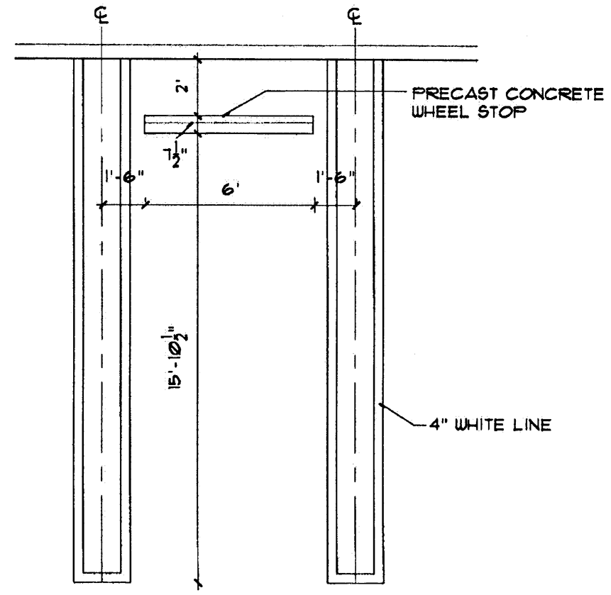
Figure 15
d.
Parallel space: Minimum nine (9) feet by twenty-three (23) feet.
e.
Compact space: Compact parking spaces may be provided for a maximum of ten percent of the required parking spaces for a project and shall be reviewed for approval by the city engineer during the development review process of a development approval and set forth in section 78-41. The minimum size of compact spaces shall be eight and one-half feet wide by 16.5 feet long.
(2)
Criteria for reduction in parking space dimensions. Requests for reduction in parking space dimensions shall comply with the standards listed below.
a.
Additional open space. Additional open space, at a ratio of 1.5 square feet for each square feet of paved parking area that is reduced through the use of smaller parking spaces shall be provided. The additional pervious open space shall be provided as additional landscaping, pedestrian amenities, or vegetative preserve areas, and shall be calculated and identified on the project site plan.
b.
Enhanced site appearance. The additional open space and landscaping or related amenities required in this subsection shall be installed within the paved portions of the parking area.
(3)
Paving. Not less than the minimum dimensions of all parking spaces, travel aisles, and other vehicular circulation areas shall be paved. Use of specialty paver brick or surfaces may be approved by the city engineer.
(4)
Striping and marking of parking spaces.
a.
Reduced space for office uses: As indicated in Figure 15, all nine (9)-foot parking spaces shall be double striped. As an alternative to double striping, the city engineer may authorize the use of contrasting paving materials, such as specialty paver bricks, as a means to identify individual parking spaces.
b.
Standard space: All parking spaces nine and one-half (9.5) feet or greater may be single striped.
(m)
Parking bays. Parking bays, which are the total of stall depth plus aisle width, shall provide for adequate maneuvering and paring space. Parking bays shall be subject to the minimum standard described in Table 32 and Figure 16.
Figure 16
Table 32. Minimum Parking Bay Dimensions for Nonresidential Uses
and Residential Uses (3)
*See Figure 16, Parking Stall Schematic.
Notes:
(1)
Dimensional requirements for stalls shall vary depending on the angle of parking provided (Column A) and the land use that the parking serves (Column I).
(2)
In column I above, "general" applies to parking spaces designated to serve all commercial uses, except retail uses and also residential uses with shared parking lots. Spaces to be reserved for use by disabled persons shall be governed by the rows labeled "handicapped." The label "unspecified" is included to provide a guideline for the design of spaces above the minimum required width.
(3)
The two (2)-foot landscape overhang shall be provided in accordance with section 78-315.
(Ord. No. 17-2000, § 179, 7-20-00; Ord. No. 16, 2014, § 8, 11-6-14; Ord. No. 7, 2017, § 19, 3-2-17; Ord. No. 6, 2022, § 24, 7-14-22)
Sec. 78-345. - Number of parking spaces required.
(a)
Required spaces. The number of off-street parking spaces required for individual uses is established in Table 33. For any use not listed in Table 33, the growth management director shall determine off-street parking requirements. The standards established in this section provide the minimum vehicular parking requirements for the various uses as classified. As indicated in Table 33, the growth management director may request additional information to demonstrate compliance with overall parking demand.
(b)
Mixed uses. For mixed use projects approved by the city council with a specific percentage of individual uses, total off-street parking requirements shall be calculated based upon the requirements applicable to each individual use. For commercial shopping centers or other centers which may provide a variety of mixed uses, the parking requirements for a shopping center shall apply.
(c)
Reduction in spaces. Unless otherwise provided herein, a reduction in the required number of parking spaces may be granted as a variance by the planning, zoning, and appeals board subject to section 78-53 or as a waiver to a planned development, PCD, or PUD approval granted by the city council.
(d)
Increase in parking spaces.
(1)
Increase of parking spaces allowed. As applicable to the type of development order, the city council, planning, zoning, and appeals board, or growth management director may authorize an increase in the number of parking in an amount not to exceed twenty (20) percent of the required spaces. Professional office and assisted living facilities may increase the number of parking in an amount not to exceed thirty (30) percent of the required spaces.
(2)
Requests for additional parking. Excluding PUDs, PCDs, or MXDs, any development order application which requests an increase of parking equal to or greater than twenty (20) percent of required parking shall be considered by the PZAB as a request for a variance.
(3)
Additional parking in PUDs, PCDs, and MXDs. Any request for an increase of parking equal to or greater than twenty (20) percent of required parking which affects a PUD, PCD, or MXD shall only be considered as an application for approval of a waiver by the city council.
(4)
Standards for additional parking spaces. A use which desires to provide parking spaces in excess of the minimum requirements of this section shall comply with the standards listed below.
a.
Additional open pervious space. Additional open space, at a ratio of 1.5 square feet for each additional square foot of paved parking and vehicular circulation area, shall be provided. The additional pervious open space shall be provided as additional landscaping, pedestrian amenities, or vegetative preserve areas, and shall be calculated and identified on the project site plan.
b.
Enhanced site appearance. The additional open space and landscaping required in this subsection shall be utilized to enhance the visual appearance of the improved site, the vehicular entries, and the parking areas. The visual enhancements shall be indicated in the application for development approval.
Table 33: Required Off-Street Parking Spaces
Notes:
Square Feet = Gross square feet.
Parking Studies. Parking studies, when provided, to be conducted in a professionally
accepted manner to determine adequate parking for proposed use.
(Ord. No. 17-2000, § 180, 7-20-00; Ord. No. 17-2004, § 5, 6-3-04; Ord. No. 20, 2007, § 2, 9-4-07; Ord. No. 16, 2014, § 9, 11-6-14; Ord. No. 7, 2017, § 20, 3-2-17; Ord. No. 11, 2017, § 3, 6-1-17; Ord. No. 22, 2019, § 10, 2-6-20; Ord. No. 10, 2021, § 2, 9-22-21; Ord. No. 6, 2022, § 25, 7-14-22; Ord. No. 5, 2024, § 24, 7-11-24)
Sec. 78-346. - Shared parking.
(a)
Permitted. The city council, may, as part of an approval of a new or expanded use, new construction, substantial renovation, or alteration or expansion of an existing site, approve the use of shared parking to reduce overall parking requirements. The basis for approval of an application to establish shared parking includes the factors listed below.
(1)
Complementary uses. Use of a building or structure for two or more uses which possess complementary, rather than competing, peak hours of usage.
(2)
Shared parking study. Preparation, in a professionally-accepted manner, of a shared parking study by a qualified professional engineer, architect, or planner.
(3)
Development order. Any development order approved by the city council which includes the use of shared parking shall:
a.
Provide the city a means to readdress the shared parking in the event future parking problems or changes in use occur;
b.
Provide a legal description of the land and structures affected;
c.
Provide for a term of at least five years;
d.
Provide a site plan to indicate uses, hours of operation, parking, etc.; and
e.
Assure the availability of all parking spaces affected by the agreement.
(4)
Amount of parking. The amount of parking provided pursuant to a shared parking agreement shall be determined as follows:
a.
Multiply the individual uses by the minimum required parking percentages per time period as contained in the five vertical columns of Table 34;
b.
Add the sum of the calculations; and
c.
The required parking is the largest number of spaces resulting from the calculations.
Table 34: Shared Parking Calculations
(Ord. No. 17-2000, § 181, 7-20-00)
Sec. 78-347. - Valet parking.
A request to establish valet parking shall be subject to the following criteria:
(a)
Valet parking area must be clear of fire lanes and Americans with Disabilities Act accessible parking spaces and/or accessible ramps.
(b)
Valet parking for restaurants and within retail commercial shopping centers shall not utilize more than sixty (60) percent of the on-site parking provided for the project.
(c)
The area of the valet parking shall be clear of driveways, drive aisles, and shall not modify the approved access circulation, unless otherwise approved by city staff.
(d)
A request to establish valet parking shall include:
1.
The location of the valet booth/drop-off area;
2.
The location and number of parking spaces to be utilized for valet parking;
3.
Consent of the property owner;
4.
The hours of operation; and
5.
Location and dimensions of any signage associated with the valet parking service.
(e)
This section is only applicable to restaurant and retail commercial shopping center projects. Golf clubhouses, clubhouses, hotels, hospitals, and medical and/or professional office buildings are exempt from the provisions of this section.
(f)
This section in its entirety shall be effective October 1, 2017.
(Ord. No. 7, 2017, § 21, 3-2-17)
Sec. 78-361. - Required.
Off-street loading facilities shall be provided and maintained in the amount required in this subdivision. However, this subdivision does not require off-street loading facilities in excess of the number required for uses which existed on August 18, 1994. After August 18, 1994, uses or structures which are enlarged, expanded, or changed, shall provide the required off-street loading facilities for the additional increment of the enlarged, expanded or changed use.
(Ord. No. 17-2000, § 182, 7-20-00)
Sec. 78-362. - Size and location of loading spaces.
(a)
Minimum dimensions. Off-street loading spaces shall comply with the minimum dimensions indicated below, or as otherwise determined by the city after the review of the use and site plan.
(1)
Overhead clearance: 15 feet.
(2)
Minimum width: 12 feet.
(3)
Minimum length: 35 feet long, exclusive of access or maneuvering areas, platforms and other appurtenances.
(4)
Maneuvering apron. A maneuvering apron, a minimum of 12 feet wide and 35 feet long, shall be provided directly behind the loading space intended to serve, or as otherwise may be approved by the city.
(b)
Location. Except as otherwise provided, off-street loading facilities shall be located on the same property which they serve.
(1)
Residential zoning districts. Off-street loading facilities shall not be located within 100 feet of a residential zoning district.
(2)
Enclosure. The city may require off-street loading facilities to be enclosed to minimize visual impacts, noise, and related effects on adjacent property owners.
(3)
Refrigerated trucks. Refrigerated trucks, and other trucks which require compressors, engines, refrigeration equipment, and similar equipment to be continuously or periodically operational shall not park within two hundred fifty (250) feet of any residential zoning district during the hours of 7:00 p.m. to 7:00 a.m. on weekdays, and 7:00 p.m. to 9:00 a.m. on Saturday and Sunday.
(c)
Circulation. Access and maneuvering areas, ramps, and other vehicular circulation areas associated with such facilities shall not be located on a public or private street right-of-way. All vehicular circulation shall be so arranged that the vehicles are not required to back from the street into the facility nor required to back from the facility into a street or other public-right-of way.
(Ord. No. 17-2000, § 183, 7-20-00; Ord. No. 7, 2017, § 22, 3-2-17)
Sec. 78-363. - Construction and maintenance.
Off-street loading facilities shall be constructed, maintained, and operated in accordance with the standards listed below:
(a)
Drainage and paving. Off-street loading facilities shall be properly graded for drainage and paved with concrete or asphaltic concrete acceptable to the city engineer.
(b)
Maintenance. Off-street loading facilities shall be maintained in good condition, free of weeds, dust, trash, and debris.
(c)
Lighting. Lighting facilities shall be so arranged that the source of light does not shine directly into adjacent residential properties or into traffic on adjoining streets.
(d)
Entrances and exits. Entrances and exits to the facility shall be located so as to minimize traffic congestion or prevent vehicles from backing from the street into the facility. Streets, alleys, or other public rights-of-way shall not be considered part of an off-street loading facility.
(e)
Circulation. In areas where access drives to off-street loading facilities occur in conjunction with off-street parking facilities that provide parking at street level for more than 600 cars, separate circulation routes within such facilities shall be maintained.
(f)
Markings. All off-street loading spaces shall be striped and clearly marked in a manner acceptable to the city engineer.
(Ord. No. 17-2000, § 184, 7-20-00)
Sec. 78-364. - Number of loading spaces required.
(a)
Minimum requirements. Off-street loading facilities shall comply with the requirements of Table 35 and shall be applicable to all structures containing commercial, business, industrial, manufacturing, storage, warehousing, processing, offices, hotels, hospitals, airports, railroad terminals, and similar uses as may be required by the growth management director. Not withstanding the requirements provided herein, structures less than 10,000 square feet may provide a loading space of a size and at such location as is consistent with the use of the structure.
Table 35: Required Off-Street Loading Spaces
Note:
*Size and location to be determined during site plan review.
(b)
Exceptions. Hotels shall provide loading spaces based upon the number of rooms. An application for development order approval for a hotel, or which includes a hotel, shall provide a study documenting the number of loading spaces to be provided.
(Ord. No. 17-2000, § 185, 7-20-00; Ord. No. 11, 2013, § 15, 9-10-13)
Sec. 78-365. - Cooperative establishment and use of facilities.
(a)
Establishment. Two or more neighboring uses may establish common off-street loading facilities, subject to approval by the city council. The total number of common off-street loading spaces shall not be less than the number required for individual users, unless otherwise approved by the city council. Criteria for reduction in the total number of off-street loading spaces include the following:
(1)
Times of usage of the truck loading facilities by the individual users;
(2)
The location of the proposed common facilities; and
(3)
The character of the merchandise involved.
(b)
Other requirements. In order to establish common off-street loading facilities, the standards listed below are applicable.
(1)
Consent. Written consent, in a form acceptable to the city attorney, is obtained from all affected property owners.
(2)
Written agreement. All conditions relating to the use, location, construction, and maintenance of the common facilities will be provided in a form acceptable to the city attorney.
(3)
Use of common facility. All users and property owners participating in a common off-street truck loading facility shall agree, in a form acceptable to the city attorney, that goods moved from the common facility shall not involve movement by truck, automobile, or other vehicle.
(Ord. No. 17-2000, § 186, 7-20-00)
Sec. 78-371. - Required parking for the physically handicapped.
(a)
Required parking. Handicapped parking, access ramps, and markings will be provided as required by F.S. Section 316.1955.
(Ord. No. 17-2000, § 187, 7-20-00)
Sec. 78-372. - Grassed parking.
Grassed parking areas may be approved by the city council for uses which have infrequent peak demand, subject to the standards and criteria established below.
(a)
Application. An application for the approval of grassed parking areas shall be submitted to the growth management department in conjunction with any other application for development order approval. The application shall include the items listed below.
(1)
A written statement and a site plan showing the area proposed for grassed parking, and the proposed method of traffic control to direct vehicular flow and parking, including the use of wheel stops.
(2)
A written statement documenting how the parking area proposed for grassed parking shall be used for parking on an average of not more than two days or nights each week. This information shall contain the following:
a.
the proposed hours and days of the expected use of the grassed parking; and
b.
the expected average daily traffic and peak hour traffic counts as calculated by a professional engineer.
(3)
Description of the method to ensure that the grassed parking surface will be maintained in its entirety with a viable turf cover due to infrequency of use.
(4)
A conceptual drainage plan for the entire parking area.
(5)
Description of the soil type of the area proposed for grassed parking.
(b)
Applicable standards. The standards listed below shall apply to the review of application to construct and utilized grassed parking areas.
(1)
Only stalls provided for peak demand may be approved as grassed parking. Paved parking shall be provided for average daily traffic, including weekday employees and visitors.
(2)
The city engineer may determine that site-specific factors, such as but not limited to soil type, exist, which necessitate that subsurface improvements be made to the area planned for grassed parking.
(3)
Existing or proposed landscaped areas, surface water management areas, or easements other than a utility easements shall not be included in the proposed grassed parking area.
(4)
Grassed parking areas shall not be utilized for handicapped parking spaces.
(5)
Grassed parking areas shall meet all minimum interior landscaping requirements normally associated with standard surface parking.
(6)
Grassed parking areas shall not be included in calculations to comply with minimum landscape or open space requirements.
(7)
Within grassed parking areas, all access aisles shall either be:
a.
paved and meet the same structural and surface requirements as for paved parking surfaces; or
b.
surfaced with paver block or other semi-pervious materials approved by the city engineer.
(8)
The city engineer may require grassed parking areas to be paved, landscaped, and otherwise improved consistent with the requirements of this division if such areas deteriorate and create a nuisance or hazardous conditions, or become unsightly.
(Ord. No. 17-2000, § 188, 7-20-00)
Sec. 78-373. - Drive-through facilities.
(a)
Design. Drive-through facilities shall be designed to minimize conflicts between pedestrian and vehicular circulation, subject to the standards listed below.
(1)
Separation. Each drive-through lane shall be separated from the circulation routes necessary for ingress or egress from the property or access to any parking space.
(2)
Marking. Each drive-through lane shall be striped, marked, or otherwise distinctly delineated in a manner acceptable to the city engineer.
(3)
Queuing and stacking. The queuing or vehicle stacking capacity of a drive-through facility, including a gated entrance to a residential development, shall be at least 100 feet. The minimum distance shall be measured from the centerline of the window closest to the edge of right-of-way from which access is provided. The stacking capacity may be increased based upon individual circumstances as determined by the city engineer.
(4)
Ordering and pickup facilities. The design and location of ordering and pickup facilities will be determined for a proposed use based on traffic engineering and planning data. Any request for a drive-through facility shall include the information listed below.
a.
Nature of the product or service being offered.
b.
Method by which the order is processed.
c.
Peak demand hour.
d.
Percentage of sales or business conducted via drive-through facilities.
e.
Anticipated vehicular stacking required.
(b)
Bypass lanes. Each drive-through facility shall provide a pass-by lane separate from the drive-through lanes, with a minimum width of ten feet.
(c)
Roofing. Roofs constructed as part of a drive-through facilities shall be consistent with the architectural style, materials, and colors of the principal structure.
(Ord. No. 17-2000, § 189, 7-20-00; Ord. No. 6, 2022, § 26, 7-14-22)
Sec. 78-374. - Covered parking structures.
Covered parking structures shall be constructed and maintained in accordance with the specifications listed below.
(a)
Maintenance. A covered parking structure shall be clean and well-maintained. Disrepair, including but not limited to rips, tears, holes, rust, and discoloration, shall be remedied immediately or shall be subject to code enforcement procedures as set forth in article VII.
(b)
Style. The appearance and material of covered parking shall be compatible with the architecture, style, and color of the principal structure project.
(c)
Materials.
(1)
Canvas shall be a prohibited material for covered parking structures. Vinyl coverings shall be a permitted material, provided a minimum 17-ounce reinforced grade or equivalent shall be used.
(2)
Metal coverings shall be constructed of a solid material, such as nonferrous aluminum, copper, or steel.
(d)
Building codes. All covered parking structures shall comply with applicable requirements of the building code. Covered parking structures shall not be constructed or installed without a building permit.
(e)
Zoning. Covered parking structures shall comply with all zoning regulations.
(f)
Landscaping. The installation of the covered parking structure shall not interfere with the natural growth of the required landscaping.
(g)
Maximum amount. Covered parking structures shall not exceed five percent of total required parking spaces for a site.
(h)
Location. Covered parking structures shall be located a minimum of 100 feet from any public right-of-way and 50 feet from any residential district. Unless otherwise approved by the city council, covered parking structures shall be located in the rear of the principal building to which the parking structure is accessory. The location of covered parking structures shall be subject to city approval during the development review or site plan review process, or as an amendment to an approved site plan.
(i)
Lighting. The construction of covered parking shall not impede or alter the security lighting of the surrounding area.
(Ord. No. 17-2000, § 190, 7-20-00)
Sec. 78-375. - Vehicle repair in residential districts.
The repairing of an automobile or a motor vehicle in a residential zoning district is subject to the restrictions listed below.
(a)
Minor repairs. Only minor repairs and maintenance may be performed, which are defined as follows:
(1)
The changing and replenishment of fluid levels, such as hydraulic fluid, windshield washer fluid, and lubricating oil;
(2)
The replacement of wiper blades;
(3)
The replacement of sparkplug and related parts;
(4)
The rotation of tires and the checking of tire pressure; and
(5)
The replacement of drive belts and hydraulic lines.
(b)
Other repairs. Any other repairs on the motor vehicle or automobile shall be restricted to completely enclosed spaces and shall be performed on privately registered vehicles having current state license plates, or motor vehicles designated by the state as qualifying for an antique or horseless carriage designation.
(c)
Location of repair. The repairs shall be performed only at the address shown on the vehicle registration.
(d)
Commercial repairs. Use of property for commercial repairs of automobiles or motor vehicles commercial nature is prohibited.
(Ord. No. 17-2000, § 191, 7-20-00)
Sec. 78-376. - Outdoor storage areas.
Screening of accessory open storage yards shall comply with the standards listed below.
(a)
Public rights-of-way. Outdoor storage areas shall be screened from view of any street as shown on the county thoroughfare improvement or city comprehensive plan as indicated below.
(1)
When an outdoor storage area abuts a collector or arterial street, the method of screening shall consist of solid walls or solid fences at least six feet in height, with access from such streets only through solid gates. Gates shall be closed when not in use. Shielding shall extend at 100 feet back from the street property line, unless an existing permanent structure shields the storage area.
(2)
When an outdoor storage area abuts a residential zoning district or property which possesses a residential future land use designation, the method of screening shall consist of solid walls or fences at least six feet in height along the boundary of the storage areas and the entire residential district. Gates shall be opaque, of the same style as the screening wall, and closed when the access is not in use.
(3)
When an outdoor storage area is within 200 feet of a residential district as defined above, the method of screening shall consist of solid walls or fences at least six feet in height and located in such a manner that the storage area is not visible from the residential district. Gates shall be opaque, of the same style as the screening wall, and closed when the access is not in use.
(Ord. No. 17-2000, § 192, 7-20-00)
Sec. 78-377. - Reserved.
Editor's note— Ord. No. 11, 2013, § 16, adopted Sep. 10, 2013, repealed § 78-377, which pertained to mechanical and service equipment screening and derived from Ord. No. 17-2000, § 193, 7-20-00.
Sec. 78-378. - Dumpsters.
(a)
Applicability. The requirements pertaining to the location and screening of dumpsters established in this section shall apply to all zoning districts within the city having or using dumpsters (ninety (90) gallons or greater in size) for sanitation or recycling service. Temporary dumpsters, such as those which are placed on job sites during construction activity, are not subject to this section. Recycling containers within city parks are exempt from this section.
(b)
Minimum requirements. The location and use of dumpsters shall comply with the standards established below.
(1)
Location. All dumpsters shall be located in such a manner as to be reasonably accessible for trash collection by the sanitation vehicles and for trash deposit by the user without becoming a nuisance or having a blighting effect. Dumpsters shall not be located within the right-of-way of a public street or alley.
(2)
Screening.
a.
All dumpster areas shall be reasonably screened from public view, from public rights-of-way, and from abutting properties.
b.
All new developments and major redevelopment projects shall screen proposed dumpsters on all four (4) sides, as indicated in Figure 17. Gates must be closed when the dumpster is not in use. Gates shall be maintained in good repair.
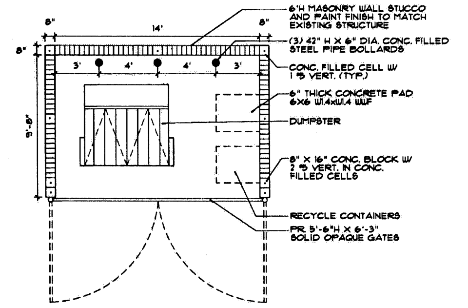
Figure 17
c.
Existing dumpsters shall be screened with materials such as concrete block, opaque fencing, or a combination thereof, on all four (4) sides. However, to the greatest extent practicable, dumpster enclosures shall be constructed in the same architectural style, color, and materials as the principal use. Exceptions to this requirement may be granted by the city for a ninety-gallon recycling container. Dumpster screening enclosures shall be maintained in good repair, and the areas surrounding dumpsters and the dumpster enclosures shall be kept neat, clean, and free from debris. The city may require the installation of landscaping to provide additional screening or other enhancements for dumpster areas that would otherwise be visible from public rights-of-way.
d.
All screening must be a minimum of six (6) feet in height, as measured from the immediately-surrounding grade or must exceed the height of the dumpster, recycling container, or trash compactor by no less than one (1) foot, whichever is greater.
e.
All dumpsters must be located or installed on a hard impermeable surface of adequate size to accommodate the dumpster. The growth management director, or designee, may authorize a reduction in the number of existing parking spaces in order to facilitate the proper location and construction of a dumpster enclosure(s) or to facilitate recycling when necessary to address a nonconforming dumpster enclosure or to facilitate recycling. The administrative reduction of required parking spaces for this limited purpose is hereby determined to be in the best interest of the public health, safety, and welfare.
f.
The locations of dumpsters and dumpster enclosures shall be depicted on and approved through site plan approval process for all development and projects. In the event an existing development does not have a site plan, the locations of dumpsters and dumpster enclosures shall be depicted on and approved through building permit plans and the plan review process.
g.
All existing nonconforming dumpsters in the city shall be required to come into compliance with these regulations in accordance with article VI, nonconformities.
h.
Dumpster enclosures are subject to the minimum building setbacks established in section 78-153, with an additional perimeter or boundary setback of 75 feet required when abutting a residential zoning district, unless the dumpster is physically located within a residential zoning district.
(c)
Appeals. Appeals from decisions of the city staff regarding dumpsters are subject to the jurisdiction of the PZAB. Appeals shall be filed as provided in section 78-56.
(Ord. No. 13, 2010, § 2, 10-7-10; Ord. No. 7, 2017, § 23, 3-2-17; Ord. No. 6, 2022, § 27, 7-14-22)
Editor's note— Ord. No. 13, 2010, § 2, adopted Oct. 7, 2010, repealed former § 78-378, and enacted a new § 78-378 as set out herein. Former § 78-378 pertained to the same subject matter and derived from Ord. No. 17-2000, § 194, adopted June 20, 2000.
Sec. 78-379. - Recycling containers.
(a)
Multifamily residential recycling storage areas. All multifamily residential projects of ten (10) or more units shall provide storage areas for recycled materials.
(1)
Location. Storage areas shall be located within the multifamily structure or structures or as part of the area containing garbage disposal facilities.
(2)
Circulation. Recyclable collection areas shall be located so as to avoid excessive maneuvering by vehicles picking up the materials.
(3)
Screening. Collection areas that are not located within a multifamily structure shall be screened in accordance with section 78-378.
(4)
Exemptions. Multifamily buildings that receive curbside recyclable materials collection service at least once a week are exempt from these requirements.
(5)
Minimum area. Multifamily dwellings, unless exempt as provided herein, shall provide the amount of storage area listed below in Table 36.
Table 36: Minimum Multifamily Recyclable Storage Area Requirements
(b)
Alternative compliance. An alternative to the required collection area may be proposed. The alternative plan shall be reviewed by the Solid Waste Authority of Palm Beach County (SWA) and approved by city.
(c)
Existing buildings. The installation of recyclable materials collection areas at existing multifamily dwellings is encouraged. Multifamily dwellings subject to substantial renovation shall provide materials collection areas as set forth herein. The growth management director, or designee, may authorize the use of existing parking spaces as locations for collection areas. Reduction of the parking for this purpose shall not require a variance.
(d)
Nonresidential recyclable materials storage areas. From the effective date of this section, all new nonresidential developments and major redevelopment of nonresidential projects shall provide storage and collection areas for recyclable materials in accordance with sections 78-378 and 78-379.
(Ord. No. 17-2000, § 195, 7-20-00; Ord. No. 13, 2010, § 3, 10-7-10)
Sec. 78-380. - Use of buildings as sales models.
(a)
Sales models permitted. A builder, contractor, or developer may use any building within any zoning district as a sales model. Use of a building as a sales model is contingent upon issuance of a certificate of occupancy and compliance with this section.
(b)
Purpose. A building shall be used as a sales model solely for the purpose of the sale of similar buildings and land sites by the builder, contractor, or developer. The sales model shall not be used as a construction office or general office. Construction equipment, maintenance equipment, vehicles, materials, supplies, or records of any type shall not be parked or stored temporarily or permanently on a model home lot or premises.
(c)
Limits.
(1)
Public improvements. Public access to sales models shall not be allowed until substantial completion of roadway improvements to provide legal access to the models, and subject to reasonable conditions by the city, the installation of water and sewer services.
(2)
Sale of services and materials. A sales model shall not be used as an area for the sale of services by or for an interior decorator, or for storage or display of bulk quantities of building products used for construction.
(d)
Time limits. The time period that a building may be used as a model is indicated below.
(1)
Nonresidential zoning districts. There shall be no time limit for nonresidential sales models in a commercial or industrial zoning district.
(2)
Arterial street location. Sales models or model homes in a residential zoning district that are located on a major arterial street are permitted for a period not to exceed five years.
(3)
Residential locations. When located within any residential zoning district and the building does not front on a major arterial street, the time limit for residential buildings to be used as a sales model is established by Table 37.
Table 37: Time Limits for Sales Models in Residential Developments
(e)
Moratorium. If a residential building moratorium is enacted by the city, the time limits in this section shall be tolled and the length of the moratorium shall not be included as part of the limits in this section.
(f)
Notice. The building official shall notify in writing the builder, contractor, or developer that a structure may be used as a sales model. The written notice shall include the details of the approval, including date of issuance, property address, and name of the property owner. Information regarding sales models shall be retained in a permanent log to be maintained by the building official.
(Ord. No. 17-2000, § 196, 7-20-00)
Sec. 78-381. - Electric vehicle charging stations.
Electric vehicle charging stations are permitted and encouraged in the following nonresidential zoning districts: PO—professional and office, CN—neighborhood commercial, CG-1—general commercial, CG-2—intensive commercial, CR—commercial recreation, M-1—Research and light industrial park, M-1A—light industrial, M2—heavy industrial, and P&I—public/institutional. Electric vehicle charging stations are also permitted In the planned unit development (PUD) and planned community development (PCD) overlay districts.
Electric vehicle charging station parking spaces, if provided, will be credited towards the minimum number of parking spaces required pursuant to section 78-345. Projects are encouraged to provide a minimum of two percent of the required parking for electric vehicle charging, which may be used as waiver justification in accordance with subsection 78-158(i).
(Ord. No. 16, 2014, § 10, 11-6-14; Ord. No. 6, 2022, § 28, 7-14-22; Ord. No. 5, 2024, § 25, 7-11-24)
Sec. 78-391. - Parking and storage of commercial vehicles, buses, trailers, trucks, recreational vehicles, watercraft, and portable storage units.
The purpose of this subdivision is to preserve the quality of residential areas in the city by restricting and regulating the parking and storage of commercial vehicles, trailers, trucks, recreational vehicles, watercraft, and portable storage units in residential districts.
(Ord. No. 17-2000, § 197, 7-20-00; Ord. No. 7, 2017, § 25, 3-2-17)
Sec. 78-392. - Parking and storage of portable storage units.
(a)
Time limitation. The temporary use and placement of a portable storage unit for the loading or unloading of items to or from the unit or residence is permitted on residential property for a period of time not to exceed fourteen (14) consecutive days. The growth management director or designee may grant one (1) extension not to exceed fourteen (14) additional consecutive days for good cause. Only one (1) portable storage unit per residential premises is permitted in any twelve (12)-month period unless there is a change of ownership of the residential premises during such twelve (12)-month period.
(b)
Placement. The placement of the portable storage unit shall be on either the driveway or approved parking area surface and shall be accomplished in such a manner that no landscaping is damaged as a result. Portable storage units shall not be placed within any right-of-way or over any easement.
(c)
Removal of portable storage units during tropical storm watch or warning and hurricane warning or watch required. In the event the National Weather Service, National Hurricane Center, or appropriate weather agency declares a tropical storm watch or warning or a hurricane watch or warning that would impact Palm Beach Gardens, all portable storage units located within the city shall be immediately removed from the property so as not to create a safety hazard because of hurricane or tropical storm force winds. The removal and replacement of any portable storage unit pursuant to this subsection shall not count toward the twelve (12)-month limitation period as set forth in subsection (a) above nor shall compliance with this subsection diminish the total number of days allowed.
(Ord. No. 7, 2017, § 26, 3-2-17)
Sec. 78-393. - Parking and storage restrictions for commercial vehicles.
All commercial vehicles shall be prohibited from being parked or stored in a residential district, unless subject to one of the exceptions listed in this subdivision.
(Ord. No. 17-2000, § 199, 7-20-00)
Sec. 78-394. - Exceptions for commercial vehicles.
The parking and storage restrictions established in this subdivision shall not apply in the situations listed below.
(a)
Construction sites. Restricted vehicles parked temporarily at a site undergoing construction, for which a current and valid building permit has been issued by the city. The restricted vehicle may remain at the construction site only as long as necessary. However, under no circumstances shall the restricted vehicle remain after completion of the construction or expiration of the building permit, whichever occurs first.
(b)
Sales office use. The use of a restricted vehicle as a sales office on an approved development site, subject to all provisions of this subdivision pertaining to such use.
(c)
Security. The use of a restricted vehicle as a security facility, subject to all provisions of this subdivision pertaining to such use.
(d)
Deliveries and service calls. The use of a restricted vehicle for deliveries, service calls, and other related trade services, provided such use is limited to the reasonable time necessary to complete a delivery or service.
(e)
Disabled vehicles. A restricted vehicle which becomes disabled and, as a result of such status, cannot reasonably comply with this subdivision. Such vehicle shall be removed from the residential district within 24 hours of the disabling incident, regardless of the nature of the disabling incident.
(f)
Public safety. A restricted vehicle which is owned, maintained, or operated by an agency of government for the purpose of public safety.
(g)
Enclosed parking. A restricted vehicle which is parked or stored in a fully-enclosed garage facility.
(1)
A restricted vehicle which is parked or stored on the side or rear yard of a lot, provided it is parked in compliance with the buffering and screening conditions set forth in section 78-395.
(Ord. No. 17-2000, § 200, 7-20-00)
Sec. 78-395. - Recreational vehicles and watercraft.
(a)
Limit. Not more than one recreation vehicle (RV) and one watercraft shall be permitted on each lot. Properties within the AE zoning district may have a maximum of one RV and any two of the following, or a maximum of three of any of the following: sports vehicle, boat or vessel with accompanying trailers, and trailers. Properties within the AR zoning district are exempt from this section.
(b)
Location.
(1)
Location. The RV or watercraft shall be parked or stored on the side or rear yard of a lot. No portion of the RV or watercraft may extend into the front yard of any lot, nor shall any portion extend into any sidewalk, street, or other right-of-way. At no time shall access to the rear of a lot be blocked or impeded by an RV or watercraft.
(2)
Dimensions. Parking areas for recreational vehicles and watercraft shall be large enough to accommodate the individual vehicle or vessel. However, the minimum parking area shall be ten feet by 18.5 feet.
(c)
Buffering and screening. The RV and watercraft shall be properly screened. Proper buffering and screening requires blocking the RV or watercraft from direct view from all sides; however, the area providing ingress and egress for the RV or watercraft to and from the lot is not required to be screened. Buffering or screening shall be accomplished by a masonry wall or fences, as well as dense hedge planting. Fences and walls shall be installed at a height of six feet. The use and maintenance of screening materials shall, at all times, comply with all provisions of this subdivision. The hedge materials used for screening purposes shall be maintained at least six feet in height above finished grade within 24 months after planting. The hedge materials used for screening purposes shall be at least three feet high above finished grade at planting.
(d)
Vehicle height. The height of the RV or watercraft, in its parked or stored position, shall not exceed the height of the principal building on the lot.
(e)
Loading and unloading. An RV or watercraft may be permitted in the front yard of a lot for one 24-hour period to permit loading or unloading. This period may be extended by the growth management director.
(f)
Residential use prohibited. Under no circumstances shall an RV or watercraft, parked or stored pursuant to this subdivision, be used for temporary or permanent residential purposes, including living, sleeping, or other similar occupancy, or storage in any manner.
(g)
Watercraft and trailers. For the purposes of this subdivision, when a watercraft is parked, stored, or resting on a trailer or similar device used or intended for storage or transportation, the watercraft and the trailer shall be considered a single unit and subject to the regulations and restrictions applicable to a watercraft.
(Ord. No. 17-2000, § 201, 7-20-00; Ord. No. 22, 2019, § 11, 2-6-20)
Sec. 78-396. - Valid nonconforming use.
(a)
Registration and eligibility. The city shall issue nonconforming use registration decals according to the guidelines established below.
(1)
Eligibility.
a.
General. An RV or watercraft shall be eligible for a nonconforming use registration decal only if such vehicle or craft has been continuously owned by a resident of the city since August 18, 1995, and has been parked or stored continuously in the front yard of a lot owned, or leased by that resident located in a residential district of the city since August 18, 1995. A renter or lessee shall also be required to submit a written approval from the property owner, fully executed and notarized, that the property owner consents to the issuance of the registration decal.
b.
Newly annexed areas. In newly annexed areas, an RV or watercraft shall be eligible for a nonconforming use registration decal if such vehicle or craft is owned by a new resident of the city on the date of annexation and has been parked or stored continuously in the front yard of a lot owned, rented, or leased by that resident located in a residential district of the city for 90 days prior the date of annexation. A renter or lessee shall also be required to submit a written approval from the property owner, fully executed and notarized, that the property owner consents to the issuance of the registration decal.
(2)
Proof. The city may require proof sufficient to establish conformity with the eligibility requirements set forth herein.
(3)
Registration decals. Registration decals shall be made available through May 15, 1998. The city may charge a fee to issue such permit. Eligibility for a nonconforming use registration decal shall automatically expire May 16, 1998. For newly annexed areas, registration decals shall be made available for 180 days after the effective date of the annexation and eligibility for a nonconforming use registration decal shall automatically expire on the 181st day.
(4)
Renewal. Recipients of a registration decal must continuously renew such registration on an annual basis by December 31st of each year. The city council shall establish a fee for registration and recording to cover all administrative costs. After December 31st, the city shall charge a late penalty of $5.00 for each month of delinquency or portion thereof, up to a maximum of $15.00. In the event a person fails to renew within 90 days in accordance with the provisions of this section, the person's legal non-conforming use status shall automatically cease and the city shall record a document in the public records evidencing same. In the event a person fails to register within 180 days in accordance with the provisions of this section, the person's legal non-conforming use status shall automatically cease and the city shall record a document in the public records evidencing same.
(5)
Recordation. The city shall record in the public records of the county evidence of the nonconforming use registration, as well as the rules regarding transferability to subsequent property owners. All costs incurred for such recordation shall be the responsibility of the recipient of the registration decal.
(b)
Transferability. The conditions listed below shall apply to transferability of a valid and continuously renewed registration.
(1)
Real property. Registration may not be transferred to a subsequent purchaser of the property.
(2)
RV or watercraft. Registration may not be transferred to a subsequent purchaser of the registered RV or watercraft.
(3)
Replacement. If an owner replaces a registered RV or watercraft, the registration may be transferred to the replacement RV or watercraft.
(4)
Residence change. If the owner moves to a different location in a residential zoning district in the city, registration of an RV or watercraft may not be maintained at the new location.
(c)
Restrictions and guidelines. Parking and storage of a validly-registered RV or watercraft shall be subject to the restrictions and guidelines listed below.
(1)
Visibility of decal. The registration decal must be permanently affixed and displayed so as to be visible from the adjoining right-of-way.
(2)
Parking surface. The RV or watercraft shall be parked on a nondusting, hardwearing surface, including but not limited to concrete, asphalt, brick, stone, or gravel. Parking on exposed shell rock is prohibited.
(3)
Front yard parking. An RV or watercraft parked or stored in a front yard shall be situated perpendicular to the adjacent right-of-way. RVs or watercraft parked or stored on corner lots may be located on either street side of the residence. Parking or storage of an RV or watercraft parallel to the front property line of a lot shall be prohibited. An RV or watercraft shall never extend in to any street right-of-way or sidewalk. An RV or watercraft shall not block or impede access to the rear of a lot.
(4)
Florida registration. At all times, an RV or watercraft parked or stored pursuant to this subdivision shall display a valid Florida registration plate, or sticker, whichever is applicable.
(5)
Maintenance. At all times, an RV or watercraft parked or stored pursuant to this subdivision shall be maintained in good and operable condition. Construction, reconstruction, or repair of an RV or watercraft shall not be permitted while the vehicle or watercraft is parked or stored in the front yard.
(6)
Traffic hazard. Notwithstanding its registration as a nonconforming use, an RV or watercraft shall not be parked or stored in a manner which may present a traffic hazard or pose a threat to public health or safety.
(d)
Waiver.
(1)
Waiver permitted. Recognizing that the strict application of the requirements of this subdivision may work an undue hardship on certain persons, a waiver from the strict application of this subdivision may be granted by the planning, zoning, and appeals board (PZAB).
(2)
Petition for waiver. A written petition for a waiver shall be filed by the owner of the vehicle or watercraft with the growth management director. The PZAB shall conduct a public hearing within 15 days to review the petition. As a basis for approval, the board must find that the requested parking or storage of the subject RV or watercraft will:
a.
Be consistent with the general character of the neighborhood considering population density, intensity and character of activity, and traffic and parking conditions; and
b.
Not be a detriment to the use, enjoyment, economic value or development of surrounding properties or the general neighborhood.
(Ord. No. 17-2000, § 202, 7-20-00; Ord. No. 54-2002, § 2, 4-10-03; Ord. No. 17-2004, § 5, 6-3-04; Ord. No. 7, 2017, § 27, 3-2-17)
Sec. 78-397. - Enforcement.
Compliance with this subdivision shall be enforced through and by the code enforcement division. The code enforcement division is authorized to remove noncompliant vehicles and watercraft pursuant to the provisions of state law.
(Ord. No. 17-2000, § 203, 7-20-00)
Sec. 78-411. - Intent.
The bicycle parking requirements established in this subdivision are intended to encourage the use of bicycles as a means of transportation in the city. By encouraging the use of bicycles, the public health, safety and welfare will be furthered through improved air quality, reduced energy consumption, and more efficient use of vehicular parking facilities.
(Ord. No. 17-2000, § 204, 7-20-00)
Sec. 78-412. - Location requirements.
All bicycle parking facilities provided to satisfy the requirements of this subdivision shall be located on the same lot or building site as the uses they serve. Bicycle parking shall be located as close as is practical to the entrance to the use served, but situated so as not obstruct the flow of pedestrians using the building entrance or sidewalk.
(Ord. No. 17-2000, § 205, 7-20-00)
Sec. 78-413. - Design requirements.
Bicycle parking facilities shall be designed as provided below.
(a)
General design standards. All bicycle parking facilities shall be of at least class III design, as defined in this Code, and shall be anchored so as to avoid or deter easy removal. All such facilities shall be clearly identified as available for bicycle parking. Wherever the design of the building or use being served by the bicycle parking facility includes covered areas which could accommodate such facilities, either as proposed or through economical redesign, covered bicycle parking shall be encouraged.
(b)
Dimensions. All bicycle parking spaces shall be not less than two feet wide and six feet long.
(Ord. No. 17-2000, § 206, 7-20-00)
Sec. 78-414. - Number of spaces required.
The following uses shall be required to provide bicycle parking in accordance with the minimum standards as listed in Table 38.
Table 38: Minimum Standards for Bicycle Parking
(Ord. No. 17-2000, § 207, 7-20-00)
Sec. 78-415. - Reduction or waiver of requirements.
The city council may reduce or waive the requirements in this subdivision if it determines there is insufficient need for the amount of bicycle parking required under this subdivision.
(Ord. No. 17-2000, § 208, 7-20-00)
Sec. 78-611. - Intent.
The city finds that the safe, convenient, and orderly flow of multimodal travel is necessary for the health, safety, welfare, and convenience of the public. It is the intent of this subdivision to ensure that roadways are in place and adequate to provide a level of service that will provide safe, convenient, and orderly flow of multimodal travel by providing specific standards, and providing guidelines and procedures for the implementation and enforcement of the standards. The city intends, by adopting the standards contained in this article, to implement the goals, objectives, policies, and standards of the city comprehensive plan, and particularly objective 2.1.2. The city finds that safe, convenient, and orderly flow of multimodal travel will be achieved by the standards set forth in this article.
(Ord. No. 17-2000, § 292, 7-20-00; Ord. No. 9, 2020, § 10, 9-10-20)
Sec. 78-612. - Applicability.
(a)
Generally. Unless otherwise provided, this article shall apply to the development order applications and required study listed below.
(1)
Comprehensive plan amendment study (CPAS). Any applications for change in land use designation.
(2)
Traffic impact study (TIS) for areas west of the Beeline Highway. Any application for changes in zoning classification, site plan, or other development application.
(3)
Site assessment study (SAS). Any application for changes in zoning designation, site plan, or other development order applications, including equivalencies, conversions of use, and the like.
(b)
Previously approved development approvals.
(1)
Existing approvals. Development order applications to amend an existing development order approved prior to the adoption of the Palm Beach County traffic performance standards on February 1, 1990, are subject to the standards only for the amount of traffic generated in excess of the existing approval.
(2)
Existing uses. Any development order application affecting property which is presently occupied, used, and generating impacts to transportation system shall be subject to the transportation standards only for the amount of traffic generated that is in excess of the existing use. For purposes of this subsection, the use of a structure or land which has been abandoned for less than five years shall be considered an existing use.
(3)
Required improvements. Any development order approval amending a previously approved development order which required road construction, right-of-way acquisition, design, contribution of money, or other improvements to a link or major intersection or multimodal improvement shall include a requirement to provide performance surety or security to secure the improvements.
(c)
Nonapplicability.
(1)
Acts and omissions. The transportation standards shall not apply to applications for development order approval filed after the effective date of the standards if specified acts or omissions of the city which were relied upon by the property owner effectively precluded the property owner from filing an approvable application for a development approval prior to such date. Only the city council may make a determination of the applicability of this subsection. A determination of this nature shall be made in a public meeting upon application of the property owner. The burden to affirmatively demonstrate by written evidence the applicability of this subsection shall be upon the property owner.
(2)
City-initiated changes. The city's transportation standards shall not apply to city-initiated future land use plan or zoning district designation changes However, the city-initiated change shall not be adopted if such changes have the effect of authorizing development that is not subject to the city's transportation standards.
(3)
Comprehensive plan consistency. The city's transportation standards shall not apply to any city-initiated future land use plan or zoning district designation amendments to achieve consistency with the city's comprehensive plan. However, the city-initiated amendments shall not be adopted if the amendments have the effect of authorizing development that is not subject to the city's transportation standards.
(d)
Entitlement. A site-specific development order may be issued for a project not exceeding entitlement density or intensity as set forth in the 1989 comprehensive plan of the Palm Beach County, if applicable. Entitlement density for residential land uses shall be based on the densities set forth in the land use element of the plan that correspond to the densities established in the city's comprehensive plan. Any density exceeding 18 dwelling units per acre shall receive the entitlement level set forth in the "5 to 18 dwelling unit per acre" range established by the city. Entitlement density for commercial and industrial land uses shall be 2½ percent of the maximum square footage of floor area allowed under the land use category or zoning district of the city.
(e)
Vested rights. The requirements of this article shall not apply in any manner to impair vested rights established pursuant to state law, to the extent that any project or portion thereof is vested and is exempt from the requirements of this article.
(Ord. No. 17-2000, § 293, 7-20-00; Ord. No. 9, 2020, § 11, 9-10-20)
Sec. 78-621. - Established.
(a)
Transportation standards established. There is established a transportation standard for all major thoroughfares and major intersections within the city. Except as specifically provided in this division, development order approvals may not be issued for a proposed project which would violate this standard.
(b)
Alternate level of service standards. The standards and requirements of this division shall not prohibit the city council from adopting alternate level of service standards for specified roadway links or intersections or multimodal facility. Alternate standards may be adopted for specified roadway links or intersections or multimodal facility, which due to circumstances beyond control of the city are currently or projected to exceed the level of service standard adopted herein. The city council also may adopt alternate standards if roadway or intersection or multimodal improvements are prohibited due to physical, environmental, historical, or aesthetic constraints.
(Ord. No. 17-2000, § 294, 7-20-00; Ord. No. 9, 2020, § 12, 9-10-20)
Sec. 78-622. - Level of service standards.
Level of service standards (LOS) are established for roadways within the urban and rural service areas as indicated in Table 44.
Table 44: Level of Service Standards for Urban and Rural Service Areas
Table 44A. Quality of Service (QOS) Standards for East of the Beeline Highway
Note for Table 44A. Details of how these QOS standards are determined are included in the City's adopted Mobility Plan.
(Ord. No. 17-2000, § 295, 7-20-00; Ord. No. 9, 2020, § 13, 9-10-20)
Sec. 78-623. - Link standard.
(a)
Development orders. Except as specifically provided in this division, development order approvals shall not be issued which would, during the build out period of the project, result in project traffic at the impact levels listed below at any point on any major thoroughfare link within the project's radius of development influence, if the total traffic on that link would result in a volume that exceeds the adopted level of service volume during the build out period of the project. For purposes of these analyses, committed improvements shall be considered.
(1)
For a comprehensive plan amendment study (CPAS). More than three percent of the level of service D service volume as set forth herein.
(2)
For a traffic impact study (TIS). Per article 12 of the Palm Beach County ULDC, as may be amended.
(3)
For a site assessment study (SAS). No link analysis is required, unless determined by the city engineer.
(b)
Service volumes and capacities. All evaluation shall be based upon the latest edition of the Florida Department of Transportation Generalized Tables, or another professionally acceptable methodology for determining road capacity approved by the city engineer.
(Ord. No. 17-2000, § 296, 7-20-00; Ord. No. 9, 2020, § 14, 9-10-20)
Sec. 78-624. - Intersection standard.
(a)
Development orders. Except as specifically provided in this division, development order approvals shall not be issued which would, during the build out period of the project, result in project traffic at the impact levels listed below on any link connecting a major intersection within the project's radius of development influence, if the intersection would result in exceeding level of service "D" standard during the build out period of the project.
(1)
For a comprehensive plan amendment study (CPAS). No intersection analysis is required.
(2)
For a traffic impact study (TIS). Per article 12 of the Palm Beach County ULDC, as may be amended.
(3)
For a site assessment study (SAS). More than five percent of the level of service D service volume, as set forth on any approach of the intersection.
(b)
Intersection standards. For purposes of the intersection standards, compliance with the level of service "D" standard shall be established using the methodology contained in the latest edition of the Highway Capacity Manual (HCM).
(Ord. No. 17-2000, § 297, 7-20-00; Ord. No. 9, 2020, § 15, 9-10-20)
Sec. 78-625. - Radius of development influence.
The maximum radius of development influence for specific types of proposed projects shall be five miles. The actual radius of development influence for each study type shall be based on the criteria set forth in section 78-643.
(Ord. No. 17-2000, § 298, 7-20-00; Ord. No. 9, 2020, § 16, 9-10-20)
Sec. 78-626. - Phasing.
Phasing may be utilized to establish compliance with the transportation standards subject to compliance with the criteria listed below.
(a)
Concurrency. The proposed project is able to comply with all other concurrency requirements of the city.
(b)
Links and intersections. The proposed phasing results in the links and intersections of the proposed project complying with the link and intersection standards set forth in this division for the build out of the project. All phases including build out shall comply with the standards set forth in this article.
(c)
Committed improvements. The proposed phasing is consistent with the extent and timing of committed improvements.
(d)
Committed improvements. The county engineer or city engineer, as applicable, shall confirm that planned improvements or construction are committed.
(e)
Applicant commitments. For any improvement which is to be completed by the applicant, a condition of approval must be imposed by the city council or a road/multimodal agreement executed, and sufficient performance security must be provided.
(f)
Building permits. Building permits may be issued for that phase of a project which was analyzed and approved based on a specified phasing program which standing alone would be the entitlement.
(Ord. No. 17-2000, § 299, 7-20-00; Ord. No. 9, 2020, § 17, 9-10-20)
Sec. 78-627. - Reliance on committed improvements.
(a)
Building permits. If a development order is approved or phased based on committed improvements, building permits may be issued for the structure or phase that is subject to the committed improvements. The building permits shall be issued at such date when it is determined the certificate of occupancy will be issued concurrently with or following completion of the committed improvements.
(b)
Deletion of committed requirements. If a development order is approved or phased based upon committed improvements which are deleted, building permits and certificates of occupancy may be issued for the structure or phase based upon the conditions listed below. For the purpose of this section, the term "committed improvements" includes both amount of construction and timing of construction.
(1)
Road program. The committed improvements which were relied upon for the issuance of a development order approval were included in the Palm Beach County Five Year Road Program or FDOT Transportation Improvement Program (TIP) or the City's Capital Improvement Program (CIP).
(2)
Deletion. Following a development order approval, the committed improvements are removed from Palm Beach County, FDOT, or City programs. For purposes of this section, the term "deleted" shall mean the following:
a.
The elimination of the construction project;
b.
The material reduction in the scope of construction work or funding thereof, as it affects the construction project;
c.
The postponement of the construction project in the five-year program for more than one year beyond the year the construction was originally programmed in the five-year program;
d.
The failure to let a road construction contract;
e.
The removal of or failure to continue funding of the construction project; and
f.
Construction delays, design delays, contracting delays, or similar delays.
(Ord. No. 17-2000, § 300, 7-20-00; Ord. No. 9, 2020, § 18, 9-10-20)
Sec. 78-641. - Submission required for development approval.
In order to demonstrate that an application for development order approval complies with the transportation standards, the applicant shall submit one or more of the following, as required per application type and location.
(a)
Comprehensive plan amendment study (CPAS).
(b)
Traffic impact study (TIS).
(c)
Site assessment study (SAS).
(Ord. No. 17-2000, § 301, 7-20-00; Ord. No. 9, 2020, § 20, 9-10-20)
Sec. 78-642. - Scope.
The applicable study or studies shall include the requirements listed below.
(a)
Transportation standards. The study shall address the requirements and standards of the county and/or the city's transportation standards.
(b)
Brevity. The study shall be presented concisely, using maps whenever practicable.
(c)
Assumptions. The study shall state all assumptions and sources of information.
(d)
Detail. The form and level of detail required shall be established by the city engineer in accordance with accepted traffic engineering principles.
(Ord. No. 17-2000, § 302, 7-20-00; Ord. No. 9, 2020, § 21, 9-10-20)
Sec. 78-643. - Methodology.
(a)
Generally. The methods of evaluation, standards, and information in this section shall be addressed in the study. The city engineer may approve alternate methods if the applicant can demonstrate that due to circumstances peculiar to the proposed project or major thoroughfare system impacted by the proposed development, other methods or standards provide a more accurate means to evaluate the links, intersections, and traffic impact of the proposed project.
(b)
Level of service. The applicable study or studies shall utilize the levels of service, as defined in section 78-622, for all major thoroughfares within the radius of development influence.
(c)
Traffic assignment. The total traffic shall be generated, and traffic assignments made for each link and major intersection within the project's radius of development influence in conformity with accepted traffic engineering principles. The assignments shall cover each phase and the buildout period of the project.
(d)
Radius of development influence. The applicable study or studies shall define the radius of development influence up to a maximum travel distance of five miles.
(1)
For a comprehensive plan amendment study (CPAS) the radius is established as shown below:
* Net daily trip generation equals trips related to the proposed land use designation less the existing land use designation. Traffic associated with all prior land use designation changes for the property that have not received development order approvals shall be cumulatively included in the net trip generation increase.
(2)
For a traffic impact study (TIS), the radius is established per article 12 of the Palm Beach County ULDC, as may be amended.
(3)
For a site assessment study (SAS), the radius is established as the directly accessed links and the intersections within one-quarter mile from each project access point. The city engineer may require additional intersection analysis per section 78-644.
(e)
Projected build out period. The projected build out period of the project shall be set forth in the TIS and/or SAS and shall be subject to the review and approval of the city engineer.
(f)
Existing traffic. Peak hour directional traffic shall be used, as defined herein. Where current data are not available to establish existing traffic, the applicant shall elect one of the methods listed below to establish existing traffic levels.
(1)
Counts. The applicant may provide traffic counts if approved by the city engineer. Traffic counts of this nature shall be performed in accordance with accepted traffic engineering principles. Counts shall be made during any continuous 24-hour period in accordance with accepted traffic engineering principles. All data are subject to review and acceptance based upon accepted traffic engineering principles.
(2)
Factors. Where a peak season count is not readily available, the count which is unavailable may be established using factors established by the city traffic engineer based on the best available data and generally accepted traffic engineering principles.
(g)
Traffic generation. Traffic generated by the project shall be calculated in the manner listed below.
(1)
ITE rates. The rates published by the Palm Beach County Traffic Division and in the latest edition of the Institute of Transportation Engineers (ITE) trip generation manual shall be used. However, the city engineer may accept other standards that provide a more accurate means to evaluate the rates of generation, including Palm Beach County traffic generation rates. The other standards shall be based upon documentation supplied by the applicant which affirmatively demonstrates the alternative method based on acceptable engineering principles.
(2)
Local conditions. The city engineer or county engineer may publish and update, from time to time, trip generation rates for local conditions. If applicable, these rates shall be used instead of the ITE rates.
(3)
Similar developments. Actual traffic counts, gathered in accordance with accepted traffic engineering principles, which establish the generation rate at three similar developments located in similar areas may be used if approved by the city engineer. These counts shall be made on weekdays, as set forth in subsection (f) of this section, for each site and averaged.
(h)
Pass-by trips. Credit against the trip generation of a proposed project may be taken for pass-by trips. Pass-by trips shall be based on the most recent rates published by the Institute of Traffic Engineering (ITE) or the rates published by Palm Beach County for local conditions.
(1)
Other uses. If a TIS and/or SAS includes land uses other than those listed in the ITE trip generation manual or county documents, and proposes an increase in the percentage credit for pass-by trips proposed in excess of the amount in those documents, the calculations shall be justified based on accepted traffic engineering principles. The calculations must be acceptable to the city engineer as part of the required study, based upon the peculiar characteristics and location of the proposed project.
(2)
Factors. Factors which should be considered in determining a different pass-by trip rate include type and size of land use, location with respect to the surrounding major thoroughfare system, and existing and projected traffic volumes.
(i)
Internal and intrazonal trip. Reduction in overall trip generation rates may occur as a result of multi-use or mixed use projects.
(1)
Multi-use project. For the purposes of this section, a multi-use project is defined by ITE as one that would "contain two or more land uses or building types that each attract people from outside the project, would share parking facilities and driveways, and would include uninterrupted pedestrian connections."
(2)
Mixed use. For the purposes of this division, a mixed-use project would contain two or more land uses which are accessible without accessing the major thoroughfare system.
(3)
Factors. Internal and intrazonal factors will vary from project to project depending on location, size, as well as number and intensity of land uses, and must be justified based on accepted engineering principles acceptable to the city engineer.
(j)
Background traffic.
(1)
Generally. Existing traffic volumes will likely increase or decrease during the build out period of the proposed project. The traffic study must account for this increase or decrease in traffic based on background traffic during the build out period of the proposed project. The projection of background traffic will be based upon the information using historical traffic growth and committed development data from the Palm Beach County TPS database and shall be established in accordance with the requirements set forth in this article and accepted traffic engineering principles. This change in traffic shall be shown as it relates to the proposed phasing.
(2)
Historical traffic growth. Using the historical traffic growth, the study shall project the increase or decrease in traffic volumes based on background traffic within the proposed project's radius of development influence during the build out period of the proposed project. For projects with a build out time of five years or more, an areawide growth rate, using locations within the radius of development influence, may be appropriate. No growth rate less than zero percent may be used without approval of the city engineer.
(3)
Using the county's TPS database:
a.
All traffic from the unbuilt portion of projects that has received approval that adds significant trips to any link within the area surrounding the proposed project during the project's build out period shall be specifically accounted for in projecting traffic.
b.
For intersections, background traffic shall specifically account for all project traffic volumes if at least one approach to the intersection has a project traffic volume greater than, or equal to, one percent of the adopted level of service D.
c.
A comparison of the traffic projection using historical growth to the traffic projections using the County's TPS database, plus a nominal growth rate per year, shall be completed.
(4)
Other considerations. The projection of background traffic coincident with the buildout period or any specified phasing program of the proposed project shall consider the criteria listed below, subject to the review and approval of the city engineer.
a.
Growth characteristics. Characteristics of existing and future growth in the radius of development influence.
b.
Development. Extent of existing, approved and likely development in the radius of development influence.
c.
Existing development. Types and sizes of existing and approved development in the area.
d.
Traffic circulation. Traffic circulation in the area.
e.
Committed projects. Diversions to committed roadway improvements.
f.
Traffic patterns. Changes in traffic patterns due to future growth.
The intent of the criteria listed above is to ensure that all traffic is accounted for and that double counting does not occur.
(k)
Committed improvements. Committed improvements shall be considered completed as scheduled for the purpose of preparation of the study. Phasing of the project to committed improvements shall be required. Confirmation of committed improvements and the timing of the commitment shall be subject to the confirmation of the city engineer.
(l)
Project phasing. The study may reflect a proposed phasing schedule for the development of the proposed project. This schedule shall address the time at which each phase will place traffic impacts on the major thoroughfares and intersections within the radius of development influence. The proposed phasing plan shall include the information listed below.
(1)
Trip generation. Project traffic figures and assignments for each proposed phase.
(2)
Committed improvements. Where the evaluation of a phased traffic impact includes the effect of committed improvements, sufficient information regarding the proposed construction shall be included to ensure that the multimodal realistically will be constructed at the times stated.
(m)
Roadway link and/or intersection analysis. Capacity analysis shall be completed per the standards outlined in sections 78-623. and 78-624.
(n)
Compliance. The analysis must demonstrate compliance with the standards contained in this division pertaining to standards, project standards, link standards, and intersection standards.
(o)
Professional services. The traffic impact studies for projects shall be prepared, sealed, and signed by a professional engineer, licensed to practice in the State of Florida.
(Ord. No. 17-2000, § 303, 7-20-00; Ord. No. 9, 2020, § 22, 9-10-20)
Sec. 78-644. - Additional specific study requirements.
(a)
Comprehensive plan amendment study (CPAS).
(1)
Analysis time periods. This study shall address both a short-range (five year) analysis and long-range (20+ year) analysis. The short-range peak hour directional traffic projections shall follow procedures outlined in section 78-643. The long-range daily analysis shall use traffic projections and roadway laneages from the latest Long Range Transportation Plan (LRTP) adopted by the Palm Beach Transportation Planning Agency (TPA).
(2)
Quality of service (QOS). In addition to the level of service analysis of the roadways, an evaluation of the multimodal facilities within the radius of development influence shall be provided.
(3)
Mitigation. If LOS and/or QOS standards are not projected to be met, the applicant for the proposed comprehensive plan amendment can propose mitigation that must be approved by the city's growth management director.
(b)
Site assessment study (SAS).
(1)
In addition to the link and intersection standards in this article, the peak hour turning movements shall be shown for all points where the project's traffic meets the directly accessed links or other roads. No credit shall be taken from site-related turning movements for the pass-by trips in this analysis. Right-turn lanes shall be required at locations where the traffic volumes exceed 75 vehicles per hour (vph) or as determined by the city engineer. Left-turn lanes will be required where traffic volumes exceed 30 vph unless it is determined by the city engineer that the volume and/or speed of the opposing traffic does not warrant a turn lane.
(2)
Project access point minimum distances from the street right-of-way to an interior service drive or parking space shall be as follows or as determined by the city engineer:
a.
Minor Driveway. Less than 500 ADT - 25 feet.
b.
Intermediate Driveway. 500 - 2,000 ADT - 50 feet.
c.
Major Driveway. More than 2,000 ADT - 100 feet.
(3)
Driveway spacing shall follow Palm Beach County access management standards or as determined by the city engineer.
(4)
This study shall include an evaluation of any off-site intersection if the city engineer makes a determination that the project has a significant impact at the intersection that would potentially warrant safety or operational improvements that are directly attributable to the impact of the project. The criteria for consideration to this analysis include, but are not limited to, the following:
a.
Intersection turn lanes or queues impacted based on project access point locations.
b.
Crash data.
c.
Site distance requirements.
d.
Traffic speeds.
(5)
The study shall include an inventory of all existing and proposed multimodal facilities along the boundaries of the development and within one-quarter mile of the project access point, including transit stops.
(6)
The study shall identify if bicycle racks and multimodal drop-off locations will be proposed by the development and where they are to be located.
(7)
Any mode share calculations related to the project impacts must be presented to the city for review and approval. Consideration of mode share must be based on significant evidence related to existing and committed multimodal improvements in place at the project's build out.
(8)
Quality of service (QOS). The project shall demonstrate, internally and along the development boundary, that QOS standards are met for multimodal facilities, or as determined by the city engineer.
(9)
Existing Approvals. If this study demonstrates that the proposed development generates less than a ten percent increase in peak hour two-way trips over the approved project and this increase does not create a significant impact, then no additional LOS or external QOS analysis is required, or as determined by the city engineer. This calculation of trip increase shall include any previous trips increase that was approved in the last five years.
(10)
Mitigation. If LOS and/or QOS standards are not projected to be met, the applicant may propose mitigation that must be approved by the city's growth management director.
(Ord. No. 17-2000, § 304, 7-20-00; Ord. No. 9, 2020, § 23, 9-10-20)
Sec. 78-645. - Conditions of development order approval.
Approval of a development order shall contain such conditions as are necessary to ensure compliance with all requirements of this chapter. The city council, planning, zoning, and appeals board, and the growth management department approvals are authorized to impose such conditions. The city council, planning, zoning, and appeals board, and growth management department may require that a road agreement be executed prior to the issuance of the development order approval. Performance security shall be required to ensure compliance with the conditions or performance under the road agreement. The road agreement or conditions of approval shall be binding on the owner, successors, assigns, and heirs. The road agreement, or notice thereof, shall be recorded in the official records of the Clerk of Circuit Court in and for Palm Beach County.
(Ord. No. 17-2000, § 305, 7-20-00; Ord. No. 17-2004, § 5, 6-3-04)