
Palmetto Bay City Zoning Code
DIVISION 30-50
ZONING DISTRICTS
Sec. 30-50.1.- Districts and general provisions.
(a)
The purpose of the zoning districts is to implement a comprehensive plan for the village development. The zoning districts designate the maximum density and intensity that may be developed within the respective districts based upon the comprehensive plan and consists of the following:
(b)
The intent of the residential districts is to protect the quality and character of residential estates and single family neighborhoods from encroachment by incompatible development; preserve open space; achieve and maintain densities that are compatible with existing and future developments; promote compatibility with natural features of the land; and minimize burdens on public services and facilities.
(c)
The intent of the business districts is to provide a range of sales and service activities including retail, wholesale, personal services, professional services, commercial and professional offices, hotels, institutional and medical uses at locations that are in proximity to public services and roadway access. Business districts are to be conducive to maintaining, attracting and expanding economic development to serve the residential community.
(d)
The intent of the mixed use districts is to encourage compact, mixed use development that accommodates residential, commercial, recreational and institutional with or near neighborhoods for day-to-day living needs. Each parcel must adhere to a unified "Master Plan" established through the public charrette process.
(e)
A minimum story shall be eight feet.
(f)
Ancillary and accessory uses are used interchangeably. Under this Code, the accessory or ancillary "uninhabitable" structures shall include uses for nondwelling purposes, including but not limited to garages, carports, cabanas, storage buildings, packing facilities, barns, stables, greenhouses, nurseries, and sheds. Accessory or ancillary habitable structures shall include, uses for dwelling purposes, including but are not limited to servants' quarter, guard houses, and guest houses.
(g)
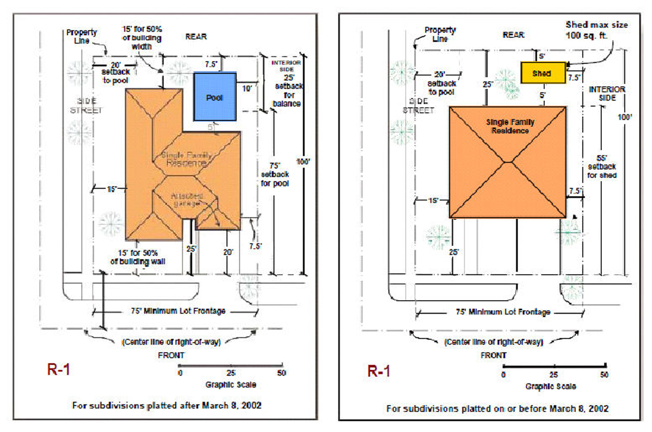
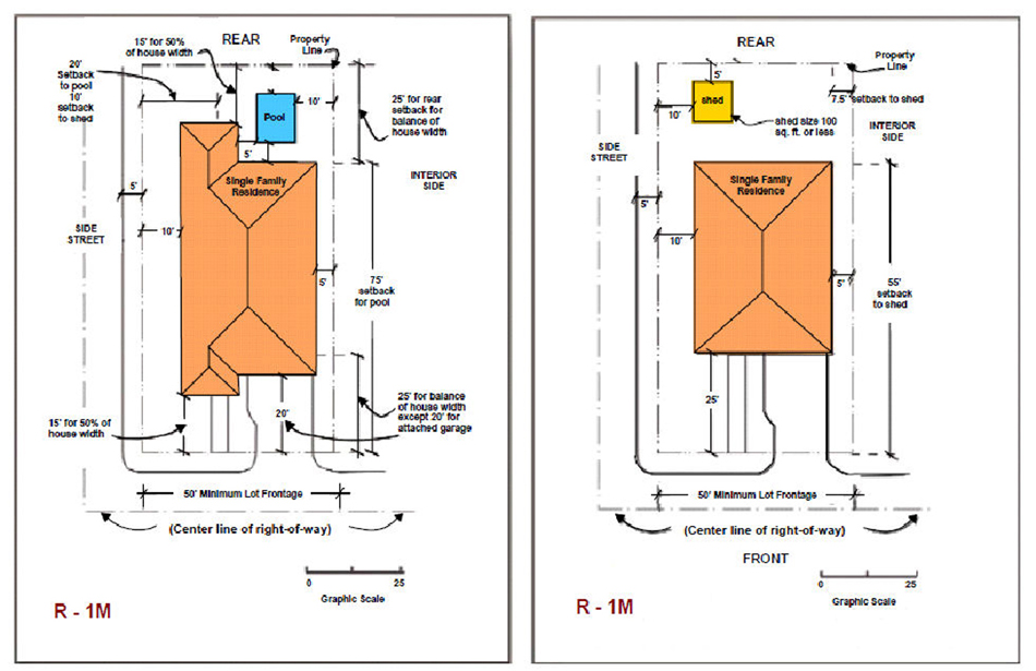
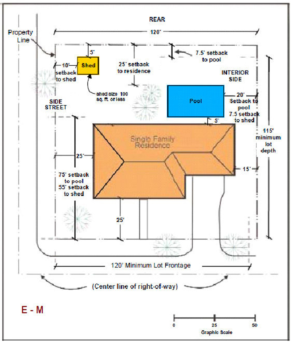
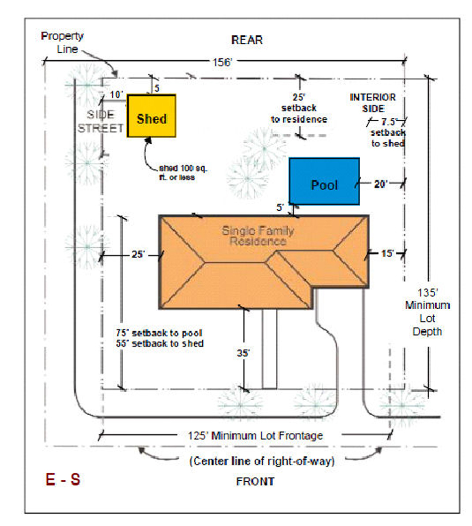
Swimming pools in all districts shall be constructed no closer than five feet to any building foundation, unless both the design and construction are approved by the director as safe and will not possibly result in a weakening of or damage to the building foundation. In no event shall said pools be closer than 18 inches to any wall or any enclosure. Screen enclosures, enclosing swimming pools or other approved uses, where attached to the principal building, shall be permitted no closer to the front property line than the principal building; and if so attached, such enclosures shall not be considered as a part of such residence or building, but shall be considered as an accessory building for purposes of lot coverage only. Swimming pools, whether or not enclosed within screen enclosures, that are not attached to the principal building, and other permitted detached screen enclosures, shall be considered as accessory uses and shall be setback at least 75 feet from the front property line.
(h)
Nothing shall be allowed on the premises in any district which would in any way be offensive or obnoxious by reason of color, design, or the emission of odors, liquids, gases, dust, smoke, vibration or noise. Nor shall anything be placed, constructed or maintained that would in any way constitute an eyesore or nuisance to adjacent property owners, residents, or to the community. No structure shall be erected, altered, structurally altered or moved except by methods and on locations unless as provided under this Code.
(i)
Lot coverage is the percentage of the overall area of the site that the building(s) occupy (building(s) area under roof at ground level/total lot area = lot coverage percentage).
(j)
Height measurement for certain structures. Height shall be measured from the grade of the property to the top of the eave of a pitched roof or to the top surface of a flat roof. Chimneys, conveyors, cooling towers, elevator bulkheads and shafts and enclosures for mechanical equipment, fire towers, and parapet walls shall not extend more than five feet above the height of the building upon which it rests. Any required airplane beacons shall comply with Federal Aviation Regulations.
(k)
Miami-Dade County Smart Plan Corridor Floor Area Ratio (FAR) requirements. All new development and redevelopment within urban centers and rapid transit activity corridors, as defined in Miami-Dade County Code of Ordinances Section 33C-3.3 (SMART Corridor Subzone; additional permitted uses; development standards; review and approval procedures), shall provide at least the minimum floor area ratio specified within the applicable floor area ranges provided in Miami-Dade County Code of Ordinances Section 33C-3.3(C), except where such minimums would result in:
(1)
Incompatible development encroaching into, or being established adjacent to or abutting, existing single-family or two-family neighborhoods; or
(2)
Existing single-family or two-family neighborhoods being required to redevelop; or
(3)
Development that is contrary to the requirements of a municipal historic preservation ordinance or Chapter 16A, as applicable, for a property or district that has been designated as historic pursuant to such historic preservation regulation.
(Ord. No. 09-17, § 1, 8-20-2009; Ord. No. 2013-03, § 1, 2-25-2013; Ord. No. 2023-03, § 2, 1-23-2023; Ord. No. 2024-04, § 3, 7-15-2024)
Sec. 30-50.2. - AG, Agricultural District.
(a)
Uses permitted. No land, body of water and/or structure shall be maintained, used or permitted to be used, and no structure shall be hereafter maintained, erected, constructed, moved, reconstructed or structurally altered or be permitted to be erected, constructed, moved, reconstructed or structurally altered for any purpose in an AG District which is designed, arranged, or intended to be used or occupied for any purpose other than the following:
(1)
All uses, except golf courses, permitted in the R-1, E-M, or E-1 Districts and subject to the restrictions of those districts that are not inconsistent with this section.
(2)
Barns, stables, sheds or other buildings used for the storage of equipment, feed, fertilizer, produce or other items ancillary for the permitted use. The use shall be accessory to the agricultural use conducted on the property provided, however, the structure shall be 50 feet from any residence under different ownership and any R or E District zoned property, unless approved after public hearing.
(3)
Fruit, vegetable and plant stands limited to products grown on the property subject to the accessory use setbacks.
(4)
Small packing facilities used for the packing of fruit and vegetables upon compliance with the following conditions:
a.
Such use shall be accessory to an agricultural use conducted on the property upon which the packing facility is located and the agricultural use must encompass 51 percent or more of the property.
b.
The packing facility shall be located at least 100 feet from any property line.
c.
The small packing facility shall not exceed 3,500 square feet.
(5)
Large packing facilities used for the packing of fruit and vegetables upon compliance with all of the following conditions:
a.
Such use shall be accessory to an agricultural use conducted on the entire property upon which the packing facility is located, and the agricultural use must encompass 51 percent or more of the property.
b.
The lot upon which the packing facility is located shall not be less than ten acres.
c.
Packing operations shall be discontinued if the farm or grove use is abandoned.
d.
Incidental cleaning, storage and shipping of the fruit and vegetables are permitted.
e.
Outside storage of refrigerated containers is prohibited unless the refrigeration system is powered by electricity. The parking of trucks with refrigeration powered by means other than electricity is permitted on a temporary basis only until the truck is loaded for delivery.
f.
The packing facility shall be 100 feet from any property line.
g.
Site plan approval is secured from the department.
h.
Upon compliance with all conditions enumerated, a certificate of use and occupancy is secured from the building and zoning department.
The term packing facility shall include any building, lean-to, pole barn or open area utilized by the farmer or grove owner in the course of packing fruit or vegetables as well as any areas whether or not within a building used for the cleaning of produce, storing of trucks, equipment, coolers, refrigerated containers, packing crates or other items used in the packing operation and parking of any vehicles including employee cars and trucks used by the farmer or grove owner to transport the produce to or from the site as well as any trucks on the property being loaded for the purpose of transporting the produce onto or off the property.
(6)
Outdoor storage of vehicles and equipment associated with agricultural, or horticultural production occurring on property(ies) other than the property on which the storage is located, provided the storage is not a principal use but is ancillary to a use permitted in this section other than residential, subject to all of the following conditions:
a.
The storage of refrigerated containers is prohibited, unless such refrigeration is electrically powered. Storage within the containers or within other types of equipment is permitted only on a recurrent basis with each occurrence limited to a maximum of 30 days.
b.
Such equipment, vehicles and the area of storage shall be properly maintained in operable condition at all times, except as otherwise provided herein.
c.
Major repairs or overhaul shall be permitted on equipment or vehicles associated with agricultural or horticultural production.
d.
The equipment and vehicles shall be located on the property with the following setbacks:
i.
From front property line, 50 feet;
ii.
From rear property line, 25 feet;
iii.
From interior side property line, 15 feet; and
iv.
From side street property line, 25 feet.
(7)
Outdoor storage of vehicles and equipment associated with agricultural or horticultural production occurring on property(ies) other than the property on which the storage is located, provided the storage is not a principal use but is ancillary to a residential use permitted in this section subject to all of the following conditions:
a.
Such storage shall be limited to equipment and/or vehicles owned or leased by the occupant-owner or occupant-lessee of the site where the storage is located.
b.
The location for such parked equipment and vehicles shall be in the rear yard or in the side yard to the rear of a line established by the front building line farthest from the street and set back to at least the rear building line. Such equipment and vehicles shall be set back from side property lines a distance at least equivalent to the required side setback for the principal building and shall be set back from the rear property line at least ten feet.
c.
The vehicles and equipment shall be maintained in operable condition at all times, except as otherwise provided herein. Every building, every accessory structure used for nondwelling purposes, including but not limited to garages, carports, cabanas, storage buildings, and every fence shall comply with the following requirements:
i.
Every foundation, exterior and interior wall, roof, floor, ceiling, window and exterior door shall be structurally sound and maintained in good repair.
ii.
Every accessory structure shall be kept in a reasonably clean and sanitary condition free from rodents, insects and vermin.
iii.
The roof of every accessory structure shall be well drained of rainwater.
iv.
All exterior surfaces subject to deterioration shall be properly maintained and protected from the elements by paint and other approved protective coating, applied in a workmanlike fashion.
d.
Major repairs or overhaul shall be permitted on equipment or vehicles associated with agricultural or horticultural production.
e.
The number of vehicles and amount of equipment stored on residential site shall be limited so as not to be a nuisance from an aesthetic and visual aspect. The storage of refrigerated containers is prohibited, unless such refrigeration is electrically powered. Storage within commercial vehicles or within other types of equipment is permitted only on a recurrent basis with each occurrence limited to a maximum of 30 days.
(8)
Groves.
(9)
Fruit and vegetable stands may be permitted upon compliance with the following conditions:
a.
The property upon which the fruit and vegetable stand is located shall be not less than five acres gross.
b.
Such fruit and vegetable stand shall be accessory to a bonafide, actively farmed and harvested agricultural crop, and the agricultural crop must encompass 51 percent or more of the property. The fruit and vegetable stand shall be operated only by the party engaged in the production of the crop on that property. The stand shall be operated only during the period of time that the crop is being produced on the site, and the fruit and vegetable stand use shall be discontinued when farming on the property is abandoned. Farming on the property shall not be deemed abandoned if the property is fallow between seasonal growing periods. Fruit and vegetables sold shall not be limited to products grown on the property.
c.
Refrigerated storage area(s) are prohibited unless the refrigeration system is powered by electricity.
d.
A minimum of six parking spaces shall be provided; the spaces shall be located a minimum of 35 feet from right-of-way pavement.
e.
The stand shall be located on the property with the following setbacks:
i.
From right-of-way pavement, 60 feet;
ii.
From rear property line, 25 feet;
iii.
From side street property line, 25 feet; and
iv.
From interior side property line, 100 feet.
f.
The stand shall be on open-sided, nonself propelled vehicle or conveyance permanently equipped to travel upon the public highways; however, a mobile home shall not be utilized as a fruit and vegetable stand.
g.
The maximum size of the stand shall not exceed 1,000 square feet. Refrigerated storage area(s) shall be included in computing the size of the stand.
h.
Food products offered for retail sale shall be derived from the agricultural crop on the property where the fruit and vegetable stand is located and such food products shall be manufactured by the fruit stand operator.
i.
The hours of operation of the fruit and vegetable stand shall be limited to between 6:30 a.m. and 9:00 p.m.
(9)
Commercial greenhouses, nurseries.
(10)
Horticultural farming.
(11)
Religious facilities and schools, including institutions of higher learning and primary and secondary schools only shall be permitted; provided, however the school structures, and its corresponding buildings or improvements, as well as all incidental (basketball, baseball fields) uses, are at least 250 feet from the boundary, property or lot line, and further provided that such uses comply with the regulations of Division 30-110 or Division 30-120 of this Code.
(12)
A group home shall be permitted in a dwelling unit provided:
a.
No more than six resident clients on the premises.
b.
That the operation of the facility be licensed by the State of Florida Department of Health and Rehabilitative Services and that the department or sponsoring agency promptly notifies the director of the licensure prior to home occupancy.
c.
Any structure used for a group home shall be located at least 1,000 feet from any other existing, un-abandoned, legally established group home. The 1,000-foot distance requirement shall be measured by following a straight line from the nearest portion of the structure of the proposed use to the nearest portion of the structure of the existing use.
(b)
Prohibited uses. All uses not specifically or provisionally provided for herein. Nothing shall be allowed on the premises in any district which would in any way be offensive or obnoxious by reason of color, design, or the emission of odors, liquids, gases, dust, smoke, vibration or noise. Nor shall anything be placed, constructed or maintained that would in any way constitute an eyesore or nuisance to adjacent property owners, residents, or to the community. No structure shall be erected, altered, structurally altered or moved except by methods and on locations as approved by the director. Specifically prohibited uses include, but are not limited to hog, chicken farms, cattle, fish farms, and all similar uses; wineries; hydroponic farms; dude ranches; and temporary/permanent labor camps.
(c)
Lot area and width. Lots for any use in AG District shall contain a minimum of five acres, and have a minimum street frontage of 200 feet. Credit shall be given towards lot area requirements for right-of-way dedication from the underlying parcel.
(d)
Reserved.
(e)
Dimensional regulations.
(f)
Minimum setbacks.
(1)
Minimum setbacks:
*Uninhabitable sheds less than 145 square feet shall, with width and depth dimensions of 12 feet or less not exceed eight feet in height above grade to the roof ridge. All other sheds and structures shall comply with the accessory building setback requirements.
a.
Horticultural nursery buildings shall comply with accessory building setback requirements, except that no minimum spacing need be provided between structures on the same property.
(g)
Agricultural disclosure.
(1)
Definitions.
a.
Affected land for the purpose of this section AG District zoned land or land abutting AG District property.
b.
Interest in real property means a nonleasehold, legal or equitable estate in land or any severable part thereof created by deed, contract, mortgage, easement, covenant or other instrument.
c.
Purchaser means a buyer, transferee, grantee, donee or other party acquiring an interest in real property.
d.
Real property transaction means the sale, grant, conveyance, mortgage or transfer of an interest in real property.
e.
Seller means a transferor, grantor, donor or other party conveying an interest in real property.
f.
Disclosure statement for real property transactions involving affected land. The seller shall provide the purchaser with the following statement, which shall be set forth on a separate sheet of paper and shall be signed by the prospective purchaser prior to the execution of any other instrument committing the purchaser to acquire title to such real property or any other interest in any affected land, as follows:
i.
For all affected land, the statement shall include the following language:
LAND INVOLVED IN THIS TRANSACTION IS ZONED AGRICULTURAL (AG) OR LIES ADJACENT TO LAND THAT IS ZONED AG, OR IS SUBJECT TO AG REGULATIONS. AGRICULTURAL ACTIVITIES WHICH MAY BE LAWFULLY CONDUCTED WITHIN THIS AREA INCLUDE BUT MAY NOT BE LIMITED TO CULTIVATION AND HARVESTING OF CROPS; OPERATION OF IRRIGATION PUMPS AND OTHER MACHINERY; GROUND OR AERIAL SEEDING OR SPRAYING; APPLICATION OF CHEMICAL FERTILIZERS, CONDITIONERS, PESTICIDES AND HERBICIDES; GENERATION OF TRACTOR AND TRUCK TRAFFIC AND OF NOISE, ODORS, DUST AND FUMES ASSOCIATED WITH THE CONDUCT OF THE FOREGOING ACTIVITIES; AND THE EMPLOYMENT AND USE OF AGRICULTURAL LABOR. SUCH AGRICULTURAL ACTIVITIES MAY BE PROTECTED FROM NUISANCE SUITS BY THE "FLORIDA RIGHT TO FARM ACT," SECTION 823.14, FLORIDA STATUTES.
ii.
In addition to the language set forth in section 30-52.2(g)(1)f.i. the statement for all nonresidential AG District land served or to be served by a septic tank shall include the following language:
ALL NONRESIDENTIAL AG LAND SERVED OR TO BE SERVED BY A SEPTIC TANK SHALL BE SUBJECT TO THE FOLLOWING PROVISIONS:
THE ONLY LIQUID WASTE WHICH SHALL BE GENERATED, DISPOSED OF, DISCHARGED, OR STORED ON THE PROPERTY SHALL BE DOMESTIC SEWAGE DISCHARGED INTO A SEPTIC TANK.
iii.
For all AG District land, the statement shall conclude with the following language:
THE ZONING CODE OF VILLAGE OF PALMETTO BAY ENUMERATES CERTAIN EXCEPTIONS WHERE SMALLER LOT SIZES ARE PERMITTED. IF THE LAND WHICH IS THE SUBJECT OF THIS TRANSACTION DOES NOT QUALIFY FOR AN EXCEPTION, AND DOES NOT MEET BOTH THE LOT FRONTAGE AND AREA REQUIREMENTS NOTED ABOVE, NO SINGLE FAMILY RESIDENTIAL USE OR ANY OTHER USE OF THE PROPERTY MAY BE PERMITTED UNLESS FIRST APPROVED AFTER PUBLIC HEARING. I HEREBY CERTIFY THAT I HAVE READ AND UNDERSTAND THE FOREGOING STATEMENT.
___________
Signature of Purchaser
_______
Date
Acknowledgment of agricultural disclosure statement on instrument of conveyance. It shall be the seller's responsibility that the following statement shall appear in a prominent location on the face of any instrument conveying title to or any other interest in the affected land. The seller shall record the notarized statement with the Clerk of the Court:
I HEREBY CERTIFY THAT I HAVE READ, UNDERSTAND AND HAVE SIGNED THE AGRICULTURAL DISCLOSURE STATEMENT FOR THE SALE OF OR OTHER TRANSACTION INVOLVING THIS PARCEL OF AFFECTED LAND AS REQUIRED BY THE CODE OF THE VILLAGE OF PALMETTO BAY, FLORIDA.
___________
Signature of Purchaser
_______
Date
a.
Penalties. Any seller who violates any provision of this section, or fails to comply therewith, or with any lawful rule, regulation or written order promulgated under this section, shall be subject to the penalties, civil liability, attorney's fees and enforcement proceedings set forth in the Code of Village of Palmetto Bay, Florida, and to such other penalties, sanctions and proceedings as may be provided by law. The Village of Palmetto Bay shall not be held liable for any damages or claims resulting from the seller's failure to comply with provisions of this section.
b.
Exceptions. Notwithstanding any other provision of the Code of Village of Palmetto Bay, real property that is zoned AG District and determined by the director to be subject to an agricultural trend of development, and which property or property interest is being transferred to the South Florida Water Management District, shall be exempt from all disclosure requirements pertaining to AG District land.
(Ord. No. 09-17, § 1, 8-20-2009; Ord. No. 2012-23, §§ 2, 5, 11-5-2012; Ord. No. 2013-03, § 1, 2-25-2013; Ord. No. 2014-03, § 2, 4-7-2014)
Sec. 30-50.3. - R-1, Single family Residential District.
(a)
Uses permitted. No land, body of water and/or structure shall be used, or permitted to be used, and no structure shall be hereafter erected, constructed, moved, reconstructed, structurally altered or maintained for any purpose in the R-1 District for any purpose unless as specifically provided herein:
(1)
Single family residential dwellings, including accessory uses consistent with the character of existing homes and uses in the area including but not limited to private garages.
(2)
Municipal recreation building(s), playground(s), or park(s) owned or operated by the village or other governmental entity.
(3)
Family day care facility and after-school care for children upon compliance with the following conditions:
a.
That the total number of children on the premises for family day care does not exceed five in number, including in the count only preschool children of the resident family. Preschool children shall consist of children five years of age or younger.
b.
That the age of the children for after-school care, excluding those of the resident family, shall not exceed 11 years of age.
c.
That the applicant secure a license from the Florida Department of Children and Families to operate a family day care facility at the subject property.
d.
Where applicable, compliance with the requirements of this Code pertaining to educational and child care facilities.
e.
Upon compliance with all conditions enumerated, a certificate of use and occupancy is secured from the department.
f.
That the facility shall comply with the safety barrier requirements and restrictions of this Code.
g.
That the applicant secure an occupational license, and certificate of use from the village.
(4)
Group homes upon compliance with the following conditions:
a.
The total number of residents on the premises shall not exceed six in number.
b.
That the applicant secures all required licenses required to operate a group home including but not limited to a license from the Florida Department of Health and Rehabilitation Service, occupational license, and certificate of use from the village.
c.
That the structure used for the group home shall be located at least 1,000 feet from another existing, un-abandoned legally established group home. The 1,000-foot distance requirement shall be measured in a straight line from the property lines of an existing group home site to the property lines of the proposed group home site.
(5)
Noncommercial boat piers or slips for docking of private watercraft, which shall be an incidental accessory use to the existing residential use, except live on board watercrafts.
(6)
Private recreation area, private recreation building or playground owned and maintained by a homeowner's or tenant association, provided the use is approved in conjunction with approval of the subdivision at time of site plan approval or plat.
(7)
Golf courses.
(8)
Home offices in accordance with Division 30-60.
(9)
Schools and religious facilities pursuant to the requirements of Divisions 30-110 or 30-120.
(b)
Conditional uses. The following uses may be approved after public hearing by the village council but only as a conditional use:
(1)
Servant's quarters.
(c)
Prohibited uses. The following uses shall be prohibited:
(1)
Bee hives, or the breeding or raising of any insects, reptiles or animals other than customary pets.
(2)
Kennels, private or commercial.
(3)
The keeping, breeding, or maintaining of horses, cattle, swine, roosters, fowl (except chickens), goats, any other farm animals or any other animals other than customary pets. The following conditions shall be applied to keeping and maintaining chickens in all single-family residential zoning districts:
a.
The keeping of no more than six chickens shall be allowed.
b.
Chickens shall be enclosed in an area no closer than required setback from any property line for "accessory structures" within the applicable district;
c.
Chickens shall only be allowed behind the front building line of the single-family structure;
d.
Chickens must be contained to an area less than 100 square feet;
e.
The enclosed area shall be no greater than six feet in total height;
f.
The keeping of chickens shall be for personal use only and not for commercial purposes.
(4)
Any use of the premises in a residential district which conflicts with normal and expected residential use in the district.
(d)
Dimensional regulations.
(e)
Minimum setbacks.
Includes principle structures, accessory structures, and sheds.
(f)
Minimum width of lots in new subdivisions in the R-1 District may be decreased from the amount required under the following conditions:
(1)
The decrease shall be applicable to lots containing a portion of their frontage along the curvilinear streets and culs-de-sac.
(2)
The minimum lot frontage as defined elsewhere for the various zoning districts must be provided at the minimum building setback line of curvilinear lots.
(3)
That the minimum frontage requirement at street right-of-way line and radius requirements of exterior street right-of-way line along curvilinear streets and culs-de-sac shall meet a minimum frontage of 50 feet.
(4)
Lot area must comply with all other minimum zoning requirements.
(5)
The design of the streets where the lot frontage occurs must conform to standards of the public works department.
(Ord. No. 09-17, § 1, 8-20-2009; Ord. No. 2012-23, §§ 2, 5, 11-5-2012; Ord. No. 2013-03, § 1, 2-25-2013; Ord. No. 2014-03, § 2, 4-7-2014; Ord. No. 2023-12, § 2, 5-15-2023)
Sec. 30-50.35. - R-1M, Modified Single family District.
(a)
Permitted uses. No land, body of water and/or structure shall be used or permitted to be used and no structure shall be hereafter erected, constructed, moved, reconstructed or structurally altered for any purpose in an R-1M District which is designed, arranged, or intended to be used or occupied for any purpose other than those uses specifically provided in the R-1 District.
(b)
Conditional uses. Same as R-1 District and noncommercial boat piers or slips for docking of private watercraft, which shall be an incidental accessory use to the existing residential use, except live on board watercrafts.
(c)
Prohibited uses. Same as R-1 District.
(d)
Dimensional regulations.
(e)
Minimum setbacks.
;adv=6;Includes principle structures, accessory structures, and sheds.
(f)
Compliance with minimum terms of subsection 30-50.3(f).
(Ord. No. 2013-03, § 1, 2-25-2013; Ord. No. 2014-03, § 2, 4-7-2014)
Sec. 30-50.4. - E-M, Estate Modified Single family District.
(a)
Uses permitted. No land, body of water and/or structure shall be used or permitted to be used and no structure shall be hereafter erected, constructed, moved, reconstructed, structurally altered or maintained for any purpose in the E-M District which shall be designed, arranged or intended to be used or occupied for any purpose other than the following, unless specifically provided herein:
(1)
Single family residential dwellings, including accessory uses consistent with the character of existing homes and uses in the area including but not limited to private garages, servant's quarters or guest houses not over one story in height (incidental to the principal residential use).
(2)
Same uses as R-1 District.
(b)
Conditional uses. Same as R-1 District.
(c)
Prohibited uses. Same as R-1 District.
(d)
Dimensional regulations.
(e)
Minimum setbacks.
(f)
Minimum width of lots in new subdivisions in the E-M District may be decreased from the amount required under the following conditions:
(1)
The decrease shall be applicable to lots containing a portion of their frontage along the curvilinear streets and culs-de-sac.
(2)
The minimum lot frontage as defined elsewhere for the various zoning districts must be provided at the minimum building setback line of curvilinear lots.
(3)
That the minimum frontage requirement at street right-of-way line and radius requirements of exterior street right-of-way line along curvilinear streets and culs-de-sac shall meet a minimum frontage of 80 feet.
(4)
Lot area must comply with all other minimum zoning requirements.
(5)
The design of the streets where the lot frontage occurs must conform to standards of the public works department.
(Ord. No. 09-17, § 1, 8-20-2009; Ord. No. 2012-23, §§ 2, 5, 11-5-2012; Ord. No. 2013-03, § 1, 2-25-2013; Ord. No. 2014-03, § 2, 4-7-2014)
Sec. 30-50.5. - E-S, Estate Suburban Single family District.
(a)
Uses permitted. No land, body of water and/or structure shall be used or permitted to be used and no structure shall be hereafter erected, constructed, moved, reconstructed, structurally altered or maintained for any purpose in the E-S District which shall be designed, arranged or intended to be used or occupied for any purpose other than the following, unless specifically provided herein:
(1)
Single family residential dwellings, including accessory uses consistent with the character of existing homes and uses in the area including but not limited to private garages, servant's quarters or guest houses not over one story in height (incidental to the principal residential use).
(2)
All permitted uses allowed in E-M District, except noncommercial boat piers or slips for docking of private watercraft.
(3)
Beekeeping not to exceed five hives, provided the same are located no closer than 150 feet to a highway or right-of-way line nor closer than 150 feet to a residential structure.
(b)
Conditional uses. Same as R-1 District.
(c)
Prohibited uses. Same as R-1 District and precludes noncommercial boat piers or slips for docking of private watercraft.
(d)
Dimensional regulations.
(e)
Minimum setbacks.
(f)
Minimum width of lots in new subdivisions in the E-S District may be decreased from the amount required under the following conditions:
(1)
The decrease shall be applicable to lots containing a portion of their frontage along the curvilinear streets and culs-de-sac.
(2)
The minimum lot frontage as defined elsewhere for the various zoning districts must be provided at the minimum building setback line of curvilinear lots.
(3)
That the minimum frontage requirement at street right-of-way line and radius requirements of exterior street right-of-way line along curvilinear streets and culs-de-sac shall meet a minimum frontage of 85 feet.
(4)
Lot area must comply with all other minimum zoning requirements.
(5)
The design of the streets where the lot frontage occurs must conform to standards of the public works department.
(Ord. No. 09-17, § 1, 8-20-2009; Ord. No. 2012-23, §§ 2, 5, 11-5-2012; Ord. No. 2013-03, § 1, 2-25-2013; Ord. No. 2014-03, § 2, 4-7-2014)
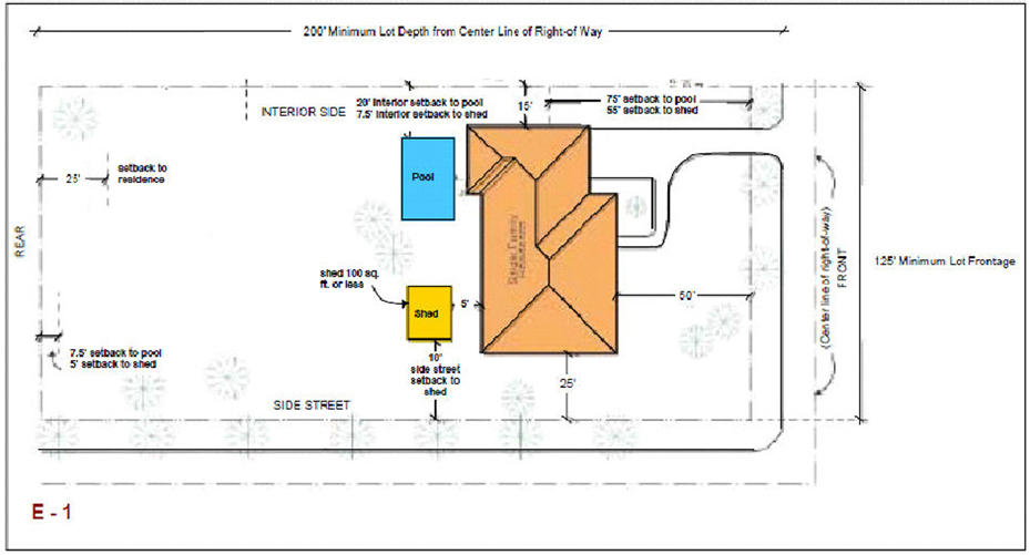
Sec. 30-50.6. - E-1, One Acre Estate Single family District.
(a)
Uses permitted. No land, body of water and/or structure shall be used or permitted to be used and no structure shall be hereafter erected, constructed, moved, reconstructed, structurally altered or maintained for any purpose in the E-1 District which shall be designed, arranged or intended to be used or occupied for any purpose other than the following, unless specifically provided herein:
(1)
Single family residential dwellings, including accessory uses consistent with the character of existing homes and uses in the area including but not limited to private garages, servant's quarters or guest houses not over one story in height (incidental to the principal residential use).
(2)
All permitted uses allowed in E-M District.
(3)
It shall be permissible to keep and maintain more that two horses, provided (1) such use is incidental to an existing residential use, (2) the area used to keep and maintain the horses is part of the residential site, and (3) that the horses are fenced at least 50 feet from property under different ownership. One additional horse may likewise be kept and maintained for each acre in excess of the first acre that is part of the residential site on those estates which are five acres or less in size. On those estates which are between five and nine acres in size, one additional horse may likewise be kept and maintained for each additional two acres that forms part of the residential site larger than five acres. On those estates which are larger than nine acres in size, one additional horse may likewise be kept and maintained for each additional five acres that forms part of the residential site larger than nine acres. The total of all horses shall not exceed ten. In no event shall the property be used for the keeping of horses owned by others than those residing on the property. All horses kept, maintained, and housed in properly constructed stalls, stables, or places of shelter approved as to location and construction by the department.
(4)
Beekeeping not to exceed five hives, provided the same are located no closer than 150 feet to a highway line nor closer than 150 feet to a residential structure.
(b)
Conditional uses. Same as R-1 District.
(c)
Prohibited uses. Same as R-1 District.
(d)
Dimensional regulations.
(e)
Minimum setbacks.
(f)
Minimum width of lots in new subdivisions in the E-1 District may be decreased from the amount required under the following conditions:
(1)
The decrease shall be applicable to lots containing a portion of their frontage along the curvilinear streets and culs-de-sac.
(2)
The minimum lot frontage as defined elsewhere for the various zoning districts must be provided at the minimum building setback line of curvilinear lots.
(3)
That the minimum frontage requirement at street right-of-way line and radius requirements of exterior street right-of-way line along curvilinear streets and culs-de-sac shall meet a minimum frontage of 85 feet.
(4)
Lot area must comply with all other minimum zoning requirements.
(5)
The design of the streets where the lot frontage occurs must conform to standards of the public works department.
(Ord. No. 09-17, § 1, 8-20-2009; Ord. No. 2012-23, §§ 2, 5, 11-5-2012; Ord. No. 2013-03, § 1, 2-25-2013; Ord. No. 2013-13, § 1, 11-4-2013; Ord. No. 2014-03, § 2, 4-7-2014)
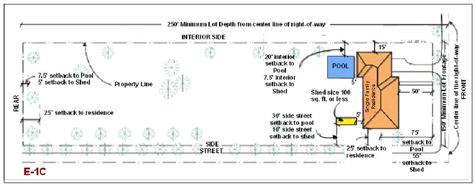
Sec. 30-50.7. - E-1C, 2.5 Acres Estate Single family District.
(a)
Uses permitted. No land, body of water and/or structure shall be used or permitted to be used and no structure shall be hereafter erected, constructed, moved, reconstructed, structurally altered or maintained for any purpose in the E-1C District which shall be designed, arranged or intended to be used or occupied for any purpose other than the following, unless specifically provided herein:
(1)
Single family residential dwellings, including accessory uses consistent with the character of existing homes and uses in the area including but not limited to private garages, servant's quarters or guest houses not over one story in height (incidental to the principal residential use).
(2)
All permitted uses allowed in R-1 District, except noncommercial boat piers or slips for docking of private watercraft
(3)
It shall be permissible to keep and maintain more that two horses, provided (1) such use is incidental to an existing residential use, (2) the area used to keep and maintain the horses is part of the residential site, and (3) that the horses are fenced at least 50 feet from property under different ownership. One additional horse may likewise be kept and maintained for each acre in excess of the first acre that is part of the residential site on those estates which are five acres or less in size. On those estates which are between five and nine acres in size, one additional horse may likewise be kept and maintained for each additional two acres that forms part of the residential site larger than five acres. On those estates which are larger than nine acres in size, one additional horse may likewise be kept and maintained for each additional five acres that forms part of the residential site larger than nine acres. The total of all horses shall not exceed ten. In no event shall the property be used for the keeping of horses owned by others than those residing on the property. All horses kept, maintained, and housed in properly constructed stalls, stables, or places of shelter approved as to location and construction by the department.
(4)
Beekeeping not to exceed five hives, provided the same are located no closer than 150 feet to a highway line nor closer than 150 feet to a residential structure.
(b)
Conditional uses. Same as R-1 District.
(c)
Prohibited uses. The following uses shall be prohibited:
(1)
All uses not specifically or provisionally provided for herein.
(2)
Noncommercial boat piers or slips for docking of private watercraft
(d)
Dimensional regulations.
(e)
Minimum setbacks.
(Ord. No. 09-17, § 1, 8-20-2009; Ord. No. 2012-23, §§ 2, 5, 11-5-2012; Ord. No. 2013-03, § 1, 2-25-2013; Ord. No. 2014-03, § 2, 4-7-2014)
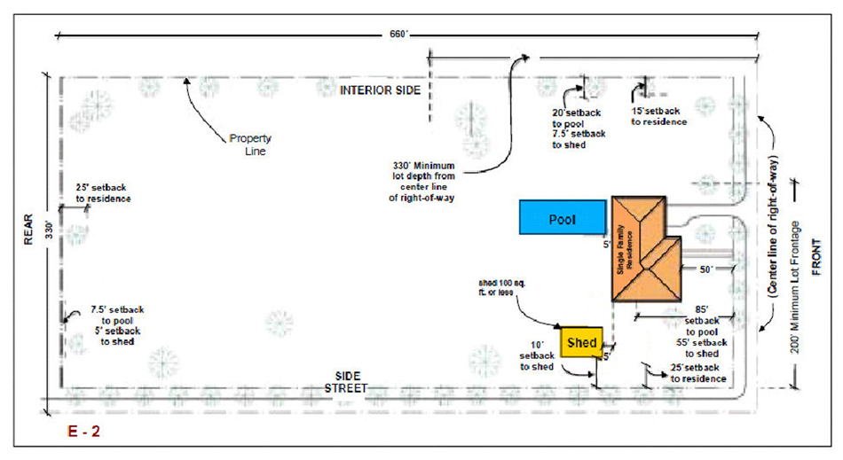
Sec. 30-50.8. - E-2, Five Acre Estate Single family District.
(a)
Uses permitted. No land, body of water and/or structure shall be used or permitted to be used and no structure shall be hereafter erected, constructed, moved, reconstructed, structurally altered or maintained for any purpose in the E-2 District which shall be designed, arranged or intended to be used or occupied for any purpose other than the following, unless specifically provided herein:
(1)
All permitted uses allowed in E-1C District, except that the minimum area of land shall be not less than five acres.
(2)
An entrance lodge for a gate-keeper's family; provided the lodge is situated not nearer than 50 feet to the property line abutting any public street or highway, and not nearer than 300 feet to adjoining premises or to a residence other than that owned by the owner of the premises on which it is situated. Plans for the entrance lodge shall meet the approval of the director.
(3)
Noncommercial boat piers of slips for docking of private watercraft, which shall be an incidental accessory use to the existing residential use, except live on board watercrafts.
(b)
Conditional uses. The following uses may be approved by the village council, after public hearing as a conditional use:
(1)
Same conditional uses allowed within the R-1 District.
(2)
The sale of fruit or vegetables grown incidental to an existing residential use. Provided no signs are displayed regarding the sale of product so raised. Such signs shall be confined to an area no closer than ten feet from an official right-of-way.
(c)
Prohibited uses. Same as E1-C District.
(d)
Dimensional regulations.
(e)
Minimum setbacks.
(Ord. No. 09-17, § 1, 8-20-2009; Ord. No. 2012-23, §§ 2, 5, 11-5-2012; Ord. No. 2013-03, § 1, 2-25-2013; Ord. No. 2014-03, § 2, 4-7-2014)
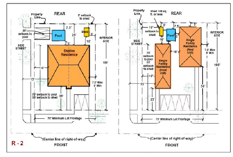
Sec. 30-50.9. - R-2, Two-Family Residential District.
(a)
Uses permitted. No land, body of water and/or structure shall be used or permitted to be used and no structure shall be hereafter erected, constructed, moved, reconstructed, structurally altered or maintained for any purpose in the R-2 District which shall be designed, arranged or intended to be used or occupied for any purpose other than the following, unless specifically provided herein:
(1)
Uses allowed in the R-1 District.
(2)
On lots meeting the requirements for two-family use, every use as a duplex or two-family residence, including two private garages. Where two separate buildings are erected to house separate families on a single lot, one shall be placed to the rear of the other and not side by side within the minimum lot width required under these regulations.
(3)
Every use as a secondary or subordinate single family residence or one-family garage apartment on the rear portion of a lot where there is only one single family residence on the front portion of the lot.
(b)
Subdivision of R-2 lots.
(1)
Duplex uses which comply with the minimum standards of this division for such uses in the R-2 District and other districts where duplex uses are permitted may be subdivided so as to create one lot for each dwelling unit, provided that the following conditions are met:
a.
Each individual lot must be subdivided in accordance with Division 30-80.
b.
Lot frontage. Each individual lot shall have a minimum frontage of 37.5 feet at the front property line and at the required 25-foot front setback line.
c.
Lot area. Each individual lot shall have a minimum area of 3,750 square feet.
d.
Lot coverage. For each individual lot, the percentage of lot covered by structures shall not exceed 0.30.
e.
Height. The maximum height shall be 35 feet to roof ridge and two stories.
f.
Setbacks. As applied to lot lines prior to lot division in accordance with subsection (f), below.
g.
Parking. For each individual lot, a minimum of two parking spaces per lot shall be provided.
h.
Utilities and services. Each individual unit shall be independently served by separate heating, air conditioning, sewer, water, electric power, gas, and other facility and utility services, wherever such utilities and services are provided, and no individual unit shall be in any way dependent upon such services or utility lines located within another unit.
i.
Walls. The individual units in a fee-simple duplex arrangement shall be separated by a party wall meeting all requirements of the Florida Building Code. Where units are offset from one another and a common party wall is used, the wall may be placed equidistant on each side of the lot line not exceeding the length of the offset.
j.
Maintenance of lot and structure. Provisions shall be made to assure that the structures and grounds in a development of this type are maintained in a satisfactory manner, without expense to the general taxpayer. The instrument incorporating such provisions shall include methods to ensure the consistency and compatibility of the maintenance of all structures, parking areas, common walls, fences, and grounds. If necessary, the instrument shall include four-foot wall-maintenance easement provisions. The instrument incorporating such provisions shall be approved by the department and shall be recorded in the public records of Miami-Dade County at the time of the subdivision. A unity of title or other similar agreement or covenant must be filed on a form approved by the department at the time of subdivision of the property in accordance with the provisions of this section; the instrument may be released by the director upon assurance that the construction of the duplex structure(s) will proceed in accordance with the provisions of this section. Building permits will only be issued for both duplex units. Construction on each unit in the duplex must proceed concurrently.
k.
No appeal rights. Individual unit owners may not appeal any development matters via the administrative variance process or to appropriate hearing boards if written agreement on building alterations, additions, etc., cannot be reached with the abutting unit owner. If agreement is reached, normal regulations pursuant to permits, public hearings, etc., must be adhered to. No variances from this subsection may be applied for or granted.
l.
Duplex lots that do not have 75 feet of frontage and/or 7,500 square feet of area, but are legally grandfathered or otherwise approved, may be subdivided in accordance with the provisions herein, provided that:
i.
Each lot in a subdivided pair shall have equal frontage at the front property line and at the required 25-foot front setback line, except as follows: On corner lots, the corner lot in a subdivided pair may have up to 55 percent of the frontage of the original lot prior to its subdivision. The other lot in this subdivided pair must have a minimum of 45 percent of the frontage of the lot.
ii.
Each lot in a subdivided pair shall have equal lot area, except as follows: On corner lots, the corner lot in a subdivided pair may have up to 0.55 of the area of the original lot prior to its subdivision. The other lot in this subdivided pair must have a minimum of 0.45 percent of the area of the original lot.
iii.
Building setbacks, as applied to lot lines prior to lot division in accordance with this section, shall be as enumerated in the chart below, except that interior side setbacks shall be a minimum of five feet.
(c)
Conditional uses. Same as R-1 District.
(d)
Prohibited uses. Same as R-1 District.
(e)
Dimensional regulations:
(f)
Minimum setbacks.
(Ord. No. 09-17, § 1, 8-20-2009; Ord. No. 2012-23, §§ 2, 5, 11-5-2012; Ord. No. 2013-03, § 1, 2-25-2013; Ord. No. 2014-03, § 2, 4-7-2014)
Sec. 30-50.10. - R-TH, Townhouse District.
(a)
Purpose and intent. It is the purpose and intent of this section to provide a townhouse zoning district in order to permit separate ownership of one-family dwelling units upon compliance with certain rules, regulations and standards, and to authorize the grouping of separately owned one-family dwelling units into a group of townhouses in such a manner as to make efficient, economical and aesthetically pleasing use of land, so restricted that the same will be continually well maintained in order to preserve the health, welfare, safety and convenience of the neighborhood and surrounding area.
(b)
Definition. As used herein, a "townhouse" is a one-family dwelling unit of a group of three or more units separated by a common party firewall; provided, however, that up to ten percent of the total number of units on any individual site plan may be developed in two-unit groupings. The common party fire wall shall extend to the roof line or above the roof of units which it serves and shall provide no openings. Where units are offset from one another and a common party wall is used, the wall may be placed equidistant on each side of the lot line not exceeding the length of the offset. Each townhouse unit shall be constructed upon a separate platted lot; provided, however, that the roof lines may overhang onto adjacent lots or common areas a maximum of 24 inches, subject to the approval of and determination by the director that the roof or drainage system is designed so that runoff of water from the roof does not adversely affect adjacent units or lots. Each townhouse unit shall be serviced with separate utilities and other facilities and shall otherwise be independent of one another; provided, however, that the electrical lines or telephone lines or cables which service a particular unit may be placed through other lots where approved by the director. The director's approval shall be based upon his finding that the placement of the lines or cables will not adversely affect the lots through which they are placed.
(c)
Uses permitted.
(1)
Those uses permitted in R-1 and R-2 Districts.
(2)
Townhouses as provided below.
(d)
Conditional uses. Same as R-1 District.
(e)
Prohibited uses. Same as R-1 District.
(f)
Dimensional regulations for town homes:
i.
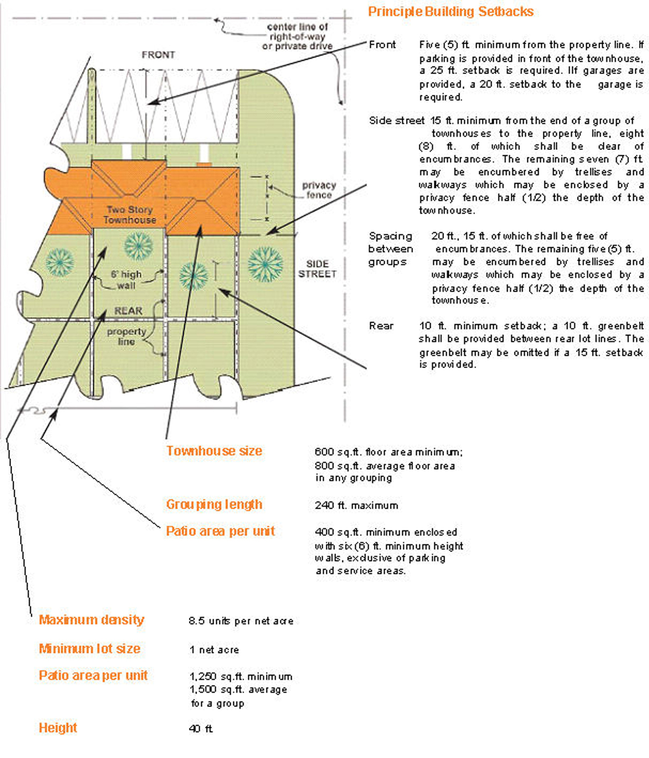
Front: There shall be a 15-foot minimum distance from the nearest edge of roadway pavement to the front building line. Where parking spaces are provided in front of townhouse buildings, the required front setback of the building shall be 25 feet from the nearest edge of roadway pavement in the parking area unless garages are provided, in which case the garage portion of the structure shall be set back 20 feet from the nearest edge of roadway pavement. Any portion of the townhouse building that is not located directly in front of parking spaces shall be set back 15 feet from the nearest edge of roadway pavement.
ii.
Rear: There shall be a ten-foot minimum rear building setback. A minimum greenbelt of ten feet shall be provided between rear lot lines; provided, however, that rear lot lines may abut without a greenbelt if a rear building setback of 15 feet is provided.
iii.
Side yard/street: There shall be a 15-foot minimum provided between the end of a group of townhouses to a public or private street pavement, eight feet of which shall be unencumbered by walls, fences or other structures or buildings. The remaining seven feet may be encumbered by trellises, chimneys or walkways which may be enclosed by privacy fences and must be attached to the principal structure. The fences shall not extend in excess of 50 percent of the depth of the townhouse.
iv.
Spacing between groups: There shall be a 20-foot minimum spacing between each group of townhouses, 15 feet of which shall be unencumbered by walls, fences or other structures or buildings. The remaining five feet may be encumbered by trellises, chimneys or walkways which must be attached to the principal structure and which may be enclosed by privacy fences. The fences shall not extend in excess of 50 percent of the depth of the townhouse.
(g)
Site plan review. The department shall review plans for compliance with zoning regulations and for compliance with the site plan review criteria. The purpose of the site plan review is to encourage logic, imagination, innovation and variety in the design process and thereby insure the congruity of the proposed development and its compatibility with the surrounding area. All plans submitted to the department shall be reviewed and approved or denied by the department within 15 days from the date of submission. The applicant shall have the right to extend the 15-day period by an additional 15 days upon timely request made in writing to the department. The department shall have the right to extend the 15-day period by written notice to the applicant that additional information is needed to process the site plan. Denials should be in writing and shall specifically set forth the grounds for denial. If the plan is disapproved the applicant may appeal to the appropriate village council in accordance with procedure established for appeals of administrative decision.
(1)
Procedure. Exhibits prepared by design professionals such as architects and landscape architects shall be submitted to the department of planning and zoning and shall include, but not be limited to the following:
a.
Site plan including the following information:
i.
Lot lines and setbacks.
ii.
Location, shape, size and height of existing and proposed buildings, vehicular and pedestrian circulation systems, entrance features, bike paths, recreational facilities and any other physical features that are proposed for the site that can be shown in plan form.
iii
Compliance with landscaping regulations.
iv.
Location of all parking spaces and waste collection area(s).
v.
Indication of exterior graphics, as required.
vi.
Indication of any site design methods used to conserve energy.
b.
Floor plans and elevations for typical townhouse units and floor plans and elevation of any recreation buildings, community buildings and other similar structures. Plan(s) for units shall indicate the private outdoor areas (patio space) for the individual unit(s).
c.
Figures indicating the following:
i.
Gross and net acreage.
ii.
Amount of common open space in square feet and percentage required and provided.
iii.
The size in square feet for the smallest and average townhouse sites.
iv.
Total number of trees required and provided in accordance with landscaping regulations.
v.
Parking required and provided.
vi.
Such other design data as may be needed to evaluate the project.
(2)
Site plan review criteria. The following criteria shall be utilized in the plan review process:
a.
Purpose and intent: The proposed development fulfills the objectives of this division.
b.
Planning studies: Design, planning studies or neighborhood area studies accepted or approved by the village council that include development patterns or environmental design criteria which would apply to the development proposal under review shall be utilized in the plan review process.
c.
Landscape: Landscape shall be reserved in its natural state insofar as is practicable by minimizing tree removal. Landscape shall be used to shade and cool, direct wind movements, enhance architectural features, relate structure design to site, visually screen noncompatible uses and block noise generated by the major roadways and intense use areas.
d.
Buffers: Buffering elements in the form of architectural design and landscape design that provide a logical transition to adjoining existing or permitted uses shall be provided.
e.
Scale: Scale of proposed structures shall be compatible with surrounding proposed or existing uses or shall be made compatible by the use of buffering elements.
f.
Street system: A well-defined system shall be designed to allow free movement throughout the development while discouraging excessive speeds, and shall structure the development in clearly defined clusters and/or groups of townhouses. All dwelling units should be located on residential service streets or courts designed to discourage all traffic except that of owner/occupants, their guests, and their services. Pedestrian and auto circulation shall be separated insofar as is practicable.
g.
Visibility: No obstruction to visibility at street intersections shall be permitted, and such visibility clearances shall be as required by the department of public works.
h.
Energy consideration: Site design methods to reduce energy consumption shall be encouraged. Energy site conservation methods may include siting of structures in relation to prevailing breezes and sun angles and use of landscape materials for shade and transpiration.
i.
Parking: Private parking shall not be in adjacent groups of more than four spaces, the groups to be separated by the use of landscape elements. Where parking is provided in a group arrangement, planting, berms or other innovative methods shall be used as a means of minimizing the adverse effect of the visual impact of parked cars. This requirement is in addition to the requirements of the village's landscape regulations.
j.
Open spaces: Open spaces shall relate to any natural characteristics in such a way as to preserve and enhance their scenic and functional qualities to the fullest extent possible.
k.
Privacy: Due consideration of aural and visual privacy shall be evidenced in the design of the overall development and in the design of the individual units.
l.
Graphics: Graphics, as required, shall be designated as an integral part of the overall design of the project.
m.
Art display: Permanent interior and exterior art displays and water features should be encouraged in the overall design of the project and adhere to the guidelines set forth in Division 30-160, "Art in Public Places."
n.
Emergency access: Access to emergency equipment shall be provided.
o.
Visual screening for decorative walls: In an effort to prevent graffiti vandalism, the following options shall be utilized for walls abutting zoned or dedicated rights-of-way:
i.
Wall with landscaping. The wall shall comply with section 30-60.2, and be setback two and one-half feet from the right-of-way line and the resulting setback area shall contain a continuous extensively landscaped buffer which must be maintained in a good healthy condition by the property owner, or where applicable, by the condominium, homeowners or similar association. The landscape buffer shall contain one or more of the following planting materials:
A.
Shrubs. Landscaping shall comply with Division 30-100 and shrubs shall be a minimum of three feet in height when measured immediately after planting and shall be planted and maintained to form a continuous, unbroken, solid, visual screen within one year after planting.
B.
Hedges. Hedges shall be a minimum of three feet in height when measured immediately after planting and shall be planted and maintained to form a continuous, unbroken, solid, visual screen within one year after planting.
C.
Vines. Climbing vines shall be a minimum of 36 inches in height at planting.
D.
Metal picket fence. Where a metal picket fence abutting a zoned or dedicated right-of-way is constructed in lieu of a decorative wall, landscaping shall not be required.
(3)
Site plan changes. The director may authorize a change in a site plan for changes to an individual townhouse unit after in-house site plan review and approval or public hearing approval for screen enclosures, patio slabs, new facial or trim work, open porch additions with or without wood or metal roofs, trellis or garden amenities, awnings, Jacuzzis, swimming pools, decks, hot tubs, etc., providing:
a.
That approval in writing is secured from an official, authorized body designated in the townhouse development to approve architectural changes in the townhouse community;
b.
That written approval of the immediate adjacent townhouse owners is secured. If the applicant is unable to contact an adjacent property owner for such approval, the applicant may present proof that he has mailed the request for approval to each adjacent unit owner, by certified mail, return receipt requested, at each adjacent property owner's mailing address as listed in the most current Miami-Dade County tax roll, and that the notice has been returned undeliverable; and
c.
That no additional variances are necessary to accomplish the proposed changes;
d.
Exceptions. The installation of temporary storm panels as approved under the Florida Building Code shall be permitted as a matter of right and shall not be subject to homeowners' association approval, nor shall such installation be subject to adjacent townhouse owners' approval. However, homeowners' association approval shall be required for the installation of permanent storm shutters. For the purposes of this subsection, temporary storm panels shall be defined as detachable protection devices that are installed temporarily over building openings in the event of an approaching hurricane or tropical storm.
In approving the amendment to the plan, the director shall find that the change in plan will be in harmony with and compatible with existing development in the area, and will not destroy the theme or character of the development in the area.
All adverse decisions of the official, authorized body designated in the townhouse development to approve architectural changes in the townhouse community shall be appealed solely pursuant to the provisions of the official documents of the townhouse community. The official authorized body of the townhouse development is required to afford the applicant, within 60 days of receipt of the request, (1) written notice of the time and place of the hearing, (2) a full hearing, and (3) a decision in writing which is furnished to the applicant. No variances from this subsection may be applied for or granted.
(h)
Maintenance of common area. Provisions satisfactory to the village council shall be made to assure that nonpublic areas and facilities for the common use of occupants of a townhouse development, but not in individual ownership of such occupants, shall be maintained in a satisfactory manner, without expense to the general taxpayer. Provisions may be provided by the incorporation of an automatic membership home association for the purpose of continuously holding title to such nonpublic areas and facilities, and levying assessment against each townhouse lot, whether improved or not, for the purpose of paying the taxes and maintaining such nonpublic areas and facilities which may include, but not be limited to, recreational areas, off-street parking bays, private streets, sidewalks, street lights, and common open and landscaped areas. Assessments shall be a lien superior to all other liens save and except tax liens and mortgage liens, provided the mortgage liens are first liens against the property encumbered thereby, subject only to tax liens, and secure indebtedness which are amortized in monthly or quarter-annual payments over a period of not less than ten years. Other methods may be acceptable if the same positively provide for the proper and continuous payment of taxes and maintenance without expense to the general taxpayers. The instrument incorporating such provisions shall be approved by the village attorney as to form and legal sufficiency and shall be recorded in the public records of Miami-Dade County at the time of the recording of the subdivision plat.
(i)
Platting requirements. Each townhouse unit shall be located on an individually platted lot. If areas for common use of occupants of a townhouse development are shown on the plat, such areas shall not be approved until satisfactory arrangements are made for maintenance as provided herein.
(j)
Trees. Landscaping and trees shall be provided in accordance with Division 30-100 of this Code.
(Ord. No. 09-17, § 1, 8-20-2009; Ord. No. 2012-23, §§ 2, 5, 11-5-2012; Ord. No. 2013-03, § 1, 2-25-2013; Ord. No. 2014-03, § 2, 4-7-2014)
Sec. 30-50.11. - R-3, Four Unit Apartment District.
(a)
Uses permitted. No land, body of water or structure shall be used or permitted to be used, and no structure shall be hereafter erected, constructed, moved or reconstructed, structurally altered or maintained for any purpose in an R-3 District which is designed, arranged or intended to be used or occupied for any purpose, except for one of the following uses:
(1)
Those uses permitted in the R-1, R-2, and R-TH Districts subject only to the requirements, limitations and restrictions applicable in the districts, including but not limited to, lot width, area, yard areas, height and coverage.
(2)
Multiple-family housing developments shall require administrative review site plan to insure compliance with all R-3 District requirements and site plan review criteria.
(3)
Places of public assembly as provided under Divisions 30-110 or 30-120, of this Code.
(4)
Day nurseries serving the adjacent neighborhood.
(5)
Not more than four families shall occupy a building in an R-3 District.
(6)
Multiple-family housing developments. Multiple-family housing developments on sites zoned R-3 District prior to the effective date of this division shall be permitted only after staff review of the site plan to insure compliance with subsection (d) below and (ii) with the site plan review criteria of subsection (f) below, except that interior side setbacks and spacing requirements shall not apply.
(7)
Community residential home. A community residential shall be permitted in a dwelling unit upon establishing the following:
a.
That the total number of resident clients on the premises not exceed 14 in number. Facilities for more than 14 resident clients must be approved through public hearing;
b.
That the operation of the community residential home be licensed by the State of Florida Department of Health and Rehabilitative Services;
c.
That the community residential home not be located within a radius of 1,200 feet of another existing, un-abandoned legally established community residential home in a multi-family zone. The 1,200-foot distance requirement shall be measured by following a straight line from the nearest portion of the structure of the proposed use to the nearest portion of the structure of the existing use;
d.
That the community residential home conform to existing zoning regulations applicable to other multiple-family uses permitted by this section;
e.
That the sponsoring agency of the community residential home notify the director in writing of its intention to establish and facility and must obtain a village certificate of use. The notice shall contain the address and legal description of the site, the number of resident clients, as well as a statement from the State of Florida Department of Health and Rehabilitative Services indicating the need for and licensing status of the proposed facility. Absence of this notification and statement shall prohibit the use and occupancy of any structure for use as a community residential home; and
f.
Nothing in this section shall permit persons to occupy a community residential home who would constitute a direct threat to the health and safety of other persons or whose residency would result in the substantial physical damage to the property of others.
(8)
All uses listed above shall conform to all the requirements listed in the applicable sections that apply to the four-unit apartment building, except that R-1 and R-2 District standards shall apply to R-1 and R-2 District uses, and except that schools, religious facilities, day nurseries, private schools, private colleges and universities shall comply with the requirements of Divisions 30-110 or 30-120 of this Code.
(b)
Conditional uses. Same conditions and procedures as in the R-1 District.
(c)
Prohibited uses. Same conditions and procedures as in the R-1 District. All uses not specifically or provisionally provided for herein.
(d)
Multi-family housing development dimensional regulations. The development shall contain either a minimum of three housing types, or where a single housing type is proposed, the model plans shall include a minimum of four different building façades). Attached individual garages shall not be credited towards parking requirements. The walling off of the community from arterial roadways shall be prohibited. Relief from this requirement may only be permitted pursuant to the village's non-use variance process.
(e)
Minimum setbacks and maximum floor area ratios.
(1)
Setbacks shall not exceed the following:
*Uninhabitable sheds less than 145 square feet shall, with width and depth dimensions of 12 feet or less not exceed eight feet in height above grade to the roof ridge. All other sheds and structures shall comply with the accessory building setback requirements.
(a) Cantilevers and open porches may project from the building wall into the required open space of the courtyard not more than four feet and stairways may project from the building wall into the required open space of the courtyard only not more than seven and one-half feet. When located in the required opens space of the courtyard, stairways shall be solely supported by the necessary columns; support by a wall is strictly prohibited.
(b) Accessory structures shown on the plan as covered parking areas shall not be enclosed for nonparking purposes. This requirement shall be acknowledged in the form of a recordable declaration of restrictive covenant which shall be provided for each multiple-family housing development constructed.
(2)
Floor area ratio shall not exceed the following:
(f)
Site plan review. Multi-family housing developments, as permitted by this section shall be subject to administrative site plan review as specified herein. The purpose of the site plan review is to encourage logic, imagination, innovation and variety in the design process and thereby ensure the congruity of the proposed development and its compatibility with the surrounding area. The department shall review proposed plans for compliance with zoning regulations and for compliance with the site plan review criteria. All plans submitted to the department shall be reviewed and approved or denied within 30 days from the date of submission. The applicant shall have the right to extend the 30-day period by an additional 30 days upon timely request made in writing to the department. The department shall have the right to extend the 30-day period by written notice to the applicant that additional information is needed to process the site plan. Denials shall be in writing and shall specifically set forth the grounds for denial. Decisions of the director may be appealed to the village council in accordance with procedure established for appeals of administrative decisions.
(g)
Site plan review procedure. Exhibits prepared by design professionals such as architects and landscape architects shall be submitted to the department and shall include, but not be limited to, the following:
(1)
Site plan including the following information:
a.
Lot lines and setbacks.
b.
Location, shape, size and height of existing and proposed buildings, decorative walls and entrance features.
c.
Landscaping in accordance with Division 30-100 of this Code.
d.
Location of off-street parking and loading facilities and waste collection areas.
e.
Indication of exterior graphics, as required.
f
Indication of any site design methods used to conserve energy.
(2)
Floor plans and elevations of all structures, including total gross square foot area of each floor.
(3)
Figures indicating the following:
a.
Gross and net acreage.
b.
Amount of landscaped open space in square feet required and provided.
c.
Amount of building coverage at ground level in square feet.
d.
Total number of trees required and provided in compliance with Division 30-100 of this Code.
e.
Parking required and provided.
f.
Total amount of paved area in square feet.
g.
Other design data as may be needed to evaluate the project.
(h)
Site plan review criteria. The following criteria shall apply in the plan review process for multi-family housing developments permitted by this section:
(1)
Purpose and intent: The proposed development authorized herein shall promote urban design, connectivity and walkability. The site plan shall foster high quality public space within the development through the use of urban design principles.
(2)
Planning studies: Design, planning studies or neighborhood area studies approved by the village council that include development patterns or environmental design criteria which would apply to the development proposal under review shall be utilized in the plan review process.
(3)
Landscape: Landscape shall be preserved in its natural state insofar as is practicable by minimizing tree removal. Landscape shall be used to shade and cool, direct wind movements, enhance architectural features, relate structure design to site, visually screen noncompatible uses and block noise generated by the major roadways and intense use areas.
(4)
Buffers: Buffering elements in the form of architectural design and landscape design that provide a logical transition to adjoining existing or permitted uses shall be provided.
(5)
Scale: Scale of proposed structures shall be compatible with surrounding proposed or existing uses or shall be made compatible by the use of buffering elements.
(6)
Circulation: Pedestrian, bicycle and motor vehicle circulation shall be separated insofar as is practicable and all circulation systems shall adequately serve the needs of the development and be compatible and functional with circulation systems outside the development. Gates which control ingress/egress to the development shall be prohibited.
(7)
Energy consideration: Site design methods to reduce energy consumption shall be encouraged. Site conservation method may include siting of structures in relation to prevailing breezes and sun angles and use of landscape materials for shade and transpiration.
(8)
Parking areas: In addition to the requirements of the landscape regulation of the Code, building wall extensions, planting, berms or other innovative methods shall be used as a means of minimizing the adverse effect of the visual impact of parking areas.
(9)
Open spaces: Open space shall relate to natural characteristics in such a way so as to preserve and enhance their scenic and functional qualities.
Recreational amenities: Recreational amenities such as swimming pools, athletic courts and fields, jogging and bicycle paths, community buildings, and the like, shall be included within the development to meet the needs of the residents and designed as an integral part of the overall design of the development.
(10)
Graphics: Graphics, as required, shall be designated as an integral part of the overall design of the development.
(11)
Art display: Permanent interior and exterior art displays and water features shall be encouraged in the overall design of the development and adhere to the guidelines set forth in Division 30-160, "Art in Public Places."
(12)
Visual screening for decorative walls: In an effort to prevent graffiti vandalism, the following options shall be utilized for walls abutting zoned or dedicated rights-of-way:
a.
Wall with landscaping. The wall shall comply with section 30-60.2, and be setback two and one-half feet from the right-of-way line. The resulting setback area shall contain a continuous extensively landscaped buffer which must be maintained in a good healthy condition by the property owner, or where applicable, by the condominium, homeowners or similar association. The landscape buffer shall contain one or more of the following planting materials:
i.
Shrubs. Landscaping shall comply with Division 30-100 and shrubs shall be a minimum of three feet in height when measured immediately after planting and shall be planted and maintained to form a continuous, unbroken, solid, visual screen within one year of planting.
ii.
Hedges. Hedges shall be a minimum of three feet in height when measured immediately after planting and shall be planted and maintained to form a continuous, unbroken, solid, visual screen within one year of planting.
iii.
Vines. Climbing vines shall be a minimum of 36 inches in height at planting.
iv.
Metal picket fence. Where a metal picket fence abutting a zoned or dedicated right-of-way is constructed in lieu of a decorative wall, landscaping shall not be required.
(Ord. No. 09-17, § 1, 8-20-2009; Ord. No. 2012-23, §§ 2, 5, 11-5-2012; Ord. No. 2013-03, § 1, 2-25-2013; Ord. No. 2014-03, § 2, 4-7-2014)
Sec. 30-50.12. - R-3M, Apartment District.
(a)
Uses permitted; requirements generally. No land, body of water or structure shall be used or permitted to be used, and no structure shall be hereafter erected, constructed, moved or reconstructed, structurally altered or maintained for any purpose in an R-3M District which is designed, arranged or intended to be used or occupied for any purpose, except for one of the following uses:
(1)
Those uses permitted in the R-1, R-2, R-3, and R-TH Districts subject only to the requirements, limitations and restrictions applicable therefore in the districts, including but not limited to, lot width, area, yard areas, height and coverage.
(2)
Multiple-family apartment house use with only one principal building on a lot, parcel or tract, designed for more than four family units subject to the following:
a.
The minimum lot width/frontage shall be 100 feet and the minimum lot area shall be 16,884 square feet.
b.
The maximum area covered by all buildings shall not exceed 30 percent of the lot.
c.
The setbacks shall be as follows:
i.
Minimum setback from front property line shall be 25 feet.
ii.
Minimum setback from interior side property line shall be 20 feet.
iii.
Minimum setback from side street property line shall be 25 feet.
iv.
Minimum setback from a rear property line shall be 25 feet.
v.
Minimum setback between buildings shall be 20 feet, except where doors, windows or other openings in the building wall of a living unit face a wall of the same building and/or a wall of another building on the same site, then there shall be provided a minimum clear distance of not less than 30 feet. The distance to be measured on a line projected at right angles at the opening to the opposite wall. Cantilevers and open porches may project from the building wall into the required open space (courtyard only) not more than four feet and that stairways may project from the building wall into the required open space (courtyard only) not more than seven and one-half feet. Stairways when located in the required open space (courtyard) shall be solely supported by the necessary columns. Support by a wall is strictly prohibited.
vi.
Accessory building shall conform to the same requirements as provided for accessory buildings in the R-1 District. Pools shall set back 30 feet from the rear, and five feet between structures.
*Uninhabitable sheds less than 145 square feet shall, with width and depth dimensions of 12 feet or less not exceed eight feet in height above grade to the roof ridge. All other sheds and structures shall comply with the accessory building setback requirements.
(a) Cantilevers and open porches may project from the building wall into the required open space of the courtyard not more than four feet and stairways may project from the building wall into the required open space of the courtyard only not more than seven and one-half feet. When located in the required opens space of the courtyard, stairways shall be solely supported by the necessary columns; support by a wall is strictly prohibited.
(b) Accessory structures shown on the plan as covered parking areas shall not be enclosed for nonparking purposes. This requirement shall be acknowledged in the form of a recordable declaration of restrictive covenant which shall be provided for each multiple-family housing development constructed.
d.
Building or structure or part thereof shall be erected or altered to a height of two stories and shall not exceed 35 feet.
e.
The floor area ratio FAR shall not exceed the following:
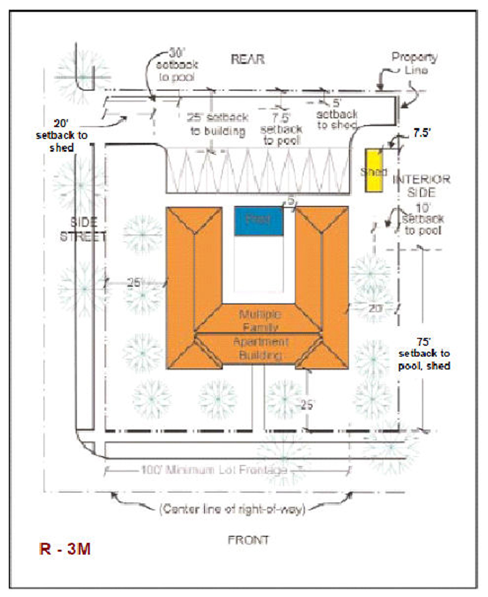
f.
The maximum number of dwelling units shall be determined on the basis of a total of 13 dwelling units per net acre.
g.
On each lot there shall be provided an open space equal to at least 25 percent of the total net lot area; the space shall be unencumbered with any structure or off-street parking and shall be landscaped and well maintained with grass, trees and shrubbery, except for areas used as pedestrian walks and ingress and egress drives, the ingress and egress drives shall not exceed the maximum width required to serve the parking area.
h.
Trees. Landscaping and trees shall be provided in accordance with Division 30-100 of this Code.
(3)
Multiple-family housing developments are permitted only after department review of the site plan to insure compliance with all R-3M District requirements and site plan review criteria. The plan shall be in compliance with the requirements contained in subparagraphs a. through h. of paragraph (3) above, except that spacing requirements between buildings may be reduced, but in no event below 20 feet. The reduction will be permitted only where the site use plan submitted indicates that the purpose and intent of the ordinance is being conformed with and that because of the arrangement of the building, adequate provisions are being made for light, air, landscaping and beautification.
(4)
Community residential home. A community residential facility as defined in this Code shall be permitted in a dwelling unit upon establishing the following:
a.
That the total number of resident clients on the premises not exceed 14 in number. Facilities for more than 14 resident clients must be approved through public hearing for an unusual use;
b.
That the operation of the community residential home be licensed by the State of Florida Department of Health and Rehabilitative Services;
c.
That the community residential home not be located within a radius of 1,200 feet of another existing, un-abandoned legally established community residential home in a multi-family zone. The 1,200-foot distance requirement shall be measured by following a straight line from the nearest portion of the structure of the proposed use to the nearest portion of the structure of the existing use;
d.
That the community residential home conform to existing zoning regulations applicable to other multiple-family uses permitted by this section;
e.
That the sponsoring agency of the community residential home notify the director in writing of its intention to establish the facility. Such notice shall contain the address and legal description of the site, the number of resident clients, as well as a statement from the State of Florida Department of Health and Rehabilitative Services indicating the need for and licensing status of the proposed facility. Absence of this notification and statement shall prohibit the use and occupancy of any structure for use as a community residential home; and
f.
Nothing in this section shall permit persons to occupy a community residential home who would constitute a direct threat to the health and safety of other persons or whose residency would result in substantial physical damage to the property of others.
(b)
Site plan review. The department shall review plans for compliance with zoning regulations and for compliance with the site plan review criteria. The purpose of the site plan review is to encourage logic, imagination, innovation and variety in the design process and thereby ensure the congruity of the proposed development and its compatibility with the surrounding area. All plans submitted to the department shall be reviewed and approved or denied within 15 days from the date of submission. The applicant shall have the right to extend the 15-day period by an additional 15 days upon timely request made in writing to department. The department shall have the right to extend the 15-day period by written notice to the applicant that additional information is needed to process the site plan. Denials shall be in writing and shall specifically set forth the grounds for denial. If the plan is disapproved the applicant may appeal to the village council in accordance with procedure established for appeals of administrative decision.
(1)
Procedure. Exhibits prepared by design professionals such as architects and landscape architects shall be submitted to the department and shall include, but not be limited to the following:
a.
Site plan including the following information:
i.
Lot lines and setbacks.
ii.
Location, shape, size and height of existing and proposed buildings, decorative walls and entrance features.
iii.
Village landscaping requirements.
iv.
Location of off-street parking and loading facilities and waste collection areas.
v.
Indication of exterior graphics, as required.
vi.
Indication of any site design methods used to conserve energy.
(2)
Floor plans and elevations of all structures, including total gross square foot area of each floor.
(3)
Figures indicating the following:
i.
Gross and net acreage.
ii.
Amount of landscaped open space in square feet required and provided.
iii.
Amount of building coverage at ground level in square feet.
iv.
Total number of trees required under Division 30-100.
v.
Parking required and provided.
vi.
Total amount of paved area in square feet.
vii.
Such other design data as may be needed to evaluate the project.
(c)
Site plan review criteria. The following criteria shall be utilized in the plan review process:
(1)
Purpose and intent: The proposed development fulfills the objectives of this section.
(2)
Planning studies: Design, planning studies or neighborhood area studies accepted or approved by the village council that include development patterns or environmental design criteria which would apply to the development proposal under review shall be utilized in the plan review process.
(3)
Landscape: Landscape shall be preserved in its natural state insofar as is practicable by minimizing tree removal. Landscape shall be used to shade and cool, direct wind movements, enhance architectural features, relate structure design to site, visually screen noncompatible uses and block noise generated by the major roadways and intense use areas.
(4)
Buffers: Buffering elements in the form of architectural design and landscape design that provide a logical transition to adjoining existing or permitted uses shall be provided.
(5)
Scale: Scale of proposed structures shall be compatible with surrounding proposed or existing uses or shall be made compatible by the use of buffering elements.
(6)
Circulation: Pedestrian and auto circulation shall be separated insofar as is practicable, and all circulation systems shall adequately serve the needs of the development and be compatible and functional with circulation systems outside the development.
(7)
Energy consideration: Site design methods to reduce energy consumption shall be encouraged. Every site conservation method may include siting of structures in relation to prevailing breezes and sun angles and use of landscape materials for shade and transpiration.
(8)
Parking areas: Building wall extensions, planting, berms or other innovative methods shall be used as a means of minimizing the adverse effect of the visual impact of parking areas. This requirement is in addition to the requirements of the village's landscape regulations.
(9)
Open spaces: Open space shall relate to any natural characteristics in such a way as to preserve and enhance their scenic and functional qualities to the fullest extent possible.
(10)
Graphics: Graphics, as required, shall be designated as an integral part of the overall design of the project.
(11)
Art display: Permanent interior and exterior art displays and water features should be encouraged in the overall design of the project and adhere to the guidelines set forth in Division 30-160, "Art in Public Places."
(12)
Visual screening for decorative walls: In an effort to prevent graffiti vandalism, the following options shall be utilized for walls abutting zoned or dedicated rights-of-way:
a.
Wall with landscaping. The wall shall comply with section 30-60.2, and be setback two and one-half feet from the right-of-way line and the resulting setback area shall contain a continuous extensively landscaped buffer which must be maintained in a good healthy condition by the property owner, or where applicable, by the condominium, homeowners or similar association. The landscape buffer shall contain one or more of the following planting materials:
i.
Shrubs. Landscaping shall comply with Division 30-100, and shrubs shall be a minimum of three feet in height when measured immediately after planting and shall be planted and maintained to form a continuous, unbroken, solid, visual screen within one year of planting.
ii.
Hedges. Hedges shall be a minimum of three feet in height when measured immediately after planting and shall be planted and maintained to form a continuous, unbroken, solid, visual screen within one year of planting.
iii.
Vines. Climbing vines shall be a minimum of 36 inches in height at planting.
b.
Metal picket fence. Where a metal picket fence abutting a zoned or dedicated right-of-way is constructed in lieu of a decorative wall, landscaping shall not be required.
(Ord. No. 09-17, § 1, 8-20-2009; Ord. No. 2012-23, § 2, 11-5-2012; Ord. No. 2013-03, § 1, 2-25-2013; Ord. No. 2014-03, § 2, 4-7-2014)
Sec. 30-50.13. - R-4L, Limited Apartment District.
(a)
Uses permitted. No land, body of water or structure shall be used, or permitted to be used and no structure shall be hereafter erected, constructed, moved or reconstructed, structurally altered or maintained for any purpose in a R-4L District which is designed, arranged or intended to be used or occupied for any purpose, except for one of the following uses:
(1)
Those uses permitted in the R-1, R-2, R-3, and R-TH Districts subject only to the requirements, limitations, and restrictions applicable in the districts; including but not limited to lot width, area, yard areas, height, and coverage.
a.
Minimum lot width and area. The minimum lot width shall be 100 feet and the minimum lot area shall be 25,000 square feet.
b.
Lot coverage. The maximum area covered by all buildings shall not exceed 30 percent of the lot.
c.
Setback requirements. The setbacks shall be as follows:
i.
Minimum setback from front property line shall be 25 feet.
ii.
Minimum setback from interior side property line shall be 15 feet for structures of not more than two stories and 20 feet for structures over two stories.
iii.
Minimum setback from side street property line shall be 25 feet.
iv.
Minimum setback from a rear property line shall be 25 feet.
v.
Where doors, windows or other openings in the building wall of a living unit face a wall of the same building and/or a wall of another building (accessory) on the same site, there shall be provided a minimum clear distance of not less than 30 feet. The distance to be measured on a line projected at right angles at the opening from the wall containing the opening to the opposite wall. Cantilevers and open porches may project from the building wall into the required open space (courtyard only) not more than four feet and that stairways may project from the building wall into the required open space (courtyard only) not more than seven and one-half feet. Stairways when located in the required open space (courtyard) shall be solely supported by the necessary columns; support by a wall is strictly prohibited.
*Uninhabitable sheds less than 145 square feet shall, with width and depth dimensions of 12 feet or less not exceed eight feet in height above grade to the roof ridge. All other sheds and structures shall comply with the accessory building setback requirements.
d.
Height. No building or structure, or part thereof shall be erected or altered to a height exceeding six stories, and shall not exceed 75 feet above finished grade.
e.
Floor area ratio. The floor area ratio shall not exceed the following:
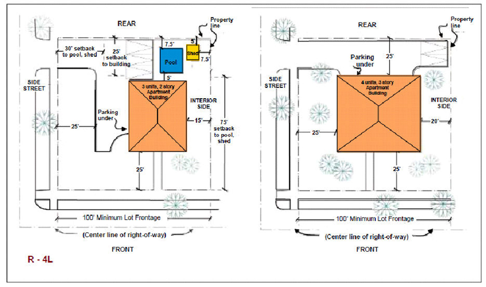
f.
Maximum number of units. The maximum number of dwelling units shall be determined on the basis of a total of 23 dwelling units per net acre.
g.
Open space. On each lot with structures not exceeding four stories, there shall be provided an open space equal to at least 25 percent of the total lot area. On lots with structures over four stories, there shall be provided an open space equal to at least 35 percent of the total lot area; and the space shall be unencumbered with any structure or off-street parking, and shall be landscaped and well maintained with grass, trees and shrubbery, excepting only areas used as pedestrian walks and ingress and egress drives; the ingress and egress drives shall not exceed a maximum width required to serve the parking area.
h.
Trees. Landscaping and trees shall be provided in accordance with Division 30-100 of the Code.
[(2)
Reserved.]
[(3)
Reserved.]
(4)
Multiple-family housing developments shall be permitted only after staff review of the site plan to ensure compliance with all R-4L District requirements and site plan review criteria. The plan shall be in accordance with the requirements contained in subparagraphs a. through h. of paragraph (1) above, except that interior setbacks and spacing requirements may be disregarded in approving the plan.
(5)
A community residential facility shall be permitted in a dwelling unit upon establishing the following:
a.
That the total number of resident clients on the premises not exceed 14 in number. Facilities for more than 14 resident clients must be approved through public hearing for an unusual use;
b.
That the operation of the community residential home be licensed by the State of Florida Department of Health and Rehabilitative Services;
c.
That the community residential home not be located within a radius of 1,200 feet of another existing, un-abandoned legally established community residential home in a multi-family zone. The 1,200-foot distance requirement shall be measured by following a straight line from the nearest portion of the structure of the proposed use to the nearest portion of the structure of the existing use;
d.
That the community residential home conform to existing zoning regulations applicable to other multiple-family uses permitted by this section;
e.
That the sponsoring agency of the community residential home notify the director in writing of its intention to establish the facility. Such notice shall contain the address and legal description of the site, the number of resident clients, as well as a statement from the State of Florida Department of Health and Rehabilitative Services indicating the need for and licensing status of the proposed facility. Absence of this notification and statements shall prohibit the use and occupancy of any structure for use as a community residential home; and
f.
Nothing in this section shall permit persons to occupy a community residential home who would constitute a direct threat to the health and safety of other persons or whose residency would result in substantial physical damage to the property of others.
(b)
Site plan review. The department shall review plans for compliance with zoning regulations and for compliance with the site plan review criteria. The purpose of the site plan review is to encourage logic, imagination, innovation and variety in the design process and thereby ensure the congruity of the proposed development and its compatibility with the surrounding area. All plans submitted to the department shall be reviewed and approved or denied within 15 days from the date of submission. The applicant shall have the right to extend the 15-day period by an additional 15 days upon timely request made in writing to the department. The department shall have the right to extend the 15-day period by written notice to the applicant that additional information is needed to process the site plan. Denials shall be in writing and shall specifically set forth the grounds for denial. If the plan is disapproved the applicant may appeal to the village council in accordance with procedure established for appeals of administrative decision.
(1)
Procedure. Exhibits prepared by design professionals such as architects and landscape architects shall be submitted to the department and shall include, but not be limited to the following:
(2)
Site plan including the following information:
a.
Lot lines and setbacks.
b.
Location, shape, size and height of existing and proposed buildings, decorative walls and entrance features.
c.
Landscaping in accordance with Division 30-100 of this Code.
d.
Location of off-street parking and loading facilities and waste collection areas.
e.
Indication of exterior graphics, as required.
f.
Indication of any site design methods used to conserve energy.
(3)
Floor plans and elevations of all structures, including total gross square foot area of each floor.
(4)
Figures indicating the following:
a.
Gross and net acreage.
b.
Amount of landscaped open space in square feet required and provided.
c.
Amount of building coverage at ground level in square feet.
d.
Total number of trees required and provided in accordance with Division 30-100 of this Code.
e.
Parking required and provided.
f.
Total amount of paved area in square feet.
g.
Such other design data as may be needed to evaluate the project.
(c)
Site plan review criteria. The following criteria shall be utilized in the plan review process:
(1)
Purpose and intent: The proposed development fulfills the objectives of this section.
(2)
Planning studies: design, planning studies or neighborhood area studies accepted or approved by the village council that include development patterns or environmental design criteria which would apply to the development proposals under review shall be utilized in the plan review process.
(3)
Landscape: Landscape shall be preserved in its natural state insofar as is practicable by minimizing tree removal. Landscape shall be used to shade and cool, direct wind movements, enhance architectural features, relate structure design to site, visually screen noncompatible uses and block noise generated by the major roadways and intense use areas.
(4)
Buffers: Buffering elements in the form of architectural design and landscape design that provide a logical transition to adjoining existing or permitted uses shall be provided.
(5)
Scale: Scale of proposed structures shall be compatible with surrounding proposed or existing uses or shall be made compatible by the use of buffering elements.
(6)
Circulation: Pedestrian and auto circulation shall be separated insofar as is practicable, and all circulation systems shall adequately serve the needs of the development and be compatible and functional with circulation systems outside the development.
(7)
Energy considerations: Site design methods to reduce energy consumption shall be encouraged. Energy site conservation methods may include siting of structures in relation to prevailing breezes and sun angles and use of landscape materials for shade and transpiration.
(8)
Parking areas: Building wall extensions, planting, berms or other innovative methods shall be used as a means of minimizing the adverse effect of the visual impact of parking areas. This requirement is in addition to the requirements of the landscape regulations of the Code of the Village of Palmetto Bay.
(9)
Open spaces: Open space shall relate to any natural characteristics in such a way as to preserve and enhance their scenic and functional qualities to the fullest extent possible.
(10)
Graphics: Graphics, as required, shall be designated as an integral part of the overall design of the project.
(11)
Art display: Permanent interior and exterior art displays and water features should be encouraged in the overall design of the project and adhere to the guidelines set forth in Division 30-160, "Art in Public Places."
(12)
Visual screening for decorative walls: In an effort to prevent graffiti vandalism, the following options shall be utilized for walls abutting zoned or dedicated rights-of-way:
a.
Wall with landscaping. The wall shall comply with section 30-60.2, and be setback two and one-half feet from the right-of-way line and the resulting setback area shall contain a continuous extensively landscaped buffer which must be maintained in a good healthy condition by the property owner, or where applicable, by the condominium, homeowners or similar association. The landscape buffer shall contain one or more of the following planting materials:
i.
Shrubs. Landscaping shall comply with Division 30-100, and shrubs shall be a minimum of three feet in height when measured immediately after planting and shall be planted and maintained to form a continuous, unbroken, solid, visual screen within one year of planting.
ii.
Hedges. Hedges shall be a minimum of three feet in height when measured immediately after planting and shall be planted and maintained to form a continuous, unbroken, solid, visual screen within one year of planting.
iii.
Vines. Climbing vines shall be a minimum of 36 inches in height at planting.
b.
Metal picket fence. Where a metal picket fence abutting a zoned or dedicated right-of-way is constructed in lieu of a decorative wall, landscaping shall not be required.
(d)
Convenience retail facilities. Not more than one food and drug convenience retail service facility of the B-1 District type shall be permitted as an accessory use to an apartment use or apartment development, the facility not to exceed 1,000 square feet in a development having a minimum of 300 apartment units, provided that:
(1)
Services relate to the needs of the inhabitants of the proposed complex;
(2)
Services are not provided direct access from public roads;
(3)
Services are not visible from public roads;
(4)
Detached signs and signs visible from public roads are not used;
(5)
Services are designed as an integral part of the total design as determined by site plan review;
(6)
Services are located in the principal structure or in a community service center structure;
(7)
An additional one square foot of retail area shall be permitted for each apartment unit above 300 units; provided, however, that the maximum square footage for such facilities shall not exceed 3,000 square feet.
(Ord. No. 09-17, § 1, 8-20-2009; Ord. No. 2012-23, §§ 2, 5, 11-5-2012; Ord. No. 2013-03, § 1, 2-25-2013; Ord. No. 2014-03, § 2, 4-7-2014)
Sec. 30-50.14. - R-4H, Hotel/Apartment House District.
(a)
Uses permitted. No land, body of water or structure shall be used, or permitted to be used and no structure shall be hereafter erected, constructed, moved or reconstructed, structurally altered or maintained for any purpose in an R-4H, High Density Residential District, which is designed, arranged or intended to be used or occupied for any purpose, except for one of the following uses:
(1)
Those uses permitted in the R-1, R-2, R-3, and R-TH Districts subject only to the requirements, limitations, and restrictions applicable thereto in the districts, including but not limited to lot width, area, setbacks, yard areas, height and coverage.
(2)
Multiple-family apartment house containing fewer than 11 units in a single building.
(3)
Hotels, motels, apartment houses, and apartment hotels containing 11 or more units, subject to site plan review as provided below. Where the applicant fails to secure the approval of the department the site plan reviewed shall be deemed denied. Where the site plan has been denied, the applicant may correct the plan to secure the approval of the department or appeal the denial for review by the village council.
(4)
Multiple-family housing developments, provided they are reviewed under the provisions of site plan review provided herein, only on approval after staff review of the site plan to ensure compliance with all district requirements. Where motel developments consist of two or more structures, unless each structure is located on a site meeting all standards of the district, the area shall be restricted to one ownership by covenant running with the land.
(5)
Private clubs, and lodges, only upon approval after public hearing pursuant to the requirements of Division 30-110.
(6)
Private art galleries, private libraries and private museums pursuant to the requirements of Division 30-110.
(7)
Bungalow villa arrangements (each structure limited to not more than two-family occupancy). Before a permit shall be granted to place buildings on a lot under the bungalow villa provision, plans shall be filed covering the size and spacing of all buildings intended in the villa and the total area of lot is to be included; not more than ten dwelling units shall be permitted under the provisions of the bungalow villa regulations and, further, the entire area shall be restricted to one ownership by covenant running with the land. Permits shall be obtained for the required ten units at one time and work on all structures shall proceed concurrently.
(8)
Community residential home. A community residential facility as defined in this Code shall be permitted in a dwelling unit upon establishing the following:
a.
That the total number of resident clients on the premises not exceed 14 in number. Facilities for more than 14 resident clients must be approved through public hearing for an unusual use;
b.
That the operation of the community residential home be licensed by the State of Florida Department of Health and Rehabilitative Services;
c.
That the community residential home not be located within a radius of 1,200 feet of another existing, un-abandoned legally established community residential home in a multi-family zone. The 1,200-foot distance requirement shall be measured by following a straight line from the nearest portion of the structure of the proposed use to the nearest portion of the structure of the existing use;
d.
That the community residential home conform to existing zoning regulations applicable to other multiple-family uses permitted by this section;
e.
That the sponsoring agency of the community residential home notify the director in writing of its intention to establish the facility. Such notice shall contain the address and legal description of the site, the number of resident clients, as well as a statement from the State of Florida Department of Health and Rehabilitative Services indicating the need for and licensing status of the proposed facility. Absence of this notification and statement shall prohibit the use and occupancy of any structure for use as a community residential home; and
f.
Nothing in this section shall permit persons to occupy a community residential home who would constitute a direct threat to the health and safety of other persons or whose residency would result in substantial physical damage to the property of others.
(b)
Site plan review—Generally. The department shall review plans for compliance with zoning regulations and for compliance with the site plan review criteria. The purpose of the site plan review is to encourage logic, imagination, innovation and variety in the design process and thereby ensure the congruity of the proposed development and its compatibility with the surrounding area. All plans submitted to the department shall be reviewed and approved or denied within 15 days from the date of submission. The applicant shall have the right to extend the 15-day period by an additional 15 days upon timely request made in writing to the department. The department shall have the right to extend the 15-day period by written notice to the applicant that additional information is needed to process the site plan. Denials shall be in writing and shall specifically set forth the grounds for denial. If the plan is disapproved, the applicant may appeal to the village council in accordance with procedure established for appeals of administrative decisions.
(1)
Procedure. Exhibits prepared by design professionals such as architects and landscape architects shall be submitted to the department and shall include, but not be limited to the following:
a.
Site plan including the following information:
i.
Lot lines and setbacks.
ii.
Location, shape, size and height of existing and proposed buildings, decorative walls and entrance features.
iii.
Landscaping in accordance with Division 30-100 of this Code.
iv.
Location of off-street parking and loading facilities and waste collection areas.
v.
Indication of exterior graphics, as required.
vi.
Indication of any site design methods used to conserve energy.
(2)
Floor plans and elevations of all structures, including total gross square foot area of each floor.
(3)
Figures indicating the following:
a.
Gross and net acreage.
b.
Amount of landscaped open space in square feet required and provided.
c.
Amount of building coverage at ground level in square feet.
d.
Total number of trees required and provided in accordance with Division 30-100 of this Code.
e.
Parking required and provided.
f.
Total amount of paved area in square feet.
g.
Such other design data as may be needed to evaluate the project.
(c)
Same—Criteria. The following criteria shall be utilized in the plan review process:
(1)
Purpose and intent: The proposed development fulfills the objectives of this section.
(2)
Planning studies: Design, planning studies or neighborhood area studies accepted or approved by the village council that include development patterns or environmental design criteria which would apply to the development proposal under review shall be utilized in the plan review process.
(3)
Landscape: Landscaping shall comply with Division 30-100, and shall be preserved in its natural state insofar as is practicable by minimizing tree removal. Landscape shall be used to shade and cool, direct wind movements, enhance architectural features, related structure design to site, visually screen noncompatible uses and block noise generated by the major roadways and intense-use areas.
(4)
Buffers: Buffering elements in the form of architectural design and landscape design that provide a logical transition to adjoining existing or permitted uses shall be provided.
(5)
Scale: Scale of proposed structures shall be compatible with surrounding proposed or existing uses or shall be made compatible by the use of buffering elements.
(6)
Circulation: Pedestrian and auto circulation shall be separated insofar as is practicable, and all circulation systems shall adequately serve the needs of the development and be compatible and functional with circulation systems outside the development.
(7)
Energy considerations: Site design methods to reduce energy consumption shall be encouraged. Energy site conservation methods may include siting of structures in relation to prevailing breezes and sun angles and use of landscape materials for shade and transpiration.
(8)
Parking areas: Building wall extensions, planting, berms or other innovative methods shall be used as a means of minimizing the adverse effect of the visual impact of parking areas. This requirement is in addition to the requirements of the landscape regulations of the Code of the Village of Palmetto Bay.
(9)
Open spaces: Open spaces shall relate to any natural characteristics in such a way as to preserve and enhance their scenic and functional qualities to the fullest extent possible.
(10)
Graphics: Graphics, as required, shall be designed as an integral part of the overall design of the project.
(11)
Art display: Permanent interior and exterior art displays and water features should be encouraged in the overall design of the project and adhere to the guidelines set forth in Division 30-160, "Art in Public Places."
(12)
Visual screening for decorative walls: In an effort to prevent graffiti vandalism, the following options shall be utilized for walls abutting zoned or dedicated rights-of-way:
a.
Wall with landscaping. The wall shall comply with section 30-60.2, and be setback two and one-half feet from the right-of-way line and the resulting setback area shall contain a continuous extensively landscaped buffer which must be maintained in a good healthy condition by the property owner, or where applicable, by the condominium, homeowners or similar association. The landscape buffer shall contain one or more of the following planting materials:
i.
Shrubs. Landscaping shall comply with Division 30-100 and shrubs shall be a minimum of three feet in height when measured immediately after planting and shall be planted and maintained to form a continuous, unbroken, solid, visual screen within one year after planting.
ii.
Hedges. Hedges shall be a minimum of three feet in height when measured immediately after planting and shall be planted and maintained to form a continuous, unbroken, solid, visual screen within one year after planting.
iii.
Vines. Climbing vines shall be a minimum of 36 inches in height immediately upon planting.
b.
Metal picket fence. Where a metal picket fence abutting a zoned or dedicated right-of-way is constructed in lieu of a decorative wall, landscaping shall not be required.
(d)
Minimum lot width and area. The minimum lot width for apartment use shall be 100 feet and the minimum lot area shall be 25,000 square feet.
(e)
Lot coverage. The lot coverage for all buildings on the site shall not exceed 0.40 of the total lot area.
(f)
Apartment setback requirements.
(1)
The setbacks shall be as follows:
a.
Front setback. For structures not exceeding 35 feet in height, the minimum setback shall be 25 feet; for structures over 35 feet in height the setbacks shall be increased by 40 percent of the additional height provided, however, that the required front setback shall not exceed 50 feet.
b.
Rear setback. For structures not exceeding 35 feet in height, the minimum setback shall be 25 feet; for structures over 35 feet in height the setbacks shall be increased by 40 percent of the additional height.
c.
Interior side setbacks and side street setbacks. Minimum setbacks for all structures shall be determined by a 63 degree line projected from the interior side property line(s) or side street property line(s) upward towards the center of the site; provided, however, that no structure shall be permitted to be closer than 25 feet to the interior side property line(s) or side street property line(s) and further provided that the passageways to Biscayne Bay or the Atlantic Ocean are adhered to as provided in this section.
d.
Minimum setback between buildings shall be 20 feet except where doors, windows or other openings in the building wall of a living unit face a wall of the same building and/or a wall of another building on the same site. In that case there shall be provided a minimum clear distance of not less than 30 feet, the distance to be measured on a line projected at right angles from the opening to the opposite wall. Cantilevers and open porches may project from the building wall into the required open space (courtyard only) not more than six feet and stairways may project from the building wall into the required open space (courtyard only) not more than ten feet. Stairways when located in the required open space (courtyard) shall be solely supported by the necessary columns. Support by a wall is strictly prohibited.
e.
Bungalow villas shall be setback as follows:
i.
25 feet from the front property line.
ii.
20 feet from a side property line abutting a highway right-of-way, except where the rear of the lot abuts a key lot; in which event, the setback for the key lot shall govern.
iii.
Ten feet from an interior side lot line.
iv.
25 feet from the rear property line.
v.
The minimum clear distance between units of a bungalow villa shall be 20 feet. Ingress and egress to all units shall be provided by a common and continuous clear space with a 30-foot minimum width.
(g)
Height. On sites which abut dedicated rights-of-way of 100 feet or more, each proposed building or structure which exceeds 100 feet in height shall be designed and situated such that the shadow created by the sun at 12:00 noon on December 31 (a sun angle of 41 degrees) will not fall on any adjacent property except for public road rights-of-way. Shadow studies shall be provided to the department. Buildings or structures may be proposed to any height except as controlled by this shadow provision and other provisions in the Code, such as floor area ratio, setbacks, airport regulations, etc. For all other sites, no building or structure or part thereof shall be of a height greater than the width of the widest street upon which such building abuts, unless approved for additional height as a result of public hearing.
(h)
Floor area ratio. The floor area ratio shall not exceed the following, provided, however, that structure parking shall not count as a part of the floor area, but shall be counted in computing building height.
(i)
Maximum number of units. The maximum number of dwelling units shall not exceed a density of 40 dwelling units per net acre or 871.2 square feet of net lot area per dwelling unit. Hotels, motels and apartment hotels developed for transient residential usage shall not exceed a density of 75 dwelling units per net acre or 580.8 square feet of lot area per dwelling unit. Each dwelling unit of a bungalow villa shall provide at least 2,000 square feet of net lot area.
(j)
Parking. Where a parking garage is not more than four feet above grade, it shall not be considered as a structure for zoning purposes in the R-4H District except as it applies to the special setback provisions under general regulations; the same setbacks shall apply as with surface parking, provided the structure is setback a minimum of ten feet from the property line. The garage will not be calculated as a part of lot coverage requirements and will not be allowed in the 20 percent unencumbered area, as enumerated in the R-4H District Regulations, subsection (1). Landscaping of the parking structure shall be provided.
If the garage is to be used for parking on the top deck, it must be landscaped according to the provisions of Division 30-100 of this Code; if it is not to be used for parking on the top deck, it shall be developed with landscaping, recreational facilities, etc., with those portions devoted to landscaping being counted as open space pursuant to the R-4H District Regulations.
(k)
Trees. Landscaping and trees shall be provided in accordance with Division 30-100 of this Code.
(l)
Open space. On each lot there shall be provided an open space equal to a minimum of 40 percent of the total lot area. The open space shall be unencumbered with any structure or off-street parking, and shall be landscaped and well maintained with grass, trees, and shrubbery, excepting only areas used as pedestrian walks and ingress and egress drives provided that such drives shall not exceed the minimum width required to serve the parking area.
(m)
Convenience retail facilities. Apartment developments having a minimum of 300 residential units may have B-1 District type convenience uses not exceeding 1,000 square feet as an accessory use to apartment developments, provided that:
(1)
Services relate to the needs of the inhabitants of the proposed complex;
(2)
Services are not provided direct access from public roads;
(3)
Services are not visible from public roads;
(4)
Detached signs and signs visible from public roads are not used;
(5)
Services are designed as an integral part of the total design as determined by site plan review;
(6)
Services are located in the principal structure or in a community service center structure; and
(7)
An additional one square foot of retail area shall be permitted for each apartment unit above 300 units; provided, however, that the maximum square footage for such facilities shall not exceed 3,000 square feet.
(n)
Consolidation of requests requiring approval by public hearing into one hearing application. All requests requiring approval by public hearing may be consolidated into one hearing application.
(1)
Subdivision of hotels and motels.
a.
Definitions.
i.
For the purposes of this section the term "subdivision of a hotel or motel" shall mean the sale, conveyance, or long-term lease or sublease (for more than six months) of five percent or more, cumulatively, of the units in a hotel or motel by the same seller, lessor or sublessor. This definition is not applicable to the transfer of an entire hotel or motel to the same transferee.
ii.
For purposes of this section the term "subdivided property" shall mean all hotel or motel units and all other components of any subdivided hotel or motel.
(2)
Any person or entity who subdivides a hotel or motel shall deliver written notice of the subdivision to the director on or before the earlier of either offering to enter into or entering into any sale, conveyance, lease, or sublease which would result in a subdivision.
(3)
If there shall be a subdivision of any hotel or motel no permit, certificate of use and occupancy or any other governmental approval shall be issued or granted except in emergencies for any subdivided property, unless and until the owner shall demonstrate to the director that the subdivided property shall continue to comply with all the provisions and regulations of this chapter and any resolutions adopted pursuant hereto. The procedure for demonstrating such compliance shall be established by submission of documentation pursuant to regulations to be promulgated by the director and approved by the village council.
(4)
It shall be presumed that the subdivision of a hotel or motel results in a change of use to nonhotel or nonmotel use. This presumption may be rebutted administratively at a public hearing. An application to rebut shall be filed for public hearing before the village council. The presumption shall be rebutted whenever such an applicant shall establish at public hearing that the property will continue to be utilized as a hotel or motel. In civil proceedings the presumption of change of use shall shift the burden of proof on this issue to the party against whom it operates; and in criminal proceedings the presumption shall constitute prima facie evidence of a change in use.
(o)
Accessory uses.
(1)
Business or commercial establishments of the B-1 District type, bars and cabarets shall be permitted in hotels, motels and apartment hotels provided they are located within the principal building, which contains at least 100 units, and provided the exterior of any such principal building shall not have store fronts or give the appearance of commercial or mercantile activity as viewed from the highway: in the event the use contains windows which may be seen from the street or highway, the windows shall be of fixed, obscure glass. Such business or commercial establishments and bars in this district shall be entered only through the lobby and no additional entrances shall be permitted, except when the same opens into a courtyard or patio (away from the street side) which is enclosed and which is not visible from the street and, except that a fire door or emergency exit shall be permitted. Hotels, motels, and apartment-hotels which extend from a street to the ocean or bay, and which have the required number of guest rooms or apartment units may have the permitted business or commercial establishment on the extreme end of the structure on the waterway side with a direct opening, provided that the opening is from the waterway side and cannot be viewed from the street or highway.
These restrictions shall not apply when the site is in a commercial district and these commercial uses are a permitted use in the district and conform to all of the requirements of the district.
(2)
Apartment developments having a minimum of 300 residential units may have B-1 District type convenience uses not exceeding 1,000 square feet as an accessory use to apartment developments, provided that:
a.
Services relate to the needs of the inhabitants of the proposed complex;
b.
Services are not provided direct access from public roads;
c.
Services are not visible from public roads;
d.
Detached signs and signs visible from public roads are not used;
e.
Services are designed as an integral part of the total design as determined by site plan review; and
f.
The facility is located in the principal structure or in a community service center structure.
(3)
An additional one square foot of retail area shall be permitted for each apartment unit above 300 units provided, however, that the maximum square footage for such facilities shall not exceed 3,000 square feet.
(4)
Hotels and motels with 150 or more guest rooms may contain liquor package use on the premises for the accommodation and use of their guests only, provided the establishment housing such use is entered only through the lobby within the building and does not have the appearance of commercial or mercantile activity as viewed from the highway. No advertisement of the use will be permitted which can be seen from the outside of the building. These restrictions shall not apply when the hotel or motel site is in a commercial district and the package store is a permitted use and conforms to all of the requirements of the district.
(5)
Hotels and motels with 200 or more guest rooms or apartment units under one roof may contain a night club on the premises, provided the exterior of any such building shall not have store fronts or give the appearance of commercial or mercantile activity as viewed from the highway. In the event the use contains windows which may be seen from the highway, the windows shall be of fixed obscure glass. Such night club shall be entered only through the lobby, and no additional entrance shall be permitted, except when the same opens into a courtyard or patio (away from street side) which is enclosed and which is not visible from the street and, except that a fire door or exit shall be permitted.
(6)
Coffee shop and dining room may be permitted in bungalow villa arrangements having 50 or more guest rooms or 50 or more units designed as one-family dwellings, provided that the exterior or any such building shall not contain store fronts and shall not have the appearance of commercial or mercantile activity as viewed from the public highway, nor be identified by any type of sign. Strip lighting by neon or other type of electric lighting to outline a building shall not be permitted.
The total square foot area of coffee shop or dining room, including kitchen facilities, etc., shall not total more than 15 square feet, multiplied by each living unit erected on the project.
(7)
Cabanas, provided they are strictly incidental to apartment house, apartment hotel, motel or hotel. Cabanas shall not be used for overnight sleeping quarters nor rented or leased to any person other than a guest of the apartment house, apartment hotel, motel or hotel.
(p)
Other spacing. No hospital, convalescent home, eleemosynary or philanthropic institution shall be located within 100 feet of any E, R-1 or R-2 Zone or within 50 feet of any property under different ownership.
(q)
Consolidation of requests requiring approval by public hearing into one hearing application. All requests requiring approval by public hearing may be consolidated into one hearing application.
(Ord. No. 09-17, § 1, 8-20-2009; Ord. No. 2012-23, §§ 2, 5, 11-5-2012; Ord. No. 2013-03, § 1, 2-25-2013)
Sec. 30-50.15. - R-5, Office District.
(a)
Uses permitted. No land, body of water or structure shall be used, or permitted to be used, and no structure shall be hereafter erected, constructed, reconstructed, moved or structurally altered or maintained for any purpose in an R-5 District which is designed, arranged, or intended to be used or occupied for any purpose, except for one or more of the following uses, and all other uses are prohibited:
(1)
Duplex use. Those uses permitted in the R-2 District subject only to the requirements, limitations and restrictions specified in the district, and except that it shall be permissible to use a 50- by 100-foot lot for two-family use in an old subdivision.
(2)
Apartment house as permitted in the R-3 District subject only to the requirements, limitations and restrictions applicable in the R-3 District for such use.
(3)
Abstract of title.
(4)
Accountants—bookkeeping.
(5)
Actuaries.
(6)
Advertising (no shops).
(7)
Adjusters (insurance).
(8)
Aerial survey and photography.
(9)
Appraisers—no sale or rental of any type of merchandise or equipment.
(10)
Architects.
(11)
Arts foundation is defined as a facility containing offices, lecture and seminar rooms, exhibition areas, as well as artists' work studios, all of which is operated by a nonprofit organization dedicated to the promotion of the visual arts and artists through the exhibition and presentation of the foundation's artists' works. An arts foundation is permitted, subject to the following conditions:
a.
That the main offices of the foundation, related lecture and seminar rooms, together with the art exhibition space, shall be the principal uses located on the premises, occupying in excess of 50 percent of the gross floor area. Related art exhibition space shall be ancillary to the principal uses.
b.
That the art display areas shall be for the exhibition of artwork created by artists who are sponsored by the foundation, and all artwork displayed shall be of the visual arts only.
c.
That all art exhibitions shall be conducted within the principal structure.
d.
That there shall be a maximum of 12 art shows per year.
e.
That off-street parking requirements for the art display area shall be calculated at one parking space for every 250 square feet, or fractional part thereof. Office and other use areas shall have off-street parking spaces provided for such areas as otherwise provided in this Code.
(12)
Attorneys.
(13)
Auditors.
(14)
Banks, excluding drive-thru banking facilities.
(15)
Banks, including drive-thru banking facilities, upon approval after public hearing on office complex sites of three acres or more.
(16)
Business analysts—Counselors or brokers.
(17)
Building contractors, office only (no shop or storage).
(18)
Chiropodists.
(19)
Chiropractors.
(20)
Consulates.
(21)
Counseling, child guidance and family service.
(22)
Court reporter, public stenographer.
(23)
Credit reporting.
(24)
Day nursery, kindergarten and after-school care licensed by the State of Florida Department of Health and Rehabilitative Services, schools, private clubs and religious facilities, pursuant to the requirements of Division 30-110 or Division 30-120.
(25)
Dentist.
(26)
Detective agencies and investigating service.
(27)
Drafting and plan service.
(28)
Engineers, professional.
(29)
Insurance and bonds.
(30)
Manufacturers agents.
(31)
Market research.
(32)
Medical doctors.
(33)
Model agencies (no school).
(34)
Mortgage broker.
(35)
Notary public.
(36)
Optician.
(37)
Optometrist.
(38)
Public libraries.
(39)
Public relations.
(40)
Real estate.
(41)
Real estate management.
(42)
Secretarial service.
(43)
Shoppers information service.
(44)
Social service bureau.
(45)
Stock brokers exchange—Investment service.
(46)
Tax consultants.
(47)
Telephone answering service.
(48)
Theater ticket agencies.
(49)
Travel agencies.
(50)
Zoning consultants.
(51)
Any use which is found by the director to be a use similar to one of the above numbered uses and, in his/her opinion, conforms to the intent of this section.
(b)
Minimum lot width and area.
(1)
Minimum lot width shall be 75 feet.
(2)
Minimum lot area shall be 25,000 square feet.
(c)
Lot coverage; setback requirements; accessory buildings; type of building permitted.
(1)
Lot coverage. The maximum lot coverage for all structures on the site shall be 40 percent.
(2)
Principal building setbacks.
a.
Minimum setback from front property line shall be 25 feet.
b.
Minimum setback from side property line abutting a highway right-of-way shall be 15 feet.
c.
Minimum setback from interior side property line shall be 15 feet.
d.
Minimum setback from rear property line shall be 25 feet.
(3)
Accessory buildings. Nonhabitable accessory building(s) shall be permitted provided that they comply with the following minimum setback requirements.
a.
Minimum setback from front property line shall be 75 feet.
b.
Minimum setback from side property line abutting a highway right-of-way shall be 20 feet.
c.
Minimum setback from interior side property line shall be seven and one-half feet.
d.
Minimum setback from rear property line shall be six feet.
(4)
Type of buildings permitted. The buildings to be erected shall be without store fronts or display windows.
(d)
Minimum square foot content and height of buildings and floor area ratio.
(1)
Minimum square foot content. The gross interior square foot area of the principal structure shall not be less than 1,000 square feet.
(2)
Heights. The maximum height of any structure shall be two stories but not to exceed 24 feet.
(3)
Floor area ratios. The floor area ratio shall not exceed the following, providing, however, that structure parking shall not count as part of the floor area, but shall be counted in computing building height.
a.
One story: 0.40 FAR.
b.
Two stories: 0.60 FAR.
(e)
Other specific requirements for the R-5 District.
(1)
Open space. On each lot there shall be an open space equal to a minimum of 25 percent of the total lot area. The open space shall be unencumbered with any structure or off-street parking, and shall be landscaped and well maintained with grass, trees and shrubbery, excepting only areas used as pedestrian walks and water bodies provided the water bodies do not count for more than 20 percent of the open space requirement. Open space areas may also include tree preservation zones of "natural forest communities" as defined in Division 30-100 of this Code. Tree preservation zones shall be delineated on all plans submitted to the village for site plan review for the purposes of determining overall preservation area and percent of overall landscaped area. The requirements contained herein do not replace or substitute for any requirements contained within Division 30-100 of this Code.
(2)
Maintenance. All landscaped areas shall be continuously maintained in a good, healthy condition, and sprinkler systems of sufficient size and spacing shall be installed to serve all required landscaped areas, except within trees preservation zones of "natural forest communities". Tree preservation zones shall also be maintained in a healthy natural condition free from trash, debris and disturbance of understory vegetation.
(3)
Mixed uses. Depending on lot area available, it shall also be permissible for the occupant of an office to have an accompanying residential use in connection therewith.
(4)
Wall. A decorative wall of masonry, reinforced concrete, precast concrete, or wood fence or other like material that will be compatible with the main structure, six feet in height, shall be erected along all interior property lines including the rear property line; provided, however, in the event that the rear property line abuts a secondary road, the wall shall be set in ten feet from the official right-of-way of the secondary road and the ten-foot strip shall be landscaped; provided further, in the event that the interior side property line abuts property zoned R-5 District or a more liberal zoning district, the requirement for the wall along the common interior property line shall not apply. All other requirements of section 30-60.2 shall apply.
(5)
Through lots. Where the building site is on a through lot, the structure shall front on the principal road, and if there is any question as to which of the two roads is the principal road, the decision of the director shall be adhered to.
(6)
Trees. Landscaping and trees shall be provided in accordance with Division 30-100 of this Code.
(7)
Minimum spacing between principal buildings and accessory buildings. Minimum spacing between principal buildings shall be 20 feet to nearest portion of building(s) and for accessory buildings, ten feet. Cantilevers may project from the building wall into the required open space (courtyard only) not more than four feet and the stairways may project from the building wall into the required open space (courtyard only) not more than seven and six tenths feet.
(8)
Accessory use. A snack bar for the convenience and use of the occupants and patrons of an office development shall be permitted; the snack bar shall not exceed 500 square feet in size and shall be permitted within an office facility of at least 20,000 square feet. The snack bar shall be completely enclosed in the building(s) and have no outside advertising or entrance. The hours of operation for any such snack bar shall be limited to 7:00 a.m. to 3:30 p.m. The snack bar area shall be provided one parking space for each 300 square feet or fractional part thereof.
(f)
Site plan review.
(1)
Purpose. The department shall, prior to issuance of any permits, review plans for compliance with zoning regulations and for compliance with the site plan review criteria. The purpose of the site plan review is to encourage logic, imagination, innovation and variety in the design process and ensure the congruity of the proposed development and its compatibility with the surrounding area. If requested approval is denied, the proposed project may be appealed to the village council in accordance with regulations governing appeals from administrative decisions contained in the this division.
(2)
Required exhibits. The following exhibits shall be prepared by design professionals such as architects and landscape architects and submitted to the department of planning and zoning:
a.
Site plan, including the following information:
i.
Lot lines and setbacks.
ii.
Location, shape, size and height of existing and proposed buildings, decorative walls and entrance features.
iii.
Landscaping in accordance with Division 30-100 of this Code.
iv.
Location of off-street parking and loading facilities and waste collection areas.
v.
Indication of exterior graphics.
vi.
Indication of any design methods used to conserve energy.
b.
Floor plans and elevations of all structures, including total gross square foot area of each floor.
c.
Figures indicating the following:
i.
Gross and net acreage.
ii.
Amount of landscaped open space in square feet required and provided.
iii.
Amount of building coverage at ground level in square feet.
iv.
Total number of trees required and provided in accordance with Division 30-100 of this Code.
v.
Parking required and provided.
vi.
Total amount of paved area in square feet.
vii.
Such other design data as may be needed to evaluate the project.
(3)
Plan review standards. The following criteria shall be utilized in the plan review process:
a.
Purpose and intent. The proposed development fulfills the objectives of this section.
b.
Planning studies. Design, planning studies or neighborhood area studies accepted or approved by the village council that include development patterns or environmental design criteria which would apply to the development proposal under review shall be utilized in the plan review process.
c.
Landscape. Landscape shall be preserved in its natural state insofar as is practicable by minimizing tree removal. Landscape shall be used to shade and cool, direct wind movements, enhance architectural features, relate structure design to site, visually screen noncompatible uses and block noise generated by the major roadways and intense-use areas.
d.
Buffers. Buffering elements in the form of architectural design and landscape design that provide a logical transition to adjoining existing or permitted uses shall be provided.
e.
Scale. Scale of proposed structures shall be compatible with surrounding proposed or existing uses or shall be made compatible by the use of buffering elements.
f.
Circulation. Pedestrian and auto circulation shall be separated insofar as is practicable, and all circulation systems shall adequately serve the needs of the development and be compatible and functional with circulation systems outside the development.
g.
Energy conservation. Design methods to reduce energy consumption shall be encouraged. Energy conservation methods may include, but not be limited to, natural ventilation of structures, siting of structures in relation to prevailing breezes and sun angles, insulation of structures, use of landscape materials for shade and transpiration, and orientation of breezes.
h.
Parking areas. Building wall extensions, planting, berms or other innovative methods shall be used as a means of minimizing the adverse effect of the visual impact of parking areas. This requirement is in addition to the requirements of the landscape regulations of the Code of the Village of Palmetto Bay.
i.
Open space. Open space shall relate to any natural characteristics in such a way as to preserve and enhance their scenic and functional qualities to the fullest extent possible.
j.
Sub-tropic architectural characteristics. Architecture and site development should incorporate consideration of the subtropical characteristics of the area. The provision of sun-control devices, shaded areas, vegetation, roof terraces and similar features characteristic of subtropical design shall be encouraged.
k.
Outdoor furniture and graphics. All outdoor furniture and graphics shall be designed as an integral part of the overall design of the project.
l.
Art display. Permanent interior and exterior art displays and water features should be encouraged in the overall design of the project and adhere to the guidelines set forth in Division 30-160, "Art in Public Places."
m.
Visual screening for decorative walls. In an effort to prevent graffiti vandalism, the following options shall be utilized for walls abutting zoned or dedicated rights-of-way:
i.
Wall with landscaping. The wall shall comply with section 30-60.2, and be setback two and one-half feet from the right-of-way line and the resulting setback area shall contain a continuous extensively landscaped buffer which must be maintained in a good healthy condition by the property owner, or where applicable, by the condominium, homeowners or similar association. The landscape buffer shall contain one or more of the following planting materials:
A.
Shrubs. Landscaping shall comply with Division 30-100 and shrubs shall be a minimum of three feet in height when measured immediately after planting and shall be planted and maintained to form a continuous, unbroken, solid, visual screen within one year of planting.
B.
Hedges. Hedges shall be a minimum of three feet in height when measured immediately after planting and shall be planted and maintained to form a continuous, unbroken, solid, visual screen within one year of planting.
C.
Vines. Climbing vines shall be a minimum of 36 inches in height at planting.
ii.
Metal picket fence. Where a metal picket fence abutting a zoned or dedicated right-of-way is constructed in lieu of a decorative wall, landscaping shall not be required.
(Ord. No. 09-17, § 1, 8-20-2009; Ord. No. 2012-23, §§ 2, 5, 11-5-2012; Ord. No. 2013-03, § 1, 2-25-2013)
Sec. 30-50.16. - B-1, Limited Business District.
(a)
Purpose. The purpose of the B-1, Limited Business District, is to provide for retail and service convenience facilities which satisfy the essential and frequent needs of the adjacent residential neighborhood.
(b)
Uses permitted. No land, body of water or structure shall be used or permitted to be used and no structure shall be hereafter erected, constructed, moved, reconstructed or structurally altered or maintained in any B-1 District, which is designed, arranged or intended to be used or occupied for any purpose, except for one or more of the following uses:
(1)
General retail and personal services: Establishments that provide goods and services geared toward consumers. Retail uses in this category shall conduct all sales within the establishment, and walk-up sales windows shall not be permitted. Use or consumption of merchandise shall not be permitted in the establishment or on premises, except by conditional use approval pursuant to section 30-50.16(d). This group shall also include establishments offering instruction in dance, music, martial arts and similar activities as determined by the director. Establishments in this section shall not include any single business that is greater than 50,000 square feet in gross floor area.
(2)
Neighborhood proprietor commercial: Small-scale, retail or service business that are independently owned, and not part of a national chain or franchise. Use or consumption of merchandise shall not be permitted in the establishment or on premises, except by conditional use approval pursuant to section 30-50.16(d). In addition to retail and office uses, the use may include artisan industry, meaning a business using light machinery and hand tools that is consumer-facing and sells part of its production through the on-premises storefront. Uses in this group shall be smaller than 10,000 square feet. Specifically precluded are the creation of noxious odors, and/or ambient noise levels that exceed the levels for that area as provided in the Palmetto Bay noise ordinance.
(3)
Food and beverage establishments: Uses in this group shall include full-service restaurants, fast food restaurants, bars and pubs and similar uses as determined by the director. Uses in this group shall be smaller than 10,000 square feet. This group shall not include nightclubs, or establishments where food and drink are accessory to billiards, other gaming, music or other entertainment. Outdoor dining areas are permitted as an accessory use, pursuant to the requirements of section 30-60.17. Outdoor areas shall not be used for cooking, food preparation, storage, live or recorded music performance at any time, except for permitted special events of no longer than two consecutive days and not more than five cumulative days per calendar year per B-1 zoned property having a single folio number.
(4)
Entertainment uses: Uses in this group shall include entertainment uses to satisfy the needs of adjacent neighborhoods, including: coin arcades, single-screen small movie theaters, community performance theaters, piano bars, childrens' interactive experiences, interactive themed rooms, puzzle rooms and games rooms. Uses in this group shall not be greater than 10,000 square feet, have no more than 100 fixed patron seats. All entertainment uses shall be completely enclosed at all times. Ambient sound levels outside the building shall not exceed the requirements of section 30-60.29. adult entertainment uses as defined by section 30-140.2 shall not be permitted as entertainment uses in this section.
(5)
Professional offices: Facilities used primarily for the business of professionals with only limited transactions occurring on-site.
(6)
Medical offices: Facilities used primarily for the business of providing medical services on an outpatient basis consisting of periodic visits by patients. Medical research offices that include regular patient visits shall be considered part of this category; however, the director shall evaluate parking requirements. Medical research offices that do not include regular patient visits shall be categorized as professional offices. Extended care services that include regular visits such as Prescribed Pediatric Extended Care (PPEC) shall be considered part of this category; however, the director shall evaluate parking requirements. Mental health, psychological and rehabilitation therapy shall be considered a part of this category use; however, the director shall evaluate parking requirements.
(7)
Civic uses: Uses that are accessible to the public and serves the religious, recreational, educational, cultural or governmental needs of the community. Civic uses include but are not limited to convention, meeting halls, private clubs, libraries, police stations, fire stations, post offices, clubhouses, religious buildings, museums, athletic facilities, auditoriums, arts buildings, and government facilities, pursuant to the requirements of Division 30-110.
(8)
Colleges and universities: Facilities that serve the educational needs of the adult population and other post-secondary educational needs. This group shall include universities, colleges, commuter colleges, university and vocational education centers, and government facilities, online campus facilities that serve the educational needs of the adult population and other post-secondary educational needs entirely by web-based and other remote methods, and other similar uses as determined by the director, pursuant to the requirements of Division 30-110.
(9)
Places of assembly: Day nursery, kindergarten and after-school care licensed by the State of Florida Department of Health and Rehabilitative Services, schools, private clubs and religious facilities, pursuant to the requirements of Division 30-110 or Division 30-120.
(10)
Automotive sales and services: Facilities used primarily for onsite sales and servicing of automobiles. This group includes new car sales, used car sales, car rentals, automobile repairs, automobile restoration, automobile replacement parts, fueling stations, and automated car washes. Commercial truck and marine vessel sales or servicing are not permitted. All servicing of vehicles shall be in enclosed bays with doors closed during servicing. Service bay doors, including the entrance and exit for automated car washes shall not be oriented toward the front of the property, and shall not be on a façade that abuts or is adjacent to a residentially-zoned district. Waste oil containers and general trash dumpsters shall be maintained in locked enclosures, and shall not be located at the front of the property or abutting a residentially-zoned district. Specifically precluded are the creation of noxious odors, other airborne emission to the outdoors and/or ambient noise levels that exceed the requirements of section 30-60.29. Open-bay automated car washes shall operate only between the local-time hours of 7:00 a.m. and 7:00 p.m.
(11)
Accommodation uses: subject to all provisions of this section.
(12)
Group residential home: A dwelling unit, licensed by the State of Florida Division of Children and Families that serves resident-clients and provides a living environment for unrelated residents who operate as a functional equivalent of a family. Uses in this group shall include nursing homes, assisted living facilities, congregate living facilities, foster care facilities, community residential homes, group homes, or other similar uses as determined by the director. Services that support the daily operation of group homes are permitted and shall include dining facilities, doctor's offices, nurse's offices, staff offices, recreation rooms and similar facilities.
(13)
Any use which is found by the director to be a use similar to one of the above numbered uses and, in his/her opinion, conforms to the intent of this section.
(c)
Accessory uses.
(1)
Children's outdoor playground facility as an accessory use to day nursery, kindergarten and after-school care subject to the following requirements:
a.
The total outdoor playground area shall not exceed 35 percent of the square footage of the subject structure;
b.
The playground equipment shall be the nonmechanical type and shall be designed and intended for children two through 12 years of age;
c.
The playground shall be immediately adjacent to, visible from, and accessible from the indoor patron area;
d.
The playground area shall be enclosed with a masonry wall or fence not less than four feet in height and any gates shall be of the spring lock type, so that they shall automatically be in a closed and always fastened position at all times; and
e.
The playground area shall not reduce required parking or landscaping for the site and shall be set back no less than ten feet from any property line and in compliance with all Code requirements.
(2)
Drive-thrus, subject to the following requirements:
a.
Shall not be located along or in front of the building;
b.
Shall not be located along the frontage or side street façade;
c.
Buffer walls are to be provided and walls shall not exceed three and one-half feet in height and shall be a minimum of 75 percent opaque;
d.
Shall be permitted upon submittal of queuing analysis by a professional engineer registered in the State of Florida, and upon determination that the drive-through shall create minimal traffic congestion or disruption to adjacent streets.
(3)
Mobile food dispensing vehicles and mobile kitchens as a temporary accessory use serving take-out, subject to the following requirements:
(i)
The temporary permit may be for no longer than three consecutive calendar days and not more than 24 cumulative days per calendar year per B-1 zoned property having a single folio number;
(ii)
All cooking, food preparation and storage shall be within the truck or mobile unit;
(iii)
Outdoor dining areas are permitted with an area of no more than 400 square feet in area;
(iv)
Recorded music performance shall be permitted between the local-time hours of 7:00 a.m. and 7:00 p.m., with ambient sound that shall not exceed the levels for as provided in the Palmetto Bay noise ordinance, section 30-60.29;
(v)
Sufficient parking must be available on premises, consisting of two spaces for the food service vehicle in addition to the vehicle itself, and one space for each table in an outdoor dining area, with all dimensional requirements pursuant to the requirements of section 30-70.
(d)
Conditional uses.
(1)
Self-storage is permitted as a conditional use, subject to the following conditions:
(i)
The ground floor frontage is occupied by retail uses with individual entrances for each retail cell;
(ii)
No wholesale or retail sales are permitted within the individual storage units;
(iii)
The loading entrance and exit shall not be along the frontage;
(iv)
All loading/unloading areas are interior to the building;
(v)
All floors of a façade that faces a public right-of-way, park, public open space, or residentially zoned land floor shall provide windows and other fenestration details, with 70 percent glazing at street level facades and a minimum of 50 percent for higher floors.
(2)
Retail uses where the consumption of merchandise is permitted for sampling within the establishment or on premises, including cigar lounges, smoking rooms and wine-tasting as ancillary to wine sales.
(3)
Mobile food dispensing vehicles and mobile kitchens as stand-alone uses serving take-out for consumption off-premises or on premises, and permitted for periods of operation longer than permitted by section 30-50.16(c)(3).
(4)
Telecommunications towers, antennas, stealth antennas, etc., as provided under section 30-60.30.
(e)
Prohibited uses.
(1)
All uses not specifically or provisionally provided for herein.
(2)
Sale of fruit or merchandise from trucks, wagons or other vehicles parked on or along public or private streets or from open stands or vacant lots shall be prohibited. Such business on private or public property shall be conducted only from within approved permanent substantial buildings.
(3)
All permitted and conditional uses included in the B-2, Special Business District, section 30-50.17.
(4)
Adult entertainment uses as defined by section 30-140.2.
(5)
Outdoor music or other electronically amplified sound, live music or other live performance for any period of time on any B-1-zoned property that is abutting a residentially zoned property, or is directly across a public right-of-way from a residentially zoned property
(6)
Any use or operation that produces outdoor smoke or noxious odors that is closer than 300 feet from any residentially zoned property.
(7)
Any outdoor operation of a permitted or conditional use that is closer than 300 feet from any residentially zoned property shall cease operations at 11:00 p.m.
(f)
Enclosed uses. All uses shall be conducted within completely enclosed buildings, unless otherwise specifically provided herein. All materials and products shall be stored within the building or within an area completely enclosed with walls which have a life expectancy of 20 years or more from the date of installation of the walls. Storage shall not be made above the height of the walls.
(g)
Dimensional regulations.
(1)
The minimum lot size is 5,000 square feet for all interior lots.
(2)
The minimum lot size for all corner lots is 7,500 square feet.
(3)
The minimum frontage for all interior lots is 50 feet.
(4)
The minimum frontage for all corner lots is 75 feet.
(5)
Lot coverage, floor area ratio, landscape area and building height are based on the parcel frontage category provided in the table:
(6)
Enclosed or non-enclosed mall areas shall not count as part of the floor area for floor area ratio computation purposes, nor as part of the lot coverage.
(7)
Parapet walls are not included in the measurement of height and shall be a maximum 42 inches tall, measured from the top of the highest slab for a flat roof, or the corner of intersection with the roof for a pitched roof.
(8)
Stair towers are not included in the measurement of height and shall be provided with surface and design elements consistent with the architectural of the building.
(9)
Mechanical equipment and elevator towers shall not exceed a maximum of 15 feet in height measured from the rooftop slab, and shall not encroach closer than 15 feet to any parapet wall or edge of roof.
(h)
Minimum setbacks.
* Zero feet when adjacent to a business district; 15 feet when adjacent to a residential district. Fifteen feet required where the adjacent property is zoned R (Residential), E (Estate), or I (Interim).
(i)
Detached, freestanding canopies to cover pump islands at gasoline service stations shall be permitted, provided that the nearest edge of the detached canopy to the front property line (measured to the official right-of-way line) is at least 17 feet therefrom. The nearest edge of the detached canopy to the side street property line (measured to the official right-of-way line is at least 12 feet therefrom. No minimum standard setback or spacing need be provided between the inner edge of the canopy and the gasoline service station building.
(j)
For the purpose of computing the amount of required landscaped open space where the building height varies, the number of stories shall be equal to the sum of the products of the number of stories of each part of the building(s) of a different height times its floor area divided by the sum of the floor area of all parts of the building(s). Said open space shall be extensively landscaped with grass, trees and shrubbery. Water areas may be used as part of the required landscaped open space provided such water areas do not exceed 20 percent of the required landscaped open space. The specific areas within enclosed or non enclosed malls which are landscaped with grass, trees and/or shrubbery, water areas therein, and area therein with permanent art display may be used as part of the required landscaped open space provided such areas do not exceed ten percent of the required landscaped open space. Landscaping and trees shall be provided in accordance with Division 30-100 of this Code.
(k)
Business property adjacent to residential districts. Where a business lot abuts an AG, I, R or E District zoned property, a decorative masonry wall at least five feet in height shall be erected on the business lots along the common property line separating the two districts. Where a dedicated alley separates the two districts, the five-foot decorative masonry wall shall be erected along the business lots adjacent to the alley, permitting only openings for egress and ingress purposes with the smallest width possible for this purpose. Where the business property is a through lot, and the rear of the business lot lies across the street right-of-way from AG, I, R or E District zoned property, said wall shall be located on the business lot ten feet in from the official right-of-way line at the rear of the lot, and the ten-foot strip shall be substantially landscaped. The director shall determine which part of the lot is the rear property line. No wall will be required along the front property line of the business lot where the same is separated from a residential zone by a street. Where the common property line between the two districts is an interior side property line, the required wall shall extend only to a point 15 feet from the official front property line.
(l)
Plan review standards.
(1)
The department shall review plans for compliance with zoning regulations and for compliance with the site plan review criteria. The decision of the department in relation to the site plan review criteria may be appealed by the party(ies) which filed the application for the project to the village council within 30 days of the date the project was denied approval in writing. Appeals will be heard as expeditiously as possible. The purpose of the site plan review is to encourage logic, imagination and variety in the design process and thereby insure the congruity of the proposed development and its compatibility with the surrounding area. All final plans submitted for building permits shall be substantially in compliance with plans approved under the plan review procedure herein established.
(2)
Exhibits which the applicant shall submit to the department of planning and zoning shall include, but not be limited to the following:
(i)
Schematic site plans at a scale of not less than one inch equals 100 feet containing the following information:
A.
Proposed commercial floor area.
B.
Height, size, shape and location of existing and proposed buildings.
C.
Parking layouts.
D.
Proposed grades if significantly altered.
E.
Existing and proposed fences, walls, signs, architectural accents, street furniture and location of advertising or graphic features.
F.
Landscaping and trees shall be provided in accordance with Division 30-100 of this Code.
(ii)
Schematic building plans including elevation and/or sections of major structures.
(iii)
Isometrics or perspective and/or model(s) of the proposed development. The director shall have the right to waive any of the items required because of the nature or timing of the development or because the information cannot be furnished at the time of this review.
(3)
The following checklist of criteria shall be utilized as a guide by the department and by the appropriate board, upon appeal, in the review process:
(i)
Planning studies. Design or planning studies completed by the department and submitted to the village council that include recommendations for development patterns or site plan criteria which would apply to the development proposal under review shall be utilized in the site plan review process.
(ii)
Exterior spatial relationships. The three-dimensional air-space volume created by the arrangement of structures and landscape shall produce spatial relationships that function with the intended use of the project and are compatible with the development or zoning in the adjoining area.
(iii)
Landscape. Landscape shall be preserved in its natural state insofar as practicable by minimizing tree removal. Landscape treatment shall be provided to enhance architectural features, strengthen vistas and important axes and provide shade.
(iv)
Buffers. Buffering elements that provide a logical transition to adjoining, existing or permitted uses shall be provided.
(v)
Scale. Scale of proposed structures shall be compatible with surrounding existing or permitted uses or shall be made compatible by the use of the buffering element.
(vi)
Signs and outdoor lighting. All outdoor lighting, signs or permanent outdoor advertising or identification features shall be designed as an integral part of and be harmonious with building design and the surrounding landscape.
(vii)
Roof installation and facilities. All permitted installations housing mechanical equipment located on the roof shall be screened from ground view and from view at the level in which the installations are located, and shall be designed as an integral part of and be harmonious with the building design.
(viii)
Circulation. Pedestrian and auto circulation shall be separated insofar as practicable and all circulation systems shall adequately serve the needs of the project and be compatible and functional with circulation systems outside the development.
(ix)
Parking areas. Building wall extensions, plantings, berms or other innovative means shall be used as a means of minimizing the adverse effect of the visual impact of parking areas. This requirement is in addition to the requirements of the landscape regulations of the village.
(x)
Service areas. Service areas which may be provided shall be screened and so located as not to be visible from view.
(xi)
Visual screening for decorative walls. In an effort to prevent graffiti vandalism, the following options shall be utilized for walls abutting zoned or dedicated rights-of-way:
A.
Wall with landscaping. The wall shall be setback two and one-half feet from the right-of-way line and the resulting setback area shall contain a continuous extensively landscaped buffer which must be maintained in a good healthy condition by the property owner, or where applicable, by the condominium, homeowners or similar association. The landscape buffer shall contain one or more of the following planting materials:
i.
Shrubs. Shrubs shall be a minimum of three feet in height when measured immediately after planting and shall be planted and maintained to form a continuous, unbroken, solid, visual screen within one year after time of planting.
ii.
Hedges. Hedges shall be a minimum of three feet in height when measured immediately after planting and shall be planted and maintained to form a continuous, unbroken, solid, visual screen within one year after time of planting.
iii.
Vines. Climbing vines shall be a minimum of 36 inches in height immediately after planting.
B.
Metal picket fence. Where a metal picket fence abutting a zoned or dedicated right-of-way is constructed in lieu of a decorative wall, landscaping shall not be required.
(Ord. No. 09-17, § 1, 8-20-2009; Ord. No. 2012-15, § 1, 9-10-2012; Ord. No. 2012-23, §§ 2, 5, 11-5-2012; Ord. No. 2013-14, § 1, 12-9-2013; Ord. No. 2021-18, § 1, 10-18-2021)
Sec. 30-50.17. - B-2, Business District.
(a)
Purpose. The purpose of the B-2 District, is to provide for large scale commercial and/or office facilities that service the needs of the village's urban areas.
(b)
Uses permitted. No land, body of water and/or structure shall be used or permitted to be used, and no structure shall be hereafter erected, constructed, reconstructed, moved, occupied or maintained for any purpose in any B-2 District except for one or more of the following uses:
(1)
All uses permitted in the B-1 District, without limitation to floor area of any single retail, commercial or entertainment business; however, floor area ratio pursuant to section 30-50.17(f)(2) is applicable.
(2)
Automobile parking garages, not over 45 feet in height, shall be permitted provided they are not located closer than 200 feet to a residential district or to a hospital, church or building used for public assemblage. Automobile parking garages shall meet all open space, lot coverage and other applicable requirements of this section.
(3)
Used automobile and truck sales and rentals in conjunction with a new automobile and truck car dealer subject to the following conditions:
a.
Open lot car and truck sales new and/or used, including as ancillary uses, automobile repairs, body and top work and painting, provided that no more than 15 percent of the gross building area is devoted to such ancillary uses.
b.
That a continuous, densely planted greenbelt of not less than 15 feet in width, penetrated only at points approved by the department of planning and zoning and public works department for ingress and egress to the property, shall be provided along all property lines abutting public rights-of-way. The greenbelt shall have shade trees planted at a maximum spacing of 30 feet on center and a hedge of a minimum of six feet in height abutting residentially zoned property and a minimum of three feet in height abutting public rights-of-way. The shade trees shall have a minimum caliper of two and one-half inches at time of planting.
c.
A minimum of 20 percent of the net lot area of the site shall be developed as landscaped open space.
d.
No vehicles shall be displayed or parked within the 15-foot greenbelt.
e.
That such uses be conducted on sites consisting of at least one and one-half net acre.
f.
That attention attracting devices, such as blinking or flashing lights, streamer lights, pennants, banners, streamers and all fluttering, spinning advertising devices (either mobile or stationary) are prohibited, except as permitted under point of sale sign regulations.
g.
That outdoor lighting shall be designed to avoid spilling beyond the site boundaries.
h.
That no vehicular test drives shall be conducted on residential local traffic streets (50-foot right-of-way or less).
i.
That the applicant obtains a certificate of use, which shall be automatically renewable yearly upon compliance with all terms and conditions.
j.
All outdoor paging or speaker systems are expressly prohibited.
k.
A maximum of 25 percent of the vehicle display area may be used for used car display.
l.
That a decorative masonry wall at least six feet in height shall enclose the vehicle storage area and repair. The placement of the wall and openings through same shall comply with the requirements contained elsewhere in this section.
(4)
Used watercraft sales in conjunction with new watercraft dealer subject to the following conditions:
a.
Open lot watercraft sales new and/or used, including as ancillary uses, watercraft repairs, body and top work and painting, provided that no more than 15 percent of the gross building area is devoted to such ancillary uses, and subject to the following conditions.
b.
That a continuous, densely planted greenbelt of not less than 15 feet in width, penetrated only at points approved by the department of planning and zoning and public works department for ingress and egress to the property, shall be provided along all property lines abutting public rights-of-way. The greenbelt shall have shade trees planted at a maximum spacing of 30 feet on center and a hedge of a minimum of six feet in height abutting residentially zoned property and a minimum of three feet in height abutting public rights-of-way. The shade trees shall have a minimum caliper of two and one-half inches at time of planting.
c.
A minimum of 20 percent of the net lot area of the site shall be developed as landscaped open space.
d.
No watercrafts shall be displayed or parked within the 15-foot greenbelt.
e.
That such uses be conducted on sites consisting of at least one and one-half net acre.
f.
That attention attracting devices, such as blinking or flashing lights, streamer lights, pennants, banners, streamers and all fluttering, spinning advertising devices (either mobile or stationary) are prohibited, except as permitted under point of sale sign regulations.
g.
That outdoor lighting shall be designed to avoid spilling beyond the site boundaries.
h.
That the applicant obtains a certificate of use, which shall be automatically renewable yearly upon compliance with all terms and conditions.
i.
All outdoor paging or speaker systems are expressly prohibited.
j.
A maximum of 25 percent of the watercraft display area may be used for used watercraft display.
k.
That a decorative masonry wall at least six feet in height shall enclose the watercraft storage area and repair. The placement of the wall and openings through same shall comply with the requirements contained elsewhere in this section.
l.
No stacking of watercraft or trailers in display area. Stacking is permitted in the storage area behind six-foot decorative wall, provided stacking does not extend beyond the height of wall.
(5)
Conservatories and music and dance schools, provided no such establishment is located within 500 feet of any residential district except after approval after public hearing.
(6)
Dancing halls or dancing academies in air-conditioned buildings providing no intoxicating beverages of any kind are served, providing that such establishments are not located closer than 500 feet to a residential district.
(7)
Entertainment uses: Uses in this group shall include entertainment uses to satisfy the needs of the urban area without limitation to scale, including: coin arcades, single-screen or multiplex movie theaters, performance theaters, piano bars, nightclubs, billiard halls, skating rinks, bingo halls, bowling alleys, and interactive experiences, located no closer than 500 feet of any residentially zoned area, subject to the requirements of section 30-60.29, Division 30-110, Division 30-130 and/or Division 30-140 as applicable, and approval at a public hearing.
(8)
Hospitals (other than animal hospitals), subject to the following conditions:
a.
That such uses shall be on sites of at least ten net acres.
b.
That the facility shall have capacity for a minimum of 100 beds.
c.
The certificate of use for the hospital shall be annually renewed.
d.
That the hospital operates a 24-hour emergency room.
e.
Structured parking shall not count as part of the floor area, but shall be counted in computing building height and number of stories. Enclosed or non-enclosed mall areas shall not count as part of the floor area, for floor area ratio computation purposes, nor as part of the lot coverage.
f.
Notwithstanding the provisions of subsection (h) below, the minimum landscaped open space at one story shall be 14 percent. The minimum landscaped open space shall be increased by one percent for each additional story or part thereof. For the purpose of computing the amount of required landscaped space where the building height varies, the number of stories shall be equal to the sum of the products of the number of stories of each part of the building(s) of a different height times its floor area divided by the sum of the floor area of all parts of the building(s). The open space shall be extensively landscaped with grass, trees and shrubbery. Water areas may be used as part of the required landscaped open space provided such water areas do not exceed 20 percent of the required landscaped open space. The specific areas within enclosed or non-enclosed malls which are landscaped with grass, trees and/or shrubbery, water areas therein, and areas therein with permanent art display may be used as part of the required landscaped open space provided such areas do not exceed ten percent of the required landscaped open space. Landscaping and trees shall be provided in accordance with Division 30-100 of this Code.
g.
That such uses shall be located within sites having frontage on a major access road, including major roadways (three or more lanes), section or half section line roads and/or frontage roadways serving limited access highways and expressways.
h.
The site shall meet and comply with the provisions of subsections (f) and (h) below, except that the wall may be penetrated at points approved by the directors of the planning and zoning department and the public works department for ingress and egress to afford pedestrian or vehicular access between the sites, and if the property where the facility is located is separated from the AG, I, R or E District zoned property by a canal or a previously existing, dedicated and improved roadway, then a wall shall not be required on that portion of the property which is separated by the canal or roadway.
(9)
Hotels in compliance with R-H District regulations.
(10)
Liquor package stores.
(11)
Major department stores.
(12)
Office parks.
(13)
Regional shopping centers.
(14)
Self-service storage facility. "Self-service storage facility" shall be defined as a fully enclosed space used for warehousing which contains individual storage units with floor area no greater than 400 square feet and an interior height not to exceed 12 feet. No wholesale or retail sales are permitted.
(15)
Gun shops (firearms and ammunition sales).
(16)
Any use which is found by the director to be a use similar to one of the above numbered uses and, in his/her opinion, conforms to the intent of this section.
(c)
Accessory uses. All accessory uses permitted in the B-1 District, pursuant to section 30-50.16(c) are permitted only when accessory to the permitted use described in the B-1 District.
(d)
Conditional uses.
Pawn shops:
(1)
Retail uses where the consumption of merchandise is permitted for sampling within the establishment or on premises, including cigar lounges, smoking rooms and wine-tasting as ancillary to wine sales.
(2)
Mobile food dispensing vehicles and mobile kitchens as a stand-alone uses serving take-out for consumption off-premises or on premises, and permitted for periods of operation longer than permitted by section 30-50.16(c)(3).
(3)
Telecommunication towers, co-location towers, stealth towers, in accordance with section 30-60.30, of the Code.
(e)
Prohibited uses.
(1)
All uses not specifically or provisionally provided for herein.
(2)
Outdoor music or other electronically amplified sound, live music or other live performance for any period of time on any B-1-zoned property that is abutting a residentially zoned property, or is directly across a public right-of-way from a residentially-zoned property
(3)
Any use or operation that produces outdoor smoke or noxious odors that is closer than 300 feet from any residentially zoned property.
(4)
Any outdoor operation of a permitted or conditional use that is closer than 300 feet from any residentially zoned property shall cease operations at 11:00 p.m.
(f)
Dimensional regulations.
(g)
Minimum setbacks and floor area ratio.
(1)
Minimum setbacks:
* Zero feet when adjacent to a business district; 15 feet when adjacent to a residential district. Enclosed or nonenclosed mail areas shall not count as part of the floor area for floor area ratio computation purposes, nor as part of the lot coverage.
(2)
After 30 feet in height, one additional foot of setback shall be provided for each five feet of additional height.
(3)
Floor area ratio (FAR) shall not exceed the following:
(h)
Where a B-2 District lot abuts an AG, I, R or E District zoned property, a decorative masonry wall six feet in height shall be erected on the B-2 District lots along the common property line separating the two districts. Where a dedicated alley separate the two districts, the wall shall be erected along the business lots adjacent to the alley, permitting only openings for egress and ingress purposes with the smallest width possible for this purpose. Where the business property is a through lot, and the rear of the B District lot lies across the street right-of-way from AG, I, R, or E District zoned property, said wall shall be located on the business lot ten feet in from the official right-of-way line at the rear of the lot, and the ten-foot strip shall be substantially landscaped. The director shall determine which part of the lot is the rear property line. No wall will be required along the front property line of the business lot where the same is separated from a residential zone by a street. Where the common property line between the two districts is an interior side property line the require wall shall extend only to a point 15 feet from the official front property line.
(i)
The minimum landscaped open space at one story shall be in accordance with the following table:
The minimum landscaped open space shall be increased by one and one-half percent for each additional story or part thereof. For the purpose of computing the amount of required landscaped open space where the building height varies, the number of stories shall be equal to the sum of the products of the number of stories of each part of the building(s) of a different height times its floor area divided by the sum of the floor area of all parts of the building(s). Said open space shall be extensively landscaped with grass, trees and shrubbery. Water areas may be used as part of the required landscaped open space provided such water areas do not exceed 20 percent of the required landscaped open space. The specific areas within enclosed or nonenclosed malls which are landscaped with grass, trees and/or shrubbery, water areas therein, and areas therein with permanent art display may be used as part of the required landscaped open space provided such areas do not exceed ten percent of the required landscaped open space. Landscaping and trees shall be provided in accordance with Division 30-100 of this Code.
(j)
Enclosed uses. All uses shall be conducted within completely enclosed buildings, unless otherwise specifically provided herein. All materials and products shall be stored within the building or within an area completely enclosed with walls which have a life expectancy of 20 years or more from the date of installation of said walls. Storage shall not be made above the height of the walls.
(k)
Detached, freestanding canopies to cover pump islands at gasoline service stations shall be permitted, provided that the nearest edge of the detached canopy to the front property line (measured to the official right-of-way line) is at least 17 feet therefrom. The nearest edge of the detached canopy to the side street property line (measured to the official right-of-way line is at least 12 feet therefrom. No minimum standard setback or spacing need be provided between the inner edge of the canopy and the gasoline service station building.
(l)
Minimum lot frontage for five or more residential units shall be 100 feet, with a minimum lot area of 10,000 square feet. Where a lot is to be used exclusively for commercial purposes, the number of store units shall not be dependent on any square foot area requirements; however, where it is desired to combine a residential use of any type with commercial use, necessary lot area shall first be provided for the residential use and, if there is any surplus area, the commercial use will be permitted, providing all setback, spacing, parking, and other requirements are met.
(m)
Nonconforming uses of land and nonconforming density. Any nonconforming use of land due to dimensional regulations or nonconforming density in the village at the effective date of adoption or amendment of this Code may be continued so long as it remains otherwise lawful, provided it meets all of the following requirements:
(1)
Land which contains nonconformity due to the dimensional regulations shall not be divided.
(2)
Land which contains nonconformity due to the dimensional regulations shall be compatible in scale and character to adjacent residential and commercial uses upon the loss of the nonconformity.
(3)
Nonconforming density may be reduced but may not be increased.
(4)
No additional structure which does not conform to the requirements of this Code shall be erected in connection with such nonconforming use of land or density.
(n)
Site plan review.
(1)
The department shall review plans for compliance with zoning regulations and for compliance with the site plan review criteria. The decision of the department in relation to the site plan review criteria may be appealed by the party(ies) which filed the application for the project to the village council within 30 days of the date the project was denied approval in writing. Appeals will be heard as expeditiously as possible. The purpose of the site plan review is to encourage logic, imagination and variety in the design process and thereby insure the congruity of the proposed development and its compatibility with the surrounding area. All final plans submitted for building permits shall be substantially in compliance with plans approved under the plan review procedure herein established.
(2)
Exhibits which the applicant shall submit to the department of planning and zoning shall include, but not be limited to the following:
(i)
Schematic site plans at a scale of not less than one inch equals 100 feet containing the following information:
A.
Proposed commercial floor area.
B.
Height, size, shape and location of existing and proposed buildings.
C.
Parking layouts.
D.
Proposed grades if significantly altered.
E.
Existing and proposed fences, walls, signs, architectural accents, street furniture and location of advertising or graphic features.
F.
Landscaping and trees shall be provided in accordance with Division 30-100 of this Code.
(ii)
Schematic building plans including elevation and/or sections of major structures.
(iii)
Isometrics or perspective and/or model(s) of the proposed development. The director shall have the right to waive any of the items required because of the nature or timing of the development or because the information cannot be furnished at the time of this review.
(3)
The following checklist of criteria shall be utilized as a guide by the department and by the appropriate board, upon appeal, in the review process:
(i)
Planning studies. Design or planning studies completed by the department and submitted to the village council that include recommendations for development patterns or site plan criteria which would apply to the development proposal under review shall be utilized in the site plan review process.
(ii)
Exterior spatial relationships. The three-dimensional air-space volume created by the arrangement of structures and landscape shall produce spatial relationships that function with the intended use of the project and are compatible with the development or zoning in the adjoining area.
(iii)
Landscape. Landscape shall be preserved in its natural state insofar as practicable by minimizing tree removal. Landscape treatment shall be provided to enhance architectural features, strengthen vistas and important axes and provide shade.
(iv)
Buffers. Buffering elements that provide a logical transition to adjoining, existing or permitted uses shall be provided.
(v)
Scale. Scale of proposed structures shall be compatible with surrounding existing or permitted uses or shall be made compatible by the use of the buffering element.
(vi)
Signs and outdoor lighting. All outdoor lighting, signs or permanent outdoor advertising or identification features shall be designed as an integral part of and be harmonious with the building design and the surrounding landscape.
(vii)
Roof installation and facilities. All permitted installations housing mechanical equipment located on the roof shall be screened from ground view and from view at the level in which the installations are located, and shall be designed as an integral part of and be harmonious with the building design.
(viii)
Circulation. Pedestrian and auto circulation shall be separated insofar as practicable and all circulation systems shall adequately serve the needs of the project and be compatible and functional with circulation systems outside the development.
(ix)
Parking areas. Building wall extensions, plantings, berms or other innovative means shall be used as a means of minimizing the adverse effect of the visual impact of parking areas. This requirement is in addition to the requirements of the landscape regulations of Division 30-100 of this Code.
(x)
Service areas. Service areas which may be provided shall be screened and so located as not to be visible from view.
(xi)
Visual screening for decorative walls. In an effort to prevent graffiti vandalism, the following options shall be utilized for walls abutting zoned or dedicated rights-of-way:
A.
Wall with landscaping. The wall shall be setback two and one-half feet from the right-of-way line and the resulting setback area shall contain a continuous extensively landscaped buffer which must be maintained in a good healthy condition by the property owner, or where applicable, by the condominium, homeowners or similar association. The landscape buffer shall contain one or more of the following planting materials:
i.
Shrubs. Shrubs shall be a minimum of three feet in height when measured immediately after planting and shall be planted and maintained to form a continuous, unbroken, solid, visual screen within one year after time of planting.
ii.
Hedges. Hedges shall be a minimum of three feet in height when measured immediately after planting and shall be planted and maintained to form a continuous, unbroken, solid, visual screen within one year after time of planting.
iii.
Vines. Climbing vines shall be a minimum of 36 inches in height immediately after planting.
B.
Metal picket fence. Where a metal picket fence abutting a zoned or dedicated right-of-way is constructed in lieu of a decorative wall, landscaping shall not be required.
(Ord. No. 09-17, § 1, 8-20-2009; Ord. No. 2011-12, § 2, 11-7-2011; Ord. No. 2012-23, §§ 2, 5, 11-5-2012; Ord. No. 2021-19, § 1, 10-18-2021)
Sec. 30-50.18. - FT&I, Franjo Triangle and U.S. 1 Island District.
(a)
Purpose, intent and applicability.
(1)
The regulations contained in this chapter and Chapter 18A of the Miami-Dade County Code, as adopted by the Village of Palmetto Bay via Ordinance No. 04-16, which chapter shall be known as the "Landscape Code," shall apply to this chapter, except as otherwise added to or modified herein.
(2)
The Illustrative Master Plan found at Figure 1, illustrates the citizens' vision and may be used to interpret this chapter. Where the Illustrative Master Plan conflicts with the text of this chapter, the text shall govern.
(3)
The boundaries shown in Figure 1 shall constitute the Franjo Triangle and U.S. 1 Island Boundary Plan and are generally described as follows:
The Franjo Triangle and U.S. 1 Island District (FT&I) encompasses both the Franjo Road Triangle and U.S. 1 Island generally bounded by S.W. 94th Avenue on the east, S.W. 168th Street and the northern portion of the U.S. 1 Island to the point of northbound and southbound lanes division on the north, U.S. 1 southbound on the west (including the island area) and S.W. 184th Street on the south.
(4)
Full scale maps of the Illustrative Master Plan presented in Figure 1, as well as all the regulating plans and street development parameters figures in this chapter, are on file with the Palmetto Bay Department of Community Development.
(5)
No provision in this chapter shall be applicable to any property lying outside the boundaries of the Franjo Triangle and U.S. 1 Island District ("FT&I") as described herein.
(b)
Definitions. Terms used throughout this chapter shall take their commonly accepted meaning unless otherwise defined in Chapters 18-A, 28 or 33 of the Code of Miami-Dade County as adopted by the Village of Palmetto Bay pursuant to Ordinance 04-16. Terms requiring interpretation specific to this chapter are as follows:
(1)
Anchor point: The location depicted on the open space plan on which a plaza, green or square must be situated.
(2)
Balcony: A projecting or recessed platform on a building, sometimes supported from below, sometimes cantilevered, enclosed with a railing or balustrade.
(3)
Bike lane: A corridor dedicated specifically for bicycle use.
(4)
Block: A combination of contiguous building lots, the perimeter of which abuts public rights-of-way or an open space.
(5)
Block face: The right-of-way line or easement line that delineates a block edge.
(6)
Boulevard: A roadway traversing a neighborhood, flanked with sidewalks, on-street parking, street trees and buildings.
(7)
Building placement diagrams: Diagrams that provide a schematic representation of the permissible footprints and profiles of structures by land use and sub-district.
(8)
Build-to line: A line parallel to the block face, along which a building shall be built. A forecourt may be used to vary the build-to line in the core and center sub-districts.
(9)
Busway: A limited access right-of-way for the exclusive use of buses.
(10)
Civic use: A use that is open to the public and conducted within a community building, including, without limitation: libraries, schools, police stations, fire stations, court houses, village hall, post offices, museums, and other governmental public buildings. The architect of a civic use building shall reflect the building's civic nature in its design.
(11)
Clear zone: An area within the curb radius, which shall be kept clear of all objects to a prescribed height to provide vehicle clearance.
(12)
Colonnade: A roofed structure, extending over a private walkway, open to the street and sidewalk except for supporting columns or piers.
(13)
Cornice line: A molded and projecting horizontal member that crowns an architectural composition.
(14)
Courtyard house: A single family dwelling distinguished by the provision of a court or atrium. The court shall be enclosed on at least three sides by habitable space and shall provide penetrable openings such as windows and doors between the interior of the dwelling and the court. A courtyard house may occupy the full width of the lot.
(15)
Department: The Village of Palmetto Bay Department of Community Development.
(16)
Designated open space: An outdoor, at-grade space including greens, squares, plazas, and colonnades as indicated on the designated open space plan.
(17)
Director: The director of the department of community development or his/her designee.
(18)
Fenestration: Design and position of windows, entrances and other structural openings in a building.
(19)
Floorplate: The shape and size of any given floor of a building. The floorplate that touches the ground is called the footprint, after the shape it leaves on the land.
(20)
Forecourt: The space between the principal building and the right-of-way where the building façade is set back and replaced by a low wall at the build-to line. The forecourt is suitable for gardens and outdoor seating and is required to be fronted by buildings on three sides.
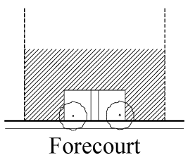
(21)
Front property line: The property line abutting the higher ranking street right-of-way. For equal ranking street rights-of-way, either frontage may be designated as the front property line.
(22)
Green: An outdoor open space, mostly surrounded by residential uses, which shall not be hard surfaced for more than 20 percent of the area exclusive of dedicated rights-of-way. Greens shall be located according to the designated open space plan, and its landscaping shall consist primarily of lawn, trees and garden structures.
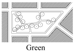
(23)
Greenway or linear park: An outdoor open space along a natural edge, including, without limitation: a river front, a canal, a scenic road, or other route. Greenways provide passage for pedestrians or bicycles and are used to link nature reserves, cultural features, other parks, and open spaces and/or historic sites.
(24)
Habitable space: Building space the use of which involves regular human presence. Habitable space shall not include areas devoted to the parking of vehicles in parking garage structures, self-service storage facilities or warehouses.
(25)
Home office: A professional office use within a residential use, as provided in Section 33-25.1 of the Miami-Dade County Code as adopted by the Village of Palmetto Bay via ordinance 04-16.
(26)
Institutional use: A use that is conducted within a building for the medical treatment or care of persons suffering from illness or infirmity; for the care of infants, convalescents, or aged persons; or for penal or corrective purposes.
(27)
Live-work unit: A mixed-use building type with one single family residential dwelling located in conjunction with one work space.
(28)
Main street: A vehicular and pedestrian thoroughfare lined primarily with mixed-use buildings, as depicted on the street types regulating plan.
(29)
Minor street: A street that is predominantly residential in character as depicted on the street types regulating plan.
(30)
Mixed-use building: A building that includes a combination of two or more vertically or horizontally integrated uses.
(31)
Off-street parking: Garage parking or surface parking not on a public or private street.
(32)
On-street parking: Parking on a public or private street.
(33)
Outdoor produce market: An outdoor commercial establishment where produce and hand crafted items are offered for sale.
(34)
Pedestal: The bottom portion of a building that creates the street frontage.
(35)
Pedestrian passages: Interconnected paved walkways that provide pedestrian passage through blocks and that connect directly with the network of sidewalks and open spaces.
(36)
Penthouse: Topmost built area of a building with a floorplate area less than that of the tower below.
(37)
Plaza: An outdoor open space fronted by retail and office uses. A minimum of 50 percent and a maximum of 75 percent of the plaza's area, exclusive of dedicated rights-of-way, shall be hard surfaced. Plazas shall be located according to the designated open space plan; and, its landscaping shall consist primarily of hard-surfaced areas, permanent architecture or water-oriented features and trees that are placed in an orderly fashion and that are regularly spaced as shown below.
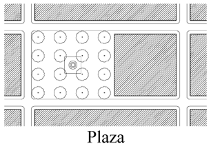
(38)
Residential building type: One of the following residential building types permitted in the FT&I District: single family detached, duplex, rowhouses/townhouses, courtyard house, side yard house, and apartment.
(39)
Rowhouses/townhouses: A single family attached dwelling unit of a group of three or more units, each separated from the adjoining unit by a common party fire wall. Each common party fire wall shall extend to the roof line or above the roof of units that it serves and shall have no openings therein. Each rowhouse/townhouse unit shall be serviced with separate utilities and shall otherwise be independent of any other unit.
(40)
Service road: A private or public vehicular passageway providing primary, secondary or service access to the sides or rear of building lots.
(41)
Sideyard house: A single family dwelling that provides an extensive porch oriented toward a side yard; the side yard is screened from the view of the street by a six-foot masonry wall along the build-to line.
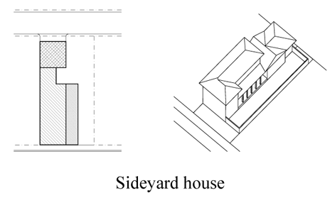
(42)
Square: An outdoor open space that shall be flanked by streets on at least three sides and shall not be hard-surfaced for more than 50 percent of the area exclusive of dedicated rights-of-way. Squares shall be located according to the designated open space plan, and their landscaping shall consist primarily of hard-surfaced walks, lawns and trees that are placed in an orderly fashion and that are regularly spaced as shown below.
(43)
Storefront: The portion of a building at the first story of a mixed-use building consisting of habitable space to be used for business, office or institutional purposes.
(44)
Story: An enclosed floor level within a building containing habitable space.
(45)
Street network: A system of intersecting and interconnecting streets and service roads.
(46)
Street type development parameters: The design criteria that establish the required elements for the placement and size of the following: sidewalks, curbs and gutters, parking, medians, bike lanes, traffic lanes, street trees, and landscape strips in the public right-of-way.
(47)
Street vista: A view through or along a street centerline terminating with the view of a significant visual composition of an architectural structure or element. Street vistas are indicated on the open space regulating plan by arrows; direction of the vista is indicated by the direction of the arrow. Garages and blank walls are not significant visual compositions.
(49)
Tower: The middle portion of a building above the pedestal and below the penthouse.
(49)
Weather protection elements: Architectural elements that provide protection from the sun and the rain, including, without limitation: colonnades, awnings, bus shelters, or projecting roofs.
(c)
Uses. No land, body of water or structure shall be used or permitted to be used, and no structure shall be hereafter erected, constructed, reconstructed, moved, structurally altered, or maintained for any purpose in the FT&I District, except as provided in this chapter. The uses delineated herein shall be permitted only in compliance with the regulating plans and general requirements provided in this chapter.
(1)
Permitted uses.
a.
Residential uses. Residential uses are permitted in the areas designated in the land use regulating plan as Live-Work Neighborhood (LW), Mixed-Use Neighborhood (MN), Mixed-Use Corridor (MC), Mixed-Use Main Street (MM), and Business and Office (BO), as provided in the table below. In addition, density averaging shall be permitted when a unified development is located on multiple parcels, with different land uses or sub-district designations, under the same ownership.
b.
Ancillary uses. The following uses shall be permitted as ancillary uses to a lawful residential unit in the areas designated:
i.
Live-Work Neighborhood (LW) and Mixed-Use Neighborhood (MN) Districts:
A.
The following accessory buildings and nonresidential uses, when located in the rear yard: workshop, garage, utility shed, gazebo, cabana, garden features, basketball hoop, pool and the like, and carport;
B.
For an attached or detached single family unit, a single accessory dwelling unit with a maximum of 600 square feet of habitable space under the same ownership as the single family unit;
C.
Home office, as provided in Section 33-25.1 of the Miami-Dade County Code as adopted by the Village of Palmetto Bay via ordinance 04-16.
ii.
Live-Work Neighborhood (LW) District: Workshop uses that occupy the work portion of a live-work unit. The workshop uses are limited to small scale businesses. The workshop use shall specifically preclude the use of large machinery or uses that create noxious odors or ambient noise levels in excess of the allowable levels for that area as provided for in the village's noise ordinance. All required parking shall be met on-site.
iii.
Mixed-Use Neighborhood (MN) District: Within the MN District, in addition to the required residential component, optional first floor uses may include:
A.
Retail uses;
B.
Professional offices;
C.
Medical, dental, and optical offices;
D.
Veterinarian offices;
E.
Service convenience uses; and
F.
Civic uses.
c.
Mixed uses. The vertical or horizontal integration of two or more of residential, business and office, civic and institutional uses shall be required as provided herein. Vertical integration allows any combination of primary uses, with business uses typically located on the ground floor and office and/or residential uses on the upper floors. Horizontal integration allows any combination of parcels with different primary uses within the same block under the same ownership.
Parcels of one-half-acre or less in size shall be exempt from the mixed use requirement. These parcels shall comply with all other general requirements and regulating plans of this chapter for the Business and Office (BO), Mixed-Use Main Street (MM) and Mixed-Use Corridor (MC) designated areas.
The following uses shall be permitted in accordance with the land use regulating plan, in the areas designated as Business and Office (BO), Mixed-Use Main Street (MM) and Mixed-Use Corridor (MC):
i.
Multiple-family dwelling units;
ii.
Professional offices;
iii.
Medical, dental and optical offices;
iv.
Veterinarian offices;
v.
Schools, in accordance with applicable provisions of this Code;
vi.
Government offices;
vii.
Hotels and apartment hotels;
viii.
Museums;
ix.
Automobile parking garages;
x.
Municipal recreation buildings;
xi.
Police and fire stations and substations;
xii.
Post offices;
xiii.
Transit stations;
xiv.
New and used automobile and motorcycle sales subject to the following requirements:
A.
Used sales shall only be permitted in conjunction with new sales; and
B.
Ancillary service and repair shall only be permitted in conjunction with new sales.
xvi.
Dry-cleaning establishments where cleaning is not done on-site, offering drop-off and pick-up service only, but allowing other related services, including without limitation, tailoring and shoe repair, provided such establishments contain no more than 4,000 square feet of floor area; and
xvii.
The following business uses, provided, however, such establishments contain no more than 20,000 square feet of gross floor area and provide no outside storage and/or display of merchandise, equipment, materials or supplies:
A.
Antique shops;
B.
Apparel store new and used merchandise;
C.
Appliance and electrical fixture stores;
D.
Art goods stores, artist studios and galleries;
E.
Auditoriums;
F.
Bait and tackle shops;
G.
Banquet and convention halls;
H.
Banks;
I.
Beauty parlors;
J.
Bakeries;
K.
Barber shops;
L.
Bicycle sales, rentals, and repairs (nonmotorized);
M.
Billiard rooms;
N.
Book stores;
O.
Card shops;
P.
Civic uses;
Q.
Confectionaries, ice cream stores and dairy stores;
R.
Department stores;
S.
Drugstores;
T.
Florist shops and garden shops;
U.
Funeral parlors,
V.
Furniture stores;
W.
Grocery stores, fruit stores, health food stores, delicatessen, meat and fish markets, and other similar food stores;
X.
Religious facilities;
Y.
Handcrafted product shops and hobby shops, including related workshops;
Z.
Hardware stores;
AA.
Health and exercise clubs;
BB.
Home improvement stores;
CC.
Information booths;
DD.
Institutional uses;
EE.
Interior design shops;
FF.
Jewelry stores;
GG.
Leather goods and luggage shops;
HH.
Locksmith;
II.
Music and dance studios;
JJ.
Newsstands;
KK.
Office and stationery supplies;
LL.
Optical stores;
MM.
Paint and wallpaper stores;
NN.
Photography studios, photo supply shops and photo galleries;
OO.
Physical training schools with indoor training, including, without limitation: gymnastics, martial arts and dance academies;
PP.
Pottery shops;
QQ.
Printing shops;
RR.
Pubs and bars, provided that these establishments comply with the distance requirements and other applicable provisions of this Code;
SS.
Libraries;
TT.
Restaurants and coffee houses;
UU.
Shoe stores and shoe repair shops;
VV.
Souvenir shops and gift shops;
WW.
Sporting goods stores;
XX.
Tailor shops;
YY.
Tobacco shops; and
ZZ.
Other similar uses.
d.
All districts within the FT&I District. Day nursery, kindergarten and after-school care licensed by the State of Florida Department of Health and Rehabilitative Services, schools, private clubs and religious facilities, pursuant to the requirements of Division 30-110 or Division 30-120.
e.
Conditionally permitted uses. The following conditional uses shall be permitted subject to the administrative approval of a site plan, pursuant to subsection (i) of this division, to assure compliance with the requirements established herein:
i.
Liquor package stores shall be permitted only in the core sub-district and only in compliance with all applicable regulations of this Code and provided that such stores shall not operate on Sundays.
ii.
Stand alone automobile service, repair and gasoline stations shall:
A.
Be permitted only in the Business and Office (BO) District areas in the center sub-district;
B.
Be exempt from the minimum height requirement;
C.
Conduct all services and repair functions within an enclosed structure, except those services routinely performed at the pump island;
D.
Prohibit outside storage and/or display of merchandise, equipment, materials and/or supplies; and
E.
Provide a continuous street façade consisting of buildings or walls along all rights-of-way except driveways. When provided, walls shall not exceed three and one-half feet in height and shall be a minimum of 75 percent opaque. The main building shall provide a minimum of 40 percent of building frontage along the front property line.
iii.
Drive-through facilities shall:
A.
Be permitted only in the core sub-district;
B.
Provide a continuous street façade consisting of buildings or walls along all rights-of-way except driveways. When provided, walls shall not exceed three and one-half feet in height and shall be a minimum of 75 percent opaque. The main building shall provide a minimum of 40 percent of building frontage along the front property line; and
C.
Be permitted upon determination under subsection (i)(B) that the drive-through shall create minimal traffic congestion or disruption to adjacent streets.
iv.
Uses operating in excess of the allowable noise levels for that area as provided for in the village's noise ordinance shall be prohibited.
v.
Sidewalk cafés and outdoor table service may be provided in compliance with the village's sidewalk café ordinance.
(d)
Regulating plans. The regulating plans shall consist of the following controlling plans, as defined and graphically depicted in this section.
(1)
The street types plan establishes a hierarchy of street types in existing and future locations. The five street types and the hierarchy of streets (from most important to least important in accommodating all types of activity) are U.S. 1, Main Street, Boulevard, Minor Street, and Service Road.
(2)
The sub-districts plan delineates two sub-districts: Core and center. These sub-districts shall regulate the allowable intensity of development in accordance with the comprehensive plan and this chapter.
(3)
The land use plan delineates the areas where specified land uses and development of various types and intensities shall be permitted.
(4)
The building heights plan establishes the minimum and maximum allowable number of stories and the overall height.
(5)
The designated open space plan designates open spaces. The designated open spaces shall be controlled by anchor points.
(6)
The new streets plan shows the location and the number of new streets needed to create the prescribed network of streets within the FT&I District. All new A Streets shall be required in the same general location as shown on the New Streets Plan. All B Streets shall be located as provided in section 30-50.18(f) of this chapter.
(7)
The bike route plan depicts the designated bike routes, including the bike facility requirements if any, which shall be shown in all development plans.
A.
Street Types Plan
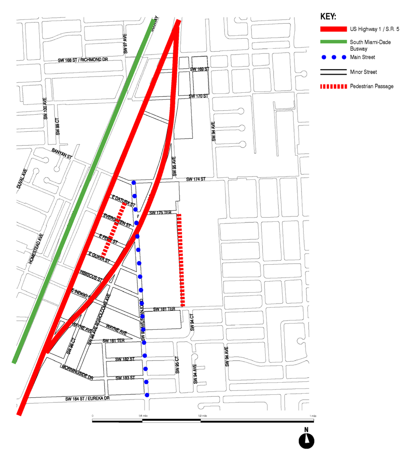
B.
Sub-Districts Plan
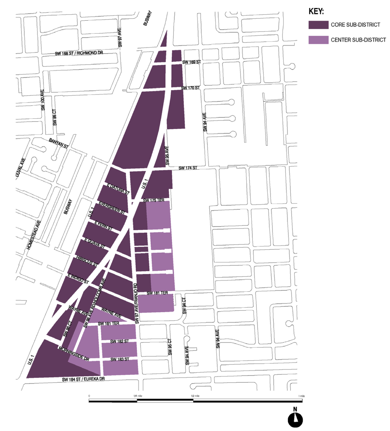
C.
Land Use Plan
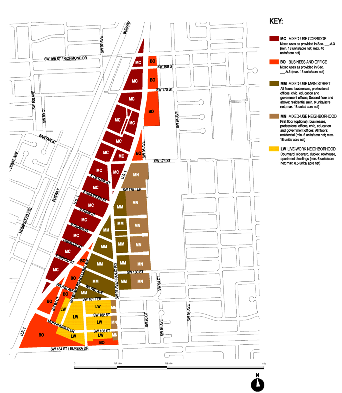
D.
Building Heights Plan
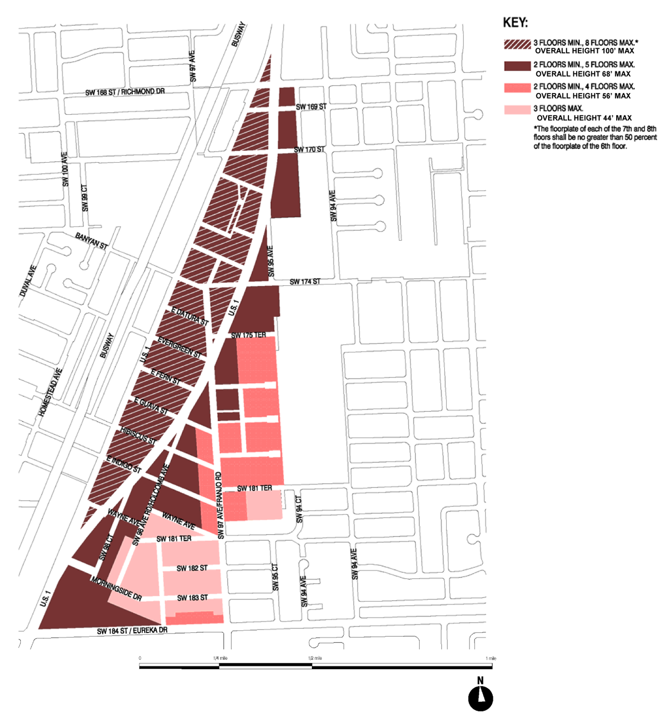
E.
Designated Open Space Plan
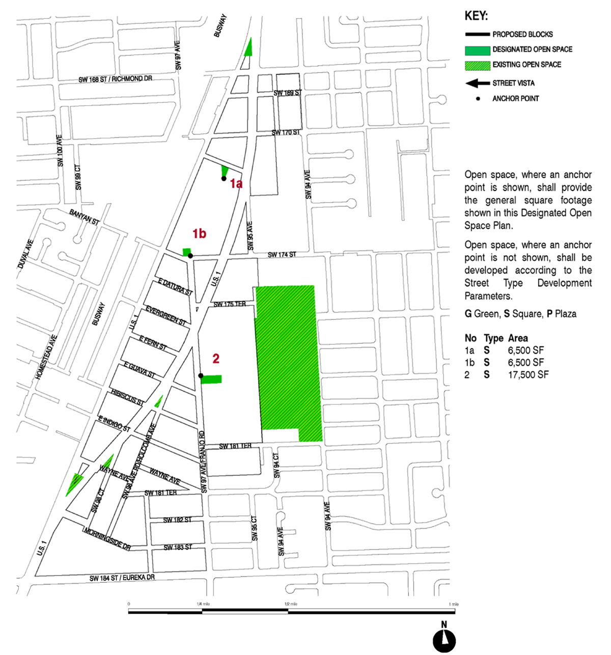
F.
New Street Dedications Plan
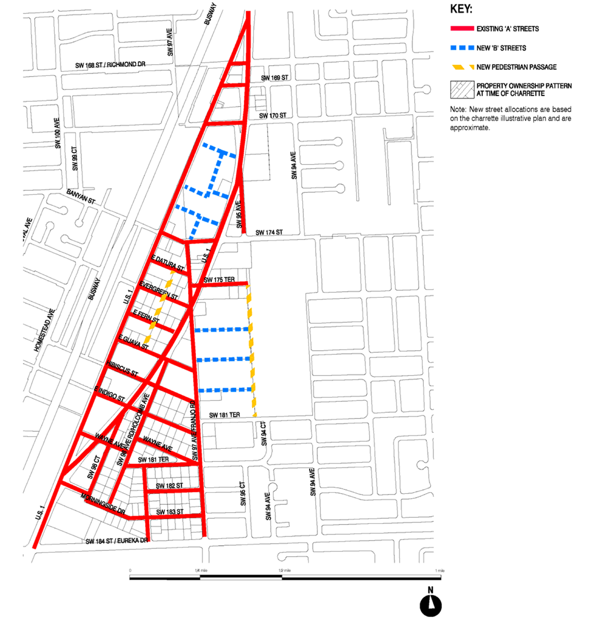
G.
Bike Route Plan
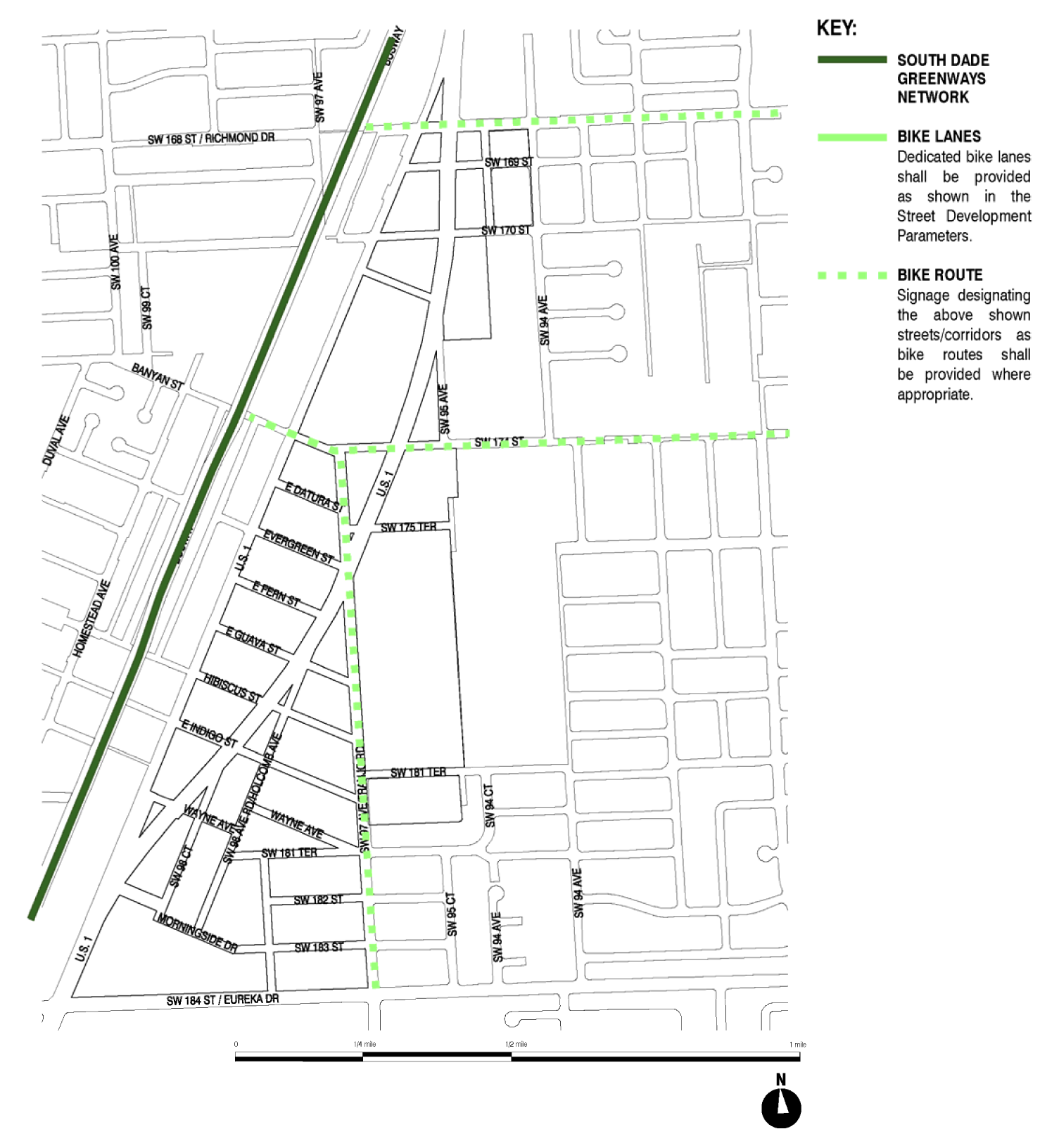
(e)
Building placement and street type development parameters.
(1)
All new development and redevelopment within the FT&I District shall comply with the building placement and design parameters as provided in this section.
(2)
Unless otherwise provided by the building placement and design parameters in this section, the following front and side street setbacks shall be required within the FT&I District:
(3)
Parcels of one-half acre in size or less, shall, on a case by case basis, be exempted from specific provisions of subsection (1) above due to impracticability of application, upon written finding of impracticability by the director of community development.
| MIXED-USE (MM, MC, BO, MN) DISTRICTS | |
|---|---|
| CORE/CENTER | |
■ BUILDING PLACEMENT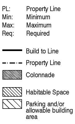 | 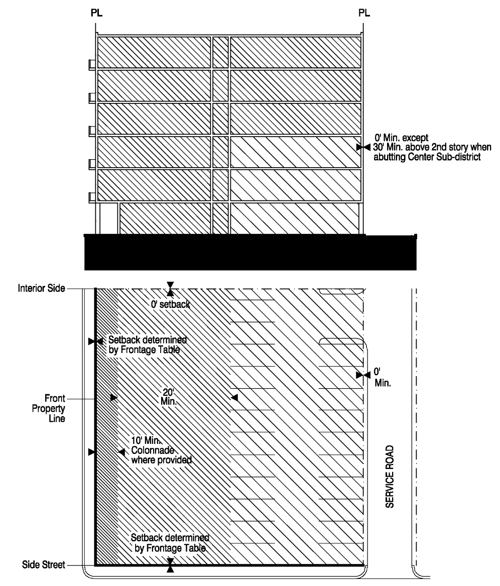 |
| LAND USES | Applies to areas designated MM, MC, BO and MN Districts. For permitted uses refer to subsection (c). |
| ■ BUILDING FRONTAGE | 100 percent minimum at build-to line in the core sub-district; 80 percent minimum at build-to line in the center sub-district. Minimum frontage requirement applies along the front property line only. |
| ■ PARKING | All on-site parking shall be accessed from the service road or adjacent minor street. Up to 60 percent of required parking may be provided off-site with a 500 feet radius. |
| ■ SETBACK | The interior side/rear setbacks shall be as shown above. Front and side street setbacks as provided in frontage table; see subsection (e) |
| ■ OTHER ELEMENTS |
The front setback, where required, shall be hard surfaced and finished to match the
adjoining sidewalk. A minimum of five feet clear width within the setback shall be
kept unobstructed for pedestrians. Weather protection elements shall be provided on
the building façade.
Colonnades where provided shall be a minimum of ten feet deep. The colonnade depth shall not exceed the colonnade height. The exterior of the colonnade shall be no closer that five feet to the curb line. Perimeter walls, fences, hedges, entrances and pedestrian pass-through shall be provided as specified in the general requirements. |
| MIXED-USE (MC, BO, MM, MN) DISTRICTS | |
|---|---|
| CORE/CENTER (CIVIC USES) | |
■ BUILDING PLACEMENT | 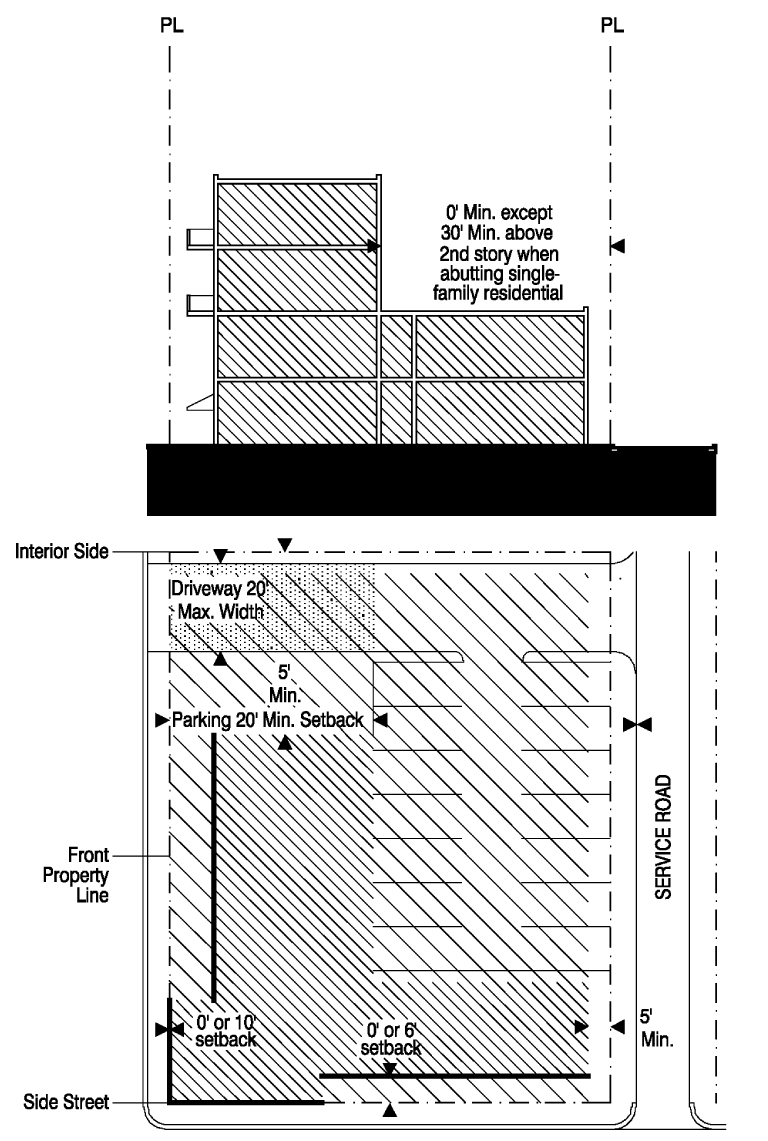 |
| LAND USES | Applies to areas designated MC, BO, MM and MN Districts developed with civic uses. for permitted uses refer to subsection (c). |
| ■ BUILDING FRONTAGE | 25 percent minimum at build-to line. Minimum frontage requirement applies along the front property line only. |
| ■ PARKING | All on-site parking shall be accessed from the service road where provided. For properties without an adjoining services road parking may be accessed from the front property line through a driveway as shown above. |
| ■ SETBACK | The front setback shall be zero feet or ten feet in order to implement urban design principles. The side and rear setback shall be as shown above. |
| ■ OTHER ELEMENTS |
The front setback shall be landscaped.
Perimeter walls, fences, hedges, entrances and pedestrian pass-through shall be provided as specified in the general requirements. |
| MIXED-USE NEIGHBORHOOD (MN) DISTRICTS | |
|---|---|
| CORE/CENTER (APARTMENTS) | |
■ BUILDING PLACEMENT | 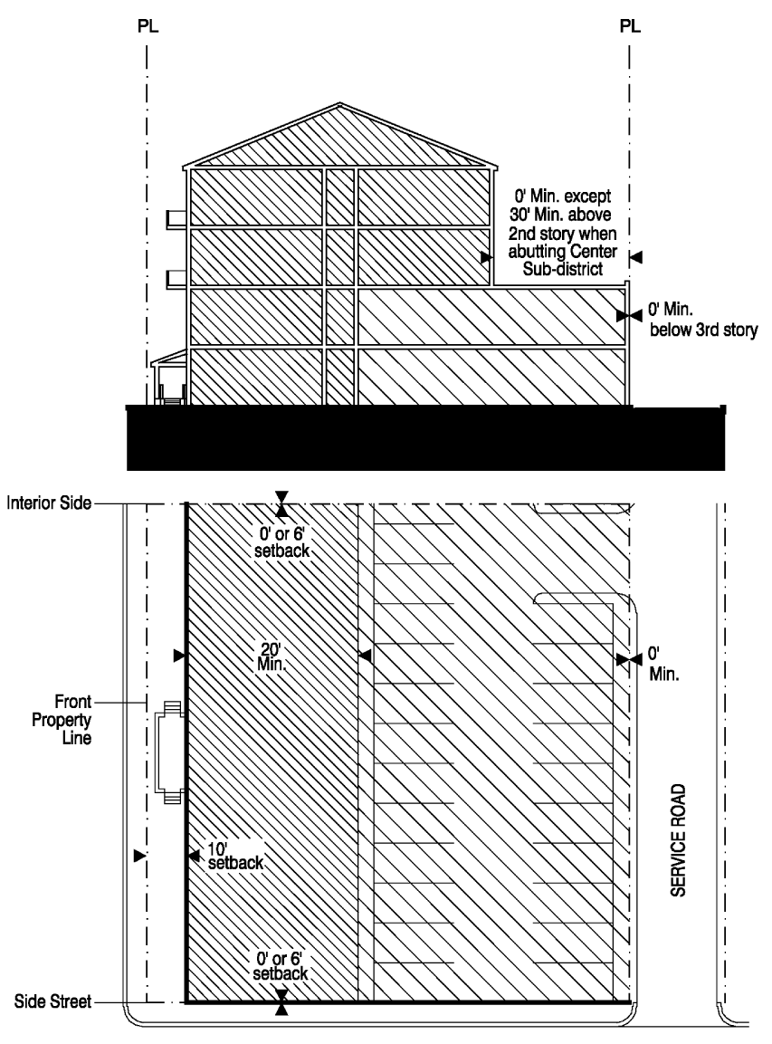 |
| LAND USES | Applies to areas designated MN District developed as apartments. for permitted uses refer to subsection (c). |
| ■ BUILDING FRONTAGE | 80 percent minimum at build-to line. Minimum frontage requirement applies along the front property line only. |
| ■ PARKING | All on-site parking shall be accessed from the service road or adjacent minor street. Up to 60 percent of required parking may be provided off-site within a 500 feet radius. |
| ■ SETBACK | The side setback shall be zero feet or six feet in order to implement urban design principles. The front and rear setback shall be as shown above. |
| ■ OTHER ELEMENTS |
The front setback shall be landscaped.
Perimeter walls, fences, hedges, entrances and pedestrian pass-through shall be provided as specified in the general requirements. |
| MIXED-USE/LIVE-WORK NEIGHBORHOOD (MM, LW) DISTRICTS | |
|---|---|
| CORE/CENTER (LIVE-WORK) | |
■ BUILDING PLACEMENT;
 | 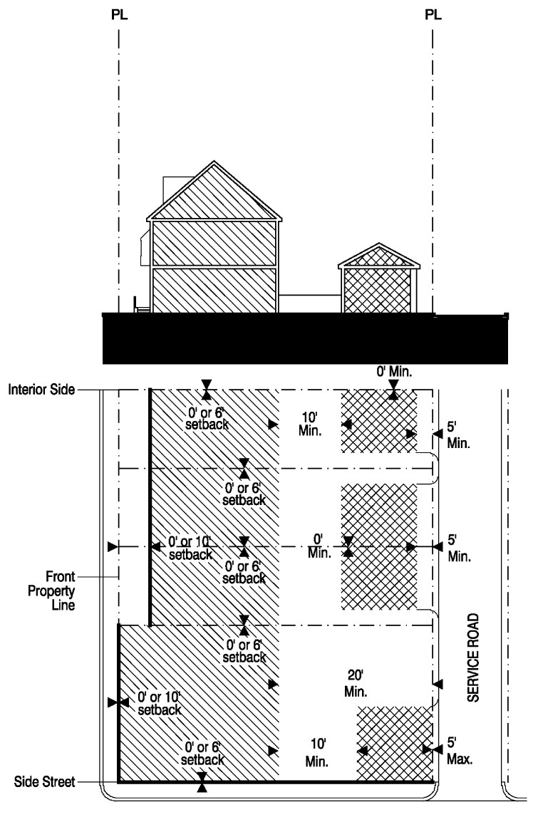 |
| LAND USES | Applies to areas designated MN and LW District developed as Live-Work units. For permitted uses refer to subsection (c). |
| ■ BUILDING FRONTAGE | 80 percent minimum at build-to line. Minimum frontage requirement applies along the front property line only. |
| ■ PARKING | All on-site parking shall be accessed from the service road or adjacent minor street. Up to 60 percent if required parking ay be provided off-site within a 500 feet radius. |
| ■ SETBACK | The side setback shall be zero feet or ten feet in order to implement urban design principles. The front and rear setback shall be as shown above. |
| ■ OTHER ELEMENTS | Perimeter walls, fences, hedges, entrances and pedestrian pass-through shall be provided as specified in the general requirements. |
| MIXED-USE/LIVE-WORK NEIGHBORHOOD (MN, LW) DISTRICTS | |
|---|---|
| CORE/CENTER(SIDEYARD OR COURTYARD) | |
■ BUILDING PLACEMENT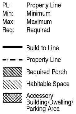 |  |
| LAND USES | Applies to areas designated MN AND LW Districts developed as Courtyard or Sideyard Houses. For permitted uses refer to subsection (c). |
| ■ BUILDING FRONTAGE | 65 percent minimum at build-to line for courtyard houses and sideyard houses. Minimum frontage requirement applies along the front property line only. |
| ■ PARKING | For sideyard and courtyard houses all on-site parking may be accessed from the service road. |
| ■ SETBACK | For courtyard houses, the side setback shall be zero feet or six feet in order to implement urban design principles. The front setback shall zero feet or ten feet in order to implement urban design principles. The rear setback shall be as shown above. |
| ■ OTHER ELEMENTS |
The front setback shall be landscaped.
Perimeter walls, fences, hedges, entrances and pedestrian pass-through shall be provided as specified in the general requirements. |
| MIXED-USE LIVE-WORK NEIGHBORHOOD (MN, LW) DISTRICTS | |
|---|---|
| CORE/CENTER (ROWHOUSE) | |
■ BUILDING PLACEMENT | 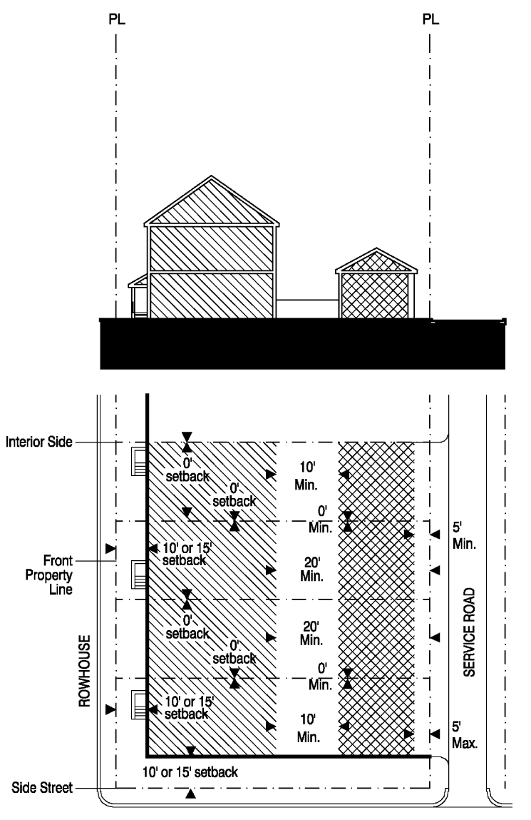 |
| LAND USES | Applies to areas designated MN and LW District developed as rowhouses. for permitted uses refer to subsection (c). |
| ■ BUILDING FRONTAGE |
100 percent minimum at build-to line except at end of building groups.
Minimum frontage requirement applies along the front property line only. |
| ■ PARKING | For rowhouses all on-site parking shall be accessed from the service road |
| ■ SETBACK | The front setback shall be ten feet or 15 feet in order to implement urban design principles. The rear and side setback shall be as shown above. |
| ■ OTHER ELEMENTS |
The front setback shall be landscaped.
Perimeter walls, fences, hedges, entrances and pedestrian pass-through shall be provided as specified in the general requirements. |
| LIVE-WORK NEIGHBORHOOD (LW) DISTRICTS | |
|---|---|
| CENTER (SINGLE FAMILY DETACHED) | |
■ BUILDING PLACEMENT | 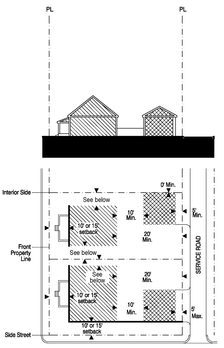 |
| LAND USES | Applies to areas designated LW District developed as single family detached dwellings. For permitted uses refer to subsection (c). |
| ■ BUILDING FRONTAGE | 40 percent minimum at build-to line. Minimum frontage requirement applies along the front property line only. |
| ■ PARKING | All on-site parking shall be accessed from the service road where provided. |
| ■ SETBACK | The front setback shall be ten feet or 15 feet in order to implement urban design principles. For lots with frontage between 50 and 75 feet the minimum side setback shall be ten percent of the lot frontage; for lots with frontage greater than 75 feet the side setback shall be a minimum of 7.5 feet. The rear setback shall be as shown above. |
| ■ OTHER ELEMENTS |
The front setback shall be landscaped.
Perimeter walls, fences, hedges, entrances and pedestrian pass-through shall be provided as specified in the general requirements. |
| LIVE-WORK NEIGHBORHOOD (LW) DISTRICTS | |
|---|---|
| CENTER (SINGLE FAMILY DETACHED WITHOUT SERVICE ROAD) | |
| ■ BUILDING PLACEMENT |
Lots> or = 50′ Only
|
| LAND USES | Applies to areas designated LW District where a service road is not provided and for lots grater than or equal to 50 feet. For permitted uses refer to subsection (c). |
| ■ BUILDING FRONTAGE | 60 percent minimum at build-to line on all frontages. The garage shall not count toward the frontage requirements. Minimum frontage requirement applies along the front property line only. |
| ■ PARKING | All on-site parking for single family detached units on lots greater or equal to 50 feet wide and in the edge sub-district only, shall be accessed from the service road or from the street as shown above. |
| ■ SETBACK | The front setback shall be ten feet or 15 feet in order to implement urban design principles. The side and rear setback shall be as shown above. |
| ■ OTHER ELEMENTS | Where a driveway intersects a sidewalk, the sidewalk shall remain at a continuous level. |
The following diagrams establish the street type parameters by sub-district. Building setbacks shall be required as illustrated in the building placement parameters; where setbacks reference a frontage table, such table shall be specific to the individual district requirements.
| MAIN STREET (Parking Both Sides) DISTRICTS | |
|---|---|
| STREET TYPE 9 | CORE |
■ STREET SECTION |  |
| LANDSCAPE/OPEN SPACE | Parking lot buffers and street trees shall meet all requirements of Chapter 18-A of this Code and this article of the Miami-Dade County Code except street trees shall have a minimum diameter breast height of four inches. Street trees shall be planted in five feet × five feet tree grates. Permanent irrigation is required. In the center sub-district, tree grates are optional and street trees shall be planted in a six feet continuous landscape strip. |
| ■ PARKING | On street parking shall count towards the minimum required parking. |
| ■ OTHER ELEMENTS |
Where a colonnade provided on the ground floor the sidewalk shall be five feet maximum
along the building side only.
If additional traffic lanes are provided the outer lanes shall be a maximum of 11 feet wide and the inner lanes shall be a maximum of ten feet wide. Additional traffic lanes shall only be added provided that all the street parameters are maintained at a minimum, as depicted above. |
| MAIN STREET DISTRICT | |
|---|---|
| STREET TYPE 9 | CENTER |
■ STREET SECTION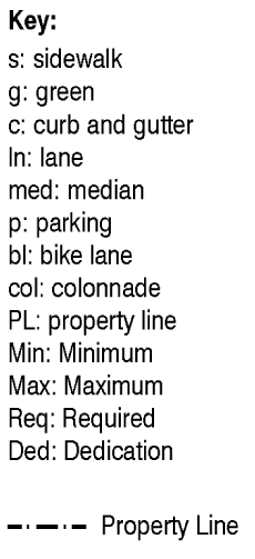 |  |
| LANDSCAPE/OPEN SPACE | Parking lot buffers and street trees shall meet all requirements of Chapter 18-A of this Code and this article of the Miami-Dade County Code except street trees shall have a minimum diameter breast height of four inches. Street trees shall be planted in five feet × five feet tree grates. Permanent irrigation is required. In the center sub-district, tree grates are optional and street trees shall be planted in a six feet continuous landscape strip. |
| ■ PARKING | N/A. |
| ■ OTHER ELEMENTS | If additional traffic lanes are provided the outer lanes shall be a maximum of 11 feet wide and the inner lanes shall be a maximum of ten feet wide. Additional traffic lanes shall only be added provided that all the street parameters are maintained at a minimum, as depicted above. |
| BOULEVARD (Parking Both Sides) DISTRICT | |
|---|---|
| STREET TYPE 1 | CORE/CENTER |
■ STREET SECTION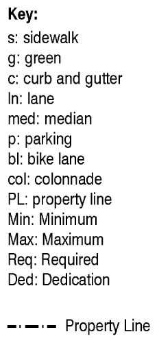 |  |
| LANDSCAPE/OPEN SPACE | Parking lot buffers and street trees shall meet all requirements of Chapter 18-A of this Code and this article of the Miami-Dade County Code except street trees shall have a minimum diameter breast height of four inches. Street trees shall be planted in five feet × five feet tree grates. Permanent irrigation is required. In the center sub-district, tree grates are optional and street trees shall be planted in a six feet continuous landscape strip. |
| ■ PARKING | On street parking shall count towards the minimum required parking. |
| ■ OTHER ELEMENTS |
Where a colonnade provided on the ground floor the sidewalk shall be five feet maximum
along the building side only.
On all Boulevard intersections, the median shall have a mountable curb. In the center sub-district, the sidewalk shall be a minimum of eight feet when adjacent to a six feet landscape strip. If additional traffic lanes are provided the outer lanes shall be a maximum of 11 feet wide and the inner lanes shall be a maximum of ten feet wide. Additional traffic lanes shall only be added provided that all the street parameters are maintained at a minimum, as depicted above. |
| BOULEVARD (No Parking) DISTRICT | |
|---|---|
| STREET TYPE 2 | CORE/CENTER |
■ STREET SECTION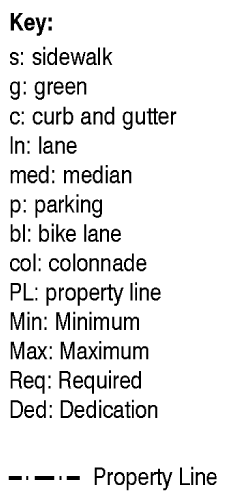 |  |
| LANDSCAPE/OPEN SPACE | Parking lot buffers and street trees shall meet all requirements of Chapter 18-A of this Code and this article of the Miami-Dade County Code except street trees shall have a minimum diameter breast height of four inches. Street trees shall be planted in five feet × five feet tree grates. Permanent irrigation is required. In the center sub-district, tree grates are optional and street trees shall be planted in a six feet continuous landscape strip. |
| ■ PARKING | N/A. |
| ■ OTHER ELEMENTS |
Where a colonnade provided on the ground floor the sidewalk shall be five feet maximum
along the building side only.
On all Boulevard intersections, the median shall have a mountable curb. In the center sub-district, the sidewalk shall be a minimum of eight feet when adjacent to a six feet landscape strip. If additional traffic lanes are provided the outer lanes shall be a maximum of 11 feet wide and the inner lanes shall be a maximum of ten feet wide. Additional traffic lanes shall only be added provided that all the street parameters are maintained at a minimum, as depicted above. |
| MINOR STREET (Parking Both Sides) DISTRICT | |
|---|---|
| STREET TYPE 3 | CORE/CENTER |
■ STREET SECTION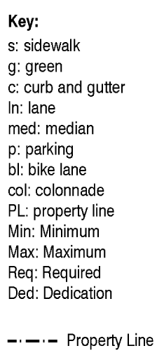 |  |
| LANDSCAPE/OPEN SPACE | Parking lot buffers and street trees shall meet all requirements of Chapter 18-A of this Code and this article of the Miami-Dade County Code except street trees shall have a minimum diameter breast height of four inches. Street trees shall be planted in five feet × five feet tree grates. Permanent irrigation is required. In the center sub-district, tree grates are optional and street trees shall be planted in a six feet continuous landscape strip. |
| ■ PARKING | On street parking shall count towards the minimum required parking. |
| ■ OTHER ELEMENTS |
Where a colonnade provided on the ground floor the sidewalk shall be five feet maximum
along the building side only.
In the center sub-district, the sidewalk shall be a minimum of eight feet when adjacent to a six feet landscape strip. If additional traffic lanes are provided the outer lanes shall be a maximum of 11 feet wide and the inner lanes shall be a maximum of ten feet wide. Additional traffic lanes shall only be added provided that all the street parameters are maintained at a minimum, as depicted above. |
| MINOR STREET (Parking One Side) DISTRICT | |
|---|---|
| STREET TYPE 4 | CORE/CENTER |
■ STREET SECTION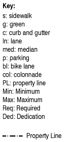 | 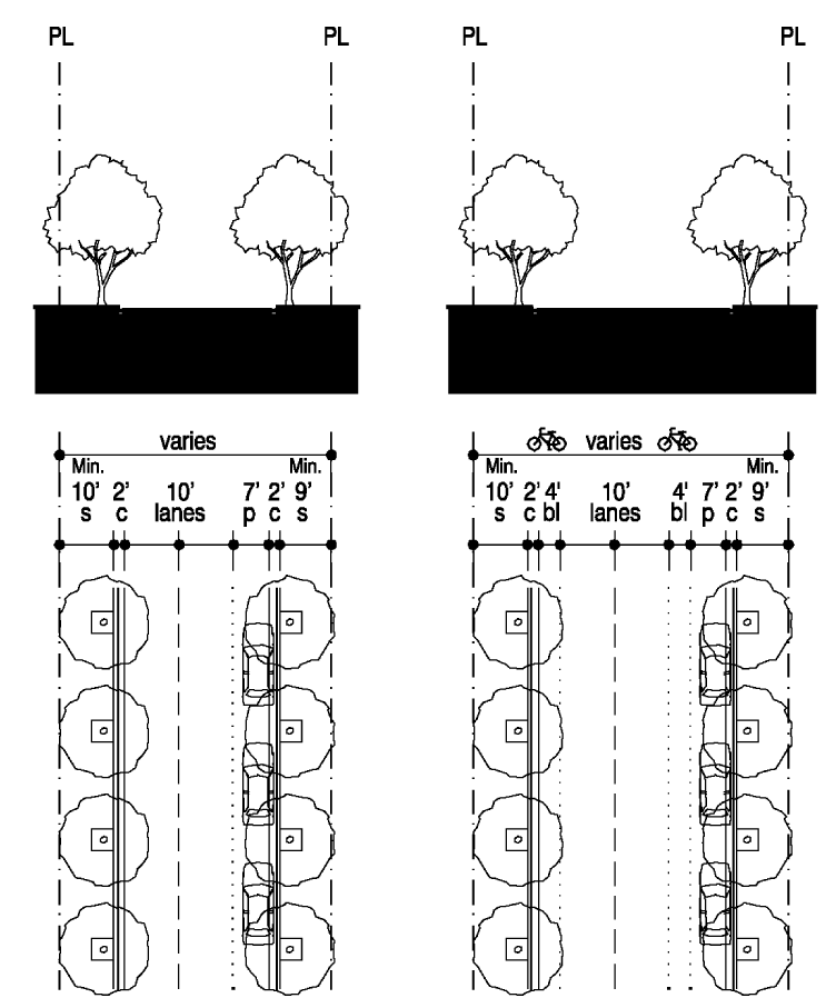 |
| LANDSCAPE/OPEN SPACE | Parking lot buffers and street trees shall meet all requirements of Chapter 18-A of this Code and this article of the Miami-Dade County Code except street trees shall have a minimum diameter breast height of four inches. Street trees shall be planted in five feet × five feet tree grates. Permanent irrigation is required. In the center sub-district, tree grates are optional and street trees shall be planted in a six feet continuous landscape strip. |
| ■ PARKING | N/A. |
| ■ OTHER ELEMENTS |
Where a colonnade provided on the ground floor the sidewalk shall be five feet maximum
along the building side only.
In the center sub-district, the sidewalk shall be a minimum of eight feet when adjacent to a six feet landscape strip. If additional traffic lanes are provided the outer lanes shall be a maximum of 11 feet wide and the inner lanes shall be a maximum of ten feet wide. Additional traffic lanes shall only be added provided that all the street parameters are maintained at a minimum, as depicted above. |
| MINOR STREET (No Parking) DISTRICT | |
|---|---|
| STREET TYPE 5 | CORE/CENTER |
|
■ STREET SECTION | 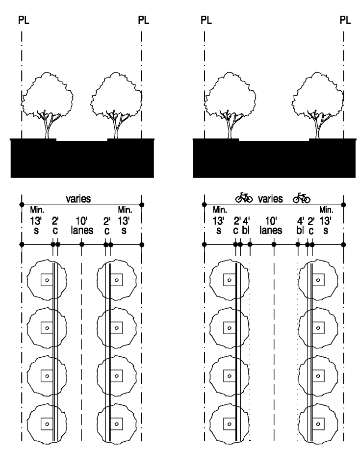 |
| LANDSCAPE/OPEN SPACE | Parking lot buffers and street trees shall meet all requirements of Chapter 18-A of this Code and this article of the Miami-Dade County Code except street trees shall have a minimum diameter breast height of four inches. Street trees shall be planted in five feet × five feet tree grates. Permanent irrigation is required. In the center sub-district, tree grates are optional and street trees shall be planted in a six feet continuous landscape strip. |
| ■ PARKING | N/A. |
| ■ OTHER ELEMENTS |
Where a colonnade provided on the ground floor the sidewalk shall be five feet maximum
along the building side only.
In the center sub-district, the sidewalk shall be a minimum of eight feet when adjacent to a six feet landscape strip. If additional traffic lanes are provided the outer lanes shall be a maximum of 11 feet wide and the inner lanes shall be a maximum of ten feet wide. Additional traffic lanes shall only be added provided that all the street parameters are maintained at a minimum, as depicted above. |
| SERVICE ROAD (In all Land use areas) DISTRICT | |
|---|---|
| STREET TYPE 7 | CORE/CENTER |
|
■ STREET SECTION |  |
| LANDSCAPE/OPEN SPACE | N/A. |
| ■ PARKING | All on-site parking shall be accessed from the service road. |
| ■ OTHER ELEMENTS | Multi-story garages, parking courts and surface parking lots are permitted along service roads only. Accessory dwellings, single family garages and accessory buildings are permitted along service roads in all sub-districts. |
| PEDESTRIAN PASSAGE DISTRICT | |
|---|---|
| STREET TYPE 8 | CORE/CENTER |
| ■ STREET SECTION | 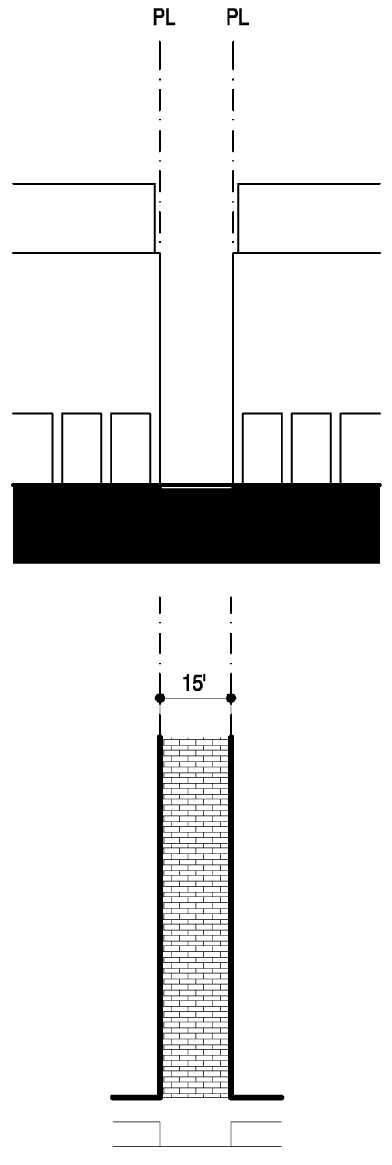 |
| LANDSCAPE/OPEN SPACE | Landscape shall meet all requirements of Chapter 18-A of this Code and this article of the Miami-Dade County Code. Trees are optional and shall be planted in a five feet × five feet tree grate or individual planter. |
| ■ PARKING | N/A. |
| ■ OTHER ELEMENTS |
For mixed-use buildings only, a minimum of 50 percent of building frontage shall be
required along the passage.
The setback along the passages shall be zero feet. The hard surfaced area shall be 15 feet and enhanced with a material different from the sidewalk. The pedestrian passage are optional and shall be interconnected with the sidewalks and public open spaces and provide pedestrian access to parking areas, through blocks, front street to street. |
(f)
General requirements. Setbacks, building frontage and building placement shall be as set forth in the building placement and design parameters in subsection (e) of this Code, except as specifically provided herein.
(1)
Lots and blocks. The following shall be required:
(2)
Buildings.
a.
Storefronts shall be provided on the first floor of mixed-use buildings, and shall be directly accessible from a street frontage or an open space as follows:
i.
For properties with two or more frontages, storefronts shall be located on a minimum of two frontages, with priority given to frontages on an open space and the highest ranking street.
ii.
Storefronts shall have a transparent clear glazed area of not less than 70 percent of the façade area. The first floor shall be occupied by habitable uses that generate pedestrian activity and provide surveillance of the street. Ground floor windowsills shall be placed at a minimum height of 24 inches and a maximum of 48 inches above grade. Security enclosures, if any, shall be of the mesh type that pedestrians can see through, and shall be located behind storefront displays.
b.
All colonnades shall comply with the following:
i.
Finished floor elevation of the colonnade shall match the adjoining sidewalk.
ii.
Colonnades shall have a minimum clear height of ten feet (including lighting) and a minimum clear width of ten feet (on the first floor from build-to line to exterior building face, excluding supporting structures). Awnings shall be permitted but shall not count toward the required colonnades. Colonnades shall not cause roof drainage into the public right-of-way. Colonnades shall be attached to buildings. In no instance shall the depth of a colonnade exceed the colonnade's height.
iii.
Freestanding colonnades shall not satisfy the build-to line requirement.
c.
A minimum of 30 percent of all first floor street walls shall be fenestrated with windows. Mirror type glass shall be prohibited. All glazing shall be of a type that permits view of human activities and spaces within the structure. Colonnade column spacing, windows and doors shall be proportioned such that the height of each opening is greater than its width. At least 50 percent of the area of security screens and gates shall be transparent.
d.
In the core and center sub-districts, the build-to line shall be maintained in accordance with the building placement and street type development parameters, except that the building may be set back up to 25 feet to accommodate a forecourt.
e.
The height of an accessory building shall not exceed the height of the principal building.
f.
An open, covered or paved connection between a principal building and an accessory building may be built within the minimum required ten-foot spacing as shown in the building placement and design parameters.
g.
Awnings, balconies, stoops, stairs, open porches, and bay windows shall be permitted to extend into the minimum required setbacks, to a maximum of:
Roof eaves, chimneys, signs, and ramps may encroach into all setbacks. Porticoes, canopies, and colonnades shall be guttered. Water run-off and drainage shall be deposited onsite.
h.
Where a zero-foot setback is permitted, roof eaves, bay windows and balconies may encroach beyond the property line a maximum of three feet, except when abutting private property. Awnings may encroach into the rights-of-way, but shall not extend into the street more than six inches from the face of the curb. All right-of-way encroachments shall be a minimum of 11 feet above the sidewalk.
i.
Buildings fronting a Main Street (Franjo Road) shall provide 20 percent of fenestration as balconies.
j.
Accessory buildings shall be permitted to have balconies or bay windows that encroach a maximum of three feet into the rear yard setback.
k.
Service areas shall be screened and located out of the view from adjacent properties or from the street.
l.
The primary entrance of a building shall provide access to a public right-of-way or an open space. The primary entrance to the upper levels of mixed-use building with colonnades shall be through the colonnaded area along the front property line.
m.
Each story shall have a maximum height of 16 feet, as measured from floor to floor. Any height above 16 feet shall count as an additional story, except that a single story may have a maximum height of 30 feet, provided that no mezzanine area exceeds ten percent of the floor area of that story.
n.
A live-work unit shall have two components: a workshop and a residential unit. The workshop component may occur on the ground floor with living space on the upper floors or in a courtyard building which provides workshop space along the street and residential space at the side and back. The workshop shall be directly accessible from the primary street frontage or an open space. The workshop's façade shall have a transparent clear glazed area of not less than 70 percent. The primary entrance of the residential component of a live-work unit shall be separate from the workshop component of the unit and shall directly lead to a primary street frontage or an open space.
o.
Rowhouses/townhouses shall provide a minimum of 15 feet between building groups and the length of a building group shall not exceed 240 feet.
p.
A cornice line shall project a minimum of two inches from the front elevation of the structure.
(3)
Open space. Open spaces under this chapter shall be classified as (1) designated or (2) private open spaces.
a.
Designated open spaces shall be subject to the following requirements:
i.
The general location, area and dimensions shall conform with the designated open space plan.
ii.
Designated open spaces shall include the anchor point depicted on the regulating plan, and shall be provided at grade level.
iii.
Provided that all other parameters on the designated open space plan are met and that an individual/developer owns the entire designated open space area and an adjacent area, the final location of the designated open space may be pivoted around its anchor point onto such adjacent area, allowing the area previously designated as open space to be developed as permitted in the Land Use Regulating Plan.
iv.
Designated open spaces shall be provided in the form of squares, greens or plazas as provided in the designated open space plan. Parking lot buffers shall not count toward the designated open space requirement.
v.
No replatting or other land subdivision shall divide property in such a way that required designated open space is avoided or its location changed.
vi.
Designated open spaces shall be shaded, and its ground surface shall be a combination of paving materials, lawn or ground cover.
vii.
If a lot or group of lots is designated partially as open space in the designated open space plan, the portion not designated as open space shall be developable in a contiguous pattern at a density/intensity that will equal the density/intensity permitted by the land use designation for the entire parcel. An additional story above the number of stories permitted by the sub-districts and building heights plans shall be permitted only to allow the increased density/intensity and shall front the designated open space.
viii.
Around designated open spaces, the building's frontage, height and placement shall be in accordance with the building placement and design parameters.
b.
Private open spaces.
i.
Private open spaces shall be provided in the form of colonnades, courtyards, terraces, and lawns. Parking lot buffers shall not count toward the open space requirement.
ii.
All residential developments, except for multi-family residential and live-work units, shall provide a minimum of 400 square feet of private open space per lot, in the form of courtyards, terraces and lawns.
iii.
All multi-family residential developments, including mixed-use developments, shall reserve a minimum of ten percent of the site for common, private open space. Colonnades, where required, shall count toward this requirement.
iv.
Private open spaces shall be shaded, and their ground surface shall be a combination of paving materials, lawn or ground cover. Enclosures of private open spaces shall comply with subsection (8) below.
c.
In addition to the open space required above at subsection (f)(3), for residential development over 50 units, an additional dedication not to exceed two acres may be made for parkland and public school use.
(4)
Landscape. Except as provided herein, landscape shall be provided as required by Chapter 18A Miami-Dade County Code as adopted by the Village of Palmetto Bay via ordinance 04-16. In the Core and Center Sub-districts, landscape shall be provided as follows:
a.
Street trees shall be planted at a maximum of 25 feet average on center, with a minimum four-inch diameter at breast height.
b.
Street trees shall not be required when colonnades are being provided along the street.
c.
For all land uses, except for single family or duplex, tree requirements for private property shall be based on 16 trees per net acre of lot area and, in addition to the placement on the lot, may be placed in greens, squares, plazas, and medians.
(5)
Parking. Except as provided herein, parking shall be provided as required by Division 30-70 of the Land Development Code.
a.
Multi-story parking garages, parking lots and on-street parking shall count toward all parking requirements except for the parking requirements of detached single family residences, courtyard and sideyard houses, row-houses/townhouses, or duplexes. Multi-story structured parking shall be counted in computing building height.
b.
Parking shall be provided as follows:
c.
The combined parking requirement for mixed-use development shall be 90 percent of the total parking otherwise required in this section; provided, however, that in the core sub-district, the combined parking required for mixed-use development shall be 80 percent of the total parking otherwise required in this section.
d.
Mixed-use developments in the core and center sub-districts may provide up to 60 percent of the required parking off-site, where the off-site parking is located on a minor street and within 500 feet of the development, provided the provisions of subsection o., below, are complied with. Any certificate of use for mixed-use shall immediately terminate in the event such parking area is not available. An applicant for approval of a mixed-use development with off-site parking shall execute and record in the public records of this village a declaration of restrictions approved by the director covenanting that such mixed-use shall cease and terminate upon the elimination of such parking area, and that no mixed-use requiring such parking shall be made of such property until the required parking area is available and provided.
e.
Residential uses on a lot or group of lots entirely or partially designated as open space as provided in section 30-50.19, may provide off-site parking of up to 60 percent of the parking required, provided the provisions of subsection o., below, are complied with. This off-site parking shall be located on a minor street and within 500 feet of the development. Such residential uses shall immediately terminate in the event such parking area is not available. An applicant for approval of a development with off-site parking shall execute and record in the public records of this village a declaration of restrictions approved by the director covenanting that such residential use shall cease and terminate upon the elimination of such parking area, and that no residential use requiring such parking shall be made of such property until the required parking area is available and provided.
f.
Individual parking garages for single family homes shall count toward the parking requirement.
g.
Parking for individuals with disabilities shall comply with the Florida Building Code.
h.
Parking for persons transporting strollers shall comply with Division 30-70 of the Code.
i.
Except for detached single family homes, courtyard or sideyard houses and duplexes, all parking may be in the form of multi-story parking garage structures or parking lots that shall be provided in the rear or on one side of the building, screened from public right-of-way. Parking is not permitted in the front setback.
j.
Multi-story parking garage structures shall be screened along all frontages, except along a service road or a pedestrian passage by a liner building containing a minimum depth of 20 feet of habitable space. On parcels having a lot depth at any one point of less than 150 feet, as measured from the front property line, screening shall only be required on the ground floor. All architectural elements of a multi-story parking structure that face a street or an open space shall appear consistent and harmonious with that of habitable space. No vehicles parked within the structure shall be visible from the street.
k.
Parking lots shall provide for vehicular connectivity to adjacent parking areas.
l.
All structures and uses which are erected, established or enlarged within the FT&I District shall provide adequate off-street parking spaces and control mechanisms for on-site vehicular and pedestrian traffic in order to insure the safety and convenience of the public pursuant to the requirements of this section.
m.
Adjacent on-street parking spaces may count toward the minimum parking requirements set forth above at subsections e. and f. and as providing for at Division 30-70 of this Code, provided that the property owner complies with subsection o., below; a partial space longer than 11 feet shall count as a full space.
n.
Unimproved rights-of-way adjacent to business property in the FT&I District may be improved by the abutting property as on-street parking spaces, for credit towards required on-site parking, by written agreement approved by the village manager provided that the property complies with subsection o., below. The village manager upon the advice of the village council, will determine if the installation of parking meters is warranted and appropriate for the area.
o.
Should property requesting the use of rights-of-way for parking construct the on-street parking as part of the development of the private property, the property in question shall receive a credit with the village for said spaces constructed for five years. Thereafter, an annual fee of $1,000.00, per space, which shall increase five percent annually, shall be paid to the village for all on-street parking spaces which are credited or counted toward minimum parking requirements for new structures, or a change in use that increases the minimum number of parking spaces required. If the on-street spaces already exist or were developed by the village, the property seeking to use the improved on-street spaces shall immediately pay the fee identified herein, if those spaces are being utilized to meet the minimum parking requirement for the property's development.
p.
Failure to comply with subsection o. above, shall result in the loss or revocation of the certificate of use and/or occupancy for the property failing to meet minimum parking requirements for the project, and subject the property and any user of the property to a daily penalty of $250.00, per day.
q.
Funds received under subsection o. or p. shall be paid into the FT&I District Improvement Trust Fund, which shall be a trust account separated from the village's general fund accounts. The funds from the FT&I District Improvement trust account shall be used at the village council's discretion for the specific purpose of developing or reimbursing the village for improvements to FT&I District public parking facilities, infrastructure to increase parking capacity, and the installation of metering devises, and shall not be under the control or discretion of third-persons. Funds collected in this account may also be used towards items that improve the pedestrian environment and may include, but be not limited to bicycle parking and racks, sidewalk improvements and maintenance, bench installation, water fountains, outdoor recycle bins, signage for parking and bicycle racks, tree planting and maintenance.
(6)
Streets, service roads, pedestrian passages and utilities.
a.
All streets shall be located according to the new streets plan and street types development parameters. All new B streets and pedestrian passages shall be in the same general location as shown on the new streets dedications plan and may be modified or deleted as provided in b., below. All streets and pedestrian passages shall allow general public access. Privately built streets shall provide an approved plat restriction to allow general public access. No gates that impede through traffic are permitted along A or B streets. No new B streets or pedestrian passages shall be deleted.
b.
The director shall approve the modification of A or B streets if the following conditions are satisfied:
i.
Review and approval by the director of public works who shall review the proposal for traffic and safety issues.
ii.
The proposal does not diminish the general size and location of an open space shown in the designated open space plan.
iii.
The proposal maintains connectivity to the surrounding area.
iv.
The proposal enhances pedestrian safety.
v.
The proposal is compatible with the surrounding area.
vi.
The proposal allows for the appropriate use of private property.
For deletions of any streets, a public hearing shall be required.
c.
The design of new streets and modifications of existing streets shall comply with the following requirements:
i.
Street rights-of-way shall be in accordance with the street type development parameters.
ii.
All streets and service roads shall connect to other streets or service roads. Culs-de-sac, T-turnarounds and dead end streets shall be prohibited.
iii.
Sidewalks shall be provided and consist of:
A.
Minimum width of six feet, unless a different width is required by the street development parameters;
B.
Minimum unobstructed area of 60 inches;
C.
Where a colonnade is required, free and clear use of a continuous unobstructed area of at least 60 inches within the colonnade; and
D.
No utility poles, fire hydrants or any other temporary or permanent structures within the unobstructed area.
iv.
Where on-street parking is provided, parking lanes shall be no closer than 25 feet from the intersection measured from the outermost corner of the nearest corner property line
v.
Maximum curb radii at intersections shall comply with the following:
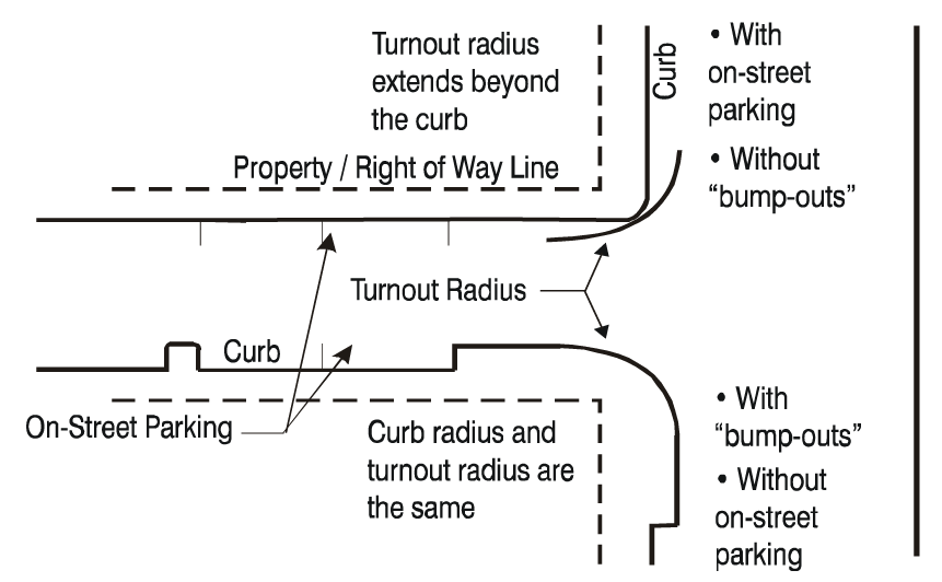
vi.
Curb and gutters shall be provided as follows:
A.
All sub-districts: At all intersections and roadway edges of arterials, boulevards and Main Street.
B.
Core and Center Sub-districts: At all intersections and roadway edges of minor streets.
vii.
Utilities other than fire hydrants shall run underground.
viii.
Buildings placed at the end of a street vista may provide one additional story above that which is otherwise permitted by the building height regulating plan; such additional story shall occupy up to 15 percent of the floor area of the story immediately below.
ix.
Service roads may occur within buildings.
x.
Service road access from the front property line shall be limited to one point of access for every 250 feet of frontage.
(7)
Street lighting. Street lighting shall comply with the following:
a.
Street lighting shall be provided in MC, BO, MN, MN and LW Districts. Street lighting shall be provided in driveways, parking areas, sidewalks, pedestrian passages, commercial establishment entryways, recreation areas, and multi-family residential common areas and entryways.
b.
Outdoor lighting of these areas shall comply with Section 33-4.1 of the Miami-Dade County Code as adopted by the Village of Palmetto Bay via ordinance 04-16.
c.
All light fixtures shall be of a pedestrian scale, with a maximum height of 18 feet and a maximum spacing between fixtures of 40 feet.
d.
The type and style of lights shall be as specified by the village and spacing of light fixtures shall be approved by the village's department of public works. Village approval shall be based on uniformity of types, location, right-of-way width, and luminosity.
e.
Weather and vandalism resistant covers shall protect all light fixtures.
f.
Streetlamps shall be installed on both sides of streets.
g.
Cobra-head lights shall not be permitted.
(8)
Walls, fences, and hedges. The following shall be permitted:
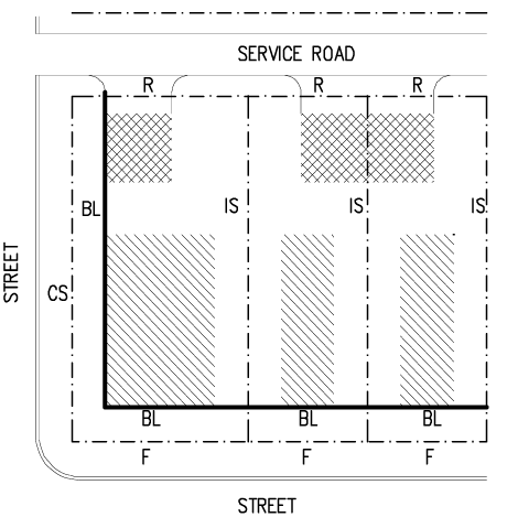 Note: Hedges and shrubs shall be subject to Chapter 18-A of this Code.Where a wall
or fence is used for screening parking areas along streets, a five-foot landscape
strip with a hedge shall be required in front of the wall or fence.The maximum spacing
for pillars and posts shall apply except along driveways. Note: Hedges and shrubs shall be subject to Chapter 18-A of this Code.Where a wall
or fence is used for screening parking areas along streets, a five-foot landscape
strip with a hedge shall be required in front of the wall or fence.The maximum spacing
for pillars and posts shall apply except along driveways. |
(9)
Enclosed uses. All uses shall be conducted within completely enclosed buildings, except outdoor uses that may be expressly permitted in this chapter. Materials and products shall be stored within an enclosed building or within an area completely enclosed within walls having a life expectancy of 20 years or more from the date of installation. Storage shall not be visible above the height of the walls. Commercial trucks shall be stored or parked within an enclosed building or an area enclosed by a fence, wall or hedge, and out of the view from adjacent properties. Aboveground propane and chlorine storage tanks shall be prohibited.
(g)
Signs. Except as provided herein, signage shall comply with Section 33-284.63 of the Miami-Dade County Code as adopted by the Village of Palmetto Bay via ordinance 04-16.
(1)
Temporary signs shall be permitted in compliance with Section 33-99 of the Miami-Dade County Code as adopted by the Village of Palmetto Bay via ordinance 04-16.
(2)
Permanent point of sale signs. Permanent point of sale signs shall be permitted as follows:
a.
The following permanent point of sale signs are permitted in all sub-districts in conjunction with permitted business uses: building identification, detached, flat attached, hanging, awning, and cantilever projecting.
i.
Cantilever projecting signs shall be mounted and perpendicular to the building.
ii.
The copy of an awning sign shall only be located on the valance of the awning.
iii.
The bottom of a hanging sign shall be located at a minimum height of eight feet from the finished floor.
b.
Maximum size, location, and number of signs shall be as follows:
c.
Illumination/lighting shall comply with Section 33-96 of the Miami-Dade County Code as adopted by the Village of Palmetto Bay via Ordinance 04-16.
d.
Maximum heights shall be as follows:
i.
Four feet above grade to top of sign for detached signs;
ii.
No limits for flat attached signs;
iii.
For signs painted on the façade of a building or on the valance of an awning, the copy shall not exceed one foot.
(3)
Prohibited signs. The following types of outdoor signs shall be prohibited:
a.
Automatic electric changing signs;
b.
Revolving, rotating and other moving signs;
c.
Banners;
d.
Flags;
e.
Roof signs;
f.
Balloon signs; and
g.
Class C commercial signs or other outdoor advertising, except as permitted by the village.
(h)
Nonconforming structures, uses, and occupancies. Nothing contained in this chapter shall be deemed or construed to prohibit a continuation of a legal nonconforming structure, use or occupancy in the FT&I District that either (1) was existing as of the date of the district boundary change on the property to FT&I District or (2) on or before said date, had received final site plan approval through a public hearing pursuant to this chapter or through administrative site plan review or had a valid building permit. However, any structure, use or occupancy in the FT&I District that is discontinued for a period of at least six months, or is superseded by a lawful structure, use or occupancy permitted under this chapter, or that incurs damage to the roof or structure to an extent of 50 percent or more of its market value, shall be subject to Section 33-35(c) of the Miami-Dade County Code as adopted by the Village of Palmetto Bay via Ordinance 04-16. However, a lawfully existing single family home use that is discontinued for a period of at least six months or that incurs damage to the roof or structure to an extent of 50 percent, or more of its market value, shall not be subject to Section 33-35(c) of the Miami-Dade County Code as adopted by the Village of Palmetto Bay via Ordinance 04-16.
(i)
Review procedure/administrative site plan and architectural review. Except for individual single family homes and duplexes, all applications for development approval within FT&I District that are not otherwise permitted as nonconforming uses or structures shall comply with the requirements of this chapter and with the site plan and architectural review criteria contained herein. Developments shall be processed and approved administratively as follows:
(1)
Administrative site and architectural plan review. The department shall review plans, including the exhibits listed below for completeness and compliance with the provisions of this chapter, including the regulating plans, and for compliance with the site plan review criteria provided herein. The director shall issue a final decision within 21 days of the date of submission of the completed application. The applicant shall have the right to extend the 21-day period by an additional 21 days upon timely request made in writing to the department. The department shall have the right to extend the 21-day period by written notice to the applicant that additional information is needed. Denials shall be in writing and shall specifically set forth the grounds for the denial. Any final decision of the director may be appealed in accordance with the procedures established in this chapter for appeals of administrative decisions.
(2)
Applications for administrative site plan and architectural review under this chapter shall be accompanied by exhibits prepared by registered architects and landscape architects that shall be submitted to the department and shall include the following:
a.
Site plan(s) including:
i.
Sub-district location and land use plan designation;
ii.
Street layouts and designations, as per this chapter;
iii.
Locations, shape, size, and height of existing buildings;
iv.
Pedestrian and vehicular circulation systems;
v.
Drive-through facilities circulation systems, if any;
vi.
Indication of street vistas;
vii.
Lot lines, setbacks and build-to-lines;
viii.
Location of open spaces including anchor points, if applicable;
xi.
Location, layouts and drives of on-street and off-street parking, loading facilities and waste collection areas;
x.
Location, layouts of drive through facilities, including ingress and egress;
xi.
Indication of signage; and
xii.
Indication of any site or building design methods used to conserve energy.
b.
Landscape plans, including specifications of species of plant material, location, and size in accordance with this chapter and Chapter 18A of the Miami-Dade County Code as adopted by the Village of Palmetto Bay via ordinance 04-16.
c.
Street cross-sections, including adjacent buildings and open space.
d.
Floor plans, elevations and sections of all buildings, including total gross square feet of area for each floor and all dimensions relating to the requirements of this chapter. A pattern book may be submitted for detached and attached single family units including, at a minimum, unit plans and elevations, elevation of unit groupings and typical design details such as street lamps, benches, fencing, and paving details.
e.
Figures indicating the following:
i.
Gross and net acreage;
ii.
Total square footage for each use by type;
iii.
Total number of dwelling units;
iv.
Total number of parking spaces required and provided;
v.
Amount of passive and active open space in square feet; and
vi.
Such other design data as may be needed to evaluate the project's compliance with the requirements of this chapter, including traffic impact analyses and studies.
(3)
Fees established for review of applications for administrative site plan and architectural review under this chapter. The village shall charge the applicant the direct cost of review by employed professionals and/or engineering, planning, legal, technical or environmental consultants deemed reasonably necessary by the village to review any application. Charges shall be in accord with the hourly rate charges by such employed professionals or consultants. The applicant shall reimburse the village for the cost of such upon submission of an invoice within 30 days.
(j)
Zoning relief from certain requirements. Relief from the following requirements of this chapter shall be permitted only pursuant to the standards and requirements of Section 33-311(A)(4)(a) of the Miami-Dade County Code as adopted by the Village of Palmetto Bay via Ordinance No. 04-16.
(1)
Minimum and maximum densities;
(2)
Required liner buildings used to screen parking;
(3)
Colonnade regulations, including minimum horizontal and vertical clearances;
(4)
Provision of A streets;
(5)
Requirements for street trees, greens, plazas, squares and medians;
(6)
Maximum size of blocks;
(7)
Curb requirement in the core and center sub-district;
(8)
Signage;
(9)
Parking; and
(10)
Use variance.
Any variance sought under this section shall require a supermajority vote of the council presiding at a meeting. However, in the event only three members of the village council are present at the variance request zoning hearing, a unanimous vote of the council shall be required.
(k)
Conflicts with other chapters and regulations. This chapter shall govern in the event of conflicts with other zoning, subdivision or landscape regulations of this Code.
(l)
Vesting of site plan and building permits. All site plans and building permits already being reviewed (prior to final passage of the FT&I District Ordinance) by the village department of community development may proceed forward and shall not be required to adhere to the FT&I District Ordinance. Further, it being the intent of this division that building permits for the repair of existing structures, or parts thereof building permits may be issued for any and all projects if the project does not increase the size or footprint of the existing building or structure, and, provided, the project does not require more than 50 percent modification. Fifty percent modification shall require compliance with the FT&I District Ordinance.
(Ord. No. 06-06, § 1, 5-1-2006; Ord. No. 08-03, § 1, 2-4-2008; Ord. No. 09-05, § 1, 2-2-2009; Ord. No. 09-17, § 1, 8-20-2009; Ord. No. 2012-23, §§ 2, 5, 11-5-2012)
Sec. 30-50.19. - Village Mixed Use District, VMU.
(a)
Purpose, intent and applicability. The purpose of the Village Mixed Use District (VMU) is to offer residents and visitors an expanded range of opportunities to live and work within the village, by creating a mixed-use development with the characteristics of a pedestrian oriented neighborhood that promotes the health and well being of its residents by encouraging physical activity, alternative transportation and greater social interaction. By enacting the VMU District, the village shall:
(1)
Create and preserve an interconnected system of green space to protect Biscayne Bay;
(2)
Create an inviting mixed-use, pedestrian-friendly environment and a new use predominately comprised of high-end housing for older persons;
(3)
Establish a postcard-quality town scene that will be a symbol of the caliber, character and identity of the Village of Palmetto Bay; and
(4)
Protect and enhance scenic Old Cutler Road, minimizing any visual impacts from proposed development.
The boundaries shown in attached Figure 1 shall constitute the Village Mixed Use District boundary plan with all areas therein designated as zoned within the requirements of the ordinance.
(b)
No provision in this section 30-50.19 shall be applicable to any property lying outside the boundaries of the Village Mixed-Use District ("VMU").
(c)
Definitions. Terms used throughout this zoning district, under section 30-50.19 shall take their commonly accepted meaning unless otherwise defined in other Village Code provisions. Terms requiring interpretation specific to this zoning district are as follows:
Apartment building: A building which is used or intended to be used as a multi-family dwelling unit; as a home or residence for three or more families living in separate apartments, in which the yard areas, hallways, stairways, balconies and other common areas and facilities are shared by families living in the apartment units.
Grade: The established grade of the property shall be established at the crown of the public road, as defined by this division, adjoining the property.
Property: The entire land (Figure 1) within the VMU District, regardless of ownership.
Residential building type: One of the following multifamily residential building types shall be permitted in the VMU District: Apartment building, rowhouses/townhouses or senior housing (as hereinafter defined).
Rowhouses/townhouses: A single family attached dwelling unit of a group of two or more units each separated from the adjoining unit by a common party firewall or slab. Each common party fire wall shall extend to the roof line or above the roof of units that it serves or otherwise meet fire code separation requirements. Each rowhouse/townhouse unit shall be serviced with separate utilities and shall otherwise be independent of any other unit. Notwithstanding the above, these units may be stacked one over the other, and may be placed above or beside a shared garage and/or storage area.
Senior housing: Attached dwelling units, intended to be "housing for older persons" as such phrase is defined in F.S. § 760.29(4), which may also include ancillary offices and dining and entertainment space; as well as medical and nursing services, long term care, assisted living, continuing care, transitional or hospice uses which shall be limited to use by residents of the senior housing. To the extent the provision of these ancillary services requires the use of a separate bedroom apart from a resident's unit for overnight stays, each such bedroom shall be considered a residential unit. Notwithstanding the foregoing, the nursing and medical services to be provided as an accessory or ancillary use to senior housing shall not allow for the establishment or creation within the VMU District of a state-licensed hospital or a "skilled nursing facility" as such term is defined by Section 1819 of the Social Security Act. Notwithstanding the preceding sentence, as an exception thereto, ancillary nursing and medical services may serve, at any one time, no more than 20 percent of the senior housing residents.
(d)
Uses. Uses are allowed in the VMU District as provided for in this subsection. However, these uses shall not be deemed or construed to prohibit a continuation of any structure, use or occupancy in the VMU that were existing as of the date of the effective date of this division.
(1)
Permitted uses; Village Mixed Use District.
a.
Residential uses. Multifamily residential, up to 304 units or as supported by the village's traffic volume analysis of Old Cutler Road pursuant to this section, which may include apartment buildings, rowhouses/townhouses, and Senior Living Facilities as provided by F.S. § 760.29. For the purposes of this subsection and within the VMU zoning district, each individual hotel unit shall be considered and count as an individual residential unit. Residential uses are permitted in accordance with the village's adopted comprehensive plan and the Declaration of Restrictive Covenants and the First Amendment to the Declaration of Restrictive Covenants recorded May 1, 1989 at Official Records Book 14089 at Pages 2349-52 and Official Records Book 12428 at Pages 923-1010, of the Public Records of Miami-Dade County, Florida, and the Amended Declaration of Restrictive Covenants in Lieu of Unity of Title recorded Official Resources Book 27101 at Pages 2672—2678 of the public Records of Miami-Dade County, Florida.
Automobile traffic volume on Old Cutler Road generated by residential land uses within the VMU Zoning District shall not exceed the automobile traffic volume which would have been generated by the residential development rights of 300 senior housing units and 100 multi-family residential rowhouses/townhouses in the VMU Zoning District pursuant to the VMU provisions of Village Ordinance No. 08-09 and by residential development rights of 85 single family residential units in the Interim Zoning District (which is contiguous to the western boundary of the VMU Zoning District) pursuant to the Interim provisions of Village Code section 30-50.22, as in effect on May 1, 2016. The owners of all property within the VMU shall execute a restrictive covenant running with the land containing the automobile traffic volume restriction of this subsection and development rights of this subsection shall not be available to such owners until such a covenant, approved by the village attorney, is publicly recorded.
b.
Mixed uses. The vertical or horizontal integration of two or more of residential, business and office, and other permissible uses. Vertical integration allows any combination of primary uses. Horizontal integration allows any combination of parcels with different primary uses within the VMU District. The following uses shall be permitted, either as a mixed use or on their own:
i.
Auditoriums;
ii.
Banks;
iii.
Banquet, convention or meeting halls;
iv.
Beauty parlors, spa services and barber shops;
v.
Civic uses, except schools;
vi.
Day care center and nursery;
vii.
Dry cleaning, pick up and drop off only;
viii.
Fire stations or substations;
ix.
Medical and dental offices; professional and general business offices; government offices;
x.
Health clubs and private clubs;
xi.
Hotel;
xii.
Museums;
xiii.
Newsstands;
xiv.
Public parks; preserve areas;
xv.
Recreational facilities; entertainment amphitheatre or stages; tennis courts; court games; putting greens, swimming pools;
xvi
Restaurants, coffee houses, cafeterias, delicatessens;
xvii.
Rowhouses/townhouses;
xviii.
Retail uses and service convenience uses;
xix.
Senior housing; and
xx.
Shoe repair shops.
c.
Additional uses. Approval of additional uses other than as set forth in i. through xx. above would require village council approval of the use provided such uses would not have an unfavorable effect on the economy of the village, would not generate or result in excessive noise or traffic, cause undue or excessive burden on public facilities, including water, sewer, solid waste disposal, recreation, transportation, streets, roads, highways or other such facilities which have been constructed or which are planned and budgeted for construction, are accessible by private or public roads, streets or highways, when considering the necessity for and reasonableness of such applied for use in relation to present and future development of the area concerned and the compatibility of the applied for use with such area and its development.
(2)
Prohibited uses. Schools, public or private.
(e)
General requirements. These requirements shall not be deemed or construed to prohibit a continuation or restoration after casualty of any structure, use or occupancy in the VMU District that was existing as of the date of the effective date of this section.
(1)
Buildings.
a.
Heights. All height restrictions herein are deemed as consistent with the intent of the previously enacted Village of Palmetto Bay Comprehensive Plan which established parameters for this VMU District. Furthermore, all height restrictions must remain in conformity with any existing deed restrictions, declarations, or covenants in effect as to any lands within the VMU District. All buildings shall be no higher than 85 feet above grade in height. This shall not preclude, above such height restrictions, bonuses granted by a transfer of development right, antennae, elevator and roof equipment, stairway roof access and railings or similar safety barrier, as long as said structures are not visible from the property line of the VMU District at Old Cutler Road.
b.
Spaces. All buildings and building groups shall provide a minimum of ten feet between each building or building groups unless attached. Rowhouses/townhouses shall provide a minimum of ten feet between building groups.
c.
Building placement and buildable area:
i.
Minimum lot width, depth and size for rowhouse/townhouse: 24 feet wide by 30 feet deep. No rowhouse/townhouse shall be smaller than 600 square feet, and the average size of the rowhouses/townhouses in any grouping shall be a minimum of 800 square feet.
ii.
Maximum lot coverage: Maximum lot coverage shall be 35 percent times gross lot area. The maximum lot coverage may be calculated by measurement of the entire VMU District with lot area coverage allocated by covenant or declaration of the property owners within the property. Areas covered by water features, access roads, seawalls, sidewalks and other installations which are not habitable building space shall be considered as open space in calculations under this division.
d.
Allocation of development rights. All development rights shall be allocated by covenant or declaration of the property owners within the VMU District. Development density shall be governed by height limitations, maximum lot coverage, and residential unit density and not by any other reference in the Land Development Code to floor area ratios, except for nonresidential uses which shall not exceed a floor area ratio of 0.5.
e.
Density. Overall density for all residential units on the property, including senior housing facilities, shall be a minimum of 3.0 and a maximum of 14.0 dwelling units per gross acre, all as consistent with the comprehensive plan of the village. Residential density calculations pursuant to the preceding sentence shall be calculated based upon the entire land area zoned VMU, regardless of any non-residential development within the VMU. Additional units may be developed in accordance with an approved transfer of development rights.
f.
Covenant in lieu of unity of title. All property owners within the VMU District shall, notwithstanding any provision herein, be obliged to abide by the conditions of any covenant in lieu of unity of title of record applicable to the lands in the VMU District.
g.
Parking:
i.
Multi-story parking garages, parking lots and on-street parking on private roads shall count toward all parking requirements: Individual parking garages for rowhouses/townhouses shall count toward the parking requirement. Required parking for square footage and uses added after the effective date of this section shall be:
ii.
All permissible uses set forth herein, except residential and medical not contained within a senior housing facility: One parking space for each 350 square feet, or portion thereof, of net floor area, measured as the floor area less stairwells, balconies, hallways, lobbies, elevator shafts and all vertical penetrations.
iii.
Multiple-family dwelling units: One parking space for each bedroom, up to two bedrooms, and then one parking space for every two bedrooms thereafter.
iv.
Senior housing: A minimum of one parking space per dwelling unit, up to the first two bedrooms, and then, one-half-space parking space for every bedroom thereafter.
v.
Shared parking for nonresidential uses may be allowed by the director to meet the code required parking requirements, upon a review of the type of use, the level of projected use and the hours of operation compared to other uses on the property.
vi.
Medical: Other than medical uses which are contained within any senior housing facility, one parking space for each 200 square feet, or portion thereof, of net floor area, measured as the floor area less stairwells, balconies, hallways, lobbies, elevator shafts and all vertical penetrations.
(f)
Signs. Signage shall be permitted on the exterior of any structure, not to exceed five percent of the square footage area of the exterior façade of any structure. Monument signage shall also be permitted, not to exceed ten feet in height.
(g)
Entrance features. Entrance features shall be permitted upon a showing that the location and means of access do not create a visual obstruction that results in a traffic hazard, are complimentary in character and scale to the development on the property, and are maintained in a manner acceptable to the department.
(h)
Hurricane evacuation. The property owner(s) shall create, enforce and implement a hurricane evacuation plan for its residents. All costs associated with the plan's implementation shall be borne by the master association which governs and enforces regulations applicable to all property owners in the district. The village shall bear no costs associated with hurricane evacuation procedures required to be in full force and effect within the VMU District.
(i)
Nonconforming structures, uses, and occupancies. Nothing contained in this section 30-50.19 shall be deemed or construed to prohibit a continuation or restoration after casualty of a legal nonconforming structure, use or occupancy in the VMU District that was existing as of the effective date of this division.
(j)
Review procedure/administrative site plan review. All applications for development approval within the VMU District that are not otherwise permitted as nonconforming uses or structures shall comply with the requirements of section 30-30.5 and this section and with the site plan review criteria contained therein. Developments shall be processed and approved administratively or by village council action, as applicable, as follows:
(1)
Administrative site plan review.
a.
The department shall review plans, including all materials required under section 30-30.5 for completeness and compliance with the provisions of sections 30-30.5 and 30-50.19, and for compliance with the site plan review criteria provided therein, including but not limited to traffic analysis.
b.
This requirement shall be in addition to any declaration or covenant effecting the property that imposes greater or different standards of review, including but not limited to any covenant in lieu of unity of title requiring public hearing and compliance with existing site plans absent such hearing and village council action, administrative review, notice and public meetings and hearings; and/or all other existing or future restrictions, which shall remain in full force and effect.
c.
Conflicts. Conflicts with other sections, divisions and regulations. This section shall govern the VMU District in the event of conflicts with other zoning, subdivision or landscape regulations of this Code.
(k)
Public access to the general public of the VMU District's walking paths, trails, path around the existing lagoon, and bike paths shall be provided during daylight hours, with all parties utilizing said designated areas holding harmless the owners within the VMU District and entering at their own risk. This public access shall provide a network of spaces available to the general public and interconnect the green spaces of the VMU District to the remainder of village. Public access to this network of walkways and trails is consistent with the village's comprehensive plan and more specifically, pages 3 and 9 of the underlying charrette report approving the creation of the VMU District. In no manner may residents trespass on other areas of the VMU District which are not within the above-designated areas and the owners of property within the VMU District may develop reasonable regulations relating to the manner, and extent of use of the public access walkways, paths, and trails, provided that the above-referenced hours shall not be modified except in the case of emergency involving public safety or the establishment of special events that require limited access during the duration of the event. The VMU District property owners shall be entitled to reconfigure the walkways and trails subject to public access. so long as interconnection to the remainder of the village is preserved.
(Ord. No. 08-09, § 1, 6-9-2008; Ord. No. 09-17, § 1, 8-20-2009; Ord. No. 2012-13, § 5, 11-5-2012; Ord. No. 2016-14, § 2, 5-2-2016; Ord. No. 2019-19, § 1, 11-5-2018)
Sec. 30-50.20. - PAD, Planned Area Development.
(a)
Purpose and intent. The purpose and intent of the planned area development district, is to create living environments that are responsive to the needs of their inhabitants; to provide flexibility in planning, design and development; to encourage innovative approaches to the design of community environments; to encourage the fulfillment of housing needs appropriate to various life styles and income levels; to encourage the integration of different housing types within a development; to provide for necessary commercial, recreational and educational facilities conveniently located in relation to housing; to provide for an efficient use of land; to provide an environment compatible with surrounding land use; to adapt the zoning process to changes in construction and development technology; to encourage the preservation of the natural site features; to provide community environments that are so designed and located as to be an integral part of the total ecosystem; to encourage the design of communities and structures adapted to the local subtropical climate; thereby promoting the public health, safety, and general welfare of the village.
(b)
Ownership requirements. An applicant(s) for approval of a planned area development shall be owner(s) of record, or a lessee with the sworn-to consent of the owner(s).
(c)
Review procedures. The planned area development review procedures are divided into four steps: (1) pre-application conference; (2) total development plan review; (3) development tract review; and (4) review criteria:
(1)
Pre-application conference. To obtain information each applicant shall confer with the department, other affected interested department heads, and where applicable, representatives of adjacent municipalities, in connection with the preparation of the planned area development application. It shall be the responsibility of the department to coordinate and invite department heads, municipalities or their representatives to a joint meeting. The general outlines of the proposal evidenced schematically by sketch plans and including narrative information sufficient for the understanding of the proposed development shall be provided by the applicant for consideration at the joint meeting, before submission of the zoning application for planned area district boundary change. Thereafter and within ten working days after the pre-application conference, the director shall furnish the applicant with all written comments resulting from such conference including appropriate recommendations to inform and assist the applicant in his preparation of the components of the planned area development application.
(2)
Total development plan review. Following the pre-application conference the total development plan reviews shall be initiated by the applicant. Required exhibits listed below and a completed development impact statement as required, together with an application for public hearing shall be submitted to the department.
a.
Required exhibits—Written documents. The following written documents shall be submitted as part of the planned area development zoning application:
i.
Recordable agreement guaranteeing the development in accordance with promises made in the written and graphic documents listed below as approved by the village council.
ii.
A completed development impact statement, if required under the Code.
iii.
A development schedule indicating the approximate date(s) when construction of the planned area development and stages thereof can be expected to be initiated.
iv.
Quantitative data for the following: Total number of dwelling units; total number of bedrooms; size of total development proposed land coverage of buildings and structures; acres of common open space; gross and net residential densities; total amount of open space; total amount of nonresidential construction, amount of public and private roads, and population projections.
v.
Tentative agreements with appropriate governmental agencies for the proposed dedication of land for public uses prior to public hearing.
b.
Required exhibits. Graphic documents, maps, site plans and drawings of the proposed planned area development shall be submitted as part of the total development plan and shall contain the following minimum information:
i.
The existing site characteristics including any major variations of elevations, water course(s), unique natural features, and natural vegetation.
ii.
Legal description and size of developmental tracts (see subsection (e) below for details of developmental tracts).
iii.
The location of all major land uses with densities and/or floor area of such uses including structure heights, with drawings indicating basic development concepts of the proposed development.
iv.
The location and size in acres or square feet of all areas to be conveyed, dedicated, or reserved as common open spaces, public facility space, common recreational areas, school sites, and similar public and semipublic uses.
v.
The existing and proposed circulation system of arterial and collector streets, and major points of access to public rights-of-way including major points of ingress and egress to the development. Notations of proposed ownership of roadways, public or private, should be included where appropriate.
vi.
The existing and proposed pedestrian, equestrian and bicycle circulation systems including interrelationships with the vehicular circulation system, indicating proposed treatment of points of conflicts.
vii.
A schematic landscape plan in accordance with Division 30-100 of this Code, indicating the proposed design of major landscape elements. Plant names and sizes of tree masses shall be provided.
viii.
Adequate information on land areas adjacent to the proposed planned area development to indicate the relationships between the proposed development and adjacent areas, including existing land uses, zoning classifications, densities, vehicular, pedestrian and equestrian circulation systems and public facilities, as well as unique natural features of the landscape.
ix.
The proposed treatment of the perimeter of the planned area development including materials and techniques to be used such as screens, landscape buffer, fences, walls and berms when appropriate.
x.
Any additional information required by the review authority necessary to evaluate the character and impact of the proposed planned area development.
c.
Review process. The review of the total development plan of a planned area development shall be by the village council pursuant to Division 30-30.
(3)
Development tract review. Following approval of the total development plan by the village council, review at the development tract level may be initiated.
a.
Required exhibits. The following exhibits shall be prepared by Florida registered landscape architects, architects and engineers and shall accompany the development tract review application to be filed with the department:
i.
A plan indicating existing zoning on site and adjacent areas.
ii.
Aerial photograph or map indicating site and development in the immediate area.
iii.
Site plan at no less than one inch to 20 feet which shall include the following information:
A.
Location, shape, size and height of existing and proposed buildings, fences and walls.
B.
Pedestrian, equestrian and vehicular circulation systems.
C.
Parking layouts and drives.
D.
Landscaping in accordance with Division 30-100 of this Code.
E.
Major changes in grades (more than 24 inches).
F.
Building setbacks and spacing.
G.
A legend including the following applicable information shall be provided as part of the site plan in accordance with the following format:
H.
The following information shall be provided on the site plan or in a separate document:
(i)
Amount of pervious and impervious surfaces.
(ii)
Maximum density of development tract approved at public hearing.
(iii)
Density as proposed.
(iv)
Total dwelling units.
(v)
Table of dwelling unit mix.
(vi)
Total number of bedrooms.
(vii)
Total number of building types including accessory buildings.
(viii)
Table of buildings by heights, stories, unit types, and square footage.
(ix)
Name of water utility.
(x)
Name of sewer utility.
(xi)
Required private open space.
(xii)
Provided minimum and average private open space.
(xiii)
Table of parking spaces required and provided.
(xiv)
Acreage dedicated for public and semipublic facilities.
(xv)
Survey of existing trees.
(xvi)
Total number of trees required and provided in accordance with Division 30-100 of this Code.
(xvii)
Any supplementary data needed to adequately review the proposed development.
iv.
Floor plans, elevations, sections, when appropriate, and either isometrics or perspectives for the different proposed buildings at no less than one inch equals 16 feet which shall include the following information:
A.
Location, shape, size and heights of enclosed and unenclosed spaces within the proposed buildings.
B.
Horizontal and vertical circulation systems of the proposed buildings.
C.
Design of the outdoor surfaces of the proposed buildings.
b.
Review process. Prior to the development of a development tract (see subsection (e), below) or prior to the sale, transfer or lease of any portion of a development tract, a development tract plan shall be prepared, submitted to, and approved by the department for review and approval in accordance with review criteria, subsection (c), relating to review procedures, and development plan(s) approved by the village council. The development tract plan is a detailed refinement of information provided in the approved total development plan. If the planned area development involves only one development tract the same procedure shall be followed.
Upon approval of a development tract plan, a copy of the approved plan and statement of approval shall be forwarded to the applicant and to the department for filing in the planned area development file for the particular project.
If requested approval is denied, the proposed project may be appealed to the village council, in accordance with regulations governing appeals from administrative decisions.
(4)
Review criteria. The following criteria shall be utilized as a basis for the review of the total development plan and the development tract plans:
a.
Purpose and intent. The proposed development shall fulfill the purpose and intent of this section.
b.
Planning studies. Design, planning or development studies accepted or approved by the village council that include development patterns or environmental design criteria which would apply to the development proposal under review shall be utilized in the site plan review process.
c.
Exterior spatial relationships. The three-dimensional airspace volume created by the arrangement of structures and landscape shall produce spatial relationships that function with the intended use and occupancy of the project and are compatible with the development or zoning in the adjoining area. Building height shall reflect a scale compatible with the development or zoning in the adjoining area. Elements that provide a logical transition to adjoining existing or permitted uses shall be provided. Spacing between buildings shall provide ample access for emergency equipment.
d.
Subtropical characteristics. Architecture and site development should incorporate consideration of the subtropical characteristics of the area. The provision of sun-control devices, shaded areas, vegetation, roof terraces and similar features characteristic of subtropical design shall be encouraged.
e.
Energy conservation. Design methods to reduce energy consumption shall be encouraged. Energy conservation methods may include but not be limited to natural ventilation of structures, sitting of structures in relation to prevailing breezes and sun angles, insulation of structures, use of landscape material for shade, direction of breezes and transpiration.
f.
Privacy. Due consideration of aural and visual privacy shall be evidenced in the design of the overall development and in the design of individual units.
g.
Open space. A variety of open spaces shall be provided, appropriate to the needs of the particular type of development. Open space shall relate to any natural characteristics in such a way as to preserve and enhance their scenic and functional qualities to the fullest extent possible and shall be so located and developed as to be easily accessible to all residents of the development.
h.
Landscape. The landscape shall be preserved in its natural state insofar as is practicable by minimizing tree removal. Landscaping shall be used to shade and cool, direct wind movements, provide scale, enhance architectural features, relate structure design to the site, visually screen noncompatible uses and block noise generated by the major roadways and intense use areas.
i.
Location of public and semipublic uses. All public uses and semipublic uses such as churches, schools, day care centers, post offices, and other similar facilities shall be so located as to provide easy access by residents of the proposed development.
j.
Circulation. Pedestrian, bicycle trails and equestrian trails shall be separated from auto circulation insofar as is practicable and all circulation systems shall adequately serve the needs of the development and be compatible and functional in its relationship to circulation systems outside the development.
k.
Parking areas. Parking areas shall be provided that are screened and so located as not to interfere with the livability of the development, its environs, and adjacent properties. Parking areas shall be conveniently located for occupants of the residential structures and shall comply with Division 30-70.
l.
Service areas. Service areas shall be provided that are screened and so located as not to interfere with the livability of the development or adjacent properties.
m.
Visual screening for decorative walls. In an effort to prevent graffiti vandalism, the following options shall be utilized for walls abutting zoned or dedicated rights-of-way:
(i)
Wall with landscaping. The wall shall comply with section 30-60.2, and be setback two and one-half feet from the right-of-way line and the resulting setback area shall contain a continuous extensively landscaped buffer which must be maintained in a good healthy condition by the property owner, or where applicable, by the condominium, homeowners or similar association. The landscape buffer shall contain one or more of the following planting materials:
A.
Shrubs. Landscaping shall comply with Division 30-100 and shrubs shall be a minimum of three feet in height when measured immediately after planting and shall be planted and maintained to form a continuous, unbroken, solid, visual screen within one year after planting.
B.
Hedges. Landscaping shall comply with Division 30-100 and hedges shall be a minimum of three feet in height when measured immediately after planting and shall be planted and maintained to form a continuous, unbroken, solid, visual screen within one year after planting.
C.
Vines. Climbing vines shall be a minimum of 36 inches in height at planting.
(ii)
Metal picket fence. Where a metal picket fence abutting a zoned or dedicated right-of-way is constructed in lieu of a decorative wall, landscaping shall not be required.
(e)
Development parameters. All applications for the planned area district shall comply with the following applicable development parameters:
(1)
Size of development site. The minimum size of the site to be developed as a Planned Area Development District shall be five acres.
(2)
Development tracts.
a.
Proposed development shall be structured into separate geographical units termed development tracts. The tract shall be subject to unity of title and be so designed as to constitute a self-sufficient unit. The unity of title shall continue on record unless the plat includes individual lot development which was approved as such in the total development plan, in which case that part may be released from the unity of title upon final plat approval by the village council. The tract shall be buildable in one phase, having common open space, a road system and a sufficient identity of its own in the event the overall project is not completed.
b.
The scheduling capabilities of the developer should relate to the size and delineation of the proposed development tract. In the design of the development tract, consideration shall be given to factors such as natural characteristics of the site, the major road patterns, the location of retail commercial facilities, water bodies, public facilities, common open space, the phasing of the development and other factors which provide definition for development tracts.
c.
At any time after a planned area development district boundary change is approved at final hearing, any tract so approved may be subdivided in accordance with the village's subdivision ordinances without any prior public hearing before the village council, providing that the new tract or tracts so created shall meet all of the provisions of this section, all existing agreements of record, and the written approval of the department.
The foregoing is not intended to preclude phased condominium development as contemplated by F.S. § 718.403.
(3)
Permitted residential uses. All residential types, including single family, and multi-family, and workforce housing units in compliance with the provisions of this section whether detached, attached or any combination thereof, shall be permissible in the planned area development zoning classification upon approval by the village council.
(4)
Maximum permitted density. Maximum permitted densities, in terms of number of units per gross residential acre and total number of dwelling units and bedrooms, shall be established for each development tract at the time of approval of the development plan by the village council. All uses and land areas devoted thereto approved under the other use provision, the development parameters of subsection (e), shall be excluded in the computation of the overall residential density. The number of dwelling units and densities shall be in conformance with the comprehensive plan, neighborhood planning studies and existing zoning and development in adjacent and in immediate areas shall be considered in the establishment of the maximum density for the Planned Area Development District. The information provided in the development impact statement shall be considered in the establishment of densities.
(5)
Accessory uses. Accessory uses which are designed in a manner compatible with the planned area development and relate to the common needs of its inhabitants shall be permitted. Accessory uses shall include but not be limited to parking garages, recreation buildings, swimming pools, play fields, utility or maintenance buildings and other similar uses.
(6)
Convenience retail service facilities. Convenience retail service facilities as permitted in the B-1 Neighborhood Business District shall be permitted on the basis of the following standards:
a.
Three square feet of interior convenience retail floor area per dwelling unit shall be permitted.
b.
Such services shall be designed as an integral part of the total development and conveniently located for the use of the residents of the proposed development.
c.
Such facilities shall not be constructed prior to initiation of construction of the residential units which justify the need for such retail facilities.
d.
Such services are not visible from public roads, detached signs and signs visible from public roads are not permitted.
(7)
Public facilities. If dedicated by the developer, land for public facilities shall be appropriately located in terms of projected user needs. The public facility space shall not be considered in meeting common open space requirements.
(8)
Other uses with PAD District application.
a.
Other zoning districts upon approval pursuant to a development order not previously listed as permitted uses in this section but related to the needs of the inhabitants of a proposed development or to village-wide needs shall be permitted if approved under the provisions of this section. Such other uses shall be included as separate development tracts on the basis of the zoning districts in which they are permitted and shall comply with all requirements of the applicable zoning districts, as well as all applicable requirements for development tracts. Deviations from required setback regulations need not be in conformity with the provisions of this division. Separate requests for zoning districts shall be made at the time of the PAD District application and shall be deemed an integral part of the application.
b.
Other uses that are permitted only by the special exception, new use or unusual use procedure under the zoning regulations are permitted in a development tract, subject to the required village council approval. In all instances the development tracts in which such other uses are located shall comply with all applicable requirements for development tracts and shall be filed with the application for the planned area development district. No separate request or application for special exceptions or unusual uses shall be required so long as they are clearly noted on the development plan.
(9)
Common open space. Open space for the common benefit of the residents of the proposed development shall be provided in accordance with the requirements in the following table:
Areas to be credited toward the common open space requirements may include the following:
a.
Landscaped ground areas maintained with grass, trees and shrubbery, and unencumbered with any structure or off-street parking or private drives including those on roof decks and other above-grade surfaces.
b.
Entrance features, pedestrian walks and sitting areas, shuffle boards, swimming pools, tennis courts, accessory buildings related to active or passive recreational uses and other passive or active uses including golf courses, which shall be restricted for the use.
c.
Tree preservation zones of "natural forest communities" as defined in Section 24B-1, Code of Miami-Dade County, as adopted by the village pursuant to Division 30-100 of this Code.
d.
Water bodies, but such water areas shall not be credited for more than 50 percent of the required common open space.
e.
Land for perimeter walls, buffers, fences and berms shall be considered part of the common open space.
f.
The following criteria shall apply to the provisions of common open space:
i.
Recreational use or uses appropriate for the use of the projected future residents of the proposed development shall be provided.
ii.
Common open space shall be so located and developed as to be accessible to residents of the development.
iii.
Common open space shall relate to any natural site characteristics in such a way as to preserve and enhance both their functional and scenic qualities to the fullest extent.
iv.
Improvements to common open space areas in accordance with the development tract plan shall be coordinated with and shall keep pace with the construction of dwelling units.
(10)
Conveyance and maintenance of common open space. All land designated on approved plans as common open space will be conveyed under one of the following procedures:
a.
For those projects developed under a condominium arrangement, common open space shall be maintained under the applicable Florida State law.
b.
The common open space may be conveyed to a homeowners' association in which case conveyance shall be subject to covenants to be approved by the village restricting the open space to uses specified in the final plan and providing for the maintenance of the common open space in a manner that assures its continuing use for its intended purpose provided that:
i.
Approval by the village attorney's office shall be required.
ii.
A homeowners' association shall be established before the units or individual building lots are sold.
iii.
Membership shall be mandatory for each resident and the association shall have the authority to adjust the assessment to meet the needs of maintaining the open space.
iv.
Any sums levied by the homeowners' association that remain unpaid shall become a lien on the individual property and the lien shall be superior to all other liens save and except tax liens and mortgage liens, provided the mortgage liens are first liens against the property encumbered thereby, subject only to tax liens and secure indebtedness which are amortized in monthly or quarter annual payments over a period of not less than ten years.
v.
The homeowners' association shall be responsible for maintenance and local taxes.
(11)
Private open space. Private open space is required for each single family attached or detached unit that has direct ground floor access. The space shall be for the exclusive recreational or leisure use of the inhabitants of the dwelling unit, and shall be located immediately adjacent to the unit, and designed in such a way as to provide privacy from adjacent dwelling units. The private open space shall be in addition to the common open space required and the amount of such space shall be equivalent to 60 percent of the interior gross floor area of each attached unit and equivalent to 125 percent of the interior gross floor area of each detached unit. Provisions shall be made in the sale or rental of such units that such private open space is for the exclusive use of the unit concerned.
(12)
Trees. Landscaping and trees shall be provided in accordance with Division 30-100 of this Code.
(13)
Parking. All required parking shall comply with Division 30-70, relating to parking.
(14)
Minimum square footage. The minimum square footage for a single family attached or detached unit that has direct ground floor access shall be 850 square feet. Multi-family residential units shall have a minimum square footage of 400 square feet for efficiencies, 550 square feet for one bedroom units with an additional 100 square feet for each additional bedroom.
(Ord. No. 09-17, § 1, 8-20-2009; Ord. No. 2012-13, § 5, 11-5-2012)
Sec. 30-50.21. - Public facilities—Use and location.
(a)
Exclusive procedure.
(1)
The procedure provided herein shall be exclusive. The village council may establish any governmental facility listed as follows where the council may direct without regard to the zoning or use classification of any particular site or location: public parks, playgrounds and buildings, and structures supplementary and incidental to such uses; fire stations; police stations; public water and sewer treatment and distribution facilities; public libraries; public buildings and centers; Village Hall and offices; public hospitals, nursing homes and health facilities; public auditoriums, arenas, museums, art galleries and convention halls; public maintenance and equipment yards; public bus stations and rapid-transit stations and facilities; and uses determined by the village council to be similar to those listed above.
(2)
The village council may only authorize the erection, construction and operation of the governmental facilities enumerated in subsection (1) above by resolution following public hearing. The public hearing shall be held upon at least 15 days' notice of the time and place of such hearing published in a newspaper of general circulation in the village, which publication shall include the time and place of hearing before the village council. A courtesy notice containing general information as to the date, time, and place of the hearing, the property location and general nature of the application may be mailed to the property owners of record, within a radius of 300 feet of the property described in the application, or such greater distance as the council may prescribe; provided, however, that failure to mail or receive such courtesy notice shall not affect any action or proceeding taken hereunder. To provide additional notice to the public, the property shall be posted by a sign or signs indicating the action desired and the time and place of the public hearing thereon. Failure to post such property shall not affect any action taken hereunder. At the public hearing the village council shall consider, among other factors, the type of function involved, the public need therefore, the existing land use pattern in the area, alternative locations for the facility and the nature of the impact of the facility on the surrounding property. After considering these the factors, the village council shall take such action as is necessary to provide for and protect the public health, safety and welfare of the citizens and residents of the village.
In the event the village council authorizes the construction, erection, use or operation of a governmental facility in accordance with the procedures delineated above, or in the event the council otherwise determines that village-owned property should be utilized by the village for a particular public purpose, the property shall be posted by a sign or signs conspicuously located thereon indicating the governmental facility or use authorized for the property. Such sign or signs may be removed upon the commencement of construction. The village manager or designee shall periodically check the property to ensure that the signs provided for in this subsection remain in existence and accurately depict the proposed use of the subject property. This subsection shall be construed as directory only and failure to comply with the provisions hereof shall not affect the validity of the village council's action authorizing the use of the property for the designated purposes.
(3)
Any facility which is designated as or intended to be operated as a domestic violence center at the time of consideration, planning, erection, construction or acquisition, shall be exempt from the notice and public hearing provisions set forth in subsection (2) above.
(4)
A council member may request a deferral of consideration of any item relating to the construction, erection, use or operation of a governmental facility for up to 30 days the first time the item appears on a council agenda or the first time the item is raised at a village council meeting if the proposed construction, erection, use or operation of the governmental facility affects that council's district exclusively or primarily. Upon the council member's invoking this right, discussion upon that item shall cease and the commission shall move to another item of business.
(5)
Notwithstanding any contrary provisions of this Code, during an appeal of a development order for a government facility approved pursuant to this section, zoning approvals relating to that development order being appealed shall be issued upon the request of the applying government, providing that:
a.
The applying government indicates in writing that it will conform as necessary to any subsequent changes mandated as a result of the appellate process by the court or by the village council; and
b.
That other applicable requirements of law are met.
(Ord. No. 09-17, § 1, 8-20-2009; Ord. No. 2015-13, § 2, 11-2-2015)
Sec. 30-50.22. - Interim zoning district.
(a)
The boundary of Interim (I) District shall be the entire unincorporated area of the village, excepting the area specifically covered by another district.
(b)
Standards for determining zoning regulations to be applied to interim property.
(1)
All properties in the Interim District, which are inside the village limits, as shown on the zoning map, and which have not been previously trended or otherwise approved through the public hearing process for a specific use, shall be subject to the following trend determination process:
If a neighborhood in the Interim District is predominantly one classification of usage, the director shall be governed by the regulations for that class of usage in determining the standard zoning regulations to be applied, including setbacks, yard areas, type of structures, height, limitations, use, etc. For the purposes of this section, "trend of development" shall mean the use or uses which predominate in adjoining properties within the Interim District which because of their geographic proximity to the subject parcel make for a compatible use. The director shall be guided in determining what constitutes a neighborhood by limiting the evaluation to separate geographic areas, which may be designated by natural boundaries (rivers, canals, etc.) and/or manmade boundaries (roads, full-and half-section lines, etc.). The director's decision shall be subject to appeal pursuant to the provisions of Division 30-30 of the Code. If no trend of development has been established in the Interim neighborhood, minimum standards of the E-2 District shall be applied. All lots subject to compliance with the standards of the E-2 District shall contain a minimum land area of five acres gross, unless a larger minimum lot size is required by the Code.
Notwithstanding the foregoing, certain platting activity occurring prior to April 12, 1974, which created lots meeting the minimum requirements of the E-1 District on April 12, 1974, shall qualify such lots for those uses permitted in the E-1 District. Those lots shall include only those lots indicated on:
i.
Plats recorded prior to April 12, 1974; and
ii.
Tentative plats approved as of April 12, 1974, and finally approved and recorded within 90 days after such approval; and
iii.
A tentative plat for single family residential lots approved prior to April 12, 1974, if each lot in the approved tentative plat met the minimum standards of the E-1 District, provided that no final plat or other tentative plat for the subject property was approved after April 12, 1974, and that as of December 31, 2003, a majority of the lots indicated on the tentative plat had been improved with residences pursuant to building permit in accordance with the tentative plat's provisions; and
iv.
Waivers of plat approved prior to April 12, 1974; and parcels, other than the aforementioned platted lots or tentatively approved plat lots, that prior to April 12, 1974 were purchased under a contract for deed or deeded and met the minimum requirements of the E-1 District shall be qualified for those uses permitted in the E-1 District. However, if such deeded parcels were contiguous to and under the same ownership on April 12, 1974, and such deeded contiguous parcels are less than the five acre minimum site size of the E-2 District, but exceed the minimum standards of the E-1 District, such property shall be considered as one parcel of land and cannot be divided or used except as one lot.
(c)
Group homes. A group home shall be permitted in a dwelling unit provided:
(1)
That the total number of resident clients on the premises not exceed six in number.
(2)
That the operation of the facility be licensed by the State of Florida Department of Health and Rehabilitative Services and that said department or sponsoring agency promptly notify the director of said licensure no later than the time of home occupancy.
(3)
That the structure used for a group home shall be located at least 1,000 feet from another existing, unabandoned legally established group home. The 1,000-foot distance requirement shall be measured by following a straight line from the nearest portion of the structure of the proposed use to the nearest portion of the structure of the existing use.
(d)
New district classifications. Subdivisions in Interim Districts shall be governed by the provisions of Division 30-80 (relating to platting and subdivisions) of this Code. Where applications for building permits indicate the need for reclassification of an area in Interim District, the director may initiate an application for a change of zoning.
(e)
Public hearing on refusal to issue permit. Whenever a permit to construct, alter, move or use a building or premises in an Interim District is refused because the proposed use would conflict with regulations contained herein, the person desiring a permit may apply for a public hearing.
(Ord. No. 09-17, § 1, 8-20-2009)
Sec. 30-50.23.1-01. - Purpose and intent.
This section provides regulations for development within the Village of Palmetto Bay Downtown District and outlines how these regulations will implement the village's vision. The intention of this section is to facilitate development of a community focus within the Village of Palmetto Bay. This section will:
• Create a living and working environment in Palmetto Bay that will feature walkable and bikeable streets, compact mixed-use buildings, and convenient access to many forms of transportation;
• Provide for appropriate architectural scale through development standards that provide for varied building forms that respond to the individual sectors within the Downtown District;
• Promote and enhance commercial and civic street activity through sufficient ground-level commercial uses; and,
• Promote and enhance the architectural character of the Downtown District through high-quality village design, architectural features and complete streets design standards.
(Ord. No. 2020-09, § 1, 7-28-2020)
Sec. 30-50.23.1-02. - Application.
Downtown Palmetto Bay Code is guided by these provisions herein for the sole purpose of establishing regulations for Downtown development. Where there is a conflict between the Downtown and other requirements of any other statute, law, or regulation, the higher standard for achieving the Downtown vision shall govern, unless otherwise noted.
(Ord. No. 2020-09, § 1, 7-28-2020)
Sec. 30-50.23.1-03. - Nonconforming uses and structures.
Nothing contained in this document shall be deemed or construed to prohibit the continuation of a legally established, nonconforming use or structure. The intent of this section is to encourage nonconformities to be brought into compliance with the Downtown Palmetto Bay Code.
(a)
Nonconforming uses.
(1)
Legally established nonconforming uses may continue to operate so long as the use was legally established.
(2)
If a nonconforming use is discontinued for a period six months, the use may not be reestablished. A use shall be considered discontinued once the activities or commerce essential to the continuation of the use are abandoned. Discontinuance due to acts of force majeure shall not constitute abandonment, provided that a good faith effort is made to reestablish said use.
(b)
Nonconforming structures.
(1)
Legally established nonconforming structures may continue to be used and maintained, so long as structure was legally conforming to the existing code at the time of construction.
(2)
Expansions, repairs, alterations and improvements to nonconforming structures shall be permitted in accordance with the following provisions:
a.
Internal and external repairs or improvements (general upkeep) that do not increase the square footage of the nonconforming structure shall be permitted and shall not be subject to the requirements of this section.
b.
Expansions to a nonconforming structure shall be permitted as follows:
(i)
If the total square footage of the proposed improvement is less than or equal to 30 percent of the structure's gross story area at the time it became nonconforming, any request for improvement shall require application for site plan approval. In addition, the property shall meet the tree requirements of 20 trees per net acre of lot area.
(ii)
If the total square footage of the proposed improvement is greater than 30 percent of the structure's gross floor area at the time it became nonconforming, the entire structure and site improvements shall be brought into compliance with the Downtown code.
(3)
If a nonconforming structure is damaged by an act of force majeure, repairs shall be subject to the following provisions:
a.
If a repair/replacement cost is less than 50 percent of the building's assessed value prior to the force majeure, the structure may be reconstructed at the same height and within the same building footprint as permitted originally, provided a new application for a building permit is filed within 24 months of the date of damage.
b.
If a repair/replacement cost is equal to or greater than 50 percent of the building's assessed value, the structure and site improvements shall be brought into full compliance with the Downtown code.
c.
These provisions do not override the floodplain management regulations found in section 30-100.6.
(Ord. No. 2020-09, § 1, 7-28-2020)
Sec. 30-50.23.1-04. - Organization
Downtown Palmetto Bay Code
• Purpose and intent
• Application
• Nonconforming uses and structures
• Organization
• Village design review procedure
Architectural Standards
• Purpose
• Building types
• Vertical mixed-use building—Uses by story
• Building massing
• Frontage standards
• Service standards
• Access standards
• Lighting standards
• Other general development standards
Regulating Plans
• Purpose
• Downtown Zoning District Limits
• Sectors plan
• Streets plans
• Open space
• Uses
• Densities and intensities
• Parking
Downtown Design Standards
• Purpose
• Downtown sectors
• Main Street Sector
• Island Sector
• Eureka Sector
• Neighborhood Sector
Sustainability & Resiliency
• Purpose and intent
• Green Building Requirements
Definitions
Landscape Standards
• Purpose and intent
• Tree removal and preservation
• Minimum landscape standards
• Downtown Tree Trust Fund
• Tree protection
• Buffers between the Downtown District and Residential Zones
• Landscape areas in permanent parking lots
• Irrigation
• Landscape maintenance
• Enforcement and penalties
(Ord. No. 2020-09, § 1, 7-28-2020)
Sec. 30-50.23.1-05. - Village design review procedure.
All applications for development approval within the Village of Palmetto Bay Downtown District shall comply with the requirements of Division 30-30. This section applies to all development approval procedures as particularly required by this section and the review criteria in the sections to follow.
(a)
Application process. All developments within the Village of Palmetto Bay Downtown District shall be afforded the opportunity for site plan and architecture pre-application staff review. These informal meetings are to provide the applicant the opportunity to become familiar with the standards set forth in this code and to be advised on any site planning issues that may arise regarding a development. Applicants are encouraged to present schematic plans of the development so that potential issues in the plan may be addressed before application submittal.
The applicant may submit an application for review by the department. Applications for site plan review shall be accompanied by exhibits prepared by a registered architect/landscape architect submitted to the planning and zoning division and shall include the following illustrations at a minimum:
(1)
Application;
(2)
Survey;
(3)
Site plans illustrating all proposed development on the site, including a table that indicates the required and provided:
a.
Floor areas of commercial gross leasable area, residential area, circulation, amenities, back-of-house and total;
b.
Height of buildings and structures, number of stories, height to roof, parapets, and highest rooftop structure;
c.
Residential density based on gross acreage;
d.
Floor area ratio based on net lot area;
e.
Setbacks and step-backs for each side;
f.
Frontage and façade glazing calculations;
g.
Number of residential units categorized by number of bedrooms and floor area;
h.
Building lot coverage;
i.
Landscape and hardscape (pervious) area;
j.
Public open space (includes hardscape);
k.
Surface parking area; and
l.
Private open spaces.
(4)
Location map;
(5)
Identification of street cross-sections within the site plan;
(6)
Identification of primary frontage for the site, all floor plans, elevations, and sections of all buildings, for each story and all dimensions/percentage requirements.
(b)
Site plan review required. All applications for development pursuant to section 30-50.23 shall require site plan review. Those site plans that include variances or any use which requires public hearing pursuant to the village land development regulations shall be subject to public hearing review before the mayor and village council.
(c)
Traffic analysis review process required. All applications for development shall require a traffic analysis:
(1)
Traffic concurrency for the Downtown District that is subject to these regulations is established by the data and analysis of the 2019 Update of the Traffic Impact Analysis for the Downtown Redevelopment Task Force or its successor.
(2)
Prior to review, a new development that includes more than five residential units or 5,000 square foot of gross commercial floor area is required to submit a traffic consumption analysis by a registered professional engineer in the State of Florida. The consumption analysis shall determine if the proposal is within the traffic impact assumptions used for baseline development in the 2019 Update of the Traffic Impact Analysis for the Downtown Redevelopment Task Force or its successor.
(3)
If traffic impacts are less than those projected by the 2019 Update of the Traffic Impact Analysis for the Downtown Redevelopment Task Force or its successor, no further traffic concurrency analysis is required.
(4)
If traffic impacts are greater than this level, the village will commission its traffic engineering consultants to perform a traffic impact analysis for the development paid by the applicant.
(Ord. No. 2020-09, § 1, 7-28-2020)
Sec. 30-50.23.2-01. - Purpose.
This section establishes the Regulating Plans which define the District-wide regulations for development on the properties within the Village of Palmetto Bay Downtown District. The Regulating Plans consist of the following plans:
Section 2.02 Downtown Zoning District Limits
Section 2.03 Sector Plan
Section 2.04 Streets Plan
Section 2.05 Open Space Plan
Section 2.06 Uses Plan
Section 2.07 Densities and Intensities
Section 2.08 Parking
(Ord. No. 2020-09, § 1, 7-28-2020)
Sec. 30-50.23.2-02. - Downtown Zoning District limits.
The land area that is included in the Downtown zoning district is shown in Figure 1, and includes:
West Boundary: Limits of the Village of Palmetto Bay, coinciding with the centerline of the southbound lanes or centerline of the two-way portion of South Dixie Highway (US-1).
East Boundary: Centerline of SW 94th Avenue from SW 168th Street to rear lot lines of properties south of SW 174th Street; property line just east of the theoretical SW 95th Avenue, from centerline of SW 174th Street to rear lot line of property; the eastern edge of right-of-way for Park Drive on both sides of SW 175th Terrace; eastern limit of the Park Drive from SW 175th Terrace to SW 180th Street; side and rear lot line of the properties on the south side of SW 180th Street; centerline of SW 97th Avenue from this location south to SW 184th Street.
North Boundary: Centerline of SW 168th Street, from Northbound lanes of US-1 east to centerline of SW 94th Avenue; and the triangle of land from between US-1 right-of-way, north of SW 168th Street.
South Boundary: Centerline of SW 184th Street, from centerline of US-1 to centerline of SW 97th Avenue.
Figure 1
Downtown Zoning District Boundaries and Sector Plan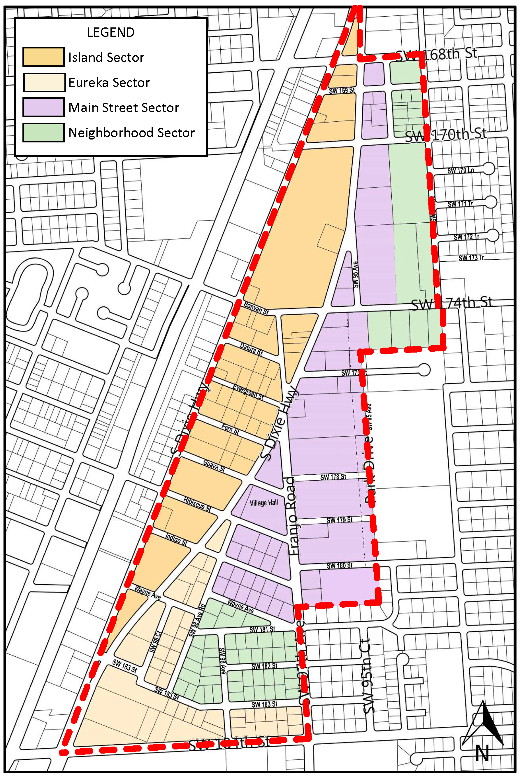
(Ord. No. 2020-09, § 1, 7-28-2020)
Sec. 30-50.23.2-03. - Sector Plan.
The Sector Plan shown in Figure 1, defines the sectors within the Downtown District that progress from higher density areas to less density areas, and provide for a mixture of uses.
The sectors directly reinforce the Village of Palmetto Bay's vision for the Downtown and provide an opportunity for property owners to develop in a manner that supports the village design objectives and transforms the Downtown into a cohesive, mixed-use District.
A.
Main Street. The Main Street Sector applies to the primary area of the Downtown, which is composed of the most vital, pedestrian and bike-oriented blocks with commercial components scaled to the pedestrian. Building typologies are suitable to satisfy the broad assortment of retail, office, service and residential uses that create the village mixed-use Downtown area. Franjo Road is the main street and shall be developed with mixed-use developments that provide a continuous pedestrian walk with ground-level retail and offices or multi-family residential units above. Landscaping reflects the pedestrian character, emphasizes pedestrian and bike protection, and accentuates the architectural character of the area.
B.
Island. The Island Sector applies to the area of the Downtown that is between the northbound and southbound lanes of the bifurcated segment of South Dixie Highway (US-1) and is the sector that is closest to the South Dade Transitway. This sector provides for the most flexible mixed-use building types, with small and larger scale retail at the ground level and offices or multi-unit residential on the stories above. Stand-alone commercial uses may be accommodated in the Island Sector with other compatible uses integrated in a form that meets the development and design standards required in this section. Landscaping should consist of a more village scale and pattern of planting and pedestrian hardscape.
C.
Eureka. The Eureka Sector applies to the area of the Downtown that is south of Indigo Street and immediately east of the Island Sector, and the corridor along the SW 184th Street. Eureka provides transition from the large-scale development along US-1 to the smaller scale main street mixed-use environment and residentially focused Neighborhood Sector. This sector provides for flexible building types to accommodate commercial/retail at the ground-level and offices or multi-unit residential on the stories above, while respecting transitions to the east edge of the sector. Landscaping should consist of a more village scale and pattern of planting along US-1 and SW 184th Street, while emphasizing a safe and convenient pedestrian and bike environment along other streets.
D.
Neighborhood. The Neighborhood Sector applies to lower intensity mixed-use and residentially focused area within Downtown that is compatible with uses nearby, and provides transition to the residential neighborhoods to the east. Townhouse and low-rise residential building types maintain a compatible visual profile to the other sectors but establish scale compatibility to neighborhoods to the east. Single-family houses may be developed in a village form such as side-yard and courtyard houses that maintain the street edge, respect the public realm, yet provide a protected private area expected of single-family home types. Landscaping should be consistent with the neighborhood scale of the sector and be more focused on green space than hardscape.
(Ord. No. 2020-09, § 1, 7-28-2020)
Sec. 30-50.23.2-04. - Street type plan.
The street connectivity standards identify the standards for new and existing streets with regard to dimensions for determining dedication, construction and/or redevelopment by the Village of Palmetto Bay and property owners.
All construction of new and redevelopment of existing rights-of-way shall be the responsibility of the individual property owners. The rights-of-way are intended to support the Village of Palmetto Bay vision for a highly connected, multi-modal, pedestrian and bike-friendly network of streets within Downtown. Property owners shall be responsible for the portion of the right-of-way on all sides of development that are considered street frontage. Wherever the existing right-of-way does not accommodate the location of the build-to-line at the edge or outside of the public right-of-way, a dedication amounting to the minimum required to achieve this criterion shall be necessary for site plan approval, whether by administrative approval or Council approval at a public hearing.
This section provides the elements and dimensions for each type of street shown in the Street Type Plan, Figure 2. Table 1 provides the size, location and treatment of the elements that comprise the right-of-way and shall determine the relevant build-to line that forms the datum line for development. For all street types, a build-to line that is measured from the centerline of the right-of-way shall be established consistent with the street type. This criterion shall be necessary for site plan approval, whether by administrative approval or Council approval at a public hearing.
Figure 2
Street Types Plan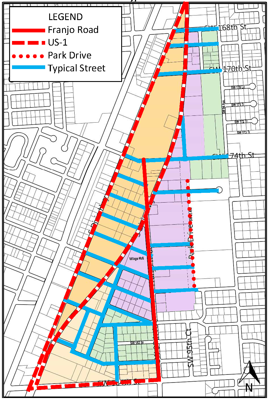
Table 1
Street Type Plan Elements and Dimensions
| Street Type | Franjo Road | US-1 Northbound | US-1 Southbound | Park Drive | Typical Street |
|---|---|---|---|---|---|
| Diagram | 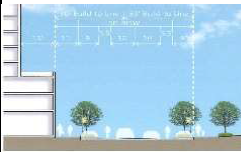 | 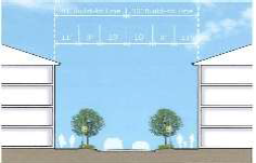 | |||
| Limits |
US-1
to SW 184th Street | SW 168th Street to SW 184th Street | SW 168th Street to SW 184th Street | SW 174th Street to SW 180th Street | all other locations |
| Right-of-way |
70-ft.
35-ft. from CL | 100-ft. | 66-ft. | 60-ft. | 60-ft. |
| Build-To-Line | 50-ft. from centerline | 50-ft. from centerline | 16-ft. from centerline | 30-ft. from centerline | 30-ft. from centerline |
| Median Area | 12-ft. planted | 10-ft. planted | none | none | none |
| Travel Lanes | one 10-ft. lane each direction | 3 1-way lanes 11-ft. | 3 1-way lanes 11-ft. | one 10-ft. lane each direction | one 10-ft. lane each direction |
| Bicycle Lanes | 5-ft. each direction | None | None | 5-ft. each direction | None |
| Parallel Parking | Each direction 8-ft. | 1 parking lane with slip lane separated by median | None | Each direction 9-ft. | Each direction 9-ft. |
| Curb Transition | Curb and gutter | Curb and gutter | Curb and gutter | Curb and gutter | Curb and gutter |
| Landscape Area | Tree grates and between parking | Planting strip, 6-ft. | Planting strip, 6-ft. | Tree grates and between parking | Tree grates and between parking |
| Sidewalk Width | 10-ft. | 10-ft. | 10-ft. | 6-ft. | 6-ft. |
| Effective Sidewalk Width | 8-ft. | 10-ft | 10-ft. | 6-ft. | 6-ft. |
| Outdoor Seating (in ROW) | Acceptable | No | No | Acceptable | as applicable in Sector |
| Ground Story Uses | Commercial/Retail | Commercial/Retail | Commercial/Retail | Commercial/Retail | as applicable in Sector |
(Ord. No. 2020-09, § 1, 7-28-2020; Ord. No. 2021-21, § 1, 11-15-2021)
Sec. 30-50.23.2-05. - Open space.
(a)
General Downtown-wide standards. The goal for Downtown is to achieve 20 percent of community open space. Community open space includes primary road buffers, perimeter buffers and parks. Overall Downtown open space areas shall be based on gross acreage. Adequate common open space shall be provided to meet the recreational needs for the residents. If the development consists solely of conventional detached single-family dwellings and recreational needs are otherwise provided for, these provisions of common open space shall not apply. The intent of the section is to:
(1)
Encourage landmark opportunities, including plazas, squares, pocket parks and open spaces of public assembly and social activity; and
(2)
Integrate street level plazas, courtyards and open spaces to create a sense of place and activate the sidewalks and streets.
(b)
Public open space locations.
(1)
The Main Street Sector shall include open spaces on-site and prioritized toward Franjo Road.
(2)
Island Sector and Eureka Sector shall include open spaces on-site and prioritized away from US-1.
(3)
The Neighborhood Sector locations shall include open spaces on-site, except for conventional detached single-family dwellings.
(c)
Public open space standards.
(1)
The public open spaces shall be provided outside of the right-of-way in accordance with the standards provided in section 30-50.23.3, and consistent with the general standards summarized in Table 2.
Table 2
Public Open Space Standards
(2)
All public open space requirements are provided as a percentage of the net lot area and must be located on corners where possible.
(3)
In the Main Street Sector, public open spaces are required as per Table 2.
(4)
Where parking or other elements border the open space, special design characteristics shall be employed such as addition of buffers, hedges, and low walls to reinforce the edges of the open space.
(5)
A restrictive covenant for the perpetual maintenance for all public plazas and cross-throughs shall be recorded with the appropriate Miami-Dade County agency in a form approved by the Village Attorney.
(6)
Pursuant to Sector requirements, the developer shall dedicate to the public, access ways to pass through oddly shaped or unusually long blocks and to provide public paths creating access to parks, schools, mass transit facilities and community services.
(7)
Lighting for pedestrian ways shall be provided to ensure personal safety. Lighting shall be integrated into the architectural character both in terms of illumination and fixtures. Lighting shall not impact off-site uses or traffic on adjacent streets.
(8)
Buildings and open spaces shall provide amenities to improve the microclimate along streets, with respect to excessive heat or sunlight.
a.
Where appropriate, canopies or arcades can be provided along the street frontage of buildings.
b.
Shade trees shall be planted to provide additional climate protection and contribute to an attractive pedestrian environment.
(9)
Except as provided herein, landscape shall be provided as required in Village of Palmetto Bay Landscape Standards section 30-50.23.6.1.
(d)
Private open space standards. Private open space shall be provided in the form of courtyards, balconies, terraces, lawns, community gardens, amenity recreation decks and landscaped roof terraces/gardens on buildings/parking structures.
(1)
The amount of private open space shall be provided according to the requirements by sector in section 30-50.23.3.
(2)
Permitted frontage types shall count towards meeting the private open space requirements of these regulations.
(3)
Within the areas designated as private open space, tree requirements shall follow section 30-50.23.6.
(4)
The area of any covered patio, gazebo or other roofed shade structures shall count towards meeting the private open space requirements, if two sides are opened to the outside.
(Ord. No. 2020-09, § 1, 7-28-2020)
Sec. 30-50.23.2-06. - Uses.
(a)
Permitted uses. No land, body of water or structure shall be used or permitted to be used, and no structure shall be hereafter erected, constructed, reconstructed, moved, structurally altered, or maintained for any purpose in Downtown except as provided in this section. The uses delineated herein shall be permitted only in compliance with the regulating plans and general requirements provided in this section.
(b)
Mixed-use.
(1)
The vertical or horizontal integration of two or more of residential, live-work, business and office, civic and institutional uses is encouraged as provided herein. Vertical integration allows any combination of primary uses with commercial/retail uses typically located on the ground story and office and/or residential uses on the upper stories. Horizontal integration allows any combination of parcels with different primary uses within the same block under the same ownership. Vertical integration of mixed-uses shall be required within buildings that have primary frontage along SW 97th Avenue (Franjo Road).
(2)
Mixed uses are determined by the integration of one or more different land use categories from each column in Table 3. Vertical disposition of the uses shall be as required in Table 3.
Table 3
Criteria to Determine Mixed-use
(c)
Residential principal uses. Residential uses are permitted in the areas designated in the Sector Plan as provided in Table 4.
Table 4
Permitted and Conditional Residential Uses by Sector
(d)
Residential home offices. Home offices are permitted as an ancillary use to principal residential uses up to 200 square foot of story area and as provided in section 30-60.14 of the Village of Palmetto Bay Code.
(e)
Live-work units.
(1)
Definition.
A live-work unit (LWU) is defined as a space within a mixed-use building that is used jointly for commercial and residential purposes, where:
a.
The resident of the business is responsible for the commercial activity performed; and
b.
The commercial or manufacturing activity conducted takes place subject to a valid business license associated with the premises.
(2)
Permitted uses. A LWU is a permitted use for detached single-family buildings, attached single-family buildings, and multifamily buildings, and is a permitted use subject to the criteria below:
a.
The minimum area of an individual LWU is 625 square feet;
b.
The LWU shall be located on the ground story of a mixed-use building and may be used to define a building as mixed-use when in combination with residential uses or office uses on other stories;
c.
The LWU shall count as one-half of a residential unit toward all residential density calculations;
d.
The commercial area and the living area shall to be separated by a wall or permanent partition on a single level, or by story or mezzanine for a multi-level LWU. Alternatively, the work component may be in a legal accessory structure to an attached or detached single family dwelling unit;
e.
The work component exceeds 200 square feet of the floor or 32 percent of total unit area;
f.
The LWU shall be constructed with an external door opening to the street frontage for commercial use, and an additional door to the interior circulation of the building for residential use;
g.
The LWU shall include a full kitchen;
h.
The LWU shall include at least one full bath within the living area and one-half bath within the work area;
i.
A sign relating to the commercial use may be displayed on the transom of the external street-side door, or on a plaque to the side of the exterior door, and is to be no larger than two square feet;
j.
All supplies and items affiliated with the commercial functions of the commercial activity will be completely contained within the LWU;
k.
No variances of the requirements a. through j. may be granted;
l.
Parking requirements for the LWU shall be the same as for residential units of the same number of bedrooms. The commercial story area of a LWU shall account for one-half of a parking space toward the parking requirement;
m.
An annually renewable certificate of use and occupancy shall be required for the commercial use;
n.
Specific commercial occupations:
(i)
Work area uses may include any professional office, professional service or gallery use;
(ii)
Limited patronage by clients is permissible; and
(iii)
Inside the premises:
a)
There may be limited display, creation, distribution or merchandise that are deemed compatible with other uses in the mixed-use building and the sector;
b)
Fabrication, viewing and sale of art, artisan or craft work, with all fabrication only of one-off custom work by the resident of the LWU, and as permitted by administrative determination according to compatibility. Compatibility is determined by such factors as noise, glare, vibration, odor, hours of operation, and safety, as applicable.
(f)
Non-residential uses.
(1)
Permitted uses. Non-residential uses are permitted in the areas designated in the Sector Plan as provided in Table 5. No outside storage or display of merchandise, equipment, materials or supplies is permitted in any sector.
Table 5
Permitted and Conditional Non-Residential Uses by Sector
(2)
Non-residential conditional uses. The following uses shall be permitted as conditional uses, provided the following:
a.
Civic uses shall be permitted within the Neighborhood Sector only on sites that are less than one acre. Schools are permitted in all sectors of the Downtown zoning district subject to a public hearing and the criteria of division 30-110 and division 30-120 of the Village of Palmetto Bay Code.
b.
Automotive uses shall be permitted within the Island and Eureka Sectors subject to the following conditions:
(i)
Used car sales shall only be permitted in conjunction with new car sales;
(ii)
Ancillary sales, service and repair shall only be permitted in conjunction with new car sales;
(iii)
No outside storage or display of merchandise, equipment, materials or supplies is permitted, except for limited display of new car inventory with not more than one inventory vehicle per 20-foot of frontage and interspersed with landscape trees or public hardscape and furniture;
(iv)
Legally established, presently operating gas stations may continue to operate as legally nonconforming uses, subject to the standards of section 1.04 of the Village of Palmetto Bay Code.
c.
Drive-through facilities shall be permitted, where the following criteria are met:
(i)
Permitted only in the Island and Eureka Sectors;
(ii)
Permitted in Main Street Sector only where the property has a frontage directly on US-1;
(iii)
Provide a continuous street façade consisting of buildings or walls along all rights-of-way except driveways. The main building shall provide a minimum of 40 percent of building frontage along the primary frontage;
(iv)
Where buffer walls are provided, walls shall not exceed 42 inches in height and shall be a minimum of 75 percent opaque;
(v)
Permitted upon determination that the drive-through shall create minimal traffic congestion or disruption to adjacent streets.
d.
Theaters, clubs, restaurants and cafés, especially if live entertainment is held on premises, are permitted only as conditional uses in the Main Street and Eureka Sectors with limited hours of nighttime operation until 11:00 p.m., and subject to sound level criteria of the village noise ordinance, section 30-60.29 of the Village of Palmetto Bay Code.
e.
Sidewalk cafe and outdoor table service may be provided in compliance with the sidewalk café ordinance, section 30-60.17 of the Village of Palmetto Code.
f.
Self-storage is permitted as a conditional use in the Island and Eureka Sectors and must be within a completely enclosed mixed-use building, subject to the following conditions:
(i)
The ground story frontage is occupied by retail uses with individual entrances for each retail store;
(ii)
No wholesale or retail sales are permitted within the individual storage units;
(iii)
The loading entrance and exit shall not be on Franjo Road, and not be across from any portion of the Neighborhood Sector;
(iv)
All loading/unloading areas are interior to the building;
(v)
All stories of a façade that face a public right-of-way, park, public open space, or residentially-zoned ground story shall provide windows and other fenestration details, with 70 percent glazing at street level façades and a minimum of 50 percent for higher stories.
(g)
Accessory building.
(1)
Detached accessory building shall be permitted only with specifically allowed building types in accordance with Table 6. Accessory buildings are not permitted as stand-alone uses without a principal structure.
(2)
Accessory buildings shall only be permitted to the rear of the principal building, and on corner lots may not face Franjo Road, US 1 or Park Drive.
(3)
Accessory buildings shall be subject to all required setbacks and minimum building separation of the Sector in section 30-50.23.3.
(4)
The height of an accessory building shall not exceed the permissible accessory building height of the sector in section 30-50.23.3.
(h)
Accessory dwellings.
(1)
Accessory dwellings shall be permitted within permitted accessory building.
(2)
The height of an accessory dwelling shall be one story.
(3)
The gross floor area of an accessory dwelling shall not exceed 600 square feet.
(4)
Accessory dwellings shall not have an oven range or stove within the unit.
(5)
An accessory dwelling may be located on the second story of an accessory building when the first story is occupied by a private garage.
Table 6
Accessory Buildings, Uses and Accessory Dwellings
(i)
Unusual uses. Any residential or non-residential use which is found by the director or designee to be a use similar to one of the above numbered uses and conforms to the intent of this section may be permitted, specific to the site requested as an unusual use and subject to conditions required by the director. An unusual use determination may not be applied to another location and shall require another determination by the director.
(j)
Prohibited uses. Any residential or non-residential use that is not specifically listed or determined by the director or designee to be a conforming unusual use is prohibited.
(Ord. No. 2020-09, § 1, 7-28-2020)
Sec. 30-50.23.2-07. - Densities and intensities.
(a)
Residential density.
(1)
Residential density shall be defined as an objective measurement of the number of residential units allowed per unit of land.
a.
Residential unit shall mean a building or portion thereof that is designed or used exclusively for residential occupancy, but not including trailers, mobile homes, hotels, motels, boarding houses, lodging houses or tourist homes. A residential unit must include food storage, preparation and cooking facilities in a dedicated area, and an enclosed room within the unit that includes a toilet, washing sink and bathing or showering facilities. In the Downtown District, live work units (LWU) that are not used exclusively for residential occupancy are permitted in accordance with the requirements of section 30-50.23.2-06E.
b.
For the purpose of defining residential density, a unit of land shall be defined as any area designated in the Village of Palmetto Bay Future Land Use Map as a category of land that is developable for residential development as defined by Future Land Use Element Policy 1.1.1.
c.
In the Downtown District, residential densities shall be based on the gross lot area, which includes the private lot area(s) and the area that extends from each property boundary that is along a public street or public right-of-way to the centerline of the right-of-way, including the area defined by the projection of the right-of-way lines at intersections. Fractional dwelling units shall be rounded down.
(2)
The residential density for any lot shall not exceed the maximum density as stated in the sector plans in sections 30-50.23.3-02.2, 30-50.23.3-02.3, 30-50.23.3-02.4 and 30-50.23.3-02.5. The maximum residential density is a maximum potential that is subject to further reduction in compliance with other requirements in this code for lot size, building height, number of stories, setbacks, step-backs, other form requirements, parking requirements, and the limitations of infrastructure and essential services as required by section 30-50.23.2-07.A.4. and other requirements of this article.
(3)
Work-Live Units that comport with all the requirements of section 30-50.23.2-06E. shall be counted as half of one residential unit.
(4)
The entire Downtown District shall permit a total of 2,500 residential dwelling units, until updated through amendment to the adopted Village Comprehensive Plan. All development approvals must be consistent with: the adopted Village Comprehensive Plan; the Village of Palmetto Zoning Code; and all applicable village requirements for the design and construction of streets, utility facilities and other essential services per section 30-30.5(j)(1).
(5)
The entire Downtown District shall permit a maximum number of residential dwelling units, such that a level of service within the Downtown District of a quarter acre of parks and public open space per 1,000 residents is not exceeded, with assignment of three residents to each dwelling unit, until updated through amendment to the adopted Village Comprehensive Plan.
(b)
Non-residential intensity.
(1)
Non-residential intensity means an objective measurement of the extent to which land may be developed or used, including the consumption or use of the space above, on, or below ground; the measurement of the use of or demand on natural resources; and the measurement of the use of or demand on facilities and services.
a.
Non-residential development shall mean a building or portion thereof that is designed or used for uses other than residential uses as defined in section 30-50-23.2-06.
b.
The work area components of LWU shall be excluded from non-residential use calculation.
(2)
Non-residential intensity shall be regulated by compliance with building form requirements for each sector as provided in sections 30-50.23.3-02.2, 30-50.23.3-02.3, 30-50.23.3-02.4 and 30-50.23.3-02.5. These regulations include lot size, building height, number of stories, setbacks, step-backs, other form requirements, parking requirements, and the limitations of infrastructure and essential services as required by section 30-50.23.2-07 and other requirements of this article.
(3)
The entire Downtown District shall permit a total of 1,500,000 gross square foot of floor area of non-residential uses, until updated through amendment to the adopted Village Comprehensive Plan. All development approvals must be consistent with the adopted Village Comprehensive Plan; the Village of Palmetto Bay Zoning Code; and all applicable village requirements for the design and construction of streets, utility facilities and other essential services per section 30-30.5(j)(1).
(Ord. No. 2020-09, § 1, 7-28-2020)
Sec. 30-50.23.2-08. - Parking.
(a)
On-site parking. On-site parking shall be considered any parking structure, surface parking, tuck-under parking, private parking garage or surface parking pad within the property lines and applicable build-to lines on private property.
(1)
Parking structures shall meet the village dimensional requirements.
(2)
The number of levels of a parking structure is used toward the determination of the number of stories of a building except when the parking structure is located alongside the habitable parts of the building.
(3)
The roof of all parking structures used for on-site parking for developments subject to this requirement shall be programmed with:
a.
Amenity deck (private open space);
b.
Green roof as defined in section 30-50.23.6;
c.
Renewable energy generation as defined in section 30-50.23.5, and/or renewable water heating systems as defined in section 30-50.23.5;
d.
Water reclamations systems as defined in section 30-50.23.5.
(b)
Off-site parking. Parking requirements may be satisfied off-site. Off-site parking shall be considered any parking structure, surface parking or on-street parking located on a development parcel other than the parcel being developed. Off-site parking shall be permitted subject to the following requirements:
(1)
Off-site parking is permitted pursuant to the requirements of Table 7;
(2)
Pedestrian access of the off-site parking is 1,000 feet or less from the front entrance of the parcel being developed, measured by the shortest path straight line;
(3)
For all off-site parking in a parking structure or surface parking lot subject to the standards above, the applicant/owner must submit a 20-year parking covenant attached to the proposed development plan. The parking covenant must be approved by the village attorney for form, prior to acceptance; and
(c)
On-street parking. On-street parking may be counted toward parking requirements. On-street parking shall be considered any parking located in a public right-of-way that is immediately adjacent to the boundaries of the development property. On-street parking shall be permitted subject to the following requirements:
(1)
On-street parking is permitted pursuant to the requirements of Table 7;
(2)
On-street parking spaces may only be used that are directly adjacent to the property lines of the property along a street frontage;
(3)
On-street parking spaces must meet the village's dimensional requirements, including all landscape space as required; and
(4)
On-street parking spaces that are used to meet the parking requirement shall be shown on the site plan, and approved by the director for administrative approval, or approved by the village council at a public hearing if required.
(d)
Mechanized parking. Mechanized parking shall be permitted towards meeting the parking requirement for all off-street parking, and shall comply with the following:
(1)
Mechanized parking shall only be permitted in fully enclosed parking structures, or in parking areas that are not visible to any public spaces;
(2)
Mechanized spaces shall be counted by including all spaces on a lift and the space under the lift;
(3)
For residential parking requirements, each lift shall only be assigned to one dwelling unit;
(3)
A queuing analysis shall be submitted with application for review, and no part of the queue may block a public street, sidewalk, emergency access, or non-mechanized parking access; and
(4)
Mechanized parking spaces shall not account for more than 50 percent of the total parking count. For residential developments on lots of 15,000 square feet or less, all of the parking spaces may be mechanical parking.
(e)
Valet parking. Valet parking shall be permitted towards meeting the parking requirement for all off-street parking, and shall comply with the following:
(1)
A pick-up/drop-off area shall be provided with enough queuing space;
(2)
A queuing analysis shall be submitted with application for review, and no part of the queue may block a public street, sidewalk, emergency access, or non-mechanized parking access;
(3)
The valet storage parking area shall be subject to the requirements of this section within the Downtown District;
(4)
Valet parking shall only be approved as a condition of the certificate of use and/or certificate of occupancy;
(5)
Valet parking spaces shall not account for more than 50 percent of the total parking count; and
(6)
Valet parking shall only be approved as a covenant agreed and executed by the owner and the village, the covenant must be approved by the village attorney for form, prior to acceptance.
(f)
Tandem parking. Tandem parking shall be permitted towards meeting the parking requirement for all off-street parking, and shall comply with the following:
(1)
Unattended tandem parking shall only be permitted for residential units that require two or fewer spaces. No tandem space may be assignable to more than one residential unit. No tandem space may be counted for the visitor component of the residential parking requirement;
(2)
All other tandem parking shall be attended by valet personnel. Valet parking shall only be approved as condition of the certificate of use and/or certificate of occupancy; and
(3)
Tandem parking shall only be permitted for on-site parking.
(g)
Parking architectural standards. All parking requirements of this section shall be met with additional requirements of this section regarding specific architectural standards for parking structures and surfaces:
(1)
Private parking garages shall not be located at the front of the lot. A parking structure must provide a habitable ground floor liner at the front of the lot;
(2)
Any part of the parking structure that does not have a liner shall have decorative wall with fenestration, screening, and/or landscaping that is consistent with the architecture of the overall building. Screening or other features may be part of an approved art-in-public places (AIPP) program;
(3)
On-site surface parking shall not be located at the front of the lot; and
(4)
Any part of on-site surface parking or its access that is adjacent to a public street or pedestrian way or single-family zoning district shall be buffered by a minimum ten-foot deep landscape area that includes:
a.
Wall and/or landscape hedge at a minimum height of 36 inches and maximum height of 72 inches; and
b.
Surface parking shall not encroach into any required setbacks.
(h)
Parking landscape standards. For landscape areas in permanent and temporary parking lots, see section 30-50.23.6.
(i)
Number of parking spaces required.
(1)
The total number of parking spaces shall be provided in accordance with Table 7, and include all special needs parking requirements of section 30-50.23-08K.
(2)
The requirement for the total number of spaces may be provided by on-site spaces, off-site spaces, on-street spaces, mechanized parking spaces, valet parking spaces, and tandem parking spaces.
(3)
The total number of parking spaces provided may be reduced from the total number as provided in Table 7 through approved shared parking in accordance with all criteria of section 30-50.23-08J.
(4)
All other uses shall comply with the parking standards provided in section 30-70.8 of the Village of Palmetto Bay Zoning Code or as determined by the director.
Table 7
Number of Parking Spaces Required
(j)
Shared parking. Shared parking spaces may be counted toward parking requirements with the following conditions:
(1)
Shared spaces are based on temporal complimentary use in which one use occupies the space at a different time than another. Shared spaces may also be based on internal capture in which persons walk from one use to another. Shared space parking may be applied within a mixed-use property or among adjacent properties, pursuant to the requirements this section and of Table 8;
(2)
An adjacent property can be used as a shared parking space;
(3)
For all shared parking that is not in the development property, the applicant/owner must submit a 20-year parking covenant attached to proposed development plan. The village attorney must approve the parking covenant; and
(4)
The director shall approve any shared parking spaces, and the number that may be shared shall be calculated by the method contained herein:
The parking required for any two functions is calculated by dividing the number of spaces required by the lesser of the two uses by the appropriate factor from Table 8 and adding the result to the use of the highest number parking requirement. If there is another use that is not indicated in the sharing factor table, then the sharing factor of 1.1 shall be used.
Table 8
Shared Parking Factors
(k)
Special needs parking.
(1)
All special needs parking shall count towards the required parking on a one-to-one basis.
(2)
The number and dimensions of parking for individuals with disabilities shall comply with the standards of the Florida Building Code;
(3)
Stroller parking shall be provided for all commercial parking areas, including commercial parking for a mixed-use building, and shall be provided at locations close to the pedestrian entrance as per Table 9;
(4)
Preferential parking for veterans shall be provided at locations close to the pedestrian entrance as per Table 9;
(5)
Electric vehicle charging station parking shall be provided at convenient locations, distributed among garage levels as per Table 9;
(6)
Low-speed vehicle parking shall be provided at convenient locations, distributed among garage levels, with the required number as per Table 9; and
(7)
Two-wheel vehicle parking shall be provided at convenient locations, distributed among garage levels, with the required number as per Table 9.
Table 9
Special Needs Parking Components
(l)
Bicycle parking.
(1)
In addition to the vehicle parking, for every ten parking spaces required, one bicycle parking space shall be provided;
(2)
A minimum of 25 percent of the required bicycle parking shall be provided along the primary street frontage;
(3)
Adequate and accessible bicycle racks shall be installed at all public buildings and public spaces;
(4)
Bicycle parking shall be protected from the weather.
(Ord. No. 2020-09, § 1, 7-28-2020)
Sec. 30-50.23.3-01. - Purpose.
This section identifies the Downtown Design Standards for development in each of the four sectors that comprise the Downtown District, and ensures that development is consistent with the vision for the Downtown District. Each sector shall follow the standards for building types, building form and placement, massing and disposition of uses. The sectors are identified as follows:
• Main Street Sector;
• Island Sector;
• Eureka Sector; and
• Neighborhood Sector.
(a)
All standards in this section that are expressed as maximums shall not be exceeded in compliance with all applicable provisions of the Village of Palmetto Bay Zoning Code.
(b)
All standards in this section that are expressed as minimums shall be equaled or exceeded in compliance with all applicable provisions of the Village of Palmetto Bay Zoning Code.
(c)
The map of the boundaries and parcels included in each sector and the "Intent of the Sector" statements for each of the sector summaries are consistent with section 30-50.23.2-03.
(d)
Build-to lines are the datum for determining setbacks, stepbacks and frontage lines, based on the build-to line locations in section 30-50.23.2-04.
(e)
Open space requirements in this section are consistent with the open space requirements in section 30-50.23.2-05.
(f)
Permitted and conditional uses for each sector are defined in section 30-50.23.2-06 with definitions for uses as defined in section 30-50.23.7.
(g)
Residential densities and non-residential intensities for each of the sectors are defined in section 30-50.23.2-07.
(h)
Parking amount, location and design requirements are in section 30-50.23.2-08.
(Ord. No. 2020-09, § 1, 7-28-2020)
Sec. 30-50.23.3-02.1. - Main street sector.
Figure 5 Main Street Sector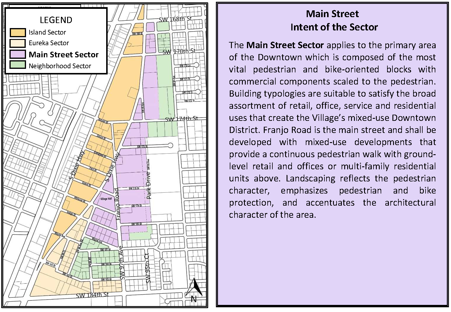
Table 7
Main Street Sector
Table 8
Main Street Sector
(Ord. No. 2020-09, § 1, 7-28-2020)
Sec. 30-50.23.3-02.2. - Island sector.
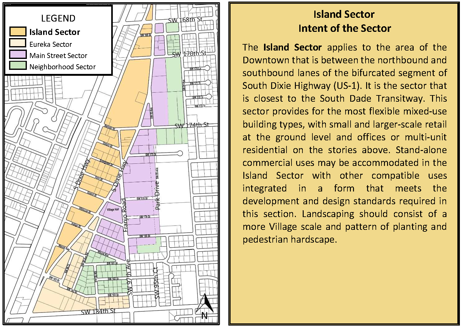
Sec. 30-50.23.3-02.3. - Eureka sector.
Figure 7 Eureka Sector
Table 11
Eureka Sector
Table 12
Eureka Sector
(Ord. No. 2020-09, § 1, 7-28-2020)
Sec. 30-50.23.3-02.4. - Neighborhood sector.
Figure 8 Neighborhood Sector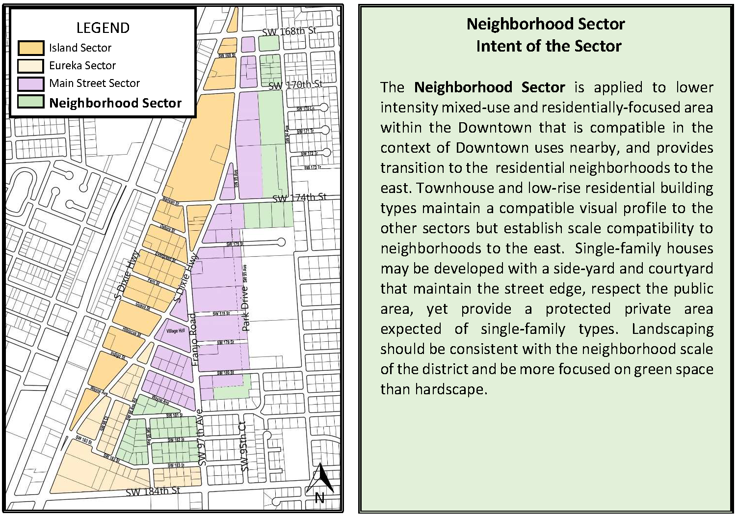
Table 13
Neighborhood Sector
Table 14
Neighborhood Sector
(Ord. No. 2020-09, § 1, 7-28-2020)
Sec. 30-50.23.4-01. - Purpose.
This section of the Downtown Zoning Code contains specific development standards that apply to new development and significant redevelopment in the Downtown District. The intent and purpose of the development standards is to ensure consistency with the village vision. The following architectural standards will aid property owners, architects, builders and other design professionals in the understanding of what are the appropriate building frontages, building types, massing, fenestrations and character for the Downtown District. The standards in this section apply to various building types in all sectors.
(Ord. No. 2020-09, § 1, 7-28-2020)
Sec. 30-50.23.4-02. - Building types.
Subject to the requirements of the applicable sector, a proposed building type shall be designed as one of the building types.
(a)
Mixed-use building. A mixed-use building type is occupied by one or a combination of multi-family residential, commercial or offices at the ground story and office/multi-family residential units on the story(s) above. The building shall have facades along one or more street frontages. Larger buildings with more than two street frontages can accommodate larger footprint commercial uses and structured parking within the envelope. Smaller buildings with shallower footprints on smaller lots may have services and parking in the rear of the lot or on a side street.
(b)
Commercial building. A non-residential building type is occupied by a single type of commercial or office use on the ground story and all stories above. The building shall have façades along one or more street frontages. Larger buildings with more than two street frontages can accommodate larger footprint commercial uses and structured parking within the envelope. Smaller buildings with shallower footprints on smaller lots may have services and parking in the rear of the lot or on a side street.
(c)
Stacked apartment. A neighborhood-scaled, multi-family residential building type has residential units throughout all stories of the building. Larger buildings with more than two street frontages can accommodate larger footprint commercial uses and structured parking within the envelope. Smaller buildings with shallower footprints on smaller lots may have services and parking in the rear of the lot or on a side street.
(d)
Townhouse. A residential building type that shares a common wall with the structure next to it. Each individual structure is occupied by one residence, on all stories, in an array of at least three structures, side-by-side along the primary street frontage.
(e)
Single family house. A residential building type accommodates one primary residence in the primary structure. The frontage on which the main entrance of the building is situated may be on the established frontage of the lot through prior platting.
(Ord. No. 2020-09, § 1, 7-28-2020)
Sec. 30-50.23.4-03. - Vertical mixed-use building—Uses by story.
(a)
A mixed-use building type shall accommodate certain commercial uses at the ground story and multi-family residential units and other non-retail or eatery uses on the stories above, with the number of stories consistent with the sector requirement.
(b)
The use categories that are permitted for each story shall be consistent with Table 15. The use categories listed in Table 15 are consistent with the use categories in Table 3 and Table 4 in section 30-50.23.2-06.
(c)
Eating and drinking establishments may be permitted on upper stories.
(d)
All ground story units along Franjo Road shall be designed to accommodate retail uses, retail offices or eating and drinking establishments.
Table 15
Habitable Use by Story in Island, Eureka and Main Street Sectors
Table 16
Habitable Use by Story in the Neighborhood Sector
(Ord. No. 2020-09, § 1, 7-28-2020)
Sec. 30-50.23.4-04. - Building massing.
All building types are subject to the following general development parameters:
(a)
Building massing.
(1)
Buildings shall be constructed as varying masses with different materiality, texture and depth.
(2)
Horizontal and vertical extrusions will be used to create the desired building form with dimensions in accordance with section 30-50.23.3.
(3)
For building articulation, a horizontal break in building façade shall occur every sixty (60) foot or less on buildings that occupy more than one hundred twenty (120) foot of continuous frontage. Breaks in building façade shall be recessed from the build-to line up to two (2) foot and shall be the height of the base element of the building.
(4)
For building articulation and to break the façade massing, the use of materials and extrusion of elements shall be used.
(5)
Balconies on the façade above the level of stepbacks shall make up no more than seventy percent (70%) of elevation at that story.
(6)
Buildings shall provide fenestration on all sides.
(7)
A minimum of thirty percent (30%) of the total building façade shall be fenestrated with windows along all street frontages.
(8)
Each unit within the building regardless of use shall have outdoor exposure and access to open space.
(9)
Public main entrances shall include a vestibule from the main street. The intent is to create a transition space near entrance doors and pedestrians walking along the sidewalk.
(10)
Building massing treatment shall be focused to address a pedestrian scale to enhance the assortment of street level public area.
(11)
The use of a variety of architectural attributes and materiality shall enhance the street-level experience to create a sense of place, establishing identity for the Downtown Zoning District.
(b)
Building height.
(1)
Building height measured to the roof line or eave, shall be in accordance with the heights provided in section 30-50.23.3.
(2)
Parapet walls shall be shall comply with Florida Building Code, measured from the top of the highest slab of a flat roof, or the corner intersection of a non-flat roof, provided that a pitched roof does not contain a habitable space.
(3)
Any equipment such as mechanical equipment, rooftop landscape or recreational equipment shall not exceed maximum 15 feet in height measured from the top of the roof and shall be setback 15 feet perpendicular to the nearest parapet wall. Stair and elevator towers shall be exempt from this requirement only if they provide design elements consistent with the architectural concept of the building.
(c)
Building number of stories.
(1)
Buildings shall be built conforming to the minimum and maximum number of stories provided in section 30-50.23.3.
(2)
For the purpose of calculating the number of stories in a building, a story shall be defined as the habitable space between finished floor and finished floor of story above.
(3)
Mezzanines shall not count towards the number of stories provided that the total area of mezzanine level is 30 percent or less of the floor area of that story (floor area below the mezzanine).
(4)
Basements shall not be considered towards the building height (stories).
(5)
Underground parking shall not be counted as a story.
(6)
The number of stories of a building is determined by the number of habitable stories and parking levels above ground as depicted on the façade of the building.
(Ord. No. 2020-09, § 1, 7-28-2020)
Sec. 30-50.23.4-05. - Frontage standards.
Buildings shall have a street level frontage type as provided in section 30-50.23.3. This code establishes various frontage types which describe different approaches for building frontages and façades configured along the street. By using appropriate frontage types, each new building will contribute to the desired character of each sector and desired Downtown vision.
Figure 9 Gallery
Frontage
(illustrative only, refer to text for regulation)
(a)
Gallery. The gallery frontage has a recessed street level façade that creates a passageway parallel to the street that is covered by the upper stories of the building which may be supported by columns or cantilevered. It provides a strong visual continuity of the street front, as well as shade from sun and shelter from weather to pedestrians. The gallery frontage is used for retail and other commercial uses in the Main Street Sector, Island Sector and Eureka Sectors.
(1)
The arcade frontage type shall be permitted with certain building types in the given sector, and encouraged along the primary frontage along Franjo Road, as defined in section 30-50.23.3.
(2)
Soffits, columns, arches/openings and other details shall be treated consistent with the architectural character of the whole building.
(3)
The openings of the arcade shall be of vertical proportion and have a finished story that matches at the adjoining sidewalk.
a.
The minimum unobstructed clear height from finished story to the highest point of arcade opening shall be 14 feet.
b.
The minimum clear width from column face to column face, or column face to building face shall be no less than ten feet.
c.
Openings within the storefront shall be aligned to the centerline between the columns and a minimum ten feet tall. Openings within the storefront shall meet all other requirements for a storefront frontage type.
(4)
Elements may project off the façade of the frontage, such as balconies and terraces.
(5)
Awnings shall be a maximum ten feet in width and shall only correspond to and attach to the openings of the arcade. Awnings shall be a minimum one foot clear from the edge of the building in elevation.
(b)
Storefront. The storefront is a façade positioned at the required build-to line or setback, with entrances to the habitable spaces at sidewalk level. It is typically used for retail and commercial frontage and is also suitable for some residential buildings with common entrances. This frontage type can be accompanied by cantilevered roof(s) and awning(s). Recessed entryways are acceptable in the storefront frontage type such as vestibules. The storefront frontage may be set back from the build-to line to complement adjacent frontages.
Figure 10 Storefront Frontage
(illustrative only, refer to text for regulation)
(1)
The storefront frontage type shall be permitted with certain building types in each sector, as defined in section 30-50.23.3.
(2)
The following shall apply to all storefronts as independent frontage types or complimentary to another frontage type, such as with the arcade or forecourt types:
a.
A minimum 14 feet clear to a maximum of 18 feet tall, as measured from the finished floor or adjoining sidewalk; and
b.
Openings within the storefront shall be vertically proportioned and a minimum of ten feet wide and ten feet tall.
(i)
A minimum of 70 percent of the ground story storefront shall be glazed with a transparent, non-opaque/non-reflective glazing to provide clear view into the unit.
(ii)
Display cases or merchandise/goods storage shall be 36 inches maximum in height from the finished sidewalk and shall maintain a minimum of 70 percent clear view into the unit.
(iii)
Security measures, such as gates, grating or roll down shutters shall be prohibited from exterior application and shall only occur on the interior side of the glass and shall be minimum 50 percent clear view into the storefront.
c.
Entrances to storefront may be recessed eight feet maximum from the build-to line, when used as an independent frontage type. Width of recessed entrance shall be the width of one storefront bay or ten feet maximum, whichever is less.
(3)
Elements may project off the façade of the frontage subject to the standards for encroachments by sector in section 30-50.23.3.
(4)
Awnings may be a maximum ten feet in width and shall not project more than six feet into the sidewalk:
a.
Awnings may only cover storefront glazing.
b.
Awnings should provide protection from rain, provide shade, and add color and attractiveness to the street.
c.
For spans wider than ten feet, a break of eight inches may be provided between awnings.
d.
Awnings may be a minimum one foot clear from the edge of the building in elevation.
(c)
Forecourt. The forecourt is a semi-public, exterior open space, compatible with the gallery and storefront frontage type, that is partially surrounded by building on at least two sides and also opened to the street sidewalk, forming a court which can be level with or raised above the street. The forecourt is appropriate in the form of outdoor landscaped open space/gathering area and suitable offices or residential uses.
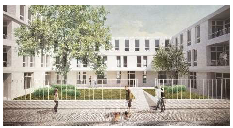
Figure 11 Forecourt Frontage
(illustrative only, refer to text for regulation)
(1)
The forecourt frontage type shall be permitted in certain building types in each sector, as defined in section 30-50.23.3.
(2)
The following shall apply to all buildings with forecourt in conjunction with another frontage type, such as with the arcade or storefront types:
a.
A minimum ten feet deep along the primary frontage.
b.
A minimum 20 feet wide of the lot width along the frontage.
c.
A decorative fence, maximum three feet in height, may be placed along the build-to line and count towards minimum frontage percentage standards for a building along the primary street.
(3)
Awnings are permitted and shall meet the criteria of storefront frontages.
(d)
Reserved.
(e)
Canopy. A canopy frontage contains a permanently attached rigid canopy that projects outward from the façade to shield the main entrance, windows and sidewalk from the elements. Canopy frontage type may be constructed facing any of the street types.
Figure 12 Canopy Frontage (illustrative only, refer to text for regulation)
(1)
A minimum of 20 feet wide of the lot width along frontage.
(2)
Permanent structures shall meet Florida Building Code regulations.
(3)
For a span wider than 20 feet, a break of eight inches shall be provided between every canopy structure.
(f)
Porch. Associated with single family houses, the porch frontage is an elevated semi-private, exterior space, that is built at the setback line and corresponds to the front of a single-family house building. There is a potential landscape yard space as a transition to an elevated landing before the entrance into the building. A fence may be built at the build-to line to enclose the yard space and preserve the street edge.
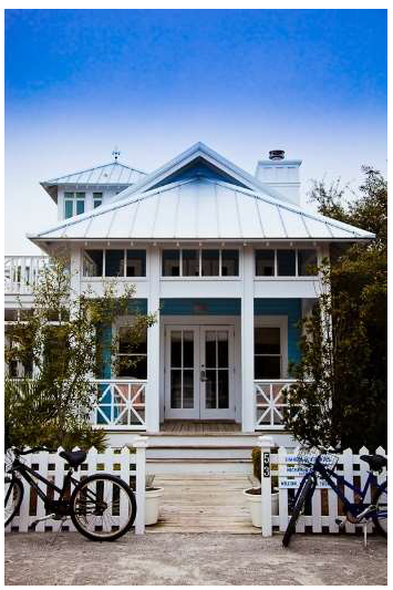
Figure 13 Porch Frontage (illustrative only, refer to text for regulation)
(1)
Porch frontage type shall be permitted only in the Neighborhood Sector.
a.
For all single-family houses with a porch frontage types, setback shall be ten feet from the build-to line, on the primary frontage.
(i)
A decorative fence, maximum three feet in height, may be placed along the build-to line and count towards minimum frontage percentage standards for a building along the primary street.
(ii)
The area between the interior face of the wall and porch shall be landscaped and count towards private open space requirements.
(iii)
The ground-level space shall be at minimum 50 percent of the area between the setback and build-to line. The ground-level space shall be landscaped with a minimum of 50 percent pervious area.
b.
A porch shall not encroach into ten feet setback area to preserve yard space.
c.
A porch shall be a minimum six feet deep.
d.
A porch shall have a minimum of 12 feet wide and correspond directly to the entry of the single-family house.
e.
A porch shall be a minimum height of eight feet clearance from finished story of porch to ceiling.
f.
A porch shall transition from adjoining sidewalk and yard level to meet the first story of the building at the entrance.
(g)
Service. Larger buildings particularly along the Island Sector without an alley or internal service area may require a service frontage. Examples are loading docks, service bays and unlined parking garages. Service areas shall be located on the street with least traffic as determined by the director. The permitted locations of service frontages are limited to reduce their adverse impacts on abutting streets and the overall downtown vision.
Figure 14 Service Frontage (illustrative only, refer to text for regulation)
(1)
Service frontages shall have enough queuing space for loading without obstruction at sidewalk.
(2)
Service frontages shall be treated with materiality to break up the façade.
(3)
Service frontages shall be restricted along major thoroughfares such as US 1 and Main pedestrian street.
(Ord. No. 2020-09, § 1, 7-28-2020)
Sec. 30-50.23.4-06. - Service standards.
(a)
All services shall be subject to the following:
(1)
Where there is an alley present, all services, including utility access, above ground equipment and trash enclosures shall be located on alleys. Pedestrian ways shall not be used as service alleys;
(2)
Where there is no alley present, all services, including utility access, above ground equipment and trash enclosures shall be located within the build to line, and meet applicable standards for building placement; and
(3)
For buildings with street frontages on multiple sides, services shall be located to the rear of the lot:
a.
All services shall be screened from the street view by habitable building space, landscaping and/or wall at a minimum height of 36 inches and maximum height of 72 inches; and
b.
Services shall not encroach into required setback and landscaped areas.
(b)
For all development with primary frontage along SW 97th Avenue (Franjo Road), all existing street utilities shall be relocated underground at the time of development. All new utilities other than fire hydrants shall be underground.
(c)
Services shall be located out of view of the street and shall not impact the general aesthetic of the architecture of the building.
(Ord. No. 2020-09, § 1, 7-28-2020)
Sec. 30-50.23.4-07. - Access standards.
(a)
All parking and services shall be accessed according to the following:
(1)
For parking access standards see section 30-50.23.3;
(2)
For sites with multiple street frontages where no alley is present, parking and services access shall be from rear of lot or side street; and
(3)
For landlocked sites with singular frontage on a primary street, access to parking and services should be via driveway passage through or driveway alongside the first story of the building.
(b)
The primary entrance to the units on upper stories shall be accessed through a ground-level lobby.
(c)
Each level of building shall have access to a garage (if applicable) via stairs or elevator.
(Ord. No. 2020-09, § 1, 7-28-2020)
Sec. 30-50.23.4-08. - Lighting standards.
(a)
All lighting shall comply with the following:
(1)
Lighting shall be provided in driveways, parking areas, sidewalks, pedestrian paseos, commercial establishments, entryways, recreation areas and multi-family common areas and entryways. Lighting of these area shall comply with section 30-60.6 of the Village Zoning Code.
(2)
Accent lighting along pedestrian paseos and sidewalks shall be pedestrian scale.
(b)
The specifications for the street lighting shall be approved by the planning and zoning director and public services director.
(1)
Light standards shall meet and maintain the recommended luminance range to minimize light trespass for neighborhood protection.
(c)
Smart lighting and LED lighting are encouraged in the Downtown District.
(Ord. No. 2020-09, § 1, 7-28-2020)
Sec. 30-50.23.4-09. - Other general development standards.
(a)
Vibration: Reserved.
(b)
Mechanical unit:
(1)
Mechanical units on ground-level shall be screened from ground-level view, from abutting streets by sight obscuring landscape fences or shrubs.
(2)
Mechanical units located on roof tops shall meet section 30-50.23.4-04.
(Ord. No. 2020-09, § 1, 7-28-2020)
Sec. 30-50.23.5-01. - Intent and purpose.
The purpose of this section is to promote sustainable development within the Village of Palmetto Bay by supporting resilient design and construction practices. The village's intent is to establish a certification compliance practice that incentivizes all qualifying projects to attain a minimum LEED certification or similar green building program recognized in this chapter. Sustainable building practices will promote the economic, social, and environmental health of the village and ensure that the village continues to become environmentally resilient to combat sea level rise and reduce climate change. This section is designed to achieve the following objectives:
(1)
Increase energy efficiency in buildings;
(2)
Encourage water and resource conservation;
(3)
Reduce waste generated by construction projects;
(4)
Reduce long-term building operating and maintenance costs;
(5)
Improve indoor air quality and occupant health;
(6)
Contribute to meeting state and local commitments to reduce greenhouse gas production and emissions; and
(7)
Encourage sound village planning principles.
(Ord. No. 2020-09, § 1, 7-28-2020)
Sec. 30-50.23.5-02. - Green building requirements.
(a)
Standards. This section shall be administered using standards developed by the United States Green Building Council (USGBC) or equivalent standard. All government-owned development projects within the Village of Palmetto Bay shall achieve baseline third-party certification, such as LEED, ENERGY STAR for Buildings, National Green Building Standard, Florida Green Building Coalition, or other similar organizations. All other developments above 10,000 square feet shall achieve baseline third-party certification to promote sustainable practices.
(b)
Sustainability requirements. Mandatory compliance with this section shall be required for all applicants with building permit applications that meet the following criteria:
(1)
All new construction that over 10,000 square feet of floor area for non-governmental buildings;
(2)
Buildings constructed on Village of Palmetto Bay property; and
(3)
Commercial and multi-family buildings where the developers of such property request a right-of-way encroachment (except for awnings and signs), abandonment or vacation of right-of-way, mixed-use site plan review or planned area development.
(c)
Green Building Bond.
(1)
Reserved.
(Ord. No. 2020-09, § 1, 7-28-2020)
Sec. 30-50.23.6-01. - Intent and purpose.
It is the intent of these regulations to establish minimum landscape standards for Downtown District developments which will enhance, improve and maintain the quality of the landscape, including:
(1)
Prevent the destruction of the existing tree canopy and promote its expansion;
(2)
Improve the aesthetic appearance of new development;
(3)
Protect existing landscape;
(4)
Promote sound landscaping principles using drought and salt-tolerant plant species;
(5)
Promote the use of trees and shrubs for energy conservation;
(6)
Provide larger tree canopy for shade;
(7)
Improve stormwater management;
(8)
Ameliorate noise impacts and light pollution;
(9)
Mandate the use of shrub and tree species native to Miami-Dade County pursuant to the Miami-Dade County Landscape Manual on privately-owned parcels and publicly-owned lands that require landscaping to be installed or maintained and incorporate such species; and
(10)
Require the eradication of all trees and other plants that are prohibited pursuant to the Miami-Dade County Landscape Manual or prohibited pursuant to section 24-49.9 of the Code of Miami-Dade County, Florida.
(a)
Tree removal permit and preservation.
(1)
No person, agent, or representative thereof, directly or indirectly, shall cut down, destroy, move or effectively destroy through damaging any tree except pursuant to the procedures and requirements of Chapter 18A of the Miami-Dade County Landscape Code. A tree removal permit is required from Miami-Dade County under this section. Additionally, no trees located within the Village of Palmetto Bay public right-of-way shall be removed, damaged or destroyed unless prior written approval has been obtained from the Public Services Department Director.
(2)
A permit for development activity shall be issued only upon approval of a tree work permit issued in compliance with Chapter 18A of the Miami-Dade County Landscape Code.
(3)
The Public Services Department of the Village of Palmetto Bay is responsible for administering and enforcing this provision within the right-of-way and on parcels owned by the Village. The Village of Palmetto Bay and Miami-Dade County are responsible for administering and enforcing this provision on privately-owned lands.
(4)
The Village Manager or Manager's designee is authorized to require the maintenance and replacement of any tree that is planted as mitigation pursuant to tree removal permits issued by Miami-Dade County.
(5)
The pruning of any trees on public property and rights-of-way is prohibited unless expressly approved by the Public Services Department and Miami-Dade County. Pruning of trees on public rights-of-way shall only be done by the Village of Palmetto Bay or its contractors. Prohibited trees in rights-of-way shall not be trimmed or otherwise maintained and shall be removed.
(6)
All landscape removal and permitting shall be brought in front of the Palmetto Bay Tree Board for consultation and review prior to Planning and Zoning Division application recommendation.
(b)
Minimum landscaping standards. The following standards shall be considered minimum requirements unless otherwise indicated in the land development regulations or the minimum standards of the Miami-Dade County Landscape Manual:
Trees:
(1)
Tree size: All trees that are required for landscaping except street trees, shall be a minimum of 12 feet high with a minimum crown spread of six feet and have a minimum caliper of four inches at time of planting.
(2)
Forty percent of the tree requirement shall be met by native species with a minimum height of ten feet and a minimum caliper of two inches at time of planting. Exceptions may be taken into consideration and presented to the village public services director for approval in cases where uncommon or rare native plant material meeting the minimum size requirement is not commercially available.
(3)
Street tree size and spacing: Street trees shall be of diverse species, well suited for growth in Palmetto Bay or native to Palmetto Bay which normally mature to a height of at least 20 feet. Street tree plantings shall comply with Americans with Disabilities Act (ADA) clearance requirements. Furthermore, street trees shall have a minimum clear trunk of four feet, an overall height of 12 to 14 feet and a minimum caliper of three inches at time of planting and shall be provided along all roadways at a maximum average spacing of 20 feet on center. The 20-foot average spacing requirement for townhouse or multi-family units shall be based on the total lineal footage of roadway for the entire project and not based on individual lot widths. Street trees shall be placed within the swale area or shall be placed on private property where demonstrated to be necessary due to right-of-way obstructions as determined by the Public Services Department. Street trees planted along roadways shall be placed consistent with the American Association of State Highway and Transportation Officials (AASHTO) Roadside Design Guide with respect to edge of roadway pavement and/or where unable to locate within the right-of-way within seven foot of the property line on private property. The village may require an increase of the maximum average spacing due to site-specific constraints such as, but not limited to, visibility triangles, signage, utilities, view corridors, or the use of large canopy or large tree diameter.
(4)
Palms as street trees: Single trunk palm species with a minimum of ten inches diameter at breast height (DBH) and a minimum of fifteen feet of clear or gray wood at time of planting may be planted in addition to the required number of street trees. The maximum spacing of palms as street trees shall be 20 feet on center. Palms shall not count towards the required number of street trees. The village may require an increase in the maximum spacing due to site-specific constraints, such as, but not limited to, visibility triangles, signage, utilities view corridors, or the use of large canopy or large tree diameter.
(5)
Power lines: Under high voltage transmission lines installed independent of underground distribution lines, tree height and spread shall not exceed the minimum approach distances specified in the Florida Power and Light (FPL) Plant the Right Tree in the Right Place guidelines and illustrations. The maximum spacing of appropriate and allowed tree species planted under power lines shall be 20 feet on center. The village may require an increase of the maximum average spacing due to site-specific constraints, such as, but not limited to, visibility triangles, signage, utilities view corridors, or the use of large canopy or large tree diameter. However, the total number of required trees shall be 20 feet average spacing and any required street trees that cannot be provided along the roadway shall be planted elsewhere on the site.
(6)
Grass/sod areas shall be planted with natural growing species well adapted to localized growing conditions in the village. Swales shall be sodded and maintained by the owner. All new development must provide grass/sod areas as means of permeable green areas within a development.
(7)
Minimum number of required trees per acre of net lot area (not including street trees) is 28 trees. If a lot is less than one acre, the minimum number of trees is ten.
a.
In multi-family residential and commercial zones within the Downtown District, if the minimum number of trees required cannot be planted on the ground level of the subject property, the applicant may plant ten percent of the required trees on upper levels such as open recreation areas, roofs, and exposed decks.
b.
Grass/sod areas that are to be used for organized sports such as football and soccer or other similar sports or playgrounds that are clearly identified on a landscape plan shall not be counted toward calculating minimum grass/sod area requirements.
c.
Trees shall be planted to provide shade to residences to maximize energy conservation. All exterior ground story air conditioning units shall be shaded by trees and/or shrubs.
d.
Existing trees required by law to be preserved on-site and that meet the requirements of minimum tree size shall be counted toward fulfilling the minimum tree requirements of the Village of Palmetto Bay or Miami-Dade County.
e.
Prohibited and controlled trees shall not be planted or counted toward fulfilling minimum tree requirements. Prohibited and controlled trees list shall comply with the Miami Dade County Prohibited and Controlled Tree Species. All prohibited species shall be removed prior to development of a parcel and all developed parcels shall be maintained at all times free of all prohibited species. It is a violation of this section to allow the growth of prohibited species on a parcel or to sell, plant, propagate, transport, trim or otherwise maintain a prohibited species within the Village of Palmetto Bay.
f.
No less than 40 percent of the required trees shall be native species.
g.
No less than 50 percent of the required trees shall be low maintenance or drought tolerant species.
h.
Diversity of tree species is required to insure the creation of a healthier and more diverse tree canopy over time in the village.
i.
All of the trees used for landscaping or planted shall be listed in the Miami-Dade County Landscape Manual, the Miami-Dade County Street Tree Master Plan, the University of Florida's Low-Maintenance Landscape Plants for South Florida list (Florida Friendly Landscapes), or other list approved by the Village of Palmetto Bay Public Services Department.
j.
Where the state, county or municipality determines that the planting of trees and other landscape material is not appropriate in the public right-of-way, the village may require that said trees and landscape material be placed on an approved off-site location, including on public or private property as determined appropriate by the village manager or manager's designee.
k.
Landscaping including but not limited to all required trees shall be maintained by the property owner. Landscaping that dies or is removed shall be replaced within 30 days by the property owner and maintained at all times. It shall be a violation of this section to fail to maintain all landscaping required by the village as well as all landscaping necessary to meet the minimum standards of the Miami-Dade County Landscape Manual.
l.
Notwithstanding the minimum sizes required herein, the village manager or manager's designee may require or may authorize trees for planting in rights-of-way or in public parks that do not meet the minimum height or caliper standards of the village at the time of planting in cases where the desired species are not commercially available in the sizes required. This is intended to allow for the creation of a more diverse canopy and to encourage the planting of underplanted, uncommon or rare native species that may not be commercially available in large or mature sizes.
(d)
Downtown Tree Trust Fund. Reserved.
(e)
Tree protection. Reserved.
(f)
Buffers between the Downtown District and residential zones.
(1)
Where the Downtown District abuts a residential zoning district, and where such areas will not be entirely visually screened by an intervening building or structure from the abutting property, the abutting property within the Downtown District shall be location of the buffer consisting of:
a.
A landscaped buffer strip shall consist of trees with understory evergreen shrubs and ground covers within a minimum ten-foot wide landscaped strip.
b.
Trees with a minimum height of 12 feet shall be planted at a maximum average spacing of 20 feet on center.
c.
Evergreen shrubs at a minimum of 24 to 36 inches high at time of planting shall be also used in addition to trees as a buffer and shall form a continuous screen between the dissimilar land uses within one year after planting.
d.
Where site limits or constraints do not allow the ten-foot wide landscaped buffer strip, provide a six-foot high wall or approved fence, provided on the side of the fence that faces the residential area. Vines may be used in conjunction with fences, screens or walls, in order to soften blank wall conditions.
(g)
Landscaped areas in permanent parking lots.
(1)
An at-grade parking lot shall require the landscaped area to be a minimum of 20 percent of the total area.
(2)
A landscaped area with a tree shall be required at the end of all parking rows, particularly when abutting an aisle or building. Planting areas for each tree shall have a minimum width of eight feet, six inches, exclusive of the curb dimension, and shall be planted or covered with other landscape materials.
(3)
For each row of parking there shall be a landscape area with one tree for every ten spaces.
(4)
For each row of parallel parking there shall be a minimum of two landscape areas, such as in a curbed bulb out, for every three parking spaces. The landscape areas shall be equally spaced wherever possible. Parallel parking landscape area/tree place details such as curbed bulb outs shall be approved by the public services department.
(5)
All required trees shall be of an approved shade tree variety which shall attain a minimum mature crown spread greater than 20 feet.
(6)
Landscaped areas shall require protection from vehicular encroachment. Car stops shall be placed at least two feet, six inches from the edge of the paved area.
(7)
All parking stalls, access aisles and driveways in residential uses shall be separated from any building by a minimum of 30 inches and landscaped with shrubs, groundcover, or other suitable plant materials.
(8)
All parking lots adjacent to a right-of-way or private street shall be screened by a continuous planting layer of trees, shrubs, and groundcover.
(9)
A landscape area that is a minimum of five feet in width shall be provided when parking stalls, access aisles, or driveways are located along any side or rear lot line. The landscape areas shall be planted with a continuous hedge and with trees spaced a maximum of 20 feet on center.
All landscaping that is placed on the lot shall be maintained in good condition to present a healthy, neat and orderly appearance. Any landscaping that dies shall be replaced within 30 days and maintained.
(h)
Landscape installation. Landscape installation procedures are pursuant to the Miami Dade County Landscape Installation Specifications Standards, the Guide to the University of Florida's Florida Friendly Landscaping provided by the Florida Yards and Neighborhoods Program of the University of Florida/IFAS Miami Dade Extension Small Trees for South Florida list.
(i)
Irrigation. All newly planted and relocated plant material shall be watered by a permanent irrigation system, unless a natural irrigation system is in place. This requirement for a permanent irrigation system shall not apply to native plantings such as slash pines. The following methods are encouraged to conserve water:
(1)
Cisterns and rain barrels are encouraged to conserve water, supplement irrigation systems, and as components of permanent irrigation systems.
(2)
Water services are provided by Miami-Dade County. The village encourages the use of brown and gray water. Brown and gray water irrigation is encouraged in the following methods. Approval by Miami- Dade county is required:
a.
Brown water turf irrigation: After treatment of effluent from toilets and kitchen, recycled water may be used to irrigate the lawn grass/sod areas. Sub-surface dripline irrigation may be used throughout the grass/sod areas and soil moisture sensors contribute to control the watering regime.
b.
Gray water irrigation: Gray water from showers and hand basins is treated to a secondary standard and then pumped out to irrigation. Gray water may be used to irrigate trees and plants. Sub-surface dripline irrigation may be used with the purple piping and like grass/sod area irrigation, this system is split into zones to control the watering regime.
c.
Rain sensors: A rain sensor activated by rainfall, which acts as a water conservation device connected to an automatic irrigation system.
(j)
Landscape lighting.
(1)
Landscape lighting is considered accent lighting for trees, palms, understory plantings, and pathways. Low voltage landscape lighting is encouraged.
(2)
For energy efficiency, landscape lighting shall be controlled with timers and sensors.
(k)
Landscape maintenance. Reserved.
(l)
Enforcement and penalties. Reserved.
(Ord. No. 2020-09, § 1, 7-28-2020)
Sec. 30-50.23.7. - Definitions.
Terms used throughout this document shall take their commonly accepted meaning unless otherwise defined in the Village Zoning Code section 30-40.1. Terms requiring interpretation specific to this chapter are as follows:
Abutting: Being separated by a common border with no interfering space.
Access: The place or way by which pedestrians and vehicles have a safe and usable ingress and egress to a site.
Accessory building: An enclosed building that is subordinate to the main building that is used as a dwelling unit (in-law quarters, guest house), garage, storage shed or similar use.
Accessory dwelling: An attached or detached dwelling unit which is incidental or subordinate to the main or principal dwelling on a lot.
Accommodation uses: Facilities that provide short-term lodging including hotels, motels, rooming houses, bed and breakfast and similar uses. Accommodations shall be rented in no less than 24-hour (minimum) increments.
Adjacent: A common border with separation from another common border by a roadway, easement, or right-of-way.
Alley: Any public or private thoroughfare for the use of pedestrians or vehicles, intended for service and/or a secondary means of access to abutting properties.
Apartment: A multi-family unit type that is for rent.
At-grade: Parking lot encompassing commercial parking lots or noncommercial parking lots which are located on ground level of building.
Arcade: A covered passageway with arches along one or both sides.
Automotive uses: Establishments specializing in the service or repair of automobiles, automobile tire sales and replacement, automobile parts sales and installation, sales of new and used automobiles, and gas stations or other form of stations used for the powering/charging of automobiles. Electric vehicle charging stations are exempted.
Base element: A continuous raised platform supporting a building, or a large block of two stories beneath a multi-layer block of a smaller area.
Bicycle lane: An on-road delineation (usually in the form of a path) specifically dedicated for bicycle use.
Big box retail/services: A chain, commercial-retail establishment with gross floor area greater than 20,000 square feet.
Bioretention: A method used to eliminate contaminants and particles from stormwater runoff, which can be in the form of adding organic mulch layers, soil, grass buffer strips, or sand beds to designated areas.
Bioswale: A channel that is used for the accumulation of excess pollution and debris from small drainage areas that can be used along sidewalks, streets, and parking lots.
Block: A combination of contiguous building lots, the perimeter of which abuts public street(s), private street(s), easement(s) or dedicated open space(s).
Building frontage: The portion of the building required to be located along the build-to-line.
Building height: The vertical distance measured from the average height of the crown of the road, adjacent to the building frontage, to the top of the highest slab for a flat roof. For a pitched roof, the height of the building shall be measured to the highest point of the finished roof or eave.
Building type: A structure defined by the combination of mass, configuration and placement within a site.
Build-to-line: A line established by the Streets Plan, Table 1 in section 30-50.23.2-04, and determined by the street that the property abuts, which is parallel to the block face along which the building shall be built. The build-to line is generally the right-of-way line and establishes a starting point from which setbacks, stepbacks, sidewalk width, landscape areas and other lot requirements are measured.
Civic uses: Uses that are accessible to the public and serves the religious, recreational, educational, cultural or governmental needs of the community. Civic uses include but are not limited to convention, meeting halls, private clubs, libraries, police stations, fire stations, post offices, clubhouses, religious buildings, museums, athletic facilities, auditoriums, theaters, arts buildings and government facilities. The architecture of a civic use building shall reflect its civic nature.
Clear view: For commercial retail uses, unobstructed site line into the units shall be maintained to encourage pedestrian activity interaction and provide surveillance of the street.
Colleges and universities (in-person campus): Facilities that serve the educational needs of the adult population and other post-secondary educational needs. This group shall include universities, colleges, commuter colleges and other similar uses as determined by the director.
Colleges and universities (online campus): Facilities that serve the educational needs of the adult population and other post-secondary educational needs entirely by web-based and other remote methods.
Commercial parking structure: Structures that provide parking as the primary on-site use. These facilities offer short-term parking of vehicles and may charge a fee for such use. This group include shared parking facilities, shuttle parking facilities, transit park-and-ride facilities, and other similar uses as determined by the director.
Community garden: Open space set aside for the cultivation and harvesting of produce such as flowers, fruits and vegetables.
Condominium: An ownership version of a multi-family unit type.
Construction: Any project associated with the creation, development, or erection of any structure required to comply with this chapter.
Courtyard house: An attached single-family dwelling type that contains a court or atrium. The court shall be enclosed on at least three sides by habitable building space and shall provide penetrable openings such as windows and doors between the interior of the dwelling and the court. A courtyard house may occupy the maximum frontage as allowed by building type within a sector.
Decorative fence: A functional fence that is designed with aesthetics in mind and adds to the appearance and design of the property or building. At least fifty percent (50%) of the square footage of the fence shall be open through fenestrations or decorative elements.
Designated public open space: An outdoor, at-grade space including green areas, courtyards, squares and plazas.
Director: The Director of the Village of Palmetto Bay Planning and Zoning Division.
Drive-through facilities: Drive-through facilities associated with retail use, personal service establishments or restaurants.
Division: A subordinate part of a department, specifically the planning and zoning division under the community and economic development department.
Dwelling unit (DU): A structure or part of a structure which is intended to be used as a home or residence with full kitchen.
Dwelling unit type: A detached single-family house, an apartment or townhouse.
Eave: The part of the roof that meets or overhangs the walls of a building.
Enhanced stormwater quality and quantity improvements: Projects that augment water quality and quantity by reducing polluted runoff, advancing groundwater recharge, soil infiltration and erosion control and restoring natural habitat.
Entertainment uses: Uses in this group shall include nightclubs, coin arcades, movie theaters, performance theaters, radio, movie and/or television studios, billiard halls, skating rinks, bingo halls, piano bars, bowling alleys and similar uses as determined by the director.
Entrance (main): The principal point of access of pedestrians to a building. In the support of pedestrian and bike activity, the main or primary entrance shall be oriented to the frontage rather than to parking.
Envelope: The skin or external walls of a building.
Environmental monitoring: Periodic or continuous surveillance or testing to determine the level of compliance required by the Environmental Protection Agency (EPA), Florida Division of Environmental Protection (DEP), or Miami-Dade County Division of Regulatory and Environmental Resources (RER) and/or pollutant levels in various media (air, soil, water) or biota, as well as to derive knowledge from this process. Examples of environmental monitoring include but are not limited to water quality sampling and monitoring, groundwater testing and monitoring, and habitat monitoring.
Environmental remediation: Cleanup or mitigation for air, soil or water contamination of a property.
Environmental restoration: The return of an ecosystem to a close approximation of its original condition prior to development taking place.
Fenestration: Design and position of windows and other structural openings within a façade.
Finish floor: The top layer of all the structural flooring layers.
Flat: A single story dwelling unit, occupied by one family.
Floor: The lower surface of a room which is walkable.
Floor plate: The shape and size of any given story of a building within a site.
Full kitchen: A room with cooking facilities and equipment including a range/stove/oven.
Food and beverage establishments: Uses in this group shall include full-service restaurants, fast food restaurants, bars and pubs and similar uses as determined by the director.
Forecourt: A semi-public, exterior open space, that is particularly surrounded by building on at least two sides and opened to the street sidewalk forming a court which can be level with or raised above the street.
Front property line: The length of the boundary of any one lot along a public right-of-way as defined by the plat.
Frontage type: The architectural element that serves to transition from the public right-of-way to the entrance of a building type. The frontage type when combined in a public environment and a specific building type create a desired streetscape.
General retail/personal services: Establishments that provide goods and services geared toward consumers. This group shall include businesses such as banks, beauty parlors, adult day care, bakeries, bookstores, apparel stores, grocery stores, pharmacies, health clubs, gift shops, indoor pet care/boarding, vehicle retail showrooms and similar uses as determined by the director. This group shall also include establishments offering instruction in dance, music, martial arts and similar activities as determined by the director.
Gross leasable area (GLA): The amount of floor space available to be rented in a commercial property.
Green building certification agency: The United States Green Building Code (USGBC) or the International Living Future Institute, or other third party agencies capable of awarding green building certifications.
Green building: Generally, the resource-efficient design, construction, and operation of buildings by employing environmentally-sensible construction practices, systems and materials.
Green infrastructure: Both the natural environment and engineered systems to provide clean water, conserve ecosystem values and functions, and provide a wide array of benefits to people and wildlife. Green infrastructure uses vegetation, soils, and natural processes to manage natural resources and create healthier environments. Examples of green infrastructure practices include but are not limited to right-of-way bioswales, green roofs, rain gardens, permeable pavements, infiltration planters, trees and tree boxes and rainwater harvesting systems.
Green roof: A living roof system that is partially or completely covered with vegetation and a growing medium.
Group residential home: A dwelling unit, licensed by the State of Florida Division of Children and Families that serves resident-clients and provides a living environment for unrelated residents who operate as a functional equivalent of a family. Uses in this group shall include nursing homes, assisted living facilities, congregate living facilities, foster care facilities, community residential homes, group homes, or other similar uses as determined by the director. Services that support the daily operation of group homes are permitted and shall include dining facilities, doctor's offices, nurse's offices, staff offices, recreation rooms and similar facilities and services.
Green space: An outdoor area that shall not be hard-surfaced for more than 20 percent of the area exclusive of dedicated streets. The landscape shall consist of primarily lawn, trees and garden structures.
Habitable building space: Air-conditioned interior area, the use of which involves regular human presence. Habitable space shall not include areas devoted to parking, storage, service room, private spaces or corridors.
Hardscape: The man-made features in landscape architecture. Examples are paths, walls or plazas.
Horizontal projection: The distance in which an architectural element can project off the façade of a building.
Internal capture: Vehicular trips generated by a mixed-use development that both begin and end within the development.
Landscape area: Area within the right-of-way that identifies the type of landscape finishing applied to the ground between the pedestrian way and pavement transition.
LEED: A current edition of the Leadership in Energy and Environmental Design (LEED) Green Building Rating System for Building Design and Construction or Homes, as applicable, of the United States Green Building Council (USGBC).
Liner building: Building configuration, shallow in depth, no less than twenty feet and occupied with habitable space to screen a parking garage or surface parking lot from the public.
Loft: A double-story height dwelling unit with or without mezzanine, occupied by one family.
Lot coverage: The total square footage of all the footprints of all the structures on a lot divided by the gross lot area which results in a percentage.
Lot depth: The length of a parcel along the interior side or on the secondary frontage.
Lot width: The length of a parcel along the primary frontage.
Materiality: The quality or character of materials applied to a building.
Median area: Landscaped area within the right-of-way that can accommodate landscaping between travel lanes on a street, avenue or road.
Medical office uses: Facilities used primarily for the business of providing medical services on an outpatient basis consisting of periodic visits by patients. Medical research offices that include regular patient visits shall be considered part of this category; however, the director shall evaluate parking requirements. Medical research offices that do not include regular patient visits shall be categorized as general offices. Extended care services that include regular visits such as Prescribed Pediatric Extended Care (PPEC) shall be considered part of this category; however, the director shall evaluate parking requirements. Mental health, psychological and rehabilitation therapy shall be considered a part of this category use; however, the director shall evaluate parking requirements.
Mezzanine: An intermediate story, between stories of a building, that does not count against the number of stories, so long as it is no bigger than 30 percent of the area of the main story below.
Mixed-use development: The vertical or horizontal integration of two or more of residential, live-work, business, and office, civic and institutional within a unified development. Vertical integration allows any combination of primary uses, with commercial/retail uses typically located on the ground story and office and/or residential uses on the upper stories. Horizontal integration allows any combination of parcels with different primary uses within the same block under the same ownership. Mixed-uses are determined by the integration of one or more different land use categories from each column in Table 3 of section 30-50.23.2-06. Vertical disposition of the uses shall be as required in Table 3.
Mixed-used environment: An environment or space that includes a combination of residential, non-residential uses, and mixed-use developments to create an integrated live-work-play experiences. The Downtown District is intended to be developed with mixed-use developments that provide a continuous pedestrian walk with ground-level retail, offices other commercial uses, live-work units and multi-family residential units above.
Municipal recreation facility: A building, playground or park, owned or operated by the village or county that is specifically designed, constructed and operated for public recreational use.
Neighborhood proprietor commercial-retail and office services: Small-scale, retail or professional service business that are independently owned, and not part of a national chain or franchise. The use shall specifically preclude the use of large machinery or the creation of noxious odors/ambient noise levels that exceed the levels for that area, as provided in the Palmetto Bay noise ordinance.
Office uses: Facilities used primarily for the business of professionals with only limited transactions occurring on-site. This group shall include offices for accountants, architects, appraisers, attorneys, consulates, financial firms, insurance adjusters, realtors, and other uses as determined by the director.
Off-site: The limits outside of the area encompassed by the lot where a permitted activity is conducted.
Off-site parking: Any parking structure, surface parking or on-street parking located on a development parcel other than the parcel being developed.
On-site parking: Any parking structure, surface parking, tuck-under parking, private parking garage or surface parking pad within the property lines and applicable build-to lines within a property.
On-street parking: S on a private or public right-of-way street.
Open space: (Public) Recreational areas for residents which enhance the beauty and environmental quality of neighborhoods. Open space is any open piece of land that is undeveloped (has no buildings or other built structures) and is accessible to the public. Open space includes green space, parks, playgrounds, community gardens, public seating areas, public plazas and public cemeteries. School yards and athletic fields of schools that are not open to the public during non-school hours are categorized as private open space and may not be counted toward open space. Vacant lots are not included as open space, unless they are landscaped and open to the public.
Open space (private): Recreational areas for residents and visitors of a specific group and are not available to the public at-large. Private open space includes courtyards, balconies, terraces, lawns, community gardens, amenity recreation decks and landscaped roof terraces/gardens on buildings/parking structures. In addition, the area of any covered patio, gazebo or other roofed shade structures shall count towards meeting the private open space requirements, as long as two sides are opened to the outside. School yards and athletic fields of schools that are not open to the public during non-school hours are categorized as private open space.
Parking structure: A multi-level, publicly accessible building with the primary use to accommodate the parking requirements for both residential and non-residential uses.
Pavement transition: Transition between the pedestrian way and travel lanes, within the right-of-way. Can be curb and gutter or swale.
Parapet (roof): A low wall along the edge of a roof or balcony to provide safety and shield the view of rooftop mechanical equipment.
Pedestrian paseo: Pedestrian-only passage to break up the mass of large buildings at mid-block locations, allowing access to the lot behind buildings and connecting directly from the network of sidewalks and open spaces.
Pedestrian way: Area within the right-of-way that is designated as the primary area for pedestrian movement.
Permeable area: An area with high porosity and absorption of rainwater to pass through the surface into the soil and subsequently to the aquifer.
Permeable pavements: Applies to pavements that can maintain a high porosity and allow rainwater to pass through the surface underneath while providing environmental and financial benefits. Permeable pavements can be in form of porous asphalt, porous turf, permeable clay brick pavers, permeable-bound recycled glass porous pavement, and resin-bound paving.
Plaza: An outdoor open space fronted by mixed-use retail and office uses. A minimum of 50 percent and a maximum of 75 percent of the plaza's area, exclusive of dedicated streets, shall be hard-surfaced. The landscape of plazas shall consist primarily of hard-surfaced areas, permanent architecture or water features and trees that are placed in an orderly fashion.
Porch: A frontage that is an elevated semi-private, exterior space, that is built at the setback line and corresponds to the front of a single-family house building.
Primary frontage: For property with multiple frontages, the edge of the property that faces the highest-used pedestrian street as determined by the director.
Private parking garage: A structure that can accommodate storage of vehicles for a single-family residential use such as single-family houses, located at the rear of the lot away from the primary street frontage.
Project: Any construction associated with the creation, development or erection of any building required to comply with the Downtown Zoning Code.
Temporary parking lots: A parcel or space designated and properly marked as a parking lot.
Rainwater harvesting: The collection and storage of rainwater in forms of barrels, containers, and roof gutters that can be used for irrigation and gardening.
Roof line: Used to describe the fascia and soffits immediately below the roof and the eaves.
Roof ridge: Highest point of the roof.
Scorecard: A guide provided by the green building certification agency to assist in determining the total project score and achievable credits and level of certification at the inception of a green building, as provided in section 30-50.23.05.
Single-family house: A residential building type that accommodates one primary residence.
Solar water heating (SWH): The alteration of sunlight into heat to provide energy to a fluid to increase its temperature.
Solar water heater: A device or equipment that uses the energy of the sun to heat water that is generally for home or building use.
Square: An outdoor open space that shall be flanked by streets on at least three sides and shall not be hard surfaced for more than 50 percent or the area exclusive of dedicated streets. Squares shall be landscaped with lawns and trees that are placed in an orderly fashion.
Stacked apartment building: A neighborhood-scaled, multi-family residential building type with similar residential units throughout all stories of the building. Floor plans are intended to accommodate a variety of unit types.
Storefront: A façade positioned at the required build-to line or setback, with entrances to the habitable spaces at sidewalk level. It is typically used for retail and commercial frontage and is also suitable for some higher intensity residential buildings with common entrances.
Story: The habitable space between finished floor and finished ceiling.
Street: Any thoroughfare, such as a public street, private street, or easement that affords primary vehicular access to an abutting property.
Street frontage: The edge of the property that abuts a street.
Street network: A system of intersecting and interconnecting streets and service roads.
Street vista: A view through or along a street centerline terminating with the view of a significant visual composition of an architectural structure or element.
Surface parking: A one-layer parking lot at the ground level that accommodates parking requirements for both residential and non-residential uses.
Surface parking pad: A private, surface parking lot that accommodates the parking requirements for single family residential uses and located at the rear of the lot or away from primary street frontage.
Temporary parking lots: Any property that is used for parking motor vehicles on a temporary basis, such as in construction lots, and is available to employees for temporary parking of vehicles.
Thoroughfare standards: Miami-Dade County design criteria that establish the required elements for the placement of sidewalks, curbs and gutters, parking, medians, bike lanes, traffic lanes, street trees and landscaping.
Townhouse: A two or more story dwelling units occupied by one single family.
Travel lane: Area within the right-of-way dedicated for motor vehicles that can also be shared with bicyclists.
USGBC: United States Green Building Council.
Village scale: A small community or town focusing on lower density and lower building heights.
Vertical clearance (ground): An area measured from the finished sidewalk, which shall be kept clear of all objects to the prescribed height for pedestrians to pass under.
Vertical proportion: A proportion that is at a minimum the same width that it is tall. Preferably the height of the subject is greater than the width.
(Ord. No. 2020-09, § 1, 7-28-2020)
Sec. 30-50.24. - OC, Old Cutler Neighborhood Commercial District.
(a)
Purpose and intent.
(1)
The character of the Old Cutler neighborhood has a unique sense of place for many reasons: its proximity to the former Town of Cutler, its relationship to the Charles Deering Estate, the surrounding neighborhood commercial atmosphere at the intersection of Old Cutler Road and SW 168 Street (Richmond Drive), the scenic Old Cutler Trail for bicyclists, and its location at the northwestern edge of Biscayne National Park. A rich legacy and a vibrant balance of neighborhood commercial uses relate to both the present needs of the adjacent residential neighborhoods and the visitors of the Charles Deering Estate. The purpose and intent of the OC, Old Cutler Neighborhood Commercial District is to guide and shape development that contributes to the creation of a unique sense of place and vitality. This section is intended to:
a.
Promote a balance of compact pedestrian scaled low and medium intensity uses with limited retail, service, including offices and food and beverage establishments which serve the daily needs of the adjacent residential neighborhoods and the visitors of the Charles Deering Estate.
b.
Alleviate development pressures on adjacent residential neighborhoods by creating site development standards, implementing design guidelines and building standards with green building and green site incentives; increased landscape requirements; and specific sign standards that are more compatible with a pedestrian and neighborhood scale that enhances the visual character of the district.
c.
Facilitate safe, attractive and convenient pedestrian and bicycle circulation, that minimizes conflicts between pedestrians, bicycles, vehicles and parking areas and establishes requirements for pedestrian and bicycle continuity and accessibility.
d.
Establish district requirements to create a continuous sidewalk network and reserve the space between buildings and streets for pedestrian and bicycle friendly functions.
e.
Minimize the use of adjacent residential neighborhood streets for commercial area parking by establishing adequate parking requirements and encouraging shared parking arrangements.
f.
Enforce district noise regulations which limit the allowable noise level(s) of permitted uses at different times of day pursuant to section 30-60.29.
(2)
This zoning district is established within the business and office (BO) future land use map (FLUM) category.
(3)
The requirements of this section shall apply to new construction and substantial improvements.
a.
New construction shall be defined as: creation, development, or erection of any new building.
b.
Substantial improvement shall be defined as: additions or renovations to, or redevelopment of, an existing building or project, where the cost of such addition, renovation or redevelopment exceeds 50 percent of the value of the existing structure or exceeds 50 percent of the existing square footage.
(b)
Permitted uses. No land, body of water or structure shall be used or permitted to be used, and no structure shall be hereafter erected, constructed, reconstructed, moved, occupied or maintained for any purpose in the district except for one or more of the following uses:
(1)
Limited low and medium intensity retail, service, office and food and beverage establishment uses, of 3,500 square feet or less, provided that they do not contain a drive-through component, limited to:
a.
Antique shop.
b.
Apparel store.
c.
Art gallery.
d.
Bank (walk-up).
e.
Bait and tackle shop.
f.
Bakery, retail only (baking permitted on premises).
g.
Bicycle shop.
h.
Bookstore (adult bookstore not included).
i.
Community garden.
j.
Food and beverage establishments.
k.
Florist.
l.
Gift shop.
m.
Government office.
n.
Hardware store.
o.
Hobby shop.
p.
Medical office, including acupuncturist, chiropractor, dentist, optometrist, physician and similarly licensed professions.
q.
Museum and cultural center.
r.
Personal services, including beauty and barber shop, health spa, tailoring, shoe repair and other similar professions.
s.
Professional office, including accountant, administrative and management services, architect, engineer, counselor, graphic designer, investment agent, lawyer and other similar professions.
t.
Park and open space.
u.
Other uses which are similar in nature to the uses permitted above.
(c)
Conditional uses. The following uses are reviewed as conditional uses pursuant to section 30-30.4.
(1)
Day care center.
(2)
Bed-and-breakfast.
(3)
Retail uses limited to 3,500 square feet or less where the sale of merchandise is permitted for sampling within the establishment or on premises, including cigar and hookah lounges, smoking rooms and wine-tasting as ancillary to wine sales. An establishment where the primary product is nicotine vaporizers is prohibited.
(4)
Mixed-use development, provided that the maximum number of residential dwelling units shall not exceed a density of six residential dwelling units per net acre.
(5)
Food store, convenience, limited to 3,500 square feet or less.
(6)
Parking structures.
(8)
Places of public assembly.
(9)
Studio schools including: art, dance, drama, music, sculpture and similar instruction.
(10)
Veterinary office and grooming services.
(11)
Drive-through component.
(d)
Prohibited uses.
(1)
Adult entertainment.
(2)
Automotive sales and services.
(3)
Self-storage facilities.
(4)
Gasoline service stations, including expansion of existing.
(5)
Kennel.
(6)
Nicotine vaporizer retail establishments.
(7)
Outdoor storage and display areas.
(8)
Any other use that is not specifically listed.
(e)
Site development standards.
(1)
Dimensional regulations.
a.
Minimum lot area: 5,000 square feet.*
*Minimum lot area for parking structures and mixed-use developments is one net acre.
b.
Minimum lot frontage: 50 linear feet.
c.
Minimum lot depth: 100 linear feet.
d.
Maximum lot coverage:
0.40 net lot area.
e.
Minimum pervious area:
0.20 net lot area.
f.
Maximum building height: 35 feet (two stories).
g.
Maximum building height parking structures and mixed-use developments: 45 feet (four stories)
(2)
Setbacks:
a.
Front yard fronting Old Cutler.
Road and SW 168 Street.
(Richmond Drive): 15 feet maximum.
b.
All front setbacks require a ten-foot landscape buffer.
c.
Street side yard: Ten feet minimum.
d.
Interior side yard: 0 feet allowed.
e.
Interior side yard (contiguous to a residential lot): 15 feet minimum.
f.
Rear yard: Ten feet minimum.
(3)
Maximum floor area ratio (FAR):
0.40 (one-story).
0.50 (two-stories).
0.60 (three-stories).
0.70 (four-stories).
(4)
Green design. The Old Cutler Neighborhood Commercial District requires new construction and substantial improvements to achieve certain green building and site design components pursuant to section 30-50.24(J).
(f)
Landscape standards.
(1)
Buffer and screening requirements.
a.
Perimeter landscape bufferyard: All new developments with shall include a ten-foot landscape area for front, rear, and street side setbacks.
1.
Unless otherwise noted, plant material shall conform to the standards for Florida Number 1 or better, as defined by the current edition of the Grades and Standards for Nursery Plants, Division of Plant Industry, Florida Department of Agriculture and Consumer Services.
2.
Native requirement: A minimum 75 percent of plant material must be Florida native species. A list of current approved native species shall be maintained by the planning and zoning division. Plants that are incompatible with the surrounding environment shall be avoided.
3.
Pine Rockland and Rockland Hammock requirement: 25 percent of the required Florida native species shall be plant material indigenous to the pine rockland and rockland hammock ecosystems.
4.
Drought and salt tolerant requirement: A minimum 50 percent of plant material must be drought and salt tolerant.
5.
Species mix: No one species and no one category of species can exceed 25 percent of the minimum number of plant material required. Emphasis shall be on less common and/or rare species.
6.
Existing trees or palms to remain or relocate credits: Existing trees and palms (excluding prohibited species) preserved on site or relocated will be credited towards meeting the planting requirements of this article as approved by village staff.
b.
Parking lot bufferyards: All parking lots adjacent to a residential lot shall be screened by a continuous planting and an eight-foot high concrete block stucco (CBS) wall with a ten-foot wide landscape buffer incorporating the required plantings.
(1)
Planting material at time of planting shall consist of combination of canopy, understory and shrubs. Variations due to specific species may be approved by the director.
(g)
Parking and pedestrian connectivity requirements.
(1)
New construction and substantial improvements.
a.
Surface parking shall be located on the interior side or rear of the building.
1.
Parking adjacent to the right-of-way may be approved by the director and the department of public services.
2.
Alternative parking layouts, which include surface parking abutting a right-of-way must provide increased landscape buffering abutting a right-of-way or a residential lot. An increase in pedestrian amenities may also be required (e.g., benches, street furniture, planters, decorative paver blocks, etc.)
b.
Parking structures may be constructed as a garage with or without a parking lift and may be used to meet parking requirements for any use or combination of uses on or off-site. Parking structures shall be constructed at-grade and above. Subterranean parking is prohibited. Parking structures shall be lined with commercial uses on the first floor only facing Richmond Drive and/or Old Cutler Road. Such structures shall be considered accessory to the principal use and shall be designed to meet or exceed the following standards:
1.
Parking garages shall comply with the parking and loading standards with regard to marking, signage, striping, and minimum number of spaces to be provided pursuant to division 30-70.
2.
Design layout. The applicant shall submit a traffic study and a site plan that show interior traffic circulation, access use of ramps, parking space and aisle dimensions, traffic control signs and pavement markings, safe and efficient vehicular and pedestrian operation, location of entrances and exits, sight triangles at entrances and exits, and screening of the vehicles located in or on the parking structure from adjoining properties and public streets.
i.
Floor width table. The unobstructed distance between columns or walls measured at any point between the ends of the parking aisle shall be as indicated in the table below:
3.
Parking lifts. May be used to stack two or three vehicles vertically in each parking space and shall be located within a parking garage or structure for the use they serve.
i.
Parking lifts shall not be subject to the minimum parking length and width dimensions.
ii.
Queuing is prohibited within any right-of-way.
iii.
Maximum sound levels shall not exceed applicable thresholds pursuant to section 30-60.29.
4.
Details of the interior traffic circulation, parking space, and aisle dimensions shall be shown on the required site plan.
5.
Vehicle access and flow for new and existing developments shall have minimal impact on pedestrian circulation, and there must be continuity across the access areas and the opening of all curb cuts, pursuant to division 30-70.
6.
Ingress and egress shall be located to cause the least interference with traffic and the least nuisance on any adjacent street. Ingress and egress along SW 167 Street shall be limited to emergency services. The location, size, and number of entrances and exits shall be subject to approval by the director.
c.
Shared parking arrangements between developments and commercial uses is encouraged.
d.
Pedestrian and bicycle connectivity: Clearly defined pedestrian walkways shall be provided through parking areas, between buildings, and from public sidewalks to a site.
1.
Bicycle parking and/or storage shall be provided pursuant to the off-street parking requirements in section 30-70.11
(2)
Electric vehicle (EV) parking: In order to maximize and promote sustainable development, parking spaces created and parking areas that are reconfigured must contain a minimum of one EV charging station and at least one of the following:
a.
Pervious parking area.
b.
Cool pavement technology.
(3)
When a public sidewalk does not exist, property owners shall provide a six-foot wide sidewalk within the right-of-way.
(h)
Utility standards:
(1)
All new construction shall be required to have utility service underground.
(2)
All new utility and transmission lines, including, but not limited to those required for electrical services, telephone, fiber-optic infrastructure, CATV and street lighting shall be installed underground.
(3)
If a parcel contains a septic system and connections to sanitary sewer systems are present, all new construction improvements for that parcel must convert the septic system into a sanitary sewer system.
(i)
Building and design standards.
(1)
Unobstructed pedestrian access and shade shall be provided along streets and rights-of-way or next to areas commonly used by the public through the use of canopy trees and within private property awnings, arcades, balconies, overhangs, etc. shall be required.
(2)
New developments shall provide other appropriate pedestrian and bicycle amenities such as benches, bicycle storage, public bicycle repair stands.
(3)
New developments and substantial improvements shall be designed in the Florida Coastal Vernacular Style. Architectural components may include awnings, shutters, horizontal siding, hip or gable roofs, porches, balconies, gingerbread details, etc. The Florida Coastal Vernacular architectural style shall include the following architectural elevations facing public rights-of-way:
a.
Roof material: Metal, dimensional shingle or manufactured equivalent of a wood shake roof.
1.
Roof style: Hipped or gable. Mansard will be considered. Flat roofs as the architectural feature are prohibited.
2.
Roof pitch: Hipped or gable roofs shall have a pitch no greater than 5:12; mansard roof shall be no greater than 9:12; porch roof shall be a lower pitch than the main roof. A minimum six inches overhang is required for any roof structure. All structures must have a minimum 3:12 slope roof. Multiple roof systems with matching roof slopes are permissible. Low slopes ("flat") roof systems are permissible when screened by a mansard roof or parapet wall meeting the design requirements.
b.
Exterior building material: Horizontally struck stucco, board and batten, wood siding including contemporary manufactured horizontal boards. Flat stucco surfaces may be considered based on architectural design.
c.
Front porch: The front porch shall encompass an area greater than 30 percent of the front facade. The porch must be a minimum of 60 inches in depth.
d.
Trim finishes: Gingerbread trim (ornamental wooden millwork) and/or porch railings, columns or posts shall have the appearance of light frame wood construction.
1.
Trim finishes shall be of a contrasting lighter color than that of the primary building color with the exception of white as a primary building color.
e.
There shall exist no area greater than 400 square feet of contiguous blank wall area on any front facade that remains unadorned by architectural features that include, but are not limited to, windows, doors, lights, banding trim or porch elements.
f.
All buildings shall have elements to relieve the sense of a solid monolithic mass that complements the scale of surrounding structures and the proposed building. Areas of continuous linear that run along a main facade shall have a minimum sixteen-inch break every 40 feet. Items such as pilasters, colonnades, angle changes and material changes are suitable methods for obtaining relief in large buildings.
(4)
Chain link fences are prohibited.
(j)
Green building and green design requirements.
(1)
New construction—All new construction shall meet the following standards:
a.
Any complete construction or reconstruction of a new building must be built to the minimum standards of Leadership in Energy and Environmental Design (LEED), Florida Green Building Coalition (FGBC), or National Green Building Standard (NGBS) Certification.
b.
Any construction or demolition must provide documentation demonstrating the demolition process during that takes place on the subject site. Building materials are encouraged to be reclaimed and recycled, creating less waste.
c.
Water impact statement: All new developments shall require a water impact statement and/or study conducted by a licensed engineer of the proposed development and its impacts on the aquifer, water table, infiltration, groundwater, surface waters, stormwater and the floodplain.
d.
Prior to the issuance of a temporary certificate of occupancy (TCO), certificate of occupancy (CO), or certificate of completion (CC), whichever comes first, the property owner must provide a sustainability fee to the village as established by village resolution. The sustainability fee shall be valued at three percent of the total construction valuation of the building permit. The valuation shall be recalculated from the original fee provided at the time of building permit application and be based on actual construction cost. However, the property owner may be entitled to a refund or partial refund, of the fee based upon achieving the levels in the compliance schedule below:
(2)
Alteration(s) or remodeling of existing buildings which affect more than 50 percent of the floor area of the principal building or use, or the cost of said alterations or remodeling is more than 50 percent of the fair market value of the improvement of the structure on the site prior to the alteration(s) or improvement(s) shall meet the following requirements:
a.
Roof improvements must fall under one of the following categories:
1.
Cool roof.
2.
Green roof.
3.
Renewable energy, such as solar energy.
4.
Aluminum/metal roof.
b.
Water impact statement: All substantial improvements shall require a water impact statement and/or study conducted by a licensed engineer of the proposed development and its impacts on the aquifer, water table, infiltration, groundwater, surface waters, stormwater and the floodplain.
1.
Provide commercial grade outdoor trash/recycling receptables. Acceptable styles are on file in the planning and zoning division.
(3)
In addition to the green building and green design requirements of this section, parking structures, and mixed-use developments shall provide the following:
a.
Stormwater management.
1.
Parking structures, and mixed-use developments shall provide integrated systems that use low impact development (LID) techniques such as permeable surfaces, roof rainwater collection systems and bioretention/rain gardens, etc. The system shall be designed to result in:
i.
No net increase in the rate and quantity of stormwater runoff from existing to developed conditions; or
ii.
If the amount of impervious is greater than 50 percent, the system shall be designed to result in a 25 percent decrease in the rate and quantity of runoff.
b.
Vegetated roofs.
1.
Parking structures, and mixed-use developments shall provide vegetated roofs which cover at least 60 percent of the building footprint. Roofs shall:
i.
Conform to best available technology standards, such as those published by Leadership in Energy and Environmental Design (LEED);
ii.
Be designed in accordance with the Miami-Dade County Stormwater Management Manual.
c.
Solar energy collection.
1.
Parking structures, and mixed-use developments shall provide solar energy system installation that provides at least 15 percent of a building's expected annual operating energy. In addition, solar panels/collectors are allowed to exceed maximum height limit as long as they do not extend more than 12 inches above the surface of the roof.
i.
The system shall be designed and installed under the direction of a licensed engineer with demonstrated expertise in the design and construction of such systems.
d.
Energy efficiency.
1.
Parking structures, and mixed-use developments shall provide energy reduction beyond prerequisite standards by at least 20 percent for new structures. Projects shall use an energy cost budget analysis to demonstrate energy savings over current standards.
(k)
Dumpster and mechanical equipment requirements.
(1)
Any exterior garbage receptacles, dumpsters or mechanical equipment must be placed on a concrete slab, screened and landscaped from view of any right-of-way or a residential lot with 100 percent opaque material which is compatible with the front façade of the building. In addition, garbage receptacles and dumpsters must maintain a minimum of a five-foot setback from any property line, be located on private property and accessible for waste management service.
(l)
Lighting standards.
(1)
Exterior light fixtures must complement the design of the building.
(2)
Outdoor lighting within parking lots shall not exceed a maximum overall height of 15 feet.
(3)
Outdoor lighting shall utilize LED bulbs.
(m)
District sign standards. Signage shall comply with the standards in division 30-90 except as modified herein.
(1)
Uniform signage plan.
a.
Uniform signage plan. No building permit shall be issued for an individual sign requiring a permit unless and until a uniform signage plan for the lot on which the sign will be erected has been submitted as conforming with this section.
1.
Uniform signage plan requirements.
i.
An accurately scaled site plan of the subject property;
ii.
Location of buildings, parking lots, driveways, and landscaped areas;
iii.
Tabular summary with a computation of the maximum total sign area, the maximum area for individual signs, the height of signs, the number of signs permitted and setbacks if applicable;
iv.
The following details about the proposed signage must be indicated:
(A)
Color scheme;
(B)
Lettering or graphic style;
(C)
Lighting;
(D)
Location of each sign on the buildings;
(E)
Material type;
(F)
Sign proportions
(2)
Permanent signs.
a.
Wall signs. One wall sign for each building or store front on a lot. The maximum area of such sign shall be in accordance with the following table:
This sign shall not encompass more than 75 percent of the width of store front or building. On corner lots the owner may elect to have two wall signs provided that the total sign area of the two wall signs shall not exceed the total area permitted for one such sign.
1.
Walls sign standards:
i.
All wall signs constructed, erected, placed or modified shall consist only of individual, or channel letters, numbers, figures and other symbols.
ii.
Wall signs shall be located only on the wall face containing the main entrance to the building or establishment on which it is placed. In the case of corner properties, a second wall sign may be permitted.
iii.
Wall signs shall not extend above the eaves of a building with a pitched roof nor be situated so as to block doors or windows wholly or partially, conceal architectural details or obscure the composition of the facade where they are located.
iv.
Wall signs shall be architecturally compatible with the style, composition, materials, colors, and details of the building, as well as with other signs used on the building or its vicinity.
v.
Walls signs shall be mounted so that the method of installation is concealed. Signs applied to masonry surfaces should be mechanically fastened to mortar joints only and not directly into brick or stone. Drilling to provide electrical service should also follow the same rule.
vi.
Wall signs located on buildings within the same block-face shall be placed at the same height in order to create a unified sign band.
b.
Hanging signs. One hanging sign shall be permitted per tenant in a multi-tenant center.
1.
Hanging sign standards:
i.
Hanging signs for the purpose of this section are signs that suspend perpendicular to a building wall, down from and supported by or attached to the underside of a structure or to an extension of a structure.
ii.
Hanging signs must be securely fastened to an approved overhang with a maximum size of one foot by three feet providing eight feet clearance between the bottom of the sign and the walkway below.
iii.
Hanging signs shall not be electrified in any manner.
iv.
No part of a hanging sign shall extend beyond the edge of the overhang.
v.
The copy of a hanging sign must pertain to the premises.
vi.
Wood and painted metal are the preferred materials for hanging signs. Wood signs shall use only high-quality exterior grade wood with suitable grade finishes.
c.
Monument signs. Each lot having a street frontage of 100 feet or more shall be permitted one monument sign in accordance with the following table:
The dimensions of monument signs permitted within this district shall not exceed these dimensions.
1.
Monument sign standards:
i.
Minimum setbacks: a monument sign shall not be located (leading edge) less than seven feet from any public right-of-way line, five feet from any adjacent property line, or 25 feet from any public right-of-way intersection.
ii.
Landscaping: a monument sign shall be located in a landscaped area of a minimum of 100 square feet of additional landscaping in accordance with a landscape plan, in addition to the other applicable landscaping requirements, which shall be required as a condition of erecting and maintaining a monument sign.
iii.
Materials: a monument sign shall be constructed of the same or aesthetically comparable materials and products of which the principal building finish on the same property is constructed.
(3)
Murals shall be permitted in this district pursuant to the procedures in section 30-160.
a.
Murals easily accessible or clearly visible to the general public from adjacent public property such as a street or other public thoroughfare or sidewalk shall be subject to review pursuant to section 30-160.6.
b.
Murals for the purpose of this section are any mosaic, painting, or graphic art technique applied, implanted, or placed directly onto a building, exterior wall, or site that contains no copy, advertising symbols, or trademarks.
c.
Murals are not permitted on any façade directly abutting a residentially zoned property or directly across a public right-of-way from a residentially-zoned property. A primary façade is defined (for purposes of this section) as the building elevation that faces the adjacent street right-of-way and is the primary entrance.
d.
Design standards:
1.
The location, scale, and content of the proposed mural shall be integrated with the building's façade and other elements of the property to enhance the architecture and aesthetics of a building, exterior wall, or site;
2.
The proposed mural, by its design, construction, and location will not have an adverse effect on an abutting property or the permitted use thereof;
3.
The mural will not have a detrimental effect on the structural integrity of the exterior wall on which it is applied or affixed.
4.
Mural dimensions will be reviewed on a case-by-case basis.
e.
Additional materials required for a conditional use application of a mural:
1.
A scaled detailed drawing indicating the location of the proposed mural on the building or site;
2.
An elevation plan of the existing building, exterior wall, or site;
3.
Materials and methods of installation;
4.
The name of the artist and the anticipated process and timeline;
5.
Maintenance plan.
f.
Maintenance:
1.
The mural shall be kept in good condition for the life of the mural according to a maintenance.
2.
The display surface shall be kept clean and neatly painted and free from corrosion.
3.
A maintenance plan and budget for the mural is required. This plan will allocate responsibility for monitoring the condition of the mural on a regular basis, for decision-making related to repair and removal.
4.
Any mural that is not maintained, faded, or is in disrepair shall be ordered removed or covered with opaque paint, similar to the primary building materials, colors, or other appropriate material by the mayor and village council.
(4)
Prohibited signs.
a.
Prohibited signs are found in section 30-90.11. Additionally, back-lighting, incandescent lighting, LED, marquee, neon and pylon signs are prohibited in this district.
(Ord. No. 2023-01, § 2, 1-23-2023)