
Parkland City Zoning Code
ARTICLE 10
- DISTRICTS
DIVISION 40. - PRD PLANNED RESIDENTIAL DEVELOPMENT DISTRICT AND PCD PLANNED COMMERCIAL DISTRICT[2]
Editor's note— Sec. 2(Exh. A) of Ord. No. 2018-019, adopted Apr. 3, 2019, repealed and replaced div. 40 in its entirety to read as herein set out. Former div. 40 pertained to the same subject matter, consisted of §§ 10-4010—10-4090, and derived from Ord. No. 2015-09, adopted Sept. 21, 2015.
Sec. 10-10.- Classes and symbols.
For the purposes of this chapter and in respect to the regulation of the use of land and water, height and bulk of buildings and structures, population density and open space, the city is hereby divided into the following districts. Certain lands within the city retain their pre-annexation unincorporated area (county) zoning in order to maintain the zoning standards that governed use and development of such areas prior to annexation.
With the noted exception of the county A-1 and A-2 districts, the differences between such county zoning standards and the standards of the corresponding city zoning designations are minor. Accordingly, applicable county zoning standards except for A-1 and A-2 districts have been incorporated into this chapter, and properties with a county zoning designation other than A-1 and A-2 shall be fully subject to the regulations of this chapter.
A.
Agricultural districts:
A-1, Agricultural district.
BCA-1, Broward County Agricultural Estate District (subject to the A-1 district regulations and other governing provisions of the Broward County Zoning Code).
BCA-2, Broward County General Agriculture District (subject to the A-2 district regulations and other governing provisions of the Broward County Zoning Code).
PBAR, Palm Beach County Agricultural Reserve (subject to the AR district provisions and other governing provisions of the Palm Beach County Land Development Code).
B.
Residential districts:
AE-1, Agricultural estate (1 du/2½ ac) district.
AE-2, Agricultural estate (1 du/ac) restrict.
BCE-1, Broward County Estate Residential District.
RS-1, Estate density residential district.
RS-2, RS-2.5, RS-3, and RS-4, Low-density single-family residential districts.
RS-6, Special single-family district.
RM-5 to RM-10, Multifamily, low-medium-density districts.
PUD, Planned unit development district.
PRD, Planned residential district.
C.
Commercial business districts:
B-1, Neighborhood business district.
B-2, Community business district.
B-3, Community business district.
PCD, Planned commercial district.
OP, Office park district.
D.
Industrial district: I-1, Light industrial district.
E.
Recreation/open space district: OS, Recreation/open space district.
F.
Commercial recreation district: CR, Commercial recreation district.
G.
Community facilities district: CF, Community facilities district.
H.
Utilities district: U, Utilities district.
I.
Conservation district: CONS, Conservation district.
(Ord. No. 2015-09, § 2(Exh. A), 9-21-2015)
Sec. 10-20. - Zoning map.
The areas assigned to these districts, the designations of the same and the boundaries of said districts shown upon the official zoning map that is on file in the planning and zoning department office and made a part of this chapter are hereby established; and said map and the proper notations, references and other information shown thereon shall be as much a part of this chapter as if the matters and information set forth by said map are attached as appendix A (the maps are not reproduced herein) and are identified by the signatures of the mayor and clerk of the city, together with the number of this chapter and its effective date. Each district shall be subject to the regulations stipulated in this chapter.
A.
The boundaries of the districts are as shown upon the zoning map which is adopted by references and made a part hereof, and entitled "Official Zoning Map of the City of Parkland, Florida".
B.
The amended zoning map and all the notations, references and other information shown thereon are a part of this land development code as if such information set forth on the map were all fully described and set out. This amended zoning map, properly attested, shall remain at all times on file in the office of the city clerk. The boundaries of such districts as are shown upon the official zoning map, or as will be shown by subsequent amendment thereto, are adopted and approved, and the regulations of this land development code, governing the use of land and buildings, the height of buildings, building site areas, the size of yards about buildings and other matters as set forth in this land development code, are established and declared to be in effect upon all land included within the boundaries of each and every district shown upon such map.
C.
In the creation by this land development code of the respective districts, the city commission has given due and careful consideration to the peculiar suitability of each and every such district for the particular regulations applied thereto, and the necessary proper and comprehensive groupings and arrangements of the various uses and densities of population in accordance with a well-considered plan for the development of the city.
(Ord. No. 2015-09, § 2(Exh. A), 9-21-2015)
Sec. 10-30. - Water areas.
The water surface and the land under the water surface of all canals, rivers, waterways, ponds, lakes and other water areas in the city not otherwise zoned are hereby placed in the same zoning district as the land which they abut as shown on the zoning map. Where the zoning district shown on the zoning map is different on opposite sides of the water area, then the kind of zoning district on each side shall extend to the centerline or midpoint of the water area.
(Ord. No. 2015-09, § 2(Exh. A), 9-21-2015)
Sec. 10-40. - Districting of vacated ways.
Where a street or alley shown on a zoning district map is hereafter officially vacated by replatting or otherwise, the land formerly in such street or alley right-of-way shall be included within the zoning district of the adjoining property on either side of said vacated street or alley. In the event that such street or alley was a district boundary between two (2) or more different zoning districts, the new district boundary shall be the former centerline of such vacated street or alley.
(Ord. No. 2015-09, § 2(Exh. A), 9-21-2015)
Sec. 10-50. - Interpretation of zoning district boundaries.
Unless otherwise shown, the district boundaries are right-of-way lines of streets, alleys, or waterways, the subdividing or boundary lines of recorded plats or the extensions thereof; or lot lines or the extensions thereof; and where the districts designated on maps accompanying and made a part of this chapter are approximately bound by street lines, alley lines, waterway lines or the subdividing or boundary lines of recorded plats, extensions thereof, or lot lines or extensions thereof, such lines or the extensions thereof shall be considered to be district boundaries. Where uncertainty exists as to boundaries of any district, the following rules of interpretation shall apply:
A.
Lots of record. Where a district boundary divides a lot of record existing at the time of the adoption of the particular district boundary, and the location of the boundary is not dimensioned relative to the lot lines, the boundary shall be determined by use of the scale appearing on the map, provided that if the boundary line scales to within twenty-five (25) feet of a lot line, the boundary shall be deemed to be such lot line.
B.
City limits. Where a district boundary is shown as approximately following city limits it shall be deemed to be following city limits.
C.
Other interpretations. Where due to scale or illegibility of the zoning map, or due to the absence of a street, alley, easement, waterway or recorded subdivision plat lines, the planning and zoning director finds that there is uncertainty, contradiction or conflict as to the intended location of any district boundary, the planning and zoning director shall be responsible for interpreting the intent of the zoning map to determine and designate the proper location of such district boundary in accordance with the intent and purpose of the code. The ordinance causing the rezoning of land, the supporting materials made part of the city commission's consideration of the ordinance, and city commission meeting minutes concerning the ordinance causing the rezoning shall be primary considerations for determining district boundaries. Appeal from the interpretation of the director shall be to the city commission as required in article 55, division 15, appeal of administrative decisions.
(Ord. No. 2015-09, § 2(Exh. A), 9-21-2015)
Sec. 10-60. - Interpretation of permitted, prohibited and special exception uses.
A.
No use shall be permitted in any zoning district which is not listed as a permitted use, special exception use, or determined to be an accessory use.
B.
In accordance with F.S. § 381.986, it is hereby expressly provided that medical marijuana dispensaries are prohibited within the city in each and every zoning district.
(Ord. No. 2015-09, § 2(Exh. A), 9-21-2015; Ord. No. 2017-11, § 2, 11-1-2017)
Sec. 10-510.- Applicability.
The regulations of this division apply to the City of Parkland A-1 District. Areas within the city that still retain pre-annexation Broward County A-1 (BCA-1) zoning are subject to the A-1 District provisions of the Broward County Zoning Code, as may be amended from time to time.
(Ord. No. 2015-09, § 2(Exh. A), 9-21-2015)
Sec. 10-520. - Purpose of district.
The A-1 agricultural district is intended to apply to those areas of the city where the future proper development is uncertain, and for which a more restrictive use would be premature and unreasonable.
(Ord. No. 2015-09, § 2(Exh. A), 9-21-2015)
Sec. 10-530. - Uses permitted.
The list of permitted uses for the A-1 district is provided in table 10-1, permitted uses, residential districts.
(Ord. No. 2015-09, § 2(Exh. A), 9-21-2015; Ord. No. 2019-001B, § 4, 9-25-2019)
Editor's note— Table 10-1 hereinabove referenced can be found at the end of article 10.
Sec. 10-540. - Dimensional use requirements.
The dimensional regulations for the A-1 district is provided in table 10-2, dimensional use requirements, residential districts.
(Ord. No. 2019-001B, § 4, 9-25-2019)
Editor's note— Sec. 4 of Ord. No. 2019-001B, adopted Sept. 25, 2019, amended § 10-540 in its entirety to read as herein set out. Former § 10-540 pertained to height and derived from Ord. No. 2015-09, adopted Sept. 21, 2015.
Table 10-2 hereinabove referenced can be found at the end of article 10.
Sec. 10-550. - Reserved.
Editor's note— Sec. 4 of Ord. No. 2019-001B, adopted Sept. 25, 2019, deleted § 10-550, which pertained to lot coverage, and derived from Ord. No. 2015-09, adopted Sept. 21, 2015.
Sec. 10-560. - Reserved.
Editor's note— Sec. 4 of Ord. No. 2019-001B, adopted Sept. 25, 2019, deleted § 10-560, which pertained to minimum lot area and width, and derived from Ord. No. 2015-09, adopted Sept. 21, 2015.
Sec. 10-570. - Reserved.
Editor's note— Sec. 4 of Ord. No. 2019-001B, adopted Sept. 25, 2019, deleted § 10-570, which pertained to setbacks, and derived from Ord. No. 2015-09, adopted Sept. 21, 2015.
Sec. 10-580. - Reserved.
Editor's note— Sec. 4 of Ord. No. 2019-001B, adopted Sept. 25, 2019, deleted § 10-580, which pertained to animal enclosures, and derived from Ord. No. 2015-09, adopted Sept. 21, 2015.
Sec. 10-1010.- Purpose of district.
The AE-1 zoning classification is intended to apply to areas designated for single-family detached dwellings on lots of at least two and one-half (2½) acres in size. The classification is also intended to allow the limited agricultural use of property within its boundaries. All land now or hereafter included in the city is hereby zoned and designated AE-1 for single-family use unless otherwise specifically zoned (see also section 5-1020, regulation of unzoned property.).
(Ord. No. 2015-09, § 2(Exh. A), 9-21-2015)
Sec. 10-1020. - Uses permitted.
The list of permitted uses for the AE-1 district is provided in table 10-1, permitted uses, residential districts.
(Ord. No. 2015-09, § 2(Exh. A), 9-21-2015; Ord. No. 2019-001B, § 5, 9-25-2019)
Editor's note— Table 10-1 hereinabove referenced can be found at the end of article 10.
Sec. 10-1030. - Dimensional use requirements.
The dimensional regulations for the AE-1 district is provided in table 10-2, dimensional use requirements, residential districts.
(Ord. No. 2019-001B, § 5, 9-25-2019)
Editor's note— Sec. 5 of Ord. No. 2019-001B, adopted Sept. 25, 2019, amended § 10-1030 in its entirety to read as herein set out. Former § 10-1030 pertained to size of lot, and derived from Ord. No. 2015-09, adopted Sept. 21, 2015.
Table 10-2 hereinabove referenced can be found at the end of article 10.
Sec. 10-1040. - Reserved.
Editor's note— Sec. 5 of Ord. No. 2019-001B, adopted Sept. 25, 2019, deleted § 10-1040, which pertained to lot coverage, and derived from Ord. No. 2015-09, adopted Sept. 21, 2015.
Sec. 10-1050. - Building restrictions.
No building, fence, wall, pole or other structure shall be erected, placed or permitted to remain on any building or lot until the building plans and specifications meet the following criteria: Solid fence shall be limited to five (5) feet in height within ten (10) feet of property lines and shall not be over seven (7) feet in height within twenty (20) feet of the property lines. Shrubbery and living fences shall also comply with these provisions. Trees shall be permitted on the property lines provided that there is sufficient space between the trees to permit the free flow of air. Any person who constructs a culvert on any canal must construct a culvert not less than forty-eight (48) inches on the side canals and sixty (60) inches on the main canal. The main canal is defined as that canal detailed on the map attached to the ordinance from which this chapter is derived and on file in the office of the city clerk.
(Ord. No. 2015-09, § 2(Exh. A), 9-21-2015)
Sec. 10-1060. - Reserved.
Editor's note— Sec. 5 of Ord. No. 2019-001B, adopted Sept. 25, 2019, deleted § 10-1060, which pertained to setback requirements, and derived from Ord. No. 2015-09, adopted Sept. 21, 2015.
Sec. 10-1070. - Reserved.
Editor's note— Sec. 5 of Ord. No. 2019-001B, adopted Sept. 25, 2019, deleted § 10-1070, which pertained to prohibited uses, and derived from Ord. No. 2015-09, adopted Sept. 21, 2015.
Sec. 10-1080. - Nonconforming uses.
All uses not in conformance with this division, except mobile homes, are hereby declared to be nonconforming uses and may continue for a period of five (5) years or until the present owner of the property transfers the same; whereupon, the nonconforming use shall cease forthwith, and provided, further, that no use which violates the deed restrictions of the city shall be deemed a lawful nonconforming use.
(Ord. No. 2015-09, § 2(Exh. A), 9-21-2015)
Sec. 10-1090. - Variances.
Variances, for a limited term to be set in each case by the city commission, may be granted by a four-fifths (⅘) majority of the commission only upon application and a clear showing that the public health, safety, welfare and morals are served thereby in the sole discretion of the commission, whose decision shall be final.
(Ord. No. 2015-09, § 2(Exh. A), 9-21-2015)
Sec. 10-1510.- Purpose of districts.
The AE-2 and Broward County E-1 zoning classifications are intended to apply to areas to be used for single-family detached dwellings on lots of at least one (1) acre in size. Areas zoned BCE-1 retain their pre-annexation zoning designation, the district regulations of which are incorporated herein. The classifications are also intended to allow the limited agricultural use of property within their boundaries.
(Ord. No. 2015-09, § 2(Exh. A), 9-21-2015)
Sec. 10-1520. - Uses permitted.
The list of permitted uses for the AE-2 and BCE-1 districts are provided in table 10-1, permitted uses, residential districts.
(Ord. No. 2015-09, § 2(Exh. A), 9-21-2015; Ord. No. 2019-001B, § 6, 9-25-2019)
Editor's note— Table 10-1 hereinabove referenced can be found at the end of article 10.
Sec. 10-1530. - Dimensional use requirements.
The dimensional regulations for the AE-2 and BCE-1 districts are provided in table 10-2, dimensional use requirements, residential districts.
(Ord. No. 2019-001B, § 6, 9-25-2019)
Editor's note— Sec. 6 of Ord. No. 2019-001B, adopted Sept. 25, 2019 amended § 10-1530 in its entirety to read as herein set out. Former § 10-1530 pertained to size of lot, and derived from Ord. No. 2015-09, adopted Sept. 21, 2015.
Table 10-2 hereinabove referenced can be found at the end of article 10.
Sec. 10-1540. - Reserved.
Editor's note— Sec. 6 of Ord. No. 2019-001B, adopted Sept. 25, 2019, deleted § 10-1540, which pertained to lot coverage, and derived from Ord. No. 2015-09, adopted Sept. 21, 2015.
Sec. 10-1550. - AE-2 building restrictions.
A.
Within the AE-2 district, no building, fence, wall, pole or other structure shall be erected, placed or permitted to remain on any building, lot until the following building plans and specifications are met: Solid fences shall be limited to five (5) feet in height within ten (10) feet of property lines and shall not be over seven (7) feet in height within twenty (20) feet of property lines. Shrubbery and living fences shall also comply with these provisions. Trees shall be permitted on the property lines provided that there is sufficient space between the trees to permit the free flow of air.
B.
No structure other than one (1) single-family residence and private garage and such outbuilding as may be required for residential or permitted agricultural use shall be erected, placed or permitted to remain on the property. In determining the square-footage of the dwelling, porches, carports, garages, areas not covered by a roof and areas covered only by screen shall be excluded.
(Ord. No. 2015-09, § 2(Exh. A), 9-21-2015)
Sec. 10-1560. - Reserved.
Editor's note— Sec. 6 of Ord. No. 2019-001B, adopted Sept. 25, 2019, deleted § 10-1560, which pertained to setbacks, and derived from Ord. No. 2015-09, adopted Sept. 21, 2015.
Sec. 10-1570. - AE-2 district supplemental use regulations.
A.
No trailer (except boat trailers, horse trailers, utility trailers and recreational vehicles bearing an RV license tag) shall be permitted on any lot. No temporary structure or trailer shall be occupied for living purposes, temporarily or otherwise; except that for one (1) continuous period of time not exceeding six (6) continuous months' duration and upon the grant of a permit by the city, the owner of any lot may occupy a trailer located on said lot during the actual construction of a permanent residence thereon pursuant to a valid building permit issued by the city.
B.
No sod, top soil, rocks or earth shall be removed from the land without the permission of the city.
C.
All pets and animals must be confined to the premises of the owner. All livestock will be restricted to those animals generally considered as not obnoxious: Cattle, horses, dogs, cats and other commonly accepted animals. Commercial raising of obnoxious animals, such as hogs, goats, etc., is specifically prohibited. Commercial activities with any animals are specifically prohibited, except that this will not preclude the sale of agricultural products raised as a secondary activity to normal country living.
D.
Any business, commercial or industrial use not specifically permitted under those uses permitted in section 10-1520, uses permitted, or by other ordinances of the city, is not permitted.
(Ord. No. 2015-09, § 2(Exh. A), 9-21-2015; Ord. No. 2019-001B, § 6, 9-25-2019)
Sec. 10-1580. - AE-2 district nonconforming uses.
All uses not in conformance with this division except trailers pursuant to section 10-1570, AE-2 district prohibited uses, are hereby declared to be nonconforming uses and may continue for a period of five (5) years from the date of the ordinance from which this division was derived or until the present owner of the property transfers the same, whereupon the nonconforming use shall terminate, and provided, further, that no use which violates the deed restrictions in the Pine Tree Estates shall be deemed a lawful nonconforming use.
(Ord. No. 2015-09, § 2(Exh. A), 9-21-2015)
Sec. 10-1585. - Reserved.
Editor's note— Sec. 6 of Ord. No. 2019-001B, adopted Sept. 25, 2019, deleted § 10-1585, which pertained to height, and derived from Ord. No. 2015-09, adopted Sept. 21, 2015.
Sec. 10-1590. - AE-2 district variances.
Variances, for a limited term to be specified in each case by the city commission, may be granted by a four-fifths (⅘) majority of the commission only upon application and a clear showing that the public health, safety, welfare and morals are served thereby in the sole discretion of the commission, whose decision shall be final.
(Ord. No. 2015-09, § 2(Exh. A), 9-21-2015)
Sec. 10-1595. - Pine Tree Estates.
The lands known as Pine Tree Estates, according to the legal description attached to the ordinance from which this division was derived, are hereby zoned AE-2 in accordance with the terms of this division.
(Ord. No. 2015-09, § 2(Exh. A), 9-21-2015)
Editor's note— The legal description referred to in this section is not included herein but is on file in the office of the city clerk.
Sec. 10-2010.- Purpose of districts.
The RS-1, RS-2, RS-2.5, RS-3, Broward County RS-3, and RS-4 zoning districts are established to provide for a variety of low-density single-family dwelling units. Areas zoned BCRS-3 retain their pre-annexation county zoning designation, the district regulations of which are incorporated herein.
(Ord. No. 2015-09, § 2(Exh. A), 9-21-2015; Ord. No. 2019-001B, § 7, 9-25-2019)
Sec. 10-2020. - Uses permitted.
The permitted uses for the RS-1, RS-2, RS-2.5, RS-3, BCRS-3, and RS-4 low-density zoning districts are provided in table 10-1, permitted uses, residential districts.
(Ord. No. 2015-09, § 2(Exh. A), 9-21-2016; Ord. No. 2019-001B, § 7, 9-25-2019)
Sec. 10-2030. - Dimensional use requirements.
The dimensional regulations for the RS-1, RS-2, RS-2.5, RS-3, BCRS-3, and RS-4 low-density zoning districts are provided in table 10-2, dimensional use requirements, residential districts.
(Ord. No. 2019-001B, § 7, 9-25-2019)
Editor's note— Sec. 7 of Ord. No. 2019-001B, adopted Sept. 25, 2019, amended § 10-2030 in its entirety to read as herein set out. Former § 10-2030 pertained to height, and derived from Ord. No. 2015-09, adopted Sept. 21, 2015.
Table 10-2 hereinabove referenced can be found at the end of article 10.
Sec. 10-2040. - Reserved.
Editor's note— Sec. 7 of Ord. No. 2019-001B, adopted Sept. 25, 2019, deleted § 10-2040, which pertained to lot coverage, and derived from Ord. No. 2015-09, adopted Sept. 21, 2015.
Sec. 10-2050. - Reserved.
Editor's note— Sec. 7 of Ord. No. 2019-001B, adopted Sept. 25, 2019, deleted § 10-2050, which pertained to lot area and width, and derived from Ord. No. 2015-09, adopted Sept. 21, 2015.
Sec. 10-2060. - Reserved.
Editor's note— Sec. 7 of Ord. No. 2019-001B, adopted Sept. 25, 2019, deleted § 10-2060, which pertained to setbacks, and derived from Ord. No. 2015-09, adopted Sept. 21, 2015.
Sec. 10-2070. - Reserved.
Editor's note— Sec. 7 of Ord. No. 2019-001B, adopted Sept. 25, 2019, deleted § 10-2070, which pertained to floor area, and derived from Ord. No. 2015-09, adopted Sept. 21, 2015.
Sec. 10-2080. - Reserved.
Editor's note— Sec. 7 of Ord. No. 2019-001B, adopted Sept. 25, 2019, deleted § 10-2080, which pertained to density, and derived from Ord. No. 2015-09, adopted Sept. 21, 2015.
Sec. 10-2510.- Purpose.
The purpose of the RS-6 special single-family district is to permit variation in lot size, shape, width, depth and building setbacks for single-family developments in order to provide savings in installation costs, land resources and energy use, to preserve areas for common open space and to provide an incentive for the development of innovative and creative alternatives to the traditional single-family home while ensuring to the greatest extent possible compatibility with adjacent developments and existing neighborhoods.
After the effective date of this ordinance, the city shall no longer permit rezoning to the RS-6 district. Furthermore, existing RS-6 districts shall not be permitted to expand beyond their current zoning boundaries. All RS-6 districts existing prior to the effective date of this ordinance shall be considered legal and conforming.
(Ord. No. 2015-09, § 2(Exh. A), 9-21-2015; Ord. No. 2018-019, § 4(Exh. C), 4-3-2019)
Sec. 10-2520. - Uses permitted.
The permitted uses for the RS-6 district is provided in table 10-1, permitted uses, residential districts.
(Ord. No. 2015-09, § 2(Exh. A), 9-21-2015; Ord. No. 2019-001B, § 8, 9-25-2019)
Sec. 10-2530. - Dimensional use requirements.
The dimensional regulations for the RS-5 district are provided in table 10-2, dimensional use requirements, residential districts.
(Ord. No. 2019-001B, § 8, 9-25-2019)
Editor's note— Sec. 8 of Ord. No. 2019-001B, adopted Sept. 25, 2019, amended § 10-2530 in its entirety to read as herein set out. Former § 10-2530 pertained to land area required for subdivision, and derived from Ord. No. 2015-09, adopted Sept, 21, 2015.
Table 10-2 hereinabove referenced can be found at the end of article 10.
Sec. 10-2540. - Reserved.
Editor's note— Sec. 8 of Ord. No. 2019-001B, adopted Sept. 25, 2019, deleted § 10-2540, which pertained to lot size, and derived from Ord. No. 2015-09, adopted Sept. 21, 2015.
Sec. 10-2550. - Reserved.
Editor's note— Sec. 8 of Ord. No. 2019-001B, adopted Sept. 25, 2019, deleted § 10-2550, which pertained to lot coverage, and derived from Ord. No. 2015-09, adopted Sept. 21, 2015.
Sec. 10-2560. - Reserved.
Editor's note— Sec. 8 of Ord. No. 2019-001B, adopted Sept. 25, 2019, deleted § 10-2560, which pertained to height, and derived from Ord. No. 2015-09, adopted Sept. 21, 2015.
Sec. 10-2570. - Reserved.
Editor's note— Sec. 8 of Ord. No. 2019-001B, adopted Sept. 25, 2019, deleted § 10-2570, which pertained to density, and derived from Ord. No. 2015-09, adopted Sept. 21, 2015.
Sec. 10-2580. - Reserved.
Editor's note— Sec. of Ord. No. 2019-001B, adopted Sept. 25, 2019, deleted § 10-2580, which pertained to floor area, and derived from Ord. No. 2015-09, adopted Sept. 21, 2015.
Sec. 10-2590. - Reserved.
Editor's note— Sec. 8 of Ord. No. 2019-001B, adopted Sept. 25, 2019, deleted § 10-2590, which pertained to setbacks, and derived from Ord. No. 2015-09, adopted Sept. 21, 2015.
Sec. 10-3010.- Purpose of districts.
The RM-5, Broward County RM-5, RM-6, RM-7, RM-8, RM-9 and RM-10 zoning districts are established for low-medium-density residential units consistent with the low-medium-density residential land use category. Areas zoned BCRM-5 retain their pre-annexation county zoning designation, the district regulations of which are incorporated herein.
(Ord. No. 2015-09, § 2(Exh. A), 9-21-2015; Ord. No. 2019-001B, § 9, 9-25-2019)
Sec. 10-3020. - Uses permitted.
The permitted uses for the RM-5 to RM-10, and BCRM-5 zoning districts are provided in table 10-1, permitted uses, residential districts.
(Ord. No. 2015-09, § 2(Exh. A), 9-21-2015; Ord. No. 2019-001B, § 9, 9-25-2019)
Editor's note— Table 10-1 hereinabove referenced can be found at the end of division 10.
Sec. 10-3030. - Dimensional use requirements.
The dimensional regulations for the RM-5 to RM-10, and BCRM-5 zoning districts are provided in table 10-2, dimensional use requirements, residential districts.
(Ord. No. 2019-001B, § 9, 9-25-2019)
Editor's note— Sec. 9 of Ord. No. 2019-001B, adopted Sept. 25, 2019, amended § 10-3030 in its entirety to read as herein set out. Former § 10-3030 pertained to height and derived from Ord. No. 2015-09, adopted Sept. 21, 2015.
Table 10-2 hereinabove referenced can be found at the end of article 10.
Sec. 10-3040. - Reserved.
Editor's note— Sec. 9 of Ord. No. 2019-001B, adopted Sept. 25, 2019, deleted § 10-3040, which pertained to lot coverage, building height, and derived from Ord. No. 2015-09, adopted Sept. 21, 2015.
Sec. 10-3050. - Reserved.
Editor's note— Sec. 9 of Ord. No. 2019-001B, adopted Sept. 25, 2019, deleted § 10-3050, which pertained to lot size and dimensions, and derived from Ord. No. 2015-09, adopted Sept. 21, 2015.
Sec. 10-3060. - Reserved.
Editor's note— Sec. 9 of Ord. No. 2019-001B, adopted Sept. 25, 2019, deleted § 10-3060, which pertained to setbacks, and derived from Ord. No. 2015-09, adopted Sept. 21, 2015.
Sec. 10-3070. - Reserved.
Editor's note— Sec. 9 of Ord. No. 2019-001B, adopted Sept. 25, 2019, deleted § 10-3070, which pertained to minimum floor area, and derived from Ord. No. 2015-09, adopted Sept. 21, 2015.
Sec. 10-3080. - Reserved.
Editor's note— Sec. 9 of Ord. No. 2019-001B, adopted Sept. 25, 2019, deleted § 10-3080, which pertained to density, and derived from Ord. No. 2015-09, adopted Sept. 21, 2015.
Sec. 10-3510.- Creation of planned unit development (PUD) district.
There is hereby created a planned unit development zoning district within the city limits. The boundaries of such planned unit development district are hereby defined as being the boundaries of the project known as Parkland Lakes. The six hundred sixty-six (666) acres of land which comprise the project known as Parkland Lakes, a legal description of which is attached to the ordinance from which this article is derived on file in the office of the city clerk, and incorporated by the reference herein, are hereby zoned as a planned unit development.
(Ord. No. 2015-09, § 2(Exh. A), 9-21-2015)
Editor's note— The legal description referred to in this section is not included herein but is on file in the office of the city clerk.
Sec. 10-3520. - Permitted uses.
The following uses shall be permitted in the Parkland Lakes project:
A.
Residential uses.
1.
Single-family dwellings.
2.
Multiple-family dwellings.
3.
Residential accessory uses.
4.
Community residential homes, Type 1 and Type 2, shall be permitted in accordance with F.S. § 419.001, as amended.
B.
Nonresidential uses.
1.
Commercial uses. Commercial uses within the planned unit development are subject to section 10-3550, general provisions.
2.
Special complexes. Recreational, cultural, educational, civic or similar uses which are complementary to and compatible with the planned community.
3.
Utility services. Public and private utility services and facilities, exclusive of sanitary land fill, trash sorting and/or transfer stations, incinerator, refuse trash dumps, and electric power generation plants that serve areas outside of the PUD.
4.
Government services; schools and places of worship. Government services and accessory buildings and structures and public and private, nonprofit educational facilities and services; places of worship and buildings and structures accessory thereto.
(Ord. No. 2015-09, § 2(Exh. A), 9-21-2015)
Sec. 10-3530. - Common open space.
A.
All common open space shall be preserved in perpetuity for its intended purpose as expressed in the master development plan. The developer shall choose one (1) or a combination of the following two (2) methods of administering common open space:
1.
Convey to trustees provided in an indenture establishing an association or nonprofit corporation of all individuals or corporations owning property within the planned unit development so that the common open space will be used as specified on the development plan and to ensure the maintenance of common open space.
2.
Retention of ownership, control and maintenance of common open space by the developer.
B.
All privately owned, common open space shall conform to its intended use and remain as expressed in the master development plan through the inclusion in all deeds of appropriate covenants. The deed restrictions shall run with the land and be for the benefit of present as well as future property owners.
(Ord. No. 2015-09, § 2(Exh. A), 9-21-2015)
Sec. 10-3540. - Land use regulations.
A.
Residential density. The maximum residential density for the Parkland Lakes project is hereby established at one and six-tenths (1.6) units per acre; and accordingly, the Parkland Lakes planned unit development may be developed at a maximum residential density of one and six-tenths (1.6) units per acre.
B.
Minimum lot areas and other requirements.
1.
Single-family residential. The Parkland Lakes planned unit development shall include not less than four hundred fifty (450) individual and separate single-family lots, up to ten (10) percent of which shall have a minimum lot area of twenty-two thousand (22,000) square feet; the remaining ninety (90) percent or more of which shall have a minimum lot area of twenty-five thousand (25,000) square feet each. A single-family lot shall be not less than one hundred (100) feet wide at the building line; the minimum front yard depth shall be thirty-five (35) feet; minimum depth of rear yard shall be twenty-five (25) feet, and the combined width of side yards shall be at last thirty-five (35) feet; provided, however, that the distance separating principal buildings on adjacent lots shall be not less than thirty-five (35) feet. Homes constructed on single-family residential lots shall have a minimum square footage of two thousand (2,000) square feet under roof.
2.
Multifamily residential. The developer shall be allowed to develop up to five hundred and six (506) multifamily residential units on forty-three and seven-tenths (43.7) acres as shown on the master development plan attached to the ordinance from which this article is derived and incorporated herein. Units may not be transferred between the areas as identified on the master development plan. Each multifamily dwelling structure or group of multifamily structures shall be sited on its own delineated and defined lot and shall meet the following standards:
a.
Site development plan. No multifamily residential building or structure or part thereof shall be erected, nor shall any building permit be issued unless a site development plan for each building has been approved by the city planning and zoning board. Such approval by the city planning and zoning board shall not be effective until the thirty-first day after written notification of such approval is transmitted by the planning and zoning board to the city commission, and a building permit shall not be issued until thirty-one (31) days after written notification of approval and, then, only if the city commission has not adopted a resolution seeking to review the site development plan. Should the city commission desire to amend or consider the site development plan, it may, within thirty (30) days after notification of approval by the planning and zoning board, adopt a resolution providing that the development plan be reviewed by the city commission and fixing a date for such review. Upon the date fixed in such resolution, the city commission shall conduct a hearing upon the question of approval, rejection or modification of the site development plan. At such meeting, the city commission shall either reject, approve or approve and amend the site development plan. The action of the city commission shall be final, and building permits shall be issued in accordance with its decision. In approving the site development plan, the city planning and zoning board and the city commission, when applicable, shall consider location, size, height, spacing, appearance, character and utilization of the building or structure and the appurtenances, access and circulation for vehicles and pedestrians, streets, parking areas and the relationship to adjacent property. A site development plan to be submitted pursuant to this section shall include, but not be limited to, the following plans, designs, specifications and information:
1.
A site plan with grades or contours;
2.
Elevations, floor plans and uses of buildings and structures;
3.
Curb cuts, driveways, parking areas and waiting areas;
4.
Open space;
5.
Location, size, character, height and orientation of buildings;
6.
Location and general character of landscaped areas; landscaping to comply with article 95, landscape and vegetation.
b.
Lot coverage. Lot coverage shall not exceed twenty (20) percent; provided, however, that the lot coverage within areas B and S, as depicted on the recorded plat of Parkland Lakes PUD, and as depicted upon the master development plan for Parkland Lakes, shall not exceed twenty-six (26) percent.
c.
Height limitations. In the areas designated on the master development plan as areas B and D, no multifamily dwelling unit shall exceed two (2) stories in height. In the area designated E on the master development plan, one hundred fifty (150) dwelling units may be built to a maximum height of three (3) stories; the remaining units shall be one (1) and two (2) stories in height in areas B, D and E.
d.
Parking. Off-street parking shall be provided on the same lot as the housing units that are intended to be served or at a location that is conveniently accessible to such housing units and within a distance of one hundred (100) feet from the units. Not less than two and one-half (2½) parking spaces for each dwelling unit shall be provided. Each parking space shall be not less than ten (10) feet in width and eighteen (18) feet in length. Access aisles and driveways shall be a sufficient size to permit convenient and safe maneuvering of cars, and each space shall be accessible without driving over or through any other parking space. Off-street parking facilities, including access aisles and driveways, shall be surfaced with a hard, dustless material and maintained in a smooth, well-graded and drained condition. Drainage shall not cause a nuisance on adjacent or public property.
e.
Site boundaries. No dwelling structure shall be erected or altered so as to be within ten (10) feet of its own delineated site boundary, of a boundary separating such site from adjoining property, of public access for travel or easement, or of another structure used or intended to be used as a dwelling.
f.
Roads. The developer shall be subject to an ordinance which may be enacted by city in the future which regulates the issuance of building permits in relation to the service level of Holmberg Road. The developer recognizes that it has a financial or physical obligation to improve Holmberg Road, the extent and method of which shall be decided by the city and county during the platting process.
(Ord. No. 2015-09, § 2(Exh. A), 9-21-2015)
Sec. 10-3550. - General provisions.
A.
Zoning restrictions. The zoning of the entire planned unit development is to be controlled by the master development plan and this article.
B.
Underground utilities. All utilities within the entire six hundred sixty-six (666) acres of the planned unit development shall be installed underground. Main primary feeder facilities providing service to the project are exempt from this requirement. Transformers shall be pad-mounted on the ground and contained within pad mounts, enclosures or vaults.
C.
Roads and road rights-of-way. All road rights-of-way shall be dedicated, at no cost to city, by the developer to the city at the time of platting. The developer shall designate the names of roads and road rights-of-way on the plat for the project. The developer shall install road signs and insignias. The developer shall construct all roads shown upon the plat in accordance with Broward County specifications for subdivision roads. When requested by the city, roads shall be dedicated to the city by the developer after construction and after inspection by the city to determine that the roads meet the county specifications for subdivision roads at no cost to the city.
D.
Street lighting. The developer shall install street lighting necessary to serve the development according to the standards of the county department of transportation. The developer shall, at no cost to the city, maintain the street lighting which it installs, unless such street lighting is dedicated to the city when requested and accepted by the city, and the city shall not have any obligation to pay the cost of any electricity used by such street lighting system unless such system is dedicated to the city and accepted by it at no cost to the city.
E.
Location of sewage treatment plant. The developer shall locate and construct the sewer treatment plant at the northeast corner of the project; the location of the utility site shall be more specifically shown on the master development plan. The lot upon which the sewer and water plant is located shall be as required by the county health department and other governmental agencies but shall not be less than two hundred twenty thousand (220,000) square feet. In addition, the following requirements shall be met:
1.
No unenclosed sewer treatment facility shall be located nearer to any street line than one hundred twenty-five (125) feet nor nearer than five hundred (500) feet to any other residentially zoned property within Parkland Lakes.
2.
No enclosed sewer treatment facility shall be located within five hundred (500) feet of any Parkland Lakes building site. No water pumping or treatment location shall be located nearer than fifty (50) feet to residentially zoned property.
3.
The lot shall have a landscaped setback area at least thirty-five (35) feet in width or depth adjacent to all street lines and adjacent to all lot lines separating the subject lot from other residentially zoned property. The landscaped setback area shall not be used for any building, structure, fence, wall, parking, storage or other use; except that a fence not over six (6) feet in height may be erected in any such setback area at least thirty-five (35) feet from any street line. The landscaped setback area shall be planted with grass, shrubbery and trees, and no part shall be paved and surfaced except for minimum driveways and walkways for access. All landscaping shall be maintained in a healthy, growing condition, properly trimmed and watered.
4.
All machinery, equipment and mechanical or electrical facilities shall be so designed and operated as to minimize noise effects upon surrounding residential properties.
F.
Primary access road during construction. The developer shall provide access to the project from State Road 827 (Loxahatchee Road) and shall instruct all persons performing construction activities upon the project to use State Road 827 (Loxahatchee Road) as the route for access to the project.
G.
Preservation of trees. In order to preserve the natural growth of cypress and pine trees, each application for a building permit shall be accompanied by a tree-preservation plan, which plan shall ensure that only those cypress or pine trees which must be removed to permit construction in accordance with the master plan are to be removed.
H.
Location of canals. The developer shall seek approval from the South Florida Water Management District to delete the drainage canal which has been proposed to be located along the western boundary of the project. If the South Florida Water Management District continues to require that the canal be dug at the location aforementioned, then the developer shall take such steps as are necessary to ensure that such canal is kept at the same water level as the existing canal adjacent to the western boundary of the project. The drainage plan which must be submitted by the developer at the time of platting shall provide that all surface water within the boundaries of the Parkland Lakes project will be drained into the Hillsboro Canal or internal lakes and not onto adjacent properties and, further, that the lots within the Parkland Lakes project shall be graded so that there shall be no standing surface water. When the developer has sold out the project, the developer shall dedicate all drainage pumps to the city at no cost to the city.
I.
Boundaries. Single-family residential lots shall be located along the western and southern boundary lines of the project. Those single-family residential lots located along the western boundary of the project shall not be less than thirty-two thousand six hundred seventy (32,670) square feet, not including easements or dedication for the Riverside Drive right-of-way. The provisions of this section shall be construed and implemented so as to implement the settlement agreement executed by the city on May 21, 2002, in the matter of Riverside Coalition vs. City of Parkland (Broward County Circuit Court Case No. 9913747), hereinafter referred to as "the settlement." The settlement and the restrictive covenant executed and recorded on June 24, 2004, in Official Records Book 37711, page 1310, shall govern the use and development of the area which was formerly the trafficway known as Riverside Drive. The city commission finds that the settlement and the restrictive covenant are consistent with and serve to implement the purposes and intent of this planned unit development.
J.
Riverside Drive. The right-of-way formerly designated for the extension of Riverside Drive has been vacated by action of the city commission and the Broward County Commission. The use and development of the former right-of-way is subject to the settlement and the restrictive covenant executed and recorded on June 24, 2004, in Official Records Book 37711, Page 1310.
K.
Construction and installation of water and sewer lines. The material used by the developer to construct the water and sewer lines shall conform to the standards of the American Waterworks Association and Broward County specifications and shall be approved by the city prior to construction.
L.
Commercial uses. The area designated for commercial use within the planned unit development shall comply with the regulations of the neighborhood business (B-1) district as they are from time to time amended.
M.
Entrance to the project. At platting, the developer shall submit a plat which aligns the east line of the roadway entering the property with the east line of Northwest 75th Way.
N.
Recordation of documents. This article and master development plan shall be recorded in the public records of the county after adoption. In addition, the terms and conditions of that certain agreement by and between Narco Realty, Inc., City of Parkland and Allomon Corporation, dated December 21, 1978, and [original] sections 22-67 through 22-73 [sections 10-3530 through 10-3570] shall be recorded in the public records of the county by the developer as covenants running with the land.
O.
Property owners' association. The developer shall create a property owner's association to be known as the Parkland Lakes Property Owners' Association, and the instruments creating such property owner's association will be covenants running with the land and shall require, among other things, that the property owner's association maintain all nondedicated property within the Parkland Lakes project.
P.
Excavations. The developer shall not accomplish any excavation within the project by dynamiting.
(Ord. No. 2015-09, § 2(Exh. A), 9-21-2015)
Sec. 10-3560. - Master development plan.
A.
The master development plan shall be the total site plan for the planned unit development. The master development plan specifies and indicates the following:
1.
The location, relationship, design, nature and character of all primary and secondary uses;
2.
Public and private easements (to be designated by plat);
3.
Public and private roads;
4.
Common open space;
5.
Interior vehicular circulation system;
6.
Site features, including buffer zones.
B.
The master development plan is hereby incorporated by reference. No permits shall be issued by the city, and no development shall commence unless in substantial conformance with the master development plan and this article. Changes and deviations from the master development plan which are in compliance with the provisions and intent of this article and which do not depart from the principal concept of the approved master development plan may be approved by the city without the necessity of amending this article. Changes or deviations from the master development plan which are required by other governmental entities shall not be deemed to be substantial deviations from the master development plan.
(Ord. No. 2015-09, § 2(Exh. A), 9-21-2015)
Sec. 10-3570. - Amendments to this article.
Any proposed amendment to this article, whether proposed by developer or by the city, which is determined by the city to be a substantial deviation from the terms of this article, shall not be adopted unless the amendment is submitted to a referendum vote within the city and unless at least eighty (80) percent of the electors of the city voting in such election vote in favor of the proposed amendment.
(Ord. No. 2015-09, § 2(Exh. A), 9-21-2015)
Sec. 10-4000.- Definitions.
The terms used herein shall be liberally interpreted in such a way as to require a reasonable application of such term to the circumstance in order to effectuate the public purposes contemplated herein.
For the purposes of this division, the following words and phrases shall have the meanings herein set forth when not inconsistent with the context:
Amenities means a common or shared community resource, feature, or space that provides a public benefit.
Building line means a horizontal building façade line that generally runs parallel to a property line.
Building line, primary means the closest building line to the front property line.
Clubhouse means a shared building programmed for community use and recreation.
Community means an individually approved master planned residential district.
Street, primary means the most prominent streets in a community providing the main circulation. These are usually the widest, and include streets that connect to community entrances.
Street, secondary means ancillary streets, connected to the primary roads that provide access to subareas of a community including cul-de-sacs.
Street, tertiary means the least prominent streets in a community, usually the smallest, and potentially consisting of alleyways or drives that provide access to rear-loaded lots.
(Ord. No. 2018-019, § 2(Exh. A), 4-3-2019; Ord. No. 2019-007A, § 2(Exh. A), 9-25-2019)
Sec. 10-4010. - Purpose.
A.
The primary purpose of the planned residential development (PRD) district and the planned commercial district (PCD) is to permit land under unified control to be planned and developed as a whole (as a single operation or an approved series of operations) with a greater amount of flexibility by removing some of the detailed restriction of conventional zoning. Planned residential and commercial developments are recognized as serving the public interest and shall be reviewed in accordance with the following objectives (i.e., planned residential and commercial developments):
1.
Allow diversification of uses, structures and open spaces when not in conflict with existing and permitted land uses on abutting properties;
2.
Reduce improvement costs through a more effective use of land and a smaller network of utilities and streets than is possible through the application of standards contained in conventional land development regulations;
3.
Conserve the natural amenities of the land by encouraging the preservation and improvement of scenic and functional space;
4.
Provide maximum opportunity for application of innovative site planning concepts to the creation of aesthetically pleasing environments for living on properties of adequate size, shape and location that would not be permitted in other districts;
5.
Ensure compliance with anti-monotony standards to avoid repetitive design patterns and appearance within planned residential communities;
6.
Foster a sense of community through the provision of on-site amenities and useable and functional open spaces that are sized and located to accommodate the residents of a PRD;
7.
Ensure that development will occur according to limitations of land use, site design, population density, lot coverage, improvement standards and construction phasing authorized through the approval of a master development plan;
8.
Ensure that development will occur within the guidelines and intent of the city comprehensive plan. Planned residential and commercial developments are equally adaptable to new development, redevelopment and the conservation of land, water and other city resources. It is the intent of these regulations for planned residential and commercial developments to accomplish not only unified planning but also (to the extent not inconsistent with the intent and objectives of this chapter) the purpose of zoning and other applicable city regulations to the same degree that they are intended to control development on a lot-by-lot basis; and
9.
Based upon the substantial public advantages of planned residential and commercial development, it is the intent of planned residential and commercial development regulations to promote and encourage development in this form where tracts are suitable in size, location and character for the uses and structures proposed to be planned and developed as unified and coordinated communities.
B.
The city commission shall only approve a rezoning to a PRD or PCD where the applicant can affirmatively demonstrate that its proposal complies with and furthers the above goals and objectives.
(Ord. No. 2018-019, § 2(Exh. A), 4-3-2019; Ord. No. 2019-007A, § 2(Exh. A), 9-25-2019)
Sec. 10-4020. - Unified control.
All land included for the purpose of development within a planned residential or commercial development district shall be under the control of the applicant (an individual, partnership or corporation, or group of individuals, partnerships or corporations). The applicant shall present satisfactory legal documents to constitute evidence of the unified control of the entire area within the proposed planned unit development. The applicant shall agree in the application for rezoning to the following:
A.
To proceed with the proposed development according to the provisions of these regulations and conditions attached to the rezoning of the land to PRD or PCD.
B.
To provide agreements, contracts, covenants, deed restrictions, or other documents and sureties acceptable to the city, binding all owners for the completion of the development according to the plans approved at the time of rezoning to PRD or PCD and for continuing operation and maintenance of such areas, functions and facilities which are not proposed to be provided, operated or maintained at public expense. Sufficient documentation must exist to assure that all provisions of any adopted PRD or PCD are binding on the entire property.
C.
If the developer elects to administer common open space through an association or nonprofit corporation, said organization shall conform to the applicable laws of the State of Florida.
(Ord. No. 2018-019, § 2(Exh. A), 4-3-2019; Ord. No. 2019-007A, § 2(Exh. A), 9-25-2019)
Sec. 10-4030. - Permitted uses.
A.
The uses permitted within a PRD shall be consistent with the uses permitted within the residential land use designation of the land use element of the comprehensive plan, as further restricted to the uses permitted in the residential zoning districts of this chapter and by the ordinance rezoning the property to PRD.
B.
The uses permitted within a PCD shall be restricted to uses permitted in the B-1, B-2 and OP zoning districts of this chapter, as may be further limited by the ordinance rezoning the property to PCD. Places of worship shall be permitted as of right. Residential dwelling units may be permitted in a PCD in accordance with and as allowed by the commercial-to-residential flexibility provisions of the comprehensive plan and Article 2.5 of the Administrative Rules Document of the Broward County Land Use Plan, as may be amended from time to time. However, residential units shall only be permitted in structures that also house commercial uses. No freestanding residential units shall be permitted. In addition, the city commission must make a finding that inclusion of such residential units as part of the overall proposed development is appropriate and will enhance the quality of the project and that the required master plan provides for a compatible co-location of all uses on the project site.
(Ord. No. 2018-019, § 2(Exh. A), 4-3-2019; Ord. No. 2019-007A, § 2(Exh. A), 9-25-2019)
Sec. 10-4040. - General provisions.
A.
Any land zoned to a PRD or PCD shall be restricted to the uses as specifically approved in the master plan contained in the ordinance approving the PRD or PCD. If a specific parcel or amount of land is set aside for community facility, park, public education and/or conservation as identified on the master plan or approved plat for the area covered by the master plan, any area set aside for such use shall be restricted for the use so specified; such use restriction shall be binding and no change in the use shall be permitted unless the city commission approves an ordinance amending the PRD or PCD and an equal amount of land is set aside within the PRD or PCD parcel or in another area of the City of Parkland for such use and said area is specifically set aside for such use in the master plan and plat, or if outside the PRD or PCD, such land is subject to a binding deed restriction and development agreement acceptable to the city. No application for such change shall be processed by the city unless it bears the signatures of the owners of at least sixty-seven (67) percent of the land area within the PRD or PCD.
B.
Accessory structures that are usual and customary to a single family detached lot that are not specifically included on an approved master plan for a PRD zoning district may be permitted subject to compliance with the provisions of article 55, "relief and appeal procedures", division 12, "accessory structures in PRD districts not specified on an approved master plan".
C.
A pre-application meeting with the planning and zoning director is required prior to the submission of a master plan and site plan within a PRD or PCD. At this meeting, the applicant is required to present conceptual drawings. The complete submission list shall be available for inspection at the planning department.
D.
At the time of master plan submission for a PRD, an applicant shall show the proposed location of all entry features, amenities, and open space parcels; as well as sales centers and model row as applicable. An applicant shall also include conceptual layouts of these features at the time of initial PRD site plan approval. The conceptual designs shall demonstrate the general organization and essential elements of the aforementioned features.
E.
PRD site plan applications for community features including clubhouse and recreation facilities, entry features, gatehouses, and model row(s) shall not be approved without a corresponding CAB application.
(Ord. No. 2018-019, § 2(Exh. A), 4-3-2019; Ord. No. 2019-007A, § 2(Exh. A), 9-25-2019; Ord. No. 2020-023, § 2, 2-3-2021)
Sec. 10-4050. - Land use regulations.
A.
Minimum size of PRD or PCD. All planned residential and commercial developments shall contain a minimum of ten (10) acres of contiguous land unless the city commission finds that a tract which contains less than ten (10) acres is suitable as a planned residential or commercial development by virtue of some unusual conditions; in which case, the minimum may be waived by the city commission.
B.
Maximum density.
1.
The total number of dwelling units permitted in a PRD shall not exceed the total number of units permitted by the adopted future land use map.
2.
The maximum number of dwelling units permitted in a PCD shall be determined by applying the residential-to-commercial flexibility provisions of the comprehensive plan.
3.
The ordinance adopting the specific rezoning for a given PRD in question shall so specify the allowable number of units permitted in that particular planned residential development.
C.
Minimum lot area, distance between structures, frontage and setbacks.
1.
No minimum lot size shall be required within a PRD or PCD.
2.
The appropriate distance between structures shall be evaluated on an individual development basis after considering the type and character of the proposed structure types within a development and after consideration of the relevant provisions of this chapter.
a.
In no instance shall there be less than a fifteen-foot building separation between all single family detached and two-family dwelling units, as measured between the closest vertical walls of adjacent structures.
b.
Multifamily buildings and townhome buildings shall be separated by a minimum distance of one-quarter (¼) the sum of the length of the adjacent structures [minimum separation = 0.25 X [(length of building no. 1) + (length of building no. 2)]]. In lieu of the minimum separation, adjacent multifamily and townhome buildings may provide a minimum front setback variation of five (5) feet. If such setback variation is provided, the minimum required separation shall be reduced to twenty-five (25) feet regardless of building length.
3.
Each dwelling unit and other permitted use shall have access to a public street either directly, or indirectly via an approach, private road, pedestrian way, court or other area dedicated to public or private use of common easement guaranteeing access. Permitted uses are not required to front on a dedicated road. The city shall be allowed access on to privately owned roads, easements and common open space to ensure the police and fire protection of the area, to meet emergency needs, to conduct city services and to generally ensure the health and safety of the residents of the planned residential development.
4.
There are no required setbacks or yards except the following:
a.
There shall be a setback or yard of not less than twenty-five (25) feet in depth abutting all public road rights-of-way, except that there shall be a setback of not less than seventy-five (75) feet in depth within a PRD and one hundred (100) feet in depth within a PCD abutting a trafficway as depicted on the Broward County Trafficways Plan as amended from time to time.
b.
There shall be a peripheral setback from boundary lines of a PRD and PCD when abutting a nonresidential use or district of not less than twenty-five (25) feet in depth.
c.
There shall be a peripheral setback from boundary lines of a PCD, where abutting a residential use or district, of not less than fifty (50) feet in depth.
d.
Detached single-family front building setbacks shall be varied to avoid repetitious development patterns. These building setback variations shall be a minimum of five (5) feet, as measured from the front property line to the primary building line, exclusive of garages. No more than two (2) adjacent units shall be located on the same setback line without the aforementioned variation.
e.
Exclusive of garages, the front façade of detached single-family residences shall be comprised of a minimum of two (2) distinct vertical building planes. These planes shall be offset from each other by a minimum of three (3) feet (Refer to Figure 1).
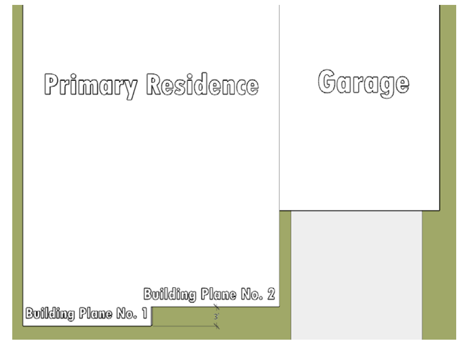
Figure 1 - Building Planes
NOTE: Graphics contained herein are for explanatory purposes only. Graphics may not be to scale and shall not supersede the written standards herein.
f.
No more than two adjacent attached residential units shall be located on the same building line without a change in setback of three (3) or more feet (Refer to Figure 2). This shall only apply to the facades within the front yard.
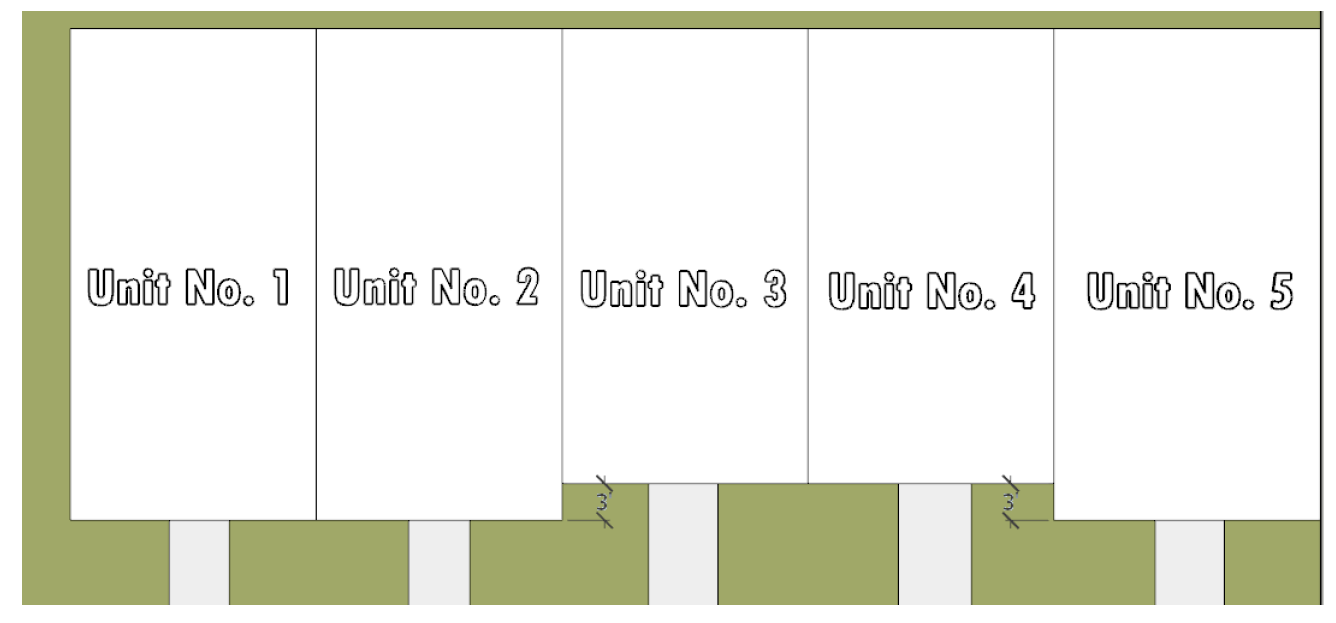
Figure 2 - Attached Unit Setback Variation
D.
Maximum length of structures. No residential structure shall exceed a length of two hundred (200) feet, nor any of the following:
1.
Residences other than single-family detached units shall not have more than six (6) attached units on any horizontal plane in one (1) building.
2.
If a residential structure other than a single-family detached unit exceeds two (2) stories, it shall be limited to a maximum width of four (4) units and a maximum dimension of one hundred twenty (120) feet.
3.
To foster a proportion between lot size and residential unit size, the following minimum standards shall apply to detached single-family residential lots. However, the Commission may vary these standards if mitigation is provided for through creative design, which may include but not is not limited to, second-story setbacks and/or front façade relief.
a.
Single story residential unit. Residential front yard facade width shall not exceed seventy-five (75) percent of the width of the lot. Cul-de-sac lots with curvilinear front yard lot lines shall be measured from the established front yard setback line.
b.
Multi-story residential unit. Residential front yard façade width shall not exceed sixty-five (65) percent of the width of the lot. Cul-de-sac lots with curvilinear front yard lot lines shall be measured from the established front yard setback line.
E.
Maximum height of structures. The city commission, after considering the recommendation from both the planning and zoning board, and city staff, shall determine the appropriate height limitations on an individual development basis after considering the character of the surrounding area, the character of the proposed development and the goals for community development as stated in the city comprehensive plan.
F.
Minimum floor area requirements for residential units located in a PRD or PCD. The minimum floor area, as defined, per dwelling unit shall be as follows:
1.
Detached single-family dwelling: One thousand one hundred fifty (1,150) square feet.
2.
Attached single-family dwelling (RS-6 unit): One thousand one hundred fifty (1,150) square feet.
3.
One-bedroom multifamily, townhouse: Seven hundred fifty (750) square feet.
4.
Each additional bedroom (multifamily, townhouse): One hundred twenty-five (125) square feet.
G.
Site coverage.
1.
The combined ground area occupied by all principal and accessory buildings and enclosed roofed structures within a PRD shall not exceed the following percentages:
a.
Single-family residential lots developed with single-story units shall not exceed forty (40) percent lot coverage on each individual lot.
b.
Single-family residential lots developed with multi-story units shall not exceed thirty-five (35) percent lot coverage on each individual lot.
c.
Townhouse, or similar lots, shall not exceed forty (40) percent lot coverage on each individual lot.
d.
All other lots within a PRD shall not exceed thirty (30) percent lot coverage.
2.
The combined ground area occupied by all principal and accessory buildings and roofed structures within a PCD shall not exceed the following percentages of total land area within the PCD:
3.
Where buildings of different heights are to be constructed, the site coverage shall not exceed the weighted average of the applicable coverages indicated in subsections 1. and 2., above.
H.
PRD general form. PRDs shall comply with the following design requirements:
1.
General community design.
a.
A PRD shall have a defined vision as a well as a design theme or character that addresses a specified market and or lifestyle. This defined vision shall be evident in the development plan, amenity package, architectural design, and model homes.
b.
PRDs shall encourage a diversity of population and households through a range of choices in housing typologies. Where practical, PRDs should be designed to encourage aging-in-place by providing opportunities for growing and aging households. Further, age restricted PRDs shall include universal design elements within the community and proposed housing models, as described by authorities such as the American Planning Association and the Centre for Excellence in University Design, National Disability Authority.
c.
Applicant shall provide a range of lot widths (typologies) to accommodate placement of different shaped and sized homes. Lot typologies should be dispersed throughout a development to avoid distinct areas of solely one lot type. Applicant may instead alternate housing typologies in lieu of providing lot width variation. An alternate housing typology shall mean a change from single-family to multifamily or a similar change. A sole change of housing models within the same typology shall not satisfy this requirement.
d.
Corner lots shall be a point of design emphasis. Residential units placed on a corner lot shall be designed so both the front and side facades enhance the street through commensurate levels of fenestration, architectural treatments, and embellishments.
2.
Streets.
a.
Master plan design shall include a hierarchy of streets including primary, secondary, and tertiary streets within the community. Each street typology shall have a distinct design palette with emphasis on primary streets.
i.
Primary streets shall include a central landscaped median, and a distinctive landscape palette, providing visual emphasis. Alternatively, primary roads may provide widened tree lawns between the curb and adjacent sidewalk. These widened tree lawns shall be a minimum of twelve (12) feet, on average, as measured between the back of the curb and the edge of the adjacent sidewalk. The tree lawn shall be planted with materials to provide shade to the adjacent street and sidewalk at time of maturity.
ii.
Lots shall be designed to front internal primary streets, prohibiting rear yards along internal primary streets. This is not intended to prohibit rear yards along adjacent roadways outside of a community.
3.
Internal circulation. An internal pedestrian and bicycle circulation system consistent with section 130-20, sidewalks, multi-use paths/trails, and bicycle lanes, shall be provided within a planned residential development separate from vehicular circulation systems. Such pedestrian and bicycle ways shall be surfaced with a durable and dustless material.
a.
Except at points of crossing, the required circulation system shall be separated from adjacent roadways by a minimum landscape buffer at least five (5) feet in width.
b.
The required circulation system shall be partially shaded by adjacent trees, at time of plant maturation.
4.
Environmental.
a.
Natural assets and environmentally sensitive areas shall be protected and used as an organizing element for design. Examples include, but are not limited to, areas of mature vegetation.
b.
Water feature and retention areas shall be designed as a prominent feature of a community and shall be distributed throughout a community accordingly.
5.
Gateways.
a.
PRD developments shall be designed with a gateway feature, highlighting the community entrance(s) with a mix of landscape, hardscape, signage, or architectural features. The design shall create a sense of identity, arrival, and prominence.
b.
If a proposed entry feature is less than a two-tenths of a mile to an existing entry feature (as measured along the centerline of the right-of-way), the proposed feature shall be designed to complement the existing entry feature. The proposed feature shall acknowledge and respond to the existing feature in terms of design cues and physical form.
c.
When a residential gateway feature integrates signage with enhanced, interactive design features such as water-walls, the gateway signage shall not be limited to the height of six (6) feet prescribed in subsection 100-1510.A.4.a. However, in no case shall the letter height or sign area exceed the maximums stated in section 100-1550 without a variance.
d.
To ensure guardhouses and entry features are completed concurrently with residential dwelling units, the applicant shall provide a construction schedule outlining completion milestones, approved by the city at the time of site plan approval for said features.
i.
The city shall allocate building permits for units approved in the PRD site plan in the following manner to ensure guardhouses and entry features are completed concurrently with the build-out of a community;
ii.
No more than twenty-five (25) percent of residential building permits shall be issued until all approved guardhouses are complete and operational.
iii.
No more than fifty (50) percent of residential building permits shall be issued until all approved entrance features are complete, and operational if applicable.
iv.
Should established and approved milestones not be met, the city shall have the discretion to withhold future building permits until such a time that the required improvements have been completed.
6.
Required recreation amenities. Each PRD of record shall be required to provide recreational amenities within its own community for the enjoyment of residents. While joint access may be provided between multiple communities as an added benefit, each PRD shall be required to provide its own recreational amenities that satisfy the requirements herein. At the time of initial site plan approval, an applicant shall identify the proposed programming/use of the recreation parcel(s).
a.
Common areas and recreation facilities shall be located to be readily and equitably accessible to all residents of a community. As such, common open spaces shall be distributed throughout a proposed development.
b.
Each PRD community developed under unified control shall be required to provide all of the following amenities, in scale with the community size:
i.
Clubhouse facility at a minimum rate of twenty (20) square feet per residential unit - measured by air-conditioned area.
ii.
Swimming pool.
iii.
Athletic courts and/or fields.
iv.
Passive and active recreation options.
v.
Activity options for all ages and abilities. If a PRD is age restricted, activity options shall be designed accordingly and need not include all age ranges.
c.
Recreation facility construction schedule. To ensure completion of the required PRD clubhouse and recreation amenities, the applicant shall provide a construction schedule outlining completion milestones, approved by the city at the time of site plan approval. This schedule shall identify all improvements required by section 10-4050.H.6, required recreation amenities.
i.
The city shall allocate building permits for units approved in the PRD site plan in the following manner to ensure the stated amenities are completed prior to build-out of a community:
ii.
No more than twenty (20) percent of building permits may be issued prior to installation of all water and sewer infrastructure and commencement of vertical construction.
iii.
No more than fifty (50) percent of all building permits may be issued prior to completion of site grading and completion of the clubhouse building shell (including roof, tiles, windows, and doors).
iv.
No more than seventy-five (75) percent of all building permits may be issued prior to completion of all clubhouse and recreation improvements shown on the approved site plan.
v.
Should established and approved milestones not be met, the city shall have the discretion to withhold future building permits until such a time that the required improvements have been completed.
I.
Off-street parking and loading requirements. Off-street parking and loading for PRDs and PCDs shall be provided in compliance with article 90, as may be amended, except as modified herein.
1.
Parking for clubhouse and recreation facilities shall be provided at the greater rate of one (1) parking space per every four (4) dwelling units within a PRD; or one (1) space per every fifty (50) square feet of any open-area assembly area within the clubhouse facility. Should multiple clubhouse or recreation facilities be proposed within a single PRD, the applicant shall coordinate with the city to determine distribution of these required parking spaces based on the proposed design programming. An applicant may be permitted to submit a parking study for consideration by the city to assess a potential reduction in required clubhouse parking.
2.
If community mailboxes are not located on the recreation parcel, they shall be distributed throughout the community as permitted by the USPS. Each mailbox area shall be designed with a minimum of two (2) adjacent designated parking spaces; or a designated pull-off area capable of accommodating a minimum of two (2) cars, in addition to the USPS required space dedication for postal trucks.
3.
All other parking standards outlined in article 90 shall apply. In the event of conflicting standards, parking regulations contained herein shall take precedence.
J.
Landscaping.
1.
Landscaping shall be provided in compliance with article 95. The city commission may require that additional landscaping be provided in unique situations.
2.
The planned development should have an overall landscaping scheme that should be practical and aesthetically functional. Plant material should be used to accomplish the design objectives of the planned development, help define the character of open spaces, and identify routes of movement. Plant materials should be native to South Florida and functionally appropriate for shade, shelter and the intended height and mass, texture, color and form. Significant spaces and routes of mobility should have distinctive planting schemes to give identity to these areas.
K.
Underground utilities. Within the planned development, all utilities, including telephone, television cable and electrical systems, shall be installed underground. Primary facilities providing service to the site may be exempted from this requirement. Large transformers shall be placed on the ground and contained within pad mounts, enclosures or vaults. Adequate landscaping with shrubs and plants shall be provided to screen all utility facilities permitted aboveground.
L.
Open space requirements.
1.
A PRD shall provide and maintain pervious open space at least equal to thirty-five (35) percent of the gross area (including all land within the perimeter) of the planned residential development.
a.
For the purposes of this section, open space shall not include the following:
i.
Yards on individual lots or yards that are reserved for the use of an individual property owner; or property that is owned in whole or part by a party other than the HOA or city.
ii.
Dedicated streets, alleys, or other public rights-of-way.
iii.
Vehicular drives, private streets, parking and loading areas, and storage areas.
iv.
Open space or landscaped areas less than one hundred fifty (150) square feet, or with any dimension of less than ten (10) feet.
b.
Areas to be calculated towards the open space requirement shall be physically accessible to all residents and shall not be privatized for the enjoyment of one (1) or a select group of residents.
i.
Water features such as lakes and/or ponds, contributing to open space calculations, shall be partially open and free of residential development on at least one (1) of four (4) sides. This common open area providing visual and physical access to the waterfront shall measure at least two hundred (200) feet in width.
ii.
Water surface areas shall account for no more than fifty (50) percent of the total required open space.
iii.
Parcels designed to accommodate a clubhouse or similar facility shall count toward no more than twenty-five (25) percent of the total required open space.
2.
A planned commercial development (PCD) shall provide and maintain open space at least equal to thirty (30) percent of the gross area (including all land within the perimeter) of the planned commercial development.
M.
Energy conservation. A planned development shall incorporate passive energy conservation in its site design. Such measures shall include, but need not be limited to, the directional orientation of buildings, the location of windows, minimization of radiant heat absorption and the inclusion of energy-efficient landscaping.
N.
Professional services required. Any plans submitted as a part of a petition for a PRD or PCD shall certify that the services of competent professionals were utilized in the designing or planning process and shall state their names and businesses and addresses. Plans must be prepared by either a planner who, by reason of his education and experience, is qualified to become or is a full member of the American Institute of Certified Planners, an architect or landscape architect licensed by the State of Florida, together with a professional engineer registered by the State of Florida and trained in the field of civil engineering and/or professional surveyor and mapper licensed by the State of Florida.
(Ord. No. 2015-09, § 2(Exh. A), 9-21-2015; Ord. No. 2019-007A, § 2(Exh. A), 9-25-2019)
Sec. 10-4060. - Procedures and requirements for rezoning to a PRD or PCD.
A.
Generally. The process for rezoning to PRD or PCD shall be the same as for a rezoning pursuant to article 50, procedures and requirements for rezonings and text amendments to the land development code.
B.
Master plan required. A master plan meeting the requirements of this section shall be required of developments requesting rezoning to PRD or PCD.
C.
Contents of master plan. A master plan shall include the following information:
1.
Delineation of the geographical area covered by the entire development.
2.
General schematic representation of the land uses included within the development.
3.
Approximate delineation of internal circulation with hierarchical classification of streets.
4.
Points of connection of the local streets to the trafficways, including a general indication of the necessary improvements to the trafficway to accommodate the local trips generated by the development.
5.
General location and size of any community facility included within the development, such as parks, schools, fire stations, community centers, etc.
6.
Location of entry features, amenities, clubhouse, and open space; as well as sales center and model row as applicable.
7.
Indication of existing native vegetation and any other natural features within the development.
8.
Schematic depiction of surface water management elements, including retention facilities, drainage easement and swales.
9.
Table of computation of land-use distribution showing proposed uses, acreage and number of units and density in the case of residential uses.
10.
Schematic depiction of the water and wastewater treatment facilities and/or the source of public water and wastewater disposal facilities; general distribution and collection plans within the development, including easements for utility pipelines.
11.
Table of uses to be permitted within a planned commercial district.
12.
Impact analysis report as required in section 35-20, impact analysis report.
13.
Such other information as determined by the planning and zoning director to be relevant to the application.
(Ord. No. 2015-09, § 2(Exh. A), 9-21-2015; Ord. No. 2019-007A, § 2(Exh. A), 9-25-2019)
Sec. 10-4070. - Conformance to approved master development plan and list of permitted uses and densities; modifications.
A.
After rezoning to PRD or PCD, no permits shall be issued by the city, and no development shall commence, unless in conformance with the approved master plan and the approved list of permitted uses, densities and intensities.
B.
Modifications to the approved master development plan are subject to the procedures prescribed in section 30-10, administration; generally applicable procedures, and article 40, site plan procedures.
(Ord. No. 2015-09, § 2(Exh. A), 9-21-2015; Ord. No. 2019-007A, § 2(Exh. A), 9-25-2019)
Sec. 10-4080. - Waivers.
A proposed development shall fully comply with all standards contained in this section and no waivers shall be available. However, this does not preclude an applicant from applying for variances.
(Ord. No. 2015-09, § 2(Exh. A), 9-21-2015; Ord. No. 2019-007A, § 2(Exh. A), 9-25-2019)
Sec. 10-4090. - Effective period of PRD and PCD approval.
Approval of a rezoning to PRD or PCD shall be void after a period of eighteen (18) months following the date of approval unless a building permit for a principal building has been issued and construction has begun. The city commission may grant successive six-month extensions upon an application by the owner or developer which costs shall be borne by the property owner requesting the extension. After the issuance of a building permit for a principal building and after construction has begun, the PRD or PCD approval shall remain in effect until the completion of the development; provided, however, that the PRD or PCD approval shall expire with respect to portions of the development for which construction has not commenced if there are no active building permits for principal buildings in effect for the development for a consecutive period in excess of one (1) year.
(Ord. No. 2015-09, § 2(Exh. A), 9-21-2015; Ord. No. 2019-007A, § 2(Exh. A), 9-25-2019)
Sec. 10-4100. - Maintenance obligations.
The applicant for a PRD or PCD shall provide for the landscaping and continued maintenance of all common areas and abutting swales and medians in abutting rights-of-way through restrictive covenants which burden the land subject to the PRD or PCD and/or such perpetual maintenance agreements as determined necessary by the city. Notwithstanding any failure of the city to require such agreements, the applicant and its successors and assigns, including a homeowners or property owners association governing the property subject to the PRD or PCD, shall be deemed to be responsible for maintenance of all common areas and abutting swales and medians and all approved landscaping in good condition.
(Ord. No. 2015-09, § 2(Exh. A), 9-21-2015; Ord. No. 2019-007A, § 2(Exh. A), 9-25-2019)
Sec. 10-4500.- Purpose of districts.
A.
B-1 district. The B-1 neighborhood business district is intended primarily to meet the local neighborhood shopping, retail and personal service needs of a limited surrounding residential area. Retail stores permitted herein are intended to include primarily specialized and convenience goods, and personal services uses allowed herein are intended to meet the daily needs of residents of the city's residential communities.
B.
B-2 district. The B-2 community business district is intended primarily to meet the shopping and personal service needs of several neighborhoods or a substantial territory. B-2 districts may be located along traffic arteries or in concentrated shopping centers.
C.
B-3, BCB-3 districts. The B-3 general business district and Broward County B-3 (BCB-3) general business district are intended to apply to arterial streets and trafficways where business establishments primarily not of a neighborhood or community service type may properly locate to serve large sections of the city and metropolitan area. Such businesses generally require considerable ground area, do not cater directly to pedestrians and need a conspicuous and accessible location convenient for motorists. Property zoned Broward County B-3 retains its pre-annexation zoning designation only with regard to specific rights as set forth in a settlement agreement recorded in Office of Records Book 29272, Pages 1650 through 1699 of the Broward County, Florida Public Records, and are otherwise subject to the provisions of this chapter.
D.
OP district. The OP office park district is intended to provide areas within the city for the exclusive development of professional offices, office parks and financial centers.
E.
S-1 district. The S-1 self-storage district is intended to provide areas within the city for the exclusive development of self-storage facilities.
(Ord. No. 2015-09, § 2(Exh. A), 9-21-2015; Ord. No. 2023-006, § 3, 6-21-2023)
Sec. 10-4505. - Uses permitted.
No building or structure or any part thereof shall be erected, altered or used or land or water used, in whole or in part, for other than one (1) or more of those specified as permitted, special exception or accessory within a particular zoning district in table 10-4505.1, permitted uses and master business. Permitted uses within the BCB-3 District are the same as the B-3 permitted uses in table 10-4505.1, as well as the Broward County Zoning Code B-3 uses specifically authorized in a settlement agreement recorded in Office of Records Book 29272, Pages 1681 through 1699 of the Broward County, Florida Public Records.
A.
Where the letter "P" appears on the same line as a listed use, said use shall be permitted in the district as indicated by the column heading in which the letter "P" appears.
B.
Where the symbol "≠" appears on the same line as a listed use, said use shall be prohibited in the district as indicated by the column heading in which the symbol "≠" appears.
C.
Where the letter "A" appears on the same line as a listed use, the listed use is permitted only as an accessory use to a primary permitted use.
D.
Where the letters "SE" appear on the same line as a listed use, the use shall be permitted only by special exception approval in the district as indicated by the column heading in which the letters "SE" appears. Such approval shall only be granted after the applicant has complied with the requirements for special exception uses pursuant to article 60, special exception uses.
E.
Unlisted uses.
1.
The planning and zoning director may authorize as a permitted use, a use that is unlisted in table 10-4505.1, but which is substantially similar in character, impact and compatibility to a listed permitted use within the applicable zoning district.
2.
The planning and zoning director may authorize the processing of a special exception use application for a use that is unlisted in table 10-4505.1, but which is substantially similar in character, impact and compatibility to a listed special exception use within the applicable zoning district.
3.
If a use is not listed as a permitted or special exception use in table 10-4505.1, and is not determined by the planning and zoning director to be an accessory use or a use that is substantially similar to a listed use pursuant to subsections 1. and 2., it shall be deemed a prohibited use, except as provided in paragraph 4., below.
4.
Any use permitted by the city land use plan within the commercial or office park land use categories not listed in table 10-4505.1 (or the supplemental regulations) as permitted, special exception or prohibited, and which the planning and zoning director determines is not substantially similar to a listed permitted or special exception use in any zoning district shall be considered a special exception use within the B-3 zoning district, in accordance with article 60 of this chapter.
Table 10-4505.1, PERMITTED USES AND MASTER BUSINESS LIST
(Ord. No. 2015-09, § 2(Exh. A), 9-21-2015; Ord. No. 2016-09, § 2, 9-21-2016; Ord. No. 2019-001B, § 2, 9-25-2019; Ord. No. 2023-006, § 4, 6-21-2023)
Sec. 10-4510. - Reserved.
Editor's note— Sec. 2 of Ord. No. 2019-001B, adopted Sept. 25, 2019, deleted § 10-4510, which pertained to supplemental regulations to master business list, and derived from Ord. No. 2015-09, adopted Sept. 21, 2015; and Ord. No. 2016-09, adopted Sept. 21, 2016.
Sec. 10-4515. - Generally applicable limitations on uses.
A.
Outdoor activities restricted. All activities of nonresidential permitted uses, including, but not limited to, sale, display preparation and storage, shall be conducted entirely within an enclosed building except for automobile parking lots, loading zones, drive-through windows, garden centers, accessory outdoor dining, outdoor playgrounds or recreation, service stations, and any principal or accessory use permitted in this chapter that the planning and zoning director determines inherently requires a portion of its activity to take place outdoors.
B.
Secondhand merchandise. No secondhand or used merchandise shall be offered for sale, displayed or stored except as specifically permitted herein.
C.
Operation of any business after 11:00 p.m. and before 7:00 a.m. is prohibited unless the city commission first grants a special exception permit to allow a business to operate later. For all businesses, any such special exception permit shall be specific to the owner and operator of the business that are the subject of the permit application, and not transferable.
(Ord. No. 2015-09, § 2(Exh. A), 9-21-2015; Ord. No. 2016-13, § 2, 1-4-2017; Ord. No. 2019-001B, § 2, 9-25-2019)
Sec. 10-4520. - Site development standards and dimensional requirements for B-1, B-2, B-3, S-1, BCB-3 and OP zoning districts.
Table 10-4520.1 provides the dimensional requirements regarding lot width and depth, lot coverage, building setbacks and building height for the B-1, B-2, B-3, S-1, BCB-3 and OP zoning districts.
Footnotes:
1.
Where a lot of record existed at the effective date of September 20, 1989 (Ord. 89-19), which has less than the required width or depth, said lot may be developed as otherwise provided in this chapter.
2.
Subject to section 10-4545, unified control, and section 10-4555, outparcels.
3.
Where permitted, residential uses shall not exceed fifty (50) percent of the gross floor area of any structure.
(Ord. No. 2019-001B, § 2, 9-25-2019; Ord. No. 2023-006, § 5, 6-21-2023)
Editor's note— Sec. 2 of Ord. No. 2019-001B, adopted Sept. 25, 2019, amended § 10-4520 in its entirety to read as herein set out. Former § 10-4520, pertained to height, and derived from Ord. No. 2015-09, adopted Sept. 21, 2015.
Sec. 10-4525. - Reserved.
Editor's note— Sec. 2 of Ord. No. 2019-001B, adopted Sept. 25, 2019, deleted § 10-4525, which pertained to lot dimensions, and derived from Ord. No. 2015-09, adopted Sept. 21, 2015.
Sec. 10-4530. - Reserved.
Editor's note— Sec. 2 of Ord. No. 2019-001B, adopted Sept. 25, 2019, deleted § 10-4530, which pertained to setbacks, and derived from Ord. No. 2015-09, adopted Sept. 21, 2015.
Sec. 10-4535. - Reserved.
Editor's note— Sec. 2 of Ord. No. 2019-001B, adopted Sept. 25, 2019, deleted § 10-4535, which pertained to lot coverage, and derived from Ord. No. 2015-09, adopted Sept. 21, 2015.
Sec. 10-4540. - Reserved.
Editor's note— Sec. 2 of Ord. No. 2019-001B, adopted Sept. 25, 2019, deleted § 10-4540, which pertained to open space, and derived from Ord. No. 2015-09, adopted Sept. 21, 2015.
Sec. 10-4545. - Unified control.
All developments which are developed and maintained under unified control and which are managed by a property owners' association responsible for the management and maintenance of the entire development, and the form of the property owners' association approved by the city commission, shall be treated as one (1) development lot for the purpose of applying the requirements of this article regardless of whether portions of the development are owned by persons other than the original owner/developer.
(Ord. No. 2015-09, § 2(Exh. A), 9-21-2015)
Sec. 10-4550. - Strip shopping centers prohibited.
Commercial development shall not be designed or developed as strip shopping centers, as defined in section 5-3530, terms defined, and shall specifically be designed to avoid the appearance, function, and layout of a strip shopping center. In all commercial developments, designs which provide only a straight row of stores/restaurants/office or other establishments and do not create or contain design elements distinguishing the development from a strip center shall be prohibited. Design elements creating an atmosphere which encourages pedestrian usage shall be required. Retail stores/restaurants/office and other establishments shall be designed not in straight rows, but in other configurations such as clusters around plazas or face to face configurations to facilitate easy pedestrian usage and interaction between uses and a sense of a village atmosphere. The use of plazas integrating the various stores/restaurants/office or other establishments shall be an essential element to create the village atmosphere. Big box retail establishments are determined to be inconsistent with the goals of this section and are restricted in accordance with the regulations of this article.
(Ord. No. 2015-09, § 2(Exh. A), 9-21-2015)
Sec. 10-4555. - Outparcels.
Outparcels shall be designed to be compatible with the parent tract through cohesive landscape and architectural design. The city's landscape architect shall have the discretion to reduce the perimeter landscape requirements of section 95-1515 along common lot lines shared between the parent tract and outparcel based upon site specific context and design.
(Ord. No. 2015-09, § 2(Exh. A), 9-21-2015; Ord. No. 2019-001A, § 5(Exh. D), 9-25-2019)
Sec. 10-5010.- Purpose.
The I-1 light industrial district is intended primarily for the manufacture, processing and assembly of articles and products not involving the use of any hazardous or noxious materials, processes or machinery likely to cause undesirable effects upon nearby or adjacent residential or business property.
(Ord. No. 2015-09, § 2(Exh. A), 9-21-2015)
Sec. 10-5020. - Permitted uses.
A.
No building or land shall be used, and no building shall be erected, constructed, reconstructed or structurally altered which is designed, arranged or intended to be occupied or used for any purpose other than for one (1) or more of the following:
1.
The manufacture or processing of such refined consumer products as bakery goods, candies, cosmetics, dairy products, drugs, pharmaceuticals and food products unless otherwise prohibited.
2.
The manufacturing, compounding, assembling or treatment of articles or merchandise from the following previously prepared materials: Bone, cellophane, canvas, cloth, cork, feathers, fur, felt, fiber, glass, horn, hair, leather, paper, plastics, precious and semiprecious metals or stones, shells, textiles, tobacco, wood (except planing mills) and yarn.
3.
The manufacture of pottery and figurines or other ceramic products using only previously pulverized clay and kiln-fired only by electricity or gas.
4.
Manufacture and assembly of metal products, including electroplating.
5.
Manufacture of musical instruments or toys, novelties, notions, and rubber and metal stamps.
6.
Machine shops.
7.
Assembly of electrical appliances, electronic instruments and devices, radio, television and photographs, including the manufacturing of small parts, such as coils, condensers, transformers, crystal holders and the like.
8.
Agricultural uses until converted to an urban use.
9.
Ice manufacturing and distributing.
10.
Boat manufacturing; boat and marine motor sales and service.
11.
Laundry and dry-cleaning plants.
12.
Storage warehouses.
13.
Wholesale establishments.
14.
Crematory.
15.
Restaurants accessory to the primary industrial use (located within a primary industrial building with external signage for restaurant).
16.
Building contractor offices and supplies.
17.
Home appliance repair; printing shop; locksmith; sharpening and grinding shop; radio, television and electronics repair; newspaper-printing plant.
18.
Taxi service establishment.
19.
New and used automobile, truck and trailer display, sales and repair; repair and service garage, including bumping and painting, auto laundry.
20.
Hatchery, fish or fowl.
21.
Sign painting, glass and mirror shop, awning and canvas shop, furniture repair shop.
22.
Milk-distributing stations.
23.
Diaper and linen services.
24.
Tire and battery store, retail plumbing and electrical fixtures, lawnmower rental, sales and service; boat and marine motor sales and service, upholstery shop.
25.
Pumps and wells, retail and wholesale.
26.
Taxidermist, research and testing laboratory, pest-control agency.
27.
Machinery sales, storage and repair.
28.
Wreckers, building and automobile.
29.
Accessory uses and structures.
30.
Major office employment centers. Major office employment center means an area designated on the comprehensive plan's future land use map as a location for employment and economic development.
31.
All uses permitted in an OS open space district.
32.
Essential services.
(Ord. No. 2015-09, § 2(Exh. A), 9-21-2015)
Sec. 10-5030. - Special exception uses.
The following uses may be permitted in an I-1 district at the discretion of the city commission in accordance with the requirements of article 60, special exception uses:
A.
Parks and open spaces.
B.
Educational or vocational institutions.
C.
Libraries.
D.
Government administration, services and maintenance facilities.
E.
Police and fire-protection facilities.
F.
Public and private utilities.
G.
Day care centers.
H.
Office and retail uses subject to the restrictions of the comprehensive plan (permitted uses in industrial areas).
I.
Medical marijuana dispensaries, unless prohibited under federal law.
J.
All uses permitted in a CR district.
K.
All uses permitted in a U district.
L.
All uses involving exterior storage of goods or products, except storage of motor vehicles used in the operation of the primary authorized use of the premises.
M.
All uses not specifically permitted in section 10-5020, permitted uses, which are determined by the planning and zoning director to be consistent with the industrial land use category of the city land use plan.
N.
Any business that operates after 9:00 p.m. Operation of any business after 9:00 p.m. is prohibited unless the city commission first grants a special exception permit to allow a business to operate later. Any such special exception permit shall be specific to the owner and operator of the business that are the subject of the permit application, and not transferable.
(Ord. No. 2015-09, § 2(Exh. A), 9-21-2015; Ord. No. 2016-21, § 2, 1-4-2017)
Sec. 10-5040. - Development standards.
A.
Utility transmission lines, etc. All utility transmission lines, conduits, conveyances or other devices or apparatus for the transmission of utility services and products, including all franchised utility services and products, shall be constructed and installed beneath the surface of the ground with the exception of a main feeder line.
B.
Off-street loading. In no instance shall off-street loading facilities front onto a public street and in no event shall these facilities front or face onto a public street or property which is zoned or designated for residential use.
C.
Lot coverage. Lot coverage shall not exceed forty-five (45) percent.
D.
Open space. Each lot to be developed shall contain a minimum of thirty (30) percent pervious open space.
E.
Building height. No building or structure shall exceed fifty (50) feet in height.
F.
Distance between buildings. Where two (2) or more separate buildings are erected or placed on the same plot, there shall be a minimum distance of twenty-five (25) feet or one-half (½) the height of the tallest building, whichever is greater, between buildings on the same plot.
G.
Setbacks. Minimum building and structure setbacks shall be provided as follows:
1.
A minimum setback of one hundred (100) feet is required from the street line of all trafficways other than the Sawgrass Expressway, and from property zoned, used or designated on the land use plan map for residential use.
2.
Twenty-five (25) feet from a street line other than a trafficway, and from a lot that is zoned or designated on the land use plan for nonresidential use.
3.
The setback requirements of this subsection are subject to yard encroachments authorized under section 20-30, yard encroachments.
H.
Minimum lot size. The minimum lot size in an I-1 district shall be one (1) acre.
I.
Machinery. All machinery other than motor vehicles shall be operated within a fully enclosed building.
(Ord. No. 2015-09, § 2(Exh. A), 9-21-2015)
Sec. 10-5050. - Unified control.
All developments which are developed and maintained under unified control and which are managed by a property owner's association responsible for the management and maintenance of the entire development, and the form of the property owner's association is approved by the city commission, shall be treated as one (1) development lot for the purpose of applying the requirements of this article regardless of whether portions of the development are owned by persons other than the original owner/developer.
(Ord. No. 2015-09, § 2(Exh. A), 9-21-2015)
Sec. 10-5510.- Purpose of district.
The CF community facilities district is intended for schools, public and private institutions, and other facilities which generally benefit the community and which have unusual or unique locational requirements.
(Ord. No. 2015-09, § 2(Exh. A), 9-21-2015)
Sec. 10-5520. - Uses permitted.
No building or structure or part thereof shall be erected, altered or used or land or water used, in whole or in part, for other than one (1) or more of the following specified uses:
A.
Parks and open spaces.
B.
Educational or vocational institutions.
C.
Places of worship.
D.
Libraries.
E.
Government administration.
F.
Police and fire-protection facilities.
G.
Public and private utilities.
H.
Day care centers.
I.
Essential services.
J.
The following uses if first approved as a special exception use (see article 60, special exception uses):
1.
Assisted living facilities.
2.
Cemeteries and mausoleums.
3.
Hospitals or clinics.
4.
Services and maintenance facilities.
K.
Accessory uses, including portable/temporary storage units subject to section 15-1510, portable/temporary storage units.
(Ord. No. 2015-09, § 2(Exh. A), 9-21-2015)
Sec. 10-5530. - Height.
No building or structure shall be erected or altered to a height exceeding forty-five (45) feet unless the city commission grants a special exception for total height not to exceed fifty-five (55) feet.
(Ord. No. 2015-09, § 2(Exh. A), 9-21-2015)
Sec. 10-5540. - Open space.
Each lot shall contain a minimum of thirty-five (35) percent pervious open space.
(Ord. No. 2015-09, § 2(Exh. A), 9-21-2015)
Sec. 10-5550. - Size of plot.
Every lot shall not be less than one hundred (100) feet in width and twenty thousand (20,000) square feet in area.
(Ord. No. 2015-09, § 2(Exh. A), 9-21-2015)
Sec. 10-5560. - Setbacks.
Every lot upon which a building or structure is erected in a CF district shall have minimum setbacks in as follows:
A.
Adjacent to any trafficway, a yard of at least seventy-five (75) feet in width shall be provided.
B.
Adjacent to any street, excluding trafficways, a yard of at least twenty-five (25) feet in width shall be provided.
C.
A rear yard of at least twenty (20) feet in width shall be provided when not abutting a trafficway or other street.
D.
A side yard of at least ten (10) feet in width shall be provided when not abutting a trafficway or other street. Any building in excess of fifteen (15) feet in height, as measured from the first-floor finished grade of the building to the highest point of the building, shall provide at least an additional two (2) feet of side yard for every ten (10) feet or fraction thereof in additional height.
E.
Section 20-30, yard encroachments, provides for certain encroachments into the yards required in this section.
(Ord. No. 2015-09, § 2(Exh. A), 9-21-2015)
Sec. 10-6010.- Purpose of district.
The OS recreation/open space district is intended for outdoor sports and recreational activities in which the participants are actively engaged, but which may also provide entertainment for spectators, but which activities are not of a commercial, profit-making nature. The activities for which the OS district is provided are normally and primarily conducted in the open air while related accessory uses may be in the open air or in a building or structure. The functional characteristics of an OS district may require its location within or in close relationship to residential areas, public recreational areas or scenic areas. Because of the nature of uses involved and the variety of arrangements of uses and facilities on the site plan of development, broad general regulations for lot size, yards, setbacks and height must be adequate for any location at which an OS district may be established.
(Ord. No. 2015-09, § 2(Exh. A), 9-21-2015)
Sec. 10-6020. - Uses permitted.
No building or structure or part thereof shall be erected, altered or used or land or water used, in whole or in part, for other than one (1) or more of the following specified uses:
A.
Active and passive outdoor recreation facilities.
B.
Recreation, civic or cultural buildings accessory to a primary recreation use.
C.
Golf courses integral to a development and intended to be retained as permanent open space.
D.
Accessory uses and structures.
E.
Essential services.
(Ord. No. 2015-09, § 2(Exh. A), 9-21-2015)
Sec. 10-6030. - Uses prohibited.
The permissible uses enumerated in section 10-6020, uses permitted, shall not be construed to include, either, as a principal or accessory use, any business or commercial use not permitted as a principal use except when meeting requirements of an accessory use.
(Ord. No. 2015-09, § 2(Exh. A), 9-21-2015)
Sec. 10-6040. - Height.
No building or structure or part thereof shall be erected or altered to a height exceeding forty-five (45) feet unless the city commission determines that additional height is compatible with the adjacent area, as defined in section 20-190, compatibility and consistency.
(Ord. No. 2015-09, § 2(Exh. A), 9-21-2015)
Sec. 10-6050. - Lot size.
Every lot shall be not less than one hundred (100) feet in width and ten thousand (10,000) square feet in area.
(Ord. No. 2015-09, § 2(Exh. A), 9-21-2015)
Sec. 10-6060. - Open space.
Each lot shall contain a minimum of thirty-five (35) percent pervious open space.
(Ord. No. 2015-09, § 2(Exh. A), 9-21-2015)
Sec. 10-6070. - Setbacks.
A.
No structure shall be located within fifty (50) feet of any residentially zoned property, nor within seventy-five (75) feet of the right-of-way line of a trafficway, nor within twenty-five (25) feet of any other street line, except as provided in subsection C.
B.
No building or roofed portion of any structure shall be located within twenty-five (25) feet of any other lot line.
C.
No required open space, yard or setback area shall be used or developed for any purpose other than for landscaping, fences or walls, lighting, and for the minimum amount of walkways and/or driveways and parking areas reasonably necessary to serve the permitted OS district uses. Section 20-30, yard encroachments, authorizes certain additional encroachments into the yards required in this section.
(Ord. No. 2015-09, § 2(Exh. A), 9-21-2015)
Sec. 10-6510.- Purpose of district.
The U utilities district is intended to implement the utilities classification of the city land use element by providing areas for the location and expansion of water, wastewater, communication and power facilities and solid waste disposal sites.
(Ord. No. 2015-09, § 2(Exh. A), 9-21-2015)
Sec. 10-6520. - Uses permitted.
No building or structure or part thereof shall be erected, altered or used or land or water used, in whole or in part, for other than one (1) or more of the following specified uses:
A.
Municipal water and wastewater treatment plants.
B.
Pumping stations.
C.
Substations and major transmission lines.
D.
Solid waste transfer sites.
E.
Radio, television, telephone or other communication transmitting, receiving or relay station, structure, tower or dish antenna.
F.
Public or private utility maintenance facilities.
G.
Accessory uses and structures.
H.
Parking for adjacent uses.
I.
Any use permitted in an OS district.
(Ord. No. 2015-09, § 2(Exh. A), 9-21-2015)
Sec. 10-6530. - Height.
No building or structure or part thereof shall be erected or altered to a height exceeding fifty (50) feet, except communication towers, which are subject to the height limitation in article 150, telecommunication towers and antennas.
(Ord. No. 2015-09, § 2(Exh. A), 9-21-2015)
Sec. 10-6540. - Lot size.
There is no minimum lot size requirement.
(Ord. No. 2015-09, § 2(Exh. A), 9-21-2015)
Sec. 10-6550. - Lot coverage.
The lot coverage shall not exceed forty (40) percent.
(Ord. No. 2015-09, § 2(Exh. A), 9-21-2015)
Sec. 10-6560. - Setbacks.
Every lot upon which a building or structure is erected in a U district shall have minimum setbacks in accordance with the following:
A.
Adjacent to any trafficway, a setback of at least seventy-five (75) feet shall be provided.
B.
Adjacent to any public or private street other than a trafficway or from any property line, a setback of at least twenty-five (25) feet shall be required.
C.
Notwithstanding anything to the contrary contained herein, when abutting residentially zoned or designated property, the setback from the abutting property line shall be increased by at least one (1) foot for every two (2) feet of building or structure height over twenty-five (25) feet.
D.
Section 20-30, yard encroachments, authorizes certain encroachments into the yards required in this section.
(Ord. No. 2015-09, § 2(Exh. A), 9-21-2015)
Sec. 10-6570. - Special landscaping and screening requirement.
In addition to the landscaping and screening requirements contained elsewhere in this chapter, all utility uses shall provide landscaping on the perimeter of the property sufficient to fully screen a structure of at least twenty-five (25) feet in height from an adjacent lot with residential zoning or land use designation, or from a public or private street.
(Ord. No. 2015-09, § 2(Exh. A), 9-21-2015)
Sec. 10-7010.- Purpose of district.
The CR commercial recreation district is intended for outdoor and indoor recreational facilities of a commercial, profit-making nature. The activities for which the CR district is provided are primarily recreational in nature, either passive or active, but may include other activities which support and are ancillary to the primary recreation use.
(Ord. No. 2015-09, § 2(Exh. A), 9-21-2015)
Sec. 10-7020. - Uses permitted.
No building or structure or part thereof shall be erected, altered or used or land or water used, in whole or in part, for other than one (1) or more of the following uses:
A.
Outdoor and indoor recreation facilities, including, but not limited to, golf courses, tennis clubs, sports arenas and other outdoor and indoor recreational uses consistent with the city's land use plan. Operation of any business after 11:00 p.m. uses is prohibited unless the city commission first grants a special exception permit pursuant to article 60 to allow a business to operate later. Any such special exception permit shall be specific to the owner and operator of the business that are the subject of the permit application, and not transferable.
B.
Accessory uses and structures.
C.
Hotels ancillary to a primary recreation use.
D.
All uses permitted in an OS district.
(Ord. No. 2015-09, § 2(Exh. A), 9-21-2015)
Sec. 10-7030. - Height.
No building or structure or part thereof shall be erected or altered to a height exceeding fifty (50) feet, unless the city commission grants a special exception pursuant to article 60 to allow a total height not to exceed seventy-five (75) feet.
(Ord. No. 2015-09, § 2(Exh. A), 9-21-2015)
Sec. 10-7040. - Lot size.
Every lot shall not be less than one hundred (100) feet in width and ten thousand (10,000) square feet in area.
(Ord. No. 2015-09, § 2(Exh. A), 9-21-2015)
Sec. 10-7050. - Open space.
Each lot shall contain a minimum of thirty-five (35) percent pervious open space.
(Ord. No. 2015-09, § 2(Exh. A), 9-21-2015)
Sec. 10-7060. - Setbacks.
The following are minimum setback requirements:
A.
No parking area shall be located within twenty-five (25) feet of any residentially zoned property nor within twenty-five (25) feet of any street line.
B.
No building or structure, except as provided in subsection D., shall be located within twenty-five (25) feet of any residentially zoned property, seventy-five (75) feet of the street line of a trafficway, or within twenty-five (25) feet of any other street.
C.
No building or roofed portion of any structure shall be located within twenty-five (25) feet of any lot line.
D.
No required open space, yard or setback area shall be used or developed for any purpose other than for landscaping, fences or walls, and parking areas subject to the restriction of subsection (A) above, and for a minimum amount of walkways and/or driveways reasonably necessary to serve the permitted CR district uses. Section 20-30, yard encroachments, authorizes certain additional encroachments into the yards required in this section.
(Ord. No. 2015-09, § 2(Exh. A), 9-21-2015)
Sec. 10-7510.- Purpose of district.
The conservation district is intended to protect natural functions of environmentally sensitive land and other open space which the city determines is appropriate for protection from development. No construction is permitted in these areas except for minimal structures and improvements required to provide safe access and essential support functions for permitted uses.
(Ord. No. 2015-09, § 2(Exh. A), 9-21-2015)
Sec. 10-7520. - Uses permitted.
The uses permitted within the conservation district include:
A.
Properties dedicated to wildlife management.
B.
Wetland and upland mitigation areas and banks.
C.
Natural resources based parks such as wildlife sanctuaries, feeding stations, nature centers, trails, outdoor research stations, walkways or aquifer recharge areas.
D.
Environmental restoration/preservation.
E.
Accessory uses which support the above uses.
(Ord. No. 2015-09, § 2(Exh. A), 9-21-2015)
Sec. 10-7530. - Lot coverage.
Lot coverage shall not exceed five (5) percent. Only structures which support the purposes of the district or necessary utilities shall be permitted.
(Ord. No. 2015-09, § 2(Exh. A), 9-21-2015)
Sec. 10-7540. - Floor area ratio.
The floor area ratio shall not exceed 0.05 (five (5) percent of the lot area).
(Ord. No. 2015-09, § 2(Exh. A), 9-21-2015)
Sec. 10-7550. - Height.
No building or structure or part thereof shall be erected or altered to a height exceeding twenty-five (25) feet.
(Ord. No. 2015-09, § 2(Exh. A), 9-21-2015)
Sec. 10-8010.- Purpose of district and applicability.
For the purpose of encouraging, maintaining, and promoting ownership and equestrian activities within the city limits, in keeping with the best management practices associated with equestrian activity, which include stables, rings or other facilities, and the residential character of the district, the city commission hereby creates the Parkland Equestrian District by adoption of the following map (a full-size copy is maintained in the city clerk's office). Such equestrian district shall be amended from time to time to encourage further areas of the city to be included in the Parkland Equestrian District, and to provide specific regulations to implement the district.
(Ord. No. 2015-09, § 2(Exh. A), 9-21-2015)
Table 10-1: Permitted Use Table, Residential Districts 1, 2, 3
Key: P - Permitted SE - Special Exception 4 en; ≠ - Prohibited 3 A - Permitted as an Accessory Use
(Ord. No. 2019-001B, § 9, 9-25-2019)
Table 10-2: Dimensional Use Regulations, Residential Districts
Sec. 10-8505.- Definitions.
For the purposes of this division, the following words and phrases shall have the meanings herein set forth when not inconsistent with the context:
Alcoholic beverages means all beverages containing more than one-half (½) of one (1) percent of alcohol by weight, including beer and wine.
Alcoholic beverage establishment means any business, operation, place or premises, other than a private residence or a full-service restaurant, where alcoholic beverages are sold or dispensed for consumption by customers, patrons or members on the premises. Establishments that provide only snack foods or prepackaged foods incidental to consumption of alcoholic beverages on the premises shall be considered alcoholic beverage establishments.
Amphitheater means an open-air venue designed for entertainment, performances. and events, typically featuring a central stage area, and may be surrounded by tiered seating. Amphitheaters may host a variety of events including concerts, theater productions, and community gatherings.
Amusements/recreation enterprises (indoor) means a privately operated commercial use that is conducted wholly in an enclosed structure, and that involves one (1) or more recreational activities for a fee.
Amusements/recreation enterprises (outdoor) means a privately operated commercial use that is conducted wholly or partially in an unenclosed area, and that involves one (1) or more recreational activities for a fee.
Entertainment includes, but is not limited to, live or pre-recorded performances, activities for participants, and amusement devices.
Entertainment venue means a place of assembly that charges patrons a fee to attend each scheduled program or performance, whereby the total number of people admitted to each program or performance does not exceed the seating capacity of the venue as approved by the fire marshal. Examples include, but are not limited to, theaters and comedy clubs. Entertainment venues may serve food and beverages.
Event venue means a facility available for rent by private parties to accommodate private functions, and is not open to the general public. The facility may include kitchen facilities for the preparation of food for consumption on-site. Private functions can include, but are not limited to, banquets, weddings, anniversaries, and other similar celebrations.
Grocery store means an establishment primarily selling groceries and household dry goods and having no more than twenty-five thousand (25,000) square feet of gross floor area; and the ability to possess a license for package sales issued by the state division of beverages and tobacco for alcoholic beverage consumption off-premises.
Instructional studio means an establishment where instruction in a specific discipline or hobby is provided as the primary use, such as painting, photography, music, cooking, and other similar areas of instruction which are conducted in either or both group or individual instruction sessions or lessons. An instructional studio is not a public or private school and does not include sports training or instruction.
Mobile vendor means a person or business that sells food, beverage, goods or services from a vehicle, cart, or other mobile equipment that can be moved around, including, but not limited to, mobile food dispensing vehicles as defined in Section 509.102, Fla. Stat.
Pack and ship facilities means an establishment offering packing and shipping services including FedEx, U.P.S. or similar pack-and-ship facilities. May include ancillary copying, printing, and notary services.
Regular programming means the daily provision of amplified or nonamplified ambient music or sounds, live performances, street performers and the like, outdoors at sound levels that do not inhibit conversation.
Restaurant, fast food means an establishment that offers quick food service, which is accomplished through a limited menu of items already prepared and held for service, or quickly prepared, fried, griddled, or heated in a device such as a microwave oven. A fast-food restaurant generally has one (1) or more of the following characteristics: It serves ready-to-eat foods or beverages in edible or paper, plastic or disposable containers. It serves foods that customers carry to the restaurant's seating facilities, to motor vehicles, or off-premises. It serves food that is ordered by customers at a counter, kiosk, or window by customers.
Restaurant, full service means an establishment engaged in the preparation and retail sale of food and beverages for on-premises consumption, where the sales of alcoholic beverages does not comprise the majority of gross sales. Full-service restaurants include tables where customers are served by waitstaff, order from a menu, and dine with non-disposable china and cutlery.
Retail establishment, general means those establishments engaged in sales and rental of new and not previously owned or used products sold directly to the ultimate user or consumer, including, but not limited to, apparel for women and men, bookstores, bicycle shops (including rental, sale, and repair), camera and photography sales and service, fabric stores, florists, and home furnishings; and excluding the following: appliance sales, auto parts store, convenience stores, hardware and building supply sales, lawn and garden sales, including lawnmowers, newsstand, cigar and tobacco sales, cigar bars; and similar uses, except as otherwise specifically defined and provided for pursuant to this division or Article 5, Division 35.
Specialty food stores means commercial establishments specializing in a single, or limited number of related, high-quality, gourmet, or artisanal foods or beverages intended for either on or off-site consumption, including, but not limited to, baked goods, candy, cheese, coffee, ice cream, meat, and wine (for off-site consumption only). except as otherwise specifically defined and provided for pursuant to this division or Article 5, Division 35.
Sports training and instruction means an establishment designed to provide coaching. education, and physical conditioning for individuals or groups engaged in athletic activities. These facilities focus on skill development, performance enhancement, and overall physical fitness through structured programs, classes, and individualized training sessions.
(Ord. No. 2024-14, § 2, 2-19-2025)
Sec. 10-8510. - Purpose.
The primary purpose of the Village in the Park ("VIP") zoning district is to accommodate a town center style development featuring varied and flexible open spaces, framed by a mix of neighborhood-serving, non-residential uses including indoor and outdoor entertainment.
(Ord. No. 2024-14, § 2, 2-19-2025)
Sec. 10-8515. - General provisions.
A.
District Boundaries. The limits of the VIP district shall be restricted to the property described by legal description, as included in the ordinance establishing the district, and as generally shown in Figure 1.
Figure 1 - Generalized VIP District Boundary Map
B.
Master Plan Required. A master plan meeting the requirements of this section shall be required of developments requesting rezoning to the VIP district. Any land zoned VIP shall be restricted to the uses as specifically approved in the master plan.
1.
Contents of Master Plan. A Master Plan shall include the following information:
a.
Delineation of the geographical area covered by the entire development.
b.
General schematic representation of the land uses included within the development.
c.
Table of computation of land-use distribution showing proposed uses and intensity within VIP district.
d.
Approximate delineation of internal circulation with hierarchical classification of streets.
e.
Points of connection of the local streets to the trafficways, including a general indication of the necessary improvements to the trafficway to accommodate the local trips generated by the development.
f.
General location and size of any community facility included within the development, such as open spaces, parks, public safety facilities, community centers, etc.
g.
Location of entry features including location and character of monument signs and similar features.
h.
Indication of existing native vegetation and any other natural features within the development.
i.
Schematic depiction of surface water management elements, including retention facilities, drainage easement and swales.
j.
Schematic depiction of the water and wastewater treatment facilities and/or the source of public water and wastewater disposal facilities; general distribution and collection plans within the development, including easements for utility pipelines.
k.
Impact analysis report as required in section 35-20, impact analysis report.
l.
Such other information as determined by the planning and zoning director to be relevant to the application.
2.
Phasing. Phasing plan, if applicable, with beginning and ending dates of construction of the entire project and beginning and ending dates for all phases of the project. Phasing plan shall demonstrate each individual phase meets requirements of the land development code.
3.
Effective Period. Master plan shall be void after a period of eighteen (18) months following the date of approval unless a building permit has been issued and construction has begun. The city commission may grant successive six-month extensions upon an application by the owner or developer which costs shall be borne by the property owner requesting the extension.
4.
Conformance to approved master plan and amendments.
a.
After rezoning to VIP, no permits shall be issued by the city, and no development shall commence, unless in conformance with the approved master plan and the approved list of permitted uses, densities and intensities.
b.
Modifications to the approved master development plan are subject to the procedures prescribed in section 30-10, administration; generally applicable procedures, and article 40, site plan procedures.
5.
Unified control. All land included for the purpose of development within the VIP district shall be under the control of the applicant (an individual, partnership or corporation, or group of individuals, partnerships or corporations). The applicant shall present satisfactory legal documents to constitute evidence of the unified control of the entire area within the proposed development. The applicant shall agree in the application for rezoning to the following:
a.
To proceed with the proposed development according to the provisions of these regulations and conditions attached to the rezoning of the land to VIP.
b.
To provide agreements, contracts, covenants, deed restrictions, or other documents and sureties acceptable to the city, binding all owners for the completion of the development according to the plans approved at the time of rezoning to VIP and for continuing operation and maintenance of such areas, functions and facilities which are not proposed to be provided, operated or maintained at public expense. Sufficient documentation must exist to assure that all provisions of any adopted VIP is binding on the entire property.
6.
Development agreement. Applicants for rezoning to the VIP district must submit a development agreement to be considered by the city commission in conjunction with the rezoning application. The development agreement shall provide for public benefits acceptable to the City and shall be in a form acceptable to the City Attorney's Office.
(Ord. No. 2024-14, § 2, 2-19-2025)
Sec. 10-8520. - Design objectives.
A.
Village in the Park Design Guidelines. All development within the VIP shall be generally consistent with the adopted Village in the Park Design Guidelines, as determined by the City. Where design deviations are proposed from the Design Guidelines, an applicant shall provide a justification statement and a design solution of equal or higher quality and character, as deemed acceptable by the city's DDRP. All proposed design deviations shall be subject to review and approval by the city commission as part of the subject development application.
1.
Conceptual Master Plan. The Design Guidelines include an overall master plan intended to demonstrate the desired qualities and character of the Village in the Park. Other development plans that meet the intent of the Guidelines, and the requirements of the VIP zoning district may be accepted provided they are in compliance with this division.
2.
Additional and/or conflicting regulations. All applicable regulations within the land development code shall apply, except where conflicting or more specific language exists within the Design Guidelines or the VIP district standards. In case of a conflict between the Design Guidelines and the VIP district standards, the VIP district standards shall prevail.
3.
Modifications to Design Guidelines. Adopted Design Guidelines may be amended from time to time by resolution adopted by the city commission.
(Ord. No. 2024-14, § 2, 2-19-2025)
Sec. 10-8525. - Uses permitted.
A.
No building or structure or any part thereof shall be erected, altered, or used in whole or in part, for other than one (1) or more of those specified as permitted, special exception, or accessory within the master business list below (Table 10-8525.A).
B.
Additional requirements may be established for individual uses.
C.
Any use that is not specifically permitted in the master business list shall be prohibited.
Table 10-8525.A
KEY:
P = Permitted Use
SE = Special Exception Use, subject to procedures of Article 60, Special Exception Uses
A = Permitted only as an accessory use to a primary permitted use
(Ord. No. 2024-14, § 2, 2-19-2025)
Sec. 10-8530. - Limitations on uses.
A.
Hours of operation. Unless the specific use is otherwise regulated in other Code provisions outside of this Division 85, business operations shall cease by 11:00 p.m. Except on Friday and Saturday, when business operations shall cease by midnight. Hours of operation may also be extended by a special event permit.
B.
Outdoor activities restricted. All activities of nonresidential permitted uses, including, but not limited to, sale, display preparation and storage, shall be conducted entirely within an enclosed building except for parking, loading zones, accessory outdoor dining, mobile vendors, outdoor playgrounds or recreation, or any uses specifically permitted to occur outside as depicted in Table 10-8525.A.
C.
Outdoor dining. All outdoor dining is subject to the issuance of a Sidewalk Cafe permit. Outdoor dining areas shall not be oriented toward a residential district, except when an intervening building or Broward County Trafficway exists, or a special exception is granted.
D.
Outdoor entertainment and regular programming. Programming of activity is encouraged as an integral part of the district. Regular programming is permitted in accordance with the following provisions:
1.
Daily entertainment on sidewalks and plazas is permitted subject to the noise ordinance and maintenance of a clear pedestrian path at all times that is at least four (4) feet wide and ADA compliant.
2.
Regular programming shall not require any additional approval.
E.
Drive-throughs. Drive-throughs shall be prohibited. However, walk-up and carry-out windows may be permitted, subject to CAB approval.
F.
Use of shopping carts and cart-returns. The use of shopping carts shall be limited to grocer tenants. If utilized, shopping cart storage and return areas shall be limited to locations adjacent to the building utilizing the shopping carts. Cart returns shall not be permitted in parking lots. Cart storage and return areas shall be designed to screen the carts from adjacent walkways and vehicular use areas, and shall be architecturally integrated with the primary building. It shall be the owner and/or tenant's responsibility to ensure carts are maintained in an orderly fashion and that all vehicular use areas are kept free of loose carts at all times.
G.
Mechanical equipment. To the maximum extent practical, mechanical equipment shall be located within buildings, in equipment rooms, rather than ground or roof mounted.
H.
Tenant size. Big box retail establishments shall be prohibited. Further, no single tenant, business, or business operation shall utilize more than twenty (20) percent of the floor area of the total development within a master planned site.
I.
Alcoholic Beverage Establishment. Alcoholic beverage establishments shall not be subject to distance separation requirements for an alcoholic beverage establishment's proximity to another such establishment within the limits of an approved VIP master plan. However, minimum distance separation requirements from other types of uses, including, but not limited to, places of worship, schools, and childcare centers, shall apply in accordance with Division 64. In no instance shall alcoholic beverage sales comprise more than fifty (50) percent of an establishment's gross sales.
J.
Amusement/Recreation Enterprises (outdoor) and Entertainment Venue (outdoor). Outdoor amusement/recreational enterprises and outdoor entertainment venue uses shall not be located closer than five hundred (500) feet from any residentially zoned property, used for residential purposes (as measured in a straight-line distance), except when an intervening Broward County Trafficway exists, or by special exception approval. Concession stands shall be prohibited.
K.
Entertainment Venue (indoor). When an indoor entertainment venue has a common wall with an adjacent use and uses amplified speakers, the portion of the building using amplified sound shall be soundproofed to achieve a rating of STC 50 or higher, or the equivalent.
L.
Grocery Store. Grocery stores shall be of a boutique nature and offer high-quality, gourmet, or artisanal foods or beverages. Grocery stores shall incorporate a minimum of each of the following specialty departments: bakery, deli, and prepared hot and cold foods.
M.
Mobile Vendor. Mobile vendors are accessory uses and shall only be allowed on properties that are developed with permitted or special exception uses within the VIP district. Mobile vendors may be considered accessory to the overall development and do not require a brick and motor location within the VIP district. Mobile vendors shall be subject to the following requirements:
1.
Mobile vendors shall adhere to all applicable state laws and must provide the city with a copy of the vendor's valid state license issued pursuant to Section 509.241, Fla. Stat., and a valid business tax receipt.
2.
Overnight parking of mobile vendor vehicles is prohibited, unless approved by the city in conjunction with a permitted special event.
3.
Mobile vendors shall not be permitted within any required setback or landscape buffer.
4.
A mobile vendor vehicle must not locate in any parking space that is required to meet the minimum number of required parking spaces for the subject property, or park or operate in a manner that impedes driveways, loading zones, or designated fire lanes.
5.
Signage on a mobile vendor vehicle must be mounted flat against the vehicle and cannot project from the vehicle. The mobile food vendor shall be permitted to place one temporary sign, not to exceed six (6) square feet, within ten (10) feet of the mobile vendor's vehicle.
6.
No more than four (4) mobile vendors shall be permitted to operate within the VIP district at the same time, without a special event permit.
7.
Mobile vendors shall not be permitted to sell alcoholic beverages unless permitted as part of a special event permit.
N.
Massage Therapy Establishment. Notwithstanding the provisions in Code section 15-410. massage therapy establishments in the VIP district may extend their hours to no later than 10:00 p.m., without separate special exception approval.
O.
Pack and Ship Facilities. Drop boxes and authorized access point locations (defined as package drop-off and pick-up locations within grocery stores, retail stores, and similar) shall be permitted as a by-right, accessory use throughout the VIP district. Commercial vehicles for pack and ship facilities shall not be permitted to be parked overnight within the VIP district.
P.
Professional Office. Professional office space on the ground floor shall require special exception approval.
Q.
Specialty Food Store. Wholesale activity shall be prohibited at specialty food stores. Food production shall be limited to production of goods intended for sale or consumption on premises (excluding production of alcoholic beverages). Specialty food stores may sell wine for off-site consumption but shall not be permitted to sell liquor or beer for off-site consumption. On-site consumption of alcohol shall require a full-service restaurant, or approval of a special exception as an alcoholic beverage establishment.
(Ord. No. 2024-14, § 2, 2-19-2025)
Sec. 10-8535. - Site development standards and dimensional requirements.
A.
Building height. Building heights shall be limited to the lesser of two (2) stories or thirty (30) feet. The amount of second story building floor area, as measured by air-conditioned square footage, shall be limited to no more than twenty-five percent (25%) of the total floor area of the master planned site. Two-story volumes without an intervening floor shall not be counted toward this limitation (example a two-story foyer or lobby area).
B.
Minimum setbacks. Except for permitted encroachments, the following setbacks shall apply:
1.
Front yard, as measured from ultimate right-of-way line for any trafficway depicted on the Broward County Trafficway Plan, as amended from time to time: Two hundred and fifty (250) feet.
2.
Rear yard: One hundred (100) feet.
3.
Side yard (abutting residential district): One hundred (100) feet.
4.
Side yard (not abutting residential district): Fifty (50) feet.
C.
Building orientation. Primary building entrances shall be located on and/or oriented toward an internal street, a common open space, pedestrian pathway, or similar. Primary building entrances shall not be oriented toward a parking lot.
D.
Maximum lot coverage. Lot coverage shall be limited to no more than twenty-five percent (25%) of the master planned site.
E.
Minimum pervious area. A minimum of thirty-five percent (35%) of the master planned site shall be pervious.
F.
Minimum open space. A minimum of thirty percent (30%) of the master planned site shall be used for the purposes of open space.
(Ord. No. 2024-14, § 2, 2-19-2025)
Sec. 10-8540. - Landscaping.
The landscaping provisions and requirements of the Land Development Code shall apply to the VIP district, except that:
A.
Requirements for perimeter buffers may be amended upon written approval of the city arborist. in the city arborist's reasonable discretion, based on existing conditions and alternative proposed designs that meet the intent of landscape code and provide the required opacity.
B.
Required perimeter landscape buffers shall include a combination of both berms and masonry walls when adjacent to a residential zoning district. This combination requirement may be eliminated upon written approval of the city arborist, in the city arborist's reasonable discretion, when an existing buffer, of sufficient design, is provided on adjacent property.
C.
Interior landscape islands shall be a minimum of fifteen (15) feet in width and may be placed on average every fifteen (15) spaces and at the terminus of all parking rows. Landscape islands shall be staggered throughout a parking lot to avoid monotony and achieve a more organic appearance.
D.
Landscaped plazas required in Section 95-1520.F shall be located adjacent to buildings and within pedestrian zones, rather than within vehicular use areas and parking lots.
E.
Landscaping material alone shall not be a suitable screen for mechanical and service areas. Instead, a combination of landscape materials, fences, walls, and similar shall be used to provide suitable screening.
(Ord. No. 2024-14, § 2, 2-19-2025)
Sec. 10-8545. - Access, streets, and circulation.
Site access and circulation standards of the Land Development Code shall apply to the VIP district, except that:
A.
Interior streets that provide access to primary building entrances shall be designed with pedestrian-oriented emphasis. To the extent feasible, the interior street shall include a one-way circulation loop, with a limited number of convenience parking spaces. Interior streets are encouraged to be as narrow as feasible for functional use and access, to promote the pedestrian scale of the Village.
B.
Interior streets that provide access to primary building entrances shall be designed so that streets can be closed for the purposes of pedestrian-only, special events, and similar. Methods and design for street closure shall be coordinated with the city engineer and public safety departments prior to site plan approval.
C.
Sidewalks adjacent to primary building entrances shall be a minimum of twelve (12) feet in width.
D.
Pathways and trails intended for recreational use shall be a minimum of ten (10) feet in width.
E.
Street sections within the Design Guidelines are conceptual. All streets, driveways, and parking shall comply with the engineering and design standards set forth in this Division 85 and within the Land Development Code.
(Ord. No. 2024-14, § 2, 2-19-2025)
Sec. 10-8550. - Off-street parking and loading.
Off-street parking and loading standards of the Land Development Code shall apply to the VIP district, except that:
A.
All vehicular use areas, except for entrance driveways, shall be setback a minimum of twenty-five (25) feet from side and rear property lines and shall not be located within any required landscape buffer.
B.
Minimum parking stall dimensions may be reduced to nine (9) feet wide and eighteen (18) feet deep.
C.
All loading zones and spaces shall be located no closer than four hundred (400) feet from any residentially zoned property, used for residential purposes, as measured in a straight-line distance.
D.
Only surface parking shall be permitted within the VIP district. Structured parking, such as parking garages, is prohibited.
E.
By special exception, the city commission may consider an increase in the percentage permitted valet parking, as regulated by section 90-1540.A.
F.
When otherwise permitted, golf cart parking may be provided as supplemental parking but shall not contribute to the minimum number of required parking spaces. When provided, golf cart spaces shall measure a minimum of six (6) feet wide and eleven (11) feet deep, and shall be clustered together rather than distributed throughout standard parking rows.
G.
Electric vehicle parking may be permitted subject to the following limitations and requirements:
1.
Up to five (5) percent of the total number of parking spaces required may be designated for electric vehicles.
2.
The location of electric vehicle parking spaces shall be coordinated with the Fire Department.
3.
All charging stations and other associated mechanical equipment shall be fully screened from view and adjacent property lines.
4.
Overnight vehicle charging shall be prohibited. All vehicle charging shall be limited to the hours of operation of the district.
(Ord. No. 2024-14, § 2, 2-19-2025)
Sec. 10-8560. - Lighting.
Lighting in the VIP district shall be consistent with the applicable Land Development Code requirements. except that mounting heights shall be limited to a maximum of twenty (20) feet in height within vehicular use areas and fifteen (15) feet within pedestrian zones and adjacent to primary building entrances.
(Ord. No. 2024-14, § 2, 2-19-2025)
Sec. 10-8565. - Signage.
Signage in the VIP district shall be consistent with the applicable Land Development Code requirements, except as provided below:
A.
A uniform sign plan shall be required in accordance with section 100-1520.
B.
Monument signs on both sides of driveways connecting to a Broward County Trafficway may be permitted subject to the size and design limitations of Article 100, and subject to approval by the city commission as part of a uniform sign program.
C.
Streetlight pole banners not to exceed eight (8) square feet are permitted throughout the district.
D.
Sandwich signs are permitted for individual businesses, adjacent to primary building entrances, provided they are not visible from a public right-of-way. Sandwich signs shall be removed at the end of each business day.
E.
Wayfinding signs are permitted provided they are not visible from a public right-of-way, and do not exceed a height of six (6) feet and twenty-four (24) square feet if approved by the city commission as part of a uniform sign program.
F.
A mural shall be considered a work of art, not a sign, and shall be exempt from the provisions of the sign code when displayed on a building facade, provided it is not primarily intended to advertise a commercial product or service. A mural shall not contain the name or image of any product, service, tenant, logo, or brand identity. A mural shall require city commission approval prior to installation.
(Ord. No. 2024-14, § 2, 2-19-2025)