
Pasadena City Zoning Code
ARTICLE 3
Specific Plan Standards
Chapter 17.30 - Central District Specific Plan[1]
Editor's note— Ord. No. 7419, § 2, adopted February 26, 2024, amended the Code by repealing former Ch. 17.30, §§ 17.30.010—17.30.050, and adding a new Ch. 17.30. Former Ch. 17.30 pertained to similar subject matter, and derived from Ord. 7009 of 2005; Ord. 7057 of 2006; Ord. 7099 of 2007; Ord. 7123 of 2007; Ord. 7135 of 2008; Ord. 7160 of 2009; Ord. 7169 of 2009; Ord. 7210 of 2011; Ord. 7235 of 2013; Ord. 7255 of 2015; Ord. 7300 of 2017; Ord. 7321 of 2018; Ord. 7326 of 2018; Ord. 7374 of 2021; Ord. No. 7313 of 2017; Ord. No. 7402, adopted Sept. 19, 2022; Ord. No. 7405, adopted October 17, 2022; and Ord. No. 7414 of September 11, 2023.
Chapter 17.35 - South Fair Oaks Specific Plan[2]
Editor's note— Ord. No. 7405, § 2, adopted October 17, 2022, amended the Code by repealing former Ch. 17.35, §§ 17.35.010—17.35.050, and adding a new Ch. 17.35. Former Ch. 17.35 pertained to similar subject matter, and derived from Ord. 7035 of 2006; Ord. 7148 of 2008; Ord. 7210, adopted August 1, 2011; Ord. 7235, adopted December 16, 2013; Ord. 7276, adopted March 7, 2016; Ord. 7300, adopted March 20, 2017; Ord. 7313, adopted November 13, 2017; Ord. 7326, adopted June 4, 2018; and Ord. 7376, adopted May 3, 2021.
Chapter 17.37 - Lincoln Avenue Specific Plan[3]
Editor's note— Ord. No. 7388, § 3(Exh. 2), adopted March 21, 2022, repealed the former Ch. 17.37, §§ 17.37.010—17.37.090, and enacted a new Ch. 17.37 as set out herein. The former Ch. 17.37 pertained to similar subject matter and derived from Ord. 7255 § 11 (Exh. 10), adopted in 2015; Ord. 7300 § 12 (Exh. 11), adopted in 2017; Ord. 7313 § 12, adopted in 2017; Ord. 7321 § 3 (Exh. 1), adopted in 2018; and Ord. 7326 § 6, adopted in 2018.
Chapter 17.39 - East Colorado Specific Plan 2003[4]
Editor's note— Ord. No 7394, § 2(Exh. 1), adopted June, 13, 2022, renumbered the former Ch. 17.31 as Ch. 17.38 and enacted a new Ch. 17.38 as set out herein. The historical notation has been retained with the amended provisions for reference purposes. Subsequently, Ord. No. 7446, § 2, adopted May 12, 2025, renumbered former Ch. 17.38 as a new Ch. 17.39.
17.30.010 - Purpose of Chapter
This Chapter lists the land uses that may be allowed within the zoning districts established by the Central District Specific Plan (CDSP), determines the type of land use permit/approval required for each use, and provides comprehensive design and development standards for all projects.
(Ord. No. 7419, § 2, 2-26-2024)
17.30.020 - Zoning Districts
The purpose of the CDSP zoning districts, Figure CDSP-1, is to implement the plan vision for each of the subareas, as described in the CDSP document and summarized below.
A.
CD-MU-C (Mixed-Use Core)
•
Create a mixed-use activity center that encourages a range of active uses where people can walk to shops, restaurants, jobs, and entertainment; and
•
Support projects that are entirely commercial or mixed-use, integrated vertically, consistent with ground floor use requirements.
B.
CD-MU-G (Mixed-Use General)
•
Enhance the existing mixed-use character with a variety of commercial services and multi-family uses; and
•
Support projects that are entirely commercial, entirely residential, or a mix of the two, integrated either horizontally or vertically, consistent with ground floor use requirements.
C.
CD-MU-N (Mixed-Use Neighborhood)
•
Promote the development of pedestrian-friendly neighborhoods with commercial uses that are sensitive to neighboring residents; and
•
Support projects that are entirely commercial, entirely residential, or a mix of the two, integrated either horizontally or vertically consistent with ground floor use requirements.
D.
CD-CL (Commercial Limited)
•
Allow for a limited selection of pedestrian-oriented commercial uses that complement the surrounding retail-focused district.
E.
CD-RM-87 (Residential Multi-family)
•
Allow opportunities for high density urban housing and relate new development to the surrounding community in scale and character.
F.
CD-RM-48 (Residential Multi-family)
•
Maintain the current uses and protect the existing high-density residential character using City of Gardens standards.
G.
CD-RM-32 (Residential Multi-family)
•
Maintain the current uses and protect the existing medium-density residential character using City of Gardens standards.
H.
OS (Open Space)
•
Provide opportunities for parks and recreation to residents and visitors.
I.
PS (Public, Semi-Public)
•
Maintain the current uses and protect the existing institutional character.
J.
PD (Planned Development)
•
Achieve a particular mix of uses and appearance through a design review process resulting in quality urban design on large sites.
Figure CDSP-1: Zoning Districts
(Ord. No. 7419, § 2, 2-26-2024)
17.30.030 - Allowable Land Uses
A.
Definitions. Definitions of specific land uses are found in Section 17.80.020.
B.
Permit Requirements. Table CDSP-1 identifies the uses of land allowed, the land use permit required to establish each use, and limitations that may apply for a particular use.
C.
Standards for Specific Land Uses. Additional standards may apply to specific land uses; refer to the Section noted in Table CDSP-1.
1.
Section 17.50.160 shall not apply to Mixed-Use Projects.
2.
Section 17.50.350 shall not apply to Multi-Family Housing.
D.
Ground Floor Frontages. In Mixed-Use zoning districts, additional commercial requirements and residential unit restrictions on the ground floor shall apply per Section 17.30.070.A.
1.
Limitations shall not apply for affordable housing developments on religious facility sites proposed in compliance with Section 17.50.230.F.
E.
Major Construction. For all non-residential uses with a gross floor area of 25,000 square feet or greater, a Conditional Use Permit shall be required per Section 17.61.050.J.2.
F.
Prohibited Uses. Those uses not listed in Table CDSP-1 are prohibited by this Specific Plan, except as otherwise provided by Section 17.21.030.A.
G.
Nonconforming Uses. Existing uses which are made nonconforming by the CDSP shall be subject to Section 17.71.
H.
Limited Hours of Operation. Uses limited in Table CDSP-1 shall comply with limited hours of operation as required by Section 17.40.070.
Table CDSP-1: Allowable Land Uses
(Ord. No. 7435, § 8, 10-28-2024; Ord. No. 7420, § 3, 4-15-2024; Ord. No. 7419, § 2, 2-26-2024)
17.30.040 - Public Realm Standards
These standards are intended to:
•
Ensure a minimum sidewalk width is achieved, appropriate to support future densities, intensities, uses, and pedestrian volumes;
•
Provide sufficient space to support dedicated Amenity and Walk Zones; and
•
Increase shade, carbon sequestration, and stormwater capture by allowing adequate space for street trees and parkways.
A.
Sidewalks.
1.
Sidewalk Width.
a.
Dimension. Projects shall provide for sidewalks that meet the required widths per Figure CDSP-2. Where the existing sidewalk right-of-way is less than the required width, the difference shall be provided through a private property dedication.
(1)
Sidewalks are measured from the Primary Curb Line of each block to the sidewalk line, as illustrated in Figure CDSP-3.
(2)
This area shall be paved for general use to the standards specified by Public Works, except for landscaped parkways per Section 17.30.040.B.
(3)
Within the sidewalk width, sidewalk zones shall be provided to the dimensions set in Figure CDSP-4.
(4)
Where the curb deviates (i.e. bulb-outs), exceptions in zone width are allowed and shall be determined by Public Works.
(5)
Driveways are allowed per Section 17.30.090.B.
b.
Maintenance. Sidewalk improvements shall be installed and maintained by the abutting property owner.
Figure CDSP-2: Sidewalk Width
Figure CDSP-3: Sidewalk Width Measurement
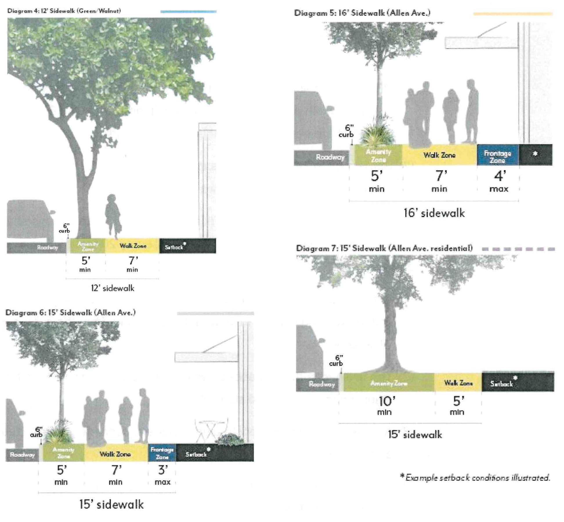
2.
Sidewalk Zones
a.
Amenity Zone. Sidewalks shall provide an Amenity Zone consistent with the width illustrated in Figure CDSP-4, including the curb.
(1)
Projects shall meet minimum parkway and street tree requirements per Section 17.30.040.B.
(2)
The following elements are permitted in the Amenity Zone at the discretion of Public Works: paved area for pedestrian mobility, parkways and street trees, seating/furniture, outdoor dining (with a Public Works permit), planters, bicycle parking, bus shelters, and/or other utility facilities including streetlights, signals, meter/sign poles, and pullboxes, etc.
b.
Walk Zone. Sidewalks shall maintain a Walk Zone as a continuous path of travel for pedestrians at the width illustrated in Figure CDSP-4. This area shall be free of all furnishings, landscaping, or obstructions.
c.
Frontage Zone. Sidewalks may include a Building Frontage Zone between the Walk Zone and the sidewalk line. A maximum width is illustrated in Figure CDSP-4.
(1)
The following elements are permitted in the Frontage Zone: paved area for pedestrian mobility, seating/furniture, outdoor dining (with a Public Works permit), planters, and/or shade structures per Section 17.30.070.D.
Figure CDSP-4: Sidewalk Zones Requirements
B.
Parkways & Street Trees.
1.
Parkways.
a.
Required Parkways. Projects shall include parkways within the Amenity Zone per Figure CDSP-5 and as follows, except as approved by the Director of Public Works.
(1)
Existing parkways shall be maintained.
(2)
For mixed-use and non-residential projects, parkway length shall be no less than 30 percent of street frontage.
(3)
For residential-only projects, parkway length shall be no less than 60 percent of street frontage.
Figure CDSP-5: Parkways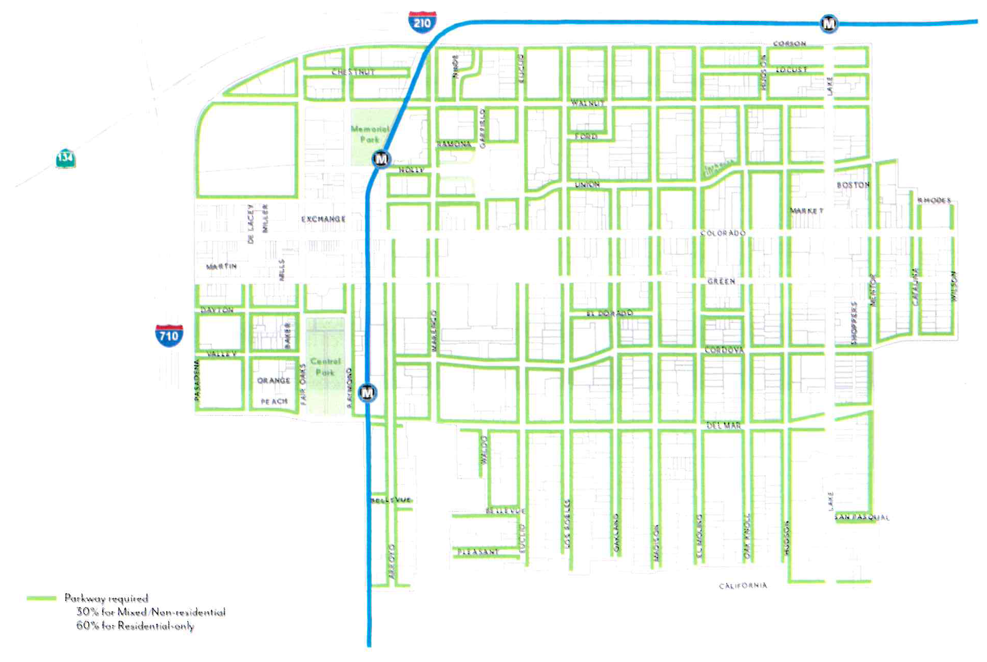
b.
Dimensions. Parkways shall be constructed at the same width as the Amenity Zones illustrated in Figure CDSP-4, minus the 6-inch width required for the curb, except as approved by the Director of Public Works.
(1)
When street parking is adjacent to the curb, a paved buffer with a minimum width of 18 inches is required, in addition to the 6-inch curb, except where tree grates are adjacent to the curb.
(2)
Barriers up to 24 inches high, such as low walls or fences, are permitted at the interior edge of the parkway but are not required.
c.
Access Ways. Where on-street parking is permitted, access ways shall be provided at a minimum frequency of one per every 20 feet of continuous parkway.
(1)
Access ways shall be a minimum of 4 feet in width and provide a firm, uniform walking surface in all weather conditions from the curb to the Walk Zone.
(2)
The finished surface of access ways shall be in plane with both the adjoining top of curb and sidewalk.
(3)
Access ways shall be constructed of pavers, concrete, or stabilized decomposed granite.
d.
Planted Area. A minimum of 80 percent of the total required parkway area for a given project shall be comprised of plant material.
(1)
Permitted materials include groundcovers, turf or turf substitutes, and shrubs or low perennials that are lower than 24 inches in height at full maturity.
a.
All plant material shall be native or climate appropriate and have a water use rating of Moderate, Low or Very-Low as defined by Water Use Classification of Landscape Species (WUCOLS) for the region. Plant water use requirements may be relaxed to maximize the efficiency of parkway stormwater capture systems per approval by the Director of Public Works.
b.
Plants with spines or thorns shall not be planted adjacent to any walkways or curbs.
c.
Edible plants are not permitted in parkways.
d.
Artificial turf is not permitted in parkways.
(2)
When removing existing plant material like turf grass from a parkway, there shall be no damage to the street tree roots. Parkway improvements involving excavation within an existing tree's root zone must be consistent with the City's Tree Protection Guidelines. Root pruning, if required and approved by Public Works, must be overseen by a Certified Arborist. Excavation within a tree's root zone must be replanted immediately to prevent the tree roots from exposure and undue harm.
e.
Non-planted Area. A maximum of 20 percent of the parkway area may be organic or inorganic cover.
(1)
Permitted materials include permeable pavers, decomposed granite, gravel, rocks, or mulch.
a.
Pavers are not allowed within 3 feet of any public streetlight pole or pull box or other utility facilities.
f.
Stormwater Management. Parkways shall either meet the following basic stormwater standards, or propose a biofiltration planter or swale design based on local conditions per the approval of the Director of Public Works.
(1)
The parkway shall be at the same grade as the adjacent hardscape surface at the outer edge of the parkway and slope at a minimum of 1 percent towards the center of the parkway.
(2)
For parkways with a width greater than 5 feet, the center 2 feet of the parkway shall be depressed 3 to 4 inches to form a shallow swale to collect sidewalk stormwater. Alternative means of storing runoff, such as gravel sumps within the parkway, may be provided with review authority approval.
g.
Irrigation. Irrigation systems in parkways shall be designed and constructed in a manner that will eliminate surface runoff onto any impermeable surface, public or private, under any condition.
(1)
Design of irrigation systems in parkways shall be in accordance with all local, state, and federal laws and regulations for water conservation.
(2)
Street tree roots shall not be damaged during the irrigation installation process.
h.
Maintenance. Abutting property owner shall maintain the parkway in a condition so as not to endanger persons or property, and not to interfere with the public convenience.
2.
Street Trees.
a.
Species. Street tree species shall be selected according to the Master Street Tree Plan at the discretion of the Director of Public Works. Trees may be planted within parkways or tree wells. For guidance on street trees, refer to Appendix A.2 Design Guidance for Tree Selection of the CDSP document.
b.
Spacing. Street trees shall be planted at a spacing of one per 30 feet. Exceptions can be made by the Director of Public Works due to conflicts with streetlights, bus shelters, utility boxes, or other street amenities or species type. Closer spacing is encouraged when feasible and when appropriate for the particular tree type.
c.
Well Dimension. Tree well width shall be equivalent to the required Amenity Zone, minus the 6-inch width required for the curb.
(1)
If a paved buffer zone is required due to adjacent street parking, the tree well width may be reduced to accommodate this buffer strip. The minimum length of a tree well shall be 6 feet.
(2)
Street trees planted within tree wells must be installed according to the Department of Public Works Tree Planting in Tree Well Standard Plan.
d.
Well Frames. Tree well frames, or tree grates, may be installed according to the Department of Public Works Tree Well Frame Installation Standard.
e.
Expanded Root Zone Cell. Each street tree shall be provided with an uncompacted root zone volume of 800 cubic feet minimum. The root zone volume depth shall be 2 feet minimum and 3 feet maximum.
(1)
Where this root zone volume cannot be provided within the parkway area, an expanded root zone cell volume shall be provided below adjacent pavement using a strategy such as structural soil or a suspended pavement system to provide an uncompacted soil area suitable for tree root growth.
(2)
The root zone volume per tree requirement may be reduced by 10 percent where two or more trees share a contiguous root zone cell.
f.
Maintenance. All street trees shall be maintained by the Department of Public Works.
(Ord. No. 7419, § 2, 2-26-2024)
17.30.050 - Summary of Development Standards
17.30.060 - Scale Standards
These standards are intended to:
•
Implement the General Plan density (du/ac) and floor area ratio (FAR) values;
•
Shape development in a manner that creates a defined public realm and appropriate scale of buildings for a visually appealing community;
•
Reduce building massing through setback and stepback requirements that create appropriate transitions to residential neighborhoods;
•
Support high-quality architecture and urban design through modulation requirements and a varied roof lines incentive;
•
Require appropriate transitions to designated historic resources; and
•
Support opportunities to increase housing near transit, and require various unit sizes to support individuals and families.
A.
Density.
1.
Residential Density. Projects that include residential dwelling units shall not exceed the allowable dwelling units per acre (du/ac) per Figure CDSP-6.
a.
Fractions shall be rounded to the nearest whole number; those at 0.50 may be rounded up.
b.
For projects utilizing state density bonus, refer to Government Code 65915.
c.
The maximum is based on total site area. If a street dedication or easement is required, density shall be calculated using the size of the lot prior to the street dedication or easement.
2.
Unit Mix. For projects with 50 dwelling units or more, inclusive of any density bonus, at least 15 percent of the total number of units shall have 3 bedrooms or more. Projects within designated historic districts and/or 100 percent single-room occupancy (SRO) projects are exempt.
Figure CDSP-6: Residential Density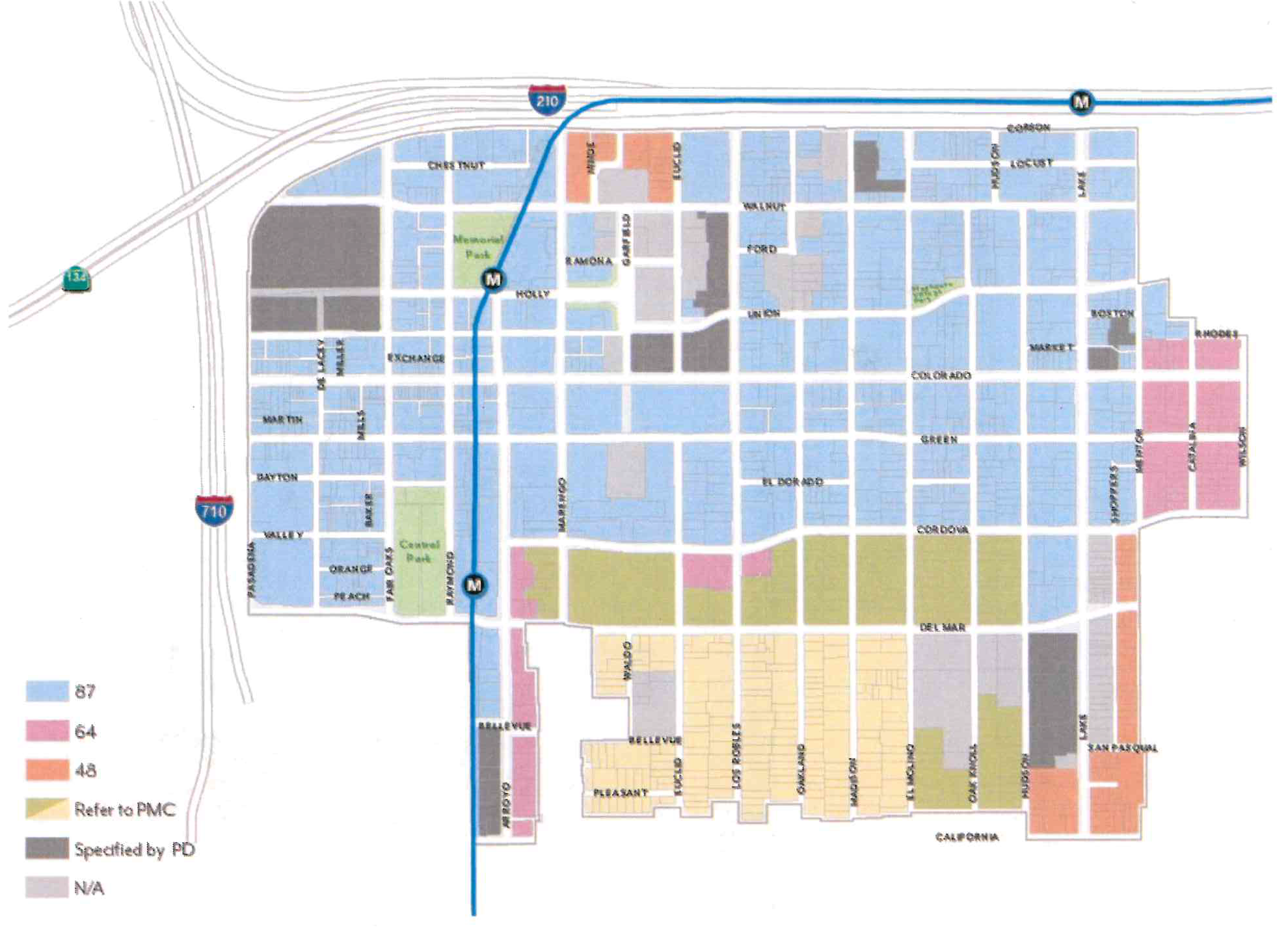
B.
Intensity.
1.
Floor Area Ratio. Projects that include non-residential space, including mixed-use, shall not exceed the allowable floor area ratio (FAR) per Figure CDSP-7.
a.
In mixed-use projects, residential floor area is included in FAR.
b.
Areas used exclusively for vehicle and bicycle parking and loading are excluded from FAR.
c.
The maximum is based on total site area. If a street dedication or easement is required, FAR shall be calculated using the size of the lot prior to the street dedication or easement.
Figure CDSP-7: Floor Area Ratio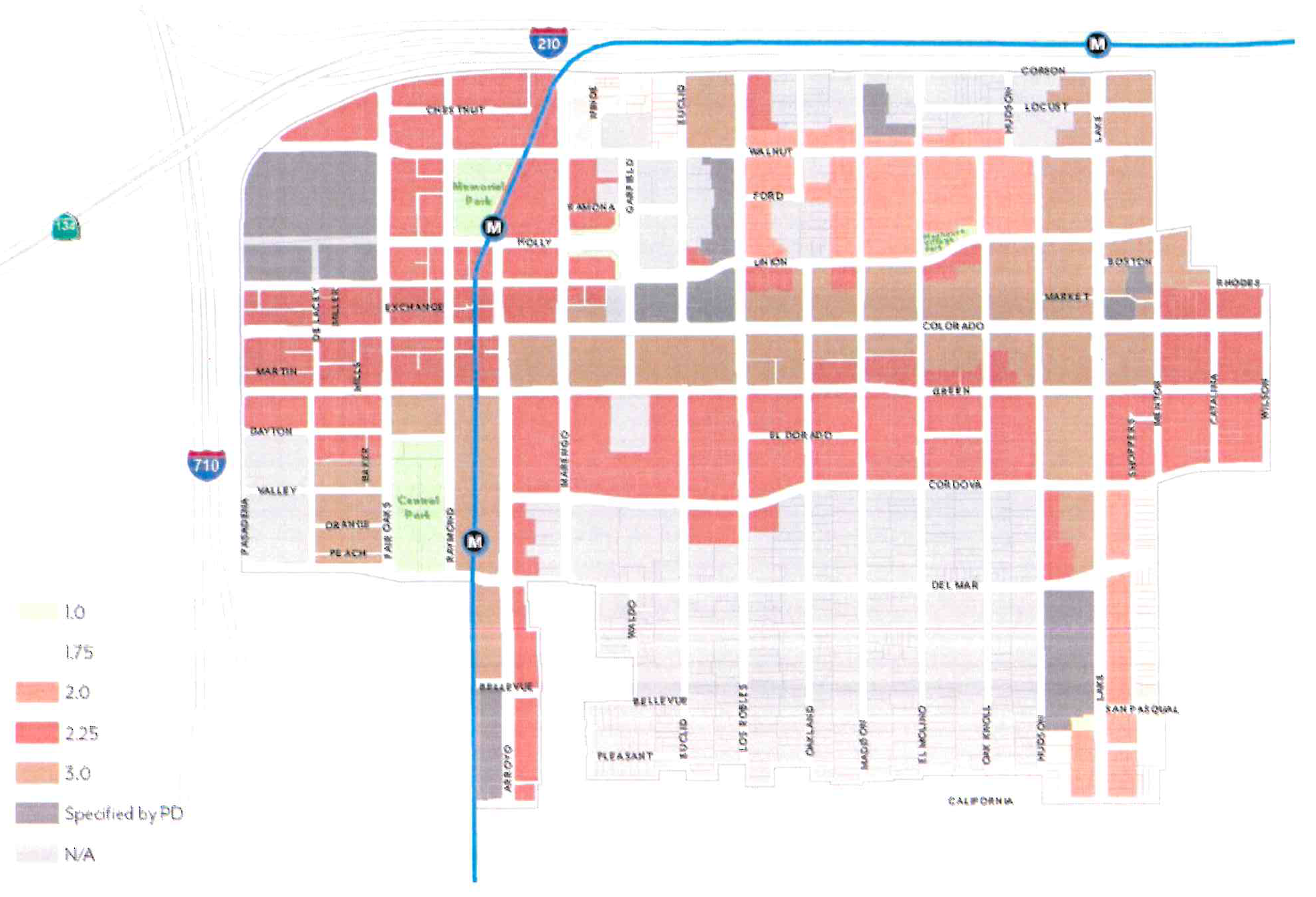
C.
Height.
1.
Building Height. Projects shall not exceed the height limits set in Figure CDSP-8.
a.
Height is measured per Section 17.40.060.
b.
Transitional height areas are height reductions along specific corridors for portions of parcels set in in Figure CDSP-8, and shall be measured as follows from the sidewalk line:
(1)
50 feet from the Green Street and Union Street.
(2)
100 feet from Hudson Avenue and Mentor Avenue.
c.
Exceptions allowed for Height Averaging per Section 17.30.060.C.2 and projecting features such as appurtenances and railings per Section 17.40.060.
Figure CDSP-8: Building Height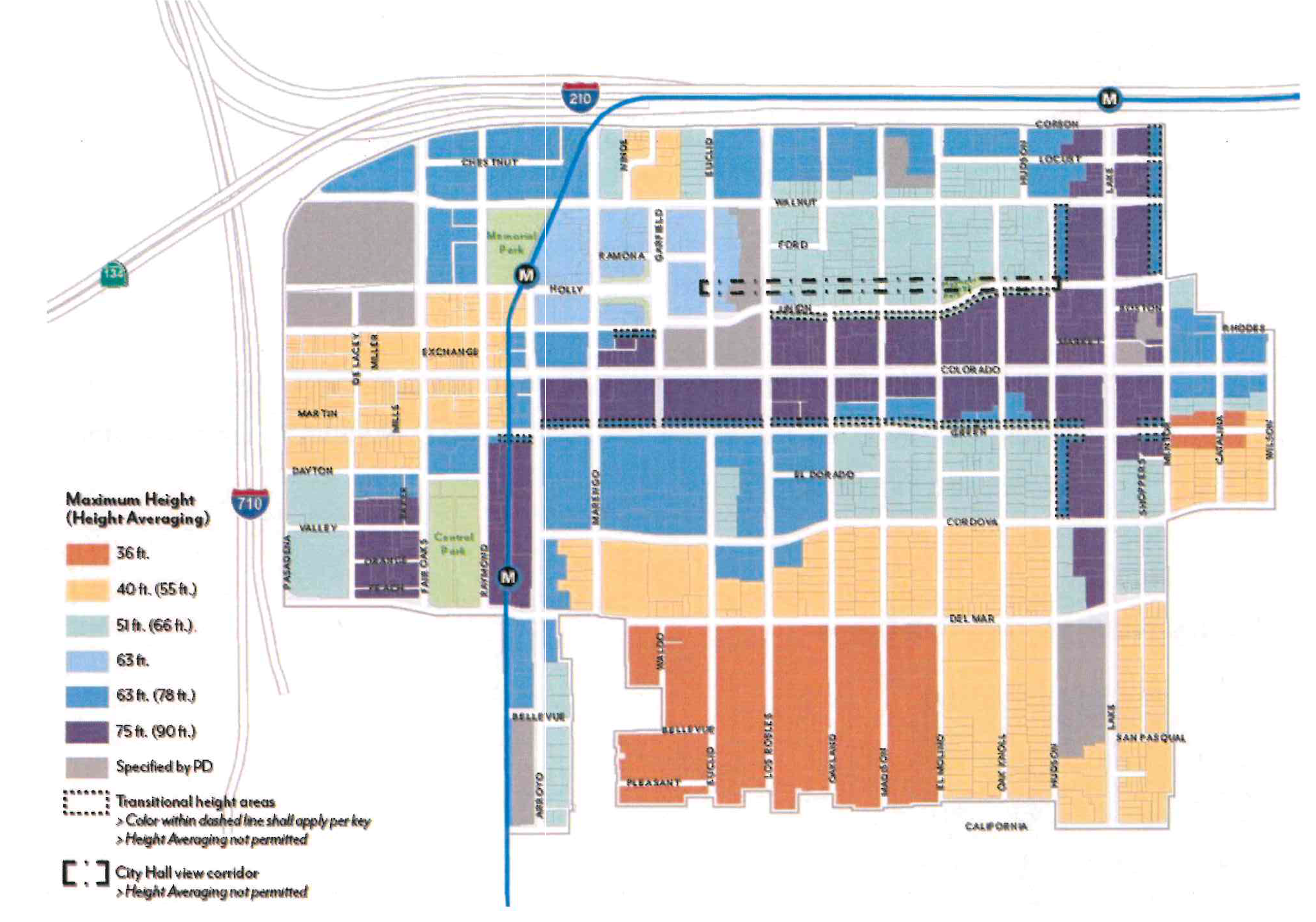
2.
Height Averaging. With approval of Design Commission, height limits may be exceeded for up to 30 percent of the building footprint to the maximum set in Figure CDSP-8, provided that the average height over the entire footprint does not exceed the allowable height; see Figure CDSP-9.
a.
The intent is to counterbalance additional height with lower heights elsewhere on-site to achieve an economically-feasible development that protects view corridors and contributes to a more visually-compelling skyline.
b.
Averaging is not applicable to other development standards relating to the building scale such as stepbacks. It may not be used in combination with a concession for building height when utilizing Section 17.43.
Figure CDSP-9: Height Averaging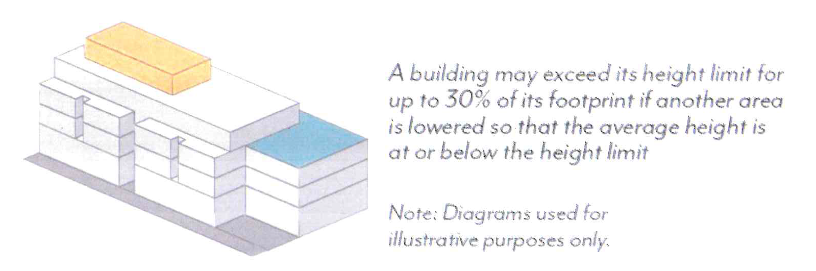
3.
City Hall View Corridor. Projects shall not block the view of the City Hall dome, Figure CDSP-10, as visible from the intersection at Hudson Avenue and Union Street; see Figure CDSP-8.
Figure CDSP-10: City Hall Dome
4.
Streetwall Height. Building shall meet or exceed the minimum streetwall height set in Table CDSP-3 for a minimum of 75 percent of building frontage, unless the overall building height is lower than the requirement; see Figure CDSP-11.
a.
Streetwall is defined as any street-façade within 10 feet of the maximum setback and is not required to be continuous.
b.
Appurtenances shall not count toward streetwall height.
Table CDSP-3: Streetwall Height
Figure CDSP-11: Streetwall Height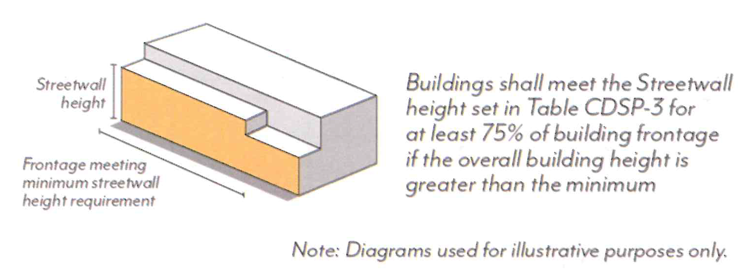
D.
Setbacks.
1.
Street Setbacks. Buildings shall comply with the street setbacks set in Figure CDSP-12, except where modified for historic adjacency per Section 17.30.070.G. Setback ranges establish a minimum and maximum for the specified percentage of linear frontage, see Figure CDSP-13.
a.
Street setbacks are measured from the sidewalk line; see Figure CDSP-3.
b.
Minimum setbacks shall apply to all stories of a building; setbacks less than the minimum are prohibited. Maximum setbacks shall apply only to the ground floor and streetwalls, Section 17.30.070.D.4, where applicable.
c.
Exceptions allowed per Section 17.40.160 (Table 4-1) and the following:
(1)
Arcades and recessed ground floors up to 15 feet in depth, as well as parking entrances per Section 17.30.090, are allowed when a second story meets the specific setback; see Figure CDSP-14.
(2)
The specified frontage percentage may be reduced for the provision of Publicly Accessible Open Space facing the street through the Design Review process with Design Commission approval.
d.
Residential units on the ground floor, where permitted, shall have a minimum setback of 5 feet. Where elevated between 4 and 6 feet above the sidewalk elevation, a minimum setback of 8 feet shall be required.
e.
For buildings set back from the sidewalk line 5 feet or more, a percentage of the setback area shall be landscaped with trees, shrubs and/or groundcover, either in the form of in-ground landscaping or planters, see Table CDSP-4.
Table CDSP-4: Landscaped Front Setback Percentages
(1)
Exceptions. Holly Street between Marengo and Garfield Avenues, and Garfield Avenue between Ramona and Union Streets are exempt from landscaping requirements.
f.
Features allowed within the street setback include: landscaping and planters, hardscape (e.g. stoops, patios), shade structures per Section 17.30.070.D, arcades and galleries per Section 17.30.070. E, walls and fences per Section 17.30.070.F, seating and furniture, outdoor dining, and other open space amenities per review authority approval.
Figure CDSP-12: Street Setbacks
Figure CDSP-13: Street Setbacks Percentage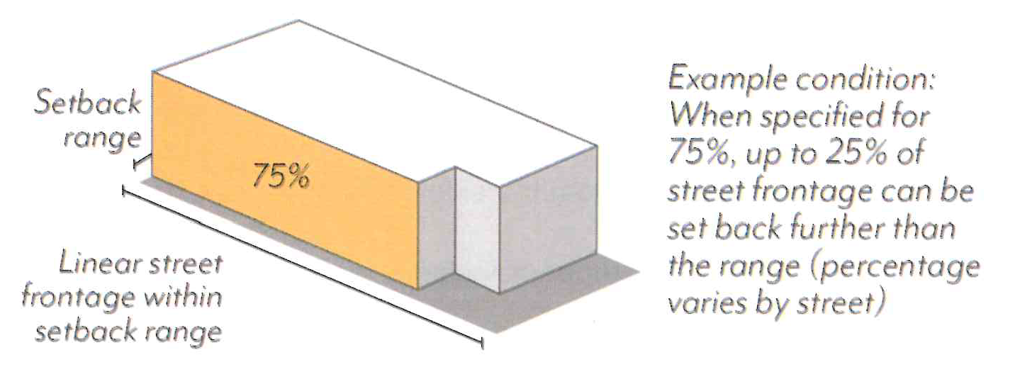
Figure CDSP-14: Recessed Ground Floor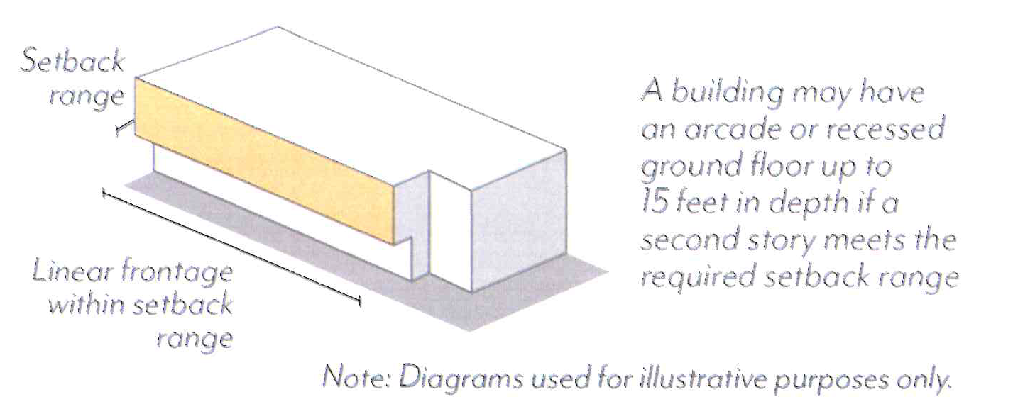
2.
Interior Setbacks. In the MU-N zoning district, projects shall have a minimum setback of 15 feet where adjacent to an RM district that is outside of the CDSP. No setback is required along other interior property lines, except where modified for historic adjacency per Section 17.30.070.G.
a.
Interior setbacks are those abutting other parcels along non-street side and rear property lines and are measured from the shared property line.
b.
Exceptions allowed per Section 17.40.160 (Table 4-1).
3.
Building Separation. In the CD-RM-87 zoning district, projects shall be separated from existing buildings on adjacent lots by a minimum of 10 feet above the first story.
E.
Stepbacks.
1.
Street Stepbacks. Along Green Street, buildings shall not exceed 20 feet in height before stepping back 8 feet in depth; see Figure CDSP-15.
a.
Street stepbacks are measured from the sidewalk line.
b.
Uses allowed within the street stepback include:
(1)
Private Open Space (e.g. balconies, terraces);
(2)
Shade structures, trellises, and similar;
(3)
Green roofs and photovoltaic panels; and/or
(4)
Other open space features per review authority approval.
Figure CDSP-15: Street Stepbacks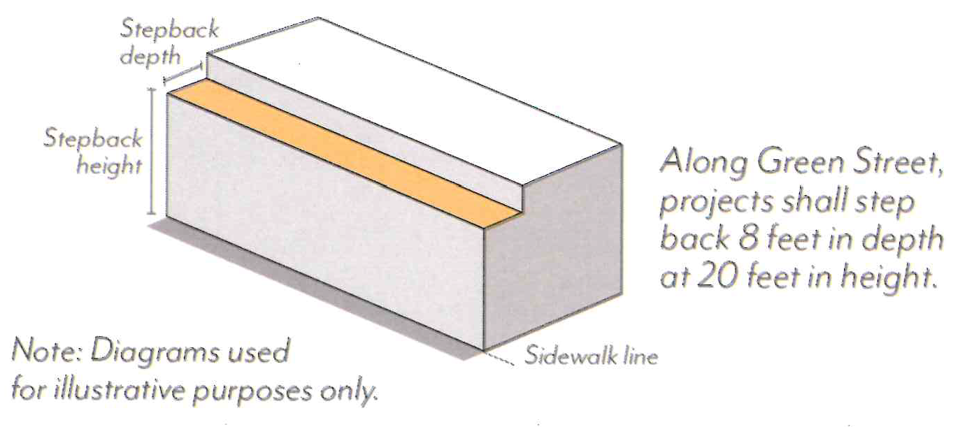
F.
Historic Adjacency.
1.
Landmark Properties. Projects on parcels with a designated historic resource shall be subject to review for consistency with the Secretary of the Interior's Standards.
2.
Transition Massing. Projects sharing a property line with a designated historic resource are subject to the following modified standards, illustrated in Figure CDSP-16.
a.
Street Setbacks. The minimum street setback shall be an average of the minimum setback set in Figure CDSP-12 and that of the resource for a minimum of 20 feet from the shared property line. If located between two resources, the street setback shall be an average of the setbacks of the two resources.
b.
Interior Setbacks. The minimum interior setback shall be equal to that of the historic resource or 15 feet, whichever is less. No setback is required where the resource is built to the shared property line.
c.
Streetwall Height. A maximum streetwall height shall not exceed the height of the historic resource for a minimum of 20 feet from the shared property line. A stepback with a minimum depth of 10 feet is required above this height, measured from the modified minimum street setback.
d.
Interior Stepbacks. Projects shall not be located within an encroachment plane sloping upward and inward at a 30-degree angle measured from the vertical, commencing 15 feet above the existing grade at the property line. This plane is not applicable if the resource is built to the shared property line.
Figure CDSP-16: Historic Adjacency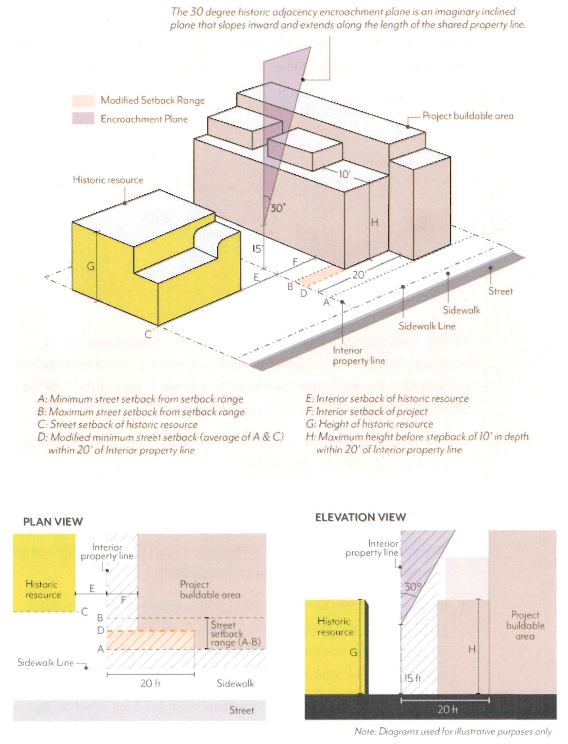
G.
Modulation.
1.
Façade Length. Each street-facing façade shall not exceed 150 feet in length unless there is a minimum break of 10 percent of the building length or 20 feet, whichever is greater. This break shall be at least 10 feet deep, open to the sky; see Figure CDSP-17.
Figure CDSP-17: Façade Length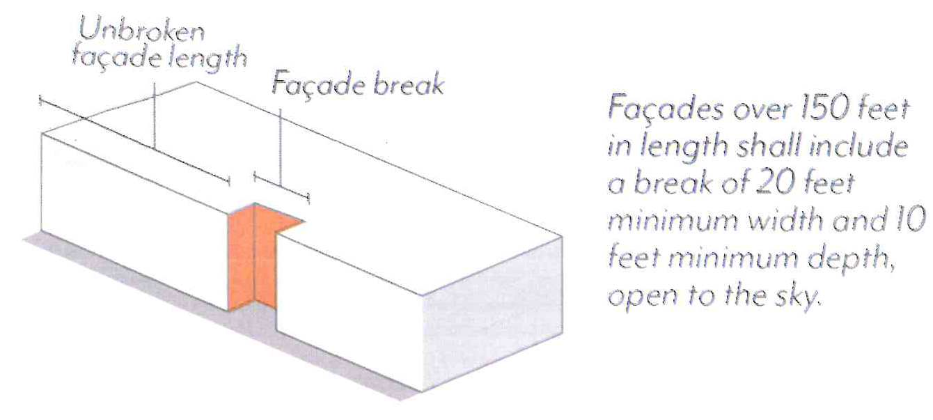
2.
Façade Area. Each street-facing façade exceeding 50 feet in length shall modulate a minimum of 25 percent of the area above the ground floor between 2 feet and 12 feet in depth from the primary façade plane; see Figure CDSP-18. Buildings with a total of 2 stories or less are exempt.
a.
The primary façade plane is defined as the vertical plane with the greatest surface area above the ground floor.
b.
Planes that are separated by a gap of at least 20 feet in width and 20 feet in depth shall be considered separate façades for the purposes of this standard.
c.
Modulation is not required to by continuous or open to the sky, and may be recessed or projected, but not past the sidewalk line.
d.
Required stepbacks per Section 17.30.060.E, façade breaks per Section 17.30.060.G.1, and projected balconies per Section 17.30.070.G.1 shall not count toward the modulation requirement; balconies that are recessed a minimum of 2 feet shall qualify.
e.
Exception to the Façade Area requirement permitted if the street-facing façade meets all of the following standards:
(1)
The maximum façade shall be 100 feet.
(2)
All windows shall be recessed at least 4 inches.
(3)
The façade shall use a textural material comprised of brick, stone, precast concrete, Venetian plaster, hand-toweled stucco, or porcelain tiles at least 12 by 4 inches. Ceramic tiles, porcelain tiles less than 12 by 4 inches, standard stucco, or flat, polished a stone shall not qualify.
(4)
The façade shall employ a tripartite division in which the façade is organized into three horizontal sections with a base, middle, and top.
a.
The middle section shall be differentiated from both the base and the top through a change in façade plane of at least 4 inches, or a consistent horizontal band that projects at least 4 inches from the façade.
b.
The top section shall use a cornice that is at least 1 foot in depth.
Figure CDSP-18: Façade Area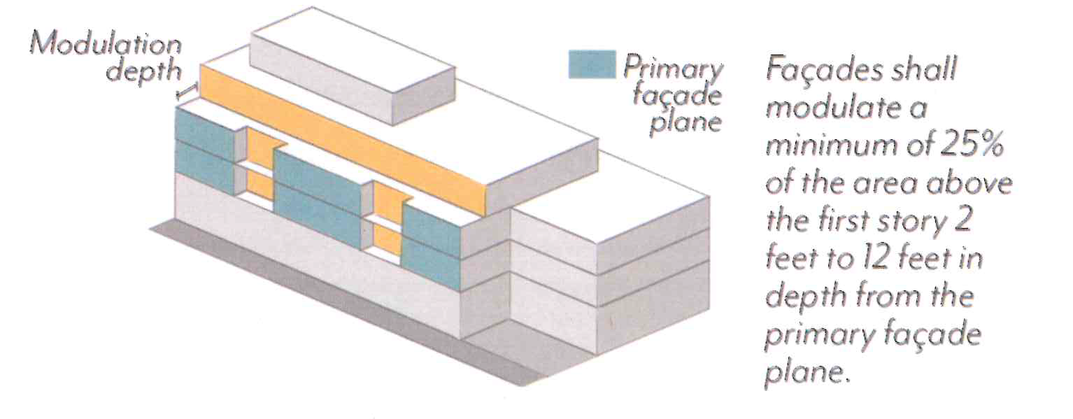
3.
Alternative Compliance.
a.
Eligibility. Modulation standards may be reduced or otherwise modified through the Design Review process if:
(1)
A minimum of 90 percent of the provided parking is fully or partially subterranean;
(2)
A minimum of one publicly accessible open space is provided at the ground level, visible and accessible from the sidewalk;
(3)
No other concessions, waivers, or incentives have been requested, including those associated with Density Bonus per Section 17.43, unless the project is designed to achieve LEED Gold certification; and
(4)
The review authority makes all of the following findings.
b.
Required Findings:
(1)
The building design provides modulation on each street-facing façade in a manner consistent with the project's architectural style and/or immediate context, including adjacent historic resources.
(2)
The building design does not cause an adverse impact on the quality of the ground floor and public realm.
(3)
The ground level open space is of adequate size and integrated with the building in a functional way that ensures the space will be actively utilized.
(4)
The modification will not be detrimental to the health, safety, and welfare of the public.
(5)
The building design is consistent with the objectives and policies of the General Plan and CDSP, as well as all other standards of the CDSP.
(Ord. No. 7446, § 5, 5-12-2025; Ord. No. 7419, § 2, 2-26-2024)
17.30.070 - Frontage
These standards are intended to:
•
Promote an active, accessible, and attractive pedestrian environment at the ground level;
•
Activate the pedestrian street experience through design and use standards;
•
Enable flexibility and adaptability over time through quality design; and
•
Support a livable urban setting comprised of a range of uses in a comfortable pedestrian environment.
A.
Ground Floor Frontages. In Mixed-Use zoning districts, ground floor use requirements are regulated by frontage type per Figure CDSP-19 and Table CDSP-5. All use requirements are regulated as a percentage of the building frontage.
1.
Commercial Uses. Frontage types shall require a minimum amount of the building frontage to be comprised of, and designed for, commercial uses per Figure CDSP-19 and Table CDSP-5; see Figure CDSP-20. Permitted commercial uses by zoning district are found in Table CDSP-1.
a.
Entrances to non-ground floor uses, and/or entrances to uses prohibited within 35 feet of the sidewalk, shall not qualify toward the minimum commercial use percentage.
b.
Commercial uses shall have an average interior depth of at least 35 feet and a minimum depth of 20 feet, measured wall-to-wall.
2.
Residential Uses. Frontage types set limitations on ground floor residential uses facing the street per Figure CDSP-19 and Table CDSP-5. Permitted residential uses by zoning district are found in Table CDSP-1.
a.
Type A: Residential units on the ground floor shall be prohibited within 35 feet of the sidewalk line, inclusive of setbacks, per Table CDSP-5; see Figure CDSP-21.
b.
Type B: Residential units on the ground floor shall be permitted with direct access to the street and a minimum setback of 5 feet.
c.
Residential common space on the ground floor shall be permitted per Table CDSP-5.
Figure CDSP-19: Ground Floor Frontage Types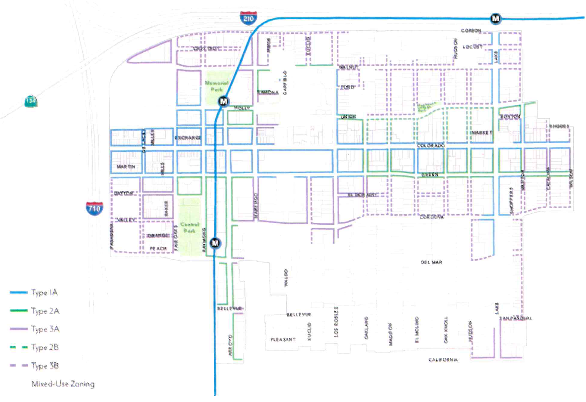
Table CDSP-5: Allowable Ground Floor Building Frontages in Mixed-Use Zones
Figure CDSP-20: Ground Floor Commercial Uses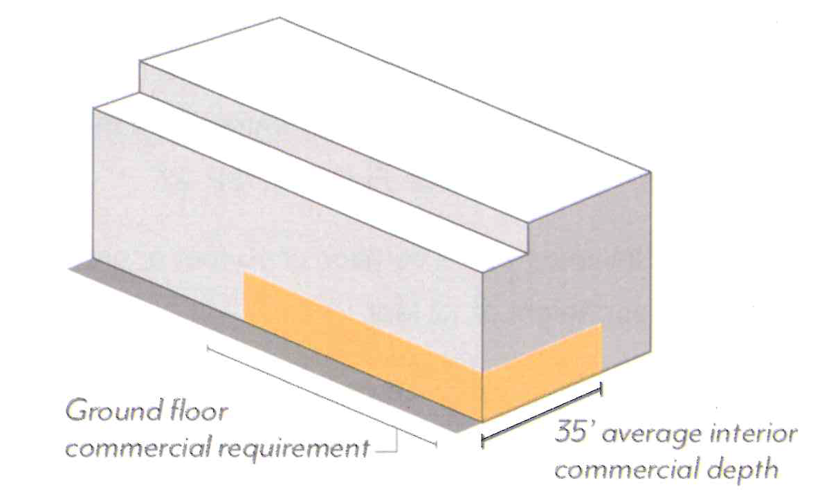
Figure CDSP-21: Ground Floor Residential Units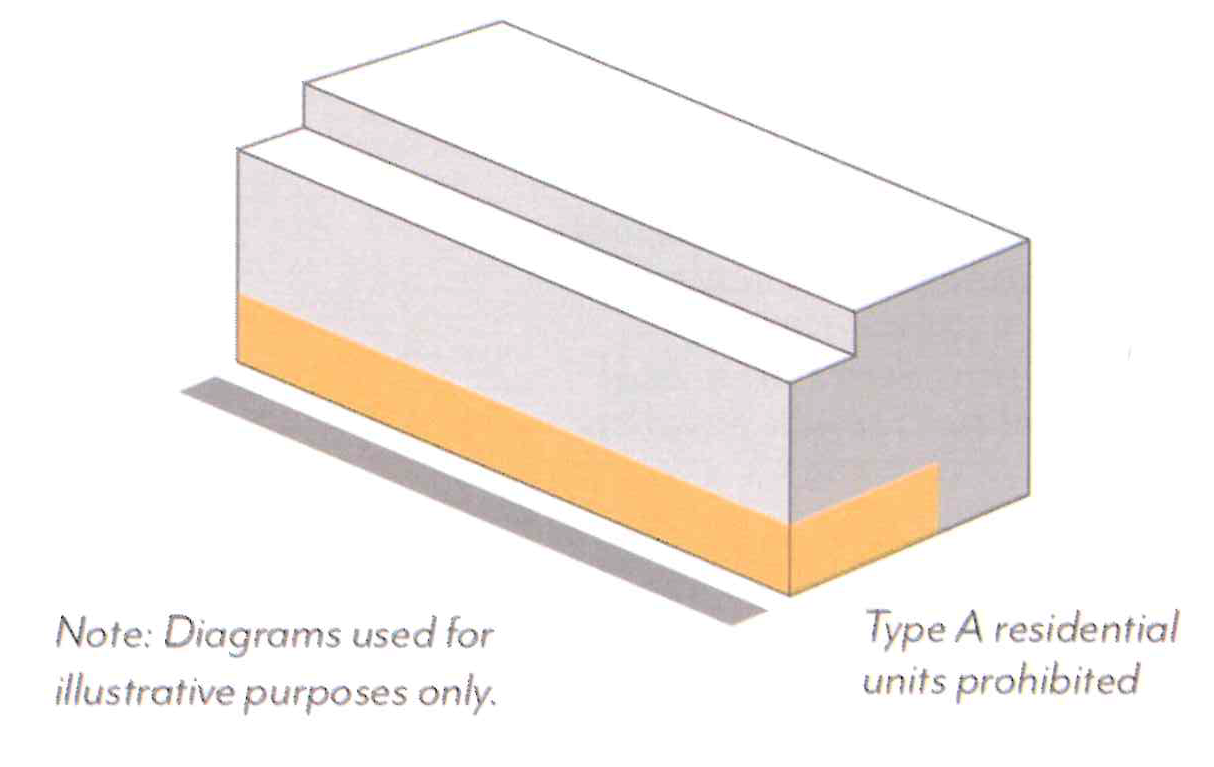
B.
Ground Floor Design.
1.
Entrances. A minimum of one primary entrance shall be located on the primary frontage of each building and open onto a sidewalk or other public space.
a.
Primary entrances shall be distinguished by architectural features or overhead projections, such as an awning or canopy.
b.
All entrances shall be recessed a minimum of 30 inches from the sidewalk line.
2.
Minimum Height. Buildings shall have a minimum ground floor height of 15 feet, measured from the sidewalk elevation closest to the primary entrance to the second story floor or roof of a one-story building; see Figure CDSP-22.
a.
Exception. Ground floor residential uses with a setback of 10 feet or greater shall have a minimum ground floor height of 12 feet.
b.
For non-residential and residential common space uses, the primary entrance of the first habitable floor shall be located at existing grade along the sidewalk line.
c.
For residential units, the first habitable floor shall be located between 6 feet above and 2 feet below the sidewalk elevation.
Figure CDSP-22: Ground Floor Height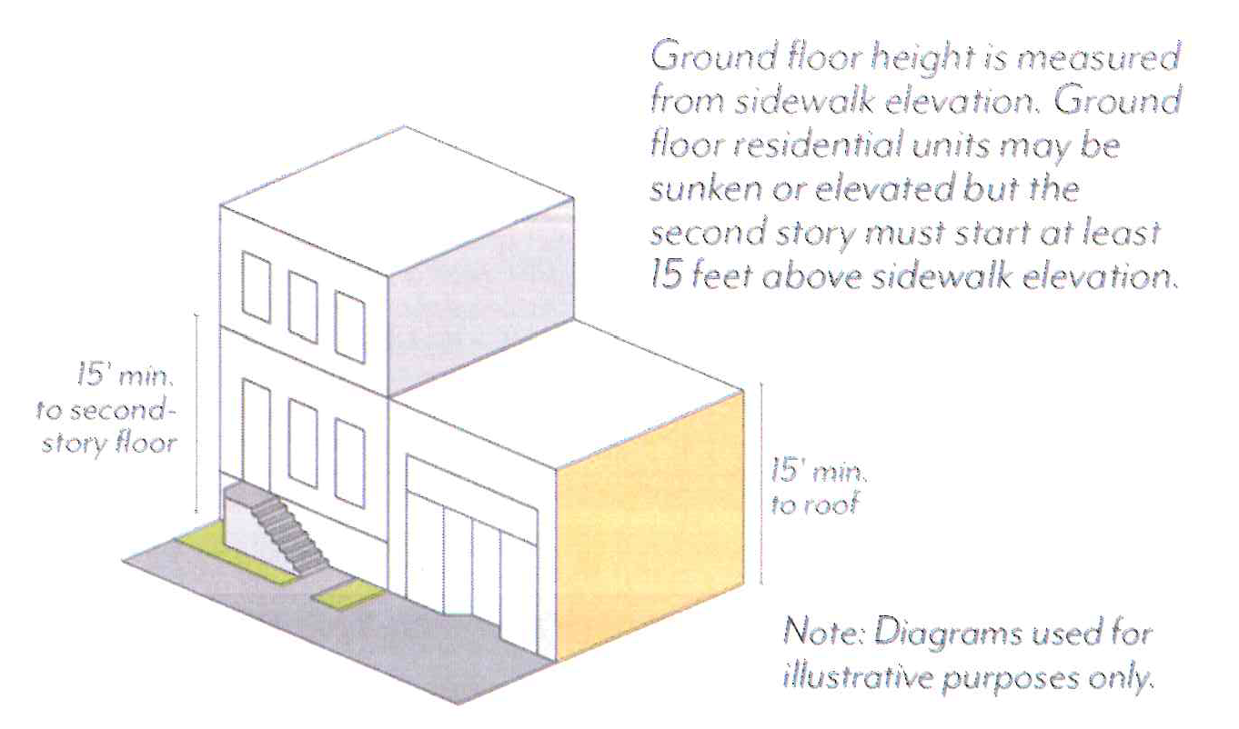
C.
Transparency.
1.
Windows & Doors. Street-facing façades shall incorporate glass providing views into work, display, sales, lobby, or similar active areas. The minimum transparency requirement is 70 percent for ground floors and 30 percent for the overall façade. For residential units, transparency requirements are reduced to 15 percent each for ground floor and the overall façade.
a.
For non-residential and residential common space uses, ground floor transparency is measured as the percentage of building frontage that consists of transparent openings between a height of 2 feet and 10 feet above the sidewalk elevation.
b.
All other transparency is measured as the percentage of building frontage area, viewed in elevation and excluding any coverage of shading devices.
c.
Windows shall be recessed by a minimum of 3 inches, measured from the outside wall to the frame of the window (mullion, muntin or similar element). Flush windows shall be permitted where exterior shading devices cover a minimum of 25 percent of the window surface area or per review authority approval.
d.
The use of tinted, mirrored, or highly reflective glass is prohibited.
e.
Blinds, drapes, posters, and shelving for product displays visible to the public right-of-way shall obscure a maximum of 10 percent of the transparent areas of each respective storefront or 50 percent for medical office uses.
2.
Blank Walls. Windowless expanses of street-facing walls shall not exceed 20 feet in length.
3.
Security Bars. Any exterior or interior security bars shall be designed to be fully hidden from view during business hours with devices such as concealed side pockets and ceiling cavities.
D.
Shade Structures.
1.
Awnings & Canopies. Any ground floor shading shall project a minimum of 3 feet from the façade and allow a minimum of 8 feet of vertical clearance from the sidewalk elevation.
a.
Shade structures shall not conflict with existing trees; exceptions to the depth requirement shall be subject to review authority approval.
2.
Colorado Boulevard. For projects on the north side of Colorado Boulevard, shade structures are required and shall project a minimum of 7 feet, up to a maximum of 10 feet, into the public-right-of-way for a minimum of 70 percent of the building frontage.
a.
Where an arcade or recessed ground floor provides a minimum of 5 feet of unobstructed pedestrian clearance, shade structures are not required.
E.
Arcades & Galleries.
1.
Arcades. Any arcades shall be located behind the minimum setback.
a.
Arcades shall be a minimum of 8 feet from back of column to building façade.
b.
The distance between columns shall be equal to or greater than the arcade depth dimension, as measured from the column center.
c.
The façade within the arcade shall meet the ground floor transparency set in Section 17.30.070.C.
d.
Uses allowed within arcades include pedestrian travel, seating/street furniture, outdoor dining, landscape planters, and/or bicycle parking.
2.
Galleries. Any galleries shall be located behind the minimum setback.
a.
Galleries shall be limited to one-story and 50 percent of the building frontage.
b.
Galleries shall allow a minimum of 10 feet of vertical clearance from the sidewalk elevation.
F.
Exterior Fixtures.
1.
Façade Lighting. Lighting shall be located on façades facing streets and public open spaces at a frequency of every 30 feet or less.
a.
Façade lighting shall be full cutoff (directing light downward and outward).
b.
Fixtures shall be located between 8 and 15 feet above the sidewalk elevation, and shall not project more than 30 inches from the façade.
c.
For buildings with ground floor residential uses, façade lighting shall be designed to be operable by the adjacent tenant.
d.
Façade lighting shall not be required on buildings located on Colorado Boulevard, designated historic resources and districts, and within the In-town Residential subarea.
2.
Venting. Interior exhaust shall be vented through the roof. Venting that must be routed through the façade due to Building Code requirements shall meet the following criteria:
a.
Vents shall be located on secondary façades where possible.
b.
Vents shall be screened by decorative caps or painted to match the façade.
c.
Vents shall be centered or consistently aligned with another architectural element, such as score lines, windows, or vertical planes.
G.
Walls & Fences.
1.
Walls & Fences. Freestanding walls, fences, and raised/landscape planters are permitted within the street setback.
a.
Walls and fences shall have a maximum height of 48 inches above the sidewalk elevation.
b.
Walls and fences taller than 30 inches shall be a minimum of 50 percent transparent and set back a minimum of 18 inches from the sidewalk line, separated by planted area. Walls and fences 30 inches or less in height do not have a transparency or setback requirement.
c.
Walls and fences used to enclose outdoor dining may be located at the sidewalk line and are not required to provide a planted area if the wall or fence is 36 inches or less and more than 50 percent transparent.
d.
Guardrails may exceed the maximum height to the extent required by the Building Code. The guardrail shall be a minimum of 50 percent transparent.
2.
Stoops & Patios. The side of a patio or stoop (when parallel to a sidewalk) taller than 30 inches in height shall be set back a minimum of 18 inches from the sidewalk line, separated by planted area.
H.
Balconies & Roof Decks.
1.
Balconies. Balconies may project a maximum of 4 feet from the building façade but shall not extend beyond the sidewalk line or within 6 feet of any interior property line.
2.
Roof Decks. The sum of all roof decks on a single building shall not exceed a maximum coverage of 60 percent of the roof area.
a.
Roof deck railings on the uppermost 2 stories shall be set back a minimum of 5 feet from the façade.
(Ord. No. 7419, § 2, 2-26-2024)
17.30.080 - Open Space
These standards are intended to:
•
Provide a variety of open space types for gathering, recreation and respite that contribute to enhanced livability within an urban setting;
•
Give residents access to light, air, and pleasant views from their living spaces;
•
Improve building design and site planning through the integration of open space throughout the development; and
•
Correlate open space requirements with number of residents and size of buildings.
A.
Minimum Area.
1.
Private and Common Open Space. Projects shall provide the minimum area of Open Space based on use and size. Areas used regularly for parking, loading or storage shall not count towards minimum Open Space requirements.
a.
Residential. Projects with dwelling units shall provide the minimum area of Open Space per Table CDSP-6 as a combination of Private and/or Common Open Space.
b.
Non-residential. Projects with more than 40,000 square feet of non-residential floor area shall provide a minimum of 5 percent of the gross non-residential floor area as Common Open Space.
(1)
Research and Development uses may reduce Open Space area requirements by a maximum of 60 percent. Research and Development projects (or the Research and Development portion of a project with multiple uses) shall exclude mechanical space from floor area for the required Open Space.
c.
Mixed-use. Projects shall comply with requirements applicable to each type of use.
Table CDSP-6: Residential Open Space by Unit Type
2.
Publicly Accessible Open Space (PAOS). Projects with more than 80,000 square feet of gross floor area (GFA) and with frontage identified on Figure CDSP-23 shall provide PAOS based on a percentage of GFA set in Table CDSP- 7.
a.
Exception: Projects with less than 80,000 square feet of GFA and selected for plaza development at the northwest corner of Lake Avenue and California Boulevard shown in Figure CDSP-23 shall provide a minimum of 400 square feet of PAOS as a corner plaza.
(1)
For projects that provide at least 600 square feet of PAOS and which comply with all standards in Section 17.30.080.D, other development standards in the CDSP may be modified with review authority approval.
b.
Research and Development uses may reduce PAOS area requirements by a maximum of 60 percent. Research and Development projects (or the Research and Development portion of a project with multiple uses) shall exclude mechanical space from floor area for the required PAOS.
c.
PAOS shall be provided in addition to Private and Common Open Space requirements.
d.
Projects shall comply with PAOS standards per Section 17.30.080.D and Paseo standards per Section 17.30.080.E where relevant.
(1)
PAOS and Paseo standards may be modified through the Design Review process, if the review authority finds that the modified design continues to be accessible to the public, functional, and includes features such as landscaping, trees, and outdoor seating.
Figure CDSP-23: Publicly Accessible Open Space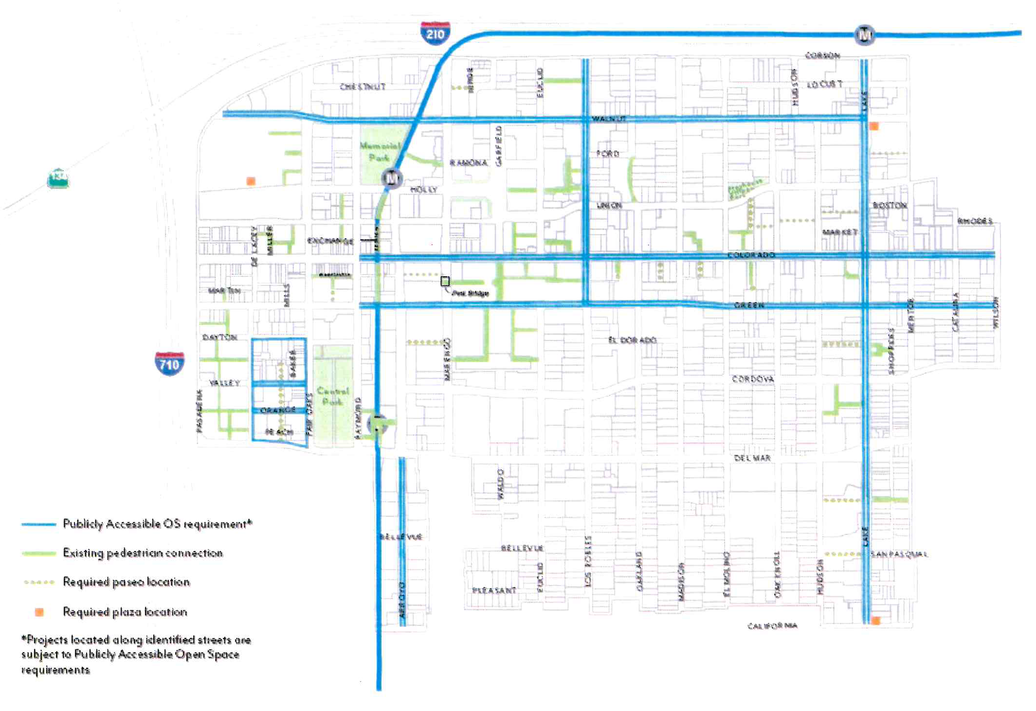
Table CDSP-7: Publicly Accessible Open Space by Project Size & Location
B.
Private Open Space.
1.
Dimensions. A minimum area of 40 square feet with a minimum dimension of 5 feet in each direction shall be required for Private Open Space.
2.
Distribution. A maximum of 40 percent of the required residential Open Space set in Table CDSP-7 shall be Private Open Space.
a.
All Private Open Space shall be outdoors.
b.
Private Open Space may be located within a required setback.
C.
Common Open Space.
1.
Dimensions. A minimum area of 400 square feet with a minimum dimension of 15 feet in each direction shall be required for Common Open Space.
2.
Distribution. A minimum of 60 percent of the required residential Open Space set in Table CDSP-7 shall be Common Open Space shared among tenants.
a.
A minimum of 70 percent of Common Open Space shall be outdoors, and a minimum of 80 percent of outdoor Common Open Space shall be open to the sky.
b.
A maximum of 30 percent of Common Open Space may be indoors. Indoor Common Open Space shall not include spaces used primarily for circulation.
3.
Access. Common Open Spaces may be accessible to the public.
4.
Hardscape. A maximum of 25 percent of Common Open Space may be paved in standard concrete. Remaining areas shall use one of the following enhanced paving techniques: brick, natural stone, unit concrete pavers, textured and colored concrete, concrete with exposed or special aggregate. Alternative paving may be allowed per review authority approval.
5.
Landscape. A minimum of 25 percent of Common Open Space shall be planted area with a minimum dimension of 30 inches in length and width. Landscaping shall comply with Section 17.44.050.
6.
Trees. A minimum of one 24-inch box tree per project or for every 500 square feet of outdoor Common Open Space, whichever is greater, shall be planted within the Common Open Space. For projects with 2 or more trees, a minimum of 50 percent of trees planted shall be shade trees.
7.
Water Features. Fountains, reflecting pools, or other decorative water features shall not exceed 5 percent of the required Common Open Space. Swimming pools are not considered water features for the purposes of this standard.
D.
Publicly Accessible Open Space (PAOS)
1.
Area. Minimum PAOS requirements are set in Section 17.30.080.A.2 and Table CDSP-7, and may be contiguous or noncontiguous, subject to the dimension and elevation standards below.
2.
Paseos. Projects that are required to provide PAOS per Section 17.30.080.A.2 and located on parcels that include a paseo opportunity area on Figure CDSP- 23, shall be required to meet the minimum area requirement by providing a paseo, defined as a pedestrian passageway that connects a public street to another public street, alley, or internal public space.
a.
Paseos shall meet the standards set in Section 17.30.080.E; design standards Section 17.30.080.D.4 through Section 17.30.080.D.12 shall not apply.
b.
No additional paseo shall be required in opportunity areas where a paseo exists. The existing paseo shall be subject to standards in Section 17.30.080.E. The standards may be modified through the Design Review process, if the review authority finds that the modified design continues to be accessible to the public, functional, and includes features such as landscaping, trees, and outdoor seating.
3.
Plazas. Projects selected for plaza development on Figure CDSP-23 shall meet the minimum area requirement by providing a corner plaza.
a.
PAOS design standards shall apply.
4.
Dimensions. A minimum area of 400 square feet with a minimum dimension of 20 feet in each direction is required for PAOS.
5.
Access. A maximum of 20 percent of the PAOS may be used as outdoor dining for a restaurant subject to review authority approval; a minimum of 80 percent of the PAOS shall be accessible to the general public.
6.
Signage. PAOS shall have signage visible from the adjacent sidewalk identifying the space as a publicly-accessible amenity and listing accessible hours.
7.
Hours. At a minimum, PAOS shall be open to the general public from 8am to 8pm. Any gated ingress or egress points shall not be closed or locked during these hours.
8.
Elevation. A minimum of 3,000 square feet of PAOS shall be at the sidewalk elevation. If less square footage is required, then all required PAOS shall be at the sidewalk elevation.
9.
Hardscape. A maximum of 25 percent of PAOS shall be paved in standard concrete. Remaining areas shall use one of the following enhanced paving techniques: brick, natural stone, unit concrete pavers, textured and colored concrete, concrete with exposed or special aggregate. Alternative paving may be allowed per review authority approval.
10.
Seating. Seating shall be provided at a minimum of 1 seat per 300 square feet of required PAOS. Fractions shall be rounded down to the nearest whole number.
a.
Benches shall be calculated as 1 seat per 24 linear inches.
11.
Landscape. A minimum of 25 percent of PAOS shall be planted area with a minimum dimension of 30 inches in length, width, and depth. Landscaping shall comply with Section 17.44.
12.
Trees. A minimum of one 24-inch box tree per project or for every 750 square feet of PAOS, whichever is greater, shall be planted. For projects with 2 or more trees, a minimum 50 percent of trees planted shall be shade trees.
a.
Trees planted in pots on the ground floor shall not be counted towards the tree requirement.
13.
Blank Walls. PAOS shall adhere to the blank wall standards defined in Section 17.30.070.C, or provide one of the following mitigations:
a.
Green wall, vines, or other vertical landscaping element that covers a minimum of 75 percent of non-conforming blank wall area.
b.
Public art including, but not limited to, murals.
14.
Common Open Space Credit. PAOS in excess of the minimum may count towards a maximum of 30 percent of the Common Open Space requirement at a 1:1 ratio.
E.
Paseos.
1.
Dimensions. Paseos shall have an average width of 20 feet, minimum width of 15 feet, and be a minimum of 75 percent open to the sky. Paseos shall have a walk zone with a minimum width of:
a.
10 feet for commercial / mixed-use paseos.
b.
8 feet for residential-only paseos.
2.
Access. Paseos shall be physically and visually accessible from the connecting public sidewalk.
a.
Fences, walls, and/or entry gates are permitted; however, these features shall not block passage through the paseo during public hours.
b.
Bollards (fixed or removable) shall be provided at all entry points of paseos to restrict vehicular access during public hours.
c.
Emergency vehicular access shall be provided.
3.
Signage. Paseos shall have signage visible from the adjacent sidewalk identifying the space as a publicly-accessible amenity and listing public hours. In paseos that have commercial frontages, a directory shall be provided at each entry. Specific sign guidelines shall be created for all properties with building façades immediately adjoining the paseos.
4.
Hours. At a minimum, paseos shall be open to the general public from 8am to 8pm. Commercial loading shall be limited to non-public hours.
5.
Elevation. Paseos shall be at ground level and ADA accessible.
6.
Programming. A maximum of 10 percent of required paseo area may be used by adjacent restaurants or food sales uses as a space restricted to customers only. Any additional programming must be non-transactional and without financial barriers to entry.
a.
Exception: Paseos may be closed to public access for private events no more than one day per month.
7.
Hardscape. A maximum of 25 percent of paseos shall be paved in standard concrete. Remaining areas shall use one of the following enhanced paving techniques: brick, natural stone, unit concrete pavers, textured and colored concrete, concrete with exposed or special aggregate. Alternative paving may be allowed per review authority approval.
8.
Stormwater Management. A minimum of 25 percent of the total paved area shall be permeable paving to allow for stormwater infiltration. Depending on soil and site conditions, infiltration and/or flow-through planters shall be installed to capture and treat 100 percent of the stormwater run-off on-site.
9.
Seating. Seating shall be provided within the paseo at a minimum of 1 seat per 300 square feet of required space. Fractions shall be rounded down to the nearest whole number.
10.
Landscape. A minimum of 25 percent of paseo area shall be planted area a minimum of 30 inches in length, width, and depth. Landscaping shall comply with Section 17.44.
11.
Trees. A minimum of one 24-inch box tree per project or per each 750 square feet of paseo area, whichever is greater, shall be planted. For projects with 2 or more trees, a minimum 50 percent of trees planted shall be shade trees.
a.
Trees planted in pots, on the ground floor, shall not be counted towards the tree requirement.
12.
Blank Walls. Paseos shall adhere to the blank wall standards defined in Section 17.30.070.C, or provide one of the following mitigations:
a.
Green wall, vines, or other vertical landscaping element that covers a minimum of 75 percent of non-conforming blank wall area.
b.
Public art including, but not limited to, murals.
13.
Common Open Space Credit. When the area needed to facilitate the connection of a public street to another public street or alley and meet Section 17.30.080.E.1 is greater than the minimum PAOS requirement, the additional required paseo area may count towards the Common Open Space requirement at a 1:1 ratio.
a.
Paseo area in excess of the minimum may count towards a maximum of 50 percent of the Common Open Space requirement at a 1:1 ratio.
(Ord. No. 7446, § 5, 5-12-2025; Ord. No. 7419, § 2, 2-26-2024)
17.30.090 - Parking
These standards are intended to:
•
Reduce the visual impacts of parking;
•
Regulate appropriate parking supply and location in a manner that prioritizes pedestrian access and multi-modal activity;
•
Encourage change of use and adaptive reuse of existing buildings through parking reductions and exemptions;
•
Promote a more efficient use of parking spaces through shared parking among multiple uses within a project; and
•
Increase design standards for surface and structured parking.
A.
Minimum Parking.
1.
Number of Spaces. Projects shall provide off-street automobile parking spaces per Table CDSP-8 based on general use classifications, and subject to the standards of Section 17.46.
a.
Where parking minimums in this Section conflict with state law, state law shall control.
b.
For projects within one-half mile of a Metro station platform, reductions in parking and a maximum number of parking spaces shall apply per Section 17.50.340.
c.
Bicycle parking shall be required per Section 17.46.320.
Table CDSP-8: Minimum Parking by Land Use
2.
Shared Parking. Parking may be shared among multiple uses per Section 17.46.050.
3.
Unbundled Parking. For any building with new residential units, automobile parking spaces shall be leased or sold separately from the rental or purchase fees, such that renters or buyers have the option of renting or buying the unit at a lower price than if the parking was included.
a.
For deed-restricted affordable units, one parking space shall be included in the base rent of each unit. The tenant may choose to receive the parking space or receive a rent discount equivalent to half the amount charged for monthly lease of a parking space. Tenants of affordable units shall not sublease their parking spaces.
b.
Renters or buyers have the right of first refusal to parking built for their unit. Any remaining spaces may be leased to other users on a month-to-month basis. New occupants shall have the opportunity to lease or purchase parking built for their unit.
B.
Vehicle Access.
1.
Driveways. For Projects with less than 200 feet of primary street frontage, a maximum of 1 two-lane driveway shall be permitted. For sites with more than 200 feet of primary street frontage, a maximum of 2 two-lane driveways shall be permitted.
a.
Driveways are not permitted on primary frontages of less than 200 feet where there is access from a secondary street or alley.
b.
The Zoning Administrator shall determine the primary frontage for purposes of compliance with this subsection.
2.
Gates. Controlled entrances to parking shall be located a minimum of 20 feet from the property line to allow for a queuing vehicle without blocking the public right-of-way.
a.
Gates at parking entrances shall be designed to conceal associated mechanical equipment from the public right-of-way in compliance with Section 17.40.150.
C.
Layout & Design.
1.
Surface Parking. Parking lots shall comply with Section 17.46.230 with the following exceptions:
a.
Parking lots shall be set back a minimum of 30 feet from the primary frontage, a minimum of 10 feet from any secondary frontage, and a minimum of 5 feet from RM zoning.
b.
Parking shall be buffered by permitted non-parking uses or a landscaped setback adjacent to the sidewalk line, except for driveways or pedestrian access to the parking area.
(1)
Landscaped setbacks shall include a row of hedges or shrubs with a minimum height of 3 feet at the time of planting that form a continuous visual screen to block vehicle headlights.
2.
Entrances to Structured Parking. For structured and subterranean parking, vehicular entrances shall employ the same materials and architectural style as the primary building.
a.
Exterior building materials shall wrap into parking entrances/exits for a minimum of 20 feet from the building façade, except areas not visible from public streets.
b.
Entrances shall not be larger than the necessary clearance area.
3.
Structured Parking. Along primary frontages, all floors of parking structures shall be lined with building floor area (e.g. commercial or residential uses) or Publicly Accessible Open Space for a minimum of 35 feet in depth. Along secondary frontages, parking structures shall be set back a minimum of 5 feet. Pedestrian access and driveways in compliance with 17.31.100.B are excluded from this requirement.
a.
Parking structure façades visible from public streets, excluding alleys, shall employ the same materials and architectural style as the primary building.
(1)
Open areas on the façade shall be designed as windows or screen using heavy-gauge metal, precast concrete panels, laminated glass, green walls, photovoltaic panels or other material per review authority.
b.
Vehicular ramps shall not be located within 10 feet of the sidewalk line, except at parking entrances/exits.
c.
A parking structure shall not exceed the height of the tallest building it serves.
4.
Underground Parking. Subterranean parking shall be set back a minimum of 5 feet from Green Street and RM zoning. Otherwise, it may extend up to the property line.
(Ord. No. 7446, § 5, 5-12-2025; Ord. No. 7419, § 2, 2-26-2024)
17.30.100 - Definitions
This Section provides definitions of terms and phrases used in the CDSP that are technical or specialized or that may not reflect common usage. In case of conflict with other provisions of the Zoning Code, these definitions shall control for the purposes of the CDSP. If a word is not defined in this Chapter, the Zoning Administrator shall determine the correct definition.
Amenity Zone.
The portion of the sidewalk located above and adjacent to the curb, providing space
for amenities such as parkways, outdoor dining, seating, trees, lighting, bicycle
racks, bus stops, etc.
Building Frontage.
The horizontal distance, measured at grade, of building wall facing the street.
Building Frontage Zone.
The portion of the sidewalk immediately adjacent to the building façade, providing
space for planters, outdoor dining, sidewalk signage, etc. This zone may not be present
on every street or block.
Curb Zone.
See "amenity zone."
Façade.
Any exterior wall plane of a building, ground level to top of roof.
Floor Area Ratio.
Numerical value obtained by dividing the above-ground area of a building or buildings
located on a lot by the total area of the lot.
Footprint.
The total ground floor area of the combined structures on a site or project area defined
by the perimeter of the building(s), including parking structures but excluding parking
lots and non-occupancy structures.
Frontage Zone.
See "building frontage zone."
Gross Floor Area (GFA).
The total enclosed area of all floors of a building measured to the inside face of
the exterior walls including halls, stairways, elevator shafts at each floor level,
service and mechanical equipment rooms and basement or attic areas having a height
of more than seven feet, but excluding area used exclusively for parking or loading
of vehicles or bicycles.
Ground Floor.
The first habitable floor of a building closest to the sidewalk elevation.
Mixed-Use Project.
The combination of commercial and residential uses in the same structure, where the
residential component is located either above (vertical mixed-use) or behind (horizontal
mixed-use) the non-residential component. Non-residential uses are typically commercial
uses.
Open Space.
For any form of open space (Common, Publicly Accessible, Private, etc.), see Section
6.3 of the CDSP.
Parkway.
Landscaped or permeable areas located within the amenity zone of the sidewalk.
Paseo.
A publicly accessible open space that functions as a pedestrian passageway connecting
a public street to another public street, alley, or internal public space. Subject
to minimum dimension and design requirements established by the CDSP.
Plaza.
A publicly accessible open space with access from a public street. Subject to minimum
dimension and design requirements established by the CDSP.
Primary Curb Line.
The face of the predominant curb of an individual block forming the edge of the street.
Primary Frontage.
The portion of a site adjacent to the street. For a site with multiple street frontages,
the primary frontage is determined by the Zoning Administrator. There shall be only
one primary frontage per site.
Residential Common Space.
Those portions of a residential use building not dedicated to residential units that
provide common services for residents. This may include spaces such as, but is not
limited to, lobby or common building entry, leasing center, gyms/exercise space, shared
kitchen, recreation center, screening or living room, business center, mail room,
or library. These spaces/portions of the building may be permitted on the ground floor
where residential units are not permitted subject to the CDSP standards.
Setback.
The horizontal distance by which a structure, parking area, or development feature
is required to be separated from the property line or the sidewalk line where applicable.
In some cases superseded by Setback range.
Setback, Interior.
Non-street side or rear setback measured at a right angle from the nearest point of
the property line abutting another parcel or alley to the nearest portion of the structure,
excluding any porches.
Setback, Street.
Front or street-side setback measured at a right angle from the nearest point of the
sidewalk line to the nearest portion of the structure, excluding any porches.
Setback Range.
Minimum and maximum horizontal distances by which a structure or development feature
is required to be separated from the sidewalk line. This measurement is similar to
a "build-to" line.
Sidewalk Line.
The line parallel to the property line accommodating the required sidewalk width,
measured from the curb face. Where a sidewalk width is not specified, the sidewalk
line is the property line.
Sidewalk Zones.
The three portions of a sidewalk that together comprise the public realm between a
building and the street. Sidewalk zones are defined by the Pasadena Street Design
Guide and regulated by the CDSP.
Shared Property Line.
The property line separating adjacent parcels.
Stepback.
The horizontal distance by which an upper story structure or development feature is
required to be separated from the property line or the sidewalk line where applicable.
Regulated above a specified vertical distance.
Street Frontage.
The horizontal distance along the street, measured at grade, between property lines
(or sidewalk line where applicable) that are perpendicular to the adjacent street.
Streetwall.
Any building façade that faces a street within 10 feet of the minimum sidewalk line.
Streetwall Height.
The portion of the street-facing building façade that rises from the sidewalk level
to the required height without an additional setback or stepback.
Subterranean.
The level of a building, inclusive of parking or habitable space, located primarily
below the ground level with a top plate of two feet or less above the sidewalk elevation.
Transparent Openings.
Building openings (windows or doors) or transparent glazing that provide visual access
into the structure.
Unbundled Parking.
Parking spaces, in any permitted configuration, rented or sold separately from the
lease or purchase price of a residential unit.
Walk Zone.
The portion of the sidewalk dedicated to pedestrian movement, clear of any obstructions.
(Ord. No. 7419, § 2, 2-26-2024)
17.31.010 - Purpose of Chapter
This Chapter lists the land uses that may be allowed within the zoning districts established by the East Colorado Specific Plan 2022 (ECSP), determines the type of land use permit and approval required for each use, and provides comprehensive design and development standards for all projects.
(Ord. No. 7394, § 3(Exh. 2), 6-13-2022)
17.31.020 - Applicability
The applicability of the ECSP land use regulations and development standards are organized by zoning district and plan chapters (Table ECSP-1). Where the standards do not apply, the relevant section of Pasadena Municipal Code (PMC) is referenced.
Table ECSP-1: Applicability
Note that Vision, Goals, and Policies included in the ECSP apply throughout the plan area.
(Ord. No. 7394, § 3(Exh. 2), 6-13-2022)
17.31.030 - Zoning Districts
The purpose of the ECSP zoning districts (Figure ECSP-1) is to implement the plan vision for each of the subareas as described in the East Colorado Specific Plan 2022 document, and summarized below.
A.
EC-MU-C (Mixed-Use Core)
•
Create a mixed-use activity center near high frequency transit that accommodates a diverse range of retail, services, and housing where people can walk to shops and restaurants.
•
Support businesses that provide products and services to Pasadena Community College students, workers, and visitors, as well as local residents.
•
Support projects that are entirely commercial, entirely residential, or a mix of the two, integrated either horizontally or vertically consistent with ground floor use requirements.
B.
EC-MU-G (Mixed-Use General)
•
Allow for a wide variety of commercial uses that support citywide needs, as well as goods and services for local residents.
•
Support projects that are entirely commercial, entirely residential, or a mix of the two, integrated either horizontally or vertically consistent with ground floor use requirements.
C.
EC-MU-N (Mixed-Use Neighborhood)
•
Promote the development of a mixed-use, pedestrian-friendly neighborhood with a broad range of retail, office, services, and multi-family housing.
•
Support projects that are entirely commercial, entirely residential, or a mix of the two, integrated either horizontally or vertically consistent with ground floor use requirements.
D.
EC-RM-32 (Residential Multi-family)
•
Maintain the current uses and protect the existing residential character of the neighborhood.
E.
PD (Planned Development)
•
Achieve a particular mix of uses, appearance, land use compatibility, or special sensitivity to neighborhood character.
Figure ECSP-1: Zoning Districts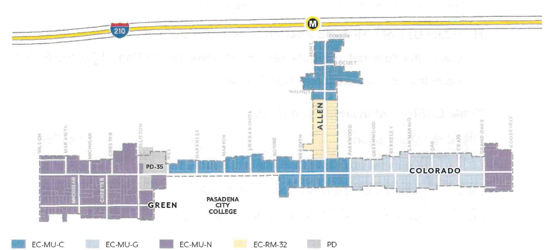
(Ord. No. 7394, § 3(Exh. 2), 6-13-2022)
17.31.040 - Allowable Land Uses
A.
Definitions. Definitions of specific land uses are found in Section 17.80.020.
B.
Permit Requirements. Table ECSP-2 identifies the uses of land allowed, the land use permit required to establish each use, and limitations that may apply for a particular use.
C.
Standards for Specific Land Uses. Additional standards may apply to specific land uses; refer to the Section noted in Table ECSP-2.
1.
Section 17.50.160 shall not apply to Mixed-Use Projects.
2.
Section 17.50.350 shall not apply to Multi-Family Housing.
D.
Ground Floor Frontages. In Mixed-Use zoning districts, additional commercial requirements and residential unit restrictions on the ground floor shall apply per Section 17.31.080.A.
E.
Major Construction. For all non-residential uses with a gross floor area of 25,000 square feet or greater, a Conditional Use Permit shall be required per Section 17.61.050.J.2.
F.
Prohibited Uses. Those uses not listed in Table ECSP-2 are prohibited by this Specific Plan, except as otherwise provided by Section 17.21.030.A.
G.
Nonconforming Uses. Existing uses which are made nonconforming by this Specific Plan shall be subject to Section 17.71.
H.
Initial Use of a Historic Resource. Where prohibited by Table ECSP-2, the initial use of the designated historic resources, identified on Page 17 of the ECSP, may be permitted with a Conditional Use Permit.
I.
Limited Hours of Operation. Uses listed in Table ECSP-2 shall comply with limited hours of operation as required by 17.40.070.
Table ECSP-2: Allowable Land Uses
(Ord. No. 7446, § 5, 5-12-2025; Ord. No. 7435, § 9, 10-28-2024; Ord. No. 7420, § 3, 4-15-2024; Ord. No. 7419, § 4, 2-26-2024; Ord. No. 7418, § 2, 2-26-2024; Ord. No. 7414, § 2, 9-11-2023; Ord. No. 7394, § 3(Exh. 2), 6-13-2022)
17.31.050 - Public Realm Standards
These standards are intended to:
•
Ensure a minimum sidewalk width is achieved, appropriate to support future densities, intensities, uses, and pedestrian volumes;
•
Enhance pedestrian conditions and improve street tree health through increased landscaping and permeability at sidewalk level;
•
Provide sufficient space to support dedicated amenity and walk zones; and
•
Increase shade, carbon sequestration, and stormwater capture by allowing adequate space for street trees and parkways.
A.
Sidewalks
1.
Sidewalk Width
a.
Dimension. Projects shall provide sidewalks that meet the required widths per Figure ECSP-2. Where the existing sidewalk right-of-way is less than the required width, the difference shall be provided through a private property dedication.
(1)
Sidewalks are measured from the Primary Curb Line of each block to the sidewalk line, as illustrated in Figure ECSP-3.
(2)
This area shall be paved for general use to the standards specified by Public Works, except for landscaped parkways per Section 17.31.050.B.
(3)
Within the sidewalk width, sidewalk zones shall be provided to the dimensions set in Figure ECSP-4.
(4)
Where the curb deviates (i.e. bulb-outs), exceptions in zone width are allowed and shall be determined by Public Works.
(5)
Driveways are allowed per Section 17.31.100.B.
b.
Maintenance. Sidewalk improvements shall be installed and maintained by the abutting property owner.
Figure ECSP-2: Sidewalk Width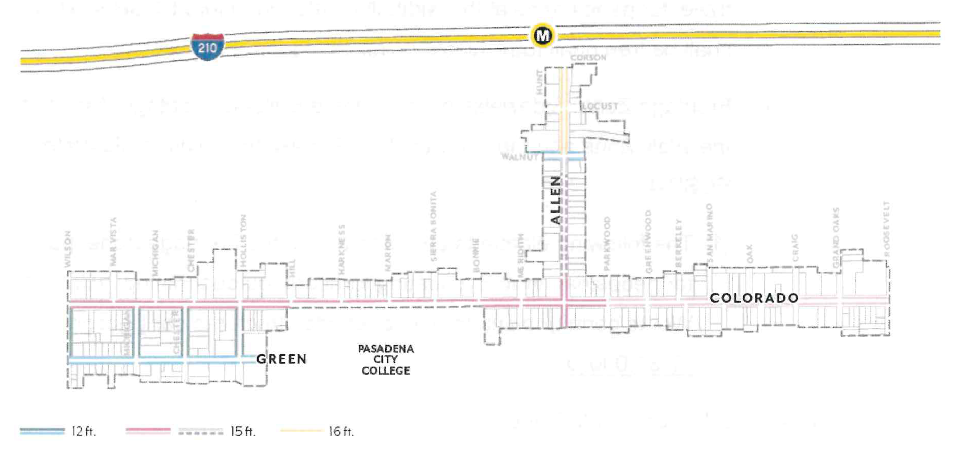
Figure ECSP-3: Sidewalk Line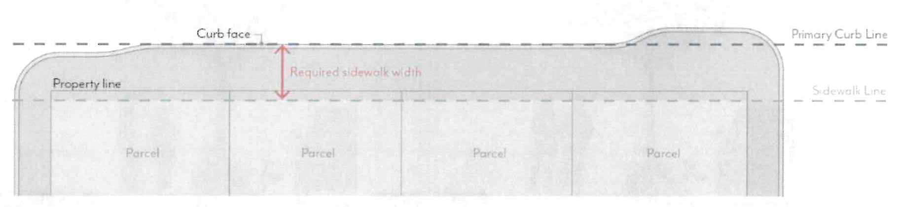
2.
Sidewalk Zones
a.
Amenity Zone. Sidewalks shall provide an Amenity Zone consistent with the width illustrated in Figure ECSP-4, including the curb.
(1)
Projects shall meet minimum parkway and street tree requirements per Section 17.31.050.B.
(2)
The following elements are permitted in the Amenity Zone at the discretion of Public Works: paved area for pedestrian mobility, parkways and street trees, seating/furniture, outdoor dining (with a Public Works permit), planters, bicycle parking, bus shelters, and/or other utility facilities including streetlights, signals, meter/sign poles, and pullboxes, etc.
b.
Walk Zone. Sidewalks shall maintain a Walk Zone as a continuous path of travel for pedestrians at the width illustrated in Figure ECSP-4. This area shall be free of all furnishings, landscaping, or obstructions.
c.
Frontage Zone. Sidewalks may include a Building Frontage Zone between the Walk Zone and the sidewalk line. A maximum width is illustrated in Figure ECSP-4.
(1)
The following elements are permitted in the Frontage Zone: paved area for pedestrian mobility, seating/furniture, outdoor dining (with a Public Works permit), planters, and/or shade structures per Section 17.31.080.D.
Figure ECSP-4: Sidewalk Zones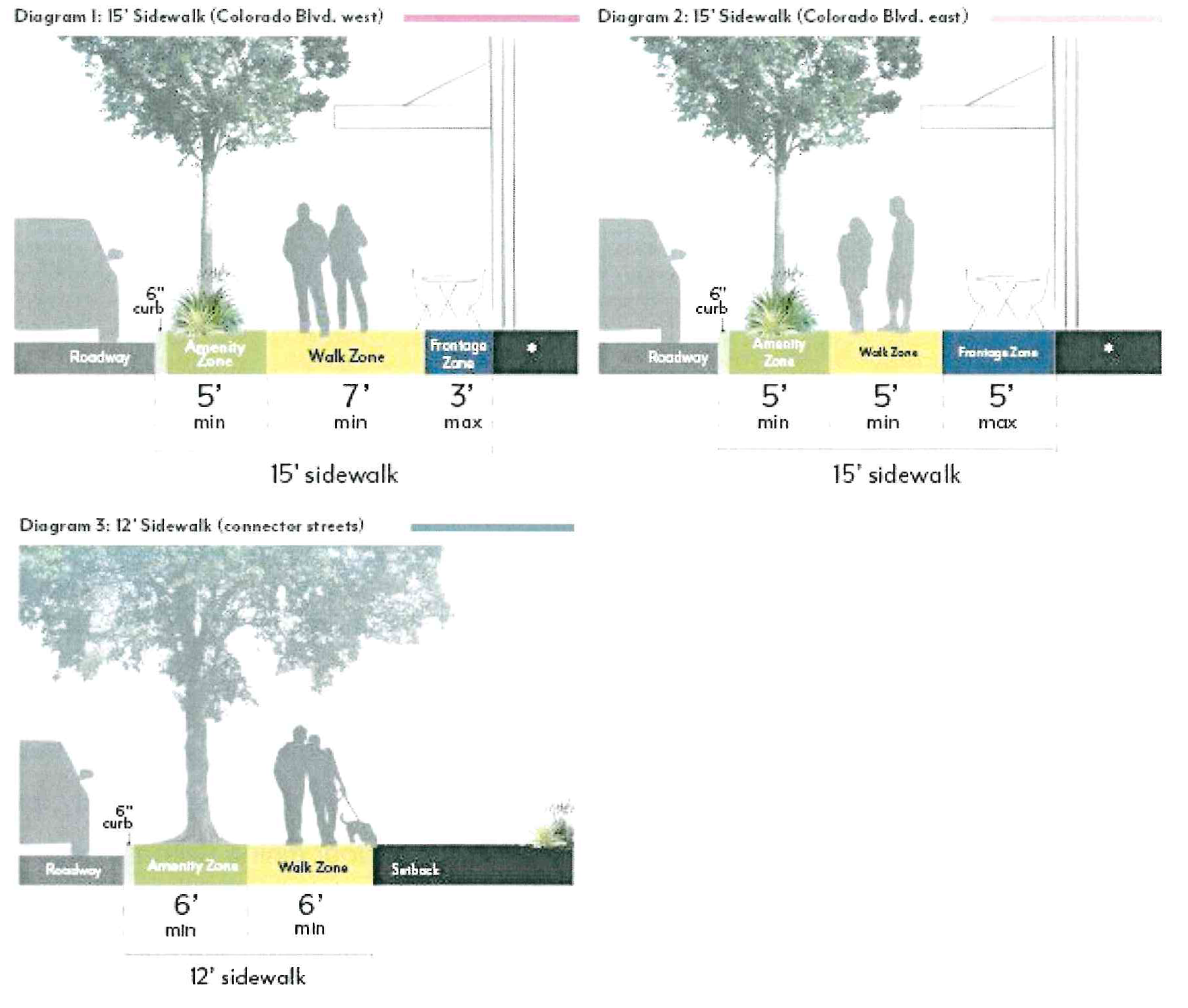
B.
Parkways & Street Trees
1.
Parkways
a.
Required Parkways. Projects shall include parkways within the Amenity Zone as follows.
(1)
In EC-RM-32, parkway length shall be no less than 60 percent of street frontage, unless approved by the Director of Public Works.
(2)
In all other zoning districts, parkway length shall be no less than 30 percent of street frontage, unless approved by the Director of Public Works.
b.
Dimensions. Parkways shall be constructed at the same width as the Amenity Zones illustrated in Figure ECSP-4, minus the 6-inch width required for the curb.
(1)
When street parking is adjacent to the curb, a paved buffer with a minimum width of 18 inches is required, in addition to the 6-inch curb, except where tree grates are adjacent to the curb.
(2)
Barriers up to 24 inches high, such as low walls or fences, are permitted at the interior edge of the parkway but are not required.
c.
Access Ways. Where on-street parking is permitted, access ways shall be provided at a minimum frequency of one per every 20 feet of continuous parkway.
(1)
Access ways shall be a minimum of 4 feet in width and provide a firm, uniform walking surface in all weather conditions from the curb to the Walk Zone.
(2)
The finished surface of access ways shall be in plane with both the adjoining top of curb and sidewalk.
(3)
Access ways shall be constructed of pavers, concrete, or stabilized decomposed granite.
d.
Planted Area. A minimum of 80 percent of the total required parkway area for a given project shall be comprised of plant material.
(1)
Permitted materials include groundcovers, turf or turf substitutes, and shrubs or low perennials that are lower than 24 inches in height at full maturity.
(2)
All plant material shall be native or climate appropriate and have a water use rating of Moderate, Low or Very-Low as defined by Water Use Classification of Landscape Species (WUCOLS) for the region. Plant water use requirements may be relaxed to maximize the efficiency of parkway stormwater capture systems per approval by the Director of Public Works.
(3)
Plants with spines or thorns shall not be planted adjacent to any walkways or curbs.
(4)
Edible plants are not permitted in parkways.
(5)
Artificial turf is not permitted in parkways.
(6)
When removing existing plant material like turf grass from a parkway, there shall be no damage to the street tree roots. Parkway improvements involving excavation within an existing tree's root zone must be consistent with the City's Tree Protection Guidelines. Root pruning, if required and approved by Public Works, must be overseen by a Certified Arborist. Excavation within a tree's root zone must be replanted immediately to prevent the tree roots from exposure and undue harm.
e.
Non-planted Area. A maximum of 20 percent of the parkway area may be organic or inorganic cover.
(1)
Permitted materials include permeable pavers, decomposed granite, gravel, rocks, or mulch. Pavers are not allowed within 3 feet of any public streetlight pole or pull box or other utility facilities.
f.
Stormwater Management. Parkways shall either meet the following basic stormwater standards, or propose a biofiltration planter or swale design based on local conditions per the approval of the Director of Public Works.
(1)
The parkway shall be at the same grade as the adjacent hardscape surface at the outer edge of the parkway and slope at a minimum of 1 percent towards the center of the parkway.
(2)
For parkways with a width greater than 5 feet, the center 2 feet of the parkway shall be depressed 3 to 4 inches to form a shallow swale to collect sidewalk stormwater. Alternative means of storing runoff, such as gravel sumps within the parkway, may be provided with review authority approval.
g.
Irrigation. Irrigation systems in parkways shall be designed and constructed in a manner that will eliminate surface runoff onto any impermeable surface, public or private, under any condition.
(1)
Design of irrigation systems in parkways shall be in accordance with all local, state, and federal laws and regulations for water conservation.
(2)
Street tree roots shall not be damaged during the irrigation installation process.
h.
Maintenance. Abutting property owner shall maintain the parkway in a condition so as not to endanger persons or property, and not to interfere with the public convenience.
2.
Street Trees
a.
Species. Street tree species shall be selected according to the Master Street Tree Plan at the discretion of the Director of Public Works. Trees may be planted within parkways or tree wells. For guidance on street trees refer to Appendix A.2 of the East Colorado Specific Plan 2022 document.
b.
Spacing. Street trees shall be planted at a spacing of one per 30 feet. Exceptions can be made by the Director of Public Works due to conflicts with street lights, bus shelters, utility boxes, or other street amenities. Closer spacing is encouraged when feasible and when appropriate for the particular tree type.
c.
Well Dimension. Tree well width shall be equivalent to the required Amenity Zone, minus the 6-inch width required for the curb.
(1)
If a paved buffer zone is required due to adjacent street parking, the tree well width may be reduced to accommodate this buffer strip. The minimum length of a tree well shall be 6 feet.
(2)
Street trees planted within tree wells must be installed according to the Department of Public Works Tree Planting in Tree Well Standard Plan.
d.
Well Frames. Tree well frames, or tree grates, may be installed according to the Department of Public Works Tree Well Frame Installation Standard.
e.
Expanded Root Zone Cell. Each street tree shall be provided with an uncompacted root zone volume of 800 cubic feet minimum. The root zone volume depth shall be 2 feet minimum and 3 feet maximum.
(1)
Where this root zone volume cannot be provided within the parkway area, an expanded root zone cell volume shall be provided below adjacent pavement using a strategy such as structural soil or a suspended pavement system to provide an uncompacted soil area suitable for tree root growth.
(2)
The root zone volume per tree requirement may be reduced by 10 percent where two or more trees share a contiguous root zone cell.
f.
Maintenance. All street trees shall be maintained by the Department of Public Works.
(Ord. No. 7394, § 3(Exh. 2), 6-13-2022)
17.31.060 - Summary of Development Standards
17.31.070 - Scale Standards
These standards are intended to:
•
Implement the General Plan density (du/ac) and floor area ratio (FAR) values;
•
Shape development in a manner that creates a defined public realm and appropriate scale of buildings for a visually appealing community;
•
Reduce building massing through setback and stepback requirements that create appropriate transitions to residential neighborhoods;
•
Support high-quality architecture and urban design through modulation requirements and a varied roof lines incentive; and
•
Require appropriate transitions to designated historic resources.
A.
Density
1.
Residential Density. Projects that include residential dwelling units shall not exceed the allowable dwelling units per acre (du/ac) per Figure ECSP-5.
a.
Fractions shall be rounded to the nearest whole number; those at 0.50 may be rounded up.
b.
For projects utilizing state density bonus, refer to Government Code 65915.
c.
The maximum is based on total site area. If a street dedication or easement is required, density shall be calculated using the size of the lot prior to the street dedication or easement.
2.
Unit Mix. For projects west of Hill Avenue with 50 dwelling units or more, inclusive of any density bonus, at least 20 percent of the total number of units shall have a minimum of 3 bedrooms.
a.
Fractions shall be rounded to the nearest whole number; those at 0.50 shall be rounded up.
Figure ECSP-5: Residential Density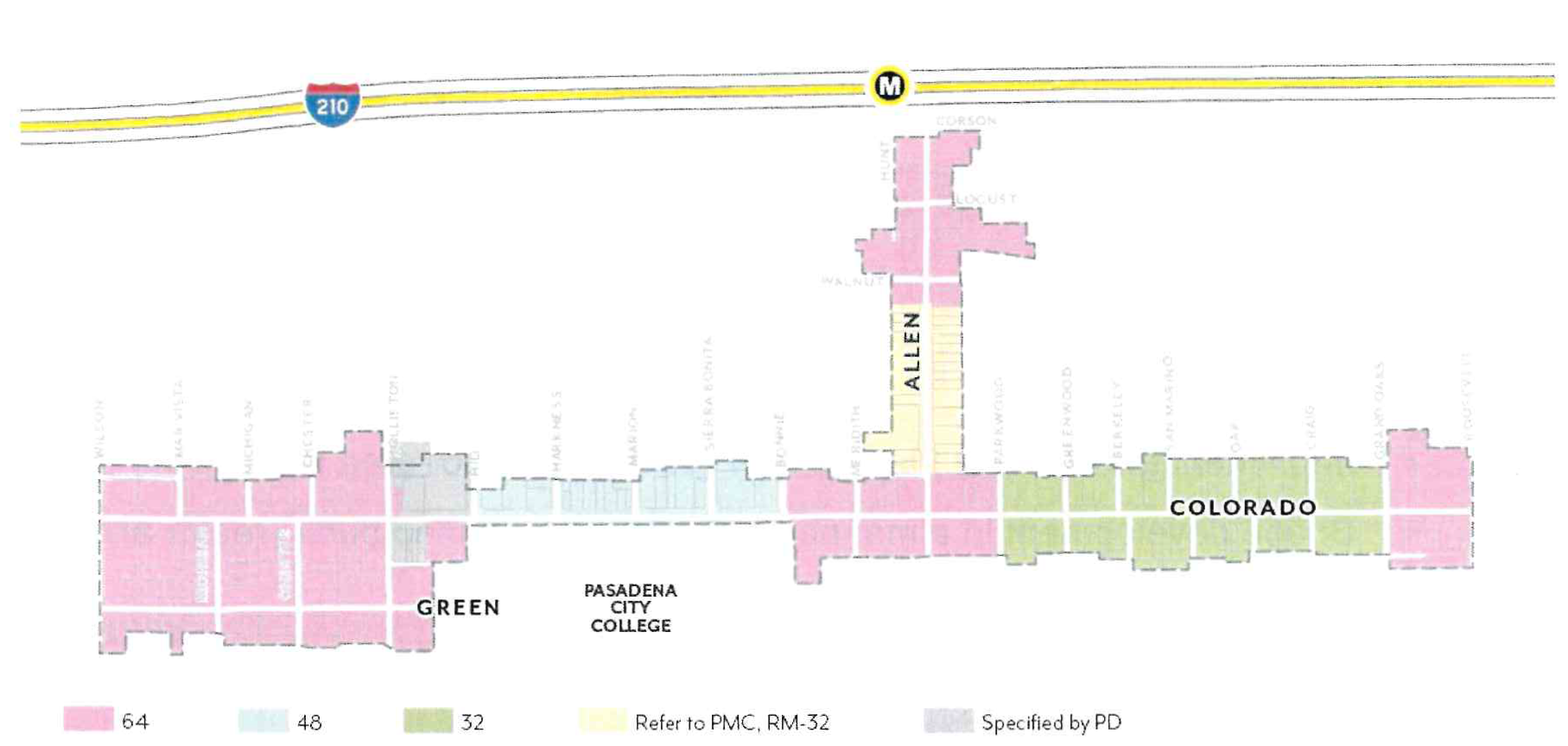
B.
Intensity
1.
Floor Area Ratio. .....Projects that include non-residential space, including mixed-use, shall not exceed the allowable floor area ratio (FAR) per Figure ECSP-6.
a.
In mixed-use projects, residential floor area is included in FAR.
b.
Areas used exclusively for vehicle and bicycle parking and loading are excluded from FAR.
c.
The maximum is based on total site area. If a street dedication or easement is required, FAR shall be calculated using the size of the lot prior to the street dedication or easement.
Figure ECSP-6: Floor Area Ratio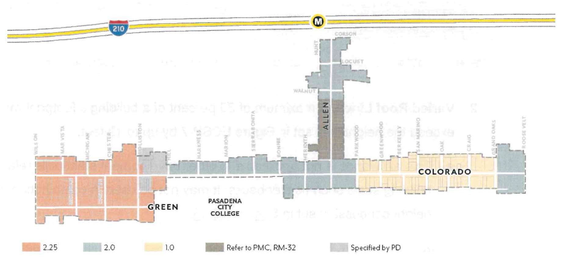
C.
Height
1.
Building Height. Projects shall not exceed the height limits set in Figure ECSP-7.
a.
Height is measured per Section 17.40.060.
b.
Maximum height for massing adjacent to street or interior property lines may be limited by required stepbacks; see Section 17.31.070.E.
c.
Exceptions allowed for Varied Roof Lines (Section 17.31.070.C.2) and projecting features such as appurtenances and railings per Section 17.40.060.
Figure ECSP-7: Building Height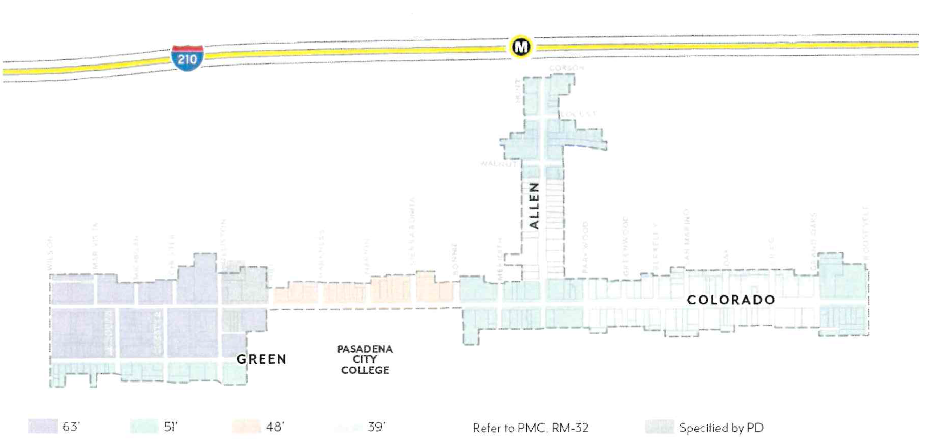
2.
Varied Roof Lines. A maximum of 30 percent of a building's footprint may exceed the height limit set in Figure ECSP-7 by up to 12 feet.
a.
This allowance is not applicable to other development standards relating to building scale such as stepbacks. It may not be used in combination with the height concession set in Section 17.43.
3.
Streetwall Height. Buildings shall meet or exceed the minimum streetwall height set in Table ECSP-4 for a minimum of 75 percent of building frontage, unless the overall building height is lower than the requirement; see Figure ECSP-8.
a.
Streetwall is defined as any street-facing façade within 10 feet of the maximum setback and is not required to be continuous.
b.
Appurtenances shall not count toward streetwall height.
Table ECSP-4: Streetwall Height
Figure ECSP-8: Streetwall Height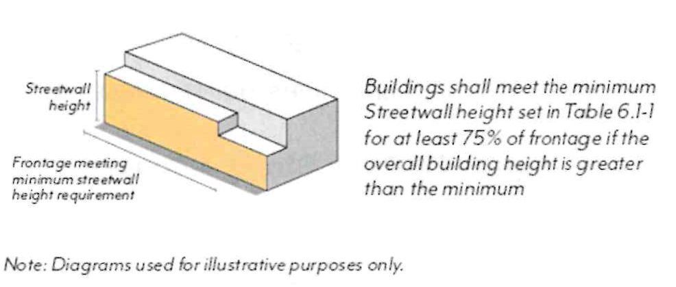
D.
Setbacks
1.
Street Setbacks. Buildings shall comply with the street setbacks set in Figure ECSP-9. Setback ranges establish a minimum and maximum for the specified percentage of linear frontage; see Figure ECSP-10.
a.
Street setbacks are measured from the sidewalk line; see Figure ECSP-3.
b.
Minimum setbacks shall apply to all stories of a building; setbacks less than the minimum are prohibited. Maximum setbacks shall apply only to the ground floor and Streetwalls (Section 17.31.070.C.3), where applicable.
c.
Residential units on the ground floor shall have a minimum setback of 5 feet. Where elevated between 4 and 6 feet above sidewalk elevation, a minimum setback of 8 feet shall be required.
d.
Exceptions allowed per Section 17.40.160 (Table 4-1) and the following:
(1)
Arcades and recessed ground floors up to 15 feet in depth, as well as parking entrances per Section 17.31.100.B, are allowed when a second story or roof meets the setback range; see Figure ECSP-11.
(2)
The specified frontage percentage may be reduced for the provision of Publicly Accessible Open Space facing the street through the Design Review process with Design Commission approval.
(3)
For Restaurants in EC-MU-G, the primary frontage percentage may be reduced to 40 percent if an additional 10 percent is provided as a solid wall of 36 to 48 inches enclosing outdoor dining.
e.
Features allowed within the street setback include: landscaping and planters, hardscape (e.g. stoops, patios), shade structures per Section 17.31.080.D, arcades and galleries per Section 17.31.080.E, exterior features per Section 17.31.080.F, walls and fences per Section 17.31.080.G, seating and furniture, outdoor dining, and other open space amenities per review authority approval.
f.
For portions of buildings set back from the sidewalk line 5 feet or more, a percentage of the setback area shall be landscaped with trees, shrubs, and/or groundcover, either in the form of in-ground landscaping or planters.
Figure ECSP-9: Street Setbacks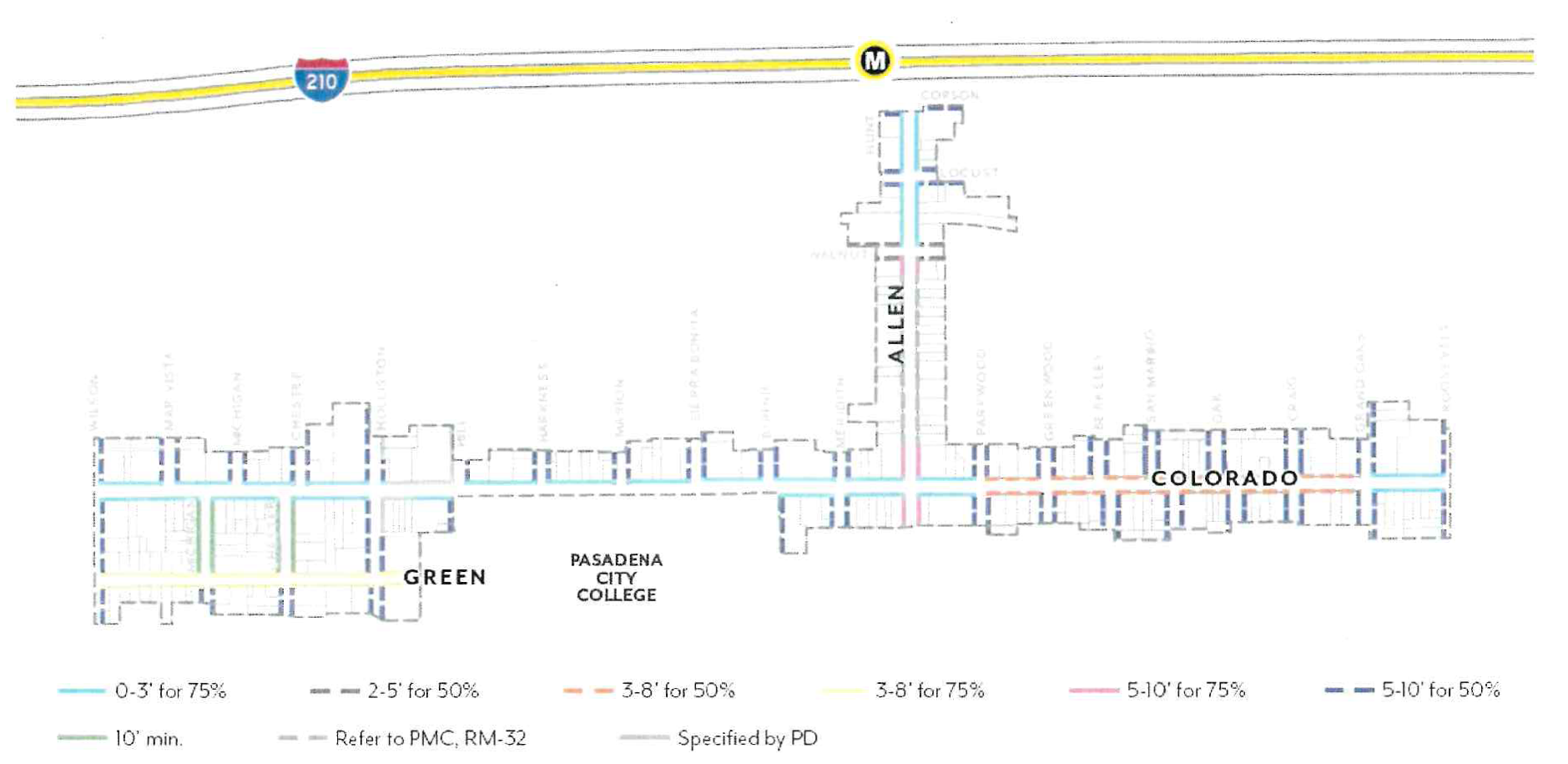
Figure ECSP-10: Street Setbacks Percentage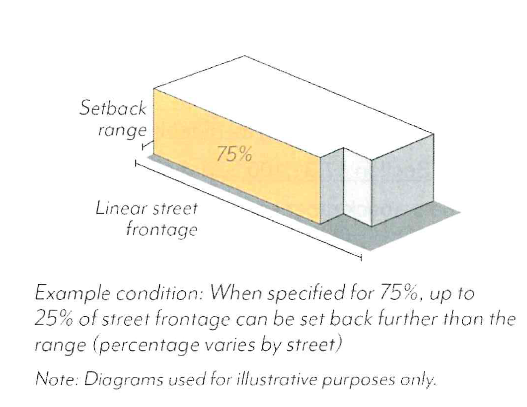
Figure ECSP-11: Recessed Ground Floor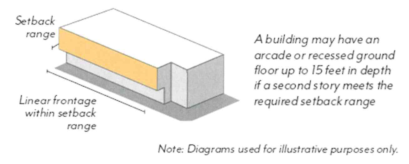
2.
Interior Setbacks. Buildings shall be set back a minimum of 15 feet from an interior property line that is adjacent to a PS or RM zoning district. No setback is required when adjacent to other districts.
a.
Interior setbacks are those abutting other parcels along non-street side and rear property lines and are measured from the shared property line.
b.
Exceptions allowed per Section 17.40.160 (Table 4-1).
E.
Stepbacks
1.
Street Stepbacks. Buildings shall not exceed the height specified in Table ECSP-5 before stepping back the specified depth; see Figure ECSP-12.
a.
Street stepbacks are measured from the sidewalk line.
b.
Uses allowed within the street stepback include: private open space (e.g. balconies, terraces), shade structures, trellises, and similar, green roofs and photovoltaic panels, and other open space features per review authority approval.
Table ECSP-5: Street Stepbacks
Figure ECSP-12: Street Stepbacks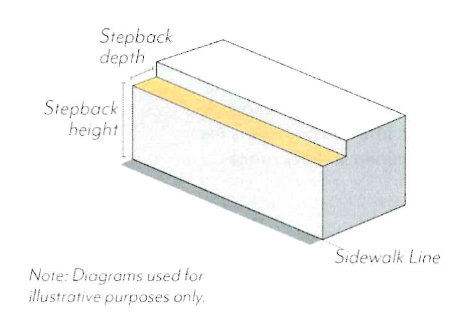
2.
Interior Stepbacks. Adjacent to RM zoning districts, buildings shall not be located within the encroachment plane sloping upward and inward at a 45-degree angle measured from the vertical, commencing 25 feet above the existing grade along the shared property line; see Figure ECSP-13.
a.
Exceptions allowed per Section 17.40.160 (Table 4-2.1).
Figure ECSP-13: Interior Stepbacks Adjacent to RM Zoning Districts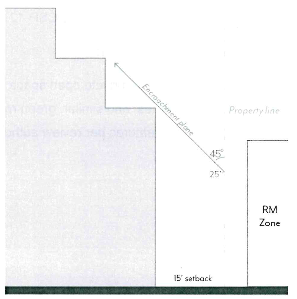
F.
Historic Adjacency
1.
Landmark Properties. Projects on parcels with a designated historic resource shall be subject to review for consistency with the Secretary of the Interior's Standards.
2.
Transition Massing. Projects sharing a property line with a designated historic resource are subject to the following modified standards, illustrated in Figure ECSP-14.
a.
Street Setbacks. The minimum street setback shall be an average of the minimum setback set in Figure ECSP-9 and that of the resource for a minimum of 20 feet from the shared property line. If located between two resources, the street setback shall be an average of the setbacks of the two resources.
b.
Interior Setbacks. The minimum interior setback shall be equal to that of the historic resource or 15 feet, whichever is less. No setback is required where the resource is built to the shared property line.
c.
Streetwall Height. A maximum streetwall height shall not exceed the height of the historic resource for a minimum of 20 feet from the shared property line. A stepback with a minimum depth of 10 feet is required above this height, measured from the modified minimum street setback.
d.
Interior Stepbacks. Projects shall not be located within an encroachment plane sloping upward and inward at a 30-degree angle measured from the vertical, commencing 15 feet above the existing grade at the property line; see Figure ECSP-14. This plane is not applicable if the resource is built to the shared property line.
Figure ECSP-14: Historic Adjacency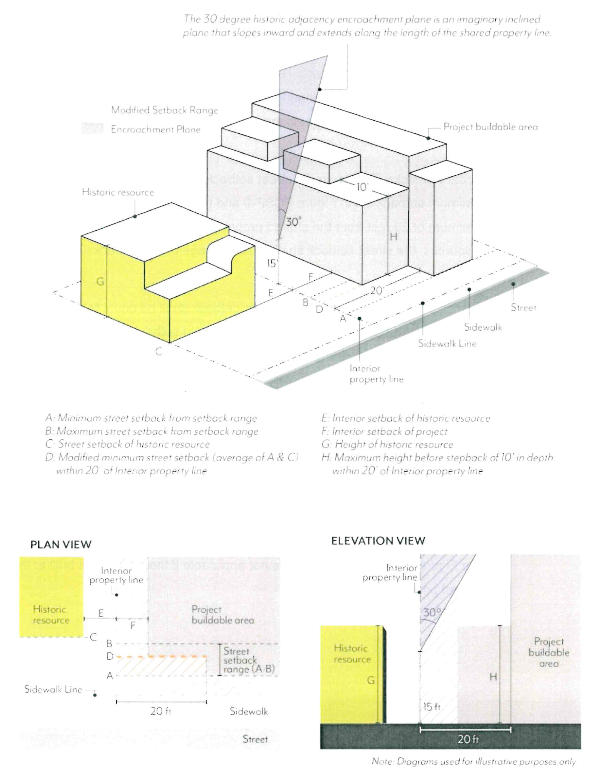
G.
Modulation
1.
Façade Length. Each street-facing façade shall not exceed 150 feet in length unless there is a minimum break of 10 percent of the building length or 20 feet, whichever is greater. This break shall be at least 10 feet deep, open to the sky; see Figure ECSP-15.
2.
Façade Area. Each street-facing façade exceeding 50 feet in length shall modulate a minimum of 25 percent of the area above the first story. This modulation shall be between 2 feet and 12 feet in depth from the primary facade plane; see Figure ECSP-16. Buildings with a total of 2 stories or less are exempt.
a.
The primary façade plane is defined as the vertical plane with the greatest surface area above the ground floor.
b.
Planes that are separated by a break of at least 20 feet in width and 10 feet in depth shall be considered separate façades for the purposes of this standard.
c.
Modulation is not required to be continuous or open to the sky, and may be recessed or projected, but not past the sidewalk line.
d.
Required stepbacks (Section 17.31.070.E), required façade breaks (Section 17.31.070.G.1), and projected balconies (Section 17.31.080.G.1) shall not count toward the modulation requirement; balconies that are recessed a minimum of 2 feet shall qualify.
| Figure ECSP-15: Facade Length | Figure ECSP-16: Facade Area |
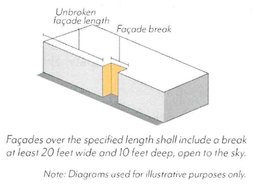 | 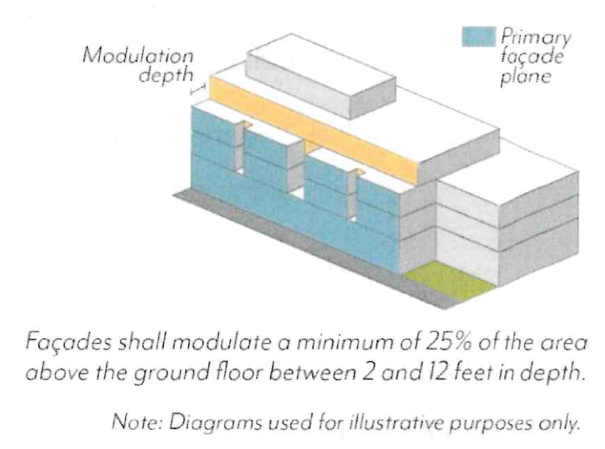 |
3.
Alternative Compliance
a.
Eligibility. Modulation standards may be reduced or otherwise modified through the Design Review process if:
(1)
A minimum of 90% of the provided parking is fully or partially subterranean;
(2)
A minimum of one publicly accessible open space is provided at the ground level, visible and accessible from the sidewalk;
(3)
No other concessions, waivers, or incentives have been requested, including those associated with Section 17.43 (Density Bonus), unless the project is designed to achieve LEED Gold certification; and
(4)
The review authority makes all of the following findings.
b.
Required Findings.
(1)
The building design provides modulation on each street-facing façade in a manner consistent with the project's architectural style and/or immediate context, including adjacent historic resources.
(2)
The building design does not cause an adverse impact on the quality of the ground floor and public realm.
(3)
The ground level open space is of adequate size and integrated with the building in a functional way that ensures the space will be actively utilized.
(4)
The modification will not be detrimental to the health, safety, and welfare of the public.
(5)
The building design is consistent with the objectives and policies of the General Plan and ECSP, as well as all other standards of the ECSP.
(Ord. No. 7446, § 5, 5-12-2025; Ord. No. 7394, § 3(Exh. 2), 6-13-2022)
17.31.080 - Frontage
These standards are intended to:
•
Prioritize pedestrian access by ensuring doorways are open to a public sidewalk or public open space;
•
Increase visibility into ground floor uses to create visual interest for pedestrians;
•
Promote shade through arcades and shade structures;
•
Support a consistent character when different uses are allowed on the ground floor within the same block; and
•
Limit blank walls on the ground floor to enhance visual interest and pedestrian comfort.
A.
Ground Floor Frontages
In Mixed-Use zoning districts, ground floor use requirements are regulated by frontage type per Figure ECSP-17 and Table ECSP-6. All use requirements are regulated as a percentage of the building frontage; see Figure ECSP-18.
1.
Commercial Uses. Frontage types require a minimum amount of the building frontage to be comprised of, and designed for, commercial uses per Figure ECSP-17 and Table ECSP-6. Permitted commercial uses by zoning district are found in Table ECSP-2.
a.
Entrances to non-ground floor uses, and/or entrances to uses prohibited within 35 feet of the sidewalk, shall not qualify toward the minimum commercial use percentage.
b.
Commercial uses shall have an average interior depth of at least 35 feet and a minimum depth of 20 feet, measured wall-to-wall.
c.
For Type 2A commercial corners, a minimum of 40 feet of commercial frontage along the designated street is required, measured from the perpendicular building frontage closest to the corner.
(1)
For corners with public open space, this commercial frontage may front the open space rather than the street.
2.
Residential Uses. Frontage types set limitations on ground floor residential uses facing the street per Figure ECSP-17 and Table ECSP-6. Permitted residential uses by zoning district are found in Table ECSP-2.
a.
Type A: Residential units on the ground floor shall be prohibited within 35 feet of the sidewalk line, inclusive of setbacks, per Table ECSP-6.
b.
Type B: Residential units on the ground floor shall be permitted with direct access to the street and a minimum setback of 5 feet.
c.
Residential common space on the ground floor shall be permitted per Table ECSP-2.
Figure ECSP-17: Ground Floor Frontage Types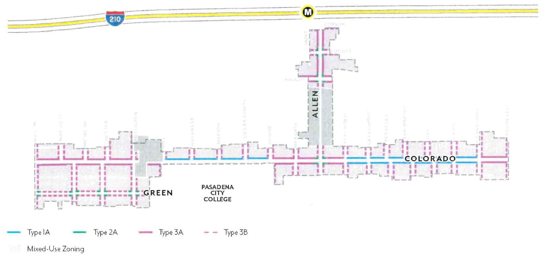
Table ECSP-6: Ground Floor Frontage Types
Figure ECSP-18: Ground Floor Commercial Uses
B.
Ground Floor Design
1.
Entrances. A minimum of one primary entrance shall be located on the primary frontage of each building and open onto a sidewalk or other public space.
a.
Primary entrances shall be distinguished by architectural features or overhead projections, such as an awning or canopy.
b.
All entrances shall be recessed a minimum of 30 inches from the sidewalk line.
2.
Minimum Height. Buildings shall have a minimum ground floor height of 15 feet, measured from sidewalk elevation closest to the primary entrance to the second story floor or roof of a one-story building; see Figure ECSP-19.
a.
Exception. Ground floor residential uses with a setback of 10 feet or greater shall have a minimum ground floor height of 12 feet.
b.
For non-residential and residential common space uses, the primary entrance of the first habitable floor shall be located at existing grade along the sidewalk line.
c.
For residential units, the first habitable floor shall be located between 6 feet above and 2 feet below sidewalk elevation.
Figure ECSP-19: Ground Floor Height
C.
Transparency
1.
Windows & Doors. Street-facing facades shall incorporate glass providing views into work, display, sales, lobby, or similar active areas. The minimum transparency requirement is 70 percent for ground floors and 30 percent for the overall façade. For residential units, transparency requirements are reduced to 15 percent.
a.
For non-residential and residential common space uses, ground floor transparency is measured as the percentage of building frontage that consists of transparent openings between a height of 2 feet and 10 feet above sidewalk elevation.
b.
All other transparency is measured as the percentage of building frontage area, viewed in elevation.
c.
Windows shall be recessed by a minimum of 3 inches from the façade, measured from the outside wall to the frame of the window (mullion, muntin or similar element). Flush windows shall be permitted where exterior shading devices cover a minimum of 25 percent of the window surface area or per review authority approval.
d.
The use of color-tinted, mirrored, or highly reflective glass is prohibited.
e.
Blinds, drapes, posters, and shelving for product displays visible to the public right-of-way shall obscure a maximum of 10 percent of the transparent areas of each respective storefront or 50 percent for medical office uses.
2.
Blank Walls. Windowless expanses of walls shall not exceed 20 feet in length.
3.
Security Bars. Any exterior or interior security bars shall be designed to be fully hidden from view during business hours with devices such as concealed side pockets and ceiling cavities.
D.
Shade Structures
1.
Awnings & Canopies. Any ground floor shading shall project a minimum of 3 feet from the façade with a minimum of 8 feet of vertical clearance from sidewalk elevation.
a.
Shade structures shall not conflict with existing trees; exceptions to the depth requirement shall be subject to review authority approval.
2.
Colorado Boulevard. For projects on the north side of Colorado Boulevard, shade structures are required and shall project a minimum of 7 feet, up to a maximum of 10 feet, into the public right-of-way for a minimum of 70 percent of the building frontage.
a.
Where an arcade or recessed ground floor provides a minimum of 5 feet of unobstructed pedestrian clearance, shade structures are not required.
E.
Arcades & Galleries
1.
Arcades. Any arcades shall be located behind the minimum setback.
a.
Arcades shall be a minimum of 8 feet from back of column to building façade.
b.
The distance between columns shall be equal to or greater than the arcade depth dimension, as measured from the column center.
c.
The façade shall meet the ground floor transparency set in Section 17.31.080.C.
d.
Uses allowed within arcades include: pedestrian travel, seating/street furniture, outdoor dining, landscape planters, and/or bicycle parking.
2.
Galleries. Any galleries shall be located behind the minimum setback.
a.
Galleries shall be limited to one-story in height and 50 percent of the building frontage.
b.
Galleries shall allow a minimum of 10 feet of vertical clearance from sidewalk elevation.
F.
Exterior Features
1.
Façade Lighting. Lighting shall be located on façades facing streets and public open spaces at a frequency of every 30 feet or less.
a.
Façade lighting shall be full cutoff (directing light downward and outward).
b.
Fixtures shall be located between 8 and 15 feet above the sidewalk elevation, and shall not project more than 30 inches from the façade.
c.
For buildings with ground floor residential units, façade lighting shall be designed to be operable by the adjacent tenant.
d.
Façade lighting shall not be required on buildings located on designated historic resources and districts.
G.
Walls & Fences
1.
Walls & Fences. Walls and fences shall be subject to Section 17.40.180 with the following exceptions for those located within the street setback.
a.
Walls and fences shall have a maximum height of 48 inches above sidewalk elevation.
b.
Walls and fences taller than 30 inches shall be a minimum of 50 percent transparent and set back a minimum of 18 inches from the sidewalk line, separated by a planted area. Walls and fences 30 inches or less in height do not have a transparency or setback requirement.
c.
Walls and fences used to enclose outdoor dining may be located at the sidewalk line and are not required to provide a planted area if the wall or fence is 36 inches or less and more than 50 percent transparent.
d.
Guardrails may exceed the maximum height to the extent required by the Building Code. The guardrail shall be a minimum of 50 percent transparent.
2.
Stoops & Patios. The side of a patio or stoop (when parallel to a sidewalk) taller than 30 inches in height shall be set back a minimum of 18 inches from the sidewalk line, separated by planted area.
H.
Balconies & Roof Decks
1.
Balconies. Balconies may project a maximum of 4 feet from the building façade but shall not extend beyond the sidewalk line or within 6 feet of any interior property line.
2.
Roof Decks. The sum of all roof decks on a single building shall not exceed a maximum coverage of 60 percent of the roof area.
a.
Roof deck railings above the top floor shall be placed behind a parapet wall of at least the same height or set back a minimum of 5 feet from the façade. For buildings employing Varied Roof Lines, the uppermost story shall be defined per the discretion of the Director.
(Ord. No. 7446, § 5, 5-12-2025; Ord. No. 7394, § 3(Exh. 2), 6-13-2022)
17.31.090 - Open Space
These standards are intended to:
•
Provide a variety of open space types for gathering, recreation and respite that contribute to enhanced livability within an urban setting;
•
Give residents access to light, air, and pleasant views from their living spaces;
•
Improve building design and site planning through the integration of open space throughout the development; and
•
Correlate open space requirements with number of residents and size of buildings.
A.
Minimum Area.
1.
Private and Common Open Space. Projects shall provide the minimum area of Open Space based on use and size. Areas used regularly for parking, loading or storage shall not count towards minimum Open Space requirements.
a.
Residential. Projects with dwelling units shall provide the minimum area of Open Space per Table ECSP-7 as a combination of Private and/or Common Open Space.
b.
Non-residential. Projects with more than 40,000 square feet of non-residential floor area shall provide a minimum of 5 percent of the gross non-residential floor area as Common Open Space.
(1)
Research and Development uses may reduce Common Open Space area requirements by a maximum of 60 percent. Research and Development projects (or the Research and Development portion of a project with multiple uses) shall exclude mechanical space from floor area for required Open Space.
c.
Mixed-use. Projects shall comply with requirements applicable to each type of use above.
Table ECSP-7: Residential Open Space by Unit Type
2.
Publicly Accessible Open Space (PAOS). Projects with more than 80,000 square feet of gross floor area (GFA) shall provide a minimum area of PAOS, calculated as a percentage of GFA, as set in Table ECSP-8.
a.
PAOS shall be provided in addition to Private and Common Open Space requirements.
b.
Projects shall comply with PAOS standards per Section 17.31.090.D and Paseo standards per Section 17.31.090.E where relevant.
(1)
PAOS and Paseo standards may be modified through the Design Review process, if the review authority finds that the modified design continues to be accessible to the public, functional, and includes features such as landscaping, trees, and outdoor seating.
c.
Research and Development uses may reduce PAOS area requirements by a maximum of 60 percent. Research and Development projects (or the Research and Development portion of a project with multiple uses) shall exclude mechanical space from floor area for required PAOS.
Table ECSP-8: Publicly Accessible Open Space
B.
Private Open Space.
1.
Dimensions. A minimum area of 40 square feet with a minimum dimension of 5 feet in each direction is required for Private Open Space.
2.
Distribution. A maximum of 40 percent of the required residential Open Space set in Table ECSP-7 shall be Private Open Space.
a.
All Private Open Space shall be outdoors.
b.
Private Open Space may be located within a required setback.
C.
Common Open Space.
1.
Dimensions. A minimum area of 400 square feet with a minimum dimension of 15 feet in each direction is required for Common Open Space.
2.
Distribution. A minimum of 60 percent of the required residential Open Space set in Table ECSP-7 shall be Common Open Space shared among tenants.
a.
A minimum of 70 percent of Common Open Space shall be outdoors, and a minimum of 80 percent of outdoor Common Open Space shall be open to the sky.
b.
A maximum of 30 percent of Common Open Space may be indoors. Indoor Common Open Space shall not include spaces used primarily for circulation.
3.
Access. Common Open Spaces may be accessible to the public.
4.
Hardscape. A maximum of 25 percent of Common Open Space may be paved in standard concrete. Remaining areas shall use one of the following enhanced paving techniques: brick, natural stone, unit concrete pavers, textured and colored concrete, concrete with exposed or special aggregate. Alternative paving may be allowed per review authority approval.
5.
Landscape. A minimum of 25 percent of Common Open Space shall be planted area with a minimum dimension of 30 inches in length and width. Landscaping shall comply with Section 17.44.050.
6.
Trees. A minimum of one 24-inch box tree per project or for every 500 square feet of outdoor Common Open Space, whichever is greater, shall be planted within the Common Open Space. For projects with 2 or more trees, a minimum of 50 percent of trees planted shall be shade trees.
7.
Water Features. A maximum of 5 percent of the required Common Open Space shall be fountains, reflecting pools, or other decorative water features. Swimming pools are not considered water features for the purposes of this standard.
D.
Publicly Accessible Open Space (PAOS)
1.
Area. Minimum area requirements are set in Section 17.31.090.A.2 and Table ECSP-8, and may be contiguous or noncontiguous, subject to the dimension and elevation standards below.
2.
Paseos. Projects that are required to provide PAOS per Section 17.31.090.A.2 and located on parcels that include a paseo opportunity area on Figure ECSP-20, as defined as a pedestrian passageway that connects a public street to another public street, alley, or internal public space.
a.
Paseos shall meet the standards set in Section 17.31.090.E; design standards Section 17.31.090.D through Section 17.31.090.D.12 shall not apply.
b.
In opportunity areas where a paseo has already been provided by previous development, additional paseos shall not be required.
3.
Plazas. Projects that are required to provide PAOS per Section 17.31.090.A.2 and located on parcels that include a plaza opportunity location on Figure ECSP-20, shall be required to meet the minimum area requirement by providing a plaza.
a.
PAOS design standards shall apply.
4.
Dimensions. A minimum area of 400 square feet with a minimum dimension of 20 feet in each direction is required for PAOS.
5.
Access. A maximum of 20 percent of the PAOS may be used as outdoor dining for a restaurant; a minimum of 80 percent of the PAOS shall be accessible to the general public.
6.
Signage. PAOS shall have signage visible from the adjacent sidewalk identifying the space as a publicly-accessible amenity and listing accessible hours.
7.
Hours. At a minimum, PAOS shall be open to the general public from 8am to 8pm. Any gated ingress or egress points shall not be closed or locked during these hours.
8.
Elevation. A minimum of 3,000 square feet of PAOS shall be at sidewalk elevation. If less square footage is required, then all required PAOS shall be at sidewalk elevation.
9.
Hardscape. A maximum of 25 percent of PAOS shall be paved in standard concrete. Remaining areas shall use one of the following enhanced paving techniques: brick, natural stone, unit concrete pavers, textured and colored concrete, concrete with exposed or special aggregate. Alternative paving may be allowed per review authority approval.
10.
Seating. Seating shall be provided at a minimum of 1 seat per 300 square feet of required PAOS. Fractions shall be rounded down to the nearest whole number.
a.
Benches shall be calculated as 1 seat per 24 linear inches.
11.
Landscape. A minimum of 25 percent of PAOS shall be planted area with a minimum dimension of 30 inches in length, width, and depth. Landscaping shall comply with Section 17.44.
12.
Trees. A minimum of one 24-inch box tree per project or for every 750 square feet of PAOS, whichever is greater, shall be planted. For projects with 2 or more trees, a minimum 50 percent of trees planted shall be shade trees.
13.
Common Open Space Credit. PAOS in excess of the minimum may count towards a maximum of 30 percent of the Common Open Space requirement at a 1:1 ratio.
Figure ECSP-20: Required Publicly Accessible Open Space
E.
Paseos.
1.
Dimensions. Paseos shall have an average width of 25 feet, minimum width of 15 feet, and be a minimum of 75 percent open to the sky. Paseos shall have a walk zone with a minimum width of:
a.
10 feet for commercial/mixed-use paseos.
b.
8 feet for residential-only paseos.
2.
Access. Paseos shall be physically and visually accessible from the connecting public sidewalk.
a.
Fences, walls, and/or entry gates are permitted; however, these features shall not block passage through the paseo during public hours.
b.
Bollards (fixed or removable) shall be provided at all entry points of paseos to restrict vehicular access during public hours.
c.
Emergency vehicular access shall be provided.
3.
Signage. Paseos shall have signage visible from the adjacent sidewalk identifying the space as a publicly-accessible amenity and listing public hours. In paseos that have commercial frontages, a directory signage shall be provided at each entry the all paseos. Specific sign guidelines shall be created for all properties with building facades immediately adjoining the paseos.
4.
Hours. At a minimum, paseos shall be open to the general public from 8am to 8pm. Commercial loading shall be limited to non-public hours.
5.
Elevation. Paseos shall be at ground level and ADA accessible.
6.
Programming. A maximum of 10 percent of required paseo area may be used by adjacent restaurants or food sales uses as a space restricted to customers only. Any additional programming must be non-transactional and without financial barriers to entry.
a.
Exception: Paseos may be closed to public access for private events no more than once per month.
7.
Hardscape. A maximum of 25 percent of paseos shall be paved in standard concrete. Remaining areas shall use one of the following enhanced paving techniques: brick, natural stone, unit concrete pavers, textured and colored concrete, concrete with exposed or special aggregate. Alternative paving may be allowed per review authority approval.
8.
Stormwater Management. A minimum of 25 percent of the total paved area shall be permeable paving to allow for stormwater infiltration. Depending on soil and site conditions, infiltration and/or flow-through planters shall be installed to capture and treat 100 percent of the stormwater run-off on-site.
9.
Seating. Seating shall be provided within the paseo at a minimum of 1 seat per 300 square feet of required space. Fractions shall be rounded down to the nearest whole number.
10.
Landscape. A minimum of 25 percent of paseo area shall be planted area a minimum of 30 inches in length, width, and depth. Landscaping shall comply with Section 17.44.
11.
Trees. A minimum of one 24-inch box tree per project or per each 750 square feet of paseo area, whichever is greater, shall be planted. For projects with 2 or more trees, a minimum 50 percent of trees planted shall be shade trees.
12.
Blank Walls. Paseos shall adhere to the blank wall standards defined in Section 17.31.080.C, or provide one of the following mitigations:
a.
Green wall, vines, or other vertical landscaping element that covers a minimum of 75 percent of non-conforming blank wall area.
b.
Public art including, but not limited to, murals.
(Ord. No. 7446, § 5, 5-12-2025; Ord. No. 7419, § 4, 2-26-2024; Ord. No. 7418, § 3, 2-26-2024; Ord. No. 7394, § 3(Exh. 2), 6-13-2022
17.31.100 - Parking
These standards are intended to:
•
Reduce the visual impacts of parking;
•
Regulate appropriate parking supply and location in a manner that prioritizes pedestrian access and multi-modal activity;
•
Encourage change of use and adaptive reuse of existing buildings through parking reductions and exemptions;
•
Promote a more efficient use of parking spaces through shared parking among multiple uses within a project; and
•
Increase design standards for parking structures through ensuring habitable floor areas between parking and street frontage and screening.
A.
Minimum Parking.
1.
Number of Spaces. Projects shall provide off-street automobile parking spaces per Table ECSP-9 based on general use classifications, and subject to the standards of Section 17.46.
a.
Where parking minimums in this Section conflict with state law, state law shall control.
b.
For projects within one-half mile of a Metro station, a maximum number of parking spaces shall apply per Section 17.50.340.
c.
Bicycle parking shall be required per Section 17.46.320.
Table ECSP-9: Minimum Parking
2.
Shared Parking. Parking may be shared among multiple uses per Section 17.46.050.
3.
Unbundled Parking. For any building with new residential units, automobile parking spaces shall be leased or sold separately from the rental or purchase fees, such that renters or buyers have the option of renting or buying the unit at a lower price than if the parking was included.
a.
For deed-restricted affordable units, one parking space shall be included in the base rent of each unit. The tenant may choose to receive the parking space or receive a rent discount equivalent to half the amount charged for monthly lease of a parking space. Tenants of affordable units shall not sublease their parking spaces.
b.
Renters or buyers have the right of first refusal to parking built for their unit. Any remaining spaces may be leased to other users on a month-to-month basis. New occupants shall have the opportunity to lease or purchase parking built for their unit.
B.
Vehicle Access.
1.
Driveways. For Projects with less than 200 feet of primary street frontage, a maximum of 1 two-lane driveway shall be permitted. For sites with more than 200 feet of primary street frontage, a maximum of 2 two-lane driveways shall be permitted.
a.
Driveways are not permitted on primary frontages of less than 200 feet where there is access from a secondary street or alley.
b.
The Zoning Administrator shall determine the primary frontage.
C.
Layout & Design.
1.
Surface Parking. Parking lots shall be set back a minimum of 30 feet from the primary frontage, a minimum of 10 feet from any secondary frontage, and a minimum of 5 feet from RM zoning. Parking shall be buffered by habitable floor area or landscaping, except for access and driveways, and comply with Section 17.46.230.
a.
Landscaping used as a parking buffer shall be located in the required parking setback and shall include hedges or shrubs a minimum of 3 feet in height at the time of planting that form a continuous visual screen.
2.
Structured Parking. Along primary frontages, all floors of parking structures shall be lined with building floor area (e.g. commercial or residential uses) or Publicly Accessible Open Space for a minimum of 35 feet in depth. Along secondary frontages, parking structures shall be set back a minimum of 5 feet. Pedestrian access and driveways in compliance with 17.31.100.B are excluded from this requirement.
a.
Parking structure facades visible from public streets, excluding alleys, shall use materials and design at least comparable to and integrated with the building architecture.
3.
Underground Parking. Subterranean parking shall be set back a minimum of 5 feet from Green Street and RM zoning. Otherwise, it may extend up to the property line.
(Ord. No. 7446, § 5, 5-12-2025; Ord. No. 7435, § 9, 10-28-2024; Ord. No. 7418, § 4, 2-26-2024; Ord. No. 7394, § 3(Exh. 2), 6-13-2022)
17.31.110 - Definitions
This Section provides definitions of terms and phrases used in this Specific Plan that are technical or specialized or that may not reflect common usage. In case of conflict with other provisions of the Zoning Code, these definitions shall control for the purposes of this Specific Plan. If a word is not defined in this Chapter, the Zoning Administrator shall determine the correct definition.
Amenity Zone.
The portion of the sidewalk located above and adjacent to the curb, providing space
for amenities such as parkways, outdoor dining, seating, trees, lighting, bicycle
racks, bus stops, etc.
Building Frontage.
The horizontal distance, measured at grade, of building wall facing the street.
Building Frontage Zone.
The portion of the sidewalk immediately adjacent to the building façade, providing
space for planters, outdoor dining, sidewalk signage, etc. This zone may not be present
on every street or block.
Curb Zone.
See "amenity zone."
Façade.
Any exterior wall plane of a building, ground level to top of roof.
Floor Area Ratio.
Numerical value obtained by dividing the above-ground area of a building or buildings
located on a lot by the total area of the lot.
Footprint.
The total ground floor area of the combined structures on a site or project area defined
by the perimeter of the building(s), including parking structures but excluding parking
lots and non-occupancy structures.
Frontage Zone.
See "building frontage zone."
Gross Floor Area (GFA).
The total enclosed area of all floors of a building measured to the inside face of
the exterior walls including halls, stairways, elevator shafts at each floor level,
service and mechanical equipment rooms and basement or attic areas having a height
of more than seven feet, but excluding area used exclusively for parking or loading
of vehicles or bicycles.
Ground Floor.
The first habitable floor of a building closest to sidewalk elevation.
Mixed-Use Project.
The combination or commercial and residential uses in the same structure, where the
residential component is located either above (vertical mixed-use) or behind (horizontal
mixed-use) the non-residential component. Non-residential uses are typically commercial
uses.
Open Space.
For any form of open space (Common, Publicly Accessible, Private, etc), see Section
17.31.090 of the Specific Plan.
Parkway.
Landscaped or permeable areas located within the amenity zone of the sidewalk.
Paseo.
A publicly accessible open space that functions as a pedestrian passageway connecting
a public street to another public street, alley, or internal public space. Subject
to minimum dimension and design requirements established by the Specific Plan.
Plaza.
A publicly accessible open space with access from a public street. Subject to minimum
dimension and design requirements established by the Specific Plan.
Primary Curb Line.
The face of the predominant curb of an individual block forming the edge of the street.
Residential Common Space.
Those portions of a residential use building not dedicated to residential units that
provide common services for residents. This may include spaces such as, but is not
limited to, lobby or common building entry, leasing center, gyms/exercise space, shared
kitchen, recreation center, screening or living room, business center, mail room,
or library. These spaces/portions of the building may be permitted on the ground floor
where residential units are not permitted subject to Specific Plan standards.
Setback.
The horizontal distance by which a structure, parking area, or development feature
is required to be separated from the property line or the sidewalk line where applicable.
In some cases superseded by Setback range.
Setback, Interior.
Non-street side or rear setback measured at a right angle from the nearest point of
the property line abutting another parcel or alley to the nearest portion of the structure,
excluding any porches.
Setback, Street.
Front or street-side setback measured at a right angle from the nearest point of the
sidewalk line to the nearest portion of the structure, excluding any porches.
Setback Range.
Minimum and maximum horizontal distances by which a structure or development feature
is required to be separated from the sidewalk line. This measurement is similar to
a "build-to" line.
Sidewalk Line.
The line parallel the property line accommodating the required sidewalk width, measured
from the curb face. Where a sidewalk width is not specified, the sidewalk line is
the property line.
Sidewalk Zones.
The three portions of a sidewalk that together comprise the public realm between a
building and the street. Sidewalk zones are defined by the Pasadena Street Design
Guide and regulated by the Specific Plan.
Shared Property Line.
The property line separating adjacent parcels.
Stepback.
The horizontal distance by which an upper story structure or development feature is
required to be separated from the property line or the sidewalk line where applicable.
Regulated above a specified vertical distance.
Street Frontage.
The horizontal distance along the street, measured at grade, between property lines
(or sidewalk line where applicable) that are perpendicular to the adjacent street.
Streetwall.
Any building façade that faces a street within 10 feet of the minimum sidewalk line.
Streetwall Height.
The portion of the street-facing building façade that rises from the sidewalk level
to the required height without an additional setback or stepback.
Subterranean.
The level of a building, inclusive of parking or habitable space, located primarily
below the ground level with a top plate of two feet or less above sidewalk elevation.
Transparent Openings.
Building openings (windows or doors) or transparent glazing that provide visual access
into the structure.
Unbundled Parking.
Parking spaces, in any permitted configuration, rented or sold separately from the
lease or purchase price.
Walk Zone.
The portion of the sidewalk dedicated to pedestrian movement, clear of any obstructions.
(Ord. No. 7394, § 3(Exh. 2), 6-13-2022)
17.32.010 - Purpose of Chapter
This Chapter lists the land uses that may be allowed within the zoning districts established by the East Pasadena Specific Plan (EPSP), determines the type of land use permit/approval required for each use, and provides standards for site layout and building size.
17.32.020 - Purposes of EPSP Zoning Districts
The purposes of the EPSP zoning districts are to implement the East Pasadena Specific Plan by ensuring that the future development of East Pasadena balances the community needs of residents with the needs of businesses and commercial property owners, and preserves the quality of life in the area in terms of existing air quality, traffic, safety, and sense of community or place, and to:
A.
Ensure the future development of East Pasadena that balances the community needs of residents with the needs of businesses and commercial property owners;
B.
Preserve the quality of life in terms of air quality, traffic, safety, and sense of community or place that exists today for all people who live and work in the East Pasadena area;
C.
Allow sufficient expansion opportunities for businesses to grow and to maintain quality job opportunities that are needed to sustain a high quality of life for all residents of Pasadena;
D.
Strengthen the City's tax and employment base by supporting and protecting existing industrial uses and providing opportunities for the start-up of new industrial and office uses, including biomedical, research and development and technology-based industries;
E.
Sustain and create business development opportunities which will thrive on the synergy of relationships with the California Institute of Technology, the Jet Propulsion Laboratory, the Huntington Hospital and other technology-based industries within Pasadena and the East Pasadena area;
F.
Establish a vital business center consisting primarily of employment activities with some retail and entertainment uses serving the residential and business community of East Pasadena and the City as a whole;
G.
Strengthen the City's tax and employment base and the linkage of commercial districts to residential neighborhoods by continuing to support retail uses which serve the needs of local residents;
H.
Provide a framework which will unify private development with development in the public realm providing a distinct and attractive identity for the East Pasadena area;
I.
Provide a mechanism which regulates the pace of development in order to accommodate the capacity of the district to a reasonable level of additional activity and traffic;
J.
Protect the City's historic resources by providing incentives to preserve historically and architecturally significant structures;
K.
Develop a more transit-oriented community;
L.
Strengthen the future ridership of the mass-transit rail system by creating linkages to adjacent and nearby land uses by providing for transit-oriented development opportunities including housing and office uses within walking distance of the transit site;
M.
Protect against the harm and inconvenience caused by unreasonable traffic congestion by providing for interim development limits until planned permanent traffic improvements can be implemented;
N.
In Subarea d1:
1.
Encourage the subarea's continued use as an industrial district with moderate amounts of additional office and commercial development;
2.
Support the subarea's existing industrial base and encourage new research and development uses; and
3.
Facilitate transit-oriented development near the proposed light rail station at Sierra Madre Villa and the 210 freeway;
O.
In Subarea d2:
1.
Encourage additional industrial and office development with a limited amount of supporting retail/commercial development;
2.
Encourage the development of child care facilities;
3.
Create innovation in the development of housing within the district by encouraging mixed-use development and live/work projects; and
4.
Create housing opportunities within the district by providing for live/work housing and mixed-use development in appropriate areas;
P.
In Subarea d3: Continue use of the area as a retail center that serves the needs of the local community and increases the competitive advantage of existing businesses through the improved quality of the environment.
17.32.030 - Applicability
A.
Zoning designations. The standards of the EPSP zoning districts apply to proposed development and new land uses in the CO, CL, CG, IG, and PS zoning districts established by Section 17.20.030 (Zoning Map and Zoning Districts), as applied to property within the specific plan area.
1.
EPSP-d1-CL. East Pasadena Specific Plan subarea d1 limited commercial district.
2.
EPSP-d1-CG. East Pasadena Specific Plan subarea d1 general commercial district.
3.
EPSP-d1-IG. East Pasadena Specific Plan subarea d1 general industrial district.
4.
EPSP-d1-CO. East Pasadena Specific Plan subarea d1 commercial office district.
5.
EPSP-d2-CO. East Pasadena Specific Plan subarea d2 commercial office district.
6.
EPSP-d2-CL. East Pasadena Specific Plan subarea d2 limited commercial district.
7.
EPSP-d2-CG. East Pasadena Specific Plan subarea d2 general commercial district.
8.
EPSP-d2-IG. East Pasadena Specific Plan subarea d2 general industrial district.
9.
EPSP-d2-PS. East Pasadena Specific Plan subarea d2 public/semi-public district.
10.
EPSP-d3-CO. East Pasadena Specific Plan subarea d3 commercial office district.
11.
EPSP-d3-CG. East Pasadena Specific Plan subarea d3 general commercial district.
B.
Subzone designations. The provisions of the CO, CL, CG, IG, and PS zoning districts are modified by this Chapter through their application in the D1, D2, and D3 subzones that are hereby established, and shown on the Zoning Map.
C.
Specific parcel designations. The requirements of CO, CL, CG, IG, and PS zoning districts as applied in the subzones established by Subsection A., are also modified by Chapter as to how they are applied to specific parcels, which are identified in this Chapter as A, B, B-1, B-2, B-3, B-4, B-5, C, D-3, E, E-1, E-2, and F, and are shown on the Zoning Map.
17.32.040 - Definition of Density
For the purposes of this Chapter, density means the number of new dwelling units, or in the case of nonresidential development projects, the amount of square footage permitted by the allowed floor area ratio, which may be developed in relation to the size of the property to be developed as expressed in dwelling units or square feet, as the case may be. It is further provided, however, that when an existing building is demolished, the number of dwelling units or floor area of any existing building, as the case may be, shall be subtracted from the number of dwelling units or floor area of any new building in determining the total additional "new" floor area on the site, regardless of use. The reuse of an existing building without the addition of new square footage or dwelling units does not result in additional "new" floor area or additional density on the site. Parking structures shall be exempt from any building density standards.
(Ord. 7160 § 17, 2009)
17.32.050 - EPSP District Land Uses and Permit Requirements
A.
Allowable land uses and permit requirements. Tables 3-5 and 3-6 identify the uses of land allowed by this Zoning Code in each EPSP zoning district, and the land use permit required to establish each use, in compliance with Section 17.21.030 (Allowable Land Uses and Permit Requirements). The land use permit requirements established by Tables 3-5 and 3-6 are as follows.
B.
Standards for specific land uses. Where the last column in the tables ("Specific Use Standards") includes a section number, the regulations in the referenced section apply to the use, in addition to all other applicable provisions of this Zoning Code.
(Ord. No. 7435, § 10, 10-28-2024; Ord. No. 7420, § 3, 4-15-2024; Ord. No. 7418, § 2, 2-26-2024; Ord. No. 7414, § 2, 9-11-2023; Ord. No. 7402, § 2, 9-19-2022; Ord. 7326 § 6, 2018; Ord. 7321 § 3 (Exh. 1), 2018; Ord. 7313 § 7, 2017; Ord. 7300 § 7 (Exhs. 6, 7), 2017; Ord. 7255 §§ 6 (Exh. 5), 7 (Exh. 6), 2015; Ord. 7235 § 3 (Exh. 2), 2013; Ord. 7210 § 5, 2011; Ord. 7169 § 9, 2009; Ord. 7164 § 4, 2009; Ord. 7160 § 15, 16, 2009; Ord. 7135 § 5 (Exh. 5), 2008; Ord. 7099 § 13 (Exh. 10, 11), 2007; Ord. 7057 § 8 (Exh. 3), 2006; Ord. 7009 § 11, 2005)
17.32.060 - EPSP Additional Land Use Regulations
A.
Big box retail. Big box retail shall not be permitted in EPSP d-2. Big box retail is defined as a retail or wholesale store of more than 75,000 square feet in area with centralized cashiering facilities.
17.32.070 - EPSP Development Standards
A.
Standards for all projects. Subdivisions, new land uses and structures, and alterations to existing land uses and structures, shall be designed, constructed, and established in compliance with the requirements of this Section, in addition to the applicable standards (e.g., landscaping, parking and loading, etc.) in Articles 4 (Site Planning and General Development Standards) and 5 (Standards for Specific Land Uses). Principal and accessory structures shall meet the same development standards unless otherwise modified in this Zoning Ordinance.
B.
Interim development standards. Subdivisions, new land uses and structures, and alterations to existing land uses and structures shall comply with the interim standards in Section 17.32.090 (Amount of Permitted Development and Allocation of Density) until the roadway extensions specified in the East Pasadena Specific Plan are completed.
FIGURE 3-11 - EAST PASADENA SPECIFIC PLAN SPECIAL BUILDING STEP BACK PROVISIONS (SUBAREA
D2, FOOTHILL BLVD.)
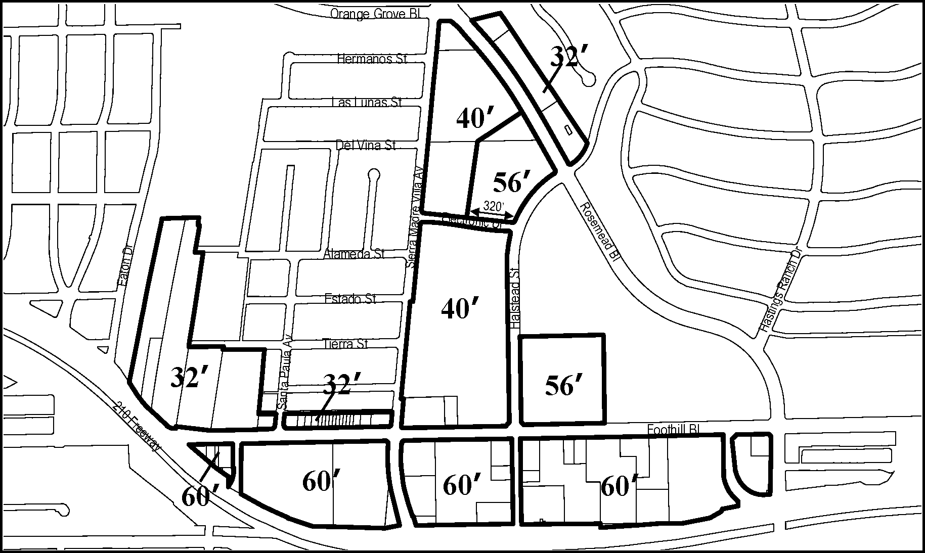
FIGURE 3-12 - EPSP HEIGHT LIMITS FOR SUBAREA D2
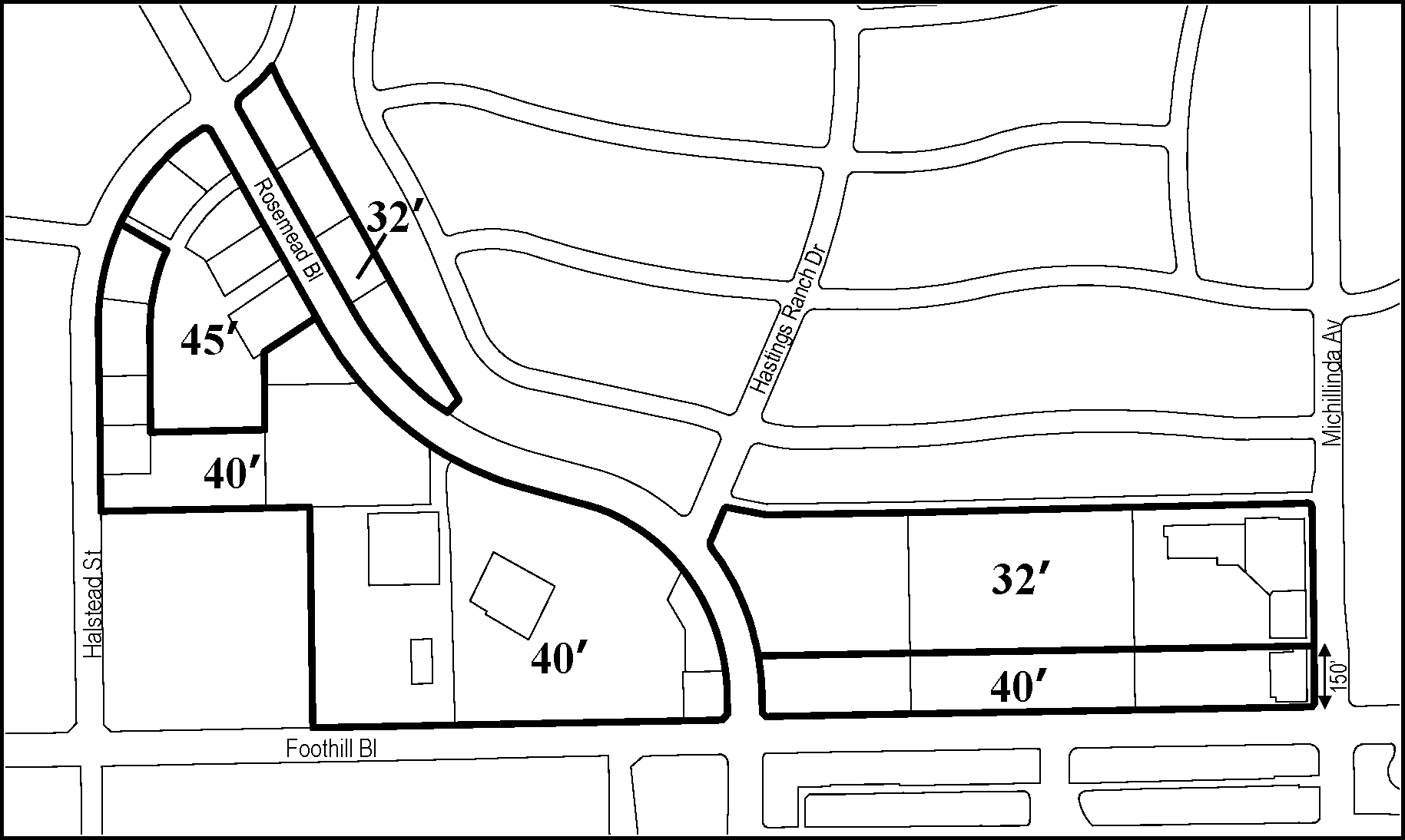
FIGURE 3-13 - EPSP HEIGHT LIMITS FOR SUBAREA d3
(Ord. 7169 § 10, 2009; Ord. 7160 § 15, 2009; Ord. 7099 § 13 (Exh. 10—14); 2007; Ord. 7035, § 5 (Exh.4—6), 2006; Ord. 7009, § 12, 13, 2005)
17.32.080 - EPSP Additional Development Standards
The following standards apply to all development within the East Pasadena Specific Plan area, except where a standard is identified as being applicable to a specific area or lot.
A.
Parking requirements. All parking areas within the East Pasadena Specific Plan shall comply with Chapter 17.46 (Parking and Loading) and the following additional requirements. See Subsection B. for additional requirements applicable to sites along Walnut Street.
1.
General landscaped setback requirements. All street frontages shall have a continuous planting area no less than 10 feet in depth and interrupted only by driveways, walkways, and buildings.
2.
Parking lot landscaping requirements - Subarea d1. Landscaping, or a masonry wall or other device with landscaping in front shall partially or fully screen vehicles from street view. The elimination of this screening shall require the Minor Conditional Use Permit approval.
3.
Parking lot landscaping requirements - Subareas d2 and d3. Landscaping shall be provided along the perimeter of any surface parking lot that abuts a street.
4.
Parking lot landscaping requirements for all Subareas. A shrub hedge, low masonry wall or other device with planting in front shall be provided along the street side perimeter of all parking lots.
a.
The wall shall be of sufficient height to screen parked cars from view to a maximum height of 42 inches. This visual barrier shall be set back within the required planting area so as to not obstruct views from driveways.
b.
A five-foot wide landscaped setback shall be provided in front of a masonry wall. A masonry wall shall be 42 inches in height. The masonry wall shall be constructed at the property line if landscaping, curbs, and gutters are provided within the Walnut Street right-of-way.
5.
Subarea d3 - Limitation on parking structures. Within Subarea d3, above-ground parking structures of no more than three stories in height are permitted only in conjunction with the construction of a public gathering space, as approved by the Director or Zoning Hearing Officer.
6.
Subarea d3 - Screening requirements. Except as otherwise provided by this Section, parking adjacent to a residential use or zone shall be screened from them with a masonry block wall or other comparable screening materials, as approved by the Zoning Administrator, designed to be compatible with residential uses.
B.
Walnut Street development standards. New permanent structures within the abandoned railroad right-of-way adjacent to Walnut Street must be approved by the Director.
1.
Application requirements. Submittals to the Planning Director shall include a site plan and Walnut Street elevations for the entire block in which the proposed project is located. The site plan shall indicate the use, location of structures, proposed curb cuts, the location and species of trees and shrubs, and the relationship of the project to proposed street improvements.
2.
Parking facilities. The following requirements apply only to parking facilities within the abandoned railroad right-of-way adjacent to Walnut Street, in addition to the other requirements of this Subsection A.
a.
Two-story parking structures.
(1)
Parking structure street access shall be provided only from north-south streets.
(2)
Landscaping and curbs and gutters within the Walnut Street right-of-way are required to be installed prior to, or as a part of, the development of any new parking structure.
(3)
Landscaped setbacks adjacent to Walnut Street are not required provided that landscaping and curbs and gutters within the public right-of-way are installed prior to, or as a part of, the proposed project development.
(4)
Planting shall be at least three feet, six inches in height adjacent to the Walnut Street right-of-way.
b.
Surface parking. A five-foot wide landscaped yard in front of a three-foot, six-inch wall, shall be provided to screen parking from Walnut Street; except that if the proposed Walnut Street improvements are installed, the wall may be constructed at the property line.
C.
Floor area ratio (FAR) exceptions.
1.
Subarea d2 FAR requirements. The floor-area-ratios specified in Table 3-11 (Floor Area Ratios Within Subarea d2 During Interim Limited Development Period) shall apply in Subarea d2 during the Interim Limited Development Period as specified in Section 17.32.090.
2.
TOD intensity options. The following intensity options are permitted for transit-oriented development on parcels B-1 and B-2 only, to enable the preservation of an historic or architecturally significant structure:
Alternative 1 - FAR = 2.0; Height Limit = 60 feet
Alternative 2 - FAR = 1.5; Height Limit = 85 feet
3.
TOD and mixed-use development FAR bonuses. The following floor area bonuses shall be permitted for transit-oriented and mixed-use development.
a.
One additional gross square foot of retail space shall be allowed for each 1.5 square feet of residential space constructed.
b.
Five additional gross square feet of retail space shall be allowed for each one gross square foot of child or elderly care space constructed.
17.32.090 - Reserved
Editor's note— Ord. No. 7277, § 6, adopted Mar. 7, 2016, repealed § 17.32.090, which pertained to amount of permitted development and allocation of density, and derived from Ord. No. 7099, §§ 14, 15 (Exh. 15), 16, 2007.
17.32.100 - Reserved
Editor's note— Ord. No. 7277, § 7, adopted Mar. 7, 2016, repealed § 17.32.100, which pertained to replacement of existing development.
17.33.010 - Purpose of Chapter
This Chapter lists the land uses that may be allowed within the zoning districts established by the Fair Oaks/Orange Grove Specific Plan (FGSP), determines the type of land use permit/approval required for each use, and provides standards for site layout and building size.
17.33.020 - Purpose of FGSP Zoning Districts
The purposes of the FGSP zoning districts are to implement the Fair Oaks/Orange Grove Specific Plan by balancing and optimizing economic development, historic preservation, and the maintenance of local community culture, and to:
A.
Protect, support and preserve the surrounding residential neighborhoods within the specific plan area by establishing appropriate land uses, development standards, and design guidelines;
B.
Improve the appearance of the area to enhance the quality of life for local residents and opportunities for employment and business development;
C.
Allow a mix of uses that provides for viable commercial and residential development and supports efforts to revitalize the area;
D.
Create a pedestrian-friendly environment that balances the needs of pedestrians and vehicular traffic, recognizing the status of Fair Oaks Avenue as a Principal Mobility Corridor;
E.
Build upon and enhance existing and new community-serving facilities (parks, libraries, community centers, schools, etc.) to respond to the needs of the community; and
F.
In District FGSP-CL-1:
1.
Help stabilize the business climate by complementing the residential uses in this segment of the corridor with new and enhanced neighborhood-serving commercial uses as select nodes while serving the needs of nearby residents.
2.
Update the overall corridor appearance through streetscape improvements, increased enforcement of housing property maintenance and Zoning Code (Code Compliance) efforts, land-use strategies, and implementation of development standards.
3.
Retain and protect existing community-serving facilities including the Community Health Center, La Pintoresca Park, and Library.
G.
In District FGSP-C-2:
1.
Expand opportunities for employment-generating and community-serving resources (i.e., Robinson Park, Jackie Robinson Center, the City's One Stop Career Services Center, Fire Station #36, etc.) to respond to the needs of the surrounding residents.
2.
Encourage a mix of land uses to increase the potential for a synergy between existing and future commercial and light industrial uses to build on the "business park" concept.
3.
Encourage development and delivery of the arts and cultural programming.
4.
Maintain existing housing and create housing opportunities within the district by providing for work/live housing in appropriate areas.
H.
In District FGSP-C-3:
1.
Build on the historical function of this area as a commercial and neighborhood center.
2.
Create a pedestrian-oriented and transit-oriented district to support businesses and residential uses in the area.
3.
Provide for commercial and mixed-use development along Fair Oaks Avenue to maintain compact urban character.
4.
Provide for commercial retail and office, residential, and mixed-use development at the intersection of Fair Oaks Avenue and Orange Grove Boulevard and along Orange Grove Boulevard.
17.33.030 - Applicability
The standards of the FGSP zoning districts apply to proposed development and new land uses in the following areas, as shown on the Zoning Map.
A.
FGSP-RM-12. Fair Oaks/Orange Grove Specific Plan - Multi-Family Residential District, 2 units per lot.
B.
FGSP-RM-16. Fair Oaks/Orange Grove Specific Plan - Multi-family Residential District, 16 units per acre.
C.
FGSP-OS. Fair Oaks/Orange Grove Specific Plan - Open Space District.
D.
FGSP-PS. Fair Oaks/Orange Grove Specific Plan - Public and Semi-Public District.
E.
FGSP-CL-1a. Fair Oaks/Orange Grove Specific Plan - Limited Commercial District 1, Subdistrict "a."
F.
FGSP-CL-1b. Fair Oaks/Orange Grove Specific Plan - Limited Commercial District 1, Subdistrict "b."
G.
FGSP-C-2. Fair Oaks/Orange Grove Specific Plan - Limited Commercial District 2.
H.
FGSP-C-3a. Fair Oaks/Orange Grove Specific Plan -Limited Commercial District 3, Subdistrict "a."
I.
FGSP-C-3b. Fair Oaks/Orange Grove Specific Plan - Limited Commercial District 3, Subdistrict "b."
J.
FGSP-C-3c. Fair Oaks/Orange Grove Specific Plan - Limited Commercial District 3, Subdistrict "c."
K.
FGSP-C-3d. Fair Oaks/Orange Grove Specific Plan - Limited Commercial District 3, Subdistrict "d."
17.33.040 - FGSP District Land Uses and Permit Requirements
A.
Allowable land uses and permit requirements. Table 3-14 identifies the uses of land allowed by this Zoning Code in each FGSP zoning district, and the land use permit required to establish each use, in compliance with Section 17.21.030 (Allowable Land Uses and Permit Requirements). The land use permit requirements established by Table 3-14 are as follows.
Note: the right column in the tables ("Specific Use Standards") will show a section number for regulations that apply to the particular use listed, in addition to the other general standards of this Zoning Code.
(Ord. No. 7435, § 11, 10-28-2024; Ord. No. 7420, § 3, 4-15-2024; Ord. No. 7418, § 2, 2-26-2024; Ord. No. 7414, § 2, 9-11-2023; Ord. No. 7402, § 2, 9-19-2022; Ord. 7326 § 6, 2018; Ord. 7321 § 3 (Exh. 1), 2018; Ord. 7313 § 8, 2017; Ord. 7300 § 8 (Exhs. 8, 9), 2017; Ord. 7255 §§ 8 (Exh. 7), 9 (Exh. 8), 2015; Ord. 7210 § 6, 2011; Ord. 7164 § 8, 2009; Ord. 7160 §§ 7, 18, 2009: Ord. 7135 § 6 (Exh. 6), 2008; Ord. 7099 §§ 17 (Exh. 16), 18 (Exh. 17), 2007; Ord. 7050 § 2 (Exh. 1), 2006; Ord. 7009 § 14, 2005)
17.33.050 - FGSP Development Standards
Subdivisions, new land uses and structures, and alterations to existing land uses and structures shall be designed, constructed, and established in compliance with the requirements of this Section, in addition to the applicable standards (e.g., landscaping, parking and loading, etc.) in Articles 4 (Site Planning and General Development Standards) and 5 (Standards for Specific Land Uses). Principal and accessory structures shall meet the same development standards unless otherwise modified in this Zoning Ordinance.
A.
Residential density and lot size requirements. Where allowed by Section 17.33.040 (FGSP District Land Uses and Permit Requirements), residential uses shall comply with the following maximum density and minimum lot size requirements; except that in the PS zone, maximum density shall be established by the Conditional Use Permit approval required for all residential development, and minimum lot size requirements shall be established by Conditional Use Permit and/or subdivision approval, as applicable. (Ord. 7009 §§ 15-16, 2005)
B.
Site planning and building standards. New land uses and structures, and alterations to existing land uses and structures shall be designed, constructed, and established in compliance with the following requirements. Some of the requirements are based on the location of the site within one of three districts established by the Fair Oaks/Orange Grove Specific Plan:
1.
District 1. Between Montana Street and Washington Boulevard;
2.
District 2. Between Washington Boulevard and Mountain Street; and
3.
District 3. Between Mountain Street and Maple Street.
C.
Building entries. Building entries shall be oriented to and accessible from the major street frontage, and directly accessible from a public sidewalk. Entries may be set back a maximum of 15 feet from the street property line to the doorway. On corner lots with multiple buildings, the front entry shall be oriented towards the front yard. On interior lots with multiple buildings, at least 51 percent of the entries shall face the front yard.
D.
Parking lots and driveways. Parking lots and driveways shall comply with the following requirements:
1.
For parcels that have 200 feet in width or more of street frontage, parking lots and structures may occupy up to 40 percent of the street frontage.
2.
For parcels less than 200 feet in width of street frontage, only one driveway shall be permitted.
E.
Mixed-use development. Mixed-use development shall comply with the following requirements:
1.
Ground floor frontage. A minimum of 20 percent of the ground floor frontage, excluding driveways and pedestrian entries, shall be devoted to nonresidential uses. Nonresidential components shall include such uses as commercial-retail, commercial-office, community facility such as community room or health fitness, and other uses permitted with frontage on a major street.
2.
Density. Density shall be determined by the underlying zoning district. For lots less than 10,000 square feet in area, the following shall be the maximum number of units permitted:
3.
Setbacks. Mixed-use projects shall comply with the following setbacks. The Zoning Administrator shall determine the front for such projects based on the character of the neighborhood.
4.
Parking. The total off-street parking spaces required shall be the sum of the required spaces for each use classification. Required parking and loading spaces for the non-residential component of the mixed-use development shall be according to the parking standards provided by Chapter 17.46. Parking shall not be visible from a street. The Zoning Administrator may modify this requirement for secondary streets.
5.
Open space. Every project shall provide usable open space not less than 150 square feet per dwelling unit. The minimum open space may be met through a combination of common and private open space. Required open space may be located at grade or above grade. Private above-grade patios and rooftop recreational areas may be included as open space. Driveways, parking areas, and front yards (exclusive of area devoted to patios and balconies) shall not be counted as open space. Landscaped setback areas (excluding front yards) over six feet in width may count toward open space.
a.
Common open space. At least 25 percent of this required minimum open space must be common open space. Common open space shall be accessible to all residents of a residential building or development. Common open space shall be open to the sky except for arbors, trellises, or similar amenities. Recreation rooms at least 600 square feet in area may qualify as common open space. A common open space area shall measure a minimum of 400 square feet in area, with no horizontal dimension less than 20 feet. Overhangs, balconies, and other projections may encroach into this 20-foot dimension up to 5 feet. Common open areas shall incorporate recreational amenities such as benches, sitting areas, children's play areas, spas, swimming pools, ball courts, tables, and barbecue areas.
b.
Private open space. A private open space shall be contiguous with the dwelling unit and maintain an eight-foot clearance under any projections. A private open space shall measure at least 35 square feet in area with no horizontal dimension less than seven feet, to be counted toward the minimum open space requirement.
6.
Fences and walls. Each project shall meet the following requirements for fences and walls. All fences and walls shall be measured from existing grade.
a.
A fence or wall in a required setback adjoining a street property line shall not exceed four feet in height except that a fence or wall may extend an additional two feet provided that the fence does not come closer than half the distance to the street property line and the total length of the six-foot fence does not exceed 50 percent of the building frontage.
b.
A six-foot solid fence or wall adjoin an interior property line abutting an RS District.
c.
Solid fences or walls along the rear property line or interior side property line shall not exceed 6 feet in height. Open decorative fences (i.e., one that is not more than 50 percent filled) may extend an additional 18 inches in height when not abutting an RS District.
(Ord. 7160 §§ 18, 19, 2009; Ord. 7050 § 3 (Exh. 2), 2006; Ord. 7035 § 6 (Exh. 7), 2006; Ord. 7099 §§ 15, 16, 2005)
17.34.010 - Purpose of Chapter
This Chapter lists the land uses that may be allowed within the SP-1 (North Lake Specific Plan Overlay District) established by the North Lake Specific Plan, determines the type of land use permit/approval required for each use, and provides basic standards for site layout and building size.
(Ord. 7129 § 3 (Exh. B) (part), 2008)
17.34.020 - Purposes of SP-1 (North Lake Specific Plan) Overlay District
The purposes of the SP-1 overlay district are to:
A.
Implement the purposes of the North Lake Specific Plan;
B.
Provide an environment that encourages people to walk, by creating spaces for pedestrian activity and minimizing vehicle intrusions into pedestrian areas;
C.
Limit the total number of uses providing either services or sales involving vehicles and of uses providing drive-through service for automobile occupants. Allow for the number of queuing positions or service windows in a drive-through business to be increased, but prohibit additional square footage to be added.
D.
Support development that is oriented to use of the light-rail station at Lake Avenue; and
E.
Provide standards to support development that is distinctive to the character of North Lake Avenue, including the house building type to promote the residential character of appropriate areas, and the village building type to promote the commercial character of appropriate areas. The standards of the SP-1 apply to the following subdistricts as shown on the Zoning Map.
1.
SP-1a - House Building Type. This subdistrict promotes a residential character that allows for a mix of some non-residential uses, including mixed-use and work/live units. Re-use of existing bungalows is encouraged in this subdistrict. This subdistrict is located along Lake Avenue, between Elizabeth Street and Ladera Street, and along Lake Avenue, between Claremont Street and Mountain Street.
2.
SP-1b - Village Building Type. This subdistrict promotes a commercial character and allows a variety of commercial uses, including mixed-use and work/live units. Residential uses are allowed in this subdistrict. This subdistrict encourages development that contributes to the pedestrian character of the street. This subdistrict includes the intersection of Lake Avenue and Washington Boulevard, bounded by Ladera Street to the north, Claremont Street to the south, Palm Terrace to the east, and Mentor Avenue to the west.
3.
SP-1c - Village Building Type. This subdistrict promotes a commercial character and allows a variety of commercial uses, including mixed-use and work/live units. Residential uses are allowed in this subdistrict. This subdistrict encourages development that contributes to the pedestrian character of the street. This subdistrict is located along east Washington Boulevard, east of Lake Avenue, north side only, between Mentor Avenue and Catalina Avenue
4.
SP-1d - Village Building Type. This subdistrict promotes only a commercial character, and excludes residential, mixed-use, and work/live units. This subdistrict is located along Lake Avenue, between Mountain Street and Orange Grove Boulevard.
5.
SP-1e - Village Building Type. This subdistrictis adjacent to the Gold Line light rail station and allows for a mixture of commercial, mixed-use and work/live units and higher density residential. Residential uses are only allowed as part of mixed-use developments. This subdistrict is located along Lake Avenue, between Orange Grove Boulevard and Maple Street.
(Ord. 7160 § 20, 2009; Ord. 7129 § 3 (Exh. B) (part), 2008)
17.34.030 - SP-1 Allowable Land Uses and Permit Requirements
A.
Allowable land uses. All land uses allowed in the base zoning districts as permitted or conditional uses may be allowed in the SP-1 overlay district in compliance with the land use permit requirements of the applicable base zoning district, except as follows:
1.
Additional allowed uses. The following additional uses shall be allowed within the SP-1 overlay:
a.
In the SP-1a subdistrict, restaurants, fast-food restaurants, formula fast-food restaurants, maintenance and repair services, and personal services are allowed. Restaurants, fast-food and formula fast-food restaurants shall not be allowed to have beer and wine service or full alcohol service.
b.
In the SP-1a, SP-1b, SP-1c and SP-1e subdistricts, work/live units are allowed subject to a conditional use permit.
2.
Additional prohibited uses. The following uses are prohibited throughout the overlay district:
a.
Commercial growing grounds;
b.
Drive-through businesses;
c.
Life/care facilities;
d.
Medical services: extended care;
e.
Temporary swap meets;
f.
Vehicle services: service station;
g.
Vehicle services: vehicle storage;
h.
Vehicle services: vehicle washing and detailing including small-scale vehicle washing and detailing businesses; or
i.
Wholesaling, distribution, and storage - small-scale.
3.
Additional Prohibited Uses in SP-1a. In the SP-1a and SP-1c subdistricts, commercial off-street parking uses are prohibited;
4.
Additional Prohibited Uses in SP-1d. In the SP-1d subdistrict, the following uses are prohibited:
a.
Single-family residential;
b.
Multi-family residential;
c.
Boarding houses;
d.
Caretaker quarters;
e.
Dormitories;
f.
Fraternity/sorority housing;
g.
Mixed-use projects;
h.
Residential care facilities, general;
i.
Residential care facilities, limited;
j.
Single-room occupancy;
k.
Supportive housing;
l.
Transitional housing; or
m.
Work/live.
5.
Additional Prohibited Uses in SP-1e. In the SP-1e subdistrict, single-family residential and multi-family residential uses.
B.
Nonconforming uses. Except as modified in this Section, the provisions of Chapter 17.71 (Nonconforming Uses, Structures, and Parcels) shall apply to nonconforming uses in the overlay district.
1.
Expansion prohibited. The following uses shall not be expanded:
a.
Mini-malls;
b.
Vehicle services - service stations;
c.
Vehicle services - vehicle/equipment repair;
d.
Vehicle services - sales and leasing limited;
e.
Vehicle services - vehicle storage;
f.
Vehicle services - vehicle washing/detailing and vehicle washing/detailing, small scale; or
g.
Commercial off-street parking.
2.
Expansion defined. For the uses listed above in subsection 1, expansion or enlargement is prohibited. The use is expanded if any of the following occurs:
a.
Enlargement or expansion of the gross floor area;
b.
The paved parking area serving the use is increased;
c.
One of the following occurs:
(1)
Increasing the number of fueling positions for a service station;
(2)
Increasing the number of work stations for vehicle equipment repair; or
(3)
Adding or changing a service at a service station or vehicle/equipment repair use that was not previously offered, including an auto wash or mini-mart.
3.
Allowed Alterations. The following changes are allowed:
a.
Modernization of equipment;
b.
Reconfiguration of the parking in order to provide a more efficient plan;
c.
Modification of existing landscaping or new landscaping to accommodate a reconfiguration of the parking;
d.
Modernization that is consistent with the intent of this subsection as determined by the Zoning Administrator.
4.
Alterations. Buildings housing any of the uses listed in Subsection B.1 above, may be altered according to the provisions of Chapter 17.71 (Nonconforming Uses, Structures, and Parcels).
C.
Drive-through businesses. The number of queuing positions or service windows for any use that provides drive-through services may be increased with the approval of a conditional use permit; however, the gross square footage of such business shall not be increased. A drive-through business may be completely demolished and rebuilt with the approval of a conditional use permit as long as the square footage of the new building is not more than the building proposed to be demolished.
(Ord. 7326 § 6, 2018; Ord. 7313, § 9, 2017; Ord. 7300 § 9, 2017; Ord. 7160 § 21, 2009; Ord. 7129 § 3 (Exh. B) (part), 2008)
17.34.040 - SP-1 General Development Standards
Subdivisions, new land uses and structures, and alterations to existing land uses and structures shall be designed, constructed, and established in compliance with the requirements in Table 3-15.1 in addition those in Section 17.34.050 (SP-1 Additional Development Standards), and the applicable standards (e.g., landscaping, parking and loading, etc.) in Article 3 (Site Planning and General Development Standards). For residential projects, see 17.34.060 (SP-1 Residential Development Standards). The development standards of the base zoning districts shall not apply.
(Ord. 7160 § 22, 2009; Ord. 7129 § 3 (Exh. B) (part), 2008)
17.34.050 - SP-1 Additional Development Standards
A.
Alcohol sales and services. The provisions of Section 17.28.030 (AD-2 overlay district) shall apply.
B.
Hours of operation. The provisions of 17.40.070 shall apply.
C.
Specific public and semi-public uses. The development standards for public or private schools, public safety facilities, and religious assembly uses shall be determined as specified by a Conditional Use Permit.
D.
Fences and walls.
1.
Within subdistrict SP-1a, the wall and fence requirements shall be that of the RS-6 district for all projects except multi-family projects which shall meet the fence and wall requirements of Section 17.40.180.B.3 (Multi-family projects (City of Gardens standards))
2.
Within all other subdistricts, the fence and wall provisions shall be those of the base district provided that an eight-foot-high solid masonry wall shall be constructed along the property line that separates a nonresidential use from a residential use. The required wall must be constructed on a property prior to any other new construction on that property.
E.
Loading and refuse areas. To the extent feasible, loading berths and refuse storage areas shall be located away from residential uses.
F.
Signs. The height of a free-standing or monument sign shall be limited to eight feet. Such sign shall have a minimum of 75 square feet of landscaping. All other signs shall meet the requirements of Chapter 17.48 (Signs).
G.
Landscaping. Vertical landscape material shall be planted and maintained on the property of a nonresidential use along the property line of a residential use.
H.
Driveways. The maximum driveway width shall be equivalent to the minimum driveway width allowed in Chapter 17.46. A landscape area shall be provided along the side of the driveway in front or corner yards. The width of the landscape area shall be a minimum of two feet and a maximum of five feet. The maximum height of planting materials within this required landscape area shall not exceed 2.5 feet.
I.
Residential building conversions. Buildings originally constructed for residential use prior to November 23, 1997, may be reused for permitted or conditionally permitted nonresidential use. Such reuse shall comply with the provisions of 17.50.070. The mixed use standards and work/live standards of this code shall not apply for such conversions. (Ord. 7129 § 3, (Exh. B), 2008)
J.
Floor area ratio. The floor area ratio requirement of the base district shall not be applicable in this specific plan.
K.
Commercial frontage and façade standards. Section 17.24.050 (Commercial Frontage and Façade Standards) shall not be applicable.
(Ord. 7160 § 23, 2009; Ord. 7129 § 3, (Exh. B) (part), 2008)
17.34.060 - SP-1 Residential Development Standards
For the development of residential uses, the following standards shall apply. All standards including height, setbacks and encroachment plane requirements of the following districts shall be applied.
A.
Single-family. For single-family uses, the standards of the RS-6 district shall apply.
B.
Two units on a lot. For two units on a lot, the standards of the RM-12 district shall apply.
C.
Three units or more. For development of three units or more, the following applies.
1.
Within the SP-1a subdistrict, the development standards of the RM-16 district shall apply.
2.
Within the SP-1b and SP-1c subdistricts, the development standards of the RM-32 district shall apply.
(Ord. 7129 § 3 (Exh. B) (part), 2008)
17.34.070 - SP-1 Edge Repair
For properties in subdistricts SP-1b and SP-1d and SP-1e that were developed prior to November 23, 1997, and that exceed the required five-foot front and corner yard provisions, additions to the existing building shall be permitted provided the development standards of the base district are met and an edge repair is provided. An edge repair is an area along the street property line set aside for pedestrian amenities. The minimum depth of the edge repair shall be five feet from the street property line, and the minimum length shall be 40 percent of the length of the parking area along each street frontage. Portions of the edge repair at intersecting streets shall comply with the regulations of Chapter 12.12 of the Municipal Code. An edge repair must include the following three elements. The required three elements shall be approved by the Planning Director under the design review process required under this chapter.
A.
Shade or shelter. An element that provides shade or shelter such as a tree.
B.
Activity. An element that provides an activity such as a newsstand that provides a sales activity; and
C.
Meeting place. An element that provides a meeting place such as a park bench.
(Ord. 7129 § 3 (Exh. B) (part), 2008)
17.35.010 - Purpose of Chapter
This Chapter lists the land uses that may be allowed within the zoning districts established by the South Fair Oaks Specific Plan (SFOSP), determines the type of land use permit/approval required for each use, and provides comprehensive design and development standards for all projects.
(Ord. No. 7405, § 2, 10-17-2022)
17.35.020 - Zoning Districts
The purpose of the SFOSP zoning districts (Figure SFOSP-1) is to implement the plan vision for each of the subareas as described in the SFOSP document, and summarized below.
A.
SFO-MU-C (Mixed-Use Core)
•
Promote the development of a mixed-use pedestrian-friendly neighborhood with a broad range of retail, medical office, labs, services, senior and multi-family housing;
•
Support businesses that leverage the proximity of Huntington Health and ArtCenter South Campus and that provide products and services to nearby institutional and local residential communities; and
•
Support projects that are a mix of residential and commercial, integrated either horizontally or vertically consistent with ground floor use requirements.
B.
SFO-MU-G (Mixed-Use General)
•
Enhance the existing mixed-use character with a variety of commercial services and multi-family uses; and
•
Support projects that are entirely commercial, entirely residential, or a mix of the two, integrated either horizontally or vertically consistent with ground floor use requirements.
C.
SFO-MU-N (Mixed-Use Neighborhood)
•
Create a mixed-use activity center near high frequency transit that accommodates a diverse range of retail and services, prioritizing housing opportunities where people can walk to shops, restaurants, jobs, and school; and
•
Support projects that are entirely commercial, entirely residential, or a mix of the two, integrated either horizontally or vertically consistent with ground floor use requirements.
D.
SFO-MU-T (Mixed-Use Transit)
•
Create a mixed-use activity center near high frequency transit that accommodates a diverse range of retail, services, and housing where people can walk to shops, restaurants, jobs, and school; and
•
Support projects that are a mix of residential and commercial, integrated either horizontally or vertically consistent with ground floor use requirements.
E.
SFO-CG (Commercial General)
•
Enhance the existing commercial character with a wide variety of commercial uses that support citywide needs, as well as pedestrian-oriented goods, restaurants, and services for local residents and employees.
F.
SFO-CL (Commercial Limited)
•
Allow for a limited selection of commercial uses which support medical-oriented uses and are compatible with the surrounding character.
G.
SFO-CF (Commercial Flex)
•
Enhance the existing eclectic character with a variety of R&D, commercial, artisanal production, and light industrial uses; and
•
Ensure that future uses are compatible with the existing character.
H.
SFO-IF (Industrial Flex)
•
Allow a range of light industrial, utility, and commercial uses for city use; and
•
Ensure that future uses are compatible with existing public and industrial uses.
I.
SFO-RM-32 (Residential Multi-family)
•
Provide areas for medium density residential neighborhoods and relate new development to the existing environment.
J.
PS (Public Semi-Public)
•
Provide for large public or semi-public land uses that may not be appropriate in other base zoning districts.
K.
PD (Planned Development)
•
Achieve a particular mix of uses, appearance, land use compatibility, or special sensitivity to neighborhood character.
Figure SFOSP-1: Zoning Districts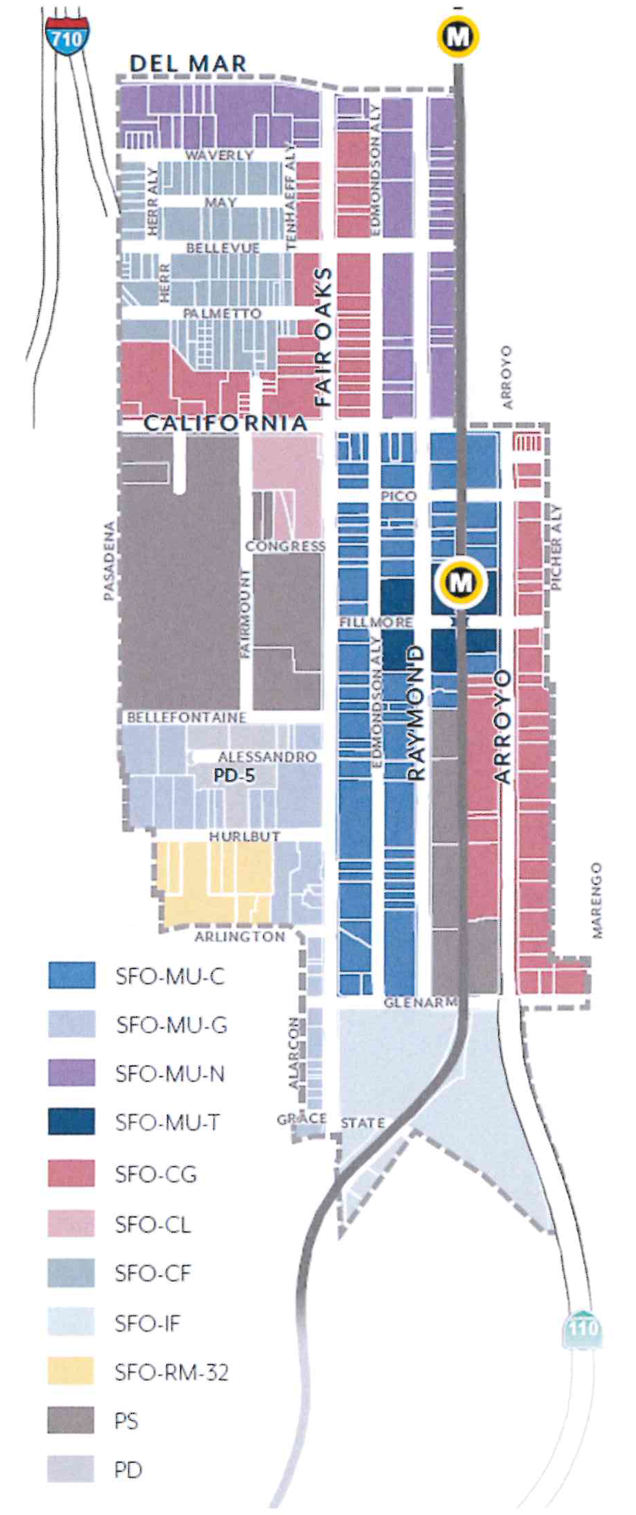
(Ord. No. 7405, § 2, 10-17-2022)
17.35.030 - Allowable Land Uses
A.
Definitions. Definitions of specific land uses are found in Section 17.80.020.
B.
Permit Requirements. Table SFOSP-1 identifies the uses of land allowed, the land use permit required to establish each use, and limitations that may apply for a particular use.
C.
Standards for Specific Land Uses. Additional standards may apply to specific land uses; refer to the PMC Section noted in Table SFOSP-1.
1.
Section 17.50.160 shall not apply to Mixed-Use Projects.
2.
Section 17.50.350 shall not apply to Multi-Family Housing.
D.
Ground Floor Frontages. In Mixed-Use zoning districts, additional commercial requirements and residential unit restrictions on the ground floor shall apply per Section 17.35.070.A.
E.
Major Construction. For all non-residential uses with a gross floor area of 25,000 square feet or greater, a Conditional Use Permit shall be required per Section 17.61.050.J.2.
F.
Prohibited Uses. Those uses not listed in Table SFOSP-1 are prohibited by the SFOSP, except as otherwise provided by Section 17.21.030.A.
G.
Nonconforming Uses. Existing uses which are made nonconforming by the SFOSP shall be subject to Section 17.71.
H.
Limited Hours of Operation. Uses listed in Table SFOSP-1 shall comply with limited hours of operation as required by Section 17.40.070.
Table SFOSP-1: Allowable Land Uses
(Ord. No. 7435, § 12, 10-28-2024; Ord. No. 7420, § 3, 4-15-2024; Ord. No. 7419, § 4, 2-26-2024; Ord. No. 7418, § 2, 2-26-2024; Ord. No. 7414, § 2, 9-11-2023; Ord. No. 7405, § 2, 10-17-2022)
17.35.040 - Public Realm Standards
These standards are intended to:
•
Ensure a minimum sidewalk width is achieved, appropriate to support future densities, intensities, uses, and pedestrian volumes;
•
Enhance pedestrian conditions and improve street tree health through increased landscaping and permeability at sidewalk level;
•
Provide sufficient space to support dedicated Amenity and Walk Zones; and
•
Increase shade, carbon sequestration, and stormwater capture by allowing adequate space for street trees and parkways.
A.
Sidewalks
1.
Sidewalk Width
a.
Dimension. Projects shall provide sidewalks that meet the required widths per Figure SFOSP-2. Where the existing sidewalk right-of-way is less than the required width, the difference shall be provided through a private property dedication.
(1)
Sidewalks are measured from the Primary Curb Line of each block to the sidewalk line, as illustrated in Figure SFOSP-3.
(2)
This area shall be paved for general use to the standards specified by Public Works, except for landscaped parkways per Section 17.35.040.B.
(3)
Within the sidewalk width, sidewalk zones shall be provided to the dimensions set in Figure SFOSP-4.
(4)
Where the curb deviates (i.e. bulb-outs), exceptions in zone width are allowed and shall be determined by Public Works.
(5)
Driveways are allowed per Section 17.35.090.B.
b.
Maintenance. Sidewalk improvements shall be installed and maintained by the abutting property owner.
Figure SFOSP-2: Sidewalk Width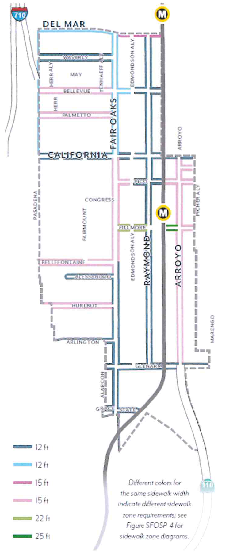
Figure SFOSP-3: Sidewalk Line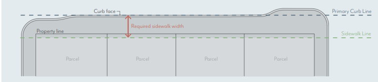
2.
Sidewalk Zones
a.
Amenity Zone. Sidewalks shall provide an Amenity Zone consistent with the width illustrated in Figure SFOSP-4, including the curb.
(1)
Projects shall meet minimum parkway and street tree requirements per Section 17.35.040.B.
(2)
The following elements are permitted in the Amenity Zone at the discretion of Public Works: paved area for pedestrian mobility, parkways and street trees, seating/furniture, outdoor dining (with a Public Works permit), planters, bicycle parking, bus shelters, and/or other utility facilities including streetlights, signals, meter/sign poles, and pullboxes, etc.
b.
Walk Zone. Sidewalks shall maintain a Walk Zone as a continuous path of travel for pedestrians at the width illustrated in Figure SFOSP-4. This area shall be free of all furnishings, landscaping, or obstructions.
c.
Frontage Zone. Sidewalks may include a Building Frontage Zone between the Walk Zone and the sidewalk line. A maximum width is illustrated in Figure SFOSP-4.
(1)
The following elements are permitted in the Frontage Zone and may not encroach on the Walk Zone: paved area for pedestrian mobility, seating/furniture, outdoor dining (with a Public Works permit), planters, and/or shade structures per Section 17.35.070.D.
Figure SFOSP-4: Sidewalk Zones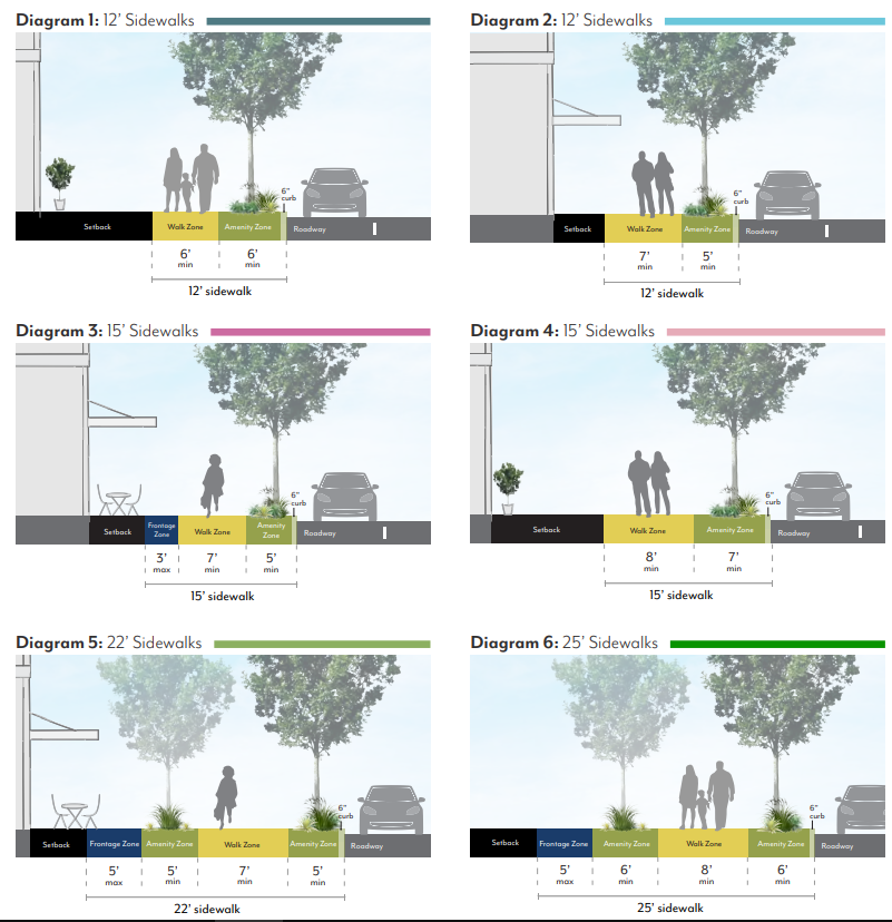
B.
Parkways & Street Trees
1.
Parkways
a.
Required Parkways. Projects shall include parkways within the Amenity Zone as follows and as illustrated in Figure SFOSP-5.
(1)
In SFO-RM-32, parkway length shall be no less than 60 percent of street frontage, unless approved by the Director of Public Works.
(2)
In all other zoning districts, parkway length shall be no less than 30 percent of street frontage, unless approved by the Director of Public Works.
Figure SFOSP-5: Parkway Design Standards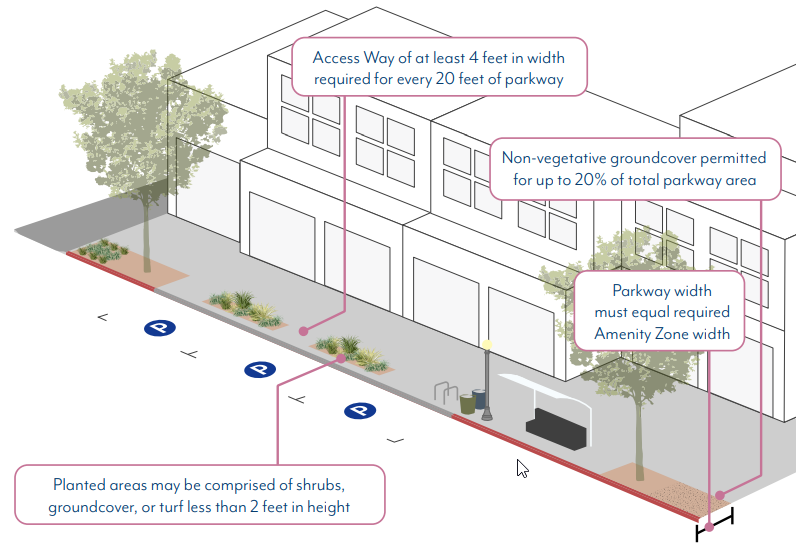
b.
Dimensions. Parkways shall be constructed at the same width as the Amenity Zones illustrated in Figure SFOSP-4, minus the 6-inch width required for the curb.
(1)
When street parking is adjacent to the curb, a paved buffer with a minimum width of 18 inches is required, in addition to the 6-inch curb, except where tree grates are adjacent to the curb.
(2)
Barriers up to 24 inches high, such as low walls or fences, are permitted at the interior edge of the parkway but are not required.
c.
Access Ways. Where on-street parking is permitted, access ways shall be provided at a minimum frequency of one per every 20 feet of continuous parkway.
(1)
Access ways shall be a minimum of 4 feet in width and provide a firm, uniform walking surface in all weather conditions from the curb to the Walk Zone.
(2)
The finished surface of access ways shall be in plane with both the adjoining top of curb and sidewalk.
(3)
Access ways shall be constructed of pavers, concrete, or stabilized decomposed granite.
d.
Planted Area. A minimum of 80 percent of the total required parkway area for a given project shall be comprised of plant material.
(1)
Permitted materials include groundcovers, turf or turf substitutes, and shrubs or low perennials that are lower than 24 inches in height at full maturity.
a.
All plant material shall be native or climate appropriate and have a water use rating of Moderate, Low or Very-Low as defined by Water Use Classification of Landscape Species (WUCOLS) for the region. Plant water use requirements may be relaxed to maximize the efficiency of parkway stormwater capture systems per approval by the Director of Public Works.
b.
Plants with spines or thorns shall not be planted adjacent to any walkways or curbs.
c.
Edible plants are not permitted in parkways.
d.
Artificial turf is not permitted in parkways.
(2)
When removing existing plant material like turf grass from a parkway, there shall be no damage to the street tree roots. Parkway improvements involving excavation within an existing tree's root zone must be consistent with the City's Tree Protection Guidelines. Root pruning, if required and approved by Public Works, must be overseen by a Certified Arborist. Excavation within a tree's root zone must be replanted immediately to prevent the tree roots from exposure and undue harm.
e.
Non-planted Area. A maximum of 20 percent of the parkway area may be organic or inorganic cover.
(1)
Permitted materials include permeable pavers, decomposed granite, gravel, rocks, or mulch.
a.
Pavers are not allowed within 3 feet of any public streetlight pole or pull box or other utility facilities.
f.
Stormwater Management. Parkways shall either meet the following basic stormwater standards, or propose a biofiltration planter or swale design based on local conditions per the approval of the Director of Public Works.
(1)
The parkway shall be at the same grade as the adjacent hardscape surface at the outer edge of the parkway and slope at a minimum of 1 percent towards the center of the parkway.
(2)
For parkways with a width greater than 5 feet, the center 2 feet of the parkway shall be depressed 3 to 4 inches to form a shallow swale to collect sidewalk stormwater. Alternative means of storing runoff, such as gravel sumps within the parkway, may be provided with review authority approval.
g.
Irrigation. Irrigation systems in parkways shall be designed and constructed in a manner that will eliminate surface runoff onto any impermeable surface, public or private, under any condition.
(1)
Design of irrigation systems in parkways shall be in accordance with all local, state, and federal laws and regulations for water conservation.
(2)
Street tree roots shall not be damaged during the irrigation installation process.
h.
Maintenance. Abutting property owner shall maintain the parkway in a condition so as not to endanger persons or property, and not to interfere with the public convenience.
2.
Street Trees
a.
Species. Street tree species shall be selected according to the Master Street Tree Plan at the discretion of the Director of Public Works. Trees may be planted within parkways or tree wells.
b.
Spacing. Street trees shall be planted at a spacing of one per 30 feet. Exceptions can be made by the Director of Public Works due to conflicts with street lights, bus shelters, utility boxes, or other street amenities or species type. Closer spacing is encouraged when feasible and when appropriate for the particular tree type.
c.
Well Dimension. Tree well width shall be equivalent to the required Amenity Zone, minus the 6-inch width required for the curb.
(1)
If a paved buffer zone is required due to adjacent street parking, the tree well width may be reduced to accommodate this buffer strip. The minimum length of a tree well shall be 6 feet.
(2)
Street trees planted within tree wells must be installed according to the Department of Public Works Tree Planting in Tree Well Standard Plan.
d.
Well Frames. Tree well frames, or tree grates, may be installed according to the Department of Public Works Tree Well Frame Installation Standard.
e.
Expanded Root Zone Cell. Each street tree shall be provided with an uncompacted root zone volume of 800 cubic feet minimum. The root zone volume depth shall be 2 feet minimum and 3 feet maximum.
(1)
Where this root zone volume cannot be provided within the parkway area, an expanded root zone cell volume shall be provided below adjacent pavement using a strategy such as structural soil or a suspended pavement system to provide an uncompacted soil area suitable for tree root growth.
(2)
The root zone volume per tree requirement may be reduced by 10 percent where two or more trees share a contiguous root zone cell.
f.
Maintenance. All street trees shall be maintained by the Department of Public Works.
(Ord. No. 7405, § 2, 10-17-2022)
17.35.050 - Summary of Development Standards
17.35.060 - Scale Standards
These standards are intended to:
•
Implement the General Plan density (du/ac) and floor area ratio (FAR) values;
•
Shape development in a manner that creates a defined public realm and appropriate scale of buildings for a visually appealing community;
•
Reduce building massing through setback and stepback requirements that create appropriate transitions to residential neighborhoods;
•
Support high-quality architecture and urban design through modulation requirements and a varied roof lines incentive; and
•
Require appropriate transitions to designated historic resources.
A.
Density.
1.
Residential Density. Projects that include residential dwelling units shall not exceed the allowable dwelling units per acre (du/ac) per Figure SFOSP-6.
a.
Fractions shall be rounded to the nearest whole number; those at 0.50 may be rounded up.
b.
For projects utilizing state density bonus, refer to Government Code 65915.
c.
The maximum is based on total site area. If a street dedication or easement is required, density shall be calculated using the size of the lot prior to the street dedication or easement.
Figure SFOSP-6: Residential Density
B.
Intensity.
1.
Floor Area Ratio. Projects that include non-residential space, including mixed-use, shall not exceed the allowable floor area ratio (FAR) per Figure SFOSP-7.
a.
In mixed-use projects, residential floor area is included in FAR.
b.
Areas used exclusively for vehicle and bicycle parking and loading are excluded from FAR.
c.
The maximum is based on total site area. If a street dedication or easement is required, FAR shall be calculated using the size of the lot prior to the street dedication or easement.
Figure SFOSP-7: Floor Area Ratio
C.
Height.
1.
Building Height. Projects shall not exceed the height limits set in Figure SFOSP-8.
a.
Height is measured per Section 17.40.060.
b.
An additional 12 feet shall be permitted for projects that are classified as Commercial Uses on Table SFOSP-1, up to a maximum height of 63 feet (75 feet with height averaging).
c.
Exceptions allowed for Height Averaging (Section 17.35.060.C.2) and projecting features such as appurtenances and railings per Section 17.40.060.
2.
Height Averaging. With approval of Design Commission, up to 30 percent of a building's footprint may exceed the height limit to the maximum set in parenthesis in Figure SFOSP-8, provided that the average height over the entire footprint does not exceed the allowable height; see Figure SFOSP-9.
a.
The intent is to counterbalance additional height with lower heights elsewhere to achieve an economically-feasible development that protects view corridors and contributes to a more visually-compelling skyline.
b.
This allowance may be used with Section 17.35.060.C.1.b but is not applicable to other development standards relating to building scale such as stepbacks. It may not be used in combination with a concession for building height when utilizing Section 17.43.
Figure SFOSP-8: Building Height
Figure SFOSP-9: Height Averaging
D.
Setbacks.
1.
Street Setbacks. Buildings shall comply with the street setbacks set in Figure SFOSP-10. Setback ranges establish a minimum and maximum for the specified percentage of linear frontage.
a.
Street setbacks are measured from the sidewalk line; see Figure SFOSP-3.
b.
Minimum setbacks shall apply to all stories of a building; setbacks less than the minimum are prohibited. Maximum setbacks shall apply only to the ground floor.
c.
Where ground floor residential units are elevated between 4 and 6 feet above sidewalk elevation, a minimum setback of 8 feet shall be required.
d.
Exceptions allowed per Section 17.40.160 (Table 4-1) and the following:
(1)
Arcades and recessed ground floors up to 15 feet in depth, as well as parking entrances per Section 17.35.090.B, are allowed when a second story meets the specified setback; see Figure SFOSP-8.
(2)
The specified frontage percentage may be reduced for the provision of Publicly Accessible Open Space facing the street through the Design Review process.
e.
Features allowed within the street setback include: landscaping and planters, hardscape (e.g. stoops, patios), shade structures per Section 17.35.070.D, arcades and galleries per Section 17.35.070.E, walls and fences per Section 17.35.070.F, seating and furniture, outdoor dining, and other open space amenities per review authority approval.
Figure SFOSP-10: Street Setbacks
2.
Interior Setbacks. Buildings shall be set back a minimum of 15 feet from an interior property line that is adjacent to a PS, RM or RS zoning district. No setback is required when adjacent to other districts or alleys.
a.
Interior setbacks are those abutting other parcels along non-street side and rear property lines and are measured from the shared property line.
b.
Exceptions allowed per Section 17.40.160 (Table 4-1).
E.
Stepbacks.
1.
Interior Stepbacks. Adjacent to RM/RS zoning, districts, buildings shall not be located within the encroachment plane sloping upward and inward at a 45-degree angle measured from the vertical, commencing 25 feet above the existing grade along the shared property line; see Figure SFOSP-11.
a.
Exceptions allowed per Section 17.40.160 (Table 4-2.1).
Figure SFOSP-11: Interior Stepbacks Adjacent to RM/RS Zoning Districts
F.
Historic Adjacency.
1.
Landmark Properties. Projects on parcels with a designated historic resource shall be subject to review for consistency with the Secretary of the Interior's Standards.
2.
Transition Massing. Projects sharing a property line with a designated historic resource are subject to the following modified standards, illustrated in Figure SFOSP-12.
a.
Street Setbacks. The minimum street setback shall be an average of the minimum setback set in Figure SFOSP-10 and that of the resource for a minimum of 20 feet from the shared property line. If located between two resources, the street setback shall be an average of the setbacks of the two resources.
b.
Interior Setbacks. The minimum interior setback shall be equal to that of the historic resource or 15 feet, whichever is less. No setback is required where the resource is built to the shared property line.
c.
Streetwall Height: A maximum streetwall height shall not exceed the height of the historic resource for a minimum of 20 feet from the shared property line. A stepback with a minimum depth of 10 feet is required above this height, measured from the modified minimum street setback.
d.
Interior Stepbacks. Projects shall not be located within an encroachment plane sloping upward and inward at a 30-degree angle measured from the vertical, commencing 15 feet above the existing grade at the property line; see Figure SFOSP-12. This plane is not applicable if the resource is built to the shared property line.
Figure SFOSP-12: Historic Adjacency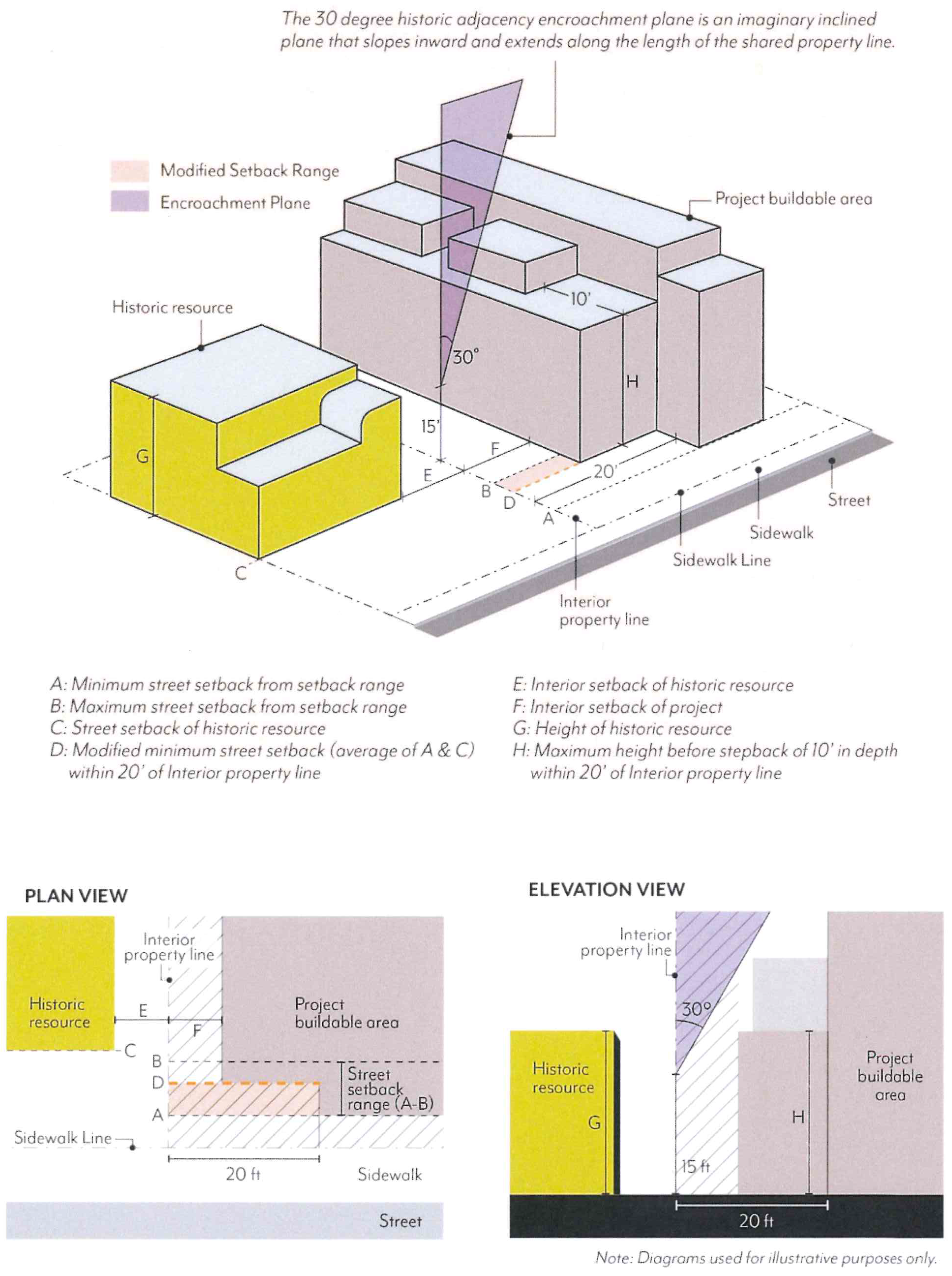
G.
Modulation
1.
Façade Length. Each street-facing façade shall not exceed 150 feet in length unless there is a minimum break of 10 percent of the building length or 20 feet, whichever is greater. This break shall be at least 10 feet deep, open to the sky; see Figure SFOSP-13.
2.
Façade Area. Each street-facing façade exceeding 50 feet in length shall modulate a minimum of 25 percent of the area above the first story. This modulation shall be a minimum of 2 feet and a maximum of 12 feet in depth from the primary façade plane; see Figure ECSP-16. Buildings with a total of 2 stories or less are exempt.
a.
The primary façade plane is defined as the vertical plane with the greatest surface area above the ground floor.
b.
Planes that are separated by a break of at least 20 feet in width and 10 feet in depth shall be considered separate façades for the purposes of this standard.
c.
Modulation is not required to be continuous or open to the sky, and may be recessed or projected, but not past the sidewalk line.
d.
Required stepbacks (Section 17.35.060.E), façade breaks (Section 17.35.060.G.1), and projected balconies (Section 17.35.070.G.1) shall not count toward the modulation requirement; balconies that are recessed a minimum of 2 feet shall qualify.
Figure SFOSP-13: Façade Length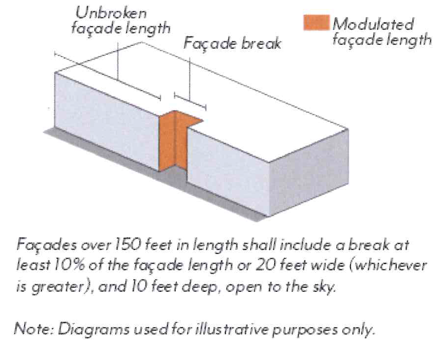
Figure SFOSP-14: Façade Area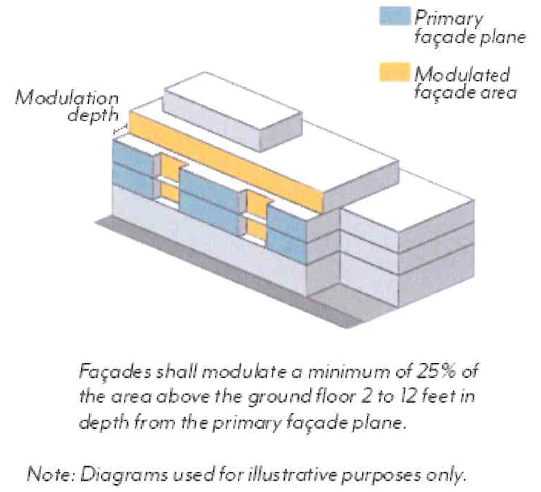
3.
Alternative Compliance.
a.
Eligibility. Modulation standards may be reduced or otherwise modified through the Design Review process if:
(1)
A minimum of 90 percent of the provided parking is fully or partially subterranean;
(2)
A minimum of one publicly accessible open space is provided at the ground level, visible and accessible from the sidewalk;
(3)
No other concessions, waivers, or incentives have been requested, including those associated with Section 17.43 (Density Bonus), unless the project is designed to achieve LEED Gold certification; and
(4)
The review authority makes all of the following findings.
b.
Required Findings
(1)
The building design provides modulation on each street-facing façade in a manner consistent with the project's architectural style and/or immediate context, including adjacent historic resources.
(2)
The building design does not cause an adverse impact on the quality of the ground floor and public realm.
(3)
The ground level open space is of adequate size and integrated with the building in a functional way that ensures the space will be actively utilized.
(4)
The modification will not be detrimental to the health, safety, and welfare of the public.
(5)
The building design is consistent with the objectives and policies of the General Plan and SFOSP, as well as all other standards of the SFOSP.
(Ord. No. 7446, § 5, 5-12-2025; Ord. No. 7419, § 4, 2-26-2024; Ord. No. 7405, § 2, 10-17-2022)
17.35.070 - Frontage
These standards are intended to:
•
Promote an active, accessible, and attractive pedestrian environment at the ground level;
•
Activate the pedestrian street experience through design and use standards;
•
Enable flexibility and adaptability over time through quality design; and
•
Support a livable urban setting comprised of a range of uses in a comfortable pedestrian environment.
A.
Ground Floor Frontages.
In Mixed-Use zoning districts, ground floor use requirements are regulated by frontage type per Figure SFOSP-15 and Table SFOSP-3. All use requirements are regulated as a percentage of the building frontage; see Figure SFOSP-16.
1.
Commercial Uses. Frontage types shall require a minimum amount of the building frontage to be comprised of, and designed for, commercial uses per Figure SFOSP-15 and Table SFOSP-3. Permitted commercial uses by zoning district are found in Table SFOSP-1.
a.
Entrances to non-ground floor uses, and/or entrances to uses prohibited within 35 feet of the sidewalk, shall not qualify toward the minimum commercial use percentage.
b.
Commercial uses shall have an average interior depth of at least 35 feet and a minimum depth of 20 feet, measured wall-to-wall.
2.
Residential Uses. Frontage Types 1 and 2 per Table SFOSP-3 and Figure SFOSP-15 set limitations on ground floor residential uses facing the street. Permitted residential uses by zoning district are found in Table SFOSP-1.
a.
Type A: Residential units on the ground floor shall be prohibited within 35 feet of the sidewalk line, inclusive of setbacks, per Table SFOSP-3; see Figure SFOSP-17.
b.
Type B: Residential units on the ground floor shall be permitted with direct access to the street and a minimum setback of 5 feet.
c.
Residential common space on the ground floor shall be permitted per Table SFOSP-3.
Figure SFOSP-15: Ground Floor Frontage Types
Table SFOSP-3: Allowable Ground Floor Building Frontages in Mixed-Use Zones
Figure SFOSP-16: Ground Floor Commercial Uses
Figure SFOSP-17: Ground Floor Residential Units
B.
Ground Floor Design.
1.
Entrances. A minimum of one primary entrance shall be located on the primary frontage of each building and open onto a sidewalk or other public space.
a.
Primary entrances shall be distinguished by architectural features or overhead projections, such as an awning or canopy.
b.
All entrances shall be recessed a minimum of 30 inches from the sidewalk line.
2.
Minimum Height. Buildings shall have a minimum ground floor height of 15 feet, measured from sidewalk elevation closest to the primary entrance to the second story floor or roof of a one-story building; see Figure SFOSP-18.
a.
For non-residential and residential common space uses, the primary entrance of the first habitable floor shall be located at existing grade along the sidewalk line.
b.
For residential units, the first habitable floor shall be located between 6 feet above and 2 feet below sidewalk elevation.
Figure SFOSP-18: Ground Floor Height
C.
Transparency.
1.
Windows & Doors. Street-facing facades shall incorporate glass providing views into work, display, sales, lobby, or similar active areas. The minimum transparency requirement is set in Tables SFOSP-4 and SFOSP-5 based on use.
a.
For non-residential and residential common space uses, ground floor transparency is measured as the percentage of building frontage that consists of transparent openings between a height of 2 feet and 10 feet above sidewalk elevation.
b.
All other transparency is measured as the percentage of building frontage area, viewed in elevation.
c.
Windows shall be recessed by a minimum of 3 inches from the façade, measured from the outside wall to the frame of the window (mullion, muntin or similar element). Flush windows shall be permitted where exterior shading devices cover a minimum of 25 percent of the window surface area or per review authority approval.
d.
The use of color-tinted, mirrored, or highly reflective glass is prohibited.
e.
Blinds, drapes, posters, and shelving for product displays visible to the public right-of-way shall obscure a maximum of 10 percent of the transparent areas of each respective storefront or 50 percent for medical office uses.
Table SFOSP-4: Transparency for Non-Residential and Residential Common Space
Table SFOSP-5: Transparency for Residential Units
2.
Blank Walls. Windowless expanses of walls shall not exceed 20 feet in length.
3.
Security Bars. Any exterior or interior security bars shall be designed to be fully hidden from view during business hours with devices such as concealed side pockets and ceiling cavities.
D.
Shade Structures.
1.
Shading. Shade structures may project up to two-thirds of the sidewalk width.
a.
Shade structures shall allow a minimum of 8 feet of vertical clearance from sidewalk elevation.
b.
Shade structures shall not conflict with existing trees; exceptions to the depth requirement shall be subject to review authority approval.
E.
Arcades & Galleries.
1.
Arcades. Any arcades shall be located behind the minimum setback.
a.
Arcades shall be a minimum of 8 feet from back of column to building façade.
b.
The distance between columns shall be equal to or greater than the arcade depth dimension, as measured from the column center.
c.
The façade within the arcade shall meet the ground floor transparency set in Section 17.35.070.C.
d.
Uses allowed within arcades include: pedestrian travel, seating/street furniture, outdoor dining, landscape planters, and/or bicycle parking.
2.
Galleries. Any galleries shall be located behind the minimum setback.
a.
Galleries shall be limited to one-story in height and 50 percent of the building frontage.
b.
Galleries shall allow a minimum of 10 feet of vertical clearance from sidewalk elevation.
F.
Exterior Features
1.
Façade Lighting. Lighting shall be located on façades facing streets and public open spaces at a frequency of every 30 feet or less.
a.
Façade lighting shall be full cutoff (directing light downward and outward).
b.
Fixtures shall be located between 8 and 15 feet above the sidewalk elevation, and shall not project more than 30 inches from the façade.
c.
For buildings with ground floor residential uses, façade lighting shall be designed to be operable by the adjacent tenant.
G.
Walls & Fences.
1.
Walls & Fences. Walls and fences shall be subject to Section 17.40.180 with the following exceptions for those located within the street setback.
a.
Walls and fences shall have a maximum height of 48 inches above sidewalk elevation.
b.
Walls and fences taller than 30 inches shall be a minimum of 50 percent transparent and set back a minimum of 18 inches from the sidewalk line, separated by planted area. Walls and fences 30 inches or less in height do not have a transparency or setback requirement.
c.
Walls and fences used to enclose outdoor dining may be located at the sidewalk line and are not required to provide a planted area if the wall or fence is 36 inches or less and more than 50 percent transparent.
d.
Guardrails may exceed the maximum height to the extent required by the Building Code. The guardrail shall be a minimum of 50 percent transparent.
2.
Stoops & Patios. The side of a patio or stoop (when parallel to a sidewalk) taller than 30 inches in height shall be set back a minimum of 18 inches from the sidewalk line, separated by planted area.
H.
Balconies & Roof Decks.
1.
Balconies. Balconies may project a maximum of 4 feet from the building façade but shall not extend beyond the sidewalk line or within 6 feet of any interior property line.
2.
Roof Decks. The sum of all roof decks on a single building shall not exceed a maximum coverage of 60 percent of the roof area.
a.
Roof deck railings above the top floor shall be placed behind a parapet wall of at least the same height or set back a minimum of 5 feet from the façade. For buildings employing Varied Roof Lines, the uppermost story shall be defined per the discretion of the Director.
(Ord. No. 7446, § 5, 5-12-2025; Ord. No. 7419, § 4, 2-26-2024; Ord. No. 7405, § 2, 10-17-2022)
17.35.080 - Open Space
These standards are intended to:
•
Provide a variety of open space types for gathering, recreation and respite that contribute to enhanced livability within an urban setting;
•
Give residents access to light, air, and pleasant views from their living spaces;
•
Improve building design and site planning through the integration of open space throughout the development; and
•
Correlate open space requirements with number of residents and size of buildings.
A.
Minimum Open Space.
1.
Private and Common Open Space. Projects shall provide the minimum area of Open Space based on use and size. Areas used regularly for parking, loading or storage shall not count towards minimum Open Space requirements.
a.
Residential. Projects with dwelling units shall provide the minimum area of Open Space per Table SFOSP-6 as a combination of Private and/or Common Open Space.
b.
Non-residential. Projects with more than 40,000 square feet of non-residential floor area shall provide a minimum of 5 percent of the gross non-residential floor area as Common Open Space.
(1)
Research and Development uses may reduce Common Open Space area requirements by a maximum of 60 percent. Research and Development projects (or the Research and Development portion of a project with multiple uses) shall exclude mechanical space from floor area for required Open Space.
c.
Mixed-use. Projects shall comply with requirements applicable to each type of use.
Table SFOSP-6: Residential Open Space by Unit Type
2.
Publicly Accessible Open Space (PAOS). Projects with more than 60,000 square feet of gross floor area (GFA) shall provide a minimum area of PAOS, calculated as a percentage of GFA, as set in Table SFOSP-7.
a.
PAOS shall be provided in addition to Private and Common Open Space requirements.
(1)
Research and Development uses may reduce PAOS requirements by a maximum of 60 percent. Research and Development projects (or the Research and Development portion of a project with multiple uses) shall exclude mechanical space from floor area for required PAOS.
b.
Projects shall comply with PAOS standards per Section 17.35.080.D and Paseo standards per Section 17.35.080.E where relevant.
(1)
PAOS and Paseo standards may be modified through the Design Review process, if the review authority finds that the modified design continues to be accessible to the public, functional, and includes features such as landscaping, trees, and outdoor seating.
c.
Research and Development uses may reduce Common Open Space area requirements by a maximum of 60 percent. Research and Development projects (or the Research and Development portion of a project with multiple uses) shall exclude mechanical space from floor area for required Open Space.
Table SFOSP-7: Publicly Accessible Open Space by Project Size & Location
B.
Private Open Space.
1.
Dimensions. A minimum area of 40 square feet with a minimum dimension of 5 feet in each direction shall be required for Private Open Space.
2.
Distribution. A maximum of 40 percent of the required residential Open Space set in Table SFOSP-6 shall be Private Open Space.
a.
All Private Open Space shall be outdoors.
b.
Private Open Space may be located within a required setback.
C.
Common Open Space.
1.
Dimensions. A minimum area of 400 square feet with a minimum dimension of 15 feet in each direction shall be required for Common Open Space.
2.
Distribution. A minimum of 60 percent of the required residential Open Space set in Table SFOSP-6 shall be Common Open Space shared among tenants.
a.
A minimum of 70 percent of Common Open Space shall be outdoors, and a minimum of 80 percent of outdoor Common Open Space shall be open to the sky.
b.
A maximum of 30 percent of Common Open Space may be indoors. Indoor Common Open Space shall not include spaces used primarily for circulation.
3.
Access. Common Open Spaces may be accessible to the public.
4.
Hardscape. A maximum of 25 percent of Common Open Space may be paved in standard concrete. Remaining areas shall use one of the following enhanced paving techniques: brick, natural stone, unit concrete pavers, textured and colored concrete, concrete with exposed or special aggregate. Alternative paving may be allowed per review authority approval.
5.
Landscape. A minimum of 25 percent of Common Open Space shall be planted area with a minimum dimension of 30 inches in length, width, and depth. Landscaping shall comply with Section 17.44.050.
6.
Trees. A minimum of one 24-inch box tree per project or for every 750 square feet of outdoor Common Open Space, whichever is greater, shall be planted within the Common Open Space. For projects with 2 or more trees, a minimum of 50 percent of trees planted shall be shade trees.
a.
Trees planted in pots, on the ground floor, shall not be counted towards the tree requirement.
7.
Water Features. A maximum of 5 percent of the required Common Open Space shall be fountains, reflecting pools, or other decorative water features. Swimming pools are not considered water features for the purposes of this standard.
D.
Publicly Accessible Open Space (PAOS)
1.
Area. Minimum PAOS requirements are set in Section 17.35.080.A.2 and Table SFOSP-7, and may be contiguous or noncontiguous, subject to the dimension and elevation standards below.
2.
Paseos. Projects that are required to provide PAOS per Section 17.35.080.A.2 and located on parcels that include a paseo opportunity area on Figure SFOSP-19, shall be required to meet the minimum area requirement by providing a paseo, defined as a pedestrian passageway that connects a public street to another public street, alley, or internal public space.
a.
Paseos shall meet the standards set in Section 17.35.080.E; design standards Section 17.35.080.D.4 through Section 17.35.080.D.12 shall not apply.
b.
No additional paseo shall be required in opportunity areas where a paseo exists. The existing paseo shall be subject to standards in Section 17.35.080.E. The standards may be modified through the Design Review process, if the review authority finds that the modified design continues to be accessible to the public, functional, and includes features such as landscaping, trees, and outdoor seating.
3.
Plazas. Projects that are required to provide PAOS per Section 17.35.080.A.2 and located on parcels that include a plaza opportunity location on Figure SFOSP-19, shall be required to meet the minimum area requirement by providing a corner plaza per Figure SFOSP-19.
a.
PAOS design standards shall apply.
4.
Dimensions. A minimum area of 400 square feet with a minimum dimension of 20 feet in each direction is required for PAOS.
5.
Access. A maximum of 20 percent of the PAOS may be used as outdoor dining for a restaurant subject to review authority approval; a minimum of 80 percent of the PAOS shall be accessible to the general public.
6.
Signage. PAOS shall have signage visible from the adjacent sidewalk identifying the space as a publicly-accessible amenity and listing accessible hours.
7.
Hours. At a minimum, PAOS shall be open to the general public from 8am to 8pm. Any gated ingress or egress points shall not be closed or locked during these hours.
8.
Elevation. A minimum of 3,000 square feet of PAOS shall be at sidewalk elevation. If less square footage is required, then all required PAOS shall be at sidewalk elevation.
9.
Hardscape. A maximum of 25 percent of PAOS shall be paved in standard concrete. Remaining areas shall use one of the following enhanced paving techniques: brick, natural stone, unit concrete pavers, textured and colored concrete, concrete with exposed or special aggregate. Alternative paving may be allowed per review authority approval.
10.
Seating. Seating shall be provided at a minimum of 1 seat per 300 square feet of required PAOS. Fractions shall be rounded down to the nearest whole number.
a.
Benches shall be calculated as 1 seat per 24 linear inches.
11.
Landscape. A minimum of 25 percent of PAOS shall be planted area with a minimum dimension of 30 inches in length and width. Landscaping shall comply with Section 17.44.
12.
Trees. A minimum of one 24-inch box tree per project or for every 750 square feet of PAOS, whichever is greater, shall be planted. For projects with 2 or more trees, a minimum 50 percent of trees planted shall be shade trees.
13.
Common Open Space Credit. PAOS in excess of the minimum may count towards a maximum of 30 percent of the Common Open Space requirement at a 1:1 ratio.
Figure SFOSP-19: Required Publicly Accessible Open Space
Opportunity areas show a range of siting options and are not representative of the scale of open space required. Refer to Section 17.35.080 for minimum dimensions. Exact siting and shape of paseos and plazas are subject to the discretion of the Planning Director. Paseos shall satisfy the intent of through-block connectivity.
E.
Paseos.
1.
Dimensions. Paseos shall have an average width of 20 feet, minimum width of 15 feet, and be a minimum of 75 percent open to the sky. Paseos shall have a walk zone with a minimum width of:
a.
10 feet for commercial/mixed-use paseos.
b.
8 feet for residential-only paseos.
2.
Access. Paseos shall be physically and visually accessible from the connecting public sidewalk.
a.
Fences, walls, and/or entry gates are permitted; however, these features shall not block passage through the paseo during public hours.
b.
Bollards (fixed or removable) shall be provided at all entry points of paseos to restrict vehicular access during public hours.
c.
Emergency vehicular access shall be provided.
3.
Signage. Paseos shall have signage visible from the adjacent sidewalk identifying the space as a publicly-accessible amenity and listing public hours. In paseos that have commercial frontages, a directory shall be provided at each entry. Specific sign guidelines shall be created for all properties with building facades immediately adjoining the paseos.
4.
Hours. At a minimum, paseos shall be open to the general public from 8am to 8pm. Commercial loading shall be limited to non-public hours.
5.
Elevation. Paseos shall be at ground level and ADA accessible.
6.
Programming. A maximum of 10 percent of required paseo area may be used by adjacent restaurants or food sales uses as a space restricted to customers only. Any additional programming must be non-transactional and without financial barriers to entry.
a.
Exception: Paseos may be closed to public access for private events no more than once per month.
7.
Hardscape. A maximum of 25 percent of paseos shall be paved in standard concrete. Remaining areas shall use one of the following enhanced paving techniques: brick, natural stone, unit concrete pavers, textured and colored concrete, concrete with exposed or special aggregate. Alternative paving may be allowed per review authority approval.
8.
Stormwater Management. A minimum of 25 percent of the total paved area shall be permeable paving to allow for stormwater infiltration. Depending on soil and site conditions, infiltration and/or flow-through planters shall be installed to capture and treat 100 percent of the stormwater run-off on-site.
9.
Seating. Seating shall be provided within the paseo at a minimum of 1 seat per 300 square feet of required space. Fractions shall be rounded down to the nearest whole number.
10.
Landscape. A minimum of 25 percent of paseo area shall be planted area a minimum of 30 inches in length, width, and depth. Landscaping shall comply with Section 17.44.
11.
Trees. A minimum of one 24-inch box tree per project or per each 750 square feet of paseo area, whichever is greater, shall be planted. For projects with 2 or more trees, a minimum 50 percent of trees planted shall be shade trees.
a.
Trees planted in pots, on the ground floor, shall not be counted towards the tree requirement.
12.
Blank Walls. Paseos shall adhere to the blank wall standards defined in Section 17.35.070.C, or provide one of the following mitigations:
a.
Green wall, vines, or other vertical landscaping element that covers a minimum of 75 percent of non-conforming blank wall area.
b.
Public art including, but not limited to, murals.
(Ord. No. 7446, § 5, 5-12-2025; Ord. No. 7419, § 4, 2-26-2024; Ord. No. 7418, § 3, 2-26-2024; Ord. No. 7405, § 2, 10-17-2022)
17.35.090 - Parking
These standards are intended to:
•
Reduce the visual impacts of parking;
•
Regulate appropriate parking supply and location in a manner that prioritizes pedestrian access and multi-modal activity;
•
Encourage change of use and adaptive reuse of existing buildings through parking reductions and exemptions;
•
Promote a more efficient use of parking spaces through shared parking among multiple uses within a project; and
•
Increase design standards for parking structures through ensuring habitable floor area and screening between parking and street frontage.
A.
Minimum Parking
1.
Number of Spaces. Projects shall provide off-street automobile parking spaces per Table SFOSP-9 based on general use classifications, and subject to the standards of Section 17.46.
a.
For projects within one-half mile of a Metro station, reductions in parking and a maximum number of parking spaces shall apply per Section 17.50.340.
b.
For projects within 500 feet of a Metro station, projects may be permitted up to a 30 percent reduction in the number of parking spaces.
c.
Bicycle parking shall be required per Section 17.46.320.
Table SFOSP-9: Minimum Parking by Land Use
2.
Shared Parking. Parking may be shared among multiple uses per Section 17.46.050.
3.
Unbundled Parking. For any building with new residential units, automobile parking spaces shall be leased or sold separately from the rental or purchase fees, such that renters or buyers have the option of renting or buying the unit at a lower price than if the parking was included.
a.
For deed-restricted affordable units, one parking space shall be included in the base rent of each unit. The tenant may choose to receive the parking space or receive a rent discount equivalent to half the amount charged for monthly lease of a parking space. Tenants of affordable units shall not sublease their parking spaces.
b.
Renters or buyers have the right of first refusal to parking built for their unit. Any remaining spaces may be leased to other users on a month-to-month basis. New occupants shall have the opportunity to lease or purchase parking built for their unit.
B.
Vehicle Access
1.
Driveways. For Projects with less than 200 feet of primary street frontage, a maximum of 1 two-lane driveway shall be permitted. For sites with more than 200 feet of primary street frontage, a maximum of 2 two-lane driveways shall be permitted.
a.
Driveways are not permitted on primary frontages of less than 200 feet where there is access from a secondary street or alley.
b.
The Zoning Administrator shall determine the primary frontage.
C.
Layout & Design
1.
Surface Parking. Parking lots shall comply with Section 17.46.230 with the following exceptions:
a.
Parking lots shall be set back a minimum of 30 feet from the primary frontage, 10 feet from any secondary frontage, and 5 feet from RM/RS zoning districts.
b.
Parking shall be buffered by permitted non-parking uses or a landscaped setback adjacent to the sidewalk line, except for driveways or pedestrian access to the parking area.
a.
Landscaped setbacks shall include hedges or shrubs with a minimum height of 3 feet at the time of planting that form a continuous visual screen to block vehicle headlights.
c.
Landscaped area with a minimum dimension of 5 feet in each direction shall be provided within the parking area as a percentage of parking lot area as follows:
•
10 to 20 parking spaces: a minimum of 5 percent
•
More than 20: a minimum of 10 percent
d.
A minimum of one tree of at least 24 gallons in size for every four vehicle parking spaces shall be planted and evenly distributed throughout the parking lot, so that a tree is located within 10 feet of any parking space.
a.
Exceptions to tree planting requirements allowed only for those parking spaces fully covered by solar energy systems.
2.
Structured Parking. Along primary frontages, all floors of parking structures shall be lined with building floor area (e.g. commercial or residential uses) or Publicly Accessible Open Space for a minimum of 35 feet in depth. Pedestrian access and driveways in compliance with 17.35.100.B are excluded from this requirement.
a.
Parking structure facades visible from public streets, excluding alleys, shall use materials and design at least comparable to and integrated with the building architecture.
3.
Underground Parking. Subterranean parking shall be set back a minimum of 5 feet from all street property lines (excluding alleys) and RM/RS zoning districts. Otherwise, it may extend up to the property line.
(Ord. No. 7446, § 5, 5-12-2025; Ord. No. 7405, § 2, 10-17-2022)
17.35.100 - Definitions
This Section provides definitions of terms and phrases used in the SFOSP that are technical or specialized or that may not reflect common usage. In case of conflict with other provisions of the Zoning Code, these definitions shall control for the purposes of the SFOSP. If a word is not defined in this Chapter, the Zoning Administrator shall determine the correct definition.
Amenity Zone. The portion of the sidewalk located above and adjacent to the curb, providing space for amenities such as parkways, outdoor dining, seating, trees, lighting, bicycle racks, bus stops, etc.
Building Frontage. The horizontal distance, measured at grade, of building wall facing the street.
Building Frontage Zone. The portion of the sidewalk immediately adjacent to the building facade, providing space for planters, outdoor dining, sidewalk signage, etc. This zone may not be present on every street or block.
Curb Zone. See 'amenity zone.'
Façade. Any exterior wall plane of a building, ground level to top of roof.
Floor Area Ratio. Numerical value obtained by dividing the above-ground area of a building or buildings located on a lot by the total area of the lot.
Footprint. The total ground floor area of the combined structures on a site or project area defined by the perimeter of the building(s), including parking structures but excluding parking lots and non-occupancy structures.
Frontage Zone. See 'building frontage zone.'
Gross Floor Area (GFA). The total enclosed area of all floors of a building measured to the inside face of the exterior walls including halls, stairways, elevator shafts at each floor level, service and mechanical equipment rooms and basement or attic areas having a height of more than seven feet, but excluding area used exclusively for parking or loading of vehicles or bicycles.
Ground Floor. The first habitable floor of a building closest to sidewalk elevation.
Mixed-Use Project. The combination of commercial and residential uses in the same structure, where the residential component is located either above (vertical mixed-use) or behind (horizontal mixed-use) the non-residential component. Non-residential uses are typically commercial uses.
Open Space. For any form of open space (Common, Publicly Accessible, Private, etc), see Section 6.3 of the SFOSP.
Parkway. Landscaped or permeable areas located within the amenity zone of the sidewalk.
Paseo. A publicly accessible open space that functions as a pedestrian passageway connecting a public street to another public street, alley, or internal public space. Subject to minimum dimension and design requirements established by the SFOSP.
Plaza. A publicly accessible open space with access from a public street. Subject to minimum dimension and design requirements established by the SFOSP.
Primary Curb Line. The face of the predominant curb of an individual block forming the edge of the street.
Residential Common Space. Those portions of a residential use building not dedicated to residential units that provide common services for residents. This may include spaces such as, but is not limited to, lobby or common building entry, leasing center, gyms/exercise space, shared kitchen, recreation center, screening or living room, business center, mail room, or library. These spaces/portions of the building may be permitted on the ground floor where residential units are not permitted subject to the SFOSP standards.
Setback. The horizontal distance by which a structure, parking area, or development feature is required to be separated from the property line or the sidewalk line where applicable. In some cases superseded by Setback range.
Setback, Interior. Non-street side or rear setback measured at a right angle from the nearest point of the property line abutting another parcel or alley to the nearest portion of the structure, excluding any porches.
Setback, Street. Front or street-side setback measured at a right angle from the nearest point of the sidewalk line to the nearest portion of the structure, excluding any porches.
Setback Range. Minimum and maximum horizontal distances by which a structure or development feature is required to be separated from the sidewalk line. This measurement is similar to a "build-to" line.
Sidewalk Line. The line parallel to the property line accommodating the required sidewalk width, measured from the curb face. Where a sidewalk width is not specified, the sidewalk line is the property line.
Sidewalk Zones. The three portions of a sidewalk that together comprise the public realm between a building and the street. Sidewalk zones are defined by the Pasadena Street Design Guide and regulated by the SFOSP.
Shared Property Line. The property line separating adjacent parcels.
Stepback. The horizontal distance by which an upper story structure or development feature is required to be separated from the property line or the sidewalk line where applicable. Regulated above a specified vertical distance.
Street Frontage. The horizontal distance along the street, measured at grade, between property lines (or sidewalk line where applicable) that are perpendicular to the adjacent street.
Streetwall. Any building façade that faces a street within 10 feet of the minimum sidewalk line.
Streetwall Height. The portion of the street-facing building façade that rises from the sidewalk level to the required height without an additional setback or stepback.
Subterranean. The level of a building, inclusive of parking or habitable space, located primarily below the ground level with a top plate of two feet or less above sidewalk elevation.
Transparent Openings. Building openings (windows or doors) or transparent glazing that provide visual access into the structure.
Unbundled Parking. Parking spaces, in any permitted configuration, rented or sold separately from the lease or purchase price of a residential unit.
Walk Zone. The portion of the sidewalk dedicated to pedestrian movement, clear of any obstructions.
(Ord. No. 7405, § 2, 10-17-2022)
17.36.010 - Purpose of Chapter
This Chapter lists the land uses that may be allowed within the zoning districts established by the West Gateway Specific Plan (WGSP), determines the type of land use permit/approval required for each use, and provides standards for site layout and building size.
17.36.020 - Purpose of WGSP Zoning Districts
The purpose of the WGSP zoning districts is to implement the West Gateway Specific Plan by balancing and optimizing economic development, historic preservation, and the maintenance of local community culture, and to:
A.
Implement the purposes of the West Gateway Specific Plan;
B.
Balance the principles of economic development, historic preservation, and maintenance of local community culture in order to optimize each and thereby achieve the goal of implementing the General Plan in the West Gateway area of Pasadena;
C.
Preserve the high-quality atmosphere that is the hallmark of this area, through complementary, well-designed landscaping and buildings appropriately scaled to blend with the character of the adjacent areas yet taking into account the intended character of this area;
D.
Provide the flexibility needed to allow new development to respond to market demand;
E.
Protect, support, and preserve Old Pasadena by allowing complementary uses while avoiding a westward expansion of Old Pasadena's boundaries;
F.
Allow a broad mix of land uses, including retail businesses, (both community-serving and neighborhood-serving), office, hotel/conference center, senior housing, life/care facilities, and residential uses including market rate and affordable housing;
G.
Encourage and facilitate appropriate development by streamlining the development process in a manner consistent with the West Gateway Specific Plan;
H.
Encourage the linking of a new development with adjacent existing features such as Central Park, Old Pasadena and the proposed light rail station, and enhance the links between features within the Specific Plan area;
I.
Recognize the importance of preserving significant historic structures in the area while promoting the replacement of existing underutilized or deteriorating structures through redevelopment;
J.
Identify areas to preserve and protect;
K.
Preserve the significant historic buildings and gardens on the Worldwide Church of God property, including the Ambassador Auditorium;
L.
Plan traffic and parking patterns in order to minimize the negative effects on adjacent neighborhoods and existing businesses;
M.
Encourage development that supports and capitalizes on transit opportunities, such as the proposed light rail station at Raymond Avenue and Del Mar Boulevard, the ARTS Circulation buses, and all other means of public transportation, including bicycles and pedestrians;
N.
Recognize the cultural and educational attributes in this area; and
O.
Enhance the Orange Grove/Colorado intersection as the symbolic western gateway into Pasadena.
17.36.030 - Applicability
The standards of the WGSP zoning districts apply to proposed development and new land uses in the following areas, as shown on the Zoning Map.
A.
WGSP-1A. The Ambassador College campus west of St. John Avenue.
B.
WGSP-1B. The Ambassador College campus east of Orange Grove Boulevard.
C.
WGSP-1C. The Colorado Boulevard area.
D.
WGSP-2. The Army Reserve Training Center site.
17.36.040 - Definitions
The following definitions shall apply in this Chapter. Words and phrases not defined here shall be as defined in Article 8 (Glossary of Specialized Terms and Land Use Types).
A.
Conversion Formula. The formula for converting new or replacement residential uses to non-residential uses, and vice-versa. Under this formula, one dwelling unit shall be equivalent to 850 square feet of non-residential development and 850 square feet of nonresidential development shall be equivalent to one dwelling unit.
B.
Density. The number of new dwelling units, or in the case of non-residential projects, the amount of floor area in square feet, which may be developed in relation to the size of the property to be developed as expressed in dwelling units or square feet per acre, as the case may be; provided, however, that when an existing building is demolished, the number of dwelling units or floor area of the existing building, as the case may be, shall be subtracted from the number of dwelling units or floor area of the new building in determining the total "new" floor area on the site, regardless of use. The density of independent living units within a senior life/care facility shall mean the number of new dwelling units in relation to size of the property to be developed. The reuse of an existing building without the addition of floor area or dwelling units does not result in "new" floor area or additional density on the site. Parking structures shall be exempt from any building density standards.
17.36.050 - WGSP District Land Uses and Permit Requirements
A.
Allowable land uses and permit requirements. Table 3-16 identifies the uses of land allowed by this Zoning Code in each residential zoning district, and the land use permit required to establish each use, in compliance with Section 17.21.030 (Allowable Land Uses and Permit Requirements). The land use permit requirements established by Table 3-14 are as follows.
Note: the right column in the tables ("Specific Use Standards") will show a section number for regulations that apply to the particular use listed, in addition to the other general standards of this Zoning Code.
(Ord. No. 7435, § 13, 10-28-2024; Ord. No. 7420, § 3, 4-15-2024; Ord. No. 7418, § 2, 2-26-2024; Ord. 7326 § 6, 2018; Ord. 7321 § 3 (Exh. 1), 2018; Ord. 7313 § 11, 2017; Ord. 7300 § 11 (Exh. 10), 2017; Ord. 7255 § 10 (Exh. 9), 2015; Ord. 7210 § 8, 2011; Ord. 7164 § 9, 2009; Ord. 7160 § 7, 2009; Ord. 7099 § 19, (Exh. 18) 2007; Ord. 7009 § 17, 2005)
17.36.060 - WGSP General Development Standards
Subdivisions, new land uses and structures, and alterations to existing land uses and structures shall be designed, constructed, and established in compliance with the requirements of this Section, in addition to the applicable standards (e.g., landscaping, parking and loading, etc.) in Articles 4 (Site Planning and General Development Standards) and 5 (Standards for Specific Land Uses). Principal and accessory structures shall meet the same development standards unless otherwise modified in this Zoning Ordinance.
A.
Amount of permitted development and allocation of density.
1.
Development allocation. Each site in the WGSP-1A, WGSP-1B, WGSP-1C and WGSP-2 zoning districts shall receive an equal allocation of new nonresidential development of 17,500 square feet for each acre or pro rata or fraction thereof. The allocation shall be pro-rated for sites of less than one acre. This allocation pertains only to new development proposed after the effective date of the West Gateway Specific Plan. This allocation may be converted to residential units at a ratio of 850 square feet to one unit.
2.
Replacement of existing development. In addition to the allocation of new development provided in Subsection A.1, existing dwelling units or nonresidential floor area may be replaced on a one-for-one basis.
a.
Existing dwelling units may be replaced with nonresidential floor area, and existing nonresidential floor area may be replaced with dwelling units. In these cases, one dwelling unit shall be considered equivalent to 850 square feet of nonresidential floor area, and 850 square feet of nonresidential floor area shall be considered equivalent to one dwelling unit.
b.
The replacement dwelling units or floor area shall be subtracted from the floor area of the new building in determining the allowable density and/or floor area of new residential and nonresidential development on the site.
c.
When an existing building is demolished, the number of dwelling units or non-residential floor area of the existing building shall be subtracted from the number of dwelling units or floor area of the new building in determining the total "new" floor area allowed on the site regardless of use.
d.
The density of independent living units within a life/care use shall mean the number of new dwelling units in relation to the size of the property to be developed.
e.
The reuse of an existing building without the addition of floor area or dwelling units does not result in "new" floor area or additional density on the site.
f.
Parking structures are exempt from the floor area limitations of this Section.
g.
The allocation of new dwelling units or new nonresidential floor area shall take place on the earlier of:
(1)
The property owner's receipt of a valid building permit for the project; or
(2)
The approval of a development agreement for the project by the Council.
B.
Transfer of development rights (TDR). With the written consent of both the donor and receiver site owner, any property owner within the specific plan area may transfer development rights from one parcel under its ownership (the "donor site") to any other parcel, whether contiguous or noncontiguous, within the specific plan area (the "receiver site").
1.
Nonresidential floor area on a donor site may be converted to dwelling units on a receiver site, and dwelling units converted to nonresidential floor area, using the conversion formula.
2.
A TDR application shall be administratively reviewed and approved by the Zoning Administrator with appeals and calls for review in compliance with Chapter 17.72 (Appeals), if the proposed development for the receiver site, including the TDR, complies with the height, setback, and other requirements of this Chapter (except for the maximum density).
3.
Any development rights transferred from a donor site shall be deducted from the additional density otherwise allowed on the parcel by this Section.
4.
The owner of a donor site shall be required to record a covenant acceptable to the City Attorney memorializing the transfer of density.
5.
The Department shall maintain records of all transfers and the current density allocations, if any, of all of the properties within the specific plan area.
C.
Demolition permits. Notwithstanding any contrary provision in the Municipal Code, an owner of property within a WGSP zoning district may obtain a demolition permit and commence demolition of an existing structure without having obtained a building permit for a replacement project on the site; provided that the property owner has entered into a development agreement with the City covering the property.
E.
Table 3-17 standards. The standards in Table 3-17 apply to residential projects, non-residential projects, and all projects, as noted, within a WGSP zoning district. In the event of a conflict between the standards in Subsections 1. or 2. of the Table, and those in Subsection 3., the requirements of Subsections 1., or 2. control as applicable to the type of project.
(Ord. 7099 § 20, (Exh. 19), 2007; Ord. 7036 § 9 (Exh. 8), 2006)
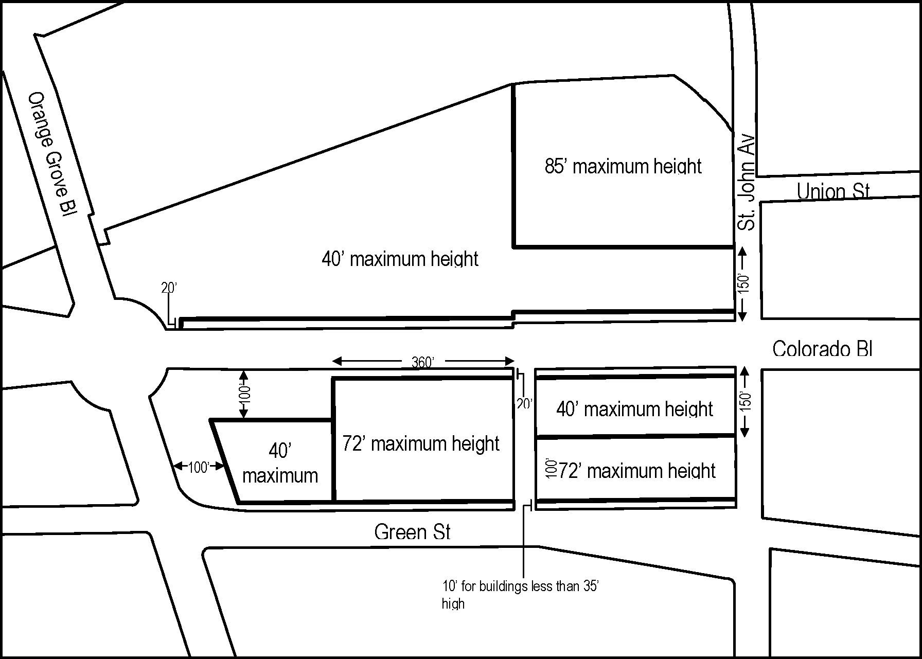
FIGURE 3-14 - WEST GATEWAY SPECIFIC PLAN
AREA 1-C (HEIGHT LIMITS AND YARD REQUIREMENTS)
(Ord. 7099 § 20 (Exh. 19), 2007; Ord. 7035 § 9 (Exh. 8), 2006)
17.37.010 - Purpose of Chapter
This Chapter lists the land uses that may be allowed within the zoning districts established by the Lincoln Avenue Specific Plan (LASP), determines the type of land use permit/approval required for each use, and provides comprehensive design and development standards for all projects.
(Ord. No. 7388, § 3(Exh. 2), 3-21-2022)
17.37.020 - Applicability
The applicability of the LASP land use regulations and development standards are organized by zoning district and plan chapters (Table LASP-1). Where the standards do not apply, the relevant section of Pasadena Municipal Code (PMC) is referenced. In PS, development shall be subject to a Conditional Use Permit or Master Plan per Section 17.26. Note that Vision, Goals & Policies and Public Realm standards apply throughout the plan area.
Table LASP-1: Applicability
(Ord. No. 7388, § 3(Exh. 2), 3-21-2022)
17.37.030 - Zoning Districts
The purpose of the LASP zoning districts (Figure LASP-1) is to implement the Lincoln Avenue Specific Plan by repurposing the Lincoln Avenue corridor from an industrial and limited commercial area into a vibrant neighborhood-oriented district, with new housing options and a complement of local-serving retail and service businesses, office spaces and community uses, all tied together with public improvements that create a vibrant and enjoyable pedestrian environment.
A.
LA-CG (Commercial General).
• Foster a pedestrian-oriented neighborhood core.
• Accommodate a diverse range of retail and office businesses that people can walk to for shopping, dining, personal and community services, and social activities.
B.
LA-CL (Commercial Limited).
• Provide opportunities for limited commercial uses that serve as a transitional buffer between residential uses and the freeway.
• Allow future uses that are compatible with neighboring homes.
C.
LA-CF (Commercial Flex).
• Allow a wide range of commercial and research & development uses.
• Provide flexibility for the city's burgeoning innovation and production industries.
• Restrict heavy industrial uses that may be inappropriate next to residential uses.
D.
LA-MU-N (Mixed-Use Neighborhood).
• Allow pedestrian-oriented ground floor commercial uses.
• Support projects that are entirely commercial, entirely residential, or a mix of the two, integrated either horizontally or vertically.
E.
LA-RM-16 (Residential Multi-Family).
• Allow a variety of multi-family and compatible residential uses of an appropriate scale.
F.
PS (Public-Semipublic).
• Accommodate institutional uses that may not be appropriate in other zoning districts.
Figure LASP-1: Zoning Districts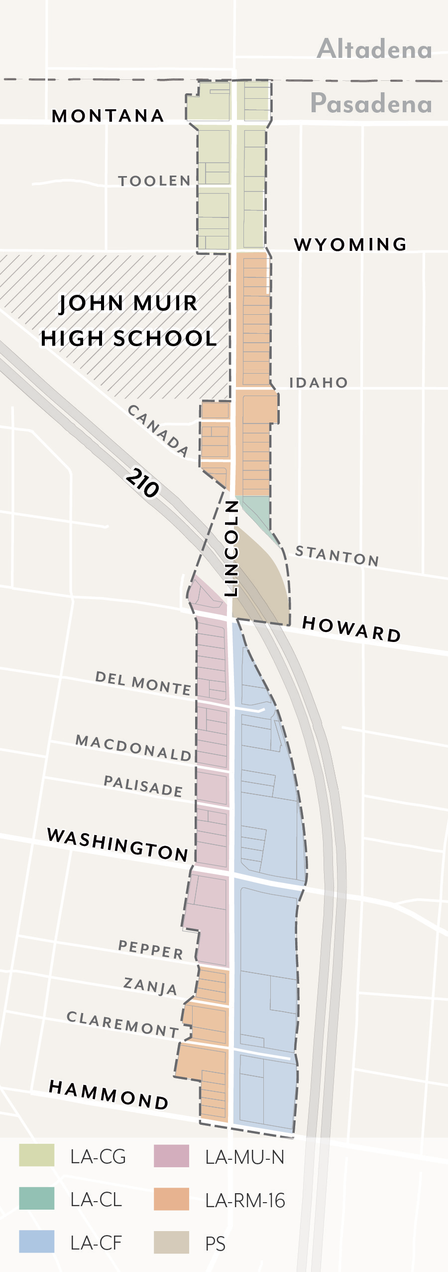
(Ord. No. 7388, § 3(Exh. 2), 3-21-2022)
17.37.040 - Allowable Land Uses
A.
Definitions. Definitions of specific land uses are found in Section 17.80.020, except those listed in Table LASP-2 footnotes.
B.
Permit Requirements. Table LASP-2 identifies the uses of land allowed, the land use permit required to establish each use, and limitations that may apply for a particular use.
C.
Standards for Specific Land Uses. Additional standards may apply to specific land uses; refer to the Section noted in Table LASP-2.
1.
Section 17.50.160 shall not apply to Mixed-Use Projects.
2.
Section 17.50.350 shall not apply to Multi-Family Housing.
D.
Upper Floors. In LA-MU-N, stories above the ground floor are limited to residential uses; non-residential uses are prohibited.
E.
Alcohol Sales. The sale of alcohol is conditionally permitted only as an accessory use to the following primary uses where permitted.
1.
On-site consumption: Accessory use to a restaurant or alcohol beverage manufacturing (i.e. brewery, distillery tasting room).
2.
Off-site consumption: Accessory use to retail food sales in commercial spaces >15,000 square feet; floor space for alcohol shall be no more than 5 percent of the total floor area, including both sales and storage.
F.
Major Construction. For all non-residential uses with a gross floor area of 25,000 square feet or greater, a Conditional Use Permit shall be required per Section 17.61.050.J.2.
G.
Prohibited Uses. Those uses not listed in Table LASP-2 are prohibited by this Specific Plan, except as otherwise provided by Section 17.21.030.A.
1.
Drive-throughs associated with any use are prohibited.
H.
Nonconforming Uses. Existing uses which are made nonconforming by this Specific Plan shall be subject to Section 17.71.
I.
Limited Hours of Operation. Uses listed in Table LASP-2 shall comply with limited hours of operation as required by Section 17.40.070.
Table LASP-2: Allowable Land Uses
(Ord. No. 7435, § 14, 10-28-2024; Ord. No. 7420, § 3, 4-15-2024; Ord. No. 7419, § 4, 2-26-2024; Ord. No. 7418, § 2, 2-26-2024; Ord. No. 7414, § 2, 9-11-2023; Ord. No. 7402, § 2, 9-19-2022; Ord. No. 7388, § 3(Exh. 2), 3-21-2022)
17.37.050 - Public Realm Standards
These standards are intended to:
• Ensure a minimum sidewalk width is achieved, appropriate to support future densities, intensities, uses, and pedestrian volumes;
• Enhance pedestrian conditions and improve street tree health through increased landscaping and permeability at sidewalk level;
• Provide sufficient space to support dedicated amenity and walk zones; and
• Increase shade, carbon sequestration, and stormwater capture by allowing adequate space for street trees and parkways.
A.
Sidewalks.
1.
Sidewalk Width.
a.
Dimension. Projects shall provide sidewalks that meet the required widths per Figure LASP-2. Where the existing sidewalk right-of-way is less than the required width, the difference shall be provided through a private property dedication.
(1)
Sidewalks are measured from the Primary Curb Line of each block to the sidewalk line, as illustrated in Figure LASP-3.
(2)
This area shall be paved for general use to the standards specified by Public Works, except for landscaped parkways per Section 17.37.050.B.
(3)
Within the sidewalk width, sidewalk zones shall be provided to the dimensions set in Figure LASP-4.
(4)
Where the curb deviates (i.e. bulb-outs), exceptions in zone width are allowed and shall be determined by Public Works.
(5)
Driveways are allowed per Section 17.37.100.B.
b.
Maintenance. Sidewalk improvements shall be installed and maintained by the abutting property owner.
Figure LASP-2: Sidewalk Width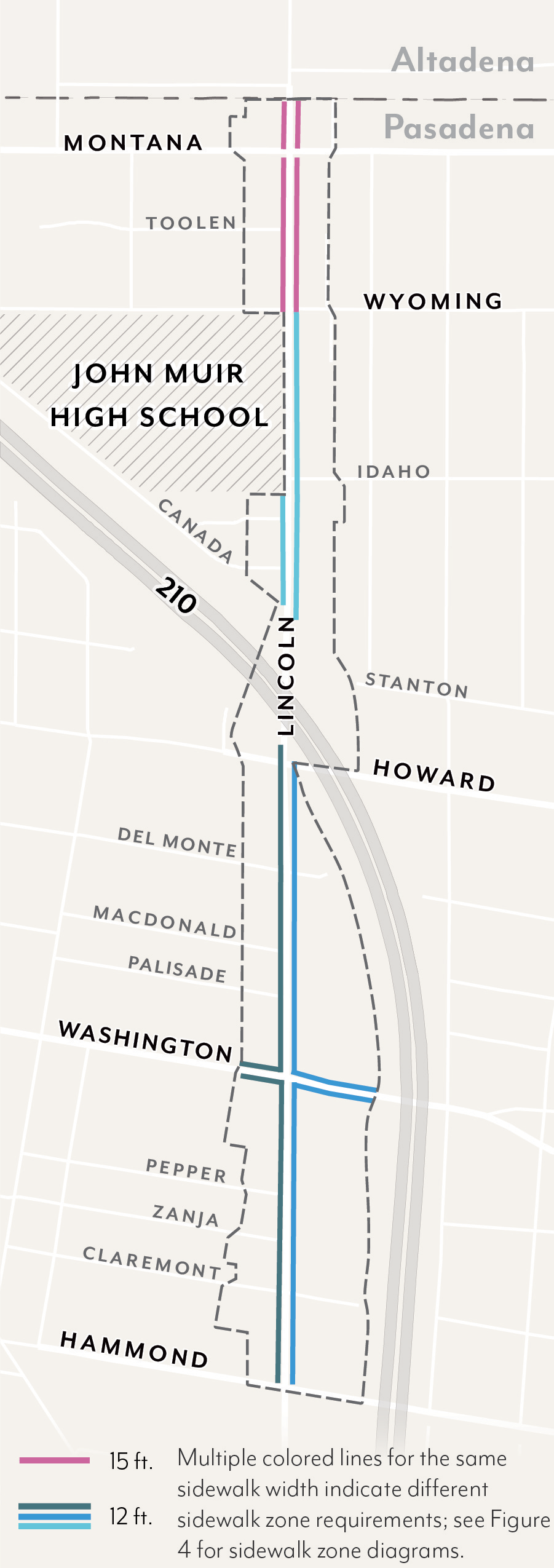
Figure LASP-3: Sidewalk Line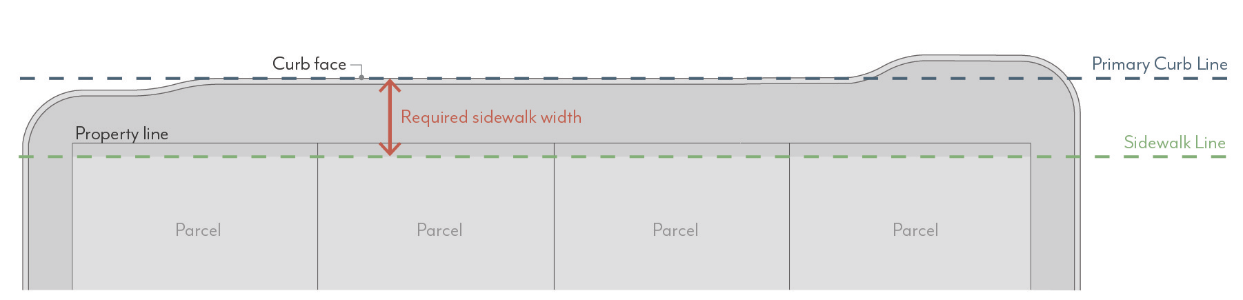
Figure LASP-4: Sidewalk Zones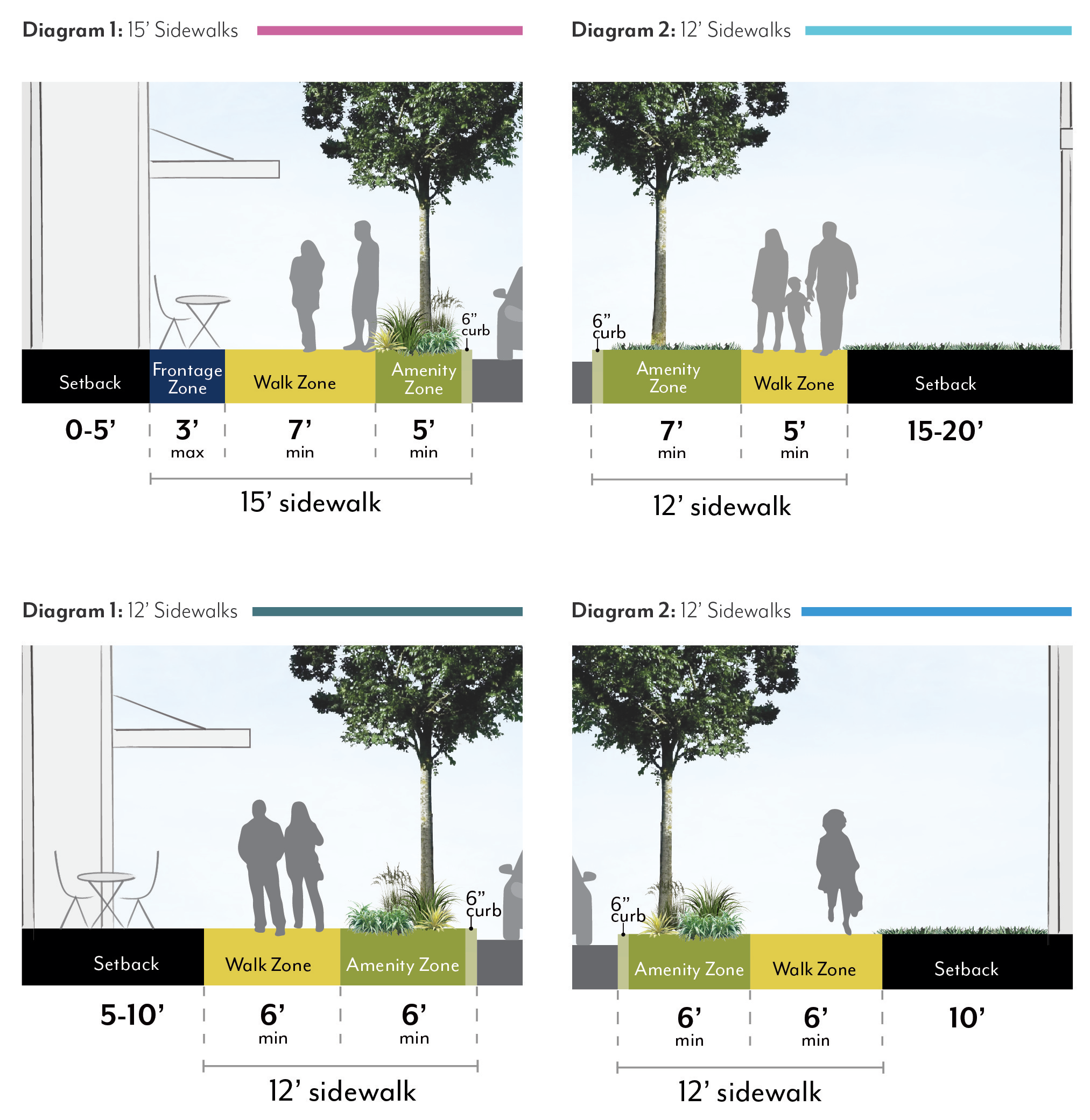
2.
Sidewalk Zones.
a.
Amenity Zone. Sidewalks shall provide an Amenity Zone consistent with the width illustrated in Figure LASP-4, including the curb.
(1)
Projects shall meet minimum parkway and street tree requirements per Section 17.37.050.B.
(2)
The following elements are permitted in the Amenity Zone at the discretion of Public Works: Paved area for pedestrian mobility, parkways and street trees, seating/furniture, outdoor dining (with a Public Works permit), planers, bicycle parking, bus shelters, and/or other utility facilities including streetlights, signals, meter/sing poles, and pullboxes, etc.
b.
Walk Zone. Sidewalks shall maintain a Walk Zone as a continuous path of travel for pedestrians at the width illustrated in Figure LASP-4. This area shall be free of all furnishings, landscaping, or obstructions.
c.
Frontage Zone. Sidewalks may include a Building Frontage Zone between the Walk Zone and the sidewalk line. A maximum width is illustrated in Figure LASP-4.
(1)
The following elements are permitted in the Frontage Zone: Paved area for pedestrian mobility, seating/furniture, outdoor dining (with a Public Works permit), planters, and/or shade structures per Section 17.37.080.D.
B.
Parkways & Street Trees.
1.
Parkways.
a.
Required Parkways. Projects shall include parkways within the Amenity Zone as follows:
(1)
In LA-RM-16, parkway length shall be no less than 60 percent of street frontage, unless approved by the Director of Public Works.
(2)
In all other zoning districts, parkway length shall be no less than 30 percent of street frontage, unless approved by the Director of Public Works.
b.
Dimensions. Parkways shall be constructed at the same width as the Amenity Zones illustrated in Figure LASP-4, minus the 6-inch width required for the curb.
(1)
When street parking is adjacent to the curb, a paved buffer with a minimum width of 18 inches is required, in addition to the 6-inch curb, except where tree grates are adjacent to the curb.
(2)
Barriers up to 24 inches high, such as low walls or fences, are permitted at the interior edge of the parkway but are not required.
c.
Access Ways. Where on-street parking is permitted, access ways shall be provided at a minimum frequency of one per every 20 feet of continuous parkway.
(1)
Access ways shall be a minimum of 4 feet in width and provide a firm, uniform walking surface in all weather conditions from the curb to the Walk Zone.
(2)
The finished surface of access ways shall be in plane with both the adjoining top of curb and sidewalk.
(3)
Access ways shall be constructed of pavers, concrete, or stabilized decomposed granite.
d.
Planted Area. A minimum of 80 percent of the total required parkway area for a given project shall be comprised of plant material.
(1)
Permitted materials include groundcovers, turf or turf substitutes, and shrubs or low perennials that are lower than 24 inches in height at full maturity.
(2)
All plant material shall be native or climate appropriate and have a water use rating of Moderate, Low or Very-Low as defined by Water Use Classification of Landscape Species (WUCOLS) for the region. Plant water use requirements may be relaxed to maximize the efficiency of parkway stormwater capture systems per approval by the Director of Public Works.
(3)
Plants with spines or thorns shall not be planted adjacent to any walkways or curbs.
(4)
Edible plants are not permitted in parkways.
(5)
Artificial turf is not permitted in parkways.
(6)
When removing existing plant material like turf grass from a parkway, there shall be no damage to the street tree roots. Parkway improvements involving excavation within an existing tree's root zone must be consistent with the City's Tree Protection Guidelines. Root pruning, if required and approved by Public Works, must be overseen by a Certified Arborist. Excavation within a tree's root zone must be replanted immediately to prevent the tree roots from exposure and undue harm.
e.
Non-planted Area. A maximum of 20 percent of the parkway area may be organic or inorganic cover.
(1)
Permitted materials include permeable pavers, decomposed granite, gravel, rocks, or mulch. Pavers are not allowed within 3 feet of any public streetlight pole or pull box or other utility facilities.
f.
Stormwater Management. Parkways shall either meet the following basic stormwater standards, or propose a biofiltration planter or swale design based on local conditions per the approval of the Director of Public Works.
(1)
The parkway shall be at the same grade as the adjacent hardscape surface at the outer edge of the parkway and slope at a minimum of 1 percent towards the center of the parkway.
(2)
For parkways with a width greater than 5 feet, the center 2 feet of the parkway shall be depressed 3 to 4 inches to form a shallow swale to collect sidewalk stormwater. Alternative means of storing runoff, such as gravel sumps within the parkway, may be provided with review authority approval.
g.
Irrigation. Irrigation systems in parkways shall be designed and constructed in a manner that will eliminate surface runoff onto any impermeable surface, public or private, under any condition.
(1)
Design of irrigation systems in parkways shall be in accordance with all local, state, and federal laws and regulations for water conservation.
(2)
Street tree roots shall not be damaged during the irrigation installation process.
h.
Maintenance. Abutting property owner shall maintain the parkway in a condition so as not to endanger persons or property, and not to interfere with the public convenience.
2.
Street Trees.
a.
Species. Street tree species shall be selected according to the Master Street Tree Plan at the discretion of the Director of Public Works. Trees may be planted within parkways or tree wells.
b.
Spacing. Street trees shall be planted at a spacing of one per 30 feet. Exceptions can be made by the Director of Public Works due to conflicts with street lights, bus shelters, utility boxes, or other street amenities. Closer spacing is encouraged when feasible and when appropriate for the particular tree type.
c.
Well Dimension. Tree well width shall be equivalent to the required Amenity Zone, minus the 6-inch width required for the curb.
(1)
If a paved buffer zone is required due to adjacent street parking, the tree well width may be reduced to accommodate this buffer strip. The minimum length of a tree well shall be 6 feet.
(2)
Street trees planted within tree wells must be installed according to the Department of Public Works Tree Planting in Tree Well Standard Plan.
d.
Well Frames. Tree well frames, or tree grates, may be installed according to the Department of Public Works Tree Well Frame Installation Standard.
e.
Expanded Root Zone Cell. Each street tree shall be provided with an uncompacted root zone volume of 800 cubic feet minimum. The root zone volume depth shall be 2 feet minimum and 3 feet maximum.
(1)
Where this root zone volume cannot be provided within the parkway area, an expanded root zone cell volume shall be provided below adjacent pavement using a strategy such as structural soil or a suspended pavement system to provide an uncompacted soil area suitable for tree root growth.
(2)
The root zone volume per tree requirement may be reduced by 10 percent where two or more trees share a contiguous root zone cell.
f.
Maintenance. All street trees shall be maintained by the Department of Public Works.
(Ord. No. 7388, § 3(Exh. 2), 3-21-2022)
17.37.060 - Summary of Development Standards
17.37.070 - Scale Standards
These standards are intended to:
• Implement the General Plan density (du/ac) and floor area ratio (FAR) values;
• Shape development in a manner that creates a defined public realm and appropriate scale of buildings for a visually appealing community;
• Reduce building massing through setback and stepback requirements that create appropriate transitions to residential neighborhoods;
• Support high-quality architecture and urban design through modulation requirements and variation in façade length; and
• Require appropriate transitions to designated historic resources.
A.
Density.
1.
Residential Density. Projects that include residential dwelling units shall not exceed the allowable dwelling units per acre (du/ac) per Figure LASP-5.
a.
Fractions shall be rounded to the nearest whole number; those at 0.50 shall be rounded up.
b.
For projects utilizing state density bonus, refer to Government Code 65915.
c.
The maximum is based on total site area. If a street dedication or easement is required, density shall be calculated using the size of the lot prior to the street dedication or easement.
B.
Intensity.
1.
Floor Area Ratio. Projects that include non-residential space, including mixed-use, shall not exceed the allowable floor area ratio (FAR) per Figure LASP-6.
a.
In mixed-use projects, residential floor area is included in FAR.
b.
Areas used exclusively for vehicle and bicycle parking and loading are excluded from FAR.
c.
The maximum is based on total site area. If a street dedication or easement is required, FAR shall be calculated using the size of the lot prior to the street dedication or easement.
| Figure LASP-5: Residential Density | Figure LASP-6: Floor Area Ratio |
|---|---|
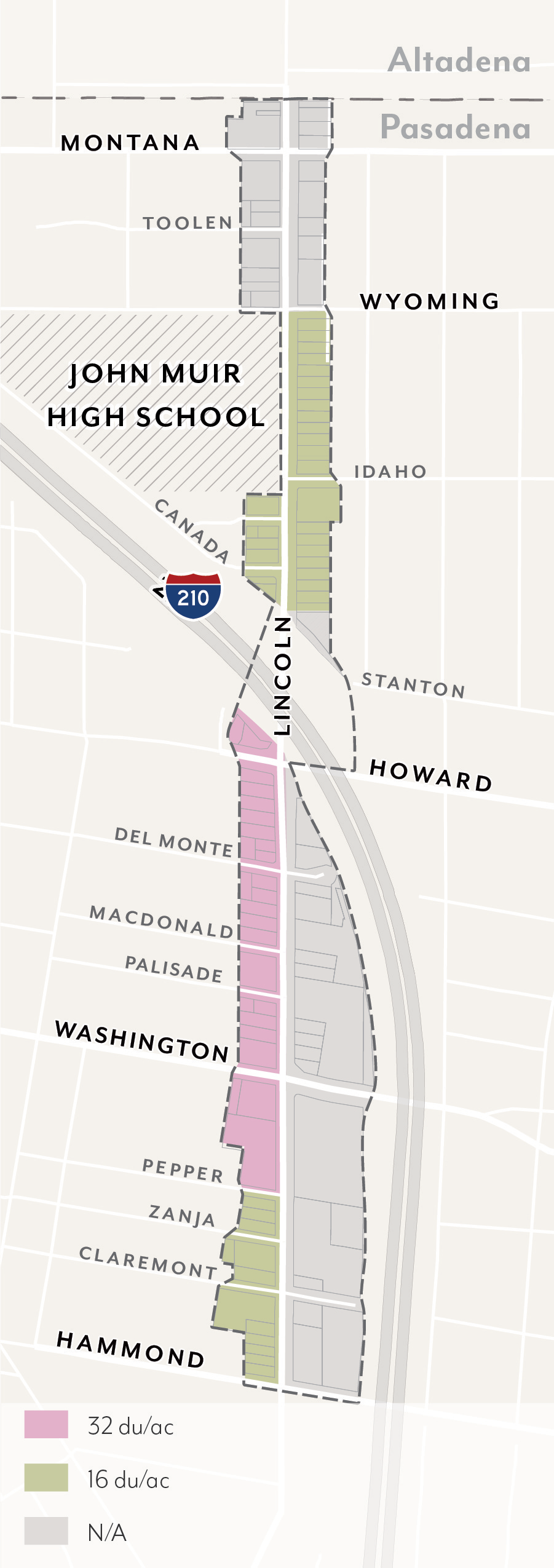 | 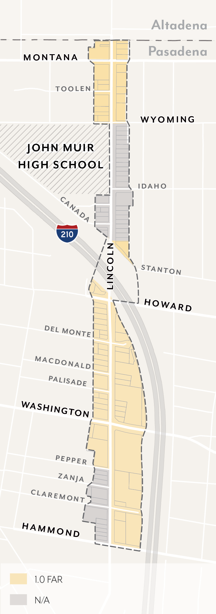 |
C.
Height.
1.
Building Height. Projects shall not exceed the height limits set in Figure LASP-7.
a.
Height is measured per Section 17.40.060.
b.
Maximum height for massing adjacent to street or interior property lines may be limited by required stepbacks; see Section 17.37.070.E.
c.
Exceptions allowed for projecting features such as appurtenances and railings per Section 17.40.060.
D.
Setbacks
1.
Street Setbacks. Buildings shall comply with the street setbacks set in Figure LASP-8. Setback ranges establish a minimum and maximum for the specified percentage of linear street frontage; see Figure LASP-9.
a.
Street setbacks are measured from the sidewalk line; see Figure LASP-3.
b.
Minimum setbacks shall apply to all stories of a building; setbacks less than the minimum are prohibited. Maximum setbacks shall apply only to the ground floor.
c.
Residential units on the ground floor shall have a minimum setback of 5 feet. Where elevated between 4 and 6 feet above sidewalk elevation, a minimum setback of 8 feet shall be required.
d.
Exceptions allowed per Section 17.40.160 (Table 4-1) and the following: Arcades and recessed ground floors up to 15 feet in depth, as well as parking entrances per Section 17.37.100.B, are allowed when a second story meets the specified setback.
e.
For portions of buildings set back from the sidewalk line 5 feet or more, a percentage of the setback area shall be landscaped with trees, shrubs, and/or groundcover, either in the form of in-ground landscaping or planters.
| Figure LASP-7: Building Height | Figure LASP-8: Street Setbacks |
|---|---|
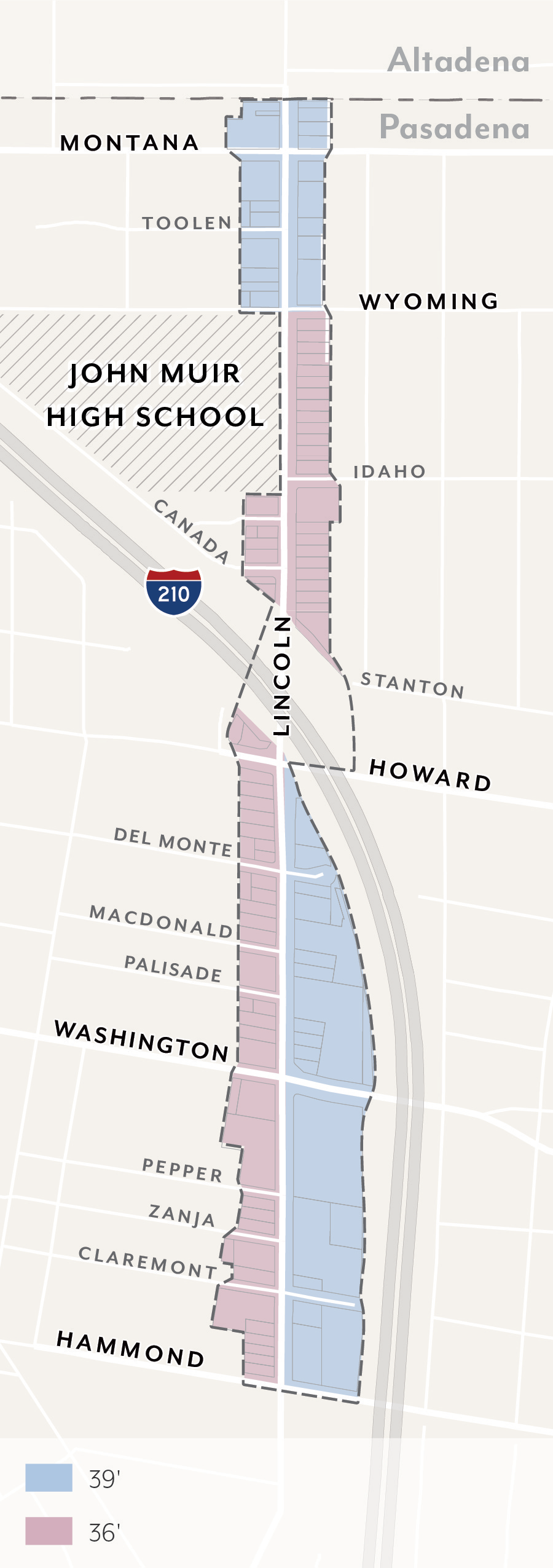 | 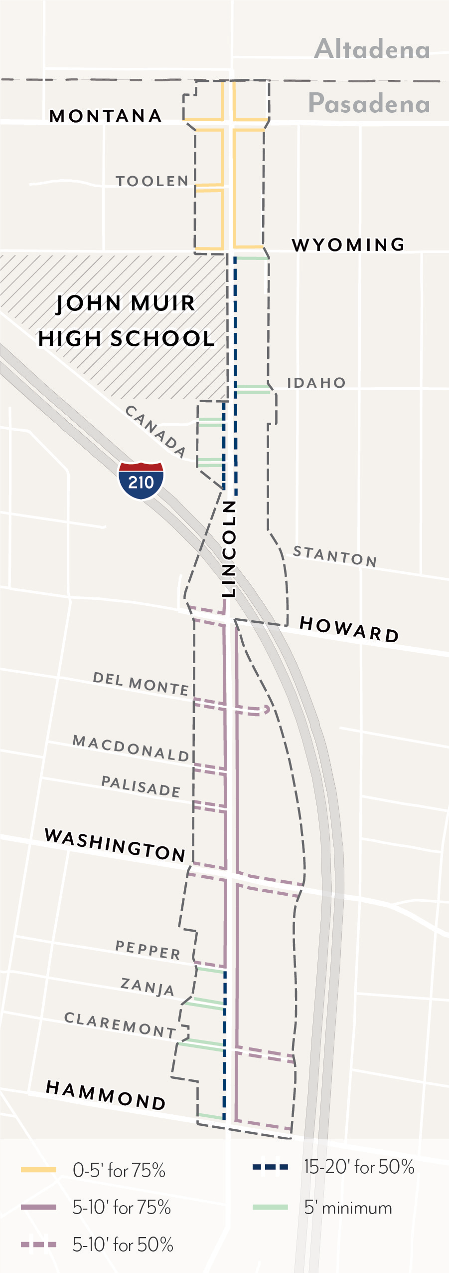 |
| Figure LASP-9: Street Setbacks Percentage | Figure LASP-10: Street Stepbacks |
|---|---|
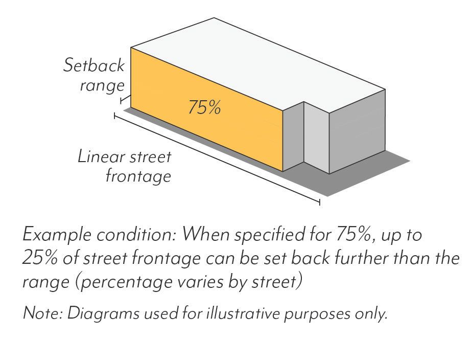 | 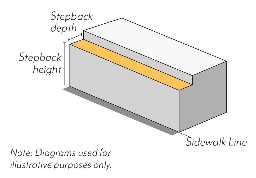 |
2.
Interior Setbacks. Buildings shall comply with the interior setbacks set in Table LASP-4 based on project type when adjacent to residential zoning districts. No setback is required when adjacent to other districts.
a.
Interior setbacks are those abutting other parcels (non-street side and rear) and are measured from the shared property line.
b.
Exceptions allowed per Section 17.40.160 (Table 4-1).
Table LASP-4: Interior Setbacks Adjacent to RM/RS
E.
Stepbacks.
1.
Street Stepbacks. Buildings utilizing a height concession per Section 17.43 shall provide a minimum stepback depth of 10 feet by a height of 36 feet along street frontages; see Figure LASP-10.
a.
Street stepbacks are those abutting public right-of-way and are measured from the sidewalk line.
b.
Uses allowed within the street stepback include: Private open space (e.g. terraces), shade structures (e.g. trellises), green roofs and photovoltaic panels, and other open space features per review authority approval.
2.
Interior Stepbacks. Adjacent to RS zoning districts, buildings shall comply with the stepbacks below. Interior stepbacks are not required along other property lines.
a.
In all zones except LA-RM-16, projects shall not be located within the encroachment plane sloping upward and inward at a 45-degree angle measured from the vertical, commencing 15 feet above the existing grade along the shared property line; see Figure LASP-11.
b.
In LA-RM-16, projects shall step back a minimum of 15 feet at the second story and 50 feet at the third story, measured from the shared property line; see Figure LASP-11.
c.
Exceptions allowed per Section 17.40.160 (Table 4-2.1).
Figure LASP-11: Setbacks and Stepbacks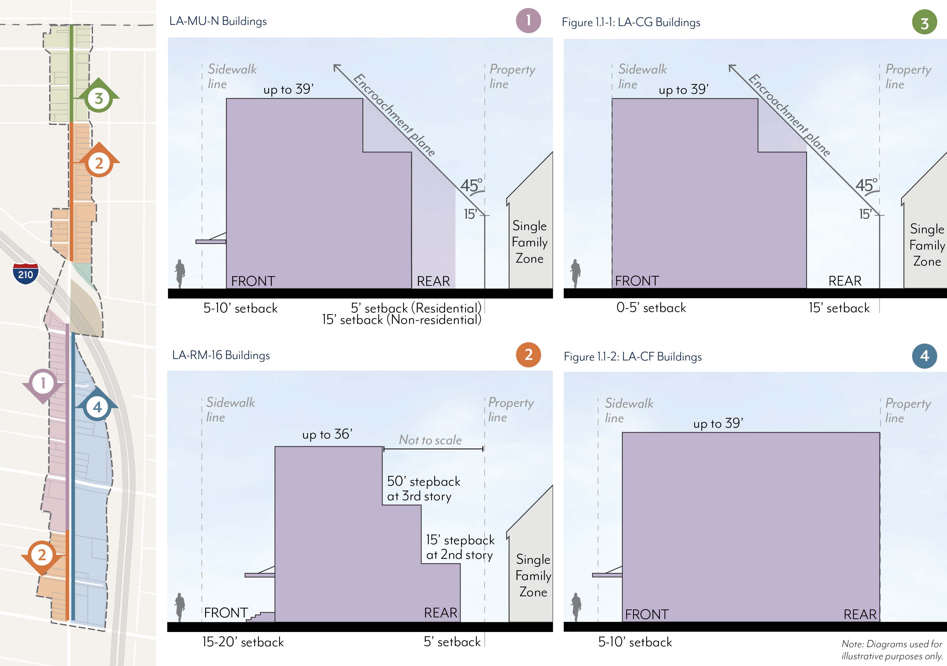
F.
Historic Adjacency.
1.
Landmark Properties. Projects on parcels with a historic resource shall be subject to review for consistency with the Secretary of the Interior's Standards.
2.
Transition Massing. Projects sharing a property line with a designated historic resource are subject to the following modified standards, illustrated in Figure LASP-12.
a.
Street Setbacks. The minimum street setback shall be an average of the minimum setback set in Figure LASP-9 and the established setback of the resource for a minimum of 20 feet from the shared property line. If located between two resources, the street setbacks shall be an average of the setbacks of the two resources for the full street frontage.
b.
Interior Setbacks. The minimum interior setback shall be equal to that of the historic resource or 15 feet, whichever is less. No setback is required where the resource is built to the shared property line.
c.
Street Stepbacks. A maximum streetwall height shall not exceed the height of the historic resource for a minimum of 20 feet from the shared property line. A stepback with a minimum depth of 10 feet is required above this height, measured from the modified minimum street setback.
d.
Interior Stepbacks. Projects shall not be located within an encroachment plane sloping upward and inward at a 30-degree angle measured from the vertical, commencing 15 feet above the existing grade at the property line; see Figure LASP-12. This plane is not applicable if the resource is built to the shared property line.
Figure LASP-12: Historic Adjacency
G.
Modulation.
1.
Façade Length. In mixed-use districts, street-facing façades shall not exceed 150 feet in length unless there is a minimum break of 10 percent of the building length or 20 feet, whichever is greater. This break shall be a minimum of 10 feet deep, open to the sky; see Figure LASP-13. Projects in CF are exempt.
Table LASP-5: Modulation
2.
Façade Area. Each street-facing façade exceeding 50 feet in length shall modulate a minimum of 25 percent of the area above the ground floor between 2 feet and 12 feet in depth from the primary façade plane; see Figure LASP-14. Buildings with a total of 2 stories or less are exempt.
a.
The primary façade plane is defined as the vertical plane with the greatest surface area above the ground floor.
b.
Modulation is not required to be continuous or open to the sky, and may be recessed or projected, but not beyond the sidewalk line.
c.
Modulation is not required to be continuous or open to the sky, and may be recessed or projected, but not beyond the sidewalk line.
d.
Required stepbacks (Section 17.37.070.E), façade breaks (Section 17.37.070.G.1), and projected balconies (Section 17.37.080.H.1) shall not count toward the modulation requirement; balconies that are recessed a minimum of 2 feet shall qualify.
| Figure LASP-13: Façade Length | Figure LASP-14: Façade Area |
|---|---|
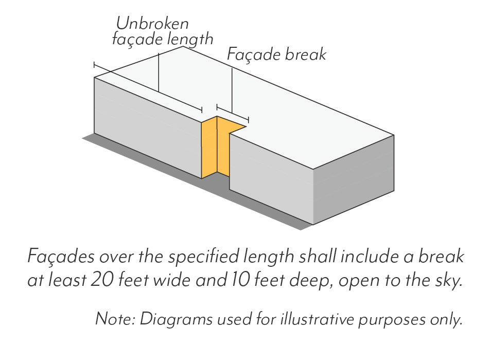 | 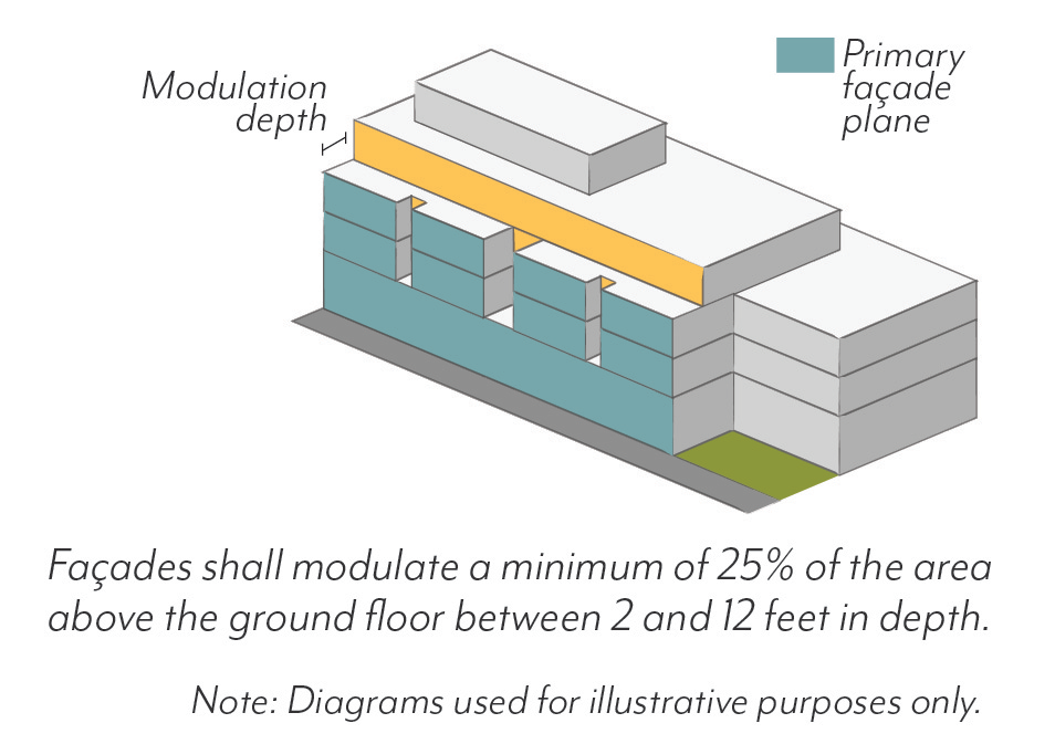 |
3.
Alternative Compliance.
a.
Eligibility. Modulation standards may be reduced or otherwise modified through the Design Review process if:
(1)
A minimum of 90% of the provided parking is fully or partially subterranean;
(2)
A minimum of one publicly accessible open space is provided at the ground level, visible and accessible from the sidewalk;
(3)
No other concessions, waivers, or incentives have been requested, including those associated with Section 17.43 (Density Bonus), unless the project is designed to achieve LEED Gold certification; and
(4)
The review authority makes all of the following findings.
b.
Required Findings.
(1)
The building design provides modulation on each street-facing façade in a manner consistent with the project's architectural style and/or immediate context, including adjacent historic resources.
(2)
The building design does not cause an adverse impact on the quality of the ground floor and public realm.
(3)
The ground level open space is of adequate size and integrated with the building in a functional way that ensures the space will be actively utilized.
(4)
The modification will not be detrimental to the health, safety, and welfare of the public.
(5)
The building design is consistent with the objectives and policies of the General Plan and LASP, as well as all other standards of the LASP.
(Ord. No. 7446, § 5, 5-12-2025; Ord. No. 7388, § 3(Exh. 2), 3-21-2022)
17.37.080 - Frontage Standards
These standards are intended to:
• Prioritize pedestrian access by ensuring doorways are open to a public sidewalk or public open space;
• Increase visibility into ground floor uses to create visual interest for pedestrians;
• Promote shade through arcades and shade structures;
• Support a consistent character when different uses are allowed on the ground floor within the same block;
• Promote consistent ground floor heights when residential and commercial uses are present within the same zone; and
• Limit blank walls on the ground floor to enhance visual interest and pedestrian comfort.
A.
Ground Floor.
1.
Height. Buildings facing Lincoln Avenue shall have a minimum ground floor height of 15 feet, measured from the sidewalk elevation to second-story floor or roof of a one-story building; see Figure LASP-15.
a.
Exception: Ground floor residential uses with a setback of 10 feet or greater shall have a minimum ground floor height of 12 feet.
b.
For residential units, the first habitable floor shall be located between 6 feet above and 2 feet below sidewalk elevation.
2.
Depth. Commercial uses shall have an average interior depth of at least 35 feet and a minimum depth of 20 feet, measured wall-to-wall.
Figure LASP-15: Ground Floor Height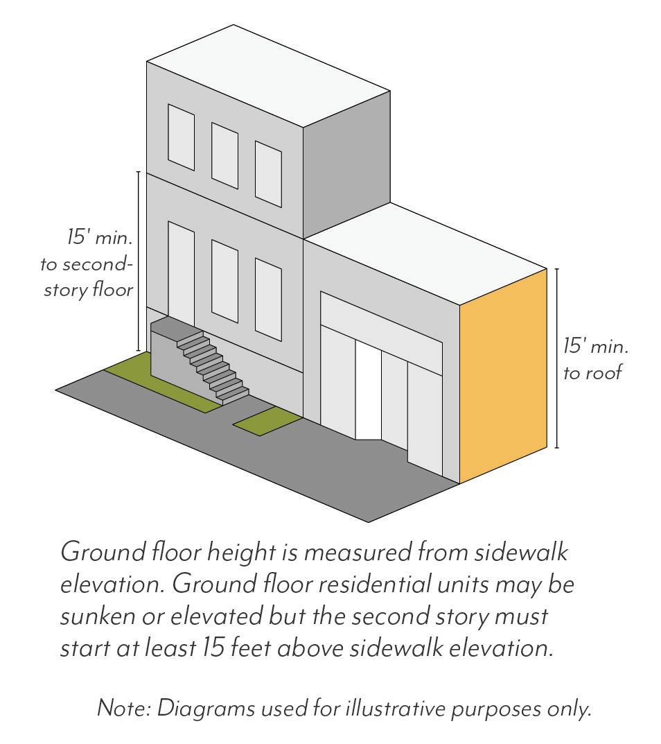
B.
Entrances.
1.
Location. A minimum of one primary entrance shall be located on the primary frontage of each building and open onto a sidewalk or public space.
a.
In LA-CG, entrances shall be recessed a minimum of 30 inches from the ground floor building façade along Lincoln Avenue. On other streets, entrances shall be recessed a minimum of 30 inches from the sidewalk line.
b.
Primary entrances shall be distinguished by architectural features or overhead projections, such as an awning or canopy.
c.
For non-residential uses, primary entrances shall be located at sidewalk elevation.
d.
Exception allowed for residential courtyard buildings with unit entrances off the courtyard. Courtyards shall be entered from the street through an architecturally defined entry (covered or open to the sky) or portico.
C.
Transparency.
1.
Windows & Doors. Minimum transparency for street-facing façades is set in Tables LASP-6 and LASP-7 based on use.
a.
For non-residential and residential common space uses, ground floor transparency is measured as the percentage of building frontage that consists of transparent openings between a height of 2 feet and 10 feet above sidewalk elevation.
b.
All other transparency is measured as the percentage of building frontage area, viewed in elevation and excluding any coverage of shading devices.
c.
Windows shall be recessed by a minimum of 3 inches from the façade, measured from the outside wall to the frame of the window (mullion, muntin or similar element).Flush windows shall be permitted where exterior shading devices cover a minimum of 25 percent of the window surface area or per review authority approval.
d.
The use of tinted, mirrored or highly reflective glazing is prohibited.
e.
Street-facing transparency blocked by walls and fences over 42 inches shall not count towards required transparency
f.
Blinds, drapes, posters, and shelving for product displays visible to the public right-of-way may obscure a maximum of 10 percent of the transparent areas of each respective storefront or 50 percent for medical office uses.
Table LASP-6: Transparency for Non-Residential and Residential Common Space
Table LASP-7: Transparency for Residential Units
2.
Blank Walls. Windowless expanses of street-facing walls shall not exceed 20 feet in length.
3.
Security Bars. Any exterior or interior security bars shall be designed to be fully hidden from view during business hours with devices such as concealed side pockets and ceiling cavities.
D.
Shade Structures.
1.
Shading. Shade structures may project up to two-thirds of the sidewalk width. In LA-CG along Lincoln Avenue, shade structures (e.g. awnings and canopies) are required, subject to a Public Works permit, and shall project a minimum of 5 feet and up to a maximum of 10 feet into the public right-of-way for a minimum of 50 percent of the building frontage.
a.
Shade structures shall allow a minimum of 8 feet of vertical clearance from sidewalk elevation and shall not conflict with existing trees.
b.
Shade structures are not required where an arcade or recessed ground floor provides a minimum of 5 feet of unobstructed pedestrian clearance.
E.
Arcades & Galleries.
1.
Arcades. Any arcades shall be located behind the minimum setback.
a.
Arcades shall be a minimum of 8 feet from back of column to building façade.
b.
The distance between columns shall be at least the same dimension as arcade depth, as measured from the column center.
c.
The façade shall meet the ground floor transparency set in Section 17.37.080.C.
d.
Uses allowed within arcades include: pedestrian travel, seating/street furniture, outdoor dining, landscape planters, and/or bicycle parking.
2.
Galleries. Any galleries shall be located behind the minimum setback.
a.
Galleries shall be limited to one-story and 50 percent of the building frontage
b.
Galleries shall allow a minimum of 10 feet of vertical clearance from sidewalk elevation.
F.
Exterior Fixtures
1.
Façade Lighting. In LA-CG, pedestrian-scale lighting, such as sconces and goose-neck fixtures, shall be located on the building frontage a minimum of every 30 feet along Lincoln Avenue.
a.
Façade lighting shall be full cutoff (directing light downward and outward).
b.
Fixtures shall be located between 8 and 15 feet above sidewalk elevation, and shall not project more than 30 inches from the façade.
c.
Lighting shall be static; flashing, pulsating or other dynamic lighting is not permitted.
G.
Walls & Fences.
1.
LA-CG, -CL, -MU-N and -RM-16 Zones. Walls, fences, raised planters, screening and similar structures (walls/fences) shall be permitted within the required street setback subject to the following conditions. All other walls and fences shall be subject to Section 17.40.180.
a.
Maximum height shall not exceed 42 inches.
b.
Walls/fences taller than 30 inches shall be a minimum of 50 percent transparent.
c.
A minimum 24 inch setback from the sidewalk line is required, separated by planted area; retaining walls with a maximum height of 30 inches are exempt from this requirement.
d.
Stoops and Patios. The side of a patio or stoop (when parallel to a sidewalk) taller than 30 inches in height shall be set back a minimum of 18 inches from the sidewalk line, separated by planted area.
2.
LA-CF Zone. Walls/fences located in front of a structure shall be subject to Section 17.37.080.G.1. Walls/fences not located in front of a structure, but along a street frontage, shall be permitted subject to the following conditions:
a.
A minimum of 5 foot setback from the sidewalk line shall be required, separated by planted area.
b.
Maximum height shall not exceed 96 inches.
(1)
Portions of walls/fences greater than 60 inches in height shall be a minimum of 50 percent transparent; portions 60 inches in height or lower are permitted to be solid walls.
(2)
Solid walls/fences integrated with the building architecture may be permitted to match the height of the ground floor, with a maximum length of 20 feet. Landscaping shall be provided between the solid wall/fence and the sidewalk line, with the exception for building/property entrances.
3.
Exceptions.
a.
Exceptions to wall/fence height allowed for guardrails, which may exceed the maximum height to the extent required by the Building Code. The guardrail shall be a minimum of 50 percent transparent.
b.
Exceptions to required wall/fence setback allowed for outdoor dining, which may be enclosed by a wall, fence, or similar structure up to a maximum of 42 inches in height located at the sidewalk line.
H.
Balconies & Roof Decks.
1.
Balconies. Balconies may project a maximum of 4 feet into a street setback but shall not extend beyond the sidewalk line or within 6 feet of any interior property line. Balconies shall not project from a building façade within 50 feet of an RS zoning district.
2.
Roof Decks. Roof decks shall be not be located within 50 feet of an RS zoning district. The sum of all roof decks shall not exceed a maximum coverage of 50 percent of the roof area.
(Ord. No. 7446, § 5, 5-12-2025; Ord. No. 7388, § 3(Exh. 2), 3-21-2022)
17.37.090 - Open Space Standards
These standards are intended to:
• Provide a variety of open space types for gathering, recreation and respite that contribute to enhanced livability within an urban setting;
• Give residents access to natural light and fresh air in and around their living spaces;
• Improve building design and site planning through the integration of open space throughout the development; and
• Correlate open space requirements with number of residents and size of buildings.
A.
Minimum Area.
1.
Private and Common Open Space. Projects shall provide the minimum area of Open Space based on use and size. Areas used regularly for parking, loading or storage shall not count towards minimum Open Space requirements.
a.
Residential. Projects with dwelling units shall provide the minimum area of Open Space per Table LASP-8 as a combination of Private and/or Common Open Space.
b.
Non-residential. Projects with more than 40,000 square feet of non-residential floor area shall provide a minimum of 5 percent of the gross non-residential floor area as Common Open Space.
(1)
Research and Development uses may reduce Common Open Space area requirements by a maximum of 60 percent. Research and Development projects (or the Research and Development portion of a project with multiple uses) shall exclude mechanical space from floor area for required Open Space.
c.
Mixed-use. Projects shall comply with requirements applicable to each type of use.
Table LASP-8: Residential Open Space
2.
Publicly Accessible Open Space. In LA-CF, projects with more than 80,000 square feet of floor area shall provide a percentage of gross floor area as Publicly Accessible Open Space, as set in Table LASP-9.
a.
Publicly Accessible Open Space shall be provided in addition to Private and Common Open Space requirements.
b.
Projects shall comply with PAOS standards per 17.37.090.D where relevant.
(1)
PAOS standards may be modified through the Design Review process, if the review authority finds that the modified design continues to be accessible to the public, functional, and includes features such as landscaping, trees, and outdoor seating.
c.
Research and Development uses may reduce PAOS requirements by a maximum of 60 percent. Research and Development projects (or the Research and Development portion of a project with multiple uses) shall exclude mechanical space from floor area for required PAOS.
Table LASP-9: Publicly Accessible Open Space
B.
Private Open Space.
1.
Dimensions. A minimum area of 40 square feet with a minimum dimension of 5 feet in each direction shall be required for Private Open Space.
2.
Distribution. A maximum of 40 percent of the required residential Open Space set in Table LASP-8 shall be Private Open Space.
a.
All Private Open Space shall be outdoors.
b.
Private Open Space may be located within a required setback.
C.
Common Open Space.
1.
Dimensions. A minimum area of 400 square feet with a minimum dimension of 15 feet in each direction is required for Common Open Space.
2.
Distribution. A minimum of 60 percent of the required residential Open Space set in Table LASP-8 shall be Common Open Space shared among tenants.
a.
A minimum of 70 percent of Common Open Space shall be outdoors, and a minimum of 80 percent of outdoor Common Open Space shall be open to the sky.
b.
A maximum of 30 percent of Common Open Space may be indoors. Indoor Common Open Space shall not include spaces used primarily for circulation.
3.
Landscape. A minimum of 25 percent of Common Open Space shall be planted area with a minimum dimension of 30 inches in length and width. Landscaping shall comply with Section 17.44.050.
4.
Trees. A minimum of one 24-inch box tree per project or for every 500 square feet of outdoor Common Open Space, whichever is greater, shall be planted within the Common Open Space. For projects with 2 or more trees, a minimum of 50 percent of trees planted shall be shade trees.
5.
Hardscape. A maximum of 25 percent of Common Open Space may be paved in standard concrete. Remaining areas shall use one of the following enhanced paving techniques: Brick, natural stone, unit concrete pavers, textured and colored concrete, concrete with exposed or special aggregate. Alternative paving may be allowed per review authority approval.
6.
Water Features. A maximum of 5 percent of the required Common Open Space shall be fountains, reflecting pools, or other decorative water features. Swimming pools are not considered water features for the purposes of this standard.
7.
Access. Common Open Spaces may be accessible to the public if desired by the property owner.
D.
Publicly Accessible Open Space.
1.
Area. Minimum area requirements are set in Section 17.37.090.A.2, and may be contiguous or noncontiguous, subject to the dimension and elevation standards below.
2.
Dimensions. A minimum area of 400 square feet with a minimum dimension of 20 feet in each direction is required for Publicly Accessible Open Space.
3.
Access. A minimum of 50 percent of the Publicly Accessible Open Space shall be accessible to the general public and shall not be restricted to patrons of a particular business.
4.
Signage. Publicly Accessible Open Space shall have signage visible from the adjacent sidewalk identifying the space as a publicly-accessible amenity and listing accessible hours.
5.
Hours. At a minimum, PAOS shall be open to the general public from 8am to 8pm. Any gated ingress or egress points shall not be closed or locked during these hours.
6.
Elevation. A minimum of 3,000 square feet of Publicly Accessible Open Space shall be at sidewalk elevation. If less square footage is required, then all required Publicly Accessible Open Space shall be at sidewalk elevation.
7.
Hardscape. A maximum of 25 percent of Publicly Accessible Open Space shall be paved in standard concrete.
a.
Remaining areas shall use one of the following enhanced paving techniques: Brick, natural stone, unit concrete pavers, textured and colored concrete, and concrete with exposed or special aggregate. Alternative paving may be allowed per review authority approval.
8.
Seating. Seating shall be provided at a minimum of 1 seat per 300 square feet of required Publicly Accessible Open Space.
a.
Benches shall be calculated as 1 seat per 24 linear inches.
b.
Fractions shall be rounded down to the nearest whole number.
9.
Landscape. A minimum of 25 percent of Publicly Accessible Open Space shall be planted area with a minimum dimension of 30 inches in length, width, and depth. Landscaping shall comply with Section 17.44.
10.
Trees. A minimum of one 24-inch box tree per project or for every 750 square feet of Publicly Accessible Open Space, whichever is greater, shall be planted. For projects with 2 or more trees, a minimum 50 percent of trees planted shall be shade trees.
11.
Common Open Space Credit. Publicly Accessible Open Space in excess of the minimum may count towards a maximum of 30 percent of the Common Open Space requirement at a 1:1 ratio.
(Ord. No. 7446, § 5, 5-12-2025; Ord. No. 7418, § 3, 2-26-2024; Ord. No. 7388, § 3(Exh. 2), 3-21-2022)
17.37.100 - Parking Standards
These standards are intended to:
• Reduce the visual impacts of parking;
• Regulate appropriate parking supply and location in a manner that prioritizes pedestrian access and multi-modal activity;
• Encourage change of use and adaptive reuse of existing buildings through parking reductions and exemptions;
• Promote a more efficient use of space through shared parking among multiple uses; and
• Increase design standards for parking structures by ensuring habitable floor area and screening between parking and street frontage.
A.
Minimum Parking.
1.
Number of Spaces. Projects shall provide off-street automobile parking spaces per Table LASP-10 based on general use classifications.
a.
Where parking minimums in this Section conflict with state law, state law shall control.
b.
Bicycle parking shall be required per Section 17.46.320.
Table LASP-10: Minimum Parking
2.
Shared Parking. Parking may be shared among multiple uses per Section 17.46.050.
3.
Unbundled Parking. For any building with new residential units, off-street automobile parking spaces shall be leased or sold separately from the unit rental or purchase fees, such that renters or buyers have the option of renting or buying the residential unit at a lower price than if the parking was included.
a.
For deed-restricted affordable units, one parking space shall be included in the base rent of each unit. The tenant may choose to receive the parking space or receive a rent discount equivalent to half the amount charged for monthly lease of a parking space. Tenants of affordable units shall not sublease their parking spaces.
b.
Renters or buyers have the right of first refusal to parking built for their unit. Any remaining spaces may be leased to other users on a month-to-month basis. New occupants shall have the opportunity to lease or purchase parking built for their unit.
c.
Unbundled parking is not required for a residential property or unit with an individual garage that is functionally a part of the property or unit (e.g., certain townhome and row houses).
B.
Vehicle Access.
1.
Driveways. For Projects with less than 200 feet of primary street frontage, a maximum of 1 two-lane driveway shall be permitted. For sites with more than 200 feet of primary street frontage, a maximum of 2 two-lane driveways shall be permitted.
a.
Driveways shall be prohibited on primary frontages of 200 feet or less where there is access from a secondary street or alley.
b.
The Zoning Administrator shall determine the primary frontage.
C.
Layout & Design.
1.
Surface Parking. Parking lots shall be set back a minimum of 30 feet from the primary frontage, 10 feet from any secondary frontage, and 5 feet from RS zoning.
a.
Parking shall be buffered by habitable floor area or landscaped area, except for access and driveways; a minimum of one tree of at least 24 gallons in size shall be provided for every 300 square feet of landscaped area.
b.
Landscaped area shall be provided as a percentage of surface parking area as follows:
(1)
Ten to 20 parking spaces: a minimum of 5%.
(2)
More than 20: a minimum of 10%.
c.
One tree of at least 24 gallons in size shall be provided for every 6 parking spaces and located so as to visually disrupt long rows of parked vehicles.
(1)
Trees shall be distributed as evenly as possible throughout the parking area; a maximum of 35% of required trees may be clustered/located within the street setback.
d.
Landscaping shall include hedges or shrubs with a minimum height of 3 feet at the time of planting that form a continuous visual screen of vehicle headlights.
e.
Landscaping shall be provided between a building and a contiguous parking area per review authority approval.
2.
Podium Parking. A maximum of 1 story of above- grade parking is permitted within habitable buildings. Multiple stories of above ground parking are permitted if the project meets the parking structure standards below.
3.
Structured Parking. Along primary frontages, all floors of parking structures shall be lined with building floor area (e.g. commercial or residential uses) or Publicly Accessible Open Space for a minimum of 35 feet in depth. Pedestrian access and driveways are excluded from this requirement.
a.
Stand-alone parking structures are prohibited in the LA-MU-N zoning district.
b.
Elevators and stairs shall be located adjacent sidewalks or public spaces.
c.
Parking areas shall be screened from the public realm using heavy-gauge metal, precast concrete panels, laminated glass, green walls, photovoltaic panels or other material per review authority approval.
4.
Underground Parking. Subterranean parking shall be set back a minimum of 5 feet from RS zoning. Otherwise, it may extend up to the property line.
(Ord. No. 7446, § 5, 5-12-2025; Ord. No. 7418, § 4, 2-26-2024; Ord. No. 7388, § 3(Exh. 2), 3-21-2022)
17.37.110 - Definitions
This Section provides definitions of terms and phrases used in this Specific Plan that are technical or specialized or that may not reflect common usage. In case of conflict with other provisions of the Zoning Code, these definitions shall control for the purposes of this Specific Plan. If a word is not defined in this Chapter, the Zoning Administrator shall determine the correct definition.
Amenity Zone. The portion of the sidewalk located above and adjacent to the curb, providing space for amenities such as parkways, outdoor dining, seating, trees, lighting, bicycle racks, bus stops, etc.
Building Frontage. The horizontal distance, measured at grade, of building wall facing the street.
Building Frontage Zone. The portion of the sidewalk immediately adjacent to the building façade, providing space for planters, outdoor dining, sidewalk signage, etc. This zone may not be present on every street or block.
Curb Zone. See 'amenity zone.'
Façade. Any exterior wall plane of a building, ground level to top of roof.
Floor Area Ratio. Numerical value obtained by dividing the above-ground area of a building or buildings located on a lot by the total area of the lot.
Footprint. The total ground floor area of the combined structures on a site or project area defined by the perimeter of the building(s), including parking structures but excluding parking lots and non-occupancy structures.
Frontage Zone. See 'building frontage zone.'
Gross Floor Area (GFA). The total enclosed area of all floors of a building measured to the inside face of the exterior walls including halls, stairways, elevator shafts at each floor level, service and mechanical equipment rooms and basement or attic areas having a height of more than seven feet, but excluding area used exclusively for parking or loading of vehicles or bicycles.
Ground Floor. The first habitable floor of a building closest to sidewalk elevation.
Mixed-Use Project. The combination or commercial and residential uses in the same structure, where the residential component is located either above (vertical mixed-use) or behind (horizontal mixed-use) the non-residential component. Non-residential uses are typically commercial uses.
Open Space. For any form of open space (Common, Publicly Accessible, Private, etc.), see Section 6.3 of the Specific Plan.
Parkway. Landscaped or permeable areas located within the amenity zone of the sidewalk.
Paseo. A publicly accessible open space that functions as a pedestrian passageway connecting a public street to another public street, alley, or internal public space. Subject to minimum dimension and design requirements established by the Specific Plan.
Plaza. A publicly accessible open space with access from a public street. Subject to minimum dimension and design requirements established by the Specific Plan.
Primary Curb Line. The face of the predominant curb of an individual block forming the edge of the street.
Residential Common Space. Those portions of a residential use building not dedicated to residential units that provide common services for residents. This may include spaces such as, but is not limited to, lobby or common building entry, leasing center, gyms/exercise space, shared kitchen, recreation center, screening or living room, business center, mail room, or library. These spaces/portions of the building may be permitted on the ground floor where residential units are not permitted subject to Specific Plan standards.
Setback. The horizontal distance by which a structure, parking area, or development feature is required to be separated from the property line or the sidewalk line where applicable. In some cases superseded by Setback range.
Setback, Interior. Non-street side or rear setback measured at a right angle from the nearest point of the property line abutting another parcel or alley to the nearest portion of the structure, excluding any porches.
Setback, Street. Front or street-side setback measured at a right angle from the nearest point of the sidewalk line to the nearest portion of the structure, excluding any porches.
Setback Range. Minimum and maximum horizontal distances by which a structure or development feature is required to be separated from the sidewalk line. This measurement is similar to a "build-to" line.
Sidewalk Line. The line parallel the property line accommodating the required sidewalk width, measured from the curb face. Where a sidewalk width is not specified, the sidewalk line is the property line.
Sidewalk Zones. The three portions of a sidewalk that together comprise the public realm between a building and the street. Sidewalk zones are defined by the Pasadena Street Design Guide and regulated by the Specific Plan.
Shared Property Line. The property line separating adjacent parcels.
Stepback. The horizontal distance by which an upper story structure or development feature is required to be separated from the property line or the sidewalk line where applicable. Regulated above a specified vertical distance.
Street Frontage. The horizontal distance along the street, measured at grade, between property lines (or sidewalk line where applicable) that are perpendicular to the adjacent street.
Streetwall. Any building façade that faces a street within 10 feet of the minimum sidewalk line.
Streetwall Height. The portion of the street-facing building façade that rises from the sidewalk level to the required height without an additional setback or stepback.
Subterranean. The level of a building, inclusive of parking or habitable space, located primarily below the ground level with a top plate of two feet or less above sidewalk elevation.
Transparent Openings. Building openings (windows or doors) or transparent glazing that provide visual access into the structure.
Unbundled Parking. Parking spaces, in any permitted configuration, rented or sold separately from the lease or purchase price.
Walk Zone. The portion of the sidewalk dedicated to pedestrian movement, clear of any obstructions.
(Ord. No. 7388, § 3(Exh. 2), 3-21-2022)
17.38.010 - Purpose of Chapter
This Chapter lists the land uses that may be allowed within the zoning districts established by the Lamanda Park Specific Plan (LPSP), determines the type of land use permit and approval required for each use, and provides comprehensive design and development standards for all projects.
(Ord. No. 7446, § 3, 5-12-2025)
17.38.020 - Zoning Districts
The purpose of the LPSP zoning districts (Figure LPSP-1) is to implement the plan vision for each of the subareas as described in the LPSP document and summarized below.
A.
LP-CF (Commercial Flex)
•
Allow flexibility for light industrial, custom manufacturing, creative office and research & development uses along with compatible commercial enterprises; and
•
Support projects that are entirely commercial and/or industrial, as well as work/live and caretaker's units.
B.
LP-MU-G (Mixed-Use General)
•
Enhance the existing mixed-use character with a broad range of retail, office, services, and multi-family housing; and
•
Support projects that are entirely commercial, entirely residential, or a mix of the two, integrated either horizontally or vertically consistent with ground floor use requirements.
C.
LP-MU-N (Mixed-Use Neighborhood)
•
Promote the development of pedestrian-friendly neighborhoods with commercial uses that are sensitive to neighboring residents; and
•
Support projects that are entirely commercial, entirely residential, or a mix of the two, integrated either horizontally or vertically, consistent with ground floor use requirements.
D.
OS (Open Space)
•
Provide areas of open space, which may include opportunities for parks and recreation, as well as space for utilities and other similar uses.
E.
PD (Planned Development)
•
Achieve a particular mix of uses and appearance through a design review process resulting in quality urban design on large sites.
Figure LPSP-1: Zoning Districts
(Ord. No. 7446, § 3, 5-12-2025)
17.38.030 - Allowable Land Uses
A.
Definitions. Definitions of specific land uses are found in Section 17.80.020.
B.
Permit Requirements. Table LPSP-1 identifies the uses of land allowed, the land use permit required to establish each use, and limitations that may apply for a particular use.
C.
Standards for Specific Land Uses. Additional standards may apply to specific land uses; refer to the Section noted in Table LPSP-1.
1.
Section 17.50.160 shall not apply to Mixed-Use Projects.
2.
Section 17.50.350 shall not apply to Multi-Family Housing.
D.
Ground Floor Frontages. In Mixed-Use zoning districts, additional commercial requirements and residential unit restrictions on the ground floor shall apply per Section 17.38.070.A.
a.
Limitations shall not apply for affordable housing developments on religious facility sites proposed in compliance with Section 17.50.230.F.
E.
Major Construction. For all non-residential uses with a gross floor area of 25,000 square feet or greater, a Conditional Use Permit shall be required per Section 17.61.050.J.2.
F.
Prohibited Uses. Those uses not listed in Table LPSP-1 are prohibited by the LPSP, except as otherwise provided by Section 17.21.030.A.
G.
Nonconforming Uses. Existing uses which are made nonconforming by the LPSP shall be subject to Section 17.71.
H.
Limited Hours of Operation. Uses listed in Table LPSP-1 shall comply with limited hours of operation as required by Section 17.40.070.
Table LPSP-1: Allowable Land Uses
(Ord. No. 7446, § 3, 5-12-2025)
17.38.040 - Public Realm Standards
These standards are intended to:
•
Ensure a minimum sidewalk width is achieved, appropriate to support future densities, intensities, uses, and pedestrian volumes;
•
Provide sufficient space to support dedicated Amenity and Walk Zones; and
•
Increase shade, carbon sequestration, and stormwater capture by allowing adequate space for street trees and parkways.
A.
Sidewalks
1.
Sidewalk Width
a.
Dimension. Projects shall provide sidewalks that meet the required widths per Figure LPSP-2. Where the existing sidewalk right-of-way is less than the required width, the difference shall be provided through a private property dedication.
(1)
Sidewalks are measured from the Primary Curb Line of each block to the sidewalk line, as illustrated in Figure LPSP-3.
(2)
This area shall be paved for general use to the standards specified by Public Works, except for landscaped parkways per Section 17.38.040.B.
(3)
Within the sidewalk width, sidewalk zones shall be provided to the dimensions set in Figure LPSP-4.
(4)
Where the curb deviates (i.e. bulb-outs), exceptions in zone width are allowed and shall be determined by the Director of Public Works.
(5)
Driveways are allowed per Section 17.38.090.B.
b.
Maintenance. Sidewalk improvements shall be installed and maintained by the abutting property owner.
Figure LPSP-2: Sidewalk Width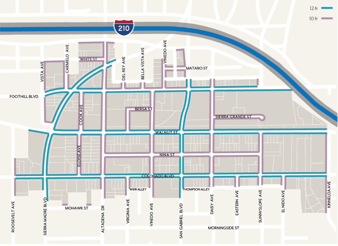
Figure LPSP-3: Sidewalk Line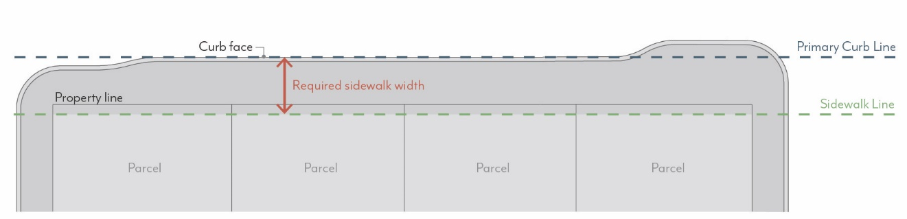
2.
Sidewalk Zones
a.
Amenity Zone. Sidewalks shall provide an Amenity Zone consistent with the width illustrated in Figure LPSP-4, including the curb.
(1)
Projects shall meet minimum parkway and street tree requirements per Section 17.38.040.B.
(2)
The following elements are permitted in the Amenity Zone at the discretion of the Director of Public Works and with public works permits (if applicable): paved area for pedestrian mobility, parkways and street trees, seating/furniture, outdoor dining, planters, bicycle parking, bus shelters, and/or other utility facilities including streetlights, signals, meter/sign poles, and pull boxes, etc.
b.
Walk Zone. Sidewalks shall maintain a Walk Zone as a continuous path of travel for pedestrians at the width illustrated in Figure LPSP-4. This area shall be free of all furnishings, landscaping, or obstructions.
Figure LPSP-4: Sidewalk Zones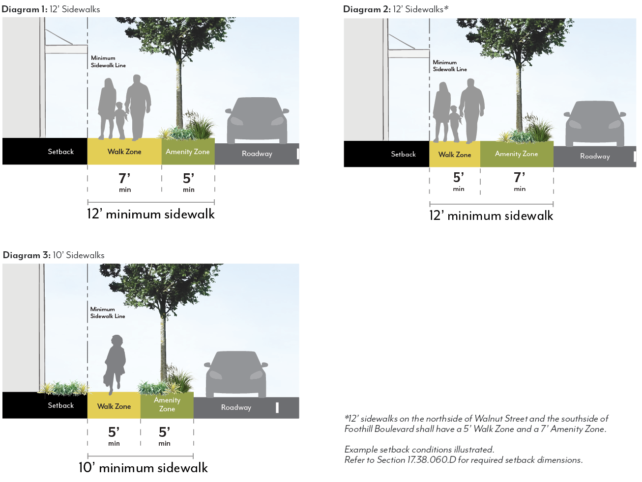
B.
Parkways & Street Trees
1.
Parkways
a.
Required Parkways. Projects shall include parkways within the Amenity Zone as follows, except as approved by the Director of Public Works as illustrated in Figure LPSP-5.
(1)
Existing parkways shall be maintained.
(2)
For mixed-use and non-residential projects, parkway length shall be no less than 30 percent of street frontage.
(3)
For residential-only projects, parkway length shall be no less than 60 percent of street frontage.
Figure LPSP-5: Parkway Design Standards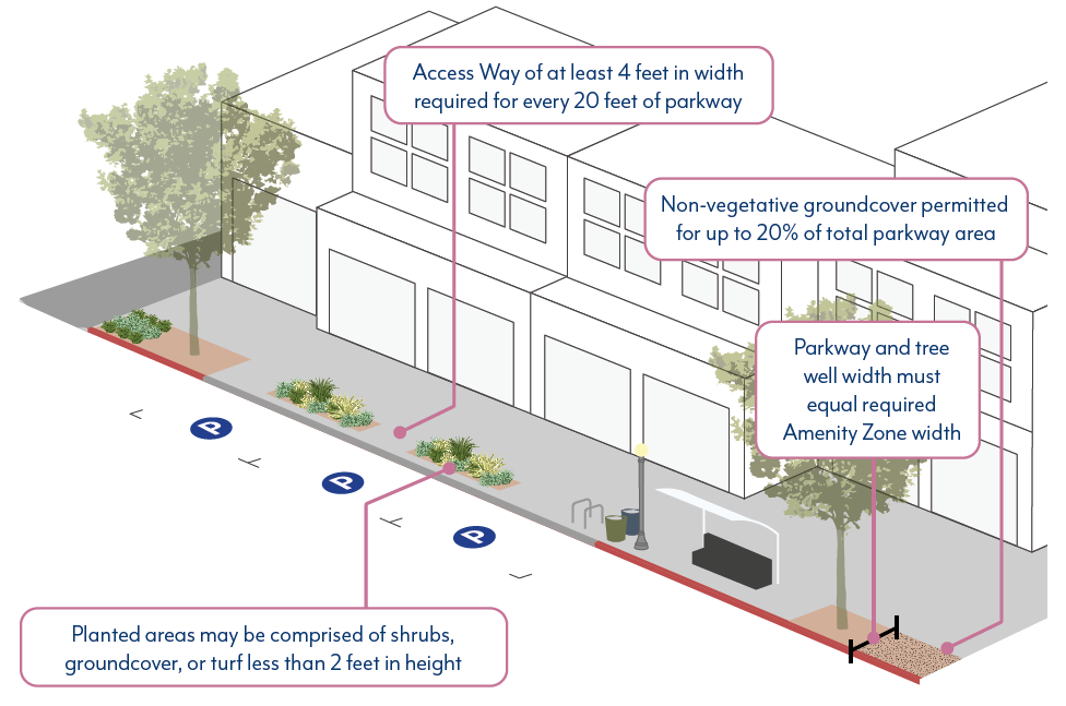
b.
Dimensions. Parkways shall be constructed at the same width as the Amenity Zones illustrated in Figure LPSP-4, minus the 6-inch width required for the curb, except as approved by the Director of Public Works.
(1)
When street parking is adjacent to the curb, a paved buffer with a minimum width of 18 inches is required, in addition to the 6-inch curb, except where tree grates are adjacent to the curb.
(2)
Barriers up to 24 inches high, such as low walls or fences, are permitted at the interior edge of the parkway but are not required.
c.
Access Ways. Where on-street parking is permitted, access ways shall be provided at a minimum frequency of one per every 20 feet of continuous parkway.
(1)
Access ways shall be a minimum of 4 feet in width and provide a firm, uniform walking surface in all weather conditions from the curb to the Walk Zone.
(2)
The finished surface of access ways shall be in plane with both the adjoining top of curb and sidewalk.
(3)
Access ways shall be constructed of pavers, concrete, or stabilized decomposed granite.
d.
Planted Area. A minimum of 80 percent of the total required parkway area for a given project shall be comprised of plant material.
(1)
Permitted materials include groundcovers, turf or turf substitutes, and shrubs or low perennials that are lower than 24 inches in height at full maturity.
a.
All plant material shall be native or climate appropriate and have a water use rating of Moderate, Low or Very-Low as defined by Water Use Classification of Landscape Species (WUCOLS) for the region. Plant water use requirements may be relaxed to maximize the efficiency of parkway stormwater capture systems subject to approval by the Director of Public Works.
b.
Plants with spines or thorns shall not be planted adjacent to any walkways or curbs.
c.
Edible plants are not permitted in parkways.
d.
Artificial turf is not permitted in parkways.
(2)
When removing existing plant material like turf grass from a parkway, there shall be no damage to the street tree roots. Parkway improvements involving excavation within an existing tree's root zone must be consistent with the City's Tree Protection Guidelines. Root pruning, if required and approved by Public Works, must be overseen by a Certified Arborist. Excavation within a tree's root zone must be replanted immediately to prevent the tree roots from exposure and undue harm.
e.
Non-planted Area. A maximum of 20 percent of the parkway area may be organic or inorganic cover.
(1)
Permitted materials include permeable pavers, decomposed granite, gravel, rocks, or mulch.
a.
Pavers are not allowed within 3 feet of any public streetlight pole or pull box or other utility facilities.
f.
Stormwater Management. Parkways shall either meet the following basic stormwater standards, or propose a biofiltration planter or swale design based on local conditions subject to approval of the Director of Public Works.
(1)
The parkway shall be at the same grade as the adjacent hardscape surface at the outer edge of the parkway and slope at a minimum of 1 percent towards the center of the parkway.
(2)
For parkways with a width greater than 5 feet, the center 2 feet of the parkway shall be depressed 3 to 4 inches to form a shallow swale to collect sidewalk stormwater. Alternative means of storing runoff, such as gravel sumps within the parkway, may be provided with review authority approval.
g.
Irrigation. Irrigation systems in parkways shall be designed and constructed in a manner that will eliminate surface runoff onto any impermeable surface, public or private, under any condition.
(1)
Design of irrigation systems in parkways shall be in accordance with all local, state, and federal laws and regulations for water conservation.
(2)
Street tree roots shall not be damaged during the irrigation installation process.
h.
Maintenance. Abutting property owner shall maintain the parkway in a condition so as not to endanger persons or property, and not to interfere with the public convenience.
2.
Street Trees
a.
Species. Street tree species shall be selected according to the Master Street Tree Plan at the discretion of the Director of Public Works. Trees may be planted within parkways or tree wells. For guidance on street trees, refer to Appendix 2 of the LPSP document.
b.
Spacing. Street trees shall be planted at a spacing of one per 30 feet. Exceptions can be made by the Director of Public Works due to conflicts with street lights, bus shelters, utility boxes, or other street amenities or species type. Closer spacing is encouraged when feasible and when appropriate for the particular tree type.
c.
Well Dimension. Tree well width shall be equivalent to the required Amenity Zone, minus the 6-inch width required for the curb.
(1)
If a paved buffer zone is required due to adjacent street parking, the tree well width may be reduced to accommodate this buffer strip. The minimum length of a tree well shall be 6 feet, parallel to the street.
(2)
Street trees planted within tree wells must be installed according to the Department of Public Works Tree Planting in Tree Well Standard Plan.
d.
Well Frames. Tree well frames, or tree grates, may be installed according to the Department of Public Works Tree Well Frame Installation Standard.
e.
Expanded Root Zone Cell. Each street tree shall be provided with an uncompacted root zone volume of 800 cubic feet minimum. The root zone volume depth shall be 2 feet minimum and 3 feet maximum.
(1)
Where this root zone volume cannot be provided within the parkway area, an expanded root zone cell volume shall be provided below adjacent pavement using a strategy such as structural soil or a suspended pavement system to provide an uncompacted soil area suitable for tree root growth.
(2)
The root zone volume per tree requirement may be reduced by 10 percent where two or more trees share a contiguous root zone cell.
f.
Maintenance. All street trees shall be maintained by the Department of Public Works.
(Ord. No. 7446, § 3, 5-12-2025)
17.38.050 - Summary of Development Standards
Table LPSP-2 provides abbreviated development and design standards by zoning district for the LPSP. Complete standards shall be referenced within Sections 17.38.060-17.38.100.
Table LPSP-2: Summary of Development Standards
(Ord. No. 7446, § 3, 5-12-2025)
17.38.060 - Scale Standards
These standards are intended to:
•
Implement the General Plan density (du/ac) and floor area ratio (FAR) values;
•
Shape development in a manner that creates a defined public realm and appropriate scale of buildings for a visually appealing community;
•
Reduce building massing through setback and stepback requirements that create appropriate transitions to residential neighborhoods;
•
Support high-quality architecture and urban design through modulation requirements and a varied roof lines incentive;
•
Encourage industrial growth in modern fields such as life sciences, production, research & development, and technology;
•
Require appropriate transitions to designated historic resources; and
•
Support opportunities to increase housing near transit, and require various unit sizes to support individuals and families.
A.
Density
1.
Residential Density. Projects that include residential dwelling units shall not exceed the allowable dwelling units per acre (du/ac) set in Figure LPSP-6.
a.
Fractions shall be rounded to the nearest whole number; those at 0.50 shall be rounded up.
b.
For projects utilizing state density bonus, refer to Government Code 65915.
c.
The maximum is based on total site area. If a street dedication or easement is required, density shall be calculated using the size of the lot prior to the street dedication or easement.
Figure LPSP-6: Residential Density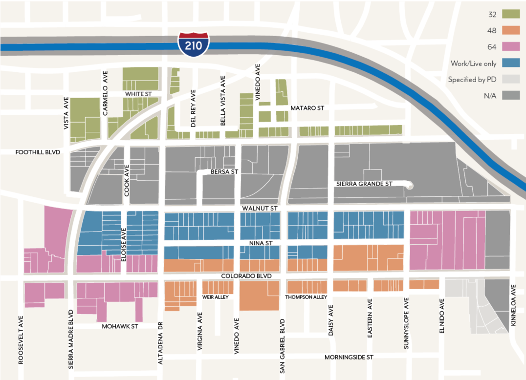
B.
Intensity
1.
Floor Area Ratio. Projects that include non-residential space, including mixed-use, shall not exceed the allowable floor area ratio (FAR) set in Figure LPSP-7.
a.
In mixed-use projects, residential floor area is included in FAR.
b.
Areas used exclusively for vehicle and bicycle parking and loading are excluded from FAR.
c.
The maximum is based on total site area. If a street dedication or easement is required, FAR shall be calculated using the size of the lot prior to the street dedication or easement.
Figure LPSP-7: Floor Area Ratio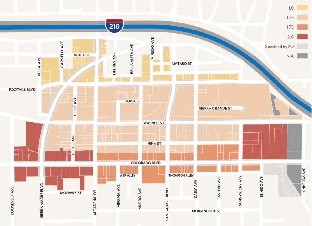
C.
Height
1.
Building Height. Projects shall not exceed the height limits set in Figure LPSP-8.
a.
Height is measured per Section 17.40.060.
b.
Exceptions allowed for Varied Roof Lines (Section 17.38.060.C.2) and projecting features such as appurtenances and railings per Section 17.40.060.
2.
Varied Roof Lines. A maximum of 30 percent of a building's footprint may exceed the height limit set in Figure LPSP-8 by up to 12 feet.
a.
This allowance is not applicable to other development standards relating to building scale such as stepbacks. It may not be used in combination with a concession for building height when utilizing Chapter 17.43.
Figure LPSP-8: Building Height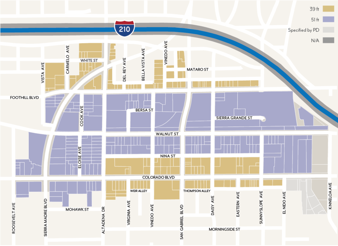
Figure LPSP-9: Varied Roof Lines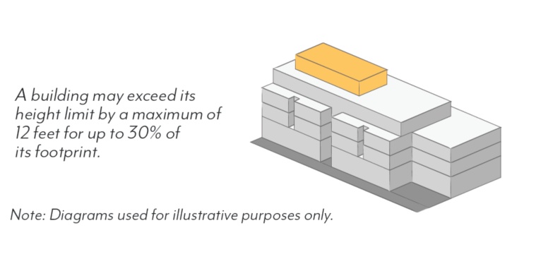
D.
Setbacks
1.
Street Setbacks. Buildings shall comply with the street setbacks set in Figure LPSP-12, except where modified for historic adjacency per Section 17.38.060.F. Setback ranges establish a minimum and maximum for the specified percentage of linear frontage; see Figure LPSP- 10.
a.
Street setbacks are measured from the sidewalk line; see Figure LPSP-3.
b.
Minimum setbacks shall apply to all stories of a building; setbacks less than the minimum are prohibited. Maximum setbacks shall apply only to the ground floor.
c.
Exceptions allowed per Section 17.40.160 (Table 4-1) and the following:
(1)
Arcades and recessed ground floors up to 15 feet in depth, as well as parking entrances per Section 17.38.90, are allowed when a second story meets the specified setback; see Figure LPSP-11.
(2)
The specified frontage percentage may be reduced for the provision of Publicly Accessible Open Space facing the street through the Design Review process.
Figure LPSP-10: Street Setback Percentage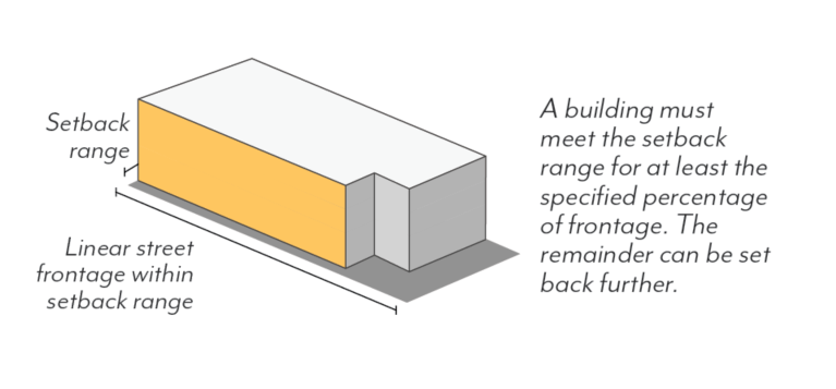
Figure LPSP-11: Recessed Ground Floor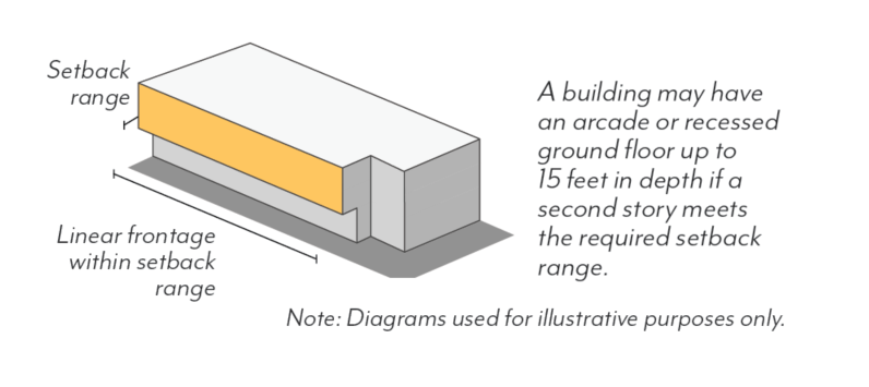
d.
Residential units on the ground floor, where permitted, shall have a minimum setback of 5 feet. Where elevated between 4 and 6 feet above sidewalk elevation, a minimum setback of 8 feet shall be required.
e.
In MU-G and MU-N, for portions of buildings set back from the sidewalk line 5 feet or more, a percentage of the setback area shall be landscaped with trees, shrubs, and/or groundcover, either in the form of in-ground landscaping or planters; see Table LPSP-3.
Table LPSP-3: Required Landscape Setbacks
f.
In CF, all required setback areas shall be landscaped except walkways, driveways, and utilities required by Building Code.
g.
Features allowed within the street setback include: landscaping and planters per Chapter 17.44, hardscape (e.g. stoops, patios), shade structures per Section 17.38.070.D, arcades and galleries per Section 17.38.070.E, walls and fences per Section 17.38.070.F, seating and furniture, outdoor dining, and/or other open space amenities per review authority approval.
Figure LPSP-12: Street Setbacks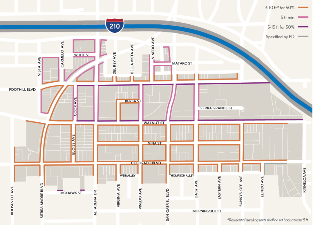
2.
Interior Setbacks. Projects shall have a minimum setback of 15 feet where adjacent to a RM/RS district. No setback is required along other interior property lines, except where modified for historic adjacency per Section 17.38.060.F
a.
Interior setbacks are those abutting other parcels along non-street side and rear property lines and are measured from the shared property line.
b.
Exceptions allowed per Section 17.40.160 (Table 4-1).
E.
Stepbacks
1.
Street Stepbacks. Along Colorado Boulevard, buildings shall not exceed 20 feet in height before stepping back 10 feet in depth, see Figure LPSP-13.
a.
Street stepbacks are measured from the sidewalk line.
i.
Uses allowed within the street stepback include: Open Space (e.g., balconies, terraces); shade structures, trellises, and similar; Green roofs are photovoltaic panels; and/or other open space features per review authority approval.
2.
Interior Stepbacks. Adjacent to RM/RS zoning, districts, buildings shall not be located within the encroachment plane sloping upward and inward at a 45-degree angle measured from the vertical, commencing 25 feet above the existing grade along the shared property line; see Figure LPSP-14.
a.
Exceptions allowed per Section 17.40.160 (Table 4-2.1).
Figure LPSP-13: Street Stepbacks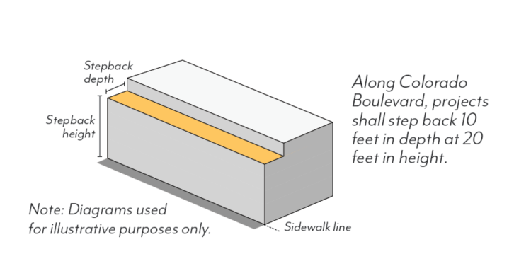
Figure LPSP-14: Interior Stepbacks Adjacent to RM/RS Zoning Districts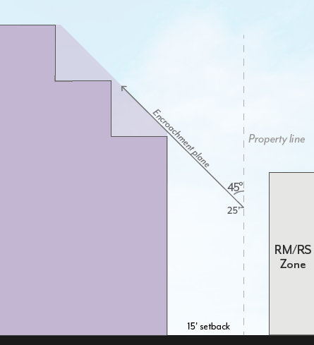
F.
Historic Adjacency
1.
Landmark Properties. Projects on parcels with a designated historic resource shall be subject to review for consistency with the Secretary of the Interior's Standards.
2.
Transition Massing. Projects sharing a property line with a designated historic resource are subject to the following modified standards, illustrated in Figure LPSP-15.
a.
Street Setbacks. The minimum street setback shall be an average of the minimum setback set in Figure LPSP-12 and that of the resource for a minimum of 20 feet from the shared property line. If located between two resources, the street setback shall be an average of the setbacks of the two resources.
b.
Interior Setbacks. The minimum interior setback shall be equal to that of the historic resource or 15 feet, whichever is less. No setback is required where the resource is built to the shared property line.
c.
Streetwall Height. A maximum streetwall height shall not exceed the height of the historic resource for a minimum of 20 feet from the shared property line. A stepback with a minimum depth of 10 feet is required above this height, measured from the modified minimum street setback.
d.
Interior Stepbacks. Projects shall not be located within an encroachment plane sloping upward and inward at a 30-degree angle measured from the vertical, commencing 15 feet above the existing grade at the property line; see Figure LPSP-15. This plane is not applicable if the resource is built to the shared property line.
Figure LPSP-15: Historic Adjacency Transition Massing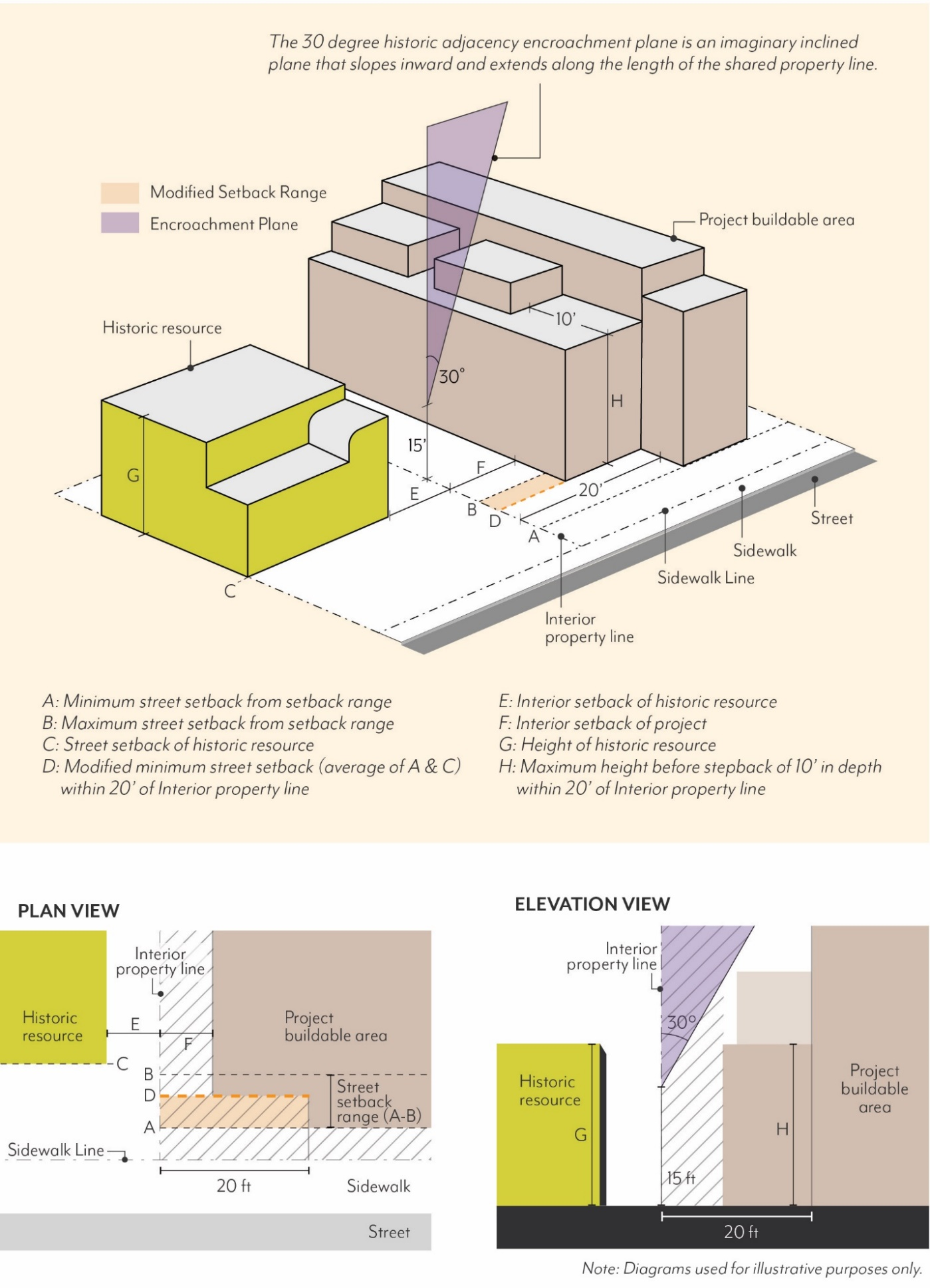
G.
Modulation
1.
Façade Length. In mixed-use districts, street-facing façade shall not exceed 150 feet in length before a minimum break of 10 percent of the building length or 20 feet, whichever is greater. This break shall be a minimum of 10 feet deep, open to the sky; see Figure LPSP-16. Projects in CF are exempt.
Figure LPSP-16: Maximum Façade Length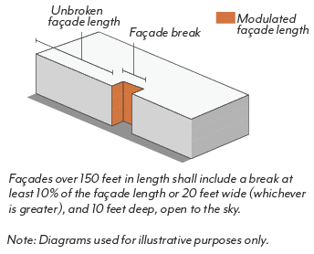
2.
Façade Area. Street-facing façades that exceed 50 feet in length shall modulate a minimum percentage of façade area set in Table LPSP-4 a minimum of 2 feet and a maximum of 12 feet in depth from the primary façade plane; see Figure LPSP-17. In mixed-use zoning districts, buildings with a total of 2 stories or less are exempt.
Table LPSP-4: Modulated Façade Area
a.
The primary façade plane is defined as the vertical plane with the greatest surface area above the ground floor.
b.
Planes that are separated by a façade break (Section 17.38.060.G.1) shall be considered separate façades for the purposes of this standard.
c.
Modulation is not required to be continuous or open to the sky, and may be recessed or projected, but not past the sidewalk line.
d.
Required stepbacks (Section 17.38.060.E), façade breaks (Section 17.38.060.G.1), and projected balconies (Section 17.38.070.G.1) shall not count toward the modulation requirement; balconies that are recessed a minimum of 2 feet shall qualify.
Figure LPSP-17: Modulated Façade Area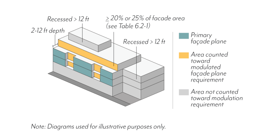
3.
Alternative Compliance
a.
Eligibility. Modulation standards may be reduced or otherwise modified through the Design Review process if:
(1)
A minimum of 50 percent of the provided parking is fully or partially subterranean;
(2)
No other concessions, waivers, or incentives have been requested, including those associated with Section 17.43 (Density Bonus), unless the project is designed to achieve LEED Gold certification; and
(3)
The review authority makes all of the following findings in this subsection (G)(3)(b).
b.
Required Findings
(1)
The building design provides modulation on each street-facing façade in a manner consistent with the project's architectural style and/or immediate context, including adjacent historic resources.
(2)
The building design does not cause an adverse impact on the quality of the ground floor and public realm.
(3)
The modification will not be detrimental to the health, safety, and welfare of the public.
(4)
The building design is consistent with the objectives and policies of the General Plan and LPSP, as well as all other standards of the LPSP.
(Ord. No. 7446, § 3, 5-12-2025)
17.38.070 - Frontage
These standards are intended to:
•
Promote an active, accessible, and attractive pedestrian environment at the ground level;
•
Activate the pedestrian street experience through design and use standards;
•
Enable flexibility and adaptability over time through quality design; and
•
Support a livable urban setting comprised of a range of uses in a comfortable pedestrian environment.
A.
Ground Floor Frontages
In Mixed-Use zoning districts, ground floor use requirements are regulated by frontage type per Figure LPSP-18 and Table LPSP-5. All use requirements are regulated as a percentage of the building frontage.
1.
Commercial Uses. Frontage types require a minimum percent of the building frontage to be comprised of, and designed for, commercial uses per Figure LPSP-18 and Table LPSP-5; see Figure LPSP-19. Permitted commercial uses by zoning district are found in Table LPSP-1.
a.
Entrances to non-ground floor uses, and/or entrances to uses prohibited within 35 feet of the sidewalk, shall not qualify toward the minimum commercial use percentage.
b.
Commercial uses shall have an average interior depth of at least 35 feet and a minimum depth of 20 feet, measured wall-to-wall.
2.
Residential Uses. Frontage types set limitations on ground floor residential uses facing the street per Figure LPSP-18 and Table LPSP-5. Permitted residential uses by zoning district are found in Table LPSP-1.
a.
Types 1, 2: Residential units on the ground floor shall be prohibited within 35 feet of the sidewalk line, inclusive of setbacks, per Table LPSP-5; see Figure LPSP-20.
b.
Type 3: Residential units on the ground floor shall be permitted with direct access to the street and a minimum setback of 5 feet.
c.
Residential common space on the ground floor shall be permitted per Table LPSP-5.
Figure LPSP-18: Ground Floor Frontage Types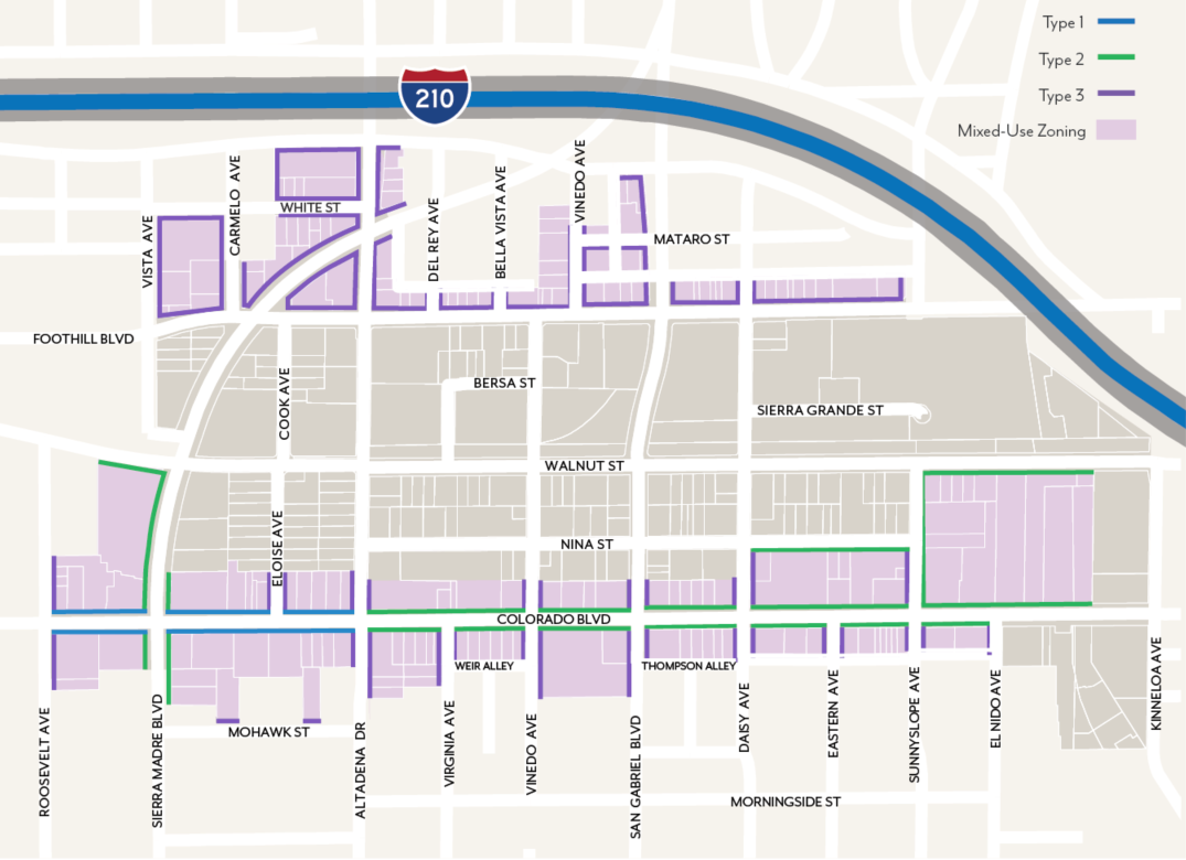
Table LPSP-5: Allowable Ground Floor Building Frontages in Mixed-Use Zones
Figure LPSP-19: Ground Floor Commercial Uses
Figure LPSP-20: Ground Floor Residential Units
B.
Ground Floor Design
1.
Entrances. A minimum of one primary entrance shall be located on the primary frontage within the setback range, connected by a pedestrian pathway a minimum of 4 feet in width that leads directly to the sidewalk.
a.
Primary entrances shall be distinguished by architectural features or overhead projections, such as an awning or canopy.
b.
On sites with frontages on both Foothill Boulevard and Walnut Street, projects shall provide pedestrian pathways on both frontages.
c.
All entrances shall be recessed a minimum of 30 inches from the sidewalk line.
2.
Minimum Height. Buildings shall have a minimum ground floor height of 12 feet, except those facing Colorado Boulevard, Foothill Boulevard, Sierra Madre Boulevard or Walnut Street, which shall have a minimum ground floor height of 15 feet. This height is measured from sidewalk elevation closest to the primary entrance to the second story floor or roof of a one-story building; see Figure LPSP-21.
a.
For residential units, the first habitable floor shall be located between 6 feet above and 2 feet below sidewalk elevation.
b.
For non-residential and residential common space uses, the primary entrance of the first habitable floor shall be located at existing grade along the sidewalk line.
(1)
Exception: In CF, the primary entrance of the first habitable floor shall be located between 4 feet above and 2 feet below sidewalk elevation.
Figure LPSP-21: Ground Floor Height
C.
Transparency
1.
Windows & Doors. Street-facing façades shall incorporate glass providing views into work, display, sales, lobby, or similar active areas. The minimum transparency requirement is set in Table LPSP-6.
a.
For non-residential and residential common space uses, ground floor transparency is measured as the percentage of building frontage that consists of transparent openings between a height of 2 feet and 10 feet above sidewalk elevation.
b.
Overall façade transparency is measured as the percentage of building frontage area, viewed in elevation and excluding any coverage of shading devices.
c.
Windows shall be recessed a minimum of 2 inches, measured from the outside wall to the frame of the window (mullion, muntin or similar element). Flush windows shall be permitted where exterior shading devices cover a minimum of 25 percent of the window surface area or per review authority approval.
d.
The use of tinted, mirrored, or highly reflective glass is prohibited.
e.
Street-facing transparency that is obstructed by walls or fences taller than 42 inches will not be counted toward the required transparency; see Figure LPSP-22.
f.
Blinds, drapes, posters, and shelving for product displays visible to the public right-of-way shall obscure a maximum of 10 percent of the transparent areas of each respective storefront or 50 percent for medical office uses.
Figure LPSP-22: Fences, Walls, and Transparency
Table LPSP-6: Minimum Transparency by Use
2.
Blank Façades. Windowless expanses of street-facing façades shall not exceed 20 feet in length.
a.
Exception: In CF zoning districts, windowless expanses of street-façades shall not exceed 40 feet in length. Blank façades shall include a minimum of one 24-inch box tree for every 15 linear feet of blank façades, except where public art (e.g., a mural) is provided per Section 17.40.100 (Public Art Requirements and Design Standards).
3.
Security Bars. Any exterior or interior security bars shall be designed to be fully hidden from view during business hours with devices such as concealed side pockets and ceiling cavities.
D.
Shade Structures
1.
Awnings & Canopies. Any ground floor shading shall project a minimum of 3 feet from the façade and allow a minimum of 8 feet of vertical clearance from sidewalk elevation.
a.
Shade structures shall not conflict with existing trees; exceptions to the depth requirement to accommodate existing trees shall be subject to review authority approval.
2.
Colorado Boulevard. For projects on the north side of Colorado Boulevard, shade structures are required and shall project a minimum of 7 feet, up to a maximum of 10 feet, into the public right-of-way for a minimum of 70 percent of the building frontage.
a.
Where an arcade or recessed ground floor provides a minimum of 5 feet of unobstructed pedestrian clearance, shade structures are not required.
E.
Arcades & Galleries
1.
Arcades. Any arcades shall be located behind the minimum setback.
a.
Arcades shall be a minimum of 8 feet from back of column to building façade.
b.
The distance between columns shall be equal to or greater than the arcade depth dimension, as measured from the column center.
c.
The façade within the arcade shall meet the ground floor transparency set in Section 17.38.070.C.
d.
Uses allowed within arcades include: pedestrian travel, seating/street furniture, outdoor dining, landscape planters, and/or bicycle parking.
2.
Galleries. Any galleries shall be located behind the minimum setback.
a.
Galleries shall be limited to one-story in height and 50 percent of the building frontage.
b.
Galleries shall allow a minimum of 10 feet of vertical clearance from sidewalk elevation.
F.
Exterior Fixtures
1.
Ground Floor Façade Lighting. Lighting shall be located on façades facing streets and public open spaces at a frequency of every 30 feet or less.
a.
Lighting shall be full cutoff (directing light downward and outward).
b.
Fixtures shall be located between 8 and 15 feet above sidewalk elevation and shall not project more than 30 inches from the façade.
c.
Ground floor residential units shall be able to operate façade lighting attached directly to their unit.
d.
Façade lighting shall not be required on designated historic resources and districts.
G.
Walls & Fences
1.
Walls & Fences. Freestanding walls, fences, and raised/landscape planters shall be permitted within the required street setback.
a.
Walls and fences shall have a maximum height of 48 inches above sidewalk elevation.
(1)
Exception: In CF, walls and fences shall have a maximum height of 72 inches above the sidewalk elevation. Walls and fences over 48 inches in height shall be set back a minimum of 5 feet from the sidewalk line, separated by planted area.
(2)
In MU-G and MU-N, walls and fences taller than 42 inches shall be a minimum of 50 percent transparent and set back a minimum of 18 inches from the sidewalk line, separated by planted area. Walls and fences 42 inches or less in height do not have a transparency or setback requirement.
b.
Wall and fences shall not block required transparency per Section 17.38.070.C.1 or murals per Section 17.38.070.C.2.
c.
Walls and fences used to enclose outdoor dining may be located at the sidewalk line and are not required to provide a planted area if the wall or fence is 36 inches or less and more than 50 percent transparent.
d.
Guardrails may exceed the maximum height to the extent required by the Building Code. The guardrail shall be a minimum of 50 percent transparent.
2.
Stoops & Patios. The side of a patio or stoop (when parallel to a sidewalk) taller than 30 inches in height shall be set back a minimum of 18 inches from the sidewalk line, separated by planted area.
H.
Balconies & Roof Decks
1.
Balconies. Balconies may project a maximum of 4 feet from the building façade but shall not extend beyond the sidewalk line or within 6 feet of any interior property line.
2.
Roof Decks. The sum of all roof decks on a single building shall not exceed a maximum coverage of 60 percent of the roof area.
a.
Roof deck railings above the top floor shall be placed behind a parapet wall of at least the same height or shall be set back a minimum of 5 feet from the façade.
(Ord. No. 7446, § 3, 5-12-2025)
17.38.080 - Open Space
These standards are intended to:
•
Provide a variety of open space types for gathering, recreation and respite that contribute to enhanced livability within an urban setting;
•
Give residents access to light, air, and pleasant views from their living spaces;
•
Improve building design and site planning through the integration of open space throughout the development; and
•
Correlate open space requirements with number of residents and size of buildings.
A.
Minimum Open Space
1.
Private and Common Open Space. Projects shall provide the minimum area of Open Space based on use and size. Areas used regularly for parking, loading or storage shall not count towards minimum Open Space requirements.
a.
Residential. Projects with dwelling units shall provide the minimum area of Open Space per Table LPSP-7 as a combination of Private and Common Open Space.
b.
Mixed-use. Projects shall comply with requirements applicable to each type of use above.
Table LPSP-7: Residential Open Space by Unit Type
2.
Publicly Accessible Open Space (PAOS). In MU-N, projects with more than 80,000 square feet of gross floor area (GFA) shall provide Publicly Accessible Open Space based on a percentage of GFA set in Table LPSP-8.
a.
PAOS shall be provided in addition to Private and Common Open Space requirements.
b.
Projects shall comply with PAOS standards per Section 17.38.080.D where relevant.
(1)
PAOS standards may be modified through the Design Review process, if the review authority finds that the modified design continues to be accessible to the public, functional, and includes features such as landscaping, trees, and outdoor seating.
c.
Research and Development uses may reduce Open Space requirements by a maximum of 60 percent. Research and Development projects (or the Research and Development portion of a project with multiple uses) shall exclude mechanical space from floor area for the required Open Space.
Table LPSP-8: Required Publicly Accessible Open Space
B.
Private Open Space
1.
Dimensions. A minimum area of 40 square feet with a minimum dimension of 5 feet in each direction shall be required for Private Open Space.
2.
Distribution. A maximum of 40 percent of the required residential Open Space set in Table LPSP-7 shall be Private Open Space.
a.
All Private Open Space shall be outdoors.
b.
Private Open Space may be located within a required setback.
C.
Common Open Space
1.
Dimensions. A minimum area of 400 square feet with a minimum dimension of 15 feet in each direction is required for Common Open Space.
2.
Distribution. A minimum of 60 percent of the required residential Open Space set in Table LPSP-7 shall be Common Open Space shared among tenants.
a.
A minimum of 70 percent of Common Open Space shall be outdoors, and a minimum of 80 percent of outdoor Common Open Space shall be open to the sky.
b.
A maximum of 30 percent of Common Open Space may be indoors. Indoor Common Open Space shall not include spaces used primarily for circulation.
3.
Access. Common Open Spaces may be accessible to the public.
4.
Hardscape. A maximum of 25 percent of Common Open Space may be paved in standard concrete. Remaining areas shall use one of the following enhanced paving techniques: brick, natural stone, unit concrete pavers, textured and colored concrete, and/or concrete with exposed or special aggregate. Alternative paving may be allowed per review authority approval.
5.
Landscape. A minimum of 25 percent of Common Open Space shall be planted area with a minimum dimension of 30 inches in length, width, and depth. Landscaping shall comply with Section 17.44.050.
6.
Trees. A minimum of one 24-inch box tree per project or for every 500 square feet of outdoor Common Open Space, whichever is greater, shall be planted within the Common Open Space. For projects with 2 or more trees, a minimum of 50 percent of trees planted shall be shade trees.
7.
Water Features. A maximum of 5 percent of the required Common Open Space shall be fountains, reflecting pools, or other decorative water features. Swimming pools are not considered water features for the purposes of this standard.
D.
Publicly Accessible Open Space (PAOS)
1.
Area. Minimum PAOS requirements are set in Section 17.38.080.A.1 and Table LPSP-8, and may be contiguous or noncontiguous, subject to the dimension and elevation standards below.
2.
Dimensions. A minimum area of 400 square feet with a minimum dimension of 20 feet in each direction shall be required for PAOS.
3.
Access. A maximum of 20 percent of the PAOS may be used as outdoor dining for a restaurant subject to review authority approval; a minimum of 80 percent of the PAOS shall be accessible to the general public.
4.
Signage. PAOS shall have signage visible from the adjacent sidewalk identifying the space as a publicly-accessible amenity and listing accessible hours.
5.
Hours. At a minimum, PAOS shall be open to the general public from 8am to 8pm. Any gated ingress or egress points shall not be closed or locked during these hours.
6.
Elevation. A minimum of 3,000 square feet of PAOS shall be at sidewalk elevation. If less square footage is required, then all required PAOS shall be at sidewalk elevation.
7.
Hardscape. A maximum of 25 percent of PAOS shall be paved in standard concrete. Remaining areas shall use one of the following enhanced paving techniques: brick, natural stone, unit concrete pavers, textured and colored concrete, concrete with exposed or special aggregate. Alternative paving may be allowed per review authority approval.
8.
Seating. Seating shall be provided at a minimum of 1 seat per 300 square feet of required PAOS. Fractions shall be rounded down to the nearest whole number.
a.
Benches shall be calculated as 1 seat per 24 linear inches.
9.
Landscape. A minimum of 25 percent of PAOS shall be planted area with a minimum dimension of 30 inches in length, width, and depth. Landscaping shall comply with Chapter 17.44.
10.
Trees. A minimum of one 24-inch box tree per project or for every 750 square feet of PAOS, whichever is greater, shall be planted. For projects with 2 or more trees, a minimum 50 percent of trees planted shall be shade trees.
a.
Trees planted in pots on the ground floor shall not be counted towards the tree requirement.
11.
Blank Walls. PAOS shall adhere to the blank wall standards defined in Section 17.38.070.C.2, or provide one of the following mitigations:
a.
Green wall, vines, or other vertical landscaping element that covers a minimum of 75 percent of blank wall area.
b.
Public art including, but not limited to, murals.
12.
Common Open Space Credit. PAOS in excess of the minimum may count towards a maximum of 30 percent of the Common Open Space requirement at a 1:1 ratio.
(Ord. No. 7446, § 3, 5-12-2025)
17.38.090 - Parking
These standards are intended to:
•
Reduce the visual impacts of parking;
•
Regulate appropriate parking supply and location in a manner that prioritizes pedestrian access and multi-modal activity;
•
Encourage change of use and adaptive reuse of existing buildings through parking reductions and exemptions;
•
Promote a more efficient use of parking spaces through shared parking among multiple uses within a project; and
•
Increase design standards for surface and structured parking.
A.
Minimum Parking
1.
Number of Spaces. Projects shall provide off-street automobile parking spaces per Table LPSP-9 based on general use classifications, and subject to the standards of Section 17.46.
a.
Where parking minimums in this Section conflict with state law, state law shall control.
b.
For projects within one-half mile of a Metro station, reductions in parking and a maximum number of parking spaces shall apply per Section 17.50.340.
c.
Bicycle parking shall be required per Section 17.46.320.
Table LPSP-9: Minimum Parking by Land Use
2.
Shared Parking. Parking may be shared among multiple uses per Section 17.46.050.
3.
Unbundled Parking. For any building with new residential units, automobile parking spaces shall be leased or sold separately from the rental or purchase fees, such that renters or buyers have the option of renting or buying the unit at a lower price than if the parking was included.
a.
For deed-restricted affordable units, one parking space shall be included in the base rent of each unit. The tenant may choose to receive the parking space or receive a rent discount equivalent to half the amount charged for monthly lease of a parking space. Tenants of affordable units shall not sublease their parking spaces.
b.
Renters or buyers have the right of first refusal to parking built for their unit. Any remaining spaces may be leased to other users on a month-to-month basis. New occupants shall have the opportunity to lease or purchase parking built for their unit.
c.
Unbundled parking is not required for a residential property or unit with an individual garage that is functionally a part of the property or unit (e.g., certain townhome and row houses).
B.
Vehicle Access
1.
Driveways. For Projects with less than 200 feet of primary street frontage, a maximum of 1 two-lane driveway shall be permitted. For sites with more than 200 feet of primary street frontage, a maximum of 2 two-lane driveways shall be permitted.
a.
Driveways are not permitted on primary frontages of less than 200 feet where there is access from a secondary street or alley.
b.
The Zoning Administrator shall determine the primary frontage for purposes of compliance with this subsection.
2.
Gates. Controlled entrances to parking shall be located a minimum of 20 feet from the property line to allow for a queuing vehicle without blocking the public right-of-way.
a.
Gates at parking entrances shall be designed to conceal associated mechanical equipment from the public right-of-way in compliance with Section 17.40.150.
C.
Layout & Design
1.
Surface Parking. Parking lots shall comply with Section 17.46.230 with the following exceptions:
a.
Parking lots shall be set back a minimum of 30 feet from the primary frontage, a minimum of 10 feet from any secondary frontage, and a minimum of 5 feet from RM zoning. Exception: In CF and the area east of Sunnyslope Avenue/north of Colorado Boulevard, parking shall be set back a minimum of 5 feet from all street frontages.
b.
Parking shall be buffered by permitted non-parking uses or a landscaped setback adjacent to the sidewalk line, except for driveways or pedestrian access to the parking area.
(1)
Landscaped setbacks shall include hedges or shrubs with a minimum height of 3 feet at the time of planting that form a continuous visual screen to block vehicle headlights.
2.
Entrances to Structured Parking. For structured and subterranean parking, vehicular entrances shall employ the same materials and architectural style as the primary building.
a.
Exterior building materials shall wrap into parking entrances/exits for a minimum of 20 feet from the building façade, except areas not visible from public streets.
b.
Entrances shall not be larger than the necessary clearance area.
3.
Structured Parking. Along primary frontages in the MU zoning districts, all floors of parking structures shall be lined with building floor area (e.g., commercial or residential uses) or Publicly Accessible Open Space for a minimum of 35 feet in depth. Along secondary frontages and along all street frontages in CF, parking structures shall be set back a minimum of 5 feet. Pedestrian access and driveways in compliance with Section 17.38.90.B are excluded from this requirement.
a.
Parking structure façades visible from public streets, excluding alleys, shall employ the same materials and architectural style as the primary building.
(1)
Open areas on the façade shall be designed as windows or screened using heavy-gauge metal, precast concrete panels, laminated glass, green walls, photovoltaic panels, or other material per review authority.
4.
Underground Parking. Subterranean parking shall be set back a minimum of 5 feet from Colorado Boulevard and RM/RS zoning. Otherwise, it may extend up to the property line.
(Ord. No. 7446, § 3, 5-12-2025)
17.38.100 - Definitions
This Section provides definitions of terms and phrases used in the LPSP that are technical or specialized or that may not reflect common usage. In case of conflict with other provisions of the Zoning Code, these definitions shall control for the purposes of the LPSP. If a word is not defined in this Chapter, the Zoning Administrator shall determine the correct definition.
Amenity Zone.
The portion of the sidewalk located above and adjacent to the curb, providing space
for amenities such as parkways, outdoor dining, seating, trees, lighting, bicycle
racks, bus stops, etc.
Building Frontage.
The horizontal distance, measured at grade, of building wall facing the street.
Building Frontage Zone.
The portion of the sidewalk immediately adjacent to the building façade, providing
space for planters, outdoor dining, sidewalk signage, etc. This zone may not be present
on every street or block.
Curb Zone.
See 'amenity zone'
Façade.
Any exterior wall plane of a building, ground level to top of roof.
Floor Area Ratio.
Numerical value obtained by dividing the above-ground area of a building or buildings
located on a lot by the total area of the lot.
Footprint.
The total ground floor area of the combined structures on a site or project area defined
by the perimeter of the building(s), including parking structures but excluding parking
lots and non-occupancy structures.
Frontage Zone.
See 'building frontage zone'
Gross Floor Area (GFA).
The total enclosed area of all floors of a building measured to the inside face of
the exterior walls including halls, stairways, elevator shafts at each floor level,
service and mechanical equipment rooms and basement or attic areas having a height
of more than seven feet, but excluding area used exclusively for parking or loading
of vehicles or bicycles.
Ground Floor.
The first habitable floor of a building closest to sidewalk elevation.
Mixed-Use Project.
The combination of commercial and residential uses in the same structure, where the
residential component is located either above (vertical mixed-use) or behind (horizontal
mixed-use) the non-residential component. Non-residential uses are typically commercial
uses.
Open Space.
For any form of open space (Common, Publicly Accessible, Private, etc.), see Section
17.38.080 of the LPSP.
Parkway.
Landscaped or permeable areas located within the amenity zone of the sidewalk.
Paseo.
A publicly accessible open space that functions as a pedestrian passageway connecting
a public street to another public street, alley, or internal public space. Subject
to minimum dimension and design requirements established by the LPSP.
Plaza.
A publicly accessible open space with access from a public street. Subject to minimum
dimension and design requirements established by the LPSP.
Primary Curb Line.
The face of the predominant curb of an individual block forming the edge of the street.
Primary Frontage.
The portion of a site adjacent to the street. For a site with multiple street frontages,
the primary frontage is determined by the Zoning Administrator. There shall be only
one primary frontage per site.
Project.
Refer to Section 17.80.020.
Residential Common Space.
Those portions of a residential use building not dedicated to residential units that
provide common services for residents. This may include spaces such as, but is not
limited to, lobby or common building entry, leasing center, gyms/exercise space, shared
kitchen, recreation center, screening or living room, business center, mail room,
or library. These spaces/portions of the building may be permitted on the ground floor
where residential units are not permitted subject to the LPSP standards.
Setback.
The horizontal distance by which a structure, parking area, or development feature
is required to be separated from the property line or the sidewalk line where applicable.
In some cases superseded by Setback range.
Setback, Interior.
Non-street side or rear setback measured at a right angle from the nearest point of
the property line abutting another parcel or alley to the nearest portion of the structure,
excluding any porches.
Setback, Street.
Front or street-side setback measured at a right angle from the nearest point of the
sidewalk line to the nearest portion of the structure, excluding any porches.
Setback Range.
Minimum and maximum horizontal distances by which a structure or development feature
is required to be separated from the sidewalk line. This measurement is similar to
a "build-to" line.
Sidewalk Line.
The line parallel to the property line accommodating the required sidewalk width,
measured from the curb face. Where a sidewalk width is not specified, the sidewalk
line is the property line.
Sidewalk Zones.
The three portions of a sidewalk that together comprise the public realm between a
building and the street. Sidewalk zones are defined by the Pasadena Street Design
Guide and regulated by the LPSP.
Shared Property Line.
The property line separating adjacent parcels.
Stepback.
The horizontal distance by which an upper story structure or development feature is
required to be separated from the property line or the sidewalk line where applicable.
Regulated above a specified vertical distance.
Street Frontage.
The horizontal distance along the street, measured at grade, between property lines
(or sidewalk line where applicable) that are perpendicular to the adjacent street.
Streetwall.
Any building façade that faces a street within 10 feet of the minimum sidewalk line.
Streetwall Height.
The portion of the street-facing building façade that rises from the sidewalk level
to the required height without an additional setback or stepback.
Subterranean.
The level of a building, inclusive of parking or habitable space, located primarily
below the ground level with a top plate of two feet or less above sidewalk elevation.
Transparent Openings.
Building openings (windows or doors) or transparent glazing that provide visual access
into the structure.
Unbundled Parking.
Parking spaces, in any permitted configuration, rented or sold separately from the
lease or purchase price of a residential unit.
Walk Zone.
The portion of the sidewalk dedicated to pedestrian movement, clear of any obstructions.
(Ord. No. 7446, § 3, 5-12-2025)
17.39.010 - Purpose of Chapter
This Chapter lists the land uses that may be allowed within the zoning districts established by the East Colorado Specific Plan (ECSP), determines the type of land use permit/approval required for each use, and provides basic standards for site layout and building size.
(Ord. No. 7446, § 2, 5-12-2025; Ord. No. 7394, § 2(Exh. 1), 6-13-2022)
17.39.020 - Purposes of ECSP Zoning Districts
The purpose of the ECSP zoning districts is to implement the East Colorado Specific Plan by balancing and optimizing economic development, historic preservation, and the maintenance of local community culture, and to:
A.
Promote a vibrant mix of land uses, a unified streetscape, and a series of distinctive "places" along the Boulevard.
B.
Improve the appearance, function, and urban ambiance of East Colorado Boulevard.
C.
Identify areas of East Colorado Boulevard, which are appropriate locations for developing mixed-use and housing projects, and areas where commercial development should be concentrated.
D.
Retain the eclectic mix of uses and protect the vitality of small, independent businesses. Uphold Colorado Boulevard as a location for specialty and niche retail businesses.
E.
Beautify the streetscape though installation of street trees, street and median landscaping to soften the urban edge, and a consistent selection of urban furnishings.
F.
Create a pedestrian-friendly environment that balances the needs of pedestrians and vehicular traffic, recognizing the heavy local and regional use of Colorado Boulevard.
G.
Protect historic resources and honor the past of Colorado Boulevard and its surrounding communities through subarea identification and remembrance of Colorado Boulevard as Route 66.
H.
Effectively plan for the utilization of the light rail stations at Allen Avenue and Sierra Madre Villa at the 210 Freeway through the establishment of special development standards in these light rail "nodes".
(Ord. No. 7446, § 2, 5-12-2025; Ord. No. 7394, § 2(Exh. 1), 6-13-2022)
17.39.030 - Applicability
The standards of the ECSP zoning districts apply to proposed development and new land uses in the following areas, as shown on the Zoning Map.
A.
ECSP-CG-1. The Mid-City area.
B.
ECSP-CG-2. The College District area.
C.
ECSP-CG-3. The Gold Line-General Commercial area.
D.
ECSP-CL-3. The Gold Line-Limited Commercial area.
E.
ECSP-CG-4. The Route 66 area.
F.
ECSP-CG-5. The Lamanda Park area.
G.
ECSP-CG-6. The Chihuahuita area.
(Ord. No. 7446, § 2, 5-12-2025; Ord. No. 7394, § 2(Exh. 1), 6-13-2022)
17.39.040 - ECSP District Land Uses and Permit Requirements
A.
Allowable land uses and permit requirements. Table 3-3 identifies the uses of land allowed by this Zoning Code in each residential zoning district, and the land use permit required to establish each use, in compliance with Section 17.21.030 (Allowable Land Uses and Permit Requirements). The land use permit requirements established by Table 3-3 are as follows.
Note: the right column in the tables ("Specific Use Standards") will show a section number for regulations that apply to the particular use listed in addition to the other general standards of this Zoning Code.
(Ord. No. 7446, § 2, 5-12-2025; Ord. No. 7435, § 15, 10-28-2024; Ord. No. 7420, § 3, 4-15-2024; Ord. No. 7418, § 2, 2-26-2024; Ord. No. 7414, § 2, 9-11-2023; Ord. No. 7402, § 2, 9-19-2022; Ord. No. 7394, § 2(Exh. 1), 6-13-2022; Ord. 7326 § 6, 2018; Ord. 7321 § 3 (Exh. 1), 2018; Ord. No. 7313, § 6, 2017; Ord. 7300 § 6 (Exh. 5), 2017; Ord. 7255 § 5 (Exh. 4), 2015; Ord. 7210 § 4, 2011; Ord. 7164 § 6, 2009; Ord. 7160 §§ 7, 14, 2009; Ord. 7148 § 2 (Exh. 1), 2008; Ord. 7099 § 12, (Exh. 8), 2007; Ord. 7009 § 10, 2005)
17.39.050 - ECSP General Development Standards
Subdivisions, new land uses and structures, and alterations to existing land uses and structures, shall be designed, constructed, and established in compliance with the requirements of this Section, in addition to the applicable standards (e.g., landscaping, parking and loading, etc.) in Article 4 (Site Planning and General Development Standards) and 5 (Standards for Specific Land Uses). Principal and accessory structures shall meet the same development standards unless otherwise modified in this Zoning Ordinance.
A.
Table 3-4 standards. The standards in Table 3-4 apply to residential projects, nonresidential projects and all projects, as noted, within a ECSP zoning district.
B.
Reserved.
(Ord. No. 7446, § 2, 5-12-2025; Ord. No. 7394, § 2(Exh. 1), 6-13-2022; Ord. 7169 § 8, 2009; Ord. 7099 § 12, (Exh. 9), 2007; Ord. 7057 § 7 (Exh. 2), 2006; Ord. 7035 § 4, (Exh. 3), 2006; Ord. 7277 § 5, 2016)