
Ponder City Zoning Code
DISTRICTS; REGULATIONS
§ 154.20 - District regulations.
(A)
Land and buildings in each of the designated districts may be used for any of the following listed uses, but no land shall hereafter be used and no building or structure shall hereafter be occupied, used, erected, altered, removed, placed, demolished or converted which is arranged or designed to be used for other purposes than those uses specified for the district in which it is located as set forth by the schedule of uses in appendix B, Table 1, listed in the following:
(B)
New and unclassified uses. It is recognized that new types of land use may develop and forms of land use not anticipated herein may seek to locate in the town. In order to provide for such changes and contingencies, a determination as to the appropriate classification of any new or unclassified form of land use shall be made as follows:
(1)
Administrative official action. The administrative official shall refer the question concerning any new or unlisted use to the planning and zoning commission requesting an interpretation as to the proper zoning classification into which the use should be placed. The use interpretation question shall be determined as to the nature of the use and whether it involves dwelling activity, sales, processing; type of product, storage and the amount and nature thereof (i.e., enclosed or open storage); anticipated employment; transportation requirements; the general degree of noise, odor, fumes, dust, toxic material and vibration likely to be generated, if any; and the general requirements for public utilities such as water and sanitary sewer.
(2)
Commission action. The planning and zoning commission shall consider the nature and described performance of the proposed use and its compatibility with the uses permitted in the various zoning districts, and determine the zoning district or districts within which the use should be permitted.
(3)
Council action. The planning and zoning commission shall transmit its findings and recommendations to the town council as to the classification proposed for any new or unlisted use. The town council shall approve the recommendation of the planning and zoning commission, or make any other determination concerning the classification of such use as appropriate, based upon its findings of fact, and amend this subsection (B) to reflect the findings and decisions.
(Ord. 00-20 § 9, passed 9-6-2000; Am. Ord. 03-50, passed 8-11-2003)
§ 154.21 - Height, area and setback regulations.
(A)
Except as herein provided, no building or structure or part thereof shall be erected, altered or converted for any uses permitted in the district in which it is located unless it is in conformity with all the minimum regulations herein specified for height, lot area, lot coverage and front, side and rear yards in appendix B, Table 2.
(B)
The front yard shall be measured from the property line to the front face of the buildings, covered porch, covered terrace or attached accessory buildings. Eave and roof extensions may project into the required yard for a distance not to exceed 24 inches.
(C)
Where lots have double frontage running through from one street to another, a required front yard shall be provided on both streets unless otherwise established by plat or by ordinance, in which case only the required front yard need be provided.
(D)
Where a building line has been established by plat or previous ordinance, and the line requires a front yard setback greater or lesser in depth that is prescribed by this chapter for the district in which the building line is located, the required front yard shall comply with the building line established by the previous ordinance or plat.
(Ord. 00-20 § 10, passed 9-6-2000; Am. Ord. 03-60, passed 10-13-2003; Am. Ord. 04-15, passed 4-12-2004)
§ 154.22 - PD - Planned development district.
(A)
General description and purpose. The planned development district is a district which accommodates planned associations of uses developed as integral land use units such as industrial districts, offices, commercial or service centers, shopping centers, residential developments of multiple or mixed housing including attached single-family dwellings or any appropriate combination of uses which may be planned, developed or operated as integral land use units either by a single owner or a combination of owners. A PD District may be used to permit new or innovative concepts in land utilization not permitted by other zoning districts in this chapter. While greater flexibility is given to allow special conditions or restrictions that would not otherwise allow the development to occur, procedures are established herein to ensure against misuse of increased flexibility.
(B)
Permitted uses. An application for a PD District shall specify the base district, the use or the combination of uses proposed. uses that may be permitted in a pd are specified in the use charts in appendix B, Table 1 and must be specified if not permitted in the base district. In the case of residential PD Districts for single-family or duplex categories, the proposed lot area shall be no smaller than the lot sizes, allowed in the base zoning district except for minor reductions in a small percentage of the lots in order to provide improved design. In selecting a base zoning district, the uses allowed in the base district must be similar or compatible with those allowed in the PD. PD designations shall not be attached to specific use permit requirements. SUPs allowed in a base zoning district are allowed in a PD only if specifically identified at the time of PD approval.
(C)
Planned development requirements.
(1)
Development requirements for each separate PD District shall be set forth in the amending ordinance granting the PD District and shall include, but may not be limited to: uses, density, lot area, lot width, lot depth, yard depths and width, building height, building elevations, coverage, floor area ratio, parking access, screening, landscaping, accessory buildings, signs, lighting, project phasing or scheduling, management associations, and other requirements as the town council and planning and zoning commission may deem appropriate.
(2)
In the PD District, uses shall conform to the standards and regulations of the base zoning district to which it is most similar. The base zoning district shall be stated in the granting ordinance. All applications to the town shall list all requested deviations from the standard requirements set forth throughout this chapter. (Applications without this list will be considered incomplete.) The planned development district shall conform to all other sections of the ordinance unless specifically excluded in the granting ordinance.
(3)
The ordinance granting a PD District shall include a statement as to the purpose and intent of the PD granted therein. A specific list is required of modifications in each district or districts and general statement citing the reason for the PD request.
(4)
The minimum acreage for a planned development request shall be one acre.
(D)
Conceptual or detailed site plan requirements. In establishing a planned development district in accordance with this section, the town council shall approve and file as part of the amending ordinance appropriate plans and standards for each planned development district. To facilitate understanding of the request during the review and public hearing process, the planning and zoning commission and town council shall require a conceptual plan of the proposed project. A detailed site plan may be submitted in lieu of the conceptual plan.
(1)
Conceptual plan. This plan shall be submitted by the applicant at the time of the PD request. The plan shall show the applicant's intent for the use of the land within the proposed planned development district in a graphic manner and as may be required, supported by written documentation of proposals and standards for development. The town may prepare application forms that further describe and explain the following requirements:
(a)
Residential conceptual plan. A conceptual plan for residential land use shall show general use, thoroughfares and preliminary lot arrangements. For residential development (such as multi-family) which does not propose individual platted lots, the conceptual plan shall set forth the size, type and location of buildings and building sites, access, density, building height, fire lane, screening, parking areas, landscaped areas, project scheduling, and other pertinent development data.
(b)
Nonresidential concept plan. A conceptual plan for uses other than residential uses shall set forth the land use proposals in a manner to adequately illustrate the type and nature of the proposed development data which may be submitted by the applicant, or required by the planning and zoning commission or town council, may include, but is not limited to, the types of use(s), topography and boundary of PD area, physical features of the site, existing streets, alleys and easements, location of future public facilities, building height and location, parking ratios, project scheduling and other information to adequately describe the proposed development and to provide data for approval which is to be used in drafting the final detailed site plan.
(2)
Detailed site plan.
(a)
This plan shall set forth the final plans for development of the planned development district and shall conform to the data presented and approved on the conceptual plan. Changes of detail on the detailed site plan, which differ from the original conceptual plan, but do not alter the basic relationship of the proposed development to adjacent property, the uses permitted, or increase the density, building height or coverage of the site, the off-street parking ratio or reduce the yards provided at the boundary of the site, or does not significantly alter the landscape plans as indicated on the approved conceptual plan may be authorized by the town council. Approval of the detailed site plan shall be the basis for issuance of a building permit, but does not release the applicant of the responsibility to submit plans to the building official for a building permit. For any residential district a preliminary plat shall qualify as the detailed site plan. The detailed site plan may be submitted for the total area of the PD or for any sections or part as approved on the conceptual plan.
(b)
The detailed site plan shall include:
1.
For nonresidential develop-ments, a site inventory analysis including a scale drawing showing major existing vegetation, natural watercourses, creeks or bodies of water and an analysis of planned changes in such natural features as a result of the development. This should include a delineation of any flood-prone areas;
2.
A scale drawing showing any proposed public or private streets and alleys; building sites or lots; areas reserved as parks, parkways, playgrounds, utility easements, school sites, street widening and street changes; the points of ingress and egress from existing streets; general location and description of existing and proposed utility services, including size of water and sewer mains; the location and width for all curb cuts and the land area of all abutting sites and the zoning classification thereof on an accurate survey of the tract with a topographical contour interval of not more than five feet;
3.
A site plan for proposed building complexes showing the location of separate buildings and the minimum distance between buildings and property lines, street lines and alley lines. Also to be included on the site plan is a plan showing the arrangement and provision of off-street parking;
4.
A conceptual landscape plan showing turf areas, screening walls, ornamental planting, wooded areas and trees to be planted;
5.
An architectural plan (elevations and the like) showing elevations and signage style to be used throughout the development in all districts, except single-family and two-family, may be required by the planning and zoning commission or town council if deemed appropriate; and
6.
All detailed site plans may have supplemental data describing standards, regulations or other data pertinent to the development of the planned development district as appropriate to adequately explain or understand the request.
(E)
Approval process and procedure. The procedure for establishing a planned development district shall follow this procedure for approval of conceptual and detailed site plans.
(1)
The planning and zoning commission shall recommend and the town council shall approve a conceptual plan or detailed site plan in public hearings. One public hearing at the planning and zoning commission and one at the town council for the PD request is adequate when:
(a)
Information on the conceptual plan and attached application is sufficient to determine the appropriate use of the land and the detailed site plan will not deviate substantially from it; and
(b)
The applicant submits adequate data with the request for the planned development district to fulfill the requirement for a detailed site plan.
(2)
(a)
If the detailed site plan conforms substantially to the conceptual site plan as approved by the town council, then a public hearing on the detailed site plan is not required. The staff shall review the detailed site plan for conformance to the conceptual plan and other requirements set forth for a detailed site plan. Approval of a detailed site plan by the town council is required after review by the planning and zoning commission prior to issuance of a building permit.
(b)
If the detailed site plan is not in conformance with the conceptual plan, then a public hearing is required by the planning and zoning commission and town council prior to approval of the detailed site plan. After approval by the town council, a building permit may be issued for the project.
(3)
The amending ordinance establishing the planned development district shall not be approved until the conceptual or detailed site plan is approved.
(a)
The detailed site plan may be approved in sections. When a site plan is approved in sections, then separate approvals for subsequent sections or phases will be required.
(b)
A detailed site plan shall be submitted for approval within one year from the date of approval of the conceptual plan for all or some portion of the conceptual plan. If a detailed site plan is not submitted within one year, the conceptual plan is subject to review by the planning and zoning commission and town council. If some portion of the project is not started within two years, the planning and zoning commission and town council may review the original conceptual plan or detailed site plan to ensure its continued validity. If the town council determines the conceptual plan is not valid, a new conceptual plan must be approved prior to a detailed site plan for the PD District. Although a new concept plan or detailed site plan may be required to be approved, this does not affect the validity of the PD in terms of uses, density, and other development standards permitted in the PD.
(F)
Planned development district recording requirements. All planned development districts approved in accordance with the provisions of this chapter in its original form, or by subsequent amendments thereto, shall be referenced on the zoning district map, and a list of the planned development districts, together with the category of uses permitted therein, shall be maintained as part of this chapter.
(Ord. 00-20 § 11, passed 9-6-2000)
§ 154.23 - Historic overlay district.
(A)
Declaration of policy. The town council hereby finds and declares as a matter of public policy that the protection, enhancement, preservation and use of historic landmarks is a public necessity and is required in the interest of the culture, prosperity, education and general welfare of the people. To this end, the town council may attach the "H" suffix to any zoning district designation as an overlay and addition to the requirements of the underlying district. The purposes of this overlay district are to:
(1)
Protect, enhance and perpetuate historic landmarks which represent or reflect distinctive and important elements of the town's and state's architectural, archaeological, cultural, social, economic, ethnic and political history and to develop appropriate settings for those places;
(2)
Safeguard the town's historic and cultural heritage, as embodied and reflected in such historic landmarks by appropriate regulations;
(3)
Stabilize and improve property values in such locations;
(4)
Foster civic pride in the beauty and accomplishments of the past;
(5)
Protect and enhance the town's attractions to tourists and visitors and provide incidental support and stimulus to business and industry;
(6)
Strengthen the economy of the town; and
(7)
Promote the use of historic landmarks for the culture, prosperity, education and general welfare of the people and visitors of the town.
(B)
Violation.
(1)
It shall be unlawful to construct, reconstruct, structurally alter, remodel, renovate, restore, demolish, raze or maintain any building, structure or land in an historic landmark designation in violation of the provisions of this section, and the town, in addition to other remedies, may institute any appropriate action or proceedings to prevent such unlawful construction, restoration, demolition, razing or maintenance to restrain, correct or abate such violation to prevent any illegal act, business or maintenance in and about the premises.
(2)
Any person violating any provision of this section shall be guilty of a misdemeanor.
(C)
Notices. Any notice required to be given under this section, if not actually delivered, shall be given by depositing the notice in the United States Mail, postage prepaid, addressed to the person or entity to whom the notice is to be given at his or her last known address. When notice is required to be given to an owner of property, the notice, delivered or mailed by certified or registered mail, may be addressed to the owner who has rendered his or her property for town taxes as the ownership appears on the last approved town tax roll.
(D)
Designation of landmarks.
(1)
The town council may designate buildings, structures, sites, districts, areas and lands in the town as historic landmarks and define, amend and delineate the boundaries thereof. The suffix "H" shall indicate the zoning designation of those buildings, structures, sites, districts, areas and lands which the town council designates as historic landmarks. This designation shall be in addition to any other use designation established in this section. The zoning map shall reflect the designation of an historic landmark by the letter "H" as a suffix to any other use designation established under this section.
(2)
In making the designation as set forth in subsection (A) above of this section, the town council shall consider but shall not be limited to one or more of the following criteria:
(a)
Character, interest or value as part of the development, heritage or cultural characteristics of the town, state or the United States;
(b)
Recognition as a recorded state historic landmark, a national historic landmark or entered into the National Register of Historic Places;
(c)
Embodiment of distinguishing characteristics of an architectural type or specimen;
(d)
Identification as the work of an architect or master builder whose individual work has influenced the development of the town;
(e)
Embodiment of elements of architectural design, detail, materials or craftsmanship that represent a significant architectural innovation;
(f)
Relationship to other distinctive buildings, sites or areas which are eligible for preservation according to a plan based on architectural, historic or cultural motif;
(g)
Portrayal of the environment of a group of people in an area of history characterized by a distinctive architectural style;
(h)
Archaeological value in that it has produced or can be expected to produce data affecting theories of historic or prehistoric interest;
(i)
Exemplification of the cultural, economic, social, ethnic or historical heritage of the town, state or United States;
(j)
Location as the site of a significant historic event;
(k)
Identification with a person who significantly contributed to the culture and development of the town, state or United States;
(l)
A building or structure that because of its location has become of value to a neighborhood, a community area or the town; or
(m)
Value as an aspect of community sentiment or public pride.
(E)
Hearings.
(1)
The town planning and zoning commission shall hold public hearings to consider any historical landmark designation ordinance after receiving a recommendation from the landowner and/or other appropriate person. The notices shall be sent to all owners of property which is proposed for "H" designation as well as to the adjoining property owners specified in the article.
(2)
Within 30 days after the hearing, the town planning and zoning commission shall set forth in writing its recommendation, including the findings of fact that constitute the basis for its decision, and shall transmit its recommendation concerning the proposed ordinance to the town council along with the recommendation of the planning and zoning commission.
(F)
Recording of designation. Upon passage of an historic landmark designation ordinance by the town council, the town secretary shall file a copy of the ordinance with the town and county tax assessors, together with a notice briefly stating the fact of the designation, and shall send a copy of the notice to the owner of the affected property by certified mail.
(G)
Amendments. The regulations, restrictions and boundaries of this section may from time to time be amended, supplemented, changed, modified or repealed. In case, however, of a written protest against such change signed by the owners of 20% or more either of the area of the lots or land included in the proposed change or of the lots or land immediately adjoining change and extending 200 feet therefrom, the amendment shall not become effective except by the favorable vote of three-fourths of all members of the town council.
(H)
Exterior alterations and changes; minor exterior alterations, ordinary maintenance: historic landmarks.
(1)
Ordinary maintenance. Ordinary maintenance shall be defined as the process of stabilizing deteriorated or damaged architectural features (including, but not limited to, roofing, windows, columns and siding); and will include any work that does not constitute a change in design, material, color or outward appearance, and include in-kind replacement or repair.
(2)
Minor exterior alteration. Minor exterior alteration shall be defined as the installation of or alteration to awnings, fences, gutters and downspouts; incandescent lighting fixtures; landscaping comprising more than 25% of the front or side yard; restoration of original architectural features that constitute a change from existing condition; painting of wood or other appropriate elements that constitutes a change in color from existing color, and additions and changes not visible from any street to the rear of the main structure or to an accessory structure.
(3)
Emergency procedure. If a landmark is damaged and the building official determines that the landmark will suffer additional damage without immediate repair, the building official may allow the property owner to temporarily protect the landmark. The protection authorized under this subsection must not permanently alter the architectural features of the landmark.
(I)
Demolition or removal of historic landmarks.
(1)
If an application is received for demolition or removal of a designated historic landmark, the building official shall forward the application to the planning and zoning commission. The planning and zoning commission shall hold a public hearing on the application within 60 days after the application is initially filed with the building official. The applicant shall be given ten-days' written notice of the hearing. The planning and zoning commission shall consider the state of repair of the building, the reasonableness of the cost of restoration or repair, the existing and/or potential usefulness, including economic usefulness of the building, the purposes behind preserving the structure as an historic landmark, the character of the neighborhood and all other factors it finds appropriate. If the planning and zoning commission determines that in the interest of preserving historical values the structure should not be demolished or removed, it shall notify the building official that the application has been disapproved, and the building official shall so advise the applicant within ten days therefrom. If the planning and zoning commission determines that the interest of preserving historical values will not be adversely affected by the demolition or removal or that the interest of preserving historical values can best be served by the removal of a structure to another specified location, it shall issue its certificate of demolition or its certificate of removal, as may be appropriate, to the building official, and the building official shall so advise the applicant within ten days therefrom.
(2)
If no action has been taken by the planning and zoning commission within 60 days of original receipt by the planning and zoning commission of the application, a certificate of demolition or a certificate of removal shall be deemed issued by the planning and zoning commission and the building official shall so advise the applicant.
(3)
After a decision is reached by the planning and zoning commission denying an application for a certificate of demolition or certificate of removal, a resubmittal of an application for such a certificate will not be accepted for additional hearing within a 12-month period from the date of final decision.
(4)
Any applicant or the owner of any property located within 300 feet of any landmark who is aggrieved by a ruling of the planning and zoning commission concerning the landmark under the provision of this section may, within 60 days after the ruling of the planning and zoning commission, appeal to the town council. Following a public hearing to be held within 60 days of the filing of a notice of such appeal with the town secretary, the town council may, by a simple majority vote, uphold or overturn any ruling of the planning and zoning commission made pursuant to this section.
(J)
Procedures for obtaining permits pending designation as historic landmark.
(1)
From and after the date on which the question of whether or not any building, structure or site within the town should be designated as an historic landmark is placed upon the agenda for any special or regular meeting of the planning and zoning commission, no building permit allowing the construction, reconstruction, alteration, change, restoration, removal or demolition will be granted. If no such permit is required, a person or entity may not construct, reconstruct, alter, change, restore, remove or demolish any exterior architectural feature of any such building or structure until the earliest of the following conditions has been met.
(2)
A final and binding decision has been made by the town council that no part of any such building or structure shall be designated an historic landmark or shall be included within any designated historic landmark. However, should the town council fail to act within 90 days from the date an appeal is filed, the requested permit shall be granted. The 90-day time limitation may be waived by the appellant to allow the town council an additional 30 days in which to act.
(K)
Maintenance; omission of repairs.
(1)
The exterior of a designated historic landmark shall be maintained to ensure the structural soundness of the landmark.
(2)
If the planning and zoning commission finds that there are reasonable grounds to believe that a designated historic landmark is structurally unsound or in imminent danger of becoming structurally unsound, the planning and zoning commission shall notify in writing the owner of record of the designated historic landmark of that fact.
(3)
Upon giving of written notice to the owner of record of the designated historic landmark, the planning and zoning commission shall hold a public hearing at the next regularly scheduled meeting to determine if the designated historic building is structurally unsound or in imminent danger of becoming structurally unsound. The planning and zoning commission's report may include evidence of economic hardship or willful neglect.
(4)
At the conclusion of the hearing, if the planning and zoning commission finds that the designated historic building is structurally unsound or in danger of becoming structurally unsound and that no valid reason exists as to why the owner cannot or should not undertake to safeguard the structural soundness of the building, it shall in writing notify the owner of record of the finding.
(5)
The owner of record of a designated historic landmark who has been notified by the planning and zoning commission that the landmark is structurally unsound or in danger of so becoming shall, within 90 days of receipt of the notice, satisfy the planning and zoning commission that reasonably necessary repairs to safeguard the structural soundness of the landmark have been effected.
(6)
If the planning and zoning commission determines that the building is structurally unsound but there are valid reasons why the owner cannot or should not undertake to safeguard the structural soundness of the building, it shall forward to the town council its recommendation as to what action, if any, should be taken on the structure.
(7)
Any applicant or interested person aggrieved by a ruling of the planning and zoning commission under the provisions of this section may, within 30 days after the date of the ruling, appeal to the town council.
(L)
Effect of zoning district use classification. Use classifications as to all property which may be included in an historic landmark designation shall continue to be governed by this chapter and the procedures herein established. Designation of property under this section may make the property owners eligible for tax credits and benefits as may be otherwise provided by local, state or federal law.
(Ord. 00-20 § 12, passed 9-6-2000)
Cross reference— Penalty, § 154.99.
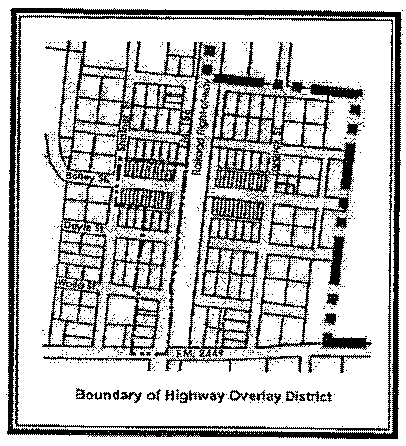
§ 154.24 - Highway overlay district.
(A)
Boundary description. The initial boundary of the HO-Highway Overlay District is delineated as indicated in the following graphic. The boundary may be amended as provided for zoning amendments. All future amendments to the boundary shall be indicated on the official zoning map of the town.
(B)
Applicable district regulations. The regulations of the underlying districts shall apply unless otherwise provided by the regulations contained in this section.
(C)
Permitted uses. Uses permitted in the Highway Overlay District shall be those permitted uses in the underlying districts as shown in appendix B, Table 1, Schedule of Uses.
(D)
Conversion of residential structures. All residential structures located within the underlying districts may be used as commercial or residential as long as the following conditions are met:
(1)
The residential structure is not altered such that the bathrooms, kitchen and garage facilities are removed or rendered unusable for a residential structure.
(2)
The natural ground cover in the front, side or rear yards is not removed or paved with a permanent surface as to render it unusable for typical residential purposes.
(3)
Any and all signage shall be monument or nameplate type signs.
(4)
In the event that the use of a residential structure shall change back from commercial to residential, all nonresidential signage shall be removed and the original ground cover shall be returned to the original condition existing prior to placement of the sign or parking area.
(E)
Concurrent use of commercial and residential structures. A commercial structure may contain a residential use concurrent with the commercial use in accordance with the following restrictions:
(1)
Only one residential unit, regardless of square footage of the residential use, may be permitted per commercial structure; except that,
(2)
More than one residential unit may be permitted for loft or studio apartments if the total number of square footage allocated to residential use does not exceed 60% of the total square footage of the structure.
(Ord. 03-24, passed 4-14-2003)