
Port Angeles City Zoning Code
CHAPTER 17
22 - COMMERCIAL AND MULTI-FAMILY DESIGN STANDARDS11
Editor's note— Ord. 3688 § 34, adopted Dec. 21, 2021, repealed the former Ch. 17.22, §§ 17.22.010—17.22.230, and enacted a new Ch. 17.22 as set out herein. The former Ch. 17.22 was entitled "CSD - Community Shopping District," and derived from: Ord. 3643 § 2, adopted Nov. 6, 2019; Ord. 3577 § 1, adopted Mar. 21, 2017; Ord. 3572 § 10, adopted Dec. 20, 2016; Ord. 3548 § 13, adopted Jan. 5, 2016; Ord. 3390 § 6, adopted Jan. 30, 2010; Ord. 3332 § 4, adopted Apr. 25, 2008; Ord. 3272, adopted Feb. 16, 2007; Ord. 3180 § 1 (part), adopted Dec. 17, 2004; Ord. 3155 §§ 10, 11, adopted Jan. 30, 2004; Ord. 3123 § 13, adopted Oct. 11, 2002; Ord. 3111 § 4, adopted Mar. 15, 2002; Ord. 3071 § 4 (part), adopted Dec. 15, 2000; Ord. 3042 § 3 (part) adopted Jan. 28, 2000; Ord. 3007 § 5 (part), adopted Jan. 15, 1999; Ord. 2977 § 1 (part), adopted Dec. 26, 1997; Ord. 2921 § 10, adopted June 28, 1996; Ord. 2863 § 3, adopted Apr. 14, 1995; Ord. 2861 § 1 (part), adopted Mar. 17, 1995; and Ord. 2797 § 4, adopted Feb. 11, 1994.
17.22.010 - Purpose.
The purpose of these commercial and multi-family design standards is to implement the goals and policies of the Port Angeles Comprehensive Plan and the objectives of each zone as provided in this title. The purpose of this chapter is to:
A.
Promote a diverse mix of retail, housing, office, and civic land uses and a genuine sense of place in Port Angeles.
B.
Encourage development that is pedestrian-oriented and human-scale in an aesthetically attractive, energy efficient, easily accessible, and economically healthy environment.
C.
Include diverse retail and service uses, higher density residential housing, a network of pedestrian-oriented streets, and a high degree of connectivity for all modes of travel.
D.
Enhance Port Angeles' visual character.
(Ord. 3688 § 34, 12/21/2021)
17.22.020 - Applicability.
A.
New development.
1.
The provisions of this chapter govern all new multi-family, commercial, and other non-residential development within the RMD, RHD, CBD, CSD, CA, CN, and CO zones.
2.
Townhouse Exception. The provisions of this chapter do not apply to townhouses, except for provisions that expressly use the word "townhouse" or "townhouses," and such provisions are applicable to townhouses in the RMD, RHD, CBD, CSD, CA, CN, and CO zones.
B.
Relationship to other codes. Where provisions of this chapter conflict with provisions in any other section of the Port Angeles Municipal Code (PAMC), this chapter prevails unless otherwise noted.
(Ord. 3688 § 34, 12/21/2021)
17.22.025 - Applicability to remodels.
1.
Small remodel. Any construction that is: (1) outside the Central Business District; and (2) increases the gross floor area of a building by less than 25 percent, on a cumulative basis, is exempt from the requirements of this Chapter 17.22.
2.
Limited remodel. Any construction that increases the gross floor area of a building by 25 percent or more (or is located inside the Central Business District) but not more than 100 percent, on a cumulative basis, is exempt from this Chapter 17.22's requirements: (1) related to the existing portion of the building where no exterior changes are proposed; and (2) that would require repositioning the building or reconfiguring the site.
3.
Major remodel. Any construction that increases the gross floor area of a building by more than 100 percent, on a cumulative basis, must follow all the requirements of this Chapter 17.22.
4.
Cumulative basis means the cumulative increase in building gross floor area is the net increase in gross floor area of a building that is created through construction within a three-year long window of time measured from issuance of certificate of occupancy or its equivalent.
5.
In the event of any uncertainty, the Community and Economic Development Director makes the final decision whether a project is a small remodel, limited remodel, or major remodel.
(Ord. 3688 § 34, 12/21/2021)
17.22.030 - How the provisions of this chapter are applied.
The provisions of this chapter are additional to the underlying zoning standards (permitted uses, setbacks, building heights, etc.). Most sections within this chapter herein include the following elements:
A.
Purpose statements, which are overarching objectives.
B.
Guidelines use words such as "should" or "is/are recommended," or "encouraged", signifying voluntary measures.
C.
Standards use words such as "must" and "is/are required," signifying mandatory actions.
1.
Some standards are easily quantifiable, while others provide a level of discretion to the applicant in how they are complied with. In the latter case, the applicant must demonstrate to the Director, in writing, how the choices made for the development meets the purpose of the standard.
2.
Departures may be allowed for specific standards in this Chapter 17.22 PAMC. They allow alternative designs provided the Community and Economic Development Director determines the resulting design and overall development meets the "purpose" of the standards and other applicable criteria. See PAMC 17.22.040 for related procedures associated with departures.
(Ord. 3688 § 34, 12/21/2021)
17.22.040 - Departures.
A.
Purpose. A number of specific departure opportunities to the design standards contained in this chapter are provided. Departure opportunities are signaled by the capitalized word DEPARTURE or the □ symbol. The purpose is to provide applicants with the option of proposing alternative design treatments, when they can demonstrate to the satisfaction of the Director that it is equal to or better than the standard, provided such departures meet the "purpose" of the particular standard, and any additional relevant departure criteria.
B.
Requests for departures are voluntary. This provision allows the flexibility for applicants to propose alternative designs on a voluntary basis.
C.
Applicability. Departure opportunities are available only where noted for specific standards.
D.
Procedures. Permit applications that include departure requests are reviewed administratively and the approval decision is made by the Director.
E.
Approval criteria. Project applicants must successfully demonstrate to the Director how the proposed departure meets the purpose(s) of the standard, and other applicable departure criteria that applies to the specific standard.
F.
Documentation. The Director must document the reasons for approving all departures within the project application records for the purpose of providing consistency in decision-making by the City.
(Ord. 3688 § 34, 12/21/2021)
17.22.100 - Purpose.
A.
To design sites and orient buildings with an emphasis on compatible development and creating a comfortable walking environment.
B.
To provide standards that recognize the need for a system of pedestrian-oriented block frontages.
| Table 17.22.105 Summary of block frontage standards | ||
|---|---|---|
| Block Frontage Type | Details | |
Storefront | 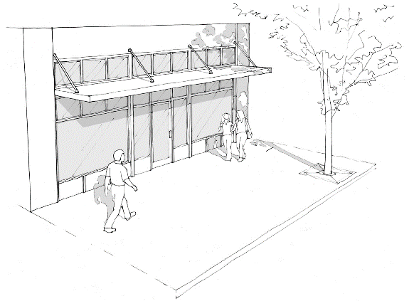 |
No new ground-level parking adjacent to the street.
Special transparency, weather protection, and entry requirements. Minimum commercial space height and depth. |
Mixed |
Ground-level parking placed to the side or rear of buildings.
Landscaping to soften façades of non-storefronts and buffer parking areas. Minimum façade transparency requirements per use and setback. | |
Landscaped | 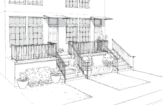 |
Ground-level parking placed to the side or rear of buildings.
Landscaping to soften façades and buffer parking areas. Minimum façade transparency requirements per use and setback. |
Basic |
No restrictions on parking lot location (except for landscaping standards).
Landscaping to soften façades of non-storefronts. Minimum façade transparency requirements per use and setback. | |
(Ord. 3688 § 34, 12/21/2021)
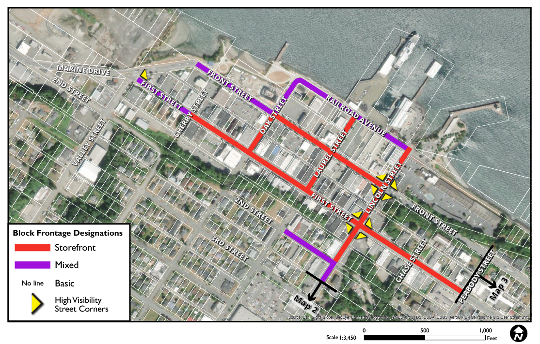
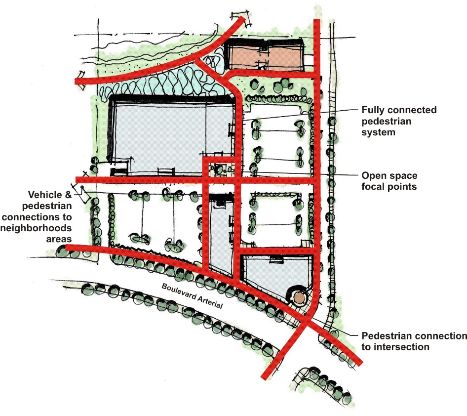
17.22.110 - Block frontage designation maps and regulations.
A.
Application of map and block frontage regulations.
1.
New multi-unit, non-residential development, and first floor residential within the CBD, CSD, CA, CN, and CO Zones in Port Angeles are subject to the block frontage standards in sections PAMC 17.22.100—17.22.170 based on the block frontage designation of the street, as illustrated in the figures in this section.
2.
For multi-family and non-residential development in the RHD and RMD zones, the standards for landscaped block frontages apply.
3.
Civic uses, public buildings, and hotels are exempt from the block frontage standards, provided the building and site design meet the following objectives:
a.
Enliven the pedestrian environment along the adjacent sidewalks.
b.
Incorporate a prominent and inviting entry visible from the street. If the site has multiple street frontages, the entry must be visible from at least one street.
c.
The site and building design stand out from the surrounding context as a distinct landmark and provides visual interest from all observable scales.
4.
These block frontage standards do not apply to townhouses.
B.
Map updates. The block frontage designation map will be updated by ordinance by the City Council as necessary to reflect new streets and other adjustments.
C.
Undesignated streets. If a street is not designated as storefront, mixed, or landscaped block frontage then it is automatically classified as a "basic" block frontage. See section PAMC 17.22.150 for applicable standards.
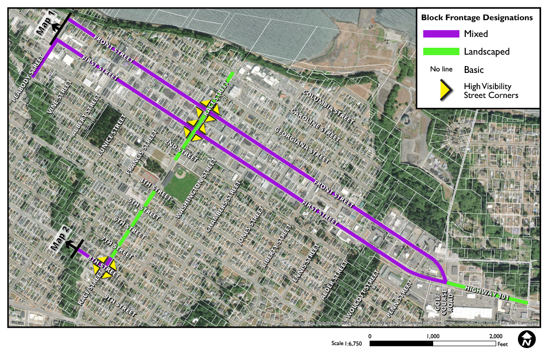
| Figure 17.22.110(A) Block frontage designation citywide index map |
|---|
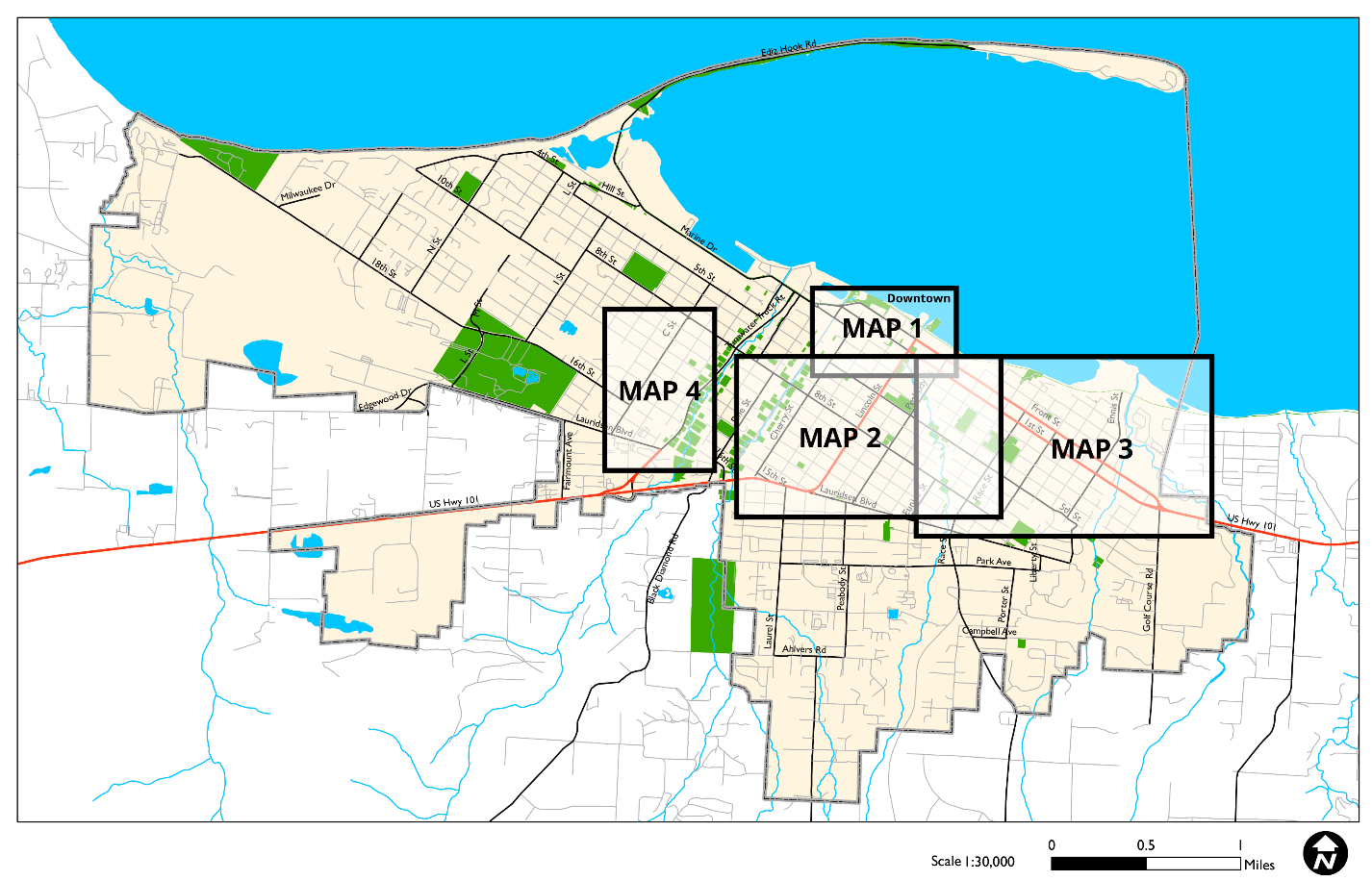 |
| Figure 17.22.110(B) Block frontage designation map 1—Downtown |
|---|
 |
| Figure 17.22.110(C) Block frontage designation map 2—Lincoln Street and 8th Street area |
|---|
 |
| Figure 17.22.110(D) Block frontage designation map 3—First/Front couplet area |
|---|
 |
| Figure 17.22.110(E) Block frontage designation map 4—C Street area |
|---|
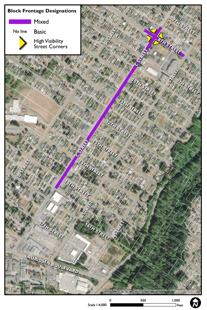 |
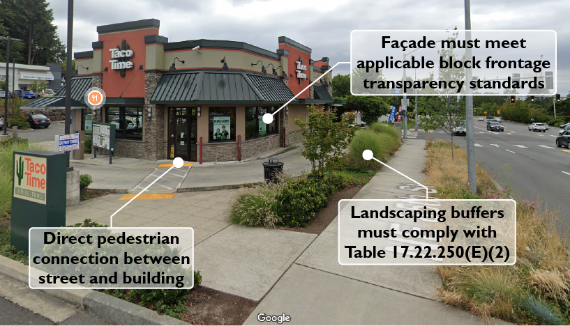
17.22.115 - About the transparency standards.
All block frontage designations contain distinct minimum façade transparency standards. The purposes of these standards are to help maintain visibility for public safety, create welcoming pedestrian-oriented streets, and facilitate a viable and attractive business environment. Table 17.22.115 below includes details in how transparency standards are measured.
| Table 17.22.115 Explanation of transparency standards | ||
|---|---|---|
| Transparency Zones by Building and Frontage Type | ||
Storefront
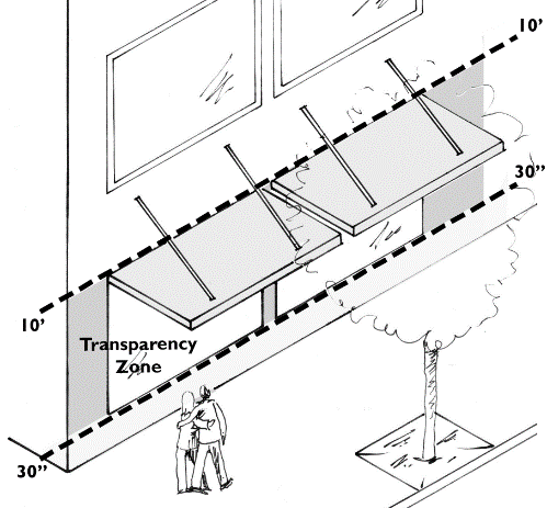 The transparency zone is on the ground floor between 30 inches and 10 feet above sidewalk
grade
The transparency zone is on the ground floor between 30 inches and 10 feet above sidewalk
grade
|
Ground floor non-residential and non-storefront
|
Residential buildings and residential portions of mixed use buildings
 All vertical surfaces of the façade are used in the calculations
|
| Other Transparency Provisions | ||
|
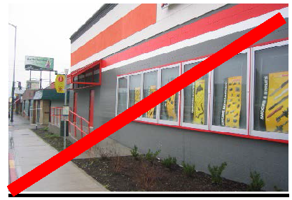
Windows must be transparent
Ground level window area for storefronts and other non-residential uses that is mirrored, reflectively, darkly tinted, covered, frosted, or perforated in any manner that obscures visibility into the building must not count as transparent window area. See also PAMC 17.22.330(C)(2). Exception: Window signs may be counted as transparent window area provided the areas generally around the sign are transparent. | 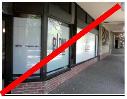 Unacceptable: Frosted glass obscuring view into storefront.
|  Unacceptable: Window sign covering transparency zone.
|
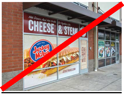
|
Display windows
Display windows may be used for up to 50 percent of non-residential transparency requirements provided they are at least 30 inches deep and allow changeable displays. Tack-on display cases as in the right example do not qualify as transparent window area. |  Acceptable: Integrated display windows.
|  Unacceptable: Tack-on display cases.
|
|
Structured parking facilities
Where structured parking facilities occupy a portion of the façade, any openings simulating windows may be used to help comply with transparency requirements. | 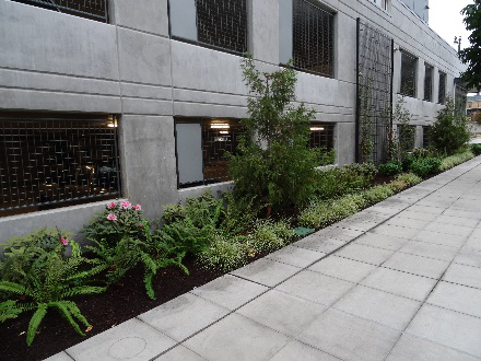 Parking garage with windows
|  Parking garage without windows
|
(Ord. 3688 § 34, 12/21/2021)
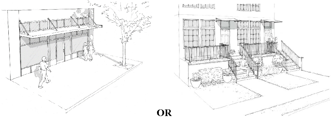
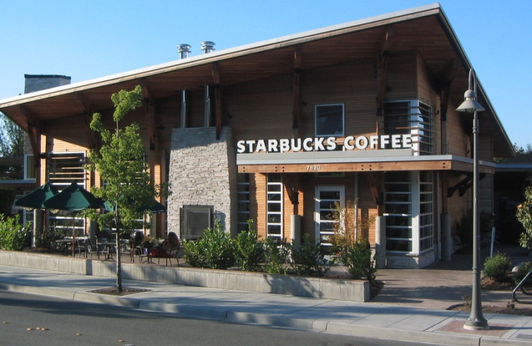
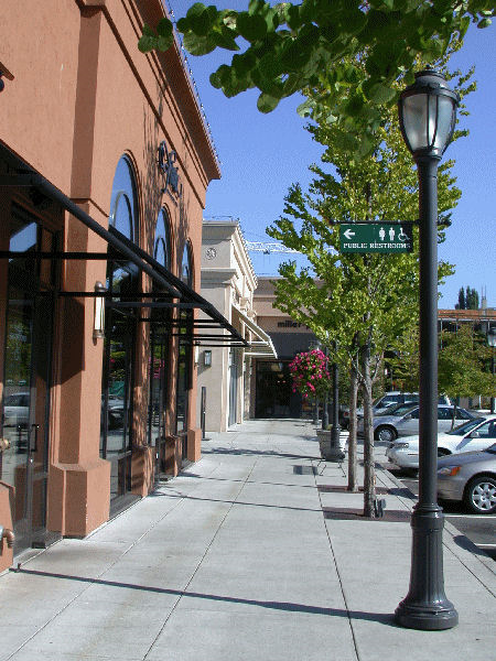
17.22.120 - Storefront block frontage standards.
A.
Purpose. Storefront block frontages are located in the most vibrant and active shopping and dining areas within Port Angeles. Blocks designated as Storefront block frontages include continuous storefronts placed along the sidewalk edge with small scale shops and many business entries.
| Table 17.22.120(A) Storefront block frontages vision and key standards |
|---|
 |
B.
Standards. All development on sites with a Storefront block frontage designation must comply with the standards in Table 17.22.120(B) below.
| Table 17.22.120(B) Storefront block frontage standards | ||
|---|---|---|
| The □ symbol refers to DEPARTURE opportunities in PAMC 17.22.120(C) below | ||
| Element | Standards | Additional Provisions and Examples |
| Ground Level | ||
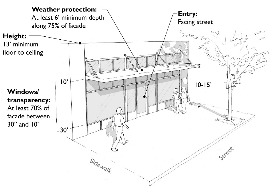
| Floor to ceiling height | 13' minimum | Applies to the area within the minimum space depth. |
| Ground level street frontage space depth | 40' minimum □ | Applies to the entire width of the space. |
| Building placement | Buildings must be placed at the back edge of the required sidewalk. Additional setbacks may be allowed for a wider sidewalk or where a public space is provided between the sidewalk and the building. |  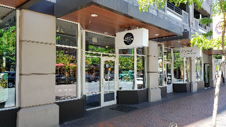 Examples of building placement and building entrances.
|
| Building entrances | Primary building entrances must face the street. For corner buildings, primary entrances for ground-level uses may face either street or the street corner. | |
| Façade transparency | At least 70% of the transparency zone. □ | See PAMC 17.22.115 for additional clarification on transparency standards. |
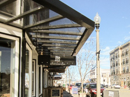
| Weather protection |
Weather protection over the sidewalk is required along at least 75% of the building's
façade, and it must be a minimum of 6' deep (drip lines must be at least that far
from the face of the building). □
Additional standards: Weather protection must have 10' to 15' of vertical clearance. Weather protection must not interfere with existing street trees, utility poles, street signs, or extend beyond the edge of the sidewalk. |
Vinyl or plastic awnings or canopies are prohibited. Any canopy or awning over a public
sidewalk should be a permanent architectural element. The building's architectural
details should not be concealed by awnings or canopies. Awning shapes should relate
to the shape of the façade's architectural elements. Transparent canopies and under-canopy
signs and lighting are encouraged.
 |
| Parking location | New ground-level (surface or structured) parking adjacent to the street is prohibited, including parking lot and garage entries and driveways. Parking may be placed below, above, and/or behind storefronts. | |
| Sidewalk width |
Minimum design options:
12' minimum between the curb edge and the storefront, including 8' minimum walking surface width and trees are integrated in grates. 8' minimum sidewalk and 6' minimum planter strip. Wider sidewalks may be required for certain streets by the Port Angeles Urban Services Standards and Guidelines Manual. □ Setbacks and utility easements must also be considered and may result in a larger minimum sidewalk width. | 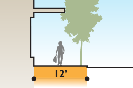 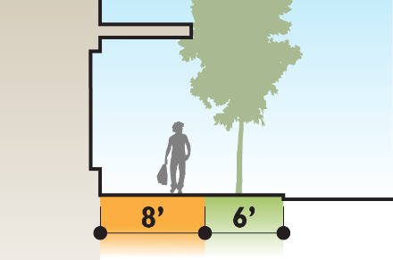 |
C.
DEPARTURE criteria. Departures from the storefront block frontage standards in Table 17.22.120(B) that feature the □ symbol will be considered per PAMC 17.22.040, provided the alternative proposal meets the purpose of the standards and the following criteria:
1.
Retail space depth. Reduced depths on up to 25 percent of the applicable block frontage will be considered where the applicant can successfully demonstrate the proposed alternative design and configuration of the space is viable for a variety of permitted retail uses.
2.
Façade transparency. Façade transparency may be reduced to a minimum of 40 percent if the façade design between ground-level windows provides visual interest to the pedestrian and mitigates the impacts of blank walls.
3.
Weather protection.
a.
Weather protection elements may be reduced in length to no less than 50 percent along building's façade and to no less than four feet in depth, provided the proposed design is proportional to architectural features of the building and building design trade-offs (elements that clearly go beyond minimum building design regulations in this chapter) meet the purpose of the standards.
b.
Smaller gaps are permitted if they are integrated into a larger façade articulation design, such as gaps associated with structural columns. Generally, structural columns are encouraged to be attached with higher or lower weather protection elements that help provide continuous coverage for pedestrians.
4.
Parking Location. Structured garage entries may be located on storefront streets if there is an acceptable tradeoff in terms of the amount and quality of storefront area that is integrated with the development. The alternative must include design features to successfully mitigate the visual impact of additional parking areas along designated storefront streets. See also PAMC 17.22.240.
5.
Sidewalk Width. Alternative designs may be considered where topographical challenges or approved City streetscape plans with different sidewalk standards exist. Alternative designs must be able to accommodate safe and comfortable pedestrian traffic and outdoor seating and dining areas.
(Ord. 3688 § 34, 12/21/2021)
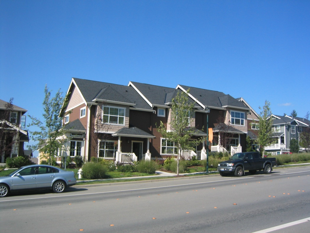
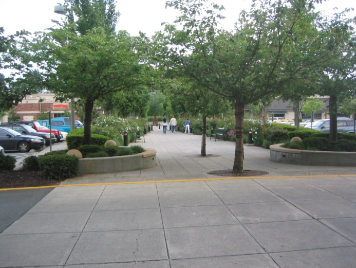
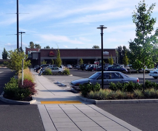
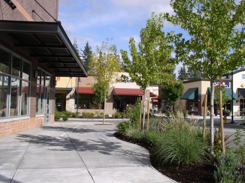
17.22.130 - Landscaped block frontage standards.
A.
Purpose. Landscaped block frontages emphasize landscaped street setbacks, clear pedestrian connections between the building and the sidewalk, and minimize surface parking lots along the frontages.
| Figure 17.22.130(A) Landscaped block frontages vision examples and key standards | |
|---|---|
 |  |
B.
Standards. All development on sites with a landscaped block frontage designation must comply with the standards in Table 17.22.130(B) below. The standards herein also apply to all multi-family and nonresidential development in the RMD and RHD zones.
| Table 17.22.130(B) Landscaped block frontage standards | ||
|---|---|---|
| The □ symbol refers to DEPARTURE opportunities in PAMC 17.22.130(C) below | ||
| Element | Standards | Additional Provisions and Examples |
|
Ground Level
Land use | Any use permitted by this title | |
| Building placement |
10' minimum setbacks are required.
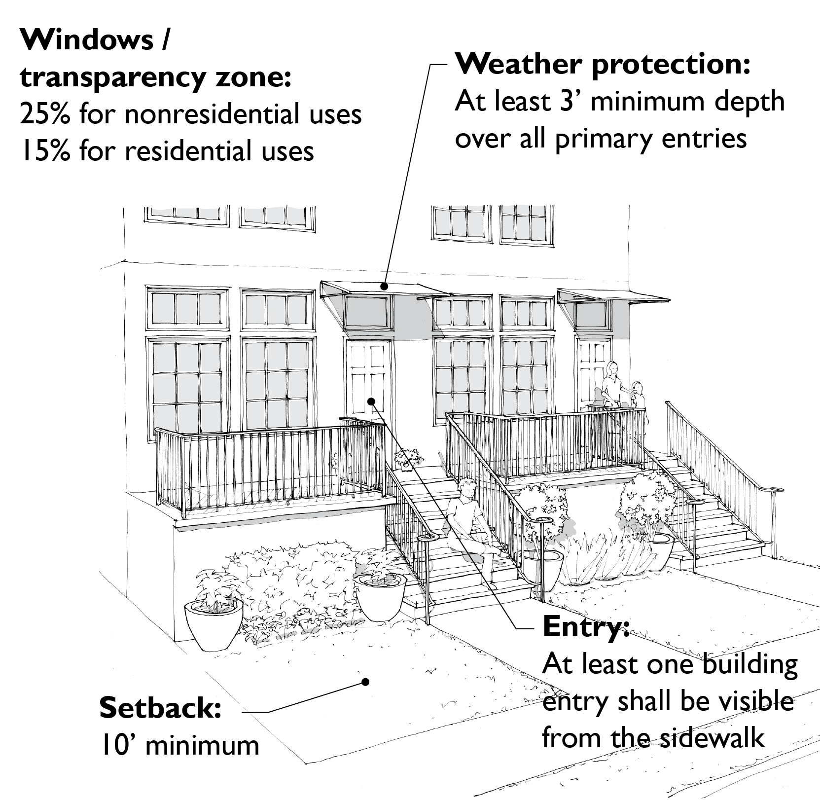
Additional standards: 20' maximum setback. Covered entries and porches are allowed to project up to 6' into this required setback. Additional setbacks may be required where future right-of-way need and/or acquisitions have been identified in city plans. | 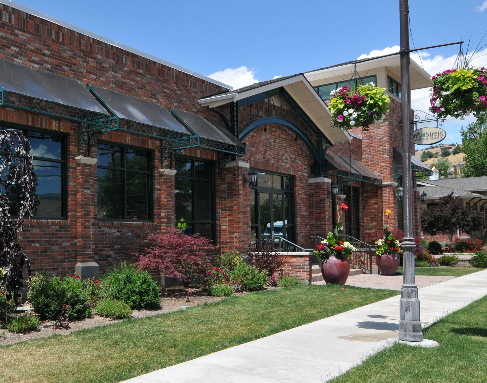 |
| Building entrances | At least one public or shared building entry must be visible from the sidewalk and feature direct physical access from the sidewalk. □ | Primary private entrances facing the street for ground level residential units are encouraged. See related standards in PAMC 17.22.170. |
| Façade transparency |
Must have at least 25% transparency for buildings with ground level nonresidential
uses. □
Must have at least 15% transparency for buildings with ground level residential uses. | See PAMC 17.22.115 for additional clarification on transparency standards. |
| Weather protection | Weather protection at least 3' deep must be provided over individual business and residential entries. Weather protection for shared entrances must be at least 5' deep. | |
| Parking location |
Parking must be located to the side, under, or rear of buildings. For multi-building
developments, no more than 50% of the lot frontage can be occupied by off-street parking
and driveways. □
See PAMC 17.22.240 for drive-through and vehicle access standards. | |
| Landscaping |
Building setback areas must be landscaped per PAMC 17.22.435.
Parking lots developed adjacent to the street must comply with landscaping provisions of PAMC 17.22.440. |  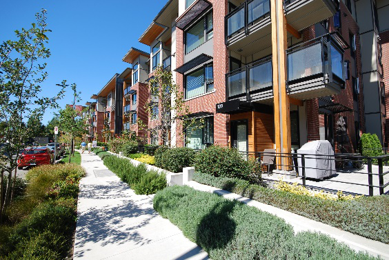 |
| Sidewalk width | A five-foot sidewalk accompanied by a minimum five-foot landscape strip is required within the right-of-way adjacent to the front property line as well as adjoining arterial corridors. | |
C.
DEPARTURE criteria. Departures from the above standards that feature the □ symbol will be considered per PAMC 17.22.040, provided the alternative proposal meets the purpose of the standards, plus the following criteria:
1.
Façade transparency. Façade transparency may be reduced to a minimum of 12.5 percent if the façade design between ground level windows provides visual interest to the pedestrian and mitigates the impacts of blank walls.
2.
Parking location. For multi-building developments, an additional ten percent of the lot frontage may be occupied by off-street parking and driveways, provided design treatments (beyond minimum standards) are included that successfully mitigate the visual impact of parking areas on the streetscape.
(Ord. 3688 § 34, 12/21/2021)
17.22.140 - Mixed block frontage standards.
A.
Purpose. The Mixed block frontage designation serves areas that accommodate a mixture of ground floor uses and allows a diversity of development frontages for the purpose of contributing to the visual character of the street and enhancing the pedestrian environment.
| Figure 17.22.140(A) Mixed block frontages vision examples and key standards |
|---|
 |
B.
Standards. All development on sites containing a mixed block frontage have the option to comply with either the storefront or landscaped block frontage provisions as set forth in PAMC 17.22.120 and .130, with the modifications in Table 17.22.140(B) below.
C.
DEPARTURE Criteria. Departures from the above standards that feature the □ symbol will be considered per PAMC 17.22.040, provided the alternative proposal meets the purpose of the standards and the following criteria:
1.
Façade transparency. Façade transparency may be reduced to the following minimums if the façade design provides visual interest to the pedestrian and mitigates the impacts of blank walls:
a.
20 percent minimum for buildings designed with nonresidential uses on the ground floor within ten feet of a sidewalk.
b.
25 percent minimum for other buildings designed with nonresidential uses on the ground floor.
c.
20 percent minimum for residential buildings/floors.
2.
Parking location. For multi-building developments, an additional ten percent of the lot frontage may be occupied by off-street parking and driveways, provided design treatments (beyond minimum standards) are included that successfully mitigate the visual impact of parking areas on the streetscape.
(Ord. 3688 § 34, 12/21/2021)
17.22.150 - Basic block frontage (streets with no designated block frontage).
A.
Purpose. Basic block frontages offer greater flexibility in siting off-street parking areas, while providing visual interest at all observable scales and meet the design objectives of the City.
B.
Applicability. All block frontages in applicable zones that are not designated in the map in PAMC 17.22.110 are subject to the standards of this section.
C.
Standards. Basic block frontages must comply with the standards in Table 17.22.150(C) below. DEPARTURES will be considered pursuant to PAMC 17.22.040.
D.
Departure Criteria. Departures from the above standards that feature the □ symbol will be considered per PAMC 17.22.040, provided the alternative proposal meets the purpose of the standards and the following criteria:
1.
Building entrances. Alternative designs may be considered provided the pedestrian route from the sidewalk to the entry is clear.
2.
Façade transparency. Façade transparency may be reduced to the following minimums if the façade design provides visual interest to the pedestrian and mitigates the impacts of blank walls:
a.
For storefronts, at least 30 percent.
b.
Other buildings designed with non-residential uses on the ground floor within ten feet of a sidewalk, at least 15 percent.
c.
For residential buildings, at least seven and one-half percent.
(Ord. 3688 § 34, 12/21/2021)
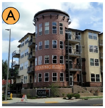
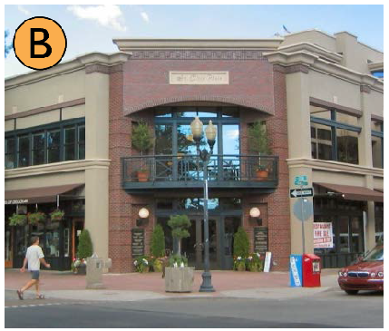
17.22.160 - High visibility street corner standards.
A.
Description/purpose. The high visibility street corner requirements apply to those sites designated on the block frontage maps in PAMC 17.22.110. The purpose is to accentuate street corners with high visibility to the public.
B.
Designation criteria. High visibility street corners may be designated on the block frontage maps in:
1.
Special high visibility intersections in Port Angeles.
2.
Intersections with a high level of current and/or envisioned pedestrian activity.
C.
Standards. Sites located on high visibility street corners must meet the following requirements:
1.
Buildings must be located within 20 feet of the street corner.
2.
At least one of the following special features must be included:
a.
Corner plaza.
b.
Cropped building corner with a special entry feature.
c.
Decorative use of building materials at the corner.
d.
Distinctive façade articulation.
e.
Sculptural architectural element.
f.
Other decorative elements that meet the purpose of the standards.
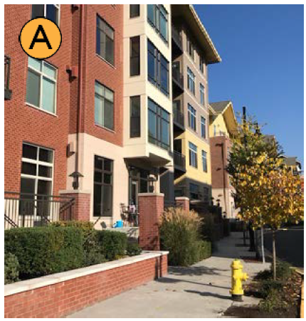
| Figure 17.22.160 High visibility street corner examples | |||||
|---|---|---|---|---|---|
 |  |  | |||
 |  | ||||
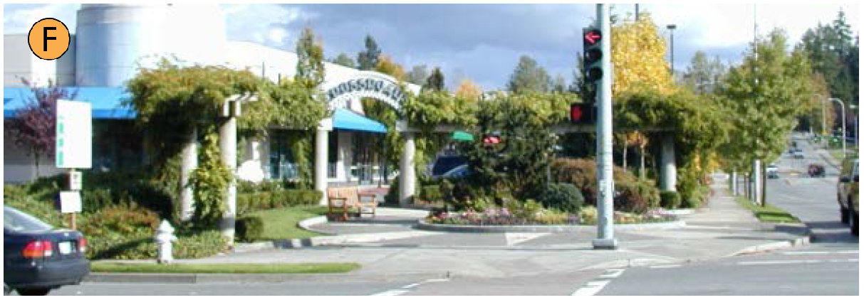 | |||||
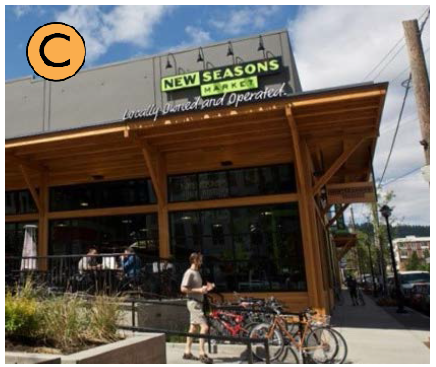
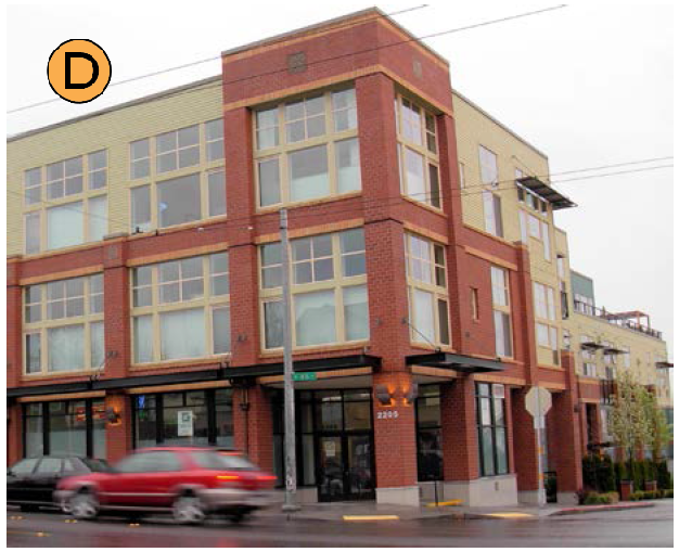
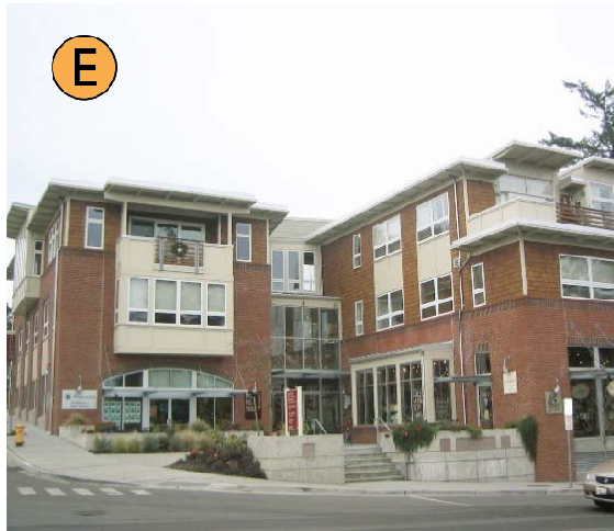
| Building A includes a corner tower and change in materials. Building B feature cropped building corners with a change in materials and decorative elements. Building C uses a decorative canopy. Building D uses a change in material color and façade articulation at the corner. Building E incorporates a plaza at the corner. Image F shows a decorative landscaped area with a trellis and neighborhood gateway sign. | |||||
(Ord. 3688 § 34, 12/21/2021)
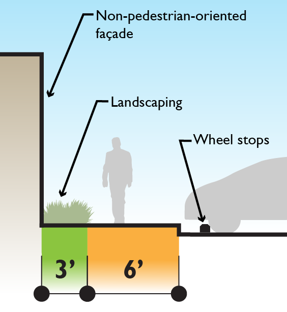
17.22.170 - Ground floor residential frontage standards.
A.
Purpose. The purpose of these standards is to:
1.
Enhance the privacy and security of residents living on the ground floor.
2.
Provide an effective visual and physical transition between the public realm and the private realm.
3.
Enhance the relationship between the building and the street through high-quality landscape and architectural design.
B.
Applicability. All developments with ground-floor residential uses adjacent to public streets must comply with the frontage standards in this section.
C.
Standards. Design treatments must be integrated to enhance the character of the public and semi-public realm while respecting the privacy of adjacent residential units. Design criteria applicable to ground-floor residential frontages are as follows:
1.
Direct access. All units abutting public sidewalks are encouraged to have individual ground-floor entries directly accessible to the sidewalk.
2.
Unit setback and elevation. Provide privacy for people living in the adjacent dwelling units and ensure the applicable street environment is comfortable through all of the following measures:
a.
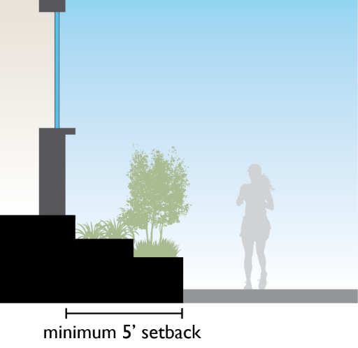
Provide a five-foot minimum setback from public sidewalks, unless a greater setback is required per applicable block frontage standards.
| Figure 17.22.170(C)(2)(a) Minimum setback between a ground floor residence and public sidewalk |
|---|
 |
b.
Where the façade is within ten feet of a street, the ground level of dwelling units must be raised from three to five feet above the level of the corresponding sidewalk. On sloped sites, the minimum and maximum heights must be calculated using the average ground elevation at perimeter walls as determined by the final grade noted on the building plan.
3.
Enhance the privacy of residents and provide an effective transition between the public and private realm by integrating all of the following measures:
a.
Provide a physical "threshold" feature, such as a hedge, retaining wall, rockery, stair, gate, railing, or a combination of such elements on private property that defines and bridges the boundary between public right-of-way and the private entry, porch, yard, or patio. Thresholds may screen, but not completely block, views to and from the public and semi-public realm areas. □
b.
Provide an outdoor space at least four feet-deep and six feet wide (24 square feet minimum area) in the front setback, such as a porch, patio, deck, or stoop. Where feasible, this space must be at the same level as the interior of the unit. □
Overhead building projections may cantilever over the outdoor space by up to 50 percent of the minimum ground level setback to public and private realm areas.
c.
Provide a covered area, porch or protected entry space, or other architectural weather protection at least three feet deep that provides cover for a person entering the unit and a transitional space between outside and inside the dwelling.
d.
Landscaping planters (in-ground or constructed and raised) must be integrated into transitional areas between the dwelling unit and the adjacent public and semi-public realm areas (see the figures below for examples). □
e.
DEPARTURES may be proposed for the design criteria in subsection (C)3. above featuring the symbol □ provided the design enhances the privacy of adjacent units and provides an effective and attractive transition between the public and private realm.
4.
See section PAMC 17.22.330 for window design standards.
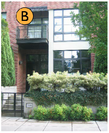
| Figure 17.22.170(C)(3)(a) Examples of ground-level residential frontages | |
|---|---|
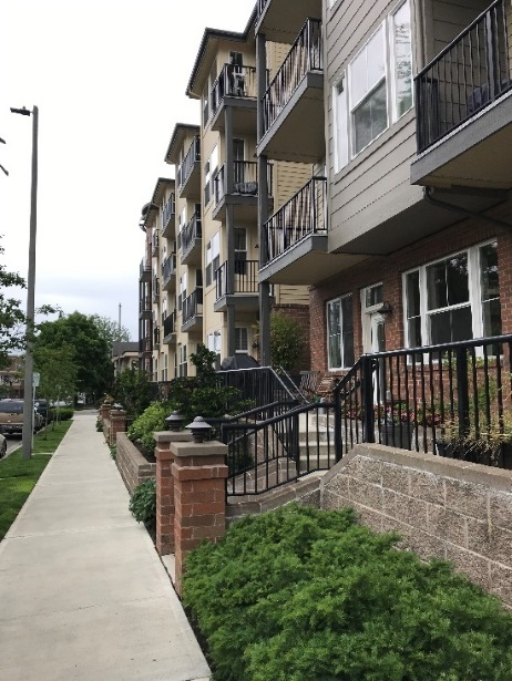 |  |
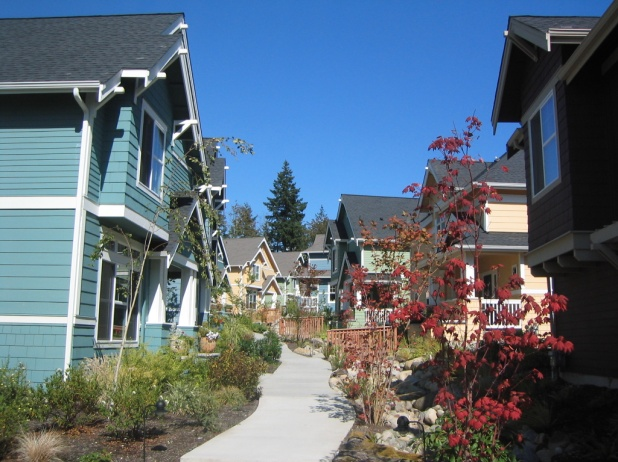
| The above images show ground-level residential frontages with setbacks of approximately 10' (left image) and 5' (right image) along different street frontages for the same corner apartment building. These ground level units all have their own private unit access from the sidewalk and are elevated above the sidewalk to enhance the privacy to the units. The landscaping elements, brick posts, split-faced concrete block stoop walls, and black metal railings help to provide an attractive and effective transition between the public and private realms. | |
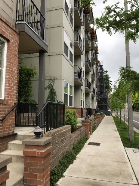
| Figure 17.22.170(C)(3)(b) Additional examples of ground-level residential frontages | |||||
|---|---|---|---|---|---|
 |  | 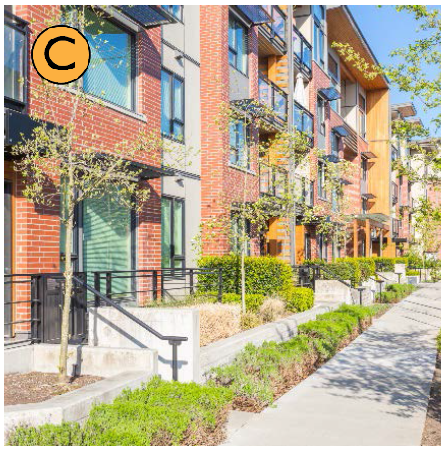 | |||
| Good examples: Image A includes a stoop design with brick terraced planters and low wrought iron fences. Images B and C include stoop designs with sidewalk level planters and concrete terrace planters. | |||||
 | 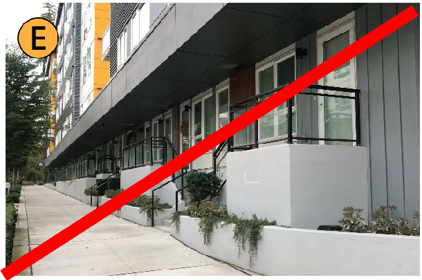 | ||||
| Bad examples: Despite the raised ground level, the setback design in Image D is insufficient to meet the intent of the standards. In Image E, the upper level building cantilever doesn't meet the standards and creates a cold "cave stoop" like form. The large areas of unscreened concrete walls in both examples are undesirable. | |||||
(Ord. 3688 § 34, 12/21/2021)
17.22.180 - Where properties front onto multiple streets.
Where a property fronts onto more than one street and each street has a different frontage designation, each building frontage must comply with the standards for the block frontage upon which it fronts, with the following clarifications:
A.
Conflicts. Where a conflict exists between frontage standards, the Director will apply the standards of a block frontage pursuant to the following order of preference:
1.
Storefront.
2.
Mixed.
3.
Landscaped.
4.
Basic.
Subsections (B-E) below clarify how the order of preference works for particular frontage elements.
B.
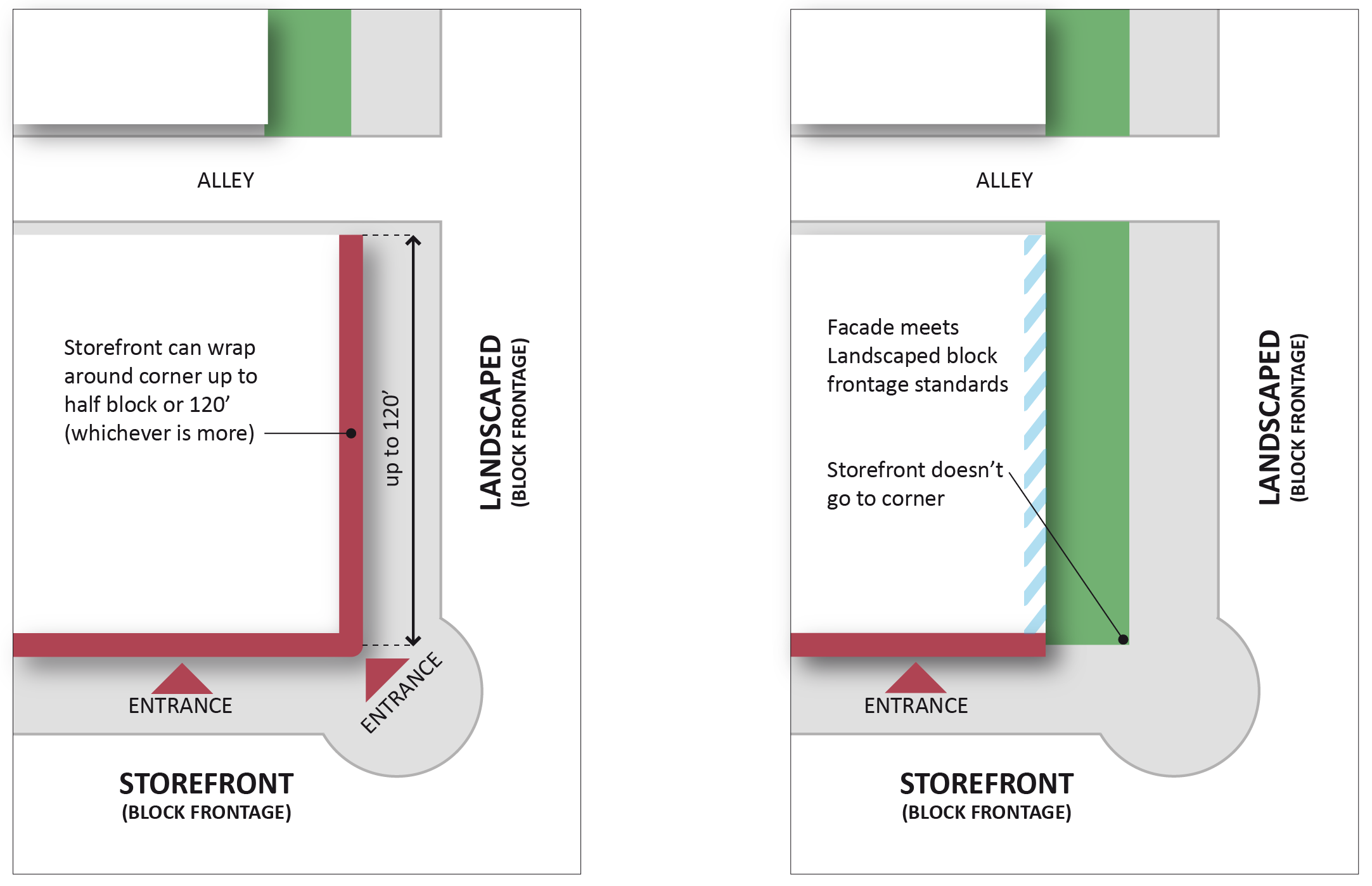
Building Location. For corner sites with landscaped block frontage on one street and storefront or mixed on another, a storefront frontage may wrap around the corner (on the landscaped block frontage side) for up to a half block width or no more than 120 feet (whichever is more).
C.
Entrances. For corner sites, entrances on both streets are encouraged, but only one entrance is required. For corner sites with frontage on a storefront block frontage on one side, an entrance must be placed on the storefront block frontage side. For corner sites with a mix of designations that do not include a storefront block frontage, the entry must be placed on the side listed first in the order of preference identified above. An entrance at the building corner and facing an intersection must be permitted under any of the above scenarios.
DEPARTURES may be considered, provided the location and design of the entry and block frontage treatments are compatible with the character of the area and enhance the character of the street.
D.
Transparency. For corner sites, at least one block frontage must meet the applicable transparency standards (based on the order of preference above). For the second block frontage, the Director may approve a reduction in the minimum amount of transparency by 50 percent. For street corners with the same designations on both frontages, buildings must employ the full transparency on the dominant frontage (based on the frontage width or established neighborhood pattern).
E.
Parking. Surface parking (including ground floor parking in a structure) adjacent to a street corner is not allowed, except:
1.
On corner lots with basic frontages on both streets.
2.
On corners with other combination of block frontages, except those with a storefront designation, via a DEPARTURE and subject to the applicable departure criteria.
| Figure 17.22.180 Examples of where properties front onto multiple streets |
|---|
 |
(Ord. 3688 § 34, 12/21/2021)
17.22.200 - Purpose.
A.
To promote thoughtful pedestrian-oriented layout of buildings, parking areas, and circulation, service, and on-site amenity elements.
B.
To promote compatibility between developments and uses.
C.
To enhance the circulation, access, and service areas of developments.
(Ord. 3688 § 34, 12/21/2021)
17.22.210 - Side and rear-yard setbacks.
A.
Purpose.
1.
To promote the functional and visual compatibility between developments.
2.
To protect the privacy of residents on adjacent properties.
B.
Side and rear setback standards. Table 17.22.210(B) below sets forth minimum side and rear-yard setbacks in all zones between zero and 15 feet. The provisions below clarify specific setback requirements:
C.
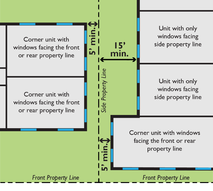
Light and air access and privacy along the side and rear property lines. Buildings or portions thereof containing multi-family dwelling units whose only windows face the interior side or rear property line must be set back from the applicable property line at least 15 feet.
DEPARTURES will be considered where it is determined that the proposed design will not create a compatibility problem based on the unique site context.
| Figure 17.22.210(C) Light/air access and privacy standards for multi-family residential buildings along interior side and rear property lines |
|---|
 |
(Ord. 3688 § 34, 12/21/2021)
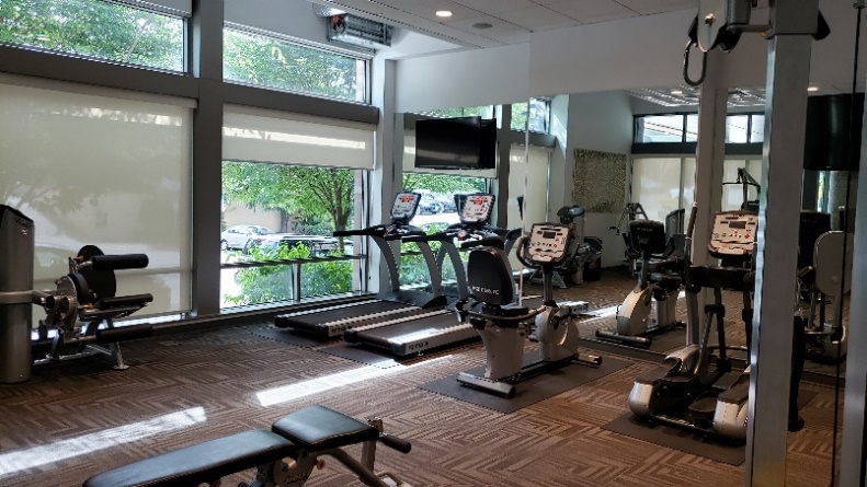
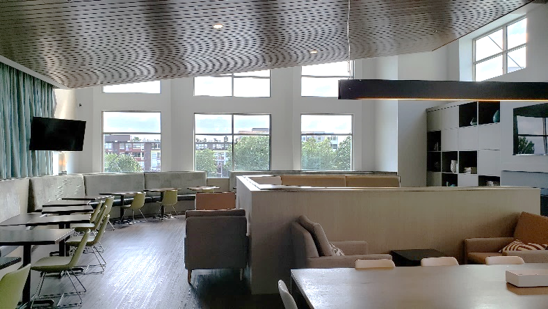
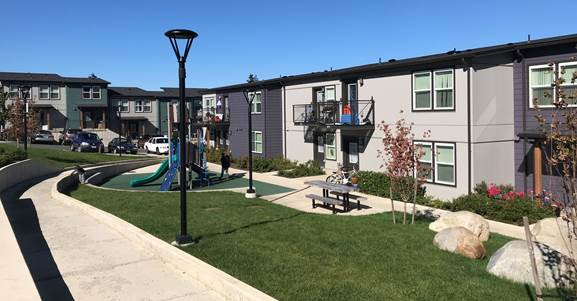
17.22.220 - Residential amenity space.
Residential amenity space refers to spaces that are integrated into residential or mixed use developments primarily enjoyed by on-site residents for recreational and social uses. Amenity spaces include common outdoor recreation areas, shared roof decks, private ground level open spaces, private balconies, shared indoor recreation areas, and children's play areas.
A.
Purpose.
1.
To create usable amenity space that is suitable for leisure or recreational activities for residents.
2.
To create amenity space that contributes to the residential setting.
B.
Applicability. Residential amenity space meeting the standards of this section is required for all new:
1.
Multi-family development.
2.
Mixed use development with residential dwellings.
3.
Senior housing and other age-restricted facilities.
C.
Amount required. Applicable developments are required to provide residential amenity space equal to a minimum of:
1.
100 square feet per dwelling unit for studio and one-bedroom dwellings.
2.
150 square feet per dwelling unit for dwellings with two or more bedrooms.
D.
Children's play areas. Developments with more than 75 units are required to integrate children's play areas as set forth in PAMC 17.22.220(F)(6).
E.
Large multi-phase developments under single ownership. Each phase of development must meet the minimum residential amenity space requirements herein. Developments have the option to integrate a surplus of usable on-site open space in early phases and apply the surplus space towards meeting the requirements for subsequent phases, provided all applicable regulations are met.
F.
Residential amenity space design standards. The following standards apply to new developments choosing to incorporate the specific amenity space types listed below:
1.
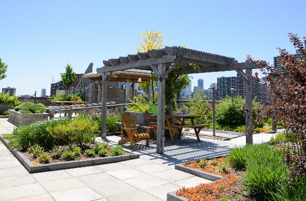
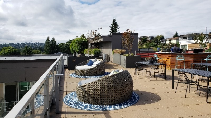
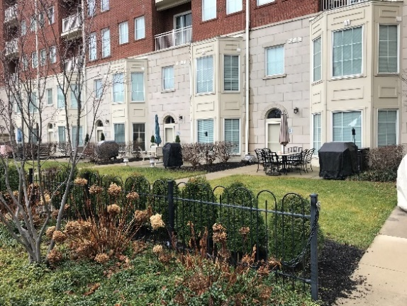
Common outdoor recreation areas. Such spaces are internal to a development and accessible to all tenants of a development, and are not required to be accessible to the general public. Examples include, but are not limited to, include landscaped courtyards, decks, entrance plazas, gardens with walkways, children's play areas, swimming pools, and water features. Accessible areas with native vegetation and areas used for stormwater retention, infiltration, or other multi-purpose recreational and/or green spaces that meet the design criteria herein may qualify as common outdoor recreation area.
Common outdoor recreation areas must meet the following design standards:
a.
The areas must be accessible to all residents of the development.
b.
The minimum area is 500 square feet. The space must feature dimensions necessary to provide functional leisure or recreational activity (unless otherwise noted herein). Stairways and service elements located within or on the edge of the space are not included in the recreation area calculations.
c.
Shared porches may qualify as recreation area, provided they are at least eight feet in depth and 96 square feet in area.
d.
Required setback and vehicular circulation areas do not count as common outdoor recreation areas, except for building entry plazas located in front setbacks.
e.
The area must be located in accessible areas that are visible from units within the development.
f.
The area must feature paths, walkable lawns, landscaping, seating, lighting, play structures, sports courts, or other pedestrian amenities to make the area more functional and enjoyable for a range of users.
g.
The area must be separated from ground level windows, streets, vehicular circulation areas, service areas, and parking lots with landscaping, fencing, and/or other acceptable treatments that enhance safety and privacy for both the recreation areas and dwelling units.
h.
Natural, artificial, and stormwater ponds may be included in the shared open space. A maximum of 50 percent of the pond surface area, as measured when the pond is at its maximum designed depth, may be counted towards the minimum requirements of subsection (C) of this section. Ponds must be integrated with trails and other features listed above to qualify as shared open space.
i.
Any children's play areas integrated as a part of a common outdoor recreation area must meet the standards of subsection (6) below.
DEPARTURES will be considered for the standards above provided they meet the purpose of the standards and fill a recreational need for the residents of the development. The use and design of the space must be integrated with the surrounding site and building features in a manner that is complementary to the development and any adjacent streetscape.
| Figure 17.22.220(F)(1) Common outdoor recreation area examples | |
|---|---|
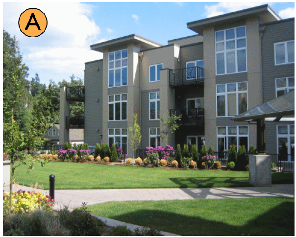 | 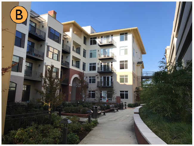 |
 |  |
| Image A includes a combination of open lawn area for informal recreation plus walkways and decorative landscape areas to enhance the setting for residents. Image B is a courtyard with includes walkways, seating areas, landscaped beds, and semi-private spaces for adjacent ground level units. Image C includes a covered gathering space with outdoor grills adjacent to a landscaped commons with a central walkway. Image D includes a common green area and separate fenced off-leash dog area. | |
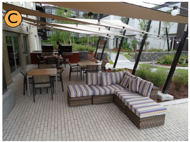
2.
Shared roof decks. Such spaces are a type of private internal common area located on the top of buildings or intermediate levels (e.g., upper floor building facade step-back areas) and are available to all residents. Examples of amenities include, but are not limited to, cooking and dining areas, seating areas, gardening areas, water features, children's play areas, and pet play areas. Shared rooftop decks must meet the following design standards:
a.
Must be available to all residents.
b.
Space must feature hard-surfacing and provide amenities that encourage use, such as seating, outdoor grills, and weather protection elements.
c.
Space must integrate landscaping elements that enhance the character of the space and encourage its use.
d.
Space must incorporate features that provide for the safety of residents, such as enclosures, railings, and appropriate lighting levels.
| Figure 17.22.220(F)(2) Shared roof deck examples | |
|---|---|
 |  |
3.
Private ground level open space. This space is adjacent and directly accessible to the subject unit. Examples include yards, stoops, and porches. Private ground level open space must meet the following design standards:
a.
Such open spaces must be enclosed by a fence and/or hedge at least 18 inches in height to qualify, but no higher than 42 inches when adjacent to a street, common outdoor recreation area, or public space (see the sight obstruction height limits of the Port Angeles Urban Services Standards and Guidelines Manual when near an intersection). Taller privacy screens between units are acceptable.
b.
Private porches that face a street or a common outdoor recreation area may qualify as amenity space, provided they are at least 50 square feet in area, with no dimension less than six feet.
c.
Ground level private open space in excess of minimum requirements in subsection (b) above must not be used in the calculations for determining the minimum useable open space requirements for other units in the development [per PAMC 17.22.220(C)].
| Figure 17.22.220(F)(3) Private ground level open space examples | |
|---|---|
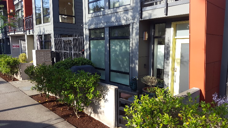 |  |
4.
Private balconies. This space is adjacent and directly accessible to the subject unit. Private balconies must meet the following design standards:
a.
Private balconies should be at least partially recessed into the building façade, when provided, and integrated into the building design to provide protection from the weather.
b.
Balconies must be at least 36 square feet in area with no dimension less than six feet to qualify as amenity space.
c.
Individual balconies larger than the minimum size requirements in the preceding subsection (b) must not be used in the calculations for determining the minimum useable open space requirements for other units in the development [per PAMC 17.22.220(C)].
| Figure 17.22.220(F)(4) Private balcony examples | |
|---|---|
 |  |
5.
Shared indoor recreation areas. Examples include, but are not limited to, multi-purpose entertainment space, fitness center, movie theater, kitchen, library, workshop, conference room, or similar amenities that promote shared use and a sense of community. Shared indoor recreation areas must meet the following design standards:
a.
The space must be accessible to all residents of the development.
b.
The minimum area is 250 square feet. The space must feature dimensions necessary to provide functional leisure or recreational activity (unless otherwise noted herein).
c.
The space must be located in a visible area, such as near an entrance, lobby, elevator bank, or high traffic corridors.
d.
The space must be designed specifically to serve interior recreational functions and not merely be leftover unrentable space used to meet the open space requirement. Such space must include amenities and design elements that will encourage use by residents.
| Figure 17.22.220(F)(5) Shared indoor recreation area examples | |
|---|---|
 |  |
6.
Children's play areas. Any children's play areas integrated as a part of a shared residential amenity space must meet all the following design standards (in addition to the design standards listed above):
a.
The minimum area is 400 square feet.
b.
Measures necessary to protect children's safety from vehicular traffic must be included, such as low fencing or landscaping to provide a physical barrier around the perimeter.
c.
Shade and rest areas for supervision must be provided by using deciduous landscaping, architectural elements (including but not limited to pergolas or shelters), or other means.
d.
Natural, creative play elements should be provided, such as ground slides from one level to another, tricycle tracks, swings hung from arbors or trees, paths that meander and are of varying materials and widths, water that can be manipulated, outdoor rooms made from landscape or rocks, and berms and hills.
e.
Play areas must be designed for a variety of ages, activities, and motor skills.
f.
Play areas must be located in areas that are highly visible to residents.
| Figure 17.22.220(F)(6) Children's play area example |
|---|
 |
(Ord. 3688 § 34, 12/21/2021)
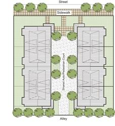
17.22.230 - Internal pedestrian access and design.
A.
Purpose.
1.
To improve the pedestrian and bicycling environment by making it easier, safer, and more comfortable to walk or ride among residences, to businesses, to the street sidewalk, to transit stops, through parking lots, to adjacent properties, and connections throughout the City.
2.
To enhance access to on- and off-site open space areas and pedestrian/bicycle paths.
B.
Access to sidewalk. All buildings must feature pedestrian connections to a sidewalk per applicable block frontage standards in PAMC 17.22.100-170. See subsection (D) below for walkway design standards.
| Figure 17.22.230(B) Examples of direct pedestrian access to buildings from the street | |
|---|---|
 |  |
C.
Internal circulation.
1.
For sites with multiple buildings:
a.
Internal walkways connecting businesses and residential entries on the same development site must be provided. Routes that minimize walking distances must be utilized to the extent practical.
DEPARTURES will be considered where an indirect route would enhance the design and/or use of a common usable open space. See subsection (D) below for walkway design standards.
b.
Pedestrian connections must be made at intervals no greater than 250 feet.
| Figure 17.22.230(C)(1) Example site plan with internal and external pedestrian connections |
|---|
 |
2.
Sites with residential units. Direct pedestrian access must be provided between all ground level unit entries and a public street or to a clearly marked walkway network or open space that has direct access to a public street. Residential developments must provide a pedestrian circulation network that connects all main entrances on the site to other areas of the site, such as:
a.
Parking areas.
b.
Recreational areas.
c.
Common outdoor areas.
d.
Any pedestrian amenities.
For townhouses or other residential units fronting the street, the sidewalk may be used to meet this standard.
| Figure 17.22.230(C)(2)(a) Direct walkways between the street and dwelling units are required | |
|---|---|
 |  |
| The entries of the example on the left connect directly to a public sidewalk while the entries in the right example connect to a common path that extends to the sidewalk. | |
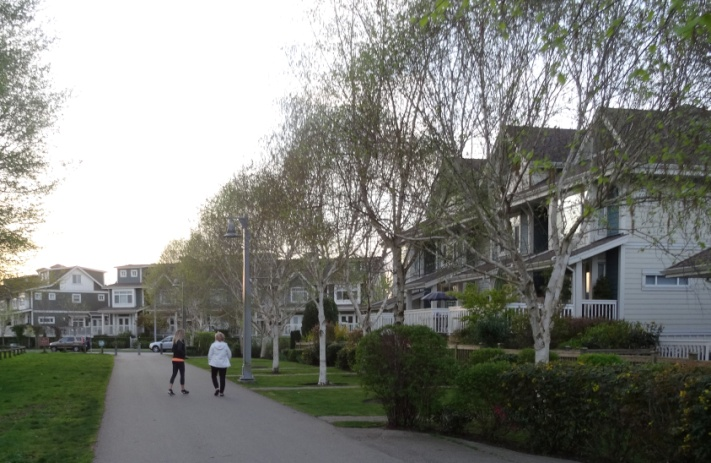
| Figure 17.22.230(C)(2)(b) Examples of attractive pedestrian connection through a residential development | |
|---|---|
 |  |
3.
Crosswalks. Crosswalks are required when a walkway crosses an on-site paved area accessible to vehicles.
a.
Appearance. All crosswalks must contain contrasting material (such as concrete) and/or patterns (such as stamped asphalt), excluding painted surfaces.
b.
Raised crosswalks (speed tables). On sites larger than one acre, all crosswalks near major building entrances, parking garage entries, vehicular entries to the site, and other high-traffic areas must be vertically raised to sidewalk level. The purpose of raised crosswalks is to provide a continuous walking or rolling surface, increase the visibility of pedestrians, and slow the speed of vehicular traffic. This requirement does not apply to crosswalks crossing public roadways.
4.
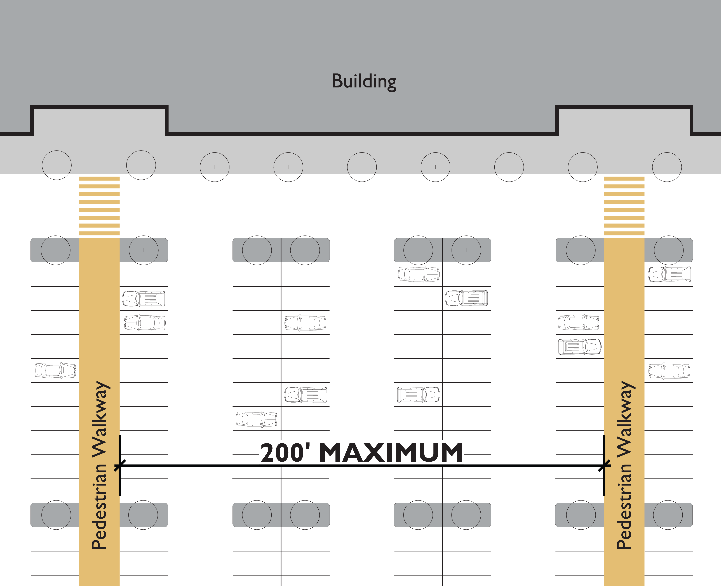
Pedestrian walkways through parking lots. Developments with 50 or more parking spaces must include specially marked or paved walkways through parking areas. At least one walkway must be provided for every four rows of parking, or at a maximum spacing of 200 feet. The walkways must provide a safe connection to the building entrance and meet the walkway design standards in subsection (D) of this section. See examples below.
| Figure 17.22.230(C)(4) Parking lot pedestrian walkway standards and examples | |
|---|---|
 | 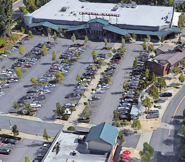 |
| Note the location of the parking lot walkway in the upper right example (connecting shops in one building to the main entry of a grocery store). | |
 |  |
| Note in both examples that the concrete walkway extends into the vehicular area to provide a highly visible and safe crosswalk. | |
5.
Connections to adjacent properties (including parks and trails). Except when adjacent properties have less than five dwelling units, internal walkways that connect to adjacent properties must be provided. Public sidewalks in the right-of-way must not count towards this requirement.
DEPARTURES will be considered where it is determined that internal connections are not necessary or practical due to lot depths, steep slopes, inconsistent adjacent parcel uses, or other contextual challenges.
6.
Barriers that limit future pedestrian access are prohibited. Gates that limit access to employees and residents are permitted. See subsection (D) below for walkway design standards.
D.
Walkway design.
1.
All internal walkways must have a minimum six feet-wide unobstructed walking surface, except where wider walkways are prescribed elsewhere in this chapter or where the applicable uses and context dictate wider walkways.
2.
Where an internal walkway is adjacent to perpendicular or angled parking, wheel stops are required to prevent encroachment of parked vehicles over the walkway. In lieu of wheel stops, an extra two feet of walkway width must be provided. See PAMC 17.22.240(B) for other situations in which wheel stops or curbing may be required.
3.
Internal walkways must be separated from structures by at least three feet for landscaping except where the adjacent building façade meets the storefront block frontage standards per PAMC 17.22.120.
DEPARTURES will be considered where other landscaping and/or façade design treatments to provide attractive walkways are proposed. Examples include, but are not limited to, sculptural, mosaic, bas-relief artwork, or other decorative treatments that meet the purpose. Figure 17.22.230(D)(3) below provides one example.
| Figure 17.22.230(D)(3) Standards for internal walkways adjacent to buildings | |
|---|---|
 |  |
| Internal walkways adjacent to building walls that do not meet storefront façade standards must provide at least three feet of landscaping to enhance the character of the walkway. The reviewing authority will consider alternative treatments, such as decorative walls (right example). | |
4.
Where walkways are between a parking lot and a multi-tenant commercial or mixed use building which is 100 feet or more long, walkways must feature a 12-foot wide sidewalk with the following features:
a.
Eight feet minimum unobstructed width.
b.
Trees placed at an average of 50 feet on-center and placed in grates or in planting strips as set forth in subsection (c) below.
DEPARTURE: Breaks in the tree coverage will be considered near building entries to enhance visibility.
c.
Planting strips may be used between any vehicle access or parking area and the walkway; provided, that the trees required above are included, the walkway meets the applicable width standards herein, and the combined walkway and planting strip is at least 12 feet wide.
d.
See also PAMC 17.22.240(F) for applicable internal roadway design standards.
| Figure 17.22.230(D)(4) Example of a successful pedestrian sidewalk between parking lot and storefront | |
|---|---|
 |  |
(Ord. 3688 § 34, 12/21/2021)
17.22.240 - Vehicular circulation and parking.
The standards herein supplement the provisions of the Port Angeles Urban Services Standards and Guidelines Manual. Where there is a conflict, the provisions herein apply, except that the City Engineer may override this requirement and apply the Public Works standard for a driveway if the Public Works Director finds that a failure to apply the Public Works standards will result in a threat to public safety.
A.
Purpose.
1.
To create a safe, convenient, and efficient network for vehicle circulation and parking.
2.
To enhance the visual character of interior access roads.
3.
To minimize conflicts with pedestrian circulation and activity.
B.
Driveways. Driveways must meet the standards of the City of Port Angeles Urban Services Standards and Guidelines Manual, including, but not limited to, standards for intersection spacing, distance from crosswalks, and width.
C.
Parking entry location. Parking lot and parking garage entries must provide vehicular access in the following order of preference:
1.
Alleys.
2.
Basic block frontage streets.
3.
Landscaped block frontage streets.
4.
Mixed block frontage streets.
See related standards for parking and driveway location under Chapter 17.22 PAMC, Article II, Block Frontage Standards.
D.
Garage and service area entries and pedestrian safety.
1.
Parking garage entries and service area entries must be well-integrated into the design of the building and must not dominate the streetscape. They should be designed and sited to complement, not subordinate, the pedestrian entry.
2.
Where vehicles enter and exit a parking garage or service area across a sidewalk or internal walkway, direct visibility between pedestrians and motorists must be provided. Treatments must include setback entries, cropped wall corners, wall openings, or other treatments to enhance safety and visibility. Treatments should also include pavement markings or changes in pavement materials. Mirrors and electronic visual/audio warnings alone are not acceptable methods of visibility.
3.
Parking garage entries are encouraged to have flat driveways behind the sidewalk for the length of at least one vehicle in order to enhance visibility between pedestrians and motorists exiting the garage. Steeply sloping driveways immediately adjacent to a sidewalk or internal walkway require greater application of visibility treatments described in (D)(2) above.
4.
Garage entry doors and gates, if provided, must be at least 50 percent transparent between the bottom and top of the door or gate in order to enhance the safety of garage users.
| Figure 17.22.240(D) Acceptable parking garage entry/exit examples | |
|---|---|
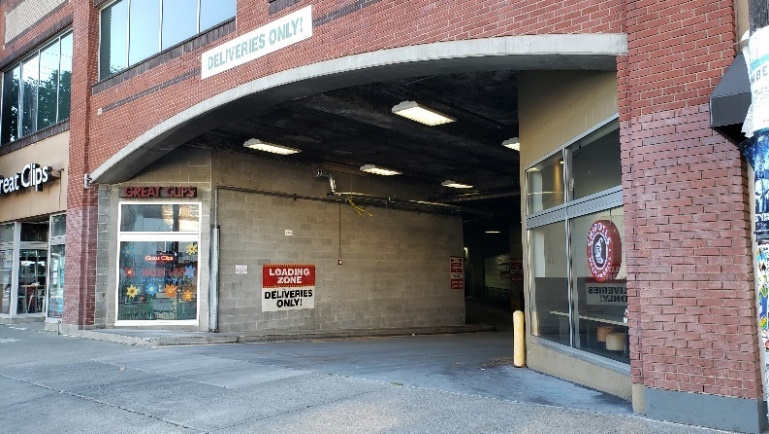 | 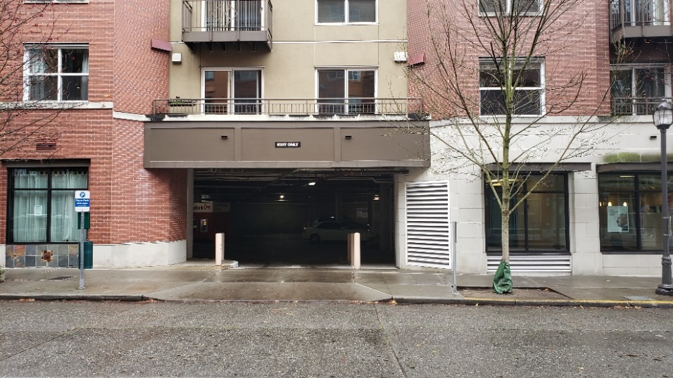 |
| Left: This commercial/loading entry has cropped corners that are also utilized for store windows. Right: This residential garage has a setback and cropped corners on both sides that are also integrated into the design of the building façade above. | |
E.
Drive-throughs. Drive-through facilities are accessory to permitted uses. This includes drive-through lanes and service windows for restaurants, banks, pharmacies, and other commercial uses.
1.
Where permitted.
a.
CA, CSD, CO, and CN zones. Permitted, provided the standards of this section are met.
b.
Drive-throughs are prohibited in the CBD zone, except for ticket kiosks at ferry terminals and parking facilities.
2.
Block frontage standards.
a.
Parking areas. For the purpose of complying with the Landscaped or Mixed block frontage standards in PAMC 17.22.130-140, drive-through lanes are considered a parking area and are calculated as part of the parking area along the frontage.
Exception: In the CA zone, drive-through lanes are not considered a parking area.
b.
Facades must comply with transparency requirements for the applicable block frontage in PAMC 17.22.130-140.
3.
Screening. Drive-through lanes, including waiting and holding lanes, must be buffered from the street and internal walkways by one of the design options set forth in Table 17.22.240(E)(2) below:
4.
Pedestrian access. Drive-through lanes must not prevent pedestrian access between a public sidewalk and on-site buildings. Designated walkways must not be located within required stacking space. See Figure 17.22.240(E)(4) for an example.
5.
Noise. Noise from drive-through speakers must not be audible from adjacent residential properties. See also Chapter 15.16 PAMC for noise control standards.
| Figure 17.22.240(E)(5) Drive-through example |
|---|
 |
(Ord. 3688 § 34, 12/21/2021)
17.22.250 - Service areas and mechanical equipment.
A.
Purpose.
1.
To minimize adverse visual, odor, fumes, and noise impacts of mechanical equipment, utility cabinets and other service areas at ground and roof levels.
2.
To provide adequate, durable, well-maintained, and accessible service and equipment areas.
3.
To protect residential uses and adjacent properties from impacts due to location and utilization of service areas.
B.
Location of ground-level service areas and mechanical equipment. Ground-level building service areas and mechanical equipment includes loading docks, trash collection and compactors, dumpster areas, storage tanks, electrical panels, HVAC equipment, and other utility equipment. If any such elements are outside the building envelope at ground level, the following location standards apply:
1.
Service areas must be located for convenient service access while avoiding negative visual, auditory, olfactory, or physical impacts on the streetscape environment and adjacent residentially zoned properties.
2.
Where practical, service areas must not be visible from the sidewalk and adjacent properties. Where the Director finds that the only option practical for locating a service area is an area visible from a public right-of-way, resident/customer parking area, internal walkway or pedestrian area, or from an adjacent property, the service area must be screened with the structural and landscaping screening measures provided in subsection (C) below.
3.
Service areas for multiple users or tenants must be co-located or consolidated to the extent practical.
4.
Service areas must be sited for alley access if available. Service elements accessible from an alley are exempt from the screening requirements of this section.
5.
Trash collection areas must include roofs or overhead weather protection and must meet required stormwater standards. Drainage must be designed to meet applicable NPDES standards.
6.
Exterior loading areas for commercial uses must not be located within 20 feet of a residentially zoned property.
DEPARTURE: Exterior commercial loading areas are exempt from this standard if the reviewing authority finds such a restriction does not allow feasible development and alternative design measures can successfully mitigate potential negative impacts. For example, areas and drives may be required to be separated from the residential lot by a masonry wall at least eight feet high.
7.
Other provisions of this section notwithstanding, service areas used by residents must be located to avoid entrapment areas and other conditions where personal security is potentially a problem. Pedestrian-scaled lighting or other measures may be needed to enhance security.
8.
Noise-producing mechanical equipment, such as fans, heat pumps, etc., must be located and/or shielded to minimize sounds and reduce impacts to adjacent dwelling units.
9.
Dumpster storage areas must be provided for all development, located on site and not in the public right-of-way, and sized to accommodate the minimum dumpster sizes (as provided by the Port Angeles engineering standards).
C.
Screening of ground-level service areas and mechanical equipment. Where screening of ground level service areas is required [see subsection (2)(b) of this section], the following applies:
1.
Structural enclosures must be constructed of masonry, heavy-gauge metal, heavy timber, or other decay-resistant material that is also used with the architecture of the main building. Alternative materials other than those used for the main building are permitted if the finishes are similar in color and texture, or if the proposed enclosure materials are more durable than those for the main structure. The walls must be sufficient to provide full screening from the affected roadway, pedestrian areas, or adjacent use, but must be no greater than seven feet tall. The enclosure may use overlapping walls as a screening method. See Figure 17.22.250(C) below.
2.
Gates must be made of heavy-gauge, sight-obscuring material. Chain link or chain link with slats is not an acceptable material for enclosures or gates.
3.
Where the interior of a service enclosures is visible from surrounding streets, walkways, or residential units, an opaque or semi-opaque horizontal cover or screen must be used to mitigate unsightly views. The horizontal screen/cover should be integrated into the enclosure design (in terms of materials and/or design).
4.
Trash collection points must be located and configured to the extent practical so that the enclosure gate swing does not obstruct pedestrian or vehicle vehicular traffic on a public right-of-way, or does not require that a hauling truck project into any public right-of-way. Screening elements must allow for efficient service delivery and removal operations.
5.
The service area must be paved.
6.
The sides and rear of service enclosures must be screened with Type B landscaping at least five feet wide in locations visible from the street, parking lots, and walkways to soften views of the screening element and add visual interest. Plants must be arranged with a minimum of 50 percent coverage at time of installation and be able to grow to fully screen or shield the equipment within three years.
DEPARTURES will be considered, provided the enclosure and landscaping treatment meet the purpose of the standards and add visual interest to site users.
| Figure 17.22.250(C) Acceptable trash screening enclosures | |
|---|---|
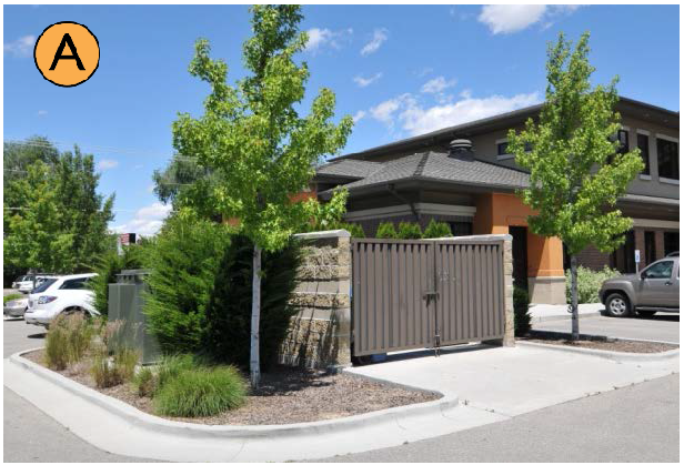 | 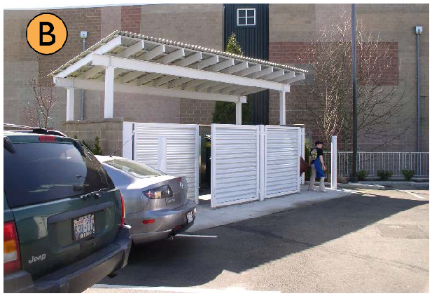 |
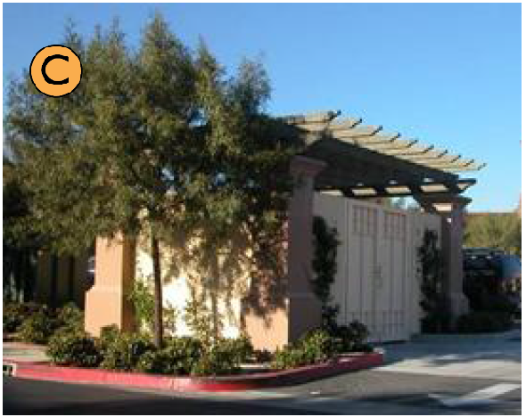 | 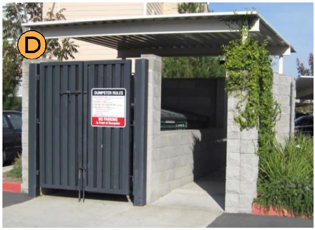 |
| All examples use durable and attractive enclosures with trees and shrubs to soften views of the enclosures from the side. Image C and D use a trellis and weather protection structure on top, a desirable feature particularly where the top of the enclosures are visible from surrounding buildings, streets, and walkways (due to topography or building heights). | |
D.
Utility meters, electrical conduit, and other service utility apparatus. These elements must be located and/or designed to minimize their visibility to the public. Project designers are strongly encouraged to coordinate with applicable service providers early in the design process to determine the best approach in meeting these standards. If such elements are mounted in a location visible from the street, internal walkway, common outdoor recreation area, or shared auto courtyards, they must be screened with vegetation and/or integrated into the building's architecture.
| Figure 17.22.250(D) Utility meter location and screening - good and bad examples | |
|---|---|
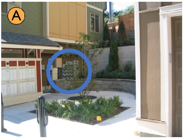 | 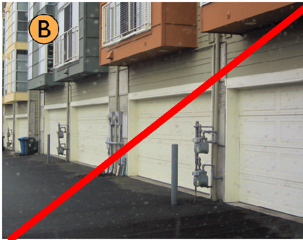 |
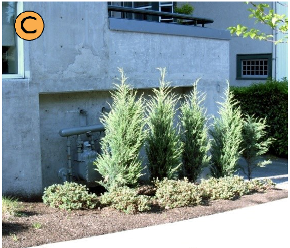 | 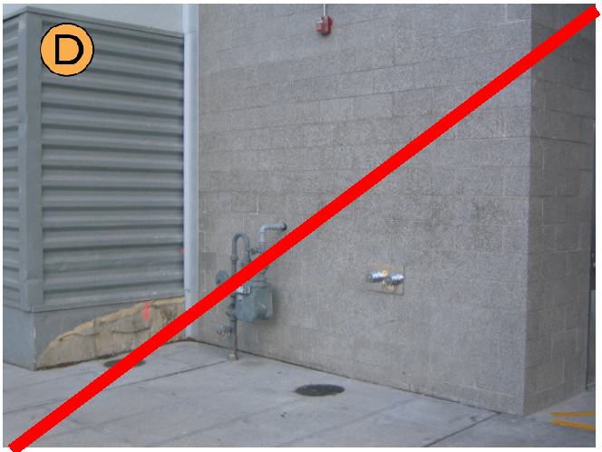 |
| Place utility meters in less visible locations. Images A and C are successfully tucked away in a less visible location and/or screened by vegetation. Images B and D are poorly executed and would not be permitted in such visible locations. Such meters must be coordinated and better integrated with the architecture of the building. | |
E.
Roof-mounted mechanical equipment.
1.
All rooftop mechanical equipment, including air conditioners, heaters, vents, and similar equipment must be fully screened from public view at the street level and from rooftop residential amenity spaces. Screening must be located so as not to interfere with operation of the equipment.
Exception: Roof-mounted wind turbines, solar energy and photovoltaic systems, and rainwater reuse systems do not require screening.
2.
For rooftop equipment, all screening devices must be well integrated into the architectural design through such elements as parapet walls, false roofs, roof wells, clerestories, or equipment rooms. Screening walls or unit-mounted screening is allowed but less desirable. Wood must not be used for screens or enclosures. Louvered designs are acceptable if consistent with building design style.
3.
The screening materials must be of material requiring minimal maintenance and must be as high as the equipment being screened.
4.
Noise producing mechanical equipment, such as fans, heat pumps, etc., must be located and/or shielded to minimize sounds and reduce impacts to adjacent dwelling units.
| Figure 17.22.250(E) Examples of how to screen roof-mounted mechanical equipment | |
|---|---|
 | 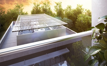 |
| The left illustration shows how rooftop mechanical equipment can be located and screened effectively. The right images shows effective location and screening, including side walls and a trellis to screen views from taller surrounding buildings. | |
(Ord. 3688 § 34, 12/21/2021)
17.22.260 - Site lighting.
A.
Purpose.
1.
To ensure that lighting contributes to the character of the streetscape and does not disturb adjacent developments and residences.
2.
Protect against light pollution, thereby reclaiming the ability to view the night sky and helping to preserve the quality of life and scenic value of this desirable visual resource throughout the region and nearby natural open spaces.
3.
Help protect and enhance human health and wellness and wildlife habitation and migration by minimizing light pollution and its impact on all forms of life.
4.
Promote lighting practices and systems to conserve energy, decrease dependence on fossil fuels, and limit greenhouse gas emissions.
5.
Ensure that sufficient lighting can be provided where needed to promote safety and security on public and private property, and to allow for reasonable lighting for outdoor activities.
6.
Provide attractive lighting that supports and enhances the urban environment, emphasizes architectural elements, and encourage pedestrian activity and wayfinding beyond daylight hours, especially during the long nights of Pacific Northwest winters.
B.
Applicability. All outdoor lighting must comply with the provisions herein, unless otherwise exempted. This includes, but is not limited to, new lighting, replacement lighting, additions and alterations, or any other lighting whether attached to buildings, poles, structures, the earth, or any other location.
1.
The following types of lighting are exempt from the provisions of this section:
a.
Lighting solely for signs.
b.
Underwater lighting.
c.
Temporary and seasonal cord-and-plug portable lighting.
d.
Construction or emergency lighting.
e.
Outdoor rope and string lights for outdoor seating and gathering areas.
C.
General standards.
1.
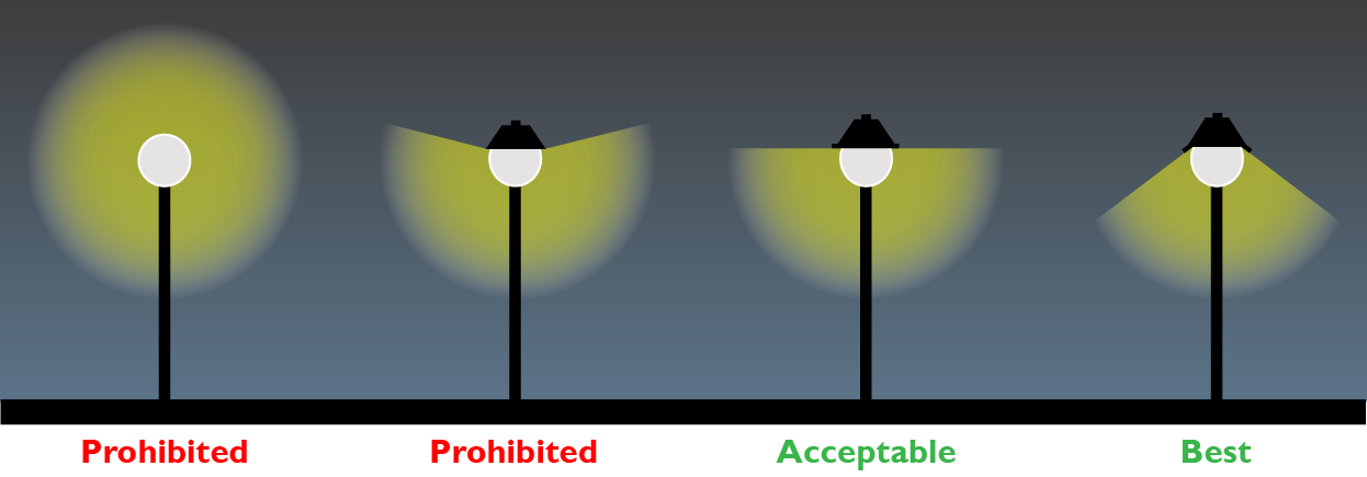
All luminaires must be fully shielded and must not emit light into the upper hemisphere around the luminaire or onto adjacent properties and structures, either through exterior full cut-off shields or through optics within the fixture. Support and mounting systems for luminaires must not allow post-installation adjustments that could defeat compliance of this requirement.
2.
City-approved standardized fixtures must be used for sidewalk lighting located within the right-of-way or publicly accessible easements on private property.
3.
On-site lighting elements throughout and surrounding the site should be complementary, including internal walkway lighting, accent and parking lot lighting, and lighting of adjacent developments and the public right-of-way.
4.
Except as provided in this section, outdoor lighting is encouraged to follow the intensity, technology, and other recommendations of the International Dark Sky Association and the Illuminating Engineering Society of North America.
| Figure 17.22.260(C) Appropriate exterior light shielding |
|---|
 |
D.
Height.
1.
Freestanding lighting fixtures in parking lots must not exceed 20 feet in height. Lighting fixtures on the top level of parking garages must not exceed 12 feet in height.
2.
Pedestrian scale lighting must not exceed 16 feet in height.
3.
Building-mounted exterior lighting must not be placed at any point greater than 20 feet above the adjacent grade, except the height limit is 14 feet when within 100 feet of a residential zone. This standard does not apply to fully recessed lights, such as when mounted on the underside of a gas station fueling canopy or a building roof overhang.
4.
Building-mounted exterior lighting for roof decks is permitted provided the luminaires are located at least 10 feet horizontally from the edge of the roof.
| Figure 17.22.260(D) Examples of site lighting | |
|---|---|
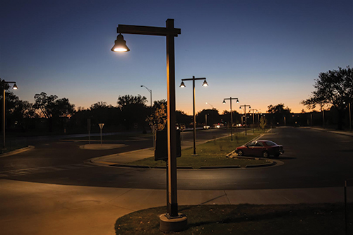 | 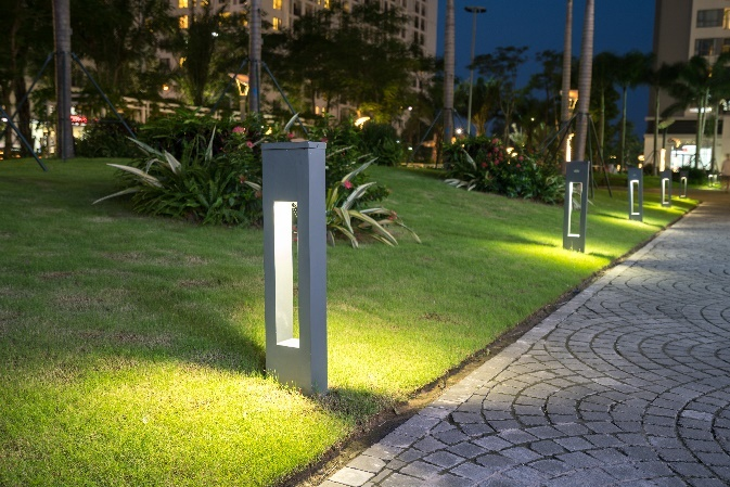 |
E.
Parking lot lighting. Lighting in parking lots must be appropriate to create adequate visibility at night and evenly distributed to increase security. Lighting must be located so that trees within the parking lot do not obscure the operation of the light fixture.
F.
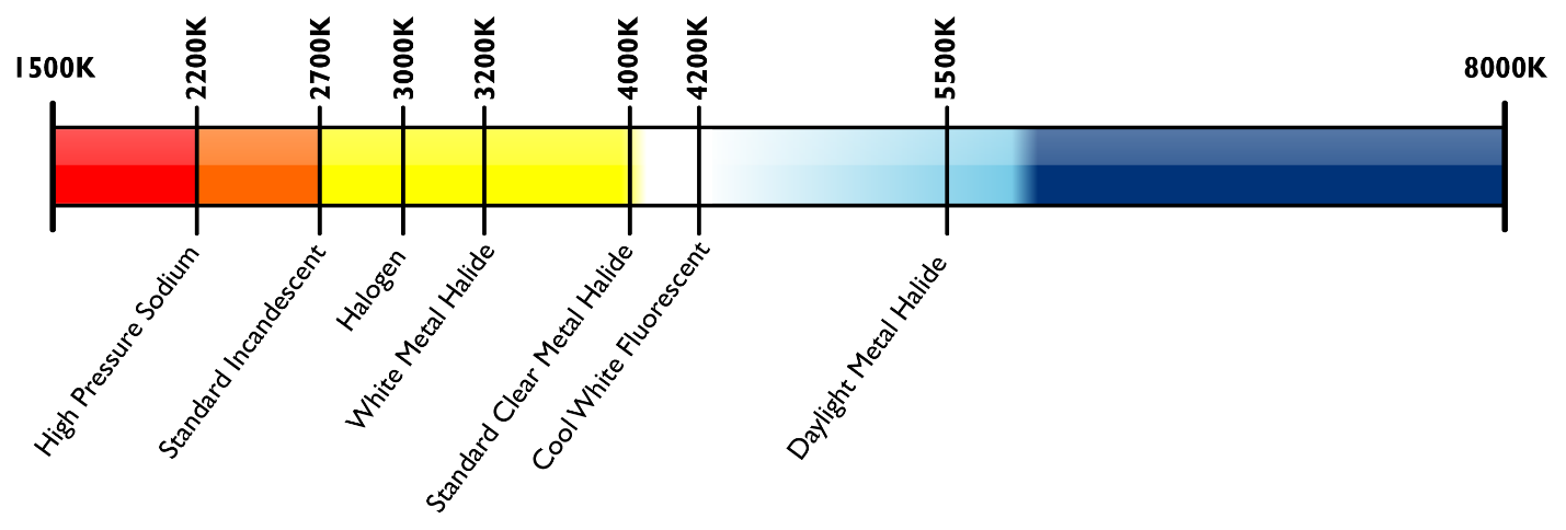
Lighting color (chromaticity). The correlated color temperature of all outdoor lighting must be 3,500 Kelvin maximum or lower (refer to American National Standard Institutes publication C78.377 for guidance on LED lighting). Exceptions may be made for architectural floodlighting, accent lighting, or outlining.
| Figure 17.22.260(F) Kelvin temperature chart |
|---|
 |
G.
Exterior lighting controls.
1.
Automated control systems, such as energy management systems, photoelectric switches, motion sensors, and astronomic timer switches, must be used to meet the hours of operation requirements and the technical and energy efficiency requirements of the applicable Washington State Energy Code.
2.
Exceptions:
a.
Egress lighting as required by the building code.
b.
Lighting required for accessibility.
c.
Lighting required by statute, law, or ordinance to operate all night.
d.
A manual override at each exit door is allowed regardless of automatic control device.
e.
Seasonal holiday lighting and event lighting.
H.
Prohibited lighting.
1.
Dynamic lighting.
2.
Luminaires exceeding 500,000 peak candelas and/or 500,000 lumens.
3.
Laser lighting.
4.
Any lighting of undeveloped environmentally sensitive areas.
5.
Any lighting that may be confused with warning signals, emergency signals, or traffic signals.
6.
Mercury, low pressure sodium, or other light sources in public areas that can impede or distort the perception of actual colors.
7.
Blinking, flashing, intermittent, and/or moving lights unless specifically allowed elsewhere in the Port Angeles Municipal Code.
8.
Lighting permanently attached to trees.
(Ord. 3688 § 34, 12/21/2021)
17.22.300 - Purpose.
This section provides standards for the design of buildings consistent with the goals and policies of the comprehensive plan. See the individual "purpose" statements under each section.
(Ord. 3688 § 34, 12/21/2021)
17.22.310 - Building character.
A.
Purpose.
1.
To promote buildings with an architectural character that reflects the Port Angeles aesthetic and is based on human-scaled design details, durable high-quality materials, sustainable design measures, and responds uniquely to the site's context.
2.
To emphasize that high-quality design is most critical to Port Angeles' high-visibility sites and corridors.
3.
To avoid generic, corporate architectural design that degrades the character and identity of Port Angeles.
B.
Corporate architecture prohibited. Architecture that is defined predominately by corporate identity features and is difficult to adapt to other uses is prohibited. For example, some franchise convenience uses have very specific architectural features (such as a distinctive roofline design that functions as a sign) that reinforce their identity. As tenants change in these types of buildings, these corporate identity features can negatively impact the character of the area and identity of new tenants. These features can also be very expensive to reconfigure and adapt to new uses.
(Ord. 3688 § 34, 12/21/2021)
17.22.320 - Building massing and articulation.
A.
Purpose. This section contains standards that affect the massing of buildings through façade design articulation, façade width, and roofline design. The purpose of this section is:
1.
To employ architectural elements (like windows, balconies, entries, etc.) that create a complementary pattern or rhythm, dividing large buildings into smaller identifiable pieces.
2.
To integrate substantial articulated/modulated features on large buildings to break up the massing and add visual interest.
B.
Exemptions. The following buildings are exempt from the requirements this section:
1.
All buildings with less than 60 horizontal feet of façade.
C.
Façade articulation. Facade articulation to create a human-scaled pattern is required for building façades and other building elevations facing parks, containing primary building entrances, and adjacent to lower intensity zones. Articulation features are listed in subsection (D).
For non-residential buildings and non-residential portions of mixed use buildings, at least three articulation features must be employed at intervals no greater than 40 feet in the CBD, CN, CO, and CSD zones, and 50 feet in the CA zone.
Townhouse buildings, multi-family buildings, and residential portions of mixed use buildings façades in all applicable zones must employ at least three articulation features at intervals that relate to the location/size of individual units within the building (or no more than every 50 feet).
D.
Articulation features to meet the standards of (C) above include:
1.
Use of window patterns and/or entries that reinforce an articulation pattern.
2.
Use of awnings or similar weather protection features (not applicable to residential buildings).
3.
Use of vertical piers/columns.
4.
Change in roofline with a difference in height, slope or pitch, direction, or shape (such as towers or dormers).
5.
Change in building material or siding style.
6.
Other design techniques that effectively reinforce a pattern of small storefronts compatible with the building's surrounding context (not applicable to residential buildings).
For non-storefront building elevations, the following additional features may be used to meet façade articulation standards:
7.
Vertical elements such as a trellis with plants, green wall, or art element.
8.
Providing vertical building modulation of at least 12 inches in depth if tied to a change in roofline per subsection (4) of this section or a change in building material, siding style, or color. On residential buildings balconies may be used to qualify for this option if they are recessed or projected from the façade by at least 18 inches. Juliet balconies or other balconies that appear to be tacked on to the façade will not qualify for this option unless they employ high quality materials and effectively meet the purpose of the standards.
9.
Other design techniques that effectively break up the massing of structures and add visual interest.
DEPARTURE: Other articulation features may be approved, provided they meet the purpose of the standards and the design criteria set forth in subsection (D) of this section.
| Figure 17.22.320(D)(1) Non-residential articulation examples | |
|---|---|
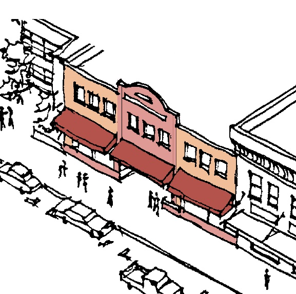 | 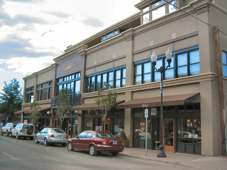 |
The left image uses window patterns, weather protection elements, and roofline modulation.
The photo example to the right also includes window patterns and weather protection
along with a change in masonry texture and color to articulate the façade. The lower
example illustrates how a multitenant retail building can successfully be articulated
(windows, weather protection, vertical building modulation, and roofline changes).
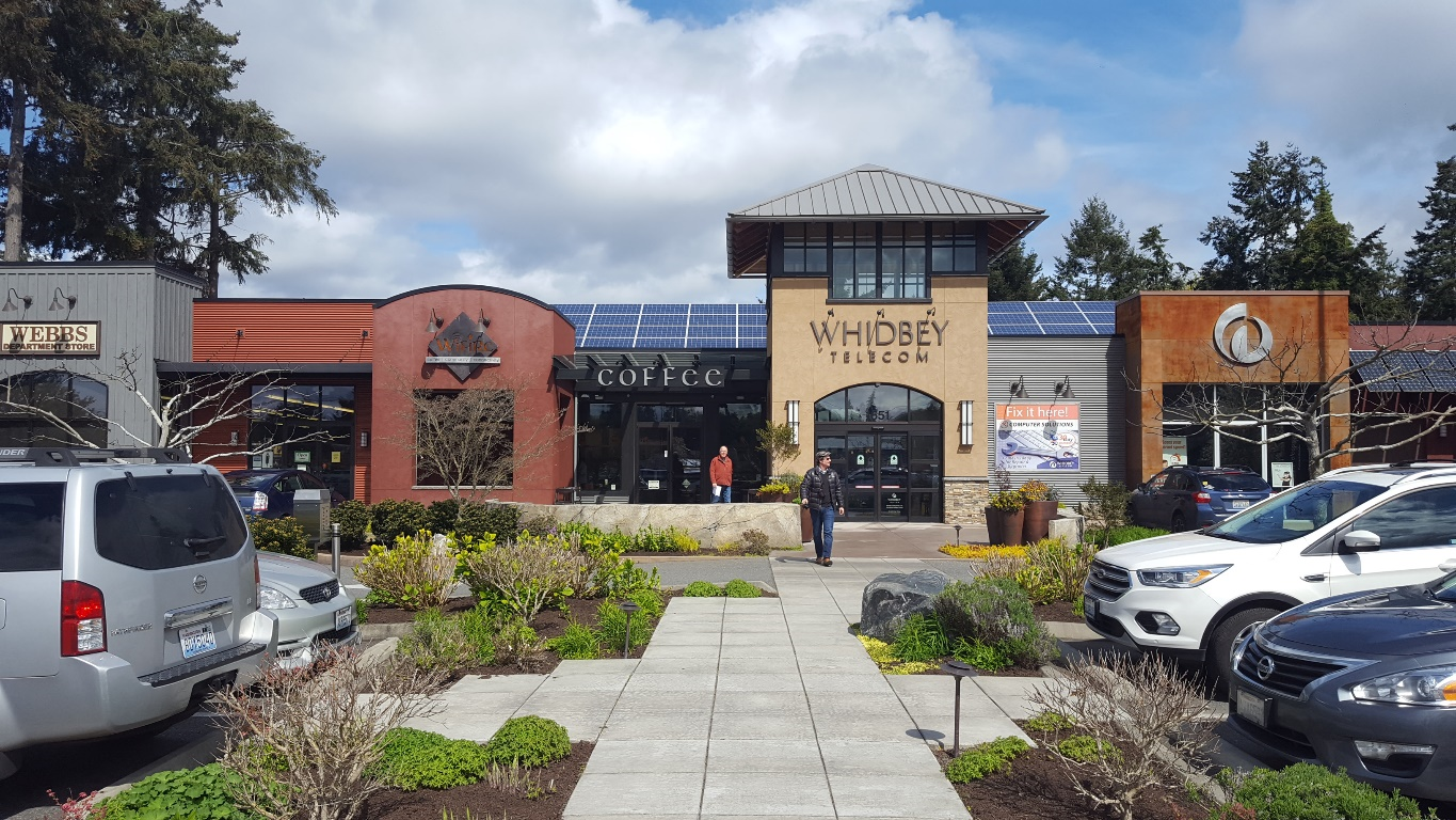 | |
| Figure 17.22.320(D)(2) Residential articulation examples | |
|---|---|
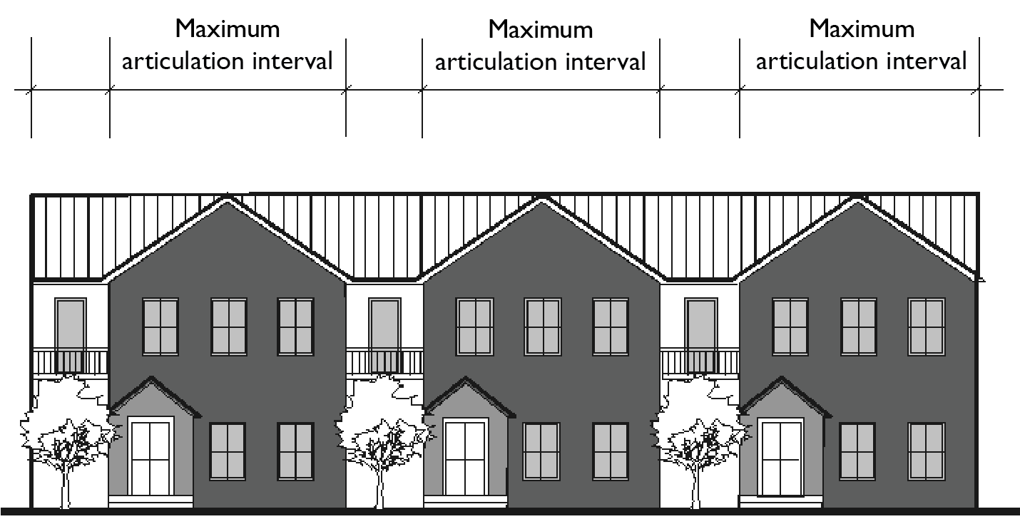 | |
| Below Image A uses a combination of vertical building modulation, window patterns, material changes, and roofline modulation. Image B is unacceptable. | |
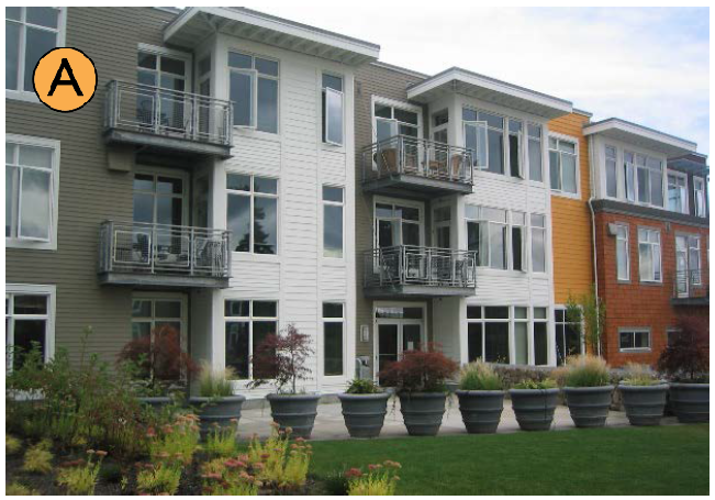 | 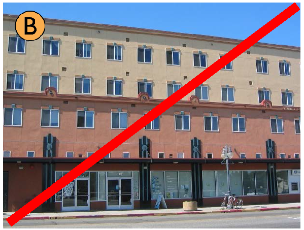 |
| Figure 17.22.320(D)(3) Acceptable examples of roofline modulation | |
|---|---|
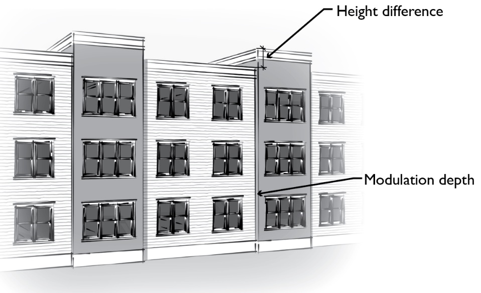 | |
| Roofline modulation qualifies as an articulation feature when combined with vertical building modulation techniques. | |
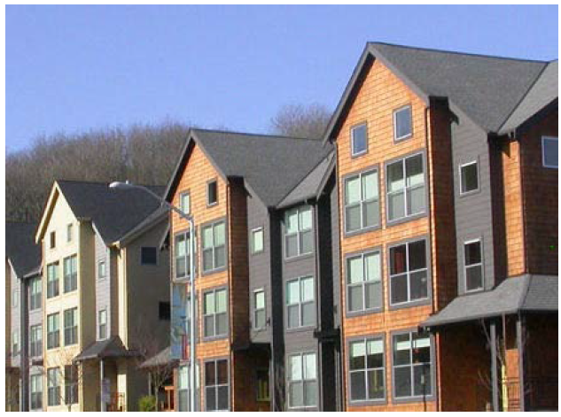 | 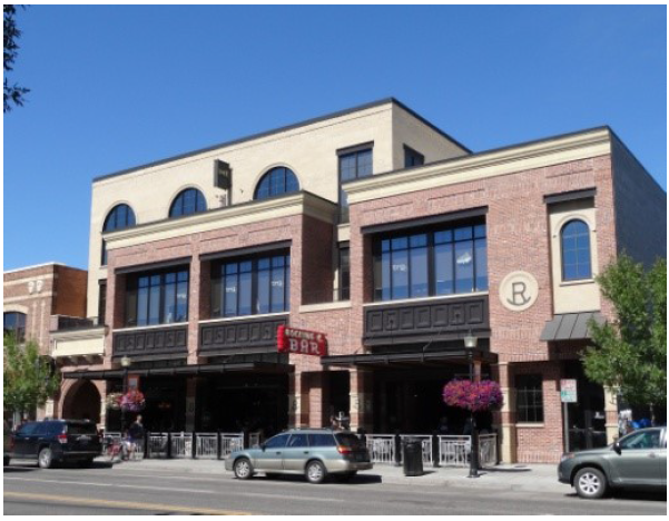 |
| The left building illustrates a pitched roof example and the right building illustrates a flat roof example. | |
E.
Departure criteria associated with articulation standards. Proposals must meet the purpose of the standards. The following criteria will be considered in determining whether the proposed articulation treatment meets the "purpose":
1.
The type and width of the proposed articulation treatment and how effective it is in meeting the purpose given the building's context.
2.
The applicable block frontage designation. Basic block frontages warrant more flexibility than block frontages designated as mixed or landscaped.
3.
The size and width of the building. Smaller buildings warrant greater flexibility than larger buildings.
4.
The quality of façade materials in concert with doors, windows, and other façade features and their ability to add visual interest to the street from a pedestrian scale and more distant observable scales.
(Ord. 3688 § 34, 12/21/2021)
17.22.330 - Building details.
A.
Purpose. This section contains standards that affect the human experience of architecture at the ground level and the quality of windows. The purpose of this section is:
1.
To encourage the incorporation of design details and small-scale elements into building façades that are attractive at a pedestrian scale.
2.
To integrate window design that adds depth, richness, and visual interest to the façade.
3.
To create clear and welcoming building entries.
B.
Applicability. This section applies only in the CBD zone.
C.
Façade details—Nonresidential and mixed use buildings. The ground floor of commercial and mixed use buildings must be enhanced with appropriate details.
1.
This standard applies to building façades and building elevations facing parks and containing primary building entrances.
2.
All new buildings must employ at least one detail element from each of the three categories in subsection (D) for each façade articulation interval (see PAMC 17.22.330).
3.
All additions associated with Level II and III improvements (see PAMC 17.22.030) must employ at least one detail element from each of the three categories in subsection (D) for each façade articulation interval (see PAMC 17.22.330).
For example, a building with 120 feet of street frontage with a façade articulated at 40 feet intervals will need to meet the standards for each of the three façade segments below.
D.
Façade detail categories.
1.
Window and/or entry treatment:
a.
Display windows divided into a grid of multiple panes.
b.
Transom windows.
c.
Roll-up windows/doors.
d.
Other distinctive window treatment that meets the purpose of the standards.
e.
Recessed entry.
f.
Decorative door.
g.
Other decorative or specially designed entry treatment that meets the purpose of the standards.
| Figure 17.22.330(D)(1) Examples of decorative or specially designed windows and entries | |||||
|---|---|---|---|---|---|
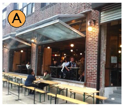 |  |  | |||
 | 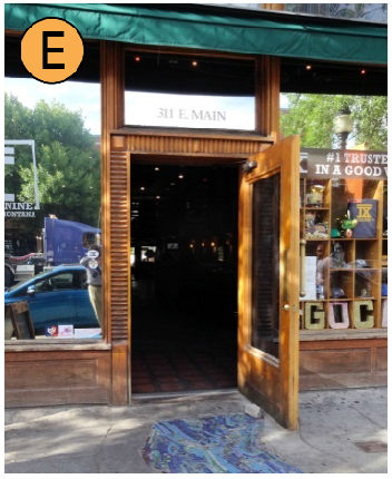 | 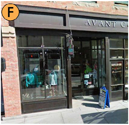 | |||
| Examples of decorative or specially designed windows and entries. A = openable storefront window. B = transom windows. C = openable window with decorative details. D = decorative window shades. E = decorative door. F = recessed entry. | |||||
2.
Building element, façade attachment, or façade detail:
a.
Custom-designed weather protection element such as a steel canopy, cloth awning, or retractable awning.
b.
Decorative building-mounted light fixtures.
c.
Bay windows, trellises, towers, and similar elements.
d.
Decorative, custom hanging sign(s) (option only available for building remodels).
e.
Other details or elements that meet the purpose of these standards.
| Figure 17.22.330(D)(2) Examples of decorative or specially designed windows and entries | |||||
|---|---|---|---|---|---|
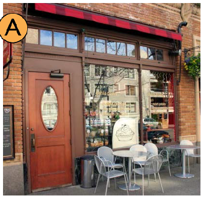 | 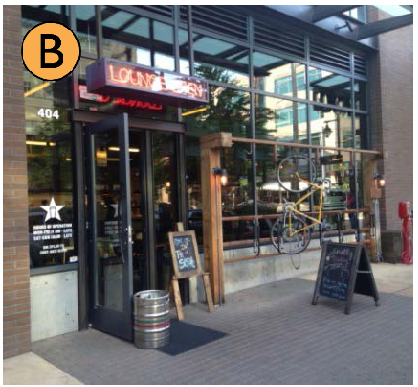 | 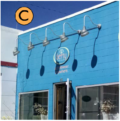 | |||
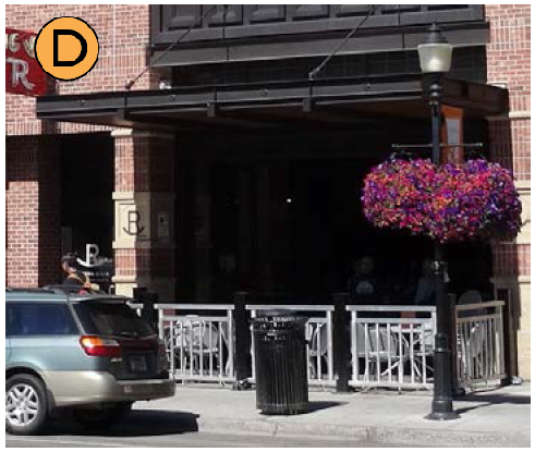 | 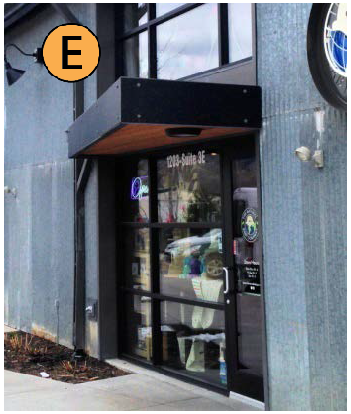 | 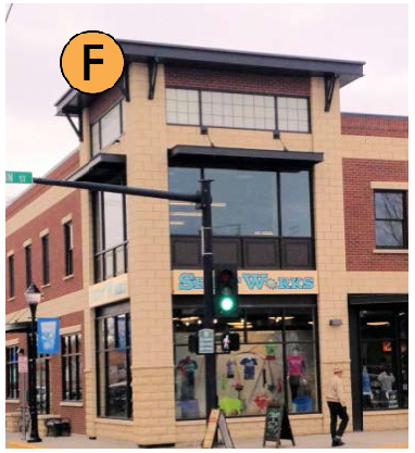 | |||
3.
Decorative material and artistic elements:
a.
Decorative building materials/use of building materials. Examples include, but are not limited to, decorative use of brick, tile, or stonework.
b.
Artwork on building, such as a mural or bas-relief sculpture.
c.
Decorative kick-plate, pilaster, base panel, or other similar feature.
d.
Hand-crafted material, such as special wrought iron or carved wood.
e.
Other details that meet the purpose of the standards.
DEPARTURES will be considered, provided the façade (at the overall scale and at the individual articulation scale) meets the purpose of the standards above.
| Figure 17.22.330(D)(3) Examples of decorative surface materials | |||||
|---|---|---|---|---|---|
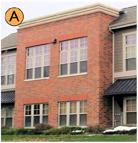 | 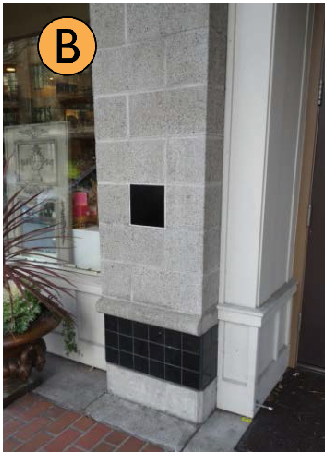 | 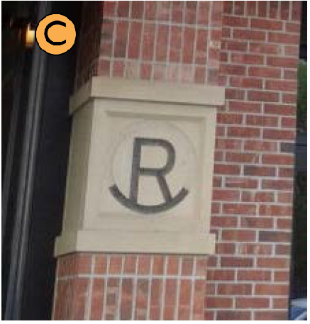 | |||
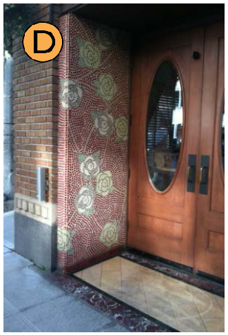 | 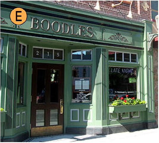 | 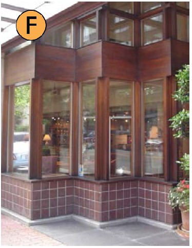 | |||
| Examples of decorative surface materials. A = decorative brick/design. B = decorative tile-work and column pattern. C = decorative medallion. D = decorative mosaic tile work. E = decorative bulkhead. F = decorative materials and design. | |||||
E.
Window design standards.
1.
All windows (except storefront display windows) must employ designs that add depth and richness to the façade. At least one of the following features must be included to meet this requirement:
(a)
Recess windows at least 1.5 inches from the façade.
(b)
Incorporate window trim (at least three inches wide) around windows.
(c)
Incorporate other design treatments that add depth, richness, and visual interest to the façade.
DEPATURES from the window standards above will be considered, provided the design meets the purpose of the standards.
| Figure 17.22.330(E) Acceptable and unacceptable window design examples | |||||
|---|---|---|---|---|---|
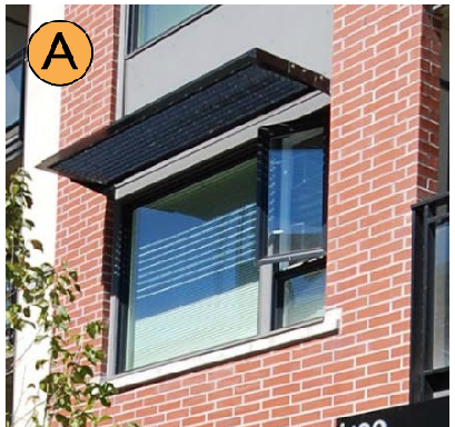 | 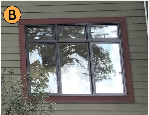 | 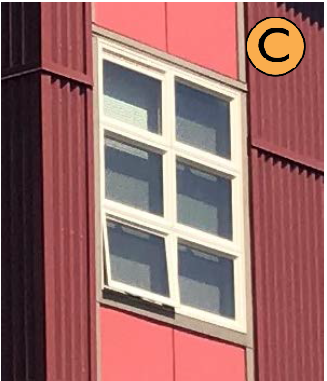 | |||
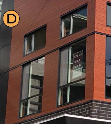 | 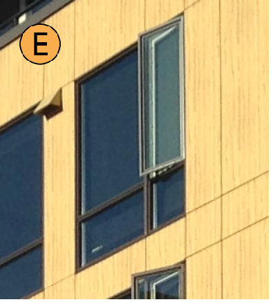 |  | |||
| The windows in Image A is recessed by at least 1.5" from the façade. Images B and C feature trim at least 3" wide. Images D and E feature a reveal/recess of less than 1.5", but the contrasting frames and mullions effectively add a sense of depth and richness to the façade. The treatment in Image F does not effectively add a sense of depth and richness to the façade. | |||||
2.
Standards for specialty glass and treatments:
a.
Ground floor windows on all buildings may not use glass that is highly reflective, mirrored, darkly-tinted, frosted, perforated, or otherwise treated to obscure visibility into the building.
b.
Exception: Frosted glass is allowed for ground floor residential units located within 15 feet of a sidewalk (see PAMC 17.22.170 for related standards). The treatment must not cover more than 50 percent of any window.
(i)
On other floors, highly reflective and mirrored glass must not be used on more than ten percent of a building façade or other building elevations facing parks and containing primary building entrances.
F.
Cornice/roofline design for flat roofs. Nonresidential and mixed use buildings employing a flat roof must employ a distinctive roofline that effectively provides an identifiable "top" to the building, including one of the following [Figure 17.22.330(F) below illustrates examples]:
1.
A traditional cornice line or a contemporary interpretation of a traditional cornice line. Such rooflines must be proportional to the size and scale of the building.
2.
Understated cornice lines are permitted depending on the materials and design of the base and middle elements in reinforcing the base/middle/top configuration.
Rooftop solar units are permitted, provided the placement and design of units visible from the surrounding streetscape are carefully integrated into the overall design concept of the building.
DEPARTURE: Alternative roofline designs may be acceptable, provided the building design, collectively, meets the purpose of the standards. For example, additional articulation treatments and/or detailing may help the building meet the departure criteria.
| Figure 17.22.330(F) Examples of buildings employing confident and distinctive rooflines | |
|---|---|
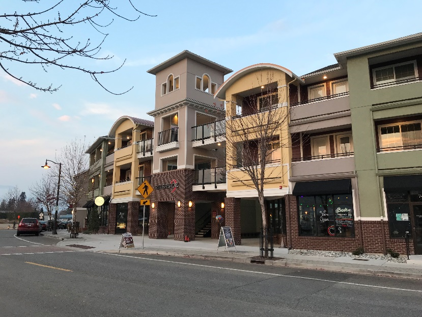 | 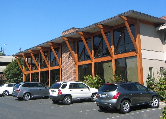 |
G.
Articulated building entries. The primary building entrance for an office building, hotel, multi-family building (when provided), public or community-based facility or other multi-story commercial building must be designed as a clearly defined and demarcated standout architectural feature of the building. Such entrances must be easily distinguishable from regular storefront entrances on the building and must be scaled proportional to the building. See Figure 17.22.330(G) below for good examples.
| Figure 17.22.330(G) Building entry examples | |
|---|---|
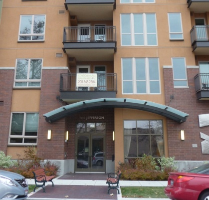 | 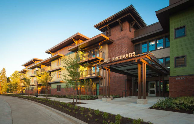 |
(Ord. 3688 § 34, 12/21/2021)
17.22.340 - Building materials.
A.
Purpose.
1.
To encourage the use of durable, high quality, and urban building materials that minimize maintenance cost and provide visual interest from all observable vantage points.
2.
To promote the use of a distinctive mix of materials that helps to articulate façades and lends a sense of depth and richness to the buildings.
3.
To place the highest priority on the first floor in the quality and detailing of materials at the pedestrian scale.
B.
Quality building materials.
1.
Applicants must use high quality durable materials. This is most important for the base of buildings, particularly for commercial and mixed use buildings where the façade is sited close to sidewalks.
2.
Prohibited exterior building materials:
a.
Fiberglass.
b.
Vinyl and plastic siding.
c.
Plywood.
d.
T-111 siding.
3.
The use of sustainably harvested, salvaged, recycled, or reused products is encouraged wherever possible.
C.
Special conditions and limitations for concrete block (also known as concrete masonry unit or CMU). Concrete block may be used as a cladding material if it is incorporated with other permitted materials and/or incorporates a combination of textures and/or colors to add visual interest. For example, combining split or rock-façade units with smooth blocks can create distinctive patterns. The figure below illustrates acceptable concrete block use/designs.
| Figure 17.22.340(C) Acceptable concrete block use and design | |
|---|---|
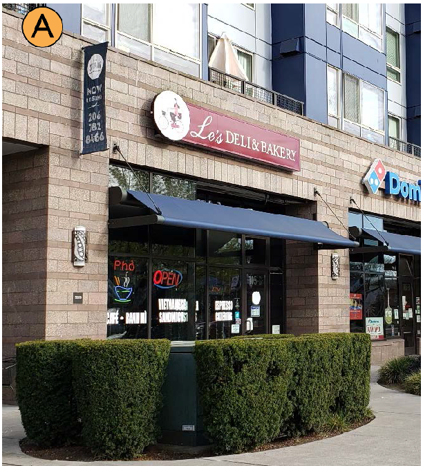 | 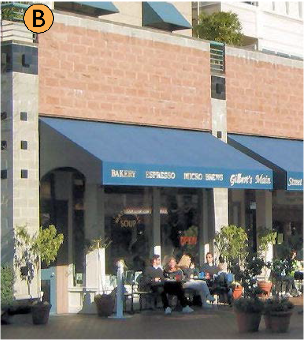 |
| Building A uses alternating rows of concrete block and brick as an effective and contrasting accent material for its podium structure. Building B uses CMU as the primary cladding material for the ground level. Note the use of split-façade CMU's above each of the awnings and coupled with the use of smooth-façade CMU's on the vertical columns (which employ black accent tiles for added interest). | |
D.
Special conditions and limitations for metal siding. Metal siding may be used as a secondary cladding material (no more than 35 percent of the cladding for the façade and no more than 50 percent for other buildings elevations) if it is incorporated with other permitted materials and complies with the following standards:
1.
Metal siding must not extend lower than two feet above grade. Masonry, concrete, or other durable material must be incorporated between the metal siding and the ground plane.
2.
Metal siding must be factory finished with a matte, nonreflective surface.
3.
Metal siding must feature visible corner molding and trim
4.
Use of at least two colors of metal siding on the façade is encouraged but not required.
DEPARTURES will be considered, provided the material's integration and overall façade composition meets the purpose of the standards.
| Figure 17.22.340(D) Acceptable metal siding examples | |
|---|---|
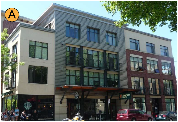 | 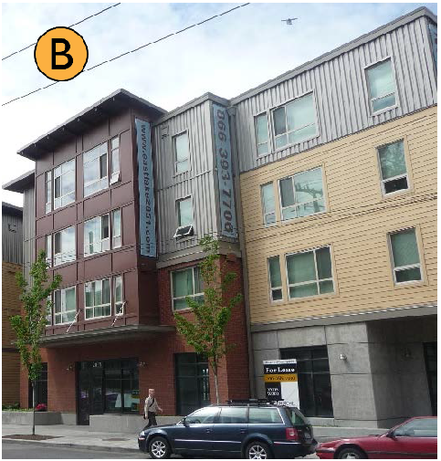 |
| The buildings in Image A and B integrate a range of metal siding with masonry and other materials. | |
E.
Special conditions and limitations for the use of exterior insulation and finish system (EIFS). Such material/finishes may be used as a decorative accent cladding material if incorporated with other permitted materials and compliant with the following:
1.
EIFS must not extend lower than eight feet above grade. Concrete, masonry, or other durable material must be used for ground level wall surfaces to provide a durable surface where damage is most likely.
2.
EIFS is allowed as a secondary cladding material.
3.
EIFS must feature a smooth or sand finish only.
4.
EIFS must be trimmed in wood, masonry, or other material and must be sheltered from weather by roof overhangs or other methods.
DEPARTURES will be considered provided, the material's integration and overall façade composition meets the purpose of the standards.
| Figure 17.22.340(E) Acceptable and unacceptable EIFS examples | |
|---|---|
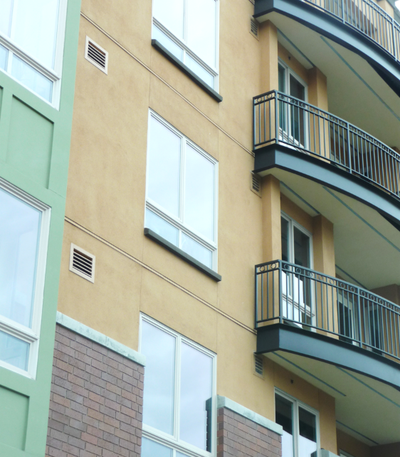 |  |
| Left image: Note the use of brick and decorative concrete block on the ground level and EIFS on the second floor. The window treatments visible on the second floor add depth and interest to the façade. Right image: EIFS is used for all building elevations above the first floor. | |
F.
Special conditions and limitations for cementitious wall board paneling/siding. Such material may be used, provided it meets the following provisions:
1.
No more than 30 percent of the façade's cladding and 40 percent of other building elevations cladding may be one texture and color of cement board.
2.
Cement board paneling/siding may not be used on the ground floor of nonresidential or mixed use buildings where adjacent to a sidewalk or other internal walkway.
3.
Where cement board paneling/siding is used, the design must integrate a mix of colors and/or textures that are articulated consistent with windows, balconies, and modulated building surfaces and are balanced with façade details that add visual interest from the ground level and adjacent buildings.
DEPARTURES will be considered, provided the material's integration and overall façade composition meets the purpose of the standards.
| Figure 17.22.340(F) Acceptable and unacceptable cementitious wall board examples | ||
|---|---|---|
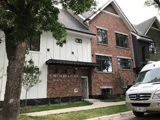 | 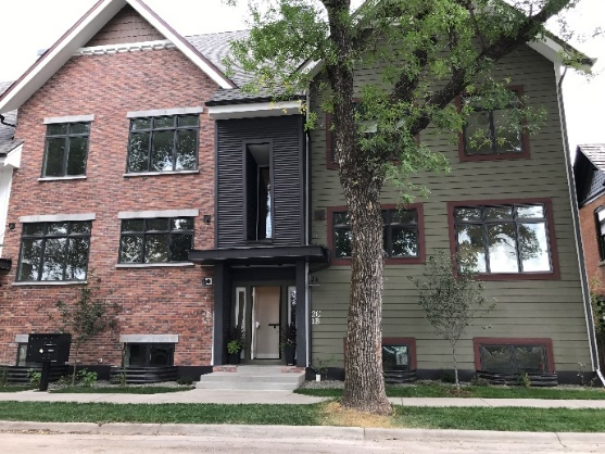 |  |
| The building on the left uses cement board in different textures and colors to help articulate the façade. The white color replicates the board and batten style in the left image and green color in the right image effectively replicates horizontal wood siding. The wall board panels covering a large area in a single color as in right image would not meet the purpose of the standards. | ||
(Ord. 3688 § 34, 12/21/2021)
17.22.350 - Blank wall treatment.
A.
Purpose.
1.
To avoid untreated blank walls.
2.
To retain and enhance the character of Port Angeles' streetscapes.
B.
Blank wall definition. A ground floor wall (including building façades and retaining walls) is considered a blank wall if it does not include a transparent window or door, it is over ten feet in height, and it has a horizontal length greater than:
1.
15 feet (when the wall is located less than five feet from the front lot line).
2.
20 feet (when the wall is located five to ten feet from the front lot line).
3.
25 feet (when the wall is located more than ten feet from the front lot line).
| Figure 17.22.350(B) Blank wall definition within five feet of a front lot line |
|---|
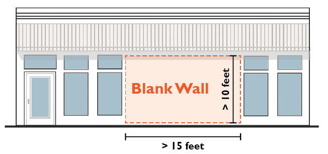 |
C.
Blank wall treatment options. Untreated blank walls located within 100 feet of, and visible from a street, public space, ground-level residential amenity space, or internal walkway are prohibited. Methods to treat blank walls include the following (a variety of treatments may be required to meet the purpose of the standards):
1.
Display windows at least 16 inches of depth to allow for changeable displays. Tack on display cases do not qualify as a blank wall treatment.
2.
Landscape planting bed at least five feet wide or a raised planter bed at least two feet high and three feet wide in front of the wall with planting materials that are sufficient to obscure or screen at least 60 percent of the wall's surface within three years.
3.
Installing a vertical trellis or "green wall" in front of the wall with climbing vines or plant materials. The method must be sufficient to obscure or screen at least 60 percent of the wall surface within three years. This option requires an irrigation and maintenance plan sufficient to maintain healthy plants for the life of the building.
4.
Installing a non-commercial mural or other permanent art feature, such as metal work or mosaics, subject to final approval by the Director.
5.
Building detailing that adds visual interest at a pedestrian scale such as belt courses of masonry, decorative tile work, or accent lighting. Such detailing must use a variety of surfaces; monotonous designs will not meet the purpose of the standards.
| Figure 17.22.350(C) Blank wall treatment examples | |
|---|---|
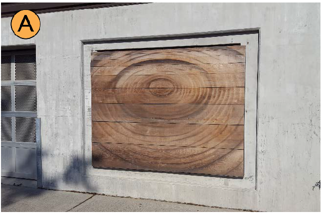 | 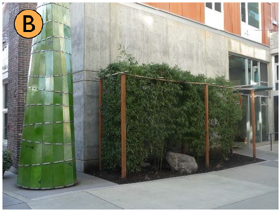 |
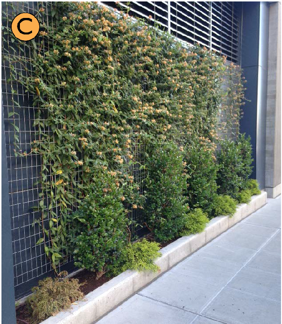 | 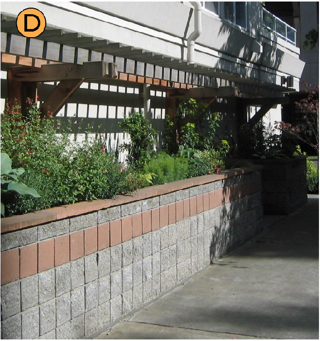 |
| Image A uses an artistic mural; Image B uses a landscape planting bed; Image C uses a trellis with a vine plant; Image D uses an elevated planting bed and a trellis. | |
(Ord. 3688 § 34, 12/21/2021)
17.22.400 - Purpose.
Landscaping is necessary to provide a well-balanced, aesthetically pleasing environment for the residents, business, and visitors of Port Angeles. Specifically, these requirements are intended to accomplish the following:
A.
Maintain and enhance property values.
B.
Enhance the character and appearance of each neighborhood and the community.
C.
Promote tree retention and the protection of existing native vegetation.
D.
Implement tree and landscaping plans and programs adopted by the City.
E.
Provide adequate buffers between differing land uses.
F.
Define, break up, and screen parking areas to reduce potentially negative impacts on adjacent uses.
G.
Improve the air quality and provide wildlife habitat.
H.
Reduce erosion and stormwater runoff.
(Ord. 3688 § 34, 12/21/2021)
17.22.410 - Applicability.
Applicability. Sections 17.22.400—17.22.460 apply to all new commercial and multi-family development and where new landscaping or trees required by other sections of this title. This chapter does not apply to required street trees (see Chapter 11.13 PAMC for street tree standards).
(Ord. 3688 § 34, 12/21/2021)
17.22.415 - Landscape plans.
A.
A landscape plan is required for all new commercial and multi-family development containing landscaping, including landscaping within the adjacent right-of-way.
B.
Landscape plans must be completed by a Washington State licensed landscape architect or Washington certified professional horticulturalist (CPH) for multi-family and nonresidential developments with a development site area of 10,000 gross square feet or more.
C.
Landscape plans must show the following elements:
1.
Boundaries and dimensions of the site.
2.
Location of existing and proposed streets, curbs, utility lines, and sidewalks.
3.
Location of buildings and structures, parking lots, driveways, loading areas, outdoor mechanical equipment, signs, refuse enclosures, overhead utilities, water meter location, grassy swales, parking lot lighting, and any plants or trees that are to remain on site.
4.
The location and design of landscape areas to be preserved and planted, and plant list to include the location, number, size, and type of plant material by botanical and common name.
5.
North arrow and scale.
6.
Irrigation system if a permanent or temporary system is proposed.
7.
Planting details.
8.
Name, address, and phone number of the person preparing the plan.
9.
Landscaping calculations in compliance with this chapter.
10.
A maintenance plan for any infiltration-based stormwater best management practices (BMPs) built as part of the landscaping design, including the specifications and maintenance procedures of any soil amendments.
D.
No building permits will be issued until a landscape plan is reviewed and approved. No certificate of occupancy (CO) will be issued until improvements are installed per the approved landscape plan. A suitable guarantee may be provided if installation is not possible or advisable due to seasonal constraints.
(Ord. 3688 § 34, 12/21/2021)
17.22.420 - Plant material and installation standards.
A.
Native and naturalized plant species. New landscaping materials must include species native to the region or hardy, waterwise, and noninvasive species appropriate in the climatic conditions of the region (decorative annuals are an exception). Generally acceptable plant materials must be those identified as hardy in Zone 8b as described in the United States Department of Agriculture's Plant Hardiness Zone Map. The selection of plant species should include consideration of soil type and depth, the amount of maintenance required, spacing, exposure to sun and wind, the slope and contours of the site, compatibility with existing native vegetation preserved on the site, water conservation where needed, soil infiltration capacity, and the impact of landscaping on visibility of the site for purposes of public safety and surveillance.
B.
Tree standards.
1.
The following terms are used to denote tree heights within this chapter:
a.
Large tree: capable of growing 35 feet high or greater under normal growing conditions.
b.
Medium tree: capable of growing over 15 feet high and less than 35 feet high under normal growing conditions.
c.
Small tree: capable of growing up to 15 feet high under normal growing conditions.
2.
Unless otherwise noted, required trees must meet the following standards at the time of planting:
a.
Deciduous trees (other than street trees) must be fully branched, have a minimum caliper of 1½ inches (as measured six inches above the root ball), and a minimum height of six feet at the time of planting.
b.
Deciduous trees within parking areas must be a minimum caliper of one inch (as measured six inches above the root ball) and a minimum height of ten feet at the time of planting.
c.
Coniferous trees must be fully branched and a minimum of six feet in height, measured from the treetop to the ground, at the time of planting.
C.
Shrub standard. Shrubs, except for ornamental grasses, must be a minimum of one-gallon size at the time of planting.
D.
Groundcover standards and guidelines.
1.
Groundcovers must be planted and spaced to result in total coverage of the required landscape area within three years, or as recommended by a Washington State licensed landscape architect or Washington certified professional horticulturalist, and must meet the following requirements:
a.
Four-inch pots at 18 inches on center.
b.
One-gallon or greater sized containers at 24 inches on center.
2.
A bed of flowers may be used in place of groundcover plants. A reduction in the minimum container size may be permitted if certified by a Washington State licensed landscape architect or Washington certified professional horticulturalist that the reduction must not diminish the intended effect or the likelihood the plants will survive.
3.
Grass is acceptable as groundcover in landscaped areas, but generally not preferred for water conservation and maintenance purposes (lawn areas designed as play areas are an exception).
4.
Groundcover areas must contain at least two inches of composted organic material at finished grade.
E.
Tree and plant diversity.
1.
If there are more than eight required trees, no more than 40 percent of them may be of one species.
2.
If there are more than 24 required trees, no more than 20 percent of them may be of one species.
3.
If there are more than 24 required shrubs, no more than 75 percent of them may be of one species.
F.
Soil augmentation and mulching.
1.
Existing soils must be augmented with a two-inch layer of fully composted organic material tilled a minimum of six inches deep prior to initial planting.
2.
Landscape areas must be covered with at least two inches of mulch to minimize evaporation. Mulch must consist of organic materials such as bark chips and wood grindings or yard waste, sawdust, and/or manure that is fully composted. Washed rock can also be used as a mulch.
G.
Landscape installation standards.
1.
All required landscaping must be in-ground, except when in raised planters. Plant materials must be installed to current nursery industry standards.
2.
Plant materials must be properly supported to ensure survival. Support devices such as guy wires or stakes must not interfere with vehicular or pedestrian movement. Where support is necessary, stakes, guy wires or other measures must be removed as soon as the plant can support itself.
3.
Existing trees and plant materials to be retained must be protected during construction, such as by use of temporary chain-link or other sturdy fence placed at the dripline of trees to be retained. Grading, topsoil storage, construction material storage, vehicles and equipment must not be allowed within the dripline of trees to be retained.
4.
Installation of landscaping materials must take into consideration access to utility vaults, pedestals, and other public and private utility facilities.
5.
Tree/shrub height and location. The landscape plan should plan for the mature size of trees and major shrubs to avoid interference with windows, decks or lighting.
6.
Trees must be protected by fencing until they are mature enough to withstand typical wildlife activity.
(Ord. 3688 § 34, 12/21/2021)
17.22.425 - Landscaping types.
Below are the planting and design requirements for specific landscaping types. These landscaping types apply when required by this chapter.
A.
Type A landscaping.
1.
Purpose. Type A landscaping functions as a full screen and visual barrier. This landscaping is typically found between residential and nonresidential areas for screening unwanted views.
2.
Screening requirement. The selected plant materials and configuration must be able to screen 70 percent of the unwanted views within five years of planting and screen substantially all of the unwanted views within six years of planting. This requirement must account for the size and characteristics of materials planted, their typical growth rate, and size at maturity.
3.
Planting requirements. Type A landscaping must consist of the following:
a.
Tree type. Predominately coniferous (more than 50 percent).
b.
Tree size. A variety of tree sizes may be used, provided at least 70 percent are medium or large [see PAMC 17.22.420(B)(1)]. Trees must be planted at the following spacing standards ("on center" refers to the distance from other trees of any size):
i.
Large trees must be spaced between 20 and 25 feet on center.
ii.
Medium trees must be spaced between 15 and 20 feet on center.
iii.
Small trees must be spaced between ten and 15 feet on center.
c.
Shrubs. Predominately coniferous provided at the rate of one shrub per 20 square feet of landscape strip.
d.
Groundcover. Planted at a density to cover the required area within three years.
e.
Species diversity. Trees and shrubs must comply with PAMC 17.22.420(E).
DEPARTURES that vary from the planting requirements of this subsection (A)(3) will be considered, provided the proposal meets the screening requirement of subsection (A)(2) of this section.
| Figure 17.22.425(A) Type A landscaping standards |
|---|
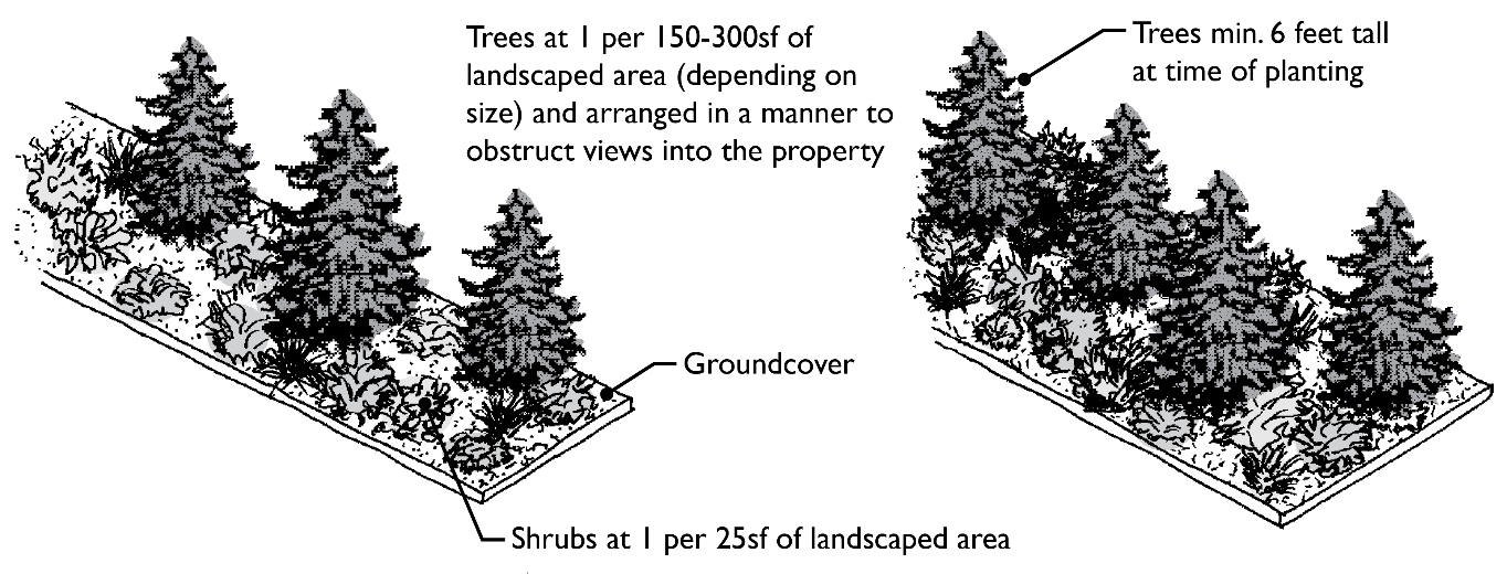 |
B.
Type B landscaping.
1.
Purpose. Type B landscaping is a "filtered screen" that functions as a visual separator. This landscaping is typically found between differing types of residential development and used for screening unwanted views from the pedestrian environment.
2.
Screening requirement. The selected plant materials and configuration must meet the purpose of the standards within five years of planting. This requirement must account for the size and characteristics of materials planted, their typical growth rate, and size at maturity.
3.
Planting requirements. Type B landscaping must minimally consist of:
a.
Tree type. At least 50 percent deciduous and at least 30 percent coniferous.
b.
Tree size. A variety of tree sizes may be used, provided at least 70 percent are medium or large (see PAMC 17.22.400(B)(1)). Trees must be planted at the following spacing standards ("on center" refers to the distance from other trees of any size):
i.
Large trees must be spaced between 20 and 25 feet on center.
ii.
Medium trees must be spaced between 15 and 20 feet on center.
iii.
Small trees must be spaced between ten and 15 feet on center.
c.
Shrubs. Provided at the rate of one shrub per 20 square feet of landscape strip and spaced no more than eight feet on center.
d.
Groundcover. Planted at a density to cover the buffer within three years.
e.
Species diversity. Trees and shrubs must comply with PAMC 17.22.420(E).
DEPARTURES that vary from the planting requirements of this subsection (B)(3) will be considered, provided the proposal meets the screening requirement of subsection (B)(2) of this section.
| Figure 17.22.425(B) Type B landscaping standards |
|---|
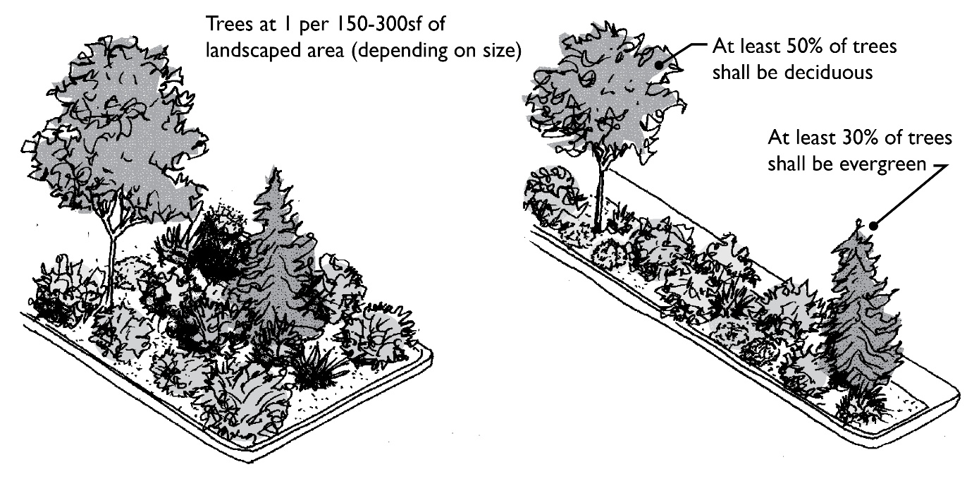 |
C.
Type C landscaping.
1.
Purpose. Type C landscaping is a "see-through screen" that functions as a partial visual separator to soften the appearance of parking areas and building elevations. This landscaping is typically found along lot frontages or between multi-family developments.
2.
Screening requirement. The selected plant materials and configuration must meet the purpose of the standards within five years of planting. This requirement must account for the size and characteristics of materials planted, their typical growth rate, and size at maturity.
3.
Planting requirements. Type C landscaping must minimally consist of:
a.
Tree species. At least 70 percent deciduous.
b.
Tree type. A variety of tree sizes may be used, provided at least 70 percent are medium or large (see PAMC 17.22.420(B)(1)). Trees must be planted at the following spacing standards ("on center" refers to the distance from other trees of any size):
i.
Large trees must be spaced between 20 and 25 feet on center.
ii.
Medium trees must be spaced between 15 and 20 feet on center.
iii.
Small trees must be spaced between ten and 15 feet on center.
c.
Shrubs. Provided at the rate of one shrub per 20 square feet of landscape strip and spaced no more than eight feet on center.
d.
Groundcover. Planted at a density to cover the buffer within three years.
e.
Species diversity. Trees and shrubs must comply with PAMC 17.22.420(E).
f.
Maintenance. Maintain trees and shrubs to maximize pedestrian visibility (generally between three and eight feet above grade).
DEPARTURES that vary from the planting requirements of this subsection (C)(3) will be considered, provided the proposal meets the screening requirement of subsection (C)(2) of this section.
| Figure 17.22.425(C) Type C landscaping standards |
|---|
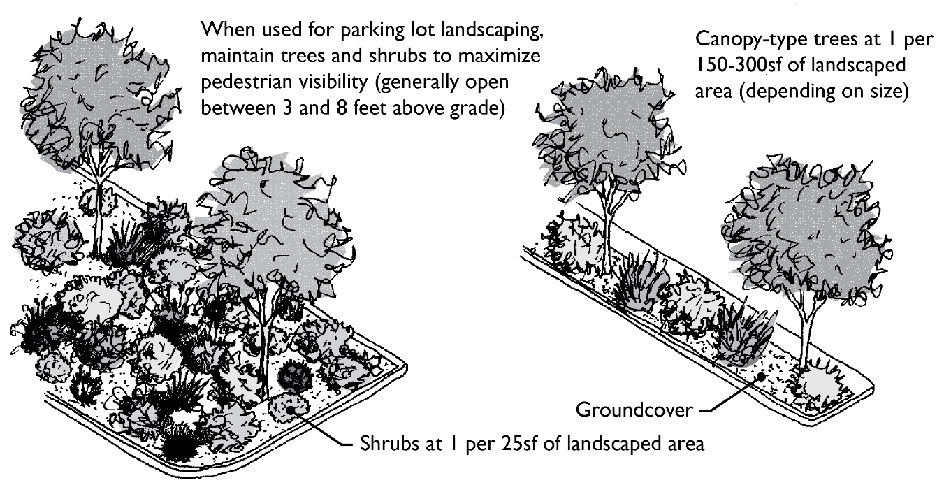 |
D.
Type D landscaping.
1.
Type D landscaping refers to all other landscaped areas that do not qualify as Type A, B, C, E, or F landscaping. While native and low-maintenance trees and shrubs are encouraged in these areas, lawn areas may be used for recreational or design purposes. These areas may also include flower beds and perennial beds.
2.
Type D landscaping may include any combination of plant materials, provided they comply with the plant materials standards in PAMC 17.22.420.
E.
Type E landscaping—Low hedge. A low hedge is intended to function as an attractive visual divider of space rather than a visual buffer between uses and properties. To qualify as a hedge landscaping type, the planting must be at least 30 inches wide and 30 inches tall. The hedge includes plant materials that typically grow no taller than five feet at maturity or are maintained between 30 inches and 48 inches tall (see the sight obstruction height limits of the Port Angeles Urban Services Standards and Guidelines Manual when near an intersection).
| Figure 17.22.425(E) Low hedge examples | |
|---|---|
 | 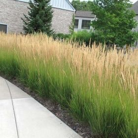 |
F.
Type F landscaping—Rain garden.
1.
A rain garden is a planted depression that collects, absorbs, and filters rainwater runoff from impervious areas. They are sized to accommodate temporary ponding and are not meant to be permanent ponds. They can also function as an attractive visual divider of space. Typical rain garden elements include:
a.
Garden is located and designed to capture impervious area runoff.
b.
Six- to 12-inch ponding depth.
c.
Two- to three-inch mulch layer.
d.
Gradual side slopes (typically 2:1).
e.
Overflow design elements with measures to prevent erosion.
f.
Generous plantings of a variety of small trees, shrubs, groundcovers, and grasses. Select plants suitable for the planting zones within the garden and around the perimeter.
Refer to the current Rain Garden Handbook for Western Washington for further guidance on rain garden location, design, planting, construction, and maintenance. The current Stormwater Management Manual for Western Washington (SWMMWW) may have altered requirements for engineered rain gardens that are required for on-site stormwater management.
2.
The applicability of rain gardens in site design will be determined by project size and flow control exemptions based upon minimum requirement No. 5 of the Western Washington Phase II municipal stormwater permit.
| Figure 17.22.425(F) Rain garden example |
|---|
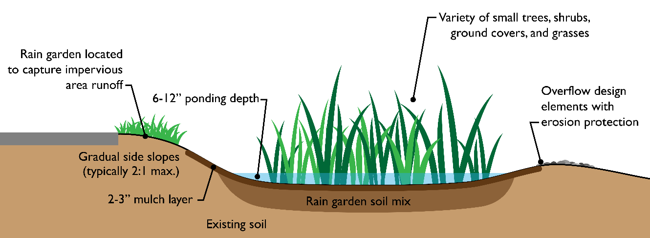 |
(Ord. 3688 § 34, 12/21/2021)
17.22.430 - Landscaping buffer standards.
A.
Required buffer standards. Landscape buffers between certain uses may be called for in Table 17.22.430 below or elsewhere in this title. The following interpretations apply to Table 17.22.430:
1.
The preservation of existing mature trees and vegetation may be preferable to new plant materials in the required buffer areas. The Director may require any of the following to better ensure the survival of existing mature trees and vegetation:
a.
Augment existing plantings with new plant materials to meet the purpose of the standards.
b.
Require wider buffers to better ensure the survival of existing mature trees and vegetation. This must be accompanied by use of a buffer averaging approach in which the buffer may be reduced in other locations to achieve, on average, the minimum buffer width required in Table 17.22.430 or elsewhere in this title.
c.
Other supplemental planting conditions.
2.
The letters A, B, C, D, E, and F refer to the landscape types described in PAMC 17.22.425. Where more than one buffer type is referenced in a cell, one of the subject buffer types is required. The term "all" means that any of the landscaping types may be used.
3.
The term "fence" refers to the requirement of a six-foot-high sight-screening fence. Such fences must comply with the provisions of PAMC 17.94.140.
4.
The numbers refer to the minimum required width of the required landscaping buffer.
5.
Where superscript numbers are included in a cell, see the corresponding note matching the number below the table.
6.
The screening elements must extend along the entire property line between the uses/properties except where precluded by structures, driveways, or similar obstructions.
7.
Where the use is across the street from an existing abutting use or zone, only the buffer type listed for the abutting street is required.
8.
DEPARTURES. Alternative buffer treatments may be approved per PAMC 17.22.040 for any of the buffer types required below, provided they meet the purpose of this chapter.
B.
Supplemental buffer standards.
1.
For screening requirements for service areas and mechanical equipment for nonresidential and multi-family development, see PAMC 17.22.250.
2.
Required buffer vegetation must be planted within the property boundaries.
3.
The height of any screen material required by this chapter in the vicinity of a point of ingress and egress may not exceed 30 inches in height within the clear-vision triangle (PAMC 17.94.090).
(Ord. 3688 § 34, 12/21/2021)
17.22.435 - Block frontage landscaping.
A.
Nonresidential and multi-family developments must include landscaping between the sidewalk and building or parking areas in conformance with this chapter. Such landscaping must include one or more of the landscaping types set forth in PAMC 17.22.425. Storefront buildings are exempt from this standard. Reductions in landscaping are allowed for walkways, stoops, porches, patios, pedestrian-oriented space, utility elements, and permitted vehicular access and signage elements.
B.
Where buildings are set back at least 15 feet from a street property line, trees must be planted at a minimum average of 30 feet apart in such planting areas, with groundcover or shrubs used liberally.
DEPARTURES may be considered, provided alternative treatments meet the purposes of this chapter.
C.
Trees utilized in these planting areas must minimize conflict with underground and overhead utilities. Trees must be from the approved list of recommended plant materials or an approved equivalent.
(Ord. 3688 § 34, 12/21/2021)
17.22.440 - Parking lot landscaping.
A.
Purpose. The purpose of parking lot landscape development is to soften the visual effect created by large expanses of barren asphalt.
B.
Required area. Planting areas in new parking areas with ten or more spaces or in upgraded or improved parking areas with ten or more spaces must constitute at least five percent of the parking area. The unused space resulting from the design of parking space arrangements or accessory structures which is over 24 square feet must be landscaped. Vegetation within LID facilities may be used to meet landscaping requirements.
C.
Minimum width and length. Planting areas must have a minimum average width of 7.5 feet (measured inside the curb) and must be the same length as the parking stall or column.
D.
Planting type. Type C landscaping must be used in required planting areas. Rain gardens, or other vegetated LID BMPs, may be integrated into planting strips, provided they integrate the same number of trees as for Type C landscaping.
E.
Distribution. Landscaped areas must be distributed throughout the parking lot and must have no more than eight consecutive parking spaces. Islands with vegetation within LID facilities may be used to meet landscaping requirements and may exceed maximum eight consecutive spaces.
F.
Parking lot perimeters.
1.
For parking lots adjacent to public streets, Type C landscaping must be used at least 7.5 feet deep, except where a greater buffer width is required per the standards in subsections (A and B) of this section.
DEPARTURES to this standard will be considered pursuant to PAMC 17.22.040, provided they meet the purpose of the standards noted above. Examples of acceptable departures may include decorative low walls with landscaping, decorative elevated planters, landscaping with a trellis, a shared-access drive, or a shared pathway. See Figure 17.22.430(F) for examples.
| Figure 17.22.440(F) Examples of alternative parking lot landscaping buffers |
|---|
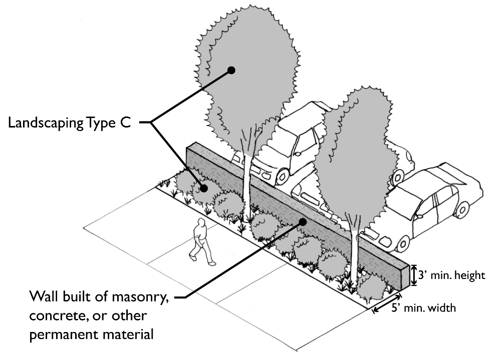 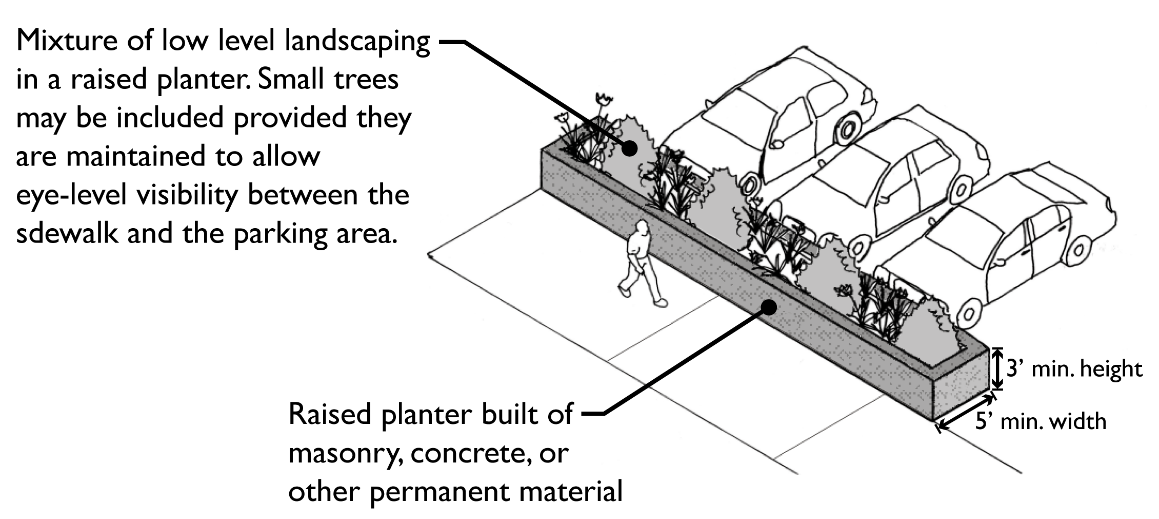 |
2.
For parking lots along internal lot lines, Type A, B, or C landscaping must be used at least 7.5 feet deep, except where a greater buffer width is required per the standards in subsections (A and B) of this section. Where recorded cooperative parking agreements are in place between adjacent properties, sites are exempt from the subject parking lot landscaping buffer (see PAMC 14.40.070).
DEPARTURES to this standard and reductions in depth by up to 50 percent will be considered pursuant to PAMC 17.22.040, provided they meet the purpose of the standards noted above.
(Ord. 3688 § 34, 12/21/2021)
17.22.445 - Other landscaping standards.
A.
Existing site vegetation—General. Applicants are encouraged to retain existing native vegetation, including indigenous shrubs, herbaceous plants, and significant trees on the subject property.
B.
Special Fire Department standards.
1.
Landscaping in the vicinity of any fire hydrant, Fire Department sprinkler connection or standpipe connection should not prevent such equipment from being immediately discernible nor deter or hinder the Fire Department from gaining immediate access to the equipment. This section includes the guidelines for landscaping around the equipment, with final approval from the City Fire Marshal.
2.
Fire hydrants.
a.
Fire hydrants must be free from obstruction on all sides by a minimum clearance of three feet.
b.
Fire hydrants along streets, driveways, parking lots, fire access routes (fire lanes), or at intersections must be visible for at least 100 feet in all directions along such streets, driveways, access routes or intersections. No plants or shrubs with a height of over 18 inches and no tree with branches or foliage below five feet must be allowed in this sight visibility area.
3.
Sprinkler and standpipe connections.
a.
Fire Department connections for sprinklers and standpipes must be free from obstructions on all sides by a minimum clearance of three feet.
b.
When a Fire Department connection is over 25 feet from a street, driveway, parking lot, or fire access route, a clear path must be maintained with minimum width of three feet between the Fire Department connection and the street, driveway, parking lot or fire access route.
(Ord. 3688 § 34, 12/21/2021)
17.22.450 - Maintenance.
A.
Property owners and their agents, heirs, or assigns are responsible for maintaining all required landscaping and screening areas in a healthy, growing condition.
B.
All landscaping and screening areas must be maintained reasonably free of weeds and trash, treated for pests/diseases in accordance with the approved landscape plan, and maintained so as to prevent mulch, straw, dirt, or other materials from washing onto streets, sidewalks, and adjoining properties.
C.
Any dead, unhealthy, or missing vegetation, or vegetation disfigured by severe or excessive pruning, unusual weather occurrence or natural catastrophe, or other natural occurrence such as damage by wild or domestic animals, must be replaced with equivalent vegetation that conforms to the approved landscaped plan and the standards of this chapter.
D.
Any engineered soil amendments must be maintained and replaced as needed to continue the original function of stormwater best management practices.
(Ord. 3688 § 34, 12/21/2021)
17.22.455 - Irrigation standards.
The purpose of this standard is to ensure that plants will survive the critical establishment period when they are most vulnerable due to lack of watering.
All required landscaped areas must comply with at least one of the following:
A.
A permanent built-in irrigation system with an automatic controller that serves the proposed landscape area, to be installed and operational before the City grants an occupancy permit or final inspection for the development.
B.
A temporary irrigation system that services the proposed landscape area, provided the applicant can successfully demonstrate that the proposed temporary irrigation system will provide sufficient water to ensure that the plant materials to be planted will survive installation, and once established, will survive without watering other than natural rainfall.
C.
A permanent or temporary irrigation system will not serve the proposed landscape area, provided:
1.
The Director finds the landscape area otherwise fulfills the requirements of this section.
2.
The applicant submits all of the following with the site plan application:
a.
A statement from a Washington State licensed landscape architect or Washington certified professional horticulturalist (CPH) certifying that the materials to be planted will survive without watering other than natural rainfall.
b.
A plan for monitoring the survival of required vegetation for at least one year and for detection and replacement of required vegetation that does not survive with like-kind material or other material approved by the City.
c.
A statement from the applicant agreeing to install an irrigation system if the reviewing authority finds one is needed to ensure survival of required vegetation, based on the results of the monitoring plan.
(Ord. 3688 § 34, 12/21/2021)
17.22.460 - Performance assurance/bonding.
If landscaping improvements cannot be installed prior to a formal certificate of occupancy, a cash deposit, letter of credit or other assurance acceptable to the City equal to 150 percent of the estimated installation costs is required. Such deposit must be accompanied by a letter which stipulates completion of all landscape improvements within six months of the certificate of occupancy or date of final approval, whichever is later. If these conditions are not met, the City may use the deposit to install the landscaping.
(Ord. 3688 § 34, 12/21/2021)