
Port Arthur City Zoning Code
SECTION 2
- ZONING DISTRICTS
2.01. - Zoning districts established.
A.
Purpose. The purpose of this section is to create zoning districts, to specify the nature and components of the permitted development and uses within them, and to establish regulations regarding the physical character and intensity of development in order to protect the public health, safety, and welfare.
B.
Designation of base zoning districts. All land within the city limits shall be classified into one of the zoning districts listed in table 2-1.
Table 2-1. Zoning District Designations
C.
Overlay zoning districts established.
1.
Overlay zoning districts shall be established under the provisions of section 6.03, zoning text and map amendments.
2.
Overlay zoning districts adopted with original comprehensive revisions of underlying zoning and referenced on the zoning district map are listed in table 2-2 below.
Table 2-2. Overlay Zoning District Designations
2.02. - Equivalency table.
Table 2-3 identifies zoning districts adopted in previous ordinances and the regulations that now apply to those districts.
Table 2-3. Equivalency Table
2.03. - Residential zoning districts.
A.
AG agricultural district.
1.
Purpose. The AG agricultural district allows use of undeveloped land used for agricultural purposes. The intensity and types of uses permitted in the AG agricultural district shall encourage and protect agricultural uses until urbanization is warranted and the appropriate change in the district classification is made.
2.
Regulations.
a.
Figure 2-1, AG dimensional standards.
b.
Table 2-4, AG other applicable standards.
Figure 2-1. AG Dimensional Standards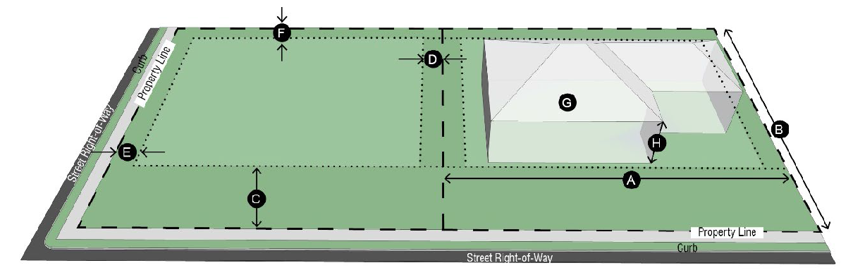
Table 2-4. AG Other Applicable Standards
B.
LDR low density residential district.
1.
Purpose. The LDR low density residential district is primarily for single family dwellings and related recreational and educational facilities normally required to provide an orderly and attractive residential area. The LDR low density residential district is intended to be defined and protected from the encroachment of uses that are not appropriate in a residential environment.
2.
Regulations.
a.
Figure 2-2, LDR dimensional standards.
b.
Table 2-5, LDR other applicable standards.
Figure 2-2. LDR Dimensional Standards
Table 2-5. LDR Other Applicable Standards
C.
MDR medium density residential district.
1.
Purpose. The MDR medium density residential district is intended to promote a variety of single family residential development on smaller lots than the LDR low density residential district and in a dense development pattern. This district can serve as a transition district between residential and nonresidential areas.
2.
Regulations.
a.
Figure 2-3, MDR dimensional standards.
b.
Table 2-6, MDR other applicable standards.
Figure 2-3. MDR Dimensional Standards
Table 2-6. MDR Other Applicable Standards
D.
HDR high density residential district.
1.
Purpose. The purpose of the HDR high density residential district is to establish areas appropriate for multiple-family dwellings.
2.
Regulations.
a.
Figure 2-4, HDR dimensional standards.
b.
Table 2-7, HDR other applicable standards.
Figure 2-4. HDR Dimensional Standards
Table 2-7. HDR Other Applicable Standards
E.
MH manufactured home district.
1.
Purpose. The MH manufactured home district is intended to provide adequate space and restrictions for the placement of HUD-Code manufactured homes and manufactured home parks in the city within designated subdivisions.
2.
Regulations.
a.
Figure 2-5, MH dimensional standards.
b.
Table 2-8, MH other applicable standards.
Figure 2-5. MH Dimensional Standards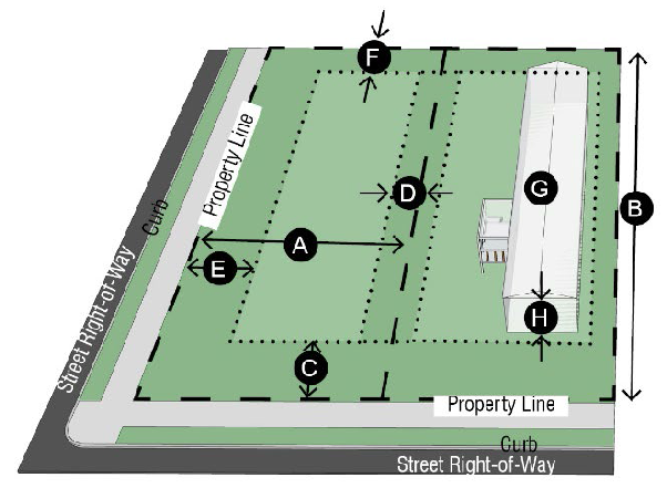
Table 2-8. MH Other Applicable Standards
2.04. - Nonresidential zoning districts.
A.
NS neighborhood services district.
1.
Purpose. The purpose of the NS neighborhood services district is to provide for retail businesses and personal services to meet the regular needs and for the convenience of adjacent residential areas. Uses in this district should be of an appropriate scale to match adjacent residential areas.
2.
Regulations.
a.
Figure 2-6, NS dimensional standards.
b.
Table 2-9, NS other applicable standards.
Figure 2-6. NS Dimensional Standards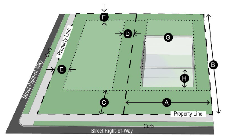
Table 2-9. NS Other Applicable Standards
B.
CR commercial retail district.
1.
Purpose. The purpose of the CR commercial retail district is to provide a location for light commercial and retail activities. These locations are typically along major thoroughfares and highways.
2.
Regulations.
a.
Figure 2-7, CR dimensional standards.
b.
Table 2-10, CR other applicable standards.
Figure 2-7. CR Dimensional Standards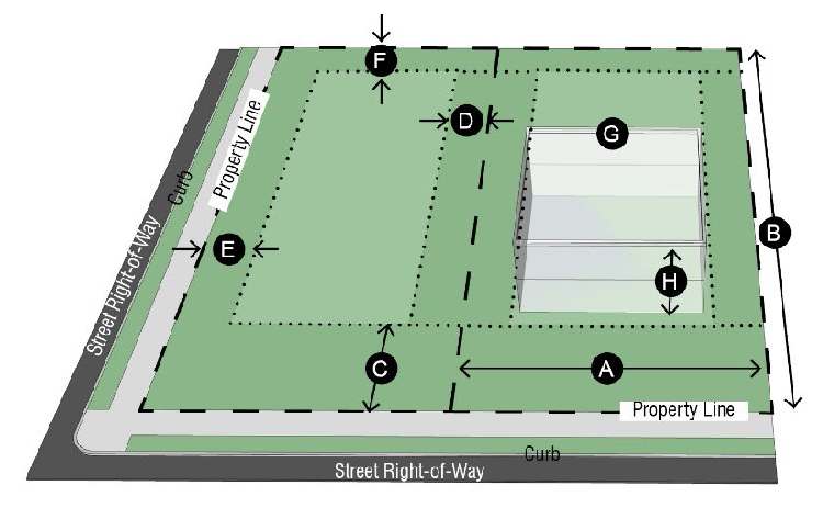
Table 2-10. CR Other Applicable Standards
C.
CG commercial general district.
1.
Purpose. The purpose of the CG commercial general district is to provide an area for uses that require special consideration because of the size of equipment, amount or type of traffic, or other intensive activities.
2.
Regulations.
a.
Figure 2-8, CG dimensional standards.
b.
Table 2-11, CG other applicable standards.
Figure 2-8. CG Dimensional Standards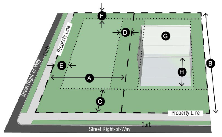
Table 2-11. CG Other Applicable Standards
D.
LI light industrial district.
1.
Purpose. The purpose of the LI light industrial district is to provide for locations for small-scale industrial uses that involve extensive processing, manufacturing or assembly of various products or equipment.
2.
Regulations.
a.
Figure 2-9, LI dimensional standards.
b.
Table 2-12, LI other applicable standards.
Figure 2-9. LI Dimensional Standards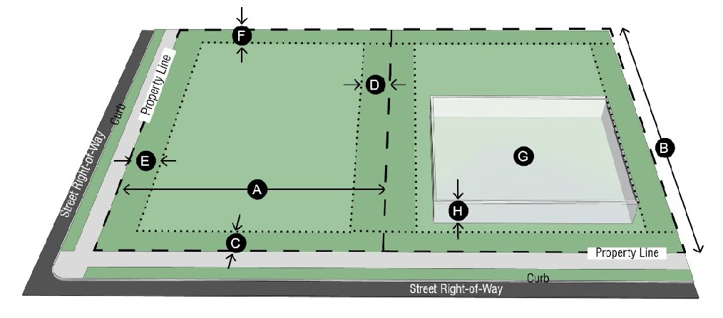
Table 2-12. LI Other Applicable Standards
[E].
HI heavy industrial district.
1.
Purpose. The purpose of the HI heavy industrial district is to provide locations for large-scale industrial uses that involve extensive processing, manufacturing or assembly of large products or equipment. This district is intended to allow for businesses that are more intense than the LI light industrial district and may include outdoor activities or the use of hazardous materials.
2.
Regulations.
a.
Figure 2-10, HI dimensional standards.
b.
Table 2-13, HI other applicable standards.
Figure 2-10. HI Dimensional Standards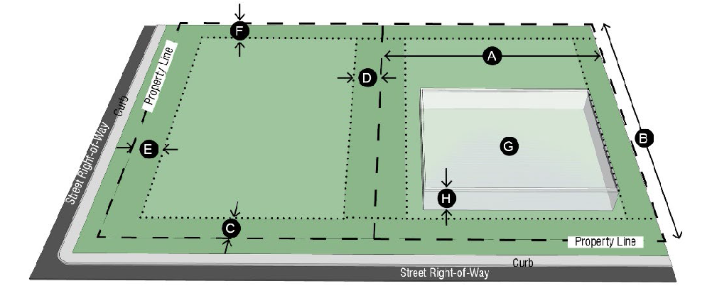
Table 2-13. HI Other Applicable Standards
2.05. - Special zoning districts.
A.
MU mixed use district.
1.
Purpose. The purpose of the MU mixed use district is to promote dense and walkable development by encouraging a variety of residential and nonresidential uses within an area.
2.
Regulations.
a.
Figure 2-11, MU dimensional standards.
b.
Table 2-14, MU other applicable standards.
Figure 2-11. MU Dimensional Standards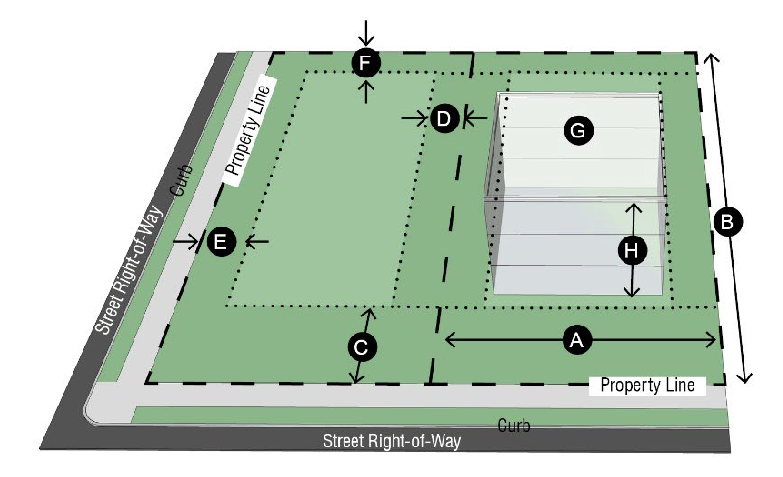
Table 2-14. MU Other Applicable Standards
B.
DT downtown core district.
1.
Purpose. The purpose of the DT downtown core district is to provide a visually cohesive district that promotes the vision of the downtown revitalization plan by developing a unique character and development pattern that favors a variety of residential and commercial uses to be located within the downtown area. These regulations aim to preserve the existing grid development pattern, support infill development, encourage revitalization, and drive economic development.
2.
Regulations.
a.
Unless otherwise specified in section 4.14, downtown district regulations, all development shall comply with the requirements as listed in table 2-15 DT other applicable standards.
Table 2-15. DT Other Applicable Standards
C.
PD planned development district.
1.
Purpose. The purpose of the PD planned development district is to provide greater flexibility and opportunity for innovation in projects.
2.
Regulations.
a.
Table 2-16, PD other applicable standards.
3.
Base zoning district.
a.
A planned development shall contain at least one base zoning district to regulate all uses and development regulations not modified by the planned development ordinance.
b.
For all existing PD planned development districts that do not specify a residential or nonresidential district, the director of planning may set a base zoning district that is most representative of established permitted uses.
c.
For all nonresidential uses that do not have a base zoning district, the base zoning district shall be CR commercial retail district. For all residential PD planned development districts that do not have a base zoning district, the base zoning district shall be LDR low density residential district.
4.
Application. For permitting requirements, see section 6.06, planned developments.
Table 2-16. PD Other Applicable Standards
2.06. - Overlay zoning districts.
A.
OL-1 overlay 1 district (open marsh, type 1).
1.
Purpose.
a.
Within the city, there are certain open marsh areas, tidal water exchange passes, and chenier ridges that ensure the public health, safety, and welfare by their geological, hydrological, and ecological functions as defined and set forth in the comprehensive master plan of the Sabine Pass area. The special character and functions of these natural resources are not adequately protected under the basic zoning district regulations established by ordinance. Therefore, the purpose of the OL-1 district shall be to protect the function of the open marshes that secure safety from storm surges, flooding and erosion, protect and preserve water quality, renew harvestable goods, and protect recreational and educational values.
b.
Performance standards, hereinafter established, for the OL-1 district shall not prevent development of the open marshes, but shall minimize adverse effects to their geological, hydrological, and ecological integrity by maintaining the physical features essential to the above cited functions in the public interest.
2.
Environmental performance standards. Prior to the issuance of any permit or certificate of occupancy, the applicant must demonstrate that:
a.
A building permit and/or certificate of occupancy shall be issued for use of the land or site development when the applicant demonstrates that the proposed use or development:
i.
Will maintain the marsh-water interface and its characteristic vegetation.
ii.
Will maintain natural flooding and drainage patterns;
iii.
Will maintain 90 percent of the natural wetland vegetation on the developed site, lot or tract;
iv.
Will maintain the normal level of the water table;
v.
Will maintain water quality (i.e. clarity and dissolve oxygen over the developed site, lot or tract);
vi.
Provide proof of determination by U.S. Corps of Engineers on whether the proposed project is subject to the 404 permit process; and
vii.
Provide a copy of 404 permit, if applicable.
B.
OL-2 overlay 2 district (open marsh, type 2).
1.
Purpose.
a.
Within the city, there are certain open marsh areas, tidal water exchange passes, and chenier ridges that ensure the public health, safety, and welfare by their geological, hydrological, and ecological functions as defined and set forth in the comprehensive master plan of the Sabine Pass area. The special character and functions of these natural resources are not adequately protected under the basic zoning district regulations established by ordinance. Therefore, the purpose of the OL-2 district shall be to protect the function of the open marshes that secure safety from storm surges, flooding, and erosion, protect and preserve water quality, renew harvestable goods, and protect recreational and educational values.
b.
Performance standards, hereinafter established, for the OL-2 district shall not prevent development of the open marshes, but shall minimize adverse effects to their geological, hydrological, and ecological integrity by maintaining the physical features essential to the above cited functions in the public interest.
2.
Environmental performance standards.
a.
A building permit and/or certificate of occupancy shall be issued for use of the land or site development when the applicant demonstrates that the proposed use or development:
i.
Will maintain the natural flooding and drainage of neighboring marshes and at least 70 percent of the developed site, lot or tract;
ii.
Will maintain the natural wetland vegetation over 70 percent of the developed site, lot or tract;
iii.
Will maintain the normal level of the water table;
iv.
Will maintain water quality (i.e. clarity and dissolve oxygen over the developed site, lot or tract);
v.
Provide proof of determination by U.S. Corps of Engineers on whether the proposed project is subject to the 404 permit process; and
vi.
Provide copy of 404 permit, if applicable.
C.
OL-3 overlay 3 district (water exchange pass).
1.
Purpose.
a.
Within the city, there are certain open marsh areas, tidal water exchange passes, and chenier ridges that ensure the public health, safety, and welfare by their geological, hydrological, and ecological functions as defined and set forth in the comprehensive master plan of the Sabine Pass Area. The special character and functions of these natural resources are not adequately protected under the basic zoning district regulations established by ordinance. Therefore, the purpose of the OL-3 district shall be to protect the function of the water exchange passes that secure safety from storm surges, flooding, and erosion, protect and preserve water quality, renew harvestable goods, and protect recreational and educational values.
b.
Performance standards, hereinafter established, for the OL-3 district shall not prevent development of the water exchange passes, but shall minimize adverse effects to their geological, hydrological, and ecological integrity by maintaining the physical features essential to the above cited functions in the public interest.
2.
Environmental performance standards.
a.
A building permit and/or certificate of occupancy shall be issued for use of the land or site development when the applicant demonstrates that the proposed use or development:
i.
Will maintain natural or existing flows of water in and out of the pass;
ii.
Will maintain the marsh-water interface and its characteristic vegetation; and
iii.
Will maintain water quality (i.e. salinity, dissolve oxygen, and clarity over the developed lot or tract).
D.
OL-4 overlay 4 district (Chenier Ridge).
1.
Purpose.
a.
Within the city, there are certain open marsh areas, tidal water exchange passes, and chenier ridges that ensure the public health, safety, and welfare by their geological, hydrological, and ecological functions as defined and set forth in the comprehensive master plan of the Sabine Pass Area. The special character and functions of these natural resources are not adequately protected under the basic zoning district regulations established by ordinance. Therefore, the purpose of the OL-4 district shall be to protect the function of the chenier ridges that secure safety from storm surges, flooding, and erosion, protect and preserve water quality, renew harvestable goods, and protect recreational and educational values.
b.
Performance standards, hereinafter established, for the OL-4 district shall not prevent development of the chenier ridges, but shall minimize adverse effects to their geological, hydrological, and ecological integrity by maintaining the physical features essential to the above cited functions in the public interest.
2.
Environmental performance standards.
a.
A building permit and/or certificate of occupancy shall be issued for use of the land or site development when the applicant demonstrates that the proposed use or development:
i.
Will maintain the natural elevation and configuration of the chenier ridge such that it remains a natural barrier to storm surges;
ii.
Will maintain native or non-competing vegetative cover by limiting building and impermeable surface coverage to:
a)
Eighty percent of the developed site, lot or tract for a commercial, support service or industrial use in the LI light industrial district or HI heavy industrial district; or
b)
Sixty percent of the developed site, lot or tract for a commercial or support service use in the CG commercial general district; or
c)
Forty percent of the developed site, lot or tract in all other districts except in the CR commercial retail district where there shall be no OL-4 coverage limitation.
iii.
Will maintain natural patterns and discharge of runoff;
iv.
Will maintain the quality and recharge capacity of the fresh water aquifer; and
v.
Will maintain wildlife access to open marsh areas in the AG agricultural district.
E.
OSP open space preservation overlay district.
1.
Purpose. The purpose of the OSP open space preservation overlay district is to preserve, conserve, and protect native and manmade open space and recreation areas in Port Arthur. It is intended that this district will provide open space for a variety of uses such as conservation of natural amenities, aesthetics, wildlife habitat, and park and recreation facilities among other similar uses. The OSP open space preservation overlay district shall be applied in addition to any base zoning district applied to land dedicated to or owned by the state, county, city, other public entity, or private property, upon consent of its owner.
2.
Special provisions.
a.
Uses permitted in the base zoning district must be related to the promotion of recreation activities or the preservation of open space. All structures or accessory buildings must be related to the promotion of recreation activities or the preservation of open space as determined by the director of planning.
i.
Such structures include but are not limited to:
a)
Buildings for educational or maintenance purposes;
b)
Restrooms;
c)
Recreational equipment;
d)
Trash receptacles;
e)
Benches;
f)
Lighting; and
g)
Signage.
b.
Any structure that may have or is found to have negative impacts to the native vegetation, wildlife, or waterways are prohibited and shall not be located in the district.
2.07. - Dimensional standards.
A.
Dimensional standards summary table. Table 2-17 is a consolidation of the dimensional tables in the zoning ordinance. In case of conflict between the summary table for dimensional standards and the dimensions outlined within each district, the more restrictive regulation shall apply.
Table 2-17. Summary of Dimensional Standards
B.
Additional dimensional standards.
1.
Special front yard regulations.
a.
If one side of a block face is divided into two or more districts, all front yards shall comply with the requirement of the most restrictive district (see figure 2-12).
Figure 2-12. Uniform Front Setback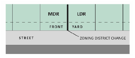
b.
The front yard shall be measured from the property line to the front face of the building, covered porch, covered terrace or attached accessory building as shown in figure 2-13. Eaves and roof extensions or porches without posts or columns may project into the required front yard for a distance not to exceed four feet. Subsurface structures, platforms or slabs shall not project into the front yard to a height greater than 30 inches above the average grade of the yard.
Figure 2-13. Measuring Front Yard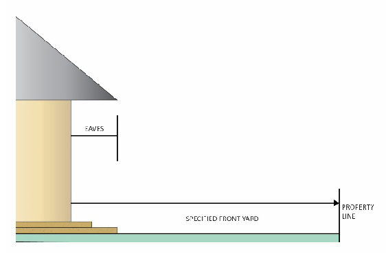
c.
Where lots have double frontage (run through a block from one street to another), a required front yard shall be provided on both streets, as shown in figure 2-14.
Figure 2-14. Double Frontage Lots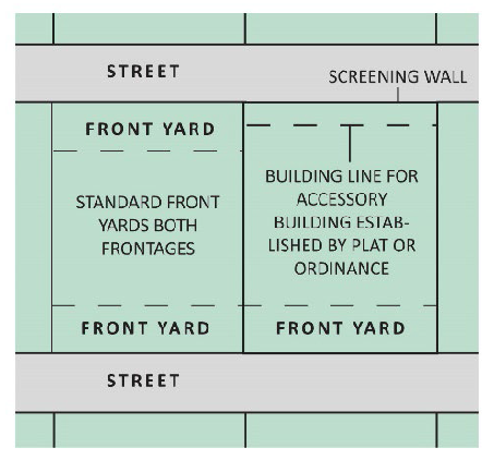
d.
On any corner lot, the vision of a motor vehicle driver approaching the street intersection must be maintained clear of obstructions for a distance of 20 feet from the corner property line along both streets. Obstructions include walls, fences, structures, signs, vehicle parking or storage, trees or other plantings, and raised slopes, terraces, embankments, or berms.
2.
Special side yard regulations.
a.
On corner lots, used for residential purposes:
i.
On all lots platted after the effective date of November 12, 1973, both street exposures shall be considered as front yards.
ii.
On all lots platted prior to the effective date of November 12, 1973, one yard shall be considered a front yard and the second yard shall be considered an exterior side yard.
b.
No complex of attached single family dwellings shall exceed 300 feet in length. A minimum required side yard of five feet shall be provided at the end of each single family dwelling complex so that the end of any two adjacent building complexes shall be at least ten feet apart.
c.
Every part of a required side yard shall be open and unobstructed except for trees, fences, and plants and permitted accessory buildings. The ordinary projections of windowsills, belt courses, cornices and other architectural features may extend up to 12 inches into the required side yard. Roof eaves and air conditioning units may be located or project up to 48 inches into the required side yard.
3.
Special rear yard regulations. Every part of a required rear yard shall be open and unobstructed to the sky from a point 30 inches above the general ground level of the graded lot, except for trees, fences and plants and for accessory buildings or structures as permitted in section 4.06, accessory buildings. The ordinary projections of windowsills, belt courses, cornices, and roof overhangs, and other architectural features may project up to 48 inches into the required rear yard.
4.
Height regulations.
a.
Cooling towers, roof gables, chimneys and vent stacks may extend for an additional height so long as their total height is not more than 40 feet above the average grade of the building.
b.
Water stand pipes and tanks, church steeples, domes and spires, school buildings, housing for the elderly, and public institutional buildings may be erected to exceed three stories provided that one foot additional shall be added to the width and depth of front, side and rear yards for each foot that such structures exceed three stories.