
Port St Joe City Zoning Code
ARTICLE I
- GENERAL PROVISIONS
Sec. 1.00.- Title.
This Code shall be entitled the City of Port St. Joe Land Development Regulation Code and may sometimes be referred to herein as the "Code."
Sec. 1.01. - Authority.
This Code is enacted under the authority of F.S. § 163.3202, the Charter of the city effective 1951 and the general powers set forth in F.S. ch. 166.
Sec. 1.02. - Applicability.
Except as specifically provided below, the provisions of this Code shall apply to all development in the city and no development shall be undertaken without prior authorization pursuant to this Code.
(1)
Exceptions: The provisions of this Code and amendments thereto shall not affect the validity of any lawfully issued and effective building or development permit, if the development activity authorized by the permit has commenced and or continues in good faith in accordance with the terms of the permit.
(2)
If the development permit expires, any further development activity on the site, shall occur only in conformance with the requirements of this Code or amendments thereto.
Sec. 1.03. - Definitions.
Unless specifically defined below, words or phrases used in this Code shall be interpreted so as to give them the meaning they have in common usage and to give this Code its most reasonable application.
"A" frame or sandwich sign. A sign so named because of the inverted v-shaped structure and utilization of copy on both sides, facing opposite directions. These signs are usually painted on wood or metal surfaces and resting on the ground, with no permanent attachment.
Abandoned (discontinued) sign. A sign that no longer identifies or advertises a bona fide business, lesser service, owner, product, or activity, time of event passed, and/or legal owner can be found. This definition shall also include any sign structure that no longer supports the sign for which it was designed.
Accessory sign. See incidental sign.
Accessory structure (appurtenant structure) means a structure that is located on the same parcel of property as the principal structure and the use of which is incidental to the use of the principal structure. Accessory structures in flood hazard areas should constitute a minimal investment and be designed to have minimal flood damage potential. Examples of accessory structures are detached garages, carports, storage sheds, pole barns, and hay sheds.
Accessory use. A use of land or structure or portion thereof customarily incidental and subordinate to the principal use of the land or structure and located on the same parcel.
Advertising. Sign copy (words or symbols) intended to directly or indirectly promote the sale of use of a product, service, commodity, entertainment, or real or personal property.
Advertising device. Any structure or device erected or intended for the purpose of displaying advertising situated upon or attached to real property. For purposes of the article, an advertising device is a sign.
Affordable housing programs policies and procedures. Administrative policies and procedures approved by the city commission for the implementation of this Code.
Affordable housing unit. Housing built with funding from federal, state, local or private resources and designated for affordable housing for moderate, low and very low income households (as hereinafter defined).
Affordable owner occupied housing unit. A dwelling unit for which the mortgage payment (including principal, interest, taxes and insurance) does not exceed 30 percent of the gross income of the households that meet the income criteria and also meet the other requirements of the city's affordable housing programs.
Affordable renter occupied housing unit. A dwelling unit for which the rental payment does not exceed 30 percent of the gross income of the households that meet the income criteria and also meet the other requirements of the city's affordable housing programs.
Alley. A roadway which affords only a secondary means of access to abutting property and not intended for general traffic circulation.
Alteration of a watercourse means a dam, impoundment, channel relocation, change in channel alignment, channelization, or change in cross-sectional area of the channel or the channel capacity, or any other form of modification which may alter, impede, retard or change the direction and/or velocity of the riverine flow of water during conditions of the base flood.
Animated sign. A sign with sound, action, motion, changing colors, flashing lights, or moving characters. Such signs may require electrical energy, but shall also include wind-activated devices including, but not limited to, spinners, aerial devices, and other attention-getting devices. This definition does not include rotating sign the revolve no faster than five revolutions per minute or electronic message boards. Also included in this definition are signs that emit or utilize in any manner any sound capable of being detected on any traveled road or high way by a person with normal hearing and signs that emit smoke, vapor, particles, or odors.
Apartment house. A building or structure arranged, intended or designed to be occupied as the dwelling place of three or more families living independently of each other (see dwelling, multiple).
Appeal means a request for a review of a decision or interpretation of any provision of this Code.
ASCE 24 means a standard titled Flood Resistant Design and Construction that is referenced by the Florida Building Code. ASCE 24 is developed and published by the American Society of Civil Engineers, Reston, VA.
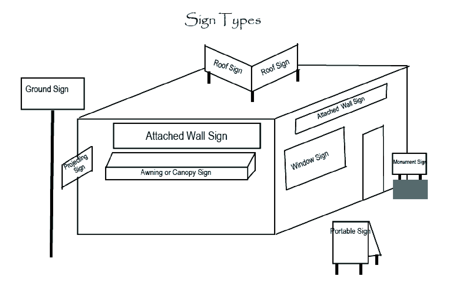
Attached sign. Any sign attached to any part of a building, as contrasted to a freestanding sign.
Automobile court (motel). A group of attached or detached buildings containing individual sleeping units, designed for or used temporarily by automobile tourists or transients with parking space conveniently located to each unit, including auto courts, motel or motor lodges.
Awning. A roof-like cover that projects from three wall of a building or the purpose of shielding a doorway, walkway, or window from the elements. Awnings are often made of fabric or flexible plastic supported by a rigid frame, and may be retracted into the face of the building.
Awning or canopy sign (a type of projecting sign). See building sign.
Balloon (as signage). Any device that is supported by air pressure or inflated with air or gas that is used to attract the attention of the public, whether or not it displays any specific advertising message.
Banner. A sign other than a flag, which is temporary in nature and made of paper, cloth, thin plastic, or similar lightweight material. A banner is not a streamer or pennant.
Base flood means the flood having a one percent chance of being equaled or exceeded in any given year (also called the "100-year flood" and the "regulatory flood"). Base flood is the term used throughout this Code.
Base flood elevation means the water-surface elevation associated with the base flood relative to the datum specified on the flood insurance rate map.
Basement means that portion of a building having its floor sub-grade (below ground level) on all sides.
Bench sign. An advertising message on any portion of a public bench.
Billboard. A freestanding sign, distinguished from a real estate directional sign or semi-public directional sign, that carries a noncommercial message or commercial message not pertaining to use or activity on the site on which it is located.
Blade sign (a type of projecting sign). See building sign.
Boardinghouse. Any dwelling in which two or more persons either individually or as families are housed or lodged for hire, with or without meals.
Breakaway wall means a wall that is not part of the structural support of the building and is intended through its design and construction to collapse under specific lateral loading forces without causing damage to the elevated portion of the building or the supporting foundation system.
Building. Any structure having a roof supported by columns or walls.
Building, height of. The vertical distance measured from the average finish grade elevation to the eaves.
_____
Building sign. A sign that in any manner is fastened to, projects from, or is placed or painted upon the exterior wall, canopy, awning, window, door, or roof of a building. The term building sign includes but is not limited to the following:
•
Awning or canopy sign. A sign imposed or painted upon or suspended beneath an awning or canopy (see illustration).
•
Blade sign. A sign suspended from the lower edge of a canopy or awning.
•
Facade or wall sign. A sign that is fastened directly to or is placed or painted directly upon the exterior wall of a building and extends from the surface of the wall no more that 18 inches.
•
Incidental (accessory) sign. An announcement or other display providing information about the occupancy or conduct of business permitted on a premises, such as logos of credit cards accepted on the premises, hours of operation, a "closed" or "open" sign, emergency contact person name and telephone number, street address, "help wanted", "no loitering or solicitations", security system notices, notices require by law, and similar information.
•
Projecting sign. A sign attached to and projecting from the wall of a building and not in the same plane as the wall, including canopy/awning signs and blade signs.
•
Roof sign. A sign that is mounted on, applied to, or otherwise structurally supported by the roof of a building; or any building sign that extends above the top edge of the parapet or eaves of a flat or shed roof; ridge live of a gable, hip, or gambrel roof; or the deck line of a mansard roof.
•
Window sign. A sign that is placed on or behind a window pane and intended to be viewed from outside the building.
_____
Changeable message sign. Any sign on which the message changes more rapidly than once every six hours.
City. The City of Port St. Joe, Florida.
Coastal high hazard area (CHHA). means areas below the elevation of the Category 1 storm surge line as established by a Sea, Lake and Overland Surges from Hurricanes (SLOSH) computerized storm surge model as defined in F.S. § 163.3178(2)(h), and depicted on the adopted Future Land Use Map Series, Map 9. For purposes of the flood provisions of Article IV, the CHHA means the special flood hazard area extending from offshore to the inland limit of a primary frontal dune along an open coast and any other area subject to high velocity wave action from storms or seismic sources. The area is designated on the FIRM as zone V1-V30, VE, or V.
Concurrency. A condition where specified facilities and services have or will have the necessary capacity to maintain adopted level of service standards at the time of impact of the development project.
Construction sign. A sign identifying the contractors, engineers, architects or financial institutions involved in the building construction or development of a property.
Court. An open unoccupied space, other than a yard, on the same lot with a building and bounded on two or more sides by such building.
Datum means a reference surface used to ensure that all elevation records are properly related. Many communities have their own datum that was developed before there was a national standard. The current national datum is the National Geodetic Vertical Datum (NGVD) of 1929, which is expressed in relation to mean sea level, or the North American Vertical Datum (NAVD) of 1988.
Density or gross density. The total number of dwelling units divided by the total site area.
Density bonus unit. A unit as a result of an increase in density permitted above the per acre density established by the City of Port St. Joe Comprehensive Plan, including the certified future land use map (FLUM) and the land development regulations.
Derelict sign. A sign that is dilapidated or in such condition as to create a hazard or nuisance, or to be unsafe or fail to comply with the building or electrical codes of the city.
Design flood means the flood associated with the greater of the following two areas:
(1)
Area with a floodplain subject to a one-percent or greater chance of flooding in any year; or
(2)
Area designated as a flood hazard area on the community's flood hazard map, or otherwise legally designated.
Design flood elevation means the elevation of the "design flood," including wave height, relative to the datum specified on the community's legally designated flood hazard map. In areas designated as Zone AO, the design flood elevation shall be the elevation of the highest existing grade of the building's perimeter plus the depth number (in feet) specified on the flood hazard map. In areas designated as Zone AO where the depth number is not specified on the map, the depth number shall be taken as being equal to two feet.
Developer. The person or entity that engages in or proposes to engage in a development activity as either the owner or as the agent of an owner of property.
Development, means for the purposes of the flood provisions of Article IV, any man-made change to improved or unimproved real estate, including but not limited to, buildings or other structures, tanks, temporary structures, temporary or permanent storage of equipment or materials, mining, dredging, filling, grading, paving, excavations, drilling operations or any other land disturbing activities.
Development or development activity includes any of the following activities:
(1)
Construction, clearing, filling, excavating, grading, paving, dredging, mining and/or other similar activities.
(2)
Building, installing, enlarging, replacing and/or substantially restoring a structure, impervious surface and/or water management system, and/or including the long-term storage of materials.
(3)
Erection of a permanent sign unless expressly exempted hereinafter.
(4)
Changing the use of the site so that the need for parking is increased.
(5)
Construction, elimination or alteration of a driveway onto a public street.
Development order. An order granting, denying or granting with conditions an application for approval of a development activity. A distinction is made between a development order and a building permit. A development order is the city authorization of a proposed development project. Such authorization must be granted by the city prior to issuance of a building permit by the city as defined for purposes of these regulations. (The development order authorizes the project, whereas the building permit authorizes specific components of the project, such as building construction, sign installation and the like). For purposes of these regulations, the development plan approval or preliminary plat approval is the development order.
Development permit. For purposes of the Code, a development permit is the official city document which authorizes the commencement or construction or land alteration without need for further application and approval. Development permits include all types of building and construction permits.
Development plan. A development plan is the application for a development order which includes all information required by the building inspector, TAC, PDRB or the board of city commissioners complying with section 2.06 and shall include data and analysis demonstrating that levels of service set forth in the comprehensive plan for all areas required by the plan shall be maintained.
Directory sign. Any sign that displays exclusively the names, logos, and locations of occupants or uses of a building or commercial complex. No advertising other than name, logo and locations of occupants or use is included.
Directory sign for multi-tenant development. A sign distinguished from a project entrance sign, which is allowed on a premises with more than one tenant or occupants of a building, and which is necessary to find tenants within the development once a patron enters the property. It may be freestanding or a building (wall) sign. Such signs are not visible from the public street right-of-way of a development which provides initial access to the property, but rather are located within the development, along a driveway, access way, or parking aisle. These signs are distinguished from project entrance signs.
Discontinued sign. A freestanding or building sign that no longer is used by an active business or establishment at that location.
Double-faced sign. A sign that has two display areas against each other or where the interior angle formed by the display areas is 60 degrees or less, where one face is designed to be seen from one direction, and the other face from the opposite direction.
Dwelling, multiple. A building or portion thereof designed for occupancy by three or more families living independently of each other (see apartment house).
Dwelling, single-family. A detached building designed for, or occupied exclusively by one family as a housekeeping unit.
Dwelling, two-family. A detached building designed for or occupied exclusively by two families only living independently of each other.
Efficiency apartment. A dwelling unit consisting principally of one room and alcoves, equipped with kitchenette and bath, and having an aggregate floor area of not less than 336 square feet, designed and intended to be used as the temporary abode of transients and seasonal occupants.
Electric sign. Any sign containing electric wiring.
Electronic message board. A type of sign that presents its message through internal illumination of flashing, intermittent, or moving lights forming the letters, number, or symbols of the message, whether or not the message appears to move across the sign face.
Eligible household. A household that qualifies for participation in an affordable housing program as designated in this article. Priority will be given to persons who work in the city limits prior to the date of application for an affordable unit and who qualify to participate in one of the city's affordable housing programs.
Encroachment means the advance or infringement of uses, plant growth, fill, excavation, buildings, permanent structures or development into a floodplain, which may impede or alter the flow capacity of a floodplain.
Environmentally sensitive lands means areas of land or water which are determined necessary by the city, based on locally determined criteria, to conserve or protect natural habitats and ecological systems such as ground and surface waters, wetlands, wellhead protection areas, floodplain and listed animal and plant species and their habitats.
Erect. To build, paint, construct, reconstruct, attach, hang, suspend, place or affix.
Existing building means, for the purposes of floodplain management, structures for which "the start of construction" commenced before June 15, 1983. This term may also be referred to as "existing structures."
Existing manufactured home park or subdivision means a manufactured home park or subdivision for which the construction of facilities for servicing the lots on which the manufactured homes are to be affixed (including at a minimum the installation of utilities, the construction of streets, and either final site grading or the pouring of concrete pads) is completed before June 15, 1983.
Expansion to an existing manufactured home park or subdivision means the preparation of additional sites by the construction of facilities for servicing the lots on which the manufactured homes are to be affixed (including the installation of utilities, the construction of streets, and either final site grading or the pouring of concrete pads).
Facade. The face of a building that is visible to the public.
Family. Any number of individuals living together as a single housekeeping unit and doing their cooking on the premises, as distinguished from a group occupying a boardinghouse, lodging house or hotel, or herein defined.
Festoons. A string of ribbons, tinsel, small flags, pennants, or pinwheels.
Filling station. Any building or premises used for the dispensing, sale or offering for sale at retail of any automobile fuels or oils. When the dispensing, sale or offering for sale is incidental to the conduct of a mechanical garage, the premises are classified as a mechanical garage and if incidental to the conduct of a public garage, the premises are classified as a public garage.
First time home buyer. A household in which no person has had ownership of a residence within the past three years.
Flag. A piece of cloth or flexible material varying in size, color and/or design that carries symbols, emblems, words, or numbers of an institution, organization, or business, or person.
Flashing sign. See animated sign.
Flood or flooding means:
A general and temporary condition of partial or complete inundation of normally dry land areas from:
(1)
The overflow of inland or tidal waters.
(2)
The unusual and rapid accumulation of runoff of surface waters from any source.
Flood damage-resistant materials means any construction material capable of withstanding direct and prolonged contact with floodwaters without sustaining any damage that requires more than cosmetic repair.
Flood hazard area means the greater of the following two areas:
(1)
The area within a floodplain subject to a one percent or greater chance of flooding in any year.
(2)
The area designated as a flood hazard area on the community's flood hazard map, or otherwise legally designated.
Flood insurance rate map (FIRM) means an official map of a community, issued by FEMA, which delineated both the areas of special flood hazard and the risk premium zones applicable to the community.
Flood insurance study (FIS) is the official hydraulic and hydrologic report provided by FEMA. The study contains an examination, evaluation, and determination of flood hazards, and, if appropriate, corresponding water surface elevations, or an examination, evaluation, and determination of mudslide (i.e., mudflow) and other flood-related erosion hazards. The study may also contain flood profiles, as well as the FIRM, FHBM (where applicable), and other related data and information.
Floodplain means any land area susceptible to being inundated by water from any source (see flooding).
Floodplain administrator is the individual appointed to administer and enforce the floodplain management regulations of the community.
Floodway means the channel of a river or other watercourse and the adjacent land areas that must be reserved in order to discharge the base flood without cumulatively increasing the water surface elevation more than a designated height.
Floodway encroachment analysis means an engineering analysis of the impact that a proposed encroachment into a floodway is expected to have on the floodway boundaries and base flood elevations; the evaluation shall be prepared by a qualified Florida licensed engineer using standard engineering methods and models.
Florida Building Code means the family of codes adopted by the Florida Building Commission, including: Florida Building Code, Building; Florida Building Code, Residential; Florida Building Code Existing Building; Florida Building Code, Mechanical; Florida Building Code, Plumbing; Florida Building Code, Fuel Gas.
Freestanding sign. See principle freestanding sign.
Frontage. The length of the property line of any one parcel along a street on which it borders.
Full-cutoff, light fixture. A light fixture designed such that no light is projected at or above a 90-degree plane running through the lowest point on the fixture where the light is emitted and less than ten percent of the rated lumens are projected between 90 degrees and 80 degrees.
Functionally dependent use means a use that cannot be used for its intended purpose unless it is located or carried out in close proximity to water, such as a docking or port facility necessary for the loading and unloading of cargo or passengers, shipbuilding or ship repair. The term does not include long-term storage, manufacture, sales, or service facilities.
Gross floor area. The sum of the gross horizontal areas of all floors of a building measured from the exterior face of exterior walls (or from the centerline of a wall separating two buildings but not including interior parking spaces or any space where the floor-to-ceiling height is less than six feet).
Garage, private. A detached accessory building or portion of a principal building for the parking or temporary storage of automobiles of the occupants of the premises.
Garage, public. A building or portion thereof, other than a private or storage garage, designed or used for servicing, repairing, equipping, housing, selling or storing motor driven vehicles.
Garage, storage. Any building or premises, other than a private or public garage, used exclusively for the parking or storage of motor vehicles.
Grade.
(1)
For buildings adjoining one street only the elevation of the sidewalk at the center of the wall adjoining the street.
(2)
For buildings adjoining more than one street, the average of the elevations of the sidewalk at the centers of all walls adjoining streets.
(3)
For buildings having no wall adjoining the street, the average level of the finished surface of the ground adjacent to the exterior walls of the building.
Hardship as related to variances from this Code means the exceptional hardship associated with the land that would result from a failure to grant the requested variance. The community requires that the variance is exceptional, unusual, and peculiar to the property involved. Mere economic or financial hardship alone is not exceptional. Inconvenience, aesthetic considerations, physical handicaps, personal preferences, or the disapproval of one's neighbors likewise cannot, as a rule, qualify as an exceptional hardship. All of these problems can be resolved through other means without granting a variance, even if the alternative is more expensive, or requires the property owner to build elsewhere or put the parcel to a different use than originally intended.
Highest adjacent grade means the highest natural elevation of the ground surface, prior to the start of construction, next to the proposed walls or foundation of a structure.
Historic structure means any structure that is:
(a)
Listed individually in the National Register of Historic Places (a listing maintained by the department of interior) or preliminarily determined by the secretary of the interior as meeting the requirements for individual listing on the National Register:
(b)
Certified or preliminarily determined by the secretary of the interior as contributing to the historical significance of a registered historic or a district preliminarily determined by the secretary to qualify as a registered historic district:
(c)
Individually listed on the state inventory of historic places, which has been approved by the secretary of the interior; or
(d)
Individually listed on a local inventory of historic places in communities with historic preservation programs that have been certified either:
1.
By the approved state program as determined by the Secretary of the Interior; or
2.
Directly by the secretary of the interior.
Holiday decorations. Signs or displays, including lighting, that are a nonpermanent installation celebrating national, state, and local holidays.
Home occupation or business. Any occupation with which there is kept no stock in trade nor commodities sold upon the premises, no person employed other than a member of the immediate family residing upon the premises, and no mechanical equipment except such as is necessary for the particular occupation authorized; limited however, to such equipment the operation of which does not create any noises or sound that will affect the occupants of the adjoining property and in connection of which there is no sign or display that will indicate from the exterior that the building is being utilized in whole and in part for any purpose other than that of a dwelling.
Hotel. A building or other structure kept, used, maintained, advertised as or held out to the public to be a place where sleeping accommodations are supplied for pay to transient or permanent guests or tenants, in which ten or more rooms are furnished for the accommodation of such guests; and having or not having one or more dining rooms, restaurants or cafes where meals or lunches are served to transient or permanent guests, such sleeping accommodations and dining rooms, restaurants or cafes, if existing, being conducted in the same building or buildings in connection therewith.
Household. One person living alone or two or more persons sharing residency whose income is considered for the affordable housing program.
Illegal (unlawful) sign. Any sign erected or maintained in violation of a preceding ordinance or erected, altered, moved, or replaced in violation of this article.
Illuminated sign. A sign illuminated in any manner by an artificial light source.
•
Externally illuminated sign. A sign illuminated by an external light source directed primarily toward such sign.
•
Internally illuminated sign. A sign containing a light source that is recessed or contained within the element of the sign.
Incidental (accessory) sign. An announcement or other display providing information about the occupancy or conduct of business permitted on a premises, such as logos of credit cards accepted on the premises, hours of operation, a "closed" or "open" sign, emergency contact person name and telephone number, street address, "help wanted", "no loitering or solicitations", security system notices, notices require by law, and similar information.
Inclusionary housing plan. The plan submitted by the developer as part of site plan approval that, at a minimum, designates the number of inclusionary units within the residential development.
Inclusionary unit. A housing unit offered to eligible households and restricted by covenants.
Inflatable sign. A sign or advertising device that is intended to be expanded by air or other gas for its proper display or support.
Intensity. an objective measurement of the extent to which land may be developed or used, including the consumption or use of the space above, on or below ground; the measurement of the use of or demand on natural resources; and the measurement of the use of or demand on facilities or services.
Interlocal agreement for public school facility planning. Agreement entered between the Gulf County Board of County Commissioners, the Cities of Port St. Joe and Wewahitchka Commissioners and the School Board of Gulf County to establish specific ways in which the plans and processes of the district school board and the local governments are to be coordinated,
Large-scale, commercial-retail building. A commercial building whose total gross building area, including outdoor display and sales areas, is equal to or exceeds 25,000 square feet. For determining building area, buildings located closer than 20 feet apart shall be considered one building.
Large-scale, commercial-retail, development project. A commercial development project where the project is developed as a common plan of development and contains a large-scale, commercial-retail building.
Letter of map change (LOMC) means an official determination issued by FEMA that amends or revises an effective flood insurance rate map or flood insurance study. Letters of map change include:
Letter of map amendment (LOMA): An amendment based on technical data showing that a property was incorrectly included in a designated special flood hazard area. A LOMA amends the current effective flood insurance rate map and establishes that a specific property, portion of a property, or structure is not located in a special flood hazard area.
Letter of map revision (LOMR): A revision based on technical data that may show changes to flood zones, flood elevations, special flood hazard area boundaries and floodway delineations, and other planimetric features.
Letter of map revision based on fill (LOMR-F): A determination that a structure or parcel of land has been elevated by fill above the base flood elevation and is, therefore, no longer located within the special flood hazard area. In order to qualify for this determination, the fill must have been permitted and placed in accordance with the community's floodplain management regulations.
Conditional letter of map revision (CLOMR): A formal review and comment as to whether a proposed flood protection project or other project complies with the minimum NFIP requirements for such projects with respect to delineation of special flood hazard areas. A CLOMR does not revise the effective flood insurance rate map or flood insurance study; upon submission and approval of certified as-built documentation, a letter of map revision may be issued by FEMA to revise the effective FIRM.
Light-duty truck means, as defined in 40 C.F.R. 86.082-2, any motor vehicle rated at 8,500 pounds Gross Vehicular Weight Rating or less which has a vehicular curb weight of 6,000 pounds or less and which has a basic vehicle frontal area of 45 square feet or less, which is:
(1)
Designed primarily for purposes of transportation of property or is a derivation of such a vehicle, or
(2)
Designed primarily for transportation of persons and has a capacity of more than 12 persons; or
(3)
Available with special features enabling off-street or off-highway operation and use.
Loading space. A space on the lot or parcel of land accessible to an alley or street not less than ten feet in width, 20 feet in depth and ten feet in height.
Lodging (rooming) house. Any house, or other structure, or any place or location kept, used, maintained, advertised or held out to the public to be a place where living quarters, sleeping or housekeeping accommodations are supplied for pay to transient or permanent guests or tenants.
Lot. A parcel of land occupied or intended for occupancy by one main building together with its accessory buildings; including the open spaces and parking spaces required by this Code. For the purpose of this Code the word "lot" shall be taken to mean any number of contiguous lots or portions thereof, upon which one or more main structures for a single use are to be erected.
Lot corner. A lot abutting upon two or more streets at their intersection.
Lot coverage. The percentage of coverage of a lot by building or impervious surface obtained by dividing the impervious surface area by the gross area of the lot.
Lot depth. The depth of a lot is the distance measured in the mean direction of the side lines of the lot from the midpoint of the front lot line to the midpoint of the opposite main rear line of the lot.
Lot, double frontage. A lot having a frontage on two nonintersecting street, as distinguished from a corner lot.
Lot, interior. A lot other than a corner lot.
Lot lines. The lines bounding a lot.
Lot of record. A lot which is a part of a subdivision, the map of which has been recorded in the public records or a designated parcel of land established in the county official records books by unrecorded plat on file or as otherwise allowed by law.
Low income. Household income 51 percent up to 80 percent of the median income of Port St. Joe, Florida and adjusted for household size.
Lowest adjacent grade means the lowest elevation, after the completion of construction, of the ground, sidewalk, patio, deck support, or basement entryway immediately next to the structure.
Lowest floor means the lowest floor of the lowest enclosed area (including basement). An unfinished or flood resistant enclosure, used solely for parking of vehicles, building access, or storage, in an area other than a basement, is not considered a building's lowest floor, provided that such enclosure is not built so as to render the structure in violation of the non-elevation design standards of the Florida Building Code or ASCE 24.
Major development. A development shall be designated as a major development if it satisfies one or more of the following criteria:
(1)
The development is a residential project of five or more dwelling units.
(2)
The development involves 5,000 square feet or more of nonresidential gross floor area.
(3)
Any development that requires a variance from zoning restrictions as set forth hereinafter.
(4)
Any development that involves the subdivision of land.
(5)
Any development that the building inspector designates as a major development. Considerations for designation as a major development may include:
a.
The proposed development is a part of a larger parcel for which additional development is anticipated that when aggregated with the project in question exceeds the limits set forth above; or
b.
The proposed development should be more thoroughly and publicly reviewed because of its complexity, hazardousness, or location.
(6)
All major development proposals require review by the technical advisory committee (TAC). The TAC may approve major development proposals classified as level 1. TAC action on a level 1 development proposal shall be forwarded to the building inspector for permit issuance or denial. Major developments having significant community impacts, or those which the TAC believes should be publicly reviewed, shall be classified as a level 2 major development and must be sent to the PDRB for review and recommendations to the board of city commissioners. Approval of level 2 major developments shall be the responsibility of the board of city commissioners All other major development shall be classified as a level 1 major development.
Mangrove stand means an assemblage of mangrove trees which are mostly low trees noted for a copious development of interlacing adventitious roots above ground and which contain one or more of the following species: Black mangrove (Avicennia Nitida); red mangrove (Rhizophora mangle); while mangrove (Languncularia Racemosa); and buttonwood (Conocarpus Erecta).
Manufactured home means a structure, transportable in one or more sections, which is eight feet or more in width and greater than 400 square feet, and which is built on a permanent, integral chassis and is designed for use with or without a permanent foundation when attached to the required utilities. The term "manufactured home" does not include a "recreational vehicle" or "park trailer." [Also defined in 15C-1.0101, F.A.C.]
Manufactured home park or subdivision means a parcel (or contiguous parcels) of land divided into two or more manufactured home lots for rent or sale.
Manufactured housing. Manufactured housing has the following features or characteristics:
(1)
Mass produced in a factory;
(2)
Designed and constructed for transportation to a site for installation and use when connected to required utilities;
(3)
Either an independent, individual building or a module for combination with other elements to form a building on the site.
Market rate unit. A unit in a residential development other than an affordable housing unit.
Market value means the building value, which is the property value excluding the land value and that of the detached accessory structures and other improvements on site (as agreed to between a willing buyer and seller) as established by what the local real estate market will bear. Market value can be established by an independent certified appraisal (other than a limited or curbside appraisal, or one based on income approach), actual cash value (replacement cost depreciated for age and quality of construction of building), or tax-assessed values adjusted to approximate market value by a factor provided by the property appraiser.
Marquee. A structure projecting from and supported by a building that extends beyond the building line or property line and fully or partially covers a sidewalk, public entrance, or other pedestrian way.
Mean sea level means the average height of the sea for all stages of the tide. It is used as a reference for establishing various elevations within the floodplain. For purposes of this Code, the term is synonymous with National Geodetic Vertical Datum (NGVD) of 1929, or North American Vertical Datum (NAVD) of 1988.
Median income. Median income is determined by the department of housing and urban development for Gulf County, and is updated annually.
Menu (portable) sign. A portable sign, whether "A" or "T" framed, temporarily located on publicly owned lands or easements or inside street right-of-way.
Minor development. A development shall be designated as a minor development if it is a residential project of four or less dwelling units or involves less than 5,000 square feet of nonresidential gross floor area and does not meet the requirements of a major development.
Moderate income. Household income 81 percent to 120 percent of the median income of Port St. Joe, Florida, and adjusted for household size. Moderate income may also be defined as workforce income.
Multi-face sign. A sign structure that contains two or more sign face surfaces that are located on different sides of the structure and are separated from each other at their nearest point by no more that three feet.
Multi-tenant development. A single office, commercial or industrial property that is designed or intended for occupancy by two or more businesses, or a multi-family residential development.
Mural. Any picture or graphic, noncommercial in nature, not advertising a product or service, painted on or attached to an exterior wall or surface. The subject matter of a mural is expressed by means of a public symbolism easily understood by a general audience.
National Geodetic Vertical Datum (NGVD) of 1929 means a vertical control used as a reference for establishing varying elevations within the floodplain.
Neon lighting or outlining. A sign, display, or installation outline windows, doors, or other portions of the building which is composed of one or more discharge lamps in which the gas contains a large proportion of neon, giving it a fluorescent or extremely bright color.
New construction means, for the purposes of administration of the flood provisions of Article IV and the flood resistant construction requirements of the Florida Building Code, structures for which the "start of construction" commenced on or after June 15, 1983 and includes any subsequent improvements to such structures.
New manufactured home park or subdivision means a manufactured home park or subdivision for which the construction of facilities for servicing the lots on which the manufactured homes are to be affixed (including at a minimum, the installation of utilities, the construction of streets, and either final site grading or the pouring of concrete pads) is completed on or after June 15, 1983.
Nonconforming sign. A nonconforming sign is a sign that was lawfully erected and maintained prior to the adoption, revision or amendment of the land development regulations, and which by reason of such adoption, revision or amendment fails to conform to all applicable regulations and restrictions of this land development regulation.
Nonconforming use. Any building or land lawfully occupied by a use that at the time of the passage of this Code or amendments thereto, does not conform after the passage of this Code or amendments thereto with the use regulations of the district in which it is situated.
North American Vertical Datum (NAVD) of 1988 means a vertical control used as a reference for establishing varying elevations within the floodplain.
Off-premises sign. Any sign, including but not limited to those listed herein, normally used for promoting a business, individual, products, or service available on the premises other than the premises where the sign is located.
Official sign. Any sign placed by a governmental body, governmental agency, or public authority, such as a traffic sign, signal, or regulatory device or warnings: official emblem, public notice, or official instrument; a sign of historical interest; a sign designation special events or areas of architectural or historic significance or gateways; or other similar sign or device, and which are erected and controlled by such governmental body or on its behalf, whether or not located within a public right-of-way.
On-site directional sign. Signs within the premises that direct traffic or pedestrians and contain no additional advertising and do not interfere with traffic or pedestrian patterns or threaten health or safety.
Open space means undeveloped lands suitable for passive recreation or conservation uses.
Outdoor, light fixtures. All outdoor, illuminating devices, reflective surfaces, lamps, and other devices, either permanently installed or portable, which are used for illumination or advertisement.
Owner. The person or entity (including personal representatives or trustees) which has legal or equitable title to the property in question.
Parcel. A unit of land within legally established lines.
Passive recreation. Recreational opportunities most likely to occur in largely undeveloped or unaltered environments and primarily includes unstructured recreational activities such as hiking, canoeing, fishing, bird watching, picnicking, etc.
Parking space. A surfaced area, enclosed or unenclosed, sufficient in size to store one automobile, together with a driveway connecting the parking space with a street or alley and permitting ingress and egress of an automobile.
Park trailer means a transportable unit which has a body width not exceeding 14 feet and which is built on a single chassis and is designed to provide seasonal or temporary living quarters when connected to utilities necessary for operation of installed fixtures and appliances. [Defined in section 320.01, F.S.]
Pennant. A small, triangular or rectangular flag or multiples thereof, made of lightweight plastic, fabric, or other material, individually supported or attached to each other by means of a string, rope, or other material and meant to be stretched across or fastened to building, or between poles and/or structures, and which is designed to move in the wind. For purpose of the article, pennants are signs. This term does not include a banner or flag as defined and regulated by the article.
Per diem. Each day or for each day.
Permanent sign. Any sign designed, constructed, and intended for more than short-term use of more than 30 days.
Planning and development review board (PDRB). The board is appointed by members of the city commission of the city. The PDRB is designated as the local planning agency and performs the functions and duties described in the Local Government Comprehensive Planning and Land Development Regulation Act of 1985 (F.S. § 163.3161 et seq.).
Political sign. A sign identifying or urging voter support for a particular election issue, political party, or candidate for public office.
Portable sign. A sign designed to be transported or easily relocated and not attached to the ground, such as but not limited to the following:
•
A sign designed to be temporarily placed upon the ground and not otherwise affixed to it.
•
A sign mounted or painted upon a vehicle or trailer, with or without wheels, which vehicle or trailer is designed or used for the primary purpose of acting as a sign.
•
An A-frame or sandwich board sign.
•
An umbrella used for advertising.
•
A sign mounted or painted upon a parked vehicle that is positioned for the primary purpose of acting as a sign exposed to the public and is not in use in the ordinary course of carrying out its transportation function.
•
Any sign mounted or painted upon a vehicle that projects or extends beyond the original manufactured body proper of the vehicle, except that a vehicle may have one sign not exceeding two feet in width and not exceeding one foot in height mounted temporarily or permanently on the roof of a vehicle.
Premises. An area of land occupied by the buildings or other physical uses that are an integral part of the activity conducted upon the land and such open spaces as are arranged and designed to be used in conjunction with that activity.
Primary residence. The legal residence of the household and qualifies for homestead exemption, if an owner occupied unit.
Principle freestanding sign. The main freestanding sign on a property, other than a billboard, permanently attached to the ground which is wholly independent of any building or other structure and supported by one or more uprights, posts, or bases placed upon or affixed in the ground and not attached to any part of a building. It includes a pole graphic and a monument graphic and has supports constructed with brick, stone, and/or other material architecturally compatible with the principal building on the lot in which the sign is located. The term "principle freestanding sign" includes but is not limited to the following:
•
Monument sign. A ground graphic in which the entire bottom of the sign face is in contact with a solid and continuous structure which is attached to the ground and made of brick, stone, or other material architecturally compatible with the principal building on the lot to which it pertains.
•
Pole sign. A sing that is mounted on a freestanding pole or similar support such that the bottom of the sign face is at least six feet about the ground.
Program deficiency means a defect in the community's floodplain management regulations or administrative procedures that impairs effective implementation of those floodplain management regulations or of the standards required by the National Flood Insurance Program.
Project entrance sign. A sign located at a discernible entrance into a particular subdivision, multi-family residential development, or office or industrial park.
Projecting sign. A sign attached to and projecting from the wall of a building and not in the same plane as the wall, including canopy/awning signs and blade signs.
Protected wellhead. Those wellheads, located within the city, which supply potable water for public consumption.
Public right-of-way. A right of passage by the public over the surface of the land without impediment, including but not limited to public sidewalks and roadways open to all traffic.
Public safety and nuisance means anything which is injurious to safety or health of the entire community or a neighborhood, or any considerable number of persons, or unlawfully obstructs the free passage or use, in the customary manner, of any navigable lake, or river, bay, stream, canal, or basin.
Real estate sign. A sign pertaining to the temporary lease, sale or rental of a parcel of land, subdivision or unit of land, building or portion thereof, or housing unit.
Recreational vehicle means a vehicle that is:
(a)
Built on a single chassis;
(b)
Four hundred square feet or less when measured at the largest horizontal projection;
(c)
Designed to be self-propelled or permanently towable by a light duty truck; and
(d)
Designed primarily not for use as a permanent dwelling but as temporary living quarters for recreational, camping, travel, or seasonal use.
Rectilinear. An area formed or enclosed by straight lines to create a rectangle.
Residential development. A development at one location of any single-family, duplex, townhouse, condominium dwelling, or other residential unit in residential or mix-use developments. Residential development shall include the conversion of rental housing to condominiums or similar residential uses.
Riverine means relating to, formed by, or resembling a river (including tributaries), stream, brook, etc.
Roof sign. A sign that is mounted on, applied to, or otherwise structurally supported by the roof of a building. A roof sign located in an industrial zone that does not extend above the tallest component of the roof shall not be subject to Section 6.0.3(8).
Sales price. The contracted price as designated at closing as the sale price of the residential unit.
Sand dune means naturally occurring accumulations of sand in ridges or mounds landward of the beach.
Sandwich sign or "A" frame. A sign so named because of the inverted v-shaped structure and utilization of copy on both sides, facing opposite directions. These signs are usually painted on wood or metal surfaces and resting on the ground, with no permanent attachment.
Semicutoff, light fixture. A fixture that projects no more than five percent of the rated lumens above a 90-degree plane running through the lowest point on the fixture where the light is emitted and less than 20 percent of the rated lumens are projected between 90 degrees and 80 degrees.
Semi-public use. A specific use facility owned or operated by a nonprofit or religious institution for the purpose of providing educational, cultural, recreational, religious, or social services to the general public.
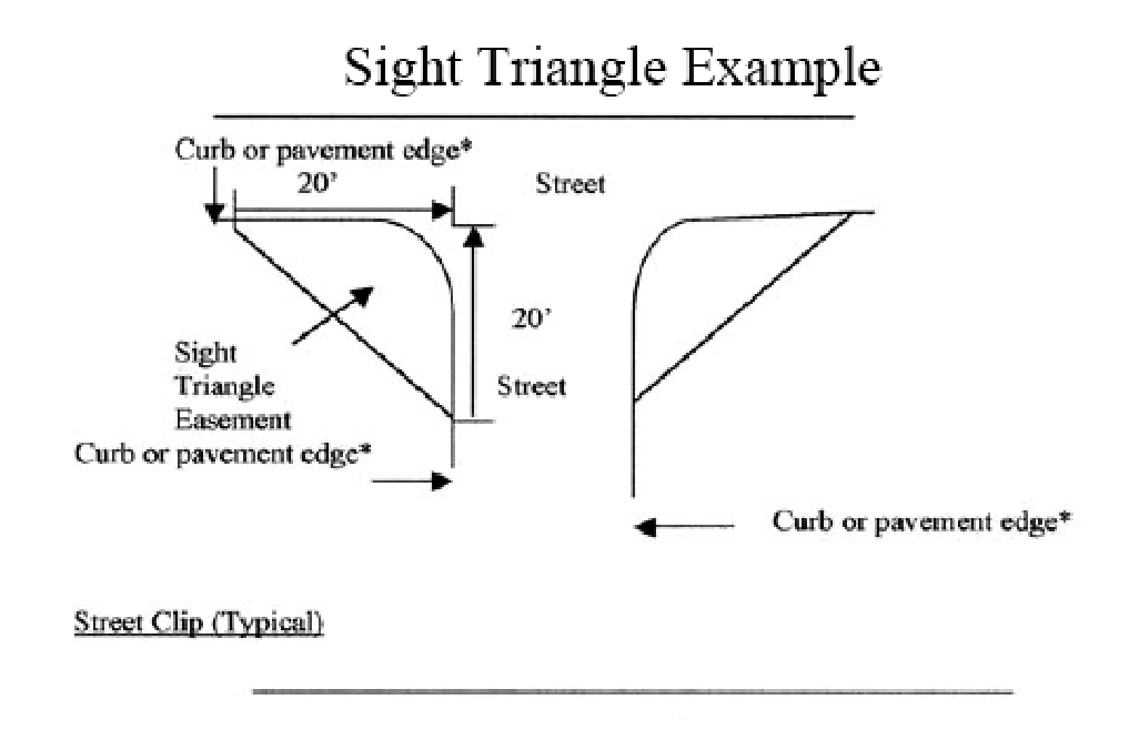
Sight triangle. The area of visibility required on a corner to allow for the safe operation of vehicles, trains, pedestrians, and cyclists in the proximity of intersection streets, rail lines, sidewalks and bicycle paths (see illustration).
Sign. The term sign shall mean any structure, display, or device that is used to advertise, identify, direct, or attract attention to a business, institution, organization, person, idea, product, service, event, or location by any means, including words, letters, figures, design characteristics, symbols, logos, fixtures, colors, movement, or illumination. The term sign shall specifically include but not limited to banners, balloons flags, pennants, streamers windblown devices and advertising devices. Furthermore, the term sign includes the sign structure, supports, lighting systems, and any attachments, ornaments, or other features used to draw the attention of the observers. The following elements are not considered to be signs, and are therefore not regulated by this article:
•
Display of goods available on a site, through windows or doors of a building or through the open air, where permitted.
•
Brands names or logos on products, product containers, or dispensers that are an integral part of the product or the product's packaging.
•
Building designs, colors, or motifs that are associated with a particular establishment or organization but which convey no commercial message, but not including neon lighting and neon window outlining as regulated by this article.
Sign face. That portion of the surface of a sign structure where words, letters, figures, symbols, logos, fixtures, colors, or other design elements are or may be located in order to convey the message, idea, or intent for which the sign has been erected or places. The sign face may be composed of two or more modules on the same surface that are separated or surrounds by portions of a sign structure not intended to contain any advertising message or idea and are purely structural or decorative in nature.
Sign face module. Each portion or unit of a sign face that is clearly separable from other such units bevy virtue of the expression of a complete thought, message, logo, or idea.
Sign height. The vertical distance to the highest point of a sign structure, as measured from the average grade at the base of the structure or directly below a projecting structure.
Sign structure. All elements of a freestanding sign, including the sign face, background or decorative elements related to the presentation of the sign's message, and the structural supports.
Snipe sign. A temporary sign or poster affixed to a tree, fence, utility pole, etc.
Special flood hazard area means an area in the floodplain subject to a one percent or greater chance of flooding in any given year. Special flood hazard areas are shown on FIRMs as Zone A, AO, A1-A30, AE, A99, AH, V1-V30, VE or V.
Start of construction. For other than new construction or substantial improvements under the Coastal Barrier Resources Act, P.L. 97-348, includes substantial improvement, and means the date the building permit was issued, provided the actual start of construction, repair, reconstruction, or improvement was within 180 days of the permit date. The actual start means the first placement of permanent construction of a building (including a manufactured home) on a site, such as the pouring of slabs or footings, installation of piles, construction of columns, or any work beyond the stage of excavation or placement of a manufactured home on a foundation. Permanent construction does not include land preparation, such as clearing, grading and filling; nor does it include the installation of streets and/or walkways; nor does it include excavation for a basement, footings, piers or foundations or the erection of temporary forms; nor does it include the installation on the property of accessory buildings, such as garages or sheds not occupied as dwelling units or not part of the main building. For substantial improvement, the actual start of construction means the first alteration of any wall, ceiling, floor, or other structural part of a building, whether or not that alteration affects the external dimensions of the building.
Step sign. Those signs made from corrugated plastic mounted on thin tubular metal stakes intended as yard signs.
Storm cellar means a place below grade used to accommodate occupants of the structure and emergency supplies as a means of temporary shelter against severe tornadoes or similar windstorm activity.
Story. That portion of a building included between the surface of any floor and the surface of the next floor above it, or if there be no floor above it, then the space between such floor and the ceiling next above it. In computing the height of a building, the height of basement or cellar shall not be included if below grade.
Story, half. A story under a gabled, hipped or gambrel roof the wall plates of which on at least two opposite exterior walls are not more than three feet above the finished floor of such story.
Streamer. A long narrow banner, pennant, or strip of fabric or other material.
Street. A public thoroughfare which affords principal means of access to abutting property.
Street line. A dividing line between a lot, tract parcel of land and a contiguous street.
Structural alterations. Any change in the supporting members of a building, such as bearing walls, bearing partitions, columns, beams or girders or any complete rebuilding of the roof or the exterior walls.
Structure. Anything constructed or erected, the use of which requires permanent location on the land, or attached to something having a permanent location on the land. For floodplain management purposes, structure means a walled and roofed building, including gas or liquid storage tank that is principally above ground, as well as a manufactured home.
Subdivision shall mean the division of a lot, tract, or parcel of land into three or more lots, plats, sites, or other divisions of land, any one of which is less than one acre except when the division results from inheritance or deed of gift. The term includes resubdivision and when appropriate to the context, relates to the process of subdividing or to the land or territory subdivided.
(a)
Large subdivision. A large subdivision is defined as any subdivision having 25 or more lots or two miles of streets and roads within the subdivision.
(b)
Small subdivision. A small subdivision is defined as any subdivision having any less than 25 lots and less than two miles of streets and roads.
Substantial damage means damage of any origin sustained by a structure whereby the cost of restoring the structure to its before damaged condition would equal or exceed 50 percent of the market value of the structure before the damage occurred.
Substantial improvement means any reconstruction, rehabilitation, addition, or other improvement of a structure, the cumulative cost of which equals or exceeds 50 percent of the market value of the structure before the "start of construction" of the improvement. This term includes structures that have incurred "substantial damage" regardless of the actual repair work performed. This term does not, however, include any repair or improvement of a structure to correct existing violations of state or local health, sanitary, or safety code specifications, which have been identified by the local code enforcement official prior to the application for permit for improvement, and which are the minimum necessary to assure safe living conditions.
Substantially improved existing manufactured home parks or subdivisions is where the repair, reconstruction, rehabilitation or improvement of the streets, utilities and pads equals or exceeds 50 percent of the value of the streets, utilities and pads before the repair, reconstruction or improvement commenced.
"T" frame. A sign so named because of the inverted t-shaped structure and utilization of copy on both sides, facing opposite directions. These signs are usually painted on wood or metal surfaces and resting on the ground, with no permanent attachment.
Technical advisory committee (TAC). This committee is composed of city staff and may include the building inspector and any other city employees deemed appropriate by the board of city commissioners.
Temporary sign. A sign that is displayed for a specific period of time not to excel 30 days and that announces special events or occurrences.
Tenant. One who possesses or occupies land or buildings by title, under a lease, or through payment of rent; an occupant, inhabitant, or dweller of a place.
Trailer. Any structure used for living, sleeping, business or storage purposes, having no foundation other than wheels, blocks, jacks, skids, horses or skirting and which has been, or reasonably may be, equipped with wheels or other devices for transporting the structure from place to place, whether by motive power or otherwise. The term "trailer" shall include camp car and house car. For purposes of this Code a trailer is a single-family dwelling and shall conform to all regulations thereof, except when located in a trailer or tourist camp as provided herein.
Trailer camp. An area containing one or more structures designed or intended to be used as temporary living quarters of two or more families and intended primarily for automobile transients.
Trailer sign. Any sign affixed to a trailer not used in conjunction with the daily operation of the advertised business.
Transportation concurrency. A condition where transportation facilities needed to serve new development shall be in place or under actual construction within one year after the local government approves a building permit or its functional equivalent that results in traffic generation.
Uniform sign plan. Coordinated drawings and specifications that establish a unified design concept with regard to the location, materials, size, letter style, and color of all signs to be placed on a property or development.
Unlawful sign. See illegal sign.
Used car lot. A lot or group of contiguous lots used for the storage, display and sales of used automobiles and where no repair work is done, except the necessary reconditioning of the cars to be displayed and sold on the premises.
Used car junkyard. A lot or group of contiguous lots used for the dismantling or wrecking of used automobiles or the storage, sale or dumping of dismantled or wrecked cars or their parts.
Variance is a grant of relief from the requirements of this Code.
Vehicle sign. Any sign affixed to a vehicle or portable trailer not used in conjunction with the daily operation of the advertised business.
Very low income. Household income which is up to 50 percent of the median income of the City of Port St. Joe, Florida, and as adjusted for household size.
Violation means the failure of a structure or other development to be fully compliant with the requirements of this Code. A structure or other development without the elevation certificate, other certifications, or other evidence of compliance required in this Code is presumed to be in violation until such time as that documentation is provided.
Wall sign. See building sign.
Watercourse means a lake, river, creek, stream, wash, channel or other topographic feature on or over which waters flow at least periodically. Watercourse includes specifically designated areas in which substantial flood damage may occur.
Water-dependent uses means activities which can be carried out only on, in or adjacent to water areas because the use requires access to the water body for: waterborne transportation including ports or marinas; recreation; electrical generating facilities; or water supply.
Water surface elevation means the height, in relation to the National Geodetic Vertical Datum (NGVD) of 1929 or the North American Vertical Datum (NAVD) of 1988, of floods of various magnitudes and frequencies in the floodplains of coastal or riverine areas.
Wellhead protection area means a 500-foot radius area designated by the City to provide land use protection for the groundwater source for a potable water wellfield, including the surface and subsurface area surrounding the wellfield.
Windblown device. Any device not otherwise specifically defined in the article, that is designed to inform or attract, whether or not such device carries a message, and which all or part of the device is set in motion by wind. For purposes of the article, windblown devices are signs.
Window sign. A sign that is placed on or behind a window pane and intended to be viewed from outside the building.
Withdrawal of application. The withdrawal of an application for development for development review. An application may be withdrawn at any time so long as no notice has been given that the application will be reviewed at a public hearing.
Workforce income. Household income 81 percent to 120 percent of the median income of the City of Port St. Joe, Florida, and adjusted for household size. Workforce income may also be defined as moderate income.
Yard. An open space on the same lot with a building, unoccupied and unobstructed from the ground upward, except by trees or shrubbery or as otherwise provided herein.
Yard, front. A yard across the full width of the lot, extending from the front line of the building to the front line of the lot, excluding steps.
Yard, rear. A yard extending across the rear of a lot measured between lot lines and being the minimum horizontal distance between the rear lot line and the rear of the main building or any projections other than steps, unenclosed balconies or unenclosed porches. On corner lots the rear yard shall be considered as parallel to the street upon which the lot has its least dimension. On both corner and interior lots the rear yard shall in all cases be at the opposite end of the lot from the front yard.
Yard, side. A yard between the building and the side line of the lot and extending from the front lot line to the rear lot line.
Yard sign. A temporary sign placed in the yard of a residence.
(Ord. No. 504, § 1(Exh. A), 4-1-14; Ord. No. 552, § 3, 3-19-19)
Sec. 1.04. - Description of development review process.
(a)
The development review process is that process by which the proposed development is reviewed by the respective local government, building inspector, technical advisory committee (TAC), and/or the planning and development review board (PDRB) to determine whether the development is consistent with the comprehensive plan and complies with the requirements of the Code. Any development requiring an amendment to the comprehensive plan shall not be approved until the comprehensive plan amendment has been adopted and the amendment has become effective.
(b)
Minor development plans require review and permit approval by the building inspector. The building inspector may designate any development activity as a major development. Considerations for such designation may include whether the proposed development is a part of a larger parcel for which additional development is anticipated to aggregate to major development status; or whether the proposed development should be more thoroughly and publicly reviewed because of its complexity, hazardousness or location.
(c)
Major development plans require review by the technical advisory committee (TAC). Level 1 major development activity requires review and approval by the technical advisory committee (TAC). The TAC action on level 1 major develop-ment plans shall be forwarded to the building inspector for permit issuance or denial. Modifications may be required prior to permit issuance. Level 2 major developments, having significant community impacts or those which the TAC believes should be publicly reviewed, must be sent to the PDRB for review and recommendation to the board of city commissioners. Approval of level 2 major developments shall be the responsibility of the board of city commissioners. The board of city commissioners action shall be forwarded to the building inspector for permit issuance or denial.
Sec. 1.05. - Intent—Generally.
With regard to this Code in general, its provisions shall be construed and implemented to achieve the following aims of the board of city commissioners:
(1)
To foster and preserve public health safety, comfort and welfare, and to aid in the appropriate development of the city in accordance with the comprehensive plan.
(2)
To establish regulations, procedures and standards for review and a development review process that is efficient, effective and equitable with respect to the rights of property owners and the interest of the citizens of the city.
(3)
To implement the comprehensive plan as required by the Local Government Comprehensive Planning and Land Development Regulation Act of 1985 (F.S. § 163.3161 et seq.).
(4)
To ensure that the availability of public facilities and services that meet the adopted level of service standards are in place prior to the issuance of development orders and permits.
Sec. 1.06. - Same—Specific intent relating to various subject areas of the Code.
The provisions of this Code dealing with the following specific subject areas shall be construed and implemented to achieve the following:
(1)
Administration. To assure that development proposals be reviewed for compliance with the requirements of this Code, the comprehensive plan and other local government regulations.
(2)
Sign regulation. To permit signs that are:
a.
Compatible with their surroundings.
b.
Constructed and maintained in a manner which does not endanger public safety or unduly distract motorists.
c.
Sized to convey sufficient information without being obtrusive.
d.
Located so as not to interfere with regulatory, public informational, control or directional signage.
(3)
On-site traffic flow and parking. To assure that all developments provide for adequate and safe parking and movement of vehicles by:
a.
Delineating and buffering the bounds of vehicular use areas so that movement, noise and glare in one area do not adversely affect activities in another area.
b.
Limiting physical site access to established points of ingress and egress.
c.
Limiting the internal movement of vehicles and pedestrians to designated traffic configurations.
(4)
Stormwater management. To prevent activities which adversely affect ground and surface water and to protect and maintain the chemical, physical and biological integrity of ground and surface waters:
a.
By encouraging the construction of stormwater management systems that approximate both aesthetically and functionally natural systems.
b.
By protecting natural drainage systems and minimizing runoff pollution to ground and surface waters.
c.
Maintaining recharge areas and restore groundwater levels.
d.
Protecting and maintaining natural salinity levels in estuary areas.
e.
Minimizing erosion and sedimentation and preventing damage to wetlands.
(5)
Floodplain protection. To protect human life and health and minimize the expenditure of public money for costly flood control projects, minimizing the need for rescue and relief efforts and to minimize prolonged business interruptions and damage to public utilities and facilities caused by flooding by:
a.
Assuring that uses and facilities vulnerable to floods are designed and constructed to resist flood damage.
b.
Preserving natural floodplains, stream channels and natural protective barriers to accommodate flood waters.
c.
Limiting the filling, grading, dredging and other development which may increase erosion, sedimentation or flood damage.
d.
Maintaining the normal movement of surface waters optimum storage capacity of watersheds, desirable groundwater levels, water quality and the natural hydrological and ecological functions of wetlands and other flood prone areas.
e.
Minimizing unnecessary disruption of commerce, access and public service during times of flooding.
f.
Minimize damage to public and private facilities and utilities.
g.
Helping maintain a stable tax base by providing for the sound use and development of flood hazard areas.
h.
Meeting the requirements of the National Flood Insurance Program for community participation as set forth in Title 44 Code of Federal Regulations, Section 59.22.
(6)
Protection of environmentally sensitive lands. To protect environmentally sensitive lands and the integrity of ground and surface water and natural habitat while also protecting the rights of property owners by:
a.
Preventing activities which adversely affect ground and surface water, natural habitats, state or federally listed plant or animal species and their habitat, and native flora and fauna.
b.
Prohibiting certain uses that are detrimental to environmentally sensitive areas.
c.
Protecting the recreational opportunities of environmentally sensitive lands.
d.
Protecting wetlands through the combined use of the City's comprehensive plan and state and federal wetlands permitting programs.
e.
Protecting potable water wellfields and natural groundwater aquifer recharge areas.
f.
Protecting the estuaries and waters of St. Joseph's Bay to prevent estuarine pollution, control surface water run-off, protect living marine resources and ensure adequate sites for water-dependent uses.
(7)
Land use regulation. To regulate the use of land and water to ensure the compatibility of adjacent uses and provide for open space by:
a.
Providing appropriate buffer zones between adjacent land uses and impose stricter buffer requirements on proposed uses of higher intensity.
b.
Abating nuisances such as noise, light, glare, heat, air pollution and stormwater runoff.
c.
Mitigating conflicts between adjoining land uses.
(8)
Regulation of the subdivision of land. To maintain and protect the local economy and natural resources and discourage haphazard, uneconomic or scattered land development and ensure safe and convenient traffic control by:
a.
Assuring land subdivision with the installation of adequate and necessary physical improvements including stormwater management facilities.
b.
Requiring installation by the developer of certain minimum improvements to assure that the citizens and taxpayers of the city will not have to bear the costs resulting from haphazard subdivision of land.
(9)
Protection of historic sites and structures. To minimize the destruction by development activity of known sites of historical or archaeological significance.
(10)
Provision of affordable housing. To increase the supply of affordable housing within the city by providing incentives for future housing developments to provide owner occupied or rental housing that is affordable to very low, low and moderate income households within the city.
(11)
Provision of public facilities and services. To ensure that public facilities and services meet or exceed the standards established in the city's comprehensive plan and are available when needed, or that development orders and permits are conditioned on the availability of these public facilities and services necessary to serve the proposed development.
(Ord. No. 552, § 4, 3-19-19)
Sec. 1.07. - Relationship to comprehensive plan.
The adoption of this Code is intended to implement the goals, objectives and policies of the comprehensive plan of the city.
Sec. 1.08. - Incorporation by reference.
The latest edition of the following works are hereby incorporated into this Code by reference:
Florida Building Code.
Standard Plumbing Code.
Standard Mechanical Code.
National Electrical Code.
National Board of Fire Prevention Code.
Sanitary Code of the State of Florida.
Council of American Building Officials, One- and Two-Family Dwelling Code.
The Future Land Use Map for the City of Port St. Joe.
The U.S. Geological Survey 7.5 Minute Quadrangle Map.
The Federal Emergency Management Agency Flood Insurance Rate Maps.
The City of Port St. Joe Zoning Map.
American Association of State Highway and Transportation Officials Geometric Design Guidelines — Street/Intersection Design Manual.
Sec. 1.09. - Rules of interpretation.
(a)
Generally. In the interpretation and application of the Code, all provisions shall be liberally construed in favor of the objectives and purposes of the city and shall not limit nor repeal any other powers granted to the city under any other statutes.
(b)
Responsibility for interpretation. In the event that any question arises concerning the application of regulations, performance standards, definitions, development criteria or any other provision of this Code, the building inspector shall be responsible for interpretation.
(c)
Computation of time. The time within which an act is to be done shall be computed by excluding the first and including the last day; if the last day is a Saturday, Sunday or legal holiday, that day shall be excluded.
(d)
Delegation of authority. Whenever a provision appears requiring the head of a department or some other city officer or employee to do some act or perform some duty, it is to be construed to authorize delegation to professional-level subordinates to perform the required act or duty unless the terms of the provision or section specify otherwise.
(e)
Gender. Words importing the masculine gender shall be construed to include the feminine and neuter.
(f)
Number. Words in the singular shall include the plural and words in the plural shall include the singular.
(g)
Shall, may. The word "shall" is mandatory, the word "may" is permissive.
(h)
Written or in writing. The term "written" or "in writing" shall be construed to include any representation of words, letters or figures, whether by printing or otherwise.
Sec. 1.10. - Repeal of prior provisions.
Any existing city ordinances duplicating or in conflict with the requirements of this Code are hereby repealed.
Sec. 1.11. - Abrogation.
This Code is not intended to repeal, abrogate or interfere with any existing easement, covenant, or deed restrictions duly recorded in the public records of the county or the city.
Sec. 1.12. - Severability.
(a)
If any section, subsection, paragraph, sentence, clause or phrase of this Code is for any reason held by any court of competent jurisdiction to be unconstitutional or otherwise invalid, the validity of the remaining provisions of the Code shall continue in full force and effect.
(b)
If any portion of this Code is found to be unconstitutional or otherwise unenforceable, all other portions of this Code shall remain in full force and effect.