
Prior Lake City Zoning Code
ARTICLE II
ADMINISTRATION
Sec. 10-19. - Purpose and intent.
(a)
Findings and purpose. The city council finds it necessary to accomplish the following:
(1)
Protect the residential, business, industrial and public areas of the city and maintain their stability.
(2)
Promote the most appropriate and orderly development of the residential, business, industrial, and public land and areas.
(3)
Provide adequate light, air and convenient access to property.
(4)
Limit congestion in the public rights-of-way.
(5)
Prevent overcrowding of land and undue concentration of structures and population by regulating the use of land and structures and the bulk of structures in relation to the land surrounding them.
(6)
Provide for compatibility of different land uses by segregating, controlling and regulating unavoidable nuisance producing uses.
(7)
Require that development proceed according to the goals and policies established in the city's comprehensive plan.
(8)
Maintain a tax base necessary to promote the economic welfare of the city by ensuring optimum values for property in the city.
(9)
Enhance the aesthetic character and appearance of the city.
(10)
Conserve natural resources and environmental assets of the city.
(11)
Provide adequate off-street parking and loading facilities.
(12)
Provide effective administration of this chapter and any future amendments to this chapter and prescribe penalties for the violation of its requirements.
(13)
Establish a continuing system of review of this chapter to ensure it will be amended to meet changing needs of the city and advances in science and technology.
(b)
Implementation. To implement these findings, the city council, through this chapter, establishes minimum requirements to protect the public health, safety, morals, comfort, convenience, and general welfare of the people. This chapter shall divide the city into zoning districts and establish regulations which control the location, erection, construction, reconstruction, alteration and use of structures and land.
(Prior Code, § 1110.100)
Sec. 10-20. - Chapter overview.
(a)
This chapter provides for the classification and regulation of uses, land and structures within the city. The classifications and regulations are intended to effectuate the goals and policies of the city's comprehensive plan, to ensure the orderly and efficient growth within the city and promote the general health, welfare, and safety of the city and its residents. Every person owning property, living, or involved in a business in the city is presumed to know the provisions of this chapter.
(b)
This chapter is divided into various subsections, many of which interrelate with other subsections of this chapter. This article provides for rules governing how the various provisions are to be interpreted and how to reconcile what may appear to be conflicts between sections.
(c)
This chapter establishes zoning districts and land uses; conditions, performance standards and dimensional standards; and procedures, process and appeals.
(d)
The city council shall annually establish by ordinance or resolution fees for land use applications, reviews and processes.
(e)
The planning commission shall serve as the board of adjustment and appeals.
(f)
The community development director shall serve as the zoning administrator.
(Prior Code, § 1110.200)
Sec. 10-21. - Interpretation.
The provisions of this article are intended to establish guidelines to follow in clarifying ambiguities that may arise regarding the meaning of text in this chapter, the interpretation of the zoning map, or the application of rules and regulations adopted pursuant to this chapter.
(Prior Code, § 1110.300)
Sec. 10-22. - Rules of construction.
The following rules of construction govern the interpretation of the language of this chapter:
(1)
Definitions. Words or terms not defined in this chapter shall have their ordinary and usual meaning at the time the word or term is being applied to a zoning question or situation. General words are construed to be restricted in their meaning by preceding particular words.
(2)
Effect. This chapter shall be construed, if possible, to give effect to all provisions in this chapter. When the words of this chapter in their application to an existing situation are clear and free from ambiguity, the letter of this chapter shall not be disregarded under the pretext of pursuing the spirit. The zoning administrator shall render interpretations of any provision of this chapter or any rule or regulation issued pursuant to this chapter. When the words of this chapter are not clear and free from ambiguity, the following factors may be considered:
a.
The purpose and necessity for the section or specific provision.
b.
The circumstance under which it was enacted.
c.
The mischief to be remedied.
d.
The object to be attained.
e.
The former chapter.
f.
The consequences of a particular interpretation.
g.
Administrative interpretations of this chapter and interpretations by the board of adjustment and appeals and the city council.
(3)
Presumptions. In interpreting this chapter, the following presumptions apply:
a.
The city council did not intend a result that is absurd, impossible of execution, or unreasonable.
b.
The city council intended the entire chapter to be effective and certain.
c.
The city council did not intend to violate the federal or state constitution.
d.
The city council intended to favor the public interest as against any private interest.
(4)
Grammar. Grammatical errors shall not destroy the application of this chapter. A transposition of words and clauses may be resorted to when a sentence, as it stands, is without meaning. Words and phrases which may be necessary to the proper interpretation of this chapter and which do not conflict with its obvious purpose and intent nor in any way affect its scope in operation may be added in the construction thereof.
(5)
Conflicts. When a general provision of this chapter conflicts with a specific provision in this chapter, the two shall be construed if possible so that effect shall be given to both. If the conflict between the two provisions is irreconcilable, the specific provisions shall prevail and shall be construed as an exception to the general provision unless the general provision was enacted subsequent to the specific provision. When several clauses are irreconcilable, the clause last in order of date shall prevail.
(6)
Reference.
a.
When any specific section is referenced in this chapter, the reference shall include and incorporate any changes, revisions or amendments as may from time to time be enacted. When a section or provision of this chapter is amended, the amendment shall be construed as merging into this chapter, becoming a part thereof, and replacing the part amended, and the remainder of the original chapter and the amendment shall be read together and viewed as one chapter passed at one time. The portions of this chapter which were not altered by the amendment shall be construed as effective from the date of the first enactment of the ordinance from which it is derived, and the new provision shall be construed as effective only from the date when the amendment became effective.
b.
When this chapter adopts the provisions of state statute by reference, it also adopts by reference any subsequent amendments of that statute.
c.
If two or more amendments to the same provision of this chapter are enacted at the same or at different times, one amendment overlooking and making no reference to the other or others, the amendments shall be construed together if possible and effect be given to each. If the amendments are irreconcilable, the amendment latest in date of final enactment shall prevail.
d.
Where a provision of this chapter references another provision of this chapter which is renumbered, the reference shall continue to refer to the amended section as it is renumbered. The referencing provision shall be assumed to have been updated to reference the new numbering.
(7)
Diagrams. Diagrams, where provided, are intended to aid written text and may not be drawn to scale. Where a conflict exists between a diagram and text, the text shall prevail.
(8)
Separability. Provisions in this chapter are separable if the following events occur:
a.
If a court of competent jurisdiction finds any provision of this chapter to be invalid, that judgment shall not affect any other provision of this chapter not specifically included in the judgment.
b.
If a court of competent jurisdiction finds the application of any portion of this chapter to a particular land or structure invalid, that judgment shall not affect the application of the provision to any other land or structure not specifically included in the judgment.
c.
If a court of competent jurisdiction finds any individual condition of a conditional use permit invalid, that judgment shall not invalidate any other condition of the same conditional use permit not specifically included in such judgment nor shall it invalidate the application of the same condition in any other conditional use permit.
(9)
Jurisdiction and authority. This chapter is enacted under the authority granted to the city by state statutes. If those statutes are amended to restrict or enlarge the authority delegated to the city, those amendments shall be deemed to be incorporated into this chapter. This chapter governs the use of all land and structures in the city unless such regulation is specifically preempted by state or federal statutes or regulations.
(10)
Application.
a.
Minimum requirements. The provisions of this chapter are the minimum requirements for the promotion of the public health, safety, morals and general welfare.
b.
More restrictive applications. Where the conditions imposed by any provision of this chapter are either more or less restrictive than comparable conditions imposed by any other applicable law, ordinance, rule or statute of any kind, the law, the conditions which are most restrictive or which impose the higher or more restrictive standards or requirements shall control.
(11)
Mixed use. All regulations applicable to each use in a mixed use development shall be applicable, unless specifically stated otherwise in the approval.
(12)
Measurement.
a.
All measured distance expressed in feet shall be to the nearest tenth of a foot. The measurement of distances when required by this chapter shall be done in a straight line in the plane located at a point one foot above the highest point in the surface of the ground along the path of measurement, from the most exterior wall of a building containing the use to the property line of the adjacent street, district, or lot or other boundary line. If the use is not within a building, the measurement shall be the shortest distance from the location of the use to the property line of the adjacent street, district, or lot or other boundary line.
b.
For lots of record existing on the effective date of the ordinance from which this chapter is derived, if the parcel dimensions shown on the recorded plat are smaller than the dimensions shown on a current survey, the dimensions shown on the plat shall be accepted as correct for the purpose of determining lot width, lot depth, lot area and setbacks, provided that the dimensions on the survey have values equal to or greater than 99 percent of the dimensions shown on the plat.
(Prior Code, § 1110.400)
Sec. 10-23. - Public hearings.
(a)
Public hearings shall be noticed, scheduled, held, and decided pursuant to applicable state statute, this chapter and city bylaws or if no such regulations apply as determined appropriate by the zoning administrator. If the public hearing is related to a specific application (CUP, variance, subdivision, vacation, etc.) the decision shall be in writing, shall be accompanied by findings based upon the record and shall be provided to interested parties as required by state law and this chapter and as determined appropriate by the zoning administrator.
(b)
For applications within the shoreland and floodplain district, a notice of the decision must be sent to the commissioner of the department of natural resources within ten days of the date of the decision.
(Prior Code, § 1110.500)
Sec. 10-50. - Terms defined.
When the following words or terms are used in this chapter or chapter 9, they shall have such meanings herein ascribed to them, unless the term is defined more specifically in an applicable section or unless the context makes such meaning repugnant thereto:
Abutting or adjoining means having a common border with or being separated from such a common border by an alley.
Aisle or access aisle means the traveled way by which vehicles enter and depart parking spaces.
Alley means a public right-of-way, with a width not exceeding 24 feet nor less than 12 feet, which affords a secondary means of access to property abutting the alley.
Alteration means any change, addition, or modification in construction or occupancy of an existing structure or modification to the surface of the ground.
Antenna means any structure or device used for the purpose of collecting or transmitting electromagnetic waves, including, but not limited to, directional antennas, such as panels, microwave dishes, communication towers and equipment, satellite dishes, and omni-directional antennas, such as whip antennas.
Automobile means a motor vehicle designed for use on the road, typically with four wheels, powered by an internal combustion engine or electric motor and able to carry a small number of people.
Berm means a land alteration where fill is added to the surface of the ground in order to create an earthen mound or hill generally used in conjunction with walls, fences, or plant materials to screen or insulate one parcel of land from another or from a street.
Block means an area of land within a subdivision that is entirely bounded by streets, or by streets and the entire boundary or boundaries of the subdivision, or by a combination of the above with a river or lake.
Block front means the distance between intersections along one side of a street.
Bluff.
(1)
The term "bluff" means a topographic feature such as a hill, cliff, or embankment having all of the following characteristics:
a.
Part or all of the feature is located in a shoreland area;
b.
The slope rises at least 25 feet above the ordinary high-water level of the water body;
c.
The grade of the slope from the toe of the bluff to a point 25 feet or more above the ordinary high-water level averages 30 percent or more; and
d.
The slope must drain toward the water body.
(2)
An area with an average slope of less than 18 percent over a distance of 50 feet or more shall not be considered part of the bluff.
(3)
Parts of a bluff include the following:
Bluff impact zone means a bluff and land located within 20 feet from the top of a bluff.
Bluff setback means the required setback from the top of bluff which is determined as follows: as measured from the top of bluff, the upper end of a segment at least 25 feet in length having an average slope less than 18 percent.

Bluff, toe of, the means the lower point of a 50-foot segment with an average slope exceeding 18 percent.
Bluff, top of the, means the highest point of the slope, as measured from the toe of the bluff, where the grade becomes less than 30 percent.
Boat house means a structure used solely for the storage of watercraft or watercraft equipment.
Boat lift means a structure or device, with or without a boat lift canopy but without walls, that is designed to lift watercraft above the level of the public water or ground elevation when not in use. The term "boat lift" also includes rail systems or track systems extending from the land bed to the shore.
Boat lift canopy means a structure or device no larger than 240 square feet in area with a fabric-covered roof that extends no more than 12 inches below the roofline and without walls or a floor that is attached to or an integral part of the boat lift or track system and is designed to shelter watercraft.
Boat slip means an area of water adjacent to a dock or slip structure which is used for storage of one watercraft.
Boulevard means that portion of a street right-of-way between the curbline and property line.
Buffer means an area of natural, noninvasive, permanently undisturbed, vegetative ground cover adjoining and surrounding a wetland measured from the delineated edge of the wetland.
Bufferyard means an area of land established to protect and screen one type of land use from another land use that is incompatible. Normally, the area is landscaped and kept in open space use. Screening techniques include the addition of vertical elements such as fences, walls, hedges, berms, or other features to mitigate the effects of incompatible land uses.
Building means any structure having a roof which may provide shelter or enclosure of persons, animals or chattel. When separated by a party wall without openings, each portion so separated shall be deemed a separate building. The following parts and descriptions are used to describe buildings:
Building basement or basement means that portion of the building having more than one-half of the ground floor-to-ceiling height below the average grade of the adjoining ground.
Building façade or façade means the exterior wall of a building exposed to public view.
Building face means that portion of the exterior wall of a structure which shall lie in a vertical plane. Any break in a building face shall be defined by an exterior angle of at least 210 degrees or a curved portion of such exterior wall which shall have a central angle of 30 degrees or more.
Building height means a distance to be measured from the mean curb level along the front lot line or from the finished grade level for all that portion of the structure having frontage on a public right-of-way to the top of the roofline of a flat roof; to the deck line of a mansard roof; to the uppermost point on a round or other arch type roof; or the mean distance of the highest gable on a pitched or hip roof.
Building roofline or roofline means the lowest plane at which the external upper covering of a building begins.
Building story or story means that portion of a building included between the surface of any floor and the surface of the floor next above, or if there is not a floor above, the space between the floor and the ceiling next above. A basement shall not be counted as a story.
Building, accessory. See Structure, accessory.
Building, principal, means the primary building on the lot as distinguished from an accessory structure.

Cannabis business includes the following cannabis businesses as further defined in section 3, division 4, Land Use Definitions and Conditions: Cannabis cultivator; cannabis delivery service; cannabis event organizer; cannabis manufacturer; cannabis mezzobusiness; cannabis microbusiness; cannabis retailer; cannabis testing facility; cannabis transporter; cannabis wholesaler; lower-potency hemp edible manufacturer; lower-potency hemp edible retailer; and medical cannabis combination business.
Cannabis cultivation and cultivate cannabis means growing cannabis plants from seed or immature plant to mature plant, harvesting cannabis flower from mature plant, packaging and labeling immature plants and seedlings and cannabis flower for sale to other cannabis businesses, transporting cannabis flower to a cannabis manufacturer located on the same premises, and performing other actions approved by the office of cannabis management.
Cannabis event, temporary means an event lasting no more than four days at which cannabis products, cannabis flower, lower-potency hemp edibles, and hemp-derived consumer products may be sold and consumed and for which the organizer has a cannabis event organizer license issued by the office of cannabis management.
Cannabis retail business means a business that is licensed or required to be licensed by the State of Minnesota as a cannabis retailer, cannabis mezzobusiness with retail operations endorsement, cannabis microbusiness with retail operations endorsement, or medical cannabis combination business operating a retail location.
Carport means space for the housing or storage of motor vehicles and enclosed on not more than two sides.
Channel means the natural or artificial depression of perceptible extent along a stream or drainageway with a definite bed and bank to confine and conduct flowing water either continuously or periodically.
Civil engineer means a person licensed to practice civil engineering under Minn. Stats. §§ 326.02 to 326.15.
Comprehensive plan means the group of maps, charts and texts that make up the comprehensive long-range plan of the city, including, but not limited to, the text of the comprehensive plan, the land use map, transportation plan and the capital improvements program.
Concept plan means a concept plan or informal map of a proposed subdivision of sufficient accuracy to be used for the purpose of discussion with the city staff and classification within this chapter.
Curb level means the grade elevation as established by the city at the curb in front of the center of the building. Where no curb level has been established, the public works director shall determine a curb level or its equivalent for the purpose of this chapter.
Deck means a horizontal, unenclosed platform with or without attached railings, seats, trellises, or other features, attached or functionally related to a principal use or site and extending 30 inches or more above ground at any point.
Density means the number of dwelling units per net acre of land.
Design standards means the specifications for the preparation of plats, both preliminary and final, indicating among other things the optimum, minimum or maximum dimensions of such items as rights-of-way, blocks, easements and lots.
Developer means any person who undertakes to improve a parcel of land by platting, grading, installing utilities or constructing any building thereon.
Development means all structures, land uses, and other modifications of the existing landscape above and below ground or water, on a single parcel, or on more than one parcel if covered by a single PUD or conditional use permit.
Dimensional standards means numerical standards relating to spatial relationships, including, but not limited to, setback, lot area, frontage, and height.
Discontinue or discontinuance means to cease a use or activity or to remove or fail to restore or replace a structure for any reason, usually for a set period of time, but excluding any time during routine seasonal closure and excluding remodeling where a valid building permit has been issued.
Driveway means a private roadway providing access to a street.
Dwelling or dwelling unit means a building or portion of a building occupied or intended to be occupied for residential accommodation which includes permanent cooking, sleeping and bathroom facilities arranged for use as living quarters for one family. The term "dwelling" does not include uses such as hotels, motels, hospitals, nursing homes, and bed and breakfasts.
Easement means the grant of one or more of the property rights by the owner to, or for the use by, the public, a public utility, corporation, or another person or entity.
Excavation means removal of soil, rock, minerals, debris or organic substances other than vegetation from a parcel of land.
Family means one of the following:
(1)
Any group of people living together as a single housekeeping unit, all of whom are related by blood, marriage, or adoption, plus children who are under foster care.
(2)
Up to four unrelated people living together as a single housekeeping unit.
(3)
Any group of people living together as a single housekeeping unit, if no more than two adult members function as the heads of the household group and the remaining members are dependent upon them for care and direction due to age, physical disability, a mental incompetency or for other reasons.
(4)
Any individual who is the owner, living and maintaining a common household and using a common cooking and kitchen facility.
Feedlot means a confined area or structure used for feeding, breeding or holding livestock for eventual sale in which animal waste may accumulate, also including barns, pens or other structures used in a dairy farm operation. For purposes of these regulations, pastures and feedlots accommodating fewer than ten animals shall not be considered animal feedlots.
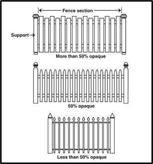
Fence means any artificially constructed barrier of any material or combination of materials erected to enclose or screen areas of land.
Filling means the placement of sand, gravel, earth or other materials of any composition on a parcel of land. Filling is also referred to as land reclamation.
Floor area means the sum of the gross horizontal areas of the several floors of a building, including interior balconies, mezzanines, basements, attics, penthouses and attached accessory buildings. Measurements shall be made from the inside of exterior walls and to the center of interior walls. For the purposes of determining off-street parking requirements, inside off-street parking or loading space is excluded from floor area. Parts of a floor area include:
Floor area, customer, means that part of the floor area of a commercial establishment used by and accessible to the public, except public restrooms.
Floor area, ground, means the part of the floor area of a building or buildings measured from the exterior faces of exterior walls but excluding decks and terraces and detached garages which do not exceed 12 feet in height.
Floor area ratio (FAR) means the numerical value obtained by dividing the total floor area of a building, excluding the basement, by the lot area on which such building is located.
Forester means a person holding at least a bachelor of science degree in forestry from an accredited four-year college of forestry.
Grade means the average elevation of the finished ground level at the midpoint of all walls of a building, or in, the case of signs, the average elevation of the finished ground level at the base of a sign. The term "grade" includes finished grade and mean ground level.
Grading means excavating, filling or other changes in the earth's natural topography, including stockpiling of earth or land.
Ground cover means plants, other than turfgrass, normally reaching an average maximum height of not more than 18 inches at maturity.
Hedge means a landscape barrier consisting of a continuous, dense planting of shrubs.
Holiday lights or décor means decorations, lights and displays which are clearly incidental to and customary and commonly associated with any national, local, or religious holiday.
Impervious surface means a constructed hard surface that either prevents or retards the entry of water into the soil and causes water to run off the surface in greater quantities and at an increased rate of flow than prior to development. For purposes of this chapter, impervious surfaces shall include, but not be limited to, rooftops; covered decks; decks or platforms with open joints with less than one-fourth-inch spacing; decks or platforms with an impervious surface beneath, including, but not limited to, under deck sheeting, concrete, asphalt, pavers, compressed or packed material, or more than one layer of landscape fabric or plastic; sidewalks greater than three feet in width; sidewalks three feet in width or less with less than three feet of pervious surface on both sides; patios; swimming pools; parking lots; concrete, asphalt, gravel driveways, or permeable pavers; areas beneath overhangs greater than two feet in width; bridges over surface waters and other similar surfaces as determined by the zoning administrator. The impervious surface of a lot shall be documented by a certificate of survey unless exempted from this requirement by the zoning administrator.
Individual sewage treatment system means a septic tank, seepage tile sewage disposal system, or any other approved sewage treatment device.
Irrigation system means a permanent, artificial watering system designed to transport and distribute water to plants.
Land means all solid ground.
Land alteration means any private or public infrastructure and utility installation, building construction, excavation, grading, clearing, filling, or other earth change which may result in:
(1)
Any alteration of land of more than one foot from the natural contour of the ground on any contiguous 450 square feet of ground where significant trees are present; or
(2)
Any cutting, removal or killing of more than 20 percent of the significant trees on any land within a period of five years.
Land reclamation. See Filling.
Land surveyor means a person licensed to practice land surveying under Minn. Stats. §§ 326.02 to 326.15.
Land use or use means the purpose or activity maintained on the property or for which the property is designed, arranged or intended. Land uses include permitted uses (P), permitted accessory uses (AC), permitted uses with conditions (PWC), conditional uses (CU) and interim uses (IU). Land uses include the following types:
Land use, accessory, means a land use on the lot which is subordinate to the principal use on the property. There must be a principal use on the lot in order for an accessory use to be allowed.
Land use, principal, means the primary land use on the lot as distinguished from an accessory use.
Landing means an intermediate platform on a flight of stairs, the dimensions of which are dictated by the building code.
Landscape architect means a person licensed by the state as a landscape architect.
Level of service means the traffic capacity of an intersection or roadway based upon criteria established and published by the Institute of Traffic Engineers, as amended periodically.
Lot means property or a parcel which meets the minimum lot width, depth, area and yard requirements of the zoning district in which it is located; which abuts a public street; and which is occupied, used or intended for occupancy or use as permitted by this chapter. The term "lot" also includes a lot of record. Lots include the following types:
Lot, corner, means a lot situated at the junction of and abutting on two or more intersecting streets, or a lot at a point of deflection in alignment of a continuous street, the interior angle of which does not exceed 135 degrees.
Lot, flag, means a large lot not meeting minimum lot width requirements and where access to the public road is by a narrow, private right-of-way or driveway.
Lot, interior, means a lot other than a corner lot.
Lot, through, means a lot which has a pair of opposite lot lines abutting two substantially parallel streets, and which is not a corner lot.
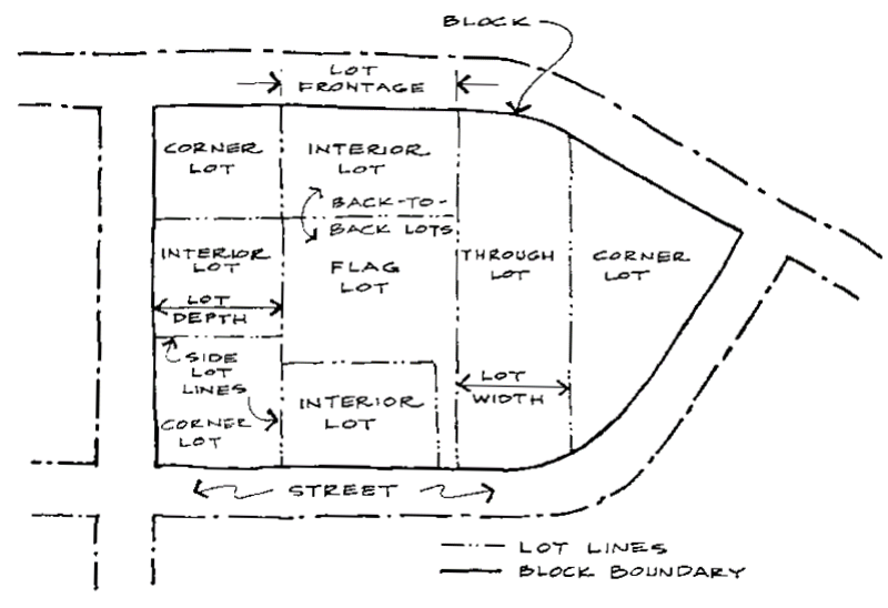
Lot Types
Lot area means the area of a lot in a horizontal plane bounded by the lot lines excluding major drainageways, wetlands, water bodies, and road rights-of-way. In the shoreland overlay district only land above the ordinary high-water level of a public water or above the 100-year water elevation of a wetland or pond may be used to meet the minimum lot area requirements. Lot area measurements include the following:
Lot depth means the mean horizontal distance between the front lot line and the rear lot line of a lot.
Lot width means the horizontal distance between the side lot lines measured at the required front yard line.
Lot line means the property line bounding a lot except that where any portion of a lot extends into the public right-of-way, street easement, or a proposed public right-of-way, the line of such public right-of-way or street easement shall be the lot line for applying the subdivision regulations and this chapter.
Lot line, front, means that boundary of a lot which abuts a street. In the case of a corner lot, it shall be the shortest frontage on a public street. If the dimensions of a corner lot are equal, the front lot line shall be designated by the owner and filed in the office of the zoning administrator. If a lot has multiple sides on more than two street frontages, the front lot line shall be determined by the zoning administrator.
Lot line, rear, means a lot line not intersecting a front lot line that is most distant from and most closely parallel to the front lot line. For a lot bounded by only three lot lines, the rear lot line shall be a line ten feet in length within the lot, parallel to and at the maximum distance from the front lot line.
Lot line, side, means a lot line which intersects with a front lot line.
Lot of record means property or a parcel whether subdivided or described by metes and bounds for which a deed, auditor's subdivision, or registered land survey has been recorded in the office of the register of deeds or registrar of titles for the county prior to June 1, 2009.
Manufactured home means as defined in Minn. Stats. § 327B.01.
Model home means a dwelling constructed on a lot within a development used for sales and marketing of the development.
Mooring facility means any area for the containment of watercraft that provides a fixed fastening for the craft, which is located in, on, above, or adjacent to the water intended for seven or more watercraft by docks, mooring buoys, or other means.
Mulch means nonliving organic, synthetic and rock materials customarily used in landscape design to retard erosion and retain moisture.
Native vegetation means any plant species with a geographic distribution indigenous to all or part of the state. Plant species which have been introduced by man are not native vegetation.
New construction means any construction of a new structure; or any total structural improvements to the exterior or interior of an existing structure that may require an electrical, plumbing, HVAC, or other zoning or building permit which exceed 50 percent of the fair market value of all the structures on the property.
Nonconformity or nonconforming means a use, property or structure which does not conform to the requirements of this chapter for the zoning district in which it is located.
Nonconformity, legal, or legally nonconforming means a use, property or structure which does not conform to the requirements of this chapter for the zoning district in which it is located but which lawfully existed at the time of passage of the portion of this chapter which makes the use, property or structure a nonconformity.
Official controls means the adopted goals, policy statements, standards, requirements, programs, and maps for the city. Such controls include, but are not limited to, the comprehensive plan, this chapter, chapter 9, the capital improvements program, and any amendment to such plans or parts thereof.
Opacity means the degree of openness to which light or views are blocked measured perpendicular to the fence for each fence section between supports. The lower percentage of opacity allows more light or view between fence materials.
Ordinary high-water level means the boundary of water basins, watercourses, public waters, and public waters wetlands; and:
(1)
The ordinary high-water level is an elevation delineating the highest water level that has been maintained for a sufficient period of time to leave evidence upon the landscape, commonly the point where the natural vegetation changes from predominantly aquatic to predominantly terrestrial;
(2)
For watercourses, the ordinary high-water level is the elevation of the top of the bank of the channel;
(3)
For reservoirs and flowages, the ordinary high-water level is the operating elevation of the normal summer pool; and
(4)
For constructed stormwater BMPs, the ordinary high-water level is the operating elevation of the permanent pool, based upon the outlet elevation or outlet structure.
Outlot means property or a parcel which is platted but not intended for immediate development. An outlot is not buildable and no building permit will be issued for an outlot. An outlot may be used as open space, transferred to the city for park or drainage uses, used as a private street or reserved for future phases of a development.
Parcel. See Property.
Parking space or parking stall means an area intended for the use of temporary parking of a motor vehicle which has a means of access to a public street.
Pedestrian way or sidewalk means a public right-of-way or easement to provide access for pedestrian or bicycle use and which may be used for the installation of utility lines usually located at the side of a road or in a park. The term "pedestrian way" includes, but is not limited to, trails and sidewalks.
Performance standards means specified criteria and limitations which are placed on development which are intended to protect the public health, safety, or welfare.
Plat means a map of a subdivision showing the boundaries and location of individual lots, outlots, easements, streets and other rights-of-way. The term "plat" includes the following types:
Plat, CIC, means a common interest community plat as described and defined by Minn. Stats. ch. 515B.
Plat, final, means a map of all or, in the case of a phased or staged development, a portion of a subdivision presented to the city council for final approval.
Plat, preliminary, means a map indicating the proposed layout of the subdivision submitted to the city council for preliminary approval.
Replat means the subdivision of land in accordance with the subdivision regulations which has previously been platted and which is of record with the county pursuant to Minn. Stats. ch. 505.
Platform means a flat, floored, roofless area detached from a house with a finished floor elevation less than 30 inches above the natural grade around the perimeter of the platform.
Playfield means an outdoor facility developed as a baseball diamond, softball diamond, soccer field, football field, tennis court, pickleball court or other surface for conducting outdoor recreational activities.
Proof of parking means a method by which an area of the lot is set aside for possible future parking needs but is not paved or striped for current parking. An area set aside for proof of parking cannot include areas of the lot required for other uses by this chapter, including, but not limited to, yards, setbacks and bufferyards.
Property or parcel means a legally described piece of land, whether platted lot or outlot or land described by metes and bounds, along with everything on the land, including, but not limited to, structures, parking lots, landscaping, lighting, and signs.
Property line means the legally described line bounding a piece of property except that where any portion of a property extends into the public right-of-way, street easement, or a proposed public right-of-way, the line of such public right-of-way or street easement shall be the property line for applying the subdivision regulations and chapter.
Property owner means legal owner of property as officially recorded by the county.
Protective covenant means a recorded contract made between private parties as to the manner in which land may be used, with the view to protecting and preserving the physical and economic integrity of any given area.
Public improvement means any facility for which the city may ultimately assume the responsibility for maintenance and operation or which may affect an improvement for which local government responsibility is established. The term "public improvement" includes, but is not limited to, roads, sidewalks, trails, parks and utilities.
Public waters means as defined in Minn. Stats. § 103G.005.
Public works design manual (PWDM) means a manual adopted by the city for developers, builders and their engineers as well as city engineers and consulting engineering personnel regulating and identifying the minimum standards for the design, construction and connection to public infrastructure facilities within the city.
Recreational equipment or recreational vehicles means equipment and/or motor vehicles used primarily for recreation, including, but not limited to, boats, boat trailers, boat lifts and rail systems, general purpose trailers, recreational campers, self-contained motorhomes, truck toppers, fish houses, utility trailers, jet skis and snowmobiles.
Recyclable materials means materials that are separated from mixed municipal solid waste for the purpose of recycling, including paper, glass, metals, automobile oil, batteries and other specifically allowed items. Refuse-derived material or other material that is destroyed by incineration is not a recyclable material.
Redevelopment district means the area within the city limits identified by Resolution No. 85-11 or any subsequent resolution or amendments thereto. This area is also referred to as Municipal Development District #1 and is commonly known as Downtown Prior Lake.
Remodel means any improvement to the exterior or interior of an existing structure that may require an electrical, plumbing, HVAC, or other zoning or building permit. The cost of a structural remodel shall not exceed 50 percent of the fair market value of the structures on the property (for construction exceeding the 50 percent fair market value, see New construction).
Retaining wall means a wall or terraced combination of walls used to provide barrier or restrain lateral forces of soil or other material and not used to support, provide a foundation for, or provide a wall for a building or structure.
Right-of-way means an area or strip of land, either public or private, acquired by dedication, easement, deed, reservation, prescription or condemnation, occupied or intended to be occupied by a road, crosswalk, utility line, railroad, electric transmission line or other similar use and on which a right-of-passage has been recorded for the use of pedestrians and vehicles, including trains or pedestrians or both.
Riparian means land abutting a protected water identified in section 10-434(a).
Sales trailer means a temporary structure within a residential development project for use as a sales or rental office for the units on the same site which is removed at buildout of the project, or when a model home is constructed, or by other terms prescribed by the city.
Screen or screening means a method of reducing the impact of noise and unsightly visual intrusions with less offensive or more harmonious elements, such as plants, berms, fences, walls, or any appropriate combination thereof.
Service stall or service bay means the area within a motor fuel station or auto repair facility of adequate size to service one motor vehicle. A service stall shall have a maximum floor area of 400 square feet.
Setback means the minimum distance which a structure must be located from right-of-way, lot lines, property lines, waters, wetlands, or any other place which is deemed to need protection.
Shore impact zone means land located between the ordinary high-water level of public water and a line parallel to it at a setback of 50 percent of the structure setback.
Shoreland means land located within the following distances from protected waters:
(1)
1,000 feet from the ordinary high-water level of a lake, pond, or flowage; and
(2)
300 feet from a river or stream or the landward extent of a floodplain on such rivers or streams, whichever is greater.
The practical limits of shorelands may be less than the statutory limits where such limits are designated by natural drainage divides at lesser distances, as shown on the city's land use map.
Shrub means a self-supporting woody perennial plant, smaller than a tree, consisting of several small stems from the ground or small branches near the ground. A shrub may be deciduous or evergreen and usually not more than ten feet in height at its maturity.
Sidewalk. See Pedestrian way.
Sign means any written or graphic announcement, declaration, demonstration, display, illustration, insignia, illumination, or message-bearing device used to advertise or promote the interest of any person when the same is displayed or placed out-of-doors in the view of the general public, on a pylon, exterior wall or building surface, or inside of a building within three feet of a transparent window. A sign shall be considered to be a structure or a part of a structure for the purpose of applying yard and height regulations.
Site plan means a plan, prepared to scale, showing accurately and with complete dimensioning, the boundaries of a site and the location of all buildings, structures, uses, and principal site development features proposed for a specific parcel of land.
Steep slopes means land where agricultural activity or development is either not recommended or described as poorly suited due to slope steepness and the site's soil characteristics, as mapped and described in available county soil surveys or other technical reports, unless appropriate design and construction techniques and farming practices are used in accordance with the provisions of this chapter. Where specific information is not available, steep slopes are lands having average slopes over 20 percent, as measured over horizontal distances of 50 feet or more, that are not bluffs.
Street means a public or private thoroughfare which is used, or intended to be used, for passage or travel by motor vehicles. Streets are further classified as follows:
Street, local, means a roadway typically having lowest traffic volumes, containing one lane of traffic in each direction, with the primary function to provide access to and from property.
Street, major collector, or major collector means a roadway containing one or two lanes of traffic in each direction with controlled intersections, with the function to serve long trips within the city and access to and from minor and principal arterials.
Street, minor arterial, or minor arterial means an interregional road containing two lanes in each direction with limited access and controlled intersections at other arterials and collector streets. Minor arterials convey traffic between towns, boroughs, or other urban centers and are used to reduce the number of trips on the regional system. Efficient movement is the primary function of a minor arterial road.
Street, minor collector, or minor collector means a roadway containing one lane of traffic in each direction with the primary function to provide access to and from neighborhoods and the local street system.
Street, principal arterial, or principal arterial means a limited access interregional arterial route containing two or more lanes in each direction. Principal arterials are designed exclusively for unrestricted movement, have no private access, and intersect only with selected arterial highways or major streets by means of interchanges engineered for free-flowing movement.
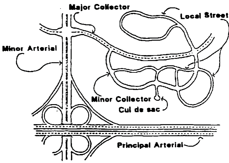
Street Classifications
Structure means anything constructed or erected, the use of which requires a location on the ground or attachment to something having a location on the ground. Structures include, but are not limited to, buildings, signs, billboards, towers/fences greater than seven feet in height, pavilions, gazebos, pergolas, trellises, retaining walls four feet in height or greater, and swimming pools.
Structure, accessory. See Accessory structure in article III, division 3 of this chapter.
Structure, principal. See Building, principal.
Subdivider means any person who commences or maintains proceedings to subdivide property under the subdivision regulations.
Subdivision means the division of an area, lot, parcel, property or tract of land into two or more parcels, tracts, lots or long-term leasehold interests by any means, including, but not limited to, preliminary and final plats, CIC plats registered land surveys, administrative subdivisions and conveyance by metes and bounds.
Tree means a self-supporting woody perennial plant having one or several self-supporting stems or trunks and numerous branches which normally attains an overall height of at least 15 feet at maturity. Trees may be classified, described, and measured as follows:
Tree caliper inch or caliper inch means a unit of measurement describing the diameter of a tree measured 4.5 feet above the finished grade level.
Tree canopy means the horizontal extension of a tree's branches in all directions from its trunk.
Tree diameter at breast height (DBH) or diameter at breast height means the diameter of a tree measured at a height of 4½ feet from the ground level.
Tree dripline or dripline means the farthest distance away from the trunk of a tree that rain or dew will fall directly to the ground from the leaves or branches of the tree.
Tree root zone or root zone means the area under a tree which is at or within the dripline of a tree.
Tree, canopy, means a deciduous tree planted primarily for its high crown of foliage or overhead canopy.
Tree, coniferous, means a woody plant having foliage on the outermost portion of the branches year round.
Tree, deciduous, means a woody plant having a defined crown and which loses leaves annually.
Tree, evergreen, or evergreen means a plant with foliage that persists and remains green year round.
Tree, heritage, means any tree which has been determined to be of high value because of its species, size, age, and other specific criteria as listed in section 10-728.
Tree, ornamental, means any tree planted primarily for its ornamental value or for screening purposes and which tends to be smaller at maturity than canopy trees.
Tree, significant, means a deciduous tree measuring six caliper inches DBH or more in diameter or a coniferous tree measuring 12 feet or more in height.
Usable open space means a required ground area or terrace on a lot which is graded, developed, landscaped and equipped and intended and maintained for either active or passive recreation or both, available and accessible to and usable by all person occupying a dwelling unit or a rooming unit on the lot and their guests. Usable open space has a minimum dimension of 30 feet. Roofs, driveways and parking areas do not constitute usable open space.
Use. See Land use.
Use district. See Zoning district.
Variance means the modification of a chapter requirement as it applies to specific property or structures.
Vehicle or motor vehicle means a machine propelled by power other than human power designed to travel along the ground by use of wheels, treads, runners or slides and transport persons or property or pull machinery and shall include, without limitation, automobiles, motorcycles, and trucks. The term "motor vehicle" does not include any item defined as recreational equipment in this chapter or electric personal assistive mobility devices.
Vehicle, commercial motor, means a motor vehicle greater than eight feet in height or greater than 22 feet in length, including, but not limited to, ambulances, boom trucks, box trucks, cargo trucks, dump trucks, farm implements, fire trucks, food trucks, hearses, limousines, semitractors or semitractor trailers, stake trucks, tank trucks and tow trucks.
Water-oriented accessory structure means a building of 120 square feet or less located on lakeshore parcels, which, because of the relationship of its use to a surface water feature, reasonably needs to be located closer to the lakeshore ordinary high-water level (OHWL) than the normal structural setback requirement. Examples of such structures include structures used to store boating accessories and equipment, gazebos, pergolas, trellises, pavilions, and screen houses. The building shall not have a water or sewer connection.
Watercraft means any vessel, boat, canoe, raft, barge, sailboard, or any similar device used or usable for carrying and transporting persons on public waters.
Watercraft, restricted, means watercraft for use on or stored on the public waters except for the following:
(1)
Watercraft 16 feet or less in length which uses no motor or a motor of ten horsepower or less; and
(2)
Watercraft 20 feet or less in length which uses no motor and is propelled solely by human power.
Wetland means lands transitional between terrestrial and aquatic systems where the water table is usually at or near the surface or the land is covered by shallow water. For purposes of this definition, wetlands must have the following three attributes:
(1)
Have a predominance of hydric soils;
(2)
Are inundated or saturated by surface water or groundwater at a frequency and duration sufficient to support a prevalence of hydrophytic vegetation typically adapted for life in saturated soil conditions; and
(3)
Under normal circumstances support a prevalence of such vegetation.
Yard means a required open space on a lot, which is unoccupied and unobstructed by a structure from its lowest ground level to the sky except as expressly permitted in this chapter. The yard shall extend along a lot line and at right angles to the lot line to a depth or width specified in the dimensional standards or setbacks for the district in which the lot is located. Types of yards include the following:
Yard, front, means an area which extends along the full width of the front lot line between side lot lines and toward the rear lot line a distance as specified in the required yard regulations for the district in which such lot is located. For lakeshore property, the front yard shall be considered that part of the lot located between the road and the nearest parallel line drawn across the front of the principal building or the minimum front yard setback.
Yard, rear, means an area which extends along the full width of the rear lot line between the side lot lines and toward the front lot line a distance as specified in the required yard regulations for the district in which the lot is located. Where the lot is a corner lot, the rear yard shall be the area between the interior side lot line and the side yard abutting a street extending toward the front yard a distance as specified in the required yard regulations for the district in which the lot is located.
Yard, side, means an area extending along a side lot line between front and rear yards having a width as specified in the required yard regulations for the district in which the lot is located.
Yard, side, abutting a street, means a yard adjacent to a street which extends along a side lot line between the front yard and rear property line. For the purposes of determining the required setbacks, a side yard abutting a street is identified as a front yard in the dimensional standards of the use district in which the yard is located.
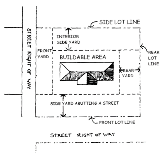
Types of Yards
Yard sale means a sale of assorted secondhand objects conducted by the property owner or occupant on their premises for a short period of time. Yard sales, also known as garage sales, rummage sales, or estate sales, are not the primary use of the property or the primary occupation of the property owner or occupant.
Zoning administrator means the individual authorized to administer the regulations of this chapter.
Zoning district or use district means an area designated for certain land uses and subject to uniform regulations and requirements governing the placement, spacing, and size of the land and structures. Zoning districts include agriculture (A), rural subdivision (R-S), low-density residential (R-1), medium-density residential (R-2), high-density residential (R-3), town center (TC), transitional town center (TC-T), neighborhood business (C-1), general business (C-2), business park (C-3), and general industrial (I-1).
Zoning map means the maps which are a part of this chapter and delineate the boundaries of the use districts.
(Prior Code, § 1111.100; Ord. No. 122-09, 8-13-2022; Ord. No. 124-12, § 2, 12-10-2024)
Sec. 10-74. - Purpose.
Land that is needed for future street purposes and as sites for other necessary public facilities and services is frequently diverted to nonpublic uses which would have been located on other lands without hardship or inconvenience to the owners. When this happens, public uses of land may be denied or may be denied or may be obtained only at prohibitive cost or at the expense of dislocating the owners and occupants of the land. Identification on an official map of land needed for future public uses permits both the public and private property owners to adjust their building plans equitably and conveniently before investments are made which will make such adjustments difficult to accomplish. It is the purpose of this division to provide a uniform procedure for the proper use of official maps as authorized by the state Municipal Planning Act, Minn. Stats. §§ 462.351 to 462.36.
(Prior Code, § 1112.100)
Sec. 10-75. - Official map defined.
The term "official map," as used in this chapter, means a map adopted in accordance with this division and with Minn. Stats. § 462.359 which may show existing and proposed future streets, roads and highways. An official map may also show the location of existing and future public land and facilities within the city. An official map may cover the entire city or any portion of the city.
(Prior Code, § 1112.200)
Sec. 10-76. - Proceedings.
(a)
Initiation. Proceedings for adoption, amendment, or repeal of an official map or any part thereof may be initiated by:
(1)
A recommendation of the planning commission; or
(2)
Action by the city council on its own initiative, recommendation of an advisory commission, or request of an outside governmental body.
(b)
Sketch maps and reports. Every proposal or request for an official map or its amendment or repeal, however initiated, shall be accompanied by a sketch map or plat showing the lands proposed to be included and the public purpose to be served.
(c)
Reference to planning commission. Except when proceedings have been initiated by recommendation of the planning commission, every proposed official map or change in a map shall be referred to the planning commission for advice and recommendation thereon, and such recommendation shall be submitted to the city council within 45 days after reference to the planning commission along with the report of the commission on the effect of the proposal on the comprehensive plan of the city. If no recommendation is received by the council or the planning commission within 45 days after reference of the proposal to the commission by the council, the council may take such action as it may deem proper upon the proposal without further action by the planning commission.
(d)
Notice and hearing.
(1)
Notice. Upon receiving the recommendation of the planning commission or after 45 days from the submission of the proposal to the planning commission without a recommendation from the commission, the council may call a public hearing on the proposal. A notice of the time, place and purpose of the hearing and a description of the property to be included in the mapped streets and public grounds shall be published in the official newspaper at least ten days prior to the date of the hearing. At least ten days prior to the hearing, the clerk shall also mail a copy of the notice to each owner of land situated within or abutting any street or other public ground shown on the official map. For purposes of this notice, the owners shall be determined by the records of the county auditor and the notice shall be addressed to the last known address as shown by the auditor's records. Failure to serve any such notice shall not invalidate the proceedings.
(2)
Hearing. At the time and place specified in the notice, the council shall hear evidence and arguments concerning the proposal. The hearing may be continued, from time to time, without further notice. The council may direct the planning commission to conduct a hearing and following the hearing to report its recommendation to the council.
(Prior Code, § 1112.300)
Sec. 10-77. - Preparation and filing of maps.
The official maps shall be prepared in sufficient detail to permit the establishment of future acquisition lines on the ground. In unplatted areas, a minimum of a centerline survey shall be made prior to the preparation of the final draft of the official map. After enactmentof any ordinance adopting an official map or amending or repealing a pervious office map ordinance, a certified copy of the official map or section to which the ordinance relates, together with an attached copy of the ordinance, shall be filed with the county recorder.
(Prior Code, § 1112.400)
Sec. 10-78. - Effect; appeals.
(a)
Effect. After an official map has been adopted and filed, the issuance of building permits by the city shall be subject to the provisions of this division. The city shall deny every application for a permit to construct a new building or structure or expand an existing building or structure within an area designated on the official map for street or other public purposes. When any street or highway is widened or improved or any new street is opened, or any interest in lands for other public purposes is acquired by the city, the city is not required in such proceedings to pay for any building or structure placed without a permit or in violation of conditions of a permit within the limits of the mapped street or outside of any building line that may have been established upon the existing street or within any area thus identified for public purposes. The adoption of an official map does not give the city any right, title or interest in areas identified for public purposes thereon, but the adoption of the map does authorize the city to acquire such interest without paying compensation for buildings or structures erected in such areas without a permit or in violation of the conditions of a permit.
(b)
Appeals.
(1)
When a building permit is denied pursuant to this division, the board of appeals and adjustments shall, upon appeal filed with it by the owner of the land, grant a permit for building in an area designated on the official map for a street or other public purpose in any case in which the board finds, upon the evidence and the arguments presented to it:
a.
That the entire property of the appellant of which the area designated for public purposes forms a part cannot yield a reasonable return to the owner unless such a permit is granted; or
b.
That, balancing the interest of the city in preserving the integrity of the official map and the comprehensive plan and the interest of the property owner in the use of his property and in the benefits of ownership, the grant of such permit is required by considerations of justice and equity.
(2)
The board of appeals and adjustments shall hold a public hearing upon the appeal after notice of the hearing has been published in the official newspaper once at least ten days before the hearing. If the board authorizes issuance of a permit, it shall specify the exact location, ground area, height and other details as to the extent and character of the building for which the permit is granted. If the board authorizes issuance of a permit, the council or other board or commission having jurisdiction shall have six months from the date of the decision of the board to institute proceedings to acquire such land or interest therein, and if no such proceedings are started within that time, the city shall issue the permit if the application otherwise conforms to local ordinances.
(Prior Code, § 1112.500)
Sec. 10-100. - Purpose.
The purpose of this division is to establish standards to encourage the effective use of off-premises signs as a means of directing vehicular and pedestrian traffic to facilities of regional significance.
(Prior Code, § 1113.100)
Sec. 10-101. - Findings.
(a)
The city finds it is necessary for the promotion and preservation of the public health, safety, welfare and aesthetics of the city that the construction, location, size and maintenance of off-premises directional signs for facilities of regional significance be controlled.
(b)
As facilities of regional significance develop within the city, residents and visitors to the city should be able to locate and gain access to these facilities easily and safely.
(c)
The safety of motorists, cyclists, pedestrians and other users of public streets and property are affected by the number, size, location and appearance of signs that unduly divert the attention of drivers.
(Prior Code, § 1113.200)
Sec. 10-102. - Definitions.
The following words, terms and phrases, when used in this division, shall have the meanings ascribed to them in this section, except where the context clearly indicates a different meaning:
Facility of regional significance means a facility that has directional signage on an interstate or state highway, generates 2,500 vehicle trips per day, is located on land owned by a governmental unit other than public right-of-way, and is located within the city corporate limits.
Off-premises directional sign means a sign erected on private property for the purpose of directing vehicular and pedestrian traffic to a facility of regional significance not located on the premises in which the sign is located. A billboard sign is not an off-premises directional sign.
(Prior Code, § 1113.300)
Sec. 10-103. - Performance standards.
(a)
Location. Signage shall be erected on property located in a commercial land use designation on the comprehensive plan land use plan map or commercial use district on the zoning map.
(b)
Off-premises directional sign permitted. One off-premises directional sign is permitted within a two-mile radius of the property on which the facility of regional significance is located.
(c)
Sign area. Signage shall not exceed 20 feet in height and 144 square feet in area per side.
(d)
Architectural materials. Signage shall be installed on a base foundation constructed of masonry materials, such as brick, stone, or color-impregnated decorative block.
(e)
Illumination. Signage shall be internally illuminated. External illumination directed away from the sign face or into the air (e.g., spotlights, light beams, etc.) is prohibited.
(f)
Setbacks. Signage shall be located at least ten feet from any property line. The sign may not be located within a traffic visibility area as defined in section 10-730.
(g)
Glare. Reflected glare or spill light from the sign shall not exceed 0.5 footcandle when the source abuts any residential parcel or 1.0 footcandle at any public right-of-way measured at one foot above the ground.
(h)
Separation of signs. Off-premises directional signs for facilities of regional significance shall be located at least 40 feet from another permanent sign as regulated by section 10-790.
(Prior Code, § 1113.400)
Sec. 10-104. - Sign permit requirements.
(a)
Generally. Before a sign requiring a permit under the provisions of this division is placed, constructed, erected, modified, or relocated, the property owner or designee shall secure a sign permit from the zoning administrator. The property owner shall maintain a sign permit for all signs on the property. A licensed electrician shall wire any sign involving electrical components. A building permit may be required in cases where the International Building Code warrants it.
(b)
Application. Application for a sign permit shall be made in writing upon forms furnished by the city. The application shall contain the following information:
(1)
Name, address and telephone number of the property owner, sign owner and installer.
(2)
Address and legal description of the property where the sign is proposed to be located.
(3)
The sign plan information required in section 10-105.
(4)
Other pertinent information as may be required by the zoning administrator.
The permit application shall be signed by the applicant, and, when the applicant is any person other than the owner of the property, the application shall also be signed by the property owner.
(Prior Code, § 1113.500)
Sec. 10-105. - Sign plan requirements.
No sign permit shall be issued until a sign plan for the entire property or building on which the sign will be erected has been approved by the zoning administrator. The purpose of the sign plan is to provide accurate information for the city to determine compliance with the requirements of this chapter. The sign plan shall include:
(1)
An accurate survey or site plan of the property at such scale as the zoning administrator shall reasonably require. The zoning administrator may also require the applicant locate lot corners on the site to verify the sign location.
(2)
Area calculations for each exterior elevation of the building, total building area, and the proposed location of signs on each exterior wall elevation.
(3)
An accurate indication on the survey or site plan of the location, area, and dimensions of each existing wall and freestanding sign and proposed future sign of any type, whether requiring a permit or not.
(4)
Lettering or graphic style, lighting, location of each sign on the building, materials and sign proportions.
(5)
A duplicate copy of the sign information that the property owner will provide to all tenants with the approved plan.
(6)
Plans, specifications, and method of construction or attachment to the building or in the grounds, including all dimensions, showing all light sources, illumination levels, type and color lights, and details of any light shield or shades.
(Prior Code, § 1113.600)
Sec. 10-106. - Maintenance.
(a)
All signs shall be maintained in a safe, presentable and sound structural condition at all times. Maintenance shall include painting, repainting, cleaning, replacement or repair of defective parts and the like.
(b)
Any sign that the city finds is in a dangerous or defective condition shall be removed or repaired by the owner of the sign or the owner of the property on which the sign is located.
(Prior Code, § 1113.700)
Sec. 10-107. - Lapse of sign permit.
A sign permit shall lapse automatically if the business related to the sign is discontinued for a period of one year. If the sign is not removed or a new permit for a sign allowed by this division has not been issued within 30 days of notice of permit expiration, the city may have the sign removed and assess costs back to the property as provided by Minn. Stats. ch. 429.
(Prior Code, § 1113.800)
Sec. 10-108. - Cancellation.
A sign permit shall become null and void if the work for which the permit was issued has not been completed within a period of six months after the date of the permit approval. A permit may be renewed one time for an additional six months and no additional fee shall be collected for the renewal. This clause does not apply to temporary or conditional sign permits.
(Prior Code, § 1113.900)
Sec. 10-109. - Removal of signs.
(a)
If the city finds that any sign, temporary or permanent, or other structure regulated herein is unsafe or insecure, a menace to the public, or in violation of the provisions of this division, the zoning administrator shall give written notice to the holder of the permit. The holder of the permit shall remove or alter the structure so as to comply with the standards required by this division and indicated by the zoning administrator within seven days after issuance of such notice. If after receiving the notice such person fails to remove or alter the sign so as to comply with the provisions of this division, such sign shall be deemed to be a nuisance and may be abated by the city by proceedings taken under Minn. Stats. ch. 429 and the cost of abatement, including administration expenses and reasonable attorney fees, may be levied as a special assessment against the property upon which the sign is located.
(b)
The city may cause any sign or sign structure that is an immediate public hazard to be removed summarily after a reasonable attempt has been made to have the property owner remove the sign.
(c)
Notice of violation will be sent by certified mail to the property owner and, if applicable, to the person to whom the permit is issued.
(Prior Code, § 1113.1000)