
Prosper City Zoning Code
CHAPTER 2
ZONING DISTRICTS
1.1 - Zoning districts.
The Town of Prosper, Texas is hereby divided into the following zoning districts. Development occurring in the following Districts shall comply with the regulations and standards as established herein. The Districts established herein shall be known as:
1.2 - Definitions and purpose of zoning districts (base zoning districts) (Z07-8).
A.
A—AGRICULTURAL DISTRICT: This district is intended to provide a location for principally undeveloped or vacant land situated on the fringe of an urban area and used for agricultural purposes, but may become an urban area in the future. Generally, the Agricultural District will be near development; therefore, the agricultural activities conducted in this District should not be detrimental to urban land uses. The types of uses and the area and intensity of uses permitted in this District shall encourage and protect agricultural uses until urbanization is warranted and the appropriate change in district classification is made. The Agricultural District is also intended to protect areas that may be unsuitable for development because of, among other things, physical problems, lack of infrastructure, constraints, or potential health or safety hazards such as flooding, as well as providing for preservation of natural open space areas.
B.
SF-E—SINGLE FAMILY-ESTATE DISTRICT: This district will provide for development of single family detached dwelling units on a minimum lot size of one acre. Other uses, such as religious and educational facilities, parks, and open spaces will be provided for to maintain a balanced, orderly, convenient, and attractive residential area.
C.
SF-22—SINGLE FAMILY-22 DISTRICT: This district will provide for development of single family detached dwelling units on a minimum lot size of 22,000 square feet. Other uses, such as religious and educational facilities, parks, and open spaces will be provided for to maintain a balanced, orderly, convenient, and attractive residential area.
D.
SF-17.5—SINGLE FAMILY-17.5 DISTRICT: This district will provide for development of single family detached dwelling units on a minimum lot size of 17,500 square feet. Other uses, such as religious and educational facilities, parks, and open spaces will be provided for to maintain a balanced, orderly, convenient, and attractive residential area.
E.
SF-15—SINGLE FAMILY-15 DISTRICT: This district will provide for development of single family detached dwelling units on a minimum lot size of 15,000 square feet. Other uses, such as religious and educational facilities, parks, and open spaces will be provided for to maintain a balanced, orderly, convenient, and attractive residential area.
F.
SF-12.5—SINGLE FAMILY-12.5 DISTRICT: This district will provide for development of single family detached dwelling units on a minimum lot size of 12,500 square feet. Other uses, such as religious and educational facilities, parks, and open spaces will be provided for to maintain a balanced, orderly, convenient, and attractive residential area.
G.
SF-10—SINGLE FAMILY-10 DISTRICT: This district will provide for development of single family detached dwelling units on a minimum lot size of 10,000 square feet. Other uses, such as religious and educational facilities, parks, and open spaces will be provided for to maintain a balanced, orderly, convenient, and attractive residential area.
H.
DTSF—DOWNTOWN SINGLE FAMILY DISTRICT: This district is designed specifically for the residential portions of the original or downtown area of the town. This area is generally bounded by the railroad tracks on the west, Eighth Street on the north, Craig Road on the east, and First Street on the south. The standards set forth in this district strive to accommodate the original platting, as well as the preferable standard for a minimum fifty-foot lot width. These standards will provide for a suitable residential environment for family life on smaller parcels of land. Other uses, such as religious and educational facilities, parks, and open spaces will be provided for to maintain a balanced, orderly, convenient, and attractive residential area. This zoning district is appropriate in residential areas designated as Old Town Core District on the Future Land Use Plan.
I.
TH—TOWNHOME DISTRICT: This district will provide for development of attached residential dwelling units in structures accommodating three to nine units. This district is a high density district, not to exceed ten units per acre. The standards in this district are intended to promote stable, quality multiple occupancy residential development at increased densities. Individual ownership of the townhome units is encouraged. Multiple townhome units may be constructed on a single lot, or on adjacent individual lots. Other uses, such as religious and educational facilities, parks, and open spaces will be provided for to maintain a balanced, orderly, convenient, and attractive residential area. This zoning district is appropriate in areas designated as high density residential on the Future Land Use Plan. Limited amounts of this district may also be appropriate in areas designated as tollway corridor or U.S. 380 Adjacency Corridor on the Future Land Use Plan.
J.
2F—TWO FAMILY DISTRICT: This district will provide for development of two family attached dwelling units on either a single lot, or two adjacent lots. The standards in this district are intended to promote stable, quality multiple occupancy residential development at slightly increased densities. Individual ownership of the two family or duplex units is encouraged. Other uses, such as religious and educational facilities, parks, and open spaces will be provided for to maintain a balanced, orderly, convenient, and attractive residential area. This zoning district is appropriate in areas designated as high density residential or residential in-fill development in areas designated as historic on the Future Land Use Plan.
K.
MF—MULTIFAMILY DISTRICT: This district will provide for development of high density attached residential dwelling units, not to exceed 15 units per acre. The standards in this district are intended to promote stable, quality multiple occupancy residential development at high densities. The principal permitted land uses will include apartment complexes and townhomes. Other uses, such as religious and educational facilities, parks, and open spaces will be provided for to maintain a balanced, orderly, convenient, and attractive residential area. This zoning district should be located adjacent to a major thoroughfare and is appropriate in areas designated as high density residential on the Future Land Use Plan. Limited amounts of this district may also be appropriate in areas designated as tollway corridor or U.S. 380 Adjacency Corridor on the Future Land Use Plan.
L.
MH—MOBILE HOME DISTRICT: This district is a detached residential district establishing standards for the development of a mobile home park, a mobile home subdivision, or a recreational vehicle park. A mobile home park offers spaces for the placement of mobile home units on a lease or rental basis. Mobile home subdivisions include individually platted lots, for sale within the subdivision, for the placement of mobile home units. Other uses, such as religious and educational facilities, parks, and open spaces will be provided for to maintain a balanced, orderly, convenient, and attractive residential area. This zoning district may be appropriate in areas designated as high density residential on the Future Land Use Plan.
M.
O—OFFICE DISTRICT: This district is established to accommodate a variety of office developments providing for professional, financial, medical, and similar services for local residents; corporate offices for regional and national operations; major employment centers for city, county, and state governmental entities; and service uses necessary to support such office uses. Such uses do require accessibility to major thoroughfares. This zoning district may be appropriate in areas designated as office, tollway corridor, U.S. 380 Adjacency Corridor, or retail on the Future Land Use Plan.
N.
DTO—DOWNTOWN OFFICE DISTRICT: This district is established to maintain existing and encourage additional office development in the original downtown portion of the town. Standards for vehicle parking, building set-backs, and building height are similar to those existing on developed properties in this section of the town. Therefore, these standards are only applicable to this section of the town. This district will accommodate a variety of office developments providing for professional, financial, medical, and similar services for local residents and service uses necessary to support such office uses. This zoning district may be appropriate in areas designated as Old Town Core District on the Future Land Use Plan.
O.
NS—NEIGHBORHOOD SERVICE DISTRICT: This district is established as a limited retail category intended for use by residents of nearby neighborhood areas for the purpose of supplying day-to-day needs and personal services. Establishments should include small, free-standing retail structures, such as convenience stores and neighborhood oriented personal service establishments. Sites zoned neighborhood service should be located on a major thoroughfare and generally utilize a site adjacent to one or more logical neighborhood service areas. The total gross floor area of all structures in an individual Neighborhood Service District should not exceed 14,000 square feet. This zoning district may be appropriate in areas designated as office or retail on the Future Land Use Plan.
P.
DTR—DOWNTOWN RETAIL DISTRICT: This district is established to maintain existing and encourage additional retail development in the original downtown portion of the town, west of Coleman Street. Standards for vehicle parking, building set-backs, and building height are similar to those existing on developed properties in this section of the town. Therefore, these standards are only applicable to this section of the town. This zoning district may be appropriate in areas designated as Old Town Core District on the Future Land Use Plan.
Q.
R—RETAIL DISTRICT: This district is established to provide locations for various types of general retail and service uses for one or more neighborhoods. Developments within a retail district should utilize established landscape and buffering requirements and be limited to two stories in height. The retail district and shopping areas should generally be located at intersections of major thoroughfares and convenient to their residential service area. This zoning district may be appropriate in areas designated as retail on the Future Land Use Plan.
R.
DTC—DOWNTOWN COMMERCIAL DISTRICT:This district is established to maintain existing and encourage additional retail and commercial development in the original downtown portion of the town. Standards for vehicle parking, building set-backs, and building height are similar to those existing on developed properties in this section of the town. Therefore, these standards are only applicable to this section of the town. This zoning district may be appropriate in areas designated as Old Town Core District on the Future Land Use Plan.
S.
C—COMMERCIAL DISTRICT: This district is intended predominately for heavy retail, service, light intensity wholesale and commercial uses, but excluding warehousing uses. The nature of uses in this district has operating characteristics and traffic service requirements generally compatible with typical office, retail, and some residential environments. Uses in this district may require open, but screened, storage areas for materials. This zoning district may be appropriate in areas designated as community or regional retail on the Future Land Use Plan.
T.
CC—COMMERCIAL CORRIDOR DISTRICT: This district is intended primarily for employment center uses such as light manufacturing, warehousing, wholesaling, office, and distribution operations that do not depend upon frequent customer or client visits, as well as service uses necessary to support such employment center uses. Such uses do require accessibility to major thoroughfares or highways. This zoning district may be appropriate in areas designated as Tollway Corridor, U.S. 380 Adjacency Corridor, or industrial on the Future Land Use Plan.
U.
I—INDUSTRIAL DISTRICT: This district is intended primarily for uses in the conduct of light manufacturing, assembling and fabrication, and for warehousing, wholesaling and service operations that do not depend upon frequent customer or client visits. Such uses do require accessibility to major highways, rail lines or other means of transportation. This zoning district is appropriate in areas designated as industrial on the Future Land Use Plan.
V.
PD—PLANNED DEVELOPMENT DISTRICT: The Planned Development District is a district that accommodates planned associations of uses developed as integral land use units such as offices, commercial or service centers, shopping centers, residential developments of multiple or mixed housing (including attached single-family dwellings), or any appropriate combination of uses that may be planned, developed, or operated as integral land use units either by a single owner or a combination of owners. A PD District may be used to permit new or innovative concepts in land utilization not permitted by other zoning districts in this chapter. While greater flexibility is given to allow special conditions or restrictions that would not otherwise allow the development to occur, procedures are established herein to insure against misuse of increased flexibility.
W.
SUP—SPECIFIC USE PERMIT: The specific use permit provides the town an opportunity to approve, conditionally approve, or deny identified specific uses that may be permitted in specified zoning districts. These uses generally have unusual nuisance characteristics or are of a public or semi-public character and are often essential or desirable for the general convenience and welfare of the community. However, because of the nature of the use, the importance of the use's relationship to the Comprehensive Plan, and possible adverse impacts on neighboring properties review, evaluation, and exercise of sound planning judgment relative to the location and site plan are required.
2.1 - Equivalency table.
The following table will identify zoning districts adopted in the previous zoning ordinance and the district that now applies in this chapter to those districts:
3.1 - General purpose and description.
The Agricultural District is intended to provide a location for principally undeveloped or vacant land situated on the fringe of an urban area and used for agricultural purposes, but may become an urban area in the future. Generally, the Agricultural District will be near development; therefore, the agricultural activities conducted in this district should not be detrimental to urban land uses. The types of uses and the area and intensity of uses permitted in this district shall encourage and protect agricultural uses until urbanization is warranted and the appropriate change in district classification is made. The Agricultural District is also intended to protect areas that may be unsuitable for development because of physical problems, lack of infrastructure, constraints, or potential health or safety hazards such as flooding, as well as providing for preservation of natural open space areas.
3.2 - Regulations.
A.
Size of Yards:
1.
Minimum Front Yard — 40 feet.
2.
Minimum Side Yard — 20 feet; 25 feet on corner adjacent to side street.
3.
Minimum Rear Yard — 20 feet.
B.
Size of Lots:
1.
Minimum Lot Area — Two acres.
2.
Minimum Lot Width — 200 feet.
3.
Minimum Lot Depth — 200 feet.
C.
Minimum Dwelling Area: 1,800 square feet.
D.
Maximum Height: Two and a half stories, no greater than 40 feet.
E.
Maximum Lot Coverage: 20 percent.
3.3 - Permitted uses.
Permitted uses shall be in accordance with the "Schedule of Uses" as outlined in Section 1.3 of Chapter 3.
(Ord. No. 15-74, 12-08-15)
4.1 - General purpose and description.
The Single Family-Estate District will provide for development of single family detached dwelling units on a minimum lot size of acre. Other uses, such as religious and educational facilities, parks, and open spaces will be provided for to maintain a balanced, orderly, convenient, and attractive residential area.
4.2 - Regulations.
A.
Size of Yards:
1.
Minimum Front Yard — 40 feet.
2.
Minimum Side Yard — Fifteenfeet; including on corner adjacent to side street.
3.
Minimum Rear Yard — 25 feet.
B.
Size of Lots:
1.
Minimum Lot Area — One acre.
2.
Minimum Lot Width — 150 feet.
3.
Minimum Lot Depth — 200 feet.
C.
Minimum Dwelling Area: 1,800 square feet.
D.
Minimum Enclosed Parking (Garage) Area: 400 square feet.
E.
Maximum Height: Two and a half stories, no greater than 40 feet.
F.
Exterior Construction of Main Buildings: Refer to Chapter 4, Section 9.8.
G.
Maximum Lot Coverage: 45 percent.
H.
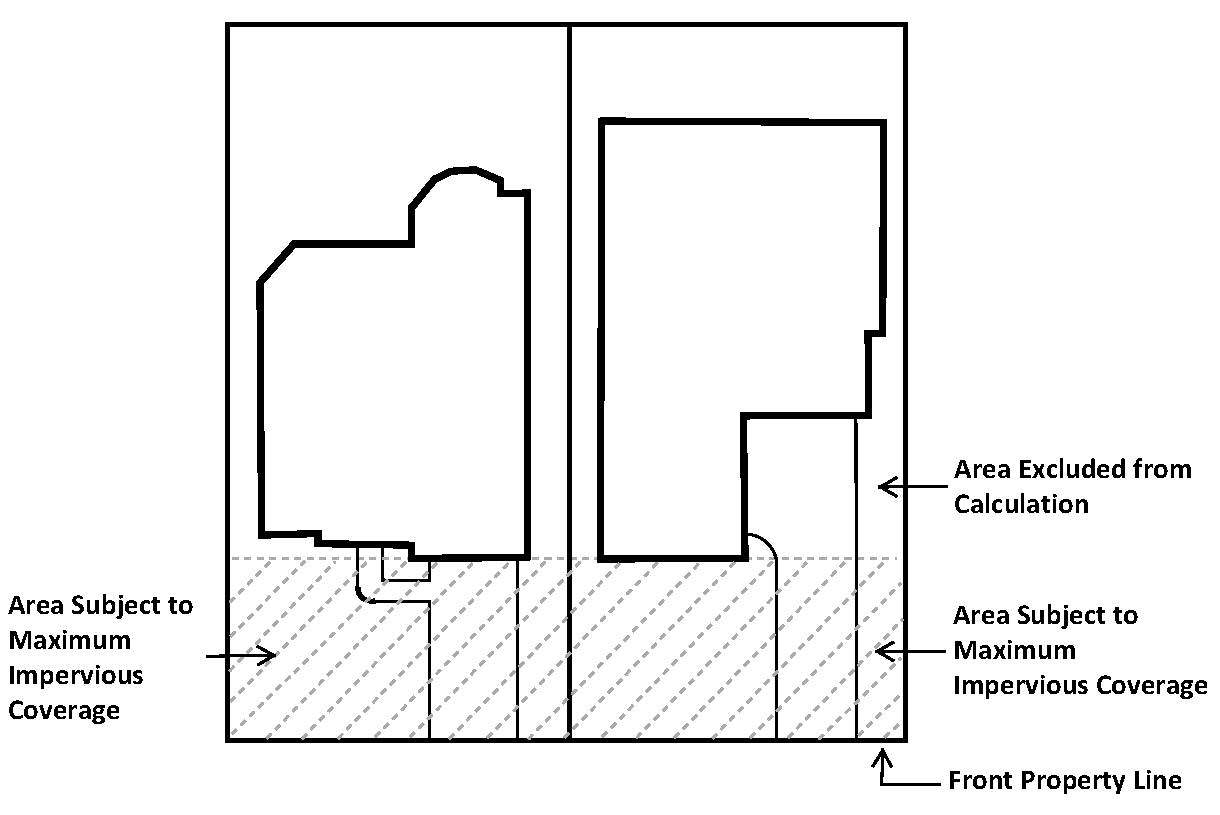
Maximum Impervious Coverage of Front Yards: The cumulative area of any driveway plus any other impervious surface area located between the front property line and any front building wall shall not exceed 50 percent of the area between the front property line and any front building wall. The area subject to the maximum impervious coverage is illustrated below.
(Ord. No. 15-55, 9-22-15)
4.3 - Permitted uses.
Permitted uses shall be in accordance with the "Schedule of Uses" as outlined in Section 1.3 of Chapter 3.
(Ord. No. 15-74, 12-8-15)
5.1 - General purpose and description.
The Single Family-22 District will provide for development of single family detached dwelling units on a minimum lot size of 22,000 square feet. Other uses, such as religious and educational facilities, parks, and open spaces will be provided for to maintain a balanced, orderly, convenient, and attractive residential area.
5.2 - Regulations.
A.
Size of Yards:
1.
Minimum Front Yard — 40 feet.
2.
Minimum Side Yard — 12 feet; 15 feet on corner adjacent to side street.
3.
Minimum Rear Yard — 25 feet.
B.
Size of Lots:
1.
Minimum Lot Area — 22,000 square feet.
2.
Minimum Lot Width — 120 feet.
3.
Minimum Lot Depth — 170 feet.
C.
Minimum Dwelling Area: 1,800 square feet.
D.
Minimum Enclosed Parking (Garage) Area: 400 square feet.
E.
Maximum Height: Two and a half stories, no greater than 40 feet.
F.
Exterior Construction of Main Buildings: Refer to Chapter 4, Section 9.8.
G.
Maximum Lot Coverage: 45 percent.
H.
Maximum Impervious Coverage of Front Yards: The cumulative area of any driveway plus any other impervious surface area located between the front property line and any front building wall shall not exceed 50 percent of the area between the front property line and any front building wall. The area subject to the maximum impervious coverage is illustrated below.

(Ord. No. 15-55, 9-22-15)
5.3 - Permitted uses.
Permitted uses shall be in accordance with the "Schedule of Uses" as outlined in Section 1.3 of Chapter 3.
(Ord. No. 15-74, 12-8-15)
6.1 - General purpose and description.
The Single Family-17.5 District will provide for development of single family detached dwelling units on a minimum lot size of 17,500 square feet. Other uses, such as religious and educational facilities, parks, and open spaces will be provided for to maintain a balanced, orderly, convenient, and attractive residential area.
6.2 - Regulations.
A.
Size of Yards:
1.
Minimum Front Yard — 35 feet.
2.
Minimum Side Yard — Ten feet; 15 feet on corner adjacent to side street.
3.
Minimum Rear Yard — 25 feet.
B.
Size of Lots:
1.
Minimum Lot Area — 17,500 square feet.
2.
Minimum Lot Width — 100 feet.
3.
Minimum Lot Depth — 150 feet.
C.
Minimum Dwelling Area: 1,800 square feet.
D.
Minimum Enclosed Parking (Garage) Area: 400 square feet.
E.
Maximum Height: Two and a half stories, no greater than 40 feet.
F.
Exterior Construction of Main Buildings: Refer to Chapter 4, Section 9.8.
G.
Maximum Lot Coverage: 45 percent.
H.
Maximum Impervious Coverage of Front Yards: The cumulative area of any driveway plus any other impervious surface area located between the front property line and any front building wall shall not exceed 50 percent of the area between the front property line and any front building wall. The area subject to the maximum impervious coverage is illustrated below.

(Ord. No. 15-55, 9-22-15)
6.3 - Permitted uses.
Permitted uses shall be in accordance with the "Schedule of Uses" as outlined in Section 1.3 of Chapter 3.
(Ord. No. 15-74, 12-8-15)
7.1 - General purpose and description.
The Single Family-15 District will provide for development of single family detached dwelling units on a minimum lot size of 15,000 square feet. Other uses, such as religious and educational facilities, parks, and open spaces will be provided for to maintain a balanced, orderly, convenient, and attractive residential area.
7.2 - Regulations.
A.
Size of Yards:
1.
Minimum Front Yard — 35 feet.
2.
Minimum Side Yard — Ten feet; 15 feet on corner adjacent to side street.
3.
Minimum Rear Yard — 25 feet.
B.
Size of Lots:
1.
Minimum Lot Area — 15,000 square feet.
2.
Minimum Lot Width — 100 feet.
3.
Minimum Lot Depth — 135 feet.
C.
Minimum Dwelling Area: 1,800 square feet.
D.
Minimum Enclosed Parking (Garage) Area: 400 square feet.
E.
Maximum Height: Two and a half stories, no greater than 40 feet.
F.
Exterior Construction of Main Buildings: Refer to Chapter 4, Section 9.8.
G.
MaximumLot Coverage: 45 percent.
H.
Maximum Impervious Coverage of Front Yards: The cumulative area of any driveway plus any other impervious surface area located between the front property line and any front building wall shall not exceed 50 percent of the area between the front property line and any front building wall. The area subject to the maximum impervious coverage is illustrated below.

(Ord. No. 15-55, 9-22-15)
7.3 - Permitted uses.
Permitted uses shall be in accordance with the "Schedule of Uses" as outlined in Section 1.3 of Chapter 3.
(Ord. No. 15-74, 12-8-15)
8.1 - General purpose and description.
The Single Family-12.5 District will provide for development of single family detached dwelling units on a minimum lot size of 12,500 square feet. Other uses, such as religious and educational facilities, parks, and open spaces will be provided for to maintain a balanced, orderly, convenient, and attractive residential area.
8.2 - Regulations.
A.
Size of Yards:
1.
Minimum Front Yard — 30 feet.
2.
Minimum Side Yard — Eight feet; 15 feet on corner adjacent to side street.
3.
Minimum Rear Yard — 25 feet.
B.
Size of Lots:
1.
Minimum Lot Area — 12,500 square feet.
2.
Minimum Lot Width — 80 feet.
3.
Minimum Lot Depth — 135 feet.
C.
Minimum Dwelling Area: 1,800 square feet.
D.
Minimum Enclosed Parking (Garage) Area: 400 square feet.
E.
Maximum Height: Two and a half stories, no greater than 40 feet.
F.
Exterior Construction of Main Buildings: Refer to Chapter 4, Section 9.8.
G.
MaximumLot Coverage: 45 percent.
H.
Maximum Impervious Coverage of Front Yards: The cumulative area of any driveway plus any other impervious surface area located between the front property line and any front building wall shall not exceed 50 percent of the area between the front property line and any front building wall. The area subject to the maximum impervious coverage is illustrated below.

(Ord. No. 15-55, 9-22-15)
8.3 - Permitted uses.
Permitted uses shall be in accordance with the "Schedule of Uses" as outlined in Section 1.3 of Chapter 3.
(Ord. No. 15-74, 12-8-15)
9.1 - General purpose and description.
The Single Family-10 District will provide for development of single family detached dwelling units on a minimum lot size of 10,000 square feet. Other uses, such as religious and educational facilities, parks, and open spaces will be provided for to maintain a balanced, orderly, convenient, and attractive residential area.
9.2 - Regulations.
A.
Size of Yards:
1.
Minimum Front Yard — 25 feet.
2.
Minimum Side Yard — Eight feet; 15 feet on corner adjacent to side street.
3.
Minimum Rear Yard — 25 feet.
B.
Size of Lots:
1.
Minimum Lot Area — 10,000 square feet.
2.
Minimum Lot Width — 80 feet.
3.
Minimum Lot Depth — 125 feet.
C.
Minimum Dwelling Area: 1,800 square feet.
D.
Minimum Enclosed Parking (Garage) Area: 400 square feet.
E.
Maximum Height: Two and a half stories, no greater than 40 feet.
F.
Exterior Construction of Main Buildings: Refer to Chapter 4, Section 9.8.
G.
MaximumLot Coverage: 45 percent.
H.
Maximum Impervious Coverage of Front Yards: The cumulative area of any driveway plus any other impervious surface area located between the front property line and any front building wall shall not exceed 50 percent of the area between the front property line and any front building wall. The area subject to the maximum impervious coverage is illustrated below.

(Ord. No. 15-55, 9-22-15)
9.3 - Permitted uses.
Permitted uses shall be in accordance with the "Schedule of Uses" as outlined in Section 1.3 of Chapter 3.
(Ord. No. 15-74, 12-8-15)
10.1 - General purpose and description.
The Downtown Single Family District is designed specifically for the residential portions of the original or downtown area of the town. This area is generally bounded by the railroad tracks on the west, Eighth Street on the north, Craig Road on the east, and First Street on the south. The standards set forth in this district strive to accommodate the original platting, as well as the preferable standard for a minimum fifty-foot lot width. These standards will provide for a suitable residential environment for family life on smaller parcels of land. Other uses, such as religious and educational facilities, parks, and open spaces will be provided for to maintain a balanced, orderly, convenient, and attractive residential area. This zoning district is appropriate in residential areas designated as Old Town Core District on the Future Land Use Plan.
10.2 - Regulations.
A.
Size of Yards:
1.
Minimum Front Yard — 25 feet.
2.
Minimum Side Yard — Five feet; 15 feet on corner adjacent to side street.
3.
Minimum Rear Yard — Ten feet.
B.
Size of Lots:
1.
Minimum Lot Area — 6,000 square feet.
2.
Minimum Lot Width — 50 feet.
3.
Minimum Lot Depth — 120 feet.
C.
Minimum Dwelling Area: 1,500 square feet.
D.
Maximum Height: Two and a half stories, no greater than 40 feet.
E.
Lot Coverage: 55 percent.
F.
Building Materials: Exterior Construction of Main Buildings, Chapter 4, Section 9.8
10.3 - Permitted uses.
Permitted uses shall be in accordance with the "Schedule of Uses" as outlined in Section 1.3 of Chapter 3.
(Ord. No. 15-74, 12-8-15)
10.4 - Architectural standards.
A.
All construction must have an approved façade plan before issuance of a building permit. The Town Planner or his/her designee will review all façade plans according to the following standards and will either approve or deny the request. The applicant shall submit the appeal request in writing, within 14 days of the decision, to the Planning Department. The written request shall include specific reasons for the appeal and will be heard by the Town Council. Appeals will require notification of property owners within 200 feet and shall be mailed ten days prior to the hearing.
B.
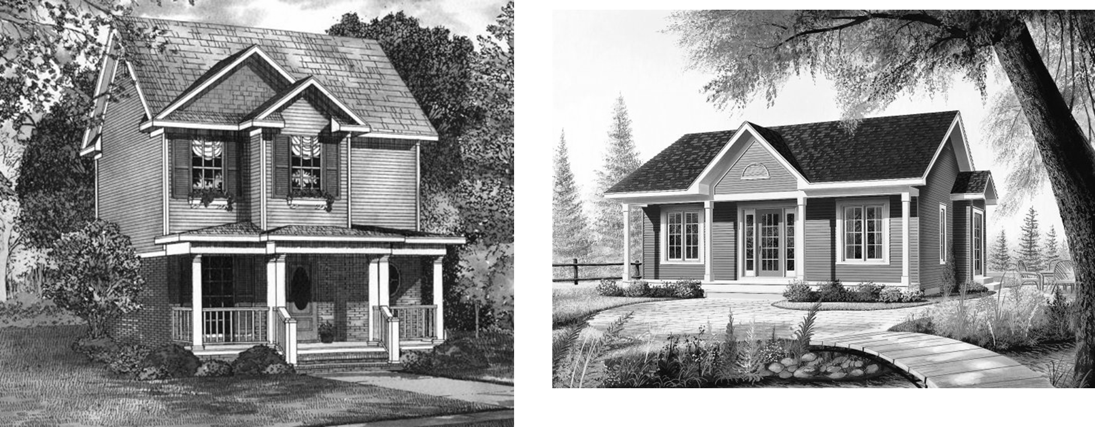
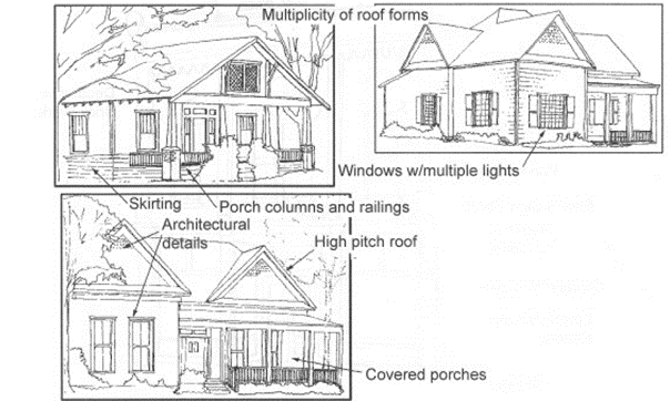
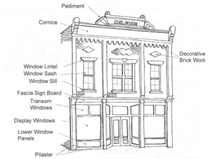
Structures must incorporate covered porches into the front façade, a multiplicity of roof forms, and high pitch roof lines. The recommended architectural styles are Folk traditional, Craftsman, and Victorian. The following examples are provided as guides for all new construction in the Downtown Single Family District:


11.1 - General purpose and description.
The Townhome District will provide for development of attached residential dwelling units in structures accommodating three to nine units. This district is a high density district, not to exceed ten units per acre. The standards in this district are intended to promote stable, quality multiple occupancy residential development at increased densities. Individual ownership of the Townhome units is encouraged. Multiple townhome units may be constructed on a single lot, or on adjacent individual lots. Other uses, such as religious and educational facilities, parks, and open spaces will be provided for to maintain a balanced, orderly, convenient, and attractive residential area. This zoning district is appropriate in areas designated as high density residential on the Future Land Use Plan. Limited amounts of this district may also be appropriate in areas designated as Tollway Corridor or US 380 Adjacency Corridor on the Future Land Use Plan.
11.2 - REGULATIONS.
A.
Maximum Permitted Density: Ten units per acre.
B.
Size of Yards:
1.
Minimum Front Yard — 25 feet.
2.
Minimum Side Yard — Zero feet for the side of a unit that is attached to another unit.
— Ten feet for the side of a unit at the end of the structure; 15 feet on corner lot adjacent to side street.
— Multiple townhome structures constructed on the same lot shall maintain a minimum separation of 20 feet.
3.
Minimum Rear Yard — 20 feet.
C.
Size of Lots:
1.
Minimum Lot Area — 2,500 square feet per dwelling unit.
2.
Minimum Lot Width — 20 feet per dwelling unit.
3.
Minimum Lot Depth — 100 feet.
D.
Minimum Dwelling Area: 1,000 square feet.
E.
Maximum Height: Two and a half stories, no greater than 40 feet.
F.
Lot Coverage: 55 percent.
G.
Minimum Usable Open Space: 20 percent.
11.3 - Permitted uses.
Permitted uses shall be in accordance with the "Schedule of Uses" as outlined in Section 1.3 of Chapter 3.
(Ord. No. 15-74, 12-8-15)
12.1 - General purpose and description.
The Two Family (Duplex) District will provide for development of two family attached dwelling units on either a single lot, or two adjacent lots. The standards in this district are intended to promote stable, quality multiple occupancy residential development at slightly increased densities. Individual ownership of the two family or duplex units is encouraged. Other uses, such as religious and educational facilities, parks, and open spaces will be provided for to maintain a balanced, orderly, convenient, and attractive residential area. This zoning district is appropriate in areas designated as high density residential or residential in-fill development in areas designated as historic on the future land use plan.
12.2 - Regulations.
A.
Size of Yards:
1.
Minimum Front Yard — 30 feet.
2.
Minimum Side Yard — Seven feet; 15 feet on corner adjacent to side street.
3.
Minimum Rear Yard — 20 feet.
B.
Size of Lots:
1.
Minimum Lot Area — 5,000 square feet, if each unit is located on its own lot.
— 10,000 square feet, if two units are located on a single lot.
2.
Minimum Lot Width — 40 feet, if each unit is located on its own lot.
— Eighty feet, if two units are located on a single lot.
3.
Minimum Lot Depth — 100 feet.
C.
Minimum Dwelling Area: 1,200 square feet.
D.
Maximum Height: Two and a half stories, no greater than 40 feet.
E.
Lot Coverage: 50 percent.
F.
Minimum Usable Open Space: Ten percent.
G.
District Platting Requirements:
1.
A lot in the 2F District may be platted into individual pairs such that a unit may be placed on each of the individual pairs of the lot. The subdivision plat shall designate the pairs for each lot and which lot lines are to be outside lot lines of each pair. There shall be only one dwelling unit per lot, and no dwelling unit shall cross a designated outside lot line. No single-family dwelling may be constructed on one of the designated pair of lots.
2.
All utilities shall be provided to each separate unit of each duplex in a 2F District such that each unit is individually metered.
3.
Special provisions shall be made when land is platted in a 2F District into lots consisting of individual pairs permitting a separately owned dwelling unit to be placed on each of the individual pairs of a lot.
a.
Plats shall be submitted and approved subject to a legal instrument(s) setting forth the manner in which common facilities or shared elements of a structure on a lot are to be maintained, or repaired, and shall include facades, roofs, and fencing.
b.
Building permits will be issued for a structure comprised of two dwelling units to be built on lot pairs but not for a single dwelling unit.
12.3 - Permitted uses.
Permitted uses shall be in accordance with the "Schedule of Uses" as outlined in Section 1.3 of Chapter 3.
(Ord. No. 15-74, 12-8-15)
13.1 - General purpose and description.
The Multifamily District will provide for development of high density attached residential dwelling units, not to exceed 15 units per acre. The standards in this district are intended to promote stable, quality multiple occupancy residential development at high densities. The principal permitted land uses will include apartment complexes and townhomes. Other uses, such as religious and educational facilities, parks, and open spaces will be provided for to maintain a balanced, orderly, convenient, and attractive residential area. This zoning district should be located adjacent to a major thoroughfare and is appropriate in areas designated as high density residential on the Future Land Use Plan. Limited amounts of this district may also be appropriate in areas designated as Tollway Corridor or U.S. 380 Adjacency Corridor on the Future Land Use Plan.
13.2 - REGULATIONS.
A.
Maximum Permitted Density: 15 units per acre.
B.
Size of Yards:
1.
Minimum Front Yard — 50 feet for one or two story structures.
— One hundred fifty feet for three story structures.
2.
Minimum Side Yard — 50 feet for one or two story structures adjacent to property that is either zoned or designated on the Future Land Use Plan for single family or two family uses.
— One hundred fifty feet for three story structures adjacent to property that is either zoned or designated on the Future Land Use Plan for single family or two family uses.
— Thirty feet for one or two story structures adjacent to property that is either zoned or designated on the Future Land Use Plan for multifamily or nonresidential uses.
— One hundred feet for one or two story structures adjacent to property that is either zoned or designated on the Future Land Use Plan for multifamily or nonresidential uses.
— Multiple structures constructed on the same lot shall maintain a minimum separation of 30 feet.
3.
Minimum Rear Yard — Same as Minimum Side Yard requirements above.
C.
Size of Lots:
1.
Minimum Lot Area — One acre.
2.
Minimum Lot Width — 100 feet.
3.
Minimum Lot Depth — 150 feet.
D.
Minimum Dwelling Area:
1.
One or two bedroom — 850 square feet.
2.
Additional bedrooms — 150 square feet per additional bedroom.
E.
Maximum Height: Three stories, no greater than 50 feet.
F.
Lot Coverage: 45 percent.
G.
Minimum Usable Open Space: 30 percent.
13.3 - Permitted uses.
Permitted uses shall be in accordance with the "Schedule of Uses" as outlined in Section 1.3 of Chapter 3.
(Ord. No. 15-74, 12-8-15)
14.1 - General purpose and description.
The Mobile Home District is a detached residential district establishing standards for the development of a mobile home park, a mobile home subdivision, or a recreational vehicle park. A mobile home park offers spaces for the placement of mobile home units on a lease or rental basis. Mobile home subdivisions include individually platted lots, for sale within the subdivision, for the placement of mobile home units. Other uses, such as religious and educational facilities, parks, and open spaces will be provided for to maintain a balanced, orderly, convenient, and attractive residential area. This zoning district may be appropriate in areas designated as high density residential on the Future Land Use Plan.
14.2 - Regulations.
A.
Size of Yards:
1.
Minimum Front Yard — 30 feet.
2.
Minimum Side Yard — Five feet with a minimum of 20 feet separation between adjacent units; 15 feet on corner adjacent to side street.
3.
Minimum Rear Yard — Ten feet.
B.
Size of Lots:
1.
Minimum Lot Area — 6,000 square feet, for individually platted lots.
— Five acres minimum and 20 acres maximum, for a mobile home or recreational vehicle park, including a minimum of 2,500 square feet per lease space.
2.
Minimum Lot Width — 50 feet per individually platted lot.
— Forty feet per lease space within a mobile home or recreational vehicle park.
3.
Minimum Lot Depth — 120 feet.
C.
Minimum Dwelling Area: 650 square feet.
D.
Maximum Height: One story, no greater than 20 feet.
E.
Lot Coverage: N/A
F.
Minimum Average Vertical Clearance of Frame above Ground Elevation: 18 inches.
14.3 - Permitted uses.
Permitted uses shall be in accordance with the "Schedule of Uses" as outlined in Section 1.3 of Chapter 3.
(Ord. No. 15-74, 12-8-15)
15.1 - General purpose and description.
The Office District is established to accommodate a variety of office developments providing for professional, financial, medical, and similar services for local residents; corporate offices for regional and national operations; major employment centers for city, county, and state governmental entities; and service uses necessary to support such office uses. Such uses do require accessibility to major thoroughfares. This zoning district may be appropriate in areas designated as Office, Tollway Corridor, U.S. 380 Adjacency Corridor, or Retail on the Future Land Use Plan.
15.2 - Regulations.
A.
Size of Yards:
1.
Minimum Front Yard: 30 feet.
2.
Minimum Side Yard:
a.
Ten feet adjacent to any nonresidential district.
b.
Twenty five feet for a one story building adjacent to any residential district. Forty feet for a two story building adjacent to any residential district
3.
Minimum Rear Yard:
a.
Ten feet adjacent to any nonresidential district.
b.
Twenty-five feet for a one story building adjacent to any residential district. Forty feet for a two story building adjacent to any residential district
B.
Size of Lots:
1.
Minimum Size of Lot Area: 7,000 square feet.
2.
Minimum Lot Width: 70 feet.
3.
Minimum Lot Depth: 100 feet.
C.
Maximum Height: Two stories, no greater than 40 feet.
D.
Lot Coverage: 30 percent.
E.
Floor Area Ratio: Maximum 0.5:1.
F.
Maximum Floor Area: 10,000 square feet; the maximum floor area may exceed 10,000 square feet only if the entire structure is in excess of 200 feet from a residential use or zone.
15.3 - Permitted uses.
Permitted uses shall be in accordance with the "Schedule of Uses" as outlined in Section 1.3 of Chapter 3.
(Ord. No. 15-74, 12-8-15)
16.1 - General purpose and descriptio.
The Downtown Office District is established to maintain existing and encourage additional office development in the original downtown portion of the town. Standards for vehicle parking, building set-backs, and building height are similar to those existing on developed properties in this section of the town. Therefore, these standards are only applicable to this section of the town. This district will accommodate a variety of office developments providing for professional, financial, medical, and similar services for local residents and service uses necessary to support such office uses. This zoning district may be appropriate in areas designated as Old Town Core District on the Future Land Use Plan.
16.2 - Regulations.
A.
Size of Yards:
1.
Minimum Front Yard — 25 feet.
2.
Minimum Side Yard — Five feet; 15 feet on corner adjacent to side street.
3.
Minimum Rear Yard — Ten feet.
B.
Size of Lots:
1.
Minimum Lot Area — 6,000 square feet.
2.
Minimum Lot Width — 50 feet.
3.
Minimum Lot Depth — 120 feet.
C.
Minimum Dwelling Area: 1,500 square feet.
D.
Maximum Height: Two and a half stories, no greater than 40 feet.
E.
Lot Coverage: 55 percent.
F.
Building Materials: Exterior Construction of Main Buildings, Chapter 4, Section 9.8
16.3 - Permitted uses.
Permitted uses shall be in accordance with the "Schedule of Uses" as outlined in Section 1.3 of Chapter 3.
(Ord. No. 15-74, 12-8-15)
16.4 - Architectural standards.
A.
All construction must have an approved façade plan before issuance of a building permit. The Town Planner or his/her designee will review all façade plans according to the following standards and will either approve or deny the request. The applicant shall submit the appeal request in writing, within 14 days of the decision, to the Planning Department. The written request shall include specific reasons for the appeal and will be heard by the Town Council. Appeals will require notification of property owners within 200 feet and shall be mailed ten days prior to the hearing.
B.
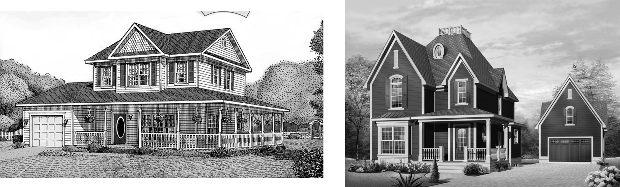
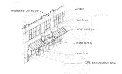
Structures must incorporate covered porches into the front façade, a multiplicity of roof forms, and high pitch roof lines. The recommended architectural styles are Folk traditional, Craftsman, and Victorian. The following examples are provided as guides for all new construction in the Downtown Office District:

17.1 - General purpose and description.
The Neighborhood Service District is established as a limited retail category intended for use by residents of nearby neighborhood areas for the purpose of supplying day-to-day needs and personal services. Establishments should include small, free-standing retail structures, such as convenience stores and neighborhood oriented personal service establishments. Sites zoned Neighborhood Service should be located on a major thoroughfare and generally utilize a site adjacent to one or more logical neighborhood service areas. The total gross floor area of all structures in an individual Neighborhood Service District should not exceed 14,000 square feet. This zoning district may be appropriate in areas designated as office or retail on the Future Land Use Plan.
17.2 - Regulations.
A.
Size of Yards:
1.
Minimum Front Yard: 25 feet.
2.
Minimum Side Yard: 15 feet; 25 feet adjacent to a residential use or zone.
3.
Minimum Rear Yard: Ten feet; 25 feet adjacent to a residential use or zone.
B.
Size of Lots:
1.
Minimum Size of Lot Area: 7,000 square feet.
2.
Minimum Lot Width: 70 feet.
3.
Minimum Lot Depth: 100 feet.
C.
Maximum Height: One story, no greater than 30 feet.
D.
Lot Coverage: 35 percent.
E.
Floor Area Ratio: Maximum 0.35:1.
F.
Maximum Floor Area: The combined floor area of all buildings or structures on a lot shall not exceed 14,000 square feet.
17.3 - Permitted uses.
Permitted uses shall be in accordance with the "Schedule of Uses" as outlined in Section 1.3 of Chapter 3.
(Ord. No. 15-74, 12-8-15)
18.1 - General purpose and description.
The Downtown Retail District is established to maintain existing and encourage additional retail development in the original downtown portion of the Town. Standards for vehicle parking, building set-backs, and building height are similar to those existing on developed properties in this section of the Town. Therefore, these standards are only applicable to this section of the Town. This zoning district may be appropriate in areas designated as Old Town Core District on the Future Land Use Plan.
18.2 - Regulations.
A.
Size of Yards:
1.
Minimum Front Yard:
a.
None if adjacent to a street with a right-of-way of 80 feet or greater, a minimum of 80 percent of any building façade adjacent to a street must be constructed on the property line.
b.
Five feet if adjacent to a street with less than 80 if right-of-way, a minimum of 80 percent of any building façade adjacent to a street must be constructed on the front yard setback line.
c.
If adjacent to an intersection, all property lines adjacent to a street shall be deemed a front yard. The building façade adjacent to the streets must be located on the front yard setback lines towards the corner of the intersection. The setback is determined by the right-of-way width.
The area between the back of curb and the building façade shall be provided as a minimum of 12 foot wide concrete sidewalk measured from the back of curb. Any area beyond the 12 feet and adjacent to the building façade may be provided as sidewalk or landscaping.
The following projections shall be permitted in the required setback or beyond the property line:
a.
Ordinary building projections, including but not limited to: water tables, sills, belt courses, and pilasters, may project up to 12 inches into the required front yard or beyond the property line, or beyond the face of an architectural projection.
b.
Balconies above the first floor may project up to 48 inches into the required front yard or beyond the property line and have a minimum of nine feet of clearance over the sidewalk.
c.
Canopies, awnings, cinema or theater marquees, and/or kiosks may project up to 48 inches into the required front yard or beyond the property line and have a minimum of nine feet of clearance over the sidewalk.
d.
Roof eaves, soffits, cornices, and parapet treatments may project up to 36 inches into the required front yard or beyond the property line, or beyond the face of an architectural projection, provided that no portion extending below nine feet above the sidewalk may project more than 12 inches.
e.
Architectural projections, including bays, first floor show windows, towers, and oriels; below grade vaults and areaways; and elements of a nature similar to the preceding; may project up to 36 inches into the required front yard or beyond the property line.
2.
Minimum Side Yard:
a.
None, subject to provision of fire retardant wall as required by current adopted edition of the Uniform Building Code.
b.
Ten feet without fire retardant wall.
3.
Minimum Rear Yard:
a.
None, if abutting an alley and constructed with fire retardant wall.
b.
None, if attached to an adjacent building and constructed with fire retardant wall.
c.
Ten feet without alley separation or fire retardant wall.
B.
Size of Lots:
1.
Minimum Size of Lot Area: 5,000 square feet unless platted as a lot of record prior to the adoption of this district.
2.
Minimum Lot Width: 45 feet unless platted as a lot of record prior to the adoption of this district.
3.
Minimum Lot Depth: 100 feet unless platted as a lot of record prior to the adoption of this district.
C.
Maximum Height: Two stories, no greater than 40 feet.
18.3 - Permitted uses.
Permitted uses shall be in accordance with the "Schedule of Uses" as outlined in Section 1.3 of Chapter 3.
(Ord. No. 15-74, 12-8-15)
18.4 - Architectural standards.
A.
All construction must have an approved façade plan before issuance of a building permit. The Town Planner or his/her designee will review all façade plans according to the following standards and will either approve or deny the request. The applicant shall submit the appeal request in writing, within 14 days of the decision, to the Planning Department. The written request shall include specific reasons for the appeal and will be heard by the Town Council. Appeals will require notification of property owners within 200 feet and shall be mailed ten days prior to the hearing.
B.
The primary building material shall be clay fired brick. Natural stones and other masonry materials are encouraged for architectural details and accents.
C.
Awning and canopies should be architectural materials that complement the building such as metal flashing, wood trim, or fabric. Vinyl is not permitted.
D.
Choice of color for the primary façade, various architectural elements, or details shall be compatible with the overall visual qualities existing within the original downtown portion of the town.
E.
The following examples are provided as guides for all new construction in the Downtown Retail District:


19.1 - General purpose and description.
The Retail District is established to provide locations for various types of general retail and service uses for one or more neighborhoods. Developments within a Retail District should utilize established landscape and buffering requirements and be limited to two stories in height. The Retail District and shopping areas should generally be located at intersections of major thoroughfares and convenient to their residential service area. This zoning district may be appropriate in areas designated as retail on the Future Land Use Plan.
19.2 - Regulations.
A.
Size of Yards:
1.
Minimum Front Yard: 30 feet.
2.
Minimum Side Yard:
a.
Fifteen feet adjacent to a nonresidential district. The minimum side yard setback may be eliminated for attached retail buildings on separate lots as shown on an approved site plan.
b.
Thirty feet for a one story building adjacent to a residential district and 60 feet for a two story building adjacent to a residential district.
c.
Thirty feet adjacent to a street.
3.
Minimum Rear Yard:
a.
Fifteen feet adjacent to a nonresidential district. The minimum side yard setback may be eliminated for attached retail buildings on separate lots as shown on an approved site plan.
b.
Thirty feet for a one story building adjacent to a residential district and 60 feet for a two story building adjacent to a residential district.
B.
Size of Lots:
1.
Minimum Size of Lot Area: 10,000 square feet.
2.
Minimum Lot Width: 100 feet.
3.
Minimum Lot Depth: 100 feet.
C.
Maximum Height: Two stories, no greater than 40 feet.
D.
Lot Coverage: 40 percent.
E.
Floor Area Ratio: Maximum 0.4:1.
19.3 - Permitted uses.
Permitted uses shall be in accordance with the "Schedule of Uses" as outlined in Section 1.3 of Chapter 3.
(Ord. No. 15-74, 12-8-15)
20.1 - General purpose and description.
The Downtown Commercial District is established to maintain existing and encourage additional retail and commercial development in the original downtown portion of the town. Standards for vehicle parking, building set-backs, and building height are similar to those existing on developed properties in this section of the town. Therefore, these standards are only applicable to this section of the town. This zoning district may be appropriate in areas designated as Old Town Core District on the Future Land Use Plan.
20.2 - Regulations.
A.
Size of Yards:
1.
Minimum Front Yard:
a.
None if adjacent to a street with a right-of-way of 80 feet or greater, a minimum of 80 percent of any building façade adjacent to a street must be constructed on the property line.
b.
Five feet if adjacent to a street with less than 80 if right-of-way, a minimum of 80 percent of any building façade adjacent to a street must be constructed on the front yard setback line.
c.
If adjacent to an intersection, all property lines adjacent to a street shall be deemed a front yard. The building façade adjacent to the streets must be located on the front yard setback lines towards the corner of the intersection. The setback is determined by the right-of-way width.
d.
The area between the back of curb and the building façade shall be provided as a minimum of 12 foot wide concrete sidewalk measured from the back of curb. Any area beyond the 12 feet and adjacent to the building façade may be provided as sidewalk or landscaping.
e.
The following projections shall be permitted in the required setback or beyond the property line:
i.
Ordinary building projections, including but not limited to: water tables, sills, belt courses, and pilasters, may project up to 12 inches into the required front yard or beyond the property line, or beyond the face of an architectural projection.
ii.
Balconies above the first floor may project up to 48 inches into the required front yard or beyond the property line and have a minimum of nine feet of clearance over the sidewalk.
iii.
Canopies, awnings, cinema or theater marquees, and/or kiosks may project up to 48 inches into the required front yard or beyond the property line and have a minimum of nine feet of clearance over the sidewalk.
iv.
Roof eaves, soffits, cornices, and parapet treatments may project up to 36 inches into the required front yard or beyond the property line, or beyond the face of an architectural projection, provided that no portion extending below nine feet above the sidewalk may project more than 12 inches.
v.
Architectural projections, including bays, first floor show windows, towers, and oriels; below grade vaults and areaways; and elements of a nature similar to the preceding; may project up to 36 inches into the required front yard or beyond the property line.
2.
Minimum Side Yard.
a.
None if adjacent to a non-residential district, subject to provision of fire retardant wall as required by current adopted edition of the Uniform Building Code.
b.
Thirty feet for a one story building adjacent to a residential district and 60 feet for a two or more story building adjacent to a residential district.
3.
Minimum Rear Yard
a.
None, if adjacent to a non-residential district and abutting an alley and constructed with fire retardant wall.
b.
None, if attached to an adjacent building and constructed with fire retardant wall.
c.
Ten feet, if adjacent to a non-residential district without alley separation or fire retardant wall.
d.
Thirty feet for a one story building adjacent to a residential district and 60 feet for a two or more story building adjacent to a residential district.
B.
Size of Lots:
1.
Minimum Size of Lot Area: 5,000 square feet unless platted as a lot of record prior to the adoption of this district.
2.
Minimum Lot Width: 45 feet unless platted as a lot of record prior to the adoption of this district.
3.
Minimum Lot Depth: 100 feet unless platted as a lot of record prior to the adoption of this district.
C.
Maximum Height: Two stories, no greater than 40 feet.
20.3 - Permitted uses.
Permitted uses shall be in accordance with the "Schedule of Uses" as outlined in Section 1.3 of Chapter 3.
(Ord. No. 15-74, 12-8-15)
20.4 - Architectural standards.
A.
All construction must have an approved façade plan before issuance of a building permit. The Town Planner or his/her designee will review all façade plans according to the following standards and will either approve or deny the request. The applicant shall submit the appeal request in writing, within 14 days of the decision, to the Department of Development Services. The written request shall include specific reasons for the appeal and will be heard by the Town Council. Appeals will require notification of property owners within 200 feet and shall be mailed ten days prior to the hearing.
B.
The primary building material shall be clay fired brick. Natural stones and other masonry materials are encouraged for architectural details and accents.
C.
Awning and canopies should be architectural materials that complement the building such as metal flashing, wood trim, or fabric. Vinyl is not permitted.
D.
Choice of color for the primary façade, various architectural elements, or details shall be compatible with the overall visual qualities existing within the original downtown portion of the town.
E.
The following examples are provided as guides for all new construction in the Downtown Commercial District:

21.1 - General purpose and description.
The Commercial District is intended predominately for heavy retail, service, light intensity wholesale and commercial uses, but excluding warehousing uses. The nature of uses in this district has operating characteristics and traffic service requirements generally compatible with typical office, retail, and some residential environments. Uses in this district may require open, but screened, storage areas for materials. This zoning district may be appropriate in areas designated as community or regional retail on the Future Land Use Plan.
21.2 - Regulations.
A.
Size of Yards:
1.
Minimum Front Yard: 30 feet.
2.
Minimum Side Yard:
a.
Fifteen feet adjacent to a nonresidential district. The minimum side yard setback may be eliminated for attached retail buildings on separate lots as shown on an approved site plan.
b.
40 feet for a one story building adjacent to a residential district and 60 feet for a two story building adjacent to a residential district.
c.
Thirty feet adjacent to a street.
3.
Minimum Rear Yard:
a.
Fifteen feet adjacent to a nonresidential district. The minimum side yard setback may be eliminated for attached retail buildings on separate lots as shown on an approved site plan.
b.
40 feet for a one story building adjacent to a residential district and 60 feet for a two story building adjacent to a residential district.
B.
Size of Lots:
1.
Minimum Size of Lot Area: 10,000 square feet.
2.
Minimum Lot Width: 100 feet.
3.
Minimum Lot Depth: 100 feet.
C.
Maximum Height: Two stories, no greater than 40 feet.
D.
Lot Coverage: 50 percent.
E.
Floor Area Ratio: Maximum 0.5:1.
21.3 - Permitted uses.
Permitted uses shall be in accordance with the "Schedule of Uses" as outlined in Section 1.3 of Chapter 3.
(Ord. No. 15-74, 12-8-15)
22.1 - General purpose and description.
The Commercial Corridor District is intended primarily for employment center uses such as light manufacturing, warehousing, wholesaling, office, and distribution operations that do not depend upon frequent customer or client visits, as well as service uses necessary to support such employment center uses. Such uses do require accessibility to major thoroughfares or highways. This zoning district may be appropriate in areas designated as Tollway Corridor, US 380 Adjacency Corridor, or Industrial on the Future Land Use Plan.
22.2 - Regulations.
A.
Size of Yards:
1.
Minimum Front Yard: 30 feet for one or two story buildings, 50 feet for buildings taller than two stories.
2.
Minimum Side Yard:
a.
Twenty-five feet adjacent to a nonresidential district. The minimum side yard setback may be eliminated for attached buildings on separate lots as shown on an approved site plan.
b.
Forty feet for a one story building adjacent to a residential district and 60 feet for a two story building adjacent to a residential district.
c.
Forty feet adjacent to a street.
3.
Minimum Rear Yard:
a.
Twenty-five feet adjacent to a nonresidential district. The minimum rear yard setback may be eliminated for attached buildings on separate lots as shown on an approved site plan.
b.
Forty feet for a one story building adjacent to a residential district and 60 feet for a two story building adjacent to a residential district.
B.
Size of Lots:
1.
Minimum Size of Lot Area: 10,000 square feet.
2.
Minimum Lot Width: 100 feet.
3.
Minimum Lot Depth: 100 feet.
C.
Maximum Height: Eight stories, not greater than 100 feet. Where buildings or structures exceed 40 feet in height, such buildings or structures shall not be located closer to any residential district boundary line than a distance equal to the sum of the required side or rear yard specified plus twice the height of the building above 40 feet.
D.
Lot Coverage: 60 percent.
E.
Floor Area Ratio: Maximum 1.5:1
22.3 - Permitted uses.
A.
Compliance with State and Federal Law: No uses shall be allowed which are prohibited by state law or which operate in excess of state or federal environment or pollution standards as determined by the U.S. Environmental Protection Agency, Texas Air Control Board, Texas State Department of Health, or the Texas Water Commission, as the case.
B.
Open Storage: Not more than 20 percent of the lot or tract may be used for the open storage of products, materials, or equipment, all of which shall be screened from adjoining properties or streets.
C.
High Risk or Hazardous Uses:
1.
The uses listed in 22.3(D) below are permitted in the Commercial Corridor District, provided that such uses shall not disseminate dust, fumes, gas, noxious odor, smoke, glare, or other atmospheric influence beyond the boundaries of the property on which such use is located and which produces no noise exceeding the average intensity of noise of street traffic at that point and provided that such use does not create fire hazards on surrounding property.
2.
"High risk or hazardous" uses are not permitted in the Commercial Corridor District. In this section, "high risk or hazardous" use means any use whose operation, in the opinion of the Fire Chief, involves a much higher than average risk to public health and safety. These uses include but are not limited to facilities where significant amounts of radiation, radioactive materials, highly toxic chemicals or substances, or highly combustible or explosive materials are present, used, produced, stored, or disposed of.
D.
Permitted Uses. Permitted uses shall be in accordance with the "Schedule of Uses" as outlined in Section 1.3 of Chapter 3.
(Ord. No. 15-74, 12-8-15)
23.1 - General purpose and description.
The Industrial District is intended primarily for uses in the conduct of light manufacturing, assembling and fabrication, and for warehousing, wholesaling and service operations that do not depend upon frequent customer or client visits. Such uses do require accessibility to major highways, rail lines or other means of transportation. This zoning district is appropriate in areas designated as Industrial on the Future Land Use Plan.
23.2 - Regulations.
A.
Size of Yards:
1.
Minimum Front Yard: 50 feet.
2.
Minimum Side Yard:
a.
Thirty feet adjacent to a nonresidential district.
b.
Sixty feet adjacent to a residential district.
c.
Fifty feet adjacent to a street.
3.
Minimum Rear Yard:
a.
Thirty feet adjacent to a nonresidential district.
b.
Sixty feet adjacent to a residential district.
4.
Additional Setback: For structures requiring railroad access, setback requirements from the centerline of the railroad right-of-way shall be in accordance with applicable state law.
B.
Size of Lots:
1.
Minimum Size of Lot Area: 10,000 square feet.
2.
Minimum Lot Width: 100 feet.
3.
Minimum Lot Depth: 100 feet.
C.
Maximum Height: Eight stories, not greater than 100 feet. Where buildings or structures exceed 40 feet in height, such buildings or structures shall not be located closer to any residential district boundary line than a distance equal to the sum of the required side or rear yard specified plus twice the height of the building above 40 feet.
D.
Floor Area Ratio: Maximum 1:1
23.3 - Permitted uses.
A.
Compliance with State and Federal Law: No uses shall be allowed which are prohibited by state law or which operate in excess of state or federal environment or pollution standards as determined by the U.S. Environmental Protection Agency, Texas Air Control Board, Texas State Department of Health, or the Texas Water Commission, as the case.
B.
Open Storage: Not more than 20 percent of the lot or tract may be used for the open storage of products, materials, or equipment, all of which shall be screened from adjoining properties or streets.
C.
High Risk or Hazardous Uses:
1.
The uses listed in 1.3(D) below are permitted in the Industrial District, provided that such uses shall not disseminate dust, fumes, gas, noxious odor, smoke, glare, or other atmospheric influence beyond the boundaries of the property on which such use is located and which produces no noise exceeding the average intensity of noise of street traffic at that point and provided that such use does not create fire hazards on surrounding property.
2.
A "high risk or hazardous industrial use" is permitted by specific use permit only. In this section, "high risk or hazardous industrial use" means any industrial use whose operation, in the opinion of the Fire Chief, involves a much higher than average risk to public health and safety. These uses include but are not limited to facilities where significant amounts of radiation, radioactive materials, highly toxic chemicals or substances, or highly combustible or explosive materials are present, used, produced, stored, or disposed of.
D.
Permitted Uses. Permitted uses shall be in accordance with the "Schedule of Uses" as outlined in Section 1.3 of Chapter 3.
(Ord. No. 15-74, 12-8-15)
24.1 - General purpose and description.
The Planned Development (PD) District is a district that accommodates planned associations of uses developed as integral land use units such as offices, commercial or service centers, shopping centers, residential developments of multiple or mixed housing (including attached single-family dwellings), or any appropriate combination of uses that may be planned, developed, or operated as integral land use units either by a single owner or a combination of owners. A PD District may be used to permit new or innovative concepts in land utilization not permitted by other zoning districts in this chapter. While greater flexibility is given to allow special conditions or restrictions that would not otherwise allow the development to occur, procedures are established herein to insure against misuse of increased flexibility.
24.2 - Planned development regulations.
A.
Development requirements for each PD District shall be set forth in the amending ordinance granting that PD District and shall include, but may not be limited to; base district(s), uses, density, lot area, lot width, lot depth, yard depths and widths, building height, building elevations, coverage, floor area ratio, parking, access, screening, landscaping, architectural standards, project phasing or scheduling, management associations, and other requirements as the Town Council and/or Planning and Zoning Commission may deem appropriate.
B.
In the PD District, uses shall conform to the standards and regulations of the base zoning district(s) to which it is most similar. The particular zoning district shall be stated in the granting ordinance. All applications to the Town shall list all requested variances from the standard requirements set forth throughout this chapter (applications without this list, as well as other reasons, will be considered incomplete).
C.
The ordinance granting a PD District shall include a statement as to the purpose and intent of the PD granted therein, including a general statement citing the reason for the PD request. The ordinance granting a PD District shall also include a proposed development schedule for the PD District.
D.
The PD District shall conform to all sections of this chapter unless specifically addressed in the granting ordinance.
24.3 - Conceptual development plan.
In establishing a PD District in accordance with this section, the Town Council shall approve and file as part of the amending ordinance appropriate exhibits and standards for each PD District. To facilitate understanding of the request during the review and public hearing process, the Planning and Zoning Commission and/or Town Council may require a Conceptual Development Plan that illustrates graphically the standards contained therein.
A.
Any applicant requesting approval of a PD District shall schedule a pre-submittal meeting with the Director of Planning, or his/her designee, to determine whether or not a conceptual development plan is to be submitted with the PD zoning request.
B.
If it is determined that a conceptual development plan is necessary, this plan shall be submitted by the applicant at the time of the PD zoning request. The plan shall show the applicant's intent for the use(s) of the land within the proposed PD District in a graphic manner and supported by written documentation of proposals and standards for development. Dependent on the nature of the PD request, this plan may be submitted as a residential plan, non-residential plan, or a mixed-use combination of the two. For a mixed-use development, the plan shall comply with requirements for both the residential and non-residential plans.
1.
Residential Conceptual Development Plan. A conceptual development plan for residential land use shall show in a graphic format the proposed general land use, streets, thoroughfares and preliminary lot arrangements. The applicant shall submit text material to further explain the characteristics of the plan, including but not limited to, the size, type and location of buildings and building sites, access, density, building height, fire lanes, screening, parking areas, landscaped areas, project scheduling, and other pertinent development data.
2.
Non-Residential Conceptual Development Plan. A conceptual development plan for non-residential uses shall set forth the land use proposals in a manner to adequately illustrate the type and nature of the proposed development. The plan may include, but is not limited to, the types of use(s), topography and boundary of PD area, proposed ingress and egress, physical features of the site, existing streets, alleys and easements, location of future public facilities, building height and location, parking ratios, project scheduling and other information to adequately describe the proposed development and to provide data for approval that is to be used in preparing the final development plan(s).
24.4 - Conformance to the conceptual development plan.
Plats and/or site plans submitted for the development of the PD District shall conform to the data presented and approved on the conceptual development plan. Changes of detail on these final development plan(s) that differ from the conceptual development plan may be authorized by the Planning and Zoning Commission, with their approval of the final development plan(s) and without public hearing, if the proposed changes do not:
1.
Alter the basic relationship of the proposed development to adjacent property;
2.
Alter the uses permitted;
3.
Increase the density;
4.
Increase the building height;
5.
Increase the coverage of the site;
6.
Reduce the off-street parking ratio;
7.
Reduce the building lines provided at the boundary of the site; or
8.
Significantly alter any open space plans.
If the Planning and Zoning Commission determines that the proposed change(s) violates one or more of the above eight criteria, then a public hearing must be held to adequately amend the PD District's granting ordinance prior to the Planning and Zoning Commission's approval of the final development plan(s).
24.5 - Procedure (Z11-0005).
A.
The procedure for establishing a PD District shall follow the procedure for zoning amendments as set forth in Chapter 1, Section 9.
B.
If no development has occurred in the PD District within five years from the date of adoption of the granting ordinance, the Planning and Zoning Commission and Town Council may review the original conceptual development plan to ensure its continued validity. If the town determines the concept is not valid, a new conceptual development plan shall be approved prior to the town issuing a building permit for any portion of the PD District.
C.
All PD Districts approved in accordance with the provisions of this chapter in its original form, or by subsequent amendments thereto, shall be referenced on the Zoning District Map, and a list of such PD Districts, together with the category of uses permitted therein, shall be maintained as part of this ordinance in Chapter 5, Section 2.
D.
Owners of property within a PD District may request rezoning for only the portion of the PD District they own. Notice of such rezoning will be based on the boundary of the portion of the PD District being rezoned rather than the entire PD District. In considering the request, the Planning and Zoning Commission and Town Council shall evaluate the effect of the rezoning on the remaining property within the PD District. If the Planning and Zoning Commission or Town Council determine that the rezoning necessitates adjustments to the terms and conditions of the original PD District, the zoning case to rezone the portion of the PD District will be tabled so that the town can initiate a zoning case for the remainder of the PD District and first consider amendments to the terms and conditions of the original PD District.
25.1 - General purpose and description.
This section provides the town an opportunity to approve, conditionally approve, or deny identified specific uses that may be permitted in specified zoning districts. These uses generally have, among other things, unusual nuisance characteristics or are of a public or semi-public character and are often essential or desirable for the general convenience and welfare of the community. However, because of the nature of the use, the importance of the use's relationship to the Comprehensive Plan, and possible adverse impacts on neighboring properties review, evaluation, and exercise of sound planning judgment relative to the location and site plan are required.
25.2 - Procedure.
A.
The procedure for authorizing a Specific Use Permit (SUP) shall follow the procedure for zoning amendments as set forth in Chapter 1, Section 9.
B.
All SUP applications shall be accompanied by a site plan drawn to scale and showing the general arrangement of the project, together with essential requirements such as off-street parking facilities; size, height, construction materials, and locations of buildings and the uses to be permitted; means of ingress and egress to public streets; the type of visual screening such as walls, plantings and fences; and the relationship of the intended use to all existing properties and land uses in all directions to a minimum distance of 200 feet.
C.
The Planning and Zoning Commission or Town Council may require additional information or drawings (such as, among other things, building floor plans), operating data and expert evaluation or testimony concerning the location, function and characteristics of any building or use proposed.
25.3 - Specific use permit regulations.
A.
In recommending that a SUP for the premises under consideration be granted, the Planning and Zoning Commission shall determine that such uses are harmonious and adaptable to building structures and uses of abutting property and other property in the vicinity of the premises under consideration, and shall make recommendations as to, among other things, requirements for the paving of streets, alleys and sidewalks, means of ingress and egress to public streets, provisions for drainage, adequate off-street parking, protective screening and open space, area or security lighting, heights of structures, and compatibility of buildings. The Planning and Zoning Commission and Town Council shall consider the following criteria in determining the validity of the SUP request:
1.
Is the use harmonious and compatible with its surrounding existing uses or proposed uses?
2.
Are the activities requested by the applicant normally associated with the requested use?
3.
Is the nature of the use reasonable?
4.
Has any impact on the surrounding area been mitigated?
B.
In granting a SUP, the Town Council may impose conditions that shall be complied with by the owner or grantee before a Certificate of Occupancy (CO) may be issued by the Building Official for use of the building on such property pursuant to such SUP and such conditions precedent to the granting of the CO. Any special conditions shall be set forth in writing by the Town Council prior to issuance of the CO.
C.
No SUP shall be granted unless the applicant, owner and grantee of the SUP shall be willing to accept and agree to be bound by and comply with the written requirements of the SUP as attached to the site plan drawing(s) and approved by the Planning and Zoning Commission and Town Council.
D.
If required, a building permit shall be applied for and secured within six months from the time of granting the SUP, provided however, that the Town Council may authorize an extension of this time upon recommendation by the Planning and Zoning Commission. After six months from the date of approval has elapsed, the Planning and Zoning Commission and Town Council may review the site plan for continued validity. If the site plan is determined invalid, the property owner(s) must submit a new or revised site plan for approval prior to any construction or application for building permit for the area designated for the SUP.
E.
A building, premise, or land used under a SUP may be enlarged, modified, structurally altered, or otherwise changed provided the changes do not:
1.
Increase the height of structures, including, without limitation, antenna support structures.
2.
Increase building square footage from its size at the time the original SUP was granted by greater than ten percent;
3.
Reduce the distance between a building or noise-generating activity on the property and an adjacent, off-site residential use. This provision shall not apply should the property and the residential use be separated by a major thoroughfare depicted on the town's Thoroughfare Plan; or
4.
Reduce the amount of open space as indicated on the previously approved zoning exhibit.
All other enlargements, modifications, structural alterations, or changes shall require the approval of a new SUP.
F.
The Board of Adjustment shall not have jurisdiction to hear, review, reverse, or modify any decision, determination, or ruling with respect to the specific land use designated by any SUP.
G.
When the Town Council authorizes granting of a SUP, the zoning map shall be amended according to its legend to indicate that the affected area has conditional and limited uses, and said amendment is to indicate the appropriate zoning district for the approved use and prefixed by an "S" designation. SUPs granted shall be indicated by numerical designation on the zoning district map. Chapter 5, Section 2 of this Ordinance shall list by the numerical designation each SUP and the conditions of approval. SUPs are issued to the property.
H.
Upon holding a properly notified public hearing, the Town Council may amend, change, or rescind a SUP if:
1.
There is a violation and conviction of any of the provisions of this chapter or any ordinance of the town that occurs on the property for which the SUP is granted.
2.
The building, premise, or land used under a SUP is enlarged, modified, structurally altered, or otherwise significantly changed without approval of a separate SUP for such enlargement, modification, structural alteration, or change.
3.
Violation of any provision of the terms or conditions of a SUP.
4.
Ad valorem taxes on the property are delinquent by more than six months.
5.
The SUP was obtained by fraud or with deception.
25.4 - Specific use permit for private club (Z13-0010).
Editor's note— Ord. No. 13-48, adopted September 10, 2013, repealed § 25.4.