
Ray City Zoning Code
ARTICLE III
- DEVELOPMENT STANDARDS
Sec. 34-137. - Applicable provisions.
All development shall comply with the applicable provisions of this article.
(Ord. No. 2018-01, § 1, 4-9-2018)
Sec. 34-138. - Adequate public facilities required.
(a)
Unless expressly authorized elsewhere in this article, all development, and all lots or parcels within a development, shall be provided with water, sewer, power, telephone, paved streets, curbs, gutters, stormwater facilities, street lights and sidewalks.
(b)
All public facilities necessary to serve the development, including any necessary easements, extension of mains, lift stations, streets, sidewalks, and other improvements, shall be provided by the developer as set forth herein.
(c)
No improvements shall be made until all necessary plans, profiles and specifications have been submitted to and approved by the city engineer.
(Ord. No. 2018-01, § 1, 4-9-2018)
Sec. 34-139. - Streets.
(a)
The arrangement, character, extent, width, grade and location of all streets shall be related to:
(1)
Existing and planned streets;
(2)
Topographic conditions;
(3)
Existing natural features including wetlands, marshes and tree growths;
(4)
Public convenience and safety;
(5)
Existing and proposed uses of the land served by the streets; and
(6)
The most advantageous development of adjoining uses.
(b)
The arrangement of streets in a subdivision shall provide, where possible, for the continuation or appropriate extension of existing and proposed streets in the city.
(c)
Where a subdivision borders on or contains a railroad right-of-way or limited access highway right-of-way, the city may require a street approximately parallel to such right-of-way, at a distance suitable for the appropriate use of the intervening land. Such distance shall also be determined with regard for the requirements of approach grades and future grade separation. In such instances, non-access restrictions may be required to limit access only to specific points along the right-of-way. Landscape buffering may also be required along the right-of-way to separate incompatible uses.
(d)
Streets shall be laid out so as to intersect as nearly as possible at right angles, and no street shall intersect any other street at less than 75 degrees, and no more than two streets shall intersect at one point.
(e)
The use of cul-de-sac streets shall be limited in order to promote a well-connected street network that provides for safe, direct and convenient access by vehicles, bicycles and pedestrians. Such streets are permitted in instances where there is no reasonable opportunity to provide for future connections to adjoining streets, including natural barriers such as water features or man-made barriers such as railroad tracks.
(f)
The maximum length of a cul-de-sac street shall be 750 feet measured from the centerline of the intersection of the through street to the center of the cul-de-sac.
(g)
Islands or medians within a cul-de-sac may be permitted so long as a neighborhood association or similar group assumes responsibility for curb and vegetation maintenance.
(h)
Dead-end streets shall not be permitted without a suitable cul-de-sac or other approved turn-around with a diameter of no less than 120 feet. Appropriate arrangements shall be made for those parts of temporary turn-arounds outside of street rights-of-way to revert to the abutting property owners at such time as streets shall be extended.
(i)
Half streets are prohibited.
(j)
No street names shall be used which will duplicate or be confused with the names of existing streets in the city. Names of streets aligned with existing streets shall be the same as those of the existing streets. Street names shall be subject to the approval of the city commission.
(k)
The width of all alleys shall be at least 20 feet.
(l)
All streets shall have a grade of not less than 0.4 percent and not more than ten percent.
(m)
All streets shall be designed by a licensed engineer with plans and final construction approved by the city engineer.
(n)
All streets shall be paved.
(o)
Streets shall be built to the standards in table 34-139.1:
Table 34-139.1
Urban and Rural Street Standards
Up to 63 feet may be required where angle parking is allowed.
(Ord. No. 2018-01, § 1, 4-9-2018)
Sec. 34-140. - Lots.
(a)
The size, shape and orientation of lots shall be appropriate for the location of the subdivision and for the type of development and use contemplated. The lots shall be designed to provide an aesthetically pleasing building site and a proper architectural setting for the building contemplated.
(b)
Every lot shall front or abut a public street.
(c)
All lots created after the adoption of this article shall comply with the requirements of the zoning district in which they are located unless a variance or other waiver is properly granted.
(d)
Corner lots shall be designed to have sufficient width to permit appropriate building setbacks from both roads and to provide acceptable visibility for traffic safety. (See the setback requirements of particular zoning districts in article II of this chapter.)
(e)
Side lot lines shall be substantially at right angles or radials to street lines.
(f)
Lot lines shall follow municipal and zoning district boundary lines rather than cross them.
(g)
Depth and width of properties reserved or laid out for commercial or industrial use shall be adequate to provide for the off-street parking and service facilities at a minimum required by this article and by the type of use and development contemplated.
(Ord. No. 2018-01, § 1, 4-9-2018)
Sec. 34-141. - Blocks.
(a)
The length, width and shape of blocks shall be suited to the planned use of land, zoning requirements, convenient access, control and safety of street traffic and the limitations and opportunities of topography.
(b)
Blocks must be wide enough to allow for two tiers of lots unless a narrower configuration is essential to provide separation of residential development from traffic arteries, or to overcome specific disadvantages of topography or orientation.
(c)
Block length shall not be more than 1,320 feet.
(Ord. No. 2018-01, § 1, 4-9-2018)
Sec. 34-142. - Pedestrian and bicycle facilities.
(a)
Sidewalks.
(1)
All new development shall include sidewalks and sidewalks within the public right-of-way or sidewalk easements along all street frontages. A variance will be required for any deviation from this standard.
(2)
All sidewalks shall comply with this article or ADA guidelines, whichever is stricter.
(3)
Sidewalks widths shall be in accordance with table 34-139.1.
(4)
Sidewalks shall have a minimum four-inch concrete thickness and be installed over a minimum of four inches of compacted three-fourths-inch minus base course that extends at least two inches beyond the width of the concrete surface.
(5)
Sidewalks shall have a maximum grade of eight percent on ramps and five percent on other areas. The cross slope shall be two percent maximum. Control joints shall be placed every five feet.
(6)
Cluster mailboxes and other obstructions must be placed either separate from or adjoining the sidewalk but shall not obstruct travel along the sidewalk.
(b)
Combined pedestrian and bicycle routes.
(1)
Combined pedestrian and bicycle routes are required where determined necessary by the city commission to provide circulation or safe access to schools, playgrounds, shopping, adjoining neighborhoods, transportation and other community facilities or for the continuation of existing, planned or reasonably anticipated routes.
(2)
Bicycle facilities may be located along streets. Such facilities shall be a minimum of ten feet wide and striped to separate the path from traffic. This may necessitate additional easement or right-of-way over and above the standard width.
(3)
Pedestrian and bicycle easements or rights-of-way shall be a minimum of 14 feet wide when separate from roads and on gentle terrain and shall be wider when necessitated by terrain or other features.
(4)
Trails shall comply with this article or ADA guidelines, whichever is stricter. Paved trails shall be a minimum of ten feet wide with eight feet, six inches of vertical clearance. Trails shall consist of a minimum three inches of hot mix asphalt over a minimum compacted base of six inches of three-fourths-inch minus gravel. The compacted base shall extend at least six inches beyond the asphalt surface on both sides of the trail. The maximum grade shall not exceed eight percent for ramps and five percent in other areas with landings spaced as per ADA guidelines. The standard cross slope shall be one percent and two percent maximum.
(Ord. No. 2018-01, § 1, 4-9-2018)
Sec. 34-143. - Parks and open space.
Parks and open space provide a valuable asset to the city, its historical development and the health and general welfare of its residents. These standards are intended to ensure that parks and open space provide focal points for new residential development. A central square or green, for example, may comprise a majority of the area required for dedication.
(1)
Applicability. The parks/open space dedication requirement applies to all new residential development except in the CBD and AG zoning districts.
(2)
Location. The location and extent of parks/open space or a proposal for a fee in lieu of park development shall be indicated on all preliminary plats and site plans.
(3)
Dedication. Parks/open space shall be dedicated to the city park district unless expressly authorized by the city commission. In such cases, the parks/open space area shall be maintained by a property owners' association.
(4)
Required parks/open space. The amount of required parkland or open space shall be ten percent of the gross site area.
(5)
Cash-in-lieu. At the discretion of the planning and zoning commission and city commission, a cash payment may be required in combination with or instead of parkland. The monetary amount shall be the pre-development fair market value of the required parks/open space determined by a licensed appraiser. The appraisal shall not be more than 30 days old when submitted for final determination. The money shall be paid to the city park district prior to final platting for subdivisions or certificate of compliance issuance for other development and shall only be used for park acquisition, development, maintenance and recreational programs.
(6)
Criteria. For the city to accept a park or open space area, the area must be:
a.
Large enough to be useful and aesthetically pleasing;
b.
Suitable for active or passive recreation, but may include areas of slope, drainages, wetlands, or other areas that will not be developed in an amount not to exceed 25 percent of the total acreage;
c.
Within one-fourth mile of the periphery of the development to be served and safely accessible by pedestrians coming from the residences served;
d.
Cost effective to develop and maintain; and
e.
Help to provide for the recreational needs of the future residents as a part of the city's overall parks and recreation program.
(Ord. No. 2018-01, § 1, 4-9-2018)
Sec. 34-144. - Utility easements.
(a)
Easements across lots or along rear or side lot lines shall be provided for utilities and shall be ten feet wide for gas, communications and electrical, and 20 feet minimum each for water and sewer.
(b)
Easements shall be centered on lot lines where possible. Total easement width shall be subject to city engineer discretion. Such easements shall be designated as "utility easement" on the plat or site plan.
(c)
Subject to utility company approval, utility lines for electric power and telephone service shall be placed underground (unless otherwise specified in this article) in the utility easements.
(d)
Utility easements shall connect with easements established in adjoining properties.
(Ord. No. 2018-01, § 1, 4-9-2018)
Sec. 34-145. - Grading and drainage.
(a)
Drainage plan approval required. Whenever one acre (43,560 square feet) or more of land is to be disturbed by development, the developer shall submit a grading and drainage plan to the city engineer prior to soil disturbance. All improvements required by the city engineer shall be installed by the developer prior to final subdivision plat approval (unless a developer's agreement is in effect) or prior to certificate of compliance issuance, as appropriate.
(1)
In addition, if the proposed development will create more than 10,000 square feet of impervious, a grading and drainage plan shall be submitted to the city engineer for approval even if less than one acre is disturbed.
(b)
Developers shall submit the following documents at a minimum for approval by the city engineer:
(1)
Comprehensive grading and drainage plan;
(2)
Developer's agreement.
(c)
The grading and drainage plan shall include the following:
(1)
Existing features, including a drainage area map showing the topography of the drainage basin contributing to the site, and a site plan showing the site's topography and natural and manmade features including wetlands, drainages, vegetation, soil types, streets, utilities, structures, etc.;
(2)
Proposed alterations to the site, including clearing and grading, cuts, fills, planned contours, phased site work description and timetable (when applicable) and vegetation that is planned to be preserved;
(3)
Temporary erosion and sediment control measures (best management practices) during construction; and
(4)
Long term facilities for site drainage and stormwater management including drainage easements of adequate location and width to accommodate drainage from the site and upstream areas and also to accommodate access for maintenance purposes.
(d)
The following design storm shall be used:
(1)
Minor—use two-year 24-hour storm;
(2)
Major—use 100-year 24-hour storm;
(3)
For commercial development, use 50-year 24-hour storm;
(4)
Rainfall depths shall be determined using the current version of the NOAA Atlas.
(e)
Acceptable runoff calculation methods include:
(1)
Rational Method if drainage basin area is ≤ five acres;
(2)
Modified Rational Method if drainage basin area is ≤ five acres;
(3)
NRCS (formerly SCS) Curve Number Method if drainage basin area is > five acres.
(f)
Time of concentration shall be calculated per NRCS Technical Release TR-55 - Urban Drainage Hydrology for Small Watersheds.
(g)
Gutter flows shall not exceed 18 inches in depth during the major storm. Curb shall not be overtopped during the minor storm. In addition, underground storm facilities shall have the capacity to collect and carry all runoff from the minor storm without overtopping the curb.
(h)
For arterial streets, the depth of runoff shall not exceed six inches measured at the crown of the roadway during the major storm. During the minor storm, at least one lane in each direction of travel must be kept clear.
(i)
Natural drainages such as depressions, swales, ditches, drains, channels, etc. shall be preserved to the maximum extent possible. If preservation of existing drainages is not possible, developer shall provide adequate accommodations ensuring flows through natural drainages are properly mitigated. Applicable regulations from other agencies will need to be met in the event existing drainages are not preserved.
(j)
Non-stormwater discharge is prohibited from entering the storm drain system without prior approval of the city. This includes, but is not limited to, groundwater, wash water, interior building drainage water, irrigation water, foundation drains, air conditioning condensation, water from sump pumps, etc.
(k)
Storm drains shall not discharge into sanitary sewer facilities.
(l)
Storm drain systems shall not discharge into agricultural water user's facilities without the written permission of the appropriate irrigation district.
(m)
Stormwater detention or retention ponds may be located within public parkland at the discretion of the city.
(n)
Easements may be required between lots and along public rights-of-way to manage storm drainage in subdivisions.
(o)
If onsite retention or detention facilities are utilized, unless otherwise provided a special maintenance district shall be created prior to filing the final subdivision plat in order to provide funds for the maintenance of such facilities.
(p)
Culverts of adequate size must be provided and installed by the developer where drainage channels intersect any street right-of-way or easement. The length of the culvert, amount of backfill to be placed over it, and the culvert's capacity shall be approved by the city engineer. Culverts shall be sized to ensure the following limits are met:
(1)
Flow shall not overtop the roadway for the minor storm;
(2)
Depth of flow shall be less than 6 inches at the street crown for the major storm. Buildings shall not be inundated at the ground line unless flood-proofed;
(3)
Headwater depth shall be limited to HW/D ≥ 1.5 relative to culvert diameter D.
(q)
Concrete curbs and gutters shall be installed in all residential subdivisions, also in all development in the CBD and HC zoning districts, and in all multiple-family dwelling projects, hotels/motels and where deemed necessary by the city commission in accordance with the plans and specifications approved by the city.
(r)
The full width of all rights-of-way shall be graded and all streets shall be surfaced in accordance with plans and specifications of the city (see table 34-139.1).
(s)
Drainage easements, where necessary, shall be shown on the subdivision plat or site plan.
(t)
A Stormwater Pollution Prevention Plan (SWPPP) and Notice of Intent (NOI) may be required to address stormwater runoff during construction and until landscaping has been established. Determine whether your project will require these and submit as necessary.
(u)
Additional requirements for residential lot developments.
(1)
Stormwater leaving the development shall not exceed pre-development levels unless otherwise approved by the city council. Off-site runoff from the subdivision must maintain existing drainage characteristics (i.e. inflow/outflow locations and runoff rates) of pre-developed conditions.
(2)
Site grading requirements shall follow specific requirements established in/on the subdivision plat and the developer's agreement.
(3)
Unmitigated runoff generated from a residential site (or new improvements) shall not drain from that site to a neighboring property.
(4)
Hard surfaces (including gutter downspouts) shall drain onto lawns or pervious areas providing a minimum length of 15 feet for runoff to disperse prior to reaching the property line with slopes no greater than five percent for lawns and no greater than two percent for other pervious areas.
(5)
Property owners may not alter existing drainage patterns of their lots without prior approval from the city engineer.
(6)
The elevation of residential dwellings and other lot features must be established in recognition of the city's policy that storm runoff flows are allowed to a depth of 18 inches in the gutter flow line of adjacent streets during the major storm.
(7)
Stormwater features shall be preserved per the initial design and maintained by the property owner.
(v)
Additional requirements for commercial property developments.
(1)
Runoff from 50-year, 24-hour storms shall be mitigated on-site with no discharge onto neighboring property or the public rights-of-way unless otherwise approved by the city council. The volume of required storage shall be based upon the assumption of no discharge to the city's storm drain system.
(2)
Due to the potential for increased pollutant runoff, some sites may require additional regulatory and design requirements, including, but not limited to: fueling stations, any facility storing/transporting more than 1,500 gallons of petroleum products, hydraulic equipment storage, property zoned heavy industrial, vehicle maintenance/repair, nurseries, lawn care/fertilizer facility, agricultural or animal care facility, or other similar facilities as determined by the city engineer.
(3)
Overland/sheet flow to the city's storm drain system including streets and alleys is not allowed unless approved by the city's engineer.
(4)
Parking lots and driveway areas may not pond to a depth greater than 12 inches during the major storm.
(5)
The elevation of commercial properties and other lot features must be established in recognition of the city's policy that storm runoff flows are allowed to a depth of 18 inches in the gutter flow line of adjacent streets during the major storm.
(6)
Owner shall call for city inspection of drainage facilities prior to backfillings.
(7)
All on-site drainage facilities shall be owned, operated, and maintained by the development.
(w)
Additional requirements for subdivision development.
(1)
Stormwater leaving the development property shall not exceed pre-development levels unless otherwise approved by the city council. Off-site runoff from the subdivision must maintain existing drainage characteristics (i.e. inflow/outflow locations and runoff rates) of pre-developed conditions. Runoff entering the subdivision from upstream properties shall also be evaluated and included in the composite rate and volume of runoff from the subdivision.
(2)
The elevation of residential dwellings and other lot features must be established in recognition of the city's policy that storm runoff flows are allowed to a depth of 18 inches in the gutter flow line of adjacent streets during the major storm.
(3)
If off-site discharge onto neighboring properties is required, a drainage easement must be obtained through the downstream neighboring properties to the point at which the runoff is collected in a public drainage facility.
(4)
Subdivisions developing adjacent to ditches/drains shall include a 30-foot half right-of-way along the property frontage for maintenance access.
(5)
As-builts shall be stamped and submitted by the professional engineer of record.
(6)
TV report shall be submitted for connections within the public right-of-way.
(7)
Landscape plans shall be submitted with the development plans.
(Ord. No. 2018-01, § 1, 4-9-2018)
Sec. 34-146. - Sewage disposal system.
Municipal sanitary sewers shall be installed so as to provide service to each lot within the subdivision or development unless in the AG zoning district as permitted in this article. All sewer plans shall be reviewed and approved by the city engineer prior to installation.
(Ord. No. 2018-01, § 1, 4-9-2018)
Sec. 34-147. - Municipal water supply.
Water mains shall be installed so as to provide service to each lot within the subdivision or other development that meets or exceeds minimum fire flow requirements. All water plans shall be reviewed and approved by the city engineer prior to installation.
(Ord. No. 2018-01, § 1, 4-9-2018)
Sec. 34-148. - Solid waste.
Solid waste disposal facilities shall be provided by the developer where deemed appropriate by the city commission. Visual screening of solid waste facilities may be required.
(Ord. No. 2018-01, § 1, 4-9-2018)
Sec. 34-149. - Mail delivery.
A means of mail delivery such as cluster mailbox units may be required.
(Ord. No. 2018-01, § 1, 4-9-2018)
Sec. 34-150. - Survey monuments.
Monuments shall be placed at all block corners, angle points, points of curves in streets and at intermediate points as shall be required by the planning and zoning commission and city commission.
(Ord. No. 2018-01, § 1, 4-9-2018)
Sec. 34-151. - Traffic impact analysis.
When required by this article, the developer shall submit a traffic impact analysis (TIA) to gauge the impacts of development on transportation facilities, safety and traffic flow.
(1)
Preparation. A professional engineer or transportation planner must prepare the traffic impact analysis.
(2)
Form and content. The TIA shall be in written form along with supporting maps and other appropriate information. At a minimum, the report must include the following elements:
a.
Purpose and goals;
b.
A description of the site and study area, which shall extend to the most logical collector or arterial road based on trip distribution patterns;
c.
Existing traffic circulation conditions and patterns including road geometrics, roadway capacity, conditions of roads leading to the development and other relevant information;
d.
Anticipated traffic circulation conditions and patterns including road geometrics, traffic counts, trip distribution, land uses, crash data, intersection evaluations, roadway capacity and other relevant information;
e.
Anticipated effects of the development on the existing road network; and
f.
Recommendations and alternatives to alleviate the negative effects (if any) and maintain the existing level of service after development.
(Ord. No. 2018-01, § 1, 4-9-2018)
Sec. 34-152. - Large scale development.
Large scale development includes 50 or more residential lots/units, commercial or industrial, or a combination of uses that will potentially generate 500 or more vehicle trips on the average working day (ADT) based on research published by the Institute of Transportation Engineers or a similar source.
(1)
Large scale development shall provide public facilities necessitated, entirely or in part, by the development. Such facilities include public water, sewer, runoff management, street improvements, pedestrian and bicycle facilities, public parks and playgrounds, emergency medical, police and fire protection and solid waste.
(2)
At the discretion of the administrator, the public needs of a large scale development may be determined through a fact finding process at the expense of the developer. The administrator may retain professional planners or engineers to prepare a community impact report, the purpose of which is to determine what facilities needs may be attributed to the development and at what costs. The administrator shall inform the developer of this requirement at a pre-application meeting. No final permit shall be granted until the developer has paid for all costs associated with this process.
(Ord. No. 2018-01, § 1, 4-9-2018)
Sec. 34-153. - Bed and breakfast establishments.
(a)
The establishment shall be operated by the owner of the home who must live on the property.
(b)
The bed and breakfast may not contain more than four guest rooms or serve more than 12 guests.
(c)
Food service may be provided for resident guests only.
(d)
Bed and breakfasts may not be leased or offered for use as reception space, office space, meeting space or similar events open to non-resident guests.
(e)
A maximum of one wall sign, which may be externally lit, not exceeding eight square feet in area, may be displayed.
(f)
At least one off-street parking space shall be provided per room. If the parcel abuts an alley, access to guest parking shall be from the alley.
(Ord. No. 2018-01, § 1, 4-9-2018)
Sec. 34-154. - Multiple-family dwellings and hotels/motels.
(a)
Pedestrian access. A system of walkways connecting each dwelling or hotel building to public sidewalks, on-site parking, other on-site multiple-family dwellings, solid waste disposal areas, mail boxes, recreation areas and storage areas shall be provided.
(b)
Vehicular access. At least two roads/approaches accessing public streets shall be provided for more than 15 dwelling units or rooms. The circulation pattern must be acceptable to the local fire department and the city engineer.
(c)
Parking. At least two on-site parking spaces shall be provided per dwelling and 1.2 per hotel room. No more than 50 percent of the parking should be provided between the primary buildings and the primary access street.
(d)
Design. The architectural style of each building shall be consistent and finished on all sides. Additionally, the developer shall provide at least four of the features below (at the developer's discretion). Also see the design guidelines in appendix A, on file in city hall, for application forms.
(1)
Modulated building wall planes by using projections, recesses and offset planes with a minimum depth of two feet;
(2)
Balconies or bay windows on the front of the building facade;
(3)
Varied rooflines;
(4)
Visual diversity on all building facade by varying materials, texture and color;
(5)
Landscaping adjacent to the building that includes at least one tree and four shrubs per each 25 linear feet of building facade that faces a public street;
(6)
Windows or glazed area equal to at least 15 percent of the combined total of all the building's facades.
(e)
Parks and open space. The parks and open space requirements of this article apply to multiple-family dwellings (see section 34-143).
(Ord. No. 2018-01, § 1, 4-9-2018)
Sec. 34-155. - Parking and loading.
(a)
Purpose and intent. These standards establish off-street parking requirements designed to lessen congestion in the streets and provide a reasonable amount of parking for developments.
(b)
Applicability. Any building or structure erected or located and any use of land established after the effective date of the ordinance from which this article is derived, including changes of use and additions to existing uses, shall be required to provide off-street parking in accordance with the standards in this section, with the following two exceptions:
(1)
In the CBD, certain land uses are exempt from these requirements. See section 34-111(1)a. and b.;
(2)
Where a change of land use within an existing building or lot requires an increase in off-street parking by ten percent or less, the increase shall be waived.
(c)
Size. A standard parking space is nine feet wide by 20 feet deep.
(d)
Vertical clearance. Each space shall have a vertical clearance of at least eight feet.
(e)
Location.
(1)
For all residential uses, off-street parking shall be located on the same lot as the use they serve;
(2)
For all other uses, off-street parking shall not be located more than 300 feet from the lot and must be located within the same zoning classification as the use they serve;
(3)
For land uses other than single-family and two-family residential, a portion of parking is encouraged to be located behind the primary structure (i.e., on the opposite side of the building from the street access);
(4)
Parking shall not be located where it inhibits visibility at any intersections.
(f)
Plan review and permit required. Parking plans including location, circulation pattern, signage, dimensions, lighting, landscaping, pedestrian and bicycle facilities and other specifications shall be drawn to scale and submitted for review and approval for all land uses other than single- and two-family residential and related accessory uses.
(g)
Construction. All off-street parking spaces and associated access shall be improved with asphalt or concrete or comparable hard surface except for temporary land uses, which may be gravel.
(h)
Drainage. All off-street parking areas shall be designed and constructed to allow proper drainage and include stormwater containment to be reviewed and approved by the city engineer.
(i)
Landscaping and screening.
(1)
For land uses requiring 40 or more spaces and for all land uses in the HC district, a minimum of ten percent of the parking lot shall be landscaped.
(2)
For all land uses requiring ten or more spaces, a buffer strip consisting of landscape vegetation and that may include decorative fencing, rock and berms shall be required.
(j)
Lighting. Parking lot lighting shall be side-shielded and downward pointed to prevent glare from leaving the site.
(k)
Drive aisles. Minimum aisle widths shall be:
(1)
For two-way circulation and 90-degree parking: 24 feet;
(2)
For one-way circulation and 60-degree angle parking: 18 feet; and
(3)
For one-way circulation and 45-degree angle parking: 15 feet.
(l)
Snow storage. A snow storage area at least two percent of the size of the parking lot, drive aisles and circulation shall be provided to avoid the loss of required parking spaces to snow storage.
(m)
Required parking. All development shall provide at least the minimum number of off-street parking spaces established in table 34-155.1. Except as provided in subsection (n) of this section, if two or more uses occupy the same building or lot, the total requirement shall be the sum of the requirements of the individual uses.
(n)
Shared parking. At the discretion of the permitting authority (administrator or city commission), up to a 30 percent reduction in the number of parking spaces required for off-street parking may occur under the following circumstances:
(1)
When at least 50 percent of the parking spaces required by this section are for primarily "nighttime" uses such as theatres, bowling alleys, bars and related uses, and the parking spaces also serve those uses that are provided by "daytime" uses such as banks, offices, furniture stores, retail, wholesale and related uses;
(2)
When at least 50 percent of the parking spaces required by this section for a religious institution, an auditorium incidental to a school, or a similar use, may be supplied by the off-street parking facilities provided by uses primarily of a "daytime" nature;
(3)
When the joint parking facility is located within 300 feet of either the building or land use for which the parking facility is required;
(4)
When the applicant for a joint-use parking facility can demonstrate, there is no substantial conflict in the principal operating hours of the buildings and uses for which the joint use is proposed; and
(5)
When a contract providing for shared use for a period of at least 15 years is executed before issuance of a permit.
(o)
Required parking for uses not listed. Where a minimum number of parking spaces for a land use is not listed in table 34-155.1, the administrator shall determine the appropriate number of spaces based on:
(1)
The most similar land use described herein;
(2)
Parking requirements from other jurisdictions; and/or
(3)
Published sources of parking standards such as those produced by the Institute of Transportation Engineers and the American Planning Association.
(p)
Loading areas.
(1)
Commercial and industrial buildings shall provide one safe, properly signed off-street freight loading area for each 10,000 square feet of gross floor area or outdoor storage.
(2)
Daycare centers, schools, health care facilities, places of assembly and similar land uses shall provide at least one safe, properly signed off-street passenger loading area.
Table 34-155.1
Required Off-Street Parking
(Ord. No. 2018-01, § 1, 4-9-2018)
Sec. 34-156. - Mobile home parks.
(a)
Mobile home parks shall contain a minimum of five acres of land.
(b)
A minimum of ten percent of the gross site area shall be devoted to open space and recreation facilities.
(c)
Each mobile home shall be placed within a lot at least 50 feet in width and with a minimum area of 6,000 square feet.
(d)
All structures shall have a setback of a minimum of 15 feet from any exterior park boundary and 25 feet from all streets.
(e)
All structures shall be set back at least ten feet from interior mobile home park lot lines.
(f)
No mobile home shall be older than ten years on the date of installation.
(g)
Underground utility hookups shall be provided to each lot in the park. These utilities shall include water, sewer, gas, electricity and telephone.
(h)
All lots in the park shall be accessible at all times to emergency vehicles.
(i)
Off-street parking of at least two parking spaces for each mobile home unit shall be provided. Additional parking spaces may be required depending on the number of beds and use.
(j)
Streets in the park shall be dedicated public streets, designed and constructed according to standards recommended by the developer's engineer and approved by the city engineer.
(k)
All regulations of state regulatory agencies and departments relating to mobile homes shall be complied with.
(l)
One or more common mailbox facility shall be provided to serve the residents.
(m)
A school bus stop shall be provided if requested by the school district.
(Ord. No. 2018-01, § 1, 4-9-2018)
Sec. 34-157. - Recreational vehicles.
(a)
Recreational vehicles shall not be used as residences except as may be permitted in approved temporary workforce housing facilities (section 34-158).
(b)
Recreational vehicles may be occupied and parked on a residential lot as an accessory use for not more than 14 consecutive days.
(c)
Unoccupied recreational vehicles may be stored on a residential lot or within a commercial storage area.
(d)
Unoccupied recreational vehicles stored on a residential lot shall comply with all setback requirements of the district.
(Ord. No. 2018-01, § 1, 4-9-2018)
Sec. 34-158. - Temporary workforce housing facilities.
The following requirements apply to all temporary workforce housing facilities except for farming or construction projects not to exceed 60 days:
(1)
A conditional use permit and site plan must be approved prior to any land development related to a temporary workforce housing facility.
(2)
A temporary workforce housing facility conditional use permit is valid for one year. At least 60 days prior to the expiration date the developer may apply for renewal of the permit, subject to review of all of the requirements of this article, or dismantle the facility and reclaim the site.
(3)
Water, sewage disposal and solid waste disposal facilities must meet the requirements of and be approved by the city, Upper Missouri District Health Unit and/or R&T Rural Water Association.
a.
An accessible, adequate, safe and potable supply of water for domestic purposes shall be provided to each dwelling.
b.
Each dwelling shall be properly connected to the city sewer system. All connections shall be designed by the developer's engineer and installed with city approval in accordance with all applicable state and city health codes and requirements.
c.
Solid waste facilities shall be provided by the developer in approved locations that are screened from public view and of sufficient capacity to accommodate the needs of the residents. Solid waste shall be collected weekly or more often by a private party and shall be disposed of in an approved manner.
(4)
The facility must have adequate emergency medical, fire protection, law enforcement and security services. The level of services shall be determined by the city commission through consultation with local service providers.
(5)
Stormwater shall be managed as required in section 34-145. Note: a state department of health construction activity permit may also be required.
(6)
All roads leading to and within the site must be made to city standards. Interior roads are not required to be paved but must be surfaced with a dust free material and maintained as such by the developer through the life of the facility according to a schedule approved by the city commission. If at any time the city commission determines the facility is a drainage or dust nuisance, written notice shall be provided to the facility manager and the roads shall be paved within 60 days, weather permitting.
(7)
Underground utilities shall be provided to each dwelling. These utilities shall include water, sewer, gas, electricity and telephone. No overhead utilities are permitted within the site.
(8)
Adequate recreational facilities shall be provided to serve the expected number and types of residents.
(9)
A plan for site maintenance and management shall be submitted, reviewed and approved. Such a plan shall include management of on-site portions of the water supply and sewage disposal systems, solid waste disposal, emergency medical, fire protection, security and law enforcement, street naming and unit numbering, laundry and recreational facilities, road maintenance, parking, operational rules of the facility, an evacuation plan, owner and on-site manager contact information, and require that an updated occupancy and contact list be maintained and be available for city inspection at all times.
(10)
A site closure and restoration plan setting forth how the temporary housing facility will be dismantled and restored to pre-construction condition shall be reviewed and approved. A developer's agreement and restoration bond is required (see subsection (21) of this section).
(11)
The following development standards shall apply:
a.
The minimum distance between any housing units is 15 feet;
b.
The minimum distance between any building and an internal street right-of-way or easement is 25 feet;
c.
The minimum distance from any building to an external property/site boundary is 50 feet;
d.
Each dwelling unit shall have one parking space per bed for residents. This requirement may be lessened if bussing is provided. No on-street parking shall be permitted. One visitor parking space shall be provided for every ten resident parking spaces;
e.
Internal roadways and walkways shall be lit using low-intensity lighting directed away from adjacent uses.
(12)
Permanently attached porches, carports, awnings, room additions and similar additions are prohibited.
(13)
Dwellings shall be anchored to the ground in accordance with applicable city and state building codes.
(14)
All temporary workforce housing facilities shall be limited for use solely as temporary housing facilities and shall not be converted to any other use without full compliance with all city and state requirements for the new use.
(15)
All dwelling units installed shall not be older than ten years on the day of installation.
(16)
All exterior boundaries of the temporary workforce housing facility site shall be landscaped and bermed in a natural looking manner to provide a visual buffer from adjacent properties. Landscaping shall consist of rocks, shrubs, trees, and grasses that are native to the area and that require minimal maintenance. Non-metal, decorative fences may also be included in the landscape buffer areas.
(17)
Storage buildings for individual dwelling units are limited to a maximum of 200 square feet of floor area and ten feet in height. Only one storage building is permitted per residence, which may be located within 15 feet of the residence it serves. Common storage facilities may be provided.
(18)
Prior to occupancy, all units shall be numbered for easy visual identification and all street signs erected.
(19)
Prior to occupancy, the developer shall provide evidence of having received all applicable state permits that may include adherence to the International Residential Code, International Building Code, International Plumbing Code, International Mechanical Code, International Fire Code, International Fuel Gas Code, International Property Maintenance Code and others adopted by the state or the city commission.
(20)
No space may be occupied or used until it has been issued a certificate of occupancy by the building inspector.
(21)
Site restoration and bonding.
a.
Prior to obtaining a certificate of compliance, the developer shall submit to the city commission a restoration bond intended to cover the cost of restoring the site to pre-development or more pristine condition. The type of bond (e.g., certificate of deposit, irrevocable letter of credit) shall be one that is acceptable to the city commission.
b.
The amount of the bond shall be determined at the developer's expense by an engineer licensed in the state who calculates the costs of removal of all infrastructure and facilities including sewer, water, electrical, telephone, roads, and all site improvements. The cost shall also include re-grading (as applicable), noxious weed control, planting and fertilization. The engineer shall submit for city commission review all calculations and pricing based on current figures. The bond amount shall be 125 percent of the engineer's total estimate. The city commission reserves the right to reject the engineer's calculations if it determines the figures do not represent an accurate accounting of the required work and costs.
c.
The amount of the bond shall be reviewed and updated every year along with the conditional use permit.
d.
Prior to termination of use of the temporary workforce housing facility, the developer shall restore the site to pre-development condition or a more pristine state. However, if the developer determines a higher and better use exists for the site, the developer may seek permission to prepare the site for an alternate use. Upon approval of the city commission and in compliance with all rules and regulations and this article, the developer shall make all preparations for alternate use prior to the city commission releasing the bond.
(Ord. No. 2018-01, § 1, 4-9-2018)
Sec. 34-159. - Fences, visibility at intersections.
Except as otherwise specifically provided in other codes and ordinances of the city, the following regulations shall apply to the placement and construction of fences, landscaping and other visual obstructions at intersections:
(1)
No fence shall be constructed which will constitute a traffic hazard and no ordinance permit shall be granted for the placement of a fence unless the administrator has certified that the proposed fence will not constitute a traffic hazard.
(2)
No person shall erect or maintain any fence which will be hazardous or dangerous to persons or animals, or which will materially damage the adjacent property by obstructing the view, shutting out the sunlight or hindering ventilation, or any fence which shall adversely affect the public health, safety and welfare.
(3)
Within 30 feet on either side of where two streets intersect, fences and vegetation shall be a maximum of 30 inches in height from the crown of the road and tree branches shall hang no lower than six feet higher than the crown of the road to allow drivers to see adequately in both directions. These requirements also exist within 15 feet on both sides of where a driveway intersects with a street.
(4)
No fence shall reach a maximum height above finished grade of greater than six feet.
(Ord. No. 2018-01, § 1, 4-9-2018; Ord. of 7-11-2022(1))
Sec. 34-160. - Signs.
(a)
Purpose. The purpose of these standards is to provide reasonable, effective, consistent, content-neutral and nondiscriminatory sign standards; to recognize that signs are a necessary means of useful communication and convenience to the public; to ensure that signs do not constitute a traffic or pedestrian safety hazard, obstruct public ways, or create a nuisance; to promote both renovation and proper maintenance of signs; to protect and enhance the community's image; to encourage innovative and attractive design; to allow for special circumstances; and to guarantee equal treatment under the law.
(b)
Scope. These standards govern the type, placement, and physical dimensions of signs within the different zoning districts. These standards shall not regulate official traffic or government signs; the copy or message of signs; signs not intended to be viewed from a public right-of-way; window displays; product dispensers and point of purchase displays (i.e., newspaper dispensers); scoreboards on athletic fields; flags of any nation, government, or noncommercial organization; gravestones; commemorative plaques; the display of street numbers; or any display or construction not defined herein as a sign.
(c)
Permits required. Unless otherwise provided in subsection (d) of this section, all new signs shall require a zoning conformance permit as described in section 34-70 and a certificate of compliance as described in section 34-76.
(d)
Signs not requiring permits. The following types of signs are allowed and are exempt from permit requirements but must be in conformance with all other requirements of these standards:
(1)
Signs used by religious institutions, libraries, nonprofit public service organizations, museums or civic organizations;
(2)
Construction and neighborhood identification signs, provided they do not exceed 32 square feet in size, one construction sign per contractor, and one neighborhood identification sign per entrance;
(3)
Directional/informational signs less than four feet in overall height and maximum of 12 square feet in area per face;
(4)
Holiday decorations and signs, and seasonal banners and pennants erected by authorized entities;
(5)
Nameplates and address signs;
(6)
Political signs provided they do not exceed ten square feet in residential districts or 32 square feet in other districts. Such signs shall not be erected more than 45 consecutive days prior to the pertinent election or referendum and shall be removed within 14 days following such election or referendum unless federal or state laws would require an earlier removal. Political signs may be placed only on private property;
(7)
Real estate signs provided they do not exceed ten square feet for residential properties and 32 square feet for all other structures or properties for sale, lease or rent, and are removed within one week after closing;
(8)
Window signs, displays, and painted/vinyl or other substance window lettering;
(9)
Signs that cannot be read from the public right-of-way (e.g., a menu board at a drive-through);
(10)
Temporary banners, pennants, balloons, tethered objects, strings of flags, streamers, inflated objects or any device intended as an attractant and that may be affected by the movement of the air. Such signs shall not be displayed for a period of more than two weeks;
(11)
Portable signs including, but not limited to, portable reader board, sandwich boards, A-frame, tire or tire rim, costumed character, stuffed animal, strings of lights arranged in the shape of a product, arrow or message;
(12)
Holiday decorations and community signs, banners and pennants for events of city-wide, civic, or public benefit as authorized by the city commission;
(13)
Signs identifying private property or hazards;
(14)
Barber pole signs not exceeding six feet in height and six square feet in area, attached to a building;
(15)
Works of art including wall graphics, murals, carvings and sculptures with no advertising matter and which are not used in connection with a promotion, goods or services or as an advertising device. Such works of art are not limited by the area restrictions in these standards;
(16)
Temporary signs advertising a special, one-time event such as a garage sale, not to exceed four square feet, and that must be removed within two days of the event.
(e)
Prohibited signs. The following types of signs are prohibited in all districts:
(1)
New signs that exceed the limitations of these standards;
(2)
Signs imitating or resembling official traffic or government signs or signals;
(3)
Any sign attached to a utility pole or structure, street light, tree, fence, fire hydrant, bridge, curb, sidewalk, park bench or other location on public property except as otherwise provided. This prohibition is not intended to include any tags, signs or other informational signs required by utility companies;
(4)
Any sign placed in any public right-of-way except for signs erected by the city or other authorized entity;
(5)
Signs which have been unlawfully or illegally erected and/or maintained;
(6)
Any strobe lights or searchlights, animated, rotating, flashing, blinking signs or signs displaying video;
(7)
Signs that constitute a traffic hazard or nuisance that are detrimental to the health, safety and welfare of the public; and
(8)
Any sign which emits audible sound, odor, smoke, steam, laser, or hologram light.
(f)
Signs permitted by zoning district. The signs set forth in tables 34-160.1, 34-160.2 and 34-160.3 are permitted on-premises in the indicated zones pursuant to subsections (g) and (h) of this section, subject to a permit.
(g)
AG, R-1, R-2 and R-3 Zones.
Table 34-160.1
Sign Standards for the AG, R-1, R-2 and R-3 Zones
(1)
For each single-family or duplex occupancy, one nameplate not exceeding four square feet in area;
(2)
For each multiple-family occupancy, one nameplate not exceeding ten square feet in area;
(3)
For a neighborhood and for other permitted or conditional uses, two identification signs per entrance not to exceed 32 square feet in area and eight feet in height from street grade and must be placed at minimum five feet from any property line;
(4)
Signs shall not block windows or any means of ingress or egress.
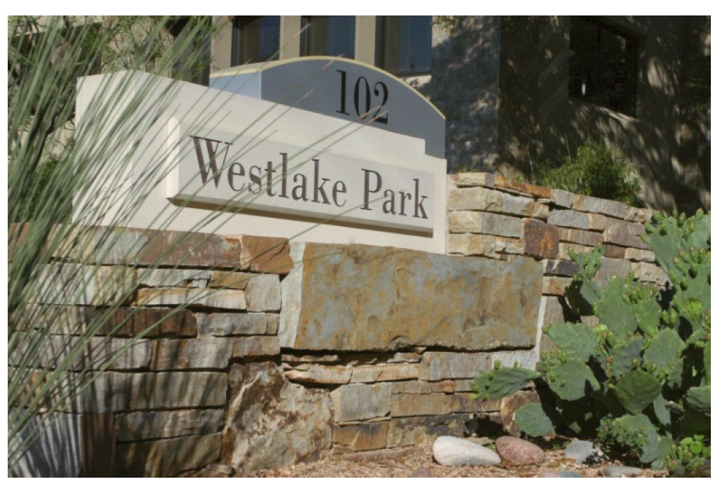
Example of neighborhood/tract identification sign within permitted dimensions.
(h)
GCI, HC and CBD Zones.
Table 34-160.2
Sign Standards for the GCI and HC Zones
Table 34-160.3
Sign Standards for the CBD Zone
(1)
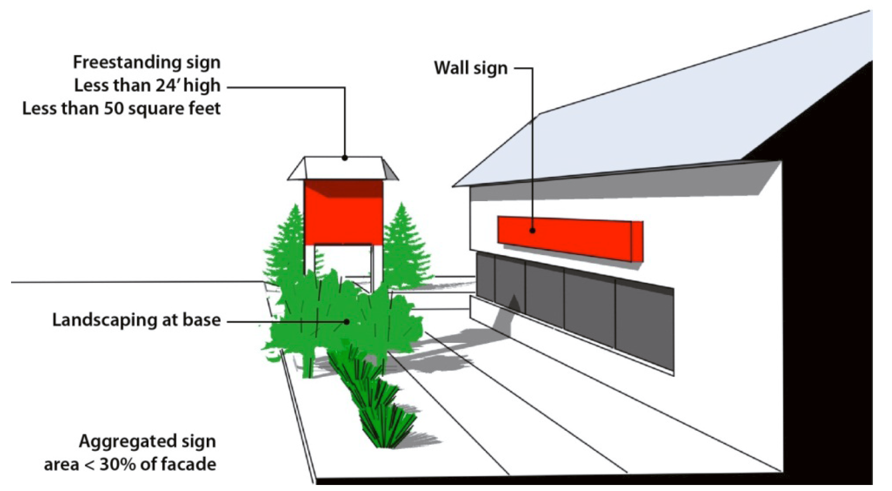
For each principal building, one freestanding sign not exceeding 50 square feet in area and 24 feet in height from street grade;
(2)
Freestanding signs shall have landscaping at their base and be architecturally related to the design of the building;
(3)
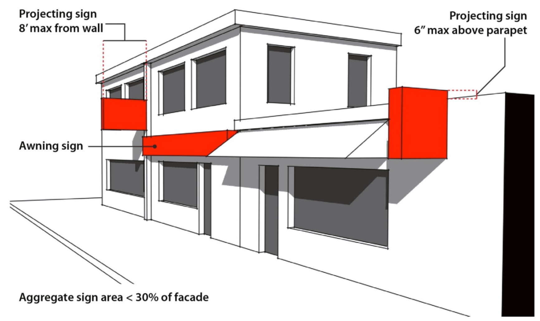
For each principal building, one wall sign which includes signs affixed to awnings;
(4)
For each principal building, one projecting sign not extending more than eight feet from wall structure and rising not more than six inches above roof parapet;
(5)
For each principal building, one wall or awning sign, which may include smaller signs within a larger frame where there is more than one land use (e.g., more than one business) in a building;
(6)
For each principal building, one projecting sign not extending more than eight feet from wall structure and rising not more than six inches above roof parapet;
(7)
The total combined wall and projecting sign area shall not exceed 30 percent of building facade.
(Ord. No. 2018-01, § 1, 4-9-2018)
Sec. 34-161. - Demolition.
Demolition is the complete removal of a structure. The demolition of any structure over 100 square feet in size requires a demolition permit (see appendix A, on file in city hall, for a permit application form). The following requirements apply to all structural demolition.
(1)
All demolition, debris removal and filling of excavated or basement areas shall occur within 30 days of a demolition permit being granted by the administrator.
(2)
All debris and related salvage shall be promptly stacked and removed from the site.
(3)
Excavated or basement areas shall be filled to ground level with clean material if work stops for seven days or more.
(4)
Signage of hazard shall be conspicuously posted around the perimeter of the site.
(5)
Fire protection measures shall be taken when deemed necessary by the fire chief.
(6)
For demolition projects over 5,000 square feet in area, a performance bond of the type and amount approved by the city commission shall be required.
(7)
Asbestos inspection may be required, at the discretion of the administrator. If asbestos is found, the 30-day time period may be extended.
(8)
Prior to a permit being granted, approval from the following shall be required:
a.
City engineer;
b.
Electric company;
c.
Solid waste official;
d.
Building official;
e.
Gas company official;
f.
Phone company official; and
g.
Cable company official.
(Ord. No. 2018-01, § 1, 4-9-2018)
Sec. 34-162. - Group and center child care facility.
Any facility required by the North Dakota Department of Human Services to have a health inspection where children receive care and supervision for 24 hours or less per day, unaccompanied by the child's parent, guardian or custodian.
(1)
License, registration certificates.
a.
Child care facilities shall be licensed per N.D.C.C. § 75.03.10.
(2)
Outdoor play areas.
a.
Child care facilities shall provide at least 75 square feet of outdoor play area per child, consistent with state law.
(3)
Fence.
a.
Notwithstanding other standards of this section that regulate fences, child care facilities may be required to provide a six-foot high solid fence, or a minimum 20-foot wide landscape buffer to separate outdoor play areas from adjoining residential dwellings.
(4)
Signs.
a.
Child care centers shall be limited to one sign not to exceed 12 square feet in sign area when in a residentially zoned district unless additional area is granted through the conditional use permit process.
(5)
Residential appearances.
a.
In residential zoning districts, child care facilities shall have a residential appearance. Criteria for evaluating residential appearance include, but are not limited to, the sizes of windows and doors, building materials and site design and building orientation.
(6)
Additional conditions.
a.
Additional conditions may be attached to an approval that are intended to reduce or minimize any potential adverse impact upon other property in the area, or to carry out the purpose and intent of the comprehensive plan, other adopted plans, or this article. In such cases, any conditions shall be directly related to the impacts of the proposed use and shall be roughly proportional in both nature and extent to the anticipated impacts of the use.
(Ord. of 10-8-2018(1))
Sec. 34-163. - Residential district design standards.
(a)
The following design standards shall apply to all new residential construction in the Residential 1 and Residential 2 Zoning Districts:
(1)
The primary entryways (typically defined as the front door) of all residential structures shall be oriented towards the public right-of-way from which the property is typically accessed.
(2)
The front façades of dwellings and attached garages shall be offset from one another by at least four feet. The front façade of a structure shall be defined as the side of the building most directly parallel to the public right-of-way from which the property is typically accessed.
(3)
Accessory buildings shall not be located closer to the public right-of-way from which the property is typically accessed than the primary structure.
(4)
All primary and accessory structures located on the same parcel shall be designed with similar, complementary residential exterior finishes and styles.
(5)
All gable roofs shall have eaves extending a minimum of one foot, measured horizontally, from all sidewalls of the building. Mobile homes are exempt.
(6)
Vertical metal siding is permitted when accompanied by each of the following:
a.
Wainscotting covering the bottom 30 percent of all exterior sidewalls, as measured from the sidewall-ground intersection to the sidewall-eave intersection, shall be installed around the entire exterior of the building. The 30 percent measurement shall be determined upon a sidewall that remains the same height for its entire length and shall apply consistently to all exterior sidewalls. Wainscotting materials shall be consistent with façade appearance requirements for all structures.
b.
Trim considered residential in nature shall be included on all exterior windows and doors.
c.
The color and material of accessory structure exteriors shall be complimentary in appearance to the façade of the primary structure on the property.
(7)
Residential structures constructed partly or entirely off-site—including manufactured, modular, prefabricated, and/or mobile homes—must be attached to a permanent foundation, or must be skirted with brick, stone, or other materials of similar appearance. Skirting shall entirely obscure foundation structural elements from view.
(b)
The following design standards shall apply to all new residential construction in the Residential 3 Zoning District:
(1)
Accessory buildings shall not be located closer to the public right-of-way from which the property is typically accessed than the primary structure.
(2)
All primary and accessory structures located on the same parcel shall be designed with similar, complementary residential exterior finishes and styles. Corrugated metal siding is prohibited.
(3)
All gable roofs shall have eaves extending a minimum of one foot, measured horizontally, from the sidewall of the building.
(4)
Vertical siding is permitted when accompanied by each of the following:
a.
Wainscotting covering the bottom 30 percent of all exterior sidewalls, as measured from the sidewall-ground intersection to the sidewall-eave intersection, shall be installed around the entire exterior of the building. The 30 percent measurement shall be determined upon a sidewall that remains the same height for its entire length and shall apply consistently to all exterior sidewalls. Wainscotting materials shall be consistent with façade appearance requirements for all structures.
b.
Trim considered residential in nature shall be included on all exterior windows and doors.
c.
The color and material of accessory structure exteriors shall be complimentary in appearance to the façade of the primary structure on the property.
(5)
Residential structures constructed partly or entirely off-site—including manufactured, modular, prefabricated, and/or mobile homes—must be attached to a permanent foundation, or must be skirted with brick, stone, or other materials of similar appearance. Skirting shall entirely obscure foundation structural elements from view.
(Ord. of 11-13-2023(1))

