
Redmond City Zoning Code
ARTICLE I
ZONING STANDARDS
PRESERVATION OF HISTORIC BUILDINGS AND SITES (APPENDICES)
APPENDIX "A" RATING SHEET
Editor's note— Appendix "A" was amended by Ord. No. 2011-06 passed May 24, 2011. Later, was deleted by Ord. No. 2018-13 passed December 11, 2018.
APPENDIX "B" DESIGN REVIEW GUIDELINES ALTERATIONS/ADDITIONS
Editor's note— Appendix "B" was deleted by Ord. No. 2018-13 passed December 11, 2018.
APPENDIX "C" DESIGN REVIEW GUIDELINES NEW CONSTRUCTION
Editor's note— Appendix "C" was deleted by Ord. No. 2018-13 passed December 11, 2018.
APPENDIX "D" THE FEDERAL REQUIREMENTS OF THE CERTIFIED LOCAL GOVERNMENT
Editor's note— Appendix "D" was deleted by Ord. No. 2011-06 passed May 24, 2011.
Sec. 8.001. - Title.
The City of Redmond Zoning Standards is contained in Sections 8.001 through 8.999 herein inclusive.
Sec. 8.010. - Purpose.
These standards are adopted for the purpose of promoting the livability, health, safety, peace, comfort, convenience, economic well-being and general welfare of the City and not limited to, but specifically to achieve, the following designated objectives:
1.
To protect the character and values of land and buildings and economic stability of sound residential, business, and industrial districts and to enhance the quality of the desired environment in them by:
A.
Preventing the intrusion of inharmonious uses.
B.
Preventing the encroachment on desirable open space appurtenant to each district.
C.
Providing for the safe and efficient movement of existing and prospective traffic.
D.
Assuring the provision of necessary off-street parking space for vehicles.
2.
To provide for additional growth and development in a manner appropriate to the character of the City and which will contribute to the economic stability of the City and strengthen the basis of its private and governmental economy.
3.
To assure that future development occurs in an orderly manner and is relatively compact to provide for economy and efficiency in public services and utilities and to protect the City from costs which may be incurred when unsuitable, scattered, or premature development occurs.
4.
To assure satisfactory physical relationships between districts of different use characteristics and among uses of various types and to minimize conflicts among land uses.
5.
To minimize traffic hazard, traffic congestion and the conflict between land uses and the movement of traffic, and to encourage alternative transportation means to automobiles.
6.
To preserve the various City areas' right to be attractive and pleasing in appearance and to aid in the development of the City by assuring that development in areas of higher density or of commercial or industrial use and along appropriate routes of travel is neat, orderly, and attractive.
7.
To regulate the placement, height, and bulk of buildings; and the placement and growth of vegetation within the City to ensure access to solar energy by reasonably regulating interests in property within the City, as authorized by Law, to promote and maximize the conservation of energy by preserving the option to utilize solar energy and to implement the Comprehensive Plan policies relating to solar energy.
8.
To encourage the design of new buildings, structures and developments which use solar energy and protect future options to use solar energy by protecting solar access, and by having sustainable development as a goal.
9.
To assure that middle housing is part of new neighborhood development consistent with the Great Neighborhood Principles and the community need to increase affordable and workforce housing.
10.
To assure annexation in an orderly manner and integration of affordable and workforce housing.
(Ord. No. 2022-04, 6-28-2022)
Sec. 8.020. - Definitions.
As used herein, the following words and phrases shall mean:
Abut. Having a common border with or being separated from such a common border by a right-of-way, alley, or easement.
Access. The right to cross between public and private property.
Access Management. The process of regulating access to streets, roads, and highways.
Accessible Route. A continuous unobstructed path connecting all accessible elements and spaces of a building or facility. Interior accessible routes may include corridors, floors, ramps, elevators, lifts, and clear floor spaces at fixtures. Exterior accessible routes may include connections to the public right-of-way, parking access aisles, curb ramps, crosswalks at vehicular ways, walks, ramps, and lifts.
Accessory Dwelling. See Dwelling, Accessory Dwelling.
Accessory Structure. A non-dwelling structure incidental and subordinate to the main structure and located on the same property as the main structure.
Accessory Use. A use incidental and subordinate to the main use of a property and located on the same property as the main use.
Acreage, Gross. The total area within a unit of land.
Active Recreation. Recreational activities which require coordination or equipment, taking place at a prescribed location, such as sites or fields. See also Passive Recreation.
Active Style Park. A park designed for active recreation no less than 15,000 square feet in size and consolidated shape. Examples of active-style park components include sports play areas, exercise equipment units, public/family gatherings with picnic shelters or tables, play structures, or designated pet areas. Active-style parks commonly feature some passive recreation features, but only as a secondary use. See also Passive-Style Park.
Adjacent. See Abut.
Adjoining. See Abut.
Administrative Decision. A discretionary action or permit decision made without a public hearing but requiring public notification and an opportunity for appeal.
Adverse Impact. Negative effect of some action governed by this Code.
Affected Person. Owners of record of real property located within a minimum distance of 100 feet, exclusive of public street and other rights-of-ways, from the property subject to and affected by a decision.
Affordable Housing. Affordable housing is generally defined as housing within the means of a household that may occupy low- and moderate-income housing, meeting one of the thresholds defined in this section. Affordable Housing warrants low- and moderate-income affordability deed restrictions of at least 30 years. The affordability period may be adjusted based on the use of development incentives, modifications, variances or exceptions.
In the case of dwelling units for rent, "affordable" means housing for which rent and utilities are no more than 30 percent of the gross annual household income for a family earning less than or equal to 60 percent the Area Median Income (AMI), based on the most recent HUD Income Limits for the Bend-Redmond Metropolitan Statistical Area.
In the case of dwelling units for sale, "affordable" means housing in which the mortgage, amortized interest, taxes, insurance, HOA and associated fees, if any, constitutes no more than 30 percent of such gross annual household income for a family earning less than or equal to 80 percent of the Area Median Income (AMI), based on the most recent HUD Income Limits for the Bend-Redmond Metropolitan Statistical Area.
Agent. Any person who is authorized to represent or act for any other person.
Alley. A public or private way reserved as a secondary means of access to the back or side of a property and not intended for transporting through traffic. Alternate use of an alley is permissible when determined to be in the public interest.
Alter. To change, add to, or modify a structure or a use.
Architectural Theme. The use of a repetitive and dominant element or style to create a unifying and coherent form of construction.
Arena, Indoor. A facility intended to enclose spectator sporting events.
Auto Detailing. A use designed for cleaning the inside and outside of autos, not including an automated car wash.
Auto Sales. Commercial sale of new or used autos.
Auto and Tire Service. A commercial business engaged primarily in supplying services generally required in the operation and maintenance of automotive vehicles. Major automotive repairs, painting and body and fender work, are excluded from this definition.
Automobile Recycling or Wrecking Yard. A premises used for the long-term outdoor storage and sale of used automobile or truck parts.
Awning. A sheet of canvas or other material stretched on a frame and used to keep the sun or rain off a storefront, window, doorway, or deck.
Batch Plant, Asphalt. A heavy industrial use intended for mixing and preparing asphalt and/or other oil-based paving surfacing material requiring large scale preparation.
Batch Plant, Concrete. A use intended for mixing and preparing concrete or similar (non-oil-based) paving surfacing material requiring large scale preparation.
Bed and Breakfast. Provides accommodations plus breakfast on a daily or weekly basis in an operator- or owner-occupied home that is primarily used for this purpose. A Bed and Breakfast may contain up to five rental guest rooms.
Bee. Any stage of development of the common domestic honeybee, Apis mellifera species.
Beekeeper. A person owning, possessing, or controlling one or more colonies of bees.
Berm. A continuous small rise or hill in the ground which is intended to buffer or visually screen certain elements of development such as parking areas.
Block. An area of land bounded by streets or by a combination of streets and public parks, cemeteries, railroad rights-of-ways or lines, shorelines or waterways, natural topographical barriers, or corporate boundary lines of a city.
Boarding or Rooming House. A building containing five or less guest rooms intended or designed to be used, or that are used, rented, or hired out to be occupied, or that are occupied for sleeping purposes by guests.
Buildable Area. The portion of property that can be used to construct a building. Buildable area is the area excluding yard setbacks, easements (includes the width of easement and airspace above), and other legal or physical prohibitions to construction.
Building. Any structure used or intended for supporting or sheltering any use or occupancy.
Building Footprint. The area of a building as measured around its foundation.
Building Height. See Height, Building.
Canopy. A permanent roofed structure which may be free-standing or partially attached to a building for a purpose of providing shelter to patrons in automobiles, and patrons on foot, but shall not mean a completely enclosed structure.
Capacity. The maximum level of designated use of any facility, or part thereof, as determined pursuant to the provisions of the City's adopted codes and standards or State Statutes.
Car Wash. Automated or manual facility whose primary use is the washing of cars.
Cemetery. Land dedicated to being used for the burial and honoring of the dead.
Child. A child under 13 years of age or a child under 18 years of age who has special needs or disabilities and requires a level of care that is above normal for the child's age.
Child Care Center (commercial). Any registered child care facility which is not a child care home.
Child Care Facility. Any Facility that provides child care to children, including a day nursery, nursery school, child care center, certified or registered family care home or similar unit operating under any name.
Child Care Home (residential). Any registered child care facility or certified group child care home where child care is offered in a residence up to 16 children, including children of the provider, regardless of full-time or part-time status consistent with State Law. (ORS 329A.440).
Church. A place or structure having a primary function of providing a place of worship for a known/established non-profit religion or religious institution.
City. City Staff, Development Director, Planning Commission, Hearings Officer, or City Council.
Clear and Objective. Relates to decision criteria and standards that do not involve substantial discretion or individual judgment in their application.
Clinic, Animal. See Veterinarian.
Clinic, Medical-Dental. See Office.
Club. Private organization that has limited membership.
Colony. A beehive and its equipment and appurtenances, including one queen, bees, comb, honey, pollen, and brood.
Commercial Amusement Establishment. Any place where entertainment or amusement is provided, where the public on a commercial basis may observe or join in the activities.
Common Area. Land within a development not individually owned or dedicated for public use, which is designed and intended for the common use or enjoyment of the residents of the development. May include complementary structures and improvements.
Comprehensive Plan. The Plan and coordinated land use map and policy statements adopted by the City of Redmond pursuant to ORS Chapters 197 and 227 for the Redmond Urban Growth Boundary.
Conditional Use. A use which requires a conditional use permit review and approval.
Conforming. In compliance with the regulations of the applicable zone designation.
Construction Plans. The plans, profiles, cross sections and drawings or reproductions thereof, approved by a registered professional engineer, which show the details of the work to be done on public improvements and facilities.
Contiguous. See Abut.
Contiguous Land. Units of land under the same ownership which abut, irrespective of roadways, easements, or rights-of-way.
Contractor's Yard. Outdoor area containing contractor equipment or privately owned, not-for-sale, supplies.
Convalescent Home. See Nursing Home.
Convention Center. Public, semi-public, or privately-owned facility whose primary purpose is to accommodate large gatherings of people for events.
Cottage Cluster Project. A development site with one or more cottage clusters. Each cottage cluster as part of a cottage cluster project must have its own common courtyard.
Cottage Clusters. Groupings of no fewer than four detached housing units per acre with a footprint of less than 900 square feet each and that include a common courtyard. Cottage Cluster units may be located on a single Lot or Parcel, or on individual Lots or Parcels.
Dairy Product Processing Facility. A facility that processes milk into products for sale and distribution.
Day Care (commercial). See Child Care Center.
Day Care (residential). See Child Care Home.
Day Nursery. See Child Care Facility.
Deck. A covered or uncovered flat-floored area adjoining a dwelling, or other building, and adapted especially to outdoor use.
Dedication. The transfer of private property to public ownership upon written acceptance. The term may also be used for dedications to a private homeowners' association.
Demolition. Any act or process that destroys in part or in whole a building or structure.
Density(ies). A measurement of the number of dwelling units in relationship to a specified unit of land; density calculations are based upon net acreage, which generally excludes land devoted to right-of-way. The net acreage is determined by subtracting from the total acreage of the lot or parcel that which is deemed necessary for street dedication and that area used for private streets and common driveways, if any.
Density Transfer, OSPR/"R" Zone. The allowance of reduced-sized lots in residential zones in exchange for a specific area of Open Space Park Reserve land, which would be dedicated, deeded, or sold to the City of Redmond. Density transfer provisions apply to residentially zoned land immediately adjacent to desired land zoned (or potentially zoned) OSPR/Open Space Park Reserve, or land at the urban edge not adjacent to land in designated urban reserves. The percentage of land area to be credited as 'transfer land' is to be evaluated on a case-by-case basis.
Developer. Any person, corporation, partnership, agent of the developer, or other legal entity that creates, or proposes to create, a land development, subdivision, partitioning, or other development including residential, commercial, or industrial developments.
Development. Any human-caused change to improved or unimproved real estate that requires a permit or approval from any agency of the City, County, or State, including but not limited to, buildings or other structures, mining, filling, grading, paving of infrastructure, excavation or drilling operations, landscaping, and storage of materials. Development excludes site grading prior to site development for overhead and underground utility improvements where the real property will be returned to essentially the same condition following completion of improvements.
Discretionary. A permit action or decision that involves substantial judgment.
Drainage. (1) Surface water runoff; (2) the removal of surface water or groundwater from land by drains, grading, or other means, which include runoff controls to minimize erosion and sedimentation during and after construction or development.
Drainage Easement. An easement used for drainage ditches, pipes, or other natural or man-made water conveyance or runoff.
Duplex. See Dwelling, Duplex.
Dwelling. As follows:
Accessory Dwelling Unit (ADUs). A secondary living unit, attached or detached, accessory to a single-family detached dwelling in a residential zone containing cooking facilities meeting the dimensional standards and other requirements of the zone district in which it is located.
Duplex. Two attached, or detached, dwelling units on a Lot or Parcel when neither is an accessory dwelling.
Dwelling Unit (DU). A single unit providing complete independent living facilities for one or more person, including permanent provisions for living, sleeping, eating, cooking, and sanitation.
Guest House. A detached building used as sleeping quarters for guests of the occupants of the main dwelling and having no cooking facilities.
Live/work Dwelling. A building type that consists of commercial space on the ground floor and residential space on the ground and/or upper floors. The ground floor commercial or office space has visibility, signage, and access from the primary street. To preserve the pedestrian orientation of the commercial or office space, alley or rear access is required to provide services and residential parking. A separate home occupation may be allowed in addition to the commercial space. The permitted live/work dwelling types are defined below:
1.
Live/work Townhouse. A townhouse in which a business shall be limited to the ground floor and may not exceed 50 percent of the floor area of the entire townhouse unit, excluding the garage.
2.
Live/Work Apartment. A residential multi-story, multi-unit building with a minimum of 50 percent of the building ground floor used as retail, office, or commercial space.
Manufactured Dwelling.
1.
Residential trailer. A structure constructed for movement on the public highways that has sleeping, cooking and plumbing facilities, that is intended for human occupancy, that is being used for residential purposes and that was constructed before January 1, 1962.
2.
Mobile Home. A structure constructed for movement on the public highways that has sleeping, cooking and plumbing facilities, that is intended for human occupancy, that is being used for residential purposes and that was constructed between January 1, 1962, and June 15, 1976, and met the construction requirements of Oregon mobile home law in effect at the time of construction.
3.
Manufactured Home. A structure constructed for movement on the public highways that has sleeping, cooking and plumbing facilities, that is intended for human occupancy, that is being used for residential purposes and that was constructed in accordance with federal manufactured housing construction and safety standards and regulations in effect at the time of construction. Manufactured dwelling does not include any building or structure constructed to conform to the State of Oregon Structural Specialty Code or the Low-Rise Residential Dwelling Code or any unit identified as a recreational vehicle by the manufacturer.
4.
Multi-Family Complex. A building or group of buildings on a single lot containing a total of five or more dwelling units.
5.
Quadplex. Four attached, or detached, dwelling units on a Lot or Parcel.
6.
Single Family Detached Dwelling. A detached building containing one dwelling unit, including manufactured homes.
7.
Triplex. Any configuration of three attached, or detached, dwelling units on one Lot or Parcel.
Easement. A right to use a parcel of land for specific purposes, but in which ownership of the land is not transferred. Easement includes use of property and air above the easement. Easement encroachment prohibitions shall consist of, but are not limited to, permanent structures, buildings including porches and roof eaves or components thereof, or any other horizontal and vertical encroachment, obstruction, excavation, or alternation of the easement.
Egress. Access point for exiting a building, site, or area.
Equipment, General. Smaller equipment that is typically used outdoors, such as lawnmowers, weed trimmers, rental trucks and trailers, rototillers, and so forth.
Equipment, Heavy. Large equipment including but not limited to backhoes, dump trucks, cranes, bulldozers, semi-truck trailers and their containers, and so forth.
Exaction. Contributions, dedications, and/or payments required to mitigate development impacts as an authorized condition for receiving a development permit.
Exempt Vegetation. A tree or other plant that is shown by the sun chart accompanying a solar access permit application to cast existing shade on a protected area.
Family. One or more persons, related or unrelated, living together in a single dwelling unit.
Farm Use. 'Farm Use' means the employment of land including that portion of such lands under buildings supporting accepted farming practices for the purpose of generating an income by raising, harvesting, and selling crops, or by the feeding, breeding, management, and sale of, or the product of, livestock, poultry, fur-bearing animals, or honeybees or for dairying and the sale of dairy products or any other agricultural or horticultural use or animal husbandry or any combination thereof. Farm use includes the preparation and storage of the products raised on such land for man's use and animal use and disposal by marketing or otherwise. It does not include the use of land subject to the provision of ORS 321, except land used exclusively for growing cultured Christmas trees, or to the construction and use of dwellings customarily provided in conjunction with the farm use. The definition of 'accepted farming practice,' as used in DCC Title 20 and the Redmond Development Code, means a mode of operation that is common to farms of a similar nature, necessary for the operation of such farms to generate an income and customarily utilized in conjunction with farm use.
Feasibility Study. An analysis of a specific project or program to determine whether it can be successfully carried out.
Floor Area. The sum of the gross horizontal areas of the floors of a building, measured from the exterior faces of the exterior walls or from the center line of walls separating two buildings, but not including:
1.
Attic space providing headroom of less than seven feet.
2.
Basement, if the floor above is less than six feet above grade.
3.
Uncovered steps or fire escapes.
4.
Private garages, carports, or porches.
Fowl. Fowl means any female fowl from the order galli formes, including: chickens, ducks, turkeys, peacocks or pea fowl.
Fraternal Organization. See Club.
Frontage. That portion of a parcel of property which abuts a dedicated public street or highway or an approved private way (except an alley).
Garage, Public or Private Parking. A publicly or privately-owned structure having one or more tiers of heights used for the parking of automobiles. Open garages may include parking spaces for customers, patrons, or clients provided said parking spaces are clearly identified as parking spaces for the building or use which is required to provide said space.
Gas Station, Auto. Service station having a primary function of providing gasoline to passenger automobiles.
Gas Station, Card Lock. Semi or fully automated service station that provides gasoline to persons having the appropriate card to enable fueling; typically intended for auto fleet (commercial vehicle) fueling.
Gift and Card Shop. Shop that exclusively sells cards and gifts.
Grade. The average level of the finished surface of the ground adjacent to the exterior of a building.
Established Grade. The elevation of the ground or infrastructure as officially established by City authority.
Existing Grade. The surface of the ground or infrastructure at a stated location as it exists prior to disturbance in preparation for a project.
Finished Grade. The final elevation of the ground surface after man-made alterations, such as grading, grubbing, filling, or excavating, have been made on the ground surface.
Ground Level Grade. The average of the finished ground level at the center of all walls of a building. In case walls are parallel to and within five feet of a sidewalk, alley or other public way, the above-ground level should be measured at the elevation of the sidewalk, alley, or public way.
Natural Grade. The existing grade or elevation of the ground surface that exists or existed prior to man-made alterations, such as grading, grubbing, filling, or excavating.
Grading. Any leveling, stripping, cutting, filling, or stockpiling of earth or land, including the land in its cut, or filled condition, to create new grades.
Regular Grading. Any grading that involves 5,000 cubic yards or less of material.
Engineered Grading. Any grading that involves more than 5,000 cubic yards of material, or any filling of land that is intended to provide support for structures and or infrastructure.
Granny Flat. See Dwelling, Accessory Dwelling.
Gross Square Footage. The sum of all areas on all floors of a building included within the outside faces of the exterior walls.
Ground Cover. A plant material or non-plant material (e.g., bark chips, mulch, gravel) that is used to cover bare ground.
Guest House. A detached building used as sleeping quarters for guests of the occupants of the main dwelling and having no cooking facilities; differs from an Accessory Dwelling.
Health Club. A place of business with equipment and facilities for exercising and improving physical fitness.
Health Spa. A place of business with equipment and facilities for physical care.
Hearings Body. The City staff, Community Development Director, or designee, Planning Commission, Hearings Officer, or City Council.
Hearing, Initial. The first hearing authorized and conducted by the Planning Commission, Hearings Officer, or City Council.
Hearings Officer. A planning and zoning hearings officer appointed or designated by the City Council pursuant to ORS 227.165.
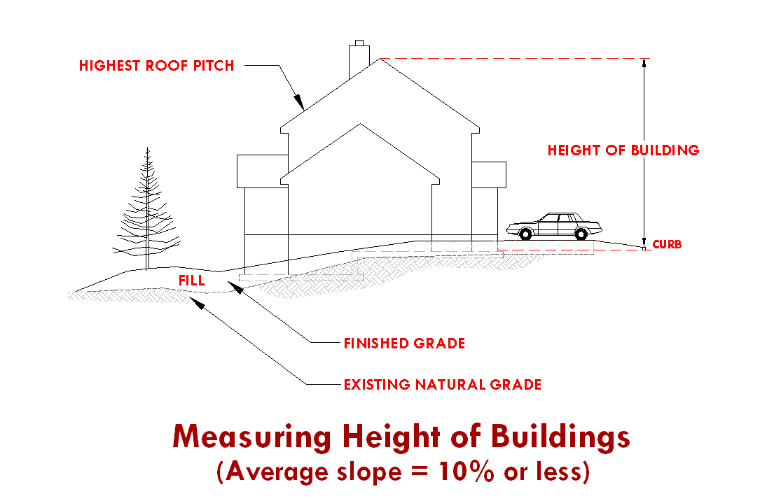
Height, Building. With natural grade of up to and including ten percent, "height of a building" is the vertical distance measured between the elevation of the curb serving the property, and the highest point on the roof. For sites having a natural grade of greater than ten percent, "height of a building" is measured from average finished grade to the highest point of the roof, and a maximum of four feet of introduced fill is permitted. See illustrations below.
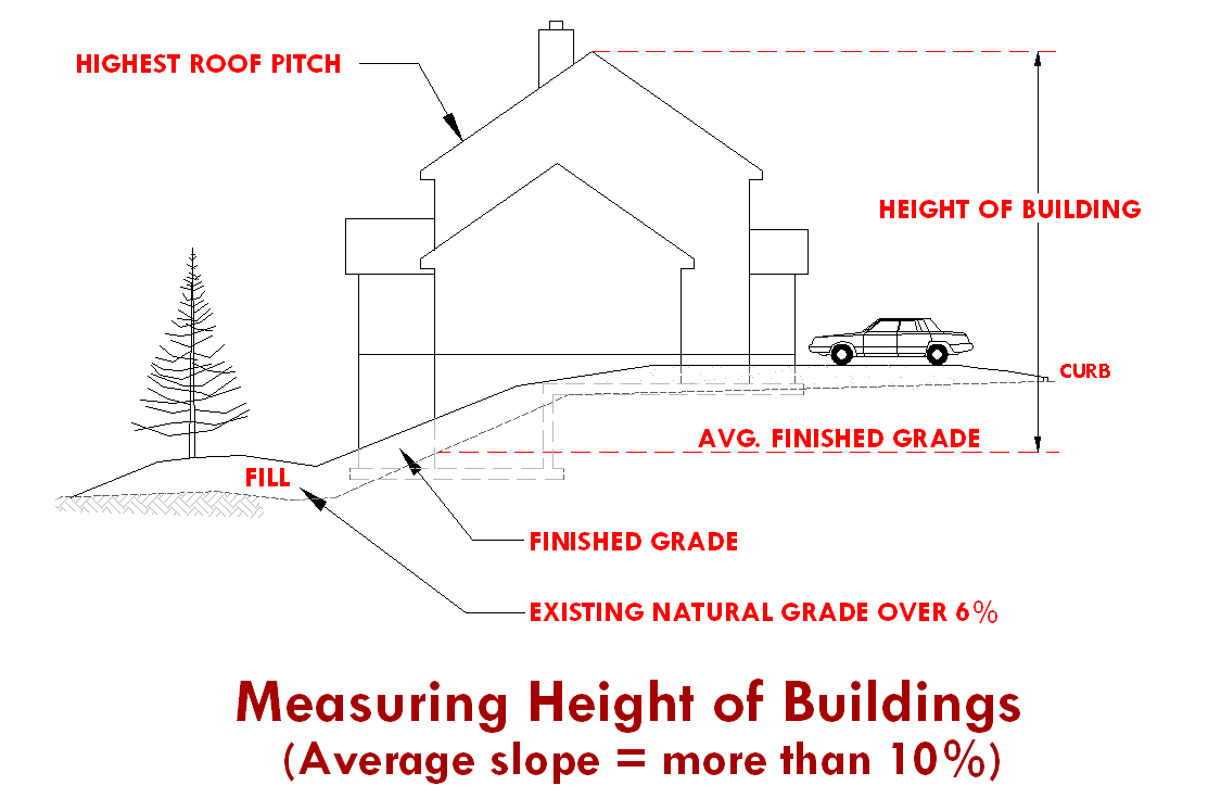
4' fill (max.) permitted without a variance
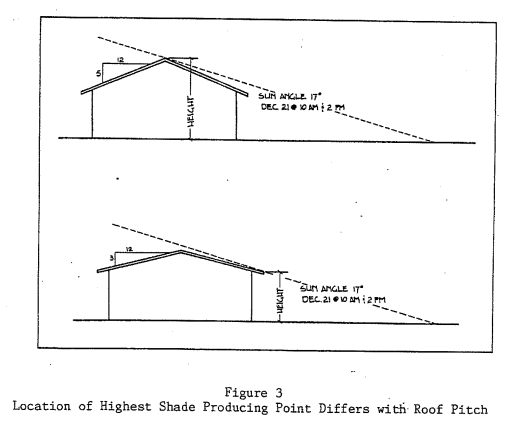
Highest Shade Producing Point. The highest shade producing point of the structure two hours before and after the solar zenith on December 21. The highest shade producing point could be the tallest point of the structure. Whenever the roof pitch is at an angle less than 17 degrees, the highest shade producing point will be the bottom eave of the structure (see figure below).
Hive. Any Langstroth type structure with movable frames intended for the housing of a bee colony. A hive typically consists of a cover, honey supers, brood chambers, and a bottom board.
Home Occupation. Any business activity carried on by a resident, or resident family, of a dwelling as an accessory use within the same dwelling, or in an accessory structure on the same property. The business activity shall not be detrimental to the overall character of the neighborhood.
Homeless Shelter. A building, facility, or portion thereof used by a not-for-profit agency or organization for the purpose of providing sleeping quarters.
Hospital. A facility with an organized medical staff, with permanent facilities that include inpatient beds and with medical services, including physician services and continuous nursing services under the supervision of registered nurses, to provide diagnosis and medical or surgical treatment primarily for but not limited to acutely ill patients and accident victims, to provide treatment for the mentally ill or to provide treatment in special inpatient care facilities.
Hotel (Motel). Any building containing six or more guest rooms intended or designed to be used, or that are used, rented, or hired out to be occupied, or that are occupied for sleeping purposes by guests.
Impervious Surface. Any hard-surfaced area that does not readily absorb or retain water, including but not limited to building roofs, paved parking and driveway areas, sidewalks, and other paved areas.
Improvement. Any man-made physical addition to a property affecting the value or use of that property.
Improvement Agreement. Any contract, security or agreement that may be required and accepted between the developer and the City to assure that necessary improvements will function as required for a specific period of time. See also Performance Guarantee.
Indoor Commercial Recreation. A room or rooms within an enclosed building which is designated and used for recreational purposes by the public.
Infill Development. Development or redevelopment of vacant, parcels of land in otherwise built-up areas.
Ingress. Access point for entering a building, site, or area.
Instrument Runway. A runway equipped or to be equipped with a precision electronic navigation aid or landing aid or other air navigation facilities suitable to permit the landing of aircraft by an instrument approach under restricted visibility conditions. Instrument runways are classed as precision and non-precision instrument runways.
Intensity of Use. The range or scale or concentration or degree of impact of use, often measured by floor area ratios, building coverage or traffic generation.
Interest. Includes a lot or parcel, share, undivided interest, or membership which includes the right to occupy the land overnight, and a lessee's interest in land for more than three years or less than three years if the interest may be renewed under the terms of the lease for a total period more than three years. Interest does not include any security interest under a land sales contract, trust deed or mortgage. Interest does not include divisions of land created by lien foreclosures or foreclosures of recorded contracts for the sale of real property.
Junkyard. Primary or accessory use of land for the storage, dismantling or selling of castoff or salvage material of any sort in other than the original form in which it was manufactured and/or assembled and not including reconditioned second-hand furniture or fixtures sold from within a walled building.
Kennel. A lot or buildings in which four or more dogs or cats, at least four months of age, are kept commercially for board, propagation, training, or sale.
Land Division. The subdividing or partitioning of land for any purpose into lots or parcels, or the creation of lots or parcels for the purpose of sale or lease.
Land Division, Expedited. A division of land as defined in ORS 197.360.
Land Division, Middle Housing. A partition or subdivision of a lot or parcel on which the development of middle housing is allowed.
Landscape. The act of improving the aesthetic appearance or ecosystem function of land by changing its contours, adding and maintaining ornamental features and plantings.
Landscaping Supply. Indoor or outdoor sales (wholesale or retail) of bulk items typically associated with landscaping, including (but not limited to) topsoil, mulch, gravel, river rock, fountains, pavers, and so forth.
Land Use. The main activity that occurs on a piece of land.
Livestock. Horses, mules, donkeys, cattle, llamas, alpacas, sheep, goats, swine, domesticated fowl and any animal bred and maintained commercially or otherwise, within any type of enclosure.
Live/Work Unit, New. A new structure or use, which is being created to have no more than two dwelling units, as well as a business component (more intensive than a licensed home occupation as defined in this code).
Live/Work Unit, Existing. Any existing on-site building in which no more than two dwelling units, as well as a business component (more intensive than a licensed home occupation as defined in this code), already exists.
Live/Work Unit, Modified. Any existing on-site building that is being changed into a structure for the purpose of having no more than two dwelling units, as well as a business component (more intensive than a licensed home occupation as defined in this code).
Loading Area. An off-street space within a building or on the same lot with a building, for the temporary parking of a commercial vehicle or truck while loading or unloading merchandise or materials.
Lodge. See Club.
Lot. A lawfully created unit of land that is created by a subdivision of land. See also Lot of Record.
Corner Lot. A lot abutting upon two or more streets other than alleys, at their intersection, or upon two parts of the same street, such streets or parts of same street forming an interior angle of less than 135 degrees within the lot line.
Cul-de-sac Lot. A lot fronting the bulb of a cul-de-sac that has a frontage of less than 50 feet.
Double Frontage Lot. An interior lot having frontage on more than one street, or a corner lot having frontage on more than two streets.
Flag Lot. A lot which fronts a public street or road and where access to the street or road is by a private driveway. A lot shall be considered as a "flag lot" if the pole of the flag lot is less than half the width of the average lot width having between 20 and 50 feet of street frontage.
Interior Lot. A lot other than a corner lot.
Irregular Lot. A lot of such a shape or configuration that technically meets the area, frontage and width requirements of these standards but meets these requirements by incorporating unusual elongations, angles, curvilinear lines unrelated to topography or other natural land features.
Nonconforming Lot. A lot that lawfully existed prior to the enactment of the requirements of these standards, but which does not meet the minimum lot size or lot width requirements.
Through Lot. An interior lot having a frontage on two streets and/or highways, not including an alley.
See also Lot, Double Frontage.
Lot Area. The total horizontal surface area within the property lines of a lot, exclusive of streets.
Lot Consolidation. The consolidation of lot lines resulting in fewer lots.
Lot Coverage. The percentage of a lot containing the footprint of structures or buildings.
Lot Line. The property line bounding a lot.
Front Lot Line. For a lot other than a corner lot, the lot line abutting a street other than an alley; for a corner lot, a lot line abutting either street other than an alley. In the case of a corner lot, or double frontage lot, the Community Development Department Director, or designee, shall determine the front lot line. The determination shall be made to provide the necessary public safety and shall be based on street classifications, house and driveway orientation, lot dimensions, and adjacent property use.
Rear Lot Line. The lot line that is opposite and most distant from the front lot line. In the case of an irregular, triangular or other shaped lot, a line ten feet in length within the lot parallel to and at a maximum distance from the front lot line.
Side Lot Line. Any lot line or lines not a front or rear lot line. An interior side lot line is a lot line common to more than one lot or to the lot and an alley; and exterior side lot line is a lot line common to the lot and a street other than an alley.
Lot Line Adjustment. The adjustment of common property line(s) or boundaries between adjacent lots, tracts, or parcels for the purpose of accommodating a transfer of land. The resulting adjustment shall not create any additional lots, tracts, or parcels and all reconfigured lots, tracts, or parcels shall contain sufficient area and dimension to meet minimum requirements for zoning and building purposes.
Lot of Record. Any unit of land created as follows:
1.
A lot in an existing, duly recorded subdivision;
2.
A parcel in an existing, duly recorded major or minor land partition; or,
3.
An existing unit of land for which a survey has been duly filed which conformed to all applicable regulations at the time of filing; or
4.
Any unit of land created by deed description or metes and bounds provided, however, contiguous units of land created by deed description or metes and bounds under the same ownership and not conforming to the minimum parcel size of these standards shall be considered one lot of record.
Lot Width. The horizontal distance between the side lines of a lot measured at right angles to its depth along a straight line parallel to the front lot line at the minimum required setback.
Lumber Mill. Facility having the primary purpose of shaping and cutting raw or partially finished lumber.
Manufactured Dwelling Park. Any place where four or more manufactured dwellings or prefabricated structures, as defined in ORS 455.010, that are relocatable and more than eight and one-half feet wide, are located within 500 feet of one another on a lot, tract or parcel of land under the same ownership, the primary purpose of which is to rent or lease space or keep space for rent or lease to any person for a charge or fee paid or to be paid for the rental or lease or use of facilities or to offer space free in connection with securing the trade or patronage of such person.
Manufacturing, Commercial. Light assembly as a support use to the primary commercial use (i.e., furniture assembly, electronic repair / assembly).
Manufacturing, Heavy Industrial. Industrially related manufacturing; typified by use of larger machinery or chemicals; not generally associated with commercial sales other than as a secondary use to the primary industrial use.
Manufacturing, Light Industrial. Fully enclosed; manufacturing of items permitted in the respective zone; does not use chemicals or materials which may be toxic or otherwise detectable visually or by odor from neighboring properties.
Martial Arts Studio. A place where any art of self-defense is taught and/or practiced.
Master Development Plan (MDP). A detailed development plan showing compliance with the applicable Great Neighborhood Planning Principles, the Redmond Urban Area Framework Plan, and adopted Area Plans on lands currently zoned Urban Holding-10 (UH-10). The MDP typically identifies proposed land uses, buildings locations, landscaping, potential art locations, access and internal circulation, and infrastructure for a project where the development program may be planned to occur in phases over a period of several years. MDP's may include multiple land parcels. The MDP is a required urban planning step before annexation and rezoning property.
Master Plan; Master Development Plan. An overall plan indicating the physical and functional interrelationships between uses and facilities for a project, a series of projects or phased developments. Components of a master plan are set forth in Section 8.270.
Middle Housing. Means Duplexes, Triplexes, Quadplexes (fourplexes), Cottage Clusters, and Townhouses
Ministerial. A routine governmental action or decision that involves little or no discretion. The issuance of a building permit is a ministerial action.
Mini Storage. Securable, "for rent" unit intended to store personal items on a long-term basis.
Mixed-Use. Development that combines residential, commercial, public, or institutional uses within the same building or site. Mixed-use development may occur as a "vertical" mixed-use, where housing is located above the ground floor, or "horizontal" mixed-use, where housing is located on the ground floor or in a separate building or part of a building.
Within horizontal mixed-use developments, residential uses shall be located behind commercial uses relative to the front lot line, or if located at the front of the building, be less than 20 percent of the frontage of such mixed-use building. Stand alone residential uses may be horizontally mixed with other uses as specified in the MUN zone.
Mobile Food Pod. A site containing more than one Mobile Food Unit and associated amenities.
Mobile Food Unit. A mobile vehicle, such as a food truck, trailer, or car, from which primarily food or beverages is provided to walk-up customers and does not include drive-thru service. Mobile Food Units shall be mobile at all times and must be on wheels that are functional and appropriate for the type of unit at all times.
Mobile Food Vendor. A Mobile Food Unit operating in a temporary manner in conjunction with a public or private event.
Modification.A modification is an amendment to an approved site development plan, a condition of approval, or change to an existing structure that has not received a land use approval.
Minor Modification. A change that is less than 25 percent of any building footprint, height or size, site improvement or dimensional requirement.
Major Modification. A change that is equal to or greater than 25 percent of any building footprint, height or size, site improvement or dimensional requirement.
Floor Area. The sum total of the gross horizontal areas of each story of the building measured from the inside of exterior walls or from the centerline of the party walls.
Floor Area Ratio (FAR). The total floor area of all structures and all above grade floors on a lot divided by the lot area. For FAR calculations, the floor area is measured to the inside of exterior walls. The following shall be excluded from the floor area calculation:
1.
Space below grade.
2.
Mechanical spaces.
3.
Elevator and stair shafts.
4.
Lobbies and common spaces, including atriums.
5.
Space dedicated to parking.
6.
Decks, balconies, porches.
Modification of Application. Means the applicant's submittal of new information after an application has been deemed complete and prior to the close of the record on a pending application that would modify a development proposal by changing one or more of the following previously described components: proposed uses, operating characteristics, intensity, scale, site lay out (including, but not limited to, changes in setbacks, access points, building design, size or orientation, parking, traffic, or pedestrian circulation plans), or landscaping in a manner that requires the application of new criteria to the proposal or that would require the finding of fact to be changed. It does not mean an applicant's submission of new evidence that merely classifies or supports the pending application.
Monument. A permanent and fixed survey marker conforming to the requirements established by State law and the regulations of Deschutes County.
Multi-family Complex. See Dwelling, Multi-family Complex.
MUTCD. Manual of Uniform Traffic Control Devices, Federal Highway Administration.
Needed Housing. As defined in ORS 197.303, as amended.
Net Square Footage. Gross square feet of a building less common areas and interior walls. Common areas include stairwells, elevators, storage areas, computer server rooms, other shafts, lobbies, underground parking, and similar kinds of uses.
Non-Conforming Structure or Use. A lawful existing structure or use at the time these Development Code standards or any amendment thereof becomes effective, which does not conform to the requirements of the zone in which it is located.
Nursery for Plants. Enclosed facility intended for commercially growing or distributing plants.
Nursing Home. Any home, institution or other structure maintained or operating for the nursing and care of four or more ill or infirm adults not requiring hospital care or hospital facilities.
Office. A room, suite of rooms, or portion of a building used for the practice of a profession or for conducting the affairs of a business.
Open Space. Land retained as undeveloped land for use as passive or active recreational area; land that is developed with park, landscaping, or other non-structural amenities. See also Usable Open Space.
Overlay Zone. A defined area or district which provides regulations in addition to those regulations in the underlying zones.
Owner. Person in whom is vested the ownership, dominion, or title of property; includes contract purchaser.
Partial Master Development Plan (PMDP). A land use plan including the same requirements as a Master Development Plan (MDP) but for only a portion of the subject property(s). The PMDP is a required urban planning step before annexation and rezoning property. Only the partially master planned portion of the property may be annexed unless otherwise approved by the City.
Partition. To divide an area or tract of land into two or three parcels.
Passive Recreation. Recreational activities which are commonly unorganized, noncompetitive, dependent on the landscape, and require no developed facilities. See also Active Recreation.
Passive-Style Park. A park designed for passive recreation that is of any configuration, shape, or size and is landscaped without irrigated turf. Examples of passive-style park components include seating elements, shape structures or tree canopies, trails or walkways, habitat areas. See also Active-Style Park.
Performance Bond. A document, acceptable by the City, issued by a surety company, in return for a fee or premium, guaranteeing the performance of the terms and conditions of a development approval.
Performance Guarantee. Any security or contract that may be accepted by a municipality as a guarantee that improvements required as part of an application for development are satisfactorily completed. See also Improvement Agreement.
Person. An individual, firm, partnership, corporation, company, association, syndicate, or any other legal entity, whether he, she or it is acting for himself, herself, or itself, or as the servant, employee, agent, or representative of another.
Plat, Final. The final plan of all or a portion of a subdivision or partition that is presented to the approving authority for final signature and recording in accordance with State law.
Plat, Tentative. A plan of all or a portion of a subdivision or partition that is submitted for approval in accordance with State law, and that is not a final plat.
Precision Machine Shop. Shop or facility that manufactures alters or modifies metal parts. Typically applies to computerized machining of tools and parts requiring high precision machining.
Primary Use. The most prevalent use to which property is or may be devoted, and to which all other uses on the premises are derived as accessory or secondary uses. As used relative to dwelling units, the primary dwelling would be the first dwelling unit to be located on a specific parcel or lot.
Principal Use. The primary or predominant use to which the property is or may be devoted, and to which all other uses on the premises are accessory.
Printing and Publishing, Retail. Service commercial use providing printing services available to the general public.
Printing, Wholesale. Printing intended to serve retail or other wholesale uses rather than the general public.
Public Recreation Facility. A facility that is owned and operated by a public entity primarily for recreational uses. Accessory uses such as art studios, meeting/classrooms, child care, offices, and related commercial uses including food vendors and retail are allowed.
Public Right-of-Way. A strip of land acquired by dedication, prescription or condemnation and intended to be occupied by a street, trail, waterline, sanitary sewer, and/or other public utilities or facilities.
Public Transportation Station. A place which includes a covered structure or a covered facility that is specifically designed to permit users to access public transit (such as buses). Such stations permit users to access one or more modes of public transit and incorporate public accommodations such as vehicle and bicycle parking, rest rooms, vending machines, benches, and tables for the convenience of travelers.
Public Use. A structure or property intended or used for a public property is or may be devoted, and to which all other uses on the premises are accessory.
Public Way. Any street, alley, or other parcel of land open to the outside air leading to a public street, which has been deeded, dedicated, or otherwise permanently appropriated to the public for public use and that has a clear width and height of not less than ten feet.
Quasi-Judicial Action. A decision or action of a public body that involves substantial discretion or judgment in applying the standards and criteria of this Code.
Recreational Area. Areas (other than village green) that are designed, constructed, designated, or used for recreational activities. Examples include: open space containing a park; landscaped or undisturbed natural areas; landscaped trails where a 10-foot-wide paved trail is in a 20 foot easement and is not a public sidewalk; pavilion areas at least 600 square feet in area; pool; splash pad; play court for racket sports and basketball; clubhouse; community room; art and seated viewing area; community garden; a plaza(s) at least 600 square feet in area.
Recreational Vehicle. A vehicle with or without motive power that is designed for use as temporary living quarters for recreational, camping, or travel use. Recreational vehicles include travel trailer, truck camper, and motor home.
Recreational Vehicle (RV) Park. A place where two or more recreational vehicles are located within 500 feet of one another on a lot, tract, or parcel of land under common ownership and having as its primary purpose temporary living quarters and the renting of space and related facilities for a charge or fee. Approved Safe Parking and Vehicle Camping site, per Chapter 5 of City Code, do not constitute an RV Park.
Recreational Vehicle Site. A plot of ground within a recreational vehicle park intended for the accommodation of a recreational vehicle or other camping unit on a temporary basis. The site may include individual use areas for picnic tables, fire pits, private parking, and other private uses.
Recycling Collection Center. Center used as a collection point for household or other types of residential recycling.
Recycling Use. Alteration of a material or commodity for re-use. Includes, but is not limited to, recycling aluminum, glass, paper, and plastic.
Replat. An amendment to a recorded plat.
Research and Development Facility, General. Establishment primarily engaged in industrial or scientific research including limited product testing; does not include medical research.
Research and Development Facility, Medical. Medically related research; use of biohazardous chemicals subject to DEQ regulations.
Reserve Strip. "Reserve Strip" means a strip of land usually a minimum of one foot in width, reserved across the end of a street or alley terminating at the boundary of a subdivision, or a strip of land between a dedicated street of less than full width and adjacent acreage, in either case reserved or held for future street extension or widening.
Residential Facility. A residential care, residential training, or residential treatment facility, as those terms are defined in ORS 443.400, licensed, or registered under ORS 443.400 to 443.460 or licensed under ORS 418.205 to 418.327 by the Department of Human Services that provides residential care alone or in conjunction with treatment or training or a combination thereof for six to 15 individuals who need not be related. Staff persons required to meet licensing requirements shall not be counted in the number of facility residents and need not be related to each other or to any resident of the residential facility. (ORS 197.660)
Residential Home. A residential treatment or training or an adult foster home licensed by or under the authority of the department, as defined in ORS 443.400, under ORS 443.400 to 443.825, a residential facility registered under ORS 443.480 to 443.500, or an adult foster home licensed under ORS 443.705 to 443.825 that provides residential care alone or in conjunction with treatment or training or a combination thereof for five or fewer individuals who need not be related. Staff persons required to meet licensing requirements shall not be counted in the number of facility residents and need not be related to each other or to any resident of the residential home. (ORS 197.660)
Residential Use. Occupancy such as a human dwelling or lodging place.
Retail, Bulky. Large retail items including furniture, cars, etc.
Retail, Medical Supply. Shop that specializes in goods and commodities relating to care and rehabilitation of medical patients.
Ridge Line (building). The top of a roof at its highest elevation.
Road. A public or private way that is created to provide ingress or egress for persons to one or more lots, parcels, areas, or tracts of land. See also Street.
Rock Crushing, Permanent. Use of facility or site to crush rock as an ongoing operation. Could involve imported or on-site rock and may involve transporting crushed rock to other sites.
Rock Crushing, Temporary. Use of a site to crush rock on a temporary basis. Must involve on-site rock only but may involve transporting said crushed rock to an off-premises site. Crushing shall be incidental to primary use on the site.
Roof Treatments. Any additions to a style of roof that breaks up a single pitched roof. Examples of roof treatments are dormers, cupolas, and multi-pitched roofs.
School. A place for teaching, demonstration, or learning.
Screening. Materials used to conceal a feature or object from sight, such as fencing, walls, canopy, vegetation, or other barrier.
Semi-Public Use. A structure or use intended or used for a semi-public purpose by a church, lodge, club, or any other non-profit organization.
Setback. The distance between the vertical face of a structure and a property line. See Yard.
Single Room Occupancy. A residential dwelling with no less than four but no more than six attached single room occupancy units and sanitary or food preparation facilities for shared use of the occupant(s). See also Single Room Occupancy Unit.
Single Room Occupancy Unit. Dwelling Area within a single room occupancy development which is independently rented and lockable and provides living and sleeping space for the exclusive use of the unit occupant(s). See also Single Room Occupancy Development.
Site Improvement. Landscaping, paving for pedestrian and vehicle ways, outdoor lighting, recreational facilities, etc., added to a site.
Slope. The amount of deviation of a surface from the horizontal, usually expressed as a percentage or by degrees.
Start of Construction. The first placement of permanent construction of a structure (other than a manufactured home) on a site, such as the pouring of slabs or footings or any work beyond the stage of excavation.
Story. The portion of a building included between the upper surface of any floor and the upper surface of the floor next above it, except the top story shall be that portion of a building within the upper surface of the top-most floor and ceiling or roof above.
Street. A public or private way, other than an alley, that is created to provide primary vehicle access for persons to one or more lots, parcels, areas, or tracts of land. See also Road.
Arterial Street (Major). A street with access control, channelized intersections, restricted parking, and that collects and distributes traffic to and from minor arterial streets.
Arterial Street (Minor). A street with a high volume of traffic that collects and distributes traffic to and from collector streets.
Collector Street. A restricted access street supplementary to the arterial street system used or intended to be used principally for the movement of traffic between arterial and local streets.
Cul-de-sac. A street having one end open to traffic and the other end terminating in a vehicle turnaround.
Dead End Street. A street having only one end open to traffic, and the other end terminating in a "stub out".
Frontage Road. A street parallel and adjacent to a collector or arterial providing access to abutting properties.
Local Street. A street intended primarily for access to abutting properties.
Roadway. That portion of a street developed for vehicular traffic.
Structure. Any combination of materials forming any construction, which requires a foundation and is intended to support or shelter any use of occupancy. Also see definition of Accessory Structure.
Structural Alteration. Any change to the supporting members of a structure including foundation, bearing walls or partitions, columns, beams, girders, or any structural change in the roof or in the exterior walls.
Subdivide Land. To divide land into four or more lots within a calendar year.
Subdivider. Any person who causes land to be subdivided.
Subdivision and Subdivided Lands. Please refer to ORS 92.010(16).
Supportive Shelter. Any tract of land being actively managed by an agency which maintains two or more shelter units for the primary purpose of providing shelter alongside supportive services to individuals or families who lack access to permanent or safe shelter.
Thrift Store. Retail use that vends second-hand (used) items including clothing and furniture.
Townhouse. A dwelling unit that is part of a row of two or more attached dwelling units, where each dwelling unit is located on an individual Lot of Parcel and shares at least one common wall with an adjacent unit.
Townhouse Project. One or more townhouse structures constructed, or proposed to be constructed, together with the development site where the land has been divided, or is proposed to be divided, to reflect the Townhouse property lines and the any commonly owned property.
Tract, Private/Public. A piece of land set aside in a separate area for dedication to the public, a homeowner's association, to other entity (e.g., open space, recreation facilities, sensitive lands, etc.).
Truck Stop. Fueling facility that also provides food, washing facility and other amenities whose primary clientele is semi-truck drivers and rigs.
Turf. Vegetated groundcover, typically a species of grass.
Artificial Turf. Synthetic Fiber surfacing made to mimic the appearance or function of grass or other groundcover without the requirements of real plant material.
Irrigated/Irrigatable Turf. Vegetated groundcover, typically grass or sod, requiring active management and inputs to maintain, including but not limited to the installation/use of irrigation infrastructure, fertilizers, pesticides, ect.
Native/Natural Turf. Vegetative groundcover consisting of native plants species, needing no management or inputs to maintain.
Unbuildable Area. An area in which a structure could not be built as a permitted use under existing development standards for the area according to the Redmond Development Code.
Urban-Rural Interface. The area where urban development interfaces with Deschutes County zoned rural areas.
Usable Open Space. Areas that contain natural or man-made vegetation that are physically accessible year-round for use by the general public, or by specific groups or persons within a defined project boundary or physical area (such as within a Planned Unit Development). Water surfaces such as ponds or canals; canyon walls, and other areas that are not physically accessible year-round to the general public are not to be counted as part of the required "usable open space area".
Use. The purpose to which land and/or any structure or improvement thereon is or is proposed to be put. The word "use" is synonymous with the terms "land use" and "use of land" unless the context clearly indicates otherwise.
Utilities. Public or private infrastructure which includes but is not limited to sewer, water, electric, telephone, natural gas, and cable television.
Utility Facility. Any major structure owned or operated by a public, private or cooperative electric, fuel, communication, sewage or water company for the generation, transmission, distribution or processing its products or for the disposal of cooling water, waste, or by-products, and including power transmission lines, major trunk pipelines, power substations, dams, water towers, sewage lagoons, sanitary landfills and similar facilities, but excluding sewer, water, gas, telephone and power local distribution lines and similar minor facilities allowed in any zone.
Vehicle Storage and Towing Yard. Lot for storage of parking tow-a-way's, impound yard, and storage lot for autos, trucks, busses, and R.V.'s.
Veterinary Clinic. A facility in which medical care is provided to animals.
Warehouse. Storage space for household or commercial goods within an enclosed building without direct access to individual storage spaces. Excludes wholesale distribution and storage, and vehicular storage.
Wholesale Distribution. An establishment engaged in the bulk sales or storage of goods with distribution and storage facilities without direct public access. Includes "contractor supplies".
Workforce Housing. Housing that constitutes no more than 30 percent of such gross annual household income for a family earning 80 to 120 percent of the Area Median Income (AMI). AMI is based on the most recent HUD Income Limits for the Bend-Redmond Metropolitan Statistical Area. Workforce Housing warrants income-based deed restrictions of at least 30 years. The affordability period may be adjusted based on the use of development incentives, modifications, variances, or exceptions.
Yard. An open space on a lot which is unobstructed from the ground up, except as otherwise provided in these standards. Yards provide light, ventilation, privacy, room for drainage, landscaping, and emergency access.
Yard, Front. A yard between side lot lines and measured horizontally at right angles to the front lot line from the front lot line to the nearest point of a building. Any yard meeting this definition and abutting on a street other than an alley shall be considered a front yard.
Yard, Rear. A yard between side lot lines and measured horizontally at right angles to the rear lot line from the rear lot line to the nearest point of a building.
Yard, Side. A yard between side lot lines and measured horizontally at right angles from the side lot line to the nearest point of a building.
Zero Lot Line. The location of a building on a lot in such a manner that one or more of the building's sides rest directly on a lot line.
Zero Lot Line Subdivision. A type of subdivision utilizing zero lot lines between units and providing for potential individual ownership of each lot.
(Ord. No. 2009-04, 4-28-2009; Ord. No. 2009-03, 5-26-2009; Ord. No. 2009-14, 12-8-2009; Ord. No. 2010-10, 10-26-2010; Ord. No. 2011-09, 11-8-2011; Ord. No. 2012-04, 4-24-2012; Ord. No. 2012-10, 8-14-2012; Ord. No. 2015-01, 2-24-2015; Ord. No. 2016-17, 1-31-2017; Ord. No. 2018-09, 9-11-2018; Ord. No. 2020-15, 11-10-2020; Ord. No. 2022-04, 6-28-2022; Ord. No. 2022-09, 12-13-2022; Ord. No. 2023-07, 12-19-2023)
Sec. 8.025. - Compliance with Zoning Provisions.
1.
A lot may be used, and a structure or part of a structure may be constructed, reconstructed, altered, occupied, or used only as these standards permit.
2.
No dimensional requirement of these standards shall be violated after its terms become effective unless specifically provided for herein.
3.
No lot area, yard, or other open space which is required by these standards for one use shall be used as the required lot area, yard, or open space for another use.
(Ord. No. 2020-15, 11-10-2020)
Sec. 8.026. - Consistency with Plans and Laws.
Actions initiated under this Code shall be consistent with applicable State and Federal laws and regulations as these laws and regulations may now or hereafter provide. No parcel of land or structure may be used for, or in conjunction with, an activity that violates any State or Federal law (with the exception of federal laws related to marijuana businesses and processing industrial hemp).
(Ord. No. 2014-03, 4-1-2014; Ord. No. 2025-03, § 1, 4-8-2025)
Sec. 8.030. - Authority and Land Use or Zoning Approval.
1.
Authority. Whenever necessary to enforce the provisions of the Development Code, the Director, or designee, shall have the authority in addition to other remedies provided by law, to issue compliance notices and orders, assess penalties, record violations and liens with the City Clerk, issue citations, to institute injunction, mandamus, abatement, or other appropriate proceedings to prevent, temporarily or permanently enjoin or abate a violation.
2.
Approval. The Direction, or designee, or other Approving Authority, shall not give land use or zoning approval on any development or use of land that is not in full compliance with all applicable provisions of the Development Code, regardless of whether the applicant(s) or current owner(s) created the violation.
3.
Prior to the construction, alteration or change of use of any structure or lot for which land use approval or a zoning permit, but not a building permit, is required, approval for such construction, reconstruction, alteration, or change of use of any structure or lot shall be obtained from the Planning Department. Approval may be authorized if:
A.
It results in the property coming into full compliance with all applicable provisions of the Development Code or City Code. This includes sequencing of permits or other approvals as part of a voluntary compliance agreements.
B.
It is necessary to protect public safety and welfare.
C.
It is for work related to and within a valid easement over, on or under an affected priority.
(Ord. No. 2022-04, 6-28-2022)
Sec. 8.035. - Abrogation and Greater Restrictions.
It is not intended by these standards to repeal, abrogate, or impair any existing easements, covenants, or deed restrictions.
Sec. 8.040. - Interpretation.
Where the conditions imposed by any provision of these standards are less restrictive than comparable conditions imposed by any other provisions of these standards or by any ordinance, resolution, or regulation, the provisions which are more restrictive shall govern.
Sec. 8.045. - Repeal of Standards as Affecting Existing Liabilities.
The repeal of any zoning standard contained herein shall not have the effect to release or extinguish any penalty, forfeiture, or liability incurred under such zoning standards, unless a provision of these standards shall so expressly provide, and such provisions repealed shall be treated as still remaining in force for the purpose of sustaining any proper action or prosecution for the enforcement of such penalty, forfeiture, or liability, and for the purpose of authorizing the accusation, prosecution, conviction, and punishment of a person or persons who violated the repealed provisions or part thereof prior to the effective date of these standards.
Sec. 8.050. - Existing Agreement and Zoning Permits.
This does not repeal, abrogate, or impair any existing easements, covenants, deed restrictions, tentative land division plan approvals, and zoning permits such as conditional use permits, non-conforming use permits, temporary use permits, special exceptions, for building permits.
Sec. 8.055. - Site Plan Review.
1.
No building, grading, parking, land use, sign or other required permit shall be issued for a use for which a site plan is required by the Redmond Site and Design Review Standards until such time those requirements are met.
2.
Non-compliance with a final approved site plan pursuant hereto shall be a zoning standards violation.
Sec. 8.060. - Authorization of Similar Uses and/or Waivers.
The Community Development Director, Designee, or Planning Commission may determine that a use or site element not specifically listed in the allowed uses of a zone shall be included among the allowed uses; this determination shall be made by administrative process. A similar use determination shall be decided based on the following criteria:
1.
The use or element is similar in character to one or more of the principal uses permitted;
2.
The traffic generated on such use is similar to one or more of the principal permitted uses;
3.
The use is not first permitted in a less restrictive zoning district; and
4.
The use is consistent with the comprehensive plan. Conditions of approval may be required to assure the proposed use is consistent with the purpose of the applicable zone and comprehensive plan.
(Ord. No. 2016-17, 1-31-2017)
Sec. 8.065. - Establishment of Zones and Districts.
(Identifies allowable zones and definitions for them):
R-1 Limited Residential Zone. To provide lower density residential neighborhoods for single family detached residences, middle housing, and a mix of other housing types.
R-2 Limited Residential Zone. To provide low density residential neighborhoods for single family detached residences, middle housing, and a mix of other housing types.
R-3 Limited Residential Zone. To provide medium density residential neighborhoods with a mix of single-family detached residences, middle housing, and a mix of other housing types.
R-3A Limited Residential Zone. To provide medium density residential neighborhoods with a mix of single-family detached residences, middle housing, mix of other housing types, and allow for some limited commercial use on a conditional use basis. Examples of limited commercial uses include restaurant, theater, art gallery, office space and retail.
R-4 General Residential Zone. To provide medium density residential neighborhoods with a mix of single-family detached residences, middle housing, and a mix of other housing types including multi-family residential development. Limited commercial uses such as offices are also conditionally permitted where compatible with surrounding development.
R-5 High Density Residential Zone. To provide high density residential neighborhoods with an emphasis on multi-family development, middle housing, and smaller lot single family developments. Limited commercial uses such as offices are also conditionally permitted where compatible with surrounding development.
UH-10 Urban Holding Zone. To retain large undeveloped or underdeveloped land areas for future urban development; to act as a holding category and is considered agricultural in nature as it will allow agricultural uses to continue operation until urbanization takes place. Land in the UH-10 Holding Zone requires annexation, master plan approval, a zone change and/or a comprehensive plan amendment before urban development can occur. In most instances, Master plans are required before development can occur.
C-1 Strip Service Commercial Zone. To create and preserve areas suitable for commercial uses and services primarily oriented to automobile traffic, requiring extensive outdoor display and storage, and support of the central business district or principal downtown shopping area. In general, this zone shall be applied to those areas already existing and desirable to retain and for those areas that, because of new and/or changing traffic patterns, should be developed for such purpose. In addition, this zone allows for high density residential development in these areas where such development will not adversely affect commercial development in the zone as a whole.
C-2 Central Business District Commercial Zone. To create and preserve areas suitable for commercial uses and services on a broad basis to serve as the central shopping or principal downtown area for the City. In general, this zone shall be applied to the town "center" already existing and desirable to retain, and to abutting and adjacent areas necessary to serve population growth. In any event, no other C-2 Zone shall be established until there is demonstrated need for such action; no two C-2 Zones shall be established in such relationship to each other that they cannot act as one center.
Downtown Overlay District. To create and preserve areas within the C-2 Central Business District Commercial Zone that is vibrant and pedestrian-friendly where people can shop, work, and play in a traditional downtown setting. In general, this district will encourage a vibrant mix of pedestrian-oriented uses, including residential, shopping and entertainment uses and increase in the density and intensity of development.
C-3 Special Service Commercial Zone. To create and preserve areas suitable for special commercial uses and services and compatible non-commercial uses, and on a broad basis to serve as a center for emergency services such as medical-health care for the City. The zone should also encourage the location of uses which provide close and easy access for that sector of the population which is in most need of such services such as the elderly and maintain the quiet and low intensity use atmosphere deemed preferential for such uses.
C-4 Limited Service Commercial Zone. To retain the general character of the limited strip type commercial that presently exists in that area encompassed by this zone, and to provide for a lower intensity of heavily auto-related business while maintaining an attractive appearance in the area of the western entry to the City; such entry being a high use route for visitors to the area.
C-4A Limited Service Commercial Zone. Limited strip type commercial and to provide for a lower intensity of heavily auto-related business. A mix of limited service commercial and limited residential uses are intended to serve large industrial tracts/employment areas and reduce crosstown vehicular trips.
C-5 Tourist Commercial Zone. To provide for commercial uses primarily oriented to travelers and tourists in locations complimentary to existing facilities and future major transportation facilities and to provide incentive for public and private investments in traveler and tourist related complexes.
M-1 Light Industrial Zone. To provide for light industrial uses such as light manufacturing, research, transportation facilities and similar uses which have a limited impact on surrounding properties and are compatible with clean non-polluting industries along with limited office and commercial activities which support these light industrial uses. Furthermore, uses associated with the M-1.5 General Industrial Zone can possibly be permitted.
M-1.5 Five General Industrial Zone. To provide for general industrial needs such as defined offices, industrial park activities, manufacturing, research, and contractor uses using less than 35 percent of the property for outdoor storage of raw or assembled materials. Development, site design and architecture should promote quality, compatibility, and aesthetics. Storage must be sufficiently screened by fences or landscaping. M-1.5 uses can be approved in either the M-1 Light Industrial Zone or M-2 Heavy Industrial Zone when approved through a Conditional Use Permit.
M-2 Heavy Industrial Zone. To promote the economic diversification by allowing a wide range of industrial and heavy commercial uses and providing sufficient land for industries that have a more pronounced impact on the urban environment because of noise, smoke, air, and other emissions or because of traffic and other operating characteristics associated with these industries. The M-2 zone also allows for heavy commercial uses in areas where previous subdivisions of land and current ownership patterns have resulted in separate ownerships of smaller M-2 zoned parcels and, therefore, challenged to be readily used for industrial purposes. Furthermore, uses associated with the M-2 Heavy Industrial Zone can possibly be permitted.
FG Fairgrounds Zone. To allow for development or enhancement of the Deschutes County Fairgrounds to support services, facilities, or events to serve the region (e.g., related to training, sporting, recreational, medical, conference, public safety, or emergency coordination).
(LLI) Large Lot Industrial Zone. That area within the City identified to attract, aid, or facilitate industrial and business development projects focused on, in support of, or that directly benefit traded-sector uses that require an adequate supply of large, developable parcels of industrial land for industrial uses, including distribution centers and warehouse centers.
OSPR Open Space Park Reserve Zone. To preserve and provide for open space areas of natural, scenic, historical, or geological significance and to provide areas for recreational development and use, both passive and active. The OSPR zone also provides for private development appropriate with the goals and master plan for the canyon and the transfer of development rights to areas suitable for higher density development.
Airport Control (AC) Overlay Zone. In order to provide for the safety and use of land coincident with the Redmond Municipal Airport and prevent man-made or natural objects from encroaching into necessary aviation airspace, certain airport control zones are created which include all of the land lying within transitional surfaces, conical surface, instrument approach surface, non-instrument approach surfaces and horizontal surface. These zones are established as indicated on the current Redmond Airport Master Plan (Airport Layout Plan drawing set) for existing runways and future modifications thereto, Redmond Municipal Airport, or any other airport that may be constructed necessitating aviation controls which will affect land within the corporate limits of Redmond.
Airport Zone/Airport Compatibility Zone. To provide, encourage and support the continued operation and vitality of Redmond Municipal Airport by allowing certain airport related light industrial, manufacturing, commercial or recreational uses in accordance with State law (ORS 8.36.600 et seq.).
PF Public Facilities Zone. To provide for public facility and other uses such as: wastewater treatment facilities, water storage reservoirs, well sites, public schools, public or private child care facilities, transportation/mobility, libraries, museums, pavilions, public plazas, public safety or emergency services, emergency training and coordination facilities, and Public Works Administration facilities.
Park Zone. To provide for public park uses such as playgrounds, ball fields and open space.
MUE Mixed-Use Employment Zone. The purposes of this zone are to:
1.
Areas designated MUE are intended for development as employment centers developed as campus-type or light industrial with some limited commercial and residential development contained within the MUE area. Stand alone residential projects are not permitted within the MUE area. The City may provide for mixed use projects located within the MUE through planned developments.
2.
Commercial uses must be of a type and scale that is designed to support surrounding industrial, and employment uses and may not be used for commercial development that serves a regional retail function, such as large merchandise retailers, home improvement centers, and mini-mall developments.
3.
Development within the district should be oriented to pedestrians and support non-motorized and mass transportation modes.
MUN Mixed-Use Neighborhood Zone. The minimum size for this zoning district is three acres. The purposes of this zone are to:
1.
Establish an area in which a critical mass of retail, service, and other commercial uses together with civic uses can be located which can provide everyday goods and services to residents of the surrounding neighborhoods. Residential uses may be combined with commercial uses (as horizontal or vertical mixed-uses or live/work units) or may be allowed as standalone uses when developed as multi-family housing subject to site and design standards;
2.
Encourage development that exhibits the physical design characteristics of pedestrian-oriented, storefront-style shopping streets; and
3.
Promote the health and well-being of residents by encouraging physical activity, alternative transportation, and greater social interaction.
MULW Mixed Use Live/Work Zone. The purpose of the MULW zone is to:
1.
Provide a mixed-use area that is appropriate for development which may include both living units and work space;
2.
Provide flexibility for the development of live/work units; and,
3.
Provide locations, where appropriate, for new businesses to start up and existing businesses to continue and potentially expand.
(Ord. No. 2009-03, 5-26-2009; Ord. No. 2009-14, 12-8-2009; Ord. No. 2011-09, 11-8-2011; Ord. No. 2015-01, 2-24-2015; Ord. No. 2016-17, 1-31-2017; Ord. No. 2017-12, 12-12-2017; Ord. No. 2020-15, 11-10-2020; Ord. No. 2022-04, 6-28-2022; Ord. No. 2022-09, 12-13-2022; Ord. No. 2023-07, 12-19-2023)
Sec. 8.070. - Location of Zones.
The boundaries of the zones listed in these standards shall be as indicated on the most recent City of Redmond Zone Map, as amended, which is hereby adopted by reference. The boundaries shall be modified in accordance with Section 8.750 et seq. (Amendments).
(Ord. No. 2022-04, 6-28-2022)
Sec. 8.075. - Zoning Maps.
A Zoning Map or Zoning Map Amendment adopted by Section 8.070 of these standards or by an amendment to said section shall be prepared by authority of the Planning Commission or be a modification by the City Council of a map or map amendment so prepared. The map or map amendment shall be dated with the effective date of adoption of the map or map amendment. A certified print of the adopted map or map amendment shall be maintained in the office of the County Clerk, the office of the City Manager and the Planning Department as long as these standards remain in effect.
Sec. 8.080. - Zone Boundaries.
Unless otherwise specified, Zone Boundaries are section lines, subdivision lines, lot lines, center lines of streets, alleys, canal, or rights-of-way, water courses, ridges or rimrocks, other readily recognizable or identifiable natural features, or such lines extended. Whenever any uncertainty exists as to the boundary of a zone as shown on the Zoning Map or amendment thereto, the following regulations shall control:
1.
Where a boundary line is indicated as following a street, alley, canal, or right-of-way, it shall be construed as following the center line of such right-of-way.
2.
Where a boundary line follows or approximately coincides with a section, lot, or property ownership line, it shall be construed as following such line.
3.
When a lot is divided by a zone boundary and the property owner disputes the location of the boundary, the owner may file a declaratory ruling to determine the exact location of the zone boundary. In this case, the determination shall be made by the Hearings Body, subject to appeal by the City Council.
4.
Where a public street, alley, canal, or railroad right-of-way is officially vacated, the zoning regulations applicable to abutting property on each side of the center line of such right-of-way is officially vacated, the zoning regulations applicable to abutting property on each side of the center line of such right-of-way on each respective side thereof. If the right-of-way is vacated in total to one property owner, the zoning of that abutting property shall apply to the total vacated property.
(Ord. No. 2022-09, 12-13-2022)
Sec. 8.085. - Zoning of Annexed Areas.
Property annexed to the City shall be zoned in compliance with approved Urban Area Master Plans or with a zoning classification that is compatible with planned land use designations in the Comprehensive Plan, the Redmond Urban Area Framework Plan, as determined by the City.
(Ord. No. 2015-01, 2-24-2015)
Sec. 8.121. - (Reserved)
Editor's note— Section 8.121 "Higher Density Overlay Zone" was deleted by Ord. No. 2023-07 passed December 19, 2023.
Sec. 8.125. - (Reserved)
Editor's note— Section 8.125 "Residential Neighborhood Mixed Use RMU Zone" was deleted by Ord. No. 2022-04 passed June 28, 2022. Later was deleted by Ord. No. 2023-07 passed December 19, 2023.
Sec. 8.130. - Urban Holding UH-10 Zone.
The City shall administer the provisions of Title 20 Redmond Urban Area Zoning Ordinance of the Deschutes County Code for this County zoning district.
1.
Master Development Plans. The development and approval of an Urban Area Master Plan subject to the provisions of Section 8.270 is required as a condition of annexation, prior to or concurrent with rezoning from UH-10 to City zoning districts.
2.
Exception to Master Development Plans Requirement. Approval of a development plan may be granted without going through a Master Development Plan process according to the following requirements:
Non-Residential Properties.
A.
The development plan is 12 acres or less in size; and,
B.
The development plan addresses the applicable Great Neighborhood Principles; and, the development plan includes an appropriate local grid street plan, that complies with street spacing and connectivity requirements in the Redmond TSP and showing street connectivity and bike/pedestrian system connectivity to adjacent planned and unplanned residential areas; and,
C.
The development plan meets applicable requirements for land near the urban edge; and,
D.
The development approval is obtained through a PUD process except when the property is to be used for a public use, such as for a park or school or some other public facility; and,
E.
Annexation to the City of Redmond is proposed as part of the development plan; and,
F.
The development plan addresses all other applicable requirements of the Redmond Comprehensive Plan and Development Code; and,
G.
The development plan conforms to the density and design guidelines established for the area in the Redmond Urban Framework Plan and/or an adopted Area Plan.
Residential Properties.
H.
The parcel is within the City of Redmond or can be annexed to the City; and,
I.
The parcel is three acres or less in size; and,
J.
The development plan conforms to the density and design guidelines established for the area in the Redmond Urban Framework Plan and/or an adopted Area Plan; and,
K.
The development plan meets the applicable Great Neighborhood Principles, Land Division, and Site Plan policies; and,
L.
Significant Goal 5 resources, as defined in Redmond Comprehensive Plan, Chapter 5, are identified, and managed, in accordance with Redmond's Goal 5 resource protection program; and,
M.
The development plan includes an appropriate local grid street plan that complies with street spacing and connectivity requirements in the Redmond TSP and showing street connectivity and bike/pedestrian system connectivity to adjacent planned and unplanned residential areas; and,
N.
The development plan meets applicable requirements for land near the urban edge and meets applicable planning requirements for land near the urban rural interface; and,
O.
The development application meets all other required elements for one of the City's land use planning approval processes.
(Ord. No. 2015-01; 2-24-2015; Ord. No. 2020-15, 11-10-2020; Ord. No. 2022-04, 6-28-2022)
Sec. 8.135. - Table A, Residential Zones, Uses Permitted.
The following uses are allowed outright or conditionally in each of the Residential zones as follows:
"O" means Permitted Outright
"C" means Permitted Conditionally
"N" means Not Allowed
(Ord. No. 2009-04, 4-28-2009; Ord. No. 2015-04, 5-19-2015; Ord. No. 2016-17, 1-31-2017; Ord. No. 2018-09, 9-11-2018; Ord. No. 2020-15, 11-10-2020; Ord. No. 2022-04, 6-28-2022; Ord. No. 2023-07, 12-19-2023; Ord. No. 2025-03, § 1, 4-8-2025)
Sec. 8.137. - Table for R-3A Zones, Uses Permitted.
The following uses are allowed outright or conditionally in the Residential Zone R-3A as follows:
C = conditional uses.
(Ord. No. 2018-09, 9-11-2018; Ord. No. 2020-15, 11-10-2020; Ord. No. 2022-04, 6-28-2022; Ord. No. 2023-07, 12-19-2023; Ord. No. 2025-03, § 1, 4-8-2025)
Sec. 8.138. - Standards.
Except as provided for in Sections 8.137 and 8.615, the standards and criteria for development in the R-3 zone shall apply to development in the R-3A zone.
Sec. 8.140. - Table B, Minimum Standards.
The following minimum standards apply in each of the Residential zones:
(Ord. No. 2012-04, 4-24-2012; Ord. No. 2013-04, 5-14-2013; Ord. No. 2018-09, 9-11-2018; Ord. No. 2020-15, 11-10-2020; Ord. No. 2022-04, 6-28-2022; Ord. No. 2022-09, 12-13-2022; Ord. No. 2023-07, 12-19-2023)
Sec. 8.141. - Single Family Detached Dwellings and Plexes Development and Design Standards.
1.
Purpose. The purpose of these Development and Design Standards is to promote and sustain:
A.
Quality development throughout a variety of housing choices;
B.
Architectural design that:
1.
Enhances the visual environment and character of the community;
2.
Preserves and protects property values, as well as public and private infrastructure investment;
3.
Conveys a sense of balance and character among all neighborhoods throughout Redmond; and
4.
Elevates the attractiveness and quality of life in Redmond.
2.
Intent. The intent of the Development and Design Standards is to:
A.
Maintain flexibility for a variety of architectural style to be developed;
B.
Continue to allow innovations in design that recognize newer technologies such as solar and wind power, telecommunications, and environmentally conscious construction methods; and,
C.
Promote quality design characteristics that will enhance the long-term desirability of the dwelling, neighborhood, and community.
3.
Procedure. New single-family detached dwellings and plexes, shall be reviewed for conformance with the requirements listed in this Section, subject to the procedures outlined below:
A.
If applicable, pursuant to Section 8.2135, for proposed development on a lot created by a subdivision that received tentative subdivision approval no more than ten years ago, the applicant shall elect in writing that: a) development and design standards in effect at time of tentative subdivision approval be applied; or b) development and design standards herein be applied. The standards chosen shall apply to all subsequent development in the subdivision.
B.
Track 1. Clear and Objective Process. Conformance with Section 8.141(5.), below. An application demonstrating conformance with this Section shall be shown on the architectural plans submitted with the building permit application and administered as part of the plan review process. These applications are reviewed administratively.
C.
Track 2. Discretionary Process. As an alternative to the Track 1 procedure, an application may be submitted which demonstrates conformance with the Purpose and Intent of this Section as listed above. These applications are reviewed administratively unless it is determined that a public hearing is necessary, in which case the application will be reviewed by the appropriate Hearings Body. The City may also approve other architectural designs or design elements not listed in this Section, approve exceptions or uniquely identifiable house styles provided they comply with the intent of this Section.
D.
Design Review for Manufactured and Mobile Homes not within approved mobile home parks: Some manufactured homes and mobile homes may not be able to fully comply with the requirements below. In those cases, the following features are required as part of a Track 2 process.
1.
At least one covered porch;
2.
One exterior types of wall siding material on four sides;
3.
Band courses; and
4.
Application and Approval Process. The applications for either a Track 1 or 2 review as specified in Sections 8.141(3.)(A.) and (B.) above, shall be submitted prior to or in conjunction with an application for a building permit.
5.
Architectural Design Standards. Although specific architectural styles are not mandated, single family detached dwellings and plexes, shall conform with the following standards:
A.
Screening of Mechanical Equipment. All exterior ground mounted mechanical equipment located forward from the line of the front façade (living space and garage) of the building shall be screened from the street at the ground/eye level line of sight. Solar power, wind power, and satellite dishes necessitating placement on walls or roofs for normal operation are exempt from this provision.
B.
Building Design. The standards of this Section apply per residential structure, rather than per dwelling unit contained in the residential structure.
1.
Architectural Design. Duplicate or repetitive exterior home designs must be separated by at least one lot/attached building of non-repetitive exterior design on either side of the home and not be directly across the street from one another. Home designs will not be considered repetitious if three differentiating criteria are used as listed below:
a.
Process. Builders of dwelling units or residential structures on the same street, with the exception of multiple dwelling units that are part of a single plex development, shall submit a plat showing the house plan names, elevation designations, or pictures for adjacent homes.
b.
Attached plexes are exempt.
2.
Roof Design. Required Roof Design Elements:
a.
Pitched or sloping roof elements;
b.
Eave of at least 12 inches.
3.
Front Façade Wall Design. Ten façade elements listed below shall be used on the front elevation. Use of T-111 exceeding 20 percent of all facades, combined, is not allowed.
a.
Twenty five percent fenestration of the first story front façade.
b.
Window trim at least 3.5 inches wide that completely surrounds the window;
c.
Band course, band molding, bellyband, belt course that runs the entire width of the front façade of relatively slight projection; or at the break of the second floor (if one exists) or at the line made by the lower roofline at the gable end;
d.
Variation in wall siding, wall surface pattern or decorative materials. If an area above the highest band course exists, it must contain a different siding material than the area below the band;
e.
Recessed or covered front entry at least 20 square feet, with a minimum four foot depth measured from the front door. If columns are used, they must not be exposed dimensional lumber less than 6" × 6";
f.
Windows with multi-paned sashes, operable sashes, or windows that are elliptical, round, arched, bay, semi-circular or similar design;
g.
Shutters;
h.
Balconies;
i.
Garage doors, including patterning relief over the door surface;
j.
Optional enhancements and substitutions:
i.
Enclosed soffits;
ii.
One- and one-half inches caliper tree, in addition to required street trees;
iii.
Covered rear patio or porch;
iv.
Eave greater than 12 inches in depth, including extended soffit details;
v.
Where gable ends are proposed, at least three gable end elements;
vi.
Masonry accents;
vii.
Paint color schemes, with a minimum of two colors used; and
viii.
Other elements or substitutions as approved by the Community Development Director, or designee.
4.
Side Elevations Facing Public Streets. Side elevations facing streets must include either window trim at least 3.5" in width, or full-lap siding. Façade facing streets are required to have at least ten square feet of windows or doors.
5.
Front Door. A front door that is visible from the public street frontage (front yard) and pedestrian connection between the front door and the public sidewalk is required.
6.
Driveways and Garages.
a.
A garage is required for each newly constructed residential structure and shall be of adequate size to accommodate a minimum of one vehicle, and shall at a minimum, meet the design requirements in Sections 8.505 through 8.515 (Off Street Parking and Loading Requirements) and Section 8.2820 (Access Management Standards).
i.
Manufactured homes may meet this standard by substituting a garage with covered parking or carport.
ii.
Triplexes and quadplexes may meet this standard by substituting garage or covered parking with uncovered, paved parking spot(s) per the design requirements in Sections 8.505 through 8.515.
b.
Driveways shall be of adequate size to accommodate a minimum of one vehicle, and shall at a minimum, meet the design requirements in Section 8.515 Parking Table and Diagram.
c.
A single-family detached home that adds an ADU shall continue to meet the minimum parking spaces requirement for the primary home.
d.
Notwithstanding the applicable provisions of Sections 8.505 through 8.515 (Off Street Parking and Loading Requirements) and Section 8.2820 (Access Management Standards), all required off street parking areas and driveways constructed in conjunction with single family detached dwellings or plexes may have alternative surfaces to concrete or asphalt and may include permeable surfaces to the extent they provide an all-weather surface sufficient for vehicular travel. Loose gravel, aggregate and similar surface treatments are not permitted for required parking spaces.
7.
Off-street Parking. The minimum number of required off-street parking spaces for single-family detached dwellings and plexes are specified in Section 8.500.
8.
Landscaping. See Sections 8.520 through 8.540 for applicable landscaping standards.
9.
Fences. See Section 8.340.
10.
Conversion. Conversions of an existing single-family detached dwelling to a duplex, triplex, or quadplex is allowed, provided that the conversion does not increase non-conformance with applicable standards of the underlying zone and this Section.
(Ord. No. 2013-04, 5-14-2013; Ord. No. 2014-14, 7-22-2014; Ord. No. 2015-04, 5-19-2015; Ord. No. 2016-17, 1-31-2017; Ord. No. 2017-12, 12-12-2017; Ord. No. 2018-09, 9-11-2018; Ord. No. 2020-15, 11-10-2020; Ord. No. 2022-04, 6-28-2022; Ord. No. 2022-09, 12-13-2022; Ord. No. 2023-07, 12-19-2023)
Sec. 8.142. - Townhouse Development and Design Standards.
1.
Procedure. New townhouses shall be reviewed for conformance with the requirements listed in this Section.
2.
Table A: Minimum Standards.
3.
Off-Street Parking. Townhouses shall meet the off-street parking requirements of Section 8.500.
4.
Areas Owned in Common. For townhouse projects, common areas must be maintained by a homeowners association or other legal entity. A homeowners association may also be responsible for exterior building maintenance. A copy of any applicable covenants, restrictions and conditions must be recorded and provided to the City prior to issuance of a building permit.
5.
Design Standards. New townhouses shall meet the design standards in Subsections (A.) through (G.) of this Section.
A.
Entry Orientation. The main entrance of each townhouse must:
1.
Be within 8 feet of the longest street-facing wall of the dwelling unit, if the lot has public street frontage; and
2.
Either:
a.
Face the street (see Figure 1);
b.
Be at an angle of up to 45 degrees from the street (see Figure 2);
c.
Face a common open space or private access or driveway that is abutted by dwellings on at least two sides; or
d.
Open onto a porch (see Figure 3). The porch must:
i.
Be at least 25 square feet in area; and
ii.
Have at least one entrance facing the street or have a roof.
Figure 1. Main Entrance Facing the Street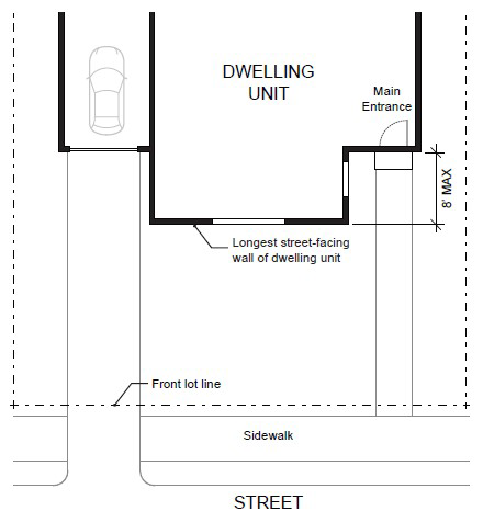
Figure 2. Main Entrance at 45° Angle from the Street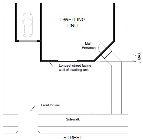
Figure 3. Main Entrance Opening onto a Porch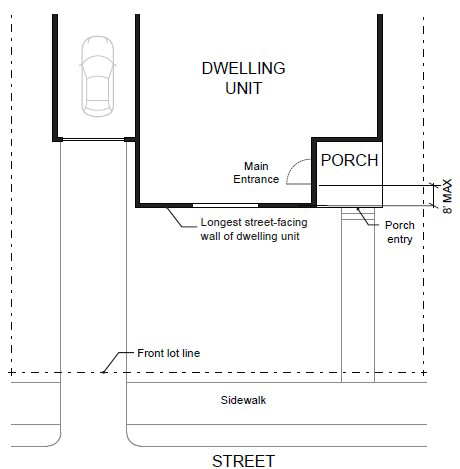
B.
Unit Definition. Each townhouse must include at least one of the following on at least one street-facing façade (see Figure 4):
1.
A roof dormer a minimum of four feet in width, or
2.
A balcony a minimum of two feet in depth and four feet in width and accessible from an interior room, or
3.
A bay window that extends from the facade a minimum of two feet, or
4.
An offset of the facade of a minimum of two feet in depth, either from the neighboring townhouse or within the façade of a single townhouse, or
5.
An entryway that is recessed a minimum of three feet, or
6.
A covered entryway with a minimum depth of four feet, or
7.
A porch meeting the standards of Subsection (A.2.d.) of this Section. Balconies and bay windows may encroach into a required setback area.
Figure 4. Townhouse Unit Definition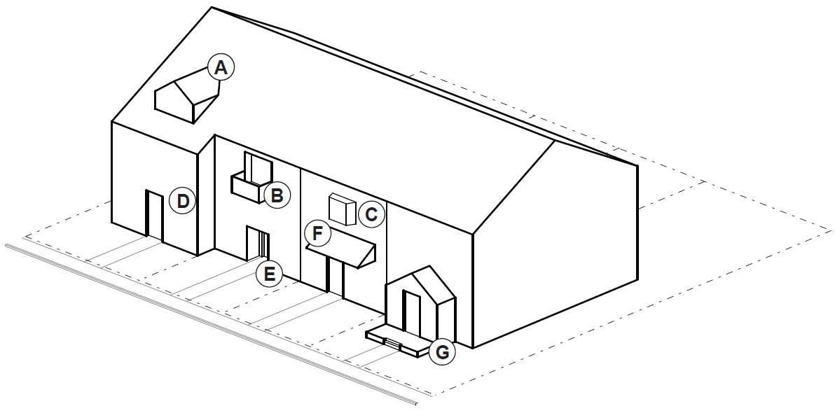
C.
Windows. A minimum of 15 percent of the area of all street-facing facades on each individual unit must include windows or entrance doors. Half of the window area in the door of an attached garage may count toward meeting this standard. See Figure 5.
Figure 5. Window Coverage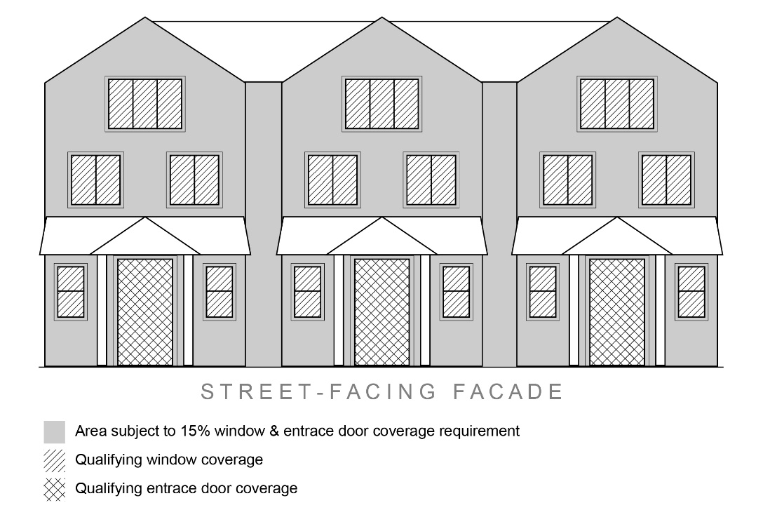
D.
Driveway Access and Parking. Townhouses with frontage on a public street shall meet the following standards:
1.
Garages on the front façade of a townhouse, off-street parking areas in the front yard, and driveways in front of a townhouse are allowed if they meet the following standards (see Figure 6).
a.
Each townhouse lot has a street frontage of at least 15 feet on a local street.
b.
A maximum of one driveway approach is allowed for every townhouse. Driveway approaches and/or driveways may be shared.
c.
Outdoor on-site parking and maneuvering areas do not exceed 12 feet wide on any lot.
d.
The garage width does not exceed 12 feet, as measured from the inside of the garage door frame.
Figure 6. Townhouses with Parking in Front Yard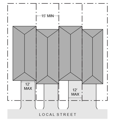
2.
The following standards apply to driveways and parking areas for townhouse projects that do not meet all of the standards in Subsection (1.).
a.
Off-street parking areas shall be accessed on the back façade or located in the rear yard. No off-street parking shall be allowed in the front yard or side yard of a townhouse.
b.
A townhouse project that includes a corner lot shall take access from a single driveway approach on the side of the corner lot. See Figure 7.
Figure 7. Townhouses on Corner Lot with Shared Access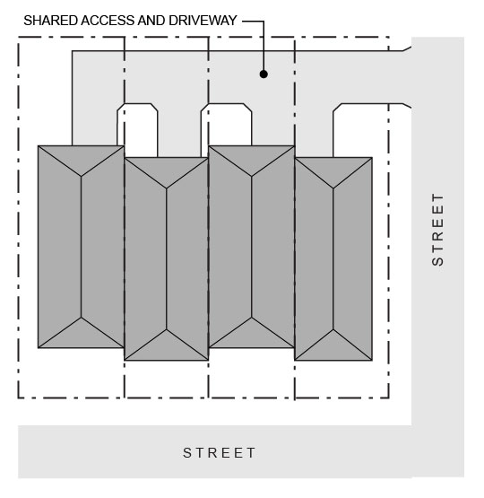
c.
Townhouse projects that do not include a corner lot shall consolidate access for all lots into a single driveway. The driveway and approach are not allowed in the area directly between the front façade and front lot line of any of the townhouses. See Figure 8.
Figure 8. Townhouses with Consolidated Access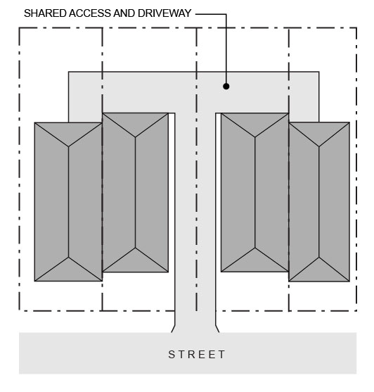
d.
A townhouse project that includes consolidated access or shared driveways shall grant access easements to allow normal vehicular access and emergency access.
3.
Townhouse projects in which all units take exclusive access from a rear alley are exempt from compliance with Subsection (2.).
4.
All driveway accesses for townhouses must comply with Section 8.2820 (Access Management Standards).
E.
Screen of Mechanical Equipment. All exterior ground mounted mechanical equipment located forward from the line of the front façade (living space and garage) of the building shall be screened from the street at the ground/eye level line of sight. Solar power, wind power, and satellite dishes necessitating placement on walls or roofs for normal operation are exempt from this provision.
F.
Landscaping. See Sections 8.520 through 8.540 for applicable landscaping requirements.
G.
Fences. See Section 8.340.
(Ord. No. 2018-09, 9-11-2018; Ord. No. 2020-15, 11-10-2020; Ord. No. 2022-04, 6-28-2022; Ord. No. 2022-09, 12-13-2022; Ord. No. 2023-07, 12-19-2023)
Sec. 8.143. - Cottage Cluster Development and Design Standards.
1.
Procedure. New cottage clusters shall be reviewed for conformance with the requirements listed in this Section.
2.
Table A: Minimum Standards.
3.
Building Separation. Cottages shall be separated by a minimum distance of six feet. The minimum distance between all other structures, including accessory structures, shall be in accordance with building code requirements.
4.
Unit Size.
A.
The maximum building footprint for a cottage is 900 square feet.
B.
The maximum average floor area for a cottage cluster is 1,400 square feet per dwelling unit. Community buildings shall be included in the average floor area calculation for a cottage cluster.
5.
Cluster Size.
A.
Cottage clusters must include a minimum of four units per cluster.
B.
A cottage cluster may include up to a maximum of 12 cottages per common courtyard. More than one cottage cluster may be permitted on a site.
6.
Off-Street Parking and Access. Cottages shall meet the off-street parking and access requirements of Sections 8.500 and 8.2820.
7.
Design Standards. New cottage clusters shall meet the design standards in Subsections (A. through H.) of this Section.
A.
Cottage Orientation. Cottages must be clustered around a common courtyard, meaning they abut the associated common courtyard or are directly connected to it by a pedestrian path, and must meet the following standards (see Figure 1):
1.
Each cottage within a cluster must either abut the common courtyard or must be directly connected to it by a pedestrian path.
2.
A minimum of 50 percent of cottages within a cluster must be oriented to the common courtyard and must:
a.
Have a main entrance facing the common courtyard;
b.
Be within ten feet from the common courtyard, measured from the façade of the cottage to the nearest edge of the common courtyard; and
c.
Be connected to the common courtyard by a pedestrian path.
3.
Cottages within 20 feet of a street property line may have their entrances facing the street.
4.
Cottages not facing the common courtyard, or the street, must have their main entrances facing a pedestrian path that is directly connected to the common courtyard.
B.
Common Courtyard Design Standards. Each cottage cluster must share a common courtyard in order to provide a sense of openness and community of residents. Common courtyards must meet the following standards (see Figure 1):
1.
The common courtyard must be a single, contiguous piece.
2.
Cottages must abut the common courtyard on at least two sides of the courtyard.
3.
The common courtyard must contain a minimum of 150 square feet per cottage within the associated cluster.
4.
The common courtyard must be a minimum of 15 feet wide at its narrowest dimension.
5.
The common courtyard must be landscaped in either active or passive park style. If the common courtyard is landscaped as an active-style park, it may be of any size and shall not be subject to the irrigated turf restriction of Section 8.530(7.).
6.
Pedestrian paths must be included in a common courtyard. Paths that are contiguous to a courtyard shall count toward the courtyard's minimum dimension and area. Parking areas, required setbacks, and driveways do not qualify as part of a common courtyard.
Figure 1. Cottage Cluster Orientation and Common Courtyard Standards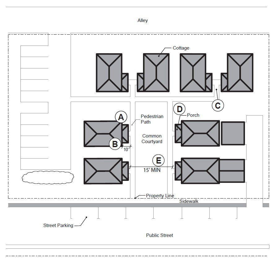
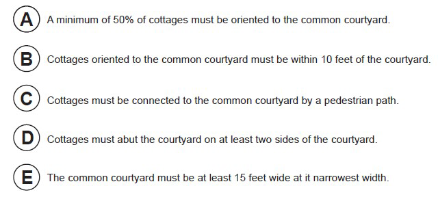
C.
Community Buildings. Cottage cluster projects may include community buildings for the shared use of residents that provide space for accessory uses such as community meeting rooms, guest housing, exercise rooms, day care, or community eating areas. Community buildings must meet the following standards:
1.
Each cottage cluster is permitted one community building, which shall count towards the maximum average floor area, pursuant to Subsection (4.).
2.
A community building that meets the development code's definition of a dwelling unit must meet the maximum 900 square foot footprint limitation that applies to cottages, unless a covenant is recorded against the property stating that the structure is not a legal dwelling unit and will not be used as a primary dwelling.
D.
Pedestrian Access.
1.
An accessible pedestrian path must be provided that connects the main entrance of each cottage to the following:
a.
The common courtyard;
b.
Shared parking areas;
c.
Community buildings; and
d.
Sidewalks in public rights-of-way abutting the site or rights-of-way if there are no sidewalks.
2.
The pedestrian path must be hard-surfaced and a minimum of four feet wide.
E.
Facades. Cottages must meet the architectural design standards for single-family detached dwellings in Section 8.141(5.B.1. through 4.).
F.
Parking Design. (See Figure 2).
1.
Clustered Parking. Off-street parking may be arranged in clusters, subject to the following standards:
a.
Cottage cluster projects with fewer than 16 cottages are permitted parking clusters of not more than five contiguous spaces.
b.
Parking clusters must be separated from other spaces by at least four feet of landscaping.
c.
Clustered parking areas may be covered.
2.
Parking Location and Access.
a.
Off-street parking spaces and vehicle maneuvering areas shall not be located:
i.
Within 20 feet from any street property line, except alley property lines;
ii.
Between a street property line and the front façade of cottages located closest to the street property line. This standard does not apply to alleys.
b.
Off-street parking spaces shall not be located within ten feet of any other property line, except alley property lines. Driveways and drive aisles are permitted within ten feet of other property lines.
3.
Screening. Clustered parking areas and parking structures shall be screened from sight of common courtyards and public streets at a height of no less than three feet.
4.
Garages and Carports.
a.
Garages and carports (whether shared or individual) must not abut common courtyards.
b.
Individual attached garages up to 200 square feet shall be exempted from the calculation of maximum building footprint for cottages.
c.
Individual detached garages must not exceed 400 square feet in floor area.
d.
Garage doors for attached and detached individual garages must not exceed 20 feet in width.
G.
Screening of Trash Enclosures. Centralized Trash Enclosures are required and shall be visually consistent, or architecturally compatible, in terms of color and materials with the cottage units, a minimum six feet in height, and contain sufficient space to accommodate both refuse disposal and recycling containers adequate to accommodate the degree of development.
H.
Screening of Mechanical Equipment. All exterior ground mounted mechanical equipment located forward from the line of the front façade (living space and garage) of the building shall be screened from the street at the ground/eye level line of sight. Solar power, wind power, and satellite dishes necessitating placement on walls or roofs for normal operation are exempt from this provision.
I.
Accessory Structures. Accessory structures must not exceed 400 square feet in floor area.
J.
Existing Structures. On a lot or parcel to be used for a cottage cluster project, an existing single-family detached dwelling on the same lot at the time of proposed development of the cottage cluster may remain within the cottage cluster project area under the following conditions:
1.
The existing dwelling may be non-conforming with respect to the requirements of this code.
2.
The existing dwelling may be expanded up to a maximum height of 25 feet or the maximum building footprint of 900 square feet; however, existing dwellings that exceed the maximum height and/or footprint of this code may not be expanded.
3.
The floor area of the existing dwelling shall not count towards the maximum average floor area of a cottage cluster.
4.
The existing dwelling shall be excluded from the calculation of orientation toward the common courtyard, per Subsection (6.A.).
Figure 2. Cottage Cluster Parking Design Standards
(Ord. No. 2022-04, 6-28-2022; Ord. No. 2022-09, 12-13-2022; Ord. No. 2023-07, 12-19-2023)
Sec. 8.144. - Conversion of Existing Commercial Structures for Housing.
1.
Design and Review. A proposal for conversion of an existing commercial structure to housing is not required to comply with this Section if the proposed conversion could be permitted through another use and review procedure. However, if an applicant is seeking approval of such proposal through this Section, the proposal must comply with the entirety of this Section in order to be approved.
A.
For any proposal to convert an existing commercial structure or portion thereof to housing, regardless of the zoning of the subject property, system development charges will be applied to the proposed development as the City deems appropriate, but the charges shall be reduced by the full nominal amount of the water and wastewater system development charges paid at the time the commercial structure was originally constructed, if any. The parking requirements for conversion of an existing commercial structure or portion thereof to housing are described in Section 8.500(2.).
B.
Conversion of an existing commercial structure or portion thereof to housing on a subject property that is located within a non-residential zoning district shall not require a zone change or conditional use review to allow the proposed residential use.
(Ord. No. 2023-07, 12-19-2023)
Sec. 8.145. - Public-Owned Affordable Housing Developments.
Proposals which comply with the standards of this Section shall be approved.
1.
Ownership. The subject property for the Public-Owned Affordable Housing Development proposal must meet one of the following conditions:
A.
The subject property is located outside of the Airport and Industrial zones and is owned by a public body or a nonprofit; or
B.
The subject property is located within the M-1 zone and is owned by a public body.
2.
Affordability Standard. In order to qualify as a Public-Owned Affordable Housing Development, the entirety of the units proposed on the subject property must, at a minimum, be:
A.
Available to rent or own at 80 percent of AMI based on the most recent HUD Income Limits for the Bend-Redmond Metropolitan Statistical Area and controlled by an affordable housing covenant as defined in ORS 456.270 for a period of no less than 30 years; or
B.
Available to rent or own at a collective average of 60 percent of AMI based on the most recent HUD Income Limits for the Bend-Redmond Metropolitan Statistical Area and controlled by an affordable housing covenant as defined in ORS 456.270 for a period of no less than 30 years.
3.
Review. The development of Public-Owned Affordable Housing on a subject property located within a non-residential zoning district shall not require a zone change or conditional use review to allow the proposed residential use.
4.
Density and Height Bonus. Any Public-Owned Affordable Housing Development proposal located within a residential zone shall be granted one of the following density and height bonuses. In this Section, effective maximum density shall mean the greater of either the maximum number of lots per acre or the maximum number of dwelling units per acre.
A.
When the proposed Public-Owned Affordable Housing Development is subject to an effective maximum density standard of 16 dwelling units per acre or less, that maximum density standard shall be increased by 200 percent. Additionally, the maximum building height standard shall be increased by 12 feet.
B.
When the proposed Public-Owned Affordable Housing Development is subject to an effective maximum density standard between 17 and 45 dwelling units per acre, that maximum density standard shall be increased by 150 percent. Additionally, the maximum building height standard shall be increased by 24 feet.
C.
When the proposed Public-Owned Affordable Housing Development is subject to an effective maximum density standard of 46 dwelling units per acre or more, that maximum density standard shall be increased by 125 percent. Additionally, the maximum building height standard shall be increased by 36 feet.
The City reserves the right to reduce the height or density of the development as necessary to address health, safety, or habitability issues, including fire safety concerns, or to comply with a protective measure adopted pursuant to a statewide land use planning goal. If the City has found a reduction of the density and/or height bonus to be necessary on this basis, the City shall provide findings supported by substantial evidence as part of the planning review of the Public-Owned Affordable Housing Development.
(Ord. No. 2023-07, 12-19-2023)
Sec. 8.166. - Limited Service Commercial C-4A Zone.
Except as provided in Sections 8.190 and 8.195, the standards and criteria for development in the C-4A Zone shall apply to development in the C-4A Zone.
Sec. 8.175. - Downtown Overlay District.
In the Downtown Overlay District, the following regulations shall apply:
1.
Purpose. The purpose of the Downtown Overlay District is to promote and sustain:
A.
Economic Growth. Assure opportunities for a stable, vital, diverse, and competitive economy in the heart of the City.
B.
Vibrant Downtown. Strengthen downtown as a vibrant, mixed-use district that draws a wide spectrum of residents and visitors.
C.
Downtown Appearance. Improve and enhance the appearance of the built environment and natural features throughout downtown, especially along primary commercial corridors, and other major arterials.
D.
Historic Character. Preserve and retain historic structures and cultural resources throughout downtown.
E.
Pedestrian Environment. Improve and enhance the pedestrian environment throughout downtown, as well as the pedestrian connections to surrounding neighborhoods and civic resources.
2.
Intent. The intent of the Downtown Overlay District is to:
A.
Encourage a vibrant mix of pedestrian-oriented uses, including residential, shopping and entertainment uses;
B.
Increase the density and intensity of development;
C.
Establish height, bulk, and lot coverage regulations that balance existing urban fabric with a desired character for downtown;
D.
Promote active ground floors by regulating the quantity and location of doors and windows;
E.
Establish standards for setbacks and landscaping that encourage and promote a strong pedestrian environment.
F.
Establish parking and access standards that support pedestrian activity.
3.
Uses Permitted. (Please see Section 8.190 Table C)
4.
Development Standards. In the Downtown Overlay District, the following dimensional standards shall apply:
A.
Minimum Building Setback. Two feet. Surface treatment needs to be of similar nature as adjoining sidewalk.
B.
Maximum Building Setback. Ten feet. Surface treatment beyond two feet from the sidewalk needs to be landscaped or treated with decorative pavers. Use of irrigated turf or asphalt is prohibited. For full-block developments, a minimum of 50 percent of the primary street-facing building façade must be located at the minimum two feet setback as described in Subsection (4.A.).
C.
Minimum Landscaped Area. No minimum landscaping requirement.
D.
Ground Floor Windows. Ground floor windows must be at least 50 percent of the building length and 50 percent of the street-facing façade to a minimum height of 10'-0" above finished right-of-way. If the site has two or more frontages, the Ground Floor Window standards is only required on the primary façade. The other façade has a minimum requirement of 50 percent of the building length and 25 percent of the ground floor wall area. Windows are required to be transparent.
Please note: Ground floor wall area is defined as all wall areas up to ten feet above the finished grade.
Ground Floor Windows—Residential Use: 25 percent of the ground floor wall area must be transparent.
E.
Main Entrance. The front door to all buildings must be oriented to the primary street. In the event that a building is located on the corner, the front door should be oriented directly to the corner or located within 50 feet of the corner of the primary street.
F.
Pedestrian Connection from Front Door to the Street. Create a straight-line connection from the front door to the primary street sidewalks.
G.
Exterior Display and Storage. Permanent storage between the building and the street is prohibited.
H.
Screening HVAC Equipment. Screen rooftop mechanical equipment through extended parapets or other roof forms that are integrated into the overall composition of the building. Screen ground floor mechanical equipment. Renewable energy generation devices may be exempt from screening, subject to site and design review by a hearings body.
I.
Parking and Access. Parking between the building and the primary street is prohibited.
5.
Building Height. The intent of the building height standards is to set guidelines to assist the development in the downtown core that increase economic activity, capital value and encourage investment in the downtown core. The following guidelines provide performance standards that encourage innovative design and development techniques within specific parameters. They are generally prioritized to include the following: Compatibility with existing downtown buildings and surrounding residential neighborhoods; Human scale related to building design, including height and massing, and its impact on solar access and views; Multi-story and mixed-use buildings for increased density and diversified use on premium land in the urban core; Development incentives for increased height, based on Performance Bonuses.
A.
Maximum Height. The maximum height allowed for the downtown overlay district for all structures that are not within one full city block of a residential zone and west of SW 5 th Street is 60 feet, and east of SW 5 th Street is 75 feet. The maximum height of structures east of 5 th Street may be increased if a Conditional Use Permit for the structure is approved by a Hearings Body. The following standards shall apply to structures in the Downtown Overlay District.
1.
Street Wall Height. Maximum street wall façade height for the downtown overlay district for all structures that are not within one full city block of a residential zone is 45 feet.
2.
Upper-floor Setback. Buildings taller than 45 feet must step back upper stories by at least ten feet measured from the façade of the street wall facing the street, public park, or open space.
3.
Residential Buffer Zone. All buildings in the Downtown Overlay District within one full city block adjacent to a residential zone shall be considered to be part of the Residential Buffer Zone, wherein the following height standards apply:
a.
Maximum Height: The maximum height allowed for all structures within the Residential Zone Buffer is 50 feet.
b.
Street Wall Height: Maximum street wall façade height for structures within the Residential Zone Buffer is 35 feet.
c.
Upper Floor Setback Requirements: Buildings taller than 35 feet must step back upper stories by at least ten feet measured from the façade of the street wall facing the street, alleyway, public park, or open space.
B.
Architectural Standards for Buildings Taller Than 45 Feet. In addition to the existing Site and Design Review criteria and Downtown Overlay District Design Standards, the following architectural standards will apply to all buildings taller than 45 feet.
1.
On upper floors use windows and/or architectural features that provide interest on all four sides of the building when permitted within the building code.
2.
Abrupt changes in building heights and/or roof orientation should be diminished by offsets of building form and mass.
3.
Use recesses and projections to visually divide building surfaces into smaller scale elements.
4.
Use color to visually reduce the size, bulk, and scale of the building.
5.
Buildings 60 feet or over shall provide rooflines with articulated features.
6.
Location of back flow prevention devices and the fire sprinkler riser must be identified on project plans submitted for site and design review and shall be located inside the building.
C.
Buildings within the Downtown Overlay District shall only be permitted to exceed 75 feet if they comply with the standards set forth below.
1.
Performance Bonus. Additional building height above 75 feet may be approved if the project achieves a minimum of 12 points from the following:
2.
Building Bulk for Buildings over 60 feet in Height.
a.
Floor Area Ratio (FAR). Buildings between 60 feet and 85 feet shall have a maximum floor area ratio of 4.0. Buildings 85 feet and taller shall have a maximum floor area ratio of 5.0. Floor Area Ratio (FAR) is a method of calculating allowable floor area in a development as a means of controlling "bulk" and "massing" of larger developments, often encouraging setbacks and step backs, and progressively slender upper floors.
3.
Application Requirements for Buildings Over 75 Feet. Planning applications submitted for new buildings over 75 feet tall shall include the following additional items to assist the City in the analysis and decision-making process.
a.
Three-Dimensional Digital Model. A complete three-dimensional digital model of the proposed building.
b.
Solid Waste Management Plan. A solid waste management plan to show how the project meets or exceeds the City's Solid Waste Guidelines, to the approval of the Utilities Director.
c.
Utilities Infrastructure Analysis. An Engineer's evaluation of existing utilities infrastructure and recommendations to ensure that the project will have adequate water pressure for domestic use and fire flows and that the collection system in the area surrounding the project is sufficient to meet the project's impact.
d.
Emergency Services Access Plan. A written and graphic plan, created in consultation with the City's Fire Marshal to show how access to site and upper floors for emergency response personnel will be provided.
e.
Public Safety Plan. A security plan, created in consultation with the Police Department for all proposed buildings that include publicly accessible areas such as parking garages, courtyards, public stairways, elevators, and decks.
4.
Height Design Departure. In addition to the availability of variances as noted in Sections 8.700 through 8.720, a design departure procedure will be established to allow a project to achieve flexibility in the application of prescriptive development standards and height performance bonuses (limited to two height performance bonuses). A 20 percent departure may be granted administratively. In order to allow a departure from a code standard, an applicant must demonstrate that it would result in a development that better meets the intent of the purpose of the regulation and applicable design guidelines.
6.
Design Standards. Any change to the exterior of a building or a property shall be reviewed by the Community Development Department pursuant to Article IV Section 8.3040.
7.
Off-Street Parking. Subject to the standards of Section 8.505 through 8.515.
A.
Fee-In-Lieu of Parking. The purpose of these provisions is to allow development in the Downtown Overlay District to reduce the number of off-street parking spaces through payment of a fee in order to meet the parking requirements set forth in this Code. These provisions may be utilized for parking required for new construction or for an increase in required parking resulting from the change of use of an existing building.
Payment made to the City in-lieu of supplying the required off-street parking spaces for a project in the Downtown Overlay District may be provided as follows:
1.
By the one-time payment of a non-refundable parking and mobility improvement fee to the City in the amount established in the City's Fee Schedule, paid prior to the issuance of Certificate of Occupancy. Fees collected shall be used to fund parking, street improvements or facilities to improve mobility or enhance pedestrian connectivity and safety in the Downtown Overlay District.
2.
From time to time the City shall establish the value of off-street parking facilities on a per parking space basis, used to establish the above parking and mobility improvement fee.
3.
The City Engineering shall evaluate development proposals requesting to pay an in-lieu fee through conducting a Transportation System Analysis or parking study.
4.
Any such request for parking in-lieu may be denied or reduced by the Community Development Director, or designee. The Director, or designee, shall determine:
a.
Whether there is sufficient alternative parking within a two to four-block radius of the project location.
b.
Whether approval of the request would have an adverse effect on surrounding neighborhoods.
c.
Whether the request meets the Purpose and Intent of the Downtown Overlay District Zone.
d.
Compliance with the Redmond Comprehensive Plan 2040 and support plans, as amended.
(Ord. No. 2016-17, 1-31-2017; Ord. No. 2022-04, 6-28-2022; Ord. No. 2022-09, 12-13-2022; Ord. No. 2023-07, 12-19-2023)
Sec. 8.186. - Large Lot Industrial (LLI) Zone.
1.
LLI Zone Regulations. The following standards and regulations apply in the LLI Zone:
A.
The lot shall adhere to the designation as acknowledged by the Central Oregon Intergovernmental Council.
B.
No property that is zoned LLI can be rezoned to another zone within ten years of the LLI designation.
C.
The minimum lot size is 50 acres. Division or separation of lots or parcels within the site to new lots or parcels less than the minimum lot size is not allowed until the site is developed with a primary traded sector use requiring a large lot.
D.
Allowed uses are traded sector uses as provided in Subsection (2.).
E.
Uses allowed to support a primary user include:
1.
Subordinate industrial uses that rely upon and support the primary traded sector use;
2.
Service commercial uses that support the traded sector uses if they are limited to 7500 square feet per use; and
3.
Retail uses accessory to a traded sector use and limited to 7500 square feet.
F.
Conceptual Phased Site Development Plan. A Conceptual Phased Site Development Plan is required for each primary traded-sector use as part of the Site and Design Review process in addition to the criteria and requirements outlined in Article IV of this code. In addition to the requirements outlined in Section 8.3025, the following elements shall be considered as part of the Conceptual Phased Site Development Plan:
1.
Open Space. Generally identify land provided for open space on the site.
2.
Connectivity and Trail Networks. A conceptual transportation plan for streets, pedestrians connectivity and trail networks. E.g., Connection of bicycle routes and pedestrian network for utility and recreational purposes.
3.
Site Design. Describe how the design elements (i.e., streets, open spaces, signage, and architecture) are integrated and coordinated throughout the site.
4.
Analysis of Anticipated Utility Consumption by Phase. Analysis of the anticipated utility consumption by phase for wastewater, water, power, natural gas, and other utility infrastructure necessary to support the development.
2.
LLI Zone Uses Permitted. The following uses are allowed outright or conditionally in the Large Lot Industrial Zone:
O = Outright uses
C = Conditional Uses
3.
Minimum Standards. See Table D, 8.195.
(Ord. No. 2015-11, 9-22-2015; Ord. No. 2022-09, 12-13-2022)
Sec. 8.190. - Table C, Uses Permitted.
The following uses identified below are allowed outright or conditionally in each of the Commercial and Industrial zones. Outright or conditional uses in the M-1.5 zone may be permitted Conditionally in the M-1 or M-2 zones; this allowance does not apply for uses Not Allowed ("N").
"O" means Permitted Outright
"C" means Permitted Conditionally
"N" means Not Allowed
O* Maximum size = 10,000 square feet
O** Maximum size = 20,000 square feet
(Ord. No. 2012-10, 8-14-2012; Ord. No. 2015-04, 5-19-2015; Ord. No. 2016-17, 1-31-2017; Ord. No. 2017-12, 12-12-2017; Ord. No. 2018-09, 9-11-2018; Ord. No. 2020-15, 11-10-2020; Ord. No. 2022-04, 6-28-2022; Ord. No. 2022-09, 12-13-2022; Ord. No. 2023-07, 12-19-2023; Ord. No. 2025-03, § 1, 4-8-2025
Sec. 8.195. - Table D, Minimum Standards.
The following minimum standards are required in each of the Commercial and Industrial zones as follows (all distances are measured in feet):
(Ord. No. 2012-10, 8-14-2012; Ord. No. 2014-12, 5-27-2014; Ord. No. 2015-11, 9-22-2015; Ord. No. 2018-09, 9-11-2018; Ord. No. 2020-15, 11-10-2020; Ord. No. 2022-04, 6-28-2022; Ord. No. 2023-07, 12-19-2023)
Sec. 8.220. - Table E, Permitted Uses.
The following land uses are permitted outright or conditionally in each respective zone:
"O" means Permitted Outright
"C" means Permitted Conditionally
"N" mean Not Allowed
(Ord. No. 2009-04, 4-28-2009; Ord. No. 2015-04, 5-19-2015; Ord. No. 2016-17, 1-31-2017; Ord. No. 2018-09, 9-11-2018; Ord. No. 2020-15, 11-10-2020; Ord. No. 2022-04, 6-28-2022; Ord. No. 2023-07, 12-19-2023; Ord. No. 2025-03, § 1, 4-8-2025)
Sec. 8.225. - Table F, Minimum Standards.
The following minimum standards are required in each respective zone (all distances are measured in feet):
(Ord. No. 2009-04, 4-28-2009; Ord. No. 2020-15, 11-10-2020; Ord. No. 2023-07, 12-19-2023)
Sec. 8.230. - Special Use Zone - Airport Control (AC) Overlay Zone.
1.
Purpose and Applicability. The purpose and applicability of the AC Zone is:
A.
To provide for the safety and use of land coincident with the airport and prevent man-made or natural objects from encroaching into necessary aviation airspace, certain airport control zones are created which include all of the land lying within transitional surfaces, conical surface, instrument approach surface, non-instrument approach surfaces and horizontal surface.
B.
These zones shall be established as indicated on the current Redmond Airport Layout Plan Drawing Set for existing runways and future modifications thereto, Redmond Municipal Airport, or any other airport that may be constructed necessitating aviation controls which will affect land within the corporate limits of Redmond.
2.
AC Sub-Zone Classifications and Designation. In the AC Zone, the following zones are hereby created:
A.
Conical zone AC/C.
B.
Horizontal zone AC/H.
C.
Precision instrument approach zone AC/P-1A.
D.
Non-precision instrument approach zone AC/NO-1A.
E.
Visual approach zone AC/VA.
F.
Transition zone AC/T.
3.
Sub-Zone Coverage. AC Sub-Zone coverage requirements shall be as follows:
A.
Conical Zone (AC-C). That area below the conical surface which commences at the periphery of the horizontal surface and extends outward and upward at a slope of 20 to 1 for a horizontal distance of 4,000 feet.
B.
Horizontal Zone (AC/H). That area below the horizontal surface, which surface is 150 feet above the established airport and connecting the adjacent arcs by lines tangent to those arcs. The radius of each arc is:
1.
Five thousand feet for all runways designated as utility or visual.
2.
Ten thousand feet for all other runways.
* Should a 5,000 feet arc be encompassed by tangents connecting two adjacent 10,000 foot arcs, the 5,000 foot arc shall be disregarded in the construction of the perimeter of the horizontal surface.
B.
Precision Instrument Approach Zones (AC/P-IA). Those areas below the precision instrument approach surface; which surface begins at the end of the primary surface with a width of 1,000 feet and extends outward 10,000 feet at a slope of 50 to 1 with an additional 40,000 feet at a slope of 40 to 1 and expanding to a far end surface width of 16,000 feet.
C.
Non-Precision Instrument Approach Surface (AC/NO-1A). Areas below the non-precision instrument approach surface, which surface begins at the end of the primary surface with a width of 500 feet and extends upward and outward 10,000 feet at a slope of 34 to 1 and expanding to a width of 4,000 feet with visibility minimum as low as three-fourths of a statute mile and to 2,000 feet for a utility runway with a non-precision instrument approach.
D.
Visual Approach Zones (AC/VA). Those areas lying below the visual approach surface which surface begins at the end of the primary surface with a width of 250 feet for utility runways having only visual approaches; and a width of 500 feet for other than utility runways having only visual approaches and expanding to a width of 1,250 feet for a utility runway or 1,500 feet for other than utility runways.
E.
Transition Zones (AC/T). Those areas below the transitional surfaces, which surfaces extend outward and upward at right angles to the runway centerline and the runway centerline extended at a slope of 7 to 1 from the sides of the primary surface for those portions of the precision approach surface which project through and beyond the limits of the conical surface, extend a distance of 5,000 feet measured horizontally from the edge of the approach surface and at right angles to the runway centerline.
4.
Height Limitations.
A.
In AC Sub-zones, no structure or tree shall be erected, altered, allowed to grow not be maintained in any sub-zone to a height in excess of the height limit herein established for such sub-zones. Such height limitations are determined for the conical and horizontal zones from the airport elevation. The runway and elevations are the basis for the height limitations for the approach surfaces. The height limitations for the transitional zones are based on adjacent runway elevations and the peripheral elevations of the approach, horizontal, and conical surfaces.
B.
Excepted height limitations, nothing in these standards shall be construed as prohibiting the growth, construction, or maintenance of any tree or structure to heights permitted under Sections 8.100 through 8.230; provided, that such tree or structure shall not exceed height limits provided in this Section.
C.
Where an area is covered by more than one height limitation, the more restrictive limitations shall prevail.
5.
Use Restrictions. Notwithstanding any other provisions of these standards, no use may be made of land within any AC zone in such a manner as to create electrical interference with radio communication between the airport and aircraft, make it difficult for pilots to distinguish between airport lights and others, result in glare in the eyes of pilots using the airport, impair visibility in the vicinity of the airport or otherwise endanger the landing, taking off or maneuvering of aircraft.
6.
Hazard Marking and Lighting. If necessary and advisable to effectuate the purpose of the AC Zone and be reasonable in the circumstances, the owner of any structure or tree which constitutes a hazard to aviation shall be required to permit the City, at its own expense to install, operate and maintain thereon such markers and lights as may be necessary to indicate to pilots the presence of an airport hazard.
(Ord. No. 2020-15, 11-10-2020; Ord. No. 2023-07, 12-19-2023)
Sec. 8.235. - Airport Zone/Airport Compatibility Zone.
In an Airport Zone or Airport Compatibility Zone, the following regulations shall apply:
1.
Purpose. The purpose of the Airport Zone or Airport Compatibility Zone is to implement the Redmond Airport Master Plan as noted on the Airport Layout Plan Drawing Set, as amended.
2.
Uses Permitted Outright. In an Airport Zone or Airport Compatibility Zone, the following uses and accessory uses are permitted subject to the provisions of Subsection (4.) of this Section:
A.
Customary and usual aviation-related activities, including but not limited to takeoffs and landings; aircraft hangars and tie-downs; construction and maintenance of airport facilities; fixed based operator facilities; a residence for an airport caretaker or security officer; and other activities incidental to the normal operation of an airport. Except as provided in this ordinance, "customary and usual aviation-related activities" do not include residential, commercial, industrial, manufacturing and other uses.
B.
Air passenger and air freight services and facilities, at levels consistent with the classification and needs identified in the Oregon Department of Aviation Airport System Plan.
C.
Emergency medical flight services, including activities, aircraft, accessory structures, and other facilities necessary to support emergency transportation for medical purposes. Emergency medical flight services do not include hospitals, medical offices, medical labs, medical equipment sales, and other similar uses.
D.
Law enforcement and firefighting activities, including aircraft and ground-based activities, facilities and accessory structures necessary to support Federal, State or local law enforcement or land management agencies engaged in law enforcement or firefighting activities. Law enforcement and firefighting activities include transport of personnel, aerial observation, and transport of equipment, water, fire retardant and supplies.
E.
Search and rescue operations, including aircraft and ground based activities that promote the orderly and efficient conduct of search or rescue related activities.
F.
Flight instruction, including activities, facilities, and accessory structures located at airport sites that provide education and training directly related to aeronautical activities. Flight instruction includes ground training and aeronautic skills training, but does not include schools for flight attendants, ticket agents or similar personnel.
G.
Aircraft service, maintenance and training, including activities, facilities and accessory structures provided to teach aircraft service and maintenance skills and to maintain, service, refuel or repair aircraft or aircraft components. "Aircraft service, maintenance and training" includes the construction and assembly of aircraft and aircraft components for personal use, but does not include activities, structures or facilities for the manufacturing of aircraft or aircraft- related products for sale to the public.
H.
Aircraft rental, including activities, facilities and accessory structures that support the provision of aircraft for rent or lease to the public.
I.
Aircraft sales and the sale of aeronautic equipment and supplies, including activities, facilities and accessory structures for the storage, display, demonstration and sales of aircraft and aeronautic equipment and supplies to the public but not including activities, facilities or structures for the manufacturing of aircraft or aircraft- related products for sale to the public.
J.
Crop dusting activities, including activities, facilities and structures accessory to crop dusting operations. Crop dusting activities include, but are not limited to, aerial application of chemicals, seed, fertilizer, defoliant and other chemicals or products used in a commercial agricultural, forestry or rangeland management setting.
K.
Agricultural and Forestry Activities, including activities, facilities and accessory structures that qualify as a "farm use" as defined in ORS 215.203 or "farming practice" as defined in ORS 30.930.
L.
Light industrial, manufacturing, commercial or recreational uses consistent with applicable provisions of either the Redmond Airport Master Plan, Redmond Comprehensive Plan or if the uses do not create a safety hazard or otherwise limit approved airport uses as determined by the Airport Director.
3.
Limitations on Use.
A.
All uses must meet local, State, and Federal environmental standards relating to noise, smoke, odor, water, sewage, air emissions, dust, and hazardous waste.
B.
Materials shall be stored, and grounds shall be maintained in a manner which will not attract or aid the propagation of insects or rodents or otherwise create a health hazard.
C.
All parking and loading demand created by any use permitted by this Section shall be accommodated on the subject premises entirely off-street.
D.
No use permitted by this Section shall require the backing of traffic onto a public street or road right-of-way for access to any use on the premises thereof.
4.
Dimensional Standards. In an Airport Zone or Airport Compatibility Zone, the following dimensional standards shall apply:
A.
The minimum lot size shall be determined in accordance with the provisions of this Section relative to setback requirements, off-street parking and loading, consistency and conformance with the Airport Layout Plan Drawing Set, as amended, and as deemed necessary by the Hearings Body to maintain air, water, and land resource quality and to protect adjoining and area land uses.
B.
The minimum building setback between a structure and an arterial street shall be 50 feet unless a greater setback is required for compliance with the Comprehensive Plan policies or criteria, and 25 feet from a collector.
C.
The right-of-way between the property line and the edge of the improved street shall be landscaped and maintained by the contiguous property owner in accordance with the provisions of the Site and Design Review Standards.
5.
Yards. Except as provided by Sections 8.550 through 8.575, in an Airport Zone or Airport Compatibility Zone, the minimum side yard shall be 10 feet from the foundation for one and two story buildings and 15 feet from the foundation for three story buildings; and front and rear yards shall be a minimum of ten feet or as approved by the Hearings Body.
6.
Height of Buildings. In an Airport Zone or Airport Compatibility Zone, all building shall meet the requirements set forth in the Airport Layout Plan Drawing Set, as amended.
7.
Off-Street Parking and Loading. In an Airport Zone or Airport Compatibility Zone, off-street parking and loading shall be provided subject to the parking provisions of Section 8.500.
(Ord. No. 2020-15, 11-10-2020; Ord. No. 2023-07, 12-19-2023)
Sec. 8.250. - Mixed-Use Neighborhood MUN Zone.
(Ord. No. 2009-03, 5-26-2009)
Sec. 8.255. - Mixed-Use Employment MUE Zone.
(Ord. No. 2009-14, 12-8-2009)
Sec. 8.256. - Mixed Use Live/Work Zone (MULW).
In a MULW Zone, the following restrictions shall apply:
1.
Purpose. The purpose of the MULW zone is to:
A.
Provide a mixed-use area that is appropriate for development which may include both living units and workspace;
B.
Provide flexibility for the development of live/work units; and,
C.
Provide locations, where appropriate, for new businesses to start up and existing businesses to continue and potentially expand.
2.
Intent of the Live/Work unit. The Live/Work unit is a combined form of living unit which can provide the necessities and comforts of home and provide a business venue for a source of income to promote the success of the owner and the surrounding area. To the extent that they include new construction, the new construction shall be well-designed, architecturally interesting, and made of quality products.
(Ord. No. 2011-09, 11-8-2011; Ord. No. 2020-15, 11-10-2020)
Sec. 8.260. - Table G, Uses Permitted.
The following land uses are permitted outright or conditionally in each respective Zone as follows:
"O" means Permitted Outright
"C" means Permitted Conditionally
"N" means Not Allowed
(Ord. No. 2009-03, 5-26-2009; Ord. No. 2009-14, 12-8-2009; Ord. No. 2011-09, 11-8-2011; Ord. No. 2015-04, 5-19-2015; Ord. No. 2020-15, 11-10-2020; Ord. No. 2022-04, 6-28-2022; Ord. No. 2022-09, 12-13-2022; Ord. No. 2023-07, 12-19-2023; Ord. No. 2025-03, § 1, 4-8-2025)
Sec. 8.261. - MULW Special District Overlay.
1.
The purpose of this Special District Overlay is to allow uses within a portion of the MULW Zone that exist at the time of the effective date of the adoption of this ordinance to be permitted as outright permitted uses. The Special District Overlay will allow existing uses and businesses to continue their operations in perpetuity, subject to the requirements of this Section.
2.
In addition to the uses allowed in Section 8.260, the following list of uses is allowed as permitted use for properties located in the Special District Overlay.
3.
Valid evidence of the presence of an existing legal use in this overlay, if required, may include the following:
A.
City Business License (specific to an address in the overlay).
B.
Other City, County or State Licensing.
C.
Past advertising spaces or phone book listings.
D.
Photographic evidence of past use.
E.
Utility billing information.
F.
Other evidence as approved by the Community Development Director.
4.
Existing businesses present at the time of the effective date of this adoption of this ordinance may be permitted to expand their use up to 50 percent of the existing operational footprint onto adjoining properties.
5.
Cessation of a business in this overlay for a period of one-year voids the special use as an existing permitted use.
(Ord. No. 2011-09, 11-8-2011)
Sec. 8.265. - Table H, Minimum Standards.
The following minimum standards are required in each respective zone (all distances are measured in feet):
Figure for Section 8.265 Table H: Maximum Building Height Step-Down/Transition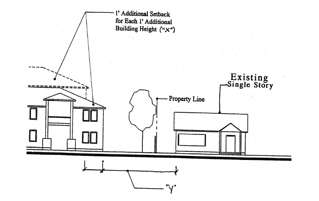
(Ord. No. 2009-03, 5-26-2009; Ord. No. 2009-14, 12-8-2009; Ord. No. 2011-09, 11-8-2011; Ord. No. 2020-15, 11-10-2020; Ord. No. 2023-07, 12-19-2023)
Sec. 8.270. - Master Development Plans.
A Master Development Plan is required as a condition of annexation, or after annexation, but prior to or concurrent with rezoning from Urban Holding-10 to other City zoning districts. The specific requirements for a Master Development Plan are:
1.
Applicability. This Section applies to properties proposed for annexation or rezoning from Urban Holding-10, except that in the event that an applicant has applied for a Planned Unit Development application prior to or concurrent with rezoning from Urban Holding-10, the Master Development Plan approval criteria shall be those used for the Planned Unit Development application and the Great Neighborhood Principles.
2.
Purpose. The purpose of Master Development Plan is to provide:
A.
Orderly and efficient development of the City consistent with the City of Redmond Framework Plan and adopted Area Plans.
B.
Compatibility or transitions with adjacent developments and the character of the area.
C.
A complementary mix of uses and activities.
D.
An interconnected transportation network (streets, bicycle routes, and pedestrian trails) within the master plan area and to existing and planned City streets, routes, and trails.
E.
A range of housing choices and densities for areas planned to have residential components.
F.
A range of open spaces and recreation facilities, as needed to facilitate the Framework Plan and an adopted Area Plan.
G.
Public and semi-public facilities and services.
H.
Preservation of historic buildings, scenic views, and natural resources to the greatest extent possible.
I.
Transitions or buffers between urban development and rural areas.
J.
Implementation of Redmond's Comprehensive Plan, including adopted Area Plans and the Great Neighborhood Planning Principles described in 3(C)(13) below.
3.
Procedures for Review.
A.
General. Master Development Plans (MDP or PMDP) shall be approved through a quasi-judicial review process. Application procedures and related fees for approval may be streamlined in order to promote timely development of urban planning for land zoned UH-10. The Community Development Director, or designee, shall inform the applicant during the mandatory pre-application stage if the proposed MDP area includes the necessary contiguous properties. The determination for the proposed plan area shall be based on utilizing the following factors:
1.
Whether there are properties that abut or are surrounded by the plan boundary that would reasonably fit within the zoning concept for the area plan;
2.
Whether the extension of public services and infrastructure would be enhanced by the inclusion of abutting properties;
3.
Whether the total acreage of abutting or enclave properties is less than the acreage in the proposed plan area; and
4.
There is a community interest that would be served by including additional properties in the plan area.
B.
Review and Approval Criteria for Master Development Plans (MPD) or Partial Master Development Plans (PMDP).
1.
General. In the review of any application for a Master Development Plan, the Planning Commission and City Council, if required, shall consider the following:
a.
Whether the proposed Plan is generally consistent with the Framework Plan, adopted Area Plan, and Comprehensive Plan in terms of land use, density, transportation systems and networks, adequacy of infrastructure and open space.
b.
Whether the proposed Plan is generally suitable for the area in which it is proposed, considering existing and planned neighborhoods, shopping and employment areas, and natural resources and hazards.
c.
Whether the proposed Plan is functionally integrated with developed or planned areas.
d.
The proposed Plan meets the applicable Great Neighborhood Principles.
C.
Master Development Plan (MDP) or Partial Master Development Plan (PMDP) Submittal Requirements and Approval Process.
An application for approval shall include the submittal requirements set forth in the City's Land Use Review application form as well as the elements described below.
1.
Narrative. A narrative shall set forth the goals and objectives of the plan and describe the urban characteristics of the planned area.
2.
Neighborhood Meeting. Proof a neighborhood meeting was conducted to provide an opportunity for the applicant to meet with surrounding property owners discuss the proposal. See Section 8.385 for meeting requirements.
3.
Development Plan Map. A map of the plan area and surrounding vicinity shall indicate planned land uses for each land parcel in the area, including plans for park and open space and community facilities, if known. The plan shall show proposed comprehensive plan map designations and zoning. The plan shall include a list of all affected properties with tax lot numbers, current ownership, parcel size, and other information that is pertinent to the plan.
4.
Land Use Diagram. The land use diagram shall generally indicate the distribution and location of planned land uses for the master plan area, including plans for park and open space and community facilities, if known. The plan shall show proposed comprehensive plan designations, zoning, and density.
5.
Significant Resources Inventory. An inventory of significant natural resources, scenic and historic resources, and open space areas including those identified on the City's adopted inventory and those that have the potential to qualify for protection under Redmond's Goal 5 resource protection program. When significant resources are present, the proposed plan shall include a management plan to protect resource sites.
6.
Parks and Open Space. Identify land suitable for park and recreation use in accordance with the needs analysis in the City of Redmond Park Master Plan (Park Plan) and an adopted Area Plan. In particular, where the Park Plan indicates there is a need for neighborhood or community park, the master plan shall identify sites that may be suitable for park development using the design and location criteria from the Park Plan or an adopted Area Plan. Density transfers, SDC credits, dedication, and other value consideration may be identified in the planning process to compensate property owners for land dedicated to public use.
7.
Air, Noise, and Water Resources. Review air, noise and water resources that may be impacted by planned development and address how adverse impacts will be avoided or mitigated in compliance with applicable local, State, and Federal regulations. The analysis may use City public facility plans, technical studies, and policies to meet this requirement when those plans address how urban development in the plan area can be served. In these instances, the Master Development Plan must show that the envisioned land uses in the plan area are consistent with the land use assumptions in the public facility plans. This requirement is particularly important for storm water management.
8.
Natural Hazard Areas. Inventory areas subject to natural hazards, particularly steep slopes, and program urban development that is suitable for the identified hazard areas.
9.
Residential Uses. Identify areas planned for housing development, if any, and the proposed zoning districts to be applied. The housing plan must identify a mix of housing types and densities so that the overall density in the area meets or exceeds the housing density objectives for the area that are identified in the Redmond Urban Framework Plan, adopted Area Plans, and the Comprehensive Plan. The Framework Plan and adopted Area Plans provide general guidance on housing densities that need to be achieved in order to meet future housing needs. Where proposed residential land uses differ from those shown in the Redmond Urban Framework Plan or adopted Area Plans, the master plan shall demonstrate how it meets the overall housing objectives of the Redmond Urban Framework Plan or adopted Area Plans. Applicants may propose new zoning districts when the proposed district(s) in total achieve the housing densities envisioned in the Redmond Urban Framework Plan or adopted Area Plans.
10.
Employment Uses. Identify areas planned for employment use and/or mixed uses and the proposed zoning for these areas. Applicants may propose new zoning districts in cases where existing districts are not suitable for the planned development provided the proposed district(s) achieve similar land improvement values and/or employment densities envisioned in the Redmond Urban Framework Plan or adopted Area Plans.
11.
Transportation Analysis and Diagram. Prepare a Transportation Impact Analysis (TIA) including a grid street plan that is consistent with street spacing and connectivity guidelines in the Redmond Transportation System Plan (TSP) and adopted Area or Framework Plans. The TIA shall identify and show:
a.
The proposed classification for all streets.
b.
The location of approved TSP improvement projects.
c.
Any capital improvements that may need to be added to the TSP in order to serve the plan area.
d.
Proposed bicycle pedestrian, and trail routes.
e.
Demonstrate how planned transportation facilities will connect to transportation facilities in adjacent urban areas.
12.
Public Facilities Analysis and Diagram. The plan shall include a conceptual layout of public facilities, including sanitary sewer, water, and storm drainage) needed to support the planned uses. The Public Facilities Analysis must be consistent with the City's adopted Public Facility Plan (PFP) and related facility master plans, including improvements related to the adopted Area Plan that may require amending the PFP.
13.
North Redmond US 97 Interchange Area Management Plan (IAMP) Compliance. The master plan shall comply with the following policies, if applicable:
a.
Any property newly annexed within the IAMP area shall have:
i.
Direct Access to a local public street other than a State highway consistent with the Local Street Connectivity Plan; and,
ii.
Any property to be annexed to the City shall relinquish all direct access rights to a State highway as a condition of development approval (when a legal alternative access exists).
14.
Great Neighborhood Principles. MDPs shall address applicable Great Neighborhood Principles below. In instances where the property proposed for a MDP is located within the boundary of an adopted Area Plan, the MDP shall also address the Great Neighborhood Principles according to the specificity provided in the Area Plan.
a.
Transportation. Connect people and places through a complete grid street network and trail system that invites walking and bicycling and provides convenient access to parks, schools, neighborhood service centers, and possible future transit stops. Traffic calming techniques and devices may be required to slow vehicles. Curved streets are encouraged to provide interest and variety in neighborhood design. Trails shall be provided to link with existing or planned pedestrian facilities.
b.
Housing. A mix of housing unit types and densities shall be integrated into the design of new neighborhoods consistent with zone requirements unless a variance or other planning permit is approved.
c.
Open spaces, greenways, recreation. All new neighborhoods shall provide open spaces with recreation amenities that are useable to the public and are integrated to the larger community via trails or pathways. Parks and plazas shall be developed in accordance with Redmond's Parks Master Plan, or otherwise should be centrally located in the neighborhood and capable of supporting public gathering places. New neighborhoods should retain and incorporate significant geological features such as rock outcroppings or stands of clustered native trees into the design and lot layout.
d.
Integrated design elements. Streets, civic spaces, signage, and architecture shall be coordinated to establish a coherent and distinct character for the MDP. MDPs may integrate design themes with adjacent developed or planned areas.
e.
Diverse mix of activities. A variety of uses are encouraged in order to create vitality and bring many activities of daily living within walking and biking distance or a short drive of homes. Amenities including, but not limited to, trails, recreation areas, and open spaces, shall be constructed before occupancy of any residential unit, unless a phasing plan is approved. Commercial service areas must be supported by a market analysis and phasing program which will be used by the City to determine construction timing.
f.
Public Art or Artistic Feature. Places for the installation of public art or artistic feature is required to provide focal points, preferably, at the gateways to neighborhoods, in and around the center of neighborhoods, or trailheads.
g.
Scenic Views. Identify and preserve scenic views and corridors of the Cascade Range, Ochoco Mountains, and Smith Rock, such as in street view sheds or park areas. Streets and common, or public, open spaces should be located and oriented to capture and preserve scenic views for the public. Minimize visual clutter from signs and utilities within scenic corridors.
h.
Urban-Rural Interface. Residential development adjacent to areas outside of the Urban Reserve Area (URA) shall provide buffering to manage the transition from urban to rural intensities by meeting at least one of the following standards:
i.
Provide 100-foot-wide landscaped buffers, exclusive of rights-of-way, for the entire length that the urban development is adjacent to lands outside of the URA. The buffers shall be landscaped with native vegetation characteristic of the local ecosystem; or
ii.
Locating lower density development at the urban-rural interface; or
iii.
Other appropriate and equivalent transitional elements as approved by the Review Authority.
i.
Pocket Parks/Tot Lots. Fully developed "pocket parks" or "tot lots" shall be incorporated into medium and high density zoned residential subdivisions and site plans. These areas shall be developed for every 25 lots/units, a minimum of 3,000 square feet and privately maintained. Examples of amenities include: turf areas, benches, deciduous shade trees, irrigation, shrubs, natural or decorative features, and adequate trash receptable(s) and lighting.
j.
Canal Trails. If canals or laterals are present, multi-use trails at least ten feet wide shall be provided, subject to the Central Oregon Irrigation District's review and approval. Pedestrian amenities such as benches and trash receptacles shall be provided at appropriate locations (e.g., every 500 feet, at trailheads or intersections with public streets).
k.
Green Design. Land divisions and site plans shall incorporate principles of sustainable design befitting the natural ecosystem of Central Oregon. These principles may be incorporated through the layout of individual lots and the configuration of neighborhoods and include energy efficient siting and construction of buildings, water-wise and native landscaping, and amenities to provide for walkability via shade and priority access for pedestrians, or other such similar design strategy.
D.
Implementation. Upon approval, all subsequent development located within the MDP boundaries shall be consistent with the approval.
E.
Amendment/Modification to Master Development Plan. Any modifications to the approved MDP shall be subject to the standards and procedures in Article II, "Modifications", and subject to the review criteria contained in this Section.
F.
Expiration of Master Development Plan. An approved MDP or PMDP shall be subject to the requirements of Section 8.1605 concerning expiration, unless a specific timeline is approved through the land use review process.
(Ord. No. 2022-04, 6-28-2022; Ord. No. 2022-09, 12-13-2022; Ord. No. 2023-07, 12-19-2023)
Sec. 8.275. - Planned Unit Development (PUD).
1.
Purpose and Applicability. The purpose of a PUD is to:
A.
Permit greater flexibility in land use regulations in applicable zones (e.g., reduction of minimum lot size requirements).
B.
Encourage creative developments.
C.
Incentivize a variety of land uses and housing types, mixed use, the economy of shared services and facilities, public amenities, and developments compatible with the surrounding area and neighborhoods.
D.
Promote and encourage infill development, flexibility in improvements on lots, and affordable and workforce housing.
E.
Encourage preservation of natural features and enhancement of the area vegetation.
F.
Facilitate sustainable design, energy efficiency, desirable aesthetics, and efficient use of open space.
Density requirements, setbacks, land use regulations, and required improvements may be adjusted to allow for a more creative, functional, and desirable living environment. In return for greater flexibility in site design and development, the PUD process introduces special requirements and standards for approval.
2.
Approval. PUD approval is subject to:
A.
Land use review and approval as Conditional Use.
B.
Zoning standards, except as modified by the PUD.
C.
Subdivision and Partitions Standards, except as modified by the PUD.
D.
Site and Design Review Standards, except as modified by the PUD.
E.
PUD Standards and Requirements.
3.
Exceptions. Exceptions of City standards may be allowed through the PUD approval process without a variance.
A.
Exceptions shall substantially result in improved design of the PUD. Improved design includes but is not limited to: alleys; public or private parks, trails, recreational areas, open spaces, common or natural areas; innovative housing design; public or private activity areas; a mixture of housing types, sizes, and projected prices; energy efficient design; a variety of trees and landscaping; art and other similar design features. A PUD need not include all of these design features in order to be approved.
B.
Exceptions to City standards include, but are not limited to:
1.
Minimum lot sizes.
2.
Setbacks.
3.
Permitted land uses.
4.
Grid street spacing standards.
5.
Connecting to public utilities, subject to acceptance by City Engineer.
6.
Street frontage, street and right-of-way width, sidewalk placement and standards, subject to acceptance by City Engineer.
7.
Landscaping.
8.
Fences and walls.
4.
Standards and Requirements. The following standards and requirements apply to a PUD application:
A.
PUDs must be a minimum of one acre in size. In the Downtown Urban Renewal District, a minimum of 0.5 acre in size.
B.
The applicant shall submit a written narrative that addresses the applicable standards, code, and regulations.
C.
A PUD approach may be utilized in the design and development of residential, mixed use, or commercial and industrial service areas.
D.
Densities. Maximum densities are identified in Table 8.140. Additional density (i.e., bonus density) beyond the maximum density will be considered as follows:
1.
Up to 20 percent beyond maximum densities for qualified Affordable Housing and Workforce Housing units. A bonus density request beyond 10 percent shall be restricted to Affordable Housing. Affordable and Workforce Housing units should be designed to be intermixed throughout the development and similar design and quality to market rate units.
2.
Up to 10 percent beyond maximum densities for including amenities that provide a community benefit or helps realize specified public policy goals. Examples include: additional protection of green space, recreational areas, open space, natural resources or view corridors. environmental improvements, trail connectivity, higher quality building design, or other additional amenities.
3.
As identified in respective Area Plans.
E.
A PUD must include usable open space, recreational area, common area or park designed for the use and benefit of all the units or lots in the development. The land area used shall be determined by the type of amenities added by the developer. See examples below:
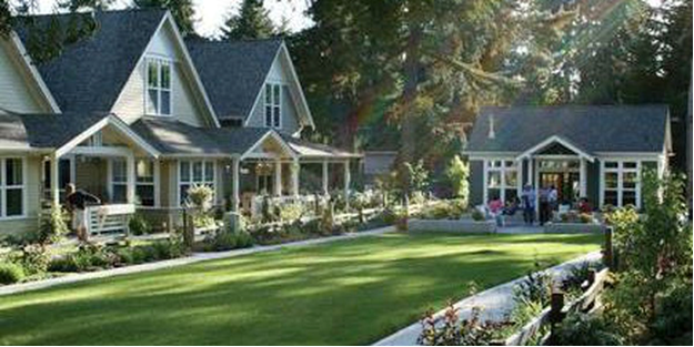
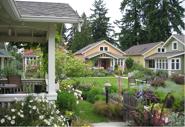
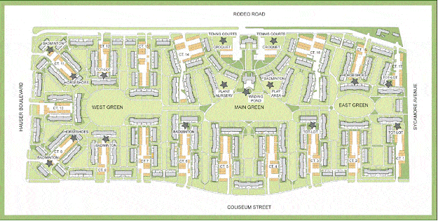
F.
Thoughtful design and architectural themes are required for all structures within any development. Design shall take into consideration themes continues on all elevations for each building, and onto the entire site including, but not limited to: lighting, fencing, accessory structures, signage, and trash enclosures.
G.
A separate application or rezoning may accompany the application for approval of the PUD in which case the two items shall be considered simultaneously.
H.
The City may recommend a performance bond or other surety to assure the proposed development will be completed as approved and within the time limits agreed to in the conditions of approval.
5.
Review Procedure for PUD's. The following procedure shall be followed in requesting approval of a PUD.
A.
A pre-development meeting is required prior to submittal of an application.
B.
Proof a neighborhood meeting was conducted for residential or mixed-used development proposals that generate 200 or more daily trip ends, or 20 or more PM peak hour trip ends, where a Transportation Impact Analysis (TIA) is required, See Section 8.385 for meeting requirements.
C.
An applicant shall submit an electronic version of the complete application. The plan shall contain and show, at an engineer's scale of no less than 1" =10', the following information:
1.
The relationship of the property to the surrounding area.
2.
The preliminary plan of subdivision or re-subdivision, if any, which shall include the information required by the Subdivision Ordinance.
3.
Land uses, building locations, density proposed, architectural style, efficiency measures, housing market served, and number of dwelling units.
4.
The arrangement of streets and pedestrian ways.
5.
Proposals that include reduced yards and lot size shall be designed to be served by private alleys or drives.
6.
The location of off-street parking spaces, and a parking management plan if the total number of spaces required exceeds 75.
7.
The location of service commercial areas, open space, recreational area, common areas, or park.
8.
Plans for site grading and drainage.
9.
Plans for water supply and sewage disposal.
10.
Plans for transfer of ownership of the property, if any, and arrangements for maintenance of common areas and facilities.
11.
Landscape plan including the list of species proposed and size/coverage at time of planting and at five years.
12.
Proposed project timing schedule and surety, if required by City.
D.
In considering the PUD, the City shall determine:
1.
There are special development objectives or physical conditions which justify a request for a PUD.
2.
The PUD will contain buffers on sides of the development that abut neighboring properties.
3.
The PUD, through its design and function, will improve livability for planned residents.
4.
The PUD contains a mix of housing types, variety of uses or services.
5.
The PUD can be completed within five years or phased for later development.
6.
The PUD will not overload adjacent streets, utilities, or infrastructure.
7.
The PUD will be consistent with the objectives of Area Plans and the Redmond Comprehensive Plan.
E.
The City Shall notify the applicant whether in its judgment the foregoing provisions have been satisfied and, if not, whether they can be satisfied with other alternatives or revision to the PUD.
6.
PUD Post Approval & Modifications. Where a PUD has been authorized pursuant to applicable zoning regulations, the plan of the subdivision shall conform with the plan of the PUD as approved.
Minor Modification. Minor modification to an approval PUD will be granted when the requested change is so minor that the CDD Director, or designee, determines that it would be appropriate for an administrative decision. Examples of minor changes include, but are not limited to: (1) a reduction in the overall number of lots, (2) minor architectural changes to approved buildings, (3) changes to phases that do no impact public facilities or change the number of approved phases, (4) changes that result in a reduction of impacts (i.e., reduced traffic flows), or (5) changes that are required to protect or increase public safety.
Major Modification. Major modifications to an approved PUD are subject to Section 8.1400.
(Ord. No. 2016-17, 1-31-2017; Ord. No. 2018-09, 9-11-2018; Ord. No. 2020-15, 11-10-2020; Ord. No. 2022-04, 6-28-2022; Ord. No. 2022-09, 12-13-2022; Ord. No. 2023-07, 12-19-2023)
Sec. 8.280. - (Reserved)
Editor's note— Section 8.280 "Cluster Developments" was amended by Ord. No. 2016-17 passed January 31, 2017. Later, was amended by Ord. No. 2017-12 passed December 12, 2017. Later, was amended by Ord. No. 2018-09 passed September 11, 2018. Later, was amended by Ord. No. 2020-15 passed November 10, 2020. Later, was deleted by Ord. No. 2022-04 passed June 28, 2022.
Sec. 8.285. - (Reserved)
Editor's note— Section 8.285 "Cottage Developments" was amended by Ord. No. 2016-17 passed January 31, 2017. Later, was amended by Ord. No. 2020-15 passed November 10, 2020. Later, was amended by Ord. No. 2022-09 passed December 13, 2022. Later, was deleted by Ord. No. 2023-07 passed December 19, 2023.
Sec. 8.286. - (Reserved)
Editor's note— Section 8.286 "Planned Unit Development (PUD), Cluster Development (CLD), and Cottage Development (COD) Review Procedure, Application Materials, and Approval Criteria" was amended by Ord. No. 2016-17 passed January 31, 2017. Later, was deleted by Ord. No. 2020-15 passed November 10, 2020. Later, was deleted by Ord. No. 2022-04 passed June 28, 2022.
Sec. 8.287. - (Reserved)
Editor's note— Section 8.287 "Amending a Planned Unit, Cluster or Cottage Development" was deleted by Ord. No. 2020-15 passed November 10, 2020. Later, was deleted by Ord. No. 2022-04 passed June 28, 2022.
Sec. 8.300. - (Reserved)
Editor's note— Section 8.300 was amended by Ord. No. 2015-01 passed February 24, 2015. Later, was amended by Ord. No. 2016-17 passed January 31, 2017. Later, was amended by Ord. No. 2017-12 passed December 12, 2017. Later, was renumbered to Section 8.270 by Ord No. 2022-04 passed June 28, 2022.
Sec. 8.305. - Establishment of Clear Vision Areas.
Clear vision areas must be established at the intersection of two streets, an alley and a street, a driveway and a street, or a street and a railroad right-of-way. These standards apply to public and private streets, alleys, and driveways. The clear vision area is triangular shaped and extends across the corner of private property to the face of the curb at the adjacent street or alley. The two legs of the clear vision area are each measured from the point of intersection of the two corner lot lines or access easement lines. Where rounded corners are present, the two legs of the clear vision area are measured from the point of intersection that would result from extending the two corner lot lines. Measurements along a driveway are taken at the edge of pavement. No structures, fences, or sight obstructions are permitted in the clear vision area, except as permitted in Section 8.310 Exceptions to Clear Vision Areas.
Clear vision distances shall be measured as follows:
ILLUSTRATION—STREET TO STREET CLEAR VISION AREA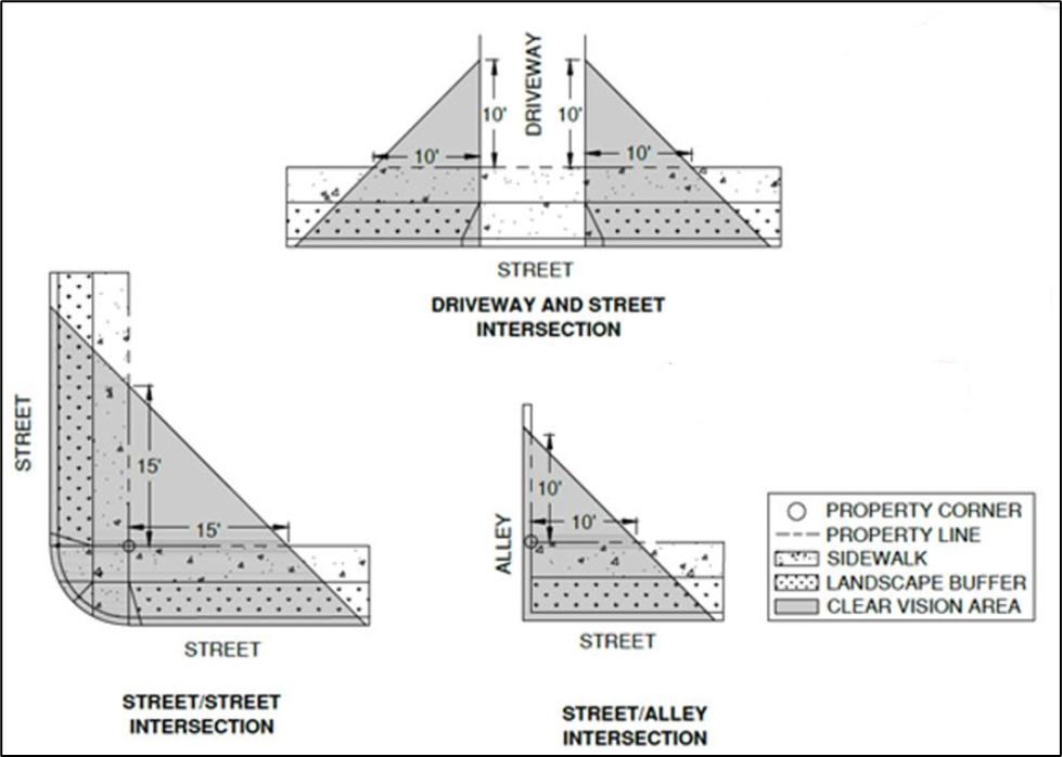
1.
Curb Painting. Curbs within clear vision areas shall be painted yellow when any of the following exist or are proposed:
A.
A commercial, industrial, or mixed-use development is proposed adjacent to a residentially-zoned area;
B.
Intersections of local roadways intersecting collector or arterial roadways; and
C.
Clear vision areas for which curb painting is deemed necessary by the City Engineer.
D.
Exceptions. Curbs shall not be painted yellow:
1.
In the Downtown Overlay District, or
2.
Where curb extensions exist or are proposed.
(Ord. No. 2020-15, 11-10-2020; Ord. No. 2023-07, 12-19-2023)
Sec. 8.310. - Exceptions to Clear Vision Areas.
The following are exempt from compliance with the clear vision area standard:
1.
Utility post or column;
2.
Tree trunk (clear of branches or foliage up to eight feet from curb height);
3.
Telephone or power poles;
4.
Plants less than three feet tall; and
5.
Utility boxes or pedestals less than three feet tall.
(Ord. No. 2023-07, 12-19-2023)
Sec. 8.315. - Construction or Alteration of Gas or Card-lock Stations.
Any gas or card-lock stations which are constructed or undergo major alteration subject to the parameters of Sections 8.3005 and 8.3010 shall conform as follows:
1.
Minimum lot size for gas or card lock stations:
A.
The minimum lot size for station sites shall be 10,000 square feet on a corner lot and 12,000 square feet on any other lot.
B.
The minimum street frontage on a corner lot shall be 100 feet.
C.
The minimum street frontage for station sites on other than a corner lot shall be 120 feet.
D.
The minimum lot depth shall be 100 feet.
Sec. 8.320. - Gas, Card-Lock, or Fuel Container Abandonment.
Any change of use proposed for any facility containing underground or above ground fuel containers shall provide verification from DEQ that all tanks have been removed or have been disabled and decontaminated. Verification of removal and/or decontamination shall occur prior to any building permit being issued for construction or for a change of use.
(Ord. No. 2020-15, 11-10-2020)
Sec. 8.321. - Canopy Standards.
For any use or structure proposing an overhead canopy, the following standards shall apply:
1.
Definition. A permanent roofed structure which may be free- standing or partially attached to a building for a purpose of providing shelter to patrons in automobiles, and patrons on foot, but shall not mean a completely enclosed structure.
2.
Setbacks. Canopy setbacks shall be measured from the edges of the canopy structure closest to the respective property lines and shall meet the setback requirements of the underlying zone, with the exception of, the C-2 zone where there are no required setbacks. The canopy structure shall be set back not less than ten feet from any property line.
3.
Lighting. All lighting directly or indirectly associated with a canopy shall be recessed from direct view from any public or private road, and from all neighboring properties.
4.
Stacking Distance. See Section 8.322, "Stacking Room".
(Ord. No. 2020-15, 11-10-2020)
Sec. 8.322. - Stacking Room.
For any use that has drive-up service, the following shall apply.
1.
Car Length. For this purpose, a car length is deemed to be 20'.
2.
Standards. The following shall apply to all on-site stacking room, which is required for any type of drive-up service:
A.
For any single window, gas pump, or other drive up use that is singular in nature (other than espresso stands or fast-food pickup windows) requiring one drive aisle, the minimum stacking room including the pickup location shall be five car lengths.
B.
For two or more pick up windows, gas pumps, or other drive up uses, the minimum stacking room shall be four car lengths for each window, pump, or similar use.
C.
For any fast-food use (excluding espresso stands), the required stacking room per drive up window is seven car lengths.
D.
The required stacking room for any espresso stand, coffee kiosk, or similar use, is three car lengths per pick up window.
E.
Any use that is not identified herein shall incorporate the minimum standard (five car lengths), or City staff may at their discretion allow for reduction in the amount of required stacking room with the finding that the use will not require the minimum stacking distance.
F.
At no time shall stacked cars conflict with any required parking, on-site access, or required loading/unloading area on or adjacent to the site.
G.
Any proposed stacking area immediately adjacent to any residence shall incorporate a six foot tall solid wall as a sound barrier between the commercial use and residence.
(Ord. No. 2020-15, 11-10-2020)
Sec. 8.323. - Minimum Standards for the Construction or Alteration of a Detached Accessory Structure (non-dwelling).
1.
The maximum lot coverage for any accessory structures requiring a building permit shall be no more than a total of 35 percent of the lot size. A Conditional Use Permit is required for the construction of any accessory structure or garage which is over 1,500 sq. ft. or over 80 percent of the size of the residence, whichever is less.
2.
Any accessory structure other than the vehicular opening of a garage shall be set back at least five feet from any property line, except as otherwise required by clear vision.
3.
Accessory structures requiring a building permit shall meet all solar requirements.
4.
Detached accessory structures shall not be located in any required front or side yard setback.
5.
Vehicle entrances into detached garages or carports shall be set back no less than 20' from any alley.
Sec. 8.325. - Accessory Dwelling Units and Guest Houses.
Accessory Dwelling Units (ADU's) and Guest Houses, when allowed in the underlying zone, are permitted subject to the following. The terms "accessory dwelling unit" and "guest house" are used synonymously herein except for the size limitations and are listed as separate and distinct uses in Section 8.135, Table A; guest houses shall not contain kitchens.
1.
Development Standards.
A.
The size of a stand-alone accessory dwelling unit shall be no less than 300 square feet in gross floor area and no more than 900 square feet in gross floor area. Guest houses shall be no less than 300 square feet in gross floor area and no more than 1200 square feet in gross floor area.
B.
ADU Setbacks and Height:
C.
If the accessory dwelling unit is located above a garage, the ADU may not exceed the footprint of the garage.
2.
An accessory dwelling unit must be able to function as a separate dwelling unit. This includes the following:
A.
The accessory dwelling unit must be separately accessible from the exterior. An interior entrance to the primary residence may be approved, pursuant to review and acceptance by the Community Development Director, or designee.
B.
The accessory dwelling unit must have separately accessible utilities, unless served by the primary residence.
C.
The accessory dwelling unit shall contain a kitchen.
D.
The accessory dwelling unit shall contain a bathroom.
E.
The accessory dwelling unit shall not be a Recreational Vehicle (RV) or portion thereof.
3.
The finished floor height of an accessory dwelling unit shall be entirely above the natural or finished grade, whichever is higher, on all sides of the structure.
4.
An accessory dwelling unit shall be located within the dimensional requirements of the zone district in which the property is located and cannot be located in front of the forward-most façade of the primary dwelling.
5.
If the entrance is accessed via stairs, a covered porch, or other sufficient means of preventing snow and ice from accumulating on the stairs shall be provided.
6.
Accessory dwelling units shall be developed in accordance with the requirements of this title which apply to residential development in general. These include, but are not limited to, all applicable International Building and Fire Code requirements related to adequate natural light, ventilation, fire egress, fire suppression, and sound attenuation between living units. This standard may not be varied.
(Ord. No. 2016-17, 1-31-2017; Ord. No. 2020-15, 11-10-2020; Ord. No. 2022-04, 6-28-2022; Ord. No. 2022-09, 12-13-2022; Ord. No. 2023-07, 12-19-2023)
Sec. 8.330. - Exterior Lighting.
1.
Purpose. The purpose of this code Section is to allow residents, businesses, and public entities to adequately illuminate the outdoor areas on their property without adversely impacting the use of adjacent property and minimizing the impact on Redmond's dark skies.
2.
Applicability. The provisions of this code Section apply to all outdoor lighting, including security lighting in all zones, unless exempted under this code Section. All outdoor lighting subject to this code Section shall comply with these requirements. This includes, but is not limited to, new lighting, replacement or repair of existing nonconforming lighting, and any other lighting whether attached to structures, poles, the earth, or any other location that illuminates exterior areas of the property. It is the property owner's responsibility to ensure compliance with this code Section, including lighting installed by a third party or prior property owner.
3.
Requirements for Lighting Regulated by this Code Section.
A.
All lighting shall be downcast and use a shielded fixture or other means to limit up lighting. The terms "downcast and shielded" mean that the fixture allows no light emission above a horizontal plane through the bottom of the fixture. See illustration A which illustrates downcast lighting and up lighting.
B.
Lighting shall not shine into neighboring residences, or onto public streets.
C.
Lighting in the canyon or within 25' of the canyon rim shall be submitted to and reviewed by the Community Development Director or Planning Commission prior to installation for compliance with this code Section.
4.
The following shall be exempt from the provisions of this code Section:
A.
City approved lighting within public right-of-way or easement for the principal purpose of illuminating streets, roads, and street signs.
B.
Lighting for public facilities including but not limited to, City Hall, public monuments, public art, public parks, and public landscaping.
C.
All lighting at the Redmond Municipal Airport.
D.
All lighting at the Deschutes County Fairgrounds.
E.
All lighting for public schools, except that sport field lighting shall be turned off within one hour of the end of the event or game.
F.
All lighting of buildings designated as historic by the City of Redmond.
G.
Sign lighting that is otherwise regulated by the provisions of the City of Redmond Sign Code.
H.
Temporary lighting for theatrical, television, performance areas and construction sites as approved by the Community Development Department.
I.
Underwater lighting in swimming pools and other water features.
J.
Emergency lighting that is only used under emergency conditions and other lighting being used during police declared emergency.
K.
Lights used for holiday decorations.
L.
Motion detector lights that operate automatically for periods of less than ten minutes.
M.
Lighting of flags for the United States, State of Oregon, POW, and City of Redmond.
N.
Lighting required by Federal or State laws or regulations.
O.
Outdoor lighting fixtures lawfully installed prior to and operable on the effective date of this code Section, and which are in compliance with the prior version of Section 8.330 may continue to be used as a nonconforming light fixture. Any repair, replacement, or relocation of outdoor light fixtures as of the effective date of this code Section shall be subject to the provisions of this code Section.
Illustration A: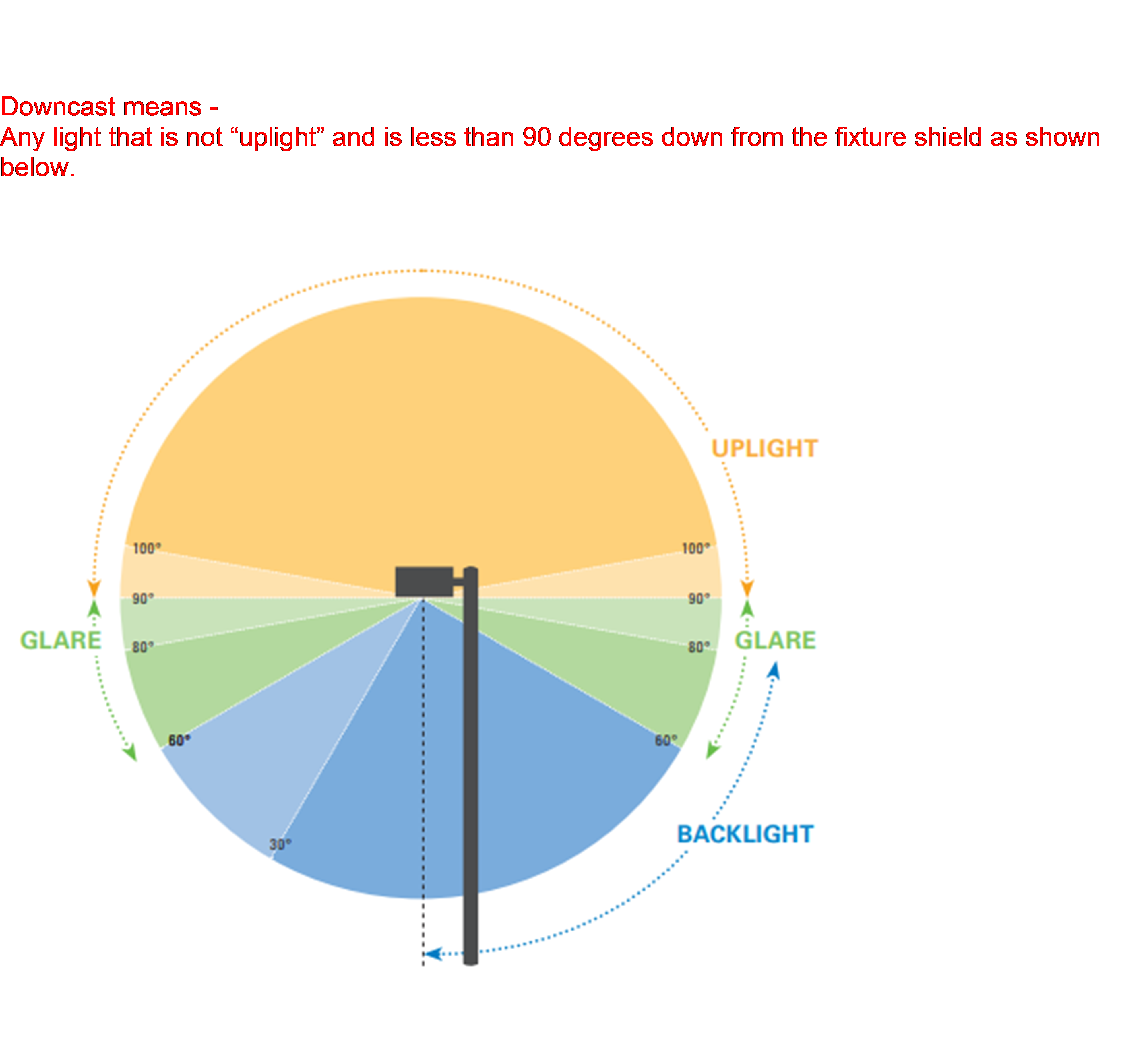
(Ord. No. 2018-12, 11-13-2018)
Sec. 8.335. - Development Standards Along the Perimeter of the Canyon.
1.
The following rules apply to any development within 100 feet of the canyon rim:
A.
Any dwelling or accessory structure shall be less than 24 feet in height and setback at least 25 feet from the canyon rim;
B.
No existing trees within 25 feet of the canyon rim, over three inches caliper measured three feet above ground level shall be removed from the site or, if removed, are replaced by an equal number of tree(s) that are at least two inches caliper measured three feet above ground level;
C.
Development shall maintain the natural appearance of the canyon rim; no alteration of the rock formation portion of the canyon rim is permitted;
D.
No fence is constructed within ten feet of the canyon rim;
E.
All lots fronting on the canyon rim shall be a minimum of 9,000 square feet;
F.
No deck, patio or structure requiring a building permit may be constructed within ten feet of the canyon rim;
G.
Lighting shall be met subject to Section 8.330, "Exterior Lighting".
2.
A Conditional Use Permit is required for the following Development along Redmond Dry Canyon:
A.
Any structure exceeding 24' height, or is located within 25' of the canyon rim;
B.
Any structure not governed by Subsection (A.1.) located in a side or rear yard area adjacent to the canyon rim.
C.
Decks or patios shall be setback from the canyon rim the same number of feet as the height of the deck or patio from the ground.
(Ord. No. 2016-17, 1-31-2017; Ord. No. 2022-04, 6-28-2022)
Sec. 8.340. - Fences.
All fences constructed shall comply with the following standards. For the purpose of these standards, fences refer to fences, lattice work, screens, or walls (other than a retaining wall). The intent of these standards is to ensure that fencing contributes positively to the appearance of the community and neighborhoods, and that the scale, location, and aesthetics of fencing does not adversely affect surrounding properties or public safety.
1.
On all properties one acre or less in size, in all Residential Zones (including residential uses in the C-2 Zone and in the Downtown Overlay District) and the Urban Holding Zone, all fences shall be developed to the following standards:
A.
Fences abutting a local public street shall comply with the following:
1.
Fences in front yards, and in that portion of side yards extending from the front property line to the front façade of the dwelling, shall be a maximum of 3½ feet tall.
2.
On corner lots, only one front yard restriction is applied relative to the 3½ feet fence height restriction, in which case, the fence along the non-front yard designated side may be up to six feet tall from the front façade of the house back to the rear property line (see fence example in Figure 1).
3.
Fences in that portion of side yards extending from the front façade of the dwelling to the rear property line, and all rear yards, shall be a maximum of eight feet tall.
4.
Fences located in side and rear yards shall incorporate architectural columns consisting of materials such as stone, brick, rock, wood, or other similar products, at each property corner along the fence that abuts the street. (See: Examples). The columns shall be a minimum of 12" × 12" in size.
5.
Fences shall be constructed of wood, vinyl, or wrought iron. Chain link fences are not permitted. Other types of fence material, powder coating and construction may be approved by the Community Development Director, or designee, subject to conforming with the intent statement above.
6.
Fences in side or rear yards which abut an alley shall be allowed to be eight feet in height. (Note: the Oregon State Building Code — as defined in State Statute — indicates that fences in excess of seven feet in height require a building permit and may need to be professionally engineered).
7.
Fences which encroach into the public right-of-way shall be treated as a nuisance and shall be subject to enforcement pursuant to Section 8.805.
B.
Fences abutting a collector or arterial street shall comply with the following:
1.
In addition to the requirements for fences abutting a local street, fences located in side and rear yards that abut a collector or arterial public street shall in addition incorporate a minimum five inches wide square column every eight feet along the fence with a cap added to the top of each column that is a minimum of a ½" larger in each direction and a minimum of one inch in height.
C.
Fences not abutting a public street shall comply with the following:
1.
Fences located in the side or rear yards shall not exceed eight feet in height. (Note: the Oregon State Building Code — as defined in State Statute — indicates that fences in excess of seven feet in height require a building permit and may need to be professionally engineered).
D.
No fence in any residential zone, except as exempted by Section 8.340(5.), shall be constructed with barbed wire, razor wire, or similar apparatus.
Figure 1 Corner Lot Fence Example
2.
In all Commercial Zones (except for the C-2, Central Business District Zone, and the Mixed-Use Zones), the PF-Public Facility Zone, the Park Zone, and in any Industrial Zone, all fences shall be developed to the following standards:
A.
The maximum height of a fence shall not exceed eight feet. (Note: The International Building Code indicates that fences in excess of seven feet in height require a building permit and may need to be professionally engineered).
3.
For any development undergoing land use review, any wood or vinyl fence bordering a street shall incorporate architectural elements in accordance with Section 8.340(1.A.4.) and/or (1.B.1.) herein.
4.
All fences, regardless of zone or location, shall comply with the following requirements:
A.
Fences fronting public streets shall provide one gate, opening, or other site access for emergency services use. For corner lots, only one opening along either the front or side yard frontage is required.
B.
Fences shall comply with the clear vision standard in Section 8.305.
C.
Fences shall be constructed on private property and shall not be located in public rights-of-way.
D.
Fences shall be comprised of wood, vinyl, metal, or other sturdy material that is able to be painted and/or maintained in structurally sound condition. All fences shall be free from exposed nails, screws, loose members, decaying materials, or other similar conditions that can pose a hazard.
5.
The following fences shall be exempt from the standards set forth herein, except for the requirement to comply with the clear vision standard in Section 8.305, as listed in Section 8.340(4.B.) above:
A.
Any security fencing around a public or quasi-public utility or entity including the Airport perimeter.
B.
Fences related to a park or school use including (but not necessarily limited to) tennis courts, driving ranges and ball fields.
C.
Fences necessary for compliance with any documented Federal or State mandated requirements (i.e., Homeland Security requirements).
D.
Any fence exempted under Subsections (5.A. and B.) herein that is in excess of 20 feet in height shall require conditional use permit review and approval, and a public hearing.
Examples:
E.
In the C-2 and DOD zoning districts, fences shall comply with the following standards:
Track 1. Fences along street frontages and/or in front of a building shall be no taller than four ft. Fences shall be made of wood, wrought iron, powder coated chain-link, and shall be at least 75 percent transparent in composition. Proposals that do not fit the Track 1 provision shall be processed as a Track 2 application.
Track 2. As an alternative to the Track 1 standards, fencing proposals must utilize alternative designs if they reflect the architectural theme of the building and site. They must also show how the public is separated from the on-site activities in an aesthetic and practical manner. In no case shall fences be taller than six feet in height.
(Ord. No. 2013-04, 5-14-2013; Ord. No. 2014-14, 7-22-2104; Ord. No. 2016-17, 1-31-2017; Ord. No. 2018-09, 9-11-2018; Ord. No. 2020-15, 11-10-2020; Ord. No. 2022-04, 6-28-2022; Ord. No. 2022-09, 12-13-2022; Ord. No. 2023-07, 12-19-2023)
Sec. 8.345 - Home Occupation.
The purpose of a home occupation is to allow residents the opportunity to engage in a home-based business. Home occupations shall have characteristics that are indistinguishable from the residential use of a dwelling, or property, and do not infringe upon the rights of nearby residents. Meeting the criteria below shall be considered and permitted as uses accessory to the residential use of a dwelling.
1.
The home occupation is to be secondary to the main use of the property as a residence. The home occupation can occur in the primary dwelling or in an accessory structure on the same property.
2.
No structural alterations shall be allowed to accommodate the home occupation except when otherwise required by law, and then only after the plans for such alterations have been reviewed and approved by the City. Such structural alterations shall not detract from the outward appearance of the building as a residence.
3.
The home occupation must be conducted wholly within lawfully built enclosed structures and in such a manner as not to give an onward appearance of a business.
4.
Outdoor storage, including but not limited to, inventory, supplies, or equipment, must be completely screened behind a sigh-obscuring fence or within an enclosed structure; stored products; equipment, or materials shall not be visible from the public right-of-way or adjacent properties or common area.
5.
A home occupation is prohibited which is inconsistent with the residential use of the property or creates adverse impacts such as: noise, vibration, smoke, dust, odor, generation or addition traffic, or other factors.
6.
No materials or commodities shall be delivered to or from the property which are of such bulk or quantity as to require delivery by a commercial vehicle or a trailer or the parking of customer's vehicles in a manner or frequency as to cause disturbance or inconvenience to nearby residents or so as to necessitate off-street parking.
7.
Exterior signs shall be limited to those permitted in the zone in which the home occupation is located. There shall be no other exterior indication of the home occupation.
8.
Allows on-site one business related vehicle or truck not exceeding 15,000 pounds gross vehicle weight and one other non-motorized wheeled trailer, which shall not exceed 10,000 pounds gross vehicle weight. No commercial vehicle as defined in ORS 801.208, as amended, is permitted as part of a home occupation.
9.
There shall be no retail sales from the premises.
10.
Home occupation licenses are subject to City Cody Section 5.335 et seq. governing nuisances and noise.
(Ord. No. 2020-15, 11-10-2020; Ord. No. 2022-04, 6-28-2022)
Sec. 8.350. - Design Standards for All Residential Structures and Sites Fronting Both Public or Private Streets and Alleys.
1.
The front doors and front facade of all primary dwelling units shall face a public or private street.
2.
At least one yard facing a public or private street shall provide a gate, opening, or other access for emergency service use.
3.
For all residential lots served by alleys and fronting a public or private street, addresses shall be clearly visible from the street rather than from the alley.
Sec. 8.360. - Placement of a Temporary Residence.
A temporary residence may be placed on a site in conjunction with the issuance of a building permit for a period of six months following the date of issuance. A property owner may apply for a permit allowing such placement by filing an application with the Community Development Director on a form provided by the Planning Department. The Community Development Director shall issue said permit but may attach conditions deemed necessary to minimize the impact of the placements on the adjacent properties. The Community Development Director may also grant an additional six months for the permit if the applicant can establish the extension is necessary.
Sec. 8.362. - Placement of Temporary Residences for Medical Hardship.
A temporary residence shall be allowed as an additional dwelling due to a medical hardship under the following restrictions:
1.
The temporary residence shall be placed within 100 feet of the main dwelling.
2.
The temporary residence shall be connected to the same sewage facility as the main residence where applicable.
3.
The applicant shall renew the permit on an annual basis and the Community Development Director shall review permits issued at any time and may revoke the permits when they are found to not be needed for the original purpose.
4.
The applicant shall provide a letter from a physician documenting the need for the temporary residence.
5.
The temporary residence must be removed within 90 days after termination of the permit.
6.
The temporary residence must meet all the required setbacks.
7.
If the temporary residence is visible from any adjacent property, site obscuring, screening shall be required.
Sec. 8.364. - Beekeeping.
The purpose of this Section is to regulate the keeping of bees on residential lots within the City of Redmond. This activity is considered to be an accessory use subject to the following standards:
1.
Location, Density, and Maintenance of Colonies.
A.
The number of colonies is limited to one colony per legal lot of up to 5,000 sq. ft. of lot area, plus one additional colony per each additional 5,000 sq. ft. of lot area, up to a maximum of eight colonies regardless of lot size.
B.
Colonies shall be located in the side or rear yard and set back no less than 10 feet from the nearest property line.
C.
Hives shall be placed on property, so the general flight pattern of bees does not unduly impact neighboring properties or their inhabitants. If any portion of a hive is located within 30 feet of a public or private property line, a flyaway barrier at least six feet in height shall be established and maintained around the hive. The flyaway barrier shall be located along the property boundary or parallel to the property line, and shall consist of a solid wall, solid fencing material, dense vegetation or combination thereof extending at least ten feet beyond the colony in each direction, so that all honeybees are forced to fly at an elevation of at least six feet above ground level over the property lines in the vicinity of the colony.
D.
Colonies shall be maintained in movable-frame hives with adequate space and management techniques to prevent overcrowding.
E.
Every beekeeper shall maintain a supply of water for the bees located within ten feet of each hive. The water shall be in a location that minimizes any nuisance created by bees seeking water on neighboring property.
F.
Hives shall be actively maintained. Hives not under human management and maintenance shall be dismantled or removed.
G.
In any instance in which a colony exhibits unusually aggressive characteristics or a disposition toward swarming, it shall be the duty of the beekeeper to promptly re-queen the colony with another queen, or the colony will be destroyed.
(Ord. No. 2010-10, 10-26-2010)
Sec. 8.365. - Keeping of Livestock.
The keeping of livestock shall be subject to the following limitations:
1.
General Provisions.
A.
Livestock may only be kept on residentially zoned properties per Section 8.135.
B.
Proper sanitation shall be maintained at all times per City Code 5.335.1.
C.
All animal food shall be stored in metal or other rodent-proof containers.
2.
Capacity.
A.
The required area for horses, mules, donkeys, and similar shall be a usable area of 10,000 square feet for the first animal, 20,000 square feet for two animals, and 5,000 square feet for each additional animal thereafter.
B.
Cows, goats, sheep, llamas, alpacas, and swine shall have a fenced corral or pasture with a usable area of at least 10,000 square feet per animal.
C.
The number of fowl [1] and rabbits allowed shall be four for the first 5,000 square feet of property and one additional animal for every 1,000 square feet of property thereafter.
3.
Setbacks.
A.
Fowl pens and coops shall be located on the rear half of the property not closer than 25 feet from any dwelling abutting the subject property.
B.
Animal runs, barns, fowl pens, and coops shall be setback ten feet from rear property lines and 15 feet from side property lines.
C.
Animal runs, barns, fowl pens, and coops shall not be located closer than three feet to the exterior walls of the residential unit on the subject property.
D.
Animal runs or barns for the enclosure of horses, cows, goats, sheep, swine, or other livestock shall not be located closer than 50 feet to a dwelling abutting the subject property.
4.
Enclosures.
A.
Animal barns, coops, and other related structures are subject to the provisions of Section 8.323, Minimum Standards for the Construction or Alteration of Detached Accessory Structure (non-dwelling).
B.
Fences used for enclosing livestock shall be kept in good repair and be at least four feet in height. They must meet the minimum standards of Section 8.340, Fences.
C.
Fowl must be contained in a fenced pen or coop at all times.
5.
Multiple Dwellings. In addition to the above criteria, livestock kept on properties containing multiple dwelling units must meet the following:
A.
The property owner or designated property manager must provide written notification to all residents of each dwelling unit verifying the keeping of livestock on the property will comply with the requirements of this Section prior to the keeping of said livestock.
B.
Animal runs, barns, fowl pens, and coops shall be located at least 20 feet away from the exterior walls of any dwelling unit on the subject property.
(Ord. No. 2010-10, 10-26-2010; Ord. No. 2018-09, 9-11-2018; Ord. No. 2023-07, 12-19-2023)
Note— Per Sec. 8.020, "fowl" means any female fowl from the order Galliformes, including: chickens, ducks, turkeys, peacocks or pea fowl. Per Sec. 5.335(15)(o), crowing fowl are considered a public nuisance and are therefore prohibited. Per Sec. 5.325, "crowing fowl" means any male fowl from the order Galliformes, including: roosters, drakes, turkeys, peacocks or pea fowl.
Sec. 8.366. - Trans America Bike Route.
No land use action or permit shall be allowed on adjacent lands to the Trans America Bike Route that will adversely affect the function of the bike route.
Sec. 8.367. - OSPR/"R" Zone Density Transfer Provisions.
1.
All property within the North Redmond US 97 Interchange Area Management Plan (IAMP) area, and annexed to the City, shall be subject to a condition of development approval that stipulates the property shall:
A.
Have immediate direct access to a local public street other than a State highway,
B.
Comply with the IAMP Local Street Connectivity Plan (Comprehensive Plan Addendum Chapter 9 Transportation Element figure 1); and
C.
Relinquish all direct access rights to a State highway when a legal alternative access exists. (Amended by City Ordinance 2007-9, June 9, 2007)
(Ord. No. 2015-01, 2-24-2015; Ord. No. 2016-17, 1-31-2017)
Sec. 8.370. - Supportive Shelter Standards.
1.
Applicability.
A.
Any proposal for a supportive shelter which is identified as a qualifying emergency shelter under ORS 197.782 shall be reviewed for compliance with State law and approved accordingly.
B.
See Use Tables 8.135, 8.137, 8.190, 8.220 and 8.260.
2.
Review and Application. Supportive shelters shall be reviewed as a Development Action. An approved site plan shall identify an appropriate timeline and process for periodic review and renewal. A complete application for a Support Shelter proposal shall include:
A.
Pre-development. A completed Pre-development Application.
B.
Site Plan. A site plan which demonstrates compliance with standards of this Section.
C.
Lease or Legal Use Agreement. A copy of the lease document or equivalent that outlines the legal agreement between the applicant and the property owner to use the subject property for the supportive shelter proposal, if the applicant is not the property owner.
D.
Financial Security Proposal. Proof of financial security in compliance with Subsection (6.D.) of these standards.
E.
Operating Plan. A plan outlining and identifying the operations, security, and case management services.
G.
Narrative. A narrative explaining the supportive shelters compliance with these standards. This includes a description of the managing agency, the name and contact information of the designated contact person from the managing agency, and a copy of the draft Code of Conduct that would be provided to authorized shelter residents.
3.
Shelter Unit. A shelter unit provides shelter from the elements. Shelter units are not dwelling units, and no structure that could meet building code as a dwelling unit shall be used as a shelter unit. Shelter units shall obtain all building permits determined to be necessary by the Building Official and may not contain natural gas appliances, or generators.
Shelter Unit Types:
A.
Tents, yurts, and membrane or fabric structures, as per ORS 197.746.
B.
Recreational Vehicles or other privately owned Vehicle (as defined by Section 5.325 of City Code).
C.
Microshelters, which are hard- or semi-hard shelled temporary structures that do not exceed 200 square feet, and which do not contain permanent provisions for cooking.
1.
Microshelter construction must adequately address safety related to snow, wind, and the use of anchors as defined in Section 5.720(5) of City Code.
4.
Open Flames and Free-standing Heaters. No open flames or free-standing heaters shall be allowed on the premises, or within vehicles unless:
A.
Open flames are integral to the operation of a built-in appliance contained in a Recreational Vehicle.
B.
The approved site plan includes a designated area or structure that may be used for propane-fired grills for cooking purposes only, situated at least ten feet from any other structure, vegetation or debris, and is supplied with a Class B rated fire extinguisher. The ignition of charcoal, wood, or other matter is prohibited.
C.
Free-standing heaters may only be used in shelter units if rated for indoor use and appropriately rated for the size of the shelter unit. Free-standing heaters must be approved by the Managing Agency or their designee prior to use on premises.
5.
Development Standards.
A.
Height and Setbacks. Building height and setback standards of the underlying zone shall apply to any supportive shelter site.
1.
Setback standards shall only be applied to permanent structures, such as common area buildings.
2.
No shelter units regardless of type may be sited closer than ten feet to any public right-of-way.
B.
Density. No supportive shelter site shall exceed a density of 25 shelter units per net acre.
6.
Site Layout and Characteristics.
A.
Proximity and Spacing. Shelter units of various types may be collocated, provided they are clearly delineated, and development standards are met. Shelter units must be sited with adequate separation between shelter types and units to provide for safety and privacy. Spacing will vary depending on shelter-type, fire-separation requirements, ADA compliance, emergency egress pathways, and emergency access for first responders.
B.
Parking. Parking areas shall be provided for use by shelter residents, staff, and visitors pursuant to Sections 8.500 through 8.515 (Off-Street Parking and Loading Requirements). Additional spaces shall be provided for authorized shelter residents using privately owned vehicles as shelter units. Parking shall be approved based on capacity proffered by managing agency providing services.
C.
Storage. No outdoor storage is permitted, excluding bicycles or similar mobility devices, except as provided in a designated and approved storage area. Residents shall be provided with enclosed, secure storage for their belongings.
D.
Fencing. The supportive shelter site shall be fenced and screened from sight except at entry and exit places. The fencing and screening shall be no less than six feet in height and shall be maintained. The Community Development Director may allow for deviations or reduced fencing or screening standards.
E.
Signage. A sign must be posted with the name and phone number of the managing agency. This sign is exempt from sign standards but must be posted at the entrance to the supportive shelter site and shall not be illuminated or exceed six square feet in size.
F.
Common Area Facilities. Common areas for use by the authorized shelter residents and staff shall be provided to ensure adequate trash and recycling services. At least one toilet and hand-washing station shall be provided and maintained. These common areas may provide access to water, sanitation, laundry, cooking, warming or cooling areas, through permanent or temporary facilities. The Oregon Health Authority may require public health best practices for shared health and sanitation facilities. Common areas may also be furnished with facilities needed by the managing agency to provide other supportive services, such as case management, counseling, daycare, kennel space, skill development, or similar.
G.
Compliance. The layout of the supportive shelter site and all structures shall comply with any applicable Federal, State, and local requirements, including but not limited to Fire, Environmental Health, Building, and Engineering requirements and will not pose any unreasonable risk to public health or safety.
1.
Ensure units and support structures are accessible in accordance with the Americans with Disabilities Act of 1990 (ADA), as amended and in accordance with the City of Redmond Building Code.
7.
Site Management. An approved supportive shelter site must be actively managed and maintained by a managing agency in order to operate and serve shelter residents. A shelter site that is not being actively managed or maintained by a managing agency for a period of six or more months will be considered to be an abandonment of the use unless an extension or another approval is obtained. A shelter site found to be operating without being actively managed and maintained by a managing agency will be considered to be in violation of this Section.
A.
Managing Agency. The managing agency may be any governmental, housing authority, nonprofit, religious agency or public benefits corporation (as defined in ORS 65.001). The managing agency must have a designated contact person and their contact information must be kept up to date for the City's use and reference.
B.
Active Management and Maintenance. A managing agency can demonstrate active management and maintenance of the supportive shelter site by having a local or on-site presence and being available to accept and respond to telephone calls during business hours and to any potential after-hours emergency.
1.
Supportive Services. A managing agency must be providing supportive services to each authorized shelter resident for the entire duration that the shelter has residents. Staff must be able to assist residents in obtaining necessary documentation, such as government identification and vehicle registration and insurance. Additional on-site services may include case management services for housing, financial, vocational, educational, physical or behavioral health care, public benefits, and any other similar services incidental to shelter.
C.
Code of Conduct. The managing agency shall not authorize a shelter resident without providing each resident with a code of conduct form to review and sign. The managing agency has the right to refuse entry or discontinue use for any individual. The code of conduct shall be written in a language understandable to the resident and shall contain policies and information that set out regulations regarding:
1.
How individuals who may stay on the premises will be selected.
2.
How many days someone may stay on the premises.
3.
Supervision and identification of the supportive services or case management to be provided.
4.
What structures or other items may be placed or stored on the premises.
5.
Conduct, noise disturbance, pets, location and expected use of all common area facilities, and visitation.
6.
Prohibition of open flames on the premises except as allowed in Section 8.370(4) of City Code.
7.
Other information or policies the managing agency feels necessary to include.
D.
Financial Security. The managing agency at the time of application shall provide a financial security proposal to ensure the removal of the improvements should the shelter site approval expire or become void. This may be in the form of a bond, petition, cash, or other adequate method. The financial security itself shall be provided to the City and secured before the shelter site may begin operation, or else the operation of the supportive shelter will be considered to be in violation of this code.
E.
Enforcement.
1.
Approval of a supportive shelter site shall not be construed to abrogate or limit the jurisdiction or authority of the Redmond Police Department or any other law enforcement agency. Notwithstanding any other provision of this Section or City Code, the City Manager or designee may:
A.
Revoke authorization of a supportive shelter site for violations of the requirements of this Section.
B.
Prohibit a supportive shelter site on a property if the City finds that any activity related to the shelter site on that property constitutes a nuisance or other threat to the public welfare.
2.
Nothing in this Section of this code creates any duty on the part of the City or its agents to ensure the protection of persons or property with regard to permitted supportive shelter sites.
(Ord. No. 2023-07, 12-19-2023; Ord. No. 2025-08, § 1, 5-13-2025)
Editor's note— Ord. No. 2022-04, adopted June 28, 2022, amended the Code by deleting former § 8.370, which pertained to building setbacks for the protection of solar access, and derived from Ord. No. 2012-04, adopted April 24, 2012; and Ord. No. 2020-15, adopted November 10, 2020. Subsequently, Ord. No. 2023-07, adopted December 19, 2023, added a new § 8.370.
Sec. 8.375. - Manufactured Home Park Standards.
A manufactured home park shall be built to site standards in effect at the time of construction and shall comply with the following additional provisions.
1.
Evidence shall be provided that the park will be connected to City sewer and water services.
2.
The space provided for each manufactured home shall be provided with City water, electrical, and sewerage connections.
3.
The number of manufactured homes shall not exceed the maximum density permitted in the underlying zone.
4.
A manufactured home shall not occupy more than 40 percent of the contiguous space provided for the exclusive use of the occupants of the manufactured homes and exclusive of space provided for the common use of tenants, such a roadway, general use structures, parking spaces, walkways, and areas for recreation and landscaping.
5.
No manufactured home in the park shall be located closer than 15 feet from another manufactured home or from a general use building in the park. No manufactured home accessory building shall be closer than ten feet from a manufactured home space or other building or structure. No manufactured home or other building or structure shall be within 25 feet of a public street property boundary or ten feet of another property boundary.
6.
A manufactured home permitted in the park shall meet the following standards as determined by an inspection by the Building Official:
A.
It shall have a State insignia indicating compliance with Oregon State Manufactured Home Construction Standards in effect at the time of the manufacture and including compliance for reconstruction or equipment installation made after manufacture.
B.
Notwithstanding deterioration which may have occurred due to misuse, neglect, accident, or other cause, the manufactured home shall meet the State standards for manufactured home construction evidenced by the insigne.
C.
It shall not contain less than 225 square feet of space as determined by measurement of the unit exclusive of any trailer hitch device.
D.
It shall contain a water closet, lavatory, shower or tub, and a sink in a kitchen or other food preparation space.
E.
A manufactured home permitted in the park shall be provided with a continuous skirting.
7.
There shall be no outdoor storage of furniture, tools, equipment, building materials or supplies belonging to the occupants or management of the park.
8.
If the park provides space for 50 or more manufactured home units, each vehicular way in the park shall be named and marked with signs which are similar in appearance to those used to identify public streets. A map of the named vehicular ways shall be provided to the fire department.
9.
If a manufactured home space or permanent structure in a park is more than 500 feet from a public fire hydrant, the park shall have water supply mains designed to serve fire hydrants and hydrants shall be provided within 500 feet of such space or structure. Each hydrant within the park shall be located on vehicular way and shall conform in design and capacity to the public hydrants in the City.
10.
Open Space. A minimum of at least 2,500 square feet plus 150 square feet per manufactured home space shall be provided for recreation area. Recreation areas shall be improved with surfacing, facilities suitable for recreational use, or landscaping. No recreation facility created within a manufactured home park wholly to satisfy the requirements of this Section shall be open to, or offered in itself, to the general public. The Community Development Director, or designee, may require the recreation area to be centrally located within the park and physically separated from streets or parking by a fence that complies with fence regulations.
11.
Parking Space Requirement. Two parking spaces shall be provided for each manufactured home space on the site. In addition, guest parking spaces shall also be provided in every manufactured home park within 200 feet of the manufactured home spaces served and at a ratio of one parking space for each two manufactured home spaces. Parking spaces shall have durable and dustless surfaces adequately maintained for all-weather use and shall be properly drained.
12.
All manufactured home parks over ten acres in size shall be located to have access on a street designated as a collector street unless otherwise approved by the Community Development Director, or designee.
13.
All manufactured home parks containing a total site area of 20 acres or more shall provide a secondary access to the mobile home park. Such secondary access shall enter the public street system at least 150 feet from the primary access.
14.
Lighting shall be installed along the access ways of the manufactured home park and the recreation area with lights of 100 watts or better or not over 100 feet apart. Wires for service to light poles and trailer spaces shall be underground.
15.
Roadways within the park shall be paved and shall not be less than 30 feet in width if parking is permitted on the margin of the roadway, or less than 24 feet in width if parking is not permitted on the edge of the roadway and an adequate designated area is provided and improved for guest parking and tenant recreational vehicles (such area shall be designed and improved to provide not less than one parking space per each two unit spaces in the park).
16.
No manufactured home park shall be created on a site of less than one acre.
17.
Sidewalks or other approved surfaced pedestrian walkways shall be provided.
(Ord. No. 2020-15, 11-10-2020; Ord. No. 2022-04, 6-28-2022; Ord. No. 2023-07, 12-19-2023)
Sec. 8.380. - Temporary Use Permit (TUP).
1.
Purpose. The purpose of this Section is to establish regulations for uses that are temporary in nature.
2.
Intent. The intent of this Section is to ensure that the temporary uses do not adversely impact the long-term uses of the same or neighboring sites or impact the general health, safety, and welfare of persons residing within the community.
3.
Applicability. Temporary uses are characterized by their short-term or seasonal nature and by the fact that permanent changes are not made to the site. These provisions place restrictions on the duration of the temporary use, its location, and other development standards.
4.
Approval. Approval may be granted for structures or uses which are temporary or seasonal in nature, such as: temporary real estate offices, construction trailers and construction offices, and Mobile Food Units. Temporary uses must also comply with other provisions of this Code, or other required City, County, or State permits.
A.
These provisions do not apply to:
1.
A Mobile Food Unit place within a Mobile Food Pod.
2.
A Mobile Food Vendor on private or public property.
B.
A Mobile Food Unit shall obtain a valid City business license and operational permit from Redmond Fire and Rescue.
5.
Application and Fee. An application for a temporary use shall be filed with the City and accompanied by the fee as specified in the City fee schedule.
6.
Permit Approval. A TUP may be authorized by the Community Development Director, or designee, provided that the applicant submits a narrative and detailed site plan that demonstrates that the proposed use:
A.
Generally conforms to the standards of the zone in which it is located.
B.
The proposed use will not adversely affect adjacent structures and uses of the surrounding neighborhood.
C.
The proposed use will not adversely affect the circulation and flow of vehicular and pedestrian traffic in the immediate area.
D.
The proposed use will not create a demand for additional parking which cannot be met safely and efficiently in existing parking areas.
E.
The proposed use will not conflict with the terms or intent of any other use permit, of any type, currently in effect on the property.
F.
The proposed use will comply with applicable noise, odor, nuisance, fire code and other provisions of this Code and not be detrimental to the public welfare of the community.
G.
Meets all applicable Building Code requirements.
H.
Is not located in the right-of-way, unless otherwise approved by the City Engineer. Construction trailers, trash receptacles, Conex boxes or other similar structures may not be places upon paved public roadways.
7.
Time Limits. Temporary uses may be issued a permit for up to one year to accommodate the duration of the proposed use. The temporary use or structure shall be removed upon expiration of the TUP.
8.
Conditions. Reasonable, clear, and objective conditions may be imposed in connection with the TUP as necessary to meet the purposes and intent of this Section. Guarantees and evidence may be required that such conditions will be or are being complied with. Such conditions may include, but are not limited to:
A.
Special setbacks and spaces.
B.
Fences and walls.
C.
Control of points of vehicular ingress and egress.
D.
Special provisions for signs.
E.
Maintenance of landscaping, weeds, litter, debris, and dust.
F.
Control of noise, vibration, and odors.
G.
Limitation of operational hours for certain activities.
H.
A time period within which the proposed use shall be developed.
I.
A time limit on total duration of temporary use.
9.
Revocation. Any departure from approved plans not authorized shall be cause for revocation. Furthermore, if in the Community Development Director's, or designee, determination, a condition, or conditions, of TUP approval are not or cannot be satisfied, the TUP approval, or building and occupancy permits, shall be revoked.
10.
Extension. Not less than ten days before expiration, a request for a one-time extension of a temporary use for an additional period may be considered.
(Ord. No. 2022-04, 6-28-2022; Ord. No. 2022-09, 12-13-2022; Ord. No. 2023-07, 12-19-2023)
Sec. 8.385. - Neighborhood Meeting.
1.
Purpose and Intent. The purpose of the neighborhood meeting is to provide a forum for the applicant, surrounding neighbors, and interested members of the community to meet and consider a proposed land use application, and to discuss issues/concerns regarding the proposal prior to application submittal. Neighborhood meetings encourage citizen participation early in the development process, and an opportunity to revise the land use application to address the issues prior to application submittal.
2.
Applicability. Neighborhood meetings are encouraged prior to submitting any land use application. The following application types or development proposals shall be subject to the neighborhood meeting requirements:
A.
Master Development Plans.
B.
Residential or mixed use development proposals that generate 200 or more daily trip ends, or 20 or more PM peak hour trip ends, where a Transportation Impact Analysis (TIA) is required.
C.
Wireless and Broadcast Communications Facilities.
3.
Requirements and Procedures. The neighborhood meeting must be held after a pre-development meeting with City Staff, but before submittal of a land use application. The applicant shall be required to hold only one meeting prior to submitting an application for a specific site but may hold more if desired. If the development proposal is revised after the neighborhood meeting, and a major modification is requested, a second neighborhood meeting with a new notice shall be required before the revised application is submitted.
A.
Location and Time. Neighborhood meetings shall be held in person at a location in reasonable proximity to the subject site. The meeting shall be held at a location open to the public., City Staff, and at a facility that is ADA accessible. The meeting shall be held on a weekday evening, or weekends at any reasonable time. Applicants may provide a virtual component for participants to join in the meeting. The virtual component shall not be done in lieu of the in-person requirements. ADA accommodations when requested by attendee must be provided.
B.
Notice - Mail. Mailed notice of the meeting shall be provided by the applicant to the neighboring property owners (within 750 feet outside city limits and 250 feet within city limits) and the Community Development Department between ten and 30 calendar days prior to the meeting. Notices must be sent first class and shall include the date, time, and location of the meeting, as well as a brief description of the development proposal and property location. The description shall take into consideration information provided by City staff at the pre-development meeting, include project contact information, a copy of the tax map or a GIS map that clearly identifies the location of the proposed development, and a conceptual site plan.
C.
Notice - Signage. The applicant shall also post notice of the neighborhood meeting on the subject site or on an access easement to the site within clear view of a public street at least seven days in advance of the meeting. The sign must display the meeting date, time, and address as well as project contact information.
D.
Meeting Requirements. The developer must provide a sign-in sheet for attendees to provide their name, address, telephone number, and email address. At the meeting, the applicant shall provide a conceptual site plan and describe the major elements of the proposal. Depending on the type and scale of the particular application, the applicant should be prepared to discuss proposed land uses and densities; traffic impacts; proposed building size and height; proposed access and parking; and proposed landscaping, buffering and/or protection of natural resources as applicable. Attendees will have an opportunity to speak at the meeting and may identify any issues that they believe should be addressed. If no one arrives within 30 minutes of the scheduled start time for the meeting, the applicant may close the meeting and this requirement will be considered met upon the applicant's submittal of the documentation to that effect.
E.
Materials Submitted with Application. The neighborhood meeting notes that identify the major points discussed about the development, list of parties notified, signed affidavits of mailing and posting notices, copies of all materials provided by the applicant, and a signature sheet of attendees shall be included with the development application upon submittal.
F.
Validity Period. The land use application shall be submitted to the City within 180 days of the neighborhood meeting. If an application is not submitted in this timeframe, the applicant shall be required to hold a new neighborhood meeting.
G.
Denial. Failure of the applicant to hold a neighborhood meeting in accordance with these provisions prior to submittal of a land use application shall result in an incomplete application and the application may be rejected.
(Ord. No. 2022-09, 12-13-2022)
Sec. 8.400. - Title.
The City of Redmond Wireless and Broadcast Communication Facility Standards are contained in Sections 8.400 through 8.450 herein inclusive.
(Ord. No. 2011-13, 11-8-2011)
Sec. 8.405. - Purpose and Applicability.
1.
Purpose. The purpose of these standards is to provide reasonable and necessary regulations for the erection of wireless and broadcast communication facilities in order to:
A.
Implement an application process for the review and permitting of facilities.
B.
Minimize the visual impacts of such facilities through careful design, siting, and screening.
C.
Allow for the reasonable siting of facilities necessary to meet the functional requirements of the wireless and broadcast industries and the public and private utilities, including conformance with the guidelines and intent of federal law and the Telecommunications Act of 1996.
D.
Provide for the reasonable siting of non-commercial transmitting and receiving antennas for the recreational benefits of the citizens.
E.
Promote and encourage, whenever practicable and whenever possible, the sharing and/or co-location of facilities among service providers.
F.
Promote and encourage, whenever possible, the placement, height and quantity of facilities in such a manner, including but not limited to the use of stealth technology, to minimize adverse aesthetic and visual impacts on the land, property and buildings adjacent to, surrounding, and in generally the same area as the requested location of such facilities, which shall mean using the least visually and physically intrusive facility that is not technologically or commercially impracticable under the facts and circumstances.
G.
Avoid potential damage to adjacent properties from tower failure through proper engineering and careful siting of towers.
H.
Protect the functions and safety of the Redmond Municipal Airport by adherence to Federal Aviation Regulations (FAR) Part 77, Oregon Aeronautics Division's Administrative Rule 738-70-010 through 738-70-260, "Physical Hazards to Air Navigation", and the Redmond Airport Master Plan.
2.
Applicability. This Section applies to the development, siting, and installation of wireless and broadcast communication facilities, including but not limited to cellular telephone facilities, broadband internet facilities, and radio and TV broadcasting facilities. This Section in no way prohibits, restricts, or impairs the installation, maintenance, or use of video antennas (including direct-to-home satellite dishes, TV antennas, and wireless cable antennas) used by viewers to receive video programming signals from direct broadcast facilities, broadband radio service providers, and TV broadcast stations.
(Ord. No. 2011-13, 11-8-2011; Ord. No. 2020-15, 11-10-2020)
Sec. 8.410. - Definitions.
The following words and phrases used in this Chapter, which supplement the definitions found in Section 8.020 and elsewhere in this Code, shall have the following meanings:
Abandoned facility means a wireless and broadcast communication facility, including the telecommunications tower, where the use thereof has been discontinued for more than 90 days.
Alternative tower structure means any existing building or other structure that is able to be used to support communication and broadcast equipment, including but not limited to light poles, utility poles, steeples, etc., but not including camouflaged or stealth towers constructed for the specific purpose of supporting communication and broadcast equipment. For the purposes of this definition, an alternative tower structure shall include all attached elements necessary to/for the structural integrity of the alternative tower structure.
Antenna means any system of wires, poles, rods, reflecting discs or similar devices designed for telephonic, radio, facsimile, data, or television communications through sending and/or receiving of electromagnetic waves when such system is either external to or attached to the exterior of a structure. Antennas shall include, but not be limited to, devices having active elements extending in any direction, and directional beam-type arrays having elements carried by and disposed from a generally horizontal boom that may be mounted up and rotated through a vertical mast or tower interconnecting the boom and antenna support, all of which elements are deemed to be part of the antenna.
Antenna height means the vertical distance measured from the ground surface at grade to the tip of the highest point of the antenna on the proposed structure.
Antenna Support means any pole, telescoping mast, tower, tripod, or any other structure that supports a device used in the transmitting and/or receiving of electromagnetic waves.
Breakpoint means the height at which a tower is structurally designed to collapse and fall within a predetermined radius.
Broadcast communication facility means any facility that transmits radio or television signals including, but not limited to, antennas, dish antennas, microwave antennas, and other types of equipment for the transmission of such signals, including towers and similar supporting structures, equipment cabinets or buildings, parking areas, and other accessory development. This definition does not apply to Amateur Radio Stations as defined by the Federal Communications Commission, Part 97 of the Commission's Rules.
Camouflaged means any wireless or broadcast communication facility that is designed to blend into the surrounding environment. Examples of camouflaged facilities may include architecturally screened roof-mounted antennas, building-mounted antennas painted to match the existing structure, antennas integrated into architectural elements, towers made to look like trees and antenna support structures designed to look like flag poles or light poles.
Collocation means locating wireless or broadcast communication equipment from more than one provider on a single support structure, including an increase in height of an existing tower or alternative tower structure to allow installation of such additional wireless communication or broadcast facility equipment.
Enclosure means an area, fenced or otherwise delineated, around the perimeter on which the equipment building, shelter, cabinet or other ancillary facilities are located.
Equipment building, shelter, cabinet or structure means a free-standing cabinet, shelter, building, or other structure used primarily to house equipment used by wireless or broadcast communication providers at a facility.
FAA means Federal Aviation Administration.
FCC means the Federal Communications Commission.
Façade mounted antenna means an antenna architecturally integrated into the façade of a building or structure.
Facility, as used in this Chapter, is inclusive of all of the elements of wireless or broadcast communication facilities, as they may be more specifically defined herein.
Guyed tower means a wireless or broadcast communication tower that is supported, in whole or in part, by guy wires and ground anchors.
Height means, when referring to a tower or structure, the distance measured from the pre-existing grade level to the highest point on the tower structure, even if said highest point is an Antenna, light, or lightning protection device.
Lattice tower means a guyed or self-supporting three or four sided, open, steel frame support structure used to support wireless or broadcast communication equipment.
Maintenance means emergency or routine repairs or replacement of transmitters, antennas, or other components of previously approved wireless telecommunication facilities which do not create a significant change in visual appearance or visual impact.
Microcell means low powered antenna that provide additional coverage and capacity where there are high numbers of users within urban and suburban macrocells, and are mounted at street level, typically on the external walls of existing structures, lampposts, and other street furniture.
Monopole means a wireless or broadcast communication facility consisting of a single pole constructed for purposes of supporting one or more antennas without guy wires or ground anchors.
Neighborhood character means those unique attributes including, but not limited to, architecture, historical and cultural features, historical development patterns, landscape, hardscape, and the size, scale and spacing of buildings and other structures that define a neighborhood's identity.
New Wireless and Broadcast Communication Facility means any newly constructed or installed wireless or broadcast communication facility whether or not it uses an existing telecommunication tower, an alternative tower structure or any modification of an existing wireless or broadcast communication facility, except for those collocations that are exempt from land use review under Section 8.425(2.) of this code and those structures or activities exempted under Section 8.440.
Panel or directional antenna means an antenna or array of antennas designed to concentrate a radio signal in a particular area.
RF means Radio Frequency.
Screened means concealed from view with a sight obscuring fence, wall, or vegetation.
Service area means the area served by a single wireless or broadcast communication facility.
Speculation tower means an antenna support structure designed for the purpose of providing location mounts for wireless or broadcast communication facilities, without a binding written commitment or executed lease from a service provider to utilize or lease space on the tower at the time the application is submitted.
Stealth means facilities, including, but not limited to microcells, antennas, towers, equipment cabinets, and any other ancillary equipment that cannot be seen from any street or any nearby property, improved or unimproved, and/or that do not result in any apparent architectural changes or additions to existing buildings or telecommunication towers or alternative tower structures. The addition of landscaping, walls, fences, or grading as screening techniques does not make an otherwise visible facility a stealth facility.
Support structure means, inclusively, an alternative tower structure, tower and telecommunications tower as those terms are specifically used in this chanter.
Telecommunications means the transmission, between or among points specified by the user, of information of the user's choosing, without change in the form or content of the information as sent and received.
Tower or telecommunications tower means any mast, pole, monopole, guyed tower, lattice tower, free standing tower, or other structure designed specifically for and primarily used to support antennas.
View Corridor means the route that directs the public or an observer's attention when looking toward an object of significance to the community, including the Cascade Mountains, Smith Rock, and historic buildings.
Whip antenna means an antenna that transmits or receives signals in 360 degrees. Whip antennas are typically cylindrical in shape, less than three inches in diameter and no more than six feet long, including the mounting.
Wireless communication facility means any facility that transmits and/or receives electromagnetic waves, including, but not limited to, antennas, dish antennas, microwave antennas, panel antennas and other types of equipment for the transmission or receipt of such signals, including telecommunications towers and similar supporting structures, equipment cabinets or buildings, parking areas, and other accessory development. This definition does not apply to Amateur Radio Stations as defined by the Federal Communications Commission, Part 97 of the Commission's Rules.
(Ord. No. 2011-13, 11-8-2011)
Sec. 8.415. - Wireless Broadcast Communication Facilities.
Wireless and Broadcast Communication Facilities shall be allowed in all zones within the City of Redmond subject to the applicable provisions of this Code, and as further restricted based on the chart below:
1.
The provider shall demonstrate one of the following in conjunction with any application for a new wireless or broadcast communication facility proposed in any Residential Zone or the Urban Holding-10 Zone:
A.
Subject to Subsection (2.) of this Section, that there are no other options under this code to provide coverage because:
1.
The proposed facility would fill a significant gap in coverage and no alternative locations are available and technologically feasible; or,
2.
The proposed facility must be sited in a residential zone to prevent unreasonable discrimination in the application of this code among providers of functionally equivalent services; or,
B.
The facility is proposed as a collocation on an alternative tower structure and the additional components are designed as a stealth facility; or
C.
The facility is proposed to be collocated and is consistent with the provisions of Section 8.425 of this Chapter.
2.
An applicant may demonstrate compliance with these standards either independently, through the provisions of Section 8.1700 of the City Land Use Procedures Ordinance (Declaratory Ruling), or in conjunction with a land use application for a new wireless or broadcast communication facility. In Declaratory Ruling cases, the Planning Commission shall be the Review Authority.
(Ord. No. 2011-13, 11-8-2011)
Sec. 8.420. - Application Requirements.
An applicant for a new wireless or broadcast communication facility shall submit the following information:
1.
Neighborhood Meeting. Proof of a neighborhood meeting was conducted to provide an opportunity for the applicant to meet with surrounding property owners to discuss the proposal. See Section 8.385 for meeting requirements.
2.
If a wireless or broadcast communications facility is proposed within a Residential or Urban Holding Zone, the applicant must demonstrate the need for the new tower and why alternative locations and design alternatives, such as the use of alternative technology, cannot be used to meet the identified service objectives, pursuant to Section 8.415 of this Chapter, unless the applicant demonstrates compliance with stealth design requirements on an existing tower or alternative tower structure as specified in Section 8.425 of this Chapter.
3.
A visual study containing, at a minimum, a vicinity map depicting where, within a half-mile radius, any portion of the proposed tower could be visible, and a photographic simulation showing the appearance of the proposed tower and accessory structures from two separate points within the impacted vicinity, accompanied by an assessment of potential mitigation measures. Such points are to be mutually agreed upon by the Community Development Director or the Community Development Director's designee and the applicant. The applicant shall include a map showing where the photos were taken. The study shall show the maximum silhouette, view shed analysis, color and finish palette, and proposed screening for all components of the facility.
4.
Documentation of the steps that will be taken to minimize the visual impact of the proposed facility, including but not limited to, the use of stealth technology, to minimize adverse aesthetic and visual impacts on the land, property and buildings adjacent to, surrounding, and in the general vicinity as the requested location of such facilities, using the least visually and physically intrusive facility that is not technologically or commercially impracticable under the facts and circumstances.
5.
The applicant shall include an inventory of all existing wireless and broadcast communication facilities within the Redmond City limits and the surrounding one mile radius thereof, including ownership and information concerning the type of facility for each.
6.
The applicant shall identify the geographic service area for the proposed facility, including a map showing all the applicant's existing sites in the local service network associated with the gap the facility is meant to close. The applicant shall describe how this service area fits into and is necessary for the service provider's service network. Prior to the issuance of any building permits, applicants for AM, FM, HDFM, TV, and DTV projects shall provide a copy of the corresponding FCC Construction Permit or license for the facility being built or re-located.
7.
A feasibility study for the collocation of the wireless or broadcast communication facility as an alternative to a new structure. The feasibility study shall include:
A.
Documentation of the efforts that have been made to collocate on existing or previously approved towers. Each applicant shall make a good faith effort to contact the owner(s) of all existing or approved towers and shall provide a list of all owners contacted in the area, including the date, form, and content of such contact.
B.
Documentation as to why collocation on existing or proposed towers or location on an alternative tower structure is not practical or feasible. Collocation shall not be precluded simply because a reasonable fee for shared use is charged or because of reasonable costs necessary to adapt the existing and proposed uses to a shared tower or alternative tower structure. The City may consider expert testimony to determine whether the fee and costs are reasonable. Collocation costs exceeding new tower development are presumed to be unreasonable.
8.
A report containing the following information:
A.
A report from a licensed professional engineer documenting the following:
1.
A description of the proposed tower height and design, including technical, engineering, and other pertinent factors governing selection of the proposed design. A cross-section of the proposed tower structure shall be included. If proposed tower is intended to accommodate future collocation, the engineer shall document that the design is sufficient for the purpose. If the proposed tower is not intended to allow for future collocation, the engineer shall provide an explanation of why it is not so intended.
2.
The total anticipated capacity of the tower in terms of the number and types of antennae which can be accommodated. The engineer shall also describe any limitations on the ability of the tower to accommodate collocation. The engineer shall describe the technical options available to overcome those limitations and reasons why the technical options considered were not used.
3.
Documentation from a licensed Professional Engineer that the proposed tower will have sufficient structural integrity for the proposed uses at the proposed location, in conformance with the minimum safety requirements of the State Structural Specialty Code, latest adopted edition at the time of the application.
B.
A description of mitigation methods which will be employed to avoid ice hazards, including increased setbacks, and/or de-icing equipment.
C.
Documentation demonstrating compliance with non-ionizing electromagnetic radiation emissions standards as set forth by the Federal Communications Commission.
D.
Evidence that the proposed tower will comply with all applicable requirements of the Federal Aviation Administration (FAA), the Aeronautics Section of the Oregon Department of Transportation, and the Federal Communications Commission (FCC).
E.
A written narrative that describes in detail all of the equipment and components to be included in the facility, e.g., antenna(s) and arrays, equipment cabinet(s), back-up generator(s), air conditioning unit(s), lighting, fencing, etc.
F.
Noise/Acoustical Information. Provide manufacturer's specifications for all noise-generating equipment such as air conditioning units and back-up generators, and a depiction of the equipment location in relation to adjoining properties.
G.
A landscape plan drawn to scale that is consistent with the need for screening at the site. Existing vegetation that is to be removed must be clearly indicated and provisions for mitigation included where appropriate.
H.
Show the designated driveway and vehicular circulation pattern for maintenance vehicles and equipment.
I.
Construction. Describe the anticipated construction techniques and timeframe for construction or installation of the facilities. This narrative shall include all temporary staging and the type of vehicles and equipment to be used.
J.
Lease. The site plan shall show the lease area of the proposed facility.
K.
Lighting and Marking. Any proposed lighting and marking of the facility, including any required by the FAA.
L.
FCC License. Provide a copy of the applicant's FCC license and/or construction permit, if an FCC license and/or construction permit is required for the proposed facility, including documentation showing that the applicant is in compliance, both cumulatively and individually, with all the FCC's RF emissions safety standards.
M.
A description of anticipated long term maintenance needs, including frequency of service, personnel needs, equipment needs and potential safety impacts of such maintenance.
9.
A written document addressing how the project satisfies the General Development Standards listed in Section 8.430, and the Approval Criteria listed in Section 8.435(2.) of this Chapter.
10.
A Facility Maintenance Plan indicating: the number of days; hours of the day; duration; type of vehicles and equipment that will be utilized; and the anticipated noise, dust, and glare that will be associated with regular maintenance of the facility to ensure normal operation. Regular maintenance to ensure normal operation shall only occur between the hours of 7:00 AM and 7:00 PM, Monday through Saturday (Sunday not permitted). Notwithstanding these restrictions, regular maintenance does not include unanticipated emergency situations of facility failure outside of normal facility maintenance hours specified herein and/or indicated in the Facility Maintenance Plan.
11.
A copy of the report from the Federal Aviation Administration (FAA) indicating that FAA form 7460-1 has been filed with the FAA and that the proposal has no impact the Redmond Airport or its aircraft approaches.
12.
The City may request any other information deemed necessary to fully evaluate and review the application and the potential impact of a proposed wireless or broadcast communications facility.
(Ord. No. 2011-13, 11-8-2011; Ord. No. 2016-17, 1-31-2017; Ord. No. 2022-09, 12-13-2022)
Sec. 8.425. - Collocation.
In order to encourage shared use of towers and telecommunications towers in all zones, all new wireless and broadcast communication facilities proposed as collocated facilities shall comply with the following collocation standards, where applicable.
1.
Except as allowed under Subsection (2.) of this Section, all collocated towers shall be subject to the standards for new towers and the provisions of this Section.
2.
To encourage shared use of towers designed specifically for such purposes, no land use review process shall be required for the addition of antennae ten feet or less in height on an existing, approved tower, or an increase in height of ten feet or less to an existing, approved tower, provided there is no change to the tower type. Nor shall a land use review process be required for accompanying accessory uses as long as such uses are screened from view within the existing facility enclosure. Notwithstanding these provisions, the applicant for any collocation shall submit a copy of the report from the Federal Aviation Administration (FAA) indicating that FAA form 7460-1 has been filed with the FAA and that the proposal has no impact on the Redmond Airport or its aircraft approaches. If additional antennae are added to a camouflaged tower, the antennae shall match the existing camouflaging. No tower shall be increased in height more than once from the original height as specified herein without being subject to land use permitting according to the same standards required herein for new towers.
3.
All collocated facilities, and additions to existing towers, shall meet all requirements of the State of Oregon Structural Specialty Code, latest adopted edition. A building permit shall be required for such alterations or additions. Documentation shall be provided by a licensed professional engineer, verifying that changes or additions to the tower structure will not adversely affect the structural integrity of the tower.
4.
All collocated facilities shall be designed in such a way as to be visually compatible with the tower structures on which they are placed.
5.
All accessory equipment shall be located within the existing enclosure, shall not result in any exterior changes to the enclosure and, in Residential and Urban Holding zones, shall not include any additional above grade equipment structures.
6.
Collocation on an alternative tower structure in a Residential or Urban Holding zone shall require a stealth design.
(Ord. No. 2011-13, 11-8-2011)
Sec. 8.430. - General Development Standards.
All new wireless and broadcast communication facilities shall be found to comply with the following standards.
1.
Visual Impact.
A.
Tower Height. Freestanding wireless and broadcast communication facilities shall be exempted from the height limitations of the zone in which they are located, except that in Residential and Urban Holding zones, no portion of the facility shall exceed 50 feet in height, except where such facility is sited on an alternative tower structure. This exemption notwithstanding, the height and mass of the transmission tower shall be the minimum, which is necessary for its intended use, as demonstrated in a report prepared by a licensed professional engineer. A wireless or broadcast communication facility that is attached to an alternative tower structure shall not exceed the height of the alternative tower structure by more than ten feet, except that for location or collocation on alternative tower structures in Residential or Urban Holding zones, no increase in height shall be allowed.
B.
Visual Impact. The applicant shall demonstrate that the tower can be expected to have the least visual impact on the environment, taking into consideration technical, engineering, economic and other pertinent factors. The blocking or impairing of views from other properties shall be taken into consideration in the sitting of a tower, and it shall be demonstrated that no other practicable alternative exists. The siting shall be made to minimize the effect on all view corridors, including reducing the height to only that which is needed to provide service. Towers clustered on the same site shall be of similar height and design, whenever possible, unless an existing tower does not conform with the standards included in the Chapter, in which case the standards of this Chapter shall apply to the new tower.
C.
Paint and Finish.
1.
A camouflage or stealth design that blends with the surrounding area shall be utilized for all wireless and broadcast communication facilities unless an alternative design is approved during the land use review process. If an alternative design is approved, all towers, antennae and associated equipment shall be painted a non-reflective, neutral color as approved through the review process. Attached communication facilities shall be painted so as to be identical to or compatible with the existing structure.
2.
Towers more than 200 feet in height shall be painted in accordance with the Oregon State Aeronautics Division and Federal Aviation Administration rules. Applicants shall attempt to seek a waiver of OSAD and FAA marking requirements. When a waiver is granted, towers shall be painted and/or camouflaged in accordance with Subsection (1.), above.
3.
Where ancillary facilities are allowed under this code to be visible, they shall be colored or surfaced so as to blend the facilities with the surrounding natural and built environment, and where mounted on the ground shall be otherwise screened from public view or placed underground.
D.
If approved in a Residential or Urban Holding zone, all equipment, and ancillary facilities necessary for the operation of and constructed as part of a wireless or broadcast communication facility shall be placed within an underground vault specific to the purpose. For facilities required to be approved as stealth facilities, no fencing around the wireless or broadcast communication facilities shall be allowed.
E.
Unenclosed storage of materials is prohibited.
F.
Other building facilities, including offices, vehicle storage areas or other similar uses not necessary for transmission or relay functions are prohibited, unless a separate land use application for such is submitted and approved. Such other facilities shall not be allowed in Residential or Urban Holding zones.
G.
Stealth design shall be required for location or collocation on alternative tower structures in all Residential and Urban Holding zones.
2.
Site Size.
A.
The site on which a transmission tower is located shall be of a sufficient shape and size to provide adequate setbacks as specified below. Towers may be located on sites containing other principal uses in the same buildable area as long as all of the other general requirements of this ordinance are met.
B.
Wherever possible, tower sites shall be large enough and structurally sufficient to allow for additional collocated and ancillary facilities, unless a finding is made by the City as part of the land use review process that the tower will not accommodate future collocation when considering requirements for visual screening. This standard shall not apply to antennae attached to existing structures or towers located on rooftops.
3.
Separation and Setbacks.
A.
Freestanding wireless broadcast and communication facilities shall be set back from any other property line by a distance equal to or greater than the tower height unless this requirement is specifically waived during the permit review process by the City for purposes of mitigating visual impacts or improving compatibility with other uses on the property.
B.
In order to ensure public safety, all wireless and broadcast communication towers located adjacent to any property designated as Residential or Urban Holding on the 2020 Greater Redmond Area Comprehensive Plan and Zone Map shall be set back from all such property lines by a distance at least equal to the height of the facility, including any antennas or other appurtenances. The setback shall be measured from that part of the tower that is closest to the neighboring residentially designated property.
C.
Freestanding wireless and broadcast communication facilities located on sites containing other principal uses must maintain a minimum distance between the tower and other principal uses of the greater of 20 percent of the tower height or 25 feet, unless during the permit review process this requirement is specifically waived by the City for purposes of mitigating visual impacts or improving compatibility with other uses on the property.
D.
A guyed tower located on sites containing other principal uses must maintain a minimum distance between the tower and other principal uses of the greater of 100 percent breakpoint or 25 feet unless this requirement is specifically waived by the City for purposes of mitigating visual impacts or improving compatibility with other uses on the property.
E.
Towers and antennae mounted on alternative tower structures shall be exempt from these minimum separation requirements. However, wireless and broadcast communication facilities and related equipment may be required to be set back from the edge of the roof line in order to minimize their visual impact on surrounding properties.
F.
Towers are prohibited in the required front yard, back yard, or side yard setback of any lot in any zone.
4.
Lighting. No lighting shall be permitted on transmission towers except that required by the Oregon State Aeronautics Division or the Federal Aviation Administration.
5.
Signs. All signs are prohibited on wireless communication and broadcast facilities, except for one non-illuminated sign, not to exceed two square feet, which shall be provided at the main entrance to the facility stating owner's name and address, and a contact name and phone number for emergency purposes.
6.
Security. All wireless and broadcast communication facilities, other than those located or collocated on an alternative tower structure or otherwise required to be built as a stealth design, shall be enclosed by decay-resistant security fencing not less than six feet in height. Fencing shall be compatible with other nearby fencing. Such requirements may be waived for attached wireless communication and broadcast facilities.
7.
Landscaping. Landscaping shall be placed around the outside perimeter of the security fencing and shall consist of fast-growing vegetation that can be expected to reach a minimum height of six feet and form a continuous hedge within two years of planting. Drought tolerant landscaping materials shall be required, and applicant shall maintain a watering regimen until it is no longer necessary to ensure the continued survival of the landscaping. Trees and shrubs in the vicinity of guy wires shall be of a kind that would not exceed 20 feet in height and would not affect the stability of the guys should they be uprooted. Landscaping shall be compatible with other nearby landscaping. Continued maintenance of all landscaping is required and deemed the applicant's responsibility and any approval shall be so conditioned.
8.
Conflict with Planned Right-of-Way. No wireless communication and broadcast facility shall be located within a planned or existing public right-of-way unless it is specifically designed for the purpose in a way that will not impede pedestrian or vehicular traffic.
9.
A paved access driveway a minimum of ten feet wide and a paved vehicular circulation area suitable to accommodate anticipated service vehicles and turnaround shall be provided between the public right of way and the facility site. Facilities approved in Industrial zones may have unpaved driveways and vehicular circulation areas.
10.
Pre-existing Towers/Non-conforming Use. In order to encourage the collocation of antennae on existing towers, all wireless communication and broadcast facilities lawfully approved and operative prior to the adoption date of this ordinance shall be allowed to continue in use without being considered to be non-conforming uses. Any changes, modifications or replacement to/of an existing tower, or alternative tower structure, other than routine maintenance, shall comply with the requirements of this Chapter.
11.
The project protects the functions and safety of the Redmond Municipal Airport by adherence to Federal Aviation Regulations (FAR) Part 77, Oregon Aeronautics Division's Administrative Rule 738-70-010 through 738-70-260, "Physical Hazards to Air Navigation," and the Redmond Airport Master Plan.
12.
Speculation Tower. No application shall be accepted or approved for a speculation tower as defined in this Section unless the applicant submits a binding written commitment or executed lease from a service provider to utilize or lease space on the tower.
13.
If the City of Redmond approves a new tower, the owner of the tower improvement shall, as conditions of approval, be required to:
A.
Record all conditions of approval specified by the City with the Deschutes County Clerk/Recorder;
B.
Respond in a timely, comprehensive manner to a request for information from a potential shared use applicant;
C.
Negotiate in good faith with any potential user for shared use of space on the tower;
D.
The above conditions, and any others required by the City, shall run with the land, and be binding on subsequent purchasers of the tower site and/or improvement; and,
E.
A person/entity who/which deems himself/herself/itself aggrieved by the failure of a tower owner to respond in a timely and comprehensive manner or negotiate in good faith for shared use of a tower approved by the City under this ordinance or any previous iteration of this ordinance, shall have a private right of action for damages for injury sustained by the party which was caused by the failure of the owner of the tower to so respond or negotiate in good faith as required by this Section. In the resulting private litigation/mediation/arbitration, the prevailing party shall be entitled to have his/her/its reasonable attorney fees paid by the non-prevailing party at the trial level and upon appeal.
(Ord. No. 2011-13, 11-8-2011; Ord. No. 2020-15, 11-10-2020)
Sec. 8.435. - Review Process and Approval Criteria.
The following procedures shall be applicable to all new wireless and broadcast communication facility applications as specified in the Section:
1.
All new wireless and/or broadcast communication facilities shall be reviewed under this Chapter. Applications for new wireless and broadcast communication facilities shall be processed in accordance with the provisions of this Section, and the City of Redmond Land Use Procedures Ordinance (Sections 8.1000 through 8.1720 as applicable).
2.
Approval Criteria. The City shall approve the application for a wireless or broadcast communication facility on the basis that the proposal complies with the General Development Standards listed in Section 8.430 above, and upon a determination that the following criteria are met:
A.
The location is the least visible of other possible locations and technological design options that achieve approximately the same signal coverage objectives.
B.
The location, size, design, and operating characteristics of the proposed facility will be compatible with adjacent uses, residences, buildings, and structures, with consideration given to:
1.
Scale, bulk, coverage, and density;
2.
The harmful effect, if any, upon neighboring properties;
3.
The suitability of the site for the type and intensity of the proposed facility; and
4.
Any other relevant impact of the proposed use in the setting where it is proposed (i.e., noise, glare, traffic, etc).
C.
All required public facilities and services have adequate capacity as determined by the City, to serve the proposed wireless or broadcast communication facility; and
3.
The City may impose any other reasonable condition(s) deemed necessary to achieve compliance with the approval standards, including designation of an alternate location, or if compliance with all of the applicable approval criteria cannot be achieved through the imposition of reasonable conditions, the application shall be denied.
4.
Notwithstanding any other provisions of this Code, the Redmond City Council may establish fees in amounts sufficient to recover all of the City's costs in reviewing applications filed pursuant to this Chapter, including retaining independent telecommunication or other professional consultants as may be necessary to review and evaluate any evidence offered as part of an application. Such fee may be imposed during the review of an application as deemed appropriate by the City Planning Department.
(Ord. No. 2011-13, 11-8-2011)
Sec. 8.440. - Exemptions.
The following shall be considered exempt structures or activities under this Chapter:
1.
Whip or other similar antennas no taller than six feet with a maximum diameter of two inches.
2.
Antennas (including direct-to-home satellite dishes, TV antennas, and wireless cable antennas) used by viewers to receive video programming signals from direct broadcast facilities, broadband radio service providers, and TV broadcast stations regardless of zone category.
3.
Low-powered networked telecommunications facilities such as microcell radio transceivers located on existing utility poles and light standards within public right-of-way. Low-powered networked telecommunications facilities shall comply with this Chapter of the Development Code.
4.
All military, federal, state, and local government communication facilities except for towers in residential zones.
5.
Cell on Wheels (COW), which are permitted as temporary uses in nonresidential zones for a period not to exceed 14 days, or during a period of emergency as declared by the City, County, or State.
6.
Replacement antennas and/or equipment, provided the replacement antennas and/or equipment have a function similar to the replaced antenna and/or equipment and do not exceed the overall size of the original antenna and/or equipment.
7.
Amateur Radio Stations as defined by the Federal Communications Commission, Part 97 of the Commission's Rules.
(Ord. No. 2011-13, 11-8-2011; Ord. No. 2016-17, 1-31-2017)
Sec. 8.445. - Maintenance.
The following maintenance requirements apply to all facilities and shall be required as conditions of approval, where applicable:
1.
All landscaping shall be maintained at all times and shall be promptly replaced if not successful.
2.
If a flagpole is used for camouflaging a facility, flags must be flown and must be properly maintained at all times.
3.
All wireless and broadcast communication facility sites shall be kept clean, free of litter and noxious weeds.
4.
All wireless and broadcast communication facility sites shall maintain compliance with current RF emission standards of the FCC, the National Electric Safety Code, and all State and local regulations.
5.
All equipment cabinets shall display a legible operator's contact number for reporting maintenance problems.
6.
The owner/operator of the facility shall submit a yearly maintenance report to the Planning Division indicating that all statements of operation as specified in the land use application, including the Facility Maintenance Plan required by Section 8.420(10.), and all conditions of approval are being complied with and met.
(Ord. No. 2011-13, 11-8-2011; Ord. No. 2016-17, 1-31-2017)
Sec. 8.450. - Abandoned Facilities.
1.
All operators who intend to abandon or discontinue the use of any wireless or broadcast communication facility shall notify the City of such intentions no less than 60 days prior to the final day of use.
2.
Wireless or broadcast communication facilities shall be considered abandoned 90 days following the final day of use or operation.
3.
All abandoned facilities shall be physically removed by the facility owner no more than 90 days following the final day of use or of determination that the facility has been abandoned, whichever occurs first.
4.
In the event that an owner discontinues use of a wireless communication and broadcast facility for more than 90 days, the City may declare the facility abandoned and require the property owner to remove it. An abandoned facility may be declared a nuisance subject to the abatement procedures of City of Redmond Code Chapter 5.350 and 5.351. Delay by the City in taking action shall not in any way waive the City's right to take action. Upon written application prior to the expiration of the 90-day period, the Community Development Director may grant a six-month extension for reuse of the facility. Additional extensions beyond the first six-month extension may be granted by the City subject to any conditions required to bring the project into compliance with current law(s) and make compatible with surrounding development.
5.
Any abandoned site shall be restored to its natural or former condition. Grading and landscaping in good condition may remain.
6.
The applicant shall submit a cash deposit to be held by the City as security for abatement of the facility as specified herein. The cash deposit shall be equal to 120 percent of the estimated cost for removal of the facility and restoration of the site. Cost estimates for the removal shall be provided by the applicant based on an independent, qualified engineer's analysis and shall be verified by the City. Upon completion of the abandonment of the facility by the applicant as specified by this Section, and inspection by the City, the entirety of the cash deposit shall be returned to the applicant.
7.
The applicant for a new wireless or broadcast communication facility shall provide an affidavit, signed by the property owner, indicating that the owner has read, and understands Section 8.445(1. through 5.), above.
(Ord. No. 2011-13, 11-8-2011)
Sec. 8.455. - (Reserved)
Editor's note— Section 8.455 "Existing Vegetation" was deleted by Ord. No. 2011-13 passed November 8, 2011.
Sec. 8.460. - (Reserved)
Editor's note— Section 8.460 "Landscaping" was deleted by Ord. No. 2011-13 passed November 8, 2011.
Sec. 8.465. - (Reserved)
Editor's note— Section 8.465 "Accessory Uses" was deleted by Ord. No. 2011-13 passed November 8, 2011.
Sec. 8.470. - (Reserved)
Editor's note— Section 8.470 "Comprehensive Plan" was deleted by Ord. No. 2011-13 passed November 8, 2011.
Sec. 8.475. - (Reserved)
Editor's note— [Section 8.475 "Agency Coordination" was deleted by Ord. No. 2011-13 passed November 8, 2011.
Sec. 8.480. - (Reserved)
Editor's note— Section 8.480 "Supported Antenna Approval Criteria" was deleted by Ord. No. 2011-13 passed November 8, 2011.
Sec. 8.485. - (Reserved)
Editor's note— Section 8.485 "Antenna Height and Setback" was deleted by Ord. No. 2011-13 passed November 8, 2011.
Sec. 8.490. - (Reserved)
Editor's note— Section 8.490 "Non-Conforming Towers and Antennas" was deleted by Ord. No. 2011-13 passed November 8, 2011.
Sec. 8.500. - Off-Street Parking.
1.
Parking space requirements are based on the following standards according to the use (note: all required accessible parking is included in the calculation derived parking standards). Manufacturing, warehousing, and other industrial uses may base the number of required parking spaces on the number of employees. When the number of employees is specified, persons counted shall be those working on the premises, including proprietors, during the largest shift at peak season.
2.
For any proposal to convert an existing commercial structure or portion thereof to housing pursuant to Section 8.144, only the lesser of the following parking requirements shall apply:
A.
The amount of parking spaces required for the portion of the existing commercial use that is proposed to be converted.
B.
The amount of parking spaces that would ordinarily be required for the proposed housing.
(Ord. No. 2009-04, 4-28-2009; Ord. No. 2009-03, 5-26-2009; Ord. No. 2020-15, 11-10-2020; Ord. No. 2022-04, 6-28-2022; Ord. No. 2022-09, 12-13-2022; Ord. No. 2023-07, 12-19-2023)
Sec. 8.505. - Off-Street Parking and Loading.
General provisions are as follows:
1.
The provisions and maintenance of off-street parking and loading spaces is the continuing obligation of the property owner. Should the owner or occupant of any lot or building change the use to which the lot or building is sited, thereby increasing off-street parking, or loading requirements, this Section must then be complied with. Businesses within the Central Business District (C-2 zone) and Downtown Overlay District (DOD) shall be exempt from this provision if there is an existing building on the subject site that prevents the addition of on-site parking. Expansions of buildings in the C-2 and DOD zone must comply with this Section.
2.
Requirements for types of buildings and uses not specifically listed in these standards shall be determined by the Community Development Director, or designee, based upon the requirements for comparable uses listed.
3.
In the event that several uses occupy a single structure or parcel of land, the total requirements for off-street parking shall be the sum of the net floor area requirements of the several uses computed separately.
4.
Owners of two or more uses, structures or parcels of land may agree to utilize jointly the same parking and loading spaces when the hours of operation do not overlap; provided that satisfactory legal evidence is presented to the City in the form of deeds, leases, or contracts to establish the joint use.
5.
Off-street parking spaces for Dwelling Units (DU) shall be located on the same parcel with those dwellings, or written contract of agreement shall be provided to the City that expressly permits shared use of parking areas which are off-site.
6.
All required parking spaces shall be located not farther than 300 feet from the building or use they are required to serve, measured in a straight line from the building unless approved by the City Engineer.
7.
Required parking spaces shall be available for the parking of passenger automobiles of residents, customers, patrons, and employees only, and shall not be used for storage of vehicles or materials or for the parking of trucks used in conducting the business or use.
8.
In any zone, every building having a gross floor area of 10,000 square feet or more, which is to be occupied for: manufacturing, storage, warehousing, retail sales, hotel, hospital, laundry, dry cleaning establishment, or other uses similar requiring the receipt or distribution by vehicles, materials or merchandise, shall provide one off-street loading berth, plus one additional loading berth for each additional 20,000 square feet of gross floor area. Each loading berth shall be provided with paved access, driveways and surfacing in the same manner as for off-street parking, except that each space shall be ten feet wide and 22 feet long with a height clearance of at least 14 feet. Additionally, all loading areas shall be screened from view of public streets at no less than three feet in height.
9.
Interior loading docks, or loading areas or docks located inside buildings, shall be considered as being screened when securable by a powered overhead door that totally encloses the opening for vehicles being loaded / unloaded.
10.
Loading and unloading of merchandise, equipment, etc. shall not be permitted from public streets or roads.
11.
Common Parking Areas shall conform to City standards and shall be located within 220 feet of the land use.
(Ord. No. 2016-17, 1-31-2017; Ord. No. 2020-15, 11-10-2020; Ord. No. 2022-04, 6-28-2022; Ord. No. 2022-09, 12-13-2022; Ord. No. 2023-07, 12-19-2023)
Sec. 8.510. - Design and Improvement Standards for Parking Lots.
The design and improvement standards for parking lots are:
1.
Vehicle Parking Space Sizes and Bicycle Parking Requirements.
A.
Each regular sized parking space or stall shall be governed by the requirements of Section 8.515 and shall have a minimum width of nine feet and a minimum length of 20 feet; must be individually accessible, paved, and shall be continuously maintained by the property owner.
B.
If desired by the applicant/owner, each compact parking space or stall shall be a minimum width of eight feet and a minimum length of 18 feet.
C.
A maximum of 30 percent compact spaces is permitted as required parking.
D.
A securable parking space shall be provided for bicycles for each new commercial use. Credit for one vehicular parking space shall be given for each five bicycle parking spaces (up to ten bicycle parking spaces / two vehicular parking spaces credit possible). However, parking lots containing fewer than ten vehicular spaces are not eligible for credits, except in the MUN and MUE zone. Also, bicycle spaces shall not replace more than 20 percent of the required parking under any circumstance.
2.
All parking or loading areas shall be screened from view of adjacent residential-zoned properties or any adjacent dwellings. The screening provided shall be no less than three feet in height and shall comply with clear vision standards where applicable. This standard does not apply to parking or loading areas which serve residential dwellings.
3.
In all zones, wherever vehicle parking and loading areas abut landscaping, a curb or secured wheel guards at least four inches high shall be provided and shall be setback at least one and one-half feet from the property line. Except for the C-2, DOD, and residential zones, vehicle parking and loading shall not be permitted within the required minimum front or street-side setback required landscaping area unless there is inadequate on-site space and is permitted by the planning division.
4.
Exterior Artificial lighting of any type shall not shine or create glare in any dwelling, property, or onto any public right of way.
5.
Access aisles shall be of sufficient width to permit easy turning and maneuvering. In no case shall access aisles be less than 20 feet in width. Any access aisle less than 24 feet in width shall provide "no parking/fire lane" striping or signage, or curbs painted red for "no parking". Further, any access aisle being used as backup room for parking spaces shall be no less than 24 feet wide.
6.
Groups of more than two parking spaces shall be so located and served by a driveway so that their use will require no backing movements or other maneuvering within a street right-of-way, other than an alley, unless approved by the City Engineer. Single family detached dwelling and middle housing type are exempt from this standard.
7.
Service drives to off-street parking areas and internal access aisles shall be designed and constructed both to facilitate the flow of traffic and to provide maximum safety for vehicles and pedestrians. Pedestrian pathways shall be clearly differentiated from vehicular drive aisles on site and may be required to be physically separated from vehicular drives or aisles to ensure pedestrian safety. The number of service drives shall be limited to the minimum that will accommodate anticipated traffic.
8.
Driveways shall have a minimum vision clearance area as described within Sections 8.305 and 8.310, "Clear Vision areas".
9.
The following standards shall apply to parking within industrial zones:
A.
Parking shall not be allowed within ten feet of a front yard property line or five feet of a side yard property line.
B.
Parking shall not be allowed on collectors or arterials when industrial zoning is contiguous to said street.
10.
For every ten parking spaces provided on a property, at least one planting bed that is at least four feet wide at the narrowest dimension shall be provided in the parking area. Additionally, there shall be at least one tree planted for every ten parking spaces provided on a property, and the trees shall be planted within the planting beds. These planting beds should be aligned with any pedestrian paths provided in a given parking area. This standard does not apply to single family detached dwellings or middle housing developments.
(Ord. No. 2009-03, 5-26-2009; Ord. No. 2020-15, 11-10-2020; Ord. No. 2022-04, 6-28-2022; Ord. No. 2023-07, 12-19-2023)
Sec. 8.515. - Parking Dimensions and Diagram.
1.
The following table and diagram provides the minimum dimensions of public or private parking areas for automobile use based on the diagram on the same page where "A" equals the parking angle, "B" equal the stall width, "C" equals the minimum stall depth, "D" equals the minimum clear aisle width, "E" equals the stall distance at bay side, "F" equals the minimum clear bay width and "G" is the maximum permitted decrease in clear aisle width for private parking areas.
PARKING TABLE:
2.
Required bike parking spaces shall be six feet in length, 2.5 feet in width, and four feet in height at minimum.
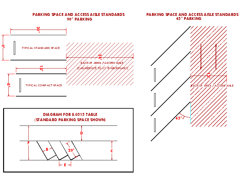
(Ord. No. 2016-17, 1-31-2017; Ord. No. 2023-07, 12-19-2023)
Sec. 8.520. - Landscape Plan Standards.
1.
Applicability. A landscape plan is required for proposal which includes any of the following:
A.
New housing.
B.
Development subject to Article IV Site and Design review.
C.
Planned Unit Development.
D.
New wireless broadcast communication facilities, as described in Section 8.415.
2.
Contents. A landscape plan need not be prepared by a certified landscape architect. However, a landscape plan must include the following to be considered complete:
A.
Existing Landscaping. The existing landscaping diagram shall depict the location of existing natural features and vegetation on the subject property and adjacent right-of-way areas. Any tree with a diameter of ten inches as measured at three feet above natural grade or greater shall be clearly labeled as a significant tree; smaller trees need not be depicted. Any tree that is shown on the plan shall be identified as coniferous or deciduous and whether the tree(s) is proposed to be retained or removed as part of the development.
B.
Proposed Landscaping. The proposed landscaping diagram shall depict the location of the vegetation, soil preparations, and irrigation for the subject property and adjacent right-of-way areas and shall be shown in relation to proposed in relation to any provided improvements, including building footprints, frontage improvements, and utility infrastructure. Additionally, the landscape plan must identify the total required landscaping area, as required by Section 8.530(2.), in square feet.
1.
Vegetation. The species, native or non-native status, and corresponding water use category as identified in the Oregon State University Extension Office Water-Wise Gardening in Central Oregon Guide, revised June 2020, shall be depicted. The installation size, if applicable, of all vegetation shall be identified. For any tree proposed to be retained, a Tree Protection Zone (TPZ) complying with the Public Works Standards and Specifications shall also be depicted. All required replacement trees shall be clearly labeled.
2.
Soil Preparation. The type of amendments or treatments to the soil shall be depicted.
3.
Irrigation. The method of irrigation proposed for use, including all points of connection and the system components (meters, valves, backflow, quick couplers, blow out ports, main and lateral lines, sprinkler layout, etc.) shall be depicted.
(Ord. No. 2023-07, 12-19-2023; Ord. No. 2024-14, § 1, 8-13-2024)
Sec. 8.530. - Landscape Design Standards.
1.
Applicability. Except where conflicting with the City of Remond Public Works Standards and Specifications, these landscaping design standards apply to any proposal which includes any of the following:
A.
New housing.
B.
Development subject to Article IV Site and Design review.
C.
Planned Unit Development.
D.
New wireless broadcast communication facilities, as described in Section 8.415.
2.
Minimum Landscaping. In all zones, the entirety of the unsurfaced yard area between the main building and any public or private street frontage shall be landscaped. Industrial and public zoned properties shall also be required to provide a ten-foot landscape buffer wherever such property directly abuts a residential zoned property, inclusive of structures. Additionally, any hillsides, berms, or other areas with a slope greater than ten percent that are disturbed during development shall be revegetated to prevent erosion and dust.
3.
Water Features. Required landscaping areas shall not include water features such as fountains, waterfalls, pools, ponds, or year-round standing water collection sites. Canals, approved water drainage facilities, or naturally occurring water features are exempt.
4.
Irrigation Systems. Irrigation shall be provided to allow for healthy plant growth. All irrigation shall be subject to the following:
A.
Water used for irrigation shall not be permitted to water or run-off onto hard surfaces, such as paved driveways, sidewalks, streets, and other non-vegetated areas. Except for the irrigation water needed to maintain vegetation within an abutting right-of-way, water shall not be allowed to leave the subject property.
B.
Trees shall only be irrigated with point-source irrigation such as drip irrigation, bubblers, and tree watering bags.
C.
Automatic irrigation systems shall not be allowed without soil-moisture or weather-based irrigation controllers with accompanying sensors and other supporting devices installed to enable smart features.
5.
Soil. Soils shall be amended to allow for healthy plant growth and water absorption. Prior to planting, soils shall be made friable by incorporating an organic soil amendment into, at minimum, the top two inches of soil. Additionally, mulch shall be applied to non-vegetated or uncovered areas at a depth of two inches. Both organic and inorganic mulches are allowed, however inorganic mulches are subject to additional standards described in this Section. An applicant may submit documentation from a certified landscape architect or soils scientist demonstrating that a different soil treatment that does not comply with this standard is necessary.
6.
Landscape Features. Required landscaping areas shall feature trees, shrubs, and live ground covers in combination, and shall not contain invasive species, exposed dirt, or dead vegetation. Non-structural hardscaping, such as boulders, pavers, walkways, courtyards, artificial turf, inorganic mulches and similar are acceptable as a landscaping feature but must not occupy more than 25 percent of required landscaped areas. Wherever inorganic mulches, including all types of rock groundcovers or mulches, are used, they shall not be used in sections exceeding 20 square feet in size, nor shall any section be closer than ten feet to any other section on the property.
Excluding permissible irrigated turf areas, required landscaped areas must be landscaped only with species which are identified as low or very low water use in the Oregon State University Extension Office Water-Wise Gardening in Central Oregon Guide, revised June 2020. Plant species that do not require irrigation once established are preferred over species that require continued irrigation. Approved water drainage facilities may feature moderate water-use plant species.
7.
Irrigated Turf. This standard applies to all irrigated turf except when used in approved active-style park areas or for recreational purposes within designated common areas. For non-residential zoned properties, not more than 20 percent of the required landscaped area may be landscaped with irrigated turf. For residential zoned properties, not more than 25 percent of the required landscaped area may be landscaped with irrigated turf. Additionally, irrigated turf areas are also subject to the following in all zones:
A.
The minimum dimension of any irrigated turf area shall not be less than ten feet.
B.
Irrigated turf shall not be planted in areas with a slope greater than 10 percent.
C.
When planting irrigated turf areas, seed mixes used shall not contain more than 25 percent cool season grass species.
8.
Trees. All trees shall have a 1.5 inch trunk diameter as measured at three feet above natural grade at the time of planting. Existing trees with a ten inch trunk diameter as measured at three feet above natural grade or greater are considered to be significant and shall be preserved to the greatest extent possible. Significant trees that are able to be preserved shall be provided with a Tree Protection Zone (TPZ) in compliance with the Public Works Standards and Specifications to protect the tree during development of the subject property.
A.
Where preservation is not feasible, significant trees shall be replaced at a 'one-to-one' ratio, inclusive of new street trees adjacent to the subject property.
B.
Street trees shall comply with Section 8.540 Street Tree Standards.
9.
Installation and Maintenance. All landscaping installation, including street trees, shall be completed prior to issuance of a Certificate of Occupancy. All landscaping shall be continuously maintained and replaced when necessary to ensure continued compliance with an approved landscape plan. Additionally, street trees shall be maintained in accordance with the standards listed in Section 3.600 of the Redmond City Code. For landscaping valued in excess of $5,000.00, a maintenance bond may be required.
10.
Deviation and Payment In Lieu. The Community Development Director or designee may:
A.
Approve a deviation from any of the standards of this Section without requiring a variance when the deviation is proposed by the applicant. Reasoning for the requested deviation must be explained in writing.
B.
Establish a fee in lieu per tree where the property is not physically feasible to replace tree(s). The fee will be specified in the City Fee Schedule.
(Ord. No. 2023-07, 12-19-2023; Ord. No. 2024-14, § 1, 8-13-2024)
Sec. 8.540. - Street Tree Standards.
Street trees are required wherever the subject property abuts public or private streets and shall be subject to the following:
1.
Species of Street Trees. Street trees shall be selected from the most recent City of Redmond Approved Street Trees list.
2.
Amount of Required Street Trees. The amount of street trees required to be installed shall be based on the length of the development frontage, less the clearance areas, divided by the required spacing distance. The required spacing distance is based on the species of tree and described in the City of Redmond Approved Street Trees list. Clearance areas are described in Subsection (C.) below.
Number of Trees Required = [(Length of Development Frontage) — (Clearance Areas)] / (Required Spacing Distance)
3.
Placement of Street Trees. Trees shall be centered in the landscape strip or shoulder, where applicable, at the required spacing distance. The required spacing distance of street trees is based on the species of tree and described in the City of Redmond Approved Street Trees list; spacing shall be measured from the center of the trunk of the tree. The spacing distance of street trees shall be adjusted based on the following:
A.
Clearance Areas, wherein no tree shall be planted. Clearance areas include:
1.
Clear vision areas;
2.
Sight distance areas;
3.
Stopping distance areas;
4.
Medians less than four feet wide;
5.
Utility easements;
6.
City easements, unless permitted by City Engineer.
B.
Buffers, which provide space between a tree and boundaries, infrastructure, improvements, or other physical barrier, shall be provided as described in the table below.
C.
Existing street trees may be factored into spacing distance and placement of street trees.
4.
The Community Development Director or designee may approve alternate street tree species selections and placements. Additionally, in the event that the required amount of street trees cannot be entirely accommodated within the public or private street frontage based on the above standards and adjustments, street trees may be permitted to be located on private property within five feet of the right-of-way, utility easement boundary, or property line.
(Ord. No. 2023-07, 12-19-2023)
Sec. 8.550. - Exception to Lot Size Requirements.
If a lot or the aggregate of contiguous lots or parcels platted prior to the effective date of these standards has an area or dimension which does not meet the requirements of these standards, the lot or aggregate holdings may be put to use permitted subject to the other requirements of the zone in which the property is located. Lots that are pre-existing in residential zones that are below the minimum size for a single-family dwelling shall be limited to one single family dwelling per lot.
(Ord. No. 2020-15, 11-10-2020)
Sec. 8.555. - Exception to Yard Requirements.
The Hearings Body may increase the yard requirement when a yard abuts a street which the City has designated for future widening. A lesser front yard may be allowed when structures on abutting lots do not meet the front yard requirements of the zone in which it is located.
(Ord. No. 2020-15, 11-10-2020)
Sec. 8.557. - Exception to Building Setback Requirements.
Any parcel of land or portion thereof which is taken by or is dedicated to a public or semi-public entity for a road, canal, railroad, utility, or other public use shall be exempt from the building setback requirements set forth by the Redmond Development Code standards when such dedication of land reduces a setback for an existing building or structure. Such setback shall be treated as a non-conforming setback by the City and shall be subject to those Code regulations and provisions that regulate non-conforming uses.
Sec. 8.560. - (Reserved)
Editor's note— Section 8.560 "Exception to Yard and Height Requirements for Detached Non-Habitable Accessory Buildings" was deleted by Ord. No. 2016-17 passed January 31, 2017.
Sec. 8.565. - Exception to Building Height Limitations.
Except for the FAA aviation requirements set forth in Federal Law, the following types of structures or structural parts are not subject to the building height limitations prescribed in Sections 8.100 through 8.295: architectural elements used for roofs, art, chimneys, church spires, clock towers, belfries, domes, monuments, fire and hose towers, observation towers, flag poles, air traffic navigational equipment, cooling towers, elevator shafts and other similar projections. Prior to construction of these structures or structural parts, a site plan shall be required in accordance with Site & Design Review Standards unless exempted by Code, or at the discretion of the Community Development Director, or Hearings Body.
(Ord. No. 2020-15, 11-10-2020; Ord. No. 2022-04, 6-28-2022)
Sec. 8.570. - Divided Legal Lots and Parcels.
A single legal lot or parcel of record may be considered as a divided lot or parcel for the purposes of these standards if it is divided by a major irrigation canal, railroad, or major topographic feature, or by a City, County, State, or Federal road. No right-of-way width less than 50 feet shall constitute an effective division. A newly divided lot or parcel that is sought due to the constraints established herein must be created through the partition or subdivision process. If the land division is the result of a city condemnation, then no planning fee shall be assessed.
Sec. 8.575. - Special Exceptions to Lot Size Requirements.
1.
Any parcel of land or portion thereof, which is required to dedicate a public or semi-public road, canal, railroad, utility, or other public use, shall be exempt from the minimum lot size requirements set forth by these standards, unless part of a proposed subdivision.
2.
For partitions involving parcels located in residential areas platted before the effective date of the current minimum lot size standards and abutting lots or parcels of substandard size under the current minimum lot size standards, an exception to the minimum lot size in the zone may be allowed if the following criteria are met:
A.
The minimum lot size for a parcel created pursuant to this exception shall be equal to or greater than the smallest lot area of the lots or parcels abutting the parent parcel.
B.
The exception provides for adequate provision of light, air, and privacy to abutting properties. This Section does not exempt solar setbacks from being applied for any lot created under these provisions (where applicable).
C.
The exception provides for the preservation of natural features, where appropriate.
D.
The exception will have minimal adverse impact on the livability, value or development of abutting properties and the surrounding area.
(Ord. No. 2022-04, 6-28-2022)
Sec. 8.600. - Authorization to Grant or Deny Conditional Uses.
Uses designated herein as conditional uses may be permitted upon authorization by the Hearings Body in accordance with the standards and procedures established in this Article. Before approving an application for a conditional use, the Hearings Body shall find the following criteria are either met, can be met by observance of conditions, or are not applicable:
1.
The proposed use will be consistent with the Comprehensive Plan, the zoning ordinances and other applicable ordinances and standards of the City.
2.
The location, size, design, and operating characteristics of the proposed use will have minimal adverse impact on the livability, value, or approximate development of abutting properties and the surrounding area.
3.
The proposed use will not exceed operational capacity of City infrastructure including sewage system, water system or the transportation system.
4.
That the proposed use will not conflict with, diminish, or substantially adversely affect the character and nature of the established neighborhood in which it is located.
(Ord. No. 2020-15, 11-10-2020)
Sec. 8.602. - Neighborhood Meeting.
Proof a neighborhood meeting was conducted for residential or mixed use development proposals that generate 200 or more daily trip ends, or 20 or more PM peak hour trip ends, where a Transportation Impact Analysis (TIA) is required, See Section 8.385 for meeting requirements.
(Ord. No. 2022-09, 12-13-2022)
Sec. 8.605. - General Conditions.
In addition to the ordinances set forth in a specific zone, this Article, and other applicable standards and criteria used in addressing a new conditional use or the alteration of an existing conditional use, the Hearings Body may impose conditions which it finds necessary to avoid an unacceptable impact and to otherwise protect the best interests of the surrounding area or the City. These conditions may include the following:
1.
Limiting the way the use is conducted including restricting the time an activity may take place and establish conditions or restraints that will minimize such environmental effects as noise, vibration, air pollution, glare, and odor. The City may require additional proof from the applicant that quantifies compliance with this requirement at the time of application submittal.
2.
Establishing an open space or recreation area.
3.
Limiting the height, size, or location of a building or other structure(s).
4.
Designating the size, number, location, and nature of vehicle access points.
5.
Increasing the amount of street dedication, roadway width or improvements within the street right-of-way, including (but not limited to) lighting and landscaping improvements. Any oversizing of public infrastructure that is required by the City that exceeds minimum City standards may be a candidate for SDC credits at the discretion of the City Engineer or designate.
6.
Designating the size, location, screening, landscaping, drainage, surfacing, or other improvement within a parking area or loading zone.
7.
Limiting or otherwise designating the number, size, location, height, and lighting of signs.
8.
Limiting the location and intensity of outdoor lighting and requiring it's shielding from any adjacent properties, or public or private streets and roads.
9.
Requiring diking, screening and/or landscaping of a facility to protect adjacent or nearby property and designating standards for its installation and maintenance.
10.
Designating the size, height, location, and materials for a fence.
11.
Protecting and preserving existing trees, vegetation, or other significant natural resources.
(Ord. No. 2020-15, 11-10-2020)
Sec. 8.610. - Permit and Improvements Assurance.
The Hearings Body may require an applicant to furnish the City with a performance bond, cash deposit, or equivalent deemed necessary to guarantee development in accordance with these standards and the conditions attached in granting a conditional use permit. Such assurance shall be accepted at the discretion of the City Finance Director or designate.
Sec. 8.615. - Standards Governing Conditional Uses.
A conditional use shall comply with the standards and criteria of the zone in which it is located and with the standards and criteria set forth in this Section and in Sections 8.600 and 8.605.
1.
Airports, Aircraft Landing Fields, Aircraft Charter, Rental, Service, and Maintenance Facilities not Located in an Airport Zone / Airport Compatibility Zone. The Hearings Body shall find that the locations and site design of the proposed facility will not be hazardous to the safety and general welfare of surrounding properties, nor that the location will unnecessarily restrict existing and future development of surrounding lands as designated by the Comprehensive Plan.
2.
Automobile Recycling, Wrecking Yard, or Junk Yard. In considering a conditional use application for an automobile recycling facility, wrecking yard or junk yard, the Hearings Body shall require that the facility or yard be enclosed and screened from public view by a sight obscuring and well maintained fence not less than six feet in height. All personal property shall remain inside the fence. If applicable, the Hearings Body shall be assured that the proposed use is in conformance with applicable State regulations.
3.
Bed and Breakfasts. A bed and breakfast shall comply with the following provisions:
A.
All new construction or conversions of existing structures to a Bed and Breakfast require Site and Design Review.
B.
All such uses are in conformance with applicable, City Sign Standards.
C.
All such uses shall have a maximum of five guest suites.
D.
All such uses shall provide one parking space per guest suite in addition to the residential use requirement of two spaces.
E.
All such uses provide parking areas to be screened as per design review standards.
4.
Cemeteries. The Hearings Body shall require evidence and shall find that the terrain and soil types of a proposed location are suitable for interment, and that the nature of the subsoil and drainage will not have a detrimental effect of ground water sources or domestic water supplies in the area of the proposed use.
5.
Church, Hospital, and Other Public/Semi-public Uses.
A.
Such uses may be authorized as a conditional use only after consideration of the following factors:
1.
Adequacy of access to and from principal streets together with the probable effect of the traffic volumes on abutting and nearby streets, and mitigation of associated impacts.
a.
Such uses or related buildings shall be at least 30 feet from a side or rear lot line when abutting a residential use.
b.
Adequate off-street parking.
c.
Adequate building and site design provisions to minimize noise and glare from the building and site.
B.
Such uses may be built to exceed the height limitations of the zone in which it is located to a maximum of 50 feet if the total floor area of the building does not exceed the area of the site and if the yard dimensions in each case are equal to at least two-thirds of the height of the principal structure.
6.
Commercial Use or Accessory Use not Wholly Enclosed within a Building. In any zone permitting a commercial use or accessory use not wholly enclosed within a building the use may be permitted as a conditional use subject to the following standards:
A.
A sight obscuring fence or evergreen hedge may be required by the Hearings Body when in its judgment, such a fence or hedge combination thereof is necessary to preserve the values of nearby properties or to protect the aesthetic character of the neighborhood or vicinity.
B.
In addition to the requirements of the applicable zone, the Hearings Body may further regulate the placement and design of signs and lights in order to preserve the values of nearby properties; to protect them from glare, noise, or other distractions; or to protect the aesthetics character of the neighborhood or vicinity.
C.
In order to avoid unnecessary traffic congestion and hazards, the Hearings Body may limit access to the property.
7.
A retail establishment, office, service commercial establishment, financial institution, or personal or business service establishment on a lot abutting or across the street from a lot in a residential zone. In any zone permitting a commercial use such as a retail establishment, office, service commercial establishment, financial institution, or personal or business service establishment on a lot abutting or across the street from a lot in a residential zone, the use may be permitted as a conditional use subject to the following standards:
A.
A sight obscuring fence or evergreen hedge may be required by the Hearings Body when in its judgment, such a fence or hedge combination thereof is necessary to preserve the values of nearby properties or to protect the aesthetic character of the neighborhood or vicinity.
B.
In addition to the requirements of the applicable zone, the Hearings Body may further regulate the placement and design of signs and lights in order to preserve the values of nearby properties; to protect them from glare, noise, or other distractions; or to protect the aesthetics character of the neighborhood or vicinity.
C.
In order to avoid unnecessary traffic congestion and hazards, the Hearings Body may limit access to the property.
8.
Commercial Amusement Establishment. A commercial amusement establishment may be authorized after consideration of the following factors:
A.
Adequacy of access from principal streets together with the probable effect on traffic volumes of abutting and nearby streets.
B.
Adequacy of off-street parking.
C.
Adequacy of building and site design provisions to maintain a reasonable minimum of noise and glare from the building and site.
D.
Hours of operation which do not conflict with adjacent residential uses where applicable.
9.
Dog Pounds and Kennels. The Hearings Body may authorize a dog pound or kennel as a conditional use if that building and site design provisions are adequate to minimize noise and odor. When necessary to protect surrounding properties, the Hearings Body may require a sight obscuring fence or hedge, and may restrict vehicular access and loading facilities, especially those required by trucks transporting large animals.
10.
Hotels in the M-1 Light Industrial Zone. Hotels may be permitted in the Light Industrial Zone only if the Hotel is:
A.
A minimum of 50 rooms; and
B.
Adjacent to and accessed from a designated arterial street.
11.
Mining, Quarrying, or Other Extraction Activity.
A.
Plans and specifications submitted to the Hearings Body for approval must contain sufficient information to allow the Hearings Body to consider and set standards pertaining to the following:
1.
The most appropriate use of the land;
2.
Setback from the property line;
3.
The protection of pedestrians and vehicles through the use of fencing and screening;
4.
The protection of fish and wildlife habitat and ecological systems through control of potential air and water pollutants;
5.
The prevention of the collection and the stagnation of water at all stages of the operation;
6.
The rehabilitation of the land upon termination of the operation.
B.
Surface mining equipment and necessary access road shall be constructed, maintained, and operated in such manner as to eliminate, as far as is practicable, noise, vibration, or dust which may be injurious or annoying to persons or other uses in the vicinity.
C.
The comments and recommendations of all appropriate natural resources agencies of the State and Federal government shall be sought.
D.
A rock crusher, washer, or sorter shall not be permanently located closer than 500 feet from a residential or commercial zone.
12.
Manufactured Home Park. A manufactured home park shall be built to site standards in effect at the time of construction and shall comply with the following additional provisions:
A.
Evidence shall be provided that the park will be connected to City sewer and water services.
B.
The space provided for each manufactured home shall be provided with City water and electrical and sewerage connections.
C.
The number of spaces for manufactured homes shall not exceed nine for each acre of the total area in the manufactured home park.
D.
A manufactured home shall occupy not more than 40 percent the contiguous space provided for the exclusive use of the occupants of the manufactured homes and exclusive of space provided for the common use of tenants, such as roadway, general use structures, parking spaces, walkways, and areas for recreation and landscaping.
E.
No manufactured home in the park shall be located closer than 15 feet from another manufactured home or from a general use building in the park. No manufactured home accessory building shall be closer than ten feet from a manufactured home space or other building or structure. No manufactured home or other building or structure shall be within 25 feet of a public street property boundary or ten feet of another property boundary.
F.
A manufactured home permitted in the park shall meet the following standards as determined by an inspection by the Building Official:
1.
It shall have a State insignia indicating compliance with Oregon State Manufactured Home Construction Standards in effect at the time of manufacture and including compliance for reconstruction or equipment installation made after manufacture.
2.
Notwithstanding deterioration which may have occurred due to misuse, neglect, accident, or other cause, the manufactured home shall meet the State standards for manufactured home construction evidenced by the insigne.
3.
It shall contain not less than 225 square feet of space as determined by measurement of the unit exclusive of any trailer hitch device.
4.
It shall contain a water closet, lavatory, shower or tub, and a sink in a kitchen or other food preparation space.
5.
A manufactured home permitted in the park shall be provided with a continuous skirting.
6.
There shall be no outdoor storage of furniture, tools, equipment, building materials or supplies belonging to the occupants or management of the park.
7.
If the park provides space for 50 or more manufactured home units, each vehicular way in the park shall be named and marked with signs which are similar in appearance to those used to identify public streets. A map of the named vehicular ways shall be provided to the fire department.
8.
If a manufactured home space or permanent structure In a park is more than 500 feet from a public fire hydrant, the park shall have water supply mains designed to serve fire hydrants and hydrants shall be provided within 500 feet of such space or structure. Each hydrant within the park shall be located on a vehicular way and shall conform in design and capacity to the public hydrants in the City.
9.
Open Space. A minimum of at least 2,500 square feet plus 150 square feet per manufactured home space shall be provided recreation area. Recreation areas shall be improved with surfacing, facilities suitable for recreational use, or landscaping. No recreation facility created within a manufactured home park wholly to satisfy the requirements of this Section shall be open to, or offered in itself, to the general public. The Community Development Director, or designee, may require the recreation area to be centrally located within the park and physically separated from streets or parking by a fence that complies with fence regulations.
10.
Parking Space Requirement. Two parking spaces shall be provided for each manufactured home space on the site. In addition, guest parking spaces shall also be provided in every manufactured home park within 200 feet of the manufactured home spaces served and at a ratio of one parking space for each two manufactured home spaces. Parking spaces shall have durable and dustless surfaces adequately maintained for all-weather use and shall be properly drained.
11.
All manufactured home parks over ten acres in size shall be located to have access on a street designated as a collector street unless otherwise approved by a Hearings Body.
12.
All manufactured home parks containing a total site area of 20 acres or more shall provide a secondary access to the mobile home park. Such secondary access shall enter the public street system at least 150 feet from the primary access.
13.
Lighting shall be installed along the access ways of the manufactured home park and the recreation area with lights of 100 watts or better or not over 100 feet apart. Wires for service to light poles and trailer spaces shall be underground.
14.
Roadways within the park shall be paved and shall be not less than 30 feet in width if parking is permitted on the margin of the roadway, or less than 24 feet in width if parking is not permitted on the edge of the roadway and an adequate designated area is provided and improved for guest parking and tenant recreational vehicles (such area shall be designed and improved to provide not less than one parking space per each two unit spaces in the park).
15.
No manufactured home park shall be created on a site of less than three acres.
16.
Sidewalks or other approved surfaced pedestrian walkways shall be provided.
17.
Public Park. The developer shall be required to either dedicate land for a public park or pay a sum into a park fund in accordance with the provisions set forth in Section 8.355 of these standards.
13.
Multi-Family Complex. A Multi-family complex shall comply with the following provisions:
A.
If such complex or any unit thereof is more than 500 feet from a public fire hydrant or as otherwise required by the uniform fire code, then a new hydrant or hydrants shall be provided at appropriate locations as determined by the Fire Marshal. Such hydrants shall be located on a vehicular way and shall conform in design and capacity to the public hydrants in the City.
B.
All such complexes with more than 20 dwelling units shall be located to have access on a street designated as a collector unless otherwise approved by the Hearings Body.
C.
Sidewalks or other approved surfaced pedestrian walkways shall be provided.
14.
Recreational Vehicle Park. A recreational vehicle park shall be built to State standards in effect at the time of construction and shall comply with the following provisions:
A.
Use Standards.
1.
No recreational vehicle park or overnight use area shall be permitted with access further than 1,000 feet from a designated arterial or collector street or private street of equal paved width. Further, such access roads shall be designed and constructed at the maximum design standards for right-of-way and/or pavement width (60 feet/36 feet). A lesser standard of not less than 30 feet may be approved by the hearings body if no street parking is allowed, sufficient off-street parking is provided and only if the proposed park plan is accompanied by an approved maintenance and enforcement management agreement.
2.
The design of recreational vehicle parks shall be subject to site plan review and approval and have minimal adverse impacts.
3.
Management headquarters, recreational facilities, toilets, dumping stations, showers, coin-operated laundry facilities, and other uses and structures customarily incidental to operation of a recreational vehicle park and campground are permitted as accessory uses to the park.
B.
Design Standards.
1.
The maximum density of an RV park shall be 20 units per acre.
2.
The space provided for each recreational vehicle site shall be not less than 1,200 square feet, exclusive of any space used for common areas, such as roadways, general use structures, walkways, common parking areas, and landscaped areas.
3.
Roadways other than those described above shall be not less than 30 feet in width if parking is permitted on the margin of the roadway, or less than 24 feet in width if parking is not permitted on the edge of the roadway, shall be paved with asphalt, concrete, or similar impervious surface, and designed to permit easy access to each recreational vehicle space. When a service drive provides only secondary access to all abutting recreational sites and those sites are all served by a roadway meeting the above standards, the secondary drive may be reduced to 14 feet if one-way and posted for no parking.
4.
Entrance driveways shall be located not closer than 150 feet from the intersection of public streets.
5.
A space provided for a recreational vehicle shall be covered with dust-free crushed gravel, or paved with asphalt, concrete or similar materials, and be designed to provide runoff of surface water. The portion of the space not occupied by a recreational vehicle and not intended as an access way to the recreational vehicle or part of an outdoor patio need not be paved or covered with gravel, provided the area is landscaped or otherwise treated to prevent dust or mud.
6.
A recreational vehicle space shall be provided with piped, potable water and sewage disposal service. A recreational vehicle staying in the park shall have available water and sewage service provided by the park if the vehicle has equipment needing such service.
7.
A recreational vehicle space shall be provided with electric service.
8.
Trash receptacles for the disposal of solid waste material shall be provided in convenient locations for the use of guests of the park and shall be of such capacity and number so that there is no accumulation of uncovered trash at any time. Trash shall be removed from the property on a scheduled basis to prevent health hazard or nuisance.
9.
No recreational vehicle or any other camping unit shall be used as a permanent residence, dwelling, or business for indefinite periods of time. Occupancy or placement extending beyond six months in any 12-period shall be presumed to be permanent occupancy. Any action toward removal of wheels of a recreational vehicle except for temporary purposes of repair is prohibited. Camping units other than recreational vehicles shall be limited to 30 days in any 60-day period.
10.
The total number of parking spaces in the park, exclusive of parking provided for the exclusive use of the manager or employees of the park shall be equal to one space per recreational vehicle space. Parking spaces shall be covered with crushed gravel, or paved with asphalt, concrete, or similar material, providing a dust-free surface.
11.
The recreational vehicle park shall provide toilets, lavatories and showers for each sex as required by the State Building Agency Administrative Rules, Chapter 918. Such facilities shall be lighted at all times of night and day, shall be ventilated, and shall be provided with adequate floor drains to permit easy cleaning.
12.
Recreational vehicles or other camping units shall be separated from each other and from other structures by at least eight feet. Accessory structures such as attached awnings or individual storage facilities shall, for purposes of this separation requirement, be considered to be part of the recreational vehicle.
13.
The land which is used for park purposes shall be screened from sight, except at entry and exit places. The screening provided shall complement the landscape and ensure compatibility with surrounding properties.
15.
Radio, Television Tower, Utility Station, or Substation. Transmitting and receiving towers and antennas are allowed as a conditional use and subject to the requirements set forth in Sections 8.400 through 8.490 of these standards.
16.
Child Care Facilities. Child Care Facilities shall provide and maintain at least 75 square feet of outdoor play area per child. A sight obscuring fence at least four feet but not more than six feet high shall separate the play area from the abutting lots.
17.
Mini-Storage Developments.
A.
The site shall contain a minimum of three acres.
B.
The site shall have access only on a minor arterial, major collector, or minor collector.
C.
The maximum lot coverage shall not exceed 60 percent of the total lot area.
D.
No more than one dwelling may be located on the site and the purpose of the dwelling shall be for the operation, maintenance, and security of the mini-storage development.
E.
All outdoor storage of recreational vehicles or boats shall be screened from view in a manner that will complement the landscape and assure compatibility with adjacent uses.
F.
All roadways within the mini-storage development shall be a minimum of 20 feet in width and shall be paved.
18.
Development in the OSPR Zone.
A.
An application for a conditional use other than for a public facility shall be denied if the proposed use is not related to or complimentary, or compatible with the recreational, historical, or scenic resources of the area.
B.
The Hearings Body may limit changes in the natural grade of land or the alteration, removal, or destruction of natural vegetation in order to prevent or minimize erosion, pollution, or degradation of the natural attractiveness of the area.
C.
The Hearings Body may require establishment and maintenance of fire breaks, the use of fire-resistant materials in construction and landscaping; or may attach other similar conditions or limitations that will serve to reduce fire hazards or prevent the spread of fire to surrounding areas.
D.
An application for a conditional use in an OSPR Zone shall be denied if the height of any structures or buildings unduly affects the natural and scenic features of the area.
E.
Development of public or private recreational centers or community centers must:
1.
Be in or within 100 feet of an enhancement area as defined on the map.
2.
Provide access to a specific parcel from existing routes accessing the canyon or routes designated in the plan maps as set forth within the adopted Canyon Master Plan and Comprehensive Plan for the City of Redmond.
3.
Be reasonably accessible for people of all ages and social and economic groups and for all geographic areas of the community.
4.
Be coordinated with adjacent open space areas and other land uses so they enhance one another and together contribute to a satisfying park environment.
5.
Provide for the preservation or enhancement of natural features, resources, and amenities, including views and vistas, canyon walls, native juniper stands and exposed rock outcroppings.
F.
Except for the development of public facilities and services, it shall be unlawful to fill, discard or store solid wastes of any kind, including but not limited to excavation, tailings, rubbish, auto bodies, junk, and other similar materials, to store any materials which are unsightly within the canyon area soil, trees, shrubbery, or other natural vegetation.
19.
Development in the R-3A. In addition to other conditional use standards and criteria applicable in the R3 zone, an application for conditional use in the R-3A zone shall be subject to the following criteria:
A.
The hearings body may limit the hours of operation (open to the public) of a commercial business allowed as a conditional use in the R3A zone so that the use is compatible with the surrounding residential neighborhood. For restaurant or theater uses, the hearings body may limit hours of operation to no later than 9:00 PM on weekdays and 10:00 PM on weekends. For other commercial uses, the hearings body may limit hours to be after 8:00 AM and no later than 6:00 PM.
B.
The applicant shall provide a plan to ensure that there is adequate off-street parking for the proposed use.
C.
Signage in the R3A zone shall be limited to either one ground mounted sign no larger than 5 × 3 square feet, or in the alternative, a non-illuminated wall size of similar size.
D.
Retail uses shall be limited to those types of businesses which provide low traffic impacts on the surrounding areas such as computer stores, clothing stores.
E.
Any restaurant allowed shall be a full service restaurant. No fast-food restaurants or drive-in/drive-through restaurant will be allowed in the R3A zone.
(Ord. No. 2015-04, 5-19-2015; Ord. No. 2016-17, 1-31-2017; Ord. No. 2020-15, 11-10-2020; Ord. No. 2022-04, 6-28-2022; Ord. No. 2022-09, 12-13-2022; Ord. No. 2023-07, 12-19-2023)
Sec. 8.616. - Conflicts.
Where there is a conflict between any other standards for uses in the R3 zone and these criteria, the criteria set forth in Section 8.615 shall control.
Sec. 8.625. - Public Hearing on a Conditional Use.
A public hearing may be required at the discretion of the Community Development Director, or designee, for any conditionally permitted use. If required, the hearing shall follow the procedure described in Land Use Administrative actions allowed under Article II.
(Ord. No. 2022-04, 6-28-2022)
Sec. 8.630. - Termination of Use.
A conditional use permit approval may have a termination date that indicates when the use is no longer permitted through the conditional use approval. If applied, then such dates shall be specified within the conditions of approval for the Conditionally Permitted Use.
Sec. 8.635. - Time Limit on a Permit for a Conditional Use.
Authorization of a conditional use shall be void after two years or such lesser time as the authorization may specify unless substantial construction has taken place. However, the Community Development Director, or Hearings Body, may allow extensions as provided in Section 8.1610.
Sec. 8.640. - Occupancy Permit.
The Commission may require an "Occupancy Permit" for any conditional use approved pursuant to the provisions of these standards. The Hearings Body shall consider such a requirement for any use authorized by a conditional use permit for which on-site improvements, or other such conditions were established by the Hearings Body upon approval of such use. The requirement of an Occupancy Permit shall be for the intent of insuring permit compliance and said permit shall not be issued except as set forth by the Hearings Body. The authority to issue an Occupancy Permit upon compliance with the requirements and conditions of a conditional use permit may be delegated by the Hearings Body to the Community Development Director.
Sec. 8.645. - Performance Bond.
The Hearings Body may require the applicant to furnish the City with a performance bond or other adequate form of assurance to guarantee development in accordance with the standards and conditions attached in granting a conditional use permit.
Sec. 8.660. - Non-Conforming Uses - Continuation of a Non-Conforming Use or Structure.
Subject to the provisions of this Article, a non-conforming use or structure existing prior to the effective date of these standards may be continued and maintained in reasonable repair. A structure conforming with respect to use but non-conforming regarding height, setback, or lot coverage may be altered or extended if the alteration or extension does not further deviate from these standards and does not adversely affect adjacent property or public rights-of-way.
Sec. 8.665. - Discontinuance of a Non-Conforming Use.
1.
If a non-conforming use involving a structure is discontinued for a period of one year, further use of the property shall conform to these standards; except that previous residential use may be allowed as a conditional use pursuant to Sections 8.600 through 8.645 provided that the conditional use application is filed with the City within one year of the cessation of the non-conforming use.
2.
If a non-conforming use not involving a structure is discontinued for a period of one year and if a conditional use application to allow a residential use is not filed with the City, further use of the property shall conform to these standards.
Sec. 8.670. - Change of a Non-Conforming Use.
If a non-conforming use is replaced by another use, the new use shall conform to all applicable zoning and development standards.
Sec. 8.680. - Destruction of a Non-Conforming Use.
If a non-conforming structure or a structure containing a non-conforming use is destroyed by any cause to an extent exceeding 60 percent of fair market value as indicated by the records of the County Assessor, a future structure or use on the site shall conform to the zoning standards and all applicable provisions of the Redmond Development Code; except that previous residential use may be allowed as a conditional use pursuant to Sections 8.600 through 8.645 provided that the conditional use is allowed in the zone and that the application is filed with the City within one year of the destruction of the existing non-conforming use.
Sec. 8.685. - Alterations and Repairs.
1.
Alteration of a non-conforming use shall be permitted to reasonably continue the use. Alteration of any such use may be permitted when necessary to comply with any lawful requirement for alteration in the use.
2.
Any application for the alteration of a use under Subsection (1.) above, including, but not limited to, an alteration necessary to comply with a lawful requirement, shall be permitted in accordance with these standards and this Section. "Alteration" of a non-conforming use may be allowed when the owner/developer demonstrates that:
A.
The alteration or change in the use results in less or no greater adverse impact to the neighborhood,
B.
A change in the structure or physical improvement results in less or no greater adverse impact to the neighborhood.
C.
There is no adverse impact on any public facility, including right of ways or public easements, located on or adjacent to the property.
Sec. 8.695. - Non-Conforming Lots of Record.
Any lot which is smaller than the minimum area required in any zone may be developed and occupied by an allowed use in that zone provided that:
1.
The lot is a legal lot of record which includes, but is not limited to, lots in a duly platted and recorded subdivision on or before the effective date of these standards or parcels created by an approved land partitioning prior to the effective date of the subdivision ordinance.
2.
The use conforms to all other requirements of that zone, including setbacks, access, and any applicable site design requirements.
3.
If there is an area deficiency, a permitted residential use shall be limited to a single dwelling unit and may include accessory structures and uses, including home occupations and garages.
(Ord. No. 2022-09, 12-13-2022)
Sec. 8.700. - Authorization to Grant or Deny Variances.
Except as provided for in Section 8.710, the Community Development Director, or Hearings Body, may authorize variances from these standards where it can be shown that owing to special and unusual circumstances related to a specific piece of property, the literal interpretation of these standards would cause an undue or unnecessary hardship; except that no variance shall be granted to allow the use of the property for purposes not authorized within the zone, or to alter any procedural requirements of these standards. Variances to residential yard/setback requirements may be allowed as described below and may include conditions to protect the best interest of the surrounding property or neighborhood and to otherwise achieve the purposes of these standards.
(Ord. No. 2016-17, 1-31-2017; Ord. No. 2020-15, 11-10-2020)
Sec. 8.705. - Standards Required to Grant Major Variances.
A major variance may be granted pursuant to the provisions of Section 8.700 if the applicant can establish the following:
1.
That special conditions exist which are peculiar to the land, structure or building involved and which are not applicable to other lands, buildings, or structures in the same zone.
2.
That strict interpretation of these standards would deprive the applicant of rights commonly enjoyed by other properties in the same zone under the terms of these standards.
3.
That the special conditions and circumstances do not result from the actions of the applicant and such conditions and circumstances do not merely constitute pecuniary hardship or inconvenience.
4.
That granting the variance will be in harmony with the objectives of these standards, and not injurious to the neighborhood or otherwise detrimental to the public welfare.
(Ord. No. 2020-15, 11-10-2020)
Sec. 8.710. - Standards Required to Grant Minor Variances to On-Site Requirements.
A minor variance under this Section shall be no greater than 25 percent of the requirement from which the variance is sought. The Community Development Director, or designee, may consider a variance from these standards relating to on site requirements.
1.
In the case of a yard setback variance, the applicant shall show the approval will result in:
A.
More efficient use of the site.
B.
Preservation of natural features where appropriate.
C.
Adequate provisions of light, air, and privacy to adjoining properties.
D.
Adequate access.
2.
In the case of a variance to the dimensional standards for off-street parking spaces or the minimum required number of off-street parking spaces, the applicant shall show that approval will provide adequate off-street parking in relation to user demand. The following factors may be considered in granting such an exception:
A.
Special characteristics of users which indicate low demand for off-street parking (e.g., low income, elderly).
B.
Opportunities for joint use of nearby off-street parking facilities.
C.
Availability of public transit.
D.
Natural features of the site (topography, vegetation, and drainage) which would be adversely affected by application of required parking standards.
3.
For variances to other on-site requirements of 25 percent or less the applicant shall show that approval of the variance will be consistent with the overall objectives of the Comprehensive Plan and zoning standards where applicable, and that the variance will have a minimal adverse impact on the livability, value or development of abutting properties and the surrounding area.
(Ord. No. 2022-04, 6-28-2022)
Sec. 8.720. - Application for a Variance.
A property owner may initiate a request for a variance by filing an application with the Community Development Department. The application shall be accompanied by a plan, drawn to a suitable scale, showing the condition to be varied and the dimensions and arrangement of the proposed development. The application shall be reviewed in the manner provided for in Article II, or, if in conjunction with site plan review, in the manner provided for in the Site & Design Review Standards.
(Ord. No. 2020-15, 11-10-2020)
Sec. 8.750. - Authorization to Initiate Amendments.
An amendment to the text of this Chapter, to the Comprehensive Plan, or an amendment to the Comprehensive Plan Map may be initiated by City Council, Planning Commission, or Community Development Director. A property owner may initiate a request for a map or text amendment by filing an application with the Community Development Department.
(Ord. No. 2020-15, 11-10-2020; Ord. No. 2022-04, 6-28-2022; Ord. No. 2022-09, 12-13-2022)
Sec. 8.755. - (Reserved)
Editor's note— Section 8.755 "Zone/Plan Map Amendments" was deleted by Ord. No. 2020-15 passed November 10, 2020.
Sec. 8.760. - Criteria for Amendments.
The burden of proof is upon the applicant. The applicant shall show the proposed change is:
1.
In conformity with all applicable State statutes;
2.
In conformity with the State-wide planning goals whenever they are determined to be applicable;
3.
In conformity with the Redmond Comprehensive Plan, land use requirements and policies; and
4.
That there is a change of circumstances, further studies justifying the amendment or mistake in the original zoning.
(Ord. No. 2020-15, 11-10-2020)
Sec. 8.765. - Tentative Approval.
Based on the facts presented at the hearing and the recommendation of the Planning Commission, if the Hearings Body determines that the applicant has met all applicable criteria for the proposed change, the Hearings Body shall give tentative approval of the proposed change. Such approval shall include any conditions, stipulations, or limitations which the Hearings Body determines to be necessary to meet the criteria. An appeal of the Hearings Body's decision shall be processed and decided in the manner provided for in Article II of these standards. Upon completion of hearings process, the council shall, by order, effect the zone reclassification of the property. Provided, however, if the applicant fails to abide by the conditions attached to the rezoning the Council may, later, rezone the affected property to its original zoning by order.
(Ord. No. 2020-15, 11-10-2020)
Sec. 8.770. - Public Hearing on Amendments.
If a map change is initiated by the Planning Commission or City Council, or if an amendment to the text of these standards is to be considered, the City Council shall hold a public hearing on the proposed change. Notice of the hearing shall be published in a newspaper of general circulation in the City the week prior to the hearing. Before establishing a map change, the Council shall make findings that the proposed change meets the criteria set forth in Section 8.760. Any change affected under this Section shall be by ordinance.
Sec. 8.775. - (Reserved)
Editor's note— Section 8.775 "Limitations on Re-Applications" was deleted by Ord. No. 2020-15 passed November 10, 2020.
Sec. 8.800. - Severability.
The provisions found within this Code are severable. If any section, sentence, clause, or phrase is adjudged by a court of competent jurisdiction to be invalid, the decision shall not affect the validity of the remaining portions of this Code.
Sec. 8.805. - Enforcement.
1.
Administration. It shall be the duty of the City Manager or an authorized representative to enforce the provisions of these standards pertaining to land use and to the construction, erection, location, or enlargement of any structure located within the City of Redmond under the jurisdiction of these standards.
2.
Building Permits. No permit shall be issued by the building official for the construction, erection, location, or enlargement or change of use of a building, structure or lot that does not conform to the requirements of these standards or any other ordinance, regulation, permit, or land use approval adopted or issued by the City of Redmond.
3.
Authority. Whenever necessary to enforce the provisions of these standards, the City Manager or an authorized representative shall have recourse to every remedy provided by law.
4.
Violation of These Standards is a Nuisance. The construction, erection, location, enlargement of use, change in use or use(s) of any structure or property in violation of these standards or those conditions and limitations approved pursuant to the provisions of these standards shall be deemed a nuisance and may be subject to abatement, removal, or other remedy provided in the City of Redmond's nuisance code under Section 5.345.
5.
Revocation for False Statement. The City Manager, or designee, may revoke any permit granted pursuant to the provisions of these standards, if it is determined the permit was issued on account of material false statements contained in the application form or material false representations made at a public hearing. A decision to revoke a permit shall be subject to the procedures established for a Development Action, with the corresponding right of appeal.
6.
Revocation for Non-conformance. The City Manager, or designee, may revoke any permit granted pursuant to the provisions to these standards for failure to comply with those conditions and limitations placed upon the exercise of the permit. A decision to revoke a permit shall be subject to the procedures established for a Development Action, with the corresponding right of appeal. Failure to comply with applicable conditions and limitations may also be subject to abatement, removal, penalty, or other remedy provided in the City of Redmond nuisance code.
7.
Penalties of Violation.
A.
A violation of any provision of these standards shall be a Class A civil infraction and/or Class A administrative infraction.
B.
Violations shall be enforced under the procedures established in Sections 2.750 through 2.799.
C.
Each day that a nuisance continues to exist constitutes a separate violation, and a separate penalty may be assessed for each day the violation continues.
(Ord. No. 2013-06, 4-9-2013; Ord. No. 2014-05, 4-8-2014; Ord. No. 2020-15, 11-10-2020)
Sec. 8.810. - Corrections.
The provisions of this Code may be corrected by the City Manager, or designee, to cure formatting, numbering, editorial and clerical errors.
(Ord. No. 2020-15, 11-10-2020)
Sec. 8.820. - Purpose.
The City of Redmond establishes a Historic Preservation Ordinance to identify, recognize, and preserve significant properties related to the community's history; encourage the rehabilitation and ongoing viability of historic buildings and structures; strengthen public support for historic preservation efforts within the community; foster civic pride; and encourage cultural heritage tourism.
(Ord. No. 2011-06, 5-24-2011; Ord. No. 2018-13, 12-11-2018)
Sec. 8.825. - Administration.
This code shall be administered by the Historic Preservation Officer.
(Ord. No. 2011-06, 5-24-2011; Ord. No. 2018-13, 12-11-2018; Ord. No. 2022-04, 6-28-2022)
Sec. 8.830. - Applicability.
No provision of this Ordinance shall be construed to prevent the ordinary maintenance of a Landmark when such action does not involve a change in design, materials, or appearance. No provision in this Ordinance shall be construed to prevent the alteration, demolition, or relocation of a Landmark when the Building Official certifies that such action is required for public safety. At his or her discretion, the Building Official may find that under State law and provisions of this ordinance that a Landmark does not meet current building code but is not dangerous.
(Ord. No. 2011-06, 5-24-2011; Ord. No. 2018-13, 12-11-2018)
Sec. 8.832. - (Reserved)
Editor's note— Section 8.832 "Property Owner Permission Required for Designation" was added by Ord. No. 2011-06 passed May 24, 2011. Later, was deleted by Ord. No. 2018-13 passed December 11, 2018.
Sec. 8.835. - Definitions.
The following definitions apply to terms used in this Code. Terms not defined have their commonly construed meaning:
Alteration. An addition, removal, or reconfiguration that changes the appearance of a Landmark. Painting, when color is not specifically noted in Landmark's Record of Designation, and ordinary maintenance are excluded from this definition.
Building. A house, barn, church, hotel, or similar construction created principally to shelter any form of human activity.
Certificate of Appropriateness (COA). A document issued by the Historic Preservation Officer indicating that the applicant has satisfactorily met the provisions of this Ordinance for the alteration, relocation, or demolition of a Landmark.
Demolition. The complete destruction or dismantling of 65 percent of, or greater, of the entirety of a Landmark.
District. A significant concentration, linkage, or continuity of sites, buildings, structures, or objects united historically or aesthetically by plan or physical development.
Eligible/Contributing. A building, structure, object, or site originally constructed within the applicable period of significance that retains and exhibits sufficient integrity (location, design, setting, materials, workmanship, feeling, and association) to convey a sense of history. These properties strengthen the historic integrity of an existing or potential historic district.
Eligible/Significant. A building, structure, object, or site originally constructed within the applicable period of significance that retains and exhibits sufficient integrity (location, design, setting, materials, workmanship, feeling, and association) to convey a sense of history. These properties strengthen the historic integrity of an existing or potential historic district and are likely individually eligible for listing in the Local Landmark Register.
Exceptional Significance. The quality of historic significance achieved outside the usual norms of age, association, or rarity.
Historic Integrity. The quality of wholeness of historic location, design, setting, materials, workmanship, feeling, and/or association of a historic resource, as opposed to its physical condition.
Historic Preservation Officer. The City Official responsible for the administration of this Ordinance.
Historic Resource. A building, structure, object, site, or district that is at least 50 years old or is of exceptional significance and potentially meets the age, integrity, and significance criteria for listing in the Local Landmark Register, but may not necessarily be recorded in the Historic Resource Survey.
Historic Resources of Statewide Significance. Buildings, structures, sites, objects, and districts that are listed in the National Register.
Historic Resource Survey. The record of buildings, structures, objects, and sites recorded by the City of Redmond used to identify historic resources potentially eligible for listing in the Local Landmark Register.
Historic Significance. The physical association of a building, structure, site, object, or district with historic events, trends, persons, architecture, method of construction, or that have yielded or may yield information important in prehistory or history.
Landmark. A building, structure, site, object, or district listed in the City of Redmond Local Landmark Register.
Local Landmark Register. The list of historic resources officially recognized by the City of Redmond as important to in its history and afforded the protection under this Ordinance.
National Register of Historic Places. The nation's official list of buildings, structures, sites, objects, and districts important in the nation's history and maintained by the National Park Service in Washington, D.C., and hereinafter referred to as the "National Register." Historic resources listed in the National Register are referred to as "Historic Resources of Statewide Significance" in Oregon Revised Statutes.
Non-Contributing. A building, structure, object, or site originally constructed within the applicable period of significance that does not retain or exhibit sufficient integrity (location, design, setting, materials, workmanship, feeling, and association) to convey a sense of history. These properties do not strengthen the historic integrity of an existing or potential historic district in their current condition.
Not in Period. A building, structure, object, or site that was originally constructed outside the applicable period of significance.
Object. A construction that is largely artistic in nature or is relatively small in scale and simply constructed in comparison to buildings or structures, including a fountain, sculpture, monument, milepost, etc.
Ordinary Maintenance. Activities that do not remove materials or alter qualities that make a historic resource eligible for listing in the Local Landmark Register, including cleaning, painting, when color is not specifically noted in Landmark's Record of Designation, and limited replacement of siding, trim, and window components when such material is beyond repair and where the new piece is of the same size, dimension, material, and finish as that of the original historic material.
Period of Significance. The time period, from one to several years or decades, during which a Landmark was associated with an important historic event(s), trend(s), person(s), architecture, or method(s) of construction.
Record of Designation. The official document created by the Historic Preservation Officer that describes how a Landmark meets the criteria for listing in the Local Landmark Register.
Rehabilitation. The process of returning a Landmark to a state of utility through repair or alteration, which makes possible an efficient use while preserving those portions and features of the Landmark and its site that convey its historic significance.
Relocation. The removal from or moving of a Landmark from its original location noted in the Record of Designation.
Site. The location of a significant event, prehistoric or historic occupation or activity, or a building or structure, whether standing, ruined, or vanished, where the location itself possesses historic, cultural, or archeological value regardless of any existing building, structure, or object.
State Historic Preservation Office (SHPO). The Oregon State Historic Preservation Office (SHPO) manages and administers programs for the protection of the State's historic and cultural resources.
Streetscape. The physical parts and aesthetic qualities of a public right-of-way, including the roadway, gutter, planting strip, sidewalk, retaining walls, landscaping, and building setback.
Structure. A functional construction made usually for purposes other than creating human shelter, such as an aircraft, bridge, fence, dam, tunnel, etc.
(Ord. No. 2018-13, 12-11-2018)
Sec. 8.840. - Severability.
If any portion of this Ordinance is for any reason held invalid or unconstitutional by any court of competent jurisdiction, such portion shall be deemed a separate, distinct, and independent provision and such holding shall not affect the validity of the remaining portions of this Ordinance shall remain in force and effect.
(Ord. No. 2011-06, 5-24-2011; Ord. No. 2018-13, 12-11-2018)
Sec. 8.845. - Conflicts with Other Laws.
If the provisions of this Ordinance are found to be in conflict with Federal or State laws, the Federal or State law shall prevail. In cases of conflict with other city ordinances the previously established statute shall take precedence.
(Ord. No. 2018-13, 12-11-2018)
Sec. 8.850. - Identification and Evaluation of Historic Resources.
The Historic Resource Survey lists, describes, and determines the eligibility of historic resources for listing in the Local Landmark Register. Not all properties listed in the Historic Resource Survey are eligible for listing in the Landmarks Register. A property need not be first listed in the Historic Resource Survey before being nominated to the Local Landmark Register under Section 8.855.
1.
The Commission shall determine and periodically revise priorities for the identification and evaluation of historic resources based on the community's needs and interests.
2.
Before commencing inventory studies or updates, the Commission shall provide notice to the public describing the inventory, its purposes, and invite public participation through posting on the City website.
3.
Surveyed properties shall be identified as Eligible/Significant (ES), Eligible/Contributing (EC), Non-Contributing (NC), or Not in Period (NP). Evaluation and documentation of properties in the Historic Resource Survey shall meet the requirements of the document "Guidelines for Historic Resource Surveys in Oregon, 2010" or most recent guidance for such efforts published by the SHPO and be supplied to the agency within six months of the completion of the study.
4.
Citizens shall have the opportunity to review and correct information included in the Historic Resource Survey. Any member of the public may place a property in the Historic Resource Survey; however, the Commission retains the authority to determine the property's eligibility for listing in the Local Landmark Register.
5.
The Commission may collect further information including, but not limited to, current photographs, architectural descriptions based on on-site observations, or archival documentation for properties already listed in the Local Landmark Register or National Register for the purposes of administering this Ordinance pursuant to the provisions of this Section.
(Ord. No. 2018-13, 12-11-2018)
Sec. 8.855. - Local Landmark Register.
The Commission may designate historic resources to the Local Landmark Register as a means of providing recognition of their significance and providing incentive and guidelines for their preservation. The Local Landmark Register is maintained by the Historic Preservation Officer and shall be available to the public.
1.
Criteria for Designating Historic Resources to the Local Landmark Register. Any building, structure, object, site, or district may be designated to the Local Landmark Register if it meets all the criteria listed below:
A.
The property is located within the boundaries of the City of Redmond.
B.
The property is over 50 years of age or of exceptional importance, or in the case of a locally designated district, the majority of the properties are over 50 years old or have exceptional significance.
C.
The property possesses sufficient historic integrity, in that there are no major alterations or additions that have obscured or destroyed the significant historic features. Major alterations that may destroy the historic integrity include, but are not limited to, changes in pitch of the main roof, enlargement or enclosure of windows on principal facades, addition of upper stories or the removal of original upper stories, covering the exterior walls with non-historic materials, moving the resource from its original location to one that is dissimilar to the original, additions which significantly detract from or obscure the form and appearance of the historic resource when viewed from the public right-of-way.
D.
The property has historic significance as demonstrated by meeting at least one of the following criteria:
1.
Association with events that have made a significant contribution to the broad patterns of our history; and/or
2.
Association with the lives or persons significant in our past; and/or
3.
Embody the distinctive characteristics of a type, period, or method of construction or that represent the work of a master, or that possess high artistic values, or that represent a significant and distinguishable entity whose components may lack individual distinction; and/or
4.
Have yielded, or may be likely to yield, information important in prehistory or history.
2.
National Register Properties. Historic resources within the corporate boundaries of the City of Redmond and listed in the National Register, including all National Contributing Register-listed historic districts in their entirety may be listed in the Local Landmark Register using the procedures outlined in Section 8.855(3.), but need not be documented as outlined in Section 8.855(1.B. through 1.D.) In such cases, the National Register nomination shall serve as the Record of Designation. As all National Register-listed properties, including individual properties in recognized as contributing National Register-listed historic districts are subject to the regulations in Section 8.865(5.), pursuant to Oregon State Law. The Local Landmark Register, maintained at the municipal level, should not be confused with the National Register of Historic Places, a Federal program administered by the National Park Service (NPS) in partnership with the Oregon State Historic Preservation Office (SHPO). Listing in each program is a separate process, not automatic, and carries different ramifications.
3.
Nomination Procedure. Any person, group, or government agency may nominate a property for listing in the Local Landmark Register. The nomination procedures are as follows:
A.
There is no fee associated with nominating a historic resource to the Local Landmark Register.
B.
The nomination for a historic resource to the Local Landmark Register must include a description of the boundaries of the proposed nominated area and the structures, objects, and sites contained therein, and a statement explaining how the historic resource(s) meet(s) the criteria under Subsection (1.) of this Section. The Historic Preservation Officer may establish additional standards for a complete application.
C.
Prior to setting the proposed nomination on the agenda for the next Historic Landmarks Commission meeting, the Historic Preservation Officer shall inform the subject property owners in writing of the nomination process, pursuant to local and State law. To be listed in the Local Landmark Register, the property's legal owner(s) shall provide to the City a written statement acknowledging that that the owner understands the nomination process and the results of such a designation, and wishes to have their property listed in the Local Landmark Register. Within locally designated historic districts a boundary may be established, but only those that submit a statement as described above will be listed in the Local Landmark Register. In cases where multiple persons or entities own a single property, a simple majority of the property owners must submit a written statement. The City of Redmond may not object to the listing of a historic resource in City ownership. This provision does not apply to individual historic resources and historic districts listed solely in the National Register.
D.
Upon acceptance of a complete application and receipt of written owner consent, the Historic Preservation Officer shall schedule a public hearing before the Historic Landmarks Commission pursuant to applicable State and local laws.
E.
The Commission shall review the documentation for completeness, accuracy, and compliance with the "Criteria for Designating Historic Resources to the Local Landmark Register" of this Section. The Commission may make a recommendation to approve, deny, or table the application pending further testimony, or to allow for the petitioner to provide additional information as requested by the Commission. The Commission shall develop written findings to support its decisions.
F.
Applications approved or denied by the Commission shall be reviewed by the City Council and the Council may make a motion to approve, deny or table the application pending further testimony.
G.
Upon final approval by the City Council, the Historic Preservation Officer shall prepare a Record of Designation that includes the original nomination materials, and any testimony or additional materials considered during the nomination process that establishes the eligibility of the historic resource for listing in the Local Landmark Register.
H.
Historic Resources designated as Landmarks shall be noted as such in the City of Redmond Historic Preservation Plan. The designation shall apply to the entirety of the recognized Landmark as described in the Record of Designation regardless of future property division or ownership.
I.
A Record of Designation may be amended through the process described in this Section. The Historic Preservation Officer may administratively add additional materials gathered under the provisions of Section 8.850 to keep the record current or elaborate on established facts in the Record of Designation. Notice of such an action shall be provided to the Commission at their next regular meeting.
4.
Results of Listing in Local Landmark Register. Historic resources listed in the Local Landmark Register receive the following benefits:
A.
All uses, and restrictions established by the underlying zoning, existing conditional use permits, and other applicable design standards shall remain in effect unless changed as provided in the City of Redmond Development Code.
B.
Landmarks are protected under the provisions of this ordinance.
C.
City staff shall consider granting zoning variances and/or conditional use permits in order to encourage the productive use and preservation of Landmarks.
D.
The local Building Official shall consider waiving certain code requirements in accordance with the existing State building code.
E.
Property owners of Landmarks may seek technical or financial assistance from the Commission in applying for grants or tax incentives for rehabilitating their properties as resources and funds are available.
F.
Property owners of Landmarks are eligible to receive City-funded grants and loans to assist with the preservation of their buildings as resources and funds are available.
(Ord. No. 2018-13, 12-11-2018; Ord. No. 2022-04, 6-28-2022)
Sec. 8.860. - Designation of a Building, Structure, Object or Site of Historical Interest.
1.
If the City Council finds that a particular site is of historical interest but does not meet the criteria for designation as a historical building or site, the Council may designate said building or site as a Building or Site of Historical Interest.
2.
Buildings or sites designated as being of historical interest shall not be required to comply with the requirements of this code except in the event of demolition or of major alteration. In this instance, the owner must notify the City within at least ten days prior to said demolition or major alteration and permit the City to take photographs of the site or building.
3.
The City and/or Landmarks Commission may also make recommendations to the owner regarding alternatives to demolition or major alteration which would be detrimental to the building or site designation as being of historical interest.
(Ord. No. 2018-13, 12-11-2018)
Sec. 8.865. - Alterations, Demolitions, and Relocations of Historic Resources listed in the Local Landmark Register.
The Landmarks Commission shall use the provisions of this Section to preserve the exterior character-defining features of Local Landmarks, listed either individually or within a locally designated historic district; and exteriors and interior public spaces of city-owned Landmarks. The portion of this Section relating to alterations does not apply to properties listed solely in the National Register of Historic Places and that have not been designated as Local Landmarks.
1.
Exclusions. Activities not subject to the provisions of this Section.
A.
Alterations to building interiors, exempting those owned by the City of Redmond.
B.
Application of exterior paint color when color is not specifically noted in record of designation.
C.
Alterations to landscape features not specifically identified as historically significant in Record of Designation.
2.
Alterations, Relocations, and Demolitions of a Landmark. No Landmark or exterior landscape or archaeological element noted as significant in the Record of Designation shall be altered, relocated, or demolished, or a new building or structure constructed within the area defined in the Record of Designation without a Certificate of Appropriateness signed and issued by the Historic Preservation Officer. Certificates must be presented to the Building Official before a building or demolition permit is issued. The process for applying for a Certificate of Appropriateness is as follows:
A.
An application for a Certificate of Appropriateness must be submitted to the City and include a description of the proposed activity, accompanying maps, photographs, drawings, and other documentation. The Historic Preservation Officer may establish additional standards for a complete application, including defining different criteria for a complete application under provisions in Subsections (3., 4., and 5.) of this Section.
B.
Upon acceptance of a complete application, the Historic Preservation Officer shall decide within 15 days if the proposed work is subject to provisions in Subsections (3., 4., or 5.) of this Section.
C.
The Historic Preservation Officer shall prepare a staff report that summarizes the proposed project, notes the criteria specified in this Ordinance under which the application shall be considered, and make a recommendation to the Commission to approve, approve with conditions, or deny the application for a Certificate of Appropriateness.
D.
Materials that may be used in the preparation of the staff report include the Record of Designation; and/or National Register nomination; and/or other archival photos, maps; and/or other documentary evidence specific to the subject property; and/or observations from on-site inspections from the public right-of-way to document its historic appearance or alteration over time; and/or documents and publications of the National Park Service or Oregon State Historic Preservation Office.
E.
The Commission shall review and act upon applications for the alteration, relocation, and demolition of a Landmark. Applications for the alteration of a Landmark may be approved, approved with conditions, or denied. Applications for the relocation or demolition of a Landmark may be approved, approved with conditions, or the action delayed for up to one year. The Commission shall develop written findings to support its decisions. The Historic Preservation Officer shall include any conditions imposed by the Commission in the Certificate of Appropriateness pursuant to this Section.
F.
A Certificate of Appropriateness issued for the alteration of a Landmark shall be effective for a period of two years from the date of its issuance. A Certificate of Appropriateness issued for the relocation or demolition of a historic resource shall be effective for a period of one year.
G.
A Landmark may be altered, relocated, or demolished without a Certificate of Appropriateness if the Building Official attests in writing that the condition of a Landmark poses a clear and immediate hazard to public safety. The comments of the Building Official with sufficient evidence to support his or her conclusions shall be provided to the Historic Preservation Officer within 15 days of making his or her decision. The Historic Preservation Officer will make these materials available to the Commission at their next regular meeting. The property owner(s) must submit an application for a Certificate of Appropriateness as required under this Ordinance within 30 days of the Building Official submitting his or her written statement to the Historic Preservation Officer.
3.
Certificate of Appropriateness - Minor Alteration. The Historic Preservation Officer may issue a Certificate of Appropriateness for a Minor Alteration of a Landmark without a public hearing when the proposed alteration will not significantly change the qualities that merited the listing of the Landmark in the Local Landmark Register. A completed Certificate of Appropriateness must be presented to the Building Official before a permit is issued. The Historic Preservation Officer shall make a list of certificates issued in this manner available to the Commission at each regular meeting. Activities eligible for a Certificate of Appropriateness issued as described in this provision include the following:
A.
Any maintenance, repair, replacements that uses materials identical to the original or existing materials.
B.
Demolition of an outbuilding noted as sharing a lot with a Landmark and specifically noted as not historically significant in its designation.
C.
New addition to a Landmark or new construction not visible from the public right-of-way.
A copy of the Certificate of Appropriateness and final written decision shall be sent to each member of the Landmarks Commission. Review of a decision by the Historic Preservation Officer may be initiated by not less than two Landmarks Commission members. The review shall be initiated in writing and delivered to the Historic Preservation Officer within 12 days of the date of the mailing of the final written decision by the Historic Preservation Officer. Review by the Landmarks Commission shall occur at the next available meeting.
4.
Certificate of Appropriateness - Major Alteration. A public hearing before the Commission and a signed Certificate of Appropriateness shall be required for Major Alteration activities not exempted in Subsections (1.A. through 1.C.) and (3.A. through 3.C.) of this Section.
A.
Prior to submitting an application for a permit pursuant to this Section, the applicant is encouraged to request a pre-application conference to review concepts and proposals.
B.
Upon acceptance of a complete application the Historic Preservation Officer shall schedule a public hearing pursuant to applicable local and State laws.
C.
In order to approve an application for the alteration of a Landmark, the Commission must find that the proposal meets the following guidelines as applicable:
1.
A property shall be used as it was historically or be given a new use that requires minimal change to its distinctive materials, features, spaces, and spatial relationships; and/or
2.
The historic integrity of a property shall be retained and preserved. The relocation of distinctive materials or alteration of features, spaces, and spatial relationships that characterize a property shall be avoided; and/or
3.
A property shall be recognized as a physical record of its time, place, and use. Changes that create a false sense of historical development, such as adding conjectural features or elements from other historic properties, shall not be undertaken; and/or
4.
Changes to a property that have acquired historic significance shall be retained and preserved; and/or
5.
Distinctive materials, features, finishes, and construction techniques or examples of craftsmanship that characterize a property shall be preserved; and/or
6.
Deteriorated historic features shall be repaired rather than replaced. If the severity of deterioration requires replacement of a distinctive feature, the new feature shall match the old in design, color, texture, and, where possible, materials. Replacement of missing features shall be substantiated by documentary and physical evidence; and/or
7.
Chemical and physical treatments, if appropriate, shall be undertaken using the gentlest means possible. Treatments that cause damage to historic materials shall not be used; and/or
8.
Archeological resources shall be protected and preserved in place. If such resources must be disturbed, mitigation measures shall be undertaken; and/or
9.
New additions, exterior alterations, or related new construction shall not destroy historic materials, features, and spatial relationships that characterize the property. The new work shall be differentiated from the old and shall be compatible with the historic materials, features, size, scale and proportion, and massing to protect the integrity of the property and its environment; and/or
10.
New additions and adjacent or related new construction shall be undertaken in such a manner that, if removed in the future, the essential form and integrity of the historic property and its environment would be unimpaired.
D.
In addition to meeting the applicable guidelines in Subsections (C.1. through C.10.) of this Section, in order to approve an application for the alteration of a Landmark the Commission must find that the proposal meets the following design standards as applicable:
1.
Vacant buildings shall be weather- and vandal-proofed in order to minimize further deterioration and the threat to public safety; and/or
2.
Rehabilitation work, especially on the exterior and the principal facades shall preserve the existing historic features or replace them if absolutely necessary with features and materials known to have existed on the building through verifiable evidence such as photographs. Alterations to Landmarks shall not be based on speculation, but instead on documentary evidence; and/or
3.
New additions shall be subordinate to the original building, meaning lower in height, attached to the rear, or set back along the side, smaller in scale, and have less architectural detail; and/or
4.
Height, width, setback, roof shape, and the overall scale and massing of new buildings within historic districts and on lots with existing Landmarks, or additions to Landmarks shall be compatible with the existing historic building(s) and, in the case of historic districts, the overall streetscape; and/or
5.
In locally designated historic districts and on lots with existing Landmarks, materials on at least the primary façade(s) of new buildings shall be similar in size, shape, color, and texture to the original materials on the facades of surrounding historic buildings; and/or
6.
Architectural details on new construction (including wood or metal trim, porches, cornices, arches, and window and door features, etc.) shall be complimentary, but shall not replicate historic features on surrounding historic buildings; and/or
7.
Window and door opening should be similar in size and orientation (vertical to horizontal) to openings on historic buildings and shall take up about the same percentage of the overall façade as those on surrounding historic buildings; and/or
8.
In Locally Designated historic districts and on lots with existing Landmarks, the relationship of the width to the height of the principal elevations for new buildings and additions to existing Landmarks shall be in scale with the surrounding structures and streetscape. Wider new building can be divided into segments that more closely resemble the façade widths of historic buildings; and/or
9.
In Locally Designated historic districts and on lots with existing Landmarks, the roof shape of new buildings and additions to existing Landmarks shall be visually compatible with the surrounding structures and streetscape. Unusual roof shapes, materials, and pitches are discouraged; and/or
10.
Moving Landmarks shall be avoided, especially to create artificial groupings; and/or
11.
The demolition of Landmarks shall be avoided whenever possible; and/or
12.
The City of Redmond Historic Resources Best Practice Manual.
5.
Demolition or Relocation. A public hearing before the Landmark Commission and a signed Certificate of Appropriateness shall be required to relocate or demolish a Landmark or any property listed in the National Register of Historic Places individually or as part of a Locally or National Designated historic district.
A.
In approving, approving with conditions, or denying an application for the demolition of a Landmark, the Landmark Commission shall find that:
1.
The applicant has completed a replacement plan for the site, including plans approved by the City of Redmond. If the property is located within a Locally Designated historic district, plans must be submitted for review by the Commission pursuant to Section 8.865(4.) as it relates to new construction; and
2.
The Building Official determines and states in writing that the building may not be safely removed from the site; and
3.
The value to the community of the proposed use of the property outweighs the value of retaining Landmark at the original location. Public testimony shall be considered when making this determination.
B.
In recommending that the City Council approve, approve with conditions, or deny an application for the relocation of a Landmark, the Landmark Commission must find that:
1.
The relocated Landmark remains within the corporate limits of Redmond.
2.
The new site provides a suitable setting and ensures the building's long-term preservation.
3.
The applicant has completed a plan for the new site, including drawings approved by the Building Official.
C.
In approving or denying an application for the relocation or demolition of a Landmark, the Commission may impose the following conditions:
1.
Photographic, video, or drawn recordation of the Landmark in its original location; and/or
2.
In the case of demolition, the Landmark be transported to a new site, and that, to the extent possible, the new location is similar to the original site and that the original setback and orientation of the building is replicated on the new lot; and/or
3.
In the cases of properties listed in the National Register, that the applicant attempts to obtain permission to move the Landmark from the National Park Service in order to retain the property's listing in the National Register and/or assume all responsibility and cost of removing the if permission cannot be obtained; and/or
4.
Other reasonable mitigation measures.
D.
At the hearing of an application to relocate or demolish a Landmark the Commission may, in the interest of exploring reasonable alternatives, delay issuance of a Certificate of Appropriateness for up to 120 calendar days from the date of the hearing.
E.
At the end of the 120 calendar day waiting period, the Historic Preservation Officer shall issue a Certificate of Appropriateness for the relocation or demolition of the Landmark.
F.
Upon issuing a Certificate of Appropriateness for the demolition of a Landmark, the Historic Preservation Officer shall post a legal notice in a local newspaper of general circulation announcing the demolition, the criteria under which the demolition was approved, the historic significance of the property, and invite the public to provide alternatives to the demolition for consideration by the Commission.
G.
Relocated Landmarks shall remain listed in the Local Landmark Register unless removed under Section 8.870.
H.
Demolished Landmarks shall be removed from the Local Landmark Register using the procedures described in Section 8.870.
(Ord. No. 2018-13, 12-11-2018; Ord. No. 2020-15, 11-10-2020; Ord. No. 2022-04, 6-28-2022)
Sec. 8.870. - Removal of Landmarks from the Local Landmark Register.
A public hearing before the Commission and a signed Certificate of Appropriateness shall be required to remove a Landmark from the Local Landmark Register.
1.
An application to remove a Landmark from the Local Landmark Register shall not be considered for one year after the date of decision for the denial of an application for the relocation or demolition of the same Landmark under Section 8.870(5.).
2.
Landmarks concurrently listed in the Local Landmark Register and National Register will be considered for removal from the Local Landmark Register only after the Landmark is removed from the National Register and the SHPO has provided written evidence of the removal to the Historic Preservation Officer.
3.
Any individual or group, including the Commission acting on its own initiative, may initiate the removal of a Landmark or individual property within a historic district from the Local Landmark Register by submitting a complete application to the Historic Preservation Officer.
4.
The Historic Preservation Officer shall establish standards for a complete application for the removal of a Landmark from the Local Landmark Register. Upon acceptance of a complete application, the Historic Preservation Officer shall schedule a public hearing pursuant to applicable local and State laws.
5.
In order to approve an application for the removal of a Landmark from the Local Landmark Register the Commission must find the following:
A.
The Landmark has ceased to meet the criteria for listing in the Local Landmark Register because the qualities which caused it to be originally listed have been lost or destroyed; and/or
B.
The property owner at the time the property was added to the Local Landmark Register did not provide written permission for such action as required under Section 8.855.
6.
Landmarks accidentally destroyed by flood, fire, or other natural or accidental act or demolished under the provisions of Section 8.865(5.) and meeting the definition of "demolished" as defined in this Ordinance may be removed administratively from the Local Landmark Register by the Historic Preservation Officer. Notice of this action and written evidence documenting the demolition of the Landmark shall be provided to the Commission at their next regular meeting. This same documentation shall be provided to the SHPO. If a Landmark is also listed in the National Register, the Commission shall request that the SHPO remove the property from the National Register if not requiring the owner to do so under Section 8.865(5.C.).
7.
Upon removing a Landmark from the Local Landmark Register, the Historic Preservation Officer shall post a legal notice in a local newspaper of general circulation announcing the removal, the criteria under which the removal was approved, and the historic significance of the property.
(Ord. No. 2018-13, 12-11-2018)
Sec. 8.875. - Economic Hardship.
The Landmarks Commission shall grant a Certificate of Appropriateness for a relocation, demolition, or, at the Commission's discretion, modify or exempt a property from the requirements of Section 8.865 if the applicant can demonstrate that complying with the provisions of this Ordinance creates an economic hardship that prevents the profitable use of the subject property.
1.
Separate standards for demonstrating an economic hardship are established for investment or income-producing and non-income-producing properties:
A.
Economic hardship for an income-producing property shall be found when the property owner demonstrates that a reasonable rate of return cannot be obtained from the Landmark if it retains its historic features, buildings, or structures in either its present condition or if it is rehabilitated.
B.
Economic hardship for a non-income-producing property shall be found when the property owner demonstrates that the Landmark has no beneficial use as a single-family dwelling or for an institutional use in its present condition or if rehabilitated.
2.
Property owners seeking a Certificate of Appropriateness for economic hardship must provide sufficient information, as determined by the Historic Preservation Officer, to support the application for the Certificate. Demonstration of an economic hardship shall not be based on or include any of the following circumstances:
A.
Willful or negligent acts by the owner; and/or
B.
Purchase of the property for substantially more than market value; and/or
C.
Failure to perform normal maintenance and repairs; and/or
D.
Failure to diligently solicit and retain tenants; and/or
E.
Failure to provide normal tenant improvements.
(Ord. No. 2018-13, 12-11-2018)
Sec. 8.880. - Appeals.
Appeals from actions of the Historic Preservation Officer shall be to the Landmarks Commission and may be filed by the applicant, the owner, occupant of the site or district concerned. Appeals from actions of the Landmarks Commission shall be to the Redmond City Council and may be filed by the applicant, the owner, occupant of the site or district concerned, or by any other person who participated in the initial hearing. Appeals must be filed within 15 days from the date of action by the Landmarks Commission, shall be filed on a form provided by the Planning Department, and shall be accompanied by a fee. Decisions by the Redmond City Council may be appealed to the Oregon State Land Use Board of Appeals in accordance with rules and procedures established by State law and that board.
(Ord. No. 2018-13, 12-11-2018)
Sec. 8.885. - Re-submittal of an Application Previously Denied.
An application for a Certificate of Appropriateness which has been denied or an application which was denied and which on appeal has not been reversed by a higher authority, including the Land Use Board of Appeals, the Land Conservation and Development Commission, or the courts, may not be resubmitted for the same or a substantially similar proposal or for the same or substantially similar action for a period of at least two years from the date the final city action is made denying the application unless there is a substantial change in the facts or a change in City policy which would change the outcome.
(Ord. No. 2018-13, 12-11-2018)
Sec. 8.890. - Enforcement of the Provisions of This Ordinance.
Penalties for violations of the provisions of this Ordinance shall be the same as for violation of the City of Redmond Planning Code.
(Ord. No. 2018-13, 12-11-2018)
Sec. 8.900. - Purpose.
For the purpose of zoning regulation pursuant to this section, recreational and medical marijuana facilities are considered the same by the City of Redmond.
(Ord. No. 2025-03, § 1, 4-8-2025)
Sec. 8.905. - Applicability and Zoning.
Marijuana businesses are an allowed use in the C-1, C-2 (excluding in the Downtown Overlay District), and C-3 zones. The following standards apply to all marijuana businesses in Redmond:
1.
Marijuana businesses include production, laboratories, processing, wholesale, and retail use.
2.
Marijuana businesses are prohibited abutting any "R" residentially zoned area, except that this provision shall not apply where the subject property abuts a street that has a highway, major arterial, minor arterial, or collector functional classification as shown in the City of Redmond Transportation System Plan.
3.
Home Occupation. A marijuana business may not be operated as a home occupation.
4.
The sale or distribution of marijuana is prohibited for mobile vendors and at all special events and outdoor markets.
5.
The point of sale and delivery for all retail marijuana sales must take place inside a retail marijuana dispensary. The mobile delivery of marijuana from a retail marijuana dispensary is prohibited.
6.
Marijuana businesses are considered "general retail" for purposes of off-street parking requirements.
(Ord. No. 2025-03, § 1, 4-8-2025)
Sec. 8.910. - Restrictions on Location: Marijuana Dispensary or Retailer.
A marijuana dispensary or retailer shall not locate:
1.
Within 500 feet of any public parks, shelters and treatment facilities, and Redmond transit hub.
2.
Within 1,000 feet of any licensed childcare and daycare facilities.
3.
Within 1,000 feet of a public elementary or secondary school for which attendance is compulsory under ORS 339.020, or a private or parochial elementary or secondary school, teaching children as described in ORS 339.030(1)(a).
4.
Within 1,000 feet of another marijuana dispensary or retailer.
5.
If a new protected property or use described in this section should be established within the aforementioned separation distance of an existing legally established marijuana dispensary or retailer, the existing marijuana dispensary or retailer may remain in place and the separation requirement shall not be applied.
6.
The spacing distance specified in this section is a straight-line measurement from the property line of the use creating the buffer distance requirement to the front façade of the dispensary.
7.
The spacing distance specified in this section may be reduced by 25% if there is a physical or geographic barrier capable of preventing children from traversing to the premises of the marijuana retailer. Physical or geographic barrier is defined as railroad tracks or Oregon state highways.
(Ord. No. 2025-03, § 1, 4-8-2025)
Sec. 8.915. - Standards of Operation.
1.
Compliance with Other Laws. All marijuana businesses shall comply with all applicable laws and regulations, including, but not limited to, zoning, building, and fire codes.
2.
Registration and Compliance with State Law. The marijuana business's state license or authority shall be in good standing with the Oregon Health Authority or Oregon Liquor Control Commission (OLCC) and the marijuana business shall comply with all applicable laws and regulations administered by the respective state agency, including, without limitation those rules that relate to labeling, packaging, testing, security, waste management, food handling, and training.
3.
No portion of any marijuana business shall be conducted outside, including but not limited to outdoor storage, production, processing, wholesaling, laboratories and retail sale, except for temporary ingress and egress of vehicles, persons and materials associated with the permitted use.
4.
Hours of Operation. Marijuana businesses shall not be open for business earlier than 8 AM and no later than 8 PM of the same day.
5.
Odors. A marijuana business shall use an air filtration and ventilation system that is certified by an Oregon Licensed mechanical engineer to ensure that all odors associated with the marijuana is confined to the licensed premises to the extent practicable. For the purposes of this provision, the standard for judging "objectionable odors" shall be that of an average, reasonable person with ordinary sensibilities after taking into consideration the character of the neighborhood in which the odor is made and the odor is detected.
6.
Doors and windows shall remain closed, except for the minimum length of time needed to allow people to ingress or egress the building.
7.
Secure Disposal. The facility must provide for secure disposal of marijuana remnants or by-products; marijuana remnants or by-products shall not be placed within the marijuana business's exterior refuse containers.
8.
Drive-Through, Walk-Up. A marijuana business may not have a walk-up window or a drive-through.
9.
The facility shall maintain compliance with all applicable security requirements of the OLCC including alarm systems, video surveillance, and a restriction on public access to certain facilities or areas within facilities.
(Ord. No. 2025-03, § 1, 4-8-2025)