
Roanoke City Zoning Code
ARTICLE IV
OVERLAY AND SPECIAL DISTRICTS
Sec. 12.600. - Use of Overlay Districts.
Overlay districts shall be used in conjunction with base zoning districts where it is appropriate to do so. In the use of the following overlay zoning classifications, the base district shall remain in effect as it is already in existence unless changed by zoning amendment and in accordance with the provisions of article II, division 5 of this chapter. New base districts or changes in existing base districts may be requested at the same time overlay or special prefix districts are requested.
Sec. 12.601. - Old Town Roanoke Neighborhood Design Overlay.
(a)
Introduction and Background. The City of Roanoke has a great diversity of neighborhoods built over the last fifty (50) years. Generally, residences have grown and adapted over time to the changing needs of residents, as well as to larger real estate trends and architectural fashions. In addition, residences have grown larger in size, new types of interior spaces have become common, and parking needs have increased. Roanoke continues to be a desirable city for new residents due to regional location, great schools, small town character, and access to shopping and restaurants.
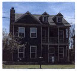
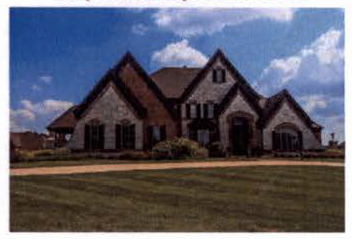
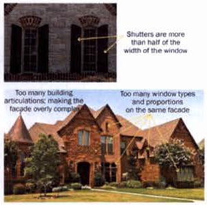
More specifically, the recent success of Oak Street's revitalization has made the adjoining Old Town Neighborhood more attractive and desirable as a place to reinvest. Given the limited number of vacant lots within Old Town and the modest size of most existing homes in the area (see Appendix B for a map on existing home sizes), much of this growth is occurring as demolitions and new home construction on lots. In addition, rising land values has also put the pressure on increasing tear-downs and rebuilds in the neighborhood. Given the scale of the older homes in the neighborhood, several of these new homes, while attractive in their own right, do not "fit in" well with the existing homes.
The purpose and intent of this Neighborhood Design Overlay (herein know as the Overlay) is to preserve the overall integrity and character of the neighborhood while allowing for more context sensitive new construction. The market pressure for older homes to be replaced by newer construction will continue due to both the success of the Oak Street revitalization and Roanoke continuing to be a great community. The City recognizes and welcomes the need for reinvestment, but desires that change occur in a manner that is respectful of the scale, texture, and character of the Old Town Neighborhood. The intent is not to stifle new construction, but rather direct it in terms of design and scale to be more compatible with the walkable character and scale of the neighborhood, thus preserving the long-term value of the neighborhood and the City.
The standards contained in this document are intended to accomplish the following:
• Provide guidance to city staff, property owners and their design professionals in designing new houses and remodeling existing structures.
• Streamline the development review process for more predictability by more clearly communicating community expectations to property owners, builders, and developers up front.
• Ensure that new development is compatible with its surrounding neighborhood.
• Establish a high level of design quality.
• Reinforce the special qualities of Old Town Neighborhood's character and scale.
(b)
Key Design Principles. This Overlay is intended to reinforce the following principles of small-town traditional neighborhood planning that is embodied in the existing character of the Old Town Neighborhood:
(1)
Small and connected blocks;
(2)
Many smaller-scaled homes oriented towards streets with building heights generally one (1) and two (2) story structures typical to the neighborhood;
(3)
The lots and a variety of homes should generate a cohesive pattern that allows streets to be civic places;
(4)
Driveway and garage sizes and locations shall minimize the impact of the automobile along the street;
(5)
Simple residential facades and roof structures;
(6)
Traditional architectural styles and proportions for façade elements; and
(7)
Compatible façade materials with the Old Town Neighborhood.
(c)
Applicability and Relationship to Zoning Regulations. The Old Town Roanoke Neighborhood area is generally defined as the existing neighborhood blocks immediately east of Oak Street, south of Byron Nelson (Bus 114), west of the commercial development on Hwy 170 and north of Lamar Street. A significant portion of these blocks were developed in the 1950's and 60's. However, there are some newer blocks east of Turner Ave. along Meadow Lane, Reed and Main Streets that are excluded from the specific overlay standards in this document.
The Old Town Design Overlay standards apply to all lots located within the Neighborhood Design Overlay Map (see Map 1). Within the Pine Street Overlay, these standards shall apply to all residential buildings types (new and remodeled) regardless of the ultimate use to be located within the building.
The Old Town Neighborhood Design Overlay standards shall address the following development standards:
• Block standards
• Building setbacks
• Building height
• Building façade standards and materials
• Roof design and material standards
• Location of driveways and garages
• Lot coverage standards and building scale standards
• Accessory building standards
All lots within the Old Town Neighborhood Design Overlay shall be exempt from the underlying zoning district and subdivision standards that address the above listed elements only. For the above listed elements, this overlay district shall supersede the zoning and subdivision standards. The underlying zoning district shall address all other elements not regulated under this overlay district.
These overlay standards will be used by the City staff in evaluating changes to existing structures and for new construction of principal and accessory buildings.
(d)
Exterior Remodel and New Residential Design Standards. This section shall address the design standards for all new residential construction and remodels in the Old Town Neighborhood Design Overlay.
(1)
Block and Lot Layout.
a.
Cul-de-sacs are not permitted in the overlay unless natural features such as topography or stream corridors prevent a street connection.
b.
Flag lots are not permitted in the Old Town Neighborhood.
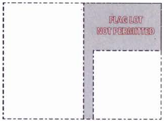
STREET
c.
Blocks widths shall be between two hundred fifty (250) feet and five hundred (500) feet.
(2)
Site Development Standards.
a.
Primary Building Setbacks: Shall meet the standards in Table 1 below.
Table 1: Setback Standards
b.
Garage Location and Setbacks. Location of residential garages shall minimize the frontage of the garage along primary streets to the extent feasible.
1.
All garages facing the street shall be setback a minimum of five feet (5') from the front façade of the building.
2.
Garage width shall be no more than forty percent (40%) of the width of the lot up to a maximum of twenty-four feet (24'). This standard shall only apply if the garage is located towards the front of the principal structure on the lot.
3.
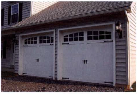
All street facing garage doors shall be articulated single garage doors.
c.
The following graphics indicate the accepted location and placement of garages (attached or detached):
Garage Locations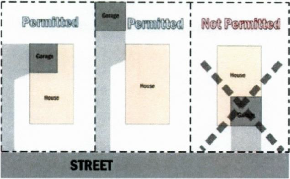
(3)
Building Massing and Scale.
a.
Height. Building height shall be a maximum of two (2) stories (not to exceed thirty feet (30').
b.
Lot Coverage and Massing. Shall be based on the size of the lot per Table 2. Second floor square footage shall be limited to a maximum of seventy-five percent (75%) of the first floor square footage.
Table 2: Lot Coverage Standards by Lot Size
c.
Roof Design. Shall be simple gabled or hipped roofs. Excessive number of roof ridges and forms shall be avoided. Other roof types and proportions shall be appropriate to the compatible architectural styles of Old Town (see appendix for Old Town Architectural style guide.)
1.
Roof elements such as dormers, chimneys, skylights, and varying heights and ridgelines may be utilized to ensure good design and neighborhood continuity. However, these shall be appropriately scaled for the traditional architectural style of the home.
(4)
Building Orientation and Street Frontage (Front Doors, Porches, Stoops).
a.
All buildings shall have doors oriented towards the primary street. The main entry to the home shall be visible from the street.
b.
Provide a prominent entry feature (either projected or recessed) that reflects the home's architectural style. Common projected entries are porches and stoops. Two- and one-story recessed entry features that do not incorporate roof overhangs or stoops shall not be permitted.
(5)
Façade Elements (Windows, Doors, Garage Doors, Architectural Elements)(Applies to Street Facing Facades Only)
a.
Residential buildings shall have relatively flat fronts and simple roofs with most building wing articulations set at the rear of the structure. Window projections, stoops, porches, balconies, and similar extensions are exempt from this standard.
b.
Architectural embellishments that add visual interest to the street facing façades roofs, such as corbels, porch or balcony railings, columns, window sills, dormers and chimneys are encouraged.
c.
Windows shall be vertical or square unless the architectural style supports horizontally proportioned windows. Maintain the same window types and proportions on the same façade. If shutters are used, they shall be half the size of the window opening.
d.
Windows shall have a wood trim around the windows. The trim width should be matched to the style, but in shall not be less than three and one-half (3 ½) inches wide. Window, door and eave trim should be consistent on all street facing elevations of the house, in terms of material, material dimensions and decorative features such as shape, carving, reveals, etc.
(6)
Building Façade Materials (Walls and Roofs).
a.
Primary Façade Materials: Building façade materials should be selected based on the historic context of Old Town. Traditionally, wood siding and uniform colored bricks were used in Old Town. There is limited precedent for stucco in Old Town. Compatible cementations fiber siding such as hardie-plank siding, wood siding, masonry, and 3-step stucco may all be used as façade materials
b.
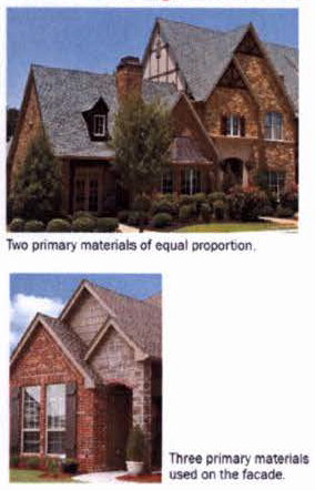
When using a mix of primary façade materials, a maximum of two (2) primary materials shall be permitted on each façade. An even split of materials (i.e., 50/50) on the façades shall not be permitted. One (1) material shall be at least two-thirds (2/3) of the façade.
c.
Accent materials shall not be limited and excluding doors and windows, they shall be limited to trims, cornices, balconies, eaves, stairs, balustrades, pediments, columns, and other decorative elements.
d.
Roof Materials: May be shingles (slate, asphalt) or standing seam metal. Clay or concrete tiles shall not be permitted.
(7)
Accessory Building Standards. Accessory structure standards in the SF-15 zoning district shall apply.
(e)
Administration and Process.
(1)
Administrative Review. Projects that clearly comply with all standards of this overlay shall be processed administratively by the Director of Community Development or his/her designee. Following a complete application, the Director of Community Development shall review and approve, approve with conditions, or deny the application.
(2)
Submittal Materials. The following information shall be required with any application for exterior remodel or new construction in the Old Town Neighborhood Design Overlay:
a.
Site plans and building plans showing all improvements on the lot (drawn to an appropriate scale).
b.
Approved plat (or plat application).
c.
All street facing elevations including exterior building material specifications (drawn to an appropriate scale).
d.
Any other documents and graphics that adequately demonstrate compliance with all applicable sections of this overlay.
(3)
Minor Modifications. Any modifications or appeals to any overlay standard shall be reviewed and considered for approval by a Special Exception Permit Application submitted to the Zoning Board of Adjustment.
Map 1. Old Town Neighborhood Design Overlay Boundary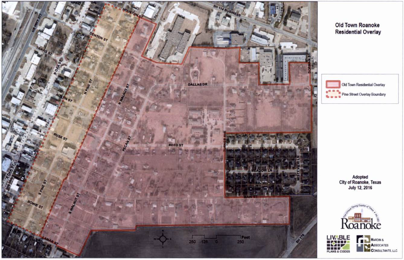
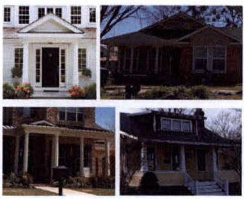
Appendix A - Architectural Style Guide for Old Town Neighborhood Roanoke
(Adapted from "A Field Guide to American Houses", by McAlester, Virginia S.)
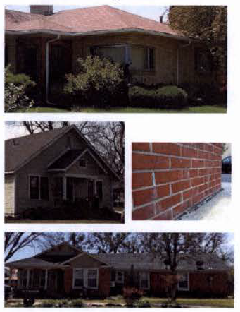
The following pages are intended to provide homeowners and applicants information on the prevalent architectural styles in Old Town in addition to helping design new homes and existing home remodels to be more consistent with the architectural traditions in Old Town. Though these preferred architectural styles reinforce the existing context of Old Town, it does not preclude other styles from being considered. These styles include:
• Minimal Traditional Style
• Ranch
• New Traditional (if used shall be based on appropriate scale, proportions and precedents in Old Town)
• American Vernacular
| Minimal Traditional Style | |
| Identifying Features: | |
|
Cottage-style homes with
• Low or medium pitched roof; • Gabled roof style; • Generally small, 1-story homes; • Roof eaves have no overhang; • Double hung windows; • Minimal architectural features; • Some of the early ranch styles are also minimal traditional. | 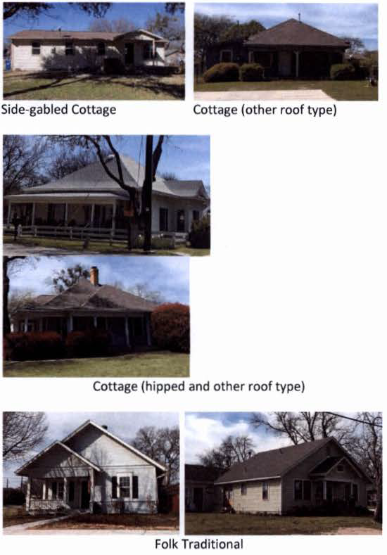 |
| Principal Subtypes: | Typical Architectural Elements: |
|
• Gable-and-wing roof
• Side-gabled (cottage) • Folk traditional (generally has steeper roof pitches) |
Roof forms:
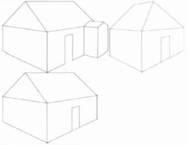 |
|
Façade characteristics:
• Simple compositions, with minimal embellishments such as porches, bay windows, platform steps. • Use of single façade materials (limited use of masonry) | |
| Ranch Style | |
| Identifying Features: | |
Homes with • Wide, one-story shapes built close to the ground;
• Low-pitched roof without dormers;
• Front entry usually located off-center and sheltered under the main roof;
• Garage typically attached to the main façade (facing the front, side or rear);
• Large picture window;
• Asymmetrical façade
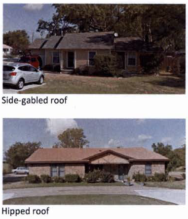 | 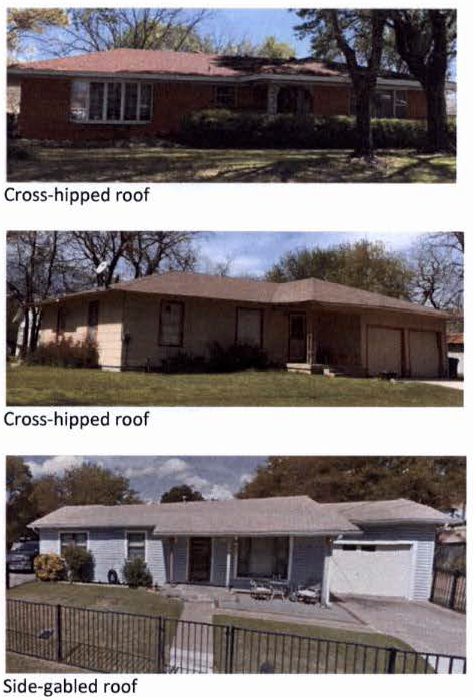 |
| Principal Subtypes/Roof forms: | Typical Architectural Elements: |
|
• Hipped roof
• Cross-hipped roof • Side-gabled roof • Cross-gabled roof | Façade characteristics:
• Windows: variety of sizes and types of pre-fab windows. Over 50% of the ranch homes had at least one (1) large picture window on the front façade. • Front entrances: typically sheltered by the roof. Entries were recessed or set into the L formed by the cross-hipped or cross-gabled roof. Several had partial-width porches. • Cladding materials: Various cladding materials used - wood, brick, stone, concrete blocks, and stucco. No more than two (2) cladding materials were used. If more than one (1) cladding material was used, cladding changes were typically in the entry area or at the base of window or in the gable end. |
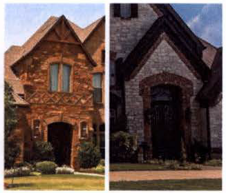
| New Traditional | |
| Identifying Features: | |
|
• Homes built since the 1970s with a more elaborate historical style;
• Several are built with elaborate styles that are popular such as Tudor, Classical, Victorian, Colonial Revival, Craftsman, etc. (often without accurate or proportional detailing or without any neighborhood context) • Front facing garages incorporated into main body of the house; side wings with garages may be attached later; • Few or no windows on the side façades • Shallow porches • Built on slab or foundation with few or no steps to the first floor of the house. | 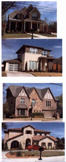 |
| Typical Architectural Elements: | |
|
• Windows: various types of windows uses including vinyl, fiberglass, aluminum, or metal clad
wood.
• Shutters: typically vinyl and not operational (should be at least the size of the window they intend to cover). • Dormers: are widely used and should be appropriately scaled and sized. |
• Porches: Typically are shallow (not permitted), but if provided shall be a minimum depth
of 6'.
• Wall cladding: Typically, several cladding materials are used on the same façade, but no more than 2 primary cladding materials. Range of cladding permitted - uniform brick veneer, 3-step stucco, cementitious fiber board (Hardie Plank), or similar. Stone masonry veneer is not permitted in Old Town. • Garages: Typically 2-car garage with individually articulated garage doors. If 3-car garage, then garage placement is towards the back of the lot. |
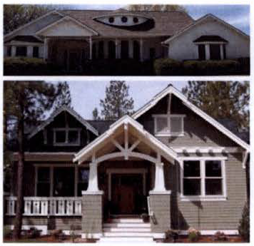
| American Vernacular | |
| Identifying Features: | |
| Homes • Built since the 1970s with a more vernacular style rather than specific architectural style; • Generally simple building forms with minimal adornment or stylistic details; • Uses one (1) dominant cladding material-wood, cementitious fiber board, or uniform brick. | 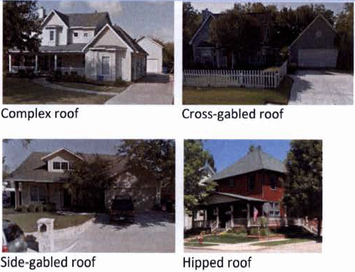 |
| Principal Subtypes | Typical Architectural Elements: |
|
• Front gabled roof, side-gabled roof, or hipped roof: simple rectangular block with
a front gabled roof. May have a porch.
• Cross-gabled: simple gable and wing roof. May have a porch. |
• Porches: are often the main embellishment on the front façade of the house. Porches are deep
enough to accommodate outdoor activity (minimum 6' deep). Porches may be screened.
Porches have simple details and lack ornamentation of columns and brackets.
• Windows: are typically double hung, with simple frames, and may be multi-paned. They are typically more traditionally placed and symmetrical. • Massing: larger homes are more typically "additive", in order to avoid the overly large look of common suburban homes. • Dormers: may be used and should be appropriately scaled and sized. • Wall cladding: Typically a single primary cladding material - uniform brick veneer, 3-step stucco, cementitious fiber board (Hardie Plank), or similar. • Garages: Typically garages are placed towards the back of the lot or home. |
Appendix B: Old Town Assessment & Context Maps
The maps in the following pages provide background information on the existing context of the Old Town neighborhood with respect to existing land uses, lot sizes, age of buildings, and architectural styles. This in turn provides a basis to assess compatibility of the newer residential buildings built in the neighborhood since 1990. The areas of compatibility identified are then the key elements of the Neighborhood Overlay regulations.
Several compatibility issues: This designation indicates several areas where the design of the new residential structure is not compatible with the historic context of the Old Town Neighborhood. These areas include: size (mostly two and one-half (2 ½) story buildings) and massing of the structure relative to the size of the lot, architectural style and building materials, roof structure, and placement of garage.
Some compatibility issues: This designation indicates some areas where the design of the new residential structure is not compatible with the historic context of the Old Town Neighborhood. These areas include location of the garage, building materials, and size of structure relative to the lot size.
Mostly compatible: This designation indicates lots that have new buildings that aremostly compatible with the historic context of the Old Town Neighborhood. This includes size and scale, building materials, placement of garage, and architectural style.
(Ord. No. 2016-115, § 2(Exh. A), adopted 7/12/2016; Ord. No. 2023-115, § 2(Exh. A), adopted 9/26/2023)
Exhibit B
Legal Description of the Properties
(Ord. No. 2016-115, § 2(Exh. B), adopted 7/12/2016; Ord. No. 2017-100, §§ 2—4, adopted 1/10/2017; Ord. No. 2017-106, §§ 2, 3, adopted 2/14/2017; Ord. No. 2023-115, § 2(Exh. A), adopted 9/26/2023)
Sec. 12.620. - General Purpose and Description.
(a)
The City Council of the City of Roanoke, Texas, after public hearing and proper notice to all parties affected and after recommendation from the Planning and Zoning Commission, may authorize the creation of a Planned Development (PD) overlay district.
(b)
The Planned Development (PD) district is an overlay zoning district which accommodates planned associations of uses developed as integral land use units such as office parks, retail/commercial or service centers, shopping centers, residential developments having a mixture of housing options, or any appropriate combination of uses which may be planned, developed or operated as integral land use units either by a single owner or a combination of owners. A Planned Development district may be used to permit new or innovative concepts in land utilization not permitted by other zoning districts in this chapter, to ensure the compatibility of land uses, and to allow for the adjustment of changing demands to meet the current needs of the community by meeting one or more of the following purposes:
(1)
To provide for a superior design on lot/tracts or buildings;
(2)
To provide for increased recreation and open space opportunities for public use and enjoyment;
(3)
To provide amenities or features that would be of special benefit to the property users or to the overall community;
(4)
To protect or preserve natural amenities and environmental assets such as trees, creeks, ponds, floodplains, slopes, viewscapes, or wildlife habitats;
(5)
To protect or preserve existing historical buildings, structures, features or places;
(6)
To provide an appropriate balance between the intensity of development and the ability to provide adequate supporting public facilities and services; and
(7)
To meet or exceed the standards of this chapter.
(c)
While greater flexibility is given to allow special conditions or restrictions that would not otherwise allow the development to occur, procedures are established herein to ensure against misuse of increased flexibility.
Sec. 12.621. - Permitted Uses.
(a)
An application for a PD district shall specify the base zoning district(s) upon which the PD is based, and the use or the combination of uses proposed, including any of the proposed uses which are not allowed by right in the base zoning district. PD designations shall not be attached to SUP requirements. Specific Use Permits allowed in a base zoning district(s) are allowed in a PD only if specifically identified as allowable by SUP at the time of PD approval, and if specifically cited as an "additional use" in the ordinance establishing the PD. Any use that is not specifically cited as permitted, by right or by SUP, in the applicable base zoning district(s) or the PD ordinance shall be prohibited unless the PD ordinance is amended using the procedures set forth in this Section and in article II, division 5 of this chapter.
(b)
In the case of residential PD districts, the proposed lot/tract sizes shall be no smaller than the lot/tract sizes allowed in the base zoning district for each type of housing except for minor changes in a small percentage of the lot/tracts, not to exceed five percent (5%), in order to provide improved design, or to provide flexibility in the layout of the subdivision or diversity in lot/tract size choices.
Sec. 12.622. - Planned Development Requirements.
(a)
Any development requirements for a particular PD district that deviate from those of the base zoning district(s) shall be set forth in the amending ordinance granting the PD district. These shall include, but may not be limited to: allowed or additional uses, lot/tract area, lot/tract width, lot/tract depth, yard depths and widths, building height and size, building exterior construction, lot/tract coverage, floor area ratio, parking, access, screening, landscaping, accessory buildings, signs, lighting, project phasing or scheduling, property management associations, and other requirements as the City Council and Planning and Zoning Commission may deem appropriate.
(b)
In the PD district, uses and development standards shall conform to the standards and regulations of the base zoning district(s) unless specifically stated otherwise in the PD ordinance. The base zoning district(s) shall be stated in the PD granting ordinance. All applications to the City shall list all requested deviations from the standard requirements set forth throughout this chapter as applicable to each base zoning district, applications without this list will be considered incomplete. The PD district shall conform to all other regulations of the applicable base zoning district(s), as well as all other sections of the Zoning Ordinance, unless specifically changed or excluded in the ordinance establishing the PD. A PD that is based upon more than one (1) base zoning district shall also include a legal (metes and bounds) description and graphic exhibit describing/showing the proposed boundaries of each respective area and its base zoning district (e.g., shown as "Proposed PD-SF-7," "Proposed PD-R," etc.).
(c)
The ordinance granting a PD district shall include a statement as to the purpose and intent of the PD district granted therein, as well as a general statement citing the reason for the PD request.
(d)
The minimum acreage for a planned development request shall be as follows:
(1)
Residential Development (SF, SFA): Twenty (20) contiguous acres
(2)
Multi-Family Development (MF-12 or MH): Ten (10) contiguous acres
(3)
Nonresidential Development (O, R, LC, BP, HI): Ten (10) contiguous acres
(4)
Mixed Use (residential and nonresidential): Fifty (50) contiguous acres
Sec. 12.623. - Submission of Concept Plan.
In establishing a Planned Development district in accordance with this Article, the City Council shall approve and file as part of the amending ordinance appropriate plans and standards for each PD district. To facilitate understanding of the request during the review and public hearing process, the concurrent submission of a concept plan shall be required along with the PD zoning application. A construction plat may be submitted in lieu of the concept plan for a single- or two-family PD, as required by the City Subdivision Ordinance, if the applicant prefers to do so, and if the applicant wishes to expend the resources and funds necessary to prepare a complete construction plat submission.
(a)
Concept Plan. This plan shall be submitted by the applicant at the time of the Planned Development request. The concept plan is part of the zoning submission process and it is not to be considered a "permit" as that term is envisioned in Chapter 245 of the Texas Local Government Code, as amended. The plan shall show the applicant's intent for the use of the land within the proposed PD district in a graphic manner and, as may be required, supported by written documentation of proposals and standards for development. The City may prepare application form(s) that further describe and explain the following requirements:
(1)
Residential PD Concept Plan. A concept plan shall be submitted with any residential PD zoning request for a development comprised of single-family or two-family (duplex) dwellings on individually platted lot/tracts, and shall show general uses, phasing of the development, access, thoroughfares, alleys (if proposed), preliminary lot/tract arrangements, proposed densities, proposed screening, landscaped or private amenity areas, project scheduling, and other pertinent development data. See the City Subdivision Ordinance for additional information on concept plan submission as it relates to the platting of land. For a single- or two-family PD (or portion of a PD)—A construction plat, as required by the City Subdivision Ordinance, shall be submitted for approval within one (1) year from the approval date of the concept plan for all or some portion of the PD covered by the overall PD concept plan. If a construction plat is not submitted within one (1) year, then the PD concept plan may be subject to review by the Planning and Zoning Commission and the City Council to determine its continued validity. If the City determines that the PD concept plan is no longer valid or that the proposed development is no longer viable, then a new PD concept plan, including a zoning application to amend the PD ordinance and its accompanying concept plan, must be submitted for review and approval prior to construction plat review/approval, and any subsequent issuance of a building permit, for any single- or two-family portion of the PD district.
(2)
Nonresidential or Multi-Family PD Concept Plan. A concept plan shall be submitted with any nonresidential, multi-family, single-family attached, or manufactured housing PD zoning request, and shall clearly show all pertinent aspects of the type and nature of the proposed development. The concept plan shall show the types of use(s) proposed; access, topography and boundaries of the PD area; existing physical features of the site; existing and proposed streets, alleys, easements and lot/tract lines; location of existing or proposed public facilities; building heights and locations; parking areas and ratios; fire lanes; screening and landscaped areas; project phasing and scheduling; and other pertinent development data to adequately describe the proposed development (see article II, division 7 of this chapter for concept plan requirements and procedures). For a nonresidential, multi-family, single-family attached, or manufactured housing PD (or portion of a PD)—A detailed site plan shall be submitted for approval (in accordance with Subsection (b) below, and with article II, division 7 of this chapter) within one (1) year from the approval date of the concept plan for all or some portion of the PD covered by the overall PD concept plan. If a detailed site plan is not submitted within one (1) year, then the PD concept plan may be subject to review by the Planning and Zoning Commission and the City Council to determine its continued validity. If the City determines that the PD concept plan is no longer valid or that the proposed development is no longer viable, then a new PD concept plan, including a zoning application to amend the PD ordinance and its accompanying concept plan, must be submitted for review and approval prior to detailed site plan review/approval, and any subsequent issuance of a building permit, for any nonresidential, multi-family, single family attached, or manufactured housing portion of the PD district.
(b)
PD Site Plan (detailed). Submission and approval of the detailed PD site plan shall be in accordance with article II, division 7 of this chapter, and shall accompany an application for a nonresidential, multi-family, single-family attached, or manufactured housing Planned Development zoning if the applicant prefers to submit the detailed site plan in lieu of the required PD concept plan. The detailed PD site plan shall establish the final plans for development of the Planned Development district (or any portion thereof), and it shall substantially conform to the site layout and development data approved on the PD concept plan, which shall be adopted along with the PD ordinance. If a PD concept plan was previously approved for the overall PD district, then a detailed PD site plan, along with the required engineering/architectural site construction plans and construction plat, may be submitted for only the sections or lot/tracts that are proposed for immediate development rather than for the entire PD. If no concept plan was approved with the ordinance establishing the PD, then a concept plan for the entire PD must be submitted and approved prior to approval of a detailed site plan, along with the required engineering/architectural site construction plans and construction plat, for only the portion(s) of the PD that are proposed for immediate development. For any single- or two-family residential district (AG, SF-22, SF-15, SF-11, or SF-7), a construction plat shall qualify as the site plan.
(c)
Lapse, Extension or Reinstatement of the PD site plan shall be in accordance with the provisions above and the provisions in article II, division 7 of this chapter.
Sec. 12.624. - Approval Process and Procedures.
(a)
The procedure for establishing a Planned Development zoning district shall follow the procedures for zoning amendments as set forth in article II, division 5 of this chapter. This procedure shall be expanded to include concurrent consideration and approval (or denial) of the concept plan that is submitted along with the PD zoning request application. The public hearings conducted for, and the subsequent actions taken upon, the PD zoning request shall also include the accompanying concept plan, and if the PD is approved then the concept plan shall become a part of the ordinance establishing the PD district.
(b)
The ordinance establishing the Planned Development zoning district shall not be approved (or adopted) until the accompanying concept plan is approved by the City Council, and until all other procedural requirements set forth in article II, divisions 5 and 7 are satisfied.
Sec. 12.625. - Report Required for Planned Development District Zoning Request.
When a zoning request for a Planned Development district is being considered, a written report from the City Manager or his/her designee discussing the project's impact upon planning, engineering, water utilities, electric, sanitation, building inspection, tax, police, fire and traffic, as well as written comments from applicable public agencies, such as the applicable School District and/or utility companies, may be submitted to the Planning and Zoning Commission prior to the Commission making any recommendations to the City Council. In the event written comments and advisement are not forthcoming in a reasonable amount of time, the Commission may, at its discretion, make a recommendation to the City Council without said comments or advisement.
Sec. 12.626. - Prefix of Planned Development Districts.
All Planned Development zoning districts approved in accordance with the provisions of this chapter, as may be amended, shall be prefixed by a "PD" designation and assigned a unique identification number (e.g., PD-1, PD-2, PD-3, and so on), and shall also be referenced on the Zoning District Map. A list of such Planned Development districts, showing the uses permitted and any other special stipulations of each PD district, shall be maintained as part of this chapter.
Sec. 12.627. - Prior Planned Development Ordinances Remaining in Effect.
Prior to adoption of this chapter, the City Council previously established certain Planned Development districts, some of which are to be continued in full force and effect. The ordinances or parts of ordinances approved prior to this chapter, specified in Appendix 2, shall be carried forth in full force and effect and are the conditions, restrictions, regulations and requirements which apply to the respective Planned Development districts shown on the Zoning District Map as of the effective date of this chapter. Each prior PD ordinance is hereby assigned a unique identification number (e.g., PD-1, PD-2, PD-3, and so on) as shown in Appendix 2, and subsequent PD ordinances adopted after the effective date of this chapter shall be similarly numbered for identification purposes.