
Rockledge City Zoning Code
ARTICLE II
PLANNING DISTRICTS
Sec. 118-37.- Substandard lots of record.
Where a lot or parcel of land has an area or frontage which does not conform to the requirements of the district in which it is located, but was a lot of record in the County, at the effective date of the ordinance from which this section is derived, such lot or parcel of land may be used for a single-family dwelling in any residential district, providing the minimum yard requirements for substandard lots (see definition) are maintained.
(LDR 1990, § 60.08(1))
Sec. 118-38. - Appendix A, planning district guidelines.
The goal of the planning district guidelines is to ensure a development pattern which recognizes land as a natural resource and promotes its most efficient and effective use in order to provide adequate space for all land use activities.
(LDR 1990, § 60.08(2))
Sec. 118-39. - Boundary limits of Planning District 1.
Planning District 1 is bounded by the following:
(1)
North: City limit line with Cocoa.
(2)
East: the Indian River.
(3)
South: the City limits.
(4)
West: A line starting at the south City limits 300 feet east and parallel to the east right-of-way line of U.S. 1, running north to Seminole Drive, excepting those platted residential lots west of the referenced line and contiguous to the east right-of-way line of U.S. 1 which shall remain in Planning Area 1, continuing north on Seminole Drive to Orange Avenue, then east to the east property line of lots adjacent to Florida Avenue; then north along the east property lines of properties along Florida Avenue or 300 feet the east Florida Avenue right-of-way line, whichever is less, with the exception of existing lots 1 and 28 located on Little John Lane in Sherwood Forest Subdivision #84 as recorded in Plat Book 10, page 5, and Taylor Park which shall remain in Planning Area 1.
a.
Planning District 1: Rockledge Drive Area.
1.
Area objective. The area objective is to maintain and improve this area primarily for low and medium density residential development and ensure that future development will not substantially alter or depreciate the existing character of the area and encourage the establishment of historic districts to protect historically significant buildings in the area.
2.
Type of land use.
(i)
New development in this area will be primarily limited to single-family dwellings and directly related land uses such as parks, schools, utilities, streets, and other noncommercial activities whose primary purpose is to serve and improve the quality of the residential districts.
(ii)
Zoning districts that may be appropriate for this area after due consideration by the City include R1, R2 or historic zoning districts. Other zoning districts shall be approved only if consistent to and compatible with the intent or criteria of this district.
(iii)
To prohibit commercial and multifamily residential development in this area except the block bordered by Rockledge Drive on the east, Shares Drive on the west, Barton Avenue on the south and Orange Avenue on the north. Commercial uses, including marinas, piers, and docks, shall not be allowed on the property located between the east right-of-way line of Rockledge Drive and the east boundary of the City limit (Channel of the Indian River).
(iv)
Encourage the establishment of historic districts to protect and enhance the historically significant sites and structures in the area.
3.
Density. The density of new residential development will be limited to that established by the applicable zoning district. The maximum residential density shall not exceed four units per acre.
4.
Compatibility.
(i)
Scale, materials, building orientation, signing, landscaping, detailing, and other physical features that are compatible with the intent to maintain the residential character of this district shall be incorporated in any new development.
(ii)
A.
Adequate vegetation and/or constructed (fences, walls, berms, etc.) buffers and/or open space will be used between different land uses.
B.
Special features to accomplish appropriate compatibility of new development with existing development shall be required through the Land Development Regulations when the need has been identified in the site plan review process.
5.
Transportation.
(i)
The transportation system will be maintained in accordance with the policies contained in the traffic circulation element.
(ii)
Strategies will be developed and coordinated with Cocoa to minimize the amount of nonresidential traffic on Rockledge Drive.
(iii)
Provisions for pedestrian and bicycle improvements as addressed in the traffic circulation element will be incorporated into any new development.
(iv)
Adequate access for sanitation, police, fire and rescue vehicles will be provided by all new development.
6.
Conservation.
(i)
One inch of stormwater shall be detained in all new developed or redeveloped areas.
(ii)
Areas east of Rockledge Drive which are within the 100-year floodplain and the coastal high hazard area shall only be used for recreational purposes with construction limited to docks or piers appurtenant to upland residential properties on the Indian River or recreational facilities identified in the recreation and open space element.
7.
Recreation and open space. Development of recreational amenities within this area to take advantage of the Indian River should proceed in accordance with the policies and strategies outlined in the recreation and open space element but shall not have an adverse effect on adjoining or historic properties.
See the map on file in city hall.
(LDR 1990, § 60.10)
Sec. 118-40. - Boundary limits of Planning District 2.
(a)
Planning District 2 is bounded by the following:
(1)
North: City limit line with Cocoa.
(2)
East: a line beginning at the north City limits with Cocoa and extending south along the east property lines of those properties adjacent to Florida Avenue to 300 feet east of the right-of-way line of Florida Avenue, whichever is less, to the Florida East Coast Railroad east right-of-way line, with the exception of existing Lots 1 and 28 located on Little John Lane in Sherwood Forest Subdivision #84 as recorded in Plat Book 10, Page 5, and Taylor Park which will remain in Planning Area 1.
(3)
Southwest: the Florida East Coast Railroad east right-of-way line.
(b)
Planning District 2: Florida Avenue Area.
(1)
Area objective. The area objective is to maintain and improve this area primarily for commercial and business development while upgrading the overall existing character and appearance of the area.
(2)
Type of land use.
a.
Development in this district will be primarily wholesale trade, retail trade, business and professional offices, public and semi-public services and such other uses which support and are compatible with the intent of this district.
b.
Existing residential development shall be retained on Florida Avenue.
c.
Development in this district may be neighborhood, community, or large-scale in nature but may not attract such significant volumes of traffic as to create conditions on roads or intersections within or immediately adjacent to this district that result in a level of service below "E."
d.
All new development proposals for this area shall be coordinated with the City of Cocoa and the City's redevelopment agency to ensure that it is compatible with and supportive of that City's downtown redevelopment efforts.
(3)
Density. Residential development will be limited to existing densities.
(4)
Compatibility.
a.
Scale, materials, building orientation, signing, landscaping, detailing, and other physical features that are compatible with the intent of this district shall be incorporated in all new development plans.
b.
Vegetative buffers, constructed buffers (fences, walls, berms, etc.) and/or open space will be used between different land uses, particularly between residential and nonresidential.
c.
Special features to accomplish appropriate compatibility of new development with existing development may be required through the Land Development Regulations when the need has been identified in the site plan review process.
d.
Efforts will be undertaken to coordinate with the County School Board to ensure compatibility of their property with neighboring land uses.
(5)
Transportation.
a.
Access from property fronting on U.S. 1 should, where feasible and appropriate, be strictly limited by use of shared access by different land uses or access to the property from existing side streets.
b.
An annual monitoring program for Florida Avenue should be initiated as part of an effort to ensure adequate traffic flow on the road.
c.
Strict limitation of access from property fronting Florida Avenue should be encouraged through the use of shared access points by different land uses or any other available means.
d.
Where feasible, provisions for pedestrian and bicycle improvements will be made as new development occurs.
e.
A corridor study shall be undertaken and draft development guidelines prepared which will define the potential of Florida Avenue as a major north-south arterial.
(6)
Conservation. One inch of stormwater shall be retained in all newly developed or redeveloped areas.
(7)
Recreation and open space. Land dedicated for recreation and open space or fees in lieu of shall be in conformance with the provisions of the recreation and open space element.
Planning District 2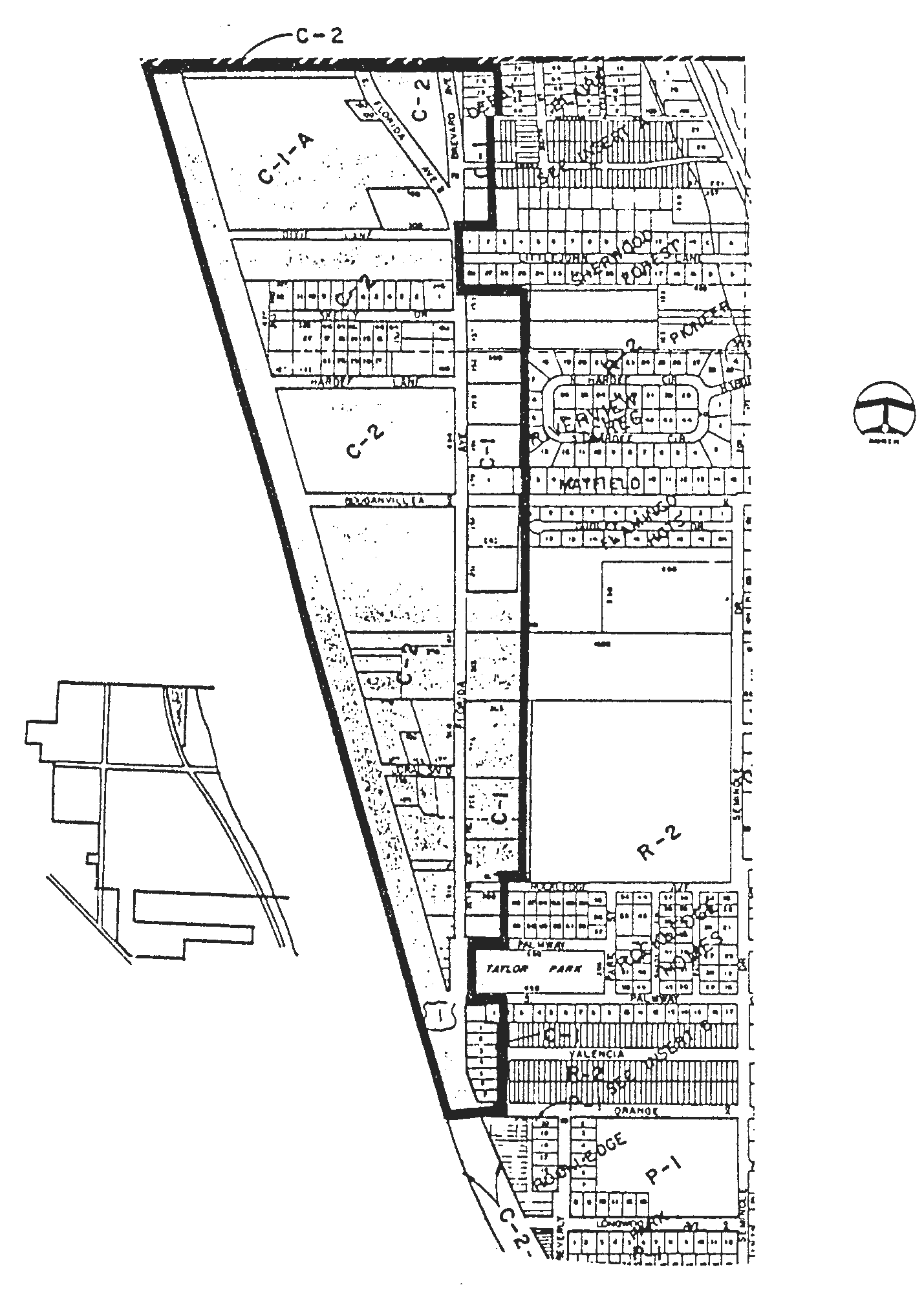
(LDR 1990, § 60.20)
Sec. 118-41. - Boundary limits of Planning District 3.
(a)
The Hospital Area is bounded by the following:
(1)
North: Orange Avenue.
(2)
Southwest: Florida East Coast Railroad east right-of-way line.
(3)
East: Seminole Avenue.
(b)
Planning District 3: Hospital Area.
(1)
Area objective. The area objective is to guide and control this area as primarily a high intensity center for medical services while ensuring compatibility of future development with regional thoroughfares, local roads, and adjacent residential development.
(2)
Type of land use.
a.
Development in this district will be limited to the hospital and related medical facilities and offices.
b.
The City shall prepare urban design guidelines for the area around the Wuesthoff Hospital to assist in the orderly transition of this area from residential to medical-related uses to be coordinated with the hospital.
(3)
Density. Intensity will be limited to the maximum building height, floor area ratio and lot coverage as prescribed in the existing zoning for this area.
(4)
Compatibility.
a.
New development will incorporate scale, materials, building, orientation, signing, landscaping, detailing, and other physical features that are compatible with the intent of this district.
b.
Adequate vegetative buffers, constructed buffers (fences, walls, berms, etc.) and/or open space will be used to define and separate different land uses.
c.
Special features to accomplish appropriate compatibility of new development with existing development may be required through the urban design guidelines established for this area if determined to be necessary during the site review process.
(5)
Transportation.
a.
A long-range program will be established for the purpose of removing all on-street parking from the area. No new development will be permitted without adequate off-street parking.
b.
Access from property fronting U.S. 1 should, where feasible and appropriate, be strictly limited through the use of shared access by different land uses or access to the property from existing side streets.
c.
Where feasible, provisions for pedestrian and bicycle improvements will be made by new development.
d.
Adequate access for sanitation, police, fire, and rescue agencies shall be provided by all new development.
e.
Efforts to beautify the U.S. 1 corridor shall be undertaken with emphasis given to landscaping and irrigating the medians.
(6)
Conservation. One inch of stormwater shall be retained in all newly developed or redeveloped areas.
(7)
Recreation and open space. No lands are anticipated to be dedicated to the provision of parks within this district.
See the map on file in city hall.
(LDR 1990, § 60.30)
Sec. 118-42. - Boundary limits of Planning District 4.
(a)
The Poinsett Area is bounded by the following:
(1)
North: Orange Avenue.
(2)
East: Florida East Coast Railroad east right-of way line.
(3)
South: the drainage ditch located in the vicinity of the half section line of section 4.
(4)
West: the west right-of-way line of the Huntington Boulevard extension from the half section line of section 4 north to the City limits.
(b)
Planning District 4: the Poinsett Area.
(1)
Area objective. The area objective is to guide and control this area for future light industrial development while ensuring compatibility with the area's natural systems, adjacent land uses and local access roadways.
(2)
Type of land use.
a.
Development in this area will be limited primarily to light industrial uses and directly related land uses.
b.
Neighborhood commercial development, consistent in scale and intensity with adjacent residential land uses, may be allowed on property fronting Poinsett Drive.
(3)
Density. The intensity of development will be limited by the capacity of the area to accommodate development given the natural constraints to development.
(4)
Compatibility.
a.
New development will incorporate scale, materials, building orientation, signing, landscaping, detailing and other physical features that are compatible with the intent to establish a quality and site sensitive development.
b.
Adequate vegetative buffers, constructed buffers (fences, walls, berms, etc.) and/or open space will be used between differing land uses.
(5)
Transportation.
a.
New development will provide for adequate access to land uses within the area for sanitation, police, fire, and rescue vehicles.
b.
Where feasible, provisions for pedestrian and bicycle improvements as addressed in the traffic circulation element will be made by new development.
(6)
Conservation.
a.
All new development will conform to the floodplain requirements found within the conservation element.
b.
All new development will be responsible for ensuring adequate drainage for their facilities so that no additional burden is placed on public drainage facilities.
(7)
Recreation and open space. This district is considered appropriate for a community park as addressed in the recreation and open space element.
See the map on file in city hall.
(LDR 1990, § 60.40)
Sec. 118-43. - Boundary limits of Planning District 5.
(a)
Planning District 5 is bounded by the following:
(1)
North: the north and east boundary of the Village Green Shopping Center, then east along Barton Boulevard to the west line of section 4, then north to the north boundary of McLarty Park, then east to the east boundary of Barton Park Manor Subdivision, then north to the drainage ditch located in the vicinity of the half section line of section 4, then east to the Florida East Coast Railroad east right-of-way line.
(2)
East: the Florida East Coast Railroad east right-of-way line south to the west line of section 10, continuing due south to the intersection of Murrell Road and Eyster Boulevard.
(3)
West: Fiske Boulevard.
(4)
South: Eyster Boulevard, west to Fiske Boulevard.
(b)
Planning District 5: Barton Boulevard Area.
(1)
Area objective. The area objective is to guide development in this area toward the establishment of a mixed use area consisting of highly intensive mixed uses while maintaining compatibility with regional thoroughfares, local roads, municipal systems, and adjacent land uses.
(2)
Type of land use. Development in this district will be limited to retail trade, business and professional offices, multiple-family attached dwellings, public and semi-public service, parks and open space, and directly related land uses such as utilities, streets, parking facilities, and other such activities that are compatible with and support the intent of this district.
(3)
Density. The density of new residential development in this planning district is limited to a maximum of 14 dwelling units per acre, except that the maximum density for an older adult living facility qualifying as housing for older persons under the provisions of F.S. § 760.29(4) is 25 dwelling units per acre if all of such facility, or the major portion thereof, is located within 1,000 feet of a community park as defined in the Comprehensive Plan and a special exception for the older adult living facility is first granted by the City. In order to qualify for the special exception, a proposed older adult living facility must be located more than 1,000 feet distant from any other older adult living facility, such distance being measured from the nearest property line of any one such facility to the nearest property line of any other such facility, and must meet other specific site and construction requirements established by these Land Development Regulations. An older adult living facility that qualified for a special exception will be entitled to a reduction in the minimum room size requirement otherwise applicable to multifamily dwelling units in Planning District 5, the extent of such reduction to be established by these Land Development Regulations. The increased density and smaller room size allowances for older adult living facilities will help to lower the per unit rental cost of the project and will help to accommodate the special housing needs of the elderly and handicapped population of the City.
(4)
Compatibility.
a.
Urban design guidelines shall be developed which address appropriate scale, materials, building orientation, signing, landscaping, detailing, and other physical features within the district.
b.
Adherence to the design guidelines shall be required to ensure orderly development of the area and compatibility of uses within and adjacent to the district.
c.
Adequate vegetation, constructed buffers (fences, walls, berms, etc.) and/or open space will be used between different land uses.
(5)
Transportation.
a.
Where possible, direct ingress and egress by new development on regional thoroughfares will be prohibited or severely limited.
b.
A corridor improvement study for Barton Boulevard will be undertaken in conjunction with the appropriate transportation agencies to ensure a continued acceptable level of service and an aesthetically pleasing design supportive of the intent of the district. The four-laning of Eyster Boulevard should be given a high priority.
c.
Where feasible, provisions for pedestrian and bicycle improvements will be made.
(6)
Conservation. New development will provide adequate treatment of stormwater prior to discharge.
(7)
Recreation and open space. New multifamily development will provide adequate open space and/or recreational facilities for occupants of the development.
Planning District 5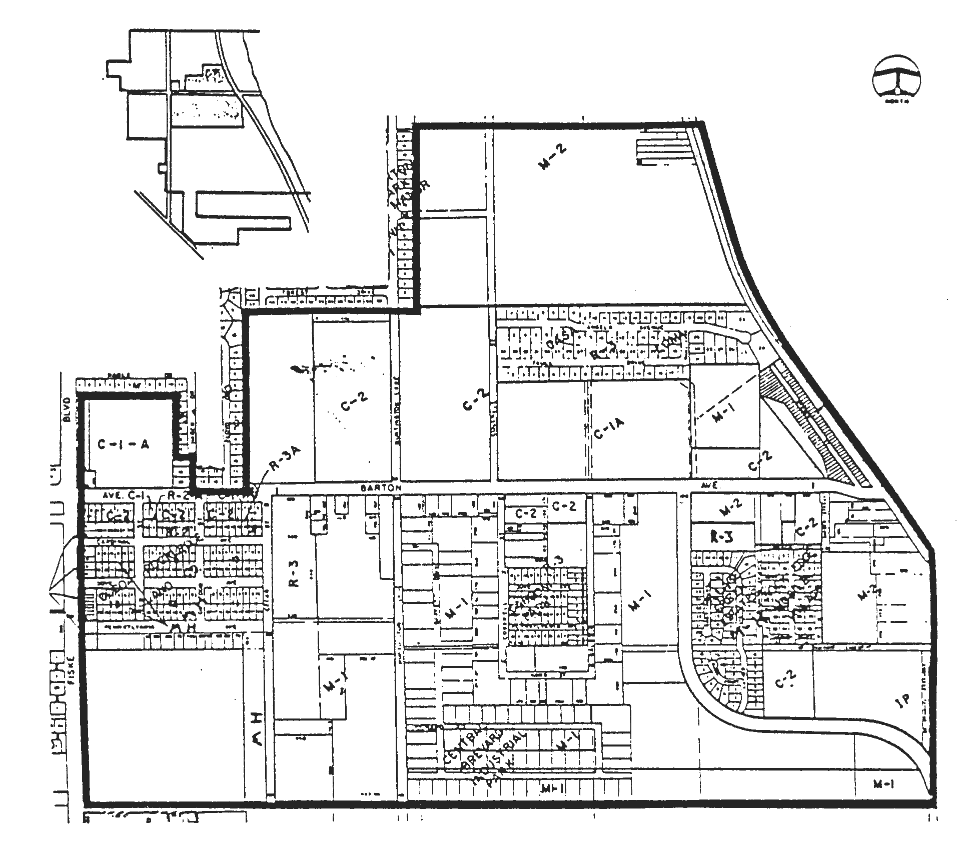
(LDR 1990, § 60.50; Ord. No. 1049-93, § 2, 4-21-1993)
Sec. 118-44. - Boundary limits of Planning District 6.
(a)
The Murrell Road Area is bounded by the following:
(1)
Northeast: a line parallel to and 300 feet east of the east right-of-way line of U.S. 1, excepting those platted single-family subdivision lots recorded as October 5, 1988, which shall remain in Planning Area 1.
(2)
South: the north boundary of section 22.
(3)
West: a line parallel to and 630 feet west of Murrell Road from the South City limits to Eyster Boulevard, excepting those platted single-family subdivision lots recorded as of October 5, 1988, which shall remain in Planning Area 8, Fiske Boulevard Area, then east to Murrell Road, then due north to U.S. 1.
(b)
Planning District 6: Murrell Road Area.
(1)
Area objective. The area objective is to establish this area as a high quality office/industrial park, with varying peripheral land uses, which is compatible with and incorporates within its design the area's natural systems.
(2)
Type of land use.
a.
Development in this area shall consist primarily of light industrial uses and professional or business offices.
b.
Residential uses may be allowed to locate on the west side of Murrell Road to a depth of 630 feet. Commercial uses may also be allowed to a depth of 300 feet.
c.
New development between U.S. 1 and the Florida East Coast Railroad should be limited to commercial uses. Existing industrial uses currently located within this area shall be discouraged from expanding.
d.
Development east of U.S. 1 will be limited to commercial uses.
(3)
Density. New residential development shall be developed at a maximum of 14 dwelling units per acre on the west side of Murrell Road to a depth of 300 feet and eight dwelling units per acre to a depth of 330 feet beyond the front 300 feet.
(4)
Compatibility.
a.
Scale, materials, building orientation, signing, landscaping, detailing, and other physical features that are compatible with the intent to maintain the residential character of this district shall be incorporated in any new development.
b.
1.
Adequate vegetative buffers, constructed buffers (fences, walls, berms, etc.) and/or open space will be used between different land uses.
2.
Special features to accomplish appropriate compatibility of new development with existing development shall be required through the Land Development Regulations when the need has been identified through the site plan review process.
c.
County lands on Murrell Road should be encouraged to develop consistent with the policies of this planning area and, when appropriate, annexed into the City.
(5)
Transportation.
a.
An internal circulation and access plan for the district shall be prepared by City staff and approved by the governing body.
b.
As part of the internal circulation and access plan, consideration shall be given to strictly limiting direct ingress and egress by new development onto the major thoroughfares within the district.
c.
Where appropriate, provisions for pedestrian and bicycle improvements shall be made by new development.
d.
Efforts to beautify the U.S. 1 corridor shall be undertaken with emphasis given to landscaping and irrigating the medians.
(6)
Conservation. All development in the district shall adhere to the floodplain policies and requirements addressed in the conservation element.
(7)
Recreation and open space. New residential development will provide the necessary open space and/or recreational facilities to serve their occupants.
See the map on file in city hall.
(LDR 1990, § 60.60; Ord. No. 1049-93, §§ 3—5, 4-21-1993)
Sec. 118-45. - Boundary limits of Planning District 7.
(a)
The Barnes Boulevard Area is bounded by the following:
(1)
North: the north boundary line of section 21 and the south line of the 50-foot road and utility easement in section 22.
(2)
East: the Florida East Coast Railroad.
(3)
South: the City limit line.
(4)
West: the City limit line.
(b)
Planning District 7: Barnes Boulevard Area.
(1)
Area objective. The area objective is to create a mixed use district having a mixture of residential types with limited commercial, industrial, and office uses.
(2)
Type of land use.
a.
Development in this district will primarily consist of single-family, multiple-family, manufactured housing, and directly related land uses such as parks, schools, utilities, streets and other such activities whose primary purpose is to serve the residents of the area.
b.
Commercial development may be allowed along Barnes Boulevard consistent with traffic design requirements for protecting the capacity of roadway and based upon an established need for commercial development within the district and unincorporated areas adjacent to the district.
c.
Through a joint planning agreement with the County, appropriate land uses and guidelines for future development around the I-95/Fiske Boulevard Interchange shall be determined.
d.
Industrial park development with limited commercial and office uses shall be encouraged to locate east of Murrell Road.
e.
The City shall undertake steps to execute an interlocal agreement with the County which identifies as an urban reserve area land adjacent to this district.
(3)
Density. The density of new residential development will be limited to a maximum of ten dwelling units per acre and will be subject to extensive compatibility tests for consistency with this area.
(4)
Compatibility.
a.
Scale, materials, building orientation, signing, landscaping, detailing, and other physical features that are compatible with the intent to maintain the residential character of this district shall be incorporated in any new development.
b.
Adequate vegetation buffers, constructed buffers (fences, walls, berms, etc.) and/or open space will be used between different land uses.
c.
Special features to accomplish appropriate compatibility of new development with existing development shall be required through the Land Development Regulations when the need has been identified through the site plan review process.
(5)
Transportation.
a.
Extension of Murrell Road south shall be encouraged.
b.
Direct ingress and egress by new development on major roadways will be severely limited.
c.
Where appropriate, provisions for pedestrian and bicycle improvement will be made.
d.
The City shall encourage and support improvements to Barnes Boulevard as a priority item of the County.
(6)
Conservation.
a.
All development within the district will occur in a manner consistent with the policies contained in the conservation element.
b.
New development will provide adequate treatment of stormwater.
(7)
Recreation and open space. Consistent with the policies of the recreation and open space element, a community or larger park should be established.
See the map on file in city hall.
(LDR 1990, § 60.70)
Sec. 118-46. - Boundary limits of Planning District 8.
(a)
The Fiske Boulevard Area is bounded by the following:
(1)
North: the city limit line.
(2)
East: a line running south along the Huntington Lane west right-of-way to the south boundary line of Barton Park Manor, then west to the west boundary line of section 4, then south to Barton Boulevard, then west along Barton Boulevard to the east boundary of Village Green Shopping Center, then north and west along the shopping center boundary to Fiske Boulevard, then south to Eyster Boulevard, then east to a point 630 feet west of Murrell Road, then south to the south line of section 16, with the exception of those platted single-family residential lots within said 630 feet which shall remain in Planning Area 8.
(3)
South: the south line of section 16.
(4)
West: the City limit line.
(b)
Planning District 8: Fiske Boulevard Area.
(1)
Area objective. The area objective is to maintain and improve this area as a low and medium density residential area and ensure that future development will not substantially alter or depreciate the existing character of the area.
(2)
Type of land use.
a.
Development within the districts will be limited primarily to single-family detached dwellings and directly related land uses such as parks, schools, utilities, streets, and other such activities whose primary purpose is to serve the residents of the district.
b.
Limited commercial, professional, and multifamily residential uses will be considered in appropriate locations based on severe compatibility and consistency tests.
c.
The City shall undertake steps to develop through an interlocal agreement with the County an urban reserve area which encompasses unincorporated areas adjacent to this district.
(3)
Density. Maximum density allowed shall not exceed five dwelling units per acre, except where current zoning has been approved at higher densities.
(4)
Compatibility.
a.
Scale, materials, building orientation, signing, landscaping, detailing, and other physical features that are compatible with the intent to maintain the residential character of this district shall be incorporated in any new development.
b.
Adequate vegetative buffers, constructed buffers (fences, walls, berms, etc.) and/or open space will be used between different land uses.
c.
Special features to accomplish appropriate compatibility of new development with existing development shall be required through the Land Development Regulations when the need has been identified through the site plan review process.
d.
The undeveloped areas west of Fiske Boulevard shall be encouraged to develop at low densities in order to protect the natural character of the land.
e.
The development of the land lying south of Levitt Park, east of Fiske Boulevard, and 630 feet or more west of Murrell Road as low and medium density residential areas utilizing the PUD provisions of this chapter shall be encouraged.
f.
Neighborhood commercial development on the lots fronting on Poinsett Drive between Fiske Boulevard and Howard Street shall be encouraged.
(5)
Transportation.
a.
A north-south collector road from the Clearlake Road Extension into an existing roadway in King's Grant Subdivision shall be encouraged.
b.
The transportation system will be maintained in accordance with the policies contained in the traffic circulation element.
c.
Provisions for pedestrian and bicycle improvements as addressed in the traffic circulation element will be incorporated into any new development.
d.
Adequate access for sanitation, police, fire and rescue vehicles will be provided by all new development.
e.
Extension of Clearlake Road to Barton Boulevard should be considered a priority road improvement project.
f.
Encourage the development of an east-west corridor between Woodsmere Parkway and Barnes Boulevard.
(6)
Conservation. The City shall undertake efforts to work with the County in preserving those wetland areas west of Fiske Boulevard.
(7)
Recreation and open space. Consistent with the policies of the open space and recreation element, a community park or larger sized park should be established in the southernmost portion of the planning district.
See the map on file in city hall.
(LDR 1990, § 60.80)