
Rocky Mount City Zoning Code
CHAPTER 7
- GENERAL DEVELOPMENT STANDARDS
Sec. 701.- General.
A.
Open space. No required open space or required lot area required for a building or structure shall, during its life, be occupied by or counted as open space for any other building or structure.
B.
Use. No building or land shall hereafter be used or occupied and no building or part thereof shall be erected, moved or structurally altered except in conformity with the uses and dimensional regulations of this LDC, or amendments thereto, for the district in which it is located.
C.
Only one (1) main building, one (1) main use on lot. In all districts every main building hereafter erected or altered shall be located on a separate lot, as defined in this LDC, and in no case shall there be more than one (1) main building and permitted accessory building on the lot nor more than one (1) main use (e.g., commercial, industrial or residential) per building and lot; provided that this requirement shall not apply to uses that are permitted by the Table of Permitted Uses [section VII.A] within the same zoning district and located in the same building, nor to motels or mobile home parks, nor to planned building groups approved by the planning board, nor to a bona fide farm use, nor to a residential use in a B-4 district, nor to tracts ten (10) acres or greater located in an A-1 district. Tracts of ten (10) or more acres in an A-1 district may have one (1) residence in addition to permitted nonresidential main uses on the same recorded tract. In the case of applications for double occupancy permits involving a residential use and a nonresidential use of the same building in an O-I or B-4 zone, where the building inspector or authorized agents deem that an above-normal safety hazard exists due to the storage of chemicals or explosive commodities, such applications shall be forwarded to the board of adjustment for a determination of whether or not a safety hazard exists which would create a substantial detriment to the proposed residential occupancy, residential occupancy of that building shall be prohibited.
D.
Minimum yards. The minimum yards or other open spaces required by this LDC, including those provisions regulating intensity of use, for each and every building hereafter erected or structurally altered shall not be encroached upon or considered as meeting the yard or open space requirements or the intensity of use provisions for any other building.
E.
Lot subdivision. No lot shall hereafter be so reduced in area as to cause any open space required by this LDC to be less in any dimension than is herein required by the minimum yard requirements of the zone in which the lot in question is situated.
F.
Improvements bond. No final certificate of occupancy/compliance for a commercial, residential or mobile home park planned building group will be issued until all required site improvements have been completed. In lieu of completion of all required site improvements, the developer of the planned group may enter into a contract with the city providing for the installation of city improvements within a designated period of time. Performance of said contract shall be secured by a cash or surety bond which will cover the total estimated cost of the improvements as determined by the director of public works; provided, however, that said bond may be waived by the city council within its discretion.
(Ord. No. O-2021-2, § 4, 1-11-21)
Sec. 702. - Building permit.
A.
Applicability.
1.
Whenever any structure or building is to be improved or erected, moved or structurally altered, a building permit shall be obtained from the inspection services administrator.
2.
No building permits may be issued for any structure on any lot in a subdivision unless the lot has been included in a final plat which has been recorded or unless the lot qualifies under the following exceptions:
a.
Unless the prior lot of record fronts on a publicly dedicated and opened street, or;
b.
Unless such lot is exempt from these regulations.
3.
Building permits required pursuant to N.C.G.S. § 160D-1110 may be denied for lots that have been illegally subdivided. In addition to other remedies, a city may institute any appropriate action or proceedings to prevent the unlawful subdivision of land, to restrain, correct, or abate the violation, or to prevent any illegal act or conduct.
B.
Application and site plan. Every applicant for a building permit application shall furnish the following information:
1.
A plot, drawn to scale, showing the exact size, shape and dimension of the lot to be built upon, the exact size and location on the lot of all existing buildings, structures and easements, and the exact size and location on the lot of the structure or building proposed to be repaired, altered, erected or moved, and the size, arrangements, number or parking stalls, movement of vehicles and ingress and egress and egress drives for all off-street parking and loading facilities.
2.
A declaration of the existing and intended use of each existing and proposed building or structure on the lot and the number of a families and housekeeping units that each existing building currently accommodates and is proposed to accommodate upon completion of construction.
3.
Any additional information deemed necessary by the director of development services or designee to determine compliance with these regulations.
4.
The director of development services or designee may require a survey of the boundaries of the lot on which the improvement is proposed to be located. If required, a surveyor registered in the State of North Carolina shall prepare such survey.
C.
Review and action by inspection. The director of development services and inspection services administrator shall be responsible for conducting reviews to determine if intended uses, buildings or structures comply with all applicable regulations and standards, including this LDC and the building code. The inspection services administrator shall not issue a building permit unless the plans, specification and intended use of such building or structures or part thereof conform in all respects to the provisions of this LDC and the building codes.
D.
Expiration and lapse of approval.
1.
If the work described in any building permit has not begun within six (6) months from the date of issuance, the building permit shall expire and be of no further effect. In such cases, no further work shall occur until a new building permit has been obtained.
2.
If, after commencement of construction, work is discontinued or no substantial work has occurred for a period of twelve (12) months or more, the building permit shall expire and be of no further effect. Work shall be stopped until a new building permit is obtained.
(Ord. No. O-2005-34b, § 1(Att. A), 5-9-05; Ord. No. 0-2006-2, § 3, 1-9-06; Ord. No. O-2018-78, § 3, 8-13-18; Ord. No. O-2021-43, § 7, 6-14-21)
Sec. 703. - Certification of occupancy.
A.
Applicability. No change shall be made in the use, the reuse or change of occupancy of any existing land, building or structure until a certificate of occupancy is obtained from the inspections services administrator certifying that all of the provisions of this LDC have been met. Furthermore, any change listed above shall cause the applicant to submit a site plan which shall be in compliance with all city requirements, including the zoning provisions of this LDC.
B.
Application. An application for a certificate of occupancy shall be filed with the inspection services administrator when a structure of use or occupancy is ready for initial use or occupancy and when a change of use or re-occupancy occurs.
C.
Effect of approval. Any department or official shall issue no permit or license required by the city or other governmental agency or employee unless a copy of an effective certificate of occupancy issued by the inspection services administrator accompanies the application for such.
D.
Conditional certificate of occupancy. Pending the issuance of a permanent certificate of occupancy, a conditional certificate may be issued. The conditional certificate shall be valid for a period established by the inspection services administrator, pending completion of an addition, or during occupancy of a structure. The inspection services administrator may issue a conditional certificate of occupancy as warranted.
E.
Unlawful to occupy without valid certificate of occupancy. It is unlawful to occupy any building that does not have a valid certificate of occupancy.
Sec. 704. - Landscaping and buffering.
Landscaping and buffering on a specific site may be comprised of a number of separate elements, as set forth below. The standards of this section provide for the preservation of existing vegetation and for the installation and maintenance of new vegetation and other landscape architectural features. The purpose of these standards is to improve property and community appearance, allow for the ecological benefits provided by plant materials, prevent the overcrowding of land and enhance the privacy and welfare of citizens by separating land uses. The landscaping and buffering standards of this section shall apply to all proposed development for which a site plan is required. All requirements shall run with the land use and shall apply against any owner or subsequent owner. Land used toward achieving the requirements of the section need not hold the same zoning designation as the use to which the landscaping and buffer applies but the landscaping shall either be on the same lot or on contiguous property under the same permanent possession or control as the lot on which the use is located.
A.
Purposes and intent. The purposes and intent of the regulations contained in this section are as follows:
1.
To aid in stabilizing the environment's ecological balance by helping to reduce soil erosion, stormwater runoff, flooding, and seasonally extreme weather conditions, while at the same time aiding in noise, glare, pollution, and heat abatement;
2.
To encourage the preservation of existing trees and vegetation;
3.
To assist in preventing overcrowding of land;
4.
To provide visual buffering and enhance the beautification of the city;
5.
To safeguard and enhance property values and to protect public and private investment;
6.
To preserve, protect and restore the unique identity and environment of Rocky Mount and preserve the economic base attracted to the city by such factors;
7.
To conserve energy, and to protect the public health, safety and general welfare;
8.
To provide habitat for living things that might not otherwise occur or be found in urban and suburban environs.
B.
Application of landscaping requirements.
1.
Except as otherwise provided, the landscaping requirements of this section shall apply to all land (public and private) located in the planning/zoning jurisdiction of the city. Unless provided otherwise by this section, none of the uses authorized by this LDC shall be permitted until such landscaping requirements are met. However, none of these requirements shall apply to:
a.
Development existing at the time this section becomes applicable, except as noted in this LDC.
b.
Lots in the downtown area bounded by Goldleaf Street to the north, Nash and Marigold Streets to the south, Albemarle and Washington Streets to the east, and Church Street to the west.
2.
The following categories are required to be landscaped:
a.
Parking lot and driveway landscaping (subsection 704.F);
b.
Dumpsters and other garbage disposal equipment (subsection 704.G);
c.
Loading areas (subsection 704.G);
d.
HVAC equipment (subsection 704.G);
e.
Buffer areas (subsection 704.H); and
3.
The intent of buffers is to provide a space to separate differing uses. The buffer width is the specified width of the area devoted to plant materials. The width is dependent on intensity of the use.
4.
There are four (4) basic plant types referred to in this LDC, and all shall be locally adapted living plants. They include large trees, small trees, shrubs, and ground cover defined as follows:
a.
Large trees: Large trees which are planted to meet the requirements of this subsection shall have an expected mature height of thirty (30) feet or greater unless subject to a power line overhead, in which case a small tree may be substituted. Sixty (60) percent of the required trees shall be locally adapted natural evergreen species. Evergreen trees used to meet the requirements of this section shall be a minimum of six (6) feet in height when planted. Deciduous trees shall be a minimum of eight (8) feet in height and six and one-quarter (6.25) inches in circumference (two (2) inches in diameter) measured one-half (.5) foot above ground level when planted. All trees shall be distributed throughout the yards, so that no required tree is closer than ten (10) feet to any other required tree.
b.
Small trees: Small trees planted to meet the requirements of this subsection shall be a minimum of four (4) feet in height (and in a three (3) gallon container) at the time of planting and have an expected mature height of between ten (10) and thirty (30) feet. Sixty (60) percent or more of these trees shall be evergreen.
c.
Shrubs: Shrubs planted to meet the minimums standards of this section shall be minimum of one and one-half (1.5) feet in height when planted and be expected to reach a height of six (6) feet or greater within five (5) years of planting. All such shrubs shall be evergreen, except that deciduous shrubs may be used in buffering for perennial watercourses.
d.
Ground cover. A planting of low plants that grow and cover soil.
C.
Landscaping procedures and general requirements.
1.
Landscape plan requirements. When site plan approval is required by this LDC on any land where the landscaping requirements of this section are applicable, the site plan shall contain in addition to the information already required, the information listed in paragraphs (a) through (e) below. When an application is made for a building permit on any land where the landscaping requirements of this chapter are applicable, such building permit application shall be accompanied by a landscape plan. The landscape plan or site plan shall contain the information listed in paragraphs (a) through (e) below, or any additional information as determined by the department of development services, planning board, or city council to enable them to determine whether the permit application or plan should be approved.
a.
Existing and proposed land uses and buildings on the subject lot, including the location and dimensions of parking areas, driveways, sidewalks, loading and exterior storage areas, and if applicable, HVAC and refrigeration equipment;
b.
Existing land uses and buildings, on adjoining and adjacent lots or within two hundred (200) feet of the common property line, whichever is less, excluding properties across a public street; and the current zoning classification(s) and the names and addresses of the owners of all adjacent or adjoining properties;
c.
Existing and proposed landscaping which will be used to comply with the requirements of this LDC including the location and dimensions of planting areas (including bufferyards); the number, location, spacing, species, and height of plants; the size in circumference one-half (½) foot above grade of new trees (except small trees); an indication of the size of walls, earth berms and fences; and provisions for watering, soil stabilization, plant protection, and maintenance access;
d.
The number, location, species, and size in circumference four and one-half (4½) feet above grade of existing natural trees which are to be maintained and preserved for credit; and the type(s) of trees (small and/or large) and number of each for which credit is being taken; and
e.
The location and description of any barriers to be erected to protect any vegetation from damage during and/or after construction.
2.
Standards. All plant material shall meet or exceed size and shape relationships specified in the latest edition of The American Standard for Nursery Stock published by the American Association of Nurserymen. All sizes specified refer to size at time of planting. No building permit shall be issued nor grading begun until a plan for buffers and landscaping has been approved.
3.
Maintenance responsibility. Unless otherwise stated, the owner of any property where landscaping is required shall be responsible for the maintenance of all required plant material and continued compliance with this section.
4.
Request for extension of occupancy. It is recognized that land development occurs continuously and that vegetation used in landscaping or screening should be planted at certain times to insure the best chance of survival. In order to insure compliance and to reduce the potential expense of replacing landscaping or screening materials which were installed at an inappropriate time or under unfavorable conditions, a letter of request for extension of compliance with landscaping requirements may be filed with the planning administrator, which states the reasons why the request is being made. The planning administrator may find cause to grant an extension of compliance if one (1) or more of the following conditions exist:
a.
The planting material is unavailable.
b.
The time for planting would jeopardize the health of planning material.
c.
Weather conditions prohibit the planting of material.
In addition, this letter shall acknowledge that the applicant for the building permit is aware of all landscaping and screening requirements. If the planning administrator grants the extension of compliance, the applicant shall post a performance guarantee (such as a letter of credit or performance bond) payable to the city from a financial institution licensed in the State of North Carolina with a local office within sixty (60) miles of the city sufficient to cover one hundred ten (110) percent of the installed landscaping costs has been posted with the department of public works. The applicant will be required to comply with the landscape requirements within one hundred eighty (180) days from the issuance of the extension of compliance, or discontinue use of the property. If the initial letter of request for extension of compliance with landscaping requirements has expired and conditions are still deemed unsuitable for planting, the applicant may request one (1) additional extension of up to ninety (90) days. The applicant shall also acknowledge that while a conditional certificate of occupancy may be issued, no final certificate of occupancy will be issued while there is an active extension of compliance with landscaping requirements. Failure to comply with the provisions of this section within the time noted in the letter of request for the extension of compliance with landscaping requirements shall be deemed a violation of this LDC.
5.
Plant and topsoil requirements. All plants installed to meet the requirements of this section shall be healthy and conform to the standards set forth in the current edition of American Standards of Nursery Stock (developed by the American Association of Nurserymen). Such plants shall be planted in fertile, sandy loam topsoil that is free from any substance that may be harmful to plant growth.
6.
Maintenance requirements. The owner is responsible for maintaining all required plant material in good health for the duration of the premises. In maintaining such plants, good husbandry techniques shall be used, including, but not limited to, proper pruning, watering, fertilizing and mulching, so that the plants will meet the requirements of this LDC and have minimum density and foliage. All landscape planting areas shall be stabilized from soil erosion immediately upon planting and shall be maintained for the duration of the premises. Such soil stabilization shall include mulching with bark or other acceptable material or seeding with grass (unless ground cover is already established). Whenever planting areas required by this section are adjacent to parking areas or driveways, the planting areas shall be protected from vehicular intrusion and damage from vehicle lubricants or fuels. Any dead, unhealthy or missing plants must be replaced with locally adapted vegetation, which conforms to the initial planting standards of this LDC. In order to help insure that required plants are established in good health and will continue to grow to their desired size, the owner of any required landscaping shall provide the city with a performance bond from a surety company authorized to do business in the state, an irrevocable letter of credit or other instrument readily convertible to cash at face value payable to the city from a financial institution licensed in the state with a local office (within sixty (60) miles of the city, or cash placed in escrow with a financial institution designated as an official depository of the city in the amount designated by the City Administrative Policy X.5.1. Planning and Development Administrative Fees. For financial guarantees of two thousand dollars ($2,000.00) or less, only irrevocable letters of credit or cash placed in escrow will be accepted. The financial guarantee may be used to replace/replant any required plants, which the city determines, are unhealthy within eighteen (18) months after the initial planting. Such replanting shall take place within one (1) year after a plant is deemed unhealthy.
7.
Traffic hazards. Landscaping shall not obstruct the view of motorists using any street, private driveway, parking aisles or the approach to any street intersection so as to constitute a traffic hazard or a condition dangerous to the public safety upon any such street, driveway parking aisle or street intersection; or violate the thirty (30) foot sight triangle or site distance easement (SDE) computation guidelines.
8.
Easements. No tree, shrub, or barrier shall be installed on property subject to utility or drainage easements without the consent of the public works and/or public utilities departments and the easement holder (grantee).
9.
Solar access. If existing development on an adjoining lot is designed for solar access, small trees shall be substituted for large trees where large trees would destroy solar access.
D.
Alternate methods of landscaping compliance. Although certain materials and particular methods of construction are specifically prescribed by this section, this section is not intended, especially whenever a stream, natural rock formation or other physiographic condition exists, to prevent the use of an alternate material or method of construction; provided any such alternate material or method of construction has been approved in writing or in plan and its use authorized by the director or the director's designee. The director may approve in writing or in plan any such alternate material or method of construction; provided, it is found that the proposed alternate material or method of construction is for the purpose intended, at least the equivalent of that specifically prescribed by the LDC in quality, effectiveness, durability, hardiness, and performance. The director may require that sufficient evidence or proof be submitted to substantiate any claim that may be made regarding its use. In instances where the ground area required for landscaping by this LDC exceeds twenty-five (25) percent of the area of the lot and the property owner has reduced the width of the bufferyard, then the size of landscaped planting areas may be further modified as deemed appropriate to achieve this twenty-five (25) percent limitation. This provision of this section is supplemental to any statutory and LDC authority to issue variances.
E.
Credit for preservation of existing vegetation. The preservation of existing vegetation within bufferyards and on-site is strongly encouraged. Existing vegetation may be used to meet any non-residential development landscaping/buffering requirements of this LDC as long as the intent and applicable standards of this LDC are fully met.
1.
Credits and other incentives to preserve vegetation: Existing live natural trees located on the subject lot and outside of drainage and utility easements and public street rights-of-way may be credited towards the tree planting requirements of this LDC, including buffer trees, street trees and parking lot trees, according to the following:
In order to receive credit, preserved vegetation must be in good health and condition. Trees designated to be preserved must be indicated on the landscape and grading plans. Protective barriers must also be shown on the landscape plans in accordance with the submission requirements of this section. If a preserved tree dies within twenty-four (24) months of the completion of the landscape project, it must be replaced with the total number of trees which were credited to the existing tree; the size of the new tree must comply with the size requirements for new trees as established in this section.
2.
Protection of existing trees during construction. No grading or other land-disturbing activity can occur on a site with existing trees which are designated to be preserved in order to meet the landscaping requirements until protective barriers are installed by the developer and approved by the director of development services. Trees designated for preservation which are counted toward the landscape requirements must be protected by barrier, while trees designated for preservation which do not count toward the landscape requirements are encouraged to be protected by barriers. The diameter of the preserved trees and the location of protective barriers must be shown on the landscape and grading plans with the dimension between the tree trunk and barrier indicated.
Barricades shall be placed around the critical root zone of the preserved trees that are within fifty (50) feet of any grading or construction activity. The critical root zone is a circle extending around the tree with a one (1) foot radius for every on inch of tree diameter. For example, a ten (10) inch diameter tree would have a barricade surrounding it, erected ten (10) feet away from the trunk. All protective barriers must be maintained throughout the building construction process.
Protective barriers shall consist of either:
a.
A fence which is at least three (3) feet high and constructed in a post and rail configuration, using two (2) by four (4) rails; or
b.
A fence with two (2) by four (4) posts placed no farther apart than ten (10) feet apart covered with four (4) foot orange polyethylene laminar safety fencing.
No credit will be allowed for any tree proposed to be retained if there is any encroachment within the "protected ground area" defined above. For the purpose of this section, an encroachment is defined as any change in the natural grade, construction of impervious surfaces, trenching or excavation, storage of equipment, materials or earth and the temporary or permanent parking or circulation of vehicles or equipment. This definition does not exclude the construction of sidewalks or permeable parking areas, so long as such areas are approved by the director and the following conditions are met:
a.
No more than ten (10) percent of the protected ground area (including any additional landscape planting area) may be covered by sidewalks, up to twenty (20) percent of this area may be covered by permeable parking areas or a combination of sidewalks and permeable parking areas;
b.
Sidewalks shall be raised to avoid root damage; private sidewalks may be constructed with asphalt if a concrete or brick sidewalk would damage the tree's roots; and
c.
Permeable paving shall provide water and gaseous exchange to the tree roots, and the existing grade shall not be lowered or raised, except that the finished paved surface may be an average of six (6) inches above the existing grade.
d.
Where existing vegetation is used in bufferyards, supplemental plantings may be required, if the existing vegetation does not provide the same effect as a planted buffer would after five (5) years of normal growth. Where supplemental evergreen shrub plantings are required, the shrubs shall have a minimum height of one and one-half (1½) feet when installed with an expected height of six (6) feet or greater within five (5) years after planting. When existing vegetation to be preserved on a site does not meet all of the requirements of this LDC, then the owner shall only be required to plant those trees and shrubs necessary to meet these requirements.
F.
Parking lot and driveway landscaping.
1.
Intent, purposes and application. The landscape requirements herein have been developed to improve the appearance of parking areas, to distribute planting areas around and within parking areas; to modify the rate of stormwater runoff and increase the capability of groundwater recharge in urbanizing areas; to provide shade, noise reduction, filtering of the air of pollutants, and other beneficial environmental effects to the microclimate; to prevent the overcrowding of land; and to break the visual blight created by large expanses of parking areas. The requirements of this subsection are for all parking areas or portions thereof, required or otherwise, built after the application of this section (effective date), which provide service to a nonresidential development, regardless of the zoning district in which they are located. Parking areas as they pertain to this subsection shall include all areas outside of public rights-of-way where motor vehicles are either stored or driven, including private driveways, parking lots, vehicular display lots, rental lots, and depots, but excluding parking buildings/structures, temporary parking areas which are covered with grass or other live plant material, and areas which are exclusively used as loading and/or service areas.
2.
Landscaped parking areas development within parking areas (including accessory drives and aisles) exceeding five thousand (5,000) square feet on the same parcel shall provide and maintain landscaped areas based upon the surfaced parking area. Areas under canopies, loading and service areas, and portions of drives with no parking on either side for a distance longer than twenty-five (25) feet and/or used exclusively as access to loading or service areas, are exempt from this requirement. The landscaping within parking areas shall be provided in addition to buffer requirements of this LDC. Internal areas provided for landscaping shall be in the amount equivalent to at least fifteen (15) percent of the paved parking area, and shall be used for either the saving of existing trees or their replacement with either trees or shrubs according to the credits below. Tree planting areas shall be located such that no parking space is farther than sixty (60) feet from a large tree trunk (To ensure this requirement is met the developer shall submit a parking landscape radius detail).
3.
Required landscape materials.
a.
Trees shall be credited at the following rates, either in combinations of small and large trees, or with large trees only, to add up to the required landscape area:
1)
One (1) two and one half (2½) inch caliper, large tree per two hundred fifty (250) square feet of required landscaped area. Each large tree shall be located within a minimum growing area of two hundred fifty (250) square feet, un-encroached upon by shrubs or impervious pavement, with a minimum dimension of ten (10) feet. Additional credit may be given for larger trees, up to four (4) inch caliper, when larger growing areas are also provided.
2)
One (1) small tree/large shrub or evergreen tree at the rate of one (1) eight (8) foot tall tree per one hundred twenty-five (125) square feet of required landscaped area. Small trees and evergreen trees shall be located within a minimum growing area of one hundred twenty-five (125) square feet, with a minimum dimension of seventy-two (72) feet, un-encroached upon by shrubs or impervious pavement. Small trees/large shrubs may be used to fulfill up to one half (½) of the required trees.
b.
Evergreen trees and large shrubs, when used, shall be either pruned or located to facilitate safe sight distance easements within parking lots.
c.
Shrubs shall be credited at the rate of one (1) fifteen (15) to eighteen (18) inch minimum height evergreen or deciduous shrub per thirty-five (35) square feet of required landscaped area. This rate may be varied based upon size of installed shrubs or ground cover. Shrubs to meet this requirement must be located within fifteen (15) feet of the paved area. Additionally, shrubs shall be located to facilitate safe sight distance easements within parking lots, and to protect them from overhangs of motor vehicles.
d.
Minimum curb radii of three (3) feet are required on the corners of all tree islands and medians to allow for free movement of motor vehicles around planting materials. All islands shall have raised edging around them to further protect plants from being run over by motor vehicles. Medians without raised edging shall include devices to stop vehicles from driving into the planted areas.
e.
No more than one (1) tree may be provided per island, unless there is at least the minimum growing area per tree as required in this LDC. Large trees shall not normally be planted less than eighteen (18) feet apart, and small trees/large shrubs shall not normally be planted less than twelve (12) feet apart.
4.
Vehicular use area landscaping design screening. Requirements of this subsection are intended to ensure attractive views of a property from streets and adjacent properties; to block views of parking lots from the adjacent rights-of-way, to moderate temperatures of impervious areas and abate glare from parking lots or service areas; to filter automotive exhaust; and to encourage the preservation of stands of existing trees and their root zones. This section specifies minimum requirements and design standards while allowing flexibility freedom in design. It is not the intent of this section to completely block the views of buildings from the street. Irrigation of landscape medians is strongly discouraged. The use of drought-tolerant planting material should be used instead. Landscaping requirements in parking areas and vehicular use areas are as follows:
a.
All vehicular use areas must have at least one (1) canopy tree trunk within sixty (60) feet of each parking space. Two (2) small trees may be used instead of one (1) canopy tree only if overhead or underground utility lines will impair the canopy tree's growth to mature habit. All vehicular use areas used for parking shall be screened from the view of adjacent properties and streets by evergreen plantings that will attain a height of three (3) feet within three (3) years. The use of shrubs and ground covers is encouraged in parking area islands and along the borders of parking areas.
b.
Existing healthy, well-formed, canopy trees may be counted toward the requirements of this section, provided that these trees are protected before and during development of the site and maintained after development in a healthy growing condition.
c.
The design of the vehicular use area with landscaped areas, and the selection of plant materials, and the vehicular use area shall meet the following standards:
1)
All parking spaces shall be within sixty (60) feet of the trunk of a canopy tree, or thirty (30) feet from small trees if allowed under overhead utilities or within special circumstances.
2)
All planting medians and/or islands in vehicular use areas should all be at least ten (10) feet long by ten (10) feet wide with a minimum of three hundred (300) square feet of space per canopy tree where these trees are proposed. This dimension must be measured from the back of the curbs. Linear planting strips between the length of parking isles are strongly encouraged rather than numerous small one (1) tree islands. If linear planting strips are used then the distance of parking spaces from a trunk of a canopy tree may be increased to seventy (70) feet.
3)
A minimum ten (10) foot wide continuous planted median shall be installed in off-street parking areas approximately every two hundred fifty (250) linear feet in one (1) direction for vehicular surface areas exceeding seventy-five thousand (75,000) square feet. Other design options may be approved provided the intent of "breaking up" large areas of parking is met. Saving existing interior trees may be credited toward this requirement. This requirement does not apply to vehicular display lots, vehicular rental lots and other similar lots.
1)
The size of the planting area and size of plant material at maturity shall allow for a three and one-half (3½) foot bumper overhang from the face back of the curb. Barriers, such as curbs or wheel stops, must be provided between vehicular use areas and landscaped areas.
2)
All sidewalks shall be at least six (6) feet from the trunks of all trees, unless otherwise approved by the Director. For example, when the placement of the sidewalk would require the removal of an existing large tree to meet this requirement or where there is not enough space on the site to accommodate both the tree and the sidewalk this requirement may be modified.
3)
Parking lots shall be graded so that landscape islands do not impound water, unless surface impoundment is required as a method of on-site retention of stormwater. Landscape islands should be thoroughly cultivated and amended so as to support healthy plant growth.
4)
Preservation of existing groups or stands of trees, groves of trees, as well as isolated islands with single trees, is strongly encouraged. Canopy trees shall be at least two and one-half (2½) inches in caliper when installed.
5)
Evergreen shrubs shall be of at least twenty-four (24) inches in height and minimum three (3) gallon container size at the time of installation.
6)
The standards for all plants in vehicular use areas shall conform to the American Standard for Nursery Stock published by the American Association of Nurserymen for tree or shrub types at installation.
7)
Adequate drainage, and mulching, and irrigation shall be provided for landscape medians and islands. If automatic underground irrigation systems are permitted, moisture sensor regulators soil moisture sensors or drip irrigation shall be used.
8)
The property owner or developer shall provide for continuous maintenance of the landscaped areas after occupancy of the building. The property owner shall ensure that performance criteria within this LDC and/or included on the approved development plan are met. Failure to correct deficiencies in a timely manner shall result in a citation for violation of this LDC.
d.
Exceptions are provided for underground parking and above ground parking structures. When parking is provided underground or within buildings, the above requirements shall not apply. However, if the parking is visible from a public right-of-way or adjacent property, then it shall be screened from views from streets and adjacent properties. Unless they are designed to look like, reflect the architectural style of, and blend in with the adjacent buildings, other buildings, dense landscaping should visually separate all parking structures from the view of streets and adjacent property. If this is not possible, then the walls of the structure should be softened by the use of terracing, plantings, or other techniques.
G.
Loading areas, trash collection and HVAC equipment screening regulations. All loading areas, trash collection areas and portions thereof, and HVAC and refrigeration equipment installed or established after the effective date of this section, which provide service to a nonresidential development and are not screened by an intervening building, shall be screened from the view of all public street rights-of-way for their entire length along those streets, except for necessary access. Screening for such areas may be accomplished by a closed fence or wall, or with natural evergreen shrubs. The location of the required screening shall be between the street right-of-way and all chain link fences, so that such fences are also screened from the street. Natural evergreen shrubs used to meet the requirements of this section shall be spaced at no more than one-half (½) of their natural spread at maturity or seven (7) feet, whichever is less. Fences/walls used to meet the requirements of this section must be comparable with the material, color and design of the main building, and additional planting materials shall be provided so that no more than two-thirds (⅔) of the surface of the fence/wall is visible from the street within three (3) years of the erection of the structure. Planting areas for shrubs which are required by this subsection shall have a minimum width of five (5) feet.
1.
Loading areas. Fences/walls used to screen loading areas must be at least six (6) feet high; when using natural evergreen shrubs for screening, such shrubs shall be a minimum of three (3) feet in height when planted and shall reach a minimum height of six (6) feet within three (3) years of planting. Screening for refuse containers (dumpsters) must equal or exceed the height of the container; this screening standard shall be met at installation for fences, or within three (3) years of planting for shrubs.
2.
HVAC equipment and trash collection. Fences/walls used to screen HVAC and refrigeration equipment or trash collection areas must equal or exceed the height of the equipment required to be screened and be located at least two and one-half (2½) feet from such equipment. Natural evergreen shrubs used for screening shall be a minimum of eighteen (18) inches in height when planted and shall be expected to equal or exceed the height of the structures required to be screened within three (3) years of planting. Shrubs planted to meet the requirements of this section shall be located so that at maturity they will be no closer than two and one-half (2½) feet to any HVAC or refrigeration equipment.
H.
Buffer areas. The intent of buffer areas is to provide a space to separate differing uses, reduce the visual impact of development and provide for the protection and retention of existing or revegetated plant materials.
1.
Permitted uses within buffer areas. Buffers shall be left in an undisturbed natural vegetative state or provided with supplemental plantings. Selective thinning of vegetation under one and one-half (1½) inch caliper and removal of dead vegetation shall be permitted as long as the intent of the buffer requirement is maintained. Driveways or walkways may cross a buffer at as near a perpendicular angle as practical. Grading in the designated buffer may be allowed with site plan approval, if the revegetation plan is determined to meet the intent of this section.
2.
Purpose of buffer yards. Buffer yards are a combination of land and physical barriers such as trees, shrubs, fencing, and earthen berms which separate various incompatible land uses. The purpose of buffer yards is to: (1) create a better quality of living for the community and stabilize the environment's ecological balance by planting and preserving vegetation; (2) establish separation and a greater sense of privacy between incompatible land uses; (3) reduce the transmission of dust, dirt, litter, air pollution, and odors; (4) help block out visual pollution, glare, and noise; (5) help protect the value of buildings and land in the community as a whole; and (6) serve as a protective or safety barrier when incompatible land uses adjoin one another.
3.
Buffers required. All new land uses established after the effective date of this section shall provide a buffer yard whenever one is required, which complies with the requirements of this LDC, on the developing property or on a contiguous planting easement on the adjacent/adjoining property which is to be screened. Existing lots may be required by the DRC and/or planning board to meet the buffer yard requirements of this LDC, when proposed expansions or additions exceed fifty (50) percent of he initially developed floor area and such expansions are subject to planned building group regulations. In all other cases, the requirements of this subsection shall not apply to adaptive reuse of existing buildings or structures.
4.
Riparian buffers. For all residential and non-residential development, a fifty (50) foot riparian buffer shall be maintained from any perennial or intermittent stream in accordance with the Tar Pamlico Nutrient Management Regulations as adopted by the North Carolina Department of Environment and Natural Resources. Land disturbing activities within the riparian buffer shall be limited to those permitted by the NC DENR regulations.
5.
Buffer yards of different setbacks or widths are required depending upon the combination of uses and the adverse effects which the uses have. Bufferyard setbacks are measured from the common property line to the edge of the closest vehicular surface area, building, loading, display, storage, or service area located on the lot of the proposed land use (except in the case of buffering for perennial watercourses which is measured from the edge of the bank of the watercourse). Whenever two (2) or more bufferyard setbacks are simultaneously applicable, as an example, a building which contains office and commercial uses, then the more stringent regulation is controlling. But, if two (2) or more different uses are present on one (1) lot, only those uses which are more than ten (10) percent of the gross floor area of the building or land area shall be considered.
6.
Detached single-family housing on its own lot shall not be required to provide any bufferyards.
7.
Determination of required bufferyard. To determine the bufferyard required by this section, the following steps shall be taken:
a.
Identify the classification of the proposed land use and any existing adjacent land uses listed in the buffer yard use classification.
b.
Use the buffer yard chart to determine the appropriate letter designation for each abutting yard. Refer to Table 8.
c.
Match the letter designation obtained from the buffer yard chart with the letter designation of the buffer yard specifications Table 9, to determine the required buffer yard.
I.
Bufferyard use classification. Below are the classifications of land uses which will determine the required bufferyards.
1.
Classification I.
a.
Single-family dwellings, golf courses (regulation), nature areas, wildlife sanctuaries and accessory uses including recreation and storage.
2.
Classification II.
a.
Duplexes, family care homes, multi-family dwellings, dormitories, manufactured home parks, fraternities and sororities, rooming/boardinghouses and accessory uses including recreation and storage.
b.
Limited impact recreational uses, including, but not limited to, playgrounds, jogging trails, bicycling areas, boat launch ramps, golf courses (par 3), picnic areas, swimming pools, tennis courts, and ball fields. Specifically excluded are miniature golf facilities, golf driving ranges not operated in conjunction with a golf course (regulation) and outdoor movie theaters.
3.
Classification III.
a.
Institutional uses, including, but not limited to, day or youth camps, cemeteries, churches, day care centers, group homes, libraries, museums, nursing homes, public or private schools, schools or homes for the physically or mentally handicapped, retirement homes, social or fraternal organizations and hospitals.
b.
Governmental buildings or uses, including, but not limited to, offices, fire stations, police stations, garages, public utilities and public service uses. Specifically excluded are sanitary landfills, wastewater treatment facilities, extraction activities and animal shelters.
c.
Commercial and services uses, including, but not limited to, retail operations, hotels, laundries/dry cleaners, grocery stores not open any time between the hours of 11:00 p.m. and 6:30 a.m., alcoholic beverage stores, restaurants (standard, not drive-ins), service or business stores (e.g. catering, bakery, duplicating, photography, shoe repair, tailoring, travel agency, etc.) taxi companies, shopping centers, funeral homes and principal use parking lots.
d.
Utility uses, including, but not limited to telephone facilities, cable television, radio and television facilities.
e.
Medium impact commercial recreation uses, including but not limited to, amusement parks, fairgrounds, miniature golf, golf driving ranges not operated in conjunction with a golf course (regulation), sports' arenas, stables, indoor recreation areas such as skating rinks, tennis, swimming, handball and racquetball, athletic clubs, exercise and dance studios and indoor theaters.
f.
Plant nurseries or greenhouses that are not a part of a farm.
g.
Offices, including drive-in facilities.
4.
Classification IV.
a.
High impact recreational uses, including, but not limited to outdoor theaters, ranges (skeet, rifle, archery) go-cart racing, billiard parlors and nightclubs.
b.
Road service uses, including, but not limited to, gasoline service stations, convenience stores, drive in/fast food restaurants, major and minor automobile repair, boat rental/sales or service, vehicle rental/sales or service, automobile wash, retail sales involving outdoor storage (vehicles, storage units, etc.), veterinary offices, kennels, bus and truck terminals and mobile home sales.
c.
Agricultural support uses including, but not limited to, farm equipment rental/sales and service, and farm supply (feed, grain and fertilizer).
d.
Grocery stores that remain open any time between 11:00 p.m. and 6:30 a.m. and animal shelters.
e.
Light industrial uses, including, but not limited to, sewing operations, wood products, laboratories, warehouses, wholesaling businesses and storage, publishing plants and printing plants, mini-warehouses, contractors' office with equipment storage yards, furniture refinishing, fuel oil, ice, coal, wood sales, lumberyards, building materials sales and storage, trade shops (including cabinet, metal, carpentry, planing, plumbing, upholstery, refinishing and paneling), tire recapping plants, and wastewater treatment plants.
5.
Classification V.
a.
Heavy industrial uses, including, but not limited to, concrete or asphalt mixing plants, open storage of bulk material or machinery, fuel generation plants, grain elevators, farm product processing (dairies, poultry or meat), meat packaging plants or slaughterhouses, resource recovery activities, landing strips and heliports, and fertilizer manufacturing.
b.
Extraction activities and junkyards.
J.
Bufferyard requirements.
1.
Bufferyard chart in Table 7-1 sets forth requirements for various use classifications.
2.
Buffering for adjacent nonresidential developed lots on which there is two hundred (200) or more feet between the common property line and any existing development may be reduced by one (1) letter (from C to B for example).
3.
Manufactured home parks must adhere to the buffer requirements specified in the regulations for manufactured home parks.
4.
The minimum allowed bufferyard width is six (6) feet. Where the bufferyard width is less than nine (9) feet, two (2) small trees shall be provided for every large tree otherwise required.
Table 7-1. Use Classification Bufferyard Requirements
5.
Bufferyard specifications.
Table 7-2. Bufferyard Specifications
6.
The required bufferyard shall be measured in a horizontal line, beginning at the property boundary line to the outermost distance required in Table 7-2 above. All required plantings shall be located within the required bufferyard.
7.
Buffering with fences, walls, and earthen berms.
(a)
A closed wooden fence or solid wall which is at least six (6) feet in height may be used toward meeting the requirements of this subsection. Such fences and walls shall be compatible with the material, color and design of the main building, and the required plant materials shall be located between the fence and the common property line. If a fence or wall which meets these requirements is installed, the number of evergreen shrubs and the bufferyard width (amount of land) may be reduced by forty (40) percent (to a minimum width of six (6) feet).
(b)
Any berms installed in a bufferyard shall have a minimum height of three (3) feet, a minimum crown width of two (2) feet, and a stabilized side slope of no greater than 2:1. A steeper side slope may be used in exceptional cases when: (a) this steeper slope is sufficiently stabilized; (b) the screening objectives of this ordinance are better achieved; and (c) physical constraints of the site prevent the use of a flatter slope.
If an earthen berm which meets these requirements is installed, the bufferyard width may be reduced by twenty (20) percent (to a minimum of six (6) feet).
(c)
Where a standard bufferyard covers more than twenty (20) percent of the total area of a lot, a fence and berm combination may be used toward meeting the requirements of this section. Such fence/berm combinations shall be at least eight (8) feet in height and must meet the fence requirements of subsection (g)(1).
If a fence/berm combination which meets these requirements is installed, the number of evergreen shrubs and the bufferyard width may be reduced by a maximum of sixty (60) percent (to a minimum of six (6) feet).
K.
Buffering for perennial and intermittent watercourses. A fifty (50) foot riparian buffer shall be maintained from any perennial or intermittent stream in accordance with the Tar Pamlico Nutrient Management Regulations as adopted by the North Carolina Department of Environment and Natural Resources. Land disturbing activities within the riparian buffer shall be limited to those permitted by the NC DENR regulations.
L.
[Reserved.]
M.
[Reserved.]
N.
Landscape screens/buffer, unsightly areas. The planning board may require screen/buffers and/or berms to block unsightly views. The intent of a screens/buffer is to use plant materials and/or other landscape architectural elements, fences or walls to obscure views from the backs and sides of adjacent properties and roadways or trash collection and dumpster locations. Breaks in screens shall be permitted to provide adequate ingress and egress as needed. Loading docks for semi-trailers and trucks over thirty-five (35) feet in length, mini-warehouses, correctional institutions, service courts, and outside storage of material stocks or equipment, not for sale on the premises, such as motor vehicles, farm equipment, or construction equipment, shall normally be screened from unobstructed off-site views.
O.
Landscape screen standards. Features and uses specified in subsection 703.0 above as requiring screen/buffers shall provide a visual obstruction from adjacent properties in conformance with the following standards: The screen may be composed of existing undisturbed or re-planted, view-obscuring vegetation, wall, fence, or berm. The items may be used individually or in combination. The result shall be a semi-opaque (seventy-five (75) percent) screen which obscures views from the ground to a height of the object being screened; however, the screen is not required to exceed eight (8) feet. Plant materials shall be at least two (2) feet tall at the time of installation and reach the desired height within three (3) to five (5) years of planting. When a combination of features is proposed, one-third (⅓) of the surface area of all walls, fences or berms that face off-site must be covered with plant material within three (3) to five (5) years. Additionally, screen areas shall be sufficient to allow for the mature growth of plant materials when used.
P.
Streetscape buffer, major arterials and collector street trees. The primary objective of major streetscape tree standards is to create a built environment that benefits from the aesthetic and environmental qualities of an extensive tree canopy along the frontages of streets and highways. Trees along major streets are attractive amenities that improve the appearance of the community, providing shade and visual interest. Trees along streets improve air quality, reduce stormwater runoff, provide wildlife habitat and moderate the micro-climate impacts of heat absorbed by paved surfaces. Street tree standards promote an appropriate balance between the built environment and the preservation of natural vegetation.
1.
Street trees for non-residential development. In all non-residential developments which do not have street yard plantings, the developer shall either retain or plant trees in front yards and corner side yards along any frontage with adjacent public rights-of-way such that there is an average at least one (1) large street tree for every thirty (30) feet of street frontage. The location of trees may be varied, as long as there is a minimum of one (1) large tree for every one hundred (100) feet of street frontage. Driveway widths may be subtracted from the frontage linear feet.
2.
Streetscape buffer for residential subdivisions. In all residential subdivisions along any minor or major arterial street frontage abutting the development, an average twenty-five (25) foot streetscape buffer shall be provided and protect the subdivision and adjacent residence's side and rear yards from traffic noise. The screen may be composed of existing undisturbed or re-planted, view-obscuring vegetation, wall, fence, or berm. The items may be used individually or in combination. The result shall be a semi-opaque (seventy-five (75) percent) screen which obscures views from the major street into the subdivision lots being screened; however, the screen is not required to exceed twelve (12) feet in height from the ground. Plant materials shall be at least two (2) feet tall at the time of installation and reach the desired height within three (3) to five (5) years of planting. When a combination of features is proposed, one-third (⅓) of the surface area of all walls, fences or berms that face off-site must be covered with plant material within three (3) to five (5) years. Additionally, screen areas shall be sufficient to allow for the mature growth of plant materials when used.
3.
Protection. Property owners and developers shall be responsible for making a good faith effort to protect existing or installed streetscape trees and buffers in accordance with standard horticultural practice. Such good faith efforts over twelve (12) months from the issuance of a certificate of occupancy shall be deemed to meet these requirements.
4.
Existing trees. Developers are encouraged to use existing specimen and other trees identified on the tree survey to meet the requirements of LDC, as long as existing trees are protected in accordance with the standards herein, protection of existing vegetation. Existing trees preserved to meet other requirements of the LDC may be used to meet these requirements as well. Street tree credit shall be granted to a development for preserving existing trees in public rights-of-way adjacent to the development provided that the root zone outside of the public right-of-way is protected.
5.
Street tree installation. Street trees to be provided in accordance with chapter 7 of this LDC, streetscape buffer tree standards, shall be clearly noted on any site plan, development plan, preliminary plat, final plat, special use permit. Street trees shall be of a species included on the list of acceptable street tree species adopted by the director. Streetscape buffer trees shall be planted in accordance therewith shall be at least two and one-half (2½) inch caliper measured four and one-half (4½) feet above the ground. The director or the director's designee shall have the authority to vary on a case-by-case basis the amount and size of required street trees where an alternative requirement would address unique site conditions and allow design flexibility while still serving the objectives for street tree standards. New street trees shall be located within the front setback area and within twenty-five (25) feet of the street right-of-way and shall not be located within or within four (4) feet of any street right-of-way or within any right-of-way easement. However, the director of public works or the director's appointee shall have the authority to approve street tree planting in the street right-of-way in situations where street trees will not conflict with public utilities or the provision of other public services. At least two hundred fifty (250) square feet of contiguous, un-encroached growing area shall be provided for each tree. The director of public works or the director's appointee shall have the authority to approve a street tree growing area of smaller size where special features are utilized in the site design to provide for adequate growth of street trees. Planting location shall take into consideration any roadway widening identified on approved arterial plans but not provided by the development. Street trees required by chapter 7, streetscape buffer tree standards, on any lot shall be planted before a certificate of occupancy is issued, except that the planting may be postponed to the appropriate season in accordance with the requirements of chapter 7, request for extension of compliance with landscaping requirements.
6.
Application of streetscape and street tree standards. All new development and land disturbing activity shall be conducted in accordance with this section, following adoption, except additions to existing residential buildings on single-family residential lots of record.
Q.
Variations. The planning board may modify buffer and landscape standards where:
1.
There are special considerations of site design and/or topography.
2.
There is existing healthy vegetation that is sufficient to meet the requirements of this section in part or in whole.
3.
There exists a unique relationship to other properties.
4.
The plantings or planting area would conflict with utilities, easements, or overhead power lines, or encroach upon city trees, as recommended by the director.
5.
Proposed street widening not provided by the developer will consume the landscaping area.
6.
The additional screening or landscaping requirements of any other section warrants a variance, in which case, the approving authority may vary the requirements of this LDC so long as the intent of all sections are met.
The director may require alternative buffers or landscaping when a modification to the requirements of this section is warranted in order to meet the intent of the specified standards.
R.
[Reserved.]
S.
[Reserved.]
T.
Landscaping in site distance triangles. Within a thirty (30) foot by thirty (30) foot sight distance triangle where any two (2) public streets intersect, all landscaping shall remain clear between and within the plain described as thirty (30) inches to ninety-six (96) inches in height above ground level. There shall be no obstructions to vision in compliance with chapter 7. Within parking lots where drive aisles intersect a travel lane, a ten (10) foot sight distance easement shall be maintained and landscaping shall remain clear of obstructions to vision between and within the plain described as thirty (30) inches to ninety-six (96) inches in height above ground level.
U.
Location and spacing. Plant materials shall be spaced in such a way as to provide an effective buffer. For example, trees and shrubs planted in a row which is parallel to the common property line would be acceptable, whereas plants in rows which are perpendicular to the common property line are not acceptable.
V.
Screening fence, wall or hedge. For the purpose of maintaining a compatible relationship between certain land uses, a screening requirement may be established in other sections of this LDC. When provisions require the construction of a screen wall or fence as a condition, the screening wall or fence:
1.
Shall be constructed, designed, and arranged to provide visual separation of such uses, irrespective of vegetation.
2.
Shall not be less than six (6) feet in height in side and rear yards, however in front yard setback areas, no fence or wall shall exceed four (4) feet in height.
3.
Shall be constructed with all braces and supports on the interior, except where both sides are of the same design and appearance.
4.
Shall be erected prior to the issuance of the certificate of occupancy or prior to the initiation of any use; and
5.
Shall be repaired and maintained as necessary.
W.
Landscaping for single-family lots, duplex sites and multifamily developments. At least one (1) large tree and one (1) small tree shall be provided on all single-family residential lots. Duplex lots shall require one (1) large tree per unit. Multifamily units shall require one (1) large tree per each four (4) units. The required trees shall comply with chapter 7, landscaping requirements preservation of existing trees on the site meeting the standards may be counted towards this requirement.
(Ord. No. O-2005-34b, § 1(Att. A), 5-9-05; Ord. No. O-2016-95, § 4, 12-12-16; Ord. No. O-2017-95, § 5, 11-13-17; Ord. No. O-2017-96, §§ 2, 3, 11-13-17; Ord. No. O-2018-78, §§ 2, 3, 8-13-18; Ord. No. O-2021-2, § 3, 1-11-21)
Sec. 705. - Drainage improvements, soil erosion and sediment control.
Drainage improvements may be required for any regulated development in conformance with the provisions of this LDC. Soil erosion and sediment control-related measures are required for any regulated land disturbance activity, in accordance with the standards set forth in chapter 8 of this LDC. All temporary measures and permanent erosion control and sediment control shall be maintained continuously in an effective, working condition.
Sec. 706. - Driveways/roadway access and sidewalks.
A.
Single-family and duplex dwellings. Curb openings for single-family and duplex dwellings shall conform to the standards in chapter 7. All residential driveways shall be surfaced with concrete, asphalt, or an approved decorative hard surface, except in the A-1 District. All existing nonconforming driveways and curb openings that serve existing residences shall be excluded from the requirements of this section.
B.
Nonresidential development driveways. Curb openings for nonresidential development shall conform to the standards in chapter 7. Driveways shall be surfaced with concrete, asphalt or an approved decorative hard surface, except in the A-1 district. All existing nonconforming driveways and curb openings that serve existing nonresidential development shall be excluded from the requirements of this section.
C.
Sidewalks. All site development and subdivision construction plans shall provide for the installation of sidewalks in accordance with the location and design requirements established in chapter 13 entitled "minimum design and improvements requirements", section 1304, subdivision improvements. As a condition of plan approval except as provided below:
1.
Existing development expansion: The sidewalk requirement may be waived for modifications of existing sites with an impervious area expansion of less than twenty-five (25) percent provided any building expansion is no more than two thousand (2,000) square feet and the total expansion of impervious area is less than twenty thousand (20,000) square feet.
D.
Sight distance easement (SDE).
1.
To the extent feasible within frontage limits, a driveway or street connection should provide the recommended sight distance requirements as set forth in "A Policy on Geometric Design of Highways and Streets" (current edition) by the American Association of State Highway Officials. The following table lists minimum sight distance values for various design vehicles.
Table 7-3. Design Sight Distance (ft) Per 10 MPH of Design Speed.
2.
In those locations where the required sight distance cannot be met to the right and/or left of the driveway location, left-turn movements from or into the driveway may be prohibited, thus, restricting the driveway operation to right turns only. In addition to those locations where the required sight distance cannot be met to the left of the driveway, a deceleration lane and a right turn acceleration lane, designed in accordance with AASHTO standards, may be required.
3.
In order to achieve adequate sight distance, the property owner will, at a minimum, be required to dedicate a ten (10) foot by seventy (70) foot sight distance easement that would remain clear between thirty (30) inches to ninety-six (96) inches in height above ground level of any obstructions to vision. In all cases, the sight distance requirements outlined in Table 3 above shall be provided. In the event the ten (10) foot by seventy (70) foot SDE is not adequate to satisfy this requirement, the SDE may be expanded to provide the necessary sight distance. Alternatively, access to/from the driveway or street connection may be restricted.
4.
The available sight distance at street and driveway connections shall not be restricted by landscaping, permanent or temporary signing, or in any other manner. The property owner or lessee shall be fully responsible for providing and maintaining safe sight distances along their property frontage. If the property owner or lessee fails to comply with this requirement, the city may, upon written notice to the property owner or lessee, remove such obstacles from the right-of-way or within the sight distance easement (at the property owner's expense) or barricade the driveway from further use until such corrections and improvements deemed necessary are made.
(Ord. No. O-2011-37, § 2, 5-9-11)
Sec. 707. - Fire and life safety access.
The following standards for fire prevention, suppression, and access shall be met.
A.
Fire hydrants.
1.
Fire hydrants shall be placed in approved locations every one thousand (1,000) feet in single-family residential or townhouse subdivisions in any district. Fire hydrants shall be located so that each front minimum building line is no more than five hundred (500) feet from a fire hydrant and located at street intersections, with intermediate hydrants between intersections, unless otherwise specified by the fire chief and director of public works. Where structures are located more that one hundred fifty (150) feet the frontal property line, the fire chief may require an additional fire hydrant(s).
2.
Fire hydrants shall be placed every eight hundred (800) feet for non-residential or multi-family residential use. Fire Hydrants shall be located so that no part of any structure is more that four hundred (400) feet from a hydrant and located at street intersections, with intermediate hydrants between intersections, unless otherwise specified by the fire chief and director of public works.
3.
Sprinklered building and/or buildings with standpipe systems shall have an additional fire hydrant designated for supporting that system. Fire hydrants designated for supporting those systems shall be located no more that seventy-five (75) feet from the Fire Department Connection (FDC).
4.
The planning board and city council may require other spacing upon recommendation from the fire chief. All fire hydrant spacing shall be measured as road travel, not as crow flies.
5.
All water lines sizes and fire hydrant locations and placement shall meet the latest NFPA standards; however, no fire hydrant shall be installed on a water line less than six (6) inches in size. For nonresidential subdivisions "The Guide for Determination of Required Fire Flow," as updated, published by the insurance services offices, will be utilized in determining the estimated water needs for fire protection. The minimal acceptable fire flow shall be one thousand (1,000) g.p.m. @ twenty (20) p.s.i., unless otherwise determined by the fire chief.
B.
Fire department connection locations. All FDC shall be located on the street side of buildings or in a vault. All FDC locations shall be approved by the fire department.
C.
Access.
1.
Means of access for fire department apparatus to one (1) and two (2) family dwellings shall consist of approved fire lanes, private streets, public streets, parking lot lanes, or a combination thereof. Where structures are located more that one hundred fifty (150) feet from the frontal property line, the fire chief may require additional fire apparatus access roads.
2.
Means of access for fire department apparatus shall be provided to all structures in planned building groups in accordance with this section and all applicable Fire and Building Codes.
3.
Where access to an area is restricted because of secured openings or where immediate access is necessary for life saving or fire-fighting purposes, the fire department may require a Knox Box to be installed by the developer in an accessible location.
4.
All public and private roadways shall be designed in accordance with the current city's engineering manual specifications, standards and designs manual.
5.
Roadways shall conform to standards established in the city's subdivision regulations.
6.
Parking in any means of access shall not be permitted within twenty (20) feet of a fire hydrant, sprinkler, or standpipe connection or in any other manner that will obstruct or interfere with the fire department's use of the hydrant or connection.
7.
Fire lanes shall be provided and marked as required by the fire department fire lanes connecting to public streets, roadways, or private streets shall be provided with curb cuts extending at least two (2) feet beyond each edge of the fire lane.
8.
Parking lot lanes shall have a minimum of twenty-five (25) feet clear width between rows of parked vehicles for vehicular access and movement.
9.
Structures exceeding one thousand (1,000) square feet gross floor area shall not be set back more than fifty (50) feet from an approved fire lane or street.
10.
Where traffic signals are required by Traffic Impact Analysis (TIA) or installed otherwise in normal or designated fire department access routes, the developer shall be responsible for the installation of Opticom or other traffic management devices as required by the fire department.
D.
Knox Box. The following structures shall be equipped with a Knox Box at or near the main entrance or other such location approved by the fire official:
1.
Commercial or industrial structures protected by an automatic fire alarm system or automatic sprinkler or standpipe system, or such structures that are secured in a manner that restricts access during an emergency;
2.
Commercial or multi-family residential structures that have restricted access or gated residential communities with limited access during an emergency.
(Ord. No. O-21-2, § 4, 1-11-21)
Sec. 708. - Off-street parking and loading.
A.
Applicability.
1.
New development. The off-street parking and loading standards of this section apply to any new building constructed and to any new use established.
2.
Expansions and alterations. The off-street parking and loading standards of this section apply when an existing structure or use is expanded or enlarged. Additional off-street parking and loading spaces will be required only to serve the enlarged or expanded area, not the entire building or use, provided that in all cases the number of off-street parking and loading spaces provided for the entire use (pre-existing plus expansion) must equal at least seventy-five (75) percent of minimum spaces required according to the tables below.
3.
Change of use. Off-street parking and loading must be provided for any change of use or manner of operation that would, based on the tables below, result in a requirement for more parking or loading spaces that the existing use. Additional parking or loading spaces will be required only in proportion to the extent of the change, not for the entire building or use.
4.
Independent parking lots. Parking areas that are not directly associated with a specific commercial, industrial or any other use, or any areas that are regularly used for parking of three (3) or more vehicles shall meet all of the parking lot standards set out in this LDC.
5.
Loading space required. Every building or structure hereafter constructed in any district for nonresidential purposes, that requires the receipt of material or merchandise for distribution by transport vehicles, shall provide and maintain on the same lot with such building off-street loading space.
B.
Parking plan required.
1.
Parking plan. A parking plan shall be submitted to the director with any application for special use permit or building permit and prior to making any parking lot improvements for curb cuts. Said plan shall be drawn to scale accurately depicting the property lines, easements, structures, sidewalks, parking and loading spaces, aisles, driveways, curb cuts, landscaping areas, drainage and a detail of the surface materials. The plan shall be approved by the DRC.
2.
Parking demand analysis. Parking space requirements may be reduced or expanded upon completion of a parking demand analysis demonstrating the actual demands of the project are less than the minimum or more than the maximum requirements of this LDC. A parking demand analysis must be prepared and sealed by a registered engineer licensed in the State of North Carolina and must include: The size and type of the proposed development, mix of uses, anticipated rate of parking turnover, and anticipated peak parking and traffic loads of all uses.
C.
Spaces required.
1.
General regulations. For land, structures or uses actually used, occupied or operated on the effective date of this LDC, there shall be provided such off-street parking space as was required for any such land, use or operation under the provisions of the off-street parking which was adopted by the city and in full force and effect at the time of the adoption of this LDC. If such land, structures or uses are enlarged, expanded or changed, there shall be provided off-street parking for the enlargement or expansion in accordance with the ratios contained herein. If existing land uses are converted to another type of land use or classified by the LDC, then the off-street ratios as contained herein must be complied with.
2.
With the exception of chapter 7, off-street parking space, either garage or properly graded open space, shall be provided in accordance with the requirements set forth below in all classes of districts. In cases where different parking and/or loading ratios are specified in the table of regulations for special uses, those ratios shall have precedence over the parking ratios specified in this section.
3.
Each applicant for a building permit or a certificate of occupancy/compliance, whose application has been submitted to the inspection services administrator or authorized agents as provided for in chapter 7, shall include information as to:
a.
Location and dimensions of off-street parking and loading space.
b.
Distance between that parking/loading space and the street or alley.
c.
Ingress and egress of the property.
This information shall be in sufficient detail to enable the inspection services administrator or authorized agents to determine if requirements of this LDC are met.
4.
The certificate of occupancy/compliance for the use of any building, structure or land where off-street parking or loading space is required shall be withheld by the or authorized agents until provisions of this section are fully met. If at any time such compliance ceases, any certificate of occupancy/compliance previously issued for the use of the property shall immediately become void and of no effect.
5.
Where parking or loading areas are provided adjacent to a public street, ingress or egress thereto shall be made only through driveways or openings not exceeding twenty-five (25) feet in width at the curb line of said street, except where the director of public works finds that a greater width is necessary to accommodate the vehicles customarily using the driveway. Detailed plans of all curb cuts and driveway openings shall be submitted to the traffic engineer for approval.
6.
No part of an off-street area required for any building or use for the purpose of complying with the provisions of off-street parking requirements in this LDC shall be included as part of any off-street parking area similarly required for another building or use, unless the times of usage of such buildings or uses will not be simultaneous.
7.
Off-street parking spaces shall be located on the same lot as the use for which provided or on a separate lot within one thousand (1,000) feet of any entrance to the building, provided that such parking space land is owned or leased by the owner of the use. Should the owner of the use lose controlling interest of the parking, the use will no longer be in compliance with the provisions of this LDC and will be subject to remedies as specified in this LDC.
8.
The off-street parking requirement for two (2) or more uses on the same lot may be combined and used jointly, provided that the parking space shall be adequate in area to provide the same total off-street parking requirements with all such uses.
9.
No parking shall be provided that would necessitate the automobile backing onto any street right-of-way. Sufficient maneuvering space shall be provided on the lot to enable the motorist to enter all street rights-of-way in a forward direction.
10.
All off-street parking spaces shall be provided with wheel or bumper guards so located that no part of parked vehicles will extend beyond the parking space onto any public right-of-way.
D.
Minimum required and maximum allowed parking spaces. Special situations which are not covered by the table below shall be handled by the board of adjustment when an appeal of an administrative interpretation is requested by the applicant. The board of adjustment shall make the final determination as to the number of spaces to be required, but shall in all cases give due consideration of the needs therefore. The following parking ratios shall control, as applicable, in the zoning districts:
Table 7-4. Parking and Loading Ratios.
1.
Maximum parking. Structured parking shall be exempt from parking maximum requirements. For nonresidential uses, the maximum amount of automobile parking spaces allowed shall be no more than twenty (20) percent above the minimum requirement. When the surface parking provided to serve a nonresidential use exceeds the maximum required parking ratios the following measures to mitigate the additional impervious surface shall be utilized:
a.
Green roof. If a green roof is utilized on the subject site that complies with the current minimum design criteria in the North Carolina Department of Environmental Quality (DEQ) Stormwater Rules and Regulations and the North Carolina State Building Code, then additional parking may be provided with documentation there will be no net increase in loading of phosphorous, nitrogen, or total suspended solids.
b.
Permeable pavement. If permeable pavement is utilized on the subject site that complies with the current minimum design criteria in the North Carolina Department of Environmental Quality (DEQ) Stormwater Rules and Regulations and the North Carolina State Building Code, then additional parking may be provided with documentation there will be no net increase in loading of phosphorous, nitrogen, or total suspended solids.
2.
Parking credits.
a.
Affordable housing. For developments that contain a deed restriction for affordable housing, providing at least twenty (20) percent of the units to households making less than eighty (80) percent of area median income according to the department of housing and urban development (HUD), the minimum parking space requirements shall be one-half (½) the number of spaces required by the LDC for the subject site. The deed restriction must remain in effect for a minimum of fifteen (15) years.
b.
Public transit. For uses located one thousand (1,000) feet or less from a fixed public transit route, the minimum parking ratios shall be one-half (½) the number of spaces required by the LDC for the subject site.
c.
Bicycle parking. Bicycle parking may substitute for up to ten (10) percent of required parking. For every five (5) bicycle parking spaces that meet the short- or long-term bicycle parking standards, the motor vehicle parking requirement is reduced by one (1) space. Existing parking may be converted to take advantage of this provision.
d.
Tree preservation. Minimum parking may be reduced by one (1) parking space for each tree thirteen (13) inches in diameter and larger that is preserved. A maximum of two (2) parking spaces or ten (10) percent of the total required may be reduced, whichever is greater.
E.
Off-street loading regulations. The duty to provide the off-street loading space herein required shall be the joint responsibility of the owner and operator of the structure or structures for which off-street loading space is required. The space shall be provided in accordance with the table below, and all off-street loading spaces shall be designed so that the vehicles loading and unloading shall not rest upon or cross any public street or alley right-of-way. All off-street loading spaces shall be at least twelve (12) feet wide, thirty (30) feet long and have an overhead clearance of fourteen (14) feet.
F.
Rules for computing requirements. The following rules apply when computing off-street parking and loading requirements.
1.
Multiple uses. Lots containing more than one (1) use must provide parking and loading in an amount equal to the total of the requirements for all uses.
2.
Fractions. When measurements of the number of required spaces result in a fractional number, any fraction of one-half (½) or less will be rounded down to the next lower whole number and any fraction of more than one-half (½) will be rounded up the next higher whole number.
3.
Area measurements. Unless otherwise expressly stated, all square footage-based parking and loading standards must be computed on the basis of gross floor area.
4.
Occupancy-based standards. For the purpose of computing parking requirements based on employees, students, residents or occupants, calculations shall be based on the largest number of persons working on any single shift, the maximum enrollment or the maximum fire-rated capacity, whichever is applicable and whichever results in the greater number of spaces.
5.
Business vehicles. When parking spaces are used for the parking of vehicles for sale, in storage or used in the operation of a business, such parking spaces shall be provided in addition to those otherwise required by this LDC. Parking spaces for business vehicles shall conform to all of the standards of this section.
6.
Unlisted uses. Upon receiving a development application for a use not specifically listed in the table above, the director shall apply the off-street parking standard specified for the listed use that is deemed most similar to the proposed use or require a parking study in accordance with subsection 707.D. above.
G.
Shared parking. Developments or uses with different operating hours or peak business periods may share off-street parking spaces if approved as part of a parking plan and if the shared parking complies with all of the following standards.
1.
Location. Shared parking spaces must be located within one thousand (1,000) feet of the primary entrance of all uses served, unless remote parking shuttle bus service is provided.
2.
Zoning district classification. Shared parking areas require the same or a more intensive zoning classification than required for the use served.
3.
Shared parking study. Those wishing to use shared parking as a means of satisfying off-street parking requirements must submit a shared parking analysis to the director that clearly demonstrates the feasibility of shared parking. The study must address, at a minimum, the size and type of the proposed development, the composition of tenants, the anticipated rate of parking turnover and the anticipated peak parking and traffic loads for all uses that will be sharing off-street parking spaces.
4.
Agreement for shared parking. A shared parking plan will be enforced through written agreement among all owners of record. An attested copy of the agreement between the owners of record must be submitted to the director for recording, and recording of the agreement must take place before issuance of a building permit for any use to be served by the off-site parking area. A shared parking agreement may be revoked only if all required off-street parking spaces will be provided in accordance with this section.
H.
Exemptions for Central City Area. The off-street parking and loading ratios shall apply to all districts with the exception of that Central City Area delineated on an official map approved by the city council and maintained by the department of development services.
1.
Core subdistrict, central city area.
a.
New surface parking as a principal use shall not be permitted without issuance of a special use permit.
b.
There shall be no minimum parking required.
c.
Any parking provided shall not exceed one-half (½) the number of spaces required by the LDC for the subject use.
2.
Transitional subdistrict, central city area.
a.
Parking ratios shall be one-half (½) the number of spaces required by the LDC for the subject site.
I.
Parking lot design standards.
1.
An off-street parking space shall not be less than the size required in the city's manual of design specifications as illustrated below:
2.
Surfacing. All required off-street parking areas, including parking and loading spaces, driveways and aisles, shall be surfaced with concrete, asphalt or decorative hard surface in accordance with the specifications for material and construction methods and approved by the director of public works.
3.
[Reserved.]
4.
Handicapped spaces. Off-street handicapped parking spaces shall be included within the total spaces otherwise required and be provided according to the NC State Accessibility Code.
5.
Markings. All parking and loading spaces shall be marked and maintained in accordance with the approved parking plan. Directional markings shall also be provided and maintained as needed.
6.
Fire lanes. Fire lanes as may be needed shall be provided and marked in red as "Fire Lane - No Parking" for emergency vehicle access in accordance with chapter 7 of this LDC.
7.
Lighting. Whenever lighting is provided, the lighting facilities shall be arranged so that illumination is directed away from residential properties and will not interfere with traffic.
8.
Drainage. All parking areas shall be properly graded to provide for adequate storm drainage and onsite detention of stormwater as required by the director of public works.
9.
Bumpers, curbs or wheel stops. A permanent curb, bumper wheel stop or similar device shall be installed in such a manner that parked vehicles do not encroach or overhand any street, alley, driveway, sidewalk, landscaping or adjacent properties.
10.
Curb cuts and driveways. All curb cuts and driveways shall conform to the standards in chapter 7 of this LDC.
11.
Traffic flow. All parking areas shall be designed to minimize traffic hazards, congestion and conflicts between pedestrians and vehicles.
12.
Paving exemptions.
a.
Storage of mobile homes, manufactured homes, farm implements, equipment, containers or other similar products in the B-4 (CBD), I-1 and I-2 zones as an accessory use to their sales, service, or rental, shall not be required to pave that portion of the lot devoted to storage. Instead, such storage area shall be surfaced with a sealed, dust-free surface approved by the director of public works.
b.
This subsection shall not apply to automobile sales and service uses, nor other uses where the vehicles are moved regularly.
c.
All parking lots in the A-1 district shall be exempt from the requirement for concrete, asphalt paving. Instead, such parking lots, driveways, aisles and loading areas shall be surfaced with a sealed, dust-free surface approved by the director of public works.
Table 7-5. Parking Space Design Standards (Angles)
* Compact Only Minimum Parking Dimensions
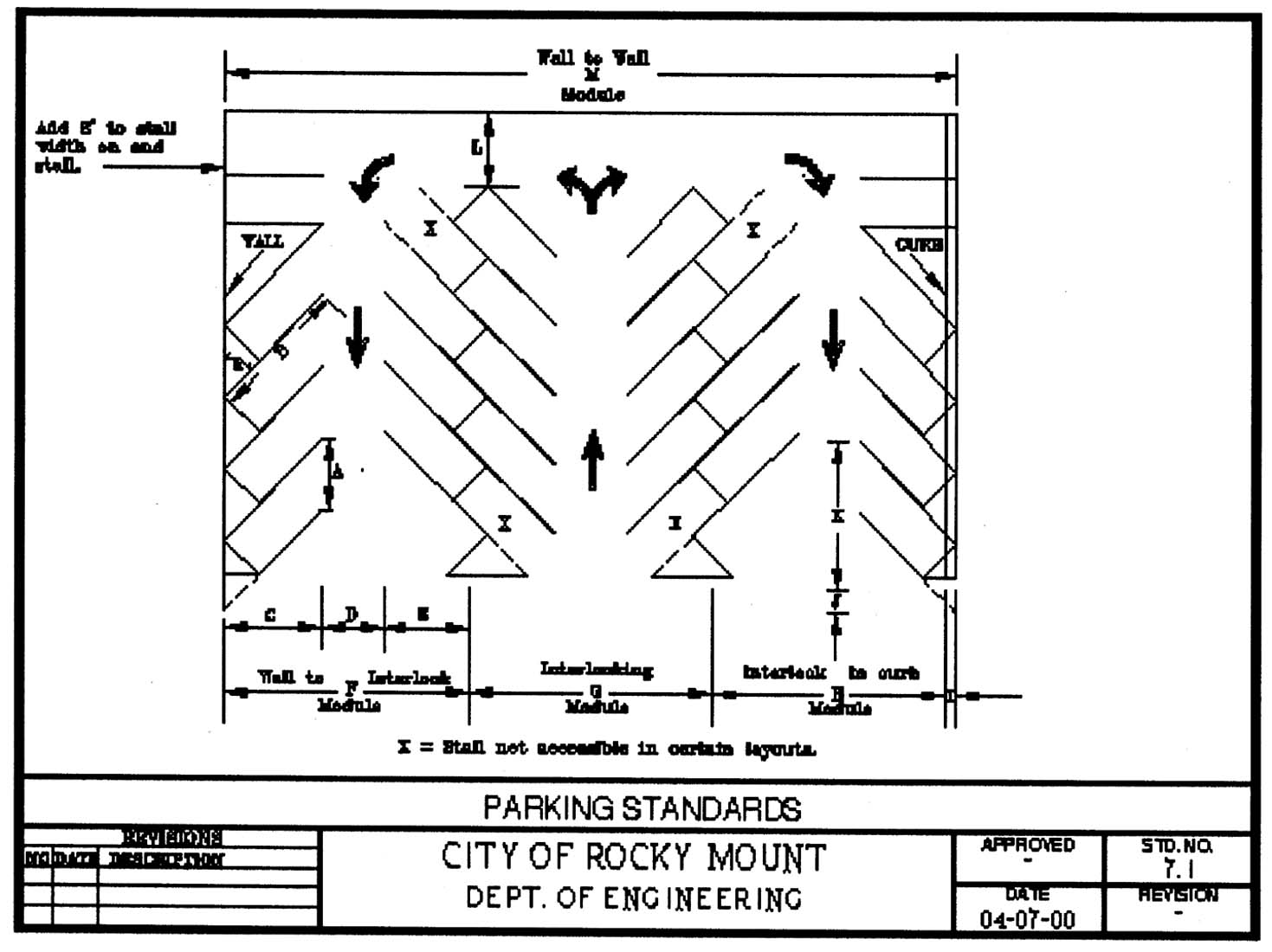
Parking Standards
J.
Parking deck.
1.
All parking spaces shall meet applicable design standards outlined in Table 7-5; and comply with handicap accessible regulations.
2.
Prohibitions. Only parking of automobile/passenger vehicles is permitted. No loading or unloading of goods from vehicles is permitted. Long-term or dead storage of vehicles is prohibited.
3.
Parking decks shall not exceed the maximum height of a structure permitted in the underlying zoning district, per LDC chapter 6.
4.
The following words shall be exempt from the total wall sign calculations (exit, enter and parking). Square footage of exempt words will be based on a one-to-one linear feet wall frontage.
5.
Prior to final approval, legal assurances (i.e. contract, management agreements or property owner association by-laws) shall be submitted to the city to ensure maintenance of parking decks.
6.
Within the central city area, parking decks shall contain commercial, office, or residential uses along the street frontages, where practical, to encourage pedestrian-oriented uses and activity at the street level.
7.
Within the central city area, if commercial, office, or residential uses are not provided, parking decks shall maintain a minimum ten-foot setback along yards with a street frontage. Public art and/or evergreen trees shall be planted to screen the first two (2) floors.
8.
If a new parking deck is connected to an existing or proposed building, then the parking deck shall be compatible with that building in terms of materials, type, color, pattern, and durability.
9.
When possible, locate parking decks and exits in the middle of the block of provide alley access.
10.
Entrance and exit locations should be clearly identified.
11.
Pedestrian entrances should be clearly visible and architecturally expressed in the exterior of the deck.
K.
Bicycle parking. Bicycle parking facilities shall be designed to provide convenient bicycle parking and to protect parked bicycles from damage. Bicycle parking spaces shall be available for residents, visitors, customers and/or employees of the use. Acceptable rack elements, rack location and access, rack area and site conditions such as protection from the elements and visibility shall conform to the Association of Pedestrian and Bicycle Professionals Bicycle Parking Guidelines.
1.
Bicycle parking design standards.
a.
Secured. Bike lockers and racks shall be securely anchored to the ground and on a hard surface. All racks shall accommodate cable locks and "U" locks and permit the locking of the bicycle frame and one (1) wheel to the rack and support a bicycle in a stable position.
b.
Accessible. Each required bicycle parking space shall be accessible without moving another bicycle. All bicycle parking spaces shall be a minimum of two (2) feet by six (6) feet and have an access aisle a minimum of five (5) feet in width.
c.
Visible. If bicycle parking is not clearly visible from the access way, directional signage shall be provided to route bicyclists to the bicycle parking facility.
2.
Short-term bicycle parking.
a.
Short-term bicycle parking spaces shall be publicly accessible and located within one hundred twenty (120) feet of the primary entrance the parking is intended to serve, or as close as the nearest non-handicap, off-street auto parking space, whichever is farther.
b.
Short-term bicycle parking shall not obstruct the required sidewalks, movement from on-street parking to the required sidewalks, or impact the minimum planting area or spacing requirements for street trees or required screening.
3.
Long-term bicycle parking.
a.
Long-term bicycle parking spaces shall be covered or enclosed and secured or supervised.
b.
Long-term bicycle parking spaces shall be located within three hundred (300) feet of the primary entrance the parking is intended to serve.
c.
Long-term bicycle parking for residential uses shall not be located within dwelling units or within deck, patio areas, or private storage areas accessory to dwelling units.
(Ord. No. 0-06-1, § 7, 1-9-06; Ord. No. 0-06-27, § 2a, 4-10-06; Ord. No. O-08-124, § 2, 10-6-08; Ord. No. O-11-117, § 3, 12-12-11; Ord. No. O-12-100, § 2, 11-12-12; Ord. No. O-14-73, § 1, 9-22-14; Ord. No. O-18-78, § 2, 8-13-18; Ord. No. O-19-58, §§ 3—6, 7-8-19; Ord. No. O-21-2, § 4, 1-11-21; Ord. No. O-21-75, § 2, 9-13-21)
Sec. 709. - Signs.
A.
Introduction.
1.
General intent and purpose. It is the intent and purpose of this section 709 to establish effective sign regulations that recognize the public as well as private interest and investment in the environment of the city; to promote economic and business development; to protect property values; to reduce distractions and obstructions that may contribute to traffic accidents; to regulate the number, size and location of signs; to prohibit unsafe signs; to cause removal of abandoned signs; and to promote and protect the health, safety, welfare, conveniences and enjoyment of the city for its residents and visitors.
2.
Principle of interpretation. Any device or object or clusters of devices or objects visible from any public right-of-way that is reasonably certain to distract a person operating a motor vehicle, however briefly, on account of the device or object's illumination, color, contrast, size, height, location, material, or number are disfavored under the LDC ("attention-attracting device"). Attention-attracting devices pose a higher risk to the health, safety, and welfare of the city's residents and visitors than do other devices and objects. Attention-attracting devices may or may not convey a message and can include, but are not limited to, search lights, beacons, strobe lights, strings of lights, barber poles, internally illuminated translucent canopies or panels, electronically controlled message boards, signs, flags, banners, streamers, pennants, propellers and inflatable objects (including strings of balloons) and oftentimes incorporate illumination, which may be stationary, moving, turning, blinking (including animation), flashing or laser. Any sign, which emits a sound, odor, or visible matter, is considered an attention-attracting device. Approved traffic-control devices are not considered to be attention-attracting devices.
B.
Sign permit. Except as provided herein, before a sign is erected, enlarged, or replaced or relocated, a permit must be obtained from the city and the construction work inspected and approved by the inspection services administrator. All signs must comply with the applicable sections of the building code as adopted by the city. All electrical installations associated with the erection and installation of a sign must be performed by a licensed electrical contractor. These regulations shall apply in all districts.
1.
Application. The following information shall be submitted with each sign permit application:
a.
A completed sign permit application form;
b.
Plans, elevations and specification of the sign and support structure, including all dimensions, materials, major color schemes, structural support and electrical specifications;
c.
For freestanding and projecting signs, a site plan that includes the location of existing and proposed signs in relationship to property lines, driveways, existing and future buildings and other site features as may be appropriate; and
d.
An indication of the proposed site by identifying the property by ownership, location and use.
2.
Review and action by director of development services or the director of development services' designee. The director of development services or the director of development services' designee must review each sign permit application in light of this LDC and act to approve, approve with conditions or deny the permit. The director of development services or the director of development services' designee may grant approval with conditions only to the extent that such conditions specify the actions necessary to bring the application into complete compliance with this LDC. If conditions warrant, the inspection services administrator, or authorized agents, may require such additional information as will enable staff to determine if such sign is to be erected in conformance with this LDC.
3.
Appeal. Appeals of sign permits denied by the director of development services or the director of development services' designee shall be taken to the board of adjustment within thirty (30) days of mailing of the interpretation, in accordance with procedures in chapter 5 of this LDC.
4.
Expiration and lapse of approval. A property owner(s) shall have six (6) months from the date of approval of a sign permit to carry out the proposed improvements; thereafter, the sign permit shall lapse, and a property owner shall be required to submit a new application in accordance with this LDC.
C.
General regulations.
1.
These regulations shall apply in all districts. No exterior sign may be erected, constructed, altered or maintained in any district, except in compliance with these regulations. Signs serving a public purpose which are authorized by the city manager and erected by the city shall be exempt from the regulations contained herein. Unless otherwise provided herein, no sign may be erected, constructed, altered or maintained without a permit from the inspections services administrator or authorized agents. Application for permits shall be submitted on forms obtainable at the office of the inspection services administrator. Each application shall be accompanied by plans which shall indicate the proposed site by identifying the property by ownership, location and use. The plans shall:
a.
Show the location of all proposed and existing signs on the lot in relation to property lines and building, zoning district boundaries, right-of-way lines and existing signs;
b.
Show size, character, complete structural specifications and methods of anchoring and support of the sign; and
c.
Indicate that such sign has been approved by the director of public works, if such approval is required by this LDC.
2.
Additional information. If conditions warrant, the director of development services or the director of development services' designee may require such additional information as necessary to determine if such sign is to be erected in conformance with this LDC. No sign shall be permitted on any public right-of-way except as specifically authorized herein.
3.
Non-exclusive causes for permit denial. In addition to grounds for denial set forth in this section 709, the director of development services or the director of development services' designee shall not issue a permit for any sign which shall:
a.
Be attached to or painted on any telephone pole, telegraph pole, power pole or other manmade object not intended to support a sign, nor on any tree, rock or other natural object, except as specifically authorized herein. Signs shall not obstruct any window, door, fire escape, stairway, ladder or opening intended to provide light, air ingress or egress for any building, structure or lot;
b.
Be erected or continued that would tend, by its location, color or nature, to be confused with or obstruct the view of traffic signs or signals, or would tend to be confused with a flashing light of an emergency vehicle;
c.
Use admonitions such as "stop," "go," "slow," "danger," etc., which might be confused with traffic directional signs or signals; or
d.
Obstruct the line of sight of motorists at intersections or along a public right-of-way.
4.
North Carolina state building code. All signs requiring permits shall be subject to the provisions of the state building code.
D.
Prohibited signs. The following signs shall not be permitted, erected or maintained:
1.
Roof signs, except for canopy or fascia signs attached to the walls, eaves, fascia or edge of the roof, and that do not extend more than three (3) feet above the highest point of the roof;
2.
Signs that are structurally unsafe or pose a safety or health hazard;
3.
Signs that by reason of size, location, content, coloring, clashing or illumination obstruct or interfere with the vision of drivers or obstruct or detract from the visibility or effectiveness of any traffic sign or control device on streets and driveways; and
4.
Signs that are located wholly or partially within the public right-of-way or any clear sight distance easement ("SDE").
5.
Signs which are attention-attracting devices that spin, flutter, that emit a sound or a flash and that are windblown or inflated.
E.
Signs not requiring a permit.
1.
Premises identification signs. Signs not exceeding two (2) square feet in area and bearing only property numbers, post office box numbers, names of occupants of the premises or other identification of the premises shall not require a permit from the director of development services or the director of development services' designee.
2.
Signs required by governmental bodies. Signs or notices required by the city, the law of the state of North Carolina, federal law or by a court of competent jurisdiction to be placed on lots otherwise subject to this section 709 shall not require a permit from the director of development services or the director of development services' designee.
3.
Signs in lots used primarily for a residential purpose. Subject to subsection E.4. hereof, with respect to freestanding, hanging, pole-mounted, projecting, or wall sign(s) which are displayed in a lots used primarily for a residential purpose, such sign(s) shall not require a permit from the director of development services or the director of development services' designee provided that:
a.
The lot displays four (4) or fewer signs;
b.
No single sign exceeds six (6) square feet in total area;
c.
No single side of any sign exceeds three (3) feet;
d.
The height of any sign does not exceed six (6) feet; and
e.
The total square footage of all signs displayed on any one (1) lot under this subsection does not exceed twenty (20) square feet.
4.
Display of official governmental flags. In light of the provisions of G.S. § 144-7 and any successor thereto ("Section 144"), this subsection E.4. shall govern the display of an "official governmental flag" (as defined in Section 144) (each a "flag") on all lots governed by this LDC. Pursuant to Section 144, the city may not prohibit a flag from being flown or displayed on lots governed by this LDC; provided, however, the city may, for the purpose of protecting the public health, safety, and welfare of its residents and visitors, impose reasonable restrictions on flag size, the number of flags, and the location and height of flagpoles.
a.
Reasonable restrictions on the display of flags on lots used primarily for a residential purpose. In accordance with Section 144, the city has determined that lots used primarily for a residential purpose may display of flag(s) in accordance with Section 144, whether as a freestanding, hanging, pole-mounted, projecting or wall sign, subject to the following limitations:
1)
The lot displays four (4) or fewer flags;
2)
No single flag exceeds twenty-four (24) square feet in total area;
3)
The total square footage of all flags displayed on any one (1) lot under this subsection does not exceed ninety-six (96) square feet;
4)
The height of any flagpole does not exceed thirty-five (35) feet; and
5)
All other applicable permits, if any, bearing on the display of a flag (i.e., a building permit) have been obtained.
b.
Reasonable restrictions on the display of flags on lots used primarily for a nonresidential purpose. In accordance with Section 144, the city has determined that lots used primarily for a nonresidential purpose may display flag(s), whether as a freestanding, hanging, pole-mounted, projecting or wall sign, and such display shall not require a permit from the director of development services or the director of development services' designee under this section 709 provided that:
1)
The lot displays twenty (20) or fewer flags;
2)
No single flag exceeds fifty (50) square feet in total area; and
3)
If pole-mounted, the pole shall not exceed the lesser of (i) the height of the principal building on the lot or (ii) twenty-five (25) feet; and
4)
All other applicable permits bearing on the display of a flag (i.e., a building permit, if applicable) have been obtained.
F.
Permitted freestanding signs.
1.
Scope and interpretation. A permit to erect a freestanding sign under this subsection F. shall issue only with respect to those lots used primarily for a nonresidential purpose.
2.
Permitted signs. A permit shall issue for a freestanding sign under this subsection F. upon a showing to the director of development services or the director of development services' designee that: (i) the lot upon which the sign shall be placed is located in a district identified in table 7-6, (ii) such lot is used primarily for a nonresidential purpose and (iii) the sign meets the applicable specifications set forth in table 7-6.
Table 7-6
3.
Subsection F. exceptions. Notwithstanding anything contained in subsection F. or table 7-6 to the contrary, a permit shall issue for a freestanding sign upon a showing that: (i) the lot upon which the sign shall be placed is located in a district identified in table 7-6; (ii) such lot is used primarily for a nonresidential purpose; (iii) the sign may be erected under an exception listed in a.—d., below and (iv) the sign meets all other applicable specifications set forth in subsection F. and table 7-6.
a.
Lots providing drive-thru services. Providers of drive-thru services may, for the convenience of their customers, erect, on a qualifying lot, two (2) additional freestanding signs on the lot of record provided that the sign: (i) does not exceed forty-five (45) square feet in area, (ii) no one (1) side of such sign exceeds seven (7) feet, (iii) the sign is no more than seven (7) feet high, and (iv) the sign is not legible or otherwise appreciable from the public right-of way.
b.
Lot frontage exception. If a qualifying lot has frontage on two (2) streets, the lot may erect an additional freestanding sign, provided each linear frontage has a minimum of one hundred fifty (150) linear feet. Each street frontage may have one (1) sign provided that such additional sign otherwise satisfies the requirements for a sign located on lot of record in the applicable district as set forth on table 7-6.
c.
Short-term display exception. A qualifying lot shall receive a permit from the director of development services or the director of development services' designee upon the submission of an application in accordance with this LDC to display no more than four (4) freestanding signs for a period of no more than thirty (30) days. The total square footage of all signs displayed pursuant to this subsection shall be no greater than thirty-two (32) square feet. Notwithstanding anything contained herein to the contrary, no sign requiring any approval or permit not provided for under this section 709 shall be permitted to be displayed pursuant to this subsection (i.e., a building permit).
4.
Conditional requirements.
a.
Conditional setback. Notwithstanding anything contained in this section 709 to the contrary, no freestanding sign may be erected on any lot used primarily for a nonresidential purpose, if such lot is immediately adjacent to a lot zoned solely for residential use, unless a distance of at least twenty (20) feet intervenes between the closest part of such sign and the adjacent lot line of the property in the residential zone.
b.
Conditional spacing. Notwithstanding anything contained in this section 709 to the contrary, a freestanding sign may only be erected on any lot used primarily for a nonresidential purpose, if such sign is located at least one hundred (100) feet from any other freestanding sign; provided, however, such condition shall not apply if the other freestanding sign is less than or equal to ten (10) feet in height. In the event the director of development services or the director of development services' designee receives two (2) or more applications to erect freestanding signs which would result in a violation of this subsection if both were approved, such application first received by the director of development services or the director of development services' designee will have priority over the later-received application until such time as the first-received application is approved or denied.
G.
Permitted wall signs, hanging signs, projecting signs and roof signs.
1.
Scope and interpretation. A permit to erect a wall signs, hanging signs, projecting signs and roof signs under this subsection G. shall issue only with respect to those lots used primarily for a nonresidential purpose.
2.
Lots in districts OI, OI-2, MA, B-1, B2, B-3, B-4, B-5, I-1, I-2, and I-P. Subject to the limitations set forth in subsection D.1. hereof, a permit shall issue for a wall sign(s), hanging sign(s), projecting sign(s) or a roof sign(s) located on lots in districts OI, OI-2, MA, B-1, B2, B-3, B-4, B-5, I-1, I-2, and I-P and used primarily for a nonresidential purpose in accordance with table 7-7 hereof.
Table 7-7
3.
Projecting and hanging signs.
a.
Applicable limitations. Notwithstanding anything contained in subsection G. and table 7-2 to the contrary, no permit for a projecting or hanging sign shall issue unless the applicant shows the following will be satisfied.
1)
Projecting and hanging signs shall be at least ten (10) feet above the finished grade of any sidewalk or other walkway.
2)
Projecting and hanging signs attached to the underside of a canopy shall be at least nine (9) feet above the finished grade of any sidewalk or other walkway.
3)
No projecting or hanging sign shall extend closer than two (2) feet to a vertical plane at any street curb line.
4)
A projecting or hanging sign that extends into a service street and alley rights-of-way shall not interfere with passage of motor carriers using the service entrances at the rear and side of commercial establishments adjacent to such rights-of-way.
b.
Sufferance. Projecting signs, where permitted to project over a public street or sidewalk right-of-way, shall remain only at the sufferance of the city, and shall be removed within five (5) days of formal notification by the director of development services or the director of development services' designee of any conditions necessitating removal.
c.
Signs affixed flat against the walls of buildings or vertical surfaces of canopies and not more than twelve (12) inches in thickness shall not be deemed a projecting sign.
d.
Signs mounted on the parapet or on the roofline and not projecting more than twelve (12) inches beyond the building face shall not be deemed a projecting sign.
e.
The thickness of such nonprojecting signs shall not be used in measuring setbacks.
f.
In no case shall the signs covered in this subsection G. extend closer than two (2) feet to a vertical plane at any street curb line.
H.
Public safety exceptions.
1.
Emergency response exceptions. In order to reduce response times of emergency response personnel (such as police, firefighters and emergency medical technicians), the following signs shall be permitted:
a.
Business complex directory sign. Business complex directory signs may be located on any lot used primarily for a nonresidential purpose for the purpose of identifying locations of different activities and buildings of a nonresidential land use contained on one (1) lot. The information contained on the signs shall not be visually legible from any exterior lot line. The location of the sign shall provide adequate vehicular stacking room on-site, as determined by the city traffic engineer.
b.
Multifamily development identification sign. One (1) identification sign shall be allowed for each multifamily development per street frontage, provided that it does not exceed thirty-six (36) square feet in area and provides the name and address of the multifamily development. Said sign may be either attached flat against the wall of the structure or may be freestanding; if freestanding, the sign shall be set back at least five (5) feet from the street right-of-way and shall be no more than six (6) feet in height above the ground. Applicable side yard setbacks for buildings shall also be adhered to.
c.
Permanent residential subdivision sign. Permanent subdivision identification signs having a maximum sign area of thirty-six (36) square feet may be erected. There shall be a limit of one (1) double-face sign or two (2) single-face signs (if two (2) single-face signs are employed, maximum area per sign is eighteen (18) square feet) for each street entrance into the development identified by the sign. The sign shall be set back at least five (5) feet from the street right-of-way line. Applicable side yard setbacks for buildings shall also be adhered to. The maximum height shall be thirty (30) inches. Permanent subdivision signs must be approved and permitted by the director of public works.
d.
Business/commercial residential subdivision sign. Permanent business subdivision signs may be erected when the approved subdivision meets the following (the following does not apply to subdivisions conveyed by condominiums or townhomes):
1)
Subdivision shall be comprised of four (4) or more lots and zoned B-3 and B-5.
2)
Subdivision signs shall not exceed sixteen (16) feet in height and one hundred twenty (120) square feet in area.
3)
Subdivision sign shall be set back at least five (5) feet from the street right-of-way line. Applicable side yard setbacks for buildings shall also be adhered to.
4)
Subdivision signs shall include the name of the subdivision and may include corporate logos.
5)
Subdivisions with more than one (1) main entrance may be allowed two (2) subdivision signs. Each sign shall be placed on a separate buildable lot of record.
6)
Subdivisions signs shall only be permitted on buildable lots.
7)
Lots occupying subdivision signs shall be limited to one (1) monument sign. Monument signs shall not exceed eight (8) feet in height and thirty-two (32) square feet in area.
e.
Flush-mounted identification sign. In addition to a freestanding sign, one (1) flush-mounted identification signs may be permitted on lots (i) located districts A-1, R-15, R-10, R-8, R-6, R-6MFA, MHP, and PDR and (ii) used primarily for a nonresidential purpose provided that such sign does not exceed one (1) square foot of sign area per horizontal linear foot of building frontage up to a maximum area of fifty (50) square feet. The content of the flush-mounted identification sign shall be limited to the name of the entity.
2.
Sign location. If it is reasonably foreseeable that the content of any sign will compel the operator of a motor vehicle to come to a complete stop in order to appreciate a sign's content and that other such operators will stop their motor vehicles at or around the same time in anticipation of the opportunity to read the such sign (for instance, a sign which identifies food items and prices for the purpose of facilitating drive-thru restaurant service), the sign permit will not issue until the city's traffic engineer determines the location of such sign provides adequate on-site vehicular stacking room.
3.
Entrance and exit signs. Freestanding entrance/exit signs may be erected on any nonresidential lot for the purpose of directing the ingress and egress of traffic, provided that they conform to the following criteria:
a.
There may be two (2) signs per driveway cut per lot.
b.
No sign shall exceed four (4) square feet.
c.
The message shall be restricted to the business name or logo and information used to direct traffic, for example: arrows, or words such as entrance/exit, in/out, freight entrance, etc. The business name or logo shall not exceed twenty-five (25) percent of the total sign area.
d.
Illumination shall be restricted to an interior source.
e.
The maximum height shall be thirty (30) inches.
f.
No part of any sign shall be closer than two (2) feet to the right-of-way, provided further that no part of any sign shall be closer than eight (8) feet to the edge of the curb line or the edge of pavement if there is no curb.
I.
Off-premise signs (billboards).
1.
Permitted. Off-premises and outdoor advertising signs shall be permitted only on tracts of land zoned B-2, B-5, I-1 and I-2; provided however, that outdoor advertising signs are not permitted in any of the above-listed districts for those portions of the district that may be located within a historic district(s) as defined in this LDC. For the purpose of this LDC, the following signs shall be considered as one (1) outdoor advertising sign:
a.
A single outdoor advertising sign.
b.
V-type and back-to-back signs, if not located more than fifteen (15) feet apart at the nearest points of each sign.
2.
Requirements.
a.
Setback. Outdoor advertising signs shall observe all setback requirements of the districts in which they are located. An outdoor advertising structure shall not be located closer than twenty-five (25) feet to any street right-of-way line. In any case, no outdoor advertising structure shall be located closer than three hundred (300) feet to a lot zoned exclusively for residential purposes.
b.
Size. Outdoor advertising signs shall not be larger than three hundred eighty (380) square feet in area as defined in "area computation." An additional twenty (20) percent of the sign area is allowed outside of the sign area for enlargements for a specific display or copy. The enlargement shall not be permanent and is only allowed for a specific display or copy. The enlargement must be removed when the specific display or copy is removed.
c.
Location. Outdoor advertising signs shall not be located less than one thousand (1,000) feet from any other outdoor advertising sign on the same street side as measured along the street right-of-way line. An outdoor advertising sign on one (1) street side may not be located less than three hundred (300) feet from an outdoor advertising sign on the opposite side of the same street or from any other existing outdoor advertising sign. This minimum three hundred (300) foot provision applies to street intersections and to parallel or curved streets located within three hundred (300) feet of an existing outdoor advertising sign.
d.
Other requirements. Outdoor advertising signs attached to a building structure shall not be higher than the wall to which they are attached. Outdoor advertising signs shall not be mounted on the rooftop of any building.
e.
Height. Off-premises signs are limited to thirty (30) feet in height above ground.
f.
Cantilever. Off-premises signs may not cantilever above buildings.
J.
Historic replica signs. Signs are considered to be historic replicas when they duplicate or replicate a sign which previously existed on site. This can be determined by age, type of sign, and time period in which it originated. Signage may be in the form of awnings, projecting or wall signs and shall display original content. Calculations for historic replica signs shall be exempt from total allowable signage for a building/structure. Such signs may be replicated based on photographic evidence or other documentation and shall be approved by the historic preservation commission. The validity of age for a historic replica sign shall be determined by the historic preservation commission.
K.
Lighting of signs. Where illuminated signs are permitted, they shall conform to the following criteria:
1.
Unless expressly prohibited, illuminated signs may have either an interior or exterior source of illumination, or both.
2.
Interior illumination, where the source of illumination is from within the sign itself, shall be such that the illumination emanating from the sign is diffused.
3.
Exterior illumination, where the source of illumination is provided by such devices as, but not limited to, floodlights or spotlights, shall be placed and shielded so as to prevent the direct rays of illumination from being cast upon neighboring lots and/or vehicles approaching on a public right-of-way from any direction.
4.
Illuminated signs are required to be non-flashing; the illumination for the sign shall not, either totally or in part, flash on and off, except for public service information signs.
5.
Whenever external lighting is provided, the lighting facilities shall be arranged so that illumination is directed away from residential properties and will not interfere with traffic.
6.
When new electrical service is required for a new freestanding sign such service shall be underground.
L.
Utilities and drainage. Signs and their support structures shall not interfere with surface or underground utilities and related facilities, and they shall not interfere with natural or artificial drainage.
M.
Sign contractors. All persons engaged in the erection, installation, construction, alteration or relocation of any sign requiring a permit under this section 709 shall obtain an annual sign contractor license from the city or be a regular employee of a licensed contractor. Before obtaining a sign contractor license, a contractor must provide evidence of current public liability insurance policy in an amount acceptable to the city.
N.
Maintenance. All signs shall be maintained in a safe, presentable and good structural condition at all times.
1.
Maintenance required. Every sign and its support, braces, guys, anchors and electrical equipment shall be maintained in safe condition at all times. All signs shall be kept in a state of good repair and aesthetic condition, free from defective, rusting or missing parts (e.g., broken sign facing, broken supports, loose appendages or struts, disfigured, cracked, ripped or peeling paint or poster paper) or missing letters or numbers and shall be able to withstand the wind load as prescribed in the state building code. Illuminated signs shall not be allowed to operate with only partial illumination. The area within ten (10) feet in all directions of the base of a freestanding sign shall be kept clear of debris and undergrowth. The message of a sign face may be changed at any time provided it complies with this LDC and other applicable local and state laws. The face of a sign and/or a sign structure that conforms to this LDC may be disassembled and taken down temporarily for the purpose of maintenance provided such sign face and/or structure are reassembled to their original location within a period of no more than sixty (60) days. A permit shall be required for such purpose.
2.
Repair or removal of improperly maintained signs. The director of development services or the director of development services' designee shall possess the authority to order the painting, repair, or alteration of any sign that in the opinion of the director of development services or the director of development services' designee constitutes a hazard to health, safety, or public welfare by reason of inadequate maintenance, dilapidation, obsolescence or abandonment. The director of development services or the director of development services' designee may order the removal of any sign that is not maintained in accordance with this LDC. Such removal shall be at the expense of the property owner. Signs that are not repaired or removed as required by this LDC shall be cause for the director of development services or the director of development services' designee to take legal or civil action to effectuate such repair or removal.
O.
Removal of discontinued signs, abandoned signs or nonconforming signs.
1.
If any sign becomes nonconforming as a result of the adoption of this LDC or an amendment thereto, that sign shall be removed in accordance with section 1104A. of this LDC, as may be amended from time to time, and the owner of the property where the sign is located shall bear the cost of removal.
2.
Any lawfully permitted sign or sign structure, including but not limited to, the supporting braces, anchors, or similar components which become nonconforming with adoption of this LDC shall be brought into compliance or be removed and replaced with a conforming sign prior to receipt of approval for any subsequent sign permit on such tract or parcel of land. If any such sign or its structure is damaged more than sixty-six and two-thirds (66.67) percent of replacement value, such sign must be removed.
3.
For conforming signs, any and all sign face advertising must be removed by the owner of the property and a blank opaque sign face must be installed and maintained with like material within thirty (30) days after the sign becomes materially misleading because of the closing of the business, service, commodity, accommodation, attraction or other enterprise or activity that is no longer being offered or conducted on the premises associated with the sign.
4.
The city may cause the removal of any sign erected, maintained, discontinued, or abandoned that is in violation of this LDC. The cost of removing the sign shall be the full responsibility of the owner of the property on which the sign is located.
5.
If the city causes the sign to be removed, a statement of the actual cost of removal and request for payment shall be mailed to the property owner. If payment is not received within thirty (30) calendar days, the cost associated with the removal shall be levied as a lien against the property owner with the appropriate county clerk. Such costs are in addition to any civil or criminal penalties that may be accessed to the owner for violation of this LDC.
P.
Area computation. For the purposes of this LDC, the square footage area of any sign shall be computed by the smallest square, triangle, rectangle, circle or combination thereof which will encompass all words, numbers and symbols situated on the sign, including latticework and wall work incidental to its decoration. For signs with three (3) or fewer sides, the total sign area shall be calculated by determining the area of one (1) sign side. For signs with more than three (3) sides, the total sign area shall be determined by calculating the combined sign area of all sides. The total sign area for any facade may not exceed the square footage permitted in chapter 7, business identification signs.
(Ord. No. O-2005-34b, § 1(Att. A), 5-9-05; Ord. No. O-2006-30, § 2, 5-8-06; Ord. No. O-08-49, § 2, 5-12-08; Ord. No. O-08-108, § 4, 8-11-08; Ord. No. O-08-124, § 3, 10-6-08; Ord. No. O-2009-2, § 5, 1-12-09; Ord. No. O-2010-46, §§ 2, 3, 6-14-10; Ord. No. O-2011-25, §§ 4—8, 3-14-11; Ord. No. O-2016-95, § 4, 12-12-16; Ord. No. O-2017-95, §§ 6—8, 11-13-17; Ord. No. O-2018-78, § 3, 8-13-18; Ord. No. O-2021-2, § 4, 1-11-21)
Sec. 710. - Fences and walls.
Fences, walls and hedges are allowed on private property within the city according to the following provisions:
A.
Generally.
1.
In all residential and O-I zoning districts, fence and walls not to exceed six and one-half (6½) feet in height may be erected along all side and rear property lines. In front yard setback areas, no fence or wall shall exceed four (4) feet in height. Fences and walls along side and rear lot lines may be constructed to a maximum height of eight (8) feet if approved by the planning board as part of a residential planned building group.
2.
In residential and O-I zoning districts, fences may be allowed within the five (5) feet drainage or utility easement. Fences are prohibited in all other easements and or rights-of-way unless approved in writing by the director of public works. Fences allowed in the five (5) ft. drainage or utility easement may be removed by the city at property owner's expense without notice. The city shall not be responsible for any damage to any fence, the reinstallation of any fence or for any cost associated with repairing or reinstalling a removed fence. Walls are prohibited within the five (5) feet drainage or utility easement.
3.
Fences and walls may be erected for existing dwelling unit(s) in a nonresidential zone in accordance with the residential fence regulations of this section.
4.
Barbed wire, razor wire or embedded glass fences are prohibited in any residential district or local historic district unless specific approval is granted by the city council following a public hearing on the matter.
5.
Business zoning districts may have a solid or open fence or wall erected to a maximum height of ten (10) feet along side and rear property lines. In front yard setback areas, no fence or wall shall exceed four (4) feet in height.
6.
Industrial zoning districts may have a solid or open fence or wall erected to a maximum height of ten (10) feet except as regulated by other provisions of this LDC.
7.
A fence or wall that does not meet the requirements of an open fence or open wall shall maintain a setback at entrances and exits of the site to provide a triangular sight distance easement that shall be a minimum of thirty-five (35) feet in length on each corner side of said entrance or exit.
8.
On rear property lines in all districts a chain link fence may be erected to a height of twelve (12) feet for the purpose of enclosing a tennis court or other court game.
9.
Where a fence is located along an interior property line separating two (2) lots and there is a difference in grade of the two (2) properties, the fence may be erected or allowed to the maximum height permitted on either side of the property line.
10.
A fence with a gate and security latch shall enclose all outdoor swimming pools, spas or other similar pools. The fence shall not be not less than five (5) feet in height. A yard fence meeting these requirements is acceptable provided the swimming pool or spa is fully enclosed. Above ground pools equipped with decks and enclosure railing that is at least five (5) feet above the ground are not required to be fenced provided that the deck area is enclosed and all entrances are equipped with a gate and security latch.
11.
No fence may be constructed on or in a public street right-of-way or on city owned property without written approval of the director of public works.
12.
Stormwater retention ponds may be required to have fencing as determined and approved by the director of public works as part of the conditions of an approved use, site development plan or building permit.
B.
Security fences.
1.
Barbed or razor wire fences. The use of barbed wire or razor wire is prohibited in all zoning districts front yards. Where permitted, barbed or razor wire shall not be located within the front setback of any building, and shall be located a minimum of fifteen (15) feet from the closest side or rear yard set back lines abutting a public right-of-way unless protected by an outer fence that complies with this LDC. In such cases, there shall be a minimum of three (3) feet between the outer fence and the barbed or razor wire fence.
2.
Electric fences.
a.
No person shall install or energize any fence or allow a fence to remain that is capable of producing an electrical shock by alternating current (AC). No person shall install or energize a fence or allow a fence to remain that is capable of producing an electrical shock by direct current (DC) without first having obtained a permit and passing necessary inspections from inspection services. Failure to comply with the provisions of this section shall give the electrical inspector the right to abate any violations either by disconnection of utilities, correction by the city at the expense of the owner and/or the responsible party with such cost being a lien if not paid by the owner and/or the responsible party, criminal prosecution, or all of the above, provided the owner and/or the responsible party is notified verbally or in writing and the owner and/or responsible party fails to make said corrections with eight (8) hours of notification. Responsible party is defined as the person who is in charge of the property at the time the violation is detected.
b.
Security fences capable of producing an electrical shock by direct current (DC) shall be allowed in A-1, B-5, I-1, and I-2 zoning districts provided they comply with the following:
1)
The installation shall comply with UL 69 (Standard for Electrical Fence Controllers) and the National Electrical Code; and
2)
The electrical fence may not be located within five (5) feet of any public way; and
3)
The system may not exceed twelve (12) volts primary voltage; and
4)
The electric fence shall be completely surrounded by a non-electrical fence with a minimum twelve (12) inch separation between the electrical and non-electrical fence; and
5)
Warning signs of a minimum twelve (12) inches by twelve (12) inches with lettering no smaller than three (3) inches in height stating: "Warning Electric Fence" or other approved verbiage must be placed at all gates and at twenty-five (25) feet intervals along the non-electrical fence.
6)
A fire department approved public safety access box shall be placed at a location acceptable to the fire department and shall house keys and or other devices that allow for emergency override of the system.
7)
Fences that produce an electric shock by direct current for livestock containment and are supplied through a transformer to convert AC current to DC current are permitted within the confines of ones property provided they comply with the following:
a)
The wire used to transport the current of the DC fence must be identified with an approved flagging material at ten (10) foot intervals; and
b)
All wiring must comply with the UL 69 and the National Electrical Code and be approved by the electrical inspector prior to being energized.
(Ord. No. O-2021-2, § 4, 1-11-21)
Sec. 711. - Handicapped accessibility standards.
A.
Standards. All development meeting the criteria outlined in subsection B. below shall meet the North Carolina State Building Accessibility Code. The building official shall be responsible for administration of these standards during review of any applications for a building permit.
B.
Applicability. These standards apply to all new and/or renovated municipal buildings and facilities used by the public. These standards apply to temporary or emergency conditions as well as permanent conditions. These standards to not apply to private single-family residences unless then owner/occupant request the installation of access ramps and/or other handicap facilities, or the residence or portions are converted to a use required to meet the requirements of the Accessibility Code.
C.
Application for building permit. Drawings and specifications for the construction or renovation of buildings shall accompany the application for a building permit. The drawings, specifications application shall be submitted to and reviewed by the inspection services administrator.
D.
Exceptions. In cases of practical difficulty, unnecessary hardship or extreme difference, the building official may grant exceptions from the literal requirements of these standards or permit the use of other methods or materials, but only when it is clearly evident that equivalent facilitation and protection are thereby secure.
(Ord. No. O-2005-34b, § 1(Att. A), 5-9-05)
Sec. 712. - Site development plans.
A.
Purpose. Site plans are made a requirement for certain projects under this LDC in order to provide for planned and orderly development. The purpose of this section is to assure that the intent of the LDC is realized through a site plan review procedure and to allow a property owner to record development intentions for a specified period of time.
B.
Applicability and review classifications. Site development plans shall be required for all new development projects except single-family dwelling units or duplex units. The projects listed and described in subsections 1.—5. below shall be subject to the provisions of this section and shall require a site development plan:
1.
General plan, Level I, Level II, Level III projects:
a.
General plans are defined as any plan review project involving commercial, small multi-family and/or industrial projects that are not required to meet the planning building group requirements of this LDC. Single-family and duplex residences are not included in this definition. Examples of general review projects include the following:
1)
Residential projects containing three (3) or more attached dwelling units.
2)
An expansion or modification of up to ten (10) percent in the floor area not to exceed ten thousand (10,000) square feet in an existing planned building group.
3)
Any commercial project located within a MA, PDR, O-I, B-2, B-3, B-4, or B-5, zoning district involving one (1) or more buildings with total square footage not exceeding ten thousand (10,000) square feet for all building(s).
4)
Any industrial project.
b.
General plan review projects will be placed into one (1) of three (3) levels for review depending on complexity of the proposed development.
1)
Level I projects are small additions, up to one thousand (1,000) square feet in area, that do not require any additional site work except for the building construction. Level I projects must submit plans meeting only the minimum submittal requirements. Level I general plans are reviewed and may be approved by the director or the director's designee.
2)
Level II projects are all nonresidential projects, greater than one thousand (1,000) square feet and less than ten thousand (10,000) square feet and multi-family projects containing three (3) to eight (8) units that require additional site improvements such as additional parking, water and sewer main extensions and/or drainage improvements. Level II projects must submit plans meeting the minimum submittal requirements and the other information required to evaluate the proposed improvements for compliance with city codes and standards. Level II general plans are reviewed and approved by the DRC.
3)
Level III projects include any industrial project located in an I-1, I-2 or I-P zoning district, regardless of the size of the project. Level III projects must meet the criteria for Level II and obtain a wastewater discharge permit when required by the city engineer. Level III general plans are reviewed and approved by the DRC. Areas that are visible from the public right-of-way and that are accessible to the public shall be required to comply with the paving and landscaping requirements as established in chapter 7 of this LDC, however, all other areas are exempt from said requirements.
2.
A planned building group project is defined as:
a.
A residential project containing nine (9) or more attached dwelling units (e.g. apartments);
b.
A residential project with attached dwelling units for individual ownership (e.g. townhouses);
c.
A commercial and/or office-institutional project located within a PDR, MA, O-I, B-1, B-2, B-4 or B-5 zoning district involving the construction of one (1) or more buildings containing a combined total of ten thousand (10,000) square feet or greater;
d.
A commercial and/or office-institutional project within a PDR, MA, O-I, B-1,B-2, B-4 or B-5 zoning district involving the construction of three (3) or more buildings regardless of project size;
e.
A commercial and/or office-institutional project located within a B-3 zoning district, regardless of project size and building number;
f.
A formerly approved non-planned building group project for which new structures are added to the site and/or the cumulative addition of ten thousand (10,000) square feet or greater is obtained on the site.
g.
Institutional uses such as childcare centers, churches, schools, and similar institutional uses, regardless of the zoning district, involving the construction of one (1) or more building containing a combined total of ten thousand (10,000) square feet gross floor area or greater;
h.
A commercial and/or office-institutional project within a B-2 or B-5 zoning district located within the Central City area;
i.
A college or university;
j.
A manufactured home park.
Planned building group projects may be approved by the planning board upon recommendation of the DRC.
3.
Residential and commercial cluster development projects. (See section 712D.5.)
4.
Planned density residential (PDR) projects: (See section 712D.4.)
5.
Other new development projects: The following projects are subject to the requirements of this section and may be approved by the DRC.
a.
Construction of a building or alterations or expansions to an existing building or use of a property.
b.
Construction of, or changes to, parking areas, circulation, access points, or other site improvements. Resurfacing that changes or deviates from the originally approved design is also included for consideration under these provisions.
c.
Alterations of watercourses, watershed boundaries, water bodies, or flood plain boundaries.
d.
Changes of land or building use where revisions to landscaping or buffering standards apply.
C.
Criteria for approval. The following evaluations shall be made during site plan review. Site plans that do not meet the criteria identified below shall be rejected.
a.
Compliance with all applicable LDC and other applicable code requirements.
b.
Compliance with a previously approved plan, such as a development plan or the city's comprehensive plan.
c.
Locations and adequacy of pedestrian and vehicular access points and parking areas.
d.
Design of traffic patterns, traffic control measures and street pavement areas, with provisions for maintaining traffic flows and reducing unfavorable effects of traffic on nearby properties.
e.
Compliance with landscaping standards and site construction specifications.
f.
Adequacy of stormwater drainage, water supply, sewer service, fire protection, street signs, and street lighting.
g.
Compliance with requirements for easements or dedications.
h.
Conformance with open space and trails planning.
i.
Solid waste regulations.
D.
Required contents for site plans. Site plan documents shall contain, the information listed below unless the DRC determines that less detailed information is required for adequate review. No process or review of a site plan will proceed without the required information. Detailed standards and specifications for design and construction are available from city, county and state agencies, as applicable.
1.
Plan review site plan requirements, Level I. All Level I plans submitted for general plan review must include these minimum submittal requirements:
a.
Plan must show the following information. The scale on the plan should be such that the relevant features of the project can easily be determined (minimum of 11" by 17" paper). Multiple sheets may be submitted when needed for clarity.
1)
Vicinity map including North arrow.
2)
Property identification number (PIN).
3)
Map of property being developed including North arrow if different from vicinity map.
4)
Existing property boundaries including metes and bounds and lengths.
5)
Building footprint and elevations.
6)
Setbacks from property lines: building and arterial (if applicable).
7)
Location of all easements and rights-of-way.
8)
Floodplain or watershed protection area boundaries (if applicable).
9)
Title block with project name and location, drawing scale, names of engineer and/or surveyor if appropriate, and developer or property owner and date of drawing.
b.
Zoning and land use information:
1)
Current zoning designation and existing or proposed land use for the subject property.
2)
Current zoning designation and land use of adjoining property owners.
3)
Size and location of any existing or proposed signs.
c.
Existing and proposed improvements:
1)
A clear delineation between existing and proposed improvements such as crosshatching for existing areas or other method showing the difference between existing and proposed.
2)
On site and adjacent storm drainage structures including pipes, ditches and catch basins.
3)
Proposed and existing streets including street names and current or proposed street address.
4)
All utilities (water, sewer, gas and electric) including meter location(s).
5)
Current or proposed type of solid waste collection and dumpster pad if applicable. (Contact the public works department for determination of type of collection required).
6)
Existing and proposed parking area including number of existing and required spaces, parking area dimensions and type of surface. For surfaces other than asphalt or concrete, parking bumpers must be shown.
7)
Location of loading areas for commercial projects.
8)
Location and width of driveways.
9)
Locations and square footage of all existing and proposed building(s).
10)
Total area that will be disturbed during the construction.
11)
Upon review by the development review committee, some projects may be reclassified to a higher level due to additional on site improvements that may be required.
12)
[Reserved.]
2.
Plan review site plan requirements, Level II & III. All Level II and III plans submitted for plan review must include the minimum submittal requirements above and the following where applicable:
a.
Department of development services requirements.
1)
Lighting plan inclusive of wattage and illumination.
2)
Number of units and bedrooms per unit, (residential projects only).
3)
Landscaping plan including calculations and details including location and height of all fences, walls and plants shown with a parking landscape radius detail. (Checklist available from planning dept.)
4)
Base flood elevation (BFE) and lowest floor elevation for projects located within the floodplain.
5)
Density or built upon area and calculations for those projects located in the watershed.
6)
For projects requiring a new or relocated bulk solid waste collection container, show the location and details of bulk solid waste container pad and screen. (Contact public works department for requirements).
b.
Erosion and sediment control requirements. For sites one (1) acre of disturbed area or larger:
1)
A completed and notarized financial responsibility form.
2)
Location and size of temporary swales, berms and diversion ditches.
3)
Location and size of sediment traps, temporary rock check dams and stabilized gravel construction entrance.
4)
Methods of permanent ground stabilization (grassing, landscaping), location of temporary silt fences and details on catch basin protection.
5)
If retention/detention basin is required, a detailed design including emergency spillway and outlet design must be provided.
6)
The following notes must be shown on the plans:
a)
A permit from the city and NC DENR as appropriate is required prior to construction.
b)
The erosion control measures must be maintained in good working order until final inspection and approval of the project by the city.
c)
Any grading beyond the limits of the approved plan is in violation of the city LDC and is subject to a fine.
c.
Storm drainage requirements.
1)
Show existing drainage on the site and the total amount of impervious surface area such as parking lots and building(s) that will be added as a result of the project.
2)
Show direction of drainage and topography of the site at contour intervals no greater than two (2) feet.
3)
Provide all design calculations for the proposed storm drainage system:
a)
Design storm event for various types of pipes.
b)
Design storm velocities in all pipe sections, swales and ditch sections.
c)
Pre and post development run off calculations and drainage area maps including any off site drainage that may be impacted by this project.
d)
Provide plans showing the location, size, invert, grade, rim or grate elevations and type of pipe for all proposed and existing storm drainage pipe, culverts, ditches, catch basins, drop inlets and manholes.
e)
Show the location and width of all storm drainage easements and indicate if they are to be public or private easements.
f)
Provide details of all drainage structures to be used.
g)
Location of floodway and floodplain within project boundaries.
h)
For all ditches, the side slope grades must be shown. (The maximum side slope shall be dependent upon the soil type and/or the type of stabilization proposed).
i)
If the proposed storm drainage system connects into an existing pipe or ditch, the existing flow in the pipe at the design storm events must be calculated and the ability of the pipe to handle the additional flow demonstrated.
j)
Existing and proposed contours (all elevations should be based upon NGVD).
k)
Design details and calculations for stormwater management and/or other BMP's to be constructed.
l)
Sanitary sewer requirements. These requirements apply only if a public sewer main is required to be installed. Provide all design calculations for the proposed sewer system to include minimum and maximum velocities in all pipe sections or projects.
3.
Planned building group regulations. Before submitting a construction plan for a planned building group it is recommended that a preliminary plan be submitted, in an effort to minimize development costs, avoid misunderstanding or misinterpretation, and ensure compliance with the requirements of this section. However, the applicant may choose to omit the preliminary plan process and submit a construction plan.
a.
Submission and review of planned building group preliminary plan. All planned building group preliminary plans submitted for plan review must include the minimum submittal requirements listed below. The number of sets of plans as established in the city's administrative manual shall be submitted. The DRC shall review the plans for compliance with the standards of this LDC and other city requirements and shall forward a recommendation to the planning board for consideration.
1)
Proposed name of the subdivision and proposed names of any public streets.
2)
Parcel information including tax parcel identification (PIN), metes and bounds of property, lot size, current zoning including any conditional uses, adjoining street names, names of adjoining property owners and adjacent zoning.
3)
Vicinity map location streets and highways, sections lines, railroads, schools, parks, and other significant features within one-half (½) mile of the proposed subdivision.
4)
Contour intervals to sea level datum of not more than two (2) feet when the slope is less than four (4) percent, and not more than five (5) feet when the slope is greater than four (4) percent, referenced to a United States Geological Survey or Coast and Geodesic Survey bench mark or monument.
5)
Natural features within and surrounding the proposed subdivision including streams, drainage channels, bodies of water, wooded areas and other significant natural features. On all watercourses leaving the tract, the direction of flow shall be indicated, and for all watercourses entering the tract, the drainage area below the point of entry shall be noted.
6)
Man-made and other cultural features within and surrounding the proposed subdivision, including existing and platted streets, bridges, culverts, utility lines, pipe lines, power transmission line structures, all easements, park areas, city and county lines, and other significant information.
7)
Proposed project layout, including building footprint, required parking and loading bay, building setbacks, plan view of proposed water and sewer service, location of required landscaping including perimeter buffers and interior islands.
8)
Location of curb and gutter along major and minor arterial, collector and local streets constructed with curb and gutter.
9)
Proposed location and types of solid waste storage facilities.
10)
Conceptual drainage plan including size and location of stormwater management facilities and pipes and plan view and cross sections of any on site or off site ditches carrying stormwater.
11)
Proposed finish floor elevation of the building, base flood elevation and floodway if appropriate.
12)
If a traffic impact analysis is required for the project, submit copy of TIA and show in plan view all recommended improvements.
13)
Such other information as the subdivider wishes to bring to the attention of the planning board and the city.
14)
Technical documentation. The preliminary plat submitted shall also be accompanied by the following written information:
15)
Source of water supply and distribution.
16)
Horizontal alignment for sanitary sewer, water supply, drainage and flood control.
17)
Typical cross sections of all streets.
18)
Certifications and endorsements:
Certification by the Director of Development Services and the Director of Public Works that this Planned Building Group Preliminary Plan was approved by the Planning Board on ________ (date) and meets the standards set forth in the Land Development Code.
b.
Submission and review of planned building group construction plan. All planned building group construction plans submitted for plan review must include the minimum submittal requirements in subsection D.1. and D.2. above and the following where applicable:
1)
Proposed provision for storm drainage and sanitary sewerage, approved by the director of public works.
2)
Topography of site at contour intervals of no greater than two (2) feet.
3)
Size and proposed location of any signs (including business identification, traffic control/parking and handicap). An integrated sign system design shall be required for all planned building group developments. These systems shall be reviewed by the director of development services or designee for materials, colors, shapes, sizes, compatibility with architecture and unity of design for the development. New individual signs and changes to existing individual signs shall be reviewed for conformance with such sign systems.
4)
All planned building groups shall meet the minimum provisions of the zoning district in which they are to be constructed with respect to the following:
a)
Minimum lot area
b)
Parking
c)
Landscaping
5)
Where any non-residentially zoned planned building group abuts a residential zoning district, such plan may include one (1) or more of following:
a)
existing or new berms of a reasonable height,
b)
additional decorative landscaping or opaque fencing,
c)
permanent undisturbed buffers and setbacks.
6)
Proposed solid waste storage facilities: Either mechanically dumped bulk containers compatible with and accessible to city is required. The location and design details of bulk container must be shown on project site plans and be approved by the director of public works or representative. Projects shall be designed and constructed to city standards and specifications. Consideration or proposed use of a private collection service does not negate this design requirement and any modification after plan approval must be approved by the director of public works or representative.
7)
All hydrants must be served by a water main of sufficient size. In no case shall the minimum size main be less than six (6) inches in diameter.
8)
Fire department vehicular access to all structures under construction shall be provided at all times. In areas where ground surfaces are soft or likely to become soft, hard all weather surface roads shall be provided.
9)
Where the length of a dead-end private drive for residential uses exceeds three hundred (300) feet and where a dead-end private drive serves non-residential uses exceeds on hundred fifty (150) feet, an area must be provided for the turnaround of firefighting vehicles on a paved or graveled surface. This area shall not be used for parking and shall subscribe a circular area having a radius of forty-five (45) feet or, shall have a configuration which provides comparable turnaround space.
10)
At least fourteen (14) feet of nominal overhead clearance shall be provided over the full width of streets, private streets, fire lanes, and other means of vehicular access.
11)
The fire protection water supply system, including fire hydrants, shall be installed and in service prior to recording the subdivision; or if no subdivision is involved, the placing of combustible building materials for structures, or combustible pre-tested fabricated building assemblies on the project site or utilizing them in the construction of building structures. If phased construction is planned, coordinated installation of the fire protection water system is permitted.
12)
Types of surfacing, slope, grade and cross-section of drives and sidewalks.
13)
The location and heights of all fences, walls and hedges shall be shown.
14)
Profiles of publicly maintained water and sewer lines.
15)
Profiles, cross sections and slopes of on-site and off-site ditches carrying water runoff.
16)
Erosion and sedimentation control plan.
17)
The installation of curb and gutter shall be required for parking lots. This may be waived or modified by the planning board upon recommendation of the director of public works if storm drainage, traffic circulation and other site design issues are improved by such waiver.
18)
Depict traffic-control devices.
19)
All plans and construction details must meet the current specifications of the city.
20)
Location and size of all heating, ventilation, air conditioning, and refrigeration equipment to be located outside the exterior building wall.
21)
Timing: Proposed schedule of development including stages likely to be followed.
22)
In addition to the requirements set forth in subsequent subsections of these planned building group regulations, a traffic impact analysis (TIA) prepared in accordance with city guidelines (available from the department of public works) shall be required for any planned building group that satisfies either one (1) of the following criteria:
a)
The proposed development is located reasonably proximal or adjacent to one (1) of the corridors identified in Table 7-1 and is expected to generate more than one hundred (100) additional peak hour trips (a.m. or p.m. peak) or one thousand (1,000) additional daily trips as determined by the most current edition of the ITE Trip Generation Manual.
b)
The proposed development is expected to generate more than four hundred (400) peak hour trips (a.m. or p.m. peak) or four thousand five hundred (4,500) daily trips as determined by the most current edition of the ITE Trip Generation Manual.
c)
This work shall be completed by a North Carolina registered professional engineer based on a scope of work approved by the city traffic engineer or designee prior to submittal of the project to the development review committee.
d)
The submittal of the TIA does not release the applicant from having to amend the analysis to address any substantive changes that result from the development review committee. Guidelines addressing the preparation of the traffic impact analysis will be made available by the city's department of public works.
Table 7-8. Corridors Identified for Application of ITE Traffic Impact Analysis Thresholds.
23)
All Planned Building Groups are required to include the following municipal certification on each page of the approved construction improvement plans:
Certification by the Director of Development Services and the Director of Public Works that this planned building group construction plan conforms to the preliminary plan approved by the Development Review Committee on _______ (date) and meets the standards set forth in the Land Development Code.
24)
No construction may begin on the improvements required by this LDC until the planning board has approved the plans for those improvements and the plans duly signed by the director and director of public works. Any party who initiates construction without an approved plan may be subject to the fines and penalties outlined in chapter 12, "Specific Penalties".
25)
The development review committee may approve an expansion and/or modification of up to ten (10) percent in the floor area not to exceed ten thousand (10,000) square feet, the parking area and/or other improvements of an existing or approved planned building group project. The proposed expansion and/or modification shall be shown on the planned building group plan previously approved by the planning board. In approving the proposed expansion and/or modification, the development review committee shall ensure that the project:
a)
Meets applicable LDC and other code requirements.
b)
Has adequate provisions for drainage.
c)
Has adequate traffic circulation.
d)
Has adequate fire protection.
e)
Has adequate solid waste collection facilities.
Upon satisfying the above standards, the proposed expansion and/or modification shall be approved by the DRC. Any project not approved by the DRC may be presented to the planning board for consideration of the standards specified herein.
26)
Placement of buildings:
a)
There shall be maintained at least twenty (20) linear feet of open space between individual and unattached buildings in a residential planned building group.
b)
Any group of buildings forming a courtyard shall have at least twenty-five (25) percent of the perimeter of such courtyard open for access by Emergency vehicles.
c)
Where the length of a street exceeds three hundred (300) feet and where there exists three (3) or more dwelling units, an area must be provided for the turnaround of firefighting vehicles on a paved or graveled surface. This area shall not be used for parking and shall subscribe a circular area having a radius of thirty-five (35) feet or, shall have a configuration which provides comparable turnaround space.
27)
Specifically for apartment and condominium projects—Recreation area: Play areas shall be provided for all apartment and condominium planned building groups. A minimum play area of two thousand (2,000) square feet, having a minimum width of forty (40) feet or a minimum radius of twenty-six (26) feet shall be provided for the first six (6) to twenty-five (25) dwelling units. For each dwelling unit over twenty-five (25) in number an additional fifty-six (56) feet per dwelling unit shall be provided. The spatial distribution and number of individual play areas within the planned building group shall be determined by the planning board on the basis of the special arrangement of the dwelling units, topography and other physical features. Swimming pools and their accessory areas shall not constitute any part of the open space requirements. No part of the required play area shall be used for any other purpose.
28)
Specifically for projects with attached units for individual ownership. (Condominium/Townhouse)
a)
Minimum lot area. Seven thousand (7,000) square feet for the first two (2) dwelling units of each building; one thousand eight hundred (1,800) square feet for each additional dwelling unit of each building. Individual lots shall be exclusive of any public land or street right-of-way. In no case shall the number of dwelling units exceed sixteen (16) per acre, exclusive of any streets or publicly dedicated land. It is noted that the planning board may recommend, and the city council may require, a lower dwelling unit density per acre than the density specified by the minimum lot area due to factors such as, but not limited to, traffic congestion, projected demands on community facilities, availability of water, sewer and electrical utilities, and consistency with the comprehensive plan of the city.
b)
Minimum lot width. Fourteen (14) feet.
c)
Maximum number of dwelling units per building. Eight (8).
d)
Setbacks.
i.
All dwelling units must be setback a minimum of twenty-five (25) feet from a public street and a minimum of twenty (20) feet from the initial perimeter of the subject development.
ii.
All buildings must be separated by a minimum of twenty (20) feet.
e)
Access. All lots shall front on a public street unless a homeowner's association is established in accordance with the provisions of this LDC and each lot is provided direct access to a public street across common property perpetually maintained for such purposes. A five (5) foot pedestrian, drainage and utility easement shall be provided on each lot along the entire length of all rear lot lines and side lot lines which are situated between the end walls of buildings. No fences, trees, shrubbery or other similar obstructions shall be permitted in that five (5) foot pedestrian, drainage and utilities easement.
f)
Structures. Location and approximate size of all existing and proposed buildings and structures within the site and all existing buildings and structures within one hundred (100) feet, in addition to public or private easements or rights-of-way adjoining or intersecting such property.
g)
Circulation. Proposed points of ingress and egress and proposed pattern of internal automobile and pedestrian circulation.
29)
Specifically for manufactured home parks.
a)
All manufactured home parks existing on the effective date of this LDC are required to comply with all applicable procedures and requirements of this LDC. Any manufactured home park failing to comply with the applicable provisions of this LDC is hereby declared to be a nonconforming use of land. All manufactured home parks shall continuously comply with the general requirements of this LDC. Failure to meet continuously each of the general requirements shall be grounds for revocation of the certificate of occupancy/compliance. This provision does not require a manufactured home park which was approved prior to adoption of this LDC to locate units with a parallel orientation to the lot (or approved space) frontage.
b)
Minimum lot area. The minimum area of ten (10) acres, providing for a minimum of twenty-five (25) manufactured home spaces shall be mandatory for the establishing of a manufactured home park. Individual manufactured home spaces shall be at least fifty (50) feet in width and shall contain at least five thousand (5,000) square feet of area. In addition, a park shall have sufficient area to meet all applicable planned building group requirements.
c)
Permitted manufactured homes. Manufactured homes meeting the definition for Type A, A-1, B or C may be permitted. Type D units shall be prohibited.
d)
Density. A maximum of six (6) units per acre shall be permitted.
e)
Parking: Each manufactured home space shall be provided with a driveway sufficient to accommodate two (2) vehicles parked in tandem. A waiver may be granted by the planning board during the planned building group process if an alternate parking design is determined to be appropriate. All parking areas, including those on individual manufactured home spaces, shall be hard-surface material approved by the department of public works.
f)
Screening and fencing. Manufactured home parks shall have on their entire perimeter a thirty (30) foot wide, Type D landscaped buffer as defined in chapter 7 of this LDC. This buffer shall be unbroken except at park entrance driveways or walkways. For a park that shares a property line with an existing park that already has a conforming bufferyard, the planning board may reduce the proposed bufferyard by up to fifty (50) percent. For parks located adjacent to railroads, major arterials, or other potential hazards, a suitable barrier shall be provided to ensure safety, and this shall be in addition to the required buffer. Screening of dumpsters is required, if applicable.
g)
Structures. Location and approximate size of all existing and proposed buildings and structures within the site and all existing buildings and structures within three hundred (300) feet, in addition to public or private easements or rights-of-way adjoining or intersecting such property. This requirement shall include the location of all intended carports, garages, outside storage buildings, etc. Plans must indicate the type of manufactured home to be placed on each space (Type A, A-1, B, and C) and how the unit is to be oriented. A waiver of the parallel orientation requirement for Type A, A-1, and B units (as provided for in the definitions) may be approved by the planning board and so indicated on the plan. A space designated for a Type C unit may be used for a Type C, B, A-1 or A unit. A space designated for a Type B unit may be used for a Type B, Type A-1 or a Type A unit. A space designated for a Type A-1 unit may be used for a Type A-1 or a Type A unit.
h)
Circulation. Proposed points of ingress and egress and pattern of internal circulation. All manufactured home spaces shall abut an interior drive or street. No manufactured home space shall have an individual driveway access through the required bufferyard to a public or private street.
i)
Landscaping: As specified in chapter 7 of this LDC and additional requirements as noted in this section.
j)
Location and dimensions of individual manufactured home spaces. Each space must designate a specific type of home permitted (A, A-1, B or C).
k)
Provision for storm drainage and a sedimentation and erosion control plan.
l)
Location and size of open play spaces and all other accessory features customarily incidental to the operation of a manufactured home park.
m)
There shall be a yard clearance of at least fifteen (15) feet between each manufactured home, including manufactured homes parked end-to-end. Manufactured homes or accessory structures shall be located no closer than thirty (30) feet to any exterior property line of the park, and no closer than ten (10) feet to the edge of any interior street or walkway.
n)
All manufactured home parks must connect to public water and sewer services. If the internal water and sewer lines are intended to be maintained by the city and/or if meters are to be provided by the city at individual home spaces, all lines shall be constructed to city standards and main lines located either within a publicly dedicated right-of-way or a publicly dedicated easement located outside any interior drive. Service lines from the tap to the individual meter may not be located outside of the dedicated right-of-way or easement. If water lines within the park are not public, the park must be served with a master meter.
o)
In addition to the yard area provided on each manufactured home space, at least two hundred (200) square feet of recreation area per manufactured home space shall be provided. Recreation areas shall be designed to meet the needs of the anticipated population of the manufactured home park and shall at a minimum include all of the following:
i.
A play lot for preschool children containing a minimum of twelve hundred (1,200) square feet within five hundred (500) feet of every space, improved with appropriate play equipment. The planning board may reduce the required recreational facilities for children if the park is to be restricted to adult occupancy only.
ii.
One (1) or more recreation areas for school age children and adults, provided with appropriate equipment for both active and passive recreation.
iii.
No recreation area shall be located within a power line easement, floodway, or other area not suitable for such purposes.
p)
All interior streets must meet city standards for either private or public streets. Private streets shall be defined for this purpose as in Table 25 private street requirements, and having the same right-of-way and construction width as a "private street" for a PDR and cluster developments. Walkways constructed of all-weather surfaces shall be provided as needed.
q)
All homes located within a manufactured home park must have a continuous masonry foundation, masonry curtain wall or skirting (as appropriate for the specific type of unit) installed prior to issuance of certificate of occupancy. The foundation, curtain wall or skirting shall be un-pierced except for required ventilation and access. Where skirting is used, it must be made of material designed and/or adapted for specific use as manufactured home skirting.
r)
In manufactured home parks, fire hydrants shall be located at entranceways and street intersections, with intermediate hydrants between intersections, but in no case shall there exceed more than one thousand (1,000) feet between fire hydrants, unless otherwise specified by the fire chief and director of public works. In addition:
s)
Fire department vehicular access to all structures under construction shall be provided at all times. In areas where ground surfaces are soft or likely to become soft, hard all weather surface roads shall be provided.
t)
All hydrants must be served by a water main of sufficient size. In no case shall the minimum size main be less than six (6) inches in diameter.
u)
At least fourteen (14) feet of vertical clearance shall be provided over the full width of streets, private streets, fire lanes, and other means of water system is permitted.
v)
Lighting shall be provided throughout the park to ensure safety of vehicles and pedestrians. All telephone, cable TV and electric lines shall be located underground. Lighting plans shall be approved by the city.
w)
All structural additions to manufactured homes, other than those which are built into the unit and designed to fold out or extend from it, shall be erected only after a building permit shall have been obtained, and such additions shall conform to the building code of the city, where applicable, or shall meet the standards of any special regulations adopted with respect to such additions. The certificate of occupancy/compliance shall specify whether such structural addition may remain permanently, must be removed when the manufactured home is removed or must be removed within a specified length of time, not to exceed three (3) months, after the manufactured home is removed.
x)
Solid waste storage facilities: Mechanically dumped bulk containers (dumpsters) compatible with and accessible to city equipment are required. The location and design details of bulk container sites must be shown on project site plans and be approved by the director of public works or representative. Projects shall be designed and constructed to city standards and specifications. Dumpster sites shall be screened from view of adjacent residential spaces or residential lots. Screening may be accomplished by a closed fence or wall which is at least the height of the dumpster.
y)
The fire protection water supply system, including fire hydrants, shall be installed and in service prior to approval of the manufactured home park; placing of combustible building materials for structures, or combustible pretested fabricated building assemblies on the project site or utilizing them in the construction of building structures. If phased construction is planned, coordinated installation of the fire protection.
z)
Consideration or proposed use of a private collection service does not negate this design requirement and any modification after plan approval must be approved by the director of public works or representative. Planned sites need not be screened until developed for use with dumpsters.
aa)
Manufactured home parks with publicly dedicated interior street systems may be eligible for rollout cart service, with the approval of the director of public works or representative.
30)
Specifically for business projects.
a)
The following planned building group development shall apply in the development of a B-3 zoned property, regardless of project size. In addition, projects located within PDR, MA, O-I, B-1, B-2, B-4, B-5, districts and churches and schools in any zoning district involving the construction of a building greater than ten thousand (10,000) square feet or projects involving the construction of more than one (1) building, structure or combination thereof shall also comply with the following regulations. Relative to expansion of a building and site improvements not qualifying for hereinafter identified "exceptions," existing building(s) and existing supporting on-site improvements such as, but not limited to, parking spaces, landscaped areas, etc. are not required to meet planned building group provisions. Proposed building and on-site improvements (non-exception) construction shall be developed according to these business planned building group provisions.
b)
Screening and fencing. A screen not less than six (6) feet high of dense plant material and/or fence where the lot abuts a residential lot.
c)
Lots fronting on a public street. The planning board may approve plans with lots within the interior of a business planned building group project provided that the board finds that adequate access is assured by the design of the planned building group.
d)
Minimum yard requirements. The planning board may approve plans which do not provide minimum yards along interior lot lines within a business planned building group project. All exterior lot lines located along the perimeter of the business planned building group shall satisfy the standards listed within the "district dimensional standards."
e)
Curb and gutter. The installation of curb and gutter shall be required as well as pavement as specified herein. The addition of curb and gutter may be waived or modified by the planning board upon recommendation of the director of public works, if storm drainage, traffic circulation or other site design issues are improved by such waiver.
f)
Plans are required and must show:
g)
Structures: Location and approximate size of all existing and proposed structures within the site and all buildings and structures within five hundred (500) feet, in addition to public or private easements or rights-of-way adjoining or intersecting such property.
h)
Circulation: Proposed points of access and egress and proposed pattern of internal automobile and pedestrian circulation.
i)
Parking and loading: Location and extent of proposed parking and loading areas.
j)
Points of access and egress shall consist of driveways or roadways at least twenty (20) feet in width and shall be set back a sufficient distance from highway intersections to minimize traffic hazards, inconvenience and congestion.
k)
Parking areas shall have a stabilized surface with parking spaces and traffic lanes clearly marked.
31)
Specifically for central city projects.
a)
The following planned building group regulations shall apply to all new construction or expansions of existing buildings in B-5 or B-2 zoned property located within the central city area. These requirements shall be in effect for both the development of individual buildings over ten thousand (10,000) square feet, and two (2) or more buildings on a single parcel, the combined area of which is greater than ten thousand (10,000) square feet.
b)
Screening and fencing. A screen not less than six (6) feet high of dense plant material and/or fence where a lot abuts a residentially zoned lot, to include the O-I zone.
c)
Plans are required and must show:
d)
Structures: Location and approximate size of all structures.
e)
Circulation. Proposed points of access and egress and proposed pattern of internal automobile and pedestrian circulation. Curb cuts at a maximum combined width of twenty-five (25) feet shall be allowed for each eighty (80) feet of lot frontage or portion thereof. The locations of all points of ingress and egress shall be approved by the city planning board upon recommendation by the city's traffic engineer.
f)
Signs: The applicable sign regulations shall apply to this planned building group requirement.
32)
Specifically for college or university projects.
a)
Plans shall show:
b)
Minimum project and lot area. All college and university planned building group projects shall contain a minimum of three (3) acres.
c)
Parking and loading. See section 707.
d)
Loading bays. One (1) loading bay for each thirty thousand (30,000) square feet of administrative space and one (1) loading space for the school cafeteria.
e)
Minimum yard requirements. All exterior lot lines within a college or university planned building group shall satisfy the standards listed within the Table 6 "yard and area requirements." In addition, a minimum seventy-five (75) foot setback will be required for any yard that abuts residential development.
f)
Structures: Location and approximate size of all existing and proposed structures within the site and all buildings and structures within five hundred (500) feet, in addition to public or private easements or rights-of-way adjoining or intersecting such property.
g)
Circulation: Proposed points of access and egress and proposed pattern of internal automobile and pedestrian circulation.
h)
Points of access and egress shall consist of driveways or roadways at least twenty (20) feet in width and shall be set back a sufficient distance from highway intersections to minimize traffic hazards, inconvenience and congestion.
i)
Parking area shall have a stabilized surface with parking spaces and traffic lanes clearly marked with the exception of athletic facilities.
j)
College or university identification sign location and specifications. Sign size shall be as approved by the planning board.
33)
Specifically for O-I(2) projects.
a)
Proposed project shall be a combination of two (2) of the following land uses: commercial, residential or office. Stand alone develop of any one shall not be permitted. No one (1) land use (commercial, residential or office) shall be greater than seventy-five (75) percent of the total development.
b)
Project shall contain a minimum of two (2) acres.
c)
A fence not less than six (6) feet must be used in addition to all buffer requirements (reduction in width is prohibited).
d)
Signs: The applicable sign regulations shall apply to this planned building group requirement.
e)
Parking: When commercial and office uses are proposed together, parking calculations will be based solely on commercial uses.
4.
Planned density residential districts (PDR). The district is intended to encourage efficient use of the land and public services and to promote high quality design that will provide a variety of dwelling types as well as adequate support services and open space for the residents of the development. The district regulations are intended to allow innovative development that is integrated with proposed adjacent uses and compatible with existing patterns of development.
a.
Pre-application conference recommended. Before submitting an application for a rezoning to the PDR district, the applicant may confer with the DRC in order to become familiar with these district review processes. The DRC will inform the applicant of the information required for filing the application. At the pre-application conference, the applicant shall provide the following:
1)
Boundaries of the property involved;
2)
Existing roadways, easements, flood zone boundary lines, watershed boundary lines and waterways;
3)
A general plan of development at a level of detail sufficient to indicate the nature and scope of the project including its magnitude in terms of approximate number and types of dwelling units, location and extent of nonresidential elements, proposed locations of major open space areas, and major circulation facilities; and
4)
Proposed treatment of the perimeter of the project boundaries bordering other zoning districts, i.e. buffer yards, setbacks, etc.
b.
Application. Following the pre-application conference, the applicant may proceed in preparing a formal application for a PDR development. The application shall consist of a simultaneous submission of a rezoning request, a special use permit application, a preliminary plat (when required) and proposed site development plan in accordance with chapter 7 of this LDC. Applications shall be accompanied by a nonrefundable fee, proof of ownership or statement from property owner authorizing application.
c.
Development plan required. No building permits or other permits regulated by this LDC shall be issued on land within any PDR district except in accordance with the approved development plan. The developer shall submit a master plan showing the conceptual design of the proposed development and a written instrument describing the conditions for the development. Including but not limited to density, setbacks and dwelling unit type, etc.
d.
Master plan submittal. The master plan shall include the following:
1)
A legal survey of the property (with metes and bounds).
2)
Parcel identification number (PIN).
3)
General location, square footage, density (units per acre), height and description of all buildings and uses with proposed setback lines.
4)
Proposed vehicular circulation and pedestrian circulation.
5)
Storm-water drainage plan, if required.
6)
Landscaping plan, required buffer yard(s), and proposed maintenance provisions.
7)
Gross area, lot area, and open space calculated to the nearest tenth of an acre.
8)
Delineation of any proposed construction phasing of the proposed development.
9)
Right-of-way, easements, and utility locations.
10)
Indication of existing natural features of the property, including watercourses, floodplain boundary lines with zones, watershed protection boundary lines, unique natural features and vegetation.
11)
Notes to plan: Include the name of the development; flood map and panel number; tax parcel identification number (PIN); name and address of property owner;, name and address of developer; name, address and telephone number of project engineer and/or designer; name, address and telephone number of contact person for project; zoning district with any conditions of approval.
12)
Other information deemed necessary by the DRC and director of development services.
e.
PDR district requirements. The following requirements shall be met by any proposed PDR rezoning application.
1)
The maintenance and perpetual existence of required private open spaces, easements, and right-of-way shall be guaranteed by creation of entities and the imposition or real conditions, covenants and restrictions as required by the city council.
2)
See section 713 of this LDC for regulations relative to homeowners associations.
3)
In the event that a subdivision plat is not required for approval of the entire PDR, no building permit for any structure within the development shall be granted until conveyances for any required public easements, streets, rights-of-way, or other public areas shall have been accepted by the city and filed with the appropriate county.
4)
Where public improvements are to be constructed or where improvements are to be made upon lands to be conveyed to the city, the landowner shall, in accordance with approved construction plans, execute the required improvements and obtain the proper inspections, or provide a financial guarantee approved by the city to cover cost of the required improvements prior to obtaining any building permit within the development.
5)
Privately maintained alleys may only be permitted in neo-traditional, new urbanism or smart growth developments within the PDR districts at the rear of lots to be used for business and residential purposes when constructed to city standards and where easements are included for necessary utility and trash pick-up purposes and maintenance is provided for in Homeowners Association documents.
6)
The minimum lots size for residential lots shall be thirty-five hundred (3,500) square feet.
7)
Where residential garages are accessed from a private alley, the rear yard set back shall be a minimum of eighteen (18) feet from the private alley easement line.
8)
Where any PDR district abuts a residential zoning district, the planning board shall require such plan to maintain or otherwise provide one (1) or more of the following:
9)
Existing or new berms of a reasonable height,
10)
Additional decorative landscaping or opaque fencing,
11)
Permanent undisturbed buffers and setbacks.
12)
Density requirements:
a)
The specific density in units per gross acre must be included in the application. The maximum allowable density is as follows: Density specified in the approval is the maximum allowable density, however, a PDR development shall not exceed ten (10) units per gross acre maximum.
13)
Dimensional requirements:
a)
Fifty (50) contiguous acres minimum;
b)
Addition to an existing approved PDR district may be made in increments of any size.
14)
Streets may be offered for public dedication or may be privately owned by homeowners association. Streets must meet the applicable design requirements set forth in the subdivision ordinance.
15)
The director shall have the authority to authorize the developer to substitute sidewalks with alternate pedestrian walkways, such as nature trails.
16)
Minimum lot area:
a)
The PDR district provides for a variety of dwelling unit styles and support uses with adherence to flexible lot area and yard requirements provided in other districts; the minimum residential lot area shall be limited to three thousand five hundred (3,500) square feet. The zero lot line provision may be utilized in a PDR development.
b)
Pre-existing dwellings: Dwellings that exist prior to the application of a PDR zone which shall remain shall be considered existing nonconforming structures and shall be subject the provisions of chapter 11 of this LDC.
c)
Setback from any public or private right-of-way: Any building that is erected, reconstructed, or moved shall be setback a minimum of fifteen (15) feet from the right-of-way line. However, for a corner lot, the minimum side distance from any right-of-way line is ten (10) feet.
d)
Accessory buildings shall not be placed in the front yard not closer than five (5) feet to the side or rear property lines.
17)
Height requirements. Maximum building height shall be thirty-five (35) feet.
18)
Open space requirements. Fifteen (15) percent of the total PDR area shall be maintained as open space. Street rights-of-way, parking lots, building areas (as defined) and yards held in individual ownership shall not constitute any part of the required open space; however, building areas for recreational facilities may be computed as open space. The city council may also require the developer to provide the city with an option to purchase open space sites at fair market prices for the development of future public recreational areas and/or community facilities. Said option shall become null and void if the city has not exercised the option prior to the completion of seventy (70) percent of the proposed dwelling units in the PDR. Any open space land use not included under approval of the PDR preliminary plan must be reviewed by the planning board and approved by the city council prior to its development.
19)
Uses within a PDR zoning district shall comply with the table of permitted uses in chapter 5 of this LDC.
20)
Condominiums shall be recorded in accordance with the North Carolina Condominium Act (N.C.G.S. [ch.] 47C).
21)
Where applicable, PDR developments are subject to subdivision and PDR provisions of this LDC.
5.
Residential cluster developments. Residential cluster development provides an alternative to conventional single-family residential development. Plans for the construction of a residential cluster development shall be approved by the planning board in accordance with the requirements of the subdivision ordinance.
A residential cluster development is defined as a development design wherein conventional zoning standards are relaxed to permit modifications in lot area, lot width, lot frontage, lot coverage, rear and side required yards, sidewalks, and public street access, and to save infrastructure development cost, environmental damage, energy use and land resources by concentrating dwellings in specific areas of the site without increasing the net density above that which would normally be allowed pursuant to section 601 District Dimensional Standards.
It is the intent of this section to allow a reduction in lot size with the result that land area "saved" by so doing will become usable open space (common area) accessible by all residents of the residential cluster development.
1)
General requirements.
a)
Residential cluster developments shall contain not less than five (5) net acres. For the purposes of this section, "net acres" shall be the total area of all lots and common area(s) exclusive of public street rights-of-way. Addition to any existing residential cluster development may be allowed provided such addition meets or exceeds all other applicable requirements.
b)
Residential cluster development is a use-by-right in A-1, O-I, R-15, R-10, R-8, R-6, R-6MFA and PDR districts. Such development shall be exempt from the conventional zoning standards relative to lot area, lot width, lot frontage, lot coverage, and required yards, normally applicable to such districts provided such development complies with minimum standards set forth in this section.
c)
Land uses specified as a special use in the applicable districts by the table of permitted uses shall meet all of the requirements as identified in this LDC.
d)
In locations where the residential cluster development is proposed to be developed immediately adjacent to a developed or undeveloped single-family subdivision which is recorded in the register of deeds office and is zoned solely for single-family land use, the planning board may require at its discretion one (1) tier of lots not utilizing the residential cluster development regulations to be developed around the perimeter or a portion thereof of the property in which the residential cluster development design is to be employed.
e)
Streets may be offered for public dedication or may be privately owned by homeowners association. Streets must meet the applicable design requirements set forth in the subdivision ordinance.
f)
The director shall have the authority to authorize the developer to substitute sidewalks with alternate pedestrian walkways, such as nature trails.
2)
Density. The maximum number of dwelling units allowed per acre are shown in the residential cluster development density table below. These requirements for residential cluster development supersede the requirements of the table of area, yard and height requirements of this LDC.
Table 7-9.
Density for Cluster Developments
*For cluster developments with more than five (5) net acres and less than ten (10) net acres.
**For cluster developments with greater than ten (10) net acres.
3)
Lot design and minimum dimensional standards.
a)
Because the dwelling unit density identified in the preceding section is consistent with conventional single-family development within the district in which the development is located, no minimum lot size or width is required for the subdivision of a residential cluster lot.
b)
For all of the residential cluster subdivision construction plats approved by the Planning Board prior to June 13, 1994, the following yard setback provisions shall apply. There are no yard setbacks required for buildings constructed for residential cluster development purposes from interior lot lines for residential cluster lots.
c)
Any residential or nonresidential building construction shall setback a minimum of twenty (20) feet from any public or private street right-of-way line as identified on the planning board approved construction plat and the initial tract of land of the residential cluster development perimeter.
d)
For residential cluster development construction plats approved by the planning board after June 13, 1994, the following shall apply. The conventional lot setbacks identified in the Table of Area, Yard and Height Requirements for each district shall apply to each cluster lot. In instances where a dwelling shares a common wall with another dwelling unit on one (1) or both sides, there shall be no side yard setback from the built-on side lot line. Minimum side and rear yard setbacks shall be five (5) feet from all interior side and interior rear lot lines.
e)
There shall be a minimum setback of twenty (20) feet from the perimeter of the initial tract of land of the residential cluster development. This area may be counted toward the dwelling density if the area is dedicated as common area and is accessible to the residents of the development.
f)
Each lot shall abut a public or private street right-of-way.
4)
Common area. A residential cluster development shall provide open space subject to all of the following requirements:
a)
Such open space shall be greater or equal in area to the total amount of area by which each lot was reduced below the minimum lot size requirement of the prevailing zoning district, or as provided under subsection b) below, whichever is greater.
b)
Residential cluster developments shall reserve not less than twenty (20) percent of the net acreage as common space.
c)
Such area shall not be used as a residential building site. For the purposes of this section, picnic areas or shelters, ball fields, walking or jogging trails, boat ramps and docks or similar recreational facilities may be allowed.
d)
Such area shall not be devoted to any public street right-of-way or private street easement, private driveway or parking area.
e)
Such area shall be left in its natural or undisturbed state if wooded at the time of development, except for the cutting of trails or walking or jogging or, if not wooded at the time of development, is improved for the uses listed under subsection c) above, or is properly vegetated and landscaped with the objectives of creating a wooded area or other area that is consistent with the objective set forth in subsection f) below.
f)
Such area shall be capable of being used and enjoyed for purposes of informal and unstructured recreation and relaxation or for horticulture if not devoted to other allowable uses in this subsection.
g)
Such area shall be legally and practically accessible to the residents of the development.
h)
A minimum of one-half (½) of the required open space shall be contained in one (1) continuous undivided part. An open space area designed around the perimeter of the cluster development shall not constitute any portion of this required open space.
i)
Such area shall be perpetually owned and maintained for the purposes of this section by the homeowners association.
j)
The location and arrangement of any open space shall be subject to planning board approval.
k)
There shall be no further subdivision of homeowners association owned property when the final plat of the initial subdivision of the residential cluster development has been recorded in the register of deeds office.
5)
Homeowners association. See section 713 of this LDC for regulations relative to homeowners associations.
6)
Validity. Approved site development plans shall be valid for a period of two (2) years from the date of approval. Upon the expiration of said two (2) year period of validity, a revised site development plan shall be required to be submitted as a new project.
(Ord. No. O-2005-34b, § 1(Att. A), 5-9-05; Ord. No. 0-2007-35, § 2, 6-11-07; Ord. No. O-2009-2, § 5, 1-12-09; Ord. No. O-2009-101, § 1, 9-14-09; Ord. No. O-2011-37, § 3, 5-9-11; Ord. No. O-2018-78, §§ 2, 3, 8-13-18; Ord. No. O-2021-2, §§ 3, 4, 1-11-21)
Sec. 713. - Homeowners association.
The establishment of a homeowners association shall be mandatory for all land subdivisions and developments involving and including commonly owned open spaces and easements.
A.
Proposed articles of incorporation for the association. Such articles of incorporation shall provide for homeowners control when over fifty (50) percent of the dwelling units are sold.
B.
Proposed bylaws of the association. Such bylaws shall contain provisions which will facilitate the selection of the most capable officers of the association. The bylaws shall also contain provisions requiring an annual audit and distribution of that audit to all the members of the association.
C.
Annual assessments. Proposed annual budget of the association showing monthly assessments. The monthly assessments must be set at a sufficient level to ensure success of the association.
D.
Budget. Proposed ten (10) year income and expense budget reflecting the establishment of a sinking fund for capital replacement.
E.
Right of entry. Proposed document granting right of entry to the common areas by rescue officers, firefighting personnel, police officers and service personnel while performing their duties.
F.
Proposed information packet for prospective buyers. The packet shall include a complete listing of all land, buildings, equipment, facilities, and other existing or proposed holdings of the association; time schedule for maintenance of major facilities and information regarding the association's assessments and fiscal program.
G.
Covenants. Proposed restrictions and covenants for the common area and residential sites.
H.
Easements. Easements over the common areas for access, ingress and egress from and to public streets and walkways and easements for enjoyment of the common areas, as well as for parking, shall be granted to each owner of a residential site.
I.
Organization. The homeowners association shall be organized and established as a legal entity prior to or as part of the final plat approval and recording process. Membership in the homeowners association shall be mandatory for each original purchaser and each successive purchaser of a residential site as follows:
1.
The homeowners association shall be responsible for the payment of premiums for liability insurance, local taxes, maintenance of recreational and other facilities located on the common areas, payment of assessments for public and private capital improvements made to or for the benefit of the common areas, maintenance and repair of the exterior of all attached residences located within the development or other common area facilities. It shall be further provided that upon default by the homeowners association in the payment to the government authority of any ad valorem taxes levied against the common areas or of assessments for public improvements to the common areas, should default continue for a period of six (6) months, then each owner of a residential site in the development shall become obligated to pay to the taxing or assessing governmental authority a portion of such taxes or assessments in an amount determined by dividing the total taxes and/or assessments due to the governmental authority by the total number of residential sites in the development. If the sum is not paid by the owner within thirty (30) days following receipt of notice of the amount due, then the sum shall become a continuing lien on the cluster real estate of the then owner, heirs, devises, personal representatives and assigns, and the taxing or assessing governmental authority may either bring any action at law against the owner obligated to pay the same or may elect to foreclose the lien against the cluster real estate of the owners.
2.
The homeowners association shall be empowered to levy assessments against the owners of the residential sites within the development for the payment of expenditures made by the homeowners association for the items set forth in the preceding paragraph and any such assessments not paid for by the owner against whom such are assessed shall constitute a lien on the cluster site of the owner. However, assessments levied by the homeowners association for common area improvements may be exempted from the developer owned lots prior to the initial sale of the individual lots or a period of three (3) years, whichever occurs first.
Sec. 714. - Appearance and design standards.
A.
Applicability.
1.
These architectural design standards shall apply to all new development in office and business districts, and non-residential uses located in residential districts on parcels adjacent to the following arterials/corridors within the City of Rocky Mount: Benvenue Road, Hunter Hill Road, Raleigh Boulevard, Sunset Avenue, Thomas A. Betts Parkway, Wesleyan Boulevard, Winstead Avenue, Cokey Road, Fairview Road, Goldrock Road, East Grand Avenue, Atlantic Avenue, Marriott Street and Hathaway Street.
2.
Additions to existing buildings and development sites shall also comply with the provision of these design standards. Additions should be sensitive to original design with improvements where possible.
B.
Review Process.
1.
Planning staff will review applications for compliance with these design standards.
2.
Applications located within local historic districts will not have to comply with these standards. The city's historic preservation commission shall have the authority to review projects located in any local historic district.
3.
Architectural elevations of the proposed project with colors and materials depicted shall be submitted in conjunction with the site development plan or architectural plans.
C.
Appeals.
1.
If in the course of administration a question arises as to the intent or meaning of any of these architectural design standards, the interpretation shall be given by the director of development services.
2.
Appeals of the Directors interpretation will be heard by the planning board. The planning board's decision may be appealed to the city council.
D.
Non-residential standards.
1.
Building materials.
a.
All exterior walls visible from the street right of way and public areas shall be partially covered with: brick, wood or fiber cement board, stone, or glass. Metal, stucco, or tinted and textured concrete may be used provided they adhere to the following standards.
1)
If metal siding or stucco is used, it must have visible corner moldings and trim. Masonry, concrete, or other durable material must be incorporated as the base (between the siding and the ground plane) and shall extend at least thirty-three (33) percent above grade.
2)
If concrete blocks are used they must incorporate a combination of textures and/or colors to add visual interest. For example, combining split or rock-façade units with smooth blocks can create distinctive patterns.
b.
Vinyl, plywood, particleboard, T1-11, asphalt siding, and smooth-faced concrete block are discouraged as exterior finish materials unless the architect can demonstrate that the materials are appropriate to the design of the building.
c.
In the Central Business District at least forty (40) percent of the first floor of any non-residential building facade that faces a public street or sidewalk shall be windows, doors or display windows of clear or lightly tinted glass that allow views into the building or display window from outside. Where windows are impracticable, a five (5) feet setback between the wall and the street shall be provided and landscaped with a continuous screen of shrubs, and one (1) tree planted for every twenty-five (25) feet or fraction thereof of street frontage. Trees may be planted in the public right-of-way as street trees. Where windows are not feasible, other wall enhancements and embellishments may be approved by the director where it is determined that the enhancements substantially achieve the intent of this section.
1)
Exterior material shall be compatible with those of surrounding buildings. Buildings shall use the same materials, or material that are architecturally harmonious, on all walls and other exterior building components that are visible from public streets and any residential districts.
2.
Building style.
a.
All exterior walls visible from the public right-of-way shall have a recognizable base, middle, and top:
1)
Building base must extend at least two (2) feet above grade and be defined by a change in at least one (1) of the following: wall thickness, materials, texture, color, ledges or sills.
2)
Building top will be defined by at least one (1) of the following: varied roof lines, cornices, fascia, overhangs, stepped parapets, or aligned openings and articulations.
3.
Building scale and mass.
a.
A single, large, dominant building mass shall be avoided. Where large structures are desired, variation in the building form is required through the use of projecting and recessed elements, setbacks, and/or distinct roof shapes. Changes in mass shall be related especially to entrances, the integral structure, and/or the organization of interior spaces and activities (i.e. different stores or uses) and not merely for cosmetic effect.
b.
Facades of eighty (80) feet in width or wider shall incorporate wall offsets of at least one-foot in depth a minimum of every forty (40) feet. Each offset shall have a minimum width of ten (10) feet.
c.
Other design techniques to break up large building forms and wall surfaces are encouraged, including: architectural elements such as columns, canopies or covered entries, and variation of materials, color, and texture. Such detailing may include sills, headers, belt or string courses, reveals, pilasters, window bays, and similar features.
4.
Colors.
a.
Colors used for exterior surfaces shall be harmonious with surrounding development. Primary materials shall be natural colors (e.g. grey, cream, brown) or muted primary colors (e.g. red, green, blue). Contrasting colors are encouraged to accent, or emphasize architectural features. The use of high-intensity or metallic colors is discouraged except for accent purposes. The use of fluorescent, day glow or neon colors shall be prohibited as a predominant wall color.
5.
Infill development.
a.
New infill development shall either be similar in size and height or, if larger, be articulated and subdivided into segments that are proportional to the mass and scale of other structures on the same block, or if no buildings exist thereon, then on adjoining blocks.
b.
New infill development shall generally be setback a distance in context with surrounding buildings of the proposed development on the same side of the street.
6.
Accessory buildings.
a.
Accessory buildings located in front of the buildings within the same development shall include a consistent level of architectural detail on all four (4) sides of the building as well as exterior materials and colors that are compatible with the primary building in the development.
7.
Landscaping.
a.
When streetscape and landscape buffers are required they shall be designed in accordance with Section 704 of this LDC. All parking areas shall be landscaped in accordance with Section 704 of this LDC.
8.
Pedestrian circulation.
a.
An integrated pedestrian circulation system that connects buildings, open space, and parking areas with the adjacent street sidewalk system and adjacent properties shall be required. Clear and obvious access shall be provided from the building entry to the pedestrian sidewalk.
9.
Mechanical equipment and utilities.
a.
Mechanical equipment shall not be placed on the front of buildings. A fence, wall, and/or plantings shall screen any mechanical equipment so as not to be visible to the public.
b.
The location of utility lines, including electrical, telephone, gas, cable television and other utility facilities shall be context sensitive and in keeping with community design standards (see chapter 7). In recognition of the importance of safety considerations and the view from the public right-of-way, utility lines and facilities shall be placed underground where feasible. Above ground utilities and facilities may only be approved by the director of utilities when cost, technical, maintenance or other system-related considerations are deemed to be significant factors. Electric transmission lines and related facilities, due to their special nature and extreme cost, shall be permitted to be maintained, expanded, repaired, and constructed above ground, based on the requirements of the electric system.
E.
Residential standards.
1.
Duplex or triplex orientation. For duplex or triplex units, the primary entrance (front door) of a minimum of one (1) unit shall face the public street right-of-way.
2.
Tree canopy. At least one (1) large tree and one (1) small tree shall be provided on all single-family residential lots. Duplex lots shall require one (1) large tree per unit. Multifamily units shall require one (1) large tree per each four (4) units. The required trees shall comply with Chapter 7, Landscaping Requirements. Preservation of existing trees on the site meeting the standards may be counted towards this requirement.
(Ord. No. O-2014-8, § 2, 2-10-14; Ord. No. O-2018-78, § 3, 8-13-18)
Sec. 715. - Street naming and addressing.
A.
Legal authority. The city shall be responsibility for assigning names to all roadways and addresses to all addressable buildings in the city limit in accordance with Appendix A, 12, subsection 2, 2.1 of the Municipal Code.
B.
Purpose. The purpose of this section is to establish standards for naming public and private streets, posting street signs and assigning numbers to all dwellings, principal buildings, businesses and industries to facilitate timely and efficient services to residents and businesses of the city and surrounding communities.
C.
Street naming.
1.
Streets requiring names. A roadway, private or public, shall be named if it meets one (1) of the following conditions:
a.
If the potential for two (2) or more dwelling units or business related buildings exist or are proposed to be constructed along the roadway.
b.
If the roadway is maintained by the city, NCDOT, or private entity.
c.
Exceptional or unusual circumstances suggest the need for an individual name.
d.
It is a private lane, street, roadway or development, commercial or residential, as defined by City Code and are vehicular travel-ways not dedicated as a public street, but resembling a local street in that they carrying traffic from a series of driveways to the public street system including, manufactured or mobile home communities/parks, shopping centers, shopping malls, entertainment arenas, and large residential living complexes. i.e. Colony Square Apts., Home Depot Plaza, Cobb Corners Plaza, Benvenue Plaza, Golden East Crossing.
2.
Street name selection, base/primary: The first part of the complete street name. The following base/primary naming standards shall be used:
a.
A street name should be appropriate and easy to read (so that children can use the name in an emergency situation), and should add to community pride; promoting local heritage, history and traditions and reflecting local geography and character.
b.
Names with the same theme (i.e., flowers, states) are suggested for naming streets in an entire subdivision, as a means of general identification.
c.
Historically used road names should be retained where possible.
d.
Names tending to be confused as homonyms, having the same or similar pronunciation but with different spellings are not acceptable within the Rocky Mount, Nash and Edgecombe County community. (e.g. Smith, Smyth or Smythe; Ellis or Allice; Allen or Alan or Ellen; Petty, Peggy; Mansfield, Mansill).
e.
Names which may be offensive (slang, double meanings, etc.) will not be accepted.
f.
Use of frivolous or complicated words or unconventional spellings in road names is not allowed. i.e. Rockcreek St., Bizness Rd.
g.
Following the National Emergency Number Standards (NENA), street names will be approved or rejected by the street name review committee (SNRC).
h.
Proposed streets obviously in direct alignment exhibiting a logical extension of existing streets or roadways shall be given the same name and numbering scheme.
i.
Streets proposed to be in alignment, having two (2) separate starting points, with structures in place, must physically connect with an all weather roadway within ninety (90) days of the start of construction. (i.e. Emerson Dr. project) Failure to meet this requirement will cause re-alignment of street plat and/or issuance of different street name.
j.
References to a number as part of the base/primary name are prohibited. (i.e. 2. Two Road, Second Street).
k.
Street name types/suffixes (2.4) shall not be used as part of the base/primary name. (i.e. Avenue B, Lane Ct., Country Court Ln.).
l.
Abbreviations of words or personal name initials are prohibited as part of the base/primary name. i.e. Jones Sch. Road, Gov. Steve Patterson Hwy., JR. Lane.
m.
All forms of punctuation as part of the base or primary name are prohibited.
n.
References to single alphabet characters or combinations of characters such as A, CO, V, as part of the base/primary name are prohibited. i.e. "A Street", "Co Ah Bar". Exemptions are allowed for names such as O Rileys Way, Man O War Street where the single letters are due to lack of punctuation, not indication of a name or word. (entries of this type in CAD dispatching systems are prone to entry error).
o.
The word "private" shall not be used as a part of the base or primary name. "Oak Private Drive", "Private Farm Lane".
p.
A word may be used in the base/primary name even though prior approval has been given to base/primary names that contain that word. i.e. Oak Grove may be considered although Oak Forest has received prior approval.
q.
The use of "Old" as part of the base/primary name is not allowed unless there is no future use planned for the remaining street name, i.e. "Old Battleboro Rd." is acceptable only if "Battleboro Rd." is not planned to be used.
3.
Prefixes, type and suffice, second part of an entire street name. Directional prefixes or any combination thereof shall not be used. i.e North, South, East, West. Street types/suffixes shall be designated in accordance with street name types/suffixes definitions in chapter 15. Other suffixes may be considered by the street name review committee (SNRC) providing they comply with United States Postal Service (USPS) guidelines.
4.
Duplication of street names. Duplication of names within Rocky Mount City limits, and Nash and Edgecombe Counties shall not be permitted. The E911 coordinator shall maintain an updated Master Street Address Guide (MSAG) of the street names within the city limits, and hold a list of Nash and Edgecombe County Street names so that new names will not duplicate existing names. These lists shall be available for review upon request. Proposed street name for new development or for name changes of existing streets shall be reviewed and approved. If two (2) or more streets within the city, and Nash or Edgecombe Counties have duplicates, or otherwise confusing names, one (1) of the street names shall be renamed as outlined in alternates for renaming existing streets. Any base/primary street name regardless of a prefix, or type/suffix shall be used only once. (i.e. Jones Drive and Jones Road; or Sunset Street and Sunset Ave.).
Exception:
A court off of a street bearing the same base/primary name. i.e. Rocky Rd. can have Rocky Ct. off of it.
5.
City/county road coordination. The department of development services and the E911 coordinator shall coordinate road names and addressing with adjacent Nash and Edgecombe counties to facilitate a logical transition where roads traverse city/county boundaries. Roads names and addressing should be continuous the entire length of the road when possible. If road names change at city/county boundaries, the names and addressing shall change at a prominent intersection. Numbering of such streets shall follow the systematic sequence of the most populated portion of the street already adequately numbered; regardless of city or county jurisdiction. Under no circumstances should ranges be allowed to change in an irrelevant area with no distinguishment.
6.
Municipal annexation of streets. In the event the city annexes an existing roadway and there is a street name conflict, the city shall change the name of the annexed roadway to conform to the guidelines outlined herein. Exception may occur if the previously named street within city limits has no addressed structures, in which case, the un-occupied street name would be changed.
7.
Naming new roads. New streets shall be named during the subdivision or construction plat submittal process. Construction plans must be submitted with proposed street names and approved by the SNRC. Street name application form shall be maintained and provided by the E911 coordinator. Proposed street names shall be approved by the SNRC process prior to approval of construction plans or issuance of building permits.
8.
Reserving new street names for new development. Upon written request, the city's department of development services may reserve proposed street names for a time period of one (1) year. The written request shall be submitted at the time of filing application for subdivisions on an approved form maintained and provided by the E911 coordinator. At the discretion of the director of development services and the E911 coordinator, a one (1) year extension may be granted. Upon recording of the subdivision final plat in the appropriate county register of deeds by the director or the director's designee, proposed street names will be official street names and removed from reserved status. If final plat recording of the subdivision plan does not occur within one (1) year of permit issuance, or two (2) years if an extension has been granted, street names will no longer be reserved. The department of development services will review all subdivisions for conformance with this street naming policy at the time of preliminary construction plan review.
9.
Length of name. New street names are restricted to a maximum of fourteen (14) letters, including spaces and a minimum of two characters. This does not include the type/suffix letters. This assures reasonable sign length.
10.
Renaming existing streets. Renaming or changing existing street names shall be approved by city council. When issues arise and safety issues result from street name duplications, phonetics, or non-compliance issues, it shall be the responsibility of the E911 coordinator to propose a resolution to city council.
a.
Conflicting street names. When two (2) or more street names conflict with each other as a result of merger, annexation, or other authorized action involving street name issues, the city's addressing unit (CAU) shall be responsible for proposing a resolution for approval to city council. The CAU will use the following point system to determine which street name should be changed. The street awarded fewer points would be recommended for change to the city council.
b.
Notification of conflict/alternate name selection. The city E911 coordinator shall cause to notify the property owners along the affected street of the need to change the street name and advise them of the process for renaming affected streets.
1)
Within thirty (30) days of the notification, the property owners may make a written request for an alternate street name.
2)
The CAU shall review from the requested street names or a list of SNRC approved submitted names if no alternative names are submitted or suitable, to determine an alternate name for the street. Those names requested by the property owners, which meet standards established herein shall be giving preference.
3)
The CAU shall report the selected alternate street name and a second choice name to the SNRC for review and consequent approval.
4)
The SRNC will review the names for compliance with the street naming policy and for duplication, and report acceptability to the department of development services within fifteen (15) days of receipt of the request for name change. Second choice street names will be assigned if the first choice is not usable.
c.
Street name change requests from residents/owners. Residents/property owners desiring to have an existing street or private road renamed shall submit the proposed street name change to the department of development services by completion of a street name change request form. The department shall submit the name change request form to the SNRC for review. If the request is reviewed by the SNRC and approved by city council, all entities shall be notified in accordance this section.
d.
Mediation. Affected property owners may speak at the city council meeting before the council makes its decision and subsequent adoption adhering to council agenda rules and regulations.
e.
Name change approval. All changes to existing street names and orders for posting of new street name signs shall be approved by city council.
f.
Notification of name change. The E911 coordinator shall notify the USPS with all street name changes. After notification of acceptance from the USPS, the following entities shall be notified within thirty (30) days:
1)
E911 telephone service provider(s)
2)
City of Rocky Mount, Nash and Edgecombe County Emergency Services
3)
The appropriate county tax assessors
4)
Elections and school boards
5)
North Carolina Department of Transportation (NCDOT)
g.
Affected property owners of street name changes.
11.
Address number changes: In the event an annexation, merger or other circumstances require that address number schemes be changed, the E911 coordinator shall be responsible for coordinating the change process.
a.
The department of development services shall determine the address number ranges to be utilized, and do not require city council approval.
b.
The use of route and or box number addressing scheme shall not be permitted.
c.
Property owners and occupants affected by the re-addressing shall be notified in accordance with this section.
d.
Re-addressing shall occur prior to and become effective upon the completion of annexation or merger to assure appropriate addressing of properties is in place, effecting adequate emergency services response enhanced 9-1-1 information.
12.
Effective date of change. Customer visual (numbers posted on structure, mail box, etc) and postal address changes should be completed within ninety (90) days of notification by the city E911 coordinator. Address number changes, not requiring city council approval, shall adhere too the same procedures. It shall be the responsibility of the E911 coordinator to cause follow up of address changes assuring customers received address change notification and time line of completion information. The owner of the building shall cause the posted address numbers to be changed within forty-five (45) days of receipt of such notice.
D.
Street name signage. All public and private roads within the city limits of Rocky Mount and its ETJ shall have approved signs and shall display the proper road name with block range numbers.
1.
Sign specification. Street name signs shall be installed at all intersections of proposed and existing streets according to city specifications; and shall comply in design, installation and maintenance, with requirements set forth below in this LDC.
a.
Sign color. The street name should be reflectorized or illuminated to show the same shape both day and night, and should have a white legend on a green background color.
b.
Sign height. Signs should be not less than seven (7) feet above the top of the curb.
c.
Sign placement. Signs should be placed with their faces parallel to the streets they name, as close to the corner as practicable with the nearest part of each sign not less than one (1) foot from both curb lines.
d.
Sign letters. The street name shall appear in capital lettering at least four (4) inches high. Supplementary lettering to indicate the type of street such as street, avenue, road, or directional information, may be in smaller lettering, at least two (2) inches high.
2.
Responsibility for street name signs.
a.
Existing public roads. The city is responsible for fabricating and installing street name signs at the intersections of all existing public roads, within the city limits of Rocky Mount the Edgecombe County ETJ in compliance this section.
b.
Existing private roads. The property owners along private roads are responsible for fabrication, installation, and maintenance of street signs at the intersection of all private and public streets in compliance with this section. When requested, the city will fabricate and install street signs on private roads at the expense of the property owner. Subsequent maintenance is the responsibility of the property owners pending dedicated easement of street and right-of-way property.
c.
New public and private roads. The property developer shall be responsible for fabricating and erecting street name signs at the intersections of all new public and private roads, in compliance with this section within thirty (30) days of construction of an all weather road surface. The municipality shall thereafter maintain street name signs at the intersection of all new streets pending dedicated easement of street and right-of-way property. In new subdivisions, all street names must be approved prior to final subdivision approval.
E.
Addressing agency and methodology. The city shall establish and assign street address numbers in accordance with the guidelines of this LDC. All buildings used for residential, commercial and/or industrial purposes shall be provided with a street name and structure number address identifying the building (See 717E.2. for exemptions).
1.
Addressing methodology.
a.
Numbering. The city shall undertake a systematic numbering program for buildings within the city limits and ETJ having all due regard for the enhancement of rapid location of properties for emergency service providers while providing an easily understood system for the general public. This range assignment shall be relative to the axis established by the department of development services being U.S. Hwy. 301 (North and South Wesleyan Blvd.) for North and South addressing; and Sunset Ave./Tarboro St. for East and West addressing.
b.
Residential property range: Address number assignment will use equal intervals of two (2) numbers per twenty (20) foot of road frontage of even or odd number. (i.e. 2,4,6; 1,3,5, etc.) The twenty (20) foot address interval will provide for fifty (50) odd and fifty (50) even addresses per one thousand (1,000) feet assuring adequate available numbers. For numbering of dead-end courts/circles, etc, numbers shall begin at the intersection of the adjacent road and terminate at the dead-end. Residential block numbering will begin measurement from the centerline rather than the first structure, site parcel, or addressable site.
c.
Commercial property range: Address number assignment will use equal intervals of two (2) numbers per five (5) foot of road frontage of even or odd number. (i.e. 2,4,6; 1,3,5, etc.) For numbering of dead-end courts/circles, etc., numbers shall begin at the intersection of the adjacent road and terminate at the dead-end. The five (5) foot address interval will provide adequate available numbers for the many variables of commercial use. (i.e. sprinkler rooms, signage, kiosks, etc.) Commercial block numbering will begin measurement from the centerline rather than the first structure, site parcel, or addressable site.
d.
Odd and even number convention. Even numbers shall be assigned to the North and West, odd numbers shall be assigned to the South and East. Number assignment will be based on primary direction of the longest part of the street.
e.
[Reserved.]
f.
Existing block numbering. Existing block range numbering systems of annexed or merged properties may be left in place if they meet both requirements below:
1)
The block range numbering system in use within the affected area is systematic with the city standards; and
2)
The block range numbering system in use within the affected area is of equal systematic interval between addresses, is expandable, and does not provide any duplicate addresses within the appropriate area.
g.
Culs-de-sac/courts. Culs-de-sac (courts) by definition are streets having one (1) end open to traffic and the other end permanently terminated by appropriate terminal utilizing a single point of ingress and egress. Address numbers for cul-de-sacs/courts shall be in the one hundred (100) block range. Odd and even numbers shall meet at the mid-point of the back of the cul-de-sac. Numbers shall be arranged such that even and odd numbers (i.e. 108 and 109) will be across from and in direct opposing order. See following illustration:
Cul-de-sac/Court
h.
Circular development. True circle developments are defined as streets having addressable sites within the outer perimeter returning to itself with one (1) primary entrance utilizing a single point of ingress and egress. Circular development shall be numbered as follows. The outer perimeter will be assigned odd numbers with numbers progressing in a clockwise direction. The inner side of the circle will be assigned even numbers. Numbers shall be arranged such that 111 should be across from 112 and so on in direct opposing order.
Circular Development
i.
Townhouses. Townhouses will be assigned a number for each unit, every ten (10) foot per this section.
j.
Apartment houses/high-rises. Apartment houses will be assigned a number for each unit, every ten (10) foot. Each apartment unit within the structure shall receive an individual apartment number. Letter designation shall not permitted. High-rises of more than two (2) stories shall be assigned one (1) address number at the main entrance with each floor receiving the next range/block of numbers. (i.e.: 100, 200, 300.) Units inside on each floor will receive suite number designations. Apartment complexes/high-rise occupancies consisting of two (2) or more buildings per site, shall require an individual street name for the property.
k.
Shopping centers and shopping malls. Each unit located in a shopping center or shopping mall shall be numbered, based on five (5) foot intervals. Address numbers shall be a minimum of ten (10) inches in height and comply with all other guidelines established herein. Shopping centers/shopping malls consisting of two (2) or more occupancies/businesses per site shall require an individual street name for the property. (i.e. Home Depot Plaza.)
l.
Buildings on the interior of a block. Building(s) located on the interior of a block, that uses a common street entrance, but does not have street frontage access, shall be assigned an address to the walkway used to access the interior of the block. This walkway shall be assigned an individual name with the type/ suffix of alley or walk. Each building in the interior of a block shall be assigned a building number with each apartment unit within each building utilizing a suite number or letter designation.
m.
Corner buildings. Corner buildings shall be addressed to the street where the primary building entrance is located. Buildings set back from a corner utilizing space for parking, may use the primary drive entrance for addressing providing additional buildings cannot be built between the side and roadway.
n.
Abbreviation, type and suffix, second part of an entire street name. The following types/suffixes are suggested for naming a type of roadway. Other suffixes not listed below may be considered at the discretion of the SNRC (street name review committee) providing they meet United States Postal Service (U.S.P.S.) guidelines.
1)
Alley (ALY) - A narrow lane between or behind a row of buildings.
2)
Avenue (AVE) - A street or thoroughfare in a densely populated area.
3)
Boulevard (BLVD) - A street with a median reflecting the wide street boulevard character.
4)
Circle (CIR) - A looped street that begins and circles back to terminate on the same street having the primary function of serving adjoining property.
5)
Court (CT) - A permanently closed, dead end or cul-de-sac street, not exceeding nine hundred (900) ft., a non-through street short in length having a primary function of serving adjoining land with a circular turnaround at the dead end utilizing a single point of ingress and egress.
6)
Drive (DR) - A curvilinear common street, usually in more densely populated areas.
7)
Highway (HWY) - A primary state or federal route, suitable for heavy traffic volume.
8)
Lane (LN) - A minor dead-end street exceeding nine hundred (900) feet in length.
9)
Parkway (PKY) - A street with a median reflecting the parkway character.
10)
Road (RD) - A common street, usually in less densely populated areas.
11)
Street (ST) - A common street, usually in more densely populated areas.
12)
Way (WAY) - A minor street.
13)
Plaza, mall, corner, center, crossing - An access street or large parking area encompassing property such as strip store shopping centers, malls, entertainment arenas, and large residential complexes. (These properties would be addressed as a private street utilizing these types and addressed accordingly to that street name.)
2.
Exempt buildings. The following buildings and uses shall be exempt from the addressing system, but may be addressed at the request of the property owner:
a.
Farm buildings, which are not residential or commercial.
b.
Accessory buildings, which have uses that are accessory to the primary use of a residential, commercial, industrial, institutional or governmental building.
c.
Unoccupied farm land or lots containing no dwellings or businesses.
3.
Addressing new construction, development, renovations, and up fits.
a.
Application for site plan shall furnish complete addressing information as set forth in this chapter.
b.
Prior to beginning new construction, property owners/developers shall submit an application for a building permit and an address request application.
c.
Address request applications shall be maintained by and available from, the department of development services.
d.
The department of development services will issue official addresses within five (5) working days after receiving the address request application.
e.
Subdivision requirements. No residential, commercial or industrial subdivision or land development shall be approved or recorded unless it has been assigned address numbers and a street name. The LDC shall require that street names and address numbers be assigned to a proposed development before a subdivision receives final approval or recording.
4.
Responsibility for display of address numbers. It shall be the responsibility of each and every property owner of each residence, apartment building, business or industry to purchase post and maintain address numbers as required by this chapter at all times, and to remove any prior or conflicting numbers. It shall be unlawful to cover any address number with any sign, drapery, or other obstruction tending to conceal such number.
5.
Premise identification. Size and location of address numbers.
a.
Residential properties (One- and two-family dwellings). Address number shall be placed in a position to be plainly legible and visible from the street or road fronting the property as near to the front entrance as possible and practical. These numbers shall contrast with their background. Address numbers shall be arabic numerals or alphabetic letters. Numbers shall be a minimum of four (4) inches high with a minimum stroke width of one-half (½) inch.
b.
Shopping center, shopping malls, and commercial establishments. Address numbers shall be a minimum of ten (10) inches in height with a minimum stroke width of one (1) inch. These numbers shall contrast with their background. Address numbers shall be arabic numerals.
c.
Private lane and long driveways. If any residence, apartment building or business (except malls or shopping centers) is located so that the address number is not clearly visible from the street, an additional address number shall be posted at the intersection of the driveway with the public street. The additional address number shall be placed in a position to be plainly legible and visible from the street or road at the driveway intersection. These numbers shall contrast with their background. Address numbers shall be Arabic numerals or alphabetic letters. Numbers shall be a minimum of four (4) inches high with a minimum stroke width of one-half (½) inch.
d.
Notice to comply. The city's E911 coordinator shall cause to notify by personal service or by certified mail to persons in violation of this policy directing them to abate the situation within fifteen (15) days after issuance of such notice. Should the violation not be corrected within the fifteen (15) days of notice, enforcement activities shall begin.
(Ord. No. O-2005-34b, § 1(Att. A), 5-9-05; Ord. No. O-2018-78, §§ 2, 3, 8-13-18)
Sec. 716. - Administrative adjustment.
A.
Purpose. Administrative adjustments are specified deviations to an approved site development plan and conditions from the prior planning board or city council approved development plan, with the exception of signs and flood plain management standards, where the change in development proposed that would be:
1.
Compatible with surrounding land uses;
2.
In keeping with the public interest;
3.
Consistent with the purposes of this LDC; and
4.
Does not violate zoning district height, bulk or setback requirements.
B.
Applicability. The director shall have the authority to authorize administrative adjustment of up to ten (10) percent from any numerical standard of an approved site development plan and conditions from the prior planning board or city council approved development plan, with the exception of signs and flood plain management standards.
C.
Application. An application for an administrative adjustment shall include a brief description of the requirement to be varied and any other material necessary to ensure the criteria in subsection 716E. below are met.
D.
Review and action by director of development services. The director shall review the application and approve, approve with conditions or deny the application based upon the criteria below. A written decision including affirmative findings on the criteria set forth below shall be mailed to the applicant, and a report shall be provided to the planning board at their next regular meeting.
E.
Administrative adjustment criteria. To approve an application for an administrative adjustment, the director shall make an affirmative finding that the following criteria are met:
1.
That granting the administrative adjustment will ensure the same general level of land use compatibility as the otherwise applicable standards;
2.
That granting the administrative adjustment will not materially and adversely affect adjacent land uses and the physical character of uses in the immediate vicinity of the proposed development because of inadequate buffering, screening, setbacks, and other land use considerations;
3.
That granting the administrative adjustment will not adversely affect property values in any material way; and
4.
That granting the administrative adjustment will be generally consistent with the purposes and intent of this LDC and the city's comprehensive plan.
F.
Appeals. Appeal of an administrative adjustment denied by the director shall be taken to the board of adjustment within thirty (30) days of the mailing of the director's decision.
G.
Expiration and lapse of approval. Property owners shall have six (6) months from the date of approval of an administrative adjustment to secure a permit to carry out the proposed improvements. If a permit has not been obtained within six (6) months of the date of approval, the approval shall lapse and be of no further effect.
(Ord. No. O-2018-78, § 3, 8-13-18)