
Rowlett City Zoning Code
CHAPTER 77
500. - DEVELOPMENT AND DESIGN STANDARDS
Sec. 77-501. - Purpose.
The development and design standards set forth in this chapter shall apply to the physical layout and design of development in Rowlett. These provisions address the physical relationship between development and adjacent properties, public streets, neighborhoods, and the natural environment, in order to implement the comprehensive plan vision for a more attractive, efficient, and livable community. The specific purposes of this chapter include:
A.
To encourage the proper use of the land by promoting an appropriate balance between the built environment and the preservation and protection of open space and natural resources;
B.
To protect public and private investment through preservation of open spaces, protection of natural resources including existing trees, providing buffers between incompatible uses and along roadways, and encouraging the planting of new trees and vegetation as deemed appropriate;
C.
To promote sound management of water quality and quantity through preservation of natural areas and by encouraging soil management and the use of native plant materials;
D.
To provide appropriate standards to ensure a high quality appearance for Rowlett and promote good design while also allowing flexibility, individuality, creativity, and artistic expression;
E.
To strengthen and protect the image, identity, and unique character of Rowlett and thereby to enhance its business economy;
F.
To protect and enhance residential neighborhoods, commercial districts, and other areas by encouraging physical development that is of high quality and is compatible with the character, scale, and function of its surrounding area; and
G.
To encourage developments that relate to adjoining public streets, open spaces, and neighborhoods with building orientation and physical connections that contribute to the surrounding network of streets and walkways.
(Ord. No. 025-06, § 1(Exh. A), 6-6-2006)
Sec. 77-502. - Protection of drainage areas and creeks; stormwater management.
A.
Purpose and scope. The purpose of this section is to protect creeks and drainage areas, to ensure adequate stormwater drainage and flood control within the city, to protect public health and safety, to minimize property damage due to flooding, to limit runoff rates to equitably distribute the cost of necessary drainage improvements, and to minimize the maintenance cost of drainage facilities constructed. Any development or improvement of property affecting storm drainage and flood control in the city is subject to the provisions of this chapter and other applicable requirements of this Code, pertaining to floods. It also applies to individual building structures, subdivisions, excavation and fill operations.
B.
Protection of drainage and creek areas.
1.
Definitions and methodology for determining floodway management area (FMA). The definitions for the terms "floodway" and "floodway fringe" shall correspond to those set forth by the Federal Emergency Management Agency (FEMA). For purposes of the National Flood Insurance Program, the concept of a floodway is used as a tool to assist the local community in floodplain management. Under this concept, the area of the 100-year floodplain is divided into a floodway and floodway fringe or flood fringe. The floodway is the channel of a stream plus any area that is part of the channel or stream that includes moving water and as determined on the latest Flood Insurance Rate Map (FIRM) published by the Federal Emergency Management Agency. The area between the floodway and boundary of the 100-year flood is termed the flood fringe. The flood fringe, or 100-year flood plain, is an area that, in any given year, has a one-percent chance of flooding, and is the area that may be considered for development based on established city engineer criteria. For the purposes of this division, the floodway management area (FMA) will correspond to the floodway as defined by FEMA.
2.
Areas where FMA is required. All special flood hazard areas, as referenced by the currently effective Flood Insurance Rate Maps (FIRM), shall be included in the FMA. If FEMA does not specify a floodway zone in any of the flood hazard areas, it shall be the developer's responsibility to establish and identify the FMA. The determination shall be made by a state-registered professional engineer and in accordance with the Drainage and Stormwater Control Ordinance, as amended, and approved by the city engineer and the Federal Emergency Management Agency. Where improvements to a drainage area are required by other ordinances of the city for the purpose of public health, safety, or welfare, those ordinances shall take precedence. The FMA is intended to apply to a creek or channel, which is to remain open, or in its natural condition unless improvements are required by the city due to the pending development of properties adjacent to or upstream of the required improvements. No construction shall occur within a FMA without an approved flood plain permit.
3.
Ownership and maintenance of FMA. The areas determined to be FMA shall be designated on and as part of the preliminary and final plan or plat. At the discretion of the city, any portion of the FMA may be accepted for dedication and designated as a park or for other public use. The FMA shall not qualify as required park dedication unless recommended by the park board and approved by the city council.
4.
Design criteria. The following design criteria shall be required for development adjacent to the FMA:
(a)
Adequate access must be provided along the FMA for public or private maintenance.
(b)
If lots back onto an FMA, at least two reasonable points of access to the FMA, each a minimum of 20 feet in width, shall be provided. Streets and alleys may qualify as access points. All areas of the FMA must be accessible from the access points.
(c)
No open detention facility shall be located adjacent to a public street. To the greatest extent practical, detention facilities shall be located underground, and the site designed in such a way as to maximize the surface area for parking.
5.
Exemptions. Drainage areas that have been altered and are not in a natural condition may be exempted from FMA requirements herein at the discretion of the city council upon recommendation of the city engineer.
C.
General requirements for stormwater management.
1.
Generally.
i.
The construction of all improvements shall be in accordance with the standards and requirements of this Chapter 77-502C., and the standards set forth in the current paving and drainage specifications and details.
ii.
The frequency chart in years (Figure 1 from the Handbook), the inlet capacity for low point inlets (Figure 2), the drainage capacity road sections (Figure 3), and the city criteria are hereby adopted as a part of this section.
iii.
Complete engineering plans for storm drainage facilities shall be prepared by a professional engineer registered in the state and experienced in civil engineering work. The total cost for such engineering plans and specifications shall be borne by the owner or the developer and shall be furnished to the city engineer for his review and approval.
iv.
In any development, alteration, or improvement of property, the owner may be required to provide, at his expense, a preliminary drainage study for the total area to be ultimately developed. This study shall be submitted to the city engineer as a part of the submitted data for consideration of preliminary plat, or site plan approval.
v.
Storm water detention facilities shall not be located within the front or exterior side yard unless an underground detention facility is proposed.
2.
Storm sewer inlets. Storm sewer inlets shall be provided along paved streets at such intervals as are necessary to limit the depth of flow as follows:
(a)
Residential streets. Based on parkway slopes of one-fourth of an inch per foot behind the curb, the 100-year design frequency flows shall not exceed a depth of one and one-half inches over the top of the curb. A maximum flow of 45 cfs will be allowed in the street.
(b)
Collector streets. Based on parkway slopes of one-fourth of an inch per foot behind the curb, in industrial and commercial areas, the 100-year design frequency flows shall not exceed a depth of one-half of an inch over the top of the curb. A maximum flow of 45 cfs will be allowed in the street.
(c)
Major thoroughfares. Based on a transverse slope of one-fourth of an inch per foot on the pavement, the 100-year design frequency flow shall not exceed the elevation of the lowest top of the curb. A maximum of 45 cfs will be allowed in the street.
(d)
Alleys. The 100-year design frequency flows shall not exceed the capacity of the alley sections. A maximum of 45 cfs will be allowed for an alley with curbs, and 25 cfs for alleys without curbs.
(e)
Positive overflow. The approved drainage system shall provide for positive overflow at all low points. The term "positive overflow" means that when the inlets do not function properly, or when the design capacity of the conduit is exceeded, the excess flow can be conveyed over land along a paved course. Normally, this would mean along a street or alley, but can require the dedications of special drainage easements on private property.
3.
Closed storm sewer system design velocities. A closed storm sewer system shall be required to accommodate a runoff exceeding the street capacity, as provided in this section, up to and including the design capacity of a 72-inch concrete pipe. The following are recommended maximum design velocities:
i.
Culverts: 15 feet per second (fps).
ii.
Inlet laterals: 10 fps.
iii.
Storm sewers: 12.5 fps.
Discharge velocities cannot exceed the permitted velocity of the channel or conduit at the outfall.
4.
Open channels. An open channel may be permitted to accommodate runoff exceeding the design capacity of a 72-inch pipe, as provided in the following:
(a)
Channels draining an area with a "CA" factor (coefficient to runoff and drainage area, as used in the "rational formula") of less than 600 shall be concrete-lined to the design depth, plus six-inch freeboard, except that a closed system as set forth in subsection 3.c. of this section may be used.
(b)
Channels draining an area with a "CA" factor between 600 and 1,000 shall be improved to a capacity of the 100-year design discharge by excavation, straightening and realignment. The construction of a concrete-lined channel shall have a width of not less than the bottom width with concrete lined to a depth of at least three feet on the banks. Earthen side slopes shall be no steeper than four to one, horizontal to vertical, and shall have approved ground cover to prevent erosion. Where drainage conditions or velocities of water will exceed that condition which would create erosion, provisions shall be made for the placement of riprap, gabion, etc., along the stream and channel banks by the developer.
(c)
Channels draining an area with a "CA" factor over 1,000 shall be designed to carry the capacity of a 100-year flood frequency storm. The specific design and type of construction improvements for this drainage facility shall have specific approval by the city engineer after review of the maintenance, erosion, and site conditions.
(d)
All areas of an earth channel section shall be improved by the developer with low-maintenance vegetation as approved by the city engineer, prior to planting. The selection of materials shall comply with the current ground cover listing for North Central Texas furnished through the state agricultural extension service.
(e)
The setback for the building line shall be as follows:
(1)
A 20-foot wide access easement shall be provided along at least one side parallel to the channel. The top width of the channel at the design depth must not exceed 50 feet unless specifically approved by the city engineer and shown on the file plans.
(2)
A drainage flume section which provides for limited flow of stormwater shall be located within a drainage easement of sufficient width which permits future maintenance accessibility.
5.
Natural drainage features. A drainage feature which is to remain in its natural state of native growth may be accepted by the city to remain as an unimproved facility so long as the water conveyance capacity of the area is adequate to handle the future and/or planned drainage requirements.
6.
Dedication of floodway land in lieu of a channel or canal. In lieu of the improvements of a channel or canal draining an area with a "CA" factor in excess of 600, the city council may elect to accept the dedication of all land within the 100-year floodway of the existing drainage channel as a permanent drainage right-of-way.
7.
Applicability of section provisions to publicly owned land. The criteria for drainage improvements as set forth in subsection C.2. through 5. of this section shall be applicable to publicly owned lands at the discretion of the city.
8.
Excavation, fill, and grading operations; permit required. Excavation, fill, and grading operations within the city limits shall be undertaken only after a proper permit has been obtained from the city engineer. Failure to obtain the proper permit may result in the requirement for the developer to replace the soils, as required by the city engineer.
9.
Easements. Drainage and floodway easements shall be provided for all open channels. Easements shall encompass all areas beneath a ground elevation defined as being the highest elevation of the following:
(a)
One foot above a design storm having a recurrence interval of 100 years, calculated by the city's criteria.
(b)
The top of the high bank.
(c)
Maintenance access.
D.
Responsibility of owner or developer for storm drainage.
1.
The owner or developer of property to be developed shall be responsible for all storm drainage flowing through or abutting such property. This responsibility includes the drainage directed to that property by ultimate development as well as the drainage naturally flowing through the property by reason of topography. It is the intent of this section that provision be made for storm drainage in accordance with subchapter 77-502C at such time as any property affected is proposed for development.
2.
Where the improvement or construction of a storm drainage facility is required along a property line common to two or more owners, the owner hereafter proposing development of his property shall be responsible for the required improvements at the time of development, including the dedication of all necessary right-of-way or easements, to accommodate the improvements.
3.
Where a property owner proposed development or use of only a portion of his property, provision for storm drainage in accordance with subchapter 77-502C shall only be required in that portion of the property proposed for immediate development, except as construction or improvements of a drainage facility outside that designated portion of the property is deemed essential to the development of that designated portion.
4.
When a property owner proposes a development, provisions shall be made in the development plan for control of excess siltation and downstream erosion. An erosion control plan shall be approved by the city engineer.
5.
The owner shall dedicate to the city the required drainage easements. Determination of the minimum easement required shall be made by the city engineer, or as outlined in subchapter 77-502C.
6.
If a property owner or developer desires to modify an existing pond or lake or desires to impound stormwater by excavation, filling or construction of a dam within a property, for retention or detention, thereby creating a lake, pond, or lagoon or basin as a part of the planned development of that property, the standard provisions for storm drainage as established in subchapter 77-502C shall be applicable, and shall also provide:
(a)
An engineering plan for such construction, accompanied by complete drainage design information, prepared by a registered professional engineer, shall have been approved by the city.
(b)
The owner or developer shall have agreed to retain under private ownership the lake, pond, or lagoon or basin constructed, and to assume full responsibility for the protection of the general public from any health or safety hazards related to the lake, pond, or lagoon constructed.
(c)
The owner or developer shall have agreed to assume full responsibility for the maintenance of the lake, pond, or lagoon or basin constructed.
(d)
The obligations in this section shall run with the land and shall be a continuing obligation of the owner of such land.
(e)
All federal, state, and county laws pertaining to impoundment of surface water are complied with, including the design construction and safety of the impounding structure. Any existing structure which is included in a project development area shall be improved to comply with the applicable federal, state, and county and city safety requirements for structures. The design flows shall be based upon the urbanized drainage flows which can result from a 100-year flood. All improvements shall be made to the dam structure at the expense of the developer, prior to acceptance of the adjacent street, utilities and drainage improvements as required in this Code.
(f)
On any existing structure, the owner will furnish a study by a professional engineer to the city for approval prior to any proposed alteration. Compensatory storage shall be provided in some manner such that equal or comparable flood retention capacity is maintained.
7.
The maintenance of private drainage facilities shall be provided for by the property owner or assigned agent. The city shall be kept advised of the responsible agent.
8.
All existing water seepage springs, or flowing water shall be connected into an underground storm sewer system, of they shall be discharged into an appropriate facility which is intended to carry stormwater runoff. Such flow will not be permitted to discharge directly into the street gutter line.
9.
Fences and screening shall be constructed such that blockage of surface water flow does not occur. This includes the requirement that erosive conditions shall not be created around, under or near a fence structure.
10.
The developer shall provide detail off-site drainage plans for the proper transition to natural ground or stream elevations. Criteria for on-site development shall apply to off-site improvements as required by the city engineer.
11.
Detention is not required on subdivisions of one acre or less provided it does not adversely affect adjoining property or public health, safety and welfare as determined by the city engineer.
_____
E.
Engineering design.
1.
Each storm drainage facility, including street capacities, shall be designed to convey the runoff which results from a certain prescribed design storm. Drainage design requirements for open and closed systems shall provide protection for property during a storm having a 100-year recurrence interval with this projected flow carried in the streets and closed drainage systems in accordance with the following:
2.
Computation of stormwater runoff for drainage areas less than 200 acres shall be by the rational method, which is based on the principle that a maximum rate of runoff from a given drainage area for an assumed rainfall intensity occurs when all parts of the area are contributing to the flow at the point of discharge. The formula for calculation of runoff by the rational method is:
For drainage areas in excess of 200 acres, where the use of "rational method" does not provide reliable data, the use of unit hydrograph flow determination shall be made. The use of a unit hydrograph calculation will be based upon standard and accepted engineering principles normally used in the professional subject to the approval of the city engineer. The Soil Conservation Service Technical Release No. 55 is an acceptable method. Computation of runoff shall be based on a fully developed drainage area, or watershed, in accordance with the land use projected in the then current comprehensive land use plan for the city. The developer or builder shall develop their site development plans so that the rate of runoff created by the development of their property does not exceed the rate of runoff resulting from that which presently exists. The runoff rate which will exit the project shall not be greater than that volume or velocity determined through the defined design criteria, as outlined in this chapter. When development can, or does provide direct drainage outlet works into Lake Ray Hubbard, consideration will be given to allow the design of storm runoff without detention or retention within the project limits.
3.
The two basic methods suggested for predicting the volume of runoff with time and the peak flow rate are the rational method and the unit hydrograph method. The rational method may be used for drainage areas less than or equal to 200 acres. Drainage basins that exceed 200 acres must use the unit hydrograph method. The Soil Conservation Service Technical Release No. 55 is an acceptable unit hydrograph method. When the rational method is used and detention is required, the volume of water supplied by the design storm may be calculated by converting the runoff rate, during a specific duration, to volume. The inflow volume should be determined for a period of at least twice the time concentration for the site. Retention and detention are two generalized types of storm runoff storage used to control the rate of runoff. All detention ponds should be designed to empty within a 24-hour period.
The data shown in Table 5.2-4 are average velocity of the runoff for calculating time of concentration or duration of rainfall for use in Table 5.2-2. These average velocities in this table shall be used unless the designer shows calculation of velocities by streets and/or storm sewers, or overland flows. Using the average velocities from this table, the designer shall calculate the time of concentration by the following formula unless more data is shown on the plans for calculating time of concentration. "Inlet time" = five minutes for property zoned for multiple-family, local business, central business, commercial or industrial; ten minutes for property zoned for parks, schools, single-family residential and duplex.
The existing soils are such that erosive conditions are created at certain velocities. The following velocities are considered to be maximum acceptable design conditions:
4.
The minimum curb inlet size shall be ten feet in length with a capacity of eight cfs.
F.
Construction in areas subject to flooding.
1.
In all areas subject to flooding, the finished floor elevation shall be a minimum of two feet above the base flood elevation as determined by the FIRM as published by the Federal Emergency Management Agency, or, in absence of such, as calculated for the runoff from a rainfall event having a recurrence interval of 100 years, in a completely developed watershed. The owner/developer shall furnish, at his expense, to the city engineer, sufficient engineering information to confirm that the minimum floor elevations proposed are as required by this subsection. Permits for new residential construction will not be issued until structures are elevated in accordance with requirements adopted by the city.
2.
No structure, excavation, filling, or construction shall be permitted within a floodplain unless an engineering design is furnished to the city engineer confirming that such will not increase the base flood elevation within that floodplain.
3.
The provisions of the city's current flood hazard prevention ordinance (F.I.M.A. criteria) shall be observed in preparing land development plans.
4.
New construction and any addition to any structure shall have the lowest floor, including the basement, elevated to the level of the base flood elevation, plus two feet, unless acceptable flood-proofing is designed into the construction.
G.
Minimum lot and floor elevations. Minimum lot and floor elevations shall be established as follows:
1.
Lots abutting a natural or excavated channel shall have a minimum elevation for the buildable area of the lot at least equal to the highest elevation of the drainage floodway easement, and a finished floor elevation at least two feet above the 100-year design storm or FIRM floodway elevation, whichever is greater. The minimum finished floor elevation shall be set at an elevation of two feet above the top of curb elevation, except when the terrain feature slopes, such that drainage is not a critical element to the project.
2.
Where lots do not abut a natural or excavated channel, minimum floor elevations shall be a minimum of one foot above the street curb or edge of alley, whichever is lower, unless otherwise approved by the city engineer. Where a lot is adjacent to a drainage flume or channel, the finished floor shall be a minimum of two feet above the high water elevation. Where the structure is below a street or alley, the builder shall grade and construct facilities such that a positive drainage system of swales are capable of discharging the resultant flows which may flow across the yard area into the structure.
3.
The minimum finished floor elevation shall be shown on the final file plat for record purposes. Prior to final acceptance of utilities and street construction by the city, a certified statement shall be prepared by a registered public surveyor showing all lot elevations, as developed within the subject project, meet or exceed the required minimum finished floor elevations. This certification shall be filed with the city engineer.
4.
Existing platted property which is subject to flooding or carries a specified or recorded minimum finished floor elevation shall be surveyed by a registered public surveyor prior to obtaining a building permit. The certified survey data shall be furnished to the city engineer for approval. A certificate of compliance with the provisions of this chapter pertaining to specified finished floor levels shall be required.
H.
Building permits; plat and site plan approval to be with held. No building permit shall be issued, nor plat or site plan approval, nor certificate of occupancy approved for any construction, reconstruction, or development upon any land where such construction, reconstruction, or development is not in conformity with the requirements and intent of this section. Anyone who violates any of the terms and provisions of this section shall be denied a building permit until the violation is corrected. Residential construction permits will not be issued until lots and/or sites are elevated from the floodplain by F.E.M.A. approved revisions.
I.
Maintenance guarantee.
(1)
The contractor shall guarantee the work which he does against defective workmanship and materials for a period of two years from the date of final acceptance by the city.
(2)
Where defective workmanship and/or materials are discovered requiring repairs to be made under this guarantee, all such repair work shall be done by the contractor at his own expense within five days after written notice of such defect has been given to him by the city. Should the contractor fail to make repair or correct such defective workmanship and/or materials within five days after being notified, the city may make the necessary repairs and charge the contractor with the actual cost of all labor and materials required.
(3)
The contractor shall provide a maintenance bond for a two-year period after the date of acceptance of the work to cover his guarantee as set forth in this section. The maintenance bond shall be valued at 20 percent of the construction costs of the improvements.
(4)
Perpetual maintenance shall be by the homeowner's association or property owner.
J.
Appeals. Decisions of the city engineer implementing the provisions contained in this section may be appealed to the board of adjustment within 20 days of the date of the decision. The decision of the board shall be final and binding.
(Ord. No. 025-06, § 1(Exh. A), 6-6-2006; Ord. No. 016-09, §§ 8—10, 6-2-2009)
Sec. 77-503. - Open space.
A.
Purpose. This section is intended to ensure that open space and natural areas throughout the city are considered and protected during the development review process. Open space serves numerous purposes, including preservation of natural areas and resources, preservation of scenic views, greater resident access to open areas and recreation, public health benefits, and enhancement of the quality of new development in the city.
B.
Public open space dedication.
1.
Purpose. This Chapter 77-505.3.B [77-503B] is intended to provide land or fees in-lieu of land for park, trail, and open space demand generated by new residential subdivisions. In general, these lands shall be suitable for the development of active play areas, passive open areas, trails, or in some instances to preserve unique landforms or natural areas. Where no suitable land is available, based on subchapter 77-503B.4 below, Characteristics of park land to be dedicated, fees in-lieu of land or the equivalent monetary value may be substituted at the city's discretion.
2.
Applicability. If a preliminary or final plat for development of any area zoned and proposed to be used for single-family, duplex, or multifamily residential purposes in the city is presented for approval, such shall be required to dedicate lands for public use if identified in the parks and open space master plan, as amended.
3.
Amount of park land to be dedicated. The amount of park land to be dedicated shall be determined based upon an individualized finding by the director of parks and recreation that the land being dedicated is reasonably related to the impacts upon the city's parks and recreation system that will be generated by the residents and users of the subject development. In making such a determination, the director of parks and recreation shall find that the park improvements will benefit the development being proposed, based upon a clearly defined nexus, and have been identified in the parks and open space master plan. The amount of land to be dedicated shall be approved by the city council.
4.
Characteristics of park land to be dedicated. Except as otherwise required by the planning and zoning commission at the time of preliminary plat approval, all dedications of land under this section shall meet the following criteria. These criteria should be considered general guidelines to ensure that the dedication of land is suitable for open space or park development.
(a)
Location.
(1)
All parkland offered for dedication under this section shall meet the requirements for location outlined in the parks and recreation master plan. Areas of unusual topography or slope shall be considered by the planning and zoning commission. The dedicated park land shall be located so as to reasonably serve the recreation and open space needs of residents of the subdivision and to comply with the Comprehensive Plan. The dedicated park land may be located outside of the residential development in order to comply with the parks and recreation master plan to add property to existing park land, or to combine land dedication efforts with those of other developments.
(2)
The director of parks and recreation shall make a recommendation to the planning and zoning commission on the suitability of any proposed park land dedication and the compatibility of the proposed dedication to the parks and open space master plan.
(3)
To the maximum extent feasible, where significant natural and scenic resource assets exist on a property, the subdivider, developer, or owner shall give priority to their preservation through public land dedication. In reviewing the proposed location of public land dedication areas, the director of parks and recreation shall make a recommendation to the planning and zoning commission and shall use all applicable plans, maps, and reports to determine whether significant resources exist on a proposed site that should be protected, with priority being given to the following areas (which are not listed in a particular order):
i.
Wetlands;
ii.
Flood hazard areas;
iii.
Lakes, rivers, stream/riparian corridors, and drainageways;
iv.
Wildlife habitat and migration corridors; and
v.
Tree preservation areas.
(4)
The dedicated park land shall form a single parcel of land, except where the director of parks and recreation determines that two or more parcels would be in the best interest of the public, given the type and distribution of open spaces needed to adequately serve the proposed development. In such cases, the planning and zoning commission may require that such parcels be connected by a dedicated strip of land at least 30 feet in width.
(b)
Usability. The dedicated land required hereby shall be suitable for passive, active, or recreational open space.
(c)
Access. Unless the land being dedicated is a sensitive environmental area to which access should be restricted for preservation purposes, public access to dedicated park land shall be provided either by adjoining public street frontage or, if required by the director of planning and director of parks and recreation, by a dedicated public easement, at least 30 feet wide, which connects the dedicated land to a public street or right-of-way. Gradients adjacent to existing and proposed streets shall allow for reasonable access to the dedicated land. Public access to greenway/greenbelt dedications only shall be at least 20 feet wide.
(d)
Areas not eligible.Lands within the following areas shall not be accepted for public/open space dedication:
i.
Private yards;
ii.
Public or private streets or rights of way;
iii.
Open parking areas and driveways for dwellings; and
iv.
Land covered by structures not intended solely for recreational uses.
(e)
Public parks. The location and size of public parks within the city shall be determined by the parks and recreation master plan. Parks shall have a minimum area and function as described in the parks and recreation master plan.
(f)
Procedure for dedication of park land. The dedication of such land shall be reviewed and approved as part of the preliminary and final plat. The subdivider shall designate on the preliminary and final plat the area or areas of land to be dedicated pursuant to this section. Where wetlands exist on a property, as certified by the United States Army Corps of Engineers, the preliminary and final plat shall also identify the boundaries of such wetlands. The director of parks and recreation shall be required, by his signature, to accept any lands for park or recreation use. The director of parks and recreation shall refer the dedication to the city council.
(g)
Submission of deed and survey. Unless otherwise stipulated in a subdivision agreement, the conveyance of dedicated land to the city shall be by warranty deed, and the title shall be free and clear of all liens and encumbrances, including real property taxes prorated to the time of conveyance. The deed shall be submitted no later than two years after the approval of a phase's preliminary plat, or by the time that 50 percent of the certificates of occupancy for that phase have been issued, whichever is earlier. The parks board may grant an extension of time after the initial two years after subdivision plat or master plan approval has elapsed.
C.
Private common open space.
1.
Purpose. Private common open space is private open land area set aside for the exclusive use and enjoyment of a development's residents, employees, or users. Goals and requirements for common open space complement this Code's requirements for dedicated public open space and parks, and serve similar purposes.
2.
Standards.
(a)
Applicability. Subdivisions of land that propose 25 lots or more shall be required to dedicate, develop, and maintain private common open space for the use by residents as required in this section.
(b)
Location criteria. To the maximum extent feasible, the subdivider, developer, or owner of property subject to this section shall give priority to the preservation of significant natural and scenic resource assets on a property, as private common open space. In reviewing the proposed location of private common open space areas, the director shall use all applicable plans, maps, and reports to determine whether significant resources exist on a proposed site that should be protected. The developer shall be responsible for identifying the following areas (which are not listed in a particular order):
(1)
Wetlands;
(2)
Flood hazard areas;
(3)
Lakes, rivers, and stream/riparian corridors;
(4)
Wildlife migration corridors; and
(5)
Tree preservation areas.
(c)
Areas not credited. Lands within the following areas shall not be counted towards required private common open space set-aside areas:
(1)
Private yards;
(2)
Public or private streets or rights-of-way;
(3)
Open parking areas and driveways for dwellings; and
(4)
Land covered by structures not intended solely for recreational uses.
(d)
Use of common open space areas. Common open space areas shall not be disturbed, developed, or improved with any structures or buildings, except for the limited purposes allowed below:
(1)
Facilities for active recreation (equipment for such uses shall be indicated on the site and/or subdivision landscape/amenity plan provided by the developer).
(2)
Common open space areas may include passive recreational and educational purposes approved by the director of parks and recreation, including but not limited to walking, biking, picnicking, fishing, preservation of natural areas and scenic resources, parks, environmental education, and wildlife habitat protection.
(3)
Clearing of underbrush and debris and the provision of walks, fountains, fences, restrooms, and similar features are allowed.
(e)
Design criteria. Land set aside for private common open space shall meet the following design criteria, as relevant:
(1)
Common open space areas shall be located so as to be readily accessible and useable by residents in various positions of the development, unless the lands are sensitive natural resources and access should be restricted. A minimum of 30 percent of the open space shall provide focal points for the neighborhood in the form of trails, play equipment, gazebos, or similar features.
(2)
The lands shall be compact and contiguous unless the land shall be used as a continuation of an existing trail, or specific topographic features require a different configuration. An example of such topographic features would be the provision of a trail or private open area along a riparian corridor.
(3)
Where private common open space areas, trails, parks, or other public spaces exist adjacent to the tract to be subdivided or developed, the private common open space shall, to the maximum extent feasible, be located to adjoin, extend, and enlarge the presently existing trail, park, or other open area land.
(4)
If adjacent to a public open space or park, a private open space or park shall connect to the adjacent public land.
(f)
Ownership. All private common open space areas shall be owned jointly or in common by the owners of the development.
(g)
No fee in lieu. The payment of fees in lieu of the set-aside of land for private common open space uses is prohibited.
D.
Appeals. Appeals of decisions made under this section shall be heard by the city council.
(Ord. No. 025-06, § 1(Exh. A), 6-6-2006)
Sec. 77-504. - Landscaping and screening.
A.
Purpose. The purposes of this section are as follows:
1.
To aid in stabilizing the environment's ecological balance by contributing to the processes of air purification, oxygen regeneration, groundwater recharge, and stormwater or irrigation runoff retardation, while at the same time aiding in noise, glare and heat abatement;
2.
To assist in providing adequate light and air and preventing overcrowding of land;
3.
To ensure that landscaping is an integral part of a development or redevelopment;
4.
To enhance the beautification of the city;
5.
To enhance property values and to protect public and private investments;
6.
To preserve and protect the unique identity and environment of the city and preserve the economic base attracted to the city by such factors;
7.
To conserve energy and natural resources; and
8.
To protect and enhance the public health, safety and general welfare.
B.
Applicability.
1.
General applicability. This section shall apply to all development and improvements to property. This shall include, but shall not be limited to the following:
(a)
Enlargement of existing development. Applications for building permits for construction work that:
(1)
Increases the number of stories in a building on the lot, or
(2)
Increases by more than ten percent or 10,000 square feet, whichever is less, of the combined floor areas of a building, or
(3)
Increases the impermeable lot coverage by more than 2,000 square feet.
(b)
Change of use. Change of use where the value of improvements to the existing building to accommodate the new use exceeds 30 percent of the tax-appraised value of the structure immediately prior to issuance of a building permit.
(c)
Nonconformities. Lots and properties to which lawful nonconforming status is terminated for any reason.
2.
Timing of applicability to individual lots. Landscaping plans shall be submitted at such time a site plan is submitted for review or an application for a building permit or certificate of occupancy (whichever is earlier) on such lot is made. When the regulations of this section become applicable to a lot, the requirements are binding on all current and subsequent owners of the lot.
3.
Relationship to other requirements.
(a)
Use-specific standards. Any use required to provide landscaping or screening pursuant to the use-specific standards of this Code shall provide such use-specific landscaping or screening. In the event of a conflict between the use-specific requirements and the general requirements of this section, the use-specific provisions shall control.
(b)
Tree preservation requirements. The general landscaping and screening requirements of this section shall be in addition to the requirements of subsection 77-504H., tree preservation. However, if an area designated for tree preservation is located in an area where general landscaping or screening would be required and where the preservation of existing vegetation would serve the same purpose as required landscaping or screening, then the applicant may receive a credit for the protected trees against the required landscaping as dictated in [subsection] 77-504H., tree preservation.
C.
Administration and enforcement of landscaping provisions.
1.
Form and content of application. To be accepted as complete, landscape plans shall be prepared by a person knowledgeable in plant material usage and landscape design (e.g., landscape architect, landscape contractor, landscape designer, etc.), prepared in the format specified by the director of planning or his/her designee and shall contain all information and supporting materials required by this section. Landscape plans involving grade work or retaining walls shall be prepared and sealed by a professional engineer licensed to practice in the State of Texas. Irrigation plans shall be submitted with building plans when the building permit application is submitted to the chief building official for review. In addition, irrigation plans shall be prepared by a licensed irrigator.
2.
Surety. When a property owner seeks a certificate of occupancy prior to landscaping being installed, the director of planning shall require an irrevocable letter of credit or cash escrow equivalent to 135 percent of the total cost of the landscaping.
3.
Deferral of planting. In any case in which a certificate of occupancy is sought during a season of the year in which the director of planning determines that it would be impractical to plant trees or shrubs, or to lay turf, a temporary certificate of occupancy may be issued, if a letter of agreement from the property owner is provided stating when the installation shall occur. All landscaping required by the approved landscape plan shall be installed within a growing season as determined by the director of planning or no longer than 90 days from the date of issuance of the temporary certificate of occupancy or the site shall be deemed to be in violation of this Code and the temporary certificate of occupancy shall be revoked.
4.
Certificate of occupancy. No certificate of occupancy shall be issued prior to the complete installation and approval of the irrigation system as indicated on the approved landscape and irrigation plans, unless otherwise provided in this section. Permits issued contrary to this provision are void from the moment of issuance and may not be relied on by the permit recipient.
D.
Required landscaping.
1.
General. In all areas other than single-family and two-family dwellings, at least 15 percent of the gross lot area (excluding rights-of-way) shall be maintained as landscaped area and shall comply with the following standards. In manufacturing or industrial zoning districts, at least 10 percent of gross lot area (excluding rights-of way) shall be maintain as landscaped area and comply with the following standards:
(a)
All required perimeter buffers and off-street parking interior landscaping shall be included in the overall minimum 15 percent of gross site landscaping.
(b)
Decorative paving square footage may be included in the required landscape area square footage if approved by the director of planning or his/her designee in lieu of the standard city sidewalk specifications.
(c)
No tree may be planted within five feet of any impermeable surface or area, unless approved by the director of planning or a greater distance is required due to tree species.
(d)
The existing natural landscape character shall be preserved to the extent reasonable and feasible. In an area of the street frontage containing a stand of trees, the developer shall use good-faith efforts to preserve such trees, and also shall comply with subsection 77-504H., tree preservation.
(e)
No unapproved landscaping, object, structure, or sign shall be placed within a visibility easement.
2.
Perimeter buffer landscape requirements.
(a)
Buffer types.
(1)
Right-of-way. Right-of-way (ROW) buffers shall be provided along all street frontages except alleys. ROW buffers shall not be required for individual single-family or duplex dwellings.
(2)
Compatibility. Compatibility buffers shall be provided between all compatible use types, except the case where single-family residential subdivisions are adjacent to other single-family residential subdivisions.
(3)
Incompatibility. Incompatibility buffers shall be provided between all incompatible use types or incompatible zoning districts.
(b)
Trees and shrubs. Trees and shrubs shall be provided in all perimeter buffers in accordance with the following standards:
(1)
Trees.
a.
ROW buffers. One canopy tree per 35 lineal feet.
b.
Compatibility buffers. One tree per 50 lineal feet.
c.
Incompatibility buffer. One canopy tree per 35 lineal feet.
(2)
Shrubs.
a.
ROW buffers. Ten evergreen shrubs per 30 lineal feet.
b.
Compatibility buffers. Ten evergreen shrubs per 30 lineal feet.
c.
Incompatibility buffers. Ten evergreen shrubs per 30 lineal feet.
(c)
Walls and fences. If a masonry wall is required within an incompatibility buffer or otherwise provided as part of the proposed landscaping, the wall shall adhere to the masonry wall standards provided in subsection 77-504F.4.
(d)
Area measurement. The width of access ways that traverse required perimeter landscape buffers shall not be included in the calculation of linear dimension.
(e)
Buffer width reduction. The required buffer width may be reduced by 50 percent where a project is separated from a ROW by a lake, stream, open space, or combination thereof, with a minimum width of 80 feet. The director of planning or his/her designee may reduce the required incompatibility buffer width by 50 percent for development tracts adjacent to a lake, stream or open space area 100 feet in width or if the same type of buffer exists on the adjacent property. The quantity of required plant material shall not be reduced in proportion to the reduction in the buffer width. A minimum of five clear feet for planting, or ten feet if a wall with a continuous footer is used, shall be maintained.
(f)
ROW buffer.
(1)
Width. The total width of the buffer along streets, thoroughfares, or other means of vehicular access shall depend on the thoroughfare classification as indicated in table 5.4-1, width of ROW buffer. The thoroughfare classification shall be determined by reference to the master thoroughfare plan map. Non-thoroughfare plan streets shall utilize the buffer width for "type C or lower" streets as indicated in table 5.4-1, width of ROW buffer, below.
(2)
Planting pattern for perimeter ROW buffer. One hundred percent of the buffer length shall be composed of a continuous opaque vertical landscape screen. The area of the buffer not planted with trees and shrubs shall be landscaped with ground cover or turf grasses.
(3)
Clustering. Canopy trees and ornamental trees may be clustered in ROW buffers, subject to the following standards:
a.
Clusters shall be spaced no more than 50 feet on center.
b.
Clusters shall consist of trees of varied height, which when averaged, equal the minimum tree height requirements.
(g)
Compatibility buffer. Compatibility buffers shall serve to provide a minor transitional buffer between similar land uses. A compatibility buffer with a minimum width of six feet shall be provided along all property lines where there is no existing buffer.
(h)
Incompatibility buffer. An incompatibility buffer shall be required between all incompatible use types or incompatible tracts in a planned development in accordance with the requirements of table 5.4-2, incompatibility buffer standards.
(1)
Landscape requirements. An incompatibility buffer shall consist of a continuous, opaque landscape barrier. The landscape barrier shall either be a hedge, fence or a wall. Shrubs and trees required pursuant to other sections of this Code shall be provided in addition to the wall/fencing type requirements shown in table 5.4-2.
(2)
Determining incompatibility buffer type. The type of incompatibility buffer required shall be the highest buffer type based on the height or use difference between adjacent uses, in accordance with table 5.4-3, required incompatibility buffer types—height and table 5.4-4, required incompatibility buffer types—use. In the case of a conflict, the most restrictive buffer type shall be required.
3.
Off-street parking landscaping requirements. Off-street parking and interior vehicular use areas shall be subject to the following landscaping requirements. Plantings required by this section's perimeter buffer landscape requirements may be used to satisfy these requirements.
(a)
General. The required percentage of interior parking lot landscaping shall be devoted to living landscaping which includes grass, ground cover, plants, shrubs and trees.
(b)
Required percentage of planting area. The required percentage of interior parking lot landscaping shall be determined based upon table 5.4-5, parking lot interior landscaping requirements. The total square footage of all areas within the parking lot perimeter, including parking spaces, islands, curbed areas, and all interior driveways and aisles with parking spaces on any side, shall be included to determine the total parking area and the required percentage of interior planting area.
(c)
Exemption. Areas used for parking or vehicular storage which are under, on, or within buildings are exempt from these standards.
(d)
Parking landscape islands. Interior areas of parking lots shall contain landscape islands located so as to best relieve the expanse of paving. Landscape islands must be located no farther apart than every 12 parking spaces and at the terminus of all rows of parking. Such islands shall contain at least one tree. The remainder shall be landscaped with shrubs, turf, ground cover or other appropriate material not to exceed three feet in height. Landscaping islands shall have a minimum size of ten feet by 18 feet and shall be separated from vehicular use areas by a six-inch non-mountable curb.
(e)
Trees. In addition to the trees required to be planted in parking landscape islands, there shall be a minimum of one tree planted for each 400 square feet or fraction thereof of required interior landscape area. A minimum of 75 percent of all trees required in the interior planting area shall be canopy trees. Ornamental trees substituted at a rate of 3:1 may count as one required tree, not to exceed 25 percent of the total required trees. Where only three or fewer trees are required, those trees shall all be canopy trees. Interior parking lot landscaping trees should not be placed in compatibility buffers. The number of interior parking lot landscaping trees may be reduced by the director of planning if the applicant provides written information documenting that providing the required interior parking lot landscaping trees would result in unhealthy conditions for tree growth.
(f)
Wheelstops. Wheelstops shall be installed no closer than two feet from the landscaped area to prevent cars from parking too close to trees or damaging shrubs and screens and to allow routine landscape maintenance.
(g)
Parking structures. Perimeter planters shall be provided along the exterior of parking structures located within 500 feet of a public right-of-way or residential zoning district. Planters shall provide a total of one-half square foot of planting area for each linear foot of facade per parking level. Planting areas may be arranged in linear fashion or clustered at intervals or on levels, and shall be provided with permanent irrigation to permit watering of plant materials. The perimeter planter requirement may be altered if in conflict with the architectural character of the structure, subject to approval of an alternative landscape plan as provided in subsection 77-504I.
4.
Single-family residential development requirements.
(a)
Individual lot requirements. Prior to the final inspection of a house in any subdivision, the builder shall plant two canopy trees in the front yard of each platted single-family residential lot. One canopy tree may be substituted with ornamental trees in accordance with the substitution guidelines in subsection 77-504E.3. Trees to be planted shall be selected from the approved plant list in subsection 77-504J.
(b)
Entryway areas. Entryway areas are required regardless of whether the entryway is a primary or secondary entry into the subdivision as defined in this section. Entryway areas are required in addition to perimeter landscape buffer requirements contained in this section.
(1)
General.
a.
The entry area will flank each side of the intersection formed by an external or perimeter street and an internal street.
b.
All dimensioning for entryway areas shall be measured from right-of-way lines.
c.
All improvements within entryway areas shall conform to regulations governing sight distance for traffic safety and other standards.
(2)
Primary entryway. The primary entryway shall be the major entrance into a residential subdivision, as identified by the developer. Both sides of the primary entryway shall be part of the subdivision.
a.
Dimensional and area requirements. Each primary entryway shall total a minimum of 9,600 square feet; that is, 4,800 square feet of landscaped area per side as follows:
i.
Eighty feet measured from the external street by 40 feet measured from the internal residential street, plus, an additional 1,600 square feet of landscaped area along the external street and adjacent to the required 3,200 square feet.
ii.
The planning and zoning commission may reduce the above landscaping requirements by up to 25 percent if landscaped street medians are provided.
b.
Planting requirements. Entryway plantings shall include two canopy trees per 500 square feet. Canopy trees may be substituted with ornamental trees in accordance with the substitution guidelines in subsection 77-504E.3. Trees to be planted shall be selected from the approved plant list in subsection 77-504J.
c.
Landscape area. The overall primary entryway shall be planted as follows:
i.
A minimum of 75 percent of the total area must be landscaped with additional combinations of shrubs or groundcover.
ii.
A maximum of 25 percent of the total area can be treated with grass/groundcover and/or hardscape amenities such as enhanced paving, fountains or sculptures.
(3)
Secondary entryway. The secondary entryway(s) shall include entrance(s) from an external or perimeter street into a residential subdivision. Both sides of a secondary entrance shall be part of the subject subdivision. Secondary entrances where access into the subdivision is from a residential street stub in an adjacent subdivision or is separated from an external street by another subdivision or property under different ownership, are not subject to the secondary entryway requirements of this section.
a.
Dimensional and area requirements. Each secondary entryway shall total a minimum of 6,400 square feet; that is, 3,200 square feet of landscaped area per side as follows:
i.
Eighty feet measured from the external street by 40 feet measured from the internal residential street.
ii.
The planning and zoning commission may reduce the above landscaping requirements by up to 25 percent if landscaped street medians are provided.
b.
Planting requirements. Entryway plantings shall include two canopy trees per 500 square feet. Canopy trees may be substituted with ornamental trees in accordance with the substitution guidelines in subsection 77-504E.3. Trees to be planted shall be selected from the approved plant list in subsection 77-504J.
c.
Landscape area. The overall secondary entryway shall be planted as follows:
i.
A minimum of 75 percent of the total area must be landscaped with additional combinations of shrubs or ground cover.
ii.
A maximum of 25 percent of the total area can be treated with grass/groundcover and/or hardscape amenities such as enhanced paving, fountains or sculptures.
(4)
Entryway medians.
a.
Minimum dimensions.
i.
Primary entryway median shall be a minimum of 24 feet in width.
ii.
Secondary entryway median shall be a minimum of 16 feet in width.
iii.
The minimum depth for primary and secondary entryway medians shall be 40 feet.
b.
Planting requirements. Median plantings shall include one canopy tree per 500 square feet. Canopy trees may be substituted with ornamental trees in accordance with the substitution guidelines in subsection 77-504E.3. Trees to be planted shall be selected from the approved plant list in subsection 77-504J.
c.
Landscape area. The overall median shall be planted as follows:
i.
A minimum of 85 percent of the total area must be landscaped with additional combinations of shrubs or ground cover.
ii.
A maximum of 15 percent of the total area can be treated with grass/groundcover and/or hardscape amenities such as enhanced paving, fountains or sculptures.
(c)
Masonry wall requirements. A masonry screening wall is required for all residential development that has a side yard or rear yard directly adjacent to a right-of-way. The masonry wall shall be a minimum height of six feet and meet the requirements for masonry walls in subsection 77-504F.4 of this Code.
(d)
Common areas. For purposes of this section, "common areas" are defined as real property and improvements (including, but not limited to, private storm drains, private streets and sidewalks, private parks, lakes and ponds, screening walls, open space, trails, and/or floodplain management areas) that are owned or controlled by a homeowner's association (HOA) for the common use, enjoyment and benefit of the owners of lots in the subdivision. Common areas shall be platted as separate tracts of land and the city shall not be responsible for maintenance of common areas. Common areas may include the following:
(1)
Medians;
(2)
Entryways;
(3)
Internal streetscape (within residential minor street rights-of-way);
(4)
Landscape buffers;
(5)
Buffer yards;
(6)
Cul-de-sac landscaped areas (center interior radii).
E.
General landscaping requirements and standards. The following criteria and standards shall apply to landscape materials and installation:
1.
Quality.
(a)
Conformance. The best professional practices of the American Society of Landscape Architects, the International Society of Arboriculture and the American Nursery and Landscape Association regarding planting, installation, trimming, and fertilization, shall apply to this section. In addition, plant materials used in conformance with the provisions of this chapter shall conform to the standards of the American Standard for Nursery Stock, ANSI Z60.1-2004, or equivalent thereof.
(b)
Approved plant list. Plant materials shall be from the City of Rowlett Approved Plant List (subsection 77-504J.). Plant materials must be suitable for local soil conditions and climate. Specifically, plant materials should have high heat tolerance and lower water consumption, where possible.
(c)
Material. Grass seed, sod and other material shall be clean and reasonably free of weeds and noxious pests and insects.
(d)
Species diversification. Plant material selection for any area of a lot shall provide species diversity so as to minimize impacts from species-specific disease. No more than 25 percent of any tree type (e.g., canopy tree, ornamental tree) shall be of the same species. A minimum of four different species shall be used as canopy trees and a minimum of four different species shall be used as ornamental trees. The various species shall not be grouped in close proximity and should be distributed throughout the lot.
2.
Plant measurements. Minimum plant measurements shall only apply to those plants that are required by this Code. Any proposed additional plants shall not be subject to these minimum requirements.
(a)
Canopy trees.
(1)
Minimum height. Canopy trees shall have a minimum height of 12 feet at time of installation.
(2)
Minimum caliper size. Canopy trees shall be a minimum of three-inch caliper as measured 12 inches above ground.
(b)
Ornamental trees.
(1)
Minimum height. Ornamental trees shall have a minimum height of eight feet at time of installation.
(2)
Minimum container size. Ornamental trees shall be a minimum of 30-gallon-container size.
(c)
Shrubs.
(1)
Minimum container size. The minimum container size for shrubs shall be three gallons.
(2)
Minimum height. Shrubs shall have a minimum height of 24 inches at time of installation and shall obtain a minimum height of 36 inches within two years of planting.
(3)
Minimum spacing. Shrubs shall be planted at a minimum spacing of three feet on center and capable of achieving a solid visual screen within one year of planting.
3.
Plant material substitutions.
(a)
Due to seasonal planting issues and a lack of plant availability, approved landscape plans may require minor revisions. Revisions to approved plans shall be approved by the director of planning or his/her designee.
(b)
Ornamental trees may be substituted for canopy trees at a ratio of three ornamental trees to one canopy tree.
4.
Proximity to overhead utilities. To minimize conflicts with overhead power lines and overhead utility installations, the applicant may substitute canopy trees with ornamental trees from the approved plant list in section 77-504.J. at a ratio of three ornamental trees to one canopy tree when located under overhead utilities. Where overhead utilities exist, trees shall be maintained so that the mature tree canopy is a minimum of ten feet from the overhead utilities.
5.
Irrigation and maintenance. All landscape areas and open space shall be provided with an adequate, inconspicuous, and complete-coverage automatic irrigation system according to the following standards:
(a)
All planted areas shall be irrigated.
(b)
Irrigation systems shall be calibrated and designed to provide the appropriate amount of water that relates to the plant species, and shall not overwater.
(c)
All irrigation systems shall be equipped with functioning rain and freeze sensors and shall comply with backflow and cross-connection regulations.
(d)
Drip or soaker irrigation shall be used in all vegetated areas exclusive of turf grass areas.
(e)
Under high-voltage power lines (operating voltages greater than 60,000 volts) and in easements for transmission towers, low pressure systems (drip and soaker hoses) shall be used. No control valve shall be located within an easement for transmission towers.
6.
Shrub beds. All shrub beds shall be separated from turf areas with steel edging, concrete edging, or other similar material. Beds shall be mulched with a minimum two-inch layer of shredded hardwood or cypress mulch. Irrigation for shrub beds shall be separated from turf areas.
7.
Maintenance. Every owner and person in control of property shall keep landscaped areas in a well-maintained, safe, clean, and attractive condition at all times. Such maintenance shall include, but is not limited to, the following:
(a)
Landscaped areas shall be kept free of trash, litter, weeds, and other such materials or plants not a part of the landscape.
(b)
All plant material shall be maintained in a healthy and growing condition, and must be replaced within 30 days with plant material of similar variety and size (size not to be smaller than the minimum required by this section at the time of replacement) if diseased, damaged, destroyed, or removed. If replacement cannot or should not be effected within the 30-day period due to seasonal temperatures, an extension may be approved by the director of planning if requested in writing, stating when such planting is to be accomplished. No planting delay of over 90 days shall occur.
(c)
Turf, grass and ground cover shall be mowed, trimmed and edged, and maintained at the proper height.
(d)
Proper pruning shall be done.
(e)
Watering shall be done on a regular basis, subject to any city drought contingency plan in effect at the time.
(f)
Landscape lighting shall be maintained in working order.
(g)
Irrigation systems shall be maintained in working order.
(h)
Property owners and persons in control shall maintain and keep clean property and areas situated between the property and the paved portion of any street, alley or right-of-way, as well as any abutting waterway.
(i)
The property owner shall be responsible for any landscaping, irrigation and maintenance of any right-of-way area between the property line and the curb line. In the case of new development, turf grass/ground cover shall be installed in the right-of-way area between the property line and the curb line and be consistent in material and/or type with the installed turf grass/groundcover on the adjacent property.
8.
Landscaping on or affecting public property.
(a)
The city has the authority to plant, preserve, spray, trim, or remove any tree, shrub, or plant on any parkway, alley, or public ground belonging to the city to protect the public health, safety, and general welfare.
(b)
It shall be unlawful for any person to cut or break any branch of any tree or shrub or injure in any way the bark of such tree or shrub growing on public property.
(c)
The city has the authority to trim or remove, or to order the trimming or removal, of vegetation that conflicts or interferes with the delivery of public services, or that creates a hazard or nuisance to public rights-of-way or easements.
9.
Utility easements. When locating landscaping and/or irrigation within a public or private utility easement, the applicant shall first obtain consent from the owner(s) of the utility easement. An easement owner's refusal to consent shall not relieve or exempt the applicant from compliance with the landscaping and irrigation requirements of this section; provided, however, that if consent cannot be obtained, plants and irrigation required in the easement area shall be located in the same yard as approved by the city.
F.
Screening standards.
1.
General. The placement of natural landscape materials (e.g., trees, shrubs, and hedges) is the preferred method for buffering differing land uses, for providing a transition between adjacent properties, and for screening the view of any parking or storage area, refuse collection, utility enclosures, or other service area visible from a public street, alley, or pedestrian area. Plants may be used with fences or berms to achieve the desired screening or buffering effect. Plant material should be mature enough at the time of planting to provide an effective buffer or screen, and should be planted in an appropriate location to allow for desired growth within a reasonable period of time.
When used to screen an activity area such as a parking lot, landscaping shall not obstruct the visibility of motorists or pedestrians or interfere with public safety.
2.
Screening of service and off-street loading spaces. All service areas and designated off-street loading spaces on a site shall be screened from all public and more restrictive, conforming adjacent uses. Screening shall comply with the following standards:
(a)
To the maximum extent feasible, service and off-street loading areas shall not be visible from public streets. If a service or loading area will be visible from a public street, approval of the planning and zoning commission shall be required.
(b)
No service and off-street loading areas shall be located within 20 feet of any public street, public sidewalk, or internal pedestrian walkway.
(c)
Vehicle maneuvering areas shall not encroach into required landscaped areas.
(d)
Service and off-street loading areas shall be incorporated into the overall design of the building and landscaping so that visual and acoustic impacts are fully contained and out of view from adjacent properties and public streets.
(e)
Service areas shall be concealed by a method of screening comprised of materials at least eight feet in height measured from the horizontal plane passing through the nearest point of the off-street loading space or service area. Such screening may be provided by using one of any of the following methods; however, off-street loading spaces located adjacent to residentially zoned property or existing residential uses shall utilize a masonry wall per subsection 77-504F.4. below:
(1)
Masonry wall pursuant to the standards set forth in subsection 77-504F.4.
(2)
Ornamental metal fence and/or berm in conjunction with solid landscape screening, per the following standards:
a.
The ornamental metal fence shall have a minimum height of six feet.
b.
The berm shall have a maximum side slope of four to one and a minimum crown width of one and one-half feet.
c.
The area shall be designed so that a berm will undulate from its lowest point to maximum height, not to exceed five feet in height.
d.
Large evergreen-type shrubs shall be selected from the approved plant list in subsection 77-504J. and planted in accordance with specifications herein. In addition, the plant materials shall:
i.
Be located in a bed that is of a width suitable for the required plant spacing, but at least five feet wide. The director of planning may require a wider bed width depending on type, species and/or growing habit.
ii.
Be planted in staggered rows over the entire length of the bed unless the director of planning approves an alternative planting density as being capable of providing a solid screen within two years of planting.
iii.
Be a minimum of five feet in height at time of planting and provides the required visual barrier.
3.
Dumpster and trash compactor screening.
(a)
Dumpsters shall be enclosed on three sides with six-foot masonry walls constructed of the same materials and finishes as the buildings; a solid double metal gate shall be required on the fourth side, and shall be kept closed at all times other than for immediate access. The opening shall not face, or shall be screened from, a public street or access easement.
(b)
An eight-foot wall constructed of the same materials and finishes as the buildings shall be provided around compactors.
(c)
Screens are not required for dumpsters in nonresidential developments when located in the service area and screened by the buildings, wing wall or screening wall from public view.
(d)
Dumpsters are required and shall be identified on a site plan for all developments that require a site plan. The specific screening requirements specified in this section shall be placed on the site plan.
4.
Masonry wall standards.
(a)
Design and materials. A masonry screening wall shall consist of a reinforced wall of the same materials, color, and texture as used on the primary structure on the site, having a minimum height of six feet and a maximum height of eight feet. The wall shall include masonry details and form varying angles similar to the primary structure. A graphic detail and schedule of materials shall be shown on the facade plan. Reinforced concrete footings are required and shall be designed, and signed by a structural engineer licensed to practice in the State of Texas.
(b)
Engineering requirements. Plans and specifications for the wall shall be submitted with the civil plans and approved by the city engineer.
(c)
Installation of landscaping between wall and alley prohibited. Where a masonry screening wall erected pursuant to this section abuts an alley, any required landscaping shall be installed between the nonresidential use and the screening wall, rather than between the screening wall and the alley.
(d)
Maintenance easement. A minimum five-foot wall maintenance easement shall be required within residential lots that abut the masonry screening wall. Wall maintenance easements shall be dedicated to or owned, and maintained, by the homeowners' association.
(e)
Conflict with easements. If the placement of the wall conflicts with an easement, the wall shall not encroach upon the easement, unless otherwise approved by the city engineer.
(f)
Public visibility. Landscaping shall be required to be planted along the face of masonry walls that are visible from public parking or public rights-of-way. The landscape area shall be equal in length to 25 percent minimum of the adjacent exterior wall with a minimum landscape area at least three feet by five feet in plan dimension. Said landscaping shall consist of native shrubs or plant material evenly distributed along the wall frontage. Where a masonry wall is adjacent to a public right-of-way, the landscaping requirements for the ROW buffer shall satisfy the requirements of this section.
(g)
Additional requirements.
(1)
The wall shall be designed so that water will drain under, through, and away from the wall on all sides. No ponding of water shall be allowed.
(2)
The wall shall be designed with footing or pier and sized to allow for no more than one inch of movement over eight feet.
(3)
Unless otherwise constrained by topography, curvature, and location of infrastructure, where walls are aligned with residential alleys, the face of the wall or column shall be a minimum of one foot from the property line.
(4)
Masonry wall construction shall be in accordance with city design specifications.
(5)
Slip-form or similar type walls are prohibited.
5.
Living screen standards. If a living screen is authorized, it shall consist of a berm and plant materials and shall comply with the following standards:
(a)
The berm shall have a minimum side slope of four to one and a minimum crown width of one and one-half feet.
(b)
The berm shall undulate from one foot to the maximum height not to exceed five feet in height.
(c)
Large evergreen-type shrubs shall be selected from the approved planting materials list and planted in accordance with specifications herein. In addition, the plant materials shall:
(1)
Be located in a bed that is of a width suitable for the required plant spacing, but at least five feet wide. The director of planning or his/her designee may require a wider bed width depending on type, species and/or growing habit.
(2)
Be planted in staggered rows over the entire length of the bed unless the director of planning or his/her designee approves an alternative planting density as being capable of providing a solid screen within one year of planting.
(3)
Be a minimum of eight feet in height at time of planting and provides the required visual barrier.
(4)
A wrought iron fence having a minimum height of not less than six feet nor more than eight feet in combination with evergreen plant material (minimum eight feet in height at time of planting) is required if a living screen is proposed.
(d)
When large evergreen-type shrubs are planted as part of the living screen, other shrub requirements contained in this Code shall be waived only for the particular buffer where the living screen is planted.
G.
[Reserved for future use.]
H.
Tree preservation.
1.
Purpose. The purpose of this section is to encourage the preservation of long-established trees of sizes that, once removed, can be replaced only after many generations of tree growth; to preserve protected trees during construction; and to control the removal of protected trees. It is the intent of this section to achieve the following:
(a)
Prohibit the indiscriminate clearing of trees from property;
(b)
To the greatest extent possible, preserve and maintain protected trees so as to enhance the quality of development;
(c)
Protect and increase the value of residential and commercial properties within the city by maintaining the city's current tree inventory;
(d)
Maintain and enhance a positive image for the attraction of new business enterprises to the city;
(e)
Protect healthy quality trees and promote the natural ecological environmental and aesthetic qualities of the city; and
(f)
Help provide needed shaded areas in order to provide relief from the heat by reducing the ambient temperature.
2.
Applicability.
(a)
Definition of "protected tree". For purposes of this Chapter a "protected tree" is any tree with a minimum eight inch caliper at DBH (11 inches DBH for Hackberry) that is not listed on the Prohibited Plant List.
(b)
Removal of protected trees prohibited without tree removal permit. Unless the area or activity is exempt under subsection H.2 below, no person, directly or indirectly, shall cut down, destroy, remove or move, or effectively destroy through damaging, any protected tree situated on property regulated by this section without first obtaining a tree removal permit under subsection H.4.(c) below.
(c)
Exemptions. Subsection 77-504(H) shall not apply to the following areas or activities:
(1)
Single-family residential uses. Property of not more than two acres, already occupied by a single-family detached, single-family attached, duplex, or townhouse dwelling. However, any construction, paving, or other activity on the property that may damage trees on the public right-of-way shall comply with the standards of subchapter 77-504H.(e)(2), Tree protection during construction.
(2)
Damaged/diseased trees. The removal of a tree that is dead, diseased, naturally fallen, damaged beyond the point of recovery, or in danger of falling, or a tree that the director of parks and recreation or designee finds to be a threat to public health, welfare, or safety. This would include requiring the removal of a diseased tree to reduce the chance of spreading the disease to adjacent healthy trees. Mitigation will be required if damage is caused by construction activity.
(3)
Irregularly pruned trees. A tree that has been irregularly pruned in such a way so that it is damaged beyond the point of recovery and has lost its aesthetic value. Mitigating may be required at the direction of the director of planning or director of parks and recreation.
(4)
Utility service interruption. The removal of a tree that has disrupted a public utility service due to a tornado, storm, flood, or other act of God. Removal shall be limited to the portion of the tree reasonably necessary to reestablish and maintain reliable utility service.
(5)
Public right-of-way. Removal of a tree in the right-of-way owned or leased by a governmental entity.
(6)
Public utility. Removal of a tree on property owned or leased by a public utility excluding property used for administration offices or functions.
(7)
Landscape nursery. All licensed plant or tree nurseries shall be exempt from the tree protection and replacement requirements and from the tree removal permit requirements only in relation to those trees planted and growing on the premises that are so planted and growing for sale to the general public.
(8)
Golf course. Golf courses shall be exempt from the tree protection and replacement requirements and from the tree removal permit requirements for removal of protected trees within areas designated as tee boxes, fairways, or greens. All other areas shall be subject to the requirements of this section.
3.
Tree removal permits.
(a)
Purpose. This section sets forth the procedure for review and approval of tree removal permits, which are required prior to removal of any protected tree.
(b)
Tree location map.
(1)
General requirement. Applications for tree removal permits must be obtained from the planning department. All requests for tree removal permits shall be accompanied by a map showing at a minimum the requirements listed in subsection 8.c.ii.(B). below. These requirements may be modified by the director of planning as needed to administer this section. Upon prior approval by the director, the map exhibit may be limited only to the applicable portion of the site. An aerial photograph may be allowed to satisfy a portion of the requirements if densely populated by trees and no construction activity is to take place in this area.
(2)
Map requirements. The location of all buildings, structures, and other improvements intended on the lot shall be shown. The limits of the construction line shall be shown, if applicable. The location of trees to be removed shall be located by measurements from the two nearest property lines and assigned a reference number as required by (D) below. The caliper (DBH) and common name of all protected tree(s) shall be shown. Any required replacement trees shall be shown with the caliper size, and the common name and scientific name of the tree. The scientific name will include Genus and species (e.g., Ulmus americana).
(c)
Authority for review.
(1)
The director shall be responsible for the review and approval of all requests for tree removal permits and associated tree survey and preservation plan for three trees or less submitted in accordance with the requirements specified in this section. Unless otherwise exempted above, the removal of more than three trees shall be approved by city council upon recommendation of the planning and zoning commission.
(2)
At the discretion of the director applicants submitting a tree removal permit application not associate with development plans may be required to submit a final or preliminary landscape plan, and elevation renderings, depending on the scope of activity involved and the sensitivity of the location or the perceived value of any relative stand of trees in the permit request.
(3)
The director may defer the approval of a tree removal permit and associated tree survey and preservation plan to the city council with recommendation of the planning and zoning commission for any reason. All decisions made by the city council shall be final and binding.
(d)
Approval criteria. The director or the city council shall deny a tree removal permit and associated tree survey and preservation plan if it is determined that:
(1)
Removal of the tree is not reasonably required in order to conduct anticipated activities;
(2)
A reasonable accommodation can be made to preserve the tree; or
(3)
The purpose and intent of this subchapter is not being met by the applicant.
(e)
Appeal. Any tree removal permit and associated tree survey and preservation plan decision made by the director may be appealed to the planning and zoning commission, whose decision may be appealed to the city council. An appeal must be filed in writing with the director not more than 20 days after the rendering of a decision by the director or action taken by the planning and zoning commission. All decisions made by the council shall be final and binding.
(f)
Permit expiration. Permits for tree removal shall be issued in connection with a building permit or site plan, and shall be valid for the period of that building permit's or site plan's validity. Permits for tree removal not issued in connection with a building permit or a site plan shall become void 180 days after the issue date on the permit.
4.
Tree survey/preservation plan.
(a)
When required. For all development subject to this subchapter 77-504H the applicant or developer shall prepare and submit a tree survey/preservation plan along with the site plan.
(b)
Contents. The tree survey/preservation plan shall be a separate plan, and shall be submitted with the landscaping plan required in subchapter 77-504, Landscaping and screening, and any development required by subchapter 77-807. The tree survey/preservation plan shall contain sufficient detail and legibility to enable the city to verify compliance with this subchapter 77-504. The tree survey/preservation plan shall, at a minimum, include the following information:
(1)
Identification and location of individual trees that are healthy and classified as a protected tree, or that are otherwise noteworthy because of species, age, size, or rarity. Each tree shall be referenced by a distinct number and the plan shall indicate the approximate canopy width of each tree or, if within a grove of protected trees where canopies combine, the overall width of the canopy.
(2)
A summary table of protected trees on the site, containing:
a.
Individual tree reference number;
b.
Both the common name and the botanical name of each tree including Genus and species;
c.
DBH, diameter of protected canopy trees and height of protected understory trees on the site;
d.
General appearance of the tree(s) with regard to health;
e.
Inches of credit, if applicable, and
f.
Whether the tree is proposed for removal.
(3)
Calculation (indicating formula) of total protected tree inches on site, number of protected tree inches to be removed, any credits, and mitigation tree inches required.
(4)
The range of height, caliper, and canopy width of the trees on the site.
(5)
Individual trees proposed for removal shall be indicated by a heavy line with an "X." A tree survey/preservation plan that shows protected trees proposed for removal shall be accompanied by an application for a tree removal permit (subsection 3 above).
(c)
Prepared by knowledgeable professional. Tree survey/preservation plans shall be prepared by persons such as arborists, foresters, or landscape architects, who have the competence and knowledge to satisfactorily develop plans required by this section.
(d)
Relationship to landscaping requirements. The requirements of this subchapter shall be in addition to the general landscaping requirements set forth in subchapter 77-504A through G.
(e)
Standards for tree protection and replacement.
(1)
Early tree removal prohibited. Thinning of trees is permitted prior to approval of a site plan; however, the removal of any protected tree, or the clearing or damage of trees from any contiguous area of 500 square feet or more, is prohibited unless authorized by an approved tree survey/preservation plan or site plan. Removal of any protected tree, or the clearing or damage of trees from any contiguous area less than 500 square feet must be approved by the director of parks and recreation or their designee.
(2)
Tree protection during construction. During construction, the following limitations shall be observed in order to protect all protected trees that are not going to be removed:
a.
Prior to construction.
i.
Tree flagging. All protected trees or groups of trees to be saved on the subject property shall be flagged with bright, fluorescent, orange vinyl tape wrapped around the main trunk at a height of four feet or more such that the tape is visible to workers operating construction equipment. Such fencing shall be placed beneath the dripline/canopy edge to prevent all possible access or intrusion by construction equipment. Fencing shall be supported at a maximum of six-foot intervals by 4-stakes or by other approved methods. Single-incident access for the purposes of clearing underbrush with handheld equipment is allowed. A tag with an assigned reference number shall be located on each protected tree for future identification. It shall be the responsibility of the property owner and/or developer to ensure that such fencing and reference tags remain as required during the construction process.
ii.
Protective fencing. Protective fencing around the critical root zone shall be required in the area of intended construction or grading.
iii.
Bark protection. In situations where a protected tree remains in the immediate area of intended construction, the tree shall be protected by enclosing the entire circumference of the tree with two-inch by four-inch lumber encircled with wire or other means that do not damage the tree. The intent is to protect the bark of the tree against contact by large construction equipment.
b.
Permanent construction methods.
i.
Boring. Boring of utilities under protected trees may be required in certain circumstances. When required, the length of the bore shall be the width of the critical root zone at a minimum and shall be a minimum depth of 48 inches.
ii.
Trenching. All trenching where possible shall be designed to avoid trenching across the critical root zone of any protected tree. This shall not inhibit the placement of necessary underground services such as water, sanitary sewer, storm sewer, electric, telephone, or gas.
iii.
Root pruning. All roots two inches or larger in diameter that are exposed as a result of trenching or other excavation shall be cut off square with a sharp medium-tooth saw and covered with pruning compound within two hours of initial exposure.
c.
Issuance of permit; conditions. No building permit or grading permit shall be issued unless the applicant signs an application or permit that states that all construction activities have met the requirements of this subsection. The building official shall make available to the applicant a copy of this subsection.
(3)
Prohibited activities. The following activities shall be prohibited within the limits of the critical root zone of any protected tree:
i.
Material storage. No materials intended for use in construction, or soil and waste materials accumulated due to excavation or demolition, shall be placed within the limits of the critical root zone of any protected tree.
ii.
Equipment cleaning; liquid disposal. No liquid used to clean equipment (other than water) shall be deposited or allowed to flow overland within the limits of the critical root zone of a protected tree. Materials removed by cleaning, such as paint, oil, solvents, asphalt, concrete, mortar, or similar materials, shall not be deposited or allowed to flow within the limits of the critical root zone of a protected tree.
iii.
Tree attachments. No signs, wires, or other attachments, other than those of a protective nature, shall be attached to any protected tree.
iv.
Vehicular traffic. No vehicular and/or construction equipment traffic or parking shall take place within the limits of the critical root zone of any protected tree other than on an existing pavement. This subsection does not apply to occasional access within a critical root zone for purposes of clearing underbrush, establishing the building pad and associated lot grading, vehicular traffic necessary for routine utility maintenance or emergency restoration of utility service, or routine mowing operations.
v.
Grade changes. No grade changes (cut or fill) shall be allowed within the limits of the critical root zone of any protected tree unless adequate construction methods are approved by the director of planning.
vi.
Impervious paving. Unless otherwise approved where no other option is available, no paving with asphalt, concrete, or other impervious materials in a manner that may reasonably be expected to kill a tree shall be placed within the limits of the critical root zone of a protected tree.
(4)
Replacement of protected trees. Protected trees removed pursuant to an approved tree removal permit and associated tree survey and preservation plan shall be replaced according to the following requirements:
a.
Plan submittal. At the discretion of the director, applicants submitting a tree removal permit application not associated with development plans may be required to submit a final or preliminary landscape plan and elevation renderings, depending on the scope of activity involved and the sensitivity of the location or the perceived value of any relative stand of trees in the permit request.
b.
Amount of replacement trees required. For each caliper inch removed, protected trees must be replaced at the following ratio: each caliper inch removed will be replaced with one caliper inch. Replacement trees must be a minimum of four-inch caliper.
c.
Replacement restriction. Any required replacement tree shall be planted such that the mature canopy of the tree will not interfere with overhead utility lines.
d.
Landscaping plans. Trees required to be added per the landscaping requirements in section 77-504 shall not be considered as replacement trees. Trees used as replacement trees must be clearly indicated as such on the landscaping plan.
e.
Credit for saved trees. For every one-caliper inch that is saved, the developer shall receive a credit of one-caliper inch that does not have to be replaced.
f.
Replacement trees planted off site. Replacement trees may be planted off site in areas or locations approved by the director or city council upon recommendation from the planning and zoning commission and may be planted:
i.
Within a specified city-designated park or other city-owned property or facility;
ii.
Within a specified private open space (i.e. private park, preserve, or similar property that is open for public use); or
iii.
Within a specified public right-of-way median.
g.
Tree mitigation fees. In lieu of planting replacement trees, the director or city council, upon recommendation from the planning and zoning commission, may approve a request to pay tree mitigation fees. The city council has the authority to waive or reduce mitigation fees as they see fit:
i.
The director shall assess tree mitigation fees paid in lieu of replacement tree planting during submission and review of a tree survey and preservation plan and/or tree removal permit application. Fees shall be collected prior to issuance of a tree removal permit and deposited into the reforestation fund.
ii.
The director shall determine the monetary value of a replacement tree by contacting landscape companies, plant nurseries, or garden centers for the price of a four-inch caliper tree installed, then averaging that cost to determine the mean cost of a four-inch tree; and then dividing by four to determine the mean cost of a one-inch tree installed. The mean cost of a one-inch tree installed is then multiplied by the required number of replacement tree inches proposed for fee payment in lieu of planting. Said formula is represented as follows:
((A+B+C+D)/4)/4 * X = Replacement Tree Escrow Fee where A, B, C, and D represent the installed cost of a four-inch tree from four sources, and where X represents the required number of replacement tree inches.
(5)
Tree pruning restrictions.
a.
Generally. No protected tree shall be pruned in such a manner that significantly disfigures the tree or in a manner that would reasonably lead to the death of a tree, except where such pruning is necessary for safety and function of utilities.
b.
Pruning standards. All pruning shall be in accordance with the National Arborist Association Standards for Pruning of Canopy Trees.
(6)
Maintenance or replacement. If any of the trees proposed for protection or trees planted as a part of this section should die within a period of one year after completion of the activities associated with construction, the owner of the property shall replace the trees within six months at a ratio of one-to-one with an approved tree.
(7)
In the event of a conflict or inconsistency with the provisions of this section and any other provision in the Code of Ordinances, this section shall prevail.
(8)
Violations. A violation of this section, including but not limited to illegal or unauthorized tree removal, is a zoning and land use violation and shall be subject to the fines and penalties thereof.
(f)
Incentive for additional tree protection. Applicants are encouraged to save as much existing vegetation and tree cover on a development site as possible. A reduction in the number of required parking spaces may be granted for preservation of additional tree cover beyond that required by this section, so that the reduction in the amount of required pavement can help preserve existing healthy trees in an undisturbed, natural condition. The amount of reduction can be determined only after taking into consideration any unique site conditions and the impact of the reduction on parking needs for the use. The reduction of parking shall only occur where the trees being protected are within the parking area. The maximum reduction in parking under this section shall not exceed 20 percent.
I.
Alternative landscape plan.
1.
Purpose and intent. An alternative landscape plan (ALP) is intended to promote the preservation and incorporation of existing native vegetation or specimen trees, or for the innovative use of plant material and improved site design.
2.
Applicability. Any development plan application may be eligible to apply for an ALP.
(a)
Design principles. To qualify for consideration an application for an ALP shall demonstrate compliance with the following principles:
(1)
Innovative use of plant materials and design techniques in response to unique characteristics of the specific site.
(2)
Preservation and/or incorporation of existing native vegetation.
(3)
Use of a variety of plant material in excess of minimum requirements.
(4)
Incorporation of naturalistic design principles, such as variations in topography, meandering or curvilinear plantings, and grouping of dominant plant materials in a manner consistent with existing native vegetation.
(5)
Integration of landscaping with on-site pedestrian facilities as well as potential connections to existing or proposed adjacent pedestrian facilities.
(6)
Use of additional shade trees to create a greater canopy effect.
(7)
A greater degree of compatibility with surrounding uses than a standard landscape plan would offer, provided the resulting landscape conforms to the design principles and guidelines of this section.
(8)
Use of water-efficient irrigation systems and xeriscaping at appropriate locations.
(9)
Incorporation of specific environmental attributes such as soil, hydrology, and vegetative communities unique to the site, and which are compatible with environmental features on-site and on adjacent properties.
(b)
Allowable modifications to standards. The standards that can be modified through the use of an ALP are listed below. Any standard not listed herein shall not be eligible to be modified through an ALP.
(1)
Perimeter buffer landscape requirements; trees and shrubs;
(2)
Perimeter buffer landscape requirements, ROW buffer width;
(3)
Perimeter buffer landscape requirements, compatibility buffer standards;
(4)
Perimeter buffer landscape requirements, incompatibility buffer standards;
(5)
Single-family residential development requirements, landscape buffer;
(6)
Single-family residential development requirements, entryway areas;
(7)
Single-family residential development requirements, masonry wall requirements;
(8)
Dumpster and trash compactor screening.
3.
Application requirements. An application for an ALP shall be in a form established by the director of planning or his/her designee, and shall include a narrative and any necessary supporting documentation that clearly details and demonstrates compliance with this section.
4.
Approval. ALPs must be submitted in conjunction with a development plan application subject to the following requirements:
(a)
Required findings. An ALP shall only be approved upon finding that:
(1)
There are unique characteristics of the property, site design or use that warrant special consideration to modify or deviate from the requirements of this section and that these characteristics are not self-created.
(2)
The ALP meets or exceeds the minimum requirements of this section, while recognizing the unusual site design or use restraints on the property.
(3)
Approval of the ALP will provide for both increased consistency and compatibility with adjacent projects located in the general vicinity of the property.
(4)
The ALP conforms to the requirements of this section and no modifications are requested except those explicitly provided in subsection 77-504I.2(b).
(b)
Approval process. The planning and zoning commission may approve an ALP, provided the subject property is less than one gross acre and the total right-of-way frontage is less than 250 feet. If the subject property is at least one gross acre or the total right-of-way frontage is greater than 250 feet, then an ALP may be allowed by recommendation of the planning and zoning commission and approval of the city council.
(c)
Appeals. The decision of the planning and zoning commission to approve, approve with conditions, or deny an alternative landscape plan may be appealed to the city council. An appeal shall be filed in writing with the director of planning not more than 20 days after the rendering of the decision or action taken by the planning and zoning commission. The city council shall vote by simple majority vote of those members present at the meeting to either approve or deny the appeal, which decision shall be final and binding.
J.
Approved plant list. The following is a list of plants and trees recommended for required landscape areas. Plants and trees marked with an asterisk require lower water needs.
(Ord. No. 025-06, § 1(Exh. A), 6-6-2006; Ord. No. 012-08, §§ 3—9, 16, 17, 4-1-2008; Ord. No. 019-08, § 3, 7-15-2008; Ord. No. 016-09, § 11, 6-2-2009; Ord. No. 033-09, § 1, 10-20-2009; Ord. No. 018-11, § 1, 8-16-2011; Ord. No. 001-12, § 3, 1-3-2012; Ord. No. 013-13, § 11, 5-21-2013; Ord. No. 025-15, §§ 1—4, 7-7-2015)
Sec. 77-505. - Transportation and access.
A.
Purpose. The purpose of this section is to support the creation of a highly connected transportation system within the city in order to provide choices for drivers, bicyclists, and pedestrians; increase effectiveness of municipal service delivery; promote walking and bicycling; connect neighborhoods to each other and to local destinations such as employment, schools, parks, and shopping centers; reduce vehicle miles of travel and travel times; improve air quality; reduce emergency response times; mitigate the traffic impacts of new development, and free up arterial capacity to better serve regional long-distance travel needs.
B.
Applicability. The standards of this section shall apply to all development in the city. However, developments with lot frontage along Lakeview Parkway (SH 66) and the President George Bush Turnpike (PGBT) frontage roads shall conform to the provisions of the Texas Department of Transportation (TxDOT) Access Management Manual and Regulations for Access Driveways to State Highways as it pertains to access management and driveway criteria. If a TxDOT requirement and a requirement contained within this section are in conflict, the more stringent will prevail.
C.
Traffic impact mitigation.
1.
Applicability of traffic impact analysis requirement. The transportation system for new development shall be capable of supporting the proposed development in addition to the existing uses in the area. Evaluation of system capacity shall be undertaken through a traffic impact analysis (TIA), which should consider the following factors without limitation: street capacity and level of service; vehicle access and loading; on-street parking impacts; the availability of transit service and connections to transit; impacts on adjacent neighborhoods; and traffic safety including pedestrian safety. At a minimum, a traffic impact analysis (TIA) shall be required with applications for development review and approval when:
(a)
The development exceeds 100 parking spaces average per driveway;
(b)
Any driveway in the development is projected to serve 1,000 or more vehicles per day;
(c)
Any driveway in the development is projected to serve 100 ingress vehicles or more in the peak hour of the adjacent street;
(d)
A TIA is required by the city engineer as a condition of any land use application approved pursuant to the requirements of this Code; or
(e)
The city engineer may also require a TIA for:
i.
Any project that proposes access to a street with level of service "C" or below;
ii.
Any case where the previous TIA for the property is more than two years old; or
iii.
Any case where the director of planning and the city engineer determine that the increased land use intensity will result in increased traffic generation.
2.
TIA and development review process.
(1)
A scoping meeting between the developer and the city engineer shall be required prior to the start of the TIA in order to determine its parameters. The traffic generation for the development shall assume the highest traffic generator for each use by right allowed for the zoning applicable to the property or requested by the applicant.
(2)
When access points are not defined or a site plan is not available at the time the TIA is prepared, additional studies may be required when a site plan becomes available or the access points are defined.
3.
Traffic mitigation measures. The applicant shall, as part of the TIA, recommend measures to minimize and/or mitigate the anticipated impacts and determine the adequacy of the development's planned access points. Mitigation measures shall be acceptable to the city engineer and may include, without limitation: an access management plan; transportation demand management measures; street improvements on or off the site; placement of pedestrian, bicycle or transit facilities on or off the site; or other capital improvement projects such as traffic calming infrastructure or capacity improvements.
[D.
Reserved.]
E.
Streets and on-site vehicular circulation.
1.
Street design standards. All streets shall meet the design standards set forth in subsection 77-603(C).
2.
Street connectivity.
(a)
Purpose. Street and block patterns shall include a clear hierarchy of well-connected streets that distribute traffic over multiple streets and avoid traffic congestion on principal routes. Within each residential development, the access and circulation system should accommodate the safe, efficient, and convenient movement of vehicles, bicycles, and pedestrians through the development, and provide ample opportunities for linking adjacent neighborhoods, properties, and land uses. Local neighborhood street systems are intended to provide multiple direct connections to and between local destinations such as parks, schools, and shopping. These connections should knit separate developments together, rather than forming barriers between them.
(b)
Vehicular access to public streets. Any development of more than 100 residential units, or additions to existing developments such that the total number of units exceeds 100 residential units, shall be required to provide vehicular access to at least four public streets unless such provision is deemed impractical by the city engineer due to topography, natural features, design of the affected streets and their ability to absorb increased traffic with minimal impact, or the configuration of adjacent developments.
(c)
Connections to vacant land. Where new development is adjacent to land likely to be developed or redeveloped in the future, all streets, bicycle paths, and access ways in the development's proposed street system shall continue through to the boundary lines of the area, as determined by the director of planning, to provide for the orderly subdivision of such adjacent land or the transportation and access needs of the community. In addition, all redevelopment and street improvement projects shall take advantage of opportunities for retrofitting existing streets to provide increased vehicular and pedestrian connectivity.
(d)
Residential streets.
(1)
Minor residential streets shall be so laid out that their use by through traffic will be discouraged. Traffic calming techniques such as diverters, neck downs, street gardens, curvilinear alignments, road humps, etc. shall be encouraged to reduce speeds and cut-through traffic. The city engineer shall determine if traffic control devices may be used to regulate and calm traffic.
(2)
Residential minor streets shall be designed and platted so that no street segment shall have a straight line for more than 1,000 feet before altering its course by at least 20 degrees.
(e)
Access.
(1)
Every proposed public or private street system shall be designed to provide vehicular interconnections to all similar or compatible adjacent uses (existing and future) by complying with the standards of subchapter 77-505F, Access management and driveway standards.
(2)
Unless it is jointly determined by the director of public works and director of planning that safety issues may develop or that topographical constraints exist, all non-residential development shall be designed to allow for cross-access to adjacent properties to encourage shared parking and provide shared ingress and egress to public or private streets.
(3)
When cross-access is deemed impractical by the city engineer on the basis of topography, the presence of natural features, or vehicular safety factors, this requirement may be waived provided that appropriate bicycle and pedestrian connections are provided between adjacent developments or land uses. A cross access easement shall be described on a final plat and filed for record prior to issuance of a certificate of occupancy for the development.
(4)
Whenever feasible, there shall be no direct access (ingress or egress) from any single-family residential lots to any secondary residential thoroughfare and above thoroughfare classification (that is, arterials, etc.). Therefore, whenever feasible, all single-family residential lots shall have direct thoroughfare access only from local residential streets.
(5)
No single-family detached or two-family lots shall front on an arterial street.
(f)
Culs-de-sac and dead-end streets. Permanent culs-de-sac shall be used when topography, uniqueness of the subdivision layout, the presence of natural features, and/or vehicular safety factors make a vehicular connection impractical. Temporary culs-de-sac constructed according to city standards may be approved on adjacent lot or parcel during a phased development, where there is common ownership of the two parcels. Dead-end streets are prohibited, except where necessary to connect to a proposed street located in a phased development, and under the same ownership. Culs-de-sac, where allowed, shall comply with the design standards set forth in subchapter 77-603C.6.
(g)
Neighborhood protection from cut-through traffic. The design of street systems shall not use streets through existing residential subdivisions unless necessary for connectivity where the resulting traffic is less than the design capacity of the existing street(s). Street connections shall connect neighborhoods to each other and to local destinations such as schools, parks, greenbelt trail systems, and shopping centers, while minimizing neighborhood cut-through vehicle traffic movements that are non-local in nature. Configuration of local and internal streets and traffic calming measures shall be used to discourage use of the local street system for cut-through collector or arterial vehicle traffic. A traffic impact analysis may be required by the city engineer to determine capacity and other such issues as determined by the city engineer.
(h)
Standards for pedestrian facilities.
(1)
Sidewalks.
a.
All sidewalks shall comply with the city's adopted standards and specifications.
b.
Sidewalks that conform to the width and size of the master trail plan shall be installed on both sides of all arterials, collector streets, and local streets (including loop streets and culs-de-sac), and within and along the frontage of all new development or redevelopment. The sidewalk shall be constructed before the final building inspection by the city. A certificate of occupancy shall not be issued or a final inspection made until the sidewalk is in place.
c.
To the extent feasible, pedestrian crossings shall be made safer for pedestrians whenever possible by shortening crosswalk distance with curb extensions, reducing sidewalk curb radii, and eliminating free right-turn lanes. Signals that allow longer crossing times in commercial and mixed-use districts, mid-block crossings in high-pedestrian use areas (if well-marked and traffic speeds are low), and raised crosswalks and medians shall be provided as appropriate.
(2)
On-site pedestrian walkways.
a.
Continuous pedestrian access. Pedestrian walkways shall form an on-site circulation system that minimizes conflict between pedestrians and traffic at all points of pedestrian access to on-site parking and building entrances. Fencing installed along walkways shall be open (e.g., wrought iron) to provide security to users of the walkway.
b.
On-site pedestrian connections. Site plans shall orient to pedestrian site access points and connections to surrounding street and trails networks, to destinations such as schools or shopping within one-quarter mile of the site, and to pedestrian linkage points on adjacent parcels, including building entrances, transit stops, walkway easements, and signalized street crossings. On-site pedestrian walkways shall connect (a) building entrances to one another and (b) from building entrances to public sidewalk connections and existing or planned transit stops. If buildings are not placed directly on the public sidewalk, then pedestrian walkways shall link the principal pedestrian site access to building entrances. All developments that contain more than one building shall provide walkways between the principal entrances of the buildings.
c.
Block connections. Trails and access easements shall be dedicated and provided according to plans adopted by the city. The amount of land to be dedicated shall be determined based on an individualized finding that the land being dedicated is reasonably related to the impacts upon the city that will be generated by the residents and users of the subject development.
F.
Access management and driveway standards. Vehicular access to lots, tracts, and parcels of land shall be designed, constructed, provided, or repaired in accordance with the following standards and requirements. Developments with lot frontage along Lakeview Parkway (SH 66) and the President George Bush Turnpike (PGBT) frontage roads shall conform to the provisions of the Texas Department of Transportation (TxDOT) Access Management Manual and Regulations for Access Driveways to State Highways as it pertains to access management and driveway criteria. Vehicular access must conform to standards established by Texas Department of Transportation, North Texas Tollway Authority and Federal Highway Administration. If a TxDOT requirement and a requirement contained within this section are in conflict, the more stringent will prevail.
1.
Single-family detached and duplex residential driveways.
(a)
Number.
(1)
All driveway connections shall be from an alley and shall be limited to one connection per lot, tract, or parcel, except as described below for circular driveways. Driveway connections from an alley shall not extend past the front building line. In areas where no alley is required, driveway connections shall be from the street.
(2)
No access to residential property shall be allowed from any Type A+ through B thoroughfare.
(3)
Circular driveways may be permitted from the street provided they do not extend past the front building line nor shall they connect to any driveway connection from an alley.
(b)
Location.
(1)
Driveways connecting to alleys shall be a minimum of 20 feet from the intersection of the alley and a public street. The distance shall be measured from the corner made by the intersecting street and alley right-of-way lines to the nearest edge of driveway pavement at the alley right-of-way line exclusive of curb return radii or fillets.
(2)
Where driveways connecting to minor public streets are permitted, they shall be a minimum of 25 feet from the intersection of the street with a second public street. Where streets are paved to include curb and gutter, the distance shall be measured from curb return to curb return. Where no curb exists, the distance shall be measured from the corner made by the intersecting street right-of-way lines to the nearest edge of driveway pavement at the street right-of-way line exclusive of curb return radii or fillets.
(c)
Spacing. The minimum spacing between driveways shall be ten feet except when adjacent property owners have made written request to the city engineer for a shared driveway connection. The distance shall be measured between the nearest edges of driveway pavements at the street or alley right-of-way line exclusive of curb return radii or fillets.
(d)
Curb return radius termination. The termination of a driveway curb return radius or fillet shall not extend beyond the projection of the property line between two adjacent lots, tracts, or parcels of land to the street or alley from its intersection with the right-of-way line. The termination point of a driveway radius or fillet shall be a minimum of ten feet from a storm sewer inlet and five feet from a fire hydrant.
(e)
Shared driveway connection. Adjacent property owners may make a written request to the city engineer for a shared driveway connection. A shared driveway connection is created when the driveways of adjacent properties both abut the shared property line. The total width of the shared driveway may not exceed 24 feet in width at the street or alley right-of-way line exclusive of curb return radii or fillets.
(f)
Width. A driveway serving a single-family detached or duplex residential lot, tract, or parcel shall not be less than ten feet nor more than 20 feet in width at the street or alley right-of-way line exclusive of curb return radii or fillets.
(g)
Curb return.
(1)
Driveway connections to alleys without curbs shall be constructed with fillets in lieu of curb returns. Driveway fillets shall have minimum dimensions of five feet along the edge of the alley pavement and five feet along the edge of the driveway pavement.
(2)
Driveway connections to public streets or alleys with curbs shall be constructed with curb returns. The curb returns shall have a minimum radius of five feet, except for driveway connections to streets listed on the adopted thoroughfare plan as arterial and secondary arterial streets.
(3)
The curb return radii for driveway connections to arterial and secondary arterial streets shall be determined by the city engineer.
(h)
Driveway connection angle. A driveway connection angle to an alley or public street may vary from 80 to 100 degrees.
(i)
Sidewalk intersections. Where a driveway is designed to cross an existing sidewalk, the sidewalk included between the edges of the driveway pavement shall be removed and reconstructed integral to the driveway. Sidewalk cross-slope within driveways shall not exceed Texas Accessibility Standards (TAS) maximums.
(j)
Special conditions for circular driveways.
(1)
All requests for circular driveways for single-family detached residential land uses may be approved subject to the following conditions:
(2)
A corner lot at the intersection of two local residential streets or at the intersection of a local residential street and a collector street may have one circular driveway connection on each street subject to the corner and property line clearance requirements of this Code;
(3)
A minimum 70 foot frontage lot with only single street frontage on a local residential or collector street may have a maximum of two circular driveway connections in the front yard subject to the corner and property line clearance requirements of this Code;
(4)
A lot with only single street frontage on a street classified as a Type A+ through B thoroughfare on the adopted thoroughfare plan may have a maximum of two circular driveway connections in the front yard subject to the corner and property line clearance requirements of this Code. This provision shall not be interpreted to allow residential to front onto such thoroughfares after adoption of this Code;
(5)
A circular driveway shall provide access to required parking if such parking is not accessible from an alley driveway connection;
(6)
The deflection angle of a circular driveway connection to the public street may vary from 45 degrees to 90 degrees;
(7)
The curb return radius of the obtuse entry or exit angle of each circular driveway connection shall be a minimum of 20 feet; and
(8)
Circular driveways shall not be approved for duplex residential land uses.
(k)
Nonconforming single-family detached and duplex residential driveways.
(1)
Single-family detached and duplex residential driveways not conforming to the requirements of this Code may remain in service until such time as they are reconstructed, except if reconstruction shall be required where the city engineer, based upon an engineering study provided by the developer, determines the nonconforming driveway constitutes a traffic safety hazard.
(2)
If a nonconforming single-family detached or duplex residential driveway cannot be reconstructed to conform to this Code, the owner of the property may seek a variance from the board of adjustment as provided in Chapter 77-800, Review and approval procedures.
2.
Multifamily land uses and all nonresidential land uses.
(a)
Driveway types.
(1)
Partial access driveways.
a.
Entry only. A driveway designed in such a manner as to prohibit the flow of traffic from a lot, parcel, or tract of land into a street.
b.
Exit only. A driveway designed in such a manner as to prohibit the flow of traffic from a street into a lot, parcel, or tract of land.
c.
Right turn in/right turn out. A driveway designed in such a manner that only right turn traffic movements into and out of the driveway are allowed.
(2)
Full access driveways.
a.
Full access, undivided. A driveway permitting two-way undivided traffic flow where all turning movements into and out of the driveway are permitted without restriction.
b.
Full access, divided. A driveway permitting two-way traffic flow where all turning movements into and out of the driveway are permitted without restriction and where the entering and exiting traffic flows are separated by a median island.
_____
(b)
Number of driveways.
(1)
Each platted lot shall be permitted one driveway contained wholly within the property frontage or as part of a joint access easement with an adjacent platted lot, tract, or parcel of land.
(2)
Where the platted lot is at the intersection of two streets, the permitted driveway shall connect to the lower adopted thoroughfare plan classification of street except that no access shall be permitted to a local residential street without the prior approval of the city engineer.
(3)
Additional driveways may be permitted provided the minimum driveway spacing and location requirements are met as follows:
i.
Additional driveways based on adjacent, continuous lot frontage to a public street:
Or where analysis has determined size and configuration of a single driveway cannot accommodate the traffic.
ii.
Additional driveways based on actual or projected peak hour exiting trips from the lot, parcel, or tract of land:
iii.
Additional driveways to a lot, parcel, or tract of land may be permitted by the city engineer when necessary for fire department access.
iv.
One additional driveway may be permitted by the city engineer for access to and from a corner lot unless there are already two driveways serving the corner lot.
For computation of additional driveways, entry only and exit only partial access driveways shall be considered to be one-half of a right turn in/right turn out partial access driveway or full access driveway.
(4)
Minimum number of driveway lanes per driveway:
Note: Driveway Lane Width = 15′.
(c)
Driveway spacing.
(1)
The following table indicates minimum driveway spacing for each adopted thoroughfare plan classification for full access driveways and right turn in/right turn out partial access driveways. The distance shall be measured between the nearest edges of driveway pavements at the street right-of-way line exclusive of curb return radii.
(2)
The full access driveway spacing distances may be reduced by up to one-half for an entry only partial access driveway followed consecutively by a downstream exit only partial access driveway.
(d)
Location of driveways.
(1)
A driveway serving a multifamily or nonresidential land use shall not connect to or access a public alley serving single-family detached or duplex residential land uses unless such connection or access has been approved by the city council and has received a recommendation by the city engineer.
(2)
A driveway serving a multifamily or nonresidential land use shall not be located at or within 25 feet of established pedestrian crossings of public streets.
(3)
A driveway serving a multifamily or nonresidential land use shall not be constructed in existing angle parking areas except when the curb is restored to its normal location along the roadway in front of the premises.
(4)
A driveway serving a multifamily or nonresidential land use shall not be designed or constructed for use for the standing or parking of vehicles or for use as angle parking.
(5)
Street intersection corner clearance.
a.
Driveways connecting to public streets near the intersection of two or more streets shall be located no closer to the intersection than indicated in the following table except when the total adjacent street frontage of the lot, tract, or parcel of land is within the minimum corner clearance distance.
b.
The distance shall be measured from the curb return.
c.
When the adjacent street frontage is within the minimum corner clearance distance:
i.
If the lot, tract, or parcel is in the process of being subdivided and replatted from a larger tract of land with sufficient frontage to meet the minimum corner clearance distance, a joint access easement by plat shall be required of the subdivider so that the minimum corner clearance requirement is maintained.
ii.
If the lot, tract, or parcel cannot obtain a joint access easement to comply with the minimum corner clearance requirements, a single driveway connection may be made at the point along the public street frontage that provides the maximum clearance distance.
(6)
Special cases for type A+ through B thoroughfares.
a.
Driveways connecting to type A+ and A thoroughfare streets or type B+ or B thoroughfare streets with medians shall align with existing or planned median openings, or be located as indicated in the following table:
b.
The distance shall be measured from the projected face of curb at the median nose to the nearest edge of driveway pavement at the curb return.
c.
Access to median openings may be achieved by means of access rights obtained by mutual agreement with an adjacent property owner with a driveway connection meeting these requirements.
(e)
Curb return radius termination. The termination of a driveway curb return radius shall not extend beyond the projection of the property line between two adjacent lots, tracts or parcels of land to the street from its intersection with the right-of-way line except when a joint access easement extends across the property line or a letter of permission from the adjacent property owner is submitted to the city engineer. The termination point of a driveway radius shall be a minimum of ten feet from a storm sewer inlet and five feet from a fire hydrant.
(f)
Limitation on the percentage of property frontage used for motor vehicle access.
(1)
The sum of the widths of all driveways connecting to a roadway from a lot, parcel, or tract shall not exceed 70 percent of the total lot, parcel, or tract frontage abutting the right-of-way line separating the lot, parcel, or tract from the roadway. Driveway width shall be measured between the terminations of the curb.
(2)
An exception to this limitation shall be permitted when a lot, parcel, or tract is set back from the public roadway and its only connection to the public roadway is by an extension of the property or a joint access easement no wider than the combined width of the driveway and the curb return. If the termination of the driveway curb return radii extends beyond the projections of the property lines or easement lines, a letter of permission from the adjacent property owner(s) shall be required to approve an exception.
(g)
Width of driveway.
(1)
A driveway serving truck docks within a building and connecting to a minor street, as classified by the adopted thoroughfare plan, within an industrially zoned area of the city may have a maximum driveway width of 60 feet.
(2)
Driveway width shall be measured between the terminations of the curb radii at a point of tangency perpendicular to the street.
(h)
Curb return.
(1)
The curb return radius for driveways designed for regular use by commercial vehicles, including long wheel base vehicles or combinations of vehicles, shall accommodate the swept path of the largest design vehicle accessing or expected to access the lot, tract, or parcel of land without encroaching on the opposing driveway lane or lanes. If the curb return radius exceeds 40 feet, a turning roadway shall be used.
(2)
Turning roadway widths. The width of turning roadways, when used, for all full access or right turn in/right turn out partial access driveways, shall accommodate the swept path of the largest design vehicle accessing or expected to access the lot, tract or parcel of land.
(3)
Minimum island size.
a.
Channelization and median islands for full access and right turn in/right turn out partial access driveways shall be a minimum 150 square feet in size.
b.
Median islands shall be a minimum three feet wide measured from back of curb to back of curb or four feet wide measured from edge of pavement to edge of pavement.
(4)
Where driveway connections are made to public streets with curbs and gutters, such curb and gutter shall be removed to the nearest construction joint, the steel exposed and tied to the new steel.
_____
(i)
Driveway/public street intersection angle.
a.
The deflection angle of all full access or right turn in/right turn out partial access driveway connections to public streets may vary from 80 degrees to 100 degrees. The driveway shall be tangent and without curve from the right-of-way line to a point 25 feet within the lot, parcel or tract of land the driveway is accessing.
b.
The deflection angle of all entry only or exit only partial access driveway connections to public streets may vary from 45 degrees to 90 degrees. The driveway shall be tangent until it has fully entered private property.
[(j)
Reserved.]
(k)
Maximum grade. The maximum driveway approach grade shall be seven percent for driveways connecting to public streets and 11 percent for driveways connecting to alleys.
(l)
Sidewalk intersections. Where a driveway is designed to cross an existing sidewalk, the sidewalk included between the edges of the driveway pavement shall be removed and reconstructed integral to the driveway. Sidewalk cross-slope within driveways shall not exceed TAS maximums.
(m)
Driveway sight distance. Sight distance for motorists exiting driveways into public roadways shall conform to chapter 22, section 22-125, of this Code of Ordinances as amended.
(n)
Driveway stacking space requirements for exiting vehicles. The stacking space required for the queuing of vehicles exiting driveways onto public roadways shall be determined as follows:
(1)
Under 50 parking spaces. From the right-of-way line of the roadway, 25 feet into the lot, parcel or tract of land per exit lane per driveway.
(2)
Over 50 parking spaces. Internal queue storage shall be determined using the latest edition of the Highway Capacity Manual, Transportation Research Board Special Report 209.
(3)
Access controlled exits. When the exiting maneuver from a driveway is controlled by means of a gate or parking attendant booth, the minimum stacking space required between the gate or booth and the right-of-way line of the roadway shall be 25 feet per exit lane per driveway.
(o)
Driveway stacking space requirements for entering vehicles. The stacking space required for the queuing of vehicles entering driveways from public roadways shall be determined as follows:
(1)
Uncontrolled entry. When the entry maneuver to a driveway is uncontrolled, the minimum stacking space required between the right-of-way line of the street and the first intersecting cross access circulation aisle shall be determined by the owner through a queuing analysis. The queuing analysis shall consider the average peak hour inbound trip generation estimate for the land use and the probability of congestion at or near the first parking spaces encountered or the first cross access circulation aisle.
(2)
Access controlled entry. When the entry maneuver to a driveway is controlled by means of a gate or parking attendant booth, the minimum stacking space required between the gate or booth and the right-of-way line of the roadway shall be determined by the owner through a queuing analysis. The queuing analysis shall consider the average peak hour inbound trip generation estimate for the land use, the cycle time of the gate or transaction, and the length of the design vehicle for the land use.
(3)
Calculation. The average peak hour inbound trip generation estimate shall be calculated using the latest edition of the Institute of Transportation Engineers' Informational Report Trip Generation for the land use served by the driveway.
(p)
Exclusive right turn lane (deceleration) required.
(1)
An exclusive right turn lane serving a driveway shall be provided on streets classified on the adopted thoroughfare plan as major or secondary thoroughfares if the average peak hour of the generator inbound right turn volume of the driveway exceeds 100 vehicles per hour. The average peak hour inbound trip generation estimate shall be calculated using the latest edition of the Institute of Transportation Engineers' Informational Report Trip Generation for the land use served by the driveway.
(2)
Right turn lane length.
a.
For right turn in/right turn out and entry only driveways, the minimum length of an exclusive right turn lane shall be the distance required to decelerate from the posted speed limit of the public street to the design speed of the right turn into the driveway as provided in the latest edition of the American Association of State Highway and Transportation Officials' A Policy on Geometric Design of Highways and Streets.
b.
For full access driveways with a single entry lane, the minimum length of an exclusive right turn lane shall be the distance required to decelerate from the posted speed limit of the public street to a stop at the driveway as provided in the latest edition of the American Association of State Highway and Transportation Officials' A Policy on Geometric Design of Highways and Streets.
c.
For full access driveways with two or more entry lanes, one of which is dedicated to right turns entering the driveway, the minimum length of an exclusive right turn lane shall be the distance required to decelerate from the posted speed limit of the public street to the design speed of the right turn into the driveway as provided in the latest edition of the American Association of State Highway and Transportation Officials' A Policy on Geometric Design of Highways and Streets.
d.
For full access driveways with two or more entry lanes and where the right turn entering the driveway does so using a turning roadway, the minimum length of an exclusive right turn lane shall be the distance required to decelerate from the posted speed limit of the public street to the design speed of the right turn into the driveway as provided in the latest edition of the American Association of State Highway and Transportation Officials' A Policy on Geometric Design of Highways and Streets.
e.
Where several successive driveways require exclusive right turn lanes, and the driveway spacing is not adequate to avoid encroachment of the right turn lane on another driveway, a continuous right-turn lane shall be used.
f.
Right turn lane length shall be measured from the end of the right turn transition taper to the point of curvature of the curb return radius into the driveway.
g.
A continuous deceleration lane may be required as a condition of a driveway permit when two or more deceleration lanes are planned and their proximity necessitates they be combined for proper traffic control and safety. The transition taper for a continuous deceleration lane shall not extend into or beyond a street intersection.
h.
In the event an applicant is allowed to locate a driveway connecting to a deceleration lane within 100 feet of an arterial intersection, the applicant shall be required to extend the deceleration lane to such intersection. The 100 feet shall be measured from the nearest edge of the driveway throat to the nearest ROW line of the intersecting arterial.
(q)
Median openings.
(1)
There shall be three classifications of median openings as follows:
a.
Full median opening. An opening in the median of a roadway permitting all traffic movements into and out of a properly aligned driveway.
b.
Left turn entry only. An opening in the median of a roadway that permits left turns into a properly aligned driveway but prevents all other cross median traffic movements.
c.
Left turn exit only. An opening in the median of a roadway that permits left turns from a properly aligned driveway but prevents all other cross median traffic movements.
(2)
Median opening to or from a driveway may be allowed if:
a.
The median is of sufficient length to be subdivided into multiple medians, each of which meets or exceeds the minimum median length described in this chapter.
b.
The median is of sufficient width to permit the construction of an exclusive left turn lane.
c.
An engineering study justifies the opening after consideration of the impact on traffic operations, levels of service and safety.
d.
Such opening does not adversely impact the provision for access to a lot, parcel, or tract of land on the opposite side of the street.
(3)
Minimum length of median islands.
The length of the median island shall be measured from the face of the curb of the median nose at one end of the island to the face of the curb of the median nose at the other end of the island.
(4)
Median opening length.
a.
The minimum length of a full median opening shall accommodate all of the turning maneuvers of the maximum length design vehicle for which the driveway is designed.
b.
The minimum length of a full median opening shall be of sufficient length so that concurrent turning maneuvers from exclusive left turn lanes serving the driveways on each side of the roadway do not conflict with each other.
c.
The maximum length of a full median opening shall be limited so that the median opening serves only a single driveway on each side of the roadway.
(5)
Relocation of existing median openings. A property owner may request permission from the city engineer to close an existing median opening and relocate it to a different point along the roadway upon submission of a letter of request to the city engineer and supporting letters from all property owners whose cross median access is affected by such relocation.
(r)
Exclusive left turn lane required.
a.
Construction of exclusive turn lanes shall be required at all full median openings providing cross median access to driveways on each side of a roadway and at all entry only median openings
b.
Construction of deceleration and/or acceleration lanes shall be as determined through a traffic impact analysis or at a minimum as shown in Figure 2.
c.
If a full median opening provides cross median access to a driveway on only one side of a roadway, construction of an exclusive left turn lane shall only be required to serve that driveway.
d.
Minimum left turn lane length.
If the projected left turn volume into a driveway exceeds 300 vehicles per hour, dual exclusive left turn lanes or two exclusive left turn lanes shall be required.
e.
Minimum turn lane transition lengths.
(1)
Left turn lane transition tapers shall be designed using either symmetrical reverse curves of at least 250 foot minimum radius or asymmetrical reverse curves where the leading reverse curve is twice the radius of the following reverse curve and the leading reverse curve has a minimum radius of at least 300 feet.
(2)
Lane transitions for right turn lanes shall either be designed as described for left turn lanes or shall use a drop transition at the nearest driveway 100 feet or more upstream from the start of the required right turn lane length.
(s)
Nonconforming multifamily and nonresidential land use driveways.
(1)
Multifamily and nonresidential land use driveways not conforming to this Code and serving a lot, parcel, or tract of land may remain in service until the occurrence of one or more of the following events:
a.
A change in the land use that requires, pursuant to this Code, five or more additional parking spaces.
b.
The addition or expansion of required stacking spaces due to a change in the land use.
c.
Any changes that alter the original design of the existing driveway.
d.
The construction of a median opening on the public street by private interests. All driveways that are served by the new median opening shall comply with the provisions of this subchapter 77-505. It shall be the responsibility of the private entity requesting the median opening to obtain the necessary permission for driveway alterations that may be required to driveways on other properties.
e.
A finding by the city engineer that one or more driveways serving the land use are a traffic hazard due to deficiencies that may be corrected by compliance with this chapter.
(2)
Upon the occurrence of any of the events described, the nonconforming status shall cease and the site shall be required to meet the requirements of this Code.
(3)
When any single nonconforming driveway is reconstructed, that driveway shall conform to this Code in all respects.
3.
Appeals and variances.
(a)
Decisions of the city engineer implementing the provisions contained in this section may be appealed to the board of adjustment within 20 days of the date of the decision. The decision of the board shall be final and binding.
(b)
The board may not vary or waive any of the provisions of this section except where physical impossibility prevents compliance, or where strict compliance deprives the property owner of a reasonable use of the property. Financial hardship shall not constitute physical impossibility. The variance granted shall be the minimum necessary to accommodate the hardship and meet the intent of the provisions of this section. In no event shall the board of adjustment have the ability to grant additional development rights not related to physical impossibility.
(Ord. No. 025-06, § 1(Exh. A), 6-6-2006; Ord. No. 012-08, §§ 10, 20, 4-1-2008; Ord. No. 016-09, §§ 12—16, 6-2-2009)
Sec. 77-506. - Off-street parking and loading.
A.
Applicability.
1.
Generally.
i.
The off-street parking and loading standards of this section shall apply to all parking lots and parking structures accessory to any building constructed and to any use established in every district.
ii.
The requirements of this section shall apply to all temporary parking lots and parking lots that are the principal use on a site.
2.
Expansions and enlargements. The off-street parking and loading standards of this section shall apply when an existing structure or use is expanded or enlarged. Additional off-street parking and loading spaces shall be required to serve the enlarged or expanded area, provided that in all cases the number of off-street parking and loading spaces provided for the entire use (pre-existing plus expansion) must equal 100 percent of the minimum ratio established in this section.
3.
Required spaces located in utility easements. When required spaces located within a utility easement become unusable due to utility construction, the minimum requirements will be reduced by that number of spaces.
B.
Off-street parking requirements.
1.
Schedule A. Unless otherwise expressly stated in this title, off-street parking spaces shall be provided in accordance with Table 5.6-1, Off-Street Parking Schedule A.
2.
Schedule B. Uses subject to Off-Street Parking Schedule B, as indicated in Off-Street Parking Schedule A, shall provide the following minimum number of off-street parking spaces, in Table 5.6-2, Off-Street Parking Schedule B.
Unless otherwise approved, lots containing more than one activity shall provide parking and loading in an amount equal to the total of the requirements for all activities.
3.
Schedule C. Uses that reference "Schedule C" in Off-Street Parking Schedule A have widely varying parking and loading demand characteristics, making it impossible to specify a single off-street parking or loading standard. Upon receiving a development application for a use subject to Schedule C standards, the director of planning shall apply the off-street parking and loading standard specified for the listed use that is deemed most similar to the proposed use or establish minimum off-street parking requirements on the basis of a parking and loading study prepared by the applicant. Such a study shall include estimates of parking demand based on recommendations of the Institute of Transportation Engineers (ITE), or other acceptable estimates as approved by the director of planning, and should include other reliable data collected from uses or combinations of uses that are the same as or comparable with the proposed use. Comparability will be determined by density, scale, bulk, area, type of activity, and location. The study shall document the source of data used to develop the recommendations.
4.
Maximum number of spaces permitted.
(a)
General maximum requirement. For any use categorized as a "Commercial" or "Industrial" use in Table 3-1, Table of Allowed Uses, off-street vehicle parking spaces shall not be provided in an amount that is more than 125 percent of the minimum requirements established in Table 5.6-1, Off-Street Parking Schedule A. The maximum number of allowable parking spaces may be adjusted by the director of planning if the applicant provides written information documenting that the proposed commercial or industrial use would not be economically viable without such adjustment.
(b)
Exceptions. If application of the maximum parking standard would result in less than six parking spaces, the development shall be allowed six parking spaces.
(c)
For the purpose of calculating parking requirements, the following types of parking spaces shall not count against the maximum parking requirement, but shall count toward the minimum requirement:
i.
Accessible parking.
ii.
Vanpool and carpool parking.
iii.
Structured parking, underground parking, and parking within, above, or beneath the building(s) it serves.
(d)
For the purpose of calculating parking requirements, the following types of parking spaces shall not count against either the minimum or maximum requirements:
i.
Fleet vehicle parking.
(e)
The maximum parking requirement may be exceeded in situations that meet the following criteria if approved by the director of planning:
(1)
The proposed development has unique or unusual characteristics such as high sales volume per floor area or low parking turnover, which create a parking demand that exceeds the maximum ratio and which typically does not apply to comparable uses; and,
(2)
The parking demand cannot be accommodated by on-street parking, shared parking with nearby uses, or by increasing the supply of spaces that are exempt from the maximum ratio; and,
(3)
The request is the minimum necessary variation from the standards; and,
(4)
If located in a mixed-use district, the uses in the proposed development and the site design are highly supportive of the mixed-use concept and support high levels of existing or planned transit and pedestrian activity.
5.
Incentive for tree protection. Applicants are encouraged to save as much existing vegetation and tree cover on a development site as possible. A maximum reduction of 20 percent in the number of required parking spaces may be granted for preservation of additional tree cover beyond that required by this Code; see subchapter 77-504H.
C.
Parking lot layout and design plan (10 or more spaces).
1.
Applicability. For all proposed parking lots with ten or more spaces, the applicant shall submit a parking lot layout and design plan for review and approval by the director of planning. The plan shall contain sufficient detail to enable the director of planning to verify compliance with this subchapter 77-506, Off-street parking and loading. Subject to approval of the director of planning, the parking layout and design plan may be combined with other plans required under this Code, such as the landscaping plan required in [subchapter] 77-504, Landscaping and screening.
2.
Minimum plan requirements.
(a)
The parking lot layout and design plan shall be prepared by a design professional such as a certified land use planner, landscape architect, professional engineer, or architect registered in the State of Texas. Such plans shall not be prepared by land surveyors unless they are an otherwise qualified design professional.
(b)
All parking layout and design plans and site plans are subject to review and approval by the director of planning to ensure that provisions have been made for minimum interference with street traffic flow and safe interior vehicular and pedestrian circulation, transit, and parking.
D.
Parking alternatives. The director of planning may approve alternatives to providing the number of off-street parking spaces required by Table 5.6-1, in accordance with the following standards.
1.
Shared parking. The director of planning may approve shared parking facilities for developments or uses with different operating hours or different peak business periods if the shared parking complies with all of the following standards:
(a)
Location. Shared parking spaces shall not be located farther than 600 feet of an entrance.
(b)
Zoning classification. Shared parking areas shall be located on a site with the same or a more intensive zoning classification than required for the primary uses served.
(c)
Shared parking study. Those proposing to use shared parking as a means of satisfying off-street parking requirements shall submit a shared parking analysis to staff that clearly demonstrates the feasibility of shared parking. The study shall be provided in a form established by the director of planning and shall be made available to the public. It shall address, at a minimum, the size and type of the proposed development, location of required parking, the composition of tenants, the anticipated rate of parking turnover, and the anticipated peak parking and traffic loads for all uses that will be sharing off-street parking spaces. The applicant shall also demonstrate that any parking reduction requested as part of the shared parking study will not result in the spillover of parking onto other properties.
(d)
Agreement for shared parking. The parties involved in the joint use of off-street parking facilities shall submit a written agreement in a form to be recorded for such joint use, approved by the director of planning as to form and content. The director of planning may impose such conditions of approval as may be necessary to ensure the adequacy of parking in areas affected by such an agreement. Recordation of the agreement with the county shall take place before issuance of a building permit for any use to be served by the shared parking area. A shared parking agreement may be revoked only if all required off-street parking spaces will be provided in accordance with the requirements of subchapter 77-506, Off-site parking.
2.
Off-site parking. The director of planning may approve the location of required off-site parking spaces on a separate lot from the lot on which the principal use is located if the off-site parking complies with all of the following standards:
(a)
Location. No off-site parking space may be located more than 600 feet from an entrance (measured along the shortest legal pedestrian route). Off-site parking spaces shall be connected to the use by acceptable pedestrian facilities. Off-site parking spaces may not be separated from the use served by a street right-of-way with a width of more than 80 feet, unless a grade-separated pedestrian walkway, a traffic signal, a shuttle bus, or other traffic control is provided or other traffic control or remote parking shuttle bus service is provided.
(b)
Zoning classification. Off-site parking areas shall have the same or a more intensive zoning classification applicable to the primary use served.
(c)
Control of site. Required parking spaces for residential uses must be located on the site of the use or within a tract owned in common by all the owners of the properties that will use the tract.
(d)
Ineligible activities. Required parking spaces for persons with disabilities may not be located off-site.
(e)
Agreement for off-site parking. In the event that an off-site parking area is not under the same ownership as the principal use served, a written agreement between the record owners shall be required. The parties shall submit a written agreement in a form to be recorded for such use, approved by the director of planning as to form and content. The director of planning may impose such conditions of approval as may be necessary to ensure the adequacy of parking in areas affected by such an agreement. Recordation of the agreement shall take place before issuance of a building permit for any use to be served by the off-site parking area. An off-site parking agreement may be revoked only if all required off-street parking spaces will be provided in accordance with the requirements of this chapter. No use shall be continued if the parking is removed unless substitute parking facilities are provided, and the director of planning shall be notified at least 60 days prior to the termination of a lease for off-site parking.
3.
On-street parking. Where allowed by the zoning district, on-street parking spaces in the right-of-way along the property line, that routed between the two side lot lines of the site, may be counted to satisfy the minimum off-street parking requirements, if approved by the city engineer.
4.
District parking. Minimum required off-street parking spaces may be waived or reduced for properties within the boundaries of a public parking or local improvement district that provides district-wide parking facilities, based on the projected parking demand to be addressed by the district-wide facility.
5.
Stacked, tandem, and valet parking. Stacked, tandem, or valet parking for nonresidential uses is allowed if an attendant is present to move vehicles. In addition, a guarantee acceptable to the city shall be filed with the city ensuring that a valet parking attendant shall always be on duty when the parking lot is in operation.
6.
Structured parking.
(a)
Maximum parking waiver. Where 75 percent or more of the parking accessory to a use is in structured parking, there shall be no maximum cap on the number of parking spaces.
(b)
Credit for nearby public structured parking. In the downtown and mixed-use districts, spaces available in public parking structures located within 1,000 feet of the subject use may be counted toward the total amount of required off-street parking.
(c)
Floor area bonus for automated and underground parking in the commercial and mixed-use districts. A floor area bonus shall be granted for underground parking structures and automated parking structures in the commercial and mixed-use districts. The bonus shall be granted at a ratio of three square feet of additional bonus area for each square foot of structured parking that is underground or within an automated parking structure.
7.
Sites in mixed-use districts. In the mixed-use districts, the total requirement for off-street parking facilities shall be the sum of the requirements for the various uses computed separately, except as follows:
(a)
All uses within MU districts shall be eligible for a five percent parking reduction to reflect the reduced automobile use associated with mixed-use developments.
(b)
A ten percent parking reduction for multifamily residential dwellings may be allowed if the proposed use is located within 300 feet of a transit stop.
(c)
The total number of parking spaces required of a use or uses in a MU district may be further reduced by the planning and zoning commission if the applicant prepares a parking evaluation that demonstrates a reduction is appropriate based on the expected parking needs of the development, availability of mass transit, and similar factors and the city engineer accepts such study as an accurate reflection of parking demand. The parking evaluation shall be prepared in a form and manner prescribed by the director of planning.
(d)
Other eligible alternatives. The director of planning may approve any other alternative to providing off-street parking spaces on the site of the subject development if the applicant demonstrates to the satisfaction of the director of planning that the proposed plan will protect surrounding neighborhoods, maintain traffic circulation patterns, and promote quality urban design to at least the same extent as would strict compliance with otherwise applicable off-street parking standards.
E.
Off-street loading requirements. No building or structure used for any commercial, business, industrial, or public/institutional use shall be erected, nor shall any such existing building or structure be altered so as to increase its gross floor area by 25 percent, without prior provision for off-street loading space in conformance with the following minimum requirements:
1.
Types of loading berths. Required off-street loading space shall be provided in berths that conform to the following minimum specifications:
(a)
Type A berths shall be at least 60 feet long by ten feet wide by 14 feet six inches high, inside dimensions.
(b)
Type B berths shall be at least 30 feet long by ten feet wide by 14 feet six inches high, inside dimensions.
(c)
Type C berths shall be located in the rear of a lot and utilize part of an adjacent alley. The building setback shall be a minimum of five feet from the property line along the alley for the entire width of the lot.
2.
Number of spaces. The following numbers and types of berths shall be provided for the specified uses in Table 5.6-3, Off-Street Loading Berths; provided. The uses specified in this subsection shall include all structures designed, intended, or arranged for such use.
3.
Uses not specifically mentioned. In the case of a use not specifically mentioned in this section, the requirements for off-street loading facilities shall be the same as the use mentioned in this section which, in the opinion of the director of planning, has most similar parking characteristics to the use mentioned in terms of loading classification.
4.
Concurrent different uses. When any proposed structure will be used concurrently for different purposes, final determination of loading requirements shall be made by the director of planning, but in no event shall the loading requirements be less than the total requirements for each use based upon its aggregate gross floor area.
5.
Location of off-street loading facilities. Off-street loading facilities required under this title shall be in all cases on the same lot or parcel of land as the structure they are intended to serve. The required off-street loading space shall not be part of the area used to satisfy the off-street parking requirements unless approved by the director of planning based on the adequacy of the site to accommodate both simultaneously. The placement of proposed off-street loading facilities adjacent to residential areas or in an area with a residential zoning classification shall be considered for noise and glare impacts. Mitigation techniques, including appropriate siting and site design measures, may be required by the planning and zoning commission.
6.
Manner of using loading areas. No space for loading or unloading of vehicles shall be so located that a vehicle using such loading space projects into any public right-of-way or fire lane. Loading space shall be provided with access to an alley, or, if no alley adjoins the lot, with access to a street. Any required front, side, or rear yard may be used for loading unless otherwise prohibited by this title. Design and location of entrances and exits for required off-street loading areas shall be subject to the approval of the director of planning based on consideration of the traffic flow and traffic safety. Service and off-street loading areas shall comply with the screening requirements for such areas set forth in subchapter 77-504F.1.
7.
Location. To the maximum extent feasible, loading areas shall be located to the rear of a site and/or away from adjacent residential areas.
8.
Signs. The owners of the property shall provide, locate, and maintain loading signs as specified by the director of planning. Such signs shall not be counted against allowed advertising sign area.
F.
Computation of parking and loading requirements.
1.
Fractions. When measurements of the number of required spaces result in a fractional number, any fraction shall be rounded up to the next higher whole number.
2.
Multiple uses. Lots containing more than one use shall provide parking and loading in an amount equal to the total of the requirements for all uses. Where there is determined to be a mix of uses within the same space occupied by the use, the director of planning may calculate the parking requirement of the total of use using the appropriate category for individual uses, such as warehousing within a retail use, retail within a warehouse use, office within a retail use, etc. In making such determination, the director shall require a detailed floor plan.
3.
Area measurements. Unless otherwise specified, where parking is determined by square footage of the use, the director of planning shall calculate parking requirements based on net square footage of a use, such as deleting atriums, large hallways, bathrooms, etc. from a square footage calculation. In making such determination, the director shall require a detailed floor plan. Structured parking within or part of a building shall not be counted in such measurement.
4.
Computation of off-street parking. Required off-street loading space shall not be included as off-street parking space in computation of required off-street parking space.
5.
Parking for unlisted uses. Parking requirements for uses not specifically listed in Table 5-6.1 shall be determined by the director of planning based on the requirements for the closest comparable use, as well as on the particular parking demand and trip generation characteristics of the proposed use. The director of planning may alternately require the submittal of a parking demand study that justifies estimates of parking demand based on the recommendations of the Institute of Transportation Engineers, and includes relevant data collected from uses or combinations of uses that are the same or comparable to the proposed use in terms of density, scale, bulk, area, type of activity, and location.
_____
G.
Dimensions of parking spaces. The parking configuration stated in the following table shall apply to all required off-street parking.
NOTE: All dimensions are to the nearest tenth of a foot.
1.
Calculation of parking space dimensions. The spatial relationships described in Table 5.6-4 shall be calculated in the manner depicted in the following diagram:
Parking Space Dimensions
2.
Recreational vehicle spaces. Parking spaces for recreational vehicles, if provided, shall be a maximum of ten feet by 40 feet.
_____
H.
Parking lot design standards.
1.
Design and location of parking areas/stacking spaces.
(a)
Design and maintenance.
(1)
All parking areas shall be designed, constructed, drained, and maintained in accordance with the city ordinances and regulations.
(2)
Parking facilities shall be continually maintained in compliance with the approved site and/or subdivision plan and shall be free of litter, potholes, and debris at all times.
(3)
Each parking area shall meet all applicable requirements set forth in subchapter 77-504, Landscaping and screening.
(b)
Vehicular circulation.
(1)
All parking areas shall be located and designed so as to avoid undue interference with the use of public streets and alleys. Parking areas shall provide suitable maneuvering room so that all vehicles may enter an abutting street in a forward direction. With the exception of local residential streets, the backing of a motor vehicle onto a public street from a parking area shall be prohibited. Pedestrian pathways shall be provided within parking areas.
(2)
Day care centers shall be designed for two drop-off lanes and an escape lane.
(3)
In the downtown districts, pedestrian pathways shall be separated from auto circulation routes in parking areas.
(c)
Buffering and screening.
(1)
All parking areas shall be separated at least ten feet from buildings, in order to allow room for sidewalks, landscaping, and other plantings between the building and the parking area. This separation may be eliminated in the rear of buildings in areas designed for unloading and loading of materials; this applies primarily to industrial and warehousing buildings.
(2)
To the extent possible, the visibility of all parking areas shall be reduced by placing at least 20 to 40 percent of the parking to the rear or side of buildings facing public streets. Ideally, no more than one two-sided bay of nose-in parking should be placed between the building(s) and the street.
(d)
Location of parking structures.
(1)
In downtown districts, maximum frontage of parking structures along any one block shall be 200 feet.
(2)
In the TH-U district, garages shall be located in the rear of the lot.
I.
Stacking spaces for drive-through uses. In addition to meeting the off-street parking requirements of this section, drive-through facilities specified in Table 5.6-5 shall comply with the minimum stacking space standards. An escape lane shall be provided adjacent to the stacking lanes.
Where required by the director of planning, an escape lane shall be provided where there are services or merchandise received by a person sitting within a vehicle.
J.
Handicapped parking requirements.
1.
Residential uses. Handicapped-accessible parking for residential uses shall be provided at the rate of one space per each dwelling unit that is designed for occupancy by the handicapped.
2.
Non-residential uses. Handicapped-accessible parking spaces shall be provided for uses other than residential, at the rate shown in Table 5.6-6:
3.
Relationship to general off-street parking requirements. Handicapped parking required by this section shall count towards the fulfillment of the general off-street parking requirements of this section.
K.
Bicycle parking in the downtown districts.
1.
Commercial and public developments. The ratio of bicycle parking space shall be two bicycle parking spaces for every 30,000 square feet of building space.
2.
Provision of stationary object. For each bicycle parking space required, a stationary object shall be provided with provisions for locking and securing. Such objects shall be shown on the site plan.
(Ord. No. 025-06, § 1(Exh. A), 6-6-2006; Ord. No. 012-08, §§ 11, 21, 4-1-2008; Ord. No. 016-09, §§ 17, 18, 6-2-2009; Ord. No. 013-13, § 12, 5-21-2013)
Sec. 77-507. - Public/institutional and commercial building standards.
A.
Purpose. This section is intended to promote high-quality non-residential building design, encourage visual variety in non-residential areas of the city, foster a more human scale and attractive street fronts, project a positive image to encourage economic development in the city, and protect property values of both the subject property and surrounding areas. In addition, this section intends to create a distinct image for important or highly visible areas of the city in order to enhance the public image of the city and encourage high quality economic development.
B.
Applicability. Development of any structure that will contain a use categorized in table 3-1, table of allowed uses, as a public or institutional, commercial or an industrial or manufacturing use shall comply with the standards of this section.
C.
Standards for all public/institutional and commercial structures.
1.
Facade plan required.
(a)
A colored facade plan showing the plan view and elevation view shall be made a part of the development plan approval process.
(b)
The colored facade plan shall include notes listing all material types, finishes, and colors for all exterior elements.
2.
Building materials. The following standards apply to all development subject to this section. Other exterior materials may be allowed by recommendation of the planning and zoning commission and approval of the city council.
(a)
Buildings shall be 100 percent masonry construction per elevation, exclusive of roofs, doors, and windows.
(b)
A minimum 20 percent of each elevation's masonry requirement shall incorporate accent bricks or stones. If accent bricks or stones are used to accent windows, doorways, porticos, porte cocheres, canopies, awnings, or support structures, such application shall only satisfy a maximum of one-half of the required 20 percent per elevation. As the term is used in this subsection, an "accent brick or stone" is one that provides a contrast by color of the natural material or stucco, shape, size, and/or texture to the field or primary bricks or stones in an elevation.
(c)
All columns and any structural support for any site element shall receive the same masonry treatment as the primary structure, except where cast stone or masonry columns are proposed as part of the design feature.
(d)
Concrete panel construction shall have brick or stone inset into the face with contrasting mortar joints. Painted, fluted, exposed aggregate, or other architectural concrete finish shall be considered an alternative material and shall first receive a recommendation from the commission, followed by consideration of and approval by the city council. A stucco finish meeting ASTM standards with a minimum thickness of three-quarter inches may be incorporated into the overall design. Flat or untextured concrete finishes are not allowed.
(e)
Wood exterior elevations and architectural elements may be approved for restaurants and retail structures by recommendation of the planning and zoning commission and approval of the city council.
(f)
Where concrete masonry units (CMU) are proposed, only those with random indentations, such as split-faced, of at least one-half inch throughout the brick face shall be allowed.
(g)
Painted, coated or stained brick, stone, or concrete masonry units may be considered by recommendation of the planning and zoning commission and approval of the city council.
(h)
In areas zoned as light manufacturing (M-1) or general manufacturing (M-2), and for uses classified as industrial or manufacturing in table 3-1 (table of allowed uses), the following standards apply:
i.
Building exteriors shall be of non-combustible materials including, tilt-up wall construction, stone, brick, tile, cast or cultured stone, painted, coated or stained brick, stone, concrete masonry units, or stucco meeting American Society for Testing and Materials (ASTM) standards with a minimum thickness of three-quarter inches. Concrete panel construction shall have brick or stone inset into the face with contrasting mortar joints. Where concrete masonry units (CMU) are proposed, only those with random indentations, such as split-faced, of at least one-half inch throughout the brick face shall be allowed. Metal building systems are not allowed.
ii.
Any facade adjacent to a public right of way, residential development, or public open space must be at minimum 60 percent masonry brick or stone construction, exclusive of roofs, doors, and windows.
3.
Building orientation.
(a)
General. The following standards apply to all areas of the city. If these standards are in direct conflict with the more detailed standards for specific areas set forth in subsections 3.c.ii. through vi. below, then the latter shall apply, but the building shall still be oriented to meet all of the standards that are not in conflict.
(1)
All primary buildings shall be oriented towards a public street. If any such building is on a lot or tract where such is within 100 feet of and viewable from a public street with no intervening structures, or a public park or open space, it shall have equally detailed facades that will include interior scuppers, similar doorway/entryway design, similar architectural details, etc. as the primary facade face, constructed of equally high quality materials, facing a public street, the lake, park or open space.
(2)
If the proposed development consists of only one building, such building shall be oriented toward the primary abutting street under the same conditions as (A) above.
(3)
If the proposed development consists of more than one building, all primary and pad site buildings shall be arranged and grouped so that their primary orientation complements adjacent, existing and proposed development, under the same conditions as (A) above and:
i.
Frames the corner of an adjacent intersection;
ii.
Frames a pedestrian and/or vehicle access corridor within the development site; or
iii.
Frames on at least three sides parking areas, public spaces, or other site amenities.
(4)
Building functions that do not directly serve the public, such as loading bays and blank walls, shall not be placed directly along the street. An exception to this standard exists if the side and/or rear elevations are similarly detailed in both architectural features and landscaping under the same conditions as (A) above. Garages bays shall not be visible from a public street, a residential zoning district or, or from a less intensive land use or zoning district.
(b)
Reserved.
(c)
In C-2 District—Lakeview Parkway Corridor. All primary buildings shall be oriented towards Lakeview Parkway/State Highway 66 under the same conditions as i.(A) above.
(d)
In MU-NS District—North Shore District. All primary buildings on lots or tracts with frontage on President George Bush Turnpike shall be oriented towards the Turnpike. If any such building is on a lot or tract with a second frontage on arterial or collector street, it shall have equally detailed facade, constructed of equally high quality materials, facing both the Turnpike and such street under the same conditions as i.(A) above.
(e)
In MU-WF District—Waterfront Area. All primary buildings on lots or tracts with frontage on Lake Ray Hubbard be oriented towards the lake. If any such building is on a lot or tract with a second frontage on arterial or collector street, it shall have equally detailed facade, constructed of equally high quality materials, facing both the lake and such street under the same conditions as i.(A) above.
4.
Building massing and facade. The following standards apply to all areas of the city. In the event any general standard conflicts with a more detailed standards for a specific area of the city, then the latter shall apply, but the building shall still meet all of the standards that are not in conflict.
(a)
Building mass.
(1)
General. A single, large, dominant building mass shall be avoided. Buildings containing 20,000 square feet or more or over one story in height shall be designed to appear more as an aggregation of smaller "building blocks" through variations in height, texture, color, and facade depth.
(2)
In C-3 District—President George Bush Turnpike Corridor south. Buildings with a single, large, dominant building mass are permitted.
(b)
Wall articulation.
(1)
General. Primary structures having single walls exceeding 50 feet in length shall incorporate two or more of the following features at least every 25 feet in length or portion thereof. In areas zoned as M-1 or M-2 primary structures having single walls exceeding 100 feet in length shall incorporate two or more of the following features at least every 50 feet in length or portion thereof:
i.
Changes in color, graphical patterning, changes in texture, or changes in material;
ii.
Projections, recesses, and reveals, expressing structural bays or other aspects of the architecture with a minimum change of plane of 12 inches;
iii.
Windows and fenestration;
iv.
Gable projections;
v.
Horizontal/vertical breaks; and
vi.
Other similar techniques.
(2)
In C-3 District—President George Bush Turnpike Corridor south. For facades of primary buildings facing from the President George Bush Turnpike, the requirements of subsection 3.a. above shall be modified to apply for every 100 feet of wall length or portion thereof, and each feature included to meet such requirements shall be scaled so as to be large enough to be easily recognized from traffic traveling at speeds of 60 miles/hour.
(c)
Entrances. Each primary structure shall have a clearly defined main pedestrian entrance featuring at least three of the following elements:
(1)
Canopies or porticos,
(2)
Overhangs,
(3)
Recesses or projections,
(4)
Arcades,
(5)
Arches,
(6)
Peaked roof forms,
(7)
Outdoor patios,
(8)
Display windows,
(9)
Architectural tile or moldings integrated into the building design, or
(10)
Integrated planters or wing walls that incorporate landscaped areas or seating areas.
(d)
Height transitions adjacent to streets or residential areas.
(1)
General. The height of each building taller than 35 feet (36 feet in M-1/M-2 zoned districts) shall be stepped down from its highest roofline at least one full story on any portion of the building located within 50 feet of a street right-of-way or an adjacent area with single-family or two-family residential development.
(2)
In the MU-WF District—Waterfront. The height of each building taller than 35 feet shall be stepped down from its highest roofline to a height of no more than 35 feet on any portion of the building located within 100 feet of an adjacent area with single-family or two-family residential development.
(e)
Roofs.
(1)
General.
a.
Sloping roofs containing top-floor dwelling units or top-floor commercial spaces such as offices are encouraged. Such a top floor may be added above the maximum height limit for the district, where the roof slope does not exceed 8:12.
b.
Where flat roofs are used, a parapet wall at least 18 inches in height shall be used on all sides of the structure. The design or height of the parapet shall include at least one change in setback or height of at least three feet along each 60 lineal feet of facade.
c.
Flat roofs or parapet roofs shall be internally drained and external scuppers and wall drains shall be prohibited. Sloped roofs may have external drains provided all gutters, downspouts, and scuppers are architecturally integrated into the design of the building.
d.
All rooftop mechanical equipment and vents greater than eight inches in diameter shall be screened. Screening may be done either with an extended parapet wall or a free-standing screen wall. Screens shall be at least as high as the equipment they hide, and shall be of a color and material matching or compatible with the dominant colors and materials found on the facades of the primary building. If equipment is visible because a screen does not meet this minimum height requirement, the director of planning shall require additional construction to provide adequate screening prior to issuance of a permanent certificate of occupancy.
(2)
Reserved.
(3)
In C-2 District—Lakeview Parkway Corridor, C-3 District—President George Bush Turnpike Corridor south. The preference for sloping roofs and height exception for sloping roofs shall not apply.
(f)
Ground floor treatment.
(1)
General. Buildings shall incorporate a human scale near ground level on commercial buildings and along street facades and entryways through the use of such scale elements as windows, doors, columns, and beams. "Human scale" means the entrances, windows, doors, columns, and beams on large buildings are in proportion to and not significantly larger than the people using the building. For example, a ten-foot high entrance cover is in proportion to a person using it; a 30-foot high colonnade is not.
(2)
In C-2 District—Lakeview Parkway Corridor C-3 District—President George Bush Turnpike Corridor south. For facades of primary buildings facing from the President George Bush Turnpike, the requirements of subsection 3.a. above shall not apply.
(g)
Four-sided design. Architectural features and treatments shall not be restricted to a single facade of any primary structure. All sides of a building open to view by the public, whether viewed from public or private property, shall display a similar level of quality and architectural interest, and shall include similar varieties of materials, trim, and horizontal and vertical articulation.
(h)
Reflective materials. Facade building materials shall not create excessive glare when viewed from any public street or from any residential area. Mirrored glass with a reflectance greater than 20 percent shall not cover more than ten percent of any exterior facade of a primary or accessory structure.
(i)
Bright colors. Intense, bright, or fluorescent colors shall not be used on windows or as the predominant color on any wall or roof of any primary or accessory structure. These colors may be used as building accent colors, but shall not constitute more than ten percent of the area of each elevation of a building. Permitted sign areas shall be excluded from this calculation. Painting or coating masonry shall be considered as an alternative material and as such shall receive a recommendation from the commission and approved by the city council.
(j)
Multiple buildings in commercial centers. In order to achieve unity between all buildings in a commercial development consisting of more than one building, all buildings in such a development, including pad site buildings, shall employ a consistent architectural style or theme, be constructed of similar exterior materials, and feature similar colors.
(k)
Reserved.
(l)
Additional Provisions for In MU-WF District—Waterfront Area.
(1)
General character. The MU-WF district includes those areas of Rowlett where there are opportunities for commercial and institutional development that taking advantage of views of Lake Ray Hubbard, and where high quality development can enhance the image of the city when viewed across the lake. To maximize those opportunities, it is important to promote and protect views across the lake from many areas within the MU-WF district. In addition, since some sites are constrained by close proximity to single-family and two family areas, it is important that adverse impacts on those areas be avoided.
(2)
Protecting views of the lake. All development in the MU-WF shall be sited, organized, and oriented to protect views of the lake for both the subject property and for properties in the MU-WF district located further from the lake. Development shall not be permitted to block view of the lake from other property in the district unless there is no alternative development site available on the property.
(3)
Protecting views from the lake. Service areas, loading docks, and parking areas shall not be located between Lake Ray Hubbard and any facade of any primary building facing Lake Ray Hubbard.
(4)
Protecting neighborhoods. In addition to meeting the requirements for stepping down building heights set forth in subchapter 77-402 development in the MU-WF area shall be designed to avoid locating loading docs, service areas, or parking lots between primary buildings and any adjacent single-family or two-family zone districts. On lots or tracts of land adjacent to such residential areas, service areas and loading docs, and parking lots shall be internalized in the primary building, if possible, or located on sides of primary buildings that face neither the neighborhoods nor Lake Ray Hubbard, if possible. In some cases, the best way to protect views and neighborhoods at the same time will be to arrange primary buildings so that service areas, loading docks, or parking areas are located on the north or south sides of such buildings.
(Ord. No. 025-06, § 1(Exh. A), 6-6-2006; Ord. No. 016-09, § 19, 6-2-2009; Ord. No. 015-11, § 1, 7-5-2011; Ord. No. 001-12, § 4, 1-3-2012; Ord. No. 013-13, § 13, 5-21-2013; Ord. No. 022-14, § 6, 6-3-2014)
Sec. 77-508. - Residential building standards.
A.
Purpose. The standards of this section are intended to promote high-quality residential development and construction; protect property values; encourage visual variety and architectural compatibility; and promote an integrated character for Rowlett's neighborhoods. Specifically, the standards:
1.
Promote new residential developments that are distinctive, have character, and relate and connect to established neighborhoods;
2.
Provide variety and visual interest in the exterior design of residential buildings;
3.
Provide for a variety of lot sizes and housing types for a range of households and age groups;
4.
Enhance the residential streetscape and diminish the prominence of garages and parking areas;
5.
Enhance public safety by preventing garages from obscuring main entrances or blocking views of the street from inside residences; and
6.
Improve the compatibility of attached and multifamily residential development with the residential character of surrounding neighborhoods.
B.
Applicability. This section applies to all development in all residential districts, unless otherwise indicated.
C.
General standards for all residential development.
1.
Reserved.
2.
Compatibility standards.
(a)
Applicability. These residential compatibility standards shall apply to development of a new residential use, or substantial expansion or alteration of an existing residential use, on a site that is adjacent to or across a street from two or more lots with existing structures. For purposes of this subsection only, "substantial expansion or alteration" shall mean construction that is equal to or greater than 25 percent of the principal dwelling structure's original gross floor area (including attached garages, but not including detached garages).
(b)
Compatibility standards.
(1)
Contextual front building setbacks. Notwithstanding the minimum front setback requirements required in subchapter 77-400, Dimensional standards, for the zoning district in which the property is located, the applicant shall use a contextual front setback when existing front setbacks on the same block are less than that required by the underlying zoning. In such circumstance, the front setback for the proposed development shall equal the average of the existing front setbacks on the same and facing block faces. Only lots with similar uses to that proposed shall be included in the average, and vacant lots shall be included using the underlying district standard.
(2)
Contextual building heights. Notwithstanding the maximum height required in subchapter 77-400, Dimensional standards, for the zoning district in which the property is located, the applicant shall apply a contextual height standard. The contextual height shall be not more than ten percent of the highest existing residential building located on both lots adjacent to the subject lot and on the lot directly across the street from the subject lot.
(3)
Appearance. New development shall be constructed to be generally compatible in appearance with other existing structures on the block that comply with this Code. This provision shall be satisfied by constructing the proposed building so that at least three of the following features are substantially similar to the majority of other buildings on the same and facing block:
i.
Roof material;
ii.
Roof overhang;
iii.
Exterior building material;
iv.
Shape, size, and alignment of windows and doors;
v.
Front porches or porticos; or
vi.
Exterior building color.
(4)
Roof pitch. The roof pitch shall conform to adjacent dwellings.
D.
Additional standards for single-family and two-family residential.
1.
Mix of housing models. Any development of 25 or more dwelling units shall have at least five different types of facade elevations. Any development of between five and 25 units shall have at least three different types of facade elevations. Each dwelling unit shall be unique in comparison to the other dwelling units in the development in at least two of the following areas:
(a)
Floor plan;
(b)
Placement of the building footprint on the lot;
(c)
Garage placement; or
(d)
Roof line.
2.
Orientation of dwellings to the street. Each residence shall have at least one primary pedestrian doorway for access to the dwelling located on the elevation of the dwelling facing the front lot line of the property-clearly visible from the street or public area adjacent to the front lot line. On corner lots, such pedestrian doorway may be located facing any adjacent street. Unless prohibited by terrain or other site constraints, the orientation of new lots shall repeat the predominant relationship of buildings to buildings and buildings to street along the same block face or the facing block face.
3.
Garages.
(a)
Unless otherwise approved by the planning and zoning commission, garages shall use "L" or "J" hook driveway entrances into garages and doors shall not face a public street. Where allowed, garage doors facing the street shall be one of the following options:
i.
A standard door for each bay;
ii.
A double-bay door no more than 18-feet in width.
(b)
Where allowed garage doors that face the street and comprise more than 25 percent of the facade shall be recessed a minimum of four feet behind either:
i.
The front wall plane of the house; or
ii.
The front wall plane of a porch that extends horizontally across at least 25 percent of the house.
(c)
The minimum front building setback may be reduced by five feet when there is a detached garage located behind the principal dwelling structure in the rear of the lot, or a rear garage attached to the principal dwelling if the front wall of the garage is located at least 20 feet behind the facade of the house.
(d)
The minimum garage depth for the vehicle parking area shall be 20 feet and measured from the interior of the structure.
E.
Additional standards for multifamily residential.
1.
Building location and orientation.
(a)
When more than one multifamily structure is constructed, the buildings shall collectively and individually adhere to the setback requirements of the district in which they are located, plus five feet per story over two stories.
(b)
In multi-building developments, the buildings are encouraged to be arranged to enclose and frame common areas. Common areas and courtyards should be convenient to a majority of units.
(c)
When more than one multi-family structure is constructed:
(1)
No side, end, or rear wall of a multi-family structure shall be located within 20 feet of a side, end, or rear wall of any other multi-family structure;
(2)
No side, end, or rear wall of a multi-family structure shall be located within 30 feet of the front wall of any other multi-family structure;
(3)
No front wall of a multi-family structure shall be located within 40 feet of the front wall of any other multi-family structure.
(4)
Unless a facade plan is approved by the planning and zoning commission, no rear elevation shall face any arterial or greater street.
2.
Building mass and articulation.
(a)
The maximum length of any multifamily building shall be 160 feet.
(b)
Each facade greater than 50 feet in length, measured horizontally, shall incorporate wall plane projections or recesses having a depth of at least ten percent of the length of the facade, and extending at least 20 percent of the length of the facade. No uninterrupted length of any facade shall exceed 50 horizontal feet.
(c)
Blocky, uniform facades are prohibited. The facades of all multi-family buildings shall be articulated through the incorporation of two or more of the following:
(1)
Balconies;
(2)
Bay or box windows;
(3)
Porches;
(4)
Dormers;
(5)
Variations in materials;
(6)
Variations in roof forms.
(d)
Buildings located within 20 feet of the public right-of-way shall have a first floor raised at least one foot off the ground to maintain privacy.
(e)
The height of each multi-family building taller than 35 feet shall be stepped down from its highest roofline at least one full story on any end of the building located within 50 feet of a street-right-of-way or an adjacent area with single-family or two-family residential development.
(f)
On multi-family buildings of eight units or less, the massing and use of exterior materials should be arranged to give each building the appearance of a large single-family home.
3.
Roof form.
(a)
Roof design.
(1)
The incorporation of a variety of roof forms is strongly encouraged. Upper-level residential floors may be incorporated into the roof form to reduce the apparent height and mass of buildings.
(2)
Multifamily residential buildings shall be designed to avoid any continuous roofline longer than 50 feet. Rooflines longer than 50 feet shall include at least one vertical elevation change of at least two feet.
(3)
Roofs shall have a visually prominent or projecting cornice line.
(b)
Roof pitch. All roofs with a pitch of less than 2:12 shall be screened by a parapet wall at least two feet in height.
4.
Facades and detail elements.
(a)
Windows. All elevations on multi-family buildings shall contain windows. Primary facades and street-facing elevations shall contain at least ten percent windows.
(b)
Four-sided design. A multi-family building's architectural features and treatments shall not be restricted to a single elevation. All sides of a building open to view by the public, whether viewed from public or private property, shall display a similar level of quality and architectural interest.
(c)
Entrances and porches.
(1)
Entrances should be prominent and visible from the street and from parking areas.
(2)
The front entry of any structure with no porch shall be emphasized by the use of at least two of the following:
a.
An elevation at least one foot above the grade of the nearest sidewalk;
b.
Double doors;
c.
A roofed structure such as a portico, awning, or marquee; or
d.
The inclusion of side-lights (glazed openings to the side of the door), and transom-lights (glazed opening above the door) in the entry design.
5.
Accessory elements.
(a)
Storage. A multi-family project shall provide covered, enclosed, and secure storage areas for bicycles and other belongings that typically cannot be accommodated within individual dwelling units. Storage and other accessory buildings shall be designed with materials and/or architectural elements that are related to the principal building(s).
(b)
Garages.
(1)
Attached or detached garages. To the maximum extent feasible, garage entries and carports shall not be located between a principal multi-family building and a required street frontage, but shall instead be internalized in building groups so that they are not visible from adjacent streets.
(2)
Size. Garages and carports shall be limited to six spaces per structure to avoid a continuous row of garages. No more than six garage doors may appear on any multi-family building elevation containing front doors, and the plane of each garage door shall be offset at least two feet from the plane of the garage door adjacent to it.
(3)
Design. Detached garages and carports shall be integrated in design with the principal building architecture, and shall incorporate similar and compatible forms, scale, materials, color, and details. Detached garages shall have pitched roofs with minimum 4:12 slope. Side- or rear-facing garages shall have windows or other architectural details that mimic the features of the living portion of the structures on the side of the garage facing a street.
(4)
Parking structures. Multi-story parking structures are strongly encouraged for multi-family developments.
(Ord. No. 025-06, § 1(Exh. A), 6-6-2006; Ord. No. 013-22, § 1, 5-3-2022)
Sec. 77-509. - Neighborhood protection standards.
A.
Purpose and relationship to other requirements. This section provides a transition between non-residential and residential uses, through discretionary approval criteria that may be applied in combination with other development standards in this Chapter 77-500 in order to provide significantly more protection for neighborhoods from the impacts of adjacent development. This section makes available a menu of additional tools to use in discretionary approvals to protect residential neighborhoods from potential adverse impacts of adjacent non-residential uses, including limitations on hours of operation, noise, and lighting.
B.
General conditions. As a condition of the approval of any conditional use permit or specific use permit for any nonresidential use located in or within 300 feet of any residential district, the decision-making body shall be authorized to impose conditions that are necessary to reduce or minimize any potential adverse impacts on residential property. Such conditions may include but are not limited to the following:
1.
Hours of operation and deliveries;
2.
Location on a site of activities that generate potential adverse impacts on adjacent uses, such as noise and glare;
3.
Placement of trash receptacles, compactors, or recycling;
4.
Location and screening of loading and delivery areas;
5.
Lighting location, design, intensity, and hours of illumination;
6.
Placement and illumination of outdoor vending machines, telephones, or similar outdoor services and activities;
7.
Additional landscaping and screening to mitigate adverse impacts;
8.
Height restrictions to preserve light and privacy and views of significant features from public property and rights of way;
9.
Preservation of natural lighting and solar access;
10.
Ventilation and control of odors and fumes; and
11.
The control of dust by the installation of landscaping or paving.
C.
Determination of incompatibility. The decision-making body may issue a determination that the land use proposed is incompatible with adjacent land uses, incompatible with the transportation corridor, or that it is not in keeping with the goals of the city.
D.
Height and setbacks. Any non-residential structure that is located in a commercial or industrial zoning district and within 100 feet of a property boundary with a residential zoning district shall be set back from the residential boundary a minimum distance equal to the height of the non-residential structure.
(Ord. No. 025-06, § 1(Exh. A), 6-6-2006; Ord. No. 016-09, § 20, 6-2-2009)
Sec. 77-510. - Exterior lighting.
A.
Purpose. The general purpose of this section is to require outdoor lighting that is adequate for safety and convenience; in scale with the activity to be illuminated and its surroundings; directed to the surface or activity to be illuminated; and designed to clearly render people and objects and contribute to a pleasant nighttime environment. Additional specific purposes are to:
1.
Provide safety and personal security as well as convenience and utility in areas of public use or traverse, for uses where there is outdoor public activity during hours of darkness;
2.
Control glare and excessive brightness to improve visual performance, allow better visibility with relatively less light, and protect residents from nuisance and discomfort;
3.
Control trespass light onto neighboring properties to protect inhabitants from the consequences of stray light shining in inhabitants' eyes or onto neighboring properties;
4.
Result in cost and energy savings to establishments by carefully directing light at the surface area or activity to be illuminated, using only the amount of light necessary; and
5.
Control light pollution to minimize the negative effects of misdirected light and recapture views to the night sky.
B.
Applicability.
1.
General. All exterior lighting for any type of residential or nonresidential development shall comply with the standards of this section, unless exempted in below.
(a)
Lighting plan requirement. All nonresidential developments shall submit a proposed exterior lighting plan. The plan must be submitted concurrently with the site plan or subdivision application. The exterior lighting plan shall include plans and specifications for streetlights, parking lot lights, and exterior building lights. The specifications shall include details of the pole, fixture height and design, lamp type, wattage, and spacing of lights.
(b)
Exempt lighting. The following types of lighting are exempt from the requirements of this section.
(1)
Soffit or wall-mounted luminaries that are permanently attached to single-family residential dwellings, not to exceed the height of the eave, and that do not produce glare onto adjacent properties or public streets.
(2)
Public street and right-of-way lighting.
(3)
Temporary decorative seasonal lighting provided that individual lamps have a light output of 200 lumens or less.
(4)
Temporary lighting for emergency or nighttime work and construction.
(5)
Temporary lighting for theatrical, television, and performance areas, or for authorized special events.
(6)
Lighting for a special district, street, or building that, according to an adopted municipal plan or ordinance, is determined to require special lighting aesthetics as part of its physical character.
(7)
Lighting required and regulated by the Federal Aviation Administration.
(8)
Internally illuminated signs.
(9)
Lighting for outdoor recreational uses such as ball diamonds, playing fields, tennis courts, and similar uses, provided that such uses comply with the following standards:
i.
Maximum permitted light post height: 80 feet.
ii.
Maximum permitted illumination at the property line: two footcandles.
iii.
Limits on hours of illumination: Exterior lighting shall be extinguished no later than 11:00 p.m. A waiver or deviation from this requirement may be granted by the city council.
(c)
General review standard. If installed, all exterior lighting shall meet the functional security needs of the proposed land use without adversely affecting adjacent properties or the community. For purposes of this section, properties that comply with the design and height standards set forth in (d) and (e) below shall be deemed to not adversely affect adjacent properties or the community.
(d)
Design standards. Exterior lighting is not required except for purposes of public safety. However, if installed, all exterior lighting shall meet the following design standards:
(1)
Light sources shall be concealed or shielded with luminaries with shielding, skirts, or cut-offs with an angle not exceeding 90 degrees to minimize the potential for glare and unnecessary diffusion on adjacent property. For purposes of this provision, "cutoff angle" is defined as the angle formed by a line drawn from the direction of light rays at the light source or reflector, and a line perpendicular to the ground from the light source above from which no light is emitted. [Illustration needed.]
(2)
Parking lots and other background spaces shall be illuminated as unobtrusively as possible while meeting the functional needs of safe circulation and protection of people and property. Foreground spaces, such as building entrances and outside seating areas, shall utilize local lighting that defines the space without glare. Floodlights shall not be utilized to light all or any portion of a building facade after normal business hours, except that if the seating area of a restaurant is closed and a drive-through remains open, the business shall be determined as open.
(3)
The style of light standards and fixtures shall be consistent with the style and character of architecture proposed on the site.
(4)
In no case shall exterior lighting add more than one footcandle to illumination levels at any point off-site. [Illustration needed.]
(5)
All outdoor light not necessary for security purposes shall be reduced, activated by motion sensor detectors, or turned off during non-operating hours.
(6)
Light fixtures used to illuminate flags, statues, or any other objects mounted on a pole, pedestal, or platform shall use a narrow cone beam of light that will not extend beyond the illuminated object.
(7)
For upward-directed architectural, landscape, and decorative lighting, direct light emissions shall not be visible above the building roof line.
(8)
No flickering or flashing lights shall be permitted, except for temporary decorative seasonal lighting.
(e)
Height standards for lighting.
(1)
In MU-DT, MU-TR, and MU-TS Districts—Downtown. All exterior lighting luminaries shall be mounted no higher than 15 feet.
(2)
In C-2 District—Lakeview Parkway Corridor. All exterior lighting luminaries shall be mounted no higher than 15 feet, except that lighting in parking lots containing more than 100 spaces shall have a maximum height of 25 feet.
(3)
In C-3 District—President George Bush Turnpike Corridor south. All exterior lighting luminaries shall be mounted no higher than 25 feet, except that lighting in parking lots containing more than 100 spaces shall have a maximum height of 35 feet, and exterior lighting luminaries within residential developments shall be mounted no higher than 15 feet.
(4)
In MU-WF District—Waterfront Area. All exterior lighting luminaries shall be mounted no higher than 15 feet.
(5)
In other zone districts. All exterior lighting luminaries shall be mounted no higher than 15 feet, except that lighting in parking lots containing more than 100 spaces shall have a maximum height of 25 feet.
(Ord. No. 025-06, § 1(Exh. A), 6-6-2006; Ord. No. 016-09, § 21, 6-2-2009; Ord. No. 022-14, § 7, 6-3-2014)
Sec. 77-511. - Operational standards.
A.
Purpose. The purpose of these operational standards is to prevent land or buildings within the city from being used or occupied in any manner so as to create any dangerous, injurious, noxious, or otherwise objectionable condition that would create adverse impacts on the residents, employees, or visitors on the property itself or on nearby properties.
B.
Applicability. The provisions of this section shall apply to all land within the city.
C.
Standards.
(1)
Vibration. No vibration shall be produced that is transmitted through the ground and is discernible without the aid of instruments at or at any point beyond the lot line.
(2)
Air pollution. There shall not be discharged into the atmosphere any contaminant for which threshold limit values are listed for working atmosphere by the American Conference of Governmental Industrial Hygienists in such quantity that the concentration of the contaminant at ground level at any point beyond the boundary of the property shall at any time exceed the threshold limit. Visible emissions of any kind at ground level past the lot line of the property on which the source of the emissions is located are prohibited. The standards for acceptable emissions may also be determined by the Texas Commission on Environmental Quality and/or the Environmental Protection Agency and/or the North Central Texas Council of Governments.
(3)
Odors. Any condition or operation that results in the creation of odors, vapors, or gaseous emissions of such intensity and character as to be detrimental to the health and welfare of the public or that interferes unreasonably with the comfort of the public shall be removed, stopped, or so modified as to remove the odor.
(4)
Electromagnetic radiation. It shall be unlawful to operate, or cause to be operated, any planned or intentional source of electromagnetic radiation for such purposes as communication, experimentation, entertainment, broadcasting, heating, navigation, therapy, vehicle velocity measurement, weather survey, aircraft detection, topographical survey, personal pleasure, or any other use directly or indirectly associated with these purposes that does not comply with the then-current regulations of the Federal Communications Commission regarding such sources of electromagnetic radiation.
(5)
Fire and explosion. In all districts in which the storage, use, or manufacture of blasting agent, combustible fibers, combustible liquid, or compressed gas is permitted, the requirements as set forth in the Building and Fire Codes, as amended, shall be met.
(6)
Materials and waste handling. No person shall cause or permit any materials to be handled, transported, or stored in a manner that allows particulate matter to become airborne or liquid matter to drain onto or into the ground. All materials or wastes that might cause fumes or dust or that constitute a fire hazard or that may be edible by or otherwise be attractive to wildlife or insects shall be stored outdoors only in closed, impermeable trash containers that are screened in accordance with this title. Toxic and hazardous materials and chemicals shall be stored, secured and maintained so that there is no contamination of ground, air, or water sources at or adjacent to the site. Notwithstanding anything contained herein, all treatment, storage, disposal, or transportation of hazardous waste shall be in conformance with all federal and state statutes, codes, and regulations. Provisions shall be provided so that all lubrication and fuel substances shall be prevented from leaking and/or draining onto the property.
(Ord. No. 025-06, § 1(Exh. A), 6-6-2006)
Sec. 77-512. - Signs.
A.
Purpose. The purpose of this section is to regulate the location, size, construction, erection, duration, use, and maintenance of all signs within the jurisdiction of the city and within its extraterritorial jurisdiction on a content-neutral basis. The specific objectives of this section are to:
(1)
Balance the rights of individuals and businesses to convey their messages through signs and the right of the public to be protected from potential harm;
(2)
Promote the health, safety, welfare, convenience, and enjoyment of the public;
(3)
Protect the public from damage or injury caused or attributable to distractions and destructions caused by improperly designed or located signs;
(4)
Protect and promote property values;
(5)
Promote community environmental setting and appearance, especially where scenic beauty is important, and avoid visual clutter; and
(6)
Support the objectives of the individual zoning districts.
B.
Applicability. Signs may be erected placed, established, painted, created or maintained only in conformance with the standards, procedures, exemptions and other requirements of this section and other applicable city regulations. In the event of conflict between the regulations of this section and those of other local, state or federal regulations, the more restrictive regulation governs, to the extent allowed by law. In the event of conflict between this section and sign regulations for a specific area or district, the regulations for the specific area or district govern.
1.
Sign exceptions. Except as otherwise provided in subpart D.4 of this section, the provisions of this section do not apply to the following:
(a)
Government signs.
(b)
Indoor signs that do not fall within the definition of window sign.
(c)
Vehicular signs.
(d)
Special event signs on or over public property, when permitted by the city manager or designee.
(e)
Street number signs not exceeding one square foot in area.
(f)
Signs approved in conjunction with a special event in accordance with the Rowlett Code of Ordinances.
(g)
Signs approved in conjunction with a temporary use permit.
(h)
Temporary signs on residential property not exceeding eight square feet in area.
(i)
Signs in athletic fields oriented to the spectators and not to those outside the fields.
2.
Permit exceptions. No sign may be erected, maintained or displayed without a valid permit unless excepted or exempt. The following signs are exempt from permit requirements and fees but are subject to all other provisions of this section:
(a)
State, national, local, institutional, or non-commercial flags attached to an approved flag pole.
(b)
On-site directional signs.
(c)
Political signs no more than 36 square feet in area and no more than eight feet in height when no illumination or moving elements are used.
(e)
Copy change for signs otherwise allowed under this Code.
(f)
Incidental signs.
(g)
Window signs.
3.
Prohibited signs. Signs not explicitly allowed by this section or this Code are prohibited. Prohibited signs include but are not limited to:
(a)
Searchlights.
(b)
Flashing, coursing, rotating, moving or revolving signs and/or whirling devices; ribbons, streamers, spinners, and other similar types of attention-getting devices.
(c)
Signs that emit audible sounds or visible matter such as smoke or steam.
(d)
Signs that produce a three dimensional image.
(e)
Billboards. Billboards are prohibited. A lot or tract of land on which a nonconforming billboard is located shall not be further subdivided until such billboard as been removed. Nonconforming billboards must be maintained in compliance with all applicable laws and regulations, including but not limited to other applicable provisions of this Code and the Rowlett Code of Ordinances.
(f)
Pole signs.
C.
Measurement standards.
1.
Sign area. For the purposes of this section, sign area shall be measured as follows:
(a)
Square or rectangular signs shall be measure as the length times the height of the sign (Figure 5.12-1).
Figure 5.12-1
(b)
Irregular shaped signs shall be measured as the sum of the areas of rectangles, triangles, circles, or combination thereof necessary to enclose the sign face (Figure 5.12-2).

Figure 5.12-2
(c)
Signs composed of individual cutout letters or figures shall be measured as the sum of areas of rectangles, triangles, circles, or combination thereof necessary to enclose the letters or figures (Figure 5.12-3).
Figure 5.12-3
(d)
Three dimensional signs shall be measured based on the rectangle or square shape that can be used to form a cube around the sign. The sign area shall be the sum of the four sides perpendicular to the ground divided by two (Figure 5.12-4).
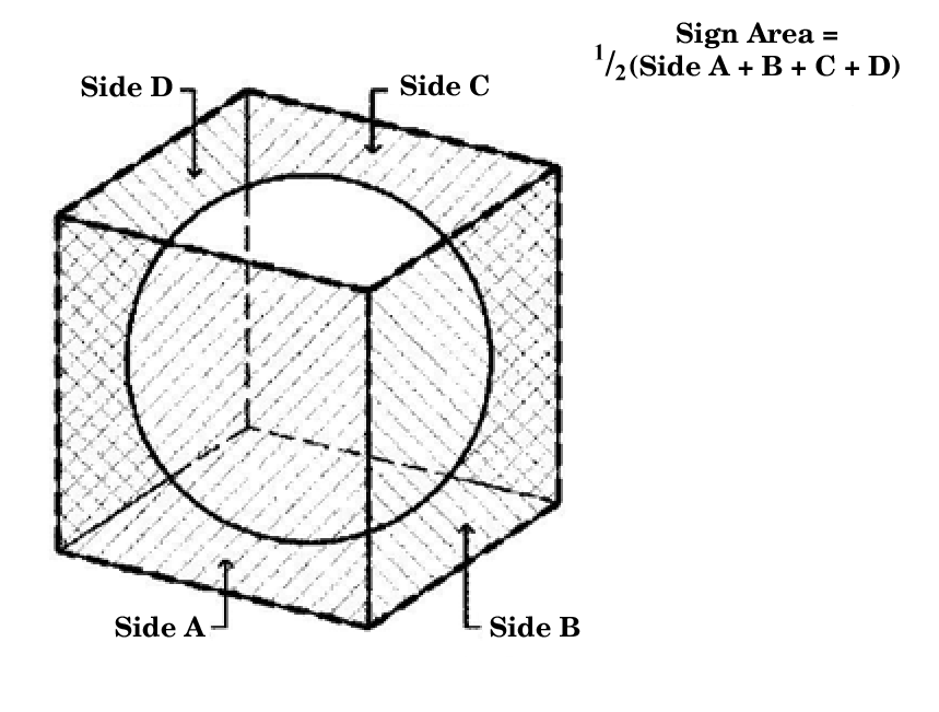
Figure 5.12-4
(e)
For double-faced signs with less than 18 inches between faces, and less than a 30-degree interior angle between faces, only one side shall be counted as the total area. Where the faces are not equal in size, the larger sign face shall be used as the basis for calculating sign area (Figure 5.12-5).
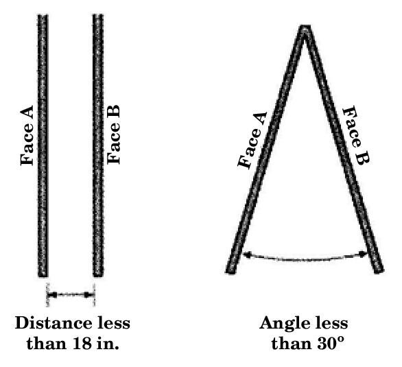
Figure 5.12-5
2.
Sign height. Sign height shall be measured as follows:
(a)
When measuring sign height, the height of the entire structure, including decorative and structural elements must be included. Monument and freestanding signs shall be measured from the base of the sign. Wall and attached signs will be measured from the lowest point of the sign or its supporting structures to the highest point of the sign or its supporting structures.
(b)
Berming or increasing the ground height to increase sign height is not permitted. Height measurement shall be from average grade if berms are used.
(c)
Clearance for a projecting sign is measured from the base of the building, or sidewalk passing under the sign to the lowest point of the sign or its supporting structure.
3.
Distance.
(a)
Whenever a minimum distance between signs is indicated, it means the horizontal distance measured from the closest points of each sign as if each sign's closest point touched the ground.
(b)
Whenever a minimum setback distance is indicated, it means the horizontal distance measured from the closest two points as if the sign's closest point touched the ground.
D.
General standards.
1.
Signs displaying noncommercial messages.
(a)
Notwithstanding any other provision of this section, any sign may display a noncommercial message, either in place of or in addition to the commercial message, so long as the sign complies with other requirements of this section or other ordinances that do not pertain to the content of the message displayed.
(b)
Notwithstanding any other provision of this section or other ordinance, any sign that may display one type of commercial message may also display any other type of commercial message, so long as the sign complies with other requirements of this Code or other ordinances that do not pertain to the content of the message displayed.
2.
Location.
(a)
Location on public property. No person shall place, erect or maintain, or cause the placement, erection or maintenance, of any sign upon any public right-of-way, utility easement, or public area, except as allowed by this section and the city engineer.
(b)
Attachment to tree or public utility pole or public structure. No person shall attach or maintain any sign upon any tree or public utility pole or public structure.
(c)
Location with respect to utility lines and streetlight standards. Signs located near utility lines and streetlights must comply with the distance clearance requirements of the most recent edition of the National Electric Code adopted by the city and the local utility standards. No variances or special exceptions may be granted.
3.
Electrical signs. Electrical signs must comply with the requirements of the city's electrical code. In addition, all illuminated signs must be built to comply with Underwriters' Laboratory requirements and standards and shall bear the Underwriters' Laboratory label. Electrical devices or signs must be protected by wire glass, safety glass, a locked box of metal or wood or other materials approved by the building official.
(a)
Lighting. In no case shall lighting spill over one foot candle onto public streets or 0.03 foot candles onto adjacent residential property.
(b)
Programmed electronic display. Programmed electronic display is allowed on one sign per street frontage per business. Electronic display and/or messaging are not allowed on any billboard. Animation, video, or scrolling is not allowed. An eight second hold time is required with transition time not to exceed one second. Electronic displays shall have automatic dimmers and brightness shall not exceed 0.3 foot candles above ambient light conditions.
4.
Safety.
(a)
Obstruction of exits, windows, or other exits. No sign may be erected or maintained in such a manner that any portion of its surface or supports will obstruct or interfere in any way with the free use of any fire escape, fire equipment, required ventilator, stairway, door, window, or other exit.
(b)
Not to constitute a traffic hazard. No person may erect or maintain any fluttering, undulating, swinging or rotating beacons, or strobe lights with lighting interruptions of less than five second intervals. No sign may be erected or maintained in such a manner as to be likely to interfere with, obstruct the view of, or be confused with any authorized traffic sign, signal, or device. No person may erect or maintain any sign that obstructs a safe visibility triangle at an intersection, as determined by the city engineer.
(c)
The safety regulations contained herein apply to all signs, including those classified as excepted from this section.
5.
Construction standards. All signs shall conform to the city's building standards specifications and the city's building codes for building materials and design.
(a)
All supporting hardware shall be concealed from view or integrated into the sign design.
(b)
Supporting structures of permanent signs shall employ the same material, colors, and textures as the associated primary structures.
(c)
All commercial signs must be printed and professional in appearance. No handwritten or spray painted commercial signs are allowed, save and except window signs painted or applied directly to the window using paints or similar media.
6.
Maintenance.
(a)
Each sign shall be maintained in good condition to prevent deterioration, oxidation, rust, discoloration, or other unsightly conditions and in a safe condition free from all hazards including but not limited to faulty wiring and loose fastenings so as not to be detrimental to public health and safety. Maintenance includes the replacement of defective parts and other acts required for the maintenance of such sign, without altering the basic copy, design, or structure of the sign. The building official shall require compliance or removal of any sign determined to be in violation of this Code in accordance with the enforcement provisions herein.
(b)
No person shall maintain or permit to be maintained on any premises owned or controlled by him any sign which is in a dilapidated or deteriorated condition as defined herein. Upon notice of violation, any such sign shall be promptly removed or repaired by the owner of the sign or the owner of the premises upon which the sign is located.
(c)
All sign copy relating to an activity, service, use or product no longer available for use or purchase by the public and all sign copy relating to a business which is closed or has vacated the premises must be removed. Painted wall signs must be painted over with a color that resembles or matches the wall. If the owner, occupant, or person in control of the premises, or person responsible for the sign, fails to remove or paint over the sign, the owner of the premises shall be responsible and the work shall be completed within 30 days following the date of notification from the city.
E.
Signage regulations by type. Specific regulations for each sign type and its corresponding permissible zoning district are outlined in the tables below.
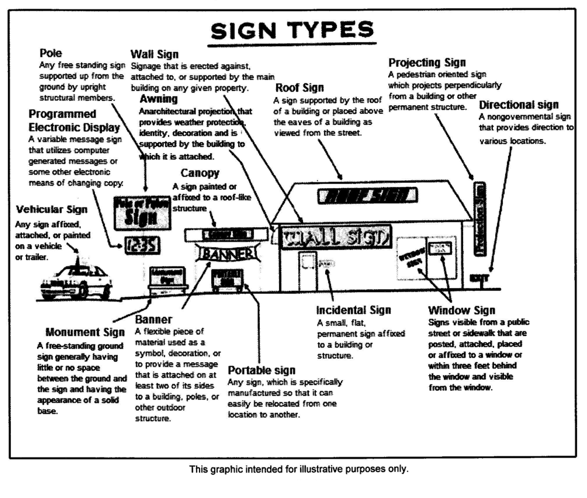
Figure 5.12-6
1 See section 77-512.B. for measurement standards.
1.
Signs allowed in specific zoning districts. The type of signs allowed in specific zoning districts are described in this section. It is unlawful for any person to erect or maintain any sign in a zoning district mentioned in this section unless such sign is of a type specifically allowed in such district. Table 5.12-2 below lists the signs allowed by zoning district. Exception: Single tenant monument and wall signs as permitted in Table 5.12-1, Specific Sign Regulations, may be allowed by the commission for nonresidential uses allowed in residential districts. In such case, the commission shall evaluate the impact of the proposed signage with regard to its compatibility with surrounding properties and neighborhoods, and may establish special conditions as may be necessary to ensure the harmonious integration and compatibility of proposed signage in the neighborhood and with the surrounding area. The decision of the commission may be appealed to the city council, if filed within 20 days after the commission's decision. The city council's determination of the appeal shall be final and binding.
F.
District signage. District signage is permanent or temporary signage intended to provide a public service by allowing off-site signs within a larger development or special district. The city council on recommendation of the planning and zoning commission must approve district directional sign plans.
(a)
All district directional signage must have approval by the city council following recommendation by the planning and zoning commission. Fees for district directional signs shall be as set forth in the city's master fee schedule.
(b)
Placement and installation of district signage must be in accordance with a site plan and must be submitted to the planning department for review and approval. District directional signs may be approved as part of a planned development application.
(c)
District directional signs may be approved only for single developments or cohesive districts at least five acres in size or larger.
(d)
District directional signs shall not obstruct the use of sidewalks and walkways, and shall not obstruct visibility triangles for vehicles, pedestrians or traffic control signs.
(e)
District directional signs shall be limited in size to no more than 32 square feet in area.
(f)
The maximum height for a district directional sign is ten feet.
(g)
District directional signs shall be located on private property provided written permission is obtained from the property owner.
(h)
District direction signs may be illuminated provided they follow all regulations regarding illuminated signage.
(i)
No additional signs, pennants, flags or other devices for visual attention or other appurtenances may be placed on a district directional sign.
(j)
In each district, district directional signs must have uniform design including color schemes, typefaces and fonts, and materials to promote sense of place or identify within the district.
(k)
The base and supporting materials for a district directional sign must be similar in type to materials used for construction of buildings in the development or district. The base and supporting materials may be metal, stone, brick, stucco or other durable and aesthetic product.
G.
Directional kiosk signs.
(a)
Administration.
■
Directional kiosk signs may be installed only pursuant to an approved and executed license agreement approved by the city. All such agreements shall govern the license to design, erect, and maintain directional kiosk signs, and provide for city review and/or approval of the location and design of proposed directional kiosk signs. All license agreements shall be terminable at will without cause by, and without recourse to, the city.
■
All directional kiosk signs are subject to all permitting requirements set forth in this code.
(b)
Location. All directional kiosk signs shall comply with the following regulations unless the applicable executed license agreement provides otherwise:
(a)
Directional kiosk signs shall be located so as not to create a traffic hazard or to obstruct the visibility of motorists, pedestrians, or traffic control signs, signals or devices. The director of development services shall exclusively determine whether a proposed sign location constitutes a traffic hazard or obstructs visibility.
(b)
Directional kiosk signs shall be located so as not to interfere with the general use of and accessibility of sidewalks, walkways, bike and hiking trails by pedestrians, bicycles and persons with disabilities.
(c)
Directional kiosk signs shall be located so as not to interfere with any public utilities or be located in a utility easement.
(d)
Directional kiosk signs shall not be located within a sight distance triangle, as defined in this code and as determined by the director.
(e)
Directional kiosk signs may not be placed adjacent to a lot with a residential use without the prior written consent of the lot owner(s) as identified on the city's most recent tax rolls. Proof of prior written consent must be attached to permit applications for all directional kiosk signs so located. If a residential use is assigned to a lot adjacent to a preexisting directional kiosk sign, no written consent is required.
(f)
Directional kiosk signs must be placed at least 100 feet away from the nearest directional kiosk sign.
(g)
Directional kiosk signs may be located within a median with approved site safety conditions.
(h)
Directional kiosk signs must be located at least five feet from the edge of all curbs and pavement lines, including improved surfaces and shoulders.
(c)
Design. All directional kiosk signs shall comply with the following regulations unless the applicable executed license agreement provides otherwise:
(a)
Directional kiosk signs may not exceed 12 feet in height and four feet in width.
(b)
Directional kiosk signs must include breakaway design features as set forth by the Texas Department of Transportation's Sign Mounting Details for Roadside Signs. Breakaway fittings must be installed below grade or otherwise concealed from public view.
(c)
The font and color of all directional kiosk signs must be uniform throughout the entire sign.
(d)
Directional kiosk signs may not be illuminated.
(e)
Each directional kiosk sign must include at the top of the sign an identification panel displaying only the name and official city logo.
(f)
No lights, signs, pennants, flags, streamers, balloons or other devices or appurtenances used to attract visual attention may be attached to directional kiosk signs.
H.
Sign review procedures.
1.
Permit.
(a)
Application. To obtain a sign permit for all on-site permanent and temporary signs, the applicant shall first file a written application for permit on a form furnished by the building inspections department. Every such application shall contain the following information:
(1)
Dimensioned drawing illustrating the location and design of the sign, the height, base, frame materials, color schemes, and letter size to be contained within the sign.
(2)
Site plan showing the location of the sign.
(3)
If the sign is an electrical sign, electrical plans and specifications.
(4)
If a temporary sign is proposed, the time period the sign will be installed.
(5)
When requested by the building official or his/her designee, more detailed plans may be required and such plans may be required to be prepared by a registered professional engineer or architect.
(b)
Review. The building official or his/her designee shall have ten business days to approve or deny the permit once the submittal has been deemed complete.
(c)
Fee. Fees shall be as required by the city's master fee schedule.
(d)
Expiration. A permit for a sign shall expire if the work is not started within 60 days after the permit is issued, or not completed within 120 days after work is commenced.
(e)
Void permits. A permit issued under this section for a sign which conflicts with any provision of this Code is void.
(f)
Required inspections. All signs for which a permit is required shall be inspected.
2.
Special exceptions.
(a)
The board of adjustment may grant a special exception from the provisions of this section if it appears that the application of a provision of this section would work a manifest injustice.
(b)
In considering a request for a special exception to the requirements of this section, the board of adjustment shall consider, but not be limited to, the type of sign, existence of signs in the general area, the degree of change requested, the reason for the exception request, the location of the exception request, the duration of the requested variance, the effect on public safety, protection of neighborhood and neighboring property, the degree of hardship or injustice involved, the effect of the exception on the general regulation of signs within the city, and such other factors as the board deems pertinent.
(c)
No special exception shall be granted by the board of adjustment if the exception sought conflicts with the spirit of this Code, and may be contrary to this section's intent to provide public safety, adequate lighting, open space and air, conservation of land, protection of property values, and encourage the appropriate use of land.
(Ord. No. 025-06, § 1(Exh. A), 6-6-2006; Ord. No. 019-08, § 4, 7-15-2008; Ord. No. 016-09, § 22, 6-2-2009; Ord. No. 004-10, § 1, 3-2-2010; Ord. No. 012-12, § 1, 5-15-2012; Ord. No. 013-13, §§ 14, 15, 5-21-2013; Ord. No. 022-14, § 8, 6-3-2014; Ord. No. 001-15, § 1, 1-6-2015; Ord. No. 030-16, §§ 1, 2, 9-6-2016)