
Ruston City Zoning Code
CHAPTER 25
01 - ZONING
Sections:
25.01.010 - Purpose and regulatory compliance.
(a)
Purpose. This "Ruston Zoning Code" is an official land use control, adopted under Chapters 36.70 and 36.70A RCW, to serve the public health, safety and welfare, to provide for orderly planned use of land resources, and to further the policies of the Comprehensive Plan of the Town of Ruston. This code governs all uses of land within the Town, including use of buildings, streets, utilities, open space and other physical amenities. This code is intended to be consistent with the Town's Comprehensive Plan and serves to implement the goals and policies of the plan.
(b)
Regulations of the Zoning Code. All land uses in the Town of Ruston must comply with the applicable requirements of this code, including requirements of this and other relevant codes.
(c)
Zoning Map. Boundaries of the various zones are shown on the zoning map on file with the Mayor. Zone boundaries may be changed by Town ordinance.
(d)
Other Land Use Laws and Regulations. This code is intended to supplement, but avoid unnecessary duplication with, all other applicable federal, State, regional and local laws and regulations, including but not limited to the following:
(1)
State Subdivision Law. Subdivision of property is subject to the requirements of the State Subdivision Act, Chapter 58.17 RCW, and the Town's subdivision ordinance. Certain light industrial and commercial developments may utilize the binding site plan provisions of the Subdivision Act.
(2)
State Environmental Policy Act. All land uses are subject to the State Environmental Policy Act (SEPA), Chapter 43.21C RCW, as implemented by State regulations, Chapter 197-11 WAC, and the Town's SEPA ordinance.
(3)
Shoreline Management Act. Land uses within "shorelines" are subject to the State Shoreline Management Act (SMA), Chapter 90.58 RCW, as implemented by State regulations, Chapter 173-14 WAC and the Town's Shoreline Master Program.
(4)
Water Pollution. Water pollution is regulated under the Federal and State Clean Water Acts, and the implementing regulations of the State Department of Ecology.
(5)
Air Pollution. Air pollution is regulated under the Federal Clean Air Act and Federal Environmental Protection Agency (EPA regulations, by the State Clean Air Act, Chapter 70.04 RCW, and implementing DOE regulations, and by the Puget Sound Air Pollution Control Authority.
(6)
Hazardous Waste. Hazardous wastes are regulated under federal laws and regulations, the State Hazardous Waste Disposal Act of 1976 and implementing DOE regulations.
(7)
International Building Codes. Mechanical, plumbing, electrical and building as adopted by the Town Council.
(8)
Other Regulations. Numerous other federal, State and local regulations regulate various aspects of land use in the Town, including those relating to construction, dredging and filling in navigable waters (U.S. Army Corps of Engineers), solid waste (DOE), radioactivity (Nuclear Regulatory Commission), pesticides (EPA and State Department of Agriculture), drinking water quality (EPA and State Department of Social and Health Services), sewage (DOE and DSHS), fire protection and suppression (State Fire Marshal and DNR), surface mining (DNR), and noise (DOE).
(9)
Standard Plans and Specifications for Road, Bridge and Municipal Construction by the Washington State Department of Transportation as adopted by the Town Council.
(e)
Mayor's Duties. The Mayor or his or her designee is authorized to administer and interpret this code. Violations shall be administratively addressed by him/her where compliance can be obtained without legal action.
(Ord. 991 § 2, July 28th, 1997; Ord. 1178 § 1, Nov. 21st, 2005).
25.01.020 - Definitions.
Repealed by Ord. No. 1591, §§ 1, 19, June 17th, 2025, and relocated as new Ch. 25.99. (Ord. 991 § 2, July 28th, 1997; Ord. 1031 § 1, May 3rd, 1999; Ord. 1178 § 1, Nov. 21st, 2005; Ord. 1289, § 1, June 15th, 2009; Ord. 1385 § 1, Dec. 18th, 2012; Ord. 1409, § 1, June 4th, 2013; Ord. 1505, § 1, Feb. 5th, 2019; Ord. 1530 § 2, June 2nd, 2020; Ord. 1551 §§ 2, 3, Oct. 5th, 2021).
25.01.030 - Establishment of zoning districts.
(a)
Purpose of Use Classifications (Zones). Use classifications are adopted to enhance the lifestyle of citizens of Ruston and the region by:
(1)
Regulating the locations of land uses;
(2)
Ensuring that different land uses are compatible and mutually beneficial;
(3)
Making possible efficient and economical public services, including streets, sewers, drainage systems, schools, and other public buildings;
(4)
Requiring orderly arrangements to facilitate movement of people and goods; and
(5)
Protecting natural and cultural resources.
(b)
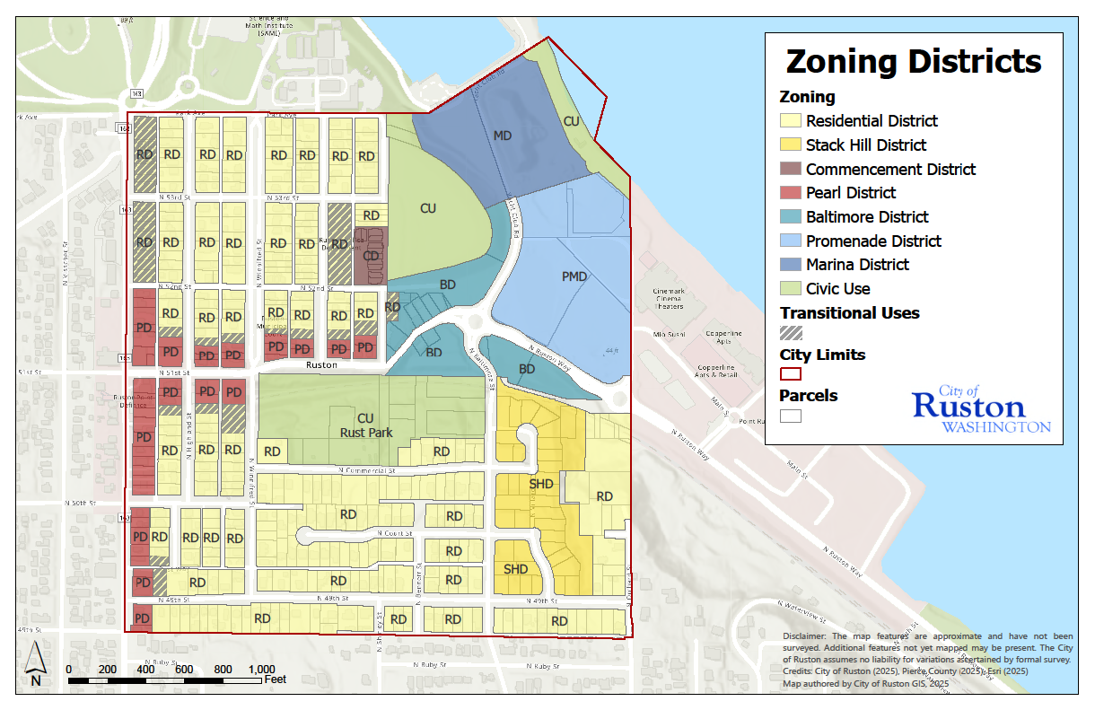
List of Zones Established. The City of Ruston is hereby divided into eight types of use districts as follows:
(c)
Official Ruston Zoning Map.
(Ord. 991 § 2, July 28th, 1997; Ord. 1178 § 1, Nov. 21st, 2005; Ord. 1382 § 1, Feb. 5th, 2013; Ord. 1591 § 2, June 17th, 2025).
25.01.040 - Residential District (RES).
(a)
Illustrations and Intent. The Residential District is zoned primarily for residential uses. This district is represented by Ruston's traditional residential-style buildings with small front, side, and rear yards along tree-lined streets. Structures are one to two stories in height with front porches and pitched roof forms. Neighborhoods include single-family homes, middle housing units, and accessory dwelling units. Home occupations and accessory dwellings are encouraged where impacts to nearby residential uses are minimized. Pedestrian-oriented street-side facades with clear entries and front porches are a high priority. Vehicle access is limited to on-street parallel parking and alleys where available.
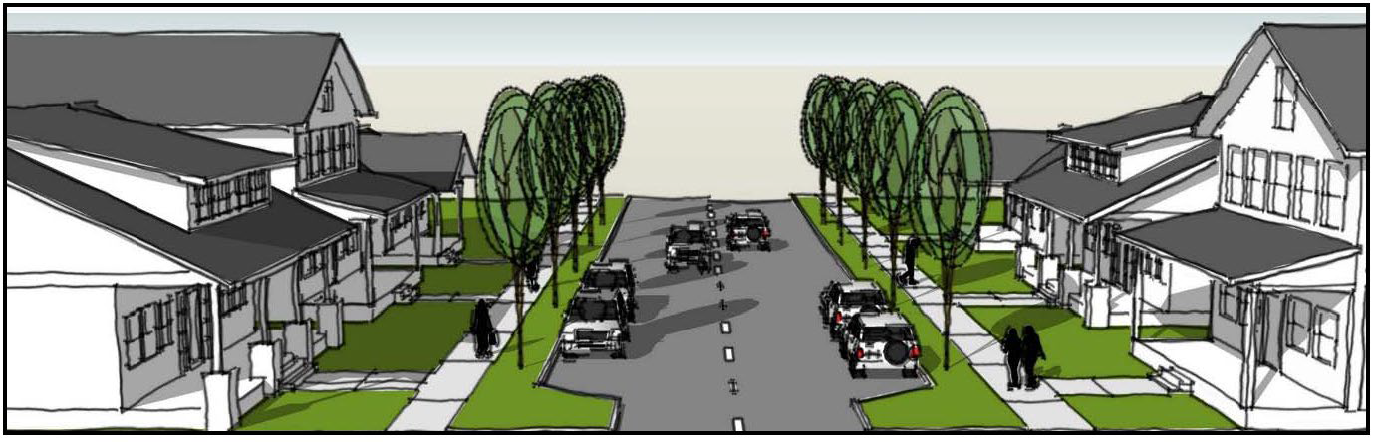
Figure 1 - Typical Residential District Form
Note: The illustrations in this section are advisory only. Refer to the standards in the following sections for the specific requirements of the Residential District.
(b)
Permitted Uses. Refer to Chapter 25.07 RMC for uses permitted in the RES zone.
(c)
Conditional Uses. Refer to Chapter 25.07 RMC for uses conditionally permitted in the RES zone.
(d)
Minimum Lot Area and Width. Every lot in the RES zone shall provide a lot area of at least 4,400 square feet with a minimum width of 45 feet. No lot which is less than the area and width specified herein may be developed unless meeting the requirements for a nonconforming lot as set forth in RMC 25.01.120.
(e)
Unit density. The maximum permitted unit density in the RES zone is two primary units per lot, or a single primary unit and two accessory dwelling units. This standard does not apply to lots after subdivision below 1,000 square feet, which will have a maximum permitted unit density of one unit per lot.
(f)
Setback Requirements and Build-to Zone (BTZ).
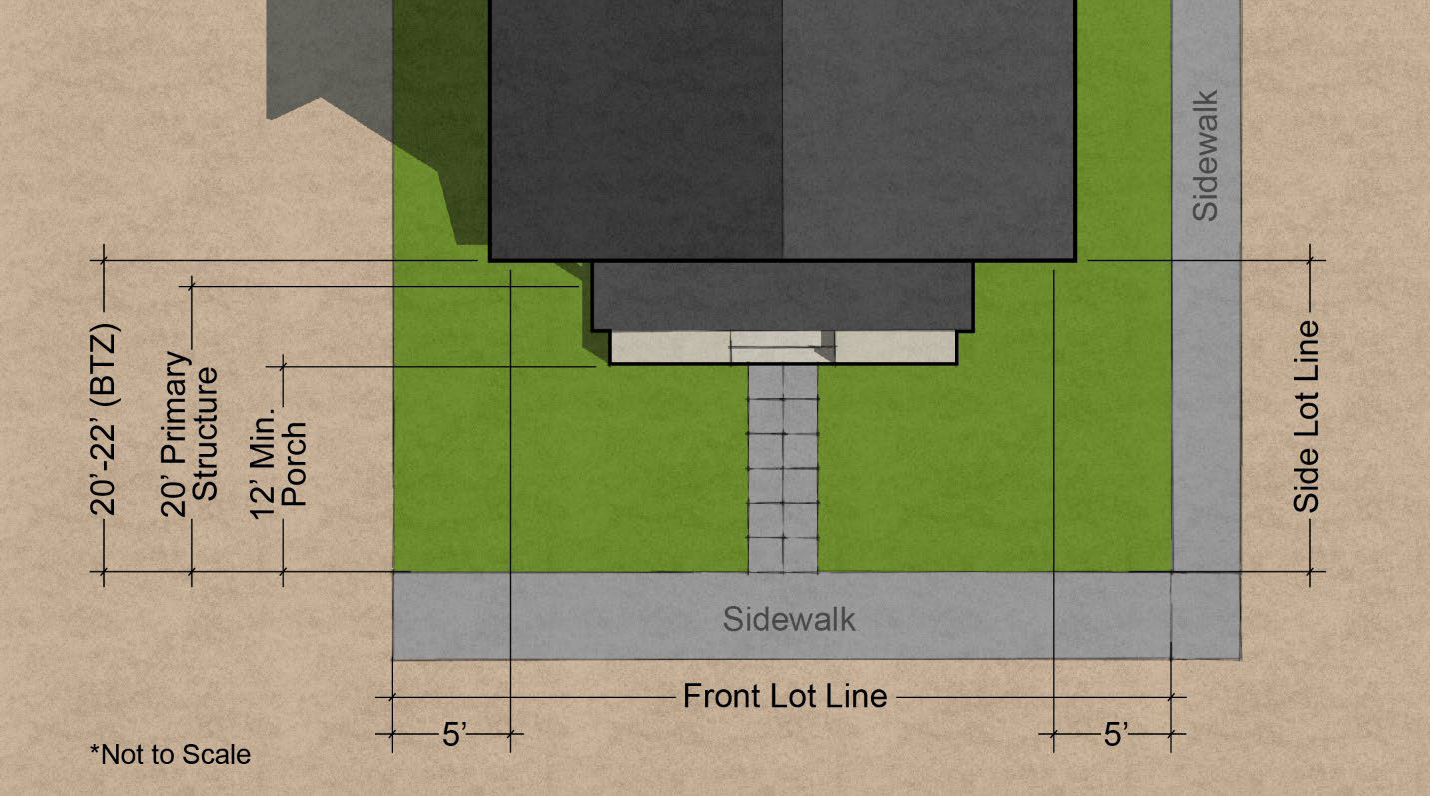
Figure 2 - Primary Structure Setbacks
(1)
Front Yard.
(A)
The primary structure minimum setback is 20 feet from the front lot line. The primary structure (BTZ) is located between 20 and 22 feet from the front lot line. At least 50 percent of the ground floor front facade of the primary structure must be located within the BTZ.
(B)
Porches may be located as close as 12 feet from the front lot line, provided that the finished floor elevation of the primary structure is at least 18 inches above the average elevation of the front lot line, as described in subsection (f) below.
(C)
Garages and accessory structures must be set back at least 26 feet from the front lot line, subject to subsection (k) of this section.
(2)
Rear Yard.
(A)
Primary structure minimum setback is 25 feet from the rear lot line.
(B)
Garages and accessory structures must be set back a minimum of three feet from the rear lot line, subject to subsection (k) of this section.
(3)
Side Yards.
(A)
Primary structures, attached garages and porches, must be set back a minimum of five feet from the side yard, with a combined total of ten feet of setback space for both side yards. Existing lots of record which do not comply with the minimum lot width may reduce the combined total side yard width to no less than ten feet.
(B)
Detached garages and accessory structures, three feet from the side yard lot line, subject to subsection (k) of this section, and RMC 25.01.090.
(4)
Setback Requirement Exception:
(A)
Detached Accessory Dwelling Units may be sited at a lot line if the lot line abuts a public alley, unless it is a public alley that the City regularly snow plows.
(g)
Permitted Height.
(1)
No structure shall exceed 25 feet in height as measured from the lot grade as defined in RMC 25.01.020 (lot grade definition); provided, that the ridge of the roof runs parallel to the view corridor and a minimum eight-foot (rise)/12-foot (run) roof pitch, with no dormers is proposed, permitted height shall be allowed to be no more than 30 feet from the lot grade.
(2)
Grade elevations by a licensed surveyor showing the lot grade must be provided on a site plan with building permit application (refer to Illustration A).
(3)
A roof elevation must be provided by a licensed surveyor to the City Building Official or designated person within five working days after rafters are installed on a new or remodeled structure. See illustration B below. This requirement may be waived by written permission of the City Building Official for structures that are clearly more than 24 inches below maximum permitted height.
(4)
No accessory building, including detached garages, shall exceed 18 feet in height as measured from the lot grade. This height limitation does not apply to accessory dwelling units. For the accessory buildings, lot grade will be determined by the corners of the rear yard building envelope defined in subsection (k) of this section. The following diagram illustrates subsection (f) of this section:
Illustration A - Determination of Lot Grade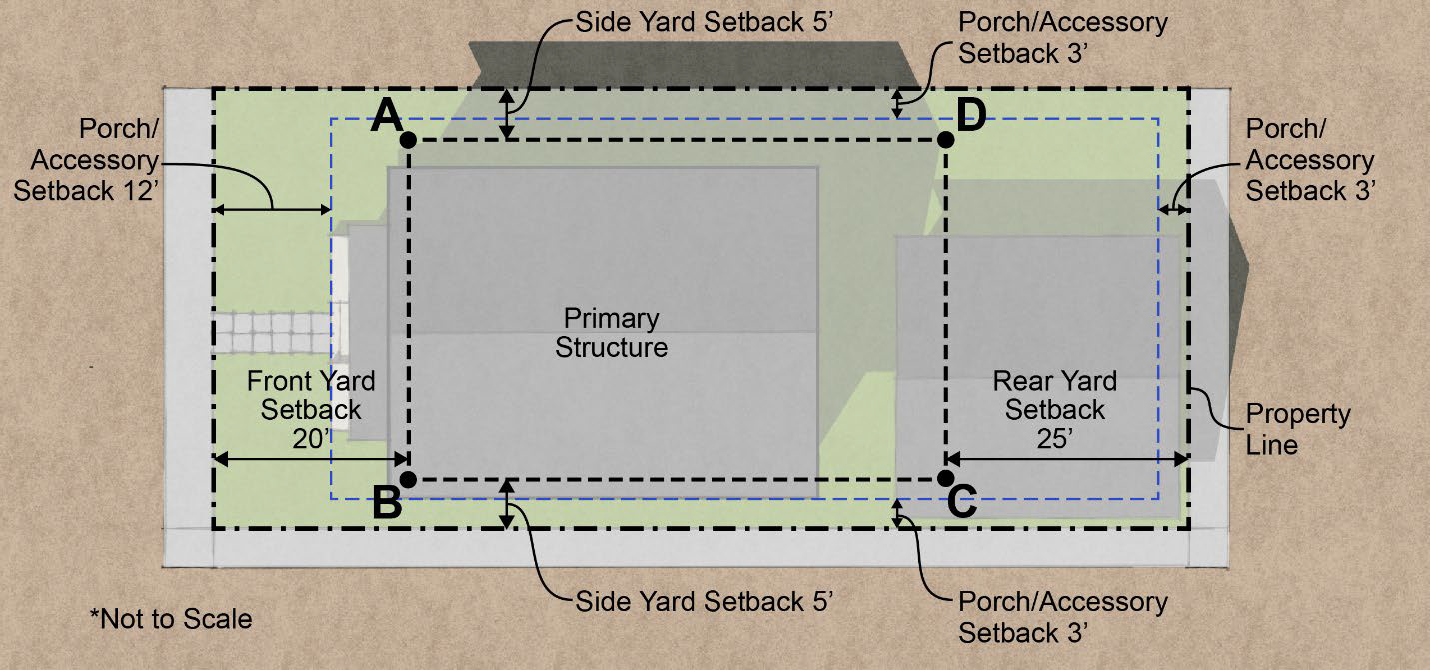
Lot Grade Calculations = Elevation of (A+B+C+D)/4
Illustration B - Measurement of Height for Proposed Structures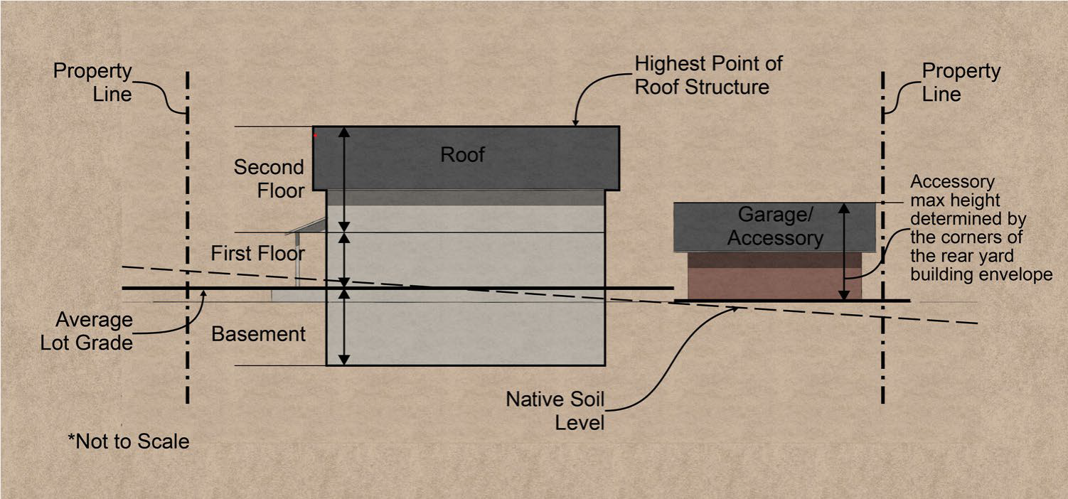
Height Measurement Figure
(h)
Minimum Open Space. A minimum amount of open space equal to at least 50 percent of the total lot area shall be required, provided that for cottage housing, the minimum amount of open space shall be equal to at least 20 percent of the total lot area. For the purposes of this section, open space shall include areas such as landscaping, patios, and decks. Additionally, up to 25 percent of the required minimum open space may include private porches, balconies, and rooftop gardens. Impervious driveway and vehicle parking areas shall not be included as open space.
(i)
Site Plan Requirements. Site plan approval is required under RMC 25.01.140 for a development of more than four residential units.
(j)
Yard Variation on Corner Properties. The City may issue special permits under the variance procedures contained in RMC 25.01.110 allowing variations of positions of side, front and rear entrances of houses to be built on corner properties formed by the intersection of two or more streets. Such approvals may result in substitution of front and/or rear yard depths for side yard depths and vice versa, but shall not otherwise result in placing any house in a position which would be illegal. No such approval shall be granted if the resulting setback does not harmonize with other residential buildings in the same block. Every application for a variance under this subsection shall be accompanied by complete plans showing all entrances to the house, and a sketch map showing accurately the location of the house on the property and locations of other residential buildings in the same block, and any other requirements under the variance procedures contained in RMC 25.01.110.
(k)
Garages, Surface Parking, Driveways and Accessory Structures. Garages, surface parking, driveways and accessory structures are permitted within the rear yard setback, subject to the following provisions:
(1)
When alley access is available, garages, surface parking and driveways are prohibited from accessing the site through front or side yards. If alley access is not available, then side yard access shall be utilized. If neither alley nor side yard access is available, then the following standards will apply to all garages, surface parking and driveways:
(A)
Side-loaded garages are preferred over front-loaded garages when access is provided through front yards.
(B)
Front-loaded garages with vehicle doors facing the front lot line that are attached to the primary structure shall include habitable space above the garage with windows facing the street, (habitable space must also meet International Building and Fire Code egress standards for bedrooms). The area of habitable space shall be at least 50 percent of the area of the garage.
(C)
Driveways and surface parking areas located within ten feet of the front lot line shall have a maximum width of ten feet and shall either contain a three-foot-wide grass strip along its center (perpendicular to the right-of-way or access street) or be paved with grass pavers.
(D)
See RMC 25.01.065 for provisions related to the conversion of garage space into an Accessory Dwelling Unit.
(l)
[Reserved.]
(m)
Fences—Height Restrictions. See RMC 25.01.101 for further regulations related to rockery/retaining wall height and height of fences on rockeries.
(1)
Fence in required front yard: 60 inches maximum height.
(2)
Fence in required side yard: 72 inches, 60 inches within 15 feet of the front property line.
(3)
Fence in required rear yard: 72 inches.
(4)
On corner lots, fences shall be limited to 42 inches in height for a distance of 15 feet from the intersection of the property lines abutting the street and to 60 inches in height for the remainder of the required front yard facing on both streets; except that fences may be permitted to a maximum height of 72 inches from the ground in the front and/or side yard on a flanking street.
(n)
Projections into Yard Setbacks. Steps and patios are permitted within setbacks. Steps providing access to a second story or higher may not be located within three feet of any side lot line. Also see RMC 25.01.110(d)(3) for other allowable projections into yard setbacks.
(o)
Architectural Standards. All development within the Residential District is subject to the architectural standards contained within Chapter 25.06 RMC.
(p)
Alley Access and Parking. Lots with existing alley access shall not be modified to eliminate such access. Any newly created lot shall provide alley access, except where provision of such access is not physically feasible due to extreme topography, as determined by the City Engineer. In cases where newly created or modified lots cannot feasibly provide alley access, then access shall be provided by easement or lot configuration to the nearest side street as illustrated in Figure 3 below. If access to a side street is not available, then provision of shared side yard access shall be required as illustrated in Figure 4 below.
Lots which include both (1) the provision of vehicle access via an alley; and (2) are adjacent to on-street public parking, may decrease the total number of required parking stalls for the lot by one stall for every 20 lineal feet of street frontage providing on-street parking.
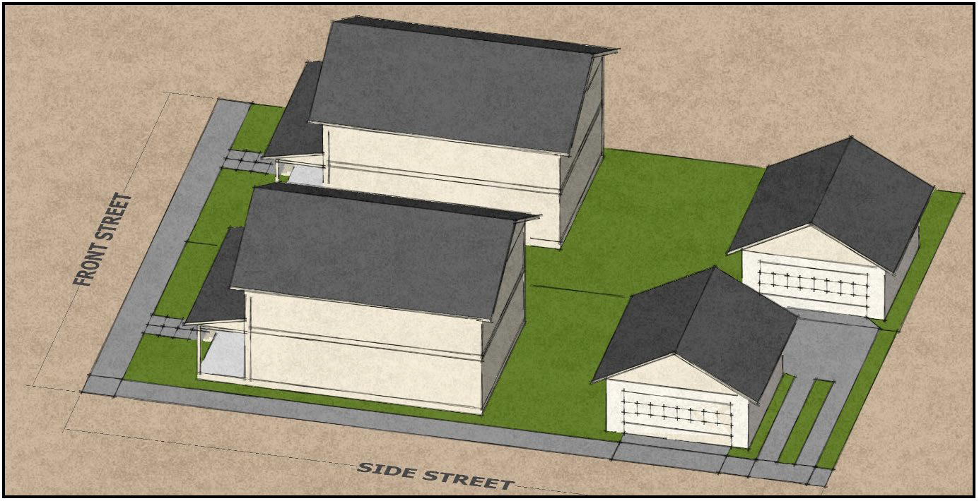
Figure 3 - Example Providing Access to Side Street via Easement/Lot Configuration
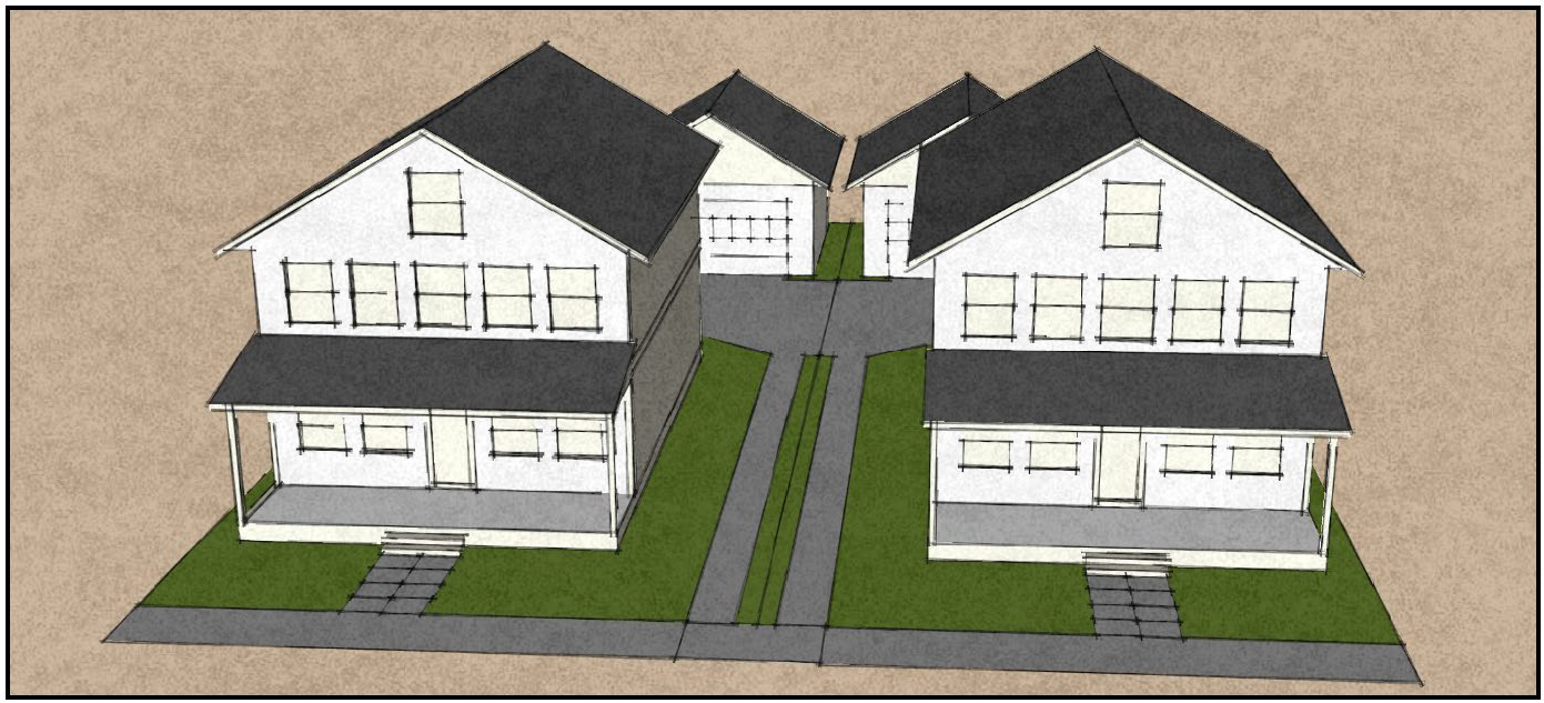
Figure 4 - Example Providing Access to Front via Shared Driveway
(Ord. 991 § 2, July 28th, 1997; Ord. 1031 § 1, May 3rd, 1999; Ord. 1178 § 1, Nov. 21st, 2005; Ord. 1409, § 2, June 4th, 2013; Ord. 1440, § 1, Aug. 5th, 2014; Ord. 1459, § 1, Dec. 1st, 2015; Ord. 1591 § 3, June 17th, 2025).
25.01.050 - Baltimore District (BD).
(a)
Purpose. The Baltimore District (BD) is intended to promote aesthetic quality, pedestrian/shopper comfort and convenience, public safety, and encourage pedestrian-oriented commercial/retail development along or near Baltimore Street, Ruston Way, Yacht Club Road, and 51st Street. Upper floor residential uses are encouraged to help create demand for commercial/retail use on the ground floor of mixed use buildings. This district is intended to encourage reuse and upgrades of the existing business buildings and promote retail frontages with street amenities and a direct visual relationship between pedestrians on the sidewalk and uses on the ground floor of the building.
(b)
Permitted Uses. Refer to Chapter 25.07 RMC for uses permitted in the Baltimore District.
(c)
Conditional Uses. Refer to Chapter 25.07 RMC for uses conditionally permitted in the Baltimore District.
(d)
Minimum Lot Area. There is no minimum lot area in the Baltimore District.
(e)
Permitted Height. No structure in the Baltimore District shall exceed 35 feet in height and no more than two stories, including all mechanical equipment, except that structures with frontage on 51st Street shall have additional height allowed so that no structure shall exceed 45 feet in height and no more than three stories, including all mechanical equipment. Lots located within the Point Ruston Master Development Plan must comply with the requirements of Ordinance 1264.
(f)
Setback and Buffer Requirements.
(1)
Yard Setback Requirements.
(A)
Front yard: 0 feet to property line.
(B)
Rear yard: 25 feet to property line.
(C)
Side yards: 0 feet to property line.
(D)
Lots located within the Point Ruston Master Development Plan must also comply with the requirements of Ordinance 1264.
(g)
Off-Street Parking Requirements. Off-street parking shall comply with RMC 25.01.090 and the City's design standards contained within Chapter 25.06 RMC.
(h)
Site Plan Requirements. Site plan approval is required under RMC 25.01.140 for any development within the Baltimore District.
(i)
Design Standards. All development within the Baltimore District is subject to the design standards contained within Chapter 25.06 RMC. Lots located within the Point Ruston Master Development Plan must also comply with the requirements of Ordinance 1264.
(Ord. 991 § 2, July 28th, 1997; Ord. 1031 § 1, May 3rd, 1999; Ord. 1178 § 1, Nov. 21st, 2005; Ord. 1409, § 3, June 4th, 2013; Ord. 1484 § 1, Nov. 15th, 2016; Ord. 1591 § 4, June 17th, 2025).
25.01.051 - The Pearl District.
(a)
Purpose. The Pearl District is intended to promote aesthetic quality, pedestrian/shopper comfort and convenience, public safety, and encourage pedestrian-oriented commercial/retail development along or near Pearl Street. Second and third floor residential uses are encouraged to help create demand for commercial/retail use on the ground floor of mixed use buildings. This district is intended to encourage reuse and upgrades of the existing business buildings and promote retail frontages with street amenities and a direct visual relationship between pedestrians on the sidewalk and uses on the ground floor of the building.
(b)
Permitted Uses. Refer to Chapter 25.07 RMC for uses permitted in the Pearl District.
(c)
Conditional Uses. Refer to Chapter 25.07 RMC for uses conditionally permitted in the Pearl District.
(d)
Minimum Lot Area. There is no minimum lot area in the Pearl District.
(e)
Permitted Height. No structure within the Pearl District shall exceed 35 feet in height and no more than two stories, including all mechanical equipment, except that structures located between 50th Street and 52nd Street shall have additional height allowed so that no structure shall exceed 45 feet in height and no more than three stories, including all mechanical equipment.
(f)
Setback and Buffer Requirements.
(1)
Yard Setback Requirements.
(A)
Front yard: 0 feet to property line.
(B)
Rear yard: 25 feet to property line.
(C)
Side yards: 0 feet to property line.
(g)
Site Plan Requirements. Site plan approval is required under RMC 25.01.140 for any development within the Pearl District.
(h)
Design Standards. All development within the Pearl District is subject to the design standards contained within Chapter 25.06 RMC.
(Ord 1212 §§ 2, 3, May 7th, 2007; Ord. 1292, § 1, July 20th, 2009; Ord. 1382 § 2, Feb. 5th, 2013; Ord. 1409, § 4, June 4th, 2013; Ord. 1591 § 5, June 17th, 2025).
25.01.052 - The Marina District.
(a)
Purpose. The Marina District (MD) is intended to promote aesthetic quality, pedestrian/shopper comfort and convenience, public safety, and encourage pedestrian-oriented commercial/retail development along or near Yacht Club Road, Dune Peninsula Park and the Point Defiance Marina. Upper floor residential uses are encouraged to help create demand for commercial/retail use on the ground floor of mixed use buildings. This Marina District is intended to promote retail frontages with street amenities and a direct visual relationship between pedestrians on the sidewalk and uses on the ground floor of the building.
(b)
Permitted Uses. Refer to Chapter 25.07 RMC for uses permitted in the Marina District.
(c)
Conditional Uses. Refer to Chapter 25.07 RMC for uses conditionally permitted in the Marina District.
(d)
Minimum Lot Area. There is no minimum lot area in the Marina District.
(e)
Permitted Height. Lots located within the Point Ruston Master Development Plan must comply with the requirements of Ordinance 1264.
(f)
Setback and Buffer Requirements. Lots located within the Point Ruston Master Development Plan must comply with the requirements of Ordinance 1264.
(g)
Site Plan Requirements. Site plan approval is required under RMC 25.01.140 for any development within the Marina District.
(h)
Design Standards. All development within the MD zone is subject to the design standards contained within Chapter 25.06 RMC. Lots located within the Point Ruston Master Development Plan must also comply with the requirements of Ordinance 1264.
(Ord. 1591 § 6, June 17th, 2025).
25.01.053 - The Promenade District.
(a)
Purpose. The Promenade District (PMD) is intended to promote aesthetic quality, pedestrian/shopper comfort and convenience, public safety, and encourage pedestrian-oriented commercial/retail development along or near Ruston Way, Central Avenue, Main Street, Grand Loop, and Grand Plaza. Upper floor residential uses are encouraged to help create demand for commercial/retail use on the ground floor of mixed use buildings. This Promenade District is intended to promote retail frontages with street amenities and a direct visual relationship between pedestrians on the sidewalk and uses on the ground floor of the building.
(b)
Permitted Uses. Refer to Chapter 25.07 RMC for uses permitted in the Promenade District.
(c)
Conditional Uses. Refer to Chapter 25.07 RMC for uses conditionally permitted in the Promenade District.
(d)
Minimum Lot Area. There is no minimum lot area in the Promenade District.
(e)
Permitted Height. Lots located within the Point Ruston Master Development Plan must comply with the requirements of Ordinance 1264.
(f)
Setback and Buffer Requirements. Lots located within the Point Ruston Master Development Plan must comply with the requirements of Ordinance 1264.
(g)
Site Plan Requirements. Site plan approval is required under RMC 25.01.140 for any development within the Promenade District.
(h)
Design Standards. All development within the MD zone is subject to the design standards contained within Chapter 25.06 RMC. Lots located within the Point Ruston Master Development Plan must also comply with the requirements of Ordinance 1264.
(Ord. 1591 § 7, June 17th, 2025).
25.01.054 - Stack Hill District.
(a)
Purpose. The Stack Hill District is zoned primarily for residential uses. This district is represented by Ruston's traditional residential-style buildings with small front, side, and rear yards along tree-lined streets. Structures are one to two stories in height with front porches and pitched roof forms. Neighborhoods include single-family homes, with allowances for Tier 3 middle housing units. Home occupations and accessory dwellings are encouraged where impacts to nearby residential uses are minimized. Pedestrian-oriented street-side facades with clear entries and front porches are a high priority. Vehicle access is limited to on-street parallel parking and alleys where available.
(b)
Permitted Uses. Refer to Chapter 25.07 RMC for uses permitted in the Stack Hill District.
(c)
Conditional Uses. Refer to Chapter 25.07 RMC for uses conditionally permitted in the Stack Hill District.
(d)
Minimum Lot Area. Lots located within the Stack Hill District must comply with the requirements of Ordinances 1224, 1261, and 1268.
(e)
Permitted Height. Lots located within the Stack Hill District must comply with the requirements of Ordinances 1224, 1261, and 1268.
(f)
Setback and Buffer Requirements.
(1)
Yard Setback Requirements. Lots located within the Stack Hill District must comply with the requirements of Ordinances 1224, 1261, and 1268.
(g)
Site Plan Requirements. Site plan approval is required under RMC 25.01.140 for any development within the Stack Hill District.
(h)
Design Standards. All development within the Stack Hill District is subject to the design standards contained within Chapter 25.06 RMC. Lots located within the Stack Hill District must also comply with the requirements of Ordinances 1224, 1261, and 1268.
(Ord. 1591 § 8, June 17th, 2025).
25.01.055 - The Commencement District.
(a)
Purpose. The Commencement District (CD) is zoned primarily for high rise multi-family residential uses in accordance with the master development plan approved under Ordinance 1155.
(b)
Permitted Uses. Refer to Chapter 25.07 RMC for uses permitted in the Commencement District.
(c)
Conditional Uses. Refer to Chapter 25.07 RMC for uses conditionally permitted in the Commencement District.
(d)
Minimum Lot Area. There is no minimum lot area in the Commencement District.
(e)
Permitted Height. Lots located within the Commencement District must comply with the requirements of Ordinance 1155.
(f)
Setback and Buffer Requirements. Lots located within the Commencement District must comply with the requirements of Ordinance 1155.
(g)
Site Plan Requirements. Site plan approval is required under RMC 25.01.140 for any development within the Commencement District.
(h)
Design Standards. All development within the Commencement District is subject to the design standards contained within Chapter 25.06 RMC. Lots located within the Commencement District must also comply with the requirements of Ordinance 1155.
(Ord. 1591 § 9, June 17th, 2025).
Editor's note— Ord. No. 1591, § 9, adopted June 17, 2025, renumbered the former § 25.01.055 as § 25.01.070 and enacted a new § 25.01.055 as set out herein. The historical notation has been retained with the amended provisions for reference purposes.
25.01.056 - The Civic Use District.
(a)
Purpose. The Civic Use District (CU) is intended to provide designated areas within Ruston that prioritize the development and preservation of civic uses for public benefit. This district aims to foster the creation and maintenance of government buildings, public parks, open spaces, and other essential facilities that serve the community at large.
(b)
Permitted Uses. Refer to Chapter 25.07 RMC for uses permitted in the Civic Use District.
(c)
Conditional Uses. Refer to Chapter 25.07 RMC for uses conditionally permitted in the Civic Use District.
(d)
Minimum Lot Area. There is no minimum lot area in the Civic Use District.
(e)
Permitted Height. No structure within the Civic Use District shall exceed the maximum height established for the Residential District.
(f)
Setback and Buffer Requirements. The Civic Use District does not require setbacks for civic or open space uses, except that lots located within the Point Ruston Master Development Plan must also comply with the requirements of Ordinance 1264.
(g)
Site Plan Requirements. Site plan approval is required under RMC 25.01.140 for any development within the Civic Use District.
(h)
Design Standards. All development within the Civic Use District is subject to the design standards contained within Chapter 25.06 RMC.
(Ord. 1591 § 10, June 17th, 2025).
25.01.060 - Master planned development (MPD) zone.
Repealed by Ord. 1476 § 1, Nov. 3rd, 2015. (Ord. 991 § 2, July 28th, 1997; Ord. 1178 § 1, Nov. 21st, 2005; Ord. 1436, § 1, Aug. 19th, 2014).
25.01.061 - Point Ruston Master Development Plan (PRMDP).
Repealed by Ord. No. 1591, § 11, June 17th, 2025. (Ord. 1264 § 2(Att. 2), Sept. 2nd, 2008; and Ord. 1363, April 2nd, 2012).
25.01.065 - Accessory dwelling units.
(a)
Accessory Dwellings Units. Accessory dwellings units may be allowed following review and approval by the Community Development Director subject to the following conditions:
(1)
Up to two accessory dwelling units may be permitted on a lot per each single-family dwelling located on the same lot, provided that the unit density set forth in RMC 25.01.040(e) for that lot is not otherwise exceeded. If a lot is developed with a duplex, or with two units meeting the definition of middle housing, then no accessory dwelling unit is permitted on that lot.
(2)
Accessory dwelling units shall comply with the development standards of the zoning district in which the accessory dwelling unit is located, including but not limited to, minimum lot coverage, setbacks, etc.
(3)
The maximum gross floor area for an accessory dwelling unit is 1,000 square feet.
(4)
Accessory dwelling units shall only be allowed on lots that meet the minimum lot sizes for the principal unit under the code. In addition, for any lot which is the result of a subdivision or a lot split and which is below the minimum lot size for the zone, no additional dwelling units, including accessory dwelling units, shall be allowed.
(5)
The maximum roof height for an accessory dwelling unit is no more than 25 feet, or the maximum height allowed for the primary unit on the lot, whichever is lower.
(6)
Accessory dwelling units shall not be allowed on any lot that contains critical areas or buffers or that is not connected to a public sewer system.
(7)
Accessory dwelling units shall not be allowed within the shoreline jurisdiction.
(8)
Parking for accessory dwelling units must meet the requirements of RMC 25.01.090.
(9)
Garage space and other accessory buildings may be converted into an accessory dwelling unit provided that the unit density set forth in RMC 25.01.040(e) is not exceeded. However, if the converted accessory building contained parking, the minimum parking standards for both the principal unit and any accessory dwelling unit must be replaced elsewhere on the property. Nonconforming use rules as set forth in RMC 25.01.120 apply to any accessory buildings that are converted which are not consistent with the applicable codes at the time of conversion.
(10)
An ADU may be sold as a condominium unit or as a separate piece of property through the unit lot subdivision process.
(11)
Detached ADUs may be sited at a lot line if the lot line abuts a public alley, unless it is a public alley that the City regularly snow plows.
(12)
Design Requirements. The design of an accessory dwelling shall be incorporated into the principal structure's design with matching materials, colors, window styles, and roof design or it shall be designed so that, to the degree reasonably feasible, the appearance of the building remains that of a single-family dwelling. Compliance with RMC 25.06.040, Architectural Standards is required.
(13)
Enforcement. If a unit cannot be legalized because it fails to meet the standards herein and the unit cannot or will not be brought into conformance with these standards, the use will have to be discontinued. The City may cite owners of illegally occupied units who do not apply for legalization. Owners who do not apply for a permit will be subject to civil penalties and other enforcement penalties under Chapter 25.03 of this Code.
(Ord. 1591 § 12, June 17th, 2025).
25.01.070 - Occupancy standards.
For all housing, including single-family, multi-family, emergency housing, emergency shelters, permanent supportive housing or transitional housing, the dwelling unit or building shall comply with all of the standards for the underlying zone and shall be limited to a maximum occupancy as follows:
(a)
Every living room shall contain not less than 120 square feet (11.2 m 2 );
(b)
Every bedroom shall contain not less than 70 square feet (6.5 m 2 ) and every bedroom occupied by more than one personal shall contain not less than 50 square feet (4.6 m 2 ) of floor area for each occupant thereof.
(c)
Kitchens and non-habitable spaces shall not be used for sleeping purposes.
(d)
The dwelling unit shall not be occupied by more occupants than permitted by the minimum area requirements in Table 1 below:
Minimum Area Requirements
(Ord. 1551 § 4, Oct. 5th, 2021; Ord. 1591 § 9, June 17th, 2025).
25.01.080 - Erosion and sedimentation control, storm water retention and groundwater discharge.
(a)
Purpose. This section is to minimize adverse impacts on marine and fresh water resources that might be caused by development on unstable soils or steep slopes, or by substantial alterations in existing landforms, increases in storm water runoff, or decreases in groundwater discharge.
(b)
Erosion Control Plan Required. An erosion control plan is required for every development involving more than:
(1)
Five hundred cubic yards excavation, fill or any combination thereof.
(2)
Eight feet depth of fill.
(3)
Ten feet depth of excavation.
(4)
One acre of grading, excavation, or fill on slopes greater than eight percent.
(5)
Any amount of grading, excavation or fill in a stream, stream channel, water body, shoreline or seasonal wetland.
(c)
Potential Problems and Purposes of Erosion Control Plans. Erosion control shall be designed to achieve the following objectives, to the extent practicable, to the reasonable satisfaction of the Town or be designed to meet these objectives by an engineer satisfactory to the Town.
(1)
Erodible Slopes. Prevent detachment and transport of soil particles from slope, particularly slopes over eight percent.
(2)
Streams, Streambeds, Stream Banks, Bodies of Water, Lake Shorelines. Prevent detachment and transport of soil particles and undercutting or damage to banks.
(3)
Drainage Ways. Prevent detachment and transport of soil particles which otherwise could be deposited in streams, bodies of water, or wetlands, promote deposits or sediment loads in these areas before they change watercourses.
(4)
Land Adjacent to Streams, Ponds, and Wetlands. Prevent detachment and transport of soil particles.
(5)
Enclosed Drainage Structures. Prevent sedimentation in structure, erosion at outflow, and deposit of sediment within the watercourse.
(6)
Large Flat Unpaved Surfaces. Prevent detachment of soil particles and their off-site transport.
(7)
Impervious Surfaces. Prevent the detachment and transport of soil from the impervious surface in increased rates or volumes of runoff.
(8)
Borrow and Stockpile Areas. Divert runoff from faces of slopes which are exposed in the excavation process; convey runoff into stable channels; leave borrow areas and stockpile in stable conditions.
(Ord. 991 § 2, July 28th, 1997; Ord. 1031 § 1, May 3rd, 1999; Ord. 1178 § 1, Nov. 21st, 2005).
25.01.090 - Parking requirements.
(a)
Parking Spaces Required. Every building erected after adoption of this Code shall have parking and loading spaces required by this chapter permanently maintained and used only for those purposes. Additions to structures require additional parking if needed to meet the required parking for the addition or the required parking for the expanded facility, whichever is smaller.
(1)
Required Parking for Specific Uses.
(A)
Bowling lanes: five parking spaces per lane.
(B)
Churches: one parking space for each five seats in the principal place of assembly. Where fixed seats consist of pews or benches, the seating capacity shall be based on 20 inches of pew or bench length per seat. If there are no fixed seats, then one parking space for each 40 square feet of floor area in the principal place of assembly.
(C)
Hotels: one parking space for each bedroom.
(D)
Hospitals: one parking space for each bed.
(E)
Public libraries: one parking space for each 250 square feet of gross floor area.
(F)
Motels: one parking space for each sleeping unit.
(G)
Offices: one parking space for each 200 square feet of gross floor area.
(H)
Rest homes, nursing homes, retirement homes, and institutions: one parking space for each four beds.
(I)
Elementary schools: one parking space for each employee and each faculty member. (Where parochial schools and churches are on the same site, the required church parking facilities shall be considered as contributing to the school parking requirement.)
(J)
Schools: one parking space for each ten students and one for each employee. (Where parochial schools and churches are on the same site, the required church parking facilities shall be considered as contributing to the school parking requirement.)
(K)
Sports arenas, auditoriums, (including school auditoriums) other places of public assembly (other than churches): one parking space for each three fixed seats. Where fixed seats consist of benches, or if there are no fixed seats, seating capacity shall be computed as for churches. (Where places of public assembly and schools are on the same site, the required school parking facilities shall be considered as contributing to the public assembly parking requirement).
(L)
Storage and warehousing, freight terminals (when comprising the only activity on the premises): one parking space for each two employees on a maximum working shift.
(M)
Theaters, taverns, restaurants, and adult entertainment facilities: one parking space for each three seats.
(2)
All commercial buildings (except as set forth in subsection (a)(1) of this section) hereafter erected shall be so designed as to make provision for off-street automobile parking equivalent to four parking stalls for each 1,000 square feet (or major fraction thereof) of gross floor area, which is defined to include all interior building area without deduction for any reason.
(3)
All multiple unit dwellings, with a unit density that exceeds the density limits set forth in RMC 25.01.040(e) and which is erected or structurally altered after June 30, 2025, shall be so designed as to make provision for off-street automobile parking equivalent to two parking stalls for each residential unit therein.
(4)
Off-street parking for each middle housing dwelling unit and each accessory dwelling unit shall be provided as follows:
(A)
No off-street parking shall be required for middle housing units within one-half mile walking distance of a major transit stop.
(B)
A maximum of two off-street parking spaces per unit shall be required on lots greater than 6,000 square feet before any zero lot line subdivisions or lot splits.
(C)
A maximum of one off-street parking space per unit shall be required on lots no greater than 6,000 square feet before any zero lot line subdivisions or lot splits.
(5)
One parking space for each three employees on the largest working shift for all scientific and research laboratories, light manufacturing and distribution uses.
(6)
Single-family residential (and additions and structural alterations over 50 percent of the house's square footage) shall make provision for off-street parking for two automobiles.
(7)
Parking facilities must be an accessory use to an allowed use of a site and shall not be the primary use of any lot except as provided in subsection (a)(8) below.
(8)
While shared parking is allowed under this section, off-premises parking that is the primary use of any lot is prohibited even under a "shared parking" arrangement. This prohibition notwithstanding, the City may allow a lot to be primarily used for interim off-site or shared parking for a period not to exceed four years as part of an approved development phasing plan whereby the parking will cease to be a primary use and will convert to an accessory or subordinate use of an allowed use at the end of the phasing period. The four-year limitation may be extended for a maximum extension time of two additional years if requested by the property owner in writing at least 60 days prior to expiration of the initial four-year period.
(b)
Parking for Common Facilities. The amount of off-street parking required may be reduced by an amount approved by the City when common parking facilities are developed for two or more uses and:
(1)
The total parking area exceeds 5,000 square feet;
(2)
The reduction is based on expected cooperative uses of parking facilities during times when not all uses are operating and the normal hours of operation are separated by at least one hour;
(3)
The number of off-street parking spaces provided for common facilities must equal the sum of the required parking spaces for each of the various uses if computed separately. The sum of required parking spaces applies for the hours during which operations of different uses overlap;
(4)
A covenant recorded among the cooperating property owners is approved by the City; and
(5)
Uses sharing parking must be located within 800 feet of each other.
(c)
Size of Parking Spaces. Each off-street parking space shall have at least 180 square feet, exclusive of drives and aisles, and be at least nine feet wide; except that in facilities of more than 20 parking spaces, up to 30 percent of the total may be at least 128 square feet, exclusive of drives and aisles, and at least eight feet wide, if identified as compact spaces. Each space must have adequate ingress and egress.
(d)
Location of Parking Spaces.
(1)
Required off-street parking shall be located as follows, with distances measured from the nearest point of the parking area to the nearest door of the building served:
(A)
For residential dwellings, parking shall be on the site.
(B)
For churches in a residential zoning district, parking shall be on-site. For churches located in other zones, parking shall be no farther than 150 feet and not in a residential zoning district.
(C)
For hospitals, homes for the aged, boarding houses and club facilities, parking shall be no farther than 150 feet from the building and not in a residential zoning district.
(D)
The off-street parking herein provided shall be on the same premises as the commercial or multiple unit dwelling to which it is appurtenant (except as provided below in subsection (d)(3) of this section).
(2)
No motor vehicles or trailers may be parked or stored in any required front yard except in driveways. Driveways may cross required yards or landscaped areas to provide access between the off-street parking and the street. Driveways serving single-family dwellings may be used for parking and may be considered to provide the two required parking spaces.
(3)
Whenever required parking is located off site, safe, durable and adequate pedestrian facilities shall be provided to the building served. Off-site parking must be located within 800 feet of the building served and is subject to the limitations contained in this section.
(4)
Alley Access. Garages and parking spaces may be located adjacent to alleys only if the following standards are met:
(A)
For alley access to parking spaces to be allowed, the alley to be used must have a right-of-way width of at least 16 feet.
(B)
The alley must have, or be provided with, an unobstructed surface at least 12 feet in width within the public right-of-way.
(C)
For parking spaces and garages proposed at right angles to the alley, at least 22 feet must be available from the back edge of the required parking space or wall of proposed garage structure to any obstruction which will inhibit maneuvering or to the far edge of the alley right-of-way, whichever is nearest.
(D)
For parking spaces and garages parallel to the alley right-of-way, the entire parking space must be located on the applicant's property and all space for maneuvering must occur on the applicant's property or on public right-of-way.
(5)
Parking of commercial vehicles is prohibited in residential zones, except as specifically allowed through the approval of a conditional use permit when associated with either a permitted or conditional use. Commercial vehicles that are parked for brief periods of time, as is necessary in their normal course of business, while performing a service or delivering a product are exempt.
(e)
Definitions for the purposes of this section are found in RMC 25.99.160 and Chapter 25.99 RMC.
(f)
Parking developed under this section shall comply with the City's design standards in Chapter 25.06 RMC.
(g)
Existing Building and Uses. Existing buildings and uses with parking lawfully established at the effective date of the ordinance codified in this chapter shall be permitted. A change to a more intense use that requires additional parking shall require application for a conditional use permit.
(Ord. 991 § 2, July 28th, 1997; Ord. 1178 § 1, Nov. 21st, 2005; Ord. 1289, § 2, June 15th, 2009; Ord. 1385 § 2, Dec. 18th, 2012; Ord. 1429, § 1, Dec. 23rd, 2013; Ord. 1591 § 13, June 17th, 2025).
25.01.100 - Signs.
Repealed by Ord. 1422, § 1, Nov. 19th, 2013. (Ord. 991 § 2, July 28th, 1997; Ord. 1178 § 1, Nov. 21st, 2005; Ord. 1310, § 2, June 7th, 2010; Ord. 1330, § 1, June 6th, 2011; Ord. 1363, §§ 2, 3, April 2nd, 2012).
25.01.101 - Fences, retaining walls and rockeries.
(a)
Location in Required Yard.
(1)
Fences, retaining walls and rockeries may be located within any required yard.
(b)
Location in Street.
(1)
Fences. No fence shall be located in any improved street. Fences may be allowed in unimproved public streets subject to approval of the Mayor's designee. The granting of an encroachment agreement must clearly state that the Town of Ruston may remove any structure that is permissively allowed in the rights-of-way. As a condition of the agreement between the Town and the applicant, the applicant shall agree that if the Town desires to remove the structure from any rights-of-way that the applicant shall not be entitled to any financial or other forms of reimbursement.
(2)
Retaining Walls and Rockeries. Retaining walls and rockeries may be allowed in any street subject to the approval of the Mayor or designated representative and the granting of an encroachment agreement covering any public street as required.
(c)
Height Measurement.
(1)
Fences. The height of a fence is measured from the top of the fence, including posts, to the existing grade or finished grade, whichever is lower, directly below the section of the fence being measured.
(2)
Retaining Walls and Rockeries. The height of a retaining wall or rockery is measured from the top of the retaining wall or rockery to the bottom of the footing or the bottom of the footer rock or pile.
(d)
Retaining Walls and Rockeries — Requirements.
(1)
Building Permit. A building permit is required for retaining walls or rockeries over four feet in height, as determined by IBC Section 106.2.
(2)
Engineer. Any rockery requiring a building permit shall be approved by the Mayor's designee, who may require a design be submitted by a licensed engineer with proper engineering expertise.
(3)
Drainage Control. Drainage control of the area behind the rockery shall be provided for all rockeries.
(4)
Maximum Height in Required Yard.
(A)
Cut Slopes. No retaining walls or rockeries, or any combination of retaining walls or rockeries, within any required yard, shall exceed a total of 144 inches in height. All retaining walls and/or rockeries within a required yard shall be included in calculating the maximum height of 144 inches. Such retaining walls or rockeries, or combination of retaining walls or rockeries, may be topped by a fence in accordance with the fence height requirements for the zone.
(B)
Fill Slopes. No retaining walls or rockeries, or any combination of retaining walls or rockeries, shall exceed a total of 72 inches in height within any required yard. All retaining walls and/or rockeries within a required yard shall be included in calculating the maximum height of 72 inches. A fence or guardrail may be placed on top of such retaining wall or rockery, but in no event shall the combined height of the fence and any retaining wall or rockery exceed 72 inches; provided, rockeries, retaining walls, fences, or any combination thereof, are limited to a maximum height of 42 inches within that portion of any required yard which lies within 20 feet of any street rights-of-way.
(5)
Fill/Berms. No person shall place fill upon which to build a fence unless the total height of the fill plus the fence does not exceed the maximum height allowable for the fence without the fill.
(6)
Shorelines. Fence, rockeries and retaining walls located within any shoreline shall also comply with Section 15.01.010 and the shoreline program as set forth in Ordinance 651.
(e)
Fence Height Deviations. Deviations from the height limitations set out in this section shall be reviewed in the manner set out below:
(1)
A request for a deviation up to ten percent beyond the requirements above shall be reviewed by the Mayor's designee under the following procedure:
(A)
The applicant shall submit two copies of plot plans and elevations, drawn to scale, showing size and construction of the proposed fence, the location of all existing structures, streets, driveways, and landscaping.
(B)
The code official shall review the submitted plans with the city engineer or designated party and shall base the decision to approve or disapprove the requested deviation on factors of traffic visibility and other public and private safety considerations, lot shape, location and topography, and the nature, location and extent of adjoining public and private structures.
(2)
Deviations ten percent to 20 percent beyond the requirements in subsections (a) to (d) of this section shall be reviewed by the Planning Commission under the procedures set forth in Section 1.07.030 and criteria set forth in Section 25.01.110(d)(2). The Commission review is advisory to the administrative official and does not constitute a permit decision subject to the procedures of Title 19, Administration of Development Regulations.
(f)
Electric and Barbed Wire Fences. Electric fences and barbed wire fences are not allowed.
(g)
Exceptions. These provisions do not apply to fences required by State law to enclose public utilities, or to chain link fences enclosing school grounds or public playgrounds, or to screens used for safety measures in public recreation areas such as ball fields or storm water retention ponds.
(Ord. 1178 § 1, Nov. 21st, 2005).
25.01.102 - Plant material in right-of-way.
(a)
Plant material in the public right-of-way shall be maintained by the adjacent property owner. Plant material shall be maintained to allow a clear sight line from three feet above grade to eight feet above grade. Trees are allowed but shall be maintained to have few or no limbs in this height range.
(b)
Plant material shall be maintained to not restrict movement or use of streets or sidewalks.
(c)
The Mayor's designee shall have the authority to enforce the provisions of this section.
(Ord. 1178 § 1, Nov. 21st, 2005).
25.01.103 - Outdoor lighting.
(a)
Purpose. It is the purpose of this section to promote public health, safety and general welfare by more efficiently using energy in the form of light by intentionally directing light only upon surfaces intended to be lit, thus reducing unnecessary glare of light into the night sky and surrounding public rights-of-way and private properties.
(b)
Lighting Standards.
(1)
Keep Light Source Hidden From Public View. All light sources shall be hidden or conform to light standards specified herein. Except for temporary seasonal holiday lighting, light sources (e.g., light bulbs or lenses) shall not be visible. Sources of high-intensity light, whether behind a lens or not, shall not be visible to the public or to any other off-site areas.
(2)
Use Downward Directional Lighting. Except for intermittent security lighting on motion detectors, all lights more than seven feet above the ground shall be downward directional. The fixture's housing must be totally opaque. Clear or refractive lenses shall not extend below the housing.
(3)
Lighting which is located lower than seven feet above the ground shall be limited to a maximum illumination equivalent of 75 watts from an incandescent bulb.
(4)
Avoid Lighting Large Areas with a Single Source. Large areas may be lit with a number of low-intensity sources close to the area requiring illumination. Illumination of a large area with a remote single source of light is prohibited. Intensity of exterior light sources shall not exceed ten footcandles per square foot. If the Mayor or his designee suspects that a lighting proposal does not comply with this requirement, a plan illustrating intensity of light measured in footcandles may be required.
(5)
Avoid Excessive Light Throw. Lighting shall not be cast beyond the premises and shall be limited to illumination of surfaces intended for pedestrians or vehicles. Illumination of landscaped areas shall be avoided unless lighting is part of the landscape area immediately around the building or the area is intended for recreational use.
(6)
All light fixtures higher than seven feet above the ground which are intended to illuminate vehicle or pedestrian areas within the public right of way or upon nonresidential or multifamily sites shall be selected from the Architectural Area Lighting Providence® Family of Fixtures, or comparable equivalent as determined by the Mayor or his designee. Specifications for available fixtures may be obtained from the Town Clerk or by navigating your web browser to the Architectural Area Lighting website at http://aal.net. Recessed can fixtures located within roof overhangs, porches, awnings, or other architectural roof elements are exempt from this requirement.
(7)
Avoid Light Fixture Designs Which Have a Utilitarian Appearance. Designs that are strictly utilitarian in appearance shall be avoided on all fixtures visible to the public, e.g., mercury vapor lights, cobra lights, shoebox lights, etc.
(8)
Limit Height of Pole Fixtures. Pole lights shall be no taller than 20 feet above a 36-inch base in parking lots and traffic areas, and no taller than 12 feet in pedestrian areas.
(9)
Indoor Business Lighting. If a business use includes indoor illuminate which illuminates areas outside the building in which it is located, the above standards shall apply.
(10)
Back-Lit Awnings Prohibited. Awnings shall be constructed of materials which are completely opaque and shall not contain signs printed or mounted upon them.
(Ord. 1310, § 1, June 7th, 2010).
25.01.110 - Conditional uses, unclassified uses and variances.
(a)
Conditional Use, Unclassified Use and Variance Procedures.
(1)
Applications. Applications for a conditional use, unclassified use or variance shall be submitted to the Mayor or his designee, and shall contain the name and address of the applicant, legal description or street address of the property, nature of the action requested, a site plan and a concise statement of why the proposed use complies with the criteria of this section, as applicable. The application shall be accompanied by a plot plan showing the grade, the height, the lot coverage, the dimensions of all existing structures and the distance from property lines and all improvements to be added to the property, including yard areas, etc. Permit and application fees as established by ordinance and recorded in the City's schedule of land use application fees. The applicant may be required to furnish additional written or graphic information necessary to enable the City staff or Hearing Examiner to act on the application.
(2)
Notice and Hearing. Notice of application shall be given and hearings held and a determination reached thereon as set forth in Section 25.01.140(e) and Title 19 of the Ruston Municipal Code.
(3)
Decision. A conditional use or variance application included in an application for site plan approval shall be considered together with the site plan.
(b)
Conditional Uses.
(1)
Purpose of Conditional Use Permit. It is the purpose of this chapter to establish review and approval procedures for unusual or unique types of land uses which due to their nature require consideration of their impact on the neighborhood and land uses in the vicinity. The purpose of the conditional use permit is to allow certain uses in zoning districts that would normally be prohibited, when the requested use is consistent with the goals and policies of the Comprehensive Plan or zoning code and is deemed consistent with the existing and potential uses within the zoning district. No existing building or structure shall be converted to a conditional use unless such building or structure complies, or is brought into compliance, with the provisions of this section.
A conditional use permit is a mechanism by which the City may require specific conditions on development or the use of land to ensure that designated uses or activities are compatible with other uses in the same zone and in the vicinity of the subject property. If imposition of conditions will not make a specific proposal compatible, the proposal shall be denied. The City's Hearing Examiner may grant conditional use permits only if all applicable provisions of this code are fulfilled:
(A)
The proposed use will not be injurious to the neighborhood or otherwise result in substantial or undue adverse economic, aesthetic, or environmental effects on adjacent property.
(B)
The proposed use will not create a hazard for pedestrian or vehicular traffic. Traffic and circulation patterns of vehicles and pedestrians relating to the proposed use shall not be detrimental to the existing and proposed allowable uses in the zoning district. The traffic and circulation patterns shall assure safe movement in the surrounding area.
(C)
Adequate access will be available for emergency vehicles.
(D)
Adequate off-street parking will be provided to prevent congestion of public streets.
(E)
The bulk and lot coverage of the proposed use shall be compatible with the surrounding property, or shall be conditioned so as to not impose an adverse impact upon the surrounding property.
(F)
Building and structure heights shall conform to the requirements of the surrounding zoning district. Bell towers, public utility antennas or similar structures may exceed the height requirements, provided that they conditioned so as to not impose an adverse impact upon the surrounding community.
(G)
Potential noise, light and glare impacts relating to the proposed use shall not unduly impact nor detract from the surrounding properties in the zoning district. The Hearing Examiner shall find that the potential noise, light and glare shall not deter from the surrounding properties in the zoning district.
(H)
Hours of Operation. The hours of operation shall not create intrusive impacts into the neighborhood.
(2)
Landscaping. Landscaping shall be provided in all areas not occupied by buildings or paving. The Hearing Examiner may require exceptional landscaping as a condition.
(3)
Effect of Conditional Use Permit.
(A)
Once a conditional use permit is approved, no building or development shall occur contrary to that specified in the conditional use permit.
(B)
The owner shall record a declaration with the Pierce County Auditor showing the land to be bound by a conditional use permit.
(i)
The declaration shall reference the official files of the City through which the permit was granted.
(ii)
The declaration shall be a covenant running with the land.
(iii)
No building permit shall be issued unless such declaration is recorded.
(iv)
No building permit shall be issued for structures other than those specified in the permit.
(c)
Unclassified Uses. In creating use classifications, the City has considered the characteristics which make uses comparable and compatible. It is not possible to enumerate and classify every use to which land might be devoted. Persons wishing to establish an unclassified use may request a classification from the City Council which shall consider such requests during its annual review (if required by law). At the discretion of the Mayor, uses sufficiently similar to classified uses can be permitted subject to approval by the Council and any conditions the Council considers appropriate. On receipt of such a request, the Mayor shall ascertain all pertinent facts and make an appropriate recommendation to the City Council for classification based upon similarities or dissimilarities, compatibility or incompatibility, with enumerated uses, for any proposed use:
(1)
Not listed as a permissible or conditional use in any zone; or
(2)
Involving new technology developed since adoption of the ordinance codified in this chapter; or
(3)
Which, because of unusual processes or material, possesses performance characteristics different than those usually associated with the use and requires the use to be placed in a more restrictive classification.
(d)
Variances.
(1)
Authorization for Variance—Findings Required. A variance from any area, setback, yard, parking or other dimensional requirements contained in this chapter may be granted by the Hearing Examiner after receiving the recommendation and written findings of fact from the City staff as described in (d)(6) below if the Hearing Examiner finds that the standards in subsection (d)(2) of this section are established by the applicant.
(2)
Variance Standards. Before any variance can be granted, the applicant must establish the following:
(A)
There is a unique condition relating to the size, shape, topography, location, or character of surrounding uses that would make the application of the regulation too restrictive; or
(i)
The purpose of the regulation from which the variance is sought would not be harmed by allowing the variance, thus making application of the regulation to the applicant's property unreasonable. Such uses may include fire safety, adequate traffic sight distance, and open space for light, air, and recreational uses; and
(B)
Approval of the variance will not grant a special privilege not enjoyed by other properties in the vicinity; or
(i)
The proposed design is more environmentally sensitive than would be the case if the design met the regulation from which a variance is sought; and
(C)
The proposed variance will not conflict with the City's comprehensive plan; and
(D)
Will not adversely affect the neighborhood's character; and
(E)
Will not adversely affect the use or value of neighboring properties.
(3)
Projections into Yard Setbacks. The following intrusions may project into any required yard setback and shall not require a variance:
(A)
Roof overhangs (eaves), belt courses, leaders, sills, pilasters, lintels, ornamental features, cornices, sun shades, gutters, and other similar features; provided, that such features do not extend more than 24 inches into any required yard setback;
(B)
Chimneys, flues, and similar fireplace structures so long as they do not extend more than two feet into the side yard setback or three feet into a front or rear yard setback;
(C)
Uncovered porches, steps, balconies and platforms that do not extend above the floor level of the second floor may extend up to six feet into the front or rear yard setback or two feet into a side yard setback;
(D)
Planting boxes or masonry planters not exceeding 48 inches in height above the finished grade level may extend into any required front or rear yard setback.
(4)
The provisions of this section shall prevail when they conflict with the provisions of Sections 25.01.040 and 25.01.050.
(5)
Variance Subject to Conditions. The Hearing Examiner may grant a variance subject to conditions or safeguards to ensure that the purpose and intent of the City's zoning regulations and comprehensive plan will not be violated.
(6)
Report and Recommendation From Mayor. The Planning Director or other City official designated by the Mayor shall prepare a written report and recommendation on the variance application and shall submit such report to the Hearing Examiner prior to his or her consideration of the variance application in a public hearing.
(Ord. 991 § 2, July 28th, 1997; Ord. 1178 § 1, Nov. 21st, 2005; Ord. 1468, § 1, Nov. 3rd, 2015).
25.01.120 - Nonconforming buildings, lots of record and uses.
(a)
Nonconforming Buildings and Uses.
(1)
Nonconforming Buildings. A nonconforming building or use is one which was lawfully established but no longer conforms to the regulations for the zone where it is located. Existing accessory buildings are exempt from the requirements of this section, but if accessory buildings are damaged by fire, explosion, other casualty, act of God, or other cause beyond the owner's control, they must be rebuilt to current International Building Code standards.
(2)
Nonconforming Uses. Nonconforming uses apply to uses buildings, structures, land, and uses which become nonconforming as a result of this chapter.
(b)
Effect of Removal or Destruction of Nonconforming Buildings or Discontinuance of Nonconforming Use.
(1)
Nonconforming Buildings. If a nonconforming building is destroyed, removed, or suffers damage of 75 percent or more of its replacement cost in the judgment of the City's Building Official, future uses of the land must conform to this title.
(2)
Nonconforming Uses. If a nonconforming use is discontinued for more than one year, the land or building may, not again be occupied or used except by a conforming use.
(c)
Maintenance and Reconstruction. Upkeep, repair, and maintenance of nonconforming buildings is permitted. A nonconforming building damaged by less than 75 percent of its replacement cost in the judgment of the City's Building Official by fire, explosion, other casualty, act of God or other cause beyond the owner's control may be continued and reconstructed, subject to all provisions of City building codes, if restoration is commenced within one year from the damage and completed with reasonable diligence.
(d)
Structural Alteration or Enlargement. Nonconforming buildings may not be enlarged or structurally altered except:
(1)
To make the building more conforming.
(2)
Where required by law.
(3)
Where a building is nonconforming only because of substandard yards, open spaces, area, or height and the structural alterations and enlargements do not increase the degree of nonconformity.
(4)
Structural alterations which do not increase the floor space are permitted where necessary to adapt a nonconforming building to new technologies or equipment for the existing uses in conformance with all applicable building regulations.
(5)
Other structural alterations may be authorized as conditional uses under Section 25.01.110, Conditional uses, unclassified uses and variances, if the alteration will improve the safety, appearance, or functionality of the property or make it less detrimental to other uses in the vicinity. Alterations must comply with all applicable building regulations.
(6)
Where necessary to provide access for elderly or disabled persons.
Nothing in this title shall be deemed to prevent the strengthening or restoring to a safe condition of any nonconforming building or part thereof declared to be unsafe by order of any City official charged with protecting the public safety. Alterations or expansion of a nonconforming use which are required by law or a public agency in order to comply with public health or safety regulations are the only alterations or expansions allowed.
(e)
Exception for Legally Established Multifamily Dwellings. Multiple-family dwellings in existence at the time of adoption of the ordinance codified in this chapter which were legally established through special permit such as a variance or which were constructed in conformance and compliance with the zoning code in effect at the time of construction shall be considered legal nonconforming uses and shall not be deemed nonconforming in terms of use or density provisions of this chapter. Such buildings may be rebuilt after a fire or other natural disaster to their original dimensions but may not be changed except as provided in this section.
Multiple-family dwellings may also be brought into compliance with this section by obtaining a permit for existing multiple-family dwelling unit legalization as outlined in Section 25.01.040.
(f)
Nonconforming Use of Land. The nonconforming use of land (where no building is involved) existing on or before June 20, 1997, may be continued, provided that:
(1)
No such nonconforming use of land shall in any way be expanded or extended either on the same or adjoining property;
(2)
If such nonconforming use of land or any portion thereof is discontinued or changed, any future use of such land shall be in conformity with the provisions of this title.
(g)
Nonconforming Lots of Record.
(1)
In any district in which single-family dwellings are permitted, a single-family dwelling and customary accessory building which was erected on any single lot of record on or before June 20, 1997, is considered a nonconforming lot, notwithstanding limitations imposed by other provisions of this title. Such nonconforming status will only be recognized for the lot if it was in separate ownership and not of continuous frontage with other lots in the same ownership as of June 20, 1997. In such case, the lot will continue to be recognized as a legal building lot unless such nonconforming status is lost in accordance with subsection (g)(2) below. This provision shall apply even though such lot fails to meet the requirements for area or width that are generally applicable in the district; provided, that yard dimensions and requirements other than those applying to area or width of the lot shall conform to the regulations for the district in which lot is located. In cases where it is not possible to obtain at least 900 square feet of building floor area and 20-foot minimum average building width, required yard setbacks may be reduced equally (on a percentage basis) on all sides, to the point that such area and width is achieved. In no case shall setbacks less than seven and one-half feet be allowed under this provision.
(2)
Combination. In all single-family zoning districts, if two or more lots or combinations of lots and portions of lots with continuous frontage are in single ownership as of June 20, 1997, or any time thereafter, then the nonconforming lot is to be and shall be deemed to have been combined with such contiguous lot or lots to the extent necessary to create [a] conforming lot and thereafter may only be used in accordance with the provision of the Ruston Zoning Code. No parcel or portion of a parcel shall be used or sold in a manner which violates Title 29 of the Ruston Municipal Code nor which diminishes compliance with lot width and area requirements established by this title, nor shall any division of any parcel be made which creates a lot with width or area below the requirements stated in this title.
(Ord. 991 § 2, July 28th, 1997; Ord. 1031 § 1, May 3rd, 1999; Ord. 1178 § 1, Nov. 21st, 2005; Ord. 1440, § 2, Aug. 5th, 2014).
25.01.125 - Curb and sidewalk construction.
Every subdivision approval, and every building permit for new construction on property where a sidewalk or curb in conformity with Town standards does not exist, shall include as a condition a requirement that such sidewalk and curb be constructed in conformity with such standards prior to issuance of an occupancy permit.
If a structure remodel is proposed with value of 60 percent or more of replacement cost of the structure, in the judgment of the Town's Building Official, curb and sidewalk must conform to this section. For this section, the value shall mean the total replacement cost, including all engineering, surveying, architectural and consultant fees, as well as all licensed and bonded contractor fees, including the contractor's profit. If labor is provided at no cost, the comparative value of this labor shall be computed, as if being performed by a licensed and bonded contractor.
(Ord. 1038 § 1, Nov. 1st, 1999; Ord. 1178 § 1, Nov. 21st, 2005).
25.01.130 - Rezones.
(a)
Initiation. An amendment of the existing zoning ordinance or map, whether it is a rezone or an addition, may be initiated by the Planning Commission, the Town Council or any interested property owner.
(b)
Application. Applications for a rezone of property within the Town shall be made with the Town Clerk on forms provided and upon payment of the appropriate fee. Applications must include a detailed vicinity map and plot plan, if applicable. Applications will be considered once a year during the Town's annual review of the Comprehensive Plan.
(c)
Plot Plans. Whenever an applicant seeks a rezone of property, the Planning Commission shall require that a detailed plot plan and vicinity map be submitted with the application to show all entrances, exits, setbacks, building height, off-street parking, streets and sidewalks, storage yards and screening. The items set out in this section and such other items as pertain to health, safety and the general community welfare shall be subject to approval by the Commission and the Council.
(d)
Planning Commission Review and Recommendation. Commission review and recommendation shall comply with Section 25.01.140.
(e)
Town Council Action.
(1)
Within 60 days after the public hearing, the Commission shall transmit its findings and recommendations to the Council for decision. The Council may hold additional public hearings provided due notice is given as set forth in Section 25.01.140(e).
(2)
Within a reasonable time after receipt of the recommendations of the Commission, the Council shall, in a public meeting, either affirm, modify or return the application to the Commission for further consideration. In the event the Council modifies the recommendation of the Commission, the Council shall make its own findings of fact and set forth in writing its reasons for the action taken.
(3)
Criteria for Council review shall include consistency with the Comprehensive Plan, consideration of the public health, safety and welfare, and any demonstration of changes in conditions warranting the rezone.
(4)
Any appeal from the decision of the council may be made in accordance with Section 25.01.140(e).
(Ord. 991 § 2, July 28th, 1997; Ord. 1178 § 1, Nov. 21st, 2005).
25.01.140 - Administration, site plans, appeals and amendments.
(a)
Purpose. This chapter describes the administrative procedures governing applications for permits and approvals required by the City of Ruston Zoning Code and Comprehensive Plan and should be read in conjunction with Title 19 of the Ruston Municipal Code.
(b)
Applicability.
(1)
Conditional Use Permit. A conditional use permit is required for any proposed use which is listed as a conditional use in the zone use classifications. A conditional use permit is also required for the siting of essential public facilities as defined in RCW 36.70A.200.
(2)
Unclassified Use Permit. An unclassified use permit is required for any proposed use which is not explicitly listed as a permitted or conditional use in the zone use classifications subject to the requirements listed in Section 25.01.110(b).
(3)
Variance Permit. A variance permit is required for any proposed use which includes a feature which is at variance with a stated requirement in the zone use classifications.
(4)
Comprehensive Plan Amendment. An amendment for any modification to the Comprehensive Plan, Comprehensive Plan map, zoning code, or zoning map must be reviewed through the City's annual review process.
(5)
Special Use Permit. A special use permit, where required in this code, shall be reviewed under the provisions of this chapter.
(6)
Site Plan Approval. Site plan approval shall be required for all development in every zone within the City limits and shall consist of review of a site plan meeting the requirements of subsection (d)(3) of this section for compliance with the provisions of the zoning code. Site plan approval is an administrative decision requiring review for compliance with adopted codes and other applicable standards.
(c)
Related Measures. Additional procedures and permits may be required which are in addition to the requirements set forth in this chapter and governed by other ordinances, laws or regulations. If a project requires more than one permit or approval, the Mayor may order a consolidation of applications to avoid unnecessary costs and delays.
(d)
Applications.
(1)
Pre-Application Meeting. All applicants for permits or approvals are encouraged to meet with the Mayor or designee, prior to submitting an application, to discuss the project, application requirements, obtain any necessary application and checklist forms, and determine any necessary information for the subsequent review meeting.
(2)
Conditional Use, Unclassified Use, Special Use, Site Plan Approval and Variance Permits Applications. An application for these permits or approvals shall contain a site plan which shall include:
(A)
Name, address, telephone number, and signature of the applicant, and the property owner (if different from the applicant).
(B)
Legal description and tax lot of subject property.
(C)
Statement of proposed use or action.
(D)
Statement of how proposed use complies with the goals, objectives, and policies of the Comprehensive Plan.
(E)
A vicinity map.
(F)
A plot plan at one inch equals 50 feet, or other appropriate scale as determined by the Mayor or designee, showing:
(i)
North point; and
(ii)
Setbacks and heights; and
(iii)
Proposed lot line adjustments and improvements; and
(iv)
Boundaries, easements, and ownerships as set forth in the legal description; and
(v)
Topography at two-foot contour intervals; and
(vi)
Existing structures and improvements, parking; and
(vii)
Location of all proposed and existing vegetation including all trees over 10 inches in diameter that might be impacted by the proposal, watercourses, other natural features and environmentally sensitive areas; and utilities and/or septic design, if appropriate; and
(viii)
Adjacent streets and rights-of-way; and
(ix)
The terms, conditions, covenants, and agreements under which the subject property is bound, if any; and
(x)
An environmental checklist, when required.
(G)
A calculation of the subject property area.
(H)
Statement of compliance with subsections of Section 25.01.110 that apply to the application being submitted.
(I)
Permit and application fees as established by ordinance and recorded in the City's schedule of land use application fees.
(J)
Other information deemed appropriate by the Mayor, Mayor's designee, Hearing Examiner, City Council or Planning Commission, depending on applicable hearing body, including, but not limited to:
(i)
Soils map and general description of soil types and their suitability for the proposed uses.
(ii)
Landscape and pedestrian connectivity plan showing all proposed landscaping, pedestrian routes and paving materials.
(iii)
A calculation of the number of dwelling units (if involving residential), gross floor area (if involving nonresidential) building coverage area, impervious surface area, number of employees (if nonresidential) and parking spaces.
(iv)
Building elevations.
(v)
Grading plan and evidence of compliance with Section 25.01.080
(vi)
Storm drainage plan and evidence of compliance with Section 25.01.080
(vii)
Utilities plan and evidence of compliance with Comprehensive Plan goals, objectives, and policies related to utilities.
(viii)
A draft of any proposed conveyance, conditions, and restrictions related to maintenance of open space and commonly owned improvements.
(3)
Amendment Approval Application.
(A)
An application for an amendment to the Comprehensive Plan or zoning code shall contain:
(i)
A precise statement of the proposed amendment and reasons for proposing.
(ii)
Any other information deemed appropriate by the Mayor, Council or Planning Commission.
(B)
An application for an amendment to the Comprehensive Plan map or zoning map shall contain:
(i)
A complete legal description of the subject property.
(ii)
The names and addresses of all recorded owners of the subject property.
(iii)
The names and notarized signatures of record owners of at least 51 percent of the tax parcels within the subject property who support the amendment (if an application for a zoning map amendment only, or by other than City Council).
(iv)
The names and addresses of all record owners of property lying within 300 feet of the exterior boundary of the subject property.
(v)
Permit and application fees as established by ordinance and recorded in the City's schedule of land use application fees (if application by other than City Council).
(vi)
Any other information deemed appropriate by the Mayor, Council or Planning Commission.
(e)
Review, Notice, Hearing, and Decisions.
(1)
The applicable hearing body will hear and review all applications under this chapter pursuant to the procedures in Title 19 of the Ruston Municipal Code.
(f)
Effect of Approval. All permits and approvals granted pursuant to this code shall be binding on the applicants and their successors, assignees, contractors and any other party participating in the development, if the project is undertaken.
An approved amendment shall be binding on all persons after their effective date, except where rights to building permits and other City approvals are vested under a prior building permit application or an approved site plan.
(1)
Expiration. Any permit or approval granted pursuant to this code becomes null and void if use or development is not commenced pursuant to the approval within the time specified in such permit or approval or, if no date is specified, before the time noted in the following schedule:
(A)
Conditional use: two years;
(B)
Unclassified use: two years;
(C)
Variance: two years;
(D)
Site Plan Approval: two years;
The Mayor may extend an approval or permit if the applicant applies for such extension at least 90 days prior to expiration and the applicant demonstrates that substantial progress has been made toward completing the requirements, or that the delay is caused by factors beyond the applicant's control. The Mayor's extension shall be issued in writing and submitted to all parties and the City Council.
(Ord. 991 § 2, July 28th, 1997; Ord. 1031 § 1, May 3rd, 1999; Ord. 1156 § 1, Nov. 1st, 2004; Ord. 1178 § 1, Nov. 21st, 2005; Ord. No. 1345, § 1, Feb. 21st, 2012; Ord. 1409, § 2, June 4th, 2013; Ord. 1435, § 1, Aug. 19th, 2014; Ord. 1468, § 2, Nov. 3rd, 2015).