
Saint Paul Park City Zoning Code
ARTICLE VIII
- ZONING DISTRICTS
DIVISION 2. - R-OS RURAL OPEN SPACE DISTRICT[9]
Editor's note— Ord. No. 762, § 11, added §§ 74-376—74-381 pertaining to R-OS rural open space district. At the editor's discretion, the former div. 2, which pertained to R-1 single-family residential district was renumbered as div. 3 to allow for said expansion of the Code while maintaining the existing numbering style.
DIVISION 3. - R-1 LOW DENSITY RESIDENTIAL DISTRICT[10]
Editor's note— Ord. No. 762, § 13, adopted January 17, 2023, repealed Div. 3 §§ 74-421—74-427, which pertained to R-2 single- and two-family residential district and derived from the Code of 1982, § 15.18, 15.181—15.184; Ord. No. 700, § 3, adopted September 16, 2013; and Ord. No. 731, § 3, adopted November 21, 2016. See editor's note at Article VIII, Division 2.
DIVISION 4. - R-2 MEDIUM DENSITY RESIDENTIAL DISTRICT[11]
Editor's note— Ord. No. 762, § 13, adopted January 17, 2023, repealed Div. 4, §§ 74-451—74-457, which pertained to R-3 medium density residential district and derived from the Code of 1982, § 15.190—15.194; Ord. No. 700, § 4, adopted September 16, 2013; and Ord. No. 731, § 4, adopted November 21, 2016. At the editor's discretion, former Divs. 5 and 6 have been renumbered as Divs. 4 and 5 respectively, to allow for codification of new districts added by Ord. No. 762, §§ 16, 17, 19, and 21.
DIVISION 5. - R-3 MANUFACTURED HOME PARK DISTRICT[12]
Editor's note— Ordinance No. 583, § 1, adopted June 2, 2003, repealed §§ 74-511—74-516 and added new sections 74-511—74-516. Formerly, such sections pertained to R-5 mobile home park district and derived from §§ 15.210—15.215 of the 1982 Code. See editor's note at Article VIII, Div. 4.
DIVISION 7. - MX-1 MARINA MIXED USE DISTRICTS[13]
Editor's note— Ord. No. 762, § 18, adopted January 17, 2023, repealed Div. 7, §§ 74-551—74-557, and added a new Div. 7 to read as set out herein. The former Div. 7 pertained to mixed-use zoning for the marina area and derived from Ord. No. 646, § 1, adopted May 18, 2009; and Ord. No. 679, § adopted March 19, 2012.
DIVISION 8. - MX-2 TRANSIT MIXED USE DISTRICTS[14]
Editor's note— Ord. No. 762, § 20, adopted January 17, 2023, repealed the former Div. 8, §§ 74-576—74-581, and enacted a new Div. 8 to read as set out herein. The former §§ 74-576—74-581 pertained to B-1 limited neighborhood business district and derived from the Code of 1982, § 15.230—15.235; Ord. No. 569, adopted July 17, 2000.
DIVISION 11. - RESERVED[15]
Editor's note— Ordinance No. 569, adopted July 17, 2000, deleted §§ 74-671—676. Formerly, such sections pertained to B-4 General Business District and derived from §§ 15.260—15.265 of the 1982 Code.
DIVISION 12. - RESERVED[16]
Editor's note— Ordinance No. 569, adopted July 17, 2000, deleted §§ 74-701—706. Formerly, such sections pertained to B-W Business Warehousing District and derived from §§ 15.270—15.275 of the 1982 Code.
DIVISION 15. - RD RIVER DEVELOPMENT DISTRICT[17]
Editor's note— Ord. No. 647, § 2, adopted May 18, 2009, repealed the former Div. 15, §§ 74-791—74-799, and enacted a new Div. 15 as set out herein. The former Div. 15 pertained to similar subject matter and derived from §§ 15.300—15.308 of the 1982 Code.
Sec. 74-361.- Establishment of districts.
The following zoning classifications are hereby established within the city:
(1)
Residential districts.
a.
R-OS, Rural-Open Space District.
b.
R-1, Low Density Residential District.
c.
R-2, Medium Density Residential District.
d.
R-3, Manufactured Home Park District.
e.
R-4, High Density Residential District.
(2)
Business and mixed use districts.
a.
MX-1, Marina Mixed Use District.
b.
MX-2, Transit Mixed Use District.
c.
B-1, Downtown Commercial District.
d.
B-2, Highway Commercial District.
(3)
Industrial districts.
a.
I-1, Light Industrial District.
b.
I-2, General Industrial District.
(4)
Special districts.
a.
RD, River Development District.
b.
PUD, Planned Unit Development District.
c.
FP, Floodplain District.
(Code 1982, § 15.160; Ord. No. 762, § 10, 1-17-23)
Sec. 74-362. - Map.
The location and boundaries of the districts established by this chapter are hereby set forth on the zoning map entitled "Zoning Map of St. Paul Park." Such map shall be on file with the city administrator, and is referred to in this chapter as the "zoning map," which map and all of the notations, references and other information shown thereon shall have the same force and effect as if fully set forth herein and is hereby made a part of this chapter by reference.
(Code 1982, § 15.161; Ord. No. 690, § 1, 12-17-12)
Sec. 74-363. - Annexed territory.
Annexed territory shall be in the R-1 district, unless special action is taken to place it in another district.
(Code 1982, § 15.162)
Sec. 74-364. - Boundaries.
(a)
Zoning district boundary lines of this chapter follow lot lines, railroad right-of-way lines, the center of watercourses or the corporate limit lines, all as they exist upon the effective date of this chapter.
(b)
Appeals concerning the exact location of a zoning district boundary line shall be heard by the city council serving as the board of adjustment and appeals.
(c)
When any street, alley or other public right-of-way is vacated by official action of the city, the zoning district abutting the centerline of such street, alley or other public right-of-way shall not be affected by such proceeding.
(Code 1982, § 15.163)
Sec. 74-376.- Purpose.
The purpose of this district is to provide a base zoning district related to low intensity rural and open space uses. This is intended to provide a district for properties that have limited development potential and will remain permanently rural.
(Ord. No. 762, § 11, 1-17-23)
Sec. 74-377. - Permitted uses.
(a)
Single family residential.
(b)
Public parks and playgrounds.
(Ord. No. 762, § 11, 1-17-23)
Sec. 74-378. - Accessory uses.
(a)
All accessory uses permitted in the R-1 District.
(Ord. No. 762, § 11, 1-17-23)
Sec. 74-379. - Conditional uses.
(a)
Nature preserves and nature centers.
(b)
All conditional uses permitted in the R-1 District.
(Ord. No. 762, § 11, 1-17-23)
Sec. 74-380. - Interim uses.
(a)
Agriculture.
(Ord. No. 762, § 11, 1-17-23)
Sec. 74-381. - Lot and building requirements and setbacks.
The following minimum requirements shall be observed in the R-OS district, subject to additional requirements, exceptions and modifications set forth in this chapter:
(1)
Lot area: 10 acres.
(2)
Lot width: 300 feet.
(3)
Setbacks.
a.
Front yards: Not less than 30 feet.
b.
Side yards:
1.
Interior lots: Not less than ten feet on any one side.
2.
Corner lots: Not less than ten feet on the interior side, nor less than 30 feet on the side yard abutting a public street right-of-way.
c.
Rear yards: 30 feet.
(4)
Building height: No structure in the R-OS district shall exceed three stories or 35 feet in height, whichever is least.
(Ord. No. 762, § 11, 1-17-23)
Sec. 74-386.- Purpose.
The purpose of the R-1, low density residential district is to provide for low density single-family detached residential dwelling units in areas identified for such a use within the Comprehensive Plan and directly related, complementary uses.
(Code 1982, § 15.17; Ord. No. 762, § 12, 1-17-23)
Sec. 74-387. - Permitted uses.
The following are permitted uses in an R-1 district:
(1)
Single-family detached dwellings.
(2)
State licensed residential care facilities serving six or fewer persons.
(3)
Public parks and playgrounds.
(4)
Essential services.
(Code 1982, § 15.171; Ord. No. 700, § 2, 9-16-13)
Sec. 74-388. - Accessory uses.
The following are permitted accessory uses in an R-1 district:
(1)
Private garages, parking spaces and carports for licensed and operable passenger cars and trucks not to exceed a gross weight of 12,000 pounds, as regulated by article V, (off-street parking), of this chapter. Private garages are intended for use to share the private passenger vehicles of the family or families resident upon the premises, and in which no business service or industry is carried on. Such garage shall not be used for the storage of more than one commercial vehicle owned or operated by a resident per dwelling unit.
(2)
Parking of recreational vehicles and equipment owned by the occupants for their personal use.
(3)
Home occupations.
(4)
Noncommercial greenhouses and conservatories.
(5)
Tennis courts and other recreational facilities which are operated for the enjoyment and convenience of the residents of the principal use and their guests.
(6)
Swimming pools shall be permitted subject to the conditions imposed in section 18-81 et seq. Between June 1 and June 10 of each year, the owner of the swimming pool shall be required to file with the city administrator an affidavit attesting to the fact that any pool owned by the affiant is in compliance with all the provisions of city ordinances.
(7)
Tool houses, sheds and similar buildings for storage of domestic supplies and noncommercial recreational equipment shall not exceed the square footage specified in section 74-219(c).
(8)
State licensed in-home day care serving 14 or fewer persons in a single family detached dwelling.
(Code 1982, § 15.172; Ord. No. 627, § 2, 12-18-06; Ord. No. 700, § 2, 9-16-13)
Sec. 74-389. - Conditional uses.
The following are conditional uses in an R-1 district. Such uses require a conditional use permit based upon procedures set forth in and regulated by section 74-91 et seq.:
(1)
Public or semipublic recreational buildings and neighborhood or community centers; public and private educational institutions limited to elementary, junior high and senior high schools; and religious institutions such as churches, chapels, temples and synagogues, provided that:
a.
Side yards shall be double that required for the district, but no greater than 30 feet.
b.
Adequate screening from abutting residential uses and landscaping is provided in compliance with section 74-222.
c.
Adequate off-street parking and access is provided on the site or on lots directly abutting directly across a public street or alley to the principal use in compliance with article V and that such parking is adequately screened and landscaped from surrounding and abutting residential uses in compliance with section 74-222.
d.
Adequate off-street loading and service entrances are provided and regulated where applicable by article VI.
e.
The provisions of section 74-91(e) are considered and satisfactorily met.
(2)
Governmental and public regulated utility buildings and structures necessary for the health, safety and general welfare of the community, provided that:
a.
Conformity with the surrounding neighborhood is maintained and required setbacks and side yard requirements are met.
b.
Equipment is completely enclosed in a permanent structure with no outside storage.
c.
Adequate screening from neighboring uses and landscaping is provided in compliance with section 74-222.
d.
The provisions of section 74-91(e) are considered and satisfactorily met.
(3)
Preschools accessory to established public and private educational institutions or religious institutions.
(4)
Residential planned unit developments, as regulated by section 74-66 through 74-69 provided no flexibilities are granted beyond subdivision right-of-way widths and the standards found in section 74-391.
(Code 1982, § 15.173; Ord. No. 654, § 3, 2-16-10; Ord. No. 698, § 1, 6-17-13; Ord. No. 700, § 2, 9-16-13)
Sec. 74-390. - Interim use permits.
Reserved.
(Ord. No. 700, § 2, 9-16-13)
Editor's note— Ord. No. 700, § 2, adopted September 16, 2013, created a new § 74-391 as herein set out and renumbered the former §§ 74-390, 74-391 as §§ 74-391, 74-392.
Sec. 74-391. - Lot and building requirements and setbacks.
The following minimum requirements shall be observed in an R-1 district, subject to additional requirements, exceptions and modifications set forth in this chapter:
(1)
Lot area: 9,000 square feet.
(2)
Lot width: 75 feet.
(3)
Setbacks.
a.
Front yards: Not less than 30 feet.
b.
Side yards:
1.
Interior lots: Not less than five feet on any one side.
2.
Corner lots: Not less than five feet on the interior side, nor less than 30 feet on the side yard abutting a public street right-of-way.
c.
Rear yards: 30 feet.
(4)
Building height: No structure in an R-1 district shall exceed three stories or 35 feet in height, whichever is least.
(Code 1982, § 15.174; Ord. No. 700, § 2, 9-16-13; Ord. No. 731, § 2, 11-21-16)
Sec. 74-392. - Garage requirement.
All single family homes shall be constructed with a minimum 440 square foot garage for each unit.
(Code 1982, § 15.175; Ord. No. 700, § 2, 9-16-13)
Sec. 74-476.- Purpose.
The purpose of the R-2, medium density residential district is to provide for medium density residential areas, as identified in the comprehensive plan, through a variety of residential housing types that are sensitive to the environmental features of the district, that utilize the existing lot and street pattern, that facilitate the efficient use of services and strengthen the quality of housing within the community through architectural, design and performance standards consistent with the small town character of the city.
(Ord. No. 645, § 1, 5-18-09; Ord. No. 762, § 14, 1-17-23)
Sec. 74-477. - Permitted uses.
The following are permitted uses in the R-2 district:
(1)
A single-family detached dwelling.
(2)
Two-family dwellings.
(3)
Townhouses.
(4)
Apartments.
(Ord. No. 645, § 1, 5-18-09; Ord. No. 762, § 14, 1-17-23; Ord. No. 768, § 5, 10-16-23)
Sec. 74-478. - Accessory uses.
The following are permitted accessory uses in a R-2 district:
(1)
Accessory buildings meeting the requirements of Section 74-219.
(2)
Private garages for licensed and operable passenger cars and trucks not to exceed a gross weight of 12,000 pounds, as regulated by article V (off-street parking) of this chapter. Private garages are intended for use of the family or families resident upon the premises, and in which no business is operated.
(3)
State licensed in-home day care serving 14 or fewer in a single family detached dwelling or up to 16 in any attached housing.
(4)
Home occupations.
(5)
Tennis courts and swimming pools which are operated for the enjoyment and convenience of the residents of the principal use and their guests.
(Ord. No. 645, § 1, 5-18-09; Ord. No. 762, § 14, 1-17-23)
Sec. 74-479. - Conditional uses.
The following are conditional uses in the R-2 district. Such uses require a conditional permit based upon procedures set forth in and regulated by section 74-91 et seq:
(1)
Public or semipublic neighborhood or community centers, public and private educational institutions, and religious institutions, provided that:
a.
Side yards shall be double that required for the district, but shall be no greater than 30 feet.
b.
Adequate screening from adjacent uses and landscaping is provided in compliance with section 72-222.
c.
Adequate off-street parking and access is provided on the site or lots directly abutting a public street or alley to the principal use in compliance with article V and that such parking is adequately screened and landscaped from surrounding and abutting residential uses in compliance with section 74-222.
d.
Adequate off-street loading and service entrances are provided and regulated where applicable by article VI.
e.
The provisions of section 74-91(e) are considered and satisfactorily met.
(2)
Government and public regulated utility buildings and structures necessary for the health, safety, and general welfare of the community, provided that:
a.
Equipment is completely enclosed in a permanent structure with no outside storage.
b.
Adequate screening from adjacent uses and landscaping is provided in compliance with section 72-222.
c.
The provisions of section 74-91(e) are considered and satisfactorily met.
(Ord. No. 645, § 1, 5-18-09; Ord. No. 762, § 14, 1-17-23)
Sec. 74-480. - Relationship to the critical area.
All development within the critical area is also subject to the provisions of the RD district, section 74-791 et seq.
(Ord. No. 645, § 1, 5-18-09)
Sec. 74-481. - Land use and development standards.
(1)
Reserved.
(2)
Density. Residential development shall be consistent with the density requirements of the comprehensive plan.
(3)
Housing mix. A complete range of permitted housing types, cited in section 74-477, is encouraged in the district and within any individual development, to the extent reasonably feasible, depending upon the size of the parcel.
(4)
Development standards for housing types. The following lot, setback and height requirements shall apply to the construction of permitted housing types for the R-2 district:
(5)
Additional standards. The following standards apply to the development of all housing types in the R-2 district:
a.
Buildings.
1.
Similar land uses should face across streets, and dissimilar land uses should abut at rear lot lines or across alleys.
2.
There may be not more than eight townhouse dwelling units in a single building.
3.
There may be not more than 12 apartment or condominium dwelling units in a single building.
4.
A front porch or stoop is required on a single-family or two-family residential structure. Front porches and stoops, provided they are not enclosed, may intrude into the required minimum front yard setback.
5.
Every building containing three or more dwelling units shall have at least one building entry or doorway facing the adjacent street.
b.
Garages. Garages in the R-2 district are subject to the following guidelines:
1.
Access to a garage from an alley when available is required unless otherwise approved by the city council. Garages may be located five feet from the rear lot line.
2.
If driveway access is provided from the street the garage or carport may not face the street unless it is located a minimum of 20 feet behind the front facade of the principal structure.
3.
Garage doors may be located on another side of dwelling (side loaded) provided that the side of the garage facing the front street has windows or other architectural details that mimic the features of the living portion of the dwelling.
4.
Garages for townhouse and condominium developments shall not exceed 30 feet in length. A minimum of five feet of landscaping must provided between any two such garages. Doorways providing access to the rear yard from the garage shall be provided.
c.
Roofs. Flat roofs are prohibited in the R-2 district.
d.
Utilities. All public and private utilities, including cable television and electrical service systems, shall be installed underground.
e.
Reserved.
f.
Reserved.
g.
Landscaping. Landscaping shall be provided within the R-2 district, subject to the following guidelines:
1.
Landscaping shall be provided on parkways, in required open space areas and all areas on a development site that are not covered by buildings, structures, paving or other impervious surface. The selection and location of landscaping elements, including trees, shall be used to prevent erosion and to meet the functional and visual purposes of defining spaces, defining circulation patterns, attracting attention to building entrances and visually integrating buildings with the landscape area and with each other.
2.
All site plans shall include landscape plans.
h.
Tree protection. Existing trees in the R-2 district shall be protected, in connection with an approved development plan, subject to the following guidelines:
1.
Existing significant trees within the development site shall be preserved to the extent that is reasonably feasible.
2.
Significant trees that are removed shall be replaced by not less than one and not more than three replacement trees sufficient to mitigate the loss of value of the removed significant tree.
3.
Existing significant trees and replacement trees shall be noted on the required landscaping plan.
i.
Reserved.
j.
Reserved.
k.
Additional setback standards. Structures shall not have a setback less than the average of the average setback on the two adjacent lots, when applicable. In cases where an adjacent lot has a street facing garage not meeting the requirements of 74-418 (4) (b) above, this requirement may be waived by the zoning administrator. In no case may a street facing garage be closer than 20 feet to a public street right-of-way.
(Ord. No. 645, § 1, 5-18-09; Ord. No. 762, § 14, 1-17-23; Ord. No. 768, §§ 6, 7, 10-16-23)
Secs. 74-482—74-510. - Reserved.
Editor's note— Ord. No. 762, § 14, adopted January 17, 2023, repealed § 74-482, which pertained to submission requirements and procedures for processing and R-4 south-west area residential development and derived from Ord. No. 645, § 1, adopted May 18, 2009.
Sec. 74-511.- Purpose.
The purpose of an R-3, manufactured home park district is to provide a separate district for manufactured home parks, distinct from other residential areas. Development in this district is not allowed without public sewer.
(Ord. No. 583, § 1, 6-2-03; Ord. No. 762, § 15, 1-17-23)
Sec. 74-512. - Permitted uses.
The following uses are permitted uses in an R-3 district: Manufactured homes.
(Ord. No. 583, § 1, 6-2-03; Ord. No. 762, § 15, 1-17-23)
Sec. 74-513. - Accessory uses.
The following are permitted accessory uses in an R-3 district: Any accessory use permitted in an R-1 district.
(Ord. No. 583, § 1, 6-2-03; Ord. No. 762, § 15, 1-17-23)
Sec. 74-514. - Conditional uses.
The following are conditional uses in an R-3 district, requiring a conditional use permit based upon the procedures set forth in and regulated by section 74-91 et seq.: All conditional uses, subject to the same conditions as allowed in an R-1 district.
(Ord. No. 583, § 1, 6-2-03; Ord. No. 762, § 15, 1-17-23)
Sec. 74-515. - Lot requirements and setbacks.
The following minimum requirements shall be observed in an R-3 district, subject to additional requirements, exceptions and modifications set forth in this chapter:
(1)
Lot area: 6,000 square feet.
(2)
Lot width: 50 feet.
(3)
Lot depth: 120 feet.
(4)
Setbacks: No unit shall be parked closer than ten feet to its side lot lines nor closer than 30 feet to its front lot line, or within ten feet of its rear lot line.
(Ord. No. 583, § 1, 6-2-03; Ord. No. 762, § 15, 1-17-23)
Sec. 74-516. - Development regulations.
(a)
General provisions. The following provisions shall govern development in an R-3 district:
(1)
All land areas shall be adequately drained, landscaped to control dust, and clean and free from refuse, garbage, rubbish and debris.
(2)
No tents shall be used for other than recreational purposes in a manufactured home park.
(3)
There shall be no outdoor camping anywhere in a manufactured home park.
(4)
Access to manufactured home parks shall be as approved by the city.
(5)
The area beneath a manufactured home shall be enclosed except that such enclosure must have access for inspection.
(b)
Site plan requirements. Site plan requirements are as follows:
(1)
Legal description and size in acres of the proposed manufactured home park.
(2)
Location and size of all manufactured home sites, dead storage areas, recreation areas, laundry drying areas, roadways, parking sites, and all setback dimensions (parking spaces, exact manufactured home sites, etc.)
(3)
Detailed landscaping plans and specifications.
(4)
Location and width of sidewalks.
(5)
Plans for sanitary sewage disposal, surface drainage, water systems, electrical service, and gas service.
(6)
Location and size of all streets abutting the manufactured home park and all driveways from such streets to the manufactured home park.
(7)
Road construction plans and specifications.
(8)
Plans for any and all structures.
(9)
Such other information as required or implied by this article or requested by public officials.
(c)
Recreation.
(1)
All manufactured home parks shall have at least ten percent of the land area developed for recreational use (tennis courts, children's play equipment, swimming pool, golf green, etc.) developed and maintained at the owner or operator's expense.
(2)
In lieu of land dedication for public park purposes, a cash contribution shall be paid to the city, in accordance with the parkland dedication requirements as contained in the subdivision regulations of the city.
(d)
Landscaping.
(1)
Each manufactured home park site shall be properly landscaped with trees, hedges, grass, fences, windbreaks, and the like.
(2)
A compact hedge, redwood fence, or landscaped area shall be installed around each manufactured home park and be maintained in first class condition at all times as approved.
(3)
All areas shall be landscaped in accordance with landscaping plan approved by the city council.
(e)
Lighting.
(1)
Artificial light shall be maintained during all hours of darkness in all buildings containing public toilets, laundry equipment, and the like.
(2)
The manufactured home park grounds shall be lighted as approved by the city from sunset to sunrise.
(f)
Storage. Enclosed storage lockers, when provided, shall be located either adjacent to the manufactured home in a manufactured home park or at such other place in the park as to be convenient to the unit for which it is provided. Storage of large items such as boats, boat trailers, etc. shall be accommodated in a separate secured area of the park.
(g)
Registration.
(1)
It shall be the duty of the operator of the manufactured home park to keep a record of all manufactured home owners and occupants located within the park. The register shall contain the following information:
a.
The name and address of each manufactured home occupant.
b.
The name and address of the owner of each manufactured home.
c.
The make, model, year and license number of each manufactured home.
d.
The state, territory or county issuing such license.
e.
The date of arrival and departure of each manufactured home.
(2)
The manufactured home park operator shall keep the register available for inspection at all times by authorized city, state and county officials, public health officials and other public officials whose duty necessitates acquisition of the information contained in the register. The register shall not be destroyed until after a period of three years following the date of departure of the registrant from the park.
(h)
Maintenance. The operator of any manufactured home park, or duly authorized attendant and/or caretaker, shall be responsible at all times for keeping the manufactured home park, its facilities and equipment in a clean, orderly, operable, and sanitary condition. The attendant or caretaker shall be answerable, along with such operator, for the violation of any provision of this article to which such operator is subject.
(i)
Submittal, review of information. All informational elements in this section shall be submitted to the city in accordance with the normal time schedule outlined for zoning district amendments, whether or not the proposal requires zoning. Proposals for manufactured home park expansions on properly zoned land shall be reviewed for compliance with the applicable standards and requirements as contained in this section by all designated and official city reviewing bodies.
(Ord. No. 583, § 1, 6-2-03; Ord. No. 762, § 15, 1-17-23)
Sec. 74-527.- Purpose.
The purpose of the R-4, high density residential district is to provide for limited areas identified for a high density residential use land use consistent with the comprehensive plan. Development is intended to be at a minimum of ten units per acre but not more than 25 units per acre in attached housing.
(Ord. No. 762, § 16, 1-17-23)
Sec. 74-528. - Permitted uses.
(a)
Apartments with four units or more with a minimum of ten units per acre but not more than 25 units per acre.
(b)
Townhomes with four units or more with a minimum of ten units per acre but not more than 25 units per acre.
(Ord. No. 762, § 16, 1-17-23)
Sec. 74-529. - Accessory uses.
(a)
Garages.
(b)
Private recreational facilities.
(Ord. No. 762, § 16, 1-17-23)
Sec. 74-530. - Conditional uses.
(a)
Housing with services (nursing home, assisted living facilities)
(b)
Governmental and public related utility buildings and structures necessary for the health, safety and general welfare of the community provided that:
(1)
Equipment is completely enclosed in a permanent structure with no outside storage.
(2)
Adequate screening from adjacent uses and landscaping is provided in compliance with section 74-222.
(3)
The provisions of section 74-91(e) are considered and satisfactorily met.
(Ord. No. 762, § 16, 1-17-23)
Sec. 74-531. - Interim uses.
1.
None.
(Ord. No. 762, § 16, 1-17-23)
Sec. 74-532. - Lot and building requirements and setbacks.
The following minimum requirements shall be observed in the R-4 district, subject to additional requirements, exceptions and modifications set forth in this chapter:
(1)
Lot area: 20,000 square feet.
(2)
Lot width: 100 feet.
(3)
Setbacks.
a.
Front yards: 30 feet.
b.
Side yards:
1.
Interior lots: Not less than ten feet on any one side.
2.
Corner lots: Not less than ten feet on the interior side, nor less than 30 feet on the side yard abutting a public street right-of-way.
c.
Rear yards: 30 feet.
(4)
Building height: No structure shall exceed three stories or 35 feet in height, whichever is least.
(Ord. No. 762, § 16, 1-17-23)
Sec. 74-541.- Purpose.
The MX-1, Marina Mixed Use District is intended to preserve and promote the marina and Mississippi Riverfront area by providing for areas of multiple use development that is carefully planned to promote efficient use of the land; to ensure sensitivity to resources of the critical area; to ensure sensitivity to the surrounding neighborhood; to retain open space by encouraging cluster development; to promote innovative site design; to ensure high quality architectural design and materials; to encourage reductions in impervious surfaces by minimizing surface parking; and, to provide good pedestrian and bicycle access. This will be accomplished through the use of two subdistricts: MX-1A, Marina Mixed Use - Commercial and MX-1B, Marina Mixed Use - Residential.
(Ord. No. 762, § 17, 1-17-23)
Sec. 74-561.- Purpose.
To provide for a mix of residential and commercial uses in the form of transit-oriented development within the area identified as such within the comprehensive plan. To achieve this goal, the following subdistricts shall be used: MX-2A, transit mixed use - commercial, and MX-2B, transit mixed use - residential.
(Ord. No. 762, § 19, 1-17-23)
Sec. 74-611.- Purpose.
The purpose of the B-1, downtown commercial district, is to provide retail or service commercial uses providing goods and services for customers from the community and from the region surrounding the community in the traditional downtown area of the city.
(Code 1982, § 15.240; Ord. No. 569, 7-17-00; Ord. No. 762, § 21, 1-17-23)
Sec. 74-612. - Permitted uses.
The following uses are permitted in the B-1 district:
(1)
Retail store.
(2)
Restaurant.
(3)
Tavern.
(4)
Professional office.
(5)
Professional service.
(6)
Medical office.
(7)
Hotel.
(8)
Off-sale liquor.
(9)
Brewpub.
(10)
Microdistillery with cocktail room.
(11)
Small brewery, minor.
(12)
Body art and tattoo establishment.
(13)
Veterinary clinic without kennel.
(14)
Residential apartments above the ground level of a commercial building.
(Code 1982, § 15.241; Ord. No. 569, 7-17-00; Ord. No. 727, § 2, 5-16-16; Ord. No. 734, § 3, 12-19-16; Ord. No. 762, § 22, 1-17-23; Ord. No. 769, § 3, 2-20-24)
Sec. 74-613. - Accessory uses.
The following are accessory uses in the B-1 district:
(1)
Off-street parking as regulated by article V of this chapter, but not including semi-trailer trucks.
(2)
Off-street loading as regulated by article VI of this chapter.
(Code 1982, § 15.242; Ord. No. 762, § 21, 1-17-23; Ord. No. 768, § 12, 10-16-23; Ord. No. 769, § 4, 2-20-24)
Sec. 74-614. - Conditional uses.
The following are conditional uses in the B-1 district, requiring a conditional use permit based on procedures set forth in and regulated by section 74-91 et seq.:
(1)
Governmental uses provided that:
a.
Conformity with the surrounding neighborhood is maintained and required setbacks are met.
b.
Adequate screening from neighboring uses is provided.
(2)
Small brewery, provided that:
a.
The brewery facility provides adequate space for off-street loading.
b.
Loading docks shall be located and designed to not be visible from adjacent public streets and residential areas.
c.
Outdoor storage is not permitted.
d.
The building design and appearance shall be compatible with retail commercial buildings.
(Code 1982, § 15.243; Ord. No. 569, 7-17-00; Ord. No. 727, § 3, 5-16-16; Ord. No. 762, § 21, 1-17-23; Ord. No. 769, § 5, 2-20-24)
Sec. 74-615. - Lot requirements and setbacks.
The following requirements shall be observed in the B-1 district, subject to additional requirements, exceptions, and modifications set forth in this chapter:
(1)
Lot area: 2,500 square feet.
(2)
Lot width: Minimum of 25 feet.
(3)
Corner/Side/rear setbacks: None.
(4)
Front setback:
a.
Maximum/minimum of zero feet from the front lot line.
b.
No building front may occupy less than 50 percent of the front lot line.
c.
The setback in subsection (4)(a) above may be increased to 15 feet when in receipt of a conditional use permit when the following provisions are met:
i.
The front lot line shall have a masonry wall or wrought iron fence the length of the front lot line excepting the opening. The wall or fence shall occupy at least 50 percent of the length of the front lot line.
ii.
The area between the building and the front lot line shall be used for the business in the manner of outdoor dining, gathering spaces, or similar.
iii.
The area between the building and the front lot line shall be landscaped and surfaced with concrete or pavers.
(Code 1982, § 15.244; Ord. No. 569, 7-17-00; Ord. No. 762, § 21, 1-17-23; Ord. No. 769, § 6, 2-20-24)
Sec. 74-616. - Building height.
No structure in a B-1 district shall exceed three stories or 35 feet in height, whichever is least.
(Code 1982, § 15.245; Ord. No. 762, § 21, 1-17-23)
Sec. 74-641.- Purpose.
The purpose of the B-2 highway commercial district is to provide for the establishment of relatively high intensity highway oriented or dependent commercial outlets providing goods and services for customers from the region. The uses allowed in this district are those that are well served by nearby arterial highways.
(Code 1982, § 15.250; Ord. No. 569, 7-17-00; Ord. No. 762, § 23, 1-17-23)
Sec. 74-642. - Permitted uses.
The following are permitted uses in a B-2 district:
(1)
Shopping center.
(2)
Professional office.
(3)
Retail stores.
(4)
Motor vehicle gas stations.
(5)
Motor vehicle sales with a minimum size principal structure of 1,000 square feet.
(6)
Hotels.
(7)
Restaurants.
(8)
Off-sale liquor.
(9)
Professional services.
(10)
Brewpub.
(11)
Microdistillery with cocktail room.
(12)
Small brewery, minor.
(13)
Tavern.
(14)
Medical offices.
(15)
Body art and tattoo establishment.
(16)
Veterinary clinic without kennels.
(Code 1982, § 15.251; Ord. No. 569, 7-17-00; Ord. No. 727, § 4, 5-16-16; Ord. No. 762, § 24, 1-17-23; Ord. No. 768, § 13, 10-16-23)
Sec. 74-643. - Accessory uses.
The following are permitted accessory uses in a B-2 district:
(1)
Commercial or business buildings and structures for a use accessory to the principal use, but such use shall not exceed 30 percent of the gross floor space of the principal use.
(2)
Off-street parking as regulated by article V of this chapter, but not including semitrailer trucks.
(3)
Off-street loading as regulated by article VI of this chapter.
(Code 1982, § 15.252; Ord. No. 569, 7-17-00; Ord. No. 762, § 23, 24, 1-17-23; Ord. No. 768, § 13, 10-16-23)
Sec. 74-644. - Conditional uses.
The following are conditional uses in a B-2 district, requiring a conditional use permit based upon the procedures set forth in and regulated by section 74-91 et seq.:
(1)
Accessory drive-through lane provided that:
a.
Drive through facilities and stacking areas shall not be located adjacent to any residential district.
b.
A buffer shall be provided between drive-through facilities and stacking areas and adjacent streets and properties.
c.
Stacking shall be provided for a minimum of six cars for each customer service point.
d.
Stacking shall be prohibited on public streets, in fire lanes and in areas that interfere with on-site vehicular and pedestrian circulation.
(2)
Open or outdoor service, sale and rental as an accessory use, provided that:
a.
Outside services, sales and equipment rental is limited to 30 percent of the gross floor area of the principal use.
b.
Outside sales areas are fenced or screened from view of neighboring residential uses or an abutting R district in compliance with section 74-222.
c.
All lighting shall be hooded and so directed that the light source shall not be visible from the public right-of-way or from neighboring residences and shall be in compliance with section 74-224.
d.
Sales area is grassed or surfaced to control dust in a manner approved by the city engineer.
e.
Does not take up parking spaces as required for conformity to this chapter.
f.
The provisions of section 74-91(e) are considered and satisfactorily met.
(3)
Accessory, enclosed retail, rental or service activity other than that allowed as a permitted use or conditional use within this section, provided that:
a.
Such use is allowed as a permitted use in a B-1 or B-2 district.
b.
Such use does not constitute more than 30 percent of the lot area and not more than 50 percent of the gross floor area of the principal use.
c.
Adequate off-street parking and off-street loading in compliance with the requirements of articles V and VI of this chapter is provided.
d.
All signing and informational or visual communication devices shall be in compliance with section 74-321 et seq.
e.
The provisions of section 74-91(e) are considered and satisfactorily met.
(4)
Commercial planned unit development as regulated by section 74-66 et seq.
(5)
Reserved.
(6)
Small brewery, provided that:
a.
The brewery facility provides adequate space for off-street loading.
b.
Loading docks shall be located and designed to not be visible from adjacent public streets and residential areas.
c.
Outdoor storage is not permitted.
d.
The building design shall be compatible with other retail commercial buildings.
(7)
Commercial recreation.
(8)
Auto repair, minor.
(9)
Veterinary clinic with kennels.
(10)
Car wash.
(11)
Garage, public.
(12)
Garden center/nursery.
(Code 1982, § 15.253; Ord. No. 548, § 1, 11-4-96; Ord. No. 569, 7-17-00; Ord. No. 680, §§ 1, 2, 3-19-12; Ord. No. 727, § 5, 5-16-16; Ord. No. 768, §§ 14—16, 10-16-23)
Sec. 74-645. - Site design and performance standards.
Notwithstanding the provisions of sections 74-66 through 74-69, the following standards and requirements cannot be modified or waived except as specifically stated:
(1)
An adequate yard with landscaping is provided along all street frontages; such yard shall not be less than 15 feet in width, except as specifically modified by the final PUD site plan at the sole discretion of the city council.
(2)
All trash and loading areas must be interior and/or use screening consisting of the same exterior facing materials as the principal building.
(3)
Truck circulation and loading areas must be separated from streets and properties adjoining the site by a buffer.
(4)
Buildings are subject to the following height restrictions:
a.
No building shall be greater than 35 feet to the highest point.
b.
Within a distance equal to the minimum lot width of an adjacent residential district, the maximum height shall not exceed the height allowed in the adjacent residential district.
c.
Buildings in excess of section [74-645(4)a.] provided that:
1.
The site is capable of accommodating the increased intensity of use.
2.
The increased intensity of use does not cause an increase in traffic volumes beyond the capacity of the surrounding streets.
3.
Public utilities and services are adequate.
4.
For each additional story over three stories or for each additional ten feet above 40 feet, front and side yard setback requirements shall be increased by five feet.
5.
The provisions of section 74-91(e) are considered and satisfactorily met.
6.
The site shall not be adjacent to a residential district.
(5)
At least one main entrance of any principal building shall face and open directly onto a connecting walkway with pedestrian frontage.
(6)
Pedestrian pathways shall be provided between buildings within the PUD site and to appropriate and reasonable entrances to the PUD site. The minimum width of pedestrian pathways shall be five feet.
(7)
General performance standards:
a.
Minimum lot width: 75 feet.
b.
Minimum lot area: 15,000 square feet.
c.
Maximum impervious surface coverage: 80 percent.
d.
Required setbacks:
1.
Right-of-way: 15 feet.
2.
Rear: 20 feet.
3.
Side: 10 feet.
4.
Residential district: 30 feet.
(Ord. No. 569, 7-17-00; Ord No. 679, § 3, 3-19-12; Ord. No. 680, § 3, 3-19-12; Ord. No. 762, § 23, 1-17-23; Ord. No. 768, § 17, 10-16-23)
Editor's note— Ordinance No. 569, adopted July 17, 2000, deleted and added a new § 74-645. Formerly, such section pertained to lot requirements and setbacks and derived from § 15.254 of the 1982 Code.
Secs. 74-646—74-670. - Reserved.
Editor's note— Ordinance No. 569, adopted July 17, 2000, deleted § 74-646 in its entirety. Formerly, such section pertained to building height and derived from § 15.255 of the 1982 Code.
Sec. 74-731.- Purpose.
The purpose of the I-I limited industrial district is to provide for the establishment of wholesale commercial business, warehousing and light industry manufacturing and processing. The overall character of the I-i district is intended to be transitional in nature, with permitted uses limited to those which can compatibly exist adjacent to lower intensity business uses.
(Code 1982, § 15.280; Ord. No. 569, 7-17-00)
Sec. 74-732. - Permitted uses.
The following are permitted uses in an I-1 district:
(1)
Radio and television station.
(2)
Trade school.
(3)
Warehouse.
(4)
Laboratories, including research, medical, dental and optical.
(5)
Governmental and public utility buildings and structures.
(6)
Commercial printing establishments.
(7)
Wholesale business.
(8)
Private clubs for sporting activities.
(9)
Commercial offices.
(10)
Veterinary clinic.
(11)
Hospitals and clinics.
(12)
Brewery.
(13)
Distillery.
(Code 1982, § 15.281; Ord. No. 569, 7-17-00; Ord. No. 680, §§ 4—6, 3-19-12; Ord. No. 696, § 1, 5-20-13; Ord. No. 727, § 6, 5-16-16)
Sec. 74-733. - Accessory uses.
The following are permitted accessory uses in a B-2 district:
(1)
Buildings and structures for a use accessory to the principal use, but such use shall not exceed 30 percent of the gross floor space of the principal use.
(2)
Off-street parking as regulated by article V of this chapter, but not including semitrailer trucks.
(3)
Off-street loading as regulated by article VI of this chapter.
(Code 1982, § 15.282; Ord. No. 768, § 18, 10-16-23)
Sec. 74-734. - Conditional uses.
The following are conditional uses in an I-1 district:
(1)
Cartage and express facilities.
(2)
Light manufacturing.
(3)
Building materials sales.
(4)
Garden centers and nurseries.
(5)
Transportation terminals.
(6)
Enclosed storage facilities limited to residential type storage.
(7)
Funeral homes and mortuaries.
(8)
Automobile service and repair.
(9)
Machine shops.
(10)
Service business, off-site.
(11)
Processing or assembly.
(12)
Private utility buildings or structures.
(13)
Industrial planned unit developments with meeting the following minimum standards:
a.
The minimum PUD site area is one acre. The PUD may include more than one contiguous property, designed and maintained as a unit.
b.
The PUD site shall include a minimum of ten percent usable open space based on total PUD land area.
c.
Building setbacks shall be regulated by the final PUD site plan and a development agreement approved by the city council upon the following findings:
The setbacks provide adequate distances from uses in adjacent districts and conform to distances from adjacent residential districts, as set forth in subsection (h).
d.
An adequate yard is provided along all street frontages: such yard shall not be less than 15 feet in width, except as specifically modified by the final PUD site plan at the sole discretion of the city council.
e.
Cumulative parking requirements may be reduced by up to 25 percent of required spaces at the sole discretion of the city council if one or both of the following are provided:
Employee car/van pooling, and/or provision for employee transit passes.
f.
All trash and loading areas must be interior to the building and must use screening consisting of the same exterior facing materials as the principal building.
g.
Truck circulation and loading areas must be separated from streets and properties adjoining the PUD site by a buffer.
h.
Buildings are subject to the following height restrictions based on distances from adjacent residential districts:
Within a distance equal to the minimum lot width of an adjacent residential district, the maximum height shall not exceed the height allowed in the adjacent residential district.
i.
Signage shall be allowed in conformance with the approved final PUD site plan and development agreement in accordance with the following conditions:
1.
Pylon signs are not permitted;
2.
Freestanding monument signs shall use the same exterior materials as the principal building(s); and
3.
Maximum allowable numbers, sizes and heights shall be regulated by sections 74-321 through 74-330, except as specifically modified by the final PUD site plan and development agreement at the sole discretion of the city council.
j.
The following criteria shall apply to landscaping, street trees and tree protection within each site:
1.
Landscaping shall be provided in required open space areas and all areas on a development site that are not covered by buildings, structures, paving or other impervious surface. The selection and location of landscaping elements, including trees, shall be used to prevent erosion and to meet the functional and visual purposes of defining spaces, defining circulation patterns, attracting attention to building entrances and visually integrating buildings with the landscaped area and with each other.
2.
All site plans shall include landscape plans.
3.
Existing significant trees within the development site shall be preserved to the extent that is reasonably feasible.
4.
Significant trees that are removed shall be replaced by not less than one and not more than three replacement trees sufficient to mitigate the loss of value of the removed significant tree.
5.
Existing significant trees and replacement trees shall be noted on the required landscaping plan. Street trees shall be planted in the center of all parkways adjacent to the development.
k.
A development agreement is required as part of the final PUD approval and shall address at a minimum: approved site and building design criteria, approved sign locations and design criteria, construction phasing, bonding or other financial surety for construction of on- and off-site improvements generated by the development and maintenance.
(14)
Taproom accessory to a brewery.
(15)
Cocktail room accessory to a microdistillery.
(Ord. No. 569, 7-17-00; Ord. No. 679, § 4, 3-19-12; Ord. No. 680, § 7, 3-19-12; Ord. No. 696, § 2, 5-20-13; Ord. No. 727, § 7, 5-16-16)
Sec. 74-735. - Lot requirements, setbacks, and building height.
(a)
Minimum lot size: 20,000 square feet.
(b)
Minimum lot width: 100 feet.
(c)
Front yard and/or right-of-way setback: 30 feet.
(d)
Side yard setback: 10 feet, 30 to residential districts.
(e)
Rear yard setback: 30 feet.
(f)
Maximum building height: 35 feet.
(Ord. No. 696, § 3, 5-20-13)
Secs. 74-736—74-780. - Reserved.
Editor's note— Ordinance No. 569, adopted July 17, 2000, deleted § 74-736 in its entirety. Formerly, such section pertained to lot requirements and setbacks. See the Code Comparative Table for complete derivation.
Sec. 74-761.- Purpose.
The purpose of the I-2, general industrial district is to provide for the establishment of heavy industrial and manufacturing development and use which because of the nature of the product or character of activity requires isolation from residential or commercial use.
(Code 1982, § 15.290)
Sec. 74-762. - Application of performance requirements.
All uses provided for under the I-2 district shall show proof of ability to comply with the performance requirements of this chapter prior to issuance of any construction permit.
(Code 1982, § 15.291)
Sec. 74-763. - Permitted uses.
The following are permitted uses in an I-2 district:
(1)
Any use permitted in the I-1, limited industrial district.
(2)
The manufacturing, compounding, assembly, packaging, treatment, or storage of products and materials.
(3)
Automobile major repair.
(Code 1982, § 15.292)
Sec. 74-764. - Accessory uses.
The following are permitted accessory uses in a B-2 district:
(1)
Buildings and structures for a use accessory to the principal use, but such use shall not exceed 30 percent of the gross floor space of the principal use.
(2)
Off-street parking as regulated by article V of this chapter, but not including semitrailer trucks, except when expressly permitted.
(3)
Off-street loading as regulated by article VI of this chapter.
(Code 1982, § 15.293; Ord. No. 768, § 19, 10-16-23)
Sec. 74-765. - Conditional uses.
The following are conditional uses in an I-2 district, requiring a conditional use permit based upon the procedures set forth in and regulated by section 74-91 et seq.:
(1)
All conditional uses allowed in an I-1, limited industrial district.
(2)
Reserved.
(3)
Incineration or reduction of waste material other than customarily incidental to a principal use (recycling center).
(4)
Reserved.
(5)
Crude oil, gasoline, or other liquid storage tanks.
(6)
Truck sales, accessory, provided:
a.
The use is accessory to a permitted cartage facility.
b.
The site is surfaced to control dust and drainage in the opinion of the city engineer.
c.
A 30-foot drive aisle is maintained through the site.
d.
Trucks for sale are restricted to a display area 30 feet by 200 feet or less.
e.
The display area shall be at least five feet from the right-of-way.
f.
Off-street parking shall be provided.
(Code 1982, § 15.294; Ord. No. 661, § 1, 8-16-10; Ord. No. 680, §§ 8, 9, 3-19-12)
Sec. 74-766. - Lot requirements and setbacks.
The following minimum requirements shall be observed in an I-2 district, subject to additional requirements, exceptions and modifications set forth in this chapter:
(1)
Lot area: One acre.
(2)
Lot width: 150 feet.
(3)
Setbacks:
a.
Front yards: Not less than 40 feet.
b.
Side yards:
1.
Not less than 20 feet on any one side.
2.
Corner lots abutting a major street: Not less than 20 feet on the interior side yard, nor less than 40 feet on the side yard abutting the major street.
3.
Side yards abutting residentially zoned property: Not less than 40 feet on the side yard abutting the residentially zoned property, nor less than 20 feet on the other side yard.
c.
Rear yards: 30 feet.
(Code 1982, § 15.295)
Sec. 74-767. - Building height.
No structure in an I-2 district shall exceed four stories or 45 feet in height, whichever is least.
(Code 1982, § 15.296)
Sec. 74-768. - Interim uses.
The following are interim uses in an I-2 district, requiring an interim use permit based upon the procedures set forth in and regulated by section 74-94 et seq.:
(1)
Temporary offices. Temporary office facilities (not including construction trailers associated with an approved project) may be placed on a site due to unique employee training periods, office overcrowding, and other similar office shortage situations; or due to a natural disaster provided the following conditions are met:
a.
The structure shall be removed from the site within 18 months.
b.
No more than one temporary office structure shall be on site at any given time.
c.
The office use shall be accessory to a permitted use on the site.
d.
Such temporary structure shall not be permitted to encroach on the required setbacks.
e.
The applicant shall demonstrate adequate parking and sanitary facilities.
(Ord. No. 687, § 1, 10-15-12)
Sec. 74-791.- Authority, intent and purpose.
(a)
Statutory authorization. The St. Paul Park River District, also referred to as the Mississippi River corridor critical area (MRCCA) is adopted pursuant to the authorization and policies contained in Minn. Stat., Chapter 116G, Minnesota Rules, Parts 6106.0010 - 6106.0180, and the planning and zoning enabling legislation in Minn. Stat., Chapter 462 and 473.
(b)
Policy. The states legislature has delegated responsibility to local governments of the state to regulate the subdivision, use and development of designated critical areas and thus preserve and enhance the quality of important historic, cultural, aesthetic values, and natural systems and provide for the wise use of these areas.
(Ord. No. 647, § 2, 5-18-09; Ord. No. 757, § 1, 1-18-22)
Sec. 74-792. - General provisions and definitions.
(a)
Jurisdiction. The provisions of this division apply to land within the river corridor boundary as described in the state register, volume 43, pages 508 to 519 and as shown on the city's official zoning map.
(b)
Underlying zoning. Uses and standards of underlying zoning districts apply except where standards of this overlay district are more restrictive.
(c)
Definitions. Unless specifically defined below, words or phrases used in this division shall be interpreted to give them the same meaning they have in common usage and to give this division its most reasonable application. For the purpose of this division, the words "must" and "shall" are mandatory and not permissive. All distances, unless otherwise specified, are measured horizontally.
(1)
Access path. An area designated to provide ingress and egress to public waters.
(2)
Adjacent. Having a boundary that physically touches or adjoins.
(3)
Agricultural use. A use having the meaning given under Minn. Stat., § 40A.02.
(4)
Alternative design. Subdivision design methods such as conservation design, transfer of development density, or similar zoning and site design techniques that protect open space and natural areas.
(5)
Biological and ecological functions. The functions of vegetation in stabilizing soils and slopes, retaining and filtering runoff, providing habitat, and recharging groundwater.
(6)
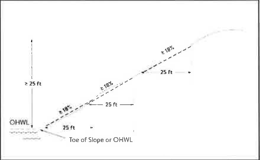
Bluff. A natural topographic feature having:
1.
A slope that rises at least 25 feet where the grade of the slope averages 18 percent or greater, measured over any horizontal distance of 25 feet, from the toe of the slope to the top of the slope. Where the slope begins below the ordinary high water level, the ordinary high water level is the toe of the slope. See Figure 1; or
Figure 1. Bluff
2.
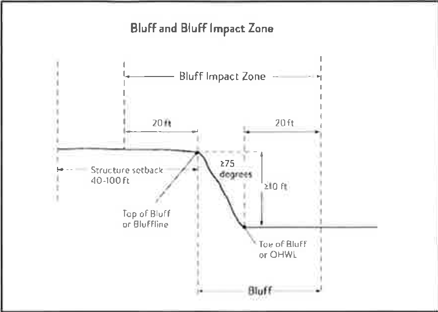
A natural escarpment or cliff with a slope that rises at least ten feet above the ordinary high water level or toe of the slope, whichever is applicable, to the top of the slope, with a slope of 75 degrees or greater. See Figure 2.
Figure 2. Natural Escarpment Bluff and Bluff Impact Zone
(7)
Bluff impact zone (BIZ). A bluff and land located within 20 feet of the bluff. See Figure 2 for natural escarpment or cliff example and Figure 3 for more common bluff example.
Figure 3. Toe, Top and Bluff Impact Zone
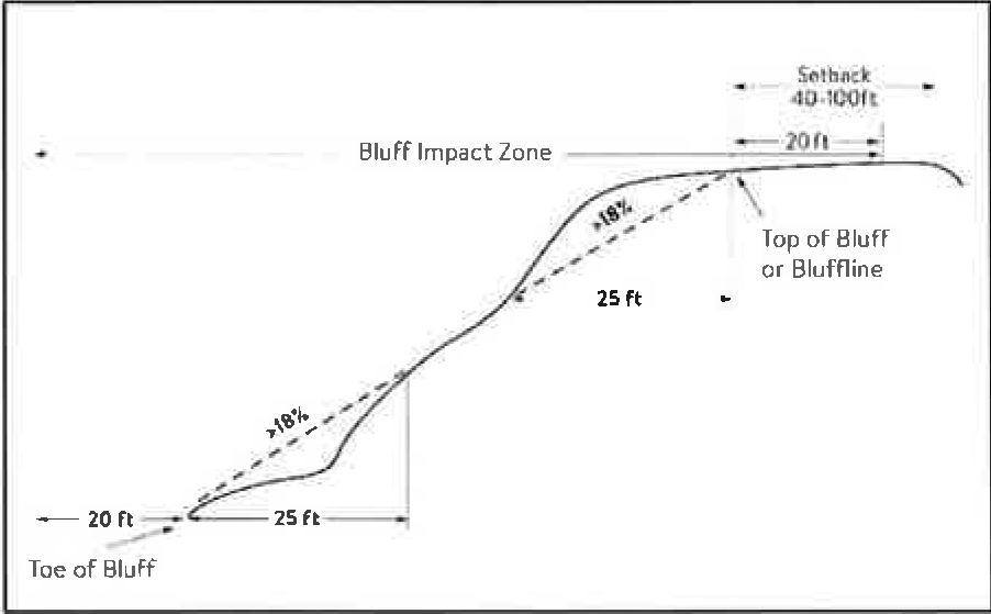
(8)
Bluffline. A line delineating the top of the bluff. More than one bluff line may be encountered proceeding landward from the river. See Figures 2 for natural escarpment or cliff example and Figure 3 for more common bluff example.
(9)
Bluff, Toe of. A line along the bottom of a bluff, requiring field verification, such that the slope above the line exceeds 18 percent and the slope below the line is 18 percent or less, measured over a horizontal distance of 25 feet. See Figure 2 for natural escarpment or cliff example and Figure 3 for more common bluff example..
(10)
Bluff, Top of. A line along the top of a bluff, requiring field verification, such that the slope below the line exceeds 18 percent and the slope above the line is 18 percent or less, measured over a horizontal distance of 25 feet. See Figure 2 for natural escarpment or cliff example and Figure 3 for more common bluff example.
(11)
Buildable area. The area upon which structures may be placed on a lot or parcel of land and excludes areas needed to meet requirements for setback, rights-of-way, bluff impact zones, historic properties, wetlands, designated floodways, land below the ordinary high water level of public waters, and other unbuildable areas.
(12)
Building. A structure with two or more outside rigid walls and a fully secured roof and affixed to a permanent site.
(13)
Certificate of compliance. A document written after a compliance inspection, certifying that the development complies with applicable requirements at the time of the inspection.
(14)
Commissioner. The commissioner of the Minnesota department of natural resources.
(15)
Conditional use. A use having the meaning given under Minn. Stat., chapters 394 and 462.
(16)
Conservation design. A pattern of subdivision that is characterized by grouping lots within a portion of a parcel, where the remaining portion of the parcel is permanently protected as open space.
(17)
Conventional subdivision. A pattern of subdivision that is characterized by lots that are spread regularly throughout a parcel in a lot and block design.
(18)
Deck. A horizontal, unenclosed, aboveground level structure open to the sky, with or without attached railings, seats, trellises, or other features, attached, or functionally related to a principal use or site.
(19)
Developer. Having the meaning given under Minn. Stat., section 116G.03.
(20)
Development. Having the meaning given under Minn. Stat., section 116G.03.
(21)
Discretionary action. An action under this chapter related to land use that requires a public hearing by local ordinance or statute, such as preliminary plats, final subdivision plats, planned unit developments, conditional use permits, interim use permits, variances, appeals, and rezonings.
(22)
Dock. Having the meaning given under Minnesota Rules, chapter 6115.
(23)
Electric power facilities. Equipment and associated facilities for generating electric power or devices for converting wind energy to electrical energy as identified and defined under Minn. Stat., section 216E.
(24)
Essential services. Underground or overhead gas, electrical, communications, steam, or water distribution, collection, supply, or disposal systems, including storm water. Essential services include poles, wires, mains, drains, pipes, conduits, cables, fire alarm boxes, traffic signals, hydrants, navigational structures, aviation safety facilities or other similar equipment and accessories in conjunction with the systems. Essential services does not include buildings, treatment works as defined in Minn. Stat., section 115.01, electric power facilities or transmission services.
(25)
Feedlot. Having the meaning given for animal feedlots under Minnesota Rules chapter 7020.
(26)
Floodplain. Having the meaning given the meaning given under Minnesota Rules chapter 6120.
(27)
Fully reconstructs. The reconstruction of an existing impervious surface that involves site grading and subsurface excavation so that soil is exposed. Mill and overlay and other resurfacing activities are not considered fully reconstructed.
(28)
Hard-surface trail. A trail surfaced in asphalt, crushed aggregate, or other hard surface, for multi-purpose use, as determined by local, regional, or state agency plans.
(29)
Historic property. An archaeological site, standing structure, site, district, or other property that is:
(1)
Listed in the national register of historic places or the state register of historic places or locally designated as a historic site under Minn. Stat., chapter 471;
(2)
determined to meet the criteria for eligibility to the national register of historic places or the state register of historic places as determined by the director of the Minnesota Historical Society; or
(3)
An unplatted cemetery that falls under the provisions of Minn. Stat., chapter 307, in consultation with the office of the state archaeologist.
(30)
Impervious surface. A constructed hard surface that either prevents or retards the entry of water into the soil and causes water to run off the surface in greater quantities and at an increased rate of flow than prior to development. Examples include rooftops, decks, sidewalks, patios, parking lots, storage areas, and driveways, including those with concrete, asphalt, or gravel surfaces.
(31)
Intensive vegetation clearing. The removal of all or a majority of the trees or shrubs in a contiguous patch, strip, row, or block.
(32)
Interim use. A use having the meaning given under Minn. Stat., chapters 394 and 462.
(33)
Land alteration. An activity that exposes the soil or changes the topography, drainage, or cross section of the land, excluding gardening or similar minor soil disturbances.
(34)
Local government. Counties, cities, and townships.
(35)
Lot. Having the meaning given under Minnesota Rules chapter 6120.
(36)
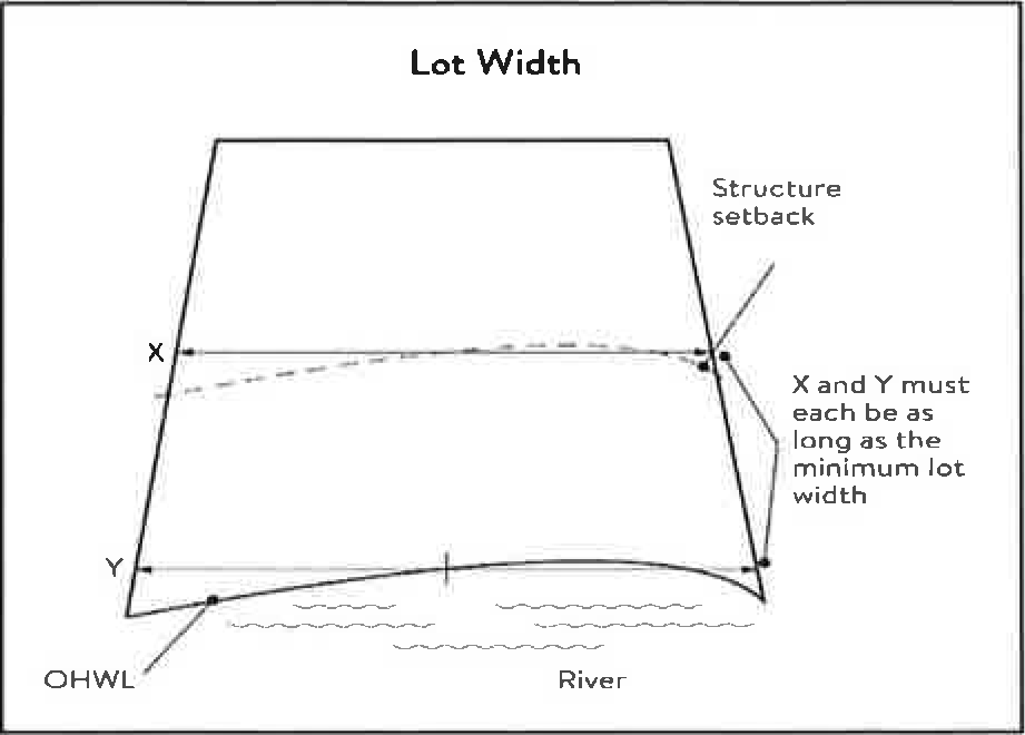
Lot width. The shortest distance between lot lines measured at both the ordinary high water level and at the required structure setback from the ordinary high water level. See Figure 3.
Figure 3. Lot Width
(37)
Marina. Having the meaning given under Minnesota Rules chapter 6115.
(38)
Mississippi river corridor critical area (MRCCA). The area within the river corridor boundary.
(39)
Mississippi river corridor critical area (MRCCA) Plan. A chapter or other element in the (insert name of jurisdiction) comprehensive plan.
(40)
Mooring facility. Having the meaning given under Minnesota Rules part 6115.0170.
(41)
Native plant community. A plant community identified by the Minnesota biological survey or biological survey issued or adopted by a local, state, or federal agency.
(42)
Natural-surface trail. A trail composed of native soil and rock or compacted granular stone, primarily intended for hiking, equestrian, or mountain bike use, as determined by local, regional, or state agency plans.
(43)
Natural vegetation. Any combination of ground cover, understory, and tree canopy that, while it may have been altered by human activity, continues to stabilize soils, retain, and filter runoff, provide habitat, and recharge groundwater.
(44)
Nonconformity. Having the meaning given under Minn. Stat., section 394.22.
(45)
Nonmetallic mining. Construction, reconstruction, repair, relocation, expansion, or removal of any facility for the extraction, stockpiling, storage, disposal, or reclamation of nonmetallic minerals such a stone, sand, and gravel. Nonmetallic mining does not include ancillary facilities such as access roads, bridges, culverts, and water level control structures. For purposes of this subpart, "facility" includes all mine pits, quarries, stockpiles, basins, processing structures and equipment, and any structures that drain or divert public waters to allow mining.
(46)
Off-premise advertising signs. Those signs that direct attention to a product, service, business, or entertainment venue that is not exclusively related to the premises where the sign is located.
(47)
Ordinary high water level (OHWL). Having the meaning given under Minn. Stat., section 103G.005.
(48)
Overlay district. A zoning district applied over one or more previously established zoning districts, establishing additional or stricter standards and criteria for covered properties in addition to those of the underlying zoning district. Overlay districts are often used to protect historic features and natural resources such as shoreland or floodplain.
(49)
Parcel. Having the meaning given under Minn. Stat., section 116G.03.
(50)
Patio. A constructed hard surface located at ground level with no railings and open to the sky.
(51)
Picnic shelter. A roofed structure opens on all sides, accessory to a recreational use.
(52)
Planned unit development (PUD). A method of land development that merges zoning and subdivision controls, allowing developers to plan and develop a large area as a single entity, characterized by a unified site design, a mix of structure types and land uses, and phasing of development over a number of years. Planned unit development includes any conversion of existing structures and land uses that utilize this method of development.
(53)
Plat. Having the meaning given under Minn. Stat., sections 505 and 515B.
(54)
Port. A water transportation complex established and operated under the jurisdiction of a port authority according to Minn. Stat., chapter 458.
(55)
Primary conservation areas (PCAs). Key resources and features, including shore impact zones, bluff impact zones, floodplains, wetlands, gorges, areas of confluence with tributaries, natural drainage routes, unstable soils and bedrock, native plant communities, cultural and historic properties, and significant existing vegetative stands, tree canopies, and other resources identified in local government plans.
(56)
Private facilities. Private roads, driveways, and parking areas, private water access and viewing facilities, decks and patios in setback areas, and private signs.
(57)
Professional engineer. An engineer licensed to practice in Minnesota.
(58)
Public facilities. Public utilities, public transportation facilities, and public recreational facilities.
(59)
Public recreation facilities. Recreational facilities provided by the state or a local government and dedicated to public use, including parks, scenic overlooks, observation platforms, trails, docks, fishing piers, picnic shelters, water access ramps, and other similar water-oriented public facilities used for recreation.
(60)
Public river corridor views (PRCVs). Views toward the river from public parkland, historic properties, and public overlooks, as well as views toward bluffs from the ordinary high water level of the opposite shore, as seen during the summer months and documented in the MRCCA plan/chapter of the comprehensive plan.
(61)
Public transportation facilities. All transportation facilities provided by federal, state, or local government and dedicated to public use, such as roadways, transit facilities, railroads, and bikeways.
(62)
Public utilities. Electric power facilities, essential services, and transmission services.
(63)
Public waters. Having the meaning given under Minn. Stat., section 103G.005.
(64)
Readily visible. Land and development that are easily seen from the ordinary high water level of the opposite shore during summer months.
(65)
Resource agency. A federal, state, regional, or local agency that engages in environmental, natural, or cultural resource protection or restoration activities, including planning, implementation, and monitoring.
(66)
Retaining wall. A vertical or nearly vertical structures constructed of mortar and rubble masonry, rock, or stone regardless of size, vertical timber pilings, horizontal timber planks with piling supports, sheet pilings, poured concrete, concrete blocks, or other durable materials.
(67)
Rock riprap. Natural coarse rock placed or constructed to armor shorelines, streambeds, bridge abutments, pilings and other shoreline structures against scour, or water or ice erosion.
(68)
River corridor boundary. The boundary approved and adopted by the metropolitan council under Minn. Stat., section 116G.06, as approved and adopted by the legislature in Minn. Stat., section 116G.15, and as legally described in the state register, volume 43, pages 508 to 518.
(69)
River-dependent use. The use of land for commercial, industrial, or utility purposes, where access to and use of a public water feature is an integral part of the normal conduct of business and where the use is dependent on shoreline facilities.
(70)
Selective vegetation removal. The removal of isolated individual trees or shrubs that are not in a contiguous patch, strip, row, or block and that does not substantially reduce the tree canopy or understory cover.
(71)
Setback. A separation distance measured horizontally.
(72)
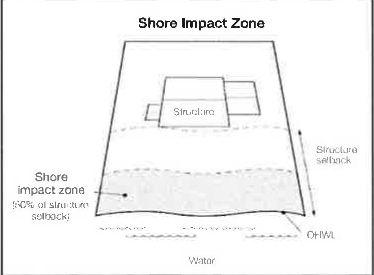
Shore impact zone (SIZ). Land located between the ordinary high water level of public waters and a line parallel to it at a setback of 50 percent of the required structure setback or, for agricultural use, 50 feet landward of the ordinary high water level. See Figure 4.
Figure 4. Shore Impact Zone
(73)
Shoreline facilities. Facilities that require a location adjoining public waters for ingress and egress, loading, and unloading, and public water intake and outflow, such as barge facilities, port facilities, commodity loading and unloading equipment, watercraft lifts, marinas, short-term watercraft mooring facilities for patrons, and water access ramps. Structures that would be enhanced by a shoreline location, but do not require a location adjoining public waters as part of their function, are not shoreline facilities, such as restaurants, bait shops, and boat dealerships.
(74)
Steep slope. A natural topographic feature with an average slope of 12 to 18 percent, measured over a horizontal distance equal to or greater than 50 feet, and any slopes greater than 18 percent that are not bluffs.
(75)
Storm water management facilities. Facilities for the collection, conveyance, treatment, or disposal of storm water.
(76)
Structure. A building, sign, or appurtenance thereto, except for aerial or underground utility lines, such as sewer, electric, telephone, or gas lines, and utility line towers, poles, and other supporting appurtenances.
(77)
Subdivision. Having the meaning given under Minn. Stat., section 462.352.
(78)
Subsurface sewage treatment system. Having the meaning given under Minnesota Rules, part 7080.1100.
(79)
Transmission services.
a.
Electric power lines, cables, pipelines, or conduits that are:
1.
used to transport power between two points, as identified and defined under Minn. Stat., section 216E.01, Subd. 4; or
2.
For mains or pipelines for gas, liquids, or solids in suspension, used to transport gas, liquids, or solids in suspension between two points; and
b.
Telecommunication lines, cables, pipelines, or conduits.
(80)
Treeline. The more or less continuous line formed by the tops of trees in a wooded area when viewed from a particular point. The treeline is determined during all seasons as if under full foliage.
(81)
Variance. Having the meaning given under Minn. Stat., section 394.22.
(82)
Water access ramp. A boat ramp, carry-down site, boarding dock, and approach road, or other access that allows launching and removal of a boat, canoe, or other watercraft with or without a vehicle and trailer.
(83)
Water-oriented accessory structure. A small building or other improvement, except stairways, fences, docks, and retaining walls, that, because of the relationship of its use to public waters, needs to be located closer to public waters than the normal structure setback. Examples include gazebos, screen houses, fish houses, pump houses, and detached decks and patios.
(84)
Water quality impact zone. Land within the shore impact zone or within 50 feet of the OHWL of the river, whichever is greater, and land within 50 feet of a public water, wetland, or natural drainage route..
(85)
Wetland. Having the meaning given under Minn. Stat., section 103G.005.
(86)
Wharf. Having the meaning given under Minnesota Rules, part 6115.0170.
(Ord. No. 647, § 2, 5-18-09; Ord. No. 702, § 1, 10-21-13; Ord. No. 757, § 1, 1-18-22)
Sec. 74-793. - Administration.
(a)
Purpose. The purpose of this Section is to identify administrative provisions to ensure this division is administered consistent with its purpose.
(b)
Permits. A permit is required for the construction of buildings or building additions (including construction of decks and signs), the installation and/or alteration of sewage treatment systems, vegetation removal consistent with Section 74-799 and land alterations consistent with Section 74-780.
(c)
Variances. Variances to the requirements under this (section, chapter, or article) may only be granted in accordance with Minn. Stat. Section 462.357 and must consider the potential impacts of variances on primary conservation areas, public river corridor views, and other resources identified in the MRCCA plan. Additionally, any variance shall be subject to the review criteria in Section 74-121 (c).
(d)
Conditional and interim use permits. All conditional and interim uses, required under this division, must comply with Minn. Stat., section 462.3595 and must consider the potential impacts on primary conservation areas, public river corridor views, and other resources identified in the MRCCA plan.
(e)
Application materials. In addition to any requirement found elsewhere in Chapter 74, applications for permits and discretionary actions required under this division must submit the following information unless the zoning administrator determines that the information is not needed.
(1)
A detailed project description; and
(2)
Survey and site plan, dimensional renderings, maintenance agreements, and other materials that identify and describe:
a.
Primary conservation areas;
b.
Public river corridor views;
c.
Buildable area;
d.
Existing and proposed topography and drainage patterns;
e.
Proposed storm water and erosion and sediment control practices;
f.
Existing and proposed vegetation to be removed and established;
g.
Ordinary high water level, bluff lines, and all required setbacks;
h.
Existing and proposed structures;
i.
Existing and proposed impervious surfaces; and
j.
Existing and proposed subsurface sewage treatment systems.
(f)
Nonconformities.
(1)
All legally established nonconformities as of the date of this ordinance may continue consistent with Minn. Stat., section 462.357, Subd. le.
(2)
New structures erected in conformance with the setback averaging provisions of Section 74-796 (c) are conforming structures.
(3)
Site alterations and expansion of site alterations that were legally made prior to the effective date of this ordinance are conforming. Site alterations include vegetation, erosion control, storm water control measures, and other nonstructural site improvements.
(4)
Legally nonconforming principal structures that do not meet the setback requirements of Section 74-796 (c) may be expanded laterally provided that:
a.
The expansion does not extend into the shore or bluff impact zone or further into the required setback than the building line of the existing principal structure (See Figure 5); and
b.
The expanded structure's scale and bulk is consistent with that of the original structure and existing surrounding development.
Figure 5. Expansion of Nonconforming Structure
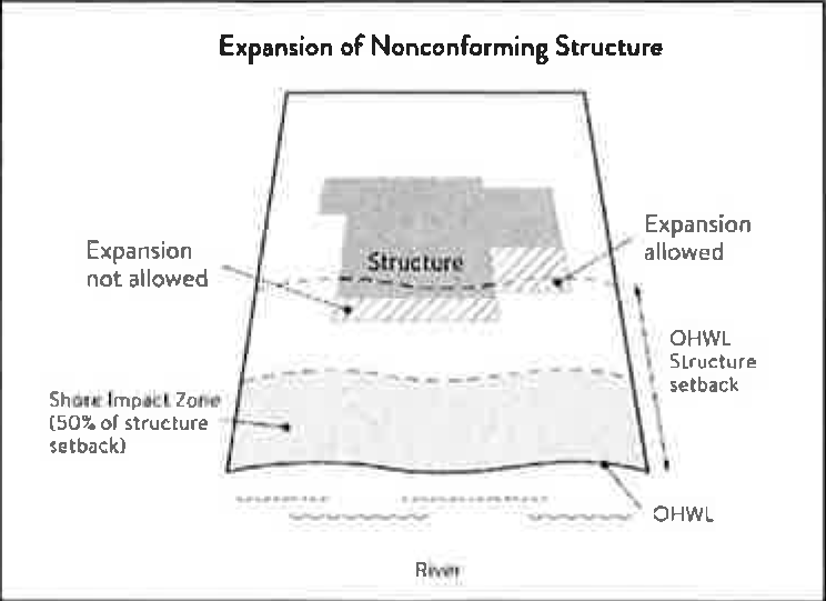
(g)
Notifications.
(1)
Amendments to this division and to the MRCCA plan must be submitted to the commissioner as provided in Minnesota Rules, part 6106.0070, Subp. 3, Items B -I.
(2)
Notice of public hearings for discretionary actions, including conditional and interim use permits, variances, appeals, rezonings, preliminary plats, final subdivision plats, master plans, and PUDs, must be sent to the following entities at least thirty (30) days prior to the hearing:
a.
The commissioner in a format prescribed by the DNR;
b.
National park service; and
c.
Where building heights exceed the height limits specified in Section 74-796 (b) as part of the conditional use or variance process, adjoining local governments within the MRCCA, including those with overlapping jurisdiction and those across the river.
(3)
Notice of final decisions for actions in Section 74-793 (g) (2), including findings of fact, must be sent to the commissioner, the national park service, and adjoining local governments within the MRCCA within ten days of the final decision.
(4)
Requests to amend district boundaries must follow the provisions in Minnesota Rules, part 6106.0100, Subp. 9, Item C.
(h)
Accommodating disabilities. Reasonable accommodations for ramps or other facilities to provide persons with disabilities access to the persons' property, as required by the federal Americans with Disabilities Act and the federal Fair Housing Act and as provided by Minnesota Rules, chapter 1341, must:
(1)
Comply with Sections 74-796 to 74-802; or
(2)
If Sections 74-796 to 74-802 cannot be complied with, ramps or other facilities are allowed with an administrative permit provided:
a.
The permit terminates on either a specific date or upon occurrence of a particular event related to the person requiring accommodation; and
b.
Upon expiration of the permit, the ramp or other facilities must be removed.
(Ord. No. 647, § 2, 5-18-09; Ord. No. 702, § 1, 10-21-13; Ord. No. 757, § 1, 1-18-22)
Sec. 74-794. - MRCCA districts.
(a)
Purpose. The purpose of this Section is to establish districts under which building height and structure placement are regulated to protect and enhance the Mississippi River's resources and features consistent with the natural and built character of each district.
(b)
District description and management purpose. The MRCCA within the City is divided into the following MRCCA Districts:
(1)
Rural and Open Space (ROS).
a.
Description. The ROS District is characterized by rural and low-density development patterns and land uses, and includes land that is riparian or visible from the river, as well as large, undeveloped tracts of high ecological and scenic value, floodplain, and undeveloped islands. Many primary conservation areas exist in the district.
b.
Management purpose. The ROS District must be managed to sustain and restore the rural and natural character of the corridor and to protect and enhance habitat, parks and open space, public river corridor views, and scenic, natural, and historic areas.
(2)
River neighborhood (RN).
a.
Description. The RN district is characterized by primarily residential neighborhoods that are riparian or readily visible from the river or that abut riparian parkland. The district includes parks and open space, limited commercial development, marinas, and related land uses.
b.
Management purpose. The RN district must be managed to maintain the character of the river corridor within the context of existing residential and related neighborhood development, and to protect and enhance habitat, parks and open space, public river corridor views, and scenic, natural, and historic areas. Minimizing erosion and the flow of untreated storm water into the river and enhancing habitat and shoreline vegetation are priorities in the district.
(3)
Separated from river (SR).
a.
Description. The SR district is characterized by its physical and visual distance from the Mississippi River. The district includes land separated from the river by distance, topography, development, or a transportation corridor. The land in this district is not readily visible from the Mississippi River.
b.
Management purpose. The SR district provides flexibility in managing development without negatively affecting the key resources and features of the river corridor. Minimizing negative impacts to primary conservation areas and minimizing erosion and flow of untreated storm water into the Mississippi River are priorities in the district. The RTC district must be managed in a manner that allows continued growth and redevelopment in historic downtowns and more intensive redevelopment in limited areas at river crossings to accommodate compact walkable development patterns and connections to the river. Minimizing erosion and the flow of untreated storm water into the river, providing public access to and public views of the river, and restoring natural vegetation in riparian areas and tree canopy are priorities in the district.
(4)
Urban Mixed (UM).
a.
Description. The UM District includes large areas of highly urbanized mixed use that are a part of the urban fabric of the river corridor, including institutional, commercial, industrial, and residential areas and parks and open space.
b.
Management purpose. The UM District must be managed in a manner that allows for future growth and potential transition of intensely developed areas that does not negatively affect public river corridor views and that protects bluffs and floodplains. Restoring and enhancing bluff and shoreline habitat, minimizing erosion and flow of untreated storm water into the river, and providing public access to and public views of the river are priorities in the district.
(c)
MRCCA district map. The locations and boundaries of the MRCCA districts established by this Division shown on the City's Zoning Map which is incorporated herein by reference. The district boundary lines are intended to follow the centerlines of rivers and streams, highways, streets, lot lines, and municipal boundaries, unless a boundary line is otherwise indicated on the map. Where district boundaries cross unsubdivided property, the district boundary line is determined by use of dimensions or the scale appearing on the map.
(Ord. No. 647, § 2, 5-18-09; Ord. No. 702, § 1, 10-21-13; Ord. No. 757, § 1, 1-18-22)
Sec. 74-795. - Special land use provisions.
(a)
Purpose. To identify development standards and considerations for land uses that have potential to negatively impact primary conservation areas and public river corridor views.
(b)
Underlying zoning. Uses within the MRCCA are generally determined by underlying zoning, with additional provisions for the following land uses:
(1)
Agricultural use. Perennial ground cover is required within 50 feet of the ordinary high water level and within the bluff impact zone.
(2)
Forestry. Tree harvesting and biomass harvesting within woodlands, and associated reforestation, must be consistent with recommended practices in conserving wooded areas in developing communities: Best management practices in Minnesota.
(3)
River-dependent uses. River-dependent uses must comply with the following design standards:
a.
Structures and parking areas, except shoreline facilities and private roads and conveyances serving river-dependent uses as provided in Section 74-802, must meet the dimensional and performance standards in this division, must be designed so that they are not readily visible, and must be screened by establishing and maintaining natural vegetation;
b.
Shoreline facilities must comply with Minnesota Rules, chapter 6115 and must:
1.
Be designed in a compact fashion so as to minimize the shoreline area affected; and
2.
Minimize the surface area of land occupied in relation to the number of watercraft or barges to be served; and
c.
Dredging and placement of dredged material are subject to existing federal and state permit requirements and agreements.
(4)
Wireless communication towers. Wireless communication towers require a conditional or interim use permit and are subject to the following design standards:
a.
The applicant must demonstrate that functional coverage cannot be provided through co-location, a tower at a lower height, or a tower at a location outside of the MRCCA;
b.
The tower must not be located in a bluff or shore impact zone; and
c.
Placement of the tower must minimize impacts on public river corridor views.
d.
Comply with the general design standards in Section 79-798 (b).
(Ord. No. 647, § 2, 5-18-09; Ord. No. 702, § 1, 10-21-13; Ord. No. 757, § 1, 1-18-22)
Sec. 74-796. - Structure height and placement and lot size.
(a)
Purpose. To establish standards that protect primary conservation areas and public river corridor views from development impacts and ensure that new development is sited consistent with the purpose of the MRCCA.
(b)
Structure height. Structures and facilities must comply with the following standards unless identified as exempt in Section 74-802.
(1)
Structures and facilities must comply with the following standards unless identified as exempt in Section 74-802.
a.
ROS District: 35 feet (or lower).
b.
RN District: 35 feet.
c.
SR District: Height is determined by underlying zoning, provided the allowed height is consistent with that of the mature treeline, where present, and existing surrounding development, as viewed from the OWHL of the opposite shore.
d.
UM District: 65 feet, provided tiering of structures away from the Mississippi River and from bluff lines is given priority, with lower structure heights closer to the river and bluff lines, and that structure design and placement minimize interference with public river corridor views. Structures over 65 feet (or lower) and up to 100 feet are allowed as conditional use according to Section 74-796 (b) (3).
(2)
Height is measured on the side of the structure facing the Mississippi River.
(3)
In addition to the conditional use permit requirements of Section 74-793 (d), criteria for considering whether to grant a conditional use permit for structures exceeding the height limits must include:
a.
Assessment of the visual impact of the proposed structure on public river corridor views, including views from other communities;
b.
Determination that the proposed structure meets the required bluff and OHWL setbacks;
c.
Identification and application of techniques to minimize the perceived bulk of the proposed structure, such as:
1.
Placing the long axis of the building perpendicular to the river;
2.
Stepping back of portions of the facade;
3.
Lowering the roof pitch or use of a flat roof;
4.
Using building materials or mitigation techniques that will blend in with the natural surroundings such as green roofs, green walls, or other green and brown building materials;
5.
Narrowing the profile of upper floors of the building; or
6.
Increasing the setbacks of the building from the Mississippi River or bluffs;
d.
Identification of techniques for preservation of those view corridors identified in the MRCCA Plan; and
e.
Opportunities for creation or enhancement of public river corridor views.
(c)
Structure and impervious surface placement.
(1)
Structures and impervious surfaces must not be placed in the shore or bluff impact zones unless identified as an exemption in Section 74-802.
(2)
Structures, impervious surfaces, and facilities must comply with the following OHWL setback provisions unless identified as exempt in Section 74-802:
a.
ROS District: 200 feet from the Mississippi River.
b.
RN District: 100 feet from the Mississippi River.
c.
UM District: 50 feet from the Mississippi River.
(3)
Structures and facilities must comply with the following bluff line setback provisions unless identified as exempt in Section 74-8020:
a.
ROS District: 100 feet.
b.
RN District: 40 feet.
c.
SR District: 40 feet.
d.
UM District: 40 feet.
(4)
Where principal structures exist on the adjoining lots on both sides of a proposed building site, the minimum setback may be altered to conform to the average of the adjoining setbacks, if the new structure's scale and bulk riverward or bluff ward of the setbacks required under Sections 74-796 (c) (2) and (3) are consistent with adjoining development. See Figure 6.
Figure 6. Structure Setback Averaging
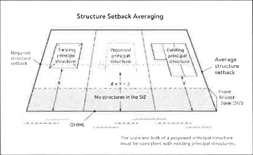
(5)
Subsurface sewage treatment systems, including the septic tank and absorption area, must be located at least 75 feet from the ordinary high water level of the Mississippi River and all other public waters.
(d)
Lot size and buildable area.
(1)
The width of lots abutting the Mississippi River in the ROS district must be at least 200 feet, unless alternative design methods are used that provide greater protection of the riparian area.
(2)
All new lots must have adequate buildable area to comply with the setback requirements of Sections 74-796 (c) (2) and (3) so as to not require variances to use the lots for their intended purpose.
(Ord. No. 647, § 2, 5-18-09; Ord. No. 757, § 1, 1-18-22; Ord. No. 764, § 1, 2-21-23)
Sec. 74-797. - Performance standards for private facilities.
(a)
Purpose. To establish design standards for private facilities that are consistent with best management practices and that minimize impacts to primary conservation areas, public river corridor views and other resources identified in the MRCCA plan.
(b)
General design standards. All private facilities must be developed in accordance with the vegetation management and land alteration requirements in Sections 74-799 and 74-800.
(c)
Private roads, driveways, and parking areas. Except as provided in Section 74-802, private roads, driveways, and parking areas must:
(1)
Be designed to take advantage of natural vegetation and topography so that they are not readily visible;
(2)
Comply with structure setback requirements according to Section 74-796 (c); and
(3)
Not be placed within the bluff impact zone or shore impact zone, unless exempt under Section 74-802 and designed consistent with Section 74-798 (b).
(d)
Private water access and viewing facilities.
(1)
Private access paths must be no more than:
a.
Eight feet wide, if placed within the shore impact zone; and
b.
Four feet wide, if placed within the bluff impact zone.
(2)
Private water access ramps must:
a.
Comply with Minnesota Rules, parts 6115.0210 and 6280.0250; and
b.
Be designed and constructed consistent with the applicable standards in design handbook for recreational boating and fishing facilities.
(3)
Design and construction of private stairways, lifts, and landings are subject to the following standards:
a.
Stairways and lifts must not exceed four feet in width.
b.
Landings for stairways and lifts must not exceed 32 square feet in area.
c.
Canopies or roofs are prohibited on stairways, lifts, or landings;
d.
Stairways, lifts, and landings must be located in the least visible portion of the lot whenever practical; and
e.
Ramps, lifts, mobility paths, or other facilities for persons with physical disabilities are allowed for achieving access to shore areas according to Section 74-797 (d) (3) and as provided under Section 74-793 (h).
(4)
One water-oriented accessory structure is allowed for each riparian lot or parcel less than 300 feet in width at the ordinary high water level, with one additional water-oriented accessory structure allowed for each additional 300 feet of shoreline on the same lot or parcel. Water-oriented accessory structures are prohibited in the bluff impact zone and must:
a.
Not exceed 12 feet in height;
b.
Not exceed 120 square feet in area; and
c.
Be placed a minimum of ten feet from the ordinary high water level.
(e)
Decks and patios in setback areas. Decks and at-grade patios may encroach into the required setbacks from the ordinary high water level and bluffs without a variance, when consistent with Sections 74-799 and 74-800, provided that:
(1)
The encroachment of the deck or patio into the required setback area does not exceed 15 percent of the required structure setback;
(2)
The area of the deck or patio that extends into the required setback area occupies no more than 25 percent of the total area between the required setback and the 15 percent using the formula:
[Required setback depth (feet) × 0.15 × lot width at setback (feet) × 0.25 = maximum total area]
(3)
The deck or patio does not extend into the bluff impact zone. See Figure 7.
Figure 7. Deck and Patio Encroachment
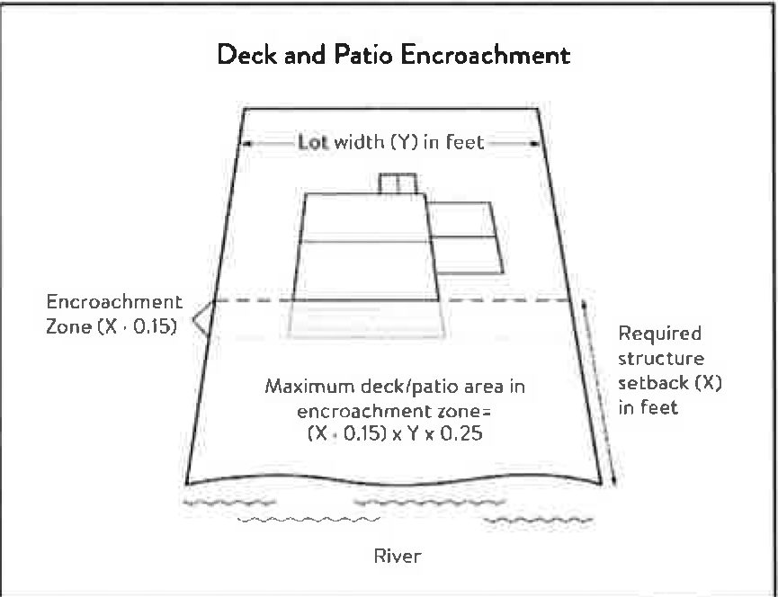
(f)
Off-premise and directional signs.
(1)
Off-premise advertising signs are prohibited.
(2)
Directional signs for patrons arriving at a business by watercraft must comply with the following standards:
a.
They must be consistent with Minn. Stat., section 86B.115.
b.
Only convey the location and name of the establishment and the general types of goods and services available, if located in a shore impact zone.
c.
Be no greater than ten feet in height and 32 square feet in surface area; and
d.
If illuminated, the lighting must be fully shielded and directed downward to prevent illumination out across the river or to the sky.
(g)
Fences. Fences between principal structures and the river are allowed if fences are:
(1)
Not higher than six feet.
(2)
Not located within the SIZ and BIZ
(3)
Not located in the regulatory floodplain.
(h)
Lighting. Within the OHWL setback:
(1)
Lighting shall be fully shielded and directed away from the river.
(2)
Uplighting is prohibited.
(Ord. No. 647, § 2, 5-18-09; Ord. No. 757, § 1, 1-18-22)
Sec. 74-798. - Performance standards for public facilities.
(a)
Purpose. To establish design standards for public facilities that are consistent with best management practices and that minimize impacts to primary conservation areas, public river corridor views and other resources identified in the MRCCA plan. Public facilities serve the public interest by providing public access to the Mississippi River corridor or require locations in or adjacent to the river corridor and therefore require some degree of flexibility.
(b)
General design standards. All public facilities must be designed and constructed to:
(1)
Minimize visibility of the facility from the river to the extent consistent with the purpose of the facility;
(2)
Comply with the structure placement and height standards in Section 74-796, except as provided in Section 74-802;
(3)
Be consistent with the vegetation management standards in Section 74-799 and the land alteration and storm water management standards in Section 74-800, including use of practices identified in best practices for meeting DNR general public waters work permit GP 2004-0001, where applicable;
(4)
Avoid primary conservation areas unless no alternative exists. If no alternative exists, then disturbance to primary conservation areas must be avoided to the greatest extent practicable, and design and construction must minimize impacts; and
(5)
Minimize disturbance of spawning and nesting times by scheduling construction at times when local fish and wildlife are not spawning or nesting.
(6)
Minimize disturbance during bird migration and nesting times by scheduling construction at times when birds are not migrating or nesting.
(c)
Right-of-way maintenance standards. Right-of-way maintenance must comply with the following standards:
(1)
Vegetation currently in a natural state must be maintained to the extent feasible;
(2)
Where vegetation in a natural state has been removed, native plants must be planted and maintained on the right-of-way; and
(3)
Chemical control of vegetation must be avoided when practicable, but when chemical control is necessary, chemicals used must be in accordance with the regulations and other requirements of all state and federal agencies with authority over the chemical's use.
(d)
Crossings of public water or public land. Crossings of public waters or land controlled by the commissioner are subject to approval by the commissioner according to Minn. Stat., sections 84.415 and 103G.245.
(e)
Public utilities. Public utilities must comply with the following standards:
(1)
High-voltage transmission lines, wind energy conversion systems greater than five megawatts, and pipelines are regulated according to Minn. Stat., chapter 216E, 216F, and 216G respectively; and
(2)
If overhead placement is necessary, utility facility crossings must minimize visibility of the facility from the river and follow other existing right of ways as much as practicable.
(3)
The appearance of structures must be as compatible as practicable with the surrounding area in a natural state with regard to height and width, materials used, and color.
(4)
Wireless communication facilities, according to Section 74-795 (b) (4).
(f)
Public transportation facilities. Public transportation facilities shall comply with structure placement and height standards in Section 74-796. Where such facilities intersect or about two or more MRCCA districts, the least restrictive standards apply. Public transportation facilities must be designed and constructed to give priority to:
(1)
Providing scenic overlooks for motorists, bicyclists, and pedestrians;
(2)
Providing safe pedestrian crossings and facilities along the river corridor;
(3)
Providing access to the riverfront in public ownership; and
(4)
Allowing for use of the land between the river and the transportation facility.
(g)
Public recreational facilities. Public recreational facilities must comply with the following standards:
(1)
Buildings and parking associated with public recreational facilities must comply with the structure placement and height standards in Section 74-796, except as provided in Section 74-802;
(2)
Roads and driveways associated with public recreational facilities must not be placed in the bluff or shore impact zones unless no other placement alternative exists. If no alternative exists, then design and construction must minimize impacts to shoreline vegetation, erodible soils and slopes, and other sensitive resources.
(3)
Trails, access paths, and viewing areas associated with public recreational facilities and providing access to or views of the Mississippi River are allowed within the bluff and shore impact zones if design, construction, and maintenance methods are consistent with the best management practice guidelines in trail planning, design, and development guidelines.
a.
Hard-surface trails are not allowed on the face of bluffs with a slope exceeding 30 percent. Natural surface trails are allowed, provided they do not exceed eight feet in width.
b.
Trails, paths, and viewing areas must be designed and constructed to minimize:
1.
Visibility from the river;
2.
Visual impacts on public river corridor views; and
3.
Disturbance to and fragmentation of primary conservation areas.
(4)
Public water access facilities must comply with the following requirements:
a.
Watercraft access ramps must comply with Minnesota Rules chapters 6115.0210 and 6280.0250; and
b.
Facilities must be designed and constructed consistent with the standards in design handbook for recreational boating and fishing facilities.
(5)
Public signs and kiosks for interpretive or directional purposes are allowed in the bluff or shore impact zones, provided they are placed and constructed to minimize disturbance to these areas and avoid visual impacts on public river corridor views. If illuminated, the lighting must be fully shielded and be directed downward.
(6)
Public stairways, lifts, and landings must be designed as provided in Section 74-797.
(Ord. No. 647, § 2, 5-18-09; Ord. No. 757, § 1, 1-18-22)
Sec. 74-799. - Vegetation management.
(a)
Purpose. To establish standards that sustain and enhance the biological and ecological functions of vegetation; preserve the natural character and topography of the MRCCA; and maintain stability of bluffs and steep slopes and ensure stability of other erosion-prone areas.
(b)
Applicability. This section applies to:
(1)
Shore impact zones;
(2)
Areas within 50 feet of a wetland or natural drainage route;
(3)
Bluff impact zones;
(4)
Areas of native plant communities; and
(5)
Significant existing vegetative stands identified in the MRCCA plan.
(c)
Activities allowed without a vegetation permit.
(1)
Maintenance of existing lawns, landscaping, and gardens;
(2)
Removal of vegetation in emergency situations as determined by the City;
(3)
Right-of-way maintenance for public facilities meeting the standards Section 74-798 (c);
(4)
Agricultural and forestry activities meeting the standards of Section 74-795;
(5)
Selective vegetation removal, provided that vegetative cover remains consistent with the management purpose of the MRCCA District, including removal of:
a.
Vegetation that is dead, diseased, dying, or hazardous;
b.
Vegetation to prevent the spread of diseases or insect pests;
c.
Individual trees and shrubs; and
d.
Invasive non-native species.
(d)
Activities allowed with a vegetation permit.
(1)
Only the following intensive vegetation clearing activities are allowed with a vegetation permit:
a.
Clearing of vegetation that is dead, diseased, dying, or hazardous;
b.
Clearing to prevent the spread of diseases or insect pests;
c.
Clearing to remove invasive non-native species.
d.
Clearing to prepare for restoration and erosion control management activities consistent with a plan approved by the city.
e.
The minimum necessary for development that is allowed with a building permit or as an exemption under Section 74-802.
(2)
General performance standards. The following standards must be met, in addition to a restoration plan under Section 74-799 (f), in order to approve a vegetation permit:
a.
Development is sited to minimize removal of or disturbance to natural vegetation;
b.
Soil, slope stability, and hydrologic conditions are suitable for the proposed work as determined by a professional engineer;
c.
Clearing is the minimum necessary and designed to blend with the natural terrain and minimize visual impacts to public river corridor views and other scenic views;
d.
Vegetation removal activities are conducted so as to expose the smallest practical area of soil to erosion for the least possible time; and
e.
Any other condition determined necessary to achieve the purpose of this section.
(e)
Prohibited activities. All other intensive vegetation clearing is prohibited.
(f)
Vegetation restoration plan.
(1)
Development of a vegetation restoration plan and reestablishment of natural vegetation is required:
a.
For any vegetation removed with a permit under Section 74-799 (d) (1);
b.
Upon failure to comply with any provisions in this section; or
c.
As part of the planning process for subdivisions as provided in Section 74-801.
(2)
Restoration plan performance standards. The vegetation restoration plan must satisfy the application submittal requirements in Section 74-793 (f), and:
a.
Vegetation must be restored in one or more of the following restoration priority areas:
1.
Areas with soils showing signs of erosion, especially on or near the top and bottom of steep slopes and bluffs;
2.
Shoreline areas within 25 feet of the water with no natural vegetation, degraded vegetation, or planted with turf grass;
3.
Areas on steep slopes and bluffs that are visible from the river with no natural vegetation, degraded vegetation, or planted with turf grass; or
4.
Other approved priority opportunity area, including priorities identified in the MRCCA plan if none of the above exist.
b.
Include vegetation that provides suitable habitat and effective soil stability, runoff retention, and infiltration capability. Vegetation species, composition, density, and diversity must be guided by nearby patches of native plant communities and by native vegetation establishment and enhancement guidelines;
c.
Any highly erodible soils disturbed during removal and/or restoration must be stabilized with deep-rooted vegetation with a high stem density;
d.
Vegetation removed must be restored with native vegetation to the greatest extent practicable. The area (square feet) of the restored vegetation should be similar to that removed to the greatest extent practicable.
e.
For restoration of removed native plant communities, restored vegetation must also provide biological and ecological function equivalent to the removed native plant communities. The area (square feet) of the restored vegetation should be equivalent to that removed;
f.
Be prepared by a qualified individual; and
g.
Include a maintenance plan that includes management provisions for controlling invasive species and replacement of plant loss for three years.
(3)
A certificate of compliance will be issued after the vegetation restoration plan requirements have been satisfied.
(Ord. No. 757, § 1, 1-18-22)
Sec. 74-800. - Land alteration standards and stormwater management.
(a)
Purpose. To establish standards that protect water quality from pollutant loadings of sediment, nutrients, bacteria, and other contaminants; and maintain stability of bluffs, shorelines, and other areas prone to erosion.
(b)
Land alteration.
(1)
Within the bluff impact zone, land alteration is prohibited, except for the following, which are allowed by permit.
a.
Erosion control consistent with a plan approved by the local government or resource agency and consistent with Section 74-780 (f);
b.
The minimum necessary for development that is allowed as an exception under Section 74-802; and
c.
Repair and maintenance of existing buildings and facilities.
(2)
Within the water quality impact zone, land alteration that involves more than ten cubic yards of material or affects an area greater than 1,000 square feet requires a permit.
(c)
Rock riprap, retaining walls, and other erosion control structures.
(1)
Construction, repair, or replacement of rock riprap, retaining walls, and other erosion control structures located at or below the OHWL must comply with Minnesota Rules, part 6115.0215, Subp. 4, item E, and 6115.0216, Subp. 2. Work must not proceed until approved by the commissioner, permitted by the US Army Corps of Engineers, and any other permits are obtained. See Figure 8.
Figure 8. Riprap Guidelines
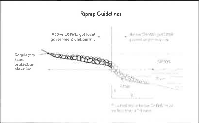
(2)
Construction or replacement of rock riprap, retaining walls, and other erosion control structures within the bluff impact zone and the water quality impact zone are allowed with a permit consistent with provisions of Section 74-780 (f) provided that:
a.
If the project includes work at or below the OHWL, the commissioner has already approved or permitted the project.
b.
The structures are used only to correct an established erosion problem as determined by the city.
c.
The size and extent of the structures are the minimum necessary to correct the erosion problem and are not larger than the following, unless a professional engineer determines that a larger structure is needed to correct the erosion problem:
1.
Retaining walls must not exceed five feet in height and must be placed a minimum horizontal distance often feet apart; and
2.
Riprap must not exceed the height of the regulatory flood protection elevation.
(3)
Repair of existing rock riprap, retaining walls, and other erosion control structures above the OHWL does not require a permit provided it does not involve any land alteration.
(d)
Stormwater management.
(1)
In the bluff impact zone, storm water management facilities are prohibited except by permit if:
a.
There are no alternatives for storm water treatment outside the bluff impact zone on the subject site;
b.
The site generating runoff is designed so that the amount of runoff reaching the bluff impact zone is reduced to the greatest extent practicable;
c.
The construction and operation of the facility does not affect slope stability on the subject property or adjacent properties; and
d.
Mitigation based on the best available engineering and geological practices is required and applied to eliminate or minimize the risk of slope failure.
(2)
In the water quality impact zone, development that creates new impervious surface, as allowed by exemption in Section 74-802, or fully reconstructs existing impervious surface of more than 10,000 square feet requires a storm water permit. Multipurpose trails and sidewalks are exempt if there is down gradient vegetation or a filter strip that is at least five feet wide.
(3)
In all other areas, storm water runoff must be directed away from the bluff impact zones or unstable areas.
(e)
Development on steep slopes. Construction of structures, impervious surfaces, land alteration, vegetation removal, or other construction activities are allowed on steep slopes if:
(1)
The development can be accomplished without increasing erosion or storm water runoff;
(2)
The soil types and geology are suitable for the proposed development; and
(3)
Vegetation is managed according to the requirements of Section 74-799.
(f)
Conditions of land alteration permit approval.
(1)
Temporary and permanent erosion and sediment control measures retain sediment onsite consistent with best management practices in the Minnesota stormwater manual;
(2)
Natural site topography, soil, and vegetation conditions are used to control runoff and reduce erosion and sedimentation;
(3)
Construction activity is phased when possible;
(4)
All erosion and sediment controls are installed before starting any land disturbance activity;
(5)
Erosion and sediment controls are maintained to ensure effective operation;
(6)
The proposed work is consistent with the vegetation standards in Section 74-799; and
(7)
Best management practices for protecting and enhancing ecological and water resources identified in best practices for meeting DNR general public waters work permit GP 2004-0001.
(g)
Compliance with other plans and programs. All development must:
(1)
Be consistent with Minn. Stat., chapter 103B, and local water management plans completed under Minn. Stat., chapter 8410;
(2)
Meet or exceed the wetland protection standards under Minnesota Rules, chapter 8420; and
(3)
Meet or exceed the floodplain management standards under Minnesota Rules, sections 6120. 5000 - 6120.6200.
(Ord. No. 757, § 1, 1-18-22)
Sec. 74-801. - Subdivision and land development standards.
(a)
Purpose.
(1)
To protect and enhance the natural and scenic values of the MRCCA during development or redevelopment of the remaining large sites.
(2)
To establish standards for protecting and restoring biological and ecological functions of primary conservation areas on large sites; and
(3)
To encourage restoration of natural vegetation during development or redevelopment of large sites where restoration opportunities have been identified in MRCCA Plans.
(b)
Applicability.
(1)
The design standards in this section apply to subdivisions, planned unit developments and master- planned development and redevelopment of land involving ten or more acres for contiguous parcels that abut the Mississippi River and 20 or more acres for all other parcels, including smaller individual sites within the following developments that are part of a common plan of development that may be constructed at different times:
a.
Subdivisions;
b.
Planned unit developments; and
c.
Master-planned development and redevelopment of land.
(2)
The following activities are exempt from the requirements of this section:
a.
Minor subdivisions consisting of three or fewer lots;
b.
Minor boundary line corrections;
c.
Resolutions of encroachments;
d.
Additions to existing lots of record;
e.
Placement of essential services; and
f.
Activities involving river-dependent commercial and industrial uses.
(c)
Application materials. Project information listed in Section 74-793 (f) must be submitted for all proposed developments.
(d)
Design standards.
(1)
Primary conservation areas, where they exist, must be set aside, and designated as protected open space in quantities meeting the following as a percentage of total parcel area:
a.
CA-ROS District: 50 percent;
b.
CA-RN District: 20 percent;
c.
CA-RTC, CA-UM, and CA-UC Districts: Ten percent; and
d.
CA-SR District: Ten percent if the parcel includes native plant communities or provides feasible connections to a regional park or trail system, otherwise no requirement.
(2)
If the primary conservation areas exceed the amounts specified in Section 74-801(d)(1), then protection of native plant communities and natural vegetation in riparian areas shall be prioritized.
(3)
If primary conservation areas exist but do not have natural vegetation (identified as restoration priorities in the MRCCA Plan), then a vegetation assessment must be completed to evaluate the unvegetated primary conservation areas and determine whether vegetation restoration is needed. If restoration is needed, vegetation must be restored according to Section 74-799 (f) (2).
(4)
If primary conservation areas do not exist on the parcel and portions of the parcel have been identified in the MRCCA plan as a restoration area, vegetation must be restored in the identified areas according to Section 74-799 (f) (2) and the area must be set aside and designated as protected open space.
(5)
Storm water treatment areas or other green infrastructure may be used to meet the protected open space requirements if the vegetation provides biological and ecological functions.
(6)
Land dedicated under other city regulations for public river access, parks, or other open space or public facilities may be counted toward the protected open space requirement.
(7)
Protected open space areas must connect open space, natural areas, and recreational areas, where present on adjacent parcels, as much as possible to form an interconnected network.
(e)
Permanent protection of designated open space.
(1)
Designated open space areas must be protected through one or more of the following methods:
a.
Public acquisition by a government entity for conservation purposes;
b.
A permanent conservation easement, as provided in Minn. Stat., chapter 84C;
c.
A deed restriction; and
d.
Other arrangements that achieve an equivalent degree of protection.
(2)
Permanent protection methods must ensure the long-term management of vegetation to meet its biological and ecological functions, prohibit structures, and prohibit land alteration, except as needed to provide public recreational facilities and access to the river.
(f)
Alternative design standards. The city may allow for alternative design methods that achieve better protection or restoration of PCAs through the city's PUD process. Individual lots in a PUD development are not required to meet the design standards of this section if it can be demonstrated that the overall development is in compliance with the standards and purpose of this section.
(Ord. No. 757, § 1, 1-18-22)
Sec. 74-802. - Exemptions.
(a)
Purpose. To provide exemptions to structure placement, height and other standards for specific river or water access dependent facilities as provided in Minn. Stat., section 116G. 15 Subd. 4.
(b)
Applicability.
(1)
Uses and activities not specifically exempted must comply with this Division. Uses and activities exempted under shore impact zone and bluff impact zone must comply with the vegetation management and land alteration standards in Sections 74-799 and 74-800.
(2)
Uses and activities in Section 74-802 (c) are categorized as:
a.
Exempt - E. This means that the use or activity is allowed;
b.
Exempt if no alternative - (E). This means that the use or activity is allowed only if no alternatives exist; and
c.
Not exempt - N. This means that a use or activity is not exempt and must meet the standards of this ordinance.
(c)
Use and activity exemptions classification.
(1)
General uses and activities.
(2)
Public utilities.
(3)
Public recreational facilities.
(4)
River-dependent uses.
(5)
Private residential and commercial water access and use facilities.
(Ord. No. 757, § 1, 1-18-22)
Sec. 74-831.- Purpose.
The purpose of the "PUD", planned unit development district is to provide for the integration and coordination of land parcels as well as the combination of varying types of residential, commercial, and industrial uses.
(Ord. No. 654, § 2, 2-16-10)
Sec. 74-832. - Application.
All permitted, permitted accessory, or conditional uses contained in divisions 1—15 of article VIII of the zoning ordinance shall be treated as uses which are potentially allowed within a PUD district, provided the uses are consistent with the comprehensive plan, to eliminate the overlapping procedural requirements of individual conditional use provisions.
(Ord. No. 654, § 2, 2-16-10)
Sec. 74-833. - Procedure.
The establishment of a PUD, planned unit development district shall be subject to the amendment and procedure requirements as outlined in sections 74-91 through 74-93 of this chapter, plus the procedures and conditions imposed by sections 74-66 through 74-69 of this chapter.
(a)
Planned unit development districts shall be established with a specific set of allowable uses, including designation of uses which may require separate conditional use permits within the PUD district. The district may refer to allowable uses in another zoning district, or the district may establish a specific list.
(b)
Planned unit development district shall be established with a specific set of required performance standards that will apply throughout the life of the district. The district may refer to the standards listed in another zoning district, or the district may establish a specific set of requirements.
(Ord. No. 654, § 2, 2-16-10)
Sec. 74-861.- Purpose.
The purpose of this district is to provide for the protection and preservation of water channels and those portions of adjoining floodplains which are reasonably required to carry and discharge a regional flood and are subject to inundation by regional floods. "Regional flood" shall be defined according to standards established by the state department of natural resources. It is the intent of this district to be applied to those areas which if left unrestricted would result in loss of life and property, health and safety hazards, disruption of commerce, utilities and governmental services, extraordinary public expenditures for floodplain protection and relief and impairment of the tax base, all of which adversely affect the public health, safety and general welfare. This district is furthermore created and applied in compliance with requirements of M.S.A. chs. 104 and 315, as amended. In addition, Minnesota Regulations N.R. 85, as amended, shall be consulted in administering and applying the regulations for this district.
(Code 1982, § 15.320)
Sec. 74-862. - Warning and disclaimer of liability.
This article does not imply that areas outside the FP, floodplain district boundaries or land uses allowed within this district will be free from flooding or flood damages. This article shall not create liability on the part of the city or any officer or employee thereof for any flood damages which result from reliance on this chapter or any administrative decision lawfully made thereunder.
(Code 1982, § 15.321)
Sec. 74-863. - District application.
The FP, floodplain district shall be applied to and superimposed upon all districts as existing or amended by the text and map of this chapter. The regulations and requirements imposed by the FP, floodplain district shall be in addition to those established by all other districts of this chapter.
(Code 1982, § 15.322)
Sec. 74-864. - District subdivision.
The area within a floodplain district is further divided into floodway and flood fringe areas. A floodway includes the channel of a river or stream and those portions of the adjoining floodplain which are required to carry and discharge the regional flood; a flood fringe area includes the area outside of the floodway but subject to inundation by the regional flood.
(Code 1982, § 15.323)
Sec. 74-865. - Rules for interpretation of district boundaries.
The boundaries of the floodplain district shall be determined by scaling distances on the official zoning map. Where interpretation is needed as to the exact location of the boundaries of the district as shown on the official zoning map, as for example where there appears to be a conflict between a mapped boundary and actual field conditions, the city administrator shall make the necessary interpretation. The person contesting the location of the district boundary shall be given a reasonable opportunity to present his case and to submit his own technical evidence if he so desires.
(Code 1982, § 15.324)
Sec. 74-866. - Permit required.
A use permit shall be required in the FP, floodplain district prior to the erection, addition, or alteration of any building, structure, use or land; and prior to the change, modification, or extension of any nonconforming building, structure or use.
(1)
Application and fee. A use permit shall be applied for from the city administrator. Such application shall be accompanied by a detailed written statement and/or plans describing the proposed change, modification, or alteration. An application fee as prescribed in chapter 42 of this Code shall be charged for each use permit and shall not be refunded.
(2)
Determination. Within ten days after the application for a use permit, the city administrator shall determine whether the change, modification, or alteration conforms to the requirements of all applicable city and state regulations and ordinances. This time limit for determination of acceptability shall be automatically extended should a referral to another governmental jurisdiction be required. The applicant shall be advised in writing of the administrator's determination and findings and, if acceptable, a use permit shall be granted.
(3)
Certificate of occupancy. All cases requiring a use permit shall also require a certificate of occupancy and shall be subject to the provisions of section 74-151 et seq.
(4)
Performance bond.
a.
Upon approval of a use permit, the city shall be provided with a surety bond prior to the issuing of building permits or initiation of work on the proposed improvements or development. Such bond shall guarantee conformance and compliance with the conditions of the use permit and the codes and ordinances of the city.
b.
The surety bond shall be in the amount of the city administrator's estimated costs of labor and materials for the proposed improvements or development.
c.
The city shall hold the surety bond until completion of the proposed improvements or development and until a certificate of occupancy indicating compliance with the use permit and codes and ordinances of the city has been issued by the city building official.
(Code 1982, § 15.325)
Sec. 74-867. - Variances and amendments.
(a)
In addition to the procedures and requirements for variances and amendments as established in section 74-91 et seq., the commissioner of natural resources shall be given at minimum a ten-day notice of any public hearing, and a review and written report must be obtained from the state department of natural resources and any other governmental body or commission having jurisdiction for such changes, additions or modifications affecting an FP, floodplain district. The commissioner of natural resources shall be advised in writing of all decisions made regarding variances and amendments.
(b)
No variance or amendment shall have the effect of allowing a prohibited use within an FP district, permit a lesser degree of flood protection than the established flood protection elevation, and/or permit standards lower than those required under applicable state law.
(Code 1982, § 15.326)
Sec. 74-868. - Permitted uses.
Uses having a low flood damage potential and not obstructing flood flows shall be permitted within the FP, floodplain district to the extent that they are not prohibited by any other ordinance and are allowed within all districts which jointly apply, and provided they do not require structure, fill, or storage of materials or equipment. In addition, no use shall adversely affect the capacity of the channels or floodway of any tributary to the main stream, drainage ditch or any other drainage facility or system. Permitted uses are limited to the following:
(1)
Residential: Lawns, gardens, parking areas, and play areas.
(2)
Industrial, business: Loading areas and parking areas.
(3)
Public and private recreational uses.
(Code 1982, § 15.327)
Sec. 74-869. - Accessory uses.
There shall be no permitted accessory uses in the FP, floodplain district.
(Code 1982, § 15.328)
Sec. 74-870. - Conditional uses.
Uses permitted as conditional uses in the FP, floodplain district require a conditional use permit based upon procedures set forth in and regulated by section 74-91 et seq. In addition, the city administrator shall determine whether the proposed conditional use location is within a floodway or flood fringe area. Upon such determination, the applicable conditions, provisions and restrictions shall be imposed. The commissioner of natural resources shall be given at minimum ten days' notice of the required public hearing and shall be advised in writing of decisions made concerning any conditional use.
(1)
Floodway.
a.
The following uses and structures may be permitted in the floodway district only after the issuance of a conditional use permit:
1.
Uses or structures accessory to open space or conditional uses.
2.
Signs.
3.
Extractions of sand, gravel, and other materials.
4.
Marinas, boat rentals, docks, piers, and water control structures.
5.
Railroads, streets, bridges, utility transmission lines, and pipelines.
6.
Storage yards for equipment, machinery, or material.
7.
Kennels and stables.
8.
Drive-in theaters, automobile, machinery or similar sales, roadside stands.
9.
Placement of fill.
b.
Standards for conditional uses in the floodway are as follows:
1.
All uses. No structure (temporary or permanent), fill (including fill for roads and levees), deposit, obstruction, storage of materials or equipment, or other uses may be allowed as conditional uses which, acting alone or in combination with existing or anticipated future uses, unduly affect the capacity of the floodway or unduly increase flood heights. Consideration of the effects of a proposed use shall be based upon the reasonable assumption that there will be an equal degree of encroachment extending for a significant reach on both sides of the stream. All conditional use applications shall be accompanied by a floodway impact statement drafted by a registered engineer. The city administrator shall be responsible for submitting the proposal and application to the department of natural resources and any other governmental unit having jurisdiction over the area for review and written comment.
2.
Fill.
i.
Any fill proposed to be deposited in the floodway must be shown to have some beneficial purpose and the amount thereof must not exceed that necessary to achieve the intended purpose, as demonstrated by a plan submitted by the owner showing the uses to which the filled land will be put and the final dimensions of the proposed fill or other materials.
ii.
Such fill or other materials shall be protected against erosion by riprap, vegetative cover, or bulkheading.
3.
Structures (temporary and permanent).
i.
Structures shall not be designated for human habitation.
ii.
Structures shall have a low flood damage potential.
iii.
The structure or structures, if allowed, shall be constructed and placed on the building site so as to offer the minimum obstruction to the flow of floodwaters. Whenever possible, structures shall be constructed with the longitudinal axis parallel to the direction of flood flow and, so far as practicable, structures shall be placed approximately on the same flood flow as the adjoining structures.
iv.
Structures shall be firmly anchored to prevent flotation which may result in damage to other structures and/or restriction of bridge openings and other narrow sections of the stream or river.
v.
Service facilities such as electrical and heating equipment shall be installed at or above the regulatory flood protection elevation for the particular area, or floodproofed.
4.
Storage of material and equipment.
i.
The storage or processing of materials that are in time of flooding buoyant, flammable, explosive, or could be injurious to human, animal or plant life is prohibited.
ii.
Storage of other material or equipment may be allowed if not subject to major damage by floods and firmly anchored to prevent flotation or shall be readily removable from the area within the time available after flood warning.
5.
Garbage and solid waste disposal.
i.
No conditional use permits for garbage and waste disposal sites shall be issued for floodway areas.
ii.
Provided, further, there shall be no further encroachment upon the floodway at existing sites.
6.
Structural works for flood control. Structural works for flood control such as dams, levees, dikes, and floodwalls shall be allowed only upon issuance of a conditional use permit. In addition, any proposed work in the beds of public waters which will change the course, current or cross section of the waters shall be subject to the provisions of M.S.A. ch. 105 and other applicable statutes.
(2)
Flood fringe.
a.
Uses allowed within the floodway.
b.
Conditional uses as allowed and limited to conditions imposed by all districts which jointly apply plus as may be modified in this section.
1.
Residential uses. Residences shall be constructed on fill with the first floor or basement floor at or above the regulatory flood protection elevation. The finished fill elevation shall be no more than one foot below the regulatory flood protection elevation for the particular area and shall extend at such elevation at least 15 feet beyond the limits of any structure or building erected thereon. Where existing streets or utilities are at elevations which make compliance with this provision impractical, or in other special circumstances, the city engineer may authorize other techniques for protection.
2.
Nonresidential uses. Structures other than residences shall ordinarily be elevated on fill as provided in subsection (2)b.1 of this section but may, in special circumstances subject to the city engineer's approval, be protected to a point at or above the regulatory flood protection elevation.
3.
Business uses. Commercial structures generally must be constructed on fill with no first floor or basement floor constructed below the flood protection elevation. Accessory land uses, such as yards, railroad tracks and parking lots, may be at lower elevations. However, a permit for such facilities to be used by the general public shall not be granted, in the absence of a flood warning system, if the area is inundated to a depth greater than two feet or subject to flood velocities greater than four feet per second upon the occurrence of a regional flood.
4.
Manufacturing and industrial uses. Manufacturing and industrial buildings, structures and appurtenant works shall be protected to the flood protection elevation. Measures shall be taken to minimize interference with normal plan operations especially for streams having protracted flood durations. Certain necessary land uses such as yards and parking lots may be at lower elevations subject to requirements set out in subsection (2)b.3 of this section. In considering permit applications, the city administrator shall give due consideration to the needs of an industry whose business requires that it be located in floodplain areas.
5.
Utilities, railroad tracks, streets and bridges. Public utility facilities, roads, railroad tracks, and bridges within the floodplain shall be designed to minimize increases in flood elevations and shall be compatible with local comprehensive floodplain development plans. Protection to the regulatory flood protection elevation shall be provided where failure or interruption of the public facilities would result in danger to the public health or safety or where such facilities are essential to the orderly functioning of the area. Where failure or interruption of service would not endanger life or health, a lesser degree of protection may be provided for minor or auxiliary roads, railroads, or utilities.
6.
Waste treatment and waste disposal.
i.
No new construction, addition, or modification to existing waste treatment facilities shall be permitted within the floodplain unless emergency plans and procedures for action to be taken in the event of flooding are prepared, filed with and approved by the state pollution control agency. The emergency plans and procedures must provide for measures to prevent introduction of any pollutant or toxic material into the floodwaters.
ii.
There shall be no disposal of garbage or solid waste materials within floodplain areas except upon issuance of a conditional use permit at sites approved by the state pollution control agency and subject to the requirements of section 74-91 et seq.
7.
Flood control works. Flood control works shall be subject to the provisions of subsection (1)b.6 of this section.
i.
The minimum height and design of any dikes, levees, floodwalls, or similar structural works shall be based upon the flood profile of the regional flood defined between the structures, subject to the following:
For urban areas, the minimum height and design of structural works shall be at least three feet above the elevation of the regional flood or at the elevation of the standard project flood, whichever is greater.
Modifications and additions to existing structural works shall assure that the work will provide a means of decreasing the flood damage potential in the area. Any existing structural work which potentially threatens public health or safety shall be modified or reconstructed in order to meet the standards contained in this section within a period of one year of the effective date of the ordinance from which this chapter derives.
ii.
Flood protection elevations and floodway limits which reflect proposed measures for flood control shall not be effective until such measures are constructed and operative unless the proposed measures will increase flood heights, in which event the regulatory flood protection elevations and floodplain limits shall reflect the anticipated increases.
iii.
Detailed plans shall be submitted to the city administrator for any new developments placed on the floodplain landward from dikes and levees. The plans must provide for ponding areas or other measures to protect against flooding from internal drainage.
(Code 1982, § 15.329)
Sec. 74-871. - Procedures and standards for evaluating proposed conditional uses.
(a)
Information required. Upon receipt of an application for a conditional use permit for a use within the floodplain district, the applicant shall be required to furnish such of the following information as is deemed necessary for the determination of the regulatory flood protection elevation and whether the proposed use is in the floodway or the flood fringe area:
(1)
A typical valley cross section showing the channel of the stream, elevation of land areas adjoining each side of the channel, cross sectional areas to be occupied by the proposed development, and high water information.
(2)
Plan (surface view) showing the nature, locations, dimensions, and elevation of the lot, contours of the ground, fill; storage of materials; floodproofing measures; the arrangement of all proposed and existing structures on the site; locations and elevations of streets; existing land uses and vegetation upstream and downstream; soil type, and the relationship of the above to the location of the channel.
(3)
Profile showing the slope of the bottom of the channel or flow line of the stream for at least 500 feet in either direction from the proposed development.
(b)
Methods used to analyze flood hazard. Information consistent with standards established by the state department of natural resources shall be used to delineate the general floodplain district. The city administrator shall, where applicable:
(1)
Estimate the discharge of the regional flood which is representative of large floods which are known to have occurred in this region and which are reasonably characteristic of what can be expected to occur on the particular stream subject to this chapter. It is in the general order of a flood which could be expected to occur on the average of once every 100 years.
(2)
Determine the specific flooding threat at the site of the proposed conditional use and determine whether the use is located in a floodway or flood fringe area by:
a.
Calculation of water surface elevations and flood protection elevations based upon a hydraulic analysis of the capacity of the stream channel and overbank areas to convey the regulatory flood. Flood protection elevations shall be one foot above the water surface elevations of the regional flood plus the increase in flood heights caused by the proposed development as provided in subsection (b)(2)b of this section.
b.
Computation of the floodway required to convey this flood without increasing flood heights to an extent which would cause substantial upstream or downstream damage to existing or reasonably anticipated future development. Computation of increases in flood heights caused by any encroachment shall be based upon the reasonable assumption that there will be an equal degree of encroachment of both sides of the stream within that reach. Generally, an increase in flood stages attributable to encroachments on the floodplain of any river or stream shall not exceed 0.5 foot in any one reach or for the cumulative effect of several reaches.
(3)
Evaluate the effects of the proposed use upon the public health, safety and general welfare in light of the purposes of this chapter and the standards established in this chapter and recommend to the planning commission and city council to deny, grant, or conditionally grant the application for the proposed use, based upon established administrative procedures of this chapter as may be applicable.
(c)
Supplementary considerations. In acting upon the conditional use application, the city council shall consider all relevant factors specified in section 74-91 et seq., in addition to the following:
(1)
The danger to life and property due to increased flood heights or velocities caused by encroachments.
(2)
The danger that materials may be swept onto other lands or downstream to the injury of others.
(3)
The proposed water supply and sanitation systems and the ability of these systems to prevent disease, contamination, and unsanitary conditions.
(4)
The susceptibility of the proposed facility and its contents to flood damage and the effect of such damage on the individual owner.
(5)
The importance of the services provided by the proposed facility to the community.
(6)
The requirements of the facility for a waterfront location.
(7)
The availability of alternative locations not subject to flooding for the proposed use.
(8)
The compatibility of the proposed use with existing development and development anticipated in the foreseeable future.
(9)
The relationship of the proposed use to the comprehensive plan and floodplain management program for the area.
(10)
The safety of access to the property in times of flood for ordinary and emergency vehicles.
(11)
The expected heights, velocity, duration, rate of rise and sediment transport of the floodwaters expected at the site.
(12)
Such other factors which are relevant to the purposes of this chapter.
(d)
Conditions attached to conditional use permits. Upon consideration of the factors listed in this section and the purposes of this chapter, the city council may attach such conditions to the granting of conditional use permits as it deems necessary to fulfill the purposes of this chapter. Such conditions may include, but are not limited to, the following:
(1)
Modification of waste disposal and water supply facilities.
(2)
Limitations on periods of use, occupancy, and operation.
(3)
Imposition of operational controls, sureties, and deed restrictions.
(4)
Requirements for construction of channel modifications, dikes, levees, and other protective measures.
(5)
Floodproofing measures in accordance with the state building code. The applicant shall submit a plan or document certified by a registered professional engineer or architect that the floodproofing measures are consistent with the regulatory flood protection elevation and associated flood factors for the particular area.
(Code 1982, § 15.3210)
Sec. 74-881.- Purpose.
The purpose of the P-1, park district, is to provide for city-owned park and recreation uses.
(Ord. No. 569, 7-17-00)
Sec. 74-882. - Permitted uses.
The following are permitted uses in a P-1 district:
(1)
Parks and recreational facilities.
(Ord. No. 569, 7-17-00)
Sec. 74-883. - Conditional uses.
The following are conditional uses in a P-1 district. Such uses require a conditional use permit based upon procedures set forth in and regulated by section 74-91 et seq:
(1)
Governmental and public regulated utility buildings and structures necessary for the health, safety and general welfare of the community, provided that:
a.
Conformity with the surrounding neighborhood is maintained.
b.
Equipment is completely enclosed in a permanent structure with no outside storage.
c.
Adequate screening from neighboring uses and landscaping is provided in compliance with section 74-222.
d.
The provisions of section 74-91(e) are considered and satisfactorily met.
(Ord. No. 569, 7-17-00)
Sec. 74-884. - Building height.
No structure in the P-1 district shall exceed three stories or 35 feet in height, whichever is least.
(Ord. No. 569, 7-17-00)
Sec. 74-891.- Purpose.
The purpose of the P-2, public/semi-public district, is to provide for public and institutional uses.
(Ord. No. 569, 7-17-00)
Sec. 74-892. - Permitted uses.
The following are permitted uses in a P-2 district:
(1)
Publicly-owned buildings and facilities, other than parks.
(2)
Schools and educational facilities.
(3)
Cemeteries.
(4)
Cultural institutions.
(Ord. No. 569, 7-17-00)
Sec. 74-893. - Accessory uses.
The following are permitted accessory uses in a P-2 district:
(1)
Garages, parking spaces for licensed and operable vehicles, as regulated by article V, (off-street parking), of this chapter. Off-street parking is to be solely related to the operation of the use.
(2)
Tool houses, sheds and similar buildings for storage of supplies and equipment solely related to the operation of the use.
(3)
Noncommercial greenhouses and conservatories.
(Ord. No. 569, 7-17-00)
Sec. 74-894. - Conditional uses.
The following are conditional uses in a P-2 district. Such uses require a conditional use permit based upon procedures set forth in and regulated by section 74-9 1 et seq:
(1)
Governmental and public regulated utility buildings and structures necessary for the health, safety and general welfare of the community, provided that:
a.
Conformity with the surrounding neighborhood is maintained.
b.
Equipment is completely enclosed in a permanent structure with no outside storage.
c.
Adequate screening from neighboring uses and landscaping is provided in compliance with section 74-222.
d.
The provisions of section 74-91(e) are considered and satisfactorily met.
(2)
State licensed residential care or assisted living facilities serving up to 16 residents accessory to a permitted institutional use provided the site has four or more acres and is located on a collector or arterial road.
(3)
Day cares, schools, and community centers accessory to a permitted institutional use.
(Ord. No. 569, 7-17-00; Ord. No. 750, § 1, 10-19-2020)
Sec. 74-895. - Lot requirements and setbacks.
The following minimum requirements shall be observed in the P-2 district, subject to additional requirements, exceptions and modifications set forth in this chapter.
(1)
Lot area: None.
(2)
Lot width: None.
(3)
Setbacks:
a.
Front yards: Not less than 30 feet.
b.
Rear yards: 30 feet.
c.
Side yards:
1.
Interior lots: Not less than 15 feet on any one side.
2.
Corner lots: Not less than 15 feet on the interior side yard nor less than 30 feet on the side yard abutting a public right-of-way.
(Ord. No. 569, 7-17-00)
Sec. 74-896. - Building height.
No structure in the P-2 district shall exceed three stories or 35 feet in height, whichever is least.
(Ord. No. 569, 7-17-00)
Sec. 74-901.- Purpose and intent.
In order to accommodate the communication needs of residents and business while protecting the public health, safety and general welfare of the community, the council finds that these regulations are necessary in order to establish predictable and balanced regulations for the siting and screening of wireless communications equipment while protecting the public against any adverse impacts on the city's aesthetic resources and the public welfare.
Goals in adopting this division are as follows:
(1)
Minimize adverse visual effects of towers through careful design and siting standards;
(2)
Avoid potential damage to adjacent properties from tower failure through structural standards and setback requirements;
(3)
Maximize the use of existing and approved towers and buildings to accommodate new wireless telecommunication antennas in order to reduce the number of towers needed to serve the community;
(4)
Utilization of public land, buildings and structures for wireless communications whenever possible;
(5)
The purpose on land outside the MUSA (Metropolitan Urban Services Area) priority will be to site freestanding towers on property identified on the comprehensive plan as open space or along proposed trail routes;
(6)
Require monopoles be designed to accommodate at least two separate users;
(7)
Freestanding monopoles shall be designed to encourage co-location of facilities on the same structure or on the same site;
(8)
When selecting freestanding sites, the following preferences shall be followed:
Primary land use areas for monopoles as special use permits.
•
Industrial.
•
Freeway development corridors in nonresidential areas, 1,000 feet from edge of
freeway right-of-way to the monopole.
•
Institution/public land or structures.
•
Athletic complexes
•
Public parks/golf courses
•
Parking lots may be used to locate monopoles where the monopole replicates,
incorporates or substantially blends with the overall lighting standards of the parking
lot.
•
Private open space as designated on the comprehensive plan.
Secondary land use areas for monopoles as special use permits.
•
Residential areas within the MUSA meeting requirements of this division and on five
acre parcels or larger.
•
Non-identified land use areas within the Metropolitan Urban Service Area as the principal
land use in excess of five acres.
Secondary land use areas for monopoles as interim special use permits.
•
Rural un-sewered areas
Primary structural location preference for wireless communication equipment as permitted uses.
•
Water towers
•
Co-location on existing telecommunication towers
•
Sides or roofs of buildings over three stories
•
Existing power or phone pole corridors
(Ord. No. 551, 5-5-97)
Sec. 74-902. - Definitions.
The following words and terms, when used in this division, shall have the following meaning unless the context clearly indicates otherwise:
Accessory structure means a structure located on the tower or antenna site customarily incidental to the receiving or transmitting or radio or television programs radio and telephone receiving wave transmit/receive antennas designed for dispatching or use with household electronic equipment, including "ham" radio equipment.
Antenna means that portion of any equipment located on the exterior or outside of any structure, used for transmitting or receiving radio or television waves.
Antenna, cellular telephone means a device consisting of a metal, carbon fibre, or other electromagnetically conductive rods or elements, usually arranged in a circular array on a single supporting pole or other structure, and used for transmission and reception of radio waves in wireless telephone communications.
Antenna, microwave means a parabolic dish or cornucopia shaped electromagnetically reflective or conductive element used for the transmission and/or reception of point to point UHF or VHF radio waves in wireless communications, and including the supporting structure thereof.
Antenna, radio and television, broadcast transmitting means a wire, set of wires, metal or carbon fibre rod or other electromagnetic element used to transmit public or commercial broadcast radio or television programming, and including the support structure thereof.
Antenna, satellite dish means a device incorporating a reflective surface that is solid, open mesh, or bar configured and is in the shape of a shallow dish, cone, horn, or cornucopia. Such device shall be used to transmit and/or receive radio or electromagnetic waves between terrestrially and/or orbitally based uses. This definition is meant to include but not be limited to what are commonly referred to as satellite earth stations, TVRO's (television receive only), and satellite microwave antennas.
Antenna, short-wave radio transmitting and receiving means a wire, set of wires or a device, consisting of a metal, carbon fibre, or other electromagnetically conductive element used for the transmission and reception of radio waves used for short-wave radio communications, and including the supporting structure thereof.
Tower means pole, spire, or structure, or combination thereof to which an antenna is attached and all supporting lines, cables, wires, braces, and masts.
(Ord. No. 551, 5-5-97)
Sec. 74-903. - Existing antennas and towers.
Antennas
and towers and accessory structures in existence as of May 5, 1997, which do not conform to or comply with this division are subject to the following provisions:
(1)
Towers may continue in use for the purpose now used and as now existing but may not be replaced or structurally altered without complying in all respects with this division.
(2)
If such towers are damaged or destroyed due to any reason or cause whatsoever, the tower may be repaired and restored to its former use, location and physical dimensions upon obtaining a building permit therefore, but without otherwise complying with this division.
(Ord. No. 551, 5-5-97)
Sec. 74-904. - Interpretation.
It is not the intention of this division to interfere with, abrogate, or annul any covenant or other agreement between parties, provided, however, where this division imposes greater restrictions upon the use or premises for antennas or towers than are imposed or required by other ordinances, rules, regulations or permits, or by covenants or agreements, the provisions of this division shall govern.
(Ord. No. 551, 5-5-97)
Sec. 74-905. - Inspections and violations.
(a)
All towers, monopoles, antennas and the like must obtain a building permit and are subject to inspection by the city building official to determine compliance with UBC construction standards. Deviations from the original construction for which a permit is obtained is a misdemeanor.
(b)
Notice of violations will be sent by registered mail to the owner and he will have 30 days from the date the notification is issued to make repairs. The owner will notify the building official that the repairs have been made, and as soon as possible thereafter, another inspection will be made and the owner notified of the results.
(Ord. No. 551, 5-5-97)
Sec. 74-906. - Special use permit.
(a)
In reviewing an application for a special use permit for the construction and maintenance of radio and television antennas and supporting towers, monopoles and accessory structures, the city council shall consider the advice and recommendations of the planning and zoning commission and the effect of the proposed use upon the health, safety, convenience and general welfare of occupants of surrounding lands, the effect of the proposed use on the comprehensive plan.
(b)
No person, firm or corporation shall erect a freestanding monopole, tower or accessory structure without obtaining a special use permit in any zoning district within the Metropolitan Urban Service Area. No person, firm or corporation shall erect a freestanding monopole, tower or accessory structure outside of the Metropolitan Urban Service Area in any zoning district without obtaining an interim special use permit. Procedures for obtaining a special use permit or an interim special use permit are the same as outlined in division 4 of the zoning code.
(c)
The applicant shall provide at the time of application sufficient information to indicate that construction, installation, and maintenance of the antenna and tower will not create a safety hazard or damage to the property of other persons.
(d)
Special use permits are not required for:
(1)
Antennas and towers used by the city for city purposes.
(2)
Adjustment, repair or replacement of the elements of an antenna array affixed to a tower or antenna, provided that replacement does not reduce the safety factor.
(3)
Antennas and/or towers erected temporarily for test purposes, for emergency communications. Temporary antennas shall be removed within 72 hours following the termination of testing or emergency communications needs.
(4)
Antennas mounted on water towers or on the side or on the roof of existing structures.
(e)
The fee to be paid for the special use permit shall be as established by resolution.
(Ord. No. 551, 5-5-97)
Sec. 74-907. - Construction requirements and area, setback and height restrictions.
(a)
All antennas, towers and accessory structures shall comply with all applicable provisions of this Code and this section.
(b)
No part of any tower or antenna shall be constructed, located, or maintained at any time, permanently or temporarily, in or upon any required tower setback area for the district in which the antenna or tower is to be located.
(c)
Antennas and towers shall not be erected in any zoning district in violation of the following restrictions:
(1)
The antennas may be mounted on a single pole not to exceed 175 feet in height, provided that the pole is located at least the height of the pole plus 25 feet from the nearest residential dwelling unit. Co-located monopoles shall be subject to all setback and height provisions.
(2)
Minimum land area for freestanding monopoles on vacant properties in residential districts shall be 5 acres.
(3)
Metal towers shall be constructed of, or treated with corrosive resistant material.
(4)
The use of guyed towers is prohibited. Towers must be self-supporting without the use of wires, cables, beams or other means. The design should utilize an open framework or monopole configuration. Permanent platforms or structures exclusive of antennas that serve to increase off-site visibility are prohibited.
(5)
The base of the tower shall occupy no more than 500 square feet and the top of the tower shall be no larger than the base.
(6)
Tower locations should provide the maximum amount of screening possible for off-site views of the facility.
(7)
Existing on-site vegetation shall be preserved to the maximum extent practicable.
(8)
The installation shall be designed to be compatible with the underlying site plan. The base of the tower and any accessory structures shall be landscaped where practical. Accessory structures will be designed to be architecturally compatible with principal structures on the site.
(9)
The tower shall be a lighter blue or gray or other color that is demonstrated to minimize visibility. No advertising or identification visible off-site shall be placed on the tower or antennas.
(10)
Antennas placed upon the tower shall be subject to state and federal regulations pertaining to non-ionizing radiation and other health hazards related to such facilities. If new, more restrictive standards are adopted the antennas shall be made to comply or continued operations may be restricted by the city council. The cost of verification of compliance shall be borne by the owner and operator of the tower.
(11)
To prevent unauthorized entry, towers shall be provided with security fencing as needed or when required by the city.
(12)
Wireless telephone antennas, where the antennas are located on an existing structure, provided that the antennas shall not extend more than 20 feet above the structure to which they are attached, whichever is less, shall be permitted uses in all zoning districts of the city. Transmitting, receiving, and switching equipment shall be housed within an existing structure whenever possible. If a new equipment building is necessary for transmitting, receiving and switching equipment, it shall be situated five feet from the side or rear yard property line and shall be landscaped where appropriate.
(d)
With the exception of necessary electronic or telephone service and connection lines approved by the city, no part of any antenna or tower nor any lines, cable, equipment or wires or braces in connection with either shall at any time extend across or over any part of the right-of-way, public street, highway, sidewalk, or property line.
(e)
Towers with antennas shall be designed to withstand a uniform wind loading as prescribed by the Minnesota State Building Code.
(f)
Antennas and metal towers shall be grounded for protection against a direct strike by lightning to the latest lightning evasion practices and shall comply with electrical wiring statutes, regulations and standards.
(g)
All signal and remote control conductors of low energy extending substantially horizontally above the ground between a tower or antenna and structure, or between towers, shall be at least eight feet above the ground at all points, unless buried underground.
(h)
The base of all AM/FM radio towers shall be surrounded with a six-foot high galvanized chain link fence with signs posted "Danger High Voltage" on all sides.
(i)
The requirements of this section do not apply to:
(1)
Antennas and towers used by the city for city purposes.
(2)
Commercially used antennas and towers existing on May 5, 1997.
(j)
Telecommunications equipment located on the side or on the roof of a building shall not be screened.
(Ord. No. 551, 5-5-97)
Sec. 74-908. - Lights and other attachments.
No antenna or tower shall have affixed or attached to it in any way except during time of repair or installation, any lights, reflectors, flashers, day time strobes or steady night time red lights or other illuminating devices, except as required by the Federal Aviation Agency or the Federal Communications Commission or the city, nor shall any tower have constructed thereon, or attached thereto, in any way, any platform, catwalk, crow's nest, or like structure, except during periods of construction or repair.
(Ord. No. 551, 5-5-97)
Sec. 74-909. - Removal of abandoned or damaged towers.
Any tower and/or antenna which is not used for six successive months shall be deemed abandoned and may be required to be removed in the same manner and pursuant to the same procedures as for dangerous or unsafe structures established by M.S.A. §§ 463.15 through 463.26.
(Ord. No. 551, 5-5-97)
Sec. 74-910. - Co-location of personal wireless communication service equipment.
A proposal for a new personal wireless service tower shall not be approved unless it can be documented by the applicant to the satisfaction of the city council that the telecommunications equipment planned for the proposed tower cannot be accommodated on an existing or approved tower or commercial building within one-half mile radius, transcending municipal borders, of the proposed tower due to one or more of the following reasons:
(1)
The planned equipment would exceed the structural capacity of the existing or approved tower or commercial building.
(2)
The planned equipment would cause interference with other existing or planned equipment at the tower or building.
(3)
Existing or approved towers and commercial buildings within one-half mile radius cannot accommodate the planned equipment at a height necessary to reasonable function.
(4)
The applicant has demonstrated by providing a city wide coverage/interference analysis and capacity analysis that location of the antennas as proposed is necessary to meet the frequency reuse and spacing needs of the cellular system and to provide adequate portable cellular telephone coverage and capacity to areas which cannot be adequately served by locating the antennas in a less restrictive district or an existing structure.
(Ord. No. 551, 5-5-97)
Sec. 74-912. - Wireless telephone towers proposed to be located in the residential zoned areas of the city.
No person, firm or corporation shall erect a monopole in a residential zone within the Metropolitan Urban Service Area without obtaining a special use permit subject to the following minimum conditions:
(1)
The applicant shall demonstrate by providing a coverage/interference analysis and capacity analysis that location of the tower as proposed is necessary to meet the frequency reuse and spacing needs of the wireless system and to provide adequate portable wireless telephone coverage and capacity to areas which cannot be adequately served by locating the antennas in a less urbanized area.
(2)
The antennas shall be located on an existing structure if possible, and shall not extend more than 20 feet above the height of the structure to which they are attached.
(3)
If no existing structure which meets the height requirements for the antennas is available for mounting the antennas, the antennas may be mounted on a single pole not to exceed 175 feet in height provided that the pole is located at least the height of the tower from the nearest residential structure, unless a qualified structural engineer shall specify in writing that any collapse of the pole will occur within a lesser distance under all foreseeable circumstances and a lesser setback is agreed to by the city council.
(4)
Transmitting, receiving and switching equipment shall be housed within an existing structure whenever possible. If a new equipment building is necessary for transmitting, receiving and switching equipment, it shall be situated five feet from the side or rear yard and shall be landscaped where appropriate.
(Ord. No. 551, 5-5-97)
Sec. 74-913. - Proof of non-interference.
Each application for a special use permit of AM/FM radio transmission facility shall include either a preliminary or a certified statement that the construction of the tower, including reception and transmission functions, will not interfere with the radio, television, telephone, facsimile machine, computer modems, telephone answering machines, and the like that are services enjoyed by area residential and nonresidential properties. In the event only a preliminary statement is submitted with the application, a final certified statement of non-interference will be provided and approved by the city prior to issuance of a building permit. The statement shall be prepared by an engineer licensed to practice in the State of Minnesota or other professional accepted by the city. A three year bond may be required as part of the special use permit to insure non-interference equipment is provided and installed to suppress interference.
(Ord. No. 551, 5-5-97)
Sec. 74-914. - Small cell wireless facilities in the public right-of-way.
(a)
Purpose. The purpose of this section is to establish zoning regulations related to the siting of small cell wireless facilities in the public right-of-way as defined and regulated by City Code sections 58-31 through 58-62. Terms used herein are defined in sections 58-33.
(b)
Conditional use permit required. Small cell wireless support structures shall require a conditional use permit when located adjacent to or within the R-1 and R-2 Districts or any PUD District with an underlying designation of R-1 or R-2.
(c)
Conditional use standards. No conditional use permit shall be granted unless it meets the following standards:
(1)
No new wireless support structure shall be greater than 50 feet in height.
(2)
No new wireless support structure shall be closer than five feet to a curb, driveway, or pedestrian way.
(3)
No new wireless support structure shall be more than five feet from the side lot line extended to the street.
(4)
To the extent possible, all antenna and equipment shall be shrouded and/or camoflauged.
(5)
New wireless support structures shall be constructed from earth-tone fiberglass.
(6)
All facilities shall use colors to minimize the visual impact when viewed from the public right-of-way and nearby properties, except in instances where the color is dictated by the federal or state authorities.
(7)
Small cell wireless facilities shall be served by underground power and communication lines in areas where utilities are underground.
(8)
Equipment enclosures shall be screened from view with landscaping materials.
(9)
If the proposed facility results in significantly increased sound levels, sound buffers may be required, including but not limited to baffling, barriers, enclosures, walls, and plantings.
(10)
Small cell facilities shall not be illuminated by artificial means and shall not display lights.
(d)
All small cell wireless facilities not within a public right-of-way shall adhere to all other requirements of sections 74-901 through 74-913.
(Ord. No. 742, § 8, 12-18-17)
Sec. 74-542. - Purpose.
To provide for areas identified for the Marina Area mixed use land use within the Comprehensive Plan with a base commercial requirement.
(Ord. No. 762, § 17, 1-17-23)
Sec. 74-543. - Permitted uses.
1.
Restaurants.
2.
Retail Stores.
3.
Professional Offices.
4.
Professional Services.
5.
Medical Offices.
6.
Marinas.
7.
Tavern.
8.
Brewpub.
9.
Microdistillery with cocktail room.
10.
Small brewery, minor.
11.
Vertical mixed use buildings with exclusively commercial uses on the ground floor.
(Ord. No. 762, § 17, 1-17-23)
Sec. 74-544. - Accessory uses.
1.
Garages, accessory to a residential use.
2.
Private recreational facilities, accessory to a residential use.
3.
Commercial or business buildings and structures for a use accessory to the principal use, but such use shall not exceed 30 percent of the gross floor space of the principal use.
4.
Off-street parking as regulated by article V of this chapter, but not including semi-trailer trucks.
5.
Off-street loading as regulated by article VI of this chapter.
(Ord. No. 762, § 17, 1-17-23; Ord. No. 768, § 8, 10-16-23)
Sec. 74-545. - Conditional uses.
1.
Apartment or Townhome residential uses that occupy less than 50% of the area of a lot with a principal commercial use that are not above the commercial use.
2.
Housing with services (nursing home, assisted living facilities).
3.
Parks and open space uses for the public.
(Ord. No. 762, § 17, 1-17-23)
Sec. 74-546. - Interim uses.
1.
None.
(Ord. No. 762, § 17, 1-17-23)
Sec. 74-547. - Lot and building requirements and setbacks the following.
Minimum requirements shall be observed in the MX-1A district, subject to additional requirements, exceptions and modifications set forth in this chapter:
(1)
Lot area: 20,000 square feet.
(2)
Lot width: 100 feet.
(3)
Setbacks.
a.
Front yards: 15 feet.
b.
Side yards:
1.
Interior lots: Not less than five feet on any one side.
2.
Corner lots: Not less than ten feet on the interior side, nor less than 15 feet on the side yard abutting a public street right-of-way.
c.
Rear yards: 30 feet.
(4)
Building height: No structure shall exceed three stories or 35 feet in height, whichever is least.
(Ord. No. 762, § 17, 1-17-23)
Sec. 74-548. - Purpose.
To provide for a mix of uses including residential with a density of 10 units per acre or more within the Marina Mixed Use area.
(Ord. No. 762, § 17, 1-17-23)
Sec. 74-549. - Permitted uses.
1.
Apartments.
2.
Townhomes.
3.
Restaurants.
4.
Retail Stores.
5.
Professional Offices.
6.
Professional Services.
(Ord. No. 762, § 17, 1-17-23)
Sec. 74-550. - Accessory uses.
1.
Garages, accessory to a residential use.
2.
Private recreational facilities, accessory to a residential use.
3.
Commercial or business buildings and structures for a use accessory to the principal use, but such use shall not exceed 30 percent of the gross floor space of the principal use.
4.
Off-street parking as regulated by article V of this chapter, but not including semi-trailer trucks.
5.
Off-street loading as regulated by article VI of this chapter.
(Ord. No. 762, § 17, 1-17-23; Ord. No. 768, § 9, 10-16-23)
Sec. 74-551. - Conditional uses.
1.
Housing with services (nursing home, assisted living facilities)
(Ord. No. 762, § 17, 1-17-23)
Sec. 74-552. - Interim uses.
1.
None
(Ord. No. 762, § 17, 1-17-23)
Sec. 74-553. - Lot and building requirements and setbacks the following.
Minimum requirements shall be observed in the MX-1B district, subject to additional requirements, exceptions and modifications set forth in this chapter:
(1)
Lot area: 20,000 square feet.
(2)
Lot width: 100 feet.
(3)
Setbacks.
a.
Front yards: 30 feet.
b.
Side yards:
1.
Interior lots: Not less than ten feet on any one side.
2.
Corner lots: Not less than ten feet on the interior side, nor less than 30 feet on the side yard abutting a public street right-of-way.
c.
Rear yards: 30 feet.
(4)
Building height: No structure shall exceed three stories or 35 feet in height, whichever is least.
(Ord. No. 762, § 17, 1-17-23)
Sec. 74-562. - Purpose.
To provide for areas identified for the transit oriented development area within the comprehensive plan with a base commercial requirement.
(Ord. No. 762, § 19, 1-17-23)
Sec. 74-563. - Permitted uses.
(a)
Restaurants.
(b)
Retail stores.
(c)
Professional offices.
(d)
Professional services.
(e)
Medical offices.
(f)
Brewpub.
(g)
Tavern.
(h)
Body art and tattoo establishment.
(i)
Vertical mixed use buildings with exclusively commercial uses on the ground floor.
(Ord. No. 762, § 19, 1-17-23)
Sec. 74-564. - Accessory uses.
1.
Garages, accessory to a residential use.
2.
Private recreational facilities, accessory to a residential use.
3.
Commercial or business buildings and structures for a use accessory to the principal use, but such use shall not exceed 30 percent of the gross floor space of the principal use.
4.
Off-street parking as regulated by article V of this chapter, but not including semi-trailer trucks.
5.
Off-street loading as regulated by article VI of this chapter.
(Ord. No. 762, § 19, 1-17-23; Ord. No. 768, § 10, 10-16-23)
Sec. 74-565. - Conditional uses.
1.
Microdistillery with cocktail room.
2.
Small brewery, minor.
3.
Governmental and public related utility buildings and structures necessary for the health, safety and general welfare of the community provided that:
(a)
Equipment is completely enclosed in a permanent structure with no outside storage.
(b)
Adequate screening from adjacent uses and landscaping is provided in compliance with section 74-222.
(c)
The provisions of section 74-91(e) are considered and satisfactorily met.
(Ord. No. 762, § 19, 1-17-23)
Sec. 74-566. - Interim uses.
1.
None.
(Ord. No. 762, § 19, 1-17-23)
Sec. 74-567. - Lot and building requirements and setbacks.
The following minimum requirements shall be observed in the MX-2A district, subject to additional requirements, exceptions and modifications set forth in this chapter:
(1)
Lot area: 2,500 square feet.
(2)
Lot width: 50 feet.
(3)
Setbacks.
a.
Front and side yards: 0 feet.
b.
Rear yards: 5 feet.
(4)
Building height: No structure shall exceed three stories or 35 feet in height, whichever is least.
(Ord. No. 762, § 19, 1-17-23)
Sec. 74-568. - Purpose.
To provide for areas identified for the transit oriented development area within the comprehensive plan to allow for a mix of residential and commercial uses.
(Ord. No. 762, § 19, 1-17-23)
Sec. 74-569. - Permitted uses.
1.
Apartments.
2.
Restaurants.
3.
Retail stores.
4.
Professional offices.
5.
Professional services.
6.
Medical offices.
7.
Brewpub.
8.
Tavern.
9.
Body art and tattoo establishment.
10.
Vertical mixed use buildings with commercial uses on the ground floor.
(Ord. No. 762, § 19, 1-17-23)
Sec. 74-570. - Accessory uses.
1.
Garages, accessory to a residential use.
2.
Private recreational facilities, accessory to a residential use.
3.
Commercial or business buildings and structures for a use accessory to the principal use, but such use shall not exceed 30 percent of the gross floor space of the principal use.
4.
Off-street parking as regulated by article V of this chapter, but not including semi-trailer trucks.
5.
Off-street loading as regulated by article VI of this chapter.
(Ord. No. 762, § 19, 1-17-23; Ord. No. 768, § 11, 10-16-23)
Sec. 74-571. - Conditional uses.
1.
Day care centers.
2.
Governmental and public related utility buildings and structures necessary for the health, safety and general welfare of the community provided that:
(a)
Equipment is completely enclosed in a permanent structure with no outside storage.
(b)
Adequate screening from adjacent uses and landscaping is provided in compliance with section 74-222.
(c)
The provisions of section 74-91(e) are considered and satisfactorily met.
(Ord. No. 762, § 19, 1-17-23)
Sec. 74-572. - Interim uses.
1.
None.
(Ord. No. 762, § 19, 1-17-23)
Sec. 74-573. - Lot and building requirements and setbacks.
The following minimum requirements shall be observed in the MX-2B district, subject to additional requirements, exceptions and modifications set forth in this chapter:
(1)
Lot area: 5,000 square feet.
(2)
Lot width: 50 feet.
(3)
Setbacks.
a.
Front and side yards: 0 feet.
b.
Rear yards: 5 feet.
(4)
Building height: No structure shall exceed three stories or 35 feet in height, whichever is least.
(Ord. No. 762, § 19, 1-17-23)