
Salem City Zoning Code
SECTION 8
0 - SPECIAL DISTRICT REGULATIONS
8.1 - FLOOD HAZARD OVERLAY DISTRICT (FHOD)[1]
8.1.1 Purpose. The FHOD Ordinance is adopted to maintain the City of Salem's National Flood Insurance Program (NFIP) designation. The FHOD is established as an overlay to all other districts. In Massachusetts, the FHOD is part of a federal requirement for communities that choose to participate in the NFIP. All development in the FHOD, including structural and non-structural activities, whether permitted by right or by building permit, must comply with, 780 CMR (the Massachusetts Statewide Building Code, the "MA Building Code"), 310 CMR (the Department of Environmental Protection Regulations), the Salem Wetlands Protection & Conservation Ordinance (Chapter 50) and its implementing regulations.
The goal of the FHOD is furthermore to:
1.
Ensure the safety of the public, the environment, and property through reducing threats to life and personal injury;
2.
Eliminate new hazards to emergency response officials;
3.
Prevent the occurrence of public emergencies resulting from water quality, contamination, and pollution due to flooding;
4.
Avoid the loss of utility services which if damaged by flooding would disrupt or shut down the utility network and impact regions of the community beyond the site of flooding;
5.
Eliminate costs associated with the response and cleanup of flooding conditions; and
6.
Reduce damage to public and private property resulting from flood waters.
8.1.2 Definitions. The defined terms in this Section are for terms used in this FHOD Ordinance. To the extent not defined herein or elsewhere in the Ordinance, words used herein shall have the definitions found in Title 44 of the Code of Federal Regulations, section 59.1, or in the current edition of the MA Building Code where undefined federally.
1.
Development means any human-made change to improved or unimproved land, including but not limited to construction of buildings or other structures, mining, dredging, filling, grading, paving, excavating, or drilling operations or storage of equipment or materials. [US Code of Federal Regulations, Title 44, Part 59]
2.
Floodway means the channel of the river, creek, or other watercourse and the adjacent land areas that must be reserved in order to discharge the base flood without cumulatively increasing the water surface elevation more than a designated height.
3.
Functionally dependent use means a use which cannot perform its intended purpose unless it is located or carried out in close proximity to water. The term includes but is not limited to docking facilities, port facilities that are necessary for the loading and unloading of cargo or passengers, and ship building and ship repair facilities, but does not include long-term storage or related manufacturing facilities.
4.
Highest adjacent grade means the highest natural elevation of the ground surface prior to construction next to the proposed walls of a structure.
5.
Historic structure means any structure that is:
a.
Listed individually in the National Register of Historic Places (a listing maintained by the Department of Interior) or preliminarily determined by the Secretary of the Interior as meeting the requirements for individual listing on the National Register;
b.
Certified or preliminarily determined by the Secretary of the Interior as contributing to the historical significance of a registered historic district or a district preliminarily determined by the Secretary to qualify as a registered historic district;
c.
Individually listed on a state inventory of historic places with historic preservation programs which have been approved by the Secretary of the Interior; or
d.
Individually listed on a local inventory of historic places in communities with historic preservation programs that have been certified either:
1.
By an approved state program as determined by the Secretary of the Interior or
2.
Directly by the Secretary of the Interior in states without approved programs.
[US Code of Federal Regulations, Title 44, Part 59]
6.
New construction. Structures for which the start of construction commenced on or after the effective date of the first floodplain management code, regulation, ordinance, or standard adopted by the authority having jurisdiction, including any subsequent improvements to such structures. New construction includes work determined to be substantial improvement. [Referenced Standard ASCE 24-14]
7.
Recreational vehicle means a vehicle which is:
a.
Built on a single chassis;
b.
Four hundred (400) square feet or less when measured at the largest horizontal projection;
c.
Designed to be self-propelled or permanently towable by a light duty truck; and
d.
Designed primarily not for use as a permanent dwelling but as temporary living quarters for recreational, camping, travel, or seasonal use.
[US Code of Federal Regulations, Title 44, Part 59]
8.
Regulatory floodway - see Floodway.
9.
Special flood hazard area. The land area subject to flood hazards and shown on a Flood Insurance Rate Map (FIRM) or other flood hazard boundary map as Zone A, AE, A1-30, A99, AR, AO, AH, V, VO, VE or VI-30.
10.
Start of construction. The date of issuance of a building permit for New Construction (which includes substantial Repair, Rehabilitation, or Improvement), provided the actual Start of Construction is within one hundred eighty (180) days after the date of issuance of said permit. The actual start of construction means the first placement of permanent construction of a building (including a manufactured home) on a site, such as the pouring of a slab or footings, installation of pilings, or construction of columns. For a Substantial Repair, Rehabilitation, or Improvement, the actual "Start of Construction" means the first alteration of any wall, ceiling, floor, or other structural part of a building, whether or not that alteration affects the external dimensions of the building. "Permanent construction" as referenced above does not include land preparation (such as clearing, excavation, grading or filling); the installation of streets or walkways; excavation for a basement, footings, piers (including in-water piers) or foundations; the erection of temporary forms; or the installation of accessory buildings such as garages or sheds not occupied as dwelling units or not part of the main building.
11.
Structure means, for floodplain management purposes, a walled and roofed building, including a gas or liquid storage tank, that is principally above ground, as well as a manufactured home.
12.
Substantial repair of a foundation. When work to repair or replace a foundation results in the repair or replacement of a portion of the foundation with a perimeter along the base of the foundation that equals or exceeds fifty (50) percent of the perimeter of the base of the foundation measured in linear feet, or repair or replacement of fifty (50) percent of the piles, columns or piers of a pile, column or pier supported foundation, the building official shall determine it to be substantial repair of a foundation. Applications determined by the building official to constitute substantial repair of a foundation shall require all existing portions of the entire building or structure to meet the requirements of 780 CMR.
13.
Variance means a grant of relief by the Salem Zoning Board of Appeals from the terms of the FHOD.
14.
Violation means the failure of a structure or other development to be fully compliant with this FHOD Ordinance. A structure or other development without an elevation certificate, other certifications, or other evidence of compliance required in § 60.3 is presumed to be in violation until such time as that documentation is provided. [US Code of Federal Regulations, Title 44, Part 59]
8.1.3 Applicability. The City of Salem requires a permit for all proposed construction or other development in the floodplain overlay district, including new construction or changes to existing buildings, placement of manufactured homes, placement of agricultural facilities, fences, sheds, storage facilities or drilling, mining, paving and any other development that might increase flooding or adversely impact flood risks to other properties.
8.1.4 Determination of Non-Applicability. Upon applicant's submittal of a written description of the project scope, the Building Commissioner may issue a Determination of this Ordinance's Non-Applicability in the event that activities within the FHOD boundaries will have no impact or de minimis impact on flooding.
8.1.5 FHOD Boundaries. The FHOD is herein established as an overlay district. The district includes all special flood hazard areas within Salem designated as Zone A, AE, AH, AO, A99, V, or VE on the Essex County Flood Insurance Rate Map (FIRM) issued by the Federal Emergency Management Agency (FEMA) for the administration of the National Flood Insurance Program.
The exact boundaries of the FHOD shall be defined by the one (1) percent chance base flood elevations shown on the FIRM dated July 8, 2025 and further defined by the Essex County Flood Insurance Study (FIS) report dated July 8, 2025. The FIRM and FIS report are incorporated herein by reference and are on file with the City Clerk and Floodplain Administrator.
8.1.6 Designation of Community Floodplain Administrator. The City of Salem hereby designates the position of Building Commissioner to be the official Floodplain Administrator for the City.
8.1.7 Permit Application Procedure. An Applicant for a Permit shall file the application to the Office of Inspectional Services which shall comply with the following submittal requirements:
1.
A site plan at an appropriate scale, typically one (1) inch equals forty (40) feet shall be prepared by the appropriate registered professional and shall show at least the following:
a.
Lot lines within which the development is proposed in relation to the nearest road intersection;
b.
The location, boundaries and dimensions of each lot in question;
c.
One-foot contours of the existing and proposed land surface; and
d.
Location of existing and proposed applicable FEMA zones, structures, watercourses, applicable Base Flood Elevation mapping, drainage, and drainage easements, means of access, utilities, and sewer disposal facilities including leaching fields, if any.
2.
A written description of the proposed development or use relative to all applicable provisions of this FHOD Ordinance.
3.
Signed attestation that all applicable federal, state, and other local permits required for the project have been obtained.
A permit shall be issued only if a project conforms to this article and all other applicable laws.
8.1.8 Permit Fees. Fees for FHOD permits shall be paid as follows:
1.
Request for Determination of Non-Applicability, twenty-five dollars ($25.00).
2.
FHOD permit, three hundred dollars ($300.00).
8.1.9 Lapse. Rights authorized by a FHOD permit that are not exercised within one (1) year of the date of the grant of such permit shall lapse.
8.1.10 All Other Permits. The Proponent must acquire all other necessary permits prior to the issuance to an FHOD permit and must demonstrate that all necessary permits have been acquired to the extent lawfully feasible.
8.1.11 FHOD Permit Criteria.
1.
In Zones A and AE, the proposed use, including filling or excavating, shall not increase the water surface elevation of the one-hundred-year flood more than a net zero or de minimis amount, with consideration of any compensatory flood storage or other mitigation provided.
2.
Unnumbered A Zones. In A Zones, in the absence of FEMA Base Flood Elevation (BFE) data and floodway data, the Applicant shall obtain, review, and reasonably utilize base flood elevation and floodway data available from a Federal, State, or other sources (including engineering studies). This shall apply to New Construction, Substantial Repair, Rehabilitation or Improvement, or other Development so defined herein within a Zone A. The Applicant shall elevate residential structures to or above the BFE, provide floodproofing or elevate nonresidential structures to or above the BFE, and prohibit encroachments into floodways.
3.
Subdivision Proposals/Development Proposals. All Subdivision proposals and Development proposals in the FHOD district shall:
a.
be reviewed to assure that:
• Such proposals minimize flood damage.
• All public utilities and facilities are located and constructed so as to minimize flood damage.
• Adequate drainage is provided.
b.
Base flood Elevation data. When proposing subdivisions or other developments greater than fifty (50) lots or five (5) acres (whichever is less), the proponent must provide technical data to determine BFE on a Project Site, where the BFE is not established by FEMA.
4.
Recreational vehicles. In A, Al-30, AH, AE Zones, VI-30, VE, and V Zones, all recreational vehicles to be placed on a site must be elevated and anchored in accordance with the applicable Zone's regulations for foundation and elevation requirements or be on the site for less than one hundred eighty (180) consecutive days or be fully licensed and highway ready.
5.
Protection of Dunes. Alteration of sand dunes is prohibited when the alteration would increase potential flood damage.
6.
Watercourse alterations or relocations in riverine areas. In a riverine area, the Floodplain Administrator or their designee shall notify the following of any alteration or relocation of a watercourse:
a.
Adjacent Communities, especially upstream and downstream
b.
Bordering States, if affected
c.
NFIP State Coordinator Massachusetts Department of Conservation and Recreation.
d.
NFIP Program Specialist Federal Emergency Management Agency, Region I.
7.
Requirement to Submit New Technical Data. If the City acquires data that changes the base flood elevation in the FEMA mapped Special Flood Hazard Areas, the City will, within six (6) months, notify FEMA of these changes by submitting the technical or scientific data that supports the change(s.) Notification shall be submitted to:
a.
NFIP State Coordinator Massachusetts Department of Conservation and Recreation.
b.
NFIP Program Specialist Federal Emergency Management Agency, Region I.
8.
Violation and Floodway Encroachment. In Zones A, Al-30, and AE, along watercourses that have not had a regulatory floodway designated, the best available Federal, State, Local, or other floodway data shall be used to prohibit encroachments in floodways which would result in any increase in flood levels within the community during the occurrence of the base flood discharge.
In Zones Al-30 and AE, along watercourses that have a regulatory floodway designated on the Essex County FIRM, encroachments are prohibited, including fill, new construction, substantial improvements, and other development within the adopted regulatory floodway unless it has been demonstrated through hydrologic and hydraulic analyses performed in accordance with standard engineering practice that the proposed encroachment would not result in any increase in flood levels within the community during the occurrence of the base flood discharge.
8.1.12 Variance and Hardships. Variances to Building Code floodplain standards.
For variances to the state Building Code, the City will request from the MA Building Code Appeals Board a written and/or audible copy of the portion of the hearing related to the variance and will maintain this record in the community's files.
The City shall also issue a letter to the property owner regarding potential impacts to the annual premiums for the flood insurance policy covering that property, in writing over the signature of a community official that (i) the issuance of a variance to construct a structure below the base flood level will result in increased premium rates for flood insurance up to amounts as high as twenty-five dollars ($25.00) for one hundred dollars ($100.00) of insurance coverage and (ii) such construction below the base flood level increases risks to life and property.
Such notification shall be maintained with the record of all variance actions for the referenced development in the FHOD.
8.1.13 Variances to FHOD Ordinance. The Salem Zoning Board of Appeals may grant a variance after due notice and a public hearing in accordance with Section 9.3.2 of the Ordinance so long as the Board finds the relief requested meets the requirements outlined below. A variance from this Ordinance must meet the requirements set out by State law (M.G.L. Chapter 40A, Section 10) and may only be granted if:
1.
Good and sufficient cause and exceptional non-financial hardship exist;
2.
the variance will not result in additional threats to public safety, extraordinary public expense, or fraud or victimization of the public; and
3.
the variance is the minimum action necessary to afford relief.
8.1.14 Abrogation and Greater Restriction Section. The floodplain management regulations found in this FHOD Ordinance shall take precedence over any less restrictive conflicting local laws, ordinances, or codes.
8.1.15 Disclaimer of Liability. The degree of flood protection required by this FHOD Ordinance is considered reasonable but does not imply total flood protection.
8.1.16 Severability. If any section, provision or portion of this FHOD Ordinance is deemed to be unconstitutional or invalid by a court, the remainder of the Ordinance shall be effective.
8.1.17 Local Enforcement. The Building Commissioner is authorized and directed to enforce all of the provisions of this Section.
8.1.18 Amendments to this Ordinance. The adoption of the FHOD Ordinance is a requirement for Salem's continued participation in the flood insurance program of the federal government. Future amendments to this FHOD Ordinance shall comply with applicable federal requirements.
8.1.19 Relation to Other Laws. The provisions of this FHOD Ordinance are not intended to repeal, amend, abrogate, annul or interfere with any lawfully adopted state or federal laws or regulations or any local ordinances, covenants, regulations or rules. However, where this FHOD Ordinance imposes greater restrictions, the provisions of this Ordinance shall govern. (Note: The jurisdiction of the Building Commissioner under the Salem FHOD ordinance includes areas not shown on the FEMA FIRM Maps).
(Ord. of 07-11-24(1), § I; Ord. of 05-08-25(1), §§ I, II)
Editor's note—Ord. of 07-11-24(1), § I, repealed the former §§8.1.1—8.1.9, and enacted a new §§ 8.1.1—8.1.19 as set out herein. The former Art. X pertained to similar subject matter and derived from Ord. of 4-24-12, §§ IV—XI; Ord. of 4-8-14, § I; Ord. of 9-9-21, §§ 10, 8, 9.
8.2 - ENTRANCE CORRIDOR OVERLAY DISTRICT (ECOD)
8.2.1 Purpose. The purpose of the Entrance Corridor Overlay District (ECOD) is to augment underlying zoning regulations in designated areas to:
1.
Protect and enhance the major entrance ways into the City; and
2.
Ensure that such areas are improved in a manner which is in the best interest of the City.
8.2.2 Applicability. The ECOD shall be established along the corridors designated on the zoning map. The boundaries of the overlay shall be interpreted as following the rear lot lines of properties fronting on the corridor or along a line one hundred fifty (150) feet from the centerline of the corridor, whichever is less, with the exception of the provisions set forth in Section 8.2.8, in which the boundary of the overlay is the rear lot line.
1.
Properties within such district shall be controlled by the regulations of the underlying zoning districts, except as hereunder specified. In instances of conflicting requirements, the restrictions listed below shall prevail.
2.
Except as set forth in Section 8.2.8, the requirements of this section shall not apply to Planned Unit Development (PUD) proposals, or those development proposals which are required to obtain a site plan review special permit.
8.2.3 Requirements. The following requirements shall apply to all properties in the ECOD:
1.
Curb cuts. Only one (1) curb cut of no greater than twenty-four (24) feet shall be permitted for all residential uses. A maximum of two (2) curb cuts no greater than twenty-four (24) feet each shall be permitted for all commercial uses.
2.
Mechanical equipment and refuse storage areas. No refuse storage areas or mechanical equipment areas shall be located in a front yard, nor within twenty-five (25) feet of the front lot line of the side yard. Such areas shall be screened from all public ways, parking areas, residential land uses and open spice areas.
8.2.4 Fences. In order to maintain and maximize aesthetic views and sight lines, all fences along the front and side lot lines shall comply with the following standards:
1.
No fence along front or side lot line shall be more than four (4) feet in height, as measured from the curb level of the street, or average grade elevation of the land where the fence is to be located, whichever is deemed appropriate.
2.
Chain link and wire fences are prohibited along front and side lot lines.
3.
Any fence constructed within an ECOD shall require a fence permit issued by the City building department.
8.2.5 Parking Areas. All parking areas of more than twelve (12) spaces shall be arranged and landscaped to properly screen vehicles from adjacent properties and streets. Trees are a crucial component of the entry corridor, available in a broad range of species and sizes. Shade trees are preferred for their medium to large canopy width and height for a full range of community benefits identified in the tree ordinance, including cooling and stormwater uptake. The requirements for such landscaping are as follows:
1.
Landscaping shall include one (1) medium to large shade tree of three and one-half-inch to four-inch caliper diameter at breast height (DBH) for each three (3) parking spaces unless otherwise waived pursuant to Section 8.2.9 of this section. Trees shall be planted in plant beds bounded by six-inch granite curbing.
2.
No plant bed shall be less than fifteen (15) square feet, and no dimension of such plant bed shall be less than forty-two (42) inches, measured from inside face of curb to inside face of curb or wall.
3.
A planting strip of no less than forty-two (42) inches wide shall separate vehicles parked face to face in a parking area. Such planting strip shall include one (1) three and one-half-inch to four-inch caliper tree every twenty-seven (27) feet.
8.2.6 Signage. A sign review committee, comprised of the following members, shall be established for the purpose of reviewing all signage proposed for the ECOD; Building Commissioner or designee; and City Planner or designee; and representative of the Salem Redevelopment Authority.
1.
The sign review committee shall review the size, location, type of material and design of all signs located within an ECOD.
2.
The sign review committee shall follow the Salem Sign Ordinance, except that the sign review committee shall be allowed to limit the size of all signs within an ECOD to one-half (½) the size which is allowed in the underlying zone.
3.
Approval by a simple majority of this committee is required prior to a sign permit being granted by the City.
8.2.7 Site Plan Review. All new construction over two thousand (2,000) square feet in nonresidential uses shall be required to be reviewed and approved under the provisions of site plan review by the Planning Board.
8.2.8 Design Review Board Recommendation. Design Oversite by the Design Review Board of the Salem Redevelopment Authority shall be provided as follows:
1.
The Planning Board shall not take action on construction of nonresidential structure(s) or premises ten thousand (10,000) gross square feet or more until it has received a recommendation from the Design Review Board of the Salem Redevelopment Authority concerning the design of the project.
2.
The Planning Board shall vote to determine whether construction of nonresidential structure(s) or premises between two thousand (2,000) and nine thousand nine hundred ninety-nine (9,999) square feet in nonresidential uses will be referred to the Design Review of the Salem Redevelopment Authority for a recommendation concerning the design of the project. If a simple majority of the Planning Board votes in favor of referring the project to the Design Review Board, then the Planning Board shall not take action until such recommendation has been received.
3.
The Planning Board shall not take action on any residential structure containing six (6) or more residential dwelling units until it has received a recommendation from the Design Review Board of the Salem Redevelopment Authority concerning the design of the project.
8.2.9 Design Waivers.
1.
Upon the request of the Applicant, the Planning Board may grant a Special Permit pursuant to Section 9.4 to waive the following requirements in the interests of design flexibility and overall project quality, and upon a finding of consistency of such variation with the overall purpose and objectives of the Entrance Corridor Overlay District. Applicants shall annotate plans to identify this distinction prior to approval.
2.
In lieu of the standard three and one-half-inch to four-inch caliper DHB shade trees required per Section 8.2.5(1), the Planning Board may grant a waiver to allow up to 20% of the trees located within an ECOD to be smaller two-inch to three-inch caliper DBH ornamental trees and or container grown multi-stem and hedge species with a corresponding applicant payment to the Tree Replacement fund per Salem Code of Ordinances Ch. 43 Sec. 61, amount to be determined by the Tree Warden.
(Ord. of 1-11-18(1), §§ 1—3; Ord. of 5-12-22(2), § 1, A—C)
8.3 - BUSINESS PARK DEVELOPMENT DISTRICT
8.3.1 Purpose. The Business Park Development District is designed to provide encouragement for the development of land uses which will further the objectives of:
1.
The creation of business and industry within the City.
2.
Enhancement of the City's employment base.
3.
Enhancement of the City's tax and revenue base. It is also the intent of this section to ensure compliance with the master plan and acceptable zoning practices.
8.3.2 Special Permit Required. No development in excess of ten thousand (10,000) square feet of gross building area shall be allowed within the Business Park Development Zoning District without a business park development special permit from the Planning Board.
8.3.3 Parking. The parking requirement for a development in excess of ten thousand (10,000) square feet shall be determined by the Planning Board. Development less than ten thousand (10,000) square feet shall comply with the parking requirements set forth in Section 5.1.
8.3.4 Application. Any petition filed for a business park development under this section shall be accompanied by fifteen (15) copies of a site plan, which shall be at a scale to be established by the Planning Board and shall include fifteen (15) copies of all information required for a definitive plan under Section III B of the Subdivision Regulations of the Planning Board of the City of Salem, and such petition shall also be accompanied by fifteen (15) copies of an environmental impact statement as set out in Appendix A of the Subdivision Regulations of the Planning Board of the City of Salem. The site plan shall also contain the following information:
1.
Location and dimensions of all building and other construction;
2.
Location and dimensions of all parking areas, loading areas, walkways and driveways;
3.
Location and dimensions of internal roadways and accessways to adjacent public roadways;
4.
Location and type of external lighting;
5.
Location, type, dimensions and quantities of landscaping and screening;
6.
Location and dimensions of utilities, including water, surface drainage, sewer and other waste disposal;
7.
Location of snow storage areas;
8.
Location of existing natural features, including ponds, bridges, streams and wetlands;
9.
Topography of the land at two-foot contours.
8.3.5 Narrative. Such site plan shall also be accompanied by a brief narrative, as requested by the Planning Board, addressing these concerns in the following defined categories:
1.
Buildings;
2.
Parking and loading;
3.
Traffic flow and circulation;
4.
External lighting;
5.
Landscaping and screening;
6.
Utilities;
7.
Snow removal.
8.3.6 Complementary and Ancillary Uses. In addition to the uses set out as permitted uses in the Business Park Development District in the Table of Use Regulations, the development of other uses shall also be allowed at the discretion of the Planning Board, if the Board determines that such use will complement existing and proposed uses and act as an acceptable ancillary use. Such other uses to be considered are as follows:
1.
Restaurants and other eating establishments;
2.
Hotels, motels and other lodging establishments.
8.3.7 Review. The Planning Board shall review such submitted information in accordance with accepted site planning standards and attempt to promote such standards and make certain that the development, if approved, take place in a manner which will in all aspects be an asset to the City. The Planning Board shall request changes in such plans and information submitted to promote the quality of the development and its impact upon the health, safety, convenience and general welfare of the inhabitants of the City.
8.3.8 Distribution. The Planning Board shall, within seven (7) days after receipt of said application, transmit one (1) copy of said application and plan to the Building Commissioner, City Engineer, Head of the Fire Department or the Head of the Fire Department's designee, Board of Health and Conservation Commission, who may at their discretion investigate the application and report in writing their recommendations to the Planning Board. The Planning Board shall not take final action on such plan until it has received a report thereon from the Building Commissioner, City Engineer, Head of the Fire Department or the Head of the Fire Department's designee, Board of Health and Conservation Commission or until thirty-five (35) days have elapsed after distribution of such application without a submission of a report. Notice of the filing of the petition shall be given to the City Clerk, Police Department, Department of Public Services, and School Department and further notice shall be given as required by the Planning Board.
(Ord. of 9-9-21, § 11)
8.3.9 Decision. The Planning Board may grant such a special permit provided that:
1.
If the surrounding area is residential in nature or is land reserved for conservation use, or is land which the board determines to be appropriate for such a requirement, a seventy-five-foot buffer zone shall be provided on the parcel being proposed for development within which no construction or disturbance of land, excepting approved landscaping or screening, shall take place.
2.
To enhance the quality of the development and to maintain adequate open space, ten (10) percent of all land area must be maintained as open space. No construction of any kind shall take place in such area.
3.
Screening and landscaping: The proposed development shall properly screen all buildings, structures and other construction with vegetative landscaping, earth berms, fencing or other appropriate screening as determined by the Planning Board.
8.3.10 Waivers and Further Conditions. The Planning Board may waive any requirement of this Section in the grant of any special permit. The Planning Board may, in appropriate cases, impose further restrictions as a condition in the grant of any special permit.
8.4 - NORTH RIVER CANAL CORRIDOR NEIGHBORHOOD MIXED USE DISTRICT (NRCC)
8.4.1 Purpose. The North River Canal Corridor Neighborhood Mixed Use District (NRCC) is intended to fulfill the goals and objectives contained within the Neighborhood Master Plan for the North River Canal Corridor (the NRCC Plan). The NRCC Plan encourages the best use for the North River Canal Corridor physically, economically, environmentally, and socially while promoting the best interests of the residents of the city. The goals of the NRCC Plan, as stated in the North River Canal Corridor Vision Statement, February 2003, are as follows:
1.
Create appropriate development while preserving our historic neighborhood character;
2.
Address transportation issues for existing and new developments;
3.
Enhance the public realm in keeping with our unique neighborhood character.
8.4.2 Standards. In order to achieve these goals, all development shall comply with the following standards:
1.
All development shall be in compliance with the NRCC Plan.
2.
All development shall be designed to complement and harmonize with adjacent land uses (existing and proposed) with respect to architecture, scale, landscaping and screening. Building materials of brick, stone, and wood are encouraged. Pre-cast concrete or prefab aluminum or metal panels are highly discouraged.
3.
Ground floor spaces should have active pedestrian friendly uses.
4.
Buildings should be located in a way to create a presence on the main corridor's street edges.
5.
Buildings shall face the main corridor and have an entrance on the main corridor.
6.
Streets and roadways must include sidewalks and landscaping to provide an attractive connection for pedestrian use, and to complement adjacent parkland.
7.
Uses are designed to generate pedestrian traffic.
8.
All retail uses should support the adjacent neighborhoods.
9.
All development shall be designed to facilitate, accommodate, and encourage use by pedestrians and non-motorized forms of transportation as much as, if not more so than, use by motorized vehicles.
10.
Water dependent uses are encouraged to be developed on the parcels located within the district and adjacent to the North River, particularly parks, open space, pedestrian facilities, and both public and commercial recreational facilities; marinas, boat yards, boat basins, boat storage yards, yacht clubs, and other commercial and recreational boating; shore protection structures such as seawalls, bulkheads and revetments; flood, water level, or tidal control facilities; marine industry, including marine terminals for the transfer between ships and shore, facilities related to the construction, serving, maintenance, repair or storage of vessels or other marine structures, facilities for tug boats, barges, dredges or other vessels engaged in port operations or marina construction.
8.4.3 Consistency with Plan. The NRCC Plan, when read in concert with this section, establishes a comprehensive plan for development in the North River Canal Corridor. Development must comply with both the NRCC Plan and this Section.
8.4.4 Definitions.
Main Corridors: Main corridors are defined as the portions of Boston Street, Bridge Street, North Street, and Mason Street that are located within the boundaries of the NRCC District.
8.4.5 Uses. Uses are permitted as set forth in the following Table of NRCC Uses. The Planning Board shall serve as the special permit granting authority in the NRCC District.
(Ord. of 9-25-14, § I; Ord. of 9-9-21, §§ 12, 13)
8.4.6 Fences. In order to maintain and maximize the aesthetic views and sight lines, all fences along the front and side lot lines shall comply with the following standards:
1.
No fence along a front line or side lot line to the front building line shall be more than four (4) feet in height, as measured from the curb level of the street or the average grade elevation of the land where the fence is to be located, whichever is deemed appropriate.
2.
Chain link and wire fences are prohibited along any lot lines.
8.4.7 Signage. All signage shall follow the Salem Sign Ordinance, except that the size of all signs within the NRCC District shall be one-half (0.5) the size which is allowed by the Salem Sign Ordinance.
1.
If site plan review is required, the design of all proposed signs must be reviewed by the Design Review Board, and a recommendation received by the Planning Board prior to action being taken on the site plan review application.
8.4.8 Mechanical Equipment and Refuse Storage. No refuse storage areas or mechanical equipment such as HVAC units, heating units, or generators shall be located in a front yard, nor within twenty-five (25) feet of the side yard lot line. Such areas and equipment shall be screened from all public ways, parking areas, residential land uses and open space areas.
8.4.9 Parking Requirements. Parking areas within the NRCC District shall meet the following criteria:
1.
Parking in this district should be located to the rear or side of the building whenever physically feasible.
2.
All parking areas of more than twelve (12) spaces shall be arranged and landscaped to properly screen vehicles from adjacent properties and streets.
3.
Such landscaping shall include, at a minimum, one (1) tree of at least three and one-half-inch caliper measured at six (6) inches above grade after planting for each three (3) parking spaces. Trees shall be planted in plant beds bounded by six-inch granite curbing. No plant bed shall be less than fifteen (15) square feet and no dimension of such plant bed shall be less than three (3) feet. A planting strip of no less than three (3) feet wide shall separate vehicles parked face to face in a parking area. Such planting strip shall include one (1) three and one-half-inch to four inch caliper tree every twenty seven (27) feet (in line with striping) and other appropriate landscaping.
4.
Parking spaces for the following uses shall be provided as follows:
a.
For artist lofts and living space as described in Section § 8.4.5, one (1) space per unit for patrons of artist spaces with a studio where items are sold.
b.
All other uses in the NRCC shall follow the parking requirements as listed in this Zoning Ordinance.
(Ord. of 09-25-2025(1), § VII)
8.4.10 Density Regulations. A building erected hereafter for uses permitted in the NRCC District shall meet the requirements set forth in the Table of Dimensional Requirements.
8.4.11 Density Bonuses. The Planning Board may award a density bonus to increase the number of dwelling units beyond the maximum number permitted in the NRCC District. The density bonus in the district shall not, in the aggregate, be more than one and one half that of the maximum number of units permitted in the district. Computations shall be rounded to the lowest number. A density bonus may be awarded in the following circumstances:
1.
If one hundred (100) percent of the historically significant portions of an existing building, as approved by the Salem Historical Commission or there is an opinion from the Massachusetts Historical Commission that it is eligible for listing on the National Register, is being preserved; a bonus of up to fifty (50) percent of the maximum number of units permitted may be awarded. In order for the density bonus to be awarded, any new development on the site cannot adversely affect the historic building, as determined by the Salem Historical Commission. The "historically significant portions of the building" shall be determined by an architectural preservation professional.
2.
For every unit of affordable housing, which is defined as year-round units that serve households at or below eighty (80) percent of the area median income and shall remain affordable for a minimum of ninety-nine (99) years as evidenced by deed restrictions and that meet all requirements of G.L. Chapter 40B, one dwelling unit may be added as a density bonus; provided, however, that this density bonus shall not exceed twenty-five (25) percent of the maximum number of units permitted.
8.4.12 Retail Uses. The following standards shall apply to all retail uses:
1.
Retail uses are allowed only as part of a mixed use building containing non-retail uses on the upper floors.
2.
Retail uses are allowed only on the ground level of a building.
3.
The gross square footage of retail uses shall not exceed fifty (50) percent of the gross floor area of the building.
4.
Except by special permit, each individual retail use shall not exceed three thousand (3,000) gross square feet in size. Individual retail uses cannot be combined.
8.4.13 Transitional Overlay District. The Transitional Overlay District encompasses those parcels that are located at the boundaries of the NRCC District and that also abut a residential zone (either directly or across a public way) or abut a residentially used parcel outside the NRCC District. This section of the Ordinance sets additional requirements for development of those parcels. It is intended to create development in the NRCC District that will be compatible with the adjacent residentially zoned and used parcels and that will provide a transition and buffer between the adjacent residentially zoned and used parcels in the NRCC District. Properties located within the Transitional Overlay District shall meet the following requirements:
1.
Height of buildings: Buildings located within fifty (50) feet of a residentially zoned or used parcel shall be a maximum of forty (40) feet in height or three (3) stories.
2.
Loading facilities: Loading facilities shall be located at the rear or side of the structure and must be a minimum of fifty (50) feet from abutting residentially zoned or used parcels so as to minimize the impact on the abutting residential parcels.
3.
Buffer areas: A buffer zone is an area where no construction or destruction of land shall take place. A minimum buffer area of fifty (50) feet is required from any residential use, conservation use, or residentially zoned parcel. The buffer area must include landscaping to shield the abutting residential properties.
4.
Fences/boundary walls: The maximum height of fences and boundary walls adjacent to residentially zoned or used parcels can be increased to ten (10) feet with special permit approval from the Planning Board.
8.4.14 Transitional Overlay District; Additional Requirements. Properties located within the Transitional Overlay District that are also located on the North River but not the North River Canal, shall, in addition to the above requirements, also meet the following requirements:
1.
Loading facilities: Loading facilities shall be located at the rear of the structure and must be a minimum of fifty (50) feet from the river's edge.
2.
Preferred uses permitted as of right include:
a.
Water dependent uses, particularly parks, open space, pedestrian facilities, and both public and commercial recreational facilities;
b.
Marinas, boat yards, boat basins, boat storage yards, yacht clubs, and other commercial and recreational boating;
c.
Shore protection structures such as seawalls, bulkheads and revetments;
d.
Flood, water level, or tidal control facilities;
e.
Marine industry, including marine terminals for the transfer between ships and shore, facilities related to the construction, serving, maintenance, repair or storage of vessels or other marine structures, facilities for tug boats, barges, dredges or other vessels engaged in port operations or marina construction.
3.
Non-preferred uses include all uses other than water-dependent uses, as described above. Non-preferred uses are allowed in the Transitional Overlay District only by the issuance of a special permit from the Planning Board.
8.4.15 Site Plan Review. Any proposed building or additions of any size, excluding the construction of a two-family or single-family home, shall be subject to site plan review. The site plan shall include the following in addition to the requirements of section 9.5.
1.
Information on subsurface contamination/toxic material and adequate plans for remediation so that the public health will not be adversely affected;
2.
Floodplain information and plans for adequate management of any anticipated problems;
3.
Adequate stormwater management plans;
4.
Adequate net-zero-energy plan;
5.
Information on the water distribution and sanitary sewer system and plans for any modification necessary to adequately serve the proposed development
(Ord. of 5-26-22(2), § 4)
8.4.16 Action. The Planning Board shall review all such submitted plans in accordance with the following criteria:
1.
That the project is in compliance with the North River Canal Corridor Master Plan, and a determination shall be made as to whether or not the development plan is in compliance with said master plan and if not in compliance, the basis of the determination that the plan is not in compliance.
2.
Action shall not be taken on any plan until it has received a recommendation from the Design Review Board of the Salem Redevelopment Authority concerning the design of the project. The design review board shall refer to the Urban Design Criteria, Exhibit C of both Urban Renewal Plans East and West when making their recommendation.
3.
The project shall be designed to complement and harmonize with adjacent land uses (existing and proposed) with respect to architecture, scale, landscaping and screening.
4.
Buildings shall use materials and details that are consistent with the architectural heritage of surrounding buildings. Building materials of brick, stone, and wood are encouraged. Pre-cast concrete panels are discouraged.
5.
Buildings shall be located in a way to create a presence on main corridor street edges.
6.
Parking lots shall avoid large expanses that are unbroken by buildings or substantial landscaped areas.
7.
Ground floor spaces should have lively, pedestrian friendly uses.
8.
Buildings shall have a strong pedestrian connection to streets and/or pedestrian ways.
9.
New facade elements on existing buildings shall use materials and details that are consistent with the architectural heritage of the buildings on which they are located.
10.
Parking facilities are located to the rear or side of the structures whenever physically feasible.
11.
Traffic calming measures should be used to discourage cut through traffic in the rear parking lot of any site.
(Ord. of 6-28-18, § I)
8.5 - CONSERVATION OVERLAY DISTRICT (COD)
8.5.1 Purpose. The purpose of the Conservation Overlay District (COD) is to augment underlying zoning regulations in designated areas in order to:
1.
Promote conservation of soil, water, plants and natural resource areas;
2.
Protect and enhance habitat and wildlife;
3.
Preserve historic open space, passive recreation, and nature study areas within the community;
4.
Prevent soil and groundwater pollution;
5.
Foster more effective environmental protection;
6.
Ensure that such areas are improved in a manner which is in the best interest of the City.
8.5.2 Applicability. The Conservation Overlay District shall be established along the areas designated on the zoning map. The boundaries of the overlay shall be interpreted as following the boundaries of Highland Park.
1.
Properties within such district shall be controlled by the regulations of underlying zoning districts, except as specified within this Ordinance in instances of conflicting requirements, the restrictions listed below shall prevail.
2.
The requirements of this section shall not apply to work performed to maintain or repair the existing uses within Highland Park.
8.5.3 Uses and Other Requirements. In addition to the general purposes recited above, the Conservation Overlay District is intended to protect Salem's last remaining acreage of historic natural resource areas, in particular Highland Park, from the negative effects and intrusion of additional development; to provide for safe, continuous public access to, from and within Highland Park; and to enhance open space within existing greenbelts by means of suitable buffer zones to assure and reclaim reasonable public and visual access to existing natural resource areas.
The following requirements shall apply to all properties and uses within the Conservation Overlay District.
1.
Unless otherwise exempt pursuant to this subsection, no alteration, addition, construction, reconstruction, or expansion of any buildings, uses or structures within the Conservation Overlay District shall be permissible.
2.
The expansion, development, or alteration of existing facilities or uses located within the Conservation Overlay District, including the expansion of the existing municipal golf course, shall be specifically prohibited, with the exception that (1) the expansion or creation of walking paths and nature trails within the Overlay District area shall be permissible; (2) the expansion of the existing buildings or uses associated with the current municipal golf course shall be permissible provided that any expansion shall not exceed the footprint of the existing area designated for the golf course; (3) temporary uses customarily and incidental to existing facilities shall be permissible.
8.6 - WATERFRONT INDUSTRIAL OVERLAY DISTRICT (WIOD)
8.6.1 Purpose. To promote the economic health and stability of the City of Salem by encouraging commercial and industrial development and investment in this waterfront area that will generate employment and tax revenue. To permit and encourage mixed-use development, including, but not limited to, offices, education, health care, food service, marina use, day care, government facilities, manufacturing and warehousing and to promote development consistent with the Salem Harbor Plan. To preserve and continue the historic and industrial and mercantile character and business of this waterfront area of the City, which has been a center of Salem's industrial and commercial enterprise since Salem's merchant fleet plied the China Trade over two hundred (200) years ago, and since the operations of the Naumkeag Steam Cotton Company was erected on this site in 1839 as the first steam operated textile mill in America.
8.6.2 Applicability.
1.
The new Waterfront Industrial Overlay District (WIOD) zoning district will encompass the property known as Shetland Park, shown as Parcel No. 0448 on Salem Assessors Map 34.
2.
The New WIOD Zoning District shall be construed as an overlay district. The property within such district shall be controlled by the regulations of the underlying zoning district except as hereunder specified.
8.6.3 Permitted Uses. The following uses are allowed by right in the WIOD and would be deemed "Principal Uses". Uses not specified below are controlled by the regulations of the underlying zoning district.
(Ord. No. 6-16-10, § I)
8.6.4 Minimum Lot Area. The minimum lot area in the WIOD is twenty five (25) acres.
(Ord. No. 6-16-10, § I)
8.7 - BRIDGE STREET NECK OVERLAY DISTRICT
8.7.1 Purpose. The purpose of Bridge Street Neck Overlay District (BSN) is to enhance the Bridge Street Neck neighborhood by helping to achieve the vision and principles of the Bridge Street Neighborhood Vision Update Plan (2020 or most recent edition), including:
1.
Maintain a thriving small and local business district.
2.
Encouraging clusters of retail and mixed-use development on Bridge Street.
3.
Developing a vibrant, family-friendly neighborhood, affordable to residents across a range of incomes.
4.
Developing a sense of place based on the neighborhood's location, unique assets, history, and architecture.
5.
Enhancing the public realm through improved site-planning, sidewalk amenities, and open spaces.
6.
To provide certainty regarding acceptable land uses and development design.
8.7.2 District Boundaries. The Bridge Street Neck Overlay District shall be established as an overlay district superimposed on all underlying zoning districts within the Bridge Street Neck Overlay District boundaries. The boundary extends to all parcels north of Webb Street that abut Bridge Street, in addition to 2, 4, 6, 8, and 10 Pierce Avenue; 2, 4, 6, 8 and 10 Waite Street; 38 Rear Bridge Street; 3-5, 6, and 7 Cromwell Street; 18 East Collins Street; and 9 Lathrop Street, as shown on the official zoning map.
8.7.3 Eligible Uses.
1.
A developer may elect either to develop a project in accordance with the requirements of the Bridge Street Neck Overlay District, or to develop a project in accordance with requirements of the regulations for use, dimension, Section 8.4, and all other provisions of the Zoning Ordinance governing the underlying zoning district(s).
2.
If a use is permitted by the Bridge Street Neck Overlay District but not by the underlying zoning, it shall be considered a permitted use and is not eligible for a special permit pursuant to Section 3.3.2 of the Salem Zoning Ordinance.
3.
Uses are permitted as set forth in the following Table of Bridge Street Neck Uses. Uses permitted through a Special Permit are granted by the Planning Board.
8.7.4 Administrative Plan Review Applicability. The Director of Planning and Community Development or their designee shall review all Administrative Plan Review applications in accordance with the criteria set forth in 8.7.12, with no testimony or submission of evidence as would be allowed at a public hearing. Each project hereunder shall require an administrative plan review:
1.
An addition of less than two thousand (2,000) gross square feet.
2.
Façade Improvements.
8.7.5 Site Plan Review Applicability. The Planning Board shall review all such submitted plans in accordance with the provisions of Section 9.5 and 8.7. At the time of filing an application under Section 8.7.13, the applicant shall provide a copy of the application to the City of Salem Design Review Board. Each project hereunder shall require site plan review approval:
1.
An addition of more than 2,000 square feet; or,
2.
Any project that includes a request for a Development Standard Waiver Special Permit.
8.7.6 Development Standard Waiver Special Permit Applicability. Recognizing that the Development Standards cannot anticipate all circumstances or innovative approaches, a waiver may be requested from the development standards specified in Section 8.7.8. to provide the ability to create appropriate variations.
8.7.7 Building Design Guidelines.
1.
Purpose and overview
A.
Building investments should strengthen the neighborhood, reinforce its intimate and historic scale, and contribute to the vitality, activity, and continuity of a walkable place. The following design guidelines are intended to help achieve these goals. Although they are advisory in nature, project applicants are strongly encouraged to incorporate, as applicable. Explanatory diagrams are provided to assist with the various guidelines.
B.
Bridge Street Neck has experienced almost continuous development over its three centuries of existence, resulting in a variety of historic architectural styles present. While new development need not mimic previous buildings or styles, it should be designed in a way that complements and harmonizes with the character of nearby existing properties with respect to architecture, scale, landscaping and screening.
C.
Additions to historic buildings, as defined by having a Form B on the State Massachusetts Cultural Resource Information System (MACRIS) database or listed as a contributing resource in the Bridge Street Neck National Register Historic District, should be clearly subordinate to the historic building.
D.
Historic architectural features should be preserved whenever possible or reproduced as needed. Retention of architectural detailing and inclusion of similar detail in new projects is encouraged.
2.
Site and building design
A.
Building Orientation. Buildings should be located and oriented towards the street.
B.
Building Mass. The historic context of the neighborhood should be respected. Large buildings should be visually reduced by changes in the massing, architectural elements, and other articulations. Generally, larger buildings should be articulated into bays of 40 feet or less.
C.
Setbacks. Historically, buildings had minimal front setbacks along Bridge Street. New development should replicate this streetscape pattern with minimal setbacks, as well. Setbacks are appropriate to provide outdoor seating. Setbacks may also be used strategically to set apart signature buildings.
D.
Reduce Visual Impact of Parking. Parking should be located in the rear of buildings. Where possible, driveways should be consolidated.
E.
Sensitive Building Height. Where appropriate, building height of proposed development should be sensitive to its context, such as through stepping down a portion of the building to meet the height of adjacent buildings, if the adjacent buildings are historic.
F.
Interesting Rooflines. No one roof type characterizes the neighborhood's buildings, although the front gable is most common. Roofs of new buildings should respect the styles that currently exist.
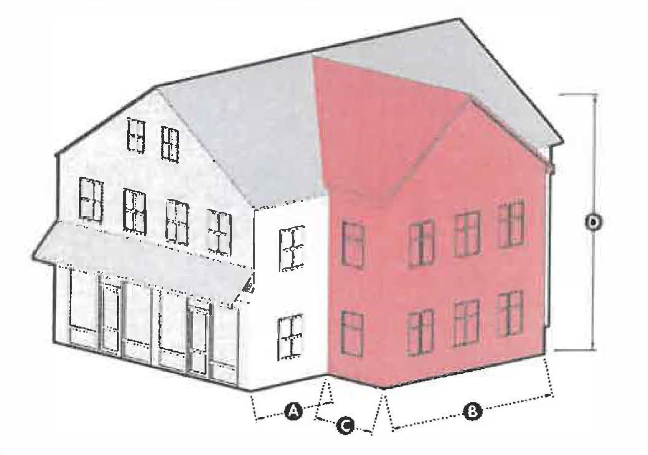
The following two diagrams (Figure 1 and Figure 2) provide two views of a hypothetic
development to visually represent the provisions of 8.7.7.2 A through 8.7.7.2 F Figure
1: Site and building design diagram (1 of 2)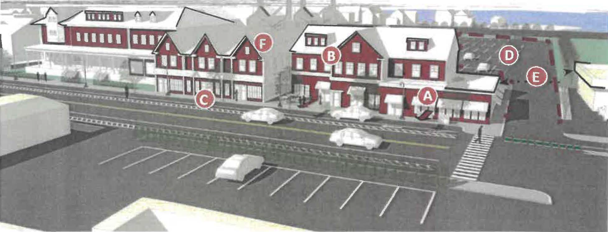
Figure 2: Site and building design diagram (2 of 2)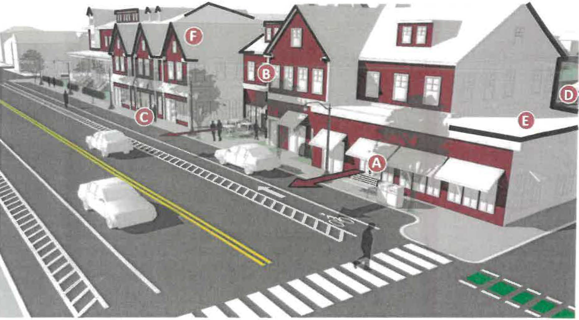
3.
Façade Design
A.
Facade Organization. Facades should be divided horizontally into a base, middle, and top with distinct visual cues for each section. The base provides the anchor for the structure, while displaying ground-floor activity. The middle portion reflects uses on upper floors, often with smaller, regularly spaced windows. The top of the building transitions and integrates with the roof.
B.
Active Ground-floor Uses. Activity on the ground floor, facing the street, strengthens the vibrancy of the neighborhood. This activity traditionally includes shops, restaurants, and other businesses. It may also include residential lobbies, community rooms, exercise rooms, cafes, or gallery spaces.
C.
Ground-floor Windows. The ground floor of buildings should generally include a higher percentage of window glazing compared to the rest of the building (60% is often a target). Glass should be clear, as opposed to tinted or reflective.
D.
Canopies and Awnings. Canopies and awnings can be used to provide a human- scaled element to the ground-floor of buildings by reducing the building's appearance of bulk and mass. They also provide protection from the elements.
E.
Architectural Details. Facade details help reinforce the neighborhood's character. Facade details can draw attention to the doors, windows, ground floor levels, cornices, and eaves of buildings. They can also help modulate the mass of large buildings by dividing them into a pattern of smaller bays.
F.
High Quality Materials. High quality and durable materials, such as clapboard (wood or composite), stone, and brick, should be used where possible. Vinyl siding and other synthetic materials should generally be avoided.
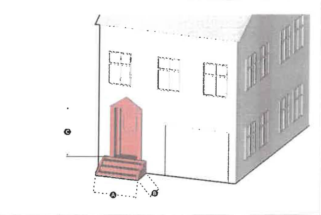
The following two diagrams (Figures 3 through 6) provide diagrams and photos to visually represent the provisions of 8.7.7.3 A through 8.7.7.3 E.
Figure 3: Facade Design Diagram (1 of 4)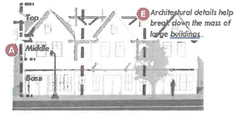
Figure 4: Facade Diagram (2 of 4)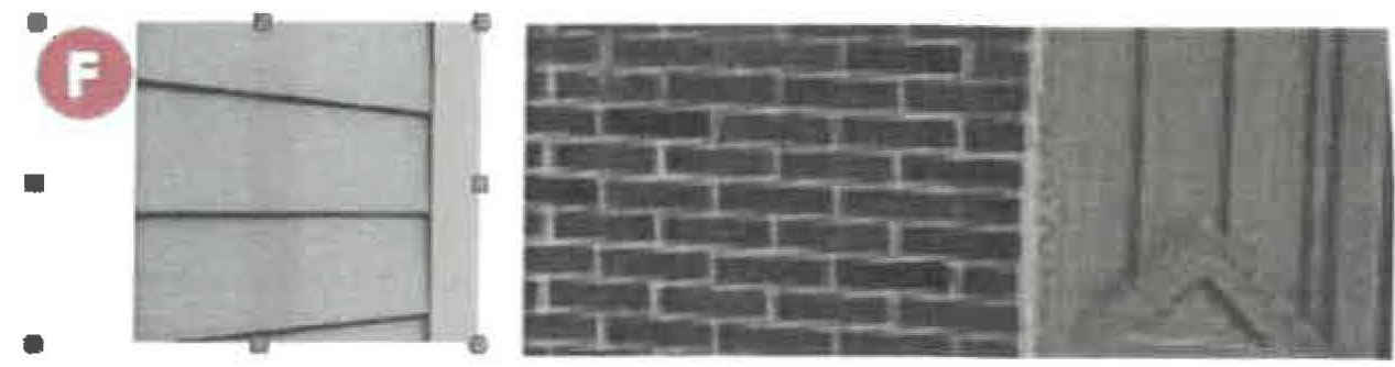
Figure 5: Facade design diagram (3 of 4)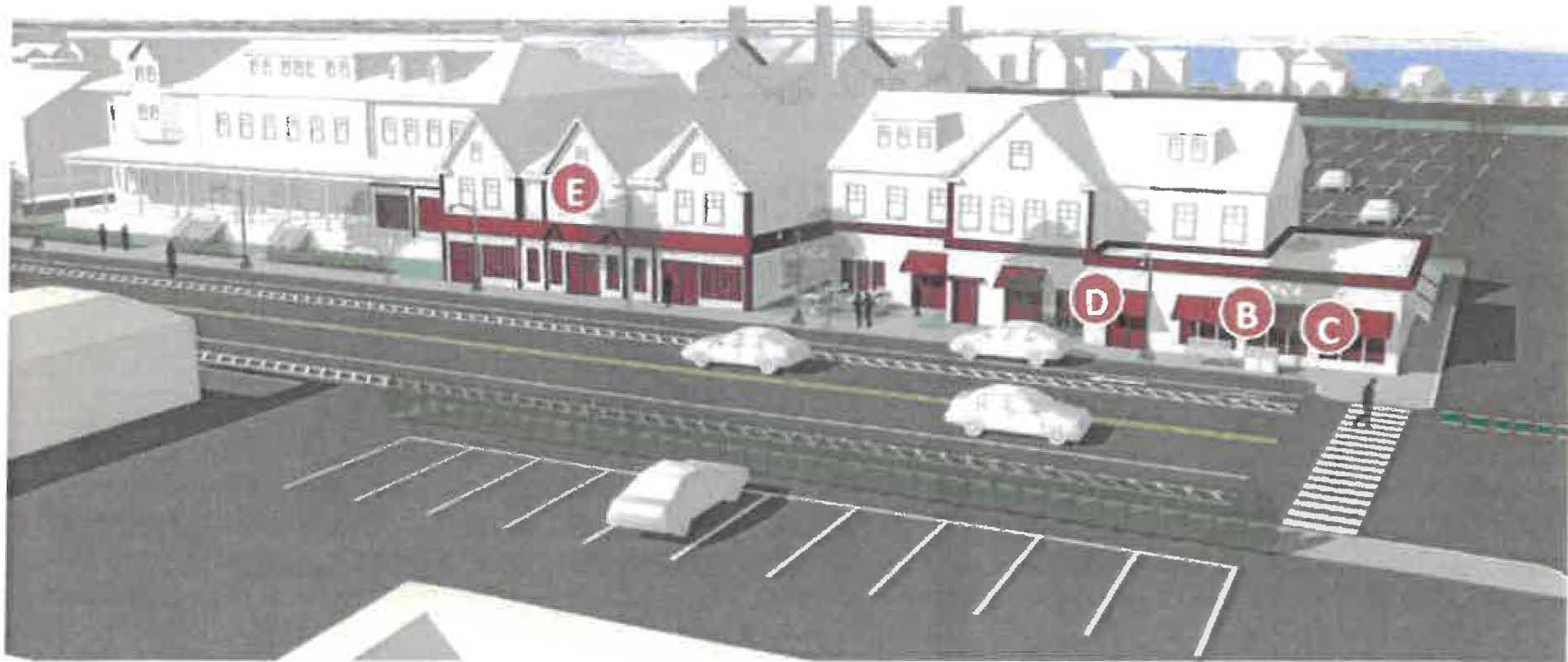
Figure 6: Facade design diagram (4 of 4)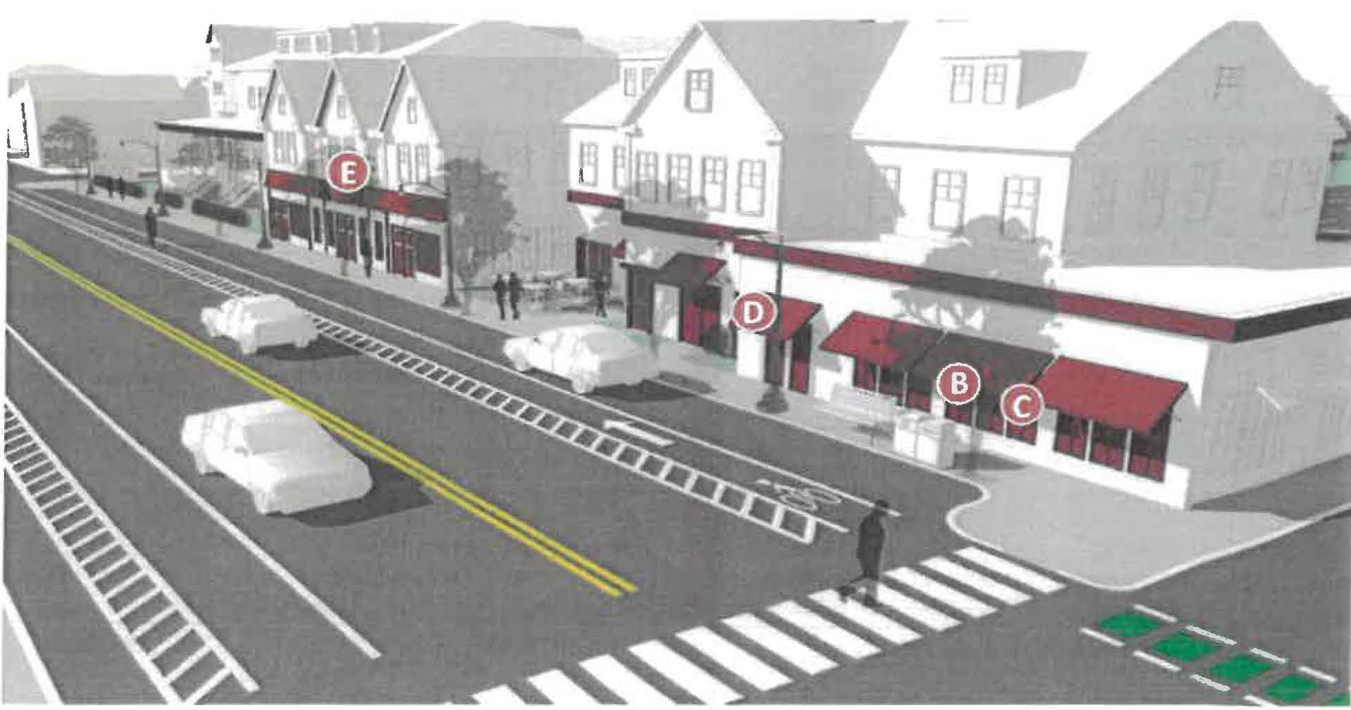
8.7.8 Development Standards.
1.
Lot Standards. In order to achieve the purpose of this ordinance, all development shall comply with the following standards:
 | |||||
| Lot Requirements | Setback Requirements | ||||
| — | Minimum lot size | 5,000 SF | C | Primary street setback (min/max) | 0 ft / 10 ft |
| A | Minimum frontage | 60 ft | D | Secondary street setback (min/max) | 10 ft / 20 ft |
| B | Minimum lot width | 60 ft | E | Side setback (min) | 10 ft or 0 ft if a common wall |
| — | Open space | 15% if containing residential; 0% otherwise | F | Rear setback (min) | 20 ft |
A.
Primary street refers to Bridge Street
B.
Secondary street applies to corner lots and refers to the street which intersects Bridge Street
C.
Where a primary street setback is greater than 0 ft, the following standards shall apply:
a.
Within the front setback, the space shall be used for one or more combination of:
i.
Outdoor seating associated with a ground-floor establishment.
ii.
Publicly available open space, such as a plaza or the like.
iii.
Stoops leading to the building's entryway. In such cases the area outside of the stairs and associated walkway, if any, shall be highly landscaped with a variety of native plants, shrubs, grasses, and trees.
iv.
An enclosed extended shopfront occupying a portion of the building. See standards for extended shopfront in Section [insert].
v.
Front garden space.
b.
The Planning Board may allow a waiver for greater setbacks whereby in its judgement, doing so will contribute to an improved public realm. Space within the additional front setback shall not be used for parking purposes.
c.
Parking is prohibited within the front setback, unless a waiver is granted by the Planning Board. Consideration will be given only in situations where locating parking beyond the front setback is considered impractical or infeasible.
d.
The setback requirements herein shall not be considered the setbacks for trees in Salem Code of Ordinances Section 43-51. The provisions of Chapter 43, public trees remain applicable.
D.
Open space requirements may include common roof-decks, courtyards, yards, gardens, space for seating associated with eating establishments and other communal spaces. Private balconies and vehicular space, such as parking and driving lanes are excluded from meeting the minimum requirement.
2.
Building Standards
The following table provides standards for new buildings constructed in the BSN.
3.
Building Design Standards
New buildings and substantial building renovations shall be reviewed with reference to the building design standards. If, in the opinion of the Planning Board, deviations from the standards and guidelines contained herein would improve the overall design of the proposed project, the standards in question may be waived.
1.
The Planning Board may permit multiple buildings and uses on the same lot, provided all standards are met.
2.
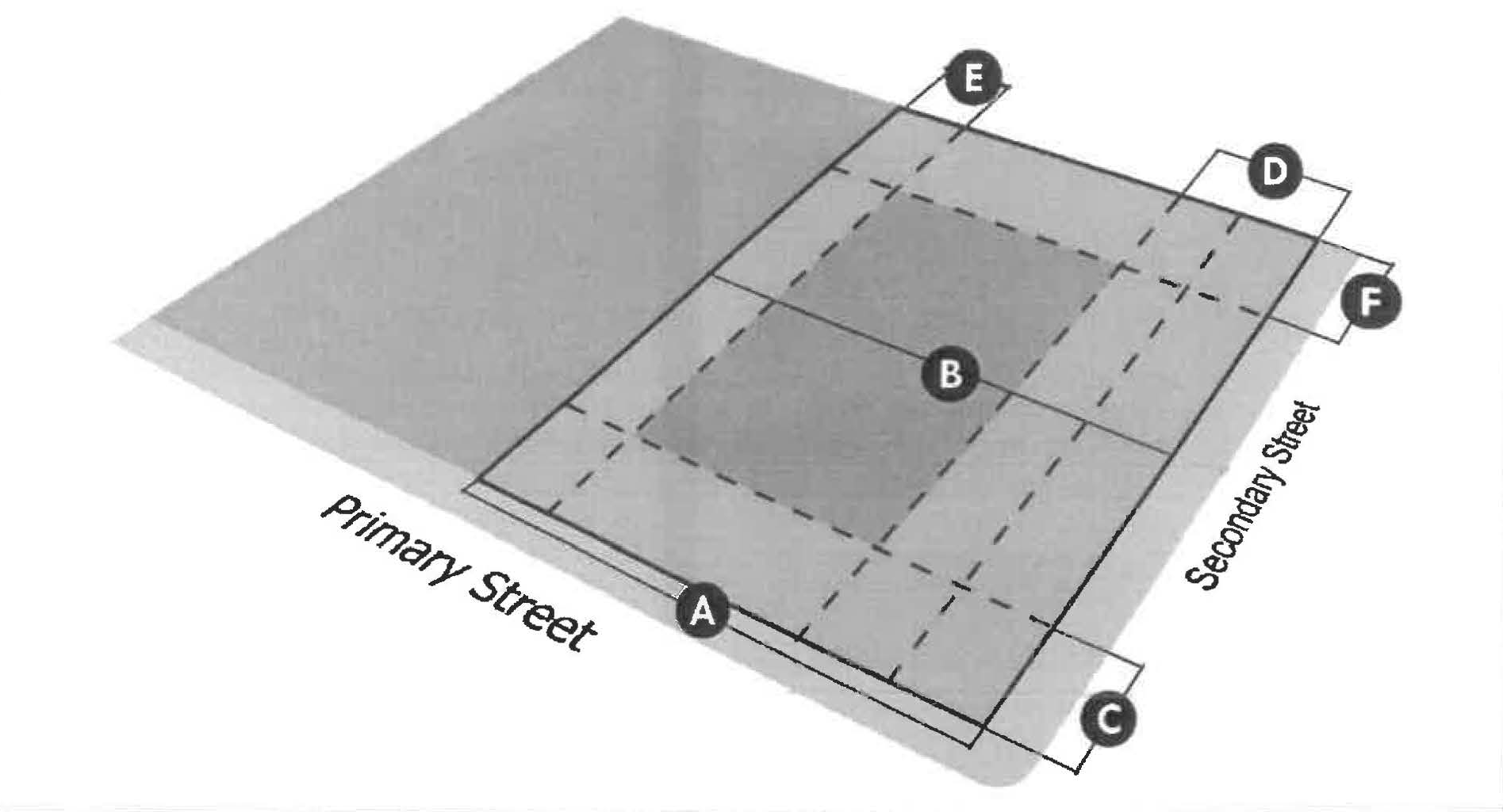
A building shall be comprised of a primary mass and an optional secondary mass. The primary massing of a building must be of rectangular form. The primary massing may be oriented either with its narrow end or long side toward the front lot line. The building façade must be built parallel to the front lot line.
Examples of primary and secondary building mass assembly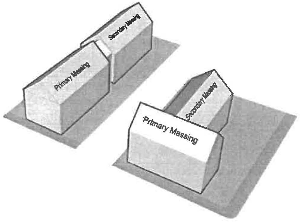
3.
Buildings shall have roofs that complement the existing context, including front gable, side gable, hip, Mansard, and flat roofs. The Planning Board may permit additional roof styles where it believes the applicant has demonstrated that the proposed roof will improve the visual character along Bridge Street.
4.
Multi-story buildings with ground-floor commercial spaces must have one principal entrance for each commercial space in addition to any principal entrance(s) necessary for upper floors.
5.
Unless otherwise noted, facade glazing shall consist of highly transparent, low reflectivity glass. Facade glazing requirements are only applicable to front facades along the primary street. Facade glazing is measured between two feet and twelve feet of the first floor facade.
6.
Vertical facade modulation reduces the visual bulk of large buildings by designing buildings to visually read as smaller buildings. To achieve this effect buildings greater than 40 feet in width shall be articulated through changes in the vertical plane of the building (minimum one foot and maximum 4 feet), vertical architectural details such as columns, pilasters, and the like, or fenestration patterns that suggests smaller buildings.
Example of vertical articulation elements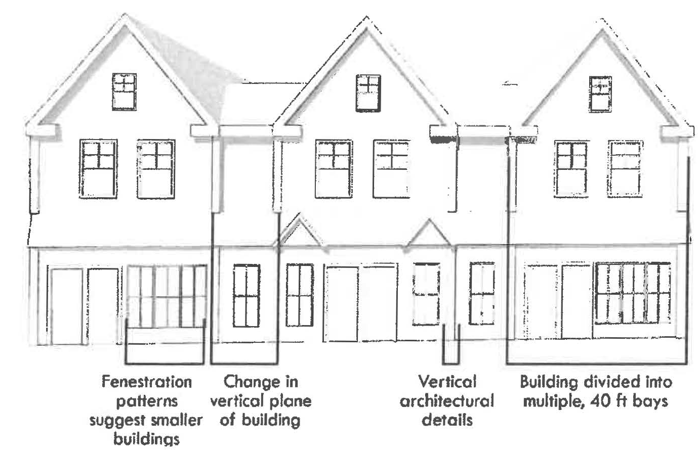
7.
Building components are accessory elements integrated into the building's massing that increase a building's usefulness and provide a means for achieving variety and individuality in design.
i.
The intent of this section is to provide a clear and flexible system for enabling the construction of new buildings and modification of existing buildings in a manner consistent with the neighborhood's character and vision.
ii.
The following components and associated standards are allowed on buildings with frontage on the primary street.
iii.
The Planning Board may permit additional building components via special permit if it determines the proposed component further enhances the building's design in relationship to the neighborhood character, is appropriate within the neighborhood context, and is consistent with the Purpose of this Ordinance.
i.
Bay window
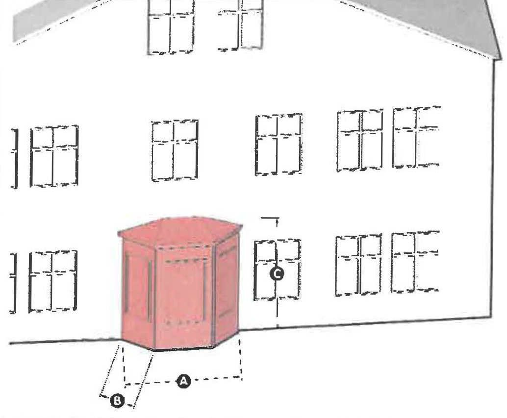 | Description: an enclosed window assembly extending from the face of a building element to permit increased light, multi-dimensional views, and articulate a building facade. | |
| A | Width (max) | 16 ft |
| B | Projection (min / max) | 0.5 ft / 4 ft |
| C | Top Plate height | Max equal to total number of full building stories |
| — | Fenestration | 30% min |
|
Standards:
1. Bay windows must attach to a single building face and may not wrap around corners. 2. Bay windows may be three-sided or curved. | ||
ii.
Cross Gable
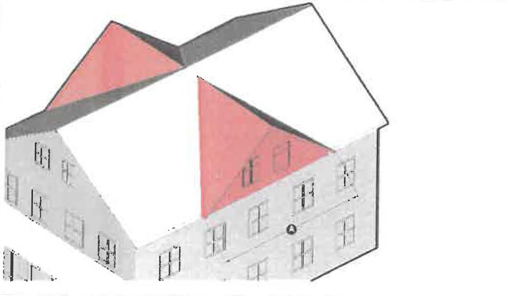 | Description: a gable roof that projects perpendicular from the roof of the primary building to increase the habitable space within the roof | |
| A | Width | Equal to the width of the narrowest building face |
| — | Fenestration | 20% min |
|
Standards:
1. Height may not be higher than the ridge beam of the primary building 2. Two cross gables of equal size and roof pitch may be used together | ||
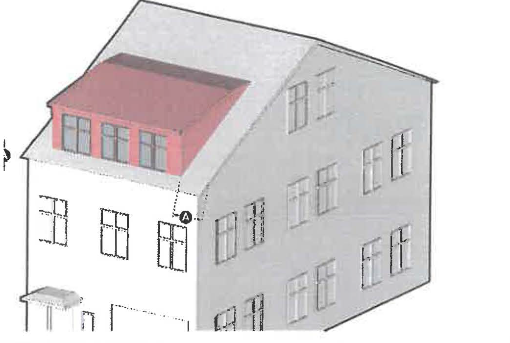
iii.
Dormer
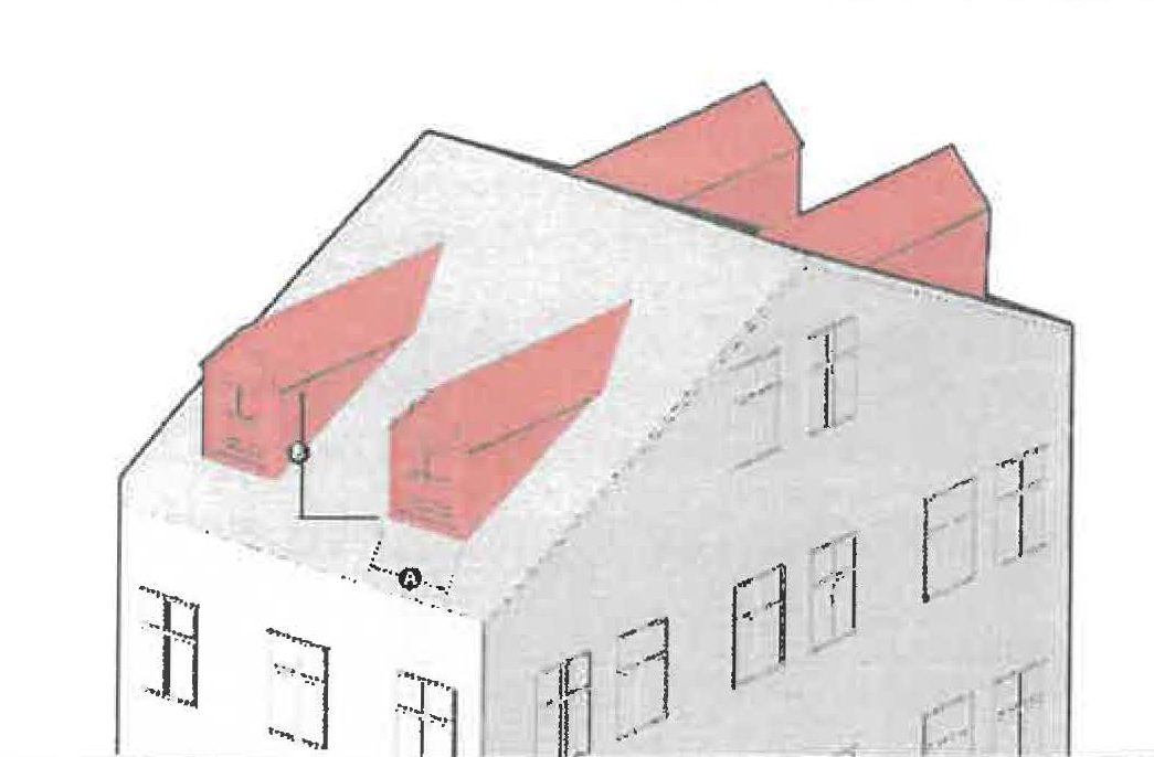 | Description: a window or group of windows with a gable, hip, or shed roof that projects vertically from the roof of a building element, designed to provide increased light and expand the habitable space within a roof. | |
| A | Width (max) | Window(s) width + 18 inches |
| B | Height (max) | No higher than height of roof |
|
Standards:
1. Setback from ridgeline must be 3 ft or greater. 2. Setback from side wall must be 1 ft or greater. 3. Separation between dormer(s) shall be a minimum of 50% of the dormer width. | ||
iv.
Extended Shopfront
 | Description: an extension of the front of a building to provide new or expanded commercial space and a shopfront. | |
| A | Width (max) | No more than the width of the building face to which it attaches |
| B | Projection (max) | 10 ft |
| C | Height (max) | Equal to the total number of full building stories |
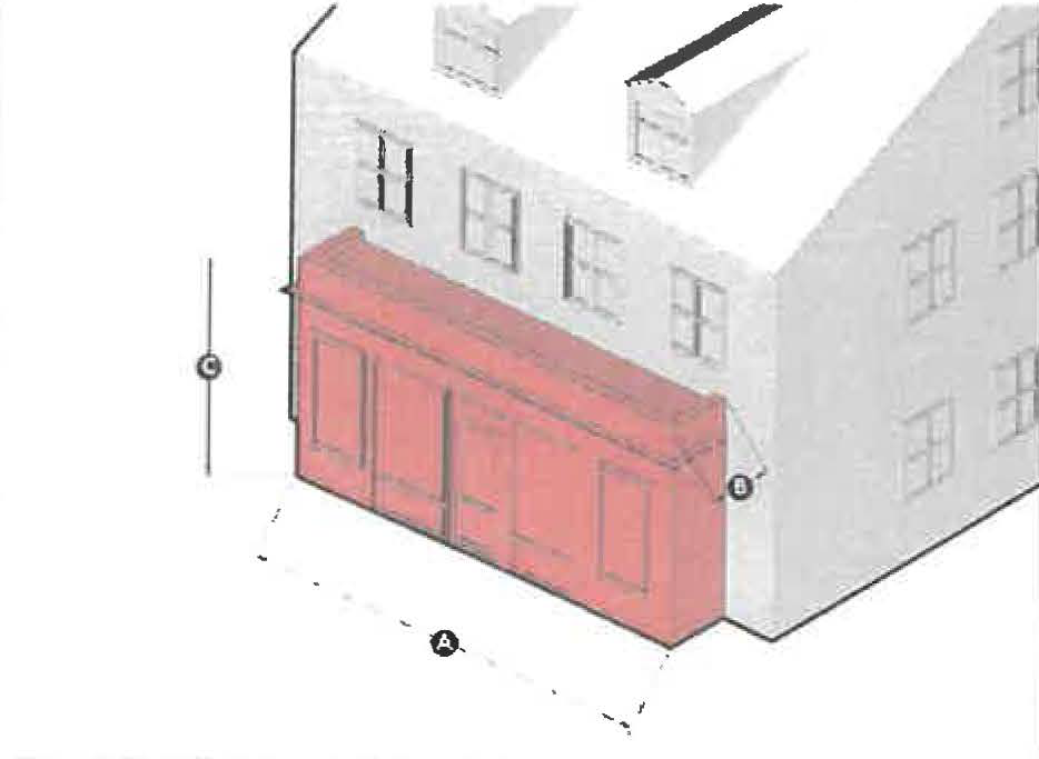
| — | Fenestration (min) | 70% ground floor 30% upper floors |
|
Standards:
1. Extended shopfronts may wrap around corners of the building face. 2. An extended shopfront may have a flat roof. 3. Extended shopfronts are permitted only on new construction. | ||
v.
Porch
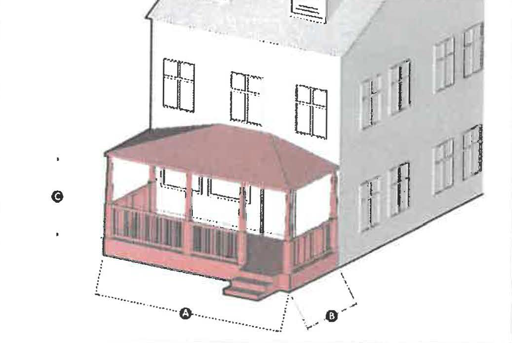 | Description: a raised platform with stairs that provides access to a building entrance. | |
| A | Width (max) | No more than the width of the adjoining building face |
| B | Projection (min / max) | 6 ft / 12 ft |
| C | Height (min) | 7 ft |
| — | Fenestration (min) | 60% when enclosed |
|
Standards:
1. Porches may be partially or fully enclosed. 2. Stairs may extend off the front or side of the porch, except when a porch is located on an upper floor in which case the stairs cannot be located along the primary frontage. 3. The space between piles or piers shall be hidden with material or plantings on all sides. | ||
vi.
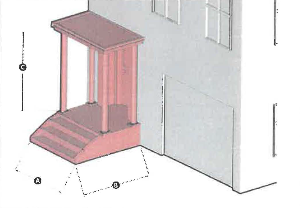
Portico
 | Description: a roofed structure above a stoop or platform supported on columns or pillars, which shields occupants from inclement weather and provides access to a building entrance. | |
| A | Width (min) | 3.5 ft |
| B | Projection (min / max) | 3.5 ft / 6 ft |
| C | Height (min) | 8 ft |
|
Standards:
1. A portico may not exceed the height of the primary ridge beam on the building element to which it attaches. 2. A portico must be elevated on a platform at least 1' from the ground. | ||
vii.
Shed Dormer
 | Description: a room, or portion of a room with a shed roof that projects vertically from the roof of a building element, designed to provide increased light and expand the habitable space under a roof. | |
| A | Gable end setback (min) | 1 ft |
| — | Fenestration | 30% min |
|
Standards:
1. Windows should be vertically proportioned and no more than 3 ft wide. 2. Shed dormers must have a minimum 4:12 slope. 3. The dormer must not extend beyond the eave line. | ||
viii.
Side wing
 | Description: a multi-story extension from the side walls of a building's primary or secondary massing. | |
| A | Setback from facade (min) | 8 ft |
| B | Width (max) | 2/3 width of primary building |
| C | Projection (max) | 12 ft |
| D | Height | Equal to or less than the height of the primary building |
| — | Fenestration (min) | 20% |
|
Standards:
1. A primary building mass may have only one side wing per side. 2. Additional building components, e.g., doors and porches, may attach to the side wing. | ||
ix.
Stoop
 | Description: a component featuring a set of stairs with a landing to the entrance of a building. | |
| A | Width (min) | 3.5 ft |
| B | Projection (min) | 3.5 ft |
| C | Height (min) | 7 ft |
|
Standards:
1. Stoops may be recessed into the building façade. 2. Stoop may be built perpendicular or parallel to the building face, but must lead directly to ground level or an abutting sidewalk from the building entrance. 3. Stoops may be configured as a split stair to access a below grade unit. 4. If a stoop is built encroaching onto a sidewalk, it must provide at least 5 ft clear and unobstructed between its outermost face and the face of the curb. | ||
4.
Parking Standards. Parking areas in the BSN shall meet the following criteria:
A.
Parking location
i.
Parking shall be located to the rear and side of a building where physically feasible.
ii.
Where parking is located on the side of a building and visible from the street or adjacent properties, it shall be screened through densely planted hedging or fencing, which in the opinion of the Planning Board effectively screens the parking and is of a quality that positively contributes to the character of the neighborhood.
B.
Parking ratios
i.
For multifamily dwellings, refer to Section § 5.1. All other new residential uses shall have 1.0 spaces per unit
ii.
Commercial uses shall have 4 spaces per 1,000 sf of leasable floor space
iii.
Other uses shall have 3 spaces per 1,000 sf of net floor area
C.
Parking requirements reduction
i.
The Planning Board may grant a waiver that allows a decrease in the required number of parking spaces through consideration of the following:
i.
On-Street Parking Off-Set. For commercial uses parking spaces required to meet the minimum off-street parking requirements may include publicly available on-street parking spaces along the building lot frontage on the same side of the street for non-residential uses.
ii.
Shared Parking and Mixed Use.
1.
A combination of uses on-site using shared parking lots with offset peak demand times where: a shared parking agreement with onsite uses where uses have offset peak demand times; uses have a high rate of parking turnover; or evidence of similar uses and location situations operating successfully with lower amounts of parking.
2.
In commercial or mixed-use developments where shared parking is proposed, the Planning Board may require an evaluation prepared by the applicant following the procedures of the Urban Land Institute (ULI) Shared Parking Manual (latest edition) or the Institute of Transportation Engineers (ITE) Shared Parking Guidelines (latest addition), or other approved procedures determined by the Planning Board.
iii.
Car-Sharing Program. The Planning Board may approve a parking reduction where an active car-sharing program is made available to residents and/or employees of a development Site; and where cars for the car-share program are available on the site or within a 700-foot walking distance of the site.
5.
Screening requirements
A.
Loading Facilities.
i.
Outdoor loading facilities, including all docks and areas used for the storage and staging of good or materials must be screened from view with landscaping or by a wall or fully closed fence, as necessary to sufficiently screen delivery vehicles. If a wall or fence is used it must be constructed of materials that are compatible with the building in terms of texture, quality, and color.
ii.
Exterior entrances and access to loading facilities that are fully enclosed within a building must have an opaque, self-closing door constructed of materials that are compatible with the principal building in terms of texture, quality, and color.
B.
Service Areas.
i.
Trash collection, trash compaction, recycling collection and other similar service areas must be fully enclosed within a building or located to the side or rear of the buildings and screened appropriately.
ii.
Exterior entrances and access to service areas that are fully enclosed within a building must have an opaque, self-closing door constructed of materials that are compatible with the principal building in terms of texture, quality, and color.
iii.
Outdoor service areas that are visible from a public street, public space, or abutting properties in the Residence district must be fully screened by a wall or fully closed fence at least six (6) feet in height with self-closing access doors and constructed of materials that are compatible with the principal building in terms of texture, quality, and color.
C.
Mechanical Equipment.
i.
Roof-mounted mechanical equipment, except sustainable energy systems, and elevator or stairwell penthouses must be set back at least ten (10) feet from the exterior walls of a building.
ii.
New buildings must provide a parapet wall or other architectural element constructed of materials that are compatible with the building in terms of texture, quality, and color that screens the visibility of roof-mounted mechanical equipment from any a public street or public space.
iii.
Wall-mounted mechanical equipment on any surface that is visible from a public thoroughfare (excluding an alley) or civic space must be screened by landscaping or an opaque screen constructed of materials that are compatible with the principal building in terms of texture, quality, and color.
iv.
Ground-mounted mechanical equipment that is visible from a public street or public space must be screened by landscaping, a fence, or a wall constructed of materials that are compatible with the principal building in terms of texture, quality, and color.
v.
Vents attached to a wall must not be located along the facade of the Primary Street and should be painted to blend in with the color of the building facade upon which it is located.
vi.
Screening must be of a height equal to or greater than the height of the mechanical equipment being screened.
vii.
An acoustic study of any relevant mechanical equipment on the effects of abutting properties and the public realm shall be included in the application materials.
(Ord. of 09-25-2025(1), § VIII)
8.7.9 Administrative Plan Review Application. Any application for approval of an administrative plan review under this section shall be accompanied by the application requirements of Section 9.5.
8.7.10 Site Plan Review Application. In addition to the application requirements of Section 9.5, the site plan review shall include a narrative of how the project complies with the criteria set forth in Section 8.7.13.
8.7.11 Development Standards Waiver Special Permit Application. Such application shall be accompanied by a narrative that describes of how the project complies with the criteria in Section 8.7.14, despite the request for said Waiver set forth.
8.7.12 Administrative Plan Review Criteria. The Planning Director or their designee shall review all such submitted plans in accordance with the development standards established in Section 8.7.8.
8.7.13 Site Plan Review Criteria.
1.
The Planning Board shall review all such submitted plans in accordance with the design guidelines herein and the following criteria:
A.
The development standards established in Section 8.7.8. unless otherwise waived by special permit from the Planning Board.
B.
Adequacy of the building layout in a way to create a presence on main corridor street edges.
C.
Adequacy of the parking facility to be located to the rear or side of the structures whenever physically feasible and adequacy of avoiding large expanses that are unbroken by buildings or substantial landscaped areas.
D.
Adequacy of the pedestrian connection to streets and pedestrian ways.
E.
Adequacy of traffic calming measures that discourage cut through traffic in the rear parking lot of any site.
2.
The Design Review Board shall review all such submitted plans in accordance with the design guidelines herein and the following criteria:
A.
Adequacy of the design to complement and harmonize with adjacent land uses (existing and proposed) with respect to architecture, scale, landscaping and screening.
B.
Adequacy of the use of building materials and details that are consistent with the architectural heritage of surrounding buildings.
C.
Adequacy of new facade elements on existing buildings to use materials and details that are consistent with the architectural heritage of the buildings on which they are located.
8.7.14 Development Standards Waiver Special Permit Criteria. In the Bridge Street Neck Overlay, no development standard waiver shall be approved unless all the following criteria, in lieu of those set forth in Section 9.4, are found to exist as part of the granting of a special permit by the Planning Board:
1.
The Design Review Board makes an advisory recommendation that the deviations from the standards and guidelines contained herein would improve the overall design of the proposed project.
2.
The Planning Board finds that the overall design would be more compliant with the intent and purpose of the ordinance and the Bridge Street Neighborhood Vision Update (2020 or most recent edition) than a strict adherence to the guidelines.
8.7.15 Administrative Plan Review Action. The Planning Director or their designee shall approve the plan provided that the plan complies with the review criteria herein. If a project does not comply with the review criteria, the applicant shall be directed to revise the plan or apply for a Site Plan Review and Development Standard Waiver Special Permit.
8.7.16 Site Plan Review Action. The Planning Board shall not take final action on the application until it receives written recommendation on the application from the Design Review Board of the Salem Redevelopment Authority.
8.7.17 Development Standard Waiver Special Permit Action. Action shall not be taken on any plan for a Site Plan Review until it has received a recommendation from the Design Review Board of the Salem Redevelopment Authority concerning the design of the project. The Design Review Board shall refer to the Development Standards and Guidelines herein and the Bridge Street Neck Vision Update Plan (2020 or most recent edition) when making their recommendation.
1.
The Design Review Board's recommendation shall state the applicable standard(s), whether the alternative design approach meets the Design Guidelines and if a waiver is recommended.
2.
The Planning Board must provide a written determination and finding whether the alternative design approach meets the requirements of the Design Criteria. Such determination shall state the applicable standard(s), the reason for granting an alternative, the applicable Design Criteria, and how the alternative meets the Design Criteria.
8.7.18 Administrative Plan Review Appeal. Any appeal of a decision of the Planning Director pursuant to this section shall be appealed to the Planning Board.
8.7.19 Site Plan Review Appeal. Any decision of the Board pursuant to this section shall be appealed in accordance with M.G.L.A. c. 40A, s. 17 to a court of competent jurisdiction.
(Ord. of 5-26-22(1), § 1)
8.8 - RESERVED[2]
Editor's note— Ord. of June 12, 2025, § I, repealed § 8.8, which pertained to Halloween parking overlay district and derived from Ord. of Sept. 22, 2022 (1), § 1.
8.9 - COASTAL RESILIENCY OVERLAY DISTRICT
8.9.1 Purpose. The City of Salem recognizes that the increased frequency and intensity of coastal flooding events resulting from climate change poses a threat to human health, safety, and welfare. Through the creation of this Coastal Resiliency Overlay District (C-ROD), the City hereby establishes land use rules reflective of anticipated future sea level rise and coastal flooding scenarios and aims to foster land use that is resilient to projected increased coastal flood risk. This Ordinance is informed by science and technical data available at the time of its adoption, through the Massachusetts Coast Flood Risk Model's (MC-FRM) projected Significant Wave Height elevation in a 100-year flood event in 2070 and is anticipated to be updated periodically as new data become available and to maintain reference to a coastal flood risk projection with an approximately fifty-year time horizon.
The goals of this Ordinance are to:
• Protect buildings from projected increased coastal flood risk, with especially high protection provided to residential dwelling units, to protect the health, safety and welfare of occupants and minimize the burden on emergency response services.
• Encourage thoughtful and strategic investment in the built environment to advance the community's goals, in areas including but not limited to housing and economic opportunity, through resilient land use that adapts to future coastal flood risk.
• Encourage adaptations to future coastal flood risk that are appropriate to the variety of Salem's existing building stock as well as the community's unique historic buildings, neighborhoods, and landscapes.
• Provide consistent regulation of land uses within locations projected to be subject to increasing coastal flood risk for the benefit of the city, community, and builders.
8.9.2 District Boundaries. The C-ROD boundary consists of the areas as shown on the zoning map. This mapping is based on the MC-FRM's projected Significant Wave Height elevation in a 100-year flood event in 2070. Where interpretation of these boundaries is in question, the
Building Commissioner shall make interpretations, where needed, as to the exact boundaries of the district. The precise boundaries of the C-ROD shall be based on actual site conditions, as determined by the Building Commissioner, based on elevations provided by a licensed professional surveyor. Any person aggrieved by the Building Commissioner's determination may appeal to the Zoning Board of Appeals pursuant to G.L. c. 40A, Sections 8 and 15 and Section 9 of the Salem Zoning Ordinance.
Sea Level Rise Base Flood Elevation and Use Requirements: Minimum Sea Level Rise Base Flood Elevation ("SLR BFE"): The SLR BFE shall be no lower than the corresponding MC-FRM projected 100-year flood event's Significant Wave Height in 2070 as depicted on mapping on file with the City of Salem Department of Planning & Community Development.
8.9.3 Applicability. A building located within the district boundary is subject to the C-ROD as shown on Table 1 below:
TABLE 1: C-ROD APPLICABILITY
Notes:
1.
For the purpose of the C-ROD, an Accessory Dwelling Unit (ADU) shall be considered a residential unit.
2.
A mixed-use building within the C-ROD shall be subject to the requirements of this Section if any of the residential or non-residential thresholds in Table 1 are met.
3.
Applicability to Central Business (B5) Zoning District: For projects in the Central Business (B5) District, this Section 8.9 shall be applicable upon approval by the Executive Office of Housing and Livable Communities of a district compliance application that includes the C-ROD district in the compliance model of the application.
8.9.4 Limitation on Uses Below SLR BFE. Residential dwelling units, building mechanical uses, and building electrical service uses shall be located above the SLR BFE except as allowed in the list below and subject to Section 8.9.7, C-ROD Site Plan Review:
1.
Residential access and vertical circulation (including lobbies, stairs, and similar spaces)
2.
Residential storage
3.
Residential Multifamily Common Support and Amenity Space
4.
Parking
5.
All non-residential uses
6.
Building Mechanical Uses and Electrical Service Uses that Cannot Practically Be Located Above SLR BFE, as defined in Section 8.9.25.
8.9.5 Exemptions. The following are exempt from the provisions of the C-ROD.
1.
Modification of an existing building where, within a 24-month period, Level 2 Alteration neither exceeds fifty (50) percent of the aggregate building area below the SLR BFE nor seventy-five (75) percent of the aggregate building area above the SLR BFE. Aggregate building area shall be as defined in the Massachusetts State Building Code.
2.
New construction or modification of existing structures that do not meet the definition of "Building" per Section 10 of the Zoning Ordinance.
3.
Portions of an existing building under separate ownership from a portion of the building where work subject to this Section is proposed to occur. For example, work in one (1) condominium may not trigger the ordinance's applicability to a separately owned condominium in the same building where work is not proposed.
4.
When a modification of an existing building is subject to this ordinance, Building Mechanical Uses and Building Electrical Uses not being reconfigured or extended may remain below the SLR BFE.
8.9.6 Relief from Dimensional Requirements. Where the Project is subject to this C-ROD Ordinance, the design shall adhere to the following provisions:
1.
Building Height: Irrespective of Sections 10.0 and 4.1,2.6 of the Salem Zoning Ordinance, Building Height shall be measured starting from the SLR BFE for Projects subject to this Section.
2.
Gross Floor Area: In addition to areas excluded by other provisions of the Ordinance, the following shall be excluded from the measurement of Gross Floor Area for Projects subject to this Section: Areas devoted to interior vertical circulation from grade to the SLR BFE (such as stairs, ramps, or elevators); and areas devoted to flood protection equipment.
3.
Front, Rear, and Side Yards. The following may be located within required setbacks irrespective of other provisions of the Salem Zoning Ordinances:
a.
In Front, Rear, and Side Yards: Areas used for vertical circulation (such as stairs, ramps, or elevators) from grade to the required SLR BFE where setbacks are maintained to the maximum extent practicable; and
b.
In Rear and Side Yards: Flood Protection Equipment, and structures housing mechanical equipment above the required SLR BFE, where setbacks are maintained to the maximum extent practicable.
8.9.7 C-ROD Site Plan Review Required. Projects subject to this section must undergo Site Plan Review per the provisions of this section, which are in lieu of the requirements of Section
8.9.8 of the Zoning Ordinance, unless 9.5.2 applies, in which case the project is subject to both C- ROD Site Plan Review and Site Plan Review Section 9.5. Absent special circumstances, applications under this Section 8.9 for C-ROD Site Plan Approval and under Section 9.5 for Site Plan Approval should be filed together for contemporaneous consideration by the Planning Board.
8.9.8 C-ROD Site Plan Review Application. An Applicant for a Site Plan Review shall file the application to the Planning Board and one (1) copy to the City Clerk. The application shall contain the following information:
A.
Any application for approval of a site plan review under this section shall be accompanied by a site plan, which shall be at a scale to be established by the Planning Board. The plan shall contain the following information, at a minimum:
1.
Location and dimensions of all buildings and other construction;
2.
Location and dimensions of all parking areas, loading areas, bicycle racks or bicycle storage areas, walkways and driveways. Plans shall clearly identify pavement grade changes exceeding five (5) percent, and any vegetated slopes steeper than 1 V:3H, identify all pedestrian and vehicular pavement materials;
3.
Location and dimensions of internal roadways and access ways to adjacent public roadways;
4.
Lot lines within which the development is proposed in relation to the nearest road intersection;
5.
Location, type, dimensions and quantities of landscaping and screening including retaining walls and fences:
6.
Current and proposed locations, dimensions, and screening of utilities including: water, storm water, sewer, drainage, drain inlets, drainage tanks, back flow preventers, manholes, hydrants, gas, electrical, telephone, wireless communication facilities, HVAC-related mechanicals, transformers, switchgears, generators, intake and exhaust features including: ventilation, stacks, fans, louvers, steam, and recycling and other waste disposal locations;
7.
Location of all existing natural features, including ponds, brooks, streams, wetlands, street trees, and existing vegetation up to the curb line;
8.
Topography of the site, with one (1) foot contours;
9.
Plans depicting the property lines and physical features, including roads, for the project site;
10.
Proposed changes to the landscape of the site, grading, vegetation clearing and planting;
11.
Locations of active farmland, wetlands, permanently protected open space, Priority Habitat Areas and BioMap 2 Critical Natural Landscape Core Habitat mapped by the Natural Heritage & Endangered Species Program (NHESP) and "Important Wildlife Habitat" mapped by the DEP;
12.
Locations of local or National Historic Districts;
13.
Location, arrangement, size, and design of roof mounted and small-scale ground mounted solar energy systems;
14.
Location and elevation of existing and proposed applicable FEMA zones, structures, watercourses, applicable Base Flood Elevation mapping, drainage, and drainage easements, means of access, utilities, and sewage disposal facilities, if any;
15.
Boundaries of C-ROD overlay district and SLR BFE within the site and citation of information used to establish SLR BFE;
16.
Project design that addresses the requirements of the C-ROD Ordinance as applicable; and
17.
For buildings that are individually listed in the National Register of Historic Places or have been determined by the Salem Historical Commission to be historically significant: Application materials listed in Section 1.7 of the Salem Historical Commission Guidelines Notebook.
B.
A statement, signed and sealed by a state licensed architect or engineer, that all covered building spaces below the SLR BFE are designed to be floodproof in compliance with the requirements of this ordinance.
C.
A written narrative describing the proposed Project and how it complies with the requirements in Section 8.9.10 of this C-ROD Ordinance.
D.
A list of federal, state, and other local permits required for the Project.
8.9.9 Distribution. The Planning Board shall, within seven (7) days after the receipt of an application pursuant to this Ordinance, transmit one (1) copy of said application to the Director of Sustainability and Resiliency, Building Commissioner, City Engineer, Head of the Fire Department or the Head of the Fire Department's designee, Board of Health, and Conservation Commission, who may at their discretion review and provide written commentary to the Planning Board.
The Planning Board shall not take final action on such application until it has received a report thereon from the Director of Sustainability and Resiliency, Building Commissioner, City Engineer, Head of the Fire Department or the Head of the Fire Department's designee, Board of Health, and Conservation Commission or until thirty-five (35) days have elapsed after distribution of such application to the listed parties.
The Salem Historical Commission shall review Projects that are individually listed in the National Register of Historic Places or have been determined by the Salem Historical Commission to be historically significant. The Historical Commission shall review the application at a public meeting and shall provide advisory comments to the Planning Board. The Historical Commission shall review the application for conformance to the Secretary of the Interior's Standards for the Treatment of Historic Properties.
The Planning Board shall not take final action on an application under this Section until it receives written confirmation from the Historical Commission that the application conforms to the Secretary of the Interior's Standards. The Planning Board may act if at least sixty (60) days have passed since delivery of the application to the Historical Commission and the Planning Board has not received any findings from the Historical Commission during the sixty (60) day period. Said sixty (60) day period may be extended by written agreement between the Applicant and Planning Board.
Nothing set forth in this section is intended to alter or amend the rights and obligations of the Historical Commission, and an Applicant's adherence thereto, pursuant to M.G.L. c. 40C.
8.9.10 Site Plan Review Criteria. When reviewing Projects subject to the C-ROD Ordinance, the Planning Board shall consider the following to the extent applicable. These criteria are in lieu of the general Site Plan Review Criteria in section 9.5 of the Salem Zoning Ordinance, unless the project is also subject per Section 9.5.2, in which case both C-ROD and Site Plan Review Section 9.5 both apply.
1.
Adequacy of best engineering practices to eliminate or minimize flood risk or damage to covered building spaces below the SLR BFE, except unoccupied, unimproved, or unenclosed areas (such as crawlspaces) that are not intended for any uses described in this C-ROD Ordinance.
2.
If project includes parking located below the SLR BFE within or beneath a building:
a.
Adequacy of alternatives analysis to demonstrate that locating parking above the SLR BFE is infeasible; and
b.
Adequacy of operations and management plan to remove vehicles from below the SLR BFE prior to a forecasted flood event.
3.
Adequacy of flood protection for all Building Mechanical Uses and Electrical Service Uses that cannot practically be located above SLR BFE, as defined in Section 8.9.25:
4.
Adequacy of convenience and safety of vehicular and pedestrian movement within the site and in relation to adjacent streets and sidewalks, particularly in the event of coastal floodwater rising to the SLR BFE.
5.
Adequacy of project design to support pedestrian connections.
6.
Adequacy of the minimization of the visual impact of utilities, building mechanicals, and flood protection equipment (see Wet and Dry Floodproofing) to the maximum extent practicable.
7.
Adequacy of protection of the building's historic character and compatibility with historic character of the surrounding neighborhood.
8.9.11 Decision. After a notice and public hearing as set in G.L. c. 40A, s. 9 and 11, the Planning Board, by a simple majority, may approve the plan provided that it meets the criteria set forth in Section 8.9.10.
8.9.12 Conditions. The Planning Board may, in appropriate cases as it determines, impose further restrictions upon the development or parts thereof as a condition to granting the approval and may waive any defined restrictions provided the project meets the 8.9.16 Waiver criteria. The Planning Board may, as a condition of approval, require that the Applicant give effective notice to prospective purchasers of the flood hazard conditions associated with said premises and the steps undertaken by the Applicant to alleviate the effects of same.
8.9.13 Relationship to Underlying Zoning. The C-ROD constitutes an overlay district as defined in Section 2.2 of the Salem Zoning Ordinance. The provisions of the Underlying Zoning, as they may be amended from time to time, continue to apply, except as expressly superseded by this C-ROD Ordinance. Where conflicts exist between this C-ROD Ordinance and the remainder of City's Zoning Ordinance, the requirements set forth in this Section shall govern.
8.9.14 Reconstruction After Catastrophe. Irrespective of Section 3.3.7 of the Salem Zoning ordinance, reconstruction of buildings with greater than five (5) residential dwelling units or seven thousand five hundred (7,500) square feet of non-residential space shall be subject to this C-ROD ordinance.
8.9.15 Waivers. The Planning Board is empowered to grant a C-ROD Site Plan Review approval that includes a waiver(s) from provisions of the C-ROD Ordinance.
8.9.16 Waiver criteria. In rare cases, waivers may be granted by the Planning Board only upon the Applicant's demonstration that structures, their occupants, and contents are and will be protected from future flood risk per the purposes of this Ordinance without strictly meeting every provision of this Ordinance. In such cases, the Planning Board shall only grant the minimum waiver necessary. In evaluating whether a waiver from one or more of the provisions C-ROD Ordinance is appropriate, the Planning Board shall consider the following:
1.
Whether the grade of the existing roadways or sidewalks from which the Property derives its frontage makes full compliance with Section 8.9.10(4) (Vehicular and pedestrian movement) of this Ordinance impractical.
2.
Whether there is no practicable way to achieve vertical circulation that complies fully with both this C-ROD Ordinance and with the Americans with Disabilities Act (ADA) and Massachusetts Architectural Access Board (MAAB) standards.
3.
Whether the purposes of this Ordinance can be achieved wholly or in part through innovative design approaches without strictly meeting every provision of this Ordinance.
4.
Whether the purposes of this Ordinance can be achieved wholly or in part through exterior site features, including, but not limited to, flood walls, earthen berms, or grading above the SRL BFE.
8.9.17 Historic Properties Waiver. If a building subject to the C-ROD lies within a Local Historic District, is individually listed in the National Register of Historic Places, or has been determined by the Salem Historical Commission at a public meeting to be historically significant, the Applicant may request a waiver from one or more provisions of this ordinance provided the petitioner demonstrates that the project meets the provisions of the ordinance to the maximum extent practicable, and that full compliance with the ordinance is not feasible without degrading the structure's historic character.
8.9.18 Waiver Request Submittal Requirements. The Planning Board will only consider the issuance of a waiver to one or more provisions of this Ordinance if the Applicant submits a written request including all of the following:
1.
A complete Site Plan Review application under this Ordinance.
2.
A list of the specific provision(s) from which a waiver is sought.
3.
A written narrative supporting how the waiver request meets the waiver criteria described in Section 8.9.16.
4.
Any additional information or materials that may support the Planning Board's consideration of the waiver request.
8.9.19 Peer Review. The Planning Board may retain third-party review services by qualified individuals to assist with the review of applications filed pursuant to this C-ROD Ordinance, as may the Zoning Board of Appeals to support consideration of an appeal of the Building Commissioner's decision regarding the boundaries of the C-ROD, pursuant to MGL Ch. 44, Section 53(G).
8.9.20 Severability. If any section, provision, or portion of this C-ROD Ordinance is deemed to be unconstitutional or invalid by a court, the remainder of the Ordinance shall be effective. In areas of conflict that would prevent compliance with the MA Building Code, the Building Code shall prevail.
8.9.21 Lapse. Site plan approval shall lapse after two (2) years from the grant thereof if a substantial use thereof has not sooner commenced except for good cause. Such approval may, for good cause, be extended in writing by the Board upon the written request of the applicant.
8.9.22 Enforcement. No building permit or Site Plan Review approval for a Project proposed and subject to this C-ROD Ordinance shall be issued without proof of prior compliance and, as appropriate, permit issuance under this Ordinance.
8.9.23 Fee. The Board may adopt reasonable administrative fees and technical review fees for C-ROD site plan review.
8.9.24 Appeal. Any decision of the Board pursuant to this Section may be appealed in accordance with G.L. c. 40A, s. 17 to a court of competent jurisdiction.
8.9.25 Definitions. The defined terms in this Section are for terminology used in this C-ROD Ordinance. To the extent not defined herein, refer to Flood Hazard Overlay District (Section 8.1) for additional definitions of terms related to this Section and Definitions (Section 10.0), notwithstanding any contrary provision(s) elsewhere in the Ordinance.
1.
Building Mechanical Uses—Refers to use of a site, structure, or portion(s) thereof to house the mechanical system of a building, including heating, ventilation, air conditioning, or other like features.
2.
Building Mechanical Uses and Electrical Service Uses that Cannot Practically Be Located Above SLR BFE—Refers to those Building Mechanical Uses and Electrical Service Uses that must be located below the SLR BFE in order to serve their intended purpose. For example, wiring and piping entering a building from underground must pass through the area below the SLR BFE to serve mechanical or electrical units located above the SLR BFE.
3.
Building Electrical Service Use—Refers to uses of a site, structure, or portion(s) thereof to house the main electrical service equipment of a building, including main panelboards, transformers, switchgear, or other like features.
4.
Floodproofing, Dry—Is the practice of sealing a space or a building up to the level of the Sea Level Rise Base Flood Elevation (SLR BFE) or higher in order to keep water from entering and strengthening structural members in anticipation of the hydrostatic and hydrodynamic pressure caused by floodwaters.
5.
Floodproofing, Wet—Constructing for the movement of water through a space or a building, which equalizes hydrostatic pressure and helps prevent structural failure, and utilizing materials that will withstand flooding without damage.
6.
Flood Protection Equipment—Equipment used to prevent or minimize water infiltration or flood damage. This type of equipment may include, but is not limited to, permanent or deployable flood walls and retention tanks for stormwater or floodwater.
7.
Level 2 Alteration—Includes the reconfiguration of space, addition or elimination of any door or window, the reconfiguration or extension of any system, or the installation of any additional equipment. (From 2021 International Building Code).
8.
Proposed Project/Project—The construction or modification of a building that is subject to this ordinance.
9.
Residential Multifamily Common Amenity and Support Space—A shared area within a building that is outside dwelling units and that houses amenities or services available for the shared use or support of residents of a multifamily residential complex. This may include, but is not limited to, a swimming pool, sauna, exercise room, pet washing facility, game room, lounge, mailroom, service desk, management office, or custodial closet.
10.
Sea Level Rise Base Flood Elevation (SLR BFE)—The SLR BFE shall be established by the top of the water elevation predicted by the coastal flood risk scenario depicted on the SLR BFE Map on file with the Department of Planning & Community Development.
11.
Structural Lot Coverage—That portion of a lot that is covered or occupied by any building or structure, but excluding unenclosed, covered, or uncovered landings or porches (unless such covered landings or porches have habitable space directly above), steps, roof overhangs, bay windows, chimneys and bulkheads as permitted in required setbacks, as well as outdoor fireplaces, decks, patios and pools.
12.
Underlying Zoning—The zoning regulations that are otherwise applicable to a Proposed Project or Property within the C-ROD, including the regulations of any other overlay district(s) as set forth in this Ordinance.
13.
Zoning Relief—Any Zoning Variance or Special Permit, exception, or zoning map or text change, or any other relief granted for a Proposed Project issued by the Zoning Board of Appeals or Salem Planning Board.
(Ord. of 07-11-24(3) § I)