
Saluda City Zoning Code
CHAPTER 4
- ZONING DISTRICTS
Sec. 4.1. - Official zoning map.
4.1.1.
Intent. In order to accomplish the purpose set forth in the comprehensive plan and section 1.2 of this ordinance, the boundaries of the zoning districts are hereby established as shown on the official zoning map of the town which together with all explanatory matter hereon, is hereby adopted by reference and declared to be a part of this ordinance. The official zoning map shall be identified by the signature of the mayor attested by the town clerk, and bearing the seal of the city under the words: "Official Zoning Map, Town of Saluda, SC," together with the date of adoption of this ordinance. The official zoning map shall be located in the office of the zoning administrator and shall be the final authority to the current zoning status of land, water areas, buildings, and other structures in the town, notwithstanding any other zoning map purported to be a copy of the official zoning map.
4.1.2.
Interpretation of district boundaries. Where uncertainty exists as to the boundaries of districts as shown on the official zoning map, the following rules shall apply:
A.
Boundaries indicated as approximately following the center of streets, highways, railroad lines, utility easements, and alleys shall be construed to follow such centerlines;
B.
Boundaries indicated as approximately following platted lot lines and town limits shall be construed as following such lines;
C.
Distances not specifically indicated on the official zoning map shall be determined by the scale of the map.
4.1.3.
Change of town boundaries. All territory which may hereafter be annexed to the town shall be considered to be in the TNR (Traditional Neighborhood Residential) district unless otherwise classified.
Sec. 4.2. - Town Center District (TC).
4.2.1.
Intent. The Town Center District is the heart of the town. This area (the downtown) has been historically and is currently the central area for shopping, services, and governmental facilities for both the residents of the town and surrounding areas. The downtown and its businesses are easily accessible by vehicles, bikes, and pedestrians. A mixture of uses that respect the existing structures, especially those with historic significance, in scale and use are appropriate for this district.
4.2.2.
General.
A.
Minimum lot size: 5,000 square feet.
B.
Maximum lot coverage. Building footprint shall not exceed 70 percent of the lot coverage.
C.
Setbacks.
1.
Front: Zero feet min. to 15 feet max.
2.
Side: Zero feet min.
3.
Rear: 20 feet min.
D.
Maximum building height: 35 feet.
Water towers, transmission towers, chimneys, flag poles, masts and aerials are permitted to exceed height limits, provided evidence from appropriate authorities is submitted to the effect that such building or structure will not interfere with any airport approach zones or flight patterns.
4.2.3.
Uses.
A.
Permitted uses. The following uses shall be permitted in the TC district.
1.
Office/commercial. The following office and commercial uses are permitted in the TC district provided that all specified standards are met:
a)
Use list.
(1)
Office.
(2)
Personal services.
(3)
Business services.
(4)
General retail.
(5)
General commercial.
b)
Standards.
(1)
Balconies and bay windows at an upper level together with awnings above head height (min. 7'-6") are permitted over the sidewalk with a maximum of five foot encroachment into the right-of-way.
(2)
Trash containers shall be located in the parking area and shall be screened from the right-of-way.
(3)
Mechanical equipment at ground level should be placed on the parking lot side of building and away from buildings on adjacent sites.
(4)
Building facades should constitute a street frontage at pedestrian scale.
(5)
Main pedestrian access to the building shall be from the street. Secondary access may be from parking areas.
2.
Single-family residential. Single-family residential uses are permitted in the TC district. Mobile/manufactured homes are not permitted in the district.
3.
Multifamily residential. Attached or detached multifamily residential uses are permitted in the TC district provided that all specified standards are met.
a)
Standards.
(1)
Parking requirement: Two spaces per unit.
4.
Institutional. The following institutional uses are permitted in the TC district. Refer to chapter 3 of this ordinance for regulations regarding signs, fencing, etc.
a)
Use list.
(1)
Church.
(2)
Government building.
(3)
School.
5.
Outdoor storage. Outdoor storage uses are permitted in the TC district provided that all specified standards are met.
a)
Standards.
(1)
The storage shall be either an accessory use on the same lot as or a primary use for a lot providing that the primary business utilizing the storage is located within the TC district.
(2)
Outdoor storage shall not front on North or South Main Street.
6.
Mixed uses. A mixture of the above uses are permitted provided that these uses meet the specified standards for that use in addition to the following standards.
a)
Standards.
(1)
When residential uses are attached to businesses or institutional uses, the residential use should be located on the higher floor and the business or institutional use should be on the lowest floor.
(2)
When residential uses are attached to businesses or institutional uses, the business and residential portions must be separated either by a soundproof concrete, masonry wall, or two framed walls at least two feet apart. Each insulated or otherwise soundproofed space should be unoccupied except for utility lines, heating and air conditioning ducts, and similar devices not producing noise or vibration or requiring regular access.
B.
Accessory uses. Permitted accessory uses and structures shall be limited to the following and any additional uses and structures the zoning administrator finds are similar to those listed in scope, size, and impact and which are otherwise in compliance with this ordinance.
1.
Residential.
a)
Private greenhouse.
b)
Private swimming pool.
c)
Private tennis or outdoor recreational court.
d)
Storage shed for personal, non-commercial use.
e)
Studios and workshops without outdoor display for personal use.
f)
Utility substation.
g)
Public utility or communication tower, setback a minimum of one foot for each one foot in height.
2.
Commercial.
a)
Storage shed.
b)
Utility substation.
c)
Public utility or communication tower, setback a minimum of one foot for each one foot in height.
3.
Standards. The following standards apply to accessory uses or structures listed as permitted in subsections 1 and 2 of this section:
a)
Accessory uses or structures shall be located on the same lot as the principal structure or use.
b)
Accessory structures shall be included in the calculation of total lot coverage.
c)
Unless otherwise noted, no accessory use or structure shall be located in a required yard.
d)
No accessory use shall create a nuisance or hazard.
e)
No accessory use shall be established until the principal use is established.
C.
Prohibited uses. The following uses shall be prohibited in the TC district:
1.
Manufactured/mobile homes.
2.
Auto repair garage.
3.
Gas station.
4.
Sexually oriented businesses.
5.
Any use not listed as being permitted is prohibited.
6.
Fireworks sales.
4.2.4.
Parking.
A.
Refer to general parking provisions in chapter 3, section 3.13, parking.
B.
Except for single-family residential, parking shall be located to the rear of the building.
C.
Parking areas on adjacent lots should be connected.
4.2.5.
Landscaping.
A.
Intent. Landscaping is required in the TC district to provide for buffering of adjacent zones, sound and light abatement, and screening of commercial uses, commercial parking, or residential parking with more than eight spaces.
B.
Requirements for parking area borders parallel to adjacent property lines.
1.
Buffer strip shall be at least five feet in width.
2.
A garden wall, opaque fence, or hedge [min. four feet in height] shall be installed along any adjacent property line.
3.
One small maturing tree is required every ten linear feet.
C.
Street trees.
1.
Where appropriate, street trees shall be planted along all public streets with permission of the appropriate jurisdiction. Street trees shall be large maturing canopy species specified by the town and approved by the planning commission.
2.
Maximum of one street tree every 30 feet on center.
3.
Tree size: Min. of three inches in caliper.
4.2.6.
Tree protection.
A.
Refer to chapter 3, section 3.12, tree protection, for general tree protection requirements.
B.
Grand trees. The destruction of any grand tree (24 inches or greater DBH) is prohibited on any parcel of commercial land, unless a permit is granted certifying that removal is in compliance with section 3.12.
C.
Protected trees. The destruction of any protected tree (eight inches or greater DBH) is prohibited on any parcel of commercial land, unless a permit is granted certifying that removal is in compliance with section 3.12.
4.2.7.
Signage.
A.
Materials employed for construction of sign shall be durable and weather resistant, and all signs shall be maintained in good repair.
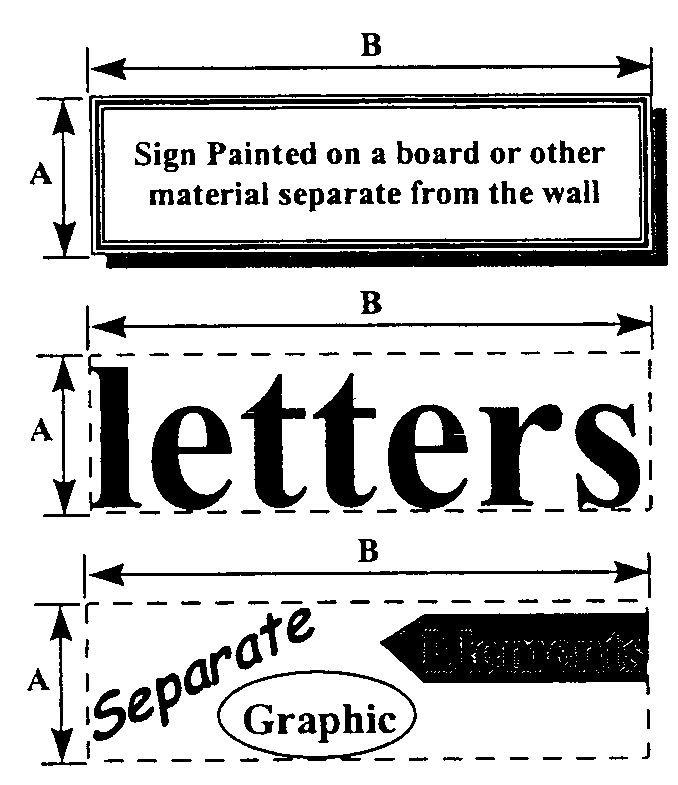
B.
Sign area. Shall be measured by height (A) by length (B) of the smallest rectangle that can be drawn to measure all sign elements. Unless otherwise noted, only one side or face of the same sign shall be used in computing sign area.
C.
Allowed signs. The applicant may select one of the following five choices for a sign type per street frontage:
1.
Wall sign.
a)
Maximum size: 25 square feet or 15 percent of the front wall area, whichever is greater.
2.
Window sign.
a)
Maximum size: 30 percent of the window area.
3.
Projecting sign.
a)
Maximum size: Six square feet for one side.
b)
Clearance: Eight feet above ground level.
4.
Awning sign.
a)
Maximum size: Individual letters shall not exceed ten inches in height.
b)
Signs, symbols, or designs may be painted or sewn on to any awning.
5.
Freestanding business sign.
a)
Monument signs are prohibited along North Main Street and South Main Street.
b)
Maximum size: 25 square feet per sign face.
c)
Maximum height: Five feet from finished grade.
D.
Secondary signs. The following signs shall be permitted in conjunction with the allowed sign:
1.
Window or projecting sign no larger than 12 inches by 18 inches bearing business identification in addition to a wall or awning sign.
2.
One sign per business occupying the upper floors of a building no larger than 12 inches by 18 inches.
E.
Prohibited signs. Refer to the definitions in chapter two of this ordinance for description of these types of signs.
1.
Moving signs of any type other than barber poles.
2.
Internally illuminated other than non-flashing neon.
3.
Signs projecting above the roofline.
4.
Roof signs.
5.
Freestanding business signs on North Main Street or South Main Street.
6.
Any advertising signs.
7.
Any sign not listed as being allowed is prohibited.
(Ord. No. 2014-006, § 2, 10-7-2014; Ord. No. 2019-01, § 4(Exh. A), 4-2-2019; Ord. No. 2022-01, § 2, 7-5-2022)
Sec. 4.3. - Traditional Neighborhood Residential District (TNR).
4.3.1.
Intent. The Traditional Neighborhood Residential District (TNR) is a predominately single-family residential area. Other uses such as multifamily dwellings, small offices and businesses are allowed in the district as long as they do not detract from the character of the small scale residential uses. Additional standards are placed on these uses to mitigate their impact on single-family uses. Small offices and businesses are appropriate in this district as long as the use respects the integrity of the residential nature of the neighborhood and offers services needed to the residents. Government buildings, schools, and parks are also appropriate uses for the Traditional Neighborhood Residential District. Standards for all uses in the district are designed to protect the health, safety, and welfare of the citizens of Saluda.
4.3.2.
General.
4.3.3.
Uses.
A.
Permitted uses. The following uses are permitted in the TNR district provided that all specified standards are met.
1.
Single-family residential building:
a)
One housing unit per lot permitted.
2.
Small multifamily residential building(s).
a)
Up to four multifamily units per lot permitted, provided that lot size meets the minimum lot area/unit listed in the general requirements.
b)
Landscaping the front setback:
(1)
One large maturing tree per housing unit shall be planted within the required front setback. The trees shall be a minimum of three inches in caliper at planting.
(2)
Two shrubs per housing unit shall be planted within the required front setback.
3.
Small office or commercial building(s).
a)
Office and commercial uses cannot occupy more than 2,000 square feet gross floor area exclusive of any residential living quarters.
b)
Office and commercial uses shall be limited to the ground floor of the structure. Residential uses above the office or commercial use is encouraged.
c)
Design of new construction shall be consistent with the residential nature of the area.
d)
Setbacks shall be consistent with neighboring property.
e)
Use list.
(1)
Neighborhood retail shop or boutique;
(2)
Professional office;
(3)
Neighborhood service;
(4)
Café or eatery establishment;
(5)
Day care center.
f)
Sign. One sign permitted provided it is non-illuminating, no larger than 12 inches by 18 inches and mounted against a wall of the principal building. Signs for apartment buildings and/or neighborhood services may be one freestanding business sign measuring 36 inches by 55 inches and one sign attached to the building measuring 12 inches by 18 inches.
g)
Landscaping the front setback.
(1)
One large maturing tree per 30 feet of street frontage shall be planted within the required front setback. The trees shall be a minimum of three inches in caliper at planting.
(2)
Two shrubs per 30 feet of street frontage shall be planted within the required front setback.
4.
Civic building(s).
a)
Use list.
(1)
School;
(2)
Church;
(3)
Park/playground;
(4)
Community center as defined in chapter 2 of this ordinance;
(5)
Governmental services building.
b)
Landscaping the front setback.
(1)
One large maturing tree per 30 feet of street frontage shall be planted within the required front setback. The trees shall be a minimum of three inches in caliper at planting.
(2)
Two shrubs per 30 feet of street frontage shall be planted within the required front setback.
B.
Prohibited uses. The following uses shall be prohibited in the TNR district:
1.
Bars or taverns;
2.
Private clubs;
3.
Service or gas station;
4.
Outdoor storage;
5.
Outdoor business;
6.
Drive-through restaurant;
7.
Dry cleaning establishment;
8.
Sexually oriented businesses;
9.
Telecommunications tower;
10.
Mobile/manufactured homes (except as a conditional use as provided in subsection 4.3.3 C);
11.
Any use not listed as being permitted is prohibited.
12.
Firework sales.
C.
Conditional use: The following use shall be permitted in the TNR district as a conditional use provided that all of the following standards are met:
1.
Manufactured homes.
a.
Manufactured homes shall be allowed only as replacements for standard construction homes that, after town inspection, were determined by the Town to be subject to condemnation and subsequently were demolished.
b.
Manufactured homes shall be limited to single family residential use and one home per parcel.
c.
Homes must be new as of the current year or previous year with certificate of origin showing no previous occupancy.
d.
Lots must be cleared and graded and all debris must be removed prior to installation of the home.
e.
Homes must be placed on a brick or block foundation with tongues removed.
f.
Property must be in compliance with the town's property maintenance codes.
g.
Property must be owner occupied.
h.
Homes must be adjacent to a parcel with a lawful existing manufactured home park.
i.
All other requirements of subsection 4.6.8 (2)(c) for mobile or manufactured home(s) shall be met.
j.
All other requirements of subsection 4.3 shall be met.
4.3.4.
Parking.
A.
General. The following parking requirements shall apply within the TNR district.
1.
Office: Three parking spaces per 1,000 square feet.
2.
Retail/restaurants: Five parking spaces per 1,000 square feet.
3.
Residential: Two parking spaces per dwelling unit.
B.
Parking. Parking for nonresidential uses shall be located to the side and rear of the building. This requirement may be waived by the zoning administrator where the use and situation requires parking to be placed to the front of the building, provided that this shall not adversely affect residential nature of the neighborhood.
C.
Landscape buffers. (For nonresidential uses.)
1.
Required landscaping area. At least five feet in depth shall be located between the abutting property lines and the parking, loading, or other vehicular use area, except where permitted driveway openings are to be provided.
2.
Required landscaping materials.
a)
One tree shall be planted for each 50 linear feet of the landscaping area and one small maturing tree or shrub of at least three feet in height shall be planted every ten linear feet within the landscape.
3.
Other requirements.
a)
All portions of the landscaping area not planted with shrubs and trees shall be planted in grass and/or with some other vegetative ground cover; and
b)
Parked vehicles may overhang a landscaped area no more than one foot, provided curbing or other wheel stops are installed to ensure no greater overhang or penetration of the landscaped islands. Landscaping, walls, fences, and earthberms shall be located as to prevent their damage and/or destruction by overhanging vehicles.
4.3.5.
Tree protection.
A.
Refer to chapter 3, section 3.12, tree protection, for general tree protection requirements.
B.
Grand trees. The destruction of any grand tree (24 inches or greater DBH) is prohibited on any parcel of non-exempt land, unless a permit is granted certifying that removal is in compliance with section 3.12.
C.
Protected trees. The destruction of any protected tree (eight inches or greater DBH) is prohibited on any parcel of non-exempt land, unless a permit is granted certifying that removal is in compliance with section 3.12.
(Ord. No. 2014-006, § 3, 10-7-2014; Ord. No. 2016-04, §§ 1, 2, 8-8-2016; Ord. No. 2019-01, § 5(Exh. A), 4-2-2019; Ord. No. 2022-01, § 3, 7-5-2022)
Sec. 4.4. - Residential District (R10).
4.4.1.
Intent. The R10 District is a single-family residential area. Government buildings, schools, and parks are also appropriate uses for the R10 District. Standards for all uses in the district are designed to protect the health, safety, and welfare of the citizens of the town.
4.4.2.
General.
4.4.3.
Uses.
A.
Permitted uses. The following uses are permitted in the RIO district provided that all specified standards are met.
1.
Single-family residential building: One housing unit per lot permitted.
2.
Civic building(s).
a)
Use list.
(1)
School;
(2)
Church;
(3)
Park/playground;
(4)
Community center as defined in chapter 2 of this ordinance.
b)
Landscaping the front setback. One large maturing tree per 30 full feet of street frontage shall be planted within the required front setback. The trees shall be a minimum of three inches in caliper at planting. Maintenance of trees will be the responsibility of the landowner
B.
Prohibited uses. The following uses shall be prohibited in the R10 district.
1.
Bars or taverns;
2.
Private clubs;
3.
Service or gas station;
4.
Outdoor storage;
5.
Outdoor business;
6.
Drive-through restaurant;
7.
Dry cleaning establishment;
8.
Sexually oriented businesses;
9.
Telecommunications towers;
10.
Manufactured or mobile homes;
11.
Eleemosynary institution that provides on-site assistance and services;
12.
Any use not listed as being permitted is also prohibited;
13.
Fireworks sales.
4.4.4.
Parking.
A.
General. The following parking requirements shall apply within the R10 district:
1.
Residential: Two parking spaces per dwelling unit.
(Ord. No. 2022-01, § 4, 7-5-2022)
Sec. 4.5. - Highway Commercial District (HC).
4.5.1.
Intent. Businesses in this district, due to the heavy auto traffic along the highways, will be primarily auto dependent businesses. This district represents the first impression, and often the only impression, that visitors to Saluda are exposed to. Because of this, the intent of these provisions is to create a corridor that represents the town and its local character. In addition, these provisions are intended to facilitate convenient access, minimize traffic congestion, and reduce visual clutter along the highways.
4.5.2.
General.
A.
Minimum lot size: 35,000 square feet.
B.
Maximum lot coverage. Building footprint shall not exceed 50 percent of the lot coverage.
C.
Minimum street frontage: 100 feet.
D.
Maximum height: 35 feet.
E.
Setbacks.
1.
Front: 20 feet min.
2.
Side: 10 feet min.
3.
Rear: 20 feet min.
F.
Entranceways, awnings, and porches. Permitted to encroach a maximum of six feet into front setbacks. Corner lots may encroach up to six feet on both the front and street-side setback.
G.
Trash containers. Located in the parking area and screened from the right-of-way.
H.
Mechanical equipment at ground level. Should be placed on the parking lot side of building, away from buildings on adjacent sites, and screened from view of public streets and residential uses.
I.
Main pedestrian access. Main pedestrian access to the building may be from the sides of the building. At least a secondary access shall be from the street frontage.
4.5.3.
Uses.
A.
Permitted uses. The following uses shall be permitted in the HC district.
1.
General retail.
2.
General commercial.
3.
Personal services.
4.
Business services.
5.
Office.
6.
Entertainment uses (i.e. theaters, drive-in theaters, mini golf).
7.
Civic uses.
8.
Fireworks sales, provided such use must be located at least 500 feet from the property line of a service station or church use, measured to the footprint of the actual building used for fireworks sales.
B.
Prohibited uses. The following uses shall be prohibited in the HC district.
1.
Residential uses.
2.
Mobile homes.
3.
Sexually oriented businesses.
C.
Accessory uses. The following uses shall be permitted in the HC district as an accessory to the primary use.
1.
Outdoor storage provided it does not front on any street and is completely screened from any street.
2.
Outdoor sales.
4.5.4.
Parking.
A.
General requirements. See general parking requirements in chapter 3, section 3.13.
B.
Whenever possible, parking areas on adjacent lots shall be connected.
4.5.5.
Landscaping.
A.
General requirements.
1.
Additions, expansions, or changes which increase a business by 40 percent of the gross floor area shall be in compliance with the landscaping requirements.
2.
If more than one landscaping/buffering requirement overlaps, the more stringent regulation shall be applied.
3.
See landscaping requirements in chapter 3, section 3.10, landscaping.
B.
Street trees.
1.
Street tree requirements apply only to lot frontage on US Highways 178 and 378 or SC Highways 121 and 39.
2.
One large maturing tree every 30 feet. (Pick one or a few species to choose from for consistency.)
3.
Required trees shall be planted a minimum distance of five feet and a maximum distance of ten feet from the right-of-way or property boundary within the required front setback.
4.
Tree size at planting: Three inches in caliper minimum.
C.
Requirements for parking areas.
1.
Peripheral.
a)
Required landscaping area. At least five feet in depth shall be located between the abutting property lines and the parking, loading, or other vehicular use area, except where permitted driveway openings are to be provided.
b)
Required landscaping materials. Choose one:
(1)
One large maturing tree shall be planted for each 50 linear feet of the landscaping area and one small maturing tree or shrub of at least three feet in height shall be planted every ten linear feet within the landscape; or
(2)
A combination of trees, hedge, other durable landscape material or approved wall, fence or earthberm may be utilized to form the continuous landscape element of at least three feet in height.
c)
Other requirements.
(1)
All portions of the landscaping area not planted with shrubs and trees or covered by a wall or fence barrier shall be planted in grass and/or with some other vegetative ground cover; and
(2)
Parked vehicles may overhang a landscaped area no more than 2½ feet, provided curbing or other wheel stops are installed to ensure no greater overhang or penetration of the landscaped islands. Landscaping, walls, fences, and earthberms shall be located as to prevent their damage and/or destruction by overhanging vehicles.
2.
Interior.
a)
Required landscaping area. Five percent of the interior of any parking, loading, or other vehicular use area shall be landscaped. The location of such landscaping is at the option of the owner or developer, provided, however, the following standards shall apply:
(1)
Landscape island. Shall be at least nine feet in width and 18 feet in length. Each island shall contain one large maturing tree plus shrubs and/or vegetative ground cover to cover the entire area.
(a)
No more than ten parking spaces shall be permitted in a continuous row without being interrupted by a landscaped island.
(b)
Each parking row shall terminate in a landscape island.
(2)
Median strip. Shall be at least ten feet in width.
(a)
Every fourth row of parking shall be separated by a median strip for landscaping and pedestrian purposes.
(b)
Every median strip shall contain plantings of one large maturing tree at intervals of 30 to 40 feet, plus shrubs and/or vegetative ground cover to cover the entire area.
b)
Other requirements.
(1)
All portions of the landscaping area not planted with trees shall be planted in grass and/or with some other vegetative ground cover; and
(2)
Parked vehicles may overhang a landscaped area no more than 2½ feet, provided curbing or other wheel stops and installed to ensure no greater overhang or penetration of the landscaped islands. Landscaping, walls, fences, and earthberms shall be located as to prevent their damage and/or destruction by overhanging vehicles.
D.
Requirements for front setback.
1.
Required landscaping area.
a)
Minimum depth: ten feet.
2.
Required landscaping materials.
a)
All portions of the landscaping area not planted with shrubs and trees or covered by a wall or fence barrier shall be planted in grass and/or with some other vegetative ground cover.
b)
One small maturing tree for every 100 square feet. (Street trees or large maturing trees may be counted towards this requirement.)
c)
Street trees, where required, shall be included as part of the required planting.
d)
Six shrubs every 500 square feet.
e)
Approved ground cover.
E.
Requirements for boundaries adjacent to the traditional neighborhood Residential Zoning District and existing residential uses in the Highway Commercial District.
1.
Required buffer area.
a)
Minimum width: 20 feet.
2.
Required buffering materials.
a)
Buffering materials shall provide an opaque buffer to create a strong impression of a spatial separation and to preclude visual contact.
b)
Seven trees for every 100 linear feet.
c)
50 shrubs per 100 linear feet.
d)
All portions of the landscaping area not planted with shrubs and trees or covered by a wall or fence barrier shall be planted in grass and/or with some other vegetative ground cover.
3.
Alternative 1. Buffering requirements reduced by 25 percent (five feet).
a)
Minimum width may be reduced by 25 percent or five feet with use of a landscaped earthberm.
b)
Berms shall be constructed within the property boundary meeting the following requirements:
(1)
Minimum height: Two feet.
(2)
Minimum crown width: Two feet.
(3)
Minimum slope: 2:1.
4.
Alternative 2. Buffering requirements reduced by 50 percent (10 feet).
a)
Minimum width may be reduced by 50 percent or ten feet and required number of shrubs reduced to 30 shrubs per 100 linear feet with use of landscaped wall or fence.
b)
Wall shall be solid and meet the standards for walls and fences set forth in section 3.3.
c)
Maximum wall height: six feet.
d)
Shrubs shall reach one-third of the height of the wall within three years.
5.
Alternative 3. Buffering requirements reduced by 60 percent (12 feet).
a)
Minimum width may be reduced by 50 percent or 12 feet and required number of shrubs reduced to 30 shrubs per 100 linear feet with use of landscaped wall or fence, and a planted earthberm.
b)
Berms shall be constructed within the property boundaries meeting the following requirements:
(1)
Minimum height: Two feet.
(2)
Minimum crown width: Two feet.
(3)
Minimum slope: 2:1.
c)
Wall shall be solid and meet the standards for walls and fences set forth in section 3.3.
d)
Maximum wall height: Six feet.
e)
Shrubs shall reach one-third of the height of the wall within three years.
4.5.6.
Tree protection.
A.
Refer to chapter 3, section 3.12, tree protection, for general tree protection requirements.
B.
Grand trees. The destruction of any grand tree (24 inches or greater DBH) is prohibited on any parcel of non-exempt land, unless a permit is granted certifying that removal is in compliance with section 3.12.
C.
Protected trees. The destruction of any protected tree (eight inches or greater DBH) is prohibited on any parcel of non-exempt land, unless a permit is granted certifying that removal is in compliance with section 3.12.
4.5.7.
Signage.
A.
Intent. The purpose of these sign regulations are: to encourage the effective use of signs as a means of communication; to maintain and enhance the aesthetic environment; and to increase the town's ability to attract sources of economic development and growth; to improve pedestrian and traffic safety; to minimize the possible adverse effect of signs on nearby public and private property; and to enable the fair and consistent enforcement of these sign regulations.
B.
Refer to section 3.10, signage, for general sign requirements.
C.
No sign, or part thereof, may be altered, constructed, changed, converted, enlarged, or moved unless in conformity with the following requirements.
D.
Sign area. Shall be measured by height (A) by length (B) of the smallest rectangle that can be drawn to measure all sign elements. Unless otherwise noted, only one side or face of the same sign shall be used in computing sign area.
E.
Allowed signs. The applicant may select two of the following six choices for a sign type per street frontage:
1.
Wall sign.
a)
Maximum size: One square foot per lineal foot of the building wall on which the sign is to be placed.
2.
Window sign. Maximum size: 20 percent of the window area.
3.
Projecting sign.
a)
Maximum size: 16 square feet for one side.
b)
Maximum height: No projecting sign shall extend above the roofline.
c)
Clearance: Eight feet above ground level.
4.
Awning sign.
a)
Maximum size: 15 percent of exterior surface of the awning.
b)
Signs, symbols, or designs may be painted or sewn onto the awning.
5.
Freestanding business sign.
a)
Maximum Size: 200 square feet.
b)
Maximum Height: 35 feet.
c)
Setback: No freestanding business sign shall be closer than five feet to an exterior property line.
d)
No more than two freestanding business signs shall be allowed per parcel, one per state road.
6.
Directory sign.
a)
The parcel shall contain no more than one directory sign.
b)
The maximum sign area shall not exceed three inches by 15 inches for each identified activity, business, firm, or tenant.
c)
The directory sign may take the form of any sign permitted in the zoning district provided that such sign shall comply with its applicable specification. If the directory sign is a freestanding business sign, no other freestanding business sign shall be located on the parcel.
F.
Prohibited signs.
1.
Moving signs of any type.
2.
Signs projecting above the roofline.
3.
Any sign not listed as being allowed is prohibited.
G.
Criteria for bonus sign area. To encourage design excellence, the maximum sign areas for the Highway Commercial District may be increased by the percentages as provided herein. A separate bonus is granted for compliance with each of the criteria and the area is cumulative, but the percentage increase is based on the original sign area limitation.
1.
Wall sign which consists of individual letters or words mounted directly on the building surface: 15 percent increase permitted.
2.
Coordinated signs in shopping centers or any three consecutive separate establishments, all the lettering and background is uniform in style and color: ten percent increase permitted.
3.
Gas stations that incorporate the price information into the main identification sign face: ten percent increase permitted.
4.
Sign is not internally illuminated (other than non-flashing neon): 15 percent increase permitted.
5.
Ground sign is installed in a landscaped planted having an area four times the area of the resultant sign for one sign face: 20 percent increase permitted.
(Ord. No. 2014-006, §§ 4—6, 10-7-2014; Ord. No. 2019-01, § 6(Exh. A), 4-2-2019; Ord. No. 2022-01, § 5, 7-5-2022)
Sec. 4.6. - Light Industrial/Office District (LIO).
4.6.1.
Intent. The purpose of the light industrial and office district is to accommodate a mix of similar and compatible light industrial uses, industrial-related business uses, and related commercial uses. The LIO district shall have limited traffic and aesthetic impacts on surrounding properties, supporting public facilities, and utilities. The LIO district is intended to generate development through the use of creative design which will enhance the character of the surrounding area.
4.6.2.
General.
A.
Minimum lot size: 35,000 square feet.
B.
Maximum lot coverage. Building footprint shall not exceed 50 percent of the lot coverage.
C.
Maximum height: 35 feet.
D.
Setbacks.
1.
Front: 20 feet minimum.
2.
Side: Ten feet minimum.
3.
Rear: 20 feet minimum.
E.
Maximum percent impervious service: 80 percent.
F.
Trash containers shall be located in the parking area and shall be screened from the right-of-way.
G.
Mechanical equipment at ground level should be placed on the parking lot side of building, away from buildings on adjacent sites, and screened from view of public streets and residential uses.
4.6.3.
Uses.
A.
Permitted uses. The following uses shall be permitted in the LIO district:
1.
Wholesale business.
2.
General commercial.
3.
Business services.
4.
Personal services.
5.
Office.
6.
Manufacturing services.
7.
Mobile/manufactured housing parks.
8.
Public utility or communication tower, setback a minimum of one foot for each one foot in height.
9.
Fireworks sales, provided such use must be located at least 500 feet from the property line of a service station or church use, measured to the footprint of the actual building used for fireworks sales.
B.
Accessory uses. The following uses shall be permitted in the LIO district as an accessory to the primary use. These uses shall meet minimum setbacks.
1.
Outdoor storage provided it does not front on any street and is completely screened from any street.
2.
Outdoor sales.
4.6.4.
Parking.
A.
General requirements. See general parking requirements in chapter 3, section 3.13.
B.
Required parking spaces for commercial and industrial uses.
C.
Required loading spaces. One space for every 30,000 square feet of floor area, or a portion thereof with a maximum of two spaces.
4.6.5.
Landscaping.
A.
General requirements.
1.
Additions, expansions, or changes which increase a business by 40 percent of the gross floor area shall be in compliance with the landscaping requirements.
2.
If more than one landscaping/buffering requirement overlaps, the more stringent regulation shall be applied.
3.
See landscaping requirements in chapter 3, section 3.11, landscaping.
B.
Requirements for parking areas associated with commercial and industrial uses.
1.
Peripheral.
a.
Required landscaping area. At least five feet in depth shall be located between the abutting property lines and the parking, loading, or other vehicular use area, except where permitted driveway openings area to be provided.
b.
Required landscaping materials. Choose one:
1.
One large maturing tree shall be planted for each 50 linear feet of the landscaping area and one small maturing tree or shrub of at least three feet in height shall be planted every ten linear feet within the landscape; or
2.
A combination of trees, hedge, other durable landscape material or approved wall, fence or earthberm may be utilized to form the continuous landscape element of at least three feet in height.
c.
Other requirements.
1.
All portions of the landscaping area not planted with shrubs and trees or covered by a wall or fence barrier shall be planted in grass and/or with some other vegetative ground cover; and
2.
Parked vehicles may overhang a landscaped area no more than 2½ feet, provided curbing or other wheel stops are installed to ensure no greater overhang or penetration of the landscaped islands. Landscaping, walls, fences, and earthberms shall be located as to prevent their damage and/or destruction by overhanging vehicles.
2.
Interior.
a.
Required landscaping area: Five percent of the interior of any parking, loading, or other vehicular use area shall be landscaped. The location of such landscaping is at the option of the owner or developer; provided, however, the following standards shall apply:
1.
Landscape island. Shall be at least nine feet in width and 18 feet in length. Each island shall contain one large maturing tree plus shrubs and/or vegetative ground cover to cover the entire area.
a)
No more than ten parking spaces shall be permitted in a continuous row without being interrupted by a landscaped island.
b)
Each parking row shall terminate in a landscaped island.
2.
Median strip. Shall be at least ten feet in width.
a)
Every fourth row of parking shall be separated by a median strip for landscaping and pedestrian purposes.
b)
Every median strip shall contain plantings of one large maturing tree at intervals of 30 to 40 feet, plus shrubs and/or vegetative ground cover to cover the entire area.
b.
Other requirements.
1.
All portions of the landscaping area not planted with trees shall be planted in grass and/or with some other vegetative ground cover; and
2.
Parked vehicles may overhang a landscaped area no more than 2½ feet, provided curbing or other wheel stops and installed to insure no greater overhang or penetration of the landscaped islands. Landscaping, walls, fences, and earthberms shall be located as to prevent their damage and/or destruction by overhanging vehicles.
C.
Requirements for front setback.
1.
Required landscaping area.
a)
Minimum depth: Ten feet.
2.
Required landscaping materials.
a.
All portions of the landscaping area not planted with shrubs and trees or covered by a wall or fence barrier shall be planted in grass and/or with some other vegetative ground cover.
b.
One small maturing tree for every 100 square feet (large maturing trees may be counted towards this requirement).
c.
Six shrubs every 500 square feet.
d.
Approved ground cover.
D.
Requirements for boundaries adjacent to the Traditional Neighborhood Residential Zoning District and existing residential uses in the Light Industrial Office District.
1.
Required buffer area.
a.
Minimum depth: 20 feet.
2.
Required buffering materials.
a.
Buffering materials shall provide an opaque buffer to create a strong impression of a spatial separation and to preclude visual contact.
b.
Seven trees for every 100 linear feet.
c.
50 shrubs per 100 linear feet.
d.
All portions of the landscaping area not planted with shrubs and trees or covered by a wall or fence barrier shall be planted in grass and/or with some other vegetative ground cover.
3.
Alternative 1. Buffering requirements reduced by 25 percent (five feet).
a.
Minimum width may be reduced by 25 percent or five feet with use of a landscaped earthberm.
b.
Berms shall be constructed within the property boundary meeting the following requirements:
1.
Minimum height: Two feet.
2.
Minimum crown width: Two feet.
3.
Minimum slope: 2:1.
4.
Alternative 2. Buffering requirements reduced by 50 percent (ten feet).
a.
Minimum width may be reduced by 50 percent or ten feet and required number of shrubs reduced to 30 shrubs per 100 linear feet with use of landscaped wall or fence.
b.
Wall shall be solid and meet the standards for walls and fences set forth in section 3.3.
c.
Maximum wall height: six feet.
d.
Shrubs shall reach one-third of the height of the wall within three years.
5.
Alternative 3. Buffering requirements reduced by 60 percent (12 feet).
a.
Minimum width may be reduced by 50 percent or 12 feet and required number of shrubs reduced to 30 shrubs per 100 linear feet with use of landscaped wall or fence, and a planted earthberm.
b.
Berms shall be constructed within the property boundaries meeting the following requirements:
1.
Minimum height: Two feet.
2.
Minimum crown width: Two feet.
3.
Minimum slope: 2:1.
c.
Wall shall be solid and meet the standards for walls and fences set forth in section 3.3.
d.
Maximum wall height: Six feet.
e.
Shrubs shall reach one-third of the height of the wall within three years.
4.6.6.
Tree protection.
A.
Refer to chapter 3, section 3.12, tree protection, for general tree protection requirements.
B.
Grand trees. The destruction of any grand tree (24 inches or greater DBH) is prohibited on any parcel of nonexempt land, unless a permit is granted certifying that removal is in compliance with section 3.12.
C.
Protected trees. The destruction of any protected tree (eight inches or greater DBH) is prohibited on any parcel of non-exempt land, unless a permit is granted certifying that removal is in compliance with section 3.12.
4.6.7.
Signage.
A.
Intent. The purpose of these sign regulations are: To encourage the effective use of signs as a means of communication; to maintain and enhance the aesthetic environment; and to increase the town's ability to attract sources of economic development and growth; to improve pedestrian and traffic safety; to minimize the possible adverse effect of signs on nearby public and private property; and to enable the fair and consistent enforcement of these sign regulations.
B.
Refer to section 3.10, signage, for general sign requirements.
C.
No sign, or part thereof, may be altered, constructed, changed, converted, enlarged, or moved unless in conformity with the following requirements.
D.
Sign area. Shall be measures by height (A) by length (B) of the smallest rectangle that can be drawn to measure all sign elements. Unless otherwise noted, only one side or face of the same sign shall be used in computing sign area.
E.
Allowed signs. The applicant may select two of the following six choices for a sign type per street frontage:
1.
Wall sign.
a)
Maximum size: One square foot per lineal foot of the building wall on which the sign is to be placed.
2.
Window sign.
a)
Maximum size: 20 percent of the window area.
3.
Projecting sign.
a)
Maximum Size: 16 square feet for one side.
b)
Maximum Height: No projecting sign shall extend above the roofline.
c)
Clearance: Eight feet above ground level.
4.
Awning sign.
a)
Maximum size: 15 percent of exterior surface of the awning.
b)
Signs, symbols, or designs may be painted or sewn onto the awning.
5.
Freestanding business sign.
a)
Maximum size: 35 square feet.
b)
Maximum height: 12 feet.
c)
Setback: No freestanding business sign shall be closer than five feet to an exterior property line.
d)
No more than one freestanding business sign shall be allowed per parcel.
6.
Directory sign.
a)
The parcel shall contain no more than one directory sign.
b)
The maximum sign area shall not exceed three inches by 15 inches for each identified activity, business, firm, or tenant.
c)
The directory sign may take the form of any sign permitted in the zoning district provided that such sign shall comply with its applicable specification. If the directory sign is a freestanding business sign, no other freestanding business sign shall be located on the parcel.
F.
Prohibited signs.
1.
Moving signs of any type.
2.
Signs projecting above the roofline.
3.
Any sign not listed as being allowed is prohibited.
4.6.8.
Conditional uses. The following uses shall be permitted in the LIO district as a conditional use provided that the standards provided are met:
1.
Sexually oriented businesses.
a)
Findings of fact.
(1)
Although there are no known sexually oriented businesses currently operating in Saluda, it is possible, and probable, that at some point one or more would desire to locate in Saluda and it is in the interests of the health, safety, and welfare of the patrons of such businesses, as well as the citizens of Saluda, to provide certain minimum standards and regulations for sexually oriented businesses, as well as the operators and employees of such businesses.
(2)
Sexually oriented businesses generate secondary effects which are detrimental to the public health, safety, and welfare. Additionally, sexually oriented businesses are frequently used for unlawful sexual activities, including public sexual indecency, prostitution, and sexual encounters of a casual nature. Such businesses are of particular concern to the community when they are located in close proximity to each other, or close to schools, churches or parks and playgrounds.
(3)
The concern over sexually transmitted diseases is a legitimate health concern of Saluda which demands reasonable regulation of these businesses in order to protect the health and well-being of our citizens.
(4)
The location of sexually oriented businesses close to residential areas diminishes property values and leads to conditions that give rise to crime in residential neighborhoods. Many studies performed in other communities indicate conclusively that property crimes and sexual crimes increase significantly in neighborhoods in which such a business is located.
(5)
It is not the intent of this section to suppress any speech activities protected by the First Amendment or to place any impermissible burden on any constitutionally protected expression or expressive conduct by the enactment or enforcement of the ordinance. Rather, it is the intent of the town council to enact a content neutral regulation which addresses the secondary effects of sexually oriented businesses.
(6)
All state laws regulating this type of business apply.
b)
Signage.
(1)
Freestanding business signs are prohibited except for one freestanding business sign showing the word "Entrance" to the parking lot, and one freestanding business sign showing the word "Exit" from the parking lot. Each freestanding business sign can be no larger than 12 inches by 18 inches and shall have no other word or decoration than the specific words described here.
(2)
Business shall not display a sign or advertising visible from public streets or sidewalks, or outside the premises that is photographic, pictorial, or illustrative.
c)
Required buffers between residential areas or residentially zoned areas and business.
(1)
Required buffer area.
(a)
Minimum width: 20 feet.
(2)
Required buffering materials.
(a)
Buffering materials shall provide an opaque buffer to create a strong impression of a spatial separation and to preclude visual contact.
(i)
Seven trees for every 100 linear feet.
(ii)
50 shrubs per 100 linear feet.
(iii)
All portions of the landscaping area not planted with shrubs and trees or covered by a wall or fence barrier shall be planted in grass and/or with some other vegetative ground cover.
(3)
Berms shall be constructed within the property boundaries meeting the following requirements:
(a)
Minimum height: Two feet.
(b)
Minimum crown width: Two feet.
(c)
Minimum slope: 2:1.
(4)
Solid walls shall be constructed and meet the standards for walls and fences set forth in section 3.3.
(a)
Maximum wall height: Six feet.
(b)
Shrubs shall reach one-third of the height of the wall within three years.
(5)
No free access shall be permitted between adjacent residential area and the parcel.
2.
Mobile or manufactured home(s).
a)
Manufactured homes and mobile homes shall be limited to residential use.
b)
Mobile or manufactured homes five years old or more are not allowed to be moved into the town or moved from one location to another within the town limits.
c)
Only one manufactured home is permitted per parcel provided that it meets the following standards:
(1)
A manufactured home must bear a seal certifying that it was built to HUD standards for mobile homes, adopted on June 15, 1976.
(2)
Exterior siding. Wood, hardboard, vinyl, brick, or aluminum and shall be comparable in composition, appearance, and durability to the exterior siding commonly used in standard residential construction.
(3)
Roofing material. Type of shingle or roofing material that is commonly used in standard residential construction.
(4)
Minimum roof pitch. Four feet by 12 feet roof pitch, or the standard of each manufacturer's equivalent to a Four feet by 12 feet roof pitch.
(5)
Skirting. Continuous permanent brick foundation or curtain wall, continuous except for ventilation and access, shall be installed upon a poured concrete footing after placement on the lot, and before occupancy.
(6)
The tongue, axles, transporting lights, and removable towing apparatus must be removed after placement on the lot and before occupancy.
(7)
Stairs, porches, entrance platforms, ramps and other means of entrance and exit to and from the home shall be installed or constructed in a manner commonly used in standard residential construction and attached firmly to the primary structure and anchored securely to the ground. Porches at least three feet by three feet shall be constructed at both the front and back entrances with appropriate handrail.
(8)
Suitable tie-down or anchoring devices shall be installed.
(9)
Follow appropriate town building codes and standards.
(10)
Have separate water and wastewater taps and may not share water and wastewater taps with any other dwelling or structure.
4.6.9.
Nonconforming manufactured homes. Such homes vacated or abandoned for a period of six months or more or nonconforming manufactured homes damaged by 50 percent or more shall be ordered to be removed from the property. Removal shall be completed within six months of the date of the removal order.
Nonconforming manufactured homes removed by the rule above may be replaced by a conforming manufactured home erected in compliance with the replacement provisions contained in this ordinance provided the replacement home is installed within six months of the issue date of the removal order.
4.6.10.
Conforming manufactured homes.
Replacement of conforming manufactured homes is allowed provided the replacement meets the requirements of this ordinance. The total number of manufactured homes may not exceed the number which existed prior to the effective date of this ordinance.
All used replacement homes shall be inspected prior to set-up for compliance with the International Property Maintenance Code. Any deficiencies must be corrected within 30 days of being placed on the property or the home shall be ordered to be removed.
A certificate of occupancy will only be issued to a manufactured home which is classified as a conforming use.
(Ord. No. 2014-006, § 7, 10-7-2014; Ord. No. 2019-01, §§ 7, 8(Exh. A), 4-2-2019; Ord. No. 2022-01, § 6, 7-5-2022)
Sec. 4.7. - Manufacturing District (M).
4.7.1.
Intent. The purpose of the manufacturing district is to accommodate manufacturing businesses within the town limits. The M district shall have limited traffic and aesthetic impacts on surrounding properties and on supporting public facilities and utilities. The M district is intended to generate development through the use of industrial parks and clustering.
4.7.2.
General.
A.
Minimum lot size: Five acres.
B.
Maximum height: 35 feet.
C.
Setbacks.
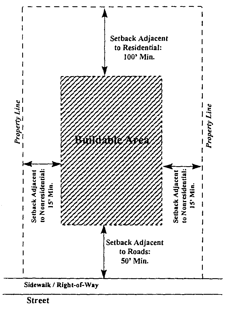
1.
Adjacent to roads. No building, outdoor storage, areas for collection of refuse, or loading area shall be permitted closer than 50 feet to the right-of-way of any road. No outdoor storage, areas for collection of refuse, or loading space shall be permitted in areas between buildings and streets where such uses are visible from the road.
2.
Adjacent to residential uses/districts. No buildings, outdoor storage, areas for collection of refuse, or loading area shall be permitted closer than 100 feet to any existing or zoned residential district. No parking shall be permitted closer than 50 feet to any such districts and uses.
3.
Adjacent to other nonresidential districts. Fifteen feet for minimum for buildings, parking, outdoor storage, and loading areas.
D.
Minimum distance between buildings: 30 feet.
E.
Maximum percent impervious service: 50 percent.
F.
Trash containers shall be located in the parking area and shall be screened from the right-of-way.
G.
Mechanical equipment at ground level should be placed on the parking lot side of building, away from buildings on adjacent sites, and screened from view of public streets and residential uses.
4.7.3.
Uses.
A.
Permitted uses. The following uses shall be permitted in the M district:
1.
Wholesale business.
2.
General commercial.
3.
Business services.
4.
Personal services.
5.
Office.
6.
Manufacturing services.
7.
Public utility or communication tower, setback a minimum of one foot for each one foot in height.
8.
Fireworks sales, provided such use must be located at least 500 feet from the property line of a service station or church use, measured to the footprint of the actual building used for fireworks sales.
B.
Prohibited uses. The following uses shall be prohibited in the M district:
1.
Residential uses.
2.
Manufactured/mobile homes.
C.
Accessory uses. The following uses shall be permitted in the M district as an accessory to the primary use:
1.
Outdoor storage provided it does not front on any street and is completely screened from any street.
2.
Outdoor sales.
4.7.4.
Parking.
A.
General requirements. See general parking requirements in chapter 3, section 3.13.
B.
Required parking spaces.
C.
Required loading spaces.
One space for every 30,000 square feet of floor area.
4.7.5.
Landscaping.
A.
General requirements.
1.
Additions, expansions, or changes which increase a business by 40 percent of the gross floor area shall be in compliance with the landscaping requirements.
2.
If more than one landscaping/buffering requirement overlaps, the more stringent regulation shall be applied.
3.
See landscaping requirements in chapter 3, section 3.11, landscaping.
B.
Requirements for parking areas.
1.
Peripheral.
a)
Required landscaping area. At least 15 feet in depth shall be located between the abutting property lines and the parking, loading, or other vehicular use area, except where permitted driveway openings area to be provided.
b)
Required landscaping materials. Choose one:
(1)
One large maturing tree shall be planted for each 50 linear feet of the landscaping area and one small maturing tree or shrub of at least three feet in height shall be planted every ten linear feet within the landscape; or
(2)
A combination of trees, hedge, other durable landscape material or approved wall, fence or earthberm may be utilized to form the continuous landscape element of at least three feet in height.
c)
Other requirements.
(1)
All portions of the landscaping area not planted with shrubs and trees or covered by a wall or fence barrier shall be planted in grass and/or with some other vegetative ground cover; and
(2)
Parked vehicles may overhang a landscaped area no more than 2½ feet, provided curbing or other wheel stops are installed to ensure no greater overhang or penetration of the landscaped islands. Landscaping, walls, fences, and earthberms shall be located as to prevent their damage and/or destruction by overhanging vehicles.
2.
Interior.
a)
Required landscaping area. Five percent of the interior of any parking, loading, or other vehicular use area shall be landscaped. The location of such landscaping is at the option of the owner or developer, provided, however, the following standards shall apply;
(1)
Landscape island. Shall be at least nine feet in width and 18 feet in length. Each island shall contain one large maturing tree plus shrubs and/or vegetative ground cover to cover the entire area.
(a)
No more than ten parking spaces shall be permitted in a continuous row without being interrupted by a landscaped island.
(b)
Each parking row shall terminate in a landscape island.
(2)
Median strip. Shall be at least ten feet in width.
(a)
Every fourth row of parking shall be separated by a median strip for landscaping and pedestrian purposes.
(b)
Every median strip shall contain plantings of one large maturing tree at intervals of 30 to 40 feet, plus shrubs and/or vegetative ground cover to cover the entire area.
b.
Other requirements.
(1)
All portions of the landscaping area not planted with trees shall be planted in grass and/or with some other vegetative ground cover; and
(2)
Parked vehicles may overhang a landscaped area no more than 2½ feet, provided curbing or other wheel stops and installed to ensure no greater overhang or penetration of the landscaped islands. Landscaping, walls, fences, and earthberms shall be located as to prevent their damage and/or destruction by overhanging vehicles.
C.
Requirements for front setback.
1.
Required landscaping area.
a)
Minimum depth: 50 feet.
2.
Required landscaping materials.
a)
All portions of the landscaping area not planted with shrubs and trees or covered by a wall or fence barrier shall be planted in grass and/or with some other vegetative ground cover.
b)
One small maturing tree for every 500 square feet (large maturing trees may be counted towards this requirement).
c)
Six shrubs every 1,000 square feet.
d)
Approved ground cover.
D.
Requirements for boundaries adjacent to the Traditional Neighborhood Residential Zoning District and existing residential uses in the Light Industrial Office District.
1.
Required buffer area.
a)
Minimum depth: 20 feet.
2.
Required buffering materials.
a)
One large maturing tree shall be planted for each 50 linear feet of the landscaping area and one small maturing tree or shrub of at least three feet in height shall be planted every ten linear feet within the landscape.
b)
All portions of the landscaping area not planted with shrubs and trees or covered by a wall or fence barrier shall be planted in grass and/or with some other vegetative ground cover.
4.7.6.
Tree protection.
A.
Refer to chapter 3, section 3.12, tree protection, for general tree protection requirements.
B.
Grand trees. The destruction of any grand tree (24 inches or greater DBH) is prohibited on any parcel of non-exempt land, unless a permit is granted certifying that removal is in compliance with section 3.12.
C.
Protected trees. The destruction of any protected tree (eight inches or greater DBH) is prohibited on any parcel of non-exempt land, unless a permit is granted certifying that removal is in compliance with section 3.12.
4.7.7.
Signage.
A.
Intent. The purpose of these sign regulations are: to encourage the effective use of signs as a means of communication; to maintain and enhance the aesthetic environment; and to increase the town's ability to attract sources of economic development and growth; to improve pedestrian and traffic safety; to minimize the possible adverse effect of signs on nearby public and private property; and to enable the fair and consistent enforcement of these sign regulations.
B.
Refer to section 3.10, signage, for general sign requirements.
C.
No sign, or part thereof, may be altered, constructed, changed, converted, enlarged, or moved unless in conformity with the following requirements.
D.
Sign area. Shall be measures by height (A) by length (B) of the smallest rectangle that can be drawn to measure all sign elements. Unless otherwise noted, only one side or face of the same sign shall be used in computing sign area.
E.
Allowed signs. The applicant may select two of the following six choices for a sign type per street frontage:
1.
Wall sign.
a)
Maximum size: one square foot per lineal foot of the building wall on which the sign is to be placed.
2.
Window sign.
a)
Maximum size: 20 percent of the window area.
3.
Projecting sign.
a)
Maximum size: 16 square feet for one side.
b)
Maximum height: No projecting sign shall extend above the roofline.
c)
Clearance: Eight feet above ground level.
4.
Awning sign.
a)
Maximum size: 15 percent of exterior surface of the awning.
b)
Signs, symbols, or designs may be painted or sewn onto the awning.
5.
Freestanding business sign.
a)
Maximum size: 45 square feet for one side.
b)
Maximum height: 3½ feet.
6.
Directory sign.
a)
The parcel shall contain no more than one directory sign.
b)
The maximum sign area shall not exceed three inches by 15 inches for each identified activity, business, firm, or tenant.
c)
The directory sign may take the form of any sign permitted in the zoning district provided that such sign shall comply with its applicable specification. If the directory sign is a freestanding business sign, no other freestanding business sign shall be located on the parcel.
F.
Prohibited signs.
1.
Moving signs of any type.
2.
Signs projecting above the roofline.
3.
Any sign not listed as being allowed is prohibited.
(Ord. No. 2014-006, § 8, 10-7-2014; Ord. No. 2019-01, § 9(Exh. A), 4-2-2019; Ord. No. 2022-01, § 7, 7-5-2022)
Sec. 4.8. - Planned Development District (PD).
4.8.1.
Intent. The intent of the Planned Development District is to encourage flexibility in the development of land in order to promote its most appropriate use; to improve the design, character, and quality of new development; to facilitate the provision of streets and utilities; and to preserve the natural and scenic features of open areas.
4.8.2.
General.
A.
Any area may apply to be zoned PD if one or more of the following conditions are met:
1.
Separate land uses, which would not otherwise be permitted to locate within the same zoning district, are proposed for development on one or more adjacent parcels.
2.
Exceptions or variations to the existing regulations are essential for the project in terms of site, design, or dimensional requirements.
B.
Minimum parcel size: 2.5 acres.
D.[C.]
Minimum lot depth: 200 feet.
E.[D.]
Minimum lot width: 100 feet.
D.[E.]
Lot shall adjoin or have direct access to at least one major street.
E.[F.]
The site shall be in one ownership, or if in several ownerships, the application for amendment to the zoning chapter shall be filed jointly by all of the owners.
4.8.3.
Uses.
A.
Permitted uses. The following uses or combination of uses shall be considered.
1.
Any use proposed by the developer and considered by the planning commission and town council as being compatible to other nearby uses within and beyond the district may be permitted in such district, upon approval by the planning commission and town council. A listing of permitted uses within a particular PD district shall be adopted as part of the regulations applying to that district. Thereafter, the uses permitted in the district shall be restricted to those listed, approved and adopted.
B.
Prohibited uses. The follow[ing] uses or combination of uses shall not be considered in the PD district:
1.
Sexually oriented businesses.
2.
Mobile or manufactured housing.
3.
Firework sales.
4.8.4.
Design criteria and development standards.
A.
Overall site design shall be harmonious in terms of landscaping, enclosure of principal and accessory uses, sizes of structures, street patterns, and use relationships. Variety in building types, heights, facades, setbacks, and size of open spaces shall be encouraged.
B.
Densities for residential dwelling units shall not exceed one unit per 2,500 square feet of land area including yard and other dimensional requirements.
C.
Bufferyards. As determined as needed by the planning commission and town council.
D.
Open space. As determined as needed by the planning commission and town council.
E.
All standards of the existing zoning district shall apply, if not specified otherwise in that particular PD district.
4.8.5.
Administrative procedures with regard to PD zoning districts.
A.
Zoning chapter amendment required. Any request pertaining to the establishment of a PD zoning district shall be considered an amendment tot he zoning chapter and shall be administered and processed in accordance with section 5.4. The request shall first be submitted to the planning commission for review, public hearing, and recommendation, then forwarded to town council for final action. If approved by the town council, all information pertaining to the proposal shall be adopted. Any proposed changes in the district shall be treated as amendments to the zoning chapter and must be considered accordingly.
B.
Time limitation. If the approved planned development project has not begun within two years of its approval date by town council, the planned development chapter shall become null and void and the land classification shall revert to its previous zoning classification.
4.8.6.
Submission materials required for development plan.
A.
Purpose and effect. An application for rezoning to a Planned Development district shall include a Development Plan incorporating the information required in subsection B of this section and such additional information as the applicant may deem necessary to provide a detailed understanding of the proposed planned development. Although it is unnecessary to become involved in the preparation of engineering drawings at this stage, the Development Plan must be sufficiently detailed to be judged for its superiority to other forms of development or other zoning districts. No development plan shall be required for rezoning to districts other than PD districts.
B.
Application contents. The following information and documentation together with such additional information as required by the commission shall constitute a complete rezoning application:
1.
The applicant's name and address and ownership interest in the subject property.
2.
The name and address, and signed written consent of those having an ownership interest, if different than the applicant filing the application.
3.
The tax map identification number.
4.
The present and proposed zoning classification and use of the subject property and adjacent land.
5.
A survey showing property boundary lines, metes and bounds, utility transmission lines and public rights-of-way crossing and adjacent to the subject property.
6.
A vicinity map.
7.
A written statement generally describing the proposed development's compliance with the comprehensive plan.
8.
One or more development plans at a scale approved by the zoning administrator depicting or describing the following features of the development:
a)
A land use plan map with a description of the type, location, and nature of land use (and building type) within each area of the development indicating the acreage and proposed density and lot requirements of each subarea.
b)
A proposed traffic circulation map which illustrates internal trafficways related to the development, existing and proposed access points, and through roads accessing adjacent parcels.
c)
A general description of the means of providing water service, sanitary sewerage, utilities, refuse collection, schools, fire protection, libraries, parks and similar services, where applicable.
d)
A delineation and description of the open space areas.
e)
A statement identifying easements and restrictive covenants relating to the establishment of common open space or service facility within the planned development, and the establishment and activation of any entity that is to be responsible for the management and maintenance of any public or private common area.
9.
A tabulation of the following information:
a)
The maximum total number of dwelling units proposed by type of structure, by subarea, if applicable.
b)
The maximum total square feet of building floor area proposed for nonresidential uses by type of use, by sub area, if applicable.
c)
The total land area, expressed in acres and as a percent of the total development area, proposed to be devoted to residential and nonresidential uses.
d)
The minimum lot requirements for each proposed use (if different that the minimum lot requirements specified in the current zoning district).
10.
If the planned development is proposed for construction in phases during a period exceeding a single construction season, a proposed phasing plan shall be submitted stating the portion of each uses and public spaces to be provided during each stage.
11.
A statement identifying each of the regulations or other applicable provisions of this ordinance which the applicant proposes to be modified as part of the development plan, the proposed modification, and the justification thereof.
(Ord. No. 2022-01, § 8, 7-5-2022)