
Sayreville City Zoning Code
ARTICLE III
APPLICATION REQUIREMENTS AND DEVELOPMENT PROCEDURES
26-59 - TECHNICAL REVIEW COMMITTEE.
All applications to the Planning Board, except informal applications, shall be made to the Technical Review Committee (TRC), as established in Article II, through the Board Secretary. The TRC shall function as the Municipal Agency for the Planning Board.
(Ord. #637-99)
26-59.1 Completeness Review. Four (4) sets of complete applications for development or other approval/action shall be submitted to the Board Secretary for distribution to the TRC. Information and data required are as per the checklists set forth in subsections 26-74.1 to 74.5 herein. Compliance with completeness requirements shall be determined by the TRC in conformance with Section 26-60 below.
(Ord. #637-99)
26-59.2 Meeting with Applicant.
a.
Upon determination of completion, at the discretion of the TRC, a project review meeting(s) shall be held with the applicant and its professionals to review and comment on the subject application.
b.
When the TRC has determined that the application is at an appropriate level of design to be heard by the Planning Board, the Board Secretary will be notified and a public hearing scheduled.
(Ord. #637-99)
26-59.3 Submission Requirements. When the applicant has completed the TRC process and a hearing has been scheduled, the procedures and submission requirements of the remainder of this article shall be followed.
(Ord. #637-99)
26-60 - COMPLETENESS REQUIREMENTS IN GENERAL.
26-60.1 Content. Each application for approval of a minor subdivision, minor site plan, preliminary major subdivision, preliminary site plan, final major subdivision or final site plan, as the case may be, and each application for variance relief, shall include all information and data listed in the appropriate corresponding checklist as set forth below in subsections 26-74.1 through 26-74.5.
(Ord. #637-99)
26-60.2 Complete Application. The Municipal Agency or its authorized committee or designee (herein called the Municipal Agency) shall review all applications and accompanying documents required by this chapter to determine that the application is complete. An application for development shall be complete for purposes of commencing the applicable time period for action by a municipal agency when so certified by the Municipal Agency. In the event that the Municipal Agency does not certify the application to be complete within forty-five (45) days of the date of its submission, the application shall be deemed complete upon the expiration of the forty-five (45) day period for purposes of commencing the applicable time period unless (a) the application lacks information indicated on the checklist for such application as set forth in subsections 26-74.1 through 26-74.5 below, and (b) the Municipal Agency has notified the applicant, in writing, of the deficiencies in the application within forty-five (45) days of submission of the application. The applicant may request that one or more submission requirements be waived, in which event the Agency shall grant or deny the request within forty-five (45) days. Nothing herein shall be construed as diminishing the applicant's obligation to prove in the application process that he is entitled to approval of the application. The Municipal Agency may subsequently require correction of any information found to be in error and submission of additional information not specified in the checklist or any revisions in the accompanying documents, as are reasonably necessary to make an informed decision as to whether the requirements necessary for approval of the application for development have been met. The application shall not be deemed incomplete for lack of any such additional information or any revisions in the accompanying documents so required by the Municipal Agency.
(Ord. #637-99)
26-61 - INFORMAL REVIEW.
26-61.1 Right to Request Informal Review. Prior to the submittal of an application for development, the applicant may request an informal review before the Board in order to:
a.
Acquaint the applicant with the substantive and procedural requirements of the subdivision and site plan ordinance;
b.
Provide for an exchange of information regarding the proposed development plan and applicable elements of the master plan, zoning ordinance and other development requirements;
c.
Advise the applicant of any public sources of information that may aid the application;
d.
Identify policies and regulations that create opportunities or pose significant constraints for the proposed development;
e.
Consider opportunities to increase development benefits and mitigate undesirable project consequences;
f.
Permit input into the general design of the project.
(Ord. #637-99)
26-61.2 Documents and Fees to be Submitted. Applicants seeking review of a concept plan shall provide fifteen (15) copies of the plan and one (1) copy of the completed application and the required review fees to the Board Secretary at least fourteen (14) days before a regularly scheduled meeting of the Board.
(Ord. #637-99)
26-61.3 Nature of Concept Plan. The concept plan is a general plan that need not be fully engineered. The plan or plat should be sufficiently detailed to allow the Board to make suggestions on general site design and layout for circulation, stormwater management, location of open space and buffers, building arrangements and to determine how the proposal meets the Borough's development goals and objectives.
(Ord. #637-99)
26-61.4 Effect of Informal Review. Neither the applicant nor the Board is bound by any concept plan or informal review. The amount of any fees for such informal review shall be a credit toward fees for review of the application for development.
(Ord. #637-99)
26-62 - WHEN SITE PLAN OR SUBDIVISION APPROVAL REQUIRED.
26-62.1 Uses and Activities Requiring Site Plan Approval. All actions that qualify as changes of use and minor and major site plans shall require Board approval, except that: (a) individual lot applications for detached one (1) or two (2) dwelling unit buildings and (b) construction work found by the Zoning Officer to constitute ordinary repairs, shall be exempt from site plan review.
(Ord. #637-99)
26-62.2 Waiver of Site Plan Approval.
a.
By Planning Board. The Board may waive the requirement for site plan approval where the Board determines that the proposed development is a permitted use in the zone and does not involve substantial site development considerations.
b.
By Zoning Officer. The Zoning Officer may waive the requirement for site plan approval when a proposed development does not involve a change in use and (1) does not meet the eligibility requirements for minor or major site plan; (2) consists solely of non-structural changes in the facade of a structure; or (3) an interior change which does not increase parking requirements and does not involve any other substantial site development considerations.
(Ord. #637-99)
26-62.3 Uses and Activities Requiring Subdivision Approval. Subdivision approval shall be required prior to the recording of any plat or deed affecting the subdivision of any land in the Borough of Sayreville except in the following cases, when no new streets are created:
a.
Divisions of property by testamentary or intestate provisions;
b.
Divisions of property upon court order;
c.
Conveyances so as to combine existing lots by deed or other instrument as set forth under N.J.S.A. 40:55D-7.
In all cases involving such exempted divisions, the Planning Board Chairperson and the Borough Clerk shall certify the exemption on the plat or deed or instrument to be filed with the County Register.
(Ord. #637-99)
26-63 - DEDICATION OF RIGHT-OF-WAY.
No subdivision or site plan involving any street(s) requiring additional right-of-way width as specified in the master plan or official map or the street requirements of this chapter shall be approved unless such additional right-of-way, either along one (1) or both sides of said street(s), as applicable, shall be deeded to the Borough or other appropriate governmental agency.
(Ord. #637-99)
26-64 - TRAFFIC IMPACT STATEMENT.
26-64.1 When Required. The Board may require a traffic impact statement as part of preliminary approval of a major subdivision or site plan if, in the opinion of the Board, the development could have an adverse impact on the road network, ingress/egress or on-site circulation.
(Ord. #637-99)
26-64.2 General Provisions.
a.
The traffic impact statement shall be prepared by a New Jersey licensed professional engineer having appropriate experience and education.
b.
All relevant sources of information used in the preparation of said statement shall be identified.
(Ord. #637-99)
26-64.3 Submission Format. All traffic impact statements shall provide a description of the impact and effect of the proposed land development upon all roads which are adjacent to or immediately affected by traffic and shall specifically address the following items:
a.
Existing conditions in the vicinity of the proposed project including:
1.
Roadway network;
2.
Representative traffic counts, not during holiday or summer periods (or with appropriate statistical adjustments for counts during the summer months);
3.
Traffic accident statistics;
4.
Availability of public transportation;
5.
Level of service of adjacent roadways.
b.
Traffic generated by the proposed development including:
1.
Trip generation;
2.
Trip distribution;
3.
Modal split;
4.
Level of service under proposed conditions.
c.
Traffic impacts caused by the proposed development as per change in existing conditions.
d.
Explanation of Traffic Reduction/Traffic Management Plans necessary pursuant to any current Federal, State or County requirements, and, where applicable, proposed interaction with appropriate County Transportation Management Areas (TMA).
e.
Recommendations for alleviating or diminishing any possible congestion or disruption to the established traffic pattern.
f.
Any other information requested by the appropriate Board reasonably required to make an informed assessment of potential traffic impacts.
(Ord. #637-99)
26-65 - ENVIRONMENTAL IMPACT ASSESSMENT.
26-65.1 When Required. The Board may require an environmental impact assessment as part of preliminary approval of a major subdivision or site plan if, in the opinion of the Board, the development could have an adverse affect on the environment. The Board may, at the request of an applicant, waive portions of the environmental impact assessment requirements upon a finding that a complete report need not be prepared in order to evaluate adequately the environmental impact of a particular project. The Board shall review the application with specific reference to the following areas of concern:
a.
A significant percentage (twenty-five (25%) percent or more) of the property has a grade of fifteen (15%) percent or more;
b.
A significant percentage (twenty-five (25%) percent or more) of the property is within or borders a flood plain;
c.
The property is located in an area where potable water supplies may be adversely affected;
d.
Industrial activities involving the use, processing or manufacture of hazardous, toxic or corrosive substances as defined and named in regulations promulgated by the U.S.E.P.A.;
e.
The visual impact of the project would be significant.
(Ord. #637-99)
26-65.2 Submission Format. All environmental impact assessments shall consist of written and graphic materials which clearly present the following information:
a.
Project Description. A description of the proposed project shall be presented to indicate the extent to which the site must be altered, the kinds of facilities to be constructed and the uses intended. The resident population, working population and visitor population shall be estimated.
b.
The compatibility or incompatibility of the proposed project shall be described in relation to the following:
1.
Borough of Sayreville master plan and master plan reexamination;
2.
Middlesex County planning documents;
3.
New Jersey State Development and Redevelopment Plan.
c.
Site Description and Inventory. The suitability of the site for the intended use shall be discussed. This shall include a description of environmental conditions on the site which shall include, but not be limited to, the following items:
1.
Topography. A description and map of the topographic conditions of the site shall be provided.
2.
Contamination. Information regarding the presence or absence of environmental contamination, including: (a) the presence of known or suspected contaminants on site; (b) prior uses of the property; (c) the status of any past or present administrative or judicial proceeding involving contamination or remediation of contamination on the site. In appropriate cases, the Board may require similar information with regard to surrounding sites.
3.
Critical Areas. A description and map of the wetland areas, wetland buffers and flood plains on the site shall be provided.
4.
Surface Water. A description and map of existing watercourses and water bodies that are partially or totally on the site shall be identified and riparian issues which may be relevant to the development.
5.
Unique Scenic Features. Describe and map those portions of the site that can be considered to have unique scenic qualities and any scenic view from the site.
6.
Miscellaneous. When warranted, an analysis shall be conducted of existing air quality and noise levels as prescribed by the New Jersey Department of Environmental Protection. When warranted, the Board may also request delineation of conditions on adjacent properties.
d.
Impact. The negative and positive impacts of the project during and after construction shall be discussed. The specific concerns that shall be considered include the following:
1.
Soil erosion and sedimentation resulting from surface runoff;
2.
Flooding and flood plain disruption;
3.
Degradation of surface water quality;
4.
Sewage disposal;
5.
Solid waste disposal;
6.
Destruction or degradation of scenic features on- and off-site;
7.
Air quality degradation;
8.
Noise levels;
9.
Lighting levels including trespass lighting;
10.
Effect on the community, including projected population increase, increase in municipal and school services, consequences to the municipal tax structure.
e.
Environmental Performance Controls. The applicant shall indicate the measures which will be employed during the planning, construction and operation phases of the project to minimize or eliminate negative impacts on and off site. Of specific interest are:
1.
Stormwater management plans and plans for soil erosion and sedimentation controls;
2.
Water supply and water conservation proposals;
3.
Noise reduction techniques;
4.
Screening and landscaping intended to enhance the compatibility of the development with adjacent areas;
5.
Miscellaneous on-site and off-site public improvements.
f.
Alternatives. A discussion of site design and project location alternatives that were considered shall be provided. The discussion shall indicate why an alternative was rejected if it would have resulted in less of a negative impact than the proposed development.
g.
Licenses, Permits and Other Approvals Required by Law. The applicant shall list all known licenses, permits and other forms of approval required by law for the construction and operation of the proposed project. This list shall include, but is not be limited to, approvals required by the Borough and agencies of the County, State and Federal governments. Where approvals have been granted, copies of said approvals shall be attached. Where approvals are pending, a note shall be made to that effect.
h.
Documentation. All publications, file reports, manuscripts or other written sources of information which were consulted in preparation of the environmental impact assessment shall be listed and footnoted. A list of all agencies and individuals from whom pertinent information was obtained orally or by letter shall be listed separately. Dates and locations of all meetings shall be specified.
i.
Review. Applicants shall be encouraged or required to provide suitable mitigation for all adverse environmental impacts and other conditions identified in the EIA and/or in the course of the public hearings before the Board.
(Ord. #637-99)
26-65.3 Review of Written Comments of Environmental Commission; Time. The Board, before taking any action hereunder, shall review the written comments of the Environmental Commission. In the event the Environmental Commission fails to provide its written comments to the Board within ten (10) days of its being provided with a copy of the land development application, the Board shall be free to take action pursuant hereto without reviewing the Environmental Commission's comments.
(Ord. #637-99)
26-65.4 Decision.
a.
The described areas of concern are by way of direction for the reviewing Board and not by way of limitation.
b.
After review of the development application by the appropriate Board, that Board shall make a decision as to whether an Environmental Impact Assessment should be required of the applicant or whether the same should be waived in its entirety as a result of the proposed development having only a slight or negligible environmental impact. In addition to the above two (2) courses of action by the reviewing Board, the Board shall have a third course which would be to require that only a specified portion of the report be completed and that the remainder of the report be waived if the Board finds that the complete report need not be prepared in order to adequately evaluate the environmental impact of the proposed development.
(Ord. #637-99)
26-65.5 Public Projects. Public projects shall be submitted and reviewed as private development projects unless specifically exempt by State or Federal law.
(Ord. #637-99)
26-66 - DEVELOPMENT PHASING.
Whenever an applicant intends to construct a development in phases, phasing information shall be included in the plans for preliminary approval, and all phases shall be:
a.
Functionally self-contained and self-sustaining with regard to access, circulation, parking, utilities, open spaces and all other site improvements and physical features and shall be capable of perpetual independent use, occupancy, operation and maintenance upon completion of construction and development of the section or stage;
b.
Properly related to other services of the community as a whole and to those facilities and services yet to be provided in the full execution and implementation of the plan;
c.
Provided with such temporary or permanent transitional features, buffers or protective areas as are necessary to prevent damage or detriment to adjoining properties or to any completed section or stage. In addition, such temporary or permanent transitional features, buffers or protective areas shall not impede development of future sections or stages in the planned development. Plans, estimated dates of completion for each section or stage and specifications of such sections or stages are to be filed with the Board, which must be of sufficient detail and of such scale as to fully demonstrate the arrangement and site locations of all structures, primary and accessory land uses, parking, landscaping, public and private utilities and services facilities and land ownership conditions.
(Ord. #637-99)
26-67 - MINOR SUBDIVISION AND SITE PLAN REVIEW PROCEDURES.
26-67.1 Submission Requirements.
a.
Submission requirements for minor subdivision and site plan approval are provided in the Minor Subdivision and Site Plan Checklist in subsection 26-74.1.
b.
The Secretary of the Board shall forward copies of the application to the following for review and comment, where appropriate:
1.
Board Professional Staff;
2.
Construction Official;
3.
Tax Assessor;
4.
Borough Fire Department;
5.
Borough Police Department;
6.
Borough Sewer and Water Department.
c.
The Board shall also have the authority to refer any application to other agencies or individuals for comments or recommendations.
(Ord. #637-99)
26-67.2 Review by Other Borough Agencies and Officials. The officials and agencies cited in subsection 26-67.1 above shall forward their comments and recommendations in writing to the Board within fourteen (14) days after receipt of the application.
(Ord. #637-99)
26-67.3 Board Action.
a.
Except for applications governed by the time limits in subsections 26-10.3.d. and/or 26-11.6 above, the Board shall approve, conditionally approve, or deny a minor subdivision or site plan within forty-five (45) days of the submission of a complete application, unless the applicant shall extend the period of time within which the Board may act.
b.
Failure of the Board to act within the period prescribed shall constitute minor subdivision or site plan approval and a certificate of the Board Secretary as to the failure of the Board to act shall be issued on request of the applicant. The certificate shall be sufficient in lieu of the written endorsement or other evidence of approval, herein required, and shall be so accepted by the County Register for purposes of filing subdivision plats or deeds.
(Ord. #637-99)
26-67.4 Effect of Approval. Approval of a minor subdivision or site plan shall be deemed final approval provided that the Board may condition such approval on the provision of improvements as may be required. The zoning requirements and general terms and conditions, whether conditional or otherwise, upon which minor subdivision or site plan approval was granted, shall not be changed for a period of two (2) years after the date on which the resolution of approval is adopted provided that the approved minor subdivision shall have been duly recorded in accordance with subsection 26-67.5 below.
(Ord. #637-99)
26-67.5 Expiration of Minor Subdivision. Approval of a minor subdivision shall expire one hundred ninety (190) days from the date on which the resolution of approval is adopted unless within such period a plat in conformity with such approval and the Map Filing Law, N.J.S.A. 46:23-9.9 et seq., or a deed clearly describing the approved minor subdivision is filed by the developer with the County Register, the Borough Engineer and the Borough Tax Assessor. Any such plat or deed accepted for such filing shall have been signed by the Board Chairperson and Secretary. In reviewing the application for development for a proposed minor subdivision, the Board may accept a plat not in conformity with N.J.S.A. 46:23-9.9 et seq.; provided that if the developer chooses to file the minor subdivision as provided herein by plat rather than deed such plat shall conform with the provisions of the said act.
(Ord. #637-99)
26-67.6 Extensions of Minor Subdivision or Site Plan Approval.
a.
The Board may extend the one hundred ninety (190) day period for filing a minor subdivision plat or deed pursuant to this Chapter if the developer proves to the reasonable satisfaction of the Board:
1.
That the developer was barred or prevented, directly or indirectly, from filing because of delays in obtaining legally required approvals from other governmental or quasi- governmental entities: and
2.
That the developer applied promptly for and diligently pursued the required approvals. The length of the extension shall be equal to the period of delay caused by the wait for the required approvals, as determined by the Board. The developer may apply for the extension either before or after what would otherwise be the expiration date.
b.
The Board shall grant an extension of minor subdivision or site plan approval for a period determined by the Board, but not exceeding one (1) year from what would otherwise be the expiration date, if the developer proves to the reasonable satisfaction of the Board that the developer was barred or prevented, directly or indirectly, from proceeding with the development because of delays in obtaining legally required approvals from other governmental agencies and that the developer applied promptly for and diligently pursued the required approvals. The developer shall apply for the extension before (a) what would otherwise be the expiration date of minor subdivision approval; or (b) the 91st day after the developer receives the first legally required approval from other governmental entities, whichever occurs later.
(Ord. #637-99)
26-68 - PRELIMINARY MAJOR SUBDIVISION AND SITE PLAN REVIEW PROCEDURES.
26-68.1 Submission Requirements.
a.
Submission Requirements for preliminary major subdivision and preliminary site plan approval are provided in the Preliminary Major Subdivision and Site Plan Checklist in subsection 26-74.2.
b.
The Secretary of the Board shall forward copies of the application to the following for review and comment, where appropriate:
1.
Board Professional Staff;
2.
Construction Official;
3.
Tax Assessor;
4.
Borough Fire Department;
5.
Borough Police Department;
6.
Borough Sewer and Water Department;
c.
The Board shall also have the authority to refer any application to other agencies or individuals for comments or recommendations.
(Ord. #637-99)
26-68.2 Review by Other Borough Agencies and Officials. The officials and agencies cited in subsection 26-68.1 above shall forward their comments and recommendations in writing to the Board within fourteen (14) days after the receipt of the application.
(Ord. #637-99)
26-68.3 Board Action.
a.
Subdivisions.
1.
Except for applications governed by the time limits in subsections 26-10.3.d. and/or 26-11.5 above, the Board shall approve, conditionally approve or deny a preliminary major subdivision application of ten (10) or fewer lots within forty-five (45) days after the submission of a complete application, unless the applicant shall extend the period of time within which the Board may act.
2.
The Board shall approve, conditionally approve or deny a preliminary major subdivision application of more than ten (10) lots within ninety-five (95) days after the submission of a complete application, unless the applicant shall extend the period of time within which the Board may act.
3.
Failure of the Board to act within the time prescribed shall constitute preliminary major subdivision approval and a certificate of the Board Secretary as to the failure of the Board to act shall be issued on request of the Applicant. Said certificate shall be sufficient in lieu of the written endorsement or other evidence of approval herein required, and shall be accepted by the County Register for purposes of filing subdivision plats.
b.
Site Plans.
1.
Except for applications governed by the time limits in subsections 26-10.3.d and/or 26-11.5 above, the Board shall approve, conditionally approve or deny a preliminary major site plan which involves ten (10) acres of land or less, and ten (10) dwelling units or less, within forty-five (45) days after the submission of a complete application unless the applicant shall extend the period of time within which the Board may act.
2.
The Board shall approve, conditionally approve or deny the preliminary major site plan of more than ten (10) acres or more than ten (10) dwelling units within ninety-five (95) days after the application is certified complete unless the applicant shall extend the period of time within which the Board may act.
3.
Failure of the Board to act within the time prescribed shall constitute preliminary major site plan approval and a certificate of the Board Secretary as to the failure of the Board to act shall be issued on request of the applicant. Said certificate shall be sufficient in lieu of a written endorsement or other evidence of approval herein required.
(Ord. #637-99)
26-68.4 Effect of Preliminary Approval. Preliminary approval of a major subdivision or site plan, except as provided in paragraph d of this section, shall confer upon the applicant the following rights for a three (3) year period from the date on which the resolution granting preliminary approval is adopted.
a.
That the general terms and conditions on which preliminary approval was granted shall not be changed, including, but not limited to, use requirements; layout and design standards for streets, curbs and sidewalks; lot sizes; yard dimensions and off-tract improvements; and in the case of a site plan, any requirements peculiar to site plan approval pursuant to N.J.S.A. 40:55D-41, except that nothing herein shall be construed to prevent the Borough from modifying by ordinance such general terms and conditions of preliminary approval as related to public health and safety.
b.
That the applicant may submit for final approval on or before the expiration date of preliminary approval the whole or a section or sections of the preliminary subdivision plat or site plan, as the case may be.
c.
That the applicant may apply for and the Board may grant extension on such preliminary approval for additional periods of at least one (1) year but not to exceed a total extension of two (2) years, provided that if the design standards have been revised by ordinance, such revised standards may govern.
d.
In the case of a subdivision of or a site plan for a planned development of fifty (50) acres or more, conventional subdivision or site plan for one hundred fifty (150) acres or more, or site plan for development of a non-residential floor area of two hundred thousand (200,000) square feet or more, the appropriate Board may grant the rights referred to in paragraphs a., b. and c. above for such period of time, longer than three (3) years, as shall be determined by the appropriate Board to be reasonable taking into consideration (1) the number of dwelling units and non-residential floor area permissible under final approval, (2) economic conditions and (3) the comprehensiveness of the development. The developer may apply for thereafter, and the Board may thereafter grant, an extension of final approval for such additional period of time as shall be determined by the Board to be reasonable taking into consideration (a) the number of dwelling units and nonresidential floor area permissible under final approval, (b) the number of dwelling units and non-residential floor area remaining to be developed, (c) economic conditions and (d) the comprehensiveness of the development.
e.
Whenever the Board grants an extension of preliminary approval pursuant to subsections c. or d. above and preliminary approval has expired before the date on which the extension was granted, the extension shall begin on what would otherwise be the expiration date. The developer may apply for an extension either before or after what would otherwise be the expiration date.
f.
The Board shall grant an extension of preliminary approval for a period determined by the Board but not exceeding one (1) year from what would otherwise be the expiration date, if the developer proves to the reasonable satisfaction of the Board that the developer was barred or prevented, directly or indirectly, from proceeding with the development because of delays in obtaining legally required approvals from other governmental entities and that the developer applied promptly for and diligently pursued the required approvals. The developer shall apply for the extension before (a) what would otherwise be the expiration date of the preliminary approval, or (b) the 91st day after the developer received the last legally required approval from other governmental entities, whichever is later. An extension granted pursuant to this section shall not preclude the Board from granting an extension pursuant to subsections c. or d. above.
(Ord. #637-99)
26-68.5 Simultaneous Preliminary and Final Site Plan Approval. Combined preliminary and final site plan approval may be granted provided all submission requirements for both applications are met. The time limit within which the Board shall act shall be the longest time permitted for either of the two (2) approvals.
(Ord. #637-99)
26-69 - FINAL APPROVAL OF MAJOR SUBDIVISION AND SITE PLAN REVIEW PROCEDURES.
26-69.1 Submission Requirements. No application for final major subdivision and no application for final site plan approval will be accepted unless it is submitted within three (3) years (plus any applicable extension as may have been granted pursuant to subsection 26-68.4c, d and f hereof) of the grant of preliminary approval of such major subdivision or site plan.
a.
Submission requirements for final major subdivision and site plan approval are provided in the Final Major Subdivision and Final Site Plan Checklist in subsection 26-74.3.
b.
The Secretary of the Board shall forward copies of the application to the following officials for review and comment where appropriate:
1.
Board Professional Staff;
2.
Construction Official;
3.
Tax Assessor;
4.
Borough Fire Department;
5.
Borough Police Department;
6.
Borough Sewer and Water Department.
c.
The Board shall also have the authority to refer any application to other agencies or individuals for comments or recommendations.
(Ord. #637-99; Ord. #865-04, § 1)
26-69.2 Review by Other Borough Agencies and Officials. The officials and agencies cited in subsection 26-69.1 above shall forward their comments and recommendations in writing to the Board within fourteen (14) days after the receipt of the final application.
(Ord. #637-99)
26-69.3 Board Action.
a.
The Board shall grant final approval if the detailed drawings, specifications and estimates of the application for final approval conform to the standards established by ordinance for final approval, the conditions for preliminary approval, and, in the case of a major subdivision, the standards prescribed in the "Map Filing Law" P.L. 1960, c. 141. In the case of a planned unit development, planned unit residential development or residential cluster, the Board may permit minimal deviations from the conditions of preliminary approval necessitated by change of conditions beyond the control of the developer since the date of preliminary approval without the developer being required to submit another application for development for preliminary approval.
b.
Final approval shall be granted or denied within forty-five (45) days after submission of a complete application or within such further time as may be consented to by the applicant. Failure of the Board to act within the period prescribed shall constitute final approval and a certificate of the Board Secretary as to the failure of the Board to act shall be issued on request of the applicant. The certificate shall be sufficient in lieu of the written endorsement or other evidence of approval, herein required, and, in the case of subdivision plans, shall be so accepted by the County Register for purposes of filing.
c.
Whenever review or approval of the application by the County Planning Board is required by N.J.S.A. 40:27-6.1 or 40:27-6.6, the Board shall condition its approval upon timely receipt of a favorable report on the application by the County Planning Board or approval by the County Planning Board by its failure to report thereon within the required time period.
(Ord. #637-99)
26-69.4 Effect of Final Approval.
a.
The zoning requirements applicable to the preliminary approval first granted and all other rights conferred upon the developer, pursuant to subsection 26-68.3 above, whether conditionally or otherwise, shall not be changed for a period of two (2) years after the date on which the resolution of final approval is adopted; provided that in the case of major subdivision the rights conferred by this section shall expire if the plat has not been duly recorded within the time period provided in subsection 26-69.6.a. below. If the developer has followed the standards prescribed for final approval and, in the case of subdivision, has duly recorded the plat with the County Register in accordance with subsection 26-69.6.a. below, the Board may extend such period of protection for extensions of one (1) year but not to exceed three (3) extensions. Notwithstanding any other provisions of this chapter, the granting of final approval terminates the time period of preliminary approval pursuant to subsection 26-68.3 above, for any section of the development which is granted final approval.
b.
In the case of a subdivision or site plan for a planned development of fifty (50) acres or more, conventional subdivision or site plan for one hundred fifty (150) acres or more, or site plan for the development of nonresidential floor area of two hundred thousand (200,000) square feet or more, the Board may grant the rights referred to in paragraph a. of this section for such period of time, longer than two (2) years, as shall be determined by the Board to be reasonable, taking into consideration:
1.
The number of dwelling units and non-residential floor area permissible under final approval;
2.
Economic conditions;
3.
The comprehensiveness of the development. The developer may apply for thereafter, and the Board may thereafter grant, an extension of final approval for such additional period of time as shall be determined by the Board to be reasonable taking into consideration the following:
(a)
The number of dwelling units and nonresidential floor area permissible under final approval,
(b)
The number of dwelling units and nonresidential floor area remaining to be developed;
(c)
Economic conditions, and
(d)
The comprehensiveness of the development.
c.
Whenever the Board grants any extension of final approval pursuant to paragraphs a. or b. above, and final approval has expired before the date on which the extension is granted, the extension shall begin on what would otherwise be the expiration date. The developer may apply for the extension either before or after what would otherwise be the expiration date.
d.
The Board shall grant an extension of final approval for a period determined by the Board but not exceeding one (1) year from what would otherwise be the expiration date, if the developer proves to the reasonable satisfaction of the Board that the developer was barred or prevented, directly or indirectly, from proceeding with the development because of delays in obtaining legally required approvals from other governmental entities and that the developer applied promptly for and diligently pursued these approvals. A developer shall apply for an extension before (1) what would otherwise be the expiration date of final approval, or (2) the 91st day after the developer receives the last legally required approval from other governmental entities, whichever occurs later. An extension granted pursuant to this section shall not preclude the Board from granting an extension pursuant to paragraphs a. or b. above.
(Ord. #637-99)
26-69.5 Conditions of Approval.
a.
Conditions Binding. All conditions of preliminary and final approval shall be binding upon the applicant, all present and future owners, tenants, users and occupants of the property and their respective successors and assigns.
b.
Failure to Maintain. The applicant and any successor in interest shall be responsible for installing and maintaining in good order and condition all required improvements and landscaping, unless such improvements in landscaping are to be installed by, and/or dedicated to and maintained by the Borough, County or another party, under the terms of approval granted by the Board. Such required improvements shall include, but not be limited to, parking improvements, buffer zones, drainage facilities, exterior lighting and landscaping. Failure of any responsible party to install and/or maintain required improvements or landscaping, shall constitute a violation of this chapter and shall be subject to the enforcement procedures set forth herein.
(Ord. #637-99)
26-69.6 Expiration of Final Major Subdivision Approval.
a.
Final approval of a major subdivision shall expire ninety-five (95) days from the date of signing of the plat unless within such period the plat shall have been duly filed by the applicant with the County Register. The Board may for good cause shown extend the period for recording for an additional period not to exceed one hundred ninety (190) days from the date of signing of the plat. The Board may extend the ninety-five (95) day or one hundred ninety (190) day period if the applicant proves to the reasonable satisfaction of the Board (1) that the applicant was barred or prevented, directly or indirectly, from filing because of delays in obtaining legally required approvals from other governmental or quasi-governmental entities and (2) that the applicant applied promptly for and diligently pursued required approvals. The length of the extension shall be equal to the period of delay caused by the wait for the required approvals, as determined by the Board. The developer may apply for an extension either before or after the original expiration date.
b.
No subdivision plat shall be accepted for filing by the County Register until it has been approved by the Board as indicated on the instrument by the signature of the Chairperson, Secretary of the Board. The signatures of the Board Chairperson and Secretary shall not be affixed until the developer has posted the performance guarantees required by this chapter and has satisfied all other applicable conditions of final approval. If the County records any plat without such approval, such recording shall be deemed null and void, and upon request of the municipality, the plat shall be expunged from the official records.
(Ord. #637-99)
26-70 - AMENDED SITE PLAN OR SUBDIVISION REVIEW.
Applications for amended site plan or subdivision review shall be governed by the same requirements as all other applications for subdivision or site plan approval.
(Ord. #637-99)
26-71 - GENERAL DEVELOPMENT PLANS; APPROVAL OF PLANNED DEVELOPMENT.
26-71.1 General.
a.
A general development plan (GDP) is defined as a comprehensive plan for the development of a planned development.
b.
Any developer of a parcel of land greater than one hundred (100) acres in size for which the developer is seeking approval of a planned development may submit a general development plan to the Planning Board prior to the granting of preliminary approval of that development by the Planning Board pursuant to Section 26-68.
c.
Approval of a general development plan, which specifies land use types, density ranges and other pertinent site data for the entire tract, confers upon the applicant and the Borough such rights as set forth in N.J.S.A. 40:55D-45.1 for a period of up to twenty (20) years with the following provisions:
1.
The approved general development plan shall not be changed with regard to the maximum total dwelling units, density ranges and uses, unless approved by the Planning Board in accordance with subsection 26-71.4.
2.
The general location and specifications for the approved major collector roads shall not be changed, unless approved by the Planning Board in accordance with subsection 26-71.4.
3.
The general development plan shall set forth the permitted number of dwelling units, the amount of non-residential floor space, the residential density and the non-residential floor area ratio for the planned development, in its entirety, according to a schedule which sets forth the timing of the various sections of the development, prototypical concept plans of each housing type and site constraints. Except as otherwise provided for by the Municipal Land Use Law or any statute, regulation or ordinance adopted pursuant thereto, following the effective date of the approval, the planned development shall be developed in accordance with the general development plan approved by the Planning Board.
4.
The term of the effect of the general development plan approval shall be determined by the Planning Board using the guidelines set forth in subsection 5. of this section, except that the term of the effect of the approval shall not exceed twenty (20) years from the date upon which the developer receives final approval of the first section of the planned development pursuant to the Municipal Land Use Law.
5.
In making its determination regarding the duration of the effect of approval of the general development plan, the Planning Board shall consider: The number of dwelling units or amount of non-residential floor area to be constructed; prevailing economic conditions; the timing schedule to be followed in completing the development and the likelihood of its fulfillment; the developer's capability of completing the proposed development; the contents of the general development plan and any conditions which the Planning Board attaches to the approval thereof.
6.
The Planning Board shall grant or deny general development plan approval within ninety-five (95) days after submission of a complete application to the administrative officer, or within such further time as may be consented to by the applicant. Failure of the Planning Board to act within the period prescribed shall constitute general development plan approval of the planned development.
7.
If a general development plan requires any relief pursuant to N.J.S.A. 40:55D-70.c. or N.J.S.A. 40:55D-51, the applicant may at its election apply for and obtain such relief as part of its application for general development plan approval or as part of any subsequent application for preliminary or final site plan or subdivision approval.
8.
Within an "area in need of redevelopment" designated in accordance with the Local Redevelopment and Housing Law, N.J.S.A. 40A:12A-1 et seq., the designated redeveloper may at its option utilize the general development plan process as set forth in this ordinance for approval of a "planned commercial development." Upon approval of a general development plan, the redeveloper shall be vested with the benefits and burdened with the obligations applicable to general development plans pursuant to N.J.S.A. 40:55D-45 through N.J.S.A. 40:55D-45.8 and this ordinance. Redeveloper may, following approval of a general development plan and in accordance with the review and approval procedures applicable to the initial approval of the general development plan, amend such general development plan to encompass additional adjoining area for which it is or becomes the designated redeveloper but which was not included in the initial general development plan.
(Ord. #637-99)
(Ord. No. 213-13, § 2, 4-8-2013)
26-71.2 Submission Requirements. All PUD/PRD applications shall be considered as a simultaneous application for major site plan and subdivision approval. An application for a planned commercial development, including any component elements which if standing alone would otherwise constitute a PUD/PRD, may be approved by way of a general development plan filed prior to the granting of an application for preliminary major site plan or subdivision approval. Such applications may, at the applicant's election, be filed concurrently or consecutively. Eighteen (18) sets of the following information shall be submitted with the general development plan application. The information need not be shown on separate sheets, but may be combined at the applicant's discretion. PUD/PRD applications shall in addition comply with the applicable checklists for major site plan and subdivision approval. For applications which constitute or are a component of a planned commercial development, the following shall serve as the application checklist, and the Planning Board may grant submission waivers in the same manner as from any other checklist requirement.
a.
Title Sheet. A title sheet containing the following information:
1.
Name of project;
2.
Existing lot and block numbers of the project site;
3.
Name and address of the owner;
4.
Name and address of applicant;
5.
Key map showing the entire tract and its relationship to the surrounding area, at a scale of one (1") inch equals two thousand (2,000') feet;
6.
Date of the original submission and each subsequent revision thereof;
7.
Total tract area;
8.
Approval signatures for:
a.
Chairperson,
b.
Secretary, and
c.
Board Engineer;
9.
Name, address and telephone number of the professional(s) preparing the submission.
b.
Project Information Required. A general land use plan at a scale of one (1") inch equals two hundred (200') feet which shall show:
1.
The tract area and general locations of the land uses to be included in the planned development.
2.
The total number of dwelling units and amount of nonresidential floor area to be provided and proposed land area to be devoted to residential and non-residential use.
3.
The proposed types of non-residential uses to be included in the planned development, and the estimated land area to be occupied by each proposed use.
4.
The density and intensity of use of the entire planned development shall be set forth, and a residential density and a non-residential floor area ratio shall be provided.
5.
Existing structures, existing uses and existing streets.
6.
The number of existing and proposed parking spaces.
c.
Circulation Plan. A circulation plan prepared at a scale of not smaller than one (1") inch equals two hundred (200') feet, which circulation plan shall show:
1.
The general location of all existing and proposed collector streets;
2.
The general location of non-vehicular pathways;
3.
Proposed improvements to the existing transportation system outside of the planned development, including but not necessarily limited to bus stops (if any).
4.
The circulation plan shall be accompanied by a traffic impact report which describes the anticipated traffic impacts of the proposed project along with a computerized model and report that demonstrates that the improvements proposed are safe and efficient for handling traffic volumes to, through and from the site. The report should also contain a traffic improvements phasing plan that ties each element of the project to necessary improvements and timing of same.
d.
Utility Plan. A utility plan prepared at a scale of not smaller than one (1") inch equals two hundred (200') feet. The utility plan shall show:
1.
The general location, need for and extent of existing and proposed major sanitary sewerage and water distribution lines and other related facilities.
2.
An engineer's report for wastewater estimating all projected flows from the development and contributory areas and a plan demonstrating how the flows can be safely and efficiently conveyed to the treatment facilities in accordance with municipal requirements including location, sizing of all major sewers, pump stations, meter chambers and other required facilities.
3.
An engineer's report for potable water facilities estimating all water demands and fire flows and preliminary models of water distribution system to demonstrate that the development can be safely and efficiently provided with potable water and can deliver necessary fire flows and identifying pipe sizes and, if needed to service the site, pumping stations and storage facilities.
4.
Any drainage facilities necessitated by the physical characteristics of the site.
5.
A plan identifying the entity responsible for the operation and maintenance of the proposed utilities.
e.
Drainage Plan. A drainage plan prepared at a scale of not smaller than one (1") inch equals two hundred (200') feet. The drainage plan shall contain:
1.
A stormwater management plan setting forth the proposed method of controlling and managing stormwater on the site, including the general location and extent of existing and proposed stormwater distribution lines.
2.
The size in acres of the drainage area.
3.
Preliminary estimates of the volume of runoff from each development area.
4.
The general location and size of detention and/or retention basins.
5.
Preliminary sizing of all storm sewers that are required to service more than one (1) section of the development or any tributary area greater than twenty (20) acres in accordance with Borough standards and associated calculations and a basis of design report demonstrating compliance with Borough requirements.
6.
The drainage plan shall be accompanied by a report demonstrating that the stormwater basins are adequately sized to accommodate the proposed development.
f.
Open Space Plan. An open space plan prepared at a scale of not smaller than one (1") inch equals two hundred (200') feet. The open space plan shall indicate:
1.
The general location and size of open space areas, parks and any other land areas to be set aside for conservation and recreational purposes together with a general description of proposed improvements;
2.
A plan identifying the entity responsible for the operation and maintenance of the proposed parks and recreational lands.
g.
In the case of a planned development whose construction is contemplated over a period of years, the general development plan shall contain a proposed phasing plan which shall entail the proposed implementation, construction and completion of each phase or element of the proposed development, including timing of amenities and infrastructure, and any terms or conditions which are intended to protect the interests of the public and the residents who occupy any section of the planned development prior to the completion of the development in its entirety.
h.
An environmental inventory and assessment, including a general description of the vegetation, soils, topography, geology, surface hydrology, wetlands delineation, climate and cultural resources of the site, existing man-made structures or features and the probable impact of the development on the environmental attributes of the site and surroundings.
i.
A community facility plan indicating the scope and type of supporting community facilities, which may include but need not be limited to, educational or cultural facilities, historic sites, libraries, hospitals, firehouses and police stations.
j.
A housing plan outlining the number of housing units to be provided and the extent to which any housing obligation assigned to the municipality pursuant to the Fair Housing Act (N.J.S.A. 52:27D-301 et seq.), will be fulfilled by the development.
k.
A local service plan indicating those public services which the applicant proposes to provide and which may include, but not be limited to, water, sewer, cable television and the location of and proposed methods of handling solid waste disposal.
l.
A fiscal impact report describing the anticipated demand on municipal services to be generated by the planned development and any other financial impacts to be faced by the municipality and/or school district as a result of the completion of the planned development. The fiscal impact report shall also include a detailed projection of property tax revenues which will accrue to the county, municipality and school district according to the schedule provided under subsection g. of this section, and following the completion of the planned development in its entirety.
(Ord. #637-99)
(Ord. No. 213-13, § 2, 4-8-2013)
26-71.3 Required Findings for Approval of a Planned Development. Prior to approval of a planned development the Planning Board shall find the following facts and conclusions:
a.
That departures by the proposed development from zoning regulations otherwise applicable to the subject property conform to the ordinance standards applicable to planned developments as set forth in this ordinance, or to an applicable redevelopment plan, or can be approved by way of the grant of variance relief;
b.
That the proposals for maintenance and conservation of the common open space are reliable, and the amount, location and purpose of the common open space are adequate:
c.
That provision through the physical design of the proposed development for public services, control over vehicular and pedestrian traffic, and the amenities of light and air, recreation and visual enjoyment are adequate;
d.
That the proposed planned development will not have an unreasonably adverse impact upon the area in which it is proposed to be established;
e.
In the case of a proposed development which contemplates construction over a period of years, that the terms and conditions intended to protect the interests of the public and of the residents, occupants and owners of the proposed development in the total completion of the development are adequate.
(Ord. No. 213-13, § 2, 4-8-2013)
26-71.4 Modification of the General Development Plan.
a.
Except as provided hereunder, following approval of the general development plan, should the developer wish to make any variation in the location of land uses within the planned development, or increase the density of residential development, or increase the floor area ratio of non-residential development in any section of the planned development, the developer shall be required to gain Planning Board approval.
b.
Any variation in the location of land uses or increase in density or floor area ratio which is proposed in reaction to a decision of, or condition of development approval imposed by, the New Jersey Department of Environmental Protection (the NJDEP) shall be approved by the Planning Board if the developer can demonstrate to the satisfaction of the Planning Board, that the variation being proposed is a direct result of such determination by the NJDEP.
c.
Except as provided hereunder, following approval of a general development plan, should the developer seek to amend or revise the plan, the developer must make application to the Planning Board for review of any said amendment or revision. No amendment or revision of the general development plan will be permitted unless approved by the Planning Board.
d.
A developer, in undertaking any section or stage of the planned development, may, without violating the terms of the approval pursuant to this chapter, reduce the number of residential units or the amount of non-residential floor space by no more than fifteen (15%) percent, or may reduce the residential density or non-residential floor area ratio by no more than fifteen (15%) percent; provided, however, that a developer may not reduce the number of residential units to be provided pursuant to the Fair Housing Act (N.J.S.A. 52:27D-301 et seq.) without prior municipal approval.
e.
Modification of schedule. In the event that the developer seeks to modify the proposed schedule, such modification shall require the approval of the Planning Board. The Planning Board shall, in deciding whether or not to grant approval of the modification, take into consideration prevailing economic and market conditions, anticipated and actual needs for residential units and non-residential space within the municipality and the region, and the availability and capacity of public facilities to accommodate the proposed development. Where such modifications to the project schedule pertain to an approved general development plan involving property within an "area in need of redevelopment" designated in accordance with the Local Redevelopment and Housing Law, N.J.S.A. 40A:12A-1 et seq., the developer shall (i) first obtain the approval of the Sayreville Economic and Redevelopment Agency, if and to the extent required by an applicable redevelopment agreement, for such modifications, and (ii) provide notice to the Sayreville Economic and Redevelopment Agency of the Planning Board's approval of such modifications.
f.
Within a planned development, the Planning Board may permit minimal deviations from an approved general development plan and any applicable conditions, where necessitated by change of circumstances beyond the control of the developer occurring since the date of general development plan approval, without the developer being required to submit an application for formal amendment of such approved general development plan. Where such minimal deviations are permitted with respect to an approved general development plan involving property within an "area in need of redevelopment" designated in accordance with the Local Redevelopment and Housing Law, N.J.S.A. 40A:12A-1 et seq., the developer shall (i) first obtain the approval of the Sayreville Economic and Redevelopment Agency, if and to the extent required by an applicable redevelopment agreement, for such minimal deviations, or (ii) where such approval is not required, provide notice to the Sayreville Economic and Redevelopment Agency of such minimal deviations.
(Ord. No. 213-13, § 2, 4-8-2013)
26-71.5 Enforcement and Modification of Planned Unit Developments. To further the mutual interest of the public, the residents and the owners of the planned unit development, in preserving the integrity of the approved plans, and to secure that modification in the plans, if any, shall not impair the reasonable reliance of the public, the residents or the owners upon the provisions of the plan, and to further assure that modification in the plans will not result in changes that would adversely affect the public interest, the enforcement and modification of the provisions of the plan as finally approved, whether said provisions are recorded by plat, covenant, easement or otherwise, shall be subject to the following provisions which shall not apply to a PUD which is or could be a component of a PCD:
a.
Enforcement by the Borough. The provisions of the plans relating to (1) the use of the land and the use, bulk and location of the buildings and structures, (2) the quality of use or the density of residential units, shall run in favor of the Borough and shall be enforceable in law or in equity by the Borough without limitation on any powers or regulations otherwise granted to the Borough by law.
b.
Enforcement by the Residents and Owners. All provisions of the plans shall run in favor of the residents and owners of the planned unit development, but only to the extent expressly provided in the plans and in accordance with the terms of the plans, and to that extent said provisions, whether recorded by plat, covenant, easement or otherwise, may be enforced by law or equity by said residents and owners, acting individually, jointly or through an organization designated in the plans to act on their behalf. However, no provisions of the plans shall be implied to exist in favor of residents and owners of the planned unit development except those portions of the plans which have been finally approved and recorded.
c.
Modification of the Plan by the Borough. All those provisions of the plans authorized to be enforced by the Borough under paragraph a. above, may be modified, removed or released by the Borough (except grants or easements relating to the service or equipment of a public utility) subject to the following conditions:
1.
No such modification, removal or release of the provisions of the plans by the Borough shall affect the rights of the residents and owners of the planned unit developments to maintain and enforce those provisions, at law or equity, as provided in above.
2.
No modification, removal or release of the provisions of a plan by the Borough shall be permitted except upon a finding by the Planning Board following a public hearing called and held in accordance with law, wherein the Planning Board determines that the same is not granted solely to confer a special benefit upon any person, is consistent with the efficient development and preservation, does not adversely affect either the enjoyment of land abutting upon or across a street from the planned unit development nor does the same adversely affect the public interest.
d.
Modification by the Residents. Residents and owners of a planned unit development may, to the extent and in the manner expressly authorized by the provisions of the plan, modify, remove or release their rights to enforce the provisions of the plan, but no such action shall affect the right of the Borough to enforce the provisions of the plan.
(Ord. #637-99)
(Ord. No. 213-13, § 2, 4-8-2013)
26-71.6 General Development Plan Completion.
a.
Upon completion of each section of the development as set forth in the approved schedule of development of the general development plan, the developer shall notify the Borough Clerk and the Secretary of the Planning Board, by certified mail, as evidence that the developer is fulfilling his obligations under the approved plan. For the purpose of this section, "completion" of any section of the development shall mean that the developer has acquired a certificate of occupancy for every residential unit or every nonresidential structure, as set forth in the approved general development plan and pursuant to N.J.S.A. 52:27D-133. If the Borough Clerk and/or the Secretary of the Planning Board, do not receive such notification at the completion of any section of the development, the Borough Clerk and/or the Secretary of the Planning Board shall notify the developer, by certified mail, in order to determine whether or not the terms of the approved plan are being complied with. Failure of the Borough Clerk and/or the Secretary of the Planning Board to notify the developer shall impose no liability upon the Borough of Sayreville, the Planning Board or any of their agents, servants or employees.
b.
If a developer does not complete any section of the development within eight (8) months of the date which is provided for in the approved plan, or if at any time the municipality has cause to believe that the developer is not fulfilling its obligations pursuant to the approved general development plan, the municipality shall notify the developer, by certified mail, to give evidence within ten (10) days that the developer is fulfilling the obligations pursuant to the approved plan. The municipality thereafter shall conduct a hearing to determine whether or not the developer is in violation of the approved plan. If, after such a hearing, the municipality finds good cause to terminate the approval, it shall provide written notice of same to the developer and the approval shall be terminated thirty (30) days thereafter.
c.
In the event that a developer who has general development plan approval does not make application for preliminary approval for the planned development which is the subject of that general development plan within five (5) years of the date upon which the general development plan has been approved by the Planning Board, the municipality shall have cause to terminate the approval in accordance with the provisions set forth in subsection b. of this section.
d.
In the event that a development which is the subject of an approved general development plan is completed before the end of the term of the approval, the approval shall terminate with the completion of the development. For the purpose of this section, a development shall be considered complete on the date upon which the developer has fulfilled all of his obligations pursuant to the approval and a certificate of occupancy has been issued for the final residential or non-residential structure in the last section of the development, and all amenities and required improvements have been completed and accepted by the Borough, in accordance with the schedule of development set forth in the approved general development plan.
(Ord. No. 213-13, § 2, 4-8-2013)
Editor's note— Ord. No. 213-13, § 2, adopted April 8, 2013, amended § 26-71 title to read as herein set out. Former § 26-71 title pertained to general development plans.
26-72 - CONDITIONAL USE APPROVAL.
The submission requirements and review process for conditional use applications shall be the same as for a major site plan, except as set forth below.
a.
The Board shall grant or deny an application for conditional use approval within ninety-five (95) days of submission of a complete application or within such further time as may be consented to by the applicant.
b.
The Board shall approve or deny a conditional use application simultaneously with any accompanying subdivision and/or site plan application. The longest time period for action by the Board, whether it be for subdivision, conditional use or site plan approval, shall apply. Whenever approval of a conditional use is requested by the applicant, notice of the hearing on the application shall include reference to the request for conditional use approval.
(Ord. #637-99)
26-73 - COUNTY APPROVAL.
a.
Whenever review or approval of a development application by the County Planning Board is required by N.J.S.A. 40:27-6.3 or 40:27-6.6, the Board shall condition any approval that it grants upon timely receipt of a favorable report on the application by the County Planning Board. The County Planning Board's failure to report thereon within the required time period provided by law shall be considered a favorable response.
b.
Whenever County Planning Board review or approval is required, the applicant shall be responsible for filing all necessary applications, plans, reports and other documents directly with the County Planning Board.
(Ord. #637-99)
26-74 - SIGNING AND DISTRIBUTION OF APPROVED PLANS.
a.
When all conditions of any minor, preliminary or final approval have been met, the applicant shall submit to the Board Secretary eight (8) copies of the approved plan(s) with all revisions required by the conditions of approval. The approved plan(s) shall then be signed by the Board Chairperson, Secretary and Engineer. Two (2) signed copies shall be returned to the applicant and the remaining copies shall be distributed by the Board Secretary.
b.
In addition to the foregoing, whenever any subdivision is to be perfected by the filing of the approval plat with the County Register in conformance with the Map Filing Law, the applicant shall submit to the Board Secretary, simultaneously with the plans described in paragraph a. above, two (2) mylars and at least eight (8) paper prints of the plat intended for recording. Provided that it conforms to the Map Filing Law, the plat intended for recording shall be signed by the Board Chairperson, Secretary and Engineer simultaneously with the signing of the approved plans submitted pursuant to paragraph a. above. After signing, one (1) mylar and all paper prints of the plat so signed shall be returned to the applicant for recording with the County Register.
c.
Following the filing of any approved subdivision plat or minor subdivision deed with the County Register, the applicant shall promptly deliver to the Board Secretary at least six (6) copies of the filed plat or recorded deed, as the case may be. The Board Secretary shall then distribute copies of the same.
d.
Whenever any subdivision is to be perfected by the filing of the approved plat with the County Register, and when the engineering review of such subdivision has been performed by the Board Engineer, the plat intended for recording shall be signed by the Board Engineer. For purposes of such signatures as the municipal engineer, the Board Engineer shall be deemed to act as an Assistant Borough Engineer.
e.
The Board Secretary shall return in the Board's files at least one (1) true copy of all signed and approved site plans and subdivision deeds and all signed, approved and filed subdivision plats.
(Ord. #637-99)
26-75 - CHECKLISTS AND APPLICATIONS.
No application for development shall be deemed complete unless the items, information, and documentation listed in the applicable checklist are submitted to the Board. If any required item is not submitted, the applicant must make a request in writing for a waiver and state the reasons supporting each such request. Furthermore, in addition to the current required submittals, all drawings associated with the preliminary and final application of Major Site Plans, Minor Subdivisions and Major Subdivisions, and their applicable reports shall be submitted in Adobe portable document format (pdf) at four hundred (400) by four hundred (400) dpi. All other documents such as, but not limited to application, escrow sheet, completion checklist, environmental impact study, traffic study, stormwater report, sewer and water report, reforestation or woodland management plan, and permits associated with the application shall be submitted in Adobe portable document format (pdf) at three hundred (300) by three hundred (300) dpi. All revisions and resubmissions shall also be submitted in these formats.
All filed Maps and required Final As-Built Plans shall be submitted in one (1) of the following formats: AutoCAD Drawing File (dwg) ESRI Shapefile (shp), Drawing Exchange Format File (dxf) or Microstation drawing file (dgn) and contain coordinate values for at least three (3) identifiable boundary corners, preferably in the 1983 New Jersey State Plane Coordinate System. Exceptions may be granted by the approving Board for circumstances where production of a Cad file presents an undue hardship.
(Ord. #637-99; Ord. #25-07, § 1)
26-75.1 Minor Subdivision and Minor Site Plan Checklist.
(Ord. #637-99; Ord. #750-01, § 1; Ord. No. 21-25, § 2, 8-18-2025)
26-75.2 Preliminary Major Subdivision and Site Plan Checklist.
(Ord. #637-99; Ord. #750-01, § 1; Ord. No. 21-25, § 2, 8-18-2025)
26-75.3 Final Major Subdivision and Site Plan Checklist.
(Ord. #637-99; Ord. #750-01, § 1; Ord. No. 21-25, § 2, 8-18-2025)
26-75.4 Variance Application Checklist.
(Ord. #637-99; Ord. #750-01, § 1; Ord. No. 21-25, § 2, 8-18-2025)
26-75.5 Standard Development Application.
(Ord. #637-99)
26-75.6 Recommended Notice to Adjacent Property Owners.
(Ord. #637-99)
26-75.7 Affidavit of Proof of Service.
(Ord. #637-99)
26-75.8 Legal Notice of Intent to Appear Before the Planning Board or Zoning Board of Adjustment.
(IF YOU ARE REQUIRED TO PUBLISH NOTICE IN THE NEWSPAPER, USE THIS FORM)
(Ord. #637-99)
26-81 - ZONE DISTRICTS.
26-81.1 Establishment of Zones. For the purpose of this chapter, the Borough of Sayreville is hereby divided into the following twenty-five (25) zones known as:
(Ord. #637-99; Ord. #725-01, § 1)
(Ord. No. 87-09, § 1, 4-13-2009; Ord. No. 116-10, § 1, 2-8-2010; Ord. No. 160-11, § 1, 5-23-2011; Ord. No. 177-12, § 1, 2-27-2012; Ord. No. 239-13, 12-16-2013; Ord. No. 254(A)-14, § 1, 5-1-2014; Ord. No. 255-14, § 1, 5-1-2014)
26-81.2 Zoning Map. The location and boundaries of the above zones are hereby established on the zoning map dated November, 1999, which is attached hereto and made a part of this chapter, excepting that the Zoning Map is hereby amended to reflect that the following lots and blocks are located within the new OS-C Zone: Block 10.03, Lot 4; Block 14, Lot 2, Block 15, Lot 1, Block 16, Lot 1; Block 17, Lots 1 and 2; Block 18, Lots 1, 2, 3, 4, 5, 6, 7 and 8; Block 19, Lot 1; Block 20, Lot 1; Block 21, Lots 1, 2, 3, 4, 5, 6 and 7; Block 22, Lot 1; Block 23, Lot 1; Block 24, Lot 1 and Block 26, Lot 1; and that the following lot and block is located within the new OS-R Zone: Block 14, Lot 1.04; and that the following lots and blocks are located within the new O-S Overlay Zone: Block 124, Lots 14, 15, 15.01, 16, 17.01, 17.03, 18, and 19; Block 129, Lots 183, 184, 185, 268, 269, 270, and 271; Block 130, Lots 264, 265, 266 and 267; Block 136, Lots 28.04, 28.05, 28.06, 28.07, 38, 39, 40, 41, 42, 43, 44, 45, 46, 47, 48, 49, 50, 51, 52, 58, and 59; and that the following lots are located within the new LI-BS Overlay Zone: Block 29, Lots 1.01, 2, 3, 3.01, 4, 4.01, 4.02, 4.03, 4.05, 4.06, 4.07, 4.08, 4.10, 4.11, 4.13, and 4.14 and that the following lots are located within the new SED-2 Office/Business Use Zone: Block 249, Lot 1 and Block 250, Lot 1 and that the following lots are located within the new BS-MR Redevelopment Area: Block 56, Lots 1.01 and 2.02; Block 57.02, Lot 1; Block 57.04, Lot 1; Block 57.05, Lot 1; Block 58, Lots 6 and 7 (Sayreville Landfill Site); and Block 283, Lot 3 (Melrose Site). The properties to be included as inclusionary multi-family dwellings projects in a Planned Residential Development District Option as follows: AH-1 Affordable Housing 1 Zone as follows: (a) Block 136.16 Lots 30.05 and 30.06; AH-2 Affordable Housing 2 Zone as follows: (a) Block 347.01 Lot 3.01 and Block 366.01 Lot 1; AH-3 Affordable Housing 3 Zone as follows: (a) Block 297 Lot 1, Block 333 Lot 1, Block 332 Lots 1, 2, 3, 4 (Cross Avenue/NL Site).
(Ord. #637-99; Ord. #725-01, § 1)
(Ord. No. 87-09, § 2, 4-13-2009; Ord. No. 116-10, § 2, 2-8-2010; Ord. No. 160-11, § 2, 5-23-2011; Ord. No. 177-12, § 2, 2-27-2012; Ord. No. 239-13, 12-16-2013; Ord. No. 366B-17, § 2, 10-10-2017; Ord. No. 356-17, § 2, 1-18-2017; Ord. No. 413-18, 6-25-2018; Ord. No. 414-18, 6-25-2018)
26-81.3 Interpretation of Zone Boundaries. Whenever an uncertainty or ambiguity exists as to the true location of any boundary line of any zone shown on the map, the following rules shall apply:
a.
Centerlines. Boundary lines indicated as following or approximately following streets, highways or other public or private ways shall be construed to follow the centerlines thereof.
b.
Platted Lines. Boundaries indicated as following or approximately following lot lines shall be construed as following such lot lines as the same appear on the Tax Maps of the Borough, as revised, from time to time.
c.
Borough Lines. Boundaries indicated as following or approximately following Borough lines shall be construed as following such Borough lines.
d.
Shorelines. Boundaries indicated as following or approximately following shorelines shall be construed to follow such shorelines but, in the event of change in the shorelines, shall be construed as moving with the actual shoreline. Boundaries indicated as following streams, rivers or other bodies of water shall be construed as following the centerlines thereof.
e.
In cases of uncertainty or disagreement as to the true location of any zone boundary line, the determination shall be made by the Board of Adjustment, except that the Planning Board shall have jurisdiction to determine a disputed zone boundary line when acting on a subdivision, site plan or conditional use application.
(Ord. #637-99)
26-81.4 Permitted, Conditional and Accessory Uses. The schedule of permitted, conditional and accessory uses is contained in Zoning Schedule I at the end of this article and is hereby made part of this chapter.
(Ord. #637-99)
26-81.5 Schedule of Area, Yard and Building Requirements. The Schedules of Area, Yard and Building Requirements are contained in Zoning Schedules II and III at the end of this article and are hereby made a part of this chapter. For both the Waterfront and Jernee Mill Road Redevelopment Areas, said Schedule is contained in the respective Redevelopment Plans.
(Ord. #637-99)
26-81.6 Interpretation of Use Regulations. This Article shall be viewed as permissive. No use or structure shall be permitted in the Borough which is not listed as a permitted, accessory or conditional use. All other uses shall be prohibited.
(Ord. #637-99)
26-81.7 Marijuana/Cannabis Uses Prohibited.
a.
Purpose. The New Jersey Cannabis Regulatory, Enforcement Assistance, and Marketplace Modernization Act (P.L. 2021, c. 16) signed into law on February 22, 2021 enables municipalities to prohibit businesses engaged in the cultivation, production, distribution, and sale of adult use cannabis products. The purpose of this section is to expressly prohibit all classes of Adult Use cannabis license. In addition, Alternative Treatment Centers, which dispense medical marijuana/cannabis products as defined in the Compassionate Use Medical Marijuana Act (P.L. 2009, c. 307), shall be expressly prohibited.
b.
The following shall be prohibited in all zones and Redevelopment Plans in the Borough:
1.
Class 1 Cannabis Cultivator, Class 2 Cannabis Manufacturer, Class 3 Cannabis Wholesaler, Class 4 Cannabis Distributor, Class 5 Cannabis Retailer, and Class 6 Cannabis Delivery licensed businesses as defined in Section 3 of P.L. 2021, c. 16, but not the delivery of cannabis items and related supplies by a licensed delivery service based in another municipality.
2.
Alternative Treatment Centers as defined in P.L. 2009, C. 307.
(Ord. No. 530-21, 6-14-2021)
26-81.8 Smoking Shops and Vape Shops.
a.
Prohibition.
1.
Smoke Shops and Vape Shops are expressly prohibited in all zones within the Borough.
b.
Pre-existing Smoke Shops and Vape Shops.
1.
Pre-existing Smoke Shops and Vape Shops are not subject to the prohibition, provided that they obtain a license within sixty (60) days of the date of passage of this ordinance from the Borough.
c.
Licensing, Application, Fees, Display and Transferability.
1.
License.
a)
No person and/or entity shall conduct, maintain or operate a Smoke Shop or Vape Shop without first obtaining a License from the Borough. License Applications will be available from the Borough.
b)
No person and/or entity shall be issued a License under this section if they are unable to pass a criminal background check.
2.
Fees and Duration.
a)
Annual fees associated with the licensing requirement for Smoke Shops and Vape Shops shall be assessed at one thousand ($1,000.00) dollars.
b)
All licenses issued under this section shall be valid for one (1) calendar year, beginning January 1, and expiring on December 31.
c)
All applications for license renewals shall be submitted to the Borough no less than sixty (60) days prior to expiration.
3.
Application.
a)
The initial application and all subsequent renewals shall include the following information.
1.
Name and contact information of the owner.
2.
Address of the Smoke Shop and/or Vape Shop.
3.
Identify if they are retailers and/or manufacturers of electronic smoking devices.
4.
Display.
a)
All licenses issued shall be posted in a visible location that can be viewed by all patrons entering the establishment.
5.
Transferability.
a)
Any licenses issued under this section are non-transferable. Any Smoke Shop or Vape Shop that changes ownership shall be required to submit a new application and receive approval of same prior to operating the business.
6.
Use of License Fees.
a)
All fees collected by the licensing of these shops shall be used to fund the enforcement of this section and promote and maintain programs established by the Borough for smoking prevention.
7.
Revocation or Suspension of License.
a)
Any license issued under this section may be revoked or suspended by the Code Enforcement Officer, pending a formal hearing before the Borough council for the following reasons:
1.
Conducting the licensed shop within the Borough in an unlawful manner or in a manner which is considered harmful to the health, safety or general welfare of the public.
2.
The application to obtain and/or renew the license contains misrepresentations or false statements.
3.
Any shop convicted of more than two (2) violations in any one (1) licensing year, or having a total of four (4) violations at any time.
8.
Hearing.
a)
Any shop that has their license revoked or suspended shall be entitled to a hearing before the Borough Council within thirty (30) days. Written notice of the time and location of such hearing shall be provided to the licensee at least five (5) days prior to the hearing date. Notice may be provided through regular mail and certified mail addressed to the business address of the licensee or by personal delivery. The notice shall contain a brief statement specifying the grounds in which such revocation or suspension is based upon.
b)
During the hearing, the licensee shall have an opportunity to be heard and answer all questions posed by the Borough Council.
9.
Enforcement.
a)
This section shall be enforced by the Code Enforcement Officer.
d.
Violations and Penalties.
1.
Unless otherwise provided by law, statute, or ordinance, any person(s) who is (are) found to be in violation of the provisions of this section shall, upon conviction thereof, pay a fine of one thousand ($1,000.00) dollars for the first violation, one thousand five hundred ($1,500.00) dollars for the second violation, and two thousand ($2,000.00) dollars for the third violation and each subsequent violation. Each violation, and every day in which a violation occurs, shall constitute a separate violation. No fines shall be issued for sixty (60) days after publication of this section.
(Ord. No. 04-23, 3-13-2023)
26-81.9 Establishment of R-7B Infill Overlay Residential Zone District. As a starting point, it is suggested that a new overlay zone be created and called the R-7B Infill Overlay Residential Zone.
(1)
Purpose. As a result of obsolescence, economics or natural disasters such as Superstorm Sandy, the purpose and intent of this overlay district is to retain the existing surrounding established residential pattern of development on old abandoned commercial and accessory use nonconforming parcels of land that require infill redevelopment in the existing R-7 Zone.
(2)
Permitted Uses. No building, structure or premises shall be used and no building or structure shall be erected or structurally altered except for the following uses:
A.
Detached Single Family Dwellings;
B.
Institutional and Public Uses;
C.
Essential Services;
D.
Community Shelters;
E.
Community Residences.
(3)
Accessory Uses. Uses customary and incidental to the principal use and stated in existing R-7 Zone regulations.
(4)
Conditional Uses.
A.
Houses of Worship
B.
Family Day Care
C.
Public Utility
(5)
Height, Area and Yard Requirements. Height and yard setback requirements shall follow those established under the R-7 Zone. Other zoning criteria regulations such as but not limited to lot width and maximum lot coverage percentage shall not apply for purposes of this infill overlay zone.
(Note: Area and frontage requirements for new single family detached dwellings shall follow those regulations established under Section 8 below)
(6)
Off-Street Parking and Loading Requirements. Off-street parking and loading requirements shall be as specified under Section 26-88.1
(7)
Signs. Signs shall be subject to the sign regulations under Sign Schedule II for R-7 Zone.
(8)
Prevailing Frontage and Lot Area Conditions.
A.
Frontage of proposed lots shall be greater than the mean prevailing neighborhood frontage.
Definition:
The Mean Prevailing Neighborhood Frontage of an area shall be determined by taking the average frontage of a portion of the neighborhood frontages on local streets in the same Zone District within three hundred (300) feet of the property in question.
B.
Lot area of proposed lots shall not be less than sixty-six (66%) percent of the standard R-7 Zone lot area requirement.
(Ord. No. 254(A)-14, § 1, 5-1-2014)
26-82 - SUPPLEMENTARY REGULATIONS.
26-82.1 Lot Regulations.
a.
Every lot shall include front, side and rear yards having the areas and dimensions required within the particular zone in which such lot is located.
b.
No yard or other open space provided for any building for the purpose of complying with the provisions of this article shall be considered as providing a yard or other open space for any other building.
c.
No land in a residential zone shall be used to fulfill open space, minimum area, minimum yard and/or setback requirements, parking or other similar requirements for any non-residential use in a non-residential zone.
d.
Where there is a question as to the suitability of a lot or lots for their intended use due to factors such as flood conditions or similar circumstances, the Board may, after adequate investigation, withhold approval of such lots.
e.
In the case of a through lot, the front lot line of such lot, for the purposes of this article, shall be considered that line upon which the majority of the buildings in the same block front, but in case there has been no clearly defined frontage established, the front lot line shall be the line upon which the primary entrance of the principal building faces, or will face when constructed.
(Ord. #637-99)
26-82.2 Yard Regulations.
a.
Projections and Encroachments. Minimum required yards shall be entirely free of buildings, structures (excluding parking) or parts thereof and no building or structure shall project into any minimum required front, side or rear yard nor shall any use be made of any such yard, except as follows:
1.
Access accommodations for handicapped or disabled persons such as ramps and/or lifts may be constructed in the required side or rear yards of an existing one (1) or two (2) family residence provided that at least one (1′) foot between the property line and the appurtenance is provided for ramps, and five (5′) feet for lifts, for maintenance purposes. Encroachments onto neighboring properties, easements or rights-of-way shall be permitted only with express permission of the property, easement or right-of-way owner.
2.
Cornices and eaves may project not more than two (2′) feet into any required yard.
3.
Sills, leaders and similar ornamental or structural features may project six (6″) inches into any required yard.
4.
An open fire escape may project into a required rear yard not more than four (4′) feet.
5.
Bay windows may project no more than three (3′) feet into a required rear yard.
6.
Decks, balconies and patios over two (2′) feet in height shall be considered part of the principal building, however, these structures may encroach five (5′) feet into the required rear yard setback.
7.
A chimney may project into any required rear yard, provided that the projection does not exceed two (2′) feet.
8.
Uncovered steps may project not more than five (5′) feet into any required front and rear yard, and not more than three (3′) feet into any required side yard.
9.
Freestanding flagpoles are permitted in any required front and rear yard, but must be set back five (5′) feet from any property line and shall not exceed a height of thirty-five (35′) feet.
10.
Window wells affording light and air to basement and cellar areas are permitted in all required yards.
b.
On corner lots, the front yard setback requirement shall be met on all abutting streets, except that individual lots not in common ownership with any adjoining lots which are validly existing and non-conforming in lot width on the date of the adoption of the ordinance codified in this article, shall be permitted to have a setback along the lot's greater street frontage equal to not less than one-half (½) the minimum front yard depth.
c.
Yards Abutting Ernston Road. Yards abutting Ernston Road shall be a minimum width of one hundred (100′) feet.
d.
Yards Abutting Navigable Waters. When side or rear yards of lots abut navigable waters, as determined by the Board Engineer, the respective side and rear yard minimum requirements shall not apply.
(Ord. #637-99)
26-82.3 Frontage Upon a Street.
a.
Every principal building shall be built upon a lot having minimum street frontage equal to the required minimum lot width upon an approved street which shall be improved in accordance with street standards established by the Borough of Sayreville or the Residential Site Improvement Standards (RSIS), as applicable.
b.
Where extra width has been dedicated for widening of existing streets, lots shall begin at such extra width line, and all setbacks shall be measured from such line.
c.
Reversed Frontage Lots. For developments situated along county roadways or other collector or arterial routes, the Board may require frontage reversal away from the collector or arterial roadway onto a separate access road. Reversed frontage lots shall be designed with minimum three (3′) foot high berming, minimum five (5′) foot high continuous evergreen landscaping, minimum five (5′) foot high board-on-board fencing, or any combination thereof, along all boundaries common to the major roadway, whose purpose shall be the visual screening of roadway traffic perspectives from the lot interior and the perception of the details of the lot usage from the traveled major roadway.
(Ord. #637-99)
26-82.4 Principal Buildings. Only one (1) principal building may be erected on each lot in the R-20, R-10, R-7, R-5, PD-10 and PD-7 residential zones. In all other zones, related compatible buildings under one (1) management may be erected, used or occupied, provided that all yard, open space, setback and coverage requirements of this article are met.
(Ord. #637-99)
26-82.5 Height Exceptions.
a.
Appurtenances Attached to Principal Structures. Church spires, belfries, domes or antennas attached to buildings, penthouses (not for human occupancy), chimneys, ventilators, skylights, water tanks, bulkheads and necessary mechanical appurtenances usually carried above roof level shall not be considered when determining the height of the building, and are not subject to height limitations, except that such features shall not exceed twenty (20%) percent of total roof area and shall not exceed a height such as is necessary to accomplish the purpose for which it is intended to serve.
b.
Freestanding Non-Commercial Accessory Structures. Water towers, radio and television antennas and flagpoles which are erected as freestanding structures may be erected to a height which can be demonstrated to the Board is necessary to accomplish their intended function. Federally licensed amateur radio facilities shall be subject to Federal Communications Commission rules (47 CFR, Part 97) which govern the height of licensed amateur operator radio antennas. The height of the tower or antennae shall conform with U.S. Federal Communications Commission Regulations governing licensed amateur radio operators and, if required, Federal Aviation Administration (F.A.A.) notification and F.C.C. approval. All freestanding non-commercial accessory structures shall not be located within any required front, side or rear yard setback areas and shall be subject to the structural provisions of the New Jersey Uniform Construction Code.
(Ord. #637-99)
26-82.6 Accessory Structures and Uses.
a.
General Requirements.
1.
No accessory structure may be built upon any lot on which there is no principal building or structure.
2.
Except as provided for in subsection 26-82.5, Height Exceptions, accessory structures in the MW, SED and I zones shall not exceed the height limit of the zoning district. In the B-1, B-2, B-3, PO, G-1, PRIME and residential zones, no accessory structure shall exceed fifteen (15′) feet in height.
3.
Accessory structures in all zone districts shall be at least ten (10′) feet from any other structure on the same lot, excluding patios.
4.
No accessory structure(s) shall be located in a required front yard or in any area, such as the "side" front yard of a corner lot, where front yard setbacks apply.
5.
Any accessory structure attached to the main building shall be considered part of the main building.
6.
Accessory buildings in residential zones shall be no greater than one hundred fifty (150) square feet in area.
7.
On through lots, no accessory structure erected in the rear yard shall be nearer to the "rear" street line than the minimum front yard setback for the zone in which such lot is located.
8.
Except as provided in paragraph 7. above, minimum setbacks from side and rear lot lines for accessory structures shall be five (5′) feet in residential zones and one-half (½) the side yard and/or rear yard setback in non-residential zones.
9.
Accessory buildings shall be architecturally similar to the principal building, to the extent possible.
b.
Requirements for Specific Accessory Structures and Uses.
1.
Swimming pools shall comply with the following requirements:
(a)
No swimming pool shall be located closer than ten (10′) feet to any side or rear lot line, or to any principal or accessory structure, excluding patios, and/or associated decking.
(b)
All pools shall be located behind the rear building line of the principal structure.
(c)
No private swimming pool shall be used other than as accessory to the principal use of the premises upon which it is located.
(d)
Elevated lights over four (4′) feet in height used or maintained in connection with a private swimming pool shall be so located and shielded that the illumination therefrom is not directed upon any adjacent property and shall be turned off by 10:00 p.m.
(e)
The yard area or portion of the yard area in which the pool is located shall be completely enclosed with a fence that is in compliance with the New Jersey Uniform Construction Code.
(f)
The pool may be lighted by either underwater or exterior lights provided all exterior lights are located so that the light is neither directed or reflected upon adjacent properties. All freestanding standards used for exterior lighting shall be no closer to the edge of the pool than its height. All lighting shall be in compliance with the applicable State Uniform Construction Code.
2.
Home Occupations. If the following standards are satisfied, home occupations shall be permitted as accessory uses in residential zones and shall be exempt from approval by the Board:
(a)
The practitioner must be the owner or lessee of the residence in which the home occupation is contained.
(b)
The practitioner must reside in the home as his or her principal residence.
(c)
There shall be no external evidence of the home occupation whatsoever.
(d)
There shall be no nonresidential employees working on the premises.
(e)
There shall be no retail sales, manufacturing or industrial operations conducted on the site.
(f)
No clients shall visit the site.
(g)
There shall be no sign identifying the home occupation and there shall be no identification of such home occupation upon any mailbox.
(h)
There shall be no delivery vehicles other than associated with the residential use on site.
(i)
The home occupation shall be clearly incidental and subordinate to the principal use of the dwelling for residential purposes. The maximum area devoted to the home occupation shall be limited to not more than twenty-five (25) percent of the total area of the floor where the home occupation use is located, excluding space used for a private garage, or four hundred (400) square feet, whichever is smaller.
(j)
No equipment or process shall be used in such home occupation which creates noise, glare, fumes, odors, electrical interference, medical waste, or other nuisance factors detectable to the human senses outside the lot on which the home occupation is conducted.
3.
Accessory apartments, as permitted in the B-2 zone, shall comply with the following requirements:
(a)
All accessory apartment units shall be located on the second story of the principal structure.
(b)
The floor area of accessory apartments shall not exceed fifty (50%) percent of the gross floor area of the principal structure.
(c)
The minimum gross floor area for any accessory apartment shall be nine hundred (900) square feet per dwelling unit.
4.
Outdoor Storage.
(a)
No flammable or explosive liquids, solids or gases shall be stored above ground unless as otherwise required by applicable Federal, State or Local regulations.
(b)
All outdoor storage facilities shall be enclosed by a fence or wall adequate to conceal such facilities and the contents thereof from adjacent property and shall meet all required accessory building setbacks for the zone in which located. No outdoor storage shall be located in the front yard of a property. This provision shall not apply to outdoor storage of new cars or other vehicles on the premises of a dealer.
(c)
No materials or wastes shall be stored on any premises in such form or manner that they may be transferred off such premises by natural causes or forces.
(d)
All materials or wastes which might cause fumes or dust or which constitute a fire hazard or which may be edible by or otherwise be attractive to rodents or insects shall be stored outdoors only in closed containers.
5.
Christmas Tree Sales. The sale of Christmas trees shall be permitted as an accessory use in any non-residential zone provided that the following standards are met:
(a)
A mercantile license shall be obtained for the use and any office trailers, except where exempted by Borough Council.
(b)
The applicant shall demonstrate that sufficient on-site parking is provided for the use and that safe ingress and egress is possible.
(c)
Any temporary office trailer shall be located within the setback lines of the property. Such a trailer shall only be allowed on the property during the month of December.
(d)
Any additional lighting installed on the property for the use shall not spill over onto the adjacent properties or roadway.
(e)
The property shall be returned to a finished appearance upon termination of the use.
(f)
A zoning permit is required.
(g)
Merchants who were licensed to sell Christmas trees in residential zones prior to the adoption of the ordinance codified in this chapter may reapply for a license, however, must meet requirements (a) through (f) of this subsection. The license or right to sell Christmas trees is non-transferable.
6.
Satellite Dishes.
(a)
Permitted Districts.
(1)
A satellite dish shall be permitted as an accessory use in all zone districts. The application shall be determined by the Zoning Officer, or by the Board of Adjustment, whenever a request for interpretation is necessary, or a variance is requested by the applicant.
(2)
Whenever an applicant claims that any general regulation standard herein must be modified because of inability to transmit and/or receive a reasonably satisfactory signal, impracticability, undue hardship, or other criteria for modification under this section, or whenever the adequacy of and/or reasonableness of screening is in issue, such application shall be referred to the Board of Adjustment for interpretation pursuant to N.J.S.A. 40:55D-70b.
(b)
Location.
(1)
The ability of the applicant to install a satellite dish in an unobtrusive location and to minimize the visual impacts on neighboring properties shall be a major factor in determining whether or not a permit is issued.
(2)
No satellite dish may be placed in the front yard of any lot in the Borough. For purposes of this requirement, a corner lot shall be deemed to have a front yard facing each street.
(3)
Transmit/receive satellite dishes and satellite dishes thirty six (36″) inches in diameter or less shall be located on the roof. Receive-only satellite dishes greater than thirty six (36″) inches in diameter shall be placed on a lot in the rear yard; provided, however, that on a clear and convincing showing by an applicant that a reasonably satisfactory signal cannot be obtained from a rear yard location, the satellite dish may be located in the side yard. If such a signal cannot be obtained in either the rear or side yard, the dish may be permitted on the roof, in accordance with the standards of this section.
(4)
All satellite dishes shall not be closer to the side property line than a distance equal to the diameter of the dishes or the side yard setback requirement for the principal structure on the lot, whichever results in the greatest setback.
(5)
All satellite dishes shall not be closer to the rear property line than a distance equal to the diameter of the dishes or the rear yard setback requirement for the principal structure on the lot, whichever results in the greatest setback.
(6)
Roof mounted antennas on a flat roof shall be located in the center of the roof structure to reduce visibility. On all other style roofs, the dish must be located on the portion of the roof facing the rear yard, or, if this would unreasonably limit signal reception, the side yard.
(c)
Height.
(1)
No ground mounted satellite earth station shall exceed twelve (12′) feet in height, as measured from the average grade at the base of the antenna to the highest point of the antenna.
(2)
No roof mounted satellite earth station may extend above the roof line more than (9′) feet six (6″) inches when mounted on a flat roof. On all other roofs, no satellite dish may extend above the highest point of the roof more than three (3′) feet. However, upon a showing that such a roof mounted antenna will not produce adequate reception under the restrictions of this subsection, the minimum height necessary for reasonably satisfactory reception may be allowed.
(d)
Additional Standards.
(1)
Diameter. The diameter of satellite dishes shall not exceed twelve (12′) feet for C-band technology for receiving and shall not exceed eight (8′) feet in diameter for Ku-band V Sat technology for transmitting. All satellite dishes larger than twenty-four (24″) inches shall be of the mesh type only, with not more than eighty-five (85%) percent of the surface being solid.
(2)
Color. All satellite earth stations shall be painted a solid, dark, non-metallic, color if ground mounted. Roof-mounted satellite dishes mounted on a flat roof or mansard style roof shall be colored to match the roof color to the extent possible painted a solid, non-metallic, non glossy light to medium gray. When mounted on any other style roof the satellite earth station shall be painted the color of the surface to which it is attached.
(3)
Number. The number of allowable satellite earth stations are as follows:
(i)
For all residential uses in residential zones: three (3) per building.
(ii)
For all other uses permitted in residential zones not specifically provided for otherwise (e.g. schools, churches, nursing homes, etc.): five (5) per building.
(iii)
For commercial and industrial zones: five (5) per business.
(4)
The satellite dish may only be used for occupants of the building located on the property.
(5)
When the use of the satellite dish is abandoned, it shall be removed.
(6)
The proposed satellite dish shall be the smallest commercially available equipment feasible based on the current technology so as to minimize the visual impact on surrounding areas.
(7)
Satellite dishes may not be mounted on a portable or movable structure, such as a trailer.
(8)
No satellite dish shall be erected on a public utility easement without the consent of the easement holder.
(9)
No satellite earth station may be used as a sign.
(10)
All wiring or connecting cables between any ground mounted satellite dish and the principal building on the site shall be buried underground. All wiring or connecting cables between the roof-mounted satellite dish and the principal building shall be hidden or appropriately screened.
(11)
All satellite dishes, appurtenances, landscaping, and fencing shall be kept and maintained in good condition.
7.
Boarders. In any residential structure, not more than two (2) persons shall be permitted to occupy any dwelling unit as boarders in accordance with the following:
a.
Not more than one (1) boarder may occupy a sleeping room.
b.
Each sleeping room shall be at least eighty (80) square feet and shall comply with the requirements of the New Jersey Uniform Construction Code.
c.
There shall be no cooking facilities in any sleeping room.
(Ord. #637-99)
26-82.7 Fences, Walls and Other Dividing Structures.
A.
Residential Zones. Fences or walls in excess of two feet in height shall be considered as accessory uses to a principal permitted use and are permitted in accordance with the standards set forth below:
1.
Walls up to two (2′) feet in height used as retaining walls, or for landscaping, shall be permitted in all yards.
2.
Fences or walls two (2′) feet to six (6′) feet in height shall be permitted only in the rear and side yards, up to and behind the front facade of the principal building. On corner lots in the "side" front yard, fences and walls shall be set back one-half (½) the required front yard setback from the property line. On a through-lot, the front yard setback for the district shall dictate the setback of the "rear" front yard fence.
3.
All fences and walls shall be set back at least three (3″) inches from the property line.
4.
General Regulations for Fences and Walls.
(a)
No fence or wall shall be so constructed or installed so as to constitute a hazard to traffic or safety.
(b)
The face or finished side of a fence or wall shall face the adjacent property or street.
(c)
No fence or wall shall be constructed with barbed wire, metal spikes or other such dangerous material or constructed in such manner as to be dangerous to animals or humans.
(d)
Conspicuous chain link fencing without screening and/or landscaping shall not be encouraged.
(e)
All fences and walls require zoning permits and building permits where applicable.
b.
Non-Residential Zones. Fences, walls or other similar dividing structures may not be erected until site plan approval for same has been obtained.
(Ord. #637-99)
26-82.8 Commercial Vehicles in Residential Zones. In a residential zone not more than one (1) commercial vehicle of a gross vehicle weight of twelve thousand (12,000) pounds or less may be kept on the premises; vehicles over twelve thousand (12,000) pounds shall not be permitted on residential properties.
(Ord. #637-99)
26-82.9 Parking of Recreational Equipment and Automobiles.
a.
Parking of Recreational Equipment. No mobile dwelling, trailer or any recreational equipment shall be stored or parked on any premises in any residential zone district within the limits of the Borough of Sayreville, except as hereinafter provided:
1.
No recreational equipment shall be stored or parked within any residential district other than that lot upon which the principal residence structure of the actual owner of the recreational equipment is located.
2.
No recreational equipment shall be stored or parked at any time when said premises are not being occupied, except for vacation absences.
3.
No recreational equipment shall be stored or parked in any district as an accessory building or use, except as herein provided.
4.
All recreational equipment shall be stored or parked to the rear of the front building line of the principal building.
5.
All recreational equipment must be kept clean and in good repair at all times and shall carry a current year's license or registration as required by law.
6.
All recreational equipment shall be maintained in mobile condition.
7.
No recreational equipment shall be used for sleeping or dwelling purposes while on said premises and shall not be commercially stored or offered or displayed for sale. Further, such recreational equipment shall not be connected with any electric, water, gas or sanitary sewer facilities.
8.
No recreational equipment shall be stored, parked or maintained so as to create a dangerous or unsafe condition on the premises where parked.
b.
Parking of Automobiles. No automobile shall be parked or stored in any area of a lot other than a garage, driveway or parking lot.
(Ord. #637-99)
26-82.10 Buffers.
a.
Where a non-residential use abuts any residential use or residentially-zoned lot, a fifty (50) foot wide landscaped buffer shall be provided between the two uses on the non-residential property, so as to continuously restrict views from the residential property.
b.
In the I and SED districts, in addition to the fifty (50′) foot wide vegetated buffer as required in paragraph a. above, an additional five (5′) feet of vegetated buffer width for each ten (10′) feet of principal building height, or fraction thereof, shall be provided.
c.
Buffers shall be designed in accordance with Article V of this chapter.
(Ord. #637-99)
26-83 - CERTAIN PERMITTED USES.
26-83.1 Child Care Centers. Child care centers are permitted uses in all non-residential zones in accordance with the following requirements:
a.
Such use shall meet the area and bulk requirements of the zone where located.
b.
The floor area occupied in any building or structure as a child care center shall be excluded in calculating the following:
1.
Any parking requirement otherwise applicable to that number of units or amount of floor space, as appropriate, as required under this article.
2.
The permitted density allowable for that building or structure under the applicable zone requirements.
(Ord. #637-99)
26-83.2 Family Day Care Homes. Family day care homes are permitted as accessory uses in all subresidential zones. All of the standards governing home occupations as set forth in subsection 26-82.6.b.2., with the exception of subsections (c) and (i), shall apply.
(Ord. #637-99)
26-83.3 Essential Services. Public utility lines for the transportation, distribution and/or control of water, electricity, gas, oil, steam and telegraph and telephone communications, and their supporting members, other than buildings and structures, including pipes, shall not be required to be located on a lot, nor shall this chapter be interpreted to prohibit the use of a property in any zone for the above uses.
(Ord. #637-99)
26-83.4 Transportables.
a.
Temporary Emergency Residential Transportable Use. Temporary residential transportables shall be permitted when a residence has been destroyed by fire or other catastrophe causing the residence to be uninhabitable based upon the determination of the Borough Construction Official. Emergency residential transportable usage will be permitted only for the duration of that period during which the destroyed dwelling is being rebuilt or repaired to restore it to a habitable condition.
1.
Temporary Housing Permit Required. All temporary residential transportables to be utilized for habitation shall comply with all applicable building and occupancy codes and shall receive a permit from the Construction Official.
2.
Occupancy Restricted. Occupancy under a temporary permit shall be limited to that person or family which occupied said destroyed residence prior to the catastrophe. These residents shall either demonstrate legal title to the property or be leasees of the premises. A lease hold term of at least one (1) month must remain following the date of the catastrophe and the tenancy must have been renewed.
3.
Time Limits. The temporary housing permit shall not be issued for a period exceeding the time necessary to restore the damaged dwelling, or a period of six (6) months, whichever comes first. Reasonable time extensions may be granted by the Construction Official. In no case shall the temporary residence transportable remain after completion of satisfactory rehabilitation of the permanent structure pursuant to issuance of all required permits for re-occupation of the damaged structure.
4.
Advertising. No advertising shall be permitted on the transportable.
5.
Transportable Size. Transportable size shall be limited to the New Jersey Division of Motor Vehicles and New Jersey Department of Transportation minimum and maximum standards.
6.
No permanent foundation may be installed in relation to the temporary emergency residential transportable.
b.
Construction Site Transportables. In any zone, transportables used for temporary purposes shall comply with the following standards:
1.
Zoning Permit and Temporary Building Permit Required. Temporary construction site transportables shall be located within the property lines of the approved construction site, and shall comply with all setback requirements of the zone in which it is located. Approval from the Zoning Officer and Construction Official is required.
2.
License from Borough Council Required. All proposed temporary construction transportables shall be licensed by the Borough Council in accordance with Chapter VIII, Section 8-19 of the Revised General Ordinances of the Borough.
3.
Limit on Number of Transportables. One (1) temporary office transportable and one (1) temporary construction storage transportable shall be permitted for each construction trade unless otherwise specified by the Board at the time of project approval.
4.
Time Limits. Temporary office transportables shall not remain upon the construction site longer than seven (7) days following the issuance of the last certificate of occupancy required for the project.
5.
Limit on Hours of Use. Office hours shall be limited to the permitted working hours identified by Borough Ordinance or as otherwise specified by the Board at the time of project approval.
6.
Limit on Type of Use. Transportables shall not be used for residential purposes.
7.
Advertising. No advertising shall be permitted on the transportable.
8.
Transportable size shall be limited to the New Jersey Division of Motor Vehicles and New Jersey Department of Transportation minimum and maximum standards.
9.
The transportable shall not be made more permanent through the installation of footings, pads or other means.
c.
Temporary Storage Transportables. Temporary storage transportables not associated with new construction shall be permitted in all non-residential zones, as specified, subject to compliance with the following conditions:
1.
Zoning Permit and Temporary Building Permit Required. Temporary storage transportables shall be located within the property lines of the property and shall comply with all setback requirements of the zone in which it is located and must be effectively screened from view from any exterior property line by vegetation and/or fencing. No transportable shall be located between the building line and street line. Approval from the Zoning Officer and Construction Official is required.
2.
License from Borough Council Required. All proposed temporary construction transportables shall be licensed by the Borough Council in accordance with Chapter VIII, Section 8-19 of the Revised General Ordinances of the Borough. Such licenses shall be valid for a period of time not to exceed two (2) years, after which time the transportable shall be removed.
3.
At no time shall the total number of temporary storage transportables per property exceed one (1) per acre. In cases where the existing number of storage transportables on a property exceeds this number, no new licenses for additional storage transportables will be granted until that number is in compliance with this standard, or a variance is obtained.
4.
Transportables shall not be stacked, and shall not exceed twenty (20′) feet in height.
5.
No advertising shall be permitted on the transportable.
6.
The transportable shall not be occupied as office or residential space.
7.
Transportable size shall be limited to the New Jersey Division of Motor Vehicles and New Jersey Department of Transportation minimum and maximum standards.
8.
The transportable shall not be made more permanent through the installation of footings, pads or other means, and shall not be connected to utilities. Determinations of permanency shall be made by the Borough Construction Official or his/her authorized designee.
9.
All movement of equipment and supplies to and from the transportable shall be limited to the permitted working hours identified by Borough Ordinance.
(Ord. #637-99)
26-84 - SUPPLEMENTARY ZONING REGULATIONS.
26-84.1 Regulations for Planned Development (PD) District.
a.
Intent and Purpose. The intent of the PD zone is to recognize and protect environmentally constrained areas containing wetlands, flood plains, other waterbodies, wooded areas and steep slopes from inappropriate development, while at the same time protecting single-family dwellings from "nuisances" such as utility rights-of-way, heavily traveled roadways and railroad rights-of-way.
b.
Standards.
1.
Minimum tract size: ten (10) acres.
2.
Bulk Standards for Single-Family Uses. See Schedules I and II at the end of this article.
3.
Schedule for Office Option. Where indicated on the Borough Zoning Map, portions of certain PD tracts shall be eligible to employ an office use option. All PD development applications for office use shall comply with the applicable standards hereafter and all other applicable standards of this chapter.
(a)
All office lots shall front on Main Street or the Lakeview Drive Extension, as shown in the 1998 Borough Master Plan.
(b)
Office lots along Main Street or the Lakeview Drive Extension shall be contiguous in location.
(c)
Minimum lot size: twenty thousand (20,000) square feet.
(d)
Minimum setbacks:
(i)
Front yard setback: forty (40′) feet
(ii)
Side yard setbacks: twenty-five (25′) feet each
(iii)
Rear yard setback: fifty (50′) feet
(e)
Minimum lot width: one hundred (100′) feet
(f)
Minimum lot depth: one hundred fifty (150′) feet
(g)
Maximum building footprint: seven thousand five hundred (7,500) square feet
(h)
Maximum lot coverage by buildings and pavement on office lots: sixty (60) percent
(i)
Maximum building height: two (2) stories
(j)
No accessory buildings shall be permitted.
(k)
Access drives shall be encouraged to be located so as to allow for a future common drive with the adjacent parcel at one (1) side yard line. Cross easements to permit such an action shall be encouraged in appropriate cases.
4.
Schedule for Continuing Care Retirement Community (CCRC) Option. Where indicated on the Borough Zoning Map, certain PD tracts, or a portions of a PD tract, shall be eligible to employ a CCRC use option. All PD development applications for CCRC use shall comply with the applicable standards hereafter and all other applicable standards of this chapter.
(a)
CCRCs shall contain independent living residences, an assisted living facility and a long term care facility/nursing facility/skilled nursing home.
(b)
Minimum percentage of tract common open space set-aside: forty (40%) percent. The common open space set-aside shall be based upon the gross acreage of the contiguous PD-zoned area, and shall include any land which may be developed under the office option. The common open space shall be set aside in connection with the CCRC development within the PD zone.
(c)
Minimum tract size: forty (40) acres
(d)
Minimum tract setbacks: one hundred (100′) foot perimeter setback
(e)
Maximum tract coverage by buildings and pavement on the CCRC tract: fifty (50%) percent
(f)
Maximum density: four units per acre
(g)
The combined number of assisted living units and nursing care units shall not be less than twenty-five (25%) percent nor more than forty (40%) percent of the total number of independent units.
(h)
Maximum building height: three (3) stories
Non-age restricted single-family housing may not be contained on the same tract as the CCRC.
(j)
Site plan approval for CCRCs shall be conditioned upon receipt of a Certificate of Authority from the State of New Jersey, Department of Community Affairs, pursuant to the Continuing Care Retirement Community Regulation and Financial Disclosure Act (N.J.S.A. 52:27D-330 et seq.)
(k)
Only one (1) site access onto Main Street shall be permitted. All other access shall occur through the installation of on-site roadways as per the 1998 Borough Master Plan.
5.
Open Space.
(a)
Minimum percentage of tract common open space set-aside: forty (40%) percent. The common open space set aside shall be based upon the gross acreage of the contiguous PD-zoned area, and shall include any land which may be developed under the office option. The common open space shall set aside in connection with the residential development within the PD zone.
(b)
The minimum required open space shall be common and shall not be contained within any privately-owned lot.
(c)
The minimum required open space shall contain, to the extent possible, the environmentally critical land of the site, such as wetlands, flood plains, steep slopes, waterbodies, and utility easement areas. Required buffer areas between lots and minor arterials shall be included in the calculation of open space.
(d)
The open space should be as contiguous and accessible as possible in order to simplify the ownership and maintenance of the open space. Where the open space is unconstrained by those factors enumerated in (b), above, it should be as useable as possible.
(e)
The Board shall evaluate the location and purpose of the open space when determining if the open space meets the minimum acreage requirement.
(f)
The landowner shall establish an organization which is in compliance with all applicable standards and conditions of State statutes and regulations for the ownership and maintenance of any common open space.
(g)
Where a site is traversed by an existing or planned minor arterial roadway, the Board may, at its discretion, consider one-half (½) of the right-of-way's area toward the open space dedication.
8.
Site Layout.
(a)
Only rear yards of lots may abut above-ground utility easements or rights-of-way greater than twenty (20′) feet in width, and only rear or side facades of principal buildings may face such utility easements and/or rights-of-way.
(b)
Flag lots shall not be an acceptable design alternative to the required individual street frontage.
9.
Access, Circulation and Parking.
(a)
Planned developments shall make logical connections to existing developments, when adjacent.
(b)
Where a site lies adjacent to institutional or public uses, bicycle and pedestrian access to such uses shall be considered in the site design.
(c)
Off-street parking requirements are as specified by Borough Ordinance, or by the New Jersey Residential Site Improvement Standards as promulgated by the State, whichever is applicable.
10.
Consideration of Master Plan Roadways.
(a)
Where there is a master plan roadway shown in the specific or general area of the site, the proposed right-of-way of the roadway shall be shown on any development plans.
(b)
The Board shall consider the desirability of the master plan roadway on the site in light of the following planning factors:
(1)
The need generated by the proposed development;
(2)
The roadway′s interrelationship with and its impact on the surrounding neighborhood;
(3)
Consistency of the roadway alignment with the circulation element of the master plan.
11.
Landscaping and Buffering.
(a)
Where planned residential uses are located adjacent to commercial (including office) or industrial properties or zones, a vegetated buffer of one hundred (100) feet in width, either on the commercial or industrial lot or within common open space, shall be provided to visually screen the uses from each other in accordance with subsections 26-96.6 and 26-96.7 of Article V of this chapter. Planned roadways shall not be included in this width requirement.
(b)
Any area between proposed lots and rights-of-way, or buildings and rights-of-way, of collector or arterial roadways shall be utilized as a buffer area which shall be designed with a combination of evergreen and deciduous trees and shrubs and/or fencing, whose purpose shall be the visual screening of roadway traffic perspectives from the lot interior and the perception of the details of the lot usage from the traveled roadway.
(c)
Existing vegetation and grades should be preserved wherever possible, especially along existing collector or arterial roadways.
(d)
Evergreen and deciduous trees and shrubs and other landscaping should be utilized in appropriate locations to screen existing buildings from proposed buildings or recreation areas, particularly in the area of abutting rear yards.
(e)
Landscaping and street trees shall be implemented in accordance with the Design Standards and Details of the Borough unless otherwise set forth herein.
12.
Additional Standards for Single-Family Residential Development.
(a)
No residential lot shall have frontage on a collector or arterial roadway.
(b)
No part of any residential lot shall be located within an above-ground utility easement or right-of-way.
(c)
No building shall be located on a high pressure, subsurface natural gas line easement.
(d)
Rear and side property lines of individual lots shall be located no less than sixty (60′) feet from the right-of-way of Ernston Road or any future extension of Ernston Road.
(e)
Garage space shall be provided at the rate of at least one (1) garage space per dwelling.
(f)
No more than fifty (50%) percent of the first floor facade which is facing the street shall be devoted to garages or car ports.
(g)
The entry face of a garage shall be offset a minimum of three (3′) feet from the face of the first story of the house or have a design which similarly minimizes the streetscape dominance of the garage.
(h)
The maximum driveway width on a lot with a one (1) car garage shall be ten (10′) feet; the maximum driveway width on a lot with a two (2) car garage shall be twenty (20′) feet.
(i)
A variety of housing types shall be constructed in accordance with subsection 26-96.9 of Article V of this chapter.
13.
Additional Standards for Office and CCRC Use.
(a)
No parking shall be permitted within the required front yard nor between any part of the front building facade and the street right-of-way.
(b)
Parking areas shall be screened from view of adjacent residential zones, existing residential uses and public roads by landscaping, fencing or a combination of these to create a buffer at least four (4′) feet in height. Landscaping shall contain a mix of deciduous and evergreen plantings sufficient to screen the view to vehicles in all seasons.
(c)
A five (5′) foot landscaped buffer shall be required along each side yard and a seven (7′) foot landscaped buffer shall be required along the rear property line. The non- impervious area in the required front yard and/or between the front building facade and the street right-of-way shall be fully planted and maintained in lawn area or ground cover or landscaped with a mix of deciduous and evergreen shrubbery and trees.
(d)
Large, one-story horizontal buildings shall contain points of vertical orientation, both architecturally and structurally.
(e)
Rooftop mechanical equipment shall be screened from public view by architecturally compatible materials. Ground level mechanical equipment, such as air conditioning equipment, utility boxes and meters, shall be screened from public view by landscaping, walls or fencing.
(Ord. #637-99)
26-84.2 Standards for G-1 District.
a.
No basement or attic apartments shall be permitted.
b.
No separate, free-standing building shall be closer than thirty (30′) feet to any other building.
c.
Where feasible, the layout of garden apartment structures shall be such that the front of one residential building or structure does not face the rear of another such building or structure or the rear of buildings or structures on adjoining properties unless two hundred (200′) feet distant therefrom.
d.
No more than sixteen (16) dwelling units shall be contained in any one continuous structure. The project shall be designed to avoid straight unbroken lines and there shall be no more than four (4) dwelling units in an unbroken building line. A setback of not less than five (5′) feet shall be deemed a satisfactory break in the building line and further provided the building length shall be limited to two hundred (200′) feet.
e.
The following recreational requirements shall be met and developed with facilities suitable to serve the residents of the dwelling units; it shall be located in an area which will not be detrimental to adjacent property owners by virtue of noise, light, glare, and any other directionable features emanating from such a facility. No recreational area shall be adjacent to the public street upon which the lot fronts.
1.
Minimum area shall be ten thousand (10,000) square feet, or five hundred (500) square feet for each dwelling unit, whichever is greater.
2.
Usable open space shall be exclusive of required front, side and rear yards, driveways, parking areas, loading or storage areas and shall be maintained exclusively for residents of the property.
3.
Such space shall not be located closer than twenty (20′) feet from interior roads or driveways.
f.
No building shall be closer than twenty (20′) feet from an interior driveway or closer than fifteen (15′) feet from any proposed parking area.
g.
All garden apartment developments shall be served by public water and sanitary sewer lines.
26-84.3 Regulations for Planned Unit and Planned Residential Development District Option.
a.
General. All restrictions of the R-7, B-2 and MW districts shall apply and control the use and development of land designated respectively as R-7 (PRD), B-2 (PUD) and MW (PUD), except if a development application is made in accordance with provisions hereinafter for a planned residential or planned unit development.
Any and all provisions of the subdivision and site plan regulations of the Borough of Sayreville as well as those regulations that apply from each district as set forth herein, shall constitute the collective development regulations of PUD and PRD District options.
b.
Statement of Objectives. If is the purpose of this section to promote concepts of modern design, construction, technology and planning methods which will advance and promote the sound growth, land reclamation and general welfare of the Borough and which will strengthen and sustain its economic potential; provide safe, efficient and economic municipal services; establish appropriate patterns for the distribution of population, commerce and industry in a variety of accommodations; coordinate said planning and growth with the protection and enhancement of natural beauty and resources, and in harmony with their surroundings, both within and without the Borough; discourage the construction of inappropriately-sized singlefamily homes on small lots; and provide a variety of public service activities, parks, playgrounds, recreational areas, parking and open space in orderly relationship to each other and in furtherance of the development of the Borough as a whole.
c.
Permitted Uses. Uses permitted in a PUD/PRD development shall be limited to the following:
1.
Detached single-family dwellings and accessory structures and uses customary and incidental thereto;
2.
Attached single-family dwellings, including townhouses, duplex and triplex homes and accessory structures and uses customary and incidental thereto;
3.
Multi-family dwellings and accessory structures and uses customary and incidental thereto;
4.
Non-residential uses limited to the following: Uses permitted in the B-2 zone and child care facilities in accordance with subsection 26-84.3d.2.(f).
d.
Development Regulations.
1.
Schedule. PUD/PRD development applications shall comply with the applicable standards hereafter and all other applicable development regulations:
2.
Application of Schedule.
(a)
Lots adjacent to existing dwellings located in a residential district shall have an area and minimum width equal to the minimum area and minimum width required for the adjacent residential district.
(b)
The minimum required area for PUD/PRD development shall include only lands contiguous to each other under single or combined ownership and located entirely within a single zoning district. The existence of a public right-of-way within such lands shall not interrupt the continuity of ownership.
(c)
Senior citizen housing units shall not be counted as part of the calculated allowable total housing units, but shall be a required component of any R-7 (PRD) development and shall not exceed two hundred (200) units if developed in conjunction with nonage restricted housing. The R-7 (PRD) development shall be totally detached single-family homes, except for the senior citizen component which may be attached single- family dwellings or multiple-family dwellings.
(1)
In the R-7 (PRD) and B-2 (PUD) zone, a density bonus shall be permitted for the sole purpose of creating senior citizen independent living housing units, and/or congregate care units and/or assisted living facility units based upon the following criteria:
(2)
In the R-7 (PRD) zone, a density of five (5.0) dwelling units per gross acre shall be permitted if the entire proposed residential development (minimum one hundred fifty (150) acres) is developed as a planned retirement community created as an age-restricted residential project pursuant to the regulations of the Federal Fair Housing Act and Equal Opportunity Act (42 U.S.C. Section 3601 et seq.). Pursuant to the Federal Fair Housing Act and Equal Opportunity Act, a planned age-restricted residential development shall mean housing operated to assist elderly persons, intended and operated for occupancy by at least one (1) person fifty-five (55) years of age or older per unit. In determining whether housing qualifies as age-restricted housing for older persons under this subsection, the Planning Board shall require at least the following factors:
(i)
The existence of significant facilities and services specifically designed to meet the physical or social needs of older persons; and
(i)
The publication of, and adherence to, policies and procedures which demonstrate an intent by the owner or manager to provide housing for senior citizens.
(d)
Open Space.
(1)
The minimum required open space and public area shall include all lands and waterways whether common open space, public facility areas or public areas. Required open space lands shall not include:
(i)
Yard areas of lots in private, individual ownership.
(ii)
Land area within an easement area or in the right-of-way of a public or private street.
(iii)
Parking lots, driveways or sidewalks.
(2)
A minimum of ten (10%) percent of all required open space area shall be developed and improved for active outdoor recreation facilities. A minimum of five (5%) percent of all required open space area shall be developed and improved for passive outdoor recreational facilities.
(3)
Open space must have safe and convenient pedestrian access.
(4)
Common Open Space. The landowner shall establish an organization which is in compliance with all applicable standards and conditions of State statutes and regulations for the ownership and maintenance of any common open space.
(5)
In the R-7 (PRD) zone, any waterbody which is counted as part of the common open space calculation, must be improved and the subsequent maintenance of the improvements shall be the sole responsibility of the developer or his assignees.
(e)
All commercial development in the R-7 (PRD) zone shall either front on Main Street or be part of a senior citizen development.
(f)
In all PUD/PRD zones, the development of child care facilities shall be encouraged by the following incentives:
(1)
A one (1%) percent reduction in the required open space improvement requirement.
(2)
A density increment of one-tenth (0.1) dwelling unit per gross acre. In order to qualify for these incentives, the child care facilities shall meet at least the following criteria:
(i)
Minimum site of one-half (½) acre.
(ii)
Minimum of two thousand (200) square feet of floor area devoted to child care in a single purpose structure.
(iii)
Compliance with all requirements of the New Jersey Division of Youth and Family Services (DYFS), or any such successors or assigns.
(iv)
Compliance with the B-3 zone bulk regulations.
e.
Development Regulations for Residential Uses.
1.
Detached Single-Family Dwellings.
(a)
Bulk standards:
(1)
Minimum lot area: See subsection 26-84.3.d. Development Regulations.
(2)
Average lot area: See subsection 26-84.3.d Development Regulations.
(3)
Minimum lot width: Fifty (50′) feet.
(4)
Minimum lot street frontage: Thirty-three (33′) feet on radial lots only.
(5)
Front yard setback: Twenty-five (25′) feet.
(6)
Rear yard setback: Twenty-five (25′) feet.
(7)
Side yard setback: Twenty (20′) feet combined with no one side yard setback less than eight (8′) feet.
(8)
Maximum lot coverage by buildings: Twenty (20%) percent.
(9)
Lot lines shall be set back a minimum distance of fifty (50′) feet from all existing State and County roads, and any existing or proposed road classified as other than a local street in the Borough Master Plan.
(10)
No accessory building shall be located within twenty (20′) feet of a public street or ten (10′) feet of any lot line, nor shall such accessory building be located within a front yard area.
(11)
No structure may exceed thirty-five (35′) feet in height.
(12)
Single-family detached housing should be developed along the site′s perimeter where the perimeter abuts a single-family residential zone.
(13)
Garage space shall be provided at the rate of at least one (1) garage space per single-family dwelling.
(14)
A maximum of ten (10%) percent of the total units proposed to be created may be less than six thousand (6,000) square feet. No two lots of under six thousand (6,000) square feet in area may abut each other in any manner.
(15)
Maximum impervious lot coverage: Forty (40%) percent.
b.
Design Standards for Detached Single-Family Dwellings:
(1)
No more than fifty (50%) percent of the first floor facade which is facing the street shall be devoted to garages or open parking.
(2)
The entry face of a garage shall be off set a minimum of three (3′) feet from the face of the first story of the house or have a design which similarly minimizes the streetscape dominance of the garage.
(3)
A variety of housing types shall be constructed with a common architectural theme.
2.
Attached Single-Family Dwellings. The minimum standards for attached single-family homes are as follows:
(a)
Bulk Standards.
(1)
The minimum size of any parcel to be offered for individual sale shall include the foundation area of the dwelling and such other appurtenances such as stairs, patios, decks, chimneys, etc., which are structurally a part of the structure.
(2)
The minimum width of any individual townhouse shall be twenty (20′) feet.
(3)
Off-street parking spaces for attached single-family units shall be provided in a parking area located within fifty (50′) feet of each dwelling unit.
(4)
The maximum height shall not exceed thirty-five (35′) feet.
(5)
The maximum building coverage in a townhouse phase or section shall be twenty (20%) percent, and the maximum coverage by the building and pavement shall be forty-five (45%) percent.
(6)
The width of a townhouse structure shall not exceed one hundred sixty (160′) feet.
(7)
No more than fifty (50%) percent of the townhouse units within a single structure shall occupy air space one above the other as defined in N.J.S.A. 46:8-1 et seq.
(8)
Open space (public or private) shall be provided within or adjacent to each residential cluster. Each recreational area shall be not less than one (1) acre in size, and an exterior dimension (length and width) of not less than one hundred (100′) feet. In addition, no tennis court, pool or similar active recreational facilities shall be located less than fifty (50′) feet from a residential dwelling.
(9)
Minimum improvements shall include one (1) multi-purpose tot lot/play yard equipment complex, one (1) active ball court (basketball/tennis/handball/ paddleball, etc.), one (1) passive area with amenities such as benches, shelters, water fountains, fencing, landscaping, lighting and such other amenities as may be deemed necessary and appropriate by the Planning Board.
(10)
Floor plans for each typical dwelling unit shall be required.
(11)
The minimum front setback distance shall be fifty (50′) feet from all existing State and County roads, or any road other than a local street as designated upon the Master Plan of the Borough. The minimum front setback distance from all other streets shall be twenty-five (25′) feet.
(12)
The minimum perimeter setback from all exterior property lines shall be fifty (50′) feet.
(13)
The minimum number of townhouse units per structure shall be four (4); the maximum number of townhouse units per structure shall be eight (8).
(14)
The minimum distance between structures (measured by the average of the line parallel to the farthest and nearest point of the wall of the building:
Front to front, rear or end: 2 x height
Rear to front, rear or end: 1.5 x height
End to end: 1 x height
(15)
There shall be a one hundred (100′) foot wide transition area created between a townhouse cluster or development and a single-family development type situated within or bordering the perimeter of the development application. A densely landscaped twenty-five (25′) foot wide screening area shall be created within the one hundred (100′) foot wide transition area. The landscaped screening area shall consist of double staggered rows of evergreen plantings with a minimum planting height of six (6′) feet; and with minimum spacing of ten (10′) feet between plantings. The landscaped screening area shall be supplemented by additional deciduous and evergreen trees and shrubs to the satisfaction of the Board.
(16)
Garage space shall be provided as set forth in subsection 26-84.3e.1.
3.
Multi-Family Dwellings. Multi-Family dwellings shall be limited to senior citizen (i.e. age-restricted) occupancy if to be rented. The minimum standards for the development of multi-family units are as follows:
(a)
The minimum setback shall be fifty (50′) feet measured from all lines that coincide with an approved street line and/or a perimeter lot line of the PRD/PUD development.
(b)
The maximum building coverage shall not exceed twenty-five (25%) percent of the total section area.
(c)
The maximum building height shall not exceed four (4) stories. Basement dwelling units are not permitted.
(d)
Floor plans for each typical dwelling shall be required.
(e)
Landscaping. Screening shall be provided along all interior lines of multi-family residential clusters having a minimum width of ten (10′) feet. This screening shall consist primarily of evergreen trees so as to provide year round visual obstruction. Screening materials shall be at least six (6′) feet in height at time of planting. It shall be the responsibility of the owner or developer or their assigns to carry out this program and to maintain the screening and to promote such care as is required to obtain the effect intended by the original plan.
(f)
No off-street parking area shall be located within fifteen (15′) feet of a public street or right-of-way.
(g)
The minimum distance between buildings (measured by the average of the line parallel to the farthest and nearest point of the wall of the building):
Front to front, rear or end: 2 x height
Rear to rear or end: 1.5 x height
End to end: 1 x height
(h)
The minimum distance from buildings to off-street parking spaces for buildings less than thirty-five (35′) feet in height shall be twelve (12′) feet. The minimum distance from buildings to off-street parking spaces for buildings greater than thirty-five (35′) feet in height shall be fifteen (15′) feet.
3.1.a.
AH-1 Affordable Housing 1 Zone (Camelot I).
1.
The purpose of the AH-1 Affordable Housing 1 Zone, which applies to Block 136.16 Lots 30.05 and 30.06, is to provide areas within the Borough designed for multi-family housing, including family affordable housing. The intent of this zone is to be developed as a comprehensive development. Should any other section of the Borough's Land Development Ordinance (Chapter 26 of the Borough's Revised General Code) contradict with the standards herein, this section shall take precedence.
The development of the AH-1 Zone shall be substantially consistent with the attached concept plan, dated May 15, 2018.
This section supersedes the Court Ordered Rezoning of this area.
2.
Principal Permitted Uses:
(a)
Multi-family dwellings.
3.
Permitted Accessory Uses:
(a)
Private parks and playgrounds.
(b)
Private recreation buildings and facilities.
(c)
Garages and off-street parking facilities.
(d)
Uses customary and incidental to the principal use.
4.
The following bulk standards shall apply:
(a)
Minimum Lot Area: Eleven (11) acres.
(b)
Minimum Building Setback:
i.
From Main Street: Ninety (90) feet.
ii.
From eastern lot line: One hundred (100) feet.
iii.
From southern lot line: Forty (40) feet.
iv.
From western lot line: Twenty (20) feet.
(c)
Minimum Distance Between Buildings:
i.
Front to front: Sixty (60) feet.
ii.
Front to rear or end: Seventy-two (72) feet.
iii.
Rear to rear or end: Seventy-two (72) feet.
iv.
End to end: Twenty-five (25) feet.
(d)
Minimum Parking Setback:
i.
The minimum distance to off-street parking spaces from buildings shall be fifteen (15) feet. Driveways located in front of garages do not require a setback.
ii.
The minimum distance to off-street parking areas from the Main Street ROW shall be twenty-five (25) feet.
(e)
The minimum distance from buildings less than thirty-five (35) feet in height to off-street parking spaces shall be twelve (12) feet. (Note: Does not apply to garages and driveway parking.) The minimum distance from buildings equal to or greater than thirty-five (35) feet in height to off-street parking spaces shall be fifteen (15) feet. Driveways adjacent to garages shall be a minimum of twenty (20) feet in length.
(f)
Maximum Building Height: Four (4) stories/fifty-six (56) feet.
(g)
Minimum Roof Pitch shall be five (5) on twelve (12).
(h)
Maximum Building Coverage: Twenty-five (25%) percent.
(i)
Maximum Impervious Coverage: Sixty-five (65%) percent.
5.
Minimum Off-Street Parking: Parking shall comply with RSIS.
6.
Maximum Number of Units: One hundred sixty-eight (168) dwelling units. A minimum of ten (10) units shall be affordable units. An additional ten (10) units may be permitted, however, in no instance shall more than three hundred eighteen (318) units be permitted on both Camelot I and Camelot II Developments.
7.
Affordable Housing:
(a)
The development of all affordable units shall comply with the Uniform Housing Affordability Controls (UHAC), N.J.A.C. 5:80-26.1 et seq. or any successor legislation; except that the deed restrictions/affordability controls for those affordable units shall remain in place for a period of at least fifty (50) years.
(b)
A minimum of fifty (50%) percent of all affordable units shall be affordable to very-low and low-income households. All other affordable units shall be affordable to moderate-income households.
(c)
A minimum of thirteen (13%) percent of all affordable units will be affordable to very-low income households.
(d)
All aspects of the affordable housing component of the tract, including but not limited to monitoring, advertisement, eligibility, controls, and restrictions, shall be in conformance with the Borough's affordable housing ordinance, found in Chapter 35 of the Borough's Revised General Code.
8.
Additional Standards:
(a)
The development shall include recreational facilities for use by the residents of the entire tract.
(b)
A landscaped boulevard entrance to the site is required off Main Street. A secondary entrance off Main Street is permitted, subject to appropriate approvals.
(c)
Existing water features may be modified. However, the water feature shall be enhanced and maintained as an additional amenity and potentially function as a retention basin.
(d)
No building shall exceed one hundred seventy (170) feet in length.
(e)
Basement dwellings are prohibited.
9.
Design Standards. Any deviation from the following standards shall trigger waiver relief.
(a)
Buffers:
i.
To the extent feasible (e.g. limitation within easements), a minimum ten-foot wide landscape buffer shall be provided along the perimeter lot lines/easements, closest to residential structures.
ii.
The buffer areas shall be planted with evergreen trees and other vegetation to provide optimal year-round screening.
iii.
Evergreen plantings shall be a minimum of six (6) feet in height at the time of planting. No buildings, signs, structures, storage of materials, roadways or parking shall be permitted within the buffer areas, with the exception of access roads into the development and freestanding signage, in accordance with this section.
(b)
Signage:
i.
The provisions of Section 26-89, entitled "Signs," shall govern any provisions regarding signage not addressed herein. Where there is conflict between Section 26-89 and this section, this section shall take precedence.
ii.
One (1) freestanding sign is permitted at the main entrance to the development. The sign shall not exceed thirty-two (32) square feet per side and four (4) feet in height. This sign may or may not be illuminated.
iii.
The freestanding sign shall be setback a minimum of ten (10) feet from the lot line.
(c)
Landscaping:
i.
Any landscaping which, within two (2) years of planting dies for any reason, shall be replaced by the developer(s) at their expense by way of written agreement.
ii.
A minimum of one (1) tree per ten (10) surface parking spaces shall be provided.
iii.
All areas not occupied by buildings, roadways, parking areas, patios, walkways, and/or any other impervious surface shall be adequately landscaped. Landscaping may include grass.
iv.
No landscaping at any location shall interfere with site triangles.
(d)
Street Trees:
i.
Street trees shall be required as detailed in subsection 26-97.2.c of the Borough Land Development Ordinance.
(e)
Exterior Lighting:
i.
Exterior lighting fixtures shall not create excessive glare or light levels or direct light onto neighboring buildings or properties.
ii.
Parking lot lights shall be LED and be provided at height not to exceed twenty-two (22) feet.
(f)
Circulation:
i.
The development of the tract shall take into consideration both the vehicular and pedestrian movement of the site in accordance with RSIS standards.
ii.
Sidewalks shall have a minimum clearance of four (4) feet in width. Sidewalk clearance must not be less than the minimum levels set by the Americans with Disabilities Act.
(g)
Utilities:
i.
Utilities shall be as visually unobtrusive as possible.
ii.
Meters and access panels shall be integrated with street and building design.
iii.
Transformers and primary and back-up generators shall be screened.
(h)
Refuse and Recycling:
i.
For affordable multi-family construction:
(1)
No refuse and recycling storage and collection areas shall be permitted between the front of a building and the street.
(2)
All outside refuse and recycling storage areas shall conform to the perimeter setbacks as established herein.
(3)
Outdoor refuse and recycling containers shall be screened with a durable enclosure, so as to not be visible by public rights-of-way or adjacent properties. Landscaping and/or fencing may be used as additional screening measures.
(4)
Refuse and recycling areas shall be designed to appropriately contain all refuse generated on site.
(5)
There shall be clear and unobstructed access to all refuse and recycling areas for collection vehicles.
10.
Section 26-81.2 Zoning Map of Chapter XXVI Land Development of the Revised General Ordinances of the Borough of Sayreville is hereby amended and superseded to include the AH-1 Affordable Housing 1 Zone as follows:
(a)
Block 136.16 Lots 30.05 and 30.06.
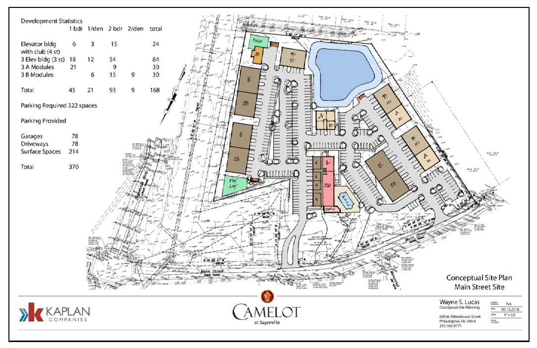
3.1.b.
AH-2 Affordable Housing 2 Zone (Camelot II).
1.
The purpose of the AH-2 Affordable Housing 2 Zone, which applies to Block 347.01 Lot 3.01 and Block 366.01 Lot 1, is to provide areas within the Borough designed for multi-family housing, including family affordable housing. The intent of this zone is to be developed as a comprehensive development. Should any other section of the Borough's Land Development Ordinance (Chapter 26 of the Borough's Revised General Code) contradict with the standards herein, this section shall take precedence.
The development of the AH-2 Zone shall be substantially consistent with the attached concept plan, dated May 15, 2018.
This section supersedes the Court Ordered Rezoning of this area.
2.
Principal Permitted Uses:
(a)
Multi-family dwellings.
3.
Permitted Accessory Uses:
(a)
Private parks and playgrounds.
(b)
Private recreation buildings and facilities.
(c)
Garages and off-street parking facilities.
(d)
Uses customary and incidental to the principal use.
4.
The following bulk standards shall apply:
(a)
Minimum Lot Area: Twenty (20) acres.
(b)
Minimum Building Setback:
i.
From Main Street: Thirty (30) feet.
ii.
From perimeter lot lines: Twenty (20) feet.
(c)
Minimum Distance Between Buildings:
i.
Front to front: Sixty (60) feet.
ii.
Front to rear or end: Seventy-two (72) feet.
iii.
Rear to rear or end: Seventy-two (72) feet.
iv.
End to end: Twenty-five (25) feet.
(d)
Minimum Parking Setback:
i.
The minimum distance to off-street parking spaces from buildings shall be fifteen (15) feet. Driveways located in front of garages do not require a setback.
ii.
Off-street parking shall not be located within the building setback along the eastern boundary of the property that shares a property line with Block 347.01 Lot 2.05.
(e)
The minimum distance from buildings less than thirty-five (35) feet in height to off-street parking spaces shall be twelve (12) feet. (Note: Does not apply to garages and driveway parking.) The minimum distance from buildings equal to or greater than thirty-five (35) feet in height to off-street parking spaces shall be fifteen (15) feet. Driveways adjacent to garages shall be a minimum of twenty (20) feet in length.
(f)
Maximum Building Height: Four (4) stories/fifty-six (56) feet.
(g)
Minimum roof pitch shall be five (5) on twelve (12).
(h)
Maximum Building Coverage: Twenty-five (25%) percent.
(i)
Maximum Impervious Coverage: Sixty-five (65%) percent.
5.
Minimum Off-Street Parking: Parking shall comply with RSIS.
6.
Maximum Number of Units: One hundred fifty (150) dwelling units. A minimum of eight (8) units shall be affordable. An additional ten (10) units may be permitted, however, in no instance shall more than three hundred eighteen (318) units be permitted on both Camelot I and Camelot II Developments.
7.
Affordable Housing:
(a)
The development of all affordable units shall comply with the Uniform Housing Affordability Controls (UHAC), N.J.A.C. 5:80-26.1 et seq. or any successor legislation; except that the deed restrictions/affordability controls for those affordable units shall remain in place for a period of at least fifty (50) years.
(b)
A minimum of fifty (50%) percent of all affordable units shall be affordable to very-low and low-income households. All other affordable units shall be affordable to moderate-income households.
(c)
A minimum of thirteen (13%) percent of all affordable units will be affordable to very-low income households.
(d)
All aspects of the affordable housing component of the tract, including but not limited to monitoring, advertisement, eligibility, controls, and restrictions, shall be in conformance with the Borough's affordable housing ordinance, found in Chapter 35 of the Borough's Revised General Code.
8.
Additional Standards:
(a)
The development shall include recreational facilities for use by the residents of the entire tract.
(b)
A landscaped boulevard entrance to the site is required off Main Street. No other entrances are permitted unless an emergency access is required.
(c)
The proposed retention basins shall be maintained as an additional amenity for the site.
(d)
No building shall exceed one hundred seventy (170) feet in length.
(e)
Basement dwellings are prohibited.
9.
Design Standards. Any deviation from the following standards shall trigger waiver relief:
(a)
Buffers:
i.
A minimum ten-foot wide landscape buffer shall be provided between the buildings/parking areas and Main Street as well as between the buildings/parking areas and the adjacent lot (Block 347.01 Lot 2.05).
ii.
The buffer areas shall be planted with evergreen trees and other vegetation to provide optimal year-round screening.
iii.
Evergreen plantings shall be a minimum of six (6) feet in height at the time of planting. No buildings, signs, structures, storage of materials, roadways or parking shall be permitted within the buffer areas, with the exception of access roads into the development and freestanding signage, in accordance this section.
(b)
Signage:
i.
The provisions of Section 26-89, entitled "Signs," shall govern any provisions regarding signage not addressed herein. Where there is conflict between Section 26-89 and this section, this section shall take precedence.
ii.
One (1) freestanding sign is permitted at the main entrance to the development. The sign shall not exceed thirty-two (32) square feet per side and four (4) feet in height. This sign may or may not be illuminated.
iii.
The freestanding sign shall be setback a minimum of ten (10) feet from the lot line.
(c)
Landscaping:
i.
Any landscaping which, within two (2) years of planting dies for any reason, shall be replaced by the developer(s) at their expense by way of written agreement.
ii.
A minimum of one (1) tree per ten (10) surface parking spaces shall be provided.
iii.
All areas not occupied by buildings, roadways, parking areas, patios, walkways, and/or any other impervious surface shall be adequately landscaped. Landscaping includes grass.
iv.
No landscaping at any location shall interfere with site triangles.
(d)
Street Trees:
i.
Street trees shall be required as detailed in Section 26-97.2.c. of the Borough Land Development Ordinance.
(e)
Exterior Lighting:
i.
Exterior lighting fixtures shall not create excessive glare or light levels or direct light onto neighboring buildings or properties.
ii.
Parking lot lights shall be LED and provided at a height not to exceed twenty-two (22) feet.
(f)
Circulation:
i.
The development of the tract shall take into consideration both the vehicular and pedestrian movement of the site in accordance with RSIS standards.
ii.
Sidewalks shall have a minimum clearance of four (4) feet in width. Sidewalk clearance must not be less than the minimum levels set by the Americans with Disabilities Act.
(g)
Utilities:
i.
Utilities shall be as visually unobtrusive as possible.
ii.
Meters and access panels shall be integrated with street and building design.
iii.
Transformers and primary and back-up generators shall be screened.
(h)
Refuse and Recycling:
i.
For affordable multi-family construction:
(1)
No refuse and recycling storage and collection areas shall be permitted between the front of a building and the street.
(2)
All outside refuse and recycling storage areas shall conform to the perimeter setbacks as established herein.
(3)
Outdoor refuse and recycling containers shall be screened with a durable enclosure, so as to not be visible by public rights-of-way or adjacent properties. Landscaping and/or fencing may be used as additional screening measures.
(4)
Refuse and recycling areas shall be designed to appropriately contain all refuse generated on site.
(5)
There shall be clear and unobstructed access to all refuse and recycling areas for collection vehicles.
10.
Section 26-81.2 Zoning Map of Chapter XXVI Land Development of the Revised General Ordinances of the Borough of Sayreville is hereby amended and superseded to include the AH-2 Affordable Housing 2 Zone as follows:
(a)
Block 347.01 Lot 3.01 and Block 366.01 Lot 1.
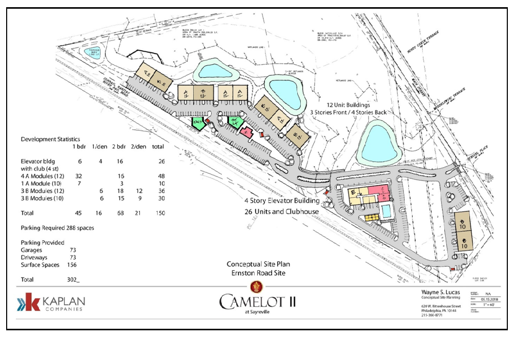
3.1.c.
AH-3 Affordable Housing 3 Zone (Cross Ave/NL).
1.
The purpose of the AH-3 Affordable Housing 3 Zone, which applies to Block 297 Lot 1, Block 333 Lot 1, and Block 332 Lots 1, 2, 3, and 4, is to provide areas within the Borough designed for multi-family, attached single-family, and townhome inclusionary housing, including family affordable housing that may be developed as stacked flats forming part of a multi-family building or as part of a townhouse building. The intent of this zone is to be developed as a comprehensive development. Should any other section of the Borough's Land Development Ordinance (Chapter XXVI of the Revised General Ordinances of the Borough of Sayreville (Codified 1986), as amended and supplemented) contradict with the standards herein, this section shall take precedence.
This section supersedes the Court Ordered Rezoning of this area.
2.
Principal Permitted Uses:
(a)
Single-family attached structures/townhomes.
(b)
Affordable units may be developed as stacked flats located within a multi-family building or as part of a townhouse building.
3.
Permitted Accessory Uses:
(a)
Private parks and playgrounds.
(b)
Private recreation buildings and facilities.
(c)
Garages and off-street parking facilities.
(d)
Uses customary and incidental to the principal use.
4.
The following bulk standards shall apply:
(a)
Minimum Lot Area: Twenty (20) acres.
(b)
Area Permitted for Buildings: Block 333 Lot 1, Block 332, Lots 1, 2, 3, and 4.
(c)
Minimum Building Setback:
i.
From Cross Avenue: Twenty-five (25) feet.
ii.
From perimeter lot lines, except the westerly perimeter: Twenty-five (25) feet.
iii.
From internal streets: Twelve (12) feet.
iv.
From westerly perimeter lot lines (westerly lot lines of Block 332, Lots 1 and 4: One hundred (100) feet.
v.
No setbacks are required from Block 297 Lot 1.
vi.
Block 297 Lot 1 and Block 332 Lots 1, 2, 3, 4 may contain stormwater facilities and/or recreational facilities, and Block 297 Lot 1 may also contain utility improvements, structures, and appurtenances.
(d)
Minimum Distance Between Buildings:
i.
Front to front: One and one-quarter (1.25) times height.
ii.
Front to rear or end: One and one-half (1.5) times height.
iii.
Rear to rear or rear to end: Thirty-five (35) feet.
iv.
End to end: Twenty (20) feet.
(e)
Minimum Parking Setback:
i.
The minimum distance to off-street parking spaces from buildings less than thirty-five (35) feet in height shall be twelve (12) feet. Driveways located in front of garages do not require a setback. Driveways shall be a minimum of twenty (20) feet deep, as measured from the face of the garage door to the street.
ii.
The minimum distance to off-street parking spaces from buildings equal to or greater than thirty-five (35) feet in height shall be fifteen (15) feet.
(f)
Maximum Building Height:
i.
Townhouses: Two and one-half (2.5) stories/thirty-five (35) feet.
ii.
Affordable Multi-Family Structures: Three (3) stories/forty-eight (48) feet.
(g)
Maximum Building Coverage: Twenty-five (25%) percent.
(h)
Maximum Impervious Coverage: Sixty-five (65%) percent.
5.
Minimum Off-Street Parking:
(a)
Parking shall comply with RSIS.
(b)
A one-car garage and driveway combination shall count as two (2) off-street spaces, provided the driveway measures a minimum of eighteen (18) feet in length between the face of the garage door and the right-of-way.
6.
Maximum Number of Units: One hundred thirty-two (132) dwelling units. A minimum of seven (7) units shall be affordable units.
7.
Affordable Housing:
(a)
The development of all affordable units shall comply with the Uniform Housing Affordability Controls (UHAC), N.J.A.C. 5:80-26.1 et seq. or any successor legislation; except that the deed restrictions/affordability controls for those affordable units shall remain in place for a period of at least fifty (50) years.
(b)
A minimum of fifty (50%) percent of all affordable units shall be affordable to very-low and low-income households. All other affordable units shall be affordable to moderate-income households.
(c)
A minimum of thirteen (13%) percent of all affordable units will be affordable to very-low income households.
(d)
All aspects of the affordable housing component, including but not limited to monitoring, advertisement, eligibility, controls, and restrictions, shall be in conformance with the Borough's affordable housing ordinance, Chapter XXXV of the Revised General Ordinances of the Borough of Sayreville (Codified 1986), as amended and supplemented.
8.
Additional Standards:
(a)
The development shall include a tot lot and a sitting/picnic area for use by the residents of the entire tract.
(b)
A boulevard entrance to the site is permitted from the east side of the tract, off Cross Avenue. No other entrances are permitted unless an emergency access is required.
(c)
Basement dwelling units are not permitted. But, finished basements, with a bathroom, as part of an overall townhouse, shall be permitted.
9.
Design Standards. Any deviation from the following standards shall trigger waiver relief:
(a)
Buffers:
i.
A minimum of a ten-foot planting strip, within and forming part of each building setback (required by the provisions of Section 4.c, above) shall serve as a buffer area. The ten-foot minimum planting strip shall be situated in that portion of a building setback that is farthest away from any particular building.
ii.
Stormwater facilities shall be permitted within building setbacks and the buffer areas that form a part of those setbacks.
iii.
The buffer areas shall be planted with evergreen trees and other vegetation to provide optimal year-round screening.
iv.
Screening materials shall be a minimum of six (6) feet in height at the time of planting.
(b)
Signage:
i.
The provisions of Section 26-89 of the Revised General Ordinances of the Borough of Sayreville (Codified 1986), as amended and supplemented, entitled "Signs," shall govern any provisions regarding signage not addressed herein. Where there is conflict between Section 26-89 and this section, this section shall take precedence.
ii.
One (1) freestanding sign is permitted at the main entrance to the development. The sign shall not exceed thirty-two (32) square feet per side and four (4) feet in height. This sign may or may not be illuminated.
iii.
The freestanding sign shall be setback a minimum of ten (10) feet from the lot line.
iv.
Directional and temporary marketing signs are permitted on all internal roadways. Directional signs shall be consistent with each other and the tract's other signage.
v.
As an alternative to the one (1) double sided freestanding sign, permitted by the provisions of Section 9.b.ii, two (2) single sided entrance wall signs are permitted. Each sign shall not exceed twenty-four (24) square feet. The height of any sign on a retaining wall shall not exceed six (6) feet. All other signs shall not exceed four (4) feet in height.
(c)
Landscaping:
i.
Any landscaping which, within one (1) year or one (1) growing season of planting dies for any reason, shall be replaced by the developer(s) at the developer(s)' expense by way of written agreement.
ii.
All areas not occupied by buildings, roadways, parking areas, patios, walkways, and/or any other impervious surface shall be adequately landscaped. Landscaping may include grass. In larger open areas, grass may constitute the only landscaped feature.
iii.
No landscaping at any location shall interfere with site triangles.
(d)
Street Trees:
i.
Street trees shall be required. Trees shall be approximately fifty (50) feet apart and located between the setback line and the street right-of-way line if possible (including the side street on corner lots) and not closer than twenty-five (25) feet from any existing or proposed streetlight or street intersection.
ii.
The trees shall be planted so as not to interfere with utilities, roadways or sidewalks.
iii.
Trees shall be nursery grown stock of not less than two and one-half (2.5) inches in caliper at breast height. There shall be no limitation on the height of the branches at planting. Where there is adequate existing growth, the Borough may waive this requirement. Species which provide shading and aesthetic benefit, conform to prevailing street tree patterns in the Borough, and take branching pattern and hardiness into consideration, are recommended.
(e)
Exterior Lighting:
i.
Exterior lighting fixtures shall not create excessive glare or light levels or direct light onto neighboring buildings or properties.
ii.
Street lights shall be LED and provided along all internal streets at a height not to exceed twenty-two (22) feet.
(f)
Circulation:
i.
The development of the tract shall take into consideration both the vehicular and pedestrian movement of the site.
ii.
Sidewalks shall be provided throughout the entire tract, providing access to all structures and parking areas in accordance with applicable RSIS standards. Based upon RSIS standards, the Planning Board may grant a de minimis exception regarding the provision of sidewalks.
iii.
Sidewalks shall have a minimum clearance of four (4) feet in width. Sidewalk clearance must not be less than the minimum levels set by the Americans with Disabilities Act.
iv.
All intersections shall contain handicapped accessible ramps.
v.
All intersections shall contain crosswalks.
(g)
Utilities:
i.
Utilities shall be as visually unobtrusive as possible.
ii.
Meters and access panels shall be integrated with street and building design.
iii.
Transformers and primary and back-up generators shall be screened.
(h)
Refuse and Recycling:
i.
For affordable multi-family construction:
(1)
No refuse and recycling storage and collection areas shall be permitted between the front of a building and the street.
(2)
All outside refuse and recycling storage areas shall conform to the perimeter setbacks as established herein.
(3)
Outdoor refuse and recycling containers shall be screened with a durable enclosure, so as to not be visible by public rights-of-way or adjacent properties. Landscaping and/or fencing may be used as additional screening measures.
(4)
Refuse and recycling areas shall be designed to appropriately contain all refuse generated on site.
(5)
There shall be clear and unobstructed access to all refuse and recycling areas for collection vehicles.
ii.
Alternative Refuse and Recycling Concept for Affordable Housing: Instead of providing for refuse and recycling storage and collection facilities and processes as set forth in Section I.h.i, above, if affordable housing units are provided utilizing a townhouse development scheme, footprint, or building, then refuse and recycling storage and collection for affordable units may be the same as for all other townhomes. Refuse and recycling storage may be on an individual basis and internal to the footprint of each unit, with collection being achieved via individual pickup and the use of private containers placed curbside on collection days.
10.
Section 26-81.2 Zoning Map of Chapter XXVI, Land Development Ordinance, of the Revised General Ordinances of the Borough of Sayreville (Codified 1986), as amended and supplemented, is hereby amended and superseded to include the AH-3 Affordable Housing 3 Zone as follows:
(a)
Block 297 Lot 1, Block 333 Lot 1, Block 332 Lots 1, 2, 3, 4 (Cross Avenue/NL Site).
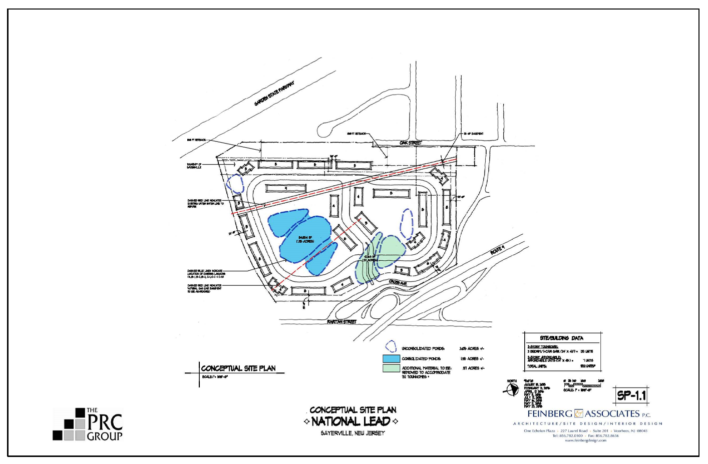
4.
Senior Citizen Housing Component in R-7 (PRD) Zone. Senior housing is encouraged to promote the national, state and Borough objective of "aging in place with dignity." To that end, a continuum of senior citizen facilities is encouraged, with a goal of providing a range of residential options, including (a) independent living quarters in senior citizen housing structures; (b) independent living in congregate facilities where daily necessities are provided in common facilities in conjunction with otherwise independent senior citizen units; (c) assisted living facilities where medical supervision and assistance is available based upon need to otherwise well seniors; (d) intermediate care facilities for frail elderly persons where continuous medical supervision and assistance is available; and (e) skilled care nursing homes for those in need of continuous medical care and supervision.
(a)
Standards for Senior Citizen Housing:
(1)
Minimum lot area: Five (5) acres.
(2)
Maximum gross site density: Twenty (20) dwelling units per acre with a maximum yield of two hundred (200) senior units on any one tract.
(3)
Minimum lot width: Three hundred (300') feet.
(4)
Minimum lot depth: Three hundred (300') feet.
(5)
Minimum building setback to any exterior property line: One hundred (100') feet.
(6)
Maximum lot coverage by building: Fifteen (15%) percent.
(7)
Maximum impervious lot coverage: Fifty (50%) percent.
(8)
Floor to area ratio (FAR): Thirty-three hundredths (0.33) maximum.
(9)
Minimum open space or landscaped area: Forty (40%) percent.
(10)
Maximum height: Four (4) stories.
(11)
Minimum off-street parking: Five tenths (0.5) of a space per dwelling unit.
(12)
Community room floor area shall be provided at the rate of ten (10) square feet per dwelling unit.
(13)
Minimum landscaped buffer area width adjoining existing adjacent land uses: Fifty (50') feet wide.
(14)
Minimum developed recreation area: A minimum of ten (10%) percent of the required open space area shall provide improved active and/or passive recreation facilities.
(15)
Independent living dwelling units:
(a)
One (1) bedroom: six hundred (600) square feet
(b)
Two (2) bedroom: seven hundred (700) square feet
(16)
Congregate care dwelling units:
(a)
One (2) bedroom: three hundred (300) square feet
(b)
Two (2) bedroom: four hundred fifty (450) square feet
(17)
Affordability: At least twenty (20%) percent of all units constructed shall be set aside as affordable units for low and moderate income residents in conformance with the rules and procedures promulgated by the New Jersey Council on Affordable Housing.
(18)
Accessory medical facilities: There shall be a minimum of five hundred (500) square feet of floor area furnished to allow for the provisions of all accessory medical facilities, including a medical suite which is equipped to accommodate periodic visits by one (1) or more members of the medical profession and/or for consultation/treatment of residents for the senior community. Direct exterior access to the medical suite shall be designed to allow for a convenient on-site loading area for access by emergency convenience retail component: In addition to the senior citizen residential vehicles and emergency personnel.
(19)
Accessory retail uses:
(i)
Five (5%) percent of the gross floor area of any senior facility may be developed for on-site accessory convenience retail uses.
(ii)
Off-street parking for any retail component shall be provided.
(iii)
Signage for any retail occupancies of the senior citizen housing project shall be scaled as to identify uses for residents of the senior housing only.
(iv)
Accessory management and administrative office space servicing only the senior citizen housing complex shall be permitted, for which off-street parking shall be provided.
(20)
No dwelling units shall be permitted in any basement area.
(21)
Coin-operated laundry washing and drying machines shall be supplied in an adequate number for the sole use and convenience of the occupants.
(22)
All units constructed shall be designed to accommodate a barrier-free life-style and shall comply with all applicable minimum design standards for barrier-free dwelling units, pursuant to the Americans with Disabilities Act, as well as all other federal and state laws or regulations.
(23)
Alarm switches shall be installed in each dwelling unit for summoning aid in an emergency. At least two (2) switches shall be installed in each dwelling unit which shall be located in the bedroom and bathroom of each unit. The switches shall be connected to a central location and shall emit an audio and visual signal alarm when activated.
(24)
Storage space. A minimum of one hundred (100) square feet of gross floor area storage space shall be provided within the floor plan design of each senior dwelling unit.
(25)
Security. The entire senior housing project shall be provided with a security system and physical security measures. The design plan of the security system and the security measures shall be submitted to the Borough Police Department. Police Department recommendations will be considered by the Board when reviewing the application.
(26)
Recreational, cultural and community facilities for the use of the residents of the senior citizen housing project and their guests may be permitted. Such facilities may include, but are not limited to: community multi-purpose room, dining room, kitchen, lobby-sitting areas, library, indoor recreation activities, exterior active and passive recreation areas, picnic areas, etc.
f.
Development Regulations for Non-Residential Use Not Associated with Senior Housing. Nonresidential use(s) shall comply with all use regulations for the B-2 General Business zone and all development and bulk regulations in the B-3 Highway Business zone in the Schedule of Area, Yard and Building Requirements in Article IV and as further set forth in this chapter. Non-residential uses associated with senior housing may be developed in accordance with subsection 26-84.3e.4.
g.
Schedule of PUD/PRD Development.
1.
The schedule for land development shall be as follows:
(a)
Following final approval of the PUD/PRD, not more than twenty-five (25%) percent of the residential building permits shall be issued until at least fifteen (15%) percent of the total commercial and/or industrial development which is approved by the total PUD/PRD has been constructed and certificate(s) of occupancy have been issued.
(b)
Following the issuance of certificates of occupancy for fifteen (15%) percent of the total commercial and/or industrial area of the PUD/PRD, then building permits may be issued for not more than fifty (50%) percent of the total of the residential dwelling units of the PUD/PRD.
(c)
Following the issuance of certificates of occupancy for forty (40%) percent of the commercial and/or industrial development area of the PUD/PRD, then building permits may be issued for not more than seventy-five (75%) percent of the total of the single-family and townhouse units of the PUD/PRD.
(d)
Following the issuance of certificates of occupancy for seventy-five (75%) percent of the commercial and/or industrial development areas of the PUD/PRD, then the building permits may be issued for the balance of the residential units of the PUD/PRD.
2.
Modification of Schedule of Development. Any modification of the approved Schedule of Development shall require the approval of the Board. In considering the application for the modification of the Schedule of Development, the Board shall take into consideration prevailing economic and market conditions, anticipated and actual need for residential units and non-residential space within the municipality and in the region as well as the availability and capacity of public facilities to accommodate the proposed development. A request for modification of the Schedule of Development shall not be considered as an application for a new GDP or a new preliminary site plan/subdivision or PUD/PRD approval.
(Ord. #637-99)
(Ord. No. 366B-17, § 1, 10-10-2017; Ord. No. 356-17, § 1, 1-18-2017; Ord. No. 413-18, 6-25-2018; Ord. No. 414-18, 6-25-2018; Ord. No. 424-18, 7-23-2018; Ord. No. 425-18, 7-23-2018; Ord. No. 448-19, 5-13-2019; Ord. No. 449-19, 5-13-2019)
26-84.4 Regulations for Open Space - Conservation (OS-C) District.
a.
Intent. The intent of the Open Space - Conservation Zone is to limit the future use to passive outdoor recreation uses and to maintain the property in its natural state. Existing Borough-related activities are allowed to continue as long as the uses (except for the water treatment operation) do not expand in the OS-C Zone.
b.
Permitted Uses.
1.
Passive outdoor recreation uses, including walking, reading, bird watching, wildlife observation, camping, nature trails and fitness trails;
2.
Leaf composting facility;
3.
Existing public utilities;
4.
Other Borough-related activities.
(Ord. #725-01, § 2)
26-84.5 Regulations for Open Space - Recreation (OS-R) District.
a.
Intent. The intent of the Open Space - Recreation zone is to maintain the western portion of the Wellfields Property for passive and active recreational uses.
b.
Permitted Uses.
1.
Football fields;
2.
Baseball fields;
3.
Basketball courts;
4.
Soccer fields;
5.
Tennis courts;
6.
Track and field activities;
7.
Other recreation fields;
8.
Ancillary parking areas;
9.
Passive recreational activities not limited to uses such as camping, fitness and nature trails and bird watching.
(Ord. #725-01, § 2)
26-84.6 Regulations for Office/Services (O-S) Overlay Zone District.
a.
Purpose. This overlay district is intended to provide a reasonable use of land for nonresidential purposes while maintaining a residential presence, and is in addition to the regulations of and is an overlay on the otherwise existing zones in which these properties are shown on the Zoning Map.
b.
Permitted Uses. No building, structure or premises shall be used and no building or structure shall be erected or structurally altered except for the following uses:
1.
Business/professional offices and banks;
2.
Barbershops, beauty shops, nail salons and similar service establishments;
3.
Retail sale and repair of computers and related equipment;
4.
Retail sales of the following: books, stationery, arts and crafts, cut flowers (i.e. florist), antiques, recreational equipment, entertainment/sports tickets. In no case shall any use be permitted which involves the sale of food or drinks, including but not limited to restaurants, snack bars, convenience stores, ice cream parlors, etc.
c.
Accessory Uses. Uses customary and incidental to the principal use and located within the principal building shall be permitted.
d.
Conditional Uses. Dwelling unit as an accessory use, subject to the following:
1.
The dwelling unit shall be accessory to the principal use at the site and shall be located in the same building.
2.
A dwelling unit shall have an exterior entrance separate from that of the principal business use at the site.
e.
Height, Area and Yard Requirements. Height, area, and yard requirements shall be those applicable in the B-1 Zone.
f.
Off-Street Parking and Loading Requirements. Off-street parking and loading requirements shall be those specified in Section 26-88.1 of the Revised Ordinances of the Borough of Sayreville.
g.
Signs. Signs shall be subject to the sign regulations under Sign Schedule II for the B-1 Zone.
h.
Architectural Treatment. The development character of the district is, in most cases, is to be residential in appearance. Most buildings were originally constructed as single-family homes. Any new, altered, or enlarged construction shall be designed to maintain a residential appearance.
i.
The following accessory apartment regulations are hereby enacted for the purpose of providing additional opportunities for affordable housing in the Borough. All accessory apartment units shall meet the following conditions:
1.
Accessory apartments shall comply with all applicable statutes and regulations of the State of New Jersey in addition to local building codes;
2.
The accessory apartment shall, for a period of at least ten (10) years from the date of the issuance of the certificate of occupancy for the unit, be rented only to a duly qualified (at the time of initial occupancy) very low, low or moderate income household based upon a rent level calculated to be affordable to such household in accordance with the criteria set forth in the Borough's Affordable Housing Ordinance;
3.
Affordable rent levels for accessory apartments shall be calculated to include a deduction for tenant paid utilities (a utility allowance);
4.
There shall be a recorded deed or declaration of covenants and restrictions applied to the property upon which the accessory apartment is located running with the land and limiting its subsequent rental in accordance with the foregoing requirements for the entire term of the deed restriction;
5.
Each accessory apartment shall have living/sleeping space, a complete kitchen and complete sanitary facilities for the exclusive use of its occupants. It shall consist of no less than two (2) rooms, one (1) of which shall be a full bathroom;
6.
The accessory apartment shall have a separate door with direct access to the outdoors;
7.
The potable water supply and sewage disposal system for the accessory apartment shall be demonstrated to be adequate;
8.
The accessory apartment shall be affirmatively marketed throughout the Borough's housing region;
9.
In the case of an accessory apartment created illegally or without proper permits which the property owner desires to legitimize as an accessory apartment under this section, all of the requirements of this section shall apply, except that no subsidy shall be provided by the Borough; and
10.
All accessory apartments shall be advertised to, and occupied by, very low-income households.
j.
The Borough shall designate an Administrative Agent to administer the accessory apartment program.
1.
The Administrative Agent shall administer the accessory apartment program including advertising, income qualifying prospective tenants, setting rents and annual rental increases, maintaining a waiting list, distributing the subsidy, securing certificates of occupancy, qualifying properties, handling application forms, filing deed restrictions and monitoring reports and affirmatively marketing the accessory apartment program;
2.
The Administrative Agent shall only deny an application for an accessory apartment if the project is not in conformance with all of the requirements of the municipal development ordinance, including this section, or the Borough's Affordable Housing Ordinance. All denials shall be in writing with the reasons clearly stated; and
3.
The Borough shall provide at least ten thousand ($10,000.00) dollars to subsidize the physical creation of an accessory apartment conforming to all applicable requirements. Prior to the grant of any subsidy, the property owner shall enter into a written agreement with Sayreville Borough insuring that (i) the subsidy shall be used only to create the accessory apartment, and (ii) the apartment shall meet all applicable requirements of the Borough of Sayreville.
k.
Applications for the creation of an accessory apartment shall be submitted to the Administrative Agent and shall include the following:
1.
A sketch of floor plan(s) showing the location, size and relationship of both the accessory apartment and primary dwelling or use within the building;
2.
Rough elevations showing the modification of any exterior building façade to which changes are proposed; and
3.
A site development sketch showing the location of the existing dwelling and other existing structures; all property lines; proposed addition if any, along with minimum building setback lines; the required parking spaces for both dwelling units; and any man-made conditions which might affect the proposal.
(Ord. No. 87-09, § 3, 4-13-2009; Ord. No. 365-17, § 1, 10-10-2017; Ord. No. 450-19, § 1, 5-13-2019)
26-84.7 Regulations for Light Industrial/Business Service Overlay Zone District.
a.
Purpose. This overlay district is intended to provide a reasonable use of land for nonresidential purposes while maintaining a residential presence. The regulations of this overlay district are in addition to the regulations of the otherwise existing zones in which these properties are shown on the Zoning Map, which regulations shall remain in place for uses permitted in the existing zones.
b.
Permitted Uses. No building, structure or premises shall be used and no building or structure shall be erected or structurally altered except for the following uses:
Light Industrial Uses:
1. Courier service;
2. Local trucking depot without exterior storage;
3. General contractor's shop/office without exterior storage;
4. Landscape contractors;
5. Special trade contractors limited to: Roofing and siding, carpentry, masonry and stone work, flooring, glass and glazing, plumbing/HVAC, electrical work, painting and paper hanging, drywall and plastering. All of these uses must be performed within the confines of an enclosed building.
Business Services Uses:
1. Collection services;
2. Credit reporting services;
3. Dance studios;
4. Florists;
5. Employment agencies;
6. Medical equipment rental and leasing;
7. Computer repair, rental and leasing;
8. Secretarial and court reporting services;
9. Furniture repair and remodeling;
10. Furniture refinishing;
11. Reupholstering shops;
12. Antique furniture restoration;
13. Security system services;
14. Wreath and grave monument sales.
c.
Accessory Uses. Uses customary and incidental to the principal use and located within the principal building shall be permitted.
d.
Height, Area and Yard Requirements. Height, area, and yard requirements shall be those applicable in the B-1 Zone.
e.
Off-Street Parking and Loading Requirements. Off-street parking and loading requirements shall be those specified in Section 26-88.1 of the Revised General Ordinances of the Borough of Sayreville.
f.
Signs. Signs shall be subject to the sign regulations under Sign Schedule II for the B-1 Zone.
g.
Buffers. Any new, altered or enlarged construction shall comply with the buffer requirements of Section 26-96.6 of the Revised General Ordinance of the Borough of Sayreville.
(Ord. No. 116-10, § 3, 2-8-2010)
26-84.8 Regulations for SED-2 Office/Business Use.
26-84.8 Regulations for Special Economic Development-2 District (SED-2).
a.
Purpose. This zone change would effect Lot 1 in Block 249 (94.0 acres) and Lot 1 in Block 250 (8.5 acres). The property in question is along Main Street approximately 1,847 feet west of Crossman Road South.
b.
Permitted Uses.
1.
Professional offices and related uses.
(a)
Corporate offices and executive centers.
(b)
Data processing facilities.
(c)
Computer centers.
(d)
Medical offices and clinical laboratories.
(e)
Banks, "back office" facilities and other fiduciary institutions.
(f)
Office-type research centers.
(g)
Municipal utilities and services.
2.
Restaurants, excluding fast food takeout facilities and drive-up service windows.
3.
Sports and health facilities as listed below, provided they are incorporated into other buildings or are built in the general architectrual style of the district. Inflatable "bubble" or corrugated frame buildings for sports facilities are prohibited.
♦
Baseball practice facilities
♦
Tennis
♦
Racquetball facilites
♦
Health spas and gymnasiums
4.
Business service uses.
(a)
Antique furniture restoration including furniture repair, refinishing and re-upholstering facilites performed within the confines of a building.
(b)
Collection services.
(c)
Employment agencies.
(d)
Security system services.
(e)
Medical equipment rental and leasing.
(f)
Supplemental education/training facilities.
5.
Research laboratories, subject to performance standards.
6.
Fully enclused wholesale, distribution and storage establishments with limited retail sales subject to performance standards.
c.
Conditional Uses.
1.
Wireless communication facilites and towers.
2.
Funeral homes.
d.
Prohibited Uses.
1.
Truck terminals.
e.
Open Space Requirements. It shall be the responsibility of the developer to set aside twenty (20%) percent of the site to be dedicated to the Borough for park and open space uses including pedestrian and bicycle trails as well as buffer requirements. The intent is an open space corridor and buffer of at least two hundred (200) feet wide which should be established along the western and southern boundary lines of Lot 1 in Block 249. This open space area would connect residential properties on Main Street with Kennedy Park, directly to the south.
f.
Height, Area and Yard Requirements. Height, area and yard requirements shall be as specified below:
1.
All uses would be in 1-/2-story structures designed in a planned development layout with aesthetic design features to make the zone visually appealing and consistent.
2.
Minimum area requirements:
Lot area: Thirty (30) acres.
Lot width: Five hundred (500) feet.
Lot depth: Four hundred (400) feet.
3.
Minimum area requirements (corner lots):
Lot area: Thirty (30) acres.
Lot width: Five hundred (500) feet.
Lot depth: Four hundred (400) feet.
4.
Minimum setback requirements:
Front yard: One hundred (100) feet.
One side yard/total: Fifty (50)/one hundred fifty (150) feet.
Rear yard: One hundred (100) feet.
5.
Maximum height (feet/stories): Thirty-five (35) feet/2.5.
6.
Maximum lot coverage:
Buildings: Fifty (50%) percent.
Buildings and pavement: Seventy-five (75%) percent.
g.
Off-Street Parking and Loading Requirements. Off-street parking and loading requirements shall be those specified in Section 26-88.1 of the Revised General Ordinance of the Borough of Sayreville.
h.
Signs. Signs shall be subject to the sign regulstions under Sign Schedul II for the SED Zone.
i.
Buffers. Buffers shall comply with the buffer requirements of Section 26-96.6 of the Revised General Ordinances of the Borough of Sayreville.
(Ord. No. 160-11, § 3, 5-23-2011; Ord. No. 177-12, § 3, 2-27-2012)
26-84.9 Establishment of B-4 General/Village Business District (GVB).
A.
Purpose. The purpose of this district is to encourage increased pedestrian oriented commercial and retail activity in the Borough's Village or Main Street hamlet and to create greater flexibility for a mixed use of commercial and residential components within individual structures to provide a variety of housing options.
B.
Permitted Uses.
1.
Single and two-family homes existing as of 2013 in accordance with the requirements of the R-5 District.
2.
Residential apartments, limited to upper floors when ground floor is nonresidential.
3.
Childcare centers.
4.
Retail store, except for those enumerated as prohibited uses.
5.
Convenience store.
6.
Business, professional or medical office.
7.
Bank.
8.
Personal service shop, salon, except for those enumerated as prohibited uses.
9.
Pick-up stations for laundries/cleaning establishments.
10.
Restaurant.
C.
Accessory Uses.
1.
Indoor storage of goods, which are sold on site (not warehousing), for businesses on site.
2.
Parking.
3.
Trash enclosure.
4.
Fencing.
5.
Signage.
D.
Conditional Uses.
1.
Boat, recreational vehicles and automobile storage, repair and sales.
2.
Churches and other houses of worship.
E.
Specifically prohibited uses.
1.
Adult bookstore/entertainment.
2.
Amusement facility, video arcade.
3.
Establishment which trades or sells used merchandise (flea market, pawn shop, used furniture store, antique shop and thrift store).
4.
Laundromat.
5.
Establishment which involves tattooing, massage, body piercing.
6.
Astrologers, cards readers, psychics.
7.
Substance abuse counseling or treatment center.
F.
Permitted Gross Density for Residential Apartment Development.
1.
The permitted gross density for a project in the General/Village Business Zone shall be fourteen (14) dwelling units per acre.
2.
An Applicant who develops age restricted housing in the General/Village Business Zone shall be entitled to a density bonus of one (1) market unit for each age restricted unit up to a maximum of thirty (30) bonus units.
3.
Preference List. One-half of the age-restricted market units constructed within the General/Village Business Zone shall be marketed with an equal preference as follows:
(a)
To current residents of the Borough;
(b)
To parents and children of current residents of the Borough;
(c)
To persons who were either residents of the Borough within the last five (5) years of the date of the adoption of this ordinance.
(d)
To current, active emergency service volunteers of the fire department and the first aid and rescue squads.
(e)
To current employees of the Borough and Board of Education.
This preference for the sale or rental of the age restricted units shall take place through the date the developer issues its final construction documents and receives one-half of its construction permits for the development.
In providing this, the developer shall maintain two (2) reservations lists. One (1) list shall contain those qualifying for the above referenced preference. A second list shall be maintained for all others expressing an interest in purchasing or renting a unit from the developer. While the aforementioned preference is in effect, the developer may only offer binding contracts to those qualifying for the preference. After the preference period has expired, the developer then may offer binding agreements to any potential purchaser or renter without preference. The Borough retains the right to review any marketing plans that the developer has to reach the Sayreville preference buyer or renter.
G.
Non Residential Development Standards
1.
The following standards are divided into three (3) categories (less than five thousand (5,000) square feet, between five thousand (5,000) square feet and nine thousand nine hundred ninety-nine (9,999) square feet and ten thousand (10,000) square feet and greater) with the associated regulations:
a.
Small Infill Site (< Five thousand (5,000) square feet)
Minimum lot size: Two thousand five hundred (2,500) square feet
Maximum lot size: Four thousand nine hundred ninety-nine (4,999) square feet
Minimum Frontage: Twenty-five (25) feet
Minimum Setbacks:
Front Yards: Fifteen (15) feet 1
Rear Yards: Twenty (20) feet
Side yards: Zero (0) feet
From Residential district: Twenty (20) feet
Maximum Building Height: Two (2) stories and twenty-five (25) feet
Minimum Building Height: Fourteen (14) feet to top of front wall
Maximum Building Coverage: Fifty (50%) percent
b.
Sites between five thousand (5,000) and nine thousand nine hundred ninety-nine (9,999) feet:
Minimum Lot Size: Five thousand (5,000) square feet
Maximum Lot Size: Nine thousand nine hundred ninety-nine (9,999) square feet
Minimum Frontage: Fifty (50) feet
Minimum Yards:
Front: Fifteen (15) feet 2
Rear: Twenty-five (25) feet
Side: Zero (0) feet, but at least four (4) feet if provided.
Maximum Building Height: Two and one-half (2.5) stories and thirty (30) feet
Maximum Building Coverage: Fifty (50%) percent
c.
Lots greater than ten thousand (10,000) square feet
Minimum Frontage: One hundred (100) feet
Minimum Setbacks:
Front yards: Fifteen (15) feet 3
Rear: Thirty (30) feet
Side: Zero (0) feet, but at least twelve (12) feet if provided
Maximum Building Height: Three (3) stories and forty-five (45) feet
Maximum Building Coverage: Seventy (70%) percent
H.
Other Standards.
1.
Efforts to coordinate the actual and apparent height of adjacent structures are encouraged. This is especially applicable where buildings are located very close to each other. It is often possible to adjust the height of a wall, cornice or parapet line to match that of an adjacent building. Similar design linkages can be achieved to adjust apparent height by placing window lines, belt courses, and other horizontal elements in a pattern that reflects the same elements on neighboring buildings.
a)
Large structures should be designed to reduce their perceived height by bulk by dividing the building mass into smaller-scale components.
b)
Projects should be compatible with the scale of development anticipated by the applicable Land Use Policies for the surrounding area and should be sited and designed to provide a sensitive transition to near-by, less-intensive zones. Projects on zone edges should be developed in a manner that creates a step in perceived height, bulk and scale between the anticipated development potential of the adjacent zones.
c)
Multiple buildings on the same site shall be designed to create a cohesive visual relationship between the buildings.
d)
Residential conversions. The conversion of an existing residential structure to any nonresidential use shall maintain the character of the existing structure and meet all off-street parking and other requirements contained under Section 26-88.1. Any conversion of an existing residential building shall be consistent with the existing architecture.
I.
Parking.
1.
No parking shall be permitted in the required front yard nor between any part of the front building facade and the street right-of-way line.
2.
Parking areas shall be screened from view of adjacent residential zones, existing residential uses and public roads by landscaping, fencing or a combination of these to create a buffer at least five (5) feet in height. Landscaping shall contain a mix of deciduous and evergreen plantings sufficient to screen the view of vehicles in all seasons.
3.
Off-street parking shall not be required for non-residential development for retail businesses occupying two thousand five-hundred (2,500) square feet or less. This provision does not apply to multiple retail spaces in a development.
4.
Off-street parking shall not be required for businesses located within five hundred (500) feet of a dedicated municipal parking lot.
5.
Parking may also be located fully below buildings, partially below grade in a building, or at-grade within a building, provided it is fully enclosed and no entry is provided facing a public street or front yard. Structured parking that is partially below grade shall be screened from the street by steps, trellises, or screens.
6.
For non-residential uses, on-street parking directly fronting a lot shall count toward fulfilling the off-street parking requirement.
J.
Building Design and Requirements.
1.
Rooftop mechanical equipment shall be screened from public view by architecturally compatible materials. Ground level mechanical equipment, such as air conditioning equipment, utility boxes and meters, shall be screened by landscaping, walls or decorative fencing.
2.
A Minimum of one (1) building entrance shall face the street where there is frontage. On corner lots, at least one (1) street shall have a building entrance. Sidewalks shall be provided within the front yard area for access from the existing sidewalk system.
3.
The visual character of building along street frontages and entryways shall be "pedestrian friendly".
4.
Porches shall not be enclosed.
5.
Fire escapes are prohibited on the front façade of a building.
6.
Signage shall conform to the standards of Sign Schedule II, except that ground sign and pole signs are not permitted.
K.
Trash Disposal/Deliveries.
1.
Trash disposal areas shall be located as far from residential zone boundaries as possible but in no case shall they be located within seven (7) feet of any residential zone or use.
2.
Deliveries and loading activities shall be restricted to weekday/daytime hours.
3.
Trash disposal areas are prohibited between the front façade and the street right-of-way.
4.
Trash and/or dumpster areas shall be screened by wood fences or landscaping, or a combination of the two (2).
5.
All provisions and facilities for storage, other than pickup of refuse, shall be contained within a principal building.
L.
Specific Conditional Use Requirements.
1.
Boat, recreational vehicle and automobile storage, repair and sales shall adhere to the following standards:
a.
The minimum lot size shall be eighty-thousand (80,000) square feet.
b.
The lot shall have a minimum lot width of two hundred (200) feet.
c.
The lot shall have a minimum depth of four hundred (400) feet.
d.
An average twenty-foot landscaped buffer shall be provided along any residential zone or any residential use, however in no event shall said buffer are be less than ten (10) feet at any such location.
e.
Racks which permit more than one (1) boat or vehicle to be stacked vertically on top of one (1) another shall be prohibited.
f.
Repair or service of boats, recreational vehicles and automobiles shall be permitted only indoors.
g.
No boat, recreational vehicle, watercraft or automobile shall be stored between any part of the front building façade and the street right-of-way line.
h.
All boats or watercraft shall be stored or shored, in such a manner, as to withstand a forty-five-mile per hour wind.
2.
Churches and other houses of worship: See Section 26-85.2
(Ord. No. 255-14, § 1, 5-1-2014)
26-85 - CONDITIONAL USES.
a.
General. The Board shall not approve a conditional use unless it finds that the use meets all the applicable requirements of this section. All conditional uses shall be subject to site plan review in accordance with Article III of this chapter.
b.
Requirements for Specific Uses.
1.
Home occupations which do not qualify as accessory uses pursuant to subsection 26-82.6.b.2. of this chapter shall be permitted in all residential zones as a conditional use, provided that the following conditions are met:
(a)
The practitioner must be the owner or lessee of the residence in which the home occupation is contained.
(b)
The practitioner must reside in the home as his or her principal residence.
(c)
The practitioner shall not utilize the services of more than one on-site employee at any time. Use of any home occupation facility by a group or groups of clients or other persons shall not be permitted.
(d)
The home occupation shall occupy less than fifty (50%) percent of the total area of the floor where located, excluding space used for a private garage or nine hundred (900) square feet, whichever is smaller.
(e)
No clients shall remain on the premises overnight.
(f)
The residential character of the neighborhood and the premises shall not be subordinated to the home occupation use.
(g)
Adequate on-site parking spaces shall be provided in accordance with this article so that no parking related to the home occupation shall occur on the street.
(h)
No retail sales, manufacturing or industrial operations shall be conducted on the site.
(i)
No more than one (1) business visitor shall be permitted at any one time. There shall be no external evidence of the home occupation, except any parking spaces that may be required pursuant to this article.
(j)
Home occupation deliveries and pick-ups shall be of the type customary to residential areas only.
(k)
No sign identifying the home occupation shall be permitted and there shall be no identification of such home occupation upon any mailbox.
(l)
No equipment or process shall be used in such home occupation which creates noise, glare, fumes, odors, electrical interference, medical waste or other nuisance factors detectable to the human senses, outside the lot on which the home occupation is conducted.
2.
Houses of Worship. Houses of worship shall be permitted as a conditional use in all zoning districts in compliance with the following:
(a)
Compliance with Zoning Schedule III at the end of this chapter.
(b)
Screening and landscaping shall be provided where necessary to minimize the development's impact on adjacent properties.
3.
Gasoline Service Stations and Public Garages. All gasoline service stations and public garages shall comply with the following requirements:
(a)
Minimum lot size: The minimum lot size shall be twenty thousand (20,000) square feet.
(b)
Minimum lot width: The minimum lot width shall be one hundred (100′) feet.
(c)
No more than three (3) gasoline service stations shall be located within one (1) linear mile. The distance shall be measured along the center line of existing streets to the nearest lot line of land use for a gasoline service station. Further, such use shall be located no less than five hundred (500′) feet from any institutional or public use or house of worship.
(d)
Outdoor storage areas and landscaping requirements: All outdoor storage facilities shall be enclosed by a fence or a wall or other suitable visible screen adequate to conceal such facilities and the contents thereof from adjacent property.
(e)
All areas not covered by buildings and pavement shall be appropriately landscaped and maintained.
(f)
Location of oil drainage pits and hydraulic lifts: No outdoor hydraulic or mechanical lifts or oil drainage or mechanical pits shall be permitted.
(g)
Location of gasoline pumps: No gasoline pumps shall be nearer than twenty-five (25′) feet to any street right-of-way line and all property lines and at least fifty (50′) feet from the boundary of a residential zone.
(h)
The sale of used cars and the storage of any unlicensed vehicles shall be prohibited.
(i)
The sale of convenience items on-site, other than those that are clearly incidental to the gasoline service station use, shall not be considered an accessory use.
(j)
All other standards of the zone in which the use is located shall be met.
4.
Full-Service or Suite Hotel.
(a)
Full-service or suite hotels shall contain not less than one hundred forty (140) rooms and may contain ballroom and meeting spaces, restaurants, dining rooms, banquet halls, bars, convenience stores and other associated accessory uses.
(b)
Maximum height: two and one-half (2 ½) stories.
(c)
Shall comply with all other bulk standards of the zone.
5.
Long-term care facility or assisted living facility shall be permitted as a conditional use in the PRIME zone, subject to the following:
(a)
Minimum lot area: five (5) acres.
(b)
Minimum lot width: three hundred (300′) feet.
(c)
Minimum lot depth: four hundred (400′) feet.
(d)
Maximum height: thirty-five (35′) feet and two and one-half (2 ½) stories.
(e)
Maximum floor area ratio (FAR): 0.30.
(f)
Maximum impervious coverage: forty (40%) percent.
(g)
Minimum setbacks:
(1)
Front yard: fifty (50′) feet.
(2)
Side and rear yards:
(i)
From single-family residential zone and/or single-family residence property line: one hundred (100′) feet.
(ii)
From multi-family residential zone and/or multi-family building property line: fifty (50′) feet.
(iii)
From non-residential zone property line: forty (40′) feet.
(3)
All yards shall be utilized as buffer areas in accordance with Articles IV and V of this chapter.
(h)
No parking shall be permitted in any required front yard setback area.
(i)
Minimum parking setback from building: ten (10′) feet.
(j)
Maximum number of units: seventy-five (75).
(k)
Maximum number of occupants: one hundred (100).
(l)
No accessory structures shall be permitted.
(m)
Minimum gross floor area per unit:
(1)
Single occupant unit: three hundred (300) square feet.
(2)
Double occupant unit: four hundred fifty (450) square feet.
6.
Continuing care retirement community (CCRC) shall be permitted as a conditional use in the PRIME zone, in accordance with subsection 26-84.1b(4)(a) through (j) and (11) of this article.
7.
Public Utility Uses. Public utility uses shall be permitted as a conditional use in all zoning districts in accordance with the following conditions:
(a)
Site plans, specifications and a statement setting forth the need and purpose of the installation are filed with the Board.
(b)
Proof is furnished that the proposed installation in a specific location is necessary and convenient for the efficiency of the public or private utility system or the satisfactory and convenient provision of service by the utility to the neighborhood or area in which the particular use is located.
(c)
The design of any building utilized in connection with such facility conforms to the general character of the area and shall in no way adversely affect the adjacent properties.
(d)
Adequate and attractive fences and other safety devices and sufficient landscaping shall be provided to provide year-round visual screening from adjacent properties.
8.
Construction Staging and Storage. Construction staging and storage shall be permitted as a conditional use in the I District in accordance with the following:
(a)
Maximum area of disturbance: four (4) acres total.
(b)
The area and equipment shall not be visible from any public right-of-way.
(c)
The area shall be used for construction staging and storage only during the time of construction. If construction is halted, for any reason, for a period of more than six (6) months, all construction equipment shall be removed from the area until construction commences again.
(d)
The area shall be returned to its original condition, or a finished appearance, after construction is completed.
(e)
The removal of mature trees shall be subject to Board approval.
(f)
Construction staging shall not occur in any area where natural buffers adjacent to residential areas would be disturbed.
(g)
Performance standards: Performance standards in accordance with Article V shall be met for noise, vibration and disposal, emission or handling of hazardous materials as required by the New Jersey Administrative Code as amended from time to time. Glare, dust and odors shall not be discernible at any property line.
9.
Billboards.
(a)
Billboards shall be permitted as a conditional use only in the B-3 zones that front on New Jersey State Highway No. 9 and comply with the following requirements:
(1)
The parcel shall have a minimum lot frontage of two hundred (200′) feet along New Jersey State Highway No. 9.
(2)
No billboard sign shall be closer than one thousand (1,000′) feet to another billboard sign located on the same or opposite side of New Jersey State Highway No. 9. This distance shall be measured along a straight line between the two (2) nearest points of the signs. The minimum spacing requirement shall not apply to two (2) panels viewed from different directions of travel on New Jersey Highway No. 9 and which share a common support structure.
(3)
No advertising sign shall be located within three hundred (300′) feet of any intersection, interchange or right-of-way of any underpass, overpass or bridge.
(4)
Only single-sided or double-faced signs with a single display per face shall be permitted. Flashing, moving or projected signs are prohibited.
(5)
There shall be no more than one (1) advertising sign on a parcel, provided however, that the advertising sign may be double-faced.
(6)
No billboard sign shall be erected within three hundred (300′) feet of the nearest property line of a residentially zoned property, property used for residential purposes, any public property or any public or private park.
(7)
No billboard shall exceed a height of fifty (50′) feet at its highest point above the elevation at the base of the sign.
(8)
The sign area of an advertising sign shall not exceed six hundred seventy-five (675) square feet per sign face.
(9)
The minimum setback line of the billboard from any property line or right-of-way shall be thirty (30′) feet measured from the closest point of the billboard to the closest point of the right-of-way.
(10)
The minimum setback line of the billboard sign from any structure shall be thirty (30′) feet.
(11)
Lighting for the advertising sign shall be designed to minimize its impact upon the surrounding area.
(12)
The base and the support structure of the advertising sign shall be designed to minimize its impact on the surrounding area.
(13)
No advertising sign shall be permitted which, because of its size, shape and location, may obscure or obstruct the view of vehicular or pedestrian traffic or be confused with any authorized traffic signal.
(b)
Additional requirements for billboard applications:
(1)
The Borough shall not accept an advertising sign application for consideration and issuance unless accompanied by a valid permit of the Department of Transportation of the State of New Jersey and any other State agency having jurisdiction over such signs.
(2)
Site plan review shall be required for all advertising sign applications. Site plans shall include structural plans and drawings, foundation specifications, wind load calculations, electrical requirements, a survey depicting the distance between advertising signs and existing advertising signage installed as of the date of the subject application and any other data reasonably required by the Planning Board to determine compliance with the applicable conditions herein imposed.
(3)
In addition to the required site plan checklist items, the applicant shall provide visual representations to the Board, demonstrating the visual impacts of the proposed advertising sign. These must be in the form of sealed diagrams and computer-generated simulations of the advertising sign proposed. These materials shall illustrate sign line and views of the proposed billboard from all adjoining property, from properties fronting on the opposite side of the highway and from points north and south of the site on New Jersey State Highway No. 9.
(4)
Efforts shall be made to limit the visual impacts on any adjoining property and the highway corridor, particularly all impacts to property either zoned for residential use or developed for residential use. Efforts to enhance the aesthetics may consist of compatible color treatments for the support structure, landscaping around the base of the support structure, lighting and other site enhancements as deemed necessary by the Board.
(Ord. #637-99; Ord. #976-06, § 1)
26-86 - NON-CONFORMING USES, STRUCTURES AND LOTS.
a.
Continuance of Existing Non-Conforming Uses and Structures. Any non-conforming use or structure which lawfully existed at the time of the passage of the ordinance codified in this article may be continued, and any existing legally non-conforming building or structure may be reconstructed or structurally altered, but only in accordance with the requirements of this article.
b.
Abandonment. A non-conforming use of a building or land, which has been abandoned, shall not thereafter be revived. A rebuttable presumption of intention to abandon a non-conforming use shall arise whenever any of the following circumstances are found to exist:
1.
The owner has made representations in any public forum that the (non-conforming) use of the property has been abandoned; or
2.
The intent to abandon is manifested by the conduct and/or statements of the owner AND is evidenced by an external act or omissions to act, which is consistent with such intent and contrary to any interest in preserving or continuing the non-conformance; or
3.
The property is vacant and is not the subject of any current development approvals and has been vacant and substantially unused and inactive for a period of twelve (12) months or more; or
4.
A cessation of operation or occupancy of any non-conforming use shall occur for a period of twelve (12) consecutive calendar months;
5.
The characteristic equipment and furnishings of the non-conforming use have been removed from the premises and have not been replaced by similar equipment within ninety (90) days, unless other facts show intention to resume the non-conforming use; or
6.
Such non-conforming use has been replaced by a conforming use.
c.
Alteration, Extension or Enlargement of Non-Conforming Use or Structure.
1.
A non-conforming use of any building, structure or land shall not be increased, enlarged, extended or changed in any manner whatsoever.
2.
No building in which a non-conforming use exists shall be enlarged, extended or structurally altered in any manner; provided, however, that:
(a)
Nothing herein shall prevent the repair and maintenance of any building wherein there exists a non-conforming use, provided that such maintenance and repair does not in any way constitute or result in a further extension of a non-conforming use.
(b)
Minor alterations and improvements which do not constitute or require structural changes may be made in or to a building wherein a non-conforming use exists, provided that such non-conforming use will not be increased, extended or enlarged thereby.
(c)
Nothing herein shall prevent the strengthening or restoration to a safe and lawful condition of any part of any building which is non-conforming.
3.
Structural alterations, internal rearrangements and renovations may be made in a building or structure which is non-conforming because it fails to comply with height, area, yard, off-street parking or other like requirements of this chapter, other than use, so long as the structural alteration or increase, internal rearrangement or renovation does not extend or enlarge the non-conformance of said building or structure.
4.
A non-conforming use changed or altered to a conforming use may not thereafter be changed back to a non-conforming use.
d.
Restoration of Existing Buildings or Structures Non-Conforming Because of Use. Whenever a building or structure is non-conforming by reason of its use, such building or structure may be restored or repaired if less than eighty (80%) percent of the existing floor area is destroyed.
e.
Restoration of Existing Buildings or Structures Which are Non-Conforming for Reasons Other Than Use. Whenever a building is non-conforming because it fails to comply with any height, area, yard, off-street parking or requirements of this chapter, other than use, and such building is partially destroyed, such building may be restored to its prior condition; provided, however, that such restoration shall not enlarge the previously existing non-conformance.
f.
Non-Conforming Improved Lot. When an improved lot in a residential zone exists as a separate isolated lot under separate ownership and does not adjoin any vacant land or vacant lot of the same owner, and such improved lot is non-conforming due to size, shape, area or setback; any existing residential building or structure on the lot may be further improved, provided that:
1.
The number of dwelling units shall not be increased even if such increased number of dwelling units are allowed in the zone.
2.
Any existing non-conforming setbacks from streets, side lot lines or rear lot lines shall not be made more non-conforming, but any improvement may maintain the same nonconforming setbacks; provided, however, that a minimum side yard of eight (8′) feet shall be maintained in the R-5 and R-7 zone districts, ten (10′) feet in the R-10 zone district and fifteen (15′) feet in the R-20 zone district.
3.
The Construction Official of the Borough of Sayreville is hereby authorized and empowered to issue any necessary construction permits in accordance with the provisions of this subsection.
(Ord. #637-99)
26-87 - WIRELESS TELECOMMUNICATIONS FACILITIES.
a.
Purpose. The purpose of this section is to establish general guidelines for the siting of wireless telecommunications towers and antennas. The goals of this section are to:
1.
Protect residential areas and land uses from potential adverse impacts of towers and antennas;
2.
Encourage the location of towers in non-residential areas;
3.
Minimize the total number of towers throughout the community.
4.
Strongly encourage the joint use of new and existing tower sites as a primary option rather than construction of additional single-use towers:
5.
Encourage users of towers and antennas to locate them, to the extent possible, in areas where the adverse impact on the community is minimal;
6.
Encourage users of towers and antennas to configure them in a way that minimizes the adverse visual impact of the towers and antennas through careful design, siting, landscape screening and innovative camouflaging techniques;
7.
Enhance the ability of the providers of telecommunications services to provide such services to the community quickly, effectively, and efficiently;
8.
Consider the effect of communication towers on the public health and safety;
9.
Avoid potential damage to adjacent properties from tower failure through proper engineering and careful siting of tower structures. In furtherance of these goals, the appropriate land use agency shall give due consideration to the Borough's master plan, zoning map, existing land uses, and environmentally sensitive areas in approving sites for the location of towers and antennas.
b.
Applicability.
1.
New Towers and Antennas. All new towers or antennas in the Borough shall be subject to these regulations, except as provided in subsection c.2 through c.4., inclusive.
2.
Amateur Radio Station Operators/Receive Only Antennas. This chapter shall not govern any tower, or the installation of any antenna, that is under seventy (70′) feet in height and is owned and operated by a federally-licensed amateur radio station operator or is used exclusively for receive only antennas.
3.
Preexisting Towers or Antennas. Preexisting towers and pre-existing antennas shall not be required to meet the requirements of this chapter, other than the requirements of subsections c.6. and c.7. unless altered, renovated or modified in which event an application shall be made to the appropriate land use agency of the Borough as required hereunder.
4.
AM Array. For purposes of implementing this ordinance, an AM array, consisting of one (1) or more tower units and supporting ground system which functions as one (1) AM broadcasting antenna, shall be considered one tower. Measurements for setbacks and separation distances shall be measured from the outer perimeter of the towers included in the AM array.
c.
General Requirements.
1.
Principal or Accessory Use. Antennas and towers may be considered either principal or accessory uses. A different existing use of an existing structure on the same lot shall not preclude the installation of an antenna or tower on such lot.
2.
Lot Size. For purposes of determining whether the installation of a tower or antenna complies with district development regulations, including but not limited to setback requirements, lot-coverage requirements, and other such requirements, the dimensions of the entire lot shall control, even though the antennas or towers may be located on leased parcels within such lot.
3.
Inventory of Existing Sites. Each applicant for an antenna and/or tower shall provide to the Zoning Officer an inventory of its existing towers, antennas, or sites approved for towers or antennas, that are either within the jurisdiction of the Borough or within one (1) mile of the border thereof, including specific information about the location, height, and design of each tower. The Zoning Officer shall share such information with other applicants applying for development approvals under this ordinance or other organizations seeking to locate antennas within the jurisdiction of the Borough, provided, however that the sharing of such information shall not in any way constitute a representation or warranty that such sites are available or suitable.
4.
Aesthetics. Towers and antennas shall meet the following requirements:
(a)
Towers shall either maintain a galvanized steel finish or, subject to any applicable standards of the FAA, be painted a neutral color so as to reduce visual obtrusiveness.
(b)
At a tower site, the design of the buildings and related structures shall, to the extent possible, use materials, colors, textures, screening, and landscaping that will blend them into the natural setting and surrounding buildings as well as resemble the architectural style of residential dwellings which may be proximate to the site.
(c)
If an antenna is installed on a structure other than a tower, the antenna and supporting electrical and mechanical equipment shall be of a neutral color that is identical to, or closely compatible with, the color of the supporting structure so as to make the antenna and related equipment as visually unobtrusive as possible.
5.
Lighting. Towers shall not be artificially lighted, unless required by the FAA or other applicable authority. If lighting is required, the lighting alternatives and design chosen shall cause the least disturbance to surrounding views and shall be subject to applicable lighting standards as are elsewhere contained within the Borough Ordinances.
6.
State or Federal Requirements. All towers must meet or exceed current standards and regulations of the FAA, the FCC, and any other agency of the State or Federal government with the authority to regulate towers and antennas. If such standards and regulations are changed, then the owners of the towers and antennas governed by this chapter shall bring such towers and antennas into compliance with such revised standards and regulations in accordance with law within six (6) months of the effective date of such standards and regulations, unless a different compliance schedule is mandated by the controlling State or Federal agency. Failure to bring towers and antennas into compliance with such revised standards and regulations shall constitute grounds for the removal of the tower or antenna at the owner's expense.
7.
Building Codes; Safety Standards. To ensure the structural integrity of towers, the owner of a tower shall ensure that it is maintained in compliance with standards contained in applicable State or Local building codes and the applicable standards for towers that are published by the Electronic Industries Association, as amended from time to time. If, upon inspection, the Borough concludes that a tower fails to comply with such codes and standards and constitutes a danger to persons or property, then upon notice being provided to the owner of the tower, the owner shall have thirty (30) days to request a hearing or to bring such tower into compliance with such standards, unless the danger to the public safety and welfare posed by such failure warrants a shorter period of time for correction or removal. Failure to bring such tower into compliance within the allowed number of days shall constitute grounds for the removal of the tower or antenna at the owner's expense.
8.
Measurement. For purposes of measurement, tower setbacks and separation distances shall be calculated and applied to facilities located in the Borough irrespective of municipal and County jurisdictional boundaries.
9.
Franchises. Owners and/or operators of towers or antennas shall certify that all franchises required by law for the construction and/or operation of a wireless communication system in the Borough have been obtained and shall file a copy of all required franchises with the Zoning Officer. In addition, an applicant before a land use agency of the Borough shall include such a certification together with a copy of all required franchises as part of the application submissions to said land use agency.
10.
Public Notice. For purposes of this chapter, any conditional use or variance request shall require public notice to all abutting property owners and all property owners of properties that are located within the corresponding separation distance listed in subsection f.2.(e)(1)(ii), Table 1, in addition to any notice otherwise required by the land development ordinance of the borough adopted under the enabling statute N.J.S.A. 40:55D-1 et. seq.
11.
Signs. No signs shall be allowed on an antenna or tower.
12.
Buildings and Support Equipment. Buildings and support equipment associated with antennas or towers shall comply with the requirements of subsection g. hereinafter.
13.
Multiple Antenna/Tower Plan. The Borough encourages the users of towers and antennas to submit a single application for approval of multiple towers and/or antenna sites, whenever more than a single site may be deemed necessary to service the Borough and the adjacent communities. Applications for approval of multiple sites shall be given priority in the review process.
e.
Permitted Uses.
1.
General. The uses listed in this section are deemed to be permitted uses and shall not require Board approval.
2.
Permitted Uses. The following uses are specifically permitted:
(a)
Antennas or towers located on property owned, leased, or otherwise controlled by the Borough provided a license or lease authorizing such antenna or tower has been approved by the Borough.
f.
Conditional Uses.
1.
General. The Planning Board may grant approval for towers and antennas as a permitted conditional use providing:
(a)
The construction, location, or placement of such tower or antenna as proposed is permitted as a conditional use within the zoning district (i.e. is within a zoning district designated as "Marine Waterfront" or "Industrial," it being the intention of this chapter that such towers and antennas are prohibited in all other zoning districts.
(b)
The applicant shall submit an application for the approval of such conditional use as is being proposed. The application shall be in such form as required by Borough Ordinance and the applicant shall pay such fees and costs as are required therein.
(c)
In addition to all such information and documentation as is generally required by the Borough's Ordinances or as may be reasonably requested by the Board, the applicant shall also submit the information required pursuant to subsection f.2.(a) and f.2.(c) hereof.
(d)
The Board shall review the application for approval and determine if the proposed use complies in particular with subsections c. and f.2.(d) and f.2.(e) as well as all other requirements hereof.
(e)
In connection with any such approval, in order to encourage shared use, the Board may, in addition to any general setback requirements, waive any setback requirements of subsection f.2.(d) or separation distances between towers of subsection f.2.(e) by up to fifty (50%) percent.
(f)
In connection with any such application, the Board may, in order to encourage the use of monopoles, permit reconstruction of an existing tower to monopole construction subject to approval by the Board.
(g)
If the proposed tower or antenna cannot be approved by the Planning Board as a conditional use, then the applicant shall be required to file an application for all necessary variances with the Zoning Board of Adjustment.
2.
List of Permitted Conditional Uses. The following conditional uses may be approved by the Planning Board after public hearing and review.
(a)
Locating a tower or antenna, including the placement of additional buildings or other supporting equipment used in connection with said tower or antenna, in any Marine Waterfront or Industrial district, provided a licensed professional engineer certifies the tower can structurally accommodate the number of shared providers of service proposed by the applicant; the Planning Board concludes the tower is in conformity with the goals set forth in subsection a. and the requirements of subsection c.; the tower meets the setback requirements in subsection f.2.(d) and separation distances in subsection f.2.(e); and the tower meets the following height and usage criteria:
(1)
For a single provider, up to ninety (90′) feet in height;
(2)
For two (2) providers, up to one hundred twenty (120′) feet in height; and
(3)
For three (3) or more providers, up to one hundred fifty (150′) feet in height.
(b)
Locating antennas on existing structures or towers consistent with the terms of subsections A. and B. below.
(1)
Antennas on Existing Structures. Any antenna which is not attached to a tower may be approved by the Planning Board as conditional, accessory use provided:
(i)
The antenna does not extend more than thirty (30) feet above the highest point of the structure;
(ii)
The antenna complies with all applicable FCC and FAA regulations; and
(iii)
The antenna complies with all applicable building codes.
(2)
Antennas on Existing Towers. An antenna which is attached to an existing tower may be approved by the Planning Board and, to minimize adverse visual impacts associated with the proliferation and clustering of towers, co-location of antennas by more than one (1) carrier on existing towers shall take precedence over the construction of new towers, provided such co-location is accomplished in a manner consistent with the following:
(i)
A tower which is modified or reconstructed to accommodate the co-location of an additional antenna shall be of the same tower type as the existing tower, unless the Planning Board allows reconstruction as a monopole.
(ii)
Height.
A.
An existing tower may be modified or rebuilt to a taller height, not to exceed thirty (30′) feet over the tower′s existing height, to accommodate the co-location of an additional antenna but in no event shall such tower exceed one hundred fifty (150′) feet in height.
B.
The additional height referred to in subsection A. above shall not require an additional distance separation as set forth in subsection (e) hereof. The tower's premodification height shall be used to calculate such distance separations.
(iii)
On-Site Location.
A.
A tower which is being rebuilt to accommodate the co-location of an additional antenna may be moved on-site within fifty (50′) feet of its existing location but in no case be located so as to cause a variation in the zone setback requirements.
B.
After the tower is rebuilt to accommodate co-location, only one tower may remain on the site.
C.
A relocated on-site tower shall continue to be measured from the original tower location for purposes of calculating separation distances between towers pursuant to subsection f.2.(e). The relocation of a tower hereunder shall in no way be deemed to cause a violation of subsection f.2.(e).
D.
The on-site relocation of a tower which comes within the separation distances to residential units or residentially zoned lands as established in subsection f.2.(e) shall only be permitted when approved by the reviewing board.
(c)
Installing a cable microcell network through the use of multiple low-powered transmitters/receivers attached to existing wireline systems, such as conventional cable or telephone wires, or similar technology that does not require the use of towers.
f.
Requirements for Approval as a Conditional Use.
1.
General. The following provisions shall govern the approval by the Planning Board of any towers or antennas as a permitted conditional use:
(a)
If the tower or antenna is not a permitted use under subsection d. above, then approval by the Planning Board as a permitted conditional use shall be required for the construction of a tower or the placement of an antenna in all zoning districts where same may be permitted as a conditional use in accordance with such conditions and requirements as are set forth herein.
(b)
Applications for conditional use approvals under this subsection shall be subject to the procedures and requirements for site plan approval as set forth in this chapter, except as modified and supplemented hereby.
(c)
In granting approval for any such conditional use, the Planning Board may impose conditions to the extent the Planning Board concludes such conditions are necessary to minimize any adverse effect of the proposed tower on adjoining properties.
(d)
Any information of an engineering nature whether civil, mechanical or electrical that the applicant submits, either in writing or in sworn testimony before any land use agency, shall be certified and/or sworn to by a professional engineer currently licensed by the State of New Jersey.
(e)
An applicant for a conditional use approval shall submit not only the information as generally required for applications to a land use agency of the Borough but all such information as is described herein following.
2.
Towers.
(a)
Information Required. In addition to any information required for applications pursuant to the land development ordinances of the Borough, applicants for an approval to permit a tower as a permitted conditional use shall submit the following information:
(1)
A scaled site plan clearly indicating the location, type and height of the proposed tower, on-site land uses and zoning, adjacent land uses and zoning (including when adjacent to other municipalities), master plan classification of the site and all properties within the applicable separation distances set forth in subsection f.2.(e), adjacent roadways, proposed means of access, setbacks from property lines, elevation drawings of the proposed tower and any other structures, topography, parking, and other information deemed by the Planning Board to be necessary to assess compliance with this chapter;
(2)
Legal description of the parent tract and leased parcel (if applicable);
(3)
The setback distance between the proposed tower and the nearest residential unit, platted residentially zoned properties, unplatted residentially zoned properties, public parks, schools and child/day care centers;
(4)
The separation distance from other towers described in the inventory of existing sites submitted pursuant to subsection c.3. above shall be shown on an updated site plan or map. The applicant shall also identify the type of construction of the existing tower(s) and the owner/operator of the existing tower(s), if known;
(5)
A landscape plan showing specific landscape materials;
(6)
Method of fencing, and finished color and, if applicable, the method of camouflage and illumination;
(7)
A description of compliance with subsections c.3., 4., 5., 6., 7., 10., 12. and 13. f.2(d) and (e) and all applicable Federal, State or Local laws;
(8)
A notarized statement by the applicant as to whether construction of the tower will accommodate co-location of additional antennas for future users;
(9)
Identification of the entities providing the backhaul network for the tower(s) described in the application and other cellular sites owned or operated by the applicant in the municipality;
(10)
A description of the suitability of the use of existing towers, other structures or alternative technology not requiring the use of towers or structures to provide the services to be provided through the use of the proposed new tower;
(11)
A description of the feasible location(s) of future towers or antennas within the Borough based upon existing physical, engineering, technological, or geographical limitations in the event the proposed tower is erected.
(b)
Factors Considered in Granting Conditional Use Approval for Towers. In addition to any standards for consideration of applications for development pursuant to this chapter, the Planning Board shall consider the following factors in determining whether to approve a tower as a permitted conditional use, although the Planning Board may waive or reduce the burden on the applicant of one (1) or more of these criteria if the Planning Board concludes that the goals of this chapter are better served thereby:
(1)
Height of the proposed tower;
(2)
Proximity of the tower to residential structures and residential district boundaries;
(3)
Nature of uses on adjacent and nearby properties;
(4)
Surrounding topography;
(5)
Surrounding tree coverage and foliage;
(6)
Design of the tower, with particular reference to design characteristics that have the effect of reducing or eliminating visual obtrusiveness;
(7)
Proposed ingress and egress; and
(8)
Availability of suitable existing towers, other structures, or alternative technologies not requiring the use of towers or structures, as discussed in subsection f.2.(c) hereof.
(c)
Availability of Suitable Existing Towers, Other Structures, or Alternative Technology. No new tower shall be permitted unless the applicant demonstrates to the reasonable satisfaction of the Planning Board that here is no alternative technology that does not require the use of towers or structures and that there is no existing tower or structure that can accommodate the applicant's proposed antenna. An applicant shall submit information requested by the Planning Board related to the availability of suitable existing towers, other structures or alternative technology. Evidence submitted to demonstrate that there is no alternative technology that does not require the use of towers or structures and that there is no existing tower or structure that can accommodate the applicant's proposed antenna, may consist of, but not be limited to, any of the following:
(1)
No existing towers or structures are located within the geographic area which meet applicant's engineering requirements;
(2)
Existing towers or structures are not of sufficient height to meet applicant's engineering requirements;
(3)
Existing towers or structures do not have sufficient structural strength to support applicant's proposed antenna and related equipment;
(4)
The applicant's proposed antenna would cause performance degradation to the existing towers or structures, or the antenna on the existing towers or structures would cause interference with the applicant's proposed antenna;
(5)
The fees, costs, or contractual provisions required by the owner in order to share an existing tower or structure or to adapt an existing tower or structure for sharing are unreasonable. Costs exceeding new tower development shall be presumed to be unreasonable;
(6)
The applicant demonstrates that there are other material factors that render existing towers and structures unsuitable;
(7)
The applicant demonstrates that an alternative technology that does not require the use of towers or structures, such as a cable microcell network using multiple low-powered transmitters/receivers attached to a wireline system, is unsuitable. Costs of alternative technology that exceed new tower or antenna development shall not be presumed to render the technology unsuitable.
(d)
Setbacks. The following setback requirements shall apply to all towers for which approval as a conditional use is required; provided, however, that the Planning Board may reduce the following setback requirements if the goals of this chapter would be better served thereby:
(1)
Towers must be set back a distance equal to at least seventy-five (75%) percent of the height of the tower from any adjoining non-residential lot line.
(2)
The height of a tower shall not exceed a distance equal to the distance between the tower base and any lot line coexistent with a residential use or residential zone line.
(3)
Guys and accessory buildings must satisfy the minimum zoning district setback requirements.
(e)
Separation. The following separation requirements shall apply to all towers and antennas for which approval as a conditional use is required; provided, however, that the Planning Board may reduce the standard separation requirements if the goals of this ordinance would be better served thereby:
(1)
Separation from Off-Site Uses/Designated Areas.
(i)
Tower separation shall be measured from the base of the tower to the lot line of the off-site uses and/or designated areas as specified in Table 1, except as otherwise provided in Table 1.
(ii)
Separation requirements for towers shall comply with the minimum standards established in Table 1.
(2)
Separation Distances Between Towers.
(i)
Separation distance between towers shall be applicable for and measured between the proposed tower and preexisting towers. The separation distances shall be measured by drawing or following a straight line between the base of the existing tower and the proposed base, pursuant to a site plan, of the proposed tower. The separation distances (listed in linear feet) shall be as shown in Table 2.
(f)
Security Fencing. Towers shall be enclosed by security fencing not less than six (6′) feet in height and shall also be equipped with an appropriate anti-climbing device; provided however, that the Planning Board may waive such requirements, as it deems appropriate.
(g)
Landscaping. The following requirements shall govern the landscaping surrounding towers for which an approval as a conditional use is required; provided, however, that the Planning Board may waive such requirements if the goals of this chapter would be better served thereby.
(1)
Tower facilities shall be landscaped with a buffer of plant materials that effectively screens the view of the tower compound from property used for residences. The standard buffer shall consist of a landscaped strip at least six (6′) feet wide outside the perimeter of the compound and eight (8′) feet high.
(2)
In locations where the visual impact of the tower would be minimal, the landscaping requirement may be reduced or waived.
(3)
Existing mature tree growth and natural land forms on the site shall be preserved to the maximum extent possible. (In some cases, such as towers sited on large, wooded lots, natural growth around the property perimeter may be sufficient buffer.)
g.
Buildings or Other Equipment Storage.
1.
Antennas Mounted on Structures or Rooftops. The equipment cabinet or structure used in association with antennas shall comply with the following:
(a)
The cabinet or structure shall not contain more than fifteen (15) square feet of gross floor area or be more than three (3′) feet in height. In addition, for buildings and structures which are less than sixty-five (65′) feet in height, the related unmanned equipment structure, if over ten (10) square feet of gross floor area or two (2′) feet in height, shall be located on the ground and shall not be located on the roof of the structure.
(b)
If the equipment structure is located on the roof of a building, the area of the equipment structure and other equipment and structures shall not occupy more than ten (10%) percent of the roof area.
(c)
Equipment storage buildings or cabinets shall comply with all applicable building codes.
2.
Antennas Mounted on Utility Poles or Light Poles. The equipment cabinet or structure used in association with antennas shall be located in accordance with the following:
(a)
The equipment cabinet or structure shall be no greater than ten (10′) feet in height or two hundred (200) square feet in gross floor area. The structure or cabinet shall be screened by an evergreen hedge with an ultimate height of eight (8′) feet and a planted height of at least thirty-six (36″) inches. In all other instances, structures or cabinets shall be screened from view of all residential properties which abut or are directly across the street from the structure or cabinet by a solid fence equal in height to the equipment cabinet or structure or an evergreen hedge with an ultimate height of eight (8′) feet and a planted height of at least thirty-six (36″) inches.
3.
Antennas Located on Towers. The related unmanned equipment structure shall not contain more than two hundred (200) square feet of gross floor area or be more than ten (10′) feet in height, and shall be located in accordance with the minimum yard requirements of the zoning district in which located.
4.
Modification of Building Size Requirements. The requirements of subsections g.1. through g.3. may be modified by the Planning Board to encourage co-location.
h.
Removal of Abandoned Antennas and Towers. Any antenna or tower that is not operated for a continuous period of twelve (12) months shall be considered abandoned, and the owner of such antenna or tower shall remove the same within ninety (90) days of receipt of notice from the Borough notifying the owner of such abandonment. Failure to remove an abandoned antenna or tower, or request a hearing, within said ninety (90) days shall be grounds to remove the tower or antenna at the owner's expense. If there are two (2) or more users of a single tower, then this provision shall not become effective until all users cease using the tower.
i.
Non-Conforming Uses.
1.
Not Expansion of Non-Conforming Use. Towers that are constructed, and antennas that are installed, in accordance with the provisions of this chapter shall not be deemed to constitute the expansion of a non-conforming use or structure.
2.
Pre-Existing Towers. Preexisting towers shall be allowed to continue their usage as they presently exist. Routine maintenance (including replacement with a new tower of like construction and height) shall be permitted on such preexisting towers. New construction other than routine maintenance on a preexisting tower shall comply with the requirements of this chapter.
3.
Rebuilding Damaged or Destroyed Non-conforming Towers or Antennas. Notwithstanding subsection h., bona fide non-conforming towers or antennas that are damaged or destroyed may be rebuilt upon obtaining site plan approval from the appropriate land use agency but without having to meet the setback and separation requirements specified in subsections f.2.(d) and f.2.(e). The type, height, and location of the tower onsite shall be of the same type and intensity as the original facility approval. Building permits to rebuild the facility shall comply with the then applicable building codes and shall be obtained within one hundred eighty (180) days from the date the facility is damaged or destroyed. If no permit is obtained or if said permit expires, the tower or antenna shall be deemed abandoned as specified in subsection h. above.
(Ord. #637-99)
26-88 - OFF-STREET PARKING AND LOADING.
26-88.1 Calculation of Required Off-Street Parking Spaces.
a.
Minimum Required Off-Street Parking Schedule for Non-Residential Uses. The number of off-street parking spaces required for any non-residential use shall be determined by reference to Parking Schedule I below.
1.
Unscheduled Uses. Off-street parking requirements for uses not listed in Parking Schedule I shall be established by the Board, based upon accepted industry standards.
2.
Combined Uses. In the case of a combination of uses, the off-street parking requirement shall consist of the sum of the spaces required for each individual use unless it can be demonstrated that staggered hours would permit modification.
3.
Fractional Spaces. Whenever the application of Parking Schedule I standards results in the requirement of a major fraction of a space in excess of fifty (50%) percent, a full space shall be required.
* Maximum occupancy based upon Uniform Construction Code Requirements.
1 Take-out components of restaurants shall add one additional space for each 25 square feet of take-out service area.
2 Retail uses such as delis, bakeries and coffee shops with on-site seating shall add one additional space for every 3 seats.
b.
Minimum Required Off-Street Parking Schedule for Residential Uses. The number of off-street parking spaces required for residential uses shall be determined pursuant to N.J.A.C. 5:21, as amended, and by reference to Parking Schedule II below. Alternative parking standards to those shown in the schedule below shall be accepted if the applicant demonstrates these standards better reflect local conditions. Factors affecting minimum number of parking space include household characteristics, availability of mass transit, urban versus suburban location and available off-site parking sources.
1.
A one-car garage and driveway combination shall count as two (2) off-street parking spaces, provided the driveway measures a minimum of eighteen (18′) feet in length between the face of the garage door and the right-of-way. A two-car garage and driveway combination shall count as three and one-half (3.5) off-street parking spaces, provided a minimum parking area width of twenty (20′) feet is provided for a minimum length of eighteen (18′) feet as specified for a one-car garage and driveway combination.
2.
When housing is included in mixed-use development, a shared parking approach to the provision of parking shall be permitted.
3.
When, in the judgment of the Board, on-street parking is available, then only that proportion of the parking requirement which is not available on the street shall be provided in off-street parking facilities. A length of twenty-three (23′) feet per on-street parking space shall be used in calculating the number of available on-street parking spaces.
4.
For projects containing dwelling units required by the New Jersey Uniform Construction Code's Barrier Free Subside (N.J.A.C. 5:23-7), to be accessible, parking spaces for people with disabilities shall be provided in accordance with the requirements of the Barrier Free Subcode and shall be considered part of the total number of required spaces.
(Ord. #647-99)
26-88.2 Required Off-Street Loading Spaces.
a.
The number of off-street loading berths required for any use shall be one (1) for the first twenty-five thousand (25,000) square feet of gross building floor area plus one (1) additional space for each additional fifteen thousand (15,000) square feet of gross building area. A minimum of one (1) space shall be provided per building.
(Ord. #637-99)
26-89 - SIGNS.
26-89.1 Sign Permit Exemptions. Exemptions shall not be construed as relieving the owner of such signs from the responsibility of complying with applicable provisions of this chapter. The exemption shall apply to the requirement for sign permit only. In addition to those signs cited in Sign Schedules I, II and III, no sign permits shall be required for the following signs:
a.
Any public notice or warning required by a valid and applicable Federal, State, County or Local law, regulation or ordinance;
b.
Any sign which is inside a building, not attached to a window or door, and is not readable from a distance of more than three (3′) feet beyond the lot line of the lot or parcel nearest to where such sign is located;
c.
Holiday lights and decorations with no commercial message;
d.
Any sign indicating the name of a building and/or date of construction and/or other incidental information about its construction, which sign is cut into a masonry surface or made of bronze or similar permanent material including historic tablets, cornerstones, memorial plaques and emblems which do not exceed four (4) square feet in area from a single viewpoint;
e.
Traffic control signs on private property, the face of which meets the Department of Transportation standard, and which contain no commercial message of any sort;
f.
Flags of the United States, New Jersey, the Borough of Sayreville, foreign nations having diplomatic relations with the United States, other flags adopted or sanctioned by an elective legislative body of competent jurisdiction and flags flown in conjunction with the flag of the United States, provided that such a flag does not exceed sixty (60) square feet in area and is not flown from a pole in excess of forty (40′) feet in height. A flag's area shall be in reasonable proportion to the length of the pole from which it is displayed. Not more than three (3) flags may be flown from any one (1) pole. The statutory requirements associated with flags and generally accepted standards of flag display etiquette shall be observed;
g.
Pump mounted fuel price informational signs subject to the following:
1.
Only one fuel price informational sign shall be permitted per fuel pump.
2.
Fuel price informational signs shall be limited in size to an area of two hundred sixteen (216) square inches in accordance with State and Federal regulations.
3.
Each fuel price informational sign shall be affixed directly and firmly to a fuel pump and shall be stationary.
4.
Nothing herein shall be construed to prohibit the advertisement of fuel prices on any other sign meeting the requirements of this section;
h.
U.S. Postal regulation mailboxes.
(Ord. #637-99)
26-89.2 Permit Procedure.
a.
No sign except those exempted by subsection 26-89.1 above shall be placed, constructed, erected or modified unless a sign permit shall have been obtained from the Zoning Officer and, where required by the New Jersey Uniform Construction Code, a building permit shall have been obtained from the Construction Official.
b.
When installation or modification of a sign has been approved by the Board as part of a development application, the Construction Official shall issue a sign permit only if the proposed sign is consistent with the Board's approval.
c.
Site Plan Approval. The Zoning Officer may waive the requirement for site plan approval only if s/he finds that the proposed signs meet the requirements of this section. If a request for waiver of site plan is denied by the Zoning Officer, the applicant may apply for waiver of site plan or for site plan approval from the Board having jurisdiction.
(Ord. #637-99)
26-89.3 Measurement of Sign Area.
a.
Measurement of Area of Individual Signs. The area of a sign face (which is also the sign area of a wall sign or other sign with only one (1) face) shall be computed by means of the smallest square, circle, rectangle, triangle or combination thereof that will encompass the extreme limits of the writing, graphic illustration, picture, symbol or other display, together with any material or color forming an integral part of the background of the sign and used to differentiate the sign from the backdrop or structure against which it is placed, but not including any supporting framework, bracing or decorative fence or wall when such fence or wall otherwise meets zoning regulations and is clearly incidental to the sign itself. No sign shall have more than two (2) display faces. The sign area for a sign with two (2) faces shall be computed by adding together the area of all sign faces visible from any one (1) point. When a sign having two (2) faces is such that both faces cannot be viewed from any point at the same time, the sign area shall be computed by the measurement of the larger of the two (2) faces. For purposes of calculating window signs, a window shall be considered the glazed area. Signs which are required by County, State or Federal agencies are exempt from calculation of permanent and temporary signage up to the minimum size required by such agencies. The area of the sign in excess of the minimum shall be subject to the sign calculation. In the event no size requirement is imposed by such agency, the sign shall not exceed one (1) square foot.
b.
Measurement of Height. The height of a freestanding sign shall be computed as the distance from the base of the sign at normal grade to the top of the highest attached component of the sign. Normal grade shall be construed to be the lower of existing grade prior to construction or the newly established grade after construction, exclusive of any filling, berming, mounding or excavation solely for the purpose of locating the sign. In cases in which the normal grade cannot reasonably be determined, sign height shall be computed on the assumption that the elevation of the normal grade at the base of the sign is equal to the elevation of the nearest point of the crown of a public road or the grade of the land at the principal entrance to the principal structure on the lot, whichever is lower.
(Ord. #637-99)
26-89.4 General Regulations.
a.
Signs shall be in harmony and consistent with the architecture of the building and relate to the features of the building in terms of location, scale, color, lettering, materials, texture and depth. Signs shall not be dominant but shall be proportionate and shall complement the building, existing signs and surroundings.
b.
There shall be consistent sign design throughout a particular project. The design elements include style of lettering, construction material, size and illumination. Lettering on signs shall not extend more than fifteen (15″) inches from the base face.
c.
Signs intended for permanent use shall be constructed of durable materials and shall be permanently affixed to the ground, building or other structure as permitted herein at the location for which approval was received.
d.
Building signs shall not obscure, conflict with or cover any architectural element and must be aligned with major building elements such as windows, trim and structure lines.
e.
No sign shall extend or project above the highest elevation of the wall to which it is attached or above the lowest part of the roofline of the building, whichever is less.
f.
No sign shall be located less than ten (10′) feet from a residential zone boundary.
g.
Illuminated Signs.
1.
Signs lit by external sources shall be allowed but shall be located in such a manner so as to avoid any glare on adjacent property. Sources of sign illumination shall be completely shielded from the view of vehicular traffic using the road or roads abutting the lot on which the sign is located.
2.
External lights used for the illumination of any sign on a building whether or not such light fixtures are attached to or separate from the building, shall not extend above the highest elevation of the front wall of the building or more than eighteen (18′) feet above the street level of the premises, whichever is less.
(Ord. #637-99)
26-89.5 Prohibited Signs.
a.
No off-site advertising sign shall be erected, used or maintained within the Borough of Sayreville; provided, however, that this regulation shall not apply to temporary signs otherwise permitted by this subsection.
b.
No signs shall be placed on fences, utility poles, trees, railway or road bridges, bridge supports or abutments, retaining walls, or water towers unless approved by the Borough Council.
c.
No sign shall be placed on an accessory building.
d.
No roof-top mounted signs, beacons, inflatable signs and/or tethered balloons shall be allowed.
e.
No sign shall be lighted by means of a flashing light or exposed neon, nor shall any sign be in whole or in part moving, mobile or revolving or electrically or mechanically activated.
f.
No sign shall be allowed with optical illusion of movement by means of a design which presents a pattern capable of reverse perspective, giving the illusion of motion or changing of copy.
g.
No commercial sign shall be allowed in a window which serves a residential use.
h.
The use and display of temporary portable signs or windsocks, banners or strings or streamers of flags, pennants or spinners or similar objects and devices across, upon, over or along any premises or building, whether as part of any sign or for advertising or public attraction, or otherwise, is prohibited in any zone, except for:
1.
Temporary displays in business or commercial zones as provided in this section.
2.
Temporary decorations customarily used for holidays, or for special events as may be approved by the Borough Council.
i.
No signs shall be allowed that are placed on or affixed to vehicles and/or trailers which are parked on a public right-of-way, public property or private property so as to be visible from a public right-of-way where the apparent purpose is to advertise a product, service or activity or direct people to a business or activity located on the same or nearby property. This is not intended, however, to prohibit signs placed on or affixed to vehicles or trailers where the sign is incidental to the primary use of the vehicle or trailer.
j.
No sign shall be allowed which obstructs any window or door opening used as a means of egress, interferes with an opening required for legal ventilation, or is attached to or obstructs any standpipe, fire escape or fire hydrant.
k.
No sign shall be allowed which obstructs the view of vehicle operators or pedestrians entering a public roadway from any parking area, service drive, public driveway, alley or other thoroughfare.
l.
No temporary signs shall be allowed except as detailed in subsection a.
(Ord. #637-99)
26-89.6 Non-conforming Signs.
a.
No non-conforming sign may be enlarged or altered in a way which would increase its nonconformity. Existing non-conforming permanent signs may continue to exist; however, when the sign is modified either in shape, size, illumination or structure, the sign shall be altered to conform to the provisions of this section.
b.
Should any non-conforming sign be damaged by any means to an extent of more than fifty (50%) percent of its replacement cost at time of damage, it shall not be reconstructed except in conformity with the provisions of this section.
(Ord. #637-99)
26-89.7 Removal of Certain Signs. In the event a business ceases operation for a period of time in excess of sixty (60) days, the sign owner or lessee, or the property owner, shall immediately remove any sign identifying or advertising said business or any product sold thereby. Upon failure of the sign owner or lessee, or property owner to comply with this section, the Zoning Officer shall issue a written notice to the sign owner or any lessee and to the property owner, which notice shall state that such sign shall be removed within the following time period: sign face: sixty (60) days; posts, columns and supporting structures: one (1) year. If the sign owner or lessee, or property owner, fails to comply with such written notice to remove, the Zoning Officer is hereby authorized to cause removal of such sign, and any expenses incidental to such removal shall be charged to the owner of the property upon which the sign is located and shall constitute a lien upon the property. For the purpose of this section, the word "remove" shall mean:
a.
The sign face, along with posts, columns or supports of freestanding signs, shall be taken down and removed from the property.
b.
The sign face and supporting structures of "projecting," "roof" or "wall" signs shall be taken down and removed from the property.
(Ord. #637-99)
26-89.8 Sign Permit Revocable.
a.
All rights and privileges acquired under the provisions of this chapter or any amendment thereto, are revocable at any time by the Office of Code Enforcement if the applicant fails to accurately depict the sign erected or to be erected or if the sign which is erected fails to meet the details of the detailed drawing submitted by the applicant. All such permits shall contain this provision.
b.
The following signs and the standards and conditions that govern such signs are set forth below. The total calculation of sign area shall include building, hanging, window and canopy signs as regulated by this chapter. All other signs are expressly prohibited.
(Ord. #637-99)
(Ord. #637-99; Ord. No. 41-24, 9-9-2024; Ord. No. 45-24, 10-28-2024)
(Ord. #637-99)
(Ord. #637-99)
(Ord. #637-99; Ord. #673-00, § 1)
(Ord. #637-99)
(Ord. #725-01, § 3)
(Ord. #637-99)
(Ord. #637-99)
(Ord. #637-99)