Senoia City Zoning Code
ARTICLE IXB
DOWNTOWN CORRIDOR OVERLAY - Highway 16
Sec. 74-202.- Purpose.
The purpose of the overlay is to establish architectural design and site development standards for regulation of development and construction along Highway 16 in the City of Senoia. Population growth in Senoia is expected to advance the need for goods and services along the arterials entering the city.
Additionally, the downtown corridor portion of Highway 16 has been identified as a gateway to downtown. The city is therefore establishing standards that will ensure development of architecturally appealing and functional multi-use settings. It is the express legislative intent of this overlay to avoid inefficient strip development that will undermine the objectives sought through adoption and implementation of this overlay.
The general boundary of the DOWNTOWN CORRIDOR OVERLAY shall be defined by those properties having frontage on Highway 16, between the intersection of Morgan Street and Highway 16 and intersection of Rock House Road and Highway 16. The actual overlay zoning boundary shall be as approved by the mayor and city council and as subsequently designated on the official zoning map.
These standards are intended to give direction to both owners and potential developers of property encompassed by the overlay. The further purpose is to ensure quality development and preserve and enhance Senoia's historic character and small town charm. An expansion in uses of various types will be needed along Highway 16 to serve this growing market as well as the commuter market. The overlay is intended to encourage development compatible with the traditional features of the community and consistent with the City of Senoia Comprehensive Plan, which has the core goals, among others, of creating connected, walkable, safe and attractive neighborhoods and districts. Additionally, the desired development patterns will minimize trips of automobiles and encourage walking, biking, golf carts, and other alternative transportation choices. Buildings and frontages are expected to have visual interest including attractive façade design, storefronts and displays, and activity zones that promote multi-stop pedestrian traffic over single-stop vehicular traffic.
(Ord. No. 21-16, § 2, 11-15-2021)
Sec. 74-203. - Applicability.
The standards and requirements of this downtown corridor overlay multi-use overlay shall apply to all properties within the geography depicted on the official zoning map of the City of Senoia. These standards shall apply to all new construction and shall apply to the affected portions of any redevelopment site or refurbished building where such renovation exceeds 50 percent of the assessed value within the overlay.
Whenever the standards of the overlay impose a more restrictive standard than the provisions of any other ordinance, statute or covenant, the standards of the overlay shall govern.
(Ord. No. 21-16, § 2, 11-15-2021)
Sec. 74-204. - Definitions.
Brick means a durable fired clay product used as a permanent exterior finish material in building construction or as a paving material.
Canopy tree means either deciduous or evergreen, of greater height and spread than surrounding understory trees, which provide shade and protection to the earth and vegetation beneath it. Canopy trees typically reach a mature height of greater than 40 feet. Indigenous examples appropriate to this district include: oak, maple, elm, beech, and dawn redwood.
Cornice means a projecting horizontal molding along the top of a wall or building. In classical architecture, the ornamental molding at the top of a wall, typically under the eaves, is divided into three parts: the architrave below, the frieze in the middle and the cornice above. Informally, the term cornice is used to describe all three of these moldings.
Façade means that portion of any exterior elevation on a building extending from grade to the top of a parapet wall, or eaves and comprising the entire width of the building elevation.
Fenestration means the punctuation in a building's façade, primarily door and window openings.
Fenestration ratio is relationship of fenestration area to façade area.
Foot-candle means a unit of illumination equal to that given by a source of one candela at a distance of one foot (equivalent to one lumen per square foot or 10.764 lux).
Greenspace means a manicured vegetated area that does not comprise any portion of a required yard and is intended to afford an amenity to the public and contains no structures other than incidental pedestrian furnishings.
Interparcel access means a private, vehicular and/or pedestrian way adequate to convey vehicular traffic and/or pedestrians from the subject property to adjacent properties in an unimpeded manner.
Loading area means space logically and conveniently located for pickup and delivery service, scaled to the vehicles expected to be used and accessible to such vehicles at all times.
Lot of record means a parcel of land the subdivision of which has been legally recorded with the office of the clerk of superior court of Coweta County, except that any subdivision of land recorded after date of adoption of the land development ordinance shall have been approved by the City of Senoia according to procedures defined in the land development ordinance.
Opaque landscape buffer means a planted area where all visual contact is substantially screened by the plantings between the subject parcel and neighboring parcel, except that the lowest one foot of height may allow visibility. The opaque portion of a buffer shall be opaque year-round. Fencing may be included as part of the buffer.
Overlay means a zoning tool that is established by ordinance to prescribe regulations that supplement, and are to be applied in combination with, those of the original, underlying zoning.
Outdoor amenity space means landscape or hardscape areas that include seating areas, plazas, café dining, art space, or occupiable landscape such as a small lawn. The intent is to create activated areas for the beneficial use of customers, employees and residents.
Parapet means that portion of a wall that extends above the roofline.
Portico means a colonnade or covered entrance, especially in classical styles of architecture; usually, a covered entrance of the building that is supported by columns.
Primary façade means the building elevation that has the primary entrance and faces the primary frontage. It is to receive the highest level of architectural articulation.
Primary frontage means the building frontage that bears the building address and the primary entrance. All other frontages are secondary frontages.
Secondary access street means a subordinate street intended to provide vehicle and pedestrian access to individual properties and designed to minimize the number of driveways directly accessing Highway 16.
Secondary façade means the building elevation(s) that face(s) a secondary street (one that does not bear the building address) or pedestrian access. It is to receive architectural articulation, but may be lesser than the primary façade.
Specimen tree means a tree that is particularly impressive or an unusual example of a species due to its size, shape, age, or any other trait that epitomizes the character of the species.
Streetscape means the visual elements of a street, including the road, sidewalks, street furniture, and trees and open spaces, etc., that combine to form the street's character. Successful streetscapes are places where people engage in various activities, including, but not limited to, motor vehicle travel.
Understory tree means any tree or woody plant which is of lesser height and spread than surrounding evergreens or deciduous trees but which still provides shade and a degree of protection to the earth and vegetation beneath it. Understory species generally reach a mature height of less than 40 feet. Indigenous examples appropriate to this district include: crepe myrtle, cherry, dogwood, magnolia, redbud, holly, golden rain tree, fringe tree, and red cedar.
(Ord. No. 21-16, § 2, 11-15-2021)
Sec. 74-205. - Permitted uses.
See permitted uses, section 74-99, table 6.4.
(Ord. No. 21-16, § 2, 11-15-2021)
Sec. 74-206. - Development regulations.
(a)
Site development. Mass grading of a site shall be prohibited and all clearing shall be subject to this article. Projects to be developed in phases shall be issued land disturbance permits for only those phases or portions of phases to be built within a subsequent 12-month period.
(b)
Site inspection. All required silt fence and tree protection fencing shall be installed and inspected before land disturbance commences.
(c)
Underground utilities. All on site utilities, including electrical lines, shall be located underground and be connected to the buildings on secondary façades.
(d)
Material samples. Exterior materials and colors submitted by the applicant and approved by the city shall be represented in a building mockup located on the development site prior to installation of any exterior finish. A city representative shall verify the mock up against the approved materials or provide alternative direction as required.
(e)
Parcel access and connectivity. An access and connectivity plan for all development in the overlay shall be subject to approval by mayor and city council.
New development should seek to create parcel access and connectivity that does not rely solely on Highway 16. The goal is to reduce congestion on Highway 16 and provide efficient ingress and egress for new development. Two ways this can be incorporated into a development plan: Secondary street network and interparcel access.
(f)
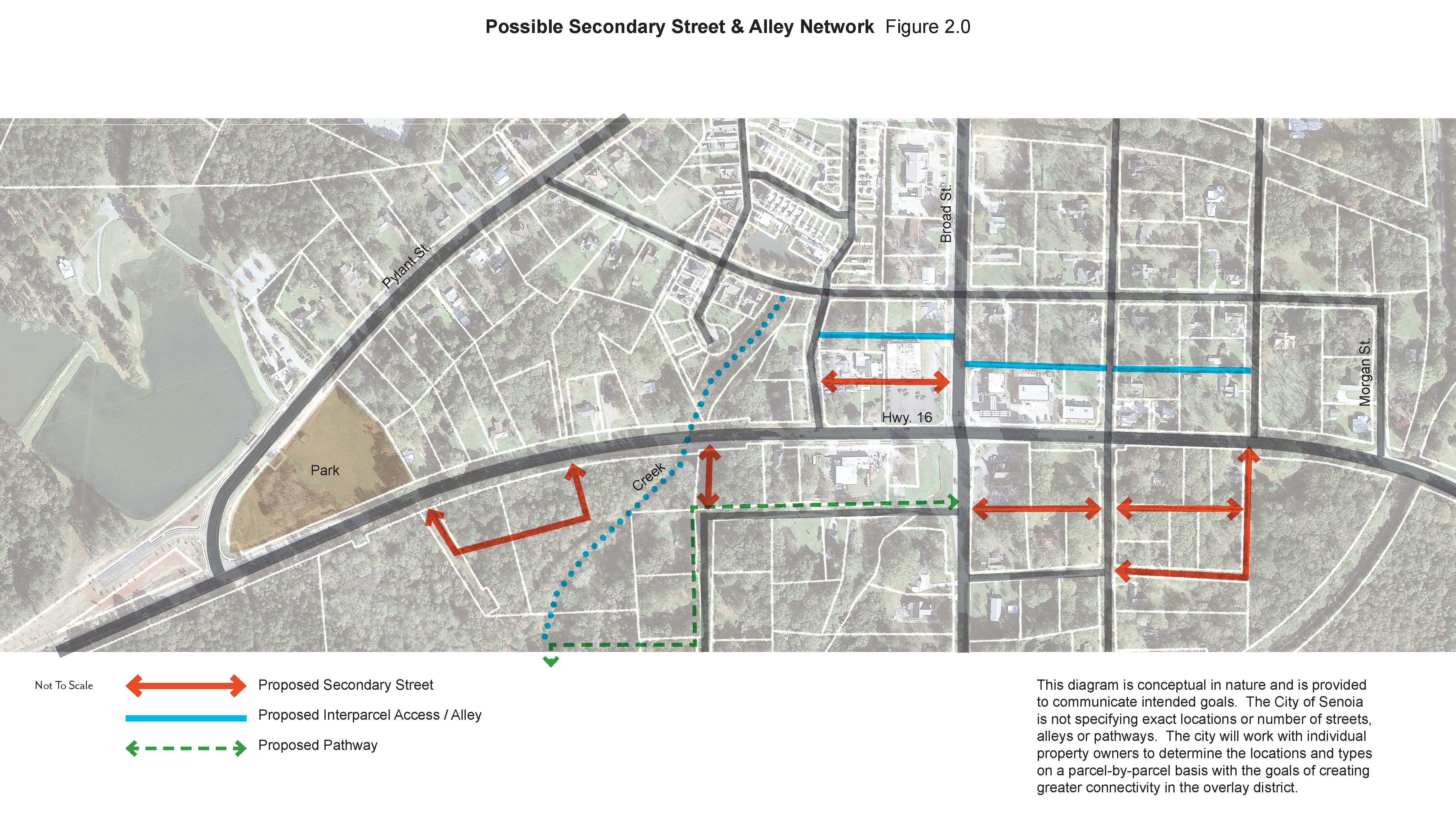
A "secondary street network" is intended to minimize disruption of traffic flow on Highway 16 by providing new, alternative routes. Platting of properties being developed within the overlay shall afford construction and dedication of such a network either through provision of building sites accessed from secondary street or by platting of building sites along Highway 16. See Possible Secondary Street and Alley Network Figure 2.0.
(1)
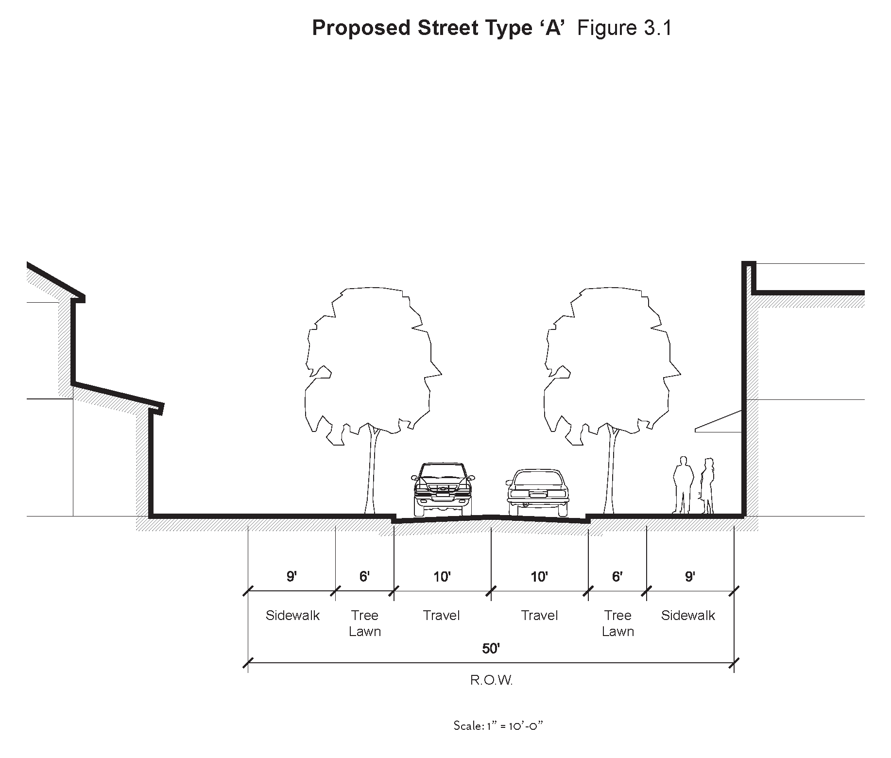
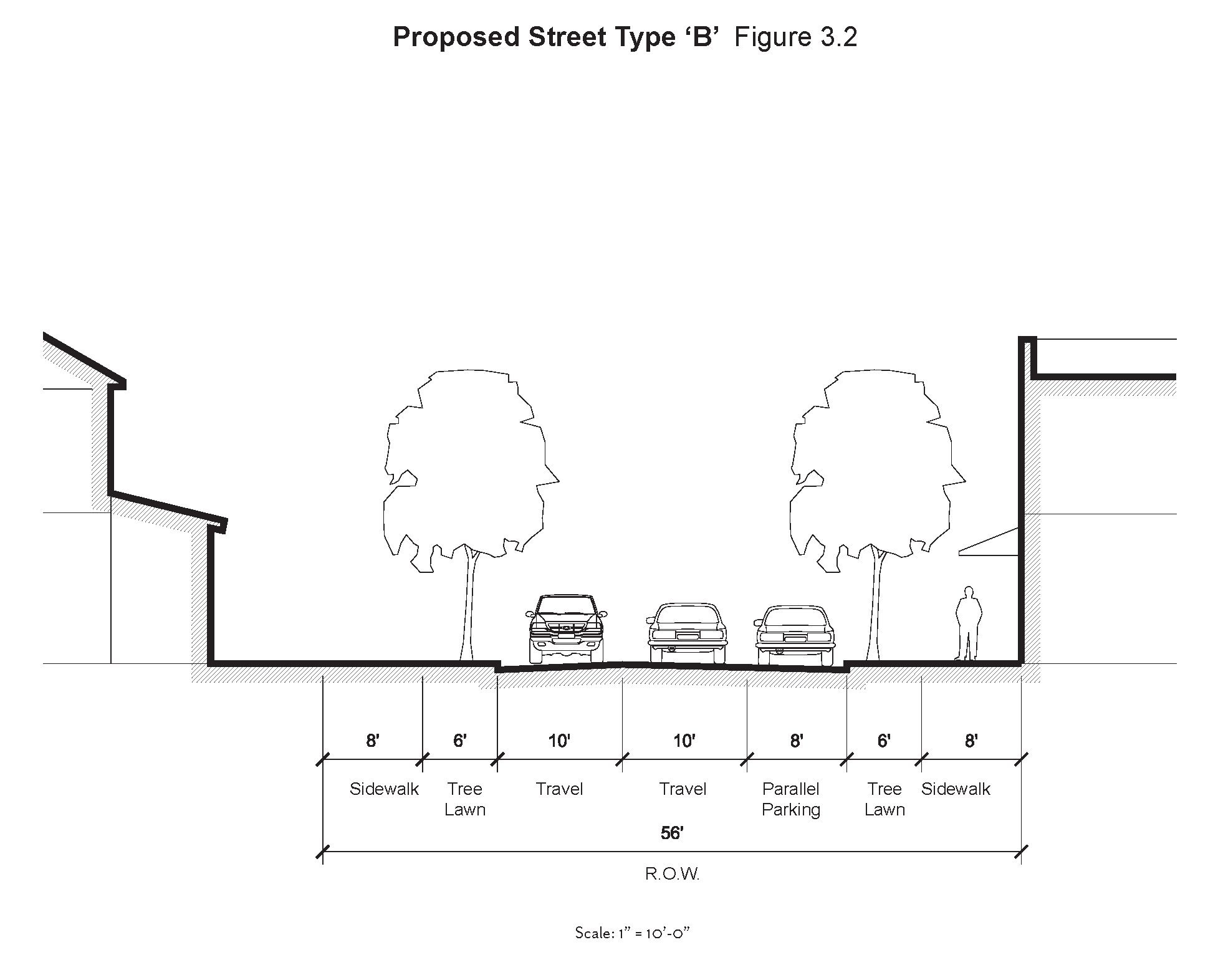
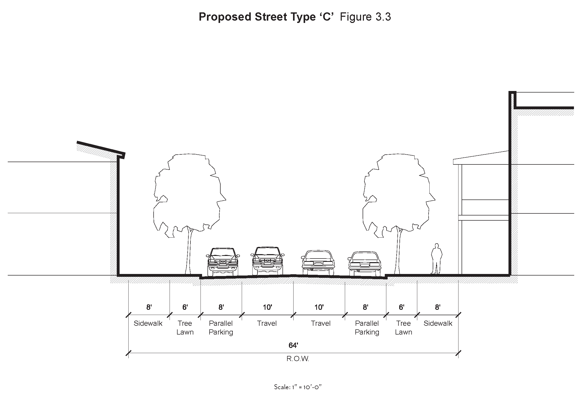
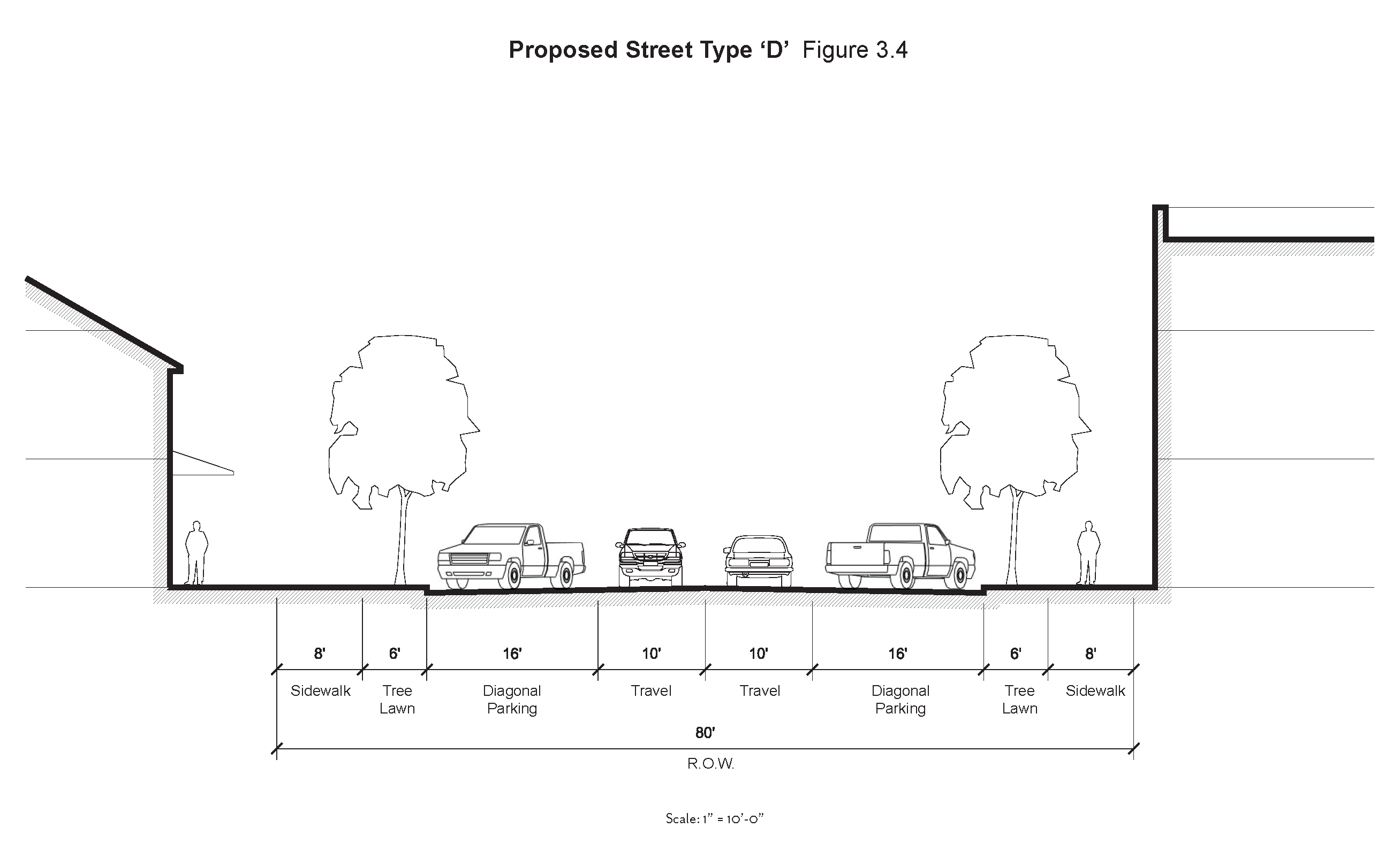
It is required that each site plan submitted for any development within the overlay provides for present or future dedication of right-of-way as previous platting may accommodate for construction of public streets. Such streets shall provide access to property interior to the development. Approval of any site plan for development along the proposed secondary street shall be conditioned upon agreement of the developer of the property to fully fund the cost of construction of such proposed public street along that development's frontage. The site plan shall consider the alignment of such secondary street on adjacent parcels and shall cooperate with the city in the design and layout of an efficient and economical secondary street network and a minimum of a 50-foot right-of-way to be established on the property. See Street Sections Figures 3.1, 3.2, 3.3, 3.4.
(2)
Upon a finding by the city engineer that a development poses inordinate traffic impacts, the applicant shall prepare a professional traffic study according to the standard traffic methodology. In addition to the general standards of the methodology, the traffic study shall include weekend traffic generation and impact analysis. The traffic study shall also evaluate all intersections nearest to the site, or any area designated by the city engineer. Upon evaluation of the traffic study findings, the city may require the applicant to modify the proposed site plan to achieve more acceptable traffic impacts.
(3)
Street width. Where secondary streets are approved, the combined travel lane width of undivided streets within the overlay shall be as a standard ten feet wide. Parking, if incorporated, shall be as follows: parallel spaces should be no more than seven feet wide (exclusive of gutter width); or if 45 degree angled parking is incorporated, spaces should be no more than 15 feet wide (exclusive of gutter width) as measured from the curb. See Street Sections Figure 3.1, 3.2, 3.3, 3.4.
(g)
Interparcel access. Interparcel vehicle and/or pedestrian access between all contiguous retail, office and multi-use lots is required unless unconducive to future development, and in that case could be waived administratively. This may or may not be in addition to a newly created secondary street network (public street). If vehicular, a ten-foot minimum travel lane is required. Pedestrian access route is encouraged to accompany a vehicle access route and can be in the form of a sidewalk or path. If interparcel access is pedestrian only, access should be no less than eight feet wide and incorporate shade trees. When designing interparcel access, connection points should be coordinated with neighboring parcels. If the parcel in question is the first to develop, reasonable care should be taken to ensure that a future connection can be made from neighboring parcels.
(h)
Highway 16 access. All building lots along Highway 16 shall be accessed from a city street; direct access from Highway 16 shall be as determined by GDOT. No building lot shall have direct access from Highway 16 unless specifically approved by the city. A coordinated effort between adjacent properties is encouraged to promote interparcel access and reduce the total number of access points from any city street and Highway 16.
(1)
No new driveway shall be permitted to provide ingress or egress to property on Highway 16 following adoption of this overlay, except for the purpose of serving existing lots of record. Access to Highway 16 shall be controlled by limiting the number of curb cuts, which shall not exceed two for the first 200 feet of frontage, with 24 feet being the maximum curb cut width. The number of such cuts may be increased by one for each additional 150 feet of street frontage on Highway 16.
(Ord. No. 21-16, § 2, 11-15-2021)
Sec. 74-207. - Parking.
All uses shall meet the requirements of this article. Any items not included herein shall be governed by the current standards in article XIII.
(1)
The minimum parking ratios for the overlay district are as follows:
a.
Retail shall be two spaces for every 1,000 square feet of floor area.
b.
Office shall be two spaces for every 1,000 square feet of floor area.
c.
Restaurant shall be three spaces for every 1,000 square feet of floor area.
d.
Residential shall be one space for one bedroom units, and two spaces for two or more bedroom units.
(2)
Electric vehicle parking.
a.
Dedicated electric vehicle (EV) parking is encouraged and may have priority positioning in a parking lot over standard spaces.
b.
Charging stations may be provided but shall not occur along a primary frontage, and should be accompanied by landscape treatment.
(3)
Golf cart parking.
a.
Golf cart parking spaces, if provided, shall be a minimum of six feet by ten feet and shall be provided off street.
b.
For non-residential uses, every one golf cart space provided on site, one car parking space can be subtracted from the development's parking requirements, up to 15 percent of the total parking requirement.
(4)
Bicycle parking.
a.
Bicycle parking is encouraged for nonresidential and multi-unit residential development in order to encourage bicycle use.
b.
Bicycle racks shall be located in close proximity to entrances and other high activity areas, highly visible, active, well-lit areas without interfering with pedestrian movement.
(5)
Off-street parking shall be uniformly distributed across the rear of the building, and allow access to adjacent lots. No off-street parking should be located between the building and the primary frontage.
a.
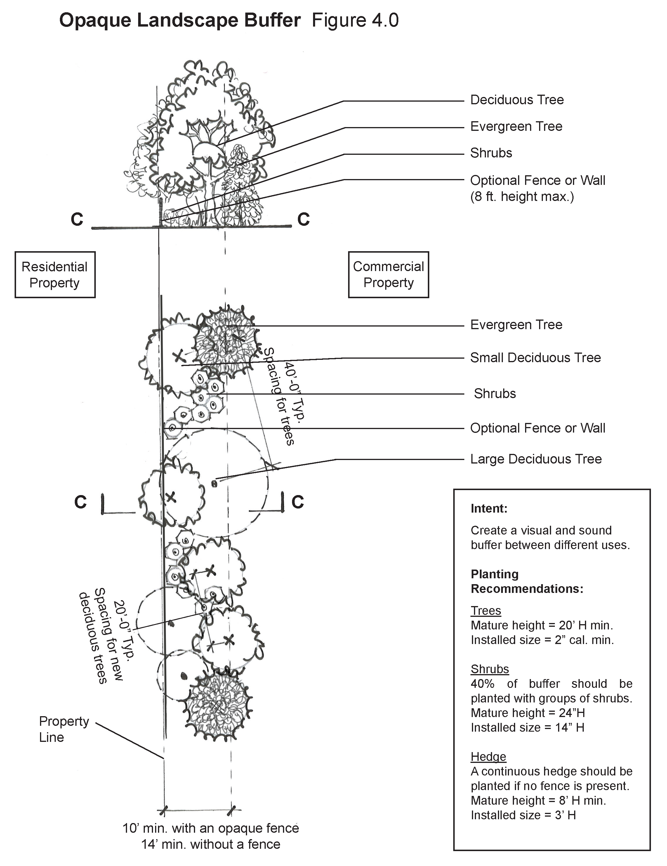
No parking or paved service areas shall be permitted within 18 feet of the property line of an adjoining residential zoning lot. Parking and service areas shall be separated from adjoining residential zoning lots using an opaque landscaped screen across the entire width of this shared property line, which may be provided in combination with a fence or wall. Installation of such a fence or wall shall not be a substitute for plant materials distributed appropriately across the entire buffer. Such buffering shall achieve a reasonable visual separation between the properties, subject to approval by the city administrator. See Opaque Landscape Buffer Figure 4.0.
b.
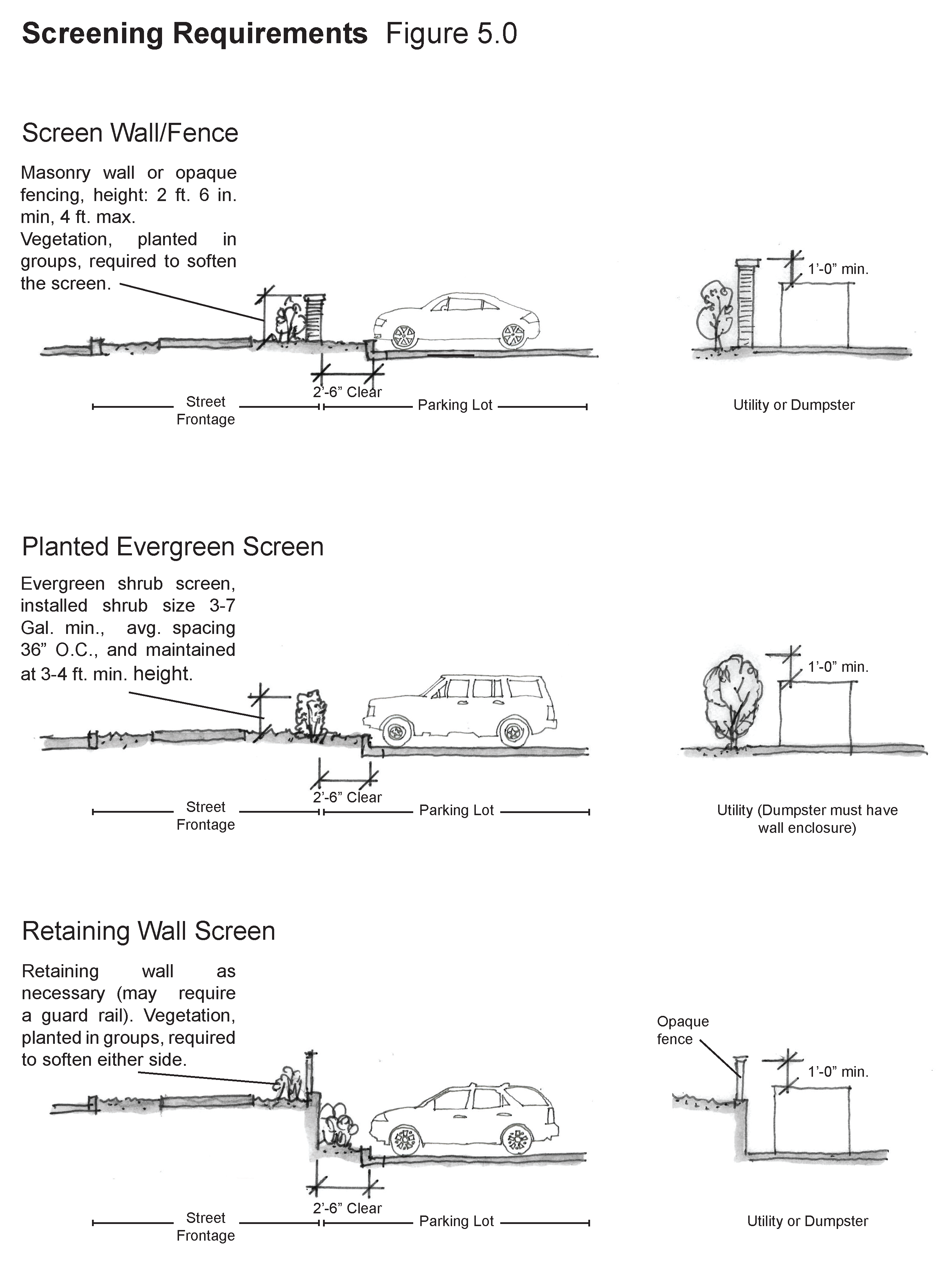
On corner lots, the parking lot shall be screened from secondary streets by the main building, accessory building, wall or fence, or landscaping. For screening techniques, see Screening Elements Section and the Screening Requirements Figure 5.0.
c.
Parking lot entrances and exits should have a maximum of 12 feet wide drive lanes, with the exception of the driveway apron.
d.
Parking areas designed to accommodate more than 20 automobiles must install interior landscaped areas so that no more than eight adjacent parking spaces exist without a landscaped separation of at least five feet in width and contain one shade tree. If significant tree save areas or natural areas exist within a parking area, the town may make an exception to this requirement as appropriate. These islands can also be developed as stormwater run-off gardens.
(6)
On-street parking may be incorporated into existing streets or proposed secondary streets as determined by the city. See Street Sections Figure 3.2, 3.3, 3.4 for possible configurations of parking. The city reserves the right whether to allow on-street parking to count towards an abutting parcels parking needs.
(Ord. No. 21-16, § 2, 11-15-2021)
Sec. 74-208. - Site design.
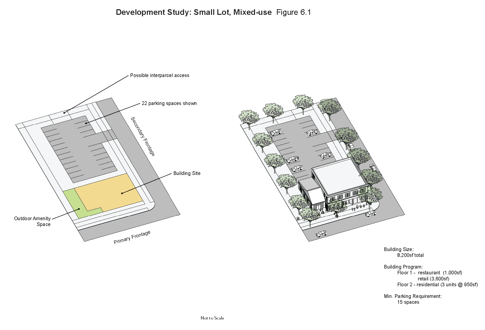
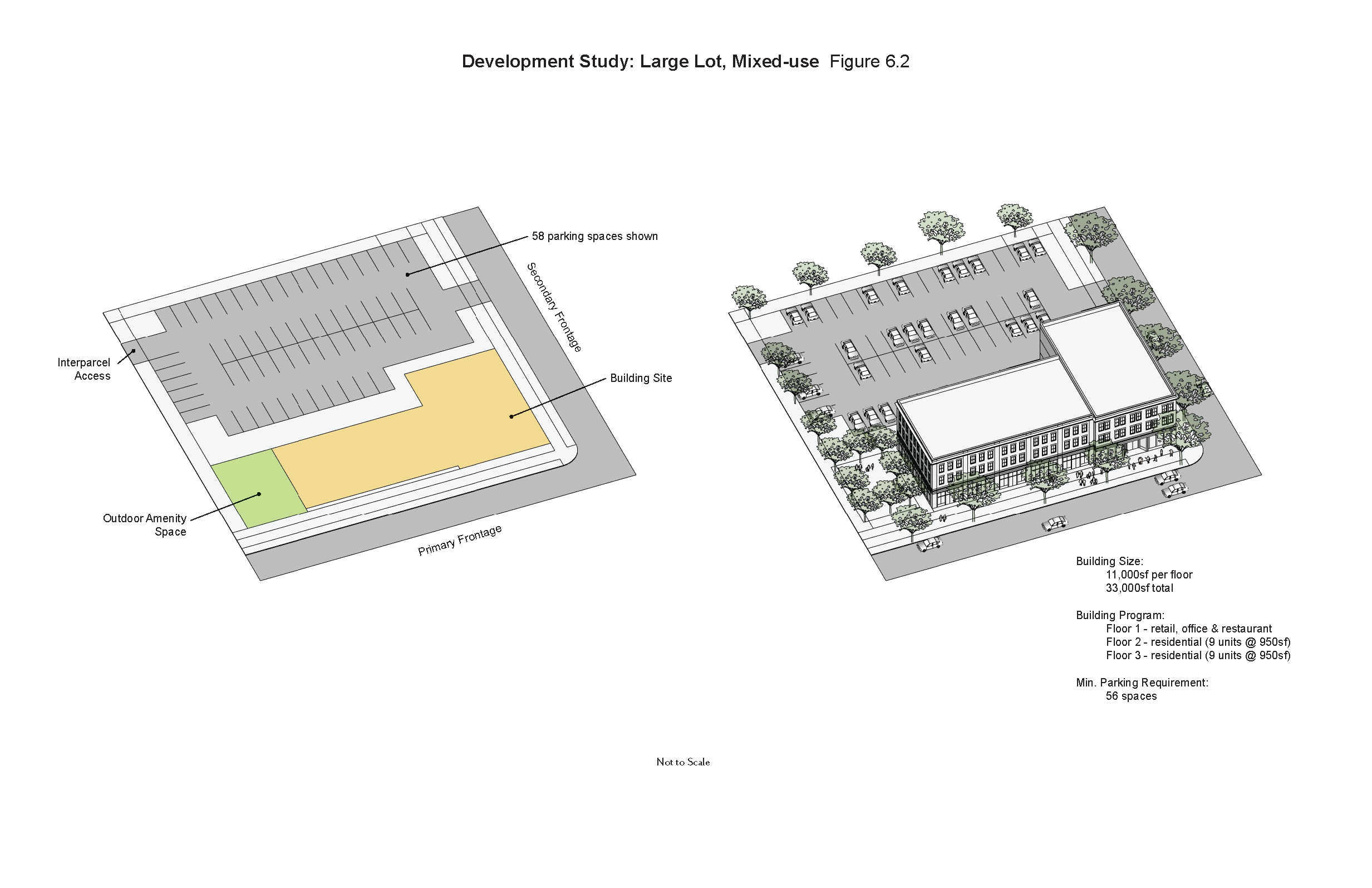
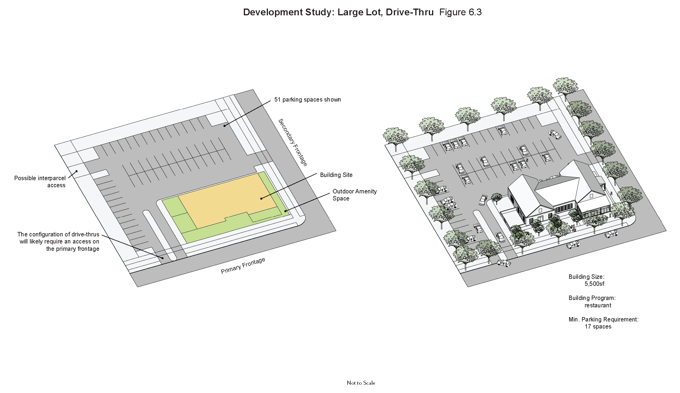
Example site designs of different development scales and programs illustrate points below. See Development Study Figures 6.1, 6.2, 6.3.
(1)
Building setback. Buildings shall be setback from the boundaries of their properties as follows:
a.
Front: 0 feet minimum.
b.
Sides: 0 feet, ten feet minimum.
c.
Rear: ten feet minimum.
(2)
The building façade shall be parallel to the primary frontage property line. Façades are not required to be parallel to the primary front property line within 20 feet of building corners. The principal entrance shall be through the façade.
(3)
Buildings shall reinforce major intersections and view terminuses through careful building placement, orientation, and form.
(4)
More than one building may occupy a parcel, but it is encouraged that a building hierarchy be incorporated with the principal building situated on the primary frontage. Accessory buildings may front onto the primary or secondary frontages.
(5)
Pedestrian improvements.
a.
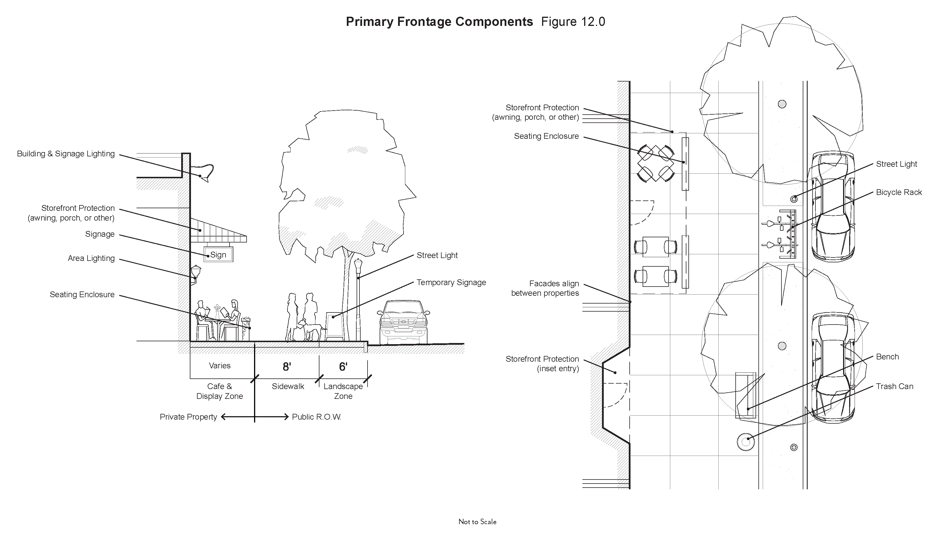
All developments shall provide sidewalks having a minimum width of eight feet, with eight feet being built within the public ROW, along all frontages of the lot that abut a public street.
b.
Sidewalks having a minimum width of eight feet shall be provided along the full length of the building façade featuring a customer entrance, and along any façade along public parking areas. The sidewalk does not have to abut the buildings as long as a connection is made to the customer entrance.
c.
All buildings shall provide direct pedestrian access from on-site parking areas as well as the public sidewalk.
d.
All on site sidewalks shall be distinguished from vehicular surfaces through the use of durable, low maintenance materials such as pavers, or bricks to enhance pedestrian safety.
(6)
Screening elements. All developments shall, to the extent practical, provide screening elements for the purpose of shielding unattractive utilities, dumpsters, loading docks, parking areas, and similar areas from view from the street or neighboring properties. See Screening Requirements Figure 5.0.
a.
Service and utility elements such as equipment storage, loading docks, and freestanding above-ground utilities should be located out of public view from streets; and, to the degree possible, adjacent properties and other highly visible areas such as parking lots, access drives, and pedestrian routes. These service elements must be appropriately screened on all sides with fencing or walls so as to be 100 percent opaque up to a minimum of one foot above the highest point of the service or utility element, with a maximum of six feet. The screening materials and design shall be visually integrated into the overall character, theme, and architectural design of the associated building or project. Landscape may be included into the screening treatment, but not in lieu of walls or fences.
b.
Dumpsters shall be located out of public view but still in an easily accessible location for service trucks. Screening shall consist of three solid walls of masonry, brick, stone or stucco construction, a minimum of six feet in height, and the fourth wall shall consist of opaque metal or wooden gates. The gate opening shall have a minimum width of 12 feet. All dumpsters shall be equipped with lids. The pad of the gated dumpster enclosure shall be concrete pad and all dumpster approaches shall also be concrete and have a minimum length of ten feet. Dumpster shall be located a minimum of 18 feet from any residential zoning district or use, and the Highway 16 right-of-way, but may otherwise be located within any required building setback.
c.
Parking lots shall be screened from view of streets and neighboring properties in the one of following manners:
1.
Hedge planted in a linear pattern;
2.
Low wall or fence with landscape treatment; or
3.
Retaining walls where the parking is set at the lower elevation.
(7)
No unenclosed, outside storage shall be permitted. Such enclosures will permit unroofed, outside storage shall consist of walls having a maximum height of six feet, and in no case less than the height of equipment, materials, merchandise or other goods to be stored. The screening materials and design shall be visually integrated into the overall character, theme, and architectural design of the associated building or project. Chain link fencing is prohibited.
(8)
Outdoor display of merchandise shall be permitted provided such display is located adjacent to the principal building, conforms to the setbacks for the zoning district and does not impede pedestrian traffic. Merchandise may only be displayed outdoors during the operative hours of the business.
(9)
Utilities all new utility lines shall be located underground. All utility boxes, meters, connections and equipment shall be disguised from view to the extent possible. Meters and conduit shall be painted to closely match the color of the wall material to which they are attached. Large junction boxes and similar equipment set on the ground shall be screened on all sides by a landscape hedge, wall or fence.
(Ord. No. 21-16, § 2, 11-15-2021)
Sec. 74-209. - Landscape and hardscape.
(a)
High-quality, sustainable landscape and hardscape is expected as an integral part of this district. The design of the landscapes should come from the local climate and topography. These landscapes should complement and soften the built environment and lend character to buildings and streets. Hardscapes should take inspiration from the historic town center area to create durable and inviting places for active uses. Additionally, the landscape and hardscape should be used to create outdoor rooms, reinforce neighborhood and/or property entries and relationships, and help blend or delineate neighborhood and/or property boundaries as required to create a harmonious and orderly evolution of the areas within the district.
(b)
One of the underlying goals should be that the landscape and hardscape of the district is thought of holistically, and the individual contributions within it are well designed, they can be used to improve the compatibility and transitions between the different land uses and properties. Landscaping can also be used in instances where a natural visual interruption would be beneficial; such as on streetscapes and in parking lots where trees and plants can provide shade, cool the air, and lower the temperature of paved surfaces to make these spaces more physically and aesthetically pleasing.
(c)
Unless otherwise stated in this document, the landscape requirements of the Senoia Code of Ordinances stand.
(d)
Preservation of natural landforms, trees and other land features.
(1)
Mass grading of a site shall be prohibited and all clearing shall be subject to this article. Selective grading and the construction of retaining walls is permissible within reason.
(2)
A minimum of ten percent of all existing trees having a diameter of 12 inches or greater shall be retained. This requirement shall be in addition to the standards of any required landscape area; however, such retention may be achieved through tree preservation within such areas.
(3)
Specimen trees in excess of 24 inches shall be inspected by an arborist for a health evaluation. If deemed in good health with a life span of over 20 years, the tree(s) should be incorporated into the site design.
(4)
Preservation of naturally occurring drainage areas, outside of wetlands, is highly encouraged. If change to these areas is deemed necessary by the project design, an adequate drainage plan is necessary for approval.
(e)
Landscape.
(1)
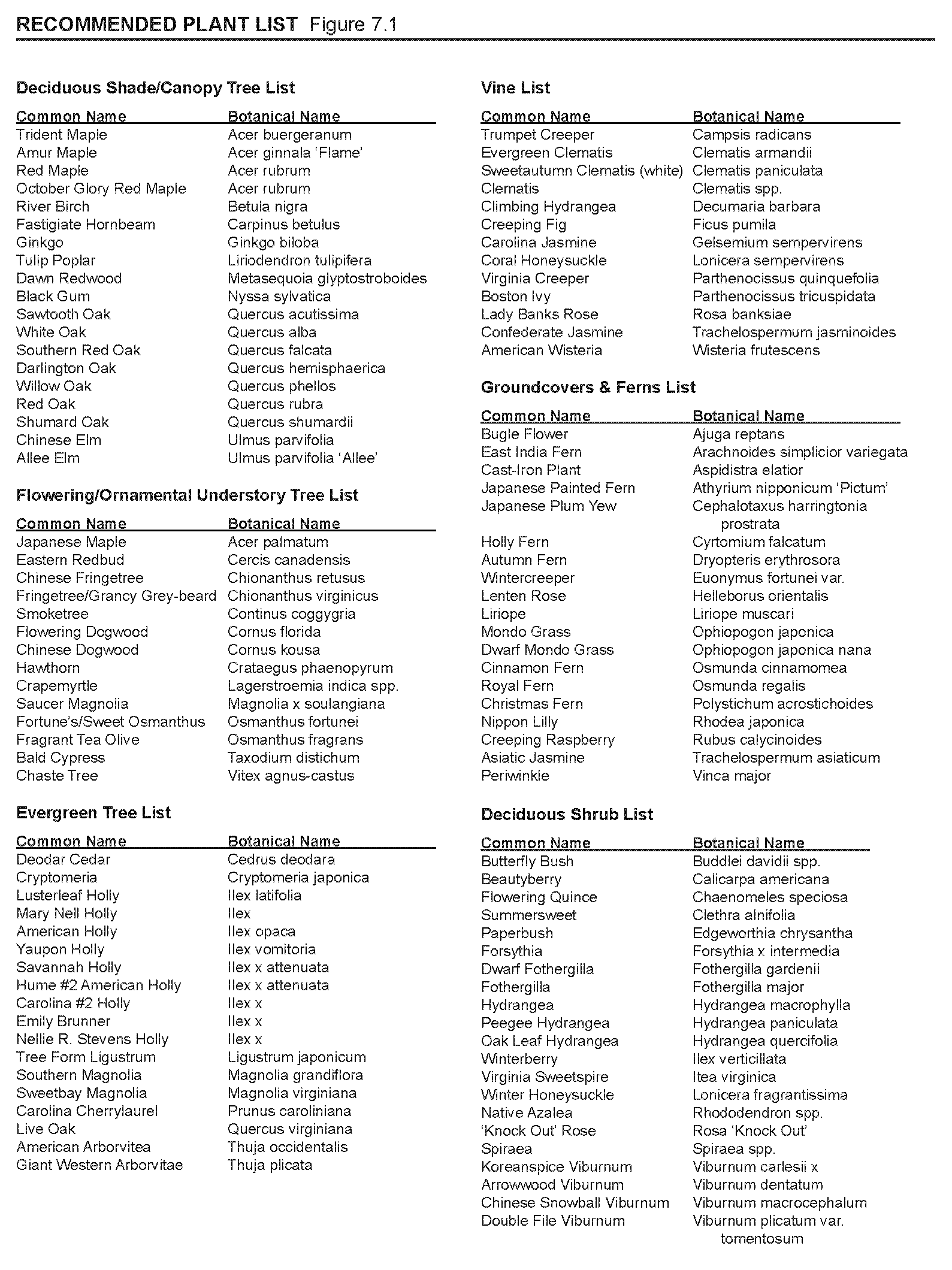
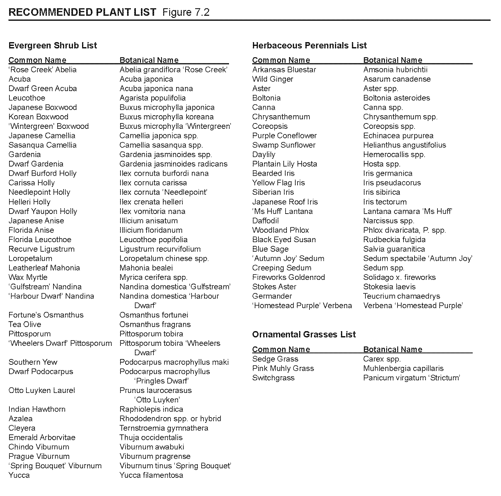
A planting plan is expected to be submitted with the site plan during the approval process. To assist applicants in this, a list of recommended trees, shrubs, vines, ground covers, perennials and grasses has been compiled for the applicant's convenience and consideration. See Recommended Plant List 7.0.
(2)
Tree sizes and spacing.
a.
Canopy trees shall be a minimum of three-inch caliper at the time of installation. Spacing will be indicated by the expected canopy size of a particular species and the tree's specific application, however canopy trees will commonly be planted within 30 to 50 feet of each other.
b.
Understory trees shall be a minimum of two-inch caliper for single trunk species and for multi trunk species, there must be at least three trunks of one-inch caliper each, at the time of installation. Spacing will be dictated by the expected canopy size of a particular species and the tree's specific application, however canopy trees will commonly be planted within 15 to 30 feet of each other.
(3)
All developments shall reserve a minimum of five percent of the gross lot area as outdoor amenity space. These spaces shall be strategically located for the beneficial use of customers, employees and residents. These outdoor amenity spaces can be configured as a hardscape or greenspace, or a combination of the two. The intent is to create activated areas for people that can include seating areas, plazas, café dining, art space, or occupiable landscape such as a small lawn. No more than 50 percent of required outdoor amenity space shall be located within a 100-year floodplain, wetlands or utility easement.
(4)
Street trees.
a.
Trees lining streets or other public gathering areas can be either canopy or understory trees. If a canopy tree, the species for this application are limited to: oak, maple, elm. If an understory tree, the recommended species for this application are: crepe myrtle, golden rain tree, fringe tree, or magnolia.
b.
Tree wells set between a sidewalk and street curb shall be a minimum of six feet wide by eight feet long (ten feet recommended).
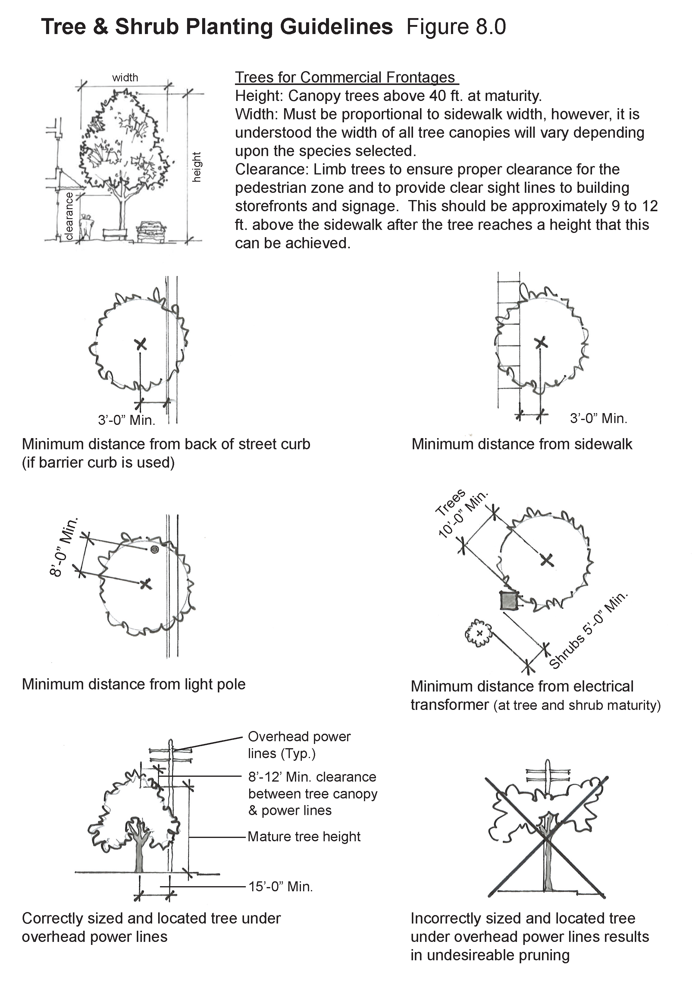
c.
Proper installation and pruning is necessary to ensure street trees will have a long, healthy lifespan. See Tree & Shrub Planting Guidelines Figure 8.0 for more information.
(5)
General plantings.
a.
Successful development plans shall have a variety of plantings appropriately dispersed around the site. Plantings should include a mix of trees, shrubs, ground cover, and potted plants. Small areas of lawn are permissible but not encouraged due their irrigation and maintenance needs.
b.
Consideration should be made to the irrigation needs of the plantings, and irrigation systems be installed where necessary to ensure healthy plant life.
c.
Where paving material does not abut buildings, foundation plantings or lawn shall be incorporated along the building walls. However, all street frontages are expected to have paving material abutting the buildings.
d.
Mulch, pine straw or decorative gravel should be applied to planting beds, but in no case shall any of these materials be the only ground covering material.
e.
A planting plan should be integrated with the rainwater drainage plan to promote natural irrigation and reduce the effects of erosion and runoff. See stormwater management section for additional information on this topic.
(6)
Landscape buffers.
a.
A landscape buffer having a minimum horizontal dimension of 15 feet shall be provided along property lines abutting residential uses. In the case that a fence or wall of six feet min. and eight feet max. is incorporated, the horizontal dimension can be reduced to ten feet but must still incorporate landscape plantings. See Opaque Landscape Buffer Figure 4.0.
b.
Buffers shall be composed of trees and shrubs which are long lived, and indigenous this part of Georgia and 50 percent of which shall be evergreen species. Plant materials may be arranged in asymmetrical groupings or in linear rows as long as placement and layering achieve the goal of creating an opaque landscape buffer.
(h)
Hardscape.
(1)
Sidewalk, curb and paving designs, patterns and materials shall be compatible and consistent with those found in the historic town center area. Enhanced design features may be permitted with city approval.
a.
Acceptable materials include (may be mixed with one another):
i.
Brick;
ii.
Concrete; and
iii.
Smooth face stone, random rectangular shape with regular joints.
b.
Prohibited materials include:
i.
Stamped concrete; and
ii.
Rough cut (uneven cleft) field stone with irregular joints.
(3)
Any site furnishings such as railings, benches, trash receptacles and bicycle racks shall complement the style and finish of those present in the historic town center area.
(Ord. No. 21-16, § 2, 11-15-2021)
Sec. 74-210. - Utilities.
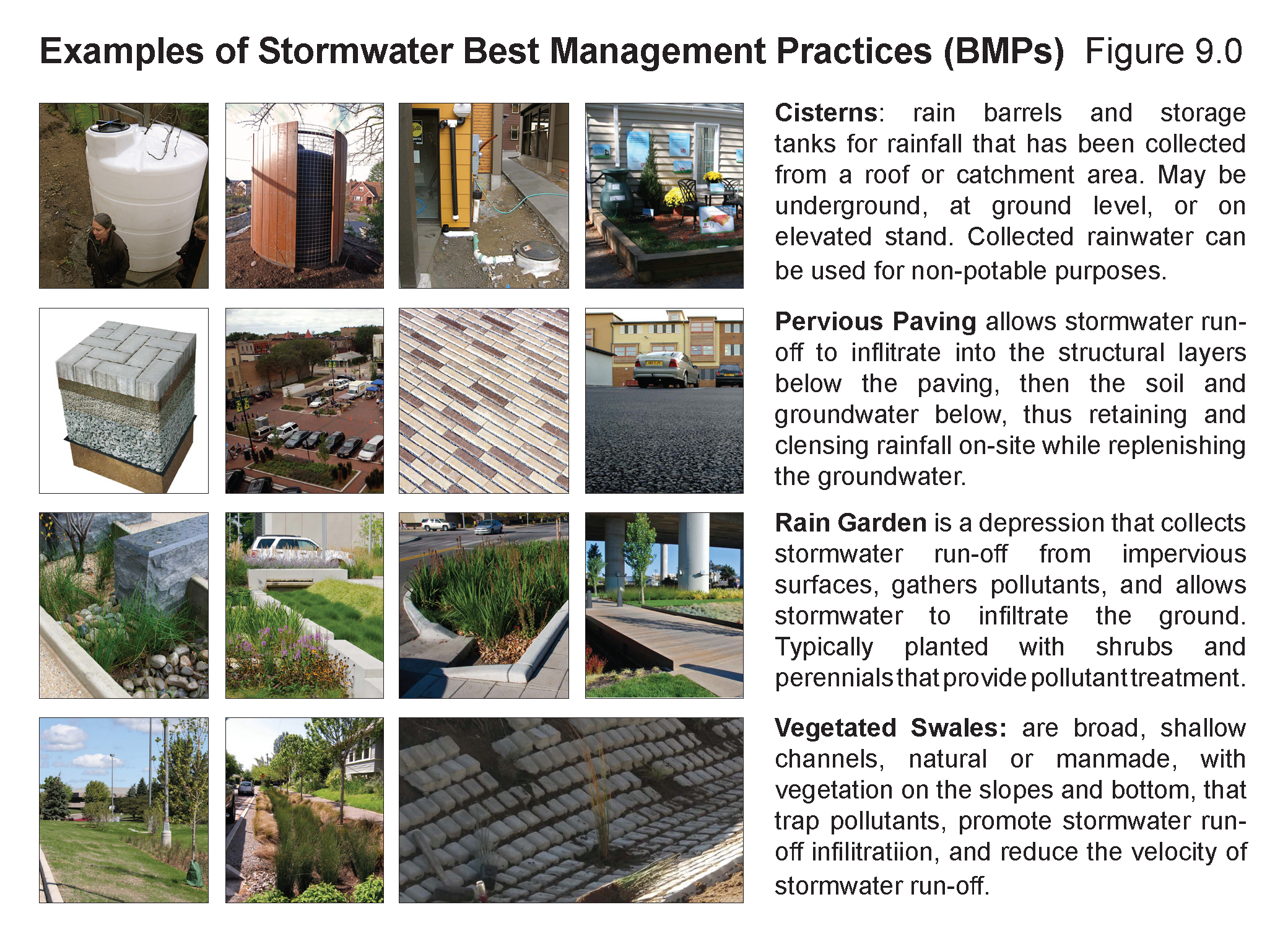
Stormwater management. The purpose of this section is to establish the following objectives for landscaped areas and buffers: limited stormwater runoff from development sites, minimize erosion, establish measurements for water conservation, and reduce the adverse environmental effects of impervious paving areas. These strategies can be naturalistic as well as urban in form and character. Ideally, a variety of stormwater best management practices (proven sustainable stormwater treatment strategies), each with a different visual appearance, are integrated into the new development site plans in order to capture and cleanse stormwater runoff. See Examples of Stormwater Best Management Practices (BMPs) Figure 9.0.
All development plans shall comply with the City of Senoia and the Metropolitan North Georgia Water Planning District (https://northgeorgiawater.org/) regulations for the Flint River and Chattahoochee River Corridors.
(1)
Impervious surfaces: Impervious surfaces should be minimized to the greatest extent possible in order to reduce the amount of stormwater runoff generated. Pervious paving areas constructed of grass cell pavers, porous asphalt, previous paver blocks or the like are encouraged for all, or portions of, parking lot areas.
(2)
Driveway and parking materials: The use of pervious or semi-pervious surfacing materials, including, but not limited to, broom finish and exposed aggregate concrete, pervious pavers, "grasscrete," or recycled materials such as rubber, used asphalt, brick, block, and concrete, may be approved for a vehicular surface area required on a site in areas in proximity to and in combination with on-site stormwater control devices, provided such areas are properly maintained.
(3)
Landscaping: New trees and landscaping will replace vegetative cover lost during land development, as vegetation slows soil erosion, helping to reduce nonpoint source pollution found in stormwater runoff.
(4)
Buffers: Buffers can help with stormwater management by slowing down the flow of water, preventing erosion, filtering out particulates in the water before it enters streams, reducing stream temperatures, and helping to prevent pollutants from entering streams as well as providing a habitat for wildlife.
(5)
Rain gardens and bioswales: Stormwater can be managed naturally by the use of planted rain gardens or bioswales. The capture, control, and treatment of rainfall takes place primarily through retention and percolation. Rainfall is channeled from streets and parking lots to curbside swales and bioretention facilities (i.e. rain gardens) and then slowly released wherever possible. The use of water-loving native plant materials can contribute to an aesthetically and environmentally sound approach to stormwater management. Cisterns: Rain barrels and underground storage tanks allow for the capture and reuse of stormwater for landscape irrigation and other purposes. Capturing stormwater from roofs before it reaches the site drainage systems reduces the need for other treatment options.
(6)
Detention ponds or retention areas should be considered only after other means of stormwater management have proven inadequate to handle the stormwater volumes. Detention ponds or retention areas shall be designed to blend with adjacent landscaped areas to the greatest possible extent. Lawn banks and fences should be avoided. Stormwater facilities may be located within a buffer; however, shall not be located in a front yard or within 50 feet of a property boundary.
(7)
Utilities all new utility lines shall be located underground. All utility boxes, meters, connections and equipment shall be disguised from view to the extent possible. Meters and conduit shall be painted to closely match the color of the wall material to which they are attached. Large junction boxes and similar equipment set on the ground shall be screened on all sides by a landscape hedge, wall or fence.
(Ord. No. 21-16, § 2, 11-15-2021)
Sec. 74-211. - Building design.
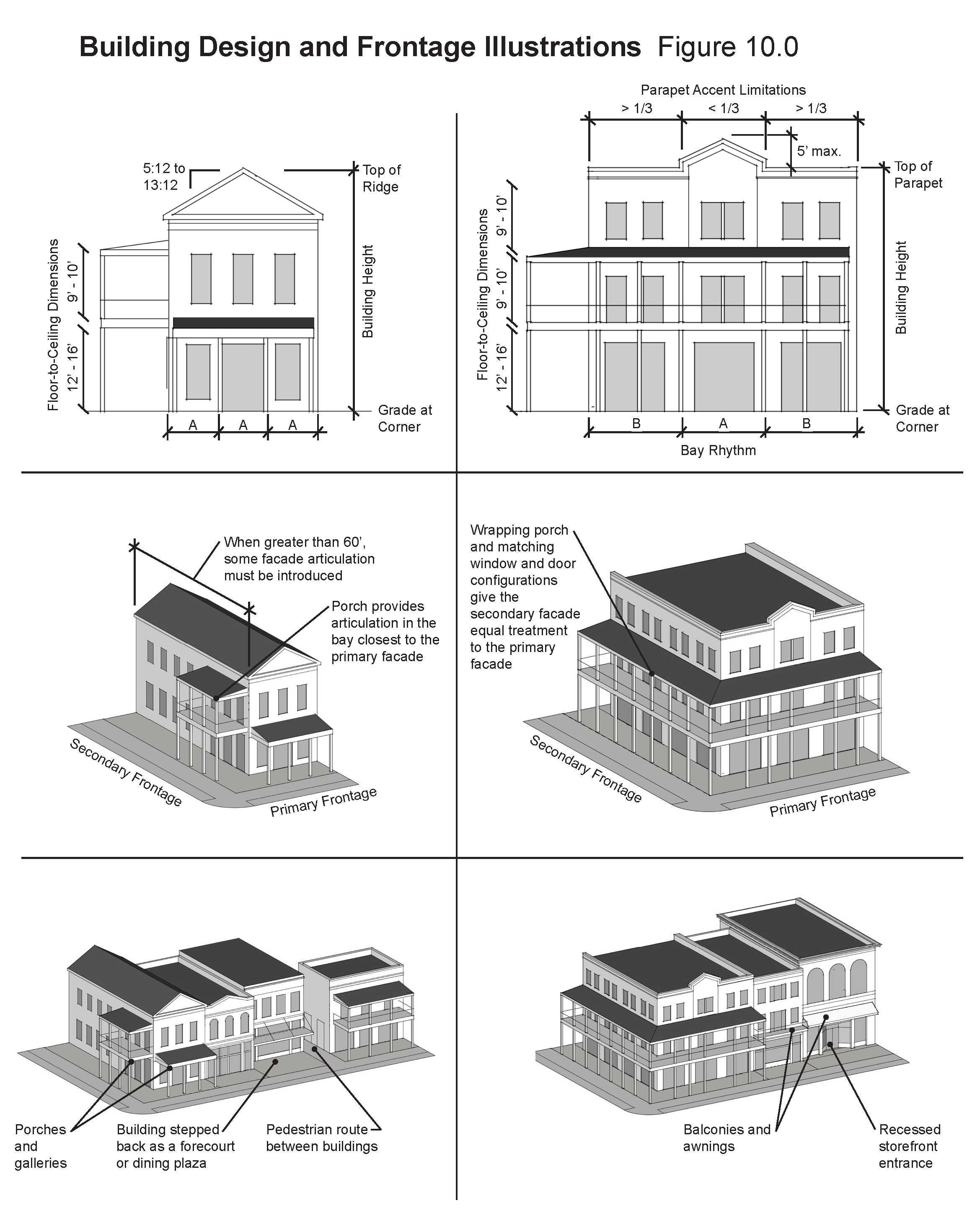
The purpose of this section is to regulate the street-front buildings envisioned for the district in order to provide an appropriately scaled and designed pedestrian environment reflective of the historic town center. See Building Design and Design Illustrations Figure 10.0 for reference on the following items.
(1)
Architecture and building materials. Principal and accessory buildings shall be designed to comply with this article and the historic district of Downtown Senoia Design Guidelines.
(2)
Building height. The principal building shall not be taller than three stories or 40 feet as measured from the natural grade at the front corners of the building to the ridgeline or parapet, whichever is greater. The ground floor is located at grade with a floor to ceiling height of 12 feet to 16 feet. Upper floors shall have a floor to ceiling height of nine feet to ten feet. Accessory buildings may be no taller than the principal building.
(3)
Building massing. The building massing is regulated by whether it has a pitched roof or flat roof configuration.
a.
Pitched roof.
1.
One story buildings with a pitched roof shall have a maximum cornice height of 18 feet.
2.
Two story buildings with a pitched roof shall have a maximum cornice height of 26 feet.
3.
Pitched roofs must not extend more than ten feet above the eaves if the roof pitch is 5:12 to 13:12.
4.
Pitched roof structures may contain additional floor area within the roof which may include dormers.
b.
Flat roof.
1.
Parapets must extend a minimum of three feet above the top of the roof structure. This minimum height is intended to ensure that all rooftop equipment is hidden from public view.
2.
Parapets must occur within the maximum building height, except that a portion of the parapet no more than more than one third the width of the corresponding façade may extend up an additional five feet.
3.
Buildings with a flat roof and parapet are not required to have a cornice/eaves line distinct from the top of the parapet.
4.
All rooftop equipment shall fall within the permissible roof heights, be located away from slopes or areas exposed to the public street, and otherwise be screened from view from adjacent public streets or be incorporated into the skin of the building or internal to the block.
(4)
Façade bay rhythm:
a.
Differentiated bays should be expressed on each façade of a building directly fronting a public space or street.
b.
Bays shall be a minimum of eight feet and a maximum of 24 feet wide on primary frontages.
c.
On any façade that is visible from a public right-of-way that is directly adjacent to an area of primary frontage, at least one bay shall be articulated on the corner adjacent to the primary façade.
d.
Where these façades are over 60 feet in length, they must have architectural articulation, such as bays or pilasters, for at least 20 percent of the façade in addition to the first bay adjacent to the primary façade.
(5)
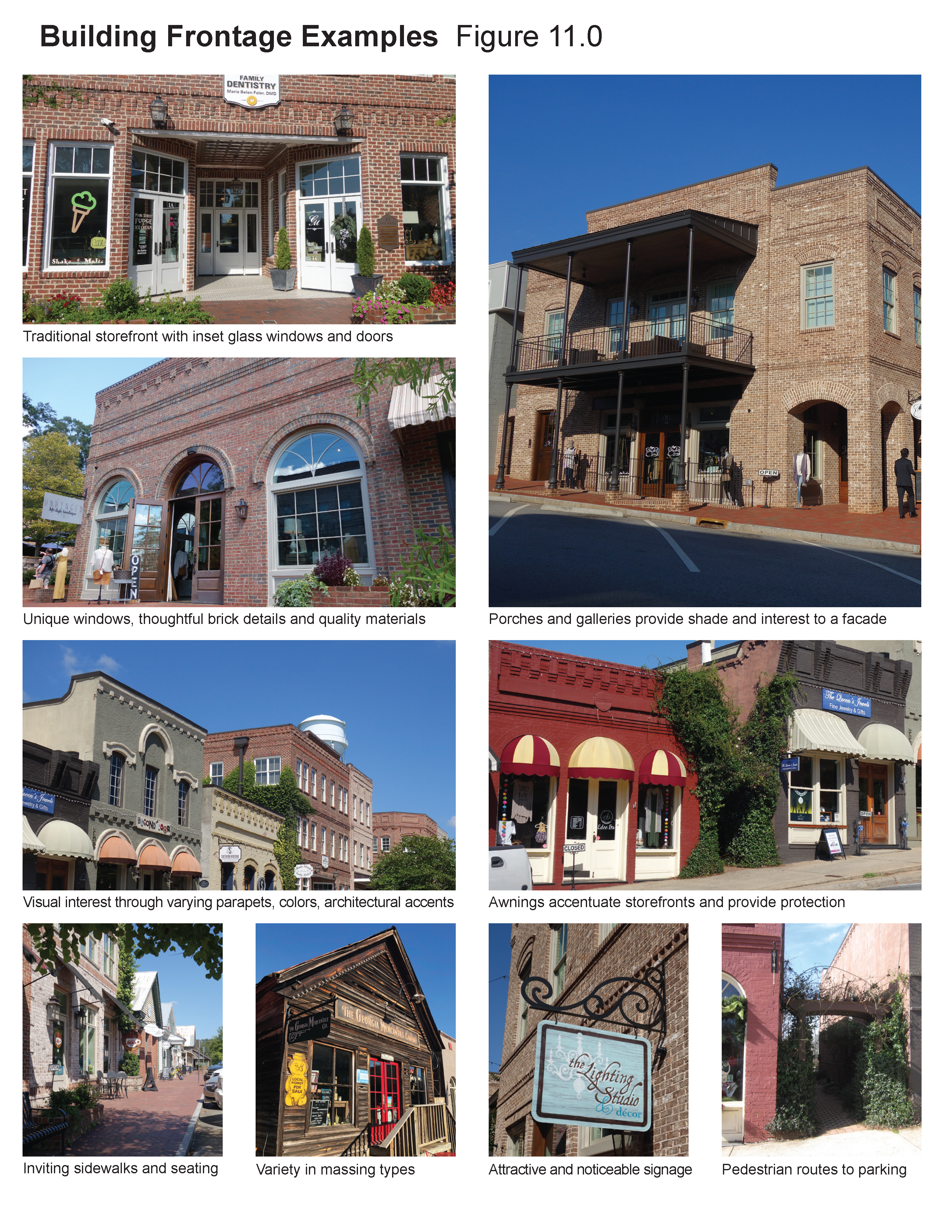
Building frontage. Buildings may front the street In a number of different ways. The building's frontage is the combination of its façade arrangement (windows and doors), any structures that project from the façade, such as porches, terraces, stoops, awnings, or bay windows and the distance of the building from the street. See Building Frontage Examples Figure 11.0. See Primary Frontage Components Figure 12.0.
(6)
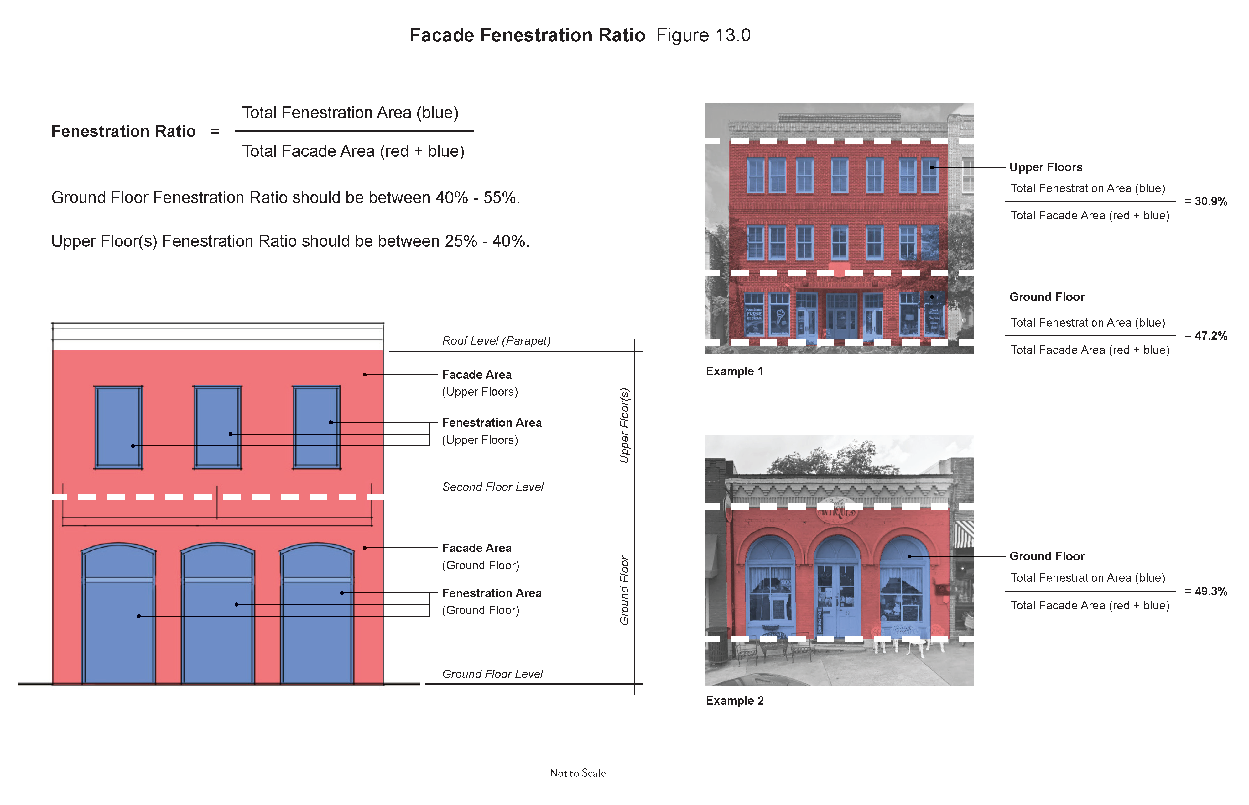
Fenestration ratio. The punctuation (door and window openings) in a building's façade is referred to as its fenestration. Two important factors of regulating fenestration are: 1) to ensure an appropriate ratio of openings to wall surface for a building façade, and 2) to ensure a degree of transparency or visual connection between the outside and inside. When calculating the fenestration area, door and window units including frames and trim may be included, however any recess or panel that does not also have a degree of transparency may not be counted. Doors that do not include glass or windows that may have opaque glass or other view-obscuring elements may only contribute up to five percent of the fenestration ratio for that floor level and also fenestration ratio figure 13.0.
a.
On the primary façade facing the primary street, the ground floor fenestration ratio should be between 40 percent and 55 percent.
b.
On the primary façade, upper floor(s) fenestration ratio should be between 25 percent and 40 percent.
c.
Commercial street fronts along the ground floor of a building shall be designed to permit maximum flexibility for subdividing commercial spaces.
(7)
Entrances. Most buildings should have two equally inviting and accessible entrances. One on the primary façade facing the primary frontage and one on a secondary façade with convenient access to the main parking lot.
(8)
Any exhaust vents on the roof or walls shall be placed on non-street facing planes, to the extent possible.
(Ord. No. 21-16, § 2, 11-15-2021)
Sec. 74-212. - Lighting design.
(a)
Streetlights shall be provided along all public rights-of-way utilizing decorative light poles and fixtures consistent with the design adopted by the City of Senoia for the overlay. Streetlights shall be staggered, spaced no more than 150 feet on-center, along both sides of the roadway.
(b)
Lighting in parking areas shall provide area lighting sufficient to achieve a minimum illumination of two foot-candles and maximum of five foot-candles of light as measured at grade level and recommended in the IESNA Lighting Handbook. Maximum pole light height for parking areas is 20 feet.
(c)
Lighting of loading areas shall follow the illumination requirements of parking areas, and should be non-intrusive to neighbors. Separate controls, such as motion detectors or timers are encouraged for loading areas.
(d)
All building entrances, walks and vehicular access shall be illuminated up to a maximum of five foot-candles of light as measured at grade level and recommended in the IESNA Lighting Handbook.
The following steps should be taken to control light trespass problems, including nuisance glare:
(1)
Prior to design and installation, inspect areas adjacent to the lighting design location to identify and consider any potential problems involving neighboring residences and roadways.
(2)
Select luminaires that have tightly controlled intensity distributions, using full cutoff reflectors and refractors.
(3)
Contain light within the design area by carefully selecting, locating, mounting, and aiming (when appropriate) the luminaires.
(4)
Use well-shielded luminaires (or select equipment that can be shielded) if a potential problem is found after installation.
(5)
Keep floodlight aiming angles low so that the entire beam always falls within the intended lighted area during (and after) the design and installation process. This lighted area should be fully within the lighting design location and have no spillover to neighboring properties.
(6)
Where adjacent to residential uses, illumination shall not exceed 0.3 foot-candle at ten feet beyond property line.
Each of the lighting fixtures chosen for this overlay district will need to adhere to the following criteria:
(1)
Light color is to be white, preferably 3,500 Kelvin, but with any adjustable range from 2,800 to 5,000 Kelvin.
(2)
The color rendering index must be 80 or greater.
(3)
The fixtures shall be primarily down-firing. Up-firing fixtures, if used for aesthetic effect, must be aimed at white horizontal reflectors to produce diffused light downward to prevent dark sky intrusion.
(4)
The light source should not be visible to drivers, bicyclists, or pedestrian unless they are directly under the fixture.
(5)
All luminaires should be control-ready with the ability in the future to be individually monitored and controlled by wired or wireless central networks.
(6)
Luminaire design (light poles, posts, fixtures, globes, etc.) should be compatible with the local context.
(Ord. No. 21-16, § 2, 11-15-2021)
Sec. 74-212.5. - Plan review procedures.
(a)
Application procedures. All applicants for new development, and/or construction permits that expand the use or building footprint shall apply for plan approval through the community development director. Application forms, available from the city, must be submitted together with a scaled site plan depicting the proposed improvements.
Applications shall be filed with the community development director 30 days prior to the meeting of the planning commission shown on the City of Senoia website.
(b)
Pre-application conference. Prior to filing an application for rezoning, development permits or building permits of property within the overlay, the applicant shall confer with the community development director for the purpose of reviewing the proposal and to obtain information about development standards and ordinances affecting property within the overlay.
(c)
Application requirements. Any application for rezoning in the downtown corridor overlay shall be accompanied by a site plan and building design schematics as provided below. A narrative containing the following information shall also be provided:
• Applications for development under this article shall be accompanied by a scaled site plan of not greater than one inch equals 50 feet depicting lot size, project dimensions, pedestrian circulation; vehicular access and parking facilities; loading facilities, greenspace, landscaping and buffers, site lighting, dumpsters; and adjoining uses and zoning.
• Information concerning adjoining uses shall indicate the architectural relationship of the proposed project or improvement to the surrounding context and shall be in the form of sketches or photographs.
• A description of the character of the development, including a summary of floor area by use types, number, total lot area and square footage allocation for parking, landscaping and greenspace.
• A development and construction schedule indicating major milestones in the proposed development.
• Projects to be developed in phases shall provide a general statement of the proposed development schedule by phase.
• Any agreements, provisions and covenants that govern the use, maintenance and protection of the development and any common or greenspace areas.
• A professional traffic study may be required for projects expected to generate more than 500 vehicle trips per day.
• Development must comply with the City of Senoia Tree Protection Ordinance.
• A "design book" that will depict and guide architectural style, scale and materials to be used in the development shall also be produced by the applicant. The front, rear and side elevations and perspective drawings of all structures to be built must be included in the design book.
(d)
Review procedures. The community development director and planning commission shall review all applications regulated under this article. Such review shall ensure proposal consistency with the purposes of this article and conformance to the standards contained herein. Site plan review by the community development director and planning commission shall precede any action by mayor and council. The findings and recommendations of the community development director and planning commission shall be provided to the mayor and council, which may incorporate such findings and recommendations in their consideration of the proposal. Planning commission shall be empowered to issue non-binding approvals or denials of site development, construction or alteration matters. All applications require final action by the mayor and council.
Applications that are approved by the mayor and council shall be forwarded to the community development director and the necessary permits issued. Should the applicant be unable or unwilling to comply with the recommended changes suggested to reach compliance with this article, no permits shall be issued. All recommended changes shall comply with the standards set out herein.
(Ord. No. 21-16, § 2, 11-15-2021)