
Siler City City Zoning Code
ARTICLE IX
Zoning Districts And Zoning Map
125 Residential Districts Established
- The following residential districts are hereby established: A-R, R-20, R-10, R-MH, R-6, and R-3. Each of these districts is designed and intended to secure for the persons who reside there a comfortable, healthy, safe, and pleasant environment in which to live, sheltered from incompatible and disruptive activities that properly belong in nonresidential districts. Other objectives of some of these districts are explained in the remainder of this section.
- The A-R district is designed to accommodate agricultural and residential uses normally associated with:
- agricultural uses normally associated with large tracts of uninhabited land near the fringe of urban areas.
- single-family residential development in areas not served by town or county water and sewer facilities and that are not yet appropriate for development at higher densities. Some types of manufactured homes are allowed to be used for single-family residential purposes in this district.
- The R-20 and R-10 district is designed primarily to accommodate single-family detached residential uses, excluding manufactured homes, at medium densities in areas served by Town water and sewer facilities. Two-Family and multi-family residences are allowed in the R-10 district.
- The R-6 district is designed to accommodate single-family detached, two-family, and multi-family dwelling units, as well as some types of manufactured homes used as single-family residences.
- The R-3 zone is designed primarily to accommodate higher density multi-family developments.
- The R-MH zone is designed to accommodate manufactured homes and manufactured home parks.
Amended August 18, 2014, June 19, 2017, April 16, 2018
126 Commercial Districts Established
- The following commercial districts are hereby established: C-C, B-1, O-I, G-C, and H-C. These districts are created to accomplish the purposes and serve the objectives set forth in the remainder of this section.
- The C-C (central-business) district is designed to accommodate a wide variety of commercial activities oriented towards pedestrians and which will result in the most intensive and attractive use of the town's central business district
- The B-1 (neighborhood-business) district is established to provide convenient retail areas in close proximity to residential neighborhoods. No industry, industrial, or wholesale business shall be allowed.
- The O-I (office-institutional) district is designed to accommodate a mixture of residential uses and uses that fall primarily within the 18.0 classification in the Table of Permissible Uses. It is intended that this zoning classification be applied primarily in areas that no longer are viable as single-family residential areas because of high traffic volumes on adjacent streets or because of other market factors but remain viable as locations for multi-family residential developments or offices. Such areas will also generally constitute transition or buffer zones between major arterial or more intensively developed commercial areas and residential districts.
- The G-C (general-commercial) district is designed to accommodate mixed uses (retail, restaurants, offices, and multi-family residential) outside of the town’s central business district.
- The H-C (highway-commercial) district is designed to accommodate the widest range of commercial activities including businesses that primarily draw from and provide services to major thoroughfares.
Amended January 10, 2011, July 16, 2018
127 Industrial Districts Established
The following districts are hereby established primarily to accommodate enterprises engaged in the industrial, processing, creating, repairing, renovation, painting, cleaning, or assembling of goods, merchandise, or equipment: Heavy Industrial (H-I) and Light Industrial (L-I). The performance standards set forth in Part II of Article XI place limitations on the characteristics of uses located in these districts. The limitations in the L-I district are more restrictive than those in the H-I district.
Amended September 18, 1995
128 Planned Unit Development Districts Established
- There are hereby established twenty-four (24) different planned unit development (PUD) districts as described in this section. Each PUD district is designed to combine the characteristics of at least three and possibly four zoning districts.
- One element of each PUD district shall be the medium-density residential element. Here there are two (2) possibilities, each one corresponding either to the R-20 or R-10 residential districts described in §125(c). Within that portion of the PUD zone that is developed for medium density residential purposes, all development must be in accordance with the regulations applicable to the medium density residential district to which the particular PUD zoning district corresponds, (except that planned residential developments shall not be permissible.)
- A second element of each PUD district shall be the higher density residential element. Here there are two (2) possibilities, each one corresponding either to the R-6 or R-3 zoning districts described in §125(d) and §125(e), respectively. Within that portion of the PUD zone that is developed for higher density residential purposes, all development must be in accordance with the regulations applicable to the higher density residential district to which the PUD district corresponds.
- A third element of each PUD district shall be the commercial element. Here there are three possibilities, each one corresponding to one of the following commercial districts identified in §126: O-I, C-C, or B-1. Within that portion of a PUD district that is developed for purposes permissible in a commercial district, all development must be in accordance with the regulations applicable to the commercial district to which the PUD district corresponds.
- A industrial/processing/manufacturing element may be a fourth element of any PUD district. Here there are two alternatives. The first is that uses permitted within the L-I district would be permitted within the PUD district. The second alternative is that uses permitted only within the H-I or L-I zoning districts would not be permitted. If an L-I element is included, then within that portion of the PUD district that is developed for purposes permissible in an L-I district, all development must be in accordance with the regulations applicable to the L-I district.
- In accordance with the description set forth in §128(a), the twenty-four (24) PUD districts shall carry the following designations to indicate their component elements:
R-20, R-6, C-C, L-I R-20, R-3, B-1, L-I R-10, R-6, O-I, L-I R-20, R-6, C-C R-20, R-3, B-1 R-10, R-6, O-I R-20, R-6, B-1, L-I R-20, R-3, O-I, L-I R-10, R-3, C-C, L-I R-20, R-6, B-1 R-20, R-3, O- R-10, R-3, C-C R-20, R-6, O-I, L-I R-10, R-6, C-C, L-I R-10, R-3, B-1, L-I R-20, R-6, O-I R-10, R-6, C-C R-10, R-3, B-1 R-20, R-3, C-C, L-I R-10, R-6, B-1, L-I R-10, R-3, O-I, L-I R-20, R-3, C-C R-10, R-6, B-1 R-10, R-3, O-I - No area of less than three (3) acres may be zoned as a PUD district, and then only upon the request of the owner or owners of all the property intended to be covered by such zone.
- As indicated in the Table of Permissible Uses, a planned unit development is the only permissible use of a PUD zone and planned unit developments are permissible only in such zones.
- Planned unit developments are subject to the requirements set forth in §149.
Amended August 18, 2014
129 Landfill District Established
- The LF-1 or Landfill-1 zoning district is hereby established.
- The LF-1 zoning district is designed to accommodate landfills.
- The above zoning district is normally associated with or characterized as follows:
- Large tracts of uninhabited land,
- Surrounded by similar uses,
- Not within development zones established by the Town’s Land Development Plan,
- In areas where municipal water and sewer are not reasonably available, and
- Not permitted if the use is prohibited by another provision of the Town’s Code of Ordinance or Unified Development Ordinance.
- The standards set forth in Appendix G place further limitation on the characteristics of uses located within the above zoning district.
Amended August 21, 2017, January 21, 2021, February 17, 2021
130 Conditional Zoning Districts Established
The following conditional zoning districts are hereby established:
| A-R-C | R-20-C | R-10-C | R-MH-C | R-6-C |
| R-3-C | C-C-C | B-1-C | O-I-C | G-C-C |
| H-C-C | L-I-C | H-I-C | LF-1-C |
Amended August 18, 2014, June 16, 2017, January 21, 2021
131 Overlay Districts Established
- Floodplain and Floodway Districts.
- The floodplain and floodway districts are hereby established as "overlay" districts, meaning that these districts are overlaid upon other districts and the land so encumbered may be used in a manner permitted in the underlying districts only if and to the extent such use is also permitted in the applicable overlay district.
- The floodplain and floodway districts are further described in Appendix K of this ordinance.
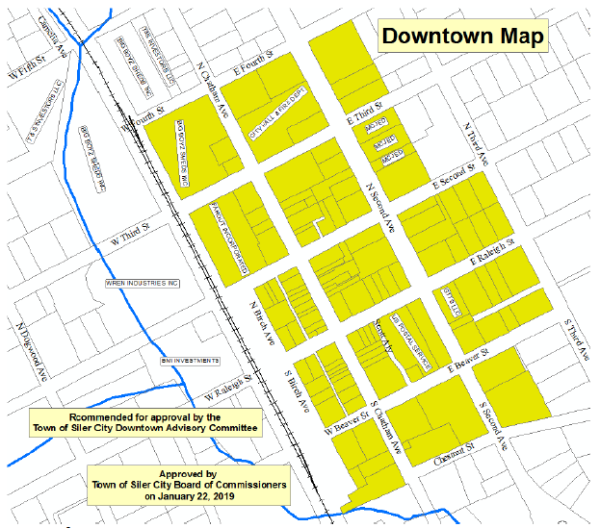
- Downtown Siler City District (DSCD).
- The DSCD is hereby established as an “overlay” district, meaning that this district is overlaid upon other districts and the land so encumbered may be used in a manner permitted in the underlying districts only if and to the extent such use is also permitted in the applicable overlay district.
- The DSCD is further described in the illustration below:
Amended May 3, 2004, February 17, 2021
132 Official Zoning Map
- There shall be a map known and designated as the Official Zoning Map, which shall show the boundaries of all zoning districts within the town's planning jurisdiction. This map may be in paper and/or digital format, shall be dated, and shall be kept and maintained for public inspection in the planning department.
- The Official Zoning Map dated August 1, 1993 is adopted and incorporated herein by reference. Amendments to this map shall be made and posted in accordance with § 133.
Amended January 21, 2021
133 Amendments To Official Zoning Map
- Amendments to the Official Zoning Map are accomplished using the same procedures that apply to other amendments to this ordinance, as set forth in Article XX.
- The administrator shall update the official Zoning Map as soon as possible following amendment.
- No unauthorized person may alter or modify the Official Zoning Map.
- The Planning Department shall keep copies of superseded copies of the zoning map for historical reference and maintained for public inspection.
Amended January 21, 2021