
South Jordan City Zoning Code
CHAPTER 17
08 DEFINITIONS GENERALLY
17.08.010: DEFINITIONS
The purpose of this chapter is to provide specific meanings for terms as they are used in this title and to facilitate the understanding and administration of the provisions of this title. Meanings shall apply to the singular or plural and to any tense of a verb. Definitions of pertinent terms provided in Utah Code Annotated are adopted as part of this title.
ACCESS: A road, lane, driveway, sidewalk, trail, path, approach or other route used for travel.
ACCESSORY DWELLING UNIT OR ADU: A Life Safety and Building Code compliant dwelling unit with contiguous floor space that is incidental and subordinate to a single-family residential unit of one of the following two (2) types:
Internal Accessory Dwelling Unit or IADU: An ADU, that qualifies as an internal ADU under Utah State Law, and is contained within the primary dwelling so that the ADU and the primary dwelling appear to be one (1) unit, that includes a kitchen and bathroom.
Guesthouse: An ADU that is detached from the primary dwelling that includes a kitchen and bathroom.
ACCESSORY USE: A use which is incidental and subordinate to the principal permitted or conditional use of the property and located within one hundred (100) linear feet of the principal use.
AFFECTED ENTITY: A county, municipality, independent special district, local district, school district, interlocal cooperation entity, specified public utility, property owner, property owners' association, or the Utah Department of Transportation, if:
- The entity's services or facilities are likely to require expansion or significant modification because of an intended use of land;
- The entity has filed with the Municipality a copy of the entity's general or long range plan; or
- The entity has filed with the Municipality a request for notice during the same calendar year and before the Municipality provides notice to an affected entity in compliance with a requirement imposed under this title.
AGRICULTURAL: Pertaining to uses related to horticulture, crop production, farm and ranch animals and other uses and buildings in appropriate zones as regulated under this title, but not including processing, packaging, warehousing or other industrial activities.
APPEAL: A process by which a person or entity may seek relief from a requirement of the land use ordinance or from a decision made by a City official or officials in the conduct of their zoning duties.
APPEAL AUTHORITY: An Appeal and Variance Hearing Officer appointed by the City Council except where otherwise specifically designated in this title or in title 16, "Subdivision And Development Code", of this Code.
ARTERIAL STREET: A street which has intercity or regional significance or which carries substantial traffic volumes such as I-15, Bangerter Highway, Redwood Road, South Jordan Parkway and 11400 South. For purposes of this title, arterial streets shall also be considered collector streets.
ASSISTED LIVING CENTER: An establishment for the housing of independent seniors with supervision, assistance and limited healthcare services in a homelike atmosphere; may include protective oversight, food and other services. Architectural standards of this title requiring garages and ten to twelve (10:12) roof pitch do not apply to this use.
BED AND BREAKFAST INN: A building containing no more than four (4) short stay units which is managed and operated by a resident of the building and which has common eating facilities.
BLOCK: A structural masonry unit manufactured from concrete.
BLOCK, DECORATIVE COLORED: A concrete masonry unit which is integrally dyed a color other than natural gray at the time of manufacture and the outside surface of which is scored, split faced or otherwise textured.
BUILDING: A roofed structure used for shelter meeting requirements of the Building Code and all requirements of this title.
BUILDING, ACCESSORY: A building or structure which is incidental and subordinate to the use of the main building on the lot or parcel.
BUILDING LINE: An imaginary line extending across a lot or parcel which is parallel to and coincident with an outside wall of a building.
BUILDING, PRINCIPAL OR MAIN: A building which is integral to the principal use to which the premises are devoted and which is usually the largest building or among the largest buildings on the lot or parcel.
CARE CENTER: An establishment for the housing of elderly or permanently disabled persons who are incapable of independent living. Architectural standards of this title requiring garages and ten to twelve (10:12) roof pitch do not apply to this use.
CASH BOND: A payment made to the City to fund future installation of public improvements.
CERTIFICATE OF OCCUPANCY: Authority granted by the building official to occupy or use a building upon satisfying City ordinances and all site plan and building permit requirements.
CITY: The City of South Jordan.
CITY COUNCIL: The elected legislative body empowered by State law to regulate and govern all planning and land use activities and regulations in the City.
CITY ENGINEER: The City Engineer of the City of South Jordan, or the person(s) engaged by the City and authorized to perform the duties assigned to the City Engineer, regardless of official job title, and shall include any deputies, assistants, representatives and designees.
COLLECTOR STREET: A street not less than sixty two feet (62') in width providing for intracity or intercity motor vehicle transportation.
COLLECTOR STREET FENCING: Fencing located within twenty feet (20') of a collector or arterial street right of way line which is constructed of materials described elsewhere in this title and the development code.
CONCEPT PLAN: Drawings and information required for review with certain conditional use permit, subdivision and site plan applications as described in city ordinances.
CONDITIONAL USE PERMIT: Authorization granted by the planning commission or city council for a conditional use according to requirements of this title.
CONDOMINIUM: A single unit in a multi-unit project, together with an undivided interest in common in the common areas and facilities of the property.
CONTINUOUS FREE FLOW ACCESS: A continuous and open path between the primary dwelling area and the potential internal accessory dwelling unit contained in a primary dwelling unit. The access path shall allow two-way access through entryways (which shall not be finished to facilitate the addition of a door), open spaces, hallways, stairways, or other open access ways that remain uninhibited by doors, walls, or any other physical barrier. The path shall have openings of at least forty-eight inches (48") wide or the standard width of the connecting corridor so as not to limit or restrict access.
CONTOUR: A line which depicts the same elevation across an area of land on a topographical map.
CUL-DE-SAC: A permanent dead end street which terminates in a circular turnaround area.
CUSTOM STORAGE: A collection of individual units limited to a maximum of two thousand (2,000) square feet per unit to be sold or rented for personal and/or business storage; light assembly, service and/or repair; and/or office use. All uses shall be conducted within completely enclosed units. The on site parking required shall be in accordance with title 16, chapter 16.26 of this code as applied to the uses of individual units and as necessary to accommodate all parking generated. The interior of the units may not to be included in fulfilling parking requirements.
DAYCARE, CENTER: A childcare facility operated as a commercial business, in accordance with city codes and requirements, but not as a home occupation.
DAYCARE, HOME: A childcare home occupation conducted in accordance with the home occupation regulations of this title.
DENSITY: The number of lots or dwelling units per acre of gross land area in a residential project.
DEVELOPMENT: Any use of land involving improvements and which requires site plan, plat or conditional use approval.
DEVELOPMENT AGREEMENT: A written contract between the city and a developer which sets forth the respective terms, conditions and obligations pertaining to a development in the city.
DEVELOPMENT REVIEW COMMITTEE (DRC): A group of appointed city officials or their designees given responsibility to review and advise concerning proposed development projects, including site plans, subdivisions, condominiums and small residential developments.
DEVELOPMENT, SMALL RESIDENTIAL (SRD): Construction of a dwelling on a vacant lot or parcel outside of a recorded subdivision or condominium.
DRIVE-THROUGH: A commercial establishment which delivers goods or services to consumers in motor vehicles.
DRIVEWAY: A privately owned and maintained vehicle access to a lot or parcel.
DWELLING, MULTIPLE-FAMILY: A building comprised of two (2) or more dwelling units.
DWELLING OR DWELLING UNIT: A building, or a portion thereof, designed for single-family residential occupancy meeting all requirements of this title and which has at least one kitchen and one bathroom, but not including tents, garages, sheds, travel trailers, campers, motor homes, motels, hotels, lodges or other quarters intended for transient or temporary occupants.
DWELLING, SINGLE-FAMILY: A building comprised entirely of one dwelling unit that may contain an accessory dwelling unit.
EASEMENT: A restricted area of a lot or parcel which is subject to a legal right of use by others who do not own the property but may control the property owner's use of the area.
EDUCATIONAL FACILITIES: Not for profit schools operated by a public, quasi-public, or private organization which has a curriculum that conforms to or is similar to that required by the state of Utah.
ELDERLY PERSON: A person who is at least sixty (60) years old who desires or needs to live with other elderly persons in a group setting but who is capable of living independently.
ELECTRONIC VENDING MACHINES: An electronic machine used to dispense a product to a consumer after a certain amount of monetary transaction has been put into the machine.
ELEVATION: The altitude of the surface of the ground.
ELEVATION, BUILDING: An architectural rendering of the front, side or rear facade of a building, including dimensions, features, materials and colors.
ESCROW: A cash payment to the city to fund, if necessary, the future installation of landscaping or other site improvements.
FAMILY OR HOUSEHOLD: One or more persons related by blood, marriage, adoption or approved foster care, and up to two (2) unrelated persons; or a group of not more than four (4) unrelated persons occupying a dwelling unit or a group of persons as defined by state law as elderly or disabled.
FLOOR AREA: The sum of all existing and possible occupied areas of a building, finished and unfinished, as measured on the exterior of the building and excluding garages, carports, patios, canopies, porches, breezeways and similar areas.
FREESTANDING BANKING KIOSKS: A small self-contained unstaffed pavilion or similar structure used for banking, or other financial purposes that is not directly associated with nor located within fifty (50) linear feet of the approved principal financial institution.
GARAGE, ATTACHED: An enclosed building designed for motor vehicle parking which is constructed with a wall or roof which is common to a dwelling.
GENERAL PLAN: A document adopted by the city that sets forth general guidelines for proposed future development of the land within the city as set forth in Utah Code Annotated; also referred to as the "master plan".
GENERAL PLAN LAND USE PLAN MAP: A map adopted by the city council which identifies the current, proposed or desired future land uses in the city and which guides zoning and development in the city.
GRADE: The elevation of the ground or the slope or incline of the ground.
HEIGHT, BUILDING: The vertical distance from the average elevation of the rough graded lot surface as measured five feet (5') from the exterior wall of a building to the peak of a pitched roof, the deck line of a mansard roof or to the top of the coping of a flat roof of the building.
HEIGHT, FENCE: The vertical distance from the ground to the top of the fence panel (portion of fence between the fence poles or supports). Minimal fence poles or supports may extend no higher than six inches (6") above the fence panel. Fencing constructed above a retaining wall shall be located a minimum of three feet (3') from the top of said retaining wall.
HEIGHT, STRUCTURE: The vertical distance from the average elevation of the finished lot surface as measured five feet (5') from any part of a structure to the highest point of the structure.
HIGH TECH USE OR RESEARCH AND DEVELOPMENT USE: A use which must be conducted in a clean environment involving research, development, manufacturing, consulting or other activities related to computer software or hardware, electronic or optical instruments, medical or scientific products and processes, pharmaceuticals or other products, equipment and activities requiring sophisticated knowledge and techniques.
HOME OCCUPATION: Any commercial business or income producing activity conducted from a residential property by family members residing in the dwelling which is clearly incidental and secondary to and compatible with the residential use of the property.
HOUSEHOLD PET: Animals ordinarily permitted in the house and/or kept for company or pleasure such as dogs, cats, birds or rabbits, but not chickens, ducks, geese, sheep, goats, pigs or other farm animals, or any animals which are likely to inflict damage, harm or discomfort or endanger the health, safety or welfare of any person or property. Other small animals weighing eight (8) ounces or less each which are permitted by law, not considered farm animals, housed within the dwelling and not likely to inflict damage, harm or discomfort or endanger the health, safety or welfare of any person or property are not regulated under this title. Offspring of household pets within the dwelling four (4) months of age or younger shall not be regulated under this title.
IMPROVEMENTS: Utilities, roads, walkways, landscaping, parking areas, buildings and other constructed amenities and infrastructure on public or private lands.
KITCHEN: Any room or space used, intended to be used, or designed to be used for cooking or for the preparation of food. Facilities that establish the use of a room or space as a kitchen include refrigerator, stoves, microwaves, other cooking appliance, built-in cabinets, sinks, garbage disposal, and electrical, water, and/or natural gas supply lines, in any combination intended to permit any room or space to be used as a kitchen.
LAND USE AUTHORITY: The planning commission except where otherwise designated in this code.
LETTER OF CREDIT: A bank guarantee issued to the city for public improvements to be installed by a developer.
LOCAL STREET OR NEIGHBORHOOD STREET: A minor street which connects individual lots or parcels to collector or arterial streets.
LOT: A parcel of real property in a subdivision or defined by metes and bounds, but not as part of a condominium, as recorded in the Salt Lake County recorder's office.
LOT AREA: The square footage or acreage encompassed within a lot or parcel measured on a horizontal plane.
LOT, CORNER: A lot located at the intersection of and fronting on two (2) streets, neither of which is a collector street, where the angle of the street intersection does not exceed one hundred thirty five degrees (135°).
LOT COVERAGE: The total horizontal area of a lot occupied by buildings, including all main and accessory buildings, carports, sheds, patio covers, breezeways, covered walkways, gazebos and other roofed structures.
LOT, DOUBLE FRONTAGE: A lot having frontage on two (2) parallel or approximately parallel streets. Double frontage lots may only access subdivision or neighborhood streets on which the lots front.
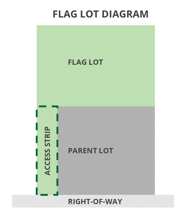
LOT, FLAG: A lot having a larger area behind another lot or parcel (resembling a flag) which is connected to the street by a narrow access strip (resembling a flagpole) which does not meet the lot width or frontage requirements of the zone.
LOT, FLAG LOT ACCESS STRIP: A narrow portion of land (resembling a flagpole) that connects a large area behind another lot or parcel (resembling a flag) to the right-of-way.
LOT FRONTAGE: The line along which a lot abuts a public street.
LOT, INTERIOR: Any lot not defined as a corner lot.
LOT LINE, FRONT: The line along which the front yard of a lot abuts a public street. The front lot line of a double frontage lot shall be the line located adjacent to the subdivision or neighborhood street, not the line adjacent to a collector or arterial street.
LOT LINE, REAR: The lot line most distant from and generally parallel to the front lot line. In the case of an irregularly shaped lot having no definable rear lot line, the rear lot line shall be a line ten feet (10') in length which is parallel with the front lot line and which connects two (2) of the other lot lines at points most distant from the front lot line.
LOT LINE, SIDE: Lot lines which are generally radial to the front lot line or any lot lines which are not front or rear lot lines.
LOT, PARENT: A lot remaining along the majority of the street frontage after a flag lot is created.
LOT WIDTH: The distance across a lot measured at the midpoint of the minimum front yard setback line.
MINOR RETAIL OR MINOR BUSINESS SERVICE: Any commercial activity which occupies a building smaller than five thousand (5,000) square feet in area.
MIXED USE: The integration of various land uses in a vicinity or project.
NONCONFORMING BUILDING OR NONCONFORMING STRUCTURE: A building or structure that legally existed before its current or a previous land use regulation or designation and, because of subsequent land use ordinance changes, does not conform with the setback, height restrictions, floor area, architecture or other regulations that govern the structure.
NONCONFORMING LOT OR PRIOR CREATED LOT: Any lot which was created prior to the adoption of this chapter or a previous ordinance which does not meet the area, width, frontage or other lot requirements of this title.
NONCONFORMING USE: A use of land that legally existed before the current land use regulation or designation and has been maintained continuously (meaning that the use has never been suspended for longer than 1 full year) since the time the land use regulations governing the land changed but, because of subsequent changes in the land use regulations, does not now conform to those regulations.
OFFICIAL MAP OR STREET PLAN: A map of proposed streets that has the legal effect of prohibiting development of the property until the Municipality develops, or permits the development of, the proposed street.
OPEN SPACE: An area preserved from development of intense urban uses in a natural, landscaped or agrarian state for recreational or other public purposes.
ORDINANCE: Planning and land use regulations or other laws and requirements adopted by the City which carry the force of law and are binding upon all who visit, reside in or own property in the City.
PARCEL: A tract or plot of land.
PARK, ACTIVE: A park designed for organized recreational and athletic activities
PARK, PASSIVE: A park designed for use by the general public and not for organized activities.
PARK STRIP: The area between a street curb and a sidewalk or property line.
PAWNBROKER, SECONDHAND MERCHANDISE DEALER, SECONDARY METALS DEALER OR RECYCLER AND SIMILAR BUSINESSES: Businesses regulated by title 5, chapter 5.48 of this Code.
PHASING: The delineation and order of specific development areas in a project as indicated in a preliminary plat or site plan.
PLANNED UNIT DEVELOPMENT (PUD): A subdivision approved by the City as allowed within a particular zone which does not meet all of the standard requirements of that zone but is approved with other standards as determined by the City Council.
PLANNING AND ZONING CODE: The body of land use regulations contained in this title, including the official zoning map of the City.
PLANNING COMMISSION: A group of South Jordan City residents appointed by the City Council to meet regularly to review general plan issues, current planning and land use issues, proposed development projects and other matters as directed by the City Council as provided under State law and City ordinance.
PLANNING DEPARTMENT: The department, division or group, regardless of name, charged with the responsibility of directing all activities associated with the planning, implementation and review of all land use controls and zoning in the City.
PLANNING DIRECTOR: That person charged with the responsibility of directing all activities and responsibilities of the Planning Department, regardless of official job title, and shall include any deputies, assistants, representatives and designees, including but not limited to the City Planner.
PLANTER: A small landscaped area usually bordered with concrete such as in a parking area or by a building foundation.
PLAT: A document describing the ownership of land either by metes and bounds or by a subdivision. A condominium record of survey map may also be known as a plat in City ordinances.
PRESCHOOL, CENTER: A preschool facility operated as a commercial business, in accordance with City codes and requirements, but not as a home occupation.
PRESCHOOL, HOME: A preschool home occupation conducted in accordance with the home occupation regulations of this title.
PRIVATE STREET: A street approved by the City which is owned and maintained by property owners.
PROJECT: A development or activity requiring subdivision, condominium, small residential, conditional use permit or site plan approval.
PROPERTY LINE ADJUSTMENT: The relocation of a property boundary between two (2) adjoining properties that does not create a new parcel or remnant land of any kind. Simple boundary line adjustments, as defined by Utah Code section 10-9a-103, shall be considered property line adjustments.
PROTECTION STRIP: A strip of privately owned land bordering a subdivision or a street within a subdivision which serves to bar access of adjacent property owners to public improvements within the subdivision until such time as the adjacent owners share in the cost of such improvements.
PUBLIC PROPERTY: Any land, road, utility, building or other property or structure owned or controlled by the City, County, State or Federal government or other political entity.
PUBLIC RIGHT-OF-WAY: Any street, alley or access owned by the City, County or State which is generally open for public use or travel.
PUBLIC USE: Any use conducted by or in behalf of the City, County, State or Federal government or other political entity.
QUASI-PUBLIC USE: Any use conducted by a nonprofit or charitable organization for the benefit of the general public or having partial government involvement or ownership.
RECORD OF SURVEY MAP: The document by which a condominium is recorded.
RECREATIONAL VEHICLE: A vehicle which is:
- Built on a single chassis,
- Four hundred (400) square feet or less when measured at the largest horizontal projections,
- Designed to be self-propelled or permanently towable by a light duty truck, and
- Designed primarily not for use as a permanent dwelling but as temporary living quarters for recreational camping, travel, or seasonal use.
RESIDENTIAL FACILITY FOR DISABLED PERSONS: A single- or multi-family dwelling unit that meets the requirements of Utah Code Annotated and this title for occupancy of disabled persons.
RESIDENTIAL FACILITY FOR ELDERLY PERSONS: A single- or multi-family dwelling unit that meets the requirements of Utah Code Annotated and this title for occupancy of elderly persons.
RETAIL: Pertaining to the sales of goods or services to the ultimate consumer which goods or services are taxable under the Retail Sales Tax provisions of Utah State law. Retail sales which are exempt from taxation may not be conducted in any commercial zone in the City. Retail does not include businesses regulated by title 5, chapter 5.48 of this Code.
SCREENING MATERIAL: Any fence, wall, berm, rock, evergreen shrub, tree, plant or other object which obscures vision.
SECONDARY WATER SYSTEM: The water delivery system intended for irrigation of crops, landscaping and plant material and not intended for culinary use.
SETBACK: The minimum required distance between a lot line and a building or structure.
SEXUALLY ORIENTED BUSINESS: Any business as defined in title 5, chapter 5.68 of this Code.
SITE PLAN: A schematic, scaled drawing of a commercial, residential, industrial, office or institutional development which meets requirements of title 16, chapter 16.24 of this Code.
SMALL RESIDENTIAL DEVELOPMENT (SRD): Construction of a dwelling on a vacant lot or parcel outside of a recorded subdivision or condominium.
SOUTH JORDAN CITY MUNICIPAL CODE OR CODE: The body of laws and regulations adopted by and applicable in South Jordan City.
STATE LAW: The body of laws and regulations adopted by and applicable in the State of Utah.
STONE: A natural masonry unit or an artificial masonry unit having the appearance of natural stone including fieldstone, sandstone, marble and granite which is used on the exteriors of buildings, walls, signs or other structures.
STONE, SIMULATED: A synthetic material used on building exteriors which has the appearance of natural stone, i.e., glass fiber reinforced concrete, certain precast products, etc.
STORY: That portion of a building located between two (2) floor surfaces or, if the uppermost floor, between the floor surface and the ceiling immediately above the floor.
STRUCTURAL ALTERATION: Any change to a supporting member of a building or structure.
STRUCTURE: Any object or building erected or constructed on a lot or parcel which exceeds six feet (6') in height or exceeds two feet (2') in height and forms a geometric shape covering a ground area greater than thirty (30) square feet.
STUB STREET: A dead end street which can provide access to adjoining vacant land and which will connect to a future street when the adjoining land is developed.
SUBDIVISION: Any division of land into two (2) or more lots or parcels. Any subdivision shall be subject to City approval and recorded in the Office of the Salt Lake County Recorder. "Subdivision" does not include property line adjustments.
SUBDIVISION AMENDMENT OR CONDOMINIUM AMENDMENT: Any change to a recorded subdivision plat or condominium record of survey map as required under this title and Utah Code Annotated. A property line adjustment does not constitute an amendment.
SUBDIVISION PLAT: A map designating land to be divided for individually owned lots and specifying public or quasi-public areas which is approved by the Planning Commission and City Council and recorded by the Salt Lake County Recorder.
TITLE: The Planning and Zoning Code of the City of South Jordan.
TOPOGRAPHY: A graphic representation or description of the natural and manmade features of the surface of the ground.
TRANSPORTATION PLAN: A document adopted by the City Council containing data, goals, policies and maps concerning existing and proposed transportation infrastructure such as major roadways, streetscapes, trails, bike routes and mass transit.
USE, COMPATIBLE: An existing or proposed use which is like or similar to other neighboring uses.
USE, CONDITIONAL: Any use listed as "conditional" in a zone and requiring Planning Commission or City Council approval of a conditional use permit, after a public hearing is held, and which may be incompatible with neighboring properties or which can be made compatible with certain conditions attached to the approval prior to or during conduct of the use.
USE, INCOMPATIBLE: An existing or proposed use which is unlike other neighboring uses and which conflicts or may conflict with the neighboring use or uses. Incompatibility may be based on noise, traffic, light, odor, vibration, emissions or other environmental or aesthetic considerations.
USE OR LAND USE: The purpose for which a parcel of land, building or structure is developed or constructed, the manner in which it is occupied or maintained or an activity conducted on the premises on a regular basis.
USE, PERMITTED: Any use listed as such and allowed within a particular zone which is established and conducted in compliance with City ordinances.
USE, TEMPORARY: A use which is seasonal or promotional in nature and does not require permanent improvements.
VARIANCE: A waiver or modification of the requirements of the land use ordinance as applied to a parcel of property that is granted by an appeal and variance hearing officer.
YARD, FRONT: The minimum required area extending across the entire width of a lot between the front lot line and any building or structure on the lot as regulated in this title.
In situations where a permanent, publicly owned or controlled landscape park strip at least forty feet (40') wide has been developed as part of the permanent street improvements, required front yards abutting said landscaped park strips may be reduced up to ten feet (10') for each minimum twenty foot (20') increment of said landscaped park strip between the street curb and the property line. Owners of lots for which a front yard reduction has been allowed may be required to landscape and/or maintain all or part of the said landscaped park strip area adjoining the property. The area may, with city approval, be used to meet the minimum front yard landscape requirement for the lot or parcel adjoining said landscaped park strip and for necessary access, utilities, lighting and signs associated with the adjoining lot or parcel. Allowed uses of said landscaped park strip will meet city requirements for said uses as though a standard street configuration existed. The landscaped park strip area provision shall not apply to single-family residential uses.
YARD, REAR: The minimum required area extending across the entire width of a lot between the rear lot line and any main building or structure on the lot as regulated in this title. For purposes of placing rear yard accessory buildings, the rear yard shall be defined as the entire area between the rear line of the main building and the rear lot line.
In situations where a permanent, publicly owned or controlled landscape park strip at least forty feet (40') wide has been developed as part of the permanent street improvements, required rear yards abutting said landscaped park strips may be reduced up to ten feet (10') for each minimum twenty foot (20') increment of said landscaped park strip between the street curb and the property line. Owners of lots for which a rear yard reduction has been allowed may be required to landscape and/or maintain all or part of the said landscaped park strip area adjoining the property. The area may, with city approval, be used to meet the minimum rear yard landscape requirement for the lot or parcel adjoining said landscaped park strip and for necessary access, utilities, lighting and signs associated with the adjoining lot or parcel. Allowed uses of said landscaped park strip will meet city requirements for said uses as though a standard street configuration existed. The landscaped park strip area provision shall not apply to single-family residential uses.
YARD, SIDE: The minimum required area between the side lot line and the main building extending from the required front yard to the required rear yard.
In situations where a permanent, publicly owned or controlled landscape park strip at least forty feet (40') wide has been developed as part of the permanent street improvements, required side yards abutting said landscaped park strips may be reduced up to ten feet (10') for each minimum twenty foot (20') increment of said landscaped park strip between the street curb and the property line. Owners of lots for which a side yard reduction has been allowed may be required to landscape and/or maintain all or part of the said landscaped park strip area adjoining the property. The area may, with city approval, be used to meet the minimum side yard landscape requirement for the lot or parcel adjoining said landscaped park strip and for necessary access, utilities, lighting and signs associated with the adjoining lot or parcel. Allowed uses of said landscaped park strip will meet city requirements for said uses as though a standard street configuration existed. The landscaped park strip area provision shall not apply to single-family residential uses.
ZONE: A district within the City in which specific regulations of this title apply to the development, use and maintenance of land, buildings and structures.
ZONING MAP: A map adopted by the City Council which designates the zoning of lands and parcels within the Municipal boundary of the City and which is governed by this title.
Amended by Ord. 2007-02 ARCHIVED on 1/16/2007
Amended by Ord. 2008-19 ARCHIVED on 11/18/2008
Amended by Ord. 2010-08 ARCHIVED on 6/15/2010
Amended by Ord. 2010-09 ARCHIVED on 4/17/2012
Amended by Ord. 2012-07 ARCHIVED on 6/19/2012
Amended by Ord. 2012-12 ARCHIVED on 10/2/2012
Amended by Ord. 2013-13 ARCHIVED on 9/3/2013
Amended by Ord. 2014-10 ARCHIVED on 6/3/2014
Amended by Ord. 2016-19 ARCHIVED on 8/1/2016
Amended by Ord. 2017-01 ARCHIVED on 1/3/2017
Amended by Ord. 2017-22 ARCHIVED on 7/18/2017
Amended by Ord. 2019-01 ARCHIVED on 3/5/2019
Amended by Ord. 2020-10 ARCHIVED on 9/15/2020
Amended by Ord. 2021-16 ARCHIVED on 8/17/2021
Amended by Ord. 2021-20 ARCHIVED on 10/5/2021
Amended by Ord. 2024-10 ARCHIVED on 5/21/2024
Amended by Ord. 2025-07 ARCHIVED on 3/4/2025
Amended by Ord. 2025-17 ARCHIVED on 11/18/2025