
South Ogden City Zoning Code
CHAPTER 5
1 FORM BASED CODE
22-14
22-01
23-17
23-01
22-16
10-5.1A-1-1: Introduction
In 2008, an update of the South Ogden City general plan was completed. This plan presented a vision, and stated a number of goals and policies to direct future development in South Ogden.
- Goals And Policies:
- Goal 1: Make South Ogden City distinct and identifiable from surrounding municipalities.
- Policy:
- Develop the east and west sides of Washington Boulevard between 36th and 40th Streets into a discernible and attractive downtown for South Ogden.
- Encourage a major transformation of Washington Boulevard into an urban setting that establishes the sense of downtown to motorists and passersby.
- Policy:
- Goal 2: Create a distinct City Center or "heart of the community."
- Policy:
- Develop a community center in the existing downtown area where residents of South Ogden can gather for community events.
- Policy:
- Goal 3: Facilitate the careful integration of new development and redevelopment in existing neighborhoods.
- Policy:
- Encourage existing residents to remain downtown and new residents to locate in residential areas between 36th and 40th Streets.
- Maintain stable areas by continuing the existing scale and feel of the surrounding residential blocks.
- Facilitate new development and encourage new investment through allowing uses in the core to redevelop in creative, mixed residential ways.
- Facilitate good, nonconflicting transition between commercial and residential uses.
- Policy:
- Goal 4: Create places for the community to gather and events to draw residents to these places.
- Policy:
- Clearly designate and signify routes which connect residents to other neighborhoods and important places within the City and adjacent to it.
- Improve neighborhood destinations throughout the community.
- Policy:
- Goal 1: Make South Ogden City distinct and identifiable from surrounding municipalities.
- Establishment Of Districts: Two (2) distinct districts are hereby created:
- South Ogden City Center.
- 40th Street corridor.
FIGURE 1.1(1)
DISTRICTS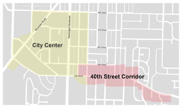
- Establishment Of Subdistricts: The above districts are further broken down into subdistricts (see section 10-5.1A-3, "Subdistricts," of this article). The following subdistricts are hereby created:
- City Center "Core."
- City Center "General."
- Riverdale Road "General."
- 40th Street "General."
- Edge. (Ord. 16-07, 6-21-2016, eff. 6-21-2016)
10-5.1A-1-2: General Subdistrict Requirements
- Applicability: The following are general block, lot, and street design requirements that are applicable to all subdistricts.
- Block Configuration: Refer to figure 1.2(1) of this section for an illustration of typical block elements.
- The shape of a block shall be generally rectangular, but may vary due to natural features or site constraints.
- Blocks shall typically be two (2) lots deep with the exception of blocks containing open space. Blocks may also include an alley.
- Blocks shall typically be fronted with lots on at least two (2) faces, preferably on the longest street faces.
FIGURE 1.2(1)
TYPICAL BLOCK ELEMENTS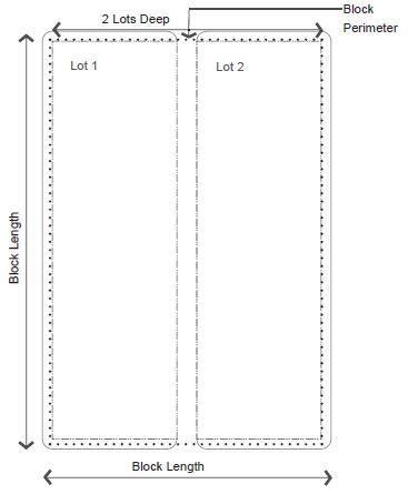
- Maximum Block Size: Block sizes for residential and commercial development and redevelopment should not exceed six hundred sixty feet by three hundred thirty feet (660' x 330'), which roughly matches the historic block size surrounding the City Center. New streets should continue this block pattern.
- Minimum Number Of Access Points: This requirement is intended to provide a minimum level of connectivity via vehicular rights-of-way between adjacent developments and to surrounding streets.
- Recommendation: A minimum of one per every one thousand five hundred feet (1,500') of street frontage is recommended.
- Designated Primary Streets: Washington Boulevard, Riverdale Road, Wall, 36th Street, and 40th Street shall be designated primary streets. The intent of the primary street designation is to develop a network of streets with continuous building frontage and no or limited vehicular driveway access to reduce conflicts between pedestrians and vehicular traffic.
- All lots adjacent to a primary street shall front on at least one primary street and that street frontage shall serve as the front of the lot, as referred to in the building type requirements.
- Lots with two (2) primary street frontages shall consult with staff to determine which street frontage warrants primary designation and the front of the lot.
- Block Access Configurations:
- Driveway Access: Vehicular driveway access should not be located off a primary street, unless the parcel is fronted by more than two (2) primary streets, in which case, staff shall determine which is the appropriate street for vehicular access. The determination shall be based on locations of existing and proposed vehicular access points of other developments along the primary streets. Exception: Does not apply to outdoor sales lots within the Riverdale Road General Zone.
- Alleys, Drives, And Driveways: Blocks may include alleys, drives, or driveway entrances with the following recommended configurations. See figure 1.2(2) of this section. Exception: Does not apply to outdoor sales lots within the Riverdale Road General Zone.
- Midblock Access: This configuration includes an alley or drive running through the center of the block.
- "T" Configuration: This configuration includes two (2) alleys within a block that are perpendicular to each other, forming a "T," allowing development to front on three (3) block faces.
- "H" Configuration: Similar to the "T" configuration, this configuration allows development to front on all four (4) block faces.
FIGURE 1.2(2)
ALLEY CONFIGURATION "H" Alley
 "T" Alley
Midblock Alley
- Access Alignment: Access to blocks shall be aligned and located on opposite sides of the block as well as aligned across the street from access to other blocks.
- Midblock Pedestrianways: Midblock pedestrianways are required on blocks longer than five hundred feet (500').
- When combined with midblock street crossings, these pathways should align to facilitate easy pedestrian movements.
- Midblock pedestrianways should be located in the middle third of a block face.
- Minimum width for midblock pedestrianways, rights-of-way or easements is twenty feet (20').
- Lots:
- Typical Lot Dimensions: All lots of record shall be developed to meet the requirements outlined in section 10-5.1A-5 of this article, building type requirements.
- Typical Lot Configuration: All lots shall have frontage along a public street unless otherwise specified in section 10-5.1A-5 of this article, building type requirements.
- Lot Shape: To create regular, rectangular lots, side property lines shall be perpendicular to the vehicular right-of-way to the extent practical.
- Through Lots: Through lots fronting on two (2) parallel streets are not permitted with the exception of a lot covering fifty percent (50%) or more of a block and the two (2) longest parallel street faces are treated as front property lines per building type requirements (refer to section 10-5.1A-5, "Building Types," of this article).
- Corner Lots: Corner lots have a front yard along one street and a corner yard along the other street. The front yard of a corner lot should be consistent with one adjacent parcel.
- The rear yard of a corner lot is typically the yard against an alley or another lot's rear yard.
- The side yard of a corner lot is adjacent to another lot.
- Flag Lots: Flag lots are prohibited.
- General Open Space Requirements: The following are requirements for provision of civic open space:
- Development of parcels over five (5) acres is required to provide five percent (5%) total lot size as civic open space. Developer shall work with City to determine appropriate location of open space. See section 10-5.1A-6, "Open Space Types," of this article.
- For developments under five (5) acres, impact fees and other funding will be used as mechanisms to ensure adequate open space will be provided.
- General Zoning District/Subdistrict Layout: For all districts/subdistricts, the following outlines how the districts/subdistricts should relate to one another.
- All Districts: The following applies to all zoning districts/subdistricts:
- Similar intensities of uses should face each other across the street.
- Blocks may contain multiple zoning subdistricts; however, changes in subdistricts should occur along an alley, the rear property line, or at a corner parcel.
- Core Subdistricts: The following applies to all core subdistricts:
- Core subdistricts are intended to provide a node that primarily consists of retail uses on the ground floor.
- Existing Residential Zones: When "core" and/or "general" subdistricts back up to the rear of existing single-family residential neighborhoods, a building stepback is required (see section 10-5.1A-5-2, figure 5.2(5) of this article). (Ord. 17-22, 11-21-2017, eff. 11-21-2017)
- All Districts: The following applies to all zoning districts/subdistricts:
10-5.1A-2-1: General Requirements
- Intent: The standards outlined in this section 10-5.1A-2 are intended to:
- Create complete streets that address all modes of travel, including pedestrian traffic, bicycle traffic, transit, and vehicular traffic.
- Address all features of the street right-of-way, including sidewalks, parkways, traffic lanes, bicycle lanes, and medians.
- Provide adequate access to all lots for vehicles and pedestrians.
- Create streets that are appropriate for their contexts in residential, commercial, or mixed use subdistricts and are designed to encourage travel at appropriate volumes and speeds.
- Create streets and public rights-of-way that result in stormwater runoff quantity reduction and improved quality of stormwater runoff. (Ord. 16-07, 6-21-2016, eff. 6-21-2016)
- Applicability: The standards in this section 10-5.1A-2 apply to all vehicular rights-of-way within all subdistricts.
Exceptions: Washington Boulevard and Riverdale Road are UDOT roads, and the City should work with UDOT on any future design changes, so that these roads can better support the goals of this article.
The future redesign of 40th Street will vary depending on whether it contains a transit line, and should be designed specifically for the type of transit mode it will contain.
Riverdale Road is already established as a location for outdoor sales lots and regulations concerning street types should be carefully considered before being applied to this zone to ensure such uses remain viable. (Ord. 17-12, 5-4-2017, eff. 5-4-2017) - General Requirements: All proposed streets, landscape or furnishings zone, and sidewalks shall be located in dedicated vehicular rights-of-way as required by this article. (Ord. 16-07, 6-21-2016, eff. 6-21-2016)
- Street Types: All new vehicular rights-of-way shall match one of the street types, refer to sections 10-5.1A-2-4 through 10-5.1A-2-9 of this article, whether publicly dedicated or privately held. (Ord. 16-07, 6-21-2016, eff. 6-21-2016; amd. Ord. 17-22, 11-21-2017, eff. 11-21-2017)
- Public Use: All streets shall be available for public use at all times. Gated streets and streets posted as private are not permitted.
- Street Construction Specifications: All construction in the right-of-way shall follow specifications defined by the Department of Public Works. (Ord. 16-07, 6-21-2016, eff. 6-21-2016)
10-5.1A-2-2: General Street Type Standards
- Street Types: Street types defined in this section 10-5.1A-2 outline acceptable street configurations. New streets should be designed using the principles and characteristics defined by each street type. The City Manager or designee, or Public Works Director may require additional right-of-way, pavement width, or additional street elements depending on unique site characteristics.
- Graphics: The graphics provided here, illustrating each street type, are samples of recommendations and illustrate a possible configuration of that street type. By applying the standards outlined, and working with the Department of Public Works and the City Manager, other configurations are possible.
- Typical Street Elements: Typical elements of a vehicular right-of-way are divided into the vehicular and pedestrian realm. Each street type detailed in this article outlines which facilities are applicable. Refer to figure 2.2(1), "Typical Right-Of-Way Elements," of this section.
FIGURE 2.2(1)
TYPICAL RIGHT-OF-WAY ELEMENTS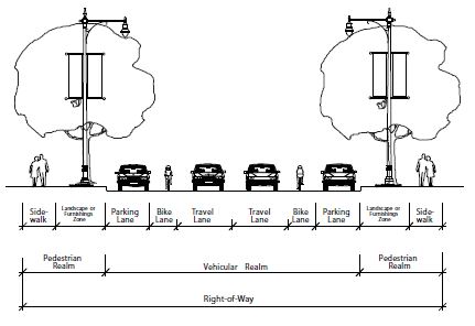
- Vehicular Realm: The vehicular realm is comprised of vehicular travel lanes, bicycle lanes, and parking lanes.
- Pedestrian Realm: The pedestrian realm is typically comprised of pedestrian facilities, such as sidewalk, path/trail, or off street bicycle path, and a buffer area consisting of a landscape zone or furnishings zone that serves to buffer pedestrians or bicyclists from the movements of higher speed vehicles in the vehicular realm.
- Landscape zone: A landscape area between the back of curb or edge of pavement to the sidewalk in which street trees, swales, lighting, and signage may be located. Typically used adjacent to residential buildings.
- Furnishings zone: A hardscape area that extends from the sidewalk to the back of curb, in which street trees, street furniture, lighting, and signage may be located. Typically used adjacent to commercial or office buildings.
- Vehicular Travel Lanes: The number and width of vehicular travel lanes are determined by the street type.
- Vehicular On Street Parking: On street parking, as permitted on designated street types, shall meet the following requirements:
- Parallel And Diagonal Parking: Parallel and diagonal parking is permitted on designated street types.
- Vehicular Parking Space Dimensions: The appropriate dimensions for on street parking spaces are outlined in table 2.2(1), "On Street Parking Space Dimensions," and figure 2.2(2), "On Street Parking Layout," of this section. The width of a parking space shall be measured from the center of a stripe.
FIGURE 2.2(2)
ON STREET PARKING LAYOUT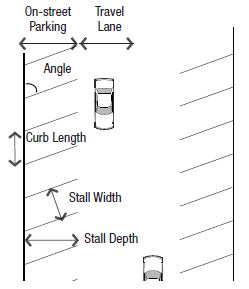
TABLE 2.2(1)
ON STREET PARKING SPACE DIMENSIONS(Ord. 17-22, 11-21-2017, eff. 11-21-2017)Angle Curb Length Stall Width Stall Depth 0° 20' 7' 7' 45° 12' 9' 17' 60° 10' 9' 18' 90° 9' 9' 20'
- Bicycle Facilities: The following types of bicycle accommodations are permitted in the vehicular realm per street type. Refer to figure 2.2(3) of this section.
FIGURE 2.2(3)
ON STREET BICYCLE FACILITIES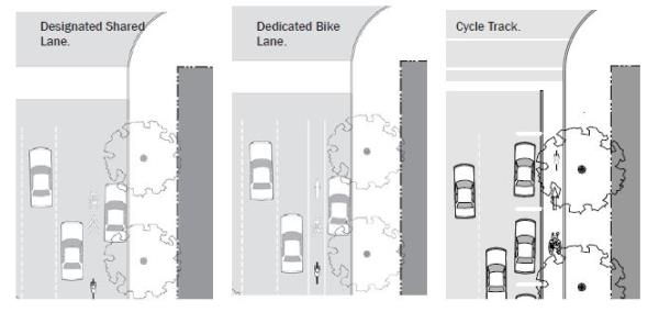
- Cycle Track: A cycle track is a separate on road bicycle facility that is typically adjacent to, but physically separated from, vehicular traffic and parking by a barrier.
- Dedicated Bicycle Lane: Dedicated bicycle lanes are striped lanes on the outside of the outermost travel lanes that are designated for only bicycle use. This lane occurs on both sides of the street and shall be four feet (4') to six feet (6') wide.
- Designated Shared Lane: A designated shared lane is a lane that is shared between vehicles and bicycles. This lane is typically wider than a standard vehicular lane, minimum thirteen feet (13'), in order to accommodate both types of users, and includes a painted bicycle marker combined with a double arrow (known as a "sharrow"). This improvement occurs in both directions.
- Shared Lane: A shared lane refers to a street that does not have bicycle lanes or a designated shared lane, but the speed and configuration of the street is such that bicycles could comfortably share lanes with traffic.
- Stormwater Management: Incorporation of stormwater management best practices into the right-of-way design is encouraged, such as incorporating drainage swales and slotted curbs into the landscape zone/furnishings zone, or permeable paving in the parking lane.
- Street Trees: Street trees are required along all street frontages, with the exception of the lane and the alley.
- Street trees shall be located either in a landscape zone within a planting bed or lawn, or in a furnishings zone in tree wells with a grate as required.
- Tree grates are required for all trees located in tree wells in pedestrian realms less than ten feet (10') in width.
- Spacing for large street trees shall be thirty feet (30') on center. City manager or designee may allow modifications based on site specific constraints.
- Fire Access: Street configurations have been calculated to provide firetruck access. Where the total width of all travel lanes totaled is narrower than twenty feet (20'), the following shall apply:
- Room To Pass: At one hundred twenty foot (120') increments, a twenty foot (20') opening in the on street parking or a twenty foot (20') dedicated pull off space must be provided to allow vehicles to pull over for a firetruck to pass.
- Driveway Or Fire Hydrant Zone: A driveway or fire hydrant zone may be utilized to fulfill the requirement. (Ord. 16-07, 6-21-2016, eff. 6-21-2016)
10-5.1A-2-3: General Street Layout Requirements
- General Layout Standards: The following standards apply to new streets or newly platted vehicular rights-of-way:
- Treatment Of Natural Features: Streets shall be designed to respect natural features, such as rivers, woodlands, or slopes, by following rather than interrupting or dead ending at the feature, if applicable.
- Street Network: The network of streets shall form an interconnected pattern with multiple intersections.
- Existing Streets: The arrangement of streets shall provide for the continuation of existing streets from adjoining areas into new subdivisions.
- Cul-De-Sac Streets: Cul-de-sacs are not permitted, unless approved by City Manager or designee due to site constraints. (Ord. 16-07, 6-21-2016, eff. 6-21-2016)
- Intersections:
- Clear View: In all form based code subdistricts at any uncontrolled street intersection, the buildings will be modified to afford automobile drivers a clear view of approaching vehicles or pedestrians. Buildings, trees, or any obstruction shall be prohibited within a triangular area formed by the street curb lines and a line connecting them at points forty feet (40') from the point of intersection of the back of the curbs (clear view area). Certain sign types are exempt from the forty foot (40') clear view area. See individual sign types for specific clear view zone requirements; however, no sign can be placed so as to obstruct the view of an automobile driver.
- Likewise, no part of a building, tree or other obstruction such as a wall or fence greater in height than twenty four inches (24") shall be allowed at any driveway entrance so as to obstruct an automobile drivers clear view of approaching vehicles or pedestrians. Anything greater in height than twenty four inches (24") is prohibited within a triangular area formed by the street property line and the edge of the driveway, with a line connecting them at points forty feet (40') from the point of intersection of the driveway and the street (clear view area); however, trees pruned high enough to permit unobstructed vision to automobile drivers shall be allowed. Certain sign types are exempt from the forty foot (40') clear view area. See individual sign types for specific clear view zone requirements; however, no sign can be placed so as to obstruct the view of an automobile driver.
- Any modifications or special conditions to be approved by the City Engineer.
- Curb Radii: The following curb radii shall be utilized unless otherwise authorized by the City Manager or designee:
- Actual Turning Radius: Intersections should be designed for actual turning radius of the typical design vehicle as opposed to the maximum design vehicle. Small curb radii at intersections shorten pedestrian crossing distances and reduce vehicle turning speeds, thereby balancing the ease of travel of the vehicles and pedestrians. Refer to figure 2.3(1) of this subsection B2a. (Ord. 18-11, 9-18-2018, eff. 9-18-2018)
FIGURE 2.3(1)
ACTUAL RIGHT TURN RADIUS WITH ON STREET PARKING
- Neighborhood And Connector Streets: At the intersection of any street with a neighborhood or a connector street, the following curb radii shall be utilized:
- With on street parking on both streets, a five foot (5') radius may be utilized.
- Without on street parking, a fifteen foot (15') radius is required.
- Avenue Streets: At the intersection of avenues to avenues or boulevards, the following curb radii shall be utilized:
- With on street parking on both streets, a ten foot (10') radius is required.
- Without on street parking on either streets, a twenty five foot (25') radius is required.
- Larger Radius: When the design vehicle requires a larger curb radius and no on street parking exists, a thirty foot (30') radius may be utilized for avenues or boulevards. Larger radii require approval of the Department of Public Works.
- Alley Intersections: The curb radius at intersections involving alleys shall be no greater than five feet (5').
- Actual Turning Radius: Intersections should be designed for actual turning radius of the typical design vehicle as opposed to the maximum design vehicle. Small curb radii at intersections shorten pedestrian crossing distances and reduce vehicle turning speeds, thereby balancing the ease of travel of the vehicles and pedestrians. Refer to figure 2.3(1) of this subsection B2a. (Ord. 18-11, 9-18-2018, eff. 9-18-2018)
- Crosswalks: Crosswalks shall be required at all intersections and midblock crossings involving connectors, avenues, and boulevards.
- Dimensions: Crosswalks shall be minimum six feet (6') in width, measured from midstripe to midstripe, per MUTCD.
- Markings: Crosswalks shall be appropriately indicated on the finished street surface with painted markings and/or textured or colored pavement.
- Crossing Distances: To encourage pedestrian activity, typical crosswalks shall not extend over thirty eight feet (38') without a landscape median, bulb outs and/or other pedestrian refuge to mitigate the negative effects of vehicular traffic on pedestrian crossing and increase pedestrian safety and comfort. Refer to figures 2.3(2) and 2.3(3) of this subsection B3c.
FIGURE 2.3(2)
WIDE STREET CROSSING WITH PEDESTRIAN REFUGE MEDIAN
FIGURE 2.3(3)
BULB OUT
- Accessibility: Accessible ramps and warning panels, per the American Disabilities Act or any more stringent State or City requirement, are required where all sidewalks or trails terminate at a crosswalk or curb.
- Ramp Orientation: Ramps shall be oriented perpendicular to traffic, requiring two (2) ramps per corner at intersecting streets.
- Bulb Outs: To shorten pedestrian crossing distances, bulb outs should be utilized at all intersections, unless otherwise required by the Department of Public Works. Refer to figure 2.3(3) of this subsection B.
- The depth of the bulb out shall match the utilized on street parking, either the width of the parallel space or the depth of the diagonal space.
- The radius of the bulb out shall match the requirements for the intersection. (Ord. 16-07, 6-21-2016, eff. 6-21-2016; amd. Ord. 18-11, 9-18-2018, eff. 9-18-2018)
- Clear View: In all form based code subdistricts at any uncontrolled street intersection, the buildings will be modified to afford automobile drivers a clear view of approaching vehicles or pedestrians. Buildings, trees, or any obstruction shall be prohibited within a triangular area formed by the street curb lines and a line connecting them at points forty feet (40') from the point of intersection of the back of the curbs (clear view area). Certain sign types are exempt from the forty foot (40') clear view area. See individual sign types for specific clear view zone requirements; however, no sign can be placed so as to obstruct the view of an automobile driver.
10-5.1A-2-4: Alley
- Intent: The alley is a very low capacity drive located at the rear of parcels. From the alley, access to parking facilities, loading facilities, and service areas, such as refuse and utilities is possible without a curb cut or driveway interrupting a street type. Refer to the typical plan and section in figure 2.4(1) of this subsection A.
FIGURE 2.4(1)
TYPICAL ALLEY
- General Requirements: Alleys shall be developed using the standards in table 2.4(1) of this subsection B.
TABLE 2.4(1)
ALLEY REQUIREMENTSNote:Permitted subdistricts All subdistricts Permitted adjacent building types All building types Typical right-of-way width 20' Vehicular realm: Travel lanes 1 yield lane Lane width 16' Allowable turn lanes Not applicable Parking lanes Not applicable Pavement width Minimum 16' Maximum 20' Median Prohibited Bicycle facilities1 Shared Pedestrian realm: Pedestrian facilities Shared; travel lanes are shared among drivers, pedestrians and bicyclists Street buffer None required
1Reference section 10-5.1A-2-2, figure 2.2(3) of this section 10-5.1A-2 for bicycle facility types and requirements.
(Ord. 16-07, 6-21-2016, eff. 6-21-2016)
10-5.1A-2-5: Lane
- Intent: A lane is a very low capacity street type that serves only those properties directly adjacent to it. Lanes can have designated realms for vehicular and pedestrian traffic, or these modes can share lanes given the low capacity and slow speed. Refer to the typical plan and section, figure 2.5(1) of this subsection A.
FIGURE 2.5(1)
TYPICAL LANE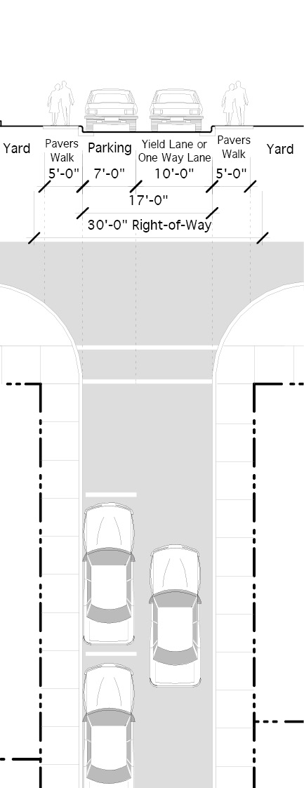
- General Requirements: The lane shall be developed using the standards in table 2.5(1) of this section.
TABLE 2.5(1)
LANE REQUIREMENTSNotes:Permitted subdistricts All subdistricts Permitted adjacent building types All building types Typical right of way width 27' to 32' Vehicular realm: Yield lane/one-way lane 1 yield lane Lane width 10' Allowable turn lanes Not applicable Parking lanes1 1 parallel lane required Pavement width Minimum 17' Maximum 20' Median Prohibited Bicycle facilities2 Shared Pedestrian realm: Pedestrian facilities Shared; travel lanes are shared among drivers, pedestrians and bicyclists Street buffer None required
1Reference section 10-5.1A-2-2, figure 2.2(2) of this article for on street parking requirements.
2Reference section 10-5.1A-2-2, figure 2.2(3) of this article for bicycle facility types and requirements.
(Ord. 16-07, 6-21-2016, eff. 6-21-2016)
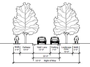
10-5.1A-2-6: Neighborhood Street
- Intent: The neighborhood street is a low capacity street designed for slow speeds with a standard right of way. It primarily serves those residences or businesses directly adjacent to it. Refer to the typical plan and section, figure 2.6(1) of this section.
FIGURE 2.6(1)
TYPICAL NEIGHBORHOOD STREET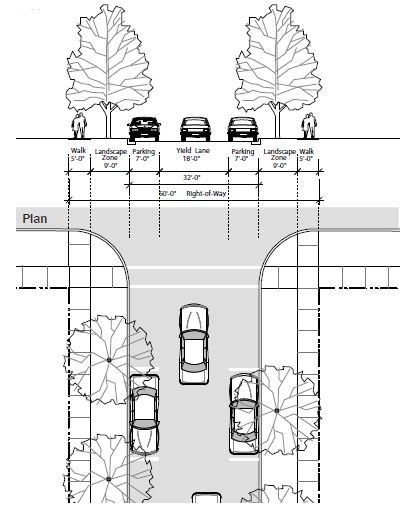
- General Requirements: The neighborhood street shall be developed using the standards in table 2.6(1) of this section.
TABLE 2.6(1)
NEIGHBORHOOD STREET REQUIREMENTSNotes:Permitted subdistricts All subdistricts Permitted adjacent building types All building types Typical right of way width 60' Vehicular realm: Travel lanes 1 yield lane Lane width 18' Allowable turn lanes Not applicable Parking lanes1 Parallel required on 1 side of street Pavement width 32', 20' for alternative3 Median Prohibited Bicycle facilities2 Shared Pedestrian realm: Pedestrian facilities Minimum 5' wide clear sidewalk on both sides Street buffer Minimum 9' wide landscape zone (parkway)
1Reference section 10-5.1A-2-2, figure 2.2(2) of this article for on street parking requirements.
2Reference section 10-5.1A-2-2, figure 2.2(3) of this article for bicycle facility types and requirements.
3Reference figure 2.6(2) of this section for alternative.
FIGURE 2.6(2)
ALTERNATIVE FIFTY FOOT RIGHT OF WAY NEIGHBORHOOD STREET
 (Ord. 16-07, 6-21-2016, eff. 6-21-2016)
10-5.1A-2-7: Connector Street
- Intent: The connector street is a medium capacity street for slow speeds with a standard right of way. It primarily serves as a through street within the neighborhood and connects neighborhood streets to avenues. Refer to the typical plan and section, figure 2.7(1) of this section.
FIGURE 2.7(1)
TYPICAL CONNECTOR STREET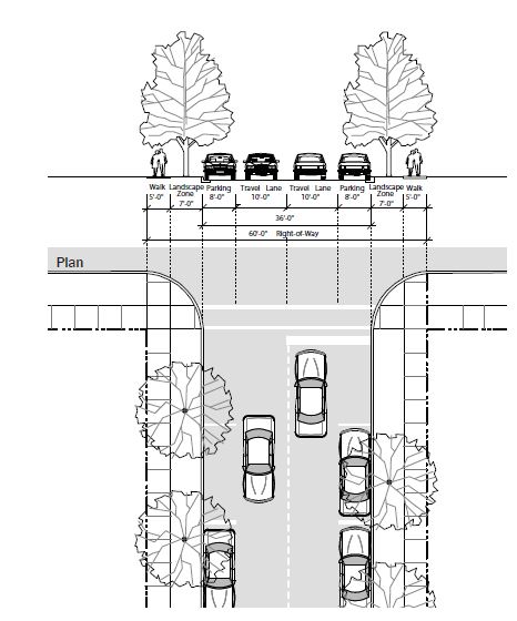
- General Requirements: Connectors shall be developed using the standards in table 2.7(1) of this section.
TABLE 2.7(1)
CONNECTOR STREET REQUIREMENTSNotes:Permitted subdistricts All subdistricts Permitted adjacent building types All building types Typical right of way width 60' to 70' Vehicular realm: Travel lanes 1 lane in each direction Lane width 10' Allowable turn lanes Right permitted in place of parking at intersections with avenue; left only with median alternative3 Parking lanes1 Parallel required on both sides of street Pavement width 36'; 40' for alternative3 Median Permitted with 80' or greater right of way Bicycle facilities2 Shared Pedestrian realm: Pedestrian facilities Minimum 5' wide clear sidewalk on both sides Street buffer Minimum 7' wide landscape zone or furnishings zone
1Reference section 10-5.1A-2-2, figure 2.2(2) of this article for on street parking requirements.
2Reference section 10-5.1A-2-2, figure 2.2(3) of this article for bicycle facility types and requirements.
3Reference figure 2.7(2) of this section for alternative.
FIGURE 2.7(2)
ALTERNATIVE EIGHTY FOOT SHARED RIGHT OF WAY CONNECTOR
(Ord. 16-07, 6-21-2016, eff. 6-21-2016)
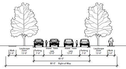
10-5.1A-2-8: Avenue
- Intent: The avenue is a medium to high capacity street for higher speeds with a wider right of way. It serves all types of development and provides crosstown connections. Refer to the typical plan and section in figure 2.8(1) of this section.
FIGURE 2.8(1)
TYPICAL AVENUE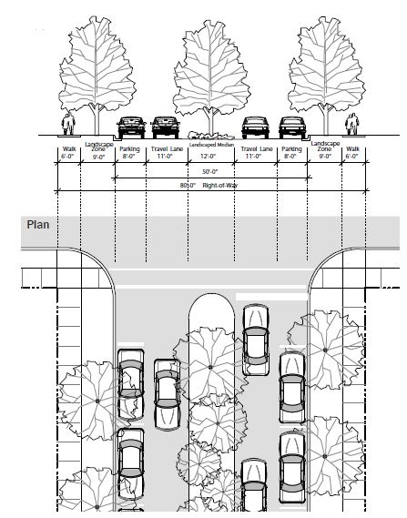
- General Requirements: Avenues shall be developed using the standards in table 2.8(1) of this section.
TABLE 2.8(1)
AVENUE REQUIREMENTSNotes:Permitted subdistricts All subdistricts Permitted adjacent building types All building types Typical right of way width 66' to 80' Vehicular realm: Travel lanes 1 lane in each direction Lane width 11' or 12' with truck traffic Allowable turn lanes Right permitted in place of parking at intersections with connector; left only with median Parking lanes1 Parallel required on both sides of street; angled permitted for alternative3 Pavement width 50'; 78' for alternative3 Median Permitted with 80' or greater right of way Bicycle facilities2 Shared; dedicated bike lane with alternative3 Pedestrian realm: Pedestrian facilities Minimum 5' wide clear sidewalk on both sides Street buffer Minimum 7' wide landscape zone or furnishings zone
1Reference section 10-5.1A-2-2, figure 2.2(2) of this article for on street parking requirements.
2Reference section 10-5.1A-2-2, figure 2.2(3) of this article for bicycle facility types and requirements.
3Reference figure 2.8(2) of this section for alternative.
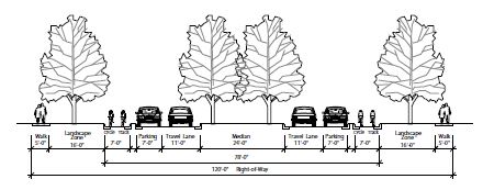
FIGURE 2.8(2)
TYPICAL AVENUE 120' ROW WITH MEDIAN AND CYCLE TRACK CONNECTOR
 (Ord. 16-07, 6-21-2016, eff. 6-21-2016)
10-5.1A-2-9: Boulevard
- Intent: The boulevard is a high capacity street for higher speeds with a wider right-of-way, one way only in this case. It serves all types of development and provides crosstown connections. Refer to the typical plan and section, figure 2.9(1) of this section.
FIGURE 2.9(1)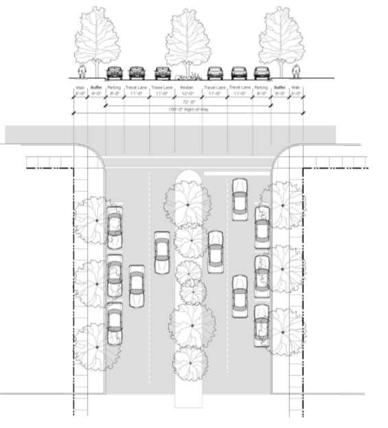
- General Requirements: Boulevards shall be developed using the guidelines in table 2.9(1) of this section.
TABLE 2.9(1)
BOULEVARD REQUIREMENTSNotes:Permitted subdistricts All subdistricts Permitted adjacent building types Storefront General stoop Civic building Typical right-of-way width 100'; 120' alternative Vehicular realm: Travel lanes Up to 2 lanes each direction Lane width 11' or 12' with truck traffic Allowable turn lanes Permitted in place of parking and bulb out at intersections Parking lanes1 Both sides, parallel only Pavement width 72'; 102', 120' alternatives Median Permitted, minimum 9' wide, preferably 12' wide Bicycle facilities2 Designated shared; cycle track alternative Pedestrian realm: Pedestrian facilities Minimum 5' wide clear sidewalk on both sides with bulbouts Buffer Minimum 5' wide landscape zone or furnishings zone, both sides; adjacent to residential districts, open space districts, the planting zone is required
1Reference subsection 10-5.1A-2-2E of this article for on-street parking requirements.
2Reference subsection 10-5.1A-2-2F of this article for bicycle facility types and requirements.
(Ord. 17-22, 11-21-2017, eff. 11-21-2017)
10-5.1A-3-1: Introduction
- The following subdistricts are hereby created to regulate the location of distinct mixes of building forms and uses permitted within the City Center and 40th Street Corridor Districts. Refer to section 10-5.1A-4, "Uses," of this article for uses and section 10-5.1A-5, "Building Types," of this article for building types permitted within each subdistrict.
The following subdistricts have been created, and each consists of a series of uses and building types that have been specifically calibrated for the subdistrict.- City Center "Core": The City Center "Core" constitutes the center of the community and heart of the new City center, and includes the majority of the shops and workplaces within the City center. The storefront building type that comprises this subdistrict defines a street wall along the primary streets of the area with storefront glass windows. Upper stories of the storefront building may be utilized for living and working.
- City Center "General": The City Center "General" Subdistrict serves as the interstitial fabric of the City, separate from the defined center or core and the edges. This area is primarily comprised by both the storefront building, and the more generic stoop building which have lower minimum transparency levels, and is mainly occupied by office, retail and residential uses at a variety of scales. This subdistrict also permits drive-through facilities to allow more flexibility for auto oriented uses as described in 10-5.1A-5-11 F.
- Riverdale Road "General": The Riverdale Road "General" Subdistrict serves as the interstitial fabric of the City, separate from the defined center or core and the edges. This subdistrict also encourages and promotes outdoor sales lots. Adjustments to the general requirements should be made to ensure such uses remain viable. This area is primarily comprised by both the storefront building, and the more generic stoop building which have lower minimum transparency levels, and is mainly occupied by office, retail and residential uses at a variety of scales. This subdistrict also permits drive-through facilities and the limited bay building type to allow more flexibility for auto oriented uses.
- 40th Street "General": The 40th Street "General" Subdistrict combines the storefront building and stoop building to create a corridor that supports a future transit line along 40th Street. Development along this corridor will be at a smaller scale and finer grain, in relation to the City center.
- Edge Subdistricts: The Edge Subdistricts are made up of smaller scale residential buildings, which provide a buffer between existing single-family residential neighborhoods and the "Core" and "General" Subdistricts. (Ord. 17-12, 5-4-2017, eff. 5-4-2017)
10-5.1A-3-2: Zoning Map
- Mapped Subdistricts: The areas and boundaries of the subdistricts listed in section 10-5.1A-3-1 of this section 10-5.1A-3 are established as shown on the map entitled "zoning map of the City of South Ogden" and referred to herein as "zoning map" on file in the City. (Ord. 16-07, 6-21-2016, eff. 6-21-2016)
10-5.1A-4-1: General Requirements
- General Provisions: The following general provisions apply to the uses outlined in this section 10-5.1A-4:
- A lot may contain more than one use.
- Each of the uses may function as either a principal use or accessory use on a lot, unless otherwise specified.
- Uses are either permitted by right in a subdistrict, permitted by right with specific development or design parameters, or require a conditional use permit (refer to subsection 10-5.1A-10-2F of this article) in order to be developed.
- Each use shall be located within a permitted building type (refer to section 10-5.1A-5, "Building Types," of this article), unless otherwise specified.
- Each use may have both indoor and outdoor facilities, unless otherwise specified.
- Organization: The uses are grouped into general categories, which may contain lists of additional uses or clusters of uses.
- Unlisted Similar Use: If a use is not listed but is similar in nature and impact to a use permitted within a zoning subdistrict, the City Manager or designee may interpret the use as permitted.
- The unlisted use will be subject to any development standards applicable to the similar permitted use.
- If the unlisted use is similar in nature and impact to a use requiring a conditional use permit, the City Manager or designee may interpret the use as also requiring a conditional use permit.
- Unlisted Dissimilar Use: If a use is not listed and cannot be interpreted as similar in nature and impact to a use within a zoning subdistrict that is either permitted or requires a conditional use permit, the use is not permitted and may only be approved through an amendment of this article. (Ord. 19-06, 4-16-2019, eff. 4-16-2019)
- Unlisted Similar Use: If a use is not listed but is similar in nature and impact to a use permitted within a zoning subdistrict, the City Manager or designee may interpret the use as permitted.
- Use Table: Table 4.1(1), "Uses By Subdistrict," of this subsection C outlines the permitted uses in each zoning subdistrict. Each use is given one of the following designations for each zoning subdistrict in which that use is permitted:
- Permitted ("P"): These uses are permitted by right in the subdistricts in which they are listed.
- Permitted With Development Standards ("P2"): These uses are permitted by right in the subdistricts in which they are listed, provided that they are developed utilizing the listed development standards. These standards are intended to alleviate any negative impacts associated with the use, making it appropriate in a subdistrict where it otherwise might not have been appropriate.
- Requires A Conditional Use Permit ("C"): These uses require administrative review and approval (refer to subsection 10-5.1A-10-2F of this article) in order to occur in the subdistricts in which they are listed and must follow any applicable development standards associated with the use as well as meet the requirements of the conditional use.
- Not Permitted: Listed uses that are not permitted in the subdistrict are indicated by a blank space.
TABLE 4.1(1)
USES BY SUBDISTRICTKey: P Permitted P2 Permitted with development standards C Requires a conditional use permit Blank Not permitted Notes:Uses Subdistricts City Center "Core" City Center "General" Riverdale Road "General" 40th Street "General" Edge Residential and lodging: Residential P P P P P Hotel and inn P P P P P2 Group living arrangements C C C C Civic: Assembly C C C C P2 Transit station P P P P P2 Hospital and clinic P P P P Library/museum/Post Office (no distribution) P P P P C Police and fire C C C C C School P P P P P Retail: Neighborhood retail P P P P General retail P C P Outdoor sales lot C Medical cannabis pharmacy P2 P2 Service: Neighborhood service P P P P General service P C C Vehicle service C P2 Office and industrial: Office P P P P P2 Craftsman industrial P2 P2 P Non-retail industrial P2 Infrastructure: Parking lot P2 P2 P2 P2 Parking structure P2 P2 P2 P2 Utility and infrastructure C C C C Open space P2 P2 P2 P2 P2 Accessory uses: Drive-through facilities P2 P2 Home occupation P P P P P Parking lot P P P P Parking structure P2 P2 P2 P2 Outdoor storage of goods P2 P2 Temporary outdoor sales lot P P P P Beer and liquor: Class A license1 P P Class B license2 P P P P Class C license3 P P P C
1Class A: Beer and/or liquor served and consumed on or off premises (bar, tavern, microbrewery).
2Class B: Beer and/or liquor sold on premises, but on premises consumption is prohibited (convenience and grocery stores, State liquor stores).
3Class C: Beer and/or liquor may be served with a meal in a restaurant.
- Building Types: The uses permitted within the subdistrict may be further limited by the building types permitted. Refer to section 10-5.1A-5, "Building Types," of this article. (Ord. 19-06, 4-16-2019, eff. 4-16-2019)
10-5.1A-4-2: Definition Of Uses
- Residential And Lodging Uses: A category of uses that includes several residence types.
- Residential: One or more dwelling units located within the principal structure of a lot, in which the units may or may not share a common wall with the adjacent (horizontally or vertically) unit or have individual entrances from the outside.
- Hotel And Inn: A facility offering temporary lodging to the general public consisting of sleeping rooms with or without in-room kitchen facilities. Secondary service uses may also be provided, such as restaurants and meeting rooms. Rooms shall be accessed from the interior of the building. In the subdistricts where a hotel or inn is permitted with development standards ("P2"), the following applies:
- The facility is limited to twelve (12) rooms.
- Bed and breakfasts and pensions are permitted.
- Group Living Arrangements: As defined in section 10-2-1 of this title.
- Civic Uses: A category of uses related to fulfilling the needs of day to day community life including assembly, public services, educational facilities, and hospitals.
- Assembly: A facility that has organized services, meetings, or programs to benefit, educate, entertain, or promote discourse amongst the residents of the community in a public or private setting. Assembly includes such uses as a community center, house of worship, and private clubs and lodges. In the subdistricts where an outdoor sales lot is permitted with development standards ("P2"), the following applies:
- Parking shall be limited to an area less than the total building footprint area.
- The facility shall primarily serve the adjacent neighborhood.
- Transit Station: A covered passenger boarding and a lighting facility with a platform(s), which may include a waiting room, ticket office or machines, restrooms, or concessions.
- Hospital And Clinic: An institution licensed by the State of Utah which provides diagnostic, therapeutic, and rehabilitative services to individuals on both an inpatient and outpatient basis by or under the supervision of one or more physicians. Any medical clinic or professional office which offers any inpatient or overnight care, or operates on a twenty four (24) hour basis shall be considered to be a hospital. A hospital may include integral support service facilities such as laboratories, outpatient units and training and central services, together with staff offices necessary to the operation of the hospital. These services may be located in one building or several buildings.
- Library/Museum: A structure open to the general public, which houses educational, cultural, artistic, or historic information, resources, and exhibits. May also include food service and a gift shop.
- Police And Fire: A facility providing public safety and emergency services; training facilities, locker rooms, and limited overnight accommodations may also be included. Police and fire facilities require a conditional use approval. The facilities shall be housed in a permitted building, but shall have the following additional allowances:
- Garage doors are permitted on the front facade.
- Exempt from maximum driveway widths.
- Post Office: A publicly accessed facility for the selling of supplies and mail related products and the small scale collection and distribution of mail and packages. Large scale postal sorting and distribution is not permitted.
- School: An education facility with classrooms and offices, that may also include associated indoor facilities such as ball courts, gymnasium, theater, and food service. (Ord. 17-22, 11-21-2017, eff. 11-21-2017)
- Assembly: A facility that has organized services, meetings, or programs to benefit, educate, entertain, or promote discourse amongst the residents of the community in a public or private setting. Assembly includes such uses as a community center, house of worship, and private clubs and lodges. In the subdistricts where an outdoor sales lot is permitted with development standards ("P2"), the following applies:
- Retail Uses: A category of uses involving the sale of goods or merchandise to the general public for personal or household consumption.
- Neighborhood Retail: A use in this category occupies a space of less than twelve thousand (12,000) square feet. Neighborhood retail includes such uses as those listed as follows:
Neighborhood retail:
Antique shop.
Apparel and accessory store.
Art and education supplies.
Bakery, retail.
Bicycle sales and repair.
Book, magazine, and newspaper store.
Building materials, hardware, and garden supply.
Camera and photo supply store.
China and glassware shop.
Convenience store.
Drugstore/pharmacy.
Fabric and craft store.
Florist.
Gift, novelty, and souvenir shop.
Grocery store.
Hardware store.
Hobby shop.
Jewelry sales and repair.
Luggage and leather goods.
Music store.
Musical instrument repair and sales.
Office supply.
Optical goods.
Paint and wallpaper.
Party supply shop.
Pet and pet supply.
Specialty food market (butcher, candy, fish market, produce, etc.).
Sporting goods sales and rental.
Stationery and paper store.
Toy shop.
Video/game sales and rental. - General Retail: A use in this category includes all neighborhood retail uses occupying a space of greater than twelve thousand (12,000) square feet and such uses as those listed as follows:
General retail:
All neighborhood retail.
Agriculture equipment and supply.
Appliance and electronic sales and service.
Automotive supply (no service).
Cabinet supply (display only).
Computer software sales and leasing.
Department store.
Electrical supplies.
Gun shop.
Heating, air conditioning and plumbing supplies, sales, and service.
Home furnishings and accessories sales and rentals.
Machine sales and rental.
Medical supply store and rental.
Medical supply store and sales.
Merchandise vending machine operators.
Motorcycle and motor scooter sales.
Pawnshop.
Smoke shop. (Ord. 16-07, 6-21-2016, eff. 6-21-2016) - Outdoor Sales Lot: A use involving the sale of goods or merchandise to businesses and/or the general public, where the majority of the goods are stored or displayed outdoors. Outdoor sales lots include such uses as the sale and rental of automobiles, trucks, trailers, boats, and recreational vehicles; and the sale of building materials, landscape materials, and garden supplies. In the subdistricts where an outdoor sales lot is permitted by conditional use ("C"), the following applies:
- Includes permanent construction of a building utilizing one of the permitted building types in the subdistrict.
- Front setback and corner setback limitations indicated in the building type tables in section 10-5.1A-5 of this article do not apply to outdoor sales lots in the Riverdale Road General Subdistrict.
- Notes limiting double-loaded parking for the permitted building types in the Riverdale Road General Subdistrict do not apply to this use. (Ord. 17-11, 4-18-2017, eff. 4-18-2017)
- Medical Cannabis Pharmacy: A business that purchases cannabis products or devices from a processing facility as described in Utah Code Annotated section 4-41a-102(4) and sells the cannabis products or devices in a medicinal form to a medical cannabis cardholder. In the subdistricts where medical cannabis pharmacies are allowed with development standards (P2), the following standards apply in addition to those found in Utah Code Annotated section 26-61a-301.
- Pharmacy shall maintain exterior facades in a manner that maintains the natural color and appearance of the building and avoids drawing special attention to the building;
- Windows shall not be darkened or covered to prohibit view into the interior of the sales space from the public view;
- Pharmacy shall be operated entirely within a closed building; and
- Hours of operation shall commence no earlier than eight o’clock (8:00) A.M. and end by eight o’clock (8:00) P.M. (Ord. 20-03, 1-21-2020)
- Neighborhood Retail: A use in this category occupies a space of less than twelve thousand (12,000) square feet. Neighborhood retail includes such uses as those listed as follows:
- Service: A category of uses that provide patrons services and limited retail products related to those services. Visibility and accessibility are important to these uses, as most patrons do not utilize scheduled appointments.
- Neighborhood Service: A use in this category occupies a space of less than twelve thousand (12,000) square feet. Neighborhood service includes such uses as follows:
Neighborhood service:
Arcade.
Bank or other financial service.
Barbershop, beauty salon, and spa.
Billiard hall.
Catering.
Daycare, adult or child.
Dry cleaning and laundry.
Emergency care clinic.
Fitness, dance studio, and gym.
Framing.
Home furniture and equipment repair.
Locksmith.
Mailing services.
Pet grooming.
Photocopying and printing.
Photography studio and supplies (on site processing permitted).
Restaurants (refer to State law for alcoholic beverage requests).
Shoe repair.
Tailor and seamstress.
Tanning salon.
Theater.
Training center.
Travel agency and tour operator.
Veterinarian. - General Service: A use in this category includes all neighborhood service uses occupying a space of greater than twelve thousand (12,000) square feet and such uses as those listed as follows:
All neighborhood services
Animal boarding (interior only)
Aquatic facilities.
Batting cages.
Bowling alley.
Concert hall.
Exterminating and disinfecting service.
Funeral home.
Miniature golf course.
Recreation, commercial indoor.
Repair of small goods and electronics.
Shooting and archery ranges (indoor only).
Short term lending business 1
Skating rink.
Tattoo/piercing parlor. - Vehicle Service: A business involving the servicing of vehicles and/or the distribution of fuel to residents of the community and region. A convenience store may also be included as a secondary use, as well as the sale of propane and kerosene. Vehicle service includes such uses as automotive filling stations, vehicle repair, car wash facilities, and tire sales and mounting. In the subdistricts where vehicle service is permitted with development standards ("P2"), the following apply:
- Use Limitation: Repair and wash facilities for semi-trucks, recreational vehicles, boats, and other oversized vehicles are not permitted.
- Service Bays: Vehicular service bays, including garages and car wash bays, shall not be located on the front facade, unless otherwise permitted by the building type.
- Outdoor Storage: Disabled or inoperable vehicles and those awaiting pick-up may be stored outdoors if:
- The vehicles are not stored for more than two (2) days.
- The storage area is located in the rear yard screened from view of the front lot line.
- The storage area is screened using the side and rear yard buffer outlined in section 10-5.1B-7, "Landscape Standards," of this article, regardless of the adjacent land uses.
- Outdoor Activities:
- All repairs or washing activities must occur inside a structure.
- Vacuuming activities may occur in open air, but must be located in the side or rear yards, screened from the front lot line.
- Temporary outdoor display of seasonal items, such as windshield wiper fluid or salt, is permitted during business hours under the canopy and adjacent to the principal structure.
- Neighborhood Service: A use in this category occupies a space of less than twelve thousand (12,000) square feet. Neighborhood service includes such uses as follows:
- Office Uses: A category of uses for businesses that involve the transaction of affairs of a profession, service, industry, or government. Patrons of these businesses usually have set appointments or meeting times; the businesses do not typically rely on walk-in customers. Office uses include those listed in subsection F2 of this section. In the districts where an office use is permitted with development standards ("P2"), the use is considered a home occupation and shall meet the following standards:
- In a live/work building, the use is exempt from the following standards:
- Hours Of Operation: Permitted hours of operation are six o'clock (6:00) A.M. to nine o'clock (9:00) P.M.
- Residence: The operator of the business shall reside in the dwelling unit.
- Vehicles: Parking of a vehicle associated with the business must be accommodated on site.
- Typical office uses:
Architecture/engineering/design.
Building contractor (office only).
Business consulting.
Charitable institutions.
Computer programming and support.
Detective services.
Educational services (tutor and testing).
Employment agency.
Financial and insurance.
Government offices.
Legal services.
Management services.
Medical and dental with laboratory.
PR and advertising.
Physical therapy/physical rehabilitation.
Property development.
Radio and TV studio.
Real estate.
Recording and sound studio.
Research agency.
Research and development.
Surveying.
- In a live/work building, the use is exempt from the following standards:
- Craftsman Industrial: A use involving small scale manufacturing, production, assembly, and/or repair with little to no noxious byproducts that includes a showroom or small retail outlet that is accessible to the public. Craftsman industrial includes such uses as those found in subsection G3 of this section. This use may also include associated facilities such as offices and small scale warehousing, but distribution is limited. The maximum overall gross floor area is limited to twenty thousand (20,000) square feet, unless otherwise noted. In the subdistricts where a craftsman industrial use is permitted with development standards ("P2"), the following apply:
- A minimum twenty percent (20%) of gross floor area shall be dedicated to a showroom located at the front of the space and is in view of a public right of way.
- Outdoor activities and storage of goods are not permitted.
- Typical craftsman industrial uses:
Apparel and finished fabric products.
Bakery and confections.
Beverages, including beer, wine, liquor, soft drinks, coffee.
Botanical products.
Brooms and brushes.
Canning and preserving food.
Commercial scale copying and printing.
Construction special trade contractors.
Cut stone and cast stone.
Dairy products.
Electrical fixtures.
Electronics assembly.
Engraving.
Fabricated metal products.
Filmmaking.
Furniture and fixtures.
Glass.
Household textiles.
Ice.
Jewelry, watches, clocks, and silverware.
Leather products.
Meat and fish products, no processing.
Musical instruments and parts.
Pasta.
Pottery, ceramics, and related products.
Printing, publishing and allied industries.
Shoes and boots.
Signs and advertising.
Small goods manufacturing.
Smithing.
Taxidermy.
Textile, fabric, cloth.
Toys and athletic goods.
Upholstery.
Woodworking.
- Parking Lot: A lot that does not contain a permitted building or open space type and is solely used for the parking of vehicles. In the subdistricts where a parking lot is permitted with development standards ("P2"), the following apply:
- Corner Lots: A corner lot shall not be used as a parking lot.
- Adjacent Parking Lots: Two (2) parking lots cannot be located directly adjacent to one another.
- Single-Family: Parking lot cannot be associated with a single-family use.
- Distance: Parking lot must be within one thousand three hundred feet (1,300') of the principal entrance to the associated use unless:
- At least seventy five percent (75%) of the spaces are dedicated for public use.
- An approved parking agreement is in place (refer to section 10-5.1A-8, "Parking," of this article).
- Pedestrian Access: Must be connected to associated use by a dedicated, public pedestrian pathway.
- Commercial Vehicles: Parking lots for commercial vehicles are not permitted in these subdistricts.
- Parking Structure: A parking structure on a lot that does not contain a permitted building type and is solely used for the parking of vehicles. In the subdistricts where a parking structure is permitted with development standards ("P2"), the following apply:
- Corner Lots: A corner lot shall not be used for a parking structure on primary streets. Parking structures may be used for corner lots on other streets if ground floor of structure is dedicated for commercial use.
- Adjacent Parking Lots: Two (2) parking facilities (lots or structures) cannot be located directly adjacent to one another.
- Primary Street: Parking structures fronting primary streets must have ground floor dedicated to commercial uses.
- Distance: Parking structure must be within one thousand three hundred feet (1,300') of the principal entrance to the associated use unless:
- At least seventy five percent (75%) of the spaces are dedicated for public use.
- An approved parking agreement is in place (refer to section 10-5.1A-8, "Parking," of this article).
- Pedestrian Access: Must be connected to associated use by a dedicated, public pedestrian pathway.
- Commercial Vehicles: Parking structures for commercial vehicles are not permitted in these subdistricts.
- Utility And Infrastructure: A lot that is primarily utilized for the City's infrastructure needs. Utility and infrastructure include such uses as electric or gas services, sewage treatment, water treatment and storage, and energy conversion systems. In all subdistricts, utility and infrastructure require a conditional use permit ("C").
- Open Space: A use of land for active or passive, public or private, outdoor space, including such uses as parks, plazas, greens, playgrounds, or community gardens. Refer to section 10-5.1A-6, "Open Space Types," of this article for permitted forms of open space. Open space uses may also be utilized to host temporary private or community events, such as a farmers' market or art fair. In the subdistricts where open space is permitted with development standards ("P2"), the following apply:
- Parking: Parking lots are not permitted in open space in any subdistrict unless otherwise approved by City Manager or designee.
- Stormwater Accommodations: Open space that incorporates stormwater management on a site or subdistrict scale is encouraged.
- Stormwater facilities shall be designed to accommodate additional uses, such as an amphitheater or a sports field.
- Stormwater facilities shall be designed not to be fenced and shall not impede public use of the land they occupy.
- Food And Beverage: This use may involve small scale food and beverage service, no more than two hundred (200) square feet in space, located in a kiosk, with no service access.
- Facades: Buildings located directly adjacent to an open space use shall treat facades facing this use with street facade requirements. (Ord. 16-07, 6-21-2016, eff. 6-21-2016)
- Accessory Uses: A category of uses that are not permitted to serve as the principal use on a zoning lot.
- Drive-Through Facilities: A use that allows customers to receive services or goods through a window while remaining stationary in their motor vehicles. A drive-through facility does not include pumps at a gas station, or any other type of pick-up service (e.g., groceries or lumber) where the driver is required to leave the vehicle or where the services and goods are delivered by other means than through a window. Refer to section 10-5.1A-5-11 of this article, for required drive-through development standards.
- Home Occupation: An occupational use that is clearly subordinate to the principal use as a residence and does not require any alteration to the exterior of a building.
- Parking Lot: An uncovered paved surface used solely for the parking of vehicles, intended for use by the occupants in an adjacent building on the lot. Parking lot locations are regulated by building type. Refer to section 10-5.1A-5, "Building Types," of this article.
- Parking Structure: A structure used solely for the parking of vehicles, intended for use by the occupants in an adjacent building on the lot. Parking structures within the buildings are regulated per building type. Refer to section 10-5.1A-5, "Building Types," of this article. Separate structure locations are also regulated by building type, but shall also meet all of the requirements of subsection I, "Parking Structure," of this section.
- Outdoor Storage Of Goods: Permanent outdoor storage of goods not typically housed or sold indoors, such as large scale materials and building and landscape supplies. In the subdistricts where outdoor storage of goods is permitted with development standards ("P2"), the following development standards apply:
- Outdoor storage areas shall be located in the rear or side yard of the lot.
- Loose materials shall not be stacked higher than six feet (6').
- Loose materials shall at a minimum be stored in a three (3) sided shelter and shall be covered.
- Materials shall be set back a minimum of five feet (5') from any lot line.
- All outdoor storage areas shall be screened from view of adjacent parcels and vehicular rights-of-way using the heavy side or rear buffer; refer to section 10-5.1A-7 of this article, landscape requirements for side and rear buffer. (Ord. 19-09, 7-2-2019, eff. 7-2-2019)
- Temporary Outdoor Sales Lot: Temporary outdoor sales lots consist of the sales of goods and/or services from a trailer, mobile store or kiosk. Temporary outdoor sales lots include such things as fireworks stands, Christmas tree lots, and produce stands. They may also include larger events such as farmers' markets. Produce stands and farmers' markets are limited to local farmers/growers selling products from their own farms or gardens, crafters selling their own crafts, and food vendors. Temporary outdoor sales lots shall be regulated through business licensing and special events permits. (Ord. 19-08, 6-18-2019, eff. 6-18-2019; amd. Ord. 19-09, 7-2-2019, eff. 7-2-2019)
- Non-Retail Industrial: A use involving small scale manufacturing, production, assembly, and/or repair with little to no noxious byproducts. Non-retail industrial includes such uses as those found in subsection M2 of this section. This use may also include associated facilities such as offices and small scale warehousing, but distribution is limited. The maximum overall gross floor area is limited to twenty thousand (20,000) square feet, unless otherwise noted. In the subdistricts where a craftsman industrial use is permitted with development standards ("P2"), the following apply:
- Outdoor activities and storage of goods are not permitted.
- Typical non-retail industrial uses:
Apparel and finished fabric products.
Bakery and confections.
Beverages, including beer, wine, liquor, soft drinks, coffee.
Botanical products.
Brooms and brushes.
Canning and preserving food.
Commercial scale copying and printing.
Construction special trade contractors.
Cut stone and cast stone.
Dairy products.
Electrical fixtures.
Electronics assembly.
Engraving.
Fabricated metal products.
Filmmaking.
Furniture and fixtures.
Glass.
Household textiles.
Ice.
Jewelry, watches, clocks, and silverware.
Leather products.
Meat and fish products, no processing.
Musical instruments and parts.
Pasta.
Pottery, ceramics, and related products.
Printing, publishing and allied industries.
Shoes and boots.
Signs and advertising.
Small goods manufacturing.
Smithing.
Taxidermy.
Textile, fabric, cloth.
Toys and athletic goods.
Upholstery.
Woodworking. (Ord. 20-10, 3-17-2020)
1An establishment engaged in providing credit intermediation and related activities that facilitate the lending of funds, issuance of credit, or any other similar types of businesses in which the activity is generally contemplated to be completed within a term of six (6) months or less, including a check casher, deferred deposit lender or title lender. A short term loan business may offer more than one type of credit intermediation service if it meets the licensing requirements for each service and operates from a single storefront. This definition does not include investment companies and state or federally chartered banks or financial institutions.No short term lending business may be located or operate within 1,000 feet of another.No more than 3 short term lending businesses may be licensed within the City. Preexisting, nonconforming uses may continue until the business ceases operation or until the business ceases operation or experiences a change in ownership. (Ord. 20-18, 7-7-2020)
10-5.1A-5-1: Introduction To Building Type Standards
- Introduction: The building types detailed in this section 10-5.1A-5, outline the required building forms for new construction and renovated structures within the subdistricts defined in section 10-5.1A-3 of this article.
- General Requirements: All building types must meet the following requirements:
- Zoning Subdistricts: Each building type shall be constructed only within its designated subdistricts. Refer to table 5.1(1), "Permitted Building Types By Subdistrict," of this subsection B1.
TABLE 5.1(1)
PERMITTED BUILDING TYPES BY SUBDISTRICTKey: P Permitted Note:Building Types City Center "Core" City Center "General" Riverdale Road "General" 40th Street "General" Edge Storefront P P P P General stoop P1 P1 P1 Limited bay P Row building P P P P Yard building P Civic building P P P P P
1Not permitted everywhere. Refer to subsection 10-5.1A-5-4B, "Building Siting," of this section 10-5.1A-5 for restrictions. - Uses: Each building type can house a variety of uses depending on the subdistrict in which it is located. Refer to section 10-5.1A-4, "Uses," of this article for uses permitted per subdistrict. Some building types have additional limitations on permitted uses.
- No Other Building Types: All buildings constructed must meet the requirements of one of the building types permitted within the zoning subdistrict of the lot.
- Permanent Structures: All buildings constructed shall be permanent construction without a chassis, hitch, or wheels, or other features that would make the structure mobile, unless otherwise noted.
- Accessory Structures:
- Attached accessory structures are considered part of the principal structure.
- Detached accessory structures are permitted per each building type and shall comply with all setbacks except the following:
- Detached accessory structures are not permitted in the front yard.
- Detached accessory structures shall be located behind the principal structure in the rear yard.
- Detached accessory structures shall not exceed the height of the principal structure. (Ord. 19-06, 4-16-2019, eff. 4-16-2019)
- Detached accessory structures are not permitted in the front yard.
- Attached accessory structures are considered part of the principal structure.
- Structures At Intersections: In all form based code subdistricts at any uncontrolled intersection, the buildings will be modified to afford automobile drivers a clear view of approaching vehicles or pedestrians. Buildings, trees, or any obstruction shall be prohibited within a triangular area formed by the street curb lines and a line connecting them at points forty feet (40') from the point of intersection of the back of the curbs (clear view area). (Ord. 18-11, 9-18-2018, eff. 9-18-2018)
- Zoning Subdistricts: Each building type shall be constructed only within its designated subdistricts. Refer to table 5.1(1), "Permitted Building Types By Subdistrict," of this subsection B1.
10-5.1A-5-2: Explanation Of Building Type Table Standards
The following explains and further defines the standards outlined on the tables for each building type; refer to sections 10-5.1A-5-3 through 10-5.1A-5-8 of this section 10-5.1A-5.
- Building Siting: The following explains the line item requirements for each building type table in sections 10-5.1A-5-3 through 10-5.1A-5-8 of this section 10-5.1A-5 within the first section of each table entitled "Building Siting."
- Multiple Principal Buildings: The allowance of more than one principal structure on a lot.
- Front Property Line Coverage: Refer to figure 5.2(1), "Measuring Front Property Line Coverage," of this subsection A2. Measurement defining the minimum percentage of street wall or building facade required along the street. The width of the principal structure(s) (as measured within the front build-to zone) shall be divided by the maximum width of the front build-to zone (BTZ).
FIGURE 5.2(1)
MEASURING FRONT PROPERTY LINE COVERAGE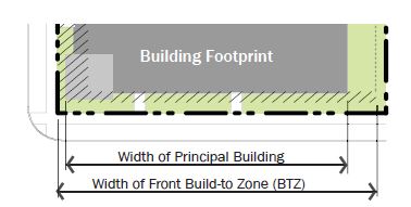
- Certain buildings have this number set to also allow the development of a courtyard along the front property line.
- Some frontage types allow side yard parking to be exempted from the front lot line coverage calculation. If such an exemption is permitted, the width of up to one double loaded aisle of parking, located with the drive perpendicular to the street and including adjacent sidewalks and landscaping, may be exempted, to a maximum of seventy two feet (72').
- Occupation Of Corner: Occupying the intersection of the front and corner build-to zones with a principal structure. In all form based code subdistricts at any uncontrolled intersection, the buildings will be modified to afford automobile drivers a clear view of approaching vehicles or pedestrians. Buildings, trees, or any obstruction shall be prohibited within a triangular area formed by the street curb lines and a line connecting them at points forty feet (40') from the point of intersection of the back of the curbs (clear view area).
- Front Build-To Zone: The build-to zone or setback parallel to the front property line. Building components, such as awnings or signage, are permitted to encroach into the build-to zone.
- All build-to zone and setback areas not covered by building must contain either landscape, patio space, or sidewalk space.
- Corner Build-To Zone: The build-to zone or setback parallel to the corner property line.
- All build-to zone and setback areas not covered by building must contain either landscape, patio space, or sidewalk space.
- Minimum Side Yard Setback: The minimum required setback along a side property line.
- Minimum Rear Yard Setback: The minimum required setback along a rear property line.
- Minimum And Maximum Lot Or Building Width: Depending on the building type, either the minimum or maximum building or unit width will be noted or the minimum and maximum width of a lot, all measured at or parallel to the front property line.
- Parking And Loading Location: The yard in which a surface parking lot, detached garage, attached garage door access, loading and unloading, and associated drive is permitted.
- Vehicular Access: The permitted means of vehicular ingress and egress to the lot.
- Alleys, when present, shall always be the primary means of access.
- When alleys are not present, a driveway may be permitted per building type and, if an alternative is available, shall not be located off a primary street.
- Height: The following explains the line item requirements for each building type table in sections 10-5.1A-5-3 through 10-5.1A-5-8 of this section 10-5.1A-5 within the second section of each table entitled "Height."
- Minimum Overall Height: The minimum overall height for the building shall be located within the build-to zone; stories above the required minimum height may be stepped back from the facade.
- Maximum Overall Height: The sum of a building's total number of stories represented in feet, plus the height of the roof not encompassed by the calculated stories and half-stories, combined.
- Half stories are located either completely within the roof structure with street facing windows or in a visible basement exposed a maximum of one half-story above grade.
- A building incorporating both a half story within the roof and a visible basement shall count the height of the two (2) half stories as one full story.
- Some building types require a building facade to step back as its height increases. If required, the upper stories of any building facade with street frontage shall be set back a designated amount beyond the building facade of the lower stories.
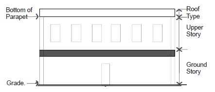
- Ground Story And Upper Story, Minimum And Maximum Height: (Refer to figure 5.2(3), "Measuring Height," of this subsection B3.) Each frontage type includes a permitted range of height in feet for each story. Additional information is as follows:
- Floor height is measured in feet between the floor of a story to the floor of the story above it.
- Floor height requirements apply only to street facing facades.
- For single-story buildings and the uppermost story of a multiple-story building, floor to floor height shall be measured from the floor of the story to the tallest point of the ceiling.
FIGURE 5.2(3)
MEASURING HEIGHT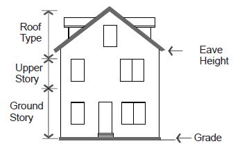
- Existing Single-Family Residential Buffer: In order to assure compatibility of new construction with adjacent single-family zones along the 40th "transit" Street:
- Transitions From Single-Family Homes: A twenty foot (20') setback is required from the property line adjacent to a single-family detached home. At twenty feet (20'), twenty five foot (25') building height is permitted in between the property line and thirty feet (30'). After thirty feet (30'), every two feet (2') in additional horizontal distance from the property line permits one foot (1') of additional vertical building height. See figure 5.2(5) of this subsection B4.
FIGURE 5.2(5)
TRANSITIONS FROM SINGLE-FAMILY HOMES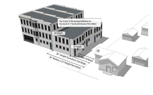
- Transitions From Single-Family Homes: A twenty foot (20') setback is required from the property line adjacent to a single-family detached home. At twenty feet (20'), twenty five foot (25') building height is permitted in between the property line and thirty feet (30'). After thirty feet (30'), every two feet (2') in additional horizontal distance from the property line permits one foot (1') of additional vertical building height. See figure 5.2(5) of this subsection B4.
- Uses: The following explains the line item requirements for each building type table in sections 10-5.1A-5-3 through 10-5.1A-5-8 of this article within the third section of each table entitled "Uses." Refer to section 10-5.1A-4, "Uses," of this article for uses permitted within each zoning subdistrict. The requirements in this section of the building type tables may limit those uses within a specific building type.
- Ground And Upper Story: The uses or category of uses which may occupy the ground and/or upper story of a building.
- Parking Within Building: The area(s) of a building in which parking is permitted within the structure.
- Required Occupied Space: The area(s) of a building that shall be designed as "occupied space," defined as interior building space regularly occupied by the building users. It does not include storage areas, utility space, or parking.
- Street Facade Requirements: The following explains the line item requirements for each building type tables in sections 10-5.1A-5-3 through 10-5.1A-5-8 of this article, within the fourth section of each table entitled "Street Facade Requirements." Street facade requirements apply only to facades facing a public or private right of way. The rear or interior side yard facades are not required to meet these standards unless otherwise stated.
- Minimum Ground Story And Upper Floor Transparency: (Refer to figure 5.2(4), "Measuring Transparency," of this section.) The minimum amount of transparency required on street facades with street frontage.
- Transparency is any glass in windows and/or doors, including any mullions, that is highly transparent with low reflectance.
- Ground story transparency, when defined separately from the overall minimum transparency, shall be measured between two feet (2') and eight feet (8') from the average grade at the base of the front facade.
- A general minimum transparency requirement shall be measured from floor to floor of each story.
FIGURE 5.2(4)
MEASURING TRANSPARENCY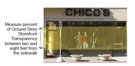
- Transparency is any glass in windows and/or doors, including any mullions, that is highly transparent with low reflectance.
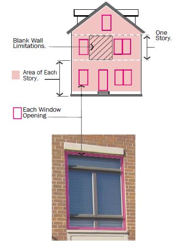
- Blank Wall Limitations: A restriction of the amount of windowless area permitted on a facade with street frontage. If required, the following shall both be met for each story:
- No rectangular area greater than thirty percent (30%) of a story's facade, as measured from floor to floor, may be windowless; and
- No horizontal segment of a story's facade greater than fifteen feet (15') in width may be windowless, unless approved by City Manager or designee.
- Entrance Type: The entrance type(s) permitted for the entrance(s) of a given building type. A mix of permitted entrance types may be utilized. Refer to section 10-5.1A-5-9, "Entrance Types," of this section 10-5.1A-5 for definition of and additional requirements for each entrance type.
- Principal Entrance Location: The facade on which the primary building entrance is to be located.
- Required Number Of Street Entrances: The minimum number of and maximum spacing between entrances on the ground floor building facade with street frontage.
- Vertical Facade Divisions: The use of a vertically oriented expression line or form to divide the facade into increments no greater than the dimension shown, as measured along the base of the facade. Elements may include a column, pilaster, or other continuous vertical ornamentation a minimum of one and a half inch depth.
- Horizontal Facade Divisions: The use of a horizontally oriented expression line or form to divide portions of the facade into horizontal divisions. Elements may include a cornice, belt course, molding, string courses, or other continuous horizontal ornamentation a minimum of one and a half inch depth.
- Minimum Ground Story And Upper Floor Transparency: (Refer to figure 5.2(4), "Measuring Transparency," of this section.) The minimum amount of transparency required on street facades with street frontage.
- Roof Type: The following explains the line item requirements for each building type table in sections 10-5.1A-5-3 through 10-5.1A-5-8 of this section 10-5.1A-5 within the fifth section entitled "Roof Type Requirements."
- Permitted Roof Type: The roof type(s) permitted for a given building type. Refer to section 10-5.1A-5-10, "Roof Types," of this section 10-5.1A-5 for more specific requirements.
- Tower: A vertical building extension that may be permitted in conjunction with another roof type on certain building types. Refer to section 10-5.1A-5-10, "Roof Types," of this section 10-5.1A-5.
- Roof Projections And Drainage: Roofs and associated drainage systems shall not extend beyond the affected property lines. Roofs and roof drainage systems shall be designed in according to applicable building codes, ensuring that all drainage and snow shedding occurs within the subject property. Roofs and associated roof drainage systems shall not be allowed to drain or shed storm water, nor allow accumulated snow to slide or be deposited onto adjacent properties or public roadways, sidewalks, and rights-of-way. (Ord. 16-07, 6-21-2016, eff. 6-21-2016; amd. Ord. 18-11, 9-18-2018, eff. 9-18-2018; Ord. 21-01, 1-19-2021, eff. 1-19-2021)
10-5.1A-5-3: Storefront Building
- Description And Intent: The storefront building is intended for use as a mixed use building located close to the front property line with parking typically in the rear or side of the lot.
The key facade element of this building type is the storefront required on the ground floor front facade, with large amounts of glass and regularly spaced entrances.
This building is available in a variety of intensities, depending on the subdistrict within which it is located. - Regulations: Regulations for the storefront building type are defined in the table in this section.
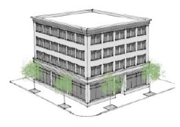 (Ord. 19-06, 4-16-2019, eff. 4-16-2019)
Permitted Subdistricts City Center "Core" City Center "General" Riverdale Road "General" 40th Street "General" 1. Building Siting: Refer to figure 5.3(1) of this section Multiple principal buildings Permitted Permitted Permitted5 Permitted (a) Front sidewalk coverage 85% 80% 80% 80%1 Occupation of corner Required6 Required6 Required5,6 Required6 (b) Front build-to zone 0' to 5' 0' to 5' 0' to 10'5 0' to 5' (c) Corner build-to zone 0' to 5'6 0' to 5'6 0' to 10'5,6 0' to 5'6 (d) Minimum side yard setback 0' 0' 0' 0' (e) Minimum rear yard setback 10' 10' 10' 10' (f) Minimum lot width None None None None Maximum lot width None None None None (g) Parking and loading location Rear yard Rear yard Rear yard5 Rear and side yard1 (i) Vehicular access Alley only; if no alley exists, 1 driveway is permitted per nonprimary facade, or as approved by the City Manager or designee Alley; if no alley exists, 1 driveway is permitted per nonprimary facade, or as approved by the City Manager or designee Alley; if no alley exists, 1 driveway is permitted per nonprimary facade, or as approved by the City Manager or designee5 Alley; if no alley exists, 2 driveways are permitted per nonprimary facades, or as approved by the City Manager or designee 2. Height: Refer to figure 5.3(2) of this section (j) Minimum overall height 2 story 1 story 1 story 1 story (k) Maximum overall height 5 stories2 3 stories 5 stories2 3 stories (l) Ground story: Minimum height 14' 14' 14' 14' Maximum height 20'3 20'3 20'3 20'3 (m) Upper stories: Minimum height 9' 9' 9' 9' Maximum height 14' 14' 14' 14' 3. Uses: Refer to figure 5.3(2) of this section. Refer to section 10-5.1A-4, "Uses," of this article for permitted uses (n) Ground story Any permitted use Any permitted use Any permitted use Any permitted use4 (o) Upper story Any permitted use (p) Parking within building Permitted fully in any basement and in rear of upper floors (q) Required occupied space 30' deep on all full floors measured from the front facade 4. Street Facade Requirements: Refer to figure 5.3(3) of this section (r) Minimum ground story transparency. Measured between 2' and 8' above grade 65% 65% 65% 65% front only (s) Minimum transparency per each story 15% 15% 15% 15% Blank wall limitations Required, see subsection 10-5.1A-5-2D2 of this section 10-5.1A-5 (t) Front facade entrance type Storefront, arcade4 Storefront, arcade4 Storefront, arcade Storefront, arcade4 (u) Principal entrance location Front facade4 Front facade4 Front facade Front or corner facade4 Required number of street entrances 1 per each 75' of front facade 1 per each 75' of front facade 1 per each 75' of front facade 1 per each 100' of front facade Vertical facade divisions Every 30' of facade width Every 30' of facade width Every 50' of facade width Every 50' of facade width Horizontal facade divisions Required within 3' of the top of the ground story, and every fifth floor above the first floor 5. Roof Type Requirements: Refer to figure 5.3(3) of this section (v) Permitted roof types Parapet, pitched, flat Parapet, pitched, flat Parapet, pitched, flat Parapet, pitched, flat Tower Permitted Permitted Permitted Permitted Notes:
1Lots wider than 140 feet are permitted 1 double loaded aisle of surface parking (maximum width of 72 feet), located perpendicular to the front property line, which is exempt from front property line coverage.
2Above the third story, the upper stories of any building facade with street frontage shall have a step back from the lower stories that is a minimum of 6 feet.
3If 18 feet or more in height, ground story shall count as 2 stories toward maximum building height.
4Lots lacking frontage on 40th Street but that are still within the 40th Street General Subdistrict are limited to permitted residential uses only.
5Does not apply to outdoor sales lots.
6At any uncontrolled intersection, the buildings will be modified to afford automobile drivers a clear view of approaching vehicles or pedestrians. Buildings, trees, or any obstruction shall be prohibited within a triangular area formed by the street curb lines and a line connecting them at points 40 feet from the point of intersection of the back of the curbs (clear view area).
(Ord. 18-11, 9-18-2018, eff. 9-18-2018; amd. Ord. 19-06, 4-16-2019, eff. 4-16-2019)FIGURE 5.3(1)
STOREFRONT BUILDING: BUILDING SITING
Typical Site Plan
Site Plan With Side Yard Parking "Core"(Ord. 18-11, 9-18-2018, eff. 9-18-2018)
FIGURE 5.3(2)
STOREFRONT BUILDING: HEIGHT AND USE REQUIREMENTS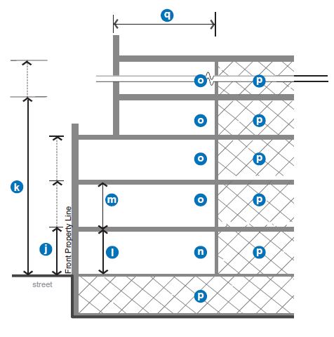
FIGURE 5.3(3)
STOREFRONT BUILDING: STREET FACADE AND ROOF REQUIREMENTS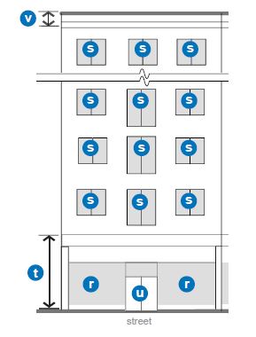
(Ord. 16-07, 6-21-2016, eff. 6-21-2016)
10-5.1A-5-4: General Stoop Building
- Description And Intent: The general stoop building type is limited in terms of uses by the subdistrict within which it is located, generally housing office and/or residential uses. Similar to the storefront building, the general stoop building is intended to be built close to the front and corner property lines allowing easy access to passing pedestrians and transit riders. Parking may be provided in the rear of the lot, internally in the building, or, in some cases, one double loaded aisle of parking is permitted in the interior or the side yard at the front property line. The minimum and maximum heights of this building type depend on the subdistrict within which it is located.
- Regulations: Regulations for the general stoop building type are defined in the table in this section. (Ord. 19-06, 4-16-2019, eff. 4-16-2019)
 (Ord. 16-07, 6-21-2016, eff. 6-21-2016)
Permitted Subdistricts City Center "General" Riverdale Road "General" 40th Street "General" 1. Building Siting: Refer to figure 5.4(1) of this section Any multi-family residential building with frontage on a public or private dedicated street must use the storefront building type Multiple principal buildings Not permitted Not permitted Not permitted (a) Front sidewalk coverage 80%1 80%1 80% Occupation of corner Required5 Required5 Required5 (b) Front build-to zone 0' to 10' 0' to 10' 0' to 10' (c) Corner build-to zone 0' to 10'5 0' to 10'5 0' to 10'5 (d) Minimum side yard setback 10' 10' 10' (e) Minimum rear yard setback 5' 5' 5' (f) Minimum lot width None None 100' Maximum lot width None None None (g) Parking and loading location Rear yard Rear yard Rear and side yard (i) Vehicular access Alley; if no alley exists, 1 driveway is permitted per nonprimary facade, or as approved by the City Manager or designee Alley; if no alley exists, 1 driveway is permitted per nonprimary facade, or as approved by the City Manager or designee Alley; if no alley exists, 1 driveway is permitted per street, or as approved by the City Manager or designee 2. Height: Refer to figure 5.4(2) of this section (j) Minimum overall height 1 story 1 story 1 story (k) Maximum overall height 3 stories 5 stories3 3 stories (l) All stories: Minimum height 9' 9' 9' Maximum height 14' 14' 14' 3. Uses: Refer to figure 5.4(2) of this section. Refer to section 10-5.1A-4, "Uses," of this article for permitted uses (n) All stories Any permitted use4 (p) Parking within building Permitted fully in basement and rear of upper floors (q) Required occupied space 30' deep on all full floors from the front facade 4. Street Facade Requirements: Refer to figure 5.4(3) of this section (r) Minimum transparency per each story 35% 35% 15% Blank wall limitations Required, see subsection 10-5.1A-5-2D2 of this section 10-5.1A-5 (t) Front facade entrance type Stoop, porch, storefront4 Stoop, porch, storefront Stoop, porch, storefront4 (u) Principal entrance location Front facade4 Front facade Front or corner facade4 Required number of street entrances 1 per each 100' of front facade 1 per each 100' of front facade 1 per each 150' of front facade Vertical facade divisions Every 25' of facade width Every 50' of facade width Every 50' of facade width Horizontal facade divisions Required within 3' of the top of any visible basement and of the ground story, and at the fifth floor above the ground floor 5. Roof Type Requirements: Refer to figure 5.4(3) of this section (v) Permitted roof types Parapet, pitched, flat Parapet, pitched, flat Parapet, pitched, flat (w) Tower Permitted Permitted Permitted Notes:
1A courtyard covering up to 35 percent of the front facade is permitted and may contribute to the front lot line coverage requirement.
2Lots wider than 140 feet are permitted 1 double loaded aisle of parking (maximum width of 72 feet), located perpendicular to the front property line, which is exempt from front property line coverage.
3Upper stories above the third story on any building facade with street frontage shall have a step back from the lower stories that is a minimum of 6 feet.
4Lots lacking frontage on 40th Street but that are still within the 40th Street General Subdistrict are limited to permitted residential uses only.
5At any uncontrolled intersection, the buildings will be modified to afford automobile drivers a clear view of approaching vehicles or pedestrians. Buildings, trees, or any obstruction shall be prohibited within a triangular area formed by the street curb lines and a line connecting them at points 40 feet from the point of intersection of the back of curbs (clear view area).
(Ord. 18-11, 9-18-2018, eff. 9-18-2018; amd. Ord. 19-06, 4-16-2018, eff. 4-16-2018)FIGURE 5.4(1)
GENERAL STOOP BUILDING: BUILDING SITING
 Typical Site Plan
 Site Plan With Side Yard Parking "Core"
(Ord. 18-11, 9-18-2018, eff. 9-18-2018)
FIGURE 5.4(2)
GENERAL STOOP BUILDING: HEIGHT AND USE REQUIREMENTS
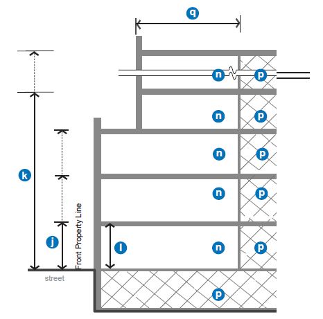 FIGURE 5.4(3)
GENERAL STOOP BUILDING: STREET FACADE REQUIREMENTS
(Ord. 16-07, 6-21-2016, eff. 6-21-2016)
10-5.1A-5-5: Limited Bay
- Description And Intent: The limited bay building type permits a lower level of ground floor storefront facade and a single vehicle bay with garage door access on the primary street. A wider range of uses can also be accommodated within this building type, including craftsman industrial uses. This building type is still intended to be built close to the front and corner property lines allowing easy access to passing pedestrians and transit riders, and continuing the fabric of the storefront building type. Parking may be provided in the rear of the lot, internally in the building, or one double loaded aisle of parking is permitted in the interior or the side yard at the front property line. The minimum and maximum heights of this building type depend on the subdistrict within which it is located.
- Regulations: Regulations for the limited bay building type are defined in the table in this section.
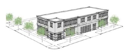 (Ord. 16-07, 6-21-2016, eff. 6-21-2016)
Permitted Subdistricts Riverdale Road "General" 1. Building Siting: Refer to figure 5.5(1) of this section Multiple principal buildings Not permitted (a) Front sidewalk coverage 75% Occupation of corner Required4 (b) Front build-to zone 0' to 15' (c) Corner build-to zone 0' to 10'4 (d) Minimum side yard setback 5' (e) Minimum rear yard setback 10' (f) Minimum lot width 50' Maximum lot width1 None (g) Parking and loading Rear and side yard (h) Street facade service bay entrance Limited to 1 per street facade, maximum width 18' (i) Vehicular access From alley; if no alley exists, maximum 1 driveway per street frontage 2. Height: Refer to figure 5.5(2) of this section (j) Minimum overall height 1 story (k) Maximum overall height 4 stories2 (l) Ground story: Minimum height 14' Maximum height 24'3 (m) Upper stories: Minimum height 9' Maximum height 14' 3. Uses: Refer to figure 5.5(2) of this section. Refer to section 10-5.1A-4, "Uses," of this article for permitted uses (n) Ground story Retail, service, office, craftsman industrial (o) Upper story Any permitted use (p) Parking within building Permitted fully in basement and in rear of upper floors plus 1 service bay width at ground floor (q) Required occupied space 30' deep on all full floors from the front facade 4. Street Facade Requirements: Refer to figure 5.5(3) of this section (r) Minimum ground story transparency measured between 2' and 8' above grade 50%, service bay door shall be transparent (s) Minimum transparency per each story 15% Blank wall limitations Required, see subsection 10-5.1A-5-2D2 of this section 10-5.1A-5 (t) Front facade entrance type Storefront, stoop (u) Principal entrance location Front or corner facade Required number of street entrances 1 per 100' of facade; service bay door not included; 1 per 150' of facade Vertical facade divisions Every 60' of facade width Horizontal facade divisions Required within 3' of the top of the ground story for all buildings over 2 stories 5. Roof Type Requirements: Refer to figure 5.5(3) of this section (v) Permitted roof types Parapet, pitched, flat Tower Permitted Notes:
1Lots wider than 140 feet are permitted 1 double loaded aisle of parking (maximum width of 72 feet), located perpendicular to the front property line, which is exempt from front property line coverage.
2Upper stories above the third story on any building facade with street frontage shall have a step back from the lower stories that is a minimum of 6 feet.
3If 18 feet or more in height, ground story shall count as 2 stories toward maximum building height.
4At any uncontrolled intersection, the buildings will be modified to afford automobile drivers a clear view of approaching vehicles or pedestrians. Buildings, trees, or any obstruction shall be prohibited within a triangular area formed by the street curb lines and a line connecting them at points 40 feet from the point of intersection of the back of the curbs (clear view area).FIGURE 5.5(1)
LIMITED BAY BUILDING: BUILDING SITING
 (Ord. 18-11, 9-18-2018, eff. 9-18-2018)
FIGURE 5.5(2)
LIMITED BAY BUILDING: HEIGHT AND USE REQUIREMENTS
 FIGURE 5.5(3)
LIMITED BAY BUILDING: STREET FACADE REQUIREMENTS
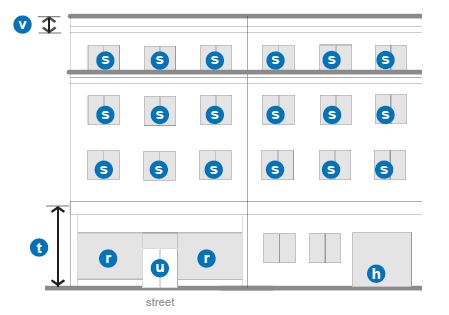
(Ord. 16-07, 6-21-2016, eff. 6-21-2016)
10-5.1A-5-6: Row Building
- Description And Intent: The row building is a building typically comprised of multiple vertical units, each with its own entrance to the street. This building type may be organized as townhouses or row houses, or it could also incorporate live/work units where uses are permitted. Parking is required to be located in the rear yard and may be incorporated either into a detached garage or in an attached garage accessed from the rear of the building. However, when the garage is located within the building, a minimum level of occupied space is required on the front facade to ensure that the street facade is active.
Regulations: Regulations for the row building type are defined in the table in this section.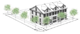
| Permitted Subdistricts | |||||
| City Center "General" And Riverdale Road "General" | 40th Street "General" | Edge | |||
| 1. | Building Siting: Refer to figure 5.6(1) of this section | ||||
| Multiple principal buildings | Permitted1 | Permitted1 | Permitted1 | ||
| (a) | Front sidewalk coverage. Not applicable to interior buildings of multiple building developments. | 65%2 | 65%2 | 65%2 | |
| Occupation of corner. Not applicable to interior buildings of multiple building developments. | Required8 | Required8 | Required8 | ||
| (b)(1) | Front yard9 depth for interior principal building | 10' | 15' | 20' | |
| (b) | Front build-to zone. Not applicable to interior buildings of multiple building developments. | 0' to 10' | 5' to 15' | 10' to 20' | |
| (c) | Corner build-to zone. Not applicable to interior buildings of multiple building developments. | 0' to 10'8 | 5' to 10'8 | 5' to 10'8 | |
| (d) | Minimum side yard setback | 0' per unit; 10' between buildings; for interior buildings, min. 10’ from property line. | 0' per unit; 15' between buildings; for interior buildings, min. 15’ from property line. | 0' per unit; 15' between buildings; for interior buildings, min. 20’ from property line. | |
| (e) | Minimum rear yard setback | 10'3 | 10'3 | 15'3 | |
| (f) | Minimum unit width | 18' per unit | 20' per unit | 22' per unit | |
| Maximum building width | Maximum of 180' per building | Maximum of 180' per building | Maximum of 110' per building | ||
| (g) | Parking | Rear yard/facade | Rear yard/facade | Rear yard/facade | |
| (i) | Vehicular access | From alley; if no alley exists, 1 driveway per building per street frontage. From alley on Washington Boulevard, 40th Street, and Riverdale Road, unless in Edge Subdistrict | |||
| 2. | Height: Refer to figure 5.6(2) of this section | ||||
| (j) | Minimum overall height | 2 story | 2 story | 2 story | |
| (k) | Maximum overall height | 3 stories | 3 stories | 3.5 stories | |
| (l) | All stories: | ||||
| Minimum height | 9' | 9' | 9' | ||
| Maximum height | 14' | 14' | 14' | ||
| 3. | Uses: Refer to figure 5.6(2) of this section. Refer to section 10-5.1A-4, "Uses", of this article for permitted uses | ||||
| (n) | Ground story | Residential, service, office, limited craftsman industrial | Residential, service, office, limited craftsman industrial | Residential only | |
| (o) | Upper story | Residential only | |||
| (p) | Parking within building | Permitted fully in basement and in rear of all floors | |||
| (q) | Required occupied space | 30' deep on all full floors from the front facade | |||
| 4. | Street Facade Requirements: Refer to figure 5.6(3) of this section | ||||
| (r) | Minimum transparency per each story | 15%4 | 15% | 15% | |
| Blank wall limitations | Required, see subsection 10-5.1A-5-2D2 of this section 10-5.1A-5 | ||||
| (t) | Front facade permitted entrance type | Stoop, porch, limited storefront5,6,7 | Stoop, porch, limited storefront5,6,7 | Stoop, porch | |
| (u) | Principal entrance location per unit | Front or corner side facade | |||
| Vertical facade divisions | Not required | ||||
| Horizontal facade divisions | For buildings over 3 stories, required within 3' of the top of any visible basement or ground story | ||||
| 5. | Roof Type Requirements: Refer to figure 5.6(3) of this section | ||||
| (v) | Permitted roof types | Parapet, pitched, flat | Parapet, pitched, flat | Parapet, pitched, flat | |
| Tower | Permitted | Permitted | Permitted | ||
Notes:
1For the purposes of the row building, a building consists of a series of units. When permitted, multiple buildings may be located on a lot with the minimum required space between them. However, each building shall meet all requirements of the building type unless otherwise noted.
2Each building shall meet the front property line coverage requirement, except 1 of every 5 units may front a courtyard with a minimum width of 30 feet. The courtyard shall be defined on 3 sides by units.
3Rear yard setback on alleys or internal access roads is 5 feet.
4When the storefront entrance type is utilized, the maximum ground story transparency for the unit is 55 percent as measured between 2 feet and 8 feet above grade.
5The storefront entrance type is permitted only on corners or buildings that are designated for live/work units.
6Commercial uses only allowed when fronting on 40th Street or Washington Boulevard.
7Uses limited to residential on lots lacking frontage on 40th Street or Ogden Avenue.
8At any uncontrolled intersection, the buildings will be modified to afford automobile drivers a clear view of approaching vehicles or pedestrians. Buildings, trees, or any obstruction shall be prohibited within a triangular area formed by the street curb lines and a line connecting them at points 40 feet from the point of intersection of the back of the curbs (clear view area).
9See definition of ‘Yard, Front –Interior Building’ in 10-5.1A-10-5.
FIGURE 5.6(1)
ROW BUILDING: BUILDING SITING
 FIGURE 5.6(2) ROW BUILDING: HEIGHT AND USE REQUIREMENTS
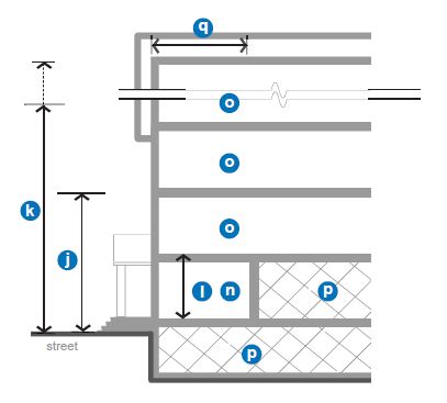 FIGURE 5.6(3)
ROW BUILDING: STREET FACADE REQUIREMENTS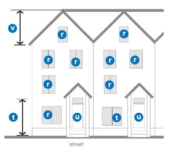
(Ord. 16-07, 6-21-2016, eff. 6-21-2016; amd. Ord. 18-11, 9-18-2018, eff. 9-18-2018; Ord. 21-01, 1-19-2021, eff. 1-19-2021)
10-5.1A-5-7: Yard Building
- Description And Intent: The yard building is a mainly residential building, incorporating a landscaped yard surrounding all sides of the building. Parking and garages are limited to the rear only with preferred access from an alley.
The yard building can be utilized in newly developing locations to create somewhat denser traditional neighborhoods, or as a buffer to existing neighborhoods. - Regulations: Regulations for the yard building type are defined in the table in this section.
 (Ord. 17-22, 11-21-2017, eff. 11-21-2017)
Permitted Subdistricts Edge 1. Building Siting: Refer to figure 5.7(1) of this section Multiple principal buildings Permitted1 (a) Front sidewalk coverage 65%2 Occupation of corner Required4 (b) Minimum front setback 15' (c) Corner setback 7.5'4 (d) Minimum side yard setback 5' (e) Minimum rear yard setback 15'3 (f) Minimum lot width 30' Maximum lot width 60' (f) Parking Rear yard/facade (i) Vehicular access From alley; if no alley exists, 1 driveway per street frontage 2. Height: Refer to figure 5.7(2) of this section (j) Minimum overall height 1.5 stories (k) Maximum overall height 3.5 stories (l) All stories: Minimum height 9' Maximum height 14' 3. Uses: Refer to figure 5.7(2) of this section. Refer to section 10-5.1A-4, "Uses," of this article for permitted uses (n) All stories Residential (p) Parking within building Permitted fully in basement and in rear of all floors (q) Required occupied space 25' deep on all full floors from the front facade 4. Street Facade Requirements: Refer to figure 5.7(3) of this section (r) Minimum transparency per each story 15% Blank wall limitations Required, see subsection 10-5.1A-5-2D2 of this section 10-5.1A-5 (t) Front facade entrance type Stoop, porch (u) Principal entrance location per unit Front, corner, or corner side facade Required number of street entrances Not required Vertical facade divisions Not required Horizontal facade divisions Not required 5. Roof Type Requirements: Refer to figure 5.7(3) of this section (v) Permitted roof types Parapet, pitched, flat Tower Not permitted Notes:
1Each building shall meet all requirements of the building type.
2When multiple buildings are located on a single lot, each building shall meet the front property line coverage requirement, except 1 of every 3 buildings may front a courtyard with a minimum width of 30 feet. The courtyard shall be defined on 3 sides by units.
3Rear yard setback for detached garages on alleys is 5 feet.
4At any uncontrolled intersection, the buildings will be modified to afford automobile drivers a clear view of approaching vehicles or pedestrians. Buildings, trees, or any obstruction shall be prohibited within a triangular area formed by the street curb lines and a line connecting them at points 40 feet from the point of intersection of the back of the curbs (clear view area).FIGURE 5.7(1)
YARD BUILDING: BUILDING SITING
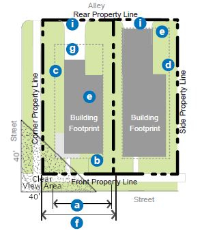 (Ord. 18-11, 9-18-2018, eff. 9-18-2018)
FIGURE 5.7(2)
YARD BUILDING: HEIGHT AND USE REQUIREMENTS
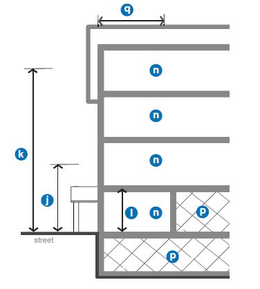 FIGURE 5.7(3)
YARD BUILDING: STREET FACADE REQUIREMENTS
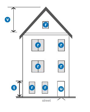
(Ord. 17-22, 11-21-2017, eff. 11-21-2017)
10-5.1A-5-8: Civic Building
- Description And Intent: The civic building is the most flexible building type intended only for civic and institutional types of uses. These buildings are distinctive within the urban fabric created by the other building types and could be designed as iconic structures. In contrast to most of the other building types, a minimum setback line is required instead of a build-to zone, though this setback is required to be landscaped. Parking is limited to the rear in most cases.
The minimum and maximum heights of this building type depend on the subdistrict within which it is located. - Regulations: Regulations for the civic building type are defined in the table in this section.
 (Ord. 16-07, 6-21-2016, eff. 6-21-2016)Notes:
Permitted Subdistricts City Center "Core" City Center "General" Riverdale Road "General" 40th Street "General" Edge 1. Building Siting: Refer to figure 5.8(1) of this section Multiple principal buildings Permitted Front sidewalk coverage Not required Occupation of corner Not required5 (b) Front setback 5' 10' 10' 10' 5' (c) Corner setback 0'5 5'5 5'5 5'5 5'5 (d) Minimum side yard setback 5' 5' 5' 5' 5' (e) Minimum rear yard setback 10' 10' 10' 10' 10' (f) Minimum lot width 50' 50' 50' 50' 50' Maximum lot width None None None None None (g) Parking and loading Rear Rear Rear and interior side yard1 Rear and interior side yard1 Rear and interior side yard1 (i) Vehicular access From alley; if no alley exists, 1 driveway per street frontage 2. Height: Refer to figure 5.8(2) of this section (j) Minimum overall height 1 story 1 story 1 story 1 story 1 story (k) Maximum overall height 5 stories 3 stories 5 stories 3 stories 2 stories (l) All stories: Minimum height 9' 9' 9' 9' 9' Maximum height 20'2 20'2 20'2 20'2 20'2 3. Uses: Refer to figure 5.8(2) of this section. Refer to section 10-5.1A-4, "Uses," of this article for permitted uses (n) All stories Limited to civic and institutional uses only (p) Parking within building Permitted fully in basement and in rear of upper floors (q) Required occupied space 30' deep on all full floors from the front facade 4. Street Facade Requirements: Refer to figure 5.8(3) of this section (r) Minimum transparency per each story 10% Blank wall limitations Not required (t) Front facade permitted entrance type Arcade, stoop3,4 (u) Principal entrance location Front or corner facade3,4 Front or corner facade3,4 Front or corner facade Front or corner facade3,4 Front or corner facade Required number of primary street entrances 1 per 100' of facade 1 per 150' of facade 1 per 150' of facade 1 per 150' of facade 1 per 150' of facade Vertical facade divisions Not required Horizontal facade divisions Not required 5. Roof Type Requirements: Refer to figure 5.8(3) of this section (v) Permitted roof types Parapet, pitched, flat; other roof types are permitted by application to City Manager (w) Tower Permitted
1Lots wider than 140 feet are permitted 1 double loaded aisle of parking (maximum width of 72 feet), located perpendicular to the front property line, which is exempt from front property line coverage.
2If 18 feet or more in height, ground story shall count as 2 stories toward maximum building height.
3Commercial uses only allowed when fronting on 40th Street or Washington Boulevard.
4Uses limited to residential on lots lacking frontage on 40th Street or Ogden Avenue.
5At any uncontrolled intersection, the buildings will be modified to afford automobile drivers a clear view of approaching vehicles or pedestrians. Buildings, trees, or any obstruction shall be prohibited within a triangular area formed by the street curb lines and a line connecting them at points 40 feet from the point of intersection of the back of the curbs (clear view area).
FIGURE 5.8(1)
CIVIC BUILDING: BUILDING SITING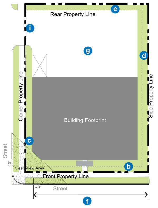 (Ord. 18-11, 9-18-2018, eff. 9-18-2018)
FIGURE 5.8(2)
CIVIC BUILDING: HEIGHT AND USE REQUIREMENTS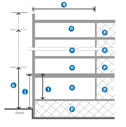 FIGURE 5.8(3)
CIVIC BUILDING: STREET FACADE REQUIREMENTS
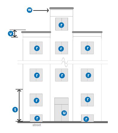
- (Ord. 16-07, 6-21-2016, eff. 6-21-2016)
10-5.1A-5-9: Entrance Types
Entrance type standards apply to the ground story and visible basement of front facades of all building types as defined in this section. Refer to the building type table requirements, sections 10-5.1A-5-3 through 10-5.1A-5-8 of this section 10-5.1A-5.
- General: The following provisions apply to all entrance types:
- Intent: To guide the design of the ground story of all buildings to relate appropriately to pedestrians on the street. Treatment of other portions of the building facades is detailed in each building type standard (refer to building types in sections 10-5.1A-5-3 through 10-5.1A-5-8 of this section 10-5.1A-5).
- Applicability: The entire ground story street facing facade(s) of all buildings shall meet the requirements of at least one of the permitted entrance types, unless otherwise stated.
- Measuring Transparency: Refer to section 10-5.1A-5-2, "Explanation Of Building Type Table Standards," of this section 10-5.1A-5 for information on measuring building transparency.
- Visible Basements: Visible basements, permitted by entrance type, are optional. The visible basement shall be a maximum of one-half (1/2) the height of the tallest story.
- Storefront Entrance Type: (Refer to figure 5.9(1) of this section.) The storefront entrance type is a highly transparent ground story treatment designed to serve primarily as the display area and primary entrance for retail or service uses.
- Transparency: Minimum transparency is required per building type.
- Elevation: Storefront elevation shall be between zero and two feet (2') above sidewalk.
- Visible Basement: A visible basement is not permitted.
- Horizontal Facade Division: Horizontally define the ground story facade from the upper stories.
- Entrance: All entries shall be recessed from the front facade closest to the street.
- Recess shall be a minimum of three feet (3') and a maximum of eight feet (8') deep, measured from the portion of the front facade closest to the street.
- When the recess falls behind the front build-to zone, the recess shall be no wider than eight feet (8').
FIGURE 5.9(1)
STOREFRONT ENTRANCE TYPE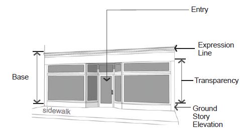
- Arcade Entrance Type: (Refer to figure 5.9(2) of this section.) An arcade entrance type is a covered pedestrian walkway within the recess of a ground story.
- Arcade: An open air public walkway is required to be recessed into the building, from the face of the building, a minimum of eight (8) and a maximum of fifteen feet (15').
- Build-To Zone: When the arcade is utilized, the outside face of the arcade shall be considered the front facade, located within the required build-to zone.
- Recessed Or Interior Facade: Storefront entrance type is required on the recessed ground story facade.
- Column Spacing: Columns shall be spaced between ten feet (10') and eighteen feet (18') on center.
- Column Width: Columns shall be a minimum of one foot eight inches (1'8") and a maximum two feet four inches (2'4") in width.
- Arcade Opening: Opening shall not be flush with interior arcade ceiling and may be arched or straight.
- Horizontal Facade Division: Horizontally define the ground story facade from the upper stories.
- Visible Basement: A visible basement is not permitted.
FIGURE 5.9(2)
ARCADE ENTRANCE TYPE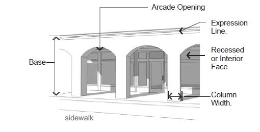
- Stoop Entrance Type: (Refer to figure 5.9(3) of this section.) A stoop is an unroofed, open platform.
- Transparency: Minimum transparency is required per building type.
- Stoop Size: Stoops shall be a minimum of three feet (3') deep and six feet (6') wide.
- Elevation: Stoop elevation shall be located a maximum of two feet six inches (2'6") above the sidewalk without visible basement and a maximum of four feet six inches (4'6") above the sidewalk with a visible basement.
- Visible Basement: A visible basement is permitted and shall be separated from the ground story by an expression line.
- Entrance: All entries shall be located off a stoop.
FIGURE 5.9(3)
STOOP ENTRANCE TYPE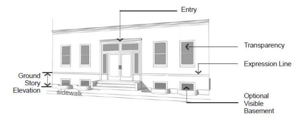
- Porch Entrance Type: (Refer to figure 5.9(4) of this section.) A porch is a raised, roofed platform that may or may not be enclosed on all sides. If enclosed, the space shall not be climate controlled.
- Transparency:
- Minimum transparency per building type is required.
- If enclosed, a minimum of forty percent (40%) of the enclosed porch shall be comprised of highly transparent, low reflectance windows.
- Porch Size: The porch shall be a minimum of five feet (5') deep and eight feet (8') wide.
- Elevation: Porch elevation shall be located a maximum of two feet six inches (2'6") above the sidewalk without a visible basement and a maximum of four feet six inches (4'6") above the sidewalk with a visible basement.
- Visible Basement: A visible basement is permitted.
- Height: Porch may be two (2) stories to provide a balcony on the second floor.
- Entrance: All entries shall be located off a porch.
FIGURE 5.9(4)
PORCH ENTRANCE TYPE
- Transparency:
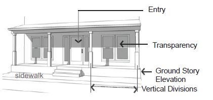
(Ord. 16-07, 6-21-2016, eff. 6-21-2016)
10-5.1A-5-10: Roof Types
Roof type standards apply to the roof and cap of all building types as defined in this section. Refer to the building type table requirements, sections 10-5.1A-5-3 through 10-5.1A-5-8 of this article.
- General Provisions: The following provisions apply to all roof types:
- Intent: To guide the design of the cap of all buildings.
- Applicability: All buildings shall meet the requirements of one of the roof types permitted for the building type.
- Measuring Height: Refer to subsection 10-5.1A-5-2B of this article for information on measuring building height.
- Other Roof Types: Other building caps not listed as a specific type may be made by a request to the city manager or designee with the following requirements:
- The roof type shall not create additional occupiable space beyond that permitted by the building type.
- The shape of the roof type shall be significantly different from those defined in this section, i.e., a dome, spire, vault.
- The building shall warrant a separate status within the community from the fabric of surrounding buildings, with a correspondence between the form of the roof type and the meaning of the building use.
- Parapet Roof Type: (Refer to figure 5.10(1), "Parapet Roof Type," of this section). A "parapet" is a low wall projecting above a building's roof along the perimeter of the building. It can be utilized with a flat or low pitched roof and also serves to limit the view of rooftop mechanical systems from the street.
- Parapet Height: Height is measured from the top of the upper story to the top of the parapet.
- Minimum height is two feet (2') with a maximum height of six feet (6').
- The parapet shall be high enough to screen the roof and any roof appurtenances from view of the street(s).
- Horizontal Expression Lines: An expression line shall define the parapet from the upper stories of the building and shall also define the top of the cap.
- Occupied Space: Occupied space shall not be incorporated behind this roof type.
FIGURE 5.10(1)
PARAPET ROOF TYPE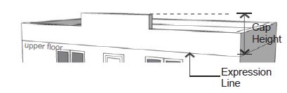
- Parapet Height: Height is measured from the top of the upper story to the top of the parapet.
- Pitched Roof Type: (Refer to figure 5.10(2), "Pitched Roof Type," of this section.) This roof type has a sloped or pitched roof. Slope is measured with the vertical rise divided by the horizontal span or run.
- Pitch Measure: The roof may not be sloped less than a four to twelve (4:12) (rise:run) or more than sixteen to twelve (16:12).
- Slopes less than four to twelve (4:12) are permitted to occur on second story or higher roofs. (Refer to figure 5.10(2) of this section, low pitched roof.)
- Configurations:
- Hipped, gabled, and combination of hips and gables with or without dormers are permitted.
- Butterfly roofs (inverted gable roof) are permitted with a maximum height of eight feet (8'), inclusive of overhang.
- Gambrel and mansard roofs are not permitted.
- Parallel Ridgeline: A gabled end or perpendicular ridgeline shall occur at least every one hundred feet (100') of roof when the ridgeline runs parallel to the front lot line. (Refer to figure 5.10(3), "Parallel Ridgeline," of this section.)
- Roof Height: Roofs without occupied space and/or dormers shall have a maximum height on street facing facades equal to the maximum floor height permitted for the building type.
- Occupied Space: Occupied space may be incorporated behind this roof type.
FIGURE 5.10(2)
PITCHED ROOF TYPE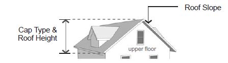
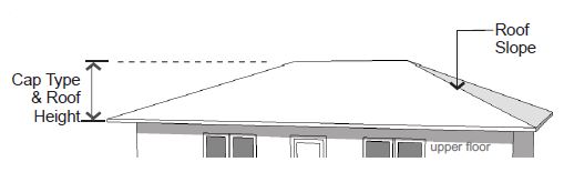
FIGURE 5.10(3)
PARALLEL RIDGELINE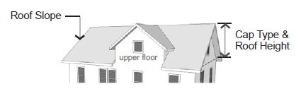
- Pitch Measure: The roof may not be sloped less than a four to twelve (4:12) (rise:run) or more than sixteen to twelve (16:12).
- Flat Roof Type: (Refer to figure 5.10(4), "Flat Roof Type," of this section.) This roof type has a flat roof with overhanging eaves.
- Configuration: Roofs with no visible slope are acceptable. Eaves are required on all street facing facades.
- Eave Depth: Eave depth is measured from the building facade to the outside edge of the eave. Eaves shall have a depth of at least fourteen inches (14").
- Eave Thickness: Eave thickness is measured at the outside edge of the eave, from the bottom of the eave to the top of the eave. Eaves shall be a minimum of eight inches (8") thick.
- Interrupting Vertical Walls: Vertical walls may interrupt the eave and extend above the top of the eave with no discernible cap.
- No more than one-half (1/2) of the front facade can consist of an interrupting vertical wall.
- Vertical walls shall extend no more than four feet (4') above the top of the eave.
- Occupied Space: Occupied space shall not be incorporated behind this roof type.
FIGURE 5.10(4)
FLAT ROOF TYPE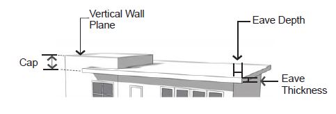
- Towers: (Refer to figure 5.10(5), "Tower," of this section.) A tower is a rectilinear or cylindrical, vertical element, that must be used with other roof types.
- Quantity: All building types, with the exception of the yard building, are limited to one tower per building.
- Tower Height: Maximum height, measured from the top of the parapet or eave to the top of the tower, is the equivalent of the height of one upper floor of the building to which the tower is applied.
- Tower Width: Maximum width along all facades is one-third (1/3) the width of the front facade or thirty feet (30'), whichever is less.
- Horizontal Expression Lines: An expression line shall define the tower from the upper stories, except on single-family or attached house residential building types.
- Occupied Space: Towers may be occupied by the same uses allowed in upper stories of the building type to which it is applied.
- Application: May be combined with all other roof types.
- Tower Cap: The tower may be capped by the parapet, pitched, low pitched, or flat-roof roof types, or the spire may cap the tower.
FIGURE 5.10(5)
TOWER
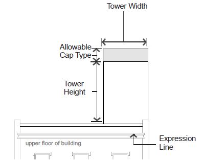
(Ord. 16-07, 6-21-2016, eff. 6-21-2016)
10-5.1A-5-11: Additional Design Requirements
The following outlines the subdistrict design guidelines that affect a building's appearance and subdistrict cohesiveness. They improve the physical quality of buildings, enhance the pedestrian experience, and protect the character of the neighborhood.
- Materials And Color:
- Primary Facade Materials: Eighty percent (80%) of each facade shall be constructed of primary materials. For facades over one hundred (100) square feet, more than one material shall be used to meet the eighty percent (80%) requirement.
- Permitted primary building materials include high quality, durable, natural materials, such as stone; brick; wood lap siding; fiber cement board lapped, shingled, or panel siding; glass. Other high quality synthetic materials may be approved during the site plan process with an approved sample and examples of successful, high quality local installations. Refer to figure 5.11(1) of this section.
- Secondary Facade Materials: Secondary materials are limited to details and accents and include gypsum reinforced fiber concrete for trim and cornice elements; metal for beams, lintels, trim, and ornamentation, and exterior architectural metal panels and cladding.
- Exterior insulation and finishing systems (EIFS) is permitted for trim only or on upper floor facades only.
FIGURE 5.11(1)
PRIMARY MATERIALS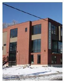
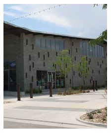
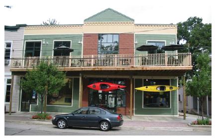
- Exterior insulation and finishing systems (EIFS) is permitted for trim only or on upper floor facades only.
- Roof Materials: Acceptable roof materials include three hundred (300) pound or better, dimensional asphalt composite shingles, wood shingles and shakes, metal tiles or standing seam, slate, and ceramic tile. "Engineered" wood or slate may be approved during the site plan process with an approved sample and examples of successful, high quality local installations. Refer to figure 5.11(2) of this section.
FIGURE 5.11(2)
ROOF MATERIALS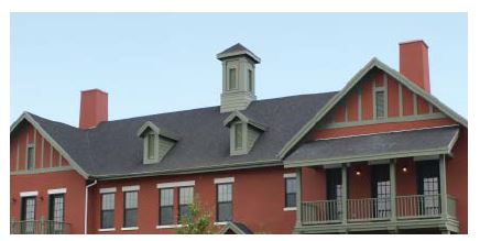
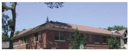
- Color: Main building colors shall be complementary to existing building stock.
- Appropriate Grade Of Materials: Commercial quality doors, windows, and hardware shall be used on all building types with the exception of the row building and the yard building. Refer to figure 5.11(3) of this section.
FIGURE 5.11(3)
COMMERCIAL GRADE DOORS AND WINDOWS

- Primary Facade Materials: Eighty percent (80%) of each facade shall be constructed of primary materials. For facades over one hundred (100) square feet, more than one material shall be used to meet the eighty percent (80%) requirement.
- Windows, Awnings, And Shutters:
- Windows: All upper story windows on all historic, residential, and mixed use buildings shall be recessed, double hung. Percent of transparency is required per building type.
- Awnings: All awnings shall be canvas or metal. Plastic awnings are not permitted. Awning types and colors for each building face shall be coordinated. Refer to figure 5.11(4) of this section.
- Shutters: If installed, shutters, whether functional or not, shall be sized for the windows. If closed, the shutters shall not be too small for complete coverage of the window. Shutters shall be wood. "Engineered" wood may be approved by city manager or designee during the site plan process with an approved sample and examples of successful, high quality local installations.
FIGURE 5.11(4)
AWNINGS
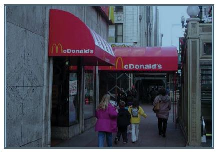
- Balconies: The following applies in all locations where balconies are incorporated into the facade design facing any street or parking lot. Refer to figure 5.11(5) of this section.
- Size: Balconies shall be a minimum of six feet (6') deep and five feet (5') wide.
- Connection To Building: Balconies that are not integral to the facade shall be independently secured and unconnected to other balconies.
- Facade Coverage: A maximum of forty percent (40%) of the front and corner side facades, as calculated separately, may be covered with balconies, including street facing railing and balcony structure.
FIGURE 5.11(5)
BALCONIES INTEGRAL TO FACADE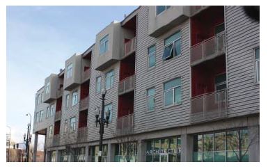
- Treatments At Terminal Vistas: When a street terminates at a parcel, the parcel shall be occupied by one of the following:
- If the parcel is open space, any open space type with the exception of the pocket park shall be utilized and a vertical element shall terminate the view. Acceptable vertical elements include a stand or grid of trees, a sculpture, or a fountain.
- If the parcel is not utilized as an open space type, the front or corner side of a building, whether fronting a primary street or not, shall terminate the view.
- Building Variety: Building design shall vary between vertical facade divisions, where required per the building types, and from adjacent buildings by the type of dominant material or color, scale, or orientation of that material and at least two (2) of the following. Refer to figure 5.11(7) of this section for one illustration of this requirement.
- The proportion of recesses and projections.
- The location of the entrance and window placement, unless storefronts are utilized.
- Roof type, plane, or material, unless otherwise stated in the building type requirements.
FIGURE 5.11(7)
BUILDING VARIETY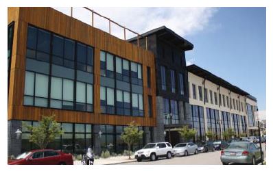
- Drive-Through Facilities: Refer to figure 5.11(8) of this section for one illustration of the following requirements:
- Application: Drive-through facilities are only allowed in the Riverdale Road "General" and City Center "General" Subdistrict.
- Drive-through Facilities Description: Drive-through facilities include any window as described in 10-5.1A-4-2(L)(1), whether it has a canopy or is located in a separate structure from the main building. Drive-through facilities shall be located on the rear facade of the building or in the rear of the lot behind the building, where permitted by use. The facility shall not be visible from the primary street.
- Stacking Lanes: Stacking lanes shall be located perpendicular to the primary facade or behind the building.
- Canopy And Structure Material: The canopy and structure shall be constructed of the same materials utilized on the building.
- For uses and lots that directly front any major street or gateway street (Riverdale Road, US-89/ Washington Boulevard, and Chimes View Drive), requirement 2 above does not apply, thereby permitting drive-through facilities to be located on one side façade or to the rear of a structure in zones where permitted by use.
- Drive-through facilities are expressly prohibited on the front façade of any building.
FIGURE 5.11(8)
RECOMMENDED DRIVE-THROUGH FACILITY LAYOUT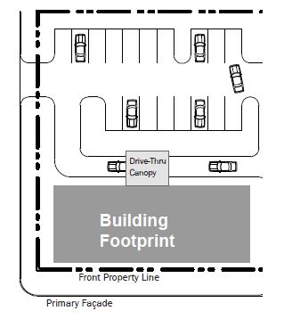
Note that Drive-through facilities may be permitted
on the sides of buildings in some subdistricts – see 10-5.1A-5-11 F
(Ord. 16-07, 6-21-2016, eff. 6-21-2016)
10-5-1A-6-1: General Requirements
- Intent: To provide open space as an amenity that promotes physical and environmental health within the community and to provide each household with access to a variety of active and passive open space types.
- General Requirements: Development of parcels over five (5) acres shall provide either five percent (5%) total lot size as a developed open space, or pay park impact fees. The applicant shall work with City to determine which option is best for the city, including the type and location of the open space, if applicable. For parcels under five (5) acres, impact fees will apply.
- Compliance: All open space provided within any core, general, or edge zoning subdistrict shall comply with one of the open space types defined by sections 10-5.1A-6-2 through 10-5.1A-6-8 of this article.
- Access: All open space types shall provide public access from a vehicular right-of-way.
- Location: Open space types shall be platted as a lot or, with permission of the City, may be located within the right-of-way. Open space types shall either be zoned as an open space zoning designation, or an adjacent zoning designation, such as core, general, or edge zoning subdistricts.
- Ownership: Open space types may either be publicly or privately owned. Whether publicly or privately owned, all open spaces must be accessible and open to the public.
- Parking Requirements: Parking shall not be required for any open space type, unless a use other than open space is determined by the City Manager or designee.
- Continuity: Connections to existing or planned trails or open space types shall be made when the open space abuts an existing or planned trail right-of-way or other civic open space type.
- Community Exterior Spaces And Amenities Required: The following applies to the City Center Core and City Center General Subdistricts only: Commercial developments with more than twenty thousand (20,000) square feet of floor area, residential developments in excess of twenty-five (25) units, or mixed developments determined by the Design Review Committee to be equivalent to the commercial/residential thresholds listed above, shall provide exterior community spaces and amenities that enhance the developments as centers of community activity. The outdoor spaces and amenities provided shall at a minimum consist of the following:
- Safe and attractive passenger drop-off/pick-up points that are integrated with traffic patterns on the site; and
- At least three (3) of the following amenities or features designed and constructed of materials that match the principal structure and linked by sidewalks to the principal structure as follow:
- A public patio/seating area at least eight hundred (800) square feet in area that includes coordinated seats, furnishings, specialty landscape features and lighting;
- A pedestrian plaza at least one thousand six hundred (1,600) square feet in area that includes coordinated seating, furnishings, specialty landscape features and lighting elements;
- A play area at least one thousand six hundred (1,600) square feet in area that includes coordinated commercial-grade play equipment, safety surfacing, fencing and similar features suitable for play activities;
- An informational kiosk area, water feature, clock tower, public sculpture or environmental art installation; and
- Any other park, open space or focal feature approved by the Design Review Committee.
- Definition Of Requirements: The following further explains or defines the requirements included in the tables in sections 10-5.1A-6-2 through 10-5.1A-6-8 of this article for each open space type. Refer to each table for the specific requirements of each open space type.
- Size:
- Minimum Size: The minimum size of the open space type is measured within the parcel lines of the property.
- Maximum Size: The maximum size of the open space type is measured within the parcel lines of the property.
- Minimum Dimension: The minimum length or width of the open space type, as measured along the longest two (2) straight lines intersecting at a right angle defining the maximum length and width of the lot. Refer to figure 6.1(1) of this section.
FIGURE 6.1(1)
EXAMPLES OF MEASURING THE MINIMUM DIMENSION OF OPEN SPACE TYPES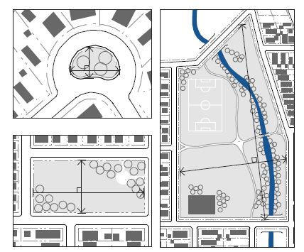
- Minimum Percentage Of Vehicular Right-Of-Way Frontage Required: The minimum percentage of the civic open space perimeter, as measured along the outer parcel line, that shall be located directly adjacent to a vehicular right-of-way, excluding alley frontage. This requirement provides access and visibility to the open space.
- Adjacent Parcels: Parcels directly adjacent to as well as directly across the street from an open space type.
- Frontage Orientation Of Adjacent Parcels: The preferred orientation of the adjacent parcels' frontages to the civic open space. Front, corner side, side, and rear refer to the property line either adjacent to the open space or facing the open space across the street.
- Improvements: The following types of development and improvements may be permitted on an open space type:
- Designated Sports Fields Permitted: Sports fields, ball courts, or structures designated for one or more particular sports including, but not limited to, baseball fields, softball fields, soccer fields, basketball courts, football fields, tennis courts, climbing walls, and skate parks are permitted.
- Playgrounds Permitted: Playgrounds include a defined area with play structures, such as slides, swings, climbing structures.
- Fully Enclosed Structures Permitted: Fully enclosed structures may include such uses as park offices, maintenance sheds, community centers, and restrooms.
- Maximum Area: For some civic open space types, fully enclosed structures are permitted, but limited to a maximum building coverage to five percent (5%) of the open space area or one thousand (1,000) square feet, whichever is less.
- Semienclosed Structures: Open air structures, such as gazebos, are permitted in all open space types.
- Maximum Percentage Of Open Water Body: The maximum amount of area within an open space type that may be covered by an open water body, including, but not limited to, ponds, lakes, and pools.
- Size:
- Stormwater In Open Space Types: Stormwater management practices, such as storage and retention facilities, may be integrated into open space types and utilized to meet stormwater requirements for surrounding parcels.
- Stormwater Features: Stormwater features in civic open space may be designed as formal or natural amenities with additional uses other than stormwater management, such as an amphitheater, sports field, or a pond or pool as part of the landscape design. Stormwater features shall not be fenced and shall not impede public use of the land they occupy. Stormwater facilities shall be designed for public safety so that in the case of a storm event water depths are minimized.
- Qualified Professional: A qualified landscape design professional, such as a landscape architect, shall be utilized to incorporate stormwater features into the design of the civic open spaces. (Ord. 17-22, 11-21-2017, eff. 11-21-2017; amd. Ord. 21-01, 1-19-2021, eff. 1-19-2021)
10-5.1A-6-2: Plaza
- Intent: To provide a formal open space of medium scale to serve as a gathering place for civic, social, and commercial purposes. The plaza may contain a greater amount of impervious coverage than any other open space type. Special features, such as fountains and public art installations, are encouraged.
- Plaza Requirements
1. Dimensions: Minimum size 0.05 acre Maximum size 1.5 acres Minimum dimension 30' Minimum percent of vehicular ROW frontage required 50%; 80% building frontage required on nonstreet frontage 2. Adjacent parcels: Permitted subdistricts All Frontage orientation of adjacent parcels Front or corner side 3. Improvements: Designated sports fields Not permitted Playgrounds Not permitted Fully enclosed structures Permitted; maximum 5% of area Maximum percent of open water 50% 4. Additional design requirements: a. Minimum building frontage At least 80% of the plaza's perimeter that does not front on vehicular right-of-way shall be lined by building frontages FIGURE 6.2(1)
TYPICAL PLAZA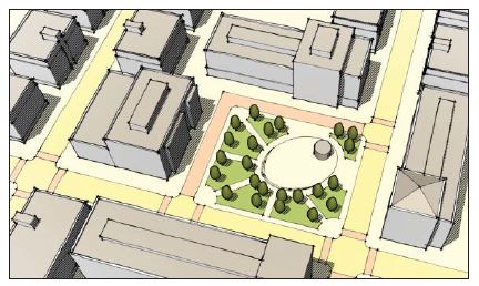
(Ord. 16-07, 6-21-2016, eff. 6-21-2016)
10-5.1A-6-3: Square
- Intent: To provide a formal open space of medium scale to serve as a gathering place for civic, social, and commercial purposes. Squares are rectilinear in shape and are bordered on all sides by a vehicular right of way, which together with building facades creates its definition.
- Square Requirements:FIGURE 6.3(1)
1. Dimensions: Minimum size 0.25 acre Maximum size 3 acres Minimum dimension 80' Minimum percent of vehicular ROW frontage required 100% 2. Adjacent parcels: Permitted districts City center "core" City center "general" 40th Street "general" Frontage orientation of adjacent parcels Front or corner side 3. Improvements: Designated sports fields Not permitted Playgrounds Not permitted Fully enclosed structures Permitted; maximum 5% of area Maximum percent of open water 30%
TYPICAL SQUARE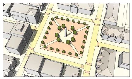
(Ord. 16-07, 6-21-2016, eff. 6-21-2016)
10-5.1A-6-4: Green
- Intent: To provide informal, medium scale active or passive recreation for neighborhood residents within walking distance, mainly fronted by streets.
- Green Requirements:FIGURE 6.4(1)
1. Dimensions: Minimum size 0.25 acre Maximum size 2 acres Minimum dimension 80' Minimum percent of vehicular ROW frontage required 100%; 50% for over 1.25 acres 2. Adjacent parcels: Permitted subdistricts All Frontage orientation of adjacent parcels Front of corner side 3. Improvements: Designated sports fields Not permitted Playgrounds Permitted Fully enclosed structures Permitted; maximum 5% of area Maximum percent of open water 30%
TYPICAL GREEN LAYOUT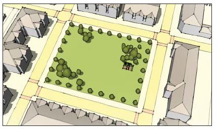
(Ord. 16-07, 6-21-2016, eff. 6-21-2016)
10-5.1A-6-5: Commons
- Intent: To provide an informal, small to medium scale space for active or passive recreation for a limited neighborhood area. Commons are typically internal to a block and tend to serve adjacent residents.
- Commons Requirements:FIGURE 6.5(1)
1. Dimensions: Minimum size 0.25 acre Maximum size 1.5 acres Minimum dimension 45' Minimum percent of vehicular ROW frontage required 0%; 2 access points required, minimum width each of 20' 2. Adjacent parcels: Permitted subdistricts All Frontage orientation of adjacent parcels Side or rear 3. Improvements: Designated sports fields Not permitted Playgrounds Permitted Fully enclosed structures Not permitted Maximum percent of open water 30%
TYPICAL COMMONS LAYOUT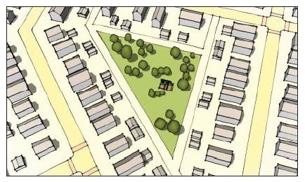
(Ord. 16-07, 6-21-2016, eff. 6-21-2016)
10-5.1A-6-6: Pocket Park
- Intent: To provide small scale, primarily landscaped active or passive recreation and gathering space for neighborhood residents within walking distance.
- Pocket Park Requirements:FIGURE 6.6(1)
1. Dimensions: Minimum size 0.05 acre Maximum size 1 acre Minimum dimension (feet) None Minimum percent of vehicular ROW frontage required 15% 2. Adjacent parcels: Permitted subdistricts All Frontage orientation of adjacent parcels Any 3. Improvements: Designated sports fields Not permitted Playgrounds Permitted Fully enclosed structures Not permitted Maximum percent of open water 30%
TYPICAL POCKET PARK LAYOUT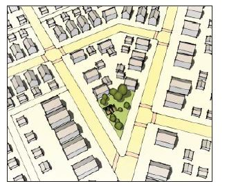
(Ord. 16-07, 6-21-2016, eff. 6-21-2016)
10-5.1A-6-7: Park
- Intent: To provide informal active and passive large scale recreational amenities to local residents and the greater region. Parks have primarily natural plantings and are frequently created around an existing natural feature such as a water body or stands of trees.
- Park Requirements:FIGURE 6.7(1)
1. Dimensions: Minimum size 1 acre Maximum size (acres) None Minimum dimension 100' Minimum percent of vehicular ROW frontage required 30% up to 5 acres; 20% over 5 acres 2. Adjacent parcels: Permitted subdistricts City center "general" 40th Street "general" Riverdale Road "general" Edge Frontage orientation of adjacent parcels Any 3. Improvements: Designated sports fields Permitted Playgrounds Permitted Fully enclosed structures Permitted, maximum 5% of area Maximum percent of open water 30%
TYPICAL PARK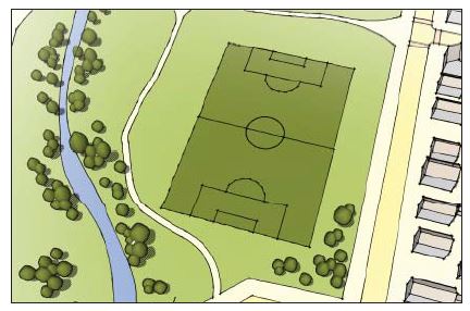
(Ord. 16-07, 6-21-2016, eff. 6-21-2016)
10-5.1A-6-8: Greenway
- Intent: To provide informal, primarily natural linear open spaces that serve to enhance connectivity between open space types and other uses. Greenways are linear open spaces that often follow a natural feature, such as a river, stream, ravine, or manmade feature, such as a vehicular right of way. A greenway may border other open space types.
- Greenway Requirements:FIGURE 6.8(1)
1. Dimensions: Minimum size 1 acre Maximum size (acres) None Minimum dimension 30'; recommended minimum average width 50' Minimum percent of vehicular ROW frontage required 0%; 1 access point required per quarter mile of length, minimum 20' width 2. Adjacent parcels: Permitted subdistricts All Frontage orientation of adjacent parcels Any 3. Improvements: Designated sports fields Permitted Playgrounds Permitted Fully enclosed structures Not permitted Maximum percent of open water 30%
TYPICAL GREENWAY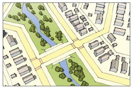
(Ord. 16-07, 6-21-2016, eff. 6-21-2016)
10-5.1A-7-1: General Requirements
- Intent: The landscape standards outlined in this section 10-5.1A-7 are designed to meet the following set of goals:
- To provide for healthy, long lived street trees within all public ways to improve the appearance of streets and create a buffer between pedestrian and vehicular travel lanes.
- To increase the compatibility of adjacent uses and minimize the adverse impacts created by adjoining or neighboring uses.
- Refer to chapter 23 of this title for landscape regulations regarding water efficient landscaping, tree and plant types and sizes, and other elements related to efficient landscape design standards.
- To shade large expanses of pavement and reduce the urban heat island effect.
- Applicability: Landscaping, trees, and buffers shall be installed as detailed in this section 10-5.1A-7.
- General Compliance: Application of this section to existing uses shall occur with the following developments:
- Any development of new or significant improvements to existing parking lots, loading facilities, and driveways. Significant improvements include new driveways, new spaces, new medians, new loading facilities, or complete reorganization of the parking and aisles.
- Alteration to an existing principal or accessory structure that results in a change of fifteen percent (15%) or more in the structure's gross floor area.
- When compliance is triggered for existing parking lots, landscape improvements shall take precedence over parking requirements.
- Buffers: Landscape buffers are required according to the provisions in this section 10-5.1A-7 with the following exceptions:
- Shared Driveways: Buffers shall not be required along a property line where a curb cut or aisle is shared between two (2) adjoining lots.
- Points Of Access: Buffering is not required at driveways or other points of access to a lot.
- Temporary Uses: These provisions do not apply to temporary uses, unless determined otherwise by the city manager or designee.
- Street Trees: Refer to section 10-5.1A-2, "Street Types," of this article, for appropriate street tree specifications.
- General Compliance: Application of this section to existing uses shall occur with the following developments:
- Water Efficient Landscaping: Refer to chapter 23 of this title for landscape regulations regarding water efficient landscaping. (Ord. 16-07, 6-21-2016, eff. 6-21-2016)
10-5.1A-7-2: Installation Of Landscape
- Intent: The following provisions aid in ensuring that all required landscaping is installed and maintained properly.
- Applicability: These provisions apply to landscape installation as required by this section.
- General Installation Requirements: The installation of landscaping shall adhere to the following standards:
- National Standards: Best management practices and procedures according to the nationally accepted standards shall be practiced.
- Installation: All landscaping and trees shall be installed in conformance with the practices and procedures established by the most recent edition of the "American Standard For Nursery Stock" (ANSI Z60.1) as published by the American Association Of Nurserymen.
- Maintenance And Protection: All landscaping and trees shall be maintained according to the most recent edition of the American National Standards Institute, including its provisions on pruning, fertilizing, support systems, lighting protection, and safety.
- Installation: Landscaping shall be fully installed prior to the issuance of a certificate of completeness.
- If seasonal conditions preclude the complete installation, a cash escrow or irrevocable letter of credit, equal to 1.5 times the installation costs as estimated by a qualified professional shall be provided.
- Complete installation is required within nine (9) months of the issuance of the temporary certificate of completeness or occupancy permit or the cash escrow or letter of credit may be forfeited.
- Plant Size Requirements: Plant material shall be sized according to table 7.2(1) of this section at the time of installation, unless otherwise noted in this section.
TABLE 7.2(1)
PLANT MATERIAL SIZE AT INSTALLATIONPlant Material Type Minimum Size Deciduous shade/overstory tree: Single trunk 2" caliper Multitrunk 10' in height Evergreen tree 8' in height Understory tree 6' in height Ornamental tree 1.5" caliper Shrubbery: Deciduous Container class 5 Evergreen Container class 5 Ground cover 3" in height - Condition Of Landscape Materials: The landscaping materials used shall be:
- Healthy and hardy with a good root system.
- Chosen for its form, texture, color, fruit, pattern of growth, and suitability to local conditions.
- Tolerant of the natural and manmade environment, including tolerant of drought, wind, salt, and pollution.
- Appropriate for the conditions of the site, including slope, water table, and soil type.
- Protected from damage by grates, pavers, or other measures.
- Plants that will not cause a nuisance or have negative impacts on an adjacent property.
- Species native or naturalized to the Wasatch Front, whenever possible.
- Compost, Mulch, And Organic Matter: Compost, mulch, and organic matter may be utilized within the soil mix to reduce the need for fertilizers and increase water retention.
- Establishment: All installed plant material shall be fully maintained until established, including watering, fertilization, and replacement as necessary.
- National Standards: Best management practices and procedures according to the nationally accepted standards shall be practiced.
- Ground Plane Vegetation: All unpaved areas shall be covered by one of the following:
- Planting Beds:
- Planting beds may include shrubs, ornamental grasses, ground cover, vines, annuals, or perennials.
- Nonliving materials, such as bark mulch, colored gravel, or mulch, are permitted for up to fifty percent (50%) of a bed area.
- Annual beds must be maintained seasonally, replanting as necessary.
- Grass: Seeded, plugged, or sodded grass may be planted throughout landscaped areas.
- Grass shall be established within ninety (90) days of planting or the area must be reseeded, replugged, or resodded.
- Planting Beds:
- Tree Installations: Refer to the list of permitted tree types, available from South Ogden parks division.
- Tree Measurement: New trees shall be measured at six inches (6") above the mean grade of the tree's trunk when four inch (4") caliper or less and twelve inches (12") for tree trunks above four inches (4"), and noted as caliper inches throughout this article.
- Tree Maintenance: Tree trimming, fertilization, and other similar work shall be performed by or under the management of an ISA certified arborist.
- Tree Size: All trees to be installed to meet the requirements of this section shall be a minimum of two inch (2") caliper at the time of installation.
- Tree Spacing: See subsection 10-5.1A-7-3D4 of this article.
- Permeable Surface: For each tree preserved or planted, a minimum amount of permeable surface area is recommended, unless otherwise stated in this article.
- Planted trees have a suggested minimum permeable area and soil volume based upon tree size; refer to table 7.2(2) of this section for details.
- Permeable area for one tree cannot count toward that of another tree.
TABLE 7.2(2)
MINIMUM RECOMMENDED SOIL VOLUMES AND PERMEABLE AREA PER PLANTED TREETree Size Soil Volume (Cubic Feet) Soil Surface Area (Square Feet With 2.5' Soil Depth) Permeable Surface Area Requirement (Square Feet) Very small 181 72 (approx. 8.5' x 8.5') 25 (5' x 5') Small 736 294 (approx. 17' x 17') 100 (10' x 10') Medium 2,852 1,141(approx. 34' x 34') 225 (15' x 15') Large 6,532 2,681 (approx. 50' x 50') 400 (20' x 20')
- Structural Soil: When the soil surface area (per table 7.2(2) of this section) of a tree will extend below any pavement, structural soil is required underneath that pavement. Structural soil is a medium that can be compacted to pavement design and installation requirements while still permitting root growth. It is a mixture of gap graded gravels (made of crushed stone), clay loam, and a hydrogel stabilizing agent to keep the mixture from separating. It provides an integrated, root penetrable, high strength pavement system that shifts design away from individual tree pits (source: Cornell University, Urban Horticulture Institute).
- Irrigation Systems: Permanent irrigation, beyond establishment, is required and shall adhere to the following standards:
- All irrigation systems shall be designed to minimize the use of water.
- Nonresidential landscape irrigation shall have an automatic clock activated permanent system.
- The irrigation system shall provide sufficient coverage to all landscape areas.
- The irrigation system shall not spray or irrigate impervious surfaces, including sidewalks, driveways, streets, and parking and loading areas.
- All systems shall be equipped with a backflow prevention device.
- All mechanical systems including controllers and backflow prevention devices shall be properly screened from public view.
- Maintenance Of Landscape: All landscaping shall be maintained in good condition at all times to ensure a healthy and orderly appearance.
- Adherence To Requirements: All required landscape shall be maintained to adhere to all requirements of this article.
- Replacing Unhealthy Landscaping: Unhealthy landscaping shall be replaced with healthy, live plants by the end of the next applicable growing season. This includes all plant material that shows dead branches over a minimum of twenty five percent (25%) of the normal branching pattern.
- Maintenance Responsibility: The owner is responsible for the maintenance, repair, and replacement of all landscaping, screening, and curbing required herein.
- Maintain Quality And Quantity: Maintenance shall preserve at least the same quantity, quality, and screening effectiveness as initially installed.
- Fences And Other Barriers: Fences, walls, and other barriers shall be maintained in good repair and free of rust, flaking paint, graffiti, and broken or damaged parts.
- Tree Topping: Tree topping is not permitted. When necessary, crown reduction thinning or pruning is permitted. Refer to subsection 10-5.1A-7-3D2 of this article for clear branch height of street trees. (Ord. 16-07, 6-21-2016, eff. 6-21-2016)
10-5.1A-7-3: Street Trees And Streetscape Design
- Intent: To line all new streets with a consistent and appropriate planting of trees, pavement design, and identity to establish tree canopy for environmental benefit and a sense of identity for all new streets.
- Applicability: The requirements herein apply to all new development requiring regulating plan approval.
- Streetscape Design Submittal: A consistent streetscape design shall be submitted for approval for all new streets within the development. At a minimum, the submittal shall include the following:
- Street Trees: Trees meeting the minimum requirements of subsection D of this section, shall be included in the streetscape design, with details related to tree pits, tree planting to meet the requirements of subsection 10-5.1A-7-2E, "Tree Installations," of this article.
- Sidewalk Pavement Design: Sidewalk paving materials and pattern shall be set for each street type (refer to section 10-5.1A-2, "Street Types," of this article).
- Street Furnishings: Benches, seatwalls, planters, planter fences, trash receptacles, and bicycle racks at the least shall be specified and quantities and locations listed for each street type (refer to section 10-5.1A-2, "Street Types," of this article).
- Landscape Design: Ground plane vegetation shall be designated for any landscape bed areas, planter areas, and tree wells.
- Lighting: Pedestrian and vehicular lighting shall be specified and locations and quantities noted.
- Identity Elements: Any other elements designed to establish the identity of each street, such as banners, pavement markers, artwork, or signage, shall be included in the streetscape design submittal. (Ord. 16-07, 6-21-2016, eff. 6-21-2016)
- Minimum Street Tree Requirements: The following standards apply to the installation of street trees:
- Exception: Street trees are not required on alleys or the lane street types, or along the fronting streets of outdoor sales lots (refer to sections 10-5.1A-2-4 and 10-5.1A-2-5 of this article, street types). (Ord. 17-12, 5-4-2017, eff. 5-4-2017)
- Clear Branch Height: Minimum clear branch height is eight feet (8').
- Street Tree Type: Medium and large shade trees are permitted to be installed as street trees. Refer to the list of permitted tree types in the "South Ogden City Approved Shade Tree List for Park Strip Planting."
- Street Tree Spacing: Street trees shall be planted as follows:
- Number: Each lot is required to have one tree for every thirty feet (30') of street frontage with a minimum of one street tree per street frontage.
- Spacing:
- Large trees must be spaced a minimum of thirty (30) and a maximum of sixty feet (60') on center.
- Medium trees must be spaced a minimum of twenty (20) and a maximum of thirty feet (30') on center.
- Placement: No trees may be planted closer to any curb or sidewalk than as follows unless a permeable surface is provided:
- Medium trees: Three feet (3').
- Large trees: Four feet (4').
- Limited Distance Between Curb And Sidewalk: Where the distance from the back of the curb to the edge of the right-of-way or property line is less than nine feet (9') with a sidewalk, applicant shall work with the City staff to determine the appropriate tree species.
- City Manager or designee may waive the street tree requirement in spaces less than nine feet (9').
- Tree Wells: In commercial subdistricts, where the sidewalk extends from the back of curb to the property line, tree wells shall be utilized.
- For tree wells adjacent to sidewalks five feet (5') wide or less, open pit is not permitted.
- The opening must be covered with a tree grate or pervious pavement.
- The opening in a tree grate for the trunk must be expandable. (Ord. 16-07, 6-21-2016, eff. 6-21-2016)
- For tree wells adjacent to sidewalks five feet (5') wide or less, open pit is not permitted.
10-5.1A-7-4: Frontage Buffer
- Intent And Applicability:
- Intent: To lessen the visual impact of vehicular areas visible from the street.
- General Applicability: Applies to properties in all "Core," "General," and "Edge" Subdistricts where a vehicular area is located adjacent to a right-of-way.
- Exceptions: Vehicular areas along alleys, except when a residential subdistrict is located across the alley; single-and two-family residences. (Ord. 16-07, 6-21-2016, eff. 6-21-2016)
- Frontage Buffer Requirements:Notes:
1. Buffer depth and location1: Depth 7' (a) Location on the site Between street facing property line and parking area2 (b) 2. Buffer landscape requirements: Uses and materials Uses and materials other than those indicated are prohibited in the buffer Shade trees Medium or large shade tree required at least every 40'; locate on the street side of the fence; spacing should alternate with street trees (c) Planting area Required continuous planting area on street side of fence, between shade trees and in front of vehicular areas (d) Planting area composition Individual shrubs with a minimum width of 24", spaced no more than 36" on center, height maintained no more than 48" Existing vegetation May be credited toward buffer area 3. Fence: (e) Location 2' from back of curb of vehicular area3 Materials Composites, steel, wood, or colored PVC; masonry columns (maximum width 2'6") and base (maximum 18" height) permitted Minimum height 3' Maximum height 4' Colors No bright or white colors Opacity Minimum 30%; maximum 80% Gate/opening 1 gate permitted per street frontage; opening width maximum 6'
1This screening requirement does not prohibit the installation of or provision for openings necessary for allowable access drives and walkways connecting to the public sidewalk.
2In front, corner, and rear yards (on a through lot), when the parking area is located adjacent to any building on the lot, the buffer must be located so that it aligns with or is behind the face of the adjacent building back to the vehicular area. The area between the buffer and the property line must be landscaped.
3No fence required within frontage buffer for outdoor sales lots.
(Ord. 17-12, 5-4-2017, eff. 5-4-2017)
FIGURE 7.4(1)
FRONTAGE BUFFER PLAN AND SECTION
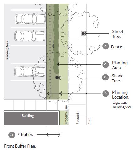
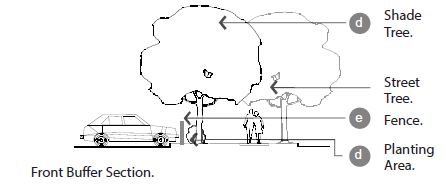
(Ord. 16-07, 6-21-2016, eff. 6-21-2016)
10-5.1A-7-5: Side And Rear Buffer
- Intent And Applicability:
- Intent: To minimize the impact that one zoning subdistrict may have on a neighboring subdistrict and to provide a transition between subdistricts.
- General Applicability: Applies to all directly adjoining properties in all "core," "general," and "edge" subdistricts.
- Side And Rear Buffer Requirements:Note:
1. Buffer depth and location: Depth1 Varies based on the zoning subdistrict of the lot and the adjacent lot; see table 7.5(1) of this section (a) Location on the site Locate buffers on more intensively zoned lot; buffer is measured from side and rear property lines 2. Required landscape screen: Width1 5' landscape screen in addition to any other buffer landscaping (b) Location1 Directly adjacent to the rear or side property line Planting area Continuous double row of shrubs required between shade trees (c) Planting area composition A professionally designed water efficient planting design that is engaging, beautiful and appropriate for the specific setting and context. Plants should include a range of perennials, decorative grasses and small shrubs as appropriate for reducing the visual impact of vehicular areas visible from the street while also meeting the requirements of chapter 23 of this title, water efficient landscaping Planting frequency Minimum of 15 shrubs per 100' of property line is required Shade trees At least 1 medium or large shade tree per every 30' within the buffer (d) 3. Buffer landscape requirements: Uses and materials Uses and materials other than those indicated are prohibited within the buffer Tree canopy coverage 1 medium or large shade tree required per 2,000 square feet of buffer, excluding the area within the required landscape screen Existing vegetation May be credited toward buffer area
1City manager or designee may reduce depth of buffer, width of landscape screen, or location of landscape screen based on existing landscaping and topography.
FIGURE 7.5(1)
LANDSCAPE SCREEN WITHIN LIGHT SIDE AND REAR BUFFER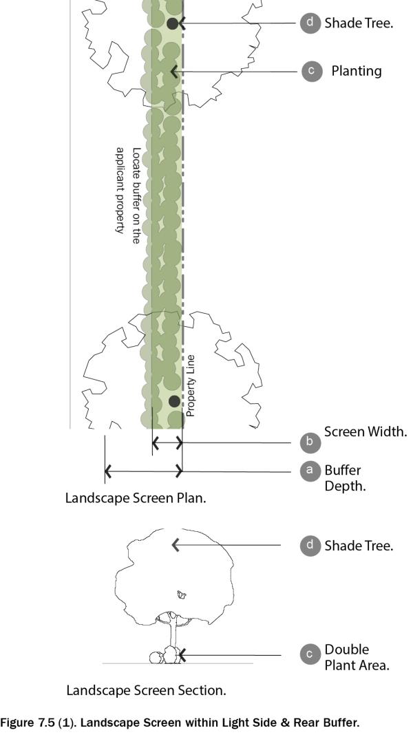 TABLE 7.5(1)
SIDE AND REAR BUFFER REQUIREMENTS BETWEEN SUBDISTRICTSBuffer Required By These Subdistricts Core General Edge Core Not required Not required Not required General Not required Not required Not required Edge 5' 5' Not required Any existing single-family 20' 10' Not required
(Ord. 16-07, 6-21-2016, eff. 6-21-2016)
10-5.1A-7-6: Interior Parking Lot Landscape
- Intent And Applicability:
- Intent: To provide shade, minimize paving and associated stormwater runoff, and improve the aesthetic look of parking lots.
- General Applicability: All open air, off street parking lots in all "core," "general," and "edge" subdistricts.
- Other Internal Parking Lot Areas: Internal areas not dedicated to parking or drives shall be landscaped with a minimum of one medium or large shade tree for the first one hundred fifty (150) square feet and one medium or large shade tree for every six hundred fifty feet (650') thereafter.
- Existing Vegetation: Existing vegetation may be credited toward these requirements. (Ord. 16-07, 6-21-2016, eff. 6-21-2016)
- Interior Parking Lot Landscape Requirements1: "Parking lot interior" is defined as the area dedicated to parking on a given parcel as measured from edge of pavement to edge of pavement.Notes:
1. Landscape island requirements: (a) Required island locations Terminal ends1 of freestanding rows or bays of parking; after every ninth parking space for rows of parking greater than 8 spaces in length2 (b) Minimum width 5'; islands less than 15' must utilize structural soil under any paved surface within a tree's critical root zone; islands under 9' must install an aeration system and utilize permeable pavement Required trees within islands Minimum of 1 medium or large shade tree per island (c) 2. Landscape median requirements: (d) Required median location Required in each freestanding bay of parking along the length of the bay Minimum width 5'; medians less than 15' must utilize structural soil under any paved surface within a tree's critical root zone; islands under 9' must install an aeration system and utilize permeable pavement 3. Tree requirements: Requirements per parking space3 Each parking space must be located within 50' of a tree planted within parking lot interior Minimum of 1 shade tree must be planted within parking lot interior or within 4' of parking lot's edge for every 3 parking spaces Tree shade goal Within 20 years of tree installation, 30% of the interior of the parking lot should be shaded by tree canopy. Refer to table 7.6(1) of this section for calculation 4. Shade structure requirements: Shade structure requirements Shade structures should be considered an acceptable alternative for meeting the tree shade goal that 30% of the interior parking lot should be shaded. Detail designs for such features should be submitted as part of section 10-5.1A-10-2, "Development Review Procedures," of this article for review and approval
1Freestanding rows or bays of parking are those not abutting the parking lot perimeter or building face, and may have a single or double row of parking.
2There shall be no more than 8 continuous parking spaces in a row without a landscape island.
3Trees within a designated buffer area may not be utilized to meet these requirements.
(Ord. 17-12, 5-4-2017, eff. 5-4-2017)
FIGURE 7.6(1)
INTERIOR PARKING LOT LANDSCAPING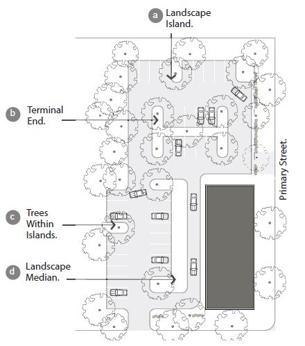
TABLE 7.6(1)
ESTIMATED CANOPY AND HEIGHT AT MATURITYTree Size Estimated Canopy At Maturity Estimated Height At Maturity Very small 150 sq. ft. Under 15' Small 400 sq. ft. 15' - 25' Medium 900 sq. ft. 25' - 40' Large 1,600 sq. ft 40'+
(Ord. 16-07, 6-21-2016, eff. 6-21-2016)
Notes
1For outdoor sales lots, interior parking requirements apply only to required staff and visitor parking areas. Parking earmarked for the display of vehicles is exempt.
10-5.1A-7-7: Active Frontage Buffer
- Intent And Applicability:
- Intent: To continue the street wall of adjacent facades.
- General Applicability: Applies to nonvehicular outdoor sites in all "Core," "General," and "Edge" Subdistricts. For vehicular areas, refer to section 10-5.1A-7-4, "Frontage Buffer," of this article. (Ord. 16-07, 6-21-2016, eff. 6-21-2016)
- Active Frontage Requirements:Notes:
1. Frontage location: Location on the site Required adjacent to dining patio or display area 2. Required fence2: Location Between 0' and 5' from the front and corner side property lines; only required in front of patio/display area (a) Materials Steel or colored PVC; masonry base or columns permitted (b) Minimum height 3' (c) Maximum height 4' Opacity Minimum 30%; maximum 60%1 Gate/opening 1 gate permitted per street frontage; opening width maximum 6'
1Fence may be solid if 42 inches or less in height.
2No fence required within active frontage for outdoor sales lots.
(Ord. 17-12, 5-4-2017, eff. 5-4-2017)
FIGURE 7.7(1)
ACTIVE FRONTAGE
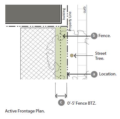
(Ord. 16-07, 6-21-2016, eff. 6-21-2016)
10-5.1A-7-8: Screening Of Open Storage, Refuse Areas, And Utility Appurtenances
- Intent And Applicability:
- Intent: To reduce the visibility of open storage, refuse areas, and utility appurtenances from public areas and adjacent properties.
- General Applicability: All dumpsters, open storage, refuse areas, and utility appurtenances in all "Core," "General," and "Edge" Subdistricts.
- Screening Of Open Storage, Refuse Areas, And Utility Appurtenances:Notes:
1. Open storage and refuse area screening requirements: Location on the site Not permitted in front or corner side yards Opaque screen wall 1 Required around 3 sides of the dumpster and trash bin area (a) Screen wall height Height shall be the higher of the following: 6' Height of use to be screened Height as determined by City to accomplish objective of the screen Visible openings Openings visible from the public way or adjacent properties must be furnished with opaque gates (b) Landscape requirement If refuse area is located within larger paved area, such as a parking lot, landscape islands must be located on 3 sides of the area, with at least 1 medium or large shade tree in at least 1 of the landscape areas2 (c) 2. Utility appurtenance screening requirements: Large private mechanical equipment3 Shall be fenced with opaque wood or brick faced masonry on all sides facing right-of-way Small private mechanical equipment4 Shall have landscape screening and a shrub bed containing shrubs spaced no more than 36" on center
1Vertical structured barrier to visibility at all times such as a fence or wall.
2This tree, if located within 50 feet of a parking space, may be utilized to meet the minimum shade requirements.
3Large private mechanical equipment is equal to or greater than 4 feet in height.
4Small private mechanical equipment is smaller than 4 feet in height.
FIGURE 7.8(1)
SCREENING OF OPEN STORAGE, REFUSE AREAS AND UTILITY APPURTENANCES
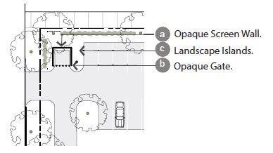
(Ord. 16-07, 6-21-2016, eff. 6-21-2016)
10-5.1A-8-1: General Requirements
- Intent: The following provisions are established to accomplish the following:
- Ensure an appropriate level of vehicle parking, loading, and storage to support a variety of land uses.
- Provide appropriate site design standards to mitigate the impacts of parking lots on adjacent land uses and zoning subdistricts.
- Provide specifications for vehicular site access.
- Applicability: This section 10-5.1A-8 shall apply to all new development and changes in use or intensity of use for existing development, in any subdistrict.
- Compliance: Compliance with the standards outlined shall be attained in the following circumstances:
- Development of all new parking facilities, loading facilities, and driveways.
- Improvements to existing parking facilities, loading facilities, and driveways, including reconfiguration, enlargement, or the addition of curbs, walkways, fencing, or landscape installation.
- Change in use requiring a change in the amount of parking.
- Damage Or Destruction: When a use that has been damaged or destroyed by fire, collapse, explosion, or other cause is reestablished, any associated off street parking spaces or loading facilities must be reestablished based on the requirements of this section 10-5.1A-8.
- Site Plan Approval Required: Parking quantities and parking design and layout shall be approved through the site plan approval process. Refer to subsection 10-5.1A-10-2E, "Site Plan Approval," of this article for more information. (Ord. 16-07, 6-21-2016, eff. 6-21-2016)
- Compliance: Compliance with the standards outlined shall be attained in the following circumstances:
10-5.1A-8-2: Parking Requirements
- General Requirements For Parking: Off street parking spaces shall be provided in conformance with table 8.2(1) "Required Off Street Vehicular Parking," of this section.
- Required Accessible Parking: Parking facilities accessible for persons with disabilities shall be in compliance with or better than the standards detailed in the state accessibility code, including quantity, size, location, and accessibility.
- Requirements For Unlisted Uses: Upon receiving a site plan approval, occupancy certificate, or other permit application for a use not specifically addressed in this section, the city manager or designee is authorized to apply off street parking standards specified for the use deemed most similar to the proposed use. In instances where an equivalent may not be clearly determined, the city manager or designee may require the applicant to submit a parking study or other evidence that will help determine the appropriate requirements.
- Private Off Premises Parking: Where private off site parking facilities are approved, such facilities shall be in the same possession as the zoning lot occupied by the building or use to which the parking facilities are accessory.
- Possession: Such possession may be either by deed or lease, guaranteeing availability of the parking commensurate with the use served by the parking.
- Agreement: The agreement providing for the use of off site parking, executed by the parties involved, shall be in a form approved by the city attorney and filed with the city manager or designee.
- Duration: The deed or lease shall require the owner to maintain the required number of parking facilities for the duration of the use served or of the deed or lease, whichever shall terminate sooner.
- Location Of Parking: Any off premises parking must be within one thousand three hundred feet (1,300') from the entrance of the use to the closest parking space measured along a dedicated pedestrian path.
- Tandem Parking: Tandem parking is permitted with approval of the city manager or designee through the site plan review process.
- Required Vehicular Parking: Table 8.2(1) of this section outlines the required vehicular parking requirements.
- Organized By Use: The parking requirements are organized by use, in a similar fashion to section 10-5.1A-4-1, table 4.1(1) of this article, use table.
- Parking rates are provided for general use categories; these numbers are applicable for all of the uses within these categories.
- If a specific use requires a different parking rate than its use category, it is also listed in table 8.2(1) of this section, required vehicular parking.
- Vehicular Spaces Required: The vehicular spaces required column indicates the required off street parking ratio, which may be subject to credits and other reductions and a maximum number, as are detailed in this section.
- Maximum Allowable Vehicular Spaces: When a use requires more than twenty (20) spaces, it is not permitted to provide greater than twenty percent (20%) over the minimum parking requirement.
- For those uses with no requirements, the maximum number of spaces required should be no more than the next level up of that use. For example, for neighborhood retail, the number of spaces should be no more than the requirements for general retail.
- Computation: Off street parking spaces shall be calculated using the following information:
- Area Measurements: The following units of measurements shall be utilized to calculate parking requirements:
- Dwelling Unit: Parking standards for residential buildings shall be computed using dwelling unit as the unit of measure, unless otherwise stated.
- Gross Square Footage: Unless otherwise expressly stated, parking standards for nonresidential uses shall be computed on the basis of gross floor area in square feet.
- Occupancy Or Capacity Based Measurements: Parking spaces required per available seat or per employee, student, or occupant shall be based on the greatest number of persons on the largest shift, the maximum number of students enrolled, or the maximum fire rated capacity, whichever measurement is applicable.
- Bench Seating: For uses in which users occupy benches, pews, or other similar seating facilities, each twenty four inches (24") of such seating shall be counted as one seat.
- Fractions: When computation of the number of required off street parking spaces results in a fractional number, any result of 0.5 or more shall be rounded up to the next consecutive whole number. Any fractional result of less than 0.5 may be rounded down to the previous consecutive whole number.
- Multiple Uses On A Lot: When there are multiple uses on a lot, required spaces shall be calculated as an amount equal to the total requirements for all uses on the lot, unless the uses qualify for shared, cooperative, or other credits to reduce parking. (Refer to subsections C and D of this section.)
TABLE 8.2(1)
REQUIRED OFF STREET VEHICULAR PARKINGUse Required Vehicle Space Residential: Single-family, all sizes, or multi-family- 1 bedroom 1.5 per dwelling unit Multi-family- studio apartment 1 per dwelling unit Multi-family- 2 bedrooms 2 per dwelling unit Multi-family- 3 or 3+ bedrooms 2.5 per dwelling unit Multi-family visitor parking .25 per dwelling unit, dedicated to use by visitors Hotel and inn 1 per room and 1 per 200 square foot office and dining room Residential care 0.33 per unit and 0.66 per employee Civic/institutional: Assembly 1 per 5 seats Transit station Per city manager or designee Hospital 0.20 per bed and 0.66 per employee Library/museum/post office (no distribution) 1 per 600 square feet Police and fire Per city manager or designee Post office (distribution) 1 per 400 square feet School: Pre-K to junior high 1 per classroom and 1 per 200 square foot office High school, higher education 1 per classroom, 1 per 200 square foot office, and 0.17 per student Retail: Neighborhood retail 1 per 300 square feet General retail 1 per 300 square feet Outdoor sales lot 1 per 250 square feet of sales area, with 1 per 10 vehicle display Service: Neighborhood service 1 per 250 square feet General service 1 per 250 square feet Eating and drinking establishments 1.0 per 3 seats plus 1/3 number of employees Vehicle services 2 per service bay and 1 per 200 square feet of retail Office and industrial: Neighborhood, general office 1 per 300 square feet Craftsman industrial 1 per 1,000 square feet of production space and 1 per 500 square feet of retail space Non-retail industrial 1 per 1,000 square feet of production space Open space and recreation: Open space and recreation Per city manager or designee
- Area Measurements: The following units of measurements shall be utilized to calculate parking requirements:
- Organized By Use: The parking requirements are organized by use, in a similar fashion to section 10-5.1A-4-1, table 4.1(1) of this article, use table.
- Multiple Use Reductions: The following reductions may be taken for multiple nonresidential uses:
- Shared Vehicular Parking: An arrangement in which two (2) or more nonresidential uses with different peak parking demands use the same off street parking spaces to meet their off street parking requirements.
- General Provisions: Through review of the site plan the city manager or designee may permit up to one hundred percent (100%) of the parking required for a daytime use to be supplied by the off street parking spaces provided for a nighttime or Sunday use and vice versa.
- Approval: In order to approve a shared parking arrangement, the city manager or designee must find, based on competent evidence provided by the applicant, that there is no substantial conflict in the principal operating hours of the uses for which the sharing of parking is proposed.
- Description Of Uses With Weekday, Nighttime, And Sunday Peak Parking:
- The following uses are considered predominantly weekday uses: office and industrial uses and other similar uses as authorized by the city manager or designee.
- The following uses are typically considered predominantly nighttime or Sunday uses: eating and drinking establishments, assembly uses, and other similar uses with peak activity at night or on Sundays, as authorized by the city manager or designee.
- Cooperative Vehicular Parking: When two (2) or more categories of nonsingle-family residential uses share a parking lot and are located on the same lot or adjacent lots, the following applies:
- General Provisions: Cooperative parking will be approved in accordance with the following. Refer to table 8.2(2) of this section.
- For each applicable land use category, calculate the number of spaces required as if it were the only use. Refer to table 8.2(1) of this section.
- Use the figures for each individual land use to calculate the number of spaces required for that use for each time period specified in table 8.2(2) of this section. This table establishes six (6) time periods per use.
- For each time period, add the number of spaces required for all applicable land uses to obtain a grand total for each of the six (6) time periods.
- Select the time period with the highest total parking requirement and use that as the total number of parking spaces required for the site on a share parking basis.
- Uses In Different Buildings: Through review of the site plan the city manager or designee may approve the cooperative agreement if any of the uses are not located in the same structure or building.
- Location Of Cooperative Parking: Any cooperative parking must be within six hundred sixty feet (660') from the entrance of the use to the closest parking space within the cooperative parking lot, measured along a dedicated pedestrian path.
- Off Site Cooperative Parking Agreement: An agreement approved by the city attorney providing for cooperative use of off site parking spaces, executed by the parties involved, shall be reviewed by the city manager or designee during review of the site plan.
- Off site cooperative parking arrangements shall continue in effect only as long as the agreement remains in force.
- If the agreement is no longer in force, then parking must be provided as otherwise required in this section.
TABLE 8.2(2)
COOPERATIVE OR SHARED VEHICULAR PARKING SPACESUse Category Weekdays Weekends Midnight - 7:00 A.M. 7:00 A.M. - 6:00 P.M. 6:00 P.M. - Midnight Midnight - 7:00 A.M. 7:00 A.M. - 6:00 P.M. 6:00 P.M. - Midnight Residential 100% 50% 80% 100% 80% 80% Retail and service 5% 100% 80% 5% 100% 60% Hotel and inn 100% 65% 100% 100% 65% 100% Place of worship 0% 30% 50% 0% 100% 75% Eating and drinking establishment 50% 70% 100% 70% 60% 100% Office 5% 100% 5% 5% 5% 5% Theater/entertainment 5% 30% 100% 5% 80% 100%
- General Provisions: Cooperative parking will be approved in accordance with the following. Refer to table 8.2(2) of this section.
- Shared Vehicular Parking: An arrangement in which two (2) or more nonresidential uses with different peak parking demands use the same off street parking spaces to meet their off street parking requirements.
- Parking Credits: Vehicular parking standards in table 8.2(1) of this section may be reduced by achieving one or all of the following credits:
- On Street Parking Credit: For all nonresidential uses, on street parking spaces that meet the following shall be credited one for one against the parking requirement:
- Spaces shall be designated on street parking available twenty four (24) hours of every day.
- On street space must be located adjacent to the property line.
- Public Parking Credit: For all nonresidential uses, public parking spaces located within six hundred sixty feet (660') of any property line may be credited against the parking requirement at a rate of one credit for every three (3) public parking spaces.
- Transit Credit: For all uses, vehicular parking requirements may be reduced with proximity to any commuter rail station or transit line with up to fifteen (15) minutes headways. Proximity is measured along a walking path from any point along the property line to the platform or transit stop.
- Within four hundred feet (400'): A reduction of fifteen percent (15%) of the required off street parking.
- Within eight hundred feet (800'): A reduction of ten percent (10%) of the required off street parking.
- Car Share Parking Credit: The vehicular parking requirements can be reduced with the inclusion of car share parking spaces as follows:
- Reduction: Per each car share parking space provided, required parking spaces shall be reduced by four (4) spaces.
- Total Reduction: Required parking spaces may be reduced up to forty percent (40%).
- Approval: Applicant must provide documentation of an agreement with a car share company. If this agreement should terminate at any point, applicant shall be required to provide parking as otherwise required herein.
- Other Parking Reductions: Additional reductions may be approved by the City Manager or designee with the submittal of a parking study illustrating the reduction.
- On Street Parking Credit: For all nonresidential uses, on street parking spaces that meet the following shall be credited one for one against the parking requirement:
- Required Bicycle Parking: Bicycle parking facilities shall be provided for any new use for which vehicular parking is required; or for modification or change of any use listed in table 8.2(1) that results in the need for additional vehicular parking facilities.
- One bicycle parking space is required for every twenty (20) required vehicular parking spaces for such use, with a minimum requirement of two (2) bicycle parking spaces for any use. There shall be no maximum limits.
- The proposed bicycle parking spaces shall be clearly shown on the site plan indicating location and type.
- Bicycle parking spaces shall:
- Be located on the same lot as the principal use;
- Be located and designed to prevent damage to bicycles by cars;
- Be located so as not to interfere with pedestrian movements;
- Be located in a highly visible, well-lighted area that is located near entrance(s) to the building;
- Be located to provide safe access from the spaces to the public right-of-way or bicycle lane;
- Be designed to accommodate a range of bicycle shapes and sizes, and to allow the frame and wheel(s) of each bicycle to be supported and secured against theft without interfering with adjacent bicycles;
- Be anchored to resist removal by vandalism and resistant to rust or corrosion.
- Not be located on sidewalks or in areas that obstruct pedestrian traffic flow.
- Be located within one hundred feet (100') of a primary building entrance. (Ord. 16-07, 6-21-2016, eff. 6-21-2016; amd. Ord. 20-10, 3-17-2020; Ord. 20-18, 7-7-2020; Ord. 21-01, 1-19-2021, eff. 1-19-2021)
10-5.1A-8-3: Parking Design Standards
- Vehicular Off Street Parking Lots: The design or redesign of all off street parking facilities shall be subject to the site plan approval procedure. Refer to subsection 10-5.1A-10-2E, "Site Plan Approval," of this article for more information.
- Vehicular Parking Space Dimensions: The appropriate dimensions for parking spaces are outlined in table 8.3(1), "Parking Space Dimensions," and figure 8.3(1), "Parking Lot Layout," of this section.
- The width of a parking space shall be measured from the center of a stripe.
- Each space shall have a vertical clearance of at least seven feet (7').
- 30° and 45° angled parking is limited to one-way travel only
TABLE 8.3(1)
PARKING SPACE DIMENSIONSNote:Angle Curb Length Stall Width Stall Depth Travel Lane Width One-Way Two-Way 0° 20' 7' - 12' 20' 30° 20' 9' 16' 12' - 45° 12' 9' 17' 13' - 60° 10' 9' 18' 18' 22' 90° 9' 9' 20'1 24' 24'
1Stall depth may be reduced 2 feet when stall directly abuts an interior parking lot median that includes an additional area beyond the minimum width outlined in subsection 10-5.1A-7-6B of this article, permitting the overhang of the adjacent parked vehicle's front bumper.
FIGURE 8.3(1)
PARKING LOT LAYOUT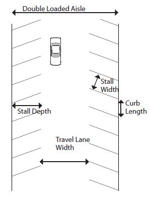
- Wheel Stops: Install wheel stops or bumper guards when parking is adjacent to a pedestrian pathway to limit vehicle overhang that reduces the sidewalk width. Such stops or guards shall be properly anchored or secured.
FIGURE 8.3(2)
PARKING LOT PEDESTRIAN WALKWAY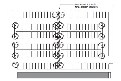
- Location Of Parking: Refer to section 10-5.1A-5 of this article, building type standards, for information on the location of parking facilities.
- Access: All off street parking and loading facilities shall open directly onto an aisle, alley, or driveway designed to provide safe access to such facilities. Exceptions include:
- Tandem Parking: No more than two (2) spaces may be included in a tandem parking spot, and the rear space must meet the access requirement.
- Parking Lifts: The lift exit shall meet the access requirement.
- Edge Of Lot And Drives: All curbs and gutters shall be located a minimum of three feet (3') from any adjacent property line or right-of-way.
- Slopes: All parking and driveway or sidewalk access shall meet the requirements of the Utah Accessibility Code.
- Landscape Screening: All parking areas shall meet the requirements of section 10-5.1A-7, "Landscape Standards," of this article.
- Landscape Areas: Areas not used specifically for sidewalks, parking spaces, driving aisles, loading, or refuse shall not be paved. Areas striped with diagonal striped islands are not permitted.
- Pavement Construction: All parking and driveways shall be constructed using asphalt, concrete, pavers, or other semipervious material approved by the City Manager or designee. One of the following shall be met:
- Paving materials with a solar reflectance index (SRI) of at least 29.
- Recycled content of fifteen percent (15%) or more.
- Illumination: All off street parking lots or parking structures shall provide a level of illumination at any point in the parking lot or structure not less than one foot-candle measured at the pavement. All lighting shall be shielded or otherwise optically controlled to provide glareless illumination and limit trespass on adjacent properties.
- Vehicular Parking Space Dimensions: The appropriate dimensions for parking spaces are outlined in table 8.3(1), "Parking Space Dimensions," and figure 8.3(1), "Parking Lot Layout," of this section.
- Bicycle Parking Design: Bicycle parking (refer to section 10-5.1A-8-2, table 8.2(1), "Required Bicycle Parking," of this article for quantity required) shall be designed and located as follows:
- Dimensions:
- Required bicycle parking spaces shall have minimum dimensions of two feet (2') in width and six feet (6') in length.
- An aisle a minimum of five feet (5') wide shall be provided behind bicycle parking facilities to allow for maneuvering.
- A minimum of two feet (2') shall be provided beside each parked bicycle to allow access. This access may be shared by adjacent bicycles.
- Racks shall be installed a minimum of two feet (2') from any wall or other obstruction.
- Location: Bicycle parking should be located within fifty feet (50') of the entrance of the use.
- Indoor or outdoor spaces are permitted, provided they are located on the lot with which they are associated.
- Spaces located within individual dwelling units may not be counted toward bicycle parking requirements.
- Bicycle parking facilities shall be separated from vehicular parking areas to protect parked bicycles from damage. The separation may be accomplished through grade separation, distance or physical barrier, such as curbs, wheel stops, poles or other similar features.
- Racks And Structures: Racks and structures shall be provided for each unprotected parking space, and shall be designed to accommodate both chain and U-shaped locking devices supporting the bicycle frame at two (2) points.
- Bicycle Storage: In multi-family or office uses bicycle storage shall be lockable and enclosed.
- Surface: The parking surface shall be designed and maintained to be mud and dust free. The use of rock or gravel areas for bicycle parking is permitted provided that edging materials are used, so that the bicycle parking area is clearly demarcated and the rock material is contained.
- Signage: If required bicycle parking for public use is not visible from the street, signs must be posted indicating their location.
- Maintenance And Lighting: Areas used for required bicycle parking must be well lit with acceptable drainage to be reasonably free of mud and standing water. Accessory off street parking for bicycles shall include provision for secure storage of bicycles. Such facilities shall provide lockable enclosed lockers or racks or equivalent structures in or upon which a bicycle may be locked by the user.
- Shower Facilities: Office and manufacturing uses with more than fifty (50) employees shall provide shower and changing room facilities.
- Long Term Parking: For multi-family residential uses, half of the bicycle parking spaces should be provided as long term parking, safe and secure from vandalism and theft, and protected from the elements. (Ord. 17-22, 11-21-2017, eff. 11-21-2017)
- Dimensions:
10-5.1A-8-4: Loading Requirements
- General Requirements: All loading facilities shall adhere to the following requirements, unless otherwise approved during site plan approval (refer to subsection 10-5.1A-10-2E of this article).
- Use Of Off Street Loading Areas: Space allocated to any off street loading use shall not be used to satisfy the space requirements for any off street parking facilities or portions thereof.
- Location: Unless otherwise specified, all required loading facilities shall be located on the same lot as the use to be served. No loading space shall block or project into a street, alley, access drive, or parking area.
- Building Frontage: Loading facilities shall be located per section 10-5.1A-5 of this article, building type requirements.
- Access: Loading facilities shall have clear access onto an alley or be connected to an alley or street via a driveway.
- Direct access to a public way, other than an alley, is prohibited.
- Each required off street loading space shall be designed with appropriate means of vehicular access to a street or alley in a manner which will least interfere with traffic movement.
- Loading Requirements: All uses except in the residential and lodging, open space, and civic and institutional categories shall provide off street loading spaces in compliance with table 8.4(1), "Required Loading Facilities," of this section.
TABLE 8.4(1)
REQUIRED LOADING FACILITIESGross Floor Area (Square Feet) Loading Spaces Required Under 5,000 0 5,000 to 20,000 1 20,001 to 40,000 2 40,001 to 70,000 3 70,001 to 100,000 4 100,001+ 4 plus 1 for each 100,000 over 100,001 - Computation: Loading facilities shall be calculated using the following information:
- Gross Square Footage: Unless otherwise expressly stated, loading standards for nonresidential buildings shall be computed on the basis of gross floor area in square feet.
- Fractions: When computation of the number of required off street loading spaces results in a fractional number, any result of 0.5 or more shall be rounded up to the next consecutive whole number. Any fractional result of less than 0.5 may be rounded down to the previous consecutive whole number.
- Shared Or Central Loading Facilities: Shared or central loading facilities are permitted if the following conditions are met:
- Each zoning lot served shall have direct access to the central loading area without crossing streets or alleys.
- Total off street loading spaces provided shall meet the minimum requirements herein specified, based on the sum of the several types of uses served unless reviewed and approved by the City Manager or designee through site plan review.
- No zoning lot served shall be more than five hundred feet (500') from the central loading area.
- Dimensions: A standard off street loading space shall be a minimum of ten feet (10') in width by twenty six feet (26') in length and an oversized loading space shall be a minimum of twelve feet (12') in width and forty feet (40') in length, exclusive of aisle and maneuvering space and shall have a minimum vertical clearance of fifteen feet (15').
- Pavement Materials: Refer to this Code for details. One of the following shall also be met:
- Paving materials with a solar reflectance index (SRI) of at least 29.
- Pervious pavement.
- Recycled content of fifteen percent (15%) or more. (Ord. 16-07, 6-21-2016, eff. 6-21-2016)
10-5.1A-8-5: Site Access And Driveways
- General Requirements: These standards shall supplement the provisions for access provided in section 10-5.1A-5 of this article, building type standards. Each driveway providing site access from a street, alley, or other vehicular right-of-way shall be designed, constructed, and permanently maintained as follows.
- Quantity Of Driveways: The number of driveways permitted for each building type is located in section 10-5.1A-5 of this article, building type standards.
- Dimensions And Design:
- Driveway Width At Property Line: All driveways shall have a maximum width of twenty four feet (24') as measured at the property line (figure 8.5(1) of this section, driveway width) except as stated below.
- Residential Building Types: Driveways constructed in residential subdistricts shall have a maximum width of eleven feet (11') when crossing the front or corner property line.
- One-Way: Maximum width for one-way driveways is twelve feet (12') at the property line. A wider driveway to access an additional side yard parking space or rear yard parking space or garage, must be approved by the Staff Review Committee.
FIGURE 8.5(1)
DRIVEWAY WIDTH AND LOCATION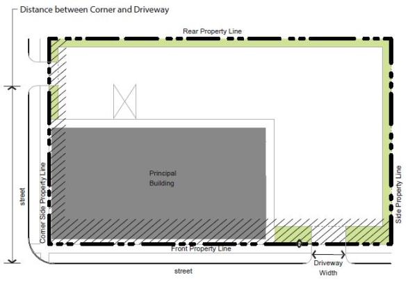
- Maximum Width: When a garage door is located on the front facade of the structure, the driveway shall be no more than two feet (2') wider than the garage door at any location.
- Shared Access: When possible, adjacent developments should share points of access to minimize impervious surface.
- Shared Driveway Width: When access is shared between three (3) or more nonresidential users, a dedicated turn lane may be constructed, allowing an increase in the maximum driveway width from twenty four feet (24') to thirty two feet (32') provided that:
- A traffic impact study states its necessity.
- Shared Driveway Width: When access is shared between three (3) or more nonresidential users, a dedicated turn lane may be constructed, allowing an increase in the maximum driveway width from twenty four feet (24') to thirty two feet (32') provided that:
- Sidewalk Pavement: Sidewalk pavement elevation, width, scoring, material, and design shall extend continuously over the driveway pavement with the intent of prioritizing the sidewalk path over the driveway. If the driveway and sidewalk are of the same material, the sidewalk path shall be scored or designated linearly over the driveway.
- Driveway Width At Property Line: All driveways shall have a maximum width of twenty four feet (24') as measured at the property line (figure 8.5(1) of this section, driveway width) except as stated below.
- Location: Specific location information can be found in section 10-5.1A-5 of this article, building type standards. Refer to figure 8.5(1) of this section.
- Driveways accessing rear yard garages are permitted within the side or rear yard setback, no closer than two feet (2') from a side or rear property line, unless the driveway is shared.
- Driveways shall not be closer than twenty five feet (25') from the intersection of two (2) streets (corner), unless otherwise stated in section 10-5.1A-5 of this article, building type standards. (Ord. 17-22, 11-21-2017, eff. 11-21-2017
10-5.1A-9-1: General Requirements
- Intent: This section 10-5.1A-9 seeks to enhance the economic and aesthetic appeal in each subdistrict through the reasonable, orderly, safe, and effective display of signage.
- Applicability: These standards shall apply to all subdistricts for nonresidential uses only. Unless otherwise stated in this article, all sign requirements in this Code shall apply. Refer to South Ogden City Sign Code (chapter 21 of this title) for permit processes, construction, design, and maintenance standards.
- General Compliance: Compliance with the regulations outlined shall be attained under the following situations:
- Newly Constructed Or Reconstructed Signage: All new signs and structural improvements to existing signs.
- Change In Use For Single Business Signage: For signage serving one business, whenever the existing use is changed to a new use resulting in a change in signage, including rewording.
- Multiple Business Signage: For signage serving multiple businesses, whenever fifty percent (50%) or more of the existing uses are changed to new uses resulting in a change in signage, including rewording.
- Damage Or Destruction: When a sign has been damaged or destroyed by fire, collapse, explosion or other cause and the cost of restoration is greater than fifty percent (50%) of the replacement value at the time of the destruction or damage, the replacement sign shall comply with the standards in this section 10-5.1A-9.
- Prohibited, Exempt Signage: Refer to the South Ogden City Sign Code for information on prohibited, and exempt signs.
- Sign Location: Unless otherwise specified, signs shall only be located within the boundaries of the lot and not in the right-of-way or on public property.
- Certain sign types may extend beyond a property line into the right-of-way or public property with permission from the City and in accordance with the regulations outlined in this section 10-5.1A-9.
- No sign shall be attached to a utility pole, tree, standpipe, gutter, or drain.
- Signs shall be erected so as to permit free ingress to or egress from any door, window, the roof, or any other exitway required by the Building Code or by Fire Department regulations.
- No sign shall be erected or maintained in such a manner as to obstruct free and clear vision of, interfere with, or be confused with any authorized traffic sign, signal, or device.
- Illumination: All signs shall be illuminated according to the following provisions unless otherwise stated:
- Signs shall be illuminated only by steady, stationary light sources directed solely at the sign or internal to it, except as permitted for electronic message boards.
- Individual letters or logos may be internally illuminated as permitted per each sign type; no other portion of the sign shall be internally illuminated, except as permitted for electronic message boards or unless otherwise stated.
- When an external artificial light source is used to illuminate a sign, the lamp (or bulb) shall be located, shielded, and directed so as to not be visible from any public street or private residence.
- No receptacle or device housing a permitted light source which is attached to the sign itself shall extend more than eighteen inches (18") from the face of the sign.
- If ground lighting is used to illuminate a sign, the receptacle or device should not extend more than twelve inches (12") above ground and must be fully screened and housed.
- The illumination of any sign, resulting from any internal or external artificial light source, shall not exceed two hundred fifty (250) nits at the sign face during the day and one hundred twenty five (125) nits at the sign face after sunset, with no light trespass onto adjacent property.
- Signs located within "core" subdistricts are exempt from this standard.
- Computation: The following standards generally apply to computing the area of signs by type and by building lot. Refer to the sign types in sections 10-5.1A-9-3 through 10-5.1A-9-13 of this article for more information.
- Exempt and temporary signs are not included in the maximum signage area calculations, unless otherwise specified.
- Height for freestanding signs is measured from the average grade at the front property line to the top of the sign, sign cabinet, or cap, whichever is highest.
- For the purposes of determining area, lot width or frontage is measured along the front property line.
- If the lot is a corner lot, the width shall be measured along the front yard.
- Building frontage is the width of the front facade of a building. (Ord. 17-22, 11-21-2017, eff. 11-21-2017)
10-5.1A-9-2: Sign Types
- Sign Type Requirements: The following pertain to specific sign types detailed in this section:
- Permitted Quantity Of Signage By Subdistrict: Table 9.2(1) of this section details the maximum permitted amount of signage on a lot within each subdistrict. Refer to section 10-5.1A-3, "Subdistricts," of this article for more information on each subdistrict.
TABLE 9.2(1)
PERMITTED QUANTITY OF SIGNAGE BY SUBDISTRICTMaximum Permitted Quantity Of Signage Per Lot "Core" Subdistricts "General" Subdistricts "Edge" Subdistricts 2 square feet per 1 linear foot of lot width with a maximum of 200 square feet or 300 square feet if a monolithic sign is used. An additional 40 square feet per additional tenant over 3 tenants permitted 1.5 square feet per 1 linear foot of lot width with a maximum of 200 square feet No signage permitted - Window Signs: Window signs shall count toward a lot's maximum permitted amount of signage. Refer to section 10-5.1A-9-8, "Window Sign," of this article.
- Signs Located On Parking Lots: One sign is permitted in addition to the maximum signage quantities detailed in table 9.2(1) of this section provided the following:
- Permitted sign types are a wall, projecting, or awning sign.
- Maximum sign area is thirty (30) square feet.
- Permitted location is either the side or rear facade along a parking lot.
- Through Lots: In addition to the maximum amount of signage permitted per lot, through lots may incorporate an additional thirty (30) square feet of signage permitted for the lot located in either the rear yard or along the rear facade.
- Exempt/Temporary Signs: Table 9.2(1) of this section does not apply to exempt or temporary signs unless otherwise specified.
- Iconic Sign Elements: Iconic sign elements of three-dimensional symbols or logos are permitted under the following conditions:
- Symbol Or Logo Size: The symbol may not be larger than four feet (4') in any direction, included in overall sign area and the surface area counts toward the maximum permitted quantity of signage per lot.
- Moving Parts: No moving parts or external illumination of the symbol may be provided.
- Text: The text component of the sign may not be more than thirty percent (30%) of the overall area of the sign.
- Electronic Message Boards (EMBs): EMBs are only allowed in the Riverdale Road Subdistrict. See individual sign types for other EMB restrictions.
- Automatic Dimmer: Electronic message boards must have an automatic dimmer to reduce sign intensity after dark.
- Hours Of Operation: The electronic message board shall only be on during the operational hours of the associated permitted business.
- Animation, Flashing Or Rapid Blinking Prohibited: A message cannot be displayed by means of animation, flashing or rapid blinking except when changing to a different message. Each individual message shall remain for a minimum of six (6) seconds.
- Cannot Be A Nuisance: The sign shall not cause glare or be intensely lighted at dark so that it creates a nuisance or hazard to vehicle traffic, pedestrians, or neighboring residential properties.
- No Off-Premises Advertising: No EMB sign may advertise for a business not located on the premises where the sign is located.
- Cannot Be Temporary Sign: EMBs cannot be a temporary sign (i.e., a small digital sign in a window or placed in front of a business to attract attention).
- Other Restrictions: See individual sign types for other EMB restrictions. (Ord. 18-04, 5-15-2018, eff. 5-15-2018)
- Permitted Quantity Of Signage By Subdistrict: Table 9.2(1) of this section details the maximum permitted amount of signage on a lot within each subdistrict. Refer to section 10-5.1A-3, "Subdistricts," of this article for more information on each subdistrict.
10-5.1A-9-3: Wall Sign
- Description: Wall signs, also known as flat or band signs, are mounted directly to the building face to which the sign is parallel. Refer to figures 9.3(1) and 9.3(2) of this section.
FIGURE 9.3(1)
WALL SIGN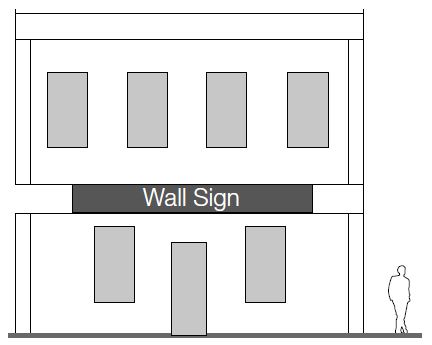
FIGURE 9.3(2)
MEASURING WALL SIGNS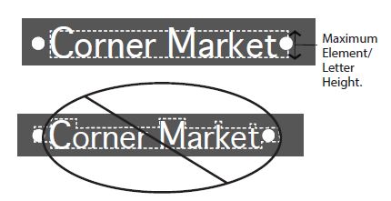
- General Requirements: Wall signs shall be developed according to the standards in table 9.3(1) of this section.
TABLE 9.3(1)
WALL SIGN REQUIREMENTSPermitted subdistricts All subdistricts Sign area No maximum area for sign type; refer to section 10-5.1A-9-2, table 9.2(1) of this article for maximum per lot Height 2' maximum letter or element height Location on the building or site Permitted on all facades Placement on the building or site 1' maximum projection from building face Quanitity 1 per tenant per public ROW frontage; 1 per tenant per side or rear facade on a parking lot Internal illumination Permitted for individual letters and logos Materials Solid wood, metal, masonry and neon glass; plastic and synthetics permitted only as separate alphanumeric characters or logos - Building Openings: Wall signs shall not cover windows or other building openings.
- Architectural Features: Wall signs shall not cover architectural building features.
- Murals: Murals, a type of wall sign painted onto the building face displaying the business name or activity, are prohibited. (Ord. 20-18, 7-7-2020)
- Computation: The area of a wall sign is calculated using the following information:
- Wall Signs: Area is calculated by drawing the smallest possible square or rectangle around the largest letters and/or elements, as is illustrated in figure 9.3(2) of this section.
- Area Credit: All areas that utilize individual alphanumeric characters or logos (including only those using wood, wood substitute, metal, or masonry) may use a total area of ninety percent (90%) of the calculation as outlined above. (Ord. 16-07, 6-21-2016, eff. 6-21-2016; amd. Ord. 20-18, 7-7-2020)
- Area Credit: All areas that utilize individual alphanumeric characters or logos (including only those using wood, wood substitute, metal, or masonry) may use a total area of ninety percent (90%) of the calculation as outlined above. (Ord. 16-07, 6-21-2016, eff. 6-21-2016; amd. Ord. 20-18, 7-7-2020)
- Wall Signs: Area is calculated by drawing the smallest possible square or rectangle around the largest letters and/or elements, as is illustrated in figure 9.3(2) of this section.
10-5.1A-9-4: Projecting Sign
- Description: A projecting sign is attached to and projects from a building face or hangs from a support structure attached to the building face. Sign faces are typically perpendicular to the building face, but may be at an angle greater than forty five degrees (45°) from the facade. The sign may be vertically or horizontally oriented. Refer to figure 9.4(1) of this section.
FIGURE 9.4(1)
PROJECTING SIGN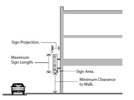
- General Requirements: Projecting signs shall be developed according to the standards in table 9.4(1) of this section.
TABLE 9.4(1)
PROJECTING SIGN REQUIREMENTSPermitted subdistricts All nonresidential subdistricts Sign area No maximum area for sign type; refer to section 10-5.1A-9-2, table 9.2(1) of this article for maximum per lot Height 8' maximum sign length, 8' minimum clearance to walk required Location on the building or site Permitted on all facades; sign and structural supports shall not extend above the eave or parapet Placement on the building or site Shall not project closer than 3' from back of curb Quantity 1 per tenant per public ROW frontage; 1 per tenant per side or rear facade on a parking lot Internal illumination Permitted for individual letters and logos Materials Solid wood, metal, masonry and neon glass; plastic and synthetics permitted only as separate alphanumeric characters or logos - Computation: The area of a projecting sign is equal to the area of one of the sign's faces. (Ord. 16-07, 6-21-2016, eff. 6-21-2016)
10-5.1A-9-5: Projecting Marquee Sign
- Description: A projecting marquee sign is a projecting sign designed to have manually changeable copy and two (2) to three (3) sign faces. Refer to figures 9.5(1) and 9.5(2) of this section.
FIGURE 9.5(1)
PROJECTING MARQUEE SIGN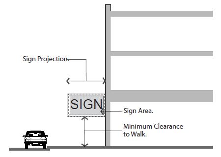
FIGURE 9.5(2)
PROJECTING MARQUEE SIGN PLAN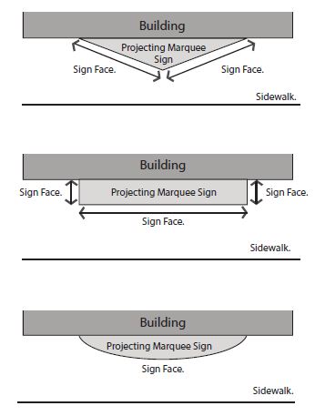
- General Requirements: Projecting marquee signs shall be developed according to the standards in this section and table 9.5(1) of this section.
TABLE 9.5(1)
PROJECTING MARQUEE SIGN REQUIREMENTSPermitted subdistricts All "core" and "general" subdistricts, limited to assembly uses or theater uses per section 10-5.1A-4, "Uses," of this article Sign area No maximum area for sign type; minimum 2 faces per sign. Refer to section 10-5.1A-9-2, table 9.2(1) of this article for maximum per lot Height 10' minimum clearance to walk required Location on the building or site Front and corner side facades only Placement on the building or site Maximum projection from building is 6'; shall not project closer than 1' from back of curb Quality 1 per lot Internal illumination Permitted for individual letters and logos Materials Solid wood, metal, masonry and neon glass. Plastic and synthetics permitted only on sign face. Electronic message and manually changeable copy boards permitted with conditions. Refer to subsections B1a and B1b of this section for conditions - Manually Changeable Copy Boards: Manually changeable copy boards are permitted on projecting marquee signs in the Riverdale Road subdistricts by right, provided the following conditions are met:
- The area of the boards cannot equal greater than thirty percent (30%) of the area of the sign face on which it is located or thirty two (32) square feet, whichever is less.
- One sign of any type containing a manually changeable copy board is permitted per lot.
- Manually Changeable Copy Boards: Manually changeable copy boards are permitted on projecting marquee signs in the Riverdale Road subdistricts by right, provided the following conditions are met:
- Computation: The sign area is calculated by combining the area of all exposed sign faces and the cabinet or structure surrounding them. (Ord. 18-04, 5-15-2018, eff. 5-15-2018)
10-5.1A-9-6: Awning Sign
- Description: A sign that is mounted, painted, or otherwise applied on or attached to an awning or canopy. Refer to figures 9.6(1) and 9.6(2) of this section.
FIGURE 9.6(1)
AWNING SIGN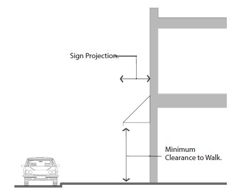
FIGURE 9.6(2)
MEASURING AWNING SIGNS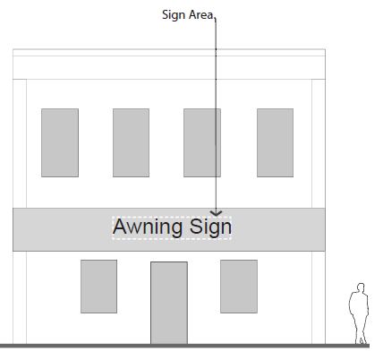
- General Requirements: Awning signs shall be developed according to the standards in table 9.6(1) of this section.
TABLE 9.6(1)
AWNING SIGN REQUIREMENTSPermitted subdistricts All subdistricts Sign area Up to 50% of the awning may be used for signage; refer to section 10-5.1A-9-2, table 9.2(1) of this article for maximum per lot Height 8' minimum clearance to walk required Location on the building or site Permitted on all facades Placement on the building or site Maximum projection from building is 6'; shall not project closer than 2' from back of curb; shall not block any window, door, or the building roof Quality 1 per tenant per street frontage; 1 per tenant per side or rear facade on a parking lot Internal illumination Not permitted Materials Cloth, canvas, metal, or wood; all supports shall be made of metal or wood - Computation: The area of an awning sign is calculated by drawing the smallest possible square or rectangle around the largest letters and/or elements of the sign portion of the awning, as is illustrated in figure 9.6(2) of this section. (Ord. 16-07, 6-21-2016, eff. 6-21-2016)
10-5.1A-9-7: Canopy Mounted Sign
- Description: A sign with individual alphanumeric characters and/or logos that is mounted on top of a permanent canopy. Refer to figures 9.7(1) and 9.7(2) of this section.
FIGURE 9.7(1)
CANOPY MOUNTED SIGN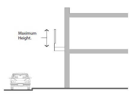
FIGURE 9.7(2)
MEASURING CANOPY MOUNTED SIGNS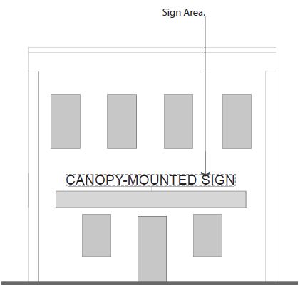
- General Requirements: Canopy mounted signs shall be developed according to the standards in table 9.7(1) of this section.
TABLE 9.7(1)
CANOPY MOUNTED SIGN REQUIREMENTSPermitted subdistricts All subdistricts Sign area No maximum area for sign type; refer to section 10-5.1A-9-2, table 9.2(1) of this article for maximum per lot Height 2' maximum letter or element height; cannot project more than 2' above roofline of canopy Location on the building or site Permitted on all facades; not intended for the principal roof of the building Placement on the building or site Shall not project beyond the front edge of the canopy; shall not block any window, door, or the building roof Quantity 1 per tenant per public ROW frontage; 1 per tenant per side or rear facade on a parking lot Internal illumination Permitted for individual letters and logos Materials Solid wood, metal, and neon glass; plastic and synthetics permitted only as separate alphanumeric characters or logos - Computation: The area of a canopy mounted sign is calculated by drawing the smallest possible square or rectangle around the largest letters and/or elements of the sign portion of the canopy mounted roof sign, as is illustrated in figure 9.7(2) of this section. (Ord. 16-07, 6-21-2016, eff. 6-21-2016)
10-5.1A-9-8: Window Sign
- Description: A window sign is posted, painted, placed, or affixed in or on a window exposed for public view or is a sign hung inside the building facing the window for public view. Refer to figure 9.8(1) of this section.
FIGURE 9.8(1)
MEASURING WINDOW SIGNS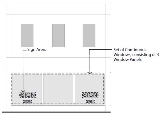
- General Requirements: Window signs shall be developed according to the standards in table 9.8(1) of this section.
TABLE 9.8(1)
WINDOW SIGN REQUIREMENTSPermitted subdistricts "Core" and "general" subdistricts Sign area Up to 30% of a set of continuous windows may be covered with signage; no more than 50% of any 1 window panel may be covered with signage Height No maximum Location on the building or site Permitted on all facades Placement on the building or site Ground or upper story windows; may be affixed to window or hung/mounted behind glass Quantity No maximum quantity, based on window sign area for ground story; 1 per tenant per floor for upper stories Internal illumination Not permitted, except on neon or similarly illuminated window signs. EMBs are not allowed Materials Drawn, painted, or affixed on the glass; wood, metal, neon glass, plastic, or other similar materials also permitted - Computation: A series of windows that are separated by frames or supporting material of less than six inches (6") in width shall be considered a single window for the purposes of computation.
- Measurement: To measure sign area percentage, divide the total sign area by the total window area, as illustrated in figure 9.8(1) of this section.
- Maximum Allowance: Window signs are counted toward a site's maximum signage allowance.
- Exempt Signs: Address and hours of operation are considered exempt signs and are not counted in the window sign area calculation. Refer to subsection 10-5.1A-9-2A2 of this section 10-5.1A-9, exempt signs.
- Temporary Window Signs: Temporary window signs must be included in the total percentage of signage per window calculation. Refer to subsection 10-5.1A-9-2A2 of this section 10-5.1A-9, temporary signs.
- Internal Illumination: Window signs may not be internally illuminated except for neon or similar illuminated window signs. (Ord. 18-04, 5-15-2018, eff. 5-15-2018)
10-5.1A-9-9: Monument Sign
- Description: A monument sign is freestanding; it is located in a front or side yard of a lot. Refer to figures 9.9(1) and 9.9(2) of this subsection A.
FIGURE 9.9(1)
MONUMENT SIGN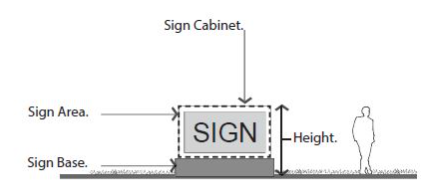
FIGURE 9.9(2)
MONUMENT SIGN WITH EMB
(Ord. 18-04, 5-15-2018, eff. 5-15-2018) - General Requirements: Monument signs shall be developed according to the standards in table 9.9(1) of this subsection B.
TABLE 9.9(1)
MONUMENT SIGN REQUIREMENTSNotes:Permitted subdistricts "Core" and "general" subdistricts Sign area Maximum 70 sq. ft. per sign face Height Maximum height 6' Location on the building or site Front or corner yards Placement on the building or site 10' setback from driveways and side property line; 3' setback1 from front and corner property lines Quality 1 per public ROW frontage Internal illumination Permitted for individual letters and logos Materials Solid wood, metal and masonry; plastic and synthetics permitted on sign face; electronic message board and manually changeable copy permitted in certain subdistricts with conditions2
1Placement: If placed closer than 5 feet from the front and corner side property lines, sign must not be located in a sight triangle extending 10 feet from either side of an intersection of a driveway and a vehicular right-of-way or 2 vehicular rights-of-way. Signs 24 inches or less are exempt from this requirement.
2Manually Changeable And Electronic Message Boards: Manually changeable copy boards and EMBs are permitted on monument signs in the Riverdale Road Subdistrict by right, provided the following conditions are met:
a. The area of the boards cannot equal greater than 50 percent of the area of the sign face on which it is located or 20 square feet, whichever is less.
b. 1 sign of any type containing a manually changeable copy board or EMB is permitted per lot.
(Ord. 18-11, 9-18-2018, eff. 9-18-2018)- Multiple Tenants: Multiple-tenant buildings on a lot with a width of greater than three hundred feet (300'), measured across the front property line, may have signage with the following parameters:
- Up to two (2) monument signs on one frontage.
- Signs shall be at least one hundred fifty feet (150') apart.
- Up to two (2) monument signs on one frontage.
- Pole Mounted Signs: Monument signs may not be pole mounted.
- Multiple Tenants: Multiple-tenant buildings on a lot with a width of greater than three hundred feet (300'), measured across the front property line, may have signage with the following parameters:
- Computation: The area of a two (2) sided monument sign is equal to the area of one sign face. The area of a three (3) or four (4) sided monument sign is equal to the total area of each sign face. This measurement includes the sign, any cabinet in which it is enclosed and the electronic message board or manually changeable copy, but excludes the base of the sign.
- Measuring Height: Height shall include the sign face, base, cabinet, and ornamental cap. (Ord. 18-04, 5-15-2018, eff. 5-15-2018)
10-5.1A-9-10: Pedestrian Scale Pole Mounted Sign
- Description: A pedestrian scale pole mounted sign is freestanding and may be mounted on one or two (2) poles. Three (3) configurations are permitted. Refer to figure 9.10(1) of this subsection A.
- A sign mounted onto a double set of poles.
- A sign mounted on a single pole.
- A sign hanging from a single pole.
THREE TYPES OF PEDESTRIAN SCALE POLE MOUNTED SIGNS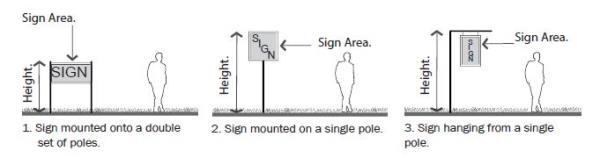
(Ord. 18-04, 5-15-2018, eff. 5-15-2018) - General Requirements: Pedestrian scale pole mounted signs shall be developed according to the standards in table 9.10(1) of this subsection B.
TABLE 9.10(1)
PEDESTRIAN SCALE POLE MOUNTED SIGN REQUIREMENTSNote:Permitted subdistricts "Core" and "general" subdistricts Sign area 8 sq. ft. maximum area per sign face Height 8' maximum height for sign mounted or hanging on a single pole. 5' for sign mounted on double set of poles; each pole shall have a maximum size of 3.5" by 3.5" Location on the building or site Front or corner yards Placement on the building or site 2' minimum setback from front and corner property lines; cannot overhang property lines1 Quality 1 per lot Internal illumination Permitted for individual letters and logos Materials Solid wood, metal and masonry; plastic and synthetics permitted on sign face
1Placement: If placed closer than 5 feet from the front and corner side property lines, sign must not be located in a sight triangle extending 10 feet from either side of an intersection of a driveway and a vehicular right-of-way or 2 vehicular rights-of-way. Signs 24 inches or less are exempt from this requirement.
(Ord. 18-11, 9-18-2018, eff. 9-18-2018) - Computation: The area of a pedestrian scale pole mounted sign is equal to the area of one sign face. (Ord. 18-04, 5-15-2018, eff. 5-15-2018)
10-5.1A-9-11: Monolithic Sign
- Description: A monolithic sign is freestanding and continuous from the ground up without visible columns, uprights or braces and uses the total structure as a sign; it is located in a front or side yard of a lot. Refer to figure 9.11(1) of this subsection A.
FIGURE 9.11(1)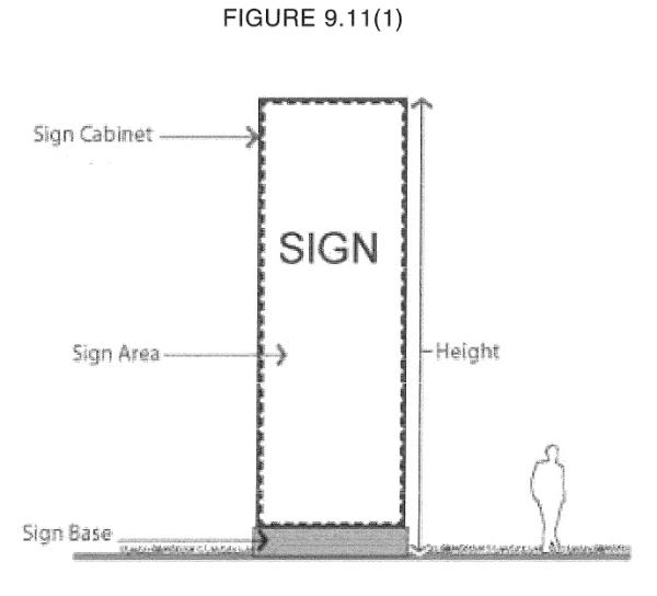
(Ord. 18-04, 5-15-2018, eff. 5-15-2018) - General Requirements: Monolithic signs shall be developed according to the standards in table 9.11(1) of this subsection B.
TABLE 9.11(1)Notes:Permitted subdistricts Riverdale Road General Sign area Maximum 196 sq. ft. per sign face Height Maximum height 25' Width Maximum width 8' Location on the building or site Front or corner yards Placement on the building or site 10' setback from driveways and side property line; 3' setback1 from front and corner property lines Quantity 1 per public ROW frontage Internal illumination Permitted for individual letters and logos Materials Solid wood, metal and masonry; plastic and synthetics permitted on sign face; electronic message board or manually changeable copy board permitted with conditions2
1Placement: If placed closer than 5 feet from the front and corner side property lines, sign must not be located in a sight triangle extending 10 feet from either side of an intersection of a driveway and a vehicular right-of-way or 2 vehicular rights-of-way.
2Manually Changeable And Electronic Message Boards: Manually changeable copy boards and EMBs are permitted on monolithic signs in the Riverdale Road Subdistrict by right, provided the following conditions are met:
a. The area of the boards cannot equal greater than 50 percent of the area of the sign face on which it is located or 20 square feet, whichever is less.
b. 1 sign of any type containing a manually changeable copy board or EMB is permitted per lot.
(Ord. 18-11, 9-18-2018, eff. 9-18-2018)- Multiple Tenants: Multiple tenant buildings on a lot with a width of greater than three hundred feet (300'), measured across the front property line, may have signage with the following parameters:
- Up to two (2) monolithic signs on one frontage.
- Signs shall be at least one hundred fifty feet (150') apart.
- Computation: The area of a two-sided monolithic sign is equal to the area of one sign face. The area of a three -or four-sided monolithic sign is equal to the total area of each sign face. This measurement includes the sign, any cabinet in which it is enclosed and the electronic message center or manually changeable copy, but excludes the base of the sign.
- Measuring Height: Height shall include the sign face, base, cabinet, and ornamental cap. (Ord. 18-04, 5-15-2018, eff. 5-15-2018)
- Measuring Height: Height shall include the sign face, base, cabinet, and ornamental cap. (Ord. 18-04, 5-15-2018, eff. 5-15-2018)
- Multiple Tenants: Multiple tenant buildings on a lot with a width of greater than three hundred feet (300'), measured across the front property line, may have signage with the following parameters:
10-5.1A-9-12: Vehicular-Scale Pole Sign
- Description: A freestanding pole-mounted sign that may be mounted on one or two (2) poles. Two (2) general configurations are permitted:
- A sign mounted onto a double set of poles. Refer to figure 9.12(1) of this section.
- A sign mounted on a single pole. Refer to figure 9.12(2) of this section.
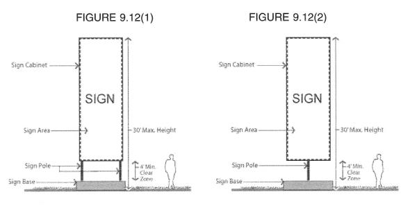
- General Requirements: Vehicular-scale pole-mounted signs shall be developed according to the standards in table 9.12(1) of this section.
TABLE 9.12(1)Notes:Permitted subdistricts Riverdale Road General Sign area 200 sq. ft. maximum area per sign face Height 30' maximum, single or double pole Width 12' maximum Clear zone height 4' minimum from top of foundation/ground to bottom of sign Location on the building or site Front yards and side yards Placement on the building or site 10' setback from driveways and side property line; 3' from front side and corner property lines1 Quantity 1 per 300' frontage maximum Internal illumination Permitted for individual letters and logos Materials Solid wood, metal and masonry; plastic and synthetics permitted on sign face. EMBs and manually changeable copy board permitted with conditions2. Support poles may be incorporated into metal, concrete, masonry or stone footings up to 4' high and 2' wide
1Placement: If placed closer than 5 feet from the front and corner side property lines, sign must not be located in a sight triangle extending 10 feet from either side of an intersection of a driveway and a vehicular right-of-way or 2 vehicular rights-of-way; cannot overhang property lines.
2Manually Changeable And Electronic Message Boards: Manually changeable copy boards and EMBs are permitted on vehicular-scale pole signs in the Riverdale Road Subdistrict by right, provided the following conditions are met:
a. The area of the boards cannot equal greater than 50 percent of the area of the sign face on which it is located or 20 square feet, whichever is less.
b. 1 sign of any type containing a manually changeable copy board or EMB is permitted per lot. - Computation: The area of a two-sided vehicular-scale pole sign is equal to the area of one sign face. The area of a three- or four-sided vehicular-scale pole sign is equal to the total area of each sign face. This measurement includes the sign, any cabinet in which it is enclosed and the electronic message center or manually changeable copy board, but excludes the base of the sign.
- Measuring Height: Height shall include the sign face, base, cabinet, and ornamental cap. (Ord. 18-04, 5-15-2018, eff. 5-15-2018)
- Measuring Height: Height shall include the sign face, base, cabinet, and ornamental cap. (Ord. 18-04, 5-15-2018, eff. 5-15-2018)
10-5.1A-9-13: Temporary Sign
- Description: A sign used to advertise community or civic projects, construction projects, real estate for sale or lease, business openings, special events, on a temporary basis. May also be a sign temporarily used until a permanent sign is established.
- Temporary signs may consist of banners, inflatables, blades, feathers, balloons, kinetic signs, building wraps, etc.
- General Requirements:
- Temporary signs shall require a temporary sign permit and shall not be erected for more than thirty (30) days. Each business, organization, etc., are limited to two (2), 30-day permits during the calendar year.
- Movable A-frame and placard signs used to advertise daily events, menus, specials, etc., do not need a temporary sign permit. They are limited to six (6) square feet (or 12 square feet if both sides of the sign are used) and may only be used during the operational hours of the associated permitted business and must be removed at the end of each business day.
- Temporary signs shall be developed according to the standards in table 9.13(1) of this section.
TABLE 9.13(1)Note:Permitted subdistricts All general, neighborhood, and edge subdistricts Sign area Maximum 36 sq. ft. per sign face Height Maximum height none Width Maximum width none Location on the building or site Within property boundaries. Placement on roof not permitted Placement on the building or site Cannot block clear view area1 Quantity 1 per public ROW frontage Internal illumination Not permitted Materials Plastic, wood, or any flexible woven fabric material such as cloth, paper, fiberglass, vinyl, or other synthetic product. EMBs are not allowed as temporary signs
1If placed closer than 5 feet from the front and corner side property lines, sign must not be located in a sight triangle extending 10 feet from either side of an intersection of a driveway and a vehicular right-of-way or 2 vehicular rights-of-way.
- Exemptions: The following temporary signs are exempt from permit requirements:
- Signs for political or civic purposes or promotions.
- Real estate for sale or lease signs.
- Computation: Temporary signs are not included in the maximum signage area calculations, unless otherwise specified. (Ord. 18-04, 5-15-2018, eff. 5-15-2018)
10-5.1A-10-1: General Provisions
- Purpose: It is the intent of this form based code (this article) to promote public health, safety, and general welfare of the community, reflecting the goals established within the South Ogden City general plan. It includes, but is not limited to, the specific purposes below:
- To achieve mixed use development that is appropriate in scale and intensity for the neighborhoods and sites proximate to transit stops and stations.
- To establish a relationship between buildings, streets, and open spaces that is pedestrian, bicycle, and transit oriented.
- To preserve and enhance the City's natural resources, energy, water, and open spaces and to promote innovative development that sustainably manages these issues, including stormwater runoff and mitigation of the urban heat island effect.
- To ensure that a variety of housing types and sizes can be developed to meet the needs of the entire community.
- To promote a variety of transportation options for residents and visitors.
- Scope Of Regulations:
- New Development: All development, construction, and establishment of uses within the limits of this article occurring after the effective date of this article shall be subject to all applicable regulations of this article.
- Renovated Structures: Building renovations affecting greater than twenty five percent (25%) gross square footage of a structure within the limits of this article shall be subject to all applicable regulations of this article. Exception: Renovations to single and two-family structures shall not be subject to all applicable regulations of this article unless those renovations affect greater than fifty percent (50%) gross square footage of the structure.
- In-Process Development: Where a building permit for a development has been applied for in accordance with the prior law in advance of this article's effective date, said development may comply with the plans from which the permit was approved and, upon completion, receive a certificate of occupancy or zoning certificate (provided all conditions are met) provided the following:
- Work or construction is begun within one year of the effective date of this article.
- Work or construction continues diligently toward completion.
- Nonconformance: After the effective date of this article, existing buildings and uses that do not comply with the regulations of this article shall be considered nonconforming and are subject to the standards of section 10-5.1A-10-4, "Nonconformances," of this article.
- Private Ownership: All roads, alleys, parking lots, service areas and similar facilities proposed for development and not specifically designated as public shall be assumed to be privately owned. South Ogden City will not be responsible for constructing, managing, operating or maintaining any private roads, alleys, parking lots, service areas, utilities or infrastructure proposed for inclusion in the districts controlled by this article.
- Administration And Enforcement: The provisions of this article shall be administered and enforced by the City Manager or designee, unless otherwise specifically stated. For the purposes of this article, the term City Manager shall be inclusive of his or her designees. Where provisions of this article differ from this Code, the requirements of this article shall apply.
- Development Application: Applications (form, fees, and plan sets) shall be filed with the City Manager or designee.
- Application Form: Application forms are available from the City.
- Fees: Fee amounts are available from the City and are due at the time the application is made; the application will be considered incomplete if fees are not paid.
- Plan Set Requirements: Number of copies and minimum scale of drawings shall be noted on the application form. All plans shall be submitted in both a paper and an approved digital format using NAD1983 State plane coordinates.
- Filing Deadline: Filing deadlines are established by the City and available at the City.
- Withdrawal Of Application: Applicant may withdraw application whole or in part at any point in the process prior to being acted or ruled upon; new application form, fees, and plan sets are required for reapplication.
- Records On File: Applications and the resulting recommendations and rulings shall be kept on file by the City Manager or designee and shall be considered public record.
- Notice: Notice requirements for each process are detailed in this Code.
- Zoning Map: The areas and boundaries of the subdistricts listed in section 10-5.1A-3 of this article are hereby established to scale as shown on the map entitled zoning map of the City and referred to herein as "zoning map."
- Process: Any development within a subdistrict shall be administered in accordance with the procedures defined in section 10-5.1A-10-2 of this article and this title.
- The application shall include the following processes:
- Preapplication meeting: Refer to subsection 10-5.1A-10-2B of this article.
- Site plan approval, including building, site, and streetscape. Refer to subsection 10-5.1A-10-2E of this article.
- The application shall include the following processes:
- Staff Review Committee: The City Manager or designee shall approve, deny, or approve with conditions all submittals for regulating plans and site plans within the subdistricts upon review by a Staff Review Committee.
- The Staff Review Committee shall include members of each regulatory agency, a representative of each affected City department (i.e., Planning, Zoning, Public Works, Transportation, Utilities).
- The Staff Review Committee shall meet regularly to process applications within the time lines established by subsections 10-5.1A-10-2A through E of this article.
- The decision regarding approval or denial of a regulating plan or site plan shall state in writing the reasons for approval or denial.
- If a regulating plan or site plan is denied by the City Manager or designee, the applicant may appeal the decision to the Hearing Officer.
- After an application is approved, approved with conditions, or denied, it will appear on the Planning Commission and City Council agendas for their information. (Ord. 17-22, 11-21-2017, eff. 11-21-2017)
10-5.1A-10-2: Development Review Procedures
- General Requirements: The processes included in this section are required for approval of new development in the South Ogden City Center and 40th Street Corridor.
- Appeal: If any application is disapproved, applicant may appeal the decision through the appeals process (refer to section 10-4-3 of this title).
- Expiration Of Approval: Approval of any application shall expire twelve (12) months from the date of approval, if permits for development have not been submitted for review or construction has not begun.
- Applicant can request an extension if done so in writing to the city manager or designee at least thirty (30) days prior to the end of the twelve (12) month period.
- Failure to act within the twelve (12) month period shall require a new application, including all forms, fees, and plan sets.
- Review Criteria: All regulating plan, site plan, and exception applications shall be reviewed using the following criteria:
- Plan complies with the standards within the intents of the general plan.
- Plan's design is consistent with the intent, character, and planning criteria of any plan in place.
- Plan's design meets all of the requirements of this article.
- Proposed development is sufficiently served by or provides essential public facilities, such as access and open space, and services, such as utilities and emergency services.
- Plan is designed with regard to preserving the lot's natural features and topography.
- Preapplication Meeting:
- Intent: To afford the applicant an opportunity to receive the advice and assistance of the professional staff before preparing formal plans and making an official application.
- Eligible Applicant: Applicant must apply for a preapplication meeting prior to submitting an application for rezoning, preliminary plat approval, exception, or variance. The preapplication meeting is encouraged for site plan approval processes.
- Application: Applicant shall submit the following:
- Form And Fees: Application, form, and applicable fees.
- Sketch Plan: A sketch plan or plans shall detail the proposal, including the following:
- General rough layout of block, and lots, with types of streets and open space type noted.
- Existing conditions such as topography, water bodies, aerial photograph, and floodplain.
- Approximate distribution of subdistricts, building types, and uses.
- Anticipated method of achieving parking requirements.
- Site survey if available.
- Exceptions Or Variances: A description of any desired exception or variance (per section 10-5.1A-10-3 of this article).
- Preapplication Meeting: Staff shall meet with the applicant to discuss the proposed plan within thirty (30) days of receipt of the complete application.

- Rezoning Process: Refer to this code for information on the rezoning process.
- Subdivision Plat Approvals: Refer to title 11 of this code for information on the subdivision plat approvals processes.
- Site Plan Approval:
- Intent: To establish a process that allows the city to administratively review development and redevelopment of sites and building types, uses, and other site requirements within all subdistricts to ensure that the full standards and intents of this article are met.
- Eligible Applicant: Applicant shall apply for site plan approval for all projects within all subdistricts listed in section 10-5.1A-3 of this article.
- Application: The following information shall constitute a complete application. Application shall be submitted in a form as determined by the city manager or designee.
- Complete application, form, and applicable fees.
- Applicant shall submit the following in compliance with the requirements of sections 10-5.1A-3, "Subdistricts," 10-5.1A-4, "Uses," 10-5.1A-5, "Building Types," 10-5.1A-6, "Open Space Types" (when submitting an application for development of an open space type), 10-5.1A-7, "Landscape Standards," 10-5.1A-8, "Parking," and 10-5.1A-9, "Signs," of this article. All maps and plans shall include date of preparation, north arrow, and scale.
- Site location map, legal description/limits of plan.
- Survey plat. Dimensions of property lines, easements, rights of way.
- Development boundaries and proposed phasing, if applicable.
- Existing conditions plan. Existing on site and adjacent off site structures, streets, utilities, easements, pavement noted either on an aerial photograph or site survey.
- Existing natural conditions plan. Existing topography, vegetation, drainageways, flood plain/way, or other unique features either on an aerial photograph or site survey.
- Site plan. A site plan delineating all proposed structures and surfaces, including parking, pavement, decks, patios, landscape, and retaining walls.
- Building plan(s). Floor plans for all buildings illustrating compliance with the requirements of section 10-5.1A-5, "Building Types," of this article.
- Table of uses. A table of uses is required on the building plan delineating locations and gross square footages of categories of uses, and illustrating compliance with section 10-5.1A-4, "Uses," of this article.
- Building elevations. Building elevations of all facades, rendered to illustrate compliance with the requirements of section 10-5.1A-5, "Building Types," of this article.
- Landscape plan. Landscape plan illustrating compliance with the requirements of section 10-5.1A-7, "Landscape Standards," of this article. All ground plane vegetation shall be illustrated. For sites with less than ten percent (10%) landscape area, the landscape plan may be combined with the site plan.
- Parking plan. Parking layout plan with table of spaces keyed to plan, illustrating compliance with section 10-5.1A-8, "Parking," of this article. Driveways, shared parking arrangements, cooperative parking, and any other parking reductions shall be included and noted for compliance with section 10-5.1A-8, "Parking," of this article.
- Signage plan, if signage is included. Signage plan illustrating compliance with the requirements of section 10-5.1A-9, "Signs," of this article.
- Open space plan, if open space is included. Open space plan shall define all paving, structures, site furnishings, and landscape areas.
- Traffic study, for projects larger than 0.5 acre, to verify impacts to surrounding roadways.
- Application Process Time Line: Upon submittal of a complete application, the application will be reviewed using the following process and time line:
- The staff review committee shall review and make recommendations on the application within thirty (30) days of the submission of the complete application.
- The city manager or designee shall render a decision to approve or disapprove the application within forty five (45) days of the submission of the complete application.
- Forty five (45) days may be extended with the applicant's written consent.
- The city manager or designee may approve, approve with conditions, or disapprove the application, providing the reasons for disapproval or any conditions for approval in writing.
- If a site plan approval is being sought for the same property, the conditional use permit shall be submitted concurrently and the time lines shall match.
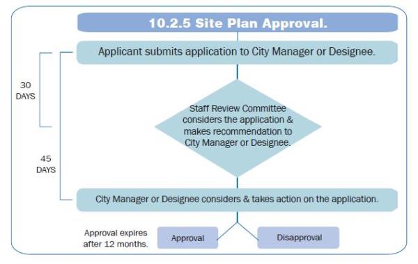
- Procedure For Site Plan Adjustments: The city manager or designee may permit minor adjustments to an approved site plan, if the revisions are within the scope and intent of the original approval.
- Process: The process to review plan adjustments is as follows:
- Applicant shall submit a revised plan and letter of explanation detailing the change to the city manager or designee.
- The city manager or designee shall review the request and notify the applicant of the decision.
- If the city manager or designee deems the change to be a major adjustment to the plan, applicant must resubmit for site plan review for approval of the new plan, including a new application (forms, fees, and plan sets).
- If the city manager or designee deems the changes to be minor adjustments and approves them as within the scope and intent of the original approval, the applicant shall revise the plan providing copies to the city manager or designee for filing prior to applying for building or construction permits.
- Minor Adjustments: Minor adjustments are limited to the following, while still meeting the requirements of this article. All other adjustments are considered major.
- Changes in dimensions or quantities less than ten percent (10%) of previous amounts.
- Process: The process to review plan adjustments is as follows:
- Conditional Use Permit:
- Intent: To establish a process to review requests for the following:
- Development of uses permitted within a zoning subdistrict, but that may not be appropriate for development on every lot within that subdistrict because of potential negative impacts associated with the use.
- Eligible Applicant: Applicant shall apply for a conditional use permit prior to the development, installation, or opening of a use in a core, general, or edge subdistrict, designated as a conditional use in section 10-5.1A-4 of this article.
- Application: The following information shall constitute a complete application. Application shall be submitted in a form as determined by the city manager or designee.
- Complete application, form, and applicable fees.
- Applicant shall submit the following in compliance with the requirements of section 10-5.1A-4, "Uses," of this article:
- Site location map, legal description/limits of plan.
- Survey plat. Dimensions of property lines, easements, rights of way.
- Development boundaries and proposed phasing, if applicable.
- Map of existing category of uses and use descriptions on parcel and all adjacent parcels within six hundred feet (600'), utilizing nomenclature found in section 10-5.1A-4 of this article.
- Map of proposed category of uses and use descriptions, utilizing nomenclature found in section 10-5.1A-4 of this article.
- Statement of intent. Statement describing existing and proposed use and zoning classification.
- Application Process Time Line: Upon submittal of a complete application, the application will be reviewed using the following process and time line:
- The staff review committee shall review and make recommendations on the application within thirty (30) days of the submission of the complete application.
- The city manager or designee shall render a decision to approve or disapprove the application within forty five (45) days of the submission of the complete application.
- Forty five (45) days may be extended with the applicant's written consent.
- The city manager or designee may approve, approve with conditions, or disapprove the application, providing the reasons for disapproval or any conditions for approval in writing.
- If a site plan approval is being sought for the same property, the conditional use permit shall be submitted concurrently and the time lines shall match. (Ord. 16-07, 6-21-2016, eff. 6-21-2016)
- Intent: To establish a process to review requests for the following:
10-5.1A-10-3: Exceptions And Variances
- Exceptions:
- Intent: To establish relief and flexibility in standards that may be administratively reviewed and approved, if certain criteria are met.
- Eligible Applicant: Applicant is eligible to apply for an exception to this article upon submittal of an application for site plan approval, in cases that involve such standards as the following:
- Regulating plan requirements:
- Distribution of permitted subdistricts within one hundred feet (100') of required amount. (Substitution of subdistricts is not permitted.)
- Block size within one hundred feet (100') of required dimensions and with the provision of a midblock pedestrianway. (Refer to section 10-5.1A-1 of this article.)
- Street type requirements within one foot (1') of required dimensions. (Refer to section 10-5.1A-2 of this article.)
- Open space requirement within one hundred feet (100') of required distance for no more than ten (10) units and with the availability of two (2) open spaces within that dimension. (Refer to sections 10-5.1A-1 and 10-5.1A-6 of this article.)
- Building type requirements within one foot (1') of required dimensions. (Refer to section 10-5.1A-5 of this article.)
- Site plan requirements:
- Landscape requirements within one foot (1') of required dimensions. (Refer to section 10-5.1A-7 of this article.)
- Parking and loading facilities within one foot (1') of required dimensions. (Refer to section 10-5.1A-8 of this article.)
- Sign type requirements within one foot (1') of required dimensions. (Refer to section 10-5.1A-9 of this article.)
- Building type requirements within one foot (1') of required dimensions. (Refer to section 10-5.1A-5 of this article.)
- Additional exceptions may be granted based on a formal request in writing by the applicant, stating specific reasons why the request does not impact the overall intent of this section, and is essential for success of the development. Staff shall report any exception request and its decision to the Planning Commission at their next meeting.
- Regulating plan requirements:
- Application Process Time Line: An application for exception may be submitted before or concurrently with either the regulating plan approval or site plan approval.
- The staff review committee shall review and make recommendations to the City Manager on the application for exception within ten business days from receiving it.
- The City Manager or designee shall render a decision to approve or disapprove the application for exception within five business days from receiving recommendations from the staff review committee.
- Variances: Refer to subsection 10-4-6C of this title for information on the variance process. (Ord. 16-07, 6-21-2016, eff. 6-21-2016)
10-5.1A-10-4: Nonconformances
- General Requirements:
- Intent: To provide a set of regulations for legal nonconforming buildings and uses and to specify those circumstances and conditions under which those nonconformances shall be gradually eliminated.
- Applicability: The standards in this section apply as follows:
- The provisions detailed in this section apply to all structures, uses, or site characteristics that lawfully existed prior to the adoption of or amendment to this article, but that may not occur under the current provisions of chapter 16 of this title.
- Structures, uses, and site characteristics that did not lawfully exist prior to the effective date or amendment to this article shall not be considered legal nonconformances and therefore are not protected under the provisions of this section.
- Continuation: All nonconformances are permitted to continue subject to the restrictions outlined in this section.
- Maintenance: All nonconformances shall be maintained as required by law to protect public health, safety, and welfare, provided said maintenance does not result in the expansion of the nonconformity.
- Nonconforming Structures:
- Intent: To provide regulations for the continuation of a structure that was legally constructed prior to the adoption or amendment to this article, but that could not occur under the current provisions of this article.
- Restrictions On Continuation: A nonconforming structure may continue based upon the following conditions:
- Alterations: The standards of this article shall apply to alterations under the following circumstances:
- Where the renovation includes an addition of more than twenty five percent (25%) in gross building square footage, the building shall be brought into conformance.
- When a renovation of the front facade occurs with no added building square footage, the street facade requirements and entrance type requirements (refer to section 10-5.1A-5-9 of this article) shall be met when the existing building front or corner facade is located within the build-to zone and the renovation includes any one of the following:
- Installation of additional doors or a change in location of a door.
- Expansion or change in location of thirty percent (30%) of windows on any street facade.
- Replacement of thirty percent (30%) or more of facade materials on any street facing facade with a different facade material.
- When a renovation of the shape or style of the roof occurs with no added building square footage, the roof type requirements (refer to section 10-5.1A-5-10 of this article) shall be met when the existing building front or corner facade is located within the build-to zone.
- Ordinary Repairs: Ordinary repairs required for safety and continued use of the structure, such as replacement of window or door glass; and interior alterations that do not affect the exterior of the building do not trigger conformance to this article.
- Impact On Nonconformity: No alteration or repair shall expand the existing or create a new nonconformity unless otherwise permitted by this subsection B.
- Damage Or Destruction: A nonconforming structure may be repaired and its use continued if damaged by any means not within the control of the owner per the Utah Code.
- Abandonment: The right to utilize a nonconforming structure shall be terminated if the structure is not utilized or is abandoned for a period of twelve (12) consecutive months.
- If the owner is actively seeking another tenant for the use or structure, the twelve (12) month period may be extended up to an additional twelve (12) months with permission of the City Council.
- To obtain this extension, the owner must provide evidence of this activity, including solicitation, showing the site to potential tenants, and maintenance of utilities and other site facilities for reuse; simply listing the site as available real estate is not sufficient.
- Alterations: The standards of this article shall apply to alterations under the following circumstances:
- Nonconforming Uses: Refer to chapter 16 of this title for information on the nonconforming uses. (Ord. 16-07, 6-21-2016, eff. 6-21-2016)
- Nonconforming Site Characteristics:
- Intent: To establish regulations for the continuation of site characteristics, such as curb cut quantity, signage, parking, landscaping, or other nonstructural, physical characteristics of a site, that was legally constructed or installed prior to the approval or amendment of this article, but that cannot be created under the provisions of this article.
- Restrictions To Continuation: A nonconforming site characteristic may continue based upon the following conditions:
- Ten Percent Exception: A site characteristic is not considered nonconforming if the size of the nonconformance is ten percent (10%) or less of this article's requirement.
- Change In Associated Use: The right to continue shall be terminated if the associated use changes or changes in intensity through such additions as an increase in the dwelling units, gross floor area, or capacity by fifteen percent (15%) or more.
- Signs
- Single or individual business signs within a multiple business center are exempt from this standard. A new tenant is permitted to install an individual business sign even if the signage on the lot as a whole is nonconforming, provided that the new sign does not exceed forty (40) square feet and otherwise complies with all other sign requirements.
- Nonconforming signs may be continued through changes in associated use if the only changes to the sign are changes in sign copy, typography, symbols, and lettering, and the supporting structure of the sign remains unchanged. Nonconforming signs consisting of individual letters and symbols, with individual supporting structures or connections, may be continued through a change in associated use, and the letters and symbols and supporting structures may be changed or modified so long as the overall area and location occupied by the sign remains the same. To the extent possible, nonconforming signs and supporting structures that are changed shall comply with current sign and construction requirements.
- Signs with EMBs must be brought into conformance with section 10-5.1A-9-2 of this article by September 30, 2018, regardless of when the EMB sign was installed.
- Signs
- Change In Associated Structure: The right to continue shall be terminated if the associated structure is altered to increase its gross floor area by fifteen percent (15%) or more.
- Abandonment: The right to continue shall be terminated if the associated use or structure, conforming or not, is abandoned for a period of twelve (12) consecutive months. This also applies to signs. (Ord. 18-04, 5-15-2018, eff. 5-15-2018)
10-5.1A-10-5: Definitions
- Graphics: The graphics, tables, and text utilized throughout this article are regulatory. In case of a conflict, text shall control over tables and graphics, and tables shall control over graphics.
- Defined Terms: For the purposes of this article, the following terms shall have the following meanings:
ANIMAL: All nonhuman members of the animal kingdom, including domestic and livestock species.
APPLICANT: The owner of a subject property or the authorized representative of the owner on which a land development application is being made.
BASEMENT: A story partly underground and having at least one-half (1/2) its height below the average level of the adjoining ground. A basement shall not be counted as a story, for purposes of height measurement.
BASEMENT, VISIBLE: A half story partially below grade and partially exposed above with required transparency on the street facade. A visible basement shall count as a half-story, for purposes of height measurement.
BLOCK: The aggregate of lots, passages, lanes, and alleys bounded on all sides by streets.
BLOCK DEPTH: A block measurement that is the horizontal distance between the front property line on a block face and the front property line of the parallel or approximately parallel block face.
BLOCK ENDS: The lots located on the end of a block; these lots are often larger than the lots in the interior of the block or those at the opposite end of the block and can be located on a more intense street type. They are typically more suitable for more intensive development, such as multiple-family or mixed use development.
BLOCK FACE: The aggregate of all the building facades on one side of a block.
BLOCK LENGTH: A block measurement that is the horizontal distance along the front property lines of the lots comprising the block.
BUILD-TO ZONE: An area in which the front or corner side facade of a building shall be placed; it may or may not be located directly adjacent to a property line. The zone dictates the minimum and maximum distance a structure may be placed from a property line. Refer to figure 10.5(2), "Setback Line Versus Build-To Zone," of this section.
FIGURE 10.5(2)
SETBACK LINE VERSUS BUILD-TO ZONE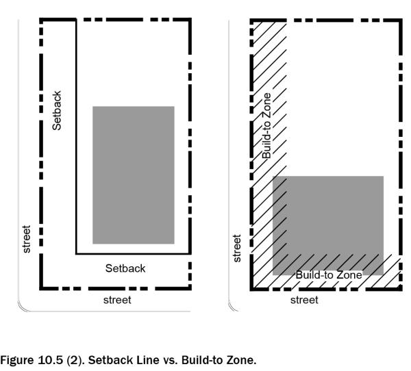
BUILDING, CALCULATING HEIGHT OF: The standard practice when calculating building height is to identify the highest point of the coping of a flat roof, or the deck line of a mansard roof, or to a point midway between the lowest part of the eaves or cornice and ridge of a pitch or hip roof, excluding architectural elements such as chimneys, flag poles, skylights, etc., and draw a line parallel to the grade plane shown on the site plan.
On sloped sites, building height is measured from the average finished grade (grade plane) highest point of the coping of a flat roof, or the deck line of a mansard roof, or to a point midway between the lowest part of the eaves or cornice and ridge of a pitch or hip roof. To calculate the average finished grade (grade plane):- Use an accurate drawing of the building footprint on the site, indicating existing topography at a minimum of two feet (2') intervals.
- Draw a minimum of three (3) equidistance points per facade or elevation. For each point indicated the spot elevation of the topography as it exists at the time of permit application (prior to modification or re-grading).
- Add the elevation of each spot and divide by the number of spot elevations. The resulting number is the average grade (grade plane).

BUILDING TYPE: A structure defined by the combination of configuration, form, and function. Refer to section 10-5.1A-5, "Building Types," of this article for more information and the list of permitted building types.
CITY MANAGER OR DESIGNEE: The South Ogden City Manager, or a person that is designated to make decisions by the City Manager.
COURTYARD: An outdoor area enclosed by a building on at least two (2) sides and is open to the sky.
COVERAGE, BUILDING: The percentage of a lot developed with a principal or accessory structure.
CRITICAL ROOT ZONE: Also referred to as drip line. The area of soil and roots within the radius beneath the tree's canopy, within the drip line, or within a circular area of soil and roots with a radius out from the trunk a distance of 1.5 feet for every inch of the tree's width (measured at 4.5 feet above the mean grade of the tree's trunk, noted as diameter breast height or dbh throughout this article).
DEDICATION: The intentional appropriation of land by the owner to the City for public use and/or ownership.
DENSITY: The number of dwelling units located in an area of land, usually denoted as units per acre.
DWELLING UNIT: One or more rooms in a dwelling, apartment, hotel or apartment hotel designed for or occupied by one family for living, sleeping and eating purposes. A dwelling unit may contain more than one set of kitchen facilities, whether temporary or permanent, provided they are used only by members of the family occupying the dwelling unit or their nonpaying guests. A dwelling unit may include up to two (2) persons per unit to whom rooms are rented in addition to a family related by blood, marriage or adoption, but if the number of such additional persons exceeds two (2) or if they use or are furnished separate cooking facilities, whether temporary or permanent, such additional persons shall be considered a separate family.
EASEMENT: A legal interest in land, granted by the owner to another person or entity, which allows for the use of all or a portion of the owner's land for such purposes as access or placement of utilities.
EAVE: The edge of a pitched roof; it typically overhangs beyond the side of a building.
ENTRANCE TYPE: The permitted treatment types of the ground floor facade of a building type. Refer to section 10-5.1A-5-9 of this article for more information and a list of permitted entrance types.
EXPRESSION LINE: An architectural feature. A decorative, three-dimensional, linear element, horizontal or vertical, protruding or indented at least two inches (2") from the exterior facade or a building typically utilized to delineate floors or stories of a building.
FACADE: The exterior face of a building, including, but not limited to, the wall, windows, windowsills, doorways, and design elements such as expression lines. The front facade is any building face adjacent to the front property line.
FAMILY: Defined as one of the following:- One person living alone.
- Two (2) or more persons, related by blood, marriage, or adoption and foster children, living together as a single housekeeping unit; and up to two (2) other persons hired for domestic help residing on the same premises where the housekeeping unit is located, or
- Not more than four (4) unrelated persons living together as a single, nonprofit housekeeping unit.
GRADE PLANE: A reference plane representing the average of the finished ground level adjoining the building at exterior walls. Refer to Figure 10.5(4) below.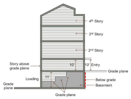
GROSS FLOOR AREA: The sum of all areas of a building, including accessory storage areas or closets within sales spaces, working spaces, or living spaces and any basement floor area used for retailing activities, the production or processing of goods, or business offices. It shall not include attic space having headroom of seven feet (7') or less and areas devoted primarily to storage, balconies, off street parking and loading areas, enclosed porches, roof decks, roof gardens, or basement floor area other than specified above.
IMPERVIOUS SURFACE: Also referred to as impervious material. Any hard surface, manmade area that does not absorb water, including building roofs, sidewalks, parking, driveways, and other paved surfaces.
LANDSCAPE AREA: Area on a lot not dedicated to a structure, parking or loading facility, frontage buffer, side and rear buffer, or interior parking lot landscaping.
LOT (Also Referred To As PARCEL): A plot of land intended to be separately owned, developed, or otherwise used as a unit. Refer to figure 10.5(1), "Lots," of this section. For a more detailed definition see section 10-2-1, definition of lot, of this title.
FIGURE 10.5(1)
LOTS
LOT AREA: The computed area contained within the property lines; it is typically denoted in square feet or acres.
LOT, CORNER: A parcel of land abutting at least two (2) vehicular rights-of-way, excluding an alley, at their intersection. Refer to figure 10.5(1), "Lots," of this section.
LOT DEPTH: The smallest horizontal distance between the front and rear property lines measured approximately parallel to the corner and/or side property line. Refer to figure 10.5(1), "Lots," of this section.
LOT, FLAG: A parcel of land having its only access to the adjacent vehicular right-of-way, excluding an alley, through a narrow strip of land. Refer to figure 10.5(1), "Lots," of this section.
LOT FRONTAGE: The horizontal distance between the side property lines, measured at the front property lines. Refer to figure 10.5(1), "Lots," of this section.
LOT, INTERIOR: A parcel of land abutting a vehicular right-of-way, excluding an alley, along one property line; surrounded by lots along the remaining property lines. Refer to figure 10.5(1), "Lots," of this section.
LOT, THROUGH (Also Referred To As A DOUBLE FRONTAGE LOT): An interior lot having frontage on two (2) approximately parallel vehicular rights-of-way, excluding an alley. Refer to figure 10.5(1), "Lots," of this section.
NONCONFORMANCE: A structure, use, lot, or site characteristic that was legally constructed or operated prior to the effective date of or amendment to this article, but that cannot be constructed, platted, or operated after the effective date of or amendment to this article.
OCCUPIED SPACE: Interior building space regularly occupied by the building users. It does not include storage areas, utility space, or parking.
OPEN SPACE TYPE: The permitted and regulated types of open spaces in this article. Refer to section 10-5.1A-6, "Open Space Types," of this article for more information and a list of the permitted types.
OPEN WATER: A pond, lake, reservoir, or other water feature with the water surface fully exposed.
OWNER: The legal or beneficial titleholder of land or holder of a written option or contract to purchase the land.
PEDESTRIANWAY: A pathway designed for use by pedestrians; it can be located midblock allowing pedestrian movement from one street to another without traveling along the block's perimeter.
PERVIOUS SURFACE (Also Referred To As PERVIOUS MATERIAL): A material or surface that allows for the absorption of water into the ground or plant material, such as permeable pavers or a vegetated roof.
PLAT: A map or chart of a division and/or combination of lots.
PRIMARY FACADE: The facade facing the street from which the building derives its street address.
PRIMARY STREET: A major corridor that receives priority over other streets in terms of setting front property lines and locating building entrances.
PROPERTY LINE (Also Referred To As LOT LINE): A boundary line of a parcel of land or lot. Refer to figure 10.5(1), "Lots," of this section.
PROPERTY LINE, CORNER: A boundary of a lot that is approximately perpendicular to the front property line and is directly adjacent to a public right-of-way, other than an alley or railroad. Refer to figure 10.5(1), "Lots," of this section.
PROPERTY LINE, FRONT: The boundary abutting a right-of-way, other than an alley, from which the required setback or build-to zone is measured, with the following exceptions:- Corner and through lots that abut a primary street shall have the front property line on that primary street.
- Corner and through lots that abut two (2) primary streets or do not abut a primary street shall utilize the orientation of the two (2) directly adjacent lots, or shall have the front property line determined by the City Manager or designee.
PROPERTY LINE, SIDE: The boundary of a lot that is approximately perpendicular to the front and rear property lines; it is not adjacent to the public right-of-way. Refer to figure 10.5(1), "Lots," of this section.
RIGHT-OF-WAY: Land dedicated or utilized for a street type, trail, pedestrianway, utility, railroad, or other similar purpose.
ROOF TYPE: The detail at the top of a building that finishes a facade, including a pitch roof with various permitted slopes and a parapet. Refer to section 10-5.1A-5-10 of this article for more information and a list of the permitted roof types.
SCALE: The relative size of a building, street, sign, or other element of the built environment.
SEMIPERVIOUS SURFACE (Also Referred To As SEMIPERVIOUS MATERIAL): A material that allows for at least forty percent (40%) absorption of water into the ground or plant material, such as pervious pavers, permeable asphalt and concrete, or gravel.
SETBACK: The horizontal distance from a property line inward, beyond which a structure may be placed. Structures or other impervious surfaces are not permitted within a setback, unless specifically permitted in this article. Refer to figure 10.5(2), "Setback Line Versus Build-To Zone," of this section.
SIGN: An object, device, or structure used to advertise, identify, display, direct, or attract attention to an object, person, institution, organization, business, product, service, event, or location by such means as words, letters, figures, images, designs, symbols, or colors. Flags or emblems of any nation, state, city, or organization; works of art which in no way identify a product; and athletic field scoreboards are not considered signs.
SOLAR REFLECTANCE INDEX (SRI): A measure of a constructed surface's ability to reflect solar heat, as shown by a small temperature rise. The measure utilizes a scale from 0 to 100 and is defined so that a standard black surface is 0 and a standard white surface is 100. To calculate for a given material, obtain the reflectance value and emittance value for the material; calculate the SRI according to ASTM E 1980-01 or the latest version.
STORY: The portion of a building included between the upper surface of a floor and the upper surface of the floor or roof next above. The story height of a building shall be measured from the average grade plane elevation of the building.
STORY, GROUND (Also Referred To As GROUND FLOOR): The first floor of a building that is level to or elevated above the finished grade on the front and corner facades, excluding basements or cellars.
STORY, HALF: A story that is partially below grade and a maximum of one-half story above the grade plane, or a story fully within the roof structure with transparency facing the street.
STORY, UPPER (Also Referred To As UPPER FLOOR): The floors located above the ground story of a building.
STREET FACE: The facade of a building that faces a public right-of-way.
STREET FRONTAGE (Also Referred To As LOT FRONTAGE): The portion of a building or lot directly adjacent to a vehicular right-of-way.
STREET TYPE: The permitted and regulated types of streets in this article. Refer to section 10-5.1A-2, "Street Types," of this article for more information and a list of the permitted street types.
STREET WALL: The vertical plane created by building facades along a street. A continuous street wall occurs when buildings are located in a row next to the sidewalk without vacant lots or significant setbacks.
STRUCTURE, ACCESSORY: The general term for a subordinate structure detached from, but located on the same lot as the principal structure; it may or may not be inhabitable.
STRUCTURE, PRINCIPAL (Also Referred To As The PRINCIPAL BUILDING): A building that contains the dominant use of the lot. It is typically located toward the front of the lot in the front build-to zone or behind the front yard setback.
SWALE: A low lying, naturally planted area with gradual slopes that facilitate the transport, absorption, and/or filtration of stormwater.
TREE CANOPY: The uppermost area of spreading branches and leaves of a tree.
TREE CANOPY COVERAGE: The area of ground covered or shaded by a tree's canopy, measured in square feet.
USE (Also Referred To As LAND USE): The specific purposes for which land or a building is designed, arranged, intended or for which it is or may be occupied or maintained.
USE, ACCESSORY: A use customarily incidental, and subordinate to the principal use or structure and located on the same lot with such principal use or structure.
USE, PRINCIPAL: The specific, primary purpose for which a lot or building is utilized.
USE, SPECIAL: A use that may not be appropriate in certain locations based on the potential negative impacts associated with the use and requires approval of a special use permit.
WATER BODY: A body of water, such as a river, pond, or lake that may be manmade or naturally occurring.
YARD: The space on a lot which is unoccupied and unobstructed from the ground to the sky by the principal structure. Lots without a structure do not have yard designations. Refer to figure 10.5(3), "Yards," of this section.
FIGURE 10.5(3)
YARDS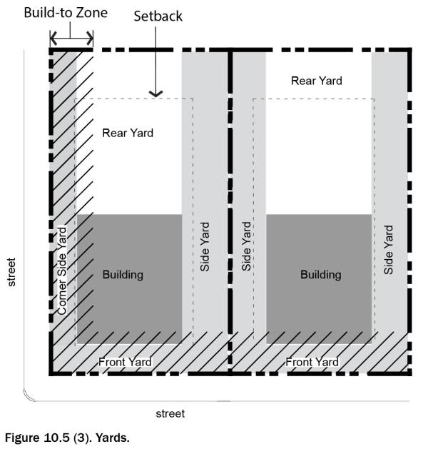
YARD, CORNER SIDE: A yard extending from the corner side building facade along a corner side property line between the front yard and rear property line. Refer to figure 10.5(3), "Yards," of this section.
YARD, FRONT: A yard extending from the front facade of the principal structure along the full length of the front property line, between the side property lines or side and corner side property lines. Refer to figure 10.5(3), "Yards," of this section.
YARD, FRONT -INTERIOR BUILDING: A yard extending the full length along the facade opposite the garage(s)/parking side of an interior building or as approved by the City Manager.
YARD, REAR: A yard extending from the rear building facade along the rear property line between the side yards or, on a corner lot, the corner side and side yards. Refer to figure 10.5(3), "Yards," of this section.
YARD, SIDE: A yard extending from the side building facade along a side property line between the front yard and rear property line. Refer to figure 10.5(3), "Yards," of this section.
ZONING SUBDISTRICT: A designation given to each lot within the City that dictates the standards for development on that lot. Refer to section 10-5.1A-3, "Subdistricts," of this article for more information and a list of permitted zoning subdistricts. (Ord. 17-22, 11-21-2017, eff. 11-21-2017; amd. Ord. 21-01, 1-19-2021, eff. 1-19-2021)
10-5.1A-11-1: City Center "Core" Subdistrict
The City Center "Core" constitutes the center of the community and heart of the new City Center, and includes the majority of the shops and workplaces within the City Center. The storefront building type that comprises this subdistrict defines a street wall along the primary streets of the area with storefront glass windows. Upper stories of the storefront building may be utilized for living and working. Building heights range from two (2) to five (5) stories.
ALLOWED BUILDING TYPES
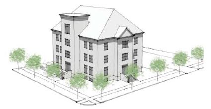
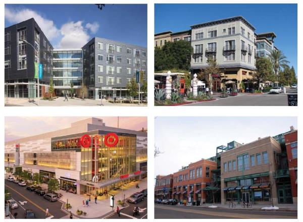
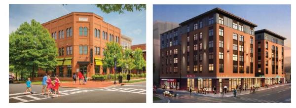
(Ord. 16-07, 6-21-2016, eff. 6-21-2016)
10-5.1A-11-2: City Center "General" Subdistrict
The city center "general" subdistrict serves as the interstitial fabric of the city, separate from the defined center or core and the edges. This area is primarily comprised by both the storefront building, and the more generic stoop building which have lower minimum transparency levels, and is mainly occupied by office, retail and residential uses at a variety of scales. Building heights range from one to five (5) stories. This subdistrict also permits drive-through facilities in order to allow more flexibility for auto-oriented uses under special circumstances.
ALLOWED BUILDING TYPES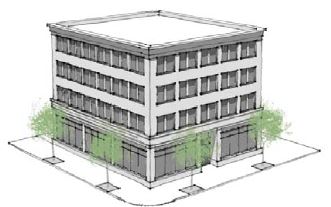
Storefront
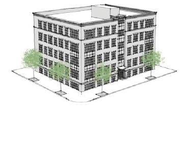 Stoop
Stoop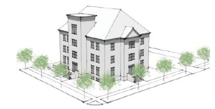
Civic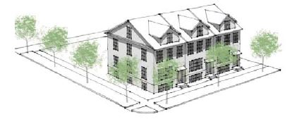
Row Building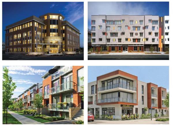
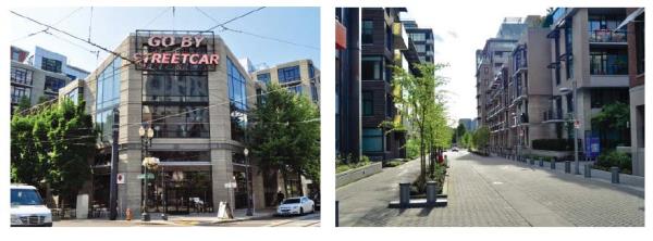
(Ord. 16-07, 6-21-2016, eff. 6-21-2016)
10-5.1A-11-3: Riverdale Road "General" Subdistrict
The Riverdale Road "general" subdistrict serves as the interstitial fabric of the city, separate from the defined center or core and the edges. This area is primarily comprised by both the storefront building, and the more generic stoop building which have lower minimum transparency levels, and is mainly occupied by office, retail and residential uses at a variety of scales. This subdistrict also permits drive-through facilities and the limited bay building type to allow more flexibility for auto oriented uses. Building heights range from one to four (4) stories.
ALLOWED BUILDING TYPES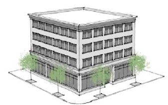
Storefront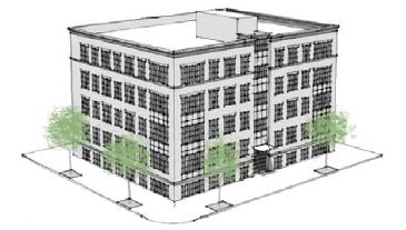
Stoop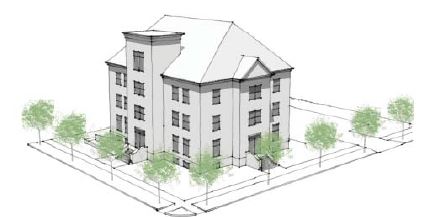
Civic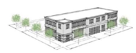
Limited Bay
Row Building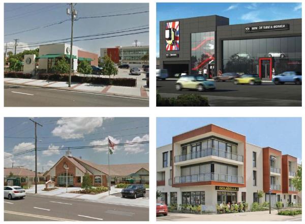
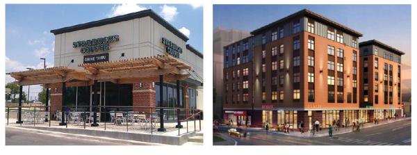
(Ord. 16-07, 6-21-2016, eff. 6-21-2016)
10-5.1A-11-4: 40th Street "General" Subdistrict
The 40th Street "general" subdistrict combines the storefront building and stoop building to create a corridor that supports a future transit line along 40th Street. Development along this corridor will be at a smaller scale and finer grain, in relation to the city center. Building heights range from one to four (4) stories.
ALLOWED BUILDING TYPES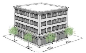
Storefront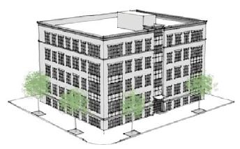
Stoop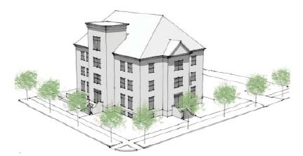
Civic
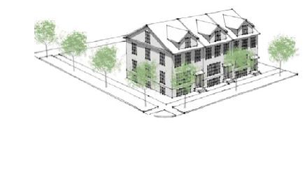 Row Building
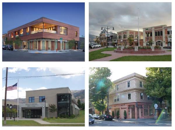
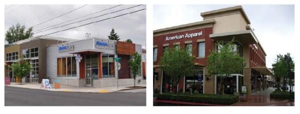
(Ord. 16-07, 6-21-2016, eff. 6-21-2016)
10-5.1A-11-5: Edge Subdistrict
The edge subdistricts are made up of smaller scale residential buildings, which provide a buffer between existing single-family residential neighborhoods and the "core" and "general" subdistricts. Building heights range from one to 3.5 stories.
ALLOWED BUILDING TYPES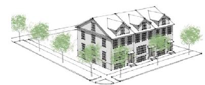
Row Building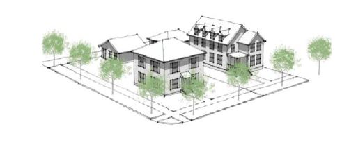
Yard Building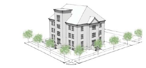
Civic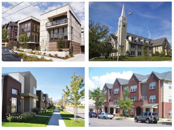
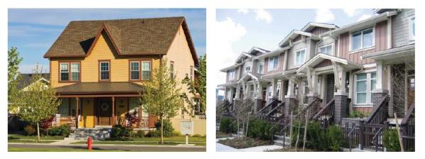
(Ord. 16-07, 6-21-2016, eff. 6-21-2016)
10-5.1B-1-1: Introduction
In June 2016, South Ogden City adopted a form based code for the City Center and 40th Street Corridor, which established a code that will help create a walkable downtown district in the City Center, and a livable transit corridor along 40th Street.
The remaining commercial areas in South Ogden are largely built-out. However, the South Ogden City Council has recognized the long-term potential for the remaining commercial areas to evolve over time as individual parcels redevelop.
This form-based code will ensure that as redevelopment occurs, new development will be based on traditional commercial development principles that emphasize walkability and pedestrians, rather than parking and automobiles.
The form-based code creates three (3) districts. The first district, Neighborhood Commercial District, is a number of smaller areas that provide convenient local commercial services for residents. The other districts, Wall Avenue and South Gateway Districts are envisioned as flexible mixed-use districts that allow for a broad range of commercial uses and building types.
The South Gateway commercial area is intended to become a strong gateway entrance to South Ogden via Hwy 89/Washington Boulevard from the South.
- Establishment Of Districts: Three (3) distinct districts are hereby created.
- Wall Avenue District.
- Neighborhood Commercial District.
- South Gateway District.
- Establishment Of Subdistricts: The above districts are further broken down into subdistricts (see section 10-5.1B-3, "Subdistricts," of this article). The following subdistricts are hereby created.
- Gateway Core.
- Gateway General.
- Neighborhood Commercial.
- Gateway Edge.
FIGURE 1.1(1)
DISTRICTS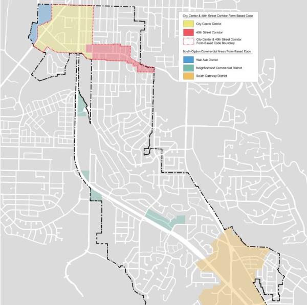
(Ord. 17-21, 11-21-2017, eff. 11-21-2017)
10-5.1B-1-2: General Subdistrict Requirements
- Applicability: The following are general block, lot, and street design requirements that are applicable to all subdistricts.
- Street Network And Connectivity: Refer to figure 1.2(1) of this section for an illustration of the existing street network. Figure 1.2(2) of this section shows an example of how streets can be added to create a connected grid of streets within the existing network in the South Gateway District.
FIGURE 1.2(1)
EXISTING STREET NETWORK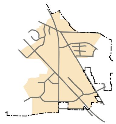 FIGURE 1.2(2)
POTENTIAL STREET CONNECTIONS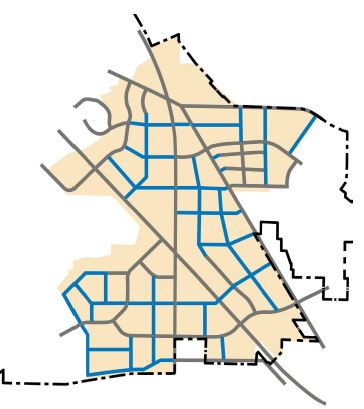
- As parcels redevelop, new streets should be constructed to create a connected street grid, similar to the example shown in figure 1.2(2) of this section.
- Block Configuration: Refer to figure 1.2(4) of this section for an illustration of the elements that create an ideal block.
- The shape of a block should generally be rectangular, but may vary due to existing street connections, natural features or site constraints.
- Blocks shall typically be two (2) lots deep with the exception of blocks containing open space. Blocks may also include an alley.
- Blocks shall typically be fronted with lots on at least two (2) faces, preferably on the longest street faces.
FIGURE 1.2(4)
TYPICAL BLOCK ELEMENTS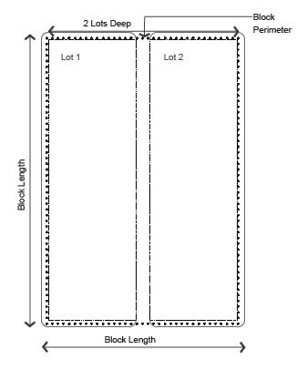
- Maximum Block Size: Block sizes for residential and commercial development and redevelopment should not exceed a perimeter length of two thousand eight hundred feet (2,800'), with the exception of blocks along highways with limited intersections.
- Minimum Number Of Access Points: This requirement is intended to provide a minimum level of connectivity via vehicular rights-of-way between adjacent developments and to surrounding streets.
- Recommendation: A minimum of one per every one thousand five hundred feet (1,500') of street frontage is recommended.
- Primary Streets: Generally, the current major streets in the three (3) South Ogden commercial area districts are State highways that will likely not be conducive to creating a walkable thoroughfare with buildings fronting these streets. Therefore, as parcels redevelop, and the street network expands within the commercial areas, primary streets should begin to form.
The final configuration and alignment will be dependent on how and when redevelopment occurs.- All new developments shall consult with staff to determine which street frontage warrants primary designation and the front of the lot.
- Refer to figure 1.2(3) of this section for an example of how primary streets may begin to form as streets are added to the district.
FIGURE 1.2(3)
POTENTIAL PRIMARY STREETS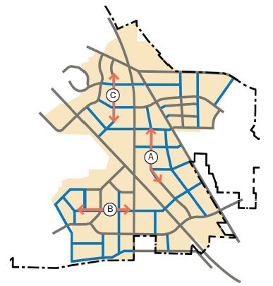
- Block Access Configurations:
- Driveway Access: Vehicular driveway access should not be located off a primary street, unless the parcel is fronted by more than two (2) primary streets, in which case, staff shall determine which is the appropriate street for vehicular access. The determination shall be based on locations of existing and proposed vehicular access points of other developments along the primary streets.
- Alleys, Drives, And Driveways: Blocks may include alleys, drives, or driveway entrances with the following recommended configurations. See figure 1.2(5) of this section.
- Mid-Block Access: This configuration includes an alley or drive running through the center of the block.
- "T" Configuration: This configuration includes two (2) alleys within a block that are perpendicular to each other, forming a "T," allowing development to front on three (3) block faces.
- "H" Configuration: Similar to the "T" configuration, this configuration allows development to front on all four (4) block faces.
FIGURE 1.2(5)
ALLEY CONFIGURATION
"H" Alley
"T" Alley
Mid-block Alley
- Access Alignment: Access to blocks shall be aligned and located on opposite sides of the block as well as aligned across the street from access to other blocks.
- Mid-Block Pedestrianways: Mid-block pedestrianways are required on blocks longer than five hundred feet (500').
- When combined with mid-block street crossings, these pathways should align to facilitate easy pedestrian movements.
- Mid-block pedestrianways should be located in the middle third of a block face.
- Minimum width for mid-block pedestrianways rights-of-way or easements is fifteen feet (15').
- Lots:
- Typical Lot Dimensions: All lots of record shall be developed to meet the requirements outlined in section 10-5.1B-5 of this article, building type requirements.
- Typical Lot Configuration: All lots shall have frontage along a public street unless otherwise specified in section 10-5.1B-5 of this article, building type requirements.
- Lot Shape: To create regular, rectangular lots, side property lines shall be perpendicular to the vehicular right-of-way to the extent practical.
- Through-Lots: Through lots fronting on two (2) parallel streets are not permitted with the exception of a lot covering fifty percent (50%) or more of a block and the two (2) longest parallel street faces are treated as front property lines per building type requirements (refer to section 10-5.1B-5, "Building Types," of this article).
- Corner Lots: Corner lots have a front yard along one street and a corner yard along the other street. The front yard of a corner lot should be consistent with one adjacent parcel.
- The rear yard of a corner lot is typically the yard against an alley or another lot's rear yard.
- The side yard of a corner lot is adjacent to another lot.
- Flag Lots: Flag lots are prohibited.
- General Open Space Requirements: The following are requirements for provision of civic open space.
- Development of parcels over five (5) acres are required to provide five percent (5%) total lot size as civic open space. Developer shall work with City to determine appropriate location of open space. See section 10-5.1B-6, "Open Space Types," of this article.
- For developments under five (5) acres, impact fees and other funding will be used as mechanisms to ensure adequate open space will be provided.
- General Zoning District/Subdistrict Layout: For all districts/subdistricts, the following outlines how the districts/subdistricts should relate to one another.
- All Districts: The following applies to all zoning districts/subdistricts.
- Similar intensities of uses should face each other across the street.
- Blocks may contain multiple zoning subdistricts; however, changes in subdistricts should occur along an alley, the rear property line, or at a corner parcel.
- Existing Residential Zones: When "general" subdistricts back up to the rear of existing single family residential neighborhoods, a building stepback is required (see section 10-5.1B-5-2, figure 5.2(5) of this article). (Ord. 17-21, 11-21-2017, eff. 11-21-2017)
- All Districts: The following applies to all zoning districts/subdistricts.
10-5.1B-2-1: General Requirements
- Intent: The standards outlined in this section 10-5.1B-2 are intended to:
- Create complete streets that address all modes of travel, including pedestrian traffic, bicycle traffic, transit, and vehicular traffic.
- Address all features of the street right-of-way, including sidewalks, parkways, traffic lanes, bicycle lanes, and medians.
- Provide adequate access to all lots for vehicles and pedestrians.
- Create streets that are appropriate for their contexts in residential, commercial, or mixed use subdistricts and are designed to encourage travel at appropriate volumes and speeds.
- Create streets and public rights-of-way that result in stormwater runoff quantity reduction and improved quality of stormwater runoff.
- Applicability: The standards in this section 10-5.1B-2 apply to all vehicular rights-of-way within all subdistricts.
Exceptions: Washington Boulevard, Harrison Boulevard, and any other road owned by UDOT. In these instances, the City should work with UDOT on any future design changes, so that these roads can better support the goals of this article. - General Requirements: All proposed streets, landscape or furnishings zones, and sidewalks shall be located in dedicated vehicular rights-of-way as required by this article.
- Street Types: All new vehicular rights-of-way shall match one of the street types, refer to sections 10-5.1B-2-4 through 10-5.1B-2-9 of this article, whether publicly dedicated or privately held.
- Public Use: All streets shall be available for public use at all times. Gated streets and streets posted as private are not permitted.
- Street Construction Specifications: All construction in the right-of-way shall follow specifications defined by the Department of Public Works. (Ord. 17-21, 11-21-2017, eff. 11-21-2017)
10-5.1B-2-2: General Street Type Standards
- Street Types: Street types defined in this section 10-5.1B-2 outline acceptable street configurations. New streets should be designed using the principles and characteristics defined by each street type. The City Manager or designee, or Public Works Director may require additional right-of-way, pavement width, or additional street elements depending on unique site characteristics.
- Graphics: The graphics provided here, illustrating each street type, are samples of recommendations and illustrate a possible configuration of that street type. By applying the standards outlined, and working with the Department of Public Works and the City Manager, other configurations are possible.
- Typical Street Elements: Typical elements of a vehicular right-of-way are divided into the vehicular and pedestrian realm. Each street type detailed in this article outlines which facilities are applicable. Refer to figure 2.2(1), "Typical Right-Of-Way Elements," of this section.
FIGURE 2.2(1)
TYPICAL RIGHT-OF-WAY ELEMENTS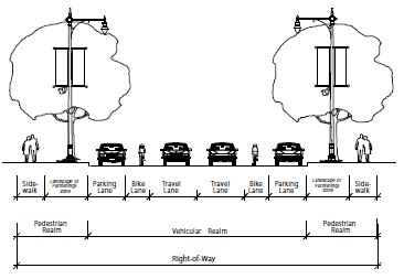
- Vehicular Realm: The vehicular realm is comprised of vehicular travel lanes, bicycle lanes, and parking lanes.
- Pedestrian Realm: The pedestrian realm is typically comprised of pedestrian facilities, such as sidewalk, path/trail, or off-street bicycle path, and a buffer area consisting of a landscape zone or furnishings zone that serves to buffer pedestrians or bicyclists from the movements of higher speed vehicles in the vehicular realm.
- Landscape Zone: A landscape area between the back of curb or edge of pavement to the sidewalk in which street trees, swales, lighting, and signage may be located. Typically used adjacent to residential buildings.
- Furnishings Zone: A hardscape area that extends from the sidewalk to the back of curb, in which street trees, street furniture, lighting, and signage may be located. Typically used adjacent to commercial or office buildings.
- Vehicular Travel Lanes: The number and width of vehicular travel lanes are determined by the street type.
- Vehicular On-Street Parking: On-street parking, as permitted on designated street types, shall meet the following requirements.
- Parallel And Diagonal Parking: Parallel and diagonal parking is permitted on designated street types.
- Vehicular Parking Space Dimensions: The appropriate dimensions for on-street parking spaces are outlined in table 2.2(1), "On-Street Parking Space Dimensions," and figure 2.2(2), "On-Street Parking Layout," of this section. The width of a parking space shall be measured from the center of a stripe.
TABLE 2.2(1)
ON-STREET PARKING SPACE DIMENSIONSAngle Curb Length Stall Width Stall Depth 0° 20' 7' 7' 45° 12' 9' 17' 60° 10' 9' 18' 90° 9' 9' 20'
FIGURE 2.2(2)
ON-STREET PARKING LAYOUT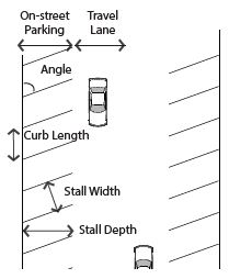
- Bicycle Facilities: The following types of bicycle accommodations are permitted in the vehicular realm per street type. Refer to figure 2.2(3) of this section.
FIGURE 2.2(3)
ON-STREET BICYCLE FACILITIES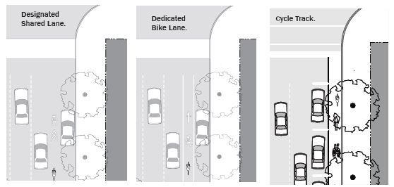
- Cycle Track: A cycle track is a separate on-road bicycle facility that is typically adjacent to, but physically separated from, vehicular traffic and parking by a barrier.
- Dedicated Bicycle Lane: Dedicated bicycle lanes are striped lanes on the outside of the outermost travel lanes that are designated for only bicycle use. This lane occurs on both sides of the street and shall be four feet (4') to six feet (6') wide.
- Designated Shared Lane: A designated shared lane is a lane that is shared between vehicles and bicycles. This lane is typically wider than a standard vehicular lane, minimum thirteen feet (13'), in order to accommodate both types of users, and includes a painted bicycle marker combined with a double arrow (known as a "sharrow"). This improvement occurs on both directions.
- Shared Lane: A shared lane refers to a street that does not have bicycle lanes or a designated shared lane, but the speed and configuration of the street is such that bicycles could comfortably share lanes with traffic.
- Stormwater Management: Incorporation of stormwater management best practices into the right-of-way design is encouraged, such as incorporating drainage swales and slotted curbs into the landscape zone/furnishing zone, or permeable paving in the parking lane.
- Street Trees: Street trees are required along all street frontages, with the exception of the lane and the alley.
- Street trees shall be located either in a landscape zone within a planting bed or lawn, or in a furnishings zone in tree wells with a grate as required.
- Spacing for large street trees shall be thirty feet (30') on center. City Manager or designee may allow modifications based on site specific constraints.
- Fire Access: Street configurations have been calculated to provide fire truck access. Where the total width of all travel lanes totaled is narrower than twenty feet (20'), the following shall apply.
- Room To Pass: At one hundred twenty foot (120') increments, a twenty foot (20') opening in the on-street parking or a twenty foot (20') dedicated pull-off space must be provided to allow vehicles to pull over for a fire truck to pass.
- Driveway Or Fire Hydrant Zone: A driveway or fire hydrant zone may be utilized to fulfill the requirement. (Ord. 17-21, 11-21-2017, eff. 11-21-2017)
10-5.1B-2-3: General Street Layout Requirements
- General Layout Standards: The following standards apply to new streets or newly platted vehicular rights-of-way.
- Treatment Of Natural Features: Streets shall be designed to respect natural features, such as rivers, woodlands, or slopes, by following rather than interrupting or dead-ending at the feature, if applicable.
- Street Network: The network of streets shall form an interconnected pattern with multiple intersections.
- Existing Streets: The arrangement of streets shall provide for the continuation of existing streets from adjoining areas into new subdivisions.
- Cul-De-Sac Streets: Cul-de-sacs are not permitted, unless approved by City Manager or designee due to site constraints. (Ord. 17-21, 11-21-2017, eff. 11-21-2017)
- Intersections:
- Clear View: In all form based code subdistricts at any uncontrolled street intersection, the buildings will be modified to afford automobile drivers a clear view of approaching vehicles or pedestrians. Buildings, trees, or any obstruction shall be prohibited within a triangular area formed by the street curb lines and a line connecting them at points forty feet (40') from the point of intersection of the back of the curbs (clear view area). Certain sign types are exempt from the forty foot (40') clear view area. See individual sign types for specific clear view zone requirements; however, no sign can be placed so as to obstruct the view of an automobile driver.
- Likewise, no part of a building, tree or other obstruction such as a wall or fence greater in height than twenty four inches (24") shall be allowed at any driveway entrance so as to obstruct an automobile drivers clear view of approaching vehicles or pedestrians. Anything greater in height than twenty four inches (24") is prohibited within a triangular area formed by the street property line and the edge of the driveway, with a line connecting them at points forty feet (40') from the point of intersection of the driveway and the street (clear view area); however, trees pruned high enough to permit unobstructed vision to automobile drivers shall be allowed. Certain sign types are exempt from the forty foot (40') clear view area. See individual sign types for specific clear view zone requirements; however, no sign can be placed so as to obstruct the view of an automobile driver.
- Any modifications or special conditions to be approved by the City Engineer.
- Curb Radii: The following curb radii shall be utilized unless otherwise authorized by the City Manager or designee.
- Intersections Design: Intersections should be designed for actual turning radius of the typical design vehicle as opposed to the maximum design vehicle. Small curb radii at intersections shorten pedestrian crossing distances and reduce vehicle turning speeds, thereby balancing the ease of travel of the vehicles and pedestrians. Refer to figure 2.3(1) of this subsection B2a. (Ord. 18-11, 9-18-2018, eff. 9-18-2018)
FIGURE 2.3(1)
ACTUAL RIGHT TURN RADIUS WITH ON-STREET PARKING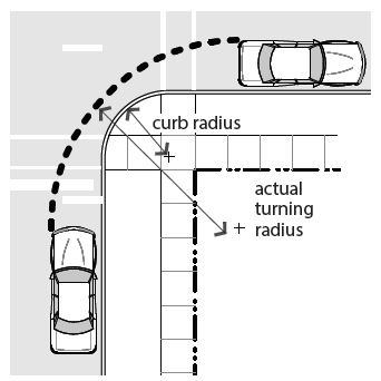
- Neighborhood And Connector Streets: At the intersection of any street with a neighborhood or a connector street, the following curb radii shall be utilized.
- With on-street parking on both streets, a five foot (5') radius may be utilized.
- Without on-street parking, a fifteen foot (15') radius is required.
- Avenue Streets: At the intersection of avenues to avenues or boulevards, the following curb radii shall be utilized.
- With on-street parking on both streets, a ten foot (10') radius is required.
- Without on-street parking on either street, a twenty five foot (25') radius is required.
- Larger Radius: When the design vehicle requires a larger curb radius and no on-street parking exists, a thirty foot (30') radius may be utilized for avenues or boulevards. Larger radii require approval of the Department of Public Works.
- Alley Intersections: The curb radius at intersections involving alleys shall be no greater than five feet (5').
- Intersections Design: Intersections should be designed for actual turning radius of the typical design vehicle as opposed to the maximum design vehicle. Small curb radii at intersections shorten pedestrian crossing distances and reduce vehicle turning speeds, thereby balancing the ease of travel of the vehicles and pedestrians. Refer to figure 2.3(1) of this subsection B2a. (Ord. 18-11, 9-18-2018, eff. 9-18-2018)
- Crosswalks: Crosswalks shall be required at all intersections and mid-block crossings involving connectors, avenues, and boulevards.
- Dimensions: Crosswalks shall be minimum six feet (6') in width, measured from mid-stripe to mid-stripe, per MUTCD.
- Markings: Crosswalks shall be appropriately indicated on the finished street surface with painted markings and/or textured or colored pavement.
- Crossing Distances: To encourage pedestrian activity, typical crosswalks shall not extend over thirty eight feet (38') without a landscape median, bulb-outs and/or other pedestrian refuge to mitigate the negative effects of vehicular traffic on pedestrian crossing and increase pedestrian safety and comfort. Refer to figures 2.3(2) and 2.3(3) of this subsection B3c.
FIGURE 2.3(2)
WIDE STREET CROSSING WITH PEDESTRIAN REFUGE MEDIAN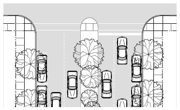
FIGURE 2.3(3)
BULB OUT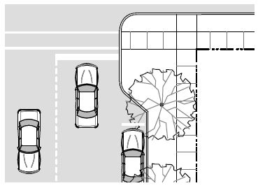
- Accessibility: Accessible ramps and warning panels, per the American Disabilities Act or any more stringent State or City requirement, are required where all sidewalks or trails terminate at a crosswalk or curb.
- Ramp Orientation: Ramps shall be oriented perpendicular to traffic, requiring two (2) ramps per corner at intersecting streets.
- Bulb-Outs: To shorten pedestrian crossing distances, bulb-outs should be utilized at all intersections, unless otherwise required by the Department of Public Works. Refer to figure 2.3(3) of this section.
- The depth of the bulb-out shall match the utilized on-street parking, either the width of the parallel space or the depth of the diagonal space.
- The radius of the bulb-out shall match the requirements for the intersection. (Ord. 17-21, 11-21-2017, eff. 11-21-2017; amd. Ord. 18-11, 9-18-2018, eff. 9-18-2018)
- Clear View: In all form based code subdistricts at any uncontrolled street intersection, the buildings will be modified to afford automobile drivers a clear view of approaching vehicles or pedestrians. Buildings, trees, or any obstruction shall be prohibited within a triangular area formed by the street curb lines and a line connecting them at points forty feet (40') from the point of intersection of the back of the curbs (clear view area). Certain sign types are exempt from the forty foot (40') clear view area. See individual sign types for specific clear view zone requirements; however, no sign can be placed so as to obstruct the view of an automobile driver.
10-5.1B-2-4: Alley
- Intent: The alley is a very low capacity drive located at the rear of parcels. From the alley, access to parking facilities, loading facilities, and service areas, such as refuse and utilities is possible without a curb cut or driveway interrupting a street type. Refer to the typical plan and section in figure 2.4(1) of this subsection A.
FIGURE 2.4(1)
TYPICAL ALLEY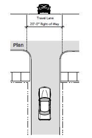
- General Requirements: Alleys shall be developed using the standards in table 2.4(1) of this subsection B.
TABLE 2.4(1)
ALLEY REQUIREMENTSNote:Permitted subdistricts All subdistricts Permitted adjacent building types All building types Typical right-of-way width 20' Vehicular realm: Travel lanes 1 yield lane Lane width 16' Allowable turn lanes Not applicable Parking lanes Not applicable Pavement width Minimum 16' Maximum 20' Median Prohibited Bicycle facilities1 Shared Pedestrian realm: Pedestrian facilities Shared; travel lanes are shared among drivers, pedestrians and bicyclists Street buffer Not required
1Reference section 10-5.1B-2-2, figure 2.2(3) of this section 10-5.1B-2 for bicycle facility types and requirements.
(Ord. 17-21, 11-21-2017, eff. 11-21-2017)
10-5.1B-2-5: Lane
- Intent: A lane is a very low capacity street type that serves only those properties directly adjacent to it. Lanes can have designated realms for vehicular and pedestrian traffic, or these modes can share lanes given the low capacity and slow speed. Refer to the typical plan and section, figure 2.5(1) of this subsection A.
FIGURE 2.5(1)
TYPICAL LANE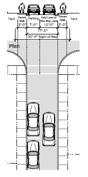
- General Requirements: The lane shall be developed using the standards in table 2.5(1) of this section.
TABLE 2.5(1)
LANE REQUIREMENTSNotes:Permitted subdistricts All subdistricts Permitted adjacent building types All building types Typical right-of-way width 27' to 32' Vehicular realm: Yield lane/one-way lane 1 yield lane Lane width 10' Allowable turn lanes Not applicable Parking lanes1 1 parallel lane required Pavement width Minimum 17' Maximum 20' Median Prohibited Bicycle facilities2 Shared Pedestrian realm: Pedestrian facilities Shared; travel lanes are shared among drivers, pedestrians and bicyclists Street buffer None required
1Reference section 10-5.1B-2-2, figure 2.2(2) of this article for on-street parking requirements.
2Reference section 10-5.1B-2-2, figure 2.2(3) of this article for bicycle facility types and requirements.
(Ord. 17-21, 11-21-2017, eff. 11-21-2017)
10-5.1B-2-6: Neighborhood Street
- Intent: The neighborhood street is a low capacity street designed for slow speeds with a standard right-of-way. It primarily serves those residences or businesses directly adjacent to it. Refer to the typical plan and section, figure 2.6(1) of this section.
FIGURE 2.6(1)
TYPICAL NEIGHBORHOOD STREET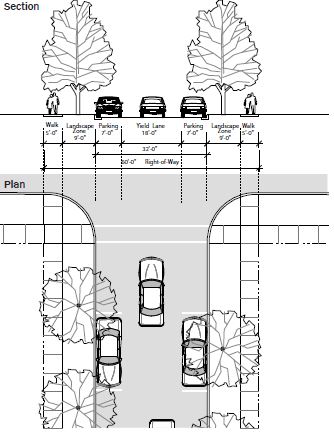
- General Requirements: The neighborhood street shall be developed using the standards in table 2.6(1) of this section.
TABLE 2.6(1)
NEIGHBORHOOD STREET REQUIREMENTSNotes:Permitted subdistricts All subdistricts Permitted adjacent building types All building types Typical right-of-way width 60' Vehicular realm: Travel lanes 1 yield lane Lane width 18' Allowable turn lanes Not applicable Parking lanes1 Parallel required on 1 side of street Pavement width 32', 20' for alternative3 Median Prohibited Bicycle facilities2 Shared Pedestrian realm: Pedestrian facilities Minimum 5' wide clear sidewalk on both sides Street buffer Minimum 9' wide landscape zone (parkway)
1Reference section 10-5.1B-2-2, figure 2.2(2) of this article for on-street parking requirements.
2Reference section 10-5.1B-2-2, figure 2.2(3) of this article for bicycle facility types and requirements.
3Reference figure 2.6(2) of this section for alternative.
FIGURE 2.6(2)
ALTERNATIVE FIFTY FOOT RIGHT-OF-WAY NEIGHBORHOOD STREET
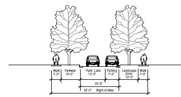
(Ord. 17-21, 11-21-2017, eff. 11-21-2017)
10-5.1B-2-7: Connector Street
- Intent: The connector street is a medium capacity street for slow speeds with a standard right-of-way. It primarily serves as a through street within the neighborhood and connects neighborhood streets to avenues. Refer to the typical plan and section, figure 2.7(1) of this section.
FIGURE 2.7(1)
TYPICAL 60 FOOT SHARED RIGHT-OF-WAY CONNECTOR
- General Requirements: Connectors shall be developed using the standards in table 2.7(1) of this section.
TABLE 2.7(1)
CONNECTOR STREET REQUIREMENTSNotes:Permitted subdistricts All subdistricts Permitted adjacent building types All building types Typical right-of-way width 60' to 70' Vehicular realm: Travel lanes 1 lane in each direction Lane Width 10' Allowable turn lanes Right permitted in place of parking at intersections with avenue; left only with median alternative Parking lanes1 Parallel required on both sides of street Pavement width 36'; 40' for alternative3 Median Permitted with 80' or greater right-of-way Bicycle facilities2 Shared Pedestrian realm: Pedestrian facilities Minimum 5' wide clear sidewalk on both sides Street buffer Minimum 7' wide landscape zone or furnishings zone
1Reference section 10-5.1B-2-2, figure 2.2(2) of this article for on-street parking requirements.
2Reference section 10-5.1B-2-2, figure 2.2(3) of this article for bicycle facility types and requirements.
3Reference figure 2.7(2) of this section for alternative.
FIGURE 2.7(2)
ALTERNATIVE 80 FOOT SHARED RIGHT-OF-WAY CONNECTOR
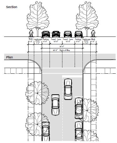
(Ord. 17-21, 11-21-2017, eff. 11-21-2017)
10-5.1B-2-8: Avenue
- Intent: The avenue is a medium to high capacity street for higher speeds with a wider right-of-way. It serves all types of development and provides crosstown connections. Refer to the typical plan and section in figure 2.8(1) of this section.
FIGURE 2.8(1)
TYPICAL AVENUE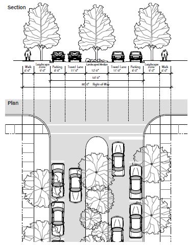
- General Requirements: Avenues shall be developed using the standards in table 2.8(1) of this section.
TABLE 2.8(1)
AVENUE REQUIREMENTSNotes:Permitted subdistricts All subdistricts Permitted adjacent building types All building types Typical right-of-way width 66' to 80' Vehicular realm: Travel lanes 1 lane in each direction Lane width 11' or 12' with truck traffic Allowable turn lanes Right permitted in place of parking at intersections with connector; left only with median Parking lanes1 Parallel required on both sides of street; angled permitted for alternative Pavement width 50'; 78' for alternative3 Median Permitted with 80' or greater right-of-way Bicycle facilities2 Shared; dedicated bike lane with alternative Pedestrian realm: Pedestrian facilities Minimum 5' wide clear sidewalk on both sides Street buffer Minimum 7' wide landscape zone or furnishings zone
1Reference section 10-5.1B-2-2, figure 2.2(2) of this article for on-street parking requirements.
2Reference section 10-5.1B-2-2, figure 2.2(3) of this article for bicycle facility types and requirements.
3Reference figure 2.8(2) of this section for alternative.
FIGURE 2.8(2)
ALTERNATIVE 120 FEET WITH MEDIAN AND CYCLE TRACK CONNECTOR
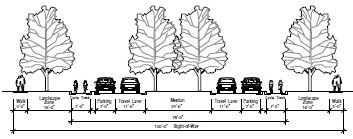
(Ord. 17-21, 11-21-2017, eff. 11-21-2017)
10-5.1B-2-9: Boulevard
- Intent: The boulevard is a high capacity street for higher speeds with a wider right-of-way, one way only in this case. It serves all types of development and provides crosstown connections. Refer to the typical plan and section, figure 2.9(1) of this section.
FIGURE 2.9(1)
TYPICAL BOULEVARD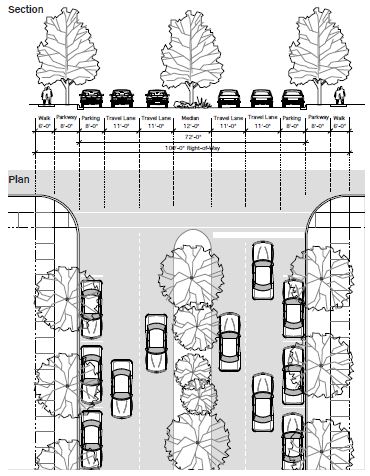
- General Requirements: Boulevards shall be developed using the guidelines in table 2.9(1) of this section.
TABLE 2.9(1)
BOULEVARD REQUIREMENTSNotes:Permitted subdistricts All subdistricts Permitted adjacent building types Storefront General stoop Civic building Typical right-of-way width 100'; 120' alternative Vehicular realm: Travel lanes Up to 2 lanes each direction Lane width 11' or 12' with truck traffic Allowable turn lanes Permitted in place of parking and bulb out at intersections Parking lanes1 Both sides, parallel only Pavement width 72'; 102', 120' alternatives3 Median Permitted, minimum 9' wide, preferably 12' wide Bicycle facilities2 Designated shared; cycle track alternative Pedestrian realm: Pedestrian facilities Minimum 5' wide clear sidewalk on both sides with bulbouts Buffer Minimum 5' wide landscape zone or furnishings zone, both sides; adjacent to residential districts, open space districts, the planting zone is required
1Reference section 10-5.1B-2-2, figure 2.2(2) of this article for on-street parking requirements.
2Reference section 10-5.1B-2-2, figure 2.2(3) of this article for bicycle facility types and requirements.
3Reference figure 2.9(2) of this section for alternative.
FIGURE 2.9(2)
ALTERNATIVE 120 FOOT RIGHT-OF-WAY WITH LOCAL LANES BOULEVARD
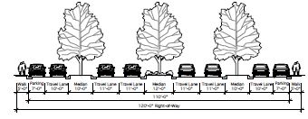
(Ord. 17-21, 11-21-2017, eff. 11-21-2017)
10-5.1B-3-1: Introduction
The following subdistricts are hereby created to regulate the location of distinct mixes of building forms and uses permitted in South Ogden commercial areas. Refer to section 10-5.1B-4, "Uses," of this article for uses and section 10-5.1B-5, "Building Types," of this article for building types permitted within each subdistrict.
- The following subdistricts have been created, and each consists of a series of uses and building types that have been specifically calibrated for each subdistrict.
- Gateway Core: The Gateway Core Subdistrict is intended to be the City's most flexible and inclusive subdistrict, ensuring a place for all of South Ogden's commercial needs. It includes a range of building types that will allow for a vibrant, mixed-use commercial area.
- Gateway General: The Gateway General Subdistrict provides the same function as the Gateway Core Subdistrict, but with a lower intensity of building to provide a buffer between residential neighborhoods and commercial areas.
- Neighborhood Commercial: The Neighborhood Subdistrict allows for smaller nodes of commercial uses, the purpose of which is to provide residents with easy access to businesses which provide local services and goods.
- Gateway Edge: The Edge Subdistricts are made up of smaller scale residential buildings, which provide a buffer between existing single family residential neighborhoods and the Commercial Subdistricts. (Ord. 17-21, 11-21-2017, eff. 11-21-2017)
10-5.1B-3-2: Zoning Map
- Mapped Subdistricts: The areas and boundaries of the subdistricts listed in section 10-5.1B-3-1 of this article are established as shown on the map entitled "Zoning Map of the City of South Ogden" and referred to herein as "Zoning Map" on file in the City. (Ord. 17-21, 11-21-2017, eff. 11-21-2017)
10-5.1B-4-1: General Requirements
- General Provisions: The following general provisions apply to the uses outlined in this section 10-5.1B-4.
- A lot may contain more than one use.
- Each of the uses may function as either a principal use or accessory use on a lot, unless otherwise specified.
- Uses are either permitted by-right in a subdistrict, permitted by-right with specific development or design parameters, or require a conditional use permit (refer to subsection 10-5.1B-10-2F of this article) in order to be developed.
- Each use shall be located within a permitted building type (refer to section 10-5.1B-5, "Building Types," of this article), unless otherwise specified.
- Each use may have both indoor and outdoor facilities, unless otherwise specified.
- Organization: The uses are grouped into general categories, which may contain lists of additional uses or clusters of uses.
- Unlisted Similar Use: If a use is not listed but is similar in nature and impact to a use permitted within a zoning subdistrict, the City Manager or designee may interpret the use as permitted.
- The unlisted use will be subject to any development standards applicable to the similar permitted use.
- If the unlisted use is similar in nature and impact to a use requiring a conditional use permit, the City Manager or designee may interpret the use as also requiring a conditional use permit.
- Unlisted Dissimilar Use: If a use is not listed and cannot be interpreted as similar in nature and impact to a use within a zoning subdistrict that is either permitted or requires a conditional use permit, the use is not permitted and may only be approved through an amendment of this article. (Ord. 19-06, 4-16-2019, eff. 4-16-2019)
- Unlisted Similar Use: If a use is not listed but is similar in nature and impact to a use permitted within a zoning subdistrict, the City Manager or designee may interpret the use as permitted.
- Use Table: Table 4.1(1), "Uses By Subdistrict," of this subsection C outlines the permitted uses in each zoning subdistrict. Each use is given one of the following designations for each zoning subdistrict in which that use is permitted.
- Permitted ("P"): These uses are permitted by-right in the subdistricts in which they are listed.
- Permitted With Development Standards ("P2"): These uses are permitted by-right in the subdistricts in which they are listed, provided that they are developed utilizing the listed development standards. These standards are intended to alleviate any negative impacts associated with the use, making it appropriate in a subdistrict where it otherwise might not have been appropriate.
- Requires A Conditional Use Permit ("C"): These uses require administrative review and approval (refer to subsection 10-5.1B-10-2F of this article) in order to occur in the subdistricts in which they are listed and must follow any applicable development standards associated with the use as well as meet the requirements of the conditional use.
- Blank Not Permitted: Listed uses that are not permitted in the subdistrict are indicated by a blank space.
TABLE 4.1(1)
USES BY SUBDISTRICTKey: P Permitted P2 Permitted with development standards C Requires a conditional use permit Blank Not permitted Notes:Uses Gateway Core Gateway General Neighborhood Commercial Gateway Edge Residential and lodging: Residential P P P P Hotel and inn P P P Group living arrangement C C C Civic: Assembly P2 P2 P2 P2 Transit station P P P P2 Hospital and clinic P P P C Library/museum/Post Office (no distribution) P P P C Police and fire C C C C School P P P P Retail: Neighborhood retail P P P General retail P P P2 Outdoor sales lot Sexually oriented business P2 Medical cannabis pharmacy P2 P2 Service: Neighborhood service P P P General service P2 C C Vehicle service P2 C Office and industrial: Office P P P2 Craftsman industrial P P P Infrastructure: Parking lot P2 P2 P2 Parking structure P2 P2 P2 Utility and infrastructure C C C C Open space P2 P2 P2 P2 Accessory uses: Drive-through facility P2 P2 P2 Home occupation P P P C Parking lot P P P P Parking structure P2 P2 P2 Outdoor storage of goods P2 P2 P2 Temporary outdoor sales lot P P P Beer and liquor: Class A license1 P Class B license2 P P P Class C license3 P P P
1Class A - Beer and/or liquor served and consumed on premises (bar, tavern, microbrewery).
2Class B - Beer and/or liquor sold on premises, but on-premises consumption is prohibited (convenience and grocery stores, State liquor stores).
3Class C - Beer and/or liquor may be served with a meal in a restaurant.
Refer to subsections 10-5.1B-4-2C1 and C2 of this section 10-5.1B-4 to determine which beer and liquor uses are allowed in neighborhood retail and general retail.
(Ord. 17-14, 5-16-2017; amd. Ord. 19-06, 4-16-2019, eff. 4-16-2019; Ord. 19-08, 6-18-2019, eff. 6-18-2019; Ord. 19-09, 7-2-2019, eff. 7-2-2019; Ord. 20-03, 1-21-2020)
- Building Types: The uses permitted within the subdistrict may be further limited by the building types permitted. Refer to section 10-5.1B-5, "Building Types," of this article. (Ord. 19-06, 4-16-2019, eff. 4-16-2019)
10-5.1B-4-2: Definition Of Uses
- Residential And Lodging Uses: A category of uses that include several residence types.
- Residential: One or more dwelling units located within the principal structure of a lot, in which the units may or may not share a common wall with the adjacent (horizontally or vertically) unit or have individual entrances from the outside.
- Hotel And Inn: A facility offering temporary lodging to the general public consisting of sleeping rooms with or without in-room kitchen facilities. Secondary service uses may also be provided, such as restaurants and meeting rooms. Rooms shall be accessed from the interior of the building. In the subdistricts where a hotel or inn is permitted with development standards ("P2"), the following applies:
- The facility is limited to twelve (12) rooms.
- Bed and breakfasts and pensions are permitted.
- Group Living Arrangement: A group living or congregate living arrangement where groups of more than four (4) unrelated persons live together in a single dwelling or housekeeping unit, including, but not limited to, assisted living unit, boarding house, lodging house, nursing home, senior housing, assisted living facility, nursing care facility, residential facility for disabled persons, dormitory, student housing, fraternity, club, institutional group, half-way house, convent, monastery, or other similar group living or congregate living arrangement of unrelated persons. A group living arrangement does not include clinics, medical or dental; hospital(s) or hospital/clinic. In the subdistricts where a group living arrangement facility is permitted with development standards ("P2"), the facility is limited to twelve (12) rooms.
- Civic Uses: A category of uses related to fulfilling the needs of day-to-day community life including assembly, public services, educational facilities, and hospitals.
- Assembly: A facility that has organized services, meetings, or programs to benefit, educate, entertain, or promote discourse amongst the residents of the community in a public or private setting. Assembly includes such uses as a community center, house of worship, and private clubs and lodges. In the subdistricts where an outdoor sales lot is permitted with development standards ("P2"), the following applies:
- Parking shall be limited to an area less than the total building footprint area.
- The facility shall primarily serve the adjacent neighborhood.
- Transit Station: A covered passenger boarding and a lighting facility with a platform(s), which may include a waiting room, ticket office or machines, restrooms, or concessions.
- Hospital And Clinic: A licensed institution providing medical care and health services to the community. These services may be located in one building or clustered in several buildings and may include laboratories, in-and out-patient facilities, training facilities, medical offices, staff residences, food service, pharmacies, and gift shop.
- Library/Museum: A structure open to the general public, which houses educational, cultural, artistic, or historic information, resources, and exhibits. May also include food service and a gift shop.
- Police And Fire: A facility providing public safety and emergency services; training facilities, locker rooms, and limited overnight accommodations may also be included. Police and fire facilities require a conditional use approval. The facilities shall be housed in a permitted building, but shall have the following additional allowances:
- Garage doors are permitted on the front facade.
- Exempt from maximum driveway widths.
- Post Office: A publicly accessed facility for the selling of supplies and mail related products and the small scale collection and distribution of mail and packages. Large-scale postal sorting and distribution is not permitted.
- School: An education facility with classrooms and offices, that may also include associated indoor facilities such as ball courts, gymnasium, theater, and food service.
- Assembly: A facility that has organized services, meetings, or programs to benefit, educate, entertain, or promote discourse amongst the residents of the community in a public or private setting. Assembly includes such uses as a community center, house of worship, and private clubs and lodges. In the subdistricts where an outdoor sales lot is permitted with development standards ("P2"), the following applies:
- Retail Uses: A category of uses involving the sale of goods or merchandise to the general public for personal or household consumption.
- Neighborhood Retail: A use in this category occupies a space of less than twelve thousand (12,000) square feet. Neighborhood retail includes such uses as those listed as follows:
Neighborhood retail:
Antique shop.
Apparel and accessory store.
Art and education supplies.
Bakery, retail.
Beer and liquor sales (see section 10-5.1B-4-1, table 4.1(1) of this article).
Bicycle sales and repair.
Book, magazine, and newspaper store.
Building materials, hardware, and garden supply.
Camera and photo supply store.
China and glassware shop.
Convenience store.
Drug store/pharmacy.
Fabric and craft store.
Florist.
Gift, novelty, and souvenir shop.
Grocery store.
Hardware store.
Hobby shop.
Jewelry sales and repair.
Luggage and leather goods.
Music store.
Musical instrument repair and sales.
Office supply.
Optical goods.
Paint and wallpaper.
Party supply shop.
Pet and pet supply.
Specialty food market (butcher, candy, fish market, produce, etc.).
Sporting goods sales and rental.
Stationery and paper store.
Toy shop.
Video/game sales and rental. - General Retail: A use in this category includes all neighborhood retail uses and has the ability to occupy a space of greater than twelve thousand (12,000) square feet and such uses as those listed as follows:
General retail:
All neighborhood retail.
Agriculture equipment and supply.
Appliance and electronic sales and service.
Automotive supply (no service).
Beer and liquor sales (see section 10-5.1B-4-1, table 4.1(1) of this article).
Cabinet supply (display only).
Computer software sales and leasing.
Department store.
Electrical supplies.
Gun shop.
Heating, air conditioning and plumbing supplies, sales, and service.
Home furnishings and accessories sales and rentals.
Machine sales and rental.
Medical supply store and rental.
Medical supply store and sales.
Merchandise vending machine operators.
Motorcycle and motor scooter sales.
Pawn shop.
Smoke shop.
State liquor store. - Outdoor Sales Lot: A use involving the sale of goods or merchandise to businesses and/or the general public, where the majority of the goods are stored or displayed outdoors. Outdoor sales lots include such uses as the sale and rental of automobiles, trucks, trailers, boats, and recreational vehicles; and the sale of building materials, landscape materials, and garden supplies. In the subdistricts where an outdoor sales lot is permitted by conditional use ("C"), the following applies:
- Not permitted on corner parcels.
- Includes permanent construction of a building utilizing one of the permitted building types in the subdistrict.
- Medical Cannabis Pharmacy: A business that purchases cannabis products or devices from a processing facility as described in Utah Code Annotated section 4-41a-102(4) and sells the cannabis products or devices in a medicinal form to a medical cannabis cardholder. In the subdistricts where medical cannabis pharmacies are allowed with development standards (P2), the following standards apply in addition to those found in Utah Code Annotated section 26-61a-301.
- Pharmacy shall maintain exterior facades in a manner that maintains the natural color and appearance of the building and avoids drawing special attention to the building;
- Windows shall not be darkened or covered to prohibit view into the interior of the sales space from the public view;
- Pharmacy shall be operated entirely within a closed building; and
- Hours of operation shall commence no earlier than eight o’clock (8:00) A.M. and end by eight o’clock (8:00) P.M. (Ord. 20-03, 1-21-2020)
- Neighborhood Retail: A use in this category occupies a space of less than twelve thousand (12,000) square feet. Neighborhood retail includes such uses as those listed as follows:
- Service: A category of uses that provide patrons services and limited retail products related to those services. Visibility and accessibility are important to these uses, as most patrons do not utilize scheduled appointments.
- Neighborhood Service: A use in this category occupies a space of less than twelve thousand (12,000) square feet. Neighborhood service includes such uses as those listed as follows:
Neighborhood service:
Arcade.
Bank or other financial service.
Barber shop, beauty salon, and spa.
Billiard hall.
Catering.
Day care, adult or child.
Dry cleaning and laundry.
Emergency care clinic.
Fitness, dance studio, and gym.
Framing.
Home furniture and equipment repair.
Locksmith.
Mailing services.
Pet grooming.
Photocopying and printing.
Photography studio and supplies (on-site processing permitted).
Restaurants (refer to State law for alcoholic beverage requests).
Shoe repair.
Tailor and seamstress.
Tanning salon.
Theater.
Training center.
Travel agency and tour operator.
Veterinarian. - General Service: A use in this category includes all neighborhood service uses and has the ability to occupy a space of greater than twelve thousand (12,000) square feet and such uses as those listed as follows:
General service:
All neighborhood services.
Animal boarding (interior only).
Aquatic facilities.
Batting cages.
Bowling alley.
Concert hall.
Exterminating and disinfecting service.
Funeral home.
Microbrewery.
Miniature golf course.
Recreation, commercial indoor.
Repair of small goods and electronics.
Shooting and archery ranges (indoor only).
Short term lending business1.
Skating rink.
Tattoo/piercing parlor. (Ord. 20-18, 7-7-2020)
- Neighborhood Service: A use in this category occupies a space of less than twelve thousand (12,000) square feet. Neighborhood service includes such uses as those listed as follows:
1An establishment engaged in providing credit intermediation and related activities that facilitate the lending of funds, issuance of credit, or any other similar types of businesses in which the activity is generally contemplated to be completed within a term of six (6) months or less, including a check casher, deferred deposit lender or title lender. A short term loan business may offer more than one type of credit intermediation service if it meets the licensing requirements for each service and operates from a single storefront. This definition does not include investment companies and state or federally chartered banks or financial institutions.
No short term lending business may be located or operate within 1,000 feet of another.
No more than 3 short term lending businesses may be licensed within the City. Preexisting, nonconforming uses may continue until the business ceases operation or until the business ceases operation or experiences a change in ownership. (Ord. 20-18, 7-7-2020)
- Vehicle Service: A business involving the servicing of vehicles and/or the distribution of fuel to residents of the community and region. A convenience store may also be included as a secondary use, as well as the sale of propane and kerosene. Vehicle service includes such uses as automotive filling stations, vehicle repair, car wash facilities, and tire sales and mounting. In the subdistricts where vehicle service is permitted with development standards ("P2"), the following apply:
- Use Limitation: Repair and wash facilities for semi-trucks, recreational vehicles, boats, and other oversized vehicles are not permitted.
- Service Bays: Vehicular service bays, including garages and car wash bays, shall not be located on the front facade, unless otherwise permitted by the building type.
- Outdoor Storage: Disabled or inoperable vehicles and those awaiting pick-up may be stored outdoors if:
- The vehicles are not stored for more than two (2) days.
- The storage area is located in the rear yard screened from view of the front lot line.
- The storage area is screened using the side and rear yard buffer outlined in section 10-5.1B-7, "Landscape Standards," of this article, regardless of the adjacent land uses.
- Outdoor Activities:
- All repairs or washing activities must occur inside a structure.
- Vacuuming activities may occur in open air, but must be located in the side or rear yards, screened from the front lot line.
- Temporary outdoor display of seasonal items, such as windshield wiper fluid or salt, is permitted during business hours under the canopy and adjacent to the principal structure.
- Office Uses: A category of uses for businesses that involve the transaction of affairs of a profession, service, industry, or government. Patrons of these businesses usually have set appointments or meeting times; the businesses do not typically rely on walk-in customers. Office uses include those listed as follows:
Office:
Architecture/engineering/design.
Building contractor (office only).
Business consulting.
Charitable institutions.
Computer programming and support.
Detective services.
Educational services (tutor and testing).
Employment agency.
Financial and insurance.
Government offices.
Legal services.
Management services.
Medical and dental with laboratory.
PR and advertising.
Physical therapy/physical rehabilitation.
Property development.
Radio and TV studio.
Real estate.
Recording and sound studio.
Research agency.
Research and development.
Surveying.
In the districts where an office use is permitted with development standards ("P2"), the following apply:- The building footprint can be no larger than twelve thousand (12,000) gross square feet.
- Craftsman Industrial: A use involving small scale manufacturing, production, assembly, and/or repair with little to no noxious by-products that includes a showroom or small retail outlet that is accessible to the public. Craftsman industrial includes such uses as those found in subsection G2 of this section. This use may also include associated facilities such as offices and small scale warehousing, but distribution is limited. The maximum overall gross floor area is limited to twenty thousand (20,000) square feet, unless otherwise noted.
- In the subdistricts where a craftsman industrial use is permitted with development standards ("P2"), the following apply:
- A minimum twenty percent (20%) of gross floor area shall be dedicated to a showroom located at the front of the space and is in view of a public right-of-way.
- Outdoor activities and storage of goods are not permitted.
- Typical craftsman industrial uses:
Apparel and finished fabric products.
Bakery and confections.
Beverages, including beer, wine, liquor, soft drinks, coffee.
Botanical products.
Brooms and brushes.
Canning and preserving food.
Commercial scale copying and printing.
Construction special trade contractors.
Cut stone and cast stone.
Dairy products.
Electrical fixtures.
Electronics assembly.
Engraving.
Fabricated metal products.
Film making.
Furniture and fixtures.
Glass.
Household textiles.
Ice.
Jewelry, watches, clocks, and silverware.
Leather products.
Meat and fish products, no processing.
Musical instruments and parts.
Pasta.
Pottery, ceramics, and related products.
Printing, publishing and allied industries.
Shoes and boots.
Signs and advertising.
Small goods manufacturing.
Smithing.
Taxidermy.
Textile, fabric, cloth.
Toys and athletic goods.
Upholstery.
Woodworking.
- In the subdistricts where a craftsman industrial use is permitted with development standards ("P2"), the following apply:
- Parking Lot: A lot that does not contain a permitted building or open space type and is solely used for the parking of vehicles. In the subdistricts where a parking lot is permitted with development standards ("P2"), the following apply:
- Corner Lots: A corner lot shall not be used as a parking lot.
- Adjacent Parking Lots: Two (2) parking lots cannot be located directly adjacent to one another.
- Single Family: Parking lot cannot be associated with a single family use.
- Distance: Parking lot must be within one thousand three hundred feet (1,300') of the principal entrance to the associated use unless:
- At least seventy five percent (75%) of the spaces are dedicated for public use.
- An approved parking agreement is in place (refer to section 10-5.1B-8, "Parking," of this article).
- Pedestrian Access: Must be connected to associated use by a dedicated, public pedestrian pathway.
- Commercial Vehicles: Parking lots for commercial vehicles are not permitted in these subdistricts.
- Parking Structure: A parking structure on a lot that does not contain a permitted building type and is solely used for the parking of vehicles. In the subdistricts where a parking structure is permitted with development standards ("P2"), the following apply:
- Corner Lots: Parking structures may be used for corner lots if the ground floor of structure is dedicated for commercial use at a minimum depth of thirty feet (30').
- Adjacent Parking Lots: Two (2) parking facilities (lots or structures) cannot be located directly adjacent to one another.
- Primary Street: Parking structures fronting primary streets must have ground floor dedicated to commercial uses at a minimum depth of thirty feet (30').
- Distance: Parking structure must be within one thousand three hundred feet (1,300') of the principal entrance to the associated use unless:
- At least seventy five percent (75%) of the spaces are dedicated for public use.
- An approved parking agreement is in place (refer to section 10-5.1B-8, "Parking," of this article).
- Pedestrian Access: Must be connected to associated use by a dedicated, public pedestrian pathway.
- Commercial Vehicles: Parking structures for commercial vehicles are not permitted in these subdistricts.
- Utility And Infrastructure: A lot that is primarily utilized for the City's infrastructure needs. Utility and infrastructure includes such uses as electric or gas services, sewage treatment, water treatment and storage, and energy conversion systems. In all subdistricts, utilities and infrastructure require a conditional use permit ("C").
- Open Space: A use of land for active or passive, public or private, outdoor space, including such uses as parks, plazas, greens, playgrounds, or community gardens. Refer to section 10-5.1B-6, "Open Space Types," of this article for permitted forms of open space. Open space uses may also be utilized to host temporary private or community events, such as a farmer's market or art fair. In the subdistricts where open space is permitted with development standards ("P2"), the following apply:
- Parking: Parking lots are not permitted in open space in any subdistrict unless otherwise approved by City Manager or designee.
- Stormwater Accommodations: Open space that incorporates stormwater management on a site or subdistrict scale is encouraged.
- Stormwater facilities shall be designed to accommodate additional uses, such as an amphitheater or a sports field.
- Stormwater facilities shall be designed not to be fenced and shall not impede public use of the land they occupy.
- Food And Beverage Service: This use may involve small scale food and beverage service, no more than two hundred (200) square feet in space, located in a kiosk, with no service access.
- Street Facade Requirements: Buildings located directly adjacent to an open space use shall treat facades facing this use with street facade requirements. (Ord. 17-21, 11-21-2017, eff. 11-21-2017)
- Accessory Uses: A category of uses that are not permitted to serve as the principal use on a zoning lot.
- Drive-Through Facility: A use that allows customers to receive services or goods through a window while remaining stationary in their motor vehicles. A drive-thru does not include pumps at a gas station, or any other type of pick-up service (e.g., groceries or lumber) where the driver is required to leave the vehicle or where the services and goods are delivered by other means than through a window. Refer to section 10-5.1B-5-11 of this article, for required drive-thru development standards.
- Home Occupation: An occupational use that is clearly subordinate to the principal use as a residence and does not require any alteration to the exterior of a building.
- Parking Lot: An uncovered paved surface used solely for the parking of vehicles, intended for use by the occupants in an adjacent building on the lot. Parking lot locations are regulated by building type. Refer to section 10-5.1B-5, "Building Types," of this article.
- Parking Structure: A structure used solely for the parking of vehicles, intended for use by the occupants in an adjacent building on the lot. Parking structures within the buildings are regulated per building type. Refer to section 10-5.1B-5, "Building Types," of this article.
- Outdoor Storage Of Goods: Permanent outdoor storage of goods not typically housed or sold indoors, such as large scale materials and building and landscape supplies. In the subdistricts where outdoor storage of goods is permitted with development standards ("P2"), the following development standards apply:
- Outdoor storage areas shall be located in the rear or side yard of the lot.
- Loose materials shall not be stacked higher than six feet (6').
- Loose materials shall at a minimum be stored in a three-sided shelter and shall be covered.
- Materials shall be set back a minimum of five feet (5') from any lot line.
- All outdoor storage areas shall be screened from view of adjacent parcels and vehicular rights-of-way using the heavy side or rear buffer, refer to section 10-5.1B-7 of this article, landscape requirements for side and rear buffer. (Ord. 19-09, 7-2-2019, eff. 7-2-2019)
- Temporary Outdoor Sales Lot: Temporary outdoor sales lots consist of the sales of goods and/or services from a trailer, mobile store or kiosk. Temporary outdoor sales lots include such things as fireworks stands, Christmas tree lots, and produce stands. They may also include larger events such as farmers' markets. Produce stands and farmers' markets are limited to local farmers/growers selling products from their own farms or gardens, crafters selling their own crafts, and food vendors. Temporary outdoor sales lots shall be regulated through business licensing and special events permits. (Ord. 19-08, 6-18-2019, eff. 6-18-2019; amd. Ord. 19-09, 7-2-2019, eff. 7-2-2019)
Notes
1An establishment engaged in providing credit intermediation and related activities that facilitate the lending of funds, issuance of credit, or any other similar types of businesses in which the activity is generally contemplated to be completed within a term of six (6) months or less, including a check casher, deferred deposit lender or title lender. A short term loan business may offer more than one type of credit intermediation service if it meets the licensing requirements for each service and operates from a single storefront. This definition does not include investment companies and state or federally chartered banks or financial institutions. a. No short term lending business may be located or operate within one thousand feet (1,000') of another. b. No more than three (3) short term lending businesses may be licensed within the City. Preexisting, nonconforming uses may continue until the business ceases operation or experiences a change in ownership.
10-5.1B-5-1: Introduction To Building Type Standards
- Introduction: The building types detailed in this section 10-5.1B-5 outline the required building forms for new construction and renovated structures within the subdistricts defined in section 10-5.1B-3 of this article.
- General Requirements: All building types must meet the following requirements.
- Zoning Subdistricts: Each building type shall be constructed only within its designated subdistricts. Refer to table 5.1(1), "Permitted Building Types By Subdistrict," of this subsection B1.
TABLE 5.1(1)
PERMITTED BUILDING TYPES BY SUBDISTRICTKEY: P Permitted Note:Building Types Gateway Core Gateway General Neighborhood Commercial Gateway Edge Storefront P P P General stoop P1 P1 P1 P1 Large format P Limited bay P P P Row Building P P Civic Building P P P P
1Not permitted everywhere. Refer to subsection 10-5.1B-5-4B, "Building Siting," of this section 10-5.1B-5 for restrictions. - Uses: Each building type can house a variety of uses depending on the subdistrict in which it is located. Refer to section 10-5.1B-4, "Uses," of this article for uses permitted per subdistrict. Some building types have additional limitations on permitted uses.
- No Other Building Types: All buildings constructed must meet the requirements of one of the building types permitted within the zoning subdistrict of the lot.
- Permanent Structures: All buildings constructed shall be permanent construction without a chassis, hitch, or wheels, or other features that would make the structure mobile, unless otherwise noted.
- Accessory Structures:
- Attached accessory structures are considered part of the principal structure.
- Detached accessory structures are permitted per each building type and shall comply with all setbacks except the following:
- Detached accessory structures are not permitted in the front yard.
- Detached accessory structures shall be located behind the principal structure in the rear yard.
- Detached accessory structures shall not exceed the height of the principal structure. (Ord. 19-06, 4-16-2019, eff. 4-16-2019)
- Detached accessory structures are not permitted in the front yard.
- Zoning Subdistricts: Each building type shall be constructed only within its designated subdistricts. Refer to table 5.1(1), "Permitted Building Types By Subdistrict," of this subsection B1.
10-5.1B-5-2: Explanation Of Building Type Table Standards
The following explains and further defines the standards outlined on the tables for each building type, refer to sections 10-5.1B-5-3 through 10-5.1B-5-8 of this section 10-5.1B-5.
- Building Siting: The following explains the line item requirements for each building type table in sections 10-5.1B-5-3 through 10-5.1B-5-8 of this section 10-5.1B-5 within the first section entitled "Building Siting."
- Multiple Principal Buildings: The allowance of more than one principal structure on a lot.
- Front Sidewalk Coverage: Refer to figure 5.2(1), "Measuring Front Sidewalk Coverage," of this section. Measurement defining the minimum percentage of street wall or building facade required along the street. The width of the principal structure(s) (as measured within the front build-to zone) shall be divided by the maximum width of the front build-to zone (BTZ).
FIGURE 5.2(1)
MEASURING FRONT SIDEWALK COVERAGE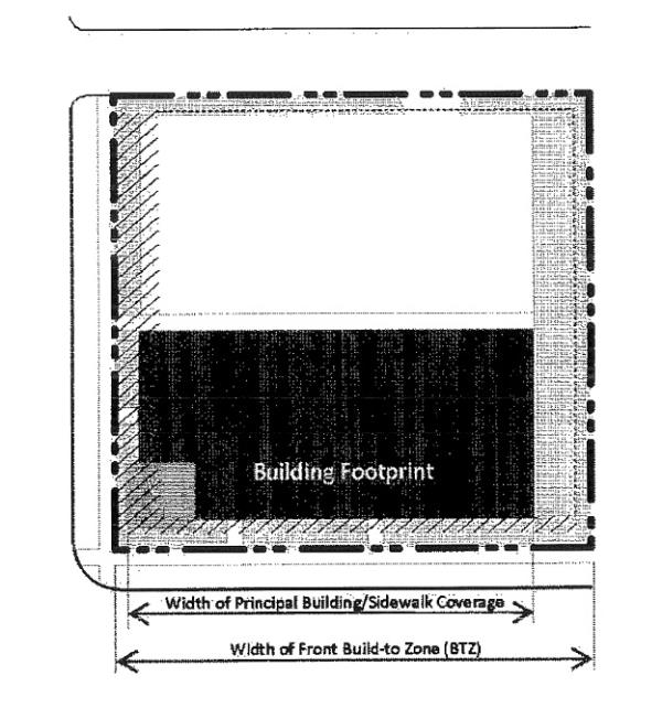
- Certain buildings have this number set to also allow the development of a courtyard along the front property line.
- Some frontage types allow side yard parking to be exempted from the front lot line coverage calculation. If such an exemption is permitted, the width of up to one double loaded aisle of parking, located with the drive perpendicular to the street and including adjacent sidewalks and landscaping, may be exempted, to a maximum of seventy two feet (72').
- Occupation Of Corner: Occupying the intersection of the front and corner build-to zones with a principal structure.
- Front Build-To Zone: The build-to zone or setback parallel to the front property line. Building components, such as awnings or signage, are permitted to encroach into the build-to zone.
- All build-to zone and setback areas not covered by building must contain either landscape, patio space, or sidewalk space.
- Corner Build-To Zone: The build-to zone or setback parallel to the corner property line.
- All build-to zone and setback areas not covered by building must contain either landscape, patio space, or sidewalk space.
- Minimum Side Yard Setback: The minimum required setback along a side property line.
- Minimum Rear Yard Setback: The minimum required setback along a rear property line.
- Minimum And Maximum Lot Or Building Width: Depending on the building type, either the minimum or maximum building or unit width will be noted or the minimum and maximum width of a lot, all measured at or parallel to the front property line.
- Parking And Loading Location: The yard in which a surface parking lot, detached garage, attached garage door access, loading and unloading, and associated drive is permitted.
- Vehicular Access: The permitted means of vehicular ingress and egress to the lot.
- Alleys, when present, shall always be the primary means of access.
- When alleys are not present, a driveway may be permitted per building type and, if an alternative is available, shall not be located off a primary street.
- Height: The following explains the line item requirements for each building type table in sections 10-5.1B-5-3 through 10-5.1B-5-8 of this article within the second section of each table entitled "Height."
- Minimum Overall Height: The minimum overall height for the building shall be located within the build-to zone; stories above the required minimum height may be stepped back from the facade.
- Maximum Overall Height: The sum of a building's total number of stories represented in feet, plus the height of the roof not encompassed by the calculated stories and half-stories, combined.
- Half stories are located either completely within the roof structure with street-facing windows or in a visible basement exposed a maximum of one half story above grade.
- A building incorporating both a half story within the roof and a visible basement shall count the height of the two (2) half stories as one full story.
- Some building types require a building facade to step back as its height increases. If required, the upper stories of any building facade with street frontage shall be set back a designated amount beyond the building facade of the lower stories.
- Ground Story And Upper Story, Minimum And Maximum Height: (Refer to figure 5.2(3), "Measuring Height," of this section.) Each frontage type includes a permitted range of height in feet for each story. Additional information is as follows:
- Floor height is measured in feet between the floor of a story to the floor of the story above it.
- Floor height requirements apply only to street facing facades.
- For single story buildings and the uppermost story of a multiple story building, floor to floor height shall be measured from the floor of the story to the tallest point of the ceiling.
FIGURE 5.2(3)
MEASURING HEIGHT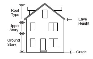
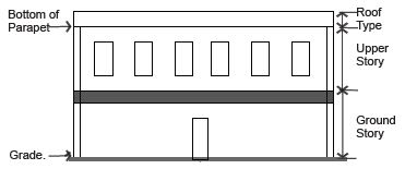
- Existing Single Family Residential Buffer: In order to assure compatibility of new construction with adjacent single family neighborhoods.
- Transitions For Single Family Homes: A twenty foot (20') setback is required from the property line adjacent to a single family detached home. At twenty feet (20'), twenty five foot (25') building height is permitted in between the property line and thirty feet (30'). After thirty feet (30'), every two feet (2') in additional horizontal distance from the property line permits one foot (1') of additional vertical building height. See figure 5.2(5) of this section.
FIGURE 5.2(5)
TRANSITIONS FROM SINGLE FAMILY HOMES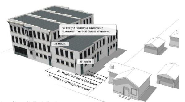
- Transitions For Single Family Homes: A twenty foot (20') setback is required from the property line adjacent to a single family detached home. At twenty feet (20'), twenty five foot (25') building height is permitted in between the property line and thirty feet (30'). After thirty feet (30'), every two feet (2') in additional horizontal distance from the property line permits one foot (1') of additional vertical building height. See figure 5.2(5) of this section.
- Uses: The following explains the line item requirements for each building type table in sections 10-5.1B-5-3 through 10-5.1B-5-8 of this article within the third section of each table entitled "Uses." Refer to section 10-5.1B-4, "Uses," of this article for uses permitted within each zoning subdistrict. The requirements in this section of the building type tables may limit those uses within a specific building type.
- Ground And Upper Story: The uses or category of uses which may occupy the ground and/or upper story of a building.
- Parking Within Building: The area(s) of a building in which parking is permitted within the structure.
- Required Occupied Space: The area(s) of a building that shall be designed as occupied space, defined as interior building space regularly occupied by the building users. It does not include storage areas, utility space, or parking.
- Street Facade Requirements: The following explains the line item requirements for each building type table in sections 10-5.1B-5-3 through 10-5.1B-5-8 of this article, within the fourth section of each table entitled "Street Facade Requirements." Street facade requirements apply only to facades facing a public or private right-of-way. The rear or interior side yard facades are not required to meet these standards unless otherwise stated.
- Minimum Ground Story And Upper Floor Transparency: (Refer to figure 5.2(4), "Measuring Transparency," of this section.) The minimum amount of transparency required on street facades with street frontage.
- Transparency is any glass in windows and/or doors, including any mullions, that is highly transparent with low reflectance.
- Ground story transparency, when defined separately from the overall minimum transparency, shall be measured between two feet (2') and eight feet (8') from the average grade at the base of the front facade.
- A general minimum transparency requirement shall be measured from floor to floor of each story.
FIGURE 5.2(4)
MEASURING TRANSPARENCY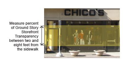
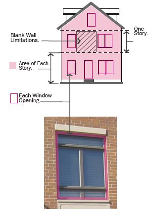
- Transparency is any glass in windows and/or doors, including any mullions, that is highly transparent with low reflectance.
- Blank Wall Limitations: A restriction of the amount of windowless area permitted on a facade with street frontage. If required, the following shall both be met for each story:
- No rectangular area greater than thirty percent (30%) of a story's facade, as measured from floor to floor, may be windowless; and
- No horizontal segment of a story's facade greater than fifteen feet (15') in width may be windowless, unless approved by City Manager or designee.
- Entrance Type: The entrance type(s) permitted for the entrance(s) of a given building type. A mix of permitted entrance types may be utilized. Refer to section 10-5.1B-5-9, "Entrance Types," of this article for definition of and additional requirements for each entrance type.
- Principal Entrance Location: The facade on which the primary building entrance is to be located.
- Required Number Of Street Entrances: The minimum number of and maximum spacing between entrances on the ground floor building facade with street frontage.
- Vertical Facade Divisions: The use of a vertically oriented expression line or form to divide the facade into increments no greater than the dimension shown, as measured along the base of the facade. Elements may include a column, pilaster, or other continuous vertical ornamentation a minimum of one and a half inch depth.
- Horizontal Facade Divisions: The use of a horizontally oriented expression line or form to divide portions of the facade into horizontal divisions. Elements may include a cornice, belt course, molding, string courses, or other continuous horizontal ornamentation a minimum of one and a half inch depth.
- Minimum Ground Story And Upper Floor Transparency: (Refer to figure 5.2(4), "Measuring Transparency," of this section.) The minimum amount of transparency required on street facades with street frontage.
- Roof Type: The following explains the line item requirements for each building type table in sections 10-5.1B-5-3 through 10-5.1B-5-8 of this section 10-5.1B-5, within the fifth section of each table entitled "Roof Types."
- Permitted Roof Type: The roof type(s) permitted for a given building type. Refer to section 10-5.1B-5-10, "Roof Types," of this section 10-5.1B-5 for more specific requirements.
- Tower: A vertical building extension that may be permitted in conjunction with another roof type on certain building types. Refer to section 10-5.1B-5-10, "Roof Types," of this section 10-5.1B-5. (Ord. 17-21, 11-21-2017, eff. 11-21-2017; amd. Ord. 21-01, 1-19-2021, eff. 1-19-2021)
10-5.1B-5-3: Storefront Building
- Description And Intent: The storefront building is intended for use as a mixed use building located close to the front property line with parking typically in the rear or side of the lot.
The key facade element of this building type is the storefront required on the ground floor front facade, with large amounts of glass and regularly spaced entrances.
This building is available in a variety of intensities, depending on the subdistrict within which it is located. - Regulations: Regulations for the storefront building type are defined in the table in this section.
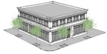 (Ord. 17-21, 11-21-2017, eff. 11-21-2017)
Permitted Subdistrict Gateway Core Gateway General Neighborhood Commerical 1. Building Siting: Refer to figure 5.3(1) of this section Multiple principal buildings Permitted Permitted Permitted (a) Front sidewalk coverage 80% 80% 80%1 Occupation of corner Required4 Required4 Required4 (b) Front build-to zone 0' to 10' 0' to 10' 0' to 15' (c) Corner build-to zone 0' to 10'4 0' to 10'4 0' to 15'4 (d) Minimum side yard setback 0' 0' 0' (e) Minimum rear yard setback 5' 5' 5' (f) Minimum lot width None None None Maximum lot width None None None (g) Parking and loading location Rear yard Rear yard Rear yard1 (i) Vehicular access Alley; if no alley exists, 1 driveway is permitted per non-primary facade, or as approved by the City Manager or designee Alley; if no alley exists, 1 driveway is permitted per non-primary facade, or as approved by the City Manager or designee Alley; if no alley exists, 1 driveway is permitted per non-primary facade, or as approved by the City Manager or designee 2. Height: Refer to figure 5.3(2) of this section (j) Minimum overall height 1 story 1 story 1 story (k) Maximum overall height 5 stories2 3 stories 3 stories (l) Ground story: Minimum height 14' 14' 14' Maximum height 20'3 20'3 20'3 (m) Upper stories: Minimum height 9' 9' 9' Maximum height 14' 14' 14' 3. Uses: Refer to figure 5.3(2) of this section. Refer to section 10-5.1B-4, "Uses," of this article for permitted uses (n) Ground story Any permitted use (o) Upper story Any permitted use (p) Parking within building Permitted fully in any basement and in rear of upper floors (q) Required occupied space 30' deep on all full floors measured from the front facade 4. Street Facade Requirements: Refer to figure 5.3(3) of this section (r) Minimum ground story transparency measured between 2' and 8' above grade 65% 65% 65% (s) Minimum transparency per each story 15% 15% 15% Blank wall limitations Required, see subsection 10-5.1B-5-2D2 of this section 10-5.1B-5 (t) Front facade entrance type Storefront, arcade Storefront, arcade Storefront, arcade (u) Principal entrance location Front facade Front facade Front facade Required number of street entrances 1 per each 100' of front facade 1 per each 100' of front facade 1 per each 100' of front facade Vertical facade divisions Every 50' of facade width Every 50' of facade width Every 50' of facade width Horizontal facade divisions Required within 3' of the top of the ground story 5. Roof Type Requirements: Refer to figure 5.3(3) of this section (v) Permitted roof types Parapet, pitched, flat Parapet, pitched, flat Parapet, pitched, flat Tower Permitted Permitted Permitted Notes:
1Lots wider than 140 feet are permitted 1 double-loaded aisle of surface parking (maximum width of 72 feet), located perpendicular to the front property line, which is exempt from front property line coverage.
2Above the third story, the upper stories of any building facade with street frontage shall have a step back from the lower stories that is a minimum of 6 feet.
3If 18 feet or more in height, ground story shall count as 2 stories towards maximum building height.
4At any uncontrolled intersection, the buildings will be modified to afford automobile drivers a clear view of approaching vehicles or pedestrians. Buildings, trees, or any obstruction shall be prohibited within a triangular area formed by the street curb lines and a line connecting them at points 40 feet from the point of intersection of the back of the curbs (clear view area).FIGURE 5.3(1)
STOREFRONT BUILDING: BUILDING SITING
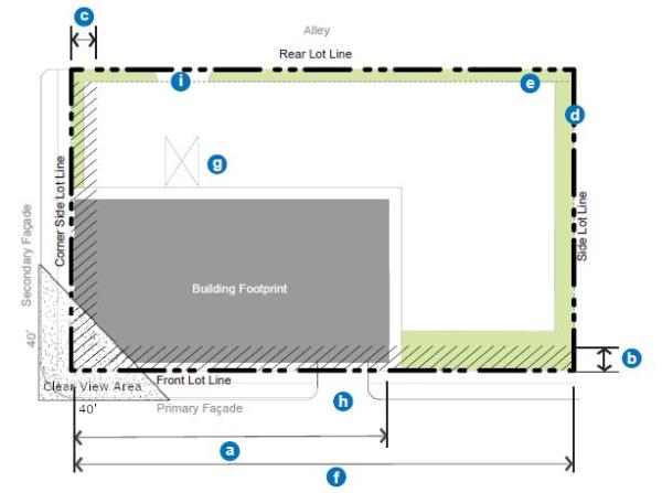 (Ord. 18-11, 9-18-2018, eff. 9-18-2018)
 FIGURE 5.3(2)
STOREFRONT BUILDING: HEIGHT AND USE REQUIREMENTS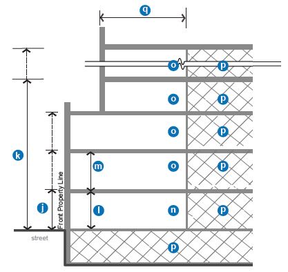 FIGURE 5.3(3)
STOREFRONT BUILDING: STREET FACADE AND ROOF REQUIREMENTS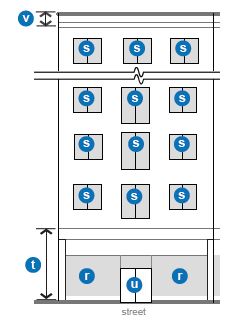
(Ord. 17-21, 11-21-2017, eff. 11-21-2017)
10-5.1B-5-4: General Stoop Building
- Description And Intent: The general stoop building type is limited in terms of uses by the subdistrict within which it is located, generally housing office and/or residential uses. Similar to the storefront building, the general stoop building is intended to be built close to the front and corner property lines allowing easy access to passing pedestrians and transit riders. Parking may be provided in the rear of the lot, internally in the building, or, in some cases, one double loaded aisle of parking is permitted in the interior or the side yard at the front property line. The minimum and maximum heights of this building type depend on the subdistrict within which it is located.
- Regulations: Regulations for the general stoop building type are defined in the table in this subsection.
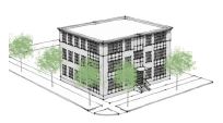
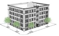 Notes
NotesPermitted Subdistricts Gateway Core Gateway General Neighborhood Commercial Gateway Edge 1. Building Siting: Refer to figure 5.4(1) of this section Any multi-family residential building with frontage on a public or private dedicated street must use the storefront building type Multiple principal buildings Permitted Permitted Permitted Permitted (a) Front sidewalk coverage 80%1 80%1 80% 80%2 Occupation of corner Required4 Required4 Required4 Required4 (b) Front build to zone 0' to 10' 0' to 10' 0' to 15' 0' to 15' (c) Corner build to zone 0' to 10'4 0' to 10'4 0' to 15'4 0' to 15'4 (d) Minimum side yard setback 0' 0' 5' 5' (e) Minimum rear yard setback 5' 5' 5' '5 (f) Minimum lot width None None None None Maximum lot width None None None None (g) Parking and loading location Rear and side yard Rear and side yard Rear and side yard Rear and side yard (i) Vehicular access Alley; if no alley exists, 1 driveway is permitted per non-primary facade, or as approved by the City Manager or designee Alley; if no alley exists, 1 driveway is permitted per non-primary facade, or as approved by the City Manager or designee Alley; if no alley exists, 1 driveway is permitted per street, or as approved by the City Manager or designee Alley; if no alley exists, 1 driveway is permitted per street, or as approved by the City Manager or designee 2. Height: Refer to figure 5.4(2) of this section (j) Minimum overall height 1 story 1 story 1 story 1 story (k) Maximum overall height 5 stories3 3 stories 3 stories 3 stories (l) All stories: Minimum height 9' 9' 9' 9' Maximum height 14' 14' 14' 14' 3. Uses: Refer to figure 5.4(2) of this section. Refer to section 10-5.1B-4, "Uses," of this article for permitted uses (n) All stories Any permitted use (p) Parking within building Permitted fully in basement and in rear of upper floors (q) Required occupied space 30' deep on all full floors from the front facade 4. Street Facade Requirements: Refer to figure 5.4(3) of this section (r) Minimum transparency per each story 35% 35% 15% 15% Blank wall limitations Required, see subsection 10-5.1B-5-2D2 of this section 10-5.1B-5 (t) Front facade entrance type Stoop, porch, storefront Stoop, porch, storefront Stoop, porch, storefront Stoop, porch (u) Principal entrance location Front facade Front facade Front or corner facade Front or corner facade Required number of street entrances 1 per each 100' of front facade 1 per each 100' of front facade 1 per each 150' of front facade 1 per each 150' of front facade Vertical facade divisions Every 60' of facade width Every 60' of facade width Every 60' of facade width Every 60' of facade width Horizontal facade divisions Required within 3' of the top of any visible basement and of the ground story, and at the fifth floor above the ground floor 5. Roof Type Requirements: Refer to figure 5.4(3) of this section (v) Permitted roof types Parapet, pitched, flat Parapet, pitched, flat Parapet, pitched, flat Parapet, pitched, flat (w) Tower Permitted Permitted Permitted Permitted
1A courtyard covering up to 35 percent of the front facade is permitted and may contribute to the front lot line coverage requirement.
2Lots wider than 140 feet are permitted 1 double-loaded aisle of parking (maximum width of 72 feet), located perpendicular to the front property line, which is exempt from front property line coverage.
3Upper stories above the third story on any building facade with street frontage shall have a step back from the lower stories that is a minimum of 6 feet.
4At any uncontrolled intersection, the buildings will be modified to afford automobile drivers a clear view of approaching vehicles or pedestrians. Buildings, trees, or any obstruction shall be prohibited within a triangular area formed by the street curb lines and a line connecting them at points 40 feet from the point of intersection of the back of the curbs (clear view area).
(Ord. 18-11, 9-18-2018, eff. 9-18-2018; amd. Ord. 19-06, 4-16-2019, eff. 4-16-2019)
FIGURE 5.4(1)
GENERAL STOOP BUILDING: BUILDING SITING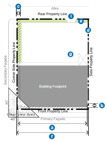
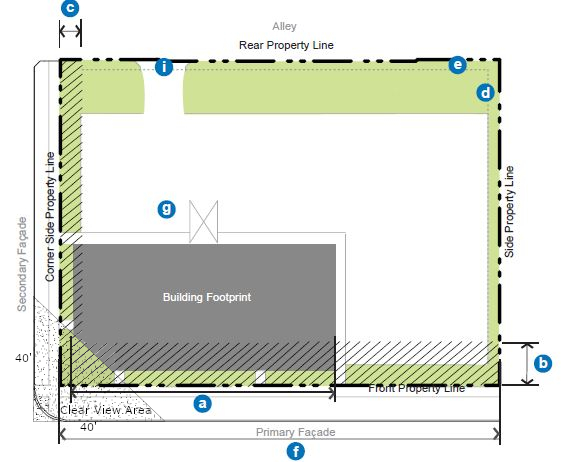 (Ord. 18-11, 9-18-2018, eff. 9-18-2018)
FIGURE 5.4(2)
GENERAL STOOP BUILDING: HEIGHT AND USE REQUIREMENTS
FIGURE 5.4(3)
GENERAL STOOP BUILDING: STREET FACADE REQUIREMENTS
- (Ord. 17-21, 11-21-2017, eff. 11-21-2017)
10-5.1B-5-5: Large Format Building
- Description And Intent: The large format building type permits a large building footprint with a ground floor storefront facade. The minimum sized building footprint of the large format building type is thirty five thousand (35,000) total square feet. If a building is to have a smaller footprint than the minimum thirty five thousand (35,000) square foot requirement then it will not be considered or approved as a large format building.
This building type is usually provided only single certificate of occupancy, and is commonly referred to as a "big-box" or "mid-box" structure.
This building type is still intended to be built close to the front and corner property lines allowing easy access to passing pedestrians and transit riders, and continuing the fabric of the storefront building type. Parking may be provided in the rear of the lot, internally in the building, or one double loaded aisle of parking is permitted in the interior or the side yard at the front property line. The minimum and maximum heights of this building type depend on the district or overlay district within which it is located. - Regulations: Regulations for the large format building type are defined in the table in this section.
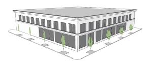 Notes:
Permitted Subdistricts Gateway Core 1. Building Siting: Refer to figure 5.5(1) of this section Multiple principal buildings Not permitted (a) Front sidewalk coverage 70%1 Occupation of corner Required (b) Front build to zone 0' to 15' (c) Corner build to zone 0' to 10' (d) Minimum side yard setback 5' (e) Minimum rear yard setback 5' (f) Minimum lot width 200' Maximum lot width 400' (g) Parking and loading location Rear and side yard (i) Vehicular access Alley; if no alley exists, 1 driveway is permitted per non-primary facade, or as approved by the City Manager or designee 2. Height: Refer to figure 5.5(2) of this section (j) Minimum overall height 1 story (k) Maximum overall height 3 stories (l) Ground story: Minimum height 14' Maximum height 24'2 All stories: Minimum height 9' Maximum height 14' 3. Uses: Refer to figure 5.5(2) of this section. Refer to section 10-5.1B-4, "Uses," of this article for permitted uses (n) Ground story Retail, service, office, craftsman industrial (o) Upper story Same as ground story (p) Parking within building Permitted fully in basement and in rear of all floors. Permitted full on upper floors (q) Required occupied space 50' deep on all full floors from the front facade 4. Street Facade Requirements: Refer to figure 5.5(3) of this section (r) Minimum ground story transparency measured between 2' and 8' above grade 50% front and corner-side facades only (s) Minimum transparency per each story 35% Blank wall limitations Required, see subsection 10-5.1B-5-2D2 of this article (t) Front facade entrance type Stoop, storefront (u) Principal entrance location Front or corner facade Required number of street entrances 1 per each 150' of front facade Vertical facade divisions Every 60' of facade width Horizontal facade divisions Required within 3' of the top of the ground story for all buildings over 2 stories 5. Roof Type Requirements: Refer to figure 5.5(3) of this section (v) Permitted roof types Parapet, pitched, flat Tower Permitted
1Lots wider than 140 feet are permitted 1 double-loaded aisle of parking (maximum width of 72 feet), located perpendicular to the front property line, which is exempt from front property line coverage.
2If 18 feet or more in height, ground story shall count as 2 stories towards maximum building height.
FIGURE 5.5(1)
LARGE FORMAT BUILDING: BUILDING SITING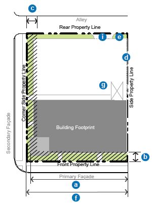
 FIGURE 5.5(2)
LARGE FORMAT BUILDING: HEIGHT AND USE REQUIREMENTS FIGURE 5.5(3)
LARGE FORMAT BUILDING: STREET FACADE REQUIREMENTS
 (Ord. 17-21, 11-21-2017, eff. 11-21-2017)
10-5.1B-5-6: Limited Bay
- Description And Intent: The limited bay building type permits a lower level of ground floor storefront facade and a single vehicle bay with garage door access on the primary street. A wider range of uses can also be accommodated within this building type, including craftsman industrial uses. This building type is still intended to be built close to the front and corner property lines allowing easy access to passing pedestrians and transit riders, and continuing the fabric of the storefront building type. Parking may be provided in the rear of the lot, internally in the building, or one double loaded aisle of parking is permitted in the interior or the side yard at the front property line. The minimum and maximum heights of this building type depend on the subdistrict within which it is located.
- Regulations: Regulations for the limited bay building type are defined in the table in this section.
(Ord. 17-21, 11-21-2017, eff. 11-21-2017)Notes:Permitted Subdistricts Gateway Core Gateway General Neighborhood Commercial 1. Building Siting: Refer to figure 5.6(1) of this section Multiple principal buildings Not permitted Not permitted Not permitted (a) Front sidewalk coverage 75% 75% 75%1 Occupation of corner Required5 Required5 Required5 (b) Front build to zone 0' to 15' 0' to 15' 0' to 15' (c) Corner build to zone 0' to 10'5 0' to 10'5 0' to 10' 5 (d) Minimum side yard setback 5' 5' 5' (e) Minimum rear yard setback 5' 5' 5' (f) Minimum lot width 50' 50' 50' Maximum lot width None None None (g) Parking and loading Rear and side yard Rear and side yard Rear and side yard1 (h) Street facade service bay entrance4 Limited to 1 per street facade, maximum width 18' Limited to 1 per street facade, maximum width 18' Limited to 1 per street facade, maximum width 18' (i) Vehicular access From alley; if no alley exists, maximum 1 driveway per street frontage From alley; if no alley exists, maximum 1 driveway per street frontage From alley; if no alley exists, maximum 1 driveway per street frontage 2. Height: Refer to figure 5.6(2) of this section (j) Minimum overall height 1 story 1 story 1 story (k) Maximum overall height 5 stories2 3 stories 3 stories (l) Ground story: Minimum height 14' 14' 14' Maximum height 24'3 24'3 24'3 (m) Upper stories: Minimum height 9' 9' 9' Maximum height 14' 14' 14' 3. Uses: Refer to figure 5.6(2) of this section. Refer to section 10-5.1B-4, "Uses," of this article for permitted uses (n) Ground story Retail, service, office, craftsman industrial Retail, service, office, craftsman industrial Retail, service, office, craftsman industrial (o) Upper story Any permitted use Any permitted use Any permitted use (p) Parking within building Permitted fully in basement and in rear of upper floors plus 1 service bay width at ground floor Permitted fully in basement and in rear of upper floors plus 1 service bay width at ground floor Permitted fully in basement and in rear of upper floors plus 1 service bay width at ground floor (q) Required occupied space 30' deep on all full floors from the front facade 30' deep on all full floors from the front facade 30' deep on all full floors from the front facade 4. Street Facade Requirements: Refer to figure 5.6(3) of this section (r) Minimum ground story transparency measured between 2' and 8' above grade 50%, service bay door shall be transparent 50%, service bay door shall be transparent 50%, service bay door shall be transparent (s) Minimum transparency per each story 15% 15% 15% Blank wall limitations Required, see subsection 10-5.1B-5-2D2 of this section 10-5.1B-5 (t) Front facade entrance type Storefront, stoop Storefront, stoop Storefront, stoop (u) Principal entrance location Front or corner facade Front or corner facade Front or corner facade Required number of street entrances 1 per 150' of facade; service bay door not included 1 per 150' of facade; service bay door not included 1 per 150' of facade; service bay door not included Vertical facade divisions Every 60' of facade width Every 60' of facade width Every 60' of facade width Horizontal facade divisions Required within 3' of the top of the ground story for all buildings over 2 stories Required within 3' of the top of the ground story for all buildings over 2 stories Required within 3' of the top of the ground story for all buildings over 2 stories 5. Roof Type Requirements: Refer to figure 5.6(3) of this section (v) Permitted roof types Parapet, pitched, flat Parapet, pitched, flat Parapet, pitched, flat Tower Permitted Permitted Permitted
1Lots wider than 140 feet are permitted 1 double-loaded aisle of parking (maximum width of 72 feet), located perpendicular to the front property line, which is exempt from front property line coverage.
2Upper stories above the third story on any building facade with street frontage shall have a step back from the lower stories that is a minimum of 6 feet.
3If 18 feet or more in height, ground story shall count as 2 stories towards maximum building height.
4Also refer to figure 5.6(3) of this section.
5At any uncontrolled intersection, the buildings will be modified to afford automobile drivers a clear view of approaching vehicles or pedestrians. Buildings, trees, or any obstruction shall be prohibited within a triangular area formed by the street curb lines and a line connecting them at points 40 feet from the point of intersection of the back of the curbs (clear view area).
FIGURE 5.6(1)
LIMITED BAY BUILDING: BUILDING SITING
(Ord. 18-11, 9-18-2018, eff. 9-18-2018)
FIGURE 5.6(2)
LIMITED BAY BUILDING: HEIGHT AND USE REQUIREMENTS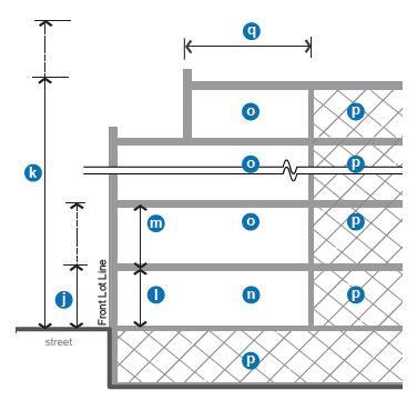
FIGURE 5.6(3)
LIMITED BAY BUILDING: STREET FACADE REQUIREMENTS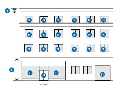
(Ord. 17-21, 11-21-2017, eff. 11-21-2017)
10-5.1B-5-7: Row Building
- Description And Intent: The row building is a building typically comprised of multiple vertical units, each with its own entrance to the street. This building type may be organized as townhouses or rowhouses, or it could also incorporate live/work units where uses are permitted.
Parking is required to be located in the rear yard and may be incorporated either into a detached garage or in an attached garage accessed from the rear of the building. However, when the garage is located within the building, a minimum level of occupied space is required on the front facade to ensure that the street facade is active. - Regulations: Regulations for the row building type are defined in the table in this section.
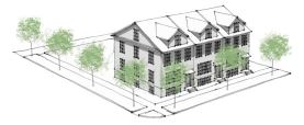
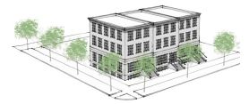
Notes:Permitted Subdistricts Gateway General Gateway Edge 1. Building Siting: Refer to figure 5.7(1) of this section Multiple principal buildings. Not applicable to interior buildings of multiple building developments. Permitted1 Permitted1 (a) Front sidewalk coverage. Not applicable to interior buildings of multiple building developments. 65%2 65%2 Occupation of corner. Not applicable to interior buildings of multiple building developments. Required6 Required6 (b) Front build to zone. Not applicable to interior buildings of multiple building developments. 5' to 15' 5' to 20' (b)(1) Front yard9 depth for interior principal building. 15' 20' (c) Corner build to zone. Not applicable to interior buildings of multiple building developments. 5' to 10'6 5' to 10'6 (d) Minimum side yard setback 0' per unit; 15' between buildings; for interior buildings, min. 15’ from property line. 0' per unit; 15' between buildings; for interior buildings, min. 20’ from property line. (e) Minimum rear yard setback 10'3 15'3 (f) Minimum unit width 20' per unit 22' per unit Maximum building width Maximum of 8 units per building Maximum of 6 units per building (g) Parking Rear yard/facade Rear yard/facade (i) Vehicular access From alley; if no alley exists, 1 driveway per building per street frontage. From alley on any primary street 2. Height: Refer to figure 5.7(2) of this section (j) Minimum overall height 2 story 2 story (k) Maximum overall height 3.5 stories 3.5 stories (l) All stories: Minimum height 9' 9' Maximum height 14' 14' 3. Uses: Refer to figure 5.7(2) of this section. Refer to section 10-5.1B-4, "Uses," of this article for permitted uses (n) Ground story Residential, service, office, limited craftsman industrial Residential only (o) Upper story Residential only (p) Parking within building Permitted fully in basement and rear of all floors (q) Required occupied space 30' deep on all full floors from the front facade 4.
Street Facade Requirements: Refer to figure 5.7(3) of this section (r) Minimum transparency per each story 15%4 15%4 Blank wall limitations Required, see subsection 10-5.1B-5-2D2 of this section 10-5.1B-5 (t) Front facade permitted entrance type Stoop, porch, limited storefront5 Stoop, porch (u) Principal entrance location per unit Front or corner side facade Vertical facade divisions Not required Horizontal facade divisions Not required 5. Roof Type Requirements: Refer to figure 5.7(3) of this section (v) Permitted roof types Parapet, pitched, flat Parapet, pitched, flat Tower Permitted Permitted
1For the purposes of the row building, a building consists of a series of units. When permitted, multiple buildings may be located on a lot with the minimum required space between them. However, each building shall meet all requirements of the building type unless otherwise noted.
2Each building shall meet the front property line coverage requirement, except 1 of every 5 units may front a courtyard with a minimum width of 30 feet. The courtyard shall be defined on 3 sides by units.
3Rear yard setback on alleys or internal access roads is 5 feet.
4When the storefront entrance type is utilized, the maximum ground story transparency for the unit is 55 percent as measured between 2 feet and 8 feet above grade.
5The storefront entrance type is permitted only on corners or buildings that are designated for live/work units.
6At any uncontrolled intersection, the buildings will be modified to afford automobile drivers a clear view of approaching vehicles or pedestrians. Buildings, trees, or any obstruction shall be prohibited within a triangular area formed by the street curb lines and a line connecting them at points 40 feet from the point of intersection of the back of the curbs (clear view area).
7See definition of ‘Yard, Front –Interior Building’ in 10-5.1B-10-5.
FIGURE 5.7(1)
ROW BUILDING: BUILDING SITING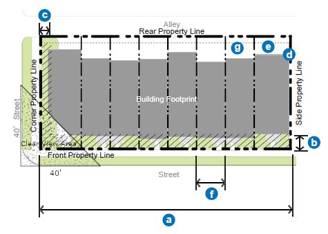
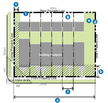 FIGURE 5.7(2)
ROW BUILDING: HEIGHT AND USE REQUIREMENTS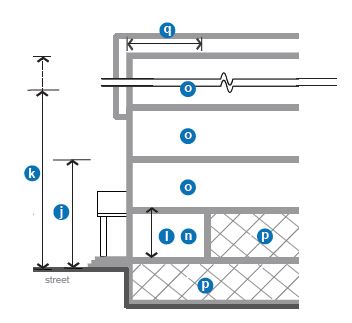 FIGURE 5.7(3)ROW BUILDING: STREET FACADE REQUIREMENTS
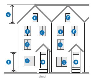 (Ord. 17-21, 11-21-2017, eff. 11-21-2017; amd. Ord. 18-11, 9-18-2018, eff. 9-18-2018; Ord. 21-01, 1-19-2021, eff. 1-19-2021)
10-5.1B-5-8: Civic Building
- Description And Intent: The civic building is the most flexible building type intended only for civic and institutional types of uses. These buildings are distinctive within the urban fabric created by the other building types and could be designed as iconic structures. In contrast to most of the other building types, a minimum setback line is required instead of a build to zone, though this setback is required to be landscaped. Parking is limited to the rear in most cases.
The minimum and maximum heights of this building type depend on the subdistrict within which it is located. - Regulations: Regulations for thze civic building type are defined in the table in this section.
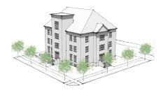 (Ord. 17-21, 11-21-2017, eff. 11-21-2017)Notes:
Permitted Subdistricts Gateway Core Gateway General Neighborhood Commercial Gateway Edge 1. Building Siting: Refer to figure 5.8(1) of this section Multiple principal buildings Permitted Front sidewalk coverage Not required Occupation of corner Required if open space is not provided between building and property line3 (b) Front setback 5' 5' 5' 5' (c) Corner setback 0'3 5'3 5'3 5'3 (d) Minimum side yard setback 5' 5' 5' 5' (e) Minimum rear yard setback 5' 5' 5' 5' (f) Minimum lot width 50' 50' 50' 50' Maximum lot width None None None None (g) Parking and loading Rear rear Rear and interior side yard1 Rear and interior side yard1 (i) Vehicular access From alley; if no alley exists, 1 driveway per street frontage 2. Height: Refer to figure 5.8(2) of this section (j) Minimum overall height 1 story 1 story 1 story 1 story (k) Maximum overall height 5 stories 3 stories 3 stories 2 stories (l) All stories: 9' 9' 9' 9' Minimum height 20'2 20'2 20'2 20'2 Maximum height 3. Uses: Refer to figure 5.8(2) of this section. Refer to section 10-5.1B-4, "Uses," of this article for permitted uses (n) All stories Limited to civic and institutional uses only (p) Parking within building Permitted fully in basement and in rear of upper floors (q) Required occupied space 30' deep on all full floors from the front facade 4. Street Facade Requirements: Refer to figure 5.8(3) of this section (r) Minimum transparency per each story 15% Blank wall limitations Not required (t) Front facade permitted entrance type Arcade, stoop (u) Principal entrance location Front or corner facade Front or corner facade Front or corner facade Front or corner facade Required number of primary street entrances 1 per 100' of facade 1 per 150' of facade 1 per 150' of facade 1 per 150' of facade Vertical facade divisions Not required Horizontal facade divisions Not required 5. Roof Type Requirements: Refer to figure 5.8(3) of this section (v) Permitted roof types Parapet, pitched, flat; other roof types are permitted by application to City Manager (w) Tower Permitted
1Lots wider than 140 feet are permitted 1 double-loaded aisle of parking (maximum width of 72 feet), located perpendicular to the front property line, which is exempt from front property line coverage.
2If 18 feet or more in height, ground story shall count as 2 stories towards maximum building height.
3At any uncontrolled intersection, the buildings will be modified to afford automobile drivers a clear view of approaching vehicles or pedestrians. Buildings, trees, or any obstruction shall be prohibited within a triangular area formed by the street curb lines and a line connecting them at points 40 feet from the point of intersection of the back of the curbs (clear view area).
FIGURE 5.8(1)
CIVIC BUILDING: BUILDING SITING (Ord. 18-11, 9-18-2018, eff. 9-18-2018)
FIGURE 5.8(2)
CIVIC BUILDING: HEIGHT AND USE REQUIREMENTS FIGURE 5.8(3)
CIVIC BUILDING: STREET FACADE REQUIREMENTS
 (Ord. 17-21, 11-21-2017, eff. 11-21-2017)
10-5.1B-5-9: Entrance Types
Entrance type standards apply to the ground story and visible basement of front facades of all building types as defined in this section. Refer to the building type table requirements, sections 10-5.1B-5-3 through 10-5.1B-5-8 of this section 10-5.1B-5.
- General: The following provisions apply to all entrance types.
- Intent: To guide the design of the ground story of all buildings to relate appropriately to pedestrians on the street. Treatment of other portions of the building facades is detailed in each building type standard (refer to building types in sections 10-5.1B-5-3 through 10-5.1B-5-8 of this section 10-5.1B-5).
- Applicability: The entire ground story street-facing facade(s) of all buildings shall meet the requirements of at least one of the permitted entrance types, unless otherwise stated.
- Measuring Transparency: Refer to section 10-5.1B-5-2, "Explanation Of Building Type Table Standards," of this section 10-5.1B-5, for information on measuring building transparency.
- Visible Basements: Visible basements, permitted by entrance type, are optional. The visible basement shall be a maximum of one-half (1/2) the height of the tallest story.
- Storefront Entrance Type: (Refer to figure 5.9(1) of this section.) The storefront entrance type is a highly transparent ground story treatment designed to serve primarily as the display area and primary entrance for retail or service uses.
- Transparency: Minimum transparency is required per building type.
- Elevation: Storefront elevation shall be between zero feet (0') and two feet (2') above sidewalk.
- Visible Basement: A visible basement is not permitted.
- Horizontal Facade Division: Horizontally define the ground story facade from the upper stories.
- Entrance: All entries shall be recessed from the front facade closest to the street.
- Recess shall be a minimum of three feet (3') and a maximum of eight feet (8') deep, measured from the portion of the front facade closest to the street.
- When the recess falls behind the front build-to zone, the recess shall be no wider than eight feet (8').
FIGURE 5.9(1)
STOREFRONT ENTRANCE TYPE
- Arcade Entrance Type: (Refer to figure 5.9(2) of this section.) An arcade entrance type is a covered pedestrian walkway within the recess of a ground story.
- Arcade: An open-air public walkway is required to be recessed into the building, from the face of the building, a minimum of eight feet (8') and a maximum of fifteen feet (15').
- Build-To Zone: When the arcade is utilized, the outside face of the arcade shall be considered the front facade, located within the required build-to zone.
- Recessed Or Interior Facade: Storefront entrance type is required on the recessed ground story facade.
- Column Spacing: Columns shall be spaced between ten feet (10') and eighteen feet (18') on center.
- Column Width: Columns shall be a minimum of one foot eight inches (1'8") and a maximum two feet four inches (2'4") in width.
- Arcade Opening: Opening shall not be flush with interior arcade ceiling and may be arched or straight.
- Horizontal Facade Division: Horizontally define the ground story facade from the upper stories.
- Visible Basement: A visible basement is not permitted.
FIGURE 5.9(2)
ARCADE ENTRANCE TYPE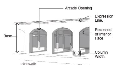
- Stoop Entrance Type: (Refer to figure 5.9(3) of this section.) A stoop is an unroofed, open platform.
- Transparency: Minimum transparency is required per building type.
- Stoop Size: Stoops shall be a minimum of three feet (3') deep and six feet (6') wide.
- Elevation: Stoop elevation shall be located a maximum of two feet six inches (2'6") above the sidewalk without visible basement and a maximum of four feet six inches (4'6") above the sidewalk with a visible basement.
- Visible Basement: A visible basement is permitted and shall be separated from the ground story by an expression line.
- Entrance: All entries shall be located off a stoop.
FIGURE 5.9(3)
STOOP ENTRANCE TYPE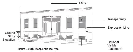
- Porch Entrance Type: (Refer to figure 5.9(4) of this section.) A porch is a raised, roofed platform that may or may not be enclosed on all sides. If enclosed, the space shall not be climate controlled.
- Transparency:
- Minimum transparency per building type is required.
- If enclosed, a minimum of forty percent (40%) of the enclosed porch shall be comprised of highly transparent, low reflectance windows.
- Porch Size: The porch shall be a minimum of five feet (5') deep and eight feet (8') wide.
- Elevation: Porch elevation shall be located a maximum of two feet six inches (2'6") above the sidewalk without a visible basement and a maximum of four feet six inches (4'6") above the sidewalk with a visible basement.
- Visible Basement: A visible basement is permitted.
- Height: Porch may be two (2) stories to provide a balcony on the second floor.
- Entrance: All entries shall be located off a porch.
FIGURE 5.9(4)
PORCH ENTRANCE TYPE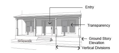
- Transparency:
(Ord. 17-21, 11-21-2017, eff. 11-21-2017)
10-5.1B-5-10: Roof Type
Roof type standards apply to the roof and cap of all building types as defined in this section. Refer to the building type table requirements, sections 10-5.1B-5-3 through 10-5.1B-5-8 of this article.
- General Provisions: The following provisions apply to all roof types.
- Intent: To guide the design of the cap of all buildings.
- Applicability: All buildings shall meet the requirements of one of the roof types permitted for the building type.
- Measuring Height: Refer to subsection 10-5.1B-5-2B of this article for information on measuring building height.
- Other Roof Types: Other building caps not listed as a specific type may be made by a request to the City Manager or designee with the following requirements:
- The roof type shall not create additional occupiable space beyond that permitted by the building type.
- The shape of the roof type shall be significantly different from those defined in this section, i.e., a dome, spire, vault.
- The building shall warrant a separate status within the community from the fabric of surrounding buildings, with a correspondence between the form of the roof type and the meaning of the building use.
- Parapet Roof Type: (Refer to figure 5.10(1), "Parapet Roof Type," of this section.) A parapet is a low wall projecting above a building's roof along the perimeter of the building. It can be utilized with a flat or low pitched roof and also serves to limit the view of roof-top mechanical systems from the street.
- Parapet Height: Height is measured from the top of the upper story to the top of the parapet.
- Minimum height is two feet (2') with a maximum height of six feet (6').
- The parapet shall be high enough to screen the roof and any roof appurtenances from view of the street(s).
- Horizontal Expression Lines: An expression line shall define the parapet from the upper stories of the building and shall also define the top of the cap.
- Occupied Space: Occupied space shall not be incorporated behind this roof type.
FIGURE 5.10(1)
PARAPET ROOF TYPE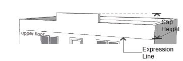
- Parapet Height: Height is measured from the top of the upper story to the top of the parapet.
- Pitched Roof Type: (Refer to figure 5.10(2), "Pitched Roof Type," of this section.) This roof type has a sloped or pitched roof. Slope is measured with the vertical rise divided by the horizontal span or run.
- Pitch Measure: The roof may not be sloped less than a 4:12 (rise:run) or more than 16:12.
- Slopes less than 4:12 are permitted to occur on second story or higher roofs. (Refer to figure 5.10(2) of this section, low pitched roof.)
- Configurations:
- Hipped, gabled, and combination of hips and gables with or without dormers are permitted.
- Butterfly roofs (inverted gable roof) are permitted with a maximum height of eight feet (8'), inclusive of overhang.
- Gambrel and mansard roofs are not permitted.
- Parallel Ridge Line: A gabled end or perpendicular ridge line shall occur at least every one hundred feet (100') of roof when the ridge line runs parallel to the front lot line. (Refer to figure 5.10(3), "Parallel Ridge Line," of this section.)
- Roof Height: Roofs without occupied space and/or dormers shall have a maximum height on street-facing facades equal to the maximum floor height permitted for the building type.
- Occupied Space: Occupied space may be incorporated behind this roof type.
FIGURE 5.10(2)
PITCHED ROOF TYPE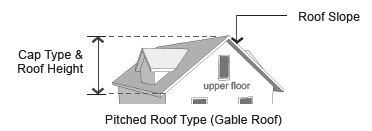
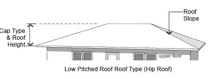
FIGURE 5.10(3)
PARALLEL RIDGE LINE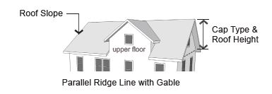
- Pitch Measure: The roof may not be sloped less than a 4:12 (rise:run) or more than 16:12.
- Flat Roof Type: (Refer to figure 5.10(4), "Flat Roof Type," of this section.) This roof type has a flat roof with overhanging eaves.
- Configuration: Roofs with no visible slope are acceptable. Eaves are required on all street facing facades.
- Eave Depth: Eave depth is measured from the building facade to the outside edge of the eave. Eaves shall have a depth of at least fourteen inches (14").
- Eave Thickness: Eave thickness is measured at the outside edge of the eave, from the bottom of the eave to the top of the eave. Eaves shall be a minimum of eight inches (8") thick.
- Interrupting Vertical Walls: Vertical walls may interrupt the eave and extend above the top of the eave with no discernible cap.
- No more than one-half (1/2) of the front facade can consist of an interrupting vertical wall.
- Vertical walls shall extend no more than four feet (4') above the top of the eave.
- Occupied Space: Occupied space shall not be incorporated behind this roof type.
FIGURE 5.10(4)
FLAT ROOF TYPE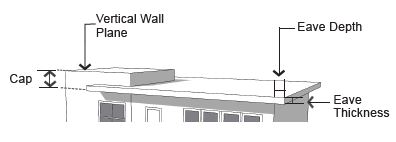
- Towers: (Refer to figure 5.10(5), "Tower," of this section.) A tower is a rectilinear or cylindrical, vertical element, that must be used with other roof types.
- Quantity: All building types, with the exception of the civic building, are limited to one tower per building.
- Tower Height: Maximum height, measured from the top of the parapet or eave to the top of the tower, is the equivalent of the height of one upper floor of the building to which the tower is applied.
- Tower Width: Maximum width along all facades is one-third (1/3) the width of the front facade or thirty feet (30'), whichever is less.
- Horizontal Expression Lines: An expression line shall define the tower from the upper stories, except on single family or attached house residential building types.
- Occupied Space: Towers may be occupied by the same uses allowed in upper stories of the building type to which it is applied.
- Application: May be combined with all other roof types.
- Tower Cap: The tower may be capped by the parapet, pitched, low pitched, or flat roof roof types, or the spire may cap the tower.
FIGURE 5.10(5)
TOWER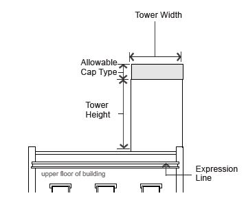
(Ord. 17-21, 11-21-2017, eff. 11-21-2017)
10-5.1B-5-11: Additional Design Requirements
The following outlines the subdistrict design guidelines that affect a building's appearance and subdistrict cohesiveness. They improve the physical quality of buildings, enhance the pedestrian experience, and protect the character of the neighborhood.
- Materials And Color:
- Primary Facade Materials: Eighty percent (80%) of each facade shall be constructed of primary materials. For facades over one hundred (100) square feet, more than one material shall be used to meet the eighty percent (80%) requirement.
- Permitted primary building materials include high quality, durable, natural materials, such as stone, brick; wood lap siding; fiber cement board lapped, shingled, or panel siding; glass. Other high quality synthetic materials may be approved during the site plan process with an approved sample and examples of successful, high quality local installations. Refer to figure 5.11(1) of this section.
FIGURE 5.11(1)
PRIMARY MATERIALS
- Permitted primary building materials include high quality, durable, natural materials, such as stone, brick; wood lap siding; fiber cement board lapped, shingled, or panel siding; glass. Other high quality synthetic materials may be approved during the site plan process with an approved sample and examples of successful, high quality local installations. Refer to figure 5.11(1) of this section.
- Secondary Facade Materials: Secondary materials are limited to details and accents and include gypsum reinforced fiber concrete for trim and cornice elements; metal for beams, lintels, trim, and ornamentation, and exterior architectural metal panels and cladding.
- Exterior insulation and finishing systems (EIFS) is permitted for trim only or on upper floor facades only.
- Roof Materials: Acceptable roof materials include three hundred (300) pound or better, dimensional asphalt composite shingles, wood shingles and shakes, metal tiles or standing seam, slate, and ceramic tile. "Engineered" wood or slate may be approved during the site plan process with an approved sample and examples of successful, high quality local installations. Refer to figure 5.11(2) of this section.
FIGURE 5.11(2)
ROOF MATERIALS
- Color: Main building colors shall be complementary to existing building stock.
- Appropriate Grade Of Materials: Commercial quality doors, windows, and hardware shall be used on all building types with the exception of the row building. Refer to figure 5.11(3) of this section.
FIGURE 5.11(3)
COMMERCIAL GRADE DOORS AND WINDOWS
- Primary Facade Materials: Eighty percent (80%) of each facade shall be constructed of primary materials. For facades over one hundred (100) square feet, more than one material shall be used to meet the eighty percent (80%) requirement.
- Windows, Awnings, And Shutters:
- Windows: All upper story windows on all historic, residential, and mixed use buildings shall be recessed, double hung. Percent of transparency is required per building type.
- Awnings: All awnings shall be canvas or metal. Plastic awnings are not permitted. Awning types and colors for each building face shall be coordinated. Refer to figure 5.11(4) of this section.
FIGURE 5.11(4)
AWNINGS
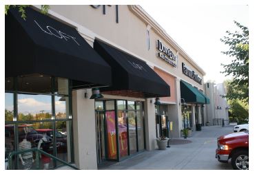
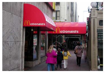
- Shutters: If installed, shutters, whether functional or not, shall be sized for the windows. If closed, the shutters shall not be too small for complete coverage of the window. Shutters shall be wood. "Engineered" wood may be approved by City Manager or designee during the site plan process with an approved sample and examples of successful, high quality local installations.
- Balconies: The following applies in all locations where balconies are incorporated into the facade design facing any street or parking lot. Refer to figure 5.11(5) of this section.
- Size: Balconies shall be a minimum of six feet (6') deep and five feet (5') wide.
- Connection To Building: Balconies that are not integral to the facade shall be independently secured and unconnected to other balconies.
- Facade Coverage: A maximum of forty percent (40%) of the front and corner side facades, as calculated separately, may be covered with balconies, including street-facing railing and balcony structure.
FIGURE 5.11(5)
BALCONIES INTEGRAL TO FACADE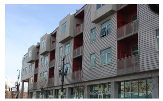
- Treatments At Terminal Vistas: When a street terminates at a parcel, the parcel shall be occupied by one of the following:
- If the parcel is open space, any open space type with the exception of the pocket park shall be utilized and a vertical element shall terminate the view. Acceptable vertical elements include a stand or grid of trees, a sculpture, or a fountain.
- If the parcel is not utilized as an open space type, the front or corner side of a building, whether fronting a primary street or not, shall terminate the view.
- Building Variety: Building design shall vary between vertical facade divisions, where required per the building types, and from adjacent buildings by the type of dominant material or color, scale, or orientation of that material and at least two (2) of the following. Refer to figure 5.11(7) of this section for one illustration of this requirement.
- The proportion of recesses and projections.
- The location of the entrance and window placement, unless storefronts are utilized.
- Roof type, plane, or material, unless otherwise stated in the building type requirements.
FIGURE 5.11(7)
BUILDING VARIETY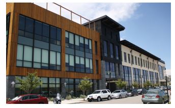
- Drive-Through Facilities: Refer to figure 5.11(8) of this section for one illustration of the following requirements.
- Application: Drive-through facilities are only allowed in the Gateway Core, Gateway General, and Neighborhood Commercial Subdistricts.
- Drive-through Facilities Definition: Drive-through facilities include any window as described in 10-5.1A-4-2(L)(1), whether it has a canopy or is located in a separate structure from the main building. Drive-Through facilities shall be located on the rear facade of the building or in the rear of the lot behind the building, or side facades where permitted by use.
- Stacking Lanes: Stacking lanes shall be located perpendicular to the primary facade or behind the building.
- Canopy And Structure: The canopy and structure shall be constructed of the same materials utilized on the building.
- Drive-through facilities are expressly prohibited on the front façade of any building.
FIGURE 5.11(8)
RECOMMENDED DRIVE-THROUGH FACILITY LAYOUT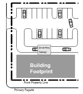
Note that Drive-through facilities may be permitted on the sides of buildings where permitted by use – see 10-5.1B-5-11 F
(Ord. 17-21, 11-21-2017, eff. 11-21-2017)
10-5.1B-6-1: General Requirements
- Intent: To provide open space as an amenity that promotes physical and environmental health within the community and to provide each household with access to a variety of active and passive open space types.
- General Requirements: Development of parcels over five (5) acres are required to provide five percent (5%) total lot size as civic open space. Developer shall work with City to determine appropriate location of open space. For parcels under five (5) acres, impact fees and other funding will be used as mechanisms to ensure adequate open space will be provided.
- Compliance: All open space provided within any General or Edge Zoning Subdistrict shall comply with one of the open space types defined by sections 10-5.1B-6-2 through 10-5.1B-6-8 of this article.
- Access: All open space types shall provide public access from a vehicular right-of-way.
- Location: Open space types shall be platted as a lot or, with permission of the City, may be located within the right-of-way. Open space types shall either be zoned as an open space zoning designation, or an adjacent zoning designation, such as General or Edge Zoning Subdistricts.
- Ownership: Open space types may either be publicly or privately owned. Whether publicly or privately owned, all open spaces must be accessible and open to the public.
- Parking Requirements: Parking shall not be required for any open space type, unless a use other than open space is determined by the City Manager or designee.
- Continuity: Connections to existing or planned trails or open space types shall be made when the open space abuts an existing or planned trail right-of-way or other civic open space type.
- Definition Of Requirements: The following further explains or defines the requirements included in the tables in sections 10-5.1B-6-2 through 10-5.1B-6-8 of this article for each open space type. Refer to each table for the specific requirements of each open space type.
- Size:
- Minimum Size: The minimum size of the open space type is measured within the parcel lines of the property.
- Maximum Size: The maximum size of the open space type is measured within the parcel lines of the property.
- Minimum Dimension: The minimum length or width of the open space type, as measured along the longest two (2) straight lines intersecting at a right angle defining the maximum length and width of the lot. Refer to figure 6.1(1) of this section.
FIGURE 6.1(1)
EXAMPLES OF MEASURING THE MINIMUM DIMENSION OF OPEN SPACE TYPES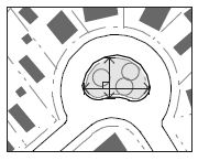
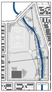
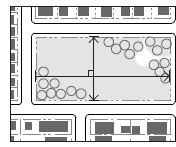
- Minimum Percentage Of Vehicular Right-Of-Way Frontage Required: The minimum percentage of the civic open space perimeter, as measured along the outer parcel line, that shall be located directly adjacent to a vehicular right-of-way, excluding alley frontage. This requirement provides access and visibility to the open space.
- Adjacent Parcels: Parcels directly adjacent to as well as directly across the street from an open space type.
- Frontage Orientation Of Adjacent Parcels: The preferred orientation of the adjacent parcels' frontages to the civic open space. Front, corner side, side, and rear refers to the property line either adjacent to the open space or facing the open space across the street.
- Improvements: The following types of development and improvements may be permitted on an open space type.
- Designated Sports Fields Permitted: Sports fields, ball courts, or structures designated for one or more particular sports including, but not limited to, baseball fields, softball fields, soccer fields, basketball courts, football fields, tennis courts, climbing walls, and skate parks are permitted.
- Playgrounds Permitted: Playgrounds include a defined area with play structures.
- Fully Enclosed Structures Permitted: Fully enclosed structures may include such uses as park offices, maintenance sheds, community centers, and restrooms.
- Maximum Area: For some civic open space types, fully enclosed structures are permitted, but limited to a maximum building coverage to five percent (5%) of the open space area or one thousand (1,000) square feet, whichever is less.
- Semi-Enclosed Structures: Open-air structures, such as gazebos, are permitted in all open space types.
- Maximum Percentage Of Open Water Body: The maximum amount of area within an open space type that may be covered by an open water body, including, but not limited to, ponds, lakes, and pools.
- Size:
- Stormwater In Open Space Types: Stormwater management practices, such as storage and retention facilities, may be integrated into open space types and utilized to meet stormwater requirements for surrounding parcels.
- Stormwater Features: Stormwater features in civic open space may be designed as formal or natural amenities with additional uses other than stormwater management, such as an amphitheater, sports field, or a pond or pool as part of the landscape design. Stormwater features shall not be fenced and shall not impede public use of the land they occupy. Stormwater facilities shall be designed for public safety so that in the case of a storm event water depths are minimized.
- Qualified Professional: A qualified landscape design professional, such as a landscape architect, shall be utilized to incorporate stormwater features into the design of the civic open spaces. (Ord. 17-21, 11-21-2017, eff. 11-21-2017)
10-5.1B-6-2: Plaza
- Intent: To provide a formal open space of medium scale to serve as a gathering place for civic, social, and commercial purposes. The plaza may contain a greater amount of impervious coverage than any other open space type. Special features, such as fountains and public art installations, are encouraged.
- Plaza Requirements:FIGURE 6.2(1)
1. Dimensions: Minimum size 0.05 acre Maximum size 1.5 acres Minimum dimension 30' Minimum percent of vehicular ROW frontage required 50%; 80% building frontage required on non-street frontage 2. Adjacent parcels: Permitted subdistricts All Frontage orientation of adjacent parcels Front or corner side 3. Improvements: Designated sports fields Not permitted Playgrounds Not permitted Fully enclosed structures Permitted; maximum 5% of area Maximum percent of open water 50% 4. Additional design requirements: a. Minimum building frontage At least 80% of the plaza's perimeter that does not front on vehicular right-of-way shall be lined by building frontages
TYPICAL PLAZA
(Ord. 17-21, 11-21-2017, eff. 11-21-2017)
10-5.1B-6-3: Square
- Intent: To provide a formal open space of medium scale to serve as a gathering place for civic, social, and commercial purposes. Squares are rectilinear in shape and are bordered on all sides by a vehicular right-of-way, which together with building facades creates its definition.
- Square Requirements:FIGURE 6.3(1)
1. Dimensions: Minimum size 0.25 acre Maximum size 3 acres Minimum dimension 80' Minimum percent of vehicular ROW frontage required 100% 2. Adjacent parcels: Permitted districts All Frontage orientation of adjacent parcels Front or corner side 3. Improvements: Designated sports fields Not permitted Playgrounds Not permitted Fully enclosed structures Permitted; maximum 5% of area Maximum percent of open water 30%
TYPICAL SQUARE
(Ord. 17-21, 11-21-2017, eff. 11-21-2017)
10-5.1B-6-4: Green
- Intent: To provide informal, medium scale active or passive recreation for neighborhood residents within walking distance, mainly fronted by streets.
- Green Requirements:FIGURE 6.4(1)
1. Dimensions: Minimum size 0.25 acre Maximum size 2 acres Minimum dimension 80' Minimum percent of vehicular ROW frontage required 100%; 50% for over 1.25 acres 2. Adjacent parcels: Permitted subdistricts All Frontage orientation of adjacent parcels Front or corner side 3. Improvements: Designated sports fields Not permitted Playgrounds Permitted Fully enclosed structures Permitted; maximum 5% of area Maximum percent of open water 30%
TYPICAL GREEN LAYOUT
(Ord. 17-21, 11-21-2017, eff. 11-21-2017)
10-5.1B-6-5: Commons
- Intent: To provide an informal, small to medium scale space for active or passive recreation for a limited neighborhood area. Commons are typically internal to a block and tend to serve adjacent residents.
- Commons Requirements:FIGURE 6.5(1)
1. Dimensions: Minimum size 0.25 acre Maximum size 1.5 acres Minimum dimension 45' Minimum percent of vehicular ROW frontage required 0%; 2 access points required, minimum width each of 20' 2. Adjacent parcels: Permitted subdistricts All Frontage orientation of adjacent parcels Side or rear 3. Improvements: Designated sports fields Not permitted Playgrounds Permitted Fully enclosed structures Not permitted Maximum percent of open water 30%
TYPICAL COMMONS LAYOUT
(Ord. 17-21, 11-21-2017, eff. 11-21-2017)
10-5.1B-6-6: Pocket Park
- Intent: To provide small scale, primarily landscaped active or passive recreation and gathering space for neighborhood residents within walking distance.
- Pocket Park Requirements:FIGURE 6.6(1)
1. Dimensions: Minimum size 0.05 acre Maximum size 1 acre Minimum dimension (feet) none Minimum percent of vehicular ROW frontage required 15% 2. Adjacent parcels: Permitted subdistricts All Frontage orientation of adjacent parcels Any 3. Improvements: Designated sports fields Not permitted Playgrounds Permitted Fully enclosed structures Not per mitted Maximum percent of open water 30%
TYPICAL POCKET PARK LAYOUT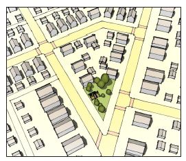
(Ord. 17-21, 11-21-2017, eff. 11-21-2017)
10-5.1B-6-7: Park
- Intent: To provide informal active and passive large-scale recreational amenities to local residents and the greater region. Parks have primarily natural plantings and are frequently created around an existing natural feature such as a water body or stands of trees.
- Park Requirements:FIGURE 6.7(1)
1. Dimensions: Minimum size 1 acre Maximum size (acres) None Minimum dimension 100' Minimum percent of vehicular ROW frontage required 30% up to 5 acres; 20% over 5 acres 2. Adjacent parcels: Permitted subdistricts All Frontage orientation of adjacent parcels Any 3. Improvements: Designated sports fields Permitted Playgrounds Permitted Fully enclosed structures Permitted, maximum 5% of area Maximum percent of open water 30% 4. Additional design requirements: a. Vehicular right-of-way frontage of parks less than 5 acres At least 30% of the park shall continuously front on a vehicular right-of-way
TYPICAL PARK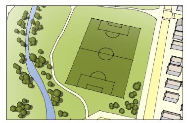
(Ord. 17-21, 11-21-2017, eff. 11-21-2017)
10-5.1B-6-8: Greenway
- Intent: To provide informal, primarily natural linear open spaces that serve to enhance connectivity between open space types and other uses. Greenways are linear open spaces that often follow a natural feature, such as a river, stream, ravine, or man-made feature, such as a vehicular right-of-way. A greenway may border other open space types.
- Greenway Requirements:FIGURE 6.8(1)
1. Dimensions: Minimum size 1 acre Maximum size (acres) None Minimum dimension 30'; recommended minimum average width 50' Minimum percent of vehicular ROW frontage required 0%; 1 access point required per quarter mile of length, minimum 20' width 2. Adjacent parcels: Permitted subdistricts All Frontage orientation of adjacent parcels Any 3. Improvements: Designated sports fields Permitted Playgrounds Permitted Fully enclosed structures Not permitted Maximum percent of open water 30%
TYPICAL GREENWAY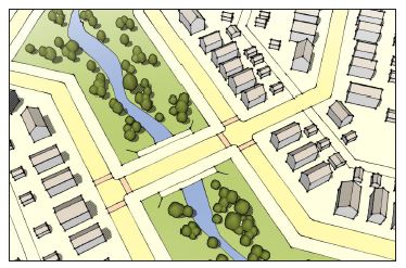
(Ord. 17-21, 11-21-2017, eff. 11-21-2017)
10-5.1B-7-1: General Requirements
- Intent: The landscape standards outlined in this section are designed to meet the following set of goals.
- To provide for healthy, long-lived street trees within all public ways to improve the appearance of streets and create a buffer between pedestrian and vehicular travel lanes.
- To increase the compatibility of adjacent uses and minimize the adverse impacts created by adjoining or neighboring uses.
- Refer to chapter 23 of this title for landscape regulations regarding water efficient landscaping, tree and plant types and sizes, and other elements related to efficient landscape design standards.
- To shade large expanses of pavement and reduce the urban heat island effect.
- Applicability: Landscaping, trees, and buffers shall be installed as detailed in this section 10-5.1B-7.
- General Compliance: Application of this section 10-5.1B-7 to existing uses shall occur with the following developments.
- Any development of new or significant improvements to existing parking lots, loading facilities, and driveways. Significant improvements include new driveways, new spaces, new medians, new loading facilities, or complete reorganization of the parking and aisles.
- Alteration to an existing principal or accessory structure that results in a change of fifteen percent (15%) or more in the structure's gross floor area.
- When compliance is triggered for existing parking lots, landscape improvements shall take precedence over parking requirements.
- Buffers: Landscape buffers are required according to the provisions in this section 10-5.1B-7 with the following exceptions.
- Shared Driveways: Buffers shall not be required along a property line where a curb cut or aisle is shared between two (2) adjoining lots.
- Points Of Access: Buffering is not required at driveways or other points of access to a lot.
- Temporary Uses: These provisions do not apply to temporary uses, unless determined otherwise by the City Manager or designee.
- Street Trees: Refer to section 10-5.1B-2, "Street Types," of this article for appropriate street tree specifications.
- General Compliance: Application of this section 10-5.1B-7 to existing uses shall occur with the following developments.
- Water Efficient Landscaping: Refer to chapter 23 of this title for landscape regulations regarding water efficient landscaping. (Ord. 17-21, 11-21-2017, eff. 11-21-2017)
10-5.1B-7-2: Installation Of Landscape
- Intent: The following provisions aid in ensuring that all required landscaping is installed and maintained properly.
- Applicability: These provisions apply to landscape installation as required by this section.
- General Installation Requirements: The installation of landscaping shall adhere to the following standards.
- National Standards: Best Management Practices and procedures according to the nationally accepted standards shall be practiced.
- Installation: All landscaping and trees shall be installed in conformance with the practices and procedures established by the most recent edition of the American Standard for Nursery Stock (ANSI Z60.1) as published by the American Association of Nurserymen.
- Maintenance And Protection: All landscaping and trees shall be maintained according to the most recent edition of the American National Standards Institute, including its provisions on pruning, fertilizing, support systems, lighting protection, and safety.
- Installation: Landscaping shall be fully installed prior to the issuance of a certificate of completeness.
- If seasonal conditions preclude the complete installation, a cash escrow or irrevocable letter of credit, equal to 1.5 times the installation costs as estimated by a qualified professional.
- Complete installation is required within nine (9) months of the issuance of the temporary certificate of completeness or occupancy permit or the cash escrow or letter of credit may be forfeited.
- Plant Size Requirements: Plant material shall be sized according to table 7.2(1) of this section at the time of installation, unless otherwise noted in this section.
TABLE 7.2(1)
PLANT MATERIAL SIZE AT INSTALLATIONPlant Material Type Minimum Size Deciduous shade/overstory tree: Single trunk 2" caliper Multitrunk 10' in height Evergreen tree 8' in height Understory tree 6' in height Ornamental tree 1.5" caliper Shrubbery: Deciduous Container Class 5 Evergreen Container Class 5 Groundcover 3" in height - Condition Of Landscape Materials: The landscaping materials used shall be:
- Healthy and hardy with a good root system.
- Chosen for its form, texture, color, fruit, pattern of growth, and suitability to local conditions.
- Tolerant of the natural and man-made environment, including tolerant of drought, wind, salt, and pollution.
- Appropriate for the conditions of the site, including slope, water table, and soil type.
- Protected from damage by grates, pavers, or other measures.
- Plants that will not cause a nuisance or have negative impacts on an adjacent property.
- Species native or naturalized to the Wasatch Front, whenever possible.
- Compost, Mulch, And Organic Matter: Compost, mulch, and organic matter may be utilized within the soil mix to reduce the need for fertilizers and increase water retention.
- Establishment: All installed plant material shall be fully maintained until established, including watering, fertilization, and replacement as necessary.
- National Standards: Best Management Practices and procedures according to the nationally accepted standards shall be practiced.
- Ground Plane Vegetation: All unpaved areas shall be covered by one of the following.
- Planting Beds:
- Planting beds may include shrubs, ornamental grasses, ground cover, vines, annuals, or perennials.
- Nonliving materials, such as bark mulch, colored gravel, or mulch, are permitted for up to fifty percent (50%) of a bed area.
- Annual beds must be maintained seasonally, replanting as necessary.
- Grass: Seeded, plugged, or sodded grass may be planted throughout landscaped areas.
- Grass shall be established within ninety (90) days of planting or the area must be reseeded, replugged, or resodded.
- Planting Beds:
- Tree Installations: Refer to the list of permitted tree types, available from South Ogden Parks Division.
- Tree Measurement: New trees shall be measured at six inches (6") above the mean grade of the tree's trunk when four inch (4") caliper or less and twelve inches (12") for tree trunks above four inches (4"), and noted as caliper inches throughout this article.
- Tree Maintenance: Tree trimming, fertilization, and other similar work shall be performed by or under the management of an ISA certified arborist.
- Tree Size: All trees to be installed to meet the requirements of this section shall be a minimum of two inch (2") caliper at the time of installation.
- Tree Spacing: See subsection 10-5.1B-7-3D4 of this article.
- Permeable Surface: For each tree preserved or planted, a minimum amount of permeable surface area is recommended, unless otherwise stated in this article.
- Planted trees have a suggested minimum permeable area and soil volume based upon tree size; refer to table 7.2(2) of this section for details.
- Permeable area for one tree cannot count toward that of another tree.
MINIMUM RECOMMENDED SOIL VOLUMES AND PERMEABLE AREA PER PLANTED TREETree Size Soil Volume (Cubic Feet) Soil Surface Area (Sq. Ft. With 2.5' Soil Depth) Permeable Surface Area Requirement (Sq. Ft.) Very small 181 72 (approx. 8.5' x 8.5') 25 (5' x 5') Small 736 294 (approx. 17' x 17') 100 (10' x 10') Medium 2,852 1,141 (approx. 34' x 34') 225 (15' x 15') Large 6,532 2,681 (approx. 50' x 50') 400 (20' x 20') - Structural Soil: When the soil surface area (per table 7.2(2) of this section) of a tree will extend below any pavement, structural soil is required underneath that pavement. Structural soil is a medium that can be compacted to pavement design and installation requirements while still permitting root growth. It is a mixture of gap-graded gravels (made of crushed stone), clay loam, and a hydrogel stabilizing agent to keep the mixture from separating. It provides an integrated, root penetrable, high strength pavement system that shifts design away from individual tree pits (source: Cornell University, Urban Horticulture Institute).
- Irrigation Systems: Permanent irrigation, beyond establishment, is required and shall adhere to the following standards.
- All irrigation systems shall be designed to minimize the use of water.
- Nonresidential landscape irrigation shall have an automatic clock-activated permanent system.
- The irrigation system shall provide sufficient coverage to all landscape areas.
- The irrigation system shall not spray or irrigate impervious surfaces, including sidewalks, driveways, streets, and parking and loading areas.
- All systems shall be equipped with a back-flow prevention device.
- All mechanical systems including controllers and back-flow prevention devices shall be properly screened from public view.
- Maintenance Of Landscape: All landscaping shall be maintained in good condition at all times to ensure a healthy and orderly appearance.
- Adherence To Requirements: All required landscape shall be maintained to adhere to all requirements of this article.
- Replacing Unhealthy Landscaping: Unhealthy landscaping shall be replaced with healthy, live plants by the end of the next applicable growing season. This includes all plant material that shows dead branches over a minimum of twenty five percent (25%) of the normal branching pattern.
- Maintenance Responsibility: The owner is responsible for the maintenance, repair, and replacement of all landscaping, screening, and curbing required herein.
- Maintain Quality And Quantity: Maintenance shall preserve at least the same quantity, quality, and screening effectiveness as initially installed.
- Fences And Other Barriers: Fences, walls, and other barriers shall be maintained in good repair and free of rust, flaking paint, graffiti, and broken or damaged parts.
- Tree Topping: Tree topping is not permitted. When necessary, crown reduction thinning or pruning is permitted. Refer to subsection 10-5.1B-7-3D2 of this article for clear branch height of street trees. (Ord. 17-21, 11-21-2017, eff. 11-21-2017)
10-5.1B-7-3: Street Trees And Streetscape Design
- Intent: To line all new streets with a consistent and appropriate planting of trees, pavement design, and identity to establish tree canopy for environmental benefit and a sense of identity for all new streets.
- Applicability: The requirements herein apply to all new development requiring regulating plan approval.
- Streetscape Design Submittal: A consistent streetscape design shall be submitted for approval for all new streets within the development. At a minimum, the submittal shall include the following:
- Street Trees: Trees meeting the minimum requirements of subsection D of this section, shall be included in the streetscape design, with details related to tree pits, tree planting to meet the requirements of subsection 10-5.1B-7-2E, "Tree Installations," of this article.
- Sidewalk Pavement Design: Sidewalk paving materials and pattern shall be set for each street type (refer to section 10-5.1B-2, "Street Types," of this article).
- Street Furnishings: Benches, seatwalls, planters, planter fences, trash receptacles, and bicycle racks at the least shall be specified and quantities and locations listed for each street type (refer to section 10-5.1B-2, "Street Types," of this article).
- Landscape Design: Ground plane vegetation shall be designated for any landscape bed areas, planter areas, and tree wells.
- Lighting: Pedestrian and vehicular lighting shall be specified and locations and quantities noted.
- Identity Elements: Any other elements designed to establish the identity of each street, such as banners, pavement markers, artwork, or signage, shall be included in the streetscape design submittal.
- Minimum Street Tree Requirements: The following standards apply to the installation of street trees.
- Exception: Street trees are not required on alleys or the lane street types (refer to sections 10-5.1B-2-4 and 10-5.1B-2-5 of this article, street types).
- Clear Branch Height: Minimum clear branch height is eight feet (8').
- Street Tree Type: Medium and large shade trees are permitted to be installed as street trees. Refer to the list of permitted tree types in the South Ogden City Approved Shade Tree List for Park Strip Planting.
- Street Tree Spacing: Street trees shall be planted as follows.
- Number: Each lot is required to have one tree for every thirty feet (30') of street frontage with a minimum of one street tree per street frontage.
- Spacing:
- Large trees must be spaced a minimum of thirty feet (30') and a maximum of sixty feet (60') on center.
- Medium trees must be spaced a minimum of twenty feet (20') and a maximum of thirty feet (30') on center.
- Placement: No trees may be planted closer to any curb or sidewalk than as follows unless a permeable surface is provided:
- Medium trees: Three feet (3').
- Large trees: Four feet (4').
- Limited Distance Between Curb And Sidewalk: Where the distance from the back of the curb to the edge of the right-of-way or property line is less than nine feet (9') with a sidewalk, applicant shall work with the City staff to determine the appropriate tree species.
- City Manager or designee may waive the street tree requirement in spaces less than nine feet (9').
- Tree Wells: In commercial subdistricts, where the sidewalk extends from the back of curb to the property line, tree wells shall be utilized.
- For tree wells adjacent to sidewalks five feet (5') wide or less, open pit is not permitted.
- The opening must be covered with a tree grate or pervious pavement.
- The opening in a tree grate for the trunk must be expandable. (Ord. 17-21, 11-21-2017, eff. 11-21-2017)
- For tree wells adjacent to sidewalks five feet (5') wide or less, open pit is not permitted.
10-5.1B-7-4: Frontage Buffer
- Intent And Applicability:
- Intent: To lessen the visual impact of vehicular areas visible from the street.
- General Applicability: Applies to properties in all "general" and "edge" subdistricts where a vehicular area is located adjacent to a right-of-way.
- Exceptions: Vehicular areas along alleys, except when a residential subdistrict is located across the alley; single and two family residences.
- Frontage Buffer Requirements:Notes:
1. Buffer depth and location1: Depth 7' (a) Location on the site Between street facing property line and parking area2 (b) 2. Buffer landscape requirements: Uses and materials Uses and materials other than those indicated are prohibited in the buffer Shade trees Medium or large shade tree required at least every 40'; locate on the street side of the fence; spacing should alternate with street trees (c) Planting area Required continuous planting area on street side of fence, between shade trees and in front of vehicular areas (d) Planting area composition Individual shrubs with a minimum width of 24", spaced no more than 36" on center, height maintained no more than 48" Existing vegetation May be credited toward buffer area 3. Fence: (e) Location 2' from back of curb of vehicular area Materials Composites, steel, wood, or colored PVC; masonry columns (maximum width 2'6") and base (maximum 18" height) permitted Minimum height 3' Maximum height 4' Colors No bright or white colors Opacity Minimum 30%; maximum 80% Gate/opening 1 gate permitted per street frontage; opening width maximum 6'
1This screening requirement does not prohibit the installation of or provision for openings necessary for allowable access drives and walkways connecting to the public sidewalk.
2In front, corner, and rear yards (on a through lot), when the parking area is located adjacent to any building on the lot, the buffer must be located so that it aligns with or is behind the face of the adjacent building back to the vehicular area. The area between the buffer and the property line must be landscaped.
FIGURE 7.4(1)
FRONTAGE BUFFER PLAN AND SECTION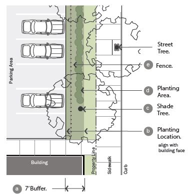
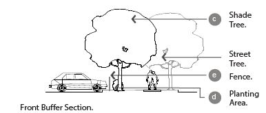
(Ord. 17-21, 11-21-2017, eff. 11-21-2017)
10-5.1B-7-5: Side And Rear Buffer
- Intent And Applicability:
- Intent: To minimize the impact that one zoning subdistrict may have on a neighboring subdistrict and to provide a transition between subdistricts.
- General Applicability: Applies to all directly adjoining properties in all "general" and "edge" subdistricts.
- Side And Rear Buffer Requirements:Note:
1. Buffer depth and location: Depth1 Varies based on the zoning subdistrict of the lot and the adjacent lot; see table 7.5(1) of this section (a) Location on the site Locate buffers on the applicant property; buffer is measured from side and rear property lines 2. Required landscape screen: Width1 5' landscape screen in addition to any other buffer landscaping (b) Location1 Directly adjacent to the rear or side property line Planting area Continuous double row of shrubs required between shade trees (c) Planting area composition A professionally-designed water-efficient planting design that is engaging, beautiful and appropriate for the specific setting and context. Plants should include a range of perennials, decorative grasses and small shrubs as appropriate for reducing the visual impact of vehicular areas visible from the street while also meeting the requirements of chapter 23 of this title, water efficient landscaping Planting frequency Minimum of 15 shrubs per 100' of property line is required Shade trees At least 1 medium or large shade tree per every 30' within the buffer (d) 3. Buffer landscape requirements: Uses and materials Uses and materials other than those indicated are prohibited within the buffer Tree canopy coverage 1 medium or large shade tree required per 2,000 square feet of buffer, excluding the area within the required landscape screen Existing vegetation May be credited toward buffer area
1City Manager or designee may reduce depth of buffer, width of landscape screen, or location of landscape screen based on existing landscaping and topography.
FIGURE 7.5(1)
LANDSCAPE SCREEN WITHIN LIGHT SIDE AND REAR BUFFER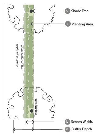
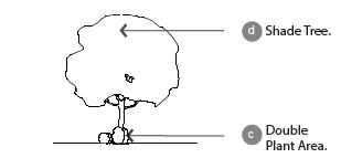 TABLE 7.5(1)
SIDE AND REAR BUFFER
REQUIREMENTS BETWEEN SUBDISTRICTSBuffer Required By These Subdistricts General Neighborhood Edge General Not required Not required Not required Neighborhood Not required Not required Not required Edge 5' 5' Not required Any existing single family 20' 10' Not required
(Ord. 17-21, 11-21-2017, eff. 11-21-2017)
10-5.1B-7-6: Interior Parking Lot Landscape
- Intent And Applicability:
- Intent: To provide shade, minimize paving and associated stormwater runoff, and improve the aesthetic look of parking lots.
- General Applicability: All open-air, off-street parking lots in all "general" and "edge" subdistricts.
- Other Internal Parking Lot Areas: Internal areas not dedicated to parking or drives shall be landscaped with a minimum of one medium or large shade tree for the first one hundred fifty (150) square feet and one medium or large shade tree for every six hundred fifty feet (650') thereafter.
- Existing Vegetation: Existing vegetation may be credited toward these requirements.
- Side And Rear Buffer Requirements: Parking lot interior is defined as the area dedicated to parking on a given parcel as measured from edge of pavement to edge of pavement.Notes:
1. Landscape island requirements: (a) Required island locations Terminal ends1 of free standing rows or bays of parking; after every ninth parking space for rows of parking greater than 8 spaces in length2 (b) Minimum width 5'; islands less than 15' must utilize structural soil under any paved surface within a tree's critical root zone; islands under 9' must install an aeration system and utilize permeable pavement Required trees
within islandsMinimum of 1 medium or large shade tree per island (c) 2. Landscape median requirements: (d) Required median location Required in each free-standing bay of parking along the length of the bay Minimum width 5'; medians less than 15' must utilize structural soil under any paved surface within a tree's critical root zone; islands under 9' must install an aeration system and utilize permeable pavement 3. Tree requirements: Requirements per parking space3
Each parking space must be located within 50' of a tree planted within parking lot interior Minimum of 1 shade tree must be planted within parking lot interior or within 4' of parking lot's edge for every 3 parking spaces Tree
shade goalWithin 20 years of tree installation, 30% of the interior of the parking lot should be shaded by tree canopy. Refer to table 7.6(1) of this section for calculation 4. Shade structure requirements: Shade structure requirements Shade structures should be considered an acceptable alternative for meeting the tree shade goal that 30% of the interior parking lot should be shaded. Detail designs for such features should be submitted as part of section 10-5.1B-10-2, "Development Review Procedures," of this article, for review and approval
1Freestanding rows or bays of parking are those not abutting the parking lot perimeter or building face, and may have a single or double row of parking.
2There shall be no more than 8 continuous parking spaces in a row without a landscape island.
3Trees within a designated buffer area may not be utilized to meet these requirements.
FIGURE 7.6(1)
INTERIOR PARKING LOT LANDSCAPING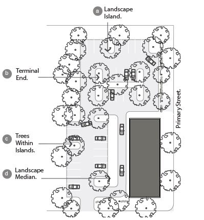
TABLE 7.6(1)
ESTIMATED CANOPY AND HEIGHT AT MATURITYTree Size Estimated Canopy At Maturity Estimated Height At Maturity Very small 150 sq. ft. Under 15' Small 400 sq. ft. 15' - 25' Medium 900 sq. ft. 25' - 40' Large 1,600 sq. ft. 40'+
(Ord. 17-21, 11-21-2017, eff. 11-21-2017)
10-5.1B-7-7: Active Frontage Buffer
- Intent And Applicability:
- Intent: To continue the street wall of adjacent facades.
- General Applicability: Applies to non-vehicular outdoor sites in all "general" and "edge" subdistricts. For vehicular areas, refer to section 10-5.1B-7-4, "Frontage Buffer," of this article.
- Active Frontage Requirements:Note:
1. Frontage location: Location on the site Required adjacent to dining patio or display area (a) 2. Required fence: Location Between 0' and 5' from the front and corner side property lines; only required in front of patio/display area (c) Materials Steel or colored PVC; masonry base or columns permitted (b) Minimum height 3' Maximum height 4' Opacity Minimum 30%; maximum 60%1 Gate/opening 1 gate permitted per street frontage; opening width maximum 6'
1Fence may be solid if 42 inches or less in height.
FIGURE 7.7(1)
ACTIVE FRONTAGE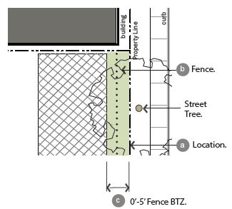
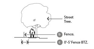
(Ord. 17-21, 11-21-2017, eff. 11-21-2017)
10-5.1B-7-8: Screening Of Open Storage, Refuse Areas, And Utility Appurtenances
- Intent And Applicability:
- Intent: To reduce the visibility of open storage, refuse areas, and utility appurtenances from public areas and adjacent properties.
- General Applicability: All dumpsters, open storage, refuse areas, and utility appurtenances in all "general" and "edge" subdistricts.
- Screening Of Open Storage, Refuse Areas, And Utility Appurtenances:Notes:
1. Open storage and refuse area screening requirements: Location on the site Not permitted in front or corner side yards Opaque screen wall1 Required around 3 sides of the dumpster and trash bin area (a) Screen wall height Height shall be the higher of the following: 6' Height of use to be screened Height as determined by City to accomplish objective of the screen Visible openings Openings visible from the public way or adjacent properties must be furnished with opaque gates (b) Landscape requirement If refuse area is located within larger paved area, such as a parking lot, landscape islands must be located on 3 sides of the area, with at least 1 medium or large shade tree in at least 1 of the landscape areas2 (c) 2. Utility appurtenance screening requirements: Large private mechanical equipment3 Shall be fenced with opaque wood or brick-faced masonry on all sides facing right-of-way Small private mechanical equipment4 Shall have landscape screening and a shrub bed containing shrubs spaced no more than 36" on center
1Vertical structured barrier to visibility at all times such as a fence or wall.
2This tree, if located within 50 feet of a parking space, may be utilized to meet the minimum shade requirements.
3Large private mechanical equipment is equal to or greater than 4 feet in height.
4Small private mechanical equipment is smaller than 4 feet in height.
FIGURE 7.8(1)
SCREENING OF OPEN STORAGE AND REFUSE AREAS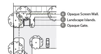
(Ord. 17-21, 11-21-2017, eff. 11-21-2017)
10-5.1B-8-1: General Requirements
- Intent: The following provisions are established to accomplish the following:
- Ensure an appropriate level of vehicle parking, loading, and storage to support a variety of land uses.
- Provide appropriate site design standards to mitigate the impacts of parking lots on adjacent land uses and zoning subdistricts.
- Provide specifications for vehicular site access.
- Applicability: This section 10-5.1B-8 shall apply to all new development and changes in use or intensity of use for existing development, in any subdistrict.
- Compliance: Compliance with the standards outlined shall be attained in the following circumstances:
- Development of all new parking facilities, loading facilities, and driveways.
- Improvements to existing parking facilities, loading facilities, and driveways, including reconfiguration, enlargement, or the addition of curbs, walkways, fencing, or landscape installation.
- Change in use requiring a change in the amount of parking.
- Damage Or Destruction: When a use that has been damaged or destroyed by fire, collapse, explosion, or other cause is reestablished, any associated off-street parking spaces or loading facilities must be reestablished based on the requirements of this section 10-5.1B-8.
- Site Plan Approval Required: Parking quantities and parking design and layout shall be approved through the site plan approval process. Refer to subsection 10-5.1B-10-2E, "Site Plan Approval," of this article for more information. (Ord. 17-21, 11-21-2017, eff. 11-21-2017)
- Compliance: Compliance with the standards outlined shall be attained in the following circumstances:
10-5.1B-8-2: Parking Requirements
- General Requirements For Parking: Off-street parking spaces shall be provided in conformance with table 8.2(1) "Required Off-Street Vehicular Parking," of this section.
- Required Accessible Parking: Parking facilities accessible for persons with disabilities shall be in compliance with or better than the standards detailed in the State Accessibility Code, including quantity, size, location, and accessibility.
- Requirements For Unlisted Uses: Upon receiving a site plan approval, occupancy certificate, or other permit application for a use not specifically addressed in this section, the City Manager or designee is authorized to apply off-street parking standards specified for the use deemed most similar to the proposed use. In instances where an equivalent may not be clearly determined, the City Manager or designee may require the applicant to submit a parking study or other evidence that will help determine the appropriate requirements.
- Private Off-Premises Parking: Where private off-site parking facilities are approved, such facilities shall be in the same possession as the zoning lot occupied by the building or use to which the parking facilities are accessory.
- Possession: Such possession may be either by deed or lease, guaranteeing availability of the parking commensurate with the use served by the parking.
- Agreement: The agreement providing for the use of off-site parking, executed by the parties involved, shall be in a form approved by the City Attorney and filed with the City Manager or designee.
- Duration: The deed or lease shall require the owner to maintain the required number of parking facilities for the duration of the use served or of the deed or lease, whichever shall terminate sooner.
- Location Of Parking: Any off-premises parking must be within one thousand three hundred feet (1,300') from the entrance of the use to the closest parking space measured along a dedicated pedestrian path.
- Tandem Parking: Tandem parking is permitted with approval of the City Manager or designee through the site plan review process.
- Required Vehicular Parking: Table 8.2(1) of this section outlines the required vehicular parking requirements.
- Organized By Use: The parking requirements are organized by use, in a similar fashion to section 10-5.1B-4-1, table 4.1(1) of this article, use table.
- Parking rates are provided for general use categories; these numbers are applicable for all of the uses within these categories.
- If a specific use requires a different parking rate than its use category, it is also listed in table 8.2(1) of this section, required vehicular and bicycle parking.
- Vehicular Spaces Required: The vehicular spaces required column indicates the required off-street parking ratio, which may be subject to credits and other reductions and a maximum number, as are detailed in this section.
- Maximum Allowable Vehicular Spaces: When a use requires more than twenty (20) spaces, it is not permitted to provide greater than twenty percent (20%) over the minimum parking requirement.
- For those uses with no requirements, the maximum number of spaces required should be no more than the next level up of that use. For example, for neighborhood retail, the number of spaces should be no more than the requirements for general retail.
- Computation: Off-street parking spaces shall be calculated using the following information.
- Area Measurements: The following units of measurements shall be utilized to calculate parking requirements.
- Dwelling Unit: Parking standards for residential buildings shall be computed using dwelling unit as the unit of measure, unless otherwise stated.
- Gross Square Footage: Unless otherwise expressly stated, parking standards for non-residential uses shall be computed on the basis of gross floor area in square feet.
- Occupancy- Or Capacity-Based Measurements: Parking spaces required per available seat or per employee, student, or occupant shall be based on the greatest number of persons on the largest shift, the maximum number of students enrolled, or the maximum fire-rated capacity, whichever measurement is applicable.
- Bench Seating: For uses in which users occupy benches, pews, or other similar seating facilities, each twenty four inches (24") of such seating shall be counted as one seat.
- Fractions: When computation of the number of required off-street parking spaces results in a fractional number, any result of 0.5 or more shall be rounded up to the next consecutive whole number. Any fractional result of less than 0.5 may be rounded down to the previous consecutive whole number.
- Multiple Uses On A Lot: When there are multiple uses on a lot, required spaces shall be calculated as an amount equal to the total requirements for all uses on the lot, unless the uses qualify for shared, cooperative, or other credits to reduce parking. (Refer to subsections C and D of this section.)
TABLE 8.2(1)
REQUIRED OFF-STREET VEHICULAR PARKINGUse Required Vehicle Space Residential: Single-family, all sizes, or multifamily, 1 bedroom 1.5 per dwelling unit Multifamily, studio apartment 1 per dwelling unit Multifamily, 2 bedrooms 2 per dwelling unit Multifamily, 3 or 3+ bedrooms 2.5 per dwelling unit Multifamily visitor parking .25 per dwelling unit, dedicated to use by visitors Hotel and inn 1 per room and 1 per 200 square foot office and dining room Residential care 0.33 per unit and 0.66 per employee Civic/institutional: Assembly 1 per 5 seats Transit station Per City Manager or designee Hospital 0.20 per bed and 0.66 per employee Library/museum/Post Office (no distribution) 1 per 600 square feet Police and fire Per City Manager or designee Post Office (distribution) 1 per 400 square feet School: Pre K to junior high 1 per classroom and 1 per 200 square foot office High school, higher education 1 per classroom, 1 per 200 square foot office, and 0.17 per student Retail: Neighborhood retail 1 per 300 square feet General retail 1 per 300 square feet Outdoor sales lot 1 per 250 square feet of sales area, with 1 per 10 vehicle display Service: Neighborhood service 1 per 250 square feet General service 1 per 250 square feet Eating and drinking establishments 1.0 per 3 seats plus 1/3 number of employees Vehicle services 2 per service bay and 1 per 200 square feet of retail Office and industrial: Neighborhood, general office 1 per 300 square feet Craftsman industrial 1 per 1,000 square feet of production space and 1 per 500 square feet of retail space Open space and recreation: Open space and recreation Per City Manager or designee
- Area Measurements: The following units of measurements shall be utilized to calculate parking requirements.
- Organized By Use: The parking requirements are organized by use, in a similar fashion to section 10-5.1B-4-1, table 4.1(1) of this article, use table.
- Multiple Use Reductions: The following reductions may be taken for multiple non-residential uses.
- Shared Vehicular Parking: An arrangement in which two (2) or more non-residential uses with different peak parking demands use the same off-street parking spaces to meet their off-street parking requirements.
- General Provisions: Through review of the site plan the City Manager or designee may permit up to one hundred percent (100%) of the parking required for a daytime use to be supplied by the off-street parking spaces provided for a nighttime or Sunday use and vice versa.
- Approval: In order to approve a shared parking arrangement, the City Manager or designee must find, based on competent evidence provided by the applicant, that there is no substantial conflict in the principal operating hours of the uses for which the sharing of parking is proposed.
- Description Of Uses With Weekday, Nighttime, And Sunday Peak Parking:
- The following uses are considered predominantly weekday uses: office and industrial uses and other similar uses as authorized by the City Manager or designee.
- The following uses are typically considered predominantly nighttime or Sunday uses: eating and drinking establishments, assembly uses, and other similar uses with peak activity at night or on Sundays, as authorized by the City Manager or designee.
- Cooperative Vehicular Parking: When two (2) or more categories of non-single family residential uses share a parking lot and are located on the same lot or adjacent lots, the following applies:
- General Provisions: Cooperative parking will be approved in accordance with the following. Refer to table 8.2(2) of this section.
- For each applicable land use category, calculate the number of spaces required as if it were the only use. Refer to table 8.2(1) of this section.
- Use the figures for each individual land use to calculate the number of spaces required for that use for each time period specified in table 8.2(2) of this section. This table establishes six (6) time periods per use.
- For each time period, add the number of spaces required for all applicable land uses to obtain a grand total for each of the six (6) time periods.
- Select the time period with the highest total parking requirement and use that as the total number of parking spaces required for the site on a share parking basis.
- Uses In Different Buildings: Through review of the site plan the City Manager or designee may approve the cooperative agreement if any of the uses are not located in the same structure or building.
- Location Of Cooperative Parking: Any cooperative parking must be within six hundred sixty feet (660') from the entrance of the use to the closest parking space within the cooperative parking lot, measured along a dedicated pedestrian path.
- Off-Site Cooperative Parking Agreement: An agreement approved by the City Attorney providing for cooperative use of off-site parking spaces, executed by the parties involved, shall be reviewed by the City Manager or designee during review of the site plan.
- Off-site cooperative parking arrangements shall continue in effect only as long as the agreement remains in force.
- If the agreement is no longer in force, then parking must be provided as otherwise required in this section.
TABLE 8.2(2)
COOPERATIVE OR SHARED VEHICULAR PARKING SPACESUse Category Weekdays Weekends Midnight - 7:00 A.M. 7:00 A.M. - 6:00 P.M. 6:00 P.M. - Midnight Midnight - 7:00 A.M. 7:00 A.M. - 6:00 P.M. 6:00 P.M. - Midnight Residential 100% 50% 80% 100% 80% 80% Retail and service 5% 100% 80% 5% 100% 60% Hotel and inn 100% 65% 100% 100% 65% 100% Place of worship 0% 30% 50% 0% 100% 75% Eating and drinking establishment 50% 70% 100% 70% 60% 100% Office 5% 100% 5% 5% 5% 5% Theater/entertainment 5% 30% 100% 5% 80% 100%
- General Provisions: Cooperative parking will be approved in accordance with the following. Refer to table 8.2(2) of this section.
- Shared Vehicular Parking: An arrangement in which two (2) or more non-residential uses with different peak parking demands use the same off-street parking spaces to meet their off-street parking requirements.
- Parking Credits: Vehicular parking standards in table 8.2(1) of this section may be reduced by achieving one or all of the following credits.
- On-Street Parking Credit: For all non-residential uses, on-street parking spaces that meet the following shall be credited one for one against the parking requirement.
- Spaces shall be designated on-street parking available twenty four (24) hours of every day.
- On-street space must be located adjacent to the property line.
- Public Parking Credit: For all non-residential uses, public parking spaces located within six hundred sixty feet (660') of any property line may be credited against the parking requirement at a rate of one credit for every three (3) public parking spaces.
- Transit Credit: For all uses, vehicular parking requirements may be reduced with proximity to any commuter rail station or transit line with up to fifteen (15) minutes headways. Proximity is measured along a walking path from any point along the property line to the platform or transit stop.
- Within four hundred feet (400'): A reduction of fifteen percent (15%) of the required off-street parking.
- Within eight hundred feet (800'): A reduction of ten percent (10%) of the required off-street parking.
- Car-Share Parking Credit: The vehicular parking requirements can be reduced with the inclusion of car-share parking spaces as follows.
- Reduction: Per each car-share parking space provided, required parking spaces shall be reduced by four (4) spaces.
- Total Reduction: Required parking spaces may be reduced up to forty percent (40%).
- Approval: Applicant must provide documentation of an agreement with a car-share company. If this agreement should terminate at any point, applicant shall be required to provide parking as otherwise required herein.
- Other Parking Reductions: Additional reductions may be approved by the City Manager or designee with the submittal of a parking study illustrating the reduction.
- On-Street Parking Credit: For all non-residential uses, on-street parking spaces that meet the following shall be credited one for one against the parking requirement.
- Required Bicycle Parking: Bicycle parking facilities shall be provided for any new use for which vehicular parking is required; or for modification or change of any use listed in table 8.2(1) that results in the need for additional vehicular parking facilities.
- One bicycle parking space is required for every twenty (20) required vehicular parking spaces for such use, with a minimum requirement of two (2) bicycle parking spaces for any use. There shall be no maximum limits.
- The proposed bicycle parking spaces shall be clearly shown on the site plan indicating location and type.
- Bicycle parking spaces shall:
- Be located on the same lot as the principal use;
- Be located and designed to prevent damage to bicycles by cars;
- Be located so as not to interfere with pedestrian movements;
- Be located in a highly visible, well-lighted area that is located near entrance(s) to the building;
- Be located to provide safe access from the spaces to the public right-of-way or bicycle lane;
- Be designed to accommodate a range of bicycle shapes and sizes, and to allow the frame and wheel(s) of each bicycle to be supported and secured against theft without interfering with adjacent bicycles;
- Be anchored to resist removal by vandalism and resistant to rust or corrosion.
- Not be located on sidewalks or in areas that obstruct pedestrian traffic flow.
- Be located within one hundred feet (100') of a primary building entrance. (Ord. 17-21, 11-21-2017, eff. 11-21-2017; amd. Ord. 20-18, 7-7-2020; Ord. 21-01, 1-19-2021, eff. 1-19-2021)
10-5.1B-8-3: Parking Design Standards
- Vehicular Off-Street Parking Lots: The design or redesign of all off-street parking facilities shall be subject to the site plan approval procedure. Refer to subsection 10-5.1B-10-2E, "Site Plan Approval," of this article for more information.
- Vehicular Parking Space Dimensions: The appropriate dimensions for parking spaces are outlined in table 8.3(1), "Parking Space Dimensions," and figure 8.3(1), "Parking Lot Layout," of this section.
- The width of a parking space shall be measured from the center of a stripe.
- Each space shall have a vertical clearance of at least seven feet (7').
- 30° and 45° angled parking is limited to one-way travel only.
FIGURE 8.3(1)
PARKING LOT LAYOUT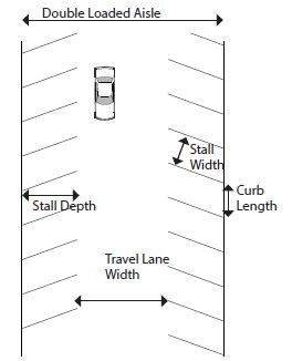
TABLE 8.3(1)
PARKING SPACE DIMENSIONSNote:Angle Curb Length Stall Width Stall Depth Travel Lane Width One-Way Two-Way 0° 20' 7' - 12' 20' 30° 20' 9' 16' 12' - 45° 12' 9' 17' 13' - 60° 10' 9' 18' 18' 22' 90° 9' 9' 20'1 24' 24'
1Stall depth may be reduced 2 feet when stall directly abuts an interior parking lot median that includes an additional area beyond the minimum width outlined in subsection 10-5.1B-7-6B2 of this article, permitting the overhang of the adjacent parked vehicle's front bumper.
- Wheel Stops: Install wheel stops or bumper guards when parking is adjacent to a pedestrian pathway to limit vehicle overhang that reduces the sidewalk width. Such stops or guards shall be properly anchored or secured.
FIGURE 8.3(2)
PARKING LOT PEDESTRIAN WALKWAY
- Location Of Parking: Refer to section 10-5.1B-5 of this article, building type standards for information on the location of parking facilities.
- Access: All off-street parking and loading facilities shall open directly onto an aisle, alley, or driveway designed to provide safe access to such facilities. Exceptions include:
- Tandem Parking: No more than two (2) spaces may be included in a tandem parking spot, and the rear space must meet the access requirement.
- Parking Lifts: The lift exit shall meet the access requirement.
- Edge Of Lot And Drives: All curb and gutter shall be located a minimum of three feet (3') from any adjacent property line or right-of-way.
- Slopes: All parking and driveway or sidewalk access shall meet the requirements of the Utah Accessibility Code.
- Landscape Screening: All parking areas shall meet the requirements of section 10-5.1B-7, "Landscape Standards," of this article.
- Landscape Areas: Areas not used specifically for sidewalks, parking spaces, driving aisles, loading, or refuse shall not be paved. Areas striped with diagonal striped islands are not permitted.
- Pavement Construction: All parking and driveways shall be constructed using asphalt, concrete, pavers, or other semi-pervious material approved by the City Manager or designee. One of the following shall be met:
- Paving materials with a solar reflectance index (SRI) of at least 29.
- Recycled content of fifteen percent (15%) or more.
- Illumination: All off-street parking lots or parking structures shall provide a level of illumination at any point in the parking lot or structure not less than one foot-candle measured at the pavement. All lighting shall be shielded or otherwise optically controlled to provide glare-less illumination and limit trespass on adjacent properties.
- Vehicular Parking Space Dimensions: The appropriate dimensions for parking spaces are outlined in table 8.3(1), "Parking Space Dimensions," and figure 8.3(1), "Parking Lot Layout," of this section.
- Bicycle Parking Design: Bicycle parking (refer to section 10-5.1B-8-2, table 8.2(1), "Required Bicycle Parking," of this article for quantity required) shall be designed and located as follows.
- Dimensions:
- Required bicycle parking spaces shall have minimum dimensions of two feet (2') in width and six feet (6') in length.
- An aisle a minimum of five feet (5') wide shall be provided behind bicycle parking facilities to allow for maneuvering.
- A minimum of two feet (2') shall be provided beside each parked bicycle to allows access. This access may be shared by adjacent bicycles.
- Racks shall be installed a minimum of two feet (2') from any wall or other obstruction.
- Location: Bicycle parking should be located within fifty feet (50') of the entrance of the use.
- Indoor or outdoor spaces are permitted, provided they are located on the lot with which they are associated.
- Spaces located within individual dwelling units may not be counted toward bicycle parking requirements.
- Bicycle parking facilities shall be separated from vehicular parking areas to protect parked bicycles from damage. The separation may be accomplished through grade separation, distance or physical barrier, such as curbs, wheel stops, poles or other similar features.
- Racks And Structures: Racks and structures shall be provided for each unprotected parking space, and shall be designed to accommodate both chain and U-shaped locking devices supporting the bicycle frame at two (2) points.
- Bicycle Storage: In multifamily or office uses bicycle storage shall be lockable and enclosed.
- Surface: The parking surface shall be designed and maintained to be mud and dust free. The use of rock or gravel areas for bicycle parking is permitted provided that edging materials, so that the bicycle parking area is clearly demarcated and the rock material is contained.
- Signage: If required bicycle parking for public use is not visible from the street, signs must be posted indicating their location.
- Maintenance And Lighting: Areas used for required bicycle parking must be well-lit with acceptable drainage to be reasonably free of mud and standing water. Accessory off-street parking for bicycles shall include provision for secure storage of bicycles. Such facilities shall provide lockable enclosed lockers or racks or equivalent structures in or upon which a bicycle may be locked by the user.
- Shower Facilities: Office and manufacturing uses with more than fifty (50) employees shall provide shower and changing room facilities.
- Long Term Parking: For multifamily residential uses, half of the bicycle parking spaces should be provided as long term parking, safe and secure from vandalism and theft, and protected from the elements. (Ord. 17-21, 11-21-2017, eff. 11-21-2017)
- Dimensions:
10-5.1B-8-4: Loading Requirements
- General Requirements: All loading facilities shall adhere to the following requirements, unless otherwise approved during site plan approval (refer to subsection 10-5.1B-10-2E of this article).
- Use Of Off-Street Loading Areas: Space allocated to any off-street loading use shall not be used to satisfy the space requirements for any off-street parking facilities or portions thereof.
- Location: Unless otherwise specified, all required loading facilities shall be located on the same lot as the use to be served. No loading space shall block or project into a street, alley, access drive, or parking area.
- Building Frontage: Loading facilities shall be located per section 10-5.1B-5 of this article, building type requirements.
- Access: Loading facilities shall have clear access onto an alley or be connected to an alley or street via a driveway.
- Direct access to a public way, other than an alley, is prohibited.
- Each required off-street loading space shall be designed with appropriate means of vehicular access to a street or alley in a manner which will least interfere with traffic movement.
- Loading Requirements: All uses except in the residential and lodging, open space, and civic and institutional categories shall provide off-street loading spaces in compliance with table 8.4(1), "Required Loading Facilities," of this section.
TABLE 8.4(1)
REQUIRED LOADING FACILITIESGross Floor Area (Square Feet) Loading Spaces Required Under 5,000 0 5,000 to 20,000 1 20,001 to 40,000 2 40,001 to 70,000 3 70,001 to 100,000 4 100,001+ 4 plus 1 for each 100,000 over 100,001 - Computation: Loading facilities shall be calculated using the following information.
- Gross Square Footage: Unless otherwise expressly stated, loading standards for non-residential buildings shall be computed on the basis of gross floor area in square feet.
- Fractions: When computation of the number of required off-street loading spaces results in a fractional number, any result of 0.5 or more shall be rounded up to the next consecutive whole number. Any fractional result of less than 0.5 may be rounded down to the previous consecutive whole number.
- Shared Or Central Loading Facilities: Shared or central loading facilities are permitted if the following conditions are met.
- Each zoning lot served shall have direct access to the central loading area without crossing streets or alleys.
- Total off-street loading spaces provided shall meet the minimum requirements herein specified, based on the sum of the several types of uses served unless reviewed and approved by the City Manager or designee through site plan review.
- No zoning lot served shall be more than five hundred feet (500') from the central loading area.
- Dimensions: A standard off-street loading space shall be a minimum of ten feet (10') in width by twenty six feet (26') in length and an oversized loading space shall be a minimum of twelve feet (12') in width and forty feet (40') in length, exclusive of aisle and maneuvering space and shall have a minimum vertical clearance of fifteen feet (15').
- Pavement Materials: Refer to this Code for details. One of the following shall also be met.
- Paving materials with a solar reflectance index (SRI) of at least 29.
- Pervious pavement.
- Recycled content of fifteen percent (15%) or more. (Ord. 17-21, 11-21-2017, eff. 11-21-2017)
10-5.1B-8-5: Site Access And Driveways
- General Requirements: These standards shall supplement the provisions for access provided in section 10-5.1B-5 of this article, building type standards. Each driveway providing site access from a street, alley, or other vehicular right-of-way shall be designed, constructed, and permanently maintained as follows.
- Quantity Of Driveways: The number of driveways permitted for each building type is located in section 10-5.1B-5 of this article, building type standards.
- Dimensions And Design:
- Driveway Width At Property Line: All driveways shall have a maximum width of twenty four feet (24') as measured at the property line (figure 8.5(1) of this section, driveway width) except as stated below.
- Residential building types: Driveways constructed in residential subdistricts shall have a maximum width of eleven feet (11') when crossing the front or corner property line.
- Maximum width for one-way driveways is twelve feet (12') at the property line.
FIGURE 8.5(1)
DRIVEWAY WIDTH AND LOCATION
- Maximum Width: When a garage door is located on the front facade of the structure, the driveway shall be no more than two feet (2') wider than the garage door at any location. A wider driveway to access an additional side yard parking space or rear yard parking space or garage, must be approved by the Staff Review Committee.
- Shared Access: When possible, adjacent developments should share points of access to minimize impervious surface.
- Shared Driveway Width: When access is shared between three (3) or more non-residential users, a dedicated turn lane may be constructed, allowing an increase in the maximum driveway width from twenty four feet (24') to thirty two feet (32') provided that:
- A traffic impact study states its necessity.
- Shared Driveway Width: When access is shared between three (3) or more non-residential users, a dedicated turn lane may be constructed, allowing an increase in the maximum driveway width from twenty four feet (24') to thirty two feet (32') provided that:
- Sidewalk Pavement: Sidewalk pavement elevation, width, scoring, material, and design shall extend continuously over the driveway pavement with the intent of prioritizing the sidewalk path over the driveway. If the driveway and sidewalk are of the same material, the sidewalk path shall be scored or designated linearly over the driveway.
- Driveway Width At Property Line: All driveways shall have a maximum width of twenty four feet (24') as measured at the property line (figure 8.5(1) of this section, driveway width) except as stated below.
- Location: Specific location information can be found in section 10-5.1B-5 of this article, building type standards. Refer to figure 8.5(1) of this section.
- Driveways accessing rear yard garages are permitted within the side or rear yard setback, no closer than two feet (2') from a side or rear property line, unless the driveway is shared.
- Driveways shall not be closer than twenty five feet (25') from the intersection of two (2) streets (corner), unless otherwise stated in section 10-5.1B-5 of this article, building type standards. (Ord. 17-21, 11-21-2017, eff. 11-21-2017)
10-5.1B-9-1: General Requirements
- Intent: This section 10-5.1B-9 seeks to enhance the economic and aesthetic appeal in each subdistrict through the reasonable, orderly, safe, and effective display of signage.
- Applicability: These standards shall apply to all subdistricts for non-residential uses only. Unless otherwise stated in this chapter, all requirements of this Code pertaining to sign requirements shall apply. Refer to the South Ogden City Sign Code (chapter 21 of this title) for permit processes, construction, design, and maintenance standards.
- General Compliance: Compliance with the regulations outlined shall be attained under the following situations.
- Newly Constructed Or Reconstructed Signage: All new signs and structural improvements to existing signs.
- Change In Use For Single Business Signage: For signage serving one business, whenever the existing use is changed to a new use resulting in a change in signage, including rewording.
- Multiple-Business Signage: For signage serving multiple businesses, whenever fifty percent (50%) or more of the existing uses are changed to new uses resulting in a change in signage, including rewording.
- Damage Or Destruction: When a sign has been damaged or destroyed by fire, collapse, explosion or other cause and the cost of restoration is greater than fifty percent (50%) of the replacement value at the time of the destruction or damage, the replacement sign shall comply with the standards in this article.
- Prohibited And Exempt Signage: Refer to the South Ogden City Sign Code for information on prohibited, and exempt signs.
- Sign Location: Unless otherwise specified, signs shall only be located within the boundaries of the lot and not in the right-of-way or on public property.
- Certain sign types may extend beyond a property line into the right-of-way or public property with permission from the City and in accordance with the regulations outlined in this section.
- No sign shall be attached to a utility pole, tree, standpipe, gutter, or drain.
- Signs shall be erected so as to permit free ingress to or egress from any door, window, the roof, or any other exit-way required by the Building Code or by Fire Department regulations.
- No sign shall be erected or maintained in such a manner as to obstruct free and clear vision of, interfere with, or be confused with any authorized traffic sign, signal, or device.
- Illumination: All signs shall be illuminated according to the following provisions unless otherwise stated.
- Signs shall be illuminated only by steady, stationary light sources directed solely at the sign or internal to it, except as permitted for electronic message boards.
- Individual letters or logos may be internally illuminated as permitted per each sign type; no other portion of the sign shall be internally illuminated, except as permitted for electronic message boards or unless otherwise stated.
- When an external artificial light source is used to illuminate a sign, the lamp (or bulb) shall be located, shielded, and directed so as to not be visible from any public street or private residence.
- No receptacle or device housing a permitted light source which is attached to the sign itself shall extend more than eighteen inches (18") from the face of the sign.
- If ground lighting is used to illuminate a sign, the receptacle or device should not extend more than twelve inches (12") above ground and must be fully screened and housed.
- The illumination of any sign, resulting from any internal or external artificial light source, shall not exceed two hundred fifty (250) nits at the sign face during the day and one hundred twenty five (125) nits at the sign face after sunset, with no light trespass onto adjacent property.
- Computation: The following standards generally apply to computing the area of signs by type and by building lot. Refer to the sign types in sections 10-5.1B-9-3 through 10-5.1B-9-13 of this article for more information.
- Exempt and temporary signs are not included in the maximum signage area calculations, unless otherwise specified.
- Height for freestanding signs is measured from the average grade at the front property line to the top of the sign, sign cabinet, or cap, whichever is highest.
- For the purposes of determining area, lot width or frontage is measured along the front property line.
- If the lot is a corner lot, the width shall be measured along the front yard.
- Building frontage is the width of the front facade of a building. (Ord. 18-04, 5-15-2018, eff. 5-15-2018)
10-5.1B-9-2: Sign Types
- Sign Type Requirements: The following pertain to specific sign types detailed in this section.
- Permitted Quantity Of Signage By Subdistrict: Table 9.2(1) of this section details the maximum permitted amount of signage on a lot within each subdistrict. Refer to section 10-5.1B-3, "Subdistricts," of this article for more information on each subdistrict.
TABLE 9.2(1)
PERMITTED QUANTITY OF SIGNAGE BY SUBDISTRICTMaximum Permitted Quantity Of Signage Per Lot Core And General Subdistricts Neighborhood Subdistricts Edge Subdistricts 2 square feet per 1 linear foot of lot width with a maximum of 200 square feet or 300 square feet if a monolithic sign is used. An additional 40 square feet per additional tenant over 3 tenants permitted 1.5 square feet per 1 linear foot of lot width with a maximum of 150 square feet No signage permitted - Window Signs: Window signs shall count towards a lot's maximum permitted amount of signage. Refer to section 10-5.1B-9-8, "Window Sign," of this article.
- Signs Located On Parking Lots: One sign is permitted in addition to the maximum signage quantities detailed in table 9.2(1) of this section provided the following.
- Permitted sign types are a wall, projecting, or awning sign.
- Maximum sign area is thirty (30) square feet.
- Permitted location is either the side or rear facade along a parking lot;
- Through Lots: In addition to the maximum amount of signage permitted per lot, through lots may incorporate an additional thirty (30) square feet of signage permitted for the lot located in either the rear yard or along the rear facade.
- Exempt/Temporary Signs: Table 9.2(1) of this section does not apply to exempt or temporary signs unless otherwise specified.
- Iconic Sign Elements: Iconic sign elements of three dimensional symbols or logos are permitted under the following conditions.
- Symbol Or Logo Size: The symbol may not be larger than four feet (4') in any direction, included in overall sign area and the surface area counts towards the maximum permitted quantity of signage per lot.
- Moving Parts: No moving parts or external illumination of the symbol may be provided.
- Text: The text component of the sign may not be more than thirty percent (30%) of the overall area of the sign.
- Electronic Message Boards (EMBs): EMBs are only allowed in the Gateway General, Gateway Core, and Neighborhood Commercial Subdistricts.
- Automatic Dimmer: Electronic message boards must have an automatic dimmer to reduce sign intensity after dark.
- Hours Of Operation: The electronic message board shall only be on during the operational hours of the associated permitted business.
- Animated, Flashing Or Rapid Blinking Prohibited: A message cannot be displayed by means of animation, flashing or rapid blinking except when changing to a different message. Each individual message shall remain for a minimum of six (6) seconds.
- Cannot Be A Nuisance: The sign shall not cause glare or be intensely lighted at dark so that it creates a nuisance or hazard to vehicle traffic, pedestrians, or neighboring residential properties.
- No Off-Premises Advertising: No EMB sign may advertise for a business not located on the premises where the sign is located.
- Cannot Be Temporary Sign: EMBs cannot be a temporary sign (i.e., a small digital sign in a window or placed in front of a business to attract attention).
- Other Restrictions: See individual sign types for other EMB restrictions. (Ord. 18-04, 5-15-2018, eff. 5-15-2018)
- Permitted Quantity Of Signage By Subdistrict: Table 9.2(1) of this section details the maximum permitted amount of signage on a lot within each subdistrict. Refer to section 10-5.1B-3, "Subdistricts," of this article for more information on each subdistrict.
10-5.1B-9-3: Wall Sign
- Description: Wall signs, also known as flat or band signs, are mounted directly to the building face to which the sign is parallel. Refer to figures 9.3(1) and 9.3(2) of this section.
FIGURE 9.3(1)
WALL SIGN
FIGURE 9.3(2)
MEASURING WALL SIGNS
- General Requirements: Wall signs shall be developed according to the standards in table 9.3(1) of this section.
TABLE 9.3(1)
WALL SIGN REQUIREMENTSPermitted subdistricts All core, general, and neighborhood subdistricts Sign area No maximum area for sign type; refer to section 10-5.1B-9-2, table 9.2(1) of this article for maximum per lot Height 2' maximum letter or element height Location on the building or site Permitted on all facades Placement on the building or site 1' maximum projection from building face Quantity 1 per tenant per public ROW frontage; 1 per tenant per side or rear facade on a parking lot Internal illumination Permitted for individual letters and logos Materials Solid wood, metal, masonry and neon glass; plastic and synthetics permitted only as separate alphanumeric characters or logos - Building Openings: Wall signs shall not cover windows or other building openings.
- Architectural Features: Wall signs shall not cover architectural building features.
- Murals: Murals, a type of wall sign painted onto the building face displaying the business name or activity, are prohibited. (Ord. 20-18, 7-7-2020)
- Computation: The area of a wall sign is calculated using the following information.
- Wall Signs: Area is calculated by drawing the smallest possible square or rectangle around the largest letters and/or elements, as is illustrated in figure 9.3(2) of this section.
- Area Credit: All areas that utilize individual alphanumeric characters or logos (including only those using wood, wood substitute, metal, or masonry) may use a total area of ninety percent (90%) of the calculation as outlined above. (Ord. 18-04, 5-15-2018, eff. 5-15-2018; amd. Ord. 20-18, 7-7-2020)
- Area Credit: All areas that utilize individual alphanumeric characters or logos (including only those using wood, wood substitute, metal, or masonry) may use a total area of ninety percent (90%) of the calculation as outlined above. (Ord. 18-04, 5-15-2018, eff. 5-15-2018; amd. Ord. 20-18, 7-7-2020)
- Wall Signs: Area is calculated by drawing the smallest possible square or rectangle around the largest letters and/or elements, as is illustrated in figure 9.3(2) of this section.
10-5.1B-9-4: Projecting Sign
- Description: A projecting sign is attached to and projects from a building face or hangs from a support structure attached to the building face. Sign faces are typically perpendicular to the building face, but may be at an angle greater than forty five degrees (45°) from the facade. The sign may be vertically or horizontally oriented. Refer to figure 9.4(1) of this section.
FIGURE 9.4(1)
PROJECTING SIGN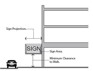
- General Requirements: Projecting signs shall be developed according to the standards in table 9.4(1) of this section.
TABLE 9.4(1)
PROJECTING SIGN REQUIREMENTSPermitted subdistricts All core, general, and neighborhood subdistricts Sign area No maximum area for sign type; refer to section 10-5.1B-9-2, table 9.2(1) of this article for maximum per lot Height 8' maximum sign length, 8' minimum clearance to walk required Location on the building or site Permitted on all facades; sign and structural supports shall not extend above the eave or parapet Placement on the building or site Shall not project closer than 3' from back of curb Quantity 1 per tenant per public ROW frontage; 1 per tenant per side or rear facade on a parking lot Internal illumination Permitted for individual letters and logos Materials Solid wood, metal, masonry and neon glass; plastic and synthetics permitted only as separate alphanumeric characters or logos - Computation: The area of a projecting sign is equal to the area of one of the sign's faces. (Ord. 18-04, 5-15-2018, eff. 5-15-2018)
10-5.1B-9-5: Projecting Marquee Sign
- Description: A projecting marquee sign is a projecting sign designed to have manually changeable copy and two (2) to three (3) sign faces. Refer to figures 9.5(1) and 9.5(2) of this section.
FIGURE 9.5(1)
PROJECTING MARQUEE SIGN
FIGURE 9.5(2)
PROJECTING MARQUEE SIGN PLAN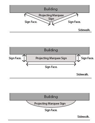
- General Requirements: Projecting marquee signs shall be developed according to the standards in this section and table 9.5(1) of this section.
TABLE 9.5(1)
PROJECTING MARQUEE SIGN REQUIREMENTSNote:Permitted subdistricts All core, general, and neighborhood subdistricts, limited to assembly uses or theater uses per section 10-5.1B-4, "Uses," of this article Sign area No maximum area for sign type; minimum 2 faces per sign. Refer to section 10-5.1B-9-2, table 9.2(1) of this article for maximum per lot Height 10' minimum clearance to walk required Location on the building or site Front and corner side facades only Placement on the building or site Maximum projection from building is 6'; shall not project closer than 1' from back of curb Quantity 1 per lot Internal illumination Permitted for individual letters and logos Materials Solid wood, metal, masonry and neon glass; plastic and synthetics permitted only on sign face; electronic message and manually changeable copy boards permitted with conditions1
1See subsection C1 of this section for conditions. - Computation: The sign area is calculated by combining the area of all exposed sign faces and the cabinet or structure surrounding them.
- Manually Changeable And Electronic Message Boards: Manually changeable copy boards and EMBs are permitted on projecting marquee signs in the Gateway General, Gateway Core, and Neighborhood Commercial Subdistricts by right, provided the following conditions are met:
- The area of the boards cannot equal greater than thirty percent (30%) of the area of the sign face on which it is located or thirty two (32) square feet, whichever is less.
- One sign of any type containing a manually changeable copy board or EMB is permitted per lot. (Ord. 18-04, 5-15-2018, eff. 5-15-2018)
- Manually Changeable And Electronic Message Boards: Manually changeable copy boards and EMBs are permitted on projecting marquee signs in the Gateway General, Gateway Core, and Neighborhood Commercial Subdistricts by right, provided the following conditions are met:
10-5.1B-9-6: Awning Sign
- Description: A sign that is mounted, painted, or otherwise applied on or attached to an awning or canopy. Refer to figures 9.6(1) and 9.6(2) of this section.
FIGURE 9.6(1)
AWNING SIGN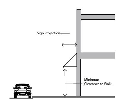
FIGURE 9.6(2)
MEASURING AWNING SIGNS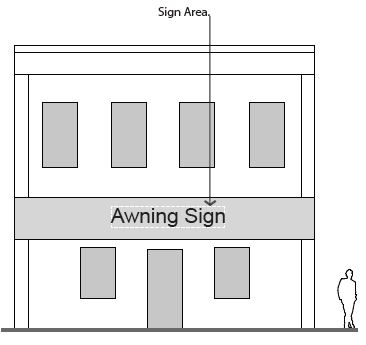
- General Requirements: Awning signs shall be developed according to the standards in table 9.6(1) of this section.
TABLE 9.6(1)
AWNING SIGN REQUIREMENTSPermitted subdistricts All core, general, and neighborhood subdistricts Sign area Up to 50% of the awning may be used for signage; refer to section 10-5.1B-9-2, table 9.2(1) of this article for maximum per lot Height 8' minimum clearance to walk required Location on the building or site Permitted on all facades Placement on the building or site Maximum projection from building is 6'; shall not project closer than 2' from back of curb; shall not block any window, door, or the building roof Quantity 1 per tenant per street frontage; 1 per tenant per side or rear facade on a parking lot Internal illumination Not permitted Materials Cloth, canvas, metal, or wood; all supports shall be made of metal or wood - Computation: The area of an awning sign is calculated by drawing the smallest possible square or rectangle around the largest letters and/or elements of the sign portion of the awning, as is illustrated in figure 9.6(2) of this section. (Ord. 18-04, 5-15-2018, eff. 5-15-2018)
10-5.1B-9-7: Canopy-Mounted Sign
- Description: A sign with individual alphanumeric characters and/or logos that is mounted on top of a permanent canopy. Refer to figures 9.7(1) and 9.7(2) of this section.
FIGURE 9.7(1)
CANOPY-MOUNTED SIGN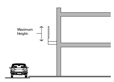
FIGURE 9.7(2)
MEASURING CANOPY-MOUNTED SIGNS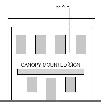
- General Requirements: Canopy-mounted signs shall be developed according to the standards in table 9.7(1) of this section.
TABLE 9.7(1)
CANOPY-MOUNTED SIGN REQUIREMENTSNote:Permitted subdistricts All core, general, and neighborhood subdistricts Sign area No maximum area for sign type; refer to section 10-5.1B-9-2, table 9.2(1) of this article for maximum per lot Height 2' maximum letter or element height; cannot project more than 2' above roof line of canopy Location on the building or site Permitted on all facades; not intended for the principal roof of the building Placement on the building or site Shall not project beyond the front edge of the canopy; shall not block any window, door, or the building roof Quantity 1 per tenant per public ROW frontage; 1 per tenant per side or rear facade on a parking lot Internal illumination Permitted for individual letters and logos Materials Solid wood, metal, and neon glass; plastic and synthetics permitted only as separate alphanumeric characters or logos. EMBs and manually changeable copy boards are permitted with conditions1
1Manually Changeable And Electronic Message Boards: Manually changeable copy boards and EMBs are permitted on canopy signs in the Gateway Core, Gateway General, and Neighborhood Commercial Subdistricts by right, provided the following conditions are met:
a. The area of the boards cannot equal greater than 30 percent of the area of the sign face on which it is located or 32 square feet, whichever is less.
b. 1 sign of any type containing a manually changeable copy board or EMB is permitted per lot. - Computation: The area of a canopy-mounted sign is calculated by drawing the smallest possible square or rectangle around the largest letters and/or elements of the sign portion of the canopy-mounted sign, as is illustrated in figure 9.7(2) of this section. (Ord. 18-04, 5-15-2018, eff. 5-15-2018)
10-5.1B-9-8: Window Sign
- Description: A window sign is posted, painted, placed, or affixed in or on a window exposed for public view or is a sign hung inside the building facing the window for public view. Refer to figure 9.8(1) of this section.
FIGURE 9.8(1)
MEASURING WINDOW SIGNS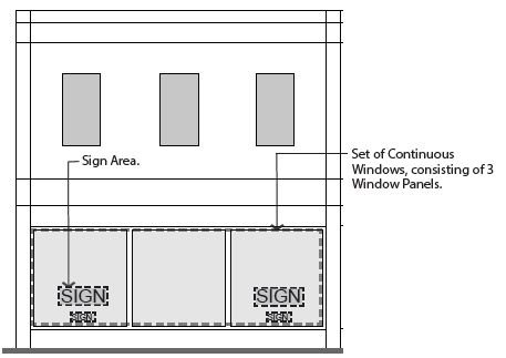
- General Requirements: Window signs shall be developed according to the standards in table 9.8(1) of this section.
TABLE 9.8(1)
WINDOW SIGN REQUIREMENTSPermitted subdistricts All core, general, and neighborhood subdistricts Sign area Up to 30% of a set of continuous windows may be covered with signage; no more than 50% of any 1 window panel may be covered with signage Height No maximum Location on the building or site Permitted on all facades Placement on the building or site Ground or upper story windows; may be affixed to window or hung/mounted behind glass Quantity No maximum quantity, based on window sign area for ground story; 1 per tenant per floor for upper stories Internal illumination Not permitted, except on neon or similarly illuminated window signs. EMBs are not allowed Materials Drawn, painted, or affixed on the glass; wood, metal, neon glass, plastic, or other similar materials also permitted - Computation: A series of windows that are separated by frames or supporting material of less than six inches (6") in width shall be considered a single window for the purposes of computation.
- Measurement: To measure sign area percentage, divide the total sign area by the total window area, as illustrated in figure 9.8(1) of this section.
- Maximum Allowance: Window signs are counted toward a site's maximum signage allowance.
- Exempt Signs: Address and hours of operation are considered exempt signs and are not counted in the window sign area calculation. Refer to subsection 10-5.1B-9-2A2 of this article, exempt signs.
- Temporary Window Signs: Temporary window signs must be included in the total percentage of signage per window calculation. Refer to subsection 10-5.1B-9-2A2 of this article, temporary signs.
- Internal Illumination: Window signs may not be internally illuminated except for neon or similar illuminated window signs. (Ord. 18-04, 5-15-2018, eff. 5-15-2018)
10-5.1B-9-9: Monument Sign
- Description: A monument sign is freestanding; it is located in a front or side yard of a lot. Refer to figures 9.9(1) and 9.9(2) of this section.
FIGURE 9.9(1)
MONUMENT SIGN
FIGURE 9.9(2)
MONUMENT SIGN WITH EMB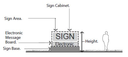
(Ord. 18-04, 5-15-2018, eff. 5-15-2018) - General Requirements: Monument signs shall be developed according to the standards in table 9.9(1) of this subsection B.
TABLE 9.9(1)
MONUMENT SIGN REQUIREMENTSNotesPermitted subdistricts All Core, General, and Neighborhood Subdistricts Sign area Maximum 70 sq. ft. per sign face Height Maximum height 6' Location on the building or site Front or corner yards Placement on the building or site 10' setback from driveways and side property line; 3' setback1 from front and corner property lines Quantity 1 per public ROW frontage Internal illumination Permitted for individual letters and logos Materials Solid wood, metal and masonry; plastic and synthetics permitted on sign face; electronic message board and manually changeable copy permitted in certain subdistricts with conditions2
1Sight Triangle: If placed closer than 5 feet from the front and corner side property lines, sign must not be located in a sight triangle extending 10 feet from either side of an intersection of a driveway and a vehicular right-of-way or 2 vehicular rights-of-way. Signs 24 inches or less are exempt from this requirement.
2Manually Changeable And Electronic Message Boards: Manually changeable copy boards and EMBs are permitted on monument signs in the Gateway General, Gateway Core, and Neighborhood Commercial Subdistricts by right, provided the following conditions are met:
a. The area of the boards cannot equal greater than 50 percent of the area of the sign face on which it is located or 20 square feet, whichever is less.
b. 1 sign of any type containing a manually changeable copy board or EMB is permitted per lot.
(Ord. 18-11, 9-18-2018, eff. 9-18-2018)- Multiple Tenants: Multiple tenant buildings on a lot with a width of greater than three hundred feet (300'), measured across the front property line, may have signage with the following parameters:
- Up to two (2) monument signs on one frontage.
- Signs shall be at least one hundred fifty feet (150') apart.
- Pole-Mounted Signs: Monument signs may not be pole-mounted.
- Multiple Tenants: Multiple tenant buildings on a lot with a width of greater than three hundred feet (300'), measured across the front property line, may have signage with the following parameters:
- Computation: The area of a two-sided monument sign is equal to the area of one sign face. The area of a three- or four-sided monument sign is equal to the total area of each sign face. This measurement includes the sign, any cabinet in which it is enclosed and the electronic message center or manually changeable copy board, but excludes the base of the sign.
- Measuring Height: Height shall include the sign face, base, cabinet, and ornamental cap. (Ord. 18-04, 5-15-2018, eff. 5-15-2018)
- Measuring Height: Height shall include the sign face, base, cabinet, and ornamental cap. (Ord. 18-04, 5-15-2018, eff. 5-15-2018)
10-5.1B-9-10: Pedestrian-Scale Pole-Mounted Sign
- Description: A pedestrian-scale pole-mounted sign is freestanding and may be mounted on one or two (2) poles. Three (3) configurations are permitted. Refer to figure 9.10(1) of this subsection
- A sign mounted onto a double set of poles.
- A sign mounted on a single pole.
- A sign hanging from a single pole.
FIGURE 9.10(1)
THREE TYPES OF PEDESTRIAN-SCALE POLE-MOUNTED SIGNS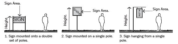
(Ord. 18-04, 5-15-2018, eff. 5-15-2018)
- General Requirements: Pedestrian-scale pole-mounted signs shall be developed according to the standards in table 9.10(1) of this subsection B.
TABLE 9.10(1)
PEDESTRIAN-SCALE POLE-MOUNTED SIGN REQUIREMENTSNote:Permitted subdistricts All Core, General, and Neighborhood Subdistricts Sign area 8 sq. ft. maximum area per sign face Height 8' maximum height for sign mounted or hanging on a single pole; 5' for sign mounted on double set of poles; each pole shall have a maximum size of 3.5" by 3.5" Location on the building or site Front or corner yards Placement on the building or site 2' minimum setback from front and corner property lines; cannot overhang property lines1 Quantity 1 per lot Internal illumination Permitted for individual letters and logos Materials Solid wood, metal and masonry; plastic and synthetics permitted on sign face
1Placement: If placed closer than 5 feet from the front and corner side property lines, sign must not be located in a sight triangle extending 10 feet from either side of an intersection of a driveway and a vehicular right-of-way or 2 vehicular rights-of-way. Signs 24 inches or less are exempt from this requirement.
(Ord. 18-11, 9-18-2018, eff. 9-18-2018) - Computation: The area of a pedestrian-scale pole-mounted sign is equal to the area of one sign face. (Ord. 18-04, 5-15-2018, eff. 5-15-2018)
10-5.1B-9-11: Monolithic Sign
- Description: A monolithic sign is freestanding and continuous from the ground up without visible columns, uprights or braces and uses the total structure as a sign; it is located in a front or side yard of a lot. Refer to figure 9.11(1) of this subsection A.
FIGURE 9.11(1)
MONOLITHIC SIGN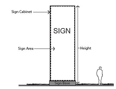 (Ord. 18-04, 5-15-2018, eff. 5-15-2018)
 - General Requirements: Monolithic signs shall be developed according to the standards in table 9.11(1) of this subsection B.
TABLE 9.11(1)
MONOLITHIC SIGN REQUIREMENTSNotes:Permitted subdistricts Gateway Core Sign area Maximum 196 sq. ft. per sign face Height Maximum height 25' Width Maximum width 8' Location on the building or site Front or corner yards Placement on the building or site 10' setback from driveways and side property line; 3' setback1 from front and corner property lines Quantity 1 per public ROW frontage Internal illumination Permitted for individual letters and logos Materials Solid wood, metal and masonry; plastic and synthetics permitted on sign face; electronic message board or manually changeable copy board permitted with conditions2
1Sight Triangle: If placed closer than 5 feet from the front and corner side property lines, sign must not be located in a sight triangle extending 10 feet from either side of an intersection of a driveway and a vehicular right-of-way or 2 vehicular rights-of-way.
2Manually Changeable And Electronic Message Boards: Manually changeable copy boards and EMBs are permitted on monolithic signs in the Gateway Core Subdistrict by right, provided the following conditions are met:
a. The area of the boards cannot equal greater than 50 percent of the area of the sign face on which it is located or 20 square feet, whichever is less.
b. 1 sign of any type containing a manually changeable copy board or EMB is permitted per lot.
(Ord. 18-11, 9-18-2018, eff. 9-18-2018)- Multiple Tenants: Multiple tenant buildings on a lot with a width of greater than three hundred feet (300'), measured across the front property line, may have signage with the following parameters:
- Up to two (2) monolithic signs on one frontage.
- Signs shall be at least one hundred fifty feet (150') apart.
- Multiple Tenants: Multiple tenant buildings on a lot with a width of greater than three hundred feet (300'), measured across the front property line, may have signage with the following parameters:
- Computation: The area of a two-sided monolithic sign is equal to the area of one sign face. The area of a three- or four-sided monolithic sign is equal to the total area of each sign face. This measurement includes the sign, any cabinet in which it is enclosed and the electronic message center or manually changeable copy board, but excludes the base of the sign.
- Measuring Height: Height shall include the sign face, base, cabinet, and ornamental cap. (Ord. 18-04, 5-15-2018, eff. 5-15-2018)
- Measuring Height: Height shall include the sign face, base, cabinet, and ornamental cap. (Ord. 18-04, 5-15-2018, eff. 5-15-2018)
10-5.1B-9-12: Vehicular-Scale Pole Sign
- Description: A freestanding pole-mounted sign that may be mounted on one or two (2) poles. Two (2) general configurations are permitted:
- A sign mounted onto a double set of poles. Refer to figure 9.12(1) of this subsection A.
- A sign mounted on a single pole. Refer to figure 9.12(2) of this subsection A.
FIGURE 9.12(1)
VEHICULAR-SCALE POLE SIGN MOUNTED ON A DOUBLE SET OF POLES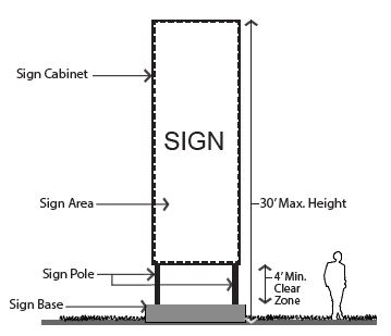
FIGURE 9.12(2)
VEHICULAR-SCALE POLE SIGN MOUNTED ON A SINGLE POLE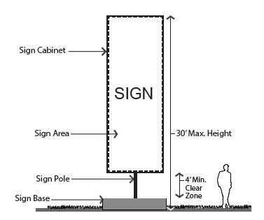
- General Requirements: Vehicular-scale pole-mounted signs shall be developed according to the standards in table 9.12(1) of this section.
TABLE 9.12(1)
VEHICULAR-SCALE POLE SIGN REQUIREMENTSNotes:Permitted subdistricts Gateway Core Sign area 200 sq. ft. maximum area per sign face Height 30' maximum, single or double pole Width 12' maximum Clear zone height 4' minimum from top of foundation/ground to bottom of sign Location on the building or site Front yards and side yards Placement on the building or site 10' setback from driveways and side property line; 3' from front side and corner property lines1 Quantity 1 per 300' frontage maximum Internal illumination Permitted for individual letters and logos Materials Solid wood, metal and masonry; plastic and synthetics permitted on sign face. EMBs and manually changeable copy board permitted with conditions2. Support poles may be incorporated into metal, concrete, masonry or stone footings up to 4' high and 2' wide
1Sight Triangle: If placed closer than 5 feet from the front and corner side property lines, sign must not be located in a sight triangle extending 10 feet from either side of an intersection of a driveway and a vehicular right-of-way or 2 vehicular rights-of-way; cannot overhang property lines.
2Manually Changeable And Electronic Message Boards: Manually changeable copy boards and EMBs are permitted on monolithic signs in the Gateway Core Subdistrict by right, provided the following conditions are met:
a. The area of the boards cannot equal greater than 50 percent of the area of the sign face on which it is located or 20 square feet, whichever is less.
b. 1 sign of any type containing a manually changeable copy board or EMB is permitted per lot. - Computation: The area of a two-sided vehicular-scale pole sign is equal to the area of one sign face. The area of a three- or four-sided vehicular-scale pole sign is equal to the total area of each sign face. This measurement includes the sign, any cabinet in which it is enclosed and the electronic message center or manually changeable copy board, but excludes the base of the sign.
- Measuring Height: Height shall include the sign face, base, cabinet, and ornamental cap. (Ord. 18-04, 5-15-2018, eff. 5-15-2018)
- Measuring Height: Height shall include the sign face, base, cabinet, and ornamental cap. (Ord. 18-04, 5-15-2018, eff. 5-15-2018)
10-5.1B-9-13: Temporary Sign
- Description: A sign used to advertise community or civic projects, construction projects, real estate for sale or lease, business openings, special events, on a temporary basis. May also be a sign temporarily used until a permanent sign is established.
Temporary signs may consist of banners, inflatables, blades, feathers, balloons, kinetic signs, building wraps, etc. - General Requirements: Temporary signs shall require a temporary sign permit and shall not be erected for more than thirty (30) days. Each business, organization, etc., are limited to two (2), 30-day permits during the calendar year.
Movable A-frame and placard signs used to advertise daily events, menus, specials, etc., do not need a temporary sign permit. They are limited to six (6) square feet (or 12 square feet if both sides of the sign are used) and may only be used during the operational hours of the associated permitted business and must be removed at the end of each business day.
Temporary signs shall be developed according to the standards in table 9.13(1) of this section.
TABLE 9.13(1)
TEMPORARY SIGN REQUIREMENTSNote:Permitted subdistricts All general, core, neighborhood, and edge subdistricts Sign area Maximum 36 sq. ft. per sign face Height Maximum height none Width Maximum width none Location on the building or site Within property boundaries. Placement on roof not permitted Placement on the building or site Cannot block clear view area1 Quantity 1 per public ROW frontage Internal illumination Not permitted Materials Plastic, wood, or any flexible woven fabric material such as cloth, paper, fiberglass, vinyl, or other synthetic product. EMBs are not allowed as temporary signs
1If placed closer than 5 feet from the front and corner side property lines, sign must not be located in a sight triangle extending 10 feet from either side of an intersection of a driveway and a vehicular right-of-way or 2 vehicular rights-of-way. - Exemptions: The following temporary signs are exempt from permit requirements:
- Signs for political (see section 10-21C-20 of this title for rules specific to political signs) or civic purposes or promotions.
- Real estate for sale or lease signs.
- Computation: Temporary signs are not included in the maximum signage area calculations, unless otherwise specified. (Ord. 18-04, 5-15-2018, eff. 5-15-2018)
10-5.1B-10-1: General Provisions
- Purpose: It is the intent of this form based code (this article) to promote public health, safety, and general welfare of the community, reflecting the goals established within the South Ogden City General Plan. It includes but is not limited to the specific purposes below.
- To achieve mixed use development that is appropriate in scale and intensity for the neighborhoods and sites proximate to transit stops and stations.
- To establish a relationship between buildings, streets, and open spaces that is pedestrian, bicycle, and transit-oriented.
- To preserve and enhance the City's natural resources, energy, water, and open spaces and to promote innovative development that sustainably manages these issues, including stormwater runoff and mitigation of the urban heat island effect.
- To ensure that a variety of housing types and sizes can be developed to meet the needs of the entire community.
- To promote a variety of transportation options for residents and visitors.
- Scope Of Regulations:
- New Development: All development, construction, and establishment of uses within the limits of this article occurring after the effective date of this article shall be subject to all applicable regulations of this article.
- Renovated Structures: All building renovations affecting greater than fifty percent (50%) gross square footage of a structure within the limits of this article shall be subject to all applicable regulations of this article.
- In-Process Development: Where a building permit for a development has been applied for in accordance with the prior law in advance of this article's effective date, said development may comply with the plans from which the permit was approved and, upon completion, receive a certificate of occupancy or zoning certificate (provided all conditions are met) provided the following.
- Work or construction is begun within one year of the effective date of this article.
- Work or construction continues diligently toward completion.
- Nonconformance: After the effective date of this article, existing buildings and uses that do not comply with the regulations of this article shall be considered nonconforming and are subject to the standards of section 10-5.1B-10-4, "Nonconformances," of this article.
- Private Ownership: All roads, alleys, parking lots, service areas and similar facilities proposed for development and not specifically designated as public shall be assumed to be privately owned. South Ogden City will not be responsible for constructing, managing, operating or maintaining any private roads, alleys, parking lots, service areas, utilities or infrastructure proposed for inclusion in the districts controlled by this article.
- Administration And Enforcement: The provisions of this article shall be administered and enforced by the City Manager or designee, unless otherwise specifically stated. For the purposes of this article, the term City Manager shall be inclusive of his or her designees.
Where provisions of this article differ from this Code, the requirements of this article shall apply. - Development Application: Applications (form, fees, and plan sets) shall be filed with the City Manager or designee.
- Application Form: Application forms are available from the City.
- Fees: Fee amounts are available from the City and are due at the time the application is made; the application will be considered incomplete if fees are not paid.
- Plan Set Requirements: Number of copies and minimum scale of drawings shall be noted on the application form. All plans shall be submitted in both a paper and an approved digital format using NAD1983 State plane coordinates.
- Filing Deadline: Filing deadlines are established by the City and available at the City.
- Withdrawal Of Application: Applicant may withdraw application whole or in part at any point in the process prior to being acted or ruled upon; new application form, fees, and plan sets are required for reapplication.
- Records On File: Applications and the resulting recommendations and rulings shall be kept on file by the City Manager or designee and shall be considered public record.
- Notice: Notice requirements for each process are detailed in this Code.
- Zoning Map: The areas and boundaries of the subdistricts listed in section 10-5.1B-3 of this article are hereby established to scale as shown on the map entitled Zoning Map of the City and referred to herein as "Zoning Map."
- Process: Any development within a subdistrict shall be administered in accordance with the procedures defined in section 10-5.1B-10-2 of this article and this title.
- The application shall include the following processes:
- Pre-application meeting. Refer to subsection 10-5.1B-10-2B of this article.
- Site plan approval, including building, site, and streetscape. Refer to subsection 10-5.1B-10-2E of this article.
- The application shall include the following processes:
- Staff Review Committee: The City Manager or designee shall approve, deny, or approve with conditions all submittals for regulating plans and site plans within the subdistricts upon review by a Staff Review Committee.
- The Staff Review Committee shall include members of each regulatory agency, a representative of each affected City Department [i.e., Planning, Zoning, Public Works, Transportation, Utilities].
- The Staff Review Committee shall meet regularly to process applications within the time lines established by subsections 10-5.1B-10-2A through E of this article.
- The decision regarding approval or denial of a regulating plan or site plan shall state in writing the reasons for approval or denial.
- If a regulating plan or site plan is denied by the City Manager or designee, the applicant may appeal the decision to the Hearing Officer.
- After an application is approved, approved with conditions, or denied, it will appear on the Planning Commission and City Council agendas for their information. (Ord. 18-04, 5-15-2018, eff. 5-15-2018)
10-5.1B-10-2: Development Review Procedures
- General Requirements: The processes included in this section are required for approval of new development in the South Ogden commercial areas.
- Appeal: If any application is disapproved, applicant may appeal the decision through the appeals process (refer to section 10-4-3 of this title).
- Expiration Of Approval: Approval of any application shall expire twelve (12) months from the date of approval, if permits for development have not been submitted for review or construction has not begun.
- Applicant can request an extension if done so in writing to the City Manager or designee at least thirty (30) days prior to the end of the twelve (12) month period.
- Failure to act within the twelve (12) month period shall require a new application, including all forms, fees, and plan sets.
- Review Criteria: All regulating plan, site plan, and exception applications shall be reviewed using the following criteria.
- Plan complies with the standards within the intents of the General Plan.
- Plan's design is consistent with the intent, character, and planning criteria of any plan in place.
- Plan's design meets all of the requirements of this article.
- Proposed development is sufficiently served by or provides essential public facilities, such as access and open space, and services, such as utilities and emergency services.
- Plan is designed with regard to preserving the lot's natural features and topography.
- Pre-Application Meeting:
- Intent: To afford the applicant an opportunity to receive the advice and assistance of the professional staff before preparing formal plans and making an official application.
- Eligible Applicant: Applicant must apply for a pre-application meeting prior to submitting an application for rezoning, preliminary plat approval, exception, or variance. The pre-application meeting is encouraged for site plan approval processes.
- Application: Applicant shall submit the following.
- Application, form, and applicable fees.
- Sketch plan. A sketch plan or plans shall detail the proposal, including the following.
- General rough layout of block, and lots, with types of streets and open space type noted.
- Existing conditions such as topography, water bodies, aerial photograph, and floodplain.
- Approximate distribution of subdistricts, building types, and uses.
- Anticipated method of achieving parking requirements.
- Site survey if available.
- Exceptions or variances. A description of any desired exception or variance (per section 10-5.1B-10-3 of this article).
- Pre-Application Meeting: Staff shall meet with the applicant to discuss the proposed plan within thirty (30) days of receipt of the complete application.

- Rezoning Process: Refer to this Code for information on the rezoning process.
- Subdivision Plat Approvals: Refer to title 11 of this Code for information on the subdivision plat approvals processes.
- Site Plan Approval:
- Intent: To establish a process that allows the City to administratively review development and redevelopment of sites and building types, uses, and other site requirements within all subdistricts to ensure that the full standards and intents of this article are met.
- Eligible Applicant: Applicant shall apply for site plan approval for all projects within all subdistricts listed in section 10-5.1B-3 of this article.
- Application: The following information shall constitute a complete application. Application shall be submitted in a form as determined by the City Manager or designee.
- Complete application, form, and applicable fees.
- Applicant shall submit the following in compliance with the requirements of sections 10-5.1B-3, "Subdistricts," 10-5.1B-4, "Uses," 10-5.1B-5, "Building Types," 10-5.1B-6, "Open Space Types" (when submitting an application for development of an open space type), 10-5.1B-7, "Landscape Standards," 10-5.1B-8, "Parking," and 10-5.1B-9, "Signs," of this article. All maps and plans shall include date of preparation, north arrow, and scale.
- Site location map, legal description/limits of plan.
- Survey plat. Dimensions of property lines, easements, rights-of-way.
- Development boundaries and proposed phasing, if applicable.
- Existing conditions plan. Existing on-site and adjacent off-site structures, streets, utilities, easements, pavement noted either on an aerial photograph or site survey.
- Existing natural conditions plan. Existing topography, vegetation, drainageways, floodplain/way, or other unique features either on an aerial photograph or site survey.
- Site plan. A site plan delineating all proposed structures and surfaces, including parking, pavement, decks, patios, landscape, and retaining walls.
- Building plan(s). Floor plans for all buildings illustrating compliance with the requirements of section 10-5.1B-5, "Building Types," of this article.
- Table of uses. A table of uses is required on the building plan delineating locations and gross square footages of categories of uses, and illustrating compliance with section 10-5.1B-4, "Uses," of this article.
- Building elevations. Building elevations of all facades, rendered to illustrate compliance with the requirements of section 10-5.1B-5, "Building Types," of this article.
- Landscape plan. Landscape plan illustrating compliance with the requirements of section 10-5.1B-7, "Landscape Standards," of this article. All ground plane vegetation shall be illustrated. For sites with less than ten percent (10%) landscape area, the landscape plan may be combined with the site plan.
- Parking plan. Parking layout plan with table of spaces keyed to plan, illustrating compliance with section 10-5.1B-8, "Parking," of this article. Driveways, shared parking arrangements, cooperative parking, and any other parking reductions shall be included and noted for compliance with section 10-5.1B-8, "Parking," of this article.
- Signage plan, if signage is included. Signage plan illustrating compliance with the requirements of section 10-5.1B-9, "Signs," of this article.
- Open space plan, if open space is included. Open space plan shall define all paving, structures, site furnishings, and landscape areas.
- Application Process Timeline: Upon submittal of a complete application, the application will be reviewed using the following process and timeline.
- The Staff Review Committee shall review and make recommendations on the application within thirty (30) days of the submission of the complete application.
- The City Manager or designee shall render a decision to approve or disapprove the application within forty five (45) days of the submission of the complete application.
- Forty five (45) days may be extended with the applicant's written consent.
- The City Manager or designee may approve, approve with conditions, or disapprove the application, providing the reasons for disapproval or any conditions for approval in writing.
- If a site plan approval is being sought for the same property, the conditional use permit shall be submitted concurrently and the timelines shall match.
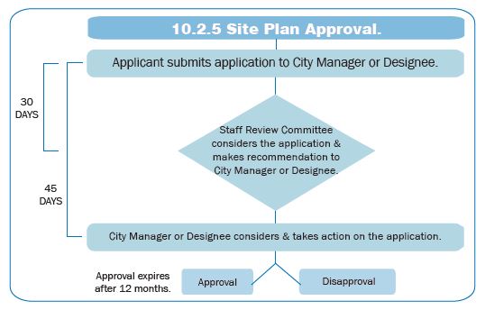
- Procedure For Site Plan Adjustments: The City Manager or designee may permit minor adjustments to an approved site plan, if the revisions are within the scope and intent of the original approval.
- Process: The process to review plan adjustments is as follows.
- Applicant shall submit a revised plan and letter of explanation detailing the change to the City Manager or designee.
- The City Manager or designee shall review the request and notify the applicant of the decision.
- If the City Manager or designee deems the change to be a major adjustment to the plan, applicant must resubmit for site plan review for approval of the new plan, including a new application (forms, fees, and plan sets).
- If the City Manager or designee deems the changes to be minor adjustments and approves them as within the scope and intent of the original approval, the applicant shall revise the plan providing copies to the City Manager or designee for filing prior to applying for building or construction permits.
- Minor Adjustments: Minor adjustments are limited to the following, while still meeting the requirements of this article. All other adjustments are considered major.
- Changes in dimensions or quantities less than ten percent (10%) of previous amounts.
- Process: The process to review plan adjustments is as follows.
- Conditional Use Permit:
- Intent: To establish a process to review requests for the following.
- Development of uses permitted within a zoning subdistrict, but that may not be appropriate for development on every lot within that subdistrict because of potential negative impacts associated with the use.
- Eligible Applicant: Applicant shall apply for a conditional use permit prior to the development, installation, or opening of a use in a core, general, neighborhood or edge subdistrict, designated as a conditional use in section 10-5.1B-4 of this article.
- Application: The following information shall constitute a complete application. Application shall be submitted in a form as determined by the City Manager or designee.
- Complete application, form, and applicable fees.
- Applicant shall submit the following in compliance with the requirements of section 10-5.1B-4, "Uses," of this article.
- Site location map, legal description/limits of plan.
- Survey plat. Dimensions of property lines, easements, rights-of-way.
- Development boundaries and proposed phasing, if applicable.
- Map of existing category of uses and use descriptions on parcel and all adjacent parcels within six hundred feet (600'), utilizing nomenclature found in section 10-5.1B-4 of this article.
- Map of proposed category of uses and use descriptions, utilizing nomenclature found in section 10-5.1B-4 of this article.
- Statement of intent. Statement describing existing and proposed use and zoning classification.
- Application Process Timeline: Upon submittal of a complete application, the application will be reviewed using the following process and timeline.
- The Staff Review Committee shall review and make recommendations on the application within thirty (30) days of the submission of the complete application.
- The City Manager or designee shall render a decision to approve or disapprove the application within forty five (45) days of the submission of the complete application.
- Forty five (45) days may be extended with the applicant's written consent.
- The City Manager or designee may approve, approve with conditions, or disapprove the application, providing the reasons for disapproval or any conditions for approval in writing.
- If a site plan approval is being sought for the same property, the conditional use permit shall be submitted concurrently and the timelines shall match. (Ord. 18-04, 5-15-2018, eff. 5-15-2018)
- Intent: To establish a process to review requests for the following.
10-5.1B-10-3: Exceptions And Variances
- Exceptions:
- Intent: To establish relief and flexibility in standards that may be administratively reviewed and approved, if certain criteria are met.
- Eligible Applicant: Applicant is eligible to apply for an exception to this article upon submittal of an application for site plan approval, in cases that involve such standards as the following:
- Regulating plan requirements:
- Distribution of permitted subdistricts within one hundred feet (100') of required amount. (Substitution of subdistricts is not permitted.)
- Block size within one hundred feet (100') of required dimensions and with the provision of a mid-block pedestrianway (refer to section 10-5.1B-1 of this article).
- Street type requirements within one foot (1') of required dimensions (refer to section 10-5.1B-2 of this article).
- Open space requirement within one hundred feet (100') of required distance for no more than ten (10) units and with the availability of two (2) open spaces within that dimension (refer to sections 10-5.1B-1 and 10-5.1B-6 of this article).
- Building type requirements within one foot (1') of required dimensions (refer to section 10-5.1B-5 of this article).
- Site plan requirements:
- Landscape requirements within one foot (1') of required dimensions (refer to section 10-5.1B-7 of this article).
- Parking and loading facilities within one foot (1') of required dimensions (refer to section 10-5.1B-8 of this article).
- Sign type requirements within one foot (1') of required dimensions (refer to section 10-5.1B-9 of this article).
- Building type requirements within one foot (1') of required dimensions (refer to section 10-5.1B-5 of this article).
- Additional exceptions may be granted based on a formal request in writing by the applicant, stating specific reasons why the request does not impact the overall intent of this section, and is essential for success of the development. Staff shall report any exception request and its decision to the Planning Commission at their next meeting.
- Regulating plan requirements:
- Application Process Time Line: An application for exception may be submitted before or concurrently with either the regulating plan approval or site plan approval.
- The Staff Review Committee shall review and make recommendations to the City Manager on the application for exception within ten business days of receiving it.
- The City Manager or designee shall render a decision to approve or disapprove the exception application within five business days from receiving recommendations from the staff review committee.
- Variances: Refer to subsection 10-4-6C of this title for information on the variance process. (Ord. 18-04, 5-15-2018, eff. 5-15-2018)
10-5.1B-10-4: Nonconformances
- General Requirements:
- Intent: To provide a set of regulations for legal nonconforming buildings and uses and to specify those circumstances and conditions under which those nonconformances shall be gradually eliminated.
- Applicability: The standards in this section apply as follows.
- The provisions detailed in this section apply to all structures, uses, or site characteristics that lawfully existed prior to the adoption of or amendment to this article, but that may not occur under the current provisions of chapter 16 of this title.
- Structures, uses, and site characteristics that did not lawfully exist prior to the effective date or amendment to this article shall not be considered legal nonconformances and therefore are not protected under the provisions of this section.
- Continuation: All nonconformances are permitted to continue subject to the restrictions outlined in this section.
- Maintenance: All nonconformances shall be maintained as required by law to protect public health, safety, and welfare, provided said maintenance does not result in the expansion of the nonconformity.
- Nonconforming Structures:
- Intent: To provide regulations for the continuation of a structure that was legally constructed prior to the adoption or amendment to this article, but that could not occur under the current provisions of this article.
- Restrictions On Continuation: A nonconforming structure may continue based upon the following conditions.
- Alterations: The standards of this article shall apply to alterations under the following circumstances.
- Where the renovation includes an addition of more than fifty percent (50%) in gross building square footage, the building shall be brought into conformance.
- When a renovation of the front facade occurs with no added building square footage, the street facade requirements and entrance type requirements (refer to section 10-5.1B-5-9 of this article) shall be met when the existing building front or corner facade is located within the build to zone and the renovation includes any one of the following:
- Installation of additional doors or a change in location of a door.
- Expansion or change in location of thirty percent (30%) of windows on any street facade.
- Replacement of thirty percent (30%) or more of facade materials on any street facing facade with a different facade material.
- When a renovation of the shape or style of the roof occurs with no added building square footage, the roof type requirements (refer to section 10-5.1B-5-10 of this article) shall be met when the existing building front or corner facade is located within the build-to zone.
- Ordinary Repairs: Ordinary repairs required for safety and continued use of the structure, such as replacement of window or door glass; and interior alterations that do not affect the exterior of the building do not trigger conformance to this article.
- Impact On Nonconformity: No alteration or repair shall expand the existing or create a new nonconformity unless otherwise permitted by this subsection B.
- Damage Or Destruction: A nonconforming structure may be repaired and its use continued if damaged by any means not within the control of the owner per the Utah Code.
- Abandonment: The right to utilize a nonconforming structure shall be terminated if the structure is not utilized or is abandoned for a period of twelve (12) consecutive months.
- If the owner is actively seeking another tenant for the use or structure, the twelve (12) month period may be extended up to an additional twelve (12) months with permission of the City Council.
- To obtain this extension, the owner must provide evidence of this activity, including solicitation, showing the site to potential tenants, and maintenance of utilities and other site facilities for reuse; simply listing the site as available real estate is not sufficient.
- Alterations: The standards of this article shall apply to alterations under the following circumstances.
- Nonconforming Uses: Refer to sections 10-16-2 and 10-16-3 of this title for information on the nonconforming uses.
- Nonconforming Site Characteristics:
- Intent: To establish regulations for the continuation of site characteristics, such as curb cut quantity, signage, parking, landscaping, or other non-structural, physical characteristics of a site, that was legally constructed or installed prior to the approval or amendment of this article, but that cannot be created under the provisions of this article.
- Restrictions To Continuation: A nonconforming site characteristic may continue based upon the following conditions.
- Ten Percent Exception: A site characteristic is not considered nonconforming if the size of the nonconformance is ten percent (10%) or less of this article's requirement.
- Change In Associated Use: The right to continue shall be terminated if the associated use changes or changes in intensity through such additions as an increase in the dwelling units, gross floor area, or capacity by fifteen percent (15%) or more.
- Signs
- Single or individual business signs within a multiple business center are exempt from this standard. A new tenant within a multiple business center is permitted to install an individual business sign even if the signage on the lot as a whole is nonconforming, provided that the new sign or signs does not exceed forty (40) square feet and otherwise complies with all other sign requirements.
- Nonconforming signs may be continued through changes in associated use if the only changes to the sign are changes in sign copy, typography, symbols, and lettering, and the supporting structure of the sign remains unchanged. Nonconforming signs consisting of individual letters and symbols, with individual supporting structures or connections, may be continued through a change in associated use, and the letters and symbols and supporting structures may be changed or modified so long as the overall area and location occupied by the sign remains the same. To the extent possible, nonconforming signs and supporting structures that are changed shall comply with current sign and construction requirements.
- Signs with EMBs must be brought into conformance with subsection 10-5.1B-9-2A4 of this article by September 30, 2018, regardless of when the EMB sign was installed.
- Signs
- Change In Associated Structure: The right to continue shall be terminated if the associated structure is altered to increase its gross floor area by fifteen percent (15%) or more.
- Abandonment: The right to continue shall be terminated if the associated use or structure, conforming or not, is abandoned for a period of twelve (12) consecutive months. This also applies to signs.(Ord. 18-04, 5-15-2018, eff. 5-15-2018)
10-5.1B-10-5: Definitions
- Graphics: The graphics, tables, and text utilized throughout this article are regulatory. In case of a conflict, text shall control over tables and graphics and tables shall control over graphics.
Defined Terms: For the purposes of this article, the following terms shall have the following meanings.
ANIMAL: All non-human members of the animal kingdom, including domestic and livestock species.
APPLICANT: The owner of a subject property or the authorized representative of the owner on which a land development application is being made.
BASEMENT: A story partly underground and having at least one-half (1/2) its height below the average level of the adjoining ground. A basement shall not be counted as a story, for purposes of height measurement.
BASEMENT, VISIBLE: A half story partially below grade and partially exposed above with required transparency on the street facade. A visible basement shall count as a half-story, for purposes of height measurement.
BLOCK: The aggregate of lots, passages, lanes, and alleys bounded on all sides by streets.
BLOCK DEPTH: A block measurement that is the horizontal distance between the front property line on a block face and the front property line of the parallel or approximately parallel block face.
BLOCK ENDS: The lots located on the end of a block; these lots are often larger than the lots in the interior of the block or those at the opposite end of the block and can be located on a more intense street type. They are typically more suitable for more intensive development, such as multiple family or mixed use development.
BLOCK FACE: The aggregate of all the building facades on one side of a block.
BLOCK LENGTH: A block measurement that is the horizontal distance along the front property lines of the lots comprising the block.
BUILD-TO-ZONE: An area in which the front or corner side facade of a building shall be placed; it may or may not be located directly adjacent to a property line. The zone dictates the minimum and maximum distance a structure may be placed from a property line. Refer to figure 10.5(2), "Setback Line Vs. Build-To Zone," of this section.
FIGURE 10.5(2)
SETBACK LINE VS. BUILD-TO ZONE
BUILDING, CALCULATING HEIGHT OF: The standard practice when calculating building height is to identify the highest point of the coping of a flat roof, or the deck line of a mansard roof, or to a point midway between the lowest part of the eaves or cornice and ridge of a pitch or hip roof, excluding architectural elements such as chimneys, flag poles, skylights, etc., and draw a line parallel to the grade plane shown on the site plan.
On sloped sites, building height is measured from the average finished grade (grade plane) highest point of the coping of a flat roof, or the deck line of a mansard roof, or to a point midway between the lowest part of the eaves or cornice and ridge of a pitch or hip roof. To calculate the average finished grade (grade plane):
- Use an accurate drawing of the building footprint on the site, indicating existing topography at a minimum of two foot (2') intervals.
- Draw a minimum of three (3) equidistance points per facade or elevation. For each point indicated the spot elevation of the topography as it exists at the time of permit application (prior to modification or re-grading).
- Add the elevation of each spot and divide by the number of spot elevations. The resulting number is the average grade (grade plane).
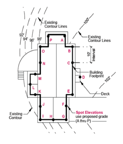
BUILDING, HEIGHT OF: The average maximum vertical height of a building or structure measured at a minimum of three (3) equidistant points from finished grade to the highest point of the coping of a flat roof, or to the deck line of a mansard roof, or to a point midway between the lowest part of the eaves or cornice and ridge of a pitch or hip roof.
BUILDING TYPE: A structure defined by the combination of configuration, form, and function. Refer to section 10-5.1B-5, "Building Types," of this article for more information and the list of permitted building types.
CITY MANAGER OR DESIGNEE: The South Ogden City Manager, or a person that is designated to make decisions by the City Manager.
COURTYARD: An outdoor area enclosed by a building on at least two (2) sides and is open to the sky.
COVERAGE, BUILDING: The percentage of a lot developed with a principal or accessory structure.
CRITICAL ROOT ZONE (Also Referred To As DRIP LINE): The area of soil and roots within the radius beneath the tree's canopy, within the dripline, or within a circular area of soil and roots with a radius out from the trunk a distance of 1.5 feet for every inch of the tree's width (measured at 4.5 feet above the mean grade of the tree's trunk, noted as diameter breast height or dbh throughout this article).
DEDICATION: The intentional appropriation of land by the owner to the City for public use and/or ownership.
DENSITY: The number of dwelling units located in an area of land, usually denoted as units per acre.
DWELLING UNIT: A room or group of rooms connected together that include facilities for living, sleeping, cooking, and eating that are arranged, designed, or intended to be used as living quarters for one family, whether owner occupied, rented, or leased.
EASEMENT: A legal interest in land, granted by the owner to another person or entity, which allows for the use of all or a portion of the owner's land for such purposes as access or placement of utilities.
EAVE: The edge of a pitched roof; it typically overhangs beyond the side of a building.
ENTRANCE TYPE: The permitted treatment types of the ground floor facade of a building type. Refer to section 10-5.1B-5-9 of this article for more information and a list of permitted entrance types.
EXPRESSION LINE: An architectural feature. A decorative, three dimensional, linear element, horizontal or vertical, protruding or indented at least two inches (2") from the exterior facade or a building typically utilized to delineate floors or stories of a building.
FACADE: The exterior face of a building, including but not limited to the wall, windows, windowsills, doorways, and design elements such as expression lines. The front facade is any building face adjacent to the front property line.
FAMILY: Family is defined as one of the following.
- One person living alone.
- Two (2) or more persons, related by blood, marriage, or adoption and foster children, living together as a single housekeeping unit; and up to two (2) other persons hired for domestic help residing on the same premises where the housekeeping unit is located, or
- Not more than four (4) unrelated persons living together as a single, nonprofit housekeeping unit.
GRADE: The average level of the finished surface of the ground story adjacent to the exterior walls of a building.
GRADE PLANE: A reference plane representing the average of the finished ground level adjoining the building at exterior walls. Refer to Figure 10.5(4) below.
FIGURE 10.5(4)
GRADE PLANE GROSS FLOOR AREA: The sum of all areas of a building, including accessory storage areas or closets within sales spaces, working spaces, or living spaces and any basement floor area used for retailing activities, the production or processing of goods, or business offices. It shall not include attic space having headroom of seven feet (7') or less and areas devoted primarily to storage, balconies, off-street parking and loading areas, enclosed porches, roof decks, roof gardens, or basement floor area other than specified above.
IMPERVIOUS SURFACE: Also referred to as impervious material. Any hard surface, man-made area that does not absorb water, including building roofs, sidewalks, parking, driveways, and other paved surfaces.
LANDSCAPE AREA: Area on a lot not dedicated to a structure, parking or loading facility, frontage buffer, side and rear buffer, or interior parking lot landscaping.
LOT (Also Referred To As PARCEL): A plot of land intended to be separately owned, developed, or otherwise used as a unit. Refer to figure 10.5(1), "Lots," of this section.
FIGURE 10.5(1)
LOTS LOT AREA: The computed area contained within the property lines; it is typically denoted in square feet or acres.
LOT, CORNER: A parcel of land abutting at least two (2) vehicular rights-of-way, excluding an alley, at their intersection. Refer to figure 10.5(1), "Lots," of this section. For a more detailed definition see definition of lot in section 10-2-1 of this title.
LOT DEPTH: The smallest horizontal distance between the front and rear property lines measured approximately parallel to the corner and/or side property line. Refer to figure 10.5(1), "Lots," of this section.
LOT, FLAG: A parcel of land having its only access to the adjacent vehicular right-of-way, excluding an alley, through a narrow strip of land. Refer to figure 10.5(1), "Lots," of this section.
LOT FRONTAGE: The horizontal distance between the side property lines, measured at the front property lines. Refer to figure 10.5(1), "Lots," of this section.
LOT, INTERIOR: A parcel of land abutting a vehicular right-of-way, excluding an alley, along one property line; surrounded by lots along the remaining property lines.
LOT, THROUGH (Also Referred To As A DOUBLE FRONTAGE LOT): An interior lot having frontage on two (2) approximately parallel vehicular rights-of-way, excluding an alley. Refer to figure 10.5(1), "Lots," of this section.
NONCONFORMANCE: A structure, use, lot, or site characteristic that was legally constructed or operated prior to the effective date of or amendment to this article, but that cannot be constructed, platted, or operated after the effective date of or amendment to this article.
OCCUPIED SPACE: Interior building space regularly occupied by the building users. It does not include storage areas, utility space, or parking.
OPEN SPACE TYPE: The permitted and regulated types of open spaces in this article. Refer to section 10-5.1B-6, "Open Space Types," of this article for more information and a list of the permitted types.
OPEN WATER: A pond, lake, reservoir, or other water feature with the water surface fully exposed.
OWNER: The legal or beneficial title-holder of land or holder of a written option or contract to purchase the land.
PEDESTRIANWAY: A pathway designed for use by pedestrians; it can be located mid-block allowing pedestrian movement from one street to another without traveling along the block's perimeter.
PERVIOUS SURFACE (Also Referred To As PERVIOUS MATERIAL): A material or surface that allows for the absorption of water into the ground or plant material, such as permeable pavers or a vegetated roof.
PLAT: A map or chart of a division and/or combination of lots.
PRIMARY FACADE: The facade facing the street from which the building derives its street address.
PRIMARY STREET: A major corridor that receives priority over other streets in terms of setting front property lines and locating building entrances.
PROPERTY LINE (Also Referred To As LOT LINE): A boundary line of a parcel of land or lot. Refer to figure 10.5(1), "Lots," of this section.
PROPERTY LINE, CORNER: A boundary of a lot that is approximately perpendicular to the front property line and is directly adjacent to a public right-of-way, other than an alley or railroad. Refer to figure 10.5(1), "Lots," of this section.
PROPERTY LINE, FRONT: The boundary abutting a right-of-way, other than an alley, from which the required setback or build-to zone is measured, with the following exceptions.
- Corner and through lots that abut a primary street shall have the front property line on that primary street.
- Corner and through lots that abut two (2) primary streets or do not abut a primary street shall utilize the orientation of the two (2) directly adjacent lots, or shall have the front property line determined by the City Manager or designee.
PROPERTY LINE, REAR: The boundary of a lot that is approximately parallel to the front property line; this line separates lots from one another or separates a lot from an alley. Refer to figure 10.5(1), "Lots," of this section.
PROPERTY LINE, SIDE: The boundary of a lot that is approximately perpendicular to the front and rear property lines; it is not adjacent to the public right-of-way. Refer to figure 10.5(1), "Lots," of this section.
RIGHT-OF-WAY: Land dedicated or utilized for a street type, trail, pedestrianway, utility, railroad, or other similar purpose.
ROOF TYPE: The detail at the top of a building that finishes a facade, including a pitch roof with various permitted slopes and a parapet. Refer to section 10-5.1B-5-10 of this article for more information and a list of the permitted roof types.
SCALE: The relative size of a building, street, sign, or other element of the built environment.
SEMI-PERVIOUS SURFACE (Also Referred To As SEMI-PERVIOUS MATERIAL): A material that allows for at least forty percent (40%) absorption of water into the ground or plant material, such as pervious pavers, permeable asphalt and concrete, or gravel.
SETBACK: The horizontal distance from a property line inward, beyond which a structure may be placed. Structures or other impervious surfaces are not permitted within a setback, unless specifically permitted in this article. Refer to figure 10.5(2), "Setback Line Vs. Build-To Zone," of this section.
SIGN: An object, device, or structure used to advertise, identify, display, direct, or attract attention to an object, person, institution, organization, business, product, service, event, or location by such means as words, letters, figures, images, designs, symbols, or colors. Flags or emblems of any nation, state, city, or organization; works of art which in no way identify a product; and athletic field score boards are not considered signs.
SOLAR REFLECTANCE INDEX (SRI): A measure of a constructed surface's ability to reflect solar heat, as shown by a small temperature rise. The measure utilizes a scale from 0 to 100 and is defined so that a standard black surface is 0 and a standard white surface is 100. To calculate for a given material, obtain the reflectance value and emittance value for the material; calculate the SRI according to ASTM E 1980-01 or the latest version.
STORY: The portion of a building included between the upper surface of a floor and the upper surface of the floor or roof next above. The story height of a building shall be measured from the average grade plane elevation of the building.
STORY, GROUND (Also Referred To As GROUND FLOOR): The first floor of a building that is level to or elevated above the finished grade on the front and corner facades, excluding basements or cellars.
STORY, HALF: A story that is partially below grade and a maximum of one-half story above the grade plane, or a story fully within the roof structure with transparency facing the street.
STORY, UPPER: Also referred to as upper floor. The floors located above the ground story of a building.
STREET FACE: The facade of a building that faces a public right-of-way.
STREET FRONTAGE (Also Referred To As LOT FRONTAGE): The portion of a building or lot directly adjacent to a vehicular right-of-way.
STREET TYPE: The permitted and regulated types of streets in this article. Refer to section 10-5.1B-2, "Street Types," of this article for more information and a list of the permitted street types.
STREETWALL: The vertical plane created by building facades along a street. A continuous streetwall occurs when buildings are located in a row next to the sidewalk without vacant lots or significant setbacks.
STRUCTURE, ACCESSORY: The general term for a subordinate structure detached from, but located on the same lot as the principal structure; it may or may not be inhabitable.
STRUCTURE, PRINCIPAL (Also Referred To As The PRINCIPAL BUILDING): A building that contains the dominant use of the lot. It is typically located toward the front of the lot in the front build-to zone or behind the front yard setback.
SWALE: A low lying, naturally planted area with gradual slopes that facilitate the transport, absorption, and/or filtration of stormwater.
TREE CANOPY: The uppermost area of spreading branches and leaves of a tree.
TREE CANOPY COVERAGE: The area of ground covered or shaded by a tree's canopy, measured in square feet.
USE: The specific purposes for which land or a building is designed, arranged, intended or for which it is or may be occupied or maintained.
USE, ACCESSORY: A use customarily, incidental, and subordinate to the principal use or structure and located on the same lot with such principal use or structure.
USE, PRINCIPAL: The specific, primary purpose for which a lot or building is utilized.
USE, SPECIAL: A use that may not be appropriate in certain locations based on the potential negative impacts associated with the use and requires approval of a special use permit.
WATER BODY: A body of water, such as a river, pond, or lake that may be man-made or naturally occurring.
YARD: The space on a lot which is unoccupied and unobstructed from the ground to the sky by the principal structure. Lots without a structure do not have yard designations. Refer to figure 10.5(3), "Yards," of this section.
FIGURE 10.5(3)
YARDS YARD, CORNER SIDE: A yard extending from the corner side building facade along a corner side property line between the front yard and rear property line.
YARD, FRONT: A yard extending from the front facade of the principal structure along the full length of the front property line, between the side property lines or side and corner side property lines. Refer to figure 10.5(3), "Yards," of this section.
YARD, FRONT -INTERIOR BUILDING: A yard extending the full length along the facade opposite the garage(s)/parking side of an interior building or as approved by the City Manager.
YARD, REAR: A yard extending from the rear building facade along the rear property line between the side yards or, on a corner lot, the corner side and side yards. Refer to figure 10.5(3), "Yards," of this section.
YARD, SIDE: A yard extending from the side building facade along a side property line between the front yard and rear property line. Refer to figure 10.5(3), "Yards," of this section.
ZONING SUBDISTRICT: A designation given to each lot within the City that dictates the standards for development on that lot. Refer to section 10-5.1B-3, "Subdistricts," of this article for more information and a list of permitted zoning subdistricts. (Ord. 18-04, 5-15-2018, eff. 5-15-2018; amd. Ord. 21-01, 1-19-2021, eff. 1-19-2021)
10-5.1B-11-1: Gateway Core
The Gateway Core Subdistrict is intended to be the City's most flexible and inclusive subdistrict, ensuring a place for all of South Ogden's commercial needs. It includes a range of building types that will allow for a vibrant, mixed-use commercial area. Building heights range from one - five (5) stories.
ALLOWED BUILDING TYPES
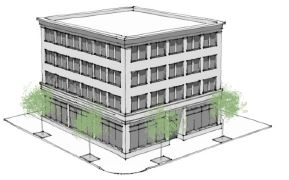
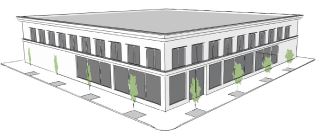
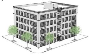

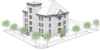
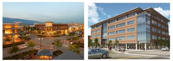
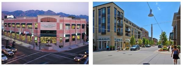
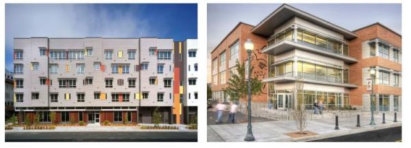
(Ord. 17-21, 11-21-2017, eff. 11-21-2017)
10-5.1B-11-2: Gateway General
The Gateway General Subdistrict provides the same function as the Gateway Core Subdistrict, but with a lower intensity of building to provide a buffer between residential neighborhoods and commercial areas. Building heights range from 1 - 3.5 stories.
ALLOWED BUILDING TYPES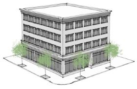
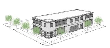
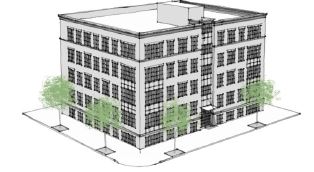
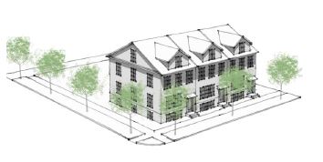
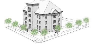
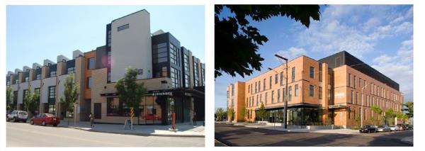
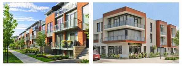
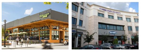
(Ord. 17-21, 11-21-2017, eff. 11-21-2017)
10-5.1B-11-3: Neighborhood Commercial Subdistrict
The Neighborhood Subdistrict allows for smaller nodes of commercial uses, the purpose of which is to provide residents with easy access to businesses which provide local services and goods. Building heights range from one - five (5) stories.
ALLOWED BUILDING TYPES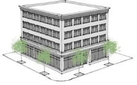
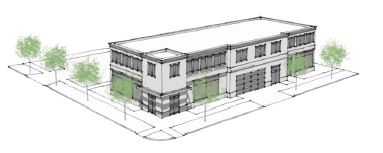
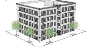
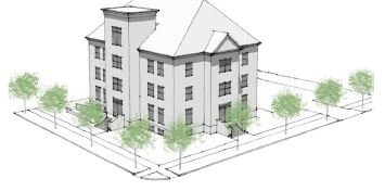
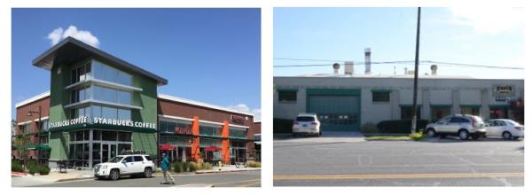
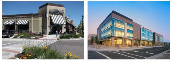
(Ord. 17-21, 11-21-2017, eff. 11-21-2017)
10-5.1B-11-4: Gateway Edge Subdistrict
The edge subdistricts are made up of smaller scale residential buildings, which provide a buffer between existing single family residential neighborhoods and the commercial subdistricts. Building heights range from 1 - 3.5 stories.
ALLOWED BUILDING TYPES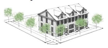

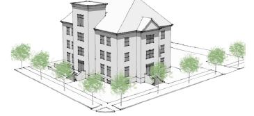
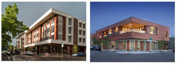
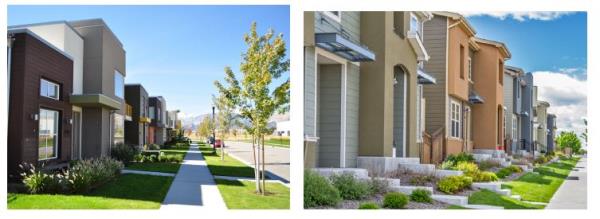
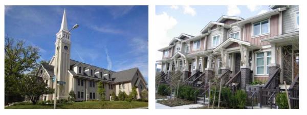
(Ord. 17-21, 11-21-2017, eff. 11-21-2017)