
Southfield City Zoning Code
ARTICLE 4
- GENERAL PROVISIONS
Sec. 5.18.- Scope.
Except as hereinafter provided, no building or land or part thereof located in the City of Southfield shall be used, altered, constructed, reconstructed, moved within or into said city except in conformity with the provisions of this chapter which apply to the district in which it is located. Any lawful, nonconforming use, building, or site existing at the time of the effective date of this chapter may be continued, provided that the building or land or use thereof shall not be structurally changed, altered, enlarged or moved, unless such altered, enlarged, or moved building or use shall conform to the provisions of this chapter for the district in which it is located. No nonconforming use, if discontinued or changed to a use permitted in the district in which it is located, shall be resumed or changed back to a nonconforming use. A nonconforming use shall be deemed discontinued for the purpose of this section if no nonconforming use is made of the property for a period of one (1) year. A nonconforming site shall be deemed discontinued for the purpose of this section if the buildings located thereon are not legally occupied for more than one (1) year, after which time all nonconforming site requirements must be brought into conformance with applicable code requirements via review through the appropriate approving body prior to building re-occupancy.
(Ord. No. 1745, § 2, 11-4-21)
Sec. 5.19. - Area and bulk regulations.
No dwelling shall be built upon a lot having a width, at the minimum required building line, of less than the lot width as required in the "schedule of regulations" in article 22.
Sec. 5.20. - Transfer of requirements.
Where any structure or use is permitted in a district other than the district in which such structure or use is first permitted under this chapter, such structure or use shall be subject to all of the requirements and regulations as are set forth in this chapter in the district in which such structure or use is first permitted.
Sec. 5.21. - Retention of jurisdiction.
In all instances where a review and/or a finding by any city agency is required under the provisions of this chapter, that agency shall retain jurisdiction over such review and/or finding and that any variation from said review and/or finding shall require approval from that agency.
Sec. 5.22. - Site plan requirements.
A.
Intent. The site plan review procedures and standards in this section are intended to provide a consistent and uniform method of review of proposed development plans, to ensure full compliance with the standards contained in this article and other applicable local ordinances and state and federal laws, to achieve efficient use of the land, to protect natural resources, and to prevent adverse impact on adjoining or nearby properties. It is the intent of these provisions to encourage cooperation and consultation between the city and the applicant to facilitate development in accordance with the city's land use objectives.
B.
Applicability. Submission of a site plan shall be required in conjunction with any of the following:
1.
Any use or development for which submission of a site plan is required by provisions of this article.
2.
Any proposal to construct, move, relocate, convert, or structurally alter a building or structure.
a.
Exceptions:
i.
Individual single-family dwellings and related accessory structures on individual parcels in residential zoning districts where they are a permitted.
ii.
Interior building or structural alterations that do not increase the gross floor area of the building or structure, increase the occupied floor area of a nonconforming use or otherwise affect compliance with the standards set forth in this article.
iii.
Change of tenant or use within an existing building that does not affect compliance with the standards set forth in this article, when the new tenant or use are a permitted use or special land uses that has already been approved by the city council.
3.
All nonresidential uses permitted in single-family districts such as, but not limited to, religious institutions, schools, and public facilities.
4.
Any change in use or site configuration that could affect compliance with the standards set forth in this article.
5.
Any special use approval required per the provisions of this article.
C.
Site plan review responsibility.
1.
City planner—Administrative site plan review. The city planner shall have responsibility to review and take action (approve, approve with conditions, or deny) on site plans meeting the following criteria:
a.
Amendments to existing approved site plans (not requiring rezoning, new special use or new zoning variance approvals):
i.
Accessory structures, not to exceed the lesser of:
(a)
Twenty-five (25) percent of the gross floor area of the existing buildings on the site.
(b)
Five thousand (5,000) square feet.
ii.
Additions to existing buildings, not to exceed the lesser of:
(a)
Thirty-five (35) percent of the gross floor area of the building.
(b)
Twenty thousand (20,000) square feet.
iii.
Art installations, after recommendation from the Southfield Public Arts Commission.
iv.
Building façade alterations.
v.
Landscape plan revisions.
vi.
Parking lot plan revisions (provided the total number of parking spaces is not changed by more than ten (10) percent and circulation hazards or congestion is not created by the redesign).
vii.
Site lighting plan revisions.
b.
Site plans for existing developed sites that do not have an approved site plan on file (not requiring rezoning, new special use or new zoning variance approvals):
i.
Changes to the existing site shall not exceed the criteria above for city planner review of amendments to existing approved site plans, otherwise the site plan will be subject to review and action by the planning commission.
c.
New site plans for developments in the TV-R Television-Radio Office -Studio, I-L Light Industrial, I-1 Industrial and P Vehicular Parking zoning districts.
2.
Planning commission—Public meeting. The planning commission (after receiving a recommendation from the city planner) shall have responsibility to review and take action (approve, approve with conditions, or deny) on site plans meeting the following criteria:
a.
New site plans for the development or redevelopment of sites for permitted and special uses.
b.
Amendments to existing site plans that do not fall within the criteria for administrative site plan review by the city planner.
c.
Site plans for existing developed sites that do not have an approved site plan on file that do not fall within the criteria for administrative site plan review by the city planner.
3.
City council—Public meeting. The city council (after receiving a recommendation from the planning commission) shall have responsibility to review and take action (approve, approve with conditions, or deny) on site plans meeting the following criteria:
a.
New site plans for ODD, RUDD and MUCD developments.
b.
Amendments to site plans for ODD, RUDD and MUCD developments that do not fall within the criteria for administrative site plan review by the city planner.
c.
Any site plan that meets the threshold for requiring a community impact statement per section 5.51 of this article.
D.
Submittal requirements. The site plans submitted for review shall include the following:
1.
Application. Completed site plan review on application on forms provided by the planning department.
2.
Fee. Site plan review fee per fee schedule set by ordinance and provided with the application forms.
3.
General plan requirements. All plans submitted for review shall include the following:
a.
Drawings to scale: 1" = 20' (<1 acre), 1" = 30' or 40' (1—3 acres), and 1" = 50' (>3 acres). Scale drawings to best fit on a 24" × 36" sheet.
b.
Title blocks indicating the name of the development, applicant's name, address, and telephone number, scale, north arrow, date(s) of submission/revision, and identification and seal of an architect, engineer, land surveyor or landscape architect who prepared plan.
4.
Survey. Survey of the properties involved in the project (prepared and sealed by a licensed surveyor per state law):
a.
Legal and common description of property(s), including parcel identification number(s).
b.
Location, description, and county registrar of deeds filing identification of all easements (public right-of-way, utilities, access, shared access, drainage, etc.)
c.
Net acreage (minus rights-of-way) and total acreage, to the nearest one-tenth acre.
d.
The lot lines dimensions. If the site is a part of a larger parcel, the plan should indicate that parcel's boundaries.
e.
All existing site features (on the site and within one hundred (100) feet of the site), including, but not limited to:
i.
Building locations, heights, setbacks, and outside dimensions, and all other structures (including fences, gates and trash receptacle location/screening, transformer pad, lighting poles, etc.).
ii.
Pavement (roads, walks, parking layout, loading area, driveways, curb cuts, etc.).
iii.
Landscape/open spaces areas (including any existing trees, ponds, streams, wetlands, floodplain, etc.).
iv.
Easements and connections for water, sanitary, storm, drainage, gas, electric, etc.
v.
All fire hydrants, and fire lanes.
vi.
Acceleration, deceleration, and passing lanes.
vii.
Location of sidewalks within the site and within the right-of-way.
viii.
Dimensions and centerline of existing and proposed roads and road rights-of-way.
ix.
Topography on the site and within one hundred (100) feet of the site at two (2) foot contour intervals, referenced to a lake survey datum benchmark.
5.
Demolition plan. When the full or partial demolition of an existing building, structure or other site improvement is proposed in the site plans, a demolition plan is required. Any environmental or material remediation required for the demolition should be indicated on the plan.
6.
Site plan.
a.
Property lines/boundaries.
b.
Location and names of roads and internal drives showing how the proposed circulation system will connect with the existing adjacent roads. The plan must indicate whether proposed roads are intended to be private or dedicated to the public.
c.
Proposed site plan features, including existing features to be retained or be relocated on the site or within one hundred (100) feet of the site:
i.
Building locations, heights, setbacks, and outside dimensions, and all other structures (including fences, gates and trash receptacle location/screening, transformer pad, lighting poles, bike racks, transit stops, etc.).
ii.
Pavement (roads, walks, curbing, parking layout, loading area, driveways, curb cuts, etc.), fully dimensioned to verify compliance with code requirements (including barrier-free requirements).
iii.
Screening walls, fences or landscaping as required along property lines separating uses, screening parking areas from rights-of-way and for screening ground mounted HVAC or electrical equipment.
iv.
Snow storage areas.
v.
Easements and connections for water, sanitary, storm, drainage, gas, electric, etc.
vi.
All fire hydrants, fire lanes.
vii.
Acceleration, deceleration, and passing lanes.
viii.
Location of sidewalks within the site and within the right-of-way.
ix.
Dimensions and centerline of existing and proposed roads and road rights-of-way.
x.
Site data summary table to include:
(a)
Number and types of units if applicable.
(b)
Gross and net square feet per use.
(c)
Building heights.
(d)
Parking—Required and provided spaces.
(e)
Setback and yard requirements.
7.
Landscape plan.
a.
Location of lawns and landscaped areas, including required landscaped greenbelts. The percentage of the site used for open space.
b.
Planting plan, including location, size, type and quantity of proposed shrubs, trees, and other live plant material.
c.
Cross-section of proposed berms.
d.
Location of any outdoor storage of materials and the manner by which it will be screened.
e.
Proposed fences and walls, including typical cross-section and height above the ground on both sides.
f.
Indication of type of any recreation facilities proposed for open space areas.
g.
Public art requirement proposal (location and type of art proposed, specific art piece can be approved later after review by the Southfield Public Arts Commission).
h.
Color site plan indicating buildings, landscape areas, walkways, parking, and drives.
8.
Site lighting and photometric plan.
a.
Lighting fixture types (manufacture sheet and specifications including methods of shielding).
b.
Exterior lighting locations.
c.
Lighting intensity throughout site and at parcel lines.
d.
Existing/proposed lighting poles heights.
9.
Civil engineering plan.
a.
Schematic utilities/engineering plan (existing/proposed easements and connections for water, sanitary, storm, drainage, gas, electric, etc.).
b.
Site grading, drainage patterns, and proposed finish grades on the site, including the finish grades of all buildings, driveways, walkways, and parking lots.
c.
Listing of types and quantities of hazardous substances and polluting materials that will be used or stored on-site at the facility in quantities greater than twenty-five (25) gallons.
d.
Areas to be used for the storage, use, loading/unloading, recycling, or disposal of hazardous substances and polluting materials, including interior and exterior areas.
e.
Location of underground storage tanks.
f.
Delineation of areas on the site that are known or suspected to be contaminated.
10.
Building floor plans.
a.
Number and floor areas of commercial tenant units contained in the building.
b.
Number, size, type, and location of each type of residential unit (one (1) bedroom units, two (2) bedroom units, etc.).
c.
Furnishings plan.
d.
Applicable construction codes and code compliance analysis.
e.
Emergency egress plan.
11.
Building elevations.
a.
Architectural elevations of building facades/exterior walls, drawn to a scale of one-quarter (¼) inch equals one (1) foot, or another scale approved by the city planner and adequate to determine compliance with the requirements of these regulations.
b.
Elevations of proposed buildings shall indicate type of building materials, roof design, dimensions of projections and architectural features, canopies, awnings and overhangs, screen walls and accessory buildings, and any outdoor or roof-located mechanical equipment, such as air conditioning units, heating units, and transformers and related screening. The city planner may permit photographs in lieu of elevations for existing buildings where minor or no change to the facade is proposed.
c.
Color building elevations and perspectives indicating building materials and colors.
12.
Additional requirements. The city planner, planning commission or city council may require the submittal of additional information related to a proposed site plan deemed necessary to meeting the intent and specific site plan review standards of this section.
13.
Waiver of submittal requirements. The city planner may waive specific submittal requirements at the request of the applicant after making a determination that those requirements are not relevant to scope or nature of the proposed project with regard to making a site plan review decision under this section.
E.
Site plan review procedures.
1.
Administrative site plan review process.
a.
Pre-submittal meeting: Optional meeting with planning department staff is recommended to discuss the project, applicable ordinance requirements and any design challenges particular to the project or site.
b.
Application submittal: Submittal of application, review fee and required supporting plans and documents.
c.
Staff review: coordinated review of submittals by city staff from multiple departments, typically two (2) to three (3) weeks. Review comments and required corrections provided back to the applicant.
d.
Applicant revisions/resubmittals: applicant revises the plans per the provided staff comments and submits the revised plans for further staff review.
e.
Repeat of the staff review and revision steps until all plan issues are resolved.
f.
Final action: City planner approves, approves with conditions, or denies approval to the site plan. Plans approved or approved with conditions are stamped and signed by the city planner, copies are sent to the applicant and property owner and a copy is retained for city records. If the site plan is denied the applicant and property owner will receive a denial letter specifying the reasons for the denial and a copy will be retained for city records.
g.
Appeals: Should the city planner deny a site plan under these provisions, that decision may be appealed to the planning commission by way of the planning commission site plan review process below.
2.
Planning commission site plan review process.
a.
Staff review: Steps a—e of the administrative site plan review process are required prior to a project being placed on an agenda to appear before the planning commission at a public meeting.
b.
First public meeting before the planning commission: The site plan is placed on the agenda for a study meeting of the planning commission for introduction and discussion only. This is an opportunity for the applicant to present the project and respond to the questions and feedback of the commission and interested members of the public.
c.
Second public meeting before the planning commission: The site plan is placed on the agenda for a regular meeting of the planning commission for further discussion and potential action on the request. The planning commission may approve, approve with conditions, or deny the site plan, they may also postpone action to seek further information or revisions related to the site plan.
d.
Public notice: In addition to the required posting of the meeting agenda per the Open Meetings Act, a direct notice of the planning commission consideration of the site plan is mailed to all owners and occupants of properties within three hundred fifty (350) feet of the subject site consistent with the required notices for special uses and rezoning per the Michigan Zoning Enabling Act.
3.
City council site plan review process.
a.
Staff review: Steps a—e of the administrative site plan review process are required prior to a project being placed on an agenda to appear before the planning commission at a public meeting.
b.
Planning commission review: Steps b—d of the planning commission site plan review process are required prior to a project being placed on an agenda to appear before the city council at a public meeting. In those cases requiring final action on site plan review by the city council the planning commission's final action shall be a recommendation to approve, approve with conditions, or deny the site plan, they may also postpone action to seek further information or revisions related to the site plan.
c.
First public meeting before the city council: The site plan is placed on the agenda for a meeting of the city council for introduction and discussion only. This is an opportunity for the applicant to present the project and respond to the questions and feedback of the Council and interested members of the public.
d.
Second public meeting before the city council: The site plan is placed on the agenda for a meeting of the city council for further discussion and potential action on the request. The city council may approve, approve with conditions, or deny the site plan, they may also postpone action to seek further information or revisions related to the site plan.
e.
Public notice: In addition to the required posting of the meeting agenda per the Open Meetings Act, a direct notice of the city council consideration of the site plan is mailed to all owners and occupants of properties within three hundred fifty (350) feet of the subject site consistent with the required notices for special uses and rezoning per the Michigan Zoning Enabling Act.
4.
Site plan approval effective. site plan approval becomes effective once all conditions related to finalizing the plans prior to permitting are completed. Pre-permitting conditions include but are not limited to drawing revisions, site maintenance agreements, ODD/RUDD/MUCD development agreements, conditional rezoning agreements, public art requirements approval or bond, etc.)
5.
Site plan approval expiration. Site plan approval shall expire if construction of the property improvements in the site plan have not commenced within eighteen (18) months of the date of approval by the responsible authority. Once construction has been commenced the site plan shall no longer be subject to automatic expiration.
6.
Site plan approval extension. An applicant may request an extension of site plan approval beyond the standard eighteen (18) month expiration period. The request must be made prior to the expiration of the site plan and the applicant must give reasonable cause as to why the construction could not be commenced within that period.
7.
Site plan approval revocation. An approved site plan may be revoked by the planning commission if construction of the site has commenced but has not completed and has not shown appreciable progress for six (6) months or more or is not progressing in a manner consistent with the approved plans. In such a case the site plan revocation shall be placed on the agenda of a regular meeting of the planning commission for a public hearing. In addition to the normal notices required for a public hearing, the city planner shall cause a written notice to be provided to the applicant and property owner at least fifteen (15) days prior to the meeting. The notice shall detail all alleged lack of progress, nuisances, inconsistencies, and violations in writing. The city planner, the building official, the applicant, and other interested persons shall be allowed to present information and testimony at the hearing. If the planning commission finds that the project is creating a nuisance and is unlikely to be completed in a timely manner related to the scale and approved phasing of the project or that the site is being developed inconsistent with the approved plan at the time of the hearing, then, by a majority vote of attending members, the commission may revoke the approval of the site plan and order the site be returned to its original condition or undeveloped state by a date certain. Failure to comply with such an order shall be deemed a violation of these regulations and shall be subject to the penalties stated in section 5.206.
F.
Standards for site plan review. The following criteria shall be used as a basis upon which site plans will be reviewed:
1.
Adequacy of information. The site plan shall include all required information in sufficiently complete and understandable form to provide an accurate description of the proposed uses and structures.
2.
Appearance. Landscaping, earth berms, fencing, signs, walls, and other site features shall be designed and located on the site so that the proposed development is aesthetically pleasing and harmonious with nearby existing or future developments.
3.
Barrier-free access. All development shall comply with applicable federal, state, and local laws and regulations regarding barrier-free access.
4.
Coordination with adjacent sites. All site features, including circulation, parking, building orientation, landscaping, lighting, utilities, common facilities, and open space shall be coordinated with adjacent properties.
5.
Compliance with zoning requirements. The site plan shall comply with the district requirements set forth in the schedule of regulations and all other applicable development standards in this article.
6.
Drainage. Appropriate measures shall be taken to ensure that the removal of surface waters will not adversely affect adjoining properties or the capacity of the public or natural storm drainage system. Provisions shall be made for a feasible storm drainage system, the construction of stormwater facilities, and the prevention of erosion. Surface water on all paved areas shall be collected at intervals so that it will not obstruct vehicular or pedestrian traffic and will not create nuisance ponding in paved areas. Final grades may be required to conform to existing and future grades of adjacent properties. Grading and drainage plans shall be subject to review by the city engineer.
7.
Emergency vehicle access. All buildings or groups of buildings shall be so arranged as to permit convenient and direct emergency vehicle access.
8.
Health and safety concerns. Any use in any zoning district shall comply with applicable federal, state, county, and local health and pollution laws and regulations with respect to noise; dust, smoke, and other air pollutants; vibration; glare and heat; fire and explosive hazards; gases; electromagnetic radiation; radioactive materials; and toxic and hazardous materials.
9.
Pedestrian circulation and access. The site plan shall provide a pedestrian circulations system which is insulated as completely as is reasonably possible from the vehicular circulation system. Every structure or dwelling unit shall be provided with adequate means of ingress and egress via public walkways. The arrangement of public and common ways for pedestrian circulation shall respect the pattern of existing or planned pedestrian or bicycle pathways in the vicinity of the site.
10.
Preservation of natural areas. The landscape shall be preserved in its natural state as much as possible, by minimizing tree and soil removal, alteration to the natural drainage courses, and the amount of cutting, filling, and grading.
11.
Privacy. The site design shall provide reasonable visual and sound privacy. Fences, walls, barriers, and landscaping shall be used, as appropriate, for the protection and enhancement of property and the safety and privacy of occupants and users.
12.
Public services. Adequate services and utilities, including water, sanitary sewer, and stormwater control services, shall be available or provided, and shall be designed with sufficient capacity and durability to properly serve the development.
13.
Sequence of development. All development phases shall be designed in logical sequence to ensure that each phase will independently function in a safe, convenient and efficient manner without being dependent upon subsequent improvements in a later phase or on other sites. Phasing of the site development, if proposed, shall be explicitly addressed as part of the approved site plan.
14.
Screening. Off-street parking, loading, and unloading areas, outside refuse storage areas, and other storage areas that are visible from adjacent homes or from public roads, shall be screened by walls or landscaping of adequate height.
15.
Site design characteristics. All elements of the site design shall be harmoniously and efficiently organized in relation to topography, the size and type of parcel, the character of adjoining property, and the type and size of buildings. The site shall be developed so as not to impede the normal and orderly development or improvement of surrounding property for uses permitted by this article.
16.
Site lighting. Site lighting shall be designed so that it is deflected away from adjoining properties and so that it does not impede vision of drivers along adjacent streets. Site lighting shall be provided in accordance with the provisions of this article.
17.
Soil erosion and sedimentation. The proposed development shall include measures to prevent soil erosion and sedimentation.
18.
Vehicular circulation and access. The arrangement of public and common ways for vehicular circulation shall respect the pattern of existing or planned streets or pedestrian or bicycle pathways in the vicinity of the site. The width of streets and drives shall be appropriate for the volume of traffic they will carry. In order to ensure public safety and promote efficient traffic flow and turning movements, the applicant may be required to limit street access points or construct a secondary access road.
a.
Vehicular ingress and egress shall be provided to a thoroughfare or freeway service drive and a proper relationship shall exist between the thoroughfare and any proposed service roads, driveways, and parking areas to encourage pedestrian and vehicular traffic safety except as follows:
i.
Vehicular ingress and egress driveways may be permitted to other than a thoroughfare or freeway service drive where such ingress and egress is provided to a street where the property directly across the street from such driveways and all property abutting such street between the driveways and a thoroughfare or freeway service drive is zoned for multiple family use, any nonresidential uses, or is developed with permanent uses other than single-family residences. This exception shall only apply if the approving person or board finds that there are special circumstances which indicate that access to site from a thoroughfare or freeway service drive is not feasible but that safe and adequate access can be provided to the site by other means or that there will be a substantial improvement in traffic safety by providing an alternate access arrangement.
b.
The site plan shall not be approved unless all interior and abutting streets have sufficiently improved rights-of-way to accommodate the vehicular traffic generated by the uses permit-ted in the district or unless adequate provision is made at the time of the approval of the site plan for such sufficiently improved rights-of-way.
19.
Vulnerability to hazards. The level of vulnerability to injury or loss from incidents involving hazardous materials or processes shall not exceed the capability of the city to respond to such hazardous incidents so as to prevent injury and loss of life and property. In making such an evaluation, the city shall consider the location, type, characteristics, quantities, and use of hazardous materials or processes in relation to the personnel, training, equipment and materials, and emergency response plans and capabilities of the city. Sites which include storage of hazardous materials or waste, fuels, salt, or chemicals shall be designed to prevent spills and discharges of polluting materials to the surface of the ground, groundwater, or nearby water bodies.
(Ord. No. 1153, 11-26-84; Ord. No. 1618, § 1, 3-9-14; Ord. No. 1678, § 2, 7-6-17; Ord. No. 1793, § 1, 8-19-24)
Sec. 5.22-1. - Special use procedure.
Whenever in this chapter there are uses permitted subject to special approval, the following procedure shall be followed:
The petitioner shall submit an application, documentation, and site plans to accurately reflect the requested use to the planning department. The matter will be referred to the planning commission by the city council who may request additional information to assist in the review of the request. Such additional information may consist of floor plans, signing, building elevations, traffic studies, etc.
A public hearing shall be held by the planning commission in accordance with the Michigan Zoning Enabling Act (MZEA), Public Act 110 of 2006, as amended, with notice being given to the owners of the property that is the subject of the request, all persons to whom real property is assessed within three hundred (300) feet of the property that is the subject of the request and to the occupants of all structures within three hundred (300) feet of the subject property regardless of whether the property or structure is located in the zoning jurisdiction, except as otherwise provided in the MZEA, and legal notice of the public hearing shall be given in a local newspaper of general circulation. Notice of the public hearing shall be given within the time prescribed pursuant to section 103 of the MZEA. The planning commission may recommend favorably, unfavorably, or favorably with conditions to the city council and shall state the reasons for their recommendation.
Upon receipt of the planning commission's recommendation, the city council shall hold a public hearing in accordance with the MZEA with notice being given to the owners of the property that is the subject of the request, all persons to whom real property is assessed within three hundred (300) feet of the property that is the subject of the request and to the occupants of all structures within three hundred (300) feet of the subject property regardless of whether the property or structure is located in the zoning jurisdiction, except as otherwise provided in the MZEA, and legal notice of the public hearing shall be given in a local newspaper of general circulation. Notice of the public hearing shall be given within the time prescribed pursuant to section 103 of the MZEA. The city council may approve, deny, or approve with conditions the special use request and shall specify the basis for their decision.
(Ord. No. 1260, 2-27-89; Ord. No. 1591, § 1, 5-6-12; Ord. No. 1676, § 1, 6-12-17; Ord. No. 1709, §§ 2—5, 10-3-19)
Sec. 5.22-2. - Conditional rezoning.
(1)
Intent, application for and processing of conditional rezoning.
(a)
This section is intended to implement section 405 of the Zoning Enabling Act (MCL125.3405) authorizing conditional rezonings.
(b)
An owner of land may voluntarily offer in writing conditions relating to the use and/or development of land for which a rezoning is requested. The offer shall be contained in a proposed conditional rezoning agreement, as described in this section, below. This offer may be made either at the time the application for rezoning is filed or may be made at a later time during the rezoning process; however, the offer shall in all events be considered by the planning commission prior to being acted upon by the city council.
(c)
The required application and process for considering a rezoning request with conditions shall be the same as that for considering rezoning requests made without any offer of conditions, except as modified by the requirements of this section.
(d)
The owner's offer of conditions may not purport to authorize uses or developments not permitted in the requested new zoning district.
(e)
Approval under this section shall not obviate the requirement for special land use approval, variance relief and/or site plan approval.
(f)
If the city is in the process of proceeding with a conditional rezoning under this section, and the applicant has not voluntarily offered the condition(s) being considered, the applicant shall inform the city clerk in writing of such fact prior to the final action of the city council granting the conditional rezoning.
(2)
Standards for approval. The following standards, among other factors deemed relevant by the planning commission and city council shall be considered in determining whether to approve a rezoning with conditional rezoning agreement, provided, the determination on whether the underlying rezoning itself should be granted shall be deemed to be a legislative decision of the city council equivalent to city council action on other amendments to the zoning ordinance.
(a)
Compatibility with the policies and uses designated for the land and area in the city's future/master land use plan;
(b)
Compatibility of the uses and improvements allowed under the proposed rezoning with conditional rezoning agreement with other zones and uses in the surrounding area;
(c)
Availability and adequacy of public services and facilities, and whether there is likely to be any adverse impact from a development or use allowed under the rezoning with conditional rezoning agreement; and
(d)
Whether the development that would be approved shall advance the public interest, weighing the reasonably expected burdens likely to result from allowing the development against the reasonably expected benefits to be achieved by the development.
(3)
Approval and effect.
(a)
If the city council, after recommendation from the planning commission, determines in its discretion that the proposed rezoning with conditional rezoning agreement should be approved, the conditional rezoning agreement shall be incorporated by attachment or otherwise as an inseparable part of the ordinance adopted by the city council to accomplish the requested rezoning with conditional rezoning agreement.
(b)
The conditional rezoning agreement, as initially submitted, or as may be modified during the course of the rezoning process, shall:
i.
Be in a form recordable with the register of deeds for oakland county or, in the alternative, be accompanied by a recordable affidavit or memorandum prepared and signed by the owner giving notice of the conditional rezoning agreement in a manner acceptable to the city attorney.
ii.
Contain a legal description of the land to which it pertains.
iii.
Contain a statement and acknowledgement that the terms and conditions of the conditional rezoning agreement shall run with the land be binding upon and inure to the benefit of the property owner and city, and their respective heirs, successors, assigns, and transferees.
iv.
A specification of all conditions proposed by the land owner to be applicable to the use and development of the land, including the following to the extent relevant:
1.
The location, size, height or other measure for and/or of buildings, structures, improvements, setbacks, landscaping, buffers, design, architecture and other features.
2.
Permissible uses of the property, and a specification of maximum density or intensity of development and/or use, expressed in terms fashioned for the particular development and/or use, for example, and in no respect by way of limitation, units per acre, maximum usable floor area, hours of operation, and the like.
3.
Preservation of natural resources and/or features.
4.
Facilities and design approaches to address any relevant traffic, storm water management and water quality issues, including the location, design and sizing of stormwater management measures.
5.
Provisions for maintenance of areas on the land, as relevant.
v.
Contain a statement acknowledging that the conditional rezoning agreement or an affidavit or memorandum giving notice thereof may be recorded by the city with the register of deeds for Oakland County.
vi.
Contain the notarized signatures of all of the owners of the subject land preceded by a statement attesting to the fact that the conditional rezoning agreement, as the same may have been modified during the rezoning process (if applicable) has been freely, voluntarily and knowledgeably offered by such owners, and agreed upon in its entirety.
(c)
Upon the rezoning taking effect, the zoning map shall be amended to reflect the new zoning classification along with a designation that the land was rezoned with a conditional rezoning agreement. The city clerk shall maintain a listing of all lands rezoned with a conditional rezoning agreement.
(d)
The approved conditional rezoning agreement or an affidavit or memorandum giving notice thereof shall be filed by the city with the register of deeds for Oakland County.
(e)
Upon the rezoning taking effect, the use of the land so rezoned shall conform thereafter to all of the requirements of the zoning district and conditional rezoning agreement.
(4)
Compliance with agreement. Any failure to comply with a condition contained within the conditional zoning agreement shall constitute a violation of this zoning ordinance and be punishable accordingly. Additionally, any such violation shall be deemed a nuisance per se and subject to judicial abatement as provided by law.
(5)
Time period for establishing development or use. Unless a longer or shorter time period is specified in the ordinance rezoning the subject land, the approved development and/or use of the land authorized in the conditional rezoning agreement shall be commenced within twelve (12) months from the effective date of the rezoning and thereafter proceed diligently to completion. This time limitation may upon written request of the land owner be extended by the city council if (1) it is demonstrated by the land owner and determined by the city council in its discretion that there is a strong likelihood that the development and/or use will commence within the period of extension and proceed diligently thereafter to completion and (2) the city council determines in its discretion that there has not been a change in circumstances that would render the current zoning with conditional rezoning agreement incompatible with other zones and uses in the surrounding area or otherwise inconsistent with sound zoning policy.
(6)
Termination of conditional rezoning agreement. If the approved development and/or use of the rezoned land does not occur within the time frame specified under subsection e, above, or if the property owner makes a request in writing for termination of the conditional rezoning agreement prior to making any improvements pursuant to the conditional rezoning agreement, then the rezoning and conditional zoning agreement shall be deemed to be immediately terminated except in the city's discretion as to that part of the land, if any, that has been developed. In the event of such termination, no new development or use of the land shall be permitted until a new zoning classification is approved by a rezoning of the land. Upon such termination, the planning department shall immediately initiate the process to rezone the land in whole or in part to its prior or other appropriate zoning classification. The procedure for considering and adopting this rezoning shall be the same as applied to all other zoning requests. Once the rezoning has occurred, the city shall, upon request of the land owner, record with the register of deeds for Oakland County a notice that the conditional rezoning agreement, except in the city's discretion as to that part of the land, if any, that has been developed, is no longer in effect.
(Ord. No. 1554, § 1, 11-19-07; Ord. No. 1678, § 2, 7-6-17)
Sec. 5.22-3. - Overlay Development District (ODD).
A.
Purpose, intent and qualifications:
1.
General purpose. Because traditional zoning separates uses into different districts using restrictive placement controls, it does not allow for creative development incorporating a variety of uses. The purpose of the overlay development district (ODD) is to encourage development of those parcels of land which, because of their size; their location being uniquely situated with regard to (higher density) adjoining uses; or their unique environmental features, a more flexible development scheme could foster creative development design, or preserve desirable natural features, significant historical landmarks and architectural features located within the ODD. Therefore, the ODD modifies the traditional form of zoning and permits variety in design, site configuration, setbacks, layout, use, and encourages efficiency in use of land and natural resources, while ensuring compatibility with surrounding land uses.
In return for greater flexibility in site design requirements, ODD's are expected to deliver exceptional quality community designs that provide above-average pedestrian amenities, incorporate creative design in the layout of buildings, focus on pedestrian space and circulation; incorporate public art; assure compatibility with surrounding land uses and neighborhood character; incorporate green infrastructure storm water management measures and the restoration of natural functions through landscaping, tree planting or soil amendment; and provide greater efficiency in the layout and provision of roads, utilities, and other infrastructure.
Finally, ODDs authorized under this chapter (see attached map) shall provide a better and more desirable living and physical environment than what would be possible under the zoning regulations that apply to the development or traditional zoning district, while implementing the policies and objectives of the comprehensive master plan, as amended.
2.
General intent. The adoption of an ODD is intended to encourage creativity through the unified development of property utilizing mixed residential, commercial and non-residential uses that provide adequate housing and employment opportunities. It is the intent of this article to allow rezoning of qualifying properties to ODD. The specific objectives of the ODD are to:
a.
Encourage innovation in land uses and variety of design, layout and type of structures constructed.
b.
Promote low impact development (LID) and green infrastructure storm water management techniques, as defined in this chapter.
c.
Achieve economy and efficiency in the use of land, natural resources, energy, and the provision of public services and utilities.
d.
Permit flexibility in the placement, setbacks, lot area and building type regulations, and combination of uses while assuring the application of sound site planning standards.
e.
Encourage the provision of pedestrian amenities and more extensive landscaping, particularly landscaping that restores natural functions through enhanced soil quality, tree canopy restoration, and use of native plantings where appropriate.
f.
Provide opportunities for improvements to public streets or facilities, pathways, and infrastructure.
g.
Promote the development of walkable, mixed-use developments that will result in more sustainable and healthy community.
h.
Achieve consistent and coordinated site design and higher quality architectural design and materials.
i.
Encourage the use, reuse, redevelopment and improvement of existing sites.
j.
Encourage the use and improvement of land where site conditions make development under conventional zoning difficult and less desirable.
k.
Incorporate public art.
3.
Intent of requiring development agreement. It is recognized that because of the complexity and uniqueness of each parcel or tract of land proposed for ODD rezoning, it is beneficial to the city and the development process if a development agreement which includes all conceptual plans, architectural elevations, development standards and specified conditions tailored to the particular parcel of property, are submitted together with the application for rezoning. This approach is intended to accomplish the objectives of the zoning ordinance by incorporating a land development project review process into the rezoning procedure to ensure integration of the proposed land development project with the characteristics of the surrounding area.
4.
Eligibility for ODD rezoning; qualifying conditions. To be eligible for ODD rezoning as provided by this article, all of the following conditions must exist with regard to the proposed ODD site:
a.
Rezoning to ODD shall not be granted in situations where the same land use objectives may be established by the application of applicable conventional zoning provisions or standards.
b.
The land proposed to be included within the ODD must consist of sufficient acreage as recommended by the planning commission to meet the objectives of this chapter:
• Southfield City Centre & Downtown Development Authority subareas: one (1) acre(s) or greater
• Southfield Technology Corridor subarea, Smart Zone and other areas identified on ODD eligible areas map: Two (2) acres or greater
An ODD may have a lot size of less than what is specified above in items A.4.b. above, if the city council finds:
i.
That an unusual physical or topographic feature of importance to the area as a whole, such as wetlands, exists on the site or in the surrounding neighborhood that will contribute to and be protected by the ODD; or,
ii.
That the property or the surrounding area has an historic character of importance to the community that will be protected by the ODD; or,
iii.
That the proposed ODD is adjacent to an approved ODD that has been completed and will contribute to the amenities and values of the neighboring ODD; or,
iv.
That the ODD is located in an area that is being redeveloped and will implement the policies of the redevelopment plan or subarea plan identified in the comprehensive master plan.
c.
The land proposed to be included in the ODD shall have features that the preservation of which will be enhanced through development as an ODD; or is uniquely situated with regard to adjoining uses which would permit variety in design, site configuration, layout and use; or has unique historical or environmental features or other characteristics which could foster creative development design and preserve desirable natural features. In developed urban areas, the ODD shall offer higher standards of architectural design, innovative layout and pedestrian amenities, including public art, than what would be achieved under conventional zoning.
d.
The proposed land use patterns must be compatible with surrounding land uses and provide decorative screening or transitional buffers to residential areas.
e.
The proposed land use patterns encourage efficiency in use of land, natural resources, provide for open space or pedestrian amenities and minimize impervious surfaces, wherever feasible.
f.
The ODD site must be served by public water and sanitary sewer service that meets or exceeds the existing city requirements for a development of the proposed size.
g.
The ODD site must abut and have direct access to a public thoroughfare.
h.
The proposed ODD shall be harmonious with the surrounding land uses and serve the public health, safety and welfare of the city as a whole.
i.
The proposed ODD shall not cause a negative or environmental impact or loss of a historic structure (unless determined by the city to be unsalvageable) on the subject site or surrounding land.
j.
The proposed ODD is not merely an attempt to circumvent the strict application of the applicable zoning standards.
B.
Uses permitted in an ODD:
1.
Principal permitted uses. In designing and developing an ODD, compatibility of land uses both within the development and surrounding the development is very important to meeting the objectives of this article. In order to ensure integration of the proposed land development project with the characteristics of the surrounding area, certain uses will be permitted and others will be prohibited. Subject to review and approval under the procedures and standards contained in this article, the following uses may be eligible for inclusion in the ODD district (see table 1):
Table 1: Permitted Table of Uses[3]
P = Permitted
X = Prohibited
*When attached to a retail center or mixed-use development
** Northland ODD only
a.
Northland sub area redevelopment plan ODD.
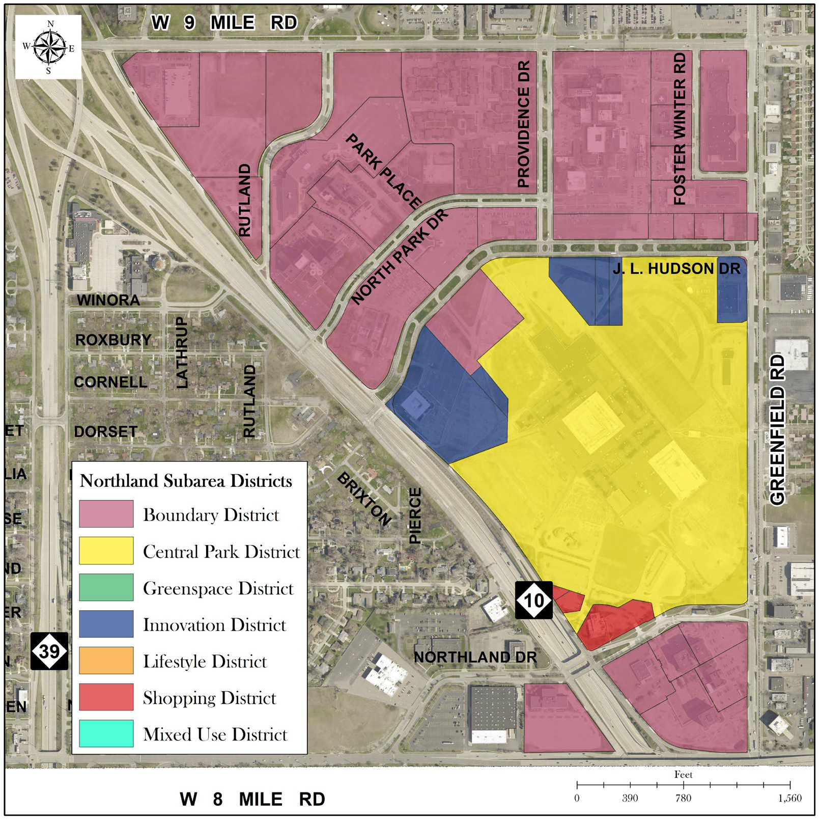
Map 1: Northland Overlay Development District: District Plan Map
Northland Subarea Districts
The Northland Subarea Redevelopment Plan Overlay Development District regulations, (the "property") subject to the following express conditions and requirements:
a.
Any future development, use, or construction of any site improvements on the property shall be consistent and in accordance with the Northland Sub Area Redevelopment Plan as contained and set forth in the City of Southfield Master Plan, as may be amended, or as otherwise may be approved by the city council;
b.
Any future development or construction of any site improvements on the property shall be governed by and in accordance with the Northland Design Standards;
c.
Any future development or construction of any site improvements on the property shall be governed by and in accordance with the Northland Overlay Development District: District Plan map (Map 1), Permitted/Prohibited Uses (Table 2), and Development Standards Matrix (Table 3);
d.
Any future development, use, or construction of any site improvements on the property shall be subject to the submission of a master development plan ("MDP") as defined in and required pursuant to subsection 5.22-3 C.3.d. of the zoning ordinance; the MDP shall be subject to the approval of the city council; and
e.
Any future development, use, or construction of any site improvements on the property shall be subject to the approval by the city council of a development agreement in the city's standard form, as required pursuant to subsection 5.22-3 C.3.e. of the zoning ordinance.
Table 2: Permitted/Prohibited Uses
P: Permitted. For prohibited uses, refer to subsection 5.22-3 B.2.
Table 3: Northland Overlay Development District: Development Standards Matrix
1. The minimum allowable square footages and unit counts may be exceeded provided
that all other provisions of the O.D.D. are met and the purpose and intent of the
design standards are achieved. Individual densities per project shall be governed
by the development standards for that district.
2. Minimum building height shall not apply to existing buildings.
3. Refer to design guidelines for specifications of building height by street frontage.
4. Existing buildings with parking between building and street shall be permitted
to remain until such time that the building is substantially
2.
Prohibited uses. In order to ensure integration of the proposed land development project with the characteristics of the surrounding area, certain land uses have been determined to be incompatible with the intent to provide the above permitted uses in an ODD. Therefore, the following uses are prohibited in ODD:
• Wholesale, not open to the general public and intensive business.
• Industrial and developmental manufacturing (Southfield Technological Corridor).
• Uses involving the processing of raw materials for shipment in bulk form to be used in an industrial or commercial operation at another location.
• Warehouses and storage yards.
• Outdoor storage or display of materials, equipment, or vehicles other than approved outdoor retail sales as an accessory to a permitted principal use.
• Automotive repair, service and sales, new and used (except in Northland ODD and except for electric vehicle research, testing, repair, and maintenance facilities in the Southfield Tech Corridor).
• Automotive washes, self serve and automatic, except those customarily an accessory to a permitted principal use.
• Sanitariums.
• Pawn shops, check cashing and pay-loan facilities.
• Sexually oriented businesses (e.g. Adult bookstores, adult motion picture theaters, cabarets, etc.).
• Mobile home parks.
• Funeral homes.
• Crematorium.
• Cemeteries.
• Dog kennels.
• Public stables and farms.
• Social halls.
• Boarding rooms, lodging and tourist homes.
• Motels.
• Outdoor drive-ins.
• Flea markets.
• Tattoo parlors.
• Arcades, golf ranges and golf domes.
• Medical marihuana facilities (except in Northland ODD).
C.
Rezoning procedure.
1.
Applicable regulations. The ODD is an overlay zoning district which imposes site configuration, building layout, architectural design, density, set back, height, use, access, parking and other development regulations that apply to this district only. All other non-conflicting regulations and standards of this chapter shall also apply to this district. In the event of a conflict between a regulation in the Code of Ordinances or a standard contained in the approved master development plan or development agreement and any other applicable regulation in this chapter, the approved master development plan or development agreement standard shall prevail.
2.
Rezoning. Rezoning a parcel or tract of land in the ODD may be initiated either by the request or with the authorization of the owner(s) of land proposed to be included in the ODD; by the planning commission; or the city council as authorized by the Zoning Enabling Act. Any rezoning to ODD shall be subject to the eligibility criteria and qualifying conditions contained in this article. A preliminary master development plan and a development agreement containing specific development standards and site plan drawings must be submitted with the application to rezone. Upon approval of the application to rezone, the final master development plan and the development agreement must be approved by the city council and recorded as required by this article prior to commencing development of any land proposed for rezoning to ODD.
3.
Application to rezone in an ODD. The application to rezone shall include the following information and documents:
a.
Ownership. The application form must be signed by the applicant, and authorized by all owners of any land to be included within the ODD and include the address telephone number and e-mail address of all applicants.
b.
Qualification. The application shall include a narrative statement describing the overall objectives of the proposed ODD; demonstrate that the proposed site meets the qualifying conditions for an ODD rezoning; and explain why the property may not be developed as currently zoned.
c.
Development impact. The application shall include a development impact statement addressing impact of the proposed development on:
i.
Surrounding land uses.
ii.
Pedestrian and vehicular traffic.
iii.
Preservation of natural or historic features.
iv.
Public utilities.
v.
Public services.
vi.
Economic impact.
vii.
Special design features (e.g. low impact development/green infrastructure stormwater techniques, architectural features, etc.)
viii.
Plan for landscaping, tree planting, and preservation or enhancement of existing soils, trees and vegetated areas, including the integration of these measures with stormwater management for the site
d.
Master development plan. The application shall include a proposed master development plan encompassing all phases of the proposed ODD, containing all information required by the planning commission and city council and prepared at an acceptable scale.
e.
Development agreement. The application shall include a proposed development agreement which shall include specific standards tailored to the ODD and use of the property in conjunction with the rezoning. The provisions contained in the agreement shall, upon approval and execution, be binding upon both parties. The agreement shall be in a form recordable with the Oakland County Register of Deeds, or in the alternative, be accompanied by a recordable memorandum prepared and signed by the property owner(s) giving notice of the ODD development agreement in a manner acceptable to the city attorney. The agreement shall, at a minimum, include the following provisions:
i.
Agreement and acknowledgment that the developer submitted and the city accepted the development proposal as set forth in the application to rezone, the master development plan, the site plans, architectural elevations and the development agreement as submitted, and granted the rezoning based on the terms set forth therein. Further, that all provisions and conditions contained in the application to rezone, master development plan and development agreement are authorized by applicable law; that the agreement is valid, and was entered into on a voluntary basis, representing a permissible exercise of authority by the city and the applicant.
ii.
Agreement that the property shall not be developed or used in a manner inconsistent with the approved master development plan and development agreement.
iii.
Agreement that the approved rezoning, master development plan and development agreement shall be binding upon and inure to the benefit of the property owner(s), the city and their respective heirs, successors, assigns, and transferees. A list of all approved uses shall be provided.
iv.
Because of the complexity and uniqueness of the parcel or tract of land proposed for the ODD, the development agreement shall include specific standards for site configuration tailored for the proposed development, including:
• Roadways; ingress, egress and other access including sidewalks and pedestrian pathways.
• Building and structure placement, mass, bulk, height, articulation and setbacks.
• Installation and extension of utilities; including a preliminary stormwater management plan, prepared by a licensed professional engineer; the stormwater management plan shall meet the standards set forth by the city engineer and shall clearly depict the integration of landscaping and any permeable surfacing with the plan for the ODD.
• Parking and circulation. Pedestrian pathways and linkages to the public sidewalk system.
• Landscaping (including tree planting, restoration areas, and vegetated stormwater management areas), public art, ornamental fencing and buffers.
• For residential uses: Maximum density and intensity of use for each proposed use addressing units per acre. For non-residential uses: Maximum useable floor area.
• Preservation of no less than twenty-five (25) percent of undeveloped primary or secondary open space for residential uses and fifteen (15) percent of urban open space, pedestrian amenities, or landscaped areas for non-residential uses unless waived by a two-thirds (⅔) vote of the city council. Open space to be preserved shall be calculated prior to making any site improvements to be performed on site and shall exclude existing and proposed rights-of-way.
• Preservation of natural features and provisions addressing the maintenance of natural resources and open space, which may include provisions in the maintenance agreement accompanying the stormwater management plan, if applicable.
• Lighting.
• Permissible uses of the property consistent with this chapter.
• Any areas proposed for commercial operations with twenty-four-hour operations shall be located fifty (50) feet from residential areas and shall be provided with buffering and screening to protect the compatibility of the uses. The fifty-foot measurement shall be calculated from the closest building envelope edge of the twenty-four-hour operation to the lot line of the closest residentially zoned property or residential building footprint, whichever is closer.
• All utilities, other than surface stormwater management measures, including electricity, telephone and cable, shall be installed underground or otherwise installed out of sight to the surrounding community, excluding main transmission lines.
v.
Architectural design and building materials.
vi.
Proposed association and condominium documents, if applicable.
vii.
Site plan drawings including proposed site elevation contours; Typical elevation drawings, with identification of facade materials of all sides of each principal building included in the ODD, drawn at a scale of one (1) inch equal to one hundred (100) feet or other scale acceptable to the planning director.
viii.
An affidavit from a qualified environmental engineer that an environmental assessment has been performed and the results indicate that there is nothing to preclude the development as proposed.
ix.
Any other provisions proposed and approved by the parties.
x.
Phasing plan, if applicable.
f.
Fee. An application to rezone land in the ODD shall be accompanied by a fee established from time to time by the city council.
4.
Public hearing on application to rezone; approval of master development plan and development agreement.
a.
Upon receipt of a complete application to rezone, a master development plan and proposed development agreement, the planning department shall conduct a preliminary review of the conceptual plan and preliminary development agreement. Once the planning department has determined that the ODD application is substantially complete, then the planning commission shall schedule a public hearing. Notice of the public hearing shall be provided as required by the Michigan Zoning Enabling Act, as amended.
b.
The planning commission shall hold a public hearing on the request to rezone and approval of the master development plan and development agreement and shall consider whether the ODD as proposed meets all of the required standards.
5.
Planning commission recommendation. After holding a public hearing and reviewing the proposed rezoning, the master development plan and the development agreement, the planning commission shall forward a recommendation to the city council. Upon a finding that the plan and agreement meet all the standards set forth in this article, the planning commission may recommend approval, approval with conditions or denial, of the master development plan, the development agreement and rezoning of the property to ODD.
6.
Review by planning commission; standards for approval. The planning commission shall recommend approval or approval with conditions upon a finding that the proposed ODD complies with all the following standards:
a.
The application to rezone, the master development plan and development agreement contain all information required by this chapter. The applicant shall follow standard procedures for application submission to the planning commission. All applicable application fees have been paid; and,
b.
The proposed site meets the qualifying conditions for an ODD rezoning; and,
c.
The proposed master development plan provides safe and efficient ingress and egress to the site, including access for fire or other emergency vehicles and safe and convenient pedestrian and vehicular circulation; and,
d.
The amount and type of traffic generated by the proposed ODD shall not create a substantial detrimental effect on neighboring properties or existing roadways; and,
e.
The proposed development is compatible with surrounding uses of land and character of the surrounding area; and,
f.
The design and placement of buildings and other structures, parking, lighting, refuse storage, public art, pedestrian pathways, stormwater management measures and landscaping: 1) ensures compatibility with surrounding properties; 2) ensures compatibility with properties within the proposed ODD; and 3) ensures that the development when viewed from public rights-of-way enhances the character of the surrounding area. further, the proposed development shall be consistent with the design standards and policies adopted by the planning department; and,
g.
The uses proposed in the master development plan and development agreement are arranged in a logical relationship to each other and have sufficient buffers to prevent adverse impacts of one (1) use upon another; and,
h.
The master development plan and development agreement is designed to the maximum extent feasible to protect the quality of natural topography, vegetation and other natural features of the site adjacent to the River Rouge Greenway in the Southfield Tech. Corridor. The development plan shall make appropriate provision for the preservation OR restoration of floodplains, wetlands, streams and stream banks, hillsides, and other natural resource areas); and,
i.
The proposed development shall provide adequate public facilities and services, including streets, utilities, and stormwater management features to have an adequate capacity to support the proposed uses. As part of a development plan proposal, an applicant may need to offer to upgrade or otherwise provide adequate facilities to support the proposed intensity of development; and
j.
The proposed development shall be consistent with the comprehensive master plan.
7.
City council review of application to rezone; master development plan and development agreement.
a.
The city council shall be provided with a copy of the planning commission's report and recommendation, minutes from the planning commission's study sessions, regular meetings and public hearing(s) and all supporting materials.
b.
Upon receipt of the recommendation from the planning commission, the city council shall schedule a public hearing on the application to rezone and approval of the master development plan and development agreement.
c.
After the public hearing and review of the planning commission reports, recommendation and supporting materials provided, and a finding as to whether the ODD as proposed meets all of the standards as provided in this article, the city council shall:
Approve, approve with conditions, or deny the application to rezone to ODD, the master development plan and the development agreement. Approval of the development agreement shall include authorizing execution by the mayor and clerk pursuant to the City Charter.
8.
Effect of approval of rezoning to ODD, approval of master development plan and development agreement. Following approval by the city council, the property shall be rezoned to ODD. Once rezoned to ODD, no improvements or construction shall be undertaken within the ODD except in conformity with the approved master development plan; the development agreement and any conditions imposed in connection with the ODD approval shall be recorded with the Oakland County Registry of Deeds.
9.
Modification of development agreement. Changes to the approved master development plan and development agreement shall require submittal of a revised master development plan and/or development agreement for review and approval as provided by this section.
a.
Minor modifications. Minor modifications to the plan and agreement falling within the administrative site plan review authority of the city planner per section 5.22 may be reviewed and acted on by the city planner per the procedures and standards in that section.
If for any reason the planning director denies a request for minor modification, an appeal of the denial may be taken to the planning commission for review and recommendation to the city council of the minor modification. Upon approval of the city council, such modification shall be included with the approved master development plan and development agreement.
b.
Major modifications. All modifications not determined to be minor and subject to administrative site plan review shall be deemed major modifications. Any major modification to the approved master development plan or development agreement shall require submittal of a revised master development plan and/or development agreement for review and recommendation by the planning commission and final approval of the city council. Upon final approval, the modification shall be incorporated into the approved master development plan and development agreement.
10.
Site plan approval. Site plan approval is required prior to commencement of any site improvement or construction of buildings within the ODD. Building permits shall not be issued prior to final site plan approval. For a multi-phased project within the ODD, there shall be a separate site plan submitted and approved for each phase of the development prior to the commencement of site improvements for that phase. ODD site plans shall be reviewed per the provisions of section 5.22 for compliance with the applicable ordinances, the master development plan and the development agreement.
11.
Site improvement performance guarantees. A performance guarantee shall be required as part of ODD approval to assure that the site improvements are completed in compliance with the approved site plan(s), the master development plan, the standards set forth in the development agreement and all applicable ordinances. For a multi-phased ODD, a separate performance guarantee shall be provided for the master improvement phase and for each phase of development. The performance guarantee may consist of a cash deposit, surety bond or letter of credit in a form acceptable to the city attorney, in an amount not to exceed twenty (20) percent of the projected cost of site improvements. A cash performance guarantee, if applicable, shall be deposited with the city treasurer. A surety bond or letter of credit shall remain in effect until all site improvements for the applicable site plan are completed. If requested, the city shall rebate a proportional share of any cash deposit, or reduce the amount of performance guarantee required, based on the percentage of work completed on the date of the request, as attested to by the requestor and verified by the city building official.
D.
Construction.
1.
Commencement of site improvements.
a.
Once the master development plan, development agreement and final site plans are approved, the site improvements shall be commenced within eighteen (18) months after receiving approval of the final engineering plans. If the ODD is a multi-phased ODD, site improvements for any phase of development shall be commenced within two (2) years of receiving final engineering approval for the applicable phase.
b.
If the site improvements are not commenced within the applicable eighteen (18) month period, the city council may extend the time for commencement of site improvements for an additional twelve (12) months upon the applicant requesting an extension prior to the expiration of the eighteen (18) month period and subsequent expiration dates.
If the master development plan and development agreement are not implemented within the time periods required due to a failure to commence site improvements, a new application for approval must be submitted and the master development plan and development agreement shall be reviewed and may be revised to take into consideration any changes that may have occurred due to the passage of time.
(Ord. No. 1603, § 4, 4-7-13; Ord. No. 1640, § 1, 5-10-15; Ord. No. 1676, § 1, 6-29-17; Ord. No. 1678, § 2, 7-6-17; Ord. No. 1709, §§ 2—5, 10-3-19; Ord. No. 1738, § 1, 6-24-21; Ord. No. 1759, § 1, 10-3-22; Ord. No. 1769, § 1, 5-11-23; Ord. No. 1793, § 1, 8-19-24)
Editor's note— The entries for "auto/truck sales and showrooms" and "medical marihuana facilities" were amended by the editor using the on-line zoning ordinance at the direction of the city.
Sec. 5.22-3-1. - RUDD, residential unit development district.
(A) Per master development plan and development agreement
A.
Statement of intent.
1.
It is the intent of this district to authorize the use of residential unit development district (RUDD) regulations for the purposes of: encouraging the use of land in accordance with its character and adaptability; promoting adaptive reuse and preservation of former school buildings and sites; foster green infrastructure and conserving natural resources, natural features and energy; encouraging innovation in land use planning; providing enhanced housing, employment, traffic circulation and recreational opportunities for the residents of Southfield; ensuring compatibility of design and use between neighboring properties; and, encouraging development that is consistent with Sustainable Southfield, as amended, and the city's future land use plan.
2.
The provisions in this article are not intended as a device for ignoring the more specific standards of the zoning ordinance, or the planning upon which the ordinance is based. To that end, provisions in this article are intended to result in land development substantially consistent with the zoning standards generally applied to the proposed uses, allowing for modifications and departures from generally applicable standards in accordance with guidelines in this article to ensure appropriate, fair, and consistent decision making.
B.
Eligibility requirements.
1.
Recognizable benefits. The residential unit development district (RUDD) will result in a recognizable and substantial benefit to the ultimate users of the project and to the community.
2.
Minimum size. The minimum size of a residential unit development district (RUDD) shall be 3.75 acres of contiguous land. The site area used to determine eligibility shall be the gross site area exclusive of public rights-of-way, provided that a minimum right-of-way of sixty (60) feet shall be reserved for all adjacent roads.
3.
Use of public services. The proposed type and density of use shall not result in an unreasonable increase in the use of public services, facilities and utilities, and shall not place an unreasonable burden upon the subject site, surrounding land, property owners and occupants, or the natural environment.
4.
Compatibility with future land use plan. The proposed development shall not have an adverse impact upon the future land use plan of the city, and shall be consistent with the intent and spirit of this article.
5.
Economic impact. The proposed development shall not result in an unreasonable negative economic impact upon surrounding properties.
6.
Usable open space. The proposed development shall provide usable open space, including but not limited to: outdoor patios, seating areas, gazebos, pergolas, gardens, playgrounds, internal walking paths, art installations, recreational facilities, etc.
7.
Unified control. The proposed development shall be under single ownership or control such that there is a single person or entity having responsibility for completing the project in conformity with this section.
8.
Legal documentation. The applicant shall provide legal documentation of single ownership or control in the form of agreements, contracts, covenants, and deed restrictions which indicate that the development can be completed as shown on the plans, and further that all portions of the development that are not to be maintained or operated at public expense will continue to be operated and maintained by the developers or their successors. These legal documents shall bind all development successors in title to any commitments made as a part of the documents. This provision shall not prohibit a transfer of ownership or control, provided notice of such transfer is given to the city clerk and city attorney.
C.
Project design standards. Proposed residential unit development district (RUDD)s shall comply with the following project design standards:
1.
Location. A residential unit development may be approved in any eligible RUDD overlay zone location in the city, as identified on the City of Southfield zoning districts map.
2.
Permitted uses. Any residential land use authorized in this section may be included in a residential unit development district (RUDD) as a principal or accessory use, provided that public health, safety and welfare are not impaired. The following additional permitted and accessory uses may also be permitted in the RUDD:
1.
Rental or management offices and club rooms accessory to the RUDD.
2.
Public, parochial, and private elementary and/or high schools offering courses in general education and not operated for profit.
3.
Non-commercial golf courses.
4.
Publicly owned buildings and buildings located on publicly owned land.
5.
Public libraries, parks, nature preserves, parkways and recreational facilities.
6.
Private parks and recreation areas for use of the residents of the RUDD.
7.
Community buildings.
8.
Accessory uses and accessory buildings.
3.
Residential density. The permitted density of residential uses within a residential unit development district (RUDD) shall be determined by the planning commission. The density established by the planning commission shall be consistent with the future land use plan and the standards contained in this section, and upon determination by the commission that such density will not adversely affect water and sewer services, storm water drainage, road capacity, traffic, parks and recreation, fire and police services, schools, character of the area, and any planned public and private improvements in the area.
4.
Applicable base regulations. Unless waived or modified in accordance with the procedures and standards set forth in this article, the yard and bulk, parking, loading, landscaping, lighting, and other standards set forth in the districts listed below shall generally be applicable for uses proposed as part of a residential unit development district (RUDD):
(a)
Single family residential uses shall comply with the regulations applicable in the (R-A, R-1, R-2, R-3, R-4, R-E, R-T) single family residential district, article 5.
(b)
Multiple family residential uses shall comply with the regulations applicable in the (RM and RMM), multiple family residential district, article 7.
5.
Regulatory flexibility. To encourage flexibility and creativity in development consistent with the residential unit development district (RUDD) concept, departures from compliance with the regulations in paragraph 4, above, may be granted as a part of the approval of the residential unit development district (RUDD). For example, such departures may include modifications of lot dimensional standards; floor area standards; setback requirements; density standards; parking, loading and landscaping requirements; and similar requirements. Such departures may be approved only on the condition that they will result in a higher quality of development than would be possible using conventional zoning standards.
6.
Open space requirements. Residential unit development district (RUDD)s shall provide and maintain twenty-five (25) percent of the gross area of the portion of the site that is designated for residential use as open space. Any pervious land area within the boundaries of the site may be included as required open space except for land contained in public or private street rights-of-way. The required open space shall be set aside by the developer through an irrevocable conveyance, such as deed restrictions or covenants that run with the land, assuring that the open space will be developed according to the site plan and never changed to another use. Such conveyance shall:
(a)
Provide for the privately-owned open space to be maintained by private property owners with an interest in the open space,
(b)
Provide maintenance standards and a maintenance schedule,
(c)
Provide for assessment of the private property owners by the City of Southfield for the cost of maintenance of the open space in the event that it is inadequately maintained and becomes a public nuisance.
7.
Frontage and access. The subject property must be located on a public thoroughfare, with direct access to the thoroughfare. Construction of private drives or secondary access drives as a means of providing indirect access to a public road shall be permitted in accordance with article II curb cuts, chapter 33, title IV streets and sidewalks, of the Southfield City Code.
8.
Natural features. The development shall be designed to promote preservation of natural animal or plant habitats of significant value that exist on the site, the planning commission or city council may require that the residential unit development district (RUDD) plan preserve the areas in a natural state and adequately protect them as open space preserves or passive recreation areas. One hundred (100) percent of any preserved natural area may be counted toward meeting the requirements for open space.
9.
Utilities. All utility lines serving the residential unit development district (RUDD), whether designed for primary service from main lines or for distribution of services throughout the site, shall be placed underground at all points within the boundaries of the site.
10.
Additional considerations. The planning commission shall take into account the following considerations, which may be relevant to a particular project: perimeter setbacks and screening; thoroughfare, drainage and utility design; underground installation of utilities; insulating the pedestrian circulation system from vehicular thoroughfares and ways; achievement of an integrated development with respect to signage, lighting, stormwater management, green infrastructure, landscaping and building materials; and noise reduction and visual screening mechanisms from vehicular thoroughfares and ways.
D.
Procedures and requirements. The approval of a residential unit development district (RUDD) application shall require an amendment to the zoning ordinance to revise the zoning map and designate the subject property as "Residential Unit Development District (RUDD # YR-####, i.e. RUDD 19-0001)." Approval of a residential unit development district (RUDD), including all aspects of the final plan and conditions imposed on it, shall constitute an inseparable part of the zoning amendments. Residential unit development district (RUDD) applications shall be submitted in accordance with the procedures and requirements set forth in section 5.22-3 C., rezoning procedure and the following:
1.
The applicant shall first submit a preliminary development plan which shall be reviewed in accordance with normal zoning amendment procedures. The planning department and planning commission shall review the preliminary development plan, hold a public hearing, and make a recommendation to the city council. The city council shall have the final authority to act on a preliminary development plan, and grant the requested residential unit development district (RUDD) zoning, subject to the master development plan, (including phase one (1) site plan if applicable), and development agreement.
2.
Following approval of the preliminary plan and rezoning to residential unit development district (RUDD), the applicant shall submit a site plan for each subsequent phase of development, if required, in accordance with the master development plan and normal site plan review procedures.
E.
Development standards and requirements with respect to review and approval. In considering any application for approval of any residential unit development district (RUDD) proposal, the planning commission and city council shall make their determinations on the basis of the standards for site plan approval set forth in section 5.22, article 4, as well as the following standards and requirements:
1.
Conformance with the residential unit development district (RUDD) concept. The overall design and all uses proposed in connection with a residential unit development district (RUDD) shall be consistent with and promote the intent of the residential unit development district (RUDD) concept as described in section 5.22-3-1 A., as well as with specific project design standards set forth herein.
2.
Compatibility with adjacent uses. The proposed residential unit development district (RUDD) shall set forth specifications with respect to architectural integrity, height, setbacks, density, parking, circulation, green infrastructure, landscaping, views, and other design and layout features which exhibit due regard for the relationship of the development to surrounding properties and the uses thereon. In determining whether this requirement has been met, consideration shall be given to:
(a)
Access to major thoroughfares.
(b)
Estimated traffic to be generated by the proposed development.
(c)
Proximity and relation to intersections.
(d)
Adequacy of driver sight distances.
(e)
Location of and access to off-street parking.
(f)
Required vehicular turning movements.
(g)
Provisions for pedestrian circulation.
(h)
Access and connection to non-motorized pathways and public transit.
3.
Protection of natural environment. The proposed residential unit development district (RUDD) shall be protective of the natural environment, and shall be in compliance with all applicable environmental protection laws and regulations.
4.
Compatibility with the future land use plan. The proposed residential unit development district (RUDD) shall be consistent with the general principles and objectives of Sustainable Southfield, as amended, and the city's future land use plan.
5.
Compliance with applicable regulations. The proposed residential unit development district (RUDD) shall be in compliance with all applicable federal, state, and local laws and regulations.
F.
Phasing and commencement of construction.
1.
Phasing. Where a project is proposed for construction in phases, the project shall be so designed that each phase, when completed, shall be capable of standing on its own in terms of the presence of services, facilities, and open space, and shall contain the necessary component to ensure protection of natural resources and the health, safety, and welfare of the users of the residential unit development district (RUDD) and the residents of the surrounding area. Each phase of the project shall be commenced within eighteen (18) months of the schedule set forth on the approved plan for the residential unit development district (RUDD). If construction is not commenced within the required time period, approval of the plan shall become null and void, subject to the guidelines in article 4, section 5.22-3
G.
Area, height, bulk, and placement requirements. Buildings and uses in the residential unit development district (RUDD) are subject to the area, height, bulk, and placement requirements in article 22, schedule of regulations, unless specifically modified in the master development plan and development agreement.
H.
General development standards. Buildings and uses in the residential unit development district (RUDD) shall be subject to all applicable standards and requirements set forth in this section, unless specifically modified in the master development plan and development agreement, including the following:
(Ord. No. 1702, § 1, 5-30-19)
Sec. 5.22-3-2. - MUCD, mixed use corridor district.
(A) To be determined with each individual development proposed
(B) Exceptions shall be made for architectural features including bay windows, balconies, etc.
A.
Statement of intent.
1.
Eligible properties within the mixed-use corridor district have frontage along main thoroughfares (i.e., West Twelve Mile Road, West Ten Mile Road and West Nine Mile Road as indicated on the zoning map) and tend to be shallow lots that make redevelopment a challenge. It is the intent of this district to authorize the use of mixed use corridor district (MUCD) regulations for the purposes of: encouraging the use of land in accordance with its character and adaptability; to act as a buffer between adjoining non-residential and residential areas, and to ensure that new development is compatible in use, scale, and design with the transitional function of the district; permit mixed-use moderate-density, multiple-family (middle housing) residential uses, along with small-scale commercial uses and mixed-use developments that will primarily serve the day-to-day needs of residents in nearby neighborhoods and residential complexes; and encourages innovation in land use planning; providing enhanced housing, employment, walkability, traffic circulation and recreational opportunities for the residents of Southfield; ensuring compatibility of design and use between neighboring properties; and, encouraging development that is consistent with Sustainable Southfield, as amended, and the city's future land use plan.
2.
The provisions in this article are not intended as a device for ignoring the more specific standards of the zoning ordinance, or the planning upon which the ordinance is based. To that end, provisions in this article are intended to result in land development substantially consistent with the zoning standards generally applied to the proposed uses, allowing for modifications and departures from generally applicable standards in accordance with guidelines in this article to insure appropriate, fair, and consistent decision making.
B.
Eligibility requirements.
1.
Recognizable benefits. The mixed-use corridor district (MUCD) will encourage redevelopment of vacant or underutilized shallow depth parcels and result in a recognizable and substantial benefit to the ultimate users of the project and to the community.
2.
Minimum size. The minimum size of a lot in the mixed-use corridor district (MUCD) shall be 0.25 acres of contiguous land. The site area used to determine eligibility shall be the gross site area exclusive of public rights-of-way, provided that a minimum right-of-way of sixty (60) feet shall be reserved for all adjacent roads.
3.
Use of public services. The proposed type and density of use shall not result in an unreasonable increase in the use of public services, facilities, and utilities, and shall not place an unreasonable burden upon the subject site, surrounding land, property owners and occupants, or the natural environment.
4.
Compatibility with future land use plan. The proposed development shall not have an adverse impact upon the future land use plan of the city and shall be consistent with the intent and spirit of this article.
5.
Economic impact. The proposed development shall not result in an unreasonable negative economic impact upon surrounding properties.
6.
Usable open space. The proposed development shall include usable open space where feasible, including, but not limited to outdoor patios, seating areas, gazebos, pergolas, gardens, rooftop amenities, playgrounds, internal walking paths, art installations, recreational facilities, etc.
7.
Unified control. The proposed development shall be under single ownership or control such that there is a single person or entity having responsibility for completing the project in conformity with this section.
8.
Legal documentation. The applicant shall provide legal documentation of single ownership or control in the form of agreements, contracts, covenants, and deed restrictions which indicate that the development can be completed as shown on the plans, and further that all portions of the development that are not to be maintained or operated at public expense will continue to be operated and maintained by the developers or their successors. These legal documents shall bind all development successors in title to any commitments made as a part of the documents. This provision shall not prohibit a transfer of ownership or control, provided notice of such transfer is given to the city clerk and city attorney.
C.
Project design standards: Proposed mixed use corridor district (MUCD)s shall comply with the following project design standards:
1.
Location. A mixed-use development may be approved in any eligible MUCD overlay zone location in the city, as identified on the City of Southfield zoning districts map.
2.
Permitted uses. Any land use authorized in this section may be included in a mixed-use corridor district (MUCD) as a principal or accessory use, provided that public health, safety, and welfare are not impaired. The following additional permitted and accessory uses may also be permitted in the MUCD:
(a)
Residential use including duplex, triplexes, fourplexes, cottage courts, multiplexes, stacked residential, row housing, four (4) to eight (8) units.
(b)
Commercial uses considered accessory to residential including retail, personal service, restaurant, and daycare, excluding drive thru.
(c)
Office use including general and medical
(d)
Public libraries, parks, nature preserves, parkways, and recreational facilities.
(e)
Private parks and recreation areas for use of the residents of the MUCD.
(f)
Community buildings.
(g)
Accessory buildings.
3.
Residential density. The permitted density of residential uses within a mixed-use corridor district (MUCD) shall be determined by the planning commission. The density established by the planning commission shall be consistent with the future land use plan and the standards contained in this section, and upon determination by the commission that such density will not adversely affect water and sewer services, storm water drainage, road capacity, traffic, parks and recreation, fire and police services, schools, character of the area, and any planned public and private improvements in the area.
4.
Applicable base regulations. Unless waived or modified in accordance with the procedures and standards set forth in this article, the yard and bulk, parking, loading, landscaping, lighting, and other standards set forth in the districts listed below shall generally be applicable for uses proposed as part of a mixed-use corridor district (MUCD):
(a)
Single family residential uses shall comply with the regulations applicable in the (R-T) attached single family residential district, article 6.
(b)
Multiple family residential uses shall comply with the regulations applicable in the (RM) multiple family (low rise) residential district, article 7, and (RMM) multiple family (medium rise) residential district, article 8.
5.
Regulatory flexibility. To encourage flexibility and creativity in development consistent with the mixed-use corridor district (MUCD) concept, departures from compliance with the regulations in paragraph 4, above, may be granted as a part of the approval of the mixed-use corridor district (MUCD). For example, such departures may include modifications of lot dimensional standards; floor area standards; setback requirements; density standards; parking, loading, and landscaping requirements; and similar requirements. Such departures may be approved only on the condition that they will result in a higher quality of development than would be possible using conventional zoning standards.
6.
Open space requirements. Mixed use corridor district (MUCD)s shall provide open space where feasible, including, but not limited to outdoor patios, seating areas, gazebos, pergolas, gardens, rooftop amenities, playgrounds, internal walking paths, art installations, recreational facilities, etc. Any pervious land area within the boundaries of the site may be included as required open space except for land contained in public or private street rights-of-way. The required open space shall be set aside by the developer through an irrevocable conveyance, such as deed restrictions or covenants that run with the land, assuring that the open space will be developed according to the site plan and never changed to another use. Such conveyance shall:
(a)
Provide for the privately-owned open space to be maintained by private property owners with an interest in the open space,
(b)
Provide maintenance standards and a maintenance schedule,
(c)
Provide for assessment of the private property owners by the City of Southfield for the cost of maintenance of the open space in the event that it is inadequately maintained and becomes a public nuisance.
7.
Frontage and access. The eligible subject property must be located on a public thoroughfare (i.e., W Twelve Mile Road, West Ten Mile Road or West Nine Mile Road) and in accordance with the MUCD boundaries as shown on the zoning map, with direct access to the thoroughfare. Construction of private drives or secondary access drives as a means of providing indirect access to a public road shall be permitted in accordance with article II curb cuts, chapter 33, title IV, streets and sidewalks, of the Southfield City Code.
8.
Natural features. The development shall be designed to promote preservation of natural animal or plant habitats of significant value that exist on the site, the planning commission or city council may require that the mixed-use corridor district (MUCD) plan preserve the areas in a natural state and adequately protect them as open space preserves or passive recreation areas. One hundred (100) percent of any preserved natural area may be counted toward meeting the requirements for open space.
9.
Utilities. All utility lines serving the mixed-use corridor district (MUCD), whether designed for primary service from main lines or for distribution of services throughout the site, shall be placed underground at all points within the boundaries of the site.
10.
Additional considerations. The planning commission shall take into account the following considerations, which may be relevant to a particular project: perimeter setbacks and screening; thoroughfare, drainage and utility design; underground installation of utilities; insulating the pedestrian circulation system from vehicular thoroughfares and ways; achievement of an integrated development with respect to signage, lighting, stormwater management, green infrastructure, landscaping and building materials; and noise reduction and visual screening mechanisms from vehicular thoroughfares and ways.
D.
Procedures and requirements. The approval of a mixed-use corridor district (MUCD) application shall require an amendment to the zoning ordinance to revise the zoning map and designate the subject property as "Mixed Use Corridor District (MUCD # YR-####, i.e., MUCD 19-0001)". Approval of a mixed-use corridor district (MUCD), including all aspects of the final plan and conditions imposed on it, shall constitute an inseparable part of the zoning amendments. Mixed use corridor district (MUCD) applications shall be submitted in accordance with the procedures and requirements set forth in section 5.22-3 C, rezoning procedure, and the following:
1.
The applicant shall first submit a preliminary development plan which shall be reviewed in accordance with normal zoning amendment procedures. The planning department and planning commission shall review the preliminary development plan, hold a public hearing, and make a recommendation to the city council. The city council shall have the final authority to act on a preliminary development plan and grant the requested mixed use corridor district (MUCD) zoning, subject to the master development plan, (including phase one (1) site plan if applicable), and development agreement.
2.
Following approval of the preliminary plan and rezoning to mixed use corridor district (MUCD), the applicant shall submit a site plan for each subsequent phase of development, if required, in accordance with the master development plan and normal site plan review procedures.
E.
Development standards and requirements with respect to review and approval. In considering any application for approval of any mixed-use corridor district (MUCD) proposal, the planning commission and city Council shall make their determinations on the basis of the standards for site plan approval set forth in section 5.22, article 4, as well as the following standards and requirements:
1.
Conformance with the mixed-use corridor district (MUCD) concept. The overall design and all uses proposed in connection with a Mixed-use corridor district (MUCD) shall be consistent with and promote the intent of the mixed-use corridor district (MUCD) concept as described in section 5.22-3-2A, as well as with specific project design standards set forth herein.
2.
Compatibility with adjacent uses. The proposed mixed use corridor district (MUCD) shall set forth specifications with respect to architectural integrity, height, setbacks, density, parking, circulation, green infrastructure, landscaping, views, and other design and layout features which exhibit due regard for the relationship of the development to surrounding properties and the uses thereon. In determining whether this requirement has been met, consideration shall be given to:
(a)
Access to major thoroughfares.
(b)
Estimated traffic to be generated by the proposed development.
(c)
Proximity and relation to intersections.
(d)
Adequacy of driver sight distances.
(e)
Location of and access to off-street parking.
(f)
Required vehicular turning movements.
(g)
Provisions for pedestrian circulation.
(h)
Access and connection to non-motorized pathways and public transit.
3.
Protection of natural environment. The proposed mixed use corridor district (MUCD) shall be protective of the natural environment and shall be in compliance with all applicable environmental protection laws and regulations. Low impact design and green infrastructure in building and site is encouraged.
4.
Compatibility with the future land use plan. The proposed mixed use corridor district (MUCD) shall be consistent with the general principles and objectives of Sustainable Southfield, as amended, and the city's future land use plan.
5.
Compliance with applicable regulations. The proposed mixed use corridor district (MUCD) shall be in compliance with all applicable federal, state, and local laws and regulations.
F.
Phasing and commencement of construction.
1.
Phasing. Where a project is proposed for construction in phases, the project shall be so designed that each phase, when completed, shall be capable of standing on its own in terms of the presence of services, facilities, and open space, and shall contain the necessary component to insure protection of natural resources and the health, safety, and welfare of the users of the mixed-use corridor district (MUCD) and the residents of the surrounding area. Each phase of the project shall be commenced within eighteen (18) months of the schedule set forth on the approved plan for the mixed-use corridor district (MUCD). If construction is not commenced within the required time period, approval of the plan shall become null and void, subject to the guidelines in article 4, section 5.22-3.
G.
Area, height, bulk, and placement requirements. Buildings and uses in the mixed-use corridor district (MUCD) are subject to the area, height, bulk, and placement requirements in article 22, schedule of regulations, unless specifically modified in the master development plan and development agreement.
H.
General development standards. Buildings and uses in the mixed-use corridor district (MUCD) shall be subject to all applicable standards and requirements set forth in this section, unless specifically modified in the master development plan and development agreement, including the following:
(Ord. No. 1756, 8-25-22)
Sec. 5.22-4. - Signs and commercial building lighting.
(1)
Necessary directional or regulatory traffic signs of not more than two (2) square feet (.186 square meters) each shall be permitted.
(2)
No moving or flashing parts or lights or devices, or stationary light bands, shall be permitted to surround windows or doors on either the interior or exterior of the building. All incandescent light sources shall be shielded from view from residentially zoned property. No lighting fixture shall be located or directed as to be a hazard to traffic safety.
(3)
Lighting that has motion either constantly or at intervals, or gives the impression of motion, characteristics of running, blinking, scintillating, or expanding, contracting or changing light patterns, shall be prohibited.
(4)
Nonconforming lighting: Any lighting which was unlawfully installed and maintained prior to the effective date of this section and which fails to conform to all applicable regulations and restrictions of this section must be removed or a variance sought from the zoning board of appeals.
(5)
Accent lighting on buildings:
(a)
Subdued accent lighting on buildings, such as indirect wall lighting, up lighting, and channelized lighting behind translucent lenses, shall be allowed provided:
1.
The lighting is an integral decorative or architectural feature of the building and not connected or gives the appearance of any connection to the overall signage of the project.
2.
The lighting may not be exposed and used only for back lighting allowing for partial exposure toward the building and not toward the street or adjacent properties.
3.
Approval process in all non-residential zoning districts.
(6)
Visible neon and fiber-optic lighting on buildings:
(a)
Visible neon, fiber-optic lighting, and similar lighting on buildings shall be allowed provided:
1.
The lighting is an integral decorative or architectural feature of the building, and is used to accent three-dimensional architectural elements.
2.
Is not connected or gives the appearance of any connection to the overall signage of the project.
3.
Visible neon, fiber-optic, or similar lighting is permitted on any side of the building not facing residential districts and shall not count toward the maximum allowable sign area, provided:
a.
The lighting does not exceed one (1) linear foot of neon or fiber-optic tube for each linear foot of building façade on the side of the building the tube is being placed upon.
b.
Such lighting in excess of the aforesaid requirements shall be counted toward the project maximum allowable sign area.
c.
Visible neon, fiber-optic, or similar lighting that exceeds the maximum linear footage noted in paragraph "a." above shall be calculated as sign area square footage at a rate of .5 feet times the linear feet of the tube or tubes.
d.
Visible neon, fiber-optic and similar lighting shall be allowed only in the city centre and downtown development authority areas of the city, and properties immediately adjacent to and along the I-696, M-10 Lodge/Northwestern Highway, Telegraph Road and Southfield Fwy corridors.
e.
Visible neon, fiber-optic and similar lighting shall be allowed in all non-residential zoning districts.
(7)
Decorative lighting used for the celebration of recognized holidays shall be allowed in all zoning districts and is not subject to the above regulations.
(8)
Visible neon, fiber-optic lighting, and similar lighting shall be subject to recommendation by the Southfield Downtown Development Authority or the city centre advisory board if located within their districts.
(9)
Shall be subject to the provisions of the development agreement if located within an overlay development district.
(10)
No such lighting shall exceed a brightness level of .3 foot candles above ambient light as measured using a foot candle (lux) meter at a preset distance. The measurement distance shall be calculated with the following formula:
Example using one (1) square foot of lighting:
Measurement distance = √(1 sq. ft. × 100) = 10 ft.
Light measurement shall be taken with the meter aimed directly at the lighting, or the area of the lighting emitting the brightest light.
(11)
Maintenance.
(a)
All signs and accent, visible neon and fiber-optic lighting shall be maintained in good working condition and shall remain fully illuminated, so as not to subject persons or property to any risk of personal injury or property damage. Any sign and accent, visible neon and fiber-optic lighting that is not so maintained at all times shall be termed a nuisance per section 9.1 of the Southfield City Code and be subject to the penalties provided in section 9.2, abatement and paragraph (12) below.
(12)
Penalties and enforcement
(a)
Any firm, corporation or person who violates any of the provisions of this chapter is responsible for a municipal civil infraction, and shall be subject to such penalties as are provided in chapter 15, section 1.703 of the Southfield City Code. Nothing in this paragraph shall be construed to limit the remedies available to the city in the event for a violation by a firm, corporation or person of this chapter.
Sec. 5.22-4-1. - Exterior lighting and glare.
(1)
Exterior site lighting from direct sources, not governed by section 5.22-4 signs and commercial building lighting, is permitted within all zoning districts (residential and non-residential) within the City of Southfield, subject to the following:
(a)
Exterior lighting shall be located and maintained to prevent the reflection and glare of light in a manner which creates a nuisance or safety hazard to operators of motor vehicles, pedestrians and adjacent properties. This provision is not intended to apply to public street lighting.
(b)
Lighting, whether pole-mounted or building-mounted, shall be placed and shielded downward so as to direct the light onto the site and away from adjacent properties. Lighting shall be shielded so that it does not cause glare for motorists.
(c)
Exterior site lighting located on any properties (residential or nonresidential) adjacent to residential zones or uses shall be designed and maintained such that illumination levels do not exceed 0.1 footcandle along property lines. Lighting for nonresidential uses adjacent to nonresidential properties shall be designed and maintained such that illumination levels do not exceed 0.5 footcandle along property lines. Light intensity shall not exceed a maximum of ten (10) footcandles in any given area.
(d)
City council, at its sole discretion, may allow for an increased level of lighting above maximum permissible levels when it can be demonstrated that such lighting is necessary for safety and security purposes.
(e)
All lighting potentially visible from an adjacent street, except pedestrian-oriented bollard lighting less than forty-two (42) inches, shall be indirect or shall incorporate a full cut-off shield-type fixture. No light slipover shall occur outside of the property boundaries.
(f)
Lighting fixtures shall not exceed a height of twenty (20) feet. In portions of a site adjacent to residential areas, lighting fixtures shall not exceed a height of fifteen (15) feet.
(2)
Light and glare from indirect sources are subject to the following:
(a)
Glare from any process (such as or similar to arc welding or acetylene torch cutting) which emits harmful ultraviolet rays shall be performed in such a manner so as not to be seen from any point beyond the property line, and so as not to create a public nuisance or hazard along lot lines.
(b)
The design and/or screening of the development shall insure that glare from automobile and commercial or industrial vehicle headlights shall not be directed into any adjacent property, particularly residential property.
(c)
Exterior doors shall be located, operated, and maintained so as to prevent any glare and light from creating a nuisance or safety hazard to operators of motor vehicles, pedestrians, and adjacent properties.
(Ord. No. 1745, § 2, 11-4-21)
Sec. 5.22-5. - Public art requirement.
Unless the project is exempt from this requirement pursuant to subsection 5.22-5(4) of this section, the site shall be designed and developed to contain public art as defined by subsection 1.180(a) of chapter 4, article VI, title I of the City Code and in accordance with the following:
(1)
A budget for the public art required by this section shall be established based on the allocation of one-half (0.5) percent of the total project cost up to twelve thousand five hundred dollars ($12,500.00) for projects between one million dollars ($1,000,000.00) and two and a half million dollars ($2,500,000.00), and one (1) percent of the total project cost up to twenty-five thousand dollars ($25,000.00) for projects in excess of two and a half million dollars ($2,500,000.00), to be committed to the procurement and display of public art on the site.
(2)
The public art shall be a work of art as defined by section 1.180 of chapter 4, article VI, title I of the City Code and shall be approved by the city's public art commission in accordance with the definition of public art and the standards set forth in subsection 1.180(a) of chapter 4, article VI, title I of the City Code and the city council prior to site plan approval. The approval by the public art commission and city council shall not be unreasonably withheld.
(3)
The total allocation as established pursuant to subsection 5.22-5(1) shall be held in the name of the city to be held in the public art fund trust account pursuant to subsection 1.180(b)(7) of chapter 4, article VI, title I. Maintenance shall be the responsibility of the owner of the property in addition to the allocation established by subsection 5.22-5(1). Failure to install the public art as required by this subparagraph and in accordance with the approved site plan shall result in denial of a certificate of occupancy. In instances where due to circumstances beyond the reasonable control of the property owner which impedes timely installment of the work of art, such as weather, delay in fabrication or delivery of the work of art, etc., a cash bond in an amount equal to the public art allocation requirement as set forth in subsection (1) hereof (the "public art bond") may be deposited with the city planning department to ensure compliance with this section. In the event the work of art is not fully installed within the period of time as established by the city planner, the public art bond shall be forfeited to the city and the proceeds thereof shall be deposited in the public art fund established pursuant to subsection 1.180(b)(7) of chapter 4, article VI of title 1 of the City Code. Failure to properly maintain the public art in accordance with the approved site plan is a violation of the zoning code and subject to enforcement pursuant to provisions of section 5.206 of this chapter. Prior to any enforcement action a violation notice shall be sent to the responsible party. A failure to cure the violation within thirty (30) days shall constitute a violation and each day thereafter that the violation remains uncured shall constitute a separate offense.
(4)
The following projects are exempt from the public art requirements of this section:
(a)
Projects where the application of this requirement would constitute a governmental taking or otherwise be contrary to law, as determined by the director of planning, under the particular facts and circumstances of that case as explained in detail by the applicant. The director of planning may request additional information from the applicant if insufficient information is provided with the site plan to make a determination. The applicant has all appeal rights as would otherwise be applicable to any determination by the director of planning.
(b)
Projects where the total project cost is less than one million dollars ($1,000,000.00).
(c)
Residential projects containing fewer than four (4) residential units.
(d)
Projects where, upon issuance of the building permit, the applicant donates an amount equivalent to the amount required in subsection 5.22-5(1) of this paragraph to the public art fund as established pursuant to subsection 1.180(b)(7) of chapter 4, article VI title I of the City Code or donates a "work of art" to the fund that is approved by the public art commission and is of equal value to the requirements established in subsection 5.22-5(1) of this section.
(e)
Projects that are renovations of existing building where the total project cost is less than one million dollars ($1,000,000.00).
(5)
A developer may choose to partially exempt a project from the public art requirement of this section to the extent the developer chooses to donate funds or works of art less than the amount established pursuant to subsection 5.22-5(1) of this section in which case the budget required for public art shall be reduced by a corresponding amount.
(6)
Public art approved per the requirements and procedures of this section, and per site plan review by the person, commission, or council having jurisdiction, shall be permitted in required front setbacks. The final location, installation, footings, etc. are subject to review and approval by the city planner and building official.
(Ord. No. 1657, § 1, 4-3-16; Ord. No. 1693, § 1, 6-14-18; Ord. No. 1776, § 1, 10-5-23)
Sec. 5.22-7. - Medical marihuana facilities.
The purpose of this section is to exercise the police, regulatory, and land use powers of the city by licensing and regulating medical marihuana provisioning centers, medical marihuana grow facilities, medical marihuana safety compliance facilities, medical marihuana secure transporters, and medical marihuana processing facilities to the extent permissible under state and federal laws and regulations and to protect the public health, safety, and welfare of the residents of Southfield; and as such this section constitutes a public purpose.
The city finds that the activities described in this section are significantly connected to the public health, safety, and welfare of its citizens and it is therefore necessary to regulate and enforce safety, security, fire, police, health and sanitation practices related to such activities and also to provide a method to defray administrative costs incurred by such regulation and enforcement.
The city further finds and declares that economic development, including job creation and training, and the protection of the health, safety, and welfare of Southfield neighborhoods and residents are public purposes.
Except as may be required or permitted by law or regulation, it is not the intent of this section to diminish, abrogate, or restrict the protections for medical use of marihuana found in the Michigan Medical Marihuana Act, the Medical Marihuana Facilities Licensing Act, or article 19section 5.179 of the zoning ordinance.
The following uses may be permitted by right or permitted subject to special use approval upon the review and approval of the city council after a recommendation from the planning commission. The use or uses shall only be approved when the following conditions have been satisfied and all licensing provisions in chapter 70 have been met. This section promotes and protects the public health, safety and welfare and mitigates potential deleterious impacts to surrounding properties and persons and conforms with the policies and requirements of the Michigan Medical Marihuana Act, P.A. 2008, Initiated Law 1 (MMMA), MCL 333.26421, et seq. (hereinafter "MMMA"), as amended, the Medical Marihuana Facilities Licensing Act (MMFLA), MCL 333.2701 (hereinafter MMFLA) and the Marihuana Tracking Act (MTA), MCL 333.27901 (hereinafter MTA). A use which purports to have engaged in the medical use of marihuana either prior to enactment of said Acts, or after enactment of said Acts but without being legally registered by the department, shall be deemed to not be a legally established use, and therefore not entitled to legal non-conforming status under the provisions of city ordinance and/or state law. The fundamental intent of this section is to exercise the police, regulatory, and land use powers of the city by licensing and regulating medical marihuana provisioning centers, medical marihuana grow facilities, medical marihuana safety compliance facilities, medical marihuana secure transporters, and medical marihuana processing facilities to the extent permissible under state and federal laws and regulations and to protect the public health, safety, and welfare of the residents of Southfield. Accordingly, this section permits authorization for activity in compliance with the MMMA, MMFLA, and MTA. Nothing in this section shall be construed as allowing a person or persons to engage in conduct that endangers others or causes a public nuisance, or to allow use, cultivation, growth, possession or control of marihuana not in strict accordance with the express authorizations of the MMMA, MMFLA, and MTA, and this section; and, nothing in this section shall be construed to undermine or provide immunity from federal law as it may be enforced by the federal or state government relative to the cultivation, distribution, or use of marihuana.
(1)
Definitions. For the purposes of this chapter:
(a)
Any term defined by the Michigan Medical Marihuana Act ("MMMA"), MCL 333.26421 et seq., as amended, the Medical Marihuana Facilities Licensing Act ("MMFLA"), MCL 333.2701, et seq., shall have the definition given in those acts, as amended, and the Marihuana Tracking Act ("MTA"), MCL 333.27901, et seq. if the definition of a word or phrase set forth in this chapter conflicts with the definition in the MMMA, MMFLA or MTA, or if a term is not defined but is defined in the MMMA, MMFLA or MTA, then the definition in the MMMA, MMFLA, or MTA shall apply.
(b)
Any term defined by 21 USC 860(e) (Controlled Substance Act) referenced in this chapter shall have the definition given by 21 USC 860(e) (Controlled Substance Act).
(c)
This chapter shall not limit an individual or entity's rights under the MMMA, MMFLA or MTA and these acts supersede this chapter where there is a conflict between them and the immunities and protections established in the MMMA unless superseded or preempted by the MMFLA.
(d)
All activities related to medical marihuana, including those related to a medical marihuana provisioning center, a medical marihuana grower facility, a medical marihuana secure transporter, a medical marihuana processor or a medical marihuana safety compliance facility shall be in compliance with the rules of the Medical Marihuana Licensing Board, the rules of the state department of licensing and regulatory affairs, or any successor agency, the rules and regulations of the city, the MMMA, MMFLA and the MTA.
(e)
Any use which purports to have engaged in the cultivation or processing of medical marihuana into a usable form, or the distribution of medical marihuana, or the testing of medical marihuana either prior to or after enactment of this chapter without obtaining the required licensing set forth in this chapter shall be deemed to be an illegally established use and therefore not entitled to legal nonconforming status under the provisions of this chapter, and/or state law. The city finds and determines that it has not heretofore authorized or licensed the existence of any medical marihuana establishment, as defined herein, in the city in and under any form whatsoever. Any license granted pursuant to this chapter shall be exclusive to the licensee, is a revocable privilege, and is not intended to, nor shall it, create a property right. Granting a license does not create or vest any right, title, franchise, or other property right.
(f)
The following terms shall have the definitions given:
(1)
Application means an application for a license pursuant to the terms and conditions set forth in the zoning ordinance.
(2)
Application for a license renewal means an application for a license renewal pursuant to the terms and conditions of the City Code.
(3)
Buffered use means a use subject to the buffering and dispersion requirements.
(4)
Building means an independent, enclosed structure having a roof supported by columns or walls, intended and/or used for shelter or enclosure of persons or chattels. When any portion of a structure is completely separated from every other part by dividing walls from the ground up, and without openings, each portion of such structure shall be deemed a separate structure, regardless of whether the portions of such structure share common pipes, ducts, boilers, tanks, furnaces, or other such systems. This definition refers only to permanent structures, and does not include tents, sheds, greenhouses and private garages on residential property, stables, or other accessory structures not in compliance with MMMA. A building does not include such structures with interior areas not normally accessible for human use, such as gas holders, tanks, smoke stacks, grain elevators, coal bunkers, oil cracking towers or similar structures.
(5)
Chapter means chapter 45, zoning and planning.
(6)
Church means an entire building set apart primarily for purposes of public worship, and which is tax exempt under the laws of this state, and in which religious services are held, and the entire building structure of which is kept for that use and not put to any other use inconsistent with that use.
(7)
City means the City of Southfield, Michigan.
(8)
Council or city council means the City Council of Southfield, Michigan.
(9)
Clerk shall mean the city clerk of Southfield, Michigan.
(10)
Cultivation or cultivate as used in this chapter means: (1) all phases of growth of marihuana from seed to harvest, and drying trimming, and curing; (2) preparing, packaging or repackaging, labeling, or relabeling of any form of marihuana.
(11)
Disqualifying felony means a felony that makes an individual ineligible to serve as a registered primary caregiver under the MMMA, MMFLA or MTA.
(12)
Employee means any individual who is employed by an employer in return for the payment of direct or indirect monetary wages or profit, under contract, and any individual who volunteers his or her services to an employer for no monetary compensation, or any individual who performs work or renders services, for any period of time, at the direction of an owner, lessee, of other person in charge of a place.
(13)
License or medical marihuana business license means a license issued for the operation of a medical marihuana establishment pursuant to the terms and conditions of this chapter and includes a license which has been renewed pursuant to the City Code.
(14)
License application means an application submitted for a license pursuant to the requirements and procedures set forth in the City Code.
(15)
Licensee means a person issued a license for an establishment pursuant to this chapter.
(16)
Marihuana means all parts of the plant Cannabis Sativa L., growing or not; the seeds of the plant; the resin extracted from any part of the plant; and every compound, manufacture, salt, derivative, mixture, or preparations of the plant or its seeds or resin.
Marihuana does not include:
a.
The mature stalks of the plant;
b.
Fiber produced from the stalks, oil or cake made from the seeds of the plant;
c.
Any other compound, manufacture, salt, derivative, mixture, or preparation of the mature stalks, (except the resin extracted from those stalks, fiber, oil or cake); or
d.
Any sterilized seed of the plant that is incapable of germination; or
e.
Industrial hemp grown or cultivated or both for research, purposes under the Industrial Hemp Research Act.
(17)
Marihuana-infused product means a topical formulation, tincture, beverage, edible substance, or similar product containing any usable marihuana that is intended for human consumption in a manner other than smoke inhalation. Marihuana-infused product shall not be considered a food for purpose of the Food Law, 2000 PA 92, MCL 289.1101—289.8111.
(18)
Marihuana Tracking Act or "MTA" means Public Act 282 of 2016 MCL 333.27901, et seq.
(19)
Medical marihuana means any marihuana intended for medical use that meets all descriptions and requirements for medical marihuana contained in the MMMA, MMFLA and the MTA and any other applicable law.
(20)
Medical Marihuana Facilities Licensing Act or MMFLA means Public Act 281 of 2016, MCL 333.27101, et seq.
(21)
Medical marihuana establishment(s) or establishment means any facility, establishment and/or center that is required to be licensed under this chapter and possesses a license or approval to operate under the MMFLA, including: a medical marihuana provisioning center, a medical marihuana grower facility; a medical marihuana processor facility; a medical marihuana secure transporter; and a medical marihuana safety compliance facility.
(22)
Medical marihuana grower facility means a commercial or business entity located in the city that is licensed or approved to operate by the state pursuant to the MMFLA and is licensed by the city pursuant to terms and conditions of this chapter that cultivates, dries, trims or cures and packages marihuana in accordance with state law.
(23)
Medical marihuana licensing board ("MMLB") means the state board established pursuant to the MMFLA.
(24)
Medical marihuana provisioning center means a commercial or business entity located in the city that is licensed or approved to operate by the state pursuant to the MMFLA and is licensed by the city pursuant to the terms and conditions of this chapter, that sells, supplies, or provides marihuana to registered qualifying patients only as permitted by state law. Medical marihuana provisioning center, as defined in the MMMA, MMFLA and MTA, includes any commercial property or business where marihuana is sold in conformance with state law and regulation. A noncommercial or nonbusiness location used by a primary caregiver to assist a qualifying patient, as defined in the MMMA, MMFLA or MTA connected to the caregiver through the state's marihuana registration process in accordance with the MMMA, MMFLA or MTA is not a medical marihuana provisioning center for purposes of this chapter.
(25)
MMFLA means the Medical Marihuana Facilities Licensing Act, MCL 333.2701, et seq. as amended from time to time.
(26)
MMMA means the Michigan Medical Marihuana Act, MCL 333.26421 et seq. as amended from time to time.
(27)
MTA means the Marihuana Tracking Act, MCL 333.27901, et seq. as amended from time to time.
(28)
Ordinance means the ordinance adopting this section of article 4 general provisions.
(29)
Park means an area of land designated by the city as a park on its master plan or on a council-approved list of city parks.
(30)
Person means an individual, partnership, firm, company, corporation, association, sole proprietorship, limited liability company, joint venture, estate, trust, or other legal entity.
(31)
Processor or medical marihuana processor facility means a commercial entity located in this city that is licensed or approved to operate by the state pursuant to the MMFLA and is licensed by the city pursuant to the terms and conditions of this chapter, that extracts resin from the marihuana or creates a marihuana-infused product, to the extent permitted by state law.
(32)
Public playground equipment means an outdoor facility, grouping, or concentration open to the public and on public property and containing three (3) or more apparatus, including, but not limited to, slides, climbers, seesaws, and swings, designed for the recreational use of children and owned and operated by a local unit of government, school district, or other unit or agency of government.
(33)
Restricted/limited access area means a building, room or other area under the control of the licensee with access governed by the MMMA, the MMFLA, the MTA or other applicable state law.
(34)
Safety compliance facility or medical marihuana safety compliance facility means a commercial or business entity located in the city that is licensed or approved to operate by the state pursuant to the MMFLA and is licensed by the city pursuant to the terms and conditions of this chapter, that receives marihuana from a medical marihuana establishment or a registered qualifying patient or a registered primary caregiver, tests it for contaminants and for Tetrahydrocannabinol and other cannabinoids in accordance with state law.
(35)
School means and includes buildings used for school purposes to provide instruction to children and youth in grades pre-kindergarten through 12, and headstart when that instruction is provided by a public, private, denominational, or parochial school.
(36)
Secure transporter or medical marihuana secure transporter means a commercial or business entity that is licensed or approved to operate by the state pursuant to the MMFLA and is licensed to operate by the city pursuant to the terms and conditions of this chapter, that stores marihuana and transports marihuana between medical marihuana facilities for a fee and in accordance with state law.
(37)
Stakeholder means, with respect to a trust, the trustee and beneficiaries; with respect to a limited liability company, the managers and members; with respect to a corporation, whether profit or non-profit, the officers, directors, or shareholders; and with respect to a partnership or limited liability partnership, the partners, both general and limited.
(38)
State means the State of Michigan.
(g)
Any term defined by the MMMA, the MMFLA, or the MTA and not defined in this chapter shall have the definition given in the MMMA, MMFLA, or MTA, as applicable.
(2)
Uses.
(a)
A medical marihuana safety compliance facility shall be authorized to receive marihuana from, test marihuana for, and return marihuana to only a marihuana facility and shall be subject to the following conditions:
(1)
Shall only be allowed as a use permitted by right in the following zoning districts:
a.
OS office service.
b.
ERO/ERO-M education research-office/education research-office limited.
c.
B-3 general business.
(2)
Maximum number of facilities: Per zoning compliance
(3)
Hours of operation: NA
(4)
All medical marihuana shall be contained within the building in an enclosed, locked facility in accordance with MMMA, MMFLA, and MTA, and the rules and regulations of the medical marihuana licensing board (MMLB), as amended.
(5)
There shall be no other accessory uses permitted within the same facility other than those associated with testing marihuana.
(6)
All persons working in direct contact with medical marihuana shall conform to hygienic practices while on duty; training programs shall be developed and implemented for all employees on recognized safe health practices in a safety compliance facility.
(7)
Litter and waste shall be properly removed and the operating systems for waste disposal are maintained in an adequate manner so that they do not constitute a source of contamination in areas where medical marihuana is exposed.
(8)
Exterior signage or advertising identifying the facility as a medical marihuana safety compliance facility shall be prohibited.
(9)
The medical marihuana facility shall be subject to periodic and unannounced inspections to ensure compliance with all applicable laws and regulations, including, but not limited to state law and city ordinances.
(10)
Drive-thru facilities shall be prohibited.
(11)
Security and lighting: A security and lighting plan shall be submitted for review and approval by the city planning and building departments.
(12)
A conspicuous sign(s) shall be posted stating that "no loitering is permitted" on such property.
(13)
Electrical, plumbing and all other inspections required by city ordinance, must be obtained and all necessary permits must be obtained confirming that all lights, plumbing, equipment and all other means proposed to be used to facilitate the growth or cultivation of marihuana plants is in conformance with all applicable codes; prior to the commencement of operation as a medical marihuana safety compliance facility.
(14)
Except as provided by state law and the zoning ordinance, consumption and/or use medical marihuana or marihuana-infused products shall be prohibited at a safety compliance facility.
(b)
A medical marihuana grower facility shall be authorized to cultivate, trim, cure, and package marihuana for sale to processors with a license as either a class A (500 plants), a class B (1,000 plants), or a class C (1,500 plants) and shall be subject to the following conditions:
(1)
Shall only be allowed in the following zoning districts:
a.
I-L light industrial as a special land use in the Eight Mile Corridor only.
b.
I-1 Industrial as a Special Use in the Eight Mile Corridor only.
(2)
Maximum number of facilities: Per zoning compliance.
(3)
Hours of operation:
a.
Monday through Friday 9:00 a.m.—9:00 p.m.
b.
Saturday 9:00 a.m.—6:00 p.m.
c.
Sunday 10:00 a.m.—6:00 p.m.
(4)
Separation requirements:
a.
Five hundred (500) feet from a residential district, residential use, "drug-free school zone," adult regulated uses, schools, religious institutions, childcare facilities, or parks.
b.
One thousand five hundred (1,500) feet from pawn shops or alternative financial services establishments.
(5)
All grower activities related to a medical marihuana grow facility shall be performed in a building.
(6)
All medical marihuana shall be contained within the building in an enclosed, locked facility in accordance with MMMA, MMFLA, and MTA, and the rules and regulations of the medical marihuana licensing board (MMLB), as amended.
(7)
Any medical marihuana grow facility shall comply with the MTA and shall maintain a log book and/or database identifying by date the amount of medical marihuana and the number of medical marihuana plants on the premises which shall not exceed the amount permitted under the grower license class issued by the state. This log shall be available to law enforcement personnel to confirm that the medical marihuana grower does not have more medical marihuana than authorized at the location and shall not be used to disclose more information than is reasonably necessary to verify lawful amount of medical marihuana at the facility.
(8)
The dispensing of medical marihuana at the medical marihuana grow facility shall be prohibited.
(9)
There shall be no other accessory uses permitted within the same facility other than those associated with cultivating, drying, trimming, curing, or packaging of medical marihuana. Multi-tenant commercial buildings may permit accessory uses in suites segregated from medical marihuana grow facilities.
(10)
Medical marihuana grow facilities shall produce no products other than useable medical marihuana intended for human consumption.
(11)
Venting of marihuana odors into areas surrounding medical marihuana grow facilities is deemed and declared to be a public nuisance.
(12)
All persons working in direct contact with medical marihuana shall conform to hygienic practices while on duty; training programs shall be developed and implemented for all employees on recognized safe health practices in a grow facility.
(13)
Litter and waste shall be properly removed and the operating systems for waste disposal are maintained in an adequate manner so that they do not constitute a source of contamination in areas where medical marihuana is exposed.
(14)
Exterior signage or advertising identifying the facility as a medical marihuana safety compliance facility shall be prohibited.
(15)
The medical marihuana facility shall be subject to periodic and unannounced inspections to ensure compliance with all applicable laws and regulations, including, but not limited to state law and city ordinances.
(16)
Drive-thru facilities shall be prohibited.
(17)
Security and lighting: A security and lighting plan shall be submitted for review and approval by the city planning and building departments.
(18)
Electrical, plumbing and all other inspections required by city ordinance, must be obtained and all necessary permits must be obtained confirming that all lights, plumbing, equipment and all other means proposed to be used to facilitate the growth or cultivation of marihuana plants is in conformance with all applicable codes; prior to the commencement of operation as a medical marihuana grow facility.
(19)
Except as provided by state law and the zoning ordinance, consumption and/or use medical marihuana or marihuana-infused products shall be prohibited at a medical marihuana grow facility.
(20)
A conspicuous sign(s) shall be posted stating that "no loitering is permitted" on such property.
(c)
A medical marihuana processing facility shall be authorized to purchase medical marihuana from growers, extract resins, and create marihuana-infused products for sale at medical marihuana provisioning facilities, and shall be subject to the following conditions:
(1)
Shall only be allowed in the following zoning districts:
a.
I-L light industrial as a special land use in the Eight Mile Corridor only.
b.
II-1 industrial as a special use in the Eight Mile Corridor only.
(2)
Maximum number of facilities: Per zoning compliance.
(3)
Hours of operation:
a.
Monday through Friday 9:00 a.m.—9:00 p.m.
b.
Saturday 9:00 a.m.—6:00 p.m.
c.
Sunday 10:00 a.m.—6:00 p.m.
(4)
Separation requirements:
a.
Five hundred (500) feet from a residential district, residential use, "drug-free school zone," adult regulated uses, schools, religious institutions, childcare facilities, or parks.
b.
One thousand five hundred (1,500) feet from pawn shops or alternative financial services establishments.
(5)
All processing activities related to a medical marihuana processing facility shall be performed in a building.
(6)
All medical marihuana shall be contained within the building in an enclosed, locked facility in accordance with MMMA, MMFLA, and MTA, and the rules and regulations of the medical marihuana licensing board (MMLB), as amended.
(7)
Any medical marihuana processing facility shall comply with the MMFLA and MTA and shall maintain a log book and/or database identifying by date the amount of medical marihuana and the number of medical marihuana plants on the premises which shall not exceed the amount permitted under the processor license issued by the state. This log shall be available to law enforcement personnel to confirm that the medical marihuana grower does not have more medical marihuana than authorized at the location and shall not be used to disclose more information than is reasonably necessary to verify lawful amount of medical marihuana at the facility.
(8)
The dispensing of medical marihuana at the medical marihuana processing facility shall be prohibited.
(9)
That portion of the structure where storage of chemicals exists shall be subject to inspection and approval by the Southfield Fire Department to ensure compliance with the Michigan Fire Protection Code.
(10)
There shall be no other accessory uses permitted within the same facility other than those associated with the processing of medical marihuana. Multi-tenant commercial buildings may permit accessory uses in suites segregated from medical marihuana processing facilities.
(11)
Medical marihuana processing facilities shall produce no products other than useable medical marihuana intended for human consumption.
(12)
Venting of marihuana odors into areas surrounding medical marihuana grow facilities is deemed and declared to be a public nuisance.
(13)
All persons working in direct contact with medical marihuana shall conform to hygienic practices while on duty; training programs shall be developed and implemented for all employees on recognized safe health practices in a processing facility.
(14)
Litter and waste shall be properly removed and the operating systems for waste disposal are maintained in an adequate manner so that they do not constitute a source of contamination in areas where medical marihuana is exposed.
(15)
Exterior signage or advertising identifying the facility as a medical marihuana safety compliance facility shall be prohibited.
(16)
The medical marihuana processing facility shall be subject to periodic and unannounced inspections to ensure compliance with all applicable laws and regulations, including, but not limited to state law and city ordinances.
(17)
Drive-thru facilities shall be prohibited.
(18)
Security and lighting: A security and lighting plan shall be submitted for review and approval by the city planning and building departments.
(19)
Electrical, plumbing and all other inspections required by city ordinance, must be obtained and all necessary permits must be obtained confirming that all lights, plumbing, equipment and all other means proposed to be used to facilitate the growth or cultivation of marihuana plants is in conformance with all applicable codes; prior to the commencement of operation as a medical marihuana processing facility.
(20)
Except as provided by state law and the zoning ordinance, consumption and/or use medical marihuana or marihuana-infused products shall be prohibited at a medical marihuana processing facility.
(21)
All medical marihuana processing facilities shall be certified as accredited under a recognized food safety system such as SQF, ISO 22000, BRC, or the FDA's FSMA (Food Safety Modernization Act) rules or demonstrate they are actively pursuing said certification at the time of the licensing and obtain said certification within eighteen (18) months of operation.
(22)
The processor shall pay for and complete an annual audit using accredited third-party auditor recognized under whatever food safety system the processor is accredited under. A copy of the audit report shall be provided to the City of Southfield by the auditor within ten (10) days of the audit completion. In the event there are deficiencies identified by the auditor, the processor shall submit to the City of Southfield a correction action plan to address the deficiencies. All deficiencies shall be addressed within thirty (30) days of submittal of the initial deficiency report.
(23)
A conspicuous sign(s) shall be posted stating that "no loitering is permitted" on such property.
(d)
A medical marihuana secure transporter shall be authorized to store and transport medical marihuana and money related to purchases or sales between the various facilities. Secure transporters are not allowed to transport to patients of registered primary caregivers. Secure transporters shall be subject to the following conditions:
(1)
Shall only be allowed in the following zoning districts:
a.
I-L light industrial as a special land use.
d.
I-1 industrial as a special land use.
(2)
Maximum number of facilities: Per zoning compliance.
(3)
Hours of operation:
a.
Monday through Friday 8:30 a.m.—9:30 p.m.
b.
Saturday 8:30 a.m.—6:30 p.m.
c.
Sunday 9:30 a.m.—6:30 p.m.
(4)
Separation requirements:
a.
Per medical marihuana licensing board regulations.
(5)
Each driver must have a Michigan Chauffeur's license.
(6)
Each secure transporter vehicle shall be operated by a two-person crew.
(7)
The secure-transporting vehicle shall not bear any markings or identification that it is carrying marihuana or marihuana-infused product.
(8)
All medical marihuana shall be contained within the building in an enclosed, locked facility in accordance with MMMA, MMFLA, and MTA, and the rules and regulations of the medical marihuana licensing board (MMLB), as amended. Outside storage, excluding transport vehicles, is prohibited.
(9)
There must be security presence in place on the property at all times by security cameras. Licensed security personnel shall be required at all times when marihuana is being stored at the facility.
(10)
Any medical marihuana secure transporter shall comply with the MMFLA and MTA and shall maintain a log book and/or database identifying by date the amount of medical marihuana on the premises which shall not exceed the amount permitted under the license issued by the state. This log shall be available to law enforcement personnel to confirm that the medical marihuana grower does not have more medical marihuana than authorized at the location and shall not be used to disclose more information than is reasonably necessary to verify lawful amount of medical marihuana at the facility.
(11)
The dispensing of medical marihuana at the medical marihuana secure transporter shall be prohibited.
(12)
There shall be no other accessory uses permitted within the same facility other than those associated with the secure transporting of medical marihuana or marihuana-infused products. Multi-tenant commercial buildings may permit accessory uses in suites segregated from medical marihuana secure transporters.
(13)
All persons working in direct contact with medical marihuana shall conform to hygienic practices while on duty; training programs shall be developed and implemented for all employees on recognized safe health practices in a processing facility.
(14)
Litter and waste shall be properly removed and the operating systems for waste disposal are maintained in an adequate manner so that they do not constitute a source of contamination in areas where medical marihuana is exposed.
(15)
Exterior signage or advertising identifying the facility as a medical marihuana secure transporter shall be prohibited.
(16)
The medical marihuana secure transporter shall be subject to periodic and unannounced inspections to ensure compliance with all applicable laws and regulations, including, but not limited to state law and city ordinances.
(17)
Drive-thru facilities shall be prohibited.
(18)
Security and lighting: A security and lighting plan shall be submitted for review and approval by the city planning and building departments.
(19)
Electrical, plumbing and all other inspections required by city ordinance, must be obtained and all necessary permits must be obtained confirming that all lights, plumbing, equipment and all other means proposed to be used to facilitate the growth or cultivation of marihuana plants is in conformance with all applicable codes; prior to the commencement of operation as a medical marihuana secure transporter.
(20)
Except as provided by state law and the zoning ordinance, consumption and/or use of medical marihuana or marihuana-infused products shall be prohibited at a medical marihuana secure transporter.
(21)
A conspicuous sign(s) shall be posted stating that "No loitering is permitted" on such property.
(e)
A medical marihuana provisioning center shall be authorized to sell packaged medical marihuana and marihuana-infused products to registered qualifying patients directly or through a registered primary caregiver, and shall be subject to the following conditions:
(1)
Shall only be allowed in the following zoning districts:
a.
B-3 general business as a special land use (excluding gas stations per article 18, section 5.169).
(2)
Maximum number of facilities: Per zoning compliance.
(3)
Hours of operation:
a.
Monday through Friday 9:00 a.m.—9:00 p.m.
b.
Saturday 9:00 a.m.—9:00 p.m.
c.
Sunday 10:00 a.m.—9:00 p.m.
d.
Or per SLU conditions.
(4)
Separation requirements:
a.
Five hundred (500) feet from a residential district, residential use, "drug-free school zone," adult regulated uses, schools, religious institutions, childcare facilities, parks, or another licensed medical marihuana provisioning center.
b.
One thousand five hundred (1,500) feet from pawn shops or alternative financial services establishments.
(5)
No medical marihuana provisioning center shall be located within another business except as permitted by medical marihuana licensing board regulations.
(6)
A medical marihuana provisioning center shall continuously monitor the entire premises on which they are operated with surveillance systems that include security cameras. Video recordings shall be maintained in a secure, off-site location for a period of fourteen (14) days.
(7)
Unless permitted by MMMA, public or common areas of medical marihuana provisioning centers must be separated from restricted or non-public areas by a permanent barrier. Unless permitted by MMMA, no medical marihuana is permitted to be stored, displayed, or transferred in an area accessible to the general public.
(8)
All medical marihuana storage areas within a medical marihuana provisioning center must be separated from any customer/patient areas by a permanent barrier. Unless permitted by MMMA, no medical marihuana is permitted to be stored in an area accessible by the general public or registered customers/patients. Medical marihuana may be displayed in sales area only if permitted by the MMFLA.
(9)
Any useable medical marihuana remaining on the premises of a medical marihuana provisioning center while the center is not in operation shall be secured in a safe permanently affixed to the premises.
(10)
No medical marihuana provisioning center may be operated in a manner creating noise, dust, vibration, glare, fumes, or odors detectable to normal senses beyond the boundaries of the property on which the medical marihuana provisioning center is operated; on any other nuisance that hinders public health, safety or welfare of the residents of Southfield.
(11)
The licenses required for this type of facility shall be prominently displayed on the premises of a medical marihuana provisioning center.
(12)
Disposal of medical marihuana shall be accomplished in a manner that prevents its acquisition by any person who may not lawfully possess it and otherwise in conformance with state law.
(13)
All medical marihuana delivered to a patient shall be packaged and labeled as provided by state law and this section. The label shall include:
a.
A unique alphanumeric identifier for the person to whom it is being delivered.
b.
A unique alphanumeric identifier for the cultivation source of the marihuana.
c.
The package contains marihuana.
d.
The date of delivery, weight, type of marihuana and dollar amount or other consideration being exchanged in the transaction.
e.
A certification that all marihuana in any form contained in the package was cultivated, manufactured, and packaged in the State of Michigan.
f.
The warning that "this product is manufactured without any regulatory oversight for health, safety or efficacy. There may be health risks associated with the ingestion or use of this product. Using this product may cause drowsiness. Do not drive or operate heavy machinery while using this product. Keep this product out of the reach of children. This product may not be used in any way that does not comply with state law or by person who does not possess a valid medical marihuana patient registry card."
g.
The name, address, email address, and phone number of an authorized representative of the medical marihuana provisioning center whom the patient can contact with any questions regarding the product.
(14)
The licensee shall require all registered patients present both their Michigan medical marihuana patient/caregiver ID card and State identification prior to entering restricted/limited areas or non-public areas of the medical marihuana provisioning center, and if no restricted/limited area is required, then promptly upon entering the medical marihuana provisioning center.
(15)
It shall be prohibited to use advertising material that is misleading, deceptive, or false, or that is designed to appeal to minors.
(16)
It shall be prohibited to display any signs that are inconsistent with local laws or regulations or state law.
(17)
No licensed medical marihuana provisioning center shall place or maintain, or cause to be placed or maintained, an advertisement of medical marihuana in any form or through any medium within the distance limitations set forth in this section.
(18)
Certified laboratory testing results that display at a minimum the Tetrahydrocannabinol (THC), Cannabidiol (CBD), total cannabidoid testing results, and a pass/fail rating based on the certified laboratory's state-required testing must be available to all medical marihuana provisioning center patients/customers upon request and prominently displayed. All processing activities related to a medical marihuana processing facility shall be performed in a building.
(19)
All medical marihuana shall be contained within the building in an enclosed, locked facility in accordance with MMMA, MMFLA, and MTA, and the rules and regulations of the medical marihuana licensing board (MMLB), as amended.
(20)
any medical marihuana processing facility shall comply with the MMFLA and MTA and shall maintain a log book and/or database identifying by date the amount of medical marihuana and the number of medical marihuana plants on the premises which shall not exceed the amount permitted under the processor license issued by the state. This log shall be available to law enforcement personnel to confirm that the medical marihuana grower does not have more medical marihuana than authorized at the location and shall not be used to disclose more information than is reasonably necessary to verify lawful amount of medical marihuana at the facility.
(21)
There shall be no other accessory uses permitted within the same facility other than those associated with the retail sales of medical marihuana. Multi-tenant commercial buildings may permit accessory uses in suites segregated from medical marihuana processing facilities.
(22)
All persons working in direct contact with medical marihuana shall conform to hygienic practices while on duty; training programs shall be developed and implemented for all employees on recognized safe health practices in a processing facility.
(23)
Litter and waste shall be properly removed and the operating systems for waste disposal are maintained in an adequate manner so that they do not constitute a source of contamination in areas where medical marihuana is exposed.
(24)
The medical marihuana provisioning center shall be subject to periodic and unannounced inspections to ensure compliance with all applicable laws and regulations, including, but not limited to state law and city ordinances.
(25)
Drive-thru facilities shall be prohibited.
(26)
Security and lighting: A security and lighting plan shall be submitted for review and approval by the city planning and building departments.
(27)
Electrical, plumbing and all other inspections required by city ordinance, must be obtained and all necessary permits must be obtained confirming that all lights, plumbing, equipment and all other means proposed to be used to facilitate the growth or cultivation of marihuana plants is in conformance with all applicable codes; prior to the commencement of operation as a medical marihuana provisioning center.
(28)
Except as provided by state law and the zoning ordinance, consumption and/or use medical marihuana or marihuana-infused products shall be prohibited at a medical marihuana provisioning center.
(29)
A conspicuous sign(s) shall be posted stating that "no loitering is permitted" on such property.
(Ord. No. 1709, § 6, 10-3-19; Ord. No. 1763, § 2, 1-23-23; Ord. No. 1795, § 1, 9-9-24)
Sec. 5.22-8. - Adult-use marijuana establishments.
(1)
Purpose. The purpose of this section is for promulgating city land use and zoning requirements for adult-use marijuana establishments by adopting local land use and zoning application, review and approval criteria in a manner that promotes and protects the public health, safety and welfare, mitigates potential impacts on surrounding properties and persons, and that conforms with the policies and requirements of the Michigan Regulation and Taxation of Marihuana Act, MCL 333.27951 et seq. as amended (hereinafter "MRTMA"), and; the state administrative rules, as amended, adopted pursuant to MRTMA (hereinafter "Rules") and for the further purpose of implementing provisions of the MRTMA and the rules. In the event of any conflict between any requirement or provision arising under this article and state law, state law shall be controlling regarding any conflicting provisions. By seeking local approval of an adult-use marijuana establishment under the zoning ordinance, applicants acknowledge and accept that local approval, licensure and regulation of adult-use marijuana establishments represent a new and evolving area of law that presents entrepreneurial risks and uncertainties regarding the state and local regulatory and licensing process, a risk that the applicant fully acknowledges, accepts and assumes.
(2)
Definitions. For purposes of this section, the following definitions shall apply:
(a)
Adult-use marijuana designated consumption establishment: A commercial space that is licensed by the department and authorized to permit adults twenty-one (21) years of age and older to consume marijuana products at the location indicated on the state license.
(b)
Adult-use marijuana establishment: Any type of adult-use marijuana-related business licensed by the department as authorized by the MRTMA.
(c)
Adult-use marijuana grower: An establishment operated by a state licensee holding less than five (5) class C adult-use marijuana grower licenses where the cultivation of adult-use marijuana takes place. An establishment receiving a grower license authorizes the establishment to grow not more than the following number of adult-use marijuana plants under the indicated license class for each license the grower holds in that class:
1.
Class A—Five hundred (500) adult-use marijuana plants.
2.
Class B—One thousand (1,000) adult-use marijuana plants.
3.
Class C—One thousand five hundred (1,500) adult-use marijuana plants.
(d)
Adult-use marijuana microbusiness: An establishment operated by a state licensee where the cultivation of not more than one hundred fifty (150) marijuana plants, the processing and packaging of marijuana, and the sale or otherwise transference of marijuana to individuals who are twenty-one (21) years of age or older or to an adult-use marijuana safety compliance facility takes place.
(e)
Adult-use marijuana processor: An establishment operated by a state licensee where the processing and packaging of marijuana takes place.
(f)
Adult-use marijuana retailer: An establishment operated by a state licensee where the sale or otherwise transference of marijuana, marijuana-infused products or marijuana accessories to individuals who are 21 years of age or older takes place.
(g)
Adult-use marijuana safety compliance facility: An establishment operated by a state licensee where the testing of marijuana for the certification of potency and the presence of contaminants takes place.
(h)
Adult-use marijuana secure transporter: A person licensed to obtain marijuana from marijuana establishments in order to transport marijuana to adult-use marijuana establishments.
(i)
City: The City of Southfield, Michigan.
(j)
Department: The State of Michigan Department of Licensing and Regulatory Affairs (LARA), including the cannabis regulatory agency (CRA) and its successor bureaus.
(k)
Excess adult-use marijuana grower: An establishment operated by a person holding five (5) class C adult-use marijuana grower licenses and licensed to cultivate marijuana and sell or otherwise transfer adult-use marijuana to adult-use marijuana establishments where the cultivation of marijuana takes place.
(l)
Marijuana (also known as 'marihuana'): All parts of the plant of the genus cannabis, growing or not; the seeds of the plant; the resin extracted from any part of the plant; and every compound, manufacture, salt, derivative, mixture, or preparation of the plant or its seeds or resin, including marijuana concentrate and marijuana-infused products. For purposes of this act, marijuana does not include:
1.
the mature stalks of the plant, fiber produced from the stalks, oil or cake made from the seeds of the plant, any other compound, manufacture, salt, derivative, mixture, or preparation of the mature stalks, except the resin extracted from those stalks, fiber, oil, or cake, or any sterilized seed of the plant that is incapable of germination;
2.
Industrial hemp; or
3.
any other ingredient combined with marijuana to prepare topical or oral administrations, food, drink, or other products.
For the purposes of this section and any other related city ordinance, the spelling of the above defined term shall be 'marijuana' and should be deemed to be equivalent to and referencing the term that is spelled 'marihuana' by the department and within the MRMTA.
(m)
Marijuana accessories: Any equipment, product, material, or combination of equipment, products, or materials, which is specifically designed for use in planting, propagating, cultivating, growing, harvesting, manufacturing, compounding, converting, producing, processing, preparing, testing, analyzing, packaging, repackaging, storing, containing, ingesting, inhaling, or otherwise introducing marijuana into the human body.
(n)
MRTMA: The Michigan Regulation and Taxation of Marihuana Act, Initiated Law 1 of 2018, MCL 333.27951 et seq. as amended.
(o)
State licensee: Any individual, corporation, limited liability company, partnership of any type, trust or other legal entity that has been issued a license by the department that allows for the operation of an adult-use marijuana establishment.
(p)
Temporary adult-use marijuana event: Any event held by an adult-use marijuana event organizer licensee where the onsite sale or consumption of marijuana, marijuana products, or marijuana accessories are authorized at the location indicated on the state license during the dates indicated on the state license.
(3)
Permitted and prohibited establishments.
(a)
Permitted establishments. Only the following listed adult-use marijuana establishments shall be permitted within the city after receiving site plan and special land use approval:
1.
Adult-use marijuana grower.
2.
Adult-use marijuana processor.
3.
Adult-use marijuana retailer.
4.
Adult-use marijuana safety compliance facility.
5.
Adult-use marijuana transporter.
(b)
Number of permitted establishments. The total number of permitted adult-use marijuana establishments shall be regulated by City of Southfield Title VII - Business and Trades. No site plan or special land use approval shall be granted for any adult-use marijuana establishment that would result in the number of approved establishments to exceed the total number allowed for each establishment type.
(c)
Permitted shared establishments. Adult-use marijuana growers, adult-use marijuana processors, adult-use marijuana safety compliance facilities and adult-use marijuana transporters may be allowed to operate in the same building provided the building is constructed and operated in compliance with all state and city requirements for the shared use of permitted adult-use marijuana establishments. Adult-use marijuana growers, adult-use marijuana processors, adult-use marijuana safety compliance facilities and adult-use marijuana transporters may be allowed to occupy more than one (1) building on the same lot provided the establishments and buildings are operated in compliance with all state and city requirements. Adult-use marijuana retailers shall not be allowed to operate in the same building occupied by any other adult-use marijuana establishment.
(d)
Prohibited establishments.
1.
Mixed-use prohibited. No other principal use, special land use or accessory use shall be permitted, or continue to operate on the same lot, parcel, or unit upon which an adult-use marijuana establishment is located and operated upon except for as allowed in section 5.22-8(3)(c).
2.
Home occupations and accessory use prohibited. An adult-use marijuana establishment, or activities associated with the establishment, shall not be permitted as a home occupation or accessory use.
3.
Other adult-use marijuana establishments prohibited. Any adult-use marijuana establishment or event not specifically listed as a permitted establishment or event within this section shall be prohibited. Prohibited uses include adult-use marijuana designated consumption establishments, adult-use marijuana microbusinesses, excess adult-use marijuana growers and temporary adult-use marijuana events.
(4)
Location. Adult-use marijuana establishments shall be required to comply with the following location requirements:
(a)
Setback buffer. Adult-use marijuana establishments shall comply with the following setbacks. Distance between the adult-use marijuana establishment and the following cited facilities shall be measured at the nearest point on the lot line of the adult-use marijuana establishment to the nearest point on the lot line of the cited facility.
1.
Adult-use marijuana growers, adult-use marijuana processors and adult-use marijuana retailers shall be setback at least five hundred (500) feet from a residential district, residential use, "drug-free school zone," adult regulated uses, schools, religious institutions, childcare facilities, or parks and one thousand five hundred (1,500) feet from pawn shops or alternative financial services establishments.
2.
Adult-use marijuana retailers shall also be setback at least five hundred (500) feet from any other medical marijuana provisioning center and any other adult-use marijuana retailer.
(b)
Permitted districts.
1.
Adult-use marijuana retailers may be permitted as a special land use on property located in the B-3, general business zoning district subject to the review and approval requirements of the zoning ordinance and any other applicable city ordinances.
2.
Adult-use marijuana growers, adult-use marijuana processors, and adult-use marijuana transporters may be permitted as a special land use on property located in the I-L, light industrial or I-1 zoning districts subject to the review and approval requirements of the zoning ordinance and any other applicable city ordinances.
3.
Adult-use marijuana safety compliance facilities may be allowed as a use permitted by right in the OS, office service, ERO, education-research-office, ERO-M, education-research-office-limited and the B-3, general business zoning district subject to the review and approval requirements of the zoning ordinance and any other applicable city ordinances.
(5)
Use requirements.
(a)
State and local licensing and registration. At the time of application for a special land use permit, the applicant must provide submit a letter from the department that the applicant has received pre-qualification status to be licensed by the Cannabis Regulatory Agency of the State of Michigan, or its designated successor. Upon approval of a special land use permit, all owners, possessors, occupants, partnerships, corporations, and/or employees shall at all times be in compliance with the laws of the State of Michigan and ordinances of the city.
(b)
Hours of operation. All adult-use marijuana establishments shall provide the city administration and chief of police with the hours of operation of the establishment at the time of applicant and shall provide revised hours if adjusted within forty-eight (48) hours of a change. All adult-use marijuana establishments shall provide such information if requested by the city. Adult-use marijuana establishments shall comply with the following hours of operation:
1.
Adult-use marijuana growers and adult-use marijuana processors shall operate between the following hours:
a)
Monday through Friday 9:00 a.m.—9:00 p.m.
b)
Saturday 9:00 a.m.—6:00 p.m.
c)
Sunday 10:00 a.m.—6:00 p.m.
2.
Adult-use marijuana secure transporters shall operate between the following hours:
a)
Monday through Friday 8:30 a.m.—9:30 p.m.
b)
Saturday 8:30 a.m.—6:30 p.m.
c)
Sunday 9:30 a.m.—6:30 p.m.
3.
Adult-use marijuana retailers shall operate between the following hours:
a)
Monday through Friday 9:00 a.m.—9:00 p.m.
b)
Saturday 9:00 a.m.—9:00 p.m.
c)
Sunday 10:00 a.m.—9:00 p.m.
d)
Or per conditions of special land use approval.
4.
Adult-use marijuana safety compliance facilities may choose their hours of operation.
(c)
Odor control. All adult-use marijuana establishments which grow and/or process marijuana shall be equipped with an operable filtration, ventilation, and exhaust system that at all times effectively confines odors to the interior of the building from which the odor is generated.
(d)
Wastewater. All adult-use marijuana establishments which grow and/or process marijuana shall be designed and operated so as to minimize the amount of pesticides, fertilizers, nutrients, marijuana, and any other potential contaminants from being discharged into the public wastewater and/or stormwater systems and shall be subject to review and approval by the city engineer.
(e)
Security requirements. All adult-use marijuana establishments must have an adequate security plan to prevent access to marijuana by non-authorized personnel, including unauthorized removal of any adult-use marijuana. All rooms that contain marijuana, in any form, must be individually locked and accessible only to authorized personnel. The building(s) housing the adult-use marijuana establishment shall all be equipped with security cameras approved by the chief of police, maintained in operational order, and installed in such a way as to monitor the entire perimeter of the building(s) including all parking lots and areas accessible by individuals and capable of recording and storing both on and off site a minimum of one hundred twenty (120) continuous hours of the perimeter monitoring. The security cameras shall be in operation twenty-four (24) hours a day, seven (7) days a week, and shall be set to maintain the record of the prior one hundred twenty (120) hours of continuous operation. The chief of police may require review and recommendation of a proposed security plan by an independent consultant with credentialed expertise in the field of site/establishment security measures. The cost of an independent review by an independent security consultant shall be paid by the applicant. All security plans shall be approved by the state and the city prior to the operation of any adult-use marijuana establishment.
(f)
Indoor activity only. All adult-use marijuana establishment activities, including, but not limited to, operations, cultivation, processing, and storage, shall be conducted within an enclosed structure. All outdoor storage is prohibited. Curb-side delivery of products to customers in parked vehicles on the same parcel, lot or unit occupied by an adult-use marijuana retailer shall be permitted.
(g)
Inspections. An adult-use marijuana establishment shall be subject to inspection to ensure compliance with all applicable codes and ordinances and state law.
(h)
Prohibited activities. No smoking, inhalation, or consumption of marijuana shall take place on the premises of any adult-use marijuana establishment.
(i)
Revocation of special land use. The revocation of an approved special land use for an adult-use marijuana establishment may be revoked upon the review and motion of the original approving authority. Revocation of a special land use to operate an adult-use marijuana facility may be considered in the following circumstances:
1.
Failure of the applicant to obtain a certificate of occupancy for the adult-use marijuana establishment within eighteen (18) months of the special use approval.
2.
Failure of the applicant to operate an adult-use marijuana establishment in compliance with the ordinances of the city or laws of the State of Michigan.
(6)
Application submittal requirements. The following items shall be required at the time of an application for adult-use marijuana establishment special land use and site plan review. If any item is not included at the time of application, the entire submittal shall not be accepted. Any subsequent revisions to an application previously reviewed shall again submit all of the following items at the time of application.
(a)
Application form. A signed and dated application for special land use and site plan review by the property owner. If the applicant does not own the property, a signed and notarized statement granting permission to another individual to submit an application shall be included with the application.
(b)
Preliminary state license approval. A letter from the Cannabis Regulatory Agency of the State of Michigan, or its' designated successor, granting preliminary state license approval for the applicant to operate an adult-use marijuana establishment that the applicant is requesting for approval.
(c)
Site plan. A site plan including all information required within Section 5.22.
(d)
Use statement. A written statement by the applicant identifying all activities, operations, products and services to be provided by the adult-use marijuana establishment, including retail sales of food and/or beverages, if any.
(e)
Hours of operation. A written statement identifying the adult-use marijuana establishment's hours of operation.
(f)
Odor control plan. A detailed description of the odor control methods and equipment the adult-use marijuana establishment will utilize to comply with this section, if applicable.
(g)
Wastewater control plan. A detailed description of the wastewater methods and equipment the adult-use marijuana establishment will utilize to comply with this section, if applicable.
(h)
Security plan. A detailed description of the methods, equipment and floor plan which will be used to secure the adult-use marijuana establishment to comply with this section.
(i)
Liability release and insurance documentation. An executed release of liability, indemnification and hold harmless agreement in the form set forth in application and proof of insurance providing general liability coverage for loss, liability and damage claims arising out of injury to persons or property in an amount to be set by resolution of the city council.
(j)
Notarized acknowledgement of operational requirements. The applicant shall submit a signed and notarized statement by all individuals receiving department pre-approval to operate the adult-use marijuana establishment that they are aware of the special land use requirements, including, but not limited to restrictions and regulations related to indoor activity, inspections, prohibited activities, revocation of special land use approval and unlawful activities and agrees to operate by the special land use and site plan requirements of the city upon receiving approval to operate a establishment. If at any point in time the individuals licensed by the state to operate the adult-use marijuana establishments changes, the subsequent licensees shall be required to provide a revised notarized acknowledgement of operational requirements prior to conducting any activities on site.
(7)
Review procedure and authorization. An adult-use marijuana establishment shall be reviewed and may be granted approval under the requirements and procedures of the applicable zoning district in which they are proposed to be located.
(8)
Standards for adult-use marijuana establishment approval. To receive approval, an adult-use marijuana establishment shall submit and provide all information required as cited above and shall be determined to be in compliance with all standards for special use approval in the applicable zoning district in which they are proposed to be located.
Sec. 5.23. - Nonconforming uses and nonconforming lots.
(1)
Intent. The enactment of this chapter shall not be deemed to affect, alter, or change any special exception or variance heretofore granted by the appropriate administrative or legislative body of the city or by a court of competent jurisdiction upon review of the action of such administrative or legislative body.
(2)
Restoration. Nothing in this chapter shall prevent the restoration of a building destroyed by fire, explosion, act of God, or act of the public enemy, subsequent to the effective date of this chapter or shall prevent the continuance of the use of such buildings or part thereof as such use existing at the time of such impairment of such building or part thereof, provided that said restoration is made within one (1) year from the time of destruction and that the same use is made of the premises.
(3)
Repairs and maintenance. Nothing herein contained shall prevent the strengthening or restoration of any building or wall declared unsafe by the director of the department of building and safety engineering hereinafter provided.
(4)
Nonconforming lots.
(a)
In any district in which single-family dwellings are permitted, a single-family dwelling and customary accessory buildings may be erected on any single lot of record at the effective date of adoption or amendment of this chapter, notwithstanding limitations imposed by other provisions of this chapter. This provision shall apply, even though such lot fails to meet the requirements for area, or width, or both, that are generally applicable in the district, provided that front, side, and rear yard dimensions, and other requirements not involving area or width, or both, of the lot shall conform to the regulations for the district in which the lot is located, except that the required total side yards for lots of record of fifty (50) feet (15.25 meters) or less in width, may be reduced six (6) inches (15.24 centimeters) for each one (1) foot (0.305 meters) of lot width less than fifty (50) feet (15.25 meters) regardless of the zone classification of the district in which the lot is located except further, that under no circumstances shall total side yards be less than fifteen (15) feet (4.575 meters) and, in the case of a residential building where a garage is not part of the dwelling, then at least nine (9) feet (2.745 meters) shall be provided for driveway purposes leading to the rear yard. Minimum side yard, in all cases, shall be not less than five (5) feet (1.525 meters).
(b)
When two (2) or more nonconforming lots or parts of nonconforming lots are in single ownership at the time of, and subsequent to, passage of this chapter, they shall be considered an individual parcel for the purposes of this chapter and must meet minimum lot frontage and lot area requirements of the chapter. If, however, fifty-one (51) percent or more of the parcels on both sides of the street, between the nearest cross streets on each side of the subject parcel, are developed and do not meet the minimum lot frontage and lot area requirements, said nonconforming lots may be split, provided the lot frontage and lot area is equal to or greater than the average lot frontage and lot area of the developed parcels on both sides of the street between the nearest cross street on each side of the parcel.
The intent of this chapter is to protect the health, safety, and welfare of the public by preventing the overcrowding of buildings, by the preservation of light, air and open space, and by maintaining the established character of existing development, and allowing reasonable development of existing nonconforming lots.
Sec. 5.24. - Established grade.
The established grade on all types of homes in the city shall be not more than twenty (20) inches (50.8 centimeters) above or below the sidewalk or crown of the road. Special cases, where natural topography has an adverse effect upon drainage and where this provision would serve no good purpose, must have special approval from the department of building and safety engineering. Said approval shall be conditioned upon a determination by the department of building and safety engineering that the proposed grade will not be injurious to the adjacent properties.
Sec. 5.25. - Moving of structures.
All structures or parts of structures to be moved within or into the city shall require approval from the board of appeals. Said approval shall be based upon a finding that the structure or part of a structure will not be injurious to the surrounding neighborhood and not contrary to the spirit and purpose of this chapter.
Sec. 5.26. - Automobile trailer camp.
No new automobile trailer camps or tourist cabins shall be established subsequent to the effective date of this chapter and automobile trailers, tourist cabins, similar portable dwellings or tents shall not be permitted to be used or occupied as dwellings except when located in, and as a part of, such trailer camps or tourist cabin business enterprises as shall have been established, and in operation, at the time of the effective date of this chapter.
Sec. 5.27. - Unlicensed and disabled motor vehicles.
No unlicensed motor vehicle or disabled motor vehicle shall be kept on any property for a period of more than seven (7) days except on industrially zoned (I-1) property or entirely within a building. Unlicensed motor vehicles or disabled motor vehicles shall be permitted on industrially zoned (I-1) properties only if kept within an enclosed fenced area screened from view from adjacent properties or kept entirely within a building. "Unlicensed motor vehicle" is a motor vehicle not displaying a proper current license plate or proof of registration pursuant to the Michigan State Motor Vehicle Code which is Act 300 of the Public Acts of 1949, as amended, being MCL 257.1 et seq. "Disabled motor vehicle" means a motor vehicle that is inoperable by reason of dismantling, disrepair or other causes, or otherwise incapable of being propelled under its own power.
(Ord. No. 1544, § 1, 4-30-07; Ord. No. 1648, § 1, 12-27-15)
Sec. 5.28. - Outside storage.
(1)
Outside storage shall be permitted only in the Industrial (I-1) District or as part of a government facility in the Regional Center (RC) District (including storage of heavy equipment and materials typically associated with a public works facility).
(2)
Outside storage areas shall be enclosed with a completely obscuring fence or solid masonry wall at least six (6) feet in height and may be constructed up to ten (10) feet in height on a case by case basis on those sides where abutting, adjacent to, or within fifty (50) feet of residential districts or where visible from any existing or proposed street rights-of-way.
(3)
Required screening devices are to be in accordance with section 5.35 wall, brick facing or section 5.37-1 fence regulations, article 4 general provisions of this chapter.
(4)
Outside storage materials may not exceed one (1) foot below the height of the required screening device. This height limitation does not apply to operable and licensed vehicles and trailers.
(5)
Outside storage areas must be set back at least twenty (20) feet from any existing or proposed street rights-of-way and must not impede or encroach into required parking spaces or minimum driveway widths.
(6)
Exterior convenience items (such as newspaper boxes, vending machines, propane tanks/cages, or similar, but not including exterior ice chests, and as determined by the city planner) are considered outside storage and must comply with the requirements of this section. Exterior ice chests are not considered outside storage and are regulated under section 5.28-2, exterior ice chests.
(7)
Unattended collection bins are not considered outside storage and are regulated under section 5.28-1 unattended collection bins.
(Ord. No. 1664, § 1, 9-8-16; Ord. No. 1699, § 4, 12-27-18; Ord. No. 1701, § 2, 2-7-19; Ord. No. 1774, § 2, 8-14-23; Ord. No. 1779, § 1, 11-13-23)
Sec. 5.28-1. - Unattended collection bins.
(1)
Unattended collection bins (UCBs) are permitted as an accessory use in the (RS) regional shopping, (B-3) general business, and (I-1) industrial zoning districts conditional upon the following to be submitted to the planning director for review and approval before placement of a UCB:
(A)
Administrative site plan review with appropriate submittal requirements. UCB locations shall not be permitted:
(1)
Upon any lot or parcel that is unimproved or is not currently used or occupied or where the principal building or structure has been closed or unoccupied for more than thirty (30) days.
(2)
Within a required landscape area.
(3)
Within one thousand (1,000) feet from another collection bin as measured along a straight line from one (1) bin to the other and no more than one (1) UCB per parcel unless documented evidence is submitted to the planning director that a second bin is required due to the volume of items delivered to the site. In this case, the one-thousand-foot separation requirement may also be waived by the planning director. A UCB must be operating at a site for at least ninety (90) days in order to establish that a second bin is required. Both UCBs shall have the same operator. No fee is required to submit an application for the second bin.
(4)
Within five hundred (500) feet from the property line of any lot used or zoned for residential purposes, within fifty (50) feet of any driveway, and less than ten (10) feet from a public right-of-way or sidewalk.
(5)
In a required vehicular parking space as determined by section 5.30 off street parking.
(6)
In a location causing a visual obstruction to vehicular or pedestrian traffic as determined by the city, or block access to required parking, emergency vehicle routes, building entrances or exits, easements, or dumpster enclosure areas.
(B)
A description and/or diagram of the proposed locking mechanism of the UCB.
(C)
A maintenance plan (including graffiti removal, pick-up schedule, and litter and trash removal on and around the UCB) that is sufficient to prevent/eliminate blight-related conditions.
(D)
Any other reasonable information regarding time, place, and manner of UCB operation, placement, and/or maintenance that the planning director requires to evaluate the proposal consistent with the requirements of this section.
(Ord. No. 1701, § 3, 2-7-19)
Sec. 5.28-2. - Exterior ice chests.
(1)
Exterior ice chests shall be permitted only in conjunction with approved gasoline filling or service stations within the (B-3) General Business District, and conditional upon the following to be submitted to the planning director for review and approval before placement:
(A)
Administrative site plan review with appropriate submittal requirements.
(1)
Ice chest must be wheelchair accessible.
(2)
Any other reasonable information regarding time, place, and manner of exterior ice chest operation, placement, and/or maintenance that the planning director requires to evaluate the proposal consistent with the requirements of this section.
(B)
Exterior ice chests shall not be permitted:
(1)
Within a required landscape area.
(2)
Within fifty (50) feet of any driveway, and less than ten (10) feet from a public right-of-way or sidewalk.
(3)
In a required vehicular parking space as determined by section 5.30 off-street parking.
(4)
In a location causing a visual obstruction to vehicular or pedestrian traffic as determined by the city, or blocking access to required parking, emergency vehicle routes, barrier-free accessible routes, building entrances or exits, easements, or dumpster enclosure areas.
(C)
Standards for approval:
(1)
Residential districts: Residential fences (R-A, R-1, R-2, R-3, R-4, & R-E) are subject to an application to the building department and the following requirements:
(a)
Front yard: Not permitted unless it meets the definition of decorative fence or living fence.
(b)
Side yard: Fences, not exceeding seventy-two (72) inches, shall not extend toward the front of the lot nearer than the front of the house (see F-1).
(c)
Rear yard: Fences shall not exceed seventy-two (72) inches in the rear yard (see F-1).
(d)
Side yard abutting a street: On corner lots where a side yard is abutting a street, and where there is a common rear yard relationship with a lot in the same block, a fence no greater than seventy-two (72) inches in height may be installed along the common street line from the side of the house to the rear property line. Clear vision zones shall be maintained for corner lots and adjacent driveways.
(e)
Decorative fencing: Decorative fencing (e.g., split rail, white picket, etc.), which is less than thirty (30) inches high and less than sixteen (16) feet in length when erected as part of landscaping does not require a permit (see F-3).
(f)
Living fences shall meet the requirements for clear vision triangles.
(g)
Permitted materials: Wood, wrought iron, tubular aluminum, vinyl coated chain link, aluminum, quality vinyl and other approved quality materials. Wood fences shall be pressure treated, painted, or stained. Board-on-board, shadow-box and semi-privacy fence styles may include a one (1) foot high lattice top (see Photo 5). Naturally decay-resistant woods (i.e., teak, redwood, cedar) may be permitted. Vinyl coated chain link fences may be permitted in the rear and side yards.
(2)
Non-residential districts: Non-residential fences and multi-family residential are subject to the following requirements:
(a)
A permit shall be required prior to the construction of any fence, after administrative approval is granted by the city planner. Administrative approval may not be required if the fence is approved as part of a site plan approval.
(b)
Fences, not to exceed six (6) feet in height, may be located within any yard except the minimum front yard setback or the minimum setback of a yard abutting a street. Ornamental fencing no taller than thirty (30) inches in height may be located within the front yard. Fences above six (6) feet in height may be requested through the zoning board of appeals. Front yard setback requirements may be waived in the City Centre and DDA districts if ornamental fencing is installed.
(c)
Chain link fences shall be vinyl coated.
(d)
Barb wire or other pointed materials may be used only in industrially zoned districts provided said material is over seven (7) feet above the ground and any projections at the top shall be over the fence owner's property and shall not overhang onto abutting property (see F-4).
(e)
Fencing and gates that cross driveways require administrative site plan review and approval.
(Ord. No. 1774, § 2, 8-14-23)
Sec. 5.29. - Off-street parking provisions.
Parking and loading. Off-street vehicular parking, in conjunction with the requirements for all land or building uses, shall be provided in accordance with the provisions of this chapter, prior to the issuance of a certificate of occupancy as herein prescribed:
(1)
The required off-street parking area shall be for occupants, employees, visitors, patrons and shall be limited in use to passenger vehicles not exceeding a net weight of three (3) tons (2.7210 metric tons) and shall be for periods of less than forty-eight (48) hours. The storage of merchandise, motor vehicles for sale, or the repair of vehicles is prohibited in said area.
(2)
Whenever a building or use requiring off-street parking is increased in floor area or any other determining unit of measure and such building or use does exist on the effective date of this chapter, the minimum number of parking spaces required shall be based upon the entire building or use, including the addition.
(3)
Required off-street parking for other than residential use shall be either on the same lot or within three hundred (300) feet (91.5 meters) of the building or use it is intended to serve, measured without crossing a major thoroughfare, from the nearest point of the building or use to the nearest point of the required off-street parking facility. The principal use shall be permitted to continue only so long as the off-street requirements of this chapter are complied with as set forth in section 5.30. However, in the DDA and city centre districts this distance may be increased to five hundred (500) feet.
(4)
Residential off-street parking spaces shall consist of a parking strip, driveway, garage, or combination thereof and shall be located on the premises they are intended to serve.
(5)
For those uses not specifically mentioned, the requirements for off-street parking facilities shall be in accord with a use which the board of appeals considers as being similar in nature.
(6)
Any area once designated as required off-street parking shall never be changed to any other use unless and until equal facilities are provided elsewhere.
(7)
Off-street parking existing at the effective date of this chapter, in connection with the operation of an existing building or use, shall not be reduced to an amount less than hereinafter required for a similar new building or new use, without administrative or site plan approval.
(8)
Two (2) or more buildings or uses may collectively provide the required off-street parking, in which case, the required number of parking spaces shall not be less than the sum of the requirements for each individual use, computed separately.
(9)
In cases of dual functioning of off-street parking where operating hours do not overlap, the board of appeals may grant a temporary modification of the requirements.
(10)
Where lighting facilities are provided, they shall be so arranged as to reflect the light away from the adjacent residential districts.
(11)
For buildings or land containing more than one (1) use as designated in section 5.30, the total parking requirement shall be determined to be the sum of the requirements for each use.
(12)
Bike racks and bike parking credit: To promote non-motorized transit and to reduce impervious surfaces, the city is encouraging alternate means of transportation. The lack of a secure bike parking space keeps many people from using their bikes, thus a minimum of four (4) bicycle parking spaces shall be provided for each non-residential and multi-family development.
For every bike rack which accommodates four (4) bicycles, one off-street parking space, up to a maximum of five (5) percent of the total required parking may be credited by the city planner. Bicycle parking racks shall be located close to the building entrance, and shall be separated from vehicle parking areas to minimize motor vehicle damage to bicycles. Bicycle racks shall be securely anchored to the supporting surface, and shall be at least three (3) feet in height and able to support a locked bicycle in an upright position.
Additional accommodations for bicyclists that may be considered and include, but are not limited to: bicycle lockers, employee shower facilities and dressing areas for employees.
(13)
A pedestrian connection/pathway shall be installed from the public sidewalk or pathway system to the main entrance of a building.
(14)
All adjacent transit stops shall be designed as an integral part of the development project, with direct access to the bus stop/shelter or waiting area from the development site, including public pathways. Additional pedestrian amenities, including benches, trash receptacles, shelters, etc. may be required depending on the transit usage of each stop. The transit stop shall be maintained by the developer for the life of the development project.
(15)
Snow storage: a snow removal plan shall be submitted or adequate on-site snow storage shall be provided that does not impede on the minimum required parking spaces. Storage of accumulated snow shall not obscure site lines or cause traffic blind spots.
(16)
It is the intent of this section to meet the reasonable parking needs of each development while increasing green space and minimizing excessive areas of pavement, which reduces aesthetic standards and contributes to the high rates of storm water runoff. Thus, exceeding the minimum parking space requirements by more than twenty (20) percent shall only be allowed with approval by the city. In granting such additional parking space, the city shall determine that such parking will be required based on a parking study or other documented evidence to accommodate the use on a typical day.
Note: parking garages and structures: when calculating the twenty (20) percent maximum threshold rule above minimum parking requirements, only the ground floor parking spaces shall be included in the total parking calculations.
(Ord. No. 1587, § 1, 11-6-11; Ord. No. 1641, § 1, 5-31-15; Ord. No. 1678, § 2, 7-6-17)
Sec. 5.30. - Off-street parking requirements.
The minimum number of off-street parking spaces shall be determined in accordance with the following table:
Table 5.30: Off-Street Parking Requirements
(A)
Figures are for center with less than twenty (20) percent of G.L.A. devoted to restaurants, entertainment and cinema space. If these uses constitute more than twenty (20) percent of G.L.A., then shared parking methodology is recommended for computation.
(B)
Measured from the transaction (pay) window. The first transaction window shall have a minimum of eight (8) spaces and two (2) or more ordering stations shall have a minimum of two hundred forty (240) linear feet of stacking. Stacking spaces shall be a minimum of nine (9) feet wide and twenty (20) feet in length, shall not extend onto any public street, and shall be distinctly separated from on-site parking so as not to interfere with ingress and egress to parking spaces.
(C)
Additional bike parking shall be provided for ten (10) percent of students.
(D)
Additional bike parking shall be provided for six (6) percent of students.
(E)
Additional parking may be required if determined necessary for assembly and dormitory (two(2)/unit).
(F)
Additional bike parking shall be provided for twelve (12) percent of required vehicular parking spaces.
(G)
Institute of traffic engineers (I.T.E.).
(H)
For uses not listed, the city planner or planning commission shall make a determination of the minimum required parking or stacking space, based upon review of information submitted by the applicant, city staff, and consultants.
(I)
Outdoor dining areas for more than thirty (30) patrons or those that use awnings, roofs, or similar permanent or temporary structures then the following standards apply:
1)
If the outdoor seating is twenty-five (25) percent or less of the indoor seating capacity, no additional parking is necessary.
2)
If the outdoor seating is twenty-six (26) to fifty (50) percent of the indoor seating capacity, then the restaurant may be required to provide up to one hundred twenty-five (125) percent of the parking required for the indoor space.
3)
If the outdoor seating is over fifty (50) percent of the indoor seating capacity, then the restaurant may be required to provide up to one hundred fifty (150) percent of the parking required for the indoor space.
(Ord. No. 1101, 8-23-82; Ord. No. 1221, 2-16-87; Ord. No. 1587, § 1, 11-6-11; Ord. No. 1597, § 1, 11-11-12; Ord. No. 1619, § 2, 3-9-14; Ord. No. 1641, § 1, 5-31-15; Ord. No. 1654, § 3, 3-20-16; Ord. No. 1678, § 2, 7-6-17; Ord. No. 1699, § 5, 12-27-18; Ord. No. 1745, § 2, 11-4-21)
Sec. 5.31. - Off-street parking space layout, standards, construction, and maintenance.
Whenever the off-street parking requirements in section 5.30 require the building of an off-street parking facility or where vehicular parking districts are used for parking purposes, such off-street parking lots shall be designed, constructed, and maintained in accordance with the following standards and regulations:
(1)
No building, structure, or land shall be erected or used for parking or driveway purposes for more than three (3) required parking spaces unless a site plan therefor has been approved by the city planner or the traffic engineer.
(2)
No parking lot shall be constructed without a proper permit issued by the department of building and safety engineering. Application for a permit shall be submitted to the department of building and safety engineering in such form as may be determined by the department of building and safety engineering and shall be accompanied by not less than two (2) sets of site plans for the development of the parking lot showing that the provisions of this chapter will be fully complied with.
(3)
The parking facilities shall be not less than the following minimum requirements. For parking angles falling between those given in the chart, dimensions used will be the larger of the two (2) values bracketing the desired angle.
1 Required minimum aisle width may be greater than the table to provide access and service by emergency vehicles (as determined by the fire marshall) and for trucks to access loading areas, dumpsters and other areas of the site as dictated by the nature of the use and site (as determined by the city planner).
(4)
Except for parallel parking, all parking spaces shall be clearly striped with double lines twenty-four (24) inches apart to facilitate movement and to help maintain an orderly parking arrangement.
(5)
Where parking abuts a sidewalk or other pavement five (5) foot minimum width, two (2) feet may be credited toward the total required parking space dimension (except for parallel parking).
(6)
All parking spaces shall be nine (9) feet in width, center to center, and eighteen (18) feet in length.
(7)
Barrier free parking shall meet the requirements of the state adopted Michigan Building Code and its referenced standards, as amended. It is the intent of this section that an integrated and connected accessible route be provided from the barrier free parking space(s) to the accessible building entrance, including the access aisles(s), accessible route(s) and accessible entrance(s). Thus, access aisles shall adjoin an accessible route which shall not be within the vehicular driveways, excepting designated crosswalks.
(8)
Parking space size option. The intent of this provision is to allow for a reduction in the hard-surfaced area for the parking of automobiles and an increase in the landscaped open space of a site. To accomplish this goal while still maintaining the required number of parking spaces for the uses on the site, the city may permit a reduction in the size of parking spaces and aisle width to accommodate compact automobiles. While this option may be applied anywhere in the city, its primary use will be in areas where the majority of automobiles are expected to be parked for periods exceeding four (4) hours.
(a)
As part of site plan review a reduction in the standard size of up to twenty-five (25) percent of the parking spaces provided on a site may be permitted. These spaces shall be restricted to the parking of compact automobiles and signs designating such parking for the use of compact automobiles only shall be provided and shall be placed at the entrance of each aisle providing compact car parking and at the front of each row in the amount of one (1) sign for each five (5) spaces.
(b)
The minimum size parking space allowed for compact automobiles shall be seven (7) feet, six (6) inches wide and fifteen (15) feet long.
(c)
The minimum aisle width allowed for compact automobiles shall be fifteen (15) feet wide for one-way traffic and twenty (20) feet wide for two-way traffic. In instances where compact and full-size automobiles use the same aisle, the minimum aisle width shall be based on the aisle width specified in section 5.31, paragraph (3) herein.
(d)
Parking spaces and aisles for compact automobiles shall be designed in such a way that they may be restriped for larger spaces if the need for such larger spaces is determined by the city and/or the owner of the property.
(e)
Landscaped open area equal in area to the amount of hard-surfaced parking area eliminated by the application of this option must be provided on the site.
Suggested plant materials are listed in section 5.38 and may be utilized in the formation of a landscape plan. This landscaped open space shall be maintained as a vegetated surface kept free of structures, infrastructure, and utilities, so that the area may be hard-surfaced and used for parking if the need for such additional parking is determined by the city and/or the owner of the property.
(f)
Review by the city council shall take into consideration the following items:
Traffic and parking layout in the site.
Location and distribution of spaces on the site.
Improved landscaping potential of the site.
Type of business and estimated length of parking.
The availability of decks or parking structures.
Any other features which may be unique to a particular site.
(9)
Parallel parking spaces shall be twenty (20) feet in length with a six (6) foot maneuvering space for each two (2) parking spaces.
(10)
All parking lots shall have clearly limited and defined access from roadways and shall not be less than twenty-four (24) feet in width at the right-of-way line.
(11)
All parking spaces shall have access from an aisle on the site. Backing directly onto a street shall be prohibited.
(12)
Vehicular access to a parking lot shall not be across any zoning district that would not permit the principal use or parking lot.
(13)
The traffic engineer or city planner may require the posting of such traffic control signs as he deems necessary to promote vehicular and pedestrian safety.
(14)
Bumper stops, curbing, or wheel chocks shall be provided to prevent any vehicle from damaging or encroaching upon any required wall, fence or buffer strips, upon any building adjacent to the parking lot, or upon any adjacent property. Breaks to allow the inflow of stormwater to landscaped areas and vegetated stormwater management measures shall be integrated into the design and arrangement of the protective stops or barriers.
(15)
All parking areas, walkways, driveways, building entryways, off-street parking and loading areas, and building complexes with exterior common areas shall be sufficiently illuminated to ensure the security of property and the safety of persons using such public or common areas and must comply with all conditions set forth by section 5.22-4-1 exterior lighting and glare.
(16)
Unless otherwise approved by the city engineer, the surface of the parking lot, all drives, and aisles shall be constructed in accordance with Michigan Department of Transportation Standard Specifications, section 4.11, aggregate pavement, section 4.12, bituminous concrete pavement, or section 4.13, concrete pavement. The city engineer shall have the authority to approve the use of permeable surfacing in parking lots.
(17)
In order to ensure pedestrian safety, sidewalks, of not less than five (5) feet in width, may be required to separate any driveway or parking area from a building.
(18)
Sidewalks, not less than five (5) feet in width, shall be constructed one (1) foot inside the right-of-way line of all abutting streets. However, a wider pathway (i.e. 8—10 feet wide) may be required along designated routes pursuant to the Southfield Nonmotorized Pathway and Public Transit Plan (and Sub-Area Plans), as amended.
(19)
All interior and abutting streets shall have rights-of-way of a sufficient width to accommodate the vehicular traffic generated by the uses permitted in the district or adequate provision shall be made at the time of the approval of the traffic plan for such sufficient width of rights-of-way. The right-of-way provided to satisfy this condition shall conform with the right-of-way standards as provided in chapter 47 of the City Code.
(20)
Where access to the off-street parking facility is onto an unpaved street, provisions shall be made for paving one-half (½) of the street abutting the length of the property in accordance with the standards set by chapter 47 of the City Code. Such provisions shall consist of a cash deposit, letter of credit, or corporate surety bond in an amount equal to the estimated assessable cost of said improvement in accordance with the standard policy of the City of Southfield. Said money, letter of credit, or corporate surety bond shall be returned after three (3) years if the improvement is not carried out.
(21)
Landscaping:
(a)
Landscaping requirements. For beyond the requirements for landscaping within building setbacks for front and side yards, parking lots with twenty (20) or more parking spaces shall require landscaped areas within the interior of the parking lot comprising a minimum of ten (10) percent of the total area of the parking lot.
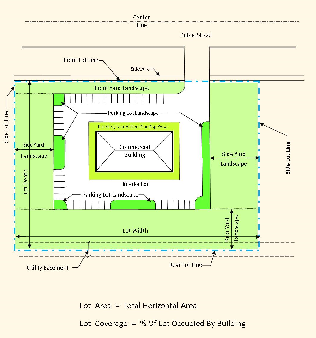
Commercial Lots & Areas
With the exception of the RC, regional center district which has detailed landscaping provisions, this parking lot requirement is exclusive of any yard and other landscaping requirement within a given zone.
Parking lot landscaping shall be no less than eight (8) feet (2.438 meters) in any single dimension and no less than one hundred and fifty (150) square feet (13.95 square meters) in any single area and shall be protected from parking areas with curbing, fencing, or other permanent means to prevent automobile encroachment onto the landscape areas. Areas less than these minimum requirements will not be considered as part of the landscaping requirements.
(b)
Landscape plan and green infrastructure/low impact development methods required: A landscape plan and green infrastructure/low impact development plan for storm water infiltration into landscape areas shall be submitted to the planning department's designated representative. The landscape plan shall include an itemized plant materials schedule with botanical and common names of materials, sizes, and quantities. The arrangement of this landscaping shall be done in such a manner as to contribute significantly to safe circulation, visual orientation, storm water management, low impact design, and other positive environmental factors.
General requirements include the following:
1.
Landscape plans are to be prepared by a registered landscape architect for all projects. Provide name, address, signed seal with registration number on the plans.
2.
Green infrastructure or low impact development methods will be integrated into the landscape design to provide for infiltration of storm water in landscape areas in lieu of irrigation where possible.
3.
Existing and proposed structures (buildings) and utilities (manholes, catch basins, poles, overhead wires, underground etc.) On the project site and structures and utilities within one hundred (100) feet of the subject property lines on adjacent properties are to be located on the landscape plan.
4.
Show exact locations of all existing trees eight (8) inches and over on site and within twenty-five (25) feet of the subject property lines on adjacent properties. Refer to article 4section 5.56 woodlands and tree preservation for requirements on tree surveys and tree replacements.
5.
Minimum plant material sizes are as follows:
a.
Shade/canopy trees—Two and one-half-inch caliper
b.
Ornamental/flowering trees—Two-inch caliper
c.
Evergreen trees—Six- to seven-foot height
d.
Flowering shrubs—Eighteen (18) inches to thirty-six (36) inches height (depends on species)
e.
Evergreen shrubs—Eighteen (18) inches to twenty-four (24) inches ht./spread (depends on species)
f.
Perennials—One (1) gallon
g.
Groundcovers—Two and one quarter (2 ¼) inches pots
All plant material to be nursery grade #1.
6.
Provide all applicable details on the plan including canopy tree, flowering tree, evergreen tree, shrub, perennial and ground cover planting details.
7.
Provide detail cross-sections of earth berms, raised planters, and post installations. Earth berm cross-sections are to show proposed heights, slope dimensions and fill/topsoil depths. planters, posts and walls should be constructed with stone, brick, concrete or wolmanized timbers and with proper detailed footings.
8.
Exceptions to the following specifications will be considered if acceptable alternatives are discussed with the planning department prior to landscape installation. Additional specifications may be added by the planning department as needed. Add the following to the landscape plan as applicable:
a.
Prior to land clearing or construction, tree protection fencing is to be installed by the contractor and inspected by the planning department. This fencing shall be installed at the drip line of all trees and shrubs to remain, in accordance with Article 4Section 5.56 woodland and tree preservation and the city's tree protection detail, and must be maintained as approved for the duration of the project. No cutting, filling, or trespassing shall occur inside the fenced areas without prior approval from the city planning department.
b.
Trees to be transplanted on the site shall be so marked in the field by the landscape architect of the developer, approved by the planning department, and transplanted using only the appropriate sized tree spade per American Association of Nurseryman and City Of Southfield Standards.
c.
Trees shown on the plan to save or transplant that are removed or damaged due to construction shall be replaced with one (1) 2 ½"-3" caliper tree for every tree removed of eight (8) inches in diameter or less. Trees over eight (8) inches in diameter shall be replaced with one (1) 2 ½"-3" caliper tree for every eight (8) inches in diameter removed. Type of replacement and location shall be determined by the project landscape architect or the planning department.
d.
Plant trees and shrubs no closer than the following minimum distances from sidewalks, curbs and parking stalls. Maintain a minimum of seven (7) feet clear along pathways:
i.
Shade/canopy trees—five (5) feet.
ii.
Ornamental/flowering trees—ten (10) feet.
iii.
Evergreen trees—ten (10) feet.
iv.
Flowering/evergreen shrubs—four (4) feet.
v.
Perennials—two (2) feet.
vi.
Groundcovers—eighteen (18) inches.
e.
Dig tree pits a minimum of two (2) feet larger than the tree root balls and shrubs pits a minimum of one (1) foot larger than the shrub root balls. Backfill with one (1) part topsoil and one (1) part soil from the excavated planting hole. Plant trees and shrubs at the same grade level at which they were planted at the nursery. If wet, clay soils are evident, plant trees and shrubs higher.
f.
Remove all twine, wire and burlap from the top one third (⅓) of tree and shrub root balls and from tree trunks. Remove all non-biodegradable materials such as plastic or nylon completely.
g.
Lawn trees are to be mulched with a minimum of four-foot wide by four-inch deep shredded bark rings or other approved design for trunk protection. Only natural-colored shredded hardwood bark mulch will be accepted.
i.
Place mulch around the base of the tree in a four-inch layer to protect roots while still allowing water to pass through.
ii.
Keep mulch two (2) to three (3) inches away from the trunk of the tree to avoid rotting the trunk.
iii.
Extend the mulch out to at least the drip line (edge of the branches).
iv.
For optimal benefits, use a one (1) inch layer of compost, covered with three (3) inch layer of shredded bark mulch.
v.
Maintain a v-notch edge around the mulched tree to keep grass from growing into the mulch and completing with tree roots for nutrients.
vi.
Replenish mulch each year, or as needed.
h.
Shrub beds are to be mulched with shredded bark mulch to a minimum depth of three (3) inches. Only natural-colored shredded hardwood bark mulch will be accepted.
i.
Sod is to be provided for all new lawn areas, especially in rights-of-way and high use areas. Peat sod is not acceptable.
j.
Existing lawn that the owner intends to save and those areas that are damaged during construction must be inspected by the city to determine viability. If the existing lawn is found to be level, healthy, dense and free from weeds, lawn may not require replacement or renovation. If renovation is required or is part of the approved plan, then the following requirements apply:
i.
If it is desired that a natural lawn be installed, the requirements of section 9.50b of chapter 111, police regulations shall be followed.
ii.
Existing lawn found to be in poor condition must first be sprayed with round-up (or approved equal) to kill existing lawn and weed areas. Wait for a minimum period of seven (7) days for the herbicide to take effect, then remove all dead sod and weeds to a minimum depth of two (2) inches. Contractor to till or disc soil to four (4) inch depth. Regrade to eliminate all bumps and depressions. Add a minimum of two (2) to four (4) inches of new topsoil or topsoil from the onsite stockpile for all lawn areas. Back fill and compact topsoil to the top of all curbs and walks prior to sodding.
iii.
Existing lawn found to be generally in good condition but with bare, sparse, or weedy areas must be renovated by filling in low areas with new topsoil or topsoil from the onsite stockpile, racking, top dressing and over seeding all sparse and bare spots and by initiating a weed and feed program.
k.
Backfill directly behind all curbs and along sidewalks and compact to top of curb or walk to support vehicle and pedestrian weight without settling.
l.
All landscape areas, especially parking lot islands and landscape beds next to buildings, shall be excavated of all building materials and poor soils to a depth of twelve (12) to eighteen (18) inches and back filled with good, medium textured planting soil (loam or light yellow clay). Add four (4) to six (6) inches of topsoil over fill material and crown a minimum of six (6) inches above top of curbs and/or walks after earth settling unless otherwise noted on the approved landscape plan.
m.
In natural areas the following procedures shall be followed:
i.
Remove trees and brush per city direction only.
ii.
Remove trash and perform surface grading (if any) only to fill in the worst low spots. Do not cut or fill around trees.
iii.
Rake, hydro seed and mulch bare ground areas with proper seed mix (shade or sunny mix):
1.
Pennfine perennial rye: twenty (20) percent proportion ninety (90) percent purity ninety (90) percent germination.
2.
Kentucky 28# common bluegrass: twenty (20) percent proportion ninety (90) percent purity ninety (90) percent germination.
3.
Penn lawn fescue: sixty (60) percent proportion ninety (90) percent purity eighty-five (85) percent germination.
4.
Seed at three hundred (300) lbs per acre. No noxious weed seeds permitted. Fertilize lawn for 10-10-10.
iv.
Let area revert to trees and shrubs. Mow very minimally, if necessary.
n.
Conversion of all asphalt and gravel areas to landscape shall be done in the following manner:
i.
Remove all asphalt, gravel and compacted soil to a depth of six (6) to eighteen (18) inches depending on the depth of the sub base and dispose off site.
ii.
Contact the planning department to schedule an inspection prior to backfilling.
iii.
Replace excavated material with good, medium-textured planting soil (loam or light yellow clay) to a minimum of two (2) inches above top of curb and sidewalk, add two (2) to four (4) inches of topsoil and crown to a minimum of six (6) inches above top of curb or walk after earth settling, unless otherwise noted on the approved landscape plan.
o.
Natural lawn areas are encouraged both on-site and in rights-of-way in accordance with section 9.50b, chapter 111, police regulations, and underground irrigation is discouraged where natural lawns are installed. Otherwise, all landscape areas including rights-of-way shall be irrigated by an automatic underground irrigation system. Lawns and shrub/landscape areas shall be watered by separate zones to minimize overwatering.
p.
All existing trees on site and in the rights-of-way shall be pruned as directed by the city to remove dead, dying and hazardous limbs or limbs which impede construction, driveways, and sidewalks. Pruning and deep-root fertilizing is to be done only by a qualified tree service company licensed with the city. Call the planning department to obtain a list of licensed tree service contractors.
q.
The construction of detention ponds should be made with the following goals in mind:
i.
Natural, free-form appearing grades.
ii.
Slopes of 1:4, or flatter.
iii.
Fencing is discouraged.
iv.
No water levels are to be retained.
v.
Mow slopes and allow bottom of basin to revert to natural vegetation.
r.
Provide bumper blocks or curbs with drainways installed around all landscape areas to provide for storm water infiltration. Alternate landscape area protection such as decorative fences, retaining walls, etc., may be acceptable in lieu of curbing or may be required in addition to curbing to protect the landscape areas and properly deflect vehicular and pedestrian traffic.
All tree removals shall include stump removal (grinding below grade) and lawn or plant bed restoration.
(c)
Maintenance. The owner of landscaping required by this section shall perpetually maintain such landscaping in good condition so as to present a healthy, neat, and orderly appearance, free from refuse and debris. All diseased and/or dead material shall be removed within sixty (60) days following notification and shall be replaced within the next appropriate planting season or within one (1) year, whichever comes first.
In the event the owner fails to maintain the landscape area in a neat and orderly manner, free from debris, the city may mail to the owner a written notice setting forth the manner in which there has been failure to maintain said property and require that the deficiencies of maintenance be cured within thirty (30) days from date of said notice. If the deficiencies set forth in the notice shall not be cured within thirty (30) days, or any extension thereof granted by the city, the city shall have a right to enter upon such property and correct such deficiencies and the cost thereof shall be charged, assessed, and collected pursuant to section 1.13 of the Southfield City Code.
(d)
Existing plant materials. In instances where healthy plant materials exist on a site prior to its development, the city planner, or his designated representative, may adjust the application of the above standards to allow credit for such plant material if such an adjustment is in keeping with, and will preserve, the intent of this section.
Clear Zone Pathway
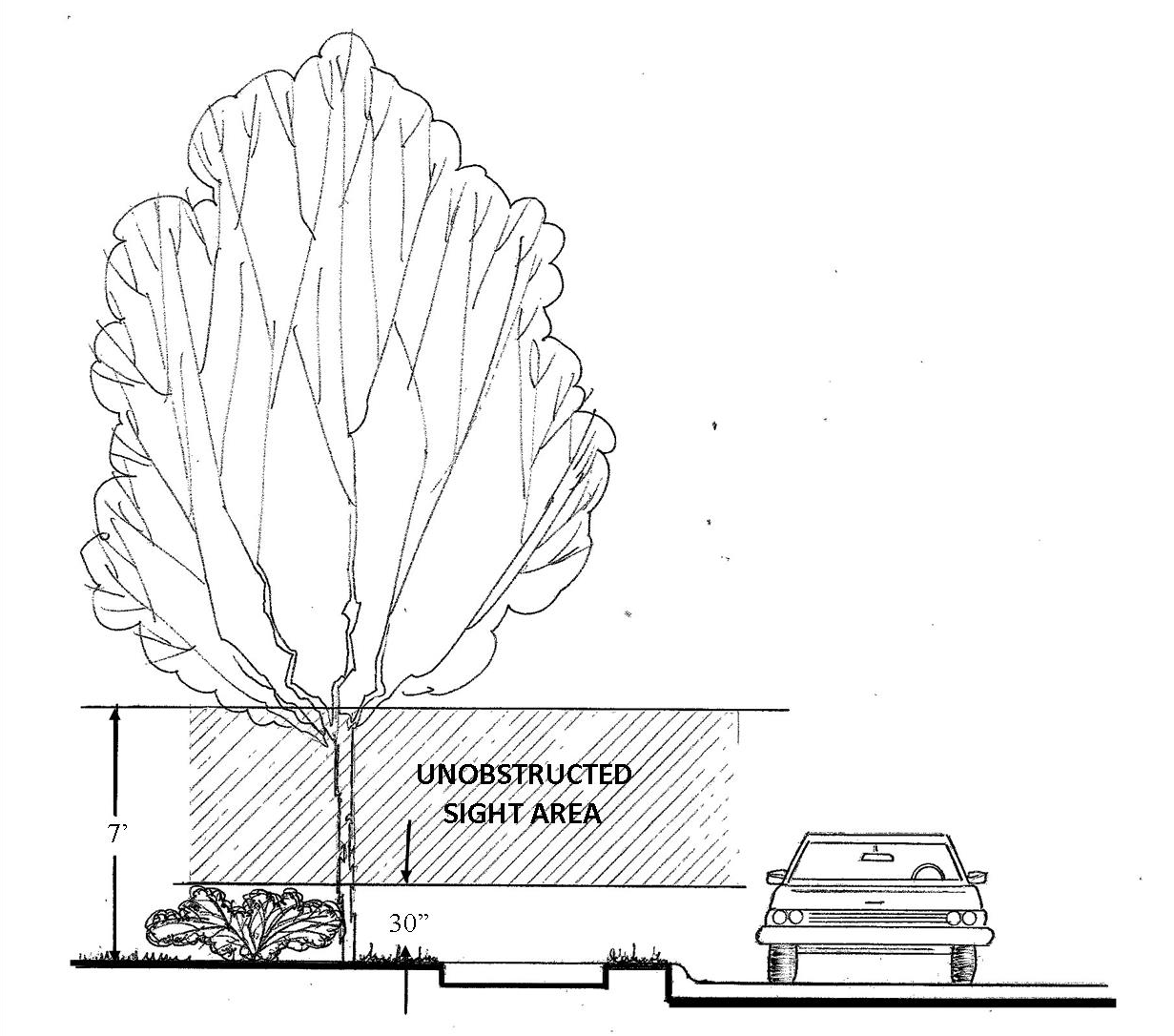
Unobstructed Sight Area
(Ord. No. 1072, 11-9-81; Ord. No. 1264, 2-27-89; Ord. No. 1641, § 1, 5-31-15; Ord. No. 1678, § 2, 7-6-17; Ord. No. 1699, § 6, 12-27-18; Ord. No. 1745, § 2, 11-4-21; Ord. No. 1800, § 1, 12-9-24; Ord. No. 1793, § 1, 8-19-24)
Sec. 5.32. - Off-street loading and unloading.
On the same premises with every building, structure, or part thereof, erected and occupied for manufacturing, storage, warehouse goods, display, a department store, a wholesale store, a market, a hotel, a hospital, a mortuary, a laundry, a dry cleaning establishment, or other uses similarly involving the receipt or distribution of vehicles or materials or merchandise, there shall be provided and maintained on the lot adequate space for standing, loading and unloading services adjacent to the opening used for loading and unloading in order to avoid undue interference with public use of the streets or alleys.
All such loading and unloading areas, including all access drives, shall be paved or permeable surfaced in accordance with section 5.31, subsection 16, and shall be in addition to the required off-street parking area requirements.
Such loading and unloading space, unless otherwise adequately provided for, shall be an area ten (10) feet (3.05 meters) by forty (40) feet (12.2 meters) with a fourteen-foot (4.27 meters) height clearance and shall be provided according to the following table:
No loading space may be on any street frontage and provision for handling all freight shall be on those sides of any building which do not face on any street or proposed street, except where such areas are obscured, from such street, with a solid masonry wall not less than six (6) feet (one and eighty-three hundredths meters) in height.
(Ord. No. 1678, § 2, 7-6-17)
Sec. 5.33. - Wall requirements and screening devices.
Boundary line lots: An unpierced masonry wall shall be provided in nonresidential districts where adjacent to, or across a street or alley from, residential districts in accordance with the following:
(1)
Where a nonresidential district is separated by a street from the front yard of lots in a residential district, there shall be provided an unpierced masonry wall set back twenty (20) feet (6.1 meters) from the street separating such residential and nonresidential districts before said nonresidential district property, within fifty (50) feet (15.25 meters) of said street (or alley), is used for nonresidential purposes.
(2)
Where a nonresidential district is separated by a street or alley from a side or rear yard of lots in a residential district, there shall be provided an unpierced masonry wall in such nonresidential district where contiguous to the street separating such residential and nonresidential districts before said nonresidential district property, within fifty (50) feet (15.25 meters) of said street (or alley), is used for nonresidential purposes.
(3)
Where a nonresidential district abuts, without being separated by a street or alley, a residential district, there shall be provided an unpierced masonry wall in such nonresidential district where contiguous to the residential district before said nonresidential district property, within fifty (50) feet (15.25 meters) of said residential property, is used for nonresidential purposes.
Where any wall, as required above, would be located within twenty-five (25) feet (7.625 meters) of a street intersection, the wall shall be angled or off-set in such manner so as to comply with the corner clearance provisions of section 5.46.
(4)
Enclosure of appliances or accessories. In all zone districts, roof appliances such as, but not limited to, cooling towers, air conditioners, heating apparatus, dust collectors, filters, transformers and any other such appliance or apparatus, other than flag poles, chimneys for carrying products of combustion and radio antenna towers, shall be enclosed within opaque walls not less in height than the height of the highest appliance, as measured from the plane of the roof surface upon which the screen device is mounted to the top of the highest appliance. However, if the screening device is mounted on the top of the parapet or other part of the building facade which extends above the roof surface, the height of the parapet or part of the building facade may be included as part of the height of the screening device as long as the sum total of the height of the parapet or other part of the building facade extending above the roof surface and the screening device is equal to the height of the highest appliance. Such walls may be louvered to permit passage of air for cross ventilation, but shall be adequate to totally screen such equipment from view. The design of the screening device shall be compatible with the architectural design of the building upon which it is located.
Sec. 5.34. - Wall height.
Wherever in this chapter an unpierced masonry wall is required, the wall shall be erected to a height of not less than six (6) feet (one and eighty-three hundredths meters) and not more than eight (8) feet (2.44 meters), measured from the average surface within the adjacent thirty (30) feet (9.15 meters) of the nonresidentially zoned property.
Sec. 5.35. - Wall, brick facing.
Wherever in this chapter an unpierced masonry wall is required:
(1)
The wall shall be faced with brick on the side facing the residentially zoned property. The brick facing is necessary to reduce the possibility of any adverse effects upon the residentially zoned property that may be caused by the development of the nonresidentially zoned property.
(2)
Whenever an unpierced masonry wall is required to be constructed, such wall shall be constructed prior to the backfilling of any foundation or prior to any construction that extends above the foundation wall, whichever first occurs, in order to preserve the residential character and livability of the adjacent residential properties during the time of construction when the noise, dust and hazards from construction equipment are most obnoxious to residential properties.
Sec. 5.36. - Wall modification.
Wherever in this chapter an unpierced masonry wall, six (6) feet (one and eighty-three hundredths meters) in height is required, any person, commission or council, having site plan review jurisdiction, may reduce the required height or waive the requirement where said wall is required to be erected within forty (40) feet (12.2 meters) of a street right-of-way and that such person, commission or council finds that the construction of said wall, as required, would constitute a traffic hazard.
(Ord. No. 1261, 2-27-89)
Sec. 5.37. - Wall substitution.
Wherever in this chapter an unpierced masonry wall is required, a buffer strip of not less than ten (10) feet (3.05 meters) in width or fence or wall may be permitted in lieu of the required unpierced masonry wall upon a finding by the city council that the buffer strip or fence or wall would provide equal or greater protection to the residential district from any adverse effects from the use of the nonresidential district.
(Ord. No. 1262, 2-27-89)
Sec. 5.37-1. - Fence regulations.
A.
Intent. The intent of this section is to provide reasonable regulations for fence installation while allowing property owners the ability to install a fence for aesthetic, screening, separating or security purposes.
B.
Definitions.
1.
Board-on-board fence: Shall mean any fence with alternating vertical boards over horizontal structures that give the fence a finished look on both sides.
2.
Chain-link or cyclone fence: Shall mean any fence that is constructed of some type of woven wire fence, with a minimum 11½-gauge in residential districts and a minimum 9-gauge in non-residential districts.
3.
Decorative fence: Shall mean any fence no more than thirty (30) inches high and no more than sixteen (16) feet in length, which are not intended for the purpose of preventing persons and/or domestic animals, from crawling or passing through the fence, except at established gateways. A decorative fence shall not include a fence constructed of chain link material or any other type of woven fence.
4.
Fence: Shall mean a structure serving as an enclosure, barrier or boundary including but not limited to posts, boards, wire, vinyl or gates.
5.
Fence height: The height of the fence will be measured at the grade. If the ground is not entirely level, then the grade shall be determined by computing the average elevation of the ground for each linear section of fence and taking the average of said total averages.
6.
Lattice: Shall mean an open framework made of strips of wood or similar material overlapped or overlaid in a regular crisscross or decorative pattern. Lattice sections may not exceed one (1) foot in height and shall not exceed fifty (50) percent coverage of open viewing.
7.
Living fence or landscape fence: A living fence or landscape fence includes a row of shrubs, hedgerows, landscape berms or similar for the purpose of enclosure, screening, or restricting the passage of air, noise or light; but shall not impede surrounding line of sight or corner clearance (clear vision zones).
8.
Ornamental security fence: An ornamental fence taller than six (6) feet in height with anti-climb features (i.e., posts/pickets that bend outward and/or have spikes at the tops, difficult to climb welded wire mesh, or similar).
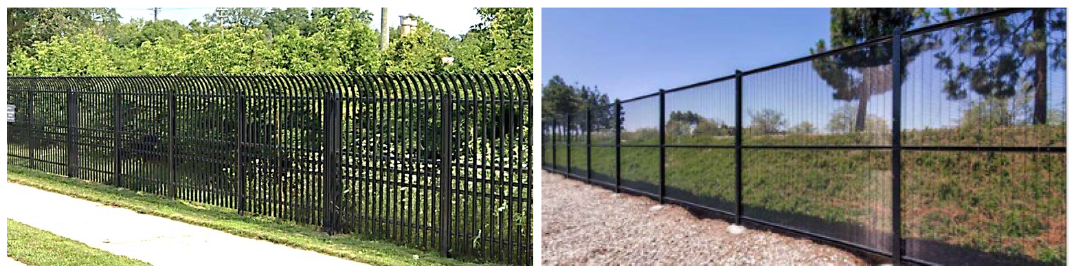
9.
Picket fence: Shall mean any fence with in-line boards no larger than one (1) inch by three (3) inches with gaps equal to the width of the boards.
10.
Privacy screen: Shall mean a sight-obscuring fence, erected adjacent to or around a selected use or area (such as a patio, deck, courtyard or swimming pool), designed to screen the area behind it from observation by persons outside its perimeter.
11.
Semi-privacy fence: Shall mean a fence designed and intended to be sight-obscuring, such as a board-on-board fence.
12.
Shadow-box fence: See Board-on-board fence.
13.
Solid fence: Any fence that presents a solid surface without any gaps in materials.
14.
Wall: See wall requirements sections 5.33—5.37.
C.
Standards for approval:
1.
Residential districts: Residential fences (R-A, R-1, R-2, R-3, R-4, and R-E) are subject to an application to the building department and the following requirements:
(a)
Front yard: Not permitted, unless it meets the definition of decorative fence or living fence.
(b)
Side yard: Fences, not exceeding seventy-two (72) inches shall not extend toward the front of the lot nearer than the front of the house.
(c)
Rear yard: Fences shall not exceed seventy-two (72) inches in the rear yard.
(d)
Double frontage yards: On corner lots where a double front setback is required, and where there is a common rear yard relationship with a lot in the same block, a fence no greater than seventy-two (72) inches in height may be installed along the common street line from the side of the house to the rear property line. Clear vision zones shall be maintained for corner lots and adjacent driveways.
(e)
Decorative fencing: Decorative fencing (e.g. split rail, white picket, etc.), which is less than thirty (30) inches high and less than sixteen (16) feet in length when erected as part of landscaping does not require a permit.
(f)
Living fences shall meet the requirements for clear vision triangles.
(g)
Permitted materials: Wood, wrought iron, tubular aluminum, vinyl coated chain link, aluminum, quality vinyl and other approved quality materials. Wood fences shall be pressure treated, painted or stained. Board-on-board, shadow-box and semi-privacy fence styles may include a one-foot high lattice top. Naturally water resistant woods (i.e. teak, redwood, cedar) may be permitted. Vinyl coated chain link fences may be permitted in the rear and side yards.
(h)
The finish side of the fence shall face out towards adjacent residential lots and public rights-of way.
(i)
Prohibited fences: Stockade, uncoated chain link and slats (i.e. vinyl, aluminum, etc.) inserted into chain link or cyclone fences. Fences shall not contain barb wire, razor wire, electric current or charge of electricity. Exception: Farms, permitted in the single-family residence districts (R-A, R-1, R-2, R-3, R-4, R-E), may contain these type fences after approval by the ZBA.
(j)
All fences shall be supported from its own structural frame system of posts and rails and not attached, connected, secured or supported by other fencing, trees, etc. in the area. Fences shall be installed in a professional manner and be plumb, straight, and true, and stepped or tapered or cut to follow the contour of the land.
(k)
Dog runs shall be located in the rear and side yards only and shall be consistent with the requirements for residential fences.
(l)
Electronic pet fence: Refer to Ordinance No. 1576 (codified as § 9.89).
2.
Nonresidential districts: Nonresidential fences and multi-family residential are subject to the following requirements:
(a)
A permit shall be required prior to the construction of any fence, after administrative approval is granted by the city planner. Administrative approval may not be required if the fence is approved as part of a site plan approval.
(b)
Fences, not to exceed six (6) feet in height, may be located within any yard except the minimum front yard setback or the minimum setback of a yard abutting a street. Ornamental fencing no taller than thirty (30) inches in height may be located within the front yard. The city planner may approve fencing up to eight (8) feet in height for uses that demonstrate the need for increased security measures (i.e., data centers, public or private utilities, broadcasting facilities, schools, religious institutions, or similar), otherwise, fences above six (6) feet in height must be requested through the zoning board of appeals. Any eight (8) foot tall fencing along rights-of-way must be ornamental in order to be approved by the city planner. Front yard setback requirements may be waived in the City Centre and DDA districts if ornamental fencing or ornamental security fencing is installed.
(c)
Chain link fences shall be vinyl coated.
(d)
Barb wire may be used only in industrially zoned districts provided said material is over seven (7) feet above the ground and any projections at the top shall be over the fence owner's property and shall not overhang onto abutting property (see F-4). Fence top spikes are to be six (6) feet or higher above the ground.
D.
Survey: The city may require the owner of the property upon which a fence is to be constructed to establish property lines upon said property through the placing of permanent stakes by a licensed surveyor. Such property lines shall be established before such fence is erected. A survey may also be required in the event an abutting property owner disputes the permit applicant's determination of a stated property line.
E.
Maintenance: All fences shall be maintained in good, safe and stable condition in accordance with local ordinances and codes. Rotten, broken or missing components shall be replaced or repaired immediately. Fences shall be made from naturally water resistant material or be pressure treated, stained, painted, or vinyl coated and kept in a good aesthetic condition.
F.
For pool enclosures and construction fencing see the Michigan Residential Code and/or the Michigan Building Code.
Sec. 5.38. - Landscape requirements and plant materials; buffer strip, parking lot, and right-of-way planting.
Whenever in this chapter landscaping treatment is required, it shall be in accordance with the specific use as mentioned in this section. All plant materials will be installed within six (6) months of the date of issuance of a temporary certificate of occupancy. In the instance where such completion is not possible, a cash bond, letter of credit, or corporate surety bond in an amount equal to the estimated cost of the landscape plan or portion thereof will be deposited with the city clerk to insure project completion. All installations of plant materials shall be in accordance with the general planting specifications as set forth by the city parks and recreation department. further, a landscape plan shall be submitted to the city planning department for review and approval prior to the installation of any required landscaping. Included on this landscape plan shall be: scale; north arrow; all permanent structures; names of all plant materials to be installed, both scientific and common; size and quantity of plant materials to be installed; existing plants on the site; ground cover to be used; hard-surfacing; other landscape materials as defined by this chapter; and name, address, and telephone number of the landscape designer.
(1)
Buffer strip planting. Whenever a buffer strip is required or permitted, it will be installed so as to provide, within a reasonable time, an effective barrier to vision, light, physical encroachment, and sound. Reasonable maintenance will be required to insure its permanent effectiveness. Specific planting requirements are:
(a)
The planting strip will be no less than ten (10) feet (3.05 meters) in width.
(b)
Plant materials shall not be placed closer than four (4) feet (1.22 meters) from the property line.
(c)
A minimum of one (1) evergreen tree shall be planted at ten-foot (3.05 meters) intervals.
(d)
A minimum of three (3) intermediate shrubs shall be placed between the spaced evergreens.
(e)
Suggested plant materials:
(2)
Parking lot plantings. Whenever this section is applied, the plant materials will be installed properly and provided such reasonable maintenance as required to insure their health and permanence. Except where landscaped areas are designed as vegetated stormwater control measures, suggested plant materials are:
_____
(b)
Shrubs: Refer to the suggested buffer strip plantings.
(c)
Vines: Vines may be planted against screening walls and used as a ground cover. All vines shall have a minimum of three (3) runners, six (6) inches (15.24 centimeters) to eight (8) inches (20.32 centimeters) long when installed.
Boston Ivy
Climbing Hydrangea
English Ivy
Running Euonymus
Common Moonseed
Baltic Ivy
Pachysandra
Ajuga
Periwinkle
Cotoneaster
(3)
Right-of-way planting. The "Master Street Tree Plan" of the city parks and recreation will be used as the guide for all right-of-way tree planting. Chapter 28, Tree Regulations, of the City Code shall be consulted for all right-of-way plantings.
(4)
Vegetated stormwater control measures:
(a)
The design and installation of vegetated stormwater control measures, which may be incorporated into required parking lot, buffer strip and right-of-way plantings, is encouraged and shall be subject to review and approval by the city engineer and city planner. Required parking lot, buffer strip, and right-of-way plantings may incorporate vegetated stormwater control measures so long as the aesthetic objectives and the minimum dimensional requirements of the planting area are, in the judgment of the city planner, satisfied by the combination of landscaping, fencing, walls and other measures proposed.
(b)
Applicants shall utilize the design guidance from the Southeast Michigan Council of Governments (SEMCOG) and City of Southfield Low Impact Design Guidelines in the selection, sizing and design of these areas. For any such vegetated stormwater control measures proposed, the landscape or stormwater management plan submitted to the city shall include:
i.
A plan indicating the contributing drainage area, land use, slope, and seasonal high groundwater elevation in areas where the practices are proposed.
ii.
Design calculations.
iii.
Detailed planting plan.
iv.
Construction detail and sequencing plan.
v.
Maintenance plan.
(Ord. No. 1678, § 2, 7-6-17)
Sec. 5.39. - Essential services.
Repealed by Ord. No. 1342, adopted June 8, 1992.
Sec. 5.40. - Public utility facilities.
In all zoning districts, except industrial, public utility facilities and uses (without storage yards), when operating requirements necessitate the locating of said facilities within the district in order to serve the immediate vicinity, shall be permitted after review and approval of the site plan and upon a finding that the use will not be injurious to the surrounding neighborhood and not contrary to the spirit and purpose of this chapter.
(Ord. No. 1263, 2-27-89; Ord. No. 1793, § 1, 8-19-24)
Sec. 5.41. - Easement use.
Erection of permanent structures on easements for public utilities is prohibited. "Permanent structure" shall mean, and include, a garage or other building (but shall not include a fence, retaining wall, freestanding wall, concrete walk, paving, or any similar object) which will prevent or interfere with the free right or opportunity to use or make the easement accessible for essential services.
Sec. 5.42. - Rear yard measurement.
Wherever there is a public alley at the rear of a lot upon which the lot abuts for its full width, measurements of the depth of any abutting rear yard required under this chapter may be made to the centerline of such alley.
Sec. 5.43. - Yard encroachments.
No yard, court, or other open space provided about any building for the purpose of complying with the provisions of these regulations shall again be used as a yard, court, or other open space for another building existing or intended to exist at the same time.
Sec. 5.44. - Fees.
The city council may, from time to time, prescribe and amend by resolution a reasonable schedule of fees to be charged to petitioners for amendments to this chapter and for the review of site plans in accordance with the provisions of this chapter.
Sec. 5.45. - Nonresidential setback from residential.
In any nonresidential zoning district, no building or structure shall be located closer to a single-family residential district than the height of the building or structure but, in no instance, shall the setback be less than fifteen (15) feet (4.575 meters). Provided, however, where greater setbacks are required by any other provisions of this chapter, such other provisions shall control the setback requirements.
Sec. 5.46. - Corner clearance and clear vision triangle.
In order to promote safe movement of vehicles at and near street intersections and driveway connections, and in order to promote more adequate protection of the safety of children, pedestrians, property and other vehicles and occupants, no permanent or temporary fence, wall, shrubbery, sign, vehicle, or other [obstruction] to vision above a height of three (3) feet (.915 meters) from the established street grades shall be permitted in the following locations:
1.
Within the corner clearance, which is the triangular area formed at the intersection of any street right-of-way lines (the "corner clearance") by a straight line drawn between said right-of-way lines at a distance, along each right-of-way line, of twenty-five (25) feet from this point of intersection.
2.
Within the clear vision triangle, which is the triangular area formed at the intersection of any street right-of-way line and driveway connection by a straight line drawn between said right-of-way line and driveway connection at a distance, along each right-of-way/driveway connection line, of ten (10) feet from this point of intersection.
(Ord. No. 1774, § 2, 8-14-23)
Sec. 5.47. - Access to structures.
Every building or structure hereafter erected or moved shall be on a lot abutting a public street or private street or permanent easement not less than thirty (30) feet (9.15 meters) in width.
Sec. 5.48. - Location of principal buildings.
Except in the case of planned developments where a site plan is approved and except for lots used for education or religious institutions, not more than one (1) single-family dwelling shall be located on a lot as defined in this chapter nor shall a single-family dwelling be located on the same lot with any other principal building. (This provision shall not be construed to prohibit the lawful division of land.)
(Ord. No. 1793, § 1, 8-19-24)
Sec. 5.49. - Floodplain controls.
(1)
Purpose. It is the purpose of the floodplain controls to apply special regulations to the use of land in those areas of the city which are subject to predictable flooding at frequent intervals and to protect the storage capacity, ground water recharge, and water purification of floodplains and to assure retention of sufficient floodplain area to convey flood flows which can reasonably be expected to occur and to better maintain environmental factors and the proper ecological balance through prohibiting unnecessary encroachments. Such regulations, while permitting reasonable economic use of such properties, will help protect the public health and reduce financial burdens imposed on the community, its governmental units, and its individuals by frequent and periodic floods, and the overflow of lands; reserve such areas for the impoundments of water to better stabilize stream flow; to better maintain the proper ecological balance; and consideration of environmental factors such as open space and aesthetic values. All lands included in such floodplain control district shall be subject to the restrictions imposed herein in addition to the restrictions imposed by any other zoning districts in which said lands should be located. The floodplains, as herein defined, are not intended for human habitation, the development of permanent structures, or any use which causes a change in the natural functional drainage grade of the floodplain.
Flood losses are caused by the cumulative effect of obstructions in flood heights and velocities, the occupancy of the floodplain areas by uses vulnerable to floods, or hazardous to other lands which are inadequately elevated or otherwise protected from flood damage.
(2)
Delineation of floodplain boundaries. The areas of special flood hazard identified by the Department of Homeland Security's Federal Emergency Management Agency, entitled Flood Insurance Study, Oakland County, Michigan, and Incorporated Areas dated September 29, 2006, with accompanying flood insurance rate maps and flood boundary floodplain maps, as delineated on the Flood Insurance Rate Map of the City of Southfield, Community Number 260179, Map Panel Numbers 26125C0514F, 0518F, 0519F, 0538F, 0539F, 0652F, 0654F, 0656F, 0657F, 0658F, 0659F, 0676F, 0677F, 0678F, 0679F, dated September 29, 2006, prepared by the Department of Homeland Security's Federal Emergency Management Agency, and the profiles prepared by the Federal Insurance Administration in conjunction with said map are hereby adopted by reference and declared to be a part of this chapter. The flood insurance study is on file at the engineering department, City of Southfield, 26000 Evergreen Road, Southfield, Michigan 48076.
This provision shall apply to all lands within the jurisdiction of the city shown on the official maps located within the boundaries of the regulatory floodplain and floodplain fringe districts which include the main branch of the Rouge River, Pebble Creek, Franklin Branch, Evans Ditch, Farmington Branch, and Carpenter Branch of the Rouge River.
(3)
Interpretation of district boundaries. The boundaries of the zoning district shall be determined by the water surface flood profile provided in the flood insurance rate map. Where interpretation is needed as to the exact location of the boundaries of the district as shown on the flood insurance rate map and flood profiles, the city engineer shall make the necessary interpretation with the assistance of the state department of natural resources and the U.S. Army Corps of Engineers when needed.
Any person or persons contesting the location of the district boundary shall be given a reasonable opportunity to present the reasons for their objection to the city engineer and to submit any technical and/or material evidence in support of their objections. The city engineer, in such cases, shall submit a report to the city council outlining the area of disagreement and the conclusions reached by him.
(4)
Appeals. The city council may, upon petition, permit minor modifications to the delineation of the floodplain boundary after review and recommendation from the city engineer. Such modifications may be approved upon the findings that:
(a)
The flow, storage capacity, and discharge of the floodplain will be maintained or improved.
(b)
The floodplains are not intended for human habitation and are kept free and clear of interference or obstruction which will cause any undue restriction of original capacity of the floodplain.
(c)
The stream flow is not revised so as to affect the riparian rights of other owners or interfere with natural drainage in the area.
(d)
The modification is necessary for the preservation and enjoyment of a substantial property right.
(e)
The modification will not be detrimental to the public welfare or injurious to other property in the surrounding area in which said property is situated.
(f)
Notification has been provided adjacent communities and the state department of natural resources prior to any alteration or relocation of a watercourse, and submittal of copies of such notification made to the Federal Insurance Administration.
(g)
All necessary permits have been received from those governmental agencies from which approval is required by federal or state law, including section 404 of the Federal Water Pollution Control Amendments of 1972.
(h)
Assure that the floodplain carrying and storage capacity within the altered or relocated portion of any watercourse is maintained.
(i)
A public hearing shall be held concerning the requested modification and notice shall be given in the official newspaper not less than fifteen (15) days prior to the hearing and the general location of the proposed modification.
(j)
Alternatives to any requested modification to the floodplain boundary shall be adequately explored and presented to the city council at the public hearing.
(5)
Establishment of floodplain zones. The floodplain areas within the jurisdiction of this chapter are hereby divided into two (2) districts: (1) Regulatory Floodplain District (RF) and (2) Floodplain Fringe District (FF). The boundaries of these districts shall be shown on the official map as regulatory floodplain and represented by "A" zones and floodplain fringe represented by "B" zones.
(6)
Uses permitted:
(a)
Regulatory floodplain district (RF). The following uses which have a low flood damage potential and do not obstruct flood flows shall be permitted within the regulatory floodplain to the extent that they are not prohibited by any other ordinance and provided they do not require structures, fill, or storage of material or equipment. No use shall adversely affect the capacity of the channels or regulatory floodplains of any tributary to the main stream, drainage ditch, or any other drainage facility or system.
1.
Agricultural uses such as general farming, outdoor plant nurseries, horticulture, and viticulture.
2.
Private and public recreational uses such as golf courses, tennis courts, driving ranges, archery ranges, picnic grounds, parks, wildlife and nature preserves, hiking, playgrounds, athletic fields, and bicycle paths.
3.
Public rights-of-way, private drives, and parking areas; provided, further, that for all zoning districts, the area of the parcel of land located within the regulatory floodplain used for the provision of parking thereon shall not exceed ten (10) percent of the regulatory floodplain area of the property involved. However, in no instance shall the parking area exceed ten (10) percent of the area outside of the regulatory floodplain.
4.
In any zoning district in which density is based upon land area, the computation of density shall not include any of the area located within the regulatory floodplain district of which the property is a part. The floodplain area may be used in computing open space and landscape requirements of any zoning district.
5.
The erection and construction of roads, bridges, causeways, and public utilities may be permitted within the regulatory floodplain by the city council after a public hearing, which has been advertised in a local newspaper not less than fifteen (15) days prior to the hearing stating the time, place, and date of the hearing, has been held, and the city council has made findings that such proposals will not be detrimental to the natural flow of water or disrupt the floodplain storage capacity, and provided the requirements of this section have been met. Exhibits submitted for review will provide sufficient information as required by the city council with respect to support, spacing, height, anchorage, and erosion control.
(b)
Floodplain fringe district (FF). Permitted uses in the floodplain fringe shall be subject to the following standards provided further that the permitted uses shall meet the standards and restrictions imposed by any other zoning district in which said lands may be located.
1.
For new construction or substantial improvement, the elevation of the lowest floor designed or intended for human habitation and/or employment (including basement) shall be at least three (3) feet (0.915 meters) above the elevation of the floodplain.
2.
Dumping or backfilling with any material in any manner is prohibited in the floodplain fringe unless, through compensating excavation and shaping, the floodplain fringe will be maintained or improved as determined by the city engineer and approved by the city council.
3.
Any filling or modification to the floodplain fringe shall have erosion controls as approved by the city engineer to prevent soil from being washed into the regulatory floodplain or channel.
4.
Any substantial improvements within a floodplain shall be:
a.
Designed and anchored to prevent flotation, collapse, or lateral movement of the structure.
b.
Constructed with materials and utility equipment resistant to flood damage.
c.
Constructed by methods and practices that minimize flood damage.
5.
All new and replacement water supply systems shall minimize flood damage.
6.
All new and replacement sanitary sewage systems shall minimize or eliminate infiltration of floodwaters into the system and discharge from systems into floodwaters. On-site waste disposal systems shall be located to avoid impairment to the system or contamination from the system during flooding.
7.
All public utilities and facilities shall be designed, constructed, and located to minimize or eliminate flood damage.
8.
Where topographic data, engineering studies, or other studies are needed as required by the city council, planning commission, or city engineer to determine the effects of flooding on a proposed site and/or the effect of a structure on the flow of water, the applicant, at his expense, shall submit such data or studies. All such required data shall be prepared by a registered professional civil engineer.
9.
The city engineer shall obtain and record the actual elevation (in relation to mean sea level) of the lowest habitable floor (including basements and cellars and any openings thereto) of all new or substantially improved structures and whether or not the structure contains a basement or cellar.
10.
The following uses which present difficult problems in removing or evacuating, in the event of flooding in the floodplain fringe, are prohibited: hospitals, senior citizen housing, nursing homes, schools, and the storage of toxic materials.
(Ord. No. 1538, 10-10-06)
Sec. 5.50. - Sexually oriented businesses.
1.
Purpose and intent.
A.
Recognizing that because of their nature, some uses have objectionable operational characteristics, particularly when several of them are concentrated in small areas and recognizing that such uses may have a harmful effect on adjacent areas, special regulation of these uses is necessary to ensure that these adverse effects will not contribute to the blighting or downgrading of the surrounding neighborhood or other sensitive land uses. These special regulations are itemized in this section and pertain to sexually oriented businesses defined in this chapter as adult arcades; adult bookstores; adult booths; adult novelty stores; adult video stores; adult motels; adult motion picture theaters; adult live state performing theater; adult model studios. Sexual encounter centers are prohibited in all zoning districts in the city.
The use or uses shall only be approved when the following conditions have been satisfied and all licensing provisions in chapter 70, title VII, business and trades, sexually oriented businesses, have been met. These use controls do not legitimize activities which are prohibited in other sections of the city's code or ordinances.
B.
The provisions of this section are not intended to offend the guarantees of the First Amendment to the United States Constitution, or to deny adults access to these types of businesses and their products, or to deny such businesses access to their intended market. Neither is it the intent of this section to legitimize activities that are prohibited by city ordinance or state or federal law. If any portion of this section relating to the regulation of adult and sexually oriented businesses is found to be invalid or unconstitutional by a court of competent jurisdiction, the city intends said portion to be disregarded, reduced and/or revised so as to be recognized to the fullest extent possible by law. The city further states that it would have passed and adopted what remains of any portion of this section related to regulation of adult and sexually oriented businesses following the removal, reduction, or revision of any portion so found to be invalid or unconstitutional.
2.
Findings. Based on evidence concerning the adverse secondary effects of adult uses on the community presented in hearings and in reports made available to the city, and on findings incorporated in the cases of City of Renton v. Playtime Theaters, Inc., 475 U.S. 41 (1986); Coleman Young v. American Mini Theaters, 427 U.S. 50 (1976); and Barnes v. Glen Theatre, Inc., 501 U.S. 560 (1991); Arcara v. Cloud Books, Inc., 478 U.S. 697 (1986); California v. LaRue, 409 U.S. 109 (1972); United States v. O'Brien, 391 U.S. 367 (1968); DLS, Inc. v. City of Chattanooga, 107 F.3d 403 (6th Cir. 1997); Kev, Inc. v. Kitsap County, 793 F. 2d 1053 (9th Cir. 1986); Hang On, Inc. v. City of Arlington, 65 F. 3d 1248 (5th Cir.1995); and South Florida Free Beaches, Inc. v. City of Miami, 734 F.2d 608 (11th Cir. 1984), as well as studies conducted in other cities including, but not limited to Phoenix, Arizona; Minneapolis, Minnesota; Houston, Texas; Indianapolis, Indiana; Amarillo, Texas; Garden Grove, California; Los Angeles, California; Whittier, California; Austin, Texas; Oklahoma City, Oklahoma; and Beaumont, Texas; and findings reported in the Final Report of the Attorney General's Commission on Pornography (1986), the Report of the Attorney General's Working Group On the Regulation of Sexually Oriented Businesses (June 6, 1989, State of Minnesota); as well as the following articles on adult regulated uses: "Does the Presence of Sexually Oriented Business Relate to Crime? An Examination using Spatial Analysis", (2012) Eric S. McCord and Richard Tewksbury; "Report: Adult Oriented Businesses in Austin" (1986), Office of Land Development Services; "Adult Entertainment Study" (1994) New York City, Department of City Planning; and "Crime—related secondary effects: secondary effects of "off site" sexually-oriented businesses", (2008) Richard McCleary Ph.D., Report Commissioned by Texas City Attorneys Association.
A.
Sexually oriented businesses and other adult business uses, as a category of adult business uses, are associated with a wide variety of adverse secondary effects including, but not limited to, personal and property crimes, prostitution, potential spread of disease, lewdness, public indecency, illicit drug use and drug trafficking, negative impacts on property values, urban blight, litter, and sexual assault and exploitation.
B.
Sexually oriented businesses and other adult business uses should be separated from sensitive land uses to minimize the impact of their secondary effects upon such uses, and should be separated from other such uses, to minimize the secondary effects associated with such uses and to prevent an unnecessary concentration of such uses in one (1) area.
C.
The preceding negative secondary effects constitute harms which the city has a substantial governmental interest in preventing and/or abating. The substantial government interest in preventing negative secondary effects, which is the city's rationale for this chapter, exists independent of any comparable analysis between sexually oriented and adult oriented businesses and non-sexually oriented businesses. Further, the city's interest in regulating sexually oriented businesses and other adult business uses extends to preventing further negative secondary effects of current or future sexually oriented businesses that may locate in the city. The city finds that the cases and documentation relied on in this section are reasonably believed to be relevant to the eradication of negative secondary effects.
D.
This section shall not have the purpose or effect of placing a limitation or restriction on the content of communicative materials, including sexually oriented or adult materials, or to deny access by distributors of sexually oriented materials. It is not the purpose of this section to impose limits or restrictions on the content of constitutionally prohibited forms of speech or expression.
3.
Prohibited uses. It shall be unlawful to operate a sexual encounter center, as defined in article 2 definitions, in any district within the city.
4.
Area requirements. In addition to compliance with all other provisions within this chapter, the following special regulations apply to all sexually oriented businesses and adult businesses:
A.
It shall be unlawful to establish any sexually oriented business as defined in this chapter, except with special use approval in the B-3 (general business) and I-1 (industrial) districts. Sexual encounter centers, as defined, are prohibited in all zoning districts.
B.
No such uses may be permitted in the B-3 (general business) or I-1 (industrial) districts within one thousand five hundred (1,500) feet of any residential district, adult regulated use, school, church, child care facility, park, measured from the lot line of the location of the proposed use. For purposes of this section, the distance between any two (2) sexually oriented businesses shall be measured in a straight line, without regard to intervening structures or objects, from the closest exterior wall of the structure in which the business is located.
C.
The city council may waive this location provision if the following findings are made:
1.
That the proposed use will not be contrary to the public interest or injurious to nearby properties and that the spirit and intent of this chapter will be observed.
2.
That the character of the area shall be maintained.
3.
That all applicable regulations of this chapter will be observed.
4.
That no sexually oriented or adult business shall be located within one thousand five hundred (1,500) feet of any pawn shop, alternative financial institution, medical marijuana facility or other sexually oriented business.
D.
Anything herein to the contrary notwithstanding the city council shall not consider the waiver of the locational requirements as hereinabove set forth until a petition shall have been filed with the city clerk and verified as to sufficiency. Such petition shall indicate approval of the proposed regulated use by fifty-one (51) percent or more of the persons owing property within a radius of one thousand (1,000) feet of the location of the proposed use as measured from the lot line. The petitioner, or his agent, shall attempt to contact all eligible property owners within this radius and must maintain a list of all addresses at which no contact was made.
E.
The petition hereinabove required shall contain an affidavit signed by the party circulating such petition attesting to the fact that the petition was circulated by him/her and that the circulator personally witnessed the signatures on the petition and that the same were affixed to the petition by the person whose name appeared thereon and that the circulator verily believes that the signers of such petition are persons owning property within one thousand (1,000) feet of the premises mentioned in said petition. Such petition shall also comply with such other rules and regulations as may be promulgated by the city council.
5.
Parking. All off-street parking areas for any sexually oriented businesses or adult businesses shall comply with article 4, general provisions of this chapter.
6.
Other requirements.
A.
Entrances to sexually oriented businesses must be posted on both the exterior and interior walls, in a location clearly visible to the entering and exiting public, using lettering no less than four (4) inches in height noting that: a) persons under the age of eighteen (18) are not permitted to enter the premises and b) no alcoholic beverages are permitted in the premises.
B.
The proposed use or uses must be of such size and character that it will be in harmony with the appropriate and orderly development of the general business district.
C.
The location, size, intensity and periods of operation of any such proposed use may be designed to eliminate any possible nuisance likely to emanate therefrom which might be adverse to occupants of any other nearby permitted uses.
D.
The proposed use must be in accord with the spirit and purpose of this chapter and not be inconsistent with, or contrary to, the objectives sought to be accomplished by this chapter and principles of sound planning.
E.
The proposed use is of such character and the vehicular traffic generated will not have an adverse effect, or be detrimental, to the surrounding land uses or the adjacent thoroughfares.
F.
The proposed use is of such character and intensity and arranged on the site so as to eliminate any adverse effects resulting from noise, dust, dirt, glare, odor or fumes.
G.
The proposed use, or change in use, will not be adverse to the promotion of the health, safety and welfare of the community.
H.
The proposed use, or change in use, must be designed and operated so as to provide security and safety to the employees and the general public.
(Ord. No. 1699, § 7, 12-27-18; Ord. No. 1707, § 1, 9-26-2019)
Sec. 5.51. - Community impact statement.
(1)
Purpose. The requirement for the submission of a community impact statement during the rezoning and/or site plan review process is to provide relevant information concerning the environmental, economic, social, and cultural effects on the community that a proposed project may have, and to provide the necessary data for the city to make a rational determination on the request. It is necessary to minimize pollution, protect wildlife and ecologically important features, retain environmental resources, and to investigate the adequacy of public utilities and facilities such as sewer, water, and transportation system.
A community impact statement (CIS), providing the information and data specified herein, shall be required and shall be submitted by the petitioner and at the expense of the petitioner.
(a)
When a request for rezoning or site plan approval is submitted, whichever shall occur first, for parcels having an area of ten (10) acres (4.05 hectares) or greater; or
(b)
When a development of one hundred fifty thousand (150,000) square feet (13,950 square meters) of gross floor area or greater is submitted for site plan review; or
(c)
When a development of two hundred (200) dwelling units or greater is submitted for site plan review; or
(d)
A community impact statement shall be required, regardless of the size of the property or project, when three (3) or more points are accumulated from the following table:
1.
Displacement of community residents .....1 point
2.
Site serves as a diversified habitat, food source and nesting place for numerous species of wildlife for the surrounding area as determined by the city parks and recreation department or state department of natural resources .....1 point
3.
The site involves land designated as regulatory floodplain .....1 point
4.
The site is considered a wetland, meaning a land characterized by the presence of water at a frequency and duration sufficient to support and that under normal circumstances does support wetland vegetation or aquatic life and is commonly referred to as a bog, swamp, or marsh and which is contiguous to an inland lake or pond, or a river or stream; or more than five (5) acres (2.025 hectares) in size, or is determined by the department of natural resources to be essential to the preservation of the natural resources of the state from pollution, impairment, or destruction and the department has notified the owner .....1 point
5.
The site contains a natural or artificial lake, pond or impoundment; a river, stream or creek which may or may not be serving as a drain or any other body of water which has definite banks, a bed and visible evidence of a continued flow or continued occurrence of water .....1 point
6.
The site is considered a woodland if a minimum of twenty (20) percent of the site consists of a well-stocked stand of trees with a majority of the trees having a three (3") inch (7.62 centimeters) caliper, or greater. .....1 point
7.
The site has slopes or grades of twenty-five (25) percent or greater .....1 point
8.
The property is located on other than a major thoroughfare .....1 point
9.
The development of the property will necessitate the widening of adjacent thoroughfares .....1 point
10.
The development of the property will necessitate the extension of the following public utilities to adequately serve it: .....
Storm sewer .....1 point
Sanitary sewer .....1 point
Water main .....1 point
11.
Roadway related carbon monoxide concentration exceeding federal standard of ten (10) milligrams per cubic meter for an eight-hour period .....1 point
(e)
The official maps of the city which are designated for wetlands, watercourses, natural and artificial floodplains and drainage courses, rivers and streams in the city including amendments which may be made from time to time, and are on file with the city engineering department, are hereby incorporated into this chapter and made a part hereof by reference.
(f)
Appeals. The requirement for a community impact statement, as provided above, may be appealed to the city council. Such appeal shall be made in writing and at least fifteen (15) days' notice of the time and place of the hearing on the appeal shall be published in an official newspaper.
If the city council, after the hearing, determines that a community impact statement is not necessary, they shall set forth the reasons for such findings.
(g)
Exclusions. The development of detached single family dwelling units on an individual basis is hereby excluded from the requirements of this section.
These provisions are applicable to multistage developments whose total building area or dwelling unit count, or both, will ultimately meet or exceed these amounts.
The requirements contained herein shall not relieve the project's sponsor from complying with other land development or environmental impact standards established by other public agencies having jurisdiction.
(2)
Application and review. The submission of a rezoning request or site plan review shall be accompanied by a community impact statement in accordance with the above criteria. A community impact statement prepared for a rezoning request shall examine the general conditions and effects of the rezoning while the community impact statement prepared for a site plan shall examine the details and requirements of the specific proposal. If the property is presently zoned for the use intended, a community impact statement shall only be required for the site plan review process. Submission shall be made to the planning department concurrently with the payment of rezoning or site plan review fees.
A review and summary report, which shall analyze the material and information provided by the sponsor, will be prepared by an administrative committee consisting of the planning department, department of public services, traffic engineer, and department of parks and recreation. The summary report shall include a fiscal analysis of the subject property and proposed development. The summary report and recommendations shall be submitted to the planning commission and city council prior to their consideration of a rezoning or site plan petition.
Not less than fifteen (15) days' notice of the time and place of the hearing regarding the proposal and the community impact statement shall be published in an official newspaper.
The community impact statement shall be available in the planning department for review by the public. Written comments on the community impact statement may be presented to the planning commission and/or city council prior to their public meeting on the matter.
(3)
Information and data required. A community impact statement shall include, but not be limited to, the following information:
(a)
Physical conditions:
1.
Legal description of the subject property accompanied by a survey map.
2.
Location map indicating the location of the subject property in relation to the city thoroughfare system.
3.
Zoning map indicating the subject property and the zoning of adjacent properties for a radius of one-half (½) mile (0.8045 kilometers).
4.
Land use map indicating the subject property and land uses of adjacent properties for a radius of one-half (½) mile (0.8045 kilometers).
5.
Site conditions of the subject property indicating;
a.
Location and size of existing natural features such as trees, streams, bodies of water, floodplains, soil types and conditions, topography, ground water table, wildlife inventory (type) location, migration patterns, (feeding habits) and vegetation inventory (classification of existing types by general location and numbers or density as appropriate).
b.
Location and size of existing facilities and utilities (thoroughfares, water service, sanitary sewer, storm drain, gas lines, electric lines, etc.).
c.
Features adjacent to and directly across the street, i.e. pavement width, driveways, passing lanes, curb cuts, etc.
6.
For any development requiring a community impact statement because of section 5.51 (1) of this chapter, the community impact statement shall include a certification by the petitioner or its agent to the city that the petitioner has consulted with appropriate representatives of the Michigan Department of Natural Resources in regard to the proposed development, and that either:
a.
All comments or requirements received from the department of natural resources are accurately disclosed in the community impact statement, or
b.
That the department of natural resources has failed to respond to the petitioner's proposal.
(b)
Project description:
1.
For rezoning, a general description of the proposed use with emphasis on the following items as they relate to the zoning ordinance:
a.
Density limitations of zone; maximum density allowable on the site.
b.
Parking requirements and probable directional distribution of potential peak hour traffic generation.
c.
Open space requirements as they relate to the request and to the site.
d.
Height limitations of site.
e.
Owners of the property; petitioner and his representative.
2.
For site plan approval, a detailed description of the proposal shall be submitted which shall include, but not be limited to:
a.
Density of proposed project including building coverage, height, net and gross floor areas, number of dwelling units and bedroom count, parking spaces required and provided, landscaped areas required and provided, and adjacent thoroughfare right-of-way.
b.
Anticipated number of employees, residents, school age children by school type, and senior citizens.
c.
Projected vehicular generation and probable directional distribution.
d.
Owners and developers of the proposed development.
If rezoning and site plan approval are required, two (2) community impact statements are necessary in accordance with (b-1) and (b-2) above.
(c)
Project impact analysis. The sponsor shall submit a full analysis and description of the proposed project's required levels of service from public utilities (sanitary and storm sewer, water, gas, electricity, etc.). The administrative committee shall examine and analyze this data in order to determine the availability and/or capacity of the existing utility systems to accept the demands of the proposed project.
1.
Local economy:
a.
Number of residents, businesses or employees displaced.
b.
Number of new long-term and short-term jobs provided.
c.
General employment base and/or housing marketing area with a definition of the market area.
d.
Project cost and estimated value.
2.
Thoroughfares:
a.
Projected traffic volumes generated on and adjacent to the site as a result of the proposed development.
b.
Improvements proposed as a result of the project to properly accommodate the development.
3.
Stormwater management:
a.
Estimated volumes of surface run-off generated by the proposed development.
b.
A summary of the stormwater management plan and approach on the subject property, including the use of green infrastructure measures.
c.
Proposed plan for maintenance responsibility for any on-site (private) stormwater control measures.
4.
Water service:
a.
Estimated minimum volumes necessary to adequately service the property and proposed development including minimum pressure and volume for not only domestic needs, but also fire hydrants, sprinklers, etc.
5.
Sanitary waste systems:
a.
Estimated volumes of sanitary effluent generated by development.
6.
Solid waste collection:
a.
Method of storage, collection, and disposal.
7.
Power, heat and communication:
a.
Availability of existing systems and their respective capacities.
b.
Any energy conservation systems of the project.
c.
Estimated requirements to adequately service the project and improvements proposed as a result of the project to properly serve the development.
8.
Transportation facilities other than private automobiles:
a.
Public.
b.
Bicycle (bikepaths, bike racks, curb cuts, etc.).
c.
Pedestrian (sidewalks, trails, etc.).
9.
Proposed fire protection and prevention provisions including, but not limited to:
a.
Accessibility to structures.
b.
Special considerations; rooftop helipad, sprinkler system, fire lanes, etc.
10.
Proposed private safety and security systems of the project:
a.
Gate houses, lighting, surveillance (TV, security guard), regulated/parking, central alarm, etc.
11.
Recreation and leisure time facilities and activities:
a.
Public recreation facilities in the area (existing and proposed).
b.
Private recreation facilities in the area (existing and proposed).
c.
Proposed facilities to be included in the project.
12.
Environmental considerations:
a.
Treatment of landscaped area, including the integration of stormwater management with landscaping and the conservation of vegetation and trees.
b.
Treatment of open space areas.
c.
Aesthetic, environmental and ecological benefits.
d.
Areas of unique flora and fauna, beauty, geological or historical significance.
e.
Changes in existing flora and fauna.
f.
Methods of minimizing or avoiding adverse environmental effects.
The community impact statement shall contain a bibliography and a list of persons, organizations and sources consulted. Additional information may be required by the administrative review committee, planning commission, or city council and shall be provided by the petitioner at such request.
(4)
The city, its agents, surveyors, or other employees may make reasonable entry upon any lands and waters within the city for the purpose of making any investigation, survey or study contemplated by this section. An investigation of any natural or artificial obstruction may be made by the planning department on its own initiative or on written request of any titleholder of land abutting the watercourse involved, or lands in a flood land area.
(5)
Site plans reviewed under this section may be approved contingent upon receiving permits from various county or state agencies. If there are substantial changes to the approved site plan as a result of the review by other agencies, the site plan must be submitted back to the city council for further review.
(Ord. No. 1226, 3-2-87; Ord. No. 1678, § 2, 7-6-17)
Sec. 5.52. - Reserved.
Editor's note— Ord. No. 1793, § 1, adopted Aug. 19, 2024, repealed § 5.52, which pertained to site plan and traffic engineering plan expiration and carried no amendatory history.
Sec. 5.53. - Historic districts.
(1)
General conditions. Upon the establishment of a "historic district" in accordance with and pursuant to chapter 45 of title V hereunder, the city council may permit a specific use(s) in addition to that permitted by the existing zoning district applied to the land. Provided, however, such additional uses shall be limited in accordance with the following:
(a)
With respect to parcels situated within a designated residential zoning district (as defined in section 5.11 hereunder), no additional use(s) shall be permitted hereunder unless such parcel contains frontage on a major thoroughfare as defined in the City of Southfield Master Plan. Additional uses may be permitted with regard to parcels having frontage on a major thoroughfare, however, such additional uses shall be limited to those permitted by article 9, office-service (O-S) district, and article 16 of this chapter, B-1, neighborhood business district.
(b)
With respect to parcels situated within a designated nonresidential zoning district (as defined in section 5.11 hereunder), such additional uses may be permitted, however, such additional uses shall be limited to those permitted by articles 9, 16, 17, and 18 hereunder (office-service district, neighborhood business district, planned business district, and general business district).
Upon receipt of a request for the establishment of such additional use(s), the city council shall receive reports and recommendations from the planning commission and the historic district commission as to the nature, effects, suitability and acceptability of the building and/or site alterations proposed in conjunction with the requested additional uses, and the conformance of same with the intent and purpose of this chapter and chapter 50, "historic preservation," of the City Code. Such reports and recommendations shall minimally contain factual evidence directly related to the specific findings required to be made of city council as hereinafter set forth.
The city council shall conduct a public hearing on a request for additional use(s) within a historic district in compliance with section 5.221, special use procedure, of this chapter.
(2)
Findings. In considering and acting upon requests for the establishment of such additional uses, the city council shall make the following findings:
(a)
That the establishment of the proposed use is necessary in order to preserve the subject structure in accordance with the intent and purpose of chapter 50, "historic preservation," of the City Code.
(b)
That the proposed building and/or site alterations will be in accordance with the provisions of this chapter and chapter 50, "historic preservation" of the City Code, unless modified as otherwise provided in this section.
(c)
That the proposed building and/or site alterations will be designed and implemented so as to minimize any adverse effects of such uses on the character of the surrounding area and will not be adverse to the promotion of the health, safety and welfare of the surrounding community.
(d)
That satisfactory financial guarantees have been provided so as to ensure the removal of the building improvements and/or site improvements necessary to return the subject property to its original use should the historic district designation be removed from the property.
In the absence of any of such specific findings being made by the city council, the proposed use(s) shall not be permitted.
Upon the approval by the city council of a proposed use as herein provided, the city council may impose such other conditions and safeguards as it may deem necessary to protect the public health, safety and general welfare of the community and to minimize any adverse effects of such use(s) on adjacent properties.
Site improvements, such as off-street parking and landscaping, shall be in accordance with those provisions of this chapter applicable to the uses(s) permitted and applicable to the zoning district within which such uses(s) would otherwise occur.
City council action in accordance with this section 5.53 shall be necessary for any succeeding change in use or change in occupancy.
(3)
Bed and breakfast. Bed and breakfasts ("B&B") shall comply with the following:
(a)
The owner of the property, or their designee, is required to live in the B&B and to provide guest services, including, but not limited to:
a.
Front desk/communication.
b.
Maid/cleaning service.
c.
Breakfast after overnight lodging.
(b)
The number of rooms available for overnight lodging by guests is limited to five (5).
(c)
Overnight guests must have access to a bathroom.
(d)
Breakfast prepared in the dwelling's kitchen is to be provided in the morning following an overnight stay as part of compensated guest services.
(e)
Breakfast at the B&B must not be advertised to the general public as a restaurant.
Sec. 5.54. - Satellite dish antenna.
Satellite dish antennas shall be permitted in all single-family residential zoning districts subject to the conditions listed in article 5, section 5.69. Satellite dish antennas shall be permitted in all other multiple-family residential zoning districts and all nonresidential zoning districts (except the TV-R, Television-Radio-Office-Studio District), subject to the following conditions:
(1)
Satellite dish antennas—Ground-mounted.
(a)
The placement and construction of satellite dish antennas must be approved by the department of building and safety engineering prior to issuance of a building permit.
(b)
Satellite dish antennas shall be located in the rear yard as defined by article 2, section 5.9, definitions (T—Z).
(c)
Satellite dish antennas shall not exceed a height of twenty-five (25) feet (7.625 meters) above the average existing grade within ten (10) feet (3.05 meters) of the antenna.
(d)
Satellite dish antennas shall be permanently ground-mounted. No antenna shall be installed on a portable or movable structure.
(e)
There shall be no text, pictures, logos or advertising displayed on any surface of the satellite dish antennas.
(f)
Satellite dish antennas shall not be located within any required parking area.
(2)
Satellite dish antennas—Roof-mounted.
(a)
The placement and construction of roof-mounted satellite dish antennas must be approved by the department of building and safety engineering prior to the issuance of a building permit.
(b)
Satellite dish antennas shall be mounted directly upon the roof of a primary or accessory structure, and shall not be mounted upon appurtenances such as chimneys, towers, poles, or spires.
(c)
Satellite dish antennas shall not exceed an overall diameter of fifteen (15) feet (4.575 meters) or an overall height of twenty-five (25) feet (7.625 meters) above the height of the building as defined by article 2, definitions, section 5.3, definitions (A—B).
(d)
There shall be no text, pictures, logos or advertising displayed on any surface of the satellite dish antennas.
(Ord. No. 1192, 3-17-86)
Sec. 5.55. - Wetland and watercourse protection.
(1)
Findings. The city council finds that wetlands and watercourses are fragile natural resources which provide several public benefits including maintenance of water quality through nutrient cycling and sediment trapping as well as flood and storm water runoff control through temporary water storage, slow release, and groundwater recharge. In addition, wetlands provide pollution treatment by serving as oxidation basins, open space, passive outdoor recreation opportunities, wildlife habitat and environmental niches, and greenbelts. Many of the wetlands remaining in Southfield are of the forested type and are associated with floodplains.
(a)
Previous construction, land development and recent redevelopment have displaced, polluted or degraded many wetlands and forested floodplains. Preservation of the wetlands in a natural condition shall be and is necessary to maintain hydrologic, economic, recreational, and aesthetic assets for existing and future residents of the city as well as for downstream landowners.
(2)
Purposes. The purposes of this section are to provide for:
(a)
The protection, preservation, and proper use of wetlands and watercourses in the city;
(b)
The coordination of and support for the enforcement of applicable federal, state, and county statutes, ordinances and regulations, including, but not limited to:
1.
Section 30307(4) of Part 303, Wetlands Protection, of the Natural Resources and Environmental Protection Act, 1994 PA 451, as amended MCL 324.30307(4) (herein the Wetlands Protection Act);
2.
Part 17, Michigan Environmental Protection Act, of the Natural Resources and Environmental Protection Act, 1994 PA 451, as amended MCL 324.1701 et. Seq. (herein the Michigan Environmental Protection Act).
(c)
Compliance with the Part 17, Michigan Environmental Protection Act, of the Natural Resources and Environmental Protection Act, 1994 PA 451, as amended MCL 324.1701 et. Seq. (herein the Michigan Environmental Protection Act) which imposes a duty on government agencies and private individuals and organizations to prevent or minimize degradation of the environment which is likely to be caused by their activities.
(d)
The establishment of standards and procedures for the review and regulation of the use of wetlands and watercourses.
(e)
The establishment of penalties for the violation of this section.
(3)
Validity and necessity. The city council declares that this section is essential to the health, safety, economic and general welfare of the people of the City, and to the furtherance of the policy set forth in article 4, section 52 of the Constitution of the State of Michigan, Section 30307(4) of Part 303, Wetlands Protection, of the Natural Resources and Environmental Protection Act, 1994 PA 451, as amended MCL 324.30307(4) (herein the Wetlands Protection Act); Part 17, Michigan Environmental Protection Act, of the Natural Resources and Environmental Protection Act, 1994 PA 451, as amended MCL 324.1701 et. Seq. (herein the Michigan Environmental Protection Act)
(4)
Construction and Application. The following rules of construction apply in the interpretation and application of this Section:
(a)
In the case of a difference of meaning or implication between the text of this section and any caption or illustration, the text shall control.
(b)
Particulars provided by way of illustration or enumeration shall not control general language.
(c)
This section shall be construed liberally in favor of the protection and preservation of natural resources of the city.
(5)
Definition of terms. Terms not specifically defined in this section shall have the meaning customarily assigned to them. The following words and phrases shall have the meaning respectively given as follows:
ACTIVITY: shall mean any use, operation, development or action caused by any person, including, but not limited to, constructing, operating or maintaining any use or development; erecting buildings or other structures; depositing or removing material; dredging; ditching; land balancing; draining or diverting water, pumping or discharge of surface water; grading; paving; vegetative clearing or excavation, mining or drilling operations.
BOTTOMLAND: shall mean the land area of a pond or lake which lies below the ordinary high-water mark and which may or may not be covered by water.
CHANNEL: shall mean the geographical area within the natural or artificial banks of a watercourse required to convey continuously or intermittently flowing water under normal or average flow conditions.
CITY: shall mean the City of Southfield.
CITY COUNCIL: shall mean the Southfield City Council.
CONTIGUOUS shall mean any of the following:
(a)
A permanent surface water connection or other direct physical contact with an inland lake or pond, a river or stream.
(b)
A seasonal or intermittent direct surface water connection to an inland lake or pond, a river or stream.
(c)
A wetland is partially or entirely located within five hundred (500) feet of the ordinary high-water mark of an inland lake or pond or a river or stream, unless it is determined by the city or the Michigan Department of Environment, Great Lakes and Energy (EGLE) in accordance with Rule 281.924 of the Wetland Administrative Rules promulgated under the Wetlands Protection Act that there is no surface or groundwater connection to these waters.
(d)
Two (2) or more areas of wetland separated only by barriers, such as dikes, roads, berms, or other similar features, but with any of the wetland areas contiguous under the criteria described in paragraphs (a), (b) or (c) of this definition.
DEPOSIT: shall mean to fill, place or dump.
DEVELOPMENT: shall mean any man-made change to improved or unimproved real estate, including, but not limited to, buildings or other structures, mining, dredging, filling, grading, paving, excavation or drilling operations.
FILL MATERIAL: shall mean soil, sand, gravel, clay, peat, debris and refuse, waste of any kind, or any other material which displaces soil or water or reduces water retention potential.
FLOODPLAIN: shall have the same meaning as provided for in section 5.5(4) of this chapter.
LAKE: shall mean an area of permanent open water which is five (5) acres or more in size.
MAY: shall mean an auxiliary verb qualifying the meaning of another verb by expressing ability, permission, or possibility. The word "may" is indicative of discretion or choice between two (2) or more alternatives.
ORDINARY HIGH-WATER MARK: shall mean the line between upland and bottomland which persists through successive changes in water levels, below which the presence and action of the water is so common or recurrent that the character of the land is markedly distinct from the upland and is apparent in the soil itself, the configuration of the surface of the soil and the vegetation.
PERSON: shall mean any individual, firm, partnership, association, corporation, company, organization or legal entity of any kind, including governmental agencies conducting operations within the city.
PLANNING DEPARTMENT: shall mean the planning department of the City of Southfield.
PLANNING COMMISSION: shall mean the Southfield Planning Commission.
POND: shall mean any body of permanent open water one (1) acre to five (5) acres in size.
RUNOFF: shall mean the surface discharge of precipitation to a watercourse, drainageway, swale, or depression.
SEASONAL: shall mean any intermittent or temporary activity which occurs annually and is subject to interruption from changes in weather, water level, or time of year, and may involve annual removal and replacement of any operation, obstruction or structure.
SOILS:
(a)
Poorly drained soils are those general organic soils from which water is removed so slowly that the soil remains wet for a large part of the time. The water table is commonly at or near the surface during a considerable part of the year. Poorly drained conditions are due to a high-water table, to a slower permeable layer within the soil profile, to seepage, or to some combination of these conditions.
(b)
Very poorly drained soils are those soils from which water is removed from the soil so slowly that the water table remains at or on the surface a greater part of the time. Soils of this drainage class usually occupy larger or depressed sites and are frequently ponded.
(c)
Hydric soils are soils that are saturated, flooded, or ponded long enough during the growing season to develop anaerobic conditions that favor the growth and regeneration of wetland vegetation.
STRUCTURE: shall mean any assembly of materials above or below the surface of the land or water, including, but not limited to, houses, buildings, bulkheads, piers, docks, rafts, landings, dams, sheds or waterway obstructions.
UPLAND: shall mean the land area which lies above the ordinary high-water mark, or well-drained land which supports upland vegetation.
WATERCOURSE: shall mean any waterway, drainageway, drain, river, stream, lake, pond or any body of surface water having definite banks, a bed and visible evidence of a continued flow or continued occurrence of water.
WETLAND: means a land or water feature, commonly referred to as a bog, swamp, or marsh, inundated or saturated by water at a frequency and duration sufficient to support, and that under normal circumstances does support, hydric soils and a predominance of wetland vegetation or aquatic life. A land or water feature is not a wetland unless it meets any of the following:
(i)
Is a water of the United States as that term is used in section 502(7) of the federal water pollution control act, 33 USC 1362.
(ii)
Is contiguous to the Great Lakes, Lake St. Clair, an inland lake or pond, or a stream. As used in this subparagraph, "pond" does not include a farm or stock pond constructed consistent with the exemption under section 30305(2)(g).
(iii)
Is more than 5 acres in size.
(iv)
Has the documented presence of an endangered or threatened species under part 365 or the endangered species act of 1973, Public Law 93-205.
(v)
Is a rare and imperiled wetland.
The above is in accordance with Section 324.30301 of Part 303, Wetlands Protection, of the Natural Resources and Environmental Protection Act, 1994 PA 451, as amended MCL 324.30307(4) (herein the Wetlands Protection Act). Further, and regarding regulation of Wetlands:
(a)
All wetlands subject to regulation by EGLE include:
1.
Wetlands, contiguous to any inland lake, stream, river, or pond. Not contiguous to an inland lake or pond, or river or a stream; and more than five (5) acres in size.
2.
Not contiguous to an inland lake or pond, or river or a stream; and five (5) acres or less in size if EGLE determines that the protection of the area is essential to the preservation of the natural resources of the state from pollution, impairment, or destruction and the department has so notified the owner.
(b)
All wetlands subject to regulation by the city include:
1.
Wetlands two (2) acres or greater in size, whether partially or entirely contained within the project site, which are not contiguous to any lake, stream, river or pond.
2.
Wetlands smaller than two (2) acres in size which are not contiguous to any lake, stream, river or pond and are determined to be essential to the preservation of the natural resources of the city as provided for in paragraph (18) of this section.
WETLANDS MAP: shall mean the City of Southfield's official map, as updated from time to time, which delineates the general location of wetlands and watercourses throughout the city.
WETLAND MITIGATION: shall mean any or all of the following: (1) methods for eliminating potential damage or destruction to wetlands; or (2) creation of wetlands from uplands to offset the loss of protected wetlands.
WETLAND USE PERMIT: shall mean the city approval required for activities in wetlands and watercourses described in paragraph (8) of this section.
WETLAND VEGETATION: shall mean plants, including, but not limited to trees, shrubs, and herbaceous plants, that exhibit adaptations to allow, under normal conditions, germination or propagation and to allow growth with at least their root systems in water or saturated soil.
(6)
Relationship to state and federal permit requirements. Whenever persons requesting a wetland use permit are also subject to state and/or federal permit requirements, the following shall apply:
(a)
Approvals under this section shall not relieve a person of the need to obtain a permit from the EGLE and/or the U.S. Army Corps of Engineers, if required.
(b)
Issuance of a permit by the EGLE and/or the U.S. Army Corps of Engineers shall not relieve a person of the need to obtain approval under this section, if applicable.
(c)
If requirements of federal, state, and local officials vary, the most stringent requirements shall be followed.
(7)
Applicability to private and public agency activities and operations. The provisions of this section, including wetland use permit requirements and criteria for wetland use permit approval, shall apply to activities and operations proposed by federal, state, local and other public agencies as well as private organizations and individuals.
(8)
Prohibited activities. Except for those activities expressly permitted by paragraph (9) it shall be unlawful for any person to do any of the following in a protected wetland or watercourse unless and until a wetland use permit is obtained from the city pursuant to this section.
(a)
Deposit or permit to be deposited any fill material or structures into any watercourse or within or upon any protected wetlands.
(b)
Remove or permit to be removed any soil from any watercourse or from any protected wetland.
(c)
Remove or permit to be removed any vegetation, including trees, from protected wetlands if such removal would adversely affect the nutrient cycling, sediment trapping, or hydrologic functions of such wetlands or cause disturbance of the soil.
(d)
Dredge, fill or land balance watercourses or protected wetlands.
(e)
Create, enlarge, diminish or alter a lake, pond, creek, stream, river, drain, or protected wetland.
(f)
Construct, operate or maintain any development in or upon protected wetlands or watercourses.
(g)
Erect or build any structure, including, but not limited to buildings, roadways, bridges, tennis courts, paving, utilities, or private poles or towers in or upon protected wetlands or watercourses.
(h)
Construct, extend or enlarge any pipe, culvert, or open or closed drainage facility which discharges silt, sediment, organic or inorganic materials, chemicals, fertilizers, flammable liquids or any other pollutants to any lake, stream, protected wetland, or watercourse, except through a retention area, settling basin, or treatment facility designed to control and eliminate the pollutant. This section shall apply to all land uses except single family uses.
(i)
Construct, enlarge, extend or connect any private or public sewage or waste treatment plant discharge to any lake, stream, river, pond, watercourse, or protected wetland except in accordance with the requirements of Oakland County, State of Michigan and/or the United States, to the extent that such entities have jurisdiction.
(j)
Drain, or cause to be drained, any water from a protected wetland or watercourse.
(k)
Fill or enclose any ditch which would result in a significant reduction of storm water absorption and filtration into the ground or would otherwise have an adverse impact on receiving watercourses or wetlands.
(9)
Permitted activities. Notwithstanding the prohibitions of paragraph (8), the following activities are permitted within watercourses or protected wetlands without a wetland use permit, unless otherwise prohibited by statute, ordinance or regulation:
(a)
Fishing, swimming, boating, canoeing, hiking, horseback riding, bird-watching, or other similar recreational activities which do not require alteration of wetland vegetation or grading of soils.
(b)
Grazing and/or watering of animals.
(c)
Education, scientific research, and nature study.
(d)
Installation for noncommercial use of temporary seasonal docks, rafts, diving platforms and other recreational devices customarily used for residential purposes.
(e)
Maintenance or repair of lawfully located roads, sewers, ditches, structures and of facilities used in the service of the public to provide transportation, electric, gas, water, telephone, telecommunication, or other services, provided that such roads, sewers, ditches, structures, or facilities are not materially changed or enlarged, and provided that the work is conducted using best management practices to ensure that flow and circulation patterns, and chemical and biological characteristics of watercourses and wetlands are not impaired and that any adverse effect on the aquatic environment will be minimized.
(f)
Excavation and filling of no more than fifty (50) cubic yards of material if necessary for the repair and maintenance of bridges, walkways, and other existing structures, provided that such structures allow for the unobstructed flow of water and preserve the natural contour of the protected wetland, except as authorized by permit.
(g)
Improvement or maintenance of the Rouge River or its tributaries when such operations are organized or sponsored by the city and are specifically intended to preserve natural resources. Such permitted activities shall include, but not be limited to: (1) removal of materials which may cause diverted flows and bank erosion, including the removal of trees, brush, and debris; (2) bank stabilization projects which require minimal disturbance of existing conditions; and (3) wildlife and aquatic habitat improvement projects.
(h)
A wetland use permit shall not be required for any use which is exempt from a permit under section 30307(4) of part 303, wetlands protection, of the Natural Resources and Environmental Protection Act, 1994 PA 451, as amended MCL 324.30307(4) (herein the Wetlands Protection Act).
(10)
Wetlands Map. The city hereby incorporates into this section and makes a part hereof by reference an official map of wetland areas and watercourses showing the general location of wetlands and watercourses in the city. Said wetlands map shall be updated when substantial new data is available or corrections are needed in order to maintain the integrity of the wetlands map.
In revising the wetlands map, the city council shall satisfy the requirements of Act 207, Public Acts of 1921, as amended, relative to the amendment of zoning ordinance maps. The wetlands map shall serve as a general guide for locating wetlands and watercourses. Field investigations to delineate the precise boundaries of wetlands and watercourses on a project site shall be the responsibility of the applicant. In cases where the city needs additional information to complete a wetland use permit application review, the city may complete on-site investigations of protected wetlands and watercourses.
(11)
Application for a wetland use permit.
(a)
An application for a wetland use permit shall be filed with the planning department. Both permit application forms, the "Application for a Local Wetland Permit" and the EGLE "Application for Permit," shall be submitted to the city as required by Act 203.
(b)
Upon receipt, the planning department shall forward a copy of each completed application to the EGLE.
(c)
When a site is proposed for development or activity necessitating review and approval of a site plan, plat or other proposed land use pursuant to City Code, said application for a wetland use permit shall be made at the same time as the site plan, plat or other proposed land use submittal. The application for a wetland use permit shall consist of the following:
1.
Four (4) copies of the wetland use permit application for each project.
2.
For a wetland use permit approval required in conjunction with a site plan, plat or other proposed land use, the applicant shall at the time of application elect to have the application processed under either subsection (i) or subsection (ii) below:
(i)
The wetland use permit application shall be reviewed, either prior to or concurrent with the review of the site plan, plat or other proposed land use submitted by the applicant, with the understanding that the land use review may not be completed at the time the decision is rendered on the wetland use permit application. Election of this alternative may require a reopening of the wetland use permit application if the land use approval is inconsistent with the wetland use permit approval; or
(ii)
The wetland use permit application shall be reviewed and acted upon concurrent with the review of the site plan, plat or other proposed land use submitted by the applicant, and the 90-day review period limitation specified in section 30307(4) of part 303, wetlands protection, of the Natural Resources and Environmental Protection Act, 1994 PA 451, as amended MCL 324.30307(4) (herein the Wetlands Protection Act) shall thereby be extended accordingly.
3.
Twenty (20) copies of a drawing of the proposed activity for projects which require city council review and approval; or four (4) copies of a drawing of the proposed activity for projects which require administrative review and approval. Each drawing must contain the following elements:
(i)
Title block, including the applicant's name, name of waterway, section of city, description of activity, scale of drawing, date drawing was prepared, name and professional credentials of the engineer, architect, or planner preparing the site drawing and the name and professional credentials of the wetlands scientist or environmental specialist who has delineated the wetland boundaries.
(ii)
Location and extent of protected wetlands and watercourses as identified through field investigation and presented on a topographic map of suitable scale. A scale of at least one (1) inch equals fifty (50) feet is required for all projects.
(iii)
Types of wetlands on the site, e.g., forested, shrub, emergent marsh, wet meadow, and aquatic bed, identified by using methods approved by EGLE. (iv) A site plan, subdivision plat, or planning map which overlays the proposed development or project onto wetlands and watercourses. Existing and proposed structures and utilities on or directly adjacent to the site shall be clearly identified in relation to existing wetland features and topography.
(v)
Typical cross sections of existing and proposed structures, dredge cuts and fills, including dimensions and elevations, and location of wetlands.
(vi)
A description of construction materials such as: type (concrete, stone, wood, etc.), thickness or depth, size, weight, slope; and a description of cut, filled or dredged materials such as: type (yellow clay, sand, silt, etc.), volume, depth and areas impacted.
(vii)
Identification of type and location of soil erosion control measures to be used during construction, including measures which will be used to trap sediment which might otherwise run off into wetlands.
(viii)
Identification of disposal areas for dredged material, if any, vicinity map showing the disposal area if off-site disposal is proposed, and method for containing dredge material to prevent reentry into wetlands or watercourses.
(ix)
Bridge or culvert cross section, if any, including the location of wetlands, and a profile of the proposed structure showing the proposed end treatment and bank stabilization locations.
(x)
Identification and description of all mitigation areas, if any, whether on-site or off-site.
4.
Four (4) copies of a cover letter signed by the applicant including the following information:
(i)
Name of project and brief description (one (1) sentence).
(ii)
Date upon which the activity is proposed to commence.
(iii)
Explanation of why the project meets the wetland use permit standards and criteria contained in paragraph (18) of this section.
(iv)
List of all federal, state, county or other local government agency permits or approvals required for the proposed project including permit approvals or denials already received. In the event of denials, the reasons for denials shall be given. Attach copies of all permits which have been issued.
(v)
Identification of any present litigation involving the property.
(iv)
Signature of applicant.
(12)
Planning department review. The planning department shall process a wetland use permit application as follows:
(a)
The planning department shall review the wetland use permit application to verify that all required information has been provided. At the request of the applicant or the city, an administrative meeting may be held to review the proposed activity in light of the purposes of this section.
(b)
Upon receipt of a complete application, the planning department shall:
1.
Initiate review procedures for the wetland use permit application.
2.
Forward a copy of each application to EGLE as required by section 30307(4) of part 303, wetlands protection, of the Natural Resources and Environmental Protection Act, 1994 PA 451, as amended MCL 324.30307(4) (herein the Wetlands Protection Act).
3.
Conduct or authorize a field investigation to review and verify the accuracy of information received and during such review shall refer to the wetlands map. The receipt of a wetland use permit application shall comprise permission from the owner to complete an on-site investigation.
4.
Coordinate field investigations and data with EGLE personnel when feasible.
5.
Modify, approve or deny the application within ninety (90) days after receipt of the completed application subject to the provisions of this section.
6.
Provide a written reason for the denial of any wetland use permit. Failure to supply complete information with an application may be reason for denial of a permit.
7.
Notify the EGLE of its decision.
(c)
Plans for wetland mitigation shall not be considered unless and until the requirements of paragraphs (18), (19) and (20) of this section have been met.
(d)
It shall be the responsibility of the planning department to employ a qualified wetlands consultant or retain qualified staff to conduct wetland field investigations and complete assessments on behalf of the city.
(13)
Planning commission review of wetland use permit application. After the planning department has completed its review of a wetland use permit application as provided for in paragraph (12) of this section, said application shall be referred to the planning commission if it relates to a proposed development or activity which requires a site plan review by said commission pursuant to the terms of this chapter or a preliminary plat pursuant to chapter 47 of the City Code. A public hearing with regard to the wetland use permit application shall be held by the planning commission at the same meeting at which it considers the related site plan or preliminary plat with notice of such hearing being sent to owners of adjoining property by first-class mail which notice shall be sent at least fifteen (15) days prior to the hearing. A legal notice of the public hearing shall be published in a local newspaper not less than five (5) days nor more than fifteen (15) days prior to the public hearing. The planning commission after conducting the public hearing shall make a recommendation to the city council with regard to whether the wetland use permit application shall be issued and relating to a favorable recommendation may suggest conditions or a mitigation plan in accordance with paragraphs (19) and (20) of this section.
(14)
City council review of wetland use permit application. Upon receipt of the planning commission recommendation with regard to a wetland use permit application and the related site plan or preliminary plat or upon receipt of a wetland use permit application which relates to a proposed development or activity which requires a soil removal or landfill permit pursuant to chapter 46 of the City Code, the city council shall hold a public hearing with regard to the wetland use permit application at the same meeting at which it considers the related site plan, preliminary plat or soil removal or landfill permit application with notice of such hearing being sent to owners of adjoining property by first-class mail which notice shall be sent at least fifteen (15) days prior to the hearing. A legal notice of the public hearing shall be published in a local newspaper not less than five (5) days nor more than fifteen (15) days prior to the public hearing. The city council may approve, deny, or approve the wetland use permit application with conditions or in conjunction with a mitigation plan as provided for in paragraphs (19) and (20) of this section.
(15)
City planner review of wetland use permit application. When a wetland use permit application is not related to a development or activity necessitating review and approval of a site plan, plat or a soil removal or landfill permit by the city council pursuant to the City Code, the city planner shall be responsible for granting or denying the application. Prior to his or her decision, notice of the wetland use permit application shall be sent to owners of adjoining property by first-class mail at least fifteen (15) days before the city planner makes his or her decision which notice shall indicate where and when the wetland use permit application may be examined and which shall further indicate that said owner(s) may file a written objection thereto with the planning department. The city planner may approve, deny or approve the wetland use permit application with conditions or in conjunction with a mitigation plan as provided for in paragraphs (19) and (20) of this section.
(16)
Appeal from decision of city planner. The city shall not issue a wetland use permit approved by the city planner until ten (10) days have passed following such approval. Any person denied a wetland use permit by the city planner, or any owner of property adjoining the property upon which the activity is proposed (including property directly across public rights-of-way and easements) when a wetland use permit is approved for issuance, may appeal to the city council. An appeal must be filed with the city clerk's office, in writing, within ten (10) days of the date of the decision being appealed. Timely filing of an appeal shall have the effect of suspending the issuance of a wetland use permit pending the outcome of the appeal. The city council, upon review, shall determine, with findings, whether or not there has been compliance with the requirements and standards of this section, and based upon its findings, it may affirm, reverse or modify the decision rendered by the city planner.
(17)
Wetland use permit conditions. Whenever the planning commission recommends issuance of a wetland use permit or the city council or city planner approves the issuance of a wetland use permit, the planning commission, the city council or the city planner shall:
(a)
Attach any reasonable conditions considered necessary to insure that the intent of this section will be fulfilled, to minimize or mitigate damage or impairment to, encroachment in or interference with natural resources and processes within the protected wetlands or watercourses, or to otherwise improve or maintain the water quality. Any conditions related to wetland mitigation shall follow the provisions of paragraphs (19) and (20) of this section.
(b)
Fix a reasonable time to complete the proposed activities.
(c)
Require the applicant to file with the city a cash or corporate surety bond or irrevocable bank letter of credit in an amount, if any, determined necessary to insure compliance with the wetland use permit approval conditions and this section.
(d)
Require that final approval of a wetland use permit application shall be contingent upon receipt of evidence by the city that required state and federal permits, if any, have been obtained by the applicant.
(18)
Wetland use permit standards and criteria.
(a)
A wetland use permit shall be approved with respect to a non-contiguous wetland less than two (2) acres in area unless the planning department determines that the wetland is essential to the preservation of the natural resources of the city. It shall not be the burden of the property owner to prove the wetland is not essential to the preservation of the natural resources of the community.
(b)
All non-contiguous wetland areas of less than two (2) acres which appear on the wetlands map, or which are otherwise identified during a field inspection by the city, shall be analyzed for the purpose of determining whether such areas are essential to the preservation of the natural resources of the city. If there is to be a denial of a wetland use permit in a non-contiguous wetland area of less than two (2) acres), then, on the basis of data presented by the applicant, or supplemental data gathered by or on behalf of the city, findings shall be made in writing and given to the applicant stating the basis for the determination that such wetland is essential to preservation of the natural resources of the city. In order to make such a determination, there shall be a finding that one (1) or more of the following exist within such wetland:
1.
The site supports state or federal endangered or threatened plants, fish, or wildlife appearing on a list specified in section 36505, endangers species protection, of the Natural Resources and Environmental Protection Act, 1994 PA 451, as amended.
2.
The site represents what is identified as a locally rare or unique ecosystem.
3.
The site supports plants or animals of an identified local importance.
4.
The site provides groundwater recharge documented by a public agency.
5.
The site provides flood and storm control by the hydrologic absorption and storage capacity of the wetland.
6.
The site provides wildlife habitat by providing breeding, nesting, or feeding grounds or cover for forms of wildlife, waterfowl, including migratory waterfowl, and rare, threatened, or endangered wildlife species.
7.
The site provides protection of subsurface water resources and provision of valuable watersheds and recharging groundwater supplies.
8.
The site provides pollution treatment by serving as a biological and chemical oxidation basin.
9.
The site provides erosion control by serving as a sedimentation area and filtering basin, absorbing silt and organic matter.
10.
The site provides sources of nutrients in water food cycles and nursery grounds and sanctuaries for fish.
(c)
The data which must be submitted by the applicant for purposes of making the determination whether the wetland is essential to the preservation of the natural resources of the city, the property owner shall make an election and response under subparagraph 1 or 2 below, relative to each non-contiguous wetland area less than two (2) acres.
1.
In lieu of having the City of Southfield or its wetland consultant proceed with the analysis and determination, the property owner may acknowledge that one (1) or more of the criteria in subparagraphs (b-1) through (b-10) above, exist on the wetland in question, including a specification of the one or more criteria which do exist; or
2.
An election to have the City of Southfield or its wetland consultant proceed with the analysis of each of the criteria in paragraphs (b-1) through (b-10) exist or do not exist in the wetland in question, including specific reasons for the conclusion in respect to each of the criteria.
(d)
If the City determines that the wetland is not essential to the preservation of the natural resources of the city, the city's decision shall be so noted on the wetland map, at the time it is amended. The requested activity shall be approved subject to all other applicable laws and regulations.
(e)
If the city determines the wetland is essential to the preservation of the natural resources of the city, and the city has found that one (1) or more of the criteria set forth exist on the site, the city shall notify the applicant in writing stating the reasons for determining the wetland to be essential to the preservation of the natural resources.
After determining that a wetland less than two (2) acres in size is essential to the preservation of the natural resources of the city, the wetland use permit application shall be reviewed according to the standards in paragraph (f) below.
(f)
The planning commission in making a recommendation with respect to a wetland use permit application and the city council or city planner in making a determination whether to approve a wetland use permit application shall consider the following standards and criteria:
1.
A wetland use permit shall be issued only if the proposed project or activity is in the public interest and is otherwise lawful in all respects.
2.
In determining whether the activity is in the public interest, the benefit which would reasonably be expected to accrue from the proposal shall be balanced against the reasonably foreseeable detriments of the activity, taking into consideration the local, state and national concern for the protection and preservation of natural resources from pollution, impairment and/or destruction. The following general criteria shall be applied in undertaking this balancing test:
(i)
The relative extent of the public and private need for the proposed activity.
(ii)
The availability of feasible and prudent methods and alternative locations, other than the project site, to accomplish the expected benefits from the activity.
(iii)
The extent and permanence of the beneficial or detrimental effects which the proposed activity may have on the public and private use to which the area is suited, including the benefits the protected wetland provides.
(iv)
The probable impact of the proposal in relation to the cumulative effect created by other existing and anticipated activities in the watershed.
(v)
The probable impact on recognized historic, cultural, scenic, ecological, or recreational values and on the public health or fish or wildlife.
(vi)
The size and quality of the protected wetland being considered.
(vii)
The amount and quality of remaining wetland in the area.
(viii)
Proximity to any waterway.
(ix)
Economic value, both public and private, of the proposed land change to the general area.
(x)
Findings of necessity for the proposed project which have been made by federal, state or local agencies.
3.
A wetland use permit shall not be granted unless it is shown that: an unacceptable disruption will not result to the aquatic resources. In determining whether a disruption to the aquatic resources is unacceptable, the criteria set forth in section 30302 of the Wetlands Protection Act and section (f) above shall be considered. A permit shall not be issued unless the applicant also shows either of the following:
(i)
The proposed activity is primarily dependent upon being located in the protected wetland
(ii)
A feasible and prudent alternative does not exist; and
(iii)
The manner in which the activity is proposed to be undertaken will result in the minimum negative impact upon protected wetlands, watercourses, and attendant natural resources under all of the circumstances; and
(g)
Following approval of the application, a wetland use permit shall be issued upon determination that all other requirements of ordinance and law have been met, including site plan, plat or land use approval is applicable, and including issuance of a permit by EGLE, if required under section 30307(4) of part 303, wetlands protection, of the Natural Resources and Environmental Protection Act, 1994 PA 451, as amended MCL 324.30307(4) (herein the Wetlands Protection Act). In cases where an EGLE permit allows activities not permitted by the wetland use permit approval granted under this section, the restrictions of the approval granted under this section shall govern.
(19)
Consideration of proposals for wetland mitigation. Prior to considering a proposal for wetland mitigation, the planning commission, the city council or the city planner shall make all of the following findings:
(a)
That all feasible and prudent efforts have been made to avoid the loss of protected wetland.
(b)
That all practical means have been considered to minimize protected wetland impacts.
(c)
That it is practical to replace the protected wetland which will be unavoidably eliminated.
(d)
That all alternatives for preserving protected wetlands and watercourses have been evaluated and found to be impractical, inappropriate, or ineffective.
(20)
Criteria for approving proposals for wetland mitigation. If the planning commission, the city council or the city planner determines that it is practical to replace the protected wetlands which will be impacted, mitigation plans shall be approved only if all of the following criteria are met:
(a)
That the mitigation plan provides for the substantial replacement of the predominant functional values of the protected wetland to be lost. Mitigated wetlands shall be replaced at a minimum of one and one-half (1.5) new acres of wetland to one (1) acre lost. A larger replacement ratio may be required if the lost wetlands are deemed to have exceptional value.
(b)
That the mitigation plan provides for no net loss of protected wetland resources and watercourses unless the planning commission, the city council or the city planner determines that the net loss will result in a minimum negative impact upon protected wetlands, watercourses, and attendant natural resources under all of the circumstances.
(c)
That the mitigation shall comply with all applicable federal, state, and local laws.
(d)
That a plan to monitor preserved and replacement wetlands over a minimum of five (5) years has been specified. The plan shall include the following information:
1.
Schedule and list of activities to be contracted and conducted related to the site's hydrology, including sub-surface and surface water for a period of at least five (5) years. A report and recommendation on the hydrologic conditions of the site should be submitted to the city annually.
2.
Schedule and list of activities to be contracted and conducted related to the site's plant establishment and control of invasive exotic species for a period of at least five (5) years. A report and recommendation on the plant establishment of the site should be submitted to the city annually.
3.
To assure that the objectives established in the mitigation plan are successful, the monitoring plan should indicate the mechanisms necessary to execute the recommendations from the annual reports and provide for additional monitoring after the five (5) year period.
(e)
Wetland mitigation and monitoring plans have been made conditions of the wetland use permit and shall be the responsibility of the applicant.
(f)
Financial assurances that mitigation is accomplished as specified by the permit condition may be required by the city.
(g)
Any mitigation activity shall be completed before the initiation of other permitted activities, unless a phased concurrent schedule can be agreed upon between the city and applicant.
(h)
Wetland mitigation plans that create less than two (2) acre wetlands shall be designed and constructed to meet one (1) of the conditions listed in paragraph 18(b)(1-10).
(21)
Protection of wetlands and watercourses during and after construction. An applicant who has received a wetland use permit under this section shall comply with the following in connection with any construction or other activity on the property for which the wetland use permit has been issued:
(a)
Maintain soil erosion control structures and measures, including, but not limited to silt fences, straw bale berms, and sediment traps. The landowner shall provide for periodic inspections throughout the duration of the project.
(b)
Through staking or other means acceptable to the planning department, clearly identify the locations of protected wetlands or watercourses on the project site so that such locations are visible to all construction workers. The visible identification of protected wetlands and watercourses shall be in place prior to the grading of any land or issuance of any construction permit.
(c)
Assure that there is no encroachment of equipment or earth-moving activities into protected wetlands or watercourses except as provided in the wetland use permit.
(d)
Prominently display at the site a copy of the wetland use permit or other evidence that a wetland use permit has been obtained. The owner shall display a copy of the wetland use permit or other certification continuously when authorized activities are conducted and for ten (10) days following completion. The owner shall allow city representatives to enter and inspect the premises at any reasonable time, and failure to allow inspections shall constitute a violation of this section.
(22)
Fees. Applications for a wetland use permit under this section shall be accompanied by a non-refundable administrative application fee in an amount specified from time to time by resolution of the city council. In addition, an applicant shall pay an additional escrow fee in an amount determined by the planning department to pay for the estimated cost of outside consultant(s) who may be retained by the city in connection with the review of the application. In the event the cost of the services of the consultant(s) is less than the escrow fee, the applicant shall be refunded the balance. In the event the cost of the services of the consultant(s) exceeds the amount of the escrow fee, the applicant shall pay the deficiency to the city prior to the issuance of a wetland use permit. A denial of an application for a wetland use permit shall not affect the applicant's obligation to pay the escrow fee provided for in this section.
(23)
Restoration requirements for illegal wetland alteration. In the event of a violation involving illegal alteration of a watercourse or protected wetland under this section, the city shall have the power to order complete restoration of the watercourse or protected wetland area by the person or agent responsible for the violation. If such responsible person or agent does not complete such restoration within a reasonable time following the order, the city shall have the authority to restore the affected watercourse or protected wetland to their prior condition wherever possible, and the person or agent responsible for the original violation shall be held liable to the city for the cost of restoration. Requirements and watercourse or protected wetland restorations ordered by the city shall be coordinated with state and/or federal agency requirements and specifications for watercourse or wetland restoration.
(24)
Injunction. Any activity conducted in violation of this section is declared to be a nuisance per se, and the city may commence a civil suit in any court of competent jurisdiction for an order abating or enjoining the violation, and/or requiring restoration of the protected wetland or watercourse as nearly as possible to its condition before the violation.
(25)
Stop-work order. The city may also issue a stop-work order or withhold issuance of a certificate of occupancy, permits or inspections until the provisions of this section, including any conditions attached to a wetland use permit, have been fully met. Failure to obey a stop-work order shall constitute a violation of this section.
(26)
Relationship to floodplain regulations; conflict. In the event of conflict or disparity between any provisions and regulations of this section and those contained in section 5.49 of this chapter, floodplain controls, with respect to a proposed activity which is regulated under both sections, the more stringent provision or regulation shall apply.
(27)
Property tax assessment. If a wetland use permit is denied, a landowner may appear at the annual board of review for the purpose of seeking a re-valuation of the affected property for assessment purposes to determine its fair market value under the use restriction.
(Ord. No. 1315, 1-31-91; Ord. No. 1367, 6-9-94; Ord. No. 1734, § 2, 4-22-21)
Sec. 5.56. - Woodlands and tree preservation.
(1)
Findings. The City of Southfield finds that rapid growth, the spread of development and increasing demands upon natural resources have had the effect of encroaching upon, despoiling, or eliminating many of the trees, woodlands and other forms of vegetation and natural resources and processes associated therewith which if preserved and maintained in an undisturbed and natural condition, constitute important physical, aesthetic, recreational, health and economic assets to existing and future residents of the city. Specifically, the city finds:
(a)
That trees and woodlands protect public health through the absorption of air pollutants and contamination, by the reduction of excessive noise and mental and physical damage related to noise pollution, and through their cooling effect in the summer months;
(b)
That trees and woodlands are an essential component of the general welfare of the city by maintaining natural beauty, recreational opportunities, wildlife habitat, and irreplaceable heritage for existing and future city residents;
(c)
That trees and woodlands play an important role in filtering waste water which passes through the ground from the surface to ground water tables and lower aquifers;
(d)
That trees and woodlands, through their root systems, stabilize the soil and play an important and effective part in city-wide soil conservation, erosion control, and flood control;
(e)
That trees and woodlands appreciably reduce the carbon dioxide content and increase the oxygen content of the air and play a vital role in purifying the air;
(f)
That the protection of such natural resources is a matter of paramount public concern, as provided by article IV, section 52 of the constitution of the State of Michigan and the Michigan Environmental Protection Act of 1970, as amended MCL 691.1201 et seq.
(2)
Purposes. The purposes of this section are:
(a)
To provide for the protection, preservation, proper maintenance and use of trees and woodlands located in this city in order to minimize disturbance to them and to prevent damage from erosion and siltation, a loss of wildlife and vegetation, and/or from the destruction of the natural habitat;
(b)
To protect the trees, woodlands, and other forms of vegetation of this city for their economic support of local property values when allowed to remain uncleared and/or unharvested and for their natural beauty, wilderness character, ecological or historical significance;
(c)
To provide for the paramount public concern for these natural resources in the interest of the health, safety and general welfare of the residents of this city.
(d)
The protection of such natural resources is a matter of paramount public concern in the interest of health, safety and general welfare of the residents of the City, consistent with the Michigan Zoning Enabling Act 110, as amended, Public Acts of 2006, as amended, the State Constitution of 1963 and the Michigan Environmental Protection Act of 1970, as amended.
(3)
Definition of terms. The following definitions shall apply in this section:
ACTIVITY: shall mean any use, operation, development or action caused by any person, including, but not limited to, constructing, operating or maintaining any use or development; erecting buildings or other structure; depositing or removing material; dredging; ditching; land balancing; draining or diverting of water, pumping or discharge of surface water; grading; paving; tree removal or other vegetation removal; excavation, mining or drilling operation.
CITY: shall mean the City of Southfield.
DEPARTMENT: shall mean the City of Southfield Planning Department.
DEVELOPMENT: shall mean man-made change to improved or unimproved real estate including, but not limited to, buildings or other structures, mining, dredging, filling, grading, paving, excavation or drilling operations.
D.B.H.: shall mean diameter at breast height or the diameter in inches of a tree measured at four and one-half (4½) feet above the existing grade.
DIRECTOR: shall mean the City of Southfield Planning Director (also known as the city planner)
DRIP LINE: shall mean an imaginary vertical line that extends downward from the outermost tips of the tree branches to the ground.
GRUBBING: shall mean the effective removal of understory vegetation from a site.
LAND CLEARING: shall mean those operations where trees and vegetation are removed and which occur previous to construction or building; e.g. road right-of-way excavation, utility excavation, grubbing, and any other necessary clearing operation.
LANDMARK TREE: shall mean a tree of the genus and/or species and diameter listed in paragraph 13 (a) of this section, and any tree of twenty-four (24) inches D.B.H. or greater, which meet the health/condition criteria of paragraph 13(b) of this section.
PERSON: shall mean any individual, firm, partnership, association, corporation, company, organization or legal entity of any kind conducting operations within the City of Southfield, including all tree removal companies and persons removing trees on behalf of others.
REMOVE OR REMOVAL: shall mean the act of removing a tree by digging up or cutting down, or the effective removal through damage to the tree or its root system.
TRANSPLANT: shall mean the digging up of a tree from one (1) place on a property and the planting of the same tree in another place on the same property, in accordance with city tree transplanting standards and specifications
TREE: shall mean a woody plant with an erect perennial trunk, which at maturity is thirteen (13) feet or more in height, which has a more or less definite crown of foliage.
TREE PROTECTION: shall mean protective wood or plastic snow fence or similar sturdy stock material staked with metal stakes ten (10) feet on center which will shield and protect trees, no closer than six (6) feet from the trunk or at the drip line, whichever is greater, of all such trees or group of trees.
WOODLANDS AREA: shall mean either:
(a)
An area of land two (2) contiguous acres or larger which is covered by at least fifty (50) percent tree canopy from one (1) or more groups of trees which have a natural understory and the remainder of the area not within the tree canopy is covered by other natural vegetation.
(b)
An area meeting the requirements of subparagraph (a) above but no less than one-half (½) but no more than two (2) acres in size and said area must meet one (1) or more of the following criteria:
1.
The area acts as a major buffer for residential property.
2.
The area is a significant entry landmark to a residential subdivision or other prominent public area which in its absence would have a significant negative impact on the area.
3.
The area is an important greenbelt linkage between other natural areas for pedestrians, recreational activities and/or wildlife.
4.
The area has high environmental value due to unusual topography, diversity of habitat, unique beauty, rare plant species or unusually large quality trees.
(4)
Woodlands map. The city hereby incorporates into this section and makes a part hereof by reference an official map of woodlands areas showing the general location of woodlands areas in the City. Said map shall be updated at any time that new and substantial data for woodlands are available. In revising the woodlands map, the city shall satisfy the requirements of Act 207, Public Acts of 1921, as amended, relative to the amendment of zoning ordinance maps. The woodlands map shall serve as a general guide for the delineation of boundaries of woodlands areas. Field investigations to delineate the precise boundaries of woodlands areas shall be the responsibility of an applicant for a tree permit. In cases where the city needs additional information to complete a tree permit application review, the city may conduct on-site investigations of woodlands areas.
(5)
Tree permit required. It shall be a violation of this section for any person, except as otherwise provided herein, to remove, cause to be removed, transplant or destroy a tree within the city without a tree permit issued in accordance with this section.
(a)
A tree permit shall be required for the following except as otherwise exempted under paragraph (6) of this section:
1.
The removal, transplanting or destruction of any tree within a woodlands area.
2.
The removal, transplanting or destruction of any tree of six (6) inches D.B.H. or greater outside of a woodlands area.
3.
The removal, transplanting or destruction of a landmark tree.
4.
Land clearing or grubbing within a woodlands area.
(6)
Exceptions. Notwithstanding the requirements of paragraph (5), the following activities are allowed without a tree permit, unless otherwise prohibited by statute or ordinance:
(a)
On occupied property for which a valid certificate of occupancy has been issued within a woodlands area, the removal or transplanting of no greater than ten (10) percent of the total number of trees on the property of less than six (6) inches D.B.H. per calendar year.
(b)
The removal or transplanting of a pear (pyrus), apple (malus), cherry (prunus), peach (prunus) or plum (prunus) tree.
(c)
The removal of dead trees where the damage resulted from an accident or non-human cause.
(d)
The trimming or care of trees or other woody vegetation provided that the work is accomplished in accordance with standardized forestry and horticultural practices as established by the American Association of Nurserymen or the National Arborist Association.
(e)
Actions made necessary by an emergency such as tornado, windstorm, flood, freeze, dangerous and infectious insect infestation, or other man-made or natural disaster, in order to prevent injury or damage to persons or property.
(f)
Tree removal in order to perform maintenance or repair of lawfully located roads, sewers, structures and of facilities used in the service of the public to provide transportation, electric, gas, water, telephone, telecommunication, or other services, provided that such roads, sewers, structures, or facilities are not materially changed or enlarged, and provided that the work is conducted using best management practices to ensure that the woodlands areas are not adversely impaired.
(g)
Improvement or maintenance of the Rouge River or its tributaries when such operations are organized or sponsored by the City and are specifically intended to preserve natural resources. Such activities shall include, but not be limited to: (1) removal of materials which may cause diverted flows and bank erosion, including the removal of trees, brush, and debris; (2) bank stabilization projects which require minimal disturbance of existing conditions; and (3) wildlife and aquatic habitat improvement projects.
(7)
Application for tree permit. Applications for a tree permit shall be filed with the department. When a site is proposed for development necessitating review and approval of a site plan, plat or any other type of permit pursuant to the City Code, said application for a tree permit shall be made at the same time as such other related application. The application for a tree permit shall consist of the following:
(a)
One (1) copy of the tree permit application.
(b)
A tree location survey in a form acceptable to the department which shall bear the following information and details:
1.
Minimum scale of one (1) inch equals twenty (20) feet. The scale shall be the same as a related site plan.
2.
The shape and dimensions of the lot or parcel, together with the existing and proposed locations of structures and improvements, including existing and proposed utilities.
3.
Locations and dimensions of all setbacks and existing or proposed easements.
4.
All trees of six (6) inches D.B.H. or greater on the project site shall be tagged in the field with identifying numbers, using noncorrosive metal tags.
5.
Exact locations of all existing trees, determined by actual field survey, of six (6) inches D.B.H. or greater including trees within the adjoining street right-of-way, trees twenty-five (25) feet beyond the limits of the property lines including adjacent properties and all trees to be affected by the development such as trees located within areas of right-of-way improvements or off-site utility work. All such trees proposed to remain, to be relocated or to be removed, shall be so designated and the numbered trees shall be identified by size (D.B.H.), grade at the base of each tree and crown spread to scale. Such verified information shall be provided by a registered land surveyor. The survey shall be accompanied by a separate key identifying the numbered trees by size, common name/genus and condition. This information must be provided by a registered landscape architect, certified arborist or forester, through an on-site inspection, who must verify the contents by seal or signature, whichever applies.
6.
If existing trees are to be relocated, the proposed location for such trees, together with a statement as to how such trees are to be moved, protected and/or stored during land clearance and construction and how they are to be maintained after construction.
7.
A statement showing how trees to remain are to be protected during land clearance, construction and on a permanent basis including the proposed use of tree wells, protective barriers, tunneling or retaining walls.
8.
The number of trees to be removed which are of six (6) D.B.H. or greater.
9.
The requirement for a tree location survey may be waived by the department for areas fifty (50) feet or more outside the construction zone. If waived, a statement indicating predominant species and estimated number and size of trees in this area shall be required. The area to remain undisturbed shall be snow fenced prior to any activity.
(c)
For tracts of land ten (10) acres or larger, a tree location survey meeting the conditions of the above requirements shall be submitted with the following supplemental documentation:
1.
An aerial photograph or copy thereof, of suitable quality one (1) inch equals one hundred (100) feet minimum.
(d)
An on-site examination shall be made by the department in lieu of the tree location survey under any of the following conditions:
1.
Where a permit is requested to remove or transplant trees on a lot which is zoned for single family purposes and upon which is located an occupied one-family dwelling; or
2.
Where a permit is requested in connection with the construction of a one-family dwelling on a lot which is zoned for single family purposes and which is not located within a subdivision for which a final plat has been approved subsequent to the effective date of this section; or
3.
Where a permit is required to remove three (3) or fewer trees.
(8)
Review of tree permit application. The city shall process a tree permit application as follows:
(a)
The department shall review the tree permit application to verify that all required information has been provided. At the request of the applicant or the department, an administrative meeting may be held to review the proposed application in light of the purpose and review standards of this section.
(b)
Upon receipt of a complete application, the department may conduct or authorize the completion of a field investigation to review and verify the accuracy of information received and during such review shall refer to the woodlands area map, if applicable. The receipt of a tree permit application shall constitute permission from the owner of the property to conduct such on-site investigation.
(c)
If a tree permit application relates to a proposed development or activity on a site necessitating site plan review, plat approval or any other type of permit approval by the director, planning commission or city council, the director, planning commission or council shall consider said application concurrent with its review of the related site plan, plat or other permit approval. If council approves a site plan, plat or other permit which conforms with the requirements of this section that approval, together with any additional terms and conditions attached thereto, will be considered to have fulfilled the requirements for a tree removal permit.
(d)
When a tree permit application is not related to a development or activity necessitating review and approval of a site plan, plat or other permit by the planning commission or city council, the director shall be responsible for granting or denying the application. In the event the tree permit application is related to development on property for which administrative site plan approval is required prior to his or her decision, notice of the tree permit application shall be sent by first-class mail to all property owners adjoining the property upon which the development is proposed (including property directly across rights-of-way and easements) at least fifteen (15) days before the director makes his or her decision which notice shall indicate where and when the tree permit application may be examined and which shall further indicate that said owner(s) may file a written objection thereto with the department.
(e)
The city shall not issue a tree permit related to an administrative site plan approval approved by the director until ten (10) days have passed following such approval. Any person denied a tree permit by the director or any owner of property adjoining the property upon which a development is proposed (including property directly across public rights-of-way and easements) when a tree permit related to an administrative site plan approval is approved, may appeal to the city council. An appeal must be filed in the city clerk's office, in writing, within ten (10) days of the date of mailing of the decision being appealed. Timely filing of an appeal shall have the effect of suspending the issuance of a tree permit related to an administrative site plan approval pending the outcome of the appeal. The city council, upon review, shall determine, with findings, whether or not there has been compliance with the requirements and standards of this section and based upon its findings, it may affirm, reverse or modify the decision rendered by the director.
(f)
Whenever an application for a tree permit is granted, the planning commission, city council or the director shall:
1.
Attach to the granting of the tree permit any reasonable conditions considered necessary to ensure that the intent of this section will be fulfilled.
2.
Affix a reasonable time to carry out the activities approved in the permit; and
3.
Require the permit grantee to file with the city a cash or corporate surety bond or irrevocable bank letter of credit in an amount determined necessary to ensure compliance with tree permit conditions and this section.
(9)
Applications which qualify for a mandatory tree permit. A tree permit application shall be granted for the following:
(a)
Where a permit has been requested with regard to occupied property for which a valid certificate of occupancy has been issued which is less than one (1) acre (.405 hectare) in area for the removal or transplanting of three (3) trees of six (6) inches D.B.H. or greater within a calendar year or not more than ten (10) percent of the total number of trees of six (6) inches D.B.H. or greater on the property, whichever is less. This provision shall not apply to landmark trees.
(b)
Where a permit has been requested with regard to occupied property for which a valid certificate of occupancy has been issued which is one (1) acre or more in area for the removal or transplanting of eight (8) trees of six (6) inches D.B.H. or greater within a calendar year or not more than ten (10) percent of the total number of trees of six (6) inches D.B.H. or greater on the property, whichever is less. This provision shall not apply to landmark trees.
(10)
Applications which do not qualify for a mandatory tree permit. The following standards shall govern the granting or denial of an application for a tree permit for property which does not qualify for a permit pursuant to paragraph (9):
(a)
The preservation and conservation of trees, woodlands areas, similar woody vegetation, wildlife and related natural resources and processes shall have priority over development when there are feasible and prudent location alternatives on the site for proposed buildings, structures or other site improvements.
(b)
The integrity of woodlands areas shall be maintained irrespective of whether such woodlands cross property lines.
(c)
Diversity of tree species shall be maintained where essential to preserving a woodlands area.
(d)
Where the proposed activity consists of land clearing it shall be limited to designated street rights-of-way, drainage and utility areas, and areas necessary for the construction of buildings, structures or other site improvements.
(e)
Where the proposed activity involves residential development, residential units shall, to the extent reasonably feasible, be designed and constructed to blend into the natural setting of the landscape.
(f)
The proposed activity shall comply with all applicable statutes and ordinances.
(g)
The proposed activity shall include necessary provisions for tree relocation or replacement in accordance with Paragraph (12) of this Section.
(h)
Tree removal or transplanting shall be limited to the following instances:
1.
When removal or transplanting is necessary for the construction of a building, structure or other site improvement, and the permit applicant has shown there is no feasible and prudent location alternative on-site for a proposed building, structure or other site improvement; or
2.
The tree is dead, in decline, in danger of falling, is located too close to existing buildings or structures, interferes with existing utility service or drainage, creates unsafe vision clearance or does not conform to other city ordinances or regulations.
(11)
Tree protection prior to and during construction.
(a)
Prior to construction and/or land clearing the applicant shall do the following:
1.
All trees for which application is being made for removal shall be so identified on-site by fluorescent orange spray paint (chalk base) or by red flagging tape prior to field inspection by the Department. Trees selected for transplanting shall be flagged with a separate distinguishing color.
2.
Construction limit fencing shall be erected which restricts access to protected areas and tree protection devices shall be installed where required over tree roots, branches and/or tree trunks. All tree protection fencing and tree protection devices shall be installed as approved by the department.
3.
Fences and tree protection devices installed shall be maintained and all construction materials, supplies and equipment shall be kept outside of the protected areas.
(b)
During construction, the applicant shall do the following:
1.
Maintain all fences and tree protection devices as approved by the department and refrain from causing or permitting any activity within the drip line of any tree or group of trees including, but not limited to, the storage of equipment, supplies, excavative materials, disposal of fuels, solvents or chemicals, or causing the disturbance of any soils or vegetation within protected areas without the prior approval of the department.
2.
No damaging attachments, wires (other than cable wires for trees), signs or permits may be fastened to any tree protected by this section.
(c)
The department shall conduct periodic inspections of the site during land clearing and/or construction in order to insure compliance with this section.
(12)
Replacement or relocation of trees. Whenever a tree permit allows removal of trees of six (6) inches D.B.H. or greater, the permit grantee shall relocate or replace the trees, except as provided in subparagraph (e) below, on a two-to-one basis and all replacement trees must measure two and one-half (2½) inch diameter or greater measured six (6) inches above grade. In lieu thereof, the city and the permit grantee may agree to replacement trees of varying diameters so long as the market value of said trees would approximate the value of the replacement trees which would be required in accordance with the above formula. In addition:
(a)
Replacement trees shall have shade potential and other characteristics comparable to the removed trees, and shall be state department of agriculture nursery grade No. 1 or better. All replacement trees, whether nursery stock or transplanted trees must be approved by the city on the project site prior to planting and must be planted in accordance with city standards for planting and transplanting including, but not limited to, staking, mulching and watering. All nursery stock and transplanted trees shall be guaranteed for one (1) year. Arborvitae and other bush-like vegetation may only be used to satisfy up to twenty-five (25) percent of all required replacements and must meet all other replacement criteria, including height requirements as reviewed and approved by the director. In addition, for replacement purposes, four (4) Arborvitae will be required to meet one (1) tree replacement.
(b)
The city shall approve tree relocation or replacement locations in order to provide optimum enhancement, preservation and protection of woodlands areas. To the extent feasible and desirable, trees shall be relocated or replaced on-site and within the same general area as trees removed.
(c)
Where it is not feasible and desirable to relocate or replace trees on-site, relocation or replacement may be made at another approved location in the City.
(d)
Where it is not feasible and desirable to relocate or replace trees on-site or at another approved location in the city, the tree permit grantee shall pay into the city tree fund, which fund is hereby created, an amount of money approximating the current market value of the replacement trees that would otherwise be required. The city shall use the city tree fund for the purpose of maintaining and preserving wooded areas, for planting and maintaining trees within the city and for expenses related to the administration and enforcement of this section.
(e)
Replacement trees shall not be required for a tree which is removed pursuant to a tree permit granted pursuant to either paragraph (9) or for a reason described in paragraph 10(h)(2) of this section.
(13)
Landmark trees. All trees within the city of twenty-four (24) inches D.B.H. or greater and all trees listed below by genus and/or species and minimum size D.B.H. shall be considered landmark trees if they also meet the health/condition criteria of subparagraph (b) below:
(a)
[Landmark trees:]
(b)
In order to be considered a landmark tree, in addition to the above requirements, said tree shall also have a score of sixteen (16) or higher as determined by the department in accordance with the following health/condition criteria:
CHART
(c)
When landmark trees are permitted to be removed, in addition to compliance with the provisions of paragraph (12), replacement trees shall be provided to a minimum of thirty (30) percent of D.B.H. of the tree to be removed. Replacement trees, measured in D.B.H. or calipers, shall be provided either individually or on an accumulative basis to meet the thirty (30) percent D.B.H. requirement, however, if on an accumulative basis, all individual trees shall measure at least two and one-half (2½) inch diameter.
(14)
Fees. Applications for a tree permit under this section shall be accompanied by a non-refundable administrative application fee in an amount specified from time to time by resolution of the city council. In addition, an applicant may be required to pay an additional escrow fee in an amount determined by the department to pay for the estimated cost of any needed outside consultant(s) who may be retained by the city in connection with the review of the application. In the event the cost of the services of the consultant(s) is less than the escrow fee, the applicant shall be refunded the balance. In the event the cost of the services of the consultant(s) exceeds the amount of the escrow fee, the applicant shall pay the deficiency to the city prior to the issuance of a tree permit. A denial of an application for a tree permit shall not affect the applicant's obligation to pay the escrow fee provided for in this section.
(15)
Fee for illegally removed trees. In addition to any penalty provided for in the event of a conviction for a violation of this section, and notwithstanding whether or not the city has commenced a civil suit for injunctive relief, any person who removes or causes any tree to be removed except in accordance with this section shall forfeit and pay to the city a civil fee equal to the total value of trees illegally removed or damaged, as computed from the International Society of Arboriculture shade tree value formula. The fee shall accrue to the city, and, if necessary, the city may file a civil action to recover the fee. The city shall place any sum collected in the city tree fund. Alternatively, the city may require replacement of illegally removed or damaged trees as restitution in lieu of the fee. Replacement will be on an inch-to-inch basis computed by adding the total diameter measured at D.B.H. in inches of the illegally removed or damaged trees. The city may use other reasonable means to estimate the tree loss if destruction of the illegally removed or damaged trees prevents exact measurement. The city may also require a combination of fee payment and tree replacement.
(16)
Injunction. Any activity conducted in violation of this section is declared to be a nuisance per se, and the city may commence a civil suit in any court of competent jurisdiction for an order abating or enjoining the violation.
(17)
Stop-work order. The city may also issue a stop-work order or withhold issuance of a certificate of occupancy, permits or inspections until the provisions of this section, including any conditions attached to a tree permit, have been fully met. Failure to obey a stop-work order shall constitute a violation of this section.
(18)
Approved site plans and plats. This section shall not apply to a site plan or plat which has received final approval prior to the effective date of this section so long as the site plan or plat remains in effect and in good standing pursuant to this chapter.
(19)
Variance for hardship. The city council may grant a variance from the provisions of this Section when undue hardship may result from strict compliance thereof.
(a)
In granting any variance, the city council shall prescribe conditions that it deems necessary or desirable for the public interest and in furtherance of the intent of this section.
(b)
No variance shall be granted unless the city council finds:
1.
There are special circumstances or conditions affecting said property such that the strict application of the provisions of this section would deprive the applicant of the reasonable use of his or her land;
2.
That the variance is necessary for the preservation and enjoyment of a substantial property right by the applicant;
3.
That the variance will further the objectives and policies of this section and chapter and the City Code.
(20)
No person shall have the right to plant any variety of Poplar trees, Willows, Box Elders, Silver Maples, Tree of Heaven, Horse Chestnut, Buckeye, or other quick-growing trees shall be planted in such locations where their roots are likely to injure sewers or heave walk or street surfaces.
(21)
Replacement trees. Minimum replacement sizes shall be as follows:
2.5—3 inches caliper for shade trees
1.75—2 inches caliper for ornamental trees
7—8 foot height for evergreen trees
(Ord. No. 1324, 8-26-91; Ord. No. 1734, § 2, 4-22-21; Ord. No. 1793, § 1, 8-19-24)
Sec. 5.57. - Outdoor nonaccessory temporary retail sales.
(1)
Nonaccessory temporary retail sales may be conducted outside of a permanent building in all zoning districts except that in a single-family residence zoning district such sales are permitted only if a permanent nonresidential use is situated on the property.
(2)
Notwithstanding section 5.221 of this chapter, nonaccessory temporary retail sales, with the exception of sales conducted by a church, mosque, synagogue or school, may be conducted outside of a permanent building in the above zoning districts only after receipt of special use approval from the director of the department of building and safety engineering. A petitioner shall submit to the director an application, site plan, and such other information as the director shall request to assist in the review of the request. Prior to a decision, the public hearing and notice requirements, as provided for in MCL 125.584(a), shall be complied with. The requested use shall only be approved by the director of the department of building and safety engineering when the following general standards have been satisfied and subject to the conditions hereinafter imposed.
(a)
Standards:
(i)
The proposed use must be in accord with the spirit and purpose of this chapter and not be inconsistent with, or contrary to, the objectives sought to be accomplished by this chapter and principles of sound planning.
(ii)
The proposed use is of such character and the vehicular traffic generated will not have an adverse affect upon, or be detrimental to, the surrounding land uses or the adjacent thoroughfares.
(iii)
The proposed use is of such character and intensity and arranged on the site so as to eliminate any adverse affects resulting from noise, dust, dirt, glare, odor, or fumes.
(iv)
The location, size, intensity, and periods of operation of any such proposed use must be designed to eliminate any possible nuisance likely to emanate therefrom which might be adverse to occupants of any other nearby uses.
(v)
The proposed use will not be adverse to the promotion of the health, safety, and welfare of the community.
(b)
Conditions:
(i)
Parking requirements shall be determined in accordance with section 5.30, of this chapter; and, if the area for parking serves another use or uses, the requirement shall be met only from parking spaces available in excess of parking requirements for the other use(s).
(ii)
The parking area shall be designed and constructed in accordance with the requirements of section 5.31, of this chapter.
(iii)
The use shall be set back at least fifty (50) feet (15.25 meters) from all lot lines.
(iv)
All areas providing a temporary use, including but not limited to: sales areas, aisles and passageways, parking, entrances and exits, shall be accessible as required under Act No. 1 of the Public Acts of 1966, as amended, being MCL 125.1351 et seq.
(Ord. No. 1405, 5-11-97; Ord. No. 1528, 2-16-06)
Sec. 5.58. - Wireless communication facilities.
A.
Purpose and intent. It is the general purpose and intent of the city to carry out the will of the United States Congress by authorizing communication facilities needed to operate wireless communication systems. However, it is the further purpose and intent of the city to provide for such authorization in a manner which will retain the integrity of neighborhoods and the character, property values, and aesthetic quality of the community at large. In fashioning and administering the provisions of this section, attempt has been made to balance these potentially competing interests.
Recognizing the number of providers authorized to establish and operate wireless communication services and coverage, it is the further purpose and intent of this section to:
1.
Facilitate adequate and efficient provision of sites for wireless communication facilities.
2.
Establish predetermined districts of the number, shape, and in the location, considered best for the establishment of wireless communication facilities, subject to applicable standards and conditions.
3.
Recognize that operation of a wireless communication system may require the establishment of facilities in locations not within the predetermined districts. In such cases, it has been determined that it is likely that there will be greater adverse impact upon neighborhoods and areas within the community. Consequently, more stringent standards and conditions should apply to the review, approval, and use of such facilities.
4.
Ensure that wireless communication facilities are situated in appropriate locations and relationships to other land uses, structures, and buildings.
5.
Limit inappropriate physical and aesthetic overcrowding of land use activities and avoid adverse impact upon existing population, transportation systems, and other public services and facility needs.
6.
Promote the public health, safety, and welfare.
7.
Provide for adequate information about plans for wireless communication facilities, including a requirement to remove unused and/or unnecessary facilities in a timely manner.
8.
Minimize the adverse impacts of technological obsolescence of such facilities, including a requirement to remove unused and/or unnecessary facilities in a timely manner.
9.
Minimize the negative visual impact of wireless communication facilities on neighborhoods, community land marks, historic sites and buildings, natural beauty areas, and public rights-of-way. This contemplates the establishment of as few structures as reasonably feasible, and the use of structures which are designed for compatibility, including the use of existing structures and the avoidance of lattice structures that are unnecessary, taking into consideration the purposes and intent of this section.
10.
The city council finds that the presence of numerous tower structures, particularly if located within residential areas, would decrease the attractiveness and destroy the character and integrity of the community. This, in turn, would have an adverse impact upon property values. Therefore, it is necessary to minimize the impact from the presence of numerous relatively tall tower structures having low architectural and other aesthetic appeal to most persons, recognizing that the absence of regulation would result in a material impediment to the maintenance and promotion of property values, and further recognizing that this economic component is an important part of the public health, safety, and welfare.
B.
Definitions. The following definitions shall apply in the interpretation of this section:
1.
Wireless communication facilities shall mean and include all structures and accessory facilities relating to the use of the radio frequency spectrum for the purpose of transmitting or receiving radio signals. This may include, but shall not be limited to, radio towers, television towers, telephone devices and exchanges, micro-wave relay towers, telephone transmission equipment building, and commercial mobile radio service facilities. Not included within this definition are: citizen band radio facilities; satellite dishes; and governmental facilities which are subject to state or federal law or regulations which preempt municipal regulatory authority.
2.
Attached wireless communication facilities shall mean wireless communication facilities that are affixed to existing structures, such as existing buildings, towers, water tanks, utility poles, and the like. A wireless communication support structure proposed to be newly established shall not be included within this definition.
3.
Wireless communication support structures shall mean structures erected or modified to support wireless communication antennas. Support structures within this definition include, but shall not be limited to, monopoles, lattice towers, light poles, wood poles, and guyed towers, or other structures which appear to be something other than a mere support structure.
4.
Collocation shall mean the location by two (2) or more wireless communication providers of wireless communication facilities on a common structure, tower, or building, with the view toward reducing the overall number of structures required to support wireless communication antennas within the community.
5.
Planning official shall mean the Southfield City Planner.
6.
City shall mean the City of Southfield.
7.
Small cell wireless facility shall mean the definition as found in the Small Wireless Communications Facilities Deployment Act, Act 365 of 2018; a wireless facility that meets both of the following requirements:
a.
Each antenna is located inside an enclosure of not more than six (6) cubic feet in volume or, in case of an antenna that has exposed elements, the antenna and all of its exposed elements would fit within an imaginary enclosure of not more than six (6) cubic feet
b.
All other equipment associated with the facility is cumulatively not more than twenty-five (25) cubic feet in volume. The following types of associated ancillary equipment are not included in the calculation of equipment volume: electric meters, concealment elements, telecommunications demarcation boxes, grounding equipment, power transfer switches, cut-off switches, and vertical cable runs for the connection of power and other services.
C.
Authorization.
1.
Subject to the standards and conditions set forth in subparagraph D.1., below, wireless communication facilities shall be permitted uses in the following circumstances:
a.
Circumstances creating permitted use treatment. In the following circumstances, a proposal to establish a new wireless communication facility shall be deemed a permitted use:
(1)
An existing structure which will serve as an attached wireless communication facility, except within a single-family residential zoning district, where the existing structure is not, in the discretion of the planning official, proposed to be either materially altered or materially changed in appearance.
(2)
A proposed collocation upon an attached wireless communication facility which had been preapproved for such collocation as part of an earlier approval by the city.
(3)
An existing structure which will serve as an attached wireless communication facility consisting of a utility pole located within a right-of-way, where the existing pole is not proposed to be modified in a manner which, in the discretion of the planning official, would materially alter the structure and/or result in an impairment of sight lines or other safety interests.
2.
Subject to the standards and conditions set forth below, wireless communication facilities shall be authorized as special land uses within all zoning districts except for single family residential and television-radio-office-studio districts.
3.
If it is demonstrated by an applicant that a wireless communication facility may not reasonably be established as a permitted use under paragraph 1, above, and is required to be established outside of a district identified in paragraph 2, above, in order to operate a wireless communication service, then, wireless communication facilities may be permitted elsewhere in the city as a special land use, subject to the criteria and standards of subsections D and F, below.
D.
General regulations.
1.
Standards and conditions applicable to all facilities. All applications for wireless communication facilities shall be reviewed in accordance with the following standards and conditions; and, if approved, shall be constructed and maintained in accordance with such standards and conditions. In addition, if the facility is approved, it shall be constructed and maintained with any additional conditions imposed by the city council in its discretion:
a.
Facilities shall not be demonstrably injurious to neighborhoods or otherwise detrimental to the public safety and welfare.
b.
Facilities shall be located and designed to be harmonious with the surrounding areas.
c.
Wireless communication facilities shall comply with applicable federal and state standards relative to the environmental effects of radio frequency emissions.
d.
Applicants shall demonstrate a justification for the proposed height of the structures and an evaluation of alternative designs which might result in lower heights.
e.
Applicants shall demonstrate why a site or sites recommended by the City are not appropriate.
f.
The following additional standards shall be met:
(1)
The maximum height of the new or modified support structure and antenna shall be the minimum height demonstrated to be necessary for reasonable communication by the applicant (and by other entities to collocate on the structure). The accessory building contemplated to enclose such things as switching equipment shall be limited to the maximum height for accessory structures within the respective district.
(2)
The minimum setback of the proposed, new, or modified support structure and accessory structures, shall be in accordance with the required setbacks for main or principal buildings as provided in the schedule of regulations for the zoning district in which the support structure is located. If the support structure is proposed to be located in a zoning district which has no setback requirements and is part of a site containing two (2) or more zoning districts, the setback requirement of the most restrictive district shall apply. (See paragraph E.3, below).
(3)
There shall be unobstructed access to the support structure, for operation, maintenance, repair, and inspection purposes, which may be provided through or over an easement. This access shall have a width and location determined by thoroughfares and traffic and circulation within the site; utilities needed to service the tower and any attendant facilities; the location of buildings and parking facilities; proximity to residential districts and minimizing disturbance to the natural landscape; and the type of equipment which will need to access the site.
(4)
The division of property for the purpose of locating a wireless communication facility is prohibited unless all zoning requirements and conditions are met.
(5)
Where an attached wireless communication facility is proposed on the roof of a building, if the equipment enclosure is proposed as a roof appliance or penthouse on the building, it shall be designed, constructed, and maintained to be architecturally compatible with the principal building. The equipment enclosure may be located within the principal building or may be an accessory building, it shall conform with all district requirements for principal buildings, including yard setbacks.
(6)
The city council shall, with respect to the color of the support structure and all accessory buildings, review and approve so as to minimize distraction; reduce visibility; maximize aesthetic appearance; and ensure compatibility with surroundings. It shall be the responsibility of the applicant to maintain the wireless communication facility in a neat and orderly condition.
(7)
The support system shall be constructed in accordance with all applicable building codes and shall include the submission of a soils report from a geotechnical engineer, licensed in the State of Michigan. This soils report shall include soil borings and statements confirming the suitability of soil conditions for the proposed use. The requirements of the Federal Aviation Administration, Federal Communication Commission, and Michigan Aeronautics Commission shall be noted.
(8)
A maintenance plan, and any applicable maintenance agreement, shall be presented and approved as part of the site plan for the proposed facility. Such plan shall be designed to ensure long term, continuous maintenance to a reasonably prudent standard.
(9)
Small cell facilities proposed within the following areas shall conform with the styles and color schemes associated with that area as indicated on the city subareas design standards and branding guidelines, as amended [4]:
a.
Centrepolis.
b.
Historic districts.
c.
National historic neighborhoods.
d.
Southfield City Centre.
e.
Southfield Downtown Development Authority.
2.
Standards and conditions applicable to special land use facilities. Applications for wireless communication facilities which may be approved as special land uses under subparagraphs 2 or 3 of paragraph C, above, shall be reviewed; and if approved, constructed, and maintained, in accordance with the standards and conditions in subparagraph D.1, and in accordance with the following standards (also see paragraph F for special land uses under subparagraph 3 of paragraph C):
a.
The applicant shall demonstrate the need for the proposed facility to be located as proposed based upon the presence of one (1) or more of the following factors:
(1)
Proximity to an interstate or major thoroughfare.
(2)
Areas of population concentration.
(3)
Concentration of commercial, industrial, and/or other business centers.
(4)
Areas where signal interference has occurred due to tall buildings, masses of trees, or other obstructions.
(5)
Topography of the proposed facility location in relation to other facilities with which the proposed facility is to operate.
(6)
Other specifically identified reason(s) creating facility need.
b.
The proposal shall be reviewed in conformity with the collocation requirements of this section.
c.
The proposal shall be processed in accordance with section 5.221 of this chapter.
E.
Application requirements.
1.
A site plan prepared in accordance with section 5.22 of this chapter shall be submitted, showing the location, size, screening, and design of all buildings and structures, including fences, and the location and size of outdoor equipment, and the location, number, and species of proposed landscaping. Site plans shall be approved pursuant to the procedure set forth in this chapter for the particular zoning district in which the facility is proposed to be located.
2.
The site plan shall also include a detailed landscaping plan where the support structure is being placed at a location which is not otherwise developed, or where a developed area will be disturbed. The purpose of landscaping is to provide screening and aesthetic enhancement for the structure base, accessory buildings, and enclosure. In all cases, there shall be shown on the plan fencing which is required for protection of the support structure and security from children and other persons who may otherwise access facilities.
3.
The application shall include a signed certification by a State of Michigan licensed professional engineer with regard to the manner in which the proposed structure will fall, which certification will be utilized, along with other criteria such as applicable regulations for the district in question, in determining the appropriate setback to be required for the structure and other facilities.
4.
The application shall include a description of security to be posted at the time of receiving a building permit for the facility to ensure removal of the facility when it has been abandoned or is no longer needed, as provided in paragraph H below. In this regard, the security shall, at the election of the applicant, be in the form of: (1) case; (2) surety bond; (3) letter of credit; or, (4) an agreement in a form approved by the city attorney and recordable at the office of the register of deeds, establishing a promise of the applicant and owner of the property to remove the facility in a timely manner as required under this section of the ordinance, with the further provision that the applicant and owner shall be responsible for the payment of any costs and attorneys fees incurred by the city in securing removal.
5.
The application shall include a map showing existing and known proposed wireless communication facilities within the city, and further showing existing and known proposed wireless communication facilities within areas surrounding the borders of the city in the location, and in the area, which are relevant in terms of potential collocation or in demonstrating the need for the proposed facility. If and to the extent the information in question is on file with the city, the applicant shall be required only to update as needed. Any such information which is trade secret and/or other confidential commercial information which, if released would result in commercial disadvantage to the applicant, may be submitted with a request for confidentiality in connection with the development of governmental policy, MCL 15.243(1)(g). This section shall serve as the promise to maintain confidentiality to the extent permitted by law. The request for confidentiality must be prominently stated in order to bring it to the attention of the city.
6.
The name, address, and phone number of the person to contact for engineering, maintenance, and other notice purposes. This information shall be continuously updated during all times the facility is on the premises.
7.
Applications, in addition to the applicable non-refundable, administrative application fee, shall be accompanied by an escrow fee in an amount determined by the planning department to pay for the estimated cost of outside consultant(s) who may be retained by the city in connection with the review of the application. In the event the cost of the services of the consultant(s) is less than the escrow fee, the applicant shall be refunded the balance. In the event the cost of the services of the consultant(s) exceeds the amount of the escrow fee, the applicant shall pay the deficiency to the city prior to the issuance of a permit. A denial of an application for a permit shall not affect the applicant's obligation to pay the deficiency.
F.
Special requirements for facilities proposed to be situated outside district. For facilities which are not permitted uses under paragraph C.I., above, and proposed to be located outside of a district identified in C.2., above, an application shall be reviewed; and, if approved, facilities shall be constructed and maintained in accordance with the following additional standards and requirements, along with those in paragraph D.
1.
At the time of the submittal, the applicant shall demonstrate that a location within the district cannot reasonably meet the coverage and/or capacity needs of the applicant.
2.
Wireless communications facilities shall be of a design as (without limitation) a steeple, bell tower, or other form which is compatible with the existing character of the proposed site, neighborhood, and general area, as approved by the city.
3.
In single family, residential districts, site locations shall be permitted on the following sites only subject to application of all other standards contained in this section:
a.
Municipally owned site.
b.
Other governmentally owned site.
c.
Religious or other institutional site.
d.
Public park.
e.
Public or private school site.
G.
Collocation.
1.
Statement of policy: It is the policy of the city to minimize the overall number of newly established locations for wireless communication facilities and wireless communication support structures within the city, and encourage the use of existing structures for attached wireless communication facility purposes, consistent with the statement of purpose and intent, set forth in paragraph A of this section above. Each licensed provider of a wireless communication facility must, by law, be permitted to locate sufficient facilities in order to achieve the objectives promulgated by the United States Congress. However, particularly in light of the dramatic increase in the number of wireless communication facilities reasonable anticipated to occur as a result of the change of federal law and policy in and relating to the Federal Telecommunications Act of 1996, it is the policy of the City that all users should collocate on attached wireless communication facilities and wireless communication facilities and wireless communication support structures in the interest of achieving the purposes and intent of this section, as stated above, and as stated in paragraph A of this section. If a provider fails or refuses to permit collocation on a facility owned or otherwise controlled by it, where collocation is feasible, the result will be that a new and unnecessary additional structure will be compelled, in direct violation of and in direct contradiction to the basic policy, intent, and purpose of the city. The provisions of this subsection are designed to carry out and encourage conformity with the policy of the city.
2.
Feasibility of collocation: Collocation shall be deemed to be feasible for purposes of this section where all of the following are met:
a.
The wireless communication provider entity under consideration for collocation will undertake to pay market rent or other market compensation for collocation.
b.
The site on which collocation is being considered, taking into consideration reasonable modification or replacement of a facility, is able to provide structural support.
c.
The collocation being considered is technologically reasonable, e.g., the collocation will not result in unreasonable interference, given appropriate physical and other adjustment in relation to the structure, antennas, and the like.
d.
The height of the structure necessary for collocation will not be increased beyond a point deemed to be permissible by the city, taking into consideration the several standards contained in parts D and F of this section, above.
3.
Requirements for collocation:
a.
A special land use permit for the construction and use of a new wireless
b.
communication facility shall not be granted unless and until the applicant
c.
demonstrates that a feasible collocation is not available for the coverage area and capacity needs.
d.
All new and modified wireless communication facilities shall be designed and constructed so as to accommodate collocation.
e.
The policy of the city is for collocation. Thus, if a party who owns or otherwise controls a wireless communication facility shall fail or refuse to alter a structure so as to accommodate a proposed and otherwise feasible collocation, such facility shall thereupon and thereafter be deemed to be a nonconforming structure and use, and shall not be altered, expanded, or extended in any respect.
4.
Incentive: Review of an application for collocation, and review of an application for a permit for use of a facility permitted under paragraph C.1.a., above, shall be expedited by the city.
H.
Removal.
1.
A condition of every approval of a wireless communication facility shall be adequate provision for removal of all or part of the facility by users and owners upon the occurrence of one (1) or more of the following events:
a.
When the facility has not been used for one hundred eighty (180) days or more. For purposes of this section, the removal of antennas or other equipment from the facility, or the cessation of operations transmission and/or reception of radio signals) shall be considered as the beginning of a period of nonuse.
b.
Six (6) months after new technology is available at reasonable cost as determined by the municipal legislative body, which permits the operation of the communication system without the requirement of the support structure.
2.
The situations in which removal of a facility is required, as set forth in paragraph 1 above, may be applied and limited to portions of a facility.
3.
Upon the occurrence of one (1) or more of the events requiring removal, specified in paragraph 1 above, the property owner or persons who had used the facility shall immediately apply or secure the application for any required demolition or removal permits, and immediately proceed with and complete the demolition or removal permits, and immediately proceed with and complete the demolition/removal, restoring the premises to an acceptable condition as reasonably determined by the planning official.
4.
If the required removal of a facility or a portion thereof has not been lawfully completed within sixty (60) days of the applicable deadline, and after at least thirty (30) days written notice, the city may remove or secure the removal of the facility or required portions thereof, with its actual cost and reasonable administrative charge to be drawn, collected, and/or enforced from or under the security posted at the time application was made for establishing the facility.
(Ord. No. 1419, 5-28-98; Ord. No. 1461, 5-29-01; Ord. No. 1614, § 1, 9-8-13; Ord. No. 1734, § 2, 4-22-21)
Note— The maps may reflect certain design requirements for particular districts identified in these maps and the city reserves the right over time and with greater actual experience with installation management, to require further particularized installation design schemes consistent with the adjacent area in each district. These potential design requirements could include but not be limited to color, height, size, separation, camouflaging, construction materials and pole capacity to place all wireless equipment inside the pole itself.
Sec. 5.59. - Comprehensive master plan procedure.
In the event the city desires to adopt a master plan or amend an existing plan (collectively referred to as "plan"), it shall be adopted, pursuant to the following procedure:
(1)
The plan shall be prepared by the planning department ("department"). The department may develop the plan with the assistance of a professional consultant if approved by the city council ("council"). The process used to obtain and review information for the plan and for its final formulation shall be reviewed by the council. Upon completion, the plan shall be submitted to the planning commission ("commission") for review.
(2)
The commission shall hold a public hearing on the proposed plan. The commission shall give notice of the time and place of the public hearing, not less than fifteen (15) days before the hearing by publication in a newspaper of general circulation in the city. The commission shall thereafter make a recommendation to the council with regard to the plan, but the council may act on the plan without the recommendation if it is not received within ninety (90) days after submission of the plan to the commission.
(3)
Upon receipt of the commission's recommendation or in the absence of a recommendation after the expiration of ninety (90) days from the time the plan was submitted to the commission, the council shall hold a public hearing on the proposed plan. The council shall give notice of the time and place of the public hearing, not less than fifteen (15) days before the hearing by publication in a newspaper of general circulation in the city. The council shall thereafter approve, approve with modifications, or reject the plan.
(4)
At least every five (5) years after adoption of a plan, the council shall review the plan and determine whether to commence the procedure to amend the plan or adopt a new plan, pursuant to this section.
(Ord. No. 1543, 1-16-07)
Sec. 5.60-D. - Reserved for rainwater harvesting systems.
A.
Identify opportunities where water can be reused for irrigation or used for indoor greywater reuse. From this, calculate the water need for the intended uses. For example, if a two thousand (2,000) square feet landscaped area requires irrigation for four (4) months in the summer at a rate of one (1) inch per week; the designer must determine how much water will be needed to achieve this goal, and how often the storage unit will be refilled via precipitation. The usage requirements and the expected rainfall volume and frequency must be determined.
B.
Rain barrels and cisterns should be positioned to receive rooftop runoff.
C.
Provide for the use or release of stored water between storm events in order for the necessary stormwater storage volume to be available.
D.
If cisterns are used to supplement greywater needs, a parallel conveyance system must be installed to separate reused stormwater or greywater from other potable water piping systems. Do not connect to domestic or commercial potable water systems.
E.
Household water demands must be considered when sizing a system to supplement residential greywater.
F.
Pipes or storage units must be clearly marked "Caution: reclaimed water, do not drink".
G.
Screens must be used to filter debris from storage units.
H.
Protect storage elements from direct sunlight by positioning and landscaping. Limit light into devices to minimize algae growth.
I.
The proximity to building foundations must be considered from overflow conditions. Overflow discharge must be a minimum of ten (10) feet from building foundation.
J.
Climate is an important consideration. Capture/reuse systems must be disconnected and emptied during winter to prevent freezing.
K.
Cisterns must be watertight (joints sealed with nontoxic waterproof material) with a smooth interior surface, and capable of receiving water from rainwater harvesting system.
L.
Covers and lids must have a tight fit to keep out surface water, animals, dust and light.
M.
Positive outlet for overflow must be provided a few inches from the top of the cistern.
N.
Observation risers must be at least six (6) inches above grade for buried cisterns.
O.
Reuse may require pressurization. To add pressure, a pump, pressure tank and fine mesh filter can be used which adds to the cost of the system, but creates a more usable system.
P.
Rain barrels require a release mechanism in order to drain empty between storm events. Connect a soaker hose to slowly release stored water to a landscaped area.
(Ord. No. 1678, § 2, 7-6-17)