
Springfield City Zoning Code
CHAPTER 153
SUBDIVISION REGULATIONS
ARTICLE X. - LARGE SCALE DEVELOPMENT PLAN[3]
Editor's note— Ord. No. 264-07-12, § 1(Exh. A), adopted July 17, 2012, repealed the former Art. XX, § 153.301, and renumbered Art. X, §§ 153.190—153.193, Art. XI, §§ 153.200—153.202, and Art. XXI, § 153.999, as Art. XI, §§ 153.202—153.205, Art. XII, §§ 153.206—153.208, and Art. XIII, § 153.999. The former § 153.301 pertained to disapproval of a large scale plan and filing a modified plan, and derived from Ord. No. 595-1-02, § 1, adopted Nov. 6, 2002. Ord. No. 264-07-12 enacted a new Art. X, §§ 153.190—153.201 as set out herein. The historical notation has been retained with the amended provisions for reference purposes.
ARTICLE XI. - TRACT SURVEY[4]
Note— See the editor's note to Art. X.
ARTICLE XII. - PROCEDURE AT PUBLIC HEARINGS; VARIATIONS; REVIEW OF ADVERSE DECISIONS; PENALTY; EFFECTIVE DATE; PUBLICATION[5]
Note— See the editor's note to Art. X.
ARTICLE XIII. - PENALTY[6]
Note— See the editor's note to Art. X.
§ 153.101. - Title.
This chapter may be cited as "The 1988 Land Subdivision Ordinance of the City of Springfield, Illinois."
§ 153.102. - Jurisdiction.
(a)
The subdivision jurisdiction of the City of Springfield shall include all land within the corporate limits of the city and all unincorporated land within 1.5 miles of the corporate limits of the city.
(b)
When the 1.5 mile subdivision jurisdiction of the city and that of another municipality overlap, a contractual agreement between the city and the other municipality may be established which designates subdivision jurisdiction boundaries in the overlap area. In the absence of such an agreement, the jurisdiction shall extend to a line equidistant from the city's boundary and the boundary of the other municipality.
(Ord. No. 804-10-93, § 1(Exh. A), 10-19-93)
§ 153.103. - Purpose.
It is the purpose of this chapter to promote growth and development and to regulate and control the division of land within the subdivision approval jurisdiction of the city in order to:
(a)
Provide for the legal and orderly division of land by requiring proper description, monumentation and recording of subdivided land; and
(b)
Promote growth of the community which protects the public health and safety and provides essential public services to existing and future residents.
The goals of this chapter shall be to:
(1)
Conform with the Springfield Comprehensive Plan.
(2)
Provide adequate public services including public water and sewer, electricity, and police and fire protection to land to be developed.
(3)
Prevent leap frog and scattered development.
(4)
Protect Lake Springfield and other area public water supplies.
(5)
Prevent development on unsuitable land.
(6)
Provide a safe and efficient street network.
(7)
Prevent premature conversion of agricultural land.
(8)
Prevent agricultural/residential conflicts.
(9)
Conserve and protect natural resources.
(10)
Prevent unauthorized development in or filling of the floodplain.
(11)
Establish lots that are of a practical size and shape.
(Ord. No. 804-10-93, § 1(Exh. A), 10-19-93; Ord. No. 264-07-12, § 1(Exh. A), 7-17-12)
§ 153.104. - Severability.
If any section, provision or portion of this chapter is adjudged unconstitutional or invalid by a court of competent jurisdiction, the remainder of the chapter shall not be affected by that decision.
§ 153.105. - Plat; when required.
It shall be unlawful for a subdivider of land within the subdivision jurisdiction of the city to subdivide land into lots, blocks, streets, alleys, or public open space unless by plat in accordance with the laws of the State of Illinois and the provisions of this chapter. It shall be unlawful to divide land without obtaining tract survey approval, when required.
(a)
The provisions of this chapter shall not apply, except as noted with respect to tract surveys, and no plat is required in any of the following instances:
(1)
The division or subdivision of land into parcels or tracts of five acres or more in size which does not involve any new streets or easements of access;
(2)
The division of lots or blocks of less than one acre in any recorded subdivision which does not involve any new streets or easements of access or drainage and utility easements;
(3)
The sale or exchange of parcels of land between owners of adjoining and contiguous land except where the transfer results in the creation of another buildable lot;
(4)
The conveyance of parcels of land or interests therein for the use as a right-of-way for railroads or other public utility facilities and other pipe lines which does not involve any new streets or easements of access;
(5)
The conveyance of land owned by a railroad or other public utility which does not involve any new streets or easements of access;
(6)
The conveyance of land for highway or other public purposes or grants or conveyances relating to the dedication of land for public use or instruments relating to the vacation of land impressed with a public use;
(7)
Conveyances made to correct descriptions in prior conveyance;
(8)
The sale or exchange of parcels or tracts of land following the division into no more than two parts of a particular parcel or tract of land existing on July 17, 1959 and not involving any new streets or easements of access. If a division is made prior to October 1, 1973, for which an exemption is claimed pursuant to this subsection (a)(8), and the division results in one part being greater than five acres and the other part being less than five acres, then the subsequent division of the part greater than five acres shall qualify for the exemption set forth in subsection (a)(9) of this section. If a division is made on or after October 1, 1973, for which an exemption is claimed pursuant to this subsection (a)(8), and the division results in one part being greater than five acres and the other part being less than five acres then the subsequent division of the part greater than five acres shall not qualify for the exemption set forth in subsection (a)(9);
(9)
The sale of a single tract less than five acres from a tract of five acres or larger when a survey is made by a licensed surveyor; provided, however, that this exemption shall not apply to the sale of any subsequent lots from the same larger tract of land, as determined by the dimensions and configuration of the larger tract on October 1, 1973, and provided that this exemption does not invalidate any other local requirements applicable to the subdivision of the land. For the purpose of this subsection (a)(9), if a tract of five acres or greater existed prior to October 1, 1973, its division on or after October 1, 1973 into two parts, each of which is less than five acres, shall nevertheless qualify for the exemption set forth in this subsection (a)(9).
(b)
A tract survey as set forth in Article X of this chapter shall be required for a division of land for which no plat is required under subsection (a) when such division or subdivision:
(1)
Is described in metes and bounds; or
(2)
Results in the remaining parcel or tract being less than five acres; or
(3)
Is conveying land as provided for in the Condominium Act.
(c)
No tract survey or plat officer approval is required for divisions which meet section 153.105(a)(4) through section 153.105(a)(7).
(Ord. No. 804-10-93, § 1(Exh. A), 10-19-93; Ord. No. 264-07-12, § 1(Exh. A), 7-17-12)
§ 153.106. - Definitions.
For the purpose of this chapter, the following definitions shall apply unless the context clearly indicates or requires a different meaning.
Alley. A public way used primarily as a service access to the rear or side of a property.
Arterial roadway network plan. The portion of the official city plan providing and planning for the present and future system of streets for the city.
As built plans. Final plans indicating in detail how the project was constructed, revised to include any changes from the construction plans. Such plans shall show all public facilities as built on the surface and underground, both on public property and on easements and also indicate all private utility locations that are known. Details shall include: sanitary and storm sewers, manholes, invert grades, bench marks, location of sanitary sewer laterals, street inlets, hydrants, general flow of surface water, and grades for drainage swales on the lot. The "as built plans" carry the seal of a registered professional engineer, certifying that construction was completed in conformance with the plans and specifications.
Block. A tract of land bounded by streets, or by a combination of streets, parks, railroad rights-of-way or bodies of water.
City clerk. The city clerk of the City of Springfield.
City engineer. The city engineer of the City of Springfield.
City or City of Springfield. The City of Springfield, Illinois, an Illinois municipal corporation.
Collector streets. Streets penetrating neighborhoods collecting traffic from local streets and channeling it into the arterial street system. A minor amount of through traffic may be expected, but collector streets primarily provide land access service and carry local traffic movements within residential neighborhoods and commercial and industrial areas.
Construction plans. The drawings prepared in the manner and containing the data, documents and information required by the article "construction plans."
Cul-de-sac. A permanent street with a single access point that ends in a turnaround and cannot be further extended without taking property not dedicated as a street. A cul-de-sac begins at its point of intersection with a street with multiple access.
Dedicate. To transfer ownership of land, either fee simple or a partial interest, for a public use, and for a public body to accept it for that public use.
Director of public works. The director of the City of Springfield's office of public works or any successor person or office having similar responsibilities.
Director, executive director or executive director of the planning commission. The executive director of the Springfield—Sangamon County Regional Planning Commission.
Drainage course. A natural watercourse, swale, depression or ditch for the drainage of surface waters and storm waters.
Dwelling unit. One or more rooms which are arranged, designed, or used as living quarters for a family, or for a community residence as a single house-keeping unit. A dwelling unit includes bathroom and kitchen facilities in addition to sleeping and living areas.
Easement. A liberty, privilege or advantage which a party or the general public may have regarding the land of another. The remainder of the rights in the land remain in the hands of the owner who retains the legal title.
Electric division. A division in the office of public utilities of the City of Springfield.
Existing township highway. Any public road in the township which is owned and maintained by the township.
Final plat. The drawing of a subdivision prepared in the manner and containing the data, documents and information required by this chapter showing lots of record and which is to be recorded with the Sangamon County Recorder of Deeds.
Flag lot. A lot in which the buildable area of the lot is located behind another lot or parcel with access to a public street by a strip of land extending from the buildable area of the lot to the street.
Floodplain. Those lands subject to inundation by the 100-year base flood identified by the flood insurance rate maps (FIRM) prepared by the Federal Emergency Management Agency (FEMA) or through calculations as specified in the Springfield Floodplain Regulations Ordinance, Chapter 150 of the Springfield City Code, or Chapter 16.72 of the Sangamon County Code, as applicable.
HMA. Hot mix asphalt meeting specifications approved by the city engineer.
Improvement. Any physical addition or change to the land that increases its utility, income, beauty or value including, but not limited to, streets, storm drainage facilities, grading, utilities, sidewalks, landscaping, lighting, recreational facilities, fire hydrants, water mains, erosion control, and sanitary sewers. Improvements also include public improvements which are owned and maintained by a governmental body.
ITE. Institute of Transportation Engineers or other standards approved by the city engineer.
Land subdivision committee. A sub-committee of the planning commission appointed by the chairman as deemed necessary to review all aspects of proposed subdivisions in accordance with this chapter. Voting membership may consist of the technical staffs of various units of local government, planning commission members and citizens. Additional technical advisory assistance may be requested as necessary.
Large scale development. A form of subdivision of land which involves the development of any residential, office, commercial, industrial or mobile home development consisting of more than 12 acres, regardless of the number of structures. For jurisdictional purposes, property located within the corporate limits of the City of Springfield shall be subject to requirements of the city zoning ordinance Section 155.052 et seq. (For property located in Sangamon County, refer to Sangamon County zoning ordinance requirements.)
Local streets. Streets not classified in a higher system which primarily provide direct access to abutting land and access to higher types of roadways. They offer the lowest level of mobility being the narrowest and shortest streets in the street system. Service to through traffic is deliberately discouraged.
Location map. A preliminary drawing or map of a proposed subdivision containing the data and information required by this chapter.
Lot. The tract within a subdivision of land marked by the subdivider as a numbered tract to be offered as a unit of land for sale or transfer of ownership.
Major arterial streets and roadways. The public streets that are identified in the most recently adopted arterial roadway network plan. They are the highest traffic volume corridors, streets and roadways serving major activity centers and the longest trip desires. Service to abutting land is subordinate to the provision of travel service to major traffic movements. They are normally spaced on a one-mile grid pattern and may include expressways.
Minor arterial streets and roadways. The public streets that are identified in the most recently adopted arterial roadway network plan. They are the corridors, public streets and public roads which interconnect with and augment the major arterial street system and provide service trips of moderate length at a somewhat lower level of travel mobility than major arterials. Minor arterials place more emphasis on land access and distribute travel to geographic areas smaller than those identified with major arterials.
Minor subdivision. The creation of a total of up to three lots (counting the remainder of the original tract from which the lots are created) which front along a public road from which access is permitted.
Official plan. The City of Springfield's Comprehensive Plan.
CWLP. The office of public utilities of the City of Springfield.
Owner. Any or all persons, entities, trusts or corporations holding legal and/or equitable title to the land to be subdivided. All beneficiaries, principals, officers, members and managers shall be listed as owners.
Pavement width. The distance from the edge of the pavement to the edge of the pavement but not including curb and gutter.
Planning commission. The Springfield Sangamon County Regional Planning Commission or one of its duly appointed subcommittees.
Planned experimental development. A form of subdivision of land that allows the development of not less than five nor more than ten acres of land with variations of some of the restrictions of standard zoning and subdivision regulations. (See Chapter 151 of this Code).
Planned unit development. A form of subdivision of land that allows the development of ten or more acres of land with variations of some of the restrictions of standard zoning and subdivision regulations. (See Chapter 151 of this Code).
Plats officer. The executive director of the Springfield—Sangamon County Regional Planning Commission or his duly authorized representative.
Preliminary plan. A plan of proposed subdivision prepared in the manner and containing the data, documents and information required by this chapter.
Private street or private road. A purported street, road, way or strip of land reserved for the use of a limited number of persons or purposes and which is not a public street or road.
Public street or public road. A street or road owned and maintained by a governmental body.
Record. To file a final plat approved by the city with the Sangamon County Recorder of Deeds.
Right-of-way. A strip of land which has been dedicated in fee simple to a public body for streets, alleys and other public improvements as determined by the public body.
Sanitary sewer. A constructed conduit connected with the sewer system that is designed to carry liquids and solids other than storm water to the Springfield Sanitary District sanitary sewer treatment plants.
Service access street or service access road. A local street or road parallel to and adjacent to a major arterial which provides access from the arterial to abutting properties.
Shall means something is mandatory; may means something is discretionary.
Shared access drive. A driveway located within an easement providing access to multiple nonresidential lots, where primary access to the lot and/or lots being developed is not available from a public street or road.
Site development plan. A non residential development, or a multi-family residential development involving more than eight (8) units on a parcel less than five (5) acres (existing and/or proposed) being developed using as their sole access a shared access drive. A variance for section 153.158(b)(2) is required before the site development can be approved.
Sketch plan. A general layout of a proposed subdivision prepared in the manner and containing the information required by this chapter.
Springfield Comprehensive Plan. The official plan of the City of Springfield adopted by the Springfield City Council.
Structure. Anything constructed or erected, the use of which requires more or less permanent location on the ground or attachment to something having a permanent location on the ground. Structures may include, but are not limited to buildings, house trailers, semi-trailers, telecommunication, radio and television towers, walls, fences and outdoor advertising devices
Storm sewer. A constructed conduit for carrying storm water to a drainage course.
Storm water. Water from roof downspouts, basement footing perimeter drains, and yard drains as well as surface runoff.
Stub street or stub road. A street or road which is intended to be extended but which is temporarily stubbed off.
Subdivider. Any or all owners, agents, or persons controlling land who commence proceedings under this chapter by submitting location and sketch maps to the planning commission office.
Subdivision jurisdiction. All land within the corporate limits of the City of Springfield and all unincorporated land within 1.5 miles of the corporate limits. Refer to section 153.102.
Subdivision of land.
(1)
Division of land into two or more parts, any of which is less than five acres in size (see section 153.105 for exemptions);
(2)
Dedication of streets or easements of access;
(3)
Creation of a planned unit development;
(4)
Creation of a planned experimental development;
(5)
Creation of a large scale development; or
(6)
Actions resulting in a new description of land not previously recorded.
In the event a subdivision is a planned unit development, a planned experimental development or a large scale development, the standards and regulations of Chapter 151 and/or 155 shall also govern.
Surety. A bonding agency that is financially qualified to do business in the State of Illinois.
Terminus point. The terminus point shall be the connection point to the nearest existing arterial road which is connected to the city core by arterial roads meeting the requirements listed in section 153.112(a)(4)(c).
Through lot. Any lot which adjoins two streets or roads that are parallel or within 45 degrees of being parallel to each other.
Tract survey. A land survey, made by an Illinois registered land surveyor, complying with the requirements of this chapter.
Township highway commissioner. The township highway commissioner for the township in which the subdivision is located.
Traffic control device. Any sign, signal, marking or device placed on or adjacent to a street or highway by authority of the traffic engineer of the City of Springfield, the State of Illinois Department of Transportation or the Sangamon County Engineer.
Traffic engineer. The city traffic engineer of the City of Springfield.
Water division. A division of the office of public utilities of the City of Springfield or similar applicable water district, commission or provider.
(Ord. No. 804-10-93, § 1(Exh. A), 10-19-93; Ord. No. 264-07-12, § 1(Exh. A), 7-17-12; Ord. No. 261-05-17, § 1, 5-16-17; Ord. No. 109-03-19, § 1(Exh. A), 3-5-19)
§ 153.107. - Arterial roadway network plan.
In order to provide proper notice, the city council shall take such action as is deemed appropriate, if any, to revise the arterial roadway network plan every four years.
(Ord. No. 591-11-98, § 1(Exh. A), 11-17-98; Ord. No. 264-07-12, § 1(Exh. A), 7-17-12)
§ 153.108. - Change of an approved plan.
If the owner or subdivider desires to make a minor change to an approved 1) preliminary plan, 2) site development plan, 3) minor subdivision or 4) large scale development plan, the owner shall submit a revised plan to the Springfield/Sangamon County Regional Planning Commission Office before proceeding with the proposed change. A change is considered minor under any of the following circumstances as determined by the Springfield/Sangamon County Regional Planning Commission Office:
(1)
The change results in an increase in the footprint of a building by no more than 5% or 500 square feet, whichever is less;
(2)
The change does not adversely affect any utility, utility plan, location or easement;
(3)
The change does not hinder the approved on site vehicular circulation;
(4)
The change results in an increase or decrease in the number of parking spaces by no more than 5% as long as the change is consistent with the zoning code;
(5)
The change does not include any new land.
All other changes shall go through the same process and be subject to the same requirements as those of initial approval. Minor changes shall not be subject to a public hearing, but shall be reviewed by the following agencies:
(1)
Springfield/Sangamon County Regional Planning Commission Office;
(2)
Electric division;
(3)
Applicable water division(s);
(4)
Office of public works;
(5)
Office of public works building and zoning staff;
(6)
City of Springfield fire department fire safety personnel;
(7)
Sangamon County Engineer;
(8)
Springfield Metro Sanitary District; and
(9)
Any other agency serving the area.
The revised plan shall be accompanied by the written statement of a registered professional engineer licensed in the State of Illinois, attesting that the revised plan contains all changes requested from the most recently approved plan. The statement shall also indicate what the requested changes are, and the location of said changes on the plan. Any revised plan submitted without this information shall neither be accepted for review nor approved.
Upon written approval by each agency listed above, the revised plan shall be deemed approved as of the date of the last written approval.
(Ord. No. 125-02-08, § 2, 2-19-08; Ord. No. 264-07-12, § 1(Exh. A), 7-17-12)
§ 153.110. - Purpose.
The location and sketch maps submittal is the most important phase of the subdivision process. The location and sketch maps submittal and review process is one of shared responsibilities among the subdivider, the subdivider's engineer, the City of Springfield, the planning commission, and service providers to determine the suitability of the site for subdividing and, if suitable, the infrastructure needs and any potential problems which may be encountered.
The purpose is to:
(a)
Determine the suitability of the site for subdividing and subsequent development measured by conformance with the comprehensive plan, effect on natural resources and natural systems, ability to provide adequate essential services to the site, and general conformance with the goals of this chapter set forth in section 153.103.
(b)
Identify general concerns and potential problems associated with subdivision of the site.
(c)
Identify existing and potential essential service infrastructure inadequacies and general ways to remedy the inadequacy, if possible.
(d)
Provide enough information so that the subdivider can determine approximate costs of subdividing the site.
(Ord. No. 264-07-12, § 1(Exh. A), 7-17-12)
§ 153.110.1. - Pre-application.
(a)
Prior to the filing of the location and sketch maps with the planning commission, the owner and/or subdivider may consult with the office of public works of the City of Springfield and the executive director of the planning commission in order to gain their advice. In so doing, both the owner and/or subdivider, the office of public works and the executive director of the planning commission or designee can reach mutual conclusions regarding the general concept and objectives of the proposed development and possible effects on the neighborhood and community.
(b)
A pre-application conference with the city staff may be conducted at the discretion of the director of the office of public works or upon the request of the owner and/or subdivider. Recommendations made during the pre-application meetings are advisory only for mutual benefit and do not require formal application or fees.
(Ord. No. 591-11-98, § 1(Exh. A), 11-17-98; Ord. No. 264-07-12, § 1(Exh. A), 7-17-12)
§ 153.111. - Submission requirements.
Information filed with the planning commission shall be of sufficient detail so that an adequate review as outlined in this section can be made and it can determine whether and how essential services will be provided and whether compliance with the suitability criteria set forth in section 153.112 will be achieved.
(a)
Location map. The location map shall consist of data added to an existing base map of a suitable scale covering an area of at least one mile radius from the tract proposed for development. The location map shall show the following information:
(1)
North point, scale and date.
(2)
Outline of the entire contiguous area owned or controlled by the subdivider with approximate boundary dimensions and total acreage.
(3)
General land legal description of the area.
(4)
Existing streets and roads expected to serve the area to be subdivided.
(5)
Existing utility lines expected to serve the area to be subdivided.
(b)
Sketch map. The sketch map shall show the general layout and character of the entire contiguous area owned or controlled by the subdivider. The scale shall be no more than 100 feet to the inch. Font size shall be no smaller than ten point. Exact dimensions or engineering plans are not required. The sketch map shall show the following information:
(1)
North point, scale and date.
(2)
Area to be subdivided with general dimensions.
(3)
General land legal description of the area.
(4)
Proposed street network and alignments with existing streets including identification of proposed collector and arterial streets.
(5)
General lot layout.
(6)
Potential open space—public parks, existing waterways, drainage or retention areas, etc.
(7)
Outstanding or unusual natural features and vegetation.
(8)
Floodplain.
(9)
Natural drainage courses with tributary areas over one square mile 640 acres or other regulated drainage courses.
(c)
Additional information. In addition to the information required below, any other information necessary for the planning commission and land subdivision committee to determine site suitability or adequacy of mitigating factors as outlined in section 153.112 and to provide comments as outlined in section 153.113(d) shall be submitted:
(1)
Title of the proposed subdivision.
(2)
Names, addresses and phone numbers of the owner, subdivider, engineer and land surveyor. A contact person should be designated.
(3)
Proposed use and approximate number of dwelling units.
(4)
Existing and proposed zoning.
(5)
Method of sewage disposal.
(6)
Method of water supply.
(7)
Electric service provider.
(8)
Fire protection district.
(9)
School district.
(10)
Soils analysis results if private sewage systems are proposed.
(11)
Written acknowledgement of plan to upgrade adjacent roadway(s) if applicable.
(Ord. No. 804-10-93, § 1(Exh. A), 10-19-93; Ord. No. 297-6-98, § 1, 6-2-98; Ord. No. 591-11-98, § 1(Exh. A), 11-17-98; Ord. No. 264-07-12, § 1(Exh. A), 7-17-12)
§ 153.112. - Subdivision site suitability.
(a)
Essential utilities and public services. The purpose of this section is to establish subdivision suitability standards to protect the public health, safety and welfare and provide for proper subdivision development to meet the needs of the citizens of City of Springfield. Land proposed to be subdivided shall have essential utilities and public services available within a reasonable distance and time period. Land to which these essential utilities and services will not be so provided shall be deemed unsuitable for subdividing. Essential utilities and services and criteria for determining if they can adequately be provided shall include the following:
(1)
Sewage disposal.
a.
Sanitary sewer service provided by the Springfield Metro Sanitary District shall be the preferred method of sewage disposal. If sanitary sewer service is currently available to the land proposed to be subdivided, it shall be the sewage disposal method used.
b.
If sanitary sewer is not currently available but the land is within the ultimate service area as identified in the Springfield Metro Sanitary District's facility plan, the land may be considered suitable for subdividing if:
1.
On-site sewage disposal facilities can and will be provided.
2.
Appropriate legal documents are executed to guarantee future owners' financial participation in future sewer extensions; and
3.
Sewer hook-up is mandatory for future lot owners.
c.
If the land cannot be served with sanitary trunk sewers, the land shall be unsuitable for subdividing unless it can be shown that adequate private sewage systems meeting the Sangamon County Private Sewage Ordinance can be provided. Due to various environmental factors and considerations (i.e., water table, soils, proximity to Lake Springfield or the area's other public water supplies) some land will not be suitable for private sewage systems.
(2)
Water supply.
a.
An Illinois Environmental Protection Agency (IEPA) approved public water supply shall be the preferred method of water supply. New development within the CWLP water service area shall be supplied by city water mains.
b.
The water supply for all developments outside the CWLP water service area shall be supplied by a public water supply if possible. If the water supply is not provided by the city, the water supply design may be subject to approval by CWLP's water division.
c.
Private wells may be permitted for developments outside the city if the subdivider can demonstrate that well water will be of adequate quantity and quality for the proposed land use and that it is not feasible to extend water mains to the land proposed to be subdivided. As a minimum guideline, the extension of 160 feet of water main per lot of the preliminary plan shall be deemed feasible. This distance shall be measured between the nearest suitable public water main and the proposed development. Mains within the development shall not count toward this extension footage.
d.
The city may extend water for subdivisions located within the territory of a public water district where such subdivisions are located within one mile of the corporate limits of the City of Springfield:
1.
If the general manager of CWLP recommends that the city exercises its exclusive right to provide water service to said development pursuant to 65 ILCS 5/11-151-3; then
2.
Only the subdivider shall be required to make application for water service under the procedures established by Resolution 87-96 provided that the subdivider agrees to impose covenants running with the land consistent with section 6(B) of Resolution 87-96 which covenants shall be included on the subdivider's final plat; and
3.
Subsequent lot or parcel owners shall not be required to file applications pursuant to Resolution 87-96, but may directly apply to CWLP for water service.
e.
When water extensions for the development of, or service to, new or existing lots, tracts, buildings, or subdivisions would be an orderly expansion of the city's distribution network:
1.
The subdivider shall be required to make application for water service under the procedures established by Resolution 87-96 provided the subdivider agrees to impose covenants running with the land consistent with section 6(B) of Resolution 87-96. For new developments, these covenants shall be included on the subdivider's final plat; and
2.
Subsequent lot or parcel owners shall not be required to file applications pursuant to Resolution 87-96, but may directly apply to CWLP for water service.
(3)
Fire protection. Land proposed to be subdivided shall meet the following conditions in order to be deemed suitable for subdividing:
a.
Land shall be within a fire protection district;
b.
There shall be a public road providing adequate access for emergency vehicles to the site as outlined in section 153.112(a)(4).
c.
There shall be a system of water mains with fire flows adequate for firefighting purposes.
If this water system is not provided, the requirement shall be met if: The buildings have a sprinkler system meeting National Fire Protection Association Standard 13, 13D, or 13R requirements.
(4)
Streets.
a.
Land proposed to be subdivided shall be suitable for street construction and shall not have limitations which adversely affect construction conditions. Factors to be considered include:
1.
Soil type as it affects shrinkage, swelling, frost heave and related considerations.
2.
Water table as it affects subgrade.
3.
Slope as it affects maintenance, snow plowing, sight distance, parking safety and need for large amounts of fill.
b.
The city engineer shall make the final determination on suitability for street construction. (See section 155.157, street design, for further requirements which may affect suitability.)
c.
Existing streets providing access to a proposed subdivision and/or being incorporated into a proposed subdivision's street system shall be suitable provided it meets the requirements established herein.
1.
This subsection shall not apply to subdivisions estimated to produce an average of 30 daily vehicle trips or less.
2.
When a proposed subdivision is estimated to produce an average of more than 30 daily vehicle trips, then a street shall be considered suitable if:
A.
Along the frontage of the subdivision, the minimum roadway standards are met if:
1.
The road surface is a minimum of 22 feet wide, with adequate road bed extending under the shoulder a minimum six inches;
2.
The pavement is constructed of asphalt or concrete;
a.
If the existing street is oil mat, the street may be constructed to meet the minimum standards by milling the pavement a maximum depth of three and one-half inches to achieve a maximum 2% cross slope and constructing a three and one-half inch HMA overlay. If after having milled the pavement slope would still exceed a 2% cross slope, the maximum cross slope shall be achieved by variable depth paving at the edges of the roadway.
3.
The street includes two-foot wide paved shoulders on both sides of the street;
a.
If shoulders do not exist and must be constructed to meet the minimum standards, but adequate ROW does not exist on the opposite side of the street to construct a two-foot wide shoulder, then a four-foot wide paved shoulder shall be constructed on the subdivision side and a six-inch wide paved shoulder shall be constructed on the opposite side;
4.
The financial impact on the developer will be limited to the cost of providing the following for minimum standards:
a.
Widening the road surface to 22 feet wide. Widening shall be a minimum of one foot wide per side and shall be accomplished with eight inches of CA-6 and six inches of HMA;
b.
Road bed of eight inches of CA-6, which shall extend a minimum of six inches from the shoulder;
c.
Pavement milling a maximum of three and one-half inches;
d.
Construction of a three and one-half inch HMA overlay;
e.
Grading and ditching as necessary along the frontage of the subdivision;
f.
Construction of two-foot wide paved shoulders on both sides of the street. If shoulder[s] do not exist and must be constructed to meet the minimum standards, but adequate ROW does not exist on the opposite side of the street to construct a two-foot wide shoulder, then a four-foot-wide paved shoulder shall be constructed on the subdivision side and a six-inch wide paved shoulder shall be constructed on the opposite side;
g.
The design, which shall be completed by the developer's engineer;
If the city engineer determines the pavement structure or roadway design is deficient for any reason, the city will be financially responsible for remedying such other deficiencies. In such event, in lieu of providing pavement milling and the three and one-half inch overlay, the subdivider shall instead provide an equivalent payment to the city in cash or by way of letter of credit (PILOC—payment in lieu of construction), prior to final plat approval. Such funds shall be available to the city for a period of up to five years from the date of the recording of the final plat, so that the city can plan for the improvements of other deficiencies in the subject street, and use the subdivider's payment to cover the cost of the milling and overlay at the same time. If, after the expiration of such five-year period, the city has not remedied the other deficiencies in the subject street and applied the subdivider's payment to the milling and overlay of the subject street, the city shall fully refund to the subdivider the cash payment for release or release the letter of credit;
5.
If the city engineer deems that the pavement structure is inadequate based on sampling and testing conducted by the developer's engineer, repair to the base will be required ahead of the surface construction. The cost of the base repairs will be the responsibility of the city;
6.
There is a minimum vertical clearance of 13 feet, six inches;
7.
The street has good drainage;
8.
Access roads and access road intersections meet safety standards, including sight distance; and
9.
The design shall be completed by the developer's engineer and determination of compliance with this section shall be made by the city engineer.
B.
Between the subdivision and the terminus point, the minimum roadway standards are met if:
1.
The road surface is a minimum of 20 feet wide;
2.
The pavement is constructed of asphalt or concrete;
a.
If the existing street is oil mat, the street may be constructed to meet the minimum standards by milling the pavement to achieve a maximum 2% cross slope and constructing a three and one-half inch HMA overlay;
b.
If the existing road surface is greater than 20 feet, but is not asphalt or concrete, the road must be constructed as described in "a" above and shall maintain the existing surface width. In no case shall the pavement width be reduced;
3.
The financial impact on the developer will be limited to the cost of providing the following for minimum standards:
a.
Widening the road surface to 22 feet wide. Widening shall be a minimum of one foot wide per side and shall be accomplished with eight inches of CA-6 and six inches of HMA.
b.
Pavement milling a maximum of three and one-half inches;
c.
Construction of a three and one-half inch HMA overlay;
d.
Grading and ditching as necessary along the frontage of the subdivision;
e.
The design, which shall be completed by the developer's engineer;
If the city engineer determines the pavement structure or roadway design is deficient for any reason, the city will be financially responsible for remedying such other deficiencies. In such event, in lieu of providing pavement milling and the three and one-half inch overlay, the subdivider shall instead provide an equivalent payment to the city in cash or by way of letter of credit (PILOC—payment in lieu of construction) prior to final plat approval. Such funds shall be available to the city for a period of up to five years from the date of the recording of the final plat, so that the city can plan for the improvements of other deficiencies in the subject street, and use the subdivider's payment to cover the cost of the milling and overlay at the same time. If, after the expiration of such five-year period, the city has not remedied the other deficiencies in the subject street and applied the subdivider's payment to the milling and overlay of the subject street, the city shall fully refund to the subdivider the cash payment for release or release the letter of credit;
4.
Any additional structural pavement deficiencies directly under existing street shall be the responsibility of the City of Springfield as described in subsection 153.112(a)(4)c.2.A.4;
5.
There is a minimum vertical clearance of 13 feet, six inches;
6.
The street has good drainage;
7.
Access roads and access road intersections meet safety standards, including sight distance; and
8.
The design shall be completed by the developer's engineer and determination of compliance with this section shall be made by the city engineer.
(b)
Other requirements. Land proposed to be subdivided shall meet the following requirements:
(1)
Site must be in conformance with the Springfield Comprehensive Plan.
(2)
Development must be in accord with appropriate jurisdictional floodplain regulations.
(3)
Development must be compatible with the various noise level standards of the Abraham Lincoln Capital Airport as recommended in the Federal Aviation Administration (FAA) Advisory Circular 150/5020-1 or latest edition.
(4)
Development must not be located in an environmentally sensitive area including sites adjacent to Lake Springfield and its tributaries or in or adjacent to dedicated nature preserves unless the subdivider can show that environmental concerns can be mitigated.
(5)
Site must be of a shape, size and terrain so that usable lots and streets in conformance with this chapter can and will be created. To achieve conformance, the site may require special design or may require the contemporaneous subdividing of adjacent property.
(6)
Development must not have a major conflict with existing use of adjacent property (waste water treatment plants, power plants, major industrial plants, landfills, certain agricultural uses, etc.) unless it is shown that factors which cause the conflict can and will be mitigated.
(7)
Development must not cause major off-site impacts and problems relating to, but not limited to, streets, drainage, water system, parks. If it is determined by the planning commission that major off-site impacts will result, the subdivider must agree to mitigate the portion of the impact caused by the subdivision.
(Ord. No. 804-10-93, § 1(Exh. A), 10-19-93; Ord. No. 69-2-97, § 1, 2-4-97; Ord. No. 264-07-12, § 1(Exh. A), 7-17-12; Ord. No. 109-03-19, § 1(Exh. A), 3-5-19; Ord. No. 085-02-23, § 1(Exh. A), 2-21-23)
§ 153.113. - Location and sketch maps review process.
(a)
The subdivider shall submit 16 prints of the location and sketch maps, a digital version(s) of these prints in PDF format or other electronic format acceptable to the planning commission, support data, and variance request(s), if applicable, accompanied by a receipt for the filing fee from the city clerk, to the planning commission by 9:00 a.m. on the second Monday of the month preceding the month in which the subdivider wishes the subdivision to be reviewed. Resubmissions of current location and sketch maps may be made on the third Monday. If all requirements of section 153.111 are not included in the submittal, the plan will not be reviewed.
(b)
The planning commission shall retain one print and the electronic version, and distribute the remaining location and sketch maps, support data and variance request(s) as follows:
One print to the appropriate water division(s);
One print to the electric division;
Two prints to the office of public works;
One print to the office of public works department of building and zoning;
One print to the fire department fire safety division;
One print to the Springfield Metro Sanitary District;
One print to the Sangamon County Engineer;
One print to the Sangamon County Soil and Water Conservation District;
One print to the appropriate school district;
Five prints to be retained by the planning commission for transmittal to affected utilities, agencies serving the area to be subdivided, or citizen members.
(c)
A legal notice of the public hearing shall be placed in a newspaper of general circulation within the Springfield area seven days before the date of the public hearing before the land subdivision committee. The subdivider shall be responsible for the cost of the necessary public notice and must present proof of publication to the planning commission before the location and sketch maps will be reviewed by the planning commission. The planning commission shall place a notice of the public hearing to be held at the land subdivision committee meeting on each public road frontage of the property to be subdivided at least seven days preceding the meeting.
(d)
The entities listed in subsection (b) above shall transmit their comments on suitability of the site in writing to the planning commission staff within two weeks of receipt.
In keeping with the purpose of the location and sketch maps stated in section 153.110 of this chapter, the comments submitted shall, at a minimum, provide the following information (as applicable to each department or agency) in order that the suitability of the site and potential problems can be determined. General, not detailed, information is adequate.
(1)
New infrastructure or improvements to existing infrastructure that are required for the subdivision as a result of a specific and uniquely attributable impact from the development.
(2)
Existing infrastructure inadequacies, if any, that will affect the timing, phasing or ability to provide services to the subdivision.
(3)
In general terms, how these inadequacies may be remedied by the subdivider, if possible.
(4)
Standards or requirements of the subdivision ordinance which the proposed subdivision may have difficulty meeting.
(5)
Any off-site impacts/problems which the subdivision will cause or exacerbate.
(6)
Any agency regulations or requirements not in the subdivision ordinance that would affect the subdivision.
(7)
Concerns or problems that are unique to the proposed site.
(8)
Identification of goals of this chapter or of the Springfield Comprehensive Plan which are not met.
(e)
The planning commission staff shall prepare a summary of comments and a recommendation on the suitability of the site based on the suitability criteria outlined in section 153.112 and on the conformance of the general layout with the Springfield Comprehensive Plan and this chapter. The summary of comments shall be transmitted to the subdivider no later than the Friday before the land subdivision committee meeting where the public hearing will be held.
(f)
A public hearing shall be held at the location and sketch maps review stage by the land subdivision committee. The land subdivision committee shall review the suitability of the site based on the suitability criteria outlined in section 153.112 and the conformance of the general layout with the Springfield Comprehensive Plan and this chapter and make a recommendation to the planning commission.
The land subdivision committee may vote to recommend that the location and sketch map be: (i) denied, (ii) approved, (iii) approved with conditions, agreed to by the subdivider, that must be met prior to planning commission review, or (iv) at the request of the subdivider, held over until its next regular scheduled meeting.
Requests by a subdivider to hold the location and sketch map review until the next scheduled meeting or to hold an informal review of the location and sketch map, must be made in writing to the planning commission at least 48 hours prior to the meeting for which such review is scheduled. Upon request of holding until the next scheduled meeting, the location and sketch map shall be removed from the land subdivision committee's agenda. If such request is not made by a subdivider more than 48 hours prior to the meeting for which review is scheduled the land subdivision committee may, at its discretion, take action on the location and sketch map as submitted or hold the submittal over until its next regularly scheduled meeting.
Comments and conditions from the land subdivision committee shall be transmitted to the subdivider within five business days after the land subdivision committee hearing. The subdivider may modify the subdivision plan to address some or all of the comments and conditions of the land subdivision committee prior to the forwarding of the plan for planning commission review, or may request that the subdivision plan be reviewed by the planning commission without revisions. In a case in which a subdivider requests a review by the planning commission without all revisions of the plan, the planning commission shall consider this to be a recommendation of denial by the land subdivision committee.
(g)
The planning commission shall receive the recommendations of the land subdivision and then shall make a recommendation to the city council with respect to the suitability of the site and conformance of the layout. The recommendation shall be made no later than its regularly scheduled meeting in the second month after the subdivision was filed, unless the subdivider requests a delay or unless all requirements of section 153.111 were not provided. Lack of action within the allotted time period shall constitute a negative recommendation to the city council. If the subdivider receives a negative planning commission recommendation and still wishes to proceed with the subdivision, the subdivider shall request in writing within 30 days that the planning commission forward the proposed subdivision with the planning commission's recommendation to the city council for action.
(h)
After receiving the planning commission's recommendation, the city council shall approve or disapprove the location and sketch maps based on the suitability criteria outlined in section 153.112 and general conformance with the city's comprehensive plan and this chapter.
(Ord. No. 804-10-93, § 1(Exh. A), 10-19-93; Ord. No. 264-07-12, § 1(Exh. A), 7-17-12)
§ 153.114. - Validity of location and sketch maps approval.
(a)
The land subdivision committee or planning commission recommendation shall be valid for a period of one year. If the subdivider has not taken the necessary action so that the planning commission can forward the plans to the city council for action within one year of the land subdivision review meeting, the location and sketch maps and any approvals shall expire. If interest is renewed in subdividing the site at a later time, the entire location and sketch maps review process and submission requirements shall be repeated.
(b)
The location and sketch maps shall be valid for a period of two years after city council approval. If a preliminary plan has not been submitted within the two-year period, or if submitted, not approved within 27 months of city council approval of the location and sketch maps, approval of the location and sketch maps shall expire. If interest is renewed in subdividing the site at a later time, the entire location and sketch maps review process and submission requirements shall be repeated.
(c)
The sketch map approval shall be valid only as long as all land area contained in the location and sketch map remains in the subdivision. If any land is removed from the subdivision, the sketch map and any subsequent preliminary plan approvals are rescinded. Any additional subdividing must start with the location and sketch map review process.
(Ord. No. 264-07-12, § 1(Exh. A), 7-17-12)
§ 153.120. - Purpose.
The preliminary plan is intended to provide a detailed layout of the proposed subdivision showing the location of public improvements, lots, drainage and open space areas.
§ 153.121. - Submission requirements.
(a)
The preliminary plan shall show the information required by subsection (b). The scale shall be no more than 100 feet to the inch. The font size shall be no smaller than ten point. All dimensions shall be to the nearest foot. The preliminary plan shall be consistent with the current zoning district classification of the property. The preliminary plan may be submitted simultaneously with the location and sketch map (see section 153.125).
(b)
Information to be shown on the plan sheets or as written documentation shall include:
(1)
The title under which the proposed subdivision is to be recorded; the names and addresses of the engineer, registered land surveyor, subdivider and owner of the tract with the name and address of the contact person to whom any notice is to be sent.
(2)
North point, scale and date of preparation and any revisions.
(3)
A notation stating "Preliminary Plan not to be recorded by Recorder of Deeds."
(4)
Total acreage.
(5)
Location of all present property lines and section lines.
(6)
The location of all streets, watercourses, and other existing features within the area to be subdivided and within 200 feet of the site.
(7)
Location and dimensions of existing buildings and their proposed disposition.
(8)
The existing utilities, drainage courses and culverts including the location and size of water mains and sewer outlets within the area to be subdivided and on the adjacent land.
(9)
Contours referring to the United States Geological Survey datum with intervals of two feet or less unless a greater interval is required because of terrain.
(10)
The elevation of the floodplain if any portion of the land to be subdivided would be submerged by the flood. Adequate buildable area must be provided above the floodplain.
(11)
Lot numbers.
(12)
Proposed location of sewer mains (may be shown on a supplemental sheet).
(13)
The proposed storm water management system (may be shown on a supplemental sheet) including:
a.
Delineation of drainage areas;
b.
Identification of storm water management areas, type of storage proposed, normal pool of wet ponds, estimated storage volumes, proposed discharge and location of discharge from each drainage area;
c.
Detention computations necessary to validate information in (a) and (b), above.
(14)
Proposed location of water mains and fire hydrants.
(15)
Location and width to the nearest foot of all proposed streets, alleys and their associated rights-of-way.
(16)
Location and width to the nearest foot of lots.
(17)
Location and width to the nearest foot of all utility easements. The subdivider shall determine the correct location of all easements to be shown on the preliminary plan from the utility companies.
(18)
The location of areas to be reserved for public use.
(19)
Proposed staging of final plats based on traffic, utilities and other factors which would determine the sequence of development with the least impact on existing residents or the city.
(20)
Draft of subdivision covenants relating to the requirements of this chapter.
(21)
Written approval of the location of the access by the governmental entity with road jurisdiction as required by 765 ILCS 205/Plat Act.
(22)
A traffic study if 75 dwelling units or five acres or more of nonresidential development is proposed. The traffic study shall include: an analysis of the anticipated traffic generation from the proposed development based upon trip generation manuals as well as directional distributions for the proposed development. If the average daily traffic (ADT) count from this study is less than 750 for each entrance, no further study is required. If the ADT is 750 or above, the following shall be required:
a.
Existing roadway volumes based upon the most current counts/data available from the Illinois Department of Transportation, City of Springfield, Sangamon County or the subdivider's traffic engineering consultant;
b.
Projected traffic generations for the development at time of construction assuming background traffic growth if necessary. Staging plan for traffic generation if needed.
c.
Projected traffic generations at 20 years post-construction assuming background traffic growth as recommended by the appropriate jurisdictional agency with the approval of the city engineer; and
d.
Turning movement data at intersections to determine warrants for lane configuration, auxiliary turn lanes and stop control or signalization of intersections.
(Ord. No. 804-10-93, § 1(Exh. A), 10-19-93; Ord. No. 264-07-12, § 1(Exh. A), 7-17-12)
§ 153.122. - Preliminary plan review process.
(a)
The subdivider shall submit 14 prints of the preliminary plan and a digital version(s) of these prints in PDF format or other electronic format acceptable to the planning commission, to the planning commission accompanied by a receipt for the filing fee from the city clerk with a filing fee by 9:00 a.m. on the third Monday of the month preceding the month in which the subdivider wishes the plan to be reviewed.
(b)
The planning commission shall retain one print and the digital version, and distribute the remaining prints as follows:
One print to the electric division;
One print to the appropriate water division(s);
Two prints to the office of public works;
One print to the Sangamon County Engineer;
One print to the office of public works department of building and zoning;
One print to the fire department fire safety division;
One print to the Springfield Metro Sanitary District; and
Five prints to the planning commission for transmittal affected agencies serving the area to be subdivided or citizen members.
(c)
The land subdivision committee members shall review the preliminary plan to determine if it meets the requirements of this chapter and make a recommendation to the planning commission.
The land subdivision committee members shall submit their findings in writing to the planning commission staff a minimum of seven business days in advance of the land subdivision committee meeting. The planning commission staff shall collect comments and submit them to the subdivider in writing a minimum of five business days in advance of the land subdivision committee meeting.
The land subdivision committee may vote to recommend that the preliminary plan be: (i) denied, (ii) approved, (iii) approved with conditions, agreed to by the subdivider, that must be met prior to planning commission review, or (iv) at the request of the subdivider, held over until its next regular scheduled meeting.
Requests by a subdivider to hold the preliminary plan review until the next scheduled meeting or to hold an informal review of the preliminary plan, must be made in writing to the planning commission at least 48 hours prior to the meeting for which such review is scheduled. Upon request of holding until the next scheduled meeting, the preliminary plan shall be removed from the land subdivision committee's agenda. If such request is not made by a subdivider more than 48 hours prior to the meeting for which review is scheduled the land subdivision committee may, at its discretion, take action on the preliminary plan as submitted or hold the submittal over until its next regularly scheduled meeting.
Comments and conditions resulting from the land subdivision committee meeting shall be transmitted to the subdivider in writing within five business days after the meeting. The subdivider may modify the preliminary plan to address some or all of the comments and conditions of the land subdivision committee prior to forwarding the plan for planning commission review, or may request that the preliminary plan be reviewed by the planning commission without revisions. In a case in which a subdivider requests a review by the planning commission without all revisions of the plan, the planning commission shall consider this to be a recommendation of denial by the land subdivision committee.
The preliminary plan may be filed and the land subdivision committee may review the plan and make a recommendation to the planning commission before the city council has approved the location and sketch maps. However, no review by the planning commission will take place and no recommendation will be made by the planning commission until the city council has approved the location and sketch maps except as provided in section 153.125.
The land subdivision committee recommendation shall be valid for a period of one year. If the subdivider has not taken action required to submit the preliminary plan to the planning commission within one year, the subdivision shall expire. If interest is renewed in subdividing the site at a later time, the entire location and sketch map review process and submission requirements shall be repeated.
(d)
The planning commission shall approve or disapprove the preliminary plan after receiving the recommendation of the land subdivision committee and appropriate documents and after the city council has approved the location and sketch maps. Approval or disapproval shall be decided no later than the second month after receiving all information required in section 153.121. Failure of the planning commission to act in the allotted time period shall constitute an approval of the plan.
(Ord. No. 804-10-93, § 1(Exh. A), 10-19-93; Ord. No. 264-07-12, § 1(Exh. A), 7-17-12)
§ 153.123. - Planning commission action.
(a)
Approval. If the planning commission finds that the preliminary plan meets the requirements of this chapter, the subdivider shall submit the original and five prints to the planning commission. The executive director shall indicate approval on the plan in substantially the following language:
"This Preliminary Plan of subdivision is approved. This is not an approval of the Final Plat and is not to be recorded."
By: _____
Executive Director
Date: _____
One print so endorsed shall be retained on file in the planning commission office, an endorsed print shall be sent to both the city engineer and the office of public works department of building and zoning, and the fourth endorsed print and the endorsed original shall be returned to the subdivider or his representative.
(b)
Disapproval. If the planning commission finds that the preliminary plan does not comply with the requirements of this chapter, it shall specify its disapproval in writing and state the noncompliance found. One print of the proposed preliminary plan with the written findings of the planning commission disapproving the plan shall be retained by the planning commission and the original with the written findings shall be returned to the subdivider who may appeal the decision as described in section 153.208.
If the subdivider desires to amend the disapproved preliminary plan, the subdivider shall submit 14 prints of the amended plan and a digital version(s) of these prints in PDF format or other electronic format acceptable to the planning commission, with receipt for the filing fee to the planning commission by 9:00 a.m. on the fourth Monday of the month preceding the month in which the subdivider wishes the amended plan to be reviewed. The planning commission shall transmit copies of the amended plan as described in section 153.122 and review will proceed as indicated in said section.
(Ord. No. 804-10-93, § 1(Exh. A), 10-19-93; Ord. No. 264-07-12, § 1(Exh. A), 7-17-12)
§ 153.124. - Validity of preliminary plan.
(a)
The preliminary plan shall be valid for a period of three years after planning commission approval. If a final plat has not been submitted to the planning commission within said three-year period, or if submitted, no final plat has been approved, the preliminary plan shall expire.
(b)
If the subdivider has not submitted a final plat within three years after preliminary plan approval, but wishes to avoid expiration of the plan, the subdivider may seek reaffirmation of the preliminary plan. The preliminary plan to be reaffirmed shall be submitted and reviewed as described in section 153.122 and shall be submitted before the existing preliminary plan expires.
If the subdivider has submitted a final plat within said three-year period, but it has not been approved during said three-year period, the subdivider may avoid expiration of the preliminary plan by making the same preliminary plan reaffirmation submission described above.
(c)
Where reaffirmation of the preliminary plan is sought, the planning commission shall require any changes in the plan it deems necessary to meet the requirements of this chapter as amended or to reflect changing land use or infrastructure in the area. If the subdivider has not resubmitted the preliminary plan with the required changes to the planning commission within 30 days after the planning commission meeting requiring changes, or if the resubmitted plan is disapproved, the plan shall expire at that time or at the end of any appeal process provided for in this chapter, whichever is later.
(d)
The original preliminary plan may be reaffirmed two times and subsequent preliminary plans may be reaffirmed only one time after each final plat. If a final plat has not been submitted to the planning commission within three years from the date of the reaffirmation, or if submitted, is not approved, the plan shall expire.
(e)
Final plat approval shall extend the validity of the preliminary plan for three years from the date of final plat approval, provided that the planning commission may require any changes necessary to meet the requirements of this chapter, and in such an event, the provisions of subsection (c) of this section with respect to resubmission shall apply.
(f)
In the event a preliminary plan expires, a subdivider wishing to proceed with subdivision of the land involved must resubmit a location and sketch map for review and proceed as in the case of an original submittal.
(Ord. No. 804-10-93, § 1(Exh. A), 10-19-93; Ord. No. 264-07-12, § 1(Exh. A), 7-17-12; Ord. No. 164-5-13, § 1(Exh. A), 5-21-13)
§ 153.125. - Simultaneous submission.
The preliminary plan may be submitted simultaneously with the location and sketch maps. By submitting the preliminary plan with the location and sketch maps the subdivider recognizes that:
(a)
Additional costs associated with the preliminary plan are being incurred without any guarantee that the location and sketch maps will be approved by the city council.
(b)
Additional costs associated with the construction plans may be incurred without any guarantee that the location and sketch maps will be approved by the city council.
(c)
Additional costs associated with the final plat may be incurred without any guarantee that the location and sketch maps will be approved by the city council.
(d)
Additional costs associated with the preliminary plan, construction plans and final plat incurred before city council approval of the location and sketch maps are in no way a consideration of the city council in determining approval or disapproval of the location and sketch maps.
When the preliminary plan is submitted simultaneously with the location and sketch maps, the preliminary plan may be reviewed by the planning commission before city council approval of the location and sketch maps. However, the planning commission's approval shall not be final and the plan shall not be signed by the executive director until the city council has approved the location and sketch maps.
The land subdivision committee's recommendation for approval of the final plat shall not be final until the city council has approved the location and sketch maps. The final plat shall not be signed by the executive director of the planning commission or transmitted to the city clerk as described in section 153.147(d)(2) and section 153.147(e) until after the city council has approved the location and sketch maps.
If the land subdivision committee recommends denial of, or tables the location and sketch maps, the preliminary plan will not be reviewed at that meeting and will not be reviewed by the land subdivision committee until the city council has approved or disapproved the location and sketch maps.
(Ord. No. 804-10-93, § 1(Exh. A), 10-19-93; Ord. No. 264-07-12, § 1(Exh. A), 7-17-12)
§ 153.130. - Purpose.
Construction plans are intended to show the design of public improvements for the subdivision so that a determination can be made as to whether city standards are met and whether the improvements are compatible with existing public improvements.
§ 153.131. - Submission requirements.
Construction plans shall be submitted on sheets not larger than 24 × 36 inches and to a scale of not more than 100 feet to the inch. Construction plans shall include the following information:
(a)
Cover sheet showing the location of the development; scales and symbols that are used; index to sheets; summary of quantities; appropriate place for approval of the city engineer; and the signature and seal of a registered professional engineer.
(b)
North arrow and bench marks with their elevations noted. Bench marks shall be referenced to mean sea level datum as determined by the United States Geological Survey.
(c)
Plan sheets showing the locations of all existing streets, right-of-way lines, sanitary sewers, storm sewers, sidewalks, drainage ditches, easements, rear lot drainage, direction of storm drainage flow, survey monuments, water mains, fire hydrants, and any other appurtenance or structure that might influence design considerations.
(d)
Profile sheets indicating the existing ground line and prepared grades and elevations for all proposed streets, sanitary sewers, drainage structures, drainage ditches, and rear lot drainage. Elevations shall be referenced to the United States Geological Survey datum.
(e)
Grading plan showing overall existing and proposed elevations with contour intervals of one or two feet.
(f)
Typical sections showing the right-of-way lines, proposed pavement widths, pavement thickness, base thickness, sub-base thickness, subgrade, crown, curbs and gutters, sidewalks and design data when required.
(g)
Detail sheets showing the details of manholes, inlets, catch basins, curbs and gutters, drainage structures and any other structure or appurtenance to be constructed, or reference made to the Standard Specifications for Road and Bridge Construction in Illinois or Highway Standards published by the Illinois Department of Transportation (IDOT).
(h)
Design computations for storm sewer design, for special structures and pavement designs when required and for anticipated fire flow.
(i)
Easement documents for construction.
(j)
Detailed description of erosion control measures to be taken during construction and NPDES permits if required.
(k)
Proof of application for an access permit from the county highway department when access to a county highway is involved or from the state when a state highway is involved.
(l)
Proof of application for a 404 permit if any dredging, riprapping, fill work or similar activities will be conducted in or around streams.
(m)
Other specific additional information may be requested by the department of city engineer.
(Ord. No. 804-10-93, § 1(Exh. A), 10-19-93; Ord. No. 264-07-12, § 1(Exh. A), 7-17-12)
§ 153.132. - Construction plan review process.
(a)
After receiving approval of the preliminary plan, the subdivider shall submit six sets of construction plans to the city engineer who shall distribute them as follows:
Two sets shall be retained by the office of public works (shall include items (a), (b), (c), (d), (e), (f), (g), (h), (i), (j), (k), (l) and (m) of section 153.131).
One set to the electric division (shall include items (a), (b), (c), (d), (e), (f), (g), (h), (i), (j) and (m) of section 153.131);
One set to the water division (shall include items (a), (b), (c), (d), (e), (f), (g), (h), (i), (j) and (m) of section 153.131);
One set to the fire department fire safety division (shall include items (a), (b), (c), (d), (e), (f), (g), (h), (i) and (m) of section 153.131);
One set to the Sangamon County Engineer when the subdivision is located outside of the corporate limits of Springfield (shall include items, (a), (b), (c), (d), (e), (f), (g), (h), (i), (j), (k), (l) and (m) of section 153.131).
(b)
Construction plans shall be submitted a minimum of 30 days before the final plat is to be submitted for review.
(c)
The department of city engineer shall complete its review within 30 days after all items of information required by section 153.131 have been submitted in writing.
(d)
Within 25 days after complete submission, the fire department fire safety division, electric and water divisions and the Sangamon County Engineer, if applicable, shall notify the city engineer in writing of any changes required in the construction plans or of their approval of them as submitted.
(e)
Within 30 days after complete submission, the city engineer shall notify the subdivider's engineer of approval of the plans or of any required changes unless the review time is extended for no more than 14 days by the city engineer in a letter to the subdivider's engineer listing reasons for the extension. If plans must be resubmitted, the city engineer shall also inform the engineer of the number of sets of plans to be submitted.
(f)
When construction plans are resubmitted with the required changes, they shall be re-reviewed within 14 days unless the review time is again extended by the city engineer in the manner set forth in subsection (e) above.
(g)
The city engineer shall notify the subdivider and the subdivider's engineer of the approval of the construction plans. Construction plans shall not be approved until proof of acquisition of a county access permit or 404 permit, if applicable, is submitted. The city engineer shall also send a notice of the approval to the:
Planning commission.
Electric division.
Appropriate water division(s).
Fire safety division of the fire department.
Department of building and zoning.
Springfield Metro Sanitary District.
Sangamon County Engineer, if applicable.
Other utility companies involved.
(h)
Construction plan approval shall remain valid for a three-year period after which approval expires and plans must be resubmitted.
(Ord. No. 804-10-93, § 1(Exh. A), 10-19-93; Ord. No. 264-07-12, § 1(Exh. A), 7-17-12)
§ 153.135. - Reimbursement to city for review and inspection.
(a)
In consideration of the expenses incurred by the city, both in professional and consulting fees, and in time, materials, transportation and workload expended by city employees reviewing subdivision plans and inspecting subdivision improvements, the owner or subdivider should pay to the city 3% of the estimated cost of the public improvements in the proposed subdivision. Such payment shall be made prior to the issuance of the building permit. If the city requires or the owner or subdivider elects to provide lime stabilization of the subdivision's internal rods, the inspection fee will be waived by the city.
(b)
The fees collected pursuant to this section shall be placed in a special fund entitled "Subdivision Inspection Fund." Funds deposited in the subdivision inspection fund shall be appropriated to the office of public works to defer expenses in reviewing subdivision plans and inspecting subdivision improvements as set forth in section 153.135(a).
(Ord. No. 804-10-93, § 1(Exh. A), 10-19-93; Ord. No. 589-11-98, § 1, 11-17-98)
§ 153.136. - Notification of construction.
The department of city engineer shall be notified at least 24 hours before construction begins. Construction shall begin only after approval of construction plans. Whenever construction stops for 24 hours or longer, the department of city engineer shall be notified 24 hours before construction begins again.
§ 153.137. - Inspection of construction.
(a)
Presence of subdivider's observer. The subdivider's engineer shall have a full-time, qualified resident observer present on the construction site for the following:
(1)
Approval of the subgrade prior to paving; and
(2)
Continuous observation of all phases of the paving operation, construction of sanitary sewer mains and appurtenances and construction of storm sewer and appurtenances.
(b)
Presence of an observer from city engineering department. The department of city engineer shall provide periodic inspection of the field construction for which the city shall be reimbursed as described in section 153.135. However, the city need not provide a full-time observer to every phase of construction.
(c)
Presence of subdivider's contractor superintendent. The subdivider's contractor shall have a superintendent on the job site at all times while construction is in progress. The superintendent shall be responsible for the entire construction procedure. In his absence, the superintendent shall indicate to the subdivider's observer, the person temporarily responsible for the conduct of the work.
§ 153.138. - Security for public improvements.
If construction has not been completed and approved by the city engineer before the final plat is submitted for approval as per this chapter, a security in the amount equal to 110% of the estimated construction costs of the unaccepted public improvements must be filed with the city engineer in order to insure completion of the public improvements as required by this chapter within a reasonable length of time without cost to the city. A security shall also be required for landscaping, recreational facilities, etc., shown on approved development plans. The form of security shall specify the particular public improvements for which the security is provided to the city. The security may not be used for any other purpose than specified therein.
The form and sufficiency of security shall be subject to the approval of the corporation counsel and the city engineer.
(Ord. No. 804-10-93, § 1(Exh. A), 10-19-93; Ord. No. 591-11-98, § 1(Exh. A), 11-17-98; Ord. No. 264-07-12, § 1(Exh. A), 7-17-12)
§ 153.139. - Length security in effect; forfeiture.
The security shall remain in effect until it is released by the city engineer upon acceptance of the public improvements (section 153.152). All public improvements must be completed within two years from the date when the security was approved. If public improvements have not been completed within said two years, at the written request of the city engineer, the subdivider shall forfeit the security in the amount necessary for the city engineer to carry out the construction or repairs so that the public improvements meet the standards of this chapter, plus administrative costs involved.
(Ord. No. 264-07-12, § 1(Exh. A), 7-17-12)
§ 153.145. - Purpose.
The final plat is intended to provide the accurate location of lots, monuments and property dedicated to public use.
§ 153.145.1. - Reserved.
Editor's note— Ord. No. 109-03-19, § 1(Exh. A), adopted Mar. 5, 2019, repealed § 153.145.1, which pertained to adjacent substandard roadway improvement agreement and security and derived from Ord. No. 591-11-98, § 1(Exh. A), adopted Nov. 17, 1998; and Ord. No. 264-07-12, § 1(Exh. A), adopted July 17, 2012.
§ 153.145.2. - Special service area tax levy.
Special service area tax financing as authorized by the Special Service Area Tax Law (35 ILCS 200/27.5 et. seq.) shall be the preferred plan of financing the owner's and/or subdivider's obligation to pay his proportional share of the cost of improving a substandard adjacent roadway. However, if special service area tax financing is deemed unfeasible by the city and the owner and/or subdivider, then another plan of financing as outlined in section 153.145.1(b) shall be mutually agreed upon by the city and the owner and/or subdivider. In establishing any such special service area, the city may defer the issuance of bonds and the levy of taxes until such time as the city determines that funds from such issuance of bonds or levy of taxes are necessary for the construction of the improvements to the substandard minor or major arterial roads.
(Ord. No. 591-11-98, § 1(Exh. A), 11-17-98)
§ 153.145.3. - Time to construct.
(a)
Minimum roadway standards. If a subdivider is required to upgrade an existing roadway to meet the subdivision suitability requirements of section 153.112(a)(4)(c), the following shall be met:
(1)
The required improvements shall be constructed:
a.
Prior to final plat approval, or
b.
Within two years after final plat approval and the subdivider shall provide security.
(b)
Security. When the subdivision process proceeds prior to meeting the subdivision suitability standards and security is necessary as determined by the city engineer to cover the cost of meeting those standards, an agreement shall be executed detailing the nature of the improvements necessary to meet the subdivision suitability standards including estimated costs and the subdivider may secure his obligation to pay for the improvements in one of the following ways:
(1)
By posting a fixed term or renewable surety bond, in a penal amount not less than 110% of the amount required by the necessary improvement to meet section 153.112(a)(4)(c) and as set forth in the agreement.
(2)
By posting a cash reserve account with the city in an amount not less than 110% of the estimated amount to complete the improvements, as determined by the city engineer, and as set forth by agreement which may be adjusted by releases authorized pursuant to the agreement.
(3)
By posting an irrevocable letter of credit in a form acceptable to the city in the amount set forth in the agreement and not less than 110% of the amount determined necessary to meet the requirements of 153.112(a)(4)(c) from a bank acceptable to the city naming the city as beneficiary thereof.
(4)
The security shall be released after improvements are constructed complying with the subdivision suitability standards. This section is intended to establish the requirements that a parcel must meet to comply with subdivision suitability standards and shall not be construed as a creating a mandatory road impact fee.
(Ord. No. 591-11-98, § 1(Exh. A), 11-17-98; Ord. No. 264-07-12, § 1(Exh. A), 7-17-12; Ord. No. 109-03-19, § 1(Exh. A), 3-5-19)
Editor's note— Ord. No. 109-03-19, § 1(Exh. A), adopted Mar. 5, 2019, amended the title of § 153.145.3 from cast contributions to time to construct.
§ 153.146. - Submission requirements.
The final plat need not cover the entire preliminary plan area, but may cover only the portion which the subdivider presently wishes to record and develop in accordance with the staging approved with the preliminary plan.
(a)
In the event that the subdivision included within the entire preliminary plan area abuts an existing or proposed major or minor arterial street, the subdivider will either:
(1)
Dedicate all of the additional right-of-way, lying along the perimeter of such preliminary plan area, required by the city's arterial roadway network plan for such abutting, major and minor arterial streets adjacent to the proposed subdivision as shown in the preliminary plan at the time the subdivider submits the final plat of the first addition for approval; or
(2)
In the alternative, the subdivider shall submit with said subdivider's final plat of the first addition, a signed option granting to the city the right to acquire, at no cost to the city, the additional adjacent right-of-way, lying along the perimeter of such preliminary plan area, required for such abutting major and/or minor arterial streets as needed;
(3)
No construction plans nor security are necessary for additional right-of-way dedicated according to this subsection (a).
(b)
Final plat. The final plat shall be drawn in black India ink on a reproducible material to a scale of not more than 100 feet to the inch. Font size shall be no smaller than the minimum font size for the respective sheet sizes shown in Appendix A. Only the sheet sizes are shown in Appendix A shall be permitted. The maximum size of the plan sheets shall be 24 × 36 inches. If more than two sheets are used, an index sheet with component areas on the remaining sheets shall be included. The final plat shall show:
(1)
The name of the owner and subdivider.
(2)
North point, scale and date of preparation and latest revisions.
(3)
Boundary lines with accurate distances and bearings with coordinates assigned to and labeled at each boundary corner. Coordinates shall be displayed with a minimum of four decimal places. Illinois State Plane Coordinates West Zone NAD 83, US Feet are preferred.
(4)
General land legal description of the plat with total acreage.
(5)
All lots designated by numbers and other grounds designated by names and numbers.
(6)
Location of all survey monuments and their descriptions, and a notation stating which National Geodetic Survey blue book monuments were used to establish state plane coordinates, if applicable.
(7)
The location of all easements provided for public use, services or utilities. easements shall include anchor space for pole lines.
(8)
An accurate outline of any portions of the property intended to be dedicated for public use.
(9)
Lines of all proposed streets with their bearings, widths and names.
(10)
The line of departure of one street from another.
(11)
The names and right-of-way widths of adjoining streets.
(12)
All dimensions, both linear and angular, necessary for locating the boundaries of the subdivision, lots, streets, easements, and other areas for public or private use. Linear dimensions shall be given to the nearest 1/100 of a foot.
(13)
Radii, arcs, chords, points of tangency and central angles for all curvilinear streets and radii for rounded corners.
(14)
If applicable, a note on the final plat stating:
"Approval of this Final Plat by the City of Springfield does not constitute a guarantee that well water is of adequate quantity or quality for residential needs or that a suitable sewage disposal system can be constructed on each lot."
Any guarantees are the subdivider's responsibility.
(15)
A statement indicating whether or not any part of the plat is located in a special flood hazard area as identified by the Federal Emergency Management Agency (FEMA) and, if applicable, a statement indicating that a floodplain was calculated in accordance with the Floodplain Regulations Ordinance, Chapter 150 of the Springfield City Code, of the city or the county and a base flood elevation was determined.
(16)
Contour lines of the base flood elevation with the location of permanent monuments.
(17)
A note referring to covenants if the setbacks are different from those of the appropriate zoning district.
(18)
Soils analysis results, if a private sewage system is used.
(19)
Area in square feet of each lot (may be on a supplemental sheet).
(20)
Owner's written acknowledgement of the right-of-way conveyance in fee simple.
(21)
Seal and signature of Illinois Professional Land Surveyor with appropriate statement that the plat meets the standards of practice of the Illinois Professional Land Surveyor's Act.
(c)
Accompanying documents. The following documents shall accompany the final plat:
(1)
Letter from the city engineer approving the construction plans.
(2)
Copies of all approved permits necessary for the subdivision to proceed as shown on the final plat and construction plans, including but not limited to, access, drainage, floodplain, dams, wetlands.
(3)
Required documents insuring perpetual maintenance of drainage areas and common areas.
(4)
Exhibit showing the location of wells and seepage field areas (must be large enough to accommodate two seepage fields) on each lot.
(5)
Any covenants or restrictions relating to the requirements of this chapter.
(Ord. No. 804-10-93, § 1(Exh. A), 10-19-93; Ord. No. 585-10-97, § 1, 10-21-97; Ord. No. 264-07-12, § 1(Exh. A), 7-17-12; Ord. No. 109-03-19, § 1(Exh. A), 3-5-19)
§ 153.147. - Final plat review process.
(a)
The subdivider shall submit 14 prints of the final plat of the proposed subdivision and a digital version(s) of these prints in PDF format or other electronic format acceptable to the planning commission to the planning commission by 9:00 a.m. on the third Monday of the month preceding the month in which the subdivider wishes the subdivision to be reviewed. A final plat shall be reviewed only after approval of the preliminary plan and approval of the construction plans by the city engineer. Preliminary plans and final plats will not be reviewed at the same meeting. However, if the preliminary plan is being reaffirmed, the preliminary plan being reaffirmed and its final plat may be reviewed and approved at the same meeting if there are no major changes required to reaffirm the preliminary plan.
(b)
The planning commission shall retain one print and the electronic version, and distribute the remaining final plats as follows:
One print to the appropriate water division(s);
One print to the electric division;
Two prints to the office of public works;
One print to the office of public works department of building and zoning;
One print to the fire department fire safety division;
One print to the Springfield Metro Sanitary District;
One print to the Sangamon County Engineer;
Five prints to be retained by the planning commission for transmittal to the affected utilities and agencies serving the area to be subdivided and citizen members.
(c)
The land subdivision committee may vote that the final plat be: (i) denied, (ii) approved, (iii) approved with conditions, agreed to by the subdivider, that must be met before the executive director of the planning commission endorses the final plat, or (iv) at the request of the subdivider, held over until its next regular scheduled meeting.
Requests by a subdivider to hold the final plat review until the next scheduled meeting or to hold an informal review of the location and sketch map, must be made in writing to the planning commission at least 48 hours prior to the meeting for which such review is scheduled. Upon request of holding until the next scheduled meeting, the final plat shall be removed from the land subdivision committee's agenda. If such request is not made by a subdivider more than 48 hours prior to the meeting for which review is scheduled the land subdivision committee may, at its discretion, take action on the final plat as submitted or hold the submittal over until its next regularly scheduled meeting.
(d)
The land subdivision committee shall approve or disapprove the final plat no later than its second regularly scheduled meeting after receiving all information required in section 153.146. Failure to act within the allotted time period shall constitute an approval. The land subdivision committee's approval shall be valid for a period of one year. If the subdivider has not taken action required to submit the plat to the city engineer within one year, the land subdivision committee's approval shall expire. If interest is renewed in the final plat and the subdivision is still current, the final plat shall be submitted according to article VI.
(1)
Approval. If the land subdivision committee finds that the final plat meets the requirements of this chapter, the subdivider shall submit the original and 12 prints to the executive director of the planning commission. The executive director shall indicate approval of the plat and endorse it, but only after receiving written certification that the final plat meets the requirements of their respective offices or divisions listed below. Written certification shall be received by the planning commission by each applicable entity within seven business days.
a.
The city engineer;
b.
The city traffic engineer;
c.
The office of public works building and zoning department;
d.
The electric division;
e.
The appropriate water division(s);
f.
The fire department fire safety division;
g.
The Springfield Metro Sanitary District, if applicable;
h.
The Sangamon County Highway Department, if applicable.
The following shall be printed or stamped on the original plat and prints and endorsed by the executive director of the planning commission.
"The final plat of this subdivision is approved by the Springfield-Sangamon County Regional Planning Commission subject to the certifications set forth in § 153.148 of the 1988 Springfield Code, as amended.
Dated: _____
Springfield-Sangamon County
Regional Planning Commission
By: _____
Executive Director
(2)
Disapproval. If the land subdivision committee finds that the final plat does not meet the requirements of this chapter, it shall specify its disapproval in writing and state the noncompliance found. One print of the proposed plan with the written findings of the land subdivision committee disapproving the plan shall be retained by the planning commission and the original with the written findings shall be returned to the subdivider. This action may be appealed as described in section 153.208.
(Ord. No. 804-10-93, § 1(Exh. A), 10-19-93; Ord. No. 264-07-12, § 1(Exh. A), 7-17-12; Ord. No. 164-5-13, § 1(Exh. A), 5-21-13)
§ 153.148. - Submission of final plat to city engineer.
(a)
The planning commission shall deliver the original final plat and three prints with a letter of transmittal to the city engineer.
(b)
The city engineer shall endorse the final plat for and in the name of the City of Springfield within seven business days after completion of all the following items:
(1)
Certifying that the public improvements required by this chapter have been approved as described in section 153.152 or, in lieu of construction, a security has been provided as described in section 153.138.
(2)
Certifying the execution and filing of any agreement and security required by section 153.145.1, if applicable.
(3)
Receiving the following documents:
a.
Notarized acknowledgement of the plat by the owner or a duly authorized attorney. This item may be a separate document or on the plat itself.
b.
The certificate of an Illinois Professional Land Surveyor attesting to the accuracy of the survey and the location of all monuments shown. The certificate may be filed as a supplement to the final plat.
c.
A certificate provided by the subdivider from the Sangamon County Clerk that payment of taxes is not delinquent.
d.
A signed statement of a professional engineer licensed in Illinois and the owner of the land or his duly authorized attorney as required by state statutes concerning drainage.
e.
Notarized statement by the owner indicating the school district(s) in which the subdivision is located.
f.
Payment for street signs.
(c)
If the final plat requirements of section 153.148(b) have not been met within one year from the date of transmission of the final plat from the planning commission to the city engineer as described in section 153.148(a), the existing final plat shall expire and must be resubmitted and reviewed as a new final plat. Section 153.124 shall apply.
(Ord. No. 804-10-93, § 1(Exh. A), 10-19-93; Ord. No. 591-11-98, § 1(Exh.A), 11-17-98; Ord. No. 147-3-99, § 1, 3-16-99; Ord. No. 264-07-12, § 1(Exh. A), 7-17-12)
§ 153.149. - Recording the final plat.
(a)
When the final plat has been approved by the land subdivision committee and signed by the city engineer, the original shall be recorded in the office of the recorder of deeds of Sangamon County, Illinois.
(b)
If the final plat is not recorded within one year from the date of the city engineer's signature, the plat must be resubmitted to the planning commission to determine if any changes in the final plat are needed to meet the requirements of this chapter. No title to any lots shall be conveyed until the original is recorded.
(Ord. No. 804-10-93, § 1(Exh. A), 10-19-93; Ord. No. 264-07-12, § 1(Exh. A), 7-17-12)
Editor's note— Ord. No. 264-07-12, § 1(Exh. A), adopted July 17, 2012, repealed § 153.149 and renumbered the former §§ 153.150—153.153 as §§ 153.249—153.152 as set out herein. The former § 153.149 pertained to city council approval and derived from Ord. No. 804-10-93, § 1(Exh. A), adopted Oct. 19, 1993. The historical notation has been retained with the amended provisions for reference purposes.
§ 153.150. - Copies of final plat.
The subdivider shall supply copies of the recorded final plat as follows:
Electric division - two copies;
Office of public works - one electronic copy in a format acceptable to the city and one paper copy;
Sangamon County Supervisor of Assessments - one electronic copy.
(Ord. No. 804-10-93, § 1(Exh. A), 10-19-93; Ord. No. 264-07-12, § 1(Exh. A), 7-17-12)
Note— See the editor's note to § 153.149.
§ 153.151. - Acceptance of public improvements.
When the following conditions have been met, the public improvements shall be accepted by the city engineer:
(a)
The city engineer has inspected the construction and all necessary repairs and corrections and certifies that the public improvements required by this chapter have been constructed. The city engineer shall inspect and make his recommendation as to the acceptance of the public improvements within 30 days of written request by the subdivider or his engineer.
(b)
"As built plans" have been prepared by the subdivider's engineer and delivered to the city engineer. "As built plans" must be submitted in electronic format acceptable to the city engineer.
(c)
The city engineer has received a signed statement of a registered professional engineer stating that the public improvements have been observed during construction and installed to the specifications shown on the construction plans.
Within 30 days after the city engineer has approved the public improvements and has received a signed statement from the subdivider stating that all contractors and subcontractors have been paid and that there are no liens against the property, the city engineer shall issue a letter to the subdivider stating that the public improvements meet the city's standards, that the security, if any, is being released and that the city engineer is accepting the dedication of the public improvements on behalf of the City of Springfield.
In areas within the city's subdivision jurisdiction but outside the city's corporate limits, the city engineer, Sangamon County Engineer and Springfield Metro Sanitary District, if appropriate, shall jointly determine whether the standards of this chapter have been met. If met, the city engineer shall so indicate in a letter to the subdivider and also that the security, if any, has been released; the Sangamon County Engineer, as a representative of the appropriate Township Highway Commissioner, shall indicate in a letter to the city engineer approval of the streets to Sangamon County standards which shall constitute acceptance of the streets by the appropriate Township Highway Commissioner; the executive director of the Springfield Metro Sanitary District shall indicate in a letter to the city engineer approval of applicable sanitary sewer facilities, but acceptance of the dedication by the Springfield Metro Sanitary District shall be by ordinance.
(Ord. No. 804-10-93, § 1(Exh. A), 10-19-93; Ord. No. 264-07-12, § 1(Exh. A), 7-17-12)
Note— See the editor's note to § 153.149.
§ 153.152. - Recapture—Roadway improvements.
(a)
Whenever the city at its own cost improves a roadway and all of the benefitted property owners have not contributed their proportional share of the costs of the roadway improvement as required by section 153.112 or section 153.157, where applicable, the office of public works may cause a recapture ordinance to be filed for passage by the city council identifying the benefitted properties, the owner of the benefitted properties and the amount of the proportional share of the benefitted properties, plus interest based upon the Consumer Price Index (CPI) for All Urban Consumers in the North Central Region of the United States as provided by the U.S. Department of Labor. The ordinance shall state the amount owed to the city from each of the benefitted properties and be recorded in the office of the recorder of deeds.
(b)
Whenever the city at its own cost improves a roadway and all of the benefitted properties have not contributed their proportional share of the cost of the roadway improvement as required by section 153.112 or section 153.157, where applicable, the city engineer shall not certify the final plat for approval by the city council until the owner and/or subdivider pays his proportional share of the cost of the roadway improvements.
(Ord. No. 591-11-98, § 1(Exh. A), 11-17-98; Ord. No. 264-07-12, § 1(Exh. A), 7-17-12; Ord. No. 109-03-19, § 1(Exh. A), 3-5-19)
Note— See the editor's note to § 153.149.
§ 153.155. - State specifications.
Unless stated otherwise in this chapter, all construction of public improvements shall be performed in accordance with the latest revised edition of the State of Illinois Standard Specifications for Road and Bridge Construction adopted by the Illinois Department of Transportation (IDOT) and the Springfield City Council.
(Ord. No. 264-07-12, § 1(Exh. A), 7-17-12)
§ 153.156. - Right-of-way of streets.
(a)
The location and width of all streets shall conform to the arterial roadway network plan. The minimum width of a street right-of-way (R-O-W) shall be as shown on the arterial roadway network plan, or if not shown on the plan, shall not be less than the following:
(1)
Major arterial 120 to 210 feet R-O-W
(2)
Minor arterial 80 to 100 feet R-O-W
(3)
Collector street 60 feet R-O-W
(4)
Local street 50 feet R-O-W
(5)
Alley 20 feet R-O-W
(6)
Existing township highway 80 feet R-O-W
(7)
Proposed township highway 70 feet R-O-W
If the subdivider disagrees with the street right-of-way dedication, the subdivider may request a variance (section 153.201).
(b)
Additional right-of-way may be required for drainage, slope maintenance or other reasons not directly related to street classification.
(c)
For subdivisions that adjoin existing streets or proposed arterials, additional right-of-way shall be dedicated, as needed, to meet the above requirements. This shall be done as follows:
(1)
The entire additional right-of-way shall be provided when the subdivision is located on both sides of the existing street.
(2)
One-half of the required right-of-way measured from the centerline of the road shall be provided when the subdivision is located on only one side of the existing public street. However, the resulting right-of-way width shall be a minimum of 50 feet.
(3)
When the centerline of the road varies from the land line, the centerline of the right-of-way dedication shall be determined by the city engineer and the subdivider's engineer.
(Ord. No. 804-10-93, § 1(Exh. A), 10-19-93; Ord. No. 109-03-19, § 1(Exh. A), 3-5-19)
§ 153.157. - Street design.
The following requirements shall be incorporated into the design of all streets:
(a)
Vertical alignment.
(1)
Grades. The maximum grade on a major arterial shall be 5%. The maximum grade on all other streets shall be 8%. The minimum grade on all streets shall be 0.40%. All street grades shall be subject to the approval of the city engineer.
(2)
Vertical curves: All grade changes shall be connected by vertical curves. The length of vertical curves shall not be less than 30 times the algebraic difference in rates of grade for crest curves and 35 times the algebraic difference for sag curves. When speed limits are to be posted greater than 30 miles per hour, vertical curvature standards shall be used as contained within the latest revision of A Policy on Geometric Design of Highways and Streets (AASHTO) for urban local, collector and arterial streets by the respective classification. The minimum length of vertical curves on all types of streets shall be ten feet.
(b)
Horizontal alignment.
(1)
Horizontal curves. When a centerline deflection angle is greater than one degree, the following curves will be required in the street: major and minor arterials and collector streets shall have a minimum centerline radius of 300 feet and a minimum length of curve of 100 feet; arterials and collectors having a design speed and/or expected posted speed greater than 30 miles per hour shall be consistent with the latest revision of the Horizontal Curvature requirements of AASHTO, A Policy on Geometric Design of Highways and Streets for the appropriate roadway classification; all other types of streets shall have a minimum centerline radius of 100 feet. The pavement in all cases shall be wide enough to allow the movement of a WB-50 design vehicle, as described in the State of Illinois, Department of Transportation Design Manual.
(2)
Intersections. All street intersections shall be as nearly at right angles as possible, and in no case, less than 60 degrees. The back of curb radius at intersections shall not be less than 20 feet. Intersections of major and minor arterials and collectors with roadways of the same classes shall not be closer than ¼ of a mile from any other such functionally classed roadways intersections. These intersections shall be located at the quarter-mile grid points.
(3)
Street offsets. Street centerline offsets should not be less than 150 feet, unless otherwise warranted to the satisfaction of the city traffic engineer and the city engineer. However, in no case shall the offset be less than 125 feet. Private drivers, other than single-family and duplex drivers, shall meet the offset requirements.
(c)
Pavement design.
(1)
All pavements shall be designed in accordance with the requirements contained in the latest, revised edition of the State of Illinois DOT Design Manual and shall be designed for a 20-year period. The minimum requirements listed in the tables of the design manual shall govern at all times.
(2)
An Illinois Bearing Ratio of 3.0 (IBR = 3.0) shall be used in pavement design unless the subdivider's engineer submits soil tests justifying a different IBR.
(3)
Vehicular traffic volumes and vehicle classification percentages used in the design shall be approved by both the city traffic engineer and the city engineer.
(d)
Grading. All grading between the right-of-way lines shall be completed to the lines and grades shown on the grading sheets in the construction plans. The full width of the right-of-way shall be graded including the subgrade of the areas to be paved.
(e)
Pavement construction. All local and collector streets shall be installed in accordance with the following pavement standards:
(1)
Subgrade:
a.
Subgrade shall be processed and compacted in accordance with section 301 of the IDOT Standard Specifications for Road and Bridge Construction.
(2)
Base course:
a.
Geotextile fabric for ground stabilization, meeting the requirements of section 210 of IDOT's Standard Specifications for Road and Bridge Construction.
b.
Six-inch compacted aggregate sub-base (CA-6) for asphalt alternate.
c.
Four-inch compacted aggregate sub-base (CA-6) for concrete alternate.
(3)
Asphalt: pavement alternate:
a.
The pavement design will consist of four inches of bituminous concrete binder course and two inches of bituminous concrete surface course, in accordance with the latest edition of the IDOT Standard Specifications for Road and Bridge Construction. Mix designs shall be submitted to the subdivider's engineer and the city engineer for approval prior to paving, and shall be appropriate mix designs for the forecasted traffic volume and anticipated vehicle composition.
b.
All subgrades shall be proof rolled and inspected by the subdivider's engineer and the city engineer. Areas that do not pass the proof roll shall be over-excavated and backfilled with oversized aggregate material and capped with six inches of CA-6.
c.
If the street is a minor arterial, the above binder and surface shall be increased to six inches and two inches. All major arterial roadways will be designed in accordance with Illinois DOT pavement design standards.
d.
All asphalt material testing shall conform to the latest Illinois DOT quality control/quality assurance procedures for documentation.
(4)
Concrete: pavement alternate:
a.
A minimum of six-inch, un-reinforced Portland cement concrete pavement, according to section 420 of IDOT Standard Specifications for Road and Bridge Construction, shall be employed. All transverse contraction joints shall be 15 feet. Joints shall be sealed per section 420.12 of IDOT's Standard Specifications for Road and Bridge Construction using materials which shall also follow the applicable IDOT Specifications.
b.
If the street is a minor arterial, the minimum pavement thickness shall be increased to eight inches.
(f)
Pavement width. The minimum pavement width shall be 27 feet from edge of pavement to edge of pavement, not including the curb and gutter. Different widths may be used depending on the anticipated traffic volumes and parking demand. These widths of pavement shall be determined by the city traffic engineer and the city engineer in consultation with the engineer for the developer. If a pavement width narrower than the above stated minimum results from this consultation, the developer shall install, at his expense, "No Parking" signs at the direction of the city traffic engineer.
(g)
Curb and gutter.
(1)
The standard curb and gutter required adjacent to flexible pavement shall be a mountable type constructed of Portland cement concrete with the following dimensions: 24 inches wide, eight inches thick on the front face (pavement side), ten inches thick on the back face, seven inches thick at center line (flow line), and a ten-inch radius in the flow line. The curb and gutter adjacent to concrete pavement, if poured monolithically, may be limited to the thickness of the pavement. When poured separately, tie bars shall be placed in the pavement in accordance with the State of Illinois Standard Specifications for Road and Bridge Construction and shall be poured to full thickness as described above.
(2)
In subdivisions proposed to have streets with an anticipated daily traffic volume of 2,500 or more, a barrier type curb and gutter similar to Type B6.18 as described in the State of Illinois, Department of Transportation, Highway Standards shall be used. Other locations where a barrier type curb and gutter are required shall be determined by the engineer for the subdivision and the city engineer.
(h)
Pavement crown. The minimum crown used on all pavements shall be ¼ inch per foot measured from the edge of the pavement to the centerline of the street.
(i)
Cul-De-Sac streets. Local streets that are also cul-de-sac streets shall be no more than 1,000 feet long unless necessitated by topography.
Cul-de-sac streets longer than 1,000 feet shall provide one interim turnaround with a radius sufficient to accommodate emergency vehicles. A turnaround shall be provided at the closed end having an outside roadway diameter of at least 90 feet and a street right-of-way diameter of 110 feet.
(j)
Stub Streets. Access shall be provided to adjoining property not yet subdivided. Proposed streets shall be extended by dedication to the boundary of such unsubdivided property. At the end of all temporary stub streets, a barricade meeting the provisions of the adopted Manual on Uniform Traffic Control Devices shall be installed by the subdivider. Temporary stub streets in excess of 250 feet shall be provided with a temporary cul-de-sac with an outside roadway diameter of at least 90 feet. The type of construction shall be determined by the city engineer. The subdivider shall dedicate a temporary easement to the appropriate street authority in the amount needed in excess of the normally required right-of-way for the temporary turnaround. When the street is extended in the future, the extra turnaround pavement shall be removed and curb and gutters and sidewalks constructed by the subdivider who constructed the temporary pavement or by the subsequent lot owner.
(k)
Multiple access. Any area of development containing 70 or more single-family lots (or equivalent population) shall be served by two functioning points of access. Where higher densities of development are proposed, a divided type entrance roadway may suffice with a median of adequate width to ensure continued emergency access lanes on one side. Depending on location and height of nearby poles or trees, the required median width shall range between 12 and 30 feet. This type of roadway construction is intended to accommodate higher density developments and not to lengthen the overall length of a cul-de-sac.
(l)
Restriction of access. When a subdivision or a portion of it adjoins a major or minor arterial, no lot shall have direct access to the arterial.
(m)
Street names and street signs.
(1)
A proposed street that is in alignment with and/or joins an existing named street shall bear the name of the existing street. In no case shall the proposed name of a street duplicate the name of an existing street within the plat jurisdiction of this chapter. The use of the suffix "street," "avenue," "boulevard," "driveway," "place," "court" or similar description shall not be a distinction sufficient to constitute compliance with this requirement.
(2)
Street name signs shall be erected at all intersections within the city's jurisdiction by the city traffic engineering department at the expense of the subdivider and shall be subject to the specifications of the city traffic engineer and the Manual on Uniform Traffic Control Devices that has been adopted by the State of Illinois.
(n)
Private streets. There shall be no private streets platted in any subdivision. Every subdivision lot shall be served from a publicly dedicated street.
(o)
Alleys. Alleys are not recommended in residential subdivisions unless deemed necessary by the planning commission.
(p)
Ramps. Where sidewalks cross a barrier type curb and gutter as described in subsection (g) of this section, ramps shall be constructed. These ramps shall be constructed to the lines and grades shown on the standard sidewalk ramp example available at the city engineer's office. Inlets for storm drainage shall not be located so that a pedestrian way will be interrupted by the inlet grates. Other locations where these ramps are required shall be determined by the city engineer.
(q)
Typical residential street section. See exhibit below for typical residential street section. For nonresidential streets, a pavement design shall be provided based upon anticipated loads based on the projected annual traffic volume.
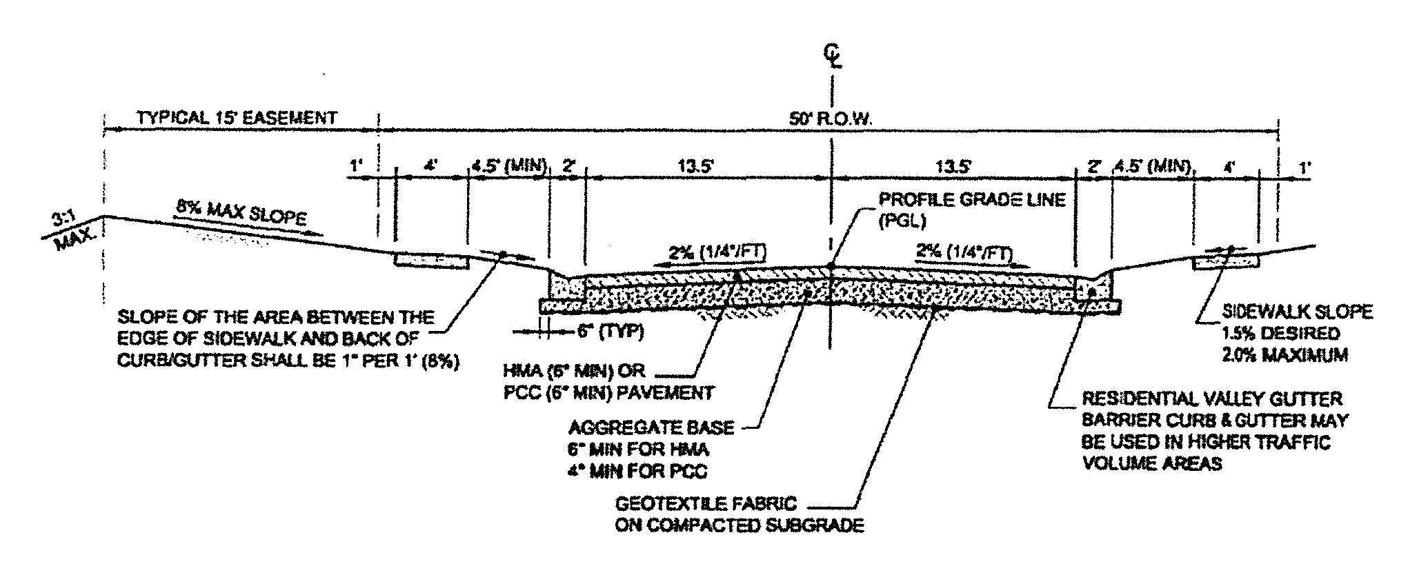
(r)
Medians and islands. Where medians or islands are proposed they shall be constructed with barrier curbing. All medians and islands shall be the responsibility of the subdivider and/or a subdivision association to maintain. A small identification sign not exceeding eight square feet mounted on a single break away post, containing only the name of the subdivision, may be installed. If such a sign is to be installed, detailed plans for the sign shall be submitted with the construction plans for approval. ln no case shall an island or median contain any other sign or structure except as may be placed for traffic control under the direction of the city traffic engineer.
(Ord. No. 804-10-93, § 1(Exh. A), 10-19-93; Ord. No. 591-11-98, § 1(Exh. A), 11-17-98; Ord. No. 085-02-23, § 1(Exh. A), 2-21-23)
§ 153.158. - Lot and block design.
(a)
Size of lots. Minimum lot sizes shall be the minimum for the applicable zoning district of Springfield or Sangamon County, except when a private sewage disposal system is necessary. When a private sewage disposal system will be used for any length of time, lots shall be a minimum of 20,000 square feet.
(b)
Lot arrangement.
(1)
Side lot lines shall be at right angles to straight street lines or substantially radial to curved street lines except, for purposes of solar orientation. In this case, side lot lines shall run within 20 degrees east or west from due north to due south. If side lot lines are being varied for solar orientation, layout and building setbacks shall also be oriented with their long axis running from east to west, with a possible variation of 20 degrees to the southwest or 20 degrees to the southeast.
(2)
Each lot shall front upon and have access to a public street. Blocks shall fit readily into the overall plan of the subdivision and the design shall evidence consideration of lot planning and easy traffic circulation (both vehicular and pedestrian), and provide space for public land use as may be needed in the neighborhood. Flag lots shall not be permitted. Through lots shall be permitted only when access is prohibited to one street as described in section 153.157(l).
(3)
Individuals desiring access to existing township roads shall obtain the approval of the appropriate township highway commissioner with respect to the type and size of culvert to be used.
(4)
The portion of a residential lot contiguous to a major or minor arterial shall have an additional ten-foot yard requirement over the minimum zoning yard requirement for screen planting.
(c)
Sizes of blocks. Blocks shall not be less than 400 feet, nor more than 1,200 feet, in length measured along the greatest dimension of the enclosed block area.
(d)
Public use and service areas.
(1)
Due consideration shall be given to the allocation of areas suitably located and of adequate size for playgrounds and parks for local or neighborhood use as well as public service areas.
(2)
When a proposed school, neighborhood park, electric substation, water storage tank, recreation area, or public access to water frontage shown in the official plan is located in whole or part in a proposed subdivision, the city council shall require, as a condition of final plat approval, that such space within the subdivision be reserved and not developed for a period not to exceed one year from the date of such final plat approval. Within the one-year period, the appropriate public agency may acquire the reserved property in the manner provided by law. If the reserved site is not acquired and no legal action is filed within the one-year period, the reservation shall become void and the site previously reserved may then be used for other purposes.
(e)
Survey monuments. All survey monuments shall be located and be made of the appropriate material as required by state law.
(f)
Lot grading.
(1)
Trees that cannot be saved, stumps, boulders and similar items shall be removed.
(2)
All grading in the subdivision shall be related to the topography of the surrounding area. All street embankments shall be raised at least 1½ feet above the 100-year flood elevation.
(3)
All building lots shall be graded or have natural slopes that will properly allow surface drainage to flow away from the principal structures to be located on the lot.
(4)
Grading in the subdivision shall provide alternate drainage ways for the purpose of carrying water away from homes and preventing damage during periods of heavy rainfall.
(Ord. No. 804-10-93, § 1(Exh. A), 10-19-93)
§ 153.159. - Erosion and sediment control.
(a)
Refer to Chapter 154 for projects in the City of Springfield corporate limits; refer to the Sangamon County Erosion Control Ordinance for those outside the corporate limits.
(Ord. No. 804-10-93, § 1(Exh. A), 10-19-93; Ord. No. 264-07-12, § 1(Exh. A), 7-17-12)
§ 153.160. - Utility easements; location of utilities.
(a)
Utility easements.
(1)
Utility easements shall be provided along front, rear or side lot lines for the purpose of erecting and maintaining one or more of the following facilities: storm sewers, sanitary sewers, surface drainage, gas mains, overhead and/or underground electric lines, telephone lines, and such other utilities reasonably required for an urban structure.
(2)
Easements shall be a minimum of ten feet in width except where they are needed for only one facility such as an underground street lighting cable in which case six feet shall be sufficient. A utility may be located in the street right-of-way if the respective company so desires and appropriate permits have been obtained.
(3)
Alternate locations for various utilities shall be decided upon by the appropriate utility companies, subject to the approval of the city engineer. In no case shall streets, permanent buildings or other man-made improvements that obstruct surface drainage be placed on rear or side lot easements.
(4)
It is the responsibility of the subdivider to notify all utility companies in writing when the land to be developed has been graded in accordance with construction plans and is ready for installation of a given utility.
(5)
The following easement conditions shall apply:
a.
Utility easement strips shall be accessible to all types of utility equipment and must be suitable for installation of utility facilities.
b.
All brush, trees, stumps and other obstructions shall be removed from utility easement strips except where preservation of foliage has been approved by the city engineer.
c.
Easement strips shall be staked by the subdivider at intervals designated by the city or utility company, including marker stakes for lot corners and grade purposes.
d.
Grades in the easement strip shall be within four inches, plus or minus, of final grade (does not apply to drainage easements). Drainage easements must be at final grade.
(b)
Location of utilities. Utilities, (sewers, electric, water and gas), whenever possible, shall be located in the public right-of-way or front lot easement in the following manner: water and electric lines shall be located on the south and east sides; sanitary sewer and gas lines shall be located on the north and west sides. ln some cases, however, electric lines may also be located on the north and west sides.
(Ord. No. 804-10-93, § 1(Exh. A), 10-19-93)
§ 153.161. - Surface water drainage.
(a)
All subdivisions shall be developed with adequate surface drainage. Surface water drainage improvements shall consist of storm sewers and/or open channels, inlets, catch basins and manholes designed and constructed to conform with standards established by the city engineer and shall adequately drain the area being developed including drainage from other areas which naturally drain through the area being developed. Storm water quality will also be considered when reviewing drainage plans.
(b)
If the surface water drainage will be changed, reasonable provision shall be made for the collection and diversion of such surface waters into public areas or drains which the subdivider has a right to use. Such provisions shall be planned for in accordance with generally accepted engineering practices to reduce the likelihood of damage to other properties because of the construction of the subdivision.
(c)
If, as the result of subdivision development, surface water is deposited in existing roadside ditches in quantities exceeding their capacity, the developer shall improve the ditches and replace culverts as needed to handle the flow.
(d)
(Specific information for required basin analysis is to be obtained form the city engineer.) Unless engineering evidence is presented to the city engineer warranting exceptions, storm sewers shall be designed and constructed to meet the following criteria:
(1)
All improvements shall be designed to handle runoff from a storm having a five-year frequency. Storm sewer conduit drains that discharge to open channels shall terminate with suitable outlet structures to control soil erosion and to prevent progressive failure of the conduit in an upstream direction.
(2)
Inlets and/or catch basins shall be spaced so that water will not flow overland more than 500 feet and shall be located so that in no case will water be required to flow across a street or be retained outside the center ten feet of drainage-utility easement. Inlets covered by a metal grate shall have a grate of a type that will not be hazardous to a bicyclist.
(3)
Storm sewer slopes shall be such that a minimum velocity of 2.5 feet per second is maintained when the pipe is flowing full without surcharge. In cases where it is impractical to obtain the above minimum velocity, modification shall be subject to approval by the city engineer.
(4)
Manholes on storm sewers shall be located at the beginning and end of all sewer runs, and at changes in slope, size and direction. The distance between manholes shall not exceed 500 feet except in locations where a greater distance will make the manholes more accessible. This greater distance shall be subject to the approval of the city engineer.
(5)
Manholes shall be constructed of concrete or masonry units having an internal diameter of not less than four feet, fitted with cast iron frames and covers and either cast iron or plastic steps. Manholes shall be constructed with precast bottoms and a lock or other approved connections.
(6)
Joints for storm sewer conduit shall be mortar joints or bituminous joints complying with paragraph 30.3.2 B or paragraph 30.3.2 C respectively, as specified in the latest revised edition of the Standard Specifications for Water and Sewer Main Construction in Illinois.
(7)
It shall be the responsibility of the subdivider to provide grade control for rear lot drainage to each lot owner. Grade control shall consist of a minimum of permanent monuments set at grade in the flowlines of the swales at intervals not exceeding 200 feet. The monuments should consist of a minimum of six-inch diameter concrete thirty-six inches deep, with an iron rod embedded in the concrete (or other design approved by the city engineer). Paved ditches and/or other private improvements may be required in areas with high water tables, low slopes, and/or erosion problems. It shall be the lot owner's responsibility to maintain the drainage course and to keep it free from features that restrict natural drainage. Storm water detention shall be required where determined to be necessary by the city engineer. Detention should be designed in accordance with the Illinois Department of Transportation Drainage Manual, or other methodology approved by the city engineer.
(8)
Limited temporary surface storage of runoff from storms exceeding the design frequency may be permitted, subject to the approval of the city engineer.
(Ord. No. 804-10-93, § 1(Exh. A), 10-19-93)
§ 153.162. - Sidewalks and sidewalk ramps.
Concrete sidewalks at least four feet wide and four inches thick shall be constructed on both sides of each street as depicted in the typical street section (section 153.157(q)). Sidewalks shall be located one foot inside the street right-of-way. Sidewalks shall be constructed along all new subdivision streets and along streets bordering the subdivision if necessary for public safety. Sidewalk ramps shall be constructed and installed with a contrasting colored detectable warning to the disabled and in accordance with current federal or state requirements (whichever is more stringent). Sidewalk ramps shall be constructed to comply with the current Illinois Department of Transportation (IDOT's) Standard 424001-03 Curb Ramps Accessible to the Disabled, with an inclusion of the contrasting colored truncated domes as the detectable warning. The construction plans must clearly show the proposed locations and the construction details of the sidewalk and the sidewalk ramps.
(Ord. No. 804-10-93, § 1(Exh. A), 10-19-93; Ord. No. 587-10-04, § 1, 10-19-04; Ord. No. 264-07-12, § 1(Exh. A), 7-17-12)
§ 153.163. - Sewage disposal.
(a)
Sanitary sewers. When a subdivision is located within the service area of a public sanitary sewerage system, sanitary sewers shall be constructed throughout the entire subdivision in such a manner as to serve adequately each building lot.
(1)
Public sanitary sewers shall be located in the north or west boulevard (between curb and sidewalk) within the street right-of-way or in a 15 foot easement behind the sidewalk within the house setback area. Parallel sewer lines along the street may be used. Sanitary sewers shall not be located in the rear yard.
(2)
Under no circumstances shall the entrance of storm water or ground water to the sanitary sewers be permitted.
(3)
When a private sewage disposal system is proposed in the City of Springfield corporate limits, it must follow the procedures in Chapter 51 of the City Code. All sanitary sewer connections and disposal systems shall comply with the ordinances of the City of Springfield, the Springfield Metro Sanitary District and the requirements of the Illinois Environmental Protection Agency. Sizes and slopes should be determined based on projected flows. Sewage systems must also meet all requirements of the Springfield Sewer Use Ordinance.
(4)
Construction features and details for sanitary sewers and appurtenances shall comply with the latest revised edition of the Standard Specifications for Water and Sewer Main Construction in Illinois.
(5)
Manholes on sanitary sewers shall be located at the beginning and end of all sewer runs, and at changes in slope, size and direction. The distance between manholes shall not exceed 500 feet.
(6)
Manholes shall be constructed of concrete or masonry units having an internal diameter of not less than four feet, fitted with cast iron frames and covers and either cast iron or plastic steps. Manholes shall be constructed with precast bottoms and a lock or other approved pipe connections.
(7)
Sewer service laterals from the main sewer to the front property line of each lot in the subdivision shall have an internal diameter of not less than six inches for a multiple family structure and not less than four inches for a single-family or duplex structure. Where adequate grade can be maintained, sewer service laterals shall be a minimum of five feet deep at the right-of-way line.
Each service lateral shall be adequately plugged with a suitable disc or stopper at the end of the line to make the joint formed completely water tight. Service lateral construction shall be equivalent to the requirements for main collecting sanitary sewers and properly marked so it can be located from the surface. The lowest sanitary sewer outlet elevation from a residence shall be according to the standards of the Springfield Metro Sanitary District.
(8)
Upon completion of the sewer construction, an air test, infiltration test or exfiltration test, as required by the district engineer of the Springfield Metro Sanitary District, shall be conducted on the entire sewer system before any building is allowed to connect to the system. The test shall be conducted under supervision of a registered professional engineer. The engineer shall furnish a certified copy of the test results to the city engineer and the district engineer of the Springfield Metro Sanitary District before connection of service lines.
(b)
Private sewage disposal systems.
(1)
Percolation tests are required for representative areas for sketch plans and for every lot in final plats. Percolation tests shall be conducted in accordance with state law. Testing shall be supervised and approved by the Sangamon County Department of Public Health.
(2)
When a private sanitary sewerage system is allowed (see section 153.112(a)(1)), individual sanitary disposal systems shall be installed to service individual dwelling units according to conditions set forth in section 153.112. These sanitary disposal systems shall be installed in accordance with the latest revised edition of the Illinois Private Sewage Disposal Licensing Act and private sewage disposal code promulgated by the Illinois Department of Public Health and the applicable ordinances of the City of Springfield and Sangamon County. Sufficient area shall be provided to accommodate two seepage fields.
(Ord. No. 804-10-93, § 1(Exh. A), 10-19-93; Ord. No. 264-07-12, § 1(Exh. A), 7-17-12)
§ 153.164. - Water supply.
(a)
Public water supply.
(1)
Public water supply within the jurisdiction of this chapter shall be designed or the design approved by the water division. New development within the City of Springfield shall be supplied by City of Springfield (CWLP) water mains.
(2)
All water mains within the jurisdiction of this chapter shall be installed to the water division's design standards. The size and depth of bury of mains, approved main materials, number, type and location of valves and hydrants, and other design details shall be reviewed and are subject to the approval of the water division. The CWLP superintendent of water engineering may require evidence that the proposed development will not reduce system conditions below acceptable levels in any portion of the water system. The superintendent of water engineering will not approve an addition to any water system that could cause a violation of the Environmental Protection Act, the IEPA Technical Policy Statements or other regulations.
(3)
Water mains not less than six inches in diameter shall be constructed throughout the entire subdivision. Installation and sterilization of all water mains shall be in accordance with the latest revised edition of the Standard Specifications for Water and Sewer Main Construction in Illinois. Specific attention shall be given to the standard specifications' separation requirements between water mains and sanitary or storm sewers. Flyash may not be used as backfill material within ten feet of an existing or proposed iron water main.
(4)
Every water supply system shall be designed in such a manner as to provide adequate fire suppression capability for the development. This requirement will be primarily determined by American Water Works Association (AWWA) Manual M31; "Distribution System Requirements for Fire Protection." Water mains larger than six inches in diameter shall be installed at the Subdivider's expense if needed to provide the area fire flow required. (Note the following chart). Fire hydrants with shut-off valves at each hydrant shall be installed throughout the entire system at maximum intervals of 500 feet or less as required by the fire department fire safety division. All fire hydrants shall be three nozzle hydrants.
The fire suppression requirements for industrial, commercial or multi-family developments are discussed in AWWA Manual M31.
Needed Fire Flow
for One- and Two-Family Dwellings*
*Dwellings not to exceed two stories in height.
Residual pressures are to be held at a minimum of 20 PSI during the calculated fire demand. The needed fire flow must be available for a firm duration of two hours at a time of peak system demand. The impact of a proposed development on existing areas shall also be considered.
(b)
Private water supply. When a private water supply is allowed (See section 153.112(a)(2)), a private well may be used. Wells shall be constructed according to the Illinois Water Well Pump Installation Code.
The fire protection requirements of section 153.112(a)(3)(c) must still be provided. The city is not responsible for certifying the adequacy of the area to support individual wells.
(Ord. No. 804-10-93, § 1(Exh. A), 10-19-93; Ord. No. 264-07-12, § 1(Exh. A), 7-17-12)
§ 153.165. - Backfill over underground utilities.
(a)
Where an underground utility is to be placed in an area which has a permanent type street or sidewalk surface, or upon which such a surface is to be constructed within a period of one year, the backfill above the utility or in case of sewers, above the top of the gravel cradle, to the level of the bottom of the permanent type surface shall be made with material specified by "Selected Granular Backfill" as provided for in the latest revised edition of the Standards and Specifications for Water and Sewer Main Construction in Illinois except that bluff sand and boiler slag may not be used for "Selected Granular Backfill". There shall be 12 inches of CA-6 crushed stone or similar material below the top of subgrade in all areas where utility trenches cross the pavement subgrade except in areas which will be lime treated or areas where rock will be used to stabilize the subgrade. Compaction of "selected granular backfill" shall be done by placing in layers not exceeding 12 inches in depth, each layer to be thoroughly tamped to the satisfaction of the city engineer. In instances when the underground utility is placed parallel and within the curblines of the roadway, the city engineer may allow the backfilled trench to be fitted in accordance with the Standard Specifications for Road and Bridge Construction of the Illinois Department of Transportation.
(b)
In areas not now subject to vehicular traffic, nor in the opinion of the city engineer likely to be within a period of one year, backfill may be made with selected excavation material which is free from clods and stones, provided such trench backfill is adequately jetted from the bottom up completely filling the trench immediately after backfilling.
(Ord. No. 804-10-93, § 1(Exh. A), 10-19-93)
§ 153.166. - Electric distribution.
The underground electric distribution system shall be installed on utility easements along front lot lines. Transformers shall normally be placed on every other lot line with secondary conductors and distribution pedestals installed on the opposite side of the street. In some instances, transformers may be installed on both sides of the street. All primary and secondary cables shall be in conduit.
§ 153.167. - Street lighting.
Street lights shall be installed along public streets in the city by the subdivider. Electrical engineers in the office of public utilities shall design or approve the design of the street lighting system according to the current I.E.S. Standard RP-8 or ANSI Standard D12.1.
§ 153.175. - Purpose.
(a)
A minor subdivision is the creation of a total of up to three lots (counting the remainder of the original tract from which the lots are created) which front along an existing public road and which involves minimal public improvements.
(b)
The minor subdivision is designed to allow an abbreviated approval process for lots having minor impact on the area.
(Ord. No. 804-10-93, § 1(Exh. A), 10-19-93; Ord. No. 264-07-12, § 1(Exh. A), 7-17-12)
§ 153.176. - Location map.
(a)
Location map submission requirements. The location map shall consist of data added to an existing base map, of a suitable scale, covering an area of at least one mile radius from the tract proposed for development. The location map shall show the following information:
(1)
Title of proposed subdivision.
(2)
North point, scale and date.
(3)
Names, addresses and phone numbers of the owner, subdivider, engineer and registered land surveyor with the name and address of the contact person to whom any notice is to be sent.
(4)
Outline of the entire area owned or controlled by the subdivider with approximate boundary dimensions and total acreage.
(5)
General land legal description of the area.
(6)
Existing streets and roads expected to serve the area to be subdivided.
(7)
Existing utility lines expected to serve the area to be subdivided.
(8)
Existing and proposed zoning.
(9)
Method of sewage disposal.
(10)
Method of water supply.
(11)
Electric service provider.
(12)
Fire protection district.
(13)
School district.
(14)
Soils analysis results if private sewage systems are proposed.
(15)
Plan to upgrade adjacent roads if applicable.
(16)
Location of floodplain.
(17)
General layout, with approximate distances.
(b)
Location map review process.
(1)
The subdivider shall submit 16 prints of the location map to the planning commission 17 days before final plat submission deadline.
(2)
The planning commission shall retain one print and distribute the remaining maps as follows:
One print to the appropriate water division(s);
One print to the electric division;
Two prints to the office of public works;
One print to the fire department fire safety division;
One print to the office of public works building and zoning department;
One print to the Springfield Metro Sanitary District;
One print to the Sangamon County Engineer;
One print to the Sangamon County Soil and Water Conservation District;
One print to the appropriate school district; and
Five prints to be retained by the planning commission for transmittal to affected utilities or agencies serving the area to be subdivided, or citizen members.
(3)
The entities listed in subsection (b)(2) shall transmit their comments on suitability of the site in writing to the planning commission staff within one week of receipt.
(4)
The executive director shall review the suitability of the site based on comments received and the suitability criteria outline in section 153.112. Within two weeks after receipt of the location map, the executive director shall either approve or disapprove the location map based on the suitability of the site. If the location map is disapproved, the owners shall be informed in writing of the noncompliance found. A disapproval may be appealed to the planning commission by filing a petition with the commission within 30 days pointing out the parts of the disapproval objected to. The land subdivision committee shall hear the appeal at its next regularly scheduled meeting and shall recommend to the planning commission to affirm, revise or modify the executive director's decision. After receiving the land subdivision committee's recommendation, the planning commission shall hear the appeal. The planning commission's decision may be appealed to the city council as described in section 153.208.
(5)
A location map shall be valid for a period of one year after approval. If a final plat has not been submitted within the one-year period, approval of the location map shall expire.
(Ord. No. 804-10-93, § 1(Exh. A), 10-19-93; Ord. No. 591-11-98, § 1(Exh. A), 11-17-98; Ord. No. 264-07-12, § 1(Exh. A), 7-17-12)
§ 153.177. - Final plat submission requirements.
(a)
Final plat submission requirements. The final plat shall be consistent with the current zoning district classification of the property.
The final plat shall be drawn to a scale of not more than 100 feet to the inch. Font size shall be no smaller than the minimum font size for the respective sheet sizes shown in Appendix A. Only the sheet sizes are shown in Appendix A shall be permitted. The maximum size of the plan sheets shall be 24 x 36 inches. The following shall be submitted on the final plat or in accompanying documents:
(1)
North point, scale, and date of preparation and any revisions.
(2)
Names and addresses of the owner, subdivider, engineer and registered land surveyor.
(3)
Total acreage.
(4)
Lot numbers.
(5)
Existing utilities and drainage courses within and adjacent to the site.
(6)
Location of all present property lines, section lines, streets, buildings and watercourses within the area and within 100 feet of the area.
(7)
Boundary lines with accurate distances and bearings with coordinates assigned to and labeled at each boundary corner. Coordinates shall be displayed with a minimum of four decimal places. Illinois State Plan Coordinates West Zone NAD 83, US Feet are preferred.
(8)
A notation stating which National Geodetic Survey blue book monuments were used to establish state plane coordinates, if applicable.
(9)
Location of proposed lots, setback lines and utility easements.
(10)
Contours referring to the United States Geological Survey datum with intervals of two feet or less unless a greater interval is required because of terrain (may be shown on a supplemental sheet). This requirement may be waived by the city engineer in the City of Springfield and the county engineer in unincorporated areas.
(11)
Contour lines of the base flood elevation with the location of permanent monuments, if applicable.
(12)
If applicable, a note on the final plat stating:
"Approval of this final plat by the City of Springfield does not constitute a guarantee that well water is of adequate quantity or quality for residential needs or that a suitable sewage disposal system can be constructed on each lot."
Any guarantees are the subdivider's responsibility.
(13)
A statement indicating whether or not any part of the plat is located in a special flood hazard area as identified by the Federal Emergency Management Agency and if applicable, a statement indicating that a floodplain was calculated in accordance with the floodplain regulations ordinance, chapter 150 of this Code, or chapter 16.72 of the Sangamon County Code and a base flood elevation was determined.
(14)
A notation stating any setback required through covenants if the setbacks are different from those of the appropriate zoning district.
(15)
If a private sewage disposal system is used, one-half acre reserved for private sewage disposal system lateral fields. When a private sewage disposal system is proposed in the City of Springfield corporate limits, it must follow the procedures in chapter 51 of the City Code.
(16)
Percolation test results, if necessary.
(17)
A written determination of compliance with section 153.112.
(18)
Seal and signature of Illinois professional land surveyor with appropriate statement that the plat meets the standards of practice of the Illinois Professional Land Surveyors Act.
(b)
Accompanying documents. The following documents shall accompany the final plat:
(1)
Exhibit showing the location of existing and/or proposed wells and seepage field areas on each lot, if applicable.
(2)
Any covenants or restrictions relating to the requirements of this chapter.
(Ord. No. 804-10-93, § 1(Exh. A), 10-19-93; Ord. No. 591-11-98, § 1(Exh. A), 11-17-98; Ord. No. 264-07-12, § 1(Exh. A), 7-17-12; Ord. No. 109-03-19, § 1(Exh. A), 3-5-19)
§ 153.178. - Review process.
(a)
The subdivider shall submit 14 prints of the minor subdivision to the planning commission office accompanied by a receipt for the filing fee from the city clerk by 9:00 a.m. on the fourth Monday of the month preceding the month in which the subdivider wishes the plan to be reviewed.
(b)
The planning commission shall retain one print and distribute the remaining prints as follows:
One print to the electric division;
One print to the appropriate water division(s);
Two prints to the office of public works;
One print to the Sangamon County Engineer;
One print to the office of public works building and zoning department;
One print to the fire department fire safety division;
One print to the Springfield Metro Sanitary District; and
Five prints to the planning commission for transmittal to the affected utilities or agencies serving the area to be subdivided.
(c)
The land subdivision committee shall review the minor subdivision plat to determine if it meets the requirements of this chapter and make a recommendation to the city council.
(d)
The land subdivision committee shall recommend approval or disapproval no later than its regularly scheduled meeting in the second month after receiving all appropriate documents. Failure to act within the allotted time period shall constitute a recommendation of disapproval.
(1)
Disapproval. If the land subdivision committee finds that the minor subdivision plat does not meet the requirements of this chapter, it shall specify its disapproval in writing and state the noncompliance found. If the subdivider receives a negative land subdivision committee recommendation and still wishes to proceed with the subdivision, the subdivision shall be reviewed by the planning commission at its next regularly scheduled meeting. If the subdivider receives a negative planning commission recommendation and still wishes to proceed with the subdivision, the subdivider shall request in writing within 30 days that the planning commission forward the proposed subdivision with the planning commission's recommendation to the city council for action.
(2)
Approval. If the land subdivision committee finds that the minor subdivision plat meets the requirements of this chapter, the subdivider shall submit the original and eight prints to the executive director. The following shall be printed or stamped on the original plat and prints and signed by the executive director of the planning commission:
"The plat of this subdivision is recommended to the City Council for approval by the Springfield-Sangamon Regional Planning Commission subject to the certifications set forth in Section 153.179 of the 1988 City Code, as amended."
Dated: _____
Springfield-Sangamon County
Regional Planning Commission
By: _____
Executive Director
(e)
The planning commission shall transmit the endorsed original plat and seven prints to the city clerk for immediate reference to the city council with a letter of transmittal. One print of the endorsed minor subdivision plat shall remain on file in the planning commission office.
(Ord. No. 804-10-93, § 1(Exh. A), 10-19-93; Ord. No. 264-07-12, § 1(Exh. A), 7-17-12)
§ 153.179. - Submission of minor subdivision plat to city council.
(a)
Upon receipt of the endorsed original minor subdivision plat and seven prints, the city clerk shall retain the original and one print on file and shall deliver one print to each of the following:
Department of city engineer;
Office of public works building and zoning department;
Electric division;
Appropriate water division(s);
Fire department fire safety division;
Springfield Metro Sanitary District.
(b)
The city clerk shall deliver the original minor subdivision plat with the letter of transmittal to the city council at its next regular session after receiving the following documents from the office of public works;
(1)
Written certification that the plat has been reviewed and has been found to comply with the requirements of their respective departments or divisions from the:
Department of city engineer;
Department of city traffic engineer;
Office of public works building and zoning department;
Electric division;
[Appropriate] water division;
Fire department fire safety division.
(2)
A certificate provided by the subdivider from the Sangamon County Clerk indicating that payment of taxes is not delinquent.
(3)
A signed statement of a registered professional engineer and the owner of the land, or his duly authorized attorney, as required by state statutes concerning drainage.
(4)
Notarized acknowledgement of the plat by the owner or a duly authorized attorney. This item may be a separate document or on the plat itself.
(5)
The certificate of an Illinois professional land surveyor attesting to the accuracy of the survey and the location of all monuments shown. The certificate may be filed as a supplement to the final plat.
(6)
A resolution provided by the city engineer approving the minor subdivision plat.
(c)
If the requirements of this section have not been met within one year from planning commission approval, the existing approvals and recommendations shall expire and the plat must be resubmitted and reviewed as a new minor subdivision.
(Ord. No. 804-10-93, § 1(Exh. A), 10-19-93; Ord. No. 264-07-12, § 1(Exh. A), 7-17-12)
§ 153.180. - City council approval.
When the requirements of section 153.179 have been met, the city council may by resolution approve the minor subdivision plat and authorize the mayor to sign the plat for and in the name of the City of Springfield, with the city clerk attesting to it. The city clerk shall retain one print on file.
§ 153.181. - Recording the minor subdivision plat.
(a)
When the minor subdivision plat has been approved by the city council and signed by the mayor and city clerk, the original tracing shall be recorded in the office of the recorder of deeds of Sangamon County, Illinois.
(b)
If the minor subdivision plat is not recorded within one year after approval by the city council, the plat must be resubmitted to the planning commission to determine if any changes in the plat are needed to meet the requirements of this chapter. No title to any lots shall be conveyed until the original is recorded.
§ 153.182. - Electric utilities installation.
The subdivider shall supply the electric division two copies of the recorded final plat before electric utilities will be installed.
§ 153.183. - Limitations on minor subdivisions.
Only one minor subdivision shall be allowed for any parcel of record existing March 24, 1987. If two lots have been created from a parcel of record after said date, all additional divisions at a later time shall follow conventional subdividing procedures.
§ 153.184. - Purpose.
(a)
A site development plan is required when shared access easements are the only means of access to a proposed development. A variance of section 153.158(b)(2) will need to be granted for the lots to have a shared access drive. However, a site development plan will not be required if the access easement has been platted through the subdivision process and the construction details for the shared access drive have been approved.
(b)
In the event that the lot or lots that are being developed pursuant to this section are part of a subdivision of property, then the requirements of this chapter, as amended, including, but not limited to, the requirements of section 153.112(a)(4)(c) shall apply.
(Ord. No. 804-10-93, § 1(Exh. A), 10-19-93; Ord. No. 11-01-00, § 1, 1-4-00; Ord. No. 461-08-04, § 1, 8-17-04; Ord. No. 264-07-12, § 1(Exh. A), 7-17-12; Ord. No. 109-03-19, § 1(Exh. A), 3-5-19)
§ 153.185. - Submission requirements for full site development plan review.
The site plan shall include the following information at a scale of no more than 100 feet to the inch with a font size no smaller than ten point:
(1)
Title of the development.
(2)
General land legal description.
(3)
North point, scale and date of preparation and any revisions.
(4)
Names, addresses and phone numbers of the owner, subdivider and engineer. A contact person should be designated.
(5)
Boundary lines with accurate distances and bearings with coordinates assigned to and labeled at each boundary corner.
(6)
Acreage of each lot.
(7)
The location, geometry, width and proposed grade of the proposed shared access drive.
(8)
Parking and proposed curb cut locations along the shared access drive if deemed necessary by the city engineer.
(9)
General location of buildable areas if deemed necessary by the city engineer.
(10)
Pedestrian sidewalks and ramps. There shall be provisions for extending an ADA accessible route from each building site to the public right-of-way.
(11)
Public and private sanitary sewer line locations and associated easements.
(12)
Proposed site grading indicated by contours or spot elevations for the shared access improvement and detention system, if required.
(13)
Proposed storm drainage system, proposed detention pond improvements, and drainage requirements, if required.
(14)
Location of existing structure(s) and public utilities, if any.
(15)
Location of proposed public water mains and fire hydrants if they are to be located along the shared access drive or public right-of-way.
(16)
Typical pavement sections for the shared access drive.
(17)
Yard setbacks showing compliance with Article VII, Chapter 155.052 of the City Code, as amended, if existing buildings are present.
(18)
Provisions for frontage landscaping if access drives parallel the right-of-way.
(19)
Traffic analysis if more than 200 cars are to be accommodated on site.
(20)
Location of floodplain, if applicable.
(21)
Written approval from appropriate regulatory agencies related to access, floodplain, dams, filling, etc., necessary to proceed as shown on the plan.
(22)
Proposed shared access agreement.
(23)
Phasing of construction of the shared access drive.
(24)
Seal and signature of a professional engineer licensed in Illinois.
(Ord. No. 804-10-93, § 1(Exh. A), 10-19-93; Ord. No. 461-08-04, § 1, 8-17-04; Ord. No. 264-07-12, § 1(Exh. A), 7-17-12)
§ 153.186. - Site development plan review.
(a)
The subdivider shall submit 16 copies of the proposed site development plan, a digital version(s) of these prints in PDF format or other electronic format acceptable to the planning commission, and any supporting data and requests for any variances of this chapter, as applicable, to the planning commission by 9:00 a.m. on the third Monday of the month preceding the month in which the subdivider wishes the site development plan to be reviewed, accompanied by a receipt for the filing fee from the city clerk. The site development plan may be reviewed concurrently with, but not before, its associated final plat.
(b)
The planning commission shall retain one print and distribute the remaining prints as follows:
One print to the electric division;
One print to the appropriate water divisions;
Two prints to the office of public works;
One print to the Sangamon County Engineer;
One print to the office of public works building and zoning department;
One print to the fire department fire safety division;
One print to the Springfield Metro Sanitary District;
Five prints to the planning commission for transmittal to affected agencies serving the site and citizen members.
The committee members shall submit their findings in writing to the planning commission staff a minimum of seven business days in advance of the land subdivision committee meeting. The planning commission staff shall collect comments and submit them to the subdivider in writing a minimum of five business days in advance of the land subdivision committee meeting.
(c)
The land subdivision committee shall review the site development plan to determine if it meets the requirements of this chapter and other applicable regulations and make a recommendation to the planning commission.
The land subdivision committee may vote to recommend that the site development plan be: (i) denied, (ii) approved, (iii) approved with conditions, agreed to by the subdivider, that must be met prior to planning commission review, or (iv) at the request of the Subdivider, held over until its next regular scheduled meeting.
Requests by a subdivider to hold the site development plan review until the next scheduled meeting or to hold an informal review, must be made in writing to the planning commission at least 48 hours prior to the meeting for which such review is scheduled. Upon request of holding until the next scheduled meeting, the site development plan shall be removed from the land subdivision committee's agenda. If such request is not made by a subdivider more than 48 hours prior to the meeting for which review is scheduled the land subdivision committee may, at its discretion, take action on the site development plan as submitted or hold the submittal over until its next regularly scheduled meeting.
Comments and conditions resulting from the land subdivision committee meeting shall be transmitted to the subdivider in writing within five business days after the meeting. The subdivider may modify the site development plan to address some or all of the comments and conditions of the land subdivision committee prior to forwarding the plan for planning commission review, or may request that the site development plan be reviewed by the planning commission without revisions. In a case in which a subdivider requests a review by the planning commission without all revisions of the plan, the planning commission shall consider this to be a recommendation of denial by the land subdivision committee.
(Ord. No. 804-10-93, § 1(Exh. A), 10-19-93; Ord. No. 264-07-12, § 1(Exh. A), 7-17-12)
§ 153.187. - Planning commission action.
(a)
Approval. If the planning commission finds that the site development plan meets the requirements of this chapter and other applicable regulations, the subdivider shall submit eight prints and a digital version(s) of these prints in PDF format or other electronic format acceptable to the planning commission. The executive director shall indicate approval of the plan and endorse it, but only after receiving written certification that the site development plan meets the requirements of their respective offices or divisions from:
Department of city engineer;
Department of city traffic engineer;
Office of public works building and zoning department;
Electric division;
The appropriate water division(s);
Fire department fire safety division;
Springfield Metro Sanitary District.
One copy of the endorsed site development plan shall be delivered immediately to the city engineer and office of public works building and zoning department.
(b)
Disapproval. If the planning commission finds that the site development plan does not comply with the requirements of this chapter, it shall specify its disapproval in writing and state the noncompliance found. One print of the proposed plan with the written findings of the planning commission disapproving the plan shall be retained by the planning commission, and the original with the written findings shall be returned to the subdivider. This action may be appealed as described in section 153.208.
(Ord. No. 804-10-93, § 1(Exh. A), 10-19-93; Ord. No. 264-07-12, § 1(Exh. A), 7-17-12)
§ 153.188. - Issuance of building permits.
The office of public works building and zoning department shall not issue any building permits in any area covered by a site development plan until an endorsed copy of the approved site development plan or copies of written approval by each applicable agency outlined section 153.108 is received. Once a site development plan is approved, the office of public works building and zoning department may issue building permits for each lot provided access by the site development plan with no further need for approvals through section 153.184.
(Ord. No. 804-10-93, § 1(Exh. A), 10-19-93; Ord. No. 264-07-12, § 1(Exh. A), 7-17-12)
§ 153.190. - Purpose.
Large scale development plan review is intended to provide a coordinated review of complex or large projects to ensure that applicable public health and safety standards and subdivision and zoning requirements are met, as well as to determine the suitability of the site for the proposed development and to identify infrastructure needs and potential problems that may be encountered.
Plan approval is required when a project meets the definition of a large scale development as defined in section 153.106. A large scale development plan is intended to provide a general layout of buildings, utilities, vehicular and pedestrian traffic circulation patterns, and general landscaping plans for the proposed site,
(Ord. No. 264-07-12, § 1(Exh. A), 7-17-12)
§ 153.191. - Submission requirements for a large scale development plan.
(a)
The large scale development plan shall include the following information at a scale of no more than 100 feet to the inch with a font size no smaller than ten point:
(1)
Title of the development.
(2)
General land legal description and acreage of the property to be developed.
(3)
North point, scale and date of preparation and any revisions.
(4)
Names, addresses and phone numbers of the owner, subdivider and engineer. A contact person should be designated.
(5)
Boundary lines with accurate distances and bearings.
(6)
Zoning district and any bulk or parking variances, existing and proposed.
(7)
Location of any existing public or private easements.
(8)
Right-of-way requirements.
(9)
Location of floodplain and natural drainage courses.
(10)
On-site pedestrian and vehicular circulation.
(11)
Parking and loading spaces.
(12)
Sidewalks and location of ramps.
(13)
Location of existing and proposed sanitary sewers and pump stations, if required.
(14)
Location of existing and proposed storm sewers and storm water detention with detention calculations.
(15)
Location of existing and proposed structures.
(16)
Location and size of existing and proposed water mains, and location of existing and proposed fire hydrants.
(17)
Location of existing streets, curb cuts, watercourses and other existing features within 200 feet of the site.
(18)
Typical pavement sections for shared access drives and emergency access lanes. Detailed cross sections, grading plans or contours are not required.
(19)
Access point locations and written approval of the location of the access by the governmental entity with road jurisdiction as required
(20)
Traffic analysis if more than 200 cars are to be accommodated on-site.
(21)
Utilities planned to serve the site.
(22)
Yard setbacks showing compliance with article VIII, chapter 155.052, as amended.
(23)
Landscape areas.
(24)
Location of outdoor signs.
(25)
Proposed phasing if separate phases are planned.
(26)
A written determination of compliance with section 153.112.
(27)
Seal and signature of a professional engineer licensed in Illinois.
(Ord. No. 264-07-12, § 1(Exh. A), 7-17-12; Ord. No. 109-03-19, § 1(Exh. A), 3-5-19)
§ 153.192. - Large scale development plan review process.
(a)
The subdivider shall submit 16 prints of the plan, a digital version(s) of these prints in PDF format or other electronic format acceptable to the planning commission, any support data, and request(s) for any variances of this chapter, if applicable, to the planning commission by 9:00 a.m. on the third Monday of the month preceding the month in which the subdivider wishes the large scale development plan to be reviewed.
(b)
The planning commission shall retain one print as well as the electronic copy and distribute the remaining prints, support data and variance request(s) as follows:
One print to the appropriate water division(s);
One print to the electric division;
Two prints to the office of public works;
One print to the office of public works building and zoning department;
One print to the fire department fire safety division;
One print to the Springfield Metro Sanitary District;
One print to the Sangamon County Engineer;
One print to the Sangamon County Soil and Water Conservation District, if the area is not part of a subdivision;
One print to the appropriate school district;
Five prints to be retained by the planning commission for transmittal to affected utilities, agencies serving the area to be subdivided, or citizen members.
(c)
Upon receipt of the prints, the entities listed in subsection (b), above, shall transmit their comments in writing pertaining to the suitability of the site for the proposed development to the planning commission staff within seven business days. The planning commission staff shall collect comments and submit them to the subdivider in writing a minimum of five business days in advance of the land subdivision committee meeting.
(d)
The planning commission shall place a notice of the public meeting to be held at the land subdivision committee meeting on each public road frontage of the property shown on the plan at least seven days preceding the meeting.
(e)
The land subdivision committee shall review the large scale development plan to determine if it meets the requirements of section 153.191, general conformance with the city's comprehensive plan, this chapter and other applicable regulations, and make a recommendation to the planning commission.
(f)
The land subdivision committee may vote to recommend that the large scale development plan be: (i) denied, (ii) approved, (iii) approved with conditions, agreed to by the subdivider, that must be met prior to planning commission review, or (iv) at the request of the subdivider, held over until its next regular scheduled meeting.
Requests by a subdivider to hold the large scale development plan review until the next scheduled meeting or to hold an informal review of the large scale development plan, must be made in writing to the planning commission at least 48 hours prior to the meeting for which such review is scheduled. Upon request of holding until the next scheduled meeting, the large scale development plan shall be removed from the land subdivision committee's agenda. If such request is not made by a subdivider more than 48 hours prior to the meeting for which review is scheduled the land subdivision committee may, at its discretion, take action on the large scale development plan as submitted or hold the submittal over until its next regularly scheduled meeting.
Comments and conditions resulting from the land subdivision committee meeting shall be transmitted to the subdivider in writing within five business days after the meeting.
If the subdivider receives a negative recommendation from the land subdivision committee and still wishes to proceed with the large scale development, the subdivider shall request in writing within 30 days that the planning commission forward the proposed large scale development plan with the land subdivision committee's recommendation to the city council for action.
(Ord. No. 264-07-12, § 1(Exh. A), 7-17-12; Ord. No. 164-5-13, § 1(Exh. A), 5-21-13)
§ 153.193. - Reserved.
Editor's note— Ord. No. 164-5-13, § 1(Exh. A), adopted May 21, 2013, repealed § 153.193 which pertained to commission action and derived from Ord. No. 264-07-12, § 1(Exh. A), adopted July 17, 2012.
§ 153.194. - City council action.
After receiving the land subdivision committee's recommendation, the city council shall approve or disapprove the large scale development plan.
(Ord. No. 264-07-12, § 1(Exh. A), 7-17-12; Ord. No. 164-5-13, § 1(Exh. A), 5-21-13)
§ 153.195. - Disapproval; filing modified plan.
(a)
If an application for large scale development plan approval is denied by the city council, another application requesting approval of the same plan shall not be accepted or considered by the land subdivision committee for a period of 18 months after the city council action. However, the applicant may submit a substantially changed or modified large scale development plan for approval within the 18-month period, or if an applicant shows that there has been a substantial change in the circumstances since the denial by the city council, the applicant may submit the same plan for approval within the 18-month period.
(b)
An applicant seeking to file a substantially changed or modified large scale development plan, or the same plan, shall submit the following to the planning commission:
(i)
A written request for leave to file a large scale development plan;
(ii)
Within 30 days of filing the application for leave to file a changed or modified plan, or the same plan, the planning commission shall decide whether there has been a substantial modification or change in the large scale development plan or a substantial change in circumstances, in order to proceed. If the planning commission denies the application for leave to file a large scale development plan, that decision shall be final and subject to judicial review. If the planning commission does conclude that a substantially changed or modified large scale development plan has been presented, or a substantial change in circumstances has occurred, then the request shall be granted and the applicant shall be permitted to file his application for large scale development plan approval.
(Ord. No. 264-07-12, § 1(Exh. A), 7-17-12; Ord. No. 164-5-13, § 1(Exh. A), 5-21-13)
§ 153.196. - Validity of large scale developments.
Large scale development plans shall be valid for five years after city council approval. The construction plans and building permit shall need to be approved within the five years after city council approval of a large scale development. The subdivider may seek an extension of the large scale development plan with written notification from the city engineer and the executive director of the planning commission granting a three-year extension. If written notification for an extension is not received, the large scale development plan shall expire.
(Ord. No. 264-07-12, § 1(Exh. A), 7-17-12)
§ 153.197. - Construction plans for large scale developments.
Construction plans for public improvements, as described in section 153.109(a), shall be submitted to the city engineer. These plans shall follow the requirements and review process in Article IV, Construction Plans. The office of public works building and zoning department shall dictate submission requirements for building permits. At the developer's option, the on-site improvements may be submitted directly to the city engineer for pre-approval prior to application for building permit, or they may be submitted along with the building permit application to the office of public works building and zoning department.
(Ord. No. 264-07-12, § 1(Exh. A), 7-17-12)
§ 153.198. - Construction and bonding of large scale developments.
Provisions of section 153.138 of this chapter shall apply to the improvements for which a bond is required in a large scale development. However, the list of improvements for which a security is required for large scale developments is modified in this section.
Security shall be required only for the phase or phases being constructed. Each phase shall be defined as submitted on the approved large scale development plan. Security shall be required for 110% of the estimated cost to complete the improvements that have not been completed and accepted prior to issuance of permits issued by the office of public works building and zoning department. Security is required for:
(a)
Public improvements, if required to serve the large scale development (to include such items as turn lanes within the public road, sidewalks, traffic signal systems when warranted, and any improvements necessary to meet the minimum requirements of section 153.112(a)(4)(c));
(b)
Storm water detention (including the pond or detention storage system and the outlet control structure);
(c)
Erosion control system (to include silt fence, ditch checks, riprap, inlet protections, soil treatment/fertilizer/seed/mulch);
(d)
Private drive or private access easement when such private drive serves as the sole access to multiple lots or tracts.
(Ord. No. 264-07-12, § 1(Exh. A), 7-17-12; Ord. No. 109-03-19, § 1(Exh. A), 3-5-19)
§ 153.199. - Recording.
(a)
When a large scale development plan has been approved by the city council, and required right-of-way or plat easement documents shall be recorded by the owner in the office of the recorder of deeds of Sangamon County, Illinois.
(b)
If the required right-of-way plat or easement documents are not recorded within one year after approval by the city engineer, the large scale development plan shall expire.
(Ord. No. 264-07-12, § 1(Exh. A), 7-17-12)
§ 153.200. - Copies of recorded documents.
After approval and recording necessary documents, the subdivider shall provide a copy of the large scale development plan and any required right-of-way dedication documents as follows:
Electric division - two copies;
Office of public works - one electronic copy in a format acceptable to the city engineer.
(Ord. No. 264-07-12, § 1(Exh. A), 7-17-12)
§ 153.201. - Issuance of building permits.
The office of public works building and zoning department shall not issue any building permits in any area covered by a large scale development plan until the city engineer provides a letter stating that all bonding and recording requirements have been met and a building permit may be issued.
(Ord. No. 264-07-12, § 1(Exh. A), 7-17-12)
§ 153.202. - Purpose.
(a)
Tract survey approval shall be required as set forth in section 153.105.
(b)
Tract survey approval is to ensure that all divisions of land comply with the State Plats Act, right-of-way, lot configuration requirements, the appropriate zoning ordinances, and that all divisions of land estimated to produce an average of more than 30 daily vehicle trips comply with section 153.112 Subdivision Suitability of this chapter.
(Ord. No. 804-10-93, § 1(Exh. A), 10-19-93; Ord. No. 591-11-98, § 1(Exh. A), 11-17-98; Ord. No. 264-07-12, § 1(Exh. A), 7-17-12; Ord. No. 109-03-19, § 1(Exh. A), 3-5-19)
§ 153.203. - Submission requirements.
When a tract survey is required by this chapter, a survey with font size no smaller than the minimum font size for the respective sheet sizes shown in Appendix A (Only the sheet sizes are shown in Appendix A shall be permitted. The maximum size of the plan sheets shall be 24 × 36 inches.) shall be submitted that includes the following information:
(a)
Land survey showing right-of-way conveyance in fee simple for roadway purposes in conformance with the arterial roadway network plan.
(b)
Seal and signature of an Illinois Professional Land Surveyor with appropriate statement that the plat meets the standards of practice of the Illinois Professional land Surveyors Act.
(c)
Notarized owner's written acknowledgement of the right-of-way conveyance in fee simple.
(d)
North arrow, scale and date.
(e)
Name, address and phone number of the land surveyor and owner.
(f)
Verification that payment of taxes is not delinquent.
(g)
Statement indicating whether any part of the land surveyed is located in a special flood hazard area.
(h)
Location of floodplain, if applicable.
(i)
Location of all buildings and their distances from front, rear and side property lines.
(j)
Parcel identification number.
(Ord. No. 804-10-93, § 1(Exh. A), 10-19-93; Ord. No. 591-11-98, § 1(Exh. A), 11-17-98; Ord. No. 264-07-12, § 1(Exh. A), 7-17-12)
§ 153.204. - Review process.
(a)
Five copies of the tract survey shall be submitted to the plats officer accompanied by the appropriate fee.
(b)
The plats officer shall review the survey to ensure that it conforms to the pertinent requirements of this chapter and Chapter 155 of the City of Springfield Code as well as the Sangamon County Zoning Ordinance, if applicable. The owner shall be notified of tract survey approval or disapproval within one working day.
(1)
Disapproval. If the plats officer finds that the tract survey does not meet the requirements of this Code, the disapproval and noncompliance found shall be specified in writing.
(2)
Approval. If the plats officer finds that the tract survey does meet the requirements of this Code, the following shall be printed or stamped on the original and prints and signed by the plats officer:
I, Sangamon County Plats Officer, do hereby approve this tract survey in accordance with the provisions of Chapter 153 of the Code of the City of Springfield, Illinois, this _____ day of ________, 19___.
_____
Sangamon County Plats Officer
(c)
The plats officer shall keep one copy and transmit four copies of the approved tract survey to the owner for recording.
(Ord. No. 804-10-93, § 1(Exh. A), 10-19-93; Ord. No. 264-07-12, § 1(Exh. A), 7-17-12)
§ 153.205. - Recording the tract survey.
After the tract survey has been approved, the original shall be recorded in the office of the recorder of deeds of Sangamon County, Illinois. If the tract survey is not recorded within 180 days of plats officer approval, the approval shall be null and void. An electronic copy of the survey shall be provided to the Sangamon County Supervisor of Assessments.
(Ord. No. 264-07-12, § 1(Exh. A), 7-17-12)
§ 153.206. - Procedure at public hearings.
The rules for conducting the public hearing provided for in this chapter shall be published by filing the same in the office of the city clerk.
(Ord. No. 264-07-12, § 1(Exh. A), 7-17-12)
§ 153.207. - Variance of subdivision requirements.
(a)
A subdivider may request a variance of the requirements of this chapter. Application for a variance shall be made in writing and submitted with the location and sketch maps unless the need is not then evident. Variance applications shall clearly state the provisions to be varied and the reasons why the variance is needed. In all cases, variance requests shall be made no later than the time the preliminary plan is reviewed by the land subdivision committee. Variance requests made thereafter shall result in the preliminary plan being referred back to the land subdivision committee for reconsideration.
(b)
If, as a result of changes imposed by the land subdivision committee at its preliminary plan review meeting, the subdivider desires a variance, it may be requested orally at that meeting.
(c)
A variation from the requirements of this chapter may be granted if the planning commission finds that the subdivision substantially complies with the following requirements:
(1)
The intent of the chapter is maintained;
(2)
Extraordinary circumstances of topography, land ownership, adjacent development or other circumstances not provided for in the chapter exist;
(3)
The extraordinary circumstances will result in a hardship, not merely an inconvenience;
(4)
The circumstances upon which the request for variance is based are not common to most other tracts of land;
(5)
The circumstances upon which the request for variance is based are not the result of the subdivider's affirmative act or failure to act; and
(6)
The purpose of a variation is not based exclusively on the desire to eliminate development costs at the expense of the public improvement standards as outlined in this chapter.
(d)
Action by the planning commission to approve a preliminary plan containing variances shall not be deemed final until the preliminary plan is approved by the city council. The planning commission shall send said plan to the city clerk who shall deliver it with the letter of transmittal to the city council at its next regular session. If the city council finds that the subdivision substantially complies with the requirements of subsection (c) of this section, it shall approve the plan.
(Ord. No. 264-07-12, § 1(Exh. A), 7-17-12)
§ 153.208. - Review of adverse planning commission decision.
If a preliminary plan, a location map for a minor subdivision, final plat or a site development plan is disapproved by the planning commission, the subdivider may file a petition within 30 days of the planning commission's decision with the city clerk asking for review of the planning commission's decision by the city council. The petition shall point out those parts of the planning commission's decision to which the subdivider objects. A public hearing shall be conducted by the city council after a one week's notice has been mailed by the city clerk to the subdivider. During the hearing, the city council shall review the sufficiency or the propriety of the preliminary plan, location map for a minor subdivision or site development plan in light of the planning commission's decision. Upon conclusion of the hearing, the city council may affirm or modify the decision of the planning commission or approve the preliminary plan, location map for a minor subdivision or site development plan.
(Ord. No. 804-10-93, § 1(Exh. A), 10-19-93; Ord. No. 264-07-12, § 1(Exh. A), 7-17-12)
§ 153.999. - Penalty for violation of chapter.
Any subdivider who violates any of the provisions of this chapter shall be deemed guilty of a misdemeanor and upon conviction thereof shall be fined in a sum not to exceed $500. Each day that a violation of this chapter continues shall constitute a separate and distinct punishable offense.
(Ord. No. 804-10-93, § 1(Exh. A), 10-19-93; Ord. No. 595-1-02, § 2, 11-6-02)