


Springfield City Zoning Code
CHAPTER A
8 - SUPPLEMENTARY DISTRICT REGULATIONS
A-801.- Regulations Applicable to All Districts.
A.
Visibility at Intersections
On a corner lot in any district, except CC, nothing shall be erected, placed, planted, or allowed to be grown in such a manner as materially to impede vision between a height of two and one-half (2½) and ten (10) feet above the center line grades of the intersecting streets in the area bounded by the street lines of such corner lots and a line joining points along said street lines fifty (50) feet from the point of the intersection.
B.
Fences, Walls, and Hedges
Notwithstanding other provisions of this ordinance, fences, walls, and hedges may be permitted in any required yard, or along the edge of any yard except as prohibited in Subsection (A) above.
C.
Accessory Buildings and Accessory Structures
No accessory buildings shall be erected in any required front yard. In addition, accessory buildings shall:
(1)
Be customarily incidental to the principal use established on the same lot.
(2)
Be subordinate to and serve such principal use.
(3)
Be subordinate in area, intent, and purpose to such principal use.
(4)
Contribute to the comfort, convenience, or necessity of users of such principal use.
(5)
Satellite dishes and such antennas and towers of less than thirty-five (35) feet above ground level shall be classified as accessory structures and restricted to the rear yard in all residential districts. All rear and side yard requirements and height requirements shall be observed.
(6)
All antennas placed in residential areas that exceed the height regulations of the district must file a request for a conditional use permit. If freestanding, these antennas must be placed in the rear yard of the principal structure and meet all appropriate rear and side yard requirements.
D.
Minimum Spacing of Buildings on a Single Zone Lot
In all districts, the minimum distance between any two (2) buildings on any single zone lot shall be as provided in this section; except that these provisions do not apply to space between a building enclosing a principal permitted use and a garage or other unoccupied building accessory thereto.
(1)
Minimum Distance between Buildings
Notwithstanding any other provisions of this ordinance, (except a mobile home; a one-family detached dwelling, and a two-family detached dwelling). Two (2) or more buildings may be constructed on a single zone lot if parking spaces and usable open space are and will continue to be available in the same proportion to all occupants of the buildings on the lot. The minimum distance between such buildings shall vary according to the height and length of a building combined with the amount of glassed area of the walls. Such minimum distance shall be either twenty (20) feet or the distance required under the following standards, whichever is greater:
(a)
Where two (2) opposing walls contain no glassed area, required or other, separation shall be as required by fire regulations;
(b)
Where a wall contains twenty-five percent (25%) or more of the glassed area, the building separation shall be ten (10) feet plus two (2) feet for each story in height plus one (1) foot for each fifteen (15) feet of building length;
(c)
Where a wall contains some, but less than twenty-five percent (25%) of the glassed area of any building, the building separation shall be five (5) feet plus one (1) foot for each fifteen (15) feet of building length.
This section shall not apply to any situation, which would permit a mobile home to be moved onto a lot occupied by a house.
(2)
Minimum Required Yard Area
Regardless of the orientation of buildings, no less than the minimum yards required by the district regulations in which such development is located shall be maintained along the outer boundaries of the zone lot.
(3)
Minimum Distance between Windows and Side or Rear Lot Lines for Buildings Greater than Three (3) Stories in Height other than Detached Dwellings
In all districts, as applicable, any window contained within a building designed for residential occupancy and having more than three (3) stories shall be a minimum of thirty (30) feet from any side or rear lot line. Said distance shall be measured in a horizontal plane at the windowsill level and perpendicular to such window.
(4)
Subdivision of Zone Lot after Development
In all districts, after any portion of a zone lot has been developed under the provisions of this section, such zone lot may be subdivided into smaller zone lots only if each resulting zone lot and building or buildings thereon comply with all of the appropriate regulations pertaining to bulk, yards, open space, and parking and loading requirements of the district in which they are located.
E.
Exception to Height Regulations
The height limitation contained in the district regulations do not apply to spires, belfries, cupolas, antennas (in commercial and industrial districts), water tanks, ventilators, chimneys, or other appurtenances usually required to be placed above the roof level and not intended for human occupancy.
F.
Structures to have Access
No building shall be erected on a lot, which does not abut at least one (1) public street for at least fifty (50) feet. This section shall not apply to properties abutting a cul-de-sac, which shall abut the street for at least forty (40) feet; or to properties whose access is provided by a private easement; provided, however, that when a permanent easement to a public street is used as access to a lot or tract of land having been or being separated by deed or plat from other property, such easement shall be at least fifty (50) feet in width from and after the time of adoption of this ordinance and shall not be used to provide access to more than one (1) lot or tract of land. This section shall not be construed to prohibit the development of buildings on lots or tracts with permanent access provided by private streets provided such development is in the form of condominium ownership of such private improvements which has been approved by the planning commission and will be in private ownership and control in perpetuity.
G.
Minimum Lot Area
No existing yard or lot shall be reduced in dimension or area below the minimum requirements set forth herein. Yards or lots created after the effective date of this ordinance shall comply. This section shall not apply when a portion of a lot is acquired for a public purpose, or in projects approved under planned unit development.
H.
Rear Yard Abutting a Public Street
When the rear yard of a lot abuts a public street, all structures built in that rear yard shall observe the same setback from the street line, center line of the street, or property line, as required for adjacent properties which front on that street. In addition, any structure located within twenty-five (25) feet of that setback line shall be no closer to any side property line than the distance required for side yards on adjoining properties fronting on that street.
I.
Corner Lots
The side yard setback requirements for corner lots shall be the same as the front setback requirements for the next adjacent lot fronting on the street that the side yard of the corner lot faces.
J.
Future Street Lines
For the purpose of providing adequate space for the future widening of streets, required setbacks, or front yards shall be determined by the rights-of-way as shown in the most current official Major Thoroughfare Plan.
K.
Reduction in Lot Area Prohibited
No lot, even though it may consist of one (1) or more adjacent lots of record, shall be reduced in area so that yards, lot area per family, lot width, building area, or other requirements of this ordinance are not maintained. This section shall not apply when a portion of a lot is acquired for a public purpose.
L.
Parking, Storage, or Use of Major Recreation Equipment
For purpose of these regulations, major recreational equipment is defined as including boats and boat trailers, travel trailers, tent trailers, pick-up campers or coaches (designed to be mounted on automotive vehicles), motorized dwellings, and the like, and cases or boxes used for transporting recreational equipment, whether occupied by such equipment or not. No major recreational equipment shall be parked or stored on any lot in a residential district in any front yard; provided, however, that such equipment may park anywhere on residential premises not to exceed twenty-four (24) hours during loading or unloading. No such equipment shall be used for living, sleeping, or housekeeping purposes when parked or stored on a residential lot, or in any location not approved for such use.
M.
Special Provisions for Party walls
In all districts, a building may be constructed so as to:
(1)
Utilize a party wall (see definition) or party walls existing on the effective date of this ordinance or lawfully erected under the terms of this ordinance; or
(2)
Incorporate a straight extension of a party wall or off an independent wall adjacent to a party wall existing on the date of this ordinance; or
(3)
Share a party wall(s) with other buildings, being erected at the same time on an adjoining zone lot or lots.
If a building is so constructed, the side and/or rear yard requirements shall be waived along the boundary of the zone lot coincident with said party wall(s), and one (1) side yard shall be provided along any side lot line where a party wall is not so utilized, and any such line yard shall not be less than the minimum width for the district in which it is located.
N.
Special Provisions for the Continuance and Extension of Public Streets and Utilities through Development Sites Remaining in Single Ownership
(1)
Purpose
It is held to be in the public interest to protect the health, safety, and welfare of residents of developments, which by reason of ownership or method of development places numerous dwellings on a single parcel of ground in which the ownership remains undivided, and the general public by providing for the orderly continuance of street patterns and the extension of utilities service, drainage ways, etc., through such developments. It is the purpose and intent of these provisions to protect that interest by enabling the extension of these facilities by the dedication of easements, rights-of-way, etc., through such sites.
(2)
Requirement for Site Plan and Plat
Within such developments as described above the following shall apply:
(a)
A site plan meeting the provisions of Chapter A-13, Section A-1303(F)(4) shall be submitted and approved.
(b)
In any instance where a portion of the site or any facilities or utilities located on the site are to be dedicated for public use, a plat meeting the requirements set forth below shall be prepared, submitted for approval, and upon approval, filed with the County Register.
(3)
Contents of Required Plat
The following information shall appear on all plats prepared in accordance with the provisions contained within this section:
(a)
A boundary survey of the site indicating the location and dimensions of all boundary lines of the property expressed in feet and decimals of a foot;
(b)
The location and width of all streets, easements, rights-of-way, or other properties located within the site, which are to be dedicated to the public. The purpose and restrictions concerning all easements shall be noted;
(c)
The size and location of all utility lines and necessary valves, connections and other appurtenances which comprise utilities to be dedicated to the public;
(d)
The distance and bearing from one point along the boundary of the development to an established survey monument;
(e)
Certificate of accuracy, dedication, and acceptance as may be necessary to establish transfer of all dedicated properties and facilities (format of certificates may be taken from the Subdivision Regulations).
O.
Temporary Use Permits
The following regulations shall govern the operation of certain necessary or seasonal uses, which are nonpermanent in nature. Application for a temporary use permit shall be made to the Board of Zoning Appeals through the Department of Community Development. Said application shall contain a graphic description of the property to be utilized and a site plan, a description of the proposed use, and sufficient information to determine yard requirements, setbacks, sanitary facilities, and parking space of the proposed temporary use. The Board may grant such temporary use permits for the following uses subject to a public hearing, the specific regulations and time limits below, and any other limitation, which may be necessary to protect adjoining property. Temporary uses that are approved by the Board of Zoning Appeals may be reissued seasonally unless otherwise specified herein through an administrative process by the Department of Community Development as long as the use is consistent with the approved site plan and temporary use. Area and bulk regulations of the district in which the use is proposed to be located shall apply.
(1)
Carnivals, Festivals, or Circuses:
Carnivals, festivals and circuses shall obtain a temporary use permit and must be located within the A, CS, CG, RI, or GI Districts; however, such permit shall be issued for a period of no longer than fourteen (14) days. Such use shall only be permitted on lots where adequate off-street parking can be provided and where adjoining uses will not be affected. Religious, charity, and nonprofit organizations located within the City of Springfield sponsoring a carnival, festival, or circus as a non-profit fund-raising event shall be exempt from obtaining a temporary use permit under the provisions of this section, but shall be required to obtain a permit at no cost from the Community Development Department within no less than five (5) working days prior to the event in order to accommodate any necessary inspections for code compliance.
(2)
Christmas Tree Sale:
Persons, businesses or organizations requesting to sell Christmas trees for profit shall obtain a 35-day temporary use permit for the display and sale of Christmas trees on open lots in Agricultural, Commercial and Industrial Districts only. Religious, charitable and non-profit organizations located within the City of Springfield shall be exempt from obtaining a temporary use permit under the provisions of this section, but shall be required to obtain a permit at no cost from the Community Development Department within no less than five (5) working days prior to the event in order to accommodate any necessary inspections for code compliance.
(3)
Temporary Buildings for Construction Projects:
In any district, a temporary use permit may be issued for contractor's temporary office and equipment sheds incidental to a construction project through an administrative process by the Department of Community Development and Planning. Such permit shall not be valid for more than one (1) year but may be renewed for six-month extensions by the Board of Zoning and Appeals; however, not more than three (3) extensions for a particular use shall be granted. Such use shall be removed immediately upon completion of the construction project, or upon expiration of the temporary use permit, whichever occurs sooner.
(4)
Religious Tent Meetings or Revivals:
A temporary use permit may be issued for a tent or other temporary structure to house a religious meeting in any district, except the RS20, R20, R15, RS10, R10, R7, CLS, R40 and MRO Districts. Such permit shall be issued for not more than a seven-day period. Such activity shall be permitted only on lots where adequate off-street parking can be provided and where adjoining uses will not be affected. Churches and religious organizations located within the City of Springfield holding religious or revival tent meetings on their own property shall not be required to have a temporary use permit under the provisions of this section for religious tent meetings or revivals lasting seven (7) days or less.
(5)
Temporary Dwelling Unit in Cases of Special Hardship:
In any residential district, a temporary use permit may be issued to place a mobile home (double-wide excluded) temporarily on a lot in which the principal structure was destroyed by fire, explosion or natural phenomena. The purpose of such placement shall be to provide temporary shelter only for the residents of the principal structure during the period of reconstruction and to prevent exceptional hardship on the same. Water supply and appropriate sewage disposal must be available. Such permit may be initially issued for nine (9) months, and one (1) extension for up to six (6) months may be granted.
(6)
Storage Trailers:
Storage trailers shall only be located within the CS, CG, RI, and GI Districts. A temporary use permit may be issued for accessory storage in trailers (as in tractor trailer). Such permit may be issued for up to one (1) year for the purpose of allowing the proprietor sufficient time to find or construct permanent storage. The trailer shall be on the same zone lot and located to the rear of the building. One (1) extension may be granted for up to three (3) months. Within the CS and CG Districts, a seasonal temporary use permit may be issued for accessory storage in trailers (as in tractor trailers). Such permits for seasonal storage may be issued annually for a three (3) month period including October, November and December. All such storage trailers may locate on the same lot or adjoining lot that is zoned CS and CG. All seasonal storage trailers must be situated to the side or rear yard of the principal structure of the commercial use applying for the permit. In no event shall seasonal storage trailers be allowed to occupy any of the minimum required parking spaces specified in this ordinance for the commercial use applying for this permit. All seasonal storage trailers must be removed by January 1 st immediately following the Christmas season for which the permit was issued.
(7)
Seasonal Sale of Farm Produce:
A temporary use permit may be issued for the sale of farm produce for the sale of farm produce for a period of fourteen (14) days with Commercial and Industrial Districts only. Robertson County farmers selling produce grown on their own land are not subject to the provisions of this section, but may obtain a transient vendor's permit as authorized by Title 9, Chapter 2 of the Springfield Municipal Code.
(8)
Temporary or Portable Office Buildings:
A temporary use permit may be issued for a temporary building while new construction or renovation is being undertaken within Commercial and Industrial Districts only. The permit may be issued for a period of six (6) months by the Board of Zoning Appeals. The structure shall be moved immediately at the completion of the construction or expiration of the permit, whichever occurs sooner.
A-802. - Development Standards for Multi-Family Dwellings.
A.
Purpose
The special provisions set forth herein are intended to provide design criteria for multi-family dwellings located on a single zone lot. Specifically, these provisions are intended to provide regulations controlling the spacing, internal orientation, etc., of multiple buildings located on a single site. It is the express purpose of these provisions to establish design criteria and to provide for the implementation of these provisions by planning commission review of the site plan required for all such developments. Provided, however, that in any instance where this use is located within a planned unit development this requirement may be fulfilled by submission of the plans required by those sections.
B.
Design Criteria
The design criteria appearing below apply to all multi-family developments:
(1)
General:
It is the intent that multi-family dwellings where they are permitted:
(a)
May be appropriately intermingled with other types of housing;
(b)
Shall not form long, unbroken lines or row housings; and
(c)
Shall constitute groupings making efficient economical, comfortable and convenient use of land and open space and serving the public purposes of zoning by means alternative to conventional arrangements of yards and buildable areas.
(2)
Detailed:
(a)
The spacing of all buildings contained in multi-family dwellings shall be as set forth in Section A-801(D) of this chapter.
(b)
Each dwelling unit shall be provided with reasonable visual and acoustical privacy. Fences, walks, and landscaping shall be provided for the protection and aesthetic enhancement of the development and privacy of the occupants, screening of objectionable views or uses and the reduction of noise.
(c)
Street sidewalks and on-site walks shall be provided for convenient and safe access to all living units from streets, driveways, parking courts or garages and for convenient circulation and access to all facilities.
(d)
The appearance and character of the site shall be preserved and enhanced by retaining and protecting existing trees and other site features; and additional new plant material shall be added for privacy, shade, beauty of buildings and grounds and the screen out objectionable features. The planting plan shall be submitted with the site development plan.
Existing trees, shrubs, evergreens and ground cover shall be retained to the extent that they enhance the project, are effective as a screen planting or are useful in protecting slopes.
(e)
Adequate recreation facilities for the residents of the project shall be provided in locations easily accessible to the living units and where they do not impair the view and privacy of living units.
Attractive outdoor sitting areas shall be provided, appropriate in size, type and number to the needs of the residents.
Well-equipped playgrounds of adequate size and number shall be provided, where it is anticipated that children will occupy the premises.
All public streets located within any multi-family development shall meet the construction specifications set forth in the Springfield Subdivision Regulations.
The planning commission shall act to ensure that any private drives, parking areas or other vehicular way used for common access for two (2) or more residents will be suitably paved and maintained as a condition of approval of the project.
C.
Access
(1)
Access to Each Site
Each site developed for multi-family dwellings shall meet the requirements for access set forth in Section A-801(F) of this chapter.
(2)
Service Access
Access and circulation shall adequately provide for firefighting equipment, service deliveries, furniture moving vans and refuse collection.
D.
Parking
Parking shall be provided in accordance with Section A-807 of this chapter.
(1)
Off-Street Parking
Off-street parking may be grouped in bays, either adjacent to streets or in the interior of blocks. Such parking areas shall generally be located in close proximity to the dwelling units they are designed to serve. At least one (1) parking space per dwelling unit shall be located so as to provide a maximum walking distance of two hundred (200) feet from the nearest entrance of the dwelling unit the space is to serve. Where appropriate, common highways, parking areas, walks and steps shall be provided, maintained and lighted for night use. Screening of parking and service areas shall be encouraged through ample use of trees, shrubs, hedges and screening walls.
A-803. - Development Standards for Semi-detached Dwellings.
A.
Purpose
The provisions set forth herein are intended to apply to all semi-detached dwellings as defined by this ordinance regardless of the district in which such use may be located. It is the express purpose of these provisions to establish design criteria and to provide for implementation of these provisions by planning commission review of the site plan required for all developments. Provided, however, that in any instance where this use is located within a planned unit development, this requirement may be fulfilled by submission of the plans required by those sections.
B.
Design Criteria
Basically, semi-detached dwellings must conform to conventional requirements for two-family (duplex) detached dwellings. Provisions must be made for a perpendicular orientation of the dwelling group to the street. Therefore, only one (1) unit of a dwelling group need abut a street, provided that proper access is available to the unit not abutting a street.
C.
Lots
The minimum lot required for any semi-detached dwelling shall be as required by the provisions of the district in which such dwelling is located. Maximum lot coverage provisions of the district in which such dwelling is located shall apply.
D.
Yards
The minimum required yards and use of required yards provisions of the district is which such dwelling is located shall apply; provided, however, that no side yard shall be required where such dwelling units are attached by a party wall.
A-804. - Development Standards for Attached Dwellings.
A.
Purpose
The provisions set forth herein is intended to apply to all attached dwellings, as defined by this ordinance, whether such units are popularly described as townhouses, atrium houses, or by any other name. The specific provisions appearing below shall apply to all attached dwellings regardless of the district in which such use may be located. It is the express purpose of these provisions to established design criteria and to provide for implementation of these provisions by planning commission review of the site plan required for all developments by Section A-1303(F). Provided, however, that in any instance where this use is located within a planned unit development, this requirement may be fulfilled by submission of the plans required by those sections.
B.
Design Criteria, General
It is intended that townhouses where they are permitted:
(1)
May be appropriately intermingled with other types of housing;
(2)
Shall not form long, unbroken lines of row housing; and
(3)
Shall constitute groupings making efficient economical, comfortable and convenient use of land and open space, and serving the public purposes of zoning by means alternative to conventional arrangements of yards and buildable areas.
C.
Design Criteria, Details
(1)
The density, or number of dwelling units permitted within a given area, shall generally be as provided by the basic district regulations. However, in no instance shall the number of single-family attached dwellings exceed sixteen (16) per net acre of such use.
(2)
The minimum lot required for any additional attached dwelling shall be two thousand (2,000) square feet. Individual attached dwellings may exceed the maximum lot coverage provisions established for the district in which such site is located. However, in no instance shall the aggregate site coverage of all dwellings, attached or otherwise, exceed the coverage provisions established for the district in which such site is located. In the event a project lies within two (2) or more zoning districts, the coverage ratio applicable to each zoning district shall apply to those attached dwellings located within it. No transfer of bulk is permitted among zoning districts.
(3)
Minimum width for the portion of the lot on which the town house is to be constructed shall be twenty-two (22) feet.
(4)
Not more than six (6) contiguous town houses shall be built in a row with the same or approximately the same front line, and not more than twelve (12) town houses shall be contiguous.
(5)
The spacing of buildings containing attached dwellings shall be as required by Section A-801(D).
(6)
Yards
(a)
For units located along the periphery of a site containing attached dwellings. The yard provisions established for the district within which the attached dwelling is located shall apply along the periphery of any site on which attached dwellings may be located.
(b)
For units located entirely within a site. No side or rear yard as such is required in connection with any attached dwelling located entirely within a site containing attached dwellings but each such unit shall on its own lot have one (1) yard containing not less than seven hundred fifty (750) square feet. This yard shall be reasonably secluded from view from streets or from neighboring property and shall not be used for off-street parking or for any accessory building.
(7)
For attached dwellings located along the periphery of any site the setback shall be as required for the district within which the unit is located. No setback is required for any unit located entirely within the internal portion of a site containing attached dwellings, unless the unit fronts a public street. Where the units' fronts on a public street, the setback shall be as required to meet district regulations.
D.
Minimum Project Size
No building permit shall be issued for any development of attached dwellings, which contains less than six (6) dwelling units as defined in Chapter A-2.
E.
Maximum Permitted Height
No attached dwelling located within any zoning district shall exceed thirty-five (35) feet in height.
F.
Open Space Requirements
A common open space provided within a development of attached dwellings shall:
(1)
Meet the requirements for quality and improvement established in Section A-804(D) of this chapter and as may be required as a condition of approval by the planning commission;
(2)
Be protected by covenants as outlined in Section A-802(B)(2)(e), which will ensure the improvements and continued maintenance of all such properties;
(3)
Serve as recreational area and open space only; and
(4)
Be transferred to the private maintenance trust at a time and in the manner specified by the Board as a condition of approval of the project.
G.
Access
(1)
Each town house dwelling shall meet the requirements for access set forth in Section A-801(F) of this chapter;
(2)
Access and circulation shall adequately provide for firefighting equipment, service deliveries, furniture moving vans, and refuse collection; and
(3)
Pedestrian access shall be provided at rear of each town house dwelling.
H.
Parking Provisions
Parking shall be provided in accordance with Section A-807. In a development of attached dwellings, it will not be necessary that off-street parking be provided on a specific lot so long as the requisite number of parking spaces is provided.
I.
Grouped Parking Facilities
Off-street parking may be grouped in bays, either adjacent to streets or in the interior of blocks. Such parking areas shall generally be located in close proximity to the dwelling units they are designed to serve. At least one (1) parking space per dwelling shall be located so as to provide a maximum walking distance of two hundred (200) feet from the nearest entrance of the dwelling unit the space is to serve. Where appropriate, common driveways, parking areas, walks and steps shall be provided, maintained and lighted for night use. Screening of parking and service areas shall be encouraged through ample use of trees, shrubs, hedges, and screening walls.
J.
Privacy
Each dwelling unit shall be provided with reasonable visual and acoustical privacy. Fences, walks, and landscaping shall be provided for the protection and aesthetic enhancement of the development and privacy of the occupants, screening of objectionable views or uses, and the reduction of noise.
K.
Walks
Street sidewalks and on-site walks shall be provided for convenient and safe access to all living units from streets, driveways, parking courts, or garages and for convenient circulation and access to all facilities.
L.
Planting
The appeal and character of the site shall be preserved and enhanced by retaining and protecting existing trees and other site features; an additional new plant material shall be added for privacy, shade, beauty of buildings and grounds and to screen out objectionable features. The planting plan shall be submitted with site plans.
Existing trees, shrubs, evergreens and ground cover shall be retained to the extent that they enhance the project, are effective as a screen planting or are useful in protecting slopes.
M.
Visibility at Access Points
The provisions of Section A-801 and Section A-807(I)(3) concerning provisions for visibility at the intersections of all drives, streets, etc., shall be adhered to within all portions of all developments of attached dwellings.
A-805. - Special Provisions Governing Mobile Home Parks.
Editor's note— Amended by Ordinance No. 96-33 and now included as a supplement to Chapter A-5 as a new section to this ordinance. See Section A-510, MH Districts.
A-806. - Other Special Regulations Pertaining to Bulk, Density, Area, and Yards.
A.
In all districts, if an amount of lot area not allocated to a dwelling unit is less than that required for one such dwelling, the remaining lot area may be used to satisfy lot area requirements if it represents not less than three-fourths (¾) of the total required.
B.
Lot Area Requirements for Community Facility Activities in Residential Districts
In all districts, the minimum lot area for community facility activities shall be as required to meet off-street parking requirements in Section A-807(C), or in no case less than twice the minimum lot area requirements for the district in which the use is located. In the case of public and private elementary and secondary schools, the required lot area shall be a minimum of five (5) acres.
C.
Special Provisions for Existing Small Lots
In all districts, a single-family dwelling may be built upon a zone lot consisting entirely of a tract of land:
(1)
Which has less than the prescribed minimum lot area, and
(2)
Which was owned separately and individually from all other adjoining tracts of land, both on the effective date of this ordinance and, on the date of application for a zoning permit, and which was a lot record prior to the effective date of this ordinance.
D.
Permitted Obstructions in Required Yards
In all districts, the following shall not be considered obstructions when located within a required yard except these items shall comply with Sections A-801(A) and (B):
(1)
In any yard:
Arbors and Trellises
Awnings or canopies projecting from a building wall over a required yard not more than six (6) feet and having no supports other than provided by the wall or its integral parts.
Chimneys projecting not more than three (3) feet into and not exceeding two percent (2%) of the area of the required yard.
Eaves, gutters, or downspouts projecting into or over required yards not more than twenty-four (24) inches or twenty percent (20%) of the width of such yard, whichever is the lesser distance.
Fire escapes or staircase, the riser of which shall be at least fifty percent (50%) open and whose vertical projection downward into a required yard does not project more than three (3) feet into, and not exceeding ten percent (10%) of the area of the required yard.
Flag poles having only one (1) structural ground member.
Fountains
Mail Boxes
Open Terraces, including natural plant landscaping.
Retaining walls
Sculpture or other similar objects of art
Street furniture such as, but not limited to, benches, drinking fountains, trash receptacles, ashtrays, light standards, and directional signs.
Walls or fences not exceeding six (6) feet in height measured from finished grade level at any point along the length of, and on any side of, such walls or fences, and not roofed or structurally part of a building.
(2)
In any rear or side yard:
Clothes poles or clotheslines
Recreation equipment
Detached garages and storage buildings provided that a five-foot setback from the property line is observed.
E.
Exceptions for Subdivision of Zone Lots after Development
In all districts, after a detached residential building has been constructed on a zone lot, such zone lot may be subdivided, subject to any other applicable regulations of this ordinance, so that portions of the building are located on different zone lots, provided that, after such a subdivision, no zone lot line may divide an area designed or intended for use as single dwelling unit within such building. Furthermore, after such a subdivision, side yard requirements shall apply only:
(1)
Where side yard requirements applied along a side lot line of the original zone lot; and
(2)
Where side lot lines of the subdivided zone lot separate detached buildings.
F.
Storage Bags
In all districts where outside storage bags are allowed, enclosed exterior storage bags with a maximum capacity greater that five hundred (500) cubic feet are prohibited.
Storage bags shall not be allowed in any front yard.
A-807. - Off-street Parking and Loading Requirements.
The following regulations are adopted in order to provide needed space off the streets for parking or loading and unloading vehicles, to lessen congestion in the streets, to improve traffic safety, to provide for a higher standard of development, and thus, to promote and protect the public health, safety, and welfare:
The provisions of this section apply to all activities as set forth in this ordinance.
A.
General Provisions
In all districts, accessory off-street parking, open or enclosed, shall be provided in conformity with the requirements set forth in this section for all uses permitted by right or as a conditional use. In addition, all other applicable requirements of this section shall apply as a condition precedent to the use of such development.
A parking space is required for a portion of a unit of measure one-half (½) or more of the amount set forth herein. For an enlargement or modification resulting in a net increase in the floor area or other applicable unit of measurement specified herein, the same requirements shall apply to such net increase in the floor area or other specified unit of measurement.
In the case of uses where the Board of Zoning Appeals is required to prescribe the number of parking spaces, it shall base its determination on recommendations from the planning commission and such other factors as the traffic generation of the facilities, the time of operation of such facilities, their location, and other such factors as affect the need for off-street parking as required under the conditional use provisions.
B.
Residential Activities
(1)
Permanent
(a)
One-family detached dwelling.
Existing/Redeveloped Lot: A single lot developed or redeveloped within an existing neighborhood.
(i)
On-street parking is prohibited:
(a)
Three (3) spaces for each dwelling unit with two (2) bedrooms or less; and
(b)
One-half (½) space for each additional bedroom.
(ii)
On-street parking is permitted: Two (2) spaces for each dwelling unit.
New Subdivision: A new residential development with multiple lots approved under subdivision regulations.
(i)
Three (3) spaces for each dwelling unit; and
(ii)
One (1) space per four (4) dwelling units in a designated parking area. The designated parking areas must be spaced so that no dwelling unit is more than two hundred (200) feet walking distance from a designated parking area.
Cottage Housing Development: Single-family detached dwellings located on a single lot or within a unified development. All dwellings may be under single or multiple ownership, with common open space and facilities maintained by an owner's association or property manager.
(i)
On-street parking is prohibited:
(a)
Two (2) spaces for each dwelling unit; and
(b)
One (1) space per three (3) dwelling units in a designated parking area. The designated parking areas must be spaced so that no dwelling unit is more than two hundred (200) feet walking distance from a designated parking area.
(ii)
On-street parking is permitted: Two (2) spaces for each dwelling unit.
(b)
Semi-detached and two-family detached dwelling.
(i)
Three (3) spaces for each dwelling unit with two (2) bedrooms or less; and
(ii)
One-half (½) space for each additional bedroom.
(c)
Attached dwelling.
(i)
On-street parking is prohibited:
(a)
Two (2) spaces for each dwelling unit; and
(b)
One (1) space per three (3) dwelling units in a designated parking area. The designated parking areas must be spaced so that no dwelling unit is more than two hundred (200) feet walking distance from a designated parking area.
(ii)
On-street parking is permitted: Two (2) spaces for each dwelling unit.
(d)
Multi-family dwelling.
(i)
Two and one-half (2 ½) spaces for each dwelling unit with two (2) bedrooms or less; and
(ii)
One (1) space for each additional bedroom.
(e)
Mobile home dwelling.
One (1) space per mobile home.
(f)
Housing for elderly persons.
Where occupancy is restricted to and maintained as housing for elderly persons (defined as at least eighty percent (80%) of units occupied by persons sixty (60) years of age or older), the minimum required parking shall be one and one-half (1 ½) spaces per dwelling unit, regardless of bedroom count. The site plan shall demonstrate that sufficient area is reserved on the lot to allow expansion to two (2) spaces per dwelling unit if, in the judgment of the planning commission or zoning administrator, occupancy or parking demand requires it.
C.
Community Facility Activities
Accessory off street parking shall be provided for the specified number of square feet of gross floor area of seating capacity or other specified unit of measurement (or fraction of one-half (½) or more thereof) for the following activity types:
D.
Commercial Activities
One (1) accessory off-street parking space shall be provided for the specified number of square feet of gross floor area (or fraction thereof) or other measures as noted for the following activities:
E.
Manufacturing Activities
One (1) space for each one thousand five hundred (1,500) square feet of gross floor area or one (1) space for each three (3) employees during the largest shift, whichever is greater.
F.
Agricultural, Resource Production, or Extractive Activities
G.
Combination of Required Parking Space
The required parking space for any number of separate uses may be combined in one (1) lot, but the required space assigned to one (1) use may not be assigned to another use, except that the parking space required for churches, theaters, or assembly halls whose peak attendance will be at night or on Sundays may be assigned to a use which will be closed at night or on Sundays.
H.
Off-Site Parking Requirements
Off-street parking space accessory to any permitted use may be located on a zone lot other than the same zone lot as such use to which the spaces are accessory, provided that:
(1)
Such spaces are not located within a residential or agricultural district;
(2)
There is no way to arrange such spaces on the same zone lot as such use;
(3)
Such spaces are located to draw a minimum of vehicular traffic to and through streets having predominantly residential frontage;
(4)
Such spaces are located no further than two hundred (200) feet from the nearest boundary of the zone lot to which they are accessory;
(5)
Such spaces are in the same ownership as the use to which they are accessory and necessary instruments are executed to ensure the required number of spaces will remain available throughout the life of such use; and
(6)
Such spaces conform to all applicable district regulations of the district in which they are located.
I.
Off-Street Parking Lot Design Standards
(1)
Design Objectives
Parking areas shall be designed with careful regard given to orderly arrangement, topography, amenity of view, ease of access, and as an integral part of the overall site design.
For reasons of use and appearance, it is desirable that parking areas be level or on terraces formed with the slope of the land. Changes in level between such terraces should be formed by retaining walls or landscaped banks.
(2)
Submission of Site Plan
Any application for a zoning permit, or for a conditional use permit where no zoning permit is necessary, that requires five (5) or more accessory off-street parking spaces to be provided on a zone lot, shall include a site plan—drawn to scale and fully dimensioned and be attached to said application showing the location, design and layout of such parking facilities and approved by the planning commission. A site plan drawn to meet the requirements of Section A-1303(F)(2) will comply.
(3)
Access Control
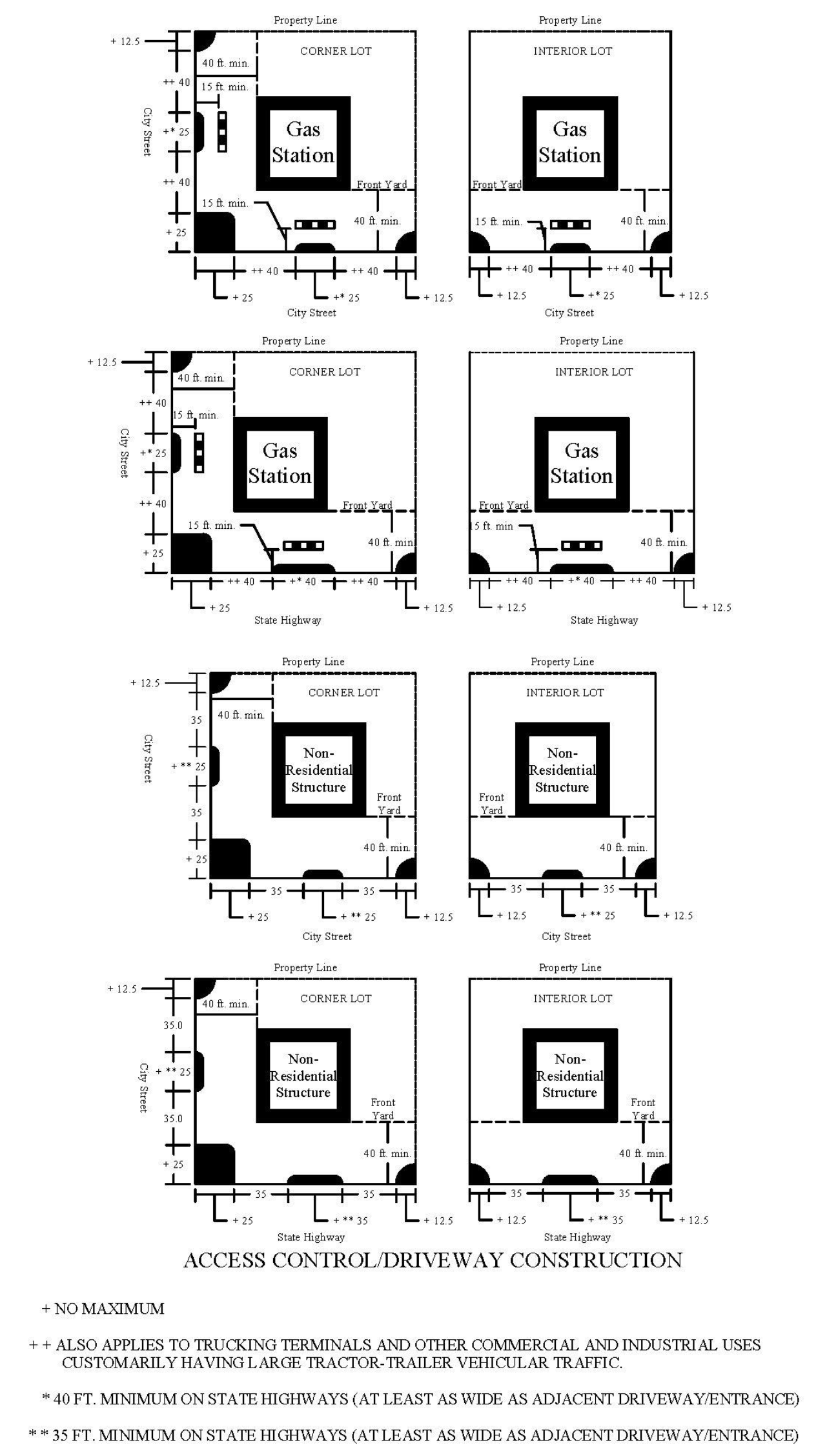
In order to promote the safety of the motorist and pedestrian and to minimize traffic congestion and conflict by reducing the points of contact, the following regulations shall apply. These regulations are shown on the following illustrations:
(a)
Maximum width of driveway openings at the property line:
Residential uses: Twenty-five (25) feet.
Gasoline service stations, freight and truck terminals, or other commercial and industrial uses customarily having a large volume of tractor-trailer vehicle traffic: Forty (40) feet.
All other non-residential uses: Thirty-five (35) feet.
(b)
Minimum distance from an adjoining interior lot line and a driveway opening — at the street right-of-way line:
Residential uses: Five (5) feet.
Non-residential uses: Twelve and one-half (12½) feet.
(c)
Minimum distance from the intersection of street right-of-way lines on a corner lot and a driveway opening at the right-of-way line:
Residential uses: Twenty-five (25) feet.
Non-residential uses: Twenty-five (25) feet.
(d)
Minimum distance between two (2) driveways serving the same property and which provide access to the same street, measured at property line:
Residential uses: Twenty-five (25) feet.
Non-residential uses: Twenty-five (25) feet.
All uses on a state highway: Twenty-five (25) feet or the same width as the widest driveway, whichever is greater.
(e)
Radius of Curb Return: The curb return radius shall meet the following requirements; provided, however, that no such radius shall exceed the distance between the driveway opening at the property line and the adjoining property line or one-half (½) the distance to an adjacent driveway:
Residential uses: Five (5) feet minimum, fifteen (15) feet maximum.
Non-residential uses: Five (5) feet minimum, twenty (20) feet maximum.
(f)
Drainage: All driveways shall be constructed with property drainpipes sized for the amount of water each should carry. Such pipes may be of concrete, metal, or other approved pipes, and headwalls and end walls shall be constructed.
(4)
Surfacing
All off-street parking areas (excluding driveways and parking areas of one-family detached homes) shall be surfaced with asphalt, concrete, or other hard surfaced dustless material and so constructed to provide for adequate drainage for both on and off-site and to prevent the release of dust. In no case shall drainage be allowed to cross sidewalks.
(5)
Lighting
Any lighting used to illuminate off-street parking areas shall be directed away from property in any residential district in such a way as not to create a nuisance, and such lighting shall not exceed 0.5-foot candle at or above any residential district boundary or commercial district boundary where residences are located and permitted.
(6)
Parking Stalls
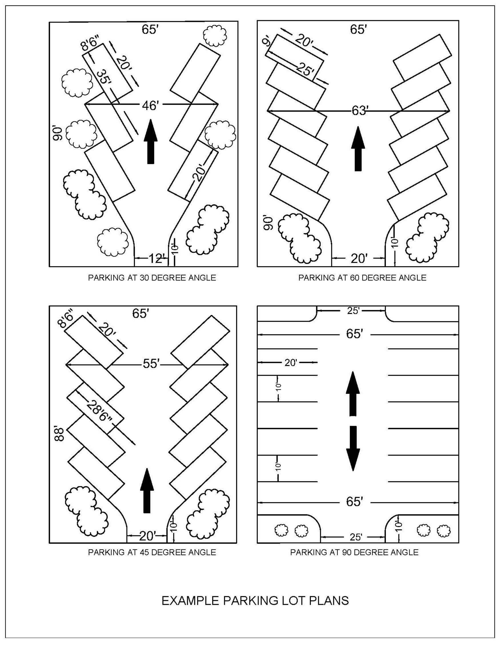
The size of each parking space shall be as shown on the sample layout illustration at the end of this Section A-807 according to the angle of parking and appropriately marked with painted lines or curbs.
(7)
Curbing
Concrete curb, according to City specifications, shall be constructed to facilitate drainage and retain all cars completely within the property together with appropriate landscaping, except at access driveways.
(8)
Maneuvering Space
Minimum width of driveways providing maneuvering space within a parking lot for ingress to and egress from parking stalls shall be as follows:
(a)
90-degree parking — 25 feet
(b)
60-degree parking — 20 feet
(c)
45-degree parking — 20 feet
(d)
30-degree parking — 12 feet
These are shown on the following illustrations.
J.
Off-street Loading and Unloading Requirements
Every building or structure hereafter constructed and used for industry, business, or trade involving the receiving or distribution of vehicles, materials, or merchandise shall provide space for the loading and unloading of vehicles off the street or public alley. Such spaces shall have access to a public or private alley, or if there is no alley, to a public street. The minimum required spaces for this provision shall be based on the total usable floor area of each principal building according to the following table:
The Board of Appeals may reduce or increase this requirement in the interest of safety where unusual or special conditions are due considerations.
(Ord. No. 09-13; Ord. No. 22-14, § 1(Exh. A), 7-19-2022; Ord. No. 24-19, § 1(Exh. A), 10-15-2024; Ord. No. 25-33, § 3(Exh. C), 11-18-2025)
A-808. - Sign Regulations for City of Springfield.
A.
Title
A section of the Springfield Zoning Ordinance to establish regulations and standards for the construction, maintenance, and removal of signs. This section shall be known as the "Sign Regulations."
B.
Purpose and Intent
(1)
Signs constitute a separate and distinct use of the land upon which they are placed and affect the use of adjacent streets, sidewalks, and property.
(2)
The purpose of our comprehensive sign plan is to create a uniform, easily understood, and very defined set of standards controlling all exterior signage. Our defined parameters are; to protect the general public health, safety, convenience, and welfare; to reduce traffic hazards caused by unregulated signs which may distract, confuse, and impair the visibility of motorists and pedestrians; to ensure the effectiveness of public traffic signs and signals; to protect the public investment in streets, highways, and other public improvements; to facilitate the creation of an attractive and harmonious community; to protect property values; and to further economic development.
C.
Applicability
These sign regulations shall apply to all exterior signs and signs that are visible from the outside within Springfield city limits.
D.
Definitions (for Sign Regulations only)
Abandoned Sign: Any sign in which the functions of direction, message, and/or identification of a bona fide business, lessor, owner, product or activity conducted or product available are obsolete.
Administrator: The Community Development Director or their designee whose responsibility it is to administer the provisions of these regulations. These activities may include, but are not limited to, reviewing applications for sign permits, corresponding and/or meeting with applicants, issuing and denying sign permits, inspecting signs, and interpreting and enforcing the provisions of these regulations.
Anchor Stores: Commercial structures of thirty thousand (30,000) square feet or greater, including grocery, department, home supply, or electronic stores.
Awning: Any non-rigid material such as fabric or flexible plastic that is supported by or stretched over a frame that is attached to an exterior wall.
Awning Sign: A sign placed directly on the surface of an awning.
Banner: A sign that is mounted on or attached to a non-rigid surface such as cloth, fabric, or paper.
Big-box Stores: Commercial structures of typically fifty thousand (50,000) square feet or greater, including grocery, department, home supply, or electronic stores.
Billboard: See off-premises sign.
Bulletin Board Sign: A particular type of changeable copy sign that displays copy in a casement made of glass or Plexiglas.
Canopy: An extension of the roof of a building or a freestanding structure that has a roof with support, but no walls.
Canopy Sign: A sign attached to a canopy.
Changeable Copy Sign: A sign that is designed so that characters, letters, or illustrations can be changed or rearranged without altering the face or surface of the sign.
Copy: The characters, letters, or illustrations displayed on a sign face.
Directional Sign: A sign that provides on-site directional assistance for the convenience of the public such as location of exits, entrances, and parking lots.
Directory Sign: A sign, which displays the names and/or addresses of the establishments or uses of a building or group of buildings.
Electronic Message Sign: A sign conveying a computerized, changeable, message and consisting of panels of individually illuminated lights controlled by a central computer panel and shall be included in total allowable square footage allowed.
Freestanding Sign: The general term for any on-site sign, which is supported from the ground and not attached to a building.
Frontage, Building: The length of a building that faces a public street.
Frontage, Lot: The length of that part of a zoning lot that fronts a public street.
Illegal Sign: A sign that was constructed in violation of regulations that existed at the time it was built.
Illuminated Sign: A sign illuminated in any manner by an artificial light source, whether internally or externally lit.
Major Office/Industrial Structures: Single office/mixed use structures of ten thousand (10,000) square feet or greater, or single industrial structures of fifty thousand (50,000) square feet or greater.
Mansard: An inclined decorative roof-like projection that is attached to an exterior building façade.
Marquee: A permanent structure other than a roof attached to, supported by, and projecting from a building and providing protection from natural elements.
Marquee Sign: A sign attached to and made part of a marquee or any other similar projection from a building.
Monument Sign: A freestanding sign with a base affixed to the ground, which measures at least two-thirds (⅔), the horizontal length of the sign.
Nonconforming Sign: A sign that met all legal requirements when constructed but that is not in compliance with current regulations. An illegal sign is not a nonconforming sign.
Obscene Sign: Any sign that exhibits statements, words, or pictures of an obscene nature, as defined by the United States Supreme Court.
Off-Premises Sign: Any sign, which is not located on the premises that it identifies or advertises.
Pole Sign: A freestanding sign with a base at least seven (7) feet above the ground which is supported from the ground by a pole or a similar support structure of narrow width.
Portable Sign: A sign that is not permanently affixed to a building, structure, or the ground or designed to be permanently affixed to a building, structure, or the ground.
Projecting Sign: A sign which is supported by an exterior wall of a building and which is displayed perpendicular to the face of the building.
Sight Distance Triangle: The land adjoining a street intersection that is kept clear of obstructions between three (3) and seven (7) feet above ground to protect the visibility and safety of motorists and pedestrians. The protected sight distance area is the triangle with legs that are the intersecting flow lines of two (2) streets at an intersection. Where local streets meet, the legs shall extend thirty-five (35) feet away from the intersection of the flow lines. Where collector or arterial streets meet, the legs shall extend forty-five (45) feet away from the intersection of the flow lines.
Sign: Any device situated outdoors that displays letters, characters, or graphics to identify a land use or attract the public's attention.
Temporary Sign: A sign that is displayed only for a specified period of time.
Wall Sign: A sign painted on or attached to a wall of a building and parallel to the wall.
Window Sign: Any signage inside or outside displayed and visible from outside for advertisement is included in allowable sign square footage.
E.
Administration
The Community Development Director or their designee shall have the responsibility and full authority to administer and enforce all provisions of these regulations, other than those provisions specifically reserved for the authority of the Springfield Municipal or Regional Board of Zoning Appeals.
F.
Permit Procedures
(1)
Permit Required: No sign or sign structure, except as provided in Subsections (J) (exempt signs) and (O) (nonconforming signs), shall be erected, displayed, altered, relocated, or replaced until a sign permit has been issued. For the purposes of these regulations, all signs except for temporary signs are considered accessory uses of real property and shall only be permitted and located on the premises of the principal use to which they pertain. No permit for a sign, except temporary signs meeting the requirements of this section, shall be issued for a sign unless the primary use of the property has been established under the provisions of the zoning ordinance.
(2)
Permit Application: Applications for sign permits shall be submitted on a form provided by the Administrator and shall contain or have attached at a minimum the following information in either written or graphic form:
(a)
Application date.
(b)
Name, address, and telephone number of the sign owner and, if different, the owner of the land on which the sign will be erected.
(c)
Address of the property where the sign or sign structure will be erected.
(d)
Signature(s) of the sign owner and, if different, the owner of the land on which the sign will be displayed.
(e)
Location of the sign on the property in relation to lot lines, buildings, sidewalks, streets, public rights-of-way, and intersections.
(f)
Type of sign (e.g., monument, wall) and general description of structural design and construction materials.
(g)
Drawing(s) of the proposed sign which shall contain specifications indicating height, perimeter, and area dimensions, means of support, method of illumination if any, and any other significant aspect of the proposed sign.
(h)
Any other information requested by the Administrator in order to carry out the purpose and intent of these regulations.
(3)
Permit Review, Issuance, and Recording: The Community Development Director or their designee shall examine all sign permit applications. Permit applicants shall be issued a copy of the original permit application, with approval and approval date noted, for all signs, which conform to the requirements of these regulations. Such approved applications shall serve as sign permits. The Administrator shall maintain a record of all sign permit applications with notations of approval or disapproval. All sign permits shall be dated and numbered in the order of their issuance.
(4)
Inspections: A final inspection by the Community Development Director or their designee shall be completed after installation of all approved signs. Any discrepancies between an approved sign and a sign as constructed shall be identified in writing and may result in the halt of construction or sign removal, if so, ordered by the Administrator.
(5)
Complaints and Revocations: The Community Development Director or their designee shall investigate any complaints of violations of these regulations and may revoke a permit if there is any violation of the provisions of these regulations or there was misrepresentation of any material facts in either the application or plans.
(6)
Fees: Each application for a sign permit shall be accompanied by the applicable fees, which shall be established by the Board of Mayor and Aldermen of the city from time to time by ordinance.
G.
Expiration of Sign Permits
If an approved sign is not erected within a period of twelve (12) months from the date the permit was originally issued, the permit shall expire and become null and void.
H.
Removal
(1)
Illegal Signs: The Community Development Director or their designee may remove or order the removal of any sign not in conformance with the provisions of these regulations, at the expense of the sign owner or lessor.
(2)
Immediate Peril: If the Community Development Director or their designee shall find any sign, which is an immediate peril to persons or property, the sign, shall be removed. If the Community Development Director or their designee cannot locate the sign owner or lessor for immediate removal of the sign, he shall remove or order the removal of the sign at the expense of the sign owner or lessor.
(3)
Abandoned signs: The Community Development Director or their designee shall require a sign to be removed within ninety (90) days of it becoming an abandoned sign.
I.
Variances, Administrative Review and Conditional Uses
(1)
The Board of Zoning Appeals may make reviews, authorize conditional uses and grant variances for any sign as authorized by Sections A-1304, A-1305 and A-1306 of the Springfield Zoning Ordinance and Tennessee Code Annotated § 13-7-207.
(2)
Procedures: All requests for variances must be filed with the Board of Zoning Appeals within thirty (30) days of the decision by the Community Development Director or their designee.
J.
Exempt Signs
Sign permits shall not be required for the following:
Addressing and Name of Resident: Signs indicating address and/or name of residential occupants of the premises, not exceeding two (2) square feet in area, and not including any commercial advertising or identification.
Artwork: Works of art that do not include any commercial messages or references and not to be included as part of the allowable square footage.
Decals: Decals affixed to windows or door glass panes, such as indicating membership in a business group or credit cards accepted at the establishments.
Directional Signs:
(1)
Signs giving on-site directional assistance for the convenience of the public, not exceeding two (2) square feet in area or located closer than five (5) feet to any property line. Directional signs may be internally lit or illuminated by white light only.
(2)
Church off-premises directional signs shall be located on private property and only with the owner's permission and limited to two (2) signs per church.
Flags, Emblems, Insignia, and Banners: Of any governmental agency or religious, charitable, public or non-profit organization, subject to the following: No single flag that is flown shall exceed forty (40) square feet in area and no single zoning lot shall fly more than three (3) such flags. If the total area of such flags exceeds seventy-two (72) square feet, the excess area shall be included in the sign area calculations for the zoning lot. Flagpoles shall not exceed thirty (30) feet in height. Wall-mounted flags, emblems, insignia, and banners shall be limited to one (1) per zoning lot and shall not exceed forty (40) square feet in area.
Handicapped Parking Space Sign: Signs not exceeding two (2) square feet in area reserving parking spaces for handicapped motorists.
Home Occupation Signs: On-premises identification signs for home occupations shall not exceed two (2) square feet in area and shall contain only the name of the business and/or business owner. Such signs shall be located on an exterior wall, window, or door of the premises.
Landscaping Signs: During the months of April 1 through October 31, one (1) landscaping sign up to a maximum of four (4) square feet may be displayed on premises with property owner permission.
Private Drive Signs: On-premises private drive signs limited to one (1) per drive entrance, not exceeding two (2) square feet in area, with language limited to the words "private drive" and the address of any residences utilizing the private roadway.
Public Signs: Signs erected by government agencies or utilities including traffic, utility, safety, railroad crossing, and identification signs for public facilities, and any signs erected by the Board of Mayor and Aldermen or under the direction of the Board of Mayor and Aldermen.
Security and Warning Signs: On-premises signs regulating the use of the premises, such as "no trespassing," "no hunting" and "no soliciting" signs that do not exceed two (2) square feet in area in residential areas and five (5) square feet in commercial and industrial areas.
Temporary Political Signs: On-premises temporary political signs may be located in any residential, commercial, or industrial district. These signs shall not exceed sixteen (16) square feet and are permitted in addition to any other signs permitted by this ordinance. Signs may be erected seventy-five (75) days before the event and these signs shall be removed within seven (7) days after the election or political event. Signs cannot be displayed in city or state right-of-way.
Temporary Real Estate Signs: Temporary signs indicating the availability of real property for lease or sale, located on the premises being leased or sold. Display of such signs shall be limited to one (1) per property not exceeding six (6) feet in height and not exceeding eight (8) square feet in area in residential zones and sixteen (16) square feet in area in all other zones. Such signs shall be removed within seven (7) days of the settlement or lease of the property.
Welcome Signs: Monument signs or signs consisting of two (2) poles supporting the face that are erected by governmental jurisdictions, civic clubs, or chambers of commerce to welcome visitors to the community. Such signs shall be located on public right-of-way or private property adjacent to major roadways near the entrance to the city limits, or other appropriate locations. The Board of Mayor and Aldermen shall approve the number, design, size, height, and location of all welcome signs before such signs are erected. All civic clubs shall be required to share a welcome sign at each approved location whenever possible, but in no event shall a shared civic club welcome sign exceed one hundred twenty (120) square feet in size.
K.
Temporary Signs Requiring a Sign Permit
The following signs may be erected only after obtaining a temporary sign permit from the Community Development Director or their designee. The permit shall cite the length of time the sign may be displayed. If any temporary sign is not removed by the expiration of the appropriate time limit noted in this section, the Community Development Director or their designee may remove it and charge the costs of removal to the individual or enterprise responsible.
Special Event Signs: Signs announcing special events including, but not limited to grand openings, special sales new management, going out of business, and events sponsored by religious, charitable, or public service groups. Any business, individual, or organization may display three (3) times in a 12-month period a maximum of two (2) signs for up to seven (7) days prior to a special event, each event not to exceed forty-five (45) days. Such signs shall be attached to buildings or existing private sign structures or sign poles with the permission of the owner and shall not exceed sixteen (16) square feet in area each and shall be removed immediately following the event.
Temporary Farm Products Signs: Temporary on-premises signs announcing the availability of seasonal farm products. The number of signs shall not exceed two (2) and the total area of all such signs shall not exceed twenty (20) square feet, nor shall any sign exceed six (6) feet in height.
Construction Signs:
(1)
Temporary signs announcing new buildings, or projects, erected after the commencement of building construction or site development. Each construction site shall be limited to one (1) construction sign not exceeding thirty-two (32) square feet in area and eight (8) feet in height, which shall be removed by the time a permanent sign is erected or a certificate of occupancy for the building is issued, whichever occurs first.
(2)
Temporary signs at construction sites are permitted for the purpose of identifying names of consultants, suppliers, etc., with four (4) square feet maximum and limited to three (3) signs per site.
Auction Signs: Signs announcing and directing the public to the auction site shall be limited to a maximum of five (5) signs per event and shall not exceed sixteen (16) square feet with the property owner's written permission and not in any city or state right-of-way, except on the auction site itself and this sign shall not exceed thirty-two (32) square feet. No sign shall be placed in such a manner that would obstruct vision of motorist or be a detriment to the functions of business. All signs shall be removed within one (1) business day following the event. Any sign not complying with this ordinance shall be removed at the owner's expense and be subject to penalty.
L.
Standards and Criteria
(1)
Generally: The regulations in this section specify the number, types, sizes, heights, and locations of signs, which are; permitted within Springfield city limits and which require a permit. Any sign regulations incorporated into a development plan approved by the board of mayor and aldermen may supersede all or part of this section.
(2)
Determination of Sign Area: In measuring the area of signs permitted under these regulations, the entire face of the sign (one (1) side only) and any wall work, frame, or backing incidental to its decoration shall be included. Where both sides of a sign contain lettering or other allowable display, one (1) side only shall be used to compute the allowable size of the sign. Where the sign consists of individual raised letters or a sign face of irregular shape, the sign area shall include all features, and the area of the smallest rectangle that can encompass the letters or sign face. Signs attached to the inside of building windows that exceed twenty-five (25) percent of the window area and are intended to be visible from the exterior of the building shall be counted as part of the wall signage, except that one hundred (100) percent window coverage is permitted on a temporary basis for no more than sixty (60) days per calendar year. Building signage is calculated based on the building wall dimensions fronting the lot street frontage. Each wall area and sign area are separately figured. The permitted building signage square footage may be partitioned along one (1) additional wall of the building. A maximum fifty (50) percent of the maximum calculated building signage square footage is permitted to be installed on the building walls not fronting the lot street frontage used to calculate the building signage area. The signage installed on all building walls shall not exceed the provisions of this ordinance.
(3)
Determination of Sign Height: The height of a sign erected within thirty (30) feet of a street shall be the distance from the grade level of the nearest curb of the street to the top of the sign or sign structure, whichever is greater. The height of all signs farther than thirty (30) feet from a street shall be the distance from the grade level where the sign is erected to the top of the sign or sign structure, whichever is greater.
(4)
Street Frontage Requirements for Freestanding Signs: Freestanding signs shall be permitted only on zoning lots with fifty (50) feet or more of street frontage.
(5)
Spacing of Freestanding Signs: No freestanding sign shall be erected within fifty (50) feet of another freestanding sign.
(6)
Installation of Wall Signs: All wall signs shall be installed flat against the wall of a building and shall not extend from the wall more than twelve (12) inches.
(7)
Residential Districts: Within residential districts, signs authorized in section (J) (exempt signs) do not require a permit. Permits are required for all other allowed signs and must conform to the following criteria:
(a)
Single-Family Subdivision Identification Signs: Signs that identify the name of a single-family residential subdivision, located at any street entrance to the subdivision, shall be erected as follows:
(1)
Number: One (1) per main entrance, not to exceed two (2) per subdivision
(2)
Type: Monument
(3)
Maximum Size and Height: Forty-eight (48) square feet in area and seven (7) feet in height
(4)
Minimum Setback: Five (5) feet from any property line and outside of all sight visibility triangles
(b)
Multi-Family Complex Signs and Signs for all Other Uses Permitted or Conditionally Allowed in Residential Districts: Signs that identify the name and/or address of an apartment, townhouse, condominium, or other multi-family residential complex, and all other uses in residential districts, located at any street or private drive entrance shall be erected as follows:
(1)
Number: One (1) per main entrance, not to exceed two (2) per complex
(2)
Type: Monument or pole
(3)
Maximum Size and Heights:
(a)
Monument Sign: Forty-eight (48) square feet in area and seven (7) feet in height
(b)
Pole Sign: Sixteen (16) square feet in area and twelve (12) feet in height with the base of the sign at least seven (7) feet above the ground
(4)
Minimum Setback: Monument sign five (5) and pole sign ten (10) feet from any property line and outside of all sight visibility triangles
(c)
Accessory Management or Rental Office Signs: Signs that identify an accessory management or rental office shall be erected as follows:
(1)
Number: One (1)
(2)
Type: Wall
(3)
Maximum Size and Heights: Six (6) square feet in area and located below the roofline
(8)
Commercial and Industrial Districts: Within commercial and industrial districts, signs authorized in section (J) (exempt signs) do not require a permit. Permits are required for all other allowed signs and must conform to the following criteria:
(a)
Signs Facing Residential Areas: Any sign erected within one hundred (100) feet of either an existing residential use or a residential zoning district shall be internally illuminated and limited to a monument sign.
(b)
Minimum Setbacks: Monument sign and sign structures must be located at least five (5) feet from any property line and outside of all sight visibility triangles. Pole sign and sign structures must be located at least ten (10) feet from any property line and outside of all sight visibility triangles.
(c)
Zoning Lots with One (1) Establishment: Any establishment located on a zoning lot with one (1) establishment may erect signs as follows:
(1)
Number: Multiple building type signs but the total of all building signage shall not exceed the maximum calculated wall signage area. In no case shall two (2) freestanding signs be allowed on the same zone lot.
(2)
Types: Wall, monument, pole, awning, canopy, or marquee or projecting.
(3)
Maximum Sizes and Heights:
(a)
Wall or marquee signs shall meet the standards of the following:
If two (2) units exist, neither unity may use more than one half (1/2) of the maximum allowable signage. The top of all wall and marquee signs shall be below the roofline.
(b)
Pole Sign: One (1) square foot of sign area per two (2) linear feet of lot frontage up to a maximum of one hundred fifty (150) square feet. The top of the sign shall not exceed thirty (30) feet in height and the base of the sign shall be at least seven (7) feet above the ground.
(c)
Monument Sign: One (1) square foot of sign area per two (2) linear feet of lot frontage up to a maximum of sixty (60) square feet in area. The height shall not exceed one (1) foot in height per fifteen (15) linear feet of lot frontage with a maximum of eight (8) feet in height. Properties with limited frontage may install a monument sign seven (7) feet in height.
(d)
Awning or Canopy Sign: One (1) square foot per two (2) linear feet of awning or canopy, up to a maximum of sixteen (16) square feet in area. No awning or canopy sign shall extend above the top of the awning or canopy.
(e)
Projecting Sign: One (1) square foot of sign area per two (2) linear feet of building wall onto which the projecting sign is to be installed up to a maximum of sixteen (16) square feet in sign square footage area. The lowest portion of the projecting sign shall be a minimum eight (8) feet above a walking surface. No portion of a projecting sign shall be above the roof line of the building on which the sign is attached. A sign is not to project more than four (4) feet from the building or structure wall and shall not project over vehicular traffic lanes. A sign is to be internally illuminated and constructed of exterior grade materials. A projecting sign which overhangs a public sidewalks hall require an engineer designed plan or specification to ensure compliance with building code provisions.
(d)
Multiple Structures on Single Zoning Lots: Multiple structures on single zoning lots that do not constitute a shopping center may erect one (1) monument sign calculated at one (1) square foot of sign area per two (2) linear feet of lot frontage up to a maximum sixty (60) square feet in area. The height shall not exceed one (1) foot in height per fifteen (15) linear feet of lot frontage with a maximum eight (8) feet in height and properties with limited frontage may install a monument sign seven (7) feet in height or one (1) pole sign calculated at one (1) square foot of sign area per two (2) linear feet of lot frontage up to a maximum of one hundred fifty (150) square feet. The top of the sign shall not exceed thirty (30) feet in height and the base of the sign shall be at least seven (7) feet above the ground. In addition, each establishment located on a single zoning lot with two (2) or more establishment may erect one (1) sign as follows:
Single buildings on single zone lots with multiple occupancies may install multiple building type signs, but the total of all building signage areas shall not exceed the maximum calculated wall signage area per linear foot of wall, for each occupancy.
Define the Above (calculated per wall, per occupancy)
(1)
Type: Wall, awning, canopy, marquee or projecting.
(2)
Maximum Size and Height:
(a)
Wall or Marquee signs shall meet the standards of the following:
If two (2) units exist, neither unit may use more than one half (1/2) of the maximum allowable signage. The top of all wall and marquee signs shall be below the roofline.
(b)
Awning or Canopy Sign: One (1) square foot per two (2) linear feet of awning or canopy, up to a maximum of sixteen (16) square feet in area. No awning or canopy sign shall extend above the top of the awning or canopy.
(c)
Projecting sign: One (1) square foot of sign area per two (2) linear feet of building wall onto which the projecting sign is to be installed up to a maximum of sixteen (16) square feet in sign square footage area. The lowest portion of the projecting sign shall be a minimum of eight (8) feet above a walking surface. No portion of a projecting sign shall be above the roof line of the building of which the sign is attached. The sign is not to project more than four (4) feet from the building or structure wall and shall not project over vehicular traffic lanes. A sign is to be internally illuminated and constructed of exterior grade materials. A projecting sign which overhangs a public sidewalk shall require an engineer designed plan or specification to ensure compliance with building code provisions.
(e)
Shopping Centers: Shopping centers with three (3) or more establishments planned as an integrated development shall be authorized to erect signs based on the following criteria:
(1)
Center Identification Sign: One (1) monument or pole sign per center, identifying the name of the center. In addition to identifying the name of the center, the sign may identify any individual establishments within the center.
(a)
Monument Sign: One (1) square foot of sign area per two (2) linear feet of lot frontage up to a maximum eighty (80) square feet in area. The height shall not exceed one (1) foot in height per fifteen (15) linear feet of lot frontage with a maximum ten (10) feet in height. Properties with limited frontage may install a monument sign seven (7) feet in height.
(b)
Pole Sign: Each sign may have a maximum of two hundred (200) square feet. The height shall not exceed thirty (30) feet. The base of sign shall be at least seven (7) feet above ground.
(2)
Individual Establishment Signs: No freestanding sign shall be displayed for individual establishments located within a center. Any establishment may install multiple building type signs but the total of all building signage areas shall not exceed the calculated wall signage area per linear foot of wall, for each occupancy.
(a)
Wall or marquee signs shall meet the standards of the following:
The top of all wall and marquee signs shall be located below the roofline.
(b)
Awning or Canopy Sign: One (1) square foot per two (2) linear feet of awning or canopy, up to a maximum of sixteen (16) square feet in area. No awning or canopy sign shall extend above the top of the awning or canopy.
(c)
Projecting Sign: One (1) square foot of sign area per two (2) linear feet of building wall onto which the projecting sign is to be installed up to a maximum of sixteen (16) square feet in sign square footage area. The lowest portion of the projecting sign shall be a minimum eight (8) feet above a walking surface. No portion of a projecting sign shall be above the roof line of the building of which the sign is attached. The sign is not to project more than four (4) feet from the building or structure wall and shall not project over vehicular traffic lanes. A sign is to be internally illuminated and constructed of exterior grade material. A projecting sign which overhangs a public sidewalk shall require an engineer designed plan specifications to ensure compliance with building code provisions.
(f)
Gasoline Stations: Automobile service and gasoline stations shall comply with all applicable sign regulations within this section, including the regulations for shopping centers if applicable. The following additional regulations shall apply to all automobile service and gasoline stations:
(1)
Changeable Fuel Price Signs: Freestanding signs identifying the name of the business may include changeable copy indicating the current price of fuel dispensed on the premises. The area of the fuel price shall be included in determining the sign area for the business.
(2)
Gas Pump Signs: Each gas pump shall be permitted a total of one (1) square foot of sign area to identify the product dispensed.
(g)
Office and/or Industrial Centers: Office and/or industrial centers at least two (2) acres in size and planned as an integrated development shall be authorized to erect signs based on the following criteria:
(1)
Center Identification Signs: One (1) monument sign per public street frontage, not to exceed a total of two (2) monument signs, identifying the name of the center only and not exceeding forty-eight (48) square feet in area and seven (7) feet in height.
(2)
Individual Building Signs: Where an office and/or industrial center is comprised of two (2) or more buildings, each individual building may erect one (1) monument sign, not to exceed twenty-four (24) square feet in area and seven (7) feet in height, identifying the principal establishment within a building.
(3)
Individual Establishment Signs: Each individual establishment within an office and/or industrial building may erect one (1) wall sign, and shall meet the standards of the following:
If two (2) units exist, neither unit may use more than one half (1/2) of the maximum allowable signage. The top of the wall sign shall be located below the roofline. Each individual establishment may install one (1) projecting sign and the square footage of the projecting sign shall be calculated in the total permitted wall signage square footage. The projecting sign shall not exceed one (1) square foot of sign area per two (2) linear feet of building wall onto which projecting sign is to be installed up to a maximum of sixteen (16) square feet in sign square footage area. The lowest portion of the projecting sign shall be a minimum of eight (8) feet above a walking surface. No portion of a projecting sign shall be above the roof line of the building on which the sign is attached. The sign is not to project more than four (4) feet from the building or structure wall and shall not project over vehicular traffic lanes. A sign is to be internally illuminated and constructed of exterior grade materials. A projecting sign which overhangs a public sidewalk shall require an engineer designed plan or specifications to ensure compliance with building code provisions.
(h)
Directory Signs: Commercial and industrial properties may erect a directory sign identifying the names and/or addresses of the establishments within individual buildings. A directory sign shall not exceed fifteen (15) square feet in area and six (6) feet in height and precludes the use of any other freestanding sign for the zoning lot on the same street frontage.
(i)
Theaters: Theaters are authorized to erect one (1) of the permitted wall or marquee signs with a changeable copy board displaying the name(s) and time(s) of the current motion picture or theatrical production.
(j)
Shopping Centers of seventy-five thousand (75,000) square feet or more:
(1)
Center Identification Sign: One (1) monument or pole sign per center, identifying the name of the center. In addition to identifying the name of the center, the sign may identify individual establishment within the center.
(a)
Monument Sign: One (1) square foot of sign area per two (2) linear feet of lot frontage up to a maximum one hundred (100) square feet in area. The height shall not exceed one (1) foot in height per fifteen (15) linear feet of lot frontage with a maximum twelve (12) feet in height. Properties with limited frontage may install a monument sign with a maximum seven (7) feet in height.
(b)
Pole sign: Each sign may have a maximum of two hundred (200) square feet. The height shall not exceed thirty (30) feet. The base of the sign shall be at least seven (7) feet above the ground.
(2)
Wall signs shall meet the standards of the following:
The top of all wall and marquee signs shall be below the roofline. Each individual establishment may install one (1) projecting sign and the square footage of the projecting sign shall be calculated in the total permitted wall sign square footage. The projecting sign shall not exceed one (1) square foot of sign area per two (2) linear feet of building wall onto which the projecting sign is to be installed up to a maximum of sixteen (16) square feet in sign square footage area. The lowest portion of the projecting sign shall be a minimum eight (8) feet above a walking surface. No portion of the projecting sign shall be above the roof line of the building on which the sign is attached. The sign is not to project more than four (4) feet from the building or structure wall and shall not project over vehicular traffic lanes. A sign is to be internally illuminated and constructed of exterior grade materials. A projecting sign which overhangs a public sidewalk shall require an engineer designed plan or specification to ensure compliance with building code provisions.
(9)
Other Uses: In cases where the regulations within this section do not specifically address a sign requested in conjunction with a permissible use, the Administrator shall make a written interpretation, which shall be kept in the permanent record for that application.
(10)
Electronic Message Signage:
(a)
Electronic Message Display: Signs that only contain gas prices and time and temperature shall only meet maximum lighting intensity requirements and image duration requirements listed below.
(b)
Number and Location: One (1) electronic message sign per property. Signs shall be located one hundred (100) feet outside of intersections and not installed in locations that will directly block or confuse a driver's view. Signs shall be spaced two hundred (200) feet from any other electronic message signs along roadways, unless the applicant can coordinate the content timing of the signs to be consistent with signs within two hundred (200) feet of an existing electronic message sign. The distance shall be measured along roadways not straight lines between signs.
(c)
Zoning Districts: Electronic message signs shall be permitted in all commercial and industrial zoning districts. The planning commission shall review and may approve proposed locations of signs in planned unit development zoning overlay districts if the intent and requirements of the ordinance are met. The board of zoning appeals may review proposals for religious, group assembly, school and day care uses and uses permitted by special exception in residential and agricultural zoning districts provided that the intent of the ordinance are met.
(d)
Maximum Size: An electronic message signs shall be limited to seventy-five (75) percent of the permitted sign type square footage.
(e)
Illumination and Brightness: The sign during daytime hours shall be a maximum light intensity of seven thousand five hundred (7,500) nits and during night time hours shall be a maximum intensity of seven hundred fifty (750) nits.
(f)
Message Duration: Images shall remain static for a minimum of eight (8) seconds and image changes and scrolling shall be accomplished within two (2) seconds or less. Images shall not flash and include sudden blasts of lights. Message shall not contain continuous scrolling and animation.
M.
Construction and Maintenance
(1)
Building Code Compliance: All signs shall be constructed in compliance with the International Building Code.
(2)
General Restrictions: Signs shall not be erected in or over a street or highway right-of-way, or on public land except as permitted in Section (J) of these sign regulations.
(3)
Condition of Signs: All signs and components shall be maintained in good repair and in a safe, clean, and attractive condition.
N.
Prohibited Signs
The following are expressly prohibited unless specifically stated otherwise in this ordinance:
Animated and Moving Signs: Including, but not limited to, pennants, flags with commercial messages, streamers, banners, propellers, discs, and searchlights.
Flashing Signs: Any signs that include lights, which flash, blink, or turn on and off intermittently, not including time and temperature signs.
Glaring Signs: Signs with light sources or reflectivity of such brightness that constitute a hazard or nuisance as determined by the Administrator.
Inflatable Signs and Objects: Including, but not limited to, balloons.
Obscene Signs: Any sign that exhibits statements, words, or pictures of an obscene nature, as defined by the United States Supreme Court.
Portable Signs: Any sign that is not permanently affixed to a building, structure, or the ground. This shall not apply to authorized temporary signs.
Poster and Handbills: Any signs affixed to trees or other natural vegetation, rocks, or utility poles.
Roof Signs: Any signs, which are erected on a roof or which, extend in height above the roofline of the building on which the sign is erected.
Simulated Traffic Signs and Obstructions: Any sign, which may be confused with or obstruct the view of any authorized traffic sign or signal, obstruct the sight distance triangle at any street intersection, or extend into the public right-of-way.
Strings of Lights: Including lights that outline property lines, sales areas, or any portion of a structure, and are intended to advertise or draw attention to a business or commercial activity.
Vehicular Signs: Any sign displayed on a parked vehicle, where the primary purpose of the vehicle is to advertise a product or business or to direct people to a business or activity. For the purposes of these regulations, vehicular signs shall not include business logos, identification, or advertising on vehicles primarily used for other business purposes.
O.
Nonconforming Signs
(1)
Generally: Any sign which does not conform to the provisions herein on the date of enactment of this ordinance or any date on which the ordinance is amended, and any sign which is accessory to a nonconforming use, shall be deemed a nonconforming sign. No nonconforming sign shall be enlarged, extended, structurally reconstructed or altered in any manner, except that a sign face may be changed so long as the new face is equal to or reduced in height, sign area, and/or projection and a sign permit is issued for the sign face change.
(2)
Removal: Nonconforming signs may remain, provided they are maintained in good repair, except for the following:
(a)
Damage or Destruction of Sign: A nonconforming sign which is damaged or destroyed to the extent of fifty percent (50%) or more of its sign face and this is to be determined by a reputable sign company at the owner's expense shall not be altered, replaced, or reinstalled unless it is in conformance with these regulations. If the damage or destruction is less than fifty percent (50%) of the sign face, the sign may be restored within one (1) year of the damage or destruction, but shall not be enlarged in any manner.
(b)
Any sign not maintained in good repair including rust, loose bolts, any damage that could cause danger to the public shall be immediately repaired or loses nonconformity.
(c)
Damage or Destruction of Use: A nonconforming sign shall be removed according to the provisions of Subsection (I) of these regulations if the structure or use to which it is accessory is damaged or destroyed to the extent of fifty percent (50%) or more of the principal structure's appraised value.
(d)
Change of Use: Whenever the use, owner, or occupant of a property changes, including but not limited to redevelopment of the site, change of the occupant, or alteration of remodeling of the structure, all nonconforming and noncomplying signs shall be removed and the site brought into compliance.
(3)
All sections of this ordinance with respect to nonconforming signs are severable and shall be interpreted and enforced in the most restrictive manner possible consistent with Tennessee Code Annotated § 13-7-208 as it currently exists or as it may be amended.
P.
Severable Nature of Regulations
The various sections, subsections, paragraphs, and clauses of these regulations are severable and, in the event, that any section, subsection, paragraph, or clause is adjudged invalid, the remainder of these regulations shall remain in full force and effect.
Q.
Protection of First Amendment Rights
Any sign, display, or device allowed under these regulations may contain any otherwise lawful message.
R.
Signs for Educational and Medical Campuses
(1)
Definitions:
Educational Campus: An Educational Campus is a contiguous area of land constituting and making up the grounds of a college or university. It contains the main building or buildings and other accessory buildings or uses on the site.
Medical Campus: A medical campus is a contiguous area of land consisting of a hospital or medical center offering a full range of in-patient and out-patient medical services including an emergency room, intensive care unit, pharmacy, medical laboratories and cafeteria offering services twenty-four (24) hours a day, seven (7) days a week; and one (1) or more medical professional office buildings or clinic staffed by physicians and other medical or health care professionals affiliated with the hospital or medical center, or occupying medical professional office buildings that are owned by the hospital or medical center.
(2)
Exceptions to the sign regulations may be granted for medical or educational campus facilities. A comprehensive plan for the signage of the campus must be prepared by the developer's architect or engineer and submitted to the Planning Commission for review and approval before a building permit for the signs is issued.
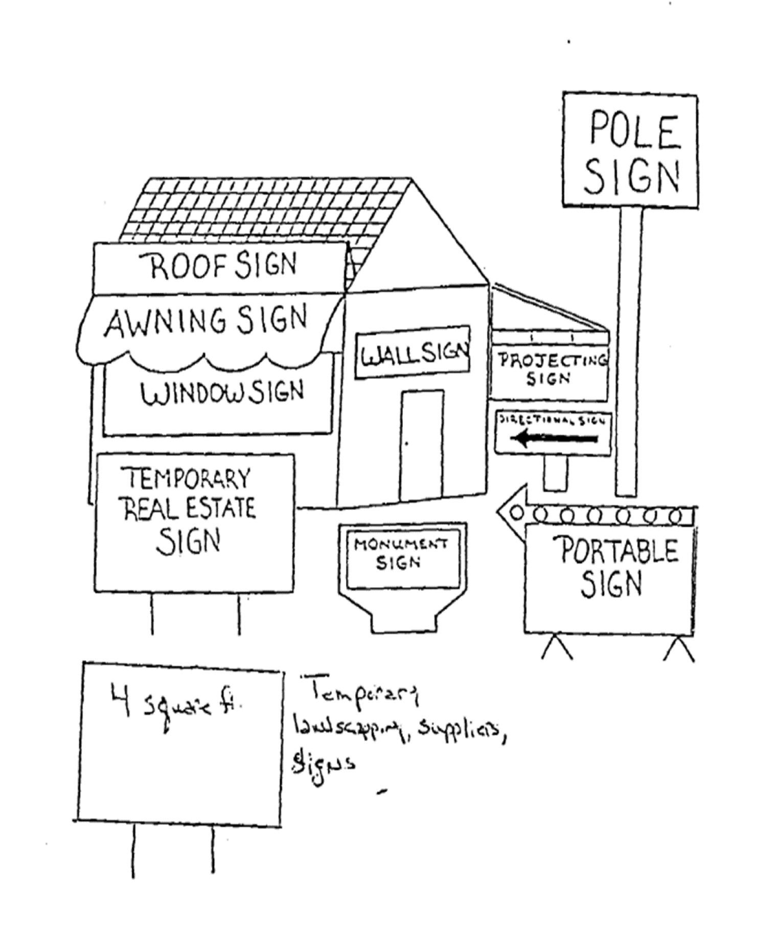
(Ord. No. 15-12; Ord. No. 16-06; Ord. No. 25-03, § 1(Exh. A), 4-15-2025; Ord. No. 25-12, § 1(Exh. A), 7-15-2025)
A-809. - Wireless Telecommunication Towers and Antennas.
A.
Purpose
The purpose of this ordinance is to establish general guidelines for the siting of wireless communication towers and antennas. The goals of this ordinance are to:
(1)
Protect residential areas and land uses form potential adverse impacts of towers and antennas;
(2)
Encourage the location of towers in non-residential areas;
(3)
Minimize the total number of towers throughout the municipal boundaries and planning region;
(4)
Strongly encourage the joint use of existing tower sites as a primary option;
(5)
Encourage the use of existing structures as a secondary antenna siting option;
(6)
Strongly encourage the joint use of new tower sites as a third option, rather than construction of additional single-use towers;
(7)
Encourage users of towers and antennas to locate them, to the extent possible, in areas where the adverse impact on the community is minimal;
(8)
Encourage developers of towers and antennas to configure them in a way that minimizes the adverse visual impact of the towers and antennas through careful design, siting, landscape screening, and innovative camouflaging techniques;
(9)
Enhance the ability of the community quickly, effectively, and efficiently;
(10)
Consider the effects on the public health and safety of communication towers;
(11)
Avoid potential damage to adjacent properties from tower failure through professional engineering and careful siting of tower structures.
In furtherance of these goals, the Board of Mayor and Aldermen shall give due consideration to the City of Springfield's comprehensive master plan, zoning map, existing land uses, and environmentally sensitive areas in approving sites for the location of towers and antennas.
B.
Definitions
As used in this ordinance, the following terms shall have the meanings set forth below:
Alternative Tower Structure means man-made trees, clock towers, bell steeples, light poles and similar alternative-design mounting structures that camouflage or conceal the presence of antennas or towers.
Antenna means any exterior transmitting or receiving device mounted on a tower, building or structure and used in communications that radiate or capture electromagnetic waves, digital signals, analog signals, radio frequencies (excluding radar signals), wireless telecommunications signals or other communication signals.
Back-haul Network means the lines that connect a provider's towers/cell sites to one (1) or more cellular telephone switching offices, and/or long distance provides, or the public switched telephone network.
Equipment Building means any building, structure, or cabinet, either site built or prefabricated, used to store or house equipment related to the operation or an antenna or antennas.
FAA means the Federal Aviation Administration.
FCC means the Federal Communications Commission.
Height means, when referring to a tower or other structure, the distance measured from the finished grade of the parcel to the highest point on the tower or other structure, including the base pad and any antenna.
Tower means any structure that is designed and constructed primarily for the purpose of supporting one (1) or more antennas for telephone, radio and similar communication purposes, including self-supporting lattice towers, guyed towers, or monopole towers. The term includes radio and television transmission towers, microwave towers, common-carrier towers, cellular telephone towers, alternative tower structures, and the like. The term includes the structure and any support thereto.
C.
Applicability
(1)
New Towers and Antennas: All new towers or antennas in the City of Springfield shall be subject to these regulations, except as provided in Sections A-809(C)(2) through (C)(5), inclusive.
(2)
Amateur Radio Station Operator/Receive Only Antennas: Chapter A-8 shall not govern any tower, or the installation of any antennas, that is under forty (40) feet in height and is owned and operated by an amateur radio station operator or is used exclusively for receive only antennas.
(3)
Preexisting Towers or Antennas: Preexisting towers and preexisting antennas shall not be required to meet the requirements of this ordinance, other than the requirements of Sections A-809(D)(6) and (D)(7).
(4)
AM Array: For purposes of implementing this ordinance, an AM array, consisting of one (1) or more tower units and supporting ground system, which functions as on AM broadcasting antenna, shall be considered one (1) tower. Setbacks and separation distances shall be measured from the outer perimeter of the towers included in the AM array. Additional tower units may be added within the perimeter of the AM array by right.
(5)
Municipal Facilities: Antennas or towers located on property owned leased, or otherwise controlled by the city shall be exempt from regulation by this ordinance.
(6)
Homeland Defense: Antennas or towers located on property owned, leased, or otherwise controlled by federal, state, county, or municipal governments and used for public safety communications or homeland defense purposes shall be exempt from regulation by this ordinance.
D.
General Requirements
(1)
Principal or Accessory Use: Antennas and towers may be considered either principal or accessory uses. A different use of an existing structure on the same lot shall not preclude the installation of an antenna or tower on such lot.
(2)
Lot Size: For purpose of determining whether the installation of a tower or antenna complies with district development regulations, including but not limited to setback requirements, lot-coverage requirements, and other such requirements, the dimensions of the entire lot shall control, even though the antennas or towers may be located on leased parcels within such lot.
(3)
Inventory of Existing Sites: Each applicant for an antenna (whether or not to be collocated) or tower shall provide to the Community Development Director an inventory of its existing towers, antennas, or sites approved for towers or antennas, that are either within the municipal boundaries of the City of Springfield or within Springfield's planning region, including specific information about the location, height, and design of each tower.
Each applicant for a new tower shall provide to the Community Development Director an inventory of all existing towers, sites approved for towers or antennas, and existing structures that are suitable to support antenna location, within the required tower separation distance, set forth at Section A-809(F)(2)(e)(ii)(a), Table 2. The applicant shall provide the name, provide, address and phone number of the owner/operator of the existing towers, sites approved for towers, and existing structures that are suitable to support antenna location.
The Community Development Director may share such information with other applicants applying for administrative approvals or Conditional Use permits under this ordinance or other organizations seeking to locate antennas or towers within the jurisdiction of the City of Springfield. However, the Community Development Director is not, by sharing such information, in any way representing or warranting that such sites are available or suitable for tower construction or antenna installation.
(4)
Aesthetics: Towers and antennas shall meet the following requirements:
(a)
Towers shall either maintain a galvanized steel finish or, subject to any applicable standards of the FAA, be painted a neutral color so as to reduce visual obtrusiveness.
(b)
The design of equipment buildings and sites shall comply with the applicable regulations set forth in Section A-809(G), and use materials, colors, textures, screening, and landscaping that will make the equipment buildings as visually unobtrusive as possible.
(c)
If an antenna is installed on a structure, other than a tower, the antenna, supporting electrical and mechanical equipment must be of a color that is identical to, or closely compatible with, the color of the supporting structure so as to make the antenna, supporting electrical and mechanical equipment, and equipment building as visually unobtrusive as possible.
(d)
The use of an Alternative Tower Structure is recommended and may be required for any tower proposed to be located outside of a RI Restricted Industrial District. The likelihood that an Alternative Tower Structure will be required shall increase as the separation distance between a proposed tower and residentially zoned districts decreases.
(5)
Lighting: Towers shall not be artificially lighted, unless required by the FAA or other applicable authority. If lighting is required, the lighting alternatives and design chosen must cause the least disturbance to the surrounding views. Where lighting is required by the FAA or other applicable authority, such lighting shall be of the "dual lighting" provisions as defined by the FAA (white during the day and red during the evening hours). In the alternative, the structure may be red lighted and marked (painted) as prescribed by the FAA or other applicable authority. However, where this alternative will result in greater visual obtrusiveness than "dual lighting" shall be required, unless the FAA or other applicable authority explicitly requires marking. White flashing lighting at night is strictly prohibited under this ordinance.
(6)
State or Federal Requirements: All towers and antennas must meet or exceed current standards and regulations of the FAA, the FCC, and any other agency of the State or Federal government with the authority to regulate towers and antennas. Applicants for new towers must certify that their proposal meets or exceeds all such standards and regulations. If such standards and regulations are changed, then the owners of the towers and antennas governed by this ordinance shall bring such towers and antennas into compliance with such revised standards and regulations within six (6) months of the effective date of such standards and regulations, unless a different compliance schedule is mandated by the controlling state or federal agency. Failure to bring towers and antennas into compliance with such revised standards and regulations shall constitute grounds for the removal of the tower or antenna at the owner's expense.
(7)
Building Codes and Safety Standards: To ensure the structural integrity of towers, tower owners shall maintain them in compliance with standards contained in applicable state and/or local building codes, as amended from time to time. Generally, if, upon inspection, the City of Springfield concludes that at tower fails to comply with such codes and standards, written notice shall be provided to the owner of the tower, and the owner shall have thirty (30) days to bring said tower into compliance with such codes and standards. However, if upon inspection, the City of Springfield concludes that the noncompliance constitutes a danger to persons or property, the written notice shall provide a time period that correlates to the urgency of the danger. Failure to bring an incompliant tower into compliance within the specified time period provided in the written notice shall constitute grounds for the removal of the tower or antenna at the owner's expense.
(8)
Measurement: For purposes of measurement, tower setback and separation distances shall be calculated and applied to facilities located in the municipal boundaries and planning region irrespective of municipal, planning region, and county jurisdictional boundaries.
(9)
Franchises: Owners and/or operators of towers or antennas shall certify that all franchises, authorizations, licenses, and/or permits required by law for the construction and/or operation of a wireless communication system in the City of Springfield have been obtained and shall file a copy of all required franchises with the city.
(10)
Public Notice: For purposes of Section A-809, any conditional use permit request, variance request, or appeal of a decision regarding an administratively approved use shall require public notice to all abutting property owners and all property owners of properties that are located wholly or partially with the corresponding separation distance listed in Section A-809(F)(2)(e)(ii), Table 2, in addition to any notice otherwise required by the Zoning Ordinance. The applicant shall be responsible for providing a tax map with a corresponding list of affected property owners at the time that the application for a conditional use permit is submitted.
(11)
Signs: No signs shall be allowed on an antenna or tower except for any structure identification sign as may be required by the FCC or the FAA. Such sign shall not exceed ten inches by fifteen inches (10" × 15") and is to be mounted at the base of the structure no higher than six (6) feet from the ground.
(12)
Equipment Buildings: Equipment Buildings and supporting electrical and mechanical equipment associated with antennas or towers shall comply with the requirements of Sections A-809(D)(4)(b), A-809(D)(4)(c), and A-809(G).
(13)
Multiple Antenna/Tower Plan: The City of Springfield encourages the users of towers and antennas to submit a single application for approval of multiple towers and/or antenna sites.
(14)
Application Review Fees: Applications for Administrative Approvals and Conditional Use Permits shall be accompanied by a non-refundable fee as established by resolution of Springfield's Board of Mayor and Aldermen, to reimburse the city for the costs of reviewing the application.
E.
Administratively Approved Uses
(1)
General: The following provisions shall govern the issuance of administrative approval for towers and antennas:
(a)
The Community Development Director may administratively approve the uses listed in Section A-809(E)(2).
(b)
The Community Development Director shall respond to each such application within sixty (60) days after receiving it by either approving or denying the application. If the Community Development Director fails to respond to the applicant within said sixty (60) days, then the application shall be deemed to be administratively approved.
(c)
Whether approving or denying a request for administrative approval, the Community Development Director shall respond in writing. If the response is in the negative, the Community Development Director shall stipulate the basis for the denial in detail, including an analysis of the considerations listed under Section A-809(F)(2)(b).
(d)
If an administrative approval is denied, the applicant may file an appeal in accordance with Section A-1304(D)(2) of this ordinance.
(e)
In considering an appeal of a decision by the Community Development Director, regarding a request for an administrative approval of a new tower in a RI Restricted Industrial District, the Board of Zoning Appeals shall consider the Community Development Director's findings, including his or her analysis of the considerations listed under Section A-809(F)(2)(b).
(2)
List of Administratively Approved Uses: The following uses may be approved by the Community Development Director after conducting an administrative review:
(a)
Locating antennas on existing structures. Any antenna, which is not attached to a tower or an alternative tower structure, may be approved by the Community Development Director as an attachment use to any, industrial structure, institutional structure, utility structure, or multi-family dwelling structure of four (4) or more stories.
(i)
The following information shall be submitted with a written request to locate antennas on existing structures:
(a)
Three (3) copies of scaled building plans clearly indicating how the proposed antennas will be situated on the existing structure and all supporting electrical and mechanical equipment. See Section A-809(D)(4)(c).
(b)
Plans for any proposed equipment buildings. See Section A-809(D)(4)(b).
(c)
Certification that the proposal meets or exceeds current standards and regulations of the FCC, FAA, and any other agency of the State or Federal government with the authority to regulate antennas.
(d)
Proof of ownership of the support structure or authorization to attach to the structure.
(e)
A report by a professional engineer establishing the structural integrity of the support structure for the proposed antenna location.
(ii)
In reviewing a request to administratively approve the locating of antennas on existing structures, the Community Development Director shall verify compliance with the following:
(a)
The antenna does not extend more than thirty (30) feet above the highest point of the structure;
(b)
The antenna complies with all applicable building codes;
(c)
Accessory equipment buildings, if proposed, comply with Section A-809(D)(4)(b); and
(d)
Antennas and supporting electrical and mechanical equipment comply with Section A-809(D)(4)(c).
(b)
Collocating antennas on existing towers: In order to minimize adverse visual impacts associated with the proliferation and clustering of towers, collocation of antennas, by more than one carrier on existing towers, shall take precedence over the construction of new towers. Antennas proposed for attachment to an existing tower, may be administratively approved by the Community Development Director.
(i)
The following shall be submitted with a written request to collocate:
(a)
A scaled site plan showing the location, type, and height of the existing tower and depicting the proposed antenna to be co-located.
(b)
Plans for any proposed equipment buildings. See Section A-809(D)(4)(b).
(c)
Certification that the proposal meets or exceeds current standards and regulations of the FCC, FAA, and any other agency of the State or Federal government with the authority to regulate towers and antennas.
(d)
The graphic description (survey) of the parent tract, leased parcels (if applicable), and any easements necessary.
(e)
Proof of ownership of the proposed site or authorization to use the proposed site.
(f)
A report by a professional engineer establishing the structural integrity of the existing tower for the proposed co-location.
(ii)
In reviewing a request to administratively approve the collocating of antennas on existing towers, the Community Development Director shall verify compliance with the following:
(a)
The antenna complies with all applicable building codes. See Section A-809(D)(7).
(b)
Accessory equipment buildings, if proposed, comply with Section A-809(D)(4)(b).
(iii)
Tower height alteration for collocation. A tower may be modified or reconstructed to accommodate the collocation of additional antennas in accordance with the following:
(a)
A tower, which is modified or reconstructed to accommodate the collocation of additional antennas, shall be of the same tower type as the existing tower, unless the Community Development Director allows reconstruction as a monopole.
(b)
An existing tower may be modified or rebuilt to a taller height, not to exceed thirty (30) feet over the existing tower's height, to accommodate the collocation of additional antennas. The height increase may only occur, by administrative approval, one time per tower. Additional height alterations or alterations increasing tower height more than thirty (30) feet shall require a conditional use permit. See Section A-809(F).
(c)
A tower's pre-alteration height shall be used to calculate distance separations, if the tower proposed for on-site relocation.
(iv)
On-site tower relocations for collocation. A tower which is being rebuilt to accommodate the collocation of additional antennas may be moved on-site within fifty (50) feet of its existing location.
(a)
After the tower is rebuilt to accommodate collocation, only one (1) tower may remain on the site.
(b)
A relocated on-site tower shall continue to be measured from the original tower location for purposes of calculating tower separation distance pursuant to Section A-809(F)(2)(e)(ii), Table 2. The relocation of a tower hereunder shall in no way be deeded to cause a violation of this section.
(c)
The on-site relocation of a tower which comes within the separation distances to residential units or residentially zoned lands as established in Section A-809(F)(2)(e)(i), Table 1, shall only be permitted by conditional use permit. See Section A-809(F).
(d)
If a tower is moved on site and a new equipment building is used, it shall comply with Section A-809(D)(4)(b).
(e)
The on-site relocation tower shall provide for collocation of a minimum of one (1) additional antenna or for a minimum of three (3) total antennas, whichever is greater.
(f)
A relocated tower may be modified or rebuilt to a taller height, not to exceed thirty (30) feet over the existing tower's height, to accommodate the collocation of additional antennas. The height increase may only occur, by administrative approval, one time per tower. Additional height alterations or alterations increasing tower height more than thirty (30) feet shall require a conditional use permit. See Section A-809(F).
(g)
A written request for on-site tower relocation for collocation shall include the information required under Section A-809(F)(2)(a).
(c)
Replacing an existing tower with a monopole tower: The Community Development Director may, in order to encourage the use of monopoles, administratively allow the reconstruction of an existing tower to monopole construction.
(i)
The following shall be submitted with a written request to replace an existing non-monopole tower with a monopole tower:
(a)
A scaled site plan clearly indicating the location, type, and height of the existing and proposed tower and depicting any proposed collocations and/or required collocation capacity.
(b)
Any proposed equipment buildings. See Section A-809(D)(4)(b).
(c)
Certifications that the proposal meets or exceeds current standards and regulations of the FCC, FAA and any other agency of the State or Federal towers and antennas.
(d)
The graphic descriptions (survey) of the parent tract, leased parcel (if applicable) any easements necessary.
(e)
Proof of ownership of the proposed site or authorization to use the proposed site.
(f)
A report by a professional engineer establishing the structural integrity of the proposed tower for its intended use.
(ii)
A monopole tower constructed to replace an existing tower shall provide for a minimum number of antennas equal to the number of antennas supported by the existing tower, or a minimum of three (3) total antennas if two (2) or fewer antennas are supported by the existing tower.
(iii)
A monopole tower constructed to replace an existing non-monopole tower may be modified or rebuilt to a taller height, not to exceed thirty (30) feet over the existing tower's height, to accommodate the collocation of additional antennas. The height increase may only occur, by administrative approval, one time per tower. Additional height alterations or alterations increasing tower height more than thirty (30) feet shall require a conditional use permit. See Section A-809(F).
(d)
Locating a new tower in a RI Restricted Industrial District:
(i)
An applicant shall provide the information required under Section A-809(F)(2)(a) and a written request for administrative approval of a new tower in a RI Restricted Industrial District.
(ii)
In reviewing an application for administrative approval of a new tower in a RI Restricted Industrial District, the Community Development Director shall consider:
(a)
Whether the request complies with this ordinance, including Section A-809(A).
(b)
The factors contained in Section A-809(F)(2)(b).
(e)
Installing a cable micro cell network: Through the use of multiple low-powered transmitters/receivers attached to existing wire line systems, such as conventional cable or telephone wires, or similar technology that does not require the use of towers.
F.
Conditional Use Permits
(1)
General: The following provisions shall govern the issuance of Conditional Use Permits for towers or antennas by the Board of Zoning Appeals. The Planning Commission shall review the site plan of every proposal requiring a Conditional Use Permit:
(a)
If the tower or antenna is not permitted under Section A-809(C) or permitted to be approved administratively pursuant to Section A-809(E) of this ordinance, then a Conditional Use Permit shall be required for the construction of a tower or the placement of an antenna in all zoning district classifications.
(b)
Applications for Conditional Use Permits under Section A-809(F) shall be subject to the procedures and requirements of Chapter A-13, Section A-1306 of this ordinance, and this part.
(c)
In granting a Conditional Use Permit for towers and antennas, the Board of Zoning Appeals shall impose conditions to the extent the Board concludes such conditions are necessary to minimize adverse effects of the proposed tower on adjoining properties.
(d)
Any information of an engineering nature that the applicant submits, whether civil, mechanical, or electrical, shall be certified by a licensed professional engineer under the guidelines of the State of Tennessee for such certifications.
(e)
An applicant for a Conditional Use Permit shall submit the information required under Section A-809(F)(2)(a).
(2)
Towers:
(a)
Information Required. In addition to any information required for an application for Conditional Use permit pursuant to Chapter A-13, Section A-1306 of this ordinance; applicants for a Conditional Use permit for a tower shall submit the following information:
(i)
Seven (7) copies of a scaled site plan showing the following:
(a)
The shape, dimensions, and location of the lot.
(b)
The type and height of the proposed tower.
(c)
Any proposed equipment buildings—Footprint, floor area and height.
(d)
Size, shape, and location of buildings on the lot, if any.
(e)
All easements and rights-of-way.
(f)
Location of driveways and entrances.
(g)
Position of fences and walls.
(h)
Existing and proposed utilities.
(i)
Proposed sign, if applicable.
(j)
The existing and proposed use of the lot.
(k)
Footprint of all existing buildings on the lot.
(l)
The existing use of all existing buildings on the lot.
(m)
Existing and proposed topography.
(n)
An engineer and surveyor's stamp.
(ii)
Construction plans.
(iii)
Storm-water runoff calculations.
(iv)
The separation distances between the proposed tower and the nearest residential unit, platted residentially zoned properties, and residentially zoned properties. See Section A-809(F)(2)(e)(i).
(v)
The separation distances between the proposed tower and existing towers or sites approved for towers. See Section A-809(F)(2)(e)(ii).
(vi)
A landscape plan showing specific landscape materials in accordance with Section A-809(F)(2)(g).
(vii)
Information required under Sections A-809(D)(3), (4)(a), (5), (10), (11), and (12).
(viii)
A notarized statement by the applicant as to whether construction of the tower will accommodate collocation of additional antennas for future users.
(ix)
A description of the feasible location(s) of future towers or antennas within the City of Springfield based upon existing physical, engineering, technological and/or geographical limitations in the event the proposed tower is erected.
(x)
A copy of the stress analysis of the proposed structure including reasonably anticipated loads of additional users, and certified by a State of Tennessee licensed Professional Engineer. Provided a licensed professional engineer certifies the tower can structurally accommodate the number of shared users proposed by the applicant.
(b)
Factors Considered in Granting Conditional Use Permits for Towers. In addition to any standards for consideration of Conditional Use Permit applications pursuant to Chapter A-13, Section A-1306, the Board of Zoning Appeals shall consider the following factors in determining whether to issue a Conditional Use Permit, although the Board of Zoning Appeals may waive or reduce the burden on the applicant of one (1) or more of these criteria if it concludes that the goals of this ordinance are better served thereby:
(i)
Height of the proposed tower;
(ii)
Proximity of the tower to residential structures and residential district boundaries;
(iii)
Nature of uses on adjacent and nearby properties;
(iv)
Surrounding topography;
(v)
Surrounding tree coverage and foliage;
(vi)
Design of the tower, with particular reference to design characteristics that have the effect of reducing or eliminating visual obtrusiveness;
(vii)
Finished color and method of camouflage and illumination;
(viii)
Proposed ingress and egress; and
(ix)
Availability of suitable existing towers, other structures, or alternative technologies not requiring the use of towers or structures, as discussed in Section A-809(F)(2)(c) of this ordinance.
(c)
Availability of Suitable Existing Towers, Other Structures, or Alternative Technology. No new tower shall be permitted unless the applicant demonstrates to the reasonable satisfaction of the Community Development Director, in the case of a request to locate a new tower in a RI Restricted Industrial District, or the Board of Zoning Appeals, when a Conditional Use Permit is required, that no existing tower, structure or alternative technology, that does not require the use of towers or structures, can accommodate the applicant's proposed antenna. An applicant shall submit information requested by the Community Development Director or the Board of Zoning Appeals related to the availability of suitable existing towers, other structures, and alternative technology. Evidence submitted to demonstrate that no existing tower, structure or alternative technology can accommodate the applicant's proposed antenna may consist of any of the following:
(i)
No existing towers or structures are located within the geographic area which meets applicant's engineering requirements.
(ii)
Existing towers or structures are not of sufficient height to meet applicant's engineering requirements.
(iii)
Existing towers or structures do not have sufficient structural strength to support applicant's proposed antenna and related equipment.
(iv)
The applicant's proposed antenna would cause electromagnetic interference with an antenna on the existing towers or structures, or the antenna on the existing towers or structures would cause interference with the applicant's proposed antenna.
(v)
The fees, costs, or contractual provisions required by the owner in order to share an existing tower or structure or to adapt an existing tower or structure for sharing are unreasonable. Costs exceeding new tower development are presumed to be unreasonable.
(vi)
The applicant demonstrates that there are other limiting factors that render existing towers and structures unsuitable.
(vii)
The applicant demonstrates that an alternative technology that does not require the use of towers or structures, such as a cable micro cell network using multiple low-powered transmitters/receivers attached to a wire line system, is unsuitable. Costs of alternative technology that exceed new tower or antenna development shall not be presumed to render the technology unsuitable.
(viii)
Self-supporting structures are to be encouraged over guyed towers. Applicants must demonstrate that a self-supported structure is not feasible before any guyed tower will be approved.
(d)
Setbacks. The following setback requirements shall apply to all towers for which a Conditional Use Permit is required, provided; however, that the Board of Zoning Appeals may reduce the standard setback requirements if the goals of this ordinance would be better served thereby:
(i)
Towers must be set back a distance equal to at least seventy-five percent (75%) of the height of the tower from any adjoining lot line.
(ii)
Guys must satisfy the minimum zoning district setback requirements.
(iii)
Equipment buildings must satisfy the minimum zoning district setback requirements, unless otherwise controlled by Section A-809(G).
(e)
Separation. The following separation requirements shall apply to all towers and antennas for which a Conditional Use Permit is required; provided, however, that the Board of Zoning Appeals may reduce the standard separation requirements if the goals of this ordinance would be better served thereby.
(i)
Separation from off-site uses/designated areas.
(a)
Tower separation shall be measured from the base of the tower to the lot line of the off-site uses and/or designated areas as specified in Table 1, except as otherwise provided in Table 1.
(b)
Separation requirements for towers shall comply with the minimum standards established in Table 1.
(ii)
Separation distances between towers.
(a)
Separation distances between towers shall be applicable for and measured between the proposed tower and preexisting towers. The separation distances shall be measured by drawing or following a straight line between the base of the existing tower and the proposed base, pursuant to a site plan, of the proposed tower. The separation distances (listed in linear feet) shall be as shown in Table 2.
(f)
Security fencing: Towers shall be enclosed by security fencing not less than six (6) feet in height and shall also be equipped with an appropriate anti-climbing device; provided however, that the Board of Zoning Appeals may waive such requirements, as it deems appropriate.
(g)
Landscaping: The following requirements shall govern the landscaping surrounding towers provided, however, that the Community Development Director may waive or reduce such requirements when considering a request for locating new tower in a RI Restricted Industrial district and that the Board of Zoning Appeals may waive such requirements when considering a request for which a Conditional Use Permit is required, if the goals of this ordinance would be better served thereby.
(i)
Tower facilities shall be landscaped with a buffer of plant materials that effectively screens the view of the tower compound from property used for residences. The standard buffer shall consist of a landscaped strip at least ten (10) feet wide outside the perimeter of the compound.
(ii)
In locations where the visual impact of the tower would be minimal, the landscaping requirement may be reduced or waived.
(iii)
Existing mature tree growth and natural land forms on the site shall be preserved to the maximum extent possible. In some cases, such as towers sited on large, wooded lots, natural growth around the property perimeter may be sufficient buffer.
G.
Equipment Buildings
(1)
General:
(a)
Equipment buildings shall comply with all applicable building codes.
(b)
Equipment buildings shall comply with Section A-809(D)(4)(b).
(2)
Located on Structures or Rooftops: The equipment building used in association with antennas shall comply with the following:
(a)
The equipment building shall not contain more than two hundred (200) square feet of gross floor area or be more than twelve (12) feet in height. In addition, for structures which are less than sixty-five (65) feet in height, the related equipment building, if over one hundred (100) square feet of gross floor area or twelve (12) feet in height, shall be located on the ground and shall not be located on the structure or rooftop.
(b)
Any equipment building located on the roof of a structure shall not occupy more than [twenty percent (20%)] of the roof area of the structure.
(3)
Located on the Ground:
(a)
In districts, other than residentially zoned districts, equipment buildings located on the ground shall comply with the yard and setback requirements of the zoning districts in which they are located.
(b)
In RI Restricted Industrial districts, equipment buildings shall be no greater than twelve (12) feet in height or two hundred (200) square feet in gross floor area. Equipment building shall be fully screened by an evergreen planting with an ultimate height of twelve (12) feet and a planted height of at least six (6) feet.
(c)
In all other nonresidential zoning districts, equipment buildings shall be no greater than twelve (12) feet or two hundred (200) square feet in gross floor area. Equipment buildings shall be screened from view by a solid fence six (6) feet in height and an evergreen planting with an ultimate height of twelve (12) feet, and a planted height of at least six (6) feet.
(d)
In residential districts, an equipment building may be located a minimum of thirty (30) feet from all lot lines, provided the equipment building is no greater than twelve (12) feet in height or one hundred (100) square feet of gross floor area. The equipment building shall be fully screened from view by a solid fence six (6) feet in height and an evergreen planting with ultimate height of twelve (12) feet and a planted height of at least six (6) feet.
(e)
Where a new or relocated equipment building, is to be located on the ground, is part of a request for administrative approval, seven (7) copies of a site plan showing the following information is required:
(i)
The location, shapes, and dimensions of the lot.
(ii)
The size, shape, and location of all buildings on the lot.
(iii)
The location of all driveways and entrances.
(iv)
The location of all easements and rights-of-way.
(v)
The location of all existing and proposed utilities.
(vi)
Existing and proposed topography.
(vii)
Storm-water runoff calculations.
(viii)
An engineer and surveyor's stamp.
(4)
Located on Towers: A related unmanned equipment structure shall not contain more than one hundred (100) square feet of gross floor area or be more than ten (10) feet in height, and shall be located no closer than forty (40) feet from all lot lines.
(5)
Modification of Equipment Building Size Requirements: The requirements of Section A-809.G.(2), related to building size, may be modified by the Community Development Director in case of administratively approved uses, or by the Board.
H.
Removal of Abandoned Antennas and Towers
Any antenna or tower that is not operated for a continuous period of twelve (12) months shall be considered abandoned, and the owner of such antenna or tower shall remove the same within ninety (90) days of receipt of notice from the City of Springfield notifying the owner of such abandonment. Failure to remove an abandoned antenna or tower within said ninety (90) days shall be grounds to remove the tower or antenna at the owner's expense. If there are two (2) or more users of a single tower, then this provision shall not become effective until all users abandon the tower.
I.
Nonconforming Uses
(1)
Not Expansion of Nonconforming Use: Towers that are constructed, and antennas that are installed, in accordance with the provisions of this ordinance shall not be deemed to constitute the expansion of a nonconforming use or structure.
(2)
Preexisting Towers: Preexisting towers, those existing or approved at the time of the adoption of this Amendment, shall be allowed to continue their usage as they presently exist. Routine maintenance shall be permitted on such preexisting towers.
(3)
Rebuilding Damaged or Destroyed Nonconforming Towers or Antennas: Notwithstanding Subsection I., bona fide nonconforming towers or antennas that are damaged or destroyed may be rebuilt without having to first obtain administrative approval or a Conditional Use Permit and without having to meet the separation requirements specified in Subsections G.(2)(d) and G.(2)(e). The type, height, and location of the tower on-site shall be of the same type and intensity as the original facility approval. Building permits to rebuild the facility shall comply with the then applicable building codes and shall be obtained within one hundred eighty (180) days from the date the facility is damaged or destroyed. If no permit is obtained or if said permit expires, the tower or antenna shall be deemed abandoned as specified in Section A-809.H.
J.
Severability
The various parts, sections and clauses of this part are hereby declared to be severable. If a court of competent jurisdiction adjudges any part, sentence, paragraph, section or clause unconstitutional or invalid, the remainder of the ordinance shall not be affected thereby.
K.
Repealer
Any ordinances or parts thereof in conflict with the provisions of this ordinance are hereby repealed to the extent of such conflict.
A-810. - Airport Overlay District.
A.
Short Title
This ordinance shall be known and may be cited as the Springfield-Robertson County Airport Zoning Ordinance.
B.
Definitions
As used in this ordinance, unless the context otherwise requires:
Airport - The Springfield-Robertson County Airport.
Airport Elevation - Seven hundred nine (709) feet above mean sea level.
Approach Surface - A surface longitudinally centered on the extended runway centerline, extending outward and upward from the end of the primary surface and at the same slope as the approach zone height limitation slope set forth in Section IV of this ordinance. In plan, the perimeter of the approach surface coincides with the perimeter of the approach zone.
Approach, Transitional, Horizontal, and Conical Zones - These zones are set forth in Subsection C. of this section.
Board of Appeals - The duly appointed board of Robertson County or the City of Springfield to hear and decide on issues related to adjustments, appeals, special exceptions or variances to the established Zoning Ordinances. The Board of Appeals may also be referred to as the Board of Zoning Appeals or Board of Adjustments.
Conical Surface - A surface extending outward and upward from the periphery of the horizontal surface at a slope of twenty (20) to one (1) for a horizontal distance of four thousand (4,000) feet.
Hazard to Air Navigation - An obstruction determined to have a substantial adverse effect on the safe and efficient utilization of the navigable air space.
Height - For the purpose of determining the height limits in all zones set forth in this ordinance and shown on the zoning map, the datum shall be mean sea level elevation unless otherwise specified.
Horizontal Surface - A horizontal plane one hundred fifty (150) feet above the established airport elevation, the perimeter of which in plan coincides with the perimeter of the horizontal zone.
Larger Than Utility Runway - A runway that is constructed for and intended to be used by propeller driven aircraft of greater than twelve thousand five hundred (12,500) pounds maximum gross weight and jet powered aircraft.
Nonconforming Use - Any pre-existing structure, object of natural growth, or use of land that is inconsistent with the provisions of the ordinance or an amendment thereto.
Nonprecision Instrument Runway - A runway having an existing instrument approach procedure utilizing air navigation facilities with only horizontal guidance, or area type navigation equipment, for which a straight-in nonprecision instrument approach procedure has been approved or planned.
Obstruction - Any structure, growth, or other object, including a mobile object, which exceeds a limiting height set forth in Subsection D. of this section.
Person - An individual, firm, partnership, corporation, company, association, joint stock association or government entity; includes a trustee, a receiver, an assignee, or similar representative of any of them.
Precision Instrument Runway - A runway having an existing instrument approach procedure utilizing, and Instrument Landing System (ILS) or a Precision Approach radar (PAR). It also means a runway for which a precision approach system is planned and is so indicated on an approved airport layout plan or any other planning document.
Primary Surface - A surface longitudinally centered on a runway. When the runway has a specifically prepared hard surface, the primary surface extends two hundred (200) feet beyond each end of that runway. The width and elevation of the primary surface is set forth in Subsection C. of this section.
Runway - A defined area on an airport prepared for landing and take-off of aircraft along its length.
Structure - An object, including a mobile object, constructed or installed by man, including but without limitation, buildings, towers, cranes, smokestacks, earth formations, and overhead transmission lines.
Transitional Surfaces - These surfaces extend outward at ninety (90) degree angles to the runway centerline and the runway centerline extended at a slope of seven (7) feet horizontally for each foot vertically from the side of the primary and approach surfaces. Transitional surfaces for those portions of the precision approach surfaces, which project through and beyond the limits of the conical surface, extend a distance of five thousand (5,000) feet measured horizontally from the edge of the approach surface and at ninety (90) degree angles to the extended runway centerline.
Tree - Any object of natural growth.
Visual Runway - A runway intended solely for the operation of aircraft using visual approach procedures.
C.
Airport Overlay Districts
In order to carry out the provisions of this ordinance, there are hereby created and established certain zones that include all of the land lying beneath the approach surfaces, transitional surfaces, horizontal surfaces, and conical surfaces as they apply to the Springfield-Robertson County Airport. Such zones are to be included as overlay districts to the existing, official zoning maps of the Springfield Planning Region and Robertson County. An area located in more than one (1) of the following zones is considered to be only in the zone with the more restrictive height limitation. The various airport overlay districts are hereby established and defined as follows:
(1)
Primary Surface Zone - Established as the imaginary surface five hundred (500) feet wide, longitudinally centered on the runway and extends a length two hundred (200) feet beyond each end of the runway. The elevation of any point on the longitudinal profile on the primary surface coincides with the elevation of the centerline of the runway. The highest determined elevation of the Springfield-Robertson County Airport is seven hundred nine (709) feet above mean sea level.
(2)
Horizontal Zone - All the airspace that lies directly under an imaginary horizontal surface one hundred fifty (150) feet above the established airport elevation, or a height eight hundred fifty-nine (859) feet above mean sea level. The horizontal zone is hereby established as being an area defined by two (2) semicircles, each having a radius point located two hundred (200) feet beyond the runway ends and, on the runway, centerline extended, the radius of each semicircle being ten thousand (10,000) feet; and lines parallel with the runway centerline connecting the semicircles. The horizontal zone does not include the approach/departure zones and the transition zones.
(3)
Conical Zone - All the airspace that lies directly under an imaginary surface extending upward and outward from the periphery of the horizontal surface at a slope of 20:1 (twenty (20) feet outward for each foot upward) and extending to a height of three hundred fifty (350) feet above the airport elevation (or one thousand fifty-nine (1,059) feet above mean sea level).
(4)
Approach/Departure Zone (Runway 4, Nonprecision) - An approach/departure zone is established at each end of the runway which shall have a width of five hundred (500) feet at a distance two hundred (200) feet beyond each end of the runway, widening thereafter uniformly to a width of three thousand five hundred (3,500) feet at a distance of ten thousand two hundred (10,200) feet beyond the end of runway 4, its centerline being the continuation of the centerline of the runway. The approach/departure surface inclines upward from the base elevation at a slope of 34:1 (thirty-four (34) feet outward for each foot upward) at the end of runway 4.
(5)
Approach/Departure Zone (Runway 22, Visual) - An approach/departure zone is established at each end of the runway which shall have a width of five hundred (500) feet at a distance two hundred (200) feet beyond each end of the runway, widening thereafter uniformly to a width of three thousand five hundred (3,500) feet at a distance of ten thousand two hundred (10,200) feet beyond the end of runway 22, its centerline being the continuation of the centerline of the runway. The approach/departure surface inclines upward from the base elevation at a slope of 34:1 (thirty-four (34) feet outward for each foot upward) at the end of runway 22.
(6)
Transitional Zone - All the airspace which lies directly under an imaginary surface extending upward and outward perpendicular to the runway centerline (and extended runway centerline) at a slope of 7:1 from the sides of the primary surface and approach/departure surface until they intersect the horizontal surface.
D.
Height Limitations
Except as otherwise provided in the ordinance, no structure shall be erected, altered, or maintained and no tree shall be allowed to grow in any zone created by this ordinance to a height in excess of the applicable height herein established for such zone. Such applicable height limitations are hereby established for each of the zones in question as follows:
(1)
Approach/Departure Zones - One (1) foot in height for each thirty-four (34) feet in horizontal distance beginning at a point two hundred (200) feet beyond and at the elevation of the end of the runway extending to a point ten thousand two hundred (10,200) feet from the end of the runway.
(2)
Transition Zones - One (1) foot in height for each seven (7) feet in horizontal distance beginning at a point two hundred fifty (250) feet normal to and at the elevation of the centerline of the runway extending two hundred (200) feet beyond each end thereof and extending to a maximum height of one hundred fifty (150) feet above the established airport elevation which is seven hundred nine (709) feet about mean sea level. In addition to the foregoing, there are established height limits of one (1) foot vertical for each seven (7) feet horizontal distance measured from the edged of all approach zones extending upward and outward to the points where they intersect the horizontal surface.
(3)
Horizontal Zone - One hundred fifty (150) feet above the established airport elevation of a maximum of eight hundred fifty-nine (859) feet about mean sea level.
(4)
Conical Zone - One (1) foot in height for each twenty (20) feet of horizontal distance beginning at the periphery of the horizontal zone extending to a height three hundred fifty (350) feet above the airport elevation of one thousand fifty-nine (1,059) feet above mean sea level.
(5)
Excepted Height Limitations - Nothing in this ordinance shall be construed as prohibiting the construction of maintenance of any structure, or growth of any tree to a height up to fifty (50) feet above the surface of the land.
E.
Use Restrictions
Notwithstanding any other provisions of this ordinance, no use may be made of land or water within any zone established by this ordinance in such a manner as to create electrical interference with navigational signals or radio communication between the airport and aircraft, make it difficult for pilots to distinguish between airport lights and others, result in glare in the eyes of pilots using the airport, impair visibility in the vicinity of the airport, create bird strike hazards, or otherwise in any way endanger or interfere with the landing, takeoff, or maneuvering of aircraft intending to use the airport.
F.
Nonconforming Uses
(1)
Regulation Not Retroactive - The regulations prescribed in this ordinance shall not be construed to require the removal, lowering, or other change or alteration of any structure or tree not conforming to the regulation as the effective date of this ordinance, or otherwise interfere with the continuance of a nonconforming use. Nothing contained herein shall require any change in the construction, alteration, or intended use of any structure, the construction or alteration of which was begun prior to the effective date of this ordinance ad is diligently prosecuted.
(2)
Marking and Lighting - Notwithstanding the preceding provision of the Section, the owner of any existing nonconforming structure or tree is hereby required to permit the installation, operation, and maintenance thereon of such markers and lights as shall be deemed necessary by the Springfield-Robertson County Airport Board to indicate to the operators of aircraft in the vicinity of the airport the presence of such airport obstruction. Such markers and lights shall be installed, operated, and maintained at the expense of the Springfield-Robertson County Airport.
G.
Permits
(1)
Future Uses - Except as specifically provided in subsections (a), (b), and (c) hereunder, no material change shall be made in the use of land, no structure shall be erected or otherwise established, and no tree shall be planted in any zone hereby created unless a permit therefore shall have been applied for and granted. Each application for a permit shall indicate the purpose for which the permit is desired, with sufficient particularity to permit it to be determined whether the resulting use, structure, or tree would conform to the regulations herein prescribed. If such determination is in the affirmative, the permit may be granted. No permit for a use inconsistent with the provisions of this ordinance shall be granted unless a variance has been approved by a board of appeals or adjustments in accordance with the provisions of the applicable Zoning Ordinance of Springfield or Robertson County.
(a)
In the area lying within the limits of the horizontal zone and conical zone, no permit shall be required for any tree or structure less than seventy-five (78) feet of vertical height above the ground, except when, because of terrain, land contour, or topographic features, such tree or structure would extend above the height limits prescribed for such zones.
(b)
In areas lying within the limits of the approach zones but a horizontal distance of four thousand two hundred (4,200) feet or more from each end of the runway, no permit shall be required for any tree or structure less than seventy-five (75) feet of vertical height above the ground, except when such tree or structure would extend above the height limit prescribed for such transition zones.
(c)
In areas lying within the limits of the transition zones beyond the perimeter of the horizontal zone, no permit shall be required for any tree or structure less than seventy-five (75) feet of vertical height above the ground, except when such tree or structure, because of terrain, land contour, or topographic features would extend above the height limit prescribed for such transition zones.
Nothing contained on any of the foregoing exception shall be construed as permitting or intending to permit any construction or alteration of any tree or structure in excess of any of the height limitations established by this ordinance, the Springfield Zoning Ordinance, or the Robertson County Zoning Ordinance.
(2)
Existing Uses - No permit shall be granted that would allow the establishment or creation of an obstruction or permit a nonconforming use, structure, or tree to become a greater hazard to air navigation than it was on the effective date of this ordinance or any amendments thereto or than it is when then application for such a permit is made. Except as indicated all applications for such permit may be granted.
(3)
Permit Issuance - The Springfield-Robertson County Airport Board shall serve in an advisory capacity to the approving authority of zoning permit issuance on all new construction, and the approving authority of zoning permit issuance on all new construction, and the alteration or maintenance of any existing tree or structure in the approach zones and transition zones requiring a permit under the provisions of this ordinance. All permit applicants shall apply to either the Springfield Department of Community Development and Planning or the Robertson County Office of Planning and Zoning, whichever has zoning jurisdiction in the territory in question affected by the development or maintenance proposal. Permits shall be issued under the terms and requirements of the pertinent Zoning Ordinance and the regulations herein prescribed. No permit shall be issued until the applicant has provided substantial information regarding the nature of the project, including the precise location, proposed use and height limitation of any and all structures or trees.
H.
Enforcement
It shall be the duty of the City of Springfield or Robertson County official duly appointed to enforce the zoning codes of each jurisdiction to administer, inspect, and enforce the provisions set forth in this ordinance.
I.
Appeals and Adjustments
Applicants may seek adjustments, appeals, special exceptions and interpretations to the ordinance through the Boards of Zoning Appeals in either Springfield or Robertson County, whichever has zoning jurisdiction over the territory in question. The Springfield-Robertson County Airport Board, the Springfield Municipal/Regional Planning Commission, and/or the Robertson County Planning Commission may make recommendations to the Boards of Zoning Appeals.
J.
Penalties
Any violation of this ordinance or any regulation, order, or ruling promulgated hereunder shall be issued penalties as prescribed within the Springfield Zoning Ordinance or the Robertson County Zoning Ordinance whichever has jurisdiction over the territory in question.
K.
Conflicting Regulations
Where there exists a conflict between any of the regulations or limitations prescribed in the ordinance and any other regulations applicable to the same area, whether the conflict be with respect to the height of structures or trees, and the use of land, or any matter, the more stringent limitation or requirement shall govern and prevail.
L.
Severability
In any of the provisions of this ordinance or the application thereof to any person or circumstances are held invalid, such invalidity shall not affect without the invalid provision or application, and to this end, the provisions of this ordinance are declared to be severable.
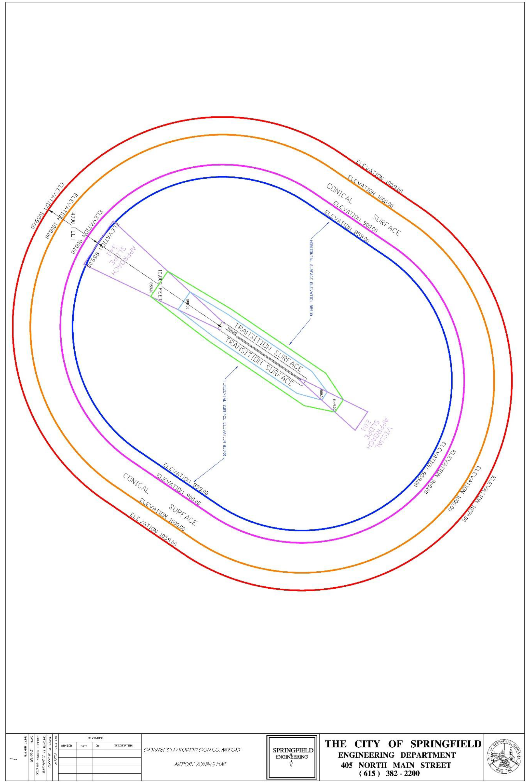
A-811. - Special Provisions of the Springfield Zoning Ordinance Applying to Multi-Story Buildings (Those ceding Two Stories).
A.
Height Limitation
The height limitation requirements of the following districts are increased from thirty-five (35) feet to seventy (70) feet.
CC - Core Commercial
MPO - Medical Professional Office
MRO - Multiple Residential and Office
CG - Commercial General
CS - Commercial Services
RI - Restricted Industrial
Building heights shall be measured on the tallest side of the building; from the ground to highest point of the building, including HVAC units and screening walls.
B.
Additional Requirements
Ten (10) feet shall be added to the front, rear, and side setbacks of the zoning district for each story over two (2). The CC district is exempt from this requirement.
In CS arid CG zones, this would work as follows:
All side and rear yards adjacent to a residential district shall provide a buffer area equal to twenty-five percent (25%) of the required yard depth. There shall be no parking areas or structures located in the required buffer area.
Buffer areas shall be provided with effective landscaping, earth berming, tree placement and/or a combination of landscaping and screening determined by the Planning Commission to render new development more attractive and to ameliorate undesirable effects upon adjacent residential areas.
High rise buildings in the CC, Core Commercial Zone, can be built with party walls providing provisions of the building, fire and safety codes can be met and provided that the parking and other provisions of the district are complied with.
Buildings in the CC area shall be designed to blend in and be architecturally compatible with the historic buildings in the district as determined by the Historic Zoning Commission.
If approved by the Planning Commission, buildings constructed in one (1) continuous story may exceed thirty-five (35) feet in height if their walls and roofs are constructed of fireproof materials and if the buildings contain adequate sprinkler systems.
All buildings in excess of thirty-five (35) feet in height shall have an approved sprinkler system.
The plans for all buildings in excess of thirty-five (35) feet in height shall be inspected by the State of Tennessee Fire Marshal's Office.
Drives and parking areas shall be designed in such a way as to allow access for fire equipment, ladder and bucket trucks to all sides of the building.
All provisions of the Standard Building Code and applicable Fire and Safety Codes of the City applying to multi story buildings shall be complied with.
The Springfield Planning Commission shall review and approve all site plans for the construction of commercial, medical and apartment buildings in excess of thirty-five (35) feet in height.
The provisions of this section apply only to buildings and do not increase the height limits for signs, billboards or other types of structures.
A-812. - City of Springfield Overlay Districts.
A.
Historic Downtown Redevelopment Overlay (HDRO) District
(1)
Purpose
The City of Springfield's history is reflected tremendously by its downtown. In order to protect the character of the Courthouse, Public Square, and surrounding businesses, and encourage new, economically viable development that is compatible with current historic structures, the Historic Downtown Redevelopment Overlay (HDRO) District is hereby created.
The HDRO District is intended to promote the economic and general welfare of the city, and require compatible new development and redevelopment. Rehabilitated structures and new buildings that use appropriate, compatible materials and colors are essential in keeping the historic nature of downtown Springfield intact. Design guidelines are also intended to assist in ensuring that property values are not lowered by nearby incompatible development. Without design standards, the character of the downtown and surrounding area can see drastic, unappealing change that negatively affects property owners, nearby businesses and residents, and the City of Springfield.
Streets with businesses that are pedestrian-friendly and attractive encourage similar types of businesses that work together to create a destination for locals and tourists alike. The primary types of development this district should include are retail businesses, offices, attractions, restaurants, and upper-story dwellings.
(2)
HDRO Defined Area
The HDRO District is hereby outlined to include all properties that border the following: The Courthouse Square and South Main Street from 5 th Avenue West to Central Avenue, including Batts Boulevard from South Main Street to Central Avenue.
(3)
Applicability
The City of Springfield Design Review Board, comprised of the members of the Springfield Planning Commission as authorized by TCA 6-54-133, will review structures in excess of fifty thousand (50,000) square feet, and authorizes the Community Development Department to take and review applications and enforce standards for the following:
•
New Construction
•
Exterior Remodeling (fifty percent (50%) or more of total exterior walls)
•
Structure Additions Adding fifty percent (50%) or More Floor Square Footage
•
Repainting (Only Requires Color Exterior Elevations)
A Preliminary Review should be scheduled with the Community Development Director prior to application to determine if rehabilitation, repainting, or new construction may meet HDRO requirements.
The Site Plan Application shall include:
•
Proposed Site Plan with All Site Improvements
•
Color Architectural Exterior Elevations
Single-family residential structures shall not fall within HDRO requirements. The types of structures the HDRO addresses are as follows:
•
Commercial/Mixed-Use
•
Industrial
•
Multi-Family Residential
•
Townhouses
Exterior colors of buildings, retaining walls, and roofs within the HDRO must meet color requirements.
Accessory structures are not intended to have the exterior material requirements, if subordinate to the use of the primary structure, and used for uses such as storage. Colors of accessory structures shall not conflict with historic or acceptable tones. Conversely, multiple primary structures must meet all requirements.
Roofing replacements should be of a similar material and one that does not conflict with the HDRO or surrounding properties, but roofing replacements shall not be reviewed for HDRO compliance.
(4)
Exterior Building Materials
Preferred wall materials may be used on any wall of a structure in the HDRO. Limited wall materials shall only be used on up to twenty-five percent (25%) of any of the individual side or rear walls. Prohibited wall materials shall not be used. Proposals using different exteriors may be considered on a case-by case basis provided it meets the purpose and intent of the overlay district.
Preferred Wall Materials:
•
Brick
•
Stone
•
Fade-Resistant Quik-Brik
•
Fade-Resistant Artificial Stone
•
Architectural Panels
•
Hardie Panels
Limited Wall Materials (Less than twenty-five percent (25%) of side/rear walls):
•
Concrete or Split-Face Block
•
Hard Coat or Textured Stucco
•
Exterior Insulation Finishing Systems (EIFS)
•
Hardie or Cementitious Siding
Prohibited Wall Materials:
•
Vinyl
•
Aluminum
•
Unsurfaced and/or Unpainted Concrete Blocks
•
Plywood
•
Wood Shakes
•
Asphalt Shingles
•
Cementitious Siding
•
Plastic or Fiberglass
Alternate proposals for exteriors may be considered, such as standard corporate design.
(5)
Colors
Colors shall be complementary to the dominant neutral building material colors such as dark red or red brown for brick, and buff, taupe, or gray for natural stone. Softer muted hues with gray or white added to the basic color shall be used to highlight architectural features such as window frames, sills, cornices, and details. Natural colors, such as those recognized by the Natural Trust for Historic Preservation may be considered to meet this requirement.
Intense bright, fluorescent, or very dark colors are not allowed. Colors conflicting with the historic tones of the HDRO include purple, orange, blue, and bright reds and yellows.
Proposed colors must be included with the architectural elevation rendering submittal.
(6)
Facades and Setbacks
Design of buildings in the HDRO downtown should complement other historic buildings. Facades may emphasize awnings or canopies to identify entrances, and may use transoms and other windows. There should be a distinct transition between the lower floor and upper stories, if applicable.
Side and rear facades do not have the same façade criteria, unless they face a public street.
Underlying zoning that allows variable setbacks, such as Commercial Core (CC), should be considered within the HDRO to encourage redevelopment. New structures should conform with existing nearby setbacks, unless the specific site area is considered conducive to redevelopment with altered setbacks.
(7)
Streetscape
Entrances should have sidewalk connections to the street. Sidewalks on lots should be consistent with the Springfield Greenway specifications, if property is adjacent to the greenway.
(8)
Parking and Access
Parking should be located to the side or rear of a building, where practical. Shared parking arrangements may be allowed downtown for rehabilitated structures.
(9)
Incentives
The Tennessee Historic Commission (https://www.tn.gov/environment/about-tdec/boards-and-commissions/board-tennessee-historical-commission.html) may be consulted to determine eligibility for a ten percent (10%) tax credit for substantial rehabilitation. This is available to all non-historic structures constructed prior to 1936. Criteria that must be met are: fifty to seventy percent (50%—70%) of the building's external walls must remain, seventy-five percent (75%) of external walls must remain as external or internal walls, seventy-five percent (75%) of the building's external structure must remain in place, and the structure must be income producing for five years, but not provide housing. However, hotels qualify for this incentive.
In addition, there is a twenty percent (20%) tax credit available to buildings that are on the National Register of Historic Places.
Preservation grants are also available. These are sixty percent (60%) matching, reimbursable grants. These can be used for survey and planning or acquisition and development.
B.
Sidewalk Café Overlay Zone
(1)
Establishment.
A special sidewalk café overlay zone is hereby created in the Historic Downtown of Springfield, Tennessee. Apart from properties that border the Springfield Greenway, the zone shall include all properties that border the following areas:
•
The Courthouse Square; and
•
South Main Street from 5th Avenue West to Central Avenue, including Batts Boulevard from South Main Street to Central Avenue.
(2)
Authorization of Use.
Restaurants located within the above-described overlay district may operate sidewalk cafés on the sidewalk directly abutting their business as an accessory use, subject to the requirements of this section and upon issuance of a permit by the Springfield Community Development Department.
(3)
Permit.
(a)
A sidewalk café permit shall be valid for one (1) year and may be renewed annually.
(b)
The applicant shall provide the community development department with:
•
A scale drawing showing the location of all proposed tables, seating areas, and clearance distances; and
•
A certificate of liability insurance in the minimum amount of one million dollars ($1,000,000.00), naming the City of Springfield as an additional insured.
(4)
Regulations.
(a)
Sidewalk cafés shall be defined as outdoor dining areas located on a portion of the sidewalk immediately abutting the operating restaurant.
(b)
The café layout shall maintain all required clearance widths in compliance with applicable federal accessibility standards and any additional requirements established by the city.
(c)
The use and operation of sidewalk cafés shall be conducted in a manner that does not obstruct pedestrian or vehicular traffic, create a nuisance, or otherwise conflict with public use of the right-of-way.
(Ord. No. 25-30, § 1(Exh. A), 11-18-2025)
A-813. - Landscaping Requirements.
A.
Purpose
In order to minimize any negative effect between adjacent uses and zoning districts, this section requires that landscaped buffers be provided for certain uses. The separation of land uses and the provision of landscaping along public and private rights-of-way through a required buffer are designed to eliminate or minimize potential nuisances, and to enhance community image and roadway beautification. Such nuisances may include dirt, litter, noise, lights, signs, unsightly buildings and structures, off-street loading and refuse areas, or parking areas. In addition, buffers provide spacing and landscaping to reduce potentially adverse impacts of noise, odor or lighting. Landscaping shall be coordinated with all site design elements including building layout, parking access and signs.
B.
Applicability
(1)
Landscaping and buffers shall be provided as set out in these zoning regulations. Buildings and structures lawfully existing as of January 1, 2010 may be modernized, altered or repaired without providing or modifying landscaping and buffers in conformance with this section, provided there is no increase in floor area in such building or structure or impervious area on the site; This shall not be construed as prohibiting the provision of landscaping or buffers in full conformance with these zoning regulations.
(2)
Where a building or structure existed as of January 1, 2010 and such building is enlarged in floor area or impervious area on the site by twenty-five percent (25%) or two thousand (2,000) square feet, whichever is less, landscaping and buffers as specified in this section shall be provided.
(3)
The regulations herein set out for landscaping and buffers shall apply to all site plan submittals except for one- or two-family dwellings on a single lot or parcel, temporary uses, or to development on site alterations on relatively undeveloped sites, which do not involve ground disturbance of ten thousand (10,000) square feet or greater.
(4)
The required buffers, as specified in these regulations, are minimum standards. The amount of land and type of planting or other screening specified for each buffer requirement are designed to mitigate nuisances or incompatibility between adjacent land uses or between a land use and a public road, where these regulations specify different buffering requirements (e.g., a different type of buffer), then the more stringent provisions shall govern.
(5)
None of the provisions of these regulations shall be construed as prohibiting additional plant material, screening and/or buffer area above that required by these regulations; or prohibiting the modification of existing landscaped buffers to perform to an equivalent degree as the buffer required by these regulations.
(6)
A landscaping plan shall accompany all site plan submittals.
C.
Design of Landscaping and Buffers
(1)
Existing Vegetation
(a)
General
The retention of "existing vegetation" shall be maximized within the proposed landscaping, parking and buffer areas. When retaining existing vegetation within the buffer area, no clearing shall be allowed within the drip line of tree canopies. Trees to be saved shall be protected by surrounding them with tree protection fencing around the edge of the drip line. Existing native habitat or plant material located within the proposed landscaping or buffer area that meets the requirements of these regulations may be counted toward the total buffer required between adjacent land uses, or toward total landscaping requirements if left undisturbed in their natural state. If the existing vegetation has been counted toward the total required buffer or landscaping and is subsequently removed or dies, it shall be replaced with the appropriate buffer or landscaping material within the next planting season.
(b)
Heritage Trees
(i)
For purposes of this ordinance, a heritage tree shall be any tree with a trunk caliper measurement of twenty-four (24) feet or greater.
(ii)
The locations of all trees six (6) inches or more in caliber shall be shown on the boundary survey.
(iii)
With the exception of clearing required for driveways, the removal of Heritage Trees is prohibited without prior approval of the City. The Community Development Director or his designee shall have the authority to permit the selective removal of heritage trees on a case by case basis that are identified for removal in the Landscaping Plan.
(iv)
The preservation of heritage trees located on the interior of the lot is encouraged, but shall not be required.
(2)
Design, Installation and Establishment Standards
Location of plants and design of landscaping, including maintenance, shall be according to ANSI standard. The use of vegetation and other lower maintenance landscape materials as shown on the Recommended Landscape List for Springfield is desired to promote environmental protection, energy efficiency, and water conservation. Other species meeting these criteria may be used, if shown on the approved Landscaping Plan, if approved by the Community Development Department.
(a)
Landscape plans submitted for approval for the purposes of satisfying the requirements of this section shall clearly indicate the common name and botanical name, location and size vegetation to be installed as well as trees to be preserved. All existing trees six (6) inches in caliper and larger shall be located on the plan.
(b)
All trees eighteen (18) inches and larger which are removed during construction shall be replaced at fifty percent (50%) of the size removed.
(c)
Rain gardens used for drainage requirements may be counted toward meeting the total landscaping requirements on a one for one basis.
(d)
No tree shall be planted within ten (10) feet of any underground utility.
(e)
Location of all underground utilities shall be shown on site and landscape plans.
(f)
Existing trees shall be counted towards the buffer requirements, the total number.
(g)
At least ten percent (10%) of the required landscaping must be placed in the front yard or near pedestrian access. This would also apply if the number per acre requirement is met by the buffering.
(h)
Every one hundred (100) linear feet of lot frontage shall contain five (5) two (2) feet understory trees and ten (10) shrubs that have a mature height of five (5) feet plus. At least fifty percent (50%) of shrubs and trees shall be evergreen.
(i)
Street trees, typically in rights-of-way or easements and maintained by the city, shall not be used toward the landscaping requirement.
Minimum Site Requirements
(3)
Plant Material and Minimum Plant Size
The following lists of plant materials shall be used as a guideline to define the required plant unit. Although the lists may be expanded, they are intended to provide guidance in selecting predominately hardy natural species. All materials shall be of high-quality nursery grade. Trees and shrubs not meeting current ANSI standards will not be accepted and will need to be replaced with acceptable landscaping. All asphalt and gravel shall be removed under the island for landscaping in the parking lots.
(4)
Soils
All landscaped areas shall have uncompacted coarse loam that is a minimum of twelve (12) inches deep. Soils shall be appreciably free of gravel, stones, rubble, or trash. All compacted soil, contaminated soil or road base fill shall be removed.
(5)
Required Plant Species
The recommended Tree List for Springfield shall be used as a guide in identifying and categorizing the different acceptable types for any required plant. Substitutions will be considered by staff on a case-by-case basis. All new landscaping shall contain two (2) or more species of both trees and shrubs.
(a)
Canopy Trees
The following will count as one (1) canopy tree toward the total number specified. Deciduous canopy trees shall be a minimum of ten (10) feet in height with a four (4) to five (5) foot spread and a two (2) inch caliper trunk at time of planting, as determined in the American Standard for Nursery Stock, ANSI Z60.1-2004
(b)
Understory Trees
Understory trees shall be a minimum of two (2) inches in caliper at time of planting as determined in the American Standard for Nursery Stock, ANSI Z60.1-2004. Multi-stem varieties shall be a minimum of eight (8) feet in height above ground level at the time of planting.
(c)
Evergreen Trees
Evergreen trees shall be a minimum of six (6) feet in height and a minimum of two (2) inches in caliper at time of planting.
(d)
Shrubs shall be a minimum of eighteen (18) inches in height.
(6)
Irrigation
All new landscaped or grass areas shall be irrigated with an irrigation system or yard hydrant within fifty (50) feet of new landscaping spaced at no more than one hundred (100) foot intervals to provide for the adequate watering of plants and grass. Separate metering of irrigation water can be arranged with the Springfield Water and Wastewater Department to avoid having to pay sewer charges on irrigation water.
(7)
Buffering
The ten (10), fifteen (15), or twenty (20) foot front yard (not building setback) required by most Commercial and Industrial Districts shall be planted in grass and landscaped with shrubbery and trees to make a separation from the street, except for vehicle ingress and egress areas and sidewalks. In all other areas, where a front yard is not designated, a minimum landscaped area of ten (10) feet shall be provided. Evergreen and other landscaping shall be used to screen dumpsters, transformers, heating and air conditioning fixtures and other unsightly fixtures on the site.
Where commercial, industrial or multi-family facilities abut single family residential areas; they shall be buffered by a ten (10) foot wide landscaped strip, which shall include five (5) trees, two (2) canopy and three (3) understory trees and ten (10) shrubs per one hundred (100) linear feet. At least fifty percent (50%) of these trees are required to evergreen.
(8)
Maintenance
Landscaping shall be maintained by the property owner. Trees and Landscaping shall be maintained in good order. Dead plants and trees shall be replaced within the planting season or six (6) months.
D.
Recommended Tree List for Springfield
CANOPY
American Elm
Deciduous, sixty (60) to eighty (80) feet at maturity; prefers full sun and tolerates
moist soils; fast growing, oval leave hardy tree, tolerates exposure, subject to Dutch
Elm Disease, but new varieties resistant to disease have also been developed.
American Sycamore
Deciduous, one hundred (100) feet at maturity; sun loving and prefers rich, moist
soil; spreading tall trunk and rounded head, young plants subject to spring frost,
can be affected by pollution in cities.
Bald Cypress
Common Bald Cypress looks like an evergreen, but is actually deciduous and drops its
leaves in the fall. The growth habit is narrow while young but becomes broader as
the plant ages. Common Bald Cypress is intolerant of shade when young and can be used
near water.
Black Tupelo
Deciduous, thirty (30) to fifty (50) feet at maturity; twenty (20) to thirty (30)
foot spread. Beautiful red, orange, and purple fall color. Unique bark. Staff recommended tree.
Black Walnut
Deciduous, one hundred (100) feet at maturity; tolerates any soil; slow grower, now
rare in East due to tree's enormous value for wood and nuts, leaves are two (2) feet
long with eleven (11) to twenty-three (23) leaflets.
English Oak
Deciduous, sixty (60) to eighty (80) feet at maturity, prefers woods; known as Common
Oak, broad, open head, sort trunk, oblong dark green leaves with six (6) lobes on
each side.
Gingko
Sixty (60) feet at maturity.
Hickory
Deciduous, one hundred (100) feet at maturity; likes rich, moist soil; produces larger
amounts of pollen, distinctively peeling bark, produces sweet, edible nut, resist
transplanting.
Littleleaf Linden
Deciduous, forty (40) to fifty (50) feet at maturity; forty (40) foot spread. Yellow
flowers, late blooming. Yellow fall foliage.
London Planetree
Deciduous, seventy-five (75) to one hundred (100) feet at maturity; medium to fast
growing, related to American Sycamore but better disease resistance, brown flaking
bark reveals cream color, dense canopy. Yellow to brown fall color. Staff recommended tree.
Northern Catalpa
Deciduous, forty (40) to sixty (60) feet high with thirty (30) foot spread, flowering,
twisting trunk gives interesting appeal. May also be used as an understory/flowering
tree selection if site area is suitable due to size.
Pecan
Deciduous, one hundred (100) feet at maturity; likes deep, loam soil; tallest of the
hickories, long-lived, produces nuts for two hundred (200) years which have important
commercial value.
Pin Oak
Deciduous, eighty (80) feet at maturity; not lime tolerant, likes moist soil; drooping
branches, glossy green, deeply lobes leaves, saucer-like acorns.
Quaking Aspen
Deciduous, forty (40) to fifty (50) feet at maturity; twenty-five (25) foot spread,
fast growing. White bark, spectacular yellow-gold fall foliage. Staff recommended tree.
Red Maple
Deciduous, eighty (80) feet at maturity; tolerates moist to dry soil; often used as
ornamental, showy flowers and fruit in spring, beautiful foliage in fall.
Serviceberry
Deciduous, one hundred (100) feet at maturity; prefers lime-free soils; often narrow,
snow-white flowers in drooping clusters, bark is gray and smooth when young and become
rigid and scaly with age, fruit is sweet and edible.
Red Oak (Southern, Northern, Scarlet, etc.)
Deciduous, one hundred (100) feet at maturity, likes sandy soil, not lime tolerant;
medium-length, deeply lobed leaves in glossy green, one (1) inch acorn, hardy tree.
Sugar Maple
Deciduous, eighty (80) feet at maturity, moist soil, strong wood, fast growing, beautiful
fall orange/red foliage. Staff recommended tree.
Tulip Poplar/Yellow Poplar
Deciduous, one hundred (100) feet at maturity, moist to dry soil; shade tree with
beautiful fall foliage, state tree, important tree for wildlife, grows well with other
species. Yellow fall foliage.
White or Green Ash
Deciduous, eighty (80) feet at maturity, moist, rich soil; sun tolerant, thick foliage,
seeds used by birds and animals.
White Oak
Deciduous, one hundred fifteen (115) feet at maturity, lime-tolerant, but not in shallow
chalky soil; soft-green lobed leaves that turn crimson in autumn; acorns three-fourths
(¾) inch long, hardy tree.
Willow Oak
Deciduous, one hundred (100) feet at maturity, moist, swampy soil; shade tree with
bright green pointed leaves, often planted along streets, public buildings and parks.
UNDERSTORY/FLOWERING
Crab Apple Hybrids (Prairie Flowering, Snowdrift, Robinson, etc.)
Deciduous, less than twenty (20) feet at maturity; good in all fertile soils, sun-loving;
fragrant leaves if crushed, profuse, fragrant flower in a wide range of colors, susceptible
to insects and disease. Staff recommended tree.
Crapemyrtle (Red Rocket, Dynamite, Catawba, etc.)
Deciduous, typically ten (10) to fifteen (15) feet at maturity. Varying flower colors
based on type, including deep reds and purples. Staff recommended tree.
Eastern Redbud
Deciduous, less than twenty (20) feet at maturity; best in moist soil, but can tolerate
dry soil; bright green leaves, pale rose flowers in spring, planted as ornamental,
but produces many seedlings.
Flowering Dogwood
Deciduous, less than twenty (20) feet at maturity; acid soil in woods, and dislikes
poor, shallow chalky soils; small flowers in a variety of colors, blooms in late spring,
exceptional as ornamental due to hardiness, also valued for its wood.
Fringetree
Deciduous, twelve (12) to twenty (20) feet at maturity with equal spread. Acid, moist,
and well-drained soil. Fragrant, long white flowers that give the tree its name. Staff recommended tree.
Golden Rain Tree
Deciduous, thirty (30) to forty (40) feet at maturity; sun-loving, tolerant of dry
solids; susceptible to fungus, has oval, coarsely-toothed leaves, small yellow flowers
that bloom in May-June.
Japanese Flowering Cherry (Kwanzan, Yoshino, Autumn Flowering, etc.)
Deciduous, twenty-five (25) to thirty (30) feet at maturity; good in most solid; glossy,
red-brown bark with glassy sheen, leaves taper to slender point at tip. Staff recommended tree.
Japanese Maple
Deciduous, twenty-five (25) to thirty (30) feet at maturity; tolerant of most soil
types; lobed leaves with brilliant autumn colors, usually pest free, red flowers in
drooping clusters in spring.
Saucer Magnolia
Deciduous, twenty (20) feet at maturity, likes neutral to acid soil; fast growing,
hybrid magnolia, saucer shaped flowers with a white-to-pink or purple-pink petal,
tolerates pollution and poor soil.
Sweetbay Magnolia
Evergreen, ten (10) to twenty (20) feet at maturity, with equal spread. Late blooming
white flowers. May also be used as a shrub/evergreen requirement.
Smoketree/Purple Smoketree
Deciduous, ten (10) to fifteen (15) feet at maturity with twelve (12) foot spread,
great accent tree. Flowers puff out in a "smoke-like" fashion in June-July. Staff recommended tree.
SHRUBS AND EVERGREENS
American Arborvitae
Evergreen, twenty (20) feet at maturity; prefers limestone, rock, and heavy clay soil;
known as White Cedar; leaves in fan-like sprays, dark green on top and pale underneath,
useful in poorly drained soil; subject to bagworms.
Boxwood (Winter Gem, Green Velvet, etc.)
Evergreen, varying heights based on application, mostly under six (6) feet. Typically
used for small to medium hedges. Staff recommended shrub.
Blue Spruce
Evergreen, grows fifty (50) to seventy-five (75) feet at maturity with twenty (20)
foot spread; slow growing. Blue color in most varieties make an attractive option
for landscaping. Deer resistant. Staff recommended screen.
Bracken's Brown Beauty Magnolia
Evergreen, thirty (30) feet at maturity; fifteen (15) foot spread. Beautiful flowers
with glossy leaves and brown underside. Staff recommended tree.
Foster's American Holly
Evergreen, thirty (30) feet at maturity; sandy soil or moist woods; stiff spines on
leaves, fruits red or orange can grow eight (8) feet in twenty (20) years, dislikes
chalky soil.
Green Giant Arborvitae
Evergreen, fifty (50) to sixty (60) feet at maturity; fast growing. Excellent for
screening. Staff recommended screen.
Japanese Black Pine
Evergreen, fifty (50) feet at maturity; prefers sandy soil; needle-like rigid leaves
four (4) inches long, in winter is easily distinguished by white, hairy leaf buds,
can lean at maturity.
Southern Magnolia
Evergreen, sixty (60) feet at maturity, likes neutral to acidic soil; traditional
southern tree, creamy-white fragrant flowers that bloom in late spring and summer;
shiny green leaves all year. Staff recommended tree.
White Pine
Evergreen, one hundred sixty (160) feet at maturity; sun-loving, narrowly conical
in shape, leaves are medium length, dark blue-green, fast growing and is easily shaped
by pruning.
(Ord. No. 17-15, § 1(Exh. A), 12-19-2017)