
Springfield City Zoning Code
ARTICLE II
- ESTABLISHMENT OF ZONING DISTRICTS AND DISTRICT STANDARDS
Sec. 30-31.- Establishment of zoning districts.
For the purposes of this chapter, the town is divided into the following zoning districts as shown on the official zoning maps:
(Ord. No. O-2019-2, § 2.0, 9-23-2019; Ord. No. 2022-2, 10-24-2022)
Sec. 30-32. - Official zoning maps.
The districts listed in section 30-31 are bounded as shown on the official zoning map, which is adopted as part of this chapter and which is on file in the town offices. A reduced copy is attached to this chapter for user convenience.
(Ord. No. O-2019-2, § 2.1, 9-23-2019; Ord. No. 2022-2, 10-24-2022)
Sec. 30-33. - Interpretation of zoning district boundaries.
Where uncertainty exists with respect to the boundary of any zoning district on the zoning map, the development review board shall determine the location of such boundaries.
(1)
Where district boundaries are indicated as approximately following the center of streets or highways, street lines, or highway right-of-way lines, such center lines, street lines, or highway right-of-way lines shall be construed to be such.
(2)
Where district boundaries are indicated as approximately following lot lines, such lot lines shall be construed to be said boundaries.
(3)
Where district boundaries are indicated as approximately parallel to center lines or street lines of streets, the center lines or right-of-way lines of highways, such district boundaries shall be construed as being parallel thereto and at such distance therefrom as indicated on the zoning map. If no distance is given, such dimensions shall be determined by the use of the scale shown on said zoning map.
(4)
Where the boundary of the district follows a river, stream or other body of water, the center of such water shall be construed to be said boundary.
(5)
Where the district boundary follows a ridgeline or toe of a slope, U.S.G.S. topographical maps, aerial photographs or on-site inspection may be used to determine in which district a proposed use is located.
(Ord. No. O-2019-2, § 2.2, 9-23-2019; Ord. No. 2022-2, 10-24-2022)
Sec. 30-34. - Lot classification.
Lots are classified according to the presence or absence of municipal water and sewer service. The classification is used to determine dimensional requirements in section 30-35. The classification system is as follows:
(Ord. No. 2022-2, 10-24-2022)
Sec. 30-59.- Specific regulations.
The following subdivisions present specific regulations applicable in each district.
(Ord. No. O-2019-2, § 2.5, 9-23-2019; Ord. No. 2022-2, 10-24-2022)
Sec. 30-77.- Purpose.
The land reserve 25-acre district is intended to conserve open space for land reserve and associated uses. These areas are generally not serviced by community facilities such as roads, utilities and water and sewer. In keeping with the community's desire to retain the town's farm and forested landscape, these areas are slated for very low-density development. The applicant shall demonstrate that the location of any proposed development is suitable for the proposed purpose. This demonstration may reference the land use and the future and current land use maps in the town plan.
(Ord. No. O-2019-2, art. 2, tab. 2.1, 9-23-2019; Ord. No. 2022-2, 10-24-2022)
Sec. 30-78. - Allowed land uses.
The land uses that are allowed in the land reserve 25-acre district are shown below and are subject to the specified review procedures:
* Additional uses. In addition to the uses set forth as permitted and conditional uses within this district, other uses which the development review board finds to be similar to uses allowed in the district in character, intensity and impact on the surrounding area may be allowed.
Exempt/notify. Indicates uses that are exempt per state law, but may require notification of the administrative officer as required in sections 30-762 and 30-916 of the land use development ordinance.
(Ord. No. O-2019-2, art. 2, tab. 2.1, 9-23-2019; Ord. No. 2022-2, 10-24-2022)
Sec. 30-79. - Dimensional requirements (unless otherwise specified by use type).
The following dimensional requirements apply to the land reserve 25-acre district:
(Ord. No. O-2019-2, art. 2, tab. 2.1, 9-23-2019; Ord. No. 2022-2, 10-24-2022)
Sec. 30-102.- Purpose.
The land reserve 10-acre district is designed to maintain open space in the outlying areas at a smaller minimum acreage while encouraging the same uses that would be applicable to the land reserve 25-acre district. These areas are more accessible than land reserve 25-acre, but the topography may be mixed and irregular similar to the residential/agricultural 5-acre district. Generally new development would require on-site water and sewer. See also the requirements of the zoning district, if any, set forth in the town plan and current and future land use maps.
(Ord. No. O-2019-2, art. 2, tab. 2.2, 9-23-2019; Ord. No. 2022-2, 10-24-2022)
Sec. 30-103. - Allowed land uses.
The land uses that are allowed in the land reserve 10-acre district are shown in below and are subject to the specified review procedures:
* Additional uses. In addition to the uses set forth as permitted and conditional uses within this district, other uses which the development review board finds to be similar to uses allowed in the district in character, intensity and impact on the surrounding area may be allowed.
Exempt/notify. Indicates uses that are exempt per state law, but may require notification of the administrative officer as required in sections 30-762 and 30-916 of the land use development ordinance.
(Ord. No. O-2019-2, art. 2, tab. 2.2, 9-23-2019; Ord. No. 2022-2, 10-24-2022)
Sec. 30-104. - Dimensional requirements (unless otherwise specified by use type).
The following dimensional requirements apply to the land reserve 10-acre district:
(Ord. No. O-2019-2, art. 2, tab. 2.2, 9-23-2019; Ord. No. 2022-2, 10-24-2022)
Sec. 30-122.- Purpose.
The residential agricultural 5-acre district has been established in outlying areas where public water and sewer service is not available and where topography is mixed and irregular. The purpose of this district is to encourage economical agricultural activities, and allow for low-density housing patterns. It shall be the policy of the town to encourage development in these areas in the manner that will best protect the agricultural and rural potential of the district. This may be accomplished through cluster development or development for residential purposes of that land which is marginal for agricultural use. See also the requirements of the zoning district, if any, set forth in the town plan and current and future land use maps.
(Ord. No. O-2019-2, art. 2, tab. 2.3, 9-23-2019; Ord. No. 2022-2, 10-24-2022)
Sec. 30-123. - Allowed land uses.
The land uses that are allowed in the residential/agricultural 5-acre district are shown below and are subject to the specified review procedures:
* Additional uses. In addition to the uses set forth as permitted and conditional uses within this district, other uses which the development review board finds to be similar to uses allowed in the district in character, intensity and impact on the surrounding area may be allowed.
Exempt/notify. Indicates uses that are exempt per state law, but may require notification of the administrative officer as required in sections 30-762 and 30-916 of the land use development ordinance.
(Ord. No. O-2019-2, art. 2, tab. 2.3, 9-23-2019; Ord. No. 2022-2, 10-24-2022)
Sec. 30-124. - Dimensional requirements (unless otherwise specified by use type).
The following dimensional requirements apply to the residential/agricultural 5-acre district:
(Ord. No. O-2019-2, art. 2, tab. 2.3, 9-23-2019; Ord. No. 2022-2, 10-24-2022)
Sec. 30-147.- Purpose.
The residential agricultural 2-acre district has been established to allow low-density residential development in areas that generally have good agricultural and forest soils. It shall be the policy of the town to encourage development in these areas in the manner that will best protect the agricultural potential of the district. This may be accomplished through cluster development or development for residential purposes of that land which is marginal for agricultural use. See also the requirements of the zoning district, if any, set forth in the town plan and current and future land use maps.
(Ord. No. O-2019-2, art. 2, tab. 2.4, 9-23-2019; Ord. No. 2022-2, 10-24-2022)
Sec. 30-148. - Allowed land uses.
The allowed land uses in the residential/agricultural 2-acre district are shown below and are subject to the specified review procedures:
* Additional uses. In addition to the uses set forth as permitted and conditional uses within this district, other uses which the development review board finds to be similar to uses allowed in the district in character, intensity and impact on the surrounding area may be allowed.
Exempt/notify. Indicates uses that are exempt per state law, but may require notification of the administrative officer as required in sections 30-762 and 30-916 of the Land Use Development Ordinance.
(Ord. No. O-2019-2, art. 2, tab. 2.4, 9-23-2019; Ord. No. 2022-2, 10-24-2022)
Sec. 30-149. - Dimensional requirements (unless otherwise specified by use type).
The following dimensional requirements apply to the residential/agricultural 2-acre district:
(Ord. No. O-2019-2, art. 2, tab. 2.4, 9-23-2019; Ord. No. 2022-2, 10-24-2022)
Sec. 30-167.- Purpose.
The medium density residential district is designated for land where central water and sewer facilities are available or where the installation of these facilities is feasible. Residential and other compatible and complementing uses are permitted in this district at densities dependent on utility service availability. This district is intended to serve as an urban fringe area for both Springfield and North Springfield, housing a majority of the community's residents in areas and at densities consistent with the utilities provided. See also the requirements of the zoning district, if any, set forth in the town plan and current and future land use maps.
(Ord. No. O-2019-2, art. 2, tab. 2.5, 9-23-2019; Ord. No. 2022-2, 10-24-2022)
Sec. 30-168. - Allowed land uses.
The land uses allowed in the medium density residential district are shown below and are subject to the specified review procedures:
* Additional uses. In addition to the uses set forth as permitted and conditional uses within this district, other uses which the development review board finds to be similar to uses allowed in the district in character, intensity and impact on the surrounding area may be allowed.
Exempt/notify. Indicates uses that are exempt per state law, but may require notification of the administrative officer as required in sections 30-762 and 30-916 of the land use development ordinance.
(Ord. No. O-2019-2, art. 2, tab. 2.5, 9-23-2019; Ord. No. 2022-2, 10-24-2022)
Sec. 30-169. - Dimensional requirements (unless otherwise specified by use type).
The following dimensional requirements apply to the medium density residential district:
(Ord. No. O-2019-2, art. 2, tab. 2.5, 9-23-2019; Ord. No. 2022-2, 10-24-2022)
Sec. 30-192.- Purpose.
The high density residential district is designated for land centrally located where central water and sewer facilities are available or readily available. Existing utilities, roads, locations, and intensive development all make certain areas appropriate for high-density development. The purpose of this district is to house a high percentage of the town's population near jobs and community services and where adequate facilities and utilities can be provided. It will be an expansion of residential and related uses. See also the requirements of the zoning district, if any, set forth in the town plan and current and future land use maps.
(Ord. No. O-2019-2, art. 2, tab. 2.6, 9-23-2019; Ord. No. 2022-2, 10-24-2022)
Sec. 30-193. - Allowed land uses.
The land uses allowed in the high density residential district are shown below and are subject to the specified review procedures:
* Additional uses. In addition to the uses set forth as permitted and conditional uses within this district, other uses which the development review board finds to be similar to uses allowed in the district in character, intensity and impact on the surrounding area may be allowed.
Exempt/notify. Indicates uses that are exempt per state law, but may require notification of the administrative officer as required in sections 30-762 and 30-916 of the land use development ordinance.
(Ord. No. O-2019-2, art. 2, tab. 2.6, 9-23-2019; Ord. No. 2022-2, 10-24-2022)
Sec. 30-194. - Dimensional requirements (unless otherwise specified by use type).
The following dimensional requirements apply to the high density residential district:
(Ord. No. O-2019-2, art. 2, tab. 2.6, 9-23-2019; Ord. No. 2022-2, 10-24-2022)
Sec. 30-212.- Purpose.
The general business district includes areas geared towards accommodating the general commercial needs of the public. Lying outside central business areas and along major travel corridors, these areas are easily accessible by existing roads. See also the requirements of the zoning district, if any, set forth in the town plan and current and future land use maps.
(Ord. No. O-2019-2, art. 2, tab. 2.7, 9-23-2019; Ord. No. 2022-2, 10-24-2022)
Sec. 30-213. - Allowed land uses.
The land uses allowed in the general business district are shown below and are subject to the specified review procedures:
* Additional uses. In addition to the uses set forth as permitted and conditional uses within this district, other uses which the development review board finds to be similar to uses allowed in the district in character, intensity and impact on the surrounding area may be allowed.
Exempt/notify. Indicates uses that are exempt per state law, but may require notification of the administrative officer as required in sections 30-762 and 30-916 of the land use development ordinance.
(Ord. No. O-2019-2, art. 2, tab. 2.7, 9-23-2019; Ord. No. 2022-2, 10-24-2022)
Sec. 30-214. - Dimensional requirements (unless otherwise specified by use type).
The following dimensional requirements apply to the general business district:
(Ord. No. O-2019-2, art. 2, tab. 2.7, 9-23-2019; Ord. No. 2022-2, 10-24-2022)
Sec. 30-237.- Purpose.
The central business district is an area that permits a variety of uses all promoting the community's governmental and retail center. This district is intended to preserve the investment made in existing business centers while encouraging the orderly development of new business. Residential uses are also allowed accommodating those who wish to live in a high-density area. See also the requirements of the zoning district, if any, set forth in the town plan and current and future land use maps.
(Ord. No. O-2019-2, art. 2, tab. 2.8, 9-23-2019; Ord. No. 2022-2, 10-24-2022)
Sec. 30-238. - Allowed land uses.
The land uses allowed in the central business district are shown below and are subject to the specified review procedures:
* Additional uses. In addition to the uses set forth as permitted and conditional uses within this district, other uses which the development review board finds to be similar to uses allowed in the district in character, intensity and impact on the surrounding area may be allowed.
Exempt/notify. Indicates uses that are exempt per state law, but may require notification of the administrative officer as required in sections 30-762 and 30-916 of the Land Use Development Ordinance.
(Ord. No. O-2019-2, art. 2, tab. 2.8, 9-23-2019; Ord. No. 2022-2, 10-24-2022)
Sec. 30-239. - Dimensional requirements (unless otherwise specified by use type).
The following dimensional requirements apply to the central business district:
(Ord. No. O-2019-2, art. 2, tab. 2.8, 9-23-2019; Ord. No. 2022-2, 10-24-2022)
Sec. 30-257.- Purpose.
The residential commercial district is a district that is designed to accommodate both residential and commercial development in the more built-up areas of town. Permitted uses would be the same as those in high density residential areas while conditional uses would include many of the uses allowed in the central business district. See also the requirements of the zoning district, if any, set forth in the town plan and current and future land use maps.
(Ord. No. O-2019-2, art. 2, tab. 2.9, 9-23-2019; Ord. No. 2022-2, 10-24-2022)
Sec. 30-258. - Allowed land uses.
The land uses allowed in the residential commercial district are shown below and are subject to the specified review procedures:
* Additional uses. In addition to the uses set forth as permitted and conditional uses within this district, other uses which the development review board finds to be similar to uses allowed in the district in character, intensity and impact on the surrounding area may be allowed.
Exempt/notify. Indicates uses that are exempt per state law, but may require notification of the administrative officer as required in sections 30-762 and 30-916 of the land use development ordinance.
(Ord. No. O-2019-2, art. 2, tab. 2.9, 9-23-2019; Ord. No. 2022-2, 10-24-2022)
Sec. 30-259. - Dimensional requirements (unless otherwise specified by use type).
The following dimensional requirements apply to the residential commercial district:
(Ord. No. O-2019-2, art. 2, tab. 2.9, 9-23-2019; Ord. No. 2022-2, 10-24-2022)
Sec. 30-282.- Purpose.
The industrial/commercial district encompasses an area lying outside the central and general business areas, along a major travel corridor with direct access to the Interstate Highway. The purpose of this district is to encourage industrial and commercial uses on a large scale, as opposed to the general and central business districts, where small-scale operations are encouraged on small parcels. See also the requirements of the zoning district, if any, set forth in the town plan and current and future land use maps.
(Ord. No. O-2019-2, art. 2, tab. 2.10, 9-23-2019; Ord. No. 2022-2, 10-24-2022)
Sec. 30-283. - Allowed land uses.
The land uses allowed in the industrial/commercial district are shown below and are subject to the specified review procedures:
* Additional uses. In addition to the uses set forth as permitted and conditional uses within this district, other uses which the development review board finds to be similar to uses allowed in the district in character, intensity and impact on the surrounding area may be allowed.
Exempt/notify. Indicates uses that are exempt per state law, but may require notification of the administrative officer as required in sections 30-762 and 30-916 of the Land Use Development Ordinance.
(Ord. No. O-2019-2, art. 2, tab. 2.10, 9-23-2019; Ord. No. 2022-2, 10-24-2022)
Sec. 30-284. - Dimensional requirements (unless otherwise specified by use type).
The following dimensional requirements apply to the industrial/commercial district:
(Ord. No. O-2019-2, art. 2, tab. 2.10, 9-23-2019; Ord. No. 2022-2, 10-24-2022)
Sec. 30-302.- Purpose.
The industrial district allows for the establishment of manufacturing employment opportunities in the community. These areas must take into consideration truck access and the availability of utilities. Space for off-street parking and trucking, therefore, must be adequate enough for industrial use. These areas must be protected from intrusion of residential or retail business uses that are not compatible with the industrial uses designated for this area. Research and development or other high-density employment activities should be concentrated in this area. See also the requirements of the zoning district, if any, set forth in the town plan and current and future land use maps.
(Ord. No. O-2019-2, art. 2, tab. 2.11, 9-23-2019; Ord. No. 2022-2, 10-24-2022)
Sec. 30-303. - Allowed land uses.
The land uses allowed in the industrial district are shown below and are subject to the specified review procedures:
* Additional uses. In addition to the uses set forth as permitted and conditional uses within this district, other uses which the development review board finds to be similar to uses allowed in the district in character, intensity and impact on the surrounding area may be allowed.
Exempt/notify. Indicates uses that are exempt per state law, but may require notification of the administrative officer as required in sections 30-762 and 30-916 of the land use development ordinance.
(Ord. No. O-2019-2, art. 2, tab. 2.11, 9-23-2019; Ord. No. 2022-2, 10-24-2022)
Sec. 30-304. - Dimensional requirements (unless otherwise specified by use type).
The following dimensional requirements apply to the industrial district:
(Ord. No. O-2019-2, art. 2, tab. 2.11, 9-23-2019; Ord. No. 2022-2, 10-24-2022)
Sec. 30-327.- Purpose.
The exit seven district includes a defined area located on the western side of Interstate 91 between the Interstate Highway and the Black River. This area has businesses that are geared towards accommodating the traveling public and to maintaining major highway systems. It is the intent of the district not to compete with the central and general business district for small businesses. It is also the intent of this district to restrict sprawl around the Interstate interchange by limiting the minimum size of parcels and the land required to support individual uses. See also the requirements of the zoning district, if any, set forth in the town plan and current and future land use maps.
(Ord. No. O-2019-2, art. 2, tab. 2.12, 9-23-2019; Ord. No. 2022-2, 10-24-2022)
Sec. 30-328. - Allowed land uses.
The land uses allowed in the exit 7 district are shown below and are subject to the specified review procedures:
* Additional uses. In addition to the uses set forth as permitted and conditional uses within this district, other uses which the development review board finds to be similar to uses allowed in the district in character, intensity and impact on the surrounding area may be allowed.
Exempt/notify. Indicates uses that are exempt per state law, but may require notification of the administrative officer as required in sections 30-762 and 30-916 of the land use development ordinance.
(Ord. No. O-2019-2, art. 2, tab. 2.12, 9-23-2019; Ord. No. 2022-2, 10-24-2022)
Sec. 30-329. - Dimensional requirements (unless otherwise specified by use type).
The following dimensional requirements apply to the exit 7 district:
(Ord. No. O-2019-2, art. 2, tab. 2.12, 9-23-2019; Ord. No. 2022-2, 10-24-2022)
Sec. 30-347.- Purpose.
The aquifer re-charge protection area primary district is an assigned district with strict controls over specific uses of or uses on the land. The purpose of this protection area is to guard and preserve the land known to provide a re-charge to the aquifer system that feeds the municipal water supply. Development will be restricted to residential use with additional controls not normally found in other zoning districts.
(Ord. No. O-2019-2, art. 2, tab. 2.13, 9-23-2019; Ord. No. 2022-2, 10-24-2022)
Sec. 30-348. - Allowed land uses.
The land uses allowed in the districts aquifer re-charge protection area—Primary district are shown below and are subject to the specified review procedures:
* Additional uses. In addition to the uses set forth as permitted and conditional uses within this district, other uses which the development review board finds to be similar to uses allowed in the district in character, intensity and impact on the surrounding area may be allowed.
Exempt/notify. Indicates uses that are exempt per state law, but may require notification of the administrative officer as required in sections 30-762 and 30-916 of the land use development ordinance.
(Ord. No. O-2019-2, art. 2, tab. 2.13, 9-23-2019; Ord. No. 2022-2, 10-24-2022)
Sec. 30-349. - Dimensional requirements (unless otherwise specified by use type).
The following dimensional requirements apply to the aquifer re-charge protection area primary district:
(Ord. No. O-2019-2, art. 2, tab. 2.13, 9-23-2019; Ord. No. 2022-2, 10-24-2022)
Sec. 30-350. - Special standards.
The following special standards shall apply to all new construction started after the adoption of this chapter:
(1)
In-ground tanks for storage of petrol-chemicals and any toxic or conceivably hazardous materials are prohibited.
(2)
Petroleum fuels that remain liquid at atmospheric pressure (fuel oil) are prohibited as heating fuels.
(3)
Storage of liquid petroleum fuels in tanks having capacity of more than 25 gallons is prohibited. This includes the storage of fuel tanker trucks.
(4)
All development shall be serviced by the municipal sewer system.
(5)
Home businesses and/or occupations that could conceivably generate/utilize toxic or hazardous materials are prohibited.
(6)
All applications for development or construction shall be submitted to the department of public works. The department of public works review, comment and recommendations are required prior to any leasing or commencement of construction.
(7)
Subsections (2) and (3) of this section notwithstanding, existing liquid petroleum fuel tanks and heating systems serving existing development may continue in use, but may not be replaced. If such tanks and heating systems are abandoned for a complete heating season, they may not be placed back in operation.
(Ord. No. O-2019-2, art. 2, tab. 2.13, 9-23-2019; Ord. No. 2022-2, 10-24-2022)
Sec. 30-374.- Purpose.
The aquifer re-charge protection area secondary district is an overlay district with strict controls over specific uses of or uses on the land. The purpose of this protection area is to guard and preserve the land know to provide a re-charge to the aquifer system that feeds the municipal water supply. Development will be restricted to those uses indicated for the underlying general business (GB) district and the medium density residential (MDR) district.
(Ord. No. O-2019-2, art. 2, tab. 2.14, 9-23-2019; Ord. No. 2022-2, 10-24-2022)
Sec. 30-375. - Dimensional requirements (unless otherwise specified by use type).
The following dimensional requirements apply to the aquifer re-charge protection area—Secondary district:
(Ord. No. O-2019-2, art. 2, tab. 2.14, 9-23-2019; Ord. No. 2022-2, 10-24-2022)
Sec. 30-376. - Special standards.
The following special standards shall apply to all new construction started after the adoption of this chapter:
(1)
In-ground tanks for storage of petrochemicals and any toxic or conceivably hazardous materials are prohibited.
(2)
All development shall be serviced by the municipal sewer system.
(3)
Home businesses and/or occupations that could conceivably generate/utilize toxic or hazardous materials are prohibited.
(4)
All applications for development or construction shall be submitted to the department of public works. The department of public works review, comment and recommendations are required prior to any leasing or commencement of construction.
(Ord. No. O-2019-2, art. 2, tab. 2.14, 9-23-2019; Ord. No. 2022-2, 10-24-2022)
Sec. 30-396.- Purpose.
The purpose of the Natural Resources Protection District shall be to protect areas that include irreplaceable, limited and significant natural resources. Use of the land shall be strictly limited to its study and enjoyment by persons through proper and controlled access that would preclude any vehicular traffic. These areas shall remain in their natural state except for means to properly control access and trespass. Any other use or development shall be prohibited.
(Ord. No. O-2019-2, art. 2, tab. 2.15, 9-23-2019; Ord. No. 2022-2, 10-24-2022)
Sec. 30-397. - Permitted and conditional uses.
The permitted and conditional uses in the Natural Resource Preservation district are as follows:
(Ord. No. O-2019-2, art. 2, tab. 2.15, 9-23-2019; Ord. No. 2022-2, 10-24-2022)
Sec. 30-423.- Purpose.
The riverfront protection overlay district is intended to reduce erosion of the banks of the Connecticut River and the Black River near the confluence of the Connecticut River, reduce pollution of the river by filtering surface runoff and ensuring that on-site sewage treatment systems are adequately separated from the river, preserve the visual qualities of the river valley (both views of the river and views from the river) and protect wetlands and other natural features along the river.
(Ord. No. O-2019-2, art. 2, tab. 2.16, 9-23-2019; Ord. No. 2022-2, 10-24-2022)
Sec. 30-424. - Location.
The RPD shall include all land located between the edges of the Connecticut River and Black River and the nearest 400-foot elevation contour up to Goulds Mills Falls on the Black River.
(Ord. No. O-2019-2, art. 2, tab. 2.16, 9-23-2019; Ord. No. 2022-2, 10-24-2022)
Sec. 30-425. - Dimensional requirements.
Dimensional requirements shall conform to those specified in the underlying districts.
(Ord. No. O-2019-2, art. 2, tab. 2.16, 9-23-2019; Ord. No. 2022-2, 10-24-2022)
Sec. 30-426. - Permitted and conditional uses.
Permitted and conditional uses shall conform to those specified in the underlying districts.
(Ord. No. O-2019-2, art. 2, tab. 2.16, 9-23-2019; Ord. No. 2022-2, 10-24-2022)
Sec. 30-427. - Special provisions.
The following special provisions shall apply to all new construction and reconstruction started after the adoption of this chapter:
(1)
For purposes of computing lot area, the area between the water's edge and the top of the bank shall not be included.
(2)
No structure shall be placed, and no land shall be excavated, filled or graded between the water's edge and within a distance of 25 feet measured horizontally from the top of the bank. Vegetation shall not be removed, and ground cover of indigenous species shall be introduced to cover bare spots. Walkways and paths shall be discouraged. Each lot may have one stairway leading to the water's edge, and one dock, if desired, and if in accordance with all applicable state and federal regulations. This provision shall not apply to town-approved multi-use or pedestrian trails or paths.
(3)
Between the top of the bank and a line 75 feet horizontally from the top of the bank, construction shall be prohibited. This provision shall not apply to town-approved multi-use or pedestrian trails or paths. Approval by the administrative officer is required prior to selective pruning or removal of trees to enhance views or to protect the riverbank from further erosion. This shall not be construed to prohibit the planting of trees or pollinator habitats in accordance with a town-approved beautification plan.
(4)
Septic systems shall be separated from the top of the riverbank by the minimum separation distance from watercourses as set forth in the state health regulations.
(5)
For proposed developments for which site plan review is required by this chapter, the development review board shall consider tree removal and other aesthetic aspects of the development project as part of its site plan review.
(Ord. No. O-2019-2, art. 2, tab. 2.16, 9-23-2019; Ord. No. 2022-2, 10-24-2022)
Sec. 30-428. - Input from conservation commission.
If the town chooses to create a conservation commission in accordance with 24 V.S.A. § 4501, the planning commission may request that the conservation commission review proposed development in the RPD district. The commission may also request the town trails, greenways, byways and rural economic advisory committee to review the proposed development.
(Ord. No. O-2019-2, art. 2, tab. 2.16, 9-23-2019; Ord. No. 2022-2, 10-24-2022)
Sec. 30-455.- Purpose.
The observatory protection overlay district has been established to ensure the continued operation of the two functioning astronomical observatories located in the town. These facilities are extremely sensitive to badly aimed or uncontrolled light, and this overlay district is established to minimize the incidence of such light.
(Ord. No. O-2019-2, art. 2, tab. 2.17, 9-23-2019; Ord. No. 2022-2, 10-24-2022)
Sec. 30-456. - Location.
The observatory protection overlay district includes that area surrounding the two observatories as shown on the overlay district map adopted as part of this chapter.
(Ord. No. O-2019-2, art. 2, tab. 2.17, 9-23-2019; Ord. No. 2022-2, 10-24-2022)
Sec. 30-457. - Special provisions.
Within this overlay district, in addition to the general provisions pertaining to exterior lighting set forth in section 30-654, all exterior light drawing more than 35 watts of power shall conform to the following special provisions: All direct light pointed in a direction within 22.5 degrees of a straight line between the light source and the observatories must be shielded so that no direct light is radiated beyond the property line.
(Ord. No. O-2019-2, art. 2, tab. 2.17, 9-23-2019; Ord. No. 2022-2, 10-24-2022)
Sec. 30-458. - Implementation.
(a)
When granting site plan approval for projects located all or in part within the observatory protection overlay district, in accordance with section 30-722, the development review board shall establish conditions designed to implement the requirements of this section.
(b)
The administrative officer shall administer complaints regarding violations of this subdivision in accordance with all applicable provisions of this chapter and the Vermont Planning and Development Act, 24 V.S.A. § 4301 et seq.
(Ord. No. O-2019-2, art. 2, tab. 2.17, 9-23-2019; Ord. No. 2022-2, 10-24-2022)
Sec. 30-485.- Purpose.
The purpose of the airport approach overlay district is to provide an area of restricted use that protects the airport from injurious encroachment, and from nearby uses harmful to the operation of the airport and aircraft using it, pursuant to 24 V.S.A. § 4414(1)(C). This district also provides for the safe and convenient use of lands within the district, and allows the airport to successfully coexist with its neighbors within and without the district.
(Ord. No. O-2019-2, art. 2, tab. 2.18, 9-23-2019; Ord. No. 2022-2, 10-24-2022)
Sec. 30-486. - Applicability.
The airport approach overlay district consists of the airport approach zones that are shown on the official zoning map of the town and defined below. All properties affected by this overlay district shall be subject to site plan review per section 30-722 and the special provisions in this section. The 11/29 runway is 75 feet wide and 3,000 feet long. The 5/23 runway is 100 feet wide and 5,498 feet long, and extends into the Town of Weathersfield. The airport approach zones are defined as follows:
(1)
Primary surface. Primary surface is the area longitudinally centered on a runway, and extends 200 feet beyond each end of the paved runway surface. The vertical elevation of the primary surface is the same as the elevation of the nearest point on the runway centerline. The primary surface for the 11/29 runway is 250 feet. The primary surface for the 5/23 runway is 500 feet.
(2)
Approach cones. Approach cones are the areas longitudinally centered on the extended runway centerline and extend outward and upward from each end of the primary surface.
a.
Extensions for the 11/29 runway. The approach cones for the 11/29 runway extend outward from the primary surface for a distance of 5,000 feet, and are 1,250 feet wide at the end of each approach cone. The approach cones extend upward at a slope of 20 to one beginning at the elevation of the primary surface.
b.
Extensions for the 5/23 runway. The approach cones for the 5/23 runway extend outward from the primary surface for a distance of 10,000 feet, and are 3,500 feet wide at the end of each approach cone. The approach cones extend upward at a slope of 34 to one beginning at the elevation of the primary surface.
1.
Horizontal zone. Horizontal zone is the horizontal plane 150 feet above the established airport elevation, the perimeter of which is determined by swinging arcs of specified radii (10,000 feet) from the center of each end of the primary surface of each runway, and connecting the arcs by lines tangent to those arcs. The horizontal zone does not include the approach cones or primary surface.
2.
Conical zone. Conical zone is the surface extending outward for a horizontal distance of 4,000 feet, and upward from the periphery of the horizontal surface at a slope of 20 to one.
(Ord. No. O-2019-2, art. 2, tab. 2.18, 9-23-2019; Ord. No. 2022-2, 10-24-2022)
Sec. 30-487. - Allowed uses.
All permitted or conditional uses in the airport approach overlay district shall be limited to those uses permitted in the underlying zoning districts.
(Ord. No. O-2019-2, art. 2, tab. 2.18, 9-23-2019; Ord. No. 2022-2, 10-24-2022)
Sec. 30-488. - Special provisions.
All properties affected by this overlay district shall be subject to the following special provisions:
(1)
No use, structure or trees shall be permitted which could obstruct the aerial approaches to the airport (i.e., extend above tree line or otherwise restrict airport operations).
(2)
All uses shall comply with applicable FAA or other federal and state regulations.
(3)
No lights or glare shall be permitted which could interfere with vision or cause confusion with airport lights.
(4)
No use shall be permitted which will produce electrical interference with radio communication or radar operations at the airport.
(Ord. No. O-2019-2, art. 2, tab. 2.18, 9-23-2019; Ord. No. 2022-2, 10-24-2022)
Sec. 30-489. - Implementation.
(a)
When granting site plan approval for projects located all or in part within the administrative officer, in accordance with section 30-722, the development review board shall establish conditions designed to implement the requirements of this subdivision.
(b)
Site plans for the administrative officer shall include topographic elevations at structure locations and structure height in addition to the requirements listed in table 30-721. One additional copy of each site plan and application materials shall be submitted to the town airport commission. The airport commission shall be notified of hearings, will have automatic status as an abutter, and be provided an opportunity to comment at hearings.
(c)
The development review board may also consult with the aviation section of the state agency of transportation to determine the potential impacts of a proposed use on the operations of the Hartness State Airport.
(d)
The administrative officer shall administer complaints regarding violations of this subdivision in accordance with all applicable provisions of this chapter and the Vermont Planning and Development Act, 24 V.S.A. § 4301 et seq.
(Ord. No. O-2019-2, art. 2, tab. 2.18, 9-23-2019; Ord. No. 2022-2, 10-24-2022)
Sec. 30-517.- Purpose.
The highway corridor overlay district is intended to manage access to land development along Clinton Street/Charlestown Road and Chester Road (VT Route 11), and River Street (VT Route 106) in a manner that preserves the safety, efficiency, development and redevelopment potential, and character of these specific highway corridors, pursuant to 24 V.S.A. § 4414(2). The specific purposes of this district are as follows:
(1)
To protect the safety of motorists traveling on these specified segments of state highways, their crossroad intersections, and to preserve the traffic flow along these highway corridors.
(2)
To protect the safety of pedestrians and bicyclists, and to provide safe, continuous facilities for bicyclists and pedestrians.
(3)
To preserve and enhance development and redevelopment options along the highway corridors by promoting development of unified access and internal circulation systems that serve more than one property.
(4)
To ensure that adjacent driveways, access roads and street intersections are designed according to standards, have adequate sight distances for safe entry and exit, and are adequately spaced in accordance with the state agency of transportation's Access Management Program Guidelines.
(5)
To accomplish these goals through cooperative planning and coordination between area property owners, town officials, personnel of the state agency of transportation, and others interested in orderly development, safety and highway capacity in these areas.
(Ord. No. O-2019-2, art. 2, tab. 2.19, 9-23-2019; Ord. No. 2022-2, 10-24-2022)
Sec. 30-518. - Applicability.
The highway corridor overlay district applies to all land in the town that contains frontage on or obtains access from Clinton Street and Chester Road (VT Route 11), and River Street (VT Route 106), or has frontage on or obtains access from any intersecting road for a distance of 300 feet from the intersection centerline. This chapter shall be in addition to all other existing regulations of the town. Properties divided by a highway corridor overlay district boundary or that do not have frontage but request an access connection in the affected area must comply with the district standards. This district does not change the zoned use of property. Permitted or conditional uses in this overlay district shall be as provided for in the existing underlying zoning districts. All properties affected by this overlay district shall be subject to site plan review per section 30-722 and the special provisions in this section. The overlay district is shown on the official zoning map of the town.
(Ord. No. O-2019-2, art. 2, tab. 2.19, 9-23-2019; Ord. No. 2022-2, 10-24-2022)
Sec. 30-519. - Previously permitted uses to be allowed to remain.
Zoning and access permits existing before the effective date of this chapter shall be allowed to remain and will be considered legal until such time as there is a change in use as detailed in this section.
(Ord. No. O-2019-2, art. 2, tab. 2.19, 9-23-2019; Ord. No. 2022-2, 10-24-2022)
Sec. 30-520. - Allowed uses.
Uses, permitted or conditional, in the highway corridor overlay district shall be limited to those uses permitted in the underlying zoning districts.
(Ord. No. O-2019-2, art. 2, tab. 2.19, 9-23-2019; Ord. No. 2022-2, 10-24-2022)
Sec. 30-521. - Special provisions.
All properties affected by this overlay district shall be subject to site plan review per section 30-722 and the following special provisions:
(1)
Lot frontage requirements. The minimum lot frontage for all newly created lots within the overlay district shall not be less than the applicable minimum frontage standard for the appropriate underlying zoning district. Frontage for properties within this overlay district that are zoned as medium density residential shall not be less than 100 feet, and flag lots shall not be allowed.
(2)
Setbacks and landscaping.
a.
No structure shall be located within 50 feet of the edge of the state highway right-of-way.
b.
All commercial and industrial land uses shall reserve a 25-foot-wide strip of land from the state highway right-of-way. This area shall serve as a landscaped area that shall include a mix of native shade and street trees, shrubs, planting beds and ground covers. Proposed landscaping and screening shall be designed to:
1.
Preserve and incorporate existing vegetation and enhance unique landscape features.
2.
Be suited to existing site conditions and be integrated with adjacent properties.
3.
Screen parking areas from view.
4.
Establish a consistent streetscape and the planting of street trees, especially in the industrial and commercial areas.
5.
Not obstruct scenic views or road visibility.
c.
Reduced setback and landscaped buffer dimensions may be allowed by the development review board where existing site conditions do not allow for compliance with these standards.
d.
A three-year landscaping maintenance plan and/or a bond or other surety to assure installation and maintenance may be required as appropriate and incorporated as a condition to site plan approval.
(3)
Access to residential lots. Residential lots are encouraged to consolidate driveways or avoid direct access onto state highways. All other reasonable access alternatives should be investigated by the state agency of transportation, in coordination with the development review board, before direct residential driveway access to the state highways is permitted.
a.
Residential lots may be required to provide shared driveways serving up to three lots or houses. Property owners shall record a permanent easement or right-of-way for such shared driveways, and a joint maintenance agreement with the property deed.
b.
Access from an adjacent local road, a frontage road or a shared access road may be required for four or more residential lots to the extent practical. Property owners shall record a permanent easement or right-of-way for frontage roads, and a joint maintenance agreement with the property deed.
Figure 1—Residential Access from a Local Road or Access Road
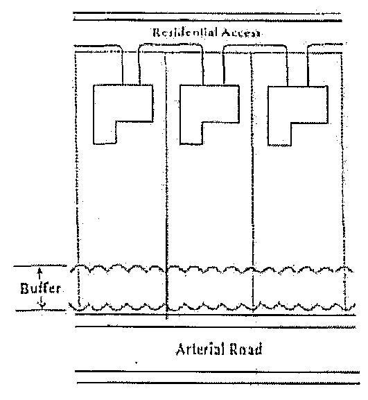
Figure 2—Access from a Shared Access Road
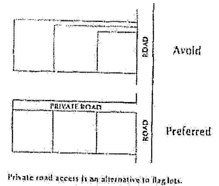
Source: Model Land Development and Subdivision Regulations That Support Access Management (Center for Urban Transportation Research, University of South Florida)
(4)
Joint and cross access. Adjacent industrial, commercial or office properties and compatible major traffic generators (i.e., shopping plazas, office parks, apartments, etc.) shall provide cross access drives or rights-of-way to allow circulation between sites. This requirement shall also apply to the re-development of existing properties to the extent feasible. Property owners shall record a cross access easement or right-of-way and a joint maintenance agreement with the property deed. A right-of-way for future joint and cross access may be required in some cases.
Figure 3—Joint and Cross Access
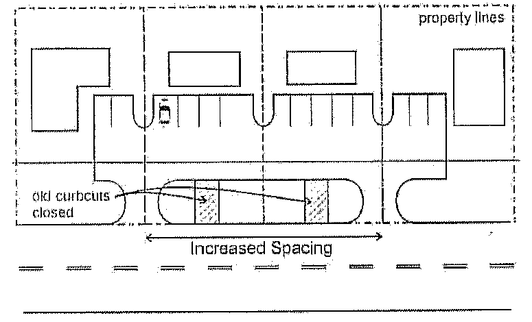
Source: US 19 Overlay District (Florida Department of Transportation, 2001)
(5)
Access or frontage roads. Access or frontage roads shall be designed, constructed and maintained per town road standards.
(6)
Access location and design.
a.
All accesses within this overlay district are subject to access permits through the state agency of transportation. All accesses shall be consistent with the state agency of transportation B-71 standards for residential and commercial drives and are subject to the state agency of transportation access management program guidelines.
b.
The state agency of transportation, in coordination with the development review board, may require turning lanes or medians where deemed necessary due to traffic volumes or where safety or operational problems exist.
c.
Each lot shall have no more than one access. Accesses with more than one entry lane and one exit lane shall incorporate channelization features to separate the entering and exiting traffic at the access.
d.
Accesses shall be provided with adequate storage (or "throat length") for entering and exiting vehicles to reduce unsafe conflicts with through traffic or on-site traffic circulation, and to avoid congestion at the entrance.
Figure 4—Commercial Access with Adequate Storage
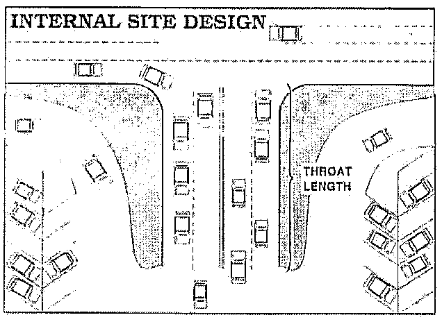
Source: Model Land Development and Subdivision Regulations That Support Access Management (Center for Urban Transportation Research, University of South Florida)
(7)
Bicycle and pedestrian access.
a.
Opportunities for bicycle and pedestrian mobility should be enhanced through site plan review objectives, and bicycle and pedestrian facilities should be provided to reduce automobile use and increase accessibility between neighborhoods, schools, recreation areas, shopping areas or employment centers. These facilities shall be consistent with the state pedestrian and bicycle facility planning and design manual.
b.
Commercial development shall support bicycle and pedestrian mobility, and make connections to adjacent commercial areas or lots.
c.
Bicycle and pedestrian facilities may be incorporated into the required landscape buffer.
(8)
Change in use. Existing properties with access connections that do not meet the requirements of the highway corridor overlay district shall be subject to these provisions when there is any change in use or expansion of use.
(Ord. No. O-2019-2, art. 2, tab. 2.19, 9-23-2019; Ord. No. 2022-2, 10-24-2022)
Sec. 30-522. - Implementation.
(a)
When granting site plan approval for projects located all or in part within the highway corridor overlay district, in accordance with section 30-722, the development review board shall establish conditions designed to implement the requirements of this subdivision.
(b)
One additional copy of each site plan and application materials shall be submitted to the state agency of transportation utilities and permits section. The utilities and permits section shall have 30 days to review each site plan and provide recommendations to the development review board. The development review board when granting site plan approval shall consider recommendations from the utilities and permits section.
(c)
The administrative officer shall administer complaints regarding violations of this subdivision in accordance with all applicable provisions of this chapter and the Vermont Planning and Development Act, 24 V.S.A. § 4301 et seq. Violations of state access permits shall be administered by the state agency of transportation.
(d)
An applicant development review board may apply for a waiver to reduce one or more of the dimensional standards in this subdivision where site conditions do not allow for compliance with these standards. For a complete application, the applicant should document clearly the reasons why the standards cannot be met.
(Ord. No. O-2019-2, art. 2, tab. 2.19, 9-23-2019; Ord. No. 2022-2, 10-24-2022)
Sec. 30-553.- Purpose.
(a)
The downtown design control overlay district was created to further revitalization of downtown Springfield in accordance with 24 V.S.A. §§ 4414(1)(E) and 4433(4).
(b)
The downtown design control overlay district has a unique character, found in our buildings, streetscape, and the natural surroundings of the Black River and Comtu Falls. This character is found throughout our history and gives the community its identity. The character of the downtown design control overlay district reflects the community's economic history, way of life, and the interaction of both with the natural and built environment. Attempts shall be made to preserve as much of a building's original design, details and materials as is feasible.
(c)
Sympathetic new design can be a positive contribution to the character of a district. Historical, architectural and visual integrity can be maintained while present and future needs are met. To acknowledge growth and character, existing buildings, and structures should be recognized as products of their own time. Rather than copying a particular style, new construction shall be complementary to the configuration of existing buildings and streetscapes, and shall relate to the traditional materials, scale, proportions, shapes and rhythms of the surrounding neighborhood.
(Ord. No. O-2019-2, § 2.20, 9-23-2019; Ord. No. 2022-2, 10-24-2022)
Sec. 30-554. - Location of the district.
(a)
The downtown design control overlay district is the same as the designated downtown, and substantially the same as the downtown historic district and the central business zoning district.
(b)
In accordance with the map attached to the ordinance from which this chapter is derived, the downtown design control overlay district will include:
(1)
Both sides of Main Street;
(2)
The Miller Art Center, so-called, on Elm Hill;
(3)
Valley Street from Main Street to the first corner, including the town parking lot, and the Bishop parcel, so-called;
(4)
The westerly side of River Street from Main Street to the Fellows Footbridge, so-called;
(5)
The north and easterly side of Mineral Street;
(6)
The state office property located at 100 Mineral Street;
(7)
Both sides of Park Street from Main Street to Pearl Street, including the Park Street School property; and
(8)
The northeasterly side of Pearl Street to Morgan Street, except for the six private dwelling properties on the northeasterly side of Pearl Street.
(Ord. No. O-2019-2, § 2.20, 9-23-2019; Ord. No. 2022-2, 10-24-2022)
Sec. 30-555. - Exceptions to design approvals.
Within the downtown design control overlay district, all land uses and development allowed (permitted or conditional) in the base zoning district are allowed and require design approval from the development review board or administrative officer, after review and comment by the downtown design review advisory commission, except for the following:
(1)
Subdivision of land.
(2)
Interior alteration or a change in use that will not result in any exterior modifications.
(3)
Exterior modifications to a noncontributing structure that will not be visible from the street.
(4)
Non-substantial alterations as determined by the administrative officer.
(Ord. No. O-2019-2, § 2.20, 9-23-2019; Ord. No. 2022-2, 10-24-2022)

