
Stafford County Unincorporated
City Zoning Code
City Zoning Code
ARTICLE III
GENERAL DISTRICT USE REGULATIONS AND STANDARDS
Sec. 28-31.- Purpose and intent.
The purposes of this article are:
(1)
To ensure that all development is consistent with the goals, objectives and policies of the County of Stafford;
(2)
To ensure a series of permitted uses for each land use district established in this article;
(3)
To ensure that every use within each district is compatible with other uses in that district;
(4)
To take into account the environmental sensitivity of natural resources; and
(5)
To ensure that development is served by adequate public services.
(Ord. No. O94-29, § 28-301, 8-9-94)
Sec. 28-32. - Applicability.
Each district is served by a set of regulations which control the use of land within that district. All development within each land use district shall be in conformance with the regulations set forth for that district.
(Ord. No. O94-29, § 28-302, 8-9-94)
Sec. 28-33. - Districts generally.
With the exception of the Marine Corps Combat Development Command (MCCDC), the unincorporated areas of the county are hereby divided into the following zoning districts:
A-1 Agricultural
A-2 Rural Residential
R-1 Suburban Residential
R-2 Urban Residential—Medium Density
R-3 Urban Residential—High Density
R-4 Manufactured Home
R-5 Age-Restricted Housing
B-1 Convenience Commercial
B-2 Urban Commercial
B-3 Office
RBC Recreational Business Campus
RC Rural Commercial
SC Suburban Commercial
M-1 Light Industrial
M-2 Heavy Industrial
PD-1 Planned Development—1
PD-2 Planned Development—2
LC—Life Care/Retirement Community
P-TND Planned-Traditional Neighborhood Development
HI Heritage Interpretation
RDA-1 Redevelopment Area 1, Boswell's Corner
UD Urban Development
Land may also be classified into the following special overlay zoning districts:
AD Airport Impact Overlay
FH Flood Hazard Overlay
FR Falmouth Redevelopment Area Overlay
HC Highway Corridor Overlay
HG Historic Gateway Corridor Overlay
HR Historic Resource Overlay
ICTP Integrated Corporate and Technology Park Overlay
MZ Military Facility Impact Overlay
RP Reservoir Protection Overlay
(Ord. No. 094-29, § 28-303, 8-9-94; Ord. No. 099-26, 7-13-99; Ord. No. O05-21, 3-15-05; Ord. No. O07-39, 7-17-07; Ord. No. O07-68, 10-2-07; Ord. No. O08-02, 5-6-08; Ord. No. O11-14, 6-21-11; Ord. No. O12-01, 2-21-12; Ord. O14-10, 12-16-14; Ord. No. O16-24, 10-18-16; Ord. No. O17-03, 5-2-17; Ord. No. O17-08, 10-3-17)
Sec. 28-34. - Purpose of districts.
In order to carry out and implement the purposes and objectives of this chapter, the land use districts herein established shall have the following purposes, respectively:
A-1 Agricultural. The purpose of the A-1 district is to reserve areas for traditional agricultural activities and to provide for their continuation as well as preservation of areas of rural character.
A-2 Rural Residential. The purpose of the A-2 district is to provide a transition between rural and urban areas, in residential areas adjacent to the growth areas which allow increased densities from the A-1 district when public water or sewer are provided.
R-1 Suburban Residential. The purpose of the R-1 district is to provide areas which are in close proximity to existing or future development of equivalent or higher densities, and which are intended for low density residential development were public water and sewerage facilities are available. Development in the R-1 district is intended to be characterized by single-family dwellings.
R-2 Urban Residential—Medium Density. The purpose of the R-2 district is to provide areas of medium-intensity residential uses designed and intended to be primarily characterized by townhouses, duplexes and single-family homes. Such districts are to be located near centers of urban concentrations, only where approved water and sewerage are available and where transportation systems are adequate.
R-3 Urban Residential—High Density. The purpose of the R-3 district is to provide areas of high-intensity residential uses designed and intended to be primarily characterized by multifamily dwellings and townhouses. Such districts are to be located at centers of urban concentrations, only where approved water and sewerage are available and where transportation systems are adequate.
R-4 Manufactured Home. The purpose of the R-4 district is to establish areas of the county which are intended for the accommodation of transportable single-family dwelling units, registered and identified by the State of Virginia as manufactured homes, formerly known as mobile homes. It is intended that these manufactured homes be located in high-density, year-round, park-type developments or subdivisions where all necessary public facilities are available and in close proximity to major roads capable of handling high volumes of traffic.
R-5 Age-Restricted Housing. The purpose of the R-5 district is to provide areas of high- intensity residential uses designed and intended to be multifamily dwellings for persons fifty-five (55) years in age or older, in accordance with all federal and state laws and regulations. Such districts are to be located within the designated urban services area and outside of the military impact areas in the comprehensive plan, where public water and sewer are available and transportation systems are adequate.
B-1 Convenience Commercial. The purpose of the B-1 district is to provide areas for selected retail shopping and personal services to serve only the needs of the adjacent urban residential areas. Such areas are intended to be located only at strategic sites in relation to population centers and transportation networks.
B-2 Urban Commercial. The purpose of the B-2 district is to designate appropriate areas for high-intensity commercial uses intended to serve retail sales and service, business and professional service needs at a regional or countywide scale. These areas should be located at strategic nodes along arterial and major collector roads where there are adequate utilities and facilities to serve intense development.
B-3 Office. The purpose of the B-3 district is to provide areas of the county for the location of professional offices and office parks. Such areas should be located as transitional areas between commercial and residential uses.
RBC Recreational Business Campus. The purpose of the RBC district is to provide areas for professional office, general office, research and development, hotel, conference facilities, low to medium intensity retail, health and fitness clubs, executive style housing, retirement housing, active recreational activities and other specified uses in a business campus environment integrated with activities dependent on significant areas of open space such as golf courses, marinas, and/or nature and wildlife preserves. This district should be located near significant environmental features such as forests, lakes with at least five (5) acres of surface water area and/or rivers and where there is provision for adequate access to major collector or higher category roadways and public sewer and water utilities.
RC Rural Commercial. The purpose of the RC district is to provide commercial uses for the convenience of nearby rural populations at intersections of arterial and major collector roads and in structures not exceeding ten thousand (10,000) square feet of gross floor area.
RDA-1 Redevelopment Area 1, Boswell's Corner. The purpose of the RDA-1 district is to establish land-use planning and urban design standards through form-based codes that promote the creation of a pedestrian-friendly destination neighborhood at the northern gateway to the county, with a focus on development of an employment center with a mix of uses, including educational and entertainment uses, supporting retail, and higher-density residential, with architectural variety, a network of streets that may include on-street parallel parking, and recreational opportunities.
SC Suburban Commercial. The purpose of the SC district is to establish areas for commercial uses designed and intended primarily to serve the needs of the immediate neighborhood in which they are located. This district should be established at locations conveniently accessible to suburban residential areas without exceeding the design capacity of road intersections serving the site.
M-1 Light Industrial. The purpose of the M-1 district is to establish areas of the county to provide for certain types of business and industrial uses characterized by light manufacturing, fabricating, warehousing and wholesale distribution, which are relatively free from offensive activities and which, with proper performance standards, will not detract from residential or commercial desirability of adjacent properties. It is intended that the M-1 district encourage the development of parks for the location of these uses. These districts should be located only where all necessary public utilities are available and where transportation systems are adequate.
M-2 Heavy Industrial. The purpose of the M-2 district is to provide areas within the county suitable for a variety of industrial type uses which may not be compatible with residential uses due to some potential nuisance or hazard. The development of "industrial parks" in the M-2 district are encouraged. Conditional use permits are required for most uses within the M-2 district to assure protection of the general public and surrounding properties. These districts should only be located where all necessary public utilities are available and where transportation systems are adequate.
PD-1 Planned Development-1. The purpose of the PD-1 district is to provide areas of the county of not less than one hundred fifty (150) acres, nor more than five hundred (500) acres which are suitable for a planned, mixed use suburban development with a variety of housing types and commercial uses intended to serve the immediate community. This district should be located only where approved water and sewerage are available or planned and where transportation systems are adequate.
PD-2 Planned Development-2. The purpose of the PD-2 district is to provide areas of the county of not less than five hundred (500), nor more than seven hundred sixty (760) acres which are suitable for a planned, neotraditional mixed use development with a variety of housing types and commercial uses intended to serve the immediate community. This district should be located only where approved water and sewerage are available or planned and where transportation systems are adequate. An exception to the minimum acreage requirement is permitted for reclassification to the PD-2 district of one or more parcels located adjacent to an existing PD-2 district, in accordance with subsection 28-53(c)(6).
LC—Life Care/Retirement Community. The purpose of the LC district is to provide areas for the continuing care of elderly, providing for transitional housing progressing from independent living in various dwelling units, with or without kitchen facilities, and culminating in nursing home care, where all related uses are located on the same lot or adjacent lots (which includes lots separated by a public right-of-way). The community may include life care facilities that provide services integral to the personal and therapeutic care of the residents thereof and shall be licensed and regulations as a home for adults under Code of Virginia, § 63.1, as amended, or any successors legislation. Such districts are to be located only where approved water and sewerage are available and where transportation systems are adequate.
P-TND Planned - Traditional Neighborhood Development. The purpose of the P-TND is to provide areas of the county which are suitable for an approach to land-use planning and urban design that promotes the development or redevelopment of pedestrian-friendly neighborhoods with a mix of uses, housing types and prices, lot sizes and density, architectural variety, a central civic building and use, a network of streets and alleys that may include on-street parallel parking, and defined development edges.
AD Airport Impact. The purpose of the AD district is to provide an overlay zone in areas which are subject to intense and/or frequent emissions of noise and vibration from airports as well as prevent obstructions of airport zones which may result in an air navigation hazard.
FH Flood Hazard. The purpose of the FH district is to provide for an overlay zone with limitations on development in areas likely to be inundated by the 100-year flood event, as defined by current flood insurance rate maps (FIRMs) for Stafford County, in order to protect life and property and to prevent or minimize flood damage.
Falmouth Redevelopment Area. The purpose of the FR district is to provide suitable and sufficient opportunities for redevelopment through new construction and reuse of existing buildings while maintaining the historic nature and cultural context of the Falmouth area of the county.
HC Highway Corridor. The purpose of the HC district is to provide an overlay zone along developed and rapidly developing high traffic road facilities where appropriate special standards for such corridors would address access and design needs.
HG Historic Gateway Corridor. The purpose of the HG district is to implement the goals of the comprehensive plan by protecting cultural resources by guiding new development along major entrance routes to the designated areas.
HI Heritage Interpretation. The purpose of the HI district is:
(1)
To reserve areas in all regions of the county for interpretation of heritage sites and to retain the setting and feeling of the cultural landscape.
(2)
To permit restoration, preservation, conservation, education, research and business activities related to the operation of a museum and other historic sites in Stafford County.
(3)
To provide heritage tourism opportunities.
(4)
To promote the preservation and enhancement of unique Stafford County cultural resources.
HR Historic Resource. The purpose of the HR district is to provide for the protection of historic resources in the county.
MZ Military Facility Impact. The purpose of the MZ district is to provide an overlay zone to address the interaction between military facilities and surrounding land uses.
RP Reservoir Protection. The purpose of the RP district is to provide an overlay zone which requires best management practices (BMPs) and other protective measures in areas critical to the integrity of public water supplies, rivers and streams, and other sensitive features.
UD Urban Development. The purpose of the UD district is to provide for areas of the county that are suitable for an urban approach to land-use planning and urban design that promotes the development or redevelopment of pedestrian-friendly, walkable neighborhoods with a mix of uses and housing types served by an interconnected network of streets. The UD district shall only be applied to property located within a targeted growth area designated on the future land use map in the comprehensive plan. To meet the intent and purpose of the district, each UD district is comprised of one or more of the following subdistricts:
(1)
Residential Single Family Dwellings (UD-2). In addition to detached houses and attached houses, the UD-2 subdistrict allows townhouses at a density of at least six (6) units per acre. Allowed nonresidential uses also include places of worship, schools, and other civic uses.
(2)
Residential Mixed Use (UD-3). In addition to townhouses, the UD-3 subdistrict allows apartments at a density of at least twelve (12) units per acre and buildings up to three stories in height. The subdistrict allows limited retail and services subject to use standards that limit the size, scale, and location.
(3)
Mixed Use Village Center (UD-4). The UD-4 subdistrict is a mixed use district allowing retail, office and residential uses in a variety of building types up to four (4) stories in height. Residential configurations include townhouses, apartments and upper floors of mixed use buildings. The subdistrict accommodates a floor area ratio (FAR) of at least 0.4.
(4)
Mixed Use Urban Center (UD-5). The UD-5 subdistrict is a mixed use district allowing retail, office and residential uses in a variety of building types up to five (5) stories in height. Residential configurations include townhouses, apartments, and upper floors of mixed use buildings. The subdistrict accommodates a floor area ratio (FAR) of at least 0.4.
ICTP Integrated Corporate and Technology Park. The purpose of the ICTP district is to promote the integration of uses to facilitate the growth and development of large scale corporate office and technology parks. Such parks have the need for and shall include integrated uses such as Class A office space, hotel space for corporate clientele, supporting retail services, data centers, child care, and multifamily housing for employees working in the district and nearby area. Such districts shall be designed to accommodate at least four hundred thousand (400,000) square feet of existing corporate office space for services such as engineering, security, computer systems development, computer software development, education, and research and development.
(Ord. No. 094-29, § 28-304, 8-9-94; Ord. No. 099-26, 7-13-99; Ord. No. 003-03, 7-1-03; Ord. No. O05-21, 3-15-05; Ord. No. O07-39, 7-17-07; Ord. No. O07-68, 10-2-07; Ord. No. O08-02, 5-6-08; Ord. No. O11-14, 6-21-11; Ord. No. O12-01, 2-21-12; Ord. O14-10, 12-16-14; Ord. No. O16-24, 10-18-16; Ord. No. O17-03, 5-2-17; Ord. No. O17-08, 10-3-17; Ord. No. O17-27, 10-17-17; Ord. No. O21-10, 6-15-21)
Sec. 28-35. - Table of uses and standards.
Table 3.1, District Uses and Standards, sets forth the uses and standards for each zoning district in Stafford County. No land or structure shall be used, occupied or developed except in accordance with the standards set forth therein.
(Ord. No. 094-29, § 28-305, 8-9-94; Ord. No. O05-21, 3-15-05)
Table 3.1. District Uses and Standards
A-1 Agricultural.
The purpose of the A-1 district is to reserve areas for traditional agricultural activities and to provide for their continuation as well as preservation of areas of rural character.
(a)
Uses permitted by right:
Accessory dwelling.
Agricultural operation for livestock/poultry. (If such operation is located on property less than two (2) acres, a conservation farm plan approved by the Tri-County City Soil and Water Conservation District (SWCD) or other applicable agency must be provided.)
Agriculture.
Agri-tourism activity.
Aquaculture.
Automobile avocation.
Cemetery.
Cemetery, churchyard (as exempted from zoning regulation by Code of Virginia, § 57-26).
Cemetery, family (as exempted from zoning regulation by Code of Virginia, § 57-26).
Equestrian use and bridle path.
Farm brewery.
Farm winery.
Farmers market (in accordance with subsection 28-39(v)).
Feedlot with a 900-foot setback from any perennial stream.
Forestry on a minimum of twenty (20) acres with a plan approved by the department of forestry and/or a certified consulting forester.
Group family day care home (in accordance with subsection 28-39(g)).
Home business I.
Home occupation.
Kennel, non-commercial.
Manufactured home qualifying as a single-family home under Virginia Code.
Park and playground.
Place of worship.
Plant and tree nursery/greenhouse on a minimum of five (5) acres.
Public facilities/utilities but not including generating facilities, substations, switching stations, and wastewater treatment facilities which are permitted as a conditional use permit, and not including propane and heating fuel distribution facilities.
Public works excluding wastewater treatment facilities.
Sawmill and ancillary products not part of a timbering operation, on a minimum of five (5) acres.
Secondary dwelling fifty (50) or more years in age upon referral of the Stafford County Historic Commission.
Single-family dwelling.
Slaughter and animal processing incidental to agricultural intensive use on a minimum of ten (10) acres and inspected by the Virginia Department of Agriculture and Consumer Services (VDACS).
Small family day care.
Veterinary clinic without boarding facilities.
Wayside stand.
Wetland mitigation bank.
(b)
Conditional use permit:
Airport, private.
Campground on a minimum of ten (10) acres.
Child care center.
Commercial tree stump grinding and mulch sale.
Communication facility.
Energy storage facility.
Golf course.
Horseracing.
Hotel/motel.
Indoor flea market.
Kennel, commercial.
Marina with or without accessory boat sales.
Nursing home.
Outdoor flea market.
Public facilities/utilities for generating facilities, substations, switching stations and wastewater treatment facilities (except for the expansion or modification to a wastewater treatment facilities existing prior to October 17, 2006).
School.
Solar facility.
Test lane facility.
(c)
Special exception:
Agricultural service establishment on lots greater than or equal to five (5) acres.
Animal feeding operation.
Bed and breakfast inn.
Club/lodge/fraternal organization.
Community use.
Event venue on lots greater than twenty (20) acres and in compliance with all state and local codes including, but not limited to, Virginia Department of Health regulations.
Home-based rescue.
Home business II.
Rural home business.
Turkey shoot.
Veterinary clinic with boarding facilities.
(d)
Requirements:
(1)
Intensity:
Open space requirement for cluster subdivision—fifty (50) percent of total subdivision tract.
Open space ratio for public works, cemetery, club, lodge, fraternal organization, schools, and places of worship ..... 0.50
Open space ratio, other uses ..... 0.80 ratio
(2)
Minimum lot area (acres):
Conventional subdivision ..... 3
Cluster subdivision ..... 1.5
Family subdivision ..... 3
(3)
Gross density:
(a)
One dwelling unit per six (6) acres.
(b)
Gross density shall be based on the area of each parent parcel, defined below, as of March 2, 2021. A parent parcel is the lot of record from which any new lot or lots are created after March 2, 2021. Each time a parent parcel is divided, the determination of the number of new dwelling units that can be created will be based upon the difference between the gross density of the parent parcel as of March 2, 2021 less the number of dwelling units which have previously been subdivided from the parent parcel after March 2, 2021.
(c)
The gross density of any lot less than twelve (12) acres in size is one dwelling unit and such lots cannot be further subdivided.
(d)
A family subdivision, meeting all requirements in section 22-5(a), shall be exempt from the application of gross density in subdividing the parcel.
(4)
Maximum density with TDR's : ..... 2.25 du/acre
(TDR developments limited to single-family detached dwellings)
(5)
Minimum yards: (Feet)
Conventional subdivision:
Front ..... 50
Side ..... 20
Rear ..... 35
Cluster subdivision:
Front ..... 40
Side ..... 10
Rear ..... 35
(6)
Maximum height (in feet) ..... 35
(7)
Minimum lot width (in feet):
Conventional subdivision ..... 200
Cluster subdivision ..... 100
(8)
Cluster designed subdivisions are permitted on parcels within the boundary established on the map entitled "Cluster Subdivision Areas." [See section 28-41.]
(Ord. No. 094-29, 8-9-94; Ord. No. 095-10, 3-7-95; Ord. No. 095-41, 5-16-95; Ord. No. 095-49, 6-20-95; Ord. No. 096-05, 1-2-96; Ord. No. 096-09, 2-6-96; Ord. No. 097-13, 1-21-97; Ord. No. 097-19, 2-18-97; Ord. No. 097-35, 5-6-97; Ord. No. 000-28, 5-16-00; Ord. No. 000-73, 9-12-00; Ord. No. 001-27, 5-1-01; Ord. No. 002-08, 3-19-02; Ord. No. 002-17, 6-18-02; Ord. No. O03-29, 6-17-03; Ord. No. O05-21, 3-15-05; Ord. No. O06-83, 10-17-06; Ord. No. O07-66, 9-4-07; Ord. No. O09-13, 6-16-09; Ord. No. O10-12, 3-2-10; Ord. No. O12-04, 3-20-12; Ord. No. O12-07, 6-19-12; Ord. No. O12-17, 6-19-12; Ord. No. O12-29, 12-4-12; Ord. No. O13-04, 2-19-13; Ord. No. O13-21, 2-19-13; Ord. No. O13-09, 3-19-13; Ord. No. O13-38, 9-17-13; Ord. No. O14-04, 2-4-14; Ord. No. O18-13, 3-20-18; Ord. No. O18-06, 12-11-18; Ord. No. O19-02, 1-22-19; Ord. No. O19-21, 10-1-19; Ord. No. O20-19, 8-18-20; Ord. No. O20-43, 10-29-20; Ord. No. O21-07, 3-2-21; Ord. No. O21-24, 9-21-21; Ord. No. O22-18, 9-20-22Ord. No. O23-01, 5-16-23; Ord. No. O25-07, 6-17-25)
A-2 Rural Residential.
The purpose of the A-2 district is to provide a transition between rural and urban areas, where public water and sewer utilities may be provided.
(a)
Uses permitted by right:
Accessory dwelling.
Agriculture.
Aquaculture.
Automobile avocation.
Bed and breakfast inn.
Community use.
Equestrian use and bridle path.
Farmers market (in accordance with subsection 28-39(v)).
Golf course.
Group family day care home (in accordance with subsection 28-39(g)).
Home business I.
Home occupation.
Manufactured home.
Noncommercial kennel.
Park and playground.
Place of worship.
Public facilities/utilities but not including generating facilities, substations, switching stations and wastewater treatment facilities which are permitted as a conditional use permit and not including propane and heating fuel distribution facilities.
Public works excluding wastewater treatment facilities.
School.
Single-family dwelling.
Small family day care.
Wetland mitigation bank.
(b)
Conditional use permit:
Club, lodge, fraternal organization.
Communication facility.
Hospital.
Marina.
Nursing home.
Public facilities/utilities for generating facilities, substations, switching stations and wastewater treatment facilities (except for the expansion or modification to a wastewater treatment facilities existing prior to October 17, 2006).
Recreational enterprise.
(c)
Special exception:
Home business II.
Parking and storage of commercial vehicles.
(d)
Requirements:
(1)
Intensity:
Open space requirement for cluster subdivision - thirty (30) percent of total subdivision tract.
Open space ratio for public works, cemetery, club, lodge, fraternal organization, schools, and places of worship ..... 0.50
Open space ratio, other uses ..... 0.80 ratio
(2)
Minimum lot area (acres):
Conventional subdivision ..... 1
Cluster subdivision ..... 0.7
(3)
Minimum yards: (Feet)
Conventional subdivision:
Front ..... 40
Side ..... 10
Rear ..... 35
Cluster subdivision:
Front ..... 30
Side ..... 10
Rear ..... 25
(4)
Maximum height (in feet) ..... 35
(5)
Minimum lot width (in feet):
Conventional subdivision ..... 100
Cluster subdivision ..... 80
(6)
Cluster designed subdivisions are permitted on parcels within the boundary established on the map entitled "Cluster Subdivision Areas." [See section 28-41.]
(Ord. No. 094-29, 8-9-94; Ord. No. 095-10, 3-7-95; Ord. No. 095-41, 5-16-95; Ord. No. 095-49, 6-20-95; Ord. No. 096-09, 2-6-96; Ord. No. 097-18, 2-18-97; Ord. No. 097-19, 2-18-97; Ord. No. 002-17, 6-18-02; Ord. No. O03-29, 6-17-03; Ord. No. O06-83, 10-17-06; Ord. No. O07-66, 9-4-07; Ord. No. O09-13, 6-16-09; Ord. No. O12-04, 3-20-12; Ord. No. O12-07, 6-19-12; Ord. No. O12-17, 6-19-12; Ord. No. O13-38, 9-17-13; Ord. No. O18-13, 3-20-18; Ord. No. O18-06, 12-11-18; Ord. No. O19-02, 1-22-19)
R-1 Suburban Residential.
The purpose of the R-1 district is to provide areas which are in close proximity to existing or future development of equivalent or higher densities, and which are intended for low-density residential development where public water and sewerage facilities are available. Development in the R-1 district is intended to be characterized primarily by single-family dwellings.
(a)
Uses permitted by right:
Accessory dwelling.
Apiary, as accessory use (in accordance with subsection 28-39 (aa)).
Community use.
Farmers market (in accordance with subsection 28-39(v)).
Group family day care home.
Home business I.
Home occupation.
Park and playground.
Place of worship within a Historic Resource (HR) overlay zoning district.
Public facilities/utilities but not including generating facilities, substations, switching stations and wastewater treatment facilities which are permitted as a conditional use permit and not including propane and heating fuel distribution facilities.
Public works excluding wastewater treatment facilities.
School.
Single-family dwelling.
Small family day care.
(b)
Conditional use permit:
Bed and breakfast inn.
Cluster subdivision, maximum, density 2.25 du/acre, on parcels within the boundary established on the map entitled "Cluster Subdivision Areas." [See section 28-41.]
Golf course.
Marina.
Nursing home.
Place of worship (except for a place of worship located within a Historic Resource (HR) overlay zoning district).
Public facilities/utilities for generating facilities, substations, switching stations and wastewater treatment facilities (except for the expansion or modification to a wastewater treatment facilities existing prior to October 17, 2006).
Recreational facility.
(c)
Special exception:
Home business II.
Keeping of horses and ponies on three-acre or larger lots.
(d)
Requirements:
(1)
Intensity:
Allocated density for conventional subdivision ..... 1.5 du/ac
Open space ratio for conventional subdivision ..... 0.50
Allowable density for cluster subdivision (see conditional use permit ..... 1.5 du/ac
Open space requirement for cluster subdivision - thirty (30) percent of total subdivision tract.
Maximum density with TDR's ..... 14.0 du/acre
TDR developments may include:
Townhouses at up to ..... 6.0 du/acre
Multifamily dwellings at up to ..... 14.0 du/acre
Open space ratio ..... .0.5
Open space ratio with TDR's ..... .0.25
(2)
Minimum yards: (Feet)
Conventional subdivision:
Front ..... 30
Side ..... 10
Rear ..... 35
Cluster subdivision:
Front ..... 30
Side ..... min. 8 total 18
Rear ..... 25
Minimum lot size ..... 8,000 s.f.
(3)
Maximum height (in feet) ..... 35
(4)
Minimum lot width (feet):
Conventional subdivision ..... 80
Cluster subdivision ..... 60
(5)
Cluster designed subdivisions are permitted on parcels within the boundary established on the map entitled "Cluster Subdivision Areas." [See section 28-41.]
(Ord. No. 094-29, 8-9-94; Ord. No. 095-10, 3-7-95; Ord. No. 095-38, 5-16-95; Ord. No. 095-49, 6-20-95; Ord. No. 096-09, 2-6-96; Ord. No. 097-13, 1-21-97; Ord. No. 099-45, 8-17-99; Ord. No. 000-22, 10-17-00; Ord. No. O06-83, 10-17-06; Ord. No. O09-13, 6-16-09; Ord. No. O12-17, 6-19-12; Ord. No. O13-21, 2-19-13; Ord. No. O13-02, 3-5-13; Ord. No. O15-10, 5-5-15; Ord. No. O18-13, 3-20-18; Ord. No. O18-06, 12-11-18; Ord. No. O19-02, 1-22-19; Ord. No. O20-09, 3-3-20)
R-2 Urban Residential—Medium Density.
The purpose of the R-2 district is to provide areas of medium density residential uses designed and intended to be primarily characterized by multifamily dwellings, duplexes and townhouses. Such districts are to be located near centers of urban concentrations, only where approved water and sewerage are available and where transportation systems are adequate.
(a)
Uses permitted by right:
Atrium house dwellings.
Community use.
Duplex.
Farmers market (in accordance with subsection 28-39(v)).
Group family day care home.
Home business I.
Home occupation.
Lot line dwellings.
Multifamily dwelling.
Park and playground.
Patio house dwellings.
Public facilities/utilities but not including generating facilities, substations, switching stations and wastewater treatment facilities which are permitted as a conditional use permit and not including propane and heating fuel distribution facilities.
Public works excluding wastewater treatment facilities.
School.
Single-family dwelling.
Small family day care.
Townhouse.
Village house dwellings.
Weak-link townhouse dwellings.
(b)
Conditional use permit:
Assisted living facility.
Golf course.
Marina.
Nursing home.
Place of worship.
Public facilities/utilities for generating facilities, substations, switching stations and wastewater treatment facilities (except for the expansion or modification to a wastewater treatment facilities existing prior to October 17, 2006).
Recreational facility.
Retirement housing.
(c)
Special exception:
Home business II.
(d)
Requirements:
(1)
Intensity:
Allocated density ..... 3.5 du/ac
Open space ratio ..... 0.25 ratio
*For duplex structures, the minimum width of any individual side yard is three (3) feet, and the minimum total width between nonattached structures is fifteen (15) feet.
**For multi-family structures, the minimum setback is thirty-five feet from any public right-of-way, and thirty (30) feet from any other structure.
***For lot line dwellings, the minimum width of any individual side yard is five (5) feet, and the minimum total width between structures is twenty (20) feet.
(Ord. No. 094-29, 8-9-94; Ord. No. 095-10, 3-7-95; Ord. No. 095-49, 6-20-95; Ord. No. 096-09, 2-6-96; Ord. No. 099-42, 7-13-99; Ord. No. 099-45, 8-17-99; Ord. No. 000-41, 8-8-00; Ord. No. 000-22, 10-17-00; Ord. No. O06-83, 10-17-06; Ord. No. O07-68, 10-2-07; Ord. No. O09-13, 6-16-09; Ord. No. O15-10, 5-5-15; Ord. No. O18-13, 3-20-18; Ord. No. O18-05, 4-17-18; Ord. No. O18-06, 12-11-18; Ord. No. O19-02, 1-22-19)
R-3 Urban Residential—High Density.
The purpose of the R-3 district is to provide areas of high density residential uses designed and intended to be primarily characterized by multifamily dwellings and townhouses. Such districts are to be located near centers of urban concentrations, only where approved water and sewerage are available and where transportation systems are adequate.
(a)
Uses permitted by right:
Atrium house dwellings.
Community use.
Duplex.
Farmers market (in accordance with subsection 28-39(v)).
Group family day care home.
Home business I.
Home occupation.
Lot line dwellings.
Multifamily dwelling.
Park and playground.
Patio house dwellings.
Public facilities/utilities but not including generating facilities, substations, switching stations and wastewater treatment facilities which are permitted as a conditional use permit and not including propane and heating fuel distribution facilities.
Public works excluding wastewater treatment facilities.
School.
Single-family dwelling.
Small family day care.
Townhouse.
Village house dwellings.
Weak-link townhouse dwellings.
(b)
Conditional use permit:
Assisted living facility.
Golf course.
Marina.
Nursing home.
Place of workshop [worship].
Public facilities/utilities for generating facilities, substations, switching stations and wastewater treatment facilities (except for the expansion or modification to a wastewater treatment facilities existing prior to October 17, 2006).
Recreational facility.
Retirement housing.
(c)
Special exception:
Home business II.
Public facility/utility for generating facilities, substations, switching stations and wastewater treatment facilities (except for the expansion or modification to a wastewater treatment facilities existing prior to October 17, 2006).
(d)
Requirements:
(1)
Intensity:
Allocated density ..... 7.0 du/ac
Open space ratio ..... 0.25 ratio
*For lot line dwellings, the minimum width of any side yard is five (5) feet, and the minimum total width between structures is fifteen (15) feet.
**For duplex structures, the minimum width of any individual side yard is three (3) feet, and the minimum total width between nonattached structures is fifteen (15) feet.
***For multifamily structures, the minimum setback is thirty-five (35) feet from any public right-of-way, and thirty (30) feet from any other structure.
(Ord. No. 094-29, 8-9-94; Ord. No. 095-10, 3-7-95; Ord. No. 095-49, 6-20-95; Ord. No. 096-09, 2-6-96; Ord. No. 099-42, 7-13-99; Ord. No. 099-45, 8-17-99; Ord. No. 000-41, 8-8-00; Ord. No. 000-22, 10-17-00; Ord. No. O06-83, 10-17-06; Ord. No. O07-68, 10-2-07; Ord. No. O09-13, 6-16-09; Ord. No. O15-10, 5-5-15; Ord. No. O18-13, 3-20-18; Ord. No. O18-05, 4-17-18; Ord. No. O18-06, 12-11-18; Ord. No. O19-02, 1-22-19)
R-4 Manufactured Homes.
The purpose of the R-4 district is to establish areas of the county which are intended to accommodate transportable single-family dwelling units, registered and identified by the State of Virginia as manufactured homes, formerly known as mobile homes. It is intended that these manufactured homes be located in high density, yearround park type developments where all necessary public facilities are available and in close proximity to major roads capable of handling high volumes of traffic.
(a)
Uses permitted by right:
Community facility.
Farmers market (in accordance with subsection 28-39(v)).
Group family day care home.
Home occupation.
Manufactured home park.
Manufactured home subdivision.
Manufactured home/mobile home.
Park and playground.
Parking of tractors for use in the manufactured home park.
Public facilities/utilities but not including generating facilities, substations, switching stations and wastewater treatment facilities which are permitted as a conditional use permit and not including propane and heating fuel distribution facilities.
Public works excluding wastewater treatment facilities.
Small family day care home.
(b)
Conditional use permit:
Public facilities/utilities for generating facilities, substations, switching stations and wastewater treatment facilities (except for the expansion or modification to a wastewater treatment facilities existing prior to October 17, 2006).
Recreational facility.
(c)
Requirements:
(1)
Intensity:
Allocated density ..... 7.0 du/ac
Open space ratio ..... 0.30 ratio
(2)
Minimum yards: Feet
Front ..... 15
Side ..... 5
Back ..... 5
(3)
Maximum height (in feet) ..... 35
(4)
Minimum lot width (in feet):
Single wide ..... 40
Double wide ..... 50
(Ord. No. 094-29, 8-9-94; Ord. No. 095-10, 3-7-95; Ord. No. 095-49, 6-20-95; Ord. No. 096-09, 2-6-96; Ord. No. 099-45, 8-17-99; Ord. No. O06-83, 10-17-06; Ord. No. O09-13, 6-16-09; Ord. No. O15-10, 5-5-15)
R-5 Age-Restricted Housing
The purpose of the R-5 district is to provide areas of high-intensity residential uses designed and intended to be multifamily dwellings for persons fifty-five (55) years in age or older, in accordance with all federal and state laws and regulations. Such districts shall be located within the designated urban services area, where public water and sewer are available and transportation systems are adequate, and outside of the military impact areas in the comprehensive plan.
(a)
Uses permitted by-right:
Assisted living facility.
Community use.
Multifamily dwelling.
Retirement housing.
(b)
Conditional use permit: Allocated density greater than 15.0 du/acre, gross tract but less than or equal to 24.0 du/acre, gross tract.
(c)
Requirements:
(1)
Intensity:
Minimum gross tract size (acres) .....2
Maximum gross tract size (acres) .....15
Allocated density .....15.0
du/acre, gross tract
Open space ratio .....0.25
(2)
Minimum yards: Feet
Front ..... 15
Side ..... 15
Rear ..... 20
For multifamily dwelling structures: additional yards of thirty-five (35) feet from any public right-of-way, and thirty (30) feet from any other structure.
(3)
Maximum height .....3 stories
(4)
Maximum floor area ratio (non-residential) .....0.7
(Ord. No. O17-08, 10-3-17)
P-TND Planned-Traditional Neighborhood Development
(a)
Uses permitted by right:
Bank, lending institution with no drive-through facility.
Bed and breakfast inn, up to five (5) rooms.
Bike station.
Carry out/cafe with no drive-through facility.
Center for the arts.
Conference center.
Convention center.
Country inn, up to twelve (12) rooms.
Day care center.
Dormitory, school.
Duplex.
Dwelling, accessory.
Dwelling, atrium house.
Dwelling, attached.
Dwelling, carriage house.
Dwelling, condominium.
Dwelling, lot line.
Dwelling, multifamily.
Dwelling, patio house.
Dwelling, quadruple-attached.
Dwelling, semi-detached.
Dwelling, single-family.
Dwelling, three-family attached.
Dwelling, townhouse.
Dwelling, village house.
Exhibition center.
Funeral home.
High intensity retail uses not otherwise listed.
Home business I.
Home occupation.
Hotel.
Instruction with studio.
Kiosk.
Library.
Live/work unit.
Medical, dental office.
Medical, dental clinic.
Museum.
Open, farmers market.
Outdoor pavilion.
Place of worship.
Professional office.
Public facilities for water/sewer pump stations and water tanks.
Public works.
Push cart.
Restaurant.
Retail uses permitted by right in the B-2 zoning district.
School.
School, college or university.
School, vocational.
Telecommunication antennas as an ancillary use to an existing building or structure.
Theater, movie/multiplex,
Triplex.
(b)
Conditional use permit:
Automobile repair.
Drive-through facilities.
Golf course, minimum of eighteen (18) holes and may include practice tees and golf driving range as an accessory only.
Hospital.
Motel.
Public facilities, except for water/sewer pump stations and propane and heating fuel distribution facilities.
Substation.
Telecommunication facility.
Telecommunication facility other than antennas which are ancillary to an existing building or structure.
Vehicle fuel sales.
(c)
Requirements:
(1)
Intensity:
Minimum gross tract area/acres .....40
(Except for redevelopment, provided there is no increase of impervious area greater than ten (10) percent, no minimum gross tract area/acres for such redevelopment.)
Minimum gross tract area with TDRs .....20 acres
Allocated density .....10.0 d.u./gross tract acres
Allocated density with TDR's .....12.0 d.u./gross tract acres
Open space ratio, gross tract .....0.25
Open space ratio with TDR's, gross tract .....0.20
(2)
Refer to tables 3.5(a), 3.5(b), 3.5(c), 3.5(d), 3.5(e), 3.5(f), and 3.5(g) for additional intensity regulations within specific Transect Zones.
(Ord. No. O07-39, 7-17-07; Ord. No. O09-13, 6-16-09; Ord. No. O13-21, 2-19-13; Ord. No. O14-33, 11-13-14; Ord. No. O18-06, 12-11-18)
B-1 Convenience Commercial.
The purpose of the B-1 district is to provide areas for selected retail shopping and personal services to serve only the needs of the adjacent residential areas. Such areas are intended to be located only at strategic sites in relation to population centers and transportation networks.
(a)
Uses permitted by right:
Bakery.
Bank and lending institution.
Barber/beauty shop.
Clinic, medical and dental.
Club/lodge/fraternal organization.
Convenience center.
Convenience store.
Dance studio.
Drug store.
Dry cleaner/laundry.
Farmers market (in accordance with subsection 28-39(v)).
Flex office.
Florist.
General office use.
Gift/antique shop.
Indoor flea market.
Low intensity commercial retail.
Medical/dental office.
Medium intensity commercial retail.
Place of worship.
Plant and tree nursery.
Professional office.
Public facilities/utilities but not including generating facilities, substations, switching stations and wastewater treatment facilities which are permitted as a conditional use permit and not including propane and heating fuel distribution facilities.
Public works excluding wastewater treatment facilities.
Restaurant without a drive-through facility.
Retail food shop.
School.
School, vocational.
Tailor shop.
Veterinary clinic.
(b)
Conditional use permit:
Adult business.
Arcade.
Broadcasting station.
Car wash.
Child care center.
Drive-through.
High intensity commercial retail not otherwise listed for this district.
Hospital.
Outdoor flea market.
Pet store.
Public facilities/utilities for generating facilities, substations, switching stations and wastewater treatment facilities (except for the expansion or modification to a wastewater treatment facilities existing prior to October 17, 2006).
Recreational enterprise.
Retail photo laboratory processing.
Vehicle fuel sale and accessory auto repair.
(c)
Requirements.
(1)
Intensity: Ratio
Maximum floor area ratio ..... 0.60
Open space ratio ..... 0.30
(2)
Minimum yards: Feet
Front* ..... 40
Side** ..... 0
Back ..... 25
(3)
Maximum height (in feet) ..... 40
*Front setback may be reduced. Specified in subsection 28-59(f)(10).
** Where adjoining property is other than commercial or industrial, the side yard shall be fifteen (15) feet or greater.
(Ord. No. 094-29, 8-9-94; Ord. No. 095-10, 3-7-95; Ord. No. 096-05, 1-2-96; Ord. No. 000-35, 6-6-00; Ord. No. 002-18, 4-2-02; Ord. No. O06-01, 6-20-06; Ord. No. O06-83, 10-17-06; Ord. No. O06-73, 12-19-06; Ord. No. O07-42, 9-4-07; Ord. No. O08-61, 9-2-08; Ord. No. O09-04, 3-3-09; Ord. No. O09-13, 6-16-09; Ord. No. O10-14, 3-16-10; Ord. No. O11-10, 6-21-11; Ord. No. O12-07, 6-19-12; Ord. No. O18-08, 2-6-18)
B-2 Urban Commercial.
The purpose of the B-2 district is to designate appropriate areas for high intensity commercial uses intended to serve retail sales and service and business and professional service needs, at a regional or countywide scale. These areas should be located at strategic nodes along arterial and major collector roads where there are adequate utilities and facilities to serve intense development.
(a)
Uses permitted by right:
Adult day care center.
All uses permitted by right in the B-1 district.
Bank and lending institution.
Barber/beauty shop.
Building material sale and storage yard and mulch sale.
Car wash.
Child care center.
Clinic, medical and dental.
Club, lodge, fraternal organization.
Convenience center.
Dance studio.
Drug store.
Dry cleaner/laundry.
Farmers market (in accordance with subsection 28-39(v)).
Flex office.
Florist.
Funeral home.
General office use.
Gift/antique shop.
Hotel.
Indoor flea market.
Lot intensity commercial retail.
Lumber/building/electrical/plumbing supply with covered storage.
Machinery sale and service.
Medical/dental office.
Medium intensity commercial retail.
Motel.
Pet store.
Place of worship.
Plant and tree nursery/greenhouse.
Printing, publishing, engraving.
Professional office.
Public facilities/utilities but not including generating facilities, substations, switching stations and wastewater treatment facilities which are permitted as a conditional use permit and not including propane and heating fuel distribution facilities.
Public works excluding wastewater treatment facilities.
Recreational enterprise.
Restaurant.
Retail bakery.
Retail food shop.
School.
School, vocational.
Tailor shop.
Theater with fewer than 3,500 seats.
Wholesale business.
(b)
Conditional use permit:
Adult business.
Arcade.
Auto service.
Automobile repair.
Boat sales.
Broadcasting station.
Drive-through.
Dwelling for watchman or caretaker on premises.
Fleet parking.
Hospital.
Marina.
Motor vehicle rental.
Motor vehicle sales.
Nightclub.
Outdoor flea market.
Public facilities/utilities for generating facilities, substations, switching stations and wastewater treatment facilities (except for the expansion or modification to a wastewater treatment facilities existing prior to October 17, 2006).
Public parking lot.
Retail photo laboratory processing.
Theater with 3,500 or more seats.
Vehicle fuel sales.
Warehouse, mini-storage.
Warehouse, storage.
(c)
Special exception:
Microbrewery in accordance with subsection 28-39(w).
(d)
Requirements:
(1)
Intensity: Ratio
Maximum floor area ratio ..... 0.70
Open space ratio ..... 0.25
(2)
Minimum yards: Feet
Front* ..... 40
Side** ..... 0
Back ..... 25
(3)
Maximum height (in feet) ..... 65
* Front setback may be reduced. Specified in subsection 28-59(f)(10).
** Where adjoining property is other than commercial or industrial, the side yard shall be fifteen (15) feet or greater.
(Ord. No. 094-29, 8-9-94; Ord. No. 095-10, 3-7-95; Ord. No. 095-40, 5-16-95; Ord. No. 096-05, 1-2-96; Ord. No. 097-19, 2-18-97; Ord. No. 099-42, 7-13-99; Ord. No. 000-35, 6-6-00; Ord. No. 001-04, 1-2-01; Ord. No. 001-16, 4-10-01; Ord. No. 001-27, 5-1-01; Ord. No. 001-39, 8-16-01; Ord. No. 001-48, 9-13-01; Ord. No. 002-18, 4-2-02; Ord. No. O06-01, 6-20-06; Ord. No. O06-83, 10-17-06; Ord. No. O06-73, 12-19-06; Ord. No. O07-42, 9-4-07; Ord. No. O07-78, 12-18-07; Ord. No. O08-61, 9-2-08; Ord. No. O09-13, 6-16-09; Ord. No. O10-14, 3-16-10; Ord. No. O11-10, 6-21-11; Ord. No. O12-07, 6-19-12; Ord. No. O12-16, 12-4-12; Ord. No. O13-07, 6-4-13; Ord. No. O13-36, 9-3-13; Ord. No. O18-08, 2-6-18; Ord. No. O21-02, 3-2-21; Ord. No. O23-24, 10-17-23)
B-3 Office.
The purpose of the B-3 district is to provide areas in the county for the location of professional offices and office parks. Such areas should be located as transitional areas between commercial and residential uses.
(a)
Uses permitted by right:
Bank and lending institution.
Clinic, medical and dental.
Farmers market (in accordance with subsection 28-39(v)).
Flex office.
General office use.
Low intensity commercial retail.
Medical/dental office.
Professional office.
Public facilities/utilities but not including generating facilities, substations, switching stations and wastewater treatment facilities which are permitted as a conditional use permit and not including propane and heating fuel distribution facilities.
Public works excluding wastewater treatment facilities.
Restaurant without drive-through.
School.
School, vocational.
(b)
Conditional use permit:
Child care center.
Drive-through.
Hospital.
Hotel/motel.
Laboratory research and testing facility.
Printing, publishing, engraving.
Public facilities/utilities for generating facilities, substations, switching stations and wastewater treatment facilities (except for the expansion or modification to a wastewater treatment facilities existing prior to October 17, 2006).
Public parking lot.
(c)
Requirements:
(1)
Intensity: Ratio
Maximum floor area ratio ..... 0.65
Maximum floor area ratio with TDR ..... 1.3
Minimum open space ratio ..... 0.30
Minimum open space ratio with TDR ..... 0.15
(2)
Minimum yards: Feet
Front* ..... 40
Side ..... 10
Back ..... 25
(3)
Maximum height (in feet) ..... 65
* Front setback may be reduced. Specified in subsection 28-59(f)(10).
(Ord. No. 094-29, 8-9-94; Ord. No. 095-10, 3-7-95; Ord. No. 000-35, 6-6-00; Ord. No. 002-18, 4-2-02; Ord. No. O06-01, 6-20-06; Ord. No. O06-83, 10-17-06; Ord. No. O07-42, 9-4-07; Ord. No. O08-61, 9-2-08; Ord. No. O09-13, 6-16-09; Ord. No. O10-14, 3-16-10; Ord. No. O11-10, 6-21-11; Ord. No. O12-07, 6-19-12; Ord. No. O13-07, 6-4-13; Ord. No. O15-06, 2-24-15; Ord. No. O18-08, 2-6-18)
RBC Recreational Business Campus.
The purpose of the RBC district is to provide areas for professional office, general office, research and development, hotel, conference facilities, low to medium intensity retail, health and fitness clubs, executive style housing, law enforcement training campuses, retirement housing, active recreational activities, and other specified uses in a business campus environment integrated with activities dependent on significant areas of open space such as golf courses, marinas, and/or nature and wildlife preserves. This district should be located near significant environmental features such as forests, lakes with at least five (5) acres of surface water area and/or rivers, and where there is provision for adequate access to major collector or higher category roadways and public sewer and water utilities.
(a)
Uses permitted by right:
Active recreation.
Amphitheater.
Athletic fields.
Automobile service.
Bake shop.
Barber/beauty shop.
Bank and lending institution.
Bocci ball fields.
Bowling alley.
Business service and supply.
Child care center.
Clinic, medical or dental.
Clubs/lodges/fraternal organizations.
Community use.
Conference facility.
Convenience center.
Convenience store.
Croquet field.
Dance studio.
Dance/exercise studio.
Drug store.
Dry cleaner/laundry.
Executive style housing.
Farmers market (in accordance with subsection 28-39(v)).
Flex office.
Florists.
General office use.
Gift/antique shops.
Golf course.
Golf driving range and practice area.
Health/fitness club or spa.
High intensity commercial retail.
Home business I.
Home occupation.
Horseback riding and stables.
Hotel/motel.
Laboratory, development, research and testing.
Light industrial use.
Light manufacturing.
Low intensity commercial retail.
Marina.
Medical/dental office.
Medium intensity commercial retail.
Parks and playgrounds.
Passive recreation.
Private school and instructional facility.
Professional office.
Public facilities/utilities but not including generating facilities, substations, switching stations and wastewater treatment facilities which are permitted as a conditional use permit and not including propane and heating fuel distribution facilities.
Public works excluding wastewater treatment facilities.
Racquetball/squash/handball courts.
Recreational facility.
Restaurant.
Retail food store (one such store shall be permitted per five hundred (500) acres of a district).
Retirement housing.
School.
Skating rink.
Swimming pool/sauna.
Tennis court/club.
Theater.
Volleyball court/club.
(b)
Conditional use permit:
Convention facility.
Drive-through.
Helistop.
Motor vehicle rental.
Multifamily dwelling.
Nightclub.
Public facilities/utilities for generating facilities, substations, switching stations and wastewater treatment facilities (except for the expansion or modification to a wastewater treatment facilities existing prior to October 17, 2006).
Public parking lot.
Recreational enterprises not otherwise permitted as a matter of right in subsection (a) above.
School.
School, vocational.
Vehicle fuel sales.
(c)
Requirements:
(1)
Intensity:
Allocated density (multifamily dwelling) .....16 du per
acre
Minimum open space ratio (multifamily dwelling) .....0.25
Allocated density (executive housing) .....1 du per 6 acres
Allocated density (retirement housing) .....7 du per acre
Minimum open space ratio (net on site, nonresidential .....0.25
Minimum open space ratio (executive housing) .....0.5
Minimum open space ration (gross for district) .....0.55
Minimum open space ratio (retirement housing) .....0.25
Maximum floor area ratio (office) .....1.0
Maximum floor area ratio (commercial retail) .....1.0
Maximum floor area ratio (hotel) .....1.0
Maximum floor area ratio (other) .....1.0
(2)
Retirement housing.
*For multifamily structures, the minimum setback is thirty-five (35) feet from any public right-of-way, and thirty (30) feet from any other structure.
**Minimum distance between townhouse end units.
***Side yard requirements: The first number indicates the minimum yard for one of the side yards. The second number is the minimum combed total for both side yards.
(3)
Executive housing.
Minimum yards.Feet
Front .....40
Side .....0
Back .....25
Minimum lot area .....1 acre
(4)
Minimum yards nonresidential.Feet
Front .....40
Side .....0
Back .....25
Nonresidential buildings shall have an additional yard requirement of one foot for each foot of building height greater than fifty (50) feet.
(5)
Maximum building height nonresidential buildings .....120 feet
(6)
Minimum district size .....500 acres
(Ord. No. 099-26, 7-13-99; Ord. No. 099-59, 11-4-99; Ord. No. 099-60, 11-4-99; Ord. No. 000-42, 6-20-00; Ord. No. 001-16, 4-10-01; Ord. No. 001-27, 5-1-01; Ord. No. 001-48, 9-13-01; Ord. No. 002-18, 4-2-02; Ord. No. 003-03, 7-1-03; Ord. No. O06-01, 6-20-06; Ord. No. O06-83, 10-17-06; Ord. No. O07-78, 12-18-07; Ord. No. O08-60, 9-2-08; Ord. No. O09-13, 6-16-09; Ord. No. O11-10, 6-21-11; Ord. No. O12-07, 6-19-12; Ord. No. O12-16, 12-4-12; Ord. No. O13-07, 6-4-13; Ord. No. O13-14, 6-4-13; Ord. No. O13-50, 10-15-13; Ord. No. O18-08, 2-6-18; Ord. No. O18-05, 4-17-18; Ord. No. O18-06, 12-11-18; Ord. No. O23-24, 10-17-23)
RC Rural Commercial.
The purpose of the RC district is to provide areas of the county located at strategic intersections of arterial and major collector roads where commercial uses in centers of less than ten thousand (10,000) square feet of gross floor area, for the convenience of nearby rural populations, can be located.
(a)
Uses permitted by right:
Agricultural service establishment.
Bank and lending institution.
Barber/beauty shop.
Clinic, medical and dental.
Convenience center.
Convenience store.
Dance studio.
Drug store.
Farmers market (in accordance with subsection 28-39(v)).
Flex office.
Florist.
Gift/antique shop.
Low intensity commercial retail.
Lumber/building/electrical/plumbing supply with covered storage and wholesale mulch sale.
Medical/dental office.
Medium intensity commercial retail.
Place of worship.
Professional office.
Public facilities/utilities but not including generating facilities, substations, switching stations and wastewater treatment facilities which are permitted as a conditional use permit and not including propane and heating fuel distribution facilities.
Public works excluding wastewater treatment facilities.
Restaurant without a drive-through.
Retail bakery.
Retail food store.
School, vocational.
Tailor shop.
Veterinary clinic.
(b)
Conditional use permit:
Adult business.
Auto service.
Broadcasting station.
Child care center.
Commercial kennel.
Drive-through.
Dry cleaner.
Indoor flea market.
Outdoor flea market.
Public facilities/utilities for generating facilities, substations, switching stations and wastewater treatment facilities (except for the expansion or modification to a wastewater treatment facilities existing prior to October 17, 2006).
Vehicle fuel sale.
(c)
Requirements:
(1)
Intensity: Ratio
Maximum floor area ratio ..... 0.55
Open space ratio ..... 0.40
(2)
Minimum yards: Feet
Front ..... 40
Side ..... 10
Back ..... 25
(3)
Maximum height (in feet) ..... 35
(Ord. No. 094-29, 8-9-94; Ord. No. 096-05, 1-2-96; Ord. No. 002-08, 3-19-02; Ord. No. 002-18, 4-2-02; Ord. No. O06-01, 6-20-06; Ord. No. O06-83, 10-17-06; Ord. No. O06-73, 12-19-06; Ord. No. O08-61, 9-2-08; Ord. No. O09-13, 6-16-09; Ord. No. O10-14, 3-16-10; Ord. No. O11-10, 6-21-11; Ord. No. O12-07, 6-19-12; Ord. No. O18-08, 2-6-18)
SC Suburban Commercial.
The purpose of the SC district is to establish areas for commercial uses designed and intended primarily to serve the needs of the immediate neighborhood in which they are located. This district should be established on major thoroughfares at locations convenient and accessible to residential areas without vehicular trips.
(a)
Uses permitted by right:
Adult day care center.
Bakery.
Bank and lending institution.
Barber/beauty shop.
Child care center.
Clinic, medical and dental.
Convenience center without vehicle fuel sale.
Dance studio.
Drug store.
Dry cleaner/laundry.
Farmers market (in accordance with subsection 28-39(v)).
Florist.
Gift/antique shop.
Low intensity commercial retail.
Medium intensity commercial retail.
Medical/dental office.
Place of worship.
Professional office.
Public facilities/utilities but not including generating facilities, substations, switching stations and wastewater treatment facilities which are permitted as a conditional use permit and not including propane and heating fuel distribution facilities.
Public works excluding wastewater treatment facilities.
Restaurant without a drive-through.
School.
School, vocational.
Tailor shop.
(b)
Conditional use permit:
Adult business.
Broadcasting station.
Drive-through.
Funeral home.
High intensity commercial retail not otherwise listed.
Indoor flea market.
Outdoor flea market.
Public facilities/utilities for generating facilities, substations, switching stations and wastewater treatment facilities (except for the expansion or modification to a wastewater treatment facilities existing prior to October 17, 2006).
Recreational enterprise.
(c)
Requirements:
(1)
Intensity: Ratio
Maximum floor area ratio ..... 0.45
Open space ratio ..... 0.40
(2)
Minimum yards: Feet
Front* ..... 40
Side ..... 10
Back ..... 25
(3)
Maximum height (in feet) ..... 35
* Front setback may be reduced. Specified in subsection 28-59(f)(10).
(Ord. No. 094-29, 8-9-94; Ord. No. 095-10, 3-7-95; Ord. No. 096-05, 1-2-96; Ord. No. 099-42, 7-13-99; Ord. No. 000-35, 6-6-00; Ord. No. O06-01, 6-20-06; Ord. No. O06-74, 10-17-06; Ord. No. O06-83, 10-17-06; Ord. No. O06-73, 12-19-06; Ord. No. O07-42, 9-4-07; Ord. No. O07-78, 12-18-07; Ord. No. O08-61, 9-2-08; Ord. No. O09-13, 6-16-09; Ord. No. O10-14, 3-16-10; Ord. No. O11-10, 6-21-11; Ord. No. O12-07, 6-19-12; Ord. No. O18-08, 2-6-18)
M-1 Industrial Light.
The purpose of the M-1 district is to establish areas of the county to provide for certain types of business and industrial uses characterized by light manufacturing, fabrication, warehousing and wholesale distribution, which are relatively free from offensive activities and which, with proper performance standards, will not detract from residential desirability of adjacent properties. It is intended that the M-1 district encourage the development of parks for the location of these uses. These [This] district should be located only where all necessary public utilities are available and where transportation systems are adequate.
(a)
Uses permitted by right:
Aquaculture.
Automobile assembling, disassembling, painting, upholstering, repairing, rebuilding, reconditioning, body and fender work, truck repairing or overhauling, tire retreading or battery manufacture.
Building materials sales and service yards.
Commercial kennels.
Contractors equipment and storage yards.
Convenience center.
Convenience store.
Fleet parking.
Flex office.
General office uses.
Hotel.
Laboratory, research and testing.
Light industrial uses.
Light manufacturing uses.
Machinery sales and service.
Maintenance, rental, and repair of modular units designed for temporary office or classrooms.
Microbrewery in accordance with subsection 28-39(w).
Motor vehicle rental.
Parking and storage of tractor trailers.
Printing, publishing, engraving.
Public facilities/utilities but not including propane and heating fuel distribution facilities, generating facilities, substations, switching stations and wastewater treatment facilities which are permitted as a conditional use permit.
Public parking lot.
Public works excluding wastewater treatment facilities.
Railroad sidings.
Restaurants without drive-through.
School, vocational.
Selected indoor recreational enterprises within industrial parks.
Storage warehouse.
Veterinary clinic.
Vocational school.
Warehousing, mini-storage.
Welding or machine shops (including the use of punch presses not to exceed fifty (50) tons rated capacity).
Wholesale business.
(b)
Conditional use permit:
Adult business.
Airport, private.
Boat sales.
Brewery.
Clinic, medical and dental.
Communication facility.
Distillery.
Drive-through.
Dwelling for watchman or caretaker on-premises.
Energy storage facility.
Low intensity commercial retail not otherwise listed.
Medium intensity commercial retail not otherwise listed.
Microbrewery, in accordance with subsection 28-39(w), with facilities for events such as weddings, parties, and/or events with two hundred (200) or more attendees.
Motor vehicle sales.
Other light industrial and manufacturing uses not otherwise listed for this district.
Place of worship.
Public facilities/utilities for propane and heating fuel distribution facilities, generating facilities, substations, switching stations and wastewater treatment facilities (except for the expansion or modification to a wastewater treatment facilities existing prior to October 17, 2006).
Recycling facilities.
School.
School, industrial.
Solar facility.
Truck stop.
Vehicle fuel sales.
(c)
Requirements:
(1)
Intensity: Ratio
Maximum floor area ..... 0.50
Open space ratio ..... 0.20
(2)
Minimum yards: Feet
Front* ..... 40
Side** ..... 15
Back** ..... 15
(3)
Maximum height (in feet) ..... 65
* Front setback may be reduced. Specified in subsection 28-59(f)(10).
** When adjoining any nonindustrial district, the setbacks shall be at least forty (40) feet.
(Ord. No. 094-29, 8-9-94; Ord. No. 095-10, 3-7-95; Ord. No. 097-04, 1-7-97; Ord. No. 097-25, 3-18-97; Ord. No. 097-36, 5-20-97; Ord. No. 097-43, 6-17-97; Ord. No. 000-35, 6-6-00; Ord. No. 001-27, 5-1-01; Ord. No. 001-48, 9-13-01; Ord. No. 002-18, 4-2-02; Ord. No. 002-17, 6-18-02; Ord. No. O06-01, 6-20-06; Ord. No. O06-83, 10-17-06; Ord. No. O06-73, 12-19-06; Ord. No. O07-78, 12-18-07; Ord. No. O09-13, 6-16-09; Ord. No. O11-10, 6-21-11; Ord. No. O12-16, 12-4-12; Ord. No. O12-37, 12-4-12; Ord. No. O13-36, 9-3-13; Ord. No. O16-38, 10-18-16; Ord. No. O18-08, 2-6-18; Ord. No. O19-20, 5-7-19; Ord. No. O23-01, 5-16-23; Ord. No. O23-24, 10-17-23)
M-2 Industrial, Heavy.
The purpose of the M-2 district is to provide areas within the county suitable for a variety of industrial type uses which may not be compatible with residential uses due to some potential nuisance or hazard. The development of "industrial parks" in the M-2 district is encouraged. Conditional use permits are required for certain uses within the M-2 district to assure protection of the general public and surrounding properties. These districts should only be located where all necessary public utilities are available and where transportation systems are adequate.
(a)
Uses permitted by right:
All uses permitted by right in the M-1 district.
Aquaculture.
Brewery.
Building material sales and service yards.
Commercial kennels.
Contractors equipment yard or rental of equipment.
Convenience center.
Convenience store.
Data center.
Distillery.
Fleet parking for vehicles.
Flex office.
General office uses.
Laboratory, research and testing.
Light industrial uses.
Light manufacturing uses.
Machinery sales and service.
Microbrewery, in accordance with subsection 28-39(w).
Printing, publishing, and engraving.
Public facilities/utilities but not including generating facilities, substations, switching stations, and wastewater treatment facilities which are permitted as a conditional use permit, and not including propane and heating fuel distribution facilities.
Public works excluding wastewater treatment facilities.
Railroad sidings.
Recycling facilities.
Restaurants without drive-through.
School, vocational.
Storage warehouses.
Truck/freight terminals.
Truck wash.
Welding or machine shops (including the use of punch presses not to exceed fifty (50) tons rated capacity).
Wholesale business.
(b)
Conditional use permit:
Adult business.
Airport, private.
Automobile salvage yard or operations.
Clinic, medical and dental.
Communication facility.
Drive-through.
Dwellings for watchman or caretaker.
Energy storage facility.
Feed lots.
Heavy industrial and heavy manufacturing uses not otherwise listed for this district.
Junkyard.
Light industrial and manufacturing not otherwise listed.
Low intensity commercial retail not otherwise listed.
Medium intensity commercial retail not otherwise listed.
Microbrewery, in accordance with subsection 28-39(w), brewery, distillery, and with facilities for events such as weddings, parties, and/or events with two hundred (200) or more attendees.
Place of worship.
Public facility/utilities for propane and heating fuel distribution facilities, generating facilities, substations, switching stations and wastewater treatment facilities (except for the expansion or modification to a wastewater treatment facilities existing prior to October 17, 2006).
Sale of motor vehicles of a gross weight greater than five (5) tons or with a capacity to carry more than sixteen (16) passengers.
School, industrial.
Slaughter and animal product processing.
Solar facility.
Truck stop.
Vehicle fuel sales.
(c)
Requirements:
(1)
Intensity: Ratio
Maximum floor area ratio ..... 1.0
Open space ratio ..... 0.25
(2)
Minimum yards: Feet
Front* ..... 40
Side ..... 40
Back ..... 40
(3)
Maximum height (in feet) ..... 65
* Front setback may be reduced. Specified in subsection 28-59(f)(10).
(Ord. No. 094-29, 8-9-94; Ord. No. 095-10, 3-7-95; Ord. No. 095-40, 5-16-95; Ord. No. 097-36, 5-20-97; Ord. No. 097-43, 6-17-97; Ord. No. 097-77, 11-25-97; Ord. No. 000-29, 10-17-00; Ord. No. 001-48, 9-13-01; Ord. No. 002-18, 4-2-02; Ord. No. 002-17, 6-18-02; Ord. No. O06-01, 6-20-06; Ord. No. O06-83, 10-17-06; Ord. No. O06-73, 12-19-06; Ord. No. O07-41, 9-4-07; Ord. No. O07-78, 12-18-07; Ord. No. O09-13, 6-16-09; Ord. No. O11-10, 6-21-11; Ord. No. O12-16, 12-4-12; Ord. No. O12-37, 12-4-12; Ord. No. O13-09, 3-19-13; Ord. No. O13-36, 9-3-13; Ord. No. O14-04, 2-4-14; Ord. No. O18-08, 2-6-18; Ord. No. O23-01, 5-16-23; Ord. No. O23-24, 10-17-23)
PD-1 Planned Development 1.
The purpose of the PD-1 district is to provide areas of the county of not less than one hundred fifty (150), nor more than five hundred (500) acres which are suitable for a planned, mixed use development with a variety of housing types and commercial uses intended to serve the immediate community. This district should be located only where approved water and sewerage area available or planned and where transportation systems are adequate.
(a)
Uses permitted by right:
Accessory dwellings.
Atrium house dwellings.
Bakeries.
Banks/lending institutions.
Barber/beauty shops.
Clinic, medical and dental.
Commercial apartments.
Community uses.
Convenience center.
Convenience store.
Dance studios.
Drug stores.
Dry cleaners/laundries.
Duplex dwellings.
Farmers market (in accordance with subsection 28-39(v)).
Florists.
General office uses.
Gift/antique shops.
Group family day care home.
Home business I.
Home occupation.
Lot line dwellings.
Medical/dental offices.
Multifamily dwellings.
Parks and playgrounds.
Patio house dwellings.
Places of worship.
Professional offices.
Public facilities/utilities but not including generating facilities, substations, switching stations and wastewater treatment facilities which are permitted as a conditional use permit and not including propane and heating fuel distribution facilities.
Public works excluding wastewater treatment facilities.
Recreational facilities.
Restaurants without drive-through.
Schools.
School, vocational.
Single-family dwellings.
Small family day care home.
Townhouse dwellings.
Village house dwellings.
Weak-link townhouse dwellings.
(b)
Conditional use permit:
Adult day care center.
Assisted living facility.
Clubs/lodges/fraternal organizations.
Child care centers.
Dwellings for watchmen or caretaker on-premises.
Low intensity commercial retail uses not otherwise listed.
Public facilities/utilities for generating facilities, substations, switching stations and wastewater treatment facilities (except for the expansion or modification to a wastewater treatment facilities existing prior to October 17, 2006).
Public parking lot.
Restaurants with drive-through.
Retail food stores greater than ten thousand (10,000) square feet.
Retirement housing.
Theaters.
Vehicle fuel sales.
(c)
Special exception.
(d)
Requirements:
(1)
Intensity:
Allocated density ..... 7.0 du/ac
Maximum density with TDR's ..... 12.0 du/acre
TDR developments may include:
Single-family detached dwellings and townhouses at up to ..... 7.0 du/acre
Multifamily dwellings at up to ..... 12.0 du/acre
Maximum floor area ratio (nonresidential) ..... 0.75
Maximum floor area ratio (nonresidential) with TDR's ..... 0.75
Open space ratio ..... 0.25
Open space ratio with TDR's ..... 0.15
* For duplex structures, the minimum required side yard setback is three (3) feet, and the minimum required distance between structures is fifteen (15) feet.
** For multifamily structures, the minimum setback is thirty-five (35) feet from any public right-of-way and thirty (30) feet from any other structure.
*** For commercial uses adjacent to nonresidential use, the minimum required side yard setback is zero (0) feet and the minimum required rear yard setback is twelve (12) feet. For commercial uses adjacent to residential use, the minimum required side yard setback is fifteen (15) feet and the minimum required rear yard setback is thirty-five (35) feet.
**** For lot line dwellings, the minimum width of any individual side yard is five (5) feet, and the minimum total width between structures is twenty (20) feet.
(Ord. No. 094-29, 8-9-94; Ord. No. 095-10, 3-7-95; Ord. No. 095-49, 6-20-95; Ord. No. 096-09, 2-6-96; Ord. No. 099-42, 7-13-99; Ord. No. 099-45, 8-17-99; Ord. No. 000-41, 8-8-00; Ord. No. 003-29, 6-17-03; Ord. No. O06-01, 6-20-06; Ord. No. O06-83, 10-17-06; Ord. No. O07-68, 10-2-07; Ord. No. O07-78, 12-18-07; Ord. No. O09-13, 6-16-09; Ord. No. O10-14, 3-16-10; Ord. No. O11-10, 6-21-11; Ord. No. O12-07, 6-19-12; Ord. No. O13-21, 2-19-13; Ord. No. O13-07, 6-4-13; Ord. No. O18-06, 12-11-18)
PD-2 Planned Development 2.
The purpose of the PD-2 district is to provide areas of the county of not less than five hundred (500), nor more than seven hundred sixty (760) acres which are suitable for a planned, mixed use development with a variety of housing types and commercial uses intended to serve the immediate community in a neo-traditional manner. This district should be located only where approved water and sewerage area available or planned and where transportation systems are adequate.
(a)
Uses permitted by right:
Accessory dwelling.
Bakeries.
Banks.
Barber shops.
Commercial apartments.
Community uses.
Convenience center.
Convenience stores.
Dry cleaners/laundries.
Duplex dwellings.
Farmers market (in accordance with subsection 28-39(v)).
Florists.
General office uses.
Gift/antique shops.
Group family day care home.
Home business I.
Home occupation.
Low intensity commercial retail.
Medical/dental offices.
Medium intensity commercial retail.
Multifamily dwellings.
Parks and playgrounds.
Places of worship.
Professional offices.
Public facilities/utilities but not including generating facilities, substations, switching stations and wastewater treatment facilities which are permitted as a conditional use permit and not including propane and heating fuel distribution facilities.
Public works excluding wastewater treatment facilities.
Recreational facilities.
Restaurants without drive-through facilities.
Retail food stores.
Schools.
School, vocational.
Single-family dwellings.
Small family day care home.
Townhouse dwellings.
(b)
Conditional use permit:
Adult day care center.
Assisted living facility.
Auto service centers.
Child care centers.
Clinics, medical or dental.
Clubs/lodges/fraternal organizations.
Dance halls.
Dwellings for watchmen or caretaker on-premises.
Funeral homes.
High intensity commercial retail.
Hotels/motels.
Marinas.
Public facilities/utilities for generating facilities, substations, switching stations and wastewater treatment facilities (except for the expansion or modification to a wastewater treatment facilities existing prior to October 17, 2006).
Public parking lot.
Recreational enterprises.
Restaurants with drive-through.
Retail food stores greater than ten thousand (10,000) square feet.
Retirement housing.
Theaters.
Vehicle fuel sales.
(c)
Special exception.
(d)
Requirements:
(1)
Intensity:
Allocated density ..... 3.25 du/ac
Maximum density with TDR's ..... 12.0 du/acre
TDR developments may include:
Townhouses at up to ..... 6.0 du/acre
Multifamily dwellings at up to ..... 12.0 du/acre
Maximum floor area ratio ..... 1.0
Maximum floor area (nonresidential) with TDR's ..... 0.75
Open space ratio ..... 0.25
Open space ratio with TDR's ..... 0.20
* For single-family and duplex structures, the minimum required side yard setback is zero (0) feet, however, the minimum required distance between structures is ten (10) feet.
** For townhouses and multifamily structures, the minimum required side setback is zero (0) feet, however, the minimum required distance between structures is thirty (30) feet and sixty (60) feet respectively.
*** For commercial uses adjacent to nonresidential use, the minimum required side setback is zero (0) feet and the minimum required rear setback is twelve (12) feet. For commercial uses adjacent to residential use, the minimum required side setback is fifteen (15) feet and the minimum required rear setback is thirty-five (35) feet.
(Ord. No. 094-29, 8-9-94; Ord. No. 095-10, 3-7-95; Ord. No. 095-49, 6-20-95; Ord. No. 096-09, 2-6-96; Ord. No. 099-42, 7-13-99; Ord. No. 099-45, 8-17-99; Ord. No. O03-29, 6-17-03; Ord. No. O06-01, 6-20-06; Ord. No. O06-83, 10-17-06; Ord. No. O07-68, 10-2-07; Ord. No. O09-13, 6-16-09; Ord. No. O11-10, 6-21-11; Ord. No. O12-07, 6-19-12; Ord. No. O13-21, 2-19-13; Ord. No. O13-07, 6-4-13; Ord. No. O17-27, 10-17-17; Ord. No. O18-06, 12-11-18)
HI Heritage Interpretation.
The purpose of the HI district is to reserve areas in all regions of the county for interpretation of heritage sites and to retain the setting and feeling of the cultural landscape, to permit restoration, preservation, conservation, education, research and business activities related to the operation of a museum and other historic sites in Stafford County, to provide heritage tourism opportunities, and to promote the preservation and enhancement of unique Stafford County cultural resources.
(a)
Uses permitted by right:
Accessory use or structure.
Agriculture.
Amphitheater.
Archive.
Cemetery.
Gift shop.
General office use.
Interpretive building.
Museum.
Passive recreation.
Professional office use.
Public facilities/utilities, excluding generating facilities, substations, switching stations, water treatment and wastewater facilities, repeaters, antennas, transmitters and receivers.
Public works, excluding roads, highways, transit facilities, police, correction and fire protection facilities, and public schools.
Visitor center.
(b)
Conditional use permit:
Employee dwelling.
Library.
Restaurant without a drive-through facility.
Storage, outdoor.
Theater.
(c)
Requirements:
(1)
Special regulations: See subsection 28-39(s).
(2)
Maximum height (in feet): Forty (40) feet.
(Ord. No. O08-02, 5-6-08; Ord. No. O14-02, 2-18-14)
AD Airport Impact Overlay.
The purpose of the AD district is to provide an overlay zone in areas which are subject to intense and/or frequent emissions of noise and vibration from such uses as airports.
(a)
Uses permitted by right:
(1)
All uses permitted in the underlying district, except those specified as conditional uses.
(b)
Conditional use permit:
(1)
All conditional uses permitted in the underlying district.
(2)
Communication facilities.
Communication towers.
(3)
Any habitable structure not associated with the operation of an airport located within a designated noise impact area.
(Ord. No. 094-29, 8-9-94; Ord. No. 003-45, 7-1-03)
CB Chesapeake Bay Protection Overlay.
The purpose of the CB district is to provide an overlay zone to protect the valuable resources of and related to the Chesapeake Bay, in accordance with Virginia Code.
(a)
Uses permitted by right:
(1)
All uses permitted by right in the underlying district.
(b)
Conditional use permit:
(1)
All conditional uses permitted in the underlying district.
(Ord. No. 094-29, 8-9-94)
FH Flood Hazard.
The purpose of the FH district is to provide an overlay zone with limitations on development in areas likely to be inundated by the 100-year flood event, in order to protect life and property and to prevent or minimize flood damage.
(a)
Uses permitted by right:
(1)
All uses permitted by right in the underlying district for any flood fringe or any approximated floodplain district.
(b)
Conditional use permit:
(1)
All conditional use permitted in the underlying district.
(c)
Special exception:
(1)
Public facilities/utilities.
(2)
Streets.
(3)
Bridges.
(4)
Railroads.
(5)
Stormwater management structures.
(6)
Marinas.
(7)
Docks.
(8)
Wharves.
(9)
Piers.
(10)
Water dependent uses.
(11)
Public works.
(Ord. No. 094-29, 8-9-94; Ord. No. O06-83, 10-17-06; Ord. No. O07-31, 5-1-07; Ord. No. O08-37, 6-17-08)
Falmouth Redevelopment Area Overlay (FR).
The purpose of the FR district is to provide suitable and sufficient opportunities for redevelopment through new construction and reuse of existing buildings while maintaining the historic nature and cultural context of the Falmouth area of the county.
(a)
Uses permitted by right. All uses permitted in the underlying zoning district, unless otherwise specifically made a conditional use by this section. Additional by-right uses shall be:
Apartment, commercial.
Bed and breakfast inn.
Community use.
Farmers market (in accordance with subsection 28-39(v)).
Home business I.
Live/work unit.
Place of worship.
Public art.
(b)
Conditional uses. All conditional uses permitted in the underlying zoning district. Additional conditional uses shall be:
Adult day care.
Any permitted or conditional uses which include drive-through facilities.
Hotels or motels.
Medium intensity commercial retail.
Theater with fewer than three thousand five hundred (3,500) seats.
Wholesale business.
(c)
Prohibited uses. The following uses shall be prohibited in the FR district:
Adult business.
Auto service.
Automobile repair.
Boat sales.
Broadcast station.
Building material sale and storage yard and mulch sale.
Car wash.
Convenience center.
Fleet parking.
High intensity commercial retail.
Hospital.
Laboratory research and testing facility.
Lumber/building/electric/plumbing supply.
Machinery sales and service.
Marina.
Motor vehicle rental.
Motor vehicle sales.
Night club.
Outdoor flea market.
Plant and tree nursery/greenhouse.
Recreational enterprise.
Theater with three thousand five hundred (3,500) or more seats.
Vehicle fuel sales.
Warehouse, mini-storage.
Warehouse, storage.
(d)
Requirements.
(1)
Intensity:
Maximum floor area ..... As in the underlying zoning district
Open space ratio ..... As in the underlying zoning district
(2)
Minimum yards:
Front, side, back ..... As in the underlying zoning district
(3)
Maximum height:
Three stories or as in the underlying zoning district, whichever is less
(4)
Minimum lot width: ..... As in the underlying zoning district
The property owner may request relief from the maximum floor area, minimum open space ratio, yard, and lot width requirements pursuant to subsection 28-351(a).
(Ord. No. O16-24, 10-18-16; Ord. No. O17-20, 7-5-17; Ord. No. O18-06, 12-11-18)
HC Highway Corridor Overlay.
The purpose of the HC district is to protect the health, safety, and general welfare of the public by the prevention or reduction of traffic congestion, and distracting visual clutter which may result in danger on the public and private streets, a limitation is hereby placed on certain automobile oriented, fast service, quick turnover uses and related signage, which generate traffic in such amount and in such manner as to present the possibility of increased danger to the motoring public and other impediments to safe travel. This district is created in recognition of the need to provide suitable and sufficient road systems in the county and the need to protect existing and future highways from unsafe use.
(a)
Uses permitted by right:
(1)
All uses permitted by right in the underlying district, except those specified as conditional uses.
(b)
Conditional use permit:
(1)
All conditional uses permitted in the underlying district.
(2)
Automobile graveyard.
(3)
Automobile service facility.
(4)
Car wash.
(5)
Convenience store.
(6)
Funeral home.
(7)
Hotel or motel.
(8)
Hospital.
(9)
Recreational enterprise.
(10)
Any use which includes a drive-through facility.
(11)
Theater, arena or auditorium.
(12)
Vehicle fuel sale.
(13)
Any other uses which include drive-through facilities.
(14)
Reserved.
(c)
Requirements:
(1)
Intensity:
Maximum floor area ..... As in the underlying district
Open space ratio ..... As in the underlying district
(2)
Minimum yards:
Front*, side*, back ..... As in the underlying district
(3)
Maximum height:
Thirty (30) feet for all structures within seventy-five (75) feet of the corridor highway; all other heights shall be as in the underlying district.
(4)
Minimum lot width:
A-1, A-2, R-1, R-2, R-3, R-4, PD-1 and PD-2 ..... As in the underlying district
B-1, B-2, B-3, RBC, SC, RC, M-1, M-2, in feet ..... 200
Lot width may be reduced to one hundred (100) feet if there is a shared entrance with an adjacent property or the sole access to the corridor highway is from interparcel access through adjacent properties or a local or private access. Lots created prior to January 1, 1995, shall be exempt from the minimum lot width.
*Setback may be reduced by fifty (50) percent if in compliance with subsection 28-59(f)(10).
(Ord. No. 094-29, 8-9-94; Ord. No. 095-10, 3-7-95; Ord. No. 096-26, 6-4-96; Ord. No. 002-13, 6-18-02; Ord. No. O06-01, 6-20-06; Ord. No. O07-78, 12-18-07)
HG Historic Gateway Corridor Overlay.
The purpose of the HG district is to implement the goals of the comprehensive plan by protecting cultural resources by guiding new development along the major entrance routes to the designated areas.
(a)
Uses permitted by right:
(1)
All uses permitted by right in the underlying district.
(b)
Conditional use permit:
(1)
All conditional uses permitted in the underlying district.
(Ord. No. O05-36, 8-24-05)
HR Historic Resource Overlay.
The purpose of the HR district is to provide protection of historic resources in the county.
(a)
Uses permitted by right:
(1)
All uses permitted by right in the underlying district.
(b)
Conditional use permit:
(1)
All conditional uses permitted in the underlying district.
(Ord. No. 094-29, 8-9-94)
MZ Military Impact Zone.
The purpose of the MZ district is to provide an overlay zone to address the interaction between military facilities and surrounding land uses.
(a)
Uses permitted by right:
(1)
All uses permitted by right in the underlying district.
(b)
Conditional use permit:
(1)
All conditional uses permitted in the underlying district.
(Ord. No. 094-29, 8-9-94)
RP Reservoir Protection Overlay.
The purpose of the RP district is to provide an overlay zone which requires best management practices (BMPs) and other protective measures in areas critical to the integrity of public water supplies, rivers and streams, and other sensitive features.
(a)
Uses permitted by right:
(1)
All uses permitted by right in the underlying district.
(b)
Conditional use permit:
(1)
All conditional uses permitted in the underlying district.
(Ord. No. 094-29, 8-9-94; Ord. No. 000-41, 8-8-00)
LC Life Care/Retirement Community.
(a)
Uses permitted by-right:
Adult day care center.
Assisted living facility.
Community use.
Dwelling, independent living unit.
Nursing home.
(b)
Conditional use permits:
Place of worship.
(c)
Special exception:
Dwelling, employee.
Home occupation.
(d)
Requirements:
(1)
Intensity: .....
Minimum gross tract size (acres) .....20.0
Allocated density .....15.0 du/acre
Open space ratio .....0.35 ratio
(2)
Minimum yards: .....
Front .....35
Side .....15
Rear .....35
(3)
Maximum height .....65
(4)
Distance between buildings (feet) .....20
(Ord. No. O07-68, 10-2-07)
RDA-1 Redevelopment Area 1, Boswell's Corner:
The purpose of the RDA-1 district is to establish land-use planning and urban design standards through form-based codes that promote the creation of a pedestrian-friendly destination neighborhood at the northern gateway to the county, with a focus on development of an employment center with a mix of uses, including educational and entertainment uses, supporting retail, and higher-density residential, with architectural variety, a network of streets that may include on-street parallel parking, and recreational opportunities.
(a)
Uses permitted by right:
Bank, lending institution with no drive-through facility.
Bike station.
Carry out/café with no drive-through facility.
Center for the arts.
Conference center.
Convention center.
Day care center.
Dormitory, school.
Duplex.
Dwelling, accessory.
Dwelling, atrium house.
Dwelling, carriage house.
Dwelling, condominium.
Dwelling, lot line.
Dwelling, multifamily.
Dwelling, patio house.
Dwelling, quadruple-attached.
Dwelling, semidetached.
Dwelling, single-family.
Dwelling, three-family attached.
Dwelling, townhouse.
Dwelling, village house.
Exhibition center.
Funeral home.
High-intensity retail uses not otherwise listed.
Home business I.
Home occupation.
Hotel.
Instruction with studio.
Kiosk.
Library.
Live/work unit.
Medical, dental office.
Medical, dental clinic.
Museum.
Open, farmers market.
Parking garage/deck.
Place of worship.
Outdoor pavilion.
Professional office.
Public facilities for water/sewer pump stations and water tanks.
Public works.
Push cart.
Restaurant.
Retail uses permitted by right in the B-2 zoning district.
School.
School, college or university.
School, vocational.
Telecommunication antennas as an ancillary use to an existing building.
Theater, movie/multiplex.
Triplex.
(b)
Conditional use permit:
Automobile repair.
Convention center.
Drive-through facilities.
Hospital.
Night club.
Public facilities, except for water/sewer pump stations.
Public parking lot.
Substation.
Telecommunication facility, including as an ancillary use to an existing structure.
Vehicle fuel sales.
(c)
Requirements:
(1)
Intensity:
(2)
Refer to Tables 3.9(a), 3.9(b), 3.9(c), 3.9(d), 3.9(e), and 3.9(f) for additional intensity regulations within specific transect zones.
(Ord. No. O11-14, 6-21-11; Ord. No. O13-07, 6-4-13; Ord. No. O18-06, 12-11-18)
UD Urban Development.
(a)
Uses permitted by right: See subsection 28-39(u) for detailed uses allowed by subdistrict.
(b)
Conditional use permit: See subsection 28-39(u) for uses allowed with a conditional use permit by subdistrict.
(c)
Special exception: See subsection 28-39(u) for special exception uses allowed by subdistrict.
(d)
Requirements:
(1)
Intensity:
(2)
Refer to subsection 28-39(u) for additional intensity regulations.
(Ord. No. O12-01, 2-21-12; Ord. No. O12-13, 6-19-12; Ord. No. O13-21, 2-19-13; Ord. No. O13-07, 6-4-13; Ord. No. O21-10, 6-15-21)
Table 3.1(a) Standards for Transfer of Development Rights (TDR), sets forth the uses and standards for all development utilizing TDR for each zoning district in Stafford County that is permitted by article XX to serve as a receiving area.
No land or structure shall be used, occupied, or developed except in accordance with the standards set forth therein.
Table 3.1(a) Standards for Transfer of Development Rights (TDR)
A-1 Agricultural.
(a)
Uses permitted by-right:
Community use.
Equestrian use and bridle path.
Group family day care home.
Home business I.
Home occupation.
Park and playground.
Public facilities/utilities but not including generating facilities, substations, switching stations and wastewater treatment facilities which are permitted by a conditional use permit and not including propane and heating fuel distribution facilities.
Public works excluding wastewater treatment facilities.
Single-family dwelling.
Small family day care.
(b)
Conditional use permit:
Bed and breakfast inn.
Nursing home.
Place of worship.
Public facilities/utilities for generating facilities, substations, switching stations, and wastewater treatment plant facilities.
Recreational facility.
(c)
Special exception:
Home business II.
(d)
Requirements: Refer to UD Urban Development subsection (d) requirements in table 3.1.
(1)
Intensity:
Maximum density ..... 2.25 du/gross acre
Open space ratio ..... 0.5
(2)
Minimum yards in feet:
Front ..... 30
Side ..... .6
Rear ..... .25
(3)
Minimum lot size ..... 6,500 s.f.
(4)
Maximum height in feet ..... 35
(5)
Minimum lot width in feet ..... 60
(Ord. No. O13-21, 2-19-13; Ord. No. O15-06, 2-24-15; Ord. No. O18-06, 12-11-18; Ord. No. O21-10, 6-15-21)
B-3 Office.
(a)
Uses permitted by right:
Apartment, commercial.
Bank and lending institution.
Clinic, medical and dental.
Dwelling, multifamily.
Farmers market (in accordance with subsection 38-39(v)).
Flex office.
General office use.
Low intensity commercial retail.
Medical/dental office.
Professional office.
Public facilities/utilities but not including generating facilities, substations, switching stations, and wastewater treatment facilities, which are permitted with a conditional use permit and not including propane and heating fuel distribution facilities.
Public works excluding wastewater treatment facilities.
Restaurant without drive-through.
School.
School, vocational.
(b)
Conditional use permit:
Child care center.
Hospital.
Hotel/motel.
Laboratory research and testing facility.
Printing, publishing, engraving.
Public facilities/utilities for generating facilities, substations, switching stations, and wastewater treatment facilities (except for the expansion or modification to a wastewater treatment facilities existing prior to October 17, 2006).
(c)
Requirements:
(1)
Intensity: Ratio
Maximum floor area ratio ..... 1.3
Minimum open space ratio ..... 0.15
Maximum tract coverage for multifamily ..... 50%
(2)
Minimum yards: Feet
Front ..... 25
Side ..... 10
Back ..... 20
(3)
Maximum building height (in feet) ..... 90
(4)
Minimum gross tract area with TDRs ..... 10 acres
(Ord. No. O15-06, 2-24-15)
R-1 Suburban Residential.
(a)
Uses permitted by-right:
Community use.
Group family day care home.
Home business I.
Home occupation.
Multifamily dwelling.
Park and playground.
Public facilities/utilities but not including generating facilities, substations, switching stations, and wastewater treatment facilities which are permitted by a conditional use permit and not including propane and heating fuel distribution facilities.
Public works excluding wastewater treatment facilities.
Single-family dwelling.
Small family day care.
Townhouse.
Weak-link townhouse dwellings.
(b)
Conditional use permit:
Assisted living facility.
Nursing home.
Place of worship.
Public facilities/utilities for generating facilities, substations, switching stations, and wastewater treatment plant facilities.
Recreational facility.
Retirement housing.
(c)
Special exception:
Home business II.
(d)
Requirements:
(1)
Intensity:
Maximum density:
For multifamily dwellings ..... 14 du/acre
For townhouses ..... 6 du/acre
(Ord. No. O13-21, 2-19-13; Ord. No. O18-06, 12-11-18)
PD-1 Planned Development-1.
(a)
Uses permitted by right:
Accessory dwellings.
Atrium house dwellings.
Bakeries.
Banks/lending institutions.
Barber/beauty shops.
Clinic, medical and dental.
Commercial apartments.
Community uses.
Convenience center.
Convenience store.
Dance studios.
Drug stores.
Dry cleaners/laundries.
Duplex dwellings.
Florists.
General office uses.
Gift/antique shops.
Group family day care home.
Home business I.
Home occupation.
Lot line dwellings.
Medical/dental offices.
Multifamily dwellings.
Parks and playgrounds.
Patio house dwellings.
Places of worship.
Professional offices.
Public facilities/utilities, but not including generating facilities, substations, switching stations, and wastewater treatment facilities which are permitted by a conditional use permit and not including propane and heating fuel distribution facilities.
Public works excluding wastewater treatment facilities.
Recreational facilities.
Restaurants without drive-through.
Schools.
School, vocational.
Single-family dwellings.
Small family day care home.
Townhouse dwellings.
Village house dwellings.
Weak-link townhouse dwellings.
(b)
Conditional use permit:
Adult day care center.
Assisted living facility.
Clubs/lodges/fraternal organizations.
Child care centers.
Dwellings for watchmen or caretaker on-premises.
Low intensity commercial retail uses not otherwise listed.
Public facilities/utilities for generating facilities, substations, switching stations, and wastewater treatment facilities.
Restaurants with drive-through.
Retail food stores greater than ten thousand (10,000) square feet.
Retirement housing.
Theaters.
Vehicle fuel sales.
(c)
Special exception.
(d)
Requirements:
(1)
Intensity:
Allocated density TDR's ..... 12.0 du/acre
TDR developments may include:
Single-family detached dwellings and townhouses at up to ..... 6.0 du/acre
Multi-family dwellings at up to ..... 12.0 du/acre
Maximum floor area (nonresidential) ratio ..... 0.75
Open space ratio ..... 0.15
Minimum tract size ..... 20.0 ac
* For duplex structures, the minimum required side yard setback is three (3) feet, and the minimum required distance between structures is fifteen (15) feet.
** For multifamily structures, the minimum setback is thirty-five (35) feet from any public right-of-way and thirty (30) feet from any other structure.
*** For commercial uses adjacent to a nonresidential use, the minimum required side yard setback is zero (0) feet and the minimum required rear yard setback is twelve (12) feet. For commercial uses adjacent to residential use, the minimum required side yard setback is fifteen (15) feet and the minimum required rear yard setback is thirty-five (35) feet.
**** For lot line dwellings, the minimum width of any individual side yard is five (5) feet, and the minimum required distance between structures is twenty (20) feet.
(Ord. No. O13-21, 2-19-13; Ord. No. O18-06, 12-11-18)
PD-2 Planned Development-2.
(a)
Uses permitted by right:
Accessory dwelling.
Bakeries.
Banks.
Barber shops.
Commercial apartments.
Community uses.
Convenience center.
Convenience stores.
Dry cleaners/laundries.
Duplex dwellings.
Florists.
General office uses.
Gift/antique shops.
Group family day care home.
Home business I.
Home occupation.
Low intensity commercial retail.
Medical/dental offices.
Medium intensity commercial retail.
Multifamily dwellings.
Parks and playgrounds.
Places of worship.
Professional offices.
Public facilities/utilities, but not including generating facilities, substations, switching stations, and wastewater treatment facilities which are permitted by a conditional use permit and not including propane and heating fuel distribution facilities.
Public works excluding wastewater treatment facilities.
Recreational facilities.
Restaurants without drive-through facilities.
Retail food stores.
Schools.
School, vocational.
Single-family dwellings.
Small family day care home.
Townhouse dwellings.
(b)
Conditional use permit:
Adult day care center.
Assisted living facility.
Auto service centers.
Child care centers.
Clinics, medical or dental.
Clubs/lodges/fraternal organizations.
Dance halls.
Dwellings for watchmen or caretaker on-premises.
Funeral homes.
High intensity commercial retail.
Hotels/motels.
Marinas.
Public facilities/utilities for generating facilities, substations, switching stations, and wastewater treatment facilities.
Recreational enterprises.
Restaurants with drive-through.
Retail food stores greater than ten thousand (10,000) square feet.
Retirement housing.
Theaters.
Vehicle fuel sales.
(c)
Special exception.
(d)
Requirements:
(1)
Intensity:
Allocated density TDR's ..... 12.0 du/acre
TDR developments may include:
Townhouses at up to ..... 6.0 du/acre
Multifamily dwellings at up to ..... 12.0 du/acre
Maximum floor area (nonresidential) ratio ..... 0.75
Open space ratio ..... 0.20
Minimum tract size ..... 20.0 ac
* For single-family and duplex structures, the minimum required side yard setback is zero (0) feet, however, the minimum required distance between structures is ten (10) feet.
** For townhouses and multifamily structures, the minimum required side setback is zero (0) feet, however, the minimum required distance between structures is thirty (30) feet and sixty (60) feet, respectively.
*** For commercial uses adjacent to a nonresidential use, the minimum required side setback is zero (0) feet and the minimum required rear setback is twelve (12) feet. For commercial uses adjacent to a residential use, the minimum required side setback is fifteen (15) feet and the minimum required rear setback is thirty-five (35) feet.
(Ord. No. O13-21, 2-19-13; Ord. No. O18-06, 12-11-18)
P-TND Planned-Traditional Neighborhood Development.
(a)
Uses permitted by right:
Bank, lending institution with no drive-through facility.
Bed and breakfast inn, up to five (5) rooms.
Bike station.
Carry out/cafe with no drive-through facility.
Center for the arts.
Conference center.
Convention center.
Country inn, up to twelve (12) rooms.
Day care center.
Dormitory, school.
Duplex.
Dwelling, accessory.
Dwelling, atrium house.
Dwelling, attached.
Dwelling, carriage house.
Dwelling, condominium.
Dwelling, lot line.
Dwelling, multifamily.
Dwelling, patio house.
Dwelling, quadruple-attached.
Dwelling, semi-detached.
Dwelling, single-family.
Dwelling, three-family attached.
Dwelling, townhouse.
Dwelling, village house.
Exhibition center.
Funeral home.
High-intensity retail uses not otherwise listed.
Home business I.
Home occupation.
Hotel.
Instruction with studio.
Kiosk.
Library.
Live/work unit.
Medical, dental office.
Medical, dental clinic.
Museum.
Open, farmers market.
Outdoor pavilion.
Place of worship.
Professional office.
Public facilities for water/sewer pump stations and water tanks.
Public works.
Push cart.
Restaurant.
Retail uses permitted by right in the B-2 zoning district.
School.
School, college or university.
School, vocational.
Telecommunication antennas as an ancillary use to an existing building or structure.
Theater, movie/multiplex.
Triplex.
(b)
Conditional use permit:
Automobile repair.
Drive-through facilities.
Golf course, minimum of eighteen (18) holes and may include practice tees and golf driving range as an accessory use only.
Hospital.
Motel.
Public facilities, except for water/sewer pump stations and propane and heating fuel distribution facilities.
Substation.
Telecommunication facility.
Telecommunication facility other than antennas which are ancillary to an existing building or structure.
Vehicle fuel sales.
(c)
Requirements:
(1)
Intensity:
Minimum gross tract area/acres ..... 20.0 ac.
Allocated density, gross tract ..... 12.0 du/acres
Open space ratio, gross tract ..... 0.20
(2)
Refer to tables 3.5(a), 3.5(b), 3.5(c), 3.5(d), 3.5(e), 3.5(f), and 3.5(g) for additional intensity regulations within specific transect zones.
(Ord. No. O13-21, 2-19-13; Ord. No. O18-06, 12-11-18)
UD Urban Development.
(a)
Uses permitted by right: See subsection 28-39(u) for detailed uses allowed by subdistrict.
(b)
Conditional use permit: See subsection 28-39(u) for conditional uses allowed by subdistrict.
(c)
Special exception: See subsection 28-39(u) for special exception uses allowed by subdistrict.
(Ord. No. O13-21, 2-19-13)
ICTP Integrated Corporate and Technology Park Overlay.
The purpose of the ICTP district is to promote the integration of uses to facilitate the growth and development of large-scale corporate office and technology parks. Such parks have the need for and shall include integrated uses such as Class A office space, hotel space for corporate clientele, supporting retail services, data centers, child care, and multifamily housing for employees working in the district and nearby area. Such districts shall be designed to accommodate at least four hundred thousand (400,000) square feet of existing corporate office space for services such as engineering, security, computer systems development, computer software development, education, and research and development.
(a)
Uses permitted by right:
Bank and lending institution.
Child care center.
Clinic, medical and dental.
Convention facility.
Dance studio.
Data center.
Drug store.
Flex office.
General office.
Hotel.
Light manufacturing.
Low intensity commercial retail.
Medical/dental office.
Medium intensity commercial retail.
Printing, publishing, engraving.
Professional office.
Public facilities/utilities not including wastewater treatment facilities, and propane and heating fuel distribution facilities.
Public works excluding wastewater treatment facilities.
Restaurant.
School.
School, vocational.
(b)
Conditional use permit:
Hospital.
Multifamily dwellings.
(c)
Special exception:
Adult day care.
Microbrewery.
(d)
Requirements:
(1)
Intensity:Ratio
Maximum floor area ratio ..... 1.0
Open space ratio ..... 0.2
(2)
Minimum yards:Feet
Front ..... 40
Side ..... 25
Back ..... 25
(3)
Minimum height (in feet) for primary buildings ..... 40
(4)
Maximum height (in feet) ..... 80
(5)
Maximum residential density ..... 24 du/acre
(Ord. No. O17-03, 5-2-17; Ord. No. O23-24, 10-17-23)
Sec. 28-36. - Permitted and conditional uses.
Uses shown as "permitted by right" in Table 3.1 shall be permitted by right only in the respective districts, as shown.
Uses shown as "permitted by conditional use permit" in the Table 3.1 shall require issuance of a conditional use permit pursuant to section 28-185 prior to the issuance of a building permit or, if no building permit is required, prior to issuance of an occupancy permit for commencement of that use.
(Ord. No. 094-29, § 28-306, 8-9-94)
Sec. 28-37. - Nonlisted uses.
If a use is not specifically permitted anywhere in Table 3.1, an application may be made by a property owner to the administrator for such use as a conditional use pursuant to section 28-185.
(Ord. No. 094-29, § 28-307, 8-9-94)
Sec. 28-38. - Performance regulations.
(a)
Bufferyards. When a bufferyard is required under the provisions of this chapter, compliance with the buffer standards shall relieve the necessity of compliance with the minimum yard provisions, if the buffer requirement is greater than the applicable yard requirement.
(b)
Corner lots. Nonresidential corner lots shall be considered to have two (2) fronts and are subject to front setback requirements for both fronts. Residential corner lots shall be considered to have one front where the front yard shall be determined to be the shortest street facing side. All other street facing sides shall have a yard of twenty-five (25) feet or the minimum front yard requirement, whichever is less.
Landscaping, fences, hedges, berms, and similar features of corner lots shall not impair clear sight distance for the intersection. A clear area from three (3) feet above grade to ten (10) feet above grade shall be maintained at all times.
(c)
Accessory buildings/structures. No accessory building or structure shall be located within ten (10) feet of any property line on any lot greater than one acre; no accessory building or structure shall be located within five (5) feet of any property line on any lot of one acre or less; no accessory building and/or structure, except for walls, fences and signs shall be located in any front yard or street-facing side yard.
No accessory building or structure shall be located within ten (10) feet of any other structure, unless it is attached to the primary structure and does not intrude into any required setbacks. In residential districts of lots less than one acre, no accessory building shall be located closer than five (5) feet to the property line except, on townhouse lots, accessory buildings may be located no closer than three (3) feet to the side property line and be exempt from rear setbacks where the lot abuts a common open area or other easement at least ten (10) feet in width.
Notwithstanding those structures specifically excepted in subsection 28-24(1) or by subsection (d) below, no accessory building or structure shall exceed the height of the primary structure. On townhouse lots, no accessory building and/or structure shall exceed ten (10) feet in height.
All accessory buildings and/or structures, except for fences or walls, on townhouse lots shall be not more than one hundred (100) square feet in size.
All accessory buildings and/or interpretive buildings within the HI district shall be exempt from the preceding conditions listed in this subsection.
(d)
Exceptions to height regulations. The board of supervisors may modify the height requirements otherwise imposed in any district for a specific structure by review and approval of a conditional use permit, pursuant to the provisions of section 28-185.
(e)
Setbacks in approved industrial parks. The board of supervisors may waive the minimum rear and side yard setback requirements for industries or businesses which are located within approved industrial parks, provided the setbacks permitted meet the intent and spirit of the park design and do not present any hazards to health and safety.
(f)
Requirements where street improvements are planned. Where roadway improvement plans are identified in the Comprehensive Plan, or are approved by either the Virginia Department of Transportation or the board of supervisors, for the widening, opening, or relocation of any street or highway within the county, it shall be required that setbacks for any new construction be calculated based on the planned right-of-way area and that the location of improvements be set outside of the planned right-of-way area as provided herein. The planned right-of-way area shall remain free of structures, parking areas, vehicle travel lanes, and monument signs, except for perpendicular utility crossings, perpendicular entrances, and approved landscaping.
(g)
Requirements for outdoor display and storage areas.
(1)
No outdoor display or storage area shall be permitted to obstruct any public access or fire exit to a building. No travel lanes or required parking shall be obstructed.
(2)
Outdoor storage areas shall be screened from all public streets and adjacent properties if the adjacent property does not have outdoor display or storage areas. Outdoor storage areas shall not be permitted in any front yard.
(3)
Outdoor storage of commercial vehicles and associated equipment, where permitted, shall be in the rear or side of principal structures, and shall not be visible from residential districts and public rights-of-way.
(h)
Density requirements. The allocated densities for each respective land use district shall not be exceeded. The maximum net density for all land use districts shall be calculated as follows: Subtract the areas of all wetlands, floodplains and slopes greater than thirty-five (35) percent from the gross area of the site to obtain the net area. Multiply the net area of the site by the allocated density to obtain the maximum net density permitted for the site.
(i)
Exceptions to floor area ratio regulations. The board of supervisors may modify the floor area ratio requirements in any district for a building or structure by review and approval of a conditional use permit, pursuant to the provisions of section 28-185.
(j)
Exceptions to open space ratio. The board of zoning appeals may modify the open space ratio requirements otherwise imposed in any district for a specific use by review and approval of a special exceptions, pursuant to the provisions of section 28-351.
(k)
Setbacks from critical resource protection area (CRPA). Refer to county Code chapter 27B.
(Ord. No. 094-29, § 28-308, 8-9-94; Ord. No. 094-53, 12-6-94; Ord. No. 097-58, 10-7-97; Ord. No. 000-25, 5-16-00; Ord. No. 000-33, 10-3-00; Ord. No. O03-54, 9-16-03; Ord. No. O05-44, 9-20-05; Ord. No. O05-33, 12-13-05; Ord. No. O07-40, 9-4-07; Ord. No. O08-02, 5-6-08; Ord. No. O08-28, 6-3-08; Ord. No. O14-10, 12-16-14; Ord. No. O21-26, 8-17-21)
Sec. 28-39. - Special regulations.
(a)
Fences, walls and hedges.
Agricultural district (A-1). Fences, walls, and hedges shall not exceed eight (8) feet in height along any rear or side yard within the required setbacks, nor shall they exceed five (5) feet in height along any front yard or within that portion of the side yard in front of the front setback line.
Rural and residential districts (A-2, R-1, R-2, R-3 and R-4). Fences, walls, and hedges shall not exceed eight (8) feet in height within any side or rear yard, nor four (4) feet in height within any front yard, street-facing side yard (except A-2), or within that portion of the side yard in front of the front setback line. In no event shall barbed wire, razor wire, or any other similar contrivance be used in residential districts.
Commercial districts (B-1, B-2, B-3, RC and SC). Fences, walls, and hedges shall not exceed eight (8) feet in height within any side or rear yard nor four (4) feet in height within any front yard or within that portion of the side yard in front of the front setback line. The use of barbed wire, razor wire, or any other similar contrivance shall not be allowed in commercial districts except when incorporated into a fence at a height of not less than seven (7) feet from the nearest adjacent grade and located on arms which do not protrude onto or over any adjoining property.
Industrial districts (M-1 and M-2). Fences, walls, and hedges shall not exceed eight (8) feet in height within any front, side or rear yard. The use of barbed wire, razor wire, or any other similar contrivance shall not be allowed in industrial districts except when incorporated into a fence at a height of not less than seven (7) feet from the nearest adjacent grade and located on arms which do not protrude onto or over any adjoining property.
Planned development districts (PD-1 and PD-2). Fences, walls and hedges must conform to the criteria for fences for the type of zoning district (residential or commercial) in which the fence, wall, or hedge is located in the planned development district.
In no event shall any fence, wall or hedge obstruct the clear sight line for vehicular traffic at entrances onto public roads.
(b)
Performance standards in M-1 and M-2 districts. The following standards shall be the minimum required of all uses in the M-1, light industrial, and M-2, heavy industrial, districts:
(1)
Within the M-1 district, all uses shall be conducted within enclosed buildings. Within the M-2 district, all uses conducted within five hundred (500) feet of any A-2, R-1, R-2, R-3 or R-4 district shall be conducted within enclosed buildings. Storage may be permitted outdoors, but shall be effectively screened by a wall, hedge, berm, fence, or landscaping, or a combination thereof, so that such outdoor storage will not be visible from a public right-of-way or property zoned other than M-1 or M-2.
(2)
The total emissions rate of dust and particulate matter, or the emissions of sulfur oxides, from any and all sources related to any use in the M-1 or M-2 district shall not exceed state air pollution control board standards, and shall comply with the state air pollution control board regulations for the control and abatement of air pollution.
(3)
The storage, utilization, or manufacture of explosives on a site shall not exceed five (5) pounds without the written permission of the fire marshal, subject to such conditions as he deems necessary.
(4)
The storage, utilization, or manufacture of solid materials which may react to intensive heat or burning shall be conducted within spaces having fire-resistant construction rated for two (2) hours and protected with an automatic fire extinguishing system.
(5)
The storage, utilization, or manufacture of flammable liquids or gases, or materials which produce flammable or explosive vapors shall be permitted only in accordance with the requirements and specifications of the county fire prevention code and the National Fire Protection Association (NFPA).
(6)
Operations shall not produce vibration or glare which adversely affects any residential area. Noise generated by operations shall conform to chapter 16 of this Code.
(c)
Manufactured home parks and subdivisions.
(1)
Lawful location of manufactured homes.
a.
It shall be unlawful for any person to permit any manufactured home which is to be used as a dwelling or living quarters to be parked upon any land under his partial or complete ownership, management, supervision, or control, unless such manufactured home is parked in a manufactured home park or manufactured home subdivision meeting the requirements of this chapter and for which site plan approval has been granted, except for those specifically permitted in the A-1 and A-2 districts which are defined in this chapter, on a permanent foundation, and subject to the same development standards as site-built, single-family dwellings.
b.
It shall be unlawful for any manufactured home sales establishment in the county to sell a manufactured home intended for use in the county, without informing the purchaser of county regulations pertaining to manufactured homes. It shall be unlawful for a manufactured home transporter to deliver a manufactured home to an unapproved or illegal location in the county.
(2)
Manufactured home parks and subdivisions.
a.
Minimum acreage, number of lots. A manufactured home park or subdivision shall have a minimum of fifteen (15) contiguous acres, not divided by a state maintained road, and shall contain no less than fifty (50) manufactured home lots.
b.
Open space and recreation/playground requirements. A minimum open space ratio of 0.30 shall be required in all manufactured home parks or subdivisions; such open space shall be reserved for common use by all residents of the manufactured home park or subdivision. Each manufactured home park or subdivision shall provide at least one playground a minimum of four thousand (4,000) square feet in area. Such playground shall be provided with improvements.
c.
Parking spaces and areas. Each manufactured home park or subdivision shall provide a minimum of two (2) off-street parking spaces per manufactured home lot. Such spaces may be located either on the individual lots or may be located in areas convenient to the lots served. In addition, each park or subdivision shall provide additional parking areas equal to one hundred eighty (180) square feet per ten (10) lots for the parking and storage of campers, recreational vehicles, boats and the like, owned by residents of the park or subdivision.
d.
Underpinning required. Each manufactured home located within a manufactured home park or subdivision shall be equipped with noncombustible underpinning which screens the area under the unit. Such underpinning shall be installed within thirty (30) days of the location of the manufactured home in the county and shall be installed before a final occupancy permit is issued.
e.
Additions to manufactured homes; accessory structures generally. No permanent or semipermanent structure shall be affixed to any manufactured home located within any manufactured home park. No habitable accessory structure shall be erected on any manufactured home lot within any manufactured home park or subdivision. This prohibition shall not include canopies, awnings, or similar expansion units or accessory structures specifically designed as attachments to manufactured homes.
f.
Storage facilities for individual lots. Each manufactured home park shall provide waterproof storage for each manufactured home lot on the premises, in an amount of at least ninety (90) cubic feet and constructed on fire resistant materials. Such storage space may be located either at a common location for all units, or upon each lot.
(d)
Horses or ponies in the R-1 districts. The raising or keeping of horses or ponies for noncommercial purposes on lots of more than three (3) acres may be permitted by special exception, provided that:
(1)
Any structure for the housing of said animals shall be at least one hundred fifty (150) feet from any property line;
(2)
Such lots shall be properly fenced to contain said animals;
(3)
No more than one animal shall be allowed for each two (2) acres of rangeable land. For the purposes of this section, "rangeable land" is an area properly fenced for use by horses, not including house or yard areas.
(e)
Special provisions applicable to commercial kennels in the A-1, Agricultural zoning district.
(1)
A commercial kennel shall only be located on a lot five (5) acres or larger in size, which is not located within a major platted subdivision.
(2)
The commercial kennel shall be located a minimum of two hundred (200) feet from the property lines.
(3)
The commercial kennel shall be completely fenced in.
(4)
The commercial kennel shall be completely screened from adjacent properties.
(5)
No more than fifty (50) animals may be kept at the commercial kennel at any time.
(f)
Special provisions applicable to the disturbance or creation of steep slopes. In areas where development may create unsafe conditions, due to the steepness of the resultant slope or the stability of the underlying soil, the following shall apply:
(1)
No permanent cut or fill slope greater than eight (8) feet in height with a grade differential of steeper than fifty (50) percent (two (2) feet of horizontal extension for every one foot of vertical rise, also termed 2:1) shall be established without the implementation of structural or nonstructural measures specifically designed to ensure the stability of the slope.
(2)
The structural or nonstructural measures shall be designed and certified by a professional engineer and approved by the county administrator or his designee. Whenever a structural or nonstructural measure is proposed, the applicant shall submit a soils report for the site. This soils report shall identify the types of soils on the site, describe any proposed fill material, and document any pertinent characteristics of the soils or fill material as they relate to the ability of the soils or fill material to continue to be stable after the development of the site. The county administrator or his designee may require the submission of a geotechnical report when specific characteristics of the site or fill material are deemed to have questionable soil stability, including, but not limited to, shrink-swell soils.
(3)
All required information shall be submitted to the county in conjunction with the site or construction plan or building permit application. Approval of any structural or nonstructural measures shall be required as a condition of the plan or permit approval.
(4)
An as-built site development plan, which delineates actual post-development topographic conditions at the site, shall be submitted to the county for all slopes described above. The as-built plan shall be drawn to scale, use two-foot contour intervals, depict the actual topographic conditions of the site, and be certified as correct by a licensed professional engineer or land surveyor. When structural measures have been used to stabilize the slope, the as-built shall have a professional engineers certification that all work conforms with the approved design plans.
(g)
Special provisions applicable to group family day care homes.
(1)
A certificate of occupancy shall be obtained in accordance with section 28-184 prior to operation of a group family day care home.
(2)
Proof of compliance with all applicable regulations shall be required prior to issuance of a certificate of occupancy for a group family day care home.
(3)
Upon receipt of an application for a certificate of occupancy for a group family day care home, the zoning administrator shall provide written notice to owners of all abutting properties of such application. If the zoning administrator receives no written objection from a person so notified within thirty (30) days of the notification and determines that the group family day care home complies with the provisions of this chapter, the zoning administrator may issue the permit.
(4)
Should an application for an occupancy permit be denied by the zoning administrator, the applicant may appeal to the board of zoning appeals. An appeal application shall be considered following a public hearing in accordance with section 15.2-2204 of the Code of Virginia, (1950) as amended. Advertisement costs for the public hearing shall be borne by the applicant.
(h)
Performance standards for golf courses and driving ranges. The following standards shall apply to all golf courses and driving ranges.
(1)
No structure associated with a golf course or driving range shall be located less than one hundred (100) feet from any lot line.
(2)
A fertilization and pesticide plan shall be filed with the county. Integrated pest management techniques shall be used as part of a fertilization and pesticide plan. The plan shall meet guidelines recommended by Virginia Polytechnic Institute and State University regarding turf management.
(3)
The owner of a golf course shall maintain records for county inspection, specifying the types of fertilizers, herbicides, and pesticides used on the golf course. The report shall include the names of fertilizers and pesticides, application rates, soil pH levels, number of times applied and total annual application.
(4)
A minimum of two (2) water quality test wells shall be located on the property. The location of such wells shall be at the periphery of the property at a lower topographic elevation than the adjacent fairways or greens. Water quality test samples shall be provided to the county on a semi-annual basis.
(5)
At-grade golf cart crossings shall be permitted on local streets only. Such crossings shall be made perpendicular to the street and shall be properly marked with signage and paint striping as recommended by the Virginia Department of Transportation.
(6)
Prior to commencement of construction of a golf course, the applicant shall provide the county with adequate surety for the repair and/or restoration to county or state maintained roadways impacted by activities.
(7)
Sources of water for irrigation of golf courses may be from surface water or the county public water supply. However, if it is deemed necessary to use groundwater, a conditional use permit in accordance with section 28-185 of this chapter shall be required.
(8)
Acceleration, deceleration, and turn lanes shall be provided where the primary access to the golf course intersects with any public road. Such lanes shall be designed to accommodate peak use of the facility.
(9)
Use of lighting for driving ranges, fairways, greens or tees shall require issuance of a conditional use permit in accordance with section 28-185 of this chapter.
(i)
Performance standards in RBC districts. The following standards shall be the minimum required for all uses in the RBC, recreational business campus district:
(1)
Within the RBC district, stormwater management systems shall be designed to best management practice (BMP) standards for nutrient and hydrocarbon pollutant reduction. Stormwater management systems that are not designed for subsurface detention and/or infiltration and whose surface areas are greater than 1.5 acres shall meet wet pond design criteria. Where feasible from an engineering standpoint, wet pond facilities shall be designed to serve more than one property.
(2)
Architectural design—Typical building elevations for exterior facades shall be submitted to the planning department (with appeal to the county administrator) for each development section as identified within the preliminary concept plan. Architectural features for buildings greater than five thousand (5,000) square feet shall be compatible within each section.
(3)
Sidewalks shall be provided within clusters of buildings and to parking areas.
(4)
Pedestrian accessways shall be designed to connect clusters of buildings to common areas and retail areas.
(5)
Lighting shall be provided along sidewalks.
(6)
Lighting fixtures used in parking lots shall be mounted no greater than thirty (30) feet in height.
(7)
A plan for sidewalk and parking lot lighting shall be submitted with each major site development plan. The plan shall be reviewed for illumination containment effects, public safety, architectural compatibility and conformity with the surrounding development pattern.
(8)
Drive-through facilities shall be oriented away from public streets and primary travel lanes. Drive-through lanes shall be screened from view from public streets and primary travel lanes.
(9)
Service bays shall be oriented away from public streets and primary travel lanes.
(10)
The gross area of all commercial retail uses shall not exceed ten (10) percent of the gross area of the district. The gross area of all retirement housing communities shall not exceed thirty (30) percent of the gross area of the district. The gross area of all multifamily dwelling communities shall not exceed two and one-tenth (2 1/10) percent of the gross area of the district.
(11)
Retail uses with drive-throughs shall provide a class C buffer, as specified in Graphic 6.1 of this chapter, to adjacent noncommercial uses located within the same zoning district.
(12)
Executive style housing. Initial residential development shall be limited to fifty (50) lots which shall be followed by the completion of five hundred thousand (500,000) square feet of commercial, retail, hotel, research and development, conference, convention, convenience industrial or office development. Thereafter, residential development shall be subject to the following phasing requirements: One residential lot shall be permitted per ten thousand (10,000) square feet of completed commercial retail, hotel, research and development, conference, convention, convenience, industrial or office development.
Residential areas shall be developed in neighborhoods. The maximum size of neighborhoods shall be fifty (50) lots. No more than fifty (50) lots shall be approved in any given year. All residential neighborhoods shall abut open space, golf course or recreation areas. All residential dwellings shall be constructed with sprinkler systems for fire suppression as approved by the fire marshal.
(13)
Retirement housing. Residential areas shall incorporate a clubhouse facility with a range of exercise equipment, sauna, meeting and activity rooms, lounge areas, personal service uses, administrative offices, and/or other community serving facilities. Recreational amenities such as club houses, walking trails, gardens, pavilions and other similar features shall be identified as to the general location and phasing of construction on a general development plan submitted with any reclassification to the RBC district. Recreational amenities shall be identified on a preliminary subdivision plan or preliminary site plan. The phasing of construction and reasonable timing for completion of amenities shall be shown on such plans subject to the discretion of the planning commission.
The development must be established and maintained in compliance with the Fair Housing Act. No portion of such retirement housing shall be built for rent. At least one resident of such residential unit shall be fifty-five (55) years of age and no person less than nineteen (19) years of age shall reside in such dwelling unit. Prior to recordation of a plat or approval of a final site plan for retirement housing, the developer shall provide evidence to the county that such restricted units preclude persons less than nineteen (19) years of age from establishing residence.
The retirement housing residential area, and/or any component thereof may be constructed as a secure, gated community with private streets; the streets shall be constructed of materials and maximum vertical grades complying with VDOT standards; such private streets may include traffic circles, islands, courtyards, and similar design features intended to encourage privacy, security and reduced vehicular speeds. All residential dwelling shall be constructed with sprinkler systems for fire suppression as approved by the fire marshal.
(14)
a.
A preliminary concept plan identifying land use pods, minor arterial streets, primary travel lanes, open space areas, common areas, pedestrian access, major stormwater management concept plans, (each system proposed to serve a drainage area in excess of three hundred fifty (350) acres) and a traffic impact study in accordance with the transportation impact statement guidelines of the county transportation plan, projecting traffic conditions upon completion of the projects facilities system facility shall be approved by the planning commission prior to issuance of any building permits.
1.
Any material change to the preliminary concept plan shall be reviewed and acted on by the planning commission within forty-five (45) days of submission to the county. Material changes, for the purpose of this section, shall mean any change greater than twenty-five (25) percent in the total area of land use pods, and/or any decrease in gross amount of open space by greater than ten (10) percent, and/or any substantial relocation of four (4) or more land use pods and/or minor arterial streets provided that such changes can be demonstrated not to increase total generated traffic by more than ten (10) percent. A recommendation for denial or failure on the behalf of the planning commission to act within the specified review period, may be appealed to the board of supervisors.
b.
A traffic impact study in accordance with the transportation impact statement guidelines of the county transportation plan, projecting traffic conditions upon completion of the project shall be approved by the department of planning prior to issuance of a building permit for the initial commercial or industrial, nongolf-course-related structure; the study will project on-site traffic conditions and will identify the on-site turn lane and road capacity requirements at the principal point(s) of access and minor arterial road intersections at build-out of the RBC district.
(15)
The minimum open space ratio required for the district shall be established in Table 3.1 of this chapter. On-site open space shall be for an individual site plan area within a larger planned development. District open space shall be for an entire tract of land that was reclassified to the Recreational Business Campus Zoning District. Golf courses, common areas, and recreational areas may count toward the district open space requirement.
(16)
Common areas shall be located throughout the project. Common areas shall include amenities such as pedestrian and bicycle trails, picnic tables, benches, fountains, band stands and/or other similar features.
(17)
Outdoor display or storage of materials or merchandise shall be prohibited except within parcels developed for golf courses. Outdoor storage of materials for maintenance of a golf course shall be exempt from this prohibition provided that the storage area shall be screened from public view, and are not located within one hundred (100) feet of any property line.
(18)
Dumpster pad sites and mechanical equipment systems shall be screened. Such screening shall consist of vegetation or materials that are consistent with the architectural design of the site and the principal building.
(19)
Loading areas shall be oriented away from public streets, or shall be screened from public streets or primary travel lanes.
(20)
Exterior wall, facades of an individual non-residential building shall be compatible or complementary in design and construction materials within each individual pod. Appurtenances and architectural features shall be designed to be compatible with and complementary to the nearby development.
(21)
Assembly, manufacturing and automobile service activities shall be conducted within enclosed buildings.
(22)
Overnight storage areas for commercial vehicles greater than seven thousand five hundred (7,500) pounds gross vehicle weight shall be screened from public view.
(23)
All public streets and primary travel lanes within commercial retail, office and hotel areas shall be constructed as a curb and gutter section.
(24)
The primary access road(s) within the district shall be constructed to major collector or higher category standard in accordance with the typical cross sections identified in the county transportation plan. The median of any divided street shall, if approved by the Virginia Department of Transportation, be landscaped with shrubs, understory and/or canopy trees.
(25)
Edges of parking areas shall be landscaped with the use of berms and/or vegetation to minimize impacts of vehicle headlight glare on public streets, primary travel lanes and adjacent properties. Parking areas shall be set back a minimum of fifteen (15) feet from the right-of-way of any public street and ten (10) feet from any property line except where the parking area is shared (i.e., the subject of cross easements).
(26)
Curb and gutter construction shall be used in all parking areas.
(27)
A minimum of twenty-five (25) percent of the required parking lot landscaping shall be located within parking lot islands.
(28)
A landscaping plan shall be submitted as a component of any major site development plan.
(29)
Development and use of helistops shall meet the following standards:
a.
No more than two (2) helistops shall be located per five hundred (500) acres of an RBC district. No helistop shall be located within five hundred (500) feet of any child care center, residence, school, or the RBC district boundary.
b.
A helistop shall consist of a flat dust-free surface, that is restricted from public access, and shall be marked with paint striping and lighting identifying it as a place for the landing and take-off of helicopters in accordance with Federal Aviation Administration standards.
(30)
Automobile service and vehicle fuel sales facilities shall comply with the following standards:
a.
No more than three (3) automobile service and/or vehicle fuel sales facilities shall be permitted per five hundred (500) acres within an RBC District.
b.
No automobile service or vehicle fuel sale facility shall be located within seven hundred fifty (750) feet of a single-family residence.
c.
No vehicle service facility shall be located within seven hundred fifty (750) feet of a child care center or school.
d.
All vehicle service facilities shall be designed to be capable of containing petroleum products and antifreeze or other liquids dispensed on-site. Catch basins used to contain dispensed liquids shall be designed such that fluids can be readily removed and disposed of in accordance with applicable laws.
e.
Lighting associated with vehicle fuel sales canopies shall be designed to be recessed within the canopy.
f.
There shall be no outdoor storage of unlicensed vehicles. Inoperable vehicles shall be permitted to be stored for a period not to exceed five (5) working days. All inoperable vehicles shall have a valid work repair order.
g.
The storage or use of hazardous materials shall be conducted in accordance with the county fire prevention code.
(31)
The use and development of convenience centers and convenience stores shall comply with the following standards:
a.
No convenience center or convenience store shall be located within seven hundred fifty (750) feet of any child care center or residence other than retirement housing.
(32)
The use and development of light industrial and/or light manufacturing shall comply with the following standards:
a.
No light industrial or light manufacturing use shall be located within seven hundred fifty (750) feet of any child care center, residence or school.
b.
No light industrial or light manufacturing use shall be located within seven hundred fifty (750) feet of any conference center or convention center.
c.
Any use which produces off-site audible industrial noise or detectable odors or smoke shall not be located closer than seven hundred fifty (750) feet of any office building or restaurant.
(33)
Any cemetery within the RBC District shall be identified on the preliminary land development plan and shall be preserved, set apart, protected and maintained in perpetuity or relocated pursuant to state law by the owner of the parcel upon which the cemetery is located.
(34)
Historic sites such as gun emplacements, foundations of historically significant sites, or similar features, as identified by the Stafford County Historic Committee, shall be identified on the preliminary land development plan by the developer and shall be preserved, set apart, protected and maintained in perpetuity or documented in accordance with Virginia Department of Historic Resources guidelines by the owner of the parcel upon which the historic sites are located.
(j)
Congregate housing and retirement housing.
(1)
Dwelling density and site intensity shall not exceed that of the underlying zoning district.
(2)
Buildings shall be designed to be architecturally compatible with and appear to be designed as those permitted in the underlying zoning district.
(3)
No more than ten (10) percent of the total floor area of a building shall be dedicated to commercial uses. Such uses shall be oriented to serve the residents of the building or development in which it is contained.
(4)
Outdoor lighting shall be provided along any sidewalk leading to an entrance of a building.
(5)
Minimum separation of condominium buildings shall be twice the minimum applicable yard requirement. Congregate dwellings shall meet the minimum yard requirements for multi-family dwellings.
(k)
Special regulations for car washes and truck washes. The following requirements shall apply to car washes and truck washes:
(1)
Facilities shall be designed with oil and water separators designed to collect runoff of motor oils, grease, fuel and other hydrocarbon liquid resides.
(2)
Facilities shall be designed to collect and provide for the adequate removal of dirt, silt and solid material debris.
(3)
Hydrocarbons, dirt, silt and other debris shall not be discharged into public sanitary sewers.
(4)
A minimum of twenty-five (25) percent of the water used on site shall be recycled.
(l)
Amateur radio service. An amateur radio service shall be permitted by right at any location licensed by the federal government, whether static or mobile. Permanent structures associated with an amateur radio service shall comply with all requirements of this chapter for an accessory structure for the zoning district in which the structure is located.
(m)
Adult businesses. In addition to all other requirements of this chapter, any adult business shall conform to the following requirements:
(1)
The business shall be located at least five hundred (500) feet away from any residential or agricultural zoning district, or any property designated to be a residential use by an approved general development plan, and at least five hundred (500) feet from the property line of any land used for any of the following:
a.
A residence;
b.
A child day care center;
c.
A school (public or private), college or university;
d.
A public park;
e.
A public library, museum or cultural center;
f.
A historic district;
g.
A church or other place of worship;
h.
Any other adult business;
i.
A building used by a federal, state or county agency or department.
(2)
Adult merchandise shall not be visible from any point outside the establishment.
(3)
Signs or attention-getting devices for the business shall not contain any words or graphics depicting, describing or relating to specified sexual activities or specified anatomical areas.
(4)
Such business shall not begin service to the public or any outside activity before 9:00 a.m. Hours of operation for any adult business shall not extend after 12:00 midnight.
(5)
Adult merchandise shall be located in a separate room or other area inaccessible to persons under eighteen (18) years of age.
(6)
All owners, managers and employees shall be at least eighteen (18) years of age.
(7)
The owner or operator shall provide adequate lighting for all entrances, exits and parking areas serving the adult business, and all areas of the establishment where the adult business is conducted. "Adequate lighting" means sufficient lighting for clear visual surveillance.
(n)
Conditional use permits for adult businesses. Conditional use permit application for adult business shall be acted upon by the board of supervisors within ninety (90) days from the date the county receives a completed application for such permit.
(o)
Cemeteries.
(1)
Reserved.
(2)
Preservation of existing cemeteries. The following requirements shall apply to cemeteries within all development plans:
a.
Parcels containing cemeteries that are not on its own separately platted lot, not established by an easement within the boundaries of such parcels, or otherwise clearly marked with places of burials delineated, shall be required at the time of site or subdivision plan review to have a professionally prepared archaeological delineation of the limits of burials within the cemetery. The delineation shall be conducted in accordance with the Virginia Department of Historic Resources and their standard archaeological practices, such as, but not limited to, the removal of topsoil around the perimeter of the visible areas of the cemetery to allow a view of any grave shaft soil discolorations beyond the apparent burials, or systematic probing with rods that detect differences in soil compaction. The archaeological delineation shall determine the limits of burials and it shall be used to establish the perimeter of the cemetery on the site plan or subdivision plat and plan. Soil removed during the delineation process shall be replaced within one month of its removal and in a manner that will not disturb the identified burials. Any associated vegetation shall be replaced in a manner that will not disturb the identified burials.
b.
The perimeter of a cemetery shall be indicated on a site development plan, subdivision plan and subdivision plat.
c.
Pedestrian access to the cemetery shall be provided on a site development plan, subdivision plan and subdivision plat either with a minimum of fifteen (15) feet of frontage on a street or as an easement that shall be a minimum of fifteen (15) feet wide from a street or other point of public ingress.
d.
A minimum thirty-five-foot wide buffer area shall be established around the perimeter of the cemetery as delineated per subsections (2)a. and b. directly above and indicated on a site development plan, subdivision plan and subdivision plat.
e.
The cemetery and associated buffer area shall be indicated as an easement or as a separate cemetery parcel on the development plan, subdivision plan and subdivision plat.
f.
Temporary fencing shall be installed around the perimeter of the cemetery and buffer area as indicated on the plan or plat, prior to receiving construction or grading plan approval. The fence shall be located outside the exterior edge of the buffer area and not within the buffer area.
g.
Permanent fencing between three (3) and four (4) feet tall shall be placed around the boundary of the cemetery including the buffer, after any surrounding site work is completed. The fence shall be located outside the exterior edge of the buffer area and not within the buffer area. The type of fence shall be determined on a case-by-case basis, as approved by the county agent, and shall include a gate for public access.
h.
Signage identifying the cemetery by its family association, as recorded in the Stafford County Cultural Resource Database, or by another name as deemed appropriate by the county agent, shall be placed on a freestanding sign located adjacent to the cemetery entrance or affixed to the fencing. The sign shall be a brass plaque or a comparable equivalent. The signage and its content shall be approved by the county agent prior to erection.
i.
The cemetery grounds, fence and buffer area shall be maintained and the responsibility for maintenance shall be established either on the site plan, subdivision plan, or subdivision plat, or by a separate recordable document submitted to the county agent along with the plan and plat. The cemetery and associated buffer area shall be conveyed to an appropriate entity that would be responsible for perpetual maintenance of the cemetery as well as the associated buffer and fence.
The party responsible for maintenance shall be indicated as one of the following:
1.
Owner of the property on which the cemetery is delineated;
2.
Homeowners' association, in the case where a homeowners' association is established and the cemetery is created as a separate out-lot, easement, or part of the common open space within a subdivision; or
3.
Other applicable association or entity, such as a business association, trust or foundation, with appropriate documentation demonstrating the entity's assent to the maintenance responsibilities and ability to carry out the maintenance responsibilities.
j.
Preservation of grave markers, including repair or cleaning, shall comply with the Virginia Department of Historic Resources standards.
k.
No grading shall occur inside the buffer and cemetery area. Grading shall not be sloped at a ratio more than three (3) to one from the existing grade of the cemetery for a distance of fifty (50) feet beyond the perimeter of the buffer area.
l.
All cemeteries shall be recorded at the county and state level. Along with the development plan, subdivision plan and subdivision plat, a completed Stafford County cemetery survey form, and a completed Virginia Department of Historic Resources cemetery form shall be submitted to the county agent.
m.
Cemetery removals and/or disinterment shall be conducted in accordance with the Virginia Code, Virginia Administrative Code and the Virginia Department of Historic Resources standards and requirements, including but not limited to, obtaining the required permit to conduct such removal and disinterment. Every effort shall be made to contact any living relatives of the proposed body to be disinterred for permission to remove the remains. Reasonable reinterment wishes of the relatives shall be complied with. Removal of cemeteries and/or disinterment shall not occur until a reinterment location has been determined and all reinterment information, including location and contact information for the new burial location, has been provided to the county agent.
n.
Nothing in this section shall preclude removal and reinterment of burials in accordance with the Code of Virginia, Virginia Administrative Code, county Code and any other applicable legislation.
(p)
Planned-Traditional Neighborhood Development (P-TND).
(1)
Applicability. The regulations and provisions for P-TND, where permitted, by right or conditional use permit in accordance with Table 3.1, shall comply with this section. No use shall incorporate any of the regulations or provisions of this section unless reclassified as a P-TND district in accordance with this chapter.
(2)
Streets.
a.
The P-TND shall use the narrowest width of streets permitted to present the traditional town center environment, reduce the speed of vehicles, and encourage pedestrian access through the P-TND.
b.
Refer to the traditional neighborhood development appendix to the comprehensive plan for specific classification of streets within a development in the P-TND district.
(3)
Pedestrian sheds.
a.
The P-TND shall be designed to contain pedestrian sheds. A pedestrian shed is an area within a community that has a destination point in which most residents within the community would travel to, either walking or riding a bicycle.
b.
Every residential unit shall be in at least one pedestrian shed.
c.
The maximum length of a pedestrian shed is a circle with a radius of one thousand, three hundred twenty (1,320) feet (the approximate distance of a leisurely five-minute walk), except that the maximum radius of a pedestrian shed on a transit hub or a proposed transit hub as a destination point is two thousand, six hundred forty (2,640) feet (the approximate distance of a ten-minute walk). Besides transit hubs, destination points shall be civic buildings and uses (planned or existing) or commercial uses. This is to encourage walking or bicycling and if the travel time would average longer than ten (10) minutes, then most would not walk or bike to the destination point.
d.
The regulating plan shall demonstrate the limits of the pedestrian shed for each residential unit per this section.
e.
Each pedestrian shed shall contain not less than five (5) percent of its gross land areas as open or park spaces as provided in Table 3.4(b).
(4)
Transect zones. The traditional neighborhood development (TND) shall comprise of all or some of the following transect zones:
a.
T1, natural zone. Consists of lands approximating or reverting to a wilderness condition, including lands unsuitable for settlement due to topography, hydrology or vegetation. This shall include all lands designated as critical resource protection area (CRPA), unless approved by the appropriate county, state, or federal offices to permit certain activities within the CRPA.
b.
T2, rural zone. Consists of lands in open or cultivated state, or sparsely settled. These include woodlands, agricultural lands, grasslands, and regulated or dedicated athletic fields and golf courses.
c.
T3, suburban zone. Consists of low-density suburban residential areas, differing by allowing home occupations. Planting is naturalistic with setbacks relatively deep. Blocks may be large and the roads irregular to accommodate natural conditions.
d.
T4, general urban zone. Consists of a mixed use but primarily residential urban fabric. It has a wide range of building types: single, patio and townhouses. Setbacks and landscaping are variable. Streets typically define medium-sized blocks.
e.
T5, urban center zone. Consists of higher-density mixed use building types that accommodate retail, offices, townhouses and multifamily. It has a tight network of streets with wide sidewalks, steady street tree planting and buildings set close to the frontages.
f.
T6, urban core zone. Consists of the highest density, with the greatest variety of uses, and civic buildings of regional importance. It may have larger blocks; streets have steady street tree planting and buildings set close to the frontage.
g.
SD-C, special districts-commercial. Consists of larger structures for commercial uses. The use may serve more than the development. The use may be appropriate when the development is in close proximity to a major transportation network. Proportion to scale between the height of the building and the street should be taken into consideration. Such uses may require a larger scale of parking in which mitigation and the use of parking structures would be strongly encouraged.
(5)
Specific regulations for all transect zones.
a.
Regulations in addition to those found in Table 3.1 for the P-TND district, shall apply specifically to development within the transect zone. Modification or deviation from a specific regulation per Tables 3.5(a), 3.5(b), 3.5(c), 3.5(d), 3.5(e), 3.5(f) and/or 3.5(g) for a transect zone may be approved by the board of supervisors as part the approval of the reclassification to the P-TND district.
b.
Except for the SD-C transect zone, or a secondary dwelling fifty (50) or more years in age upon referral of the Stafford County Historic Commission, no more than one principal building and one accessory building, or one carriage house shall be permitted on one lot.
c.
All lots shall front on an existing, state-maintained street or a street meeting the requirements of the subdivision ordinance with the exception of lots with nonresidential uses and not subject to the subdivision ordinance per section 22-144 of the subdivision ordinance.
d.
In the case for infill lots, the front setback shall not be less than the shortest front setback established by the existing buildings on the same side of the street on the same block.
e.
Setbacks from alleys shall be measured from the edge of the easement and not the centerline.
f.
Street lights shall be designed to not cause any glare into any residential use that may be above the 1st floor at street grade.
g.
Outdoor storage shall be screened from view of any principal street by a streetscreen. Outdoor storage shall be screened from view of any other street or adjoining property in compliance with section 130 of the DCSL.
h.
The P-TND shall contain at least three (3) transect zones.
(6)
Parking and loading for all transect zones
a.
Unless listed as prohibited, all parallel parking spaces shall count towards the required number of parking spaces provided the size of the parallel space is in compliance with section 28-102.
b.
The required parking for all uses within the transect zone shall be provided within the specific transect zone unless the required parking for a use is provided in another transect zone provided that:
i.
The parking is tied to a specific list of uses that are sharing parking spaces per Table 3.3(b).
ii.
The location of the parking spaces for a residential use is within one hundred fifty (150) feet and five hundred (500) feet if for a nonresidential use.
c.
A private parking garage for a residential dwelling may be counted towards the required parking space, however, the driveway accessing the private parking garage shall not be considered towards the required number of parking spaces even if the area of the driveway is adequate for a parking space.
d.
Other than parallel and angled parking spaces, all parking spaces shall be accessed by an alley or a street that is not considered a principal street.
e.
Parking lots and loading and service areas shall be screened from the principal street by buildings or streetscreens.
f.
Loading and service areas shall be connected to the parking area and shall not have direct access from the main street of the P-TND.
g.
A credit of up to ten (10) percent of the maximum required parking spaces may be granted for all uses within the same pedestrian shed where a transit stop is located.
(7)
Parking and storage facilities for bicycles for all transect zones.
a.
Facilities for the parking and/or storage of bicycles shall be provided for all uses listed in Table 3.3(c).
b.
Bicycle parking needs to be visible, accessible, easy to use, convenient, and plentiful. Parking of bikes should preferably be covered, well lit, and in plain view without being in the way of pedestrians or motor vehicles.
c.
Racks need to support the whole bike (not just one wheel) and enable the user to lock the frame and wheels of the bike with a cable or "U-shaped" lock.
d.
The racks shall be installed on a wide sidewalk with five (5) or more feet of clear sidewalk space remaining.
e.
The racks shall be installed in a manner to prevent theft of the rack.
f.
The racks shall be four (4) feet from fire hydrants, curb ramps, and building entrances.
g.
The racks shall be well distributed (have four (4) or five (5) racks distributed along the block rather than a group of four (4) or five (5) racks mid-block in one location).
h.
Located in areas of high pedestrian activity.
i.
The racks shall be located on the private property in which the use is located unless approved by the board of supervisors as part of the reclassification to the P-TND district, provided they are within five hundred (500) feet from the proposed use.
j.
Consider long-term storage facilities, such as "bike stations", centrally-located, secure bicycle parking garages that also offer bike rentals and repairs, with easy links to transit stations, lockers, and a variety of other services. The facility shall comply with the following:
i.
Individual lockers for one or two (2) bicycles.
ii.
Racks are [in an] enclosed, lockable room.
iii.
Racks are in an area that is monitored by security cameras or guards (within one hundred (100) feet) and always in an area visible to employees.
(8)
Architectural standards in all transect zones.
a.
The exterior finish material on all facades, colors of balconies and porches, and material for fences along the principal or side street line shall be determined by the approved neighborhood design standard.
b.
Flat roofs shall be enclosed by parapets a minimum of forty-two (42) inches high, or as required to conceal mechanical equipment.
c.
Mechanical equipment, whether on the ground or the roof of a building shall be screened to where it is not visible from any street.
d.
To maintain positive drainage of rainfall, all residential buildings, excluding multifamily units, shall have pitched roofs and shall be symmetrically sloped no less than 5:12, except that porches and attached sheds may be no less than 2:12.
(9)
Encroachments and projections in all transect zones.
a.
Awnings may encroach the public sidewalk, provided the sidewalk is not within the right-of-way.
b.
Stoops may encroach one hundred (100) percent of the depth of the setback.
c.
Open porches and awnings may encroach up to fifty (50) percent of the depth of the setback.
d.
Balconies and bay windows may encroach up to twenty-five (25) percent of the depth of the setback.
(10)
Additional regulations for T-3 transect zones.
a.
All signs shall not be lit or illuminated. Average lighting levels for street lights measured at the building frontage shall not exceed 1.0 f.c. (footcandles).
(11)
Additional regulations for T-4 transect zones.
a.
A minimum residential housing mix of three (3) types, such as, but not limited to: townhouse, duplex, triplex, patio, atrium, or village, shall be provided; and each type shall consist of at least twenty (20) percent of the total number of residential units within the transect zone.
b.
Average lighting levels for street lights measured at the building frontage shall not exceed 2.0 fc (footcandles).
(12)
Additional regulations for T-5 transect zones.
a.
All principal buildings shall have their principal pedestrian entrances along the street. For a corner lot, the pedestrian entrance shall be along the principal street.
b.
Facades shall be built parallel to the principal street frontage line along a minimum of seventy (70) percent of its length of the lot. A streetscreen shall be built along the remainder of the length of the lot. This shall not apply to redevelopment projects zoned P-TND prior to adoption of this ordinance.
c.
The floor at street grade of a residential unit or a building used for lodging shall be raised a minimum of two (2) feet above the average grade of the sidewalk.
d.
All parking areas, including parking garages, shall have a pedestrian access to the principal street except for a parking garage that is below the average grade of the principal street. A pedestrian access shall be provided from the principal street through the building which contains a parking garage below the average grade of the street.
e.
Average lighting levels measured at the building frontage shall not exceed 5.0 fc (footcandles).
(13)
Additional regulations for T-6 transect zones.
a.
All principal buildings shall have pedestrian access to a street. For a corner lot, the pedestrian access shall be along the principal street.
b.
The facade for buildings shall be built parallel to the principal street frontage line along a minimum of eighty (80) percent of its length of the lot. The remainder of the length shall be a street screen. This shall not apply to redevelopment projects zoned P-TND prior to adoption of this ordinance.
c.
The floor at street grade of residential units or a building used for lodging shall be a minimum of two (2) feet above the average grade of the sidewalk.
d.
Awnings may encroach the public sidewalk without limit, provided the sidewalk is not within the right-of-way.
e.
All parking areas, including parking garages, shall have a pedestrian access to the principal street except for a parking garage that is below the average grade of the principal street. A pedestrian access shall be provided from the principal street through the building which contains a parking garage below the average grade of the street.
f.
Average lighting levels measured at the building frontage shall not exceed 5.0 fc (footcandles).
(14)
Additional regulations for SD-C transect zones.
a.
All principal buildings and parking structures shall have pedestrian access to all streets the lot fronts on.
b.
In the event of underground parking, pedestrian access shall be provided from the street through the building to the underground parking area.
c.
Awnings may encroach upon the sidewalk with no limits.
d.
Reserved.
e.
All parking areas, including parking garages, shall have a pedestrian access to the principal street except for a parking garage that is below the average grade of the principal street. A pedestrian access shall be provided from the principal street through the building which contains a parking garage below the average grade of the street.
f.
Mechanical equipment, including elevator penthouses, shall be screened from view from all public streets.
g.
Antennas or microwaves used for communication or telecommunication purposes shall be screened from view from all streets including streets that are not within the P-TND.
h.
All buildings shall provide equal entrance features for the side of the building facing the principal street and the parking area.
i.
Average lighting levels measured at the building frontage shall not exceed 5.0 fc (footcandles).
(15)
List of uses permitted within specific transect zones.
a.
All uses listed in Table 3.1 are subject to specific transect zones and may not be permitted in a particular transect zone, either by-right or conditional use permit (CUP), unless listed in the following tables.
b.
Only the uses listed in the following tables may be permitted, either by-right or CUP in the TND, all other uses are prohibited in the TND. Uses listed but not permitted by-right or by issuance of a CUP are prohibited in the transect zone.
Table 3.2(a) Residential Uses Within Transect Zones
Table 3.2(b) Lodging Uses Within Transect Zones
Table 3.2(c) Office Uses Within Transect Zones
Table 3.2(d) Institutional Uses Within Transect Zones
Table 3.2(e) Retail/Eating Establishments Uses Within Transect Zones
Table 3.2(f) Cultural/Entertainment Uses Within Transect Zones
Table 3.2(g) Agricultural Uses Within Transect Zones
Table 3.2(h) Public/Civic Uses Within Transect Zones
(16)
Parking regulations for all transect zones.
a.
The uses within all transect zones shall comply with the required number of parking spaces as listed in table 3.3(a)
Table 3.3(a) Parking Requirements Per Use and Transect Zones
(17)
Shared parking for specified uses in all transect zones.
a.
Only the uses listed in table 3.3(b) may apply to the shared parking tabulations. All other uses are not eligible for shared parking credits.
b.
To determine the total number of spaces to be shared by two (2) categories, add the maximum number for each use and multiply the number by the shared parking factor identified in table 3.3(b) then subtract that difference from the total.
Example: Office use requires sixty (60) spaces and retail use requires forty (40) spaces, total spaces required for both uses is one hundred (100); multiply by 1.2 = 120; a difference of twenty (20), therefore, subtract twenty (20) from the original required parking of one hundred (100); number of spaces now required for both uses is eighty (80).
c.
When more than two (2) categories in table 3.3(b) are to share parking, add the maximum number for each use and multiply the number by the largest factor then subtract the difference from the total.
Example: The multiple categories are residential, retail, and entertainment and the largest factor is 1.3, the maximum number of spaces required is five hundred (500) and with a factor of 1.3, 500 x 1.3 = 650; 500 - 150 = 350 spaces required.
Table 3.3(b) Shared Parking Factor
(18)
Bicycle slot for each transect zone.
a.
Table 3.3(c) shall determine the number of slots for bicycle parking required per the type of use listed. If a use is not listed, it shall not require a slot for a bicycle. See [subsection (7) above for additional regulations pertaining to the location of the bicycle parking facilities.
Table 3.3(c) Parking for Bicycles
(19)
Additional regulations and restrictions for all transect zones.
Table 3.4(a) Additional Restrictions and Limitations for Specific Uses
(20)
Open and park spaces.
Table 3.4(b) Open and Park Space
(21)
Additional density and intensity regulations for specific transect zones. The request for deviation or modification from the tables may be approved by the board of supervisors with the reclassification approval for the P-TND district.
Table 3.5(a) Allocation of Transect Zones
Table 3.5(b) Base Residential Density
Table 3.5(c) Lot Occupancy*
* Table 3.5(c) shall not apply to redevelopment projects zoned P-TND prior to the adoption of this ordinance.
Table 3.5(d) Setbacks, Main Buildings
Table 3.5(e) Setbacks, Accessory Buildings
Table 3.5(f) Heights/Number of Stories
Table 3.5(g) Building Height to Street Ratio*
The building height ratio is the distance between the right-of-way line at the opposite side of the street from the building to the front edge of the building (width) and the distance from the right-of-way line at the opposite side of the street from the building to the top of the building (height). The building may terrace back each story provided the ratio is maintained.
* Table 3.5(g) shall not apply to redevelopment projects zoned P-TND prior to the adoption of this ordinance.
(22)
Addresses and street names for streets and travelways in all transect zones. All travelways and/or streets which provide access to a building will be named as approved by the planning department; and any building or unit whose primary access will be via the travelway or street will be assigned an address number to that travelway or street. When the travelway is a secondary access for a residential use and the lot has a carriage house, then the carriage house will be assigned an address to the travelway and the principal resident will have an address of the main street it fronts on even if the principal resident's vehicle access is from the travel way.
(q)
Special provisions applicable to data centers.
(1)
All primary structures shall be set back at least one hundred (100) feet from any property line abutting non-commercial or non-industrial zoned properties for sites located within the urban services area, and at least two hundred (200) feet from any property line abutting non-commercial or non-industrial zoned properties for sites located outside the urban services area.
(2)
For sites abutting or across a road from non-industrial or non-commercial zoned properties, a vegetated buffer shall be required consisting of a landscaped strip at least fifty (50) feet wide. Any buffer required pursuant to this subsection may be located within the setback required pursuant to subsection (q)(1) directly above.
(3)
Required buffers and/or setbacks may be modified by the board of supervisors as part of the approval of zoning reclassification or conditional use permit applications based on considerations specific to the site including, but not limited to, a viewshed analysis and/or noise propagation study that demonstrates that such reduction is reasonable.
(4)
A minimum of thirty (30) percent open space shall be maintained for sites located outside the urban services area.
(5)
The site shall be enclosed with security fencing at least seven (7) feet in height, include an appropriate anti-climbing device, and shall be secured with gates. Security fencing shall be installed interior to any required buffer.
(6)
All mechanical equipment, both on ground and roof-mounted equipment, shall be attenuated through sound mitigation measures including, but not limited to, sound muffling materials.
(7)
A series of sound propagation studies shall be submitted as outlined herein.
a.
The sound study shall be specific to the proposed site layout and building type shown on the site plan.
b.
The sound study shall be prepared by an environmental noise professional and submitted to the county (i) prior to final site plan approval for each phase of the project and (ii) if approval of a conditional use permit is required, with the conditional use permit application.
c.
The sound study shall evaluate (i) the noise conditions at the site prior to project development, and (ii) model-predicted noise conditions at the site resulting from the project after project development.
d.
The sound study shall include recommendations for mitigation measures, which mitigation measures may be incorporated into conditions of approval for the conditional use permit by the board of supervisors.
e.
Post-development noise conditions at the site will be evaluated and compared to local code requirements within ninety (90) days after the issuance of the occupancy permit for each phase of the project, and annually thereafter for a period of ten (10) years. Such evaluations shall be conducted by planning and zoning staff, or other appropriate staff as determined by the county administrator, on a weekday. In the event that the report shows that the use emanates sound that exceeds the maximum allowable decibel levels, all legal avenues available to obtain compliance shall be pursued.
(r)
Life care/retirement community.
(1)
The community shall be administered in such a manner as to restrict occupancy of independent living units only to persons sixty-two (62) years of age or older unless used for employee dwellings. When two (2) persons desire to live together as a family in a life care unit, only one such person must satisfy the sixty-two (62) years of age or older requirement.
(2)
The completed community shall provide independent living units, an assisted living facility and a nursing home.
(3)
The assisted living facility shall provide a minimum number of beds equal to or greater than fifteen (15) percent of the total number of independent living units proposed/constructed within the community.
(4)
The nursing home shall provide a minimum number of beds equal to or greater than twenty-five (25) percent of the total number of independent living units proposed/constructed within the community.
(s)
Performance standards in HI districts. The following standards shall be the minimum required for all uses in the HI, heritage interpretation district:
(1)
[County cultural resource inventory.] All heritage sites identified within HI districts shall be listed on the Stafford County Cultural Resource Inventory. All heritage sites utilized for heritage tourism shall be determined historically significant, according to the National Register of Historic Places Criteria and the Aspects of Integrity.
(2)
Master plan. A twenty-year master plan for the museum or site shall be submitted at the time of reclassification or site plan submittal. A master plan shall include a site map of proposed construction and reconstruction, interpretive areas, and limits of grading, and a detailed written description of all proposed changes and uses for the property (including, but not limited to, location and description of new buildings, exterior lighting, signage, and parking facilities).
(3)
Archaeological study. Any excavation, including grading, shall require archaeological study, conducted according to the Virginia Department of Historic Resources Survey Guidelines, to identify unknown cultural resources. Attempts shall be made to avoid the destruction of significant archaeological sites by grading and construction.
(4)
Architectural treatment. The preservation, rehabilitation, or restoration of an existing building or reconstruction of a new building shall comply with the Secretary of the Interior's Standards for the Treatment of Historic Properties.
(5)
ADA compliance. Under the Americans with Disabilities Act of 1990, all properties open to the public must be accessible to the disabled. Owners of heritage tourism sites shall provide the greatest level of accessibility without threatening or destroying landscape and architectural features of historic significance. See Preservation Brief 17—Architectural Character: Identifying the Visual Aspects of Historical Buildings as an Aid to Preserving Their Character by Lee H. Nelson.
(t)
Redevelopment Area - 1, Boswell's Corner (RDA-1)
(1)
Applicability. The regulations and provisions for RDA-1, where permitted, by-right or with a conditional use permit, in accordance with Table 3.1 of this chapter shall comply with this section. No use shall incorporate any of the regulations or provisions of this section unless reclassified as a RDA-1 district in accordance with this chapter.
(2)
Submission requirements. An application requesting reclassification to this district shall include, in addition to the requirements of article XII of this chapter, the following additional information:
a.
A transportation network plan that designates the classification of the street(s) within the subject property, as categorized in the traditional neighborhood development plan element of the comprehensive plan.
b.
Transect zone exhibit that denotes the limits of each transect zone on the subject property. The transect zones shall be in general conformance with the transect zone map included as part of the Boswell's Corner redevelopment plan.
(3)
Streets.
a.
The RDA-1 shall use the narrowest width of streets permitted to present the traditional town-center environment, reduce the speed of vehicles, and encourage pedestrian access throughout the RDA-1.
b.
Refer to the Boswell's Corner redevelopment plan appendix to the comprehensive plan for the specific network of streets within the RDA-1 district.
(4)
Pedestrian access.
a.
Development in the RDA-1 district shall provide for pedestrian accessibility with sidewalks along public streets to provide connectivity between residential, office, retail, and open space and recreational uses.
b.
Residential uses shall be located within one thousand three hundred twenty (1,320) feet of supporting commercial retail uses, civic buildings, or civic uses.
(5)
Transect zones. The RDA-1 shall be comprised of one or more of the following transect zones:
a.
T4, general urban zone. Consists of a mixed use (including commercial), but primarily residential, urban fabric. It has a wide range of residential building types. Setbacks and landscaping are variable. Streets typically define medium-sized blocks.
b.
T5, urban center zone. Consists of higher density mixed use building types that accommodate retail, offices, townhouses, and multifamily. It has a tight network of streets with wide sidewalks, steady street tree planting, and buildings set close to the frontages.
c.
T6, urban core zone. Consists of the highest density, with the greatest variety of uses, and civic buildings of regional importance. It may have larger blocks. Streets have steady street tree planting and buildings set close to the frontage.
(6)
Specific regulations for all transect zones.
a.
Regulations in addition to those found in table 3.1 for the RDA-1 district, shall apply specifically to development within the Transect Zone. Modification or deviation from a specific regulation per tables 3.9(a), 3.9(b), 3.9(c), 3.9(d), 3.9(e), and/or 3.9(f) for a transect zone may be approved by the board as part the approval of the reclassification to the RDA-1 district.
b.
All lots shall front on an existing, state-maintained street or a street meeting the requirements of chapter 22 of the County Code with the exception of lots with non-residential uses and not subject to County Code section 22-144.
c.
The front setback for infill lots shall not be less than the shortest front setback established by the existing buildings on the same side of the street on the same block.
d.
Setbacks from alleys shall be measured from the edge of the easement, not the centerline.
e.
Street lights shall be designed to not cause any glare into any residential use that may be above the first floor at street grade.
f.
Outdoor storage shall be screened from view of any principal street by a streetscreen and screened from view of any other street or adjoining property in compliance with section 130 of the DCSL.
(7)
Construction of infrastructure and amenities in all transect zones. If any transportation, utility, open space, recreation, or other type of infrastructure and/or amenities are included as part of a development proposal, they shall be provided in accordance with the recommendations of the elements of the comprehensive plan.
(8)
Parking and loading for all transect zones.
a.
Unless listed as prohibited, all parallel parking spaces shall count towards the required number of parking spaces, provided that the size of the parallel space is in compliance with County Code section 28-102.
b.
The required parking for all uses within the transect zone shall be provided within the specific transect zone unless the required parking for a use is provided in another transect zone, provided:
i.
The parking is tied to a specific list of uses that are sharing parking spaces per table 3.7(b).
ii.
The location of the parking spaces for a residential use is within one hundred fifty (150) feet, and within five hundred (500) feet if for a nonresidential use.
c.
Parallel parking spaces shall not be designated or reserved for patrons of any particular use or building.
d.
A private parking garage for a residential dwelling may be counted towards the required number of parking spaces; however, the driveway accessing the private parking garage shall not count towards the required number of parking spaces even if the area of the driveway is adequate for a parking space.
e.
Other than parallel parking spaces, all parking spaces shall be accessed by an alley or a street that is not a principal street.
f.
Parking lots, loading areas, and service areas shall be screened from any principal street by buildings or street screens.
g.
Loading areas and service areas shall be connected to the parking area and shall not have direct access from any main street of the RDA-1.
h.
Parking garage/deck standards.
i.
Parking garages/decks shall not exceed the eave height of any building that is located within fifty (50) feet of the parking garage/deck.
ii.
Parking garages/decks shall not front on a principal street, with the exception of access to the parking garage/deck.
iii.
When located above grade, two or more sides of a structure shall not be less than fifty (50) percent open on each floor or level, measured from the floor to the ceiling.
(9)
Parking and storage facilities for bicycles for all transect zones.
a.
Facilities for bicycle parking and/or storage shall be provided for all uses listed in table 3.7(c).
b.
Bicycle parking shall be visible, accessible, easy to use, convenient, and plentiful. Parking of bikes should preferably be covered, well lit, and in plain view without impeding pedestrians or motor vehicles.
c.
The racks shall be installed on sidewalks that have five (5) or more feet of clear sidewalk space remaining.
d.
The racks shall be installed in a manner to prevent theft of the rack or the bicycles.
e.
The racks shall be four (4) feet from all fire hydrants, curb ramps, and building entrances.
f.
The racks shall be well distributed (have four (4) or five (5) racks distributed along the block rather than a group of four (4) or five (5) racks mid-block in one location).
g.
Located in areas of high pedestrian activity.
h.
The racks shall be located on the private property on which the use is located unless approved by the board as part of the reclassification to the RDA-1 district, provided the racks are located no more than five hundred (500) feet from the proposed use.
i.
Longterm bicycle storage facilities, such as "bike stations," shall comply with the following:
i.
Individual lockers are provided for one or two (2) bicycles;
ii.
Racks are within an enclosed, lockable room; and
iii.
Racks are in an area that is monitored by security cameras or guards (guard station located no more than one hundred (100) feet from the rack(s)) and always in an area visible to employees.
(10)
Architectural standards in all transect zones. Development within the RDA-1 shall incorporate the following design standards, unless design guidelines that meet the intent of these standards are submitted and approved as part of a reclassification.
a.
The exterior finish material on all facades, colors of balconies and porches, and material for fences along the principal or side street line shall be determined by the following criteria and in general conformance with the illustrations in the Boswell's Corner redevelopment plan appendix to the comprehensive plan.
b.
Flat roofs will be enclosed by parapets. Parapets shall be tall enough to conceal all mechanical equipment located on a roof from view of any street; however, no parapet shall be less than forty-two (42) inches tall.
c.
Mechanical equipment, whether located on the ground or on the roof of a building, shall be screened so that it is not visible from any street.
d.
To maintain positive drainage of rainfall, all residential buildings, excluding multifamily units, shall have pitched roofs that shall be symmetrically sloped no less than 6:12, except that porches and attached sheds may be no less than 2:12.
e.
Any building shall be faced on all sides with durable, attractive, high-quality materials, comparable to clay brick, stone, wood, architectural concrete masonry unit (e.g., regal stone, split face, precision, ground face), precast concrete panels, or architectural metal panels. All elevations visible from the nearest edge of any existing or proposed public right-of-way shall have a combination of primary and accent materials. In no case shall exterior insulation and finish systems (EIFS), corrugated or channeled metal, preengineered metal, exposed metal wall system, unfinished/smooth face concrete block, or simulated masonry be used as a primary exterior facade. Where parking structures are used, the exterior facades shall be compatible with respect to materials, accents, and color.
f.
Facades greater than one hundred (100) feet in length, measured horizontally, shall incorporate vertical elements such as wall plane projections or recesses having a depth of at least three (3) percent of the facade length, and extending at least twenty (20) percent of the facade length. In no case shall an uninterrupted facade length exceed one hundred (100) feet. Each projection or recess shall show a change in color, texture, or pattern.
g.
Ground floor facade that face a public street shall have arcades, display windows, entry areas, awnings, or other such features along no less than sixty (60) percent of their horizontal length.
h.
Facades must include a repeating pattern that shall include no less than three (3) of the following elements: Color change; texture change; material module change, expression of architectural or structural bay though a change in plane no less than twelve (12) inches in width, such as an offset, reveal, or protecting rib. At least one of these elements shall repeat horizontally or vertically.
i.
With the exception of flat roofs, all roof materials shall be durable, high-quality materials, comparable to standing seam metal or architectural grade dimensional asphalt shingles.
j.
The primary building facade shall incorporate two (2) types of roof features or designs such as overhanging eaves (extending no less than three (3) feet past the supporting walls); sloping roofs or pitched roofs that do not exceed the average height of the supporting walls with a slope between 1:3 and 1:1 (rise:run) along the primary building facade three (3) or more roof slope planes; or raised accent elements such as dormer windows, gables, and chimneys.
k.
Each commercial building shall have clearly defined, highly visible customer entrances featuring no less than three of the following: canopies or porticos; overhangs; recess/projections; arcades; raised corniced parapets over the door; peaked roof forms; arches; outdoor patios; display windows; architectural details such as tile work and moldings which are integrated into the building structures and design; or, integral planters or wing walls that incorporated landscaped areas and/or places for sitting.
(11)
Encroachments and projections in all transect zones.
a.
Awnings may encroach on the public sidewalk, provided that the sidewalk is not located within the right-of-way.
b.
Stoops may encroach one hundred (100) percent of the depth of the setback.
c.
Open porches and awnings may encroach up to fifty (50) percent of the depth of the setback.
d.
Balconies and bay windows may encroach up to twenty-five (25) percent of the depth of the setback.
(12)
Additional regulations for T-4 transect zones.
a.
A minimum residential housing mix of three (3) types, such as but not limited to: townhouse, duplex, triplex, patio, atrium, or village, shall be provided; and each type shall consist of at least twenty (20) percent of the total number of residential units within the transect zone.
b.
Average lighting levels for street lights measured at the building frontage shall not exceed 2.0 fc (foot-candles).
c.
Except for a secondary dwelling fifty (50) or more years in age upon referral of the Stafford County Historic Commission, no more than one principal dwelling and one accessory dwelling, or one carriage house shall be permitted on one lot.
(13)
Additional regulations for T-5 transect zones.
a.
All primary buildings shall have their principal pedestrian entrances along the street. For a corner lot, the pedestrian entrance shall be along the principal street.
b.
Facades shall be built parallel to the principal street frontage line along a minimum of seventy (70) percent of its length of the lot. A streetscreen shall be built along the remainder of the length of the lot.
c.
The floor at street grade of a residential unit or a building used for lodging shall be raised a minimum of two (2) feet above the average grade of the sidewalk.
d.
All parking areas, including parking garages/decks, shall have pedestrian access to the principal street, except for a parking garage that is below the average grade of the principal street. Pedestrian access shall be provided from the principal street through the building which contains a parking garage below the average grade of the street.
e.
Average lighting levels measured at the building frontage shall not exceed 5.0 fc (foot-candles).
(14)
Additional regulations for T-6 transect zones.
a.
All principal buildings shall have pedestrian access to a street. For a corner lot, the pedestrian access shall be along the principal street.
b.
The facade for buildings shall be built parallel to the principal street frontage line along a minimum of eighty (80) percent of its length of the lot. The remainder of the length shall be a streetscreen.
c.
The floor at street grade of residential units or a building used for lodging shall be a minimum of two (2) feet above the average grade of the sidewalk.
d.
Awnings may encroach [upon] the public sidewalk without limit, provided the sidewalk is not within the right-of-way.
e.
All parking areas, including parking garages/decks, shall have pedestrian access to the principal street except for a parking garage that is below the average grade of the principal street. Pedestrian access shall be provided from the principal street through the building which contains a parking garage below the average grade of the street.
f.
Average lighting levels measured at the building frontage shall not exceed 5.0 fc (foot-candles).
(15)
List of uses permitted within specific transect zones.
a.
All uses listed in table 3.1 are subject to specific transect zones and may not be permitted in a particular transect zone, either by-right or with a conditional use permit (CUP), unless listed in the following tables.
b.
Only the uses listed in the following tables are permitted in the RDA-1, either by-right or with a CUP. All other uses are prohibited in the RDA-1.
Table 3.6(a) Residential Uses Within Transect Zones
Table 3.6(b) Lodging Uses Within Transect Zones
Table 3.6 (c) Office Uses Within Transect Zones.
Table 3.6(d) Institutional Uses Within Transect Zones
Table 3.6(e) Retail/Eating Establishments Uses WITHIN Transect Zones
Table 3.6(f) Cultural/Entertainment Uses Within Transect Zones
Table 3.6(g) Public/Civic Uses Within Transect Zones
(16)
Parking regulations for all transect zones.
a.
The uses within all transect zones shall comply with the required number of parking spaces as listed in Table 3.7(a)
b.
The RDA-1 shall be exempt from article VII of this Chapter.
Table 3.7(a) Parking requirements per use and transect zones.
(17)
Shared parking for specified uses in all transect zones.
a.
Only the uses listed in table 3.7(b) may apply to the shared parking tabulations.
b.
To determine the total number of spaces to be shared by two (2) categories, add the maximum number for each use and multiply the number by the factor then subtract that difference from the total. Example: Office use requires sixty (60) spaces and retail use requires forty (40) spaces, total spaces required for both uses is one hundred (100); multiply by 1.2 = one hundred twenty (120); a difference of twenty (20); therefore, subtract twenty (20) from the original required parking of one hundred (100); number of spaces now required for both uses is eighty (80).
c.
When more than two (2) categories in Table 3.7(b) will share parking, add the maximum number for each use and multiply the number by the smallest factor then subtract the difference from the total. Example: The multiple categories are residential, retail, and entertainment and the smallest factor is 1.1, the maximum number of spaces required is five hundred (500) and with a factor of 1.1, five hundred (500) x 1.1 = five hundred fifty (550); five hundred (500) - fifty (50) = four hundred fifty (450) spaces required.
Table 3.7(b) Shared Parking Factor.
(18)
Bicycle slot for each transect zones.
a.
Table 3.7(c) shall determine the number of slots for bicycle parking required per the type of use listed. If a use is not listed, it shall not require a slot for a bicycle. See County Code subsection 28-39(t)(9) above for additional regulations pertaining to the location of the bicycle parking facilities.
Table 3.7(c) Parking for Bicycles
(19)
Additional regulations and restrictions for all transect zones.
Table 3.8(a) Additional Restrictions and Limitations for Specific Uses
(20)
Open and park spaces.
Table 3.8(b) Open and Park Space
(21)
Additional density and intensity regulations for specific transect zones. The request for deviation or modification from the tables may be approved by the board with the reclassification approval for the RDA-1 district or upon agreement with the board and subject to the provision of appropriate additional off-site improvements.
Table 3.9(a) Base Residential Density
Table 3.9(b) Lot Occupancy.
Table 3.9(c) Setbacks, Main Buildings
In the T-5 zone and T-6 zone, if a use is associated with state or federal government agencies or contractors for state or federal agencies that require building design and location standards for security purposes, the agent to the board may waive the above-noted maximum setback requirements upon finding that the project is not detrimental to the character of the surrounding area. Any appeal of the agent's decision shall be made to the board.
Table 3.9(d) Setbacks, Accessory Buildings
Table 3.9(e) Heights/Number of Stories
Table 3.9(f) Building Height to Street Ratio
The building height ratio is the distance between the right-of-way line at the opposite side of the street from the building to the front edge of the building (width) and the distance from the right-of-way line at the opposite side of the street from the building to the top of the building (height). The building may terrace back each story provided that the ratio is maintained.
(22)
[Maximum number of dwelling units.] The maximum number of dwelling units (existing and future) in each transect zone in the RDA-1 district shall not exceed the numbers provided on the regulating plan referenced as part of the Boswell's Corner Redevelopment Area Plan, and entitled "Regulating Plan, Boswell's Corner Redevelopment Area".
(23)
Addresses and street names for streets and travelways in all transect zones. All travelways and/or streets which provide access to a building shall be named as approved by the planning and zoning department. Any building or unit whose primary access will be via the travelway or street shall be assigned an address number to that travelway or street. When the travelway is a secondary access for a residential use and the lot has a carriage house, the carriage house shall be assigned an address to the travelway and the principal resident shall have an address of the main street it fronts on, even if the principal resident's vehicle access is from the travel way.
(24)
Landscape, buffering and screening. The RDA-1 district shall be exempt from County Code section 28-82 and section 28-86. An RDA-1 development shall be subject to the transitional buffer requirements along the perimeter of the RDA-1, if applicable, per section 110.3 of the DCSL.
(u)
UD urban development.
(1)
Siting and configuration.
a.
Building types allowed by subdistrict. This section establishes each building type to ensure that proposed development is consistent with the district goals for building form, physical character, land use, and quality. Building types are allowed by subdistrict as set forth below. Shaded cells indicate allowed building types. Refer to section (u)(2)c. allowed use table for specific uses allowed in each subdistrict::
|
UD-2
Single Family Dwellings |
UD-3
Residential Mixed Use |
UD-4
Mixed Use Village Center |
UD-5
Mixed Use Urban Center | |
|---|---|---|---|---|
 Single-family dwelling
| ||||
 Attached dwelling
| ||||
 Townhouse Dwelling
| ||||
 Multifamily dwelling
| ||||
 Commercial Building
| ||||
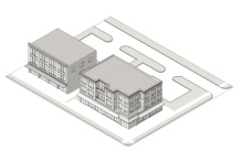 Mixed Use Building
| ||||
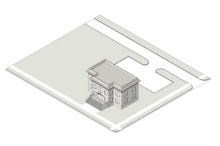 Civic Building
| ||||
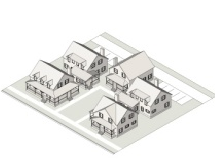 Cottage Court
| ||||
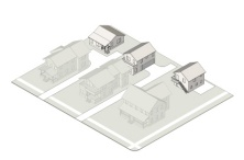 Carriage House
|
b.
Requirements for all building types.
1.
Build-to-zone.
i.
Defined.
A.
The build-to-zone is the area on the lot where a certain percentage of the front building facade must be located, measured as a minimum and maximum setback range from the edge of the right-of-way or edge of the sidewalk, whichever is greater.
B.
The required percentage specifies the amount of the front building facade that must be located in the build-to-zone area, measured based on the width of the building divided by the width of the site or lot.
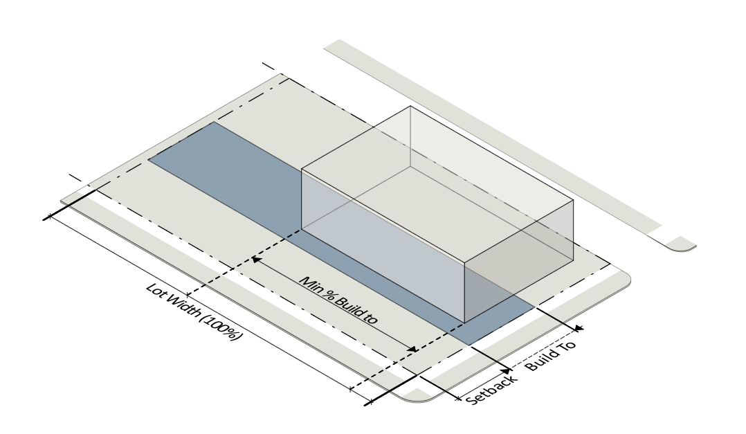
C.
A forecourt meeting the standards of subsection (u)(1)c. of this section "Building elements", is counted as part of the building width in the build-to-zone.
2.
Setbacks.
i.
Setback types. There are four (4) types of setbacks: Primary street setback, side street setback, side setback, and rear setback. Through lots are considered to have two (2) primary street setbacks.
ii.
Measurement of setbacks.
A.
Primary and side street setbacks are measured from the edge of the right-of-way.
B.
Side setbacks are measured from the side property line.
C.
Rear setbacks are measured from the rear property line or the edge of the right-of-way if there is an alley.
iii.
Parking not allowed. On-site surface must be located behind the parking setback line. This requirement is not intended to restrict on-street parking.
iv.
Parking in the front setback. For a detached or attached house, combined parking and driveway area shall not constitute more than forty (40) percent of the area between the front building facade and the front property line.
3.
Pedestrian access.
i.
An entrance providing both ingress and egress, operable to residents or customers at all times, is required to meet the street facing entrance requirements. Additional entrances off another street, pedestrian area or internal parking area are permitted.
ii.
An angled entrance may be provided at either corner of a building along the street to meet the street facing entrance requirements.
4.
Transparency.
i.
The minimum percentage of windows and doors that must cover a ground story facade is measured between zero and twelve (12) feet above the adjacent sidewalk. The standard applies only on-street-facing facades, and not interior or rear-facing facades (including the sides of mid-block buildings where no corner buildings have been constructed).
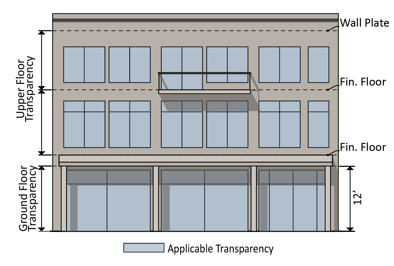
ii.
The minimum percentage of windows and doors that must cover an upper story facade is measured from top of the finished floor to the top of the finished floor above. When there is no floor above, upper story transparency is measured from the top of the finished floor to the top of the wall plate.
iii.
In a mixed use building, a minimum of sixty (60) percent of the street-fronting, street-level window pane surface area must allow views into the ground story use for a depth of at least eight (8) feet. Windows shall not be made opaque by window treatments (except operable sunscreen devices within the conditioned space).
5.
Blank wall area.
i.
Blank wall area means a portion of the exterior facade of the building that does not include a substantial material change (paint color is not considered a substantial material change); windows or doors; or columns, pilasters or other articulation greater than twelve (12) inches in depth.
ii.
Blank wall area applies in both a vertical and horizontal direction.
iii.
Blank wall width applies to both ground and upper story primary and side street-facing facades.
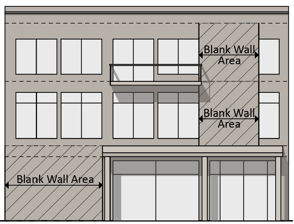
c.
Building elements.
1.
Porch. A raised structure attached to a building, forming a covered entrance to a doorway.
i.
A porch must be at least six (6) feet deep (not including the steps).
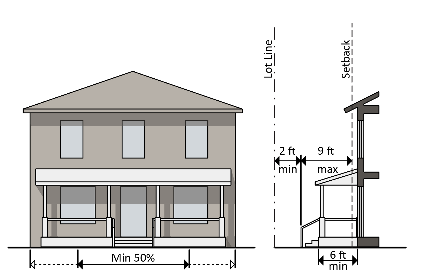
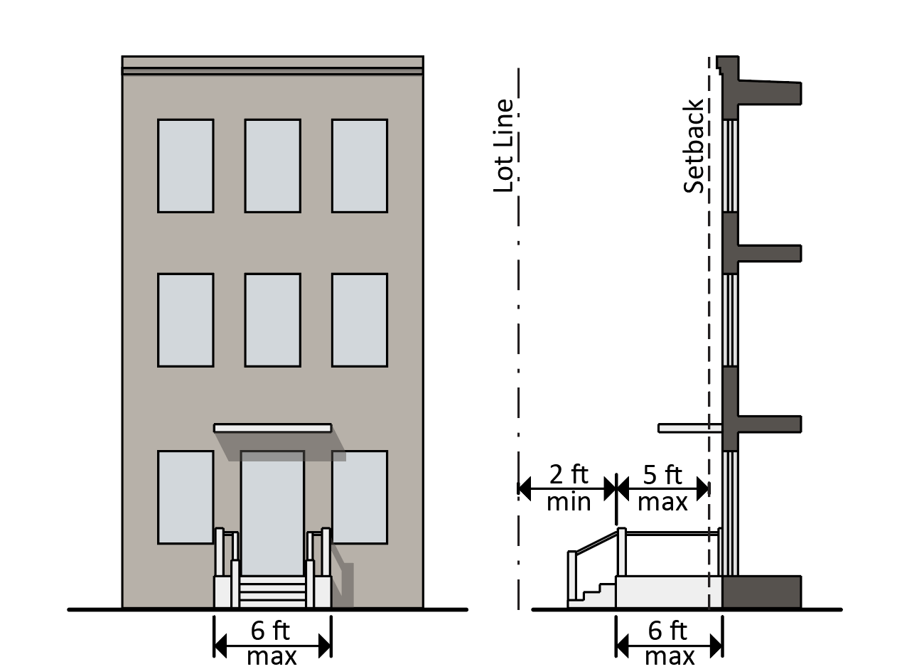
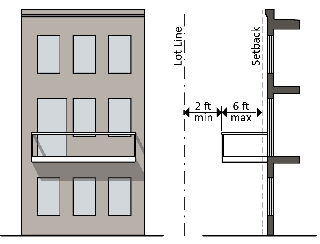
ii.
A porch must be contiguous with a width not less than fifty (50) percent of the building facade from which it projects.
iii.
A porch must be roofed but cannot be fully enclosed. Screening for protection from insects is not considered enclosure.
iv.
A porch may extend up to nine (9) feet, including the steps, into a required setback, provided that such extension is at least two (2) feet from the vertical plane of any lot line.
v.
A porch may not encroach into the public right-of-way.
2.
Stoop. A small raised platform that serves as an entrance to a building.
i.
A stoop must be no more than six (6) feet deep (not including the steps) and six (6) feet wide.
ii.
A stoop may be covered but cannot be fully enclosed.
iii.
A stoop may extend a up to six (6) feet into a required setback, provided that the landing is at least two (2) feet from the vertical plane of any lot line.
iv.
A stoop may not encroach into the public right-of-way.
3.
Balcony. A platform projecting from the wall of a building with a railing along its outer edge, often with access from a door or window.
i.
A balcony may extend up to six (6) feet into a required setback, provided that such extension is at least two (2) feet from the vertical plane of any lot line.
ii.
A balcony may be covered but cannot be fully enclosed.
iii.
A balcony may not encroach into the public right-of-way without a license for the use of public right-of-way.
4.
Gallery. A covered passage extending along the outside wall of a building supported by arches or columns that is open on one side.
i.
A gallery must have a clear depth from the support columns to the building's facade of at least eight (8) feet and a clear height above the sidewalk of at least ten (10) feet.
ii.
A gallery must be contiguous and extend over at least fifty (50) percent of the width of the building facade from which it projects.
iii.
A gallery may extend into a required street setback.
iv.
A galley may not encroach into the public right-of-way without a license for the use of public right-of-way.
5.
Awning. A wall-mounted, cantilevered structure providing shade and cover from the weather for a sidewalk.
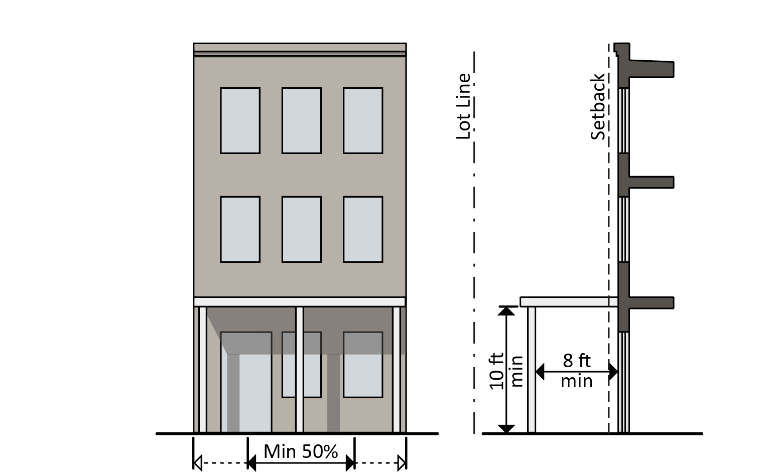
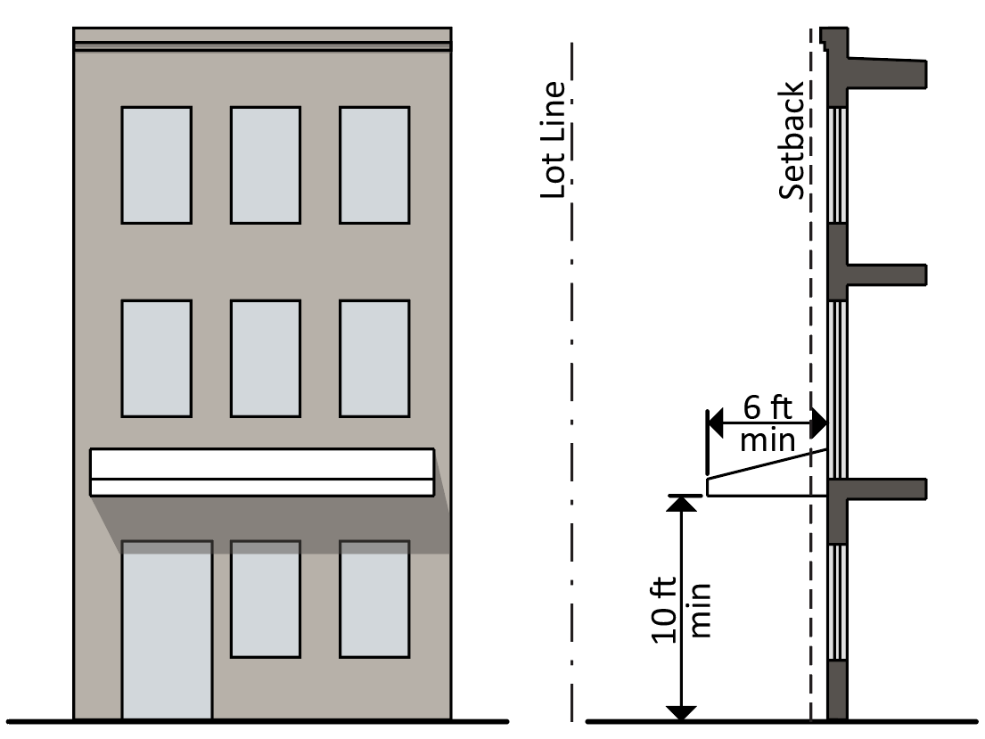
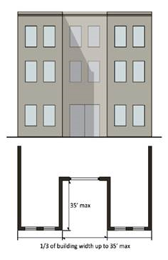
i.
An awning must be a minimum of ten (10) feet clearance height above the sidewalk and must have a minimum depth of six (6) feet.
ii.
An awning may extend into a required street setback.
iii.
An awning may not encroach into the public right-of-way without a license for the use of public right-of-way.
6.
Forecourt. An open area at grade, or within thirty (30) inches of grade, that serves as an open space, plaza, or outdoor dining area.
i.
A forecourt must be no more than one-third of the length of the building face, and in no case longer than thirty-five (35) feet in width.
ii.
A forecourt may be no more than thirty-five (35) feet in depth.
iii.
A maximum of one forecourt is permitted per site.
iv.
A forecourt is considered as part of the building for the purpose of measuring the build-to-zone.
d.
Standards by building type.
1.
Single-family (detached) & attached dwelling.
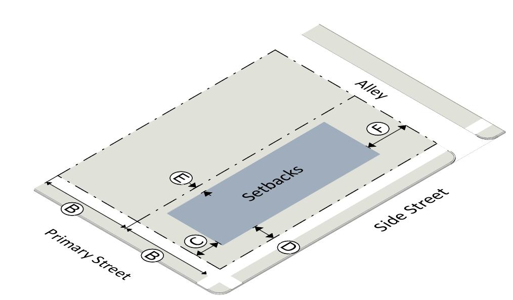 | ||
| (1) Lot Standards | ||
| Lot Dimensions | ||
| Ⓐ | Lot area (min/max) |
4,000 sf / 10,000 sf (detached)
7,500 sf / 15,000 sf (attached) |
| Ⓑ | Lot width (min/max) |
40' / 65'(detached)
60' / 80'(attached) |
| Setbacks | ||
| Ⓒ | Primary street (min) |
Principal Building: 15'
Accessory Building: 50' Parking: 30' |
| &circleD | Side street (min) |
Principal Building: 10'
Accessory Building: 10' Parking: 5' |
| Ⓔ | Side, common lot line (min) |
Principal Building: 4'
Accessory Building: 3' Parking: 5' |
| Ⓕ | Rear, common lot line/alley (min) |
Principal Building: 20'
Accessory Building: 3' Parking: 5' |
| Lot Coverage | ||
| Maximum lot coverage |
0.75 (detached)
0.85 (attached) | |
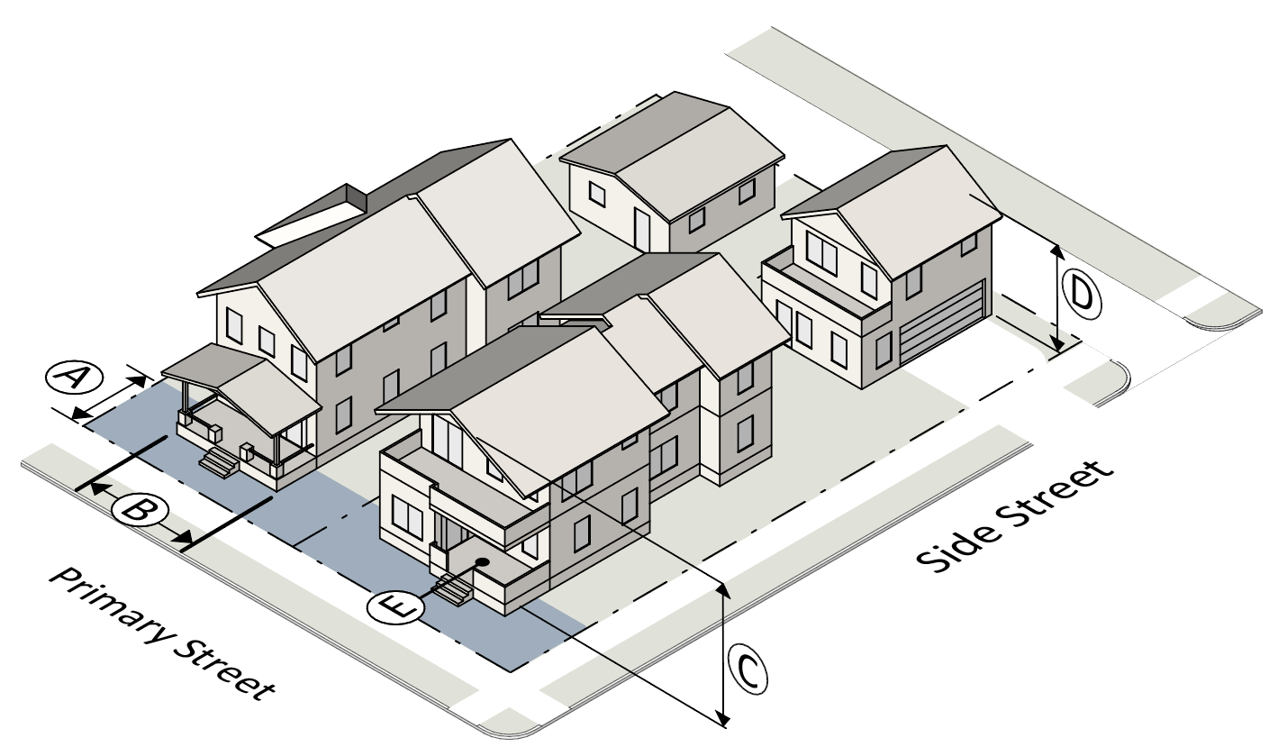 | ||
| (2) Building Standards | ||
| Build-to Zone (BTZ) | ||
| Ⓐ | Primary street (min/max) | 15' / 25' |
| Ⓑ | % of building in primary street BTZ (min) | 70% |
| Building Height | ||
| Ⓒ | Principal building (max) | 3 stories / 40' |
| Ⓓ | Accessory building (max) | 25' |
| Entrances | ||
| Street-facing entrance | Required | |
| Transparency | ||
| Ground story (min) | 20% | |
| Upper story (min) | 15% | |
| Blank wall area (max) | 30' | |
| Allowed Building Elements | ||
| Porch | Yes | |
| Stoop | Yes | |
| Balcony | Yes | |
| Gallery | No | |
| Awning | No | |
| Forecourt | No | |
2.
Townhouse Dwelling.
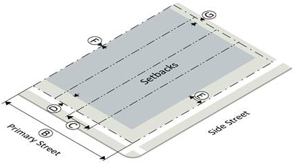 | ||
| (1) Lot Standards | ||
| Lot Dimensions | ||
| Ⓐ | Lot area (min/max) | 2,400 sf / 4,500 sf |
| Ⓑ | Site width (min) | 48' |
| Ⓒ | Lot width (min) | 24' / 36' |
| Setbacks | ||
| Ⓓ | Primary street (min) |
Building: 10'
Parking: 30' |
| Ⓔ | Side street (min) |
Building: 10'
Parking: 10' |
| Ⓕ | Side, common lot line (min) |
Building: 0'
Parking: 0' |
| Ⓖ | Rear, common lot line/alley (min) |
Building: 20'
Parking: 5' |
| Lot Coverage | ||
| Maximum lot coverage | 0.90 | |
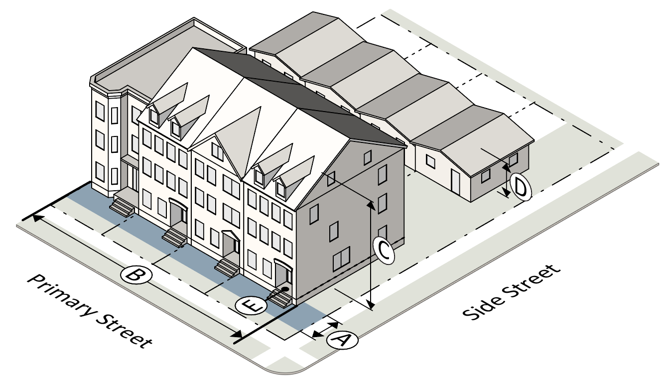 | ||
| (2) Building Standards | ||
| Build-to Zone, Site (BTZ) | ||
| Primary street (min/max) | 10' / 15' | |
| % of building in primary street BTZ (min) | 70% | |
| Building Height | ||
| Principal building (max) | 3 stories / 45' | |
| Accessory building (max) | 25' | |
| Entrances | ||
| Street-facing entrance | Required | |
| Transparency | ||
| Ground story (min) | 20% | |
| Upper story (min) | 15% | |
| Blank wall area (max) | 30' | |
| Allowed Building Elements | ||
| Porch | Yes | |
| Stoop | Yes | |
| Balcony | Yes | |
| Gallery | No | |
| Awning | No | |
| Forecourt | No | |
3.
Multifamily Dwelling.
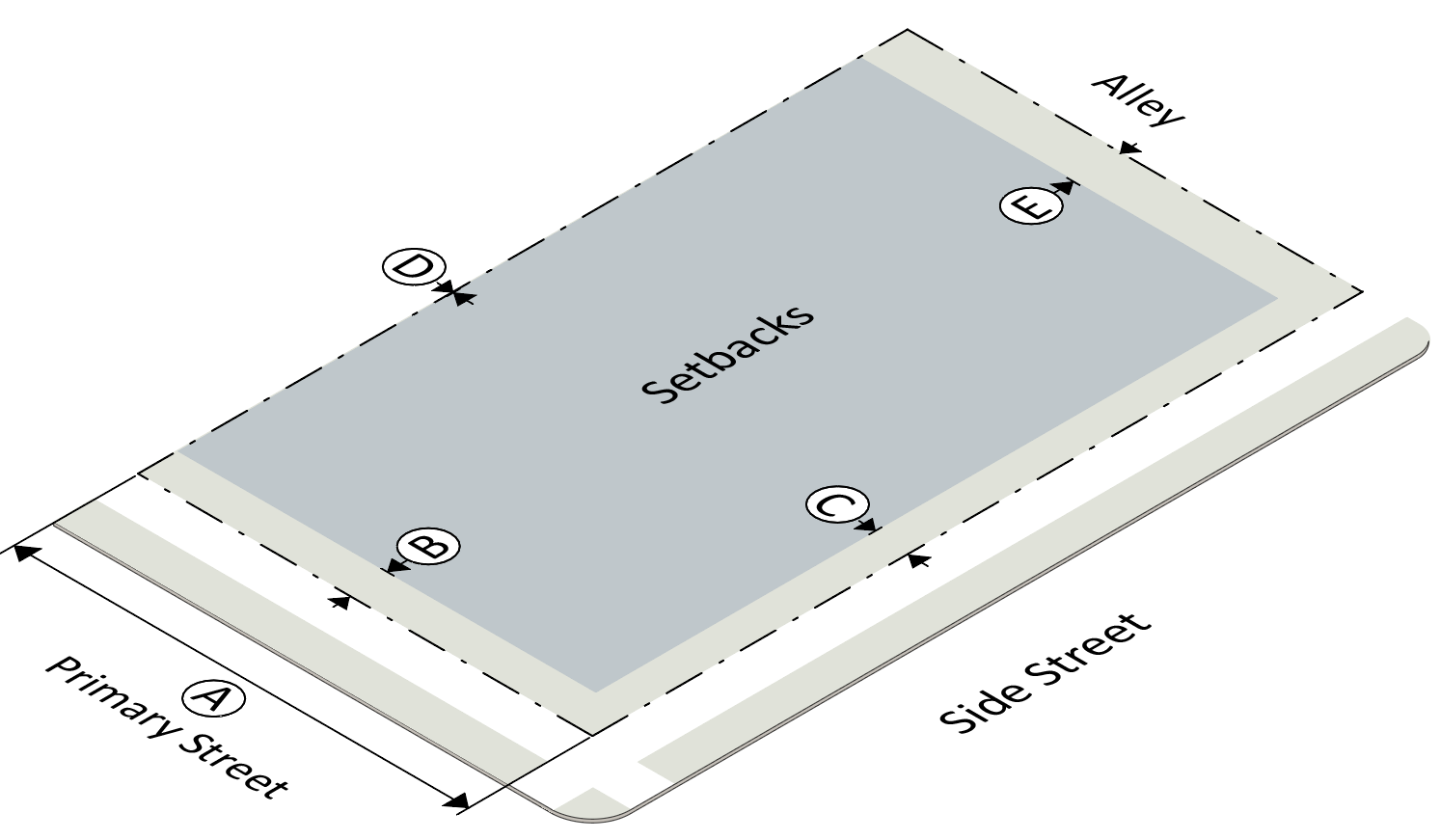 | ||
| (1) Lot Standards | ||
| Lot Dimensions | ||
| Ⓐ | Lot width (min) | 65' |
| Setbacks | ||
| Ⓑ | Primary street (min) |
Building: 5'
Parking: 30' |
| Ⓒ | Side street (min) |
Building: 5'
Parking: 15' |
| Ⓓ | Side, common lot line (min) |
Building: 10'
Parking: 5' |
| Ⓔ | Rear, common lot line/alley (min) |
Building: 10'
Parking: 5' |
| Lot Coverage | ||
| Maximum lot coverage | 0.95 | |
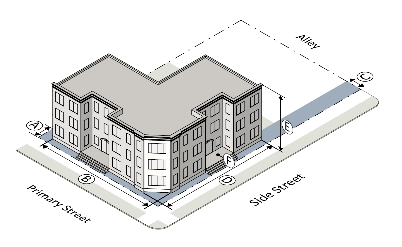 | ||
| (2) Building Standards | ||
| Build-to Zone (BTZ) | ||
| Ⓐ | Primary street (min/max) | 5' / 25' |
| Ⓑ | % of building in primary street BTZ (min) | 70% |
| Ⓒ | Side street (min/max) | 5' / 15' |
| Ⓓ | % of building in side street BTZ (min) | 35% |
| Building Height | ||
| Ⓔ | Principal building in UD-3 (max) | 3 stories / 40' |
| Ⓔ | Principal building in UD-4 (max) | 4 stories / 55' |
| Ⓔ | Principal building in UD-5 (max) | 4 stories / 75' |
| Entrances | ||
| Ⓕ | Street-facing entrance | Required |
| Transparency | ||
| Ground story (min) | 20% | |
| Upper story (min) | 15% | |
| Blank wall area (max) | 25' | |
| Allowed Building Elements | ||
| Porch | Yes | |
| Stoop | Yes | |
| Balcony | Yes | |
| Gallery | No | |
| Awning | Yes | |
| Forecourt | Yes | |
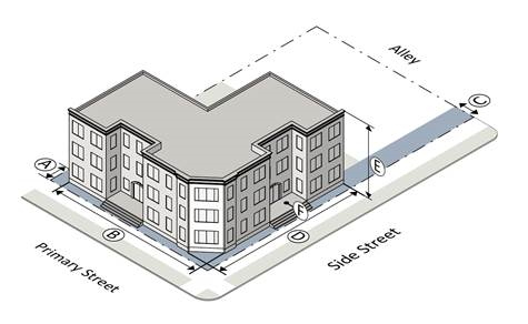 | ||
4.
Commercial Building.
 | ||
| (1) Lot Standards | ||
| Lot Dimensions | ||
| Ⓐ | Lot width (min) | 50' |
| Setbacks | ||
| Ⓑ | Primary street (min) |
Building:0'
Parking: 30' |
| Ⓒ | Side street (min) |
Building: 5'
Parking: 10' |
| Ⓓ | Side, common lot line (min) |
Building: 10'
Parking: 5' |
| Ⓔ | Rear, common lot line/alley (min) |
Building: 10'
Parking: 5' |
| Lot Coverage | ||
| Maximum lot coverage | 1.0 | |
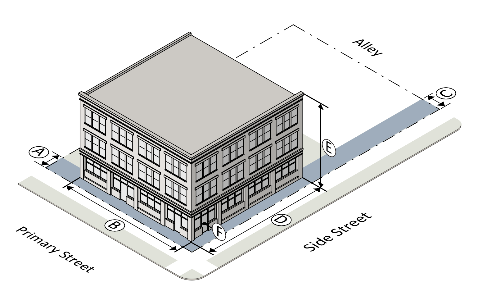 | ||
| (2) Building Standards | ||
| Build-to Zone (BTZ) | ||
| Ⓐ | Primary street (min/max) | 0' / 15' |
| Ⓑ | % of building in primary street BTZ (min) | 70% |
| Ⓒ | Side street (min/max) | 5' / 15' |
| Ⓓ | % of building in side street BTZ (min) | 35% |
| Building Height | ||
| Ⓔ | Principal building in UD-4 (max) | 4 stories / 55' |
| Ⓔ | Principal building in UD-5 (max) | 5 stories / 75' |
| Entrances | ||
| Ⓕ | Street-facing entrance | Required |
| Transparency | ||
| Ground story (min) | 40% | |
| Upper story (min) | 20% | |
| Linear blank wall area (max) | 20' | |
| Allowed Building Elements | ||
| Porch | No | |
| Stoop | No | |
| Balcony | Yes | |
| Gallery | Yes | |
| Awning | Yes | |
| Forecourt | Yes | |
5.
Mixed Use Building.
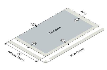 | ||
| (1) Lot Standards | ||
| Lot Dimensions | ||
| Ⓐ | Lot width (min) | 50' |
| Setbacks | ||
| Ⓑ | Primary street (min) |
Building:0'
Parking: 30' |
| Ⓒ | Side street (min) |
Building: 0'
Parking: 10' |
| Ⓓ | Side, common lot line (min) |
Building: 10'
Parking: 5' |
| Ⓔ | Rear, common lot line/alley (min) |
Building: 10'
Parking: 5' |
| Lot Coverage | ||
| Maximum lot coverage | 1.0 | |
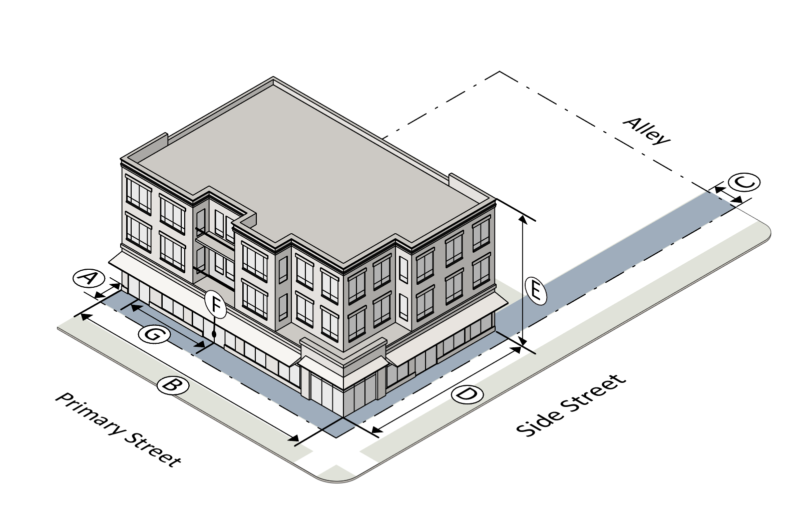 | ||
| (2) Building Standards | ||
| Build-to Zone (BTZ) | ||
| Ⓐ | Primary street (min/max) | 0' / 15' |
| Ⓑ | % of building in primary street BTZ (min) | 80% |
| Ⓒ | Side street (min/max) | 0' / 15' |
| Ⓓ | % of building in side street BTZ (min) | 40% |
| Building Height | ||
| Ⓔ | Principal building in UD-4 (max) | 4 stories / 55' |
| Ⓔ | Principal building in UD-5 (max) | 5 stories / 75' |
| Entrances | ||
| Ⓕ | Street-facing entrance | Required |
| Ⓖ | Entrance spacing (max) | 75' |
| Transparency | ||
| Ground story (min) | 60% | |
| Upper story (min) | 20% | |
| Blank wall area (max) | 20' | |
| Allowed Building Elements | ||
| Porch | No | |
| Stoop | No | |
| Balcony | Yes | |
| Gallery | Yes | |
| Awning | Yes | |
| Forecourt | Yes | |
6.
Civic Building.
 | ||
| (1) Lot Standards | ||
| Lot Dimensions | ||
| Ⓐ | Lot width (min) | 30' |
| Building Setbacks | ||
| Ⓑ | Primary street (min) |
Building: 0'
Parking: 30' |
| Ⓒ | Side street (min) |
Building: 0'
Parking: 10' |
| Ⓓ | Side, common lot line (min) |
Building: 10'
Parking: 5' |
| Ⓔ | Rear, common lot line/alley (min) |
Building: 10'
Parking: 5' |
| Lot Coverage | ||
| Maximum lot coverage | 1.0 | |
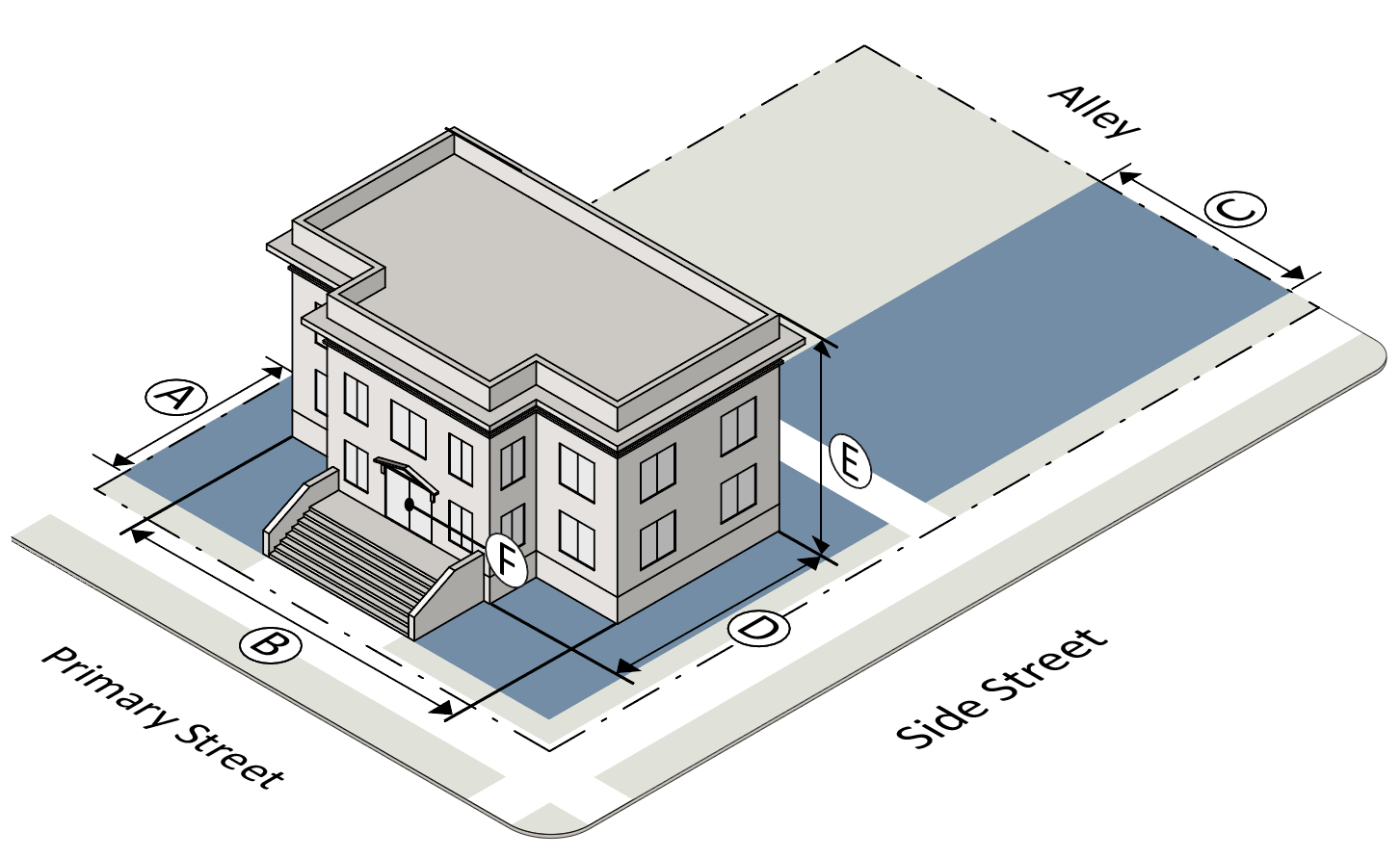 | ||
| (2) Building Standards | ||
| Build-to Zone (BTZ) | ||
| Ⓐ | Primary street (min/max) | 0' / 40' |
| Ⓑ | % of building in primary street BTZ (min) | 50% |
| Ⓒ | Side street (min/max) | 0' / 40' |
| Ⓓ | % of building in side street BTZ (min) | 25% |
| Building Height | ||
| Ⓔ | Principal building in UD -2, -3, -4 (max) | 3 stories / 45' |
| Ⓔ | Principal building in UD-5 (max) | 5 stories / 75' |
| Entrances | ||
| Ⓕ | Street-facing entrance | Required |
| Allowed Building Elements | ||
| Porch | Yes | |
| Stoop | Yes | |
| Balcony | Yes | |
| Gallery | Yes | |
| Awning | Yes | |
| Forecourt | Yes | |
7.
Cottage Court.
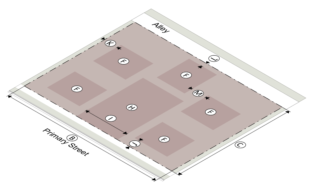 | ||
| (1) Lot Standards | ||
| Site Dimensions | ||
| Ⓐ | Lot Area (min/max) | 18,000 / 24,000 sf |
| Ⓑ | Lot width (min/max) | 150' / 200' |
| Ⓒ | Lot depth (min) | 120' |
| Ⓓ | Dwelling units per min. lot area | 5 |
| Ⓔ | Area per dwelling unit (min) | 3,600 sf |
| Ⓕ | Building footprint (max) | 1,000 sf |
| Ⓖ | Accessory structure footprint (max) | 450 sf |
| Courtyard Dimensions | ||
| Ⓗ | Area (min) | 3,000 sf |
| Ⓘ | Width (min) | 40' |
| Setbacks | ||
| Ⓙ | Primary street (min/max) |
Building: 15'
Parking: 30' |
| Ⓚ | Side, common lot line/street (min) |
Building: 10'
Parking: 5' |
| Ⓛ | Rear, common lot line/alley (min) |
Building: 10'
Parking: 5' |
| Ⓜ | Building separation (min) | 10' |
| Lot Coverage | ||
| Maximum Lot Coverage | 0.80 | |
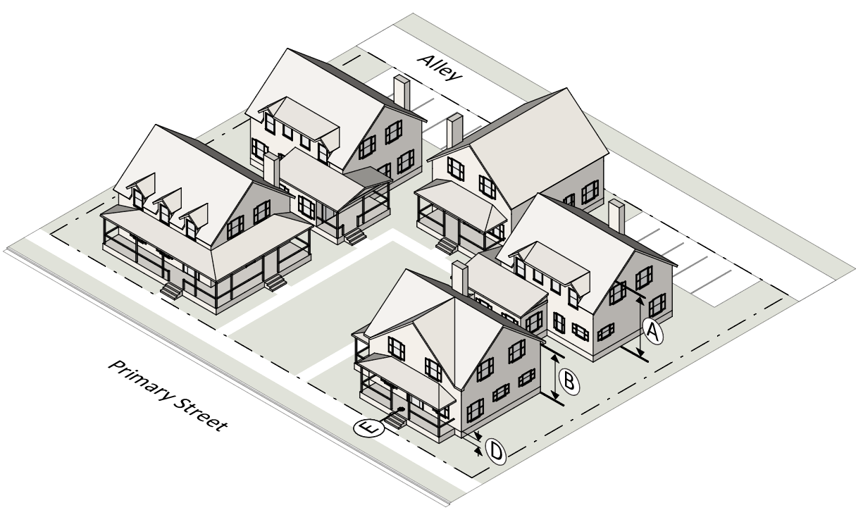 | ||
| (2) Building Standards | ||
| Building Height | ||
| Ⓐ | Principal building (max) | 3 stories / 40' |
| Ⓑ | Principal building wall plate (max) | 17' |
| Ⓒ | Accessory building (max) | 17' |
| Ⓓ | Ground floor elevation (min) | 2' |
| Entrances | ||
| Ⓔ | Street-facing entrance (end units) | Required |
| Allowed Building Elements | ||
| Porch | Yes | |
| Stoop | Yes | |
| Balcony | Yes | |
| Gallery | No | |
| Awning | No | |
| Forecourt | No | |
8.
Carriage House.
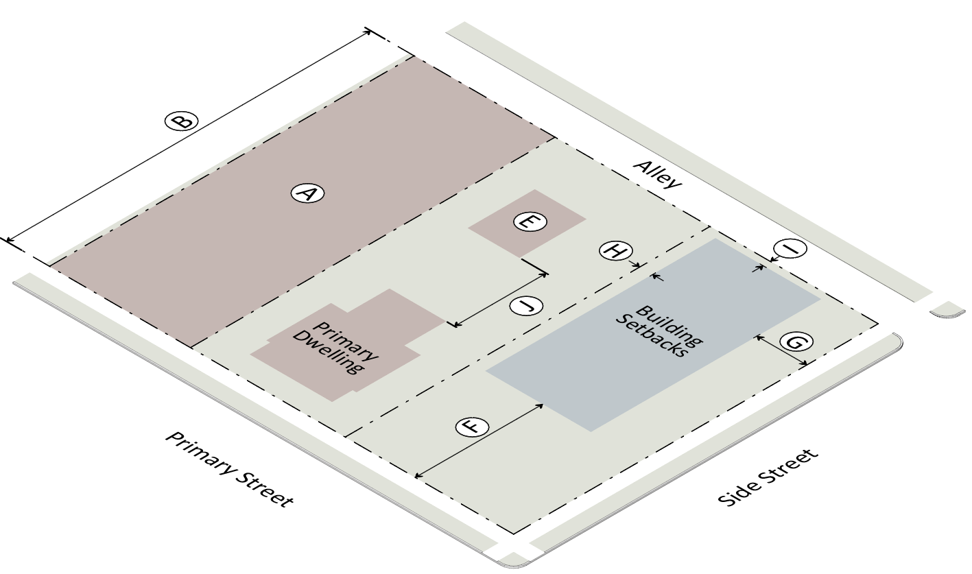 | ||
| (1) Lot Standards | ||
| Lot Dimensions | ||
| Ⓐ | Lot area (min) | 5,000 sf |
| Ⓑ | Lot depth (min) | 120' |
| Ⓒ | Dwelling units per lot (max) | 2 |
| Ⓓ | Additional on-site parking | 1 space |
| Ⓔ | Building footprint | 450 sf |
| (2) Building Placement | ||
| Building Setbacks | ||
| Ⓕ | Primary street (min) | 50' |
| Ⓖ | Side street (min) | 10' |
| Ⓗ | Side, common lot line (min) | 5' |
| Ⓘ | Rear, common lot line/alley (min) | 5' |
| Ⓙ | Building separation (min) | 16' |
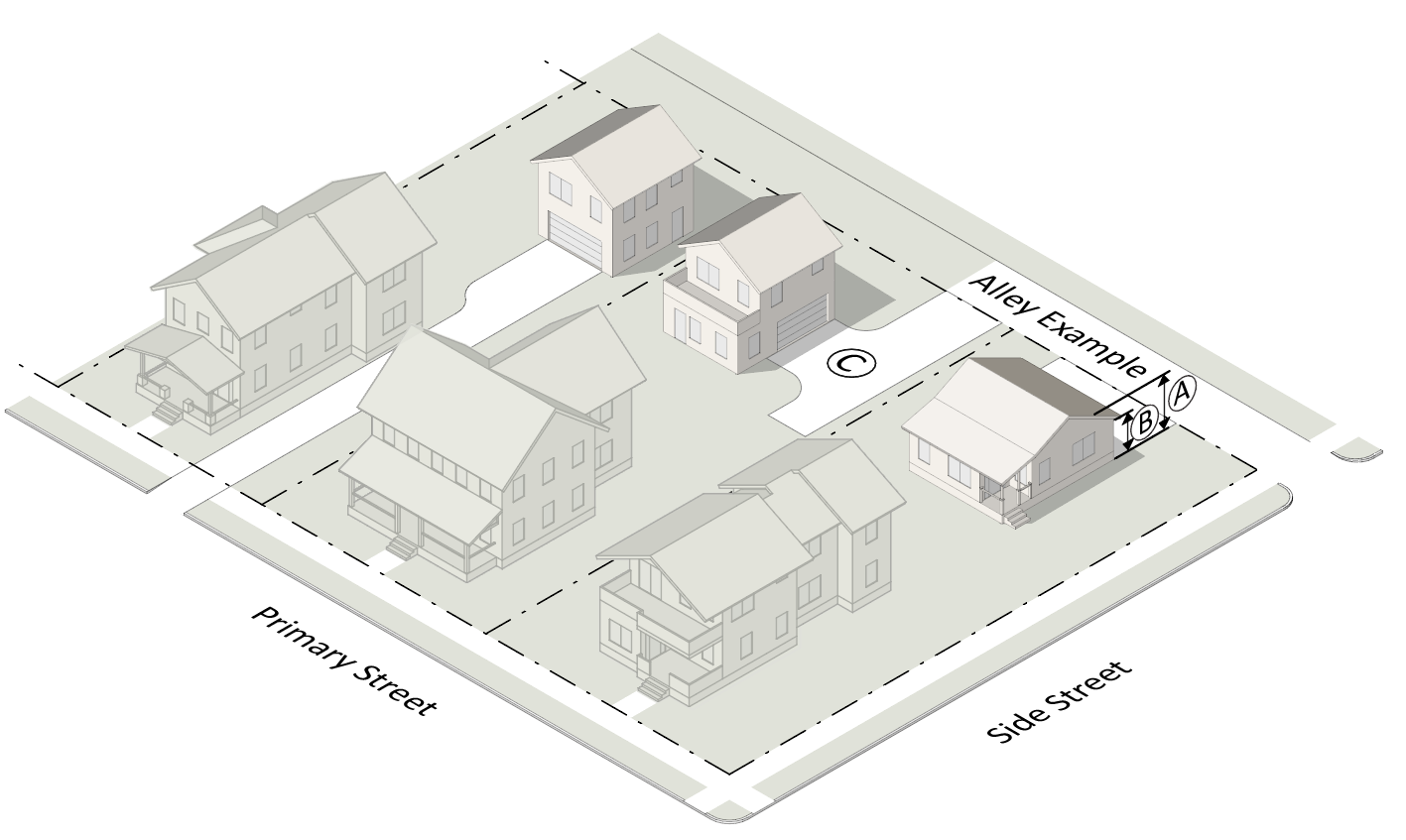 | ||
| (3) Height | ||
| Building Height | ||
| Ⓐ | Building height (max) | 25' |
| Ⓑ | Building wall plate height (max) | 17' |
| (4) Access | ||
| Vehicular | ||
| Ⓒ | From alley; or from street when no alley present | |
(2)
Land use.
a.
Permitted land uses.
1.
This section establishes the land uses allowed in each subdistrict. A lot or building shall be occupied with only the land uses allowed in this subsection (u)(2).
2.
Any one or more land uses identified in this subsection as being allowed within a specific subdistrict may be established on any parcel within that subdistrict, subject to the "Allowed Use Table", and in compliance with all applicable requirements of this district.
b.
Use standards.
1.
Ground story uses in all districts. Allowed ground story uses may extend into upper stories without regard for the upper story allowed uses listed on the use table below.
2.
Civic buildings. Only public/institutional uses listed on the use table below are allowed in a civic building type.
3.
Limited uses in UD-3 district. Nonresidential uses listed as "L" in the UD-3 district are subject to the following additional standards:
i.
The use can only be located on the ground floor in a corner unit of an apartment building type.
ii.
The unit cannot exceed two thousand five hundred (2,500) square feet in gross floor area.
iii.
Drive-thru facilities are not permitted.
c.
Allowed Use Table.
Key:
P = Permitted by Right
L = Permitted Subject to Use Standards
S = Special Exception Required
C = Conditional Use Permit Required
— = Not Permitted
(3)
Parking.
a.
Parking in the UD district. The requirements of chapter 28, article VII apply in the urban development (UD) district, except as specifically modified in this section. Parking requirements may be modified by the agent upon acceptable written justification submitted with review of a site plan or building permit application.
b.
Shared parking for specified uses. The following table defines the uses that may apply for off-street shared parking credits:
1.
To determine the total number of spaces to be shared by two (2) categories, add the maximum number for each use and multiply the number by the factor then subtract that difference from the total. Example: Office use requires sixty (60) spaces and retail use requires forty (40) spaces, total spaces required for both uses is one hundred (100); multiply by 1.2 = one hundred twenty (120); a difference of twenty (20); therefore, subtract twenty (20) from the original required parking of one hundred (100); number of spaces now required for both uses is eighty (80).
2.
When more than two (2) categories will share parking, add the maximum number for each use and multiply the number by the largest factor then subtract the difference from the total. Example: The multiple categories are residential, retail/service/entertainment, and outdoor recreation and the largest factor is 1.3, the maximum number of spaces required is five hundred (500) and with a factor of 1.3, five hundred (500) × 1.3 = six hundred fifty (650); five hundred (500) - one hundred fifty (150) = three hundred fifty (350) spaces required.
c.
Parking credits.
1.
Proximity to transit. A fifteen (15) percent reduction in the number of required parking spaces for is allowed for uses with a main entrance within a walking distance of one thousand three hundred twenty (1,320) feet of an operating transit stop, with service from 6:00 a.m. to 10:00 p.m. Monday through Friday
2.
Employer transportation demand management (TDM).
i.
Defined. Employer transportation demand management has a variety of options, including, but not limited to, employer provision of a transportation coordinator, preferential parking for car and van pools, shuttle services, financial incentives and telecommuting.
ii.
Reduction allowed. The agent may approve up to a twenty-five (25) percent reduction in the number of required parking spaces for uses that institute and commit to maintain a transportation demand management (TDM) program, considering information the applicant submits that clearly indicates the types of TDM activities and measures proposed.
3.
Private car sharing program.
i.
A reduction in the number of required parking spaces for residential units is allowed where an active on-site car-sharing program is made available for the exclusive use of residents.
ii.
The parking requirements for all dwelling units may be reduced by five (5) spaces for each car-share vehicle provided. If required, visitor spaces cannot be substituted.
4.
Valet parking. Valet parking may be permitted where all of the following standards have been met:
i.
An attendant is provided to park vehicles during all business hours of the use utilizing the valet parking.
ii.
An equivalent number of valet spaces are available to replace the number required on-site parking spaces.
iii.
Valet spaces do not require individual striping, and may take into account the mass parking of vehicles.
d.
Tandem parking.
1.
Tandem parking is allowed for single-family, two-family, and multifamily living.
2.
Two (2) parking spaces in tandem must have a combined minimum dimension of nine (9) feet in width by forty (40) feet in length.
3.
Both parking spaces in tandem must be assigned to the same dwelling unit.
4.
Tandem parking shall not be used to provide guest parking.
e.
Reserved parking. Parking spaces may be reserved for a specific tenant or unit, provided that the following standards are not exceeded:
1.
Residential.
i.
One space per efficiency or one-bedroom, multifamily dwelling unit.
ii.
Two (2) spaces per two-bedroom or greater multifamily dwelling unit.
2.
Nonresidential. No more than one-third of the total provided spaces may be reserved.
f.
Required bicycle parking.
1.
The following bicycle parking spaces are required for each nonresidential building or mixed use project. For mixed use projects, only the nonresidential portion of the project is required to provide bicycle parking:
2.
Bicycle parking racks must be high-quality, inverted "U"- type construction. Alternative high-quality bicycle parking racks may be approved by the agent if they can be shown to provide adequate theft protection and security, and support the bicycle at two (2) points of contact to prevent damage to the bicycle wheels and frame.
3.
All bicycle racks must be publicly accessible and be placed on private property, or within the public right-of-way with the approval of the agent.
4.
Bicycle racks must be located within one hundred (100) feet of the primary building entrance and in a location that is visible and easily accessible.
5.
Where a bicycle rack allows bicycles to be locked on both sides of the rack without conflict, each side may be counted as one required space.
g.
Parking garages/decks. Parking spaces within parking garages/decks shall have a minimum dimension of nine (9) feet in width by eighteen (18) feet in length.
(4)
Buffers, screening and landscaping.
a.
Transitional buffer required. A transitional buffer is required where a UD district abuts an existing residential or commercial district, as set forth in the two (2) options below. The transitional buffer is required whether or not the adjacent property is developed or vacant.
1.
Transitional buffer using adjacent lot requirements. Where single-family lots in the UD district abut a residential district, and the lots in the UD district meet the adjacent district minimum lot size requirement, no transitional buffer is required.
2.
Transitional buffer using landscaping. Where subsection a.1. above does not apply, a transitional buffer meeting the requirements of the DCSL is required, with a minimum width as set out in the table below:
3.
Street buffers. Development within the UD district shall be exempt from Section 110.2 of the DCSL, "Street Buffers adjacent to Arterial or Collector streets."
b.
Landscaping and screening required. Development within the UD district shall provide landscaping and screening in accordance with the requirements of the DCSL, except as provided below:
1.
Development shall be exempt from Section 120.2, "Parking Lot, Perimeter," and Section 120.3, "Parking Lot, Vehicle Access Drive."
2.
Development shall provide street trees in accordance with Section 120.4, "Street Trees," except that the minimum width of the planting area shall be in accordance with the street types shown in Section 28-39(u)(5) and trees shall be provided at a maximum of 50 feet apart.
3.
Landscaping may be placed within utility easements, subject to approval by the easement holder.
(5)
Streets and blocks.
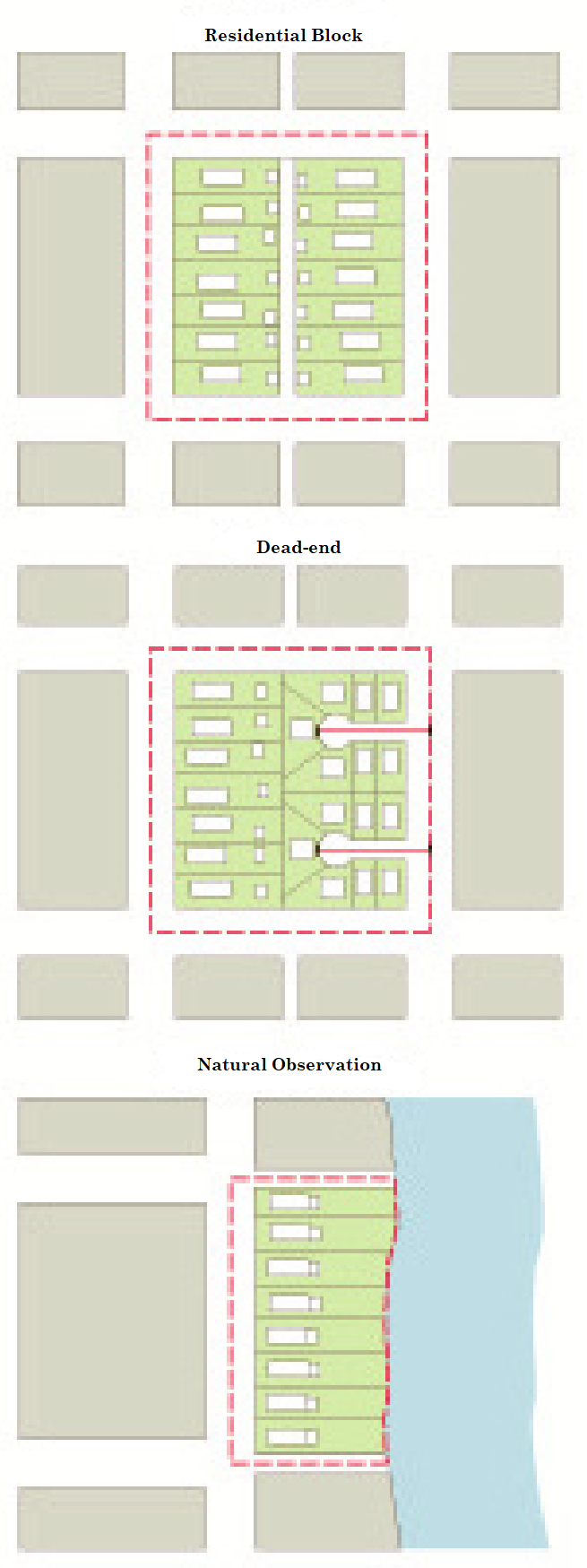
a.
Streets and blocks in the UD district. The street network in the UD district shall be in conformance with the approved master plan associated with the property, except as specifically modified in this section. Except for alleys, and as specifically modified in this section, all street and highway construction standards shall be in accordance with applicable design standards of the Virginia Department of Transportation, including the subdivision street requirements and related references. Such standards shall apply to all streets serving three (3) or more properties, regardless of whether the streets are dedicated to public use or are to be maintained by an association of the property owners served. Sidewalks, streets, street trees, and street lights must be installed and constructed for both new streets and existing streetscapes.
b.
Blocks.
1.
Applicability. The block length and perimeter standards apply to all preliminary plans, final plats, and site plans after the effective date of this amendment.
2.
Block standards.
i.
Residential blocks must have sufficient width to provide for two (2) tiers of residential lots, except where single-tier lots are required to accommodate single-loaded streets or across from a public park or open space, to allow for unusual topographical conditions, or when adjacent to the outer perimeter of a subdivision.
ii.
The following table establishes the maximum block perimeter, maximum block lengths, and a maximum length for a dead-end street by zoning district. In the event that a single block contains more than one zoning district, the most restrictive requirement applies:
3.
Block measurement.
i.
A block is bounded by a street (not including an alley) that meets the requirements of this section. This may include private streets which provide primary access through the development.
ii.
Block perimeter is measured along the centerline of intersecting streets that encompass the block.
iii.
Block length is measured from centerline to centerline of intersecting streets.
iv.
The maximum block length or perimeter may be extended in the event that steep slopes in excess of twenty-five (25) percent, freeways, waterways, railroad lines, pre-existing development, tree conservation areas, stream buffers, cemeteries, open space, or easements make the maximum block length or perimeter unfeasible.
v.
The maximum block length and perimeter may be extended by twenty-five (25) percent, if the block includes a pedestrian passage that meets the requirements of this section.
vi.
A block may be broken by a civic building or open lot; provided the lot is at least fifty (50) feet wide and provides a pedestrian passage meeting the requirements this section.
c.
Street types.
1.
This section describes guidelines for the construction of new streets in the UD district and is intended to provide a catalog of pre-approved street types that are appropriate to use. Additional streets types may be integrated into the County Code as they are approved by the board of supervisors.
2.
Alternative parking angles other than shown may be approved by the agent.
3.
Medians may be added to any of the street types shown. The dimensions for right-of-way and clear width shall be adjusted to add the width of the median. Center medians may be used to provide parallel or angle parking, where approved by the agent.
4.
The agent will make the final determination as to the appropriate street type, based on the type, scale and intensity of the proposed development.
5.
Where development occurs adjacent to an existing street, the streetscape illustrated in the most closely matching street in this section shall be installed. The agent shall determine which street is the closest match.
d.
Neighborhood local. The neighborhood local street is a minor local street intended for use where the predominant character is residential. This street is the most common residential street.
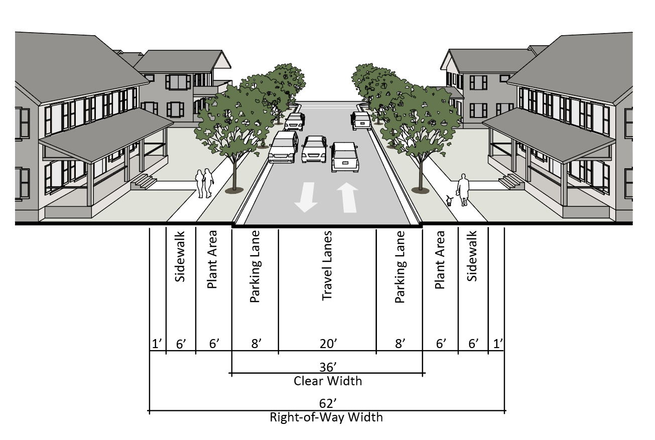
e.
Neighborhood local - angle. The neighborhood local - angle is a local street intended for use where the predominant character is attached or multi-unit residential where additional parking is needed. This street type may also include bike lanes.
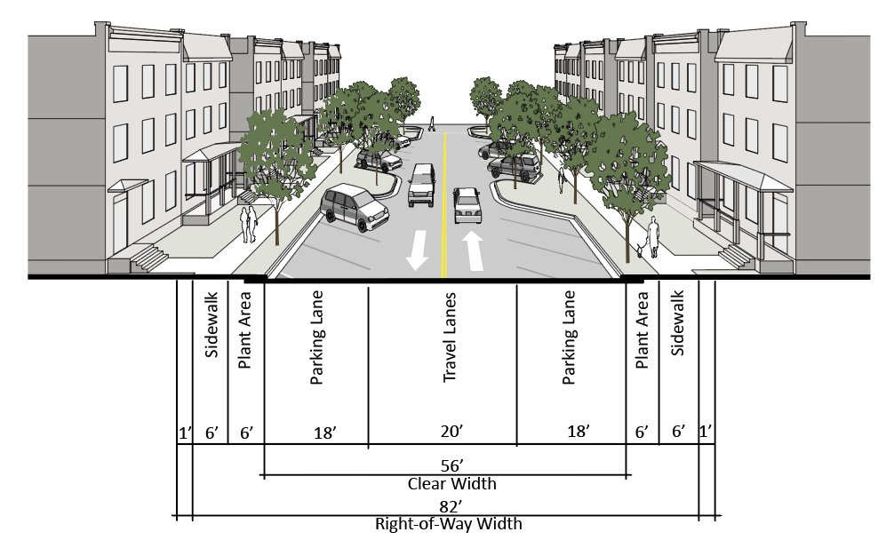
f.
Neighborhood street. The neighborhood street is a major local street intended for use where the predominant character is residential. This street is used to connect residential neighborhoods. This street type may also include bike lanes.
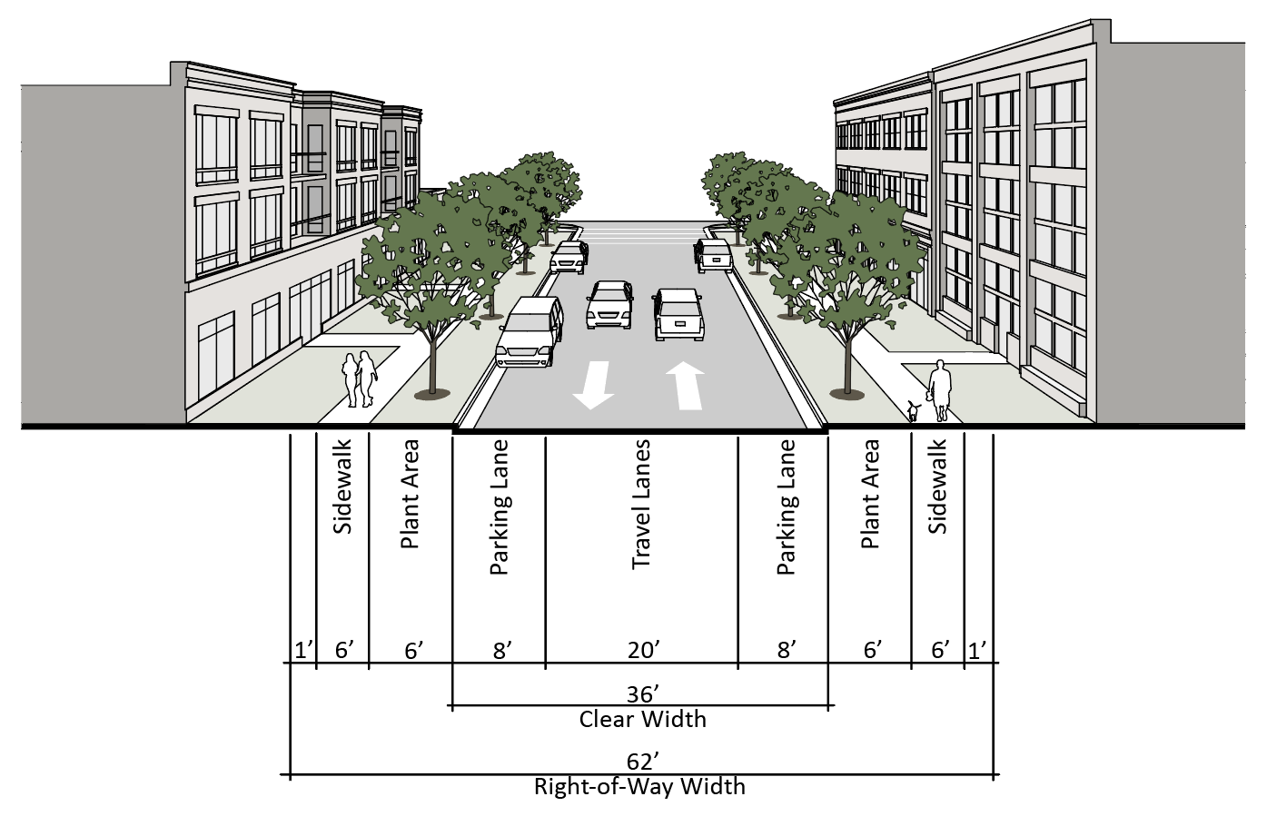
g.
Avenue. The avenue is a connector street with designated on-street parallel parking and bicycle facilities. It is intended for use in mixed use or commercial areas. The median may be eliminated to provide a continuous center turn lane. For a 4-lane configuration, the clear width and right-of-way width shall be increased by 20 feet.
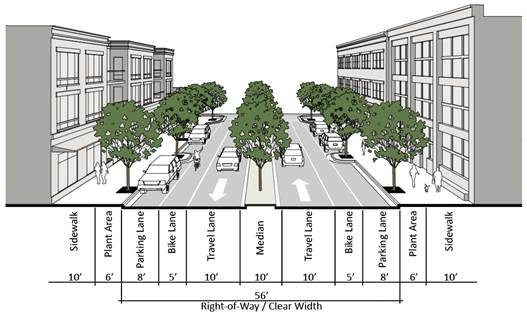
h.
Main street - parallel. The main street, parallel, is a connector street with designated on-street parallel parking. It is intended for use in mixed use areas. This street type may also include bike lanes.
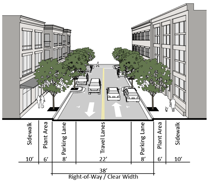
i.
Main street - angle. The main street - angle, is a connector street with designated on-street angle parking. It is intended for use in mixed use areas. This street type may also include bike lanes.
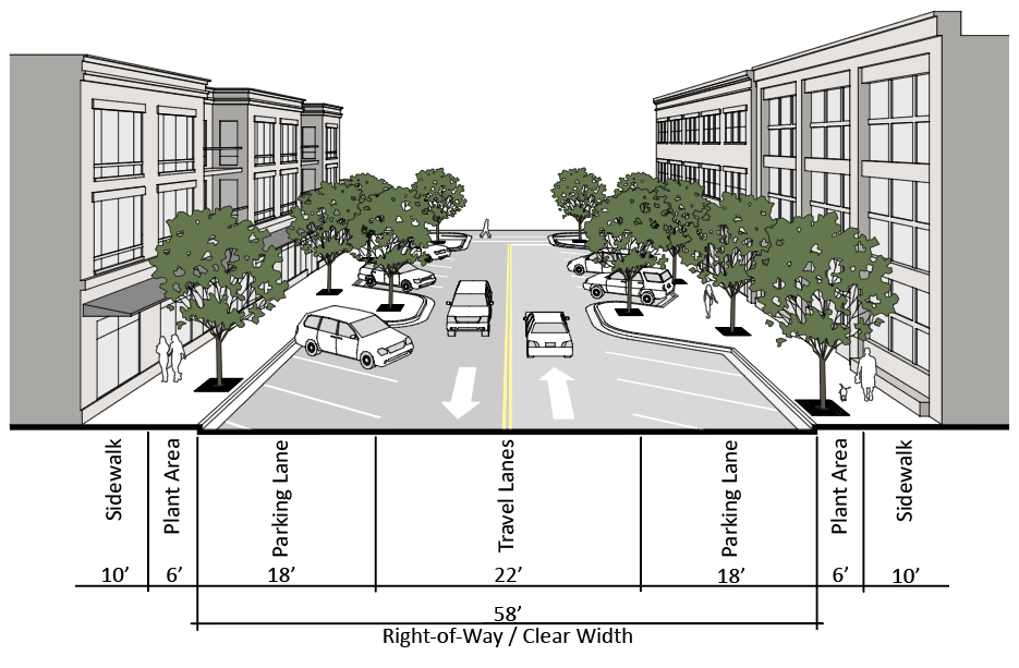
j.
Residential alley. The residential alley is a right-of-way designed to provide access to the side or rear of residential building types whose principal frontage is on a street.
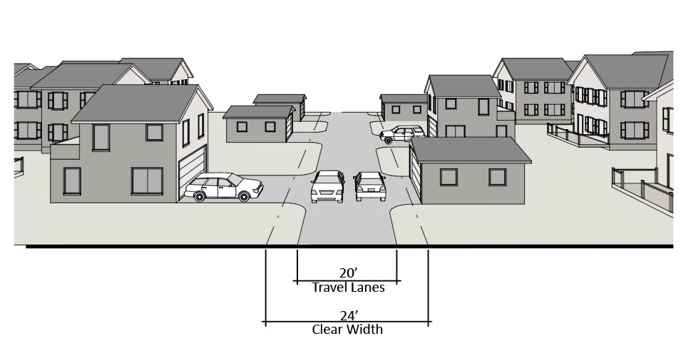
k.
Mixed use alley. The mixed use alley is a right-of-way designed to provide access to the side or rear of mixed uses whose principal frontage is on a street. Clear width shall include a minimum twenty (20) foot travelway and twelve (12) foot loading areas along both sides.
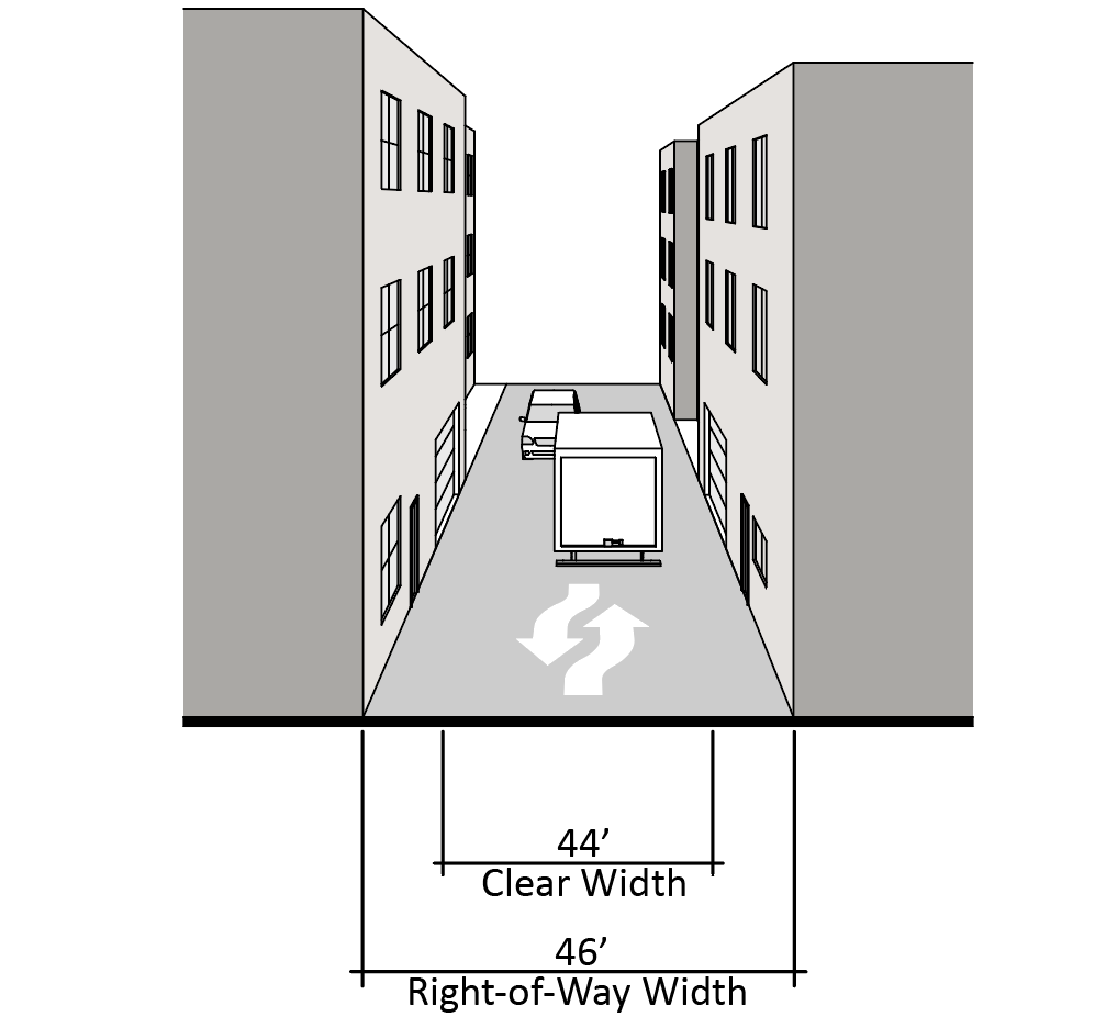
l.
Pedestrian passage. The pedestrian passage is used to break up long blocks where a street is impractical. A pedestrian passage must connect to a public street on both ends.
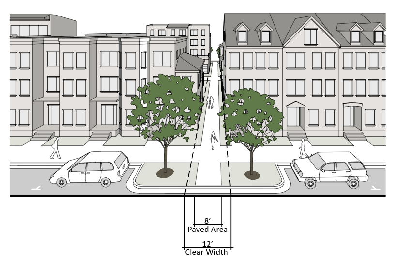
(6)
Administration.
a.
Zoning map amendments (rezoning). Article XII, "Amendments to Zoning Maps" shall apply to UD districts, as modified below. The following requirements shall be met at the time of any rezoning to a UD district:
1.
UD district master plan. The UD district request shall include a master plan that shall incorporate the area of the rezoning to a UD district approved by the board of supervisors. Future development within the UD district shall be in conformance with the applicable master plan. The master plan shall include, at minimum, the following components:
i.
Location of each proposed subdistrict.
ii.
Pedestrian shed - one-fourth (¼) mile radius from central civic building or commercial use.
iii.
Applicable street network, including street network hierarchy.
iv.
Location of civic buildings and uses.
v.
Location of historic structures and sites, if any.
vi.
Location of special sites, including vista termination points.
vii.
Location of passive and active open spaces.
viii.
Tables identifying quantities associated with each use, including acreage, amount of development, and areas designated for civic uses, open space, and streets.
ix.
Description of how the proposal is consistent with the applicable UDA recommendations in the comprehensive plan.
x.
Building elevations that illustrate the architectural features of the proposed buildings. Architectural features shall be consistent with illustrations and recommendations of any comprehensive plan documents that apply to the area in which the site is located, including, but not limited to, urban redevelopment area plans, redevelopment area plans, and the traditional neighborhood development plan.
2.
Waiver of master plan components. The agent may waive specific components of a master plan when the agent determines that the component's application to the subject property does not serve the purposes of the district and the absence of the component(s) does not materially alter the ultimate implementation of the master plan considered in its entire context.
3.
Technical modifications or adjustments to the approved master plan may be approved by the agent provided:
i.
The technical modification or adjustment for the shifting of a boundary of a subdistrict does not result in a significant relocation of a subdistrict or switching of a subdistrict, and does not increase the approved density or intensity of the entire master plan; or
ii.
The technical modification or adjustment is due to changes in the County Code or technical engineering, that may necessitate the shifting of the location of a primary road, civic building and use, or passive and active open spaces.
iii.
The request for a technical modification or adjustment shall be submitted to the agent, in writing, and include a description of the specific features of the neighborhood design standards that the applicant is requesting to be modified or adjusted, and justification as to why the originally planned feature needs to be modified or adjusted.
iv.
The agent shall render a decision in writing within forty-five (45) days from the date of receiving a written request determining: (1) whether the request is a technical modification to the master plan; and (2) whether the request is approved or denied, in whole or in part.
4.
UD district planning principles. The request must provide a written narrative, with any supporting illustrations to identify and demonstrate how the request conforms to the principles of new urbanism and traditional neighborhood design, including the following:
i.
Each neighborhood is defined by an easy walking distance from edge to center of approximately one-fourth mile.
ii.
The road network is well-connected, including connection of new local streets with existing local streets.
iii.
There are options for future transit.
iv.
Neighborhoods are mixed use, including variety of housing stock that serves a range of incomes and age groups.
v.
Uses are well-integrated, rather than widely separated and buffered.
vi.
Special sites, such as those at a terminated vista, are reserved for civic buildings and spaces that serve as symbols of the community, enhancing community identity.
vii.
Historic structures are preserved and protected.
viii.
Formal and informal active and passive open spaces are a key component. A system of open spaces is connected by pedestrian and bicycle networks.
ix.
Residential densities per gross acre of developable land (excluding open space) demonstrate at least:
A.
Three (3) single-family units;
B.
Five (5) townhouse units; and
C.
Eleven (11) multifamily units.
5.
Deviation or modification of provisions for UD districts. As part of a rezoning application to the UD district, or for properties presently zoned UD, a deviation or modification to specific siting and configuration standards in County Code § 28-39(u)(1) may be approved subject to the following provisions:
i.
As part of a rezoning application to the UD district:
A.
A written justification shall be provided by applicant for all proposed deviations or modifications that demonstrates that the request is necessary due to the unique characteristics of the specific property and demonstrates that such deviations or modifications will not conflict with the purposes of the UD district.
B.
The applicant shall propose an alternative or modified approach to fulfill the intent of the standard being modified.
ii.
For properties in a UD zoning district:
A.
An application for a proffer amendment shall be submitted by the applicant, along with a written justification for all proposed deviations or modifications that demonstrates that the request is necessary due to the unique characteristics of the specific property and demonstrates that such deviations or modifications will not conflict with the purposes of the UD district.
B.
The applicant shall propose an alternative or modified approach to fulfill the intent of the standard being modified.
iii.
The board of supervisors may approve or disapprove such request as specifically identified in the board's motion, in whole or in part.
(v)
Special provisions applicable to farmers markets.
(1)
Customer parking areas shall be provided exclusive of vendor parking, and shall be in accordance with section 28-102. At a minimum, parking and driving areas shall be surfaced in crushed stone in an amount sufficient to prevent soil erosion, abate dust and provide an adequate driving surface. Where parking areas are shared with other uses on-site, parking must meet the minimum requirements for all uses.
(2)
For properties without an existing commercial entrance onto state-maintained roadways, an entrance permit must be obtained through the Virginia Department of Transportation.
(3)
Approval must be obtained from the Stafford County Agricultural/Purchase of Development Rights Committee for establishment of a farmers market. The committee will maintain guidelines for location, management and operation of farmers markets, and review any request to determine conformity with such guidelines. A sketch plan must be submitted through the department of planning and zoning which depicts the entrance to the site, a designated vendor area, customer parking, and setbacks of the vendor area and parking area from property lines. The sketch plan must designate the size and location of any proposed structure, which must be in accordance with all applicable building code regulations.
(4)
A zoning permit must be obtained prior to operation.
(5)
For properties zoned R-1, suburban residential; R-2, urban residential-medium density; R-3, urban residential-high density; or R-4, manufactured homes, the location of farmers markets shall be limited to areas of community/civic use or on open space parcels.
(w)
Microbrewery.
(1)
Any microbrewery shall be licensed by the Virginia Department of Alcohol Beverage Control as a brewery.
(2)
Only beer products that are produced on the premises shall be sold by the facility. Any sales for on-premises and off-premises consumption shall be in accordance with the licensing requirements of the Virginia Department of Alcohol Beverage Control and any applicable Virginia law. Non-alcoholic beverages that are produced off-site may be sold at the facility.
(3)
Any part of the facility used for tasting beer products produced on-site shall be considered accessory to the brewing of beer.
(4)
To conduct events such as weddings, parties, and/or events with two hundred (200) or more attendees, a conditional use permit shall be required.
(x)
Special provisions applicable to microcell communication facilities.
(1)
Equipment and antenna for microcell communication facilities shall be no more than fifteen (15) feet in height above the roof/eave line of the structure on which it is located, nor shall it be more than eighty (80) feet in height above the average front grade of the structure.
(2)
The antenna shall not exceed three (3) feet × two (2) feet in size and not exceed an output of sixty (60) watts.
(3)
The equipment and antenna shall be screened from view or installed and/or designed to be integrated within the architectural integrity of the building or primary structure so as to be camouflaged, or use stealth technology when camouflaged techniques are not possible, so as to make the antenna and related equipment as visually unobtrusive as possible.
(4)
The area of the equipment cannot exceed twenty-five (25) percent of the footprint of the structure on which it is located.
(5)
The applicant shall comply with all federal, state and local codes, regulations and guidelines.
(6)
This use shall be considered an accessory use to all nonresidential uses permitted by-right within the B-1, convenience commercial; B-2, urban commercial; M-1, industrial light; M-2, industrial heavy; PD-1, planned development-1; PD-2 planned development-2; P-TND, planned-traditional neighborhood development; and UD, urban development zoning districts.
(7)
Microcell communication facilities shall be allowed as an accessory use on all public facility structures regardless of the zoning district in which it is located.
(y)
Special provisions applicable to ICTP overlay districts.
(1)
Sidewalks shall be provided connecting buildings, streets, alleys and common areas.
(2)
All buildings shall have integrated architectural designs that utilize common themes and building materials throughout the district, and comply with the neighborhood design standards element of the comprehensive plan.
(3)
No more than ten (10) percent of the dwelling units in a multifamily building can have three (3) or more bedrooms.
(4)
Multifamily buildings shall include space for amenities such as meeting rooms, offices, restaurants, and locations and spaces for exercise and recreation.
(z)
Special provisions applicable to solar facilities and energy storage facilities.
(1)
Such projects shall be located within two and one-half (2.5) miles of electric transmission lines.
(2)
Solar panels shall cover no more than eighty percent (80%) of the total land area of the solar project site.
(3)
The solar project site shall have access to a major collector road (or higher) as designated in the comprehensive plan unless the board of supervisors finds the amount of traffic generated by the project is such that frontage on a public road with a lesser designation will not cause an undue impact on neighboring properties or adversely affect safety or road usage.
(4)
All equipment shall be placed at least one hundred (100) feet from any property line or habitable structure located on adjacent properties unless such modification is approved by the board of supervisors.
(5)
All equipment and panels shall be at least five hundred (500) feet from the edge of any right-of-way identified as a Corridor of Statewide Significance by the state, unless such modification is approved by the board of supervisors. The setback may be modified by the board of supervisors upon demonstration that the panels will not impact the viewshed from the identified corridor.
(6)
Solar panel components shall have a UL listing and shall be designed with an anti-reflective coating. Individual arrays/solar panels shall be designed and installed in order to prevent glare toward buildings on adjacent properties and nearby vehicular traffic.
(7)
The solar project site shall be enclosed with chain link fencing not less than six (6) feet in height, include an appropriate anti-climbing device, and shall be secured with gates. Fencing shall be installed on the interior of the buffer required in subsection (z)(8) below.
(8)
A vegetated buffer shall be required around the solar project site consisting of a landscaped strip at least fifty (50) feet wide measured from each boundary line of the solar project site around the entire perimeter. The solar project site shall be landscaped and maintained with a buffer of plant materials that are mature enough to effectively screen the view to eight (8) feet above ground level of the solar panels from adjacent properties all year round. Non-invasive plant species, pollinator-friendly and wildlife-friendly native plants, shrubs and trees shall be used.
(9)
The solar project site, including the area underneath the solar panels, shall be vegetated. Solar panels shall be adequately spaced to ensure sufficient sunlight penetration to promote vegetation growth.
(10)
When a buffer is not required based on the results of a viewshed analysis, buffer requirements may be reduced or eliminated when the adjoining property is subject to an active agricultural use and the reduction or elimination is approved by the board of supervisors.
(11)
All newly installed utilities, including but not limited to electric or fiber lines, serving the solar project site shall be placed underground.
(12)
Any change of ownership or management of the solar facility or energy storage facility shall be reported to the zoning administrator within ninety (90) days of such change.
(13)
The zoning administrator shall be notified in writing at least one hundred eighty (180) days in advance of any intent to repower the facility. Such notification shall include full details for the proposed changes to the site for review and may require new permits, inspections or a site plan.
(14)
Conditional use permits applicable to solar facilities and energy storage facilities may include conditions permitted by Virginia Code § 15.2-2288.8, as amended.
(15)
A proposed decommissioning agreement shall be submitted as part of the conditional use permit application. Decommissioning shall include the removal of all solar panels, collectors, cabling, electrical components, fencing and all other associated equipment, facilities and structures to a depth of at least thirty-six (36) inches from the ground surface of the property with site rehabilitation establishing preconstruction conditions of the solar project site.
In addition to the terms required by Virginia Code § 15.2-2241.2, such agreement, which shall be recorded in the land records of the Stafford County Circuit Court, shall include the following:
a.
A description of any agreement (e.g. lease) with all landowners regarding decommissioning shall be included on the site plan;
b.
The identification of the party currently responsible for decommissioning;
c.
The types of panels and material specifications used at the project site;
d.
Standard procedures for removal of facilities and project site rehabilitation, including, but not limited to, recompacting, planting and reseeding;
e.
An estimate of all costs for the removal and disposal of solar panels, structures, cabling, electrical components, roads, fencing, and any other associated facilities above ground or up to thirty-six (36) inches below grade; and
f.
A deadline for completion of decommissioning.
(16)
The zoning administrator shall be notified in writing within thirty (30) days of the abandonment or discontinuance of the solar facility or energy storage facility use.
(aa)
Special provisions applicable to apiary as an accessory use in the R-1, Suburban Residential District.
(1)
The keeping of honeybees in four (4) hives or less shall be permitted as an accessory use to a single-family dwelling subject to the issuance of a zoning permit.
(2)
Hives shall be located in the rear yard and shall be a minimum of fifteen (15) feet from all property lines.
(3)
Minimum lot size requirements:
a.
No hives shall be permitted on any lot less than 10,000 square feet in size.
b.
A minimum lot size of 10,000 square feet is required for up to two (2) hives.
c.
A minimum lot size of 12,500 square feet is required for three (3) hives.
d.
A minimum lot size of 15,000 square feet is required for four (4) hives.
(4)
There shall be at least one adequate and accessible water source provided on-site exclusively for the hives, which shall be located within twenty (20) feet of all hives. A natural stream, pond or spring may constitute an adequate and accessible water source.
(5)
If the landing platform of a hive faces and is within twenty (20) feet of any lot or property line, there shall be a flight path barrier, consisting of a fence, structure or evergreen shrubs not less than six (6) feet in height, located in front of and shielding the entire hive or set of hives.
(6)
Signs shall be posted at the perimeter of any property not enclosed by a fence warning of the presence of hives. Such signs shall meet the standards of a minor sign.
(7)
A beekeeping best management plan shall be submitted with the zoning permit application.
(8)
Brood boxes shall be stacked no more than two (2) high.
(9)
All colonies shall be kept in hives with removable frames, which shall be kept in sound and usable condition. For the purpose of this section, "colony" means an aggregate of bees consisting principally of workers, but having, when perfect, one (1) queen and at times many drones, including brood, combs, honey, and the receptacle inhabited by the bees.
(Ord. No. 094-29, § 28-309, 8-9-94; Ord. No. 095-48, 6-20-95; Ord. No. 096-09, 2-6-96; Ord. No. 097-62, 11-18-97; Ord. No. 098-19, 3-17-98; Ord. No. 097-80, 12-16-97; Ord. No. 099-22, 6-15-99; Ord. No. 099-26, 7-13-99; Ord. No. 099-42, 7-13-99; Ord. No. 099-60, 11-4-99; Ord. No. 000-29, 10-17-00; Ord. No. 003-03, 7-1-03; Ord. No. O06-59, 8-1-06; Ord. No. O06-73, 12-19-06; Ord. No. O07-20, 3-20-07; Ord. No. O07-39, 7-17-07; Ord. No. O07-68, 10-2-07; Ord. No. O07-77, 12-18-07; Ord. No. O08-02, 5-6-08; Ord. No. O09-32, 10-20-09; Ord. No. O11-01, 6-21-11; Ord. No. O11-14, 6-21-11; Ord. No. O12-01, 2-21-12; Ord. No. O12-07, 6-19-12; Ord. No. O13-13, 6-4-13; Ord. No. O13-20, 10-15-13; Ord. No. O13-36, 9-3-13; Ord. No. O13-50, 10-15-13; Ord. No. O14-02, 2-18-14; Ord. No. O15-09, 6-2-15; Ord. No. O15-10, 5-5-15; Ord. No. O15-16, 6-16-15; Ord. No. O15-24, 9-1-15; Ord. No. O15-35, 10-20-15; Ord. No. O16-25, 8-16-16; Ord. No. O16-39, 12-13-16; Ord. No. O17-03, 5-2-17; Ord. No. O18-26, 7-10-18; Ord. No. O18-06, 12-11-18; Ord. No. O20-09, 3-3-20; Ord. No. O20-19, 8-18-20; Ord. No. O20-43, 10-29-20; Ord. No. O21-10, 6-15-21; Ord. No. O22-18, 9-20-22; Ord. No. O23-01, 5-16-23; Ord. No. O23-24, 10-17-23)
Sec. 28-40. - Official zoning map.
(a)
The location and boundaries of the districts established by this article are set forth and indicated on a set of maps entitled "Official Zoning Map of Stafford County," which may also be called "the zoning map," which shall be located in the Zoning Office of Stafford County, Virginia, and which shall be a part of this chapter to the same extent as if set out in this article III.
(b)
No changes of any nature shall be made in the zoning map or the matter shown thereon, except in conformance with the procedures set forth in this chapter and Virginia law. Any unauthorized change by any person or persons shall be considered a violation of this chapter.
(Ord. No. 094-29, § 28-310, 8-9-94)
Sec. 28-41. - Cluster subdivision areas map.
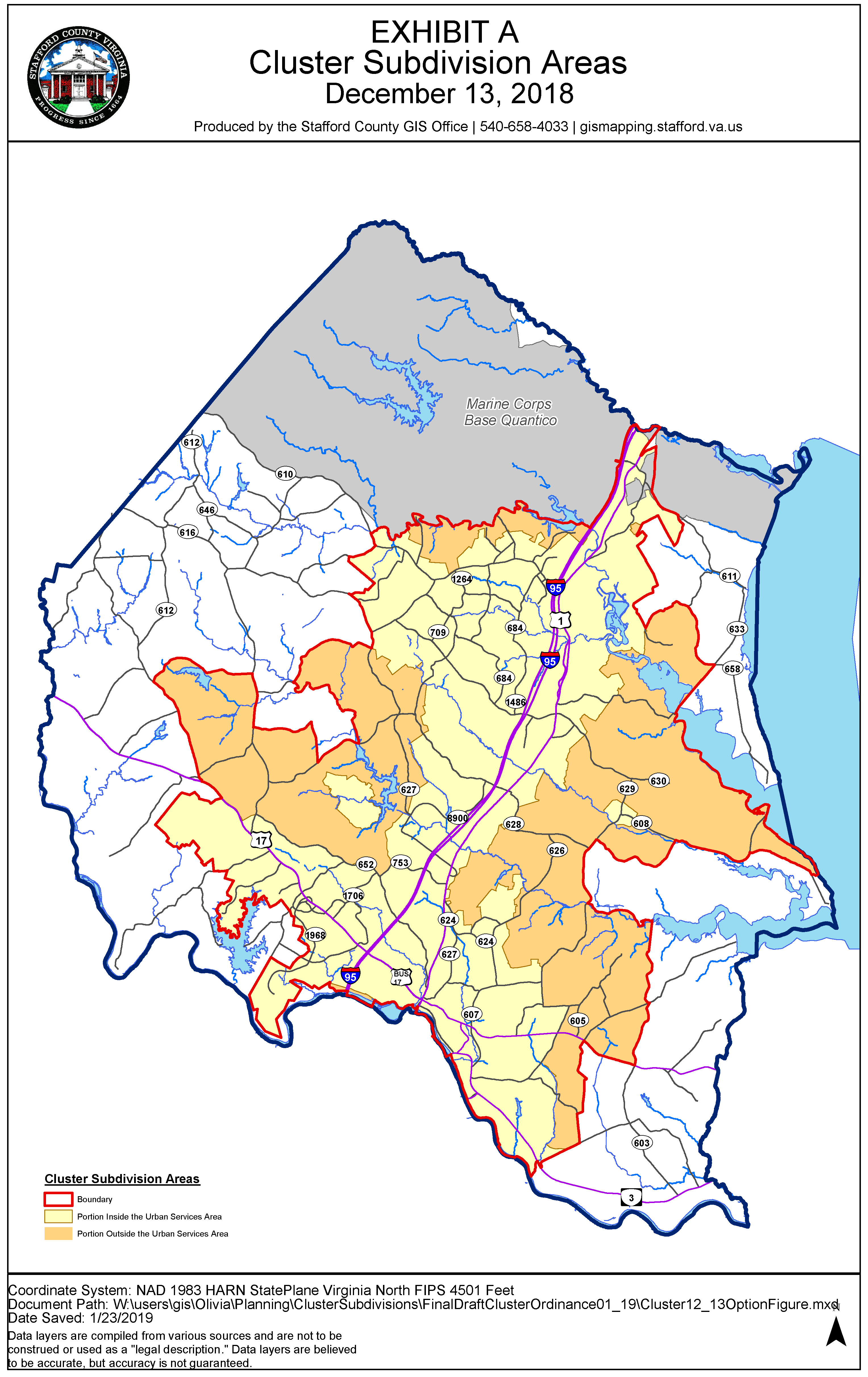
(Ord. No. O18-13, Exh. A, 3-20-18; Ord. No. O19-02, 1-22-19)