
Stonecrest City Zoning Code
ARTICLE 3
- OVERLAY DISTRICT REGULATIONS
Sec. 3.1.1. - Overlay districts generally.
Overlay districts are supplemental to the zoning district classifications established in article 2 of this chapter. This section shall supersede the applicability statements in each overlay district except as provided in subsection (F) of this section, and are applicable as follows:
A.
All development and building permits for lots located, in whole or in part, within any overlay district shall meet all of the regulations of the underlying zoning district in which they are located as well as all of the regulations of the applicable overlay district.
B.
For new development after the effective date of the ordinance from which this chapter is derived, when no complete application for a land disturbance or building permit has been filed with respect to a property located within an overlay district and the property has conditions of zoning that were approved prior to, and in conflict with the overlay district regulations contained in this article, the overlay district regulations shall prevail. If a condition of zoning does not conflict with the overlay district regulations, the condition of zoning shall remain applicable to the property.
C.
For existing development, if overlay district regulations conflict with the conditions of zoning applicable to property within in an overlay district, the existing zoning conditions remain applicable to the property.
D.
If overlay district regulations conflict with other regulations contained in this chapter, the overlay district regulations shall prevail.
E.
The use of property may be permitted without rezoning if listed as allowed by the overlay. Uses allowed by the underlying zoning in article 4 of this chapter, shall also be permitted in the overlay district, unless they are listed as prohibited within the overlay district.
F.
Each application for a business license, land disturbance permit, building permit or sign permit, which involves the development, use, exterior alteration, exterior modification or addition of any structure, must demonstrate compliance with all overlay district regulations, subject to article 8 of this chapter, nonconforming uses, structures and buildings.
G.
The zoning district designations contained in article 3 of this chapter, titled Overlay District Regulations, were not revised to reflect the new zoning district designations utilized in the updated zoning ordinance. Any discontinued zoning district references contained in this article 3 of this chapter shall therefore be construed using the conversion chart contained in Table 1.1 of article 1 of the zoning ordinance, and applied as appropriate to the updated provision of the zoning ordinance.
H.
When a plan package for a proposed development is submitted for conceptual plan review or a final design package approval for a land disturbance or building permit application, the governing district by related to design or dimensional standards by which the development will be reviewed under must be clearly stated. That governing district standards must be associated with either the underlying zoning district, or an authorized district as permitted by the applicable Overlay Tier at the time of application submittal.
I.
If the governing underlying district does not match the existing underlying district, the city may initiate a rezoning of the underlying property to the governing district, with property owner approval, at any point after final plat approval or the issuance of a Certification of Occupancy.
(Ord. of 8-2-2017, § 1(3.1.1); Ord. No. 2021-06-06, § 1(Exh. A), 8-23-2021; Ord. No. 2022-01-06, § 1(Exh. A), 1-24-2022)
Sec. 3.1.2. - Purpose and intent.
Each Subarea Overlay has its own purpose and intent based on original overlay requirements.
(Ord. of 8-2-2017, § 1(3.1.2))
Sec. 3.1.3. - Plan submittal, review and approval.
A.
Pre-submittal conference. Prior to the submittal for review of a land disturbance or building permit application for property located within an overlay district, the applicant and the staff shall have a preliminary meeting to discuss the submittal requirements.
B.
Conceptual plan submittal requirements. As part of any land-disturbance permit, building permit, or sign permit application, the applicant shall submit to the director of planning a conceptual plan package and a final design package. Each package must include full architectural and landscape plans and specifications. The submitted plans must include a site plan, architectural elevations and sections; renderings depicting the building design including elevations and architectural details of proposed buildings, exterior materials and colors, and plans and elevations of all hardscape, landscape and signs, all of which shall demonstrate that the proposed design is in compliance with all the requirements of the applicable overlay district and the underlying zoning classification. The plans must clearly state the governing district requirements by which the plans will be reviewed. If the proposed development is also located in an historic district as designated in the Code, the development shall also comply with the regulations established for the historic district in chapter 13.5 of the DeKalb County Code.
C.
Review by staff. Staff will review the conceptual plans for compliance with specifications and design guidelines contained in this zoning ordinance for the governing district requested by the applicant. If the application fails to comply with any section in this zoning ordinance, the application shall be marked "failed compliance," shall be returned to the applicant with any comments and/or redlines for revisions, and may be re-submitted with corrections addressing the staffs comments and/or redlines for further consideration. Once the application is found to be in compliance, the final design shall be forwarded to the director of planning for approval.
1.
Where the director of planning determines that said plans comply with the requirements of the overlay district, the director of planning shall approve the plans for compliance as part of the application for land disturbance, building or signs permits.
2.
Where the director of planning determines that submitted conceptual plans do not comply with the requirements of this chapter, then the director of planning shall notify the applicant in writing of the manner in which the conceptual plans fail to comply with such requirements. All applications shall be considered and decided by the director of planning within 30 days of receipt of a complete application.
3.
Any appeal to vary overlay district development standards shall be to the zoning board of appeals pursuant to article 7 of this chapter.
D.
Fees. Plans shall be accompanied by an application and payment of a fee in an amount determined by the city council.
(Ord. of 8-2-2017, § 1(3.1.3); Ord. No. 2022-01-06, § 1(Exh. A), 1-24-2022)
Sec. 3.1.4. - Conceptual plan package review.
A.
The conceptual plan package shall include the following:
1.
A narrative addressing the proposed development explaining how it meets the purpose, intent, and standards of this article. The narrative shall include a statement of what governing district review standards will be applied. The narrative shall include a tabulation of the approximate number of acres for each different land use type within the project, the approximate number of dwelling units by type, the approximate gross residential density, the approximate commercial density as well as square feet, the common open space acreage, the approximate open space acreage, the anticipated number, type and size of recreational facilities and other public amenities, and the legal mechanism for protecting and maintaining common/public open, as required in article 5 of this chapter;
2.
A site location map showing the proposed development, abutting properties, the access connections of the proposed development to surrounding and existing development, and transitional buffer zones, if required;
3.
A multi-modal access plan, prepared at a scale not greater than one inch equals 100 feet, to demonstrate a unified plan of continuous access to and between all structures in the proposed development and adjacent properties where connections are appropriate. The multi-modal access plan shall cover the entire proposed development along with public right-of-way of adjoining streets and any other property lying between the subject property and any primary or secondary streets. Safe and convenient pathways shall be provided from sidewalks along streets to each structure entrance, including pedestrian access routes across parking lots and between adjacent buildings within the same development. Connections to available transportation nodes, such as driveways, sidewalks, and bike paths shall be shown along adjacent streets and those entering adjoining properties. Where an existing or planned public transportation station or stop is within 1,250 feet from the nearest boundary of the subject property, the access plan shall show how pedestrians may safely travel from such station or stop to the subject property. Where an existing or planned bike path is located within 1,500 feet from the nearest boundary of the subject property, the access plan shall show how safe, continuous and convenient bicycle access shall be provided to the subject property.
4.
Two copies of a plan drawn to a designated scale of not less than one inch equals 100 feet, certified by a professional engineer or land surveyor licensed by the state, presented on a sheet having a maximum size of 24 inches by 36 inches, and one 8½ inches by 11 inches reduction of the plan. A .jpg copy of the plan shall be e-mailed to the director of planning. If presented on more than one sheet, match lines shall clearly indicate where the several sheets join. Such plan shall contain the following information:
a.
Boundaries of the entire property proposed to be included in the development, with bearings and distances of the perimeter property lines;
b.
Scale and north arrow, with north, to the extent feasible, oriented to the top of the plat and on all supporting graphics;
c.
Location and approximate dimensions in length and width, for landscape strips and required transitional buffers, if any;
d.
Existing topography with a maximum contour interval of five feet and a statement indicating whether it is an air survey or field run;
e.
Delineation of any floodplain designated by the Federal Emergency Management Agency, United States Geological Survey, or City of Stonecrest;
f.
Delineation of any jurisdictional wetlands, as defined by section 404 of the Federal Clean Water Act;
g.
Approximate delineation of any significant historic or archaeological feature, grave, object or structure marking a place of burial if known, and a statement indicating how the proposed development will impact it;
h.
Delineation of all existing structures and whether they will be retained or demolished;
i.
General location, in conceptual form, of proposed uses, lots, buildings, building types and building entrances;
j.
Height and setback of all existing and proposed buildings and structures;
k.
Location, size and number of all on-street and off-street parking spaces, including a shared parking analysis, if shared parking is proposed;
l.
Identification of site access points and layout, width of right-of-way and paved sections of all internal streets;
m.
Conceptual plans for drainage with approximate location and estimated size of all proposed stormwater management facilities and a statement as to the type of facility proposed;
n.
Development density and lot sizes for each type of use;
o.
Areas to be held in joint ownership, common ownership or control;
p.
Identification of site access points and layout, width of right-of-way and paved sections of all internal streets;
q.
Location of proposed sidewalks and bicycle facilities, trails, recreation areas, parks, and other public or community uses, facilities, or structures on the site;
r.
Conceptual layout of utilities and location of all existing and proposed utility easements having a width of ten feet or more;
s.
Standard details of signs, sidewalks, streetlights, driveways, medians, curbs and gutters, landscaped areas, fencing, street furniture, bicycle lanes, streets, alleys, and other public improvements demonstrating compliance with the design guidelines for the overlay district; and
t.
Seal and signature of the professional preparing the plan.
5.
Two copies of the conceptual building designs including elevation drawings drawn to a scale of not less than one-sixteenth-inch equals one foot showing architectural details of proposed building, exterior materials, all of which demonstrate that the proposed design is in compliance with the Subarea Overlay District in which it is located. Drawings shall be presented on a sheet having a maximum size of 24 inches by 36 inches, along with one 8½ inches by 11 inches reduction of each sheet. A .pdf copy of the drawings shall be e-mailed to the director of planning. If the drawings are presented on more than one sheet, match lines shall clearly indicate where the several sheets join.
6.
Lighting plan. See article 5 of this chapter.
7.
Traffic study. See article 5 of this chapter.
(Ord. of 8-2-2017, § 1(3.1.4); Ord. No. 2022-01-06, § 1(Exh. A), 1-24-2022)
Sec. 3.1.5. - Final design package.
Upon receiving and addressing the city's comments with respect to the conceptual design package, the applicant must submit the final design package, including color .pdf copies, for review and approval. The final design package must contain a statement of which governing district standards are being applied, full architectural and landscape plans, site plan, elevations, section renderings depicting the building design containing elevations and architectural detailing of proposed buildings, exterior materials and color, and plans and elevations of hardscape landscape and signs all of which must demonstrate compliance with overlay district regulations. All items and specifications necessary for obtaining land disturbance and building permits must be submitted with the final design package. The applicant may submit the final design package simultaneously with the land disturbance or building permit application, as applicable.
(Ord. of 8-2-2017, § 1(3.1.5); Ord. No. 2022-01-06, § 1(Exh. A), 1-24-2022)
Sec. 3.1.6. - Overlay use table.
Table 3.1 indicates the permitted uses within the overlay zoning districts. Even though a use is listed as an allowable use within a particular base zoning district, additional use restrictions may apply based on the applicable overlay zoning district requirements specified in this article.
A.
The uses listed in Table 3.1 shall be permitted only within the zoning overlay districts identified, and no use shall be established and no structure associated with such use shall be erected, structurally altered or enlarged unless the use is permitted as:
1.
A permitted use (P);
2.
A special use (SP) subject to the special land use permit application procedures specified in article 7 of this chapter;
3.
An administratively approved use (SA) subject to the special administrative zoning permit procedures specified in article 7 of this chapter;
4.
An accessory use (PA) as regulated by article 4 of this chapter. Table 3.1 does not list all accessory uses but clarifies uses acceptable as accessory, though not typically considered principal uses for the zoning classification.
5.
Uses lawfully established prior to the effective date of this zoning ordinance.
B.
Any use not listed in Table 3.1, below, or interpreted to be allowed by the director of planning pursuant to section 4.1.2 is prohibited. Any applicant denied a permit to allow a use of property in a zoning district other than as provided in this section may file an appeal before the zoning board of appeals as provided in article 7 of this chapter.
C.
If there is a conflict between Table 3.1 and the text of this chapter, the text shall prevail.
(Ord. No. 2021-06-06, § 1(Exh. A), 8-23-2021; Ord. No. 2022-06-01, § 2(Exh. A), 8-2-2022; Ord. No. 2022-10-02, § 1(Exh. A), 10-24-2022; Ord. No. 2023-05-03, § 1(Exh. A), 5-22-2023; Ord. No. 2023-06-02, § 1(Exh. A), 6-28-2023; Ord. No. 2023-07-02, § 1(Exh. A), 7-31-2023; Ord. No. 2024-02-04, § 1(Exh. A), 2-26-2024; Ord. No. 2024-02-05, § 1(Exh. A), 2-26-2024)
Sec. 3.4.1. - Title.
The provisions contained within this division are the regulations of the Arabia Mountain Conservation Overlay District.
(Ord. No. 2019-02-001, § 1, 2-11-2019)
Sec. 3.4.2. - Purpose and intent.
The purpose and intent of the city council in establishing the Arabia Mountain Conservation Overlay District (AMCOD) is as follows:
A.
To provide for the protection of natural resources and of scenic views of areas within the boundaries of the AMCOD, so as to protect and enhance the public welfare associated with these natural resources and the aesthetic qualities within this area, consistent with the policies of the Stonecrest Comprehensive Plan;
B.
To provide reasonable and creative planning and development within the AMCOD while preserving the natural land form and features, trees and tree canopy, and the views to and from Arabia Mountain as indicated on the adopted map;
C.
To assure that all activities and authorized uses of land allowed within the AMCOD, whether allowed uses or permitted uses, are activities or uses which are designed so as not to detract from or damage the protected natural resources and scenic beauty of this district;
D.
To encourage and promote the dedication of conservation easements to appropriate public and not-for-profit entities established and authorized to hold easements in perpetuity pursuant to the Georgia Uniform Conservation Easement Act (O.C.G.A. 44-10 and 12-6A), for the purposes of protecting historical and [archaeological] areas, the habitat of endangered or threatened animal and plant species (as defined in the federal Endangered Species Act U.S.C. 1531 and the Endangered Wildlife Act of 1973), providing passive recreational and educational opportunities, preserving the cultural history of the area, protecting open space within the city, and protecting scenic views to and from Arabia Mountain; and
E.
To provide consistent development standards that will adhere to common design characteristics that include but are not limited to: deep setbacks from the main road; strategic buffer zones; home "clustering"; shorter streets within a development and shared open spaces connected by trails, walkways and paths.
(Ord. No. 2019-02-001, § 1, 2-11-2019)
Sec. 3.4.3. - District boundaries.
The boundaries of the AMCOD shall be depicted on the official zoning maps entitled "Official Zoning Map, City of Stonecrest, Georgia, Arabia Mountain Conservation Overlay District" (the "AMCOD overlay maps"). The Official Zoning Map, City of Stonecrest, Georgia, Arabia Mountain Conservation Overlay District, to be adopted contemporaneously with this chapter, together with all explanatory information contained or referenced thereon, is hereby adopted by reference and declared to be a part of this chapter.
The AMCOD overlay maps shall be adopted contemporaneously with this chapter in digital format and contained on a compact disk to be maintained in its original, unedited and unaltered form by the clerk to the city council. A printed copy of the compact disk's contents depicting the AMCOD overlay maps on the date of its initial adoption shall also be maintained in its original, unedited and unaltered form by the clerk to the city council.
(Ord. No. 2019-02-001, § 1, 2-11-2019)
Sec. 3.4.4. - Applicability of regulations.
This division establishes standards and procedures that apply to development of any lot or portion thereof which is in whole or in part contained within the boundaries of the AMCOD. The procedures, standards, and criteria shall apply only to that portion of the subject property within the boundaries of the district.
(Ord. No. 2019-02-001, § 1, 2-11-2019)
Sec. 3.4.5. - Principal uses and principal structures.
A.
The principal uses of land and structures which are allowed in the AMCOD are as is provided by the applicable underlying zoning district, except for those listed in B below, subject to the limitations and standards contained within this district. Additional permitted uses are as follows:
1.
Recreation, passive and Nature preserve.
2.
Dog Parks.
3.
Bed and Breakfast homes.
4.
Outdoor Concert halls.
5.
Urban Gardens.
6.
Wineries/Vineyards and associated uses (with a Special Land Use Permit).
B.
Prohibited uses. The following principal uses of land and structures shall be prohibited within the AMCOD:
1.
Sexually-oriented businesses.
2.
Drive-in Theater.
3.
Fairground or Amusement Park.
4.
Swimming pools as part of a commercial Recreation, Outdoor use or Recreation club; but not including swimming pools incidental to Open space, clubhouse or pool amenity.
5.
Coliseum or stadium, except for outdoor Concert Halls.
6.
Nightclub or late night establishment.
7.
Outdoor storage, mini-warehouses, and storage buildings.
8.
Pawn shops.
9.
Mortuary or Crematorium.
10.
Alcohol Outlets.
11.
Salvage yards and junk yards.
12.
Motel or Extended Stay Motel.
13.
Shelter for homeless persons.
14.
Transitional housing facility.
15.
Fuel Dealers, Fuel Pumps and Accessory Fuel Pumps.
16.
Automobile and truck rental and leasing, Automobile brokerage, Automobile mall, Automobile recovery and storage, Automobile rental and leasing, Automobile repair and maintenance, major, Automobile repair and maintenance, minor, Automobile sales, Automobile service station, Automobile upholstery shop, Automobile wash/wax service, Recreational vehicle, boat and trailer sales and service, Freight service, Transportation equipment and storage or maintenance (vehicle), and Vehicle storage yard.
17.
Commercial parking garage/structure; Commercial parking lots.
18.
Convenience store.
19.
Drive-through facilities.
20.
Personal service establishments.
21.
Check cashing facility.
22.
Heavy equipment storage.
23.
Truck stops.
24.
Warehouses.
25.
Solid waste disposal, Private industry solid waste disposal facility.
26.
Bus station or terminal.
27.
Ambulance service facility, Private ambulance service, Dispatch office.
28.
Micro Home Community.
(Ord. No. 2019-02-001, § 1, 2-11-2019; Ord. No. 2022-06-01, § 2(Exh. A), 8-2-2022; Ord. No. 2022-10-02, § 1(Exh. A), 10-24-2022; Ord. No. 2024-02-05, § 1(Exh. A), 2-26-2024)
Sec. 3.4.6. - Accessory uses and accessory structures.
The accessory uses of land and structures which are allowed in the AMCOD are as is provided by the applicable underlying zoning district, subject to the limitations and standards contained within this division.
(Ord. No. 2019-02-001, § 1, 2-11-2019)
Sec. 3.4.7. - Lot coverage.
Except as provided in Sub-Section 3.4.9.A., Conservation communities, lot coverage within the AMCOD shall not exceed 25 percent of net lot area. Net lot area refers to the total area intended to be subdivided as shown on a city approved site plan submitted for a land disturbance permit or preliminary plat, exclusive of the area intended to be dedicated for street or utility rights of way or easements, see definition of net lot area (lot area, net) in Article 9, Definitions.
(Ord. No. 2019-02-001, § 1, 2-11-2019; Ord. No. 2022-06-01, § 2(Exh. A), 8-2-2022)
Sec. 3.4.8. - Clearing and grading of lots.
No individual lot as shown on a city approved site plan submitted for a land disturbance permit or preliminary subdivision plat shall be cleared and graded to an extent exceeding 35 percent of the net lot area before subdivision. This does not apply to individual single-family lots as shown on a city approved final subdivision plat, see Sub-Section. 3.4.9.A, Conservation communities.
(Ord. No. 2019-02-001, § 1, 2-11-2019; Ord. No. 2022-06-01, § 2(Exh. A), 8-2-2022; Ord. No. 2023-06-01, § 1(Exh. A), 6-28-2023)
Sec. 3.4.9. - Development standards.
There shall be no impervious surfaces with in the 75 foot stream buffer. All dwelling units shall be provided convenient access to all green space throughout the development via pedestrian paths or trails.
A.
Conservation Communities (residential subdivisions).
Maximum density: Eight dwelling units to the acre of total land area excluding undevelopable areas listed below:
1.
Streams and stream buffers.
2.
Wetlands.
3.
Rock outcroppings.
4.
Slopes steeper than 1:2 slope.
5.
Sites of archaeological significance.
6.
Floodplains.
7.
Areas intended to be dedication for right of way.
The minimum acreage for development is ten (10) acres.
Minimum lot width: Seventy (70) feet as measured from the front building setback line; except for a lot on a cul-de-sac, which shall have a measurement of thirty-five (35) feet
Minimum lot area: Seven thousand five hundred (7,500) square feet, except that each lot on the periphery of the entire development (all sides) is at least ten thousand (10,000) square feet.
Minimum side-yard setback: Ten (10) feet
Maximum single-family dwelling lot coverage: 50%
Greenspace: Thirty (30) percent of the total land area must be designated greenspace. Sixty (65) percent of the greenspace should be in a contiguous tract. Green space may consist of:
1.
Natural undisturbed areas.
2.
Passive recreational areas.
3.
Trails and Green ways.
4.
Bikeways and paths.
5.
Mature wooded areas.
Greenspaces shall be preserve and maintained by one of the following:
1.
Establishment of a mandatory home owner's association (HOA) to own and maintain the common green space.
2.
Dedication of legally described and platted "greenspace" to a land trust.
Minimum building setback adjacent to public or private street(s):
•
From thoroughfares, arterials and collectors: 30 feet.
•
Local streets: 20 feet.
Preliminary Plat Approval
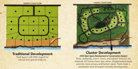
If the applicant chose to use Cluster Development as shown in this section, applicant shall submit the following:
•
A preliminary plat for the traditional lot-layout using the underlaying zoning shall be submitted.
•
A preliminary plat showing the cluster lot-layout using the overlay standards shall be submitted.
•
The number of lots shall be the same for both traditional lot-layout and cluster lot-layout.
B.
Road Specifications. All roads shall be built in accordance with Chapter 14. In the event of a conflict, the provisions of this section shall control. The design of the streets must be designed as noted below with the approval of the City Engineer:
1.
Minimal amount of cul-de-sac streets by providing more than one entrance to the to the development and interconnect streets as much as possible.
2.
Cul-de-sac streets must minimize the amount of impervious surface by limiting the internal radius to 35 feet and the width of the paved lane to 16 feet. Use grass and vegetation for the inner circle of turn-arounds, rather than paving the whole area. Declare the HOA responsible for the maintenance of the grassy area in the neighborhood bylaws.
3.
Omit curbs where possible.
4.
As an alternative to curbs and gutters, allow run off from roofs and pavements to pass immediately through grass swales or infiltration basins. Use plant materials that will absorb rainwater and act as a natural filter to oil and pollution.
5.
Provide marked, paved paths for non-vehicular traffic with in the development and connecting neighboring residential and commercial areas.
C.
Buffer Requirements. An exterior boundary buffer is required (per community/subdivision). The land area designated to the exterior buffer may be used as part of the required greenspace. The buffer area shall not be included as part of any platted residential lot within the community/subdivision.
D.
Trails. Trails maybe constructed with in the buffer. The maximum width is eight feet and must be located within the first 25 percent of the buffer furthest from the exterior boundary line.
(Ord. No. 2019-02-001, § 1, 2-11-2019; Ord. No. 2022-06-01, § 2(Exh. A), 8-2-2022; Ord. No. 2023-06-01, § 1(Exh. A), 6-28-2023)
Sec. 3.4.9.1. - Non-residential zoning district dimensional requirements.
All non-residential districts shall be developed in accordance with the regulations for the Neighborhood Shopping (NS) District.
(Ord. No. 2019-02-001, § 1, 2-11-2019)
Sec. 3.4.9.1.a - Design standards.
Buildings. New commercial buildings and renovations shall conform to the guidelines noted below.
1.
Pedestrian Amenities. All buildings shall be configured to allow safe, convenient, direct and continuous access for pedestrians to all primary building entrances. Principle building entry shall open directly on to the public right-of-way.
2.
"Build-to" line (i.e. "Building façade line"). The building shall be setback five feet from the buildable areas as indicated with in their approved site plan. Awnings and canopies are not counted in building façade line determination. Permanent structures other than buildings, such as ATMs and similar elements, shall not be located closer to the street than the building façade lines.
3.
Building height. All new buildings shall be no more than two stories, maximum height 35 feet.
4.
Façade articulation. Street-facing building façades shall be horizontally divided by floors using architectural means such as string courses, recesses, reveals or the like. They shall also be vertically divided utilizing Major and Minor Articulations to create visual interest and avoid monotony.
a.
Major Articulations shall occur at least every 60 feet of horizontal façade length and may be accomplished through: a change of façade materials extending from grade through the cornice; change in storefront systems; physical off-sets; and/or similar means intended to convey the impression of separate buildings.
b.
Minor Articulations shall occur approximately every 30 feet of horizontal façade length and may be accomplished by: the use of pilasters; the use of off-sets; or similar means intended to create the appearance of structural bays.
5.
Entrances. All first story uses adjacent to a sidewalk shall have a primary pedestrian entrance, which faces, is visible from, and is directly accessible from said sidewalk. All first story businesses with more than 60 feet of frontage along sidewalks shall provide one pedestrian entrance for every 60 linear feet of frontage or fraction thereof.
6.
Parking: Parking areas should be located to the side or rear of the building. When parking areas are located in front of the building, a buffer of 10 feet of shrubbery or landscape trees is required. All vegetation should be native to the region.
Cross Access: In order [to] reduce traffic conflicts, cross access drives with adjacent properties must be considered. This may include the interconnection of parking areas or a shared drive between properties.
7.
Storefront canopies at least five feet in depth extending over the sidewalk are recommended at all retail frontage for relief from inclement weather and for shade. These should be roofed with glass, metal, or fabric wholly supported by brackets or cables attached to the building façade. Columns to support canopies are not permitted in the public right of way (hereafter called "R.O.W."). Awnings and canopies shall not include signage on them, except when such signage is located within an apron that is less than 12 inches in height and is subject to all other applicable sign requirements of this document.
8.
Building Finish Materials. Each street-facing building façade shall have an exterior finish skin primarily of Lithonia tidal grey granite. Material that may be combined with the granite is limited to: wood, exterior brick, cementitious stucco, rustic or cut stone, architectural cast concrete, and glass panels. No more than two additional materials may be used. Concrete masonry units or artificial materials having the appearance of wood, and/or stone are not permitted as a finish material.
Decorative embellishments shall be permanent in nature and shall be of the following materials: copper, brass, bronze, cast concrete, formed exterior plaster, porcelain tile, terracotta, formed metals, glass, wood. No artificial materials having the appearance of wood, and/or stone should be used.
Primary building façade materials shall be combined only horizontally, with the heavier appearing one(s) below the lighter appearing (ones). This shall not apply to embellishments, storefronts systems, or windows frames.
Awnings. Awnings shall be of canvas and similar fabrics, fixed metal, or similar materials. Internally lit awnings and canopies that emit light through the awning or canopy material are prohibited.
(9)
Lighting. Building façades facing a public R.O.W. shall be illuminated for safety and aesthetics. Lighting shall be designed to avoid producing glare in the public R.O.W.. Lighting should be downcast with a zero-degree tilt. Fixtures should not exceed 15 feet in height. Light spillage onto adjacent residential properties shall be minimized by cutoff luminaires.
(10)
Utility service lines. Must be provided via underground conduit or pipes. Overhead utility service is not permissible in the Overlay. New construction on existing sites within Overlay must include replacement of all above-ground utility service lines with underground service or otherwise fully concealed utility service to buildings and sites.
(11)
Building Numbering. Building numbering shall be located above or beside primary entrances of building. Numbering shall be clearly visible from sidewalks. All numbering shall be six inches in height.
(12)
Dumpsters, Loading Areas and Mechanical Electrical and Plumbing Features shall be screened so as not to be visible from any public plaza, outdoor dining area, public R.O.W., or residential area. All dumpsters shall be located behind buildings and shall be enclosed by opaque fences or walls made of stone, brick, wood, or stucco; and these enclosures shall have opaque gates made of wood or metal. Chain-link gates are not permitted.
Rooftop Mechanical features shall be set at least ten feet from the edges of roofs and screened vertically from view through use of parapet walls or similar features. Additionally, all such features greater than five feet in height shall be set a[t] least 20 feet behind front building façades.
(Ord. No. 2019-02-001, § 1, 2-11-2019; Ord. No. 2023-06-01, § 1(Exh. A), 6-28-2023)
Sec. 3.4.9.2 - Height limitation.
A.
Except as provided in section 5.2.5, and in subsection B., no building or structure within the Arabia Mountain Natural Resource Protection Overlay District shall exceed a height of 35 feet, all other requirements of this chapter notwithstanding.
B.
If the placement of a telecommunications tower or antenna within this overlay district in excess of 35 feet in height is mandated by federal law, said tower or antenna, in addition to meeting all other standards and criteria applicable thereto, shall meet the following design requirements:
1.
No portion of any such tower or antenna shall extend a distance of more than ten feet above the top of the tree canopy existing on the lot upon which the tower or antenna is placed. If no tree canopy exists on said lot, then no portion of such tower or antenna shall extend a distance of more than ten feet above the top of the tree canopy closest to such tower or antenna.
2.
All portions of a tower or antenna that extend above the top of the existing mature tree canopy pursuant to subsection B.1., shall consist of an alternative tower structure that is designed and colored in a way that blends said tower or antenna with the closest tree canopy to a degree that renders said tower or antenna indistinguishable from said tree canopy at a distance of 200 feet measured horizontally from said tower or antenna.
(Ord. No. 2019-02-001, § 1, 2-11-2019)
Sec. 3.4.10. - Tree removal and replacement.
No trees other than dead, dangerous or diseased trees shall be removed from any lot except within areas of permissible grading as provided in section 3.4.8 above. Removal of trees should be certified by an arborist and/or by city permit.
No Clear cutting or mass grading is allowed with Arabia Mountain Conservation Overlay District.
(Ord. No. 2019-02-001, § 1, 2-11-2019; Ord. No. 2023-06-01, § 1(Exh. A), 6-28-2023)
Sec. 3.4.11. - Protection of steep slopes.
No lot or portion of a lot having a grade in excess of 15 percent shall be altered.
(Ord. No. 2019-02-001, § 1, 2-11-2019)
Sec. 3.4.12. - Driveways.
The director of planning is authorized to approve shared driveways for two or more dwellings within the Arabia Mountain Natural Resource Protection Overlay District in order to minimize lot coverage and tree removal within the district.
(Ord. No. 2019-02-001, § 1, 2-11-2019)
Sec. 3.4.13. - Recording of conservation easements.
The director of planning shall record, after approval by the city attorney and the city council, conservation easements within the Arabia Mountain Natural Conservation Overlay District which are made in favor of City of Stonecrest, Georgia.
(Ord. No. 2019-02-001, § 1, 2-11-2019; Ord. No. 2022-06-01, § 2(Exh. A), 8-2-2022)
Sec. 3.4.14. - Notation of all conservation easements on official zoning maps.
The director of planning shall cause to be noted on the official zoning maps any conservation easements granted within the district to any public or private entity authorized to hold such easements.
(Ord. No. 2019-02-001, § 1, 2-11-2019)
Sec. 3.4.15. - Lighting.
No light standard shall be installed that extends above the height of the tree canopy. No lighting element of any kind shall be placed upon any structure so as to extend above the height of the tree canopy. No light spillage of any kind is permitted above said tree canopy except as may be otherwise required by any applicable requirement of federal, state or local law.
(Ord. No. 2019-02-001, § 1, 2-11-2019)
Sec. 3.4.16. - Density bonus.
The director of planning is authorized to approve an increase of up to 25 percent in housing density within the district for any parcel of land having a single-family residential zoning classification. In making application to the director of planning the applicant shall present a site plan in which required lot coverage limitations are met. The site plan shall further demonstrate that the tree canopy will be preserved and protected. In approving any such plan, the director of planning is authorized to approve gravel or other permeable surface for driveways and parking areas where it is demonstrated that such permeable surface will aid in minimizing damage to the root system of trees and will prevent the impaction of soil under the canopies of trees. It is the intent of these regulations that houses be clustered rather than spread out to protect and preserve the tree canopy which is essential to the maintenance of the character of the district.
(Ord. No. 2019-02-001, § 1, 2-11-2019)
Sec. 3.4.17. - Approval of plats where density bonus permitted.
The director of planning is authorized to record plats in which a density bonus has been approved pursuant to section 3.4.16 above. The approval of any such plat shall be noted on the official zoning map by the director of planning.
(Ord. No. 2019-02-001, § 1, 2-11-2019)
Sec. 3.4.18. - AMCOD advisory committee.
The Mayor and City Council may create an AMCOD advisory committee pursuant to Chapter 2. The AMCOD advisory committee may meet with applicants for variances, rezoning and special land use permit applications prior to the submission of the application to the Planning Commission or Board of Zoning Appeals. The AMCOD advisory committee shall act in an advisory capacity only and may present its recommendations on each application in writing to the Planning Commission or Board of Zoning Appeals, applying the standards or criteria contained in Article 7. The failure of the AMCOD to make a recommendation on an application shall not invalidate any zoning decision or decision on a variance and shall not be a condition precedent to final action on the application.
(Ord. No. 2019-02-001, § 1, 2-11-2019)
Sec. 3.4.19. - Residential properties which are not subject to sections 3.4.7 and 3.4.8.
Section 3.4.7 (lot coverage) and Section 3.4.8 (clearing and grading of lots) shall not apply to any lot in the R-100, R-85, R-75, or R-60 zoning district if a certificate of occupancy for the house thereon was issued prior to August 7, 2017, and if the lot is less than one-half acre.
(Ord. No. 2019-02-001, § 1, 2-11-2019)
Sec. 3.5.1. - Scope of regulations.
This division establishes standards and procedures that apply to any development, use, alteration, height, density, parking, open space, and building on any lot or portion thereof which is in whole or in part contained within the boundaries of the Stonecrest Area Overlay District.
(Ord. of 8-2-2017, § 1(3.5.1); Ord. No. 2019-11-001, § 1, 11-25-2019; Ord. No. 2019-11-03, § 1, 11-25-2019)
Sec. 3.5.2. - Applicability of regulations.
This division applies to each application for a permit for the development, use, alteration, or modification of any structure where the subject property is in whole or in part contained within the boundaries of the Stonecrest Area Overlay District. The procedures, standards, and criteria herein apply only to that portion of the subject property within the boundaries of the Stonecrest Area Overlay District. When the Stonecrest Area Overlay District and the underlying zoning conflict, the Stonecrest Area Overlay District regulations control absent explicit language to the contrary.
(Ord. of 8-2-2017, § 1(3.5.2); Ord. No. 2019-11-001, § 1, 11-25-2019; Ord. No. 2019-11-03, § 1, 11-25-2019)
Sec. 3.5.3. - Statement of purpose and intent.
The purpose and intent of the city council in establishing the Stonecrest Area Compatible Use Zone Overlay District is as follows:
A.
To preserve, protect and enhance existing and proposed open space networks that are adjacent to or within the Stonecrest Area;
B.
To enhance the long term economic viability of this portion of City of Stonecrest by encouraging new commercial and residential developments that increase the tax base and provide jobs to the citizens of City of Stonecrest;
C.
To implement the policies and objectives of the comprehensive plan and the policies and objectives of the design guidelines for the Stonecrest Overlay District;
D.
To establish and maintain a balanced relationship between industrial, commercial, and residential growth to ensure a stable and healthy tax base in City of Stonecrest;
E.
To provide a balanced distribution of regional and community commercial and mixed- use office centers;
F.
To support high density housing in office and mixed-use centers which have the appropriate location, access, and infrastructure to accommodate it;
G.
To encourage mixed-use developments that meet the goals and objectives of the Atlanta regional commission's smart growth and livable centers initiatives;
H.
To allow flexibility in development standards in order to encourage the design of innovative development projects that set high standards for landscaping, greenspace, urban design, and public amenities;
I.
To encourage an efficient land use and development plan by forming a live-work-play environment that offers employees and residents the opportunity to fulfill their daily activities with minimal use of single-occupant automobiles;
J.
To allow and encourage development densities and land use intensities that are capable of making productive use of alternative transportation modes such as bus transit, rail transit, ridesharing, bicycling and walking;
K.
To focus and encourage formation of a well-designed, pedestrian-friendly activity centers with high-density commercial and residential development that increases vitality and choices in living environments for the citizens of the City of Stonecrest;
L.
To protect established residential areas from encroachment of uses which are either incompatible or unduly cause adverse impacts on such communities;
M.
To protect the health, safety and welfare of the citizens of the City of Stonecrest;
N.
To promote uniform and visually aesthetic architectural features which serve to unify the distinctive visual quality of the Stonecrest Area Overlay District.
(Ord. of 8-2-2017, § 1(3.5.3); Ord. No. 2019-11-001, § 1, 11-25-2019; Ord. No. 2019-11-03, § 1, 11-25-2019)
Sec. 3.5.4. - District boundaries.
A.
The boundaries of the Stonecrest Area Overlay District composed of Tiers I, II, III, IV, V, and VI described in the subparagraph B below, shall be depicted on the official zoning maps entitled "Official Zoning Map, Stonecrest, Georgia, Stonecrest Area Overlay District" (the "Stonecrest Overlay Maps"). The Stonecrest Overlay Maps are to be adopted contemporaneously with this chapter, together with all explanatory information contained or referenced thereon, is hereby adopted by reference and declared to be a part of this chapter.
B.
The Stonecrest Area Overlay District shall be divided into five [six] development tiers as follows:
1.
Tier I: High-Rise Mixed-Use Zone;
2.
Tier II: Mid-Rise Mixed-Use Zone;
3.
Tier III: Low-Rise Mixed-Use Zone;
4.
Tier IV: Transitional Mixed-Use Zone;
5.
Tier V: Cluster/Village Mixed-Use Zone ; and
6.
Tier VI: Viewshed Zone
The Stonecrest Overlay Maps shall be adopted contemporaneously with this chapter in digital format and contained on a compact disk to be maintained in its original, unedited and unaltered form by the clerk to the city council. A printed copy of the compact disk's contents depicting the Stonecrest Area Overlay maps on the date of its initial adoption shall also be maintained in its original, unedited and unaltered form by the clerk to the city council.
(Ord. of 8-2-2017, § 1(3.5.4); Ord. No. 2019-11-001, § 1, 11-25-2019; Ord. No. 2019-11-03, § 1, 11-25-2019)
Sec. 3.5.5. - Open space.
A.
Open space: Each lot may provide open space. Open space must be a minimum of 20 percent of the lot. To the extent possible, lands containing streams, lakes, 100-year floodplains, wetlands, slopes over 15 percent shall remain undisturbed and included in open space. Natural open space areas shall form an interconnected and continuous network of paths, greenways, and trails throughout the development within the Stonecrest Area Overlay District. Credit for open space areas may be transferred from one parcel to another within overall developments that remain under unified control of a single property owner or group of owners, but must demonstrate interconnectedness of public areas.
B.
Maintenance and protection of public space. Each applicant that chooses to provide for public space shall present as a part of the application for a building permit within the Stonecrest Area Overlay District a legal mechanism under which all land to be used for public space purposes shall be protected. Such legal mechanism may include deed restrictions, property owner associations, common areas held in common ownership or control, maintenance easements, or other legal mechanisms, provided that said legal mechanism shall be approved by the city attorney as assuring each of the following mandatory requirements:
1.
That all subsequent property owners within said Stonecrest Area Overlay District be placed on notice of this development restriction through the deed records of DeKalb County Superior Court;
2.
That all public space held in common will be properly maintained and insured with no liability or maintenance responsibilities accruing to the city;
3.
That a legal mechanism exists for notice of deficiencies in maintenance of the public space held in common, correction of these deficiencies, and assessment and liens against the properties for the cost of the correction of these deficiencies by a third- party or the city;
4.
When an applicant for a Stonecrest Area Overlay District chooses to utilize a property owners association in order to comply with the requirements of subsection A above, the applicant, in addition to meeting all of said requirements, shall provide for all of the following:
a.
Mandatory and automatic membership in the property owners association as a requirement of property ownership;
b.
A fair and uniform method of assessment for dues, maintenance and related costs;
c.
Where appropriate, party wall maintenance and restoration in the event of damage or destruction; and
d.
Continued maintenance of public space held in common and liability through the use of liens or other means in the case of default.
(Ord. of 8-2-2017, § 1(3.5.5); Ord. No. 2019-11-001, § 1, 11-25-2019; Ord. No. 2019-11-03, § 1, 11-25-2019)
Sec. 3.5.6. - Greenspace requirements.
A.
Landscape strips. Landscape strips not less than five feet in width must be provided along all side and rear property lines and on all public streets. The landscape strip along the public street must be a minimum of ten feet in width and must be planted with a row of street trees of at least three and one-half inches in caliper selected from the list of street trees species identified in the design guidelines for the Stonecrest Area Overlay District and planted not less than 75 feet on center. Continuous landscaped strips shall be constructed along public rights-of-way where surface parking lots are adjacent to such sidewalks or public right-of-way except at points of ingress or egress into the facility.
B.
Ground cover. Ground cover must also be provided in accordance with the design guidelines for the Stonecrest Area Overlay District in order to protect tree roots and to prevent erosion. Ground cover must consist of evergreen shrubs or groundcover plant material mulched with pine bark mulch, or other similar landscaping material.
C.
Newly planted trees must conform to the design guidelines for the Stonecrest Area Overlay District.
D.
No tree shall be planted closer than two feet from the street or sidewalk, and no closer than five feet from a fire hydrant, sign post, streetlight standard, utility pole, or similar structure.
E.
Greenspace requirements for parking lots:
1.
Greenspace areas are required in all parking lots and must comprise at least five percent of the total lot area of parking lot.
2.
In addition, all parking lots must include at least one tree for every 12 parking spaces provided. Tree planting areas may be included in the required greenspace area. Every three inches in caliper, as measured at a height of 36 inches above the ground level, of an existing tree shall count as one newly planted tree.
3.
Greenspace areas must be at least 36 square feet in area.
4.
All greenspace areas must be properly maintained in accordance with approved landscape plans. In the event that a tree or any plant material dies, it must be replaced within a reasonable time, so as to meet all requirements of this section and to allow for planting in the appropriate planting season.
5.
All trees planted pursuant to the requirements of Section 5.4.4 shall be counted for the purpose of meeting the tree planting and tree replacement requirements imposed by this chapter.
(Ord. of 8-2-2017, § 1(3.5.6); Ord. No. 2019-11-001, § 1, 11-25-2019; Ord. No. 2019-11-03, § 1, 11-25-2019)
Sec. 3.5.7. - Transitional buffer zone requirements.
Any lot within the Stonecrest Area Overlay District, that is contiguous to any lot outside of the Stonecrest Area Overlay District zoned for a residential use, must maintain a 50 foot transitional buffer zone. The transitional buffer zone cannot contain any structures, impervious surfaces, or water retention ponds and cannot be used for permanent parking, loading, or storage. Trees may not be removed from the transitional buffer zone, other than dead, decayed, dying, or hazardous trees. Additional trees and plant material may be added to the transitional buffer zone.
(Ord. of 8-2-2017, § 1(3.5.7); Ord. No. 2019-11-001, § 1, 11-25-2019; Ord. No. 2019-11-03, § 1, 11-25-2019)
Sec. 3.5.8. - Street standards.
Streets within the Stonecrest Area Overlay District may be either public or private streets. Private streets must comply with requirements of public streets found in chapter 14 and all other applicable sections of the City of Stonecrest Code, with the following exceptions:
A.
Streets in the Stonecrest Area Overlay District may be constructed with travel lanes at 11 feet in width, measured inside curb and gutter.
B.
Private or public alleys are permitted to provide secondary or service access within developments consisting of at least four buildings. An alley must provide a continuous connection between two streets. Alleys shall be paved and constructed to the same standards as the connecting streets except that:
1.
No alley shall be longer than 400 feet;
2.
No alley shall have a slope greater than seven percent;
3.
The paved width of an alley must be at least 12 feet;
4.
Alleys must be constructed with flush curbs;
5.
Alleys must have seven-foot-wide unobstructed shoulders constructed of grass sod or gravel on both sides; and
6.
Buildings must be set back at least ten feet from the back curb of an alley.
(Ord. of 8-2-2017, § 1(3.5.8); Ord. No. 2019-11-001, § 1, 11-25-2019; Ord. No. 2019-11-03, § 1, 11-25-2019)
Sec. 3.5.9. - Underground utilities.
All utilities except for major electric transmission lines and substations are required to be placed underground except where the director of planning determines that underground utilities are not feasible due to pre-existing physical conditions, such as conflicting underground structures or utilities, shallow rock, high water table, or other similar geologic or hydrologic conditions.
(Ord. of 8-2-2017, § 1(3.5.9); Ord. No. 2019-11-001, § 1, 11-25-2019; Ord. No. 2019-11-03, § 1, 11-25-2019)
Sec. 3.5.10. - Streetlights.
When necessary for the use and convenience of the occupants or users of a development, streetlights are required and shall conform to the design guidelines for the Stonecrest Area Overlay District.
(Ord. of 8-2-2017, § 1(3.5.10); Ord. No. 2019-11-001, § 1, 11-25-2019; Ord. No. 2019-11-03, § 1, 11-25-2019)
Sec. 3.5.11. - Interparcel access.
To the maximum extent possible, sidewalks and parking lots serving adjacent lots shall be interconnected to provide continuous driveway connections and pedestrian connections between adjoining lots and streets, except that this requirement shall not apply to lots zoned for single family or duplex residential units.
(Ord. of 8-2-2017, § 1(3.5.11); Ord. No. 2019-11-001, § 1, 11-25-2019; Ord. No. 2019-11-03, § 1, 11-25-2019)
Sec. 3.5.12. - Multi-modal access plans required.
Each new application for a development permit within the Stonecrest Area Overlay District must be accompanied by a multi-modal access plan prepared at a scale not greater than one-inch equals 100 feet. The multi-modal access plan must cover the full extent of the proposed development along with public rights-of-way of adjoining streets and any other property lying between the subject property and the nearest public streets on all sides. The purpose of the multi-modal access plan is to demonstrate a unified plan of continuous access to and between all buildings in the proposed development and adjacent properties. Connections to available transportation modes, such as driveways, sidewalks, and bike paths must be shown along adjacent streets and those entering adjoining properties. Safe and convenient pedestrian ways must be provided from sidewalks along streets to each building entrance, including pedestrian access routes across parking lots and between adjacent buildings within the same development. Where an existing or planned public transportation station or stop is within 1,250 feet (straight line distance) from any boundary of the subject property, the access plan must show how pedestrians may safely travel from such station or stop to the subject property. Where an existing or planned bike path is located within 1,500 feet of the subject property, the access plan must show how safe, continuous and convenient bicycle access shall be provided to the subject property.
(Ord. of 8-2-2017, § 1(3.5.12); Ord. No. 2019-11-001, § 1, 11-25-2019; Ord. No. 2019-11-03, § 1, 11-25-2019)
Sec. 3.5.13. - High-rise mixed-use zone (Tier I Zone).
A.
Permitted principal uses and structures. The principal uses of land and structures allowed in the Tier I: High-Rise Mixed-Use Zone of the Stonecrest Area Overlay District are as provided below:
1.
All uses authorized in the C-1 and C-2 (General Commercial) District, O-I (Office Institutional) District, O-D (Office-Distribution) District, and HR-2 (High Density Residential) District except those listed in B., below.
B.
Prohibited uses. The following principal uses of land and structures are prohibited in Tier I: High-Rise Mixed-Use Zone of the Stonecrest Area Overlay District:
1.
Kennels.
2.
Tire retreading and recapping.
3.
Sexually oriented businesses.
4.
Micro Home Community.
5.
Outdoor amusement services facilities.
6.
Outdoor storage.
7.
Farm equipment and supplies sales establishment.
8.
Repair, small household appliance.
9.
Hotel/motel.
10.
Automobile sales.
11.
Flea Markets
12.
Automobile title loan establishments.
13.
Pawn shops.
14.
Package stores, except package stores located in mixed-use buildings with at least three stories and one non-retail use, and the package store cannot exceed 25 percent of the total heated floor area of the building
15.
Salvage yards.
16.
Self-storage facilities. Except multi-story climate controlled self-storage facilities, with a minimum of three stories, located at least 1,500 feet from another self-storage facility subject to the following conditions:
a.
No storage units can be accessible from interior corridors, no outside storage of any kind allowed, including vehicle leasing;
b.
All buildings must contain fenestration or. architectural treatments that appear like fenestration;
c.
Storage units may not be used for commercial, residential or industrial uses.
17.
Gasoline service stations.
18.
Automobile repair and maintenance, major.
19.
Automobile and truck rental and leasing.
20.
Commercial parking lots.
21.
Automobile wash/wax service.
22.
Check cashing facility.
23.
Automobile emission testing facilities.
24.
Small box discount stores.
C.
Accessory uses and structures. The following accessory uses of land and structures are permitted in Tier I: High-Rise Mixed-Use Zone of the Stonecrest Area Overlay District:
1.
Uses and structures which are customarily incidental and subordinate to the permitted principal uses and structures in this district.
2.
Parking lots and parking garages.
3.
Open space, clubhouse or pool amenity area.
4.
Signs, in accordance with the provisions of chapter 21 and this chapter.
D.
Building setbacks. Building setbacks are governed by the MU-3 regulations.
E.
Height of buildings and structures. A building or structure in Tier I may exceed the five-story height limit without the necessity of obtaining a special land use permit. A parking deck may exceed five stories in height; however, a parking deck cannot exceed ten stories in height either as a separate deck structure or as part of an office building.
F.
Density. No development in Tier I may exceed a FAR of three and one-half, unless it also provides additional public space or other amenities singly, or in combination as provided in subsection G below.
G.
Bonus density: In exchange for providing one or more of the amenities shown in Table 3.1 an applicant may receive a density bonus as provided in Table 3.1, not to exceed a total FAR of six (6.00).
Table 3.1. Bonus FAR: Tier I
H.
Required parking. Required parking may be provided through a combination of off-street, on- street, or shared parking provided that all required parking must be located within 700 feet of the principal entrance of the buildings the parking is intended to serve. The minimum number of required parking spaces shall be as provided in article 6, except as follows:
1.
Retail uses, personal service uses, and other commercial and general business uses, including food stores: Minimum of four spaces per 1,000 square feet of gross floor area.
2.
Office and clinic uses: Minimum of three spaces per 1,000 square feet of gross floor area.
3.
Hotel and motel uses: Minimum of one space per unit.
4.
Multifamily residential uses: Minimum of one and one-quarter spaces per dwelling unit.
I.
Sidewalks. Sidewalks must be provided on all public streets. Sidewalks must be at least five feet in width with the exception of sidewalks along streets and in front of proposed high-rise buildings which must be at least ten feet in width.
(Ord. of 8-2-2017, § 1(3.5.13); Ord. No. 2019-11-001, § 1, 11-25-2019; Ord. No. 2019-11-03, § 1, 11-25-2019; Ord. No. 2024-02-05, § 1(Exh. A), 2-26-2024)
Sec. 3.5.14. - Mid-rise mixed-use zone (Tier II Zone).
A.
Permitted principal uses and structures. The principal uses of land and structures allowed in the Tier II: Mid-Rise Mixed-Use Zone of the Stonecrest Area Overlay District are as provided below:
1.
All uses authorized in the C-1 and C-2 (General Commercial) District, O-I (Office Institutional) District, O-D (Office-Distribution) District, and HR-2 (High Density Residential) District except those listed in B., below.
B.
Prohibited uses. The following principal uses of land and structures are prohibited in Tier II: Mid-Rise Mixed-Use Zone of the Stonecrest Area Overlay District:
1.
Kennels.
2.
Storage yards.
3.
Tire retreading and recapping.
4.
Sexually oriented businesses.
5.
Outdoor storage.
6.
Farm equipment and supplies sales establishment.
7.
Repair, small household appliance.
8.
Hotel/motel.
9.
Automobile sales.
10.
Flea Markets
11.
Automobile title loan establishments.
12.
Pawn shops.
13.
Package stores, except package stores located in mixed-use buildings with at least three stories and one non-retail use, and the package store cannot exceed 25 percent of the total heated floor area of the building.
14.
Salvage yards.
15.
Self-storage facilities. Except multi-story climate controlled self-storage facilities, with a minimum of three stories, located at least 1,500 feet from another self-storage facility subject to the following conditions:
•
No storage units can be accessible from interior corridors, no outside storage of any kind allowed, including vehicle leasing;
•
All buildings must contain fenestration or. architectural treatments that appear like fenestration;
•
Storage units may not be used for commercial, residential or industrial uses.
16.
Automobile repair and maintenance, major and minor.
17.
Gasoline service stations.
18.
Automobile and truck rental and leasing.
19.
Commercial parking lots.
20.
Automobile wash/wax service.
21.
Late-night establishments
22.
Nightclubs.
23.
Check cashing facility.
24.
Automobile emission testing facilities.
25.
Small box discount stores.
C.
Accessory uses and structures. The following accessory uses of land and structures are permitted in Tier II: Mid-Rise Mixed-Use Zone of the Stonecrest Area Overlay District.
1.
Uses and structures which are customarily incidental and subordinate to the permitted principal uses and structures in this district.
2.
Parking lots and parking garages.
3.
Open space, clubhouse or pool amenity area.
4.
Signs, in accordance with the provisions of chapter 21 and this chapter.
D.
Building setbacks. Building setbacks are governed by the MU-3 regulations.
E.
Height of buildings and structures. A building or structure in Tier II can have a maximum height of ten stories. A parking deck may exceed five stories in height; however, a parking deck may not exceed ten stories either as a separate deck structure or as part of an office building.
F.
Density: No development in Tier II may exceed a FAR of two and one half, unless it also provides additional public space or other amenities singly, or in combination as provided in subsection G, below.
G.
Bonus density: In exchange for providing one or more of the amenities shown in Table 3.2 an applicant may receive a density bonus as provided in Table 3.2, not to exceed a total FAR of four.
Table 3.2. Bonus FAR: Tier II
H.
Required parking. Required parking may be provided through a combination of off-street, on- street, or shared parking. All required parking must be located within 700 feet of the principal entrance of the building that the parking intended to serve. The minimum number of required parking spaces shall be as provided in article 6, except as follows:
1.
Retail uses, personal service uses, and other commercial and general business uses, including food stores: Minimum of four spaces per 1,000 square feet of gross floor area.
2.
Office and clinic uses: Minimum of three spaces per 1,000 square feet of gross floor area.
3.
Hotel and motel uses: Minimum of one space per unit.
4.
Multifamily residential uses-Minimum of one and one and one-quarter spaces per dwelling unit.
I.
[Parking.] Parking space area requirements must comply with the provisions of Section 6.1.3.
J.
Sidewalks. Sidewalks must be provided on all public streets. Sidewalks must be at least five feet in width.
(Ord. of 8-2-2017, § 1(3.5.14); Ord. No. 2019-11-001, § 1, 11-25-2019; Ord. No. 2019-11-03, § 1, 11-25-2019; Ord. No. 2019-11-05, § I, 11-25-2019)
Sec. 3.5.15. - Low-rise mixed-use zone (Tier III).
A.
Permitted uses and structures. The principal uses of land and structures allowed in the Tier III: Low-Rise Mixed-Use Zone of the Stonecrest Area Overlay District are as provided below:
1.
All uses authorized in the C-1 and C-2 (General Commercial) District, O-I (Office Institutional) District, O-D (Office Distribution) District, M (Light Industrial) District, and MR-2 (Medium Density Residential) District except those listed in B., below.
B.
Prohibited uses. The following principal uses of land and structures are prohibited in Tier III: Low-Rise Mixed-Use Zone of the Stonecrest Area Overlay District:
1.
Kennels.
2.
Junkyard.
3.
Tire retreading and recapping.
4.
Sexually oriented businesses.
5.
Outdoor amusement service facility.
6.
Outdoor storage.
7.
Automobile repair, major and minor.
8.
Hotel/motel.
9.
Automobile sales.
10.
Temporary outdoor sales.
11.
Pawn shops.
12.
Liquor stores.
13.
Nightclubs.
14.
Late-night establishments.
15.
Car wash.
16.
Self-storage.
17.
Funeral home.
18.
Mortuary.
19.
Crematorium.
20.
Farm equipment and supplies sales establishment.
21.
Repair, small household appliance.
22.
Salvage yard.
23.
Automobile service stations, except automobile service stations over 4,000 square feet with special land use permit.
24.
Commercial parking lot.
25.
Check cashing facility.
26.
Automobile emission testing facilities.
27.
Small box discount stores.
C.
Accessory uses and structures. The following accessory uses of land and structures shall be authorized in the Tier III: Low-Rise Mixed-Use Zone of the Stonecrest Area Overlay District:
1.
Uses and structures which are customarily incidental and subordinate to the permitted principal uses and structures in this district.
2.
Parking lots and parking garages.
3.
Clubhouses, including meeting rooms or recreation rooms.
4.
Swimming pools, tennis courts, and other recreation areas and similar amenities.
D.
Building setbacks. The following building setback requirements shall apply to all structures in the Tier III: Low-Rise Mixed-Use Zone of the Stonecrest Area Overlay District:
1.
Minimum front yard setback: 15 feet from right-of-way of public street, except that front-facing garages of residential units shall be set back a minimum of 25 feet from rights-of-way.
2.
Minimum interior side yard: Ten feet. There shall be a minimum of 15 feet between buildings and structures less than two stories in height and a minimum of 20 feet between any two buildings and structures when one of them is greater than two stories in height.
3.
Minimum rear yard: Ten feet.
E.
Height of buildings and structures. Maximum height, three stories
F.
Density: No development in Tier III may exceed 30 dwelling units per acre and a combined FAR of one and a half, unless it also provides additional public space or other amenities singly, or in combination as provided in subsection G, below.
G.
Bonus density: In exchange for providing one or more of the amenities shown in Table 3.3 an applicant may receive a density bonus as provided in Table 3.3, not to exceed a total FAR of three.
Table 3.3 Bonus FAR: Tier III
H.
Required parking. Required parking may be provided through a combination of off-street, on-street, or shared parking. All required parking must be located within 700 feet of the principal entrance of the building that the parking is intended to serve. The minimum number of required parking spaces must be as provided in article 6, except as follows:
1.
Retail uses, personal service uses, and other commercial and general business uses, including food stores: Minimum of four spaces per 1,000 square feet of gross floor area.
2.
Office and clinic uses: Minimum of three spaces per 1,000 square feet of gross floor area.
3.
Hotel and motel uses: Minimum of one space per unit.
4.
Multifamily residential uses-Minimum of one and one-half spaces per dwelling unit.
I.
Parking space area requirements. Parking space area requirements must comply with the provisions of section 6.1.3.
J.
Sidewalks. Sidewalks must be provided on all public streets. Sidewalks must be at least five feet in width.
K.
New or used motor vehicle dealers. New or used motor vehicle dealers are authorized in Tier III of the Stonecrest Overlay District only if they comply with the following requirements:
New or used motor vehicle dealers must be located on a parcel with a lot area of no less than three acres, and must contain at least 6,000 square feet of building floor space.
New or used motor vehicle dealers must provide vegetative screening along any automobile display areas that abut a public right-of-way. Said vegetative screening shall be located outside any guard rails or security fencing abutting such public right-of-way. Within three years of planting, the vegetative screening must be of sufficient height to screen all guard rails or security fencing abutting the public right-of-way. Planting materials shall be subject to the approval of the City of Stonecrest Arborist.
New or used motor vehicle dealers must provide screening of all maintenance areas and storage yards for automobiles stored for service. Such screening shall be sufficient to shield the maintenance areas and storage yards from visibility from any adjacent properties or public rights-of-way. Should vegetative screening be used, planting material shall be subject to the approval of the City of Stonecrest Arborist.
No overhead bay doors opening into vehicle service areas shall be visible from a public right-of-way.
(Ord. of 8-2-2017, § 1(3.5.15); Ord. No. 2018-12-01, § 1(3.5.15), 12-1-2018; Ord. No. 2019-11-001, § 1, 11-25-2019; Ord. No. 2019-11-03, § 1, 11-25-2019; Ord. No. 2019-11-05, § I, 11-25-2019)
Sec. 3.5.15.1. - Transitional mixed use zone (Tier IV).
A.
Statement of purpose and intent. The intent of this tier is to encourage mixed use development in a well-planned community and encourage principally office, residential and commercial uses to serve the convenience needs of the local community. This tier provides an economic balance to the other Stonecrest Area Compatible Use Overlay District development categories which focus more on retail uses.
B.
Mixed use requirements. All properties in Tier IV which are proposed for new development shall comply with the minimum requirements of this mixed use development category. Permits for repairs, interior alterations or tenant buildout improvements that do not alter the exterior appearance or the building footprint of the structure shall be exempt from the requirements of this division. Properties in Tier IV shall contain a minimum of two principal uses and any residential use shall not exceed 70 percent of the total floor area. The mixed use development may be combined vertically or horizontally in one or more buildings or may be provided in separate buildings or areas within a mixed-use development. A minimum of one residential and one non-residential use must be selected.
C.
Permitted principal uses and structures. The principal uses of land and structures which are allowed in the Tier IV: Transitional Mixed-Use Zone are as is provided below:
1.
All uses authorized in the C-1 and C-2 (General Commercial) District, O-I (Office Institutional) District, OCR (Office-Commercial-Residential) District, and RM-HD (High Density Residential)District except those listed in B., below.
Single-family attached detached units that are part of a master planned community so long as such single-family detached units are part of a mixed-use development and the development provides opportunities for lifelong and aging-in-place communities as defined by the Atlanta Regional Commission.
D.
Prohibited uses. The following principal uses of land and structures are prohibited in Tier IV: Transitional Mixed-Use Zone:
1.
Kennels.
2.
Tire retreading and recapping.
3.
Sexually oriented businesses.
4.
Outdoor amusement services facilities.
5.
Outdoor storage.
6.
Farm equipment and supplies sales establishments.
7.
Repair, small household appliance.
8.
Hotel/motels.
9.
Automobile title loan establishments.
10.
Pawn shops.
11.
Liquor stores.
12.
Salvage yards.
13.
Automobile repair and maintenance, major.
14.
Automobile wash/wax service.
15.
Nightclubs.
16.
Late-night establishments.
17.
Check cashing facility.
18.
Automobile emission testing facilities.
19.
Car wash, self-service.
20.
Self-storage.
21.
Funeral home.
22.
Crematorium.
23.
Mortuary.
24.
Small box discount stores.
E.
Accessory uses and structures. The following accessory uses of land and structures are permitted in Tier IV: Transitional Mixed-Use Zone:
a.
Uses and structures which are customarily incidental and subordinate to the permitted principal uses and structures in this district.
b.
Open space, clubhouse or pool amenity area.
c.
Parking lots and decks.
d.
Signs, in accordance with the provisions of chapter 21 and this chapter.
F.
Mixed-use developments: Lot width, lot area and setbacks.
1.
Lot width and area. All lots shall have at least 100 feet of frontage as measured along the public street frontage.
a.
Minimum lot area: One acre.
2.
Setback requirements.
1.
Front yard. Minimum of zero feet and a maximum of 20 feet to allow for architectural features, outdoor seating, and other project site amenities.
2.
Side yard. Minimum of zero feet and a maximum of 20feet to allow for architectural features, outdoor seating, plazas and other project site amenities.
3.
Rear yard. Minimum of 20 feet.
4.
Interior side yard. Minimum of zero feet. However, where an interior side yard is facing a structure with windows on an adjoining lot the distance between the existing structure and the proposed structure shall be a minimum of 20 feet.
G.
Single-family detached units: Lot width, lot area and setbacks.
1.
Lot width and area. All lots must have at least 50 feet of frontage as measured along the public street frontage.
a.
Minimum lot area. 5,000 square feet.
2.
Setback requirements.
a.
Front yard. Minimum of ten feet and a maximum of 20 feet.
b.
Side yard. Minimum of ten feet.
c.
Interior side yard. Minimum of five feet.
d.
Rear yard. Minimum of 30 feet.
H.
Single-family attached units: Lot width, lot area and setbacks.
1.
Lot width and area. All lots must have at least 30 feet of frontage as measured along the public street frontage.
a.
Minimum lot area. 3,000 square feet. Maximum of eight units or 240 feet.
2.
Setback requirements:
a.
Front yard: Minimum of five feet and a maximum of 20 feet.
b.
Side yard: Minimum often feet between buildings.
c.
Rear yard: Minimum often feet.
d.
Structures which are front face to front face, back face to back face, or front face to back face shall be not less than 60 feet apart. Structures which are side face to side face shall not be less than 20 feet apart. Structures which are side face to front face or back face shall be not less than 40 feet apart.
I.
Height of buildings and structures. The maximum height of any mixed-use building or structure shall not exceed five stories or 75 feet. Buildings in excess of three stories must be approved by the director of planning to assure adequacy of fire protection facilities and services. The maximum height of any residential single-family detached building or structure shall not exceed a height of 35 feet and shall not exceed two stories.
J.
Density and floor area ratios. Multifamily dwellings may be developed at a density not exceeding 30 dwelling units per acre and the combined floor area ratio for any development shall not exceed one and one-half.
1.
Density bonus. The maximum allowable FAR of a building or development in Tier IV shall be increased to a FAR not to exceed a total of three if one or more of the additional amenities is provided as described in the table below:
Table 3.4 Bonus FAR: Tier IV
K.
Required parking. Required parking may be provided through a combination of off-street, on- street, or shared parking. All required parking must be located within 700 feet of the principal entrance of the building the parking is intended to serve. The minimum number of required parking spaces must be as provided in the underlying zoning district regulations for the lot except as follows:
1.
Retail uses, personal service uses, and other commercial and general business uses, including food stores: Minimum of four spaces per 1,000 square feet of gross floor area.
2.
Office and clinic uses: Minimum of three spaces per 1,000 square feet of gross floor area.
3.
Hotel and motel uses: Minimum of one space per unit.
4.
Multifamily residential uses-Minimum of one and one-half spaces per dwelling unit.
5.
Parking space area requirements shall comply with the provisions of section 6.1.3.
6.
Single-family detached residential dwelling units shall have two spaces per unit. Garages and any surface parking areas are to be accessed by shared driveways located at the rear of the residential structure. Garages that face the public right-of-way shall be setback a minimum of 20 feet.
L.
Sidewalks. Sidewalks must be at least five feet in width and must be provided along the right-of-way of all public streets.
(Ord. of 8-2-2017, § 1(3.5.15.1); Ord. No. 2019-11-001, § 1, 11-25-2019; Ord. No. 2019-11-03, § 1, 11-25-2019; Ord. No. 2019-11-05, § I, 11-25-2019)
Sec. 3.5.15.2. - Cluster village mixed-use zone (Tier V).
A.
Statement of purpose and intent. The primary intent of Tier Vis to encourage single-family detached residential developments with associated neighborhood commercial and office uses to serve the convenience needs of the local community in a village or cluster concept. This tier provides for the preservation of open space while allowing compatible development that complements the other Stonecrest Overlay District development categories. Tier V also seeks to preserve the rural and scenic beauty of Arabia Mountain Preserve while providing flexibility to allow for creativity in site design and development. The goal of Tier V is to minimize the environmental and visual impacts of new development on natural resources and historically and culturally significant sites and structures while encouraging residential and neighborhood commercial development in a well planned community.
B.
Permitted principal uses and structures. All properties in Tier V shall be governed by all of the underlying zoning district regulations and the requirements of this section. In addition, all properties in Tier V may be used for the following principal uses of land and structures:
1.
Adult day center.
2.
Bed and breakfast.
3.
Child day care facility.
4.
Assembly hall.
5.
Cultural facility.
6.
Detached single-family dwelling.
7.
Office uses.
8.
Personal care facility.
9.
Place of worship.
10.
Retail, excluding drive-through facilities, gas and service stations, commercial amusements, liquor stores, package store, video arcades, pool halls, and small box discount stores.
11.
Office/medical.
12.
Personal services establishment.
C.
Accessory uses and structures. The following accessory uses of land and structures shall be authorized in Tier V: Cluster Village Mixed-Use Zone
1.
Uses and structures which are customarily incidental and subordinate to the permitted principal uses and structures in this district.
2.
Open space, clubhouse or pool amenity area.
D.
Prohibited uses. The following principal uses of land and structures are prohibited in Tier V: Cluster Village Mixed-Use Zone:
1.
Kennels.
2.
Junkyard.
3.
Tire retreading and recapping.
4.
Sexually oriented businesses.
5.
Go-cart concession.
6.
Outdoor storage.
7.
Automobile repair, major.
8.
Hotel/motel.
9.
Automobile sales.
10.
Temporary outdoor sales.
11.
Pawn shops.
12.
Liquor stores.
13.
Nightclubs
14.
Late-night establishments.
15.
Automobile wash, self service.
16.
Self-storage.
17.
Funeral home.
18.
Mortuary.
19.
Crematorium.
20.
Farm equipment and supplies sales establishment.
21.
Multifamily dwelling unit.
E.
Lot width, lot area and setbacks.
1.
All single-family detached residential dwellings located on Klondike Road, Plunkett Road or Rockland Road must have a minimum of 100 feet of frontage as measured along the public street frontage.
a.
Minimum lot area. 15,000 square feet.
b.
Minimum setback requirements.
i.
Front yard. 35 feet.
ii.
Side yard. 35 feet.
iii.
Rear yard. 40 feet.
iv.
Interior side yard. Ten feet.
2.
All single-family detached residential lots which are located on new roadways must have a minimum of 50 feet of frontage as measured along the public street frontage.
a.
Minimum lot area. 5,000 square feet.
b.
Minimum setback requirements.
i.
Front yard. Minimum of ten feet and a maximum of 25 feet.
ii.
Side yard. 15 feet.
iii.
Rear yard. 20 feet.
iv.
Interior side yard. Five feet.
3.
Reserved.
4.
Office and commercial uses may not be located along Klondike or Rockland Road. Any uses otherwise authorized in Tier V shall be clustered together in a "village" or "hamlet" setting and must include convenient access to neighboring residential communities in a manner that preserves the open space on the lot. Such uses must be developed in a manner that also preserves the rural and scenic nature of Tier V and is compatible with the natural design and forestation of the Arabia Mountain Preserve. Such uses must be developed in a manner that minimizes the environmental and visual impact of new development on the existing natural landscape and the historically and culturally significant sites and structures. To the extent possible, developments must be constructed in a manner that preserves the bucolic nature and farming community appearance of Tier V.
a.
Office and commercial uses must be a maximum of 2,500 square feet per tenant space.
b.
Single-use structures must be a maximum of 10,000 square feet.
c.
Lot width and lot area. Office and commercial lots must be a minimum of 20,000 square feet.
F.
Height of buildings and structures. No building or structure may exceed 35 feet in height or two stories whichever is less.
G.
Required parking. The minimum number of required parking spaces must be as provided in the underlying zoning district regulations except as follows:
1.
Residential, single-family detached: Minimum of two spaces.
2.
Retail uses, personal service uses, and other commercial and general business uses, including food stores: Minimum of four spaces per 1,000 square feet of gross floor area.
3.
Office and clinic uses: Minimum of three spaces per 1,000 square feet of gross floor area.
4.
Parking space area requirements must comply with the provisions of section 6.1.3.
H.
Sidewalks. A landscape strip must be provided between the curb and the pedestrian travel lane in compliance with land development standards. Sidewalks must be provided along the right-of-way of all public streets.
(Ord. of 8-2-2017, § 1(3.5.15.2); Ord. No. 2019-11-001, § 1, 11-25-2019; Ord. No. 2019-11-03, § 1, 11-25-2019; Ord. No. 2019-11-05, § I, 11-25-2019; Ord. No. 2022-05-01, § 1(Exh. A), 5-23-2022; Ord. No. 2022-06-01, § 2(Exh. A), 8-2-2022)
Sec. 3.5.15.3. - Viewshed zone (Tier VI).
A.
Statement of purpose and intent. The intent of Tier VI is to promote uniform and visually aesthetic development which serves to unify the distinctive visual quality of the Stonecrest Area Overlay District.
B.
Permitted principal uses and structures. The permitted principal uses of land and structures for property in Tier VI shall be governed by all of the underlying zoning district regulations.
C.
Accessory uses and structures. The permitted accessory uses and structures for property in Tier VI shall be governed by the underlying zoning district.
D.
Prohibited uses. The following principal uses of land and structures are prohibited in Tier V: Viewshed Zone:
1.
Sexually oriented businesses.
2.
Pawn shops.
3.
Package stores.
4.
Check cashing facility.
5.
Micro Home Community.
E.
Lot width, lot area and setbacks. Lot width, lot area and setbacks of property in Tier VI shall be governed by the underlying zoning district.
F.
Height of buildings and structures. The height of buildings and structures on property within Tier VI shall be governed by the underlying zoning district.
G.
Required parking. The minimum number of required parking spaces of property in Tier VI shall be governed by the underlying zoning district.
H.
Sidewalks. A landscape strip must be provided between the curb and the pedestrian travel lane in compliance with land development standards. Sidewalks must be provided along the right-of-way of all public streets.
(Ord. No. 2019-11-001, § 1, 11-25-2019; Ord. No. 2019-11-03, § 1, 11-25-2019; Ord. No. 2024-02-05, § 1(Exh. A), 2-26-2024)
Sec. 3.5.16. - Shared parking.
Shared parking is encouraged and may be authorized by the director of planning. Applicants may make application to the director of planning for authorization for a special exception for shared parking. Said applications shall be considered and decided by the director of planning pursuant to the standards and procedures set forth in section 7.6.5.
(Ord. of 8-2-2017, § 1(3.5.16); Ord. No. 2019-11-001, § 1, 11-25-2019; Ord. No. 2019-11-03, § 1, 11-25-2019)
Sec. 3.5.17. - Permits for uses.
Any use authorized by this division shall require that a development permit be issued before property improvements can be made in accordance with section 7.7.2 and a building permit required in accordance with the provisions of section 7.7.3.
(Ord. of 8-2-2017, § 1(3.5.17); Ord. No. 2019-11-001, § 1, 11-25-2019; Ord. No. 2019-11-03, § 1, 11-25-2019)
Sec. 3.5.18. - Design guidelines.
The Stonecrest Overlay District Design Guidelines dated May 2008 in DeKalb County, shall apply to all uses and structures within the Stonecrest Overlay District and shall be maintained by the planning director and available for public inspection. The design guidelines provide acceptable minimum standards to guide design and development within this overlay district. The planning director or designee is authorized to create, administer, and amend design guidelines for the Stonecrest Area Overlay District. These guidelines provide acceptable architectural design controls, landscaping, detail drawings, signage, fencing, lighting, street and site furniture, and grating criteria. These guidelines shall be used to promote proper design criteria and shall guide the planning director or designee in deciding whether a proposed design complies with the requirements of the Stonecrest Area Overlay District.
(Ord. of 8-2-2017, § 1(3.5.18); Ord. No. 2019-11-001, § 1, 11-25-2019; Ord. No. 2019-11-03, § 1, 11-25-2019)
Sec. 3.5.19. - Plans required; certificates of compliance.
A.
Plans required. Prior to the issuance of any land disturbance permit, building permit, or sign permit, the applicant shall submit to the director of planning an application which shall include a conceptual plan package as defined by this chapter which shall demonstrate that the proposed design is in compliance with all of the requirements of this Stonecrest Overlay District and the underlying zoning classification.
B.
Fees. Plans shall be accompanied by an application and payment of a fee in an amount determined by the City of Stonecrest City Council.
C.
Review. The director of planning shall review each application for compliance with all requirements of the Stonecrest Overlay District and the underlying zoning classification. Where the director determines that said plans comply with the requirements of the Stonecrest Overlay District a certificate of compliance shall be issued in the form of the director or the director's designee signing the plans and drawings after which the applicant shall then apply for land disturbance, building or signs permits. Where the director determines that said plans do not comply with the requirements of this chapter, then the director shall notify the applicant in writing stating the manner in which said applicant fails to comply with such requirements. All applications shall be considered and decided by the director of planning within 30 days of receipt of a complete application. Any appeal of the director of planning's decision in this regard shall be to the zoning board of appeals pursuant to section 7.5.2.
(Ord. of 8-2-2017, § 1(3.5.19); Ord. No. 2019-11-001, § 1, 11-25-2019; Ord. No. 2019-11-03, § 1, 11-25-2019)
Sec. 3.5.20. - Conceptual plan package review.
A.
The conceptual plan package must be composed of the following:
1.
A narrative addressing the proposed development explaining how it meets the purpose, intent, and standards of this chapter. The narrative shall include a tabulation of the approximate number of acres in each land use, the approximate number of dwelling units by type, the approximate gross residential density, the approximate commercial density, the approximate public space acreage, the anticipated number, type and size of recreational facilities and other public amenities; the legal mechanism for protecting and maintaining public space, as required in section 3.5.5.A.1.;
2.
A site location map showing the proposed development, abutting property, the relationship of the proposed development to surrounding natural features and existing development, and transitional buffer zones, if required; and
3.
A multi-modal access plan meeting the requirements of section 3.5.12.
B.
The plan to be submitted in the conceptual plan package must contain the following information:
1.
Six copies of a plan drawn to a designated scale of not less than one inch equals 100 feet, certified by a professional engineer or land surveyor licensed by the State of Georgia, presented on a sheet having a maximum size of 24 inches by 36 inches, and 8 and ½-inch by 11-inch reduction of the plan. If presented on more than one sheet, match lines must clearly indicate where the several sheets join. Such plan must contain the following information:
a.
Boundaries of the entire property proposed to be included in the development, with bearings and distances of the perimeter property lines.
b.
Scale and north arrow, with north, to the extent feasible, oriented to the top of the plat and on all supporting graphics.
c.
Location and approximate dimensions in length and width, for landscape strips and required transitional buffers, if any.
d.
Existing topography with a maximum contour interval of five feet and a statement indicating whether it is an air survey or field run.
e.
Approximate delineation of any floodplain designated by the Federal Emergency Management Agency, United States Geological Survey, or City of Stonecrest.
f.
The delineation of any jurisdictional wetlands as defined by Section 404 of the Federal Clean Water Act.
g.
Approximate delineation of any significant historic or archaeological feature, grave, object or structure marking a place of burial if known, and a statement indicating how the proposed development will impact it.
h.
A delineation of all existing structures and whether they will be retained or demolished.
i.
General location, in conceptual form, of proposed uses, lots, buildings, building types and building entrances.
j.
Height and setback of all buildings and structures.
k.
Approximate areas and development density for each type of proposed use.
l.
Location, size, and number of all on-street and off-street parking spaces, including a shared parking analysis, if shared parking is proposed.
m.
Identification of site access points and layout, width of right-of-way and paved sections of all internal streets.
n.
Conceptual plans for drainage with approximate location and estimated size of all proposed stormwater management facilities and a statement as to the type of facility proposed.
o.
Development density and lot sizes for each type of use.
p.
Areas to be held in joint ownership, common ownership or control.
q.
Identification of site access points and layout, width of right-of-way and paved sections of all internal streets.
r.
Location of proposed sidewalks and bicycle facilities trails, recreation areas, parks, and other public or community uses, facilities, or structures on the site.
s.
Conceptual layout of utilities and location of all existing or proposed utility easements having a width of 25 feet or more.
t.
Standard details of signs, sidewalks, streetlights, driveways, medians, curbs and gutters, greenspace areas, fencing, grating, street furniture, bicycle lanes, streets, alleys, and other public improvements demonstrating compliance with the design guidelines for the Stonecrest Area Overlay District.
u.
Seal and signature of professional preparing the plan.
(Ord. of 8-2-2017, § 1(3.5.20); Ord. No. 2019-11-001, § 1, 11-25-2019; Ord. No. 2019-11-03, § 1, 11-25-2019)
Sec. 3.33.1. - Scope of regulations.
This division establishes standards and procedures that apply to any development, use, alteration, height, density, parking, open space, and building on any lot or portion thereof which is in whole or in part contained within the boundaries of the I-20 Corridor Compatible Use Overlay District. This division shall be governed by chapter 27, article 3, division 1.
(Ord. of 8-2-2017, § 1(3.33.1))
Sec. 3.33.2. - Applicability of regulations.
This division applies to each application for a business license, land disturbance permit, building permit or a sign permit which involves the development, use, alteration, or modification of any structure where the subject property is in whole or in part contained within the boundaries of any of the I-20 Corridor Compatible Use Overlay District. The procedures, standards, and criteria herein apply only to that portion of the subject property within the boundaries of the I-20 Corridor Compatible Use Overlay District.
(Ord. of 8-2-2017, § 1(3.33.2))
Sec. 3.33.3. - Statement of purpose and intent.
The purpose and intent of the City of Stonecrest in establishing the I-20 Corridor Compatible Use Overlay District is as follows:
A.
To encourage development and redevelopment of properties within the district in order to achieve a variety of mixed-use communities;
B.
To provide for the development of sidewalks and walkways in order to promote safe and convenient pedestrian access and to reduce dependence on automobiles and other motorized means of transportation;
C.
To promote physically attractive, environmentally safe and economically sound mixed-use communities;
D.
To permit and to encourage mixed-use developments containing both commercial and residential uses so as to create pedestrian oriented communities in which people can live, work and play;
E.
To improve the visual appearance and increase property values within the I-20 corridor and to implement the objectives of the comprehensive plan;
F.
To enhance the long-term economic viability of the portion of the City of Stonecrest within the overlay by encouraging new commercial and residential developments that increase the tax base and provide employment opportunities to the citizens of the City of Stonecrest;
G.
To implement the policies and objectives of the comprehensive plan and the policies and objectives of the design standards for the I-20 Corridor Compatible Use Overlay District;
H.
To establish and maintain a balanced relationship between industrial, commercial, and residential growth to ensure a stable and healthy tax base;
I.
To provide a balanced distribution of regional and community commercial and mixed-use office centers;
J.
To support high-density housing in office and mixed-use centers which have the appropriate location, access, and infrastructure to support such development;
K.
To encourage mixed-use developments that meet the goals and objectives of the Atlanta Regional Commission's Smart Growth and Livable Centers Initiatives;
L.
To allow flexibility in development standards in order to encourage the design of innovative development projects that set high standards for landscaping, green space, urban design, and public amenities;
M.
To encourage an efficient land use and development plan by forming a live-work-play environment that offers employees and residents the opportunity to fulfill their daily activities with minimal use of single-occupant automobiles;
N.
To allow and encourage development densities and land use intensities that are capable of making productive use of alternative transportation modes such as bus transit, rail transit, ridesharing, bicycling and walking;
O.
To focus and encourage formation of well designed, pedestrian-friendly activity centers with high-density commercial and residential development that increases vitality and choices in living environments for the citizens;
P.
To protect established residential areas from encroachment of uses which are either incompatible or unduly cause adverse impacts on such communities, and to protect the health, safety and welfare of the citizens;
Q.
To promote uniform and visually aesthetic architectural features which serve to unify the distinctive visual quality of the I-20 corridor area.
(Ord. of 8-2-2017, § 1(3.33.3))
Sec. 3.33.4. - District boundaries and maps.
A.
The I-20 Corridor Overlay District shall be comprised of the following six areas that are centered along the roadways that intersect with Interstate 20: The Panola Road area; the Snapfinger Woods area; the Wesley Chapel Road area; the I-20/I-285 interchange area; the Candler Road corridor and the Gresham Road area.
B.
The boundaries and tiers of the Interstate 20 Corridor Compatible Use Overlay District shall be depicted on the official zoning maps entitled "Official Zoning Map, Stonecrest, Georgia, I-20 Corridor Overlay District")(the "I-20 Corridor overlay maps"). The Official Zoning Map, Stonecrest, Georgia, I-20 Corridor Overlay District, to be adopted contemporaneously with this chapter, together with all explanatory information contained or referenced thereon, is hereby adopted by reference and declared to be a part of this chapter. The I-20 Corridor overlay maps shall be adopted contemporaneously with this chapter in digital format and contained on a compact disk to be maintained in its original, unedited and unaltered form by the clerk to the city council. A printed copy of the compact disk's contents depicting the I-20 Corridor overlay maps on the date of its initial adoption shall also be maintained in its original, unedited and unaltered form by the clerk to the city council.
C.
The I-20 Corridor Overlay District shall be divided into three tiers to guide future development and redevelopment. The tiers are based on the future land use recommendations.
Tier 1.
High-intensity area focused around the four activity centers of Panola, Wesley Chapel, Candler Road and the Gresham Road area. The purpose of this tier is to allow the most intense mixed-use development. The goal is to allow for redevelopment of the oversized parking areas with new buildings including retail, office, and residential on one parcel to decrease the need for vehicular trips. The maximum height shall be up to 20 stories and 60 dwelling units/acre.
Tier 2.
Medium-intensity area wraps around the high-intensity area or at the locations of Snapfinger Woods and I-20/I-285 intersections. The purpose of this tier is to allow medium-density development in a mixed-use development. The maximum height shall be up to eight stories and allows for up to 40 dwelling units per acre.
Tier 3.
Low-intensity area which provides for a transition from the higher-intensity areas and more compatibility to the single-family neighborhoods adjacent to the overlay boundaries. The maximum height shall be up to four stories and allows up to 40 dwelling units per acre.
D.
The planning and development director shall be the final authority to determine whether any property is located within the boundaries of this section.
(Ord. of 8-2-2017, § 1(3.33.4))
Sec. 3.33.5. - Principal uses and structures.
The principal uses of land and structures which are allowed in the I-20 Corridor Overlay District are as provided by the applicable zoning district, subject to the limitations and standards contained within this division. All properties zoned C-1 (Local Commercial) District, C-2 (General Commercial) District, O-I (Office-Institutional) District, O-D (Office-Distribution) District, M (Industrial) and any RM (Multifamily Residential) District shall be used in accordance with the underlying zoning district and/or for the following principal uses of land and structures in mixed use developments subject to the standards and limitations contained within this division.
A.
Animal hospital, veterinary clinic, pet supply store, animal grooming shop, and boarding and breeding kennel as an interior accessory use.
B.
Art gallery and art supply store.
C.
Automobile services as follows:
1.
Minor automobile repair and maintenance, subject to the requirements of section 4.2.14.
2.
Automobile parts and tire stores.
D.
Bank, credit union and other similar financial institution.
E.
Business service establishment.
F.
Child daycare center and kindergarten.
G.
Communications uses as follows:
1.
Radio and television broadcasting station.
H.
Community facilities as follows:
1.
Cultural facilities.
2.
Noncommercial club or lodge.
I.
Dwellings including apartments, condominiums, and multifamily units. Mixed-use developments may include any combination above plus retail or office uses, subject to the requirements of the I-20 Overlay District regulations.
J.
Educational uses as follows:
1.
Vocational schools.
2.
Private schools, elementary, middle or high.
3.
Public school, elementary, middle or high
4.
Specialized non-degree schools to include ballet, music, martial arts, etc.
K.
Movie theater, bowling alley, and other recreational facilities where such activities are wholly enclosed within a building. Nightclubs are permitted only in Tier 1 (maximum 10,000 square feet in floor area), subject to approval of the planning and development director and business license requirements.
L.
Office uses,
M.
Place of worship.
N.
Restaurants.
O.
Retail sales
P.
Retail building supplies as follows:
1.
Electrical supply store.
2.
Hardware and other building materials establishments.
3.
Paint, glass and wallpaper store.
Q.
Services, medical and health as follows:
1.
Health service clinic.
2.
Medical and dental laboratories.
3.
Offices of health service practitioners.
4.
Pharmacy and drugstore.
5.
Private ambulance and emergency medical services.
R.
Services, personal, as follows:
1.
Barber shop, beauty shop, and similar personal service establishments.
2.
Laundry and dry-cleaning store.
3.
Funeral home.
4.
Linen and diaper service, garment pressing, alteration and repair.
5.
Photographic studios.
S.
Services, repair,
T.
Shopping center.
U.
Taxi stand and taxi dispatching office.
V.
Tennis center, club and facilities.
W.
Fitness center and health center.
X.
Hotel.
(Ord. of 8-2-2017, § 1(3.33.5); Ord. No. 2022-06-01, § 2(Exh. A), 8-2-2022)
Sec. 3.33.6. - Prohibited uses.
A.
The following principal uses of land and structures shall be prohibited within the I-20 Corridor Compatible Use Overlay District:
1.
Boarding and breeding kennels as a primary use.
2.
Storage yard for damaged automobiles or confiscated automobiles.
3.
Tire retreading and recapping.
4.
Sexually oriented businesses.
5.
Micro Home Community.
6.
Go-cart concession.
7.
Outdoor equipment and materials storage.
8.
Heavy repair shop and trade shop.
9.
Extended stay motels.
10.
Used cars sales as a primary use.
11.
Temporary and/or seasonal outdoor sales.
12.
Title and pawn shops.
13.
Liquor stores.
14.
Night clubs excluded in Tiers 2 and 3.
15.
Salvage yards/junkyards.
16.
Automobile, wash/Wax.
17.
Self-storage.
18.
Small box discount stores.
(Ord. of 8-2-2017, § 1(3.33.6); Ord. No. 2019-11-05, § II, 11-25-2019; Ord. No. 2022-06-01, § 2(Exh. A), 8-2-2022; Ord. No. 2024-02-05, § 1(Exh. A), 2-26-2024)
Sec. 3.33.7. - Accessory uses and structures.
The following accessory uses of land and structures shall be authorized in the I-20 Corridor Compatible Use Overlay District:
A.
Accessory uses and structures incidental to any authorized use.
B.
Parking lots and parking garages.
C.
Club house, including meeting room or recreation room.
D.
Swimming pools, tennis courts, and other recreation areas and similar amenities.
E.
Signs, in accordance with the provisions of chapter 21 and this chapter.
(Ord. of 8-2-2017, § 1(3.33.7))
Sec. 3.33.8. - Special permits.
The following uses and structures shall be authorized only by permits of the type indicated:
A.
Special administrative permit from the director of planning and development as referenced in section 4.2.21, commercial recreation and entertainment:
1.
Art shows, carnival rides, festivals and special events of community interest.
2.
Temporary outdoor social, religious, entertainment or recreation activity where the time period does not exceed 14 days duration, adequate parking is provided on the site.
3.
Telecommunications antennas that are incorporated in architectural features such as steeples, clock towers, water towers and attached to the top of high-rise buildings subject to requirements of section 4.2.51.
4.
Outdoor recreation/entertainment facilities.
B.
Special land use permit from the city council:
1.
Heliport.
(Ord. of 8-2-2017, § 1(3.33.8))
Sec. 3.33.9. - Development standards.
The following requirements shall apply to all structures in the I-20 Corridor Overlay District:
A.
Building setbacks. The following requirements apply:
1.
Minimum front yard setback. Zero feet from right-of-way of public street where the distance between the back of curb and property line is 15 feet in width or greater.
2.
Minimum interior Side yard: Ten feet. In mixed-use developments there shall be a minimum of 15 feet between buildings and structures less than two stories in height and a minimum of 20 feet between buildings and structures when one of them is greater than two stories in height, and a minimum of 25 feet between buildings when one of them is greater than five stories in height.
3.
Minimum Rear yard: Ten feet.
B.
Height of building and structures. All buildings and structures within the I-20 Corridor Overlay District shall comply with the height restrictions for the development category in which the subject parcels are located. The I-20 Corridor Overlay District shall be comprised of three development categories. The height restrictions are as follows:
Tier 1.
Buildings and structures shall not exceed 20 stories.
Tier 2.
Buildings and structures shall not exceed eight stories.
Tier 3.
Buildings and structures shall not exceed four stories.
A building in the I-20 Corridor Compatible Use Overlay District may exceed any of the limitations specified by an application to the city council for a special land use permit. A parking deck may exceed five stories in height; however, a parking deck shall not exceed ten stories either as a separate deck structure or as part of an office building.
C.
Density. No development shall exceed a floor-area ratio (FAR) of 3 ½, unless it also provides additional public space or other amenities singly, or in combination as provided in section D. below.
D.
Density bonus. The maximum allowable FAR of a building or development in a Tier 1 Zone shall be increased to a FAR not to exceed a total of 5½ in exchange for one or more of the additional amenities provided in the table below:
Table 3.9. Maximum Bonus Floor Area Ratio in Interstate 20 Corridor
Compatible Use Overlay
E.
Required parking. Required parking may be provided through a combination of off-street, on-street, or shared parking, provided that all required parking is located with 700 feet of the principal entrance of buildings which it is intended to serve. The minimum number of required parking spaces shall be as provided in article 6 of this chapter, except as follows:
1.
Retail uses, personal service uses, and other commercial and general business uses, including food stores: Minimum of four spaces per 1,000 square feet of gross floor area.
2.
Office and clinic uses: Minimum of three spaces per 1,000 square feet of gross floor area.
3.
Hotel and motel uses: Minimum of one space per unit.
4.
Multifamily residential uses: Minimum of 1¼ spaces per dwelling unit.
(Ord. of 8-2-2017, § 1(3.33.9))
Sec. 3.33.10. - Open space requirements.
A.
A minimum of 20 percent open space shall be provided for each new development. Open space areas may be transferred from one parcel to another within overall developments that remain under unified control of a single property owner or group of owners, but must demonstrate interconnectedness of public areas.
B.
Open spaces shall be at grade, and surrounded by a mix of uses directly accessible from a public sidewalk and building entrances.
C.
Open spaces may include any combination of the following: yards, planted areas, fountains, parks, plazas, trails and paths, hardscape elements related to sidewalks and plazas, and similar features which are located on private property and accessible to the general public; on-street parking; and natural stream buffers shall be permitted to be counted toward the 20 percent open space requirement.
D.
Private courtyards and other private outdoor amenities may be located at the interior of the block, behind buildings or on rooftops. Private courtyards and outdoor amenities shall not be counted toward the 20 percent requirement.
E.
All open space including buffers, setbacks, sidewalk clear zones, sidewalk zones and open spaces shall be fully implemented prior to issuance of a certificate of occupancy for the primary development.
F.
Each applicant shall present as a part of the application for a building permit within the I-20 Corridor Overlay District a legal mechanism under which all land to be used for public space purposes shall be maintained and protected. Such legal mechanism may include deed restrictions, property owner associations, common areas held in common ownership or control, maintenance easements, or other legal mechanisms, provided that said legal mechanism shall be approved by the city attorney as ensuring each of the following mandatory requirements:
1.
That all subsequent property owners within said I-20 Corridor Overlay District be placed on notice of this development restriction through the deed records of DeKalb County Superior Court;
2.
That all public space held in common will be properly maintained and insured with no liability or maintenance responsibilities accruing to the city;
3.
That a legal mechanism exists for notice of deficiencies in maintenance of the public space held in common, correction of these deficiencies, and assessment and liens against the properties for the cost of the correction of these deficiencies by a third-party or the city;
4.
When an applicant for an I-20 Corridor Overlay District chooses to utilize a property owners association in order to comply with the requirements of subsection A. of this section, the applicant, in addition to meeting all of said requirements, shall provide for all of the following:
a.
Mandatory and automatic membership in the property owners association as a requirement of property ownership;
b.
A fair and uniform method of assessment for dues, maintenance and related costs;
c.
Where appropriate, party wall maintenance and restoration in the event of damage or destruction; and
d.
Continued maintenance of public space held in common and liability through the use of liens or other means in the case of default.
(Ord. of 8-2-2017, § 1(3.33.10))
Sec. 3.33.11. - Transitional buffer zone and transitional height requirements.
A.
Where a lot on the external boundary of the I-20 Corridor Overlay District adjoins the boundary of any property outside the district that is zoned for any R zoning classification, RM zoning classification, MHP zoning classification, or TND zoning classification, a transitional buffer of not less than 30 feet in width shall be provided and maintained in a natural state or so as to maintain an effective visual screen. Said transitional buffer zone shall not be paved or otherwise covered with impervious surfaces and shall not be used for parking, loading, storage or any other use, except that portions of the transitional buffer zone may be utilized for installation of utilities when necessitated by the development, and when the applicant shows that the utilities cannot be located outside of the transitional buffer zone. Water detention ponds shall not be located within the transitional buffer zones. No trees, other than dead or diseased trees, shall be removed from said transitional buffer zone, but additional trees and plant material may be added to the transitional buffer zone.
B.
Where a lot on the external boundary of the I-20 Corridor Overlay District adjoins the boundary of any property outside the district that is zoned for any R zoning classification, RM zoning classification, MHP zoning classification, or TND zoning classification, a transitional height plane of 45 degrees shall apply. Sensitivity shall be exercised for developments adjacent to residentially zoned properties through the use of staggered heights, greater setbacks, and enhanced buffers. Building heights in excess of 35 feet shall increase setbacks from the buffer line at a ratio of one to one.
(Ord. of 8-2-2017, § 1(3.33.11))
Sec. 3.33.12. - Architectural regulations.
The following architectural regulations shall apply to all uses and structures within the I-20 Corridor Overlay District. The architectural style within the I-20 Corridor Overlay Districts shall be governed by the I-20 Corridor Design Standards.
A.
All building facades visible from the public street shall consist of concrete, stone, brick or stucco.
B.
Architectural accents, where utilized, shall consist of non-reflective glass, glass block, natural stone, pre-cast concrete, brick, terra cotta, stucco or wood.
C.
Seventy-five percent of the width of the front facade of the building at the ground level shall consist of fenestration.
D.
Roof materials shall not consist of any reflective surface.
E.
All exterior painted surfaces, where visible from the public street, shall be painted in earth tones. Colors shall be non-primary colors, including darker and cooler shades of green, red such as brick, yellow including beige, and lighter shades of brown including tan.
F.
Burglar bars and steel roll-down doors or curtains shall not be visible from the public street.
G.
Service bays for automobile service and repair uses shall be designed so that the openings of service bays are not visible from a public street.
H.
Chain link fences shall not be visible from the public right-of-way and metal or temporary awnings are not permitted within the district.
I.
Dumpsters shall not be visible from the public street and shall be fenced or screened so as not to be visible from any adjoining residential district.
J.
Fabric and canvas awnings and all other building materials must be of durable quality and shall be compatible with materials used in adjoining buildings.
(Ord. of 8-2-2017, § 1(3.33.12))
Sec. 3.33.13. - Landscaping requirements.
The following landscaping regulations shall apply to all uses within the I-20 Corridor Overlay District, with the exception of mixed-use developments. Such developments shall require the submittal of a landscape plan for approval.
A.
Landscape strips. Any landscape strip shown as part of final design package shall not be less than five feet in width and shall be provided along all side and rear property lines. The landscape strip in the front yard shall be a minimum of ten feet in width and shall be planted with a row of street trees of at least 3½ inches in caliper selected from the list of street trees species identified in the design standards for the I-20 Corridor Overlay District and planted not less than 75 feet on center. Continuous landscaped strips shall be constructed along public rights-of-way except at points of ingress or egress into the facility.
B.
Ground cover. Ground cover shall also be provided in accordance with the design guidelines for the I-20 Corridor Overlay District in order to protect tree roots and to prevent erosion. Ground cover shall consist of evergreen shrubs or groundcover plant material mulched with pine bark mulch, or other similar landscaping material.
C.
New trees. Newly planted trees shall conform to the design guidelines for the I-20 Corridor Overlay District.
D.
Tree spacing. No tree shall be planted closer than two feet from the street or sidewalk, and no closer than five feet from a fire hydrant, sign post, streetlight standard, utility pole, or similar structure.
E.
Parking lot landscaping requirements. All parking lots within the I-20 Corridor Overlay District shall be landscaped pursuant to the requirements of section 5.4.4.
(Ord. of 8-2-2017, § 1(3.33.13))
Sec. 3.33.14. - Sidewalks, street tree planting zone, landscaping and ground cover requirements, and curb cuts.
A.
Sidewalk requirement. There shall be a public sidewalk constructed along all public street frontages contiguous to all properties within the I-20 Corridor Overlay Districts. The sidewalk shall be located five feet from the curb and shall be ten feet in width. The five-foot zone adjacent to the curb shall be the street tree-planting zone. In blocks where there are overhead utility lines, the director of planning and development may authorize a two-foot planting zone from the curb with the five-foot tree-planting zone to be located at the sidewalk.
B.
Street tree planting. Street trees of a caliper that is not less than three inches shall be planted no less than 30 feet between centerlines along properties within the district having street frontage. Trees of the following type shall be used:
1.
Crape myrtle, standard trunk.
2.
October glory red maple.
3.
Sunset maple.
4.
Nuttal oak (Quercus nattalli).
5.
Shumard oak (Quercus shumardii).
6.
Willow oak.
7.
Zelkova serrata.
8.
Ginkgo (Ginkgo biloba).
9.
Trident maple (Acer buergeranum).
10.
Allee lacebark elm (Ulmus parvifolia emer (II)).
C.
Maintenance of trees and ground cover. All street trees and other trees and all ground cover required by this chapter or by chapter 14 of the Code shall be maintained in a healthy condition, and any trees or ground cover which die shall be replaced within the earliest possible planting season.
D.
Curb cuts. There shall be a minimum distance of 25 feet between curb cuts. Curb cuts shall not be permitted within 100 feet of the intersection of any two public streets and shall not be more than 24 feet wide.
(Ord. of 8-2-2017, § 1(3.33.14))
Sec. 3.33.15. - Underground utilities.
All utilities except for major electric transmission lines and substations are required to be placed underground except where the director of development determines that underground utilities are not feasible due to pre-existing physical conditions, such as conflicting underground structures or utilities, shallow rock, high water table, or other similar geologic or hydrologic conditions.
(Ord. of 8-2-2017, § 1(3.33.15))
Sec. 3.33.16. - Streetlights and street furnishings.
Streetlights and furnishings are required for all public streets and shall conform to the design guidelines for the I-20 Corridor Area Overlay District.
(Ord. of 8-2-2017, § 1(3.33.16))
Sec. 3.33.17. - Street and interparcel access.
Streets within the I-20 Corridor Area Overlay District may be either public or private streets. Private streets shall comply with the requirements of public streets found in chapter 14 and all other applicable sections of the Code. To the maximum extent possible, sidewalks and parking lots serving adjacent lots shall be interconnected to provide continuous driveway connections and pedestrian connections between adjoining lots and streets, except that this requirement shall not apply to lots zoned for single-family residential development. Where necessary, the City of Stonecrest may require access easements be provided to ensure continuous access and egress routes connecting commercial, office and multifamily lots.
(Ord. of 8-2-2017, § 1(3.33.17))
Sec. 3.33.18. - Multimodal access plans required.
Each new application for a development permit within the I-20 Corridor Overlay District shall be accompanied by a multi-modal access plan prepared at a scale not greater than one inch equals 100 feet. The multi-modal access plan shall cover the full extent of the proposed development along with public rights-of-way of adjoining streets and any other property lying between the subject property and the nearest public streets on wall sides. The purpose of the multi-modal access plan is to demonstrate a unified plan of continuous access to and between all buildings in the proposed development and adjacent properties. Connections to available transportation modes, such as driveways, sidewalk, and bike paths shall be shown along adjacent streets and those entering adjoining properties. Safe and convenient pedestrian ways shall be provided from sidewalks along streets to each building entrance, including pedestrian access routes across parking lots and between adjacent buildings within the same development. Where an existing or planned public transportation station or stop is within 1,250 feet (straight-line distance) from any boundary of the subject property, the access plan shall show how pedestrians may safely travel from such station or stop to the subject property, the access plan shall show how safe, continuous and convenient bicycle access shall be provided to the subject property.
(Ord. of 8-2-2017, § 1(3.33.18))
Sec. 3.33.19. - Sign regulations.
All lots in the I-20 Corridor Overlay District shall comply with all requirements of chapter 21 subject to the following additional regulations:
A.
Signs shall be designed so as to be compatible with the I-20 Corridor Design Standards;
B.
All ground signs shall be monument style signs with a base and framework made of brick; the design of ground signs must comply with the I-20 Overlay District Design Guidelines;
C.
Each lot shall have no more than one ground sign;
D.
The sign area of ground signs shall not exceed 32 square feet, unless the lot contains a shopping center, in which case ground signs are limited to 64 square feet;
E.
Ground signs shall not exceed a height of six feet, unless the lot contains a shopping center, in which case ground signs shall not exceed a height of 15 feet;
F.
Each separate store front may have a maximum of two wall signs, each of which shall not exceed an area of ten percent of the area of the facade of the ground floor of the building or 75 square feet, whichever is less;
G.
Wall signs shall be located on the primary building facade and within 15 feet of the public right-of-way;
H.
Window signs are prohibited;
I.
Banners are prohibited;
J.
Wall-mounted signs shall be channel cut letters applied directly to the building facade. Flashing, animated, marquee, sound emitting, fluorescent, rotating or otherwise moving signs are prohibited;
K.
Sign shape and lettering shall be limited as follows:
1.
Signs with more than two faces are prohibited;
2.
Sign facing shall be flat in profile and shall not exceed a thickness of eight inches;
3.
Sign faces shall be parallel;
4.
Sign lettering shall consist of block lettering in which individual letters are proportional in size to the overall size of the sign, but in no event shall individual letters exceed 18 inches in height; and
5.
Sign lettering shall be of an opaque material.
L.
Any violation of this section shall be punishable by fine not exceeding $500.00 or imprisoned for a term not to exceed six months, or both.
(Ord. of 8-2-2017, § 1(3.33.19))
Sec. 3.33.20. - Shared parking.
Shared parking is encouraged and may be authorized by the director of planning and development. Parking facilities within the parcel may be shared if multiple uses cooperatively establish and operate parking facilities and if these uses generate parking demands primarily when the remaining uses are not in operation, so that the off-street parking requirements for each use are met or exceeded during said use's operational hours. Applicants may make an application to the director of planning and development for authorization for a special exception for shared parking.
(Ord. of 8-2-2017, § 1(3.33.20))
Sec. 3.33.21. - Design guidelines.
The planning director or designee is authorized to create, administer, and amend design standards for the I-20 Corridor Compatible Use Overlay District. These standards shall provide acceptable architectural design controls, landscaping, detail drawings, signage, fencing, lighting, street and site furniture and grating. These standards shall be used to promote proper design criteria for the overlay district and shall guide the planning director in deciding whether a proposed design complies with the requirements of this overlay district. The design standards are hereby made a part of this division and shall be amended from time to time.
(Ord. of 8-2-2017, § 1(3.33.21))
Sec. 3.33.22. - Plans required; certificates of compliance.
A.
Plans required. Prior to the issuance of any land disturbance permit, building permit, or sign permit, the applicant shall submit a conceptual design package and final design package to the director of planning and development. The final design package must include full architectural and landscape architectural plans and specifications. The submitted plans must include a site plan, architectural elevations and sections; renderings depicting the building design including elevations and architectural details of proposed buildings, exterior materials and colors, and plans and elevations of all landscape, landscape and signs, all of which shall demonstrate that the proposed design is in compliance with all the requirements of this I-20 Corridor Overlay District and the underlying zoning classification.
B.
Fees. The conceptual design package shall be accompanied by an application and payment of a fee in an amount determined by the city council.
(Ord. of 8-2-2017, § 1(3.33.22))
Sec. 3.33.23. - Conceptual plan package review.
A.
The conceptual plan package shall be composed of the following:
1.
A narrative addressing the proposed development explaining how it meets the purpose, intent, and standards of this chapter. The narrative shall include a tabulation of the approximate number of acres in each land use, the approximate number of dwelling units by type, the approximate gross residential density, the approximate commercial density, the approximate public space acreage, the anticipated number, type and size of recreational facilities and other public amenities; the legal mechanism for protecting and maintaining public space, as required in section 3.5.5.A.1;
2.
A site location map showing the proposed development, abutting property, the relationship of the proposed development to surrounding and existing development, and transitional buffer zones, if required; and
3.
A multi-modal access plan meeting the requirements of section 3.33.18.
B.
The plan to be submitted in the conceptual plan package shall contain the following information:
1.
Ten copies of a site plan drawn to a designated scale of not less than one inch equals 100 feet, certified by a professional engineer or land surveyor licensed by the state, presented on a sheet having a maximum size of 24 inches by 36 inches, and one 8 ½-inch reduction of the plan. If presented on more than one sheet, match lines shall clearly indicate where the several sheets join. Such plan shall contain the following information:
a.
Boundaries of the entire property proposed to be included in the development, with bearings and distances of the perimeter property lines.
b.
Scale and north arrow, with north, to the extent feasible, oriented to the top of the plat and on all supporting graphics.
c.
Location and approximate dimensions in length and width, for landscape strips and required transitional buffers, if any.
d.
Existing topography with a maximum contour interval of five feet and a statement indicating whether it is an air survey or field run.
e.
Approximate delineation of any floodplain designated by the Federal Emergency Management Agency, United States Geological Survey, or the City of Stonecrest.
f.
The delineation of any jurisdictional wetlands, as defined by section 404 of the Federal Clean Water Act.
g.
Approximate delineation of any significant historic or archaeological feature, grave, object or structure marking a place of burial if known, and a statement indicating how the proposed development will impact it.
h.
A delineation of all existing structures and whether they will be retained or demolished.
i.
General location, in conceptual form, of proposed uses, lots, buildings, building types and building entrances.
j.
Height and setback of all buildings and structures.
k.
Approximate areas and development density for each type of proposed use.
l.
Location, size and number of all on-street and off-street parking spaces, including a shared parking analysis, if shared parking is proposed.
m.
Identification of site access points and layout, width of right-of-way and paved sections of all internal streets.
n.
Conceptual plans for drainage with approximate location and estimated size of all proposed stormwater management facilities and a statement as to the type of facility proposed.
o.
Development density and lot sizes for each type of use.
p.
Areas to be held in joint ownership, common ownership or control.
q.
Location of proposed sidewalks and bicycle facilities trails recreation areas, parks, and other public or community uses, facilities, or structures on the site.
r.
Conceptual layout of utilities and location of all existing or proposed utility easements having a width of 25 feet or more.
s.
Standard details of signs, sidewalks, streetlights, driveways, medians, curbs and gutters, landscaped areas, fencing, grating, street furniture, bicycle lanes, streets, alleys, and other public improvements demonstrating compliance with the design guidelines for the I-20 Corridor Area Overlay District.
t.
Conceptual layout of building designs including elevations showing architectural details of proposed buildings, exterior materials, all of which shall demonstrate that the proposed design is in compliance with all of the requirements of the overlay district regulations.
u.
Seal and signature of the professional preparing the site plan.
(Ord. of 8-2-2017, § 1(3.33.23))
Sec. 3.33.24. - Final design package review and approval process.
A.
Review, approval of final design package. Upon receiving comments on the conceptual design package, the applicant will submit the final design package for review and approval. The final design package must include full architectural and landscape architectural plans and specifications. The submitted plans must include a site plan, architectural elevations and sections; renderings depicting the building design including elevations and architectural details of proposed buildings, exterior materials and colors, and plans and elevations of all hardscape, landscape and signage, all of which shall demonstrate that the proposed design is in compliance with all requirements of this I-20 Corridor Overlay District and the underlying zoning classification. The final design package must be signed and sealed by a professional engineer/architect. The final design package must contain all plans, elevations, sections and specifications necessary for obtaining development and building permits. The applicant may submit the final design package simultaneously with the submission for permitting.
B.
Review. The director of planning shall review each application for compliance with all requirements of the I-20 Corridor Overlay District and the underlying zoning classification. Where the director determines that said plans comply with the requirements of the I-20 Corridor Overlay District, a certificate of compliance shall be issued in the form of the director or the director's designee signing the plans and drawings after which the applicant shall then apply for land disturbance, building or signs permits. Where the director determines that said plans do not comply with the requirements of this chapter, then the director shall notify the applicant in writing stating the manner in which said applicant fails to comply with such requirements. All applications shall be considered and decided by the director of planning within 30 days of receipt of a complete application. Any appeal of the director of planning's decision in this regard shall be to the zoning board of appeals pursuant to section 7.5.2.
(Ord. of 8-2-2017, § 1(3.33.24))
Sec. 3.33.25. - Final approval of plans.
Prior to issuance of any development or building permit, the conceptual design package and final design package shall be submitted to and approved by the planning and development director, consistent with the I-20 Corridor Overlay District requirements.
By enacting the I-20 overlay, the City Council authorizes the planning and development department director to approve the proposed development that provides for unique site features and innovative design in concert with the design guidelines and all related requirements of this division.
(Ord. of 8-2-2017, § 1(3.33.25))