
Sturgis City Zoning Code
ARTICLE V
- SCHEDULE OF REGULATIONS
1.0501.- Table—Schedule of Regulations.
This section delineates the height, bulk, density and area limits pertaining to the zoning districts defined in this ordinance.
Note: All footnotes in parentheses ( ) apply as designated in columns above (see section 1.0502).
(Ord. of 12-17-2003, § 1.0501; Ord. of 5-22-2013; Ord. of 11-13-2013; Ord. of 5-13-2015; Ord. of 3-25-2020(3) ; Ord. of 3-9-2022(1) ; Ord. of 5-9-2022 )
1.0502. - Schedule of regulations.
This section delineates the height, bulk, density and area limits pertaining to the zoning districts defined in this [zoning] ordinance. [The] following are notes to section 1.0501, table—schedule of regulations:
(a)
See Section 1.0503, average lot size, and section 1.0504, subdivision open space plan, regarding flexibility allowances.
(b)
For all uses permitted other than single-family residential, the setback shall equal the height of the main building or the setback required in this section, whichever is the greater.
(c)
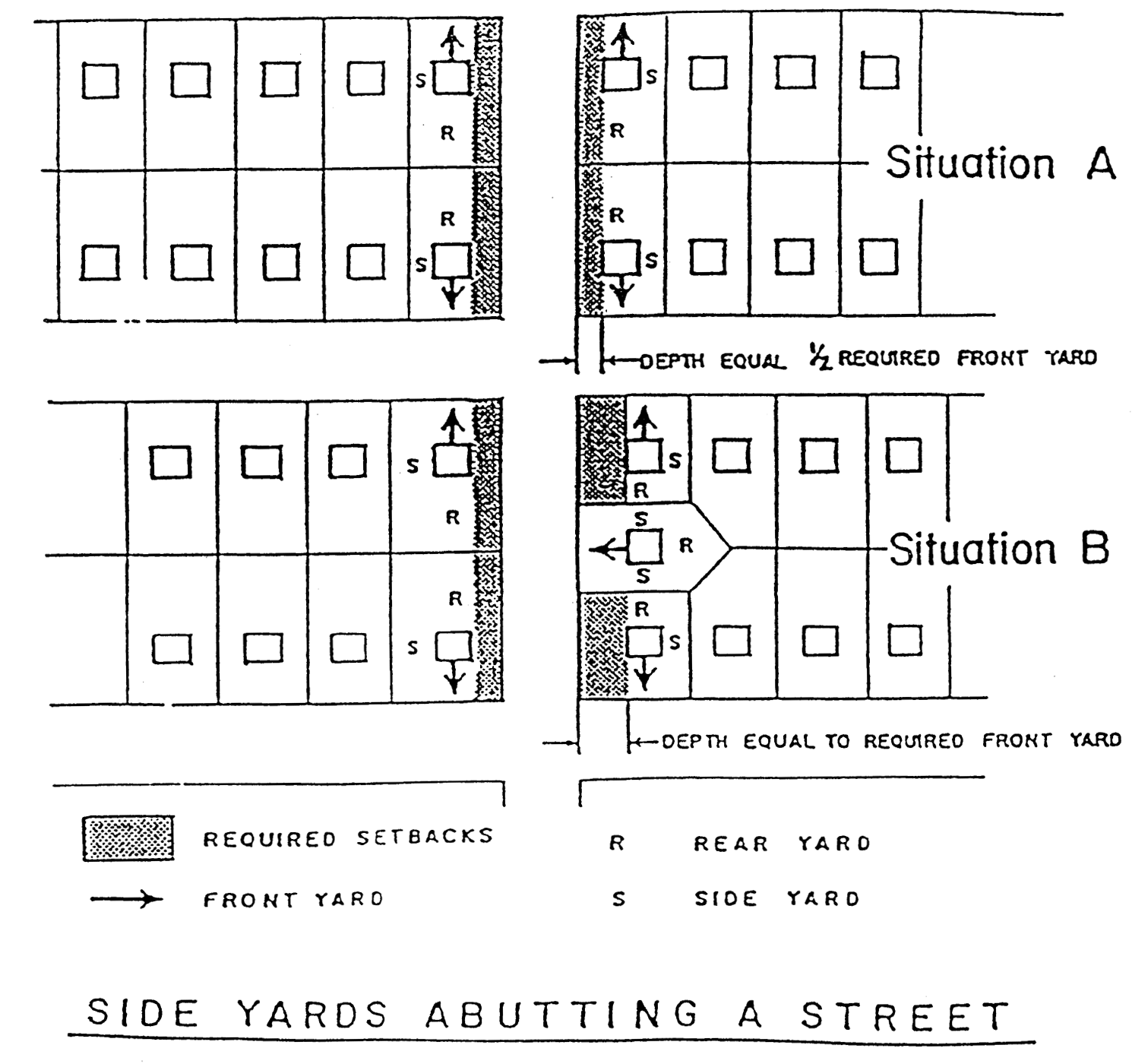
The side yard abutting upon a street shall not be less than one-half the required front yard setback where lots have a common rear yard. In case of a rear yard abutting a side yard of an adjacent lot, the side yard abutting a street shall not be less than the required front yard of the district.
(d)
R-3/R-3 A.
(1)
For all lots platted or developed as site condominium homes sites prior to January 1, 2003, all lots with dwellings with side yards of not less than five feet in width shall be considered as conforming with side yard setback requirements of this section.
(2)
For all lots platted or developed as site condominium home sites after January 1, 2003, side yards shall be a minimum of eight feet on one side of a lot and five feet on one side of a lot for a combined total of 13 feet.
(3)
For all lots platted or developed as site condominium home sites after January 1, 2003 dwellings shall be located with the eight foot side yard abutting the side yard of the adjacent lot when the adjacent dwelling is within five feet or less of the side lot line of the lot being built upon.
(4)
For all lots platted or developed as site condominium home sites after January 1, 2003 in those instances where dwellings on both sides of a lot being built upon have side yards of five feet or less the dwelling being constructed may provide side yards of not less than 6½ feet on each side of such lot.
(5)
For all lots platted or developed as site condominium home sites after January 1, 2003 where two or more vacant lots are abutting in a row all homes shall be constructed on such lots providing side yards between homes totaling 13 feet. Where existing homes may exist at the end of such row of vacant lots the side yard for the new home, abutting a five foot side yard on the existing home lot may be five feet in width.
(e)
In an R-4 apartment districts, the total number of rooms (not including kitchen, dining and sanitary facilities) shall not be more than the area of the parcel, in square feet, exclusive of public road right-of-way, divided by 1,500. In all instances where wetlands exist on the site, such wetlands shall not be utilized for determining the number of rooms allowed on the site. All units shall have at least one living room and one bedroom, except that not more than ten percent of the units may be of an efficiency apartment type. For the purpose of computing the permitted number of dwelling units per acre, the following room assignments shall control:
Efficiency = 1 room
One bedroom = 2 rooms
Two bedroom = 3 rooms
Three bedroom = 4 rooms
Four bedroom = 5 rooms
Plans presented showing one-, two- or three-bedroom units and including a den, library or other extra room shall count such extra room as a bedroom for the purpose of computing density.
(f)
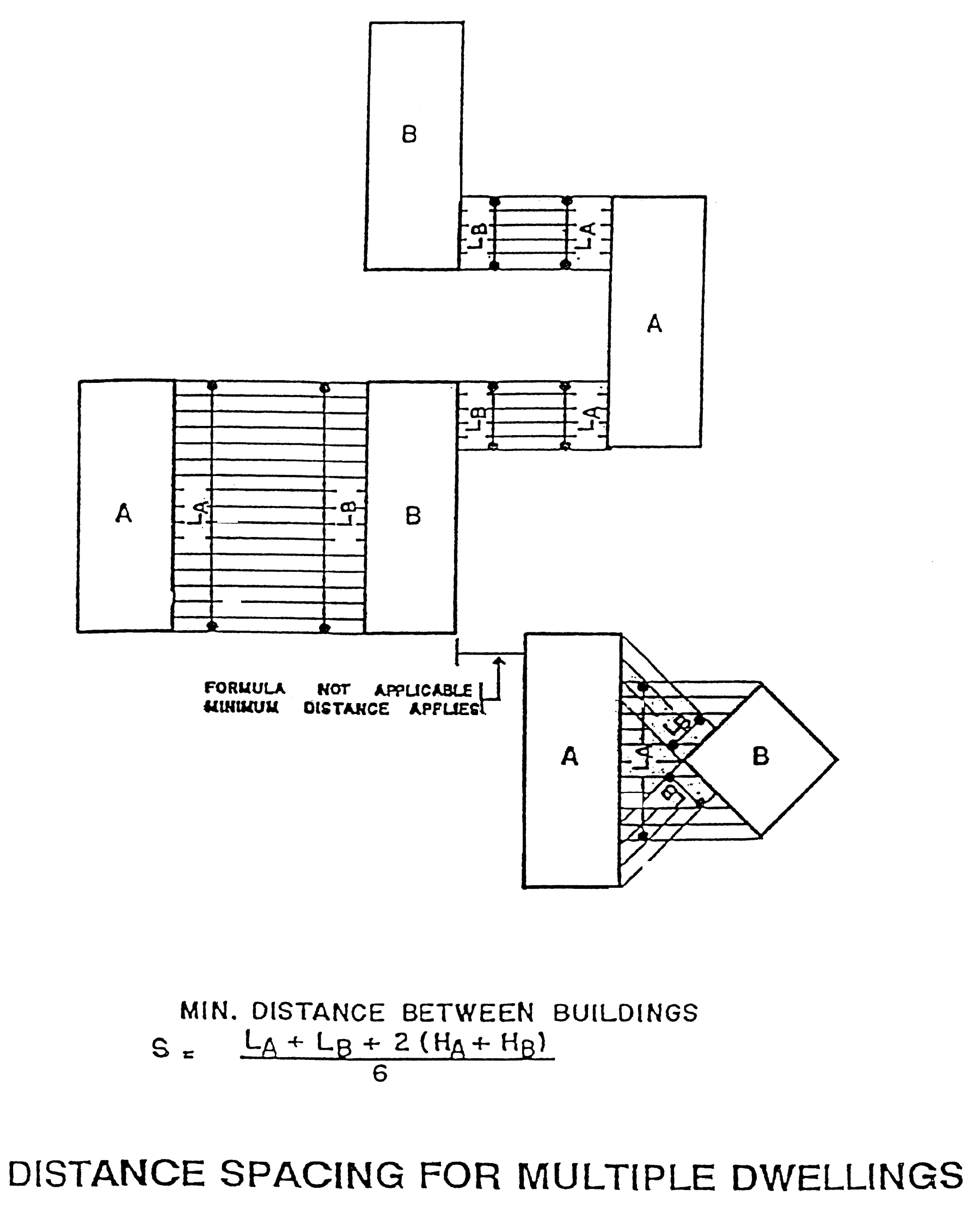
In R-4 districts, the minimum distance between any two buildings shall be regulated according to the length and height of such buildings, and in no instance shall this distance be less than 30 feet. Parking may be permitted within a required side or rear yard but shall not cover more than 30 percent of the area of any required side or rear yard or any minimum distance between buildings. Yards abutting major thoroughfares shall have a minimum depth of 50 feet. The formula regulating the required minimum distance between two buildings as follows:
where:
(g)
Off-street parking shall be permitted to occupy a portion of the required front yard provided that there is maintained a minimum obstructed landscaped setback of 10 feet between the nearest point of the off-street parking area, exclusive of access driveways, and the nearest right-of-way line.
(h)
No side yards are required along the interior side lot lines of the district, except as otherwise specified in the building code, provided that if walls of structures facing such interior side lot lines contain windows or other openings, side yards of not less than 10 feet shall be provided.
On a corner lot which has a common lot line with a residential district, there shall be provided a setback of 20 feet on the side or residential street. Where a lot borders on a residential district or a street, there shall be provided a setback of not less than 10 feet on the side bordering the residential district or street.
(i)
Loading space shall be provided in the rear yard in the ratio of at least ten square feet per front foot of building and shall be computed separately from the off-street parking requirements, except in the instance of B-OS districts loading may take place in undesignated places in parking lots provided such loading is of a short-term nature. Where an alley exists or is provided at the rear of buildings, the rear building setback and loading requirements may be computed from the center of the alley. All loading and unloading areas shall be screened from public view.
(j)
Off-street parking shall be permitted in a required side yard setback.
(k)
Single-family detached condominiums in condominium subdivisions shall meet all minimum requirements and standards of the district in which such dwellings are to be constructed.
(l)
Minimum yards for site condominiums shall be provided in accord with this section and shall be computed as follows:
(1)
Minimum front yard setbacks shall be equal to the distance between the front yard area line and the condominium dwelling.
(2)
Minimum rear yard setbacks shall be equal to the distance between the rear yard area line and the condominium dwelling.
(3)
Minimum side yard setbacks shall be equal to the distance between the side yard area line and the condominium dwelling.
(m)
Front yard setback shall be 40 feet for local street, 50 feet for collector streets and secondary arteries, and 60 feet for primary arteries.
(n)
On lots with a width of less than 60 feet and recorded as less than 60 feet prior to the date of adoption of this section, the minimum width of each of the side yards shall be five feet, except side street yards shall be a minimum width of 15 feet.
(o)
The front yard shall be the address side of the lot or parcel for setbacks purposes.
(p)
See section 1.0710 for yard exceptions.
(q)
Where the PDD-2 district is adjacent to a residential district the setbacks at the shared property lines shall be as stated in the Schedule for the corresponding residential zoning district. Where the PDD-2 district is adjacent to a property utilized exclusively for residential purposes as of September 1, 2013, the setbacks at the shared property lines shall be as stated for zoning district R-3 residential.
(r)
Off-street parking shall be permitted to occupy a portion of the required front, side and rear yards provided that there is maintained a minimum obstructed landscaped setback of five feet between the nearest point of the off-street parking area, exclusive of access driveways, and the nearest right-of-way line.
(s)
Unless modified by an approved special land use.
(t)
If parking is located in the front yard, curb stops are required at a minimum distance of five feet from any lot line abutting a public sidewalk or city right-of-way where a public sidewalk may be constructed.
(u)
In determining the front yard setback of the building, the requirements shall be calculated by averaging the depth of existing developed front yards on lots within 100 feet of the lot and within the same block. The property owner/potential owner may request consideration from the planning commission for front yard setbacks based directly on adjoining property front yard setbacks. The request, review, and fees by the planning commission shall follow the requirements of section 1.0602 of this zoning ordinance.
(Ord. of 12-17-2003, § 1.0502; Ord. of 11-13-2013; Ord. of 5-13-2015; Ord. of 3-25-2020(3) ; Ord. of 3-9-2022(1) ; Ord. of 5-9-2022 )
1.0503. - Average lot size.
The intent of this section is to permit the subdivider or developer to vary his lot sizes and lot widths so as to average the minimum size of lot per unit as required in the Schedule of Regulations, for R-1, R-2 and R-3 residential districts. If this option is selected, the following conditions shall be met:
(A)
In meeting the average minimum lot size, the subdivision or site condominium shall be so designed as not to create lots having an area or width more than ten percent below that area or width required in the schedule of regulations and shall not create an attendant increase in the number of lots. In determining the maximum number of lots permitted, all calculations shall be predicated upon the single-family districts having the following gross densities (including roads):
(1)
R-1: one dwelling unit per acre;
(2)
R-2: 3.2 dwelling units per acre;
(3)
R-3: 4.4 dwelling units per acre.
(B)
All computations showing lot area and the average, resulting through this technique shall be indicated on the print of the preliminary subdivision plat or proposed site condominium plan. The computations shall include the dimensions and area of each lot proposed, the total square foot lot area in all proposed lots, and the resultant average square foot area per lot. The average square foot area per lot shall not be less than the minimum lot size area as required for the district in which the development is located nor shall the average width of lots in the aggregate be less than the minimum lot width as required in the district in which the development is located.
(C)
The modifications permitted wider this section 1.503, average lot size, shall not be applied in conjunction with the modifications permitted under section 1.0504, subdivision [and site condominium] open space plan.
1.0504. - Subdivision and site condominium open space plan.
The intent of the subdivision open space plan is to promote the following objectives:
(A)
Provide for moderate-density development of residential areas and thereby assist an overall city effort to provide for efficiency of city services, a reduction of transportation needs, and to provide a more desirable living environment by preserving the natural character of open fields, stands of trees, brook, hills and similar natural assets;
(B)
Encourage property owners to use a more creative approach in the development of residential areas;
(C)
Encourage a more efficient, aesthetic and desirable use of open area while recognizing a reduction in development costs and allowing the property owner to bypass natural obstacles on the site;
(D)
Encourage the provision of open space within reasonable distance to all lot development of the subdivision and to further encourage the development of recreational facilities;
(E)
Modifications to the standards as outlined in the schedule of regulations may be made in the R-2 one-family residential district when the following conditions are met:
(1)
The lot area in all R-2 one-family residential districts which is served by a public sanitary sewer system may be reduced in area up to 20 percent. This reduction may be accomplished in part by reducing lot widths up to 10 feet. Lot area reductions shall be permitted, provided that the dwelling unit density is not greater than if the land area to be: subdivided were developed in the minimum square foot lot areas as required under section 1.0502, Schedule of regulations. Dwelling unit densities shall not utilize, storm water detention or retention basins nor more than 25 percent of any wetlands in computing the maximum number of dwelling units allowed.
(2)
Lot depth shall not be less than 120 feet, except when such lots border on land dedicated for park, recreation and/or open space purposes, and provided that the width of such dedicated land shall not be less than 100 feet measured at the point at which it abuts the rear yard of the adjacent lot, such lot depth may be reduced to 100 feet.
(3)
Under the provisions of subsection (E)(1) of this section, for each square foot of land gained within a residential subdivision or site condominium through the reduction of lot size below the minimum requirements as outlined in the schedule of regulations, at least equal amounts of land shall be dedicated to the common use of the lot owners in a manner approved by the municipality, or may, if approved by the municipality, be dedicated to the municipality.
(4)
The area to be dedicated for open space purposes shall in no instance be less than three acres and shall be in a location and shape approved by the planning board.
(5)
Access shall be provided to areas dedicated for open space for those lots not bordering on such open space by means of streets or pedestrian access ways.
(6)
Lands set aside to meet minimum requirement of this section may include, but not exceed, 25 percent of any wetland. In those instances where such lands are utilized to meet minimum requirements, such lands shall be shown to be able to support uses suitable for residents of the development for recreational purposes or other lands on the site shall be developed for the common use of residents.
(7)
This open space plan shall be permitted only if it is mutually agreeable to the legislative body and the subdivider or developer.
(8)
This plan, for reduced lot sizes, shall be started within one year after having received approval of the final plat or final site condominium plan and must be completed in a reasonable time. Failure to start within this period shall void all previous approval.
(9)
Under this open space plan, the developer or subdivider shall dedicate the total park area at the time of filing of the final plat or final site condominium plan on all or any portion of the plat or plan.
(10)
Under this plan, provisions satisfactory to the city commission shall be made to provide for financing any improvements shown on the plan for the open space areas, and common use areas which are to be included within the development and that maintenance of such improvements is assured by means satisfactory to the city commission.
(F)
The standards as set forth in the Schedule of Regulations shall be modified at the option of the land-owner, to allow the number of dwelling units that would be permitted in R-1 one-family residential districts on a total development parcel, to be located on eighty (80) percent of the land area (including street right-of-way) being developed, provided that, the twenty (20) percent of the land area remains in an undeveloped state in perpetuity, by means of a conservation easement, plat dedication, restrictive covenant or other legal means that runs with the land. Such modification shall be subject to the following conditions.
(a)
Lands set aside to meet minimum requirement of this section may include, but not exceed, twenty-five (25) percent of any wetland. In those instances where such lands are utilized to meet minimum requirements, such lands shall be shown to be able to support uses suitable for residents of the development for recreational purposes or other land on the site shall be developed for the common use of residents.
(b)
The area to be dedicated for open space purposes shall be in a location and shape approve by the Planning Board.
(c)
Access shall be provided to areas dedicated for open space for those lots not bordering on such open space by means of streets or pedestrian access ways.
(d)
Under this open space plan, the developer or subdivider shall dedicate the total park area at the time of filing of the final plat or final site condominium plan on all or any portion of the plat or plan.
(e)
Under this plan, provisions satisfactory to the City Commission shall be made to provide for financing any improvements shown on the plan for the open space areas, and common use areas which are to be included within the development and the maintenance of such improvements is assured by means satisfactory to the City Commission.
Cross reference— Subdivisions and other divisions, ch. 50.
1.0505. - One-family cluster option.
(A)
Intent.
(1)
The intent of this section is to permit the development of one-family residential patterns which, through design innovation, will provide for an alternative means for development of single-family areas. To accomplish this, modifications to the one-family residential standards, as outlined in this schedule of regulations (section 1.0502) may be permitted in the R-1, R-2 and R-3 districts.
(2)
In R-1, R-2 and R-3 one-family residential districts, the requirements of the schedule of regulations may be waived and the attaching of one-family dwelling units may be permitted subject to the standards of this section.
(B)
Conditions and qualifications.
(1)
The planning board may approve the clustering or attaching of buildings on parcels of land under single ownership and control which, in the option of the planning board, have characteristics that would make sound physical development under the normal subdivision approach impractical because of parcel size, shape or dimension or because it is located in a transitional use area or the site has natural characteristics which are worth preserving or which make platting difficult. In approving an area for cluster development, the planning board shall find at least one of the following conditions to exist:
a.
The parcel contains floodplain or wetland soil conditions that result in a substantial portion of the total area of the parcel being unbuildable. In no instance shall soil condition constitute less than 20 percent of the parcel.
b.
The parcel contains natural assets that would be preserved through the use of cluster development. Such assets may include natural stands of large trees, land that serves as a natural habitat for wildlife, unique topographic features or other natural assets that should be preserved.
c.
The parcel to be developed has frontage on a secondary or primary artery and is generally parallel to the thoroughfare and is of shallow depth as measured from the thoroughfare.
d.
The parcel has frontage on a primary artery and is narrow in width, as measured along the thoroughfare, which makes platting difficult, provided that the depth of the parcel is not greater than three times the width. The planning board may vary this ratio if this would be in the best interests of the city.
e.
The parcel is shaped in such a way that the angles formed by its boundaries make a subdivision difficult to achieve and the parcel has frontage on a secondary or primary artery.
f.
The parcel has vehicular access to a secondary or primary artery and a substantial portion of the parcel's perimeter is border by land that is located in an R-4, R-5, B-OS or P district.
g.
A substantial portion of the parcel's perimeter is bordered by land that is located in a B-OS, B-H or M district and the parcel has vehicular access to a secondary or primary artery.
(2)
In order to qualify a parcel for development under subsections (B)(1)a. or (B)(1)b. of this section, the planning board shall determine that the parcel has these characteristics and the request shall be supported by written and /or graphic documentation, prepared by a landscape architect, engineer, professional community planner, architect or environmental design professional. Such documentation shall include the following as appropriate: soil test borings, floodplain map, topographic map of maximum two-foot contour level, inventory of natural assets', including plant material.
(3)
This option shall not apply to those parcels of land which have been split for the apparent purpose of coming within the requirements of this cluster options section. The zoning map effective at the date of adoption of the [zoning] ordinance shall be utilized to determine property lines where a question arises regarding a parcel split.
(C)
Permitted densities.
(1)
Dwelling unit densities shall not utilize stormwater detention basins nor more than 25 percent of any wetland in computing the maximum permitted densities. The maximum permitted densities including streets are as follows:
a.
For those areas qualifying under subsections (B)(1)d.:
[For those areas qualifying under subsections] (B)(1)a. or b.:
[For those areas qualifying under subsections] (B)(1)c., e. or f.:
[For those areas qualifying under subsections] (B)(1)g.:
b.
Water areas within the parcel may be included in the computation of density provided that land adjacent to the water is substantially developed as open space.
c.
In those instances where a parcel qualifies under subsections (B)(1)a. or (B)(1)b. as well as under one or more of the remaining subsections (B)(1) through (g), the higher densities may be permitted provided that the planning board finds that such density is reasonable and does not result in the destruction or removal of the natural assets enumerated under subsections (B)(1)a. and b.
(D)
Development standards and requirements.
(1)
In areas meeting the criteria of subsection (B)(1) of this section, the minimum yard setback and minimum lot sizes per unit as required by section 1.0502, schedule of regulations, may be waived and the attaching of dwelling units may be accomplished subject to the following:
a.
The attaching of one-family dwelling units, one to another, may be permitted when the homes are attached by means of one of the following:
i.
Through a common party wall forming interior room space which does not have over 75 percent of its length in common with an abutting dwelling wall, excluding garage;
ii.
By means of an architectural wall detail that does not form interior room space;
iii.
Through abutting garage party walls of adjacent structures;
iv.
No other common party wall relationship is permitted and the number of units attached in this manner shall not exceed four.
(2)
Yard requirements shall be provided as follows:
a.
Spacing between groups of attached buildings or between each group of four unattached buildings shall be equal to at least 35 feet in an R-1 district, 30 feet in an R-2 district, 24 feet in an R-3 district, measured between the nearest points of adjacent buildings. The minimum distance between any single detached unit and any adjacent building shall be 15 feet.
b.
Off-street parking lots (more than two spaces) shall have setbacks of not less than 50 feet from any public street or from any abutting one-family residential district.
c.
Building setbacks from streets shall be equal to the front yard setback of the district.
d.
Buildings shall not be closer than 25 feet to the pavement edge of interior private drives.
(3)
The area in open space (including recreation areas and water) accomplished through the use of one-family clusters shall represent at least 20 percent of the horizontal area of a one-family cluster development that qualifies under subsections (B)(1)a. through (B)(1)f. of this section and 15 percent in those qualifying under subsections (B)(1)g. [of this section]. The provision of walks, trails and recreation facilities is required within the open space areas.
(4)
In order to provide an orderly transition of density, where the parcel proposed for use as a cluster, development abuts a one-family residential district, the planning board shall determine that the abutting one-family district is effectively buffered by means of one of the following within the cluster development:
a.
Single-family lots subject to the standards of section 1.0502, schedule of regulations.
b.
Detached one-family buildings with setbacks as required by the schedule of regulations for the applicable residential district.
c.
Open or recreation space not less than 100 feet deep.
d.
Significant changes in topography which provide an effective buffer and a building setback of not less than 75 feet.
e.
A secondary or primary artery.
f.
A similar means of providing a transition.
g.
The transition area shall be free of any building, parking spaces or drives unless the planning board finds that very unusual circumstances require such placement.
(E)
Procedures.
(1)
In making application for approval under this section, the applicant shall file a sworn statement indicating the date of acquisition of the parcel by the present owner and that the provisions of subsection (B)(3) of this section are complied with.
(2)
Qualification for cluster development.
a.
Application to the planning board for qualification of a parcel for cluster development shall include documentation substantiating one or more of the characteristics outlined in subsection (B) of this section, conditions for qualification.
b.
The planning board may make a preliminary determination as to whether or not a parcel qualifies for the cluster option under one of the provisions of subsection (13)(1) of this section based upon the documentation submitted. Such review is not a requirement but may be requested by the sponsor.
c.
A preliminary determination by the planning board that a parcel qualifies for cluster development does not ensure approval. It does, however, give an initial indication as to whether or not a petitioner should proceed to prepare a site plan.
(3)
Preliminary site plan and cluster approval.
a.
A preliminary site plan shall be submitted to the planning board and city commission for review in two stages:
i.
An initial review of the plan concept but including the information called for in subsection (E)(3)b. of this section,
ii.
Review of the plan at a public hearing, including information called for in subsection (E)(3)c. of this section.
b.
In submitting a proposed layout under this section, the applicant of the development shall include, along with the site plan, typical building elevations and floorplans, topography drawn at two-foot contour intervals, all computations relative to . acreage and density, a preliminary grading plan, and any other details that will assist in reviewing the proposed plan.
c.
Site plans submitted under this option shall be accompanied by information as required in the subdivision regulations of the city provided, however, that:
i.
Submission of an open space plan and project cost estimates for the initial review of the preliminary site plan shall be submitted at the option of the applicant.
ii.
The open space plan and cost estimate shall be submitted for review at the public hearing.
d.
The planning board shall give notice of the public hearing in accordance with provisions of section 1.1405(G) of this [zoning] ordinance.
e.
If the planning board is satisfied that the proposal meets the letter and spirit of the city zoning ordinance and should be approved, it shall set forth any conditions upon which such approval is based. If the planning board is not satisfied that the proposal meets the letter and spirit of this title, or finds that approval of the proposal would be detrimental to existing development in the general area and should not be approved, it shall record the reasons therefor in the minutes of the planning board meeting. Notice of recommendation of approval or disapproval of the proposal together with copies of all layouts and other relevant information shall be forwarded to the city clerk.
f.
The city commission shall review the action of the planning board together with relevant material submitted by the applicant. The city commission shall take action to approve or disapprove the preliminary plan or may refer such plan back to the planning board with direction for further review.
(4)
Final site plan.
a.
After approval of a preliminary plan and cluster option, final site plan shall be submitted in accordance with the requirements of article XII [of this zoning ordinance].
b.
If the final site plan is recommended for approval, such plan shall be submitted to the city attorney for the preparation of agreements setting forth the conditions upon which the approval is based. Such agreement shall be finalized and approved by the city commission prior to the issuance of any building permits.
c.
As a condition for the approval of the final site plan and open space plan, the applicant shall deposit cash, irrevocable letters of credit, or other equivalent forms of security as approved by the city commission, after review by the city attorney, in the amount of the estimated cost of the proposed improvements to the open land guaranteeing the completion of such improvements within a time to be set by the planning board. Actual development of the open space shall be carried out concurrently with the construction of dwelling units. The city may require landscape improvement for the entire site frontage where such site abuts public streets as an initial site improvement even through such frontage is not part of any early stage of project development.
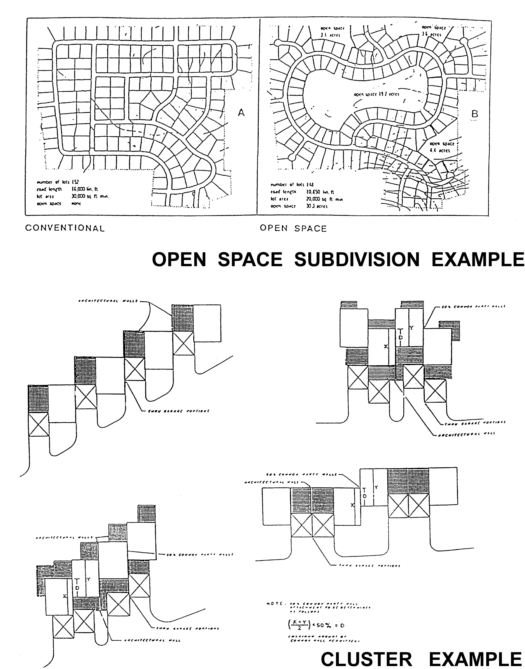
Open Space Subdivision and Cluster Example