Surfside City Zoning Code
ARTICLE III
ESTABLISHMENT OF ZONING DESIGNATIONS
Sec. 90-39.- Zoning districts.
In order to regulate the overall character of the town, in an effort to restrict the massing, volume and bulk of building masses hereafter erected or structurally altered and to ensure the character and livability of the town, the following zoning designations are hereby established. These designations further restrict the location of uses, location of buildings and the use of lot areas and regulates and determines the areas of yards, and other open spaces within and surrounding such buildings. Of primary importance is the designations' ability to control development to ensure a high quality environment that is comfortable, pedestrian friendly, safe and livable.
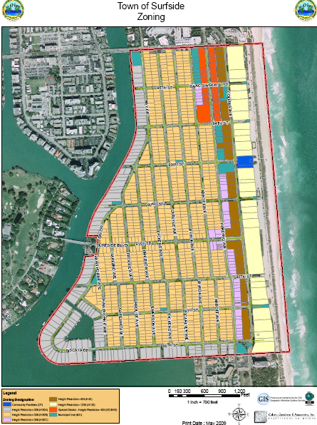
90-39.1 H30A and H30B. Districts wherein building masses are restricted to a maximum building height of 30 feet.
90-39.1.1 Purpose: The purpose of the H30 A and B districts is to protect the excellent character and scale of the single-family development now prevailing throughout much of the Town by preventing encroachment of incompatible uses and new structures that do not adequately respond to the overall scale of the existing context.
90-39.2 H30C. District wherein building masses are restricted to a maximum building height of 30 feet.
90-39.2.1 Purpose: The purpose of the H30C district is to permit single-family, two-family, multi-family and hotel structures no more than 30 feet in height.
90-39.3 H40. District wherein building masses are restricted to a maximum building height of 40 feet.
90-39.3.1 Purpose: The purpose of the H40 district is to permit single-family, two-family, multi-family and hotel structures no more than 40 feet in height.
90-39.4 H120. District wherein building masses are restricted to a maximum building height of 120 feet.
90-39.4.1 Purpose: The purpose of the H120 district is to permit multi-family dwellings and hotels no more than 120 feet in height.
90-39.5 SD-B40: Special district wherein building masses are restricted to a maximum building height of 40 feet.
90-39.5.1 Purpose: The purpose of the SD-B40 district is to permit businesses no more than 40 feet in height.
90-39.6 Municipal. Community and town owned facilities. Municipal zoning districts are assigned as municipal owned lands are aggregated.
(Ord. No. 1558, § 2(Exh. A), 8-10-10)
Sec. 90-40. - Regulating maps.
The zoning classification thereof shall be shown on a map designated as the Zoning Map of Surfside. This zoning map and all notations, dimensions, references, and symbols shown thereon pertaining to such districts shall be as much a part of these regulations as if fully described herein, and shall be filed as part of these regulations by the clerk of the town. Such map shall be available for public inspection in the offices of the town clerk and the town manager and any later alterations to this map, adopted by amendment as provided in these regulations, shall be similarly dated, filed, and made available for public reference.
90-40.1 Purpose. The intent and purpose of the regulating maps is to identify certain specific areas that, by virtue of their location, the town desires to require features that promote the safety, comfort and convenience of the pedestrian.
90-40.2 Map symbols. A district name or letter-number combination shown on the district maps indicates that the regulations pertaining to the district designated by that name or letter-number combination extend throughout the whole area in the municipality bounded by the district boundary lines which such name or letter-number combination is shown or indicated, except as otherwise provided by this section.
90-40.3 Interpretation. Where uncertainty exists with respect to the boundaries of the various districts as shown on the map accompanying and made a part of these regulations, the following rules shall apply:
90-40.3.1 In cases where a boundary line is given a position adjacent to or within a street or alley, easement, or canal, it shall be deemed to be in the center of the street, alley, easement, or canal and if the actual location of such street, alley, easement or canal varies slightly from the location as shown on the district map, then the actual location shall control.
90-40.3.2 In cases where a boundary line is shown as being located a specific distance from a street line or other physical feature, this distance shall control.
90-40.3.3 Where the district boundaries are not otherwise indicated and where the property has been or may hereafter be re-subdivided into blocks and lots, the district boundaries shall be construed to be the lot lines, and where the districts designated on the map accompanying and made a part of these regulations are bounded approximately by lot lines, such lot lines shall be construed to be the boundary of such districts unless such boundaries are otherwise indicated in the map or by ordinance.
90-40.3.4 All water areas within the zoning jurisdiction are considered to be within a zoning district and controlled by applicable district regulations. Straight line district boundaries over water areas shall be assumed to continue as straight lines until they intersect with each other or with the town limit line.
(Ord. No. 1558, § 2(Exh. A), 8-10-10)