Talbot County Unincorporated
City Zoning Code
City Zoning Code
SECTION 8
- District regulations.
Within the zoning districts established there are uses permitted, density limitations imposed, and special requirements set forth. This section establishes those uses permitted, uses prohibited, required lot area, density limitations, setbacks, height limitations and sets forth certain special regulations in order to achieve compatibility and to implement the Talbot County Comprehensive Plan.
8.1.
Uses permitted in all districts. There shall be permitted in all districts the following uses:
A.
Public utilities (but not including power and gas substations and pumping stations).
B.
Accessory buildings and uses.
8.2.
Conditional uses permitted in all districts with review. There shall be permitted in all districts the following conditional uses only after site plan review by the planning commission, specifics for which include the submission of an overall development scheme stating the development intentions of the landowner, including but not limited to the following: a statement of location and intensity of proposed use[s] and activity[ies], a physical description of proposed facilities accommodating such uses, and a general location of public utilities.
A.
Public buildings of a governmental nature, including libraries.
B.
Public utilities, not otherwise specified, including power and gas substations, telecommunication systems and pumping stations.
C.
Customary home occupations/offices.
D.
Semi-public buildings and uses, including private schools and churches.
E.
Public and private school buildings and associated uses, vocational schools, research and training facilities.
F.
Public recreational facilities, including parks, playgrounds, stadiums, etc.
G.
General hospitals, including nursing homes, group homes, and personal care homes.
H.
Day care centers, nurseries and kindergartens.
8.3.
Specific district regulations. The following pages contain specific regulations for each district including uses permitted, uses prohibited, required lot area, density limitations, setbacks, and height limitations. All lands, buildings and structures shall be developed in accordance with the zoning district regulations and use regulations applicable to the zoning district in which such land, buildings, and structures are located. Any development of land not in accordance with that permitted under these ordinances shall be prohibited.
* A rear yard setback of 20 feet shall be required when a rear yard abuts a residential district, and 20 feet of the setback shall be planted with a buffer strip of shrubs and trees to provide an aesthetic appearance.
** A side yard setback of 25 feet shall be required where a side yard abuts a residential district, and 20 feet of the setback shall be planted with a buffer strip of shrubs and trees to provide an aesthetic appearance.
*** When a rear yard abuts a residential district, 20 feet of the setback shall be planted with a buffer strip of shrubs and trees to provide an aesthetic appearance.
**** A side yard setback of 50 feet shall be required where a side yard abuts a residential district, and 20 feet of the setback shall be planted with a buffer strip of shrubs and trees to provide an aesthetic appearance.
***** A green belt of five feet shall be required on three sides of the property unless waived by the Talbot County Planning Commission.
8.4
Detailed regulations for MHU-1 district.
8.4.1.
Other requirements:
1.
Survey site plan required shall include the following: name and address of owner, vicinity map, with a minimum scale - 1" = 100', north arrow, numbered lots, lot numbers, size of lots, street layout, trash container(s) location, location of all utilities including sewage, unless originally approved with site plans - accessory building or additions to manufactured housing units allowed.
2.
Access roads within manufactured housing unit parks shall not be less than 20 feet and shall be paved with a hard surface treatment.
3.
There shall be established and maintained guest parking facilities at a ratio of one space per three manufactured housing unit spaces. If access roads are paved to a width of 32 feet, guest off-street parking spaces shall not be required.
4.
Each manufactured housing unit space shall be equipped with a pad ten feet for a single-wide, 20 feet for a double-wide by 45 feet long of six inches of compacted gravel or other similar material.
5.
Each manufactured housing unit space shall be furnished with connections to water, sewer or septic (tank), and electricity utilities; and all will be approved by the appropriate department/agency.
6.
Manufactured housing units may not be used for nonresidential use within manufactured housing unit park except for the manufactured housing unit park office.
7.
Standards for manufactured housing unit shall also apply to the latest edition of the Council of American Building Officials (CABO) One and Two Family Dwellings (Code).
8.
No owner of a manufactured housing park shall allow a manufactured housing unit to locate or relocate within the park without a location placement permit from the county inspector's office and proof of tax paid.
9.
An approved trash container(s), to be compatible with Talbot County's sanitation service, shall be located within 150 feet of any manufactured housing unit park and shall be screened by a solid opaque fence of adequate height to screen from view any material in the container. Such trash containers shall be provided by the manufactured housing unit park owner/operator.
10.
All owners, operators of said manufactured housing park shall be responsible for the upkeep of all drives (access roads) within the confines of said park; and the grounds shall be clear of all litter, trash, garbage, inoperable automobiles, trucks, etc. as well as maintaining grounds (cutting of grass, maintenance of other landscaping), and drainage to assure a clean, habitable and sanitary environment.
11.
It shall be the responsibility of the owner/manager of said manufactured housing parks to not rent, lease, or otherwise convey the use of property within confined said manufactured housing park until proper permits have been issued by the Talbot County Building Official for said location. A registration shall be required to be kept on premises of all lots rented, leased, or otherwise conveyed to include date, name, address, phone, lot number, size and model.
12.
A buffer evergreen strip of at least 25 feet in width and ten feet in height shall be planted along the side and rear yards lines of the manufactured housing unit park.
13.
Skirting. All manufactured housing units shall have suitable skirting between the base of the unit and the ground. This skirting shall be made of either concrete block, brick, wood, or other materials intended for such use. Openings in the skirting shall not be more than two inches square.
14.
Access doors. All units shall have a minimum of an 18" x 24" latchable access door and required crawl space venting.
15.
Anchors. All units shall be provided with anchors as required by the latest published edition of the CABO One and Two Family Dwelling Code.
16.
Inspection. Before electric service is given any manufactured housing unit, the unit and the lot upon which it is located shall be inspected by the Talbot County Building Official after the necessary permits are approved, and all other requirements of this ordinance and other laws, and codes, affecting said location are met.
17.
Travel trailers. Manufactured housing unit space shall not be used for the permanent accommodation of travel trailers or recreational vehicles under any circumstances.
18.
Age of units. The manufactured housing unit to be placed must be certified under the U.S. Department of Housing and Urban Development and as applicable by the Georgia State Fire Marshal's Office and manufactured after June 15, 1976 prior to issuance of a permit.
8.5.
Detailed regulations for PUD planned unit development district. The regulations established for this district are intended to provide optional methods of land development with provisions for residential, commercial, religious, educational and cultural facilities, which are integrated with the total project by unified architectural and open space treatment.
8.5.1.
Permitted uses. Single-family attached and detached dwellings; duplexes; multi-family dwellings; condominiums and townhouses; uses permitted in the C-1 district and CORD districts; educational uses; and other religious and cultural uses.
8.5.2.
Preliminary development plan. A person applying for a zoning amendment to establish a PUD district shall submit a preliminary development plan to the planning commission, consisting of:
1.
A site plan showing:
a.
The direction of north, appropriate scale and topography.
b.
The location of subject property in relation to the entire county.
c.
The use of the property adjacent to the site.
d.
The proposed use of land and density of development for the site.
e.
Proposed access to, and traffic circulation within, the site.
2.
A proposed development schedule for the project.
3.
The planned development shall be located in an area for which public facilities and services are available and adequate for the uses that are proposed; provided, however, that the applicant may provide such facilities which are not presently available, and written assurance of such provision shall be included as a part of the preliminary development which is submitted.
4.
The planning commission and board of commissioners shall review and act on the proposed zoning request and any amendment to an approved preliminary development plan in accordance with the zoning ordinance.
8.5.3.
Final development plan. Prior to the removal of natural vegetation, restructuring of the land or construction of any improvements, an approved final development plan is required. A plan shall be submitted to the planning commission, which is consistent with the preliminary development plan, and containing:
1.
A site plan showing:
a.
The direction of north, appropriate scale and topography in not greater than five foot contour intervals.
b.
The proposed location and height of all structures.
c.
The use of all structures and land.
d.
The location and use of structures adjacent to the site.
e.
The location, area and number of parking spaces and maneuvering areas.
f.
The location and dimensions of streets, driveways, and walks on and off the site.
g.
All service and loading areas and spaces.
h.
The location, size, number and character of all exterior signs and lighting.
i.
The location, character and extent of existing vegetation landscaping, retaining and screen walls and other treatment for the protection of adjoining property.
j.
The facilities for surface drainage of the premises.
k.
Location and character of all public improvements including utilities.
2.
A copy of any deed restrictions to be recorded.
3.
A comprehensive traffic analysis indicating the probable effect of the proposed development on traffic patterns and capacities of adjacent streets in the immediate area, prepared by a registered engineer or professional planner.
4.
A development schedule indicating the appropriate date when construction of the planned development or stage thereof can be expected to begin and be completed.
5.
Any other information necessary to establish compliance with this and other ordinances of the availability of adequate utility capacity.
6.
A fire protection plan, approved by the volunteer fire department servicing the area, indicating the location and size of all proposed fire mains, fire hydrants, and fire access lanes, as well as a description of all fire protection measures and devices for structures.
7.
The public improvements included in the final development plan shall be consistent with the Talbot County Subdivision Regulations. Compliance with said regulations shall be reviewed as part of the final development review process.
8.
The applicant shall provide for and/or establish an organization or other legal entity for the control and maintenance of any common open space designated on the final development plan. Such organization shall be created by covenants running with the land, and such covenants shall be included as a part of the final development plan(s) and subject to the approval of the Talbot County Board of Commissioners.
9.
Structures and open space shall be arranged in such a way as best to serve the needs of residents and commercial users of the planned development, and to minimize any adverse effects on the neighboring districts.
10.
Scenic assets and natural features, such as trees, streams, and topographic features, shall be protected and preserved to the greatest extend possible.
11.
Not more than 50 percent of the gross tract area shall be covered by buildings in the PUD.
12.
At least 50 percent of the area remaining after the development of the buildings, parking, right-of-way, and utility or drainage easements, shall be developed to serve the needs of the residents of the development; including but not limited to landscaping, patios, walks, play areas, recreation, and other uses consistent with the character of the PUD.
13.
Buffers and building set-backs shall recognize and honor existing adjacent land development. However, in no case shall a building be constructed closer than 15 feet from the PUD district boundary, nor 50 feet from any public road right-of-way.
14.
Adequate screening and separation between different land uses shall be provided by means of buffering or other acceptable methods.
15.
Vehicular access to the PUD shall be from streets capable of supporting existing and projected traffic. No streets or roads within the PUD shall connect to the public street system in such a way as to encourage use of minor streets for through streets.
16.
The PUD shall include provisions for safe and convenient pedestrian access and circulation.
8.5.4.
Final development plan review.
1.
Upon receipt of an applicant's Final Development Plan, the planning commission shall transmit a copy of the plan to the appropriate departments and agencies for their review, report and recommendation. Such officials and agencies shall each within 30 days from receiving the plan and documentation, furnish to the planning commission a report pertinent to their respective jurisdiction and concerns.
2.
The planning commission shall review the applicant's final development plan and within 90 days following the applicant's submission of the plan to the planning commission shall also prepare a written report stating clearly the reasons and justifications therefore, and identify what changes are necessary in order for the plan to be approved. Said written disapproval shall be transmitted to the applicant.
8.5.5.
Amending final development plan.
1.
The final development plan may be amended by the planning commission, provided the procedure specified (in the previous section) for review and approval is followed.
2.
Minor changes in the location, siting, or character of buildings and structures as shown on the final development plan may be authorized by the building official. No change authorized by the building official under this section may increase the size of any building or structure by more than five percent, nor change the location of any building or structure by more than ten feet in any direction; provided, notwithstanding anything in the foregoing, the building official may not permit change beyond the minimum or maximum requirements set forth in this ordinance. All other changes in the final development plan, including changes in the site plan and in the development schedule, must be made under the procedures that are applicable to the initial approval of a final development plan.
8.6.
Detailed regulations for CORD commercial outdoor recreation development.
1.
A site plan for the total acreage must be submitted to the planning commission for review and approval to ensure consistency with the overall plans for the appropriate development of the county. Final approval of the plan rests with the governing authority.
2.
Amendments to the site plan must be submitted to the planning commission for review and forwarded to the board of commissioners for final approval.
3.
When a CORD abuts a public road, the minimum setback requirements shall be those of the most restrictive adjacent zoning district.
4.
A green belt of 20 feet shall be required on three sides of the property.
5.
Off-street parking as required in subsection 13.3.
8.7.
Detailed regulations for military influence overlay district. Based on the recommendations of the Fort Benning Joint Land Use Study (May, 2008), there is hereby established the military influence overlay district, shown on the Official Zoning Map of Talbot County, which is hereby adopted and made a part of this ordinance. Development within the military influence overlay district shall comply with the provisions of this ordinance.
The regulations established for this district are intended to limit land uses that are incompatible to the training activities on Fort Benning and to provide for communication, coordination and consultation between the county and Fort Benning on potential noise and prescribed burning events on the military installation and all rezoning and subdivision activities within the Fort Benning Land Use Planning Zone (LUPZ), Noise Zone II (NZ2) and the one mile buffer of Fort Benning.
The regulations prescribed for this district shall not be construed to require the removal of, lowering or changes to any existing building, tower or structure as of the effective date of this ordinance. Further, should any existing tower, building or structure require maintenance or replacement, not to exceed its original height and dimensions, nothing in this act will prevent such maintenance or replacement. No future use of the land and no future construction of any structure shall be allowed which is inconsistent with this ordinance.
8.7.1.
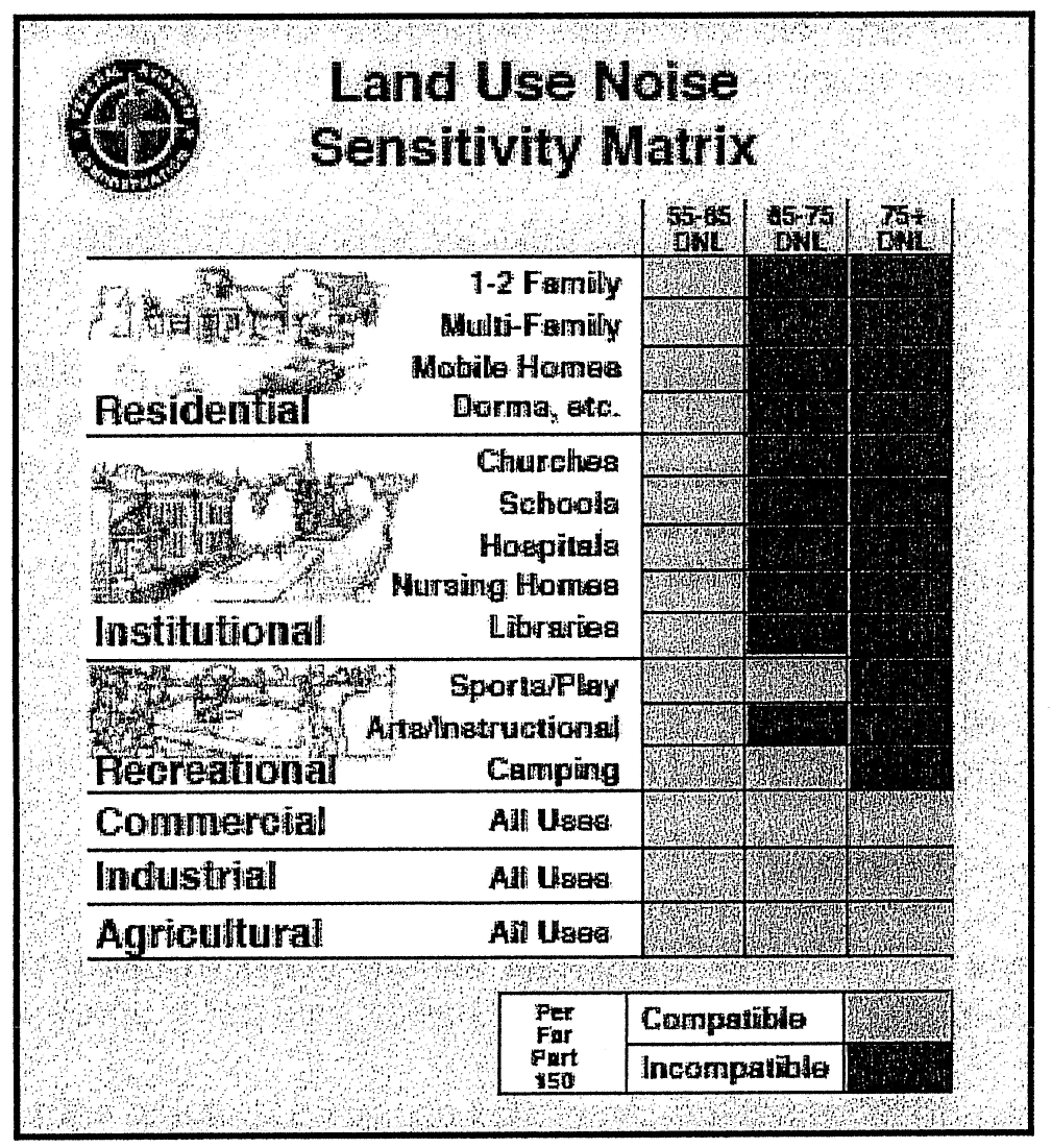
Uses. Uses such as low-density manufacturing, retail, government facilities, and agriculture are deemed compatible.
Noise sensitive uses, such as housing, schools, medical facilities or places of worship; uses that tend to concentrate large numbers of people (certain higher residential densities, schools, churches, hospitals, sports stadiums, shopping malls) are generally deemed incompatible, but may be allowed depending on the level of exposure to excessive noise and accident potential and contingent upon the use of noise level reduction measures in the construction of the building and/or site.
Uses that can interfere with safe air navigation, such as tall structures, or activities that throw off excessive lighting, smoke or dust and may impair vision are deemed incompatible.
8.7.2.
Development standards.
1.
Density. Limit single-family residential density to one—two dwelling units per acre in the LUPZ and one-mile buffer; limit density to one dwelling unit per five acres in the NZII.
2.
Noise. When noise-sensitive structures are either located within or are planned to be located within the LUPZ and the NZII, building standards need to incorporate noise level reduction measures of at least 23 dB and 30 dB to provide a level of sound attenuation compatible with occupancy.
Measures such as building location and site planning, design, the use of forested buffers and of berms and barriers can help mitigate outdoor noise exposure from ground level transportation sources. These actions are preferred wherever practical to measures that only protect interior spaces.
All re-zonings and subdivision developments require a signed noise easement from the property owner before review by the planning commission.
Buyers and sellers of real property are required at time of contract signing and before settlement to make prospective buyers and renters of real property within the LUPZ and NZII aware of noise routinely generated from Fort Benning testing and training ranges and military aerial training routes.
3.
Lighting. Outdoor lighting systems (streetlights, lighted signage, lighted canopies associated with general retail, or exterior security lighting associated with large buildings) that allow significant light to travel upward into an otherwise darkened sky are allowed contingent upon the use of light pollution reduction measures.
4.
Height. No building or structure shall be erected or built in the LUPZ and NZII that exceeds 150 feet above ground level (AGL).
5.
Interference or Impairment. No use may be made of the land contained in the LUPZ and NZII which will create electrical interference with radio communications between aircraft and the base, confuse or impair visibility or otherwise endanger the landing, taking off or maneuvering in any manner of aircraft using the base and its related gunnery and bombing range.