
Tallapoosa City Zoning Code
ARTICLE VI
- EXCEPTIONS AND MODIFICATIONS
Sec. 106-171. - Lots of record.
(a)
Single lots. Where the owner of a lot at the time of the adoption of the ordinance from which this chapter is derived or his successor in title thereto does not own sufficient land to enable him to conform to the dimensional requirements of this chapter, such lot may be used as a building site for a single-family residence in a district where residences are permitted.
(b)
Adjoining lots. If two or more adjoining lots with continuous frontage are in a single ownership at any time after the adoption of the ordinance from which this chapter is derived and such lots individually are too small to meet the yard, width, and area requirements of the district in which they are located, such groups of lots shall be considered as a single lot or several lots of minimum permitted size and the lot or lots in one ownership shall be subject to the requirements of this chapter.
(Ord. No. 01252, § 106-81, 12-12-2005)
Sec. 106-172. - Front yard setbacks for dwelling.
The setback requirements of this chapter for dwellings shall not apply to any lot where the average existing building setback line on lots located wholly or in part within 100 feet on each side of such lot, within the same block and zoning district, and fronting on the same side of the street as such lot, is less than the minimum setback required. In such cases the setback on such lots may be less than the required setback, but not less than the average of the existing setbacks on the aforementioned lots, and in no case less than ten feet from the street right-of-way.
(Ord. No. 01252, § 106-82, 12-12-2005)
Sec. 106-173. - Height limits.
The height limitations of this chapter shall not apply to church spires, belfries, cupolas and domes not intended for human occupancy; turrets with "witches' hats," monuments, water towers, observation towers, transmission towers, chimneys, smokestacks, conveyers, flag poles, radio towers, television towers, masts, aerials, the roof area (attic) of residential structures where no space for temporary or overnight occupancy has been designed or scheduled, and only storage space/use shall exist, and similar structures.
(Ord. No. 01252, § 106-83, 12-12-2005)
Sec. 106-174. - Group projects.
(a)
A group project (including, but not limited to, residential, commercial, industrial, educational, medical, religious, or civic uses) of two or more buildings to be constructed on a plot of land at least two acres not subdivided into customary streets and lots, and which will not be so subdivided, may be constructed provided:
(1)
Such uses are limited to those permitted within the district in which the project is located;
(2)
The over-all intensity of land use is no higher, and the standard of open space is no lower, than that permitted on the district in which the project is located;
(3)
The distance of every building from the nearest property line shall meet the front-yard setback and side-yard requirements of the district in which the project is located;
(4)
The building heights do not exceed the height limits permitted in the district in which the project is located; and
(5)
On property that lies within or abuts upon a residential district, there shall be a ten-foot planted buffer strip along the rear and/or side lot lines abutting the residential properties.
(b)
Approval process. Approval shall be provided by the planning commission of Tallapoosa. An application form/request letter, which may be provided by the department of planning, shall be presented. An application fee of $150.00 shall be included with the application. Said fee shall be amended from time to time by the mayor and council by resolution. The application for group project status shall be advertised in the legal advertising organ of Haralson County or similar newspaper of general circulation in a similar fashion as a rezoning application (including posting the property): at least 15 days prior to, but no more than 45 days prior to, the upcoming planning commission meeting. A site plan must be provided that shows the following:
(1)
A plat of the property showing dimensions of parcel. Also include location and size of structures to be constructed, parking spaces allocated to new construction and their location on the property. If required, the 10-foot planted buffer zone, indicating type of plant to be installed.
(2)
Verification of available sewer and water (statement from public works director or city manager).
(3)
The planning coordinator, city manager or his/her designee, shall conduct a preliminary evaluation of the submitted site plan to verify that all required information has been included. Site plan review shall require a fee of $50.00. Said fee shall provide two reviews of the site plan. If still not correct after the second review, an additional fee of $25.00 per review shall be assessed. Said fees may be amended by the mayor and council from time to time by resolution. If site plan is not complete at the time the planning commission convenes, this shall be grounds for denying the group project status request. Plans must be submitted at the time of the application being submitted. Application must be submitted in a timely fashion to allow all necessary advertising to be accomplished.
(4)
If the request is denied, a second request for the same property shall not be submitted for a minimum of 12 months from the date of the denied group project request.
(5)
Based upon the planning commissions' review of the supplied information, including public comments upon the proposal, the planning commission shall approve or deny the group project request. If any party is aggrieved of the decision by the planning commission, the aggrieved party may appeal to the City of Tallapoosa's mayor and council for review of the decision.
(Ord. No. 01252, Sec. 106-84, 12-12-2005; Ord. No. 01312, § 1(Exh. 2024-B), 3-11-2024)
Sec. 106-175. - Requirements and standards.
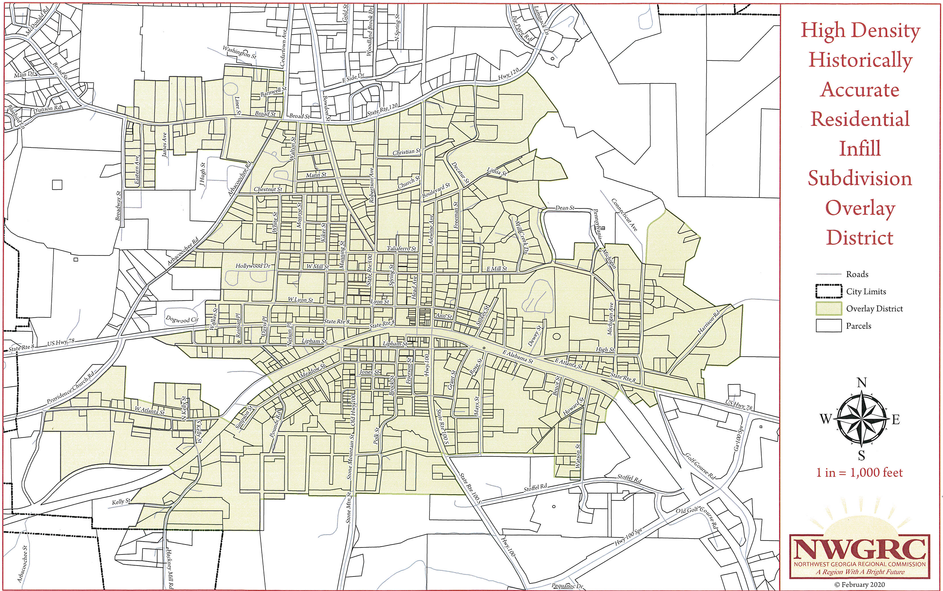
Requirements to comply with; which shall allow the platting applicant to utilize the traditional, historically accurate high density lot size permitted in section 106-128, RH, Residential Historic District, provided that such land is located within the "High Density Historically Accurate Residential Infill Subdivision Overlay District," and complies with the following standards:
(1)
Purpose and intent. It is in the public interest to maximize efficiency of the utilization of public services, infrastructure, and facilities as a means to achieve balanced growth and to provide a cost effective method for municipal service delivery. Within the residential areas of the identified traditional, high density, walkable, core historic city residential district, and delineated on the "High Density Historically Accurate Residential Infill Subdivision Overlay District," there exists an opportunity to achieve maximum utilization of land resources that have been bypassed or under-utilized in the development of the traditional, historic urban area. An increase in the density normally allowed by the underlying zoning district (RH) is deemed an appropriate incentive to promote infill development and redevelopment within this historic urban residential core for single-family residential detached district, provided that the preferred neighborhood compatibility standards are respected.
(2)
Applicability. The high density historically accurate residential infill subdivision overlay district (the overlay district) implements the infill development zone. The provisions of this overlay district apply to all parcels designated within the overlay district which wish to utilize the platting density permitted in the underlying zoning district (an RH option), and/or parcels of land which contain two acres or less; and comply with the eligibility criteria standards. The boundary of this district shall be shown in the official zoning map of the city and all parcels contained within the zone, which meet the eligibility section below, are able to utilize the provisions set forth in this section.
High Density Historically Accurate Residential Infill Subdivision Overlay District
(3)
Land development regulations. All land use and development, including, but not limited to, buildings, driveways, parking areas, street buffers, tree protection/landscaping and pedestrian/bicycle ways, shall be located and/or provided for in accordance with the provisions of the zoning ordinance and land development regulations, except as modified by this section.
(4)
Eligibility. Properties may utilize the high density subdivision allowed in the overlay districts' infill development zone (RH district density) provided they meet the following criteria:
a.
The original/initial parcel of land which the proposed subdivision is coming from does not exceed two acres.
b.
The parcel must be served by public water and sanitary sewer (septic tanks are prohibited).
c.
Parcel must be zoned one of the three RH designations, or R-200, R-150, R-100, R-75 or R-50, as shown on the city zoning map adopted on December 12, 2005, or on subsequently adopted maps.
d.
The new parcel must contain at least 5,000 square feet and a minimum of 50 feet street frontage.
e.
The original parcel, after the proposed subdivision is complete, must contain at least 5,000 square feet and have at least 50 feet street frontage. Proposed submitted plat must show all parcels; those newly created and those from the original, source parcel.
f.
Proposed new homes must contain a minimum of 1,200 heated square feet.
(5)
Architectural consistency. It is presumed that homes constructed shall be architecturally consistent with the characteristics of the surrounding homes and area.
(6)
Approval process. Standard plat approval process must be followed.
(Ord. No. 01280, exh. 2013-C(106-85), 12-9-2013)