
Temple Terrace City Zoning Code
DIVISION 5
TEMPLE TERRACE DOWNTOWN OVERLAY DISTRICT
Sec. 12-299. - Purpose and intent.
The purpose of the Downtown Overlay District (DOD) is to establish architectural, landscaping, design, building, and use and site development regulations that encourage urban compatible land uses, ensure higher quality development and function in order to protect property values, improve economic development opportunities, provide safe and efficient access with a focus on the pedestrian and further the overall goals of the community redevelopment plan (adopted May 15, 2001, as updated), the Downtown Temple Terrace Revitalization Master Plan (adopted January 31, 2005) and the Downtown Mixed Use future land use category of the city's comprehensive plan. These architectural, landscaping, design, building, use and site development criteria can encourage quality development through the use of a variety of design and site techniques while continuing to provide for a wide range of economic development opportunities. The DOD shall include the real property described in the map and legal description set forth at the end of this division as exhibit 1.
Sec. 12-300. - Relationship to underlying zoning district/planned development.
(a)
In the event of a conflict between the entitlements, regulations or standards established in this division and the equivalent provisions in the underlying zoning districts, the provisions of this division shall govern. Except in the event of preemption by this division, the underlying zoning district provisions and all other provisions of the Land Development Code shall be applicable and enforced within the DOD.
(b)
The DOD shall have no application to those properties zoned PD (Planned Development) as of the date of the enactment of this DOD until and unless such properties are rezoned.
(c)
The Downtown Community Redevelopment Plan Overlay Zoning District (code sections 12-282 through 12-298) shall not apply to the properties located in the DOD.
Sec. 12-301. - Permitted uses.
The following uses are permitted in the DOD. These permitted uses shall be allowed on all properties within the DOD in addition to the permitted and accessory uses allowed in the underlying zoning district:
(a)
Multifamily dwellings, townhouses, live/work units. Live/work units are residential units consisting of both a commercial/office and a residential component that is occupied by the same resident as a primary dwelling.
(b)
Office buildings.
(c)
Research facilities (a center where research is done).
(d)
Community and cultural facilities. (Library, museum, performing arts spaces and other similar uses.)
(e)
Government offices.
(f)
Meeting and convention facilities.
(g)
Restaurant(s) The regulations set forth in subsection 12-234(b)(48)a. and b., and subsection 12-234(c)(12) shall not apply to restaurants located in the DOD.
Sec. 12-302. - Prohibited uses.
The following uses are not permitted in the DOD even if permitted in the underlying zoning district:
(a)
Appliance stores, including repair, conducted entirely within the building.
(b)
Car rental agencies.
(c)
Automotive supply store.
(d)
Exterminator.
(e)
Golf courses and driving ranges.
(f)
Restaurant(s) with drive thru.
(g)
Automobile sales, services and leasing.
(h)
Automobile washing service, manual or mechanical, coin-operated or self-service facilities.
(i)
Gas station.
(j)
High turnover retail automotive services.
(k)
Landscape nursery.
(l)
Service stations, with or without convenience sales.
(m)
Blood donor center, which is a business primarily engaging in the activity of receiving or taking whole blood, plasma or any component thereof from human donors for consideration.
(n)
Free standing communications towers.
(o)
Single-family residential.
(p)
Towing services, trash removal operations, wrecked, junked or abandoned vehicle storage or similar uses.
(q)
Uses that involve hazardous processes or that emit noxious odors, fumes, or particulates, or that involve levels of noise that are incompatible with other permitted uses.
(r)
Dry cleaners unless the use is for pick up and drop off only.
Sec. 12-303. - Development standards.
The following development standards shall apply within the DOD:
(a)
No minimum lot size.
(b)
Maximum lot coverage: one hundred (100) percent of lot area.
(c)
Minimum side yard: zero (0) feet.
(d)
Minimum front yard: zero (0) feet.
(e)
Minimum rear yard: zero (0) feet.
(f)
Maximum building setback: a minimum of fifty (50) percent of a building's linear footage facing a public roadway must have a setback of zero (0) to ten (10) feet with a direct pedestrian connection.
(g)
Maximum fence height: ten (10) feet.
Sec. 12-304. - Crown design and building height.
(a)
A building's crown design and communication equipment/tower(s) shall be subject to approval of the city council based on aesthetic design, and conformity with the downtown mixed use, pedestrian oriented development. The crown of a building is defined as the area of the structure that is above the top floor, and may include angled roofs, decorative elements, towers and other similar construction.
(b)
Building heights within the DOD are regulated as follows:
(1)
No building shall exceed eighty (80) feet in height, excluding the crown of the building.
(2)
Minimum building height is two (2) stories.
(3)
A landowner/developer may request that a proposed project exceed eighty (80) feet in height. Such a request shall be subject to the grant of a waiver as outlined in section 12-306 of this Code and with consideration for compatibility with surrounding development, aesthetic design, and conformity with the downtown urban development.
(Ord. No. 1383, § 1(Exh. A), 12-15-2015; Ord. No. 1543, § 1, 2-7-2023)
Sec. 12-305. - Design standards.
(a)
All project design shall be based on an urban pedestrian oriented focus, and shall satisfy the following standards:
(1)
Window or transparency. The first floor elevations facing a public roadway shall provide at least fifty (50) percent window or transparency at the pedestrian level. Transparency that is open (such as but not limited to parking garage space) shall provide decorative transparency. The window or transparency is measured in lineal fashion. (For example, a 100-foot long building elevation shall have at least fifty (50) percent transparency in length.) The height of the glass or Plexiglas or opening must be a minimum height of eight (8) feet.
(2)
Accessory structures. The design of accessory structures shall incorporate design elements of the primary structure and should not be a dominant feature on the property.
(3)
Rooftop equipment. All rooftop equipment shall be screened from view on all sides visible to the general public, by building parapet walls or other building elements that appear as integral elements of the overall building.
(4)
Outdoor storage associated with building equipment and servicing areas shall be:
a.
Set back fifteen (15) feet from the front lot line;
b.
Screened by an opaque wall or fence with a height of ten (10) feet. An opaque wall or fence must completely screen the property beyond the fence and can include stockade fences or walls. Chain-link fences with slat, cloth or other similar measures are not considered to be opaque fences. The design of the screens should integrate elements of the overall building.
(5)
Landscaping. All developments shall adhere to the following landscaping requirements with a focus on the pedestrian space and sidewalk areas. A landscaping plan shall be required with all site plan submittals, showing the proposed landscaping for the site. One large palm tree will be required for every twenty (20) linear feet (on center) of property fronting along a public roadway. The following landscaping provisions include a ratio relationship between the number of plantings required, based upon the number of trees required. All shrub plants must be a minimum size of three (3) gallons at planting and all flowering perennial plants must be a minimum of one gallon at planting. For every required tree, a corresponding number of plantings from either subsection a., or b., below, will also be required to satisfy the landscape plan requirements for each site plan:
a.
Shrubs: Five (5) per required tree.
b.
Perennial plants: Seven (7) per required tree.
(6)
Planters:
a.
Planters shall be no more than three (3) feet in height and shall be spaced at intervals of four (4) feet or more unless otherwise directed.
b.
Planters shall not occupy an area of more than four (4) square feet or two (2) feet in diameter.
c.
Planters shall be placed with the face or outer edge eighteen (18) inches from the face of the curb or no more than three (3) feet from the building line. ADA requirements for the sidewalk and pedestrian space must be met.
d.
City council my allow planters of different sizes or locations on a case by case basis.
(7)
Parking requirements:
a.
No parking space requirements but a project needs to provide competent substantial evidence that its parking/transportation needs are being met.
b.
Parking lots located along public roadways will be required to provide a landscaping buffer that is four (4) feet or greater in width, between the parking area and the public sidewalk.
c.
No on-site parking is allowed in front of any structure. All parking must be on the side or rear of a structure.
(8)
Sidewalk requirements. All sidewalks along public roadway must be designed and built to meet the city's sidewalk construction and design regulations with a minimum width of eight (8) feet.
a.
All buildings will be required to have a minimum of one sidewalk connection from a sidewalk located along a public roadway to the entrance of the primary structure.
(9)
Awnings and coverings over the public sidewalk facing public roadway are required for all building entry points and over commercial space:
a.
The first floor elevations facing a public roadway shall provide at least sixty (60) percent awning or coverings at the pedestrian level over the building entry points and commercial space.
b.
The awning or covering at the pedestrian level shall be a minimum of four (4) feet in width.
(10)
Exterior wall elevations. There shall be no uninterrupted lengths of blank wall longer than ten (10) feet facing a public roadway. Walls shall be differentiated with recesses, offsets, building height, variations in rooflines, windows, awnings and materials or other architectural elements. The requirements of this paragraph do not apply to the first floor of a building.
Sec. 12-306. - Waivers.
(a)
The city council, pursuant to chapter 12, article VIII, division 3, is authorized to consider and grant a waiver(s) from the following sections of division 5:
(1)
Development standards in section 12-303;
(2)
Crown design and building height in section 12-304; and,
(3)
Design standards in section 12-305.
(b)
The city council may grant a waiver(s) only if an applicant establishes that:
(1)
There are extraordinary and exceptional conditions pertaining to the particular piece of property in question because of its size, shape or topography;
(2)
The application of the provisions of this LDC to the particular piece of property would create an unnecessary hardship;
(3)
Such conditions are peculiar to the particular piece of property involved;
(4)
Relief, if granted, would not cause substantial detriment to the public good or impair the purposes and intent of this LDC; and
(5)
Any waiver granted shall be the minimum waiver which makes possible the reasonable use of the land, building, or property.
(c)
For each waiver granted, the city council shall make a finding as part of the record stating specifically the factual basis upon which the waiver is based.
(Ord. No. 1383, § 1(Exh. A), 12-15-2015)
Exhibit 1
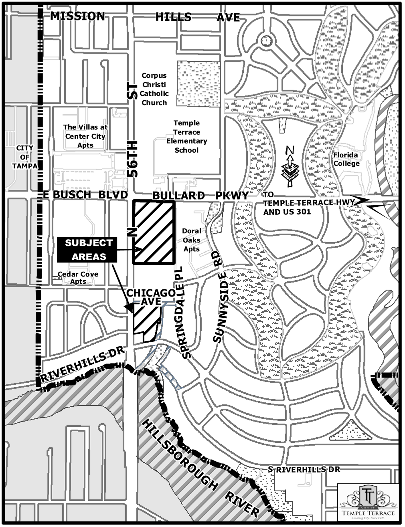
Exhibit "C"
Legal Description of Property Subject to
Temple Terrace Downtown Overlay District
Folio Number: 201949-0000
Legal Description:
AREA "A" NORTH: THAT TRACT OR PARCEL OF LAND LYING AND BEING IN SECTION 22, TOWNSHIP 28 SOUTH, RANGE 19 EAST, HILLSBOROUGH COUNTY, FLORIDA BEING MORE PARTICULARLY DESCRIBED AS FOLLOWS: COMMENCING AT THE NORTHWEST CORNER OF THE SOUTHEAST 1/4 OF SECTION 22, TOWNSHIP 28 SOUTH, RANGE 19 EAST, HILLSBOROUGH COUNTY, FLORIDA; THENCE ALONG THE SURVEY CENTERLINE OF STATE ROAD S-583, ALSO KNOWN AS 56TH STREET, SOUTH 00°00′31″ EAST, A DISTANCE OF 50.14 FEET; THENCE LEAVING SAID LINE NORTH 89°59′29″ EAST, A DISTANCE OF 45.00 FEET TO THE INTERSECTION OF THE EASTERLY RIGHT-OF-WAY LINE OF STATE ROAD S-583 AND THE SOUTHERLY RIGHT-OF-WAY LINE OF BULLARD PARKWAY AND THE POINT OF BEGINNING; THENCE SOUTH 89°20′43″ EAST, ALONG THE SOUTHERLY RIGHT-OF-WAY LINE OF BULLARD PARKWAY, FORMERLY KNOWN AS TEMPLE TERRACE HIGHWAY, A DISTANCE OF 589.73 FEET; THENCE LEAVING SAID LINE SOUTH 00°00′50″ WEST, A DISTANCE OF 1,464.67 FEET; THENCE NORTH 89°57′31″ WEST, A DISTANCE OF 589.11 FEET TO THE EASTERLY RIGHT-OF-WAY LINE OF STATE ROAD S-583, 45.00 FEET EASTERLY OF SAID SURVEY CENTERLINE; THENCE NORTH 00°00′31″ WEST, ALONG SAID RIGHT-OF-WAY LINE A DISTANCE OF 1,470.98 FEET TO THE POINT OF BEGINNING;
LESS AND EXCEPT THEREFROM THAT PORTION LYING WITHIN PHASE 1 PARCEL:
A PARCEL OF LAND LYING IN SECTION 22, TOWNSHIP 28 SOUTH, RANGE 19 EAST, HILLSBOROUGH COUNTY, FLORIDA. SAID PARCEL BEING THOSE PORTIONS OF TRACTS A-1, A-2, B-1, D-1, H AND ADDITIONAL CITY PARCEL, ALL AS DESCRIBED IN THAT CERTAIN QUIT CLAIM DEED RECORDED IN OFFICIAL RECORDS BOOK 19336, PAGE 1616, OF THE PUBLIC RECORDS OF HILLSBOROUGH COUNTY, LYING WITHIN THE FOLLOWING METES AND BOUNDS DESCRIPTION: COMMENCING AT THE NORTHWEST CORNER OF THE SOUTHEAST 1/4 OF SECTION 22, TOWNSHIP 28 SOUTH, RANGE 19 EAST, HILLSBOROUGH COUNTY, FLORIDA; THENCE ALONG THE WEST BOUNDARY OF SAID SOUTHEAST 1/4, SOUTH 00°06′43″ WEST, 238.17 FEET; THENCE DEPARTING SAID WEST BOUNDARY, SOUTH 89°53′17″ EAST, 44.71 FEET TO A POINT ON THE EASTERLY RIGHT-OF-WAY LINE OF STATE ROAD S-583 (56TH STREET); THENCE ALONG SAID EASTERLY RIGHT-OF-WAY LINE, SOUTH 00°10′20″ WEST, 704.46 FEET TO THE POINT OF BEGINNING OF THE HEREIN DESCRIBED PARCEL; THENCE DEPARTING SAID EASTERLY RIGHT-OF-WAY LINE, SOUTH 89°49′40″ EAST, 589.22 FEET TO A POINT ON THE EASTERLY RIGHT-OF-WAY LINE OF THE CLOSED COMMONWEALTH AVENUE (BROADWAY ON PLAT), AS SHOWN ON MAP OF TEMPLE TERRACE ESTATES, AS RECORDED IN PLAT BOOK 17, PAGE 22, OF THE PUBLIC RECORDS OF HILLSBOROUGH COUNTY, FLORIDA; THENCE ALONG SAID EASTERLY RIGHT-OF-WAY LINE, AND THE SOUTHERLY EXTENSION THEREOF, SOUTH 00°12′09″ WEST, 283.56 FEET; THENCE SOUTH 89°04′57″ EAST, 67.07 FEET TO A POINT ON THE WESTERLY RIGHT-OF-WAY LINE OF SPRINGDALE AVENUE; THENCE ALONG SAID WESTERLY RIGHT-OF-WAY LINE, SOUTH 02°50′45″ EAST, 109.21 FEET TO A POINT ON A TANGENT CIRCULAR CURVE, CONCAVE WESTERLY; THENCE 122.64 FEET ALONG THE ARC OF SAID CURVE TO THE RIGHT, HAVING A RADIUS OF 700.00 FEET, A CENTRAL ANGLE OF 10°02′17″, A CHORD WHICH BEARS SOUTH 02°10′22″ WEST, A CHORD DISTANCE OF 122.48 FEET TO A POINT OF TANGENCY; THENCE SOUTH 07°11′31″ WEST, 63.86 FEET TO A POINT ON THE EASTERLY EXTENSION OF THE NORTHERLY RIGHT-OF-WAY LINE OF CHICAGO AVENUE, AS SHOWN ON SAID MAP OF TEMPLE TERRACE ESTATES; THENCE DEPARTING SAID WESTERLY RIGHT-OF-WAY LINE, AND ALONG THE EASTERLY EXTENSION OF SAID NORTHERLY RIGHT-OF-WAY LINE, AND SAID NORTHERLY RIGHT-OF-WAY LINE, NORTH 89°46′14″ WEST, 649.80 FEET TO A POINT ON THE AFORESAID EASTERLY RIGHT-OF-WAY LINE OF STATE ROAD S-583; THENCE DEPARTING SAID NORTHERLY RIGHT-OF-WAY LINE, AND ALONG SAID EASTERLY RIGHT-OF-WAY LINE, NORTH 00°10′20″ EAST, 578.63 FEET TO THE POINT OF BEGINNING;
AREA "A" SOUTH: A PARCEL OF LAND LYING IN SECTION 22, TOWNSHIP 28 SOUTH, RANGE 19 EAST, HILLSBOROUGH COUNTY, FLORIDA. SAID PARCEL BEING THOSE PORTIONS OF TRACTS A-2, D-I AND H, ALL AS DESCRIBED IN THAT CERTAIN QUIT CLAIM DEED RECORDED IN OFFICIAL RECORDS BOOK 19336, PAGE 1616, AND THAT CERTAIN CORRECTIVE QUIT CLAIM DEED RECORDED IN OFFICIAL RECORDS BOOK 19954, PAGE 1849, BOTH OF THE PUBLIC RECORDS OF HILLSBOROUGH COUNTY, LYING WITHIN THE FOLLOWING METES AND BOUNDS DESCRIPTION: COMMENCING AT THE NORTHWEST CORNER OF THE SOUTHEAST 1/4 OF SECTION 22, TOWNSHIP 28 SOUTH, RANGE 19 EAST, HILLSBOROUGH COUNTY, FLORIDA; THENCE ALONG THE WEST BOUNDARY OF SAID SOUTH 1/4, SOUTH 00°06′43″ WEST, 238.17 FEET; THENCE DEPARTING SAID WEST BOUNDARY, SOUTH 89°53′17″ EAST, 44.71 FEET TO A POINT ON THE EASTERLY RIGHT-OF-WAY LINE OF STATE ROAD S-583 (56TH STREET); THENCE ALONG SAID EASTERLY RIGHT-OF-WAY LINE, SOUTH 00°10′20″ WEST, 704.46 FEET TO THE POINT OF BEGINNING OF THE HEREIN DESCRIBED PARCEL; THENCE DEPARTING SAID EASTERLY RIGHT-OF-WAY LINE, SOUTH 89°49′40″ EAST, 589.22 FEET TO A POINT ON THE EASTERLY RIGHT-OF-WAY LINE OF THE CLOSED COMMONWEALTH AVENUE (BROADWAY ON PLAT), AS SHOWN ON MAP OF TEMPLE TERRACE ESTATES, AS RECORDED IN PLAT BOOK 17, PAGE 22, OF THE PUBLIC RECORDS OF HILLSBOROUGH COUNTY, FLORIDA; THENCE ALONG SAID EASTERLY RIGHT-OF-WAY LINE, SOUTH 00°12′09″ WEST, 18.67 FEET; THENCE DEPARTING SAID EASTERLY RIGHT-OF-WAY LINE, NORTH 89°49′40″ WEST, 589.21 FEET TO A POINT ON THE AFORESAID EASTERLY RIGHT-OF-WAY LINE OF STATE ROAD S-583; THENCE ALONG SAID EASTERLY RIGHT-OF-WAY, NORTH 00°10′20″ EAST, 18.67 FEET TO THE POINT OF BEGINNING.
12.22 ACRES (M.O.L.)
Folio Numbers: 201977-0000 and 201978-0000 plus vacated rights-of-way.
Legal Description:
AREA "B": THAT TRACT OR PARCEL OF LAND LYING AND BEING IN SECTION 22, TOWNSHIP 28 SOUTH, RANGE 19 EAST, HILLSBOROUGH COUNTY, FLORIDA BEING MORE PARTICULARLY DESCRIBED AS FOLLOWS: COMMENCING AT THE NORTHWEST CORNER OF THE SOUTHEAST 1/4 OF SECTION 22, TOWNSHIP 28 SOUTH, RANGE 19 EAST, HILLSBOROUGH COUNTY, FLORIDA; THENCE ALONG THE SURVEY CENTERLINE OF STATE ROAD S-583, ALSO KNOWN AS 56TH STREET, SOUTH 00°00′31″ EAST, A DISTANCE OF 50.14 FEET; THENCE LEAVING SAID LINE NORTH 89°59′29″ EAST, A DISTANCE OF 45.00 FEET TO THE INTERSECTION OF THE EASTERLY RIGHT-OF-WAY LINE OF STATE ROAD S-583 AND THE SOUTHERLY RIGHT-OF-WAY LINE OF BULLARD PARKWAY; THENCE SOUTH 00°00′31″ EAST, ALONG THE EASTERLY RIGHT-OF-WAY LINE OF STATE ROAD S-583 A DISTANCE OF 1,535.98 FEET TO THE POINT OF BEGINNING; THENCE LEAVING SAID LINE SOUTH 89°57′41″ EAST, A DISTANCE OF 414.81 FEET TO THE POINT ON A NON-TANGENT CURVE TO THE RIGHT; THENCE SOUTHERLY 250.27 FEET ALONG THE ARC OF SAID CURVE, HAVING A RADIUS OF 1,562.38 FEET, A CENTRAL ANGLE OF 09°10′40″, AND A CHORD BEARING AND DISTANCE OF SOUTH 00°19′20″ WEST 250.00 FEET; THENCE NORTH 89°58′12″ WEST, A DISTANCE OF 32.73 FEET TO THE POINT ON A NON-TANGENT CURVE TO THE RIGHT; THENCE SOUTHERLY 249.54 FEET ALONG THE ARC OF SAID CURVE, HAVING A RADIUS OF 1,530.01 FEET, A CENTRAL ANGLE OF 09°20′41″, AND A CHORD BEARING AND DISTANCE OF SOUTH 09°38′39″ WEST 249.26 FEET TO THE NORTHERLY RIGHT-OF-WAY LINE OF RIVERHILLS DRIVE; THENCE SOUTH 78°39′00″ WEST, ALONG SAID RIGHT-OF-WAY LINE A DISTANCE OF 205.00 FEET; THENCE LEAVING SAID LINE NORTH 00°00′41″ EAST, A DISTANCE OF 150.04 FEET; THENCE SOUTH 78°45′29″ WEST, A DISTANCE OF 140.59 FEET TO THE EASTERLY RIGHT-OF-WAY LINE OF STATE ROAD S-583; THENCE NORTH 00°00′31″ WEST, ALONG SAID RIGHT-OF-WAY LINE A DISTANCE OF 413.71 FEET TO THE POINT OF BEGINNING; TOGETHER WITH THE SOUTH l/2 OF THAT PORTION OF THE VACATED CHICAGO AVENUE APPURTENANT THERETO AS VACATED AND CLOSED BY ORDINANCES RECORDED IN OFFICIAL RECORDS BOOK 19380, PAGE 1918; AND OFFICIAL RECORDS BOOK 20161, PAGE 1527, ALL OF THE PUBLIC RECORDS OF HILLSBOROUGH COUNTY, FLORIDA.
3.9 ACRES (M.O.L.)
(Ord. No. 1383, § 3(Exh. C), 12-15-2015)