
Tenino City Zoning Code
CHAPTER 106
50. - SPECIAL PURPOSE ZONES
106.50.010. - Public/semi-public (P/SP) zone.
A.
Intent. The public/semi-public zone provides for moderate· and large-scale activities relating to the purposes of state and local governmental entities and semi-public institutions by providing necessary public services. The designation allows for the specialized needs of providing public services to all areas of Tenino.
B.
Physical development. Standards applicable to physical development in the P/SP zone are provided on the following pages. Where a cross-reference is listed, see the referenced title, chapter or section for additional standards.
C.
Allowed uses and use standards. Standards applicable to use are provided in this subsection. Where a cross-reference is listed, see the referenced title, chapter, or section for additional standards. All standards in Title 106 and Title 108 are applicable unless stated otherwise.
D.
Lot standards. (Reserved).
E.
Development options and subdivision. (Reserved).
F.
Additional zone-specific standards. (Reserved).
(Ord. No. 881, § 32, 9-26-2017)
106.50.020. - West Tenino (WT) zone.
A.
Intent. The purpose of the West Tenino zone is to:
1.
Require the adoption of a master plan prior to any subdivision of land, except those subdivisions of land that occur subject to RCW 58.17.040(1), or RCW 58.17.040(3) through 58.17.040(9), to ensure that a number of smaller land divisions do not make the site unusable for future urban development.
2.
Provide requirements and guidelines for the development of the area, including items such as the layout of road connections and certain building forms and uses to facilitate the development of an individual or series of master plans for the site.
3.
Specify the land uses that are allowed in the area prior to the creation of a master plan or any subdivision of property.
B.
Physical development. Standards applicable to physical development in the WT zone are provided on the following pages. Where a cross-reference is listed, see the referenced title, chapter or section for additional standards.
C.
Allowed uses and use standards. Standards applicable to use are provided in this subsection. Where a cross-reference is listed, see the referenced title, chapter, or section for additional standards. All standards in Title 106 and Title 108 are applicable unless stated otherwise.
D.
Lot standards. (Reserved).
E.
Development options and subdivision.
1.
Subdivision prohibited. Subdivision is prohibited prior to establishing a Master Plan except for those divisions that occur subject to RCW 58.17.040(1) or RCW 58.17.040(3) through 58.17.040(9):
a.
Cemeteries and other burial plots.
b.
Divisions made by testamentary provisions, or the laws of descent.
c.
Divisions in accordance with an approved binding site plan.
d.
Divisions for the purpose of lease in association with an approved binding site plan.
e.
Boundary line adjustments.
f.
Divisions for the purpose of leasing land for wireless telecommunications facilities.
g.
Divisions of land into lots or tracts less than three acres in size for the purpose of establishing a utility facility.
F.
Additional zone-specific standards.
1.
Accessory dwelling units.
a.
Additional ADUs. All lots with an existing single-family dwelling that is also actively farmed may be allowed one ADU. For lots that exceed 20 acres in size, one additional ADU is allowed for every 20 additional acres.
Example: An agriculture operation is sited on a 79-acre parcel of land. One ADU is allowed outright. One ADU is allowed for every 20 additional acres for a total of 3 ADUs (1 + (79-20)/20 = 3.95).
b.
The ADUs must be clustered together and in proximity to a principal residential dwelling.
c.
Accessory dwelling units must not be subdivided separate from the agricultural operation.
d.
The sewage disposal and water supply must be approved by the City of Tenino.
2.
Retail and restaurants/bars. Retail and restaurant/bar uses must be in a farmer's market format.
3.
Heavy retail/service. Heavy retail/service uses shall be limited to no more than 5,000 square feet of floor area.
4.
West Tenino Master Plans. A master plan pursuant to Section 100.55, Master Planned Developments, is required for any subdivision of land except for those subdivisions that occur subject to subsection E.1. above.
a.
Required master plan elements. The master plan must include the following elements and must describe the fundamental characteristics of the proposed development as well as future development of neighboring properties.
i.
Transportation element.
ii.
Utilities element. The utilities element must include a plan for ensuring there are water rights sufficient to accommodate the anticipated uses on the site.
iii.
Land use element. The land use element must include a description of all proposed uses. Residential development must have an average net density of at least 6 dwelling units per acre.
iv.
Design guidelines element. The design guidelines must include information on how sandstone will be used in the area.
b.
Reserve areas allowed. Reserve areas for future master plans may be established in the West Tenino Residential area (shown below) as part of a master plan. Reserve areas must be at least 20 acres in size, and have a shape appropriate for the development of a future master plan. When a reserve area is utilized, the transportation element and utilities element of the original master plan must show how roadways and utilities will be provided to the reserve area.
c.
Master plan principles. A master plan should be designed in accordance with the following guidelines for the site.
i.
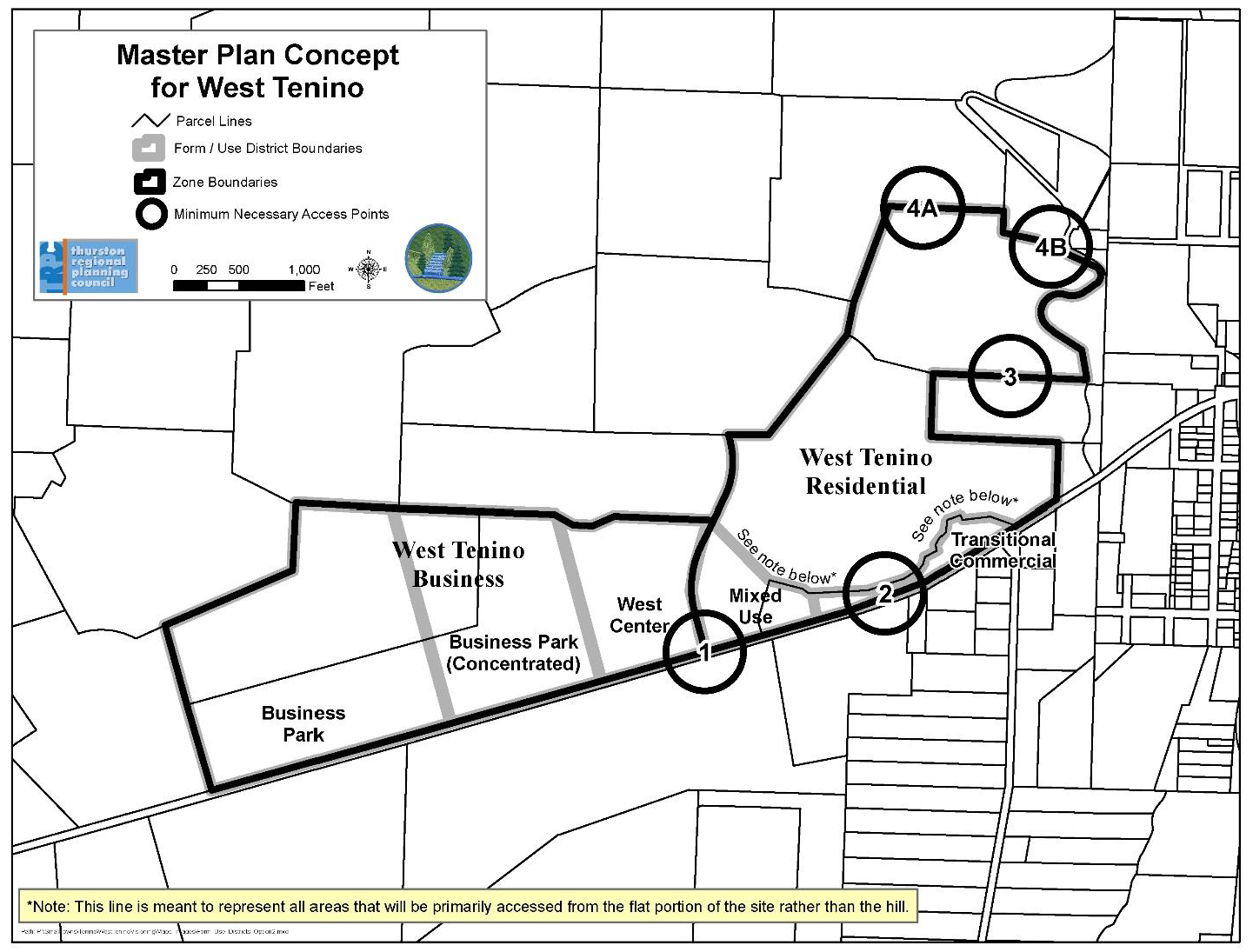
Form and use principles. The following principles are meant to articulate the desired placement of building forms and land uses throughout various districts of the master plan area. The general location that these different forms and uses apply is shown below. Variations on the location of these districts are appropriate, so long as the districts meet the fundamental intent for each area as articulated below.
(a)
Business park area.
(1)
Form. Buildings in the business park area may become even more spread out than in the concentrated business park. Buildings should be visually obscured from Old Highway 99 by the existing topography.
(2)
Access. Buildings should generally be accessed via a secondary access road (or roads) off of Old Highway 99.
(3)
Setbacks. Buildings are encouraged to be set at or near the front property line along the secondary access roads.
(4)
Uses. Appropriate uses for the business park area include agriculture, light industry, service, office, and heavy retail/service. Residential uses may also be appropriate, particularly in the northern portion of the area, but must not exceed 35 percent of the area. Residential uses should be consistent with the form principles for the West Tenino Residential area (subsection F.3.d.i.(e). below) rather than the business park area.
(b)
Business park (concentrated) area.
(1)
Form. Transitioning away from the West Center area, buildings may become less dense with yards, landscaping or parking located between the structures, though the structures should continue. Blocks may be longer than seen in the West Center area, but should not exceed 800 feet in length.
(2)
Setbacks. Buildings should be set at or near the front property line.
(3)
Uses. Appropriate uses for the business park (concentrated) area include light industry, office, and heavy retail/service. Residential uses may also be appropriate, particularly in the northern portion of the area, but must not exceed 35 percent of the area. Residential uses should be consistent with the form principles for the West Tenino Residential area (subsection F.3.d.i.(e). below) rather than the business park (concentrated) area.
(c)
West Center Area.
(1)
Form. The West Center Area of the site should provide a small retail and cultural center that is located close to the residential area on the hill and the business areas on the flat portion of the site. The area should contain a pedestrian-oriented configuration of buildings that frames the street front. Sandstone features should also be present on some of the buildings to acknowledge the city's history. Parking should be located behind the structures and be served by an alley to maintain this pedestrian-oriented street front, though on-street parking is also appropriate and encouraged. Blocks should range in length from 240 to 400 feet.
(2)
Setbacks. Buildings should be set at or near the front property line and should have no side yards.
(3)
Uses. Appropriate uses for the West Center Area include retail, service, offices, and residential. Residential uses must not exceed 35 percent of the area. The pond on the north portion of this area should be considered an amenity and be designed as a park with a trail around the pond, or some other park-like use.
(d)
Transitional commercial area.
(1)
Form. The western portion of the transitional commercial area should be a continuation of the retail and cultural center functions of the West Center area. Form should generally follow the characteristics listed for the West Center area. The eastern portion of the transitional commercial area (beyond where the hill creates a narrow strip of land between the hillside and roadway) may have buildings that are spread farther apart with parking located between the structures.
(2)
Uses. Appropriate uses for the transitional commercial area include retail, service, light industrial, and office. Residential uses are prohibited unless it can be demonstrated that there is no potential for nuisance odors from the Tenino Wastewater Treatment Plant that could have a negative impact on dwellings at any point in the future.
(e)
West Tenino residential area.
(1)
Form. A mix of housing types is appropriate. Mixed-use development may also be appropriate but may not in total exceed the ten percent of the area. Mixed use buildings should have some sandstone features and be pedestrian oriented with parking at the rear of buildings.
(2)
Access. Dwellings should generally be accessed by a well-connected street system with few cul-de-sacs. A pedestrian system with paths and/or sidewalks throughout the area should also be incorporated.
(3)
Uses. Appropriate uses for the Residential area include detached single-family dwellings, attached single-family dwellings, and retail when located in a mixed-use building. Open space associated with critical areas, such as the wetlands in the ravines on the hill, could include a trail system, and a park or trail system could provide views from areas on the hill.
ii.
Connectivity principles.
(a)
Street connections.
(1)
Lemon Hill Roadway Network and Access Points. The figure above shows the general location of necessary access points and the basic road connections that should be made on the hill portion of the West Tenino zone. Roadway locations and access points are meant to depict the primary arterial/collector corridors and minimum connectivity requirements necessary for the site. The figure is not meant to depict all roadways that will be constructed in the area. The placement of each roadway and access point may be moved to best suit the site design. However, the number of connections and access points should not decrease. The basic road connections required include:
(A)
Morningside Drive connector. A connection from the flat portion of the site to Morningside Drive (the line connecting 1 to 4A or 4B). The Morningside Drive connector, should be considered as part of the Main Roadway Spine.
(B)
Old Highway 99 connector. A connection from Old Highway 99 to the Morningside Drive Connector (the line connecting 2 and the line between 1 and 4A or 4B).
(C)
City connector. A connection from the Main Roadway Spine to an adjacent parcel within City limits that is over ten acres in size as of December 13, 2011 (the line connecting 3 and the line between 1 and 4A or 4B).
(D)
County connector. A connection from the Main Roadway Spine to an adjacent parcel more than ten acres in size as of December 13, 2011 that is located outside city limits. The parcel must also be located on Lemon Hill. This connection may be created through a roadway, a dedicated easement or a dedication for a future potential roadway to the adjacent parcel. The connection is intended to ensure connectivity should the land in unincorporated county be developed in the future.
(2)
Westside Prairie Roadway Network and Access Points. No access points or roadway network are depicted in the figure above for the flat portion of the site. Within the area, the roadway network may be tailored to best suit the design of the master plan, but should generally include the following characteristics:
(A)
A street system that is consistent with the district form principles articulated in subsection F.3.c.i. above;
(B)
A well-connected roadway network (with few if any cul-de-sacs); and
(C)
An extension of the Main Roadway Spine that connects the Spine to Lemon Hill (discussed below).
(3)
Main Roadway Spine. The main spine through the site should connect the western part of the flat portion of the site (and Old Highway 99) to Morningside Drive. The Main Roadway Spine should be designed in a manner consistent throughout its entire length. The design should define West Tenino as a unique area and include sidewalks on both sides of the street, planter strips, and bike lanes. A median in the center of the roadway should also be considered to help distinguish the road from others in the community and contribute to the sense that West Tenino is a distinct area of the community.
(b)
Trail connections. A trail should be constructed on the site that will eventually link to the Yelm/Tenino Trail. This trail should generally skirt along the bottom edge of Lemon Hill and be connected to trails, sidewalks and/or bike lanes that descend the hill. West of Lemon Hill, the trail may: Continue as an individual, stand-alone trail that travels through the West Center and Business Park areas; tie into bike lanes and sidewalks on the main roadway spine; or travel an alternative route that is based on the placement of parks within the master plan. Bike and pedestrian facilities should be considered a fundamental amenity necessary to connect West Tenino to downtown Tenino.
(Ord. No. 881, § 32, 9-26-2017)

