
Tomball City Zoning Code
ARTICLE III
- DISTRICT REGULATIONS
Sec. 50-62. - Exterior building material/Façade Overlay District.
(a)
General purpose and description.
(1)
The Façade Overlay District (FOD) is intended to improve the aesthetics and integrity of development along the two main corridors within the city, FM 2920, SH 249 and SH Business 249, where higher development standards can effectively enhance the city's image as a desirable place to live, work, and shop.
(2)
The FOD is limited to a specified area encompassing land that has already been assigned conventional zoning district classifications. It supplements the standards of the underlying conventional districts with new or different standards. In the event of a conflict between the standards of the FOD and the regulations of the underlying zoning district, the standards described herein will prevail.
(b)
Scope and enforcement.
(1)
New buildings: All new nonresidential buildings shall adhere to this section.
(2)
Existing buildings and additions to existing buildings: Existing buildings shall conform to this section upon expansion exceeding 25 percent in area of the building.
(c)
District boundary. Properties with frontage on either side of FM 2920, properties with frontage on either side of SH 249, and properties with frontage on either side of SH 249 Business. Properties zoned Old Town and Mixed Use are not included in the FOD boundary.
(d)
Building façade standards. Requirements are applicable to all sides of a building or structure visible from FM 2920, SH 249, and SH 249 Business. A building façade plan of the entire proposed project shall be submitted with site plan review documents.
(1)
Building articulation: Building articulation, which is the expression or outlining of parts of the building by its architectural design, shall be provided in order to achieve the following:
a.
Create a complementary pattern or rhythm, dividing large buildings into smaller, identifiable portions.
b.
Break up the building mass through offsets and other methods that articulate the horizontal and vertical building planes.
(2)
Building materials: A minimum of 100 percent of a building's total façade visible from FM 2920, SH 249 and SH Business 249, shall utilize materials allowed by right or special exception.
a.
Allowed by right: Masonry and glass.
b.
Allowed by special exception: New technologies not addressed or contemplated by these regulations may also be allowed by special exception, if such materials are consistent with the visual nature and quality of the masonry materials permitted herein. Additionally, franchise businesses with an established theme that has not been deviated from in any other jurisdiction may apply for a special exception to use a material not permitted in this section.
c.
Trim materials: Architectural metal, EIFS (exterior insulation and finish systems), wood, cementitious fiberboard may be utilized for window and door trim, fascia, or soffit. EIFS may be used as a trim material but shall not be used within six feet of the ground.
d.
Bright or fluorescent colors shall not be permitted on any building material.
e.
All facades of an individual building, multiple buildings in a shopping center, or integrated business development shall have architectural design, color, and materials that are compatible or consistent with an overall theme.
(Ord. No. 2015-16, § 4, 9-8-2015)
Sec. 50-63. - Zoning district map.
(a)
The city is hereby divided into zones, or districts, and the boundaries of zoning districts set out in this article are delineated upon the zoning district map of the city, which may also be cited as the zoning map, said map being adopted as a part of this chapter as fully as if the same were set forth herein in detail.
(b)
One original of the zoning district map shall be filed in the office of the city secretary and labeled as "Official Zoning Map of the city, Texas—Ordinance No. 2008-01." This copy shall be the original zoning district map adopted with this chapter and shall bear the signature of the mayor, attested by the city secretary, and shall bear the seal of the city under the following words: "This is to certify that this is the Official Zoning Map referred to in Section 3 of the Zoning Ordinance, Ordinance No. 2008-01 of the City of Tomball, Texas, adopted on the 4th day of February, 2008." This copy shall not be changed in any manner. In case of any question, this copy, together with amending ordinances, shall be controlling.
(c)
A copy of the official zoning district map shall be placed in the office of the city manager or his designee. The map copy shall be used for reference and shall be maintained up to date by posting thereon all subsequent amendments. Any changes or amendments made to the zoning district boundaries shall be made on the map copy after the amendment has been approved by the city council in accordance with section 50-34. Each entry for a zoning map amendment shall include an ordinance number that references the zoning ordinance amendment.
(d)
Reproductions for informational purposes may be made of the official zoning district map or this copy in print version or digitally by electronic files, computer disks or on the web, provided all reproductions are clearly labeled as such with a "Current as of ________" date indication. A disclaimer should also be provided that the actual zoning can only be verified by contact with the city and review of the official map.
(e)
In the event that the official zoning map becomes damaged, destroyed, lost or difficult to interpret due to age, exposure, or the nature or number of changes or additions, the city council may adopt, by ordinance following a public hearing, a new official zoning map which shall replace and supersede the prior zoning map, but which shall not, in effect, amend or otherwise change the original official zoning map or any subsequent amendment thereto. The new official zoning map shall bear the signature of the mayor, attested by the city secretary, and shall bear the seal of the city under the following words: "This is to certify that this Official Zoning Map supersedes and replaces the original Official Zoning Map referred to in Section 3 of the Zoning Ordinance, Ordinance No. 2008-01 of the City of Tomball, Texas, adopted on the 4th day of February, 2008." Unless the prior official zoning map has been lost or has been totally destroyed, the prior map or any significant parts thereof remaining shall be preserved, together with all available records pertaining to its adoption or amendment.
(Ord. No. 2008-01, § 3, 2-4-2008)
Sec. 50-64. - Zoning district boundaries.
The zoning district boundary lines shown on the zoning district map are usually along streets, alleys, property lines, or extensions thereof. Where uncertainty exists as to the boundaries of districts as shown on the zoning district map, the following rules shall apply:
(1)
Boundaries shown as approximately following the centerlines of streets, highways or alleys shall be construed to follow such centerlines.
(2)
Boundaries shown as approximately following platted lot lines shall be construed as following such lot lines.
(3)
Boundaries shown as approximately following city limits shall be construed as following such city limits.
(4)
Boundaries shown as following railroad lines shall be construed to be located along the centerline of the railroad right-of-way lines.
(5)
Boundaries shown as approximately following the centerlines of streams, rivers, creeks, canals, bodies of water, or drainageways shall be construed to follow such centerlines, and in the event of change in any such centerlines shall be construed to move with such centerlines.
(6)
Boundaries shown as parallel to, or extensions of, features described in subsections (1) through (5) of this section shall be so construed. Distances not specifically indicated on the zoning district map shall be determined by the approximate scale of the map and verified by a survey.
(7)
Whenever any street, alley or other public way is vacated by official action of the city council, or whenever such area is franchised for building purposes, the zoning district line adjoining each side of such street, alley or other public way shall be automatically extended to the centerline of such vacated street, alley or public way (or to the new property ownership boundary line, if it is not determined to be at the former centerline) and all areas so involved shall then and henceforth be subject to all regulations of the extended districts.
(8)
The zoning classification applied to a tract of land adjacent to a street shall extend to the centerline of the street unless, as a condition of zoning approval, it is stated that the zoning classification shall not apply to the street.
(9)
Where physical features on the ground are at variance with information shown on the zoning district map, or if there arises a question as to how or whether a parcel of property is zoned and such question cannot be resolved by the application of subsections (1) through (8) of this section, then the board of adjustments shall interpret the zoning district boundaries.
(10)
If the zoning of property is invalidated by a judgment of a court of competent jurisdiction, the property shall be considered classified as AG Agricultural District in the same manner as provided for newly annexed territory.
(11)
For legal descriptions, refer to the adopting ordinances for each particular rezoning change.
(Ord. No. 2008-01, § 4, 2-4-2008)
Sec. 50-65. - Compliance required and applications of regulations.
(a)
All land, buildings, structures or appurtenances thereon located within the city, which are hereafter occupied, used, constructed, erected, removed, placed, demolished, and/or converted shall be occupied, used, erected, altered, removed, placed, demolished and/or converted in conformance with the zoning regulations prescribed for the zoning district in which such land or building is located, as hereinafter provided, or such shall be subject to penalties as per section 50-5. All of the standards and regulations prescribed herein shall be considered as the minimum requirement unless explicitly stated otherwise.
(b)
No uses shall be allowed which are prohibited by state or federal law or which operate in excess of state or federal environmental, pollution or performance standards as determined by the U.S. Environmental Protection Agency (EPA), Texas State Department of Health (TSDH), Texas Commission of Environmental Quality (TCEQ), Federal Aviation Administration (FAA), Federal Communications Commission (FCC), or any other applicable state or federal agency, as the case may be.
(c)
No lot upon which a building has been erected shall later be so reduced in area that the setbacks, yards and/or open spaces shall be smaller than those required by this chapter, nor shall a part of a yard or other open space required by this chapter for any building/lot be included as a part of a yard or other open space similarly required for another building/lot.
(d)
Unless otherwise provided herein, no building shall hereafter be erected or altered:
(1)
To have more narrow or smaller front, side or rear yards than those required by this chapter;
(2)
To exceed the maximum height allowed by this chapter;
(3)
To occupy a greater percentage of lot area than allowed by this chapter; or
(4)
To accommodate or house a greater number of families than is specified within this chapter for the zoning district in which such building is located.
(Ord. No. 2008-01, § 5, 2-4-2008)
Sec. 50-66. - Zoning upon annexation.
(a)
Proceedings to establish zoning may be undertaken concurrently with annexation procedures (i.e., notified at the same time, public hearings scheduled at the same time as annexation, etc.), however, zoning approval and formal adoption of the ordinance establishing zoning must occur after annexation approval and adoption have occurred, and as a separate and distinct action by the city council. For any period of time following official annexation by the city until a zoning action has been officially adopted to zone the land, the interim zoning of the land shall be considered to be agricultural (AG), and all zoning and development regulations of the AG zoning district shall be adhered to with respect to the development and use of the land.
(b)
The initial zoning of a land parcel, whether by initiation of the landowner or by initiation of the city, must meet the requirements for notification and public hearings as set forth in section 50-34 and all other applicable state laws.
(c)
The owner of land to be annexed may submit an application for zoning the property simultaneously with submission of the petition for annexation, but no such annexation application may be made conditioned upon the approval of any particular zoning classification.
(d)
Within an area classified as AG Agricultural:
(1)
No permit for the construction of a building or use of land shall be issued by the building official, or his designee, other than a permit which will allow the construction of a building or use permitted in the AG Agricultural District, unless and until such territory has been classified in a zoning district other than the AG Agricultural District by the city council in the manner prescribed by section 50-34, except as provided in subsection (b) of this section.
(2)
If plans and preparations for developing a property for a use other than those specified in the AG Agricultural District were already in progress prior to annexation of the property into the city, in accordance with section 50-37, then the city council may authorize construction of the project by a majority vote. Application of this subsection is contingent upon the following:
a.
The applicant must be able to demonstrate that plans and other preparations for developing the property commenced prior to (i.e., were already in progress at the time of) annexation into the city.
b.
Existing land uses shall be allowed to continue in conformance with V.T.C.A., Local Government Code ch. 43 and section 50-37.
(e)
In its deliberations concerning authorization to proceed with construction of a project which meets the criteria in subsections (a) through (d) of this section, the city council shall take into consideration the appropriate land use for the area as shown on the city's future land use plan. Upon approval by the city council, the city manager or his designee shall notify the building official or his designee of such approval.
(Ord. No. 2008-01, § 6, 2-4-2008)
Sec. 50-67. - Zoning districts established.
(a)
The city is hereby divided into the following zoning districts. The use, height, area regulations, and other standards, as set out in this chapter apply to each district. The districts established herein shall be known as:
BASE DISTRICTS
SPECIAL DISTRICTS
(b)
A summary of the area regulations for the foregoing zoning districts is included section 50-83.
(c)
Certain terms and definitions used within this chapter can be found in the definitions section 50-2.
(d)
Other requirements are contained within article IV of this chapter.
(Ord. No. 2008-01, § 13, 2-4-2008)
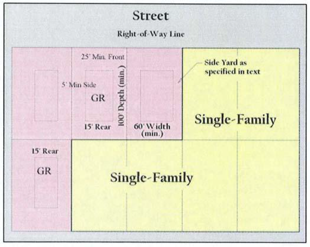
Sec. 50-68. - Agricultural District (AG).
(a)
General purpose and description. The AG Agricultural District is designed to permit the use of land for the ranching, propagation and cultivation of crops and similar uses of vacant land. Single-family uses on large lots are also appropriate for this district. Territory that has been newly annexed into the city may be initially zoned agricultural, and the district is considered a temporary holding zone until permanent zoning is approved. It is anticipated that agricultural zoned land will ultimately be rezoned to another zoning classification for its intended use in accordance with the comprehensive plan in the future. Zoning to the final, permanent classification will be considered an initial rezoning for the purposes of notice and protest requirements. The AG Agricultural District is also appropriate for areas where utilities or city services are not readily available.
(b)
Permitted uses.
(1)
Those uses listed for the AG Agricultural District in the use charts (section 50-82) as "P" or "C" are authorized uses permitted by right or conditionally permitted uses, respectively.
(2)
Livestock and domesticated animals shall only be allowed in accordance with the adopted ordinances of the city.
(3)
One manufactured home may be utilized as a temporary construction living quarters by the owner of the property, so long as a valid permit exists and construction is proceeding. In addition, non-occupied storage buildings may be allowed without a main structure for as long as a valid permit for construction of a main structure is valid.
(c)
Height regulations. The maximum height in the AG district shall be:
(1)
Three stories, and not to exceed 45 feet, for the main building/house.
(2)
Forty-five feet for agricultural structures (e.g., barns, silos, water towers, etc.), provided they are no closer than 100 feet from any residential structure on the premises, and they are set back at least 100 feet or three times their height (whichever is greater) from any front, side or rear property line.
(3)
Twenty-five feet for other accessory buildings, including detached garage, garden shed, accessory dwelling units, etc.
(d)
Area regulations.
(1)
Size of lots.
a.
Minimum lot area: One acre (i.e., 43,560 square feet).
b.
Minimum lot width: 100 feet.
c.
Minimum lot depth: 200 feet.
(2)
Size of yard.
a.
Minimum front yard: 60 feet.
b.
Minimum side yard: 30 feet; provided, however, a detached single-family dwelling and private garage may be located not less than 15 feet from the side property line or not less than 25 feet from the side property line adjacent to an arterial street, whichever is greater.
c.
Minimum rear yard: 25 feet for the main building and any accessory buildings.
(3)
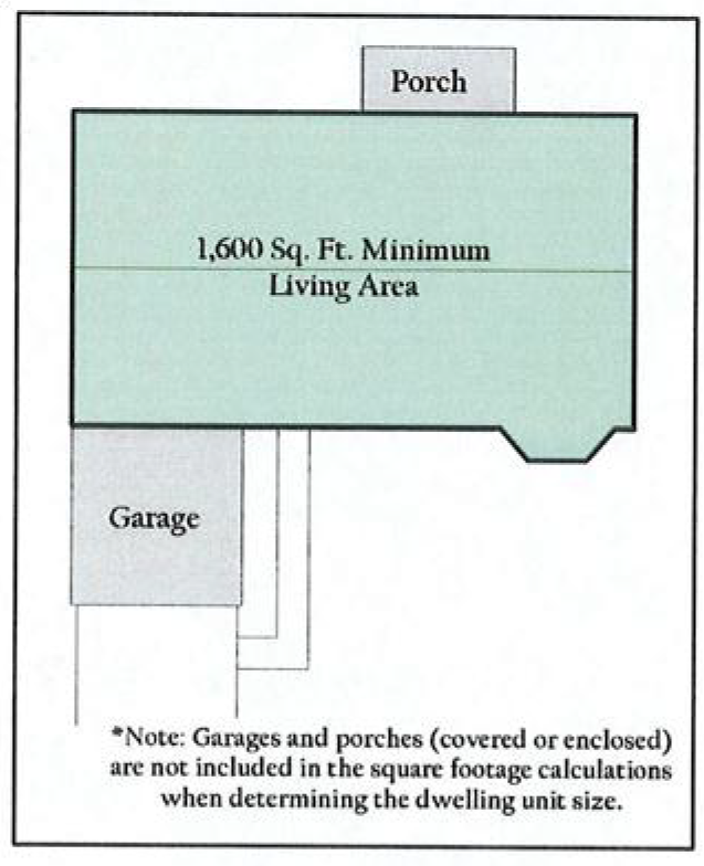
Maximum coverage lot. Maximum lot coverage is 40 percent for main buildings and accessory buildings.
(4)
Minimum floor area. Minimum floor area per dwelling unit is 1,600 square feet of heated and/or air-conditioned floor area.
Illustration 50-68-1: Lot and yard regulations for the Agricultural District
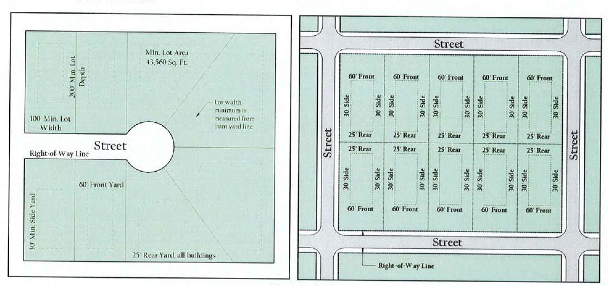
Illustration 50-68-2: Floor area for the Agricultural District
(Ord. No. 2008-01, § 14, 2-4-2008; Ord. No. 2009-31, § 2, 11-2-2009)
_____
Sec. 50-69. - Single-Family Estate Residential District (SF-20-E).
(a)
General purpose and description. The SF-20-E Single-Family Residential District is intended to provide for development of primarily very low-density detached, single-family residences on lots of not less than 20,000 square feet in size, churches, schools and public parks. It is intended for large lot subdivisions and also for the more rural type residential areas that don't meet the AG Agriculture District requirements but may want to have additional accessory buildings and animals.
(b)
Permitted uses. Those uses listed for the SF-20-E Single Family Residential District in the use charts (section 50-82) as "P" or "C" are authorized uses permitted by right or conditionally permitted uses, respectively.
(c)
Height regulations. The maximum height in the SF-20E district shall be:
(1)
Three stories, and not to exceed 45 feet, for the main building/house.
(2)
Two stories for other accessory buildings, including detached garage, garden shed, detached accessory dwelling units, gazebo, etc.
(d)
Area regulations.
(1)
Size of lots.
a.
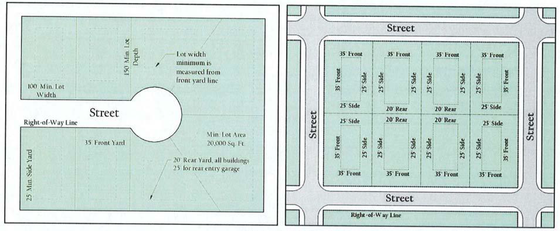
Minimum lot area: 20,000 square feet.
b.
Minimum lot width: 100 feet. Radial lots shall have a minimum width of 100 feet at and for a distance of 30 feet behind the front yard/building line. No lot shall be created that has a front yard with less than 30 feet of frontage on the front street.
c.
Minimum lot depth: 150 feet.
d.
Nonconforming lots: where a lawfully existing lot having less area, depth, or width than required in this section existed in separate ownership on the effective date of the ordinance from which this chapter is derived, the foregoing regulations relating to the size of such lot shall not prohibit the erection of a single-family dwelling thereon.
Illustration 50-69-1: Lot and yard regulations for the SF-20-E District
(2)
Size of yards.
a.
Minimum front yard: 35 feet; where lots have double frontage, running through from one street to another, the required front yard shall be provided on both streets.
b.
Minimum side yard: 10 feet. The minimum side yard of a corner lot adjacent to a street shall not be less than 15 feet, except where a lot sides on a designated arterial street, such side yard shall not be less than 25 feet.
c.
Minimum rear yard: 20 feet for the main building and any accessory buildings; 25 feet for rear garage entry.
(3)
Minimum floor area. Minimum floor area per dwelling unit is 1,600 square feet of heated and/or air-conditioned floor area.
(Ord. No. 2008-01, § 15, 2-4-2008; Ord. No. 2015-02, § 2, 2-2-2015)
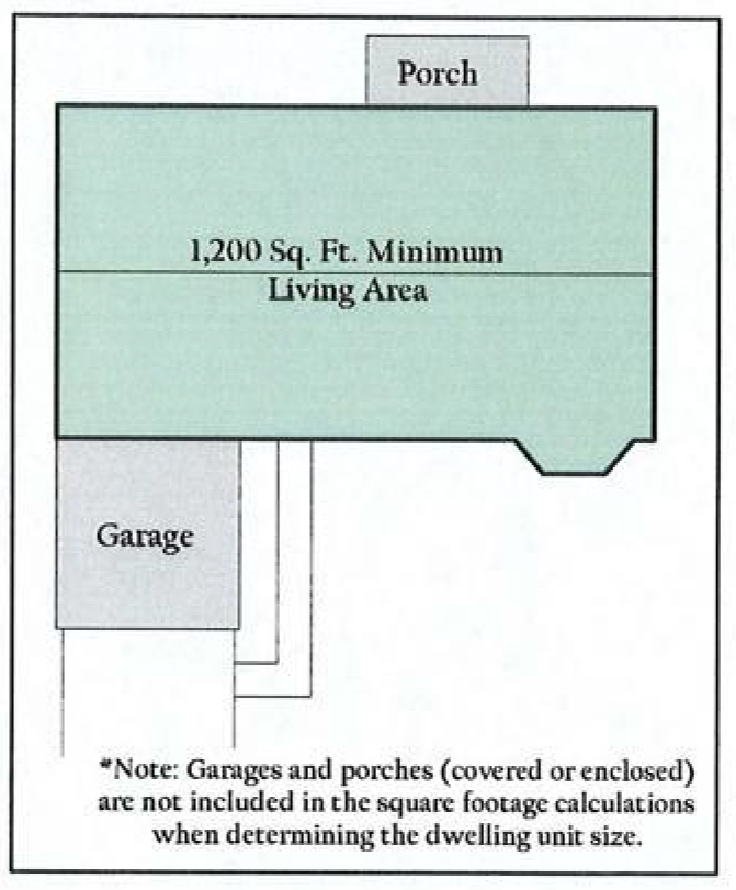
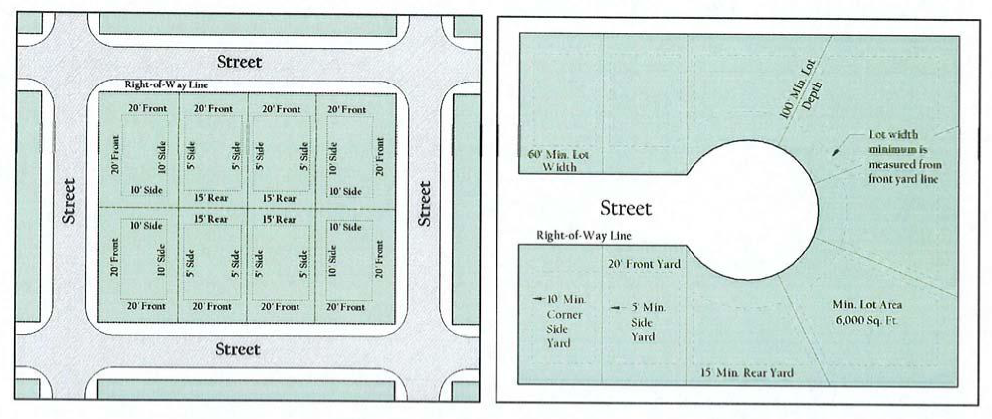
Sec. 50-70. - Single-Family Residential District (SF-9).
(a)
General purpose and description. The SF-9 Single-Family Residential District is intended to provide for development of primarily low-density detached, single-family residences on lots of not less than 9,000 square feet in size, churches, schools and public parks in logical neighborhood units.
(b)
Permitted uses. Those uses listed for the SF-9 Single-Family Residential District in the use charts (section 50-82) as "P" or "C" are authorized uses permitted by right or conditionally permitted uses, respectively.
(c)
Height regulations. The maximum height in the SF-9 district shall be:
(1)
Two stories, not to exceed 35 feet, for the main building/house.
(2)
Two stories for other accessory buildings, including detached garage, garden shed, gazebo, etc.
Illustration 50-70-1
(d)
Area regulations.
(1)
Size of lots.
a.
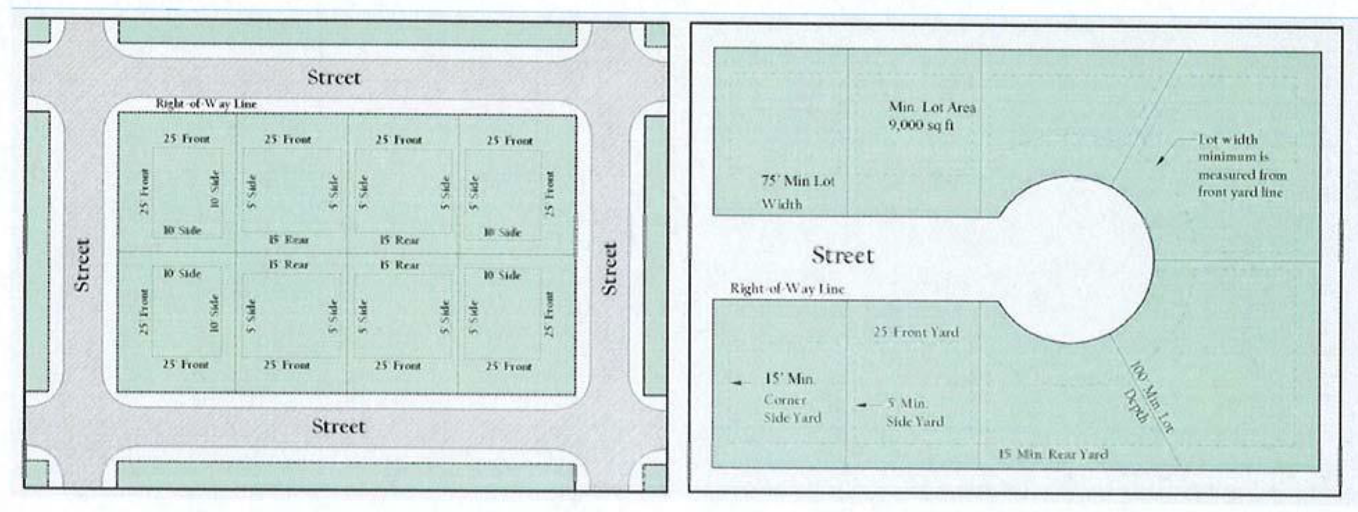
Minimum lot area: 9,000 square feet.
b.
Minimum lot width: 75 feet. Radial lots shall have a minimum width of 80 feet at and for a distance of 30 feet behind the front yard/building line. No lot shall be created that has a front yard with less than 30 feet of frontage on the front street.
c.
Minimum lot depth: 100 feet.
d.
Nonconforming lots. Where a lawfully existing lot having less area, depth, or width than required in this section existed in separate ownership on the effective date of the ordinance from which this chapter is derived, the foregoing regulations relating to the size of such lot shall not prohibit the erection of a single-family dwelling thereon.
(2)
Size of yards.
a.
Minimum front yard: 25 feet; where lots have double frontage, running through from one street to another, the required front yard shall be provided on both streets. Where a lot faces a designated arterial street, the front yard shall be a minimum of 35 feet.
b.
Minimum side yard: five feet. The minimum side yard of a corner lot adjacent to a street shall not be less than 15 feet, except that where a lot sides on a designated arterial street, such side yard shall not be less than 25 feet.
c.
Minimum rear yard: 15 feet. The rear yard where lots back on a designated arterial street shall not be less than 25 feet. However, lots backing up to a 20-foot alley shall have a five foot minimum rear yard and abutting a 15 foot alley shall have a 7.5-foot minimum rear yard.
d.
Encroachment by building eaves and air conditioning units: building eaves and air conditioning compressors may encroach not more than three feet beyond building lines into the required rear and side yard on lots created by subdivision plats for single-family residential use duly approved by the city and recorded with the county clerk of either county, as applicable, on or before November 1, 1999.
Illustration 50-70-2: Floor Area for the SF-9 District
(3)
Maximum lot coverage. Maximum lot coverage is 40 percent, including main buildings and accessory buildings.
(4)
Minimum floor area. Minimum floor area per dwelling unit is 1,200 square feet of heated and/or air-conditioned floor area.
(Ord. No. 2008-01, § 16, 2-4-2008)
_____
Sec. 50-70.1. - Single-Family Residential District (SF-7.5).
(a)
General purpose and description—The SF-7.5 Single-Family Residential District is intended to provide for development of primarily low-density detached, single-family residences on lots of not less than 7,500 square feet in size, churches, schools, and public parks in logical neighborhood units.
(b)
Permitted uses. Those uses listed for the SF-7.5 Single-Family Residential District in the use charts (section 50-82) as "P" or "C" are authorized uses permitted by right or conditionally permitted uses, respectively.
(c)
Height regulations. The maximum height in the SF-7.5 district shall be:
(1)
Two stories, not to exceed 35 feet, for the main building/house.
(2)
One story for other accessory buildings, including detached garage, garden shed, gazebo, etc.
(d)
Area regulations.
(1)
Size of lots.
a.
Minimum lot area: 7,500 square feet.
b.
Minimum lot width: 60 feet. Radial lots shall have a minimum width of 70 feet at and for a distance of 30 feet behind the front yard/building line. No lot shall be created that has a front yard less than 30 feet of frontage on the front street.
c.
Minimum lot depth: 100 feet.
d.
Nonconforming lots: where a lawfully existing lot having less area, depth, or width than required in this section existed in separate ownership on the effective date of this ordinance from [which] this chapter is derived, the foregoing regulations relating to the size of such lot shall not prohibit the erection of a single-family dwelling thereon.
(2)
Size of yards.
a.
Minimum front yard: 20 feet; where lots have double frontage, running through from one street to another, the required front yard shall be provided on both streets. Where a lot faces a designated arterial street, the front yard shall be a minimum of 35 feet.
b.
Minimum side yard: five feet. The minimum side yard of a corner lot adjacent to a street shall not be less than 15 feet, except that where a lot sides on a designated arterial street, such side yard shall not be less than 25 feet.
c.
Minimum rear yard: 15 feet. The minimum rear yard where lots back on a designated arterial street shall not be less than 25 feet. However, lots backing up to a 20-foot alley shall have a 5 foot minimum rear yard and abutting a 15-foot alley shall have a 7.5 foot minimum rear yard.
d.
Encroachment by building eaves and air conditioning units: building eaves and air conditioning compressors may encroach not more than three feet beyond building lines into the required rear and side yard on lots created by subdivision plats for single-family residential use duly approved by the city and recorded with the county clerk of either county, as applicable, on or before November 1, 1999.
(3)
Maximum lot coverage. Maximum lot coverage is 45 percent including main buildings and accessory buildings.
(4)
Minimum floor area. Minimum floor area per dwelling unit is 1000 square feet of heated and/or air-conditioned floor area.
(Ord. No. 2024-13, § 2(Exh. A), 7-1-2024)
Sec. 50-71. - Single-Family Residential District (SF-6).
(a)
General purpose and description. The SF-6 Single-Family Residential District is intended to provide for development of primarily low-density detached, single-family residences on lots of not less than 6,000 square feet in size, churches, schools and public parks in logical neighborhood units.
(b)
Permitted uses. Those uses listed for the SF-6 Single-Family Residential District in the use charts (section 50-82) as "P" or "C" are authorized uses permitted by right or conditionally permitted uses, respectively.
(c)
Height regulations. The maximum height in the SF-6 district shall be:
(1)
Two stories, not to exceed 35 feet, for the main building/house.
(2)
One story for other accessory buildings, including detached garage, garden shed, gazebo, etc.
(d)
Area regulations.
(1)
Size of lots.
a.
Minimum lot area: 6,000 square feet.
b.
Minimum lot width: 50 feet. Radial lots shall have a minimum width of 60 feet at and for a distance of 30 feet behind the front yard/building line. No lot shall be created that has a front yard with less than 30 feet of frontage on the front street.
c.
Minimum lot depth: 100 feet.
d.
Nonconforming lots: where a lawfully existing lot having less area, depth, or width than required in this section existed in separate ownership on the effective date of the ordinance from which this chapter is derived, the foregoing regulations relating to the size of such lot shall not prohibit the erection of a single-family dwelling thereon.
(2)
Size of yards.
a.
Minimum front yard: 20 feet; where lots have double frontage, running through from one street to another, the required front yard shall be provided on both streets. Where a lot faces a designated arterial street, the front yard shall be a minimum of 35 feet.
Illustration 50-71-1: Lot and yard regulations for the SF-6 District
b.
Minimum side yard: five feet. The minimum side yard of a corner lot adjacent to a street shall not be less than 15 feet, except that where a lot sides on a designated arterial street, such side yard shall not be less than 25 feet.
c.
Minimum rear yard: 15 feet. The minimum rear yard where lots back on a designated arterial street shall not be less than 25 feet. However, lots backing up to a 20-foot alley shall have a 5 foot minimum rear yard and abutting a 15-foot alley shall have a 7.5-foot minimum rear yard.
d.
Encroachment by building eaves and air conditioning units: building eaves and air conditioning compressors may encroach not more than three feet beyond building lines into the required rear and side yard on lots created by subdivision plats for single-family residential use duly approved by the city and recorded with the county clerk of either county, as applicable, on or before November 1, 1999.
Illustration 50-71-2: Floor area for the SF-6 District
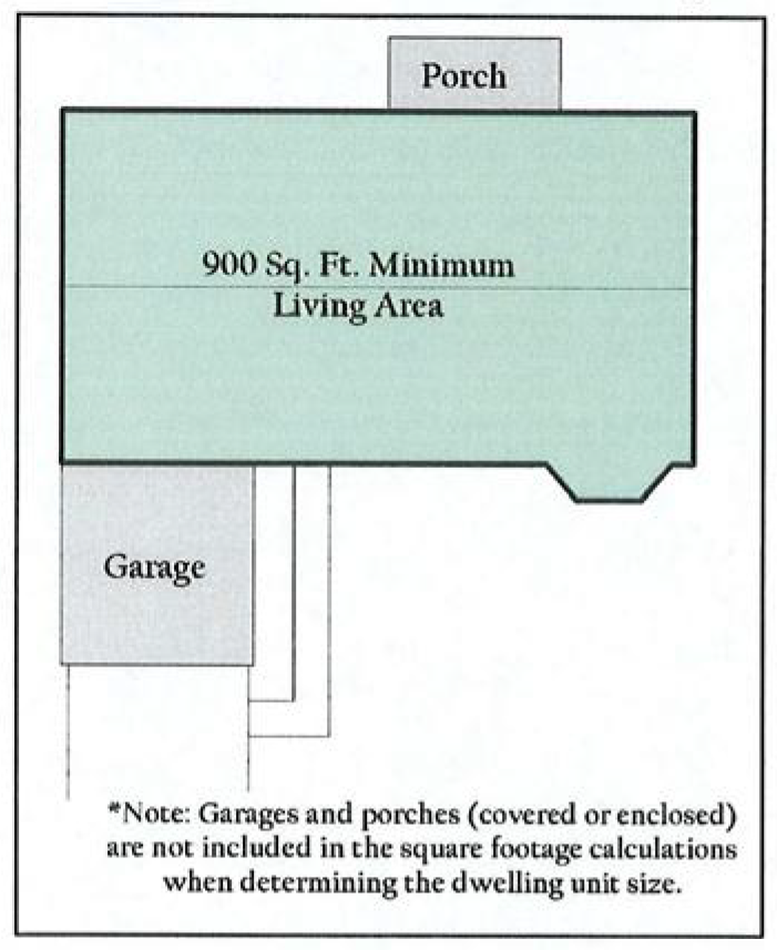
(3)
Maximum lot coverage. Maximum lot coverage is 45 percent including main buildings and accessory buildings.
(4)
Minimum floor area. Minimum floor area per dwelling unit is 900 square feet of heated and/or air-conditioned floor area.
(Ord. No. 2008-01, § 17, 2-4-2008)
_____
Sec. 50-72. - Duplex (Two-Family) Residential District (D).
(a)
General purpose and description. The D Duplex (Two-Family) Residential District is intended to promote stable, quality multiple-occupancy residential development at slightly increased densities. Individual ownership of each side of the duplex (two-family) units is encouraged, but must meet all platting, building codes and have separate utilities. This district is typically used as a buffer or transition district between lower density residential areas and higher density or nonresidential areas or major thoroughfares.
(b)
Permitted uses. Those uses listed for the D Duplex (Two-Family) Residential District in the use charts (section 50-82) as "P" or "C" are authorized uses permitted by right or conditionally permitted uses, respectively.
(c)
Height regulations. The maximum height in the D Duplex (Two-Family) Residential District shall be:
(1)
Two stories, not to exceed 36 feet, for the main building/house.
(2)
One story for other accessory buildings, including detached garage, garden shed, gazebo, etc.
Illustration 50-72-1: Lot, yard and floor area regulations for the Duplex District
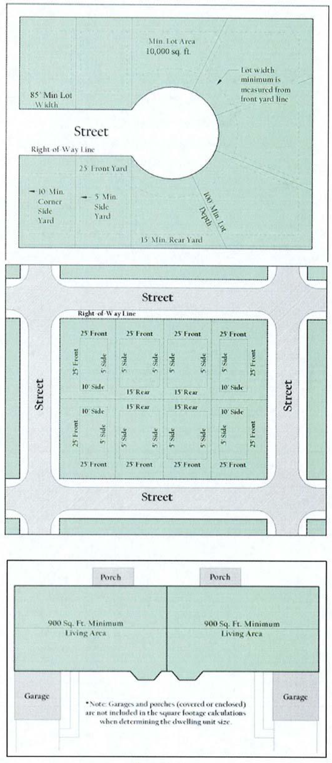
(d)
Area regulations.
(1)
Size of lots for D Duplex (Two Family) Residential District homes.
a.
Minimum lot area is 10,200 square feet for a duplex (two-family) lot or 6,000 square feet each for duplex townhomes (no more than two attached) when each side is sold off separately and each unit is located on its own platted lot with separate utilities. The buildings, while attached, are separately owned with a common wall meeting the fire and separation requirements of the adopted fire and building codes.
b.
Minimum lot width is 85 feet. Duplex townhomes (no more than two attached) sold off on separate lots shall have a minimum of 45 feet of width each. Radial lots shall have a minimum width of 85 feet and 45 feet respectively at and for a distance of 30 feet behind the front yard/building line. No lot for duplexes shall be created that has a front yard with less than 60 feet of frontage on the front street or 30 feet per townhome.
c.
Minimum lot depth is 100 feet.
(2)
Size of yards for D Duplex (Two Family) Residential District homes.
a.
Minimum front yard: 25 feet. Where a lot faces a designated arterial street, the front yard shall be a minimum of 35 feet.
b.
Minimum side yard: five feet. The minimum side yard of a corner lot adjacent to a street shall not be less than 15 feet, except that where a lot sides on a designated arterial street, such side yard shall not be less than 25 feet. On duplex townhomes (no more than two attached) with separate ownership of lots, there shall be no setback from the one common lot line, provided all other requirements including the definition have been met and there are no more than two units sharing a lot line.
c.
Minimum rear yard: 15 feet. The minimum rear yard where lots back on a designated arterial street shall not be less than 25 feet. However, lots backing up to a 20 foot alley shall have a five foot minimum rear yard and abutting a 15 foot alley shall have a 7.5 foot minimum rear yard.
d.
Encroachment by building eaves and air conditioning units: building eaves and air conditioning compressors may encroach not more than three feet beyond building lines into the required rear and side yard on lots created by subdivision plats for single-family residential use duly approved by the city and recorded with the county clerk of either county, as applicable, on or before November 1, 1999.
(3)
Maximum lot coverage. Maximum lot coverage for D Duplex (Two-Family) Residential District homes is 45 percent by main buildings and accessory buildings.
(4)
Minimum floor area. Minimum floor area per dwelling unit for D Duplex (Two-Family) Residential District homes is 900 square feet of heated and/or air-conditioned floor area per unit.
(Ord. No. 2008-01, § 20, 2-4-2008)
Sec. 50-73. - Multifamily Residential District (MF).
(a)
General purpose and description. The MF Multifamily Residential District is an attached residential district intended to provide the highest residential density of up to 20 dwelling units per acre. With the addition of carports in accordance with section 50-112(c), a density of up to 26 units to the acre could be provided. The principal permitted land uses will include low- and mid-rise multifamily dwellings and garden apartments. Recreational, religious, health and educational uses normally located to service residential areas are also permitted in this district. This district should be located adjacent to a major thoroughfare and serve as a buffer between nonresidential development or heavy automobile traffic and medium- or low-density residential development.
Illustration 50-73-1: Area regulation for multiple-family structures
(b)
Permitted uses. Those uses listed for the MF Multifamily Residential District in the use charts (section 50-82) as "P" or "C" are authorized uses permitted by right or conditionally permitted uses, respectively.
(c)
Height regulations. The maximum height in the MF district shall be:
(1)
Three stories or 45 feet, whichever is less for the main buildings.
(2)
One story for other accessory buildings, including detached garages, carports, clubhouses, gazebos, mail kiosks, laundry rooms, etc.
(3)
Refer to side and rear setbacks related to height.
(d)
Area regulations.
(1)
Size of lots.
a.
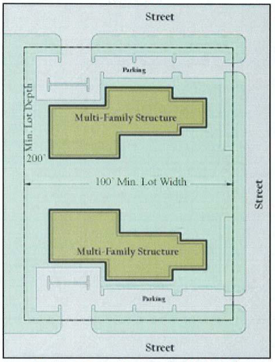
Minimum lot area: 1,816 square feet per dwelling unit, not to exceed 20 dwelling units per acre (calculated on gross acreage), except with density bonuses up to 26 dwelling units per acre for covered parking as described in off-street parking, section 50-112(c). The minimum lot (i.e., project) size shall be ten acres.
b.
Minimum lot width: 120 feet.
c.
Minimum lot depth: 200 feet.
d.
Special exception: if a property was platted or permitted for MF Multifamily Residential District prior to the effective date of the ordinance from which this chapter is derived, then it can remain its original size and configuration and does not have to meet the minimum project size, lot width or lot depth stated in this section. The property shall conform to all other MF Multifamily Residential District development standards herein, unless the building setbacks shown on a recorded plat vary from those contained herein, in which case the platted setbacks shall prevail unless a replat modifies same.
(2)
Size of yards. The following minimum yards shall be required for lots or tracts containing multifamily dwelling buildings, measured from the applicable property line; provided, however if the lot is encumbered with a street easement, such yard shall be measured from the boundary line of such street easement.
a.
Minimum front yard: 25 feet. Where a lot faces a designated arterial street, the front yard shall be a minimum of 35 feet.
b.
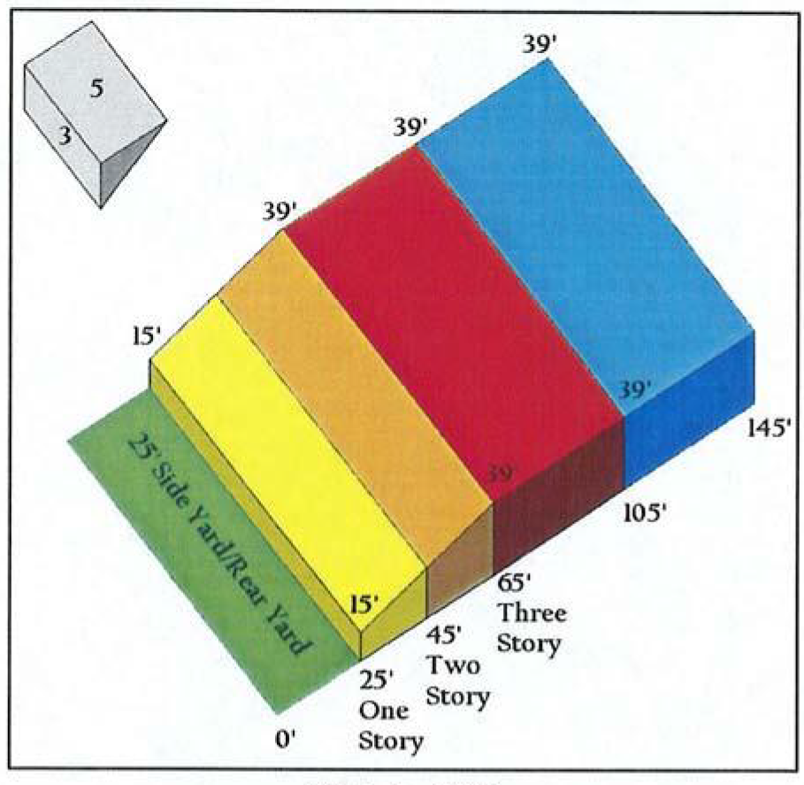
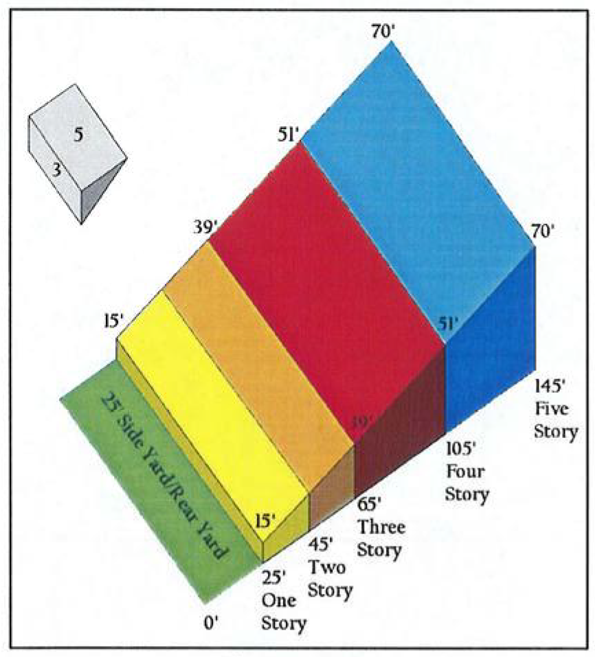
Minimum side yard:
1.
Interior: five feet.
2.
Interior adjacent to property zoned for or restricted by a duly recorded subdivision plat for single-family residential purposes is 25 feet. Setbacks shall be measured at a ratio of five feet in horizontal setback distance for every three feet of building height as shown in Illustration 50-73-2. Setback measurements shall be calculated by story.
3.
Side yard adjacent to a street: 15 feet.
4.
Side yard adjacent to a designated arterial: 25 feet.
Illustration 50-73-2: Setback and height relationship for multiple-family structures]
c.
Minimum rear yard: 15 feet. If adjacent to a single-family, duplex (two family), patio home or single-family attached district, then rear setbacks (within which parking is permitted) shall be 60 feet, unless separated by an alley in which case the setback shall be 20 feet.
d.
Zero lot line exception: notwithstanding the foregoing, except where an interior side yard or rear yard is adjacent to property zoned for or restricted by a duly recorded subdivision plat to, or primarily used for, single-family residential purposes, there shall be no required interior side or rear building line if the wall adjoining such interior side or rear lot line, as applicable, is constructed with materials giving it a four-hour firewall rating. Yards adjacent to street or alley rights-of-way are excluded from this provision.
e.
Windows: all multiple-story buildings within a multifamily development complex shall be constructed so that there shall be no windows above the first floor on any sides which are within 100 feet of property zoned for single-family uses, existing residential platted lots or existing single-family residences.
f.
Minimum building separation requirements:
1.
One-story buildings: 15 feet for buildings without openings; 20 feet for buildings with openings.
2.
Two-story buildings (or a two-story building adjacent to a one-story building): 20 feet for buildings without openings; 35 feet for buildings with openings.
3.
Over two-story buildings (or an over two-story building adjacent to a one-or two-story building): 35 feet for buildings with or without openings, or as required by the adopted building code, whichever is greater.
4.
Between a main building and an accessory building: ten feet, or as required by the adopted building code, whichever is greater.
(3)
Minimum floor area per dwelling unit.
a.
Efficiency unit: 500 square feet per unit.
b.
One-bedroom unit: 725 square feet per unit.
c.
Two or more bedroom unit: 800 square feet for the first two bedrooms, plus an additional 125 square feet for every bedroom over two (e.g., three-bedroom unit must have 925 square feet, etc.).
(4)
Maximum lot coverage. Maximum lot coverage of 50 percent total, including main and accessory buildings, pools and ponds.
(5)
Green space; recreational areas. A minimum of 50 percent of the gross platted area shall be open green space and common recreational areas. The minimum percentage of open space and common recreational areas may be reduced by the planning and zoning commission at the time of site plan approval to 20 percent of the gross platted area, provided the area is intensively landscaped with underground irrigation systems and continuous maintenance is provided for. The open green space and common recreational areas shall be areas not specifically designated or used as building sites for dwelling units, buildings sites for utility or storage buildings, parking lots, garages, streets or driveways within the multifamily development. The actual surface area of open green space, such as lawns and landscaping, and common recreational areas, such as swimming pools and surrounding paved deck, tennis courts, community rooms, saunas, and other recreational areas, shall be considered in calculating the minimum requirement for open green space and common recreational areas. Required buffer yards, except surfaced parking and driveways located within said buffer yards, if any, may be included in computing the minimum required area of green space and common recreational areas.
(6)
Screening. In addition to the requirements in section 50-115, the following screening requirements shall apply to multifamily dwelling developments.
a.
All refuse containers shall be screened.
b.
A six-foot solid fence, wall, or other similar opaque screening device shall be constructed on the side or rear of any multifamily dwelling complex adjacent to a single-family zoned property.
(e)
Special requirements.
(1)
Other types of residential development. Single-family or duplex (two family) residential units constructed in this district shall conform to SF-6 or D district standards, respectively.
(2)
Fire easements accessible. All points on the exterior facades of all buildings shall be within 150 feet of a dedicated fire lane easement (as measured by an unobstructed pathway or route for fire hoses).
(3)
Fire sprinkler system. All multifamily developments shall be provided with a fire sprinkler system in accordance with all other city ordinances.
(4)
Walkways. A four-foot-wide paved walkway shall connect the front door of each ground floor unit to a parking area. The minimum width of any sidewalk adjacent to head-in parking spaces shall be six feet to accommodate a two-foot bumper overhang for vehicles. Sidewalks of concrete cement or other masonry construction shall be provided between the dwelling units and all community facilities provided for residents in accordance with applicable city standards and specifications. All walks shall be lighted at night with a minimum intensity of two foot-candles' illumination.
(5)
Building length. Buildings shall not exceed 200 feet in length.
(6)
Oversized parking areas. Boats, campers, trailers and other recreational vehicles shall be prohibited unless oversize parking areas are provided and approved by the city. This parking area shall not be used to meet the minimum parking requirements and shall not be visible from a public street.
(7)
Signage—Address numbers. All buildings containing residential units shall provide signage which clearly identifies the numbers (i.e., addresses) of the units within each building. Signage shall be visible from entrances into the complex and/or from vehicular drive aisles within the complex such that each individual unit is easy to locate by visitors, delivery persons, and/or emergency personnel.
(8)
Lighting. All parking areas shall have appropriate lighting and shall be positioned such that lights are shielded and do not adversely impact adjacent residential areas.
(9)
Gated/secured entrances. Gated/secured entrances shall be in accordance with the design standards for gated/secured entrances on private streets as adopted.
(10)
Streets or driveways. Each multifamily dwelling complex shall have driveways constructed of concrete cement or hot mixed asphalt, shall be curbed and guttered in accordance with existing requirements of the city, and shall be at least 28 feet in width throughout. All driveways shall be lighted at night with a minimum intensity of two foot-candles' illumination.
(Ord. No. 2008-01, § 22, 2-4-2008)
Sec. 50-74. - Manufactured Home Park District (MHP).
(a)
General purpose and description. The MHP Manufactured Home Park District is a detached residential district establishing standards for the development of manufactured, HUD-Code manufactured home parks and subdivisions. A manufactured or mobile home park offers spaces for the placement of manufactured/mobile home units on a lease/rental basis or on a lot-for-sale basis. The MHP Manufactured Home Park District establishes area and design requirements for parks and subdivisions, as well as yard requirements for individual lots. Both parks and subdivisions provide open space and recreational areas appropriate for the acreage and number of units contained.
(b)
Permitted uses. Those uses listed for the MHP Manufactured Home Park District in the use charts (section 50-82) as "P" or "C" are authorized uses permitted by right or conditionally permitted uses, respectively.
(c)
Area regulations.
(1)
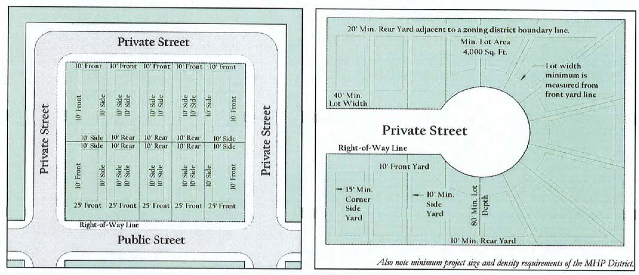
Size of spaces.
a.
Minimum lot area: 4,000 square feet per unit.
b.
Minimum lot width: 40 feet.
c.
Minimum lot depth: 80 feet.
(2)
Size of yards.
a.
Minimum front yard: 20 feet from a dedicated street; ten feet from any private street or drive.
b.
Minimum side yard: ten feet; 20 feet between units; 20 feet from zoning district boundary line; 15 feet for corner lots.
c.
Minimum rear yard: ten feet; 20 feet from any zoning district boundary line.
d.
If a garage is provided, the entry (i.e., door) side of the garage shall have a 20-foot setback as measured from any property or street right-of-way line.
(3)
Maximum floor area. Minimum floor area per dwelling unit is 750 square feet.
(4)
Maximum lot coverage. Maximum lot coverage is 50 percent for main building/unit plus any accessory buildings.
Illustration 50-74-1: Lot and yard regulations for the MHP District]
(5)
Area for manufactured home parks. Minimum project area is 20 acres; maximum project area 35 acres.
(6)
Density for manufactured home parks. No manufactured home park shall provide less than 20 spaces, and there shall be a maximum of ten spaces per gross acre within the park.
(7)
Maximum height limit.
a.
Two stories, not to exceed 35 feet, for the main building/house.
b.
One story for other accessory buildings, including detached garages, carports, management offices, clubhouses, gazebos, mail kiosks, etc.
(d)
General requirements for manufactured/mobile home parks.
(1)
Access. Each manufactured/mobile home community shall have direct access from an improved public street in accordance with chapter 40, pertaining to subdivisions, and access to individual spaces shall be from private paved drives within the site. Where an internal private street provides access to individual lots or dwelling units, the same shall be paved in accordance with city standards, and it shall be dedicated to the public as an emergency access or fire lane easement to allow for the rapid and safe movement of vehicles used in providing emergency health or public safety services. The width, design, and construction shall be adequate to accommodate the traffic generated by the park and emergency and service vehicles, as determined by the city engineer, but in no case shall the width of a driving surface be less than 26 feet. Dead-end streets are not allowed. Cul-de-sac streets shall not exceed 400 feet in length. Fire lane easements shall be maintained by the manufactured/mobile home park. Gated/secured entrances shall be in accordance with the design standards for gated/secured entrances on private streets.
(2)
Street names and signs. Within each manufactured/mobile home park, all streets shall be named, and manufactured/mobile homes numbered in a logical and orderly fashion. Street signs shall be of a color and size contrasting with those on public streets and roadways so that there is no confusion regarding which are private and which are public streets. These signs and numbers shall be of standard size and placement to facilitate location by emergency vehicles. Street names shall be submitted to the city manager or his designee and city engineer or his designee, along with the preliminary plat application, reviewed by the appropriate city staff with respect to street naming procedures set forth within chapter 40 and/or this Code, and approved by the planning and zoning commission on the preliminary plat for the subdivision. The street names shall be set with preliminary plat approval, and shall not be changed on the final plat without city approval.
(3)
Other signs. Along all sections of emergency access easements, the owner or agent shall erect metal signs prohibiting parking. The sign type, size, height and location shall be in accordance with the Manual of Uniform Traffic Control Devices and approved by the city.
(4)
Intersections. Internal streets shall interest adjoining public streets at approximately 90 degrees and at locations which will eliminate or minimize interference with traffic on those public streets.
(5)
Street lighting. Street lighting within the manufactured/mobile home park shall be provided in accordance with chapter 40, pertaining to subdivisions, and shall be maintained by the owners of the manufactured/mobile home park.
(6)
Electric and telephone service. All electrical distribution lines and all telephone lines shall be underground except the primary service lines to the park.
(7)
Drainage and soil protection. The ground surface in all parts of the park shall be graded and equipped to drain all surface water in a safe, efficient manner. Each manufactured/mobile home space shall provide adequate drainage for the placement of a manufactured/mobile home. Exposed ground surfaces in all parts of every manufactured/mobile home park shall be paved and/or covered with stone, brick paving, or other similar solid material, or protected with a vegetative growth (such as grass) capable of preventing soil erosion and eliminating dust.
(8)
Firefighting.
a.
Approaches to all manufactured/mobile homes shall be kept clear for firefighting.
b.
The owner or agent of a manufactured/mobile home park shall be responsible for the instruction of any staff in the use of the park fire protection equipment and in their specific duties in the event of a fire.
c.
The owner shall supply standard city fire hydrants located within 500 feet of all manufactured/mobile home spaces, measured along the drive or street. Such hydrants shall utilize public water contained in public lines with in public easements.
d.
The owner or agent of a manufactured/mobile home park shall be responsible for maintaining the entire area of the park free of dry brush, leaves and weeds in excess of six inches in height.
(9)
Anchorage of manufactured/mobile homes. To insure against natural hazards such as tornados, high winds and electrical storms, anchorage for each manufactured/mobile home shall be provided in accordance with the building code and state law.
(10)
Skirting.
a.
All manufactured/mobile home units not attached to a permanent foundation shall provide skirting from the top of the unit's frame to grade. Skirting shall totally enclose and secure from view the unit's axles and all required anchors, footings, and piers.
b.
All required skirting shall be of an opaque, noncombustible material, and shall be of a color similar to the materials used in the construction of the manufactured/mobile home unit such that it blends with the overall appearance of the unit.
(Ord. No. 2008-01, § 24, 2-4-2008)
Sec. 50-75. - Office District (O).
(a)
General purpose and description. The O Office District is established to create an appropriate setting for low intensity office and professional uses. The district can be used as a transition district between residential uses and more intense uses, and with appropriate buffers and landscaping, this district may be located in close proximity to residential districts. Permitted uses should be compatible with adjacent residential areas by limiting heights to one or two stories, and shall not include uses that create excessive amounts of traffic, noise, trash or late-night business operations. Traffic generated by uses in this district shall not be encouraged to travel through residential areas. Adaptive reuse of existing structures is encouraged. Buildings in this district should be compatible and similar in scale with residential uses and adjacent property.
(b)
Permitted uses. Those uses listed for the O Office District in the use charts (section 50-82) as "P" or "C" are authorized uses permitted by right or conditionally permitted uses, respectively.
(c)
Height regulations. Maximum height:
(1)
Seventy feet; also see setback requirements related to height in subsection (d)(2)b of this section.
(2)
One story for accessory buildings.
(d)
Area regulations.
(1)
Size of lots.
a.
Minimum lot area: 6,000 square feet.
b.
Minimum lot width: 60 feet.
c.
Minimum lot depth: 100 feet.
Illustration 50-75-1: Lot and yard regulations for the Office District
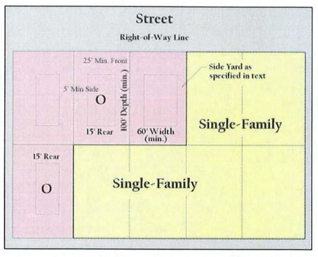
(2)
Size of yards and setbacks.
a.
Minimum front yard: 25 feet. Where a lot faces a designated arterial street, the front yard shall be a minimum of 35 feet.
b.
Minimum side yard.
1.
Interior: five feet.
2.
Interior adjacent to property zoned for or restricted by a duly recorded subdivision plat for single-family residential purposes, which does not have an existing business on such single-family residential lot is 25 feet. If adjacent to a single-family, duplex, patio home or single-family attached district, then side and rear setbacks (within which parking is permitted) shall be according to the height of the primary structure, as follows:
Illustration 50-75-2: Setback and height relationship for structures
(i)
Setbacks shall be measured at a ratio of five feet in horizontal setback distance for every three feet of building height as shown in Illustration 50-75-2.
(ii)
Setback measurements shall be calculated by story.
(iii)
These measurements shall not limit any building to less than 35 feet.
3.
Side yard adjacent to a street: 15 feet.
4.
Side yard adjacent to a designated arterial: 25 feet.
c.
Minimum rear yard: 15 feet. If adjacent to a single-family, duplex (two-family), patio home or single-family attached district, then minimum rear yards (within which parking is permitted) shall be 60 feet, unless separated by an alley in which case the minimum shall be 20 feet. When adjacent to an arterial, such minimum rear yard shall be 25 feet.
d.
Zero lot line exception: notwithstanding the requirements of this section, except where an interior side yard or rear yard is adjacent to property zoned for or restricted by a duly recorded subdivision plat to, or primarily used for, single-family residential purposes, there shall be no required interior side or rear yard if the wall adjoining such interior side or rear lot line, as applicable, is constructed with materials giving it a four-hour firewall rating. Yards adjacent to street or alley rights-of-way are excluded from this provision.
e.
Minimum underground setback: any underground building structure shall be setback from any lot line by a minimum of 15 feet.
f.
Minimum pavement setback: all paving, except for driveways and sidewalks, shall be setback from any public street right-of-way by a minimum of ten feet.
(3)
Maximum lot coverage. Maximum lot coverage is 50 percent of the net site area (after right-of-way dedication) for the gross ground floor area of all building structures, including main and accessory buildings.
(4)
Maximum floor area. Maximum floor area ratio (FAR) is 1:1.
(5)
Outdoor sales. Outdoor sales are prohibited.
(Ord. No. 2008-01, § 25, 2-4-2008)
Sec. 50-75.1. - Neighborhood Retail District (NR).
(a)
General purpose and description. The Neighborhood Retail District is intended to accommodate a limited range of retail trade, services and office activities that are needed to serve a neighborhood area. The district is to be utilized as a transition district between residential uses and more intense non-residential uses. The district is to incorporate elevated landscaping and buffering standards to facilitate seamless integration alongside residential districts. Development within the district should be similar in scale as residential uses and adjacent properties. Architectural principles should be incorporated within site development to actively engage streetscapes and create pedestrian oriented environments. Uses within this district should not include uses that create excessive traffic, noise, trash, or late-night business operations. This district is ideally suited for intersections of major thoroughfares or at the intersection of a major thoroughfare and primary entrances to residential subdivisions and/or multi-family developments.
(b)
Permitted uses. Those uses listed for the Neighborhood Retail (NR) District in the use charts (section 50-82) as "P" or "C" are authorized uses permitted by right or conditionally permitted uses, respectively.
(c)
Height regulations. Maximum height:
(1)
Forty feet; also see setback requirements related to height (d)(2)(b.2) of this section.
(2)
One story for accessory buildings
(d)
Area regulations.
(1)
Size of lots.
a.
Minimum lot area: 6,000 square feet.
b.
Minimum lot width: 60 feet.
c.
Minimum lot depth: 100 feet.
(2)
Size of yards and setbacks
a.
Minimum front yard: 15 feet. Where a lot faces a designated arterial street, the front yard shall be a minimum of 25 feet.
b.
Minimum side yard.
1.
Interior: 5 feet
2.
Interior: If adjacent to a single-family, duplex, patio home or single-family attached district, then side and rear setbacks (within which parking is permitted) shall be according to the height of the primary structure as follows:
a.
Setbacks shall be measured at a ratio of five feet in horizontal setback distance for every three feet of building height.
3.
Side yard adjacent to a street: 15 feet.
4.
Side yard adjacent to a designated arterial: 25 feet
c.
Minimum rear yard: 15 feet. If adjacent to a single-family, duplex (two-family), patio home or single-family attached district, then minimum rear yard (within which parking is permitted) shall be 60 feet, unless separated by an alley in which case the minimum shall be 20 feet. When adjacent to an arterial, minimum rear yard shall be 25 feet.
d.
Zero lot line exception: notwithstanding the requirements of this section, except where an interior side yard or rear yard is adjacent to property zoned for or restricted by a duly recorded subdivision plat to, or primarily use for, single-family residential purposes, there shall be no required interior side or rear yard if the wall adjoining such interior side or rear lot line, as applicable, is constructed with materials giving it a four-hour firewall rating. Yards adjacent to street or alley right-of-way are excluded from this provision.
e.
Minimum underground setback: any underground building structure shall be set back from any lot line by a minimum of 15 feet.
f.
Minimum pavement setback: all paving, except driveways and sidewalks, shall be set back from any public street right-of-way by a minimum of 15 feet.
(3)
Maximum lot coverage. Maximum lot coverage is 50 percent of the net site area (after right-of-way dedication) for the gross ground floor area of all building structures, including main and accessory buildings.
(4)
Maximum floor area. Maximum floor area ratio (FAR) is 1:1.
(5)
Outdoor sales: Outdoor sales are prohibited.
(6)
Outdoor storage: Outdoor storage is prohibited.
(7)
Hours of Operation: Except for uses permitted within a residential zoning district, no use shall operate before 6:00 a.m. nor after 11:00 p.m. on any day of the week.
(8)
Façade Orientation Standards.
a.
Facades of primary building(s) immediately adjacent to street right-of-way(s) shall be front and/or side facades only. Rear facades of buildings shall be prohibited from facing street right-of-way(s).
(9)
Parking Standards Refer to Section 50-112 (c)(1.1) - Parking regulations for the NR District
(Ord. No. 2023-55, § 2(Exh. A), 2-19-2024)
Sec. 50-76. - General Retail District (GR).
(a)
General purpose and description. The GR General Retail District is established to provide areas for local neighborhood shopping and service facilities for the retail sales of goods and services. These shopping areas should utilize established landscape and buffering requirements. The GR General Retail District should be located along or at the intersection of major collects or thoroughfares to accommodate higher traffic volumes.
(b)
Permitted uses. Those uses listed for the GR district in the use charts (section 50-82) as "P" or "C" are authorized uses permitted by right or conditionally permitted uses, respectively.
(c)
Height regulations. The maximum height in the GR district shall be:
(1)
Not to exceed 70 feet, for the main buildings.
(2)
One story for accessory buildings.
(d)
Area regulations.
(1)
Size of lot.
a.
Minimum lot area: 6,000 square feet.
b.
Minimum lot width: 60 feet.
c.
Minimum lot depth: 100 feet.
Illustration 50-76-1: Lot and yard regulations for the GR District
(2)
Size of yards.
a.
Minimum front yard: 25 feet. Where a lot faces a designated arterial street, the front yard shall be a minimum of 35 feet.
b.
Minimum side yard:
1.
Interior: five feet.
2.
Interior adjacent to property zoned for or restricted by a duly recorded subdivision plat for single-family residential purposes, which does not have an existing business on such single-family residential lot: 25 feet.
3.
Side yard adjacent to a street: 15 feet.
4.
Side yard adjacent to a designated arterial: 25 feet.
c.
Minimum rear yard: 15 feet. If adjacent to a single-family, duplex (two-family), patio home or single-family attached district, then minimum rear yards (within which parking is permitted) shall be 60 feet, unless separated by an alley in which case the minimum shall be 20 feet. When adjacent to an arterial street, such minimum rear yard shall be 25 feet.
d.
Zero lot line exception: notwithstanding the foregoing, except where an interior side yard or rear yard is adjacent to property zoned for or restricted by a duly recorded subdivision plat to, or primarily used for, single-family residential purposes, there shall be no required interior side or rear yard if the wall adjoining such interior side or rear lot line, as applicable, is constructed with materials giving it a four-hour firewall rating. Yards adjacent to street or alley rights-of-way are excluded from this provision.
e.
Exceptions for certain retail shopping center outbuildings fronting State Highway 249: notwithstanding any other provision of this section to the contrary, the building line for retail outbuildings adjacent to State Highway 249 and State Highway 249 Bypass shall be ten feet if:
1.
The retail outbuilding is within a shopping center development (a development comprised of retail businesses which share common parking and pedestrian areas and facilities for their clientele) which contains not less than 1¼ acres of land and which has not less than 240 feet of frontage on said State Highway 249 and State Highway 249 bypass;
2.
The retail outbuilding contains not more than 100 square feet of floor area;
3.
The retail outbuilding is located so as not to create a hazard to vehicular or pedestrian traffic on the shopping center site, the adjacent State Highway 249 and State Highway 249 Bypass, or any other adjacent public or private street or property; limit spacing of said structures to no greater than one per 300 feet;
4.
The retail outbuilding is located not less than 50 feet from any paved portion of State Highway 249 and State Highway 249 Bypass, whether main lane or access road; and
5.
The retail outbuilding is located so as to be a minimum of 300 feet from the closest retail outbuilding along either side of State Highway 249 and State Highway 249 Bypass, measured in a straight line from the center fronts of each retail outbuilding.
(3)
Maximum lot coverage. Maximum lot coverage is 50 percent including main and accessory buildings; maximum 80 percent impervious coverage (including all buildings, parking areas, sidewalks, etc.).
(4)
Maximum floor area. Maximum floor area ratio (FAR) is 1:1.
(5)
Outside storage. Outside storage, which is differentiated from outdoor sales, shall be limited to a maximum of five percent of the total lot area. For screening requirements, see section 50-115.
(Ord. No. 2008-01, § 27, 2-4-2008; Ord. No. 2015-02, § 2, 2-2-2015)
Sec. 50-77. - Commercial District (C).
(a)
General purpose and description. The C Commercial District is intended to provide a location for commercial and service-related establishments, such as wholesale product sales, welding/contractors shops, automotive repair services, upholstery shops, and other similar commercial uses. Some light manufacturing may also be allowed with certain conditions. The uses envisioned for the C Commercial District will typically utilize smaller sites and have operation characteristics which are generally not compatible with residential uses and some nonresidential uses. Convenient access to thoroughfares and collector streets is also a primary consideration.
(b)
Permitted uses. Those uses listed for the C district in the use charts (section 50-82) as "P" or "C" are authorized uses permitted by right or conditionally permitted uses, respectively.
(c)
Height regulations. The maximum height in the C district shall be:
(1)
70 feet for the main buildings; also see setback requirements related to height in subsection (d)(2)b of this section.
(2)
One story for accessory buildings.
(3)
Additional height may be approved by CUP.
(d)
Area regulations.
(1)
Size of lot.
a.
Minimum lot area: 10,000 square feet.
b.
Minimum lot width: 60 feet.
c.
Minimum lot depth; 100 feet.
(2)
Size of yards.
a.
Minimum front yard: 25 feet. Where a lot faces a designated arterial street, the front yard shall be a minimum of 35 feet.
b.
Minimum side and rear yard: ten feet. If adjacent to a single-family, duplex (two family), patio home or single-family attached district, then side and rear setbacks (within which parking is permitted) shall be according to the height of the primary structure, as follows:
Illustration 50-77-1: Setback and height relationship for commercial structures
1.
Setbacks shall be measured at a ratio of five feet in horizontal setback distance for every three feet of building height as shown in Illustration 50-75-2.
2.
Setback measurements shall be calculated by story.
3.
These measurements shall not limit any building to less than 35 feet.
c.
Interior side yards: when retail uses are platted adjacent to other retail uses and integrated into an overall shopping center site (i.e., lots/lease spaces abutting one another), no side yard is required provided it complies with the city's building code.
d.
Exceptions for certain retail shopping center outbuildings fronting State Highway 249: notwithstanding any other provision of this section to the contrary, the building line for retail outbuildings adjacent to State Highway 249 and State Highway 249 Bypass shall be ten feet if:
1.
The retail outbuilding is within a shopping center development (a development comprised of retail businesses which share common parking and pedestrian areas and facilities for their clientele) which contains not less than 1¼ acres of land and which has not less than 240 feet of frontage on said State Highway 249 and State Highway 249 Bypass;
2.
The retail outbuilding contains not more than 100 square feet of floor area;
3.
The retail outbuilding is located so as not to create a hazard to vehicular or pedestrian traffic on the shopping center site, the adjacent State Highway 249 and State Highway 249 Bypass, or any other adjacent public or private street or property; limit spacing of said structures to no greater than one per 300 feet;
4.
The retail outbuilding is located not less than 50 feet from any paved portion of State Highway 249 and State Highway 249 Bypass, whether main lane or access road; and
5.
The retail outbuilding is located so as to be a minimum of 300 feet from the closest retail outbuilding along either side of State Highway 249 and State Highway 249 Bypass, measured in a straight line from the center fronts of each retail outbuilding.
(3)
Maximum lot coverage. Maximum lot coverage is 60 percent including main and accessory buildings; maximum 90 percent impervious coverage (including all buildings, parking areas, sidewalks, etc.).
(4)
Maximum floor area. Maximum floor area ratio (FAR) is 2:1.
(5)
The maximum glare produced by any industry shall be limited to four footcandles of illumination intensity beyond the industrial or commercial tract boundary throughout the light frequency spectrum beginning with ultraviolet and ending through the infrared wavelengths.
(Code 1978, § 5-9; Code 1993, § 14-9; Ord. No. 2008-01, § 31, 2-4-2008)
Sec. 50-78. - Light Industrial District (LI).
(a)
General purpose and description. The LI Light Industrial District is intended primarily for the conduct of light manufacturing, assembling and fabrication activities, and for warehousing, research and development, wholesaling and service operations that do not typically depend upon frequent customer or client visits. Such uses do require accessibility to major thoroughfares, major highways, and/or other means of transportation such as the railroad.
(b)
Permitted uses. Those uses listed for the LI Light Industrial District in section 50-82 as "P" or "C" are authorized uses permitted by right or conditionally permitted uses, respectively.
(c)
Height regulations. The maximum height in the LI district shall be:
(1)
70 feet for the main buildings; also see setback requirements related to height in subsection (d)(2)b of this section.
(2)
One story for accessory buildings.
(d)
Area regulations.
(1)
Size of lot.
a.
Minimum lot area: 5,000 square feet.
b.
Minimum lot width: 50 feet.
c.
Minimum lot depth: 100 feet.
(2)
Size of yards.
a.
Minimum front yard: 25 feet. Where a lot faces a designated arterial street, the front yard shall be a minimum of 35 feet.
b.
Minimum side and rear yard: 25 feet. If adjacent to a single-family, duplex (two family), patio home or single-family attached district, then side and rear setbacks (within which parking is permitted) shall be according to the height of the primary structure, as follows:
1.
Setbacks shall be measured at a ratio of five feet in horizontal setback distance for every three feet of building height as shown in Illustration 50-75-2.
2.
Setback measurements shall be calculated by story.
3.
These measurements shall not limit any building to less than 35 feet.
(3)
Maximum lot coverage. Maximum lot coverage is 60 percent including main and accessory buildings; maximum 90 percent impervious coverage (including all buildings, parking areas, sidewalks, etc.)
(4)
Maximum floor area. Maximum floor-area-ratio (FAR) is 2:1.
(5)
The maximum glare produced by any industry shall be limited to four footcandles of illumination intensity beyond the industrial or commercial tract boundary throughout the light frequency spectrum beginning with ultraviolet and ending through the infrared wavelengths.
(Code 1978, § 5-9; Code 1993, § 14-9; Ord. No. 2008-01, § 31, 2-4-2008)
Sec. 50-79. - Old Town and Mixed-Use District (OT and MU).
(a)
Purpose and intent.
(1)
Old Town is an area in which many diverse land uses currently exist. The nature of the area, therefore, is a mixture of retail, commercial and other nonresidential uses, along with single-family homes and multiple-family uses. The city's comprehensive plan (the future land use plan) endorses the continuation of the mixture of uses in this area of the city, and specifically states that Retail, Office, Single-Family, Duplex (Two-Family) and Multifamily are the most appropriate uses in these areas. In addition, to serve existing residential areas and their successful integration with future nonresidential uses, increased pedestrian access would be beneficial. The Old Town and Mixed Use District is intended to provide a zoning mechanism for a variety of uses in the original town site and those areas that have a diverse mixture of uses.
(2)
The development standards in the Old Town area are designed to maintain and encourage development and redevelopment within the central business section (old downtown) of the city. Standards for the district are generally intended to regulate development such that new structures look similar to existing ones within this section of the city. They are also intended to preserve and enhance the image, character and unique qualities of the city's historic original business district. Pedestrian activity and access is also of extreme importance within this district. Pedestrian spaces shall be treated with amenities that are selected based upon their ability to unify the streetscape with the area's historic past. It is important that elements such as construction materials, colors, textures and fixture design complement the area's historic qualities. These features shall be repeated throughout the streetscape so as to unify the district as a whole. The following pedestrian-oriented areas are permitted:
a.
Public art spaces;
b.
Monuments (e.g., statues, benches, fountains);
c.
Playgrounds;
d.
Transit waiting areas;
e.
Museums;
f.
Plazas;
g.
Performing art buildings; and
h.
Outdoor eating areas.
(3)
The Old Town and Mixed Use District is also intended for those areas outside the Old Town area that either currently have or are suitable for a mixture of retail, commercial and other nonresidential uses, along with single-family homes and multifamily uses and are designated for such mixed use on the adopted comprehensive plan. Proposed planned mixed use development may also and is encouraged to utilize a Planned Development District with its flexibility.
(4)
For the purposes of this district and its regulations, the term Old Town Area shall be defined to include all lots shown on the revised map filed of record with the county on July 8, 1912, a true and correct copy of which is on file in the office of the city secretary, and which is identified as the Old Town Tomball Map.
(b)
Permitted uses. Those uses listed for the OT and MU district in the use charts (section 50-82) as "P" or "C" are authorized uses permitted by right or conditionally permitted uses, respectively.
(c)
Height regulations. The maximum height in the OT and MU district shall be:
(1)
Two stories for the main building. A three or four story building may be allowed with a conditional use permit.
(2)
One story for accessory buildings.
(d)
Area regulations for residential uses.
(1)
Size of lots.
a.
Minimum lot area: 5,000 square feet. Duplex (two-family) lots shall be a minimum of 7,000 square feet.
b.
Minimum lot width: 50 feet; radial lots shall have a minimum width of 50 feet at and for a distance of 30 feet behind the building line. The minimum width of lots for duplexes shall be 70 feet.
c.
Minimum lot depth: 100 feet.
d.
Two or more lots of record in existence on the adoption date of the ordinance from which this chapter is derived that do not meet these area requirements and are under the same ownership may be combined into one parcel meeting the requirements of this district. Such parcel shall be considered one lot and all required yards shall be measured from the new lot lines not owned in common. No lot shall be created that has a front yard with less than 50 feet of frontage on the front street.
(2)
Size of yards.
a.
Minimum area requirements for a single-family residence shall be the same as the SF-6 district.
b.
Minimum area requirements for a Duplex (Two-Family) or Duplex Townhome shall be the same as the Duplex District.
c.
Minimum area requirements for a multifamily complex shall be the same as the MF district unless otherwise specified herein.
d.
Minimum front yard: 20 feet. Where lots have double frontage, running through from one street to another, the required front yard shall be provided on both streets.
e.
Minimum side yard: five feet; ten feet for a corner lot.
f.
Minimum rear yard is ten feet; the minimum rear yard where lots back on a designated arterial street shall not be less than 25 feet. However, lots backing up to a 20 foot alley shall have a 5 foot minimum rear yard and abutting a 15 foot alley shall have a 7.5 foot minimum rear yard.
g.
Encroachment by building eaves and air conditioning units: building eaves and air conditioning compressors may encroach not more than three feet beyond building lines into the required rear and side yard on lots created by subdivision plats for single-family residential use duly approved by the city and recorded with the county clerk of either county, as applicable, on or before November 1, 1999.
h.
Lots within the portion of the Old Town area bounded by Fannin Street, Houston Street, the railroad tracks, and Pine Street, and including the lots that front on Fannin Street and Houston Street adjacent to such portion, may have a zero front or rear building line provided, however, that the alternate front or rear building line shall be a minimum of 20 feet. Interior lots may have a minimum side yard building line equal to ten percent of the lot width if the lot has less than 50 feet of width; ten feet for a corner lot.
(3)
Minimum floor area. Minimum floor area per dwelling unit is 650 square feet of heated and/or air conditioned floor area.
(4)
Nonconforming lots. Where a lawfully existing lot having less area, depth, or width than required existed in separate ownership on the effective date of Ordinance No. 2004-09, the regulations required by this section relating to the size of such lot shall not prohibit the erection of a single-family dwelling thereon.
(e)
Area regulations for nonresidential uses.
(1)
Size of lot.
a.
Minimum lot area: 5,000 square feet.
b.
Minimum lot width: 50 feet.
c.
Minimum lot depth: 100 feet.
(2)
Size of yards.
a.
Minimum area requirements for an office, retail or commercial use shall be the same as required in the Commercial District unless otherwise specified in this section.
b.
Minimum front yard is 20 feet. With the exception of Cherry Street, for that portion of the Old Town area bounded by Fannin Street, Houston Street, the railroad tracks, and Pine Street, and including the lots that front on Fannin Street and Houston Street adjacent to such portion, may have a zero front building line.
c.
Minimum side and rear yard is five feet or ten percent of the lot width if less than 50 feet of lot width when adjacent to a nonresidential zoning district or use. If adjacent to a single-family, duplex (two-family), patio home or single-family attached district or use, then side and/or rear setback shall be a minimum of 20 feet. With the exception of Cherry Street, for that portion of the Old Town area bounded by Fannin Street, Houston Street, the railroad tracks, and Pine Street, and including the lots that front on Fannin Street and Houston Street adjacent to such portion, lots adjacent to a public right-of-way may have a zero foot side and rear yard setback provided no portion of the building obstructs the visibility of vehicular traffic.
d.
Interior side yards: when retail uses are platted adjacent to other retail uses and integrated into an overall shopping center site (i.e., lots/lease spaces abutting one another), no side yard is required provided it complies with the city's building code.
e.
Old Town area required yard and building line exceptions. A commercial building constructed in the Old Town area before August 16, 1999, and which does not comply with the building lines set forth above, may expand in size provided it maintains a minimum ten-foot front building line and a minimum ten-foot side building line, provided the owner demonstrates and the chief building official determines that the use as conducted and managed, or as proposed, has minimal incompatibilities with the neighborhood. Factors used to evaluate this include:
1.
That management practices eliminate problems such as noise, waste materials, competition for on-street parking, or similar conflicts.
2.
The use's history of code enforcement complaints against it.
3.
That the use has been maintained in good condition or that the nonconformity represents a disincentive for such maintenance.
4.
Appeal of the chief building official's determination shall be to the planning and zoning commission with the same notice requirements to adjacent property owners as to the board of adjustments.
f.
Vacant land, or lots or tracts formerly used as residential property, may be developed for commercial use without conforming to the building line requirements of this chapter if the property owner or his agent establishes the following:
1.
Three or more properties within a three-block distance, whether on the same side of the street or across the street, have the same nonconformity; and
2.
Proposed development plans for the property are no more nonconforming than existing properties on the same street and maintain the same character as existing buildings.
(f)
Special requirements.
(1)
Building facade plan. The architectural style and scale of new/renovated buildings within the Old Town area on lots fronting on Commerce, Main, Market Streets between Elm and Pine Streets shall be compatible with the styles and scale of other adjacent buildings, and shall be historically accurate to the greatest extent possible in order to preserve the unique character of the city's downtown area. Therefore:
a.
In addition to the building permit plan which is required by sections 50-35 and 50-36, a building facade plan shall also be required within the above-mentioned Old Town area for new buildings and additions of more than 50 percent of the original structure's size. The building facade plan shall be submitted in conjunction with the building permit plan application.
b.
The building facade plan shall clearly show how any new structure and/or any structure that is undergoing major exterior renovations will look. Especially significant is the way in which such structures will be viewed from the thoroughfare or alley upon which the property faces and/or sides, and shall portray a reasonably accurate depiction of the materials to be used.
c.
Review, approval and appeal procedures shall be the same as the procedures for a building permit plan, as outlined in section 50-36.
d.
The city manager or his designee may, as he deems appropriate, require submission of information and materials (possibly actual samples of materials to be used) additional to those initially submitted by the applicant during the building facade plan review process.
(2)
Residential uses.
a.
Single-family uses. Single-family uses shall be permitted and shall be compatible with existing surrounding single-family homes.
b.
Multifamily residential and nonresidential uses. Multifamily residential uses shall be permitted within the Old Town and Mixed Use District in conjunction with nonresidential uses, wherein at least one floor of the building is dedicated to nonresidential use. Such structure shall meet the area requirements of the nonresidential use, provided parking is provided for all uses.
c.
Multifamily residential uses. Multifamily residential uses shall be permitted within the Old Town and Mixed Use District in accordance with the following standards:
1.
All dwelling units shall have ground-floor exterior access, which does not include access into a garage or access from a garage into a dwelling unit;
2.
All dwelling units shall have a front porch space of at least eight square feet located in front of the front door;
3.
All dwelling units shall have a pitched or gabled roof. Flat roofs shall be permitted to allow for the incorporation of terraces;
4.
Each dwelling unit shall have varying architectural elevations including varying rooflines, windows, stoop styles, etc.; and
5.
Exemptions to these standards may be made during the city's review process if the multifamily use is developed/constructed above (i.e., is located within a second or third story) a nonresidential use.
(3)
Nonresidential design standards for the Old Town area.
a.
Facades.
1.
Existing nonresidential buildings. False fronts or parapets may be added to existing buildings in order to add character and detail to simple facades.
2.
Newly constructed nonresidential buildings. Any new facade shall avoid long, monotonous, uninterrupted exterior walls wherever such facades are publicly visible. No more than 20 feet of horizontal distance of exterior wall shall be provided without facade articulation/architectural relief for any facade facing a street right-of-way or pedestrian-oriented area (refer to subsection (f)(3)e of this section). Facade articulation/architectural relief can include pilasters, windows, entrances, arcades, awnings/canopies, or other types of building massing that modulates the building mass or surface texture.
b.
Exterior finishes. Predominant exterior finish shall be fired brick or other masonry materials. Materials other than fired brick shall be considered during the plan review process, and determination of approval shall be based upon whether such materials are:
1.
Similar in appearance and quality to fired brick;
2.
Similar in appearance to original materials used within the Old Town area; and/or
3.
Cementious fiberboard such as Hardi-plank may be approved where the appearance is similar in appearance to the original materials used within the Old Town area. The use of glass material shall be permitted for less than 70 percent of the exterior facade of a structure. Trim (i.e., lintels, sills, door jambs, cornices and other similar items) shall be brick, cast stone, stone, cast or wrought iron, or concrete, and colors shall be complementary to the predominant facade colors. Accent colors for friezes, doors and door frames, window frames and mullions, awnings, moldings and other similar features shall be colors that are complementary to, and compatible with, the spirit and intent of the downtown streetscape. Bright or fluorescent colors shall not be permitted on any part of any structure.
c.
Windows, doors and other openings. Reflective glass shall not be used for windows of any structure's first floor; detailing for windows, doors and other openings shall be of wood, glass or a metal material that is complementary to the period or building style.
d.
Awnings/canopies.
1.
Ratio. Awnings shall be appropriate to the scale of the building's size and configuration. They shall not extend above the roofline of any single-story structure, or above the top of the second floor of any multiple-story structure at the awnings' highest points. Awnings shall not completely obstruct any windows on the building.
2.
Projection. Since awnings must extend beyond the building face, a reasonable amount of projection shall be allowed. No awning shall extend more than five feet outward from the building face/surface. Awnings made in such a manner as to be easily removed may encroach into the right-of-way, provided such awnings are at least eight feet above the sidewalk or surface, do not have any structural supports other than those directly attached to the building and are maintained and not allowed to deteriorate or become tattered, rusty, unpainted or unsightly. Awnings encroaching along Main Street may also have to get approval from the state department of transportation.
3.
Colors. A mixture of colors is recommended, but no more than three different colors shall be used for awnings on a single building facade (excluding business logo, which may have more colors). Bright or fluorescent colors shall not be permitted.
4.
Materials. Materials shall be of cloth, canvas, or metal, or another material that is complementary to the period or building style and that is fire retardant. Plastic shall not be permitted.
5.
Movement. Except for slight movements that are normal for fabric canopies (i.e., along fringe, etc.), no movement shall be allowed for awnings and canopy structures.
e.
Streetscape elements. Streetscape elements are considered to include the following: planters, window boxes, street furniture/furnishings, trash receptacles, and light features (e.g., fixtures attached to the structure). Such elements are permitted and shall be:
1.
Maintained to a high quality (i.e., no peeling paint, broken parts, etc.);
2.
Complementary to the historical time frame of the Old Town area;
3.
Similar to those previously approved by the city;
4.
Complementary in color to the main building color (bright or fluorescent colors shall not be permitted); and
5.
Located a maximum of five feet from the building front/facade.
(4)
Nonresidential dumpsters and mechanical equipment.
a.
Dumpsters and any other waste storage areas (refuse areas) shall be screened in accordance with section 50-115.
b.
Mechanical equipment, air conditioning units, transformers, and the like shall be screened with a six-foot screen of shrubs or a masonry wall sufficient to properly shield such areas/containers from public view; required screening shall be at least 70 percent opaque throughout the year, regardless of location. Roof-mounted equipment shall also be screened with devices (e.g., parapet wall) matching the building materials used in the structure upon which the equipment is located.
(5)
Additional off-street parking space requirements. The following additional requirements shall modify the parking requirements in section 50-82 and section 50-112 as they apply to the Old Town area. In addition, where there is a conflict, the requirements of this section shall supersede those in section 50-112.
a.
Off-street parking. For that portion of the Old Town area bounded by Fannin Street, Houston Street, the railroad tracks, and Pine Street, and including the lots that front on Fannin Street and Houston Street adjacent to such portion, there shall not be a minimum off-street parking requirement for mixed use and nonresidential developments. Residential developments shall provide off-street parking stalls in accordance with section 50-82.
b.
Off-site parking. Use of off-site parking shall be permitted to satisfy the off-street parking requirements of this chapter if said off-site parking is within the Old Town area or blocks adjacent thereto. Provided further, no off-site parking space shall be designated for use by more than one business for the purposes of satisfying such requirements.
c.
On-street parking. In the area bounded by Main Street, Market Street, and Commerce Street, between Pine and Elm, one parking space credit shall be allowed for every 22 feet of development frontage less five feet reserve on either side of driveways and ten-feet reserve on street intersections.
d.
Off-street parking design standards. Required off-street parking areas within the Old Town area shall have individual spaces marked by painted lines or curbs or other means to indicate individual spaces. Parking schemes which require the use of adjacent public or private streets for maneuvering incidental to such parking shall be allowed, except on Main Street. This requirement shall apply to all parking required for new construction and/or additions to existing buildings.
e.
Parking garages. Parking garages shall meet all requirements of the OT and MU District, including facade, streetscape, and building material requirements. Parking garages must be located to the side or rear of the main building.
(6)
Residential adjacency considerations.
a.
Site design and nuisance concerns. The building owner must include in his proposal measures for buffering, landscaping, or other site design, and any limitations necessary to address nuisance concerns, such as noise, to protect adjacent property owners.
b.
Screening. Screening of nonresidential uses and refuse areas shall be in accordance with section 50-115.
c.
Outside storage. Outside storage, which is differentiated from outdoor sales, shall be limited to a maximum of five percent of the total lot area. For screening requirements see section 50-115.
(Ord. No. 2008-01, § 34, 2-4-2008; Ord. No. 2011-06, § 2, 5-2-2011; Ord. No. 2013-15, § 2, 9-3-2013; Ord. No. 2019-07, § 2, 4-1-2019; Ord. No. 2020-33, § 2, 12-7-2020)
Sec. 50-80. - Planned Development District (PD).
(a)
General purpose and description.
(1)
The PD Planned Development District is a district which accommodates planned associations of uses developed as integral land use units such as office parks, retail/commercial or service centers, shopping centers, residential developments having a mixture of housing options (e.g., Single-Family, Multifamily, Duplex (Two Family), etc.), or any appropriate combination of uses which may be planned, developed or operated as integral land use units either by a single owner or a combination of owners. A PD Planned Development District may be used to permit new or innovative concepts in land utilization not permitted by other zoning districts in this chapter, to ensure the compatibility of land uses, and to allow for the adjustment of changing demands to meet the current needs of the community by meeting one or more of the following purposes:
a.
To provide for a superior design on lots or buildings;
b.
To provide for increased recreation and open space opportunities for public use and enjoyment;
c.
To provide amenities or features that would be of special benefit to the property users or to the overall community;
d.
To protect or preserve natural amenities and environmental assets such as trees, creeks, ponds, floodplains, slopes, viewscapes, or wildlife habitats;
e.
To protect or preserve existing historical buildings, structures, features or places;
f.
To provide an appropriate balance between the intensity of development and the ability to provide adequate supporting public facilities and services; and
g.
To meet or exceed the standards of this chapter.
(2)
The city council, after public hearing and proper notice to all parties affected and after recommendation from the planning and zoning commission, may authorize the creation of a PD Planned Development District, in accordance with the provisions of this section and section 50-34.
(3)
The ordinance granting a PD Planned Development District shall include a statement as to the purpose and intent of the PD Planned Development District granted therein, as well as a general statement citing the reason for the PD Planned Development District request.
(b)
Permitted uses.
(1)
A PD Planned Development District may be approved with any use or combination of uses allowed by this chapter. The uses permitted in any specific PD Planned Development District shall be enumerated in the ordinance establishing such district, along with any conditions or limitations deemed appropriate for the specified uses.
(2)
Patio homes, zero lot line homes, single-family attached and townhome single-family residential dwelling units as part of a master planned development with amenities including open space.
(c)
Area and height regulations.
(1)
The minimum acreage for a PD Planned Development District request shall be four acres.
(2)
Each PD Planned Development District shall establish regulations deemed necessary and appropriate for the development of the property within the district and the protection of neighboring properties. These regulations may include, but are not limited to, the following:
a.
Front, side, and rear yard requirements;
b.
Minimum lot width, depth, and areas requirements;
c.
Maximum lot coverage;
d.
Maximum building size and/or height;
e.
Landscaping, open space, and screening requirements;
f.
Off-street parking and loading requirements; and
g.
Signage requirements.
(d)
Area and height regulations for patio homes and zero lot line developments.
(1)
Reserved.
Illustration 50-80-1: Floor area for the PD-PH District]
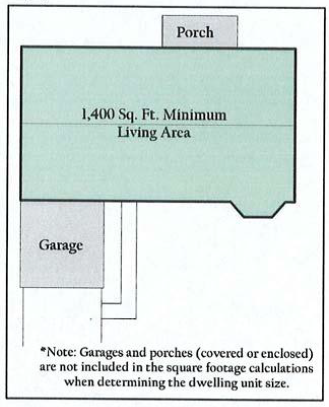
(2)
Minimum regulations. Each PD Planned Development District shall establish regulations deemed necessary and appropriate for the development of the property within the district and the protection of neighboring properties. The following regulations are minimums, but are not limited to, and may be increased or otherwise modified for a particular development:
a.
Maximum density is ten dwelling units per acre with each having a minimum of 900 square feet of living area.
b.
Minimum lot requirements.
1.
Lot size: 4,000 square feet.
2.
Width: 40 feet.
3.
Depth: 100 feet.
c.
Minimum required yards and building lines:
Illustration 50-80-2: Lot and yard regulations for the PD-Zero Lot Line District
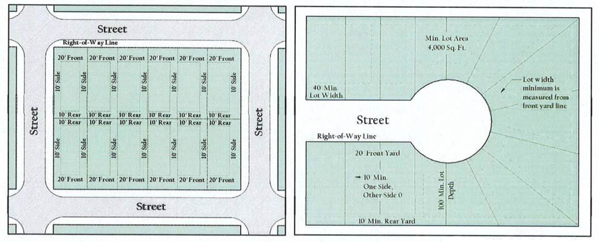
1.
Front is 20 feet, except that where a lot faces on an arterial street, the front building line shall not be less than 35 feet.
2.
Side—Interior lots. The side building line, to include eaves and appurtenances, shall not be less than five feet. On zero lot line homes the side yards shall be a minimum of zero feet and ten feet respectively. (See Illustration 50-80-2.)
3.
Side—Corner lots are 15 feet, except that where a lot sides on an arterial street, the building line shall not be less than 25 feet.
4.
Rear—Generally are 15 feet, except where the rear property line abuts an alleyway, there shall be a minimum of 30 feet between the buildings abutting said alleyway, provided that if the alleyway is a 20-foot alleyway, then the minimum rear building line shall be not less than five feet, and if the alleyway is a 15-foot-wide alleyway, then the minimum rear building line shall be not less than 7.5 feet. Zero lot line developments shall be a minimum of ten feet. (See Illustration 50-80-1.)
5.
Rear—Arterial street. The rear building line where a lot backs on an arterial street shall not be less than 25 feet
(3)
Maximum lot coverage. Not more than 60 percent of a lot may be covered with buildings, driveways, sidewalks, or other impermeable material, unless approved otherwise at the time of the PD Planned Development District and/or site plan approval by the planning and zoning commission and the city council.
(4)
Maximum height. Maximum height is two stories, or 35 feet in total height, including gables.
(5)
Green space/recreational areas. A minimum of 20 percent of the gross platted area shall be open green space. The term "open green space" is defined as, and limited to common areas of open space or landscaping and community recreational areas that are irrigated and continuously maintained. The term "open green space" does not include areas specifically designated or used as building sites for patio home or zero lot line units, building sites for utility or storage buildings, parking lots, garages, streets, or driveways within a patio home development. The actual surface areas of open green space, such as common area lawns and landscaping, community swimming pools and surrounding paved deck area, community tennis courts, community rooms, community saunas, and other common recreational areas, shall be considered in calculating the minimum requirement for open green space. Detention ponds and surrounding areas may also be considered "open green space" so long as the detention area is amenitized. Required buffer yards, except surfaced parking and driveways located within said buffer yards, if any, may be included in computing the minimum required area of open green space.
(6)
Reserved.
(7)
Reserved.
(8)
Reserved.
(e)
Area and height regulations for townhomes and single-family attached residential dwelling units.
(1)
Minimum acreage. The minimum acreage for a planned development request for a townhome or single-family attached single-family residential dwelling unit complex shall be four acres.
(2)
Regulations. Each PD Planned Development District shall establish regulations deemed necessary and appropriate for the development of the property within the district and the protection of neighboring properties. The following regulations are minimums but are not limited to, and may be increased or otherwise modified for a particular development:
Illustration 50-80-3: Lot and yard regulations for the PD-Townhome/Attached
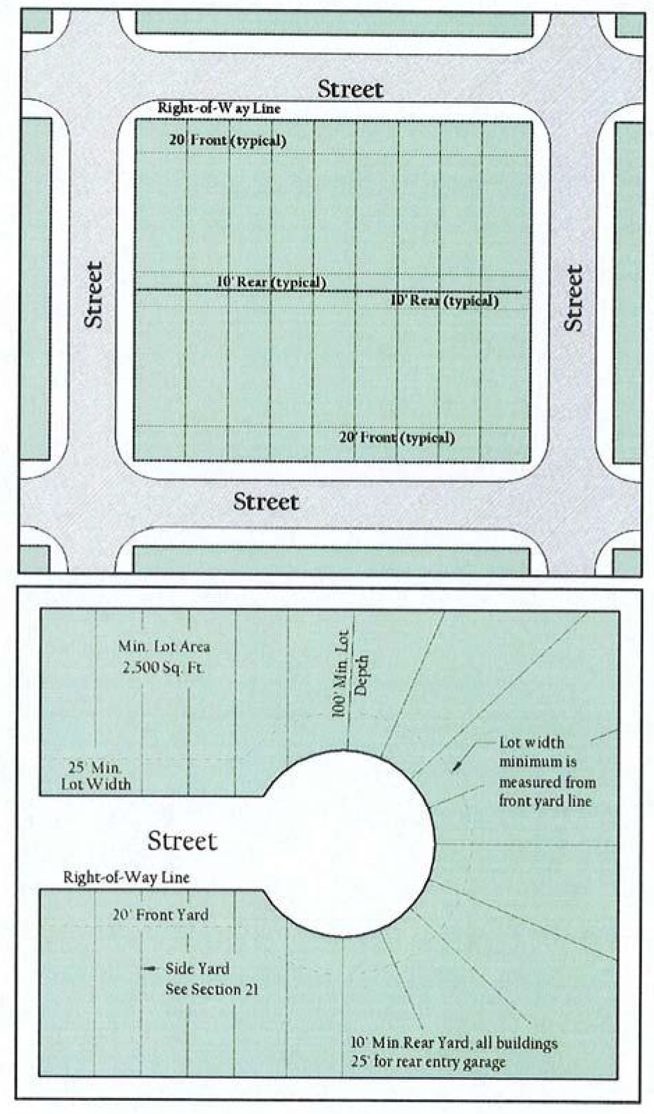
a.
Maximum density is 12 dwelling units per acre.
b.
Minimum lot requirements:
1.
Lot size: 3,600 square feet.
2.
Width: 25 feet.
3.
Depth: 100 feet.
c.
Minimum required yards and building lines.
1.
Front is 20 feet, except that where a lot faces on an arterial street, the front building line shall not be less than 35 feet.
2.
Side—Interior lots. There shall be no side yard or building line for a side of an interior lot which is adjacent to another townhome. The two side yard or building lines when two units do not share a common lot line, including eaves and appurtenances, shall be any combination that provides at least ten feet between structures.
d.
Side—Corner lots are 15 feet, except that where a lot sides on an arterial street, the building line shall not be less than 25 feet.
e.
Rear—Generally are ten feet, except where the rear property line abuts an alleyway, there shall be a minimum of 30 feet between the buildings abutting said alleyway, provided that if the alleyway is a 20-foot alleyway, then the minimum rear building line shall be not less than five feet, and if the alleyway is a 15-foot-wide alleyway, then the minimum rear building line shall be not less than 7.5 feet.
f.
Rear—Arterial streets. The rear building line where a lot back on an arterial street shall not be less than 25 feet.
(3)
Maximum lot coverage. Not more than 60 percent of a lot may be covered with buildings, driveways, sidewalks, or other impermeable material.
(4)
Maximum height. Two stories, or 25 feet in total height, including gables, shall be the maximum height.
(5)
Green space/recreational areas. A minimum of 30 percent of the gross platted area shall be open green space. The term "open green space" is defined as, and limited to common areas of open space or landscaping and community recreational areas that is irrigated and continuously maintained. The term "open green space" does not include areas specifically designated or used as building sites for patio home or zero lot line units, building sites for utility or storage buildings, parking lots, garages, streets, or driveways within a patio home development. The actual surface areas of open green space, such as common area lawns and landscaping, community swimming pools and surrounding paved deck area, community tennis courts, community rooms, community saunas, and other common recreational areas, shall be considered in calculating the minimum requirement for open green space. Required buffer yards, except surfaced parking and driveways located within said buffer yards, if any, may be included in computing the minimum required area of green space.
(6)
Screening requirements. A fence, wall, or other similar screening device, of not less than six feet nor more than eight feet in height, shall be constructed and maintained along the two sides and the rear of each patio home development complex; provided, however, no such screening device shall be required adjacent to portions of the development which contain green space, lakes, or natural habitat for a distance of 50 feet or more from such perimeter boundary.
(7)
Sidewalks. Sidewalks of concrete cement or other masonry construction shall be provided along all streets within a townhome development in accordance with applicable city standards and specifications.
(8)
Visitor parking. In addition to the parking required in section 50-112, the on and off street parking shall be analyzed to ensure that a minimum of one additional space per every two dwelling units is available for visitor parking.
(f)
Approval process.
(1)
Maximum of four steps. The review process for a planned development shall include up to four steps:
a.
Preapplication conference with the city manager or his designee (refer to section 50-36);
b.
Adoption of ordinance establishing planned development district;
c.
Concept plan; and
d.
Construction of project (after city approval of all required plans and plats).
(2)
Payment of all indebtedness attributable to the subject property. Refer to section 50-36.
(3)
Official submission date and completeness of application. Refer to section 50-34.
(4)
Supplemental requirements. Refer to section 50-36.
(g)
Concept plan.
(1)
Purpose. This section establishes a review process for planned developments. The purpose is to ensure that a development project is in compliance with all applicable city ordinances and guidelines prior to commencement of construction.
(2)
Applicability. Submission and approval of a concept plan shall be required for all planned developments.
(3)
Building permit and certificate of occupancy. A concept plan shall be submitted in conjunction with a building permit application (this is a different application than the building permit plan that is discussed within this section). No building permit shall be issued until a concept plan and all other required engineering/construction plans are first approved by the city. No certificate of occupancy shall be issued until all construction and development conforms to the concept plan and engineering/construction plans, as approved by the city.
(4)
Extent of area that should be included in a concept plan. When the overall development project is to be developed in phases, the area included within the concept plan shall include only the portion of the overall property that is to be developed/constructed.
(5)
Procedures and submission requirements for concept plan approval. All concept plans shall be prepared by a qualified civil engineer, land planner, architect or surveyor, and it shall clearly show in detail how the site will be constructed (such as paving, buildings, landscaped areas, utilities, etc.). To ensure the submission of adequate information, the city is hereby empowered to maintain and distribute a separate list of specific requirements for the review of concept plan applications.
(6)
Review and approval of a concept plan. The approval process for a concept plan shall generally be reviewed by city staff, recommendation by the planning and zoning commission, and approval by the city council.
a.
City staff review of concept plans.
1.
Upon official submission of a complete application of a concept plan for approval, the city shall review the application. Specifically, the city manager or his designee, city engineer, and the building official or their designee shall review the concept plan prior to the concept plan being forwarded to the planning and zoning commission. Determination of application completeness, notice to the applicant in writing of missing documents and information within ten business days and expiration of application within 45 calendar days due to incompleteness shall be in accordance with section 50-34.
2.
Concept plans shall be evaluated to ensure that all developments are, to the best extent possible, constructed according to the city's codes and ordinances.
3.
Following city staff review, and following discussions regarding necessary revisions, the applicant shall resubmit additional copies of the corrected concept plan to the city manager or his designee.
4.
The city manager or his designee shall then submit the corrected plan to the planning and zoning commission.
5.
It should be noted that the city manager or his designee shall forward the original plan application to the commission if the corrected version is not resubmitted within the prescribed time period.
6.
It should also be noted that a corrected plan that is incomplete or is otherwise not ready for consideration shall be subject to denial.
b.
Planning and zoning commission review of concept plans.
1.
All concept plan applications shall be reviewed by the planning and zoning commission.
2.
The city manager, or his designee, shall schedule consideration of the concept plan application on the regular agenda of the planning and zoning commission within 30 calendar days after the application is received.
3.
The planning and zoning commission shall review the concept plan and shall recommend to the city council approval, approval subject to certain conditions, or denial of the concept plan.
c.
City council review of and action on concept plans.
1.
All concept plan applications shall be reviewed by the city council after being reviewed by the planning and zoning commission.
2.
The city manager, or his designee, shall schedule consideration of the concept plan application on the regular agenda of the city council.
3.
The city council shall review the concept plan and shall approve, approve subject to certain conditions, or deny approval of the concept plan.
(7)
Revisions to the approved concept plan.
a.
Minor revisions/amendments.
1.
It is recognized that final architectural and engineering design may necessitate minor changes in the approved concept plan. In such cases, the city manager, or his designee, shall have the authority to approve minor modifications to an approved concept plan. Such minor modifications submitted on an amended concept plan, which shall substantially conform to the previously approved concept plan.
2.
Submission materials and requirements for approval of an amended concept plan shall be as determined by the city manager or his designee.
b.
Major revisions. In the event of revisions that are more extensive in nature (i.e., do not conform to the description for minor amendments in subsection (g)(7)a of this section), a revised concept plan must be resubmitted, reviewed, and approved by the city manager or his designee. The city manager or his designee shall have the authority to determine whether a revised concept plan warrants a review and approval as outlined in subsection a. of this section.
(8)
Effect of review/approval. The concept plan shall be considered authorization to proceed with construction of the site provided all other required city approvals are obtained (such as final plat, engineering plans, etc.).
(9)
Validity, lapse, and reinstatement of concept plan. Refer to section 50-37.
(h)
List of planned development districts. All Planned Development zoning districts approved in accordance with the provisions of this chapter, as may be amended, shall be prefixed by a "PD" designation and assigned a unique identification number (e.g., PD-1, PD-2, PD-3, etc.), and shall also be referenced on the zoning district map. A list of such Planned Development Districts, showing the uses permitted and any other special stipulations of each PD Planned Development District shall be maintained as part of this chapter.
(i)
Prior planned development ordinances remaining in effect. Prior to adoption of the ordinance from which this chapter is derived, the city council previously established by platting certain townhome, patio home and zero lot line developments, some of which are to be continued in full force and effect. The ordinances, parts of ordinances and/or plats approved prior to adoption of the ordinance form which this chapter is derived that applied to these developments, specified in appendix A-1 on file in the office of the city secretary, shall be carried forth in full force and effect and shall become the conditions, restrictions, regulations and requirements which apply to the respective PD Planned Development Districts shown on the zoning district map as of the effective date of the ordinance from which this chapter is derived for the property the requirements apply to. Each townhome, patio home and zero lot line development in existence at the time of adoption of the ordinance from which this chapter is derived is hereby assigned a unique identification number (e.g., PD-1, PD-2, PD-3, and so on) as shown in appendix A-1, and subsequent PD ordinances adopted after the effective date of the ordinance from which this chapter is derived shall be similarly numbered for identification purposes.
(Ord. No. 2008-01, § 36, 2-4-2008; Ord. No. 2017-17, §§ 2—8, 7-5-2017)
Sec. 50-81. - Conditional Use Permit (CUP).
(a)
Purpose and intent.
(1)
Nature of conditional use. A conditional use is a land use which, because of its unique nature, is compatible with the permitted land uses in a given zoning district only upon a determination that the external effects of the use in relation to the existing and planned uses of adjoining property and the neighborhood can be mitigated through imposition of certain standards and conditions. This section sets forth the standards used to evaluate proposed conditional uses and the procedures for approving conditional use permit (CUP) applications.
(2)
Permit required. No conditional use shall be established and no building permit shall be issued for any use designated as a conditional use within any zoning district until a conditional use permit (CUP) is approved and issued in accordance with the provisions of this section and section 50-34. An application for a CUP shall be accompanied by a concept plan prepared in the manner described in subsection (e) of this section.
(b)
Status of conditionally permitted uses. The following general rules apply to all conditional uses:
(1)
The designation of a use in a zoning district as may be permitted by CUP in section 50-82 (shown as "C" in the use charts of said chapter does not constitute an authorization or assurance that such use will be approved.)
(2)
Approval of a CUP shall authorize only the particular use for which the CUP is issued.
(3)
No use authorized by a CUP shall be enlarged, extended or relocated, nor may the number of dwelling units be increased, unless an application is made for approval of a new CUP in accordance with the procedures set forth in this section and section 50-34.
(4)
Development of the use shall not be carried out until the applicant has secured all the permits and approvals required by this chapter, this Code, and any permits that may be required by regional, state or federal agencies.
(c)
Application for conditional use permit; requirements. An application for a CUP may be submitted by the property owner or by the property owner's designated representative to the city. The application shall be accompanied by a concept plan prepared in accordance with the requirements of subsection (e) of this section. If a base zoning district amendment is required or requested, such rezoning application shall accompany the application for a CUP.
(d)
Approval process.
(1)
Maximum of four steps. The review process for a CUP shall include up to four steps:
a.
Preapplication conference with the city manager or his designee (refer to section 50-36);
b.
Adoption of ordinance granting a CUP;
c.
Concept plan; and
d.
Construction of project (after city approval of all required plans and plats).
(2)
Payment of all indebtedness attributable to the subject property. Refer to section 50-36.
(3)
Official submission date and completeness of application. Refer to section 50-34.
(4)
Supplemental requirements. Refer to section 50-36.
(e)
Concept plan.
(1)
Purpose. This section establishes a review process for conditional use permits. The purpose is to ensure that a development project is in compliance with all applicable city ordinances and guidelines prior to commencement of construction.
(2)
Applicability. Submission and approval of a concept plan shall be required for all conditional use permits.
(3)
Building permit and certificate of occupancy. A concept plan may be submitted in conjunction with a building permit application (this is a different application than the building permit plan that is discussed within this section). No building permit shall be issued until a concept plan and all other required engineering/construction plans are first approved by the city. No certificate of occupancy shall be issued until all construction and development conforms to the concept plan and engineering/construction plans, as approved by the city.
(4)
Extent of area that should be included in a concept plan. When the overall development project is to be developed in phases, the area included within the concept plan shall include only the portion of the overall property that is to be developed/constructed.
(5)
Procedures and submission requirements for concept plan approval. All concept plans shall be prepared by a qualified civil engineer, land planner, architect or surveyor, and it shall clearly show in detail how the site will be constructed (such as paving, buildings, landscaped areas, utilities, etc.). To ensure the submission of adequate information, the city is hereby empowered to maintain and distribute a separate list of specific requirements for the review of concept plan applications.
(6)
Review and approval of a concept plan. The approval process for a concept plan shall generally be review by city staff, recommendation by the planning and zoning commission, and approval by the city council.
a.
City staff review of concept plans.
1.
Upon official submission of a complete application of a concept plan for approval, the city shall review the application. Specifically, the city manager, city engineer, and the building official or their designees shall review the concept plan prior to the concept plan being forwarded to the planning and zoning commission.
2.
Concept plans shall be evaluated to ensure that all developments are, to the best extent possible, constructed according to the city's codes and ordinances.
3.
Following city staff review, and following discussions regarding necessary revisions, the applicant shall resubmit additional copies of the corrected concept plan to the city manager or his designee.
4.
The city manager or his designee shall then submit the corrected plan to the planning and zoning commission.
5.
It should be noted that the city manager or his designee shall forward the original plan application to the commission if the corrected version is not resubmitted within the prescribed time period.
6.
It should also be noted that a corrected plan that is incomplete or is otherwise not ready for consideration shall be subject to denial.
b.
Planning and zoning commission review of concept plans.
1.
All concept plan applications shall be reviewed by the planning and zoning commission.
2.
The city manager, or his designee, shall schedule consideration of any concept plan application on the regular agenda of the planning and zoning commission within 30 calendar days after the application is received.
3.
The planning and zoning commission shall review the concept plan and shall recommend to the city council approval, approval subject to certain conditions, or denial of the concept plan.
c.
City council review of and action on concept plans.
1.
All concept plan applications shall be reviewed by the city council after being reviewed by the planning and zoning commission.
2.
The city manager, or his designee, shall schedule consideration of the concept plan application on the regular agenda of the city council.
3.
The city council shall review the concept plan and shall approve, approve subject to certain conditions, or deny approval of the concept plan.
(7)
Revisions to the approved concept plan.
a.
Minor revisions/amendments.
1.
It is recognized that final architectural and engineering design may necessitate minor changes in the approved concept plan. In such cases, the city manager, or his designee, shall have the authority to approve minor modifications to an approved concept plan. Such minor modifications submitted on an amended concept plan, which shall substantially conform to the previously approved concept plan.
2.
Submission materials and requirements for approval of an amended concept plan shall be as determined by the city manager or his designee.
b.
Major revisions. In the event of revisions that are more extensive in nature (i.e., do not conform to the description for minor amendments in subsection (e)(7)a of this section), a revised concept plan must be resubmitted, reviewed, and approved by the city manager or his designee. The city manager or his designee shall have the authority to determine whether a revised concept plan warrants a review and approval as outlined in this subsection (e).
3.
Any proposed or existing building or land use that is newly established, enlarged, modified, structurally altered, or otherwise changed from the originally approved concept plan shall be deemed a major revision.
(8)
Effect of review/approval. The concept plan shall be considered authorization to proceed with construction of the site provided all other required city approvals are obtained (such as final plat, engineering plans, etc.).
(9)
Validity, lapse, and reinstatement of concept plan. Refer to section 50-37.
(f)
Standards.
(1)
Factors for consideration. When considering applications for a conditional use permit, the city shall, on the basis of the concept plan and other information submitted, evaluate the impact of the conditional use on, and the compatibility of the use with, surrounding properties and neighborhoods to ensure the appropriateness of the use at a particular location. Specific considerations shall include the extent to which:
a.
The proposed use at the specified location is consistent with the goals, objectives and policies contained in the adopted comprehensive plan.
b.
The proposed use is consistent with the general purpose and intent of the applicable zoning district regulations.
c.
The proposed use meets all supplemental standards specifically applicable to the use as set forth in this chapter.
d.
The proposed use is compatible with and preserves the character and integrity of adjacent development and neighborhoods and, as required by the particular circumstances, includes improvements or modifications either onsite or within the public rights-of-way to mitigate development-related adverse impacts, including, but not limited to:
1.
Adequate ingress and egress to property and proposed structures thereon with particular reference to vehicular and pedestrian safety and convenience, and access in case of fire;
2.
Off-street parking and loading areas;
3.
Refuse and service areas;
4.
Utilities with reference to location, availability, and compatibility;
5.
Screening and buffering features to minimize visual impacts, and/or setbacks from adjacent uses;
6.
Control of signs, if any, and proposed exterior lighting with reference to glare, traffic safety, economic effect, and compatibility and harmony with properties in the district;
7.
Required yards and open space;
8.
Height and bulk of structure;
9.
Hours of operations;
10.
Exterior construction material and building design; and
11.
Roadway adjustments, traffic control devices or mechanisms, and access restrictions to control traffic flow or divert traffic as may be needed to reduce or eliminate development-generated traffic on neighborhood streets.
e.
The proposed use is not materially detrimental to the public health, safety, convenience and welfare, or results in material damage or prejudice to other property in the vicinity.
(2)
Conditions. In approving the application, the planning and zoning commission may recommend, and the city council may impose, such additional conditions (e.g., hours of operation) as are reasonably necessary to assure compliance with the standards, purpose, and intent of this section, and in accordance with the rezoning procedures in section 50-34. Any conditions imposed shall be set forth in the ordinance approving the conditional use, and shall be incorporated into or noted on the concept plan. The city manager or his designee shall verify that the concept plan incorporates all conditions set forth in the ordinance authorizing the conditional use. The city shall maintain a record of such approved conditional uses and related conditions attached thereto.
(3)
Prohibition on waivers and variances. The foregoing additional conditions (i.e., standards of development for the CUP) shall not be subject to variances that otherwise could be granted by the board of adjustments, nor may conditions imposed by the city council subsequently be waived or varied by the board of adjustments.
(g)
Other regulations. The board of adjustments shall not have jurisdiction to hear, review, reverse, or modify any decision, determination, or ruling with respect to the specific land use designated by any conditional use permit.
(h)
Use regulations. Uses allowed by CUPs are specified in section 50-82 (specifically shown with a "C" within the use charts).
(Ord. No. 2008-01, § 37, 2-4-2008)
Sec. 50-82. - Use regulations (charts).
(a)
Conformance with the use charts.
(1)
Generally. The use of land and/or buildings shall be in accordance with those listed in the following use charts. No land or building shall hereafter be used and no building or structure shall be erected, altered, or converted other than for those uses specified in the zoning district in which it is located. The legend for interpreting the permitted uses in the use charts are:
(2)
Unlisted uses. If a use is not listed (or is blank) in the use charts, it is not allowed in any zoning district (see subsection (a)(4) of this section).
(3)
Use chart organization. The land uses are listed in the use charts in alphabetical order.
(4)
Classification of new/unlisted uses. It is recognized that new types of land use will arise in the future, and forms of land use not presently anticipated may seek to locate in the city. In order to provide for such changes and contingencies, a determination as to the appropriate classification of any new or unlisted form of land use in the use charts shall be made as follows:
a.
Initiation.
1.
A person, city department, the planning and zoning commission, or the city council may propose zoning amendments to regulate new and previously unlisted uses.
2.
A person requesting the addition of a new or unlisted use shall submit to the city manager or his designee, all information necessary for the classification of the use, including but not limited to the following:
(i)
The nature of the use and whether the use involves dwelling activity, sales, services, or processing;
(ii)
The type of product sold or produced under the use;
(iii)
Whether the use has enclosed or outside storage and the amount and nature of the storage;
(iv)
Anticipated employment typically anticipated with the use;
(v)
Transportation requirements;
(vi)
The nature and time of occupancy and operation of the premises;
(vii)
The off-street parking and loading requirements;
(viii)
The amount of noise, odor, fumes, dust, toxic materials and vibration likely to be generated;
(ix)
The requirements for public utilities such as sanitary sewer and water and any special public services that may be required; and
(x)
Impervious surface coverage.
b.
The city manager, or his designee, shall refer the question concerning any new or unlisted use to the planning and zoning commission, requesting a recommendation as to the zoning classification into which such use should be placed. The referral of the use interpretation question shall be accompanied by the statement of facts in subsection (a)(4)a.2 of this section. An amendment to this chapter shall be required as prescribed by section 50-34.
c.
The planning and zoning commission shall consider the nature and described performance of the proposed use and its compatibility with the uses permitted in the various districts and determine the zoning district or districts within which such use is most similar and should be permitted (by right or by CUP).
d.
The planning and zoning commission shall transmit its findings and recommendations to the city council as to the classification proposed for any new or unlisted use. The city council shall approve or disapprove the recommendation of the planning and zoning commission or make such determination concerning the classification of such use as is determined appropriate based upon its findings. If approved, the new or unlisted use shall be amended in the use charts of subsection(b) of this section according to section 50-34.
e.
Standards for new and unlisted uses may be interpreted by the city manager, or his designee, as those of a similar use. When a determination of the appropriate zoning district cannot be readily ascertained, the same criteria outlined in subsection (a)(b) of this section shall be followed for determination of the appropriate district. The decision of the city manager, or his designee, may be appealed according to the process outlined in subsections (a)(4)a2 through (a)(4)d of this section.
(b)
Use charts.
(Ord. No. 2008-01, § 38, 2-4-2008; Ord. No. 2010-09, § 2, 5-3-2010; Ord. No. 2012-18, § 2, 7-2-2012; Ord. No. 2013-23, § 2, 2-2-2013; Ord. No. 2013-19, § 2, 11-4-2013; Ord. No. 2014-35, § 2, 10-6-2014; Ord. No. 2014-45, § 2, 1-5-2015; Ord. No. 2015-07, § 3, 4-20-2015; Ord. No. 2015-19, § 2, 10-5-2015; Ord. No. 2015-25, § 2, 1-4-2016; Ord. No. 2016-20, § 2, 9-19-2016; Ord. No. 2016-33, § 3, 1-3-2017; Ord. No. 2018-34, § 2, 11-5-2018; Ord. No. 2022-43, § 2(Exh. A), 1-2-2023; Ord. No. 2023-03, § 2(Exh. A), 3-6-2023; Ord. No. 2023-40, § 3, 11-6-2023; Ord. No. 2023-55, § 2(Exh. A), 2-19-2024; Ord. No. 2024-13, § 2(Exh. A), 7-1-2024; Ord. No. 2024-14, § 2(Exh. A), 7-1-2024)
Sec. 50-83. - Summary of area regulations by district.
Table 50-83-1
Area Regulations Summary for Residential Districts
Table 50-83-1
Area Regulations Summary for Residential Districts
(Continued)
Table 50-83-2
Area Regulations Summary for Nonresidential and Mixed Use Districts
Table 50-83-2
Area Regulations Summary for Nonresidential and Mixed Use Districts (Continued)
(Ord. No. 2008-01, app. A, 2-4-2008)