
Vestal City Zoning Code
APPENDIX A
SUBDIVISION REGULATIONS1
Editor's note— Appendix A contains the text of the subdivision regulations for the town which derive from an amendment of August 15, 2006. Formerly, appendix A pertained to similar subject matter, and derived from regulations originally adopted May 10, 1967. Amendments are indicated by parenthetical history notes following amended provisions. The absence of a history note indicates that the provision remains unchanged from the original amendment. Obvious misspellings and punctuation errors have been corrected without notation. For stylistic purposes, a uniform system of headings, catchlines, capitalization, and expression of numbers in text has been used to conform to the Town Code. Additions made for clarity are indicated in brackets.
Cross reference— Buildings and building regulations, Ch. 5; environmental conservation, Ch. 6; excavations and soil removal, Ch. 7; underground utilities, § 20-76 et seq.; zoning, Ch. 24.
State Law reference— Subdivision approval, Town Law, § 276.
Sec. 100.- Subdivision policy.
The town board, and the planning board of the town declares that these regulations for the subdivision of land for various purposes have been promulgated to provide for the orderly growth and coordinated development of the town and to assure the comfort, convenience, safety, health and welfare of its people and further, that the approval of such subdivisions shall be based on the following considerations:
100.1.
Conformance with the various parts of the comprehensive plan and the zoning ordinance [chapter].
100.2.
Recognition of a desirable relationship to the general land form, its topographic and geologic character, to natural drainage and surface water runoff and to the ground water table.
100.3.
Recognition of desirable standards of subdivision design including adequate provision for pedestrian and vehicle traffic, for public water supply and sanitary sewer, for surface water runoff and for suitable building sites for the land use contemplated.
100.4.
Provisions for such facilities as are desirable adjuncts to the contemplated use such as parks, recreation areas, school sites, fire stations and offstreet parking.
100.5.
Review of subdivision plats shall consider general development standards and the guarantee of adequate future street access to other lands through the subdivided property.
Sec. 200. - Definitions.
200.1.
Comprehensive plan. A master plan for the future growth, protection and development for the town, affording adequate facilities for housing, transportation, recreation, public health, safety and general welfare for its population.
200.2.
Crosswalk or walkway. A right-of-way dedicated to public use, to facilitate pedestrian access through a subdivision.
200.3.
Cul-de-sac. Is a vehicular turn-around area at the dead-end of a street.
200.4.
Easement. A restriction established in a real estate deed or other legal instrument to permit the use of land by the public, a corporation or particular persons for specific uses.
200.5.
Land partition. A division of land into four (4) or more lots, along an existing public street or roadway within a five-year period.
200.6.
Limited access and planting area. An area designed to control access to public areas and also to suitably screen private properties abutting them.
200.7.
Lot. The unit into which land is divided with the intention of offering such unit for sale, either as an undeveloped or developed site, regardless of how it is conveyed. Lot shall also mean parcel, plot, site or any similar term.
200.8.
Major street. A street within a subdivision or subdivisions designed to have considerable continuity and traffic capacity that, serving as an artery, collects traffic from the minor streets and guides it to the primary and secondary highways.
200.9.
Marginal access street. A street located on a separate right-of-way parallel to and in the vicinity of a primary or secondary highway designed to provide access to abutting properties without interrupting highway traffic except at recognized intersections and access points.
200.10.
Minor streets. A street designed to provide access to abutting properties within a limited area such as a neighborhood.
200.11.
Primary highway. A highway, generally under the jurisdiction of the state or county, designed principally to provide for high speed, through traffic between centers of development such as commercial centers, industrial areas and concentrated residential communities both within and outside the town.
200.12.
Secondary highway. A highway similar to a primary highway, generally under the jurisdiction of the town, but designed for traffic between important centers of development within the town and as a highway link to the primary highway system.
200.13.
Subdivision. A division of land into two (2) or more lots in such a way as to require one (1) or more new streets to be created and/or the extension of municipal facilities.
Municipal facilities shall include, but not be limited to, public water, sanitary sewer, and related storm drainage (curb and gutter and necessary appurtenances.)
200.14.
Town engineer. That engineer duly appointed by the town.
200.15.
Regrading, excavations and soil removal. Regrading shall for the purpose of this regulation be defined as said term is defined in "An Ordinance to regulate and control general regrading of land, extraction and removal of earth products and other excavations" as adopted by and amended by the town board.
Sec. 300. - Subdivision pre-application.
300.1.
Purpose. The pre-application is suggested to prospective subdividers, their engineers or agents, so that they may obtain the advice of town officials in the formative stages of the design and to assure coordination with the comprehensive plan and conformance to town codes.
300.2.
Pre-application procedure.
(a)
The owner shall, prior to subdividing or resubdividing land, submit to the engineering department at least fifteen (15) days prior to the regular meeting of the planning board four (4) paper prints of the pre-application sketch for an informal review.
During this informal review period, a meeting shall be scheduled by the town engineering department to discuss the proposed subdivision. The developer, his agent, the developer's engineer, and the developer's surveyor will be encouraged to attend and meet with town officials. These town officials will consist of representatives from the town engineering department, water and wastewater departments, highway department, code enforcement and building inspection department and, in some cases, the planning board.
(b)
Submission of pre-application sketch to the town planning board for review.
300.3.
Subdivision pre-application sketch. A sketch drawn on a map indicating the following:
(a)
Boundary survey data.
(b)
Topographic contours with contour interval not greater than ten (10) feet and shall extend at least two hundred (200) feet beyond the proposed subdivision boundaries.
(c)
Existing drainage features (e.g. culverts, marshes, ponds, and streams), wooded areas, and other significant physical features; within the part to be subdivided of the proposed subdivision boundary.
(d)
Special site conditions (e.g. easements, power lines and structures).
(e)
Building zone district boundaries.
(f)
Relationship to the comprehensive plan for the area.
(g)
Proposed street and block layout with reference to surrounding properties and street pattern.
(h)
Existing and proposed utilities and special districts.
(i)
The subdivision name or title, town and county in which it is located, north point, date, and a graphic scale not smaller than 1" = 100'.
(j)
The name and address of the owner, subdivider; and professional advisor.
(k)
Key map. (Minimum scale of 1" = 100').
300.4.
Pre-application recommendations. The planning board shall determine whether the sketch plan meets the purposes of these regulations and shall, where it deems it necessary, make specific recommendations in writing, to be incorporated by the owner in the next submission to the planning board.
Sec. 400. - Subdivision preliminary layout.
401.
Purpose.
401.1.
The preliminary layout and the supporting documents for a proposed subdivision constitute the material to be officially submitted to the planning board and later one (1) copy shall become the official record of the town clerk. These documents shall show the general design of the subdivision and its public improvements so that the planning board can indicate its approval or disapproval of the subdivision prior to the time that the final plat, including the design and detailing of the public improvements and utilities is completed. Approval of the preliminary layout does not constitute an approval of the final plat nor should it be considered a valid basis for the construction of site improvements or for other commitments which depend upon its design characteristics.
401.2.
When revision of the proposed subdivision is required the preliminary layout shall be revised accordingly so that the files of the planning board and other town officials will be current.
401.3.
The preliminary layout shall serve as a key map to subdivisions subsequently laid out in sections on final plats.
401.4.
Examination of the preliminary layout will usually indicate whether or not the excavation and soil removal law of the town will apply to all or a part of the proposed subdivision.
402.
Procedure.
402.1.
The submission of a preliminary layout shall consist of the following items:
(a)
Application for the subdivision of the land (six (6) copies).
(b)
Acknowledgement of requirements—Preliminary layout form (six (6) copies).
(c)
The preliminary layout (six (6) paper prints).
(d)
Environmental assessment form (SEQRA).
402.2.
The subdivider shall file his complete submission for the preliminary layout at the engineering department office. A proposed submission which does not include all the required drawings and documents will not be accepted for filing. A submission shall be filed fifteen (15) days prior to a planning board meeting date, at which time the applicant or his agent should attend to be heard at that particular meeting.
402.3.
The engineering department will notify members of the planning board of the submission of a preliminary layout and will maintain a copy of the preliminary layout for review by planning board members prior to the meeting.
402.4.
The engineering department staff shall prepare a report of findings for planning board consideration and action. This report shall contain the recommendations of the superintendent of highways, water and waste water superintendent and town engineer.
402.5.
The engineering department staff will determine if the excavation and soil removal law of the town shall apply to the subdivision or whether the owner shall file a certification that he does not propose to do any general regrading or excavation as defined in that law.
403.
[Expiration of approval.] Expiration of approval of a preliminary layout submission shall expire nine (9) months after the date of such formal action. A waiver for a reasonable period of time may be given in cases of hardship upon petition to the planning board one (1) month prior to expiration of the approval. No planning board action will be taken after such expiration until a new application is submitted.
404.
Preliminary layout requirements.
404.1.
The preliminary lot layout shall be prepared by a state-licensed professional engineer or land surveyor and shall provide the information noted in this section. All drainage and utility design shall be prepared by a state-licensed professional engineer.
404.2.
The drawing sheet.
(a)
Size shall be 24" × 36" or 22" × 34"
(b)
If more than one (1) sheet is required, a clearly drawn "Match Line" shall be shown on both sheets and on the key map.
404.3.
Title block.
(a)
Name of subdivision.
(b)
Name and address of the subdivider.
(c)
Name, address, license number and seal of the professional engineer and land surveyor who certified the drawings.
(d)
Total acreage for entire tract for each building zone district within the tract and for each section.
(e)
Total number of proposed lots for entire tract.
(f)
Total footage of proposed new streets.
404.4.
Other notations.
(a)
Date of original submission and for each subsequent submission.
(b)
Graphic scale (not smaller than one (1) inch equals one hundred (100) feet (1"=100')).
(c)
True or magnetic north and date taken.
(d)
Certification by the state-licensed professional engineer or land surveyor that the topography shown resulted from an actual survey and the date of that survey.
404.5.
Key map.
(a)
Scale: One (1) inch equals one thousand (1,000) feet (1" = 1,000').
(b)
Information:
(1)
Relationship to the primary and secondary highway system and main intersections.
(2)
Boundary lines: building zone districts, special districts and municipal areas.
(3)
"Match Lines" as needed when two or more drawings are required to show the complete subdivision.
404.6.
Outline boundary data (heavy solid line) of entire tract owned by applicant.
404.7.
Boundaries of adjacent properties and property owners names.
(a)
Adjacent properties which are a part of a recorded subdivision plat may be identified by the subdivision name.
404.8.
Other boundary lines.
(a)
Building zone districts.
(b)
Special districts.
(c)
Municipal areas.
404.9.
Topographic contours (existing and proposed) of not greater than five-foot intervals in the United States Coast and Geodetic Survey datum of mean sea level.
(a)
Smaller or larger contour intervals when advisable due to the terrain shall be used after approval by the planning board.
(b)
Contours shall extend two hundred (200) feet beyond the subdivision boundary line as required.
404.10.
Existing site conditions within the subdivision and two hundred (200) feet of its boundaries.
(a)
Street rights-of-way:
(1)
Name.
(2)
Location and width.
(3)
Center line elevations at intersections and other critical points.
(4)
Typical cross section.
(b)
Rights-of-way and easements:
(1)
Identification.
(2)
Location and width.
(3)
Restrictions of use if any.
(c)
Drainage structures:
(1)
Type of structure.
(2)
Location, invert elevations, gradients and sizes of all pipe and of all other structures where applicable.
(d)
Other utility structures such as water, sewer, gas mains and power lines:
(1)
Location and size.
(e)
Marshes, ponds, streams or similar conditions:
(1)
Location and area covered indicating apparent high water level.
(2)
Water elevation on date of survey and survey date.
(3)
Maximum depth of water at critical points.
(f)
Test hole date if required:
(1)
Date and location.
(2)
Graphic representation of findings for all test holes.
(g)
Town or other public lands, lands designated as parks, open spaces or for some other public or community use.
(h)
Buildings and other structures located within subdivision boundaries which are to remain.
404.11.
Proposed site condition (see also section 800, design standards).
(a)
Streets.
(1)
Name to be checked prior to submission at the engineering department office. Street names shall not be duplicated.
(2)
Right-of-way width.
(3)
Tentative center line elevations at intersections and at principal changes in grade.
(4)
Tentative center line gradient shown in percent of slope.
(b)
Lot layout.
(1)
Lot lines and dimensions to the nearest foot.
(2)
Building setback by note.
(3)
Easements and restricted areas with notation as to purpose or restriction.
(4)
Identification of lots or parcels for special uses, whether they are to be offered for dedication or not.
(5)
Layout of all reserved parcels in conformance with existing zoning regulations to be shown by a broken line.
(c)
Preliminary storm water drainage plan [SWPPP].
(1)
Drainage structures shall be shown on the preliminary layout.
(2)
Watershed outline and their approximate areas in acres including those which extend beyond the boundaries of the subdivision shall be shown with red pencil on two (2) copies.
(d)
Utilities.
(1)
Sewer plan showing structures and direction of flow.
(2)
Water plan showing mains, valves and hydrants.
(3)
Street lighting layout.
(4)
All new streets shall be served by public water and sewer.
(L.L. No. 3 of 2007)
Cross reference— Stormwater erosion and sediment control, ch. 6 art. VI.
Sec. 500. - Final plat.
501.
Purpose.
501.1.
The final plat and supporting drawings and documents for a proposed subdivision constitutes the complete development of the subdivision proposal. It includes the recommendations resulting from the planning board review of the preliminary layout as well as the detailed layout drawings for the public improvements and utilities. After public hearing and approval by the planning board, this complete submission, along with the performance bond and the provision of the liability insurance policy as approved and accepted by the town board, becomes the basis for the construction of the subdivision so that the town engineer and planning board can monitor accordingly. The plat itself must be recorded at the county clerk's office to have legal status.
501.2.
The plat itself shall be an accurate survey record of the properties resulting from the subdivision.
502.
Procedure.
502.1.
The submission of a final plat (before planning board review) shall consist of the following items:
(a)
Letter of application for final plat approval (three (3) copies).
(b)
Acknowledgement of requirements—Final plat (three (3) copies).
(c)
The final plat (three (3) prints) including approval by Broome County department of health.
(d)
The public improvement and utilities plan and profile drawings (three (3) prints).
(e)
Letters in appropriate cases directed to the chairman of the planning board, signed by a responsible official of the state department of public works, or the Broome County department of public works, approving proposed construction on state or county rights-of-way and indicating that the necessary permits have been issued by their office, or submit a copy of the permit itself.
(f)
Deeds of dedication. Two (2) copies each for all proposed street rights-of-way, easements, easements of limited access and planting areas.
(g)
Lot areas for each lot computed to the nearest one hundred (100) square feet.
(h)
Zoning change by the town board, if applicable, has been completed.
(i)
Further review under SEQR if changes to subdivision plan are significant.
(k)
Stormwater pollution prevention plan. A stormwater pollution prevention plan consistent with the requirements of chapter 6, article VI, divisions 1 and 2 shall be required for site plan approval.
502.2.
The subdivider or his agent shall submit the final plat and supporting drawings and documents at the engineering department office fifteen (15) days prior to the meeting date on which the plat is to be acted upon.
502.3.
The engineering department staff shall prepare a report of findings for the planning board's consideration and action which shall include the recommendations of the superintendent of highways, water and waste water superintendent and the town engineer.
502.4.
The town engineer shall prepare a performance bond estimate to be submitted along with his recommendations on the final plat.
502.5.
The planning board will advertise a public hearing at least five (5) days prior to the hearing date in accordance with Section 276 of the Town Law.
502.6.
After the public hearing the planning board shall, within forty-five (45) days from the date of the public hearing on the final subdivision plat, approve or disapprove the plat. If the public hearing is waived the planning board's action must be taken within forty-five (45) days of the receipt of the final plat by the clerk of the planning board. The designated clerk of the planning board will be the town engineer. If the plat is approved the subdivider shall carry out the following steps prior to obtaining the chairman's signature approval.
(a)
Make all required corrections to the satisfaction of the planning board.
(b)
Obtain a performance bond/letter of credit in the amount of the bond estimate and an owner's protection insurance policy and submit them to the town attorney for approval by the town board.
(c)
Prepare prints of the corrected final plat drawings in the quantities as follows:
Three (3) paper prints.
Three (3) paper prints of the corrected public improvement and utilities plan and profiles.
If the final plat is disapproved, the grounds for such action shall be stated in the records of the planning board and a copy of such decision shall be sent to the owner.
502.7.
If authorized by the planning board, the chairman will sign his approval on the final plat. Such approval is contingent on receipt of the following compliance reports from the engineering department.
(a)
Approved road profiles.
(b)
Approved public improvement and utility plan.
(c)
Notification that the required performance bond/letter of credit and insurance commitments have received town board approval.
502.8.
The subdivider shall file one (1) Mylar print of the approved plat (not including the support documents) in the Broome County Clerk's office within ninety (90) days of approval. Building permits shall not be issued until a certified photostatic copy has been received from the county clerk's office.
502.9.
Planning board approval of a final plat shall not be deemed an acceptance by the town of any street or other land shown as offered for dedication to public use.
503.
Expiration of approval. Planning board approval of a final plat shall expire ninety (90) days after the date of the planning board resolution authorizing the chairman to sign the drawings.
(a)
Upon application by the subdivider, the planning board may grant an additional 90-day extension of the approval, provided however, that the plat be revised according to any change in regulations or ordinance applicable to the plat subsequent to the first resolution.
(b)
Expiration of an approval shall mean that any further action will require a review of all previous findings.
504.
Final plat requirements.
504.1.
The final plat shall be prepared by a state-licensed professional engineer or land surveyor and shall provide the information noted in this section.
504.2.
The drawing sheet:
(a)
Size shall be either 22" × 34" or 24" × 36".
(b)
If more than one (1) sheet is required, a clearly drawn "Match Line" shall be shown on both sheets and on the key map.
504.3.
Title block shall be the same as that required for the preliminary layout.
504.4.
Other notations:
(a)
They shall be the same as those required for the preliminary layout except that the certification that the topography shown resulted from an actual field survey shall be omitted.
(b)
Every final subdivision plat shall carry the following endorsement:
"Approved by resolution of the Planning Board of the Town of Vestal, New York, on the _______ day of _______19_______, subject to all requirements and conditions of said resolution. Any change, erasure, modification or revision of this plat, as approved, shall void this approval. Signed this _______ day of _______, 19_______."
504.5.
Key map of the entire subdivision shall be the same as that required on the preliminary layout, with the following additions:
(a)
The final plat area being submitted for approval shall be shaded.
504.6.
Boundary lines identified by notes:
(a)
Building zone districts.
(b)
Special districts.
(c)
Municipal areas.
504.7.
General information required:
(a)
Street rights-of-way and widening of street rights-of-way:
(1)
Name.
(2)
Location.
(3)
Width.
(4)
Notations on widenings where an offer of dedication is being made.
(b)
Other rights-of-way and easements:
(1)
Identification and description.
(2)
Location.
(3)
Width and other dimensions necessary for description.
(c)
Lot layout.
(1)
Lot number identification by a suitable system of consecutive numbers shall be circled.
(2)
Lot lines with accurate dimensions to the nearest hundredth of a foot.
(3)
Building setback lines by note.
(d)
Special parcels:
(1)
Description of proposed action and use including a note where an offer of dedication is being made.
(2)
Boundary lines with accurate dimensions to the nearest one-hundredth of a foot.
504.8.
Survey data.
(a)
Accurate traverse of subdivision boundary with true angles and distances.
(b)
Survey tie-in with true angle and distances to the three (3) nearest established street monuments or official monuments.
(c)
Municipal, town, county and special district boundaries referenced to the subdivision survey by true angles and distances.
(d)
Radii, internal angles, points of curvature, tangent distances and lengths of all arcs.
(e)
Accurate dimensions to the nearest one-hundredth of a foot.
(f)
Monuments:
(1)
Accurate location of all monuments.
(2)
Existing monuments shall be shown with this symbol: •
(3)
Proposed new monuments or monuments to be reset shall be shown with this symbol: o
(4)
One (1) monument shall be located at each property corner and at each general change in the direction of the boundary.
(5)
Two (2) monuments shall be located at each street intersection.
(6)
Monuments shall be located at the beginning and end of each curve along one (1) side of the street right-of-way.
(g)
Lots shall be monumented prior to any building construction
505.
Public improvement and utilities plan and profiles.
505.1.
This plan and profile are declared to be an integral part of the final plat submission.
505.2.
The performance bond and inspection shall be based on the public improvement and utilities plan and profiles, the final plat itself, this subdivision regulation and the town specifications for such public improvements and utilities.
505.3.
Unless a specific waiver is requested in writing, the proposed public improvements and utilities shall be considered to comply specifically with this subdivision regulation and the town specifications.
505.4.
Basic plan requirements.
(a)
Sheet size: 22" × 34" or 24" × 36".
(b)
Title block:
(1)
Name of subdivision and section.
(2)
Scale.
(3)
Date.
(c)
The plan shall show the outline of all rights-of-way, easements and similar conditions.
(d)
Street center-line gradients in percent indicated with arrows to establish the direction of slope.
(e)
Critical street center-line grade elevations.
505.5.
Drainage system requirements.
(a)
Complete drainage system for the entire subdivision, with appropriate development stages for each of the final plat sections, shall be shown graphically with all existing drainage features which are to be incorporated properly identified as existing.
(b)
Boundaries of storm water runoff watersheds for each drainage structure and their area in acres.
(c)
All proposed surface drainage structures (e.g. valley gutters).
(d)
Identification of structures by town specification type numbers.
(e)
All appropriate details and dimensions necessary to clearly explain the proposed construction, including type of construction, material, size, pitch and invert elevations, among other things, in accordance with good engineering practice.
(f)
If required, location of all test pits and bearings and description of soil conditions and water table.
(g)
Notations and calculations showing the ability of receiving waters or drains to accept the additional anticipated flows. Complete design to be approved by the town engineer.
(h)
Topography of lot, existing contours and finished contours after development showing the drainage pattern of each lot.
505.6.
Utility systems requirements.
(a)
Water supply and distribution:
(1)
Location of source on property or where piped in, the size of the supply main.
(2)
Location and size of all distribution mains.
(3)
Location of all fire hydrants and hydrant valves.
(4)
Location of all control valves.
(b)
Sanitary sewers:
(1)
Location of treatment facilities or where point of discharge and size of receiving sewer.
(2)
All sanitary manholes.
(3)
Location, size and direction of flow for all sewer lines.
(4)
Location and elevation (tops, inverts and etc.) of structures and any mechanical equipment.
(5)
Detail sheets, manufacturer's specifications, installation instructions and parts lists for all mechanical equipment.
505.7.
Profile drawing requirements:
(a)
Drawings shall be made on standard profile paper with the following scales:
(1)
Horizontal scale 1" = 40' or 1" = 50'
(2)
Vertical scale 1" = 4' or 1" = 10'
(b)
All profiles shall show the existing natural grades, the center lines of existing roads and a system of survey stations.
(c)
The center line profile of all proposed roads with dimensions of vertical curves and notation as to gradient and critical elevations.
(d)
The location and elevation (top of structures, inverts and etc.) of all drainage facilities and the profile in street rights-of-way and in drainage easements.
(L.L. No. 3 of 2007)
Sec. 600. - Performance bond/letter of credit.
601.
Purpose. A performance bond/letter of credit is posted by the subdivider to guarantee to the town that he will faithfully construct, or cause to be constructed, the required public improvements and utilities which were an integral part of his approved final plat. Further, that the construction shall be completed within a reasonable period of time and without adverse impact on the community.
602.
Procedure.
602.1.
A performance bond/letter of credit estimate will be prepared by the town engineer.
602.2.
The planning board will pass a resolution either approving or adjusting that performance bond/letter of credit estimate and provide four (4) copies signed by the chairman for the use of the subdivider in obtaining and posting a bond.
602.3.
The subdivider shall present three (3) copies of his performance bond/letter of credit executed on the standard performance bond/letter of credit form with signed copies of the performance bond/letter of credit estimate to the town attorney at least one (1) week prior to any town board meeting for approval as to form and sufficiency by the town board at such meeting.
602.4.
The town attorney shall notify the town clerk prior to the town board meeting that the performance bond/letter of credit can be added to the agenda.
602.5.
The town board shall approve or disapprove the performance bond/letter of credit as presented by the town attorney. If the performance bond/letter of credit is approved, one copy will be forwarded to the town clerk and one (1) copy will be forwarded with a copy of the town board resolution to the planning board.
602.6.
The chairman of the planning board shall receive the performance bond/letter of credit prior to signing any final plat.
602.7.
After completing the construction of the public improvements covered by the performance bond/letter of credit, and prior to the termination of the bond period, the subdivider shall prepare a set of the approved public improvement and utility plan and profiles (reproducible Mylar) amended to indicate "as built" (e.g. lateral, valve, manhole) information and apply to the superintendent of highways, water and waste water superintendent and town engineer for a final inspection of the work. The town engineer shall report to the town board on the condition of the work and recommend that the performance bond/letter of credit be released, extended or declared in default. The town engineer shall also report on the desirability of the town accepting offers of cession for streets and other lands to be dedicated for public use.
602.8.
The town board shall act on the release of, or declaration of default on, the performance bond/letter of credit.
603.
Terms of performance bonds/letters of credit.
603.1.
Performance bonds/letters of credit shall have a maximum term of three (3) years for construction and guarantee construction for one (1) year after acceptance.
603.2.
The term of a performance bond/letter of credit may be extended by petition to the town board.
604.
Additional considerations. To minimize any adverse effects of construction and development activities on the community at large or on the streets, roads, and drainage systems of the town, the subdivider shall implement appropriate preventative measures and maintenance procedures. These measures and procedures shall remain in effect throughout the development stages from the time of final plan approval to the time of final acceptance upon completion of construction. Effects to be controlled or mitigated shall include but not be limited to: drainage and stormwater run-off, soil erosion, airborne dust and fumes, and impediments to traffic circulation. If these preventative measures and maintenance procedures prove inadequate or if unforeseen deficiencies in design become apparent corrective methods shall be implemented as approved by the town engineer.
If such inadequacies or deficiencies persist without effective remedy the town engineer may, after due notification to the subdivider, take necessary action to remedy any such inadequacies or deficiencies at the expense of the subdivider. Expenses incurred shall be chargeable to the performance bond/letter of credit. Certificates of occupancy shall not be issued prior to acceptance of a street.
Sec. 700. - General liability insurance.
701.
Procedure. The subdivider shall file with the town attorney an owners protective insurance policy, at the same time the performance bond/letter of credit is filed. The town board shall approve the policy for form. The policy shall be of the same term as the performance bond/letter of credit and shall be extended in conformance with any extension of the performance bond/letter of credit.
702.
Coverage. The policy will insure the town and shall cover all operations in the development involving existence and maintenance of property and buildings, the contracting operations of every nature including all public improvements. Said policy shall have limits of liability of one million dollars ($1,000,000.00) for bodily injury to each person and one million dollars ($1,000,000.00) liability on the aggregate for each accident and property damage liability of one hundred thousand dollars ($100,000.00) for each accident and one hundred thousand dollars ($100,000.00) aggregate property damage liability.
Sec. 800. - Subdivision design standards.
801.
Purpose. These design standards are a guide to development so the town will be a coordinated well-planned community of good quality, with provision for desirable services and facilities.
802.
Land use standards.
802.1.
Proposed land uses shall conform to the zoning ordinance of the town, the comprehensive plan and the provisions of this subdivision regulation.
802.2.
Land reserved from subdivision shall be of a useful dimension for development in the future in accordance with current zoning.
802.3.
Subdivision designs shall indicate consideration for suitable protection of different types of land uses and the segregation of vehicular and pedestrian traffic incompatible with particular uses.
802.4.
In certain cases, at the discretion of the planning board, the subdivider shall provide desirable sites for public and semi-public land use such as well and water tank sites and sites for sewage treatment facilities.
803.
Street and highway standards.
803.1.
The street and highway layout shall conform to the comprehensive plan for streets and highways.
803.2.
Parcels and lots of a subdivision shall not face on primary highways. Further a limited access and planting areas shall be provided to protect such rights-of-way from traffic flow and additional hazards.
(a)
Limited access and planting areas shall have the following characteristics:
(1)
These areas shall be fifteen (15) feet wide and provide additional area in lots where they are required.
(2)
The deed easement shall prohibit construction of any building on these areas and shall also prohibit ingress from the lot or parcel over the easement area.
(3)
These areas shall be provided with appropriate fencing and planting as required by the planning board.
803.3.
The street pattern within a subdivision shall be orderly. Where appropriate, a major street shall be indicated for more direct access to minor streets.
803.4.
Subdivision land abutting park lands shall be designed so that a marginal access street is provided if necessary and that a natural buffer is provided between rear lines of lots and park area.
803.5.
Minor streets shall be laid out so that their use for through traffic will be discouraged. Particular attention should be given to eliminating possible by-passes around traffic signals and major intersections.
803.6.
Block dimensions.
(a)
The maximum length of a block shall be approximately one thousand two hundred (1,200) feet. The minimum length shall be four hundred (400) feet.
(b)
The minimum width of a block shall relate to the zoning district requirements for yards and generally shall provide for two (2) tiers of lots.
(c)
Special attention shall be given to blocks in industrial and business zones to provide for access to lots and area for parking and truck delivery.
803.7.
Dead ends.
(a)
Maximum length shall be approximately five hundred (500) feet.
(b)
Minimum radius for the right-of-way at the cul-de-sac shall be fifty (50) feet and the curb radius shall be forty (40) feet.
803.8.
Intersections.
(a)
No more than two (2) streets shall intersect or meet on any point.
(b)
No more than two (2) streets shall intersect or meet at an angle of less than sixty (60) degrees or more than one hundred twenty (120) degrees.
(c)
The center line of all streets entering an intersection shall pass through a single point.
(d)
Intersections of streets shall be spaced approximately one hundred fifty (150) feet apart measured from the points of intersection of the center lines.
(e)
Intersections on a primary highway shall be spaced a minimum of eight hundred (800) feet apart measured from the points of intersection of the center lines.
804.
Preservation of natural environment.
804.1.
Subdivision design shall preserve, in so far as is possible, the natural terrain and natural drainage lines.
804.2.
A conscious effort shall be made to preserve all worthwhile trees and shrubs which exist on a site. Such features may well be suggested for park or playground area. On individual lots or parcels, care shall be taken to preserve selected trees to enhance the landscape treatment of the development.
804.3.
Natural fertility of the soil shall be preserved by disturbing it as little as possible.
804.4.
Open water courses shall be recognized as community assets. Subdivision design may well be enhanced by featuring streams and brooks. Under no circumstances shall stream beds be straightened so that it would result in an increased rate of flow.
805.
Additional standards.
805.1.
Where the property to be subdivided is next to, or includes a railroad right-of-way, suitable provisions shall be made for such things as road crossings, screening and freight access in recognition of the relationship between the railroad and the subdivision.
806.
Regrading.
806.1.
It is the policy of the town to discourage massive regrading of subdivision sites where such earthmoving would involve cutting or filling for streets or house locations, stripping of natural ground cover and destruction of worthwhile topographic features.
Sec. 900. - Required public improvements.
901.
An outline of design and construction requirements for public improvements will be found in the appendix of this regulation.
901.1.
The following improvements will be required except where this regulation specifically waives the requirement or when the planning board waives the requirement by specific resolution:
(a)
Streets.
(b)
Concrete curb and gutters.
(c)
Water mains and fire hydrants.
(d)
Sanitary waste disposal.
(e)
Storm drainage.
(f)
Underground utilities such as electric, cable TV, telephone, street lighting apparatus, etc., shall be constructed in accordance with the specifications of the agency, utility company, government authority or special district which has jurisdiction over them.
902.
Parks, playgrounds and recreation areas.
902.1.
Purpose.
(a)
Land required. The purpose of this section is to provide an equitable and effective development standard for securing adequate land for parks, playgrounds and recreational purposes in new subdivisions which contain at least forty (40) acres of developable land. Parcels containing less acreage than this will be subject to the waiver clause and stipulated fee payments described in subsections 902.5 and 902.6.
(b)
Except as hereafter provided, lands comprising at least five (5) percent of the total area to be subdivided shall be reserved for parks, playgrounds or recreational purposes in a location with suitable public access within the subdivision as determined by the planning board.
(c)
Land shall be reserved for parks, playgrounds and recreational purposes generally in accordance with the comprehensive plan. While the plan may show only a general location of such proposed sites, the required reservation of land for recreational purposes shall be specifically located and designated on the subdivision plat.
(d)
In the event that the town board does not approve the dedication of such land, all lands designated on the plat as parks, playgrounds and recreation areas shall be retained in private ownership and shall be subject to such conditions as the Planning Board may establish on the subdivision concerning access, use and maintenance of such lands as deemed necessary to assure the preservation of such lands for their intended purposes. Such conditions shall be shown on the plat prior to plat approval and recording.
902.2.
Areas shown on comprehensive plan. Where a proposed park, playground or open space shown on the comprehensive plan is located in whole or in part in a subdivision, the planning board shall require that such area or areas be shown on the subdivision plat. Such area or areas may be dedicated to the town or county by the subdivider if the town board approves dedication.
902.3.
Areas not shown on comprehensive plan. The planning board shall require that the subdivision plat show sites of a character, extent and location suitable for the development of a park, playground or other recreation purpose. The planning board may require that the developer satisfactorily grade any such recreation areas shown on the subdivision plat. Such area or areas may be dedicated to the town or county by the subdivider if the town board approves such dedication.
902.4.
Information to be submitted. In the event that an area to be used for a park, playground or for recreational purpose is required to be so shown on the subdivision plat, prior to final approval the subdivider shall submit to the planning board, three (3) prints, at a scale of not less than thirty (30) feet to the inch, of such area and the following features thereof:
(a)
The boundaries of the said area, giving the lengths and bearings of all straight lines and the radii, lengths, central angles and tangent distances of all curves.
(b)
Existing features such as brooks, ponds, clusters of trees, rock outcrops and structures.
902.5.
Waiver. If the planning board determines that a suitable park of adequate size cannot be properly located in the subdivision plat or is otherwise not practical due to the size, topography or location of the proposed subdivision, the planning board may waive the requirement that the subdivision plat show land for such purposes.
902.6.
Trust fund.
(a)
In the event that the planning board waives the requirement of recreation land to be designated within any proposed subdivision, the planning board shall then require as a condition of subdivision plat approval a payment to the recreation land acquisition and improvement trust fund.
(b)
Such payment shall be determined by the town board in accordance with an equitable and standard fee schedule related to either the gross area of the subdivision or the number of residential lots within the proposed subdivision, which fee schedule is on file in the office of the town clerk.
(c)
Such payment shall be paid to the recreation fund at the time of the final subdivision plat approval, and no plat shall be signed by the authorized officers of the planning board until such payment is made. For subdivisions undertaken in phases, the planning board may permit a special deferred payment plan to be agreed upon at the final subdivision plat approval hearing.
(d)
Use of funds.
1.
The recreation land acquisition and improvement trust fund shall be used for the acquisition of land that:
(a)
Is suitable for permanent park, playground or other recreational purposes.
(b)
Is so located that it will serve the general neighborhood in which The subdivision is proposed.
(c)
Shall be used only for park, playground or other recreational land acquisition or improvements.
2.
Such money may also be used for the physical improvement of existing parks or recreation area serving the general neighborhood in which the land shown on the plat is situated, provided that the town board finds that there is a need for such improvements.
Sec. 1000. - Land partition.
1001.
Purpose. Land partition is a procedure for limited subdivision of land when:
(a)
No new street is to be presently constructed.
(b)
Review of land partition plats shall consider general development standards and the guarantee of adequate future street access to other lands through the partitioned property.
(c)
Land partitions that constitute a subdivision under state realty subdivision law shall be subject to Broome County Health Department review and approval as such.
1002.
Procedure.
1002.1.
To facilitate the orderly development and the prompt issuance of building permits, it is recommended that all applicants for a land partition confer with the engineering department staff prior to taking any action.
1002.2.
A land partition submission shall consist of the following items:
(a)
Applications for land partition, three (3) copies.
(b)
Land partition plat for county health department review and comment, three (3) paper prints.
1002.3.
The partitioner, or his agent, shall submit the partition, the supporting drawings and documents.
1002.4.
The planning board will distribute copies of the submission as necessary to the town officials concerned.
1002.5.
The engineering department staff shall review the submission. If it is in proper form and meets the requirements of this regulation for the development of land and if no planning or improvement complications exist, a written report shall be prepared and addressed to the planning board chairman recommending that he sign the plat and that the ordinance enforcement officer be so notified after said signature.
1002.6.
When the staff review of a land partition indicates the planning or improvement complications do exist, a written report shall be prepared addressed to the full planning board, recommending specific action or the application of subdivision procedure. If the partition plat is approved by the planning board, the planning board chairman shall be authorized to sign said plat. A plat requiring the improvement of a street shall have a public hearing before the planning board.
1002.7.
Prior to obtaining the planning board chairman's signature of approval, the applicant shall take the following steps:
(a)
Make all required corrections to the satisfaction of the planning board.
(b)
Prepare prints of the corrected drawings as follows:
Two (2) paper prints.
Three (3) Mylar prints.
(c)
Obtain a town board resolution approving the easement or right-of-way conveyances.
1002.8.
The planning board chairman shall sign his approval of the land partition upon receipt of a compliance report from the engineering department staff.
1002.9.
The partitioner shall file one (1) Mylar print of the approved land partition plat (not including the supporting drawings and documents) in the Broome County Clerk's Office.
1003.
Expiration of approval. If the land partition plat is not filed in the county clerk's office, planning board approval shall expire ninety (90) days after its chairman signed the approval. Expiration of an approval shall mean that any further action will require a review of all previous findings.
1004.
Land partition requirements.
1004.1.
A land partition plat shall consist of two (2) Mylar prints of the approved land partition plat (not including the supporting drawings and documents) in the Broome County Clerk's office.
1004.2.
The land partition plat shall be prepared by a licensed state professional engineer or land surveyor.
1005.
Design standards.
1005.1.
The properties resulting from the partitioning shall conform to the provisions of the zoning ordinance.
1005.2.
The future local street pattern for the area shall be considered with relation to the overall highway plan.
1005.3.
Where provisions for drainage are necessary, land partition approval shall be contingent upon a report from the town engineer to the planning board.
1005.4.
The terrain of a proposed land partition property shall not have more than eight (8) percent slope except in isolated spots within a proposed lot. Where greater slopes exist, the developer must submit a proposed location of the home and driveway along with documents of a Broome County Septic System approval.
1005.5.
Driveways constructed as a result of land partitioning shall not impact existing drainage patterns or highway rights of way. Any required work to the existing drainage system shall be the responsibility of the developer.
APPENDIX
Sec. A-100. - Standards and specifications for street improvements.
A-101.
Street design standards. The following minimum standards shall be required for all major, minor and marginal access streets:
A-101.1.
Horizontal alignment shall have:
(a)
A minimum radius between intersections of one hundred fifty (150) feet.
(b)
A minimum radius of twenty-five (25) feet at the property line at the intersection of street rights-of-way, except that intersections of any highway with a major street shall have a minimum radius of forty (40) feet and those with a minor street shall have a radius of thirty (30) feet.
A-101.2.
Vertical alignment shall have:
(a)
A minimum grade of one-half (0.5) percent.
(b)
Desirable maximum grade of eight (8.0) percent (ten (10.0) percent on minor streets).
(c)
A maximum grade of three (3) percent within one hundred (100) feet of the intersection between a major and a minor street.
(d)
All changes in grade of more than one (1.0) percent shall be connected by vertical curves, having a minimum length of one hundred (100) feet.
(e)
The length (L) in feet of a vertical curve shall be related to the algebraic difference in the percent of grade (A) and a constant (K = 20 for minor streets and K = 65 for secondary streets) according to the following formula: L = KA.
A-101.3.
Sight distances shall be at least:
(a)
One thousand (1,000) feet for primary highways.
(b)
Five hundred (500) feet for secondary highways.
(c)
Three hundred (300) feet for all streets.
A-101.4.
Right-of-ways widths and dimensions for improvements shall be in accordance with table I minimum required right-of-way widths.
A-101.5.
Street pattern shall conform with the provisions of section 803 of these subdivision regulations.
A-101.6.
In regulating subdivisions, these provisions shall be considered the minimum requirements generally consistent with the public welfare, and the planning board in consultation with the highway superintendent and town engineer shall modify or extend these provisions in appropriate cases as may be deemed necessary for public good.
A-101.7.
Standards for all town highways shall be determined by the town engineer and the superintendent of highways in consultation with the appropriate authorities.
A-102.
Required construction types for street improvements. Construction types for street improvements shall be in accordance with the requirements of the superintendent of highways and town engineer as in section a-103 of this appendix.
A-103.
Specifications for street improvements. (Detailed specifications for materials and construction are available from the office of the town engineer).
A-103.1.
Subgrade.
(a)
The entire right-of-way shall be cleared of brush and trees except those which will be an asset to the subdivision landscape, as determined by the town planning board.
(b)
All boulders, organic material, soft clay, spongy clay and other objectionable material shall be removed and replaced with material suitable to the town engineer.
(c)
The subgrade shall be suitably stabilized, shaped, rolled and uniformly compacted with a ten-ton or larger roller to conform with the lines and grades and typical cross-sections of this specification and the approved final plat profile drawings. The process of shaping, rolling and filling shall be repeated until no depressions develop.
(d)
When the subgrade is completely compacted, it shall be proof rolled to prove to the satisfaction of the town engineer that no soft spots exist. Proof rolling shall be performed by the contractor with a ten-ton or larger roller, at no cost to the town.
(e)
Cuts and fills shall have a maximum slope of one (1) on two (2) from the edge of the right-of-way except when specifically waived by the planning board for the purpose of saving trees or some other particular terrain feature at the given place.
A-103.2.
Base. The base shall consist of NYS DOT type 4 gravel as approved by the town engineer and the superintendent of highways. Thickness and width of the gravel base shall be in accordance with the standard street sections of the town as included with these regulations. Base material to be compacted shall be suitably moist, and shall be compacted in lifts no thicker than eight (8) inches. Base shall be approved when a density of ninety-five (95) percent Proctor is demonstrated by the developer.
A-103.3.
Paving. All paving shall be the responsibility of the subdivider. Paving shall consist of two (2) layers of bituminous plant mix concrete. The bottom layer shall be installed prior to road acceptance with bonding guarantees that the top layer will be installed within one (1) year of the date of installation of the bottom layer.
The bottom layer shall be NYS DOT type 3 Binder, placed and rolled to a thickness of three (3) inches for a major street, and two and one-half (2½) inches for a minor street.
The top layer shall be NYS DOT 7F top, placed and rolled to a thickness of two (2) inches for a major street, and one and one-half (1½) inches for a minor street. For thickness requirements see drawings H1 and H2.
(To be completed one (1) year after acceptance of the street by the town.)
A-103.4.
Curbs and gutters. (See drawing No. H-4 curb and gutter cross-sections for dimensions. Detailed specifications are available from the town engineer's office). Integral curb and gutter will be required on all streets.
A-103.5.
Pavement crown. Pavement cross-section shall be of a modified parabolic configuration with the center-line elevation being equal to the top of curb elevations.
A-103.6.
Driveway aprons.
(a)
All driveways or other parking areas shall have driveway aprons extending from the curb line to the property line.
(b)
Driveway aprons shall be of the same construction as the street paving or better.
(c)
Driveway aprons shall be at least ten (10) feet wide at the curb face and at least eight (8) feet wide at the property line.
A-103.7.
Street signs. Street signs shall be provided by the town highway superintendent.
A-103.8.
Planting strips. All planting strips within the street rights-of-way shall be finished, graded, properly prepared and seeded or sodded with lawn grass in conformance with good nursery and landscape practice.
A-103.9.
Monuments. Monuments shall be of reinforced concrete four (4) inches square with a length of at least thirty-six (36) inches or one (1) inch diameter deformed reinforcing rods a minimum of thirty-six (36) inches in length and shall be set to finished grade. Monuments shall be identified by a brass or aluminum cap which has been stamped with the surveyor registration number.
Sec. B-200. - Drainage system plan, design standards, and specifications.
B-201.
Grading and drainage system plan.
B-201.1.
A preliminary grading and drainage system shall be a part of the preliminary layout. It shall indicate in general terms a proposal for an adequate system of drainage structures to carry off and store or discharge the storm water run-off and natural drainage water which originates not only within the property boundaries but also that which originates beyond the property boundaries.
B-201.2.
The public improvement and utilities plan and profiles shall show the final drainage plan and street profiles. They shall be prepared and submitted with the final plat after the approval of the preliminary layout and drainage plan.
B-201.3.
No storm water runoff or natural drainage water shall be so diverted as to overload existing drainage systems or create flooding or the need for additional drainage structures on other private properties or public lands without proper and approved provisions being made for taking care of these conditions.
B-202.
Drainage system design standards.
B-202.1.
Collection system. The collection system shall be designed in accordance with the rational method of design using the formula: Q=AIR
(a)
"Q" is the required capacity in cubic feet per second for the collection system at the point of design.
(b)
"A" is the tributary drainage area in acres and shall include area tributary from outside sources as well as from within the subdivision itself.
(c)
"I" is the coefficient of run-off applicable to the drainage area and shall be based on consideration of soil conditions, average slope of the drainage area and degree of ultimate development of the area but in no case shall be less than the following coefficients:
(d)
"R" is the rainfall intensity in inches per hour and shall be determined by the rainfall curves (Drawing No. D-3) using a minimum twenty-five (25) year frequency. Time of concentration shall be computed or read from graph (Drawing Nos. D-1 and D-2).
(e)
Pipes or conduits shall be designed using Manning's formula for velocity:
V=1.486 × R
⅔
× S
½
N
in which -
"R" is the hydraulic radius of the conduit flowing full.
"N" is the coefficient of friction (n=0.015 for pipes eighteen (18) inches or smaller in diameter n=0.013 for pipes over eighteen (18) inches in diameter or for concrete culverts).
"S" is the slope of the pipe in feet per foot. "S" shall generally be considered as being the same as the slope of the invert of the pipe; however, such slope shall be checked against the available hydraulic gradient wherever the system discharges into a pond, creek or other body of water.
(f)
Wherever possible, design velocities in pipes shall be three (3) feet per second or over. Where steep grades are encountered, velocities over fifteen (15) feet per second shall be avoided by the use of drop manholes in the line.
(g)
Manholes or drop inlets shall be provided in drainlines not more than three hundred fifty (350) feet apart and wherever branches are connected or sized are changed and wherever there is a change in alignment or grade.
(h)
Drainlines shall be placed between the center line of the road and curb line and shall, as far as practical, parallel the center line of the road and offer as little interference to existing and proposed utilities as possible.
B-202.2.
Brooks or ditches. Where brooks or ditches are used as outlets, they shall be designed by the use of Manning's formula as indicated for collection systems in subsection B-202.1(e) with the following considerations:
(a)
The friction factor shall be 0.025 for earth ditches and 0.013 for paved ditches.
(b)
Slopes for ditch shall be not steeper than one (1) on two (2).
(c)
Design velocities in earth ditches shall not exceed three (3) feet per second.
(d)
A ditch or brook right-of-way, of sufficient minimum width to include a ten-foot access strip in addition to the width of the ditch or brook from bank top to bank top, shall be offered for dedication to the town for drainage purposes. Such right-of-way shall be shown on the drainage plan and on the final plat.
(e)
Appropriate easement to stream/brook/ditch from the nearest roadway shall be provided as required by the planning board.
B-202.3.
General design standards.
(a)
Valley gutters will be permitted at "T" intersections where they are parallel to the center line of the through road and shall be constructed to the specifications and design to be furnished by the town engineer. This is to be accomplished by gradually taking out the crown of the intersecting street starting from a point about thirty (30) feet back from the flow line of the through street. At other than "T" intersections, valley gutters will be permitted only when warranted by limited traffic use and never across heavily traveled streets.
(b)
Surface drainage in gutters shall be limited to the equivalent of that flowing from one and one-half (1.5) impervious acres.
(c)
Drainage structures which are located on county or state highways shall be approved by the appropriate highway engineer's office and a letter or permit from that office indicating such approval shall be directed to the town planning board.
B-203.
Brief specifications for drainage system structures.
B-203.1.
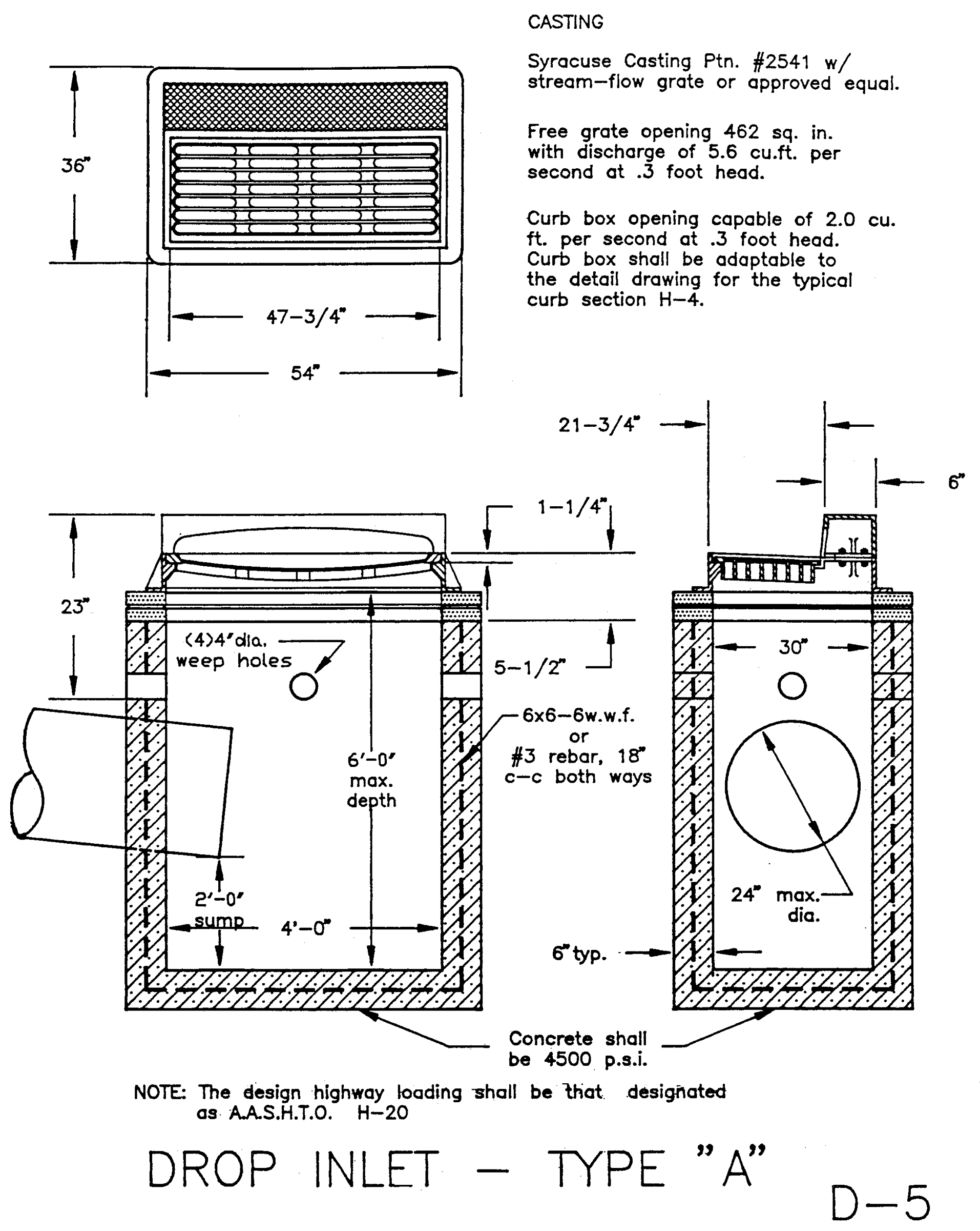
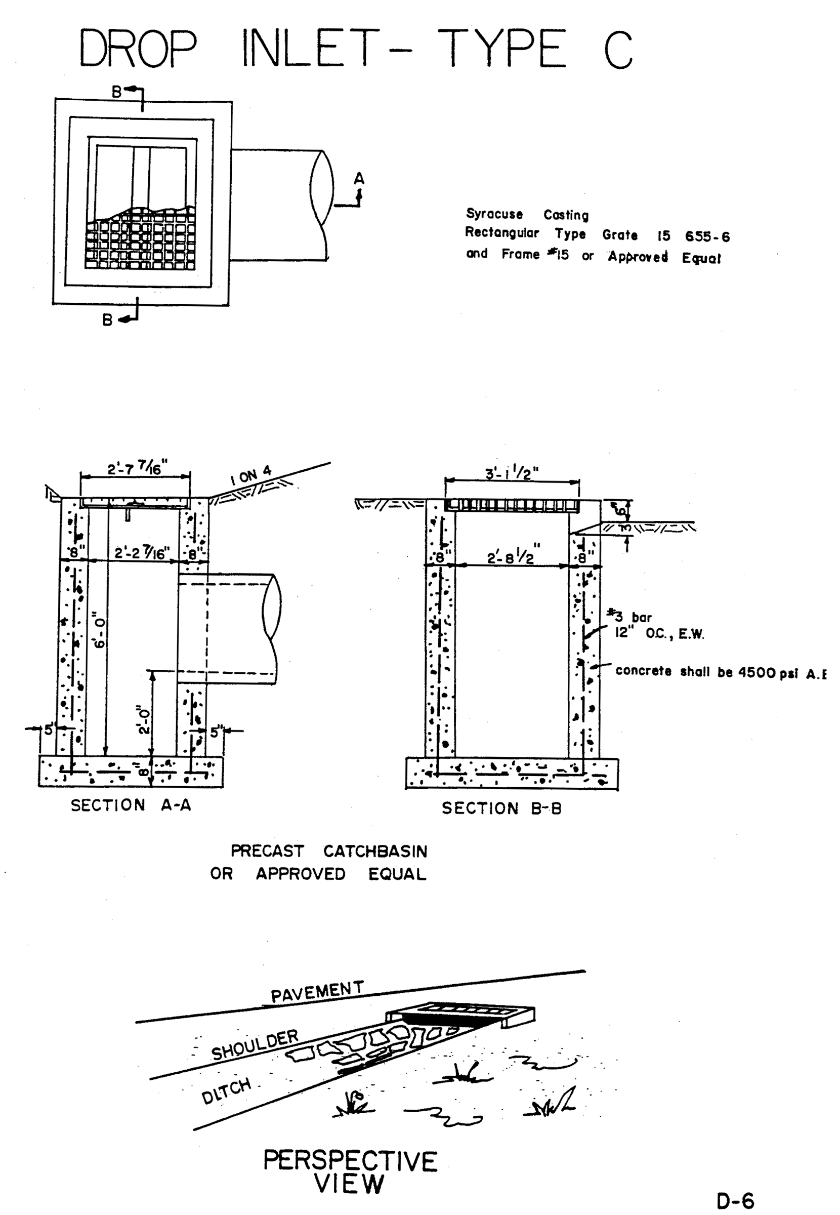
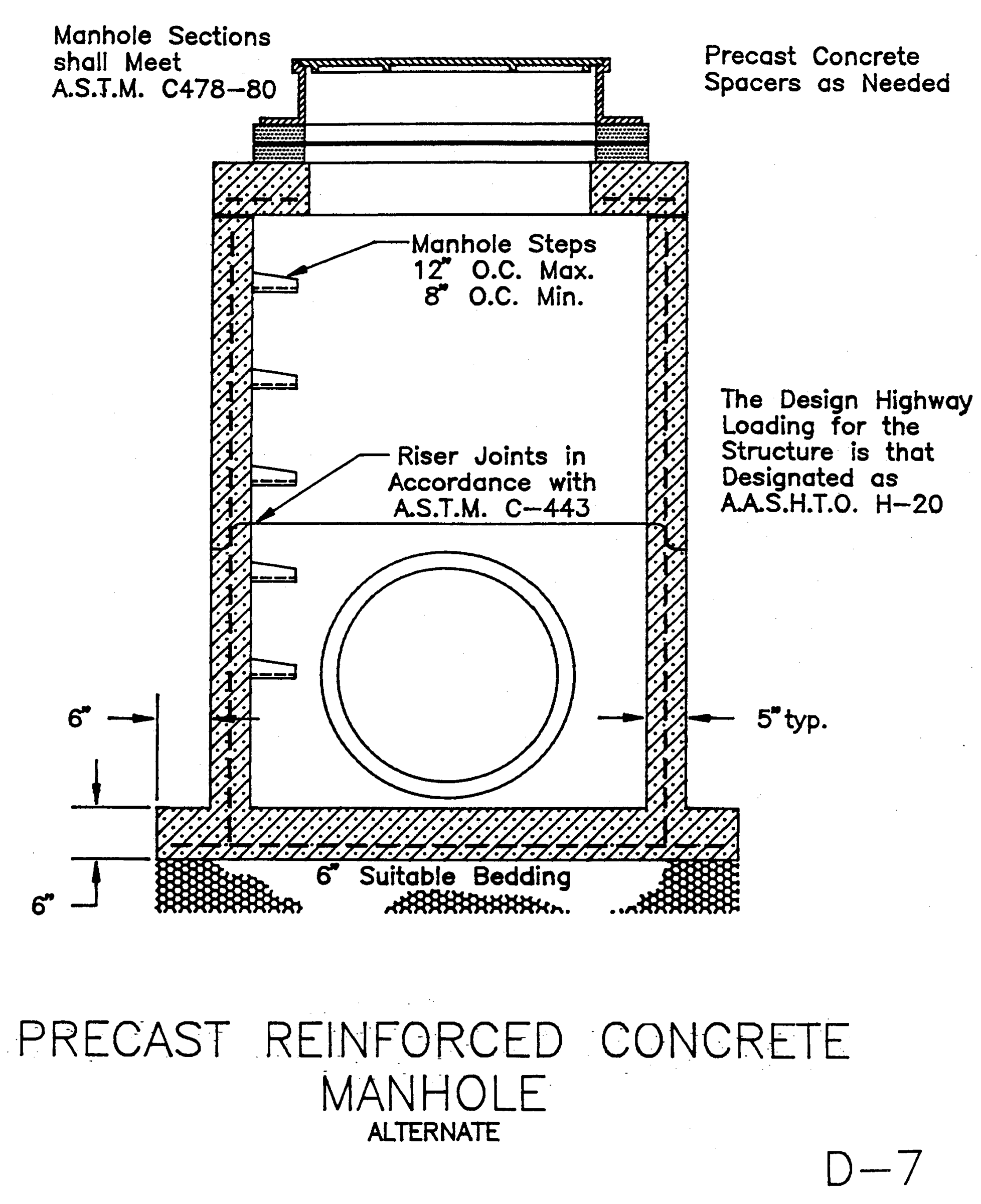
Drop inlets. All drop inlets shall be one of the approved designs presented in drawing nos. D-5 and D-6. They shall be indicated on the drainage plan by their identifying numbers. Standard manholes are presented on drawing no. D-7.
B-203.2.
All culverts shall be constructed of reinforced concrete pipe or shall be reinforced concrete box culverts. However, within highway rights-of-way minimum acceptable shall be A.S.T.M. C76-6DT table III.
(a)
Culverts shall have reinforced concrete headwalls similar to that shown on drawing no. H-6, unless another detail is approved for a specific installation.
(b)
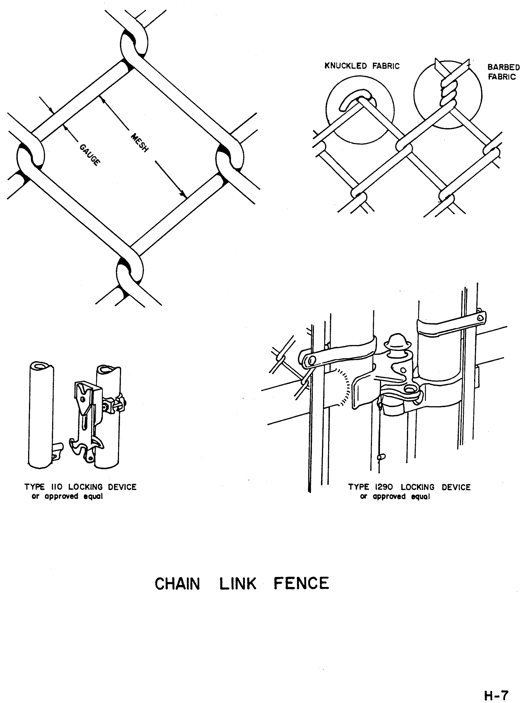
A chain link fence four (4) feet high, as shown on drawing no. H-7 shall be provided along the highway right-of-way line at the headwall on each end of the culvert and extending a minimum of four (4) feet beyond the top of the ditch or brook bank on each side of the headwall.
B-203.3.
Storm drain pipe. All storm drain pipe shall be reinforced concrete pipe unless waived. All pipe shall be laid on undisturbed subgrade with full firm and even bearing. Backfill and compaction shall be in accordance with good engineering practice. They shall be indicated on the final drainage plan with notations as to size, slope and invert elevations. Necessary easements shall be shown on the drainage plan and the final plat and shall be not less than twenty (20) feet wide.
(a)
Pipe eighteen (18) inches or less in diameter shall be of the bell and spigot type.
(b)
Pipe over eighteen (18) inches in diameter shall be of the tongue and grove type ("slip joint").
(c)
No pipe shall be smaller than fifteen (15) inches in diameter.
B-203.4.
Detention ponds.
(a)
Guidelines for detention pond design.
(1)
The method of design shall be in accordance with the Soil Conservation Service Technical Release 55 (TR55), June 1986 Edition.
(2)
Design shall be done by a NYS licensed professional engineer.
(3)
Use the following for:
Rainfall Distribution - Type II
Rainfall, P (24-hour)
2 year—2.8 inch
10 year—4.1 inch
25 year—4.9 inch
50 year—5.3 inch
100 year—5.9 inch
(4)
The outflow for 25-year storm event from the pond shall be less than or equal to the pre-development flow.
(5)
The overflow for the pond should be designed using the 100-year storm interval. A minimum of one-foot "freeboard" shall also be provided.
(6)
Size and length of the emergency spillway shall be designed for a 100-year storm event.
(7)
A state environmental conservation permit may be required if the following items are exceeded:
Over 10-foot high storage;
Storage of one million (1,000,000) gallons (3.07 acre/ft.);
Has a drainage area of one (1) square mile.
(b)
Guidelines for detention pond construction.
(1)
V-Notch weir type control structure shall be used, with steel grate provided on top of structure.
(2)
Bottom of pond shall have one (1) percent or greater slope.
(3)
Primary and auxiliary spillway shall have appropriate type rip-rap and energy dissipators installed.
(4)
A blacktop swale shall be provided between the inlet pipes and the outlet structure.
(5)
Slopes should be no steeper than one (1) vertical on three (3) horizontal with topsoil and seeding installed. Slopes can be built with one (1) on two (2); if a crown vetch type ground cover is provided.
(6)
A secured eight-foot gravel roadway should be provided for access to the control structure. An eight-foot-wide area should also be provided around the top of the pond, for use by maintenance equipment.
(7)
The access to and from all areas necessary for the maintenance of the pond shall be deeded to the town.
(8)
Depending on the location of the proposed pond, there may be a need to provide screening. If required, trees and bushes should be placed twenty-five (25) feet or more from any embankment.
(9)
All disturbed areas shall be topsoiled and seeded.
Sec. C-300. - Public utilities.
C-301.
Standards and procedure.
C-301.1.
All gas, sewer and water mains, electric, street lights and telephone lines shall be installed in accordance with the specifications of the agency, utility company or government authority or special district which has jurisdiction of the area. Location and depth should be in compliance with drawings H1, H2 and shown on public improvement and utility plan.
C-301.2.
A letter approving such a proposed installation and a statement as to who will carry out the construction signed by a responsible official of the agency, utility company or government authority or special district which has jurisdiction in the area shall be directed to the chairman of the planning board and shall be received prior to final plat approval.
Sec. D-400. - Inspections.
D-401.
Routine inspections.
D-401.1.
All improvements and utilities will be inspected by the town engineer's office to insure satisfactory compliance and completion.
D-401.2.
In no case shall any paving work be done without permission from the highway superintendent's office. At least three (3) days notice shall be given to the office prior to any such construction so that a representative of the town may be present at the time the work is to be done.
D-401.3.
The town engineer's office shall be notified three (3) days before each of the following phases of work has been started so that he or his representatives may inspect the work:
(a)
Utilities;
(b)
Storm drainage;
(c)
Curb and gutter forms;
(d)
Road paving.
D-402.
Final inspection. A final inspection of all improvements and utilities will be made to determine whether the work is satisfactory and in substantial agreement with the approved plat drawings and the town specifications.
The general condition of the site shall be also considered. Upon satisfactory final inspection, report action will be taken to release the performance guarantee covering such improvements and utilities.
Sec. E-500. - Street names.
E-501.
General rules for street names.
E-501.1.
Place. A street one (1) block long, a connecting link between two (2) longer streets or a dead end.
E.501.2.
Court, crescent or terrace. A loop street which begins and ends on the same street and is not otherwise connected with other streets or cul-de-sacs.
E-501.3.
Lane, path, street or way. Short residential streets which do not serve as secondary or feeder streets.
E-501.4.
Avenue, boulevard, drive or road. A secondary or feeder street.
E-501.5.
Continuation of street names. All existing street names shall be extended where proposed streets follow along their alignment.
E-502.
Historic or traditional street names. Such names shall be preserved even though the actual street alignment has been changed or the name does not agree with the provisions of this section.
E-503.
Duplication of street names. There shall be no duplicate street names within the town. Names shall be sufficiently different in sound and spelling in the town so as not to cause confusion.
E-504.
Approval of street names. Proposed names of streets or extensions of existing streets shall be submitted by the subdivider and shall be approved as part of the preliminary layout (subsection 404.10(a)(1)).
TABLE I
STREET CLASSIFICATIONS
D-1 Nomograph Overland Flow Time
D-2 Gutter Time of Concentration
D-3 Rainfall Curves
D-4 Drainage Computation Form
D-5 Drop Inlet Type A
D-6 Drop Inlet Type C
D-7 Precast Reinforced Concrete Manhole
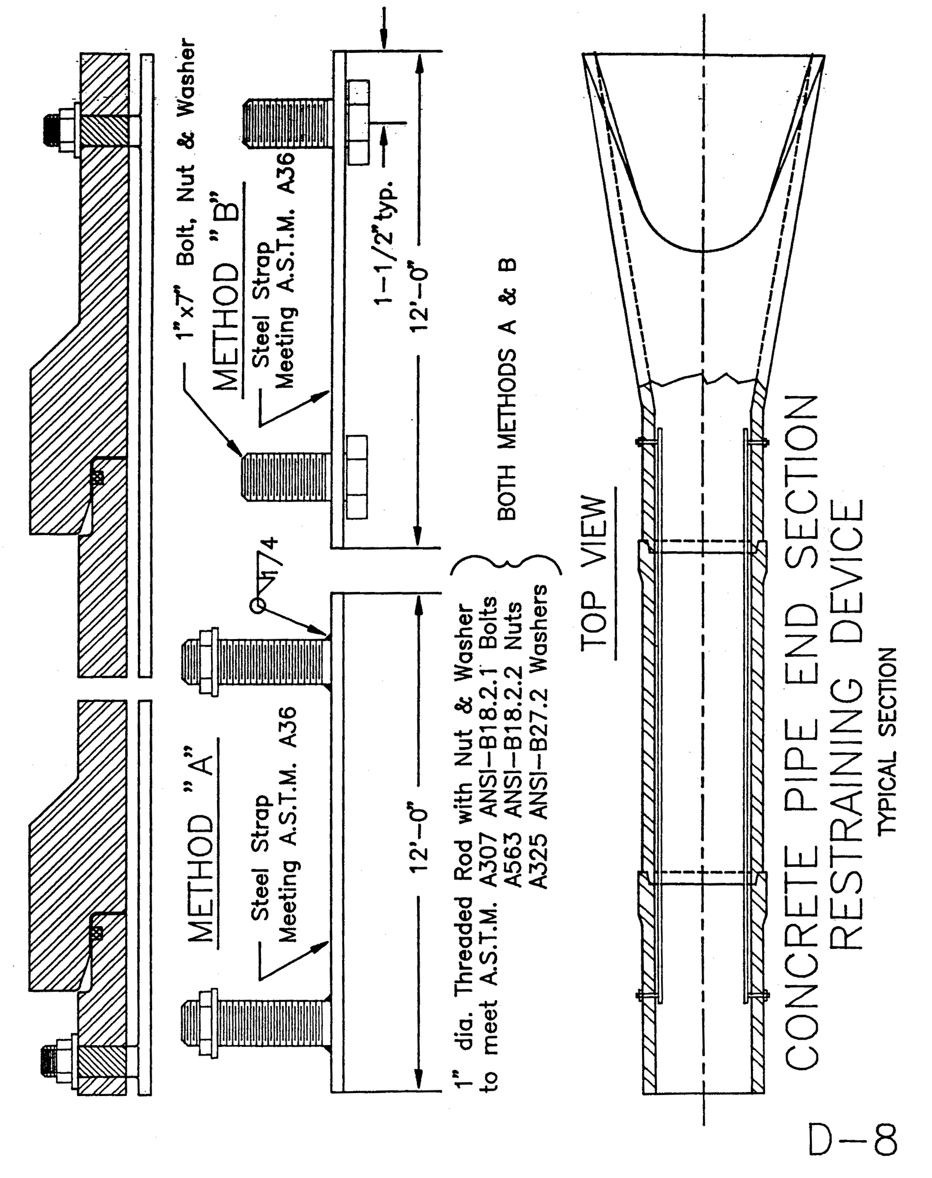
D-8 Concrete Pipe End Section Restraining Device
D-9 Detention Pond Inlet Structure
D-10 Detention Pond Detail
H-1 Typical Street Section, Minor Street
H-2 Typical Street Section, Major Street
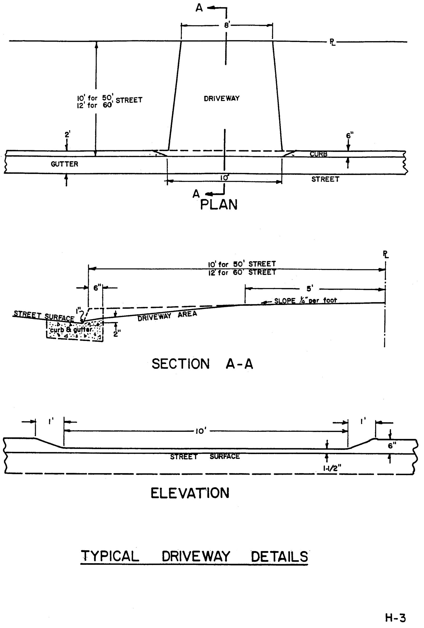
H-3 Typical Driveway Details
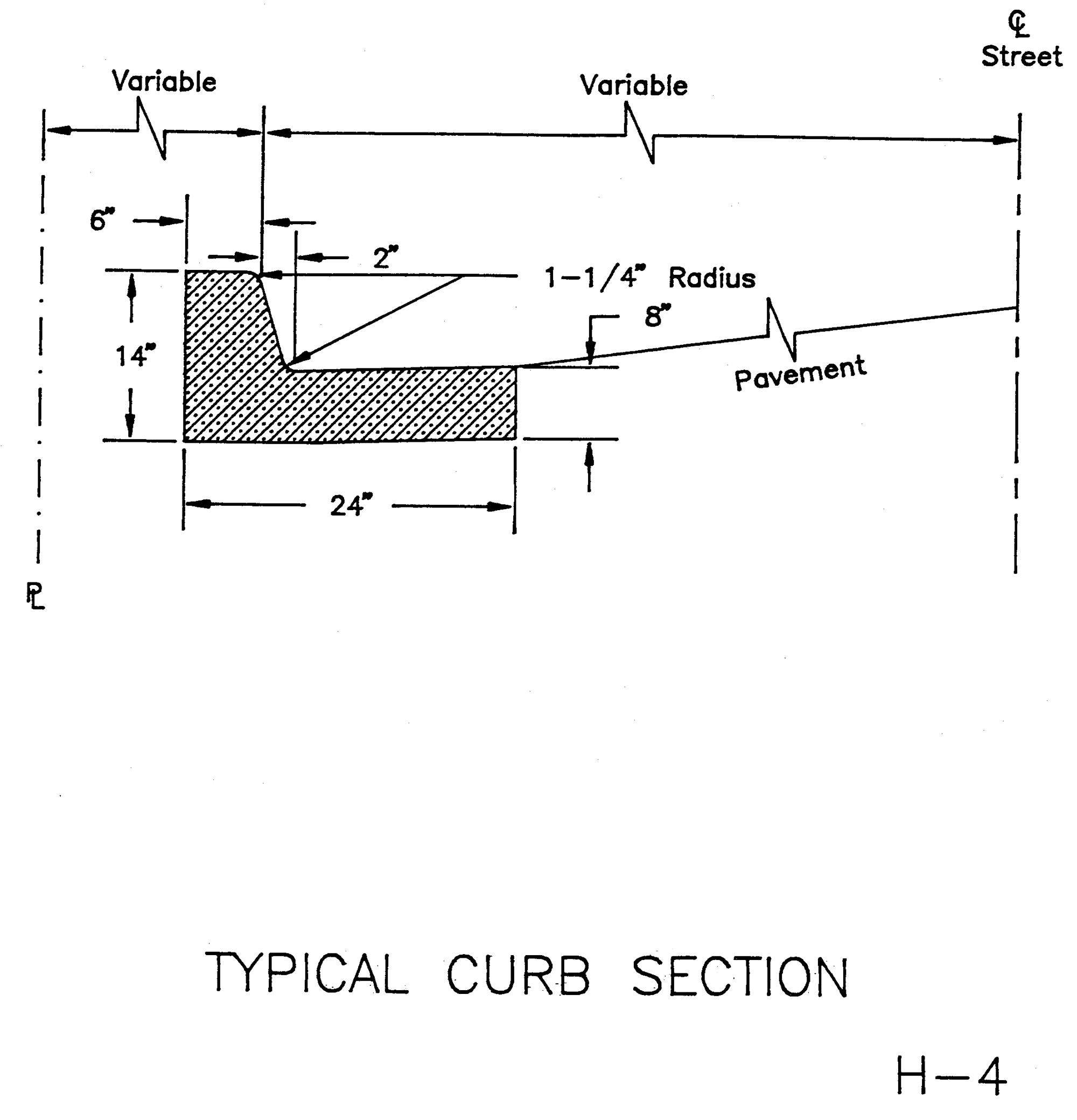
H-4 Typical Curb Section
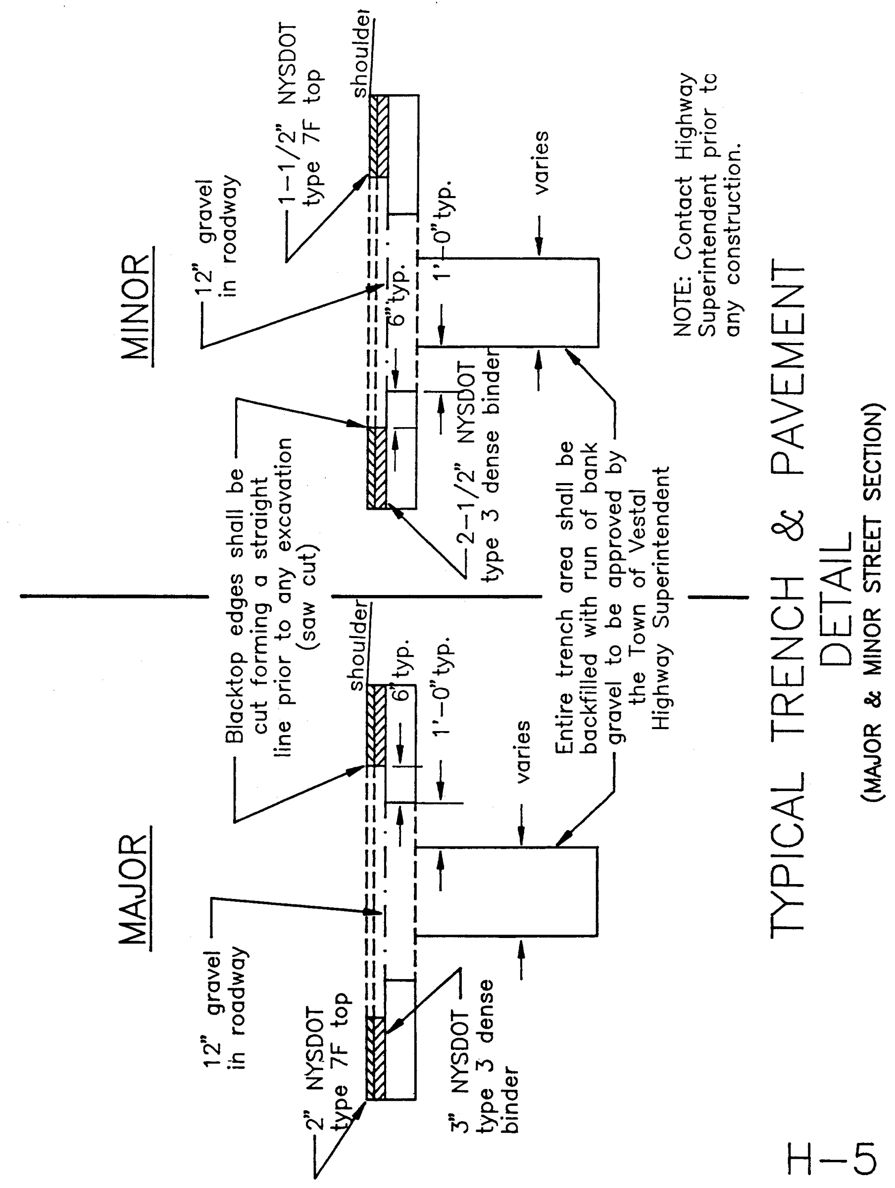
H-5 Typical Trench and Pavement
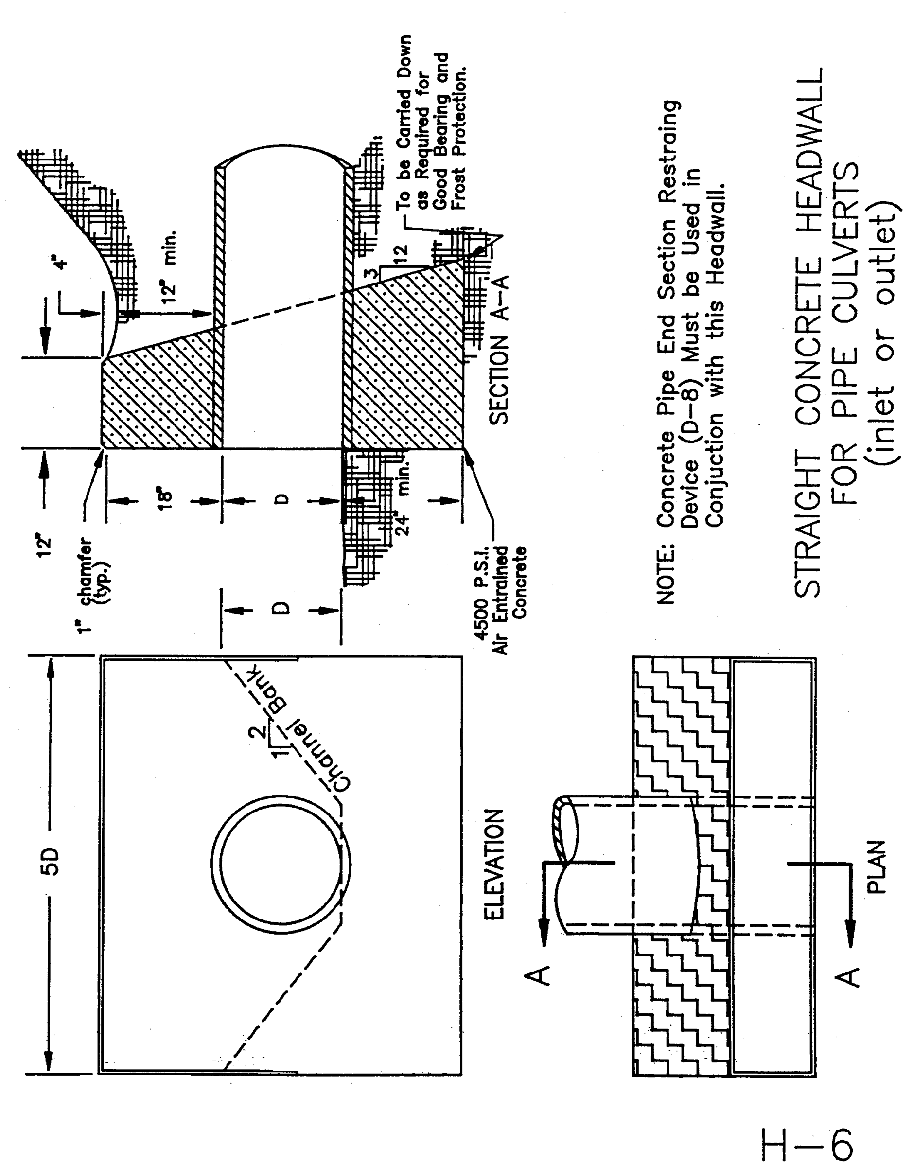
H-6 Straight Concrete Headwall for Pipe Culverts
H-7 Chain Link Fence

H-8 Sidewalk Ramp Type 1
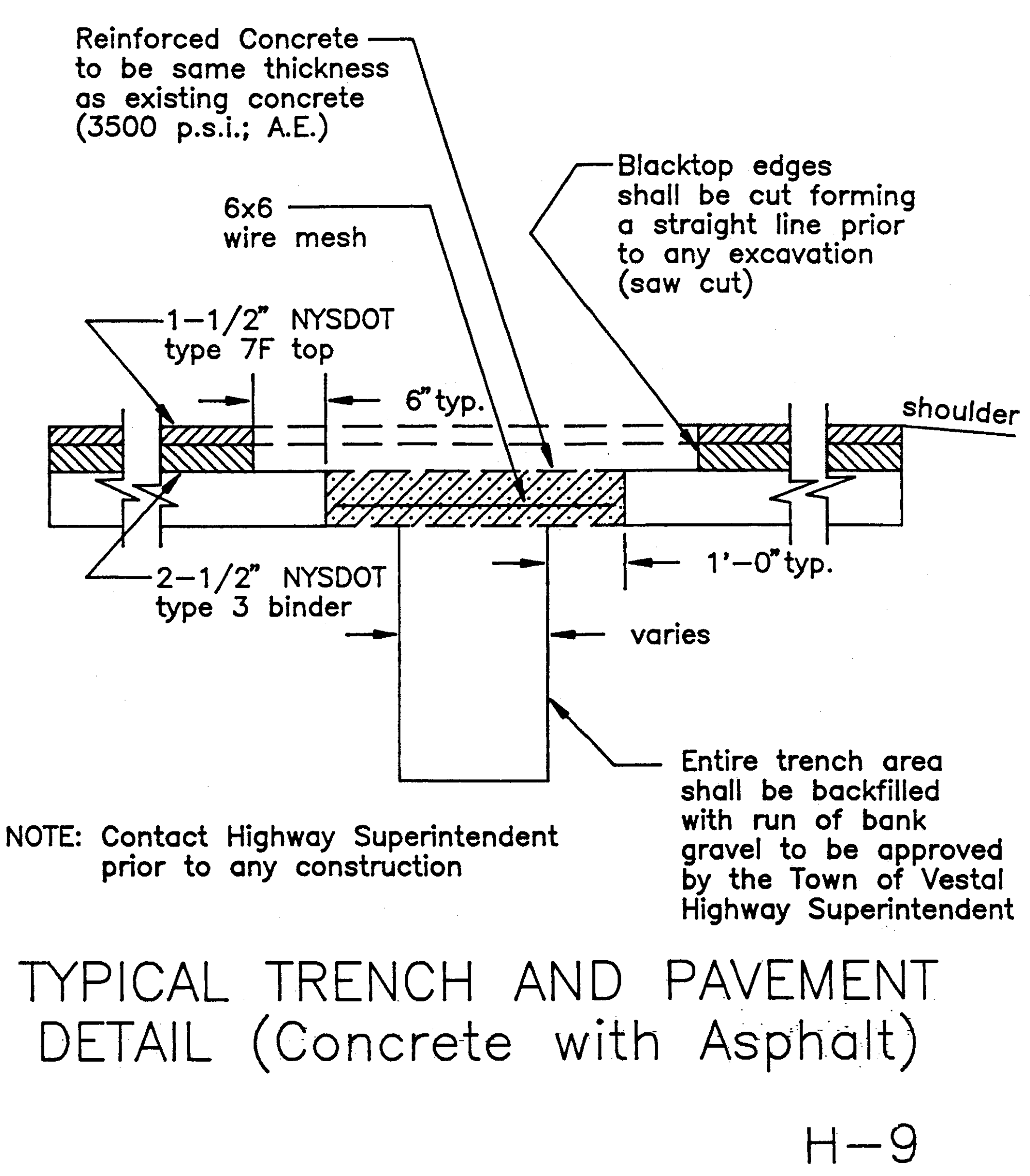
H-9 Typical Trench and Pavement Detail (Concrete with Asphalt)
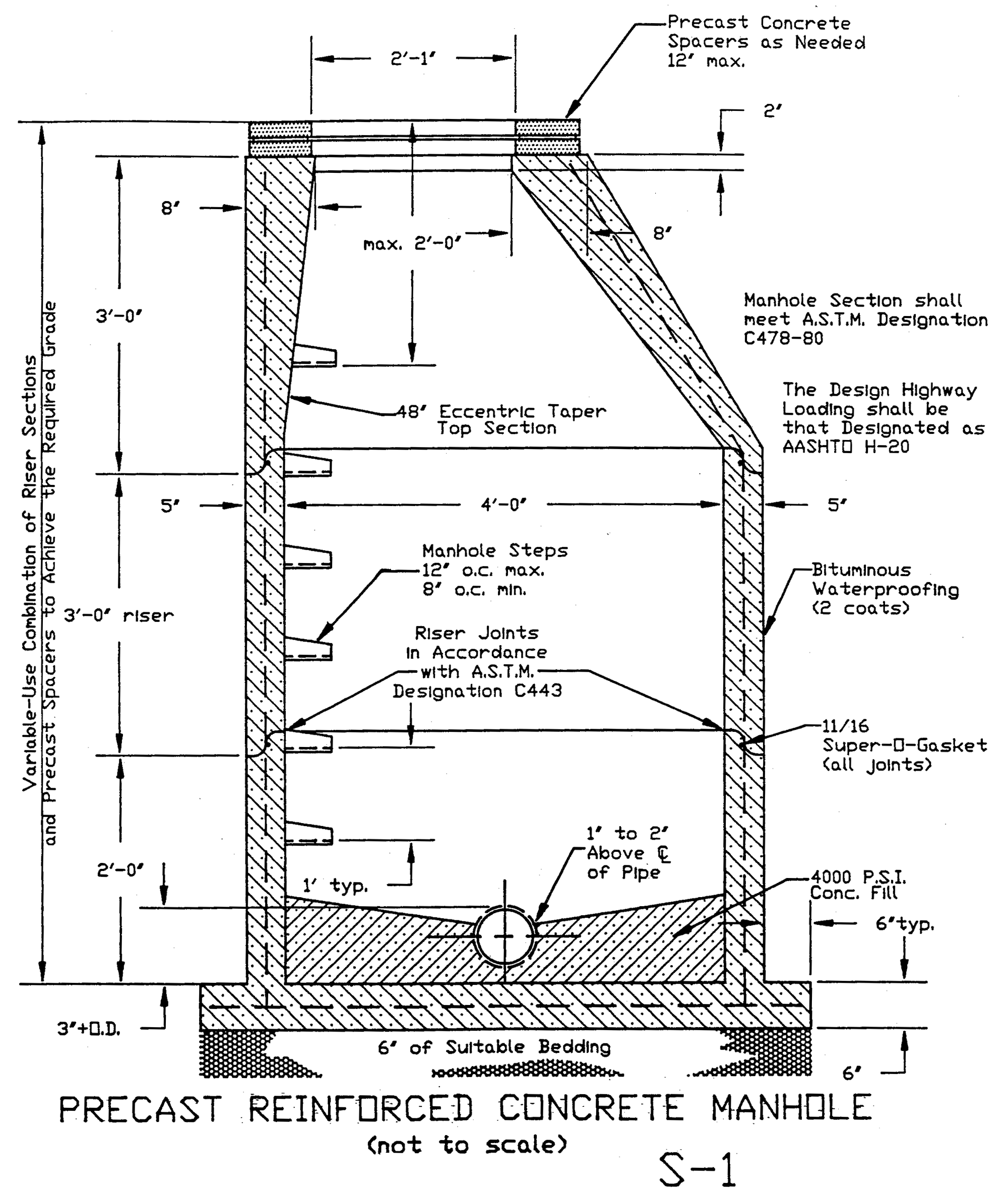
S-1 Precast Reinforced Concrete Manhole
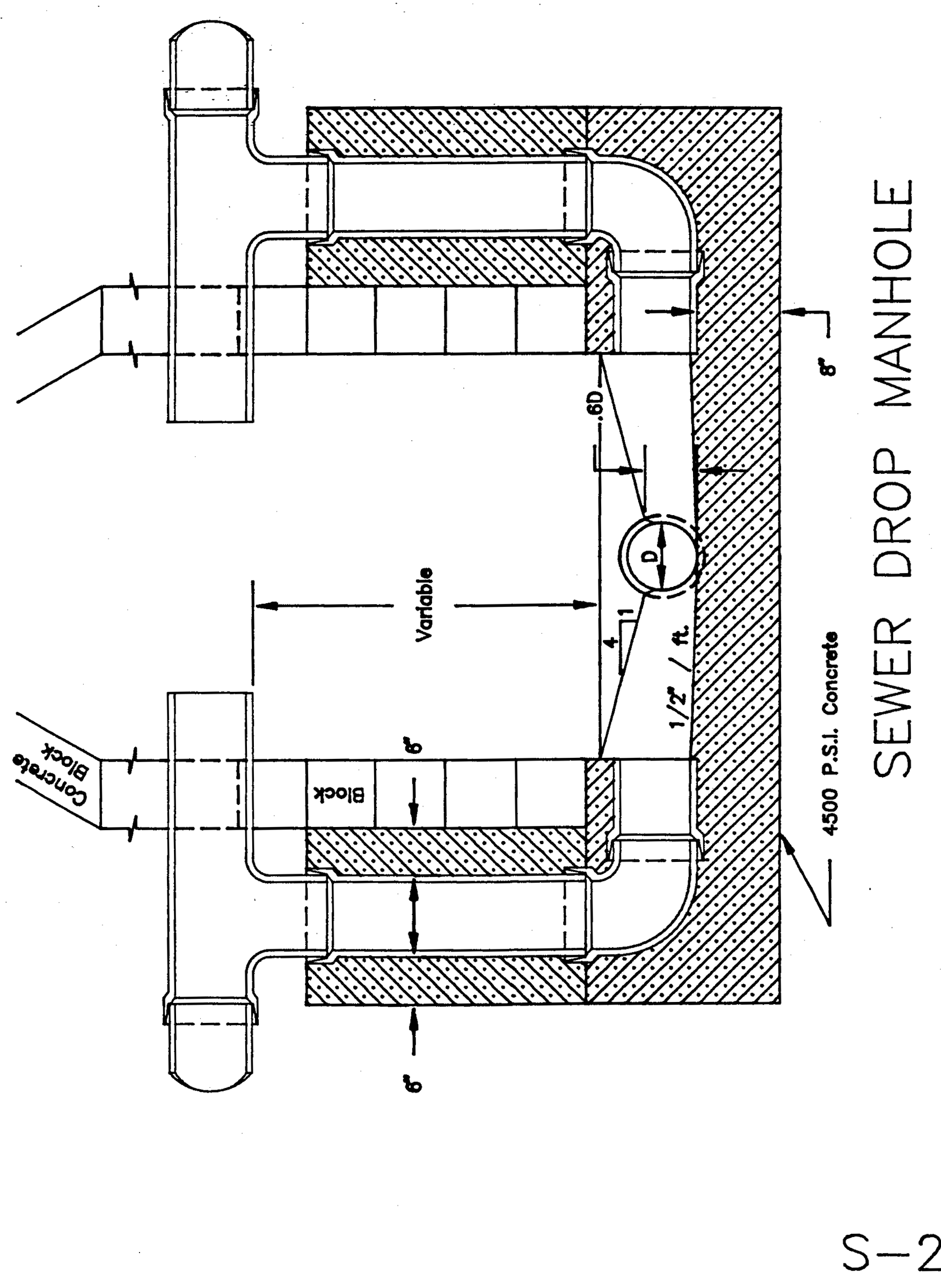
S-2 Sewer Drop Manhole
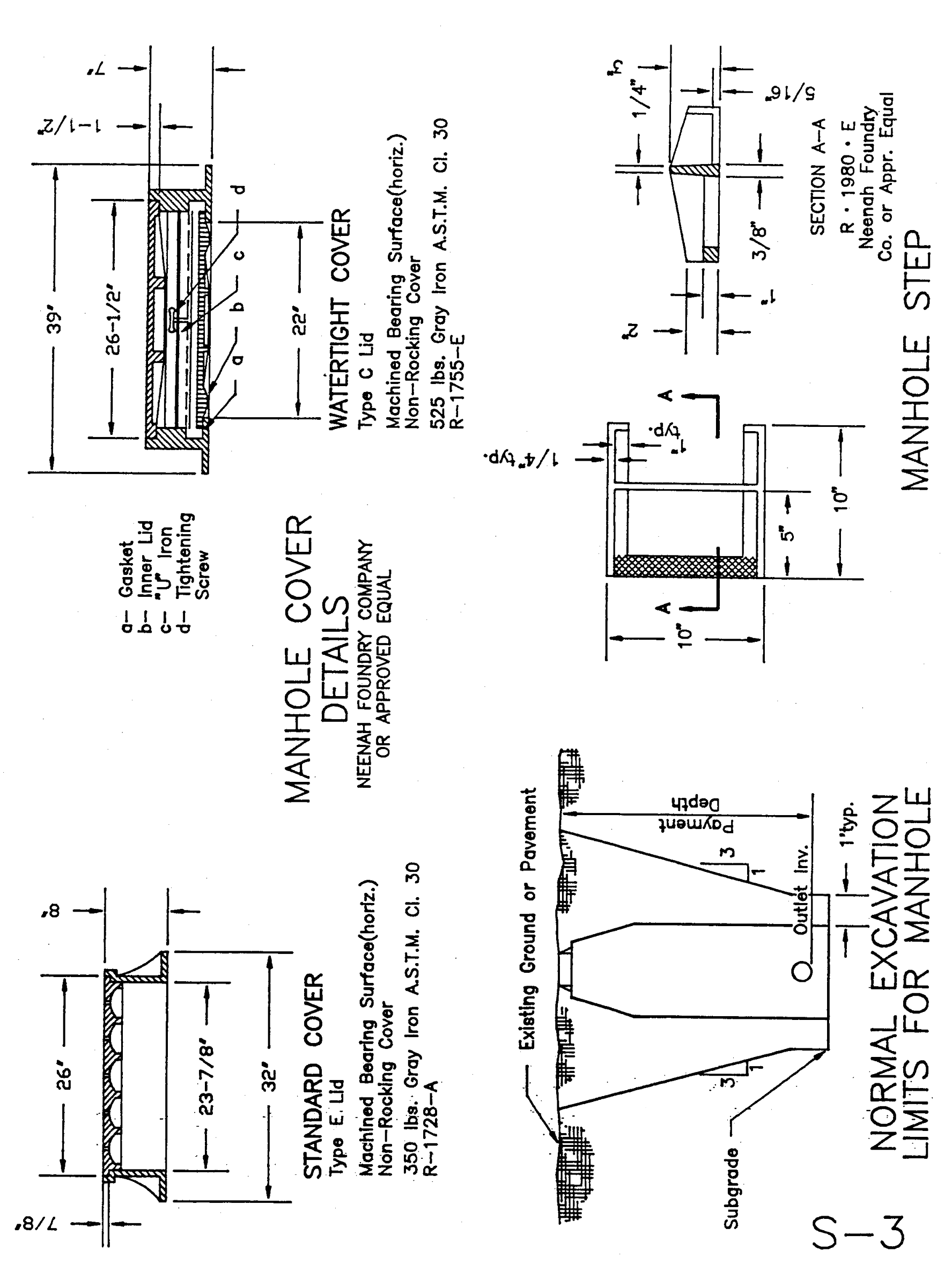
S-3 Manhole Cover Details
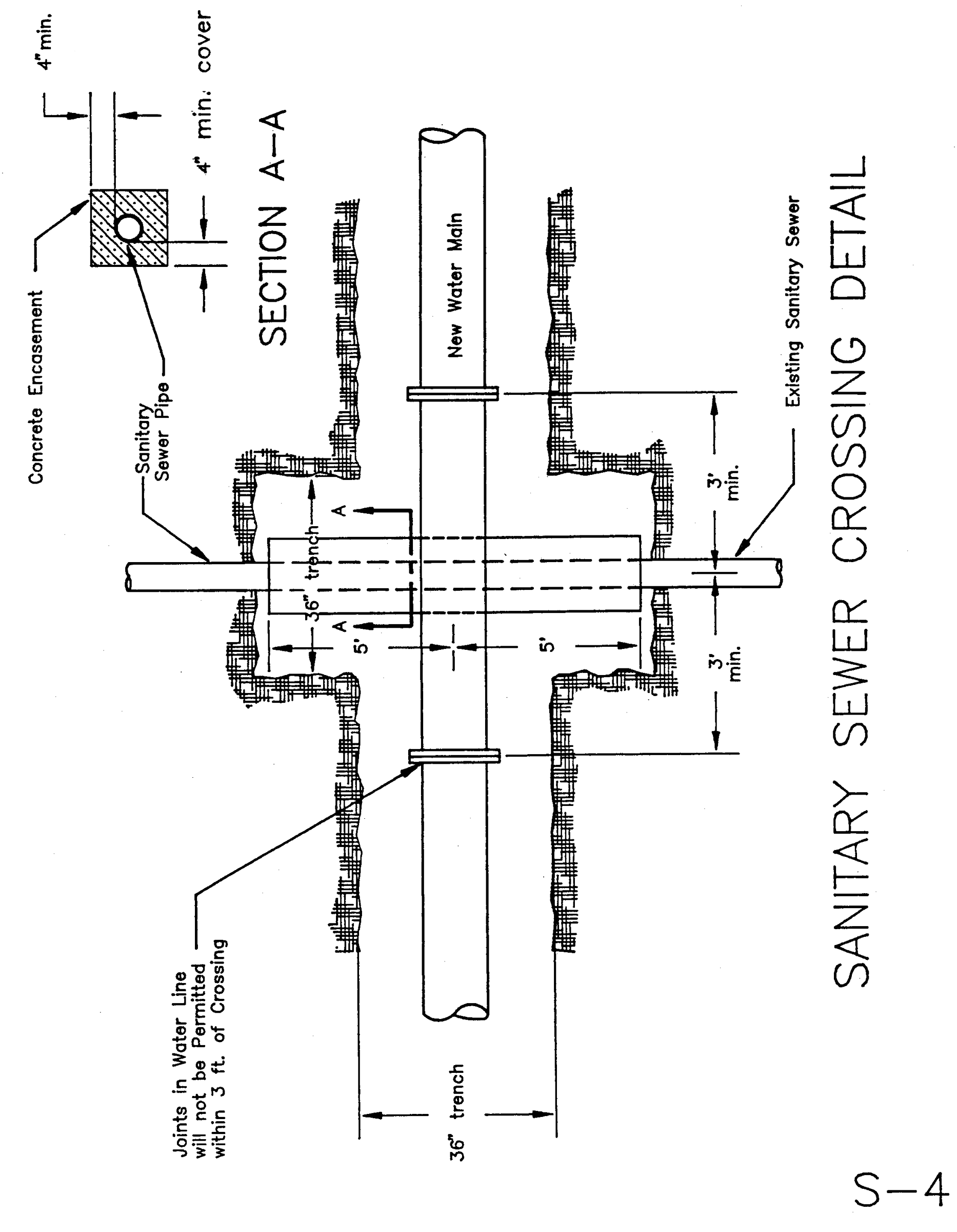
S-4 Sanitary Sewer Crossing Detail
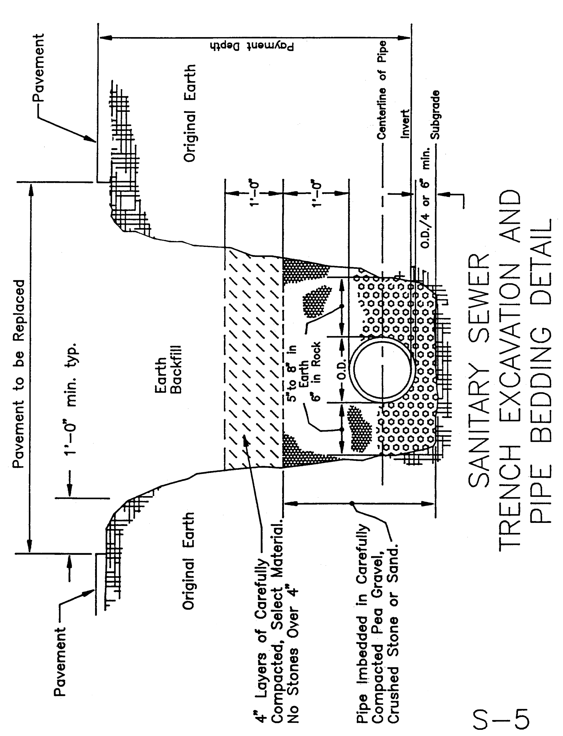
S-5 Sanitary Sewer Trench Excavation and Pipe Bedding Detail
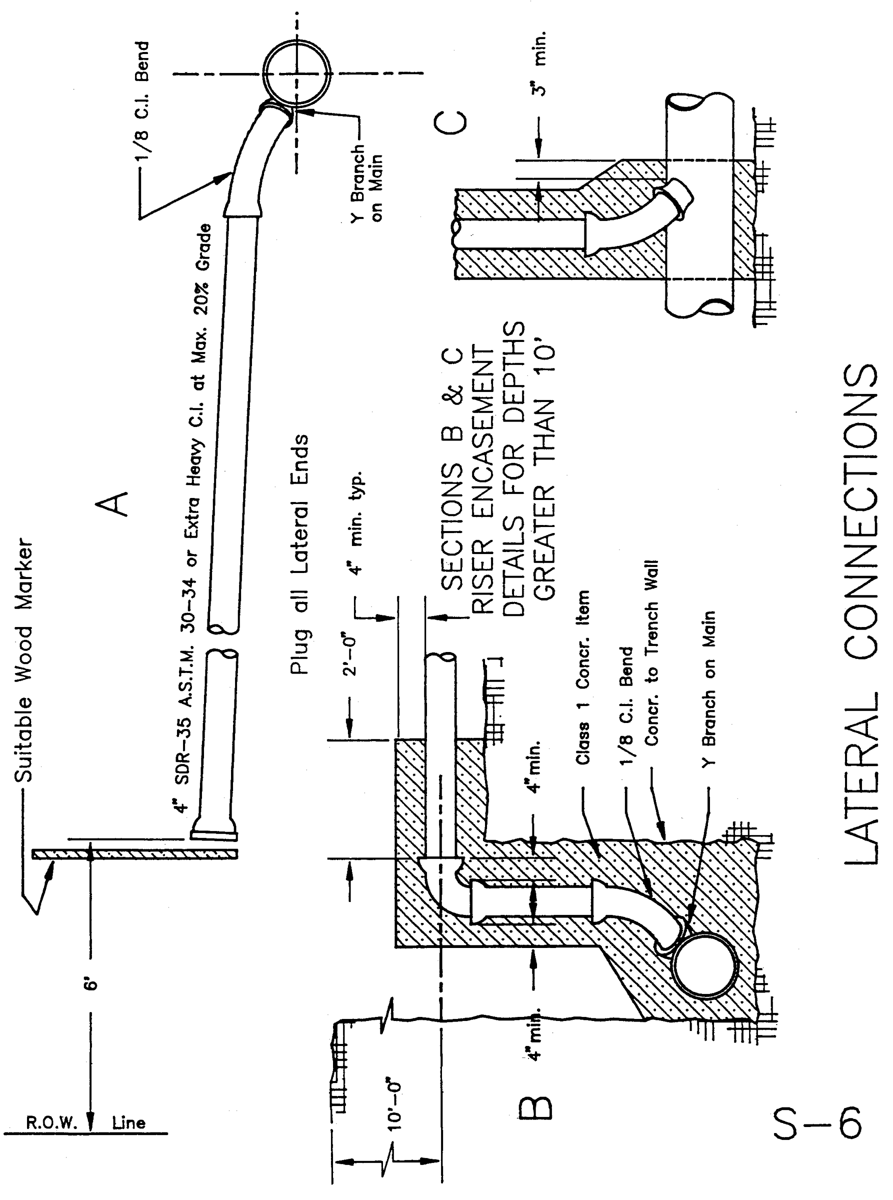
S-6 Lateral Connections
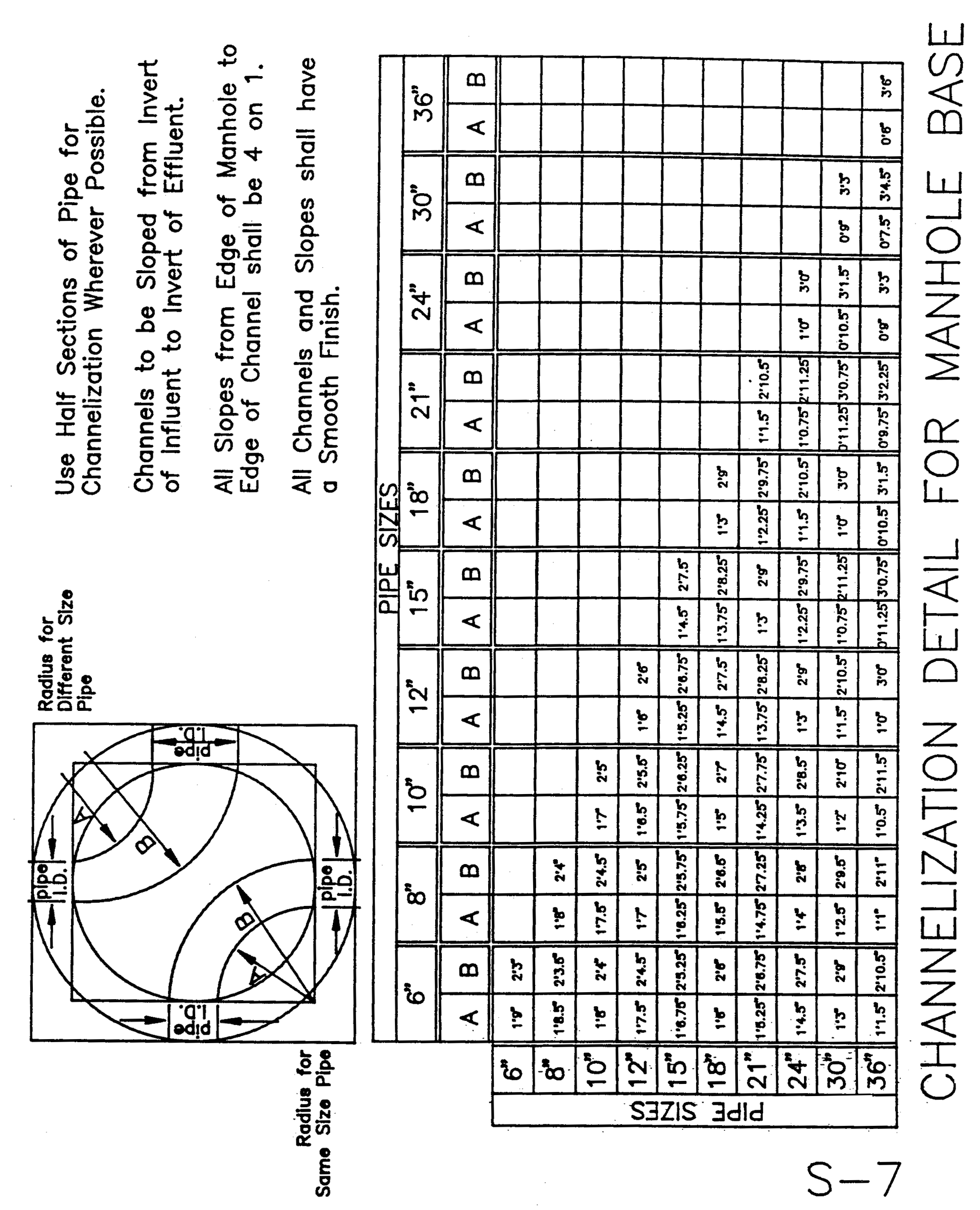
S-7 Channelization Detail for Manhole Base
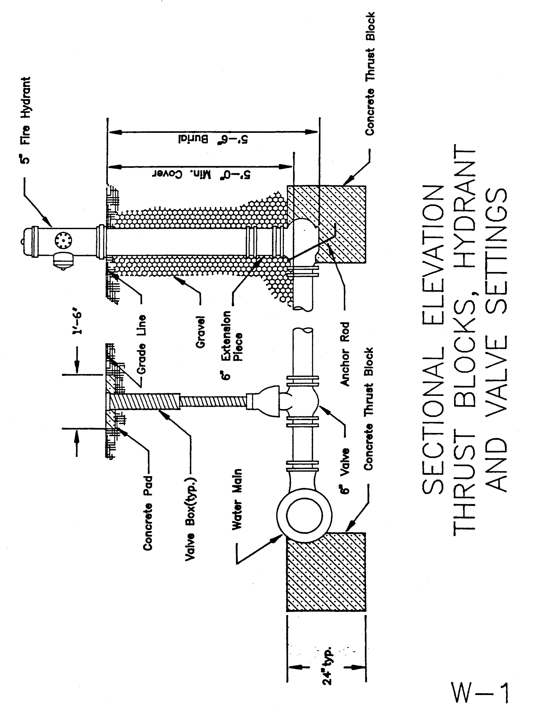
W-1 Sectional Elevation Thrust Blocks, Hydrant and Valve Settings
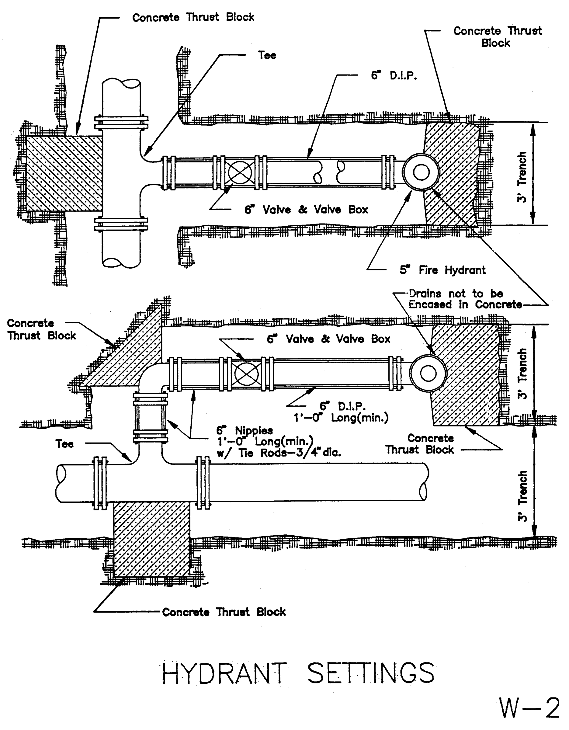
W-2 Hydrant Settings
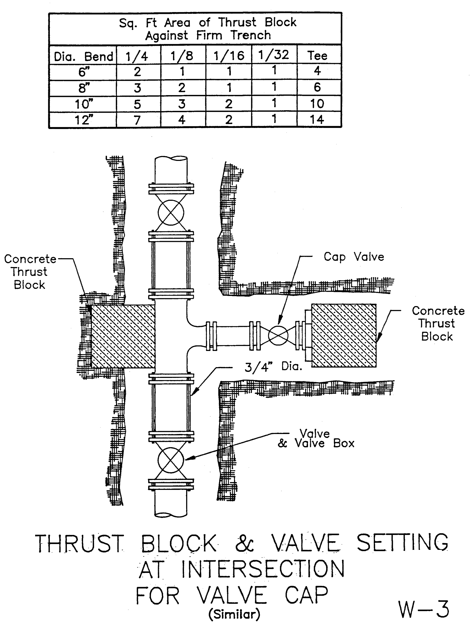
W-3 Thrust Block and Valve Setting at Intersection for Valve Cap
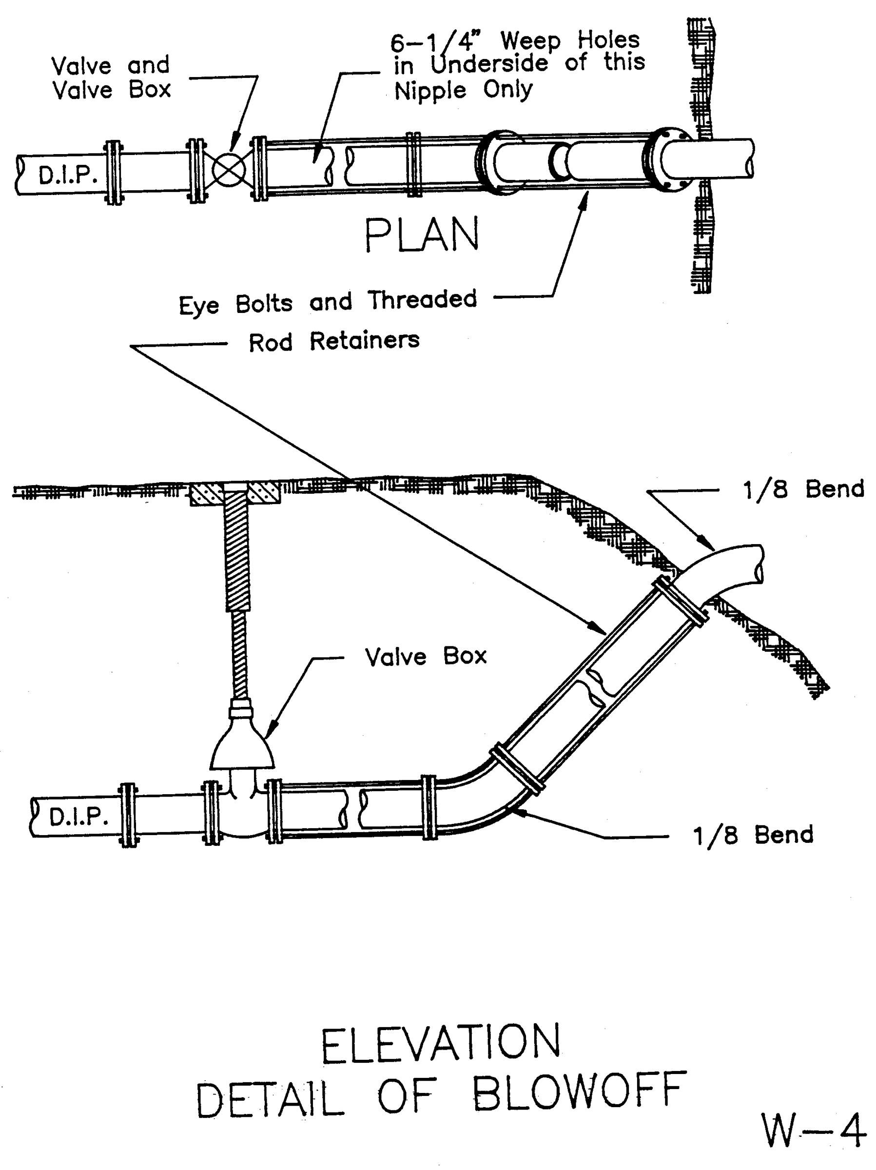
W-4 Elevation Detail of Blowoff
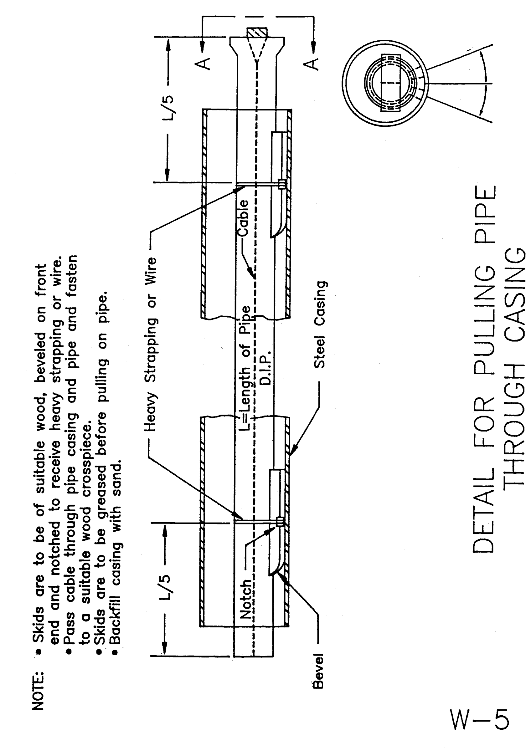
W-5 Detail for Pulling Pipe Through Casing
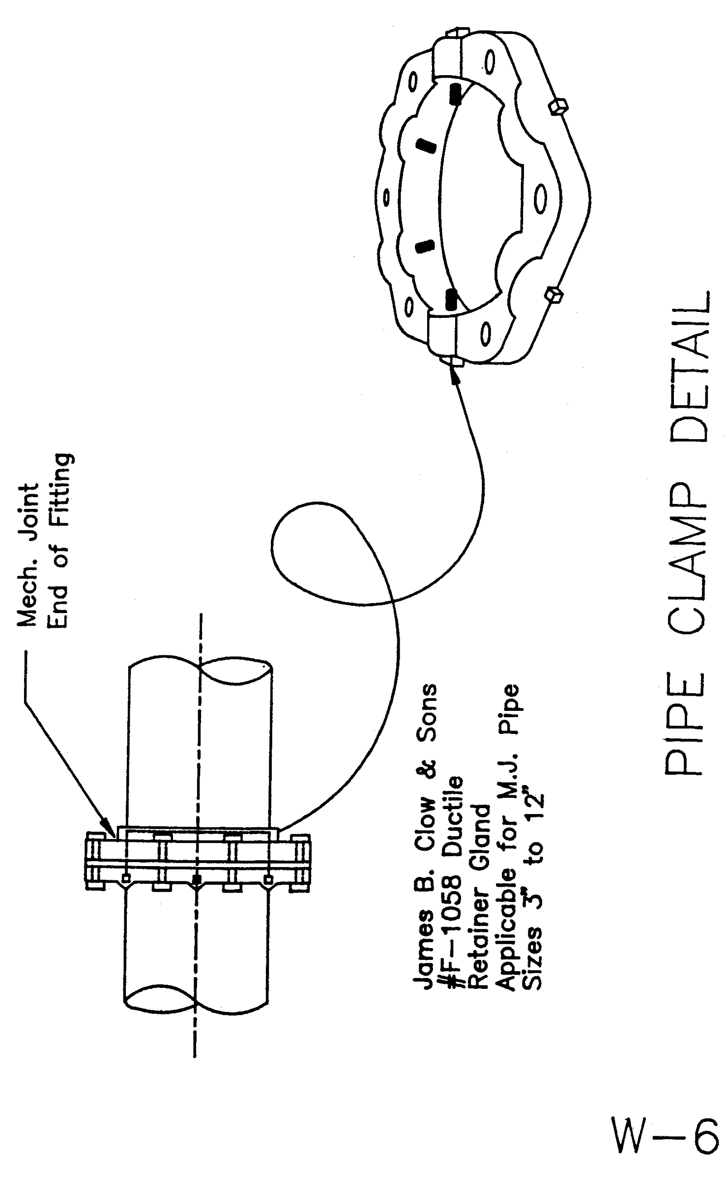
W-6 Pipe Clamp Detail
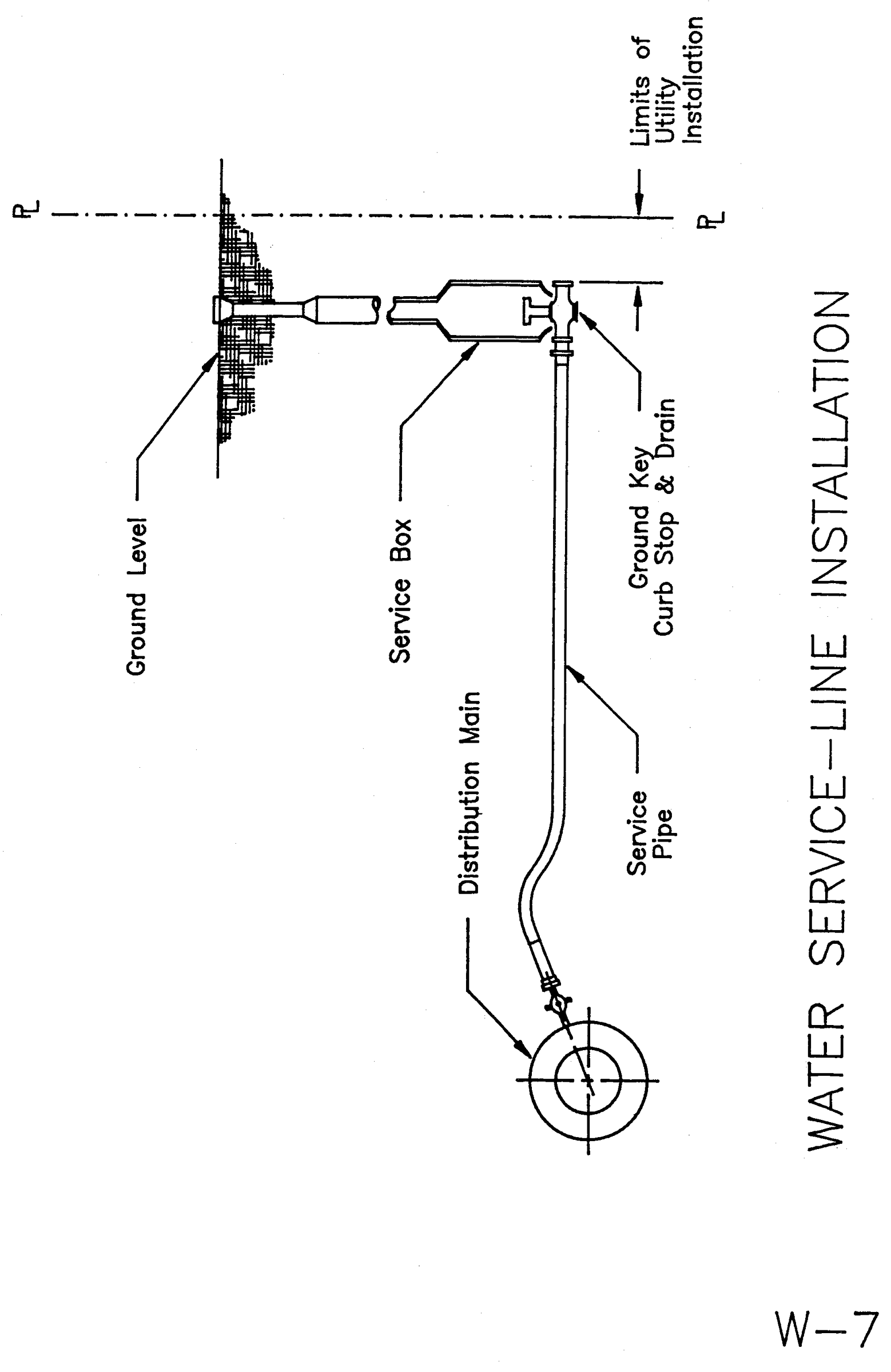
W-7 Water Service—Line Installation
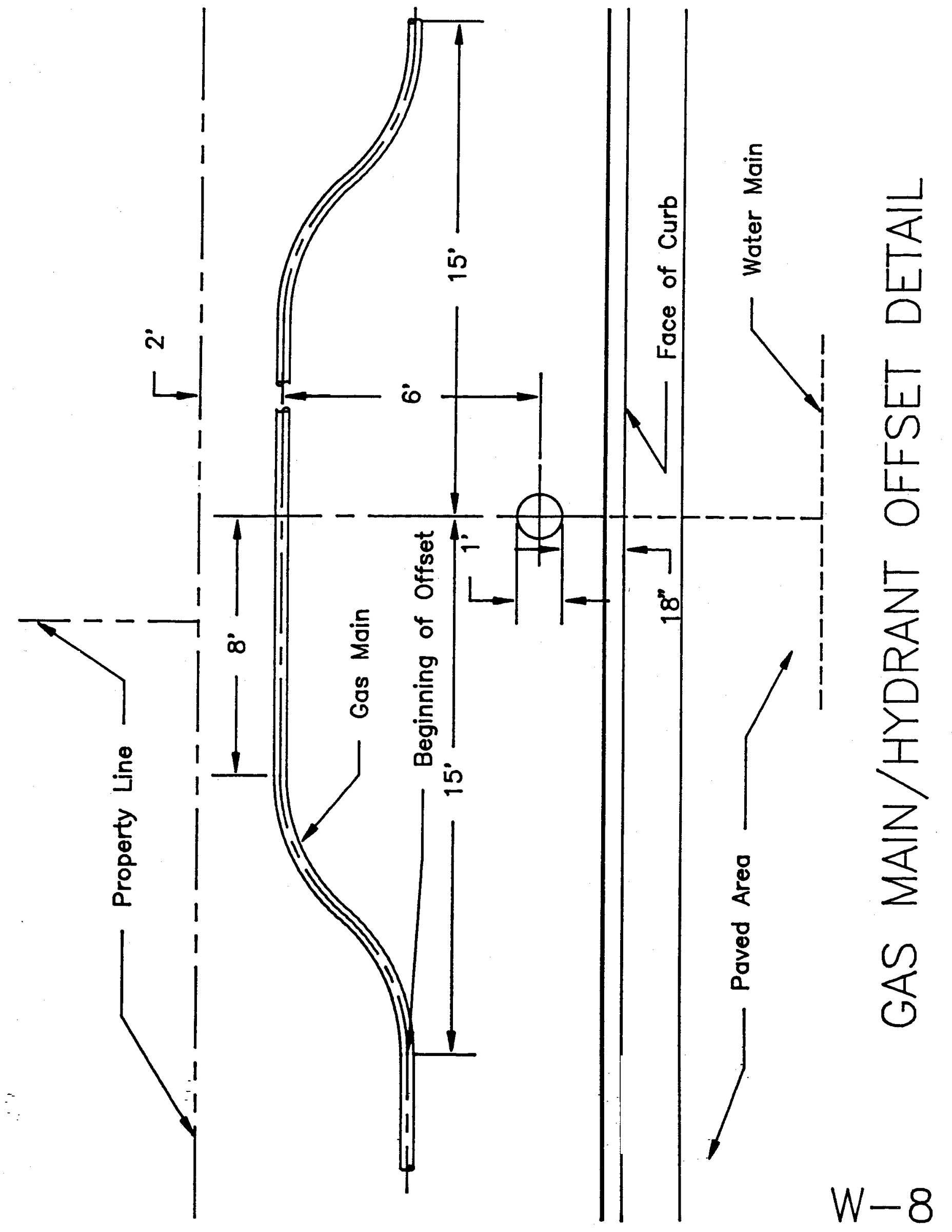
W-8 Gas Main/Hydrant Offset Detail
TOWN OF VESTAL
Vestal, New York 13850