
Victoria City Zoning Code
SECTION 18
ZONING DISTRICTS
Editor's note— Ord. No. 420, § 1, adopted July 24, 2017, repealed the former Art. III, §§ 109-51—109-75, and enacted a new Art. III as set out herein. The former Art. III pertained to similar subject matter and derived from Code 1975, §§ 404:01—404:03, 404:05, 404:06, 405:01.1, 405:01.3, 405:01.4, 405:02.1, 405:02.3; 405:02.12—405:02.17, 405:02.19, 405:02.21—405:02.26, 405:03—405:07, Code 1975, § 405:09, 406:01; Ord. No. 181, § 1, adopted March 27, 1992; Ord. No. 202, §§ 1, 3, adopted Aug. 23, 1994; Ord. No. 229, § 2, adopted July 18, 1996; Ord. No. 230, § 2(405:10), adopted Oct. 3, 1996; Ord. No. 231, § 1, adopted Dec. 10, 1996; Ord. No. 256, § 1, adopted July 24, 1997; Ord. No. 258, § 1, adopted Dec. 11, 1997; Code 1998, §§ 30-66—30-89; Ord. No. 299, §§ 1—6, adopted Oct. 10, 2002; Ord. No. 299.1, adopted June 26, 2003; Ord. No. 317, § 1, adopted March 25, 2004; Ord. No. 321, §§ 1, 2, adopted July 22, 2004; Ord. No. 414, adopted March 13, 2017.
Sec 18-1 Purpose
The purpose of this section is to provide for regulations, interpretations and exceptions set forth in this section that apply to all districts, unless otherwise specified.
(Ord. No. 420, § 1, 7-24-2017)
Sec 18-2 Establishment Of Districts
For the purpose of this Code, the city is hereby divided into zoning districts and potential districts which are hereby designated as follows:
| AG | Agriculture |
| RR | Rural Residential |
| LMR | Lake Minnetonka Residential |
| S | Shoreland Overlay District |
| R-1 | Low Density Residential District |
| R-1A | Old Town Residential District |
| R-2 | Two Family Residential District |
| R-3 | Multi-family Residential |
| R-4 | High Density Residential |
| C-1 | Neighborhood Commercial District |
| C-2 | Community Commercial District |
| CBD | Central Business District |
| I-1 | Industrial District |
| P-1 | Parks and Open Space District |
(Ord. No. 420, § 1, 7-24-2017; Ord. No. 474, 10-14-2024; Ord. No. 484 ZC, 10-13-2025)
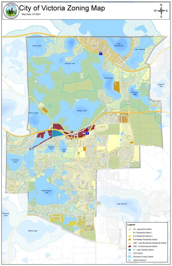
Sec 18-3 Zoning Map
The boundary of each district is indicated upon the zoning district map of the city which is entitled "City of Victoria Zoning Map" and is part of this section. If changes are made in district boundaries after the adoption of the ordinance, changes will be made to the zoning map and will be part of this section.
(Ord. No. 420, § 1, 7-24-2017)
Sec 18-4 Annexations
All territory annexed to the city, which is not shown on the zoning map as part of section 18-3 shall automatically be classified within the AG agriculture district and is subject to all regulations, notations, references and conditions applicable to such zone until such time a determination is made as the proper district, classification and amendments made to that effect.
(Ord. No. 420, § 1, 7-24-2017)
Sec 18-5 Zoning Of Streets, Alleys, Public Ways And Railroad Rights-Of-Way
All streets, alleys, public ways and railroad rights-of-way, if not otherwise specifically designated, will be deemed to be in the zoning classification as the property with the most restrictive classification immediately abutting the alley, street, public rights-of-way, or railroad right-of-way. Where the centerline of a street, alley, public way or railroad right-of way serves as a district boundary, the zoning of such areas, unless otherwise designated, will be deemed to the classification of the abutting property up to the centerline.
(Ord. No. 420, § 1, 7-24-2017)
Sec 18-6 Boundary Lines
Wherever any uncertainty exists related to the boundary of any district as shown on the zoning map, the following rules apply:
- Where district boundary lines are indicated as approximately following lot lines or section lines, such lines shall be construed to be boundaries.
- Where a lot held in one ownership and of record at the effective date of the ordinance from which this SECTION derives is divided by a district boundary line, the entire lot shall be construed to be within the less restrictive district, however, that this construal shall not apply if it increases the area of the less restrictive portion of the lot by more than 20 percent.
(Ord. No. 420, § 1, 7-24-2017)
Sec 18-7 Lots Of Record
Lots of record prior to the adoption of this Code or prior to annexation to the city but existing with less than the lot area required in the zoning district in which it is located or not having frontage on a public street will be considered a buildable lot provided:
- The lot width and lot depth meets at least two-thirds of the requirements as outlined by the district regulations
- No variance shall be required to construct a detached single-family dwelling on a nonconforming lot of record provided that it fronts on a public street or approved private street filed with the county provided the structure meets the minimum requirements of this Code.
(Ord. No. 420, § 1, 7-24-2017)
Sec 18-8 Residential Performance Standards
The following performance standards will be met for construction in each corresponding district. All manmade architectural, landscape, and paving materials shall reflect the highest quality possible and should be used in a manner suitable to the nature of the material, its role in the design, general durability, expected level of use or abuse, weathering characteristics, and ease and frequency of maintenance. The following materials or equivalent materials are acceptable:
- Residential:
- Brick.
- Stone (natural or artificial).
- Wood, natural or composite, provided the surfaces are finished for exterior use or wood of proven exterior durability is used, such as cedar, redwood or cypress.
- Stucco.
- Recyclable grades of vinyl, and finished steel or aluminum.
- Fiber cement board.
- No garage, tent, accessory building, or motor home shall at any time be used as living quarters, temporary or permanently.
- Basements and cellars may be used as living quarters or rooms as a portion of the principal residential dwelling.
- Agriculture:
- Buildings where wood poles or timbers are the primary support for the roof system and form the foundation structure, provided that wood foundations are permissible (pole buildings) only in the agriculture district.
- Prohibited materials in all districts include:
- Face materials which rapidly deteriorate or become unsightly such as galvanized metal, unfinished structural clay tile and metal panels not factory finished with a permanent surface.
- Building comprised exclusively of metal.
- Sheet metal, plastic or fiberglass siding, unless such siding is a component of a factory fabricated and finished panel.
(Ord. No. 420, § 1, 7-24-2017)
Sec 18-9 Fences
- Residential zoning districts.
- Construction, maintenance and design requirements:
- Fences shall be constructed with substantial, workmanlike quality;
- Shall be a single color;
- Shall not be constructed in a manner which blocks the flowage of stormwater;
- Fence framing must face inward on the fence owner's lot.
- Fences shall be made of only the following materials:
- Chain-link, with a minimum gauge of 11 and without plastic or other slats or coverings;
- Treated wood; painted or stained;
- Composite materials;
- Vinyl; free of holes, cracks, and damages;
- Wrought iron;
- Iron; and
- Aluminum.
- Placement:
- All fences shall be located entirely upon the private property of the person constructing the fence;
- Except, adjacent property owners can approve fences to be placed on the property line.
- Except, adjacent property owners can approve fences to be placed on the property line.
- Fences and retaining walls shall not be permitted in any easement without the approval of the easement holder;
- Shall be no closer than six and one-half (6 1/2) feet to any sidewalk or trail;
- Shall be no closer than six (6) feet to any city stormwater mains;
- Shall be no closer than twenty (20) feet to any city sanitary sewer mains or city water mains;
- Shall not be placed within the vision clearance triangle of any intersection;
- Shall not be placed in a manner which creates a hazard for motorists or pedestrians; and
- Shall not be placed in a manner which permits or causes damage to adjacent property including public and private property.
- All fences shall be located entirely upon the private property of the person constructing the fence;
- Height restrictions and permit requirements:
- Front yard - four (4) feet maximum with a zoning permit;
- Side yard - seven (7) to eight (8) feet in height with a building permit; less than seven (7) feet in height with a zoning permit.
- Rear yard - seven (7) to eight (8) feet in height with a building permit; less than seven (7) feet in height with a zoning permit.
- All permits must provide the location, material, height, gate locations, and dimensions of the proposed fence on a property survey for review and approval by the city.
- Fences located on residential properties shall not have any sign affixed to the exterior of the fence.
- Fences shall be prohibited from using any inserts or coverings which are not structurally required for the operation of the fence, except for post caps.
- Construction, maintenance and design requirements:
- Nonresidential zoning districts.
- All fences shall be located entirely upon private property of the property owner. A fence may be allowed on the property line with written permission of all the adjacent property owners.
- Screening of outdoor areas require a fence at least six (6) feet but not more than eight feet (8) in height.
- Fences between seven (7) feet and eight (8) feet in height require a building permit and engineer's design. Fences less than seven (7) feet in height require a zoning permit. Fences over eight (8) feet in height are not permitted.
- Fence materials will be compatible (similar materials, colors, and scale) with the principal building and shall be compatible with the natural surroundings.
- Fencing may be required at locations where commercial or industrial uses are adjacent to or across the street from property zoned or developed for residential or public use.
- Plant materials approved by the city may also be required in addition to, or in lieu of, fencing.
- Fences are required to have a 15-foot setback from any street or driveway opening onto a street.
- The fence shall be placed along the property lines. In the case of landscape screening, landscaping shall be placed five (5) feet off the property line.
- Fence maintenance.
- All fences shall be maintained to be structurally sound, safe, and in good repair. Every fence and immediate surrounding premises shall be maintained by the owner or person in charge thereof in a clean, sanitary, and inoffensive condition and free and clear of all obnoxious substances, rubbish, and weeds.
- All fences shall be properly surface-coated and all surfaces and supports shall be properly painted and maintained.
- All fences which are unsafe, dangerous, or unsightly shall be repaired or removed. Unsafe or dangerous fences shall be removed or otherwise properly secured by the property owner or fence owner upon receipt of notice to do so by the city. Any abandoned, unsafe, or illegal fences is declared to be a danger to the health, safety, and welfare of the citizens of the city and is declared to be a public nuisance subject to abatement and assessment, except that legally established nonconforming fences shall not be abated until they have been abandoned for more than one year.
- Nonconforming fences.
- All nonconforming fences shall be brought into compliance within 60 days of a change in the principal business use of the property.
- Any business or property with fences not in compliance with the standards of this section, but which were in place legally on the date of the adoption of this section, may retain such fences as legal nonconforming uses. Such fences shall be maintained in accordance with the maintenance, safety, and other standards set forth herein. Any significant change in the size, shape, design, or materials of the fences, as determined by the zoning administrator, shall be in conformance with all standards of this section. \
- Any nonconforming temporary or portable fences existing at the time of adoption of this article shall be made to comply with the requirements set forth or shall be removed within one year after the adoption of this article.
- Prohibited fences.
- No fence shall contain any obscene matter as described by M.S.A. § 617.241 or successor statutes.
- Any fence which creates a hazard to pedestrians, motor vehicles, recreational vehicles, or other power transportation devices.
- Any fence or fence material that is not specifically permitted by the regulations of this section.
- No fence shall contain barbed wire, chicken wire, or electrical currents.
- Appeal.
- A permit applicant or permit holder may appeal any order or determination made by the city zoning administrator, or persons authorized to act on the city zoning administrator’s behalf, pursuant to this section by filing a notice of appeal with the city administrator requesting a hearing before the planning commission. The planning commission will hear:
- Appeals where it is alleged that there is an error in any order, requirement, decision, or determination made by the administrative officer in the enforcement of this article.
- Requests for variances from the literal provisions of this article.
- Upon completion of the public hearing, the planning commission will forward to the city council a recommendation on the appeal for final decision.
- A permit applicant or permit holder may appeal any order or determination made by the city zoning administrator, or persons authorized to act on the city zoning administrator’s behalf, pursuant to this section by filing a notice of appeal with the city administrator requesting a hearing before the planning commission. The planning commission will hear:
- Enforcement.
- If the city zoning administrator or authorized persons finds that any fence regulated by this article is prohibited as to size, location, type, number, height, or method of construction, or is unsafe, insecure or a menace to the public, or if any fence has been constructed or erected without a permit first being granted to the installer of the fence or to the owner of the property upon which the fence has been erected if a permit is required for the fence, or if the owner fails to properly maintain the fence in a safe, orderly condition at all times, including the replacement of defective parts, or is in violation of any other provisions of this article, the city zoning administrator shall give written notice of such violation to the owner or permittee thereof. If the owner or permittee fails to comply with the provision set forth in this article within ten calendar days following receipt of the notice:
- Nuisance. Such fence shall be deemed to be a nuisance and may be abated by the city by proceedings taken under Article 12-III of the City Code, and the cost of abatement, including administration expenses, may be levied as a special assessment against the property upon which the fence is located.
- Penalty. Failure to comply with the provisions of this article shall be a misdemeanor.
- Any property owner that leases building space or land on or within their property has a responsibility to assist, as is applicable, in the enforcement of this section with any tenants thereof.
- If the city zoning administrator or authorized persons finds that any fence regulated by this article is prohibited as to size, location, type, number, height, or method of construction, or is unsafe, insecure or a menace to the public, or if any fence has been constructed or erected without a permit first being granted to the installer of the fence or to the owner of the property upon which the fence has been erected if a permit is required for the fence, or if the owner fails to properly maintain the fence in a safe, orderly condition at all times, including the replacement of defective parts, or is in violation of any other provisions of this article, the city zoning administrator shall give written notice of such violation to the owner or permittee thereof. If the owner or permittee fails to comply with the provision set forth in this article within ten calendar days following receipt of the notice:
(Ord. No. 420, § 1, 7-24-2017; Ord. No. 474, 10-14-2024)
Sec 18-10 Accessory Structures
- No accessory structure will be constructed on any lot prior to the time of construction of the principal building to which it is accessory. Demolition of a principal structure which leaves an accessory structure as the only structure on the property is not permitted.
- An accessory structure in the R-1 and R-2 districts can be a maximum of 900 square feet and will not consume greater than ten percent of the buildable rear yard area. A conditional use permit is required for an accessory structure exceeding 900 square feet. The maximum size of a detached accessory structure with approval of a conditional use permit shall be one and one-half times the maximum allowable size. Pole buildings are not permitted in residential districts.
- An accessory structure is permitted within the rear yard of a property. A detached garage may be located in a side yard if it meets the required setbacks for an attached garage.
- No accessory structure, with the exception of a patio or detached deck, will be located within ten feet of a principal structure or other accessory building.
- No accessory structure shall be located within any public easement or other easement dedicated to the city without written approval from the city.
- Temporary buildings incidental to construction work are required to be located entirely on private property and must be removed upon the completion or abandonment of the construction work.
- Temporary accessory storage structures not affixed to a foundation or not permanent in nature may be used for three months of a calendar year.
- No lot shall contain an attached garage together with a detached garage, detached accessory dwelling unit, and storage shed. A lot may contain a maximum of two of the four.
- The state building code requires a building permit for accessory structures in excess of 200 square feet floor area.
- Electronic copy of plans must be submitted with the application.
- Electronic copy of a survey is required as part of the application which must show the location of the accessory structure drawn to scale.
- The following accessory structures require a zoning permit, even if a builidng permit is not applicable. The permit application must include a survey showing the location of the accessory structure drawn to scale as part of the zoning permit application.
- Patio or detached deck
- Any accessory structure 200 square feet or less
- Accessory structures will be constructed of the same as or similar quality as that of the principal building. Accessory buildings shall be compatible with the principal building in materials, design, and character.
- No additional or separate driveway entrances are permitted for access to an accessory structure. An accessory structure may be accessed from an extension of the existing driveway but an additional curb cut to access an accessory structure is not permitted.
- A driveway extension servicing an accessory garage will be no greater than eight feet in width.
- A driveway extension requires landscaping and/or screening along the portion of the driveway which abuts any adjacent properties.
- Accessory structures on business properties must be incidental and subordinate to the principal use on the site. Following are standards for accessory structures on business properties:
- Structure design. All exterior materials must be compatible and coordinated with the principal structure and permanent in design.
- Location. All accessory buildings must be located to the side or rear of the front façade of the principal structure, with the exception of gas station canopies.
- Setbacks. All accessory structures must be set back at least ten feet from side and rear property lines.
- Size. The total area of accessory structures is limited to ten percent of the footprint of the principal structure, except for gas station canopies which have no limitation.
- Height. Accessory structures in business districts cannot exceed 24 feet in height.
- Quantity. No more than one structure per five acres of lot area is permitted.
- Prohibited structure designs include membrane tents and shipping containers.
(Ord. No. 420, § 1, 7-24-2017; Ord. No. 474, 10-14-2024)
Amended by Ord. 447 ZC, Zoning Code Amendments on 11/9/2020
Amended by Ord. 474 ZC on 10/14/2024
Sec 18-11 Swimming Pools
- Swimming pools are considered accessory structures and will meet the accessory structure setback requirements of each district.
- The surface of the pool must be ten feet from any portion of the principal structure including deck stairs.
- Private swimming pools will comply with the following regulations:
- All underground pools and aboveground pools over 5,000 gallons and/or more than two feet deep at any point and over 150 square feet of surface area shall be required to be enclosed by a five-foot safety fence. All gaps in the fence must be four inches or less. A fence must be constructed of corrosion-resistant material. Fence posts must be decay or corrosion resistant and must be set in concrete bases or other suitable material. The opening between the bottom of the fence and the ground or other surface must be four inches or less.
- Gates must be equipped with self-closing and self-latching devices capable of being locked, at least 48 inches above grade and inaccessible to small children.
- A pool pump, filter or other apparatus used to service a swimming pool must meet required side yard setbacks of a principal structure or ten feet minimum, whichever is greater.
- A private pool should be drained at grade of the property where it is constructed unless reviewed by the city. Prior to draining the pool, the property owner may not add chemical treatment to the pool for seven days. The person draining the pool must regulate the volume and rate of discharge to prevent damage to public or private property.
- Private swimming pools located on the site of multiple-family dwellings which are intended for, and used solely by the occupants of multiple-family dwellings require a 25-foot setback from any lot line. Swimming pools must be located on the premises in compliance with the zoning ordinance requirements. The pool and related facilities must be built in accordance with plans approved by the city. No more than two feet of water may be placed in the pool until the safety fence is completed, inspected, and approved. The pool may not be placed in operation until city inspections show compliance with the requirements of this section.
(Ord. No. 420, § 1, 7-24-2017)
Sec 18-12 Decks
A deck as defined in Sec 16-1 Definitions of this code shall be considered part of the principle structure if attached to or directly abutting the principal structure, constructed with frost footings and/or greater than 30 inches above grade. A deck is subject to setbacks of the principal structure. In zoned residential districts lots of record established prior to July 1, 1997, uncovered decks may encroach into rear yard setback areas up to 30 percent of the required minimum setback area.
A patio or detached deck as defined in Sec. 16-1 Definitions of this Code shall be considered an accessory structure and is subject to accessory structure setbacks.
(Ord. No. 420, § 1, 7-24-2017)