
Vienna City Zoning Code
ARTICLE 2
- ZONES, DISTRICTS, AND DIMENSIONAL STANDARDS
Sec. 18-201. - Establishment of zones and districts.
1.
Zones and districts are geographic areas, which together comprise all land within the Town. All lots within the Town fall within one or more zone(s) or district(s).
2.
Zones are not contiguous and are mapped across the Town primarily based on existing and desired use patterns and distinguish between disparate uses without respect to specific geographies.
3.
Districts are contiguous geographies with the Town that have similar existing or desired development patterns. Districts may include numerous blocks of different uses and building types that form the character of each district. The regulations applied to each district respect the unique development pattern while promoting desired outcomes within.
4.
All zones and districts established in the Town are listed below.
Sec. 18-202. - Map of zones and districts.
The Zoning Map together with all explanatory matter thereon is adopted by reference and declared to be a part of this Chapter. A copy of the Zoning Map shall be maintained on file in the Town offices and updated on the Town's official website. No changes of any nature shall be made to the Zoning Map or any part thereof except in conformity with the procedures set forth in this Chapter. Any unauthorized change of whatever kind by any person or persons shall be considered a violation of this Chapter.
Sec. 18-203. - Zones and district assignment to annexed areas.
Any area annexed to the Town after the effective date of the ordinance from which this Chapter is derived shall, immediately upon such annexation, be classified as having a Town zone or district most nearly approximating the zone or district which it had prior to annexation, until the Zoning Map has been amended by Town Council to include the annexed area. The Planning Commission shall recommend appropriate zoning for the annexed area to the Town Council within three (3) months after the effective date of such annexation.
Sec. 18-204. - Determination of zone boundaries.
Where uncertainty exists as to the boundaries of any of the zones established in § 18-201 and as shown on the Zoning Map established in § 18-202, the following rules shall apply:
1.
Zone boundaries are intended to follow street, alley, lot, or property lines, unless such zone boundary lines are fixed by dimensions, as shown on the zoning map.
2.
Where some boundaries are so indicated that they approximately follow lot lines and are not more than ten feet distant therefrom, such lot lines shall be such boundaries.
Sec. 18-205. - Compliance with regulations.
1.
No structure shall be located, erected, constructed, reconstructed, moved, altered, converted or enlarged, nor shall any structure or land be used or be designed to be used, except in full compliance with all the provisions of this Chapter and after the lawful issuance of all permits and certificates required by this Chapter.
2.
No lot or parcel of land, with or without structures at the time the ordinance from which this chapter is derived became effective, shall be subdivided, resubdivided, or reduced in any manner below the minimum lot width and lot area required by this chapter.
3.
No land or structure shall be used or designed to be used for any purpose other than a use that is listed as permitted or conditionally permitted in the zone or district in which such a building or land is located.
4.
No yard or other space provided for any building for the purpose of complying with the provisions of this chapter shall be considered as providing a yard or open space for any other building, and no yard or other open space on one lot shall be considered as providing a yard or open space for a structure on any other lot.
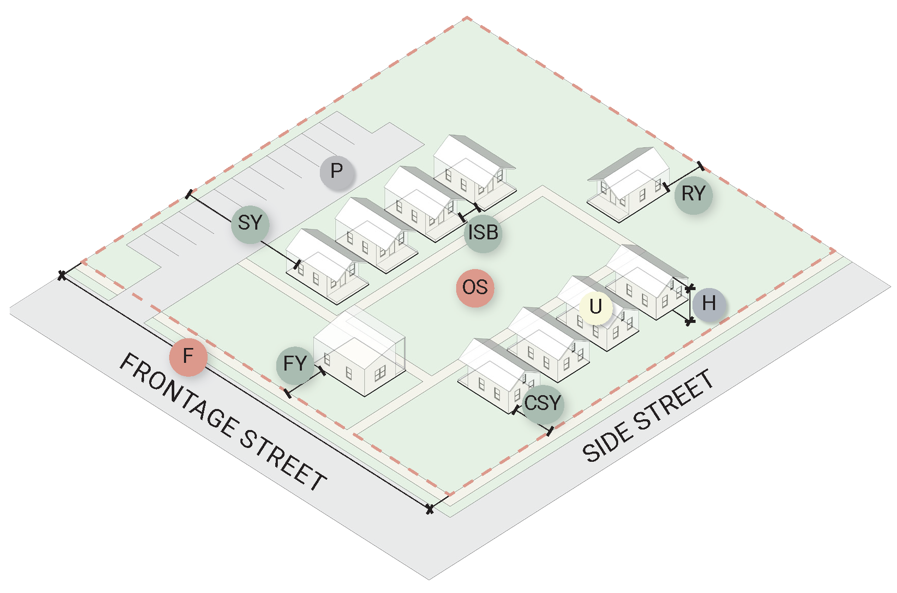
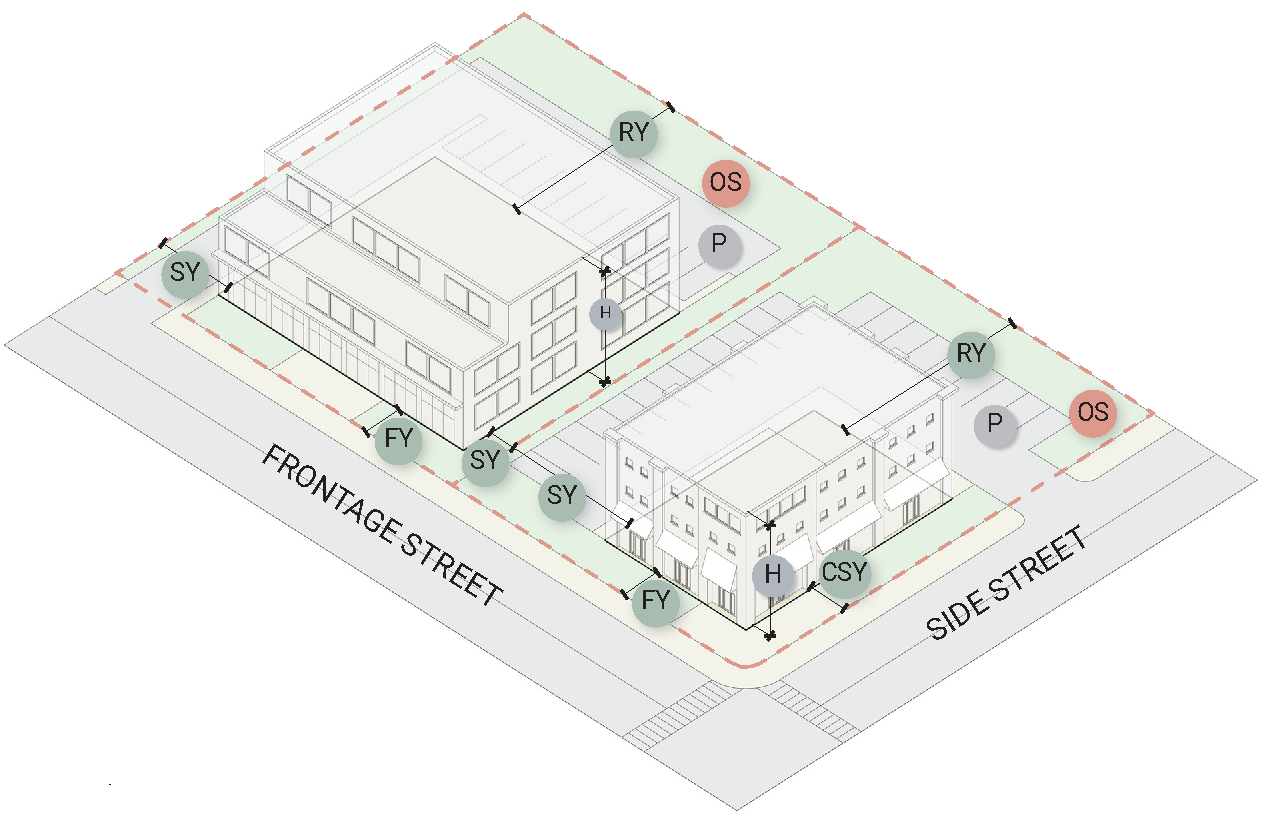
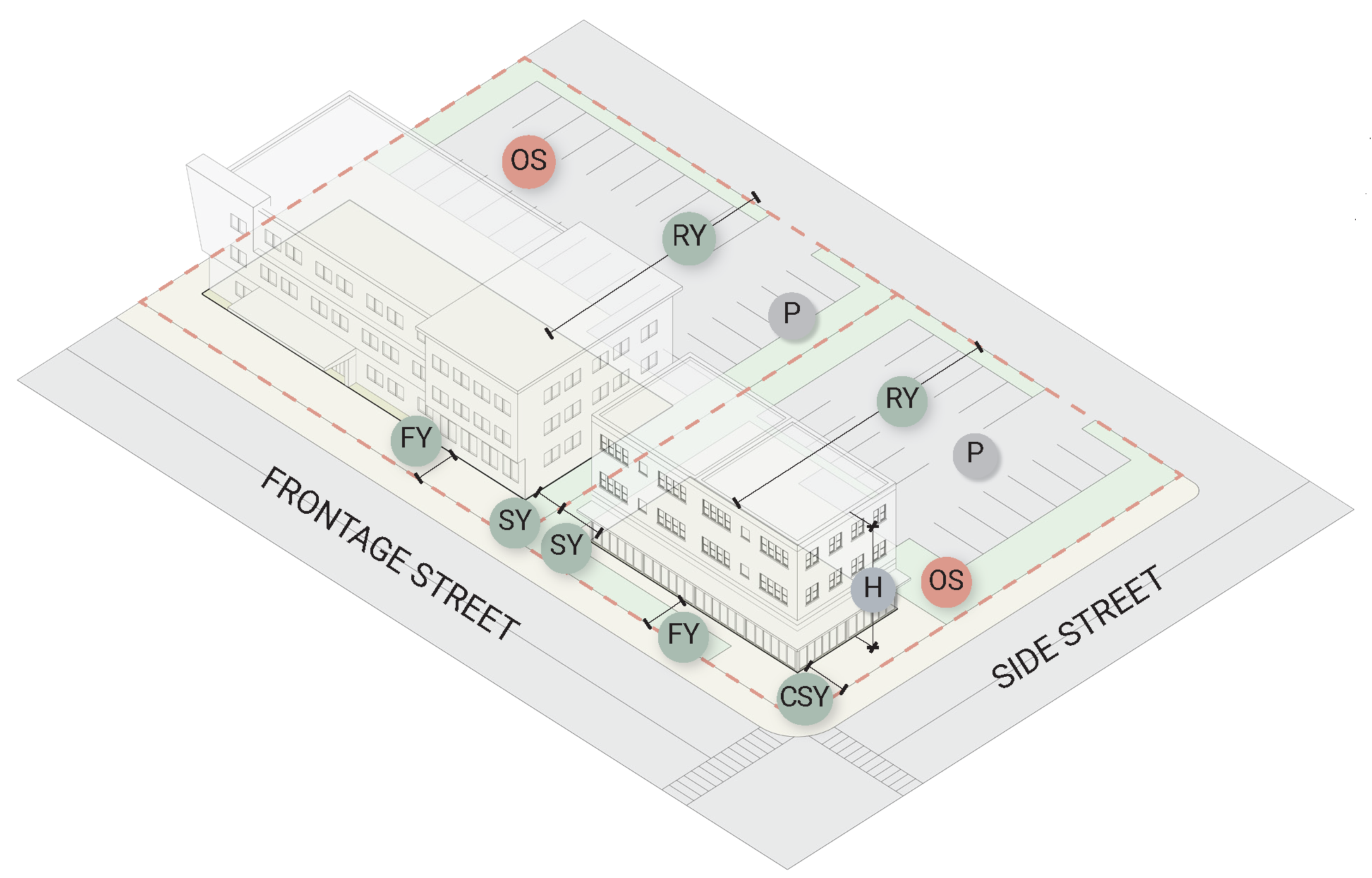
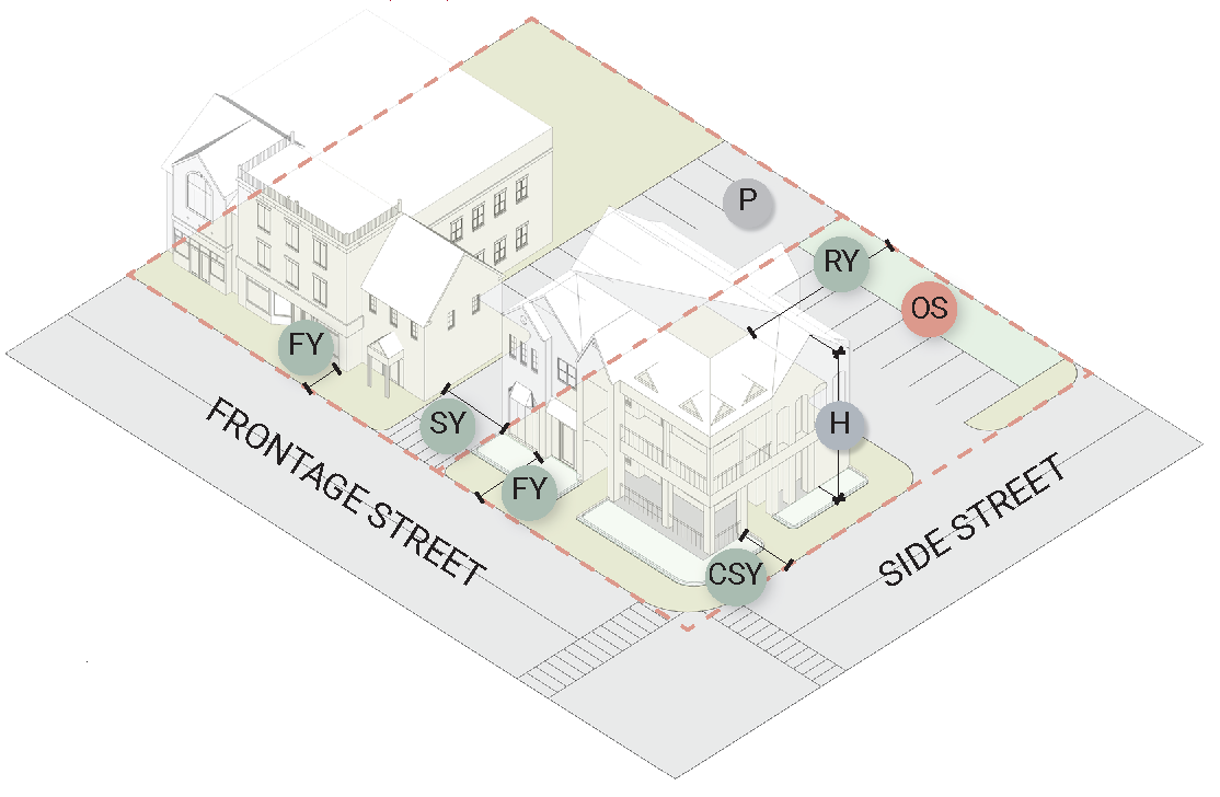
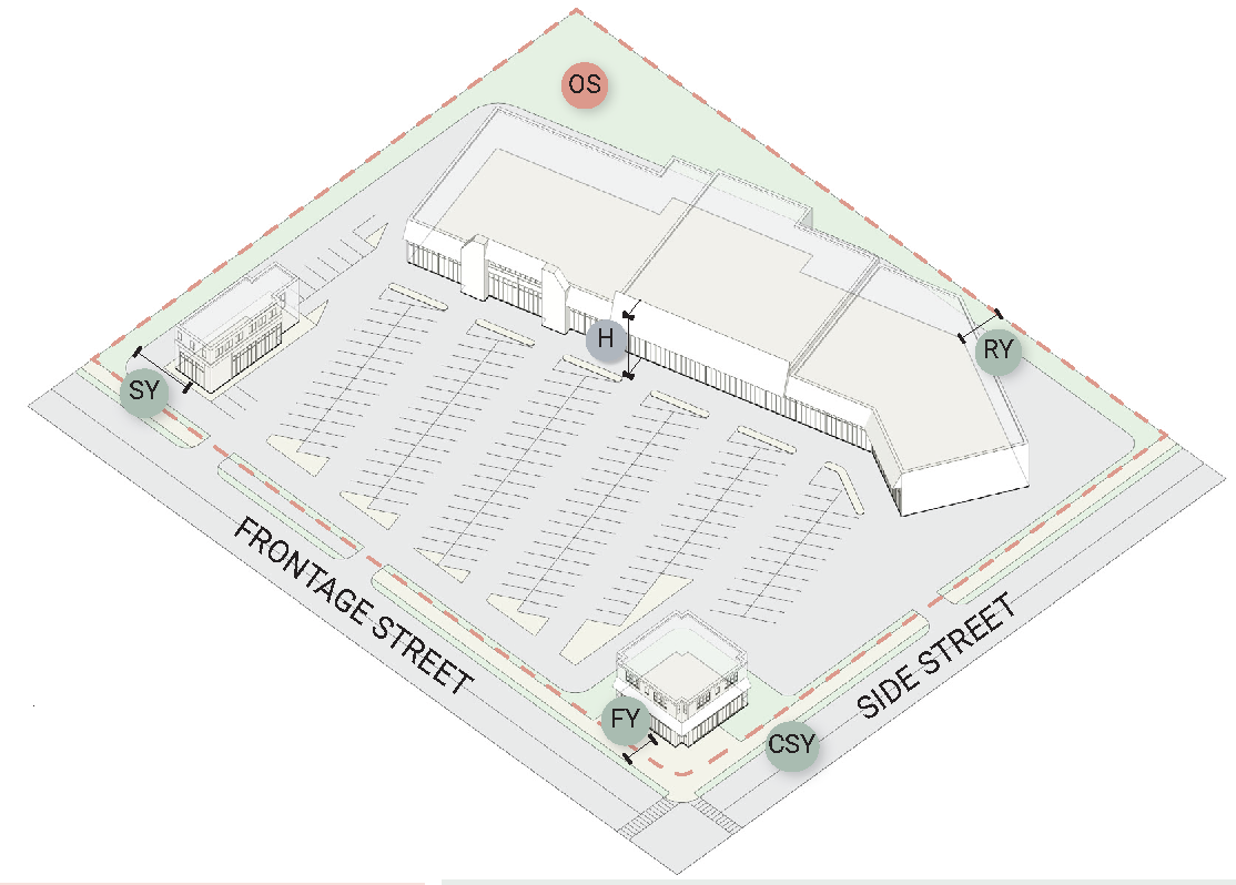
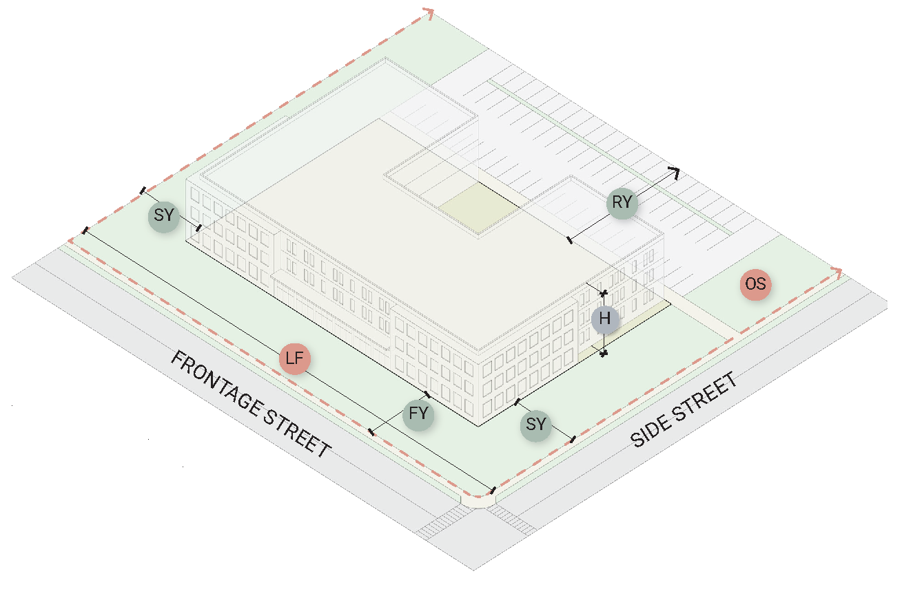
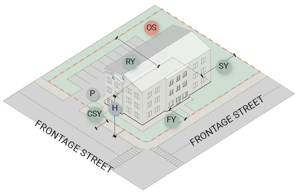
Sec. 18-206. - Illustrative examples of lot dimensions and standards.
The diagrams and text below define dimensional terms and direct how to measure lot and structure dimensions. All terms are also referenced in Article 9 - Definitions.
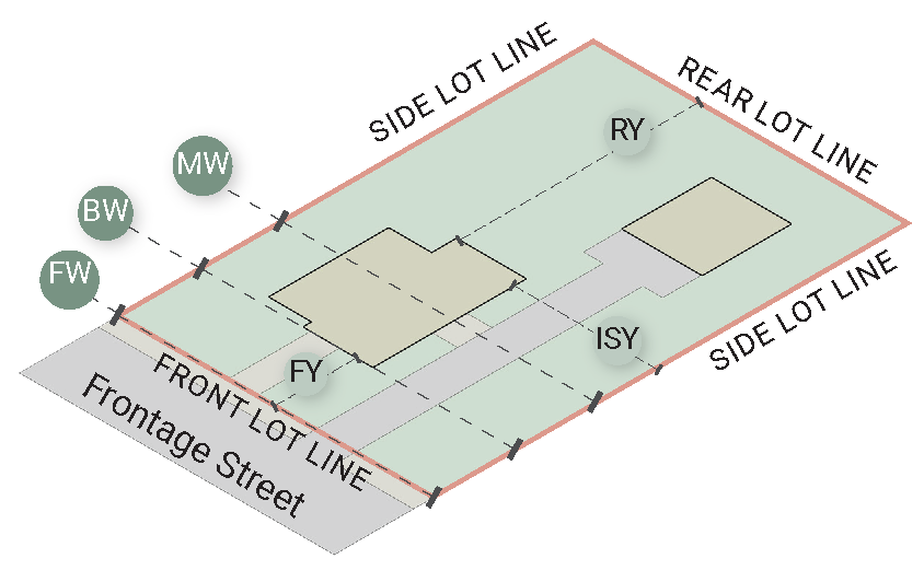
Figure 2.1. Example of Residential Interior Lot, including lot lines and lot dimensions.
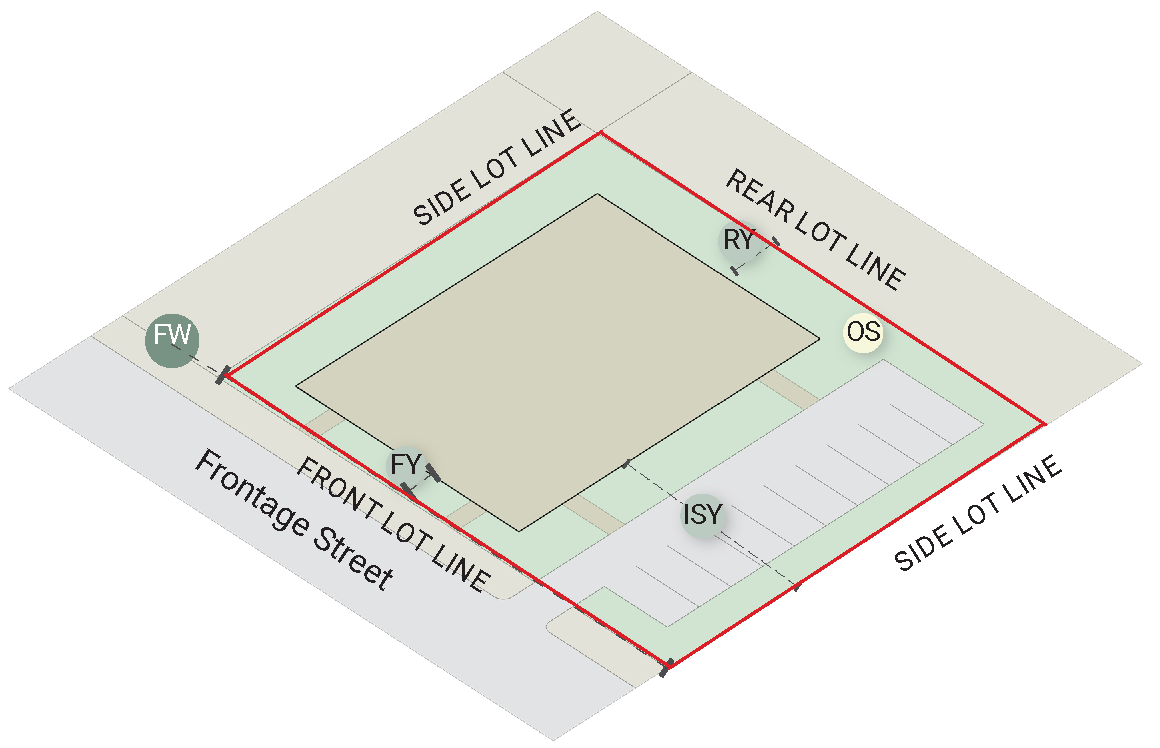
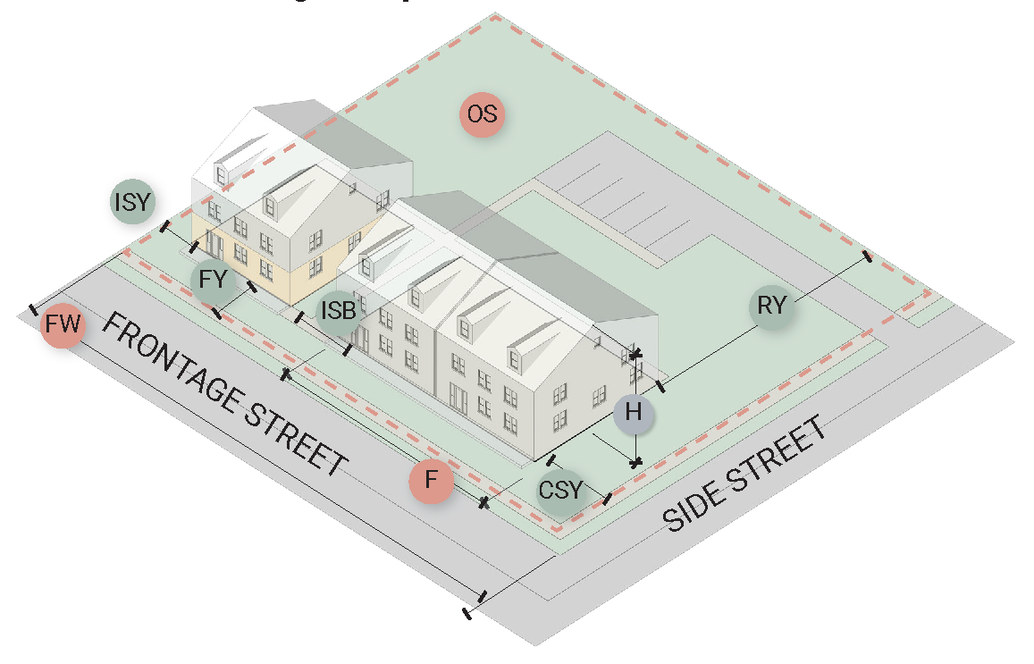
Figure 2.2. Example of Commercial Interior Lot, including lot lines and lot dimensions.
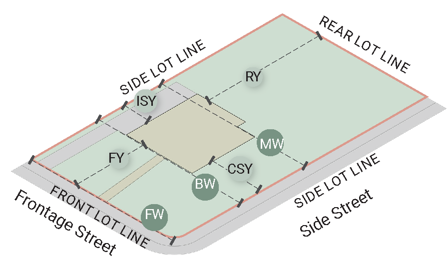
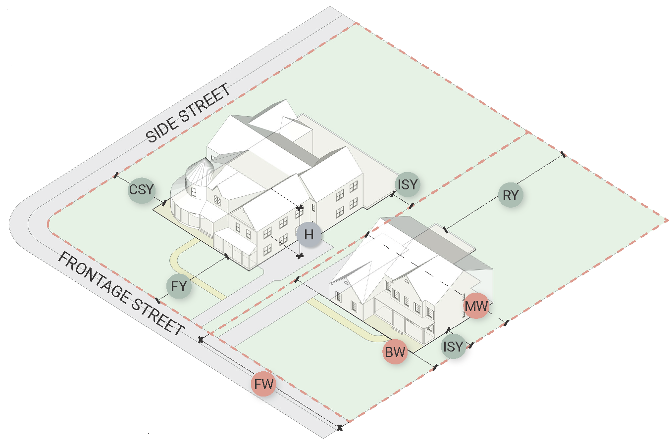
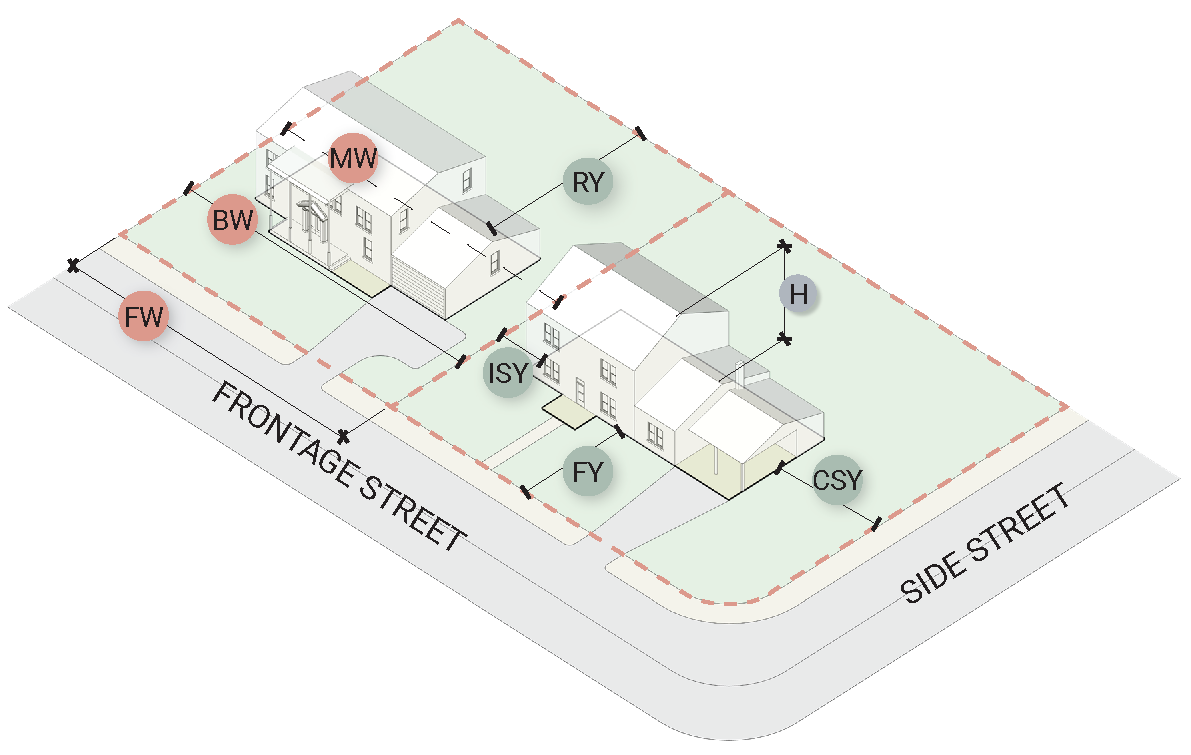
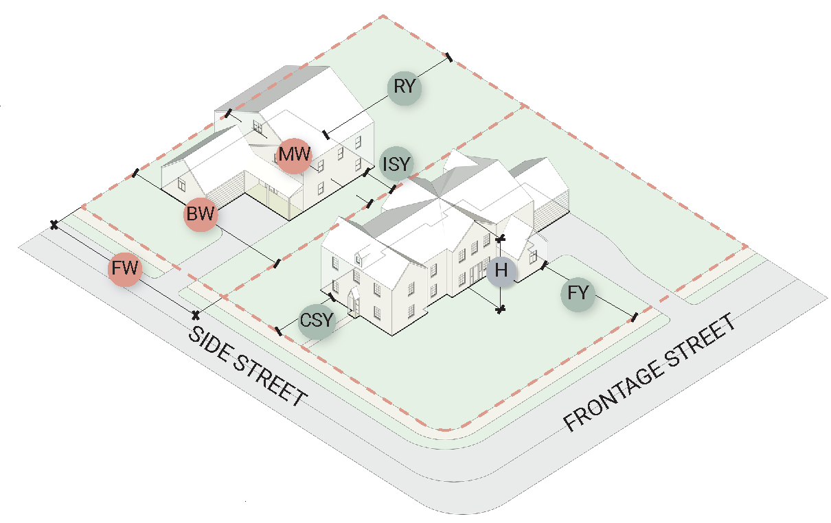
Figure 2.3. Example of Residential Corner Lot, including lot lines and lot dimensions.
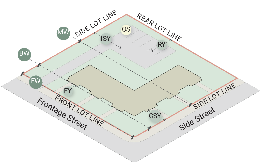
Figure 2.4. Example of Commercial Corner Lot, including lot lines and lot dimensions.
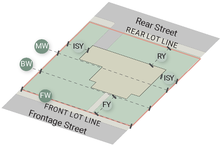
Figure 2.5. Example of Residential - Through Lot, including lot lines and lot dimensions.
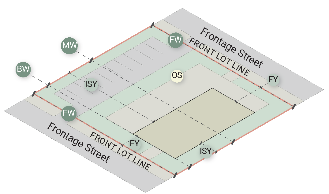
Figure 2.6. Example of Commercial - Through Lot, including lot lines and lot dimensions.
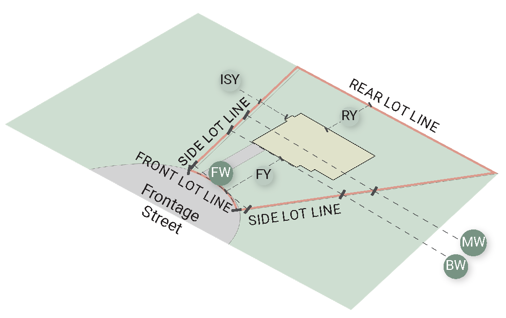
Figure 2.7. Example of Residential - Cul-de-sac pie-shaped lot, including lot lines
and lot dimensions.
Sec. 18-207. - Lot lines.
1.
Lot line. A lot line is a line dividing one lot from another or from a street or any public place.
2.
Front lot line. A front lot line is the lot line that abuts a street right-of-way. The front lot line is also referred to as the "front of lot."
A.
Where a lot is located on the inside of a curved front lot line, and the curve has an arc angle of more than fifty-five (55) degrees, the lot line shall be considered two separate lot lines, each terminating at the midpoint of the arc.
B.
When a lot has multiple lot lines abutting a street right-of-way, the front lot line shall be the shortest of the lot lines that abut a street right-of-way, except that:
i.
When two or more lot lines abut street rights-of-way and are of equal lengths, the front lot line shall be that lot line which abuts the street having the greatest total width of front lot lines within the same block; and
ii.
The Zoning Administrator may determine, for reasons of safety or continuity, that the front lot line should be a lot line other than the shortest lot line that abuts a street right-of-way.
C.
The architectural front of the building shall face the front lot line.
D.
A lot line that abuts a street right-of-way but is not considered a front lot line shall be considered a corner side lot line.
3.
Side lot line. Any lot line other than a front or rear lot line. Where two or more side lot lines are adjoining, they shall be treated as segments of an entire side lot line.
4.
Rear lot line. The lot line most directly opposite and farthest from the front lot line. If no lot line is clearly most directly opposite and farthest from the front lot line, two or more lot lines will be designated as rear lot lines for consistent application of rear yard setbacks abutting the yards of adjacent lots.
5.
Front building line. A front building line is a line that is parallel to the front lot line, is within the lot, and is separated from the front lot line by a distance equal to the minimum front yard setback for principal structures in that zone or district.
6.
Midline. A midline is a line that is positioned one-half of the shortest horizontal distance between a front lot line and a rear lot line, is parallel to a tangent line at the midpoint of a front lot line, and terminates at its intersection with any lot line.
Sec. 18-208. - Corner, interior, and through lots.
1.
Corner lot. A corner lot is any lot situated at the intersection of two or more streets, having an angle of intersection of not more than 135 degrees.
2.
Interior lot. An interior lot is any lot other than a corner lot.
3.
Through lot. A through lot is any interior lot with two or more non-adjacent lot lines that each abut a street right-of-way.
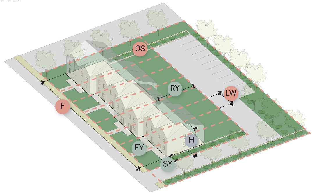
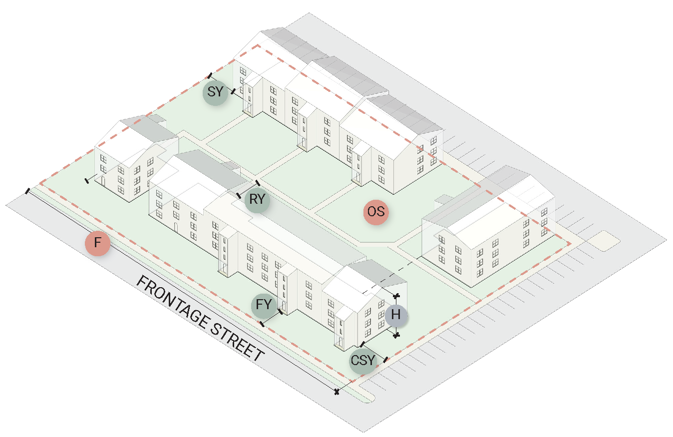
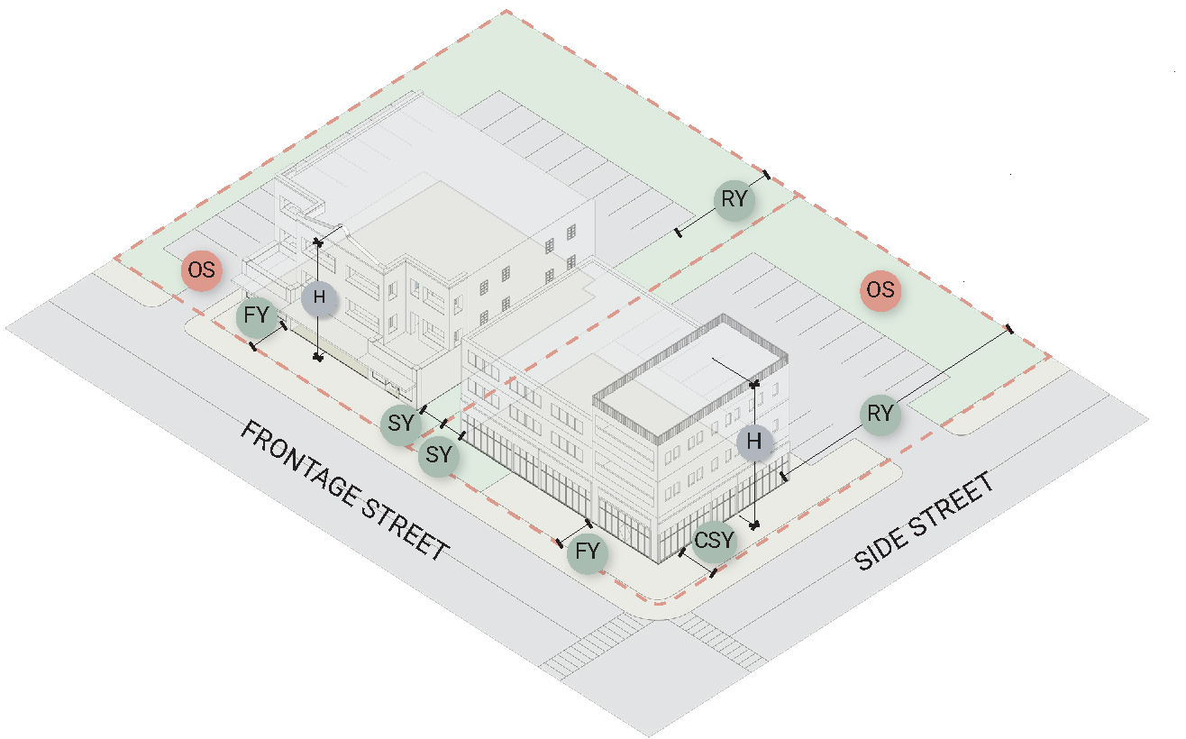
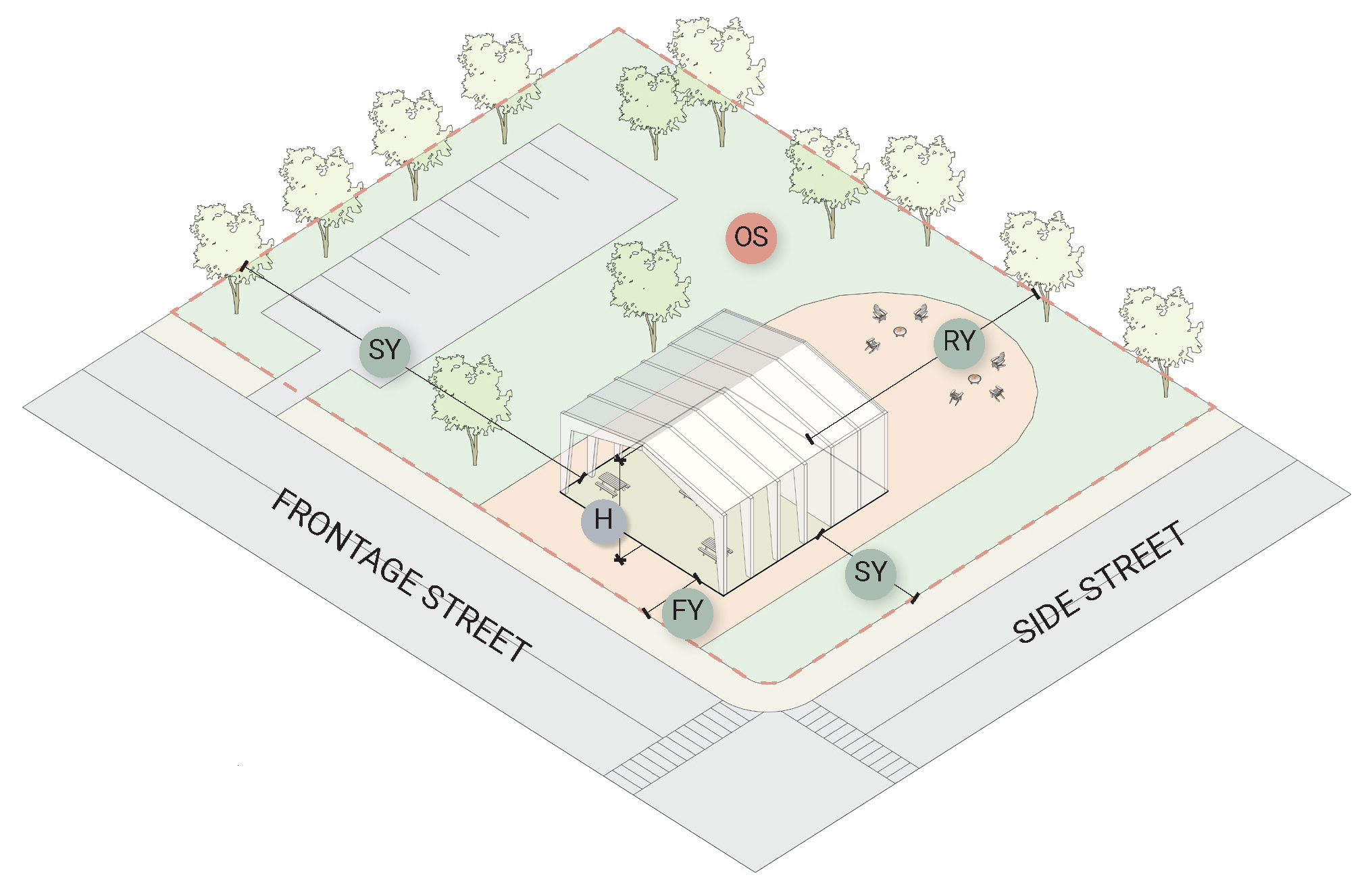
Sec. 18-209. - Yards.
1.
Yard. A yard is an open space, other than a court, on the same lot with a principal building or group of principal buildings, which open space lies between the building or outer building of a group and the nearest lot or street line.
2.
Front yard. A front yard is a yard extending across the full width of the lot between the nearest principal building and the front lot line. The depth of the required front yard shall be measured horizontally from the nearest part of the principal building to the nearest point of the front lot line.
3.
Rear yard. A rear yard is a yard extending across the full width of the lot, between the nearest rear principal building and the rear lot line. The depth of the required rear yard shall be measured horizontally from the nearest part of the principal building to the nearest part of the rear lot line.
4.
Side yard. A side yard is a yard between a principal building and the side lot line, extending from the front yard, or front lot line where no front yard is provided, to the rear yard. The width of the required side yard shall be measured horizontally from the nearest point of the side line toward the nearest part of the principal building.
5.
Corner side yard. A corner side yard is a yard between a principal building and the corner side lot line, extending from the front yard, or front lot line where no front yard is provided, to the rear yard. The width of the required corner side yard shall be measured horizontally from the nearest point of the corner side lot line toward the nearest part of the principal building.
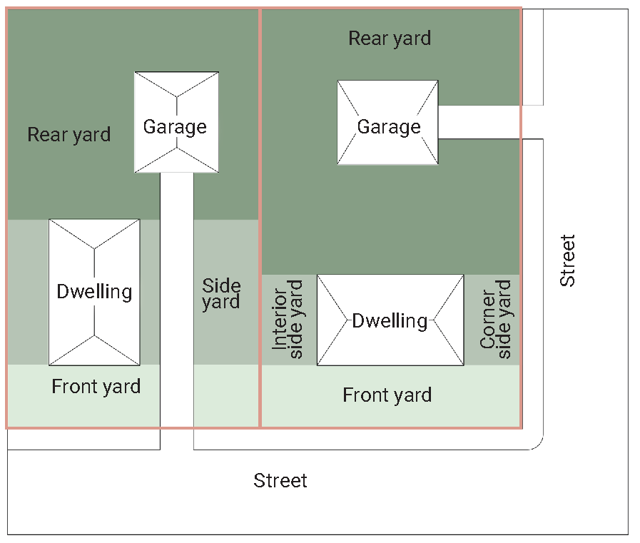
Figure 2.8. Illustration of yards.
Sec. 18-210 - Lot dimensions.
1.
Lot area. The lot area is the area of a horizontal plane contained by vertical planes extending from the lot lines.
2.
Lot width at front lot line. The lot width at front lot line is the length of the front lot line. The lot width at front lot line is sometimes referred to as the "lot frontage."
3.
Lot width at front building line. The lot width at front building line is the length of the front building line.
4.
Lot width at midline. The lot width at midline is the length of the distance from one side lot line to the opposite side lot line, measured at the mid-points of the side lot lines, or as near as possible to those mid-points so that the midline is as close to being parallel to the front lot line as possible.
5.
Front yard setback. The front yard setback is the shortest horizontal distance between a structure on the lot and the front lot line. In some instances, which will be noted in this Chapter, the front yard setback is the shortest horizontal distance between a structure on the lot and the centerline of the street right-of-way.
6.
Interior side yard setback. The interior side yard setback is the shortest horizontal distance between a structure on the lot and a side lot line that does not abut a street right-of-way.
7.
Corner side yard setback. The corner side yard setback is the shortest horizontal distance between a structure on the lot and a corner side lot line.
8.
Rear yard setback. The rear yard setback is the shortest horizontal distance between a structure on the lot and a rear lot line.
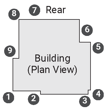
Figure 2.9. Illustration of the locations of pre-existing and post-construction grade
elevation measurements for the purpose of determining lot deviation.
Sec. 18-211. - Lot deviation.
1.
Lot deviation is the vertical change in elevation from the pre-existing lot grade to the finished lot grade.
2.
Lot deviation limits apply to a minimum of nine points along the building footprint generally as shown in Figure 2.9.
3.
For single-unit detached dwellings, not including subdivisions, the finished lot grade may deviate from the pre-existing lot grade by no more than three vertical feet at any point along the pre-existing lot grade around the footprint of the building or structure, such that all over-lot grading shall be in accordance with the natural lay of the land.
4.
The Director of Public Works may waive the three-foot lot deviation limit if deemed to be for good cause and not contrary to the public interest.
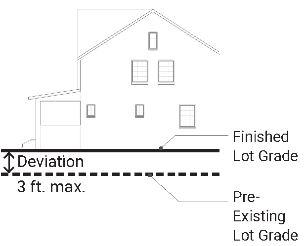
Figure 2.10. Illustration of vertical lot deviation.
Sec. 18-212. - Structure dimensions.
1.
Building height.
A.
For principal structures, building height is the maximum vertical dimension measured from the average finished lot grade at the front of the principal building to the highest point of the roof.
B.
Penthouses or roof structures for the housing of elevators, stairways, tanks, ventilating fans, or similar equipment required to operate and maintain the building, and fire or parapet walls, skylights, towers, steeples, flagpoles, water tanks, silos, or similar structures which are part of the principal building may be erected above the height limits herein described to a maximum of nine (9) feet above the roof level, but no penthouse or roof structure, or any space above the height limit shall be allowed for the purpose of providing additional floor space.
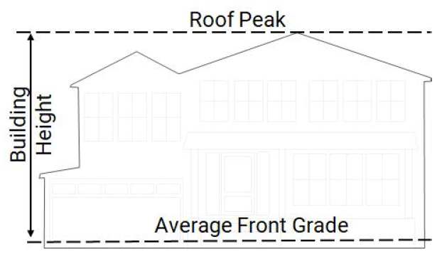
Figure 2.11. Illustration of building height.
C.
Architectural features such as steeples, cupolas, elevator housing, and decorative parapet walls may be erected beyond the nine (9) foot maximum addition above the roof level, with recommendation by the Board of Architectural Review and approval by Town Council.
D.
For accessory structures, building height is the maximum vertical dimension measured from the lowest point of grade elevation adjacent to any exterior wall of the structure to the highest point of the roof.
2.
Story. A story is a portion of a building included between the surface of any floor and the surface of the next floor directly above it, or if there is no floor above it, then the space between such floor and ceiling next above it.
3.
Basement. A basement is partially or wholly underground and not considered a story. The space shall be considered a story and not a basement if the space is exposed more than an average of seven (7) feet from proposed grade points around the footprint of the building to the next floor elevation.
4.
Half-story. A half-story is fifty percent (50%) or less floor area than the floor below.
Sec. 18-213. - Lot coverage.
1.
Residential lot coverage. Percentage of a lot that is measured by the sum of the area covered by buildings, accessory buildings, automobile parking spaces and access, stoops, sport courts, tennis courts, patios and terraces divided by the total lot area.
2.
Deck and Outdoor living coverage. Percentage of a lot that is measured by the total area of the lot that is covered by decks divided by the total lot area. The combined deck and outdoor living coverage may not exceed 5% of the total lot area. Deck area includes: 1) any open decking projecting from the principal structure, 2) deck landings or porches extending from stairs or the principal structure, 3) outdoor living structures meeting the criteria. Stairs are excluded from the deck and outdoor living coverage calculation. Up to four hundred (400) sq. ft. of deck may be covered and not count towards lot coverage with the following conditions:
A.
Must be single-level, with no roof decks or patios below;
B.
Cannot have solid walls, except the wall of the principal structure and seating walls no greater than 18" in height. Only railings and screening is permitted;
C.
Cannot be located in the front yard;
D.
Must provide for stormwater BMPs in accordance with the Stormwater Manual for Outdoor Living Areas and meet all criteria included in said manual; and
E.
Must remain as permitted by the Town of Vienna and may not be converted into conditioned living space.
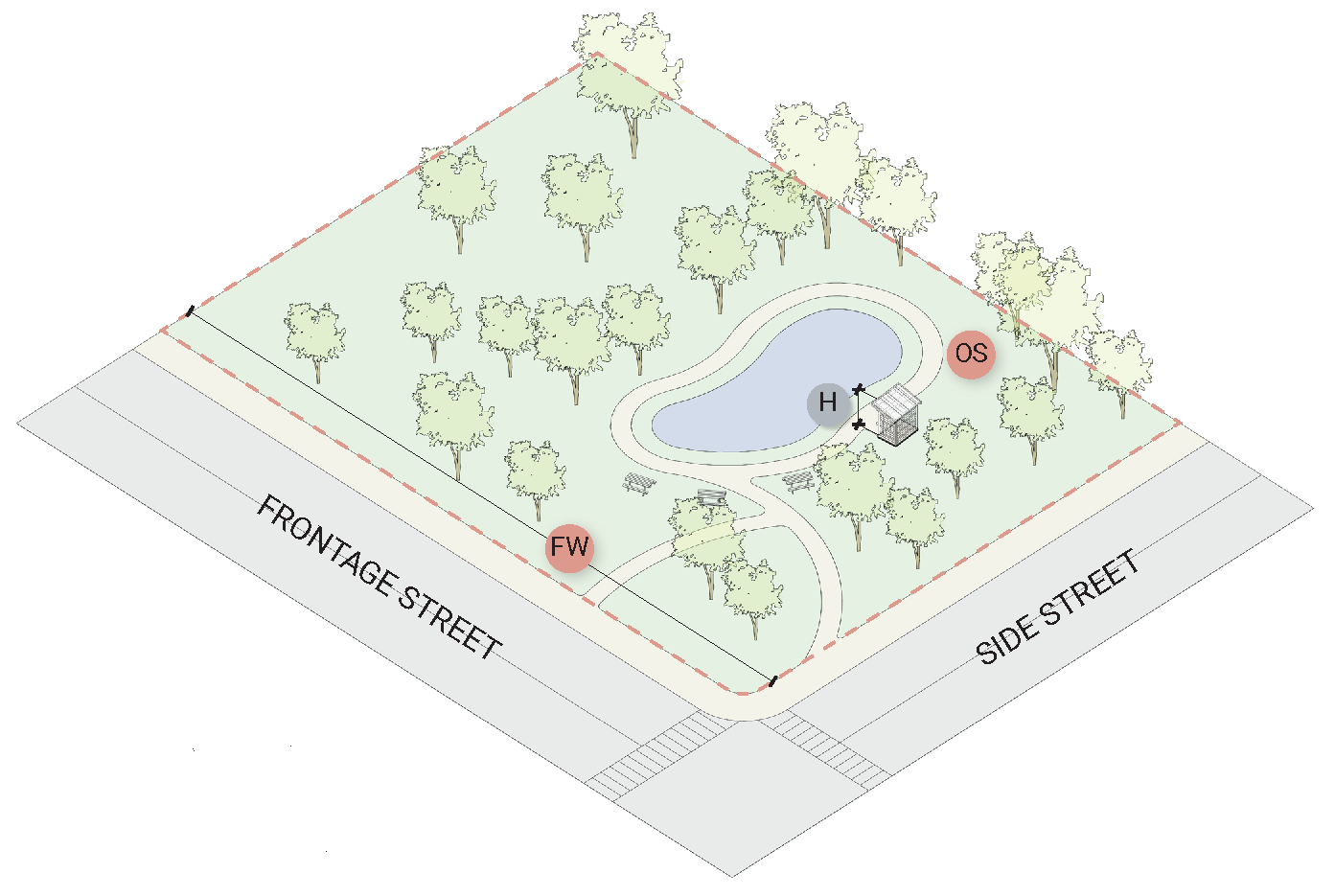
Sec. 18-214. - Open space.
1.
The purpose of open and usable space is to provide areas of trees, shrubs, lawns, pathways and other natural and man-made amenities which function for the use and enjoyment of residents, visitors and other persons.
2.
Open space is that portion of a lot at ground level that is:
A.
Eight (8) feet or more in width;
B.
One hundred and twenty (120) square feet or more in contiguous area;
C.
Unoccupied by principal or accessory enclosed structures;
D.
Not used in whole or in part as roads, alleys, emergency vehicle easement areas, driveways, maneuvering aisles or off-street parking or loading berths.
Sec. 18-215. - Allowable encroachments into required yard setbacks.
The following table sets forth permitted encroachments into yards and associated standards:
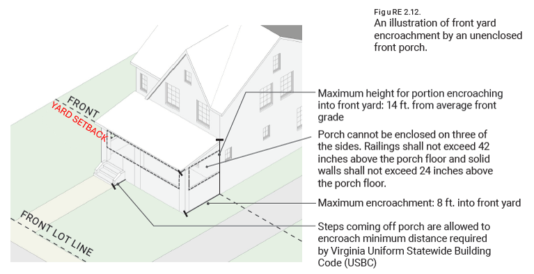
Figure 2.12. An illustration of front yard encroachment by an unenclosed front porch.
Sec. 18-216. - Established residential zones.
Sec. 18-217. - Residential - Single-Unit, 16,000 sq. ft. Zone (RS-16).
1.
RS-16 Purpose. The purpose of this zone is to provide standards for single-unit, detached residences with a minimum lot area of 16,000 square feet.
2.
RS-16 Dimensional Standards.
Principal Structure Count: 1 per lot max.
Reference to other Standards
Uses and Use Standards; Accessory Living Units: See Article 3;
Accessory structure setbacks: See Article 4A;
Development Standards - Single Unit Detached Residential Uses: See Article 4A;
Development Standards - Public, Institutional, and Community Uses - See Article 5B.
Sec. 18-218. - Residential - Single-Unit, 12,500 sq. ft. Zone (RS-12.5).
1.
RS-12.5 Purpose. The purpose of this zone is to provide standards for single-unit, detached residences with a minimum lot area of 12,500 square feet.
2.
RS-12.5 Dimensional Standards.
Principal Structure Count: 1 per lot max.
Reference to Other Standards
Uses and Use Standards; Accessory Living Units: See Article 3;
Accessory structure setbacks: See Article 4A;
Development Standards - Single-Unit Detached Residential Uses: See Article 4A;
Development Standards - Public, Institutional, and Community Uses - See Article 5B.
Sec. 18-219. - Residential - Single-Unit, 10,000 sq. ft. Zone (RS-10).
1.
RS-10 Purpose. The purpose of this zone is to provide standards for single-unit, detached residences with a minimum lot area of 10,000 square feet.
2.
RS-10 Dimensional Standards.
Principal Structure Count: 1 per lot max.
Reference to Other Standards
Uses and Use Standards; Accessory Living Units: See Article 3;
Accessory structure setbacks: See Article 4A;
Development Standards - Single-Unit Detached Residential Uses: See Article 4A;
Development Standards - Public, Institutional, and Community Uses - See Article 5B.
Sec. 18-220. - Residential - Multi-Unit Zone (RMU).
1.
RMU Purpose. The purpose of this zone is to provide standards for multi-unit residential uses, which include the following:
A.
Two-unit Attached Dwellings/Duplexes.
B.
Cottage Courts.
C.
Townhomes.
D.
Multi-unit Buildings and Complexes.
2.
RMU Dimensional Standards. The dimensional standards for each of the multi-unit residential uses listed in § 18-220.1 are as follows:
A.
Two-unit Attached Dwellings/Duplexes.
Dimensional Standards
Reference to Other Standards
Uses and Use Standards: See Article 3;
Accessory structure setbacks: See Article 4B;
Development Standards - Muti-Unit Attached Residential Uses: See Article 4B.
B.
Cottage Courts.
Dimensional Standards
Reference to Other Standards
Uses and Use Standards: See Article 3;
Accessory structure setbacks: See Article 4B;
Development Standards - Muti-Unit Attached Residential Uses: See Article 4B.
C.
Townhomes
Dimensional Standards
Reference to Other Standards
Uses and Use Standards: See Article 3;
Accessory structure setbacks: See Article 4B;
Development Standards - Muti-Unit Attached Residential Uses: See Article 4B.
D.
Multi-Unit Buildings and Complexes.
Dimensional Standards
Reference to Other Standards
Uses and Use Standards: See Article 3;
Accessory structure setbacks: See Article 4B;
Development Standards - Muti-Unit Attached Residential Uses: See Article 4B.
Sec. 18-221. - Established commercial, industrial, and mixed-use districts and zones.
Sec. 18-222. - Avenue Center District (AC).
1.
AC Purpose. The purpose of the Avenue Center District is to provide standards for the promotion of a strong, vibrant commercial and mixed-use center along Maple Avenue.
2.
AC Dimensional Standards.
Reference to Other Standards
Uses and Use Standards: See Article 3;
Development Standards - Commercial, Industrial, and Mixed Uses: See Article 5A;
Development Standards - Public, Institutional and Community Uses: See Article 5B;
Avenue Center Amenity Overlay: See § 18-222.
Sec. 18-223. - Avenue East Gateway District (AE).
1.
AE Purpose. The purpose of the Avenue East Gateway District is to promote standards for the promotion of a vibrant commercial use area east of the Avenue Center District.
2.
AE Dimensional Standards.
Reference to Other Standards
Uses and Use Standards: See Article 3;
Development Standards - Commercial, Industrial, and Mixed-Uses: See Article 5A;
Development Standards - Public, Institutional and Community Uses: See Article 5B.
Sec. 18-224. - Avenue West Gateway District (AW).
1.
AW Purpose. The purpose of the Avenue West Gateway District is to provide standards for the promotion of a vibrant commercial use area west of the Avenue Center District.
2.
AW Dimensional Standards.
Reference to Other Standards
Uses and Use Standards: See Article 3;
Development Standards - Commercial, Industrial, and Mixed-Uses: See Article 5A;
Development Standards - Public, Institutional and Community Uses: See Article 5B.
Sec. 18-225. - Church Street District (CS).
1.
CS Purpose. The purpose of the Church Street District is to provide standards that recognize the distinctive character of the original Vienna commercial district and to provide for the protection, preservation, and promotion of the traditional image and history of this unique area.
2.
CS Dimensional Standards.
Reference to Other Standards
Uses and Use Standards: See Article 3;
Development Standards - Commercial, Industrial, and Mixed-Uses: See Article 5A;
Development Standards - Public, Institutional and Community Uses: See Article 5B;
Church Street Vision Incentive Overlay: See § 18-236.
Sec. 18-226. - Gateway South District (GS).
1.
GS Purpose. The purpose of the Gateway South District is to provide standards that support neighborhood-scale commercial amenities within the southern end of the Town.
2.
GS Dimensional Standards.
Reference to Other Standards
Uses and Use Standards: See Article 3;
Development Standards - Commercial, Industrial, and Mixed-Uses: See Article 5A;
Development Standards - Public, Institutional and Community Uses: See Article 5B.
Sec. 18-227. - Corporate Park District (CP).
1.
CP Purpose. The purpose of the Corporate Park District is to provide standards for the use and development of properties as a cohesive campus-style corporate employment center.
2.
CP Dimensional Standards.
Reference to Other Standards
Uses and Use Standards: See Article 3;
Development Standards - Commercial, Industrial, and Mixed-Uses: See Article 5A;
Development Standards - Public, Institutional and Community Uses: See Article 5B;
Corporate Park District Performance Standards: See Article 5A, Division 8.
Sec. 18-228. - Mill District (M).
1.
M Purpose. The purpose of the Mill District is to provide standards for light industrial uses along Vienna's historic Washington and Old Dominion Railroad corridor.
2.
M Dimensional Standards.
Reference to Other Standards
Uses and Use Standards: See Article 3;
Development Standards - Commercial, Industrial, and Mixed-Uses: See Article 5A;
Development Standards - Public, Institutional and Community Uses: See Article 5B.
Sec. 18-229. - Neighborhood Mixed-Use Zone (NM).
1.
NM Purpose. The purpose of the Neighborhood Mixed-Use Zone is to provide standards for neighborhood-scale mixed-use development that is adjacent to residential and commercial areas, to promote, respect, and protect the existing character of adjacent residential areas.
2.
NM Dimensional Standards.
Reference to Other Standards
Uses and Use Standards: See Article 3;
Development Standards - Commercial, Industrial, and Mixed-Uses: See Article 5A;
Development Standards - Public, Institutional and Community Uses: See Article 5B.
Sec. 18-230. - Transitional Zone (T).
1.
T Purpose. The purpose of the Transitional Zone is to provide standards for neighborhood-scale professional offices that are located between residential and higher-activity commercial areas, to provide businesses space while promoting, protecting, and respecting the existing character of adjacent residential areas.
2.
T Dimensional Standards.
Reference to Other Standards
Uses and Use Standards: See Article 3;
Development Standards - Commercial, Industrial, and Mixed-Uses: See Article 5A.
Sec. 18-231. - Established parks zones.
Sec. 18-232. - Parks and Recreational Zone (PR).
1.
PR Purpose. The purpose of the Parks and Recreational Zone is to provide standards for improvements dedicated to public recreational uses.
2.
PR Dimensional Standards.
Reference to Other Standards
Uses and Use Standards: See Article 3;
Development Standards - Public, Institutional and Community Uses: See Article 5B.
Sec. 18-233. - Parks and Conservation Zone (PC).
1.
PC Purpose. The purpose of the Parks and Conservation Zone is to provide standards for the preservation or restoration of land to a natural, undisturbed, and undeveloped state.
2.
PC Dimensional Standards.
Reference to Other Standards
Uses and Use Standards: See Article 3;
Development Standards - Public, Institutional and Community Uses: See Article 5B.
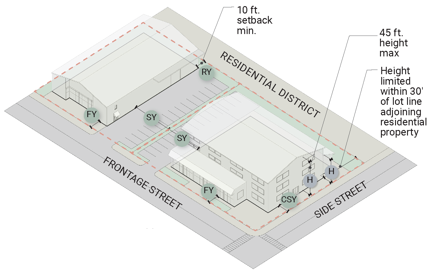
Sec. 18-234. - Established Overlay Districts.
Sec. 18-235. - Avenue Center Amenity Overlay (AC-O).
1.
AC-O Purpose. The purpose of the Avenue Center Amenity Overlay District is to accommodate rooftop amenities that may exceed the building height regulations applicable to the base zone or district in which the structure is located, while respecting and promoting the small-town character of Vienna.
FIGURE 2-13. Example of building section with a rooftop use as permitted within the
Avenue Center Amenity Overlay District.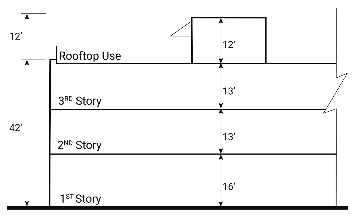
FIGURE 2.14. Reference map of the Avenue Center Amenity Overlay.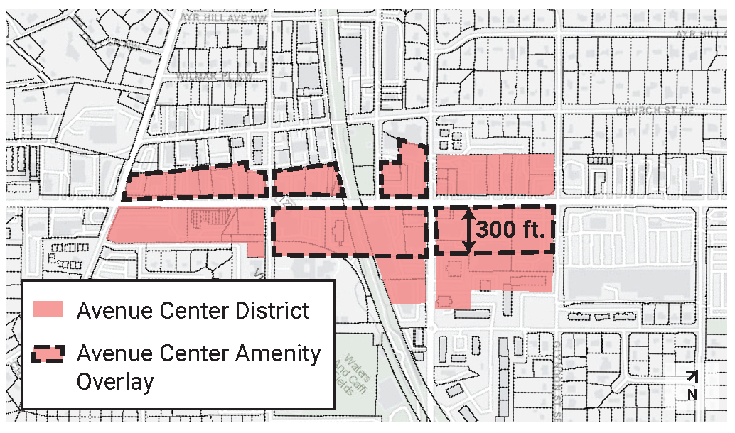
2.
AC-O Dimensional Standards.
| BUILDING STANDARDS | FIGURE 2.15. Rooftop use location diagram in plan view. | ||
| H | Building Height |
42 ft. max.
For any structure with a publicly accessible rooftop use (e.g., rooftop dining) an additional 12 feet is permitted for elevator and/or stair access penthouse use only | 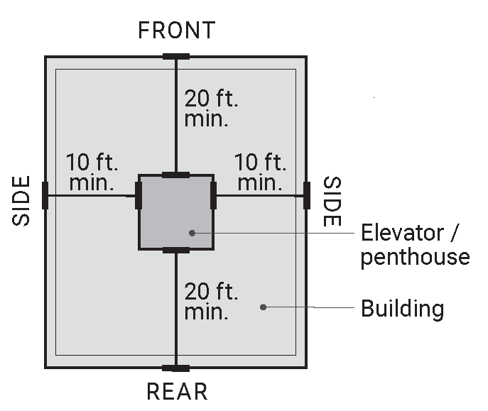 |
| Rooftop Use Location | A rooftop elevator shaft or penhouse must be centered on the building roof, set back 10 ft. min. from the building's sides and 20 ft. min. from its front and rear. | ||
Sec. 18-236. - Church Street Vision Incentive Overlay (CS-O).
FIGURE 2.16. Reference map of the Church Street Overlay.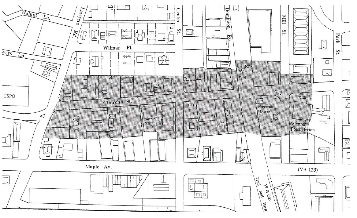
1.
CS-O Purpose.
A.
The purpose of the Church Street Vision Incentive Overlay (CS-O) is to legislatively recognize the distinctive character of the original old Vienna commercial district and to provide for the protection and preservation of the traditional image and history of that unique area as it presently exists and to encourage and enhance future development, utilizing that character and heritage as symbolized by excellence in design, architecture and that period development of the Town in early years while blending private with public development and maintenance of that valuable distinct character.
B.
In furtherance of the above purposes, the Town has expended substantial sums in capital improvement programs to enhance the utilities, landscaping, streetscaping, public ways and general municipal character of the district in harmony with that character and heritage.
C.
The Town acknowledges by legislative recognition that, because of the unique traditional nature of the particular district, accomplishment of the intended goals of this article may not always be achieved or be achievable within the strict requirements of this chapter.
D.
Strict application of the terms of this chapter in general could effectively prohibit achievement of those goals and prevent the most practical, efficient and aesthetic development of area sites in furtherance of the purposes of this article. Therefore, certain modifications, waivers and variations are required to accomplish the intended well-planned development necessary to achieve the desired character.
2.
Declaration of intent.
A.
The Town Council has made the legislative determination that the preservation of the existing traditional period character of the zone and the encouragement of future development within the zone in keeping with those same high standards of that Vienna character and heritage is in the best interests of the community, will promote long-term economic growth, encourage the optimum use of the real estate within the zone, attract new business, enhance the tax base of real estate and the taxable value of businesses within the area, encourage employment and commercial growth, and in general benefit the health, safety and welfare of the community as a whole.
B.
The Town Council declares further that it is in the best interests of the community and the owners of the property within the zone that the goals of this article are best achieved voluntarily through the cooperative efforts of property owners and the Town, and that the historic nature, unique character, and heritage of the area are best preserved without mandatory legislative imposition of historic preservation regulations or districting. Rather, the goals of this article will be best achieved through the prudent exercise of site plan powers enjoyed by the Town Council when the same are merged with the application of the incentive land use principles contemplated by incentive zoning as defined in Code of Virginia, § 15.2-2201, by the grant of bonuses in the form of selective site plan modifications by the Town to a developer or property owner in return for that developer or property owner providing within a development, construction or reconstruction, certain predefined design and plan features and amenities desired by the Town and legislatively adopted herein.
3.
Modification of General Regulations.
A.
The provisions of § 18-225 shall not apply to development, construction, or reconstruction in the Church Street District (CS) when, as an incident to that development, construction or reconstruction, adopted building design features and site plan features are voluntarily proffered by the owner or developer, and accepted by the Town in return for the grant of bonus incentives by the Town to and acceptance by the developer or owner through site plan modifications in lieu of the provisions of § 18-225. Upon acceptance by the parties, such features and bonuses shall run with the land.
B.
In addition to modifications authorized in Article 8, the Town Council is authorized to grant as modifications to site plans in the CS-O overlay incentive bonuses as adopted in § 18-836.7 in return for the voluntary proffer and acceptance by an owner or developer of building design features and site plan features provided for in § 18-223 when the same are desired by and acceptable to the Town in furtherance of the purposes of this article.
C.
Modifications consisting solely of those design features, site features and incentive bonuses which have been previously legislated and incorporated by the council into § 18-236, shall not require recommendation of the planning commission prior to granting by the council.
D.
All modifications shall provide a landscape site plan and for the continual maintenance thereof.
4.
Building and plan design features.
A.
In furtherance of the legislative intent of the Church Street Vision Incentive Overlay (CS-O) and to project continuity in harmony of character in the area, there are hereby adopted the following building design features and site plan features which are declared acceptable for use in development in the CS-O overlay in satisfaction of the provisions of § 18-236.
B.
These features were in their entirety approved by the Board of Architectural Review pursuant to the requirements of Chapter 4 prior to their adoption herein and any repeal or amendment of the same in this section must undergo prior review by the board pursuant to Chapter 4.
C.
The Zoning Administrator shall present all proposed amendments to this section to the Board of Architectural Review for the board's recommendation to the Town Council prior to presentation of the same to the Council. The Board of Architectural Review shall report its recommendations thereon to the Council within thirty (30) days of notification by the Zoning Administrator, and failure to report in such time shall constitute approval of the board.
D.
Conceptual architectural renderings.
i.
The renderings contained herein represent a conceptual illustration of the acceptable architecture design and development standards. In brief, adjoining buildings are to be constructed at staggered setbacks along the front property line, building facade between setbacks will be continuous vertically from storefront at ground level to cornice, fascia, gutters, etc. Roof forms, such as gabled, gambrel, sloped, flat with cornice, etc. must be varied at setbacks and between second and third floor. No one roof form can continue beyond two setbacks. Parking is to be open between the lots, accessed from a common drive and located behind the buildings, and the architecture shall be reminiscent of turn-of-the-century Vienna, emphasizing street lvel design and pedestrian oriented spaces.
FIGURE 2.17. Example of conceptual architectural elevation.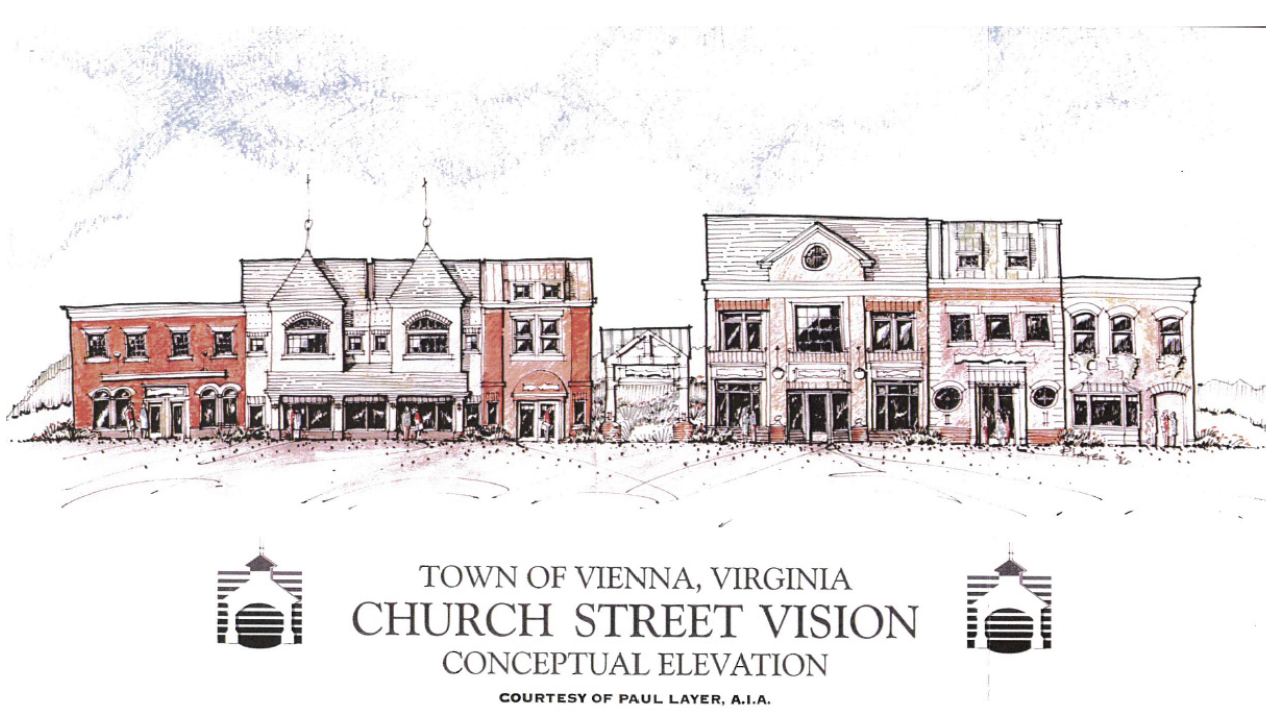
ii.
Each development shall be proportionate to the other in terms of height, scale and massing. While each building and site is developed independently and may incorporate many eclectic styles and design elements, the overall effect shall be a cohesive and comprehensive architectural area.
iii.
These renderings are not to be interpreted as working drawings, binding illustrations or specific requirements for any building or lot. The written guideline text is the applicable medium and, in the event of conflict between elements in any rendering and the written guideline text, the written guideline text shall prevail.
E.
Building Design Features.
i.
These design guidelines illustrate ways construction may occur which will complement and enhance the Town's character. They are not intended to dictate a particular style but rather offer guidance to the development theme desired in the Church Street Vision Incentive Overlay (CS-O). Buildings and developments within the CS-O overlay shall incorporate Virginia vernacular and enhance architectural styles that are reminiscent of the Town's history between 1890 and 1930.
ii.
Design goal: To coordinate the visual and architectural characteristics in the CS-O overlay, emphasize Vienna's heritage, and create a pedestrian oriented streetscape.
iii.
Design objectives:
a.
Preserve the character of the adjacent residential neighborhoods;
b.
Encourage reinvestment in the area by private property owners and merchants;
c.
Provide for at-grade separation of pedestrian and vehicular traffic through the use of on-street parking, centralized parking and clearly defined walkways;
d.
Integrate and enhance pedestrian walkways between commercial properties and public parks and lands;
e.
Maintain the character and heritage of the original historic Presbyterian Church, Freeman House and the Washington and Old Dominion (W&OD) Trail area as an enhanced public focal point and corridor gateway;
f.
Focus commercial activities, store fronts and signage at the pedestrian level.
iv.
Design policies:
a.
Continue the undergrounding of individual building utility connections;
b.
Coordinate private development with the municipal Church Street streetscape project design elements;
c.
Encourage shared and public automobile parking facilities and non-motorized transportation alternatives.
v.
General design requirements:
a.
Architectural styles for new buildings or the remodeling or renovation of existing buildings will be chosen from recommended characteristics shown in the conceptual architectural renderings appearing herein at § 18-236 and Town history and enhance the character of the Church Street corridor.
b.
Building additions shall be compatible with the conceptual architecture and provide compatible details, scale, voids, materials and colors.
c.
The lower level of buildings shall offer a front design that is conducive to pedestrian activity and interest.
d.
Visual interest shall be provided along the street and pedestrian ways, such as entrances, display windows, landscape areas and outdoor seating.
e.
Primary customer entrances shall be designed and focused on the street front. Such entrances must be maintained and accessible as an entrance at all times. Any secondary entrance must mimic the materials and design of the primary entrance.
f.
Arcades are encouraged along the first floor of corner buildings but may not be used more frequently than every three store fronts or eighty (80) feet.
g.
Solid walls, dull or minimal facades will not be designed along streets or pedestrian ways.
h.
Building heights shall be compatible with adjacent buildings and the topography of the site and in compliance with the conceptual architectural renderings.
i.
Building setbacks of in-fill structures shall be consistent with neighboring structures and in compliance with staggered setback requirements.
j.
The width and proportion of building facades shall be compatible with the overall scale of the neighborhood. Where multiple developments are proposed, the development proposal shall create the feeling of architectural proportionality through exterior facade design.
k.
Courtyard style arrangements of buildings are encouraged along the W&OD Trail and at other suitable locations to emphasize pedestrian access and minimize automobile importance.
l.
Parking shall be designed to the rear of the lot when possible. When adjoining another lot with abutting parking, the lots will be integrated and opened to each other when practical.
m.
Landscaping shall be included around the parking facilities to ease their appearance in compliance with the submitted landscape plan.
n.
Landscape areas shall be used to enhance the buildings situation and orientation on a lot.
o.
Safe, convenient walkways shall be identified by paver materials that coordinate with the public sidewalks within the public street right-of-way.
p.
Lots in the CS-O overlay on the southern side of Church Street shall encourage pedestrian access to Maple Avenue by sidewalks or paths through the lots, tying the commercial corridors together both visually and physically.
q.
Signs shall be integrated into the design of the building. They shall not interfere with the architectural integrity or features of the building and meet the sign design guidelines of this section. A complete sign package shall be designed in accordance with the design of the building, showing all intended signs along with font styles, attachment specifications standards, brackets, etc. for revies in conjunction with proposed building design.
r.
Exposed neon or any other similar linear or strip lighting shall not be visible from the street, regardless of form, size or interior location; it shall not be used as a building detail, decorative accent or signage.
s.
Materials used for construction will be consistent with the provisions of § 18-236.
t.
Vinyl siding may not be used below the second floor on any wall or surface visible from a public way. Aluminum siding and buildings primarily of glass are prohibited.
u.
Awnings or canopies may only be used in restaurant areas with outdoor patron seating.
v.
Awnings and/or canopies will be made of fabric. Vinyl or plastic awnings or canopies are not permitted.
w.
Building equipment, such as generators and air conditioning units shall be screened from view in a manner compatible with the site and using materials similar to the building and harmonious with the design.
vi.
Conceptual plan. The following rendering is a conceptual site plan with identified design elements satisfying § 18-236. It should not be interpreted as a working drawing, binding illustration or specific requirement for any building or lot. The written guideline text is the applicable medium and in the event of any conflict between elements in the conceptual site plan and the written guideline text, the written guideline text shall prevail.
FIGURE 2.18. Conceptual site plan example.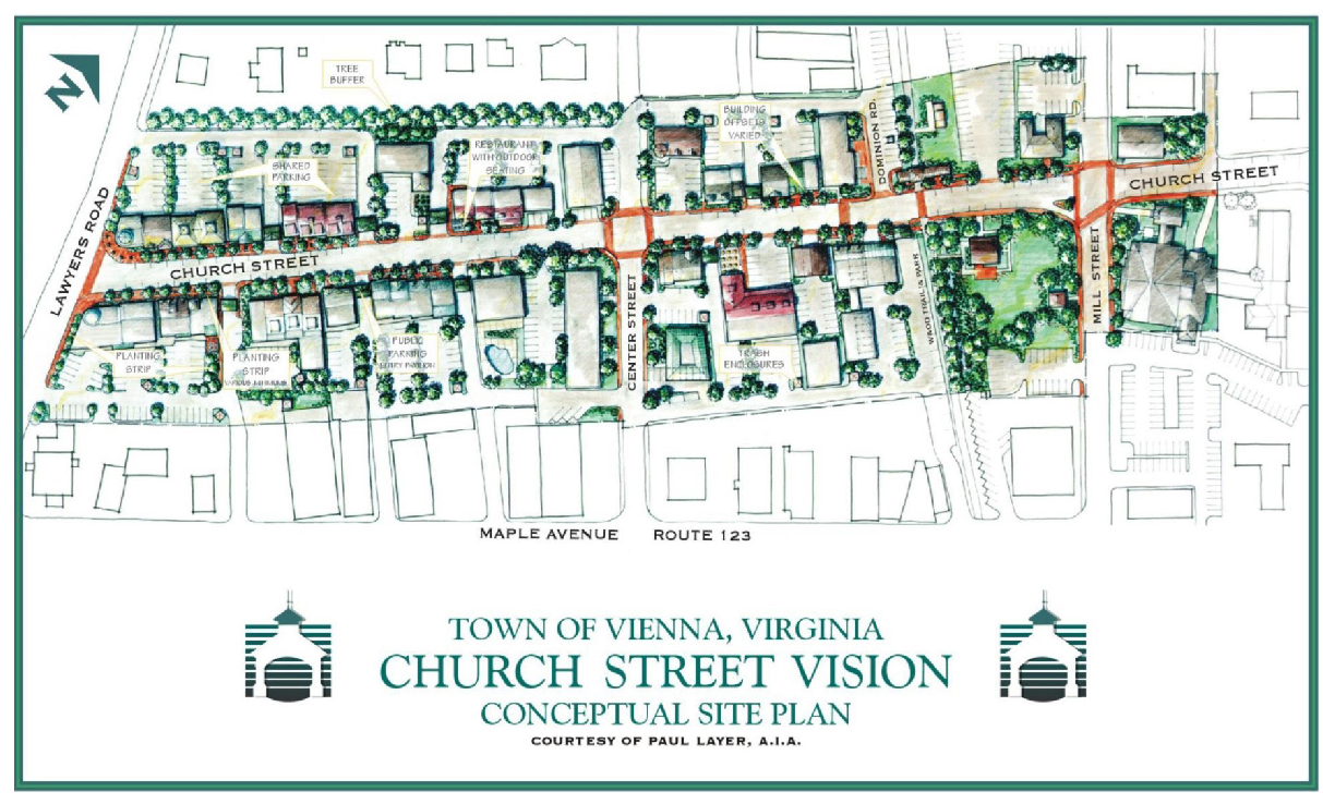
F.
Building setbacks and siting. Buildings shall be constructed to meet the following setbacks and siting criteria:
i.
Buildings shall be placed forward on a lot to create a continuous street block. Buildings shall have a relationship to adjacent buildings and facades that creates a staggered building line along the street, consistent with the following criteria.
ii.
Dimensional Standards:
Reference to Other Standards
Uses and Use Standards: See Article 3;
Development Standards - Commercial, Industrial, and Mixed-Uses: See Article 5A;
Development Standards - Public, Institutional and Community Uses: See Article 5B.
FIGURE 2.19. Illustration of staggered setbacks.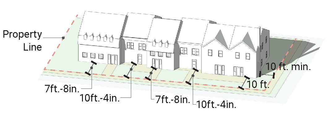
FIGURE 2.20. Illustration of recommended height.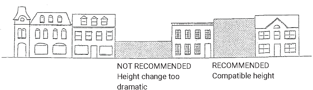
iii.
Siting. Parking is located behind the buildings which are pushed forward on the lot; Parking along the side of the building is screened by a wall; Parking is shared between properties and parking lots cross property lines.
FIGURE 2.21. Illustration of a siting that is not recommended, where parking is located
in front of the buildings.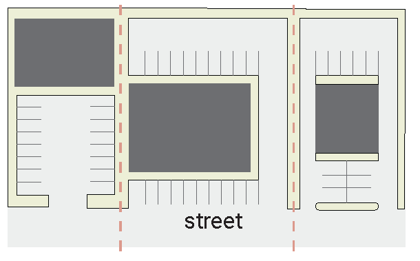
FIGURE 2.22. Illustration of a siting that is recommended.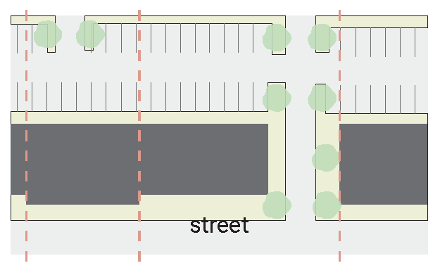
G.
Facade Proportion and street level continuity. The width and proportion of building facades (the relationship of a building's width to its height) shall be consistent with adjacent buildings. Buildings with a street front longer than forty (40) feet shall be architecturally designed and situated on the site to create the impression of multiple facades with staggered setbacks as set out in this section. Buildings should not be set back beyond the front building setbacks established in this section nor be situated to create a street front setback longer than forty (40) feet.
FIGURE 2.23. Illustration of recommended compatible façade proportion.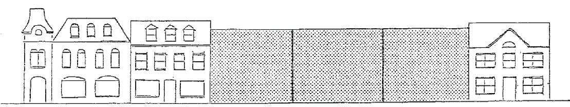
FIGURE 2.24. Illustration of façade that is too long and not recommended.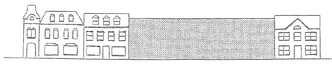
H.
Street level vitality. The street level of new and in-fill buildings, plazas, courtyards or other space and structures that face the street shall provide a primary pedestrian access and orient their design toward the street.
FIGURE 2.25. Illustration of street vitality examples.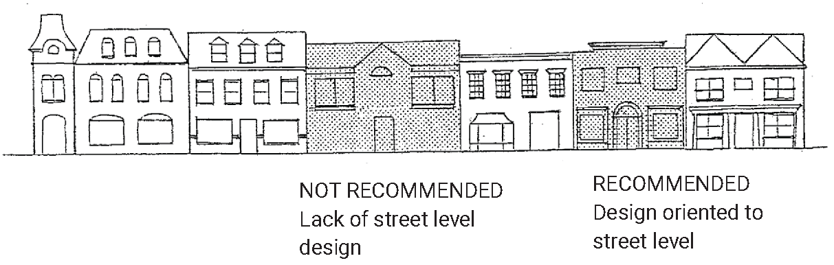
I.
Specific design requirements.
i.
First-story roofs shall have a minimum slope of 6:12.
ii.
Window centerlines shall be aligned whenever possible.
iii.
Cornices shall be aligned whenever possible.
iv.
Stucco may be used no nearer than two feet eight inches (2'8") to the base of the building. The building base, up to a height of two feet eight inches (2'8") above grade, should be constructed of brick or stone with a water table; split face block is acceptable upon review.
v.
EiFS, or any like material, may only be used above the first floor.
vi.
Mansard roofs are not permitted.
J.
Floor to area ratio (FAR).
i.
The maximum floor to area ratio (FAR) shall not exceed 0.7 for any lot and only upon accommodating both site and building design criteria.
ii.
Floor to area ratio is defined as the ratio of total floor area on a lot divided by the total lot area (FAR = total floor area/total lot area).
iii.
Total floor area is defined as the interior space of all floors of a building minus stairways, elevators, and attics or cellars with a ceiling height of six feet or less.
K.
Building materials. The following rendering identifies construction materials and architectural elements included in the CS-O overlay. It shall not be interpreted as a working drawing, binding illustration or specific requirement for any building or lot. The written guideline text is the applicable medium and in the event of any conflict between elements in any rendering and the written guideline text by the written guideline text shall prevail.
FIGURE 2.26. Illustration of architectural elements and building materials included
in the CS-O overlay.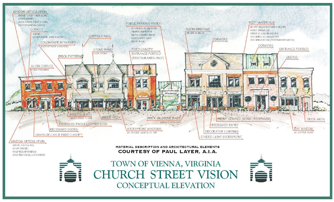
L.
Parking and circulation requirements.
i.
Parking shall be designed to the rear of the lot when possible. Where parking can only be located on the side of building, it must be screened from the principal pedestrian way by a low wall that integrates into the adjoining building or by the use of low hedges or other appropriate landscaping.
ii.
When adjoining another lot with abutting parking, the lots shall be integrated and opened to each other. In order to achieve the requirements of this section, reserved parking may be prohibited by site plan approval except for one reserved space for the owner or manager of the site.
iii.
These requirements shall in no way be permitted to delete otherwise lawfully required handicapped spaces.
iv.
Landscaping shall be included around the parking facilities to ease their appearance when possible.
v.
All lots developed as part of the CS-O district using the approved design guidelines shall provide shared parking with other lots developed under the Church Street Vision Design Guidelines unless prevented by an adjoining lot or lots not developed under the approved design guidelines.
FIGURE 2.27. Illustration of access ways.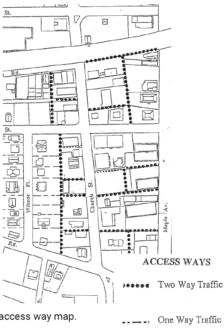
vi.
Standard parking spaces. All parking shall be provided at a net ratio of one space per six hundred (600) square feet of total floor area.
vii.
Compact parking spaces:
a.
40 percent of provided parking spaces may be compact in size.
b.
Compact parking spaces are described in § 18-529.
viii.
Access ways and easements:
a.
Access ways shall be developed within existing rights-of-way when possible, including existing, undeveloped alleys within the CS zone. When public rights-of-way or alleys are not available, access ways shall be established through dedicated public access easements specifying they are for public access purposes.
b.
Access easements shall meet fire codes and standards for one- and two-way traffic as determined and identified on the access way map.
c.
Additional public access easements may be required adjacent to existing rights-of-way or alleys to meet the fire code standards.
M.
Lighting. Lighting standards shall be no more than ten (10) feet in height above grade and shall be so arranged and hooded as to confine all direct light rays entirely within the boundaries of the property. Indirect and low ground-oriented lighting should be used whenever possible. Lighting fixture designs shall be harmonious with the general architectural nature of the building or site.
N.
Design Guidelines for Signs. Signs shall provide a coordinated image between signs and buildings and provide adequate exposure for the businesses.
i.
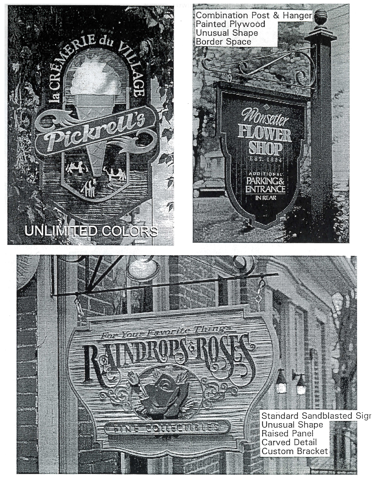
General sign design requirements.
a.
Signs shall be integrated into the design of the building and shall not interfere with the architectural integrity or features of the building.
b.
Exterior signs shall face public thoroughfares or rear parking lots.
c.
Signs may not be placed nearer to a window or door than a distance equal to the width of any molding surrounding the window or door. In the event there is no molding, the sign shall not be placed nearer to the edge of a window or door than four inches.
d.
Multiple panel signs shall be designed to create a harmonious overall impression.
e.
Exterior signs shall have an element of "three-dimensionality."
ii.
Content and layout.
a.
Sign text may only include the business name as the same is stated on the business license, except that a "trading as" (T/A) or "doing business as" (DBA) identity is acceptable. Either a tag line or three descriptive or informational items are also permitted. A trademark, or logo may be incorporated into the sign design provided the same conforms as to this provision. Telephone and facsimile numbers, Internet and electronic mail (E-mail) addresses, and prices may not be displayed on any sign.
b.
Sign design and copy shall serve the primary purpose of business identification. Colors shall be used appropriately for the architecture, business identification and design elements. Designs and colors shall not be used for product advertisement.
c.
Store hours may only be posted on an additional unilluminated sign no larger than 1½ square feet and placed adjacent to any public entrance.
d.
Sign layouts shall be centered within the sign area such that there is a border space around the entire sign with a width equal to ten percent of the total sign width.
e.
Sign designs and letter forms shall be professionally prepared.
iii.
Materials.
a.
Materials for signs will be consistent with the building architecture and section § 18-236.
b.
Signs shall be made of predominately natural materials such as wood, metal or stone.
c.
Synthetic materials, including plastic and sign foam, may be used only when it is finished to appear as a natural material.
d.
Unpainted plastic, molded plastic letters and vinyl leaf shall not be used.
e.
Glass beads or sand may be used to add texture.
f.
Only genuine metallic leaf products in gold or silver and Palladium leaf (a.k.a. Dutch Metal) may be used.
iv.
Lighting.
a.
Signs may be illuminated by reflected light only.
b.
Signs may not be internally illuminated or use any exposed neon tubing.
c.
Signs may be illuminated only by external spot lighting; such light fixtures to be architecturally part of the structure.
v.
Open signs.
a.
Each business may place one sign reading "open" in a store window facing a public thoroughfare or parking lot.
b.
"Open" signs may not exceed 1½ square feet, may not be internally illuminated and may not be made of neon.
vi.
Window signs. Only the following window signs will be permitted:
a.
One permanent window sign for each business, lettered on the inside of the glass with no background color, no larger than 25 percent of each window area of the window in which it is placed and made of either gold leaf, silver leaf or white individual letters.
b.
The area of a window sign will be calculated by measuring the outer edge of the overall sign image.
c.
Temporary window signs may not cover more than ten percent of any window area in which it is placed. Temporary window signs may not stay up for more than 30 days at one time and there may be no more than four such signs posted in any one calendar year.
vii.
Facade signs.
a.
Facade signs may not interfere with or interrupt building details or openings and shall be designed in coordination with the structure. Facade signs include any wall mounted sign facing the front street, rear customer entrance or other public way.
b.
A total of two square feet of facade signage is permitted for each linear foot of building frontage. Such sign area is to be shared by all tenants or tenant spaces within the building.
c.
Facade signs may be placed flat or perpendicular against any building side that fronts a parking lot or public thoroughfare.
d.
Facade signs must be permanently and securely attached to the building.
e.
Facade signs must be reinforced with a continuous metal band around the outer edge of the sign.
f.
Facade signs shall be below the trim fascia or gutter line.
g.
Facade signs shall not eclipse the roofline.
h.
Facade signs may be illuminated only by external spot lighting; such light fixtures to be architecturally part of the structure.
i.
Perpendicular signs may not project more than four feet from the building facade, may not over-hang the property line, and may not interfere with pedestrian traffic or the building's architectural elements.
viii.
Canopy signs. Canopy signs may only be placed flat along the canopy valance.
ix.
Freestanding signs.
a.
More than one freestanding sign may be erected per building but may not over-hang the property line or interfere with pedestrian traffic or the building's architectural elements.
b.
A freestanding sign may be no larger than twenty-four (24) square feet per building.
x.
Sign prohibitions. The following signs are prohibited:
a.
A-frame or sandwich board signs;
b.
Billboards;
c.
Signs which involve motion or rotation of any part, or display flashing, strobe, or intermittent lights;
d.
Signs generating amplified sound, smoke, vapor particle emission or objectionable odors;
e.
Standards, banners, flags, streamers and similar devices, except for national, state or local governmental flags and temporary banners approved by the zoning administrator;
f.
Exposed neon visible from the street regardless of form, location or message, including signs reading "open";
g.
Shopping center style directory signs for multiple tenants.
xi.
Additional sign restrictions.
a.
Signs shall not be placed or used to compete for automobile visibility.
b.
Real estate, "for sale" and "for rent" signs may only be placed in the windows of the building to which the signs pertain. Such signs may not be placed in outdoor locations and may be up only so long as the space is for rent or sale.
c.
Signs may not use fluorescent colors, paint additives such as "pearl" or "metal flake" reflective sheeting, or refractive metallic films, including gold leaf vinyl sheeting.
d.
Signs may not be placed or erected upon the roof of any building.
e.
Signs may not be plainly offensive to human sensibilities or otherwise provide a reasonably foreseeable detriment to the community.
xii.
Sign examples. The following pages provide examples of signs that illustrate the design elements, styles, colors and materials required in the CS-O overlay:
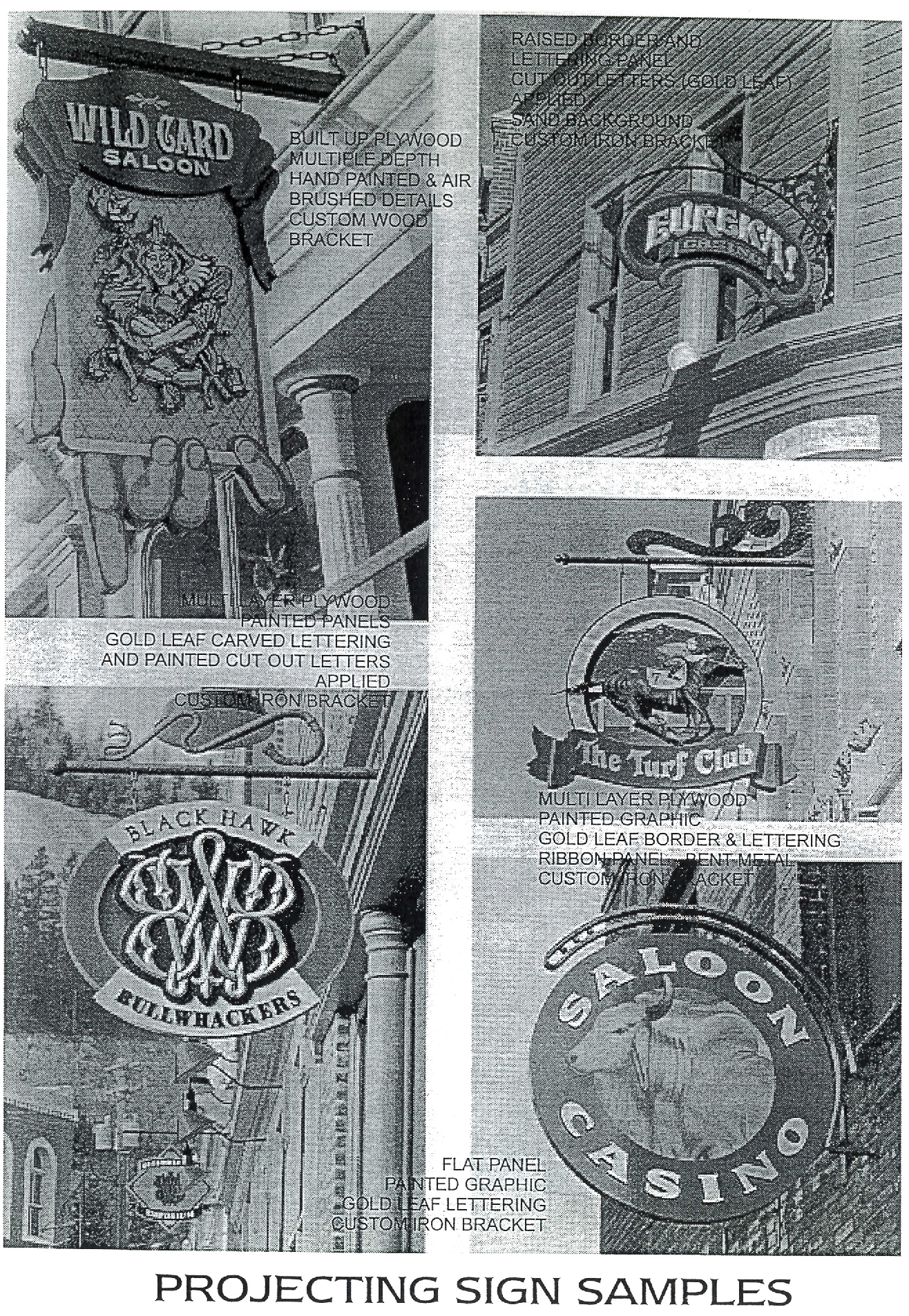
FIGURE 2.28. Sign Examples.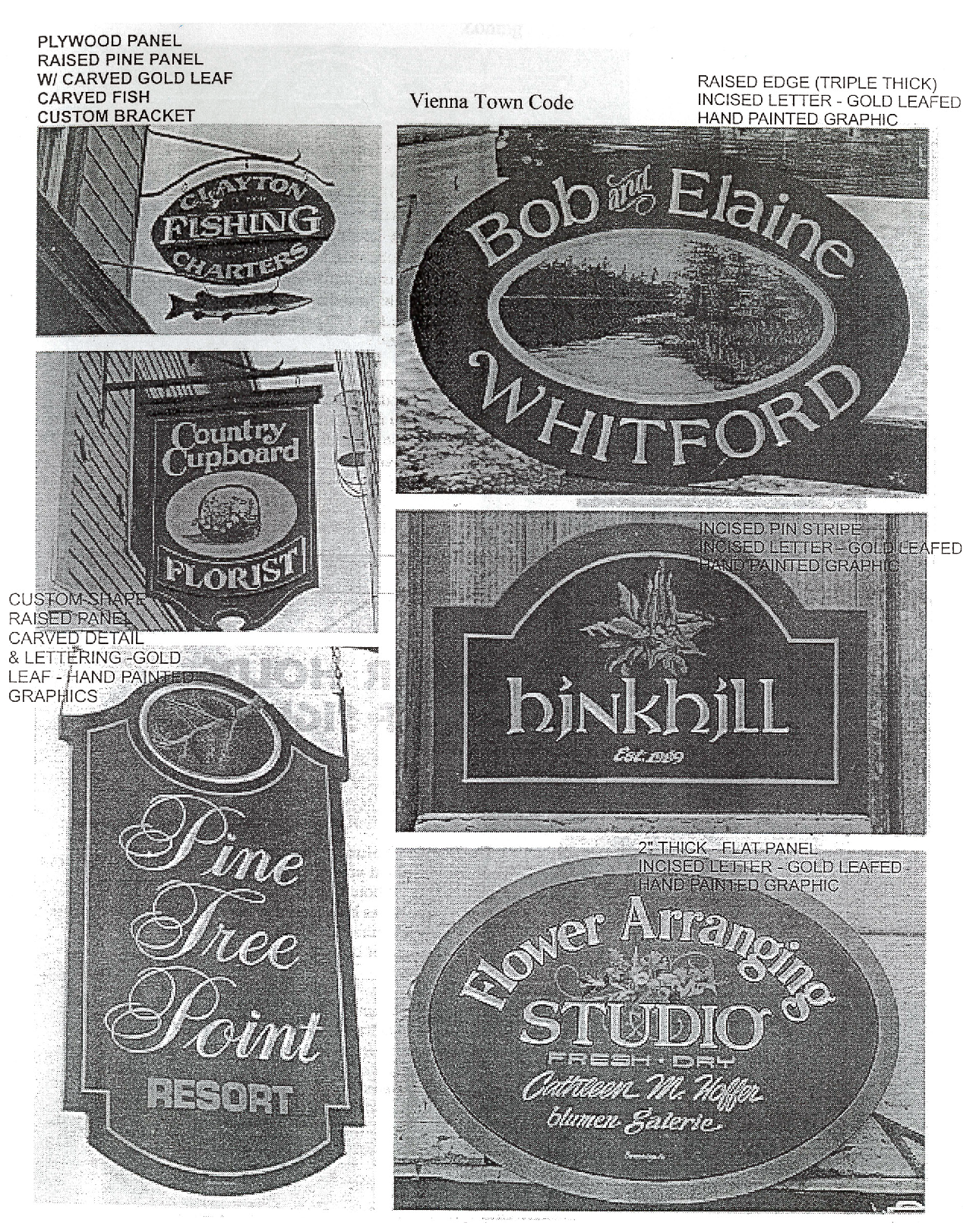
O.
Outside display and storage.
i.
Vending machines. Vending machines may not be placed outside of a wholly enclosed building or shelter.
ii.
Dumpsters. Trash, recycling and any other refuse collection dumpsters shall be located at the rear of the property and either screened, enclosed or otherwise blocked from public view. Such screening or enclosure shall be designed in conjunction with the primary building, shall use similar materials and shall provide complete obscurity of the dumpster. The screen or enclosure shall have double doors. Chainlink fencing may not be used.
P.
Sidewalks.
i.
Sidewalks in the identified CS-O overlay area shall be paved with coordinating pavers and designed to match the existing pattern established along the Church Street corridor.
ii.
Brick pavers shall be used in a coordinating pattern to widen the public sidewalk as they adjoin private sidewalks.
iii.
Sidewalks in the public right-of-way shall be constructed the full width of the lot and shall connect with existing sidewalk sections.
iv.
Sidewalks shall be clearly identified and shall connect the building entrance with the public sidewalks.
v.
Whenever possible, sidewalk patterns and pavers shall extend between the CS district and adjoining commercial properties to provide a visual connection between the commercial areas of Town and clearly delineating pedestrian space from automobile space.
vi.
A five-foot brick sidewalk shall be constructed along the front property line adjoining the public planter and sidewalk to create a divided double sidewalk. A landscaped area may be used instead, if a double sidewalk is inappropriate to the intended use of the building.
vii.
Except when the front yard is designed as a courtyard or patio, a landscape strip or planter shall be constructed between the building and the above-mentioned sidewalk. For buildings with the minimum setback, the planter or landscape strip must be at least two feet in width and placed adjacent to the building. The intent is to create a green space of varying width between the sidewalk and the building.
Q.
Landscaping.
i.
Trees shall be used to enhance the open space areas and parking lots and shall be maintained in good condition by the property owner.
ii.
Trees shall be selected so that they are resilient to pollution and drought, do not produce berries or fruit and have deep root growth so they do not upheave the sidewalks or planters.
iii.
Every landscape island five feet or more in length shall hold at least one tree and additional trees shall be planted within the island, for the full length of the island, so the ten-year canopy of each tree will touch edge-to-edge.
iv.
Trees planted shall be a minimum of four inch caliper and meet the specifications of the American Association of Nurserymen.
v.
Forty percent of the landscape island area shall be planted with vegetation in addition to trees and shall be maintained in good condition by the property owner.
vi.
The planting of trees shall be done in accordance with either the standardized landscape specifications jointly adopted by the Virginia Nurserymen's Association, the Virginia Society of Landscape Designers and the Virginia Chapter of the American Society of Landscape Architects, or the road and bridge specifications of the Virginia Department of Transportation.
R.
Lighting. Lighting standards shall be no more than ten feet in height above grade and shall be so arranged and hooded as to confine all direct light rays entirely within the boundaries of the property. Indirect and low ground-oriented lighting should be used whenever possible. Lighting fixture designs shall be harmonious with the general architectural nature of the building or site.
S.
Retaining walls and fences.
i.
All retaining walls, fences, and screening between zoning districts shall be constructed to the following required design using the following required materials and colors.
ii.
A six (6) foot tall masonry wall is required between any lot zoned single-family residential and any commercially zoned property, including lots and public access ways in the CS district. Such wall shall be constructed and maintained along the property line but on the side of the commercial land or access way. Such wall shall be constructed by the developer and maintained as part of the property.
iii.
Figure 2.29 represents the required design style for a masonry wall. The drawing should not be interpreted to be structurally detailed. Any masonry screen or retaining wall should reflect the same exterior design detail but will require additional structural engineering by an appropriately licensed professional.
FIGURE 2.29. Masonry wall example.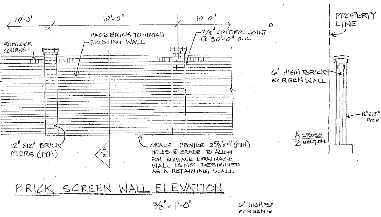
5.
Bonus modification.
i.
The following are acceptable bonus incentives which may be granted as site plan modifications by the Town Council in return for an owner or developer providing building design and site plan features desired by and acceptable to the Town and as adopted by § 18-236.
ii.
Bonus incentives:
a.
Increase building footage and lot coverage.
b.
Modification of lot coverages in general.
c.
Reduce front, rear, and side building setbacks.
d.
Modification to required number, size and location of parking spaces.
iii.
Modification, variance, or waiver of use or maximum height restriction requirements are not permitted.
Sec. 18-237. - Windover Heights Historic Overlay (WH-O).
1.
WH-O Purpose. The purpose of the Windover Heights Historic Overlay District is to recognize and designate by an overlay to the zoning map of the Town of Vienna, the Windover Heights Historic Overlay District of the Town. The district contains buildings and places in which historic events occurred and which have special public value because of notable architectural features and other features which relate to the cultural and artistic heritage of Vienna. To provide for the preservation of that district and sites therein, the Town Council recognizes that the district is a single-family residential neighborhood which has changed little since the turn of the century, which consists mostly of older homes, open spaces, and meandering streets lined with mature trees and shrubs which constitutes one of the original residential sections of historic old Vienna and which housed citizens who were prominent in the development of the Town.
FIGURE 2.30. Reference map of the Windover Heights Historic Overlay District.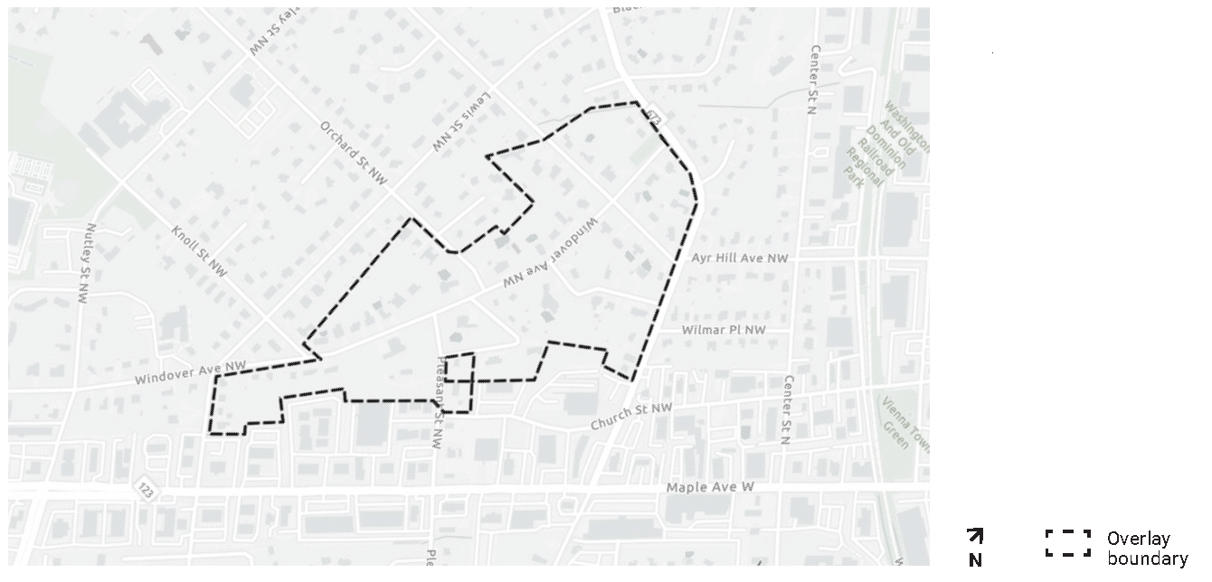
2.
Public Improvements Controls.
A.
No new construction projects, the purpose of which shall be the installation of new public improvements and publicly-owned utilities not in existence at the time of the adoption of the ordinance, shall be commenced in the Windover Heights Historic Overlay District until the Town Council shall first conduct an advertised public hearing concerning the necessity of the improvement, at which hearing the recommendations of the Windover Heights Board of Review, if available, shall be included in the record.
B.
Single lot redevelopment, except those lots with any frontage on Lawyers Road NW, within the Windover Heights Historic District is exempt from the frontage improvement requirements within Section 18-402 Frontage Improvements.
C.
The provisions of this section shall not be applicable to maintenance or repair of existing public improvements or utilities.
3.
Certification of Appropriateness Required. See § 18-840.
4.
Administration and Procedures. See Article 8.
Sec. 18-238. - Chesapeake Bay Preservation Areas Overlay (CB-O).
1.
Purpose. The purpose of the Chesapeake Bay Preservation Areas Overlay District is to protect, improve, and enhance the water quality of the Chesapeake Bay, its tributaries and other state waters. These regulations are issued under authority of Code of Virginia, § 62.1-44.15:74 and § 15.2-2283 and regulations of 9VAC25-830-10 et seq.
FIGURE 2.31. Reference map of the Chesapeake Bay Preservations Areas Overlay.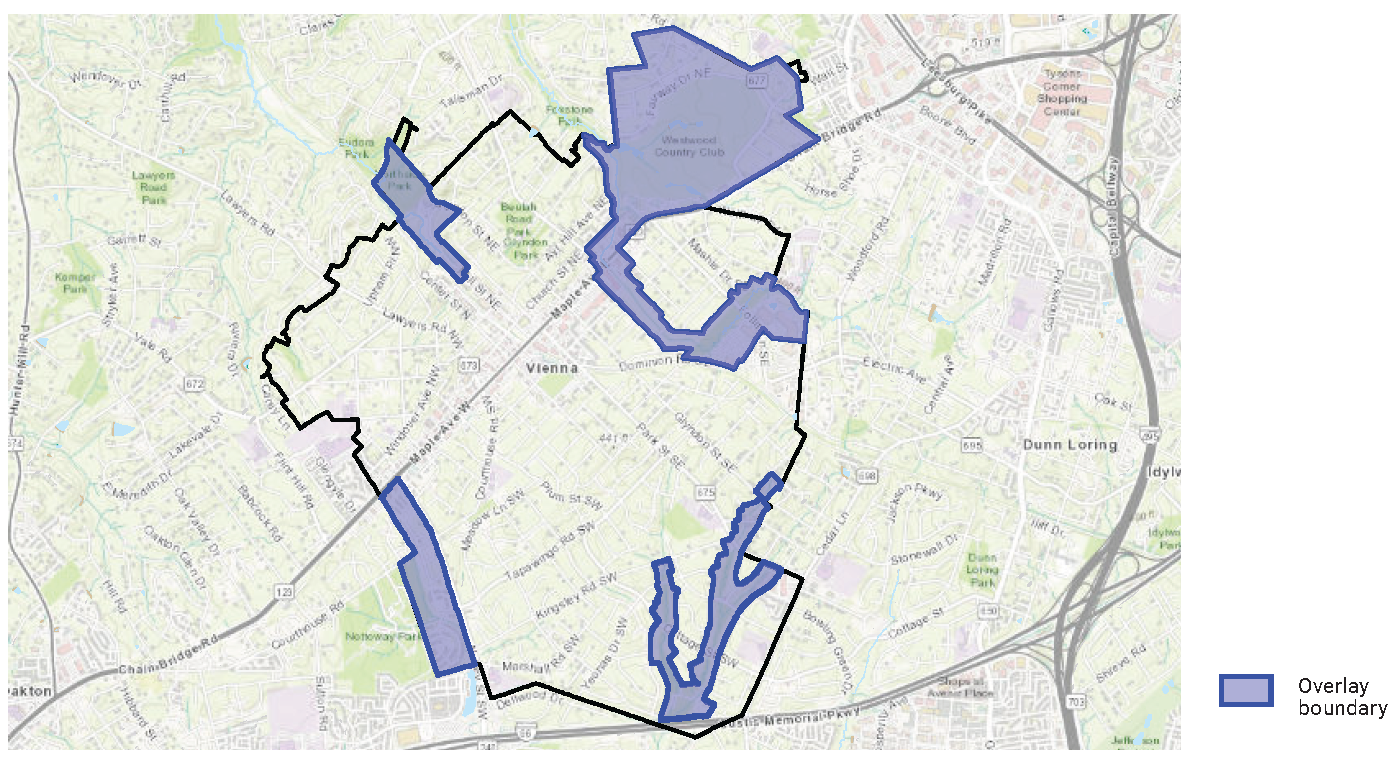
2.
Definitions. The following words, terms and phrases, when used in this article, shall have the meanings ascribed to them in Article 9, except where the context clearly indicates a different meaning.
3.
General Provisions.
A.
Application. The regulations in this section shall apply to all lands located within Chesapeake Bay Preservation Areas (CBPA), both resource management areas and resource protection areas as defined above and as depicted on the official CBPA maps for the Town of Vienna.
B.
Delineation of RPA (resource protection area) boundaries. An applicant for a building, clearing or grading permit, or subdivision or site plan review shall conduct an evaluation to locate the boundary of the RPA (100-foot buffer area) on the applicant's property as well as the boundary of the fifty (50) foot portion of the buffer area that is directly adjacent to the water body with perennial flow. All plans shall clearly delineate the buildable areas on each lot and based on the performance criteria, identify the front and side yard setbacks and any other relevant easements or limitation regarding lot coverage. The applicant shall submit the results of the evaluation to the Town for review. The Town may provide such assistance to an applicant, as the Town deems necessary, to conduct such evaluation.
C.
Dispute of resource protection area boundaries. An applicant for a building, clearing or grading permit, or subdivision or site plan review for land within an RPA who disputes the boundaries on the CBPA Map, a delineation of boundaries pursuant to the above subsection, or the inclusion of the applicant's property within an RPA shall submit to the Zoning Administrator a site specific evaluation with supporting evidence to determine where such boundaries are or whether a water body on or adjacent to the applicant's property is a water body with perennial flow. The existence and location of a water body with perennial flow that is on or adjacent to the development site must be identified in the evaluation, including any non-tidal wetlands connected by surface flow or contiguous to such a water body. The applicant shall submit to the Zoning Administrator surveys or drawings, which indicates a precise delineation of the RPA boundary, including buffer area. The Zoning Administrator will review and confirm that the boundaries of the RPA (resource protection area) are adjusted, as necessary, based on the evaluation of the site.
4.
Allowed Uses and Developments.
A.
Permitted uses, accessory uses, and conditional uses shall be allowed as established by the underlying zone or district except as specifically modified by the Chesapeake Bay Preservation Areas Overlay District regulations.
B.
Lot sizes shall meet the requirements of the underlying zone or district; provided further that any subdivision plat submitted after the effective date of the ordinance from which this article is derived shall provide sufficient area outside an RPA to accommodate an intended use.
C.
Allowed uses in resource protection areas.
i.
Land development must be permitted by the underlying zone or district and must be in compliance with all applicable performance requirements of § 18-238.5. Land development shall be allowed only if it meets one or more of the following criteria:
a.
Is water dependent. New or expanded water dependent facility may be allowed provided that:
1.
Any non-water dependent component is located outside of resource protection areas;
2.
Access will be provided with the minimum disturbance necessary. Where possible, a single point of access will be provided;
3.
it does not conflict with the comprehensive plan;
4.
It complies with the performance criteria for RPAs.
b.
Constitutes redevelopment. Redevelopment in RPAs shall be permitted only if there is no increase in the amount of impervious cover and no further encroachment within the resource protection area.
c.
Is a use established prior to October 1, 1989.
d.
Is a road or driveway not exempted under this section and satisfies the following conditions:
1.
No reasonable alternatives to aligning the road or driveway in or across the RPA exist;
2.
The alignment and design of the road or driveway are optimized, consistent with other applicable requirements, to minimize encroachment in the RPA and adverse effects on water quality;
3.
The design and construction of the road and driveway satisfy all applicable criteria of this chapter, including submission of a water quality impact assessment; and
4.
The proposed road or driveway meets all requirements to obtain a building permit or site plan approval.
e.
Is a flood control or stormwater management facility satisfying the following conditions:
1.
The facility within the RPA is in its optimum location;
2.
The size of the facility is the minimum necessary to provide necessary flood control, stormwater management, or both;
3.
The facility must be consistent with a storm management program that has been approved by the state department of environmental quality as a Phase I modification to the Town's program;
4.
All applicable permits for construction in state or federal waters have been obtained from the appropriate state and federal agency, such as the U.S. Army Corps of Engineers and the state department of environmental quality;
5.
A building permit or site plan approval has been obtained;
6.
Routine maintenance is performed on such facility to ensure that it continues to function as designed.
ii.
The following uses and improvements are exempt from the performance criteria of § 18-238.5:
a.
Passive recreation facilities, such as hike and bicycle trails, picnic areas and pathways, and historic preservation and archaeological activities, provided that:
1.
All land disturbing activity exceeding an area of 2,500 square feet shall be performed in accordance with performance criteria in § 18-238.5.B.i.e.
2.
Such uses are reviewed and approved by the zoning administrator.
b.
Utilities, public facilities, improvements such as streets, channel improvements, bridges, utility pipes and utility transmission lines with the performance criteria exemptions found in this section.
c.
Reconstruction or structural alteration of those buildings, structures, and improvements existing prior to the effective date of the ordinance from which this article is derived, provided that the performance criteria of this section are met.
D.
Nonconforming Uses and Waivers.
i.
No alteration or expansion of a nonconforming principal building or structure shall be permitted with the exception that the Zoning Administrator may grant a waiver when:
a.
There will be no net increase in non-point source pollutant load;
b.
Any development or land disturbance exceeding an area of 2,500 square feet shall comply with all requirements of Chapter 23;
c.
Granting the waiver will not confer upon the applicant any special privileges denied by this article to other property owners in the RPA;
d.
The waiver is not based on conditions or circumstances that are self-created or self-imposed, nor does the request arise from conditions or circumstances either permitted or nonconforming that are related to adjacent parcels;
e.
The waiver is the minimum necessary to afford relief;
f.
The waiver will be in harmony with the purpose and intent of the RPA, not injurious to the neighborhood or otherwise detrimental to the public welfare, and is not of substantial detriment to water quality; and
g.
Reasonable and appropriate conditions are imposed which will prevent the waiver request from causing a degradation of water quality.
ii.
This waiver may be granted only for relief from the Chesapeake Bay Preservation Area requirements and shall not apply to any other restrictions imposed or required by this Code including, but not limited to, the floodplain, zoning, subdivision, erosion and sedimentation, and stormwater management ordinances. Any development not meeting the performance criteria in this section shall require an exception.
iii.
Appeals to any waiver decision of the Zoning Administrator shall be made to the Board of Zoning Appeals in accordance with Chapter 23.
5.
Performance Criteria.
A.
It is the intent of these criteria to achieve a ten (10) percent reduction in non-point source pollution for redevelopment under one (1) acre, achieve a twenty (20) percent reduction in non-point source pollution for redevelopment one (1) acre or greater, and to prevent an increase in non-point source pollution from new development.
B.
General Performance Criteria.
i.
Unless provided elsewhere in this article, each use, development or redevelopment of lands located in a Chesapeake Bay Preservation Areas as designated on the official CBPA map for the Town and/or verified by the site specific evaluation required under § 18-238.3.B shall meet or exceed the following performance criteria:
a.
No more land shall be disturbed than is necessary to provide for the proposed use or development.
b.
Indigenous vegetation shall be preserved to the maximum extent practicable, consistent with the use and development proposed.
c.
All development, including residential, which exceeds 2,500 square feet of land disturbance, shall be subject to site plan review as required in this ordinance's site plan control provisions and shall be accomplished through a plan of development review process consistent with § 15.2-2286.A.8 of the Code of Virginia and 9VAC25-830-240(1)(e) of the Regulations.
d.
All land development shall minimize impervious area consistent with the proposed use or development.
e.
Any land disturbing activity that exceeds an area of 2,500 square feet, including single-family homes and septic lines and drain fields, shall comply with the requirements of this ordinance's environmental controls found in Chapter 23.
f.
On-site land disturbing activities shall not begin until appropriate permits such as those for land disturbing or building have been issued and evidence provided that all required federal and state wetland permits have been obtained.
g.
All development, including single-family residential, which exceeds 2,500 square feet of land disturbance, shall include the delineation of the resource protection area and resource management area boundaries, if any, including notations of the following specific state requirements on the final plat, as specified in 9VAC25-830-190(A)(4) of the Chesapeake Bay Preservation Area Designation and Management Regulations:
1.
To retain an undisturbed and vegetated 100-foot wide buffer area;
2.
The permissibility of only water dependent facilities or redevelopment in resource protection areas, including the 100-foot wide buffer area; and
3.
The delineation of the buildable areas that are allowed on each lot, based on the performance criteria specified in 9VAC25-830-190(A)(5) of the Regulations.
C.
Additional Performance Criteria for Resource Protection Areas.
i.
The following criteria shall apply within RPAs in addition to this section's general performance criteria.
ii.
Except as otherwise provided herein, no land disturbing activity and no acts prohibited by the Town Flood Plain Ordinance shall be permitted in RPAs.
iii.
Buffer area requirements:
a.
For the purpose of retarding runoff, preventing erosion and filtering non-point source pollution from runoff, a buffer area extending at least 100 feet adjacent to the edge of a water body with perennial flow shall be retained, if present, or established wherever such buffer does not exist. The 100-foot buffer shall be deemed to achieve a seventy-five (75) percent reduction in sediment and a forty (40) percent reduction of nutrients. The following performance criteria shall apply.
b.
In order to maintain the functional value of such buffer area, indigenous vegetation may be removed as permitted by the Town of Vienna only to provide reasonable sight lines, access paths, general woodlot management and BMP, including those that prevent upland erosion and concentrated flows of stormwater, as follows:
1.
Trees may be pruned or removed, subject to the provisions of Town Tree Preservation regulations to provide for sight lines and vistas; provided, however, that each tree removed shall be replaced with other vegetation, which is at least equally effective in retarding runoff, preventing erosion and filtering non-point source pollution from runoff.
2.
Dead, diseased or dying trees or shrubbery may be removed.
3.
Trees and woody vegetation may be removed in connection with approved stream bank erosion control projects. However, control techniques must be employed and appropriate vegetation established to protect or stabilize the stream bank.
4.
Any trail or pathway shall be constructed and surfaced so as to effectively control erosion.
c.
When the establishment of a buffer area results in the loss of buildable area on a lot or parcel recorded prior to October 1, 1989, the Zoning Administrator may permit encroachment into the buffer area after submission of sufficient evidence as follows:
1.
Encroachments into the buffer area shall be permitted to the minimum extent necessary to achieve reasonable buildable area for a principal building or structure and necessary utilities to serve the building or structure.
2.
Where practicable, a vegetated area that will maximize water quality protection, mitigate the effects of buffer encroachment, and is equal to the encroachment area shall be established elsewhere on the lot or parcel to maximize water quality protection.
3.
The encroachment may not extend into the fifty (50) foot portion of the buffer area that is directly adjacent to the water body with perennial flow.
d.
All plans and/or plats submitted for approval and review shall include a notation that specifies the requirement to retain an undisturbed and vegetated 100-foot buffer area in the resource protection areas ("RPA").
D.
Water Quality Impact Assessment.
i.
A water quality impact assessment (WQIA) is required to be submitted with all development and redevelopment site plans for property partially or totally located within an RPA and where there is land disturbing activity in excess of 2,500 square feet in the RMA. The WQIA study will include but not be limited to the following.
ii.
Narrative description.
a.
Impact of proposed development on water quality.
b.
Description of specific measures to be employed to mitigate the impacts.
c.
Geology of the site.
d.
Estimates of pre-development and post-development runoff.
e.
Additional information as deemed necessary by the director of public works or zoning administrator to assist in the review of the project.
iii.
Site drawing.
a.
Existing topography, soils and hydrology of the site.
b.
Boundaries of the RMA, and if adjacent to a water body with perennial flow as defined in this article, the location of the 100-foot RPA buffer area.
c.
Location and nature of any proposed encroachments into the RPA buffer area including roadways and areas of grading; location of structures, driveways, or other impervious cover; utilities; and wetland mitigation sites.
d.
Type and location of proposed stormwater management facilities and best management facilities and BMPs to mitigate the proposed encroachments.
e.
Size and location of anticipated drainfield or wastewater irrigation areas.
f.
Location of existing vegetation on site, including the number and type of trees and the vegetation to be removed in the buffer to accommodate the encroachment or modification.
g.
Re-vegetation plan that supplements the existing buffer vegetation in a manner that provides for pollutant removal and erosion and runoff control.
E.
Exemptions for Public Purposes.
i.
Exemptions for public utilities, public roads, railroads and similar facilities from performance criteria for RPAs are as follows.
ii.
Construction, installation, operation and maintenance of electric, natural gas, telephone, fiber optic, and cable television transmission lines, railroads and public roads and their appurtenant structures shall be exempt from the performance criteria in this section, provided that said construction, installation, operation and maintenance is in accordance with this ordinance's environmental controls or the Erosion and Sediment Control Law (Code of Virginia, § 62.1-44.15:51 et seq.), as appropriate.
iii.
Construction, installation and maintenance of water, sewer, natural gas, and underground telecommunications and cable television lines owned, permitted, or both by the Town or a regional service authority shall be exempt from the performance criteria in this section, provided that:
a.
Such utilities and facilities shall be located outside RPAs to the highest degree possible.
b.
No more land shall be disturbed than is necessary to provide for the desired utility installation.
c.
All construction, installation and maintenance of such utilities and facilities shall be in compliance with all applicable state and federal permits and designed and conducted in a manner that protects water quality.
d.
Any land disturbing activity exceeding an area of 2,500 square feet shall comply with the requirements of this ordinance's environmental controls.
F.
Exceptions.
i.
An application for an exception to the requirements of the Chesapeake Bay Preservation Areas Overlay § 18-238 shall be made in writing to the Board of Zoning Appeals. It shall identify the impacts of the proposed exception on water quality and on lands within the RPA through the performance of a water quality impact assessment, which complies with the provisions of subsection 5.D. of this section.
ii.
The Board of Zoning Appeals shall notify the affected public of any such exception requests and shall consider these requests in a public hearing in accordance with Code of Virginia, § 15.2-2204, except that only one hearing shall be required.
iii.
The Board of Zoning Appeals shall review the request for an exception and the water quality impact assessment and may grant the exception with such conditions and safeguards as deemed necessary to further the purpose and intent of this article if the Board of Zoning Appeals finds that:
a.
Granting the exception will not confer upon the applicant any special privileges denied by this article to other property owners in the RPA;
b.
The exception is not based on conditions or circumstances that are selfcreated or self-imposed;
c.
The exception is the minimum necessary to afford relief;
d.
The exception will be in harmony with the purpose and intent of the RPA, not injurious to the neighborhood or otherwise detrimental to the public welfare, and will not result in substantial detriment to water quality; and
e.
Reasonable and appropriate conditions can be imposed which will prevent the exception request from causing a degradation of water quality.
iv.
If the Board of Zoning Appeals cannot make the required findings or refuses to grant the exception, the Board of Zoning Appeals shall return the request for an exception together with the water quality impact assessment and the written findings and rationale for the decision to the applicant.
v.
A request for an exception to the requirements of provisions of this article other than § 18-238.4.c and subsection C.iii. of this section shall be made in writing to the Zoning Administrator. The Zoning Administrator may grant these exceptions provided that:
a.
Exceptions to the requirements are the minimum necessary to afford relief; and
b.
Reasonable and appropriate conditions are placed upon any exception that is granted, as necessary, so that the purpose and intent of this article is preserved.
c.
Exceptions to this section's general performance criteria may be made, provided that the findings noted in subsection F.iii. of this section are made.