
Vienna Charter Township
City Zoning Code
City Zoning Code
ARTICLE 18
- SCHEDULE OF REGULATIONS
Sec. 1800.- Height, bulk, density, and area standards by zoning district.
(Ord. of 3-21-2005, § 1800)
Sec. 1805. - Notes to schedule of regulations.
(a)
See sections 1810 and 1815 for alternative residential development standards. Where public sanitary sewer is not available, the minimum lot size shall be one acre. Where public water is not available, the minimum lot size shall be 15,000 square feet. Where public sanitary sewer or public water is not available, the minimum lot width shall be 100 feet in the RSA district and 90 feet in the RU-1 district.
(b)
Landscaping of all yards abutting a street shall be provided. For all uses except one-family detached residential, a landscape plan shall be submitted in accordance with the applicable provisions of section 2050. The objective of such landscaping is not to totally obscure, but to soften the overall appearance of the use. Planning commission approval of the landscape plan shall be required whenever site plan approval is required.
(c)
The minimum yard abutting a street shall be ten feet and off-street parking shall not be permitted. When a rear yard is abutting a side yard, the setback abutting a street shall not be less than the minimum front yard setback of the district and all regulations applicable to a front yard shall apply.
(d)
Density in the RMC and RM districts shall be subject to the following requirements:
(1)
The total number of rooms in multiple-dwelling structures shall not be more than the area of the parcel in square feet divided by the following square feet:
(2)
For the purpose of computing number of rooms, the following shall control:
a.
Efficiency apartment unit: one room.
b.
One-bedroom unit: two rooms.
c.
Two-bedroom unit: three rooms.
d.
Three-bedroom unit: four rooms.
Plans presented showing one-, two- and three-bedroom units and including a den, library or other extra room shall count such extra room as a bedroom for the purpose of computing density. In no instance shall more than 15 percent of the total number of units of any multiple-family development be utilized for efficiency apartments.
(3)
The area used for computing density shall be the total site area exclusive of any dedicated public right-of-way of any roads abutting the boundary of the site.
(e)
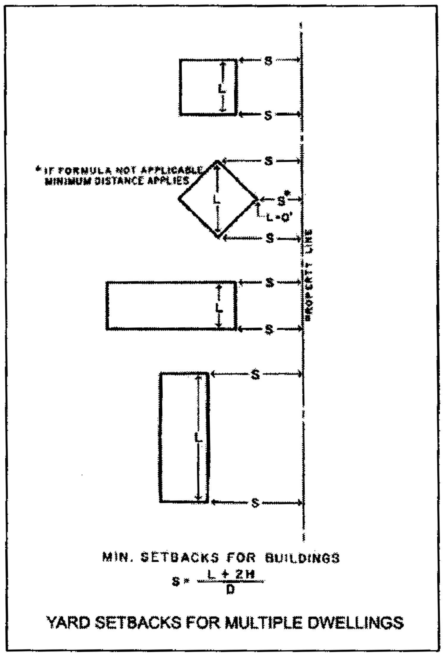
The minimum setbacks for two-family dwellings shall be 30 feet from an abutting RSA or RU-1 district or as required by footnote (m) of this section 1805 from all other abutting districts or uses. All other main buildings or uses shall provide the minimum yard setback, unless exceeded by the following requirements:
(1)
Setbacks shall be controlled in relationship to the length and height of buildings based upon the formula (see accompanying diagram):
(2)
Along those property lines which abut a one-family residential district, or which abut one-family detached units in any other district, and which are not separated from such units, lots or one-family district by a major or secondary thoroughfare, or collector road, or where the abutting one-family residential district is not already developed for a permitted use other than one-family residential, the minimum required yard shall be determined by the following formula:
a.
In the RMC district:
b.
In the RM district:
(3)
In all other instances in either the RMC or RM district or where the planning commission determines that the adjoining property is indicated on the master plan as an area of other than one-family residential use, the minimum required yard shall be determined by the following formula:
(f)
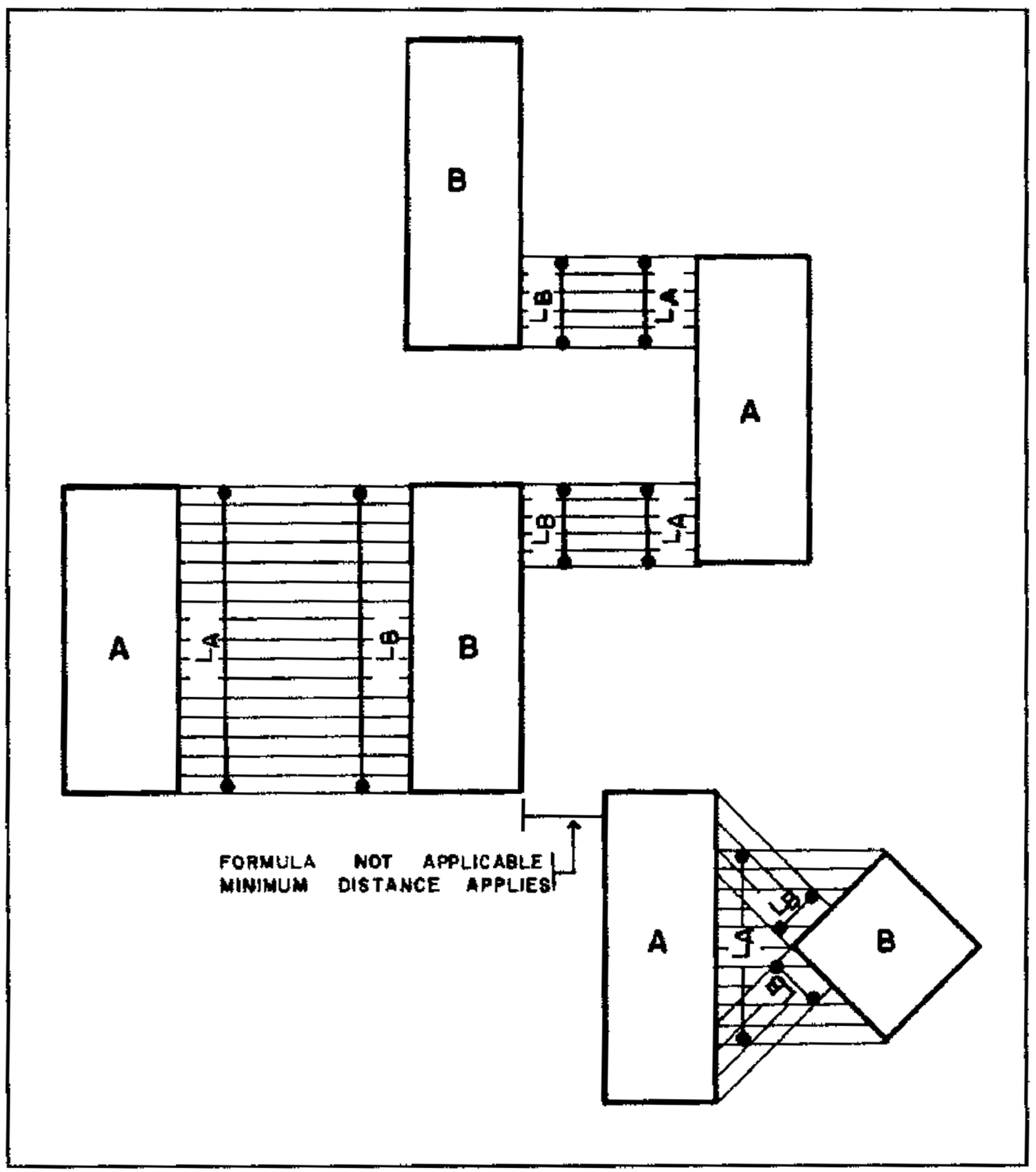
The minimum distance between any two multiple-family dwelling buildings shall be regulated according to the length and height of such buildings, but in no instance shall this distance be less than 30 feet unless there is a corner-to-corner relationship between buildings in which case the minimum distance shall be 15 feet. The minimum distance between two-family dwelling buildings shall be 15 feet.
(1)
The formula regulating the minimum distance between two buildings is as follows (see accompanying diagram):
Minimum Distance Between Buildings
(2)
The depth of any court shall not be greater than three times its width.
(g)
In any yard abutting a street or freeway, a landscaped area not less than 15 feet deep and abutting the street or freeway shall be provided in the setback.
(h)
The total floor area minimum per unit shall be as follows:
(i)
The required front yard setback may be reduced to not fewer than 25 feet, provided that there are no off-street parking spaces or aisles located within the front yard. Otherwise, parking may be permitted within the required front yard setback, provided that the parking setback is not fewer than 12 feet and an area within the front yard, including the 12 feet, remains as lawn or landscaped area which is equal to the percentage specified of the area of the required front yard setback. In those instances where the setback required by the application of a formula exceeds the stated minimum setback, the percentage shall be applied to the stated minimum setback.
(j)
The calculation of open space may include water retention. The predominant minimum width of any separate open space included in the calculation shall be ten feet.
(k)
The minimum setbacks indicated shall apply unless exceeded by the distance required by other applicable footnotes of this section or by the following formula, based upon the length and height of buildings. (see diagram accompanying footnote e):
(1)
Along those lot lines which abut a one-family residential district (RSA, RU-1) and which are not separated from the one-family district by a major or secondary thoroughfare, freeway or collector road, or the abutting one-family district is not already developed for a permitted use other than one-family residential, the minimum required setback shall be determined by:
(2)
Along those lot lines which abut a public street right-of-way or a RMC, RM or AR district or an existing use in a one-family district other than a single-family dwelling, the minimum required setback shall be determined by:
(3)
In all other instances, the minimum required setback shall be determined by:
(l)
Off-street parking spaces and aisles shall not be permitted within the minimum front yard setback.
(m)
Two-family dwellings (duplexes) located on individual zoning lots shall be subject to the following requirements:
(1)
Front yard setback — 25'.
(2)
Side yard setback — 12'.
(3)
Rear yard setback — 35'.
(n)
In those instances where a service drive is to be provided in accordance with section 1410, the required percentage of open space may be reduced to 13 percent.
(Ord. of 3-21-2005, § 1805)
Sec. 1810. - Subdivision open space plan.
1.
Purpose. The purpose of the subdivision open space plan is to encourage the proprietor of a subdivision or site condominium to vary from conventional subdivision design methods in order to promote the following objectives:
a.
To encourage a continuous and interconnected open space theme throughout a subdivision through lot size reductions and lot clustering;
b.
To encourage the preservation of natural features, including wetlands, woodlands and similar natural assets;
c.
To encourage the most cost/effective method of land development by substantial reductions in lineal feet of required roads and utility lines;
d.
To promote a more pleasing and environmentally conducive relationship between the physical development environment and the natural environment; and
e.
To provide active or passive recreation space for residents of the development.
2.
Modifications. Where public utilities for sanitary sewer and water are provided, modifications to the standards prescribed in section 1800 with respect to the RSA and RU-1 districts may be made subject to the following conditions:
a.
Lot dimensions may be reduced in accordance with the following schedule, provided that the number of residential lots or sites shall not exceed the following maximum densities (including roads):
b.
Lot or site widths shall not be less than the following:
c.
Lot depths shall not be less than the following:
d.
Minimum yard setbacks may be reduced as follows:
(1)
RSA districts, 30-foot front yards and rear yards.
(2)
RU-1 districts, 30-foot rear yards.
e.
The planning commission may take under advisement zero side yard requirements, particularly in situations of a cul-de-sac street. If approved, the side yards of each lot or site shall be recorded on the plat or condominium plan.
3.
Parcels for common use.
a.
A parcel to be dedicated for the common use of the subdivision or site condominium shall be in no instance fewer than two acres and shall be in a location and shape approved by the township, provided that, a parcel divided by a road or stream shall be considered as one parcel.
b.
Access shall be provided to areas dedicated for the common use of the subdivision to those lots not bordering on such dedicated areas by means of public streets or pedestrian access-ways.
4.
Ownership, improvement and maintenance of open space areas.
a.
A plan for the open space areas shall be submitted and shall include a cost estimate of improvements to be made within the open space.
b.
Whenever a developer or proprietor employs the terms of this section, provision shall be made for the incorporation of a home owners association or equivalent or some other means of assuring the open space remains in perpetuity. If an association, it shall provide for mandatory membership with fees adequate to maintain all common open space areas.
c.
The initial amount of development that takes place under subsection 1810.2 shall be perpetually maintained. In the event that open space is not adequately maintained, the township shall be entitled to enter upon the property and to carry out improvements as required and to make such assessments as are required to pay these costs against the owners of the dwellings located within the subdivision open space plan.
d.
Information proposed to address the requirements above in subparagraph a. shall be submitted to the township attorney who shall review the proposed subdivision open space plan and render an opinion with respect to:
(1)
The proposed manner of holding title to the open land;
(2)
The proposed manner of payment of taxes;
(3)
The proposed method of regulating the use of the open land;
(4)
The proposed method of maintenance of property and financing thereof;
(5)
Any other factor related to the legal or practical problems of ownership, use and maintenance of the open land.
5.
Review procedures.
a.
Tentative planning commission approval. If the planning commission is satisfied that the proposed subdivision open space plan meets the letter and spirit of the zoning ordinance and subdivision regulations and should be approved, it shall give tentative approval to the plan with the conditions upon which such approval should be based. Thereafter, the township board shall take action upon such application in accordance with the provisions of the ordinance.
b.
Rejection; request for hearing. If the planning commission is not satisfied that the proposed subdivision open space plan meets the letter and spirit of the zoning ordinance, it shall communicate such disapproval to the township board with the reasons therefor. The developer shall be entitled to a hearing upon such proposal before the township board upon written request filed with the township clerk within 30 days of the denial.
c.
Preliminary township board approval; contract. If the township board gives preliminary approval to the proposed subdivision open space plan, it shall instruct the township attorney to prepare a contract setting forth the conditions upon which such approval is based, which contract, after approval thereto by the township board, shall be entered into between the township board and the developer prior to the approval of any final plan based upon the approved preliminary plan.
d.
Security deposit. At the time of application for final approval, the developer shall deposit cash, irrevocable letters of credit, or other equivalent forms of security as approved by the township attorney in the amount of the estimated cost of the proposed improvements to the open land guaranteeing the completion of such improvements within a time to be set by the township board.
(Ord. of 3-21-2005, § 1810)
Sec. 1815. - One-family cluster option.
1.
Intent. The intent of this section is to permit the development of one-family residential patterns, which through design innovation, will provide for an alternative means for development of single-family areas where a parcel of land has characteristics, which hinder practical development under the normal subdivision approach or where the alternative will permit better preservation of natural features. Also, this option may permit increased densities under certain circumstances. To accomplish this, the attaching of one-family dwelling units and modifications to the one-family residential standards outlined in section 1800, may be permitted in the RSA and RU-1 district, subject to the standards and procedures of this section.
2.
Conditions for qualification.
a.
Public sanitary sewer and public water supply shall be available to the parcel in order to qualify for this option.
b.
The planning commission shall base qualification for the cluster option on two findings, with final density dependent upon whether or not the site qualifies under both findings.
(1)
First, the planning commission shall find that the parcel will qualify for the cluster development option as defined in paragraphs 2.c.(1) through (8). Development would be at the single-family densities permitted in paragraph 3.a. This finding must be made in all cases.
(2)
Second, the planning commission may additionally find that the parcel is located in an area of transition between the residential parcel and nonresidential uses of districts or a freeway or is impacted by nonresidential uses or traffic on major or secondary thoroughfares or other similar conditions. If the planning commission makes such a finding, it may permit an increase in density up to the maximum densities established in subsection 3.b.
c.
The planning commission may approve the clustering or attaching of buildings on parcels of land under single ownership and control which, in the opinion of the planning commission, have characteristics that would make sound physical development under the normal subdivision approach impractical because of parcel size, shape or dimension or because the site is located in a transitional use area or the site has natural characteristics, which are worth preserving or which make conventional lot/site layout difficult. In approving a parcel for cluster development, the planning commission shall find at least one of the following conditions to exist:
(1)
The parcel to be developed has frontage on a major or secondary thoroughfare and is generally parallel to such thoroughfare, and is of shallow depth as measured from the thoroughfare.
(2)
The parcel has frontage on a major or secondary thoroughfare and is of a narrow width, as measured along the thoroughfare, which makes platting difficult.
(3)
The parcel is shaped in such a way that the angles formed by its boundaries make a subdivision difficult to achieve and the parcel has frontage on a major or secondary thoroughfare.
(4)
A substantial portion of the parcel's perimeter is bordered by a major or secondary thoroughfare that would result in a substantial proportion of the lots of the development abutting the thoroughfare.
(5)
A substantial portion of the parcel's perimeter is bordered by land that is located in other than an RSA or RU-1 district or is developed for a use other than single-family homes.
(6)
The parcel contains a floodplain, wetland or poor soil conditions which result in a substantial portion of the total area of the parcel being unbuildable.
(7)
The parcel contains natural landforms, which are so arranged that the changes of elevation within the site includes slopes in excess of six percent between these elevations. These elevation changes and slopes shall appear as the typical feature of the site rather than the exceptional or infrequent features of the site. Permitting one-family clusters will, in the opinion of the planning commission, allow a greater preservation of the natural setting.
(8)
The parcel contains natural assets, which would be preserved through the use of cluster development. Such assets may include natural stands of large trees, land which serves as a natural habitat for wildlife, unusual topographic features or other natural assets that should be preserved.
d.
In order to qualify for development under paragraph 2.c.(6), (7) or (8) above, the planning commission shall determine that the parcel has those characteristics and that the request shall be supported by written or graphic documentation, prepared by a landscape architect, engineer, professional community planner, registered architect or environmental design professional. Such documentation shall include the following as appropriate: soil test borings, floodplain map, topographic map of maximum two-foot contour interval and inventory of natural assets.
e.
This option shall not apply to those parcels of land, which have been split for the specific purpose of coming within the requirements of this cluster option section.
3.
Permitted densities. In a cluster development, the maximum densities permitted shall be as follows (including streets, except boundary major or secondary thoroughfares or collector roads):
a.
For those parcels qualifying under paragraph (b)(2)a:
b.
For those parcels qualifying under paragraph 2.a.(1) and 2.b.(2):
c.
Water areas within the parcel may be included in the computation of density, provided that land adjacent to the water is substantially developed as open space.
d.
In those instances where increased densities may be permitted under b. above, the planning commission must find that such increased density does not preclude the application of paragraph e. of subsection (d)(1) and does not result in the destruction or total removal of such natural features as enumerated under paragraph 2.c.(6), (7) or (8) above.
4.
Development standards and requirements. On parcels meeting the criteria of 2.a. above, the minimum yard setbacks, heights and minimum lot sizes per unit as required by section 1800, may be waived and/or the attaching of dwelling units may be accomplished subject to the following:
a.
The attaching of one-family dwelling units, one to another, may be permitted when such homes are attached by means of one of the following:
(1)
Through a common party wall which does not have over 30 percent of its area in common with an abutting dwelling wall. This may be increased to 60 percent if, in the opinion of the planning commission, greater preservation of the open space would result;
(2)
By means of an architectural wall detail which does not form interior room space;
(3)
Through common garage party walls of adjacent structures;
(4)
The maximum number of dwelling units that may be attached to some degree shall not exceed four.
b.
Yard requirements shall be provided as follows:
(1)
Spacing between groups of attached buildings or between groups of four unattached buildings shall be equal to at least 20 feet in an RSA district and 15 feet in an RU-1 district, measured between the nearest points of adjacent buildings. The minimum distance between detached units within groups of four shall be 15 feet, unless there is a corner-to-corner relationship in which case the minimum may be reduced to ten feet.
(2)
Building setbacks from minor residential streets shall be determined after consideration of potential vehicular traffic volume, site design and pedestrian safety. It is intended that setbacks for each dwelling shall be such that one car length space will be available between the garage or required off-street parking spaces and the street pavement. In determining the setbacks from minor residential streets, the planning commission may use the following guidelines:
(a)
Garages or required off-street parking spaces shall not be located less than 20 feet from the right-of-way of a public street.
(b)
Where streets are private, garages or required off-street parking spaces shall not be located fewer than 20 feet from the pavement edge of the street or the shoulder of a street or, if there are sidewalks, the garage or space shall be 25 feet from the sidewalk.
(3)
That side of a cluster adjacent to a major or secondary thoroughfare or collector road shall not be nearer to such street than 25 feet.
(4)
Any side of a cluster adjacent to a private road shall not be nearer to such road than ten feet.
(5)
Buildings shall not be fewer than 25 feet from any property line.
c.
The area in open space (including subdivision recreation areas and water) accomplished through the use of one-family cluster shall represent at least 15 percent of the horizontal development area of a one-family cluster development.
d.
In order to provide an orderly transition of density, where the parcel proposed for use as a cluster development abuts a one-family residential district, the planning commission shall determine that the abutting one-family district is effectively buffered by means of one of the following within the cluster development:
(1)
Single-family lots subject to the standards of article 18 of this ordinance;
(2)
Detached buildings with setbacks as required by article 18 of this ordinance for the applicable residential district;
(3)
Open or recreation space;
(4)
Changes in topography which provide an effective buffer;
(5)
A major or secondary thoroughfare or collector road;
(6)
Some other similar means of providing a transition;
(7)
In those instances where the parcel has been qualified for the cluster option under paragraph 2.b.(1) or where the adjoining land may be used for purposes other than detached one-family dwellings, the planning commission may approve a plan in which the units are attached if the parcel is too small to provide the transition and the greatest setback possible is provided.
5.
Procedures.
a.
Qualification for cluster development.
(1)
Application to the planning commission for qualification of a parcel for cluster development shall include documentation substantiating one or more of the characteristics outlined in subsection 2.a. above. The planning commission shall hold a public hearing on the application for qualification, with notice given in accordance with section 2805.
(2)
The planning commission shall make a preliminary determination as to whether or not a parcel qualifies for the cluster option under one or both of the provisions of 2.a. above, based upon the documentation submitted.
(3)
Preliminary determination by the planning commission that a parcel qualifies for cluster development does not assure approval of the site plan and, therefore, does not approve the cluster option. It does, however, give an initial indication as to whether or not a petitioner should proceed to prepare a site plan.
b.
Site plan and cluster approval.
(1)
The planning commission shall hold a public hearing on the site plan after an initial review of a preliminary plan, which shall not require a public hearing.
(2)
In submitting a proposed layout under this section, the sponsor of the development shall include, along with the site plan, the following:
(a)
Typical building elevations and floor plans, topography drawn at two-foot contour intervals, all computations relative to acreage and density, a preliminary grading plan and any other details which will assist in reviewing the proposed plan.
(b)
If the parcel is qualified because of the potential to preserve trees, an accurate tree survey indicating the location of all trees on the site of six-inch DBH or greater. Such survey shall be at the same scale as the site plan.
(3)
Site plans submitted under this option shall be accompanied by information as required in subsection 1810.3, provided however, that:
(a)
Submission of an open space plan and cost estimates with the preliminary site plan shall be at the option of the sponsor;
(b)
The open space plan and cost estimate shall be submitted prior to final review or the public hearing.
(4)
The planning commission shall give notice of the public hearing in accordance with section 2805.
(5)
The planning commission shall give tentative approval or approval with conditions or disapprove the plan. If the planning commission approves the proposal, the clerk shall place the matter upon the agenda of the township board. If disapproved, the applicant shall be entitled to a hearing before the township board, if requested in writing within 30 days after action by the planning commission.
(6)
The township board shall conduct a public hearing on the proposed open space plan and site plan for the cluster option and shall give notice in accordance with section 2805. If the township board approves the plans, it shall instruct the township attorney to prepare a contract, setting forth the condition upon which approval is based, which contract, after approval by the township board, shall be entered into between the township and the applicant prior to the issuance of a building permit for any construction in accordance with site plans.
(7)
As a condition for the approval of the site plan and open space plan by the township board, the applicant shall deposit cash, irrevocable letters of credit or other equivalent forms of security as approved by the township attorney in the amount of the estimated cost of the proposed improvements to the open land guaranteeing the completion of such improvement within a time to be set by the township board. Actual development of the open space shall be carried out concurrently with the construction of dwelling units.
(Ord. of 3-21-2005, § 1815)

