
Vienna Charter Township
City Zoning Code
City Zoning Code
ARTICLE 20
- GENERAL PROVISIONS
Sec. 2000.- Conflicting regulations.
Whenever any provision of this ordinance imposes more stringent requirements, regulations, restrictions or limitations than are imposed or required by the provisions of any other law or ordinance, then the provisions of this ordinance shall govern.
(Ord. of 3-21-2005, § 2000)
Sec. 2005. - Scope.
No building or structure, or part thereof, shall be erected, constructed or altered and maintained, and no new use or change shall be made or maintained of any building, structure or land, or part thereof, except in conformity with the provisions of this ordinance.
(Ord. of 3-21-2005, § 2005)
Sec. 2010. - Accessory buildings and structures.
Accessory buildings or structures that are accessory to the principal use of a zoning lot, except as otherwise permitted by this ordinance, shall be permitted as regulated in this section.
1.
General conditions.
a.
Accessory buildings or structures are permitted only in connection with, incidental to and on the same lot with a principal building or structure which is permitted in the particular zoning district.
b.
An accessory building or structure must be in the same zoning district as the principal building and structure on a lot.
c.
No accessory building or structure shall be occupied or utilized unless the principal structure to which it is accessory is occupied or utilized. No accessory building or structure may be placed on a lot without a principal building, structure or use.
d.
Buildings with less than 100 square feet of floor area are not considered accessory structures in terms of regulations by this ordinance.
e.
No more than two detached accessory buildings or structures shall be permitted on any lot.
f.
All accessory buildings must be permanently attached to either a concrete or treated wood foundation or rat wall.
g.
An accessory building, other than those defined in section 205, in any residential or commercial district shall be subject to the approval of the board of appeals. This includes conditions where an accessory building is proposed prior to the construction of the principal use building.
2.
Location requirements.
a.
Where an accessory building or structure is physically attached to a main building it shall be subject to and must conform to all regulations of this ordinance applicable to main buildings.
b.
Accessory buildings or structures shall not be erected in any front yard nor in any side yard setback unless otherwise provided in this ordinance or unless the accessory building is 300 or more feet from the centerline of the road.
c.
A detached accessory building shall not be located within ten feet of any main building, nor shall it be located within one foot of an alley right-of-way.
d.
Detached accessory buildings or structures shall not be located within ten feet of any rear lot line.
e.
No accessory building may be erected in front of a single-family detached dwelling.
f.
An accessory building to be used as a garage and having similar building materials as the primary residence, may be erected in a side yard.
g.
When an accessory building or structure is located on a corner lot, the side lot line of which is substantially a continuation of the front lot line of the lot to its rear, such building or structure shall not be located within a setback which is equal to the front yard setback required of the lot to the rear of such corner lot. In no instance shall an accessory building or structure be located within ten feet of a street right-of-way line.
h.
On any corner lot or through lot, the setback requirements for main buildings from a street shall be applicable to accessory buildings or structures, unless otherwise provided.
3.
Size limitations.
a.
Detached accessory buildings shall not occupy more than 900 square feet of the side yard. In the rear yard the area may increase 100 square feet for every ten feet of additional setback, provided that, in no instance shall the accessory building exceed 2,600 square feet.
b.
No detached accessory building or structure in any residential or commercial district shall exceed one story or 13 feet in height (see section 205 for definition of building height). If provisions of subparagraph 3.a. above are complied with, the height of the accessory building may be increased one foot for every ten foot increment of setback behind the principal residence, provided that, in no instance shall the height exceed 22 feet.
c.
Nothing contained herein shall be construed to affect the size of accessory buildings used in conjunction with a legitimate farming operation as defined in this ordinance, provided that all yard requirements area complied with.
4.
Regulations relating to accessory buildings or structures.
a.
See article 19 regarding accessory off-street parking and accessory off-street loading and unloading.
b.
See section 2015 regarding accessory storage of recreational equipment or trailers.
c.
See section 2030 regarding entranceway structures.
d.
See section 2045 regarding waste receptacles.
e.
See section 2060 regarding accessory residential fences.
f.
See section 2130.1 regarding porches, decks, patios and gazebos.
g.
See article 24 regarding accessory signs.
h.
See section 2067 regarding private solar energy collector systems.
5.
Condominiums.
a.
Accessory buildings or structures in site condominium developments shall be subject to the requirements of this ordinance applicable to one-family residential lots.
b.
All other one-family residential condominium developments, attached or detached, shall be subject to the following requirements:
(1)
Accessory buildings or structures physically attached to a main building shall be located within the building envelope as depicted on the approved site plan and/or shall be subject to any of the minimum setback requirements applicable to main buildings.
(2)
Detached accessory buildings or structures, including satellite reception antennas, shall not be located between a main building and a private road or street.
(Ord. of 3-21-2005, § 2010; Ord. No. 449, § 4.01, 8-12-2019)
Sec. 2015. - Storage of recreational equipment or trailers.
The parking or storage of any recreational equipment or trailer in any residential district shall be subject to the following:
1.
No recreational equipment or trailer shall be parked or stored on any lot in a residential district except in a garage or carport or beyond the nearest portion of a building to a street; provided, however, that such equipment may be parked anywhere on residential premises for not to exceed 24 hours during loading or unloading. No such equipment shall be used for living, sleeping or housekeeping purposes when parked or stored on a residential lot, or any location not approved for such use.
2.
Recreational equipment or trailers not to exceed six feet in height above ground may be stored in an interior side yard. Minor portions of such equipment, not exceeding three square feet in vertical cross section as viewed perpendicular to the adjacent lot line, shall be permitted to exceed the six-foot height limit.
3.
Recreational equipment or trailers exceeding six feet in height may be stored only in the rear yard subject to the conditions of section 2010 with respect to height, yard coverage and setbacks.
4.
In a one-family residential condominium development, such equipment or trailers shall be stored only to the rear of any building and shall not be permitted between the sides of buildings or between a building and any private road or street, provided, however, that such equipment may be parked anywhere on the premises for a period of time not to exceed 24 hours during loading or unloading. No such equipment shall be used for living, sleeping, or housekeeping purposes when parked or stored in a residential district.
(Ord. of 3-21-2005, § 2015)
Sec. 2020. - Access management.
The standards of this section are intended to promote safe and efficient travel within the township; minimize disruptive and potentially hazardous traffic conflicts; separate traffic conflict areas by reducing the number of driveways; protect the substantial public investment in the street system; and to ensure reasonable access to properties. The following standards shall apply to all uses except residential developments involving fewer than five dwelling units. However, if it appears that there would be unusual difficulty encountered in meeting these requirements because of grade changes, existing or proposed intersections, driveways, bridges or other land restrictions, the planning commission, upon recommendation of the building inspector, may waive or modify the requirements of this section.
1.
Acceleration/deceleration/passing lanes.
a.
Driveways providing ingress and egress to all two-lane, paved major or secondary thoroughfares shall be provided with paved acceleration and deceleration lanes and passing lanes.
b.
Driveways providing ingress and egress to all three-lane, paved major or secondary thoroughfares shall be provided with paved acceleration and deceleration lanes.
c.
Driveways providing ingress and egress to roads of four or more lanes shall be provided with paved tapers or turning lanes.
d.
Required lanes or tapers shall be indicated schematically on the site plan and shall be constructed in accordance with the standards for such facilities as established by the township.
2.
Alternative means of access. To reduce the number of curb cuts to the township's major and secondary thoroughfares, alternative means of access shall be encouraged in general. In such cases, the following alternative means of access may apply.
a.
Shared driveways. Sharing or joint use of a driveway by two or more property owners shall be encouraged. The shared driveway shall be constructed along the midpoint between the two properties. If a written easement is provided which allows traffic to travel across on parcel to access another, or access the public street, the driveway can be located entirely on one parcel.
b.
Marginal access road.
(1)
In cases where a marginal access road exists, is recommended in a plan adopted by the planning commission or is proposed in an approved site plan for an adjoining lot or parcel, access shall be provided via such road, rather than by direct connection to the thoroughfare.
(2)
In areas where marginal access roads are planned, but adjacent properties have not yet developed, the site shall be designed to accommodate a future road. In such instances, the planning commission may temporarily grant individual parcels a direct connection to the adjacent major thoroughfare. A performance bond or other financial guarantee must be provided which ensures elimination of the temporary access upon completion of the road. Occupancy permits shall not be issued until such financial guarantee has been submitted to the township.
c.
Parking lot connections. All abutting parking lots within the same zoning district shall be designed in such a way as to allow for a connection to the parking lot of an existing or future use. Such connection shall be a minimum of 20 feet in width and shall be set back a minimum of 30 feet from the planned future right-of-way of adjacent roads.
3.
Access to major or secondary thoroughfare. For uses making reference to this subsection, vehicular access shall be provided only to an existing or planned major thoroughfare, freeway service drive, secondary thoroughfare or collector road. Access driveways may, however be permitted to a local public street where such access is located so that the property directly across the street from such driveway and all property abutting such street between the driveway and the thoroughfare, freeway service drive or collector road is zoned for multiple family use or any nonresidential use; is developed with permanent uses other than single-family residences; or is an area which, in the opinion of the planning commission, will be used for other than single-family purposes in the future. This exception shall only apply if the planning commission finds that there are special circumstances which indicate that there will be a substantial improvement in traffic safety by reducing the number of driveways to a thoroughfare or collector road.
(Ord. of 3-21-2005, § 2020)
Sec. 2025. - Corner clearance.
No fence, wall, shrubbery, sign or other obstruction to vision above a height of two feet from the established street grades shall be permitted within the triangular area formed at the intersection of any street right-of-way lines by a straight line drawn between said right-of-way lines at a distance along each line of 25 feet from their point of intersection, nor shall such obstruction to vision be permitted at the intersection of any driveway or alley and a street right-of-way line within a triangular area formed at such intersection by a straight line drawn between the driveway or alley line and the street right-of-way line at a distance along each line of 15 feet from their point of intersection. In those instances where such triangular area cannot be applied to the property in question, a 15-foot setback shall be required between the property line and the driveway or alley.
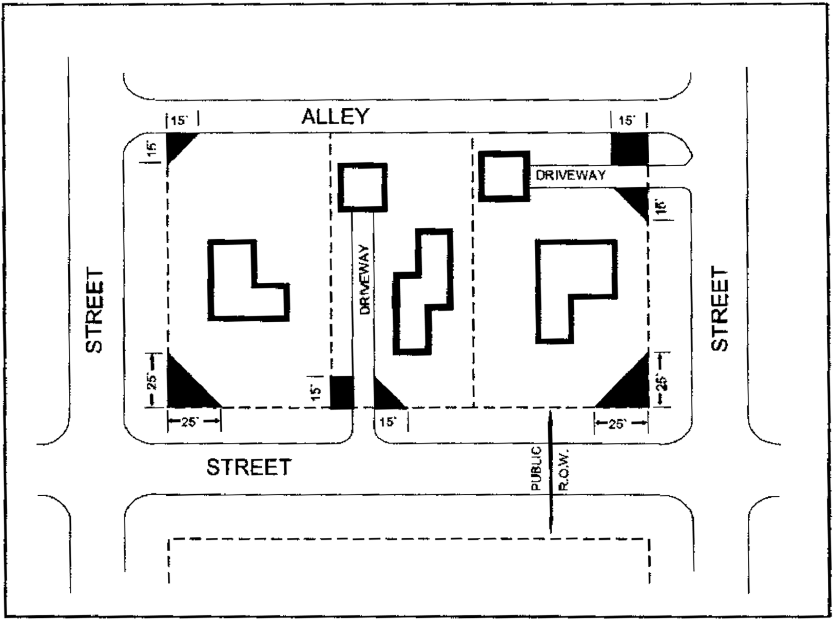
(Ord. of 3-21-2005, § 2025)
Sec. 2030. - Entranceway structures.
In districts where entranceway structures marking entrances to subdivisions, housing projects or planned nonresidential projects are permitted, including, but not limited to, walls, columns and gates, such structures may be located in a required yard except as provided in section 2025. Such entranceway structures shall comply to all codes of the township and all other applicable provisions of this ordinance, and shall be approved by the building inspector and a permit issued.
(Ord. of 3-21-2005, § 2030)
Sec. 2035. - Exterior lighting.
1.
The following exterior lighting shall be permitted in any use district:
a.
In any use district, light sources with lamps rated at a total of not more than 1,400 lumens shall be permitted, except for floodlights or spotlights.
b.
Floodlights or spotlights used for the external illumination of buildings or signs with a lamp rated at 1,000 lumens or less shall be permitted in any use district, provided that such lighting is not aimed, directed or focused toward residential districts or uses or toward a public street, so that there is no interference with the vision of persons on public streets or in residential districts or uses.
c.
Exterior lighting with lamps of more than 1,000 lumens will be permitted, provided that the light source is down-lit to reduce intensity and glare and is so arranged as to reflect lights away from all adjacent residential districts or uses and from adjacent public streets. Furthermore, the light diffusing media shall be totally shielded with opaque material on the top and all sides and the light source shall be parallel to the horizontal plane of the area to be lighted.
d.
Security lighting that is controlled by a motion detector and which does not remain on longer than ten minutes after activation shall be permitted in any use district, provided that such lighting is not aimed, directed or focused toward residential districts or uses or toward a public street, so that there is no interference with the vision of persons on public streets or in residential districts or uses.
2.
Permitted exterior lighting in any use district shall be subject to the following conditions:
a.
Exterior lighting shall not cause luminance that is greater than one footcandle within two feet of the wall of any main building in an adjacent or nearby RSA, RU-1, RMC, RM or MHP district.
b.
All illumination of signs and any other outdoor features shall not be of a flashing, moving, or intermittent type. Artificial light shall be maintained stationary and consistent in intensity and color at all times when in use.
c.
When the abutting district is an RSA, RU-1, RMC, RM or MHP district the distance between the structure supporting the light source and the property line of such zoning district shall not be less than the distance between the top of the light source and the ground below the structure or building to which the light is attached.
d.
The distance between the top of any light source and the ground below the structure shall not exceed the following, in each use district:
e.
Structures which support lighting fixtures, other than signs, may be permitted in any yard where off-street parking lots are permitted.
(Ord. of 3-21-2005, § 2035)
Sec. 2040. - Screening of rooftop equipment.
Penthouse or rooftop structures for the housing of elevators, stairways, tanks, heating and air conditioning equipment and other similar apparatus shall be screened from view by a penthouse or structure equal in height to the height of the equipment being screened, and constructed of a building material compatible with the material used in the principal building. Satellite reception antennas shall be exempt from this requirement.
(Ord. of 3-21-2005, § 2040)
Sec. 2045. - Waste receptacles.
A space for the location of a dumpster, paved and with minimum dimensions of nine feet wide and six feet deep, shall be provided for each zoning lot in the nonresidential districts (OST, OR, C or I) regardless of whether or not use of a dumpster is intended. Dumpsters may be permitted as accessory to any use except one-family residential. Dumpsters are permitted, provided that:
1.
The dumpster is located in a rear yard or interior side yard and is clearly accessible to servicing vehicles;
2.
Dumpsters shall be screened from view on all sides except for the entry side. Such screening shall consist of any permanent building wall, obscuring wall or earth mound which is not less than six feet in height or at least one foot above the height of the enclosed dumpster, whichever is greater;
3.
Dumpsters and their screening enclosures shall be located as far as practicable from any adjoining residential district or use and shall in no instance be located within 20 feet of any residential property line or district; and
4.
The location of dumpsters shall be indicated on site plans and the location and screening shall be subject to the approval of the planning commission.
(Ord. of 3-21-2005, § 2045)
Sec. 2050. - Landscaping.
For any development, other than a single-family residence, a detailed landscape plan shall be provided for any yard abutting a street and for any areas requiring a greenbelt or plantings by this ordinance. Such plans shall be submitted for review and approval by the planning commission prior to the issuance of a building permit and shall be prepared in accordance with the following:
1.
Planting plan specifications.
a.
Minimum scale of one inch = 50 feet.
b.
Existing and proposed grades at a contour interval not to exceed two feet.
c.
The planting plan shall indicate, to scale, the location, spacing and starting size for all proposed landscape material within the required greenbelt or landscaped area.
d.
Typical straight cross section including slope, height and width of berms and type of ground cover or height and type of construction for all proposed walls, including footings.
e.
Significant construction details to resolve specific site conditions, e.g., tree wells to preserve existing trees, culverts to maintain natural drainage patterns.
f.
Planting and staking details in either text or drawing form to ensure proper installation and establishment of proposed plant materials.
g.
Planting plans shall be prepared by a registered or degreed landscape architect or by a company with membership with the state association of nurserymen.
_____
2.
Plant material sizes and spacing.
a.
Plant materials shall not be placed closer than four feet from the fence line or property line.
b.
Where plant materials are planted in two or more rows, plantings shall be staggered in rows.
c.
Evergreen trees shall have a starting size of at least six feet in height. When planted in informal groupings, they shall be spaced not more than 20 feet on center. When planted in rows, they shall be spaced not more than 12 feet on center.
d.
Narrow evergreens shall have a starting size of at least four feet in height. When planted in informal groupings they shall be spaced not more than ten feet on center. When planted in rows, they shall be spaced not more than five feet on center.
e.
Large deciduous trees shall have a minimum starting size of 2½ caliper inches. They shall be planted not more than 30 feet on center when placed in informal groupings.
f.
Small deciduous trees shall have a minimum starting size of at least two caliper inches. They shall not be spaced more than 15 feet on center when placed in informal groupings.
g.
Large shrubs shall have a starting size of at least 30 inches in height. They shall be placed not more than six feet on center when placed in informal groupings and not more than four feet on center when planted in rows.
h.
Small shrubs shall have a starting size of not less than 24 inches in height or spread and be planted not more than four feet on center.
i.
Greenbelts shall be planted in a manner to ensure that the required horizontal and vertical obscuring effect of proposed land uses will be achieved. The ultimate size of plant material shall be such to ensure adequate maturity and optimum screening effect of proposed plant materials.
j.
The planning commission shall consider the choice and selection of plant materials to ensure that root system will not interfere with public utilities and that fruit and other debris (other than leaves) will not constitute a nuisance within public rights-of-way, or to abutting property owners.
k.
The relationship between deciduous and evergreen plant materials shall be such that, when required, a maximum obscuring effect will be maintained throughout the various seasonal periods.
l.
The following table lists some plant material that may be acceptable for use in the township. The list is not intended to be all-inclusive but rather suggests certain material which is commonly suitable for landscaping purposes.
_____
3.
Parking lot landscaping.
a.
In an I-1 or I-2 district, one tree for each 4,000 square feet of the total of the paved driveway and parking lot surface shall be provided.
b.
In all other districts, one tree shall be required for each 3,000 square feet of paved driveway and parking lot surface, provided that no less than two trees are provided.
c.
Trees shall be distributed evenly throughout the parking area and trees shall be provided with an open land area of not less than 150 square feet to provide area for infiltration and with a minimum diameter of six feet at the trunk of the tree for protection.
d.
Tree plantings shall also be protected from automobiles with curbing or other suitable device.
e.
In a P-1, OST, OR, or C district, when a parking area abuts a residential district, a row of large deciduous trees shall be provided on the nonresidential side of a required wall or berm. Such trees shall be located in a lawn panel with a minimum width of ten feet as measured from the property line and a minimum area of 150 square feet.
f.
Areas for landscaping within the boundaries of the paved parking lot shall be provided as follows:
4.
Areas for landscaping.
5.
Minimum width; exception. The minimum width of such areas shall be 7.5 feet except at end islands to provide for vehicular turning radii.
6.
Maintenance. Landscaped areas and plant materials required by this ordinance shall be kept free from refuse and debris. Plant materials, including lawn shall be maintained in a healthy, growing condition with a neat and orderly appearance. If any plant materials required by this ordinance die or become diseased, they shall be replaced within 30 days of written notice from the township or within an extended time period as specified in said notice.
7.
Timing. The landscaping shall be planted within six months from the date of completion of the building or improvement, and shall thereafter be reasonably maintained with permanent plant materials to provide the necessary affect. Final certificate of occupancy shall be withheld until plantings have been installed and approved. A temporary certificate of occupancy may be issued in the interim.
(Ord. of 3-21-2005, § 2050)
Sec. 2055. - Obscuring walls and landscaped berms.
1.
For those zoning districts and uses listed below, there shall be provided and maintained on those sides abutting or adjacent to a residential district, an obscuring wall or landscaped berm as required below, unless otherwise determined by the planning commission under paragraph 8 below. In any instance, a berm of equal height may be substituted for a wall, if desired. Furthermore, the planning commission may require the use of a berm rather than a wall.
2.
The height of a wall or berm shall be measured from the surface of the parking area or land on the nonresidential side of the wall or berm.
3.
In the case of a variable wall or berm height as noted above, the extent of obscuring wall or berm shall be determined by the planning commission on the basis of land usage, provided further that no wall or berm shall be less than the above required minimum, nor greater than the above required maximum.
4.
Berms shall be landscaped in accordance with section 2050, landscaping.
5.
In those instances where the border between districts or uses requiring a wall or berm is a major or secondary thoroughfare or collection road, a landscaped greenbelt may be substituted for the wall or berm adjacent to the thoroughfare.
6.
Required walls shall be located along the lot line except in the following instances:
a.
Where underground utilities interfere;
b.
Where a landscaped street yard is required, the wall shall be placed along the setback line; and
c.
Required walls may, upon approval of the planning commission, be located on the opposite side of an alley right-of-way from a nonresidential zone that abuts a residential zone when mutually agreeable to affected property owners. The continuity of the required wall on a given block will be a major consideration of the planning commission in reviewing such request.
7.
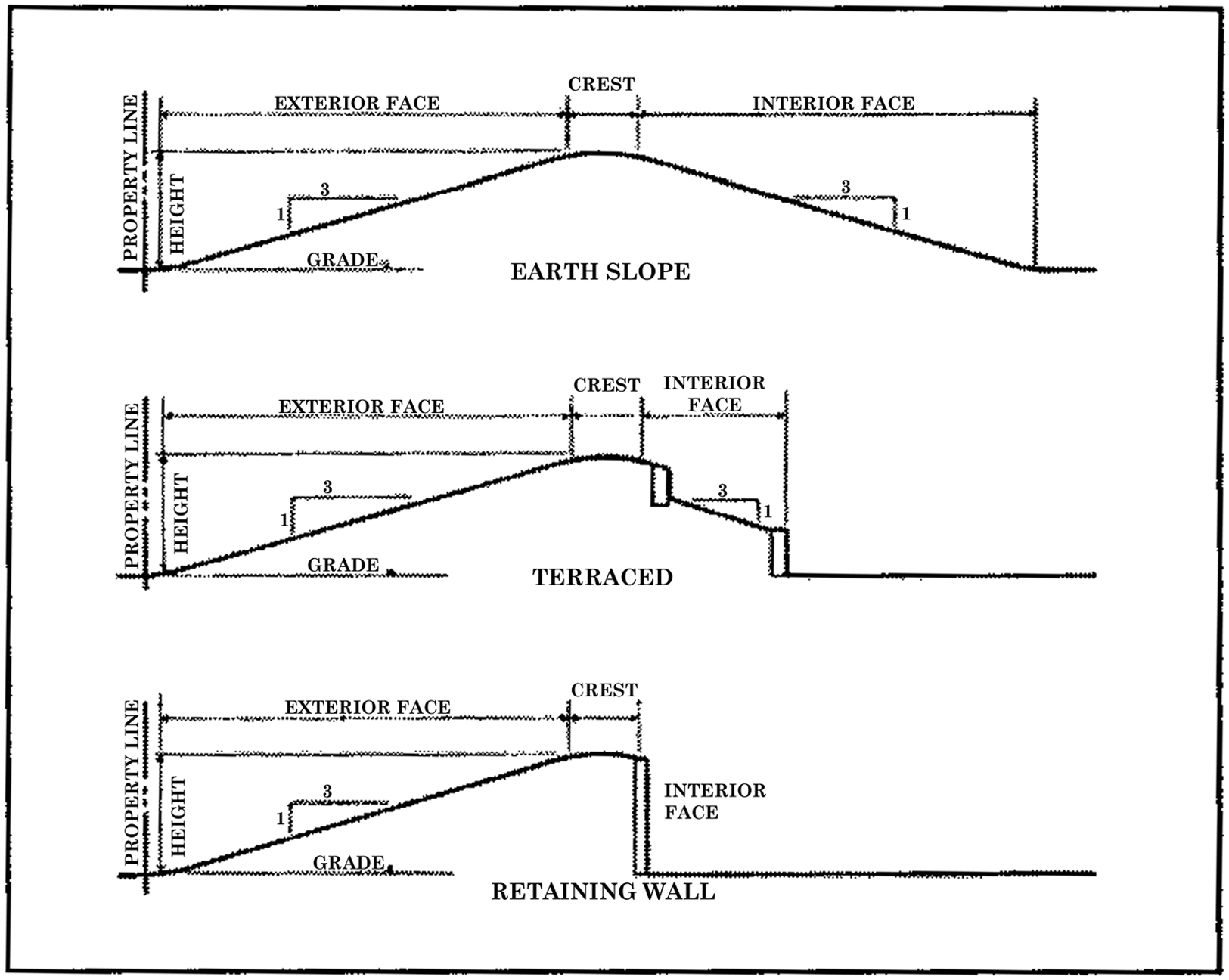
Required berms shall be constructed as landscaped earth mounds with a crest area at least two feet in width.
a.
The exterior face of the berm shall be constructed as an earthen slope.
b.
The interior face of the berm may be constructed as an earthen slope, or retained by means of a wall, terrace, or other means acceptable to the building inspector.
c.
Whenever an earthen slope is provided, it shall be constructed with an incline not to exceed one foot of vertical rise to three feet of horizontal distance.
d.
Berm slopes shall be protected from erosion by sodding or seeding. If slopes are seeded, they shall be protected with a straw mulch held in place by jute netting until the seed germinates and a permanent lawn is established. The straw mulch is not required if the seeded slope is protected by a net that is specifically designed to control erosion.
e.
The berm area shall be planted with shrubs, trees and lawn and shall be maintained in a healthy, growing condition.
8.
In those instances where the following conditions occur, the wall or berm may be waived by the planning commission.
a.
The abutting or adjacent land is proposed on the township master plan for land use as a use other than residential;
b.
The abutting or adjacent land is developed for a use other than residential;
c.
The planning commission determines that the abutting or adjacent residential district will become nonresidential in the future; or
d.
The abutting or adjacent residential district has physical characteristics which preclude the necessity of a wall or berm. Such conditions include, but are not necessarily limited to:
(1)
An abrupt rise in grade on the abutting or adjacent district;
(2)
Heavily wooded or landscaped areas that will buffer as effectively as a wall or berm; and
(3)
Other natural or manmade features that will buffer the abutting or adjacent residential districts as effectively as a wall or berm.
9.
Walls and berms shall have no openings for vehicular traffic or other purposes, except as otherwise provided in this ordinance or approved by the planning commission. Masonry walls may be constructed with openings, above three feet in height which do not in any square section (height and width) exceed 20 percent of the surface. Where walls are so pierced, the openings shall be spaced so as to maintain the obscuring character required, and shall not reduce the minimum height requirement. The arrangement of the openings shall be reviewed and approved by the building inspector.
10.
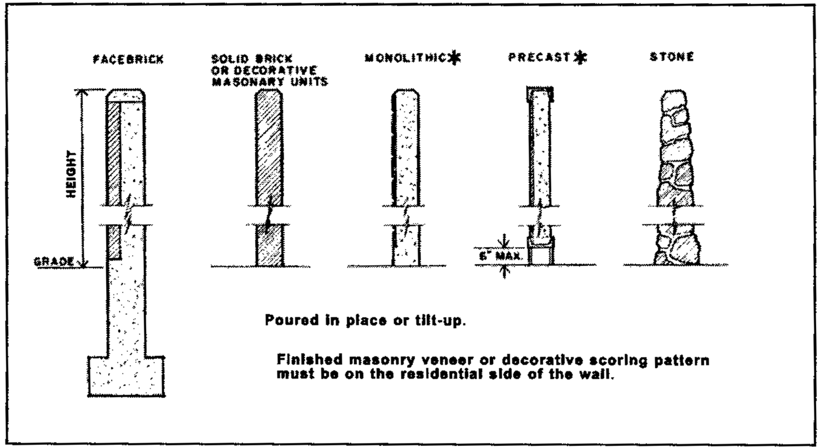
All walls herein required shall be constructed of face brick or comparable nonporous facing materials on the exterior sides facing a residential district and shall be approved by the building inspector to be durable, weather resistant, rustproof, and easily maintainable; and wood or wood products shall be specifically excluded. The top of the wall shall be finished or "capped" to provide positive drainage.
11.
The planning commission may require that a wall be varied in height or stepped to match adjacent existing walls or to ensure that adequate sight distance is ensured, provided that in no instance shall a required wall or berm be permitted to be less than 30 inches in height.
(Ord. of 3-21-2005, § 2055)
Sec. 2060. - Fences.
1.
Residential fences shall be permitted in the RSA, RU-1 and AR districts subject to the requirements applicable to accessory structures and to the following:
a.
Residential fences may be located along a property line if the other provisions of this section are met.
b.
The following requirements shall be applicable to fences on zoning lots having a lot area of less than two acres and street frontage of less than 200 feet:
(1)
Fences in all RSA, RU-1 and AR districts which enclose property or are within a required side or rear yard shall not exceed six feet in height, measured from the surface of the ground, and shall not extend toward the front of the lot nearer than the front of the house or the required minimum front yard, or whichever results in the greater setback.
(2)
Fences not to exceed three feet in height shall be permitted within a required front yard setback or an exterior side yard setback; provided, however, that section 2025 is adhered to.
(3)
Fences shall not contain barbed wire, razor wire, electric current or charge of electricity.
(4)
Fence-like structures, such as those used for backstops or tennis courts, are excluded from the regulations of this section.
c.
Fences in RSA and RU-1 districts on zoning lots that contain two acres or more shall be subject to the requirements applicable to accessory structures as well as the following:
(1)
Fences, not to exceed six feet in height, may be located within any yard except the minimum front yard setback or the minimum setback of a yard abutting a street. Greater setbacks applicable because of formulae based on buildings or parcel size shall not be considered as minimum setbacks.
(2)
Fences shall not contain barbed wire or razor wire.
(3)
Fences which enclose public or institutional parks, playgrounds or public landscaped areas, situated within an area developed with recorded lots, shall not exceed eight feet in height, measured from the surface of the ground, and shall not obstruct vision to an extent greater than 25 percent of their total area.
2.
Fences located in RSA and AR districts on zoning lots that contain two acres or more shall be subject to the requirements applicable to accessory structures as well as the following:
a.
Fences, not to exceed six feet in height, may be located within any yard, except that in a front yard or yard abutting a street that also abuts an RSA, RU-1, RCM or RM district or a zoning lot in the AR district that contains less than two acres, the minimum setbacks shall apply within 50 feet of such abutting RSA, RU-1, RCM, RM or AR district.
b.
Fences shall not contain razor wire.
3.
Fences located in all other districts shall be subject to the following conditions:
a.
A permit shall be required prior to the construction of any fence, regardless of size.
b.
Fences, not to exceed eight feet in height, may be located within any yard except the minimum front yard setback or the minimum setback of a yard abutting a street. Greater setbacks applicable because of formulae based on buildings or parcel size shall not be considered as minimum setbacks.
c.
Fences shall not contain barbed wire or razor wire.
(Ord. of 3-21-2005, § 2060)
Sec. 2065. - Flood hazard areas.
1.
Purpose. The purpose of this section is to significantly reduce hazards to persons and damage to property as a result of flood conditions in the township, and to comply with the provisions and requirements of the National Flood Insurance Program, as constituted in accord with the National flood Insurance Act of 1968, and subsequent enactment and the rules and regulations promulgated in furtherance of this program by the United States Department of Housing and Urban Development, Federal Insurance Administration, as published in the Federal Register, Volume 41, No. 207, Tuesday, December 26, 1976. Further, the objectives of this article include:
a.
The protection of human life, health and property from the dangerous and damaging effects of flood conditions;
b.
The containment of public expenditures for flood control projects rescue, and relief efforts in the aftermath of flooding, repair of flood damaged public facilities and utilities, and the redevelopment of flood damaged homes, neighborhoods, commercial and industrial areas;
c.
The prevention of private and public economic loss and social disruption as a result of flood conditions;
d.
The maintenance of stable development patterns not subject to the blighting influence of flood damage,
e.
To ensure that the public has access to information indicating the location of land areas subject to periodic flooding; and
f.
To preserve the ability of floodplains to carry and discharge a base flood.
2.
Delineation of the flood hazard area overlay zoning. The flood hazard area zone shall overlay existing zoning districts delineated on the official township zoning map. The boundaries of the area indicated as within the limits of the 100-year flood in the report entitled The Flood Insurance Study for the Township of Vienna, dated January 2, 1981, with accompanying flood insurance rate maps and flood boundary and floodway map, shall apply.
a.
A regulatory floodway shall be designated within the flood hazard area zone. The boundaries of the regulatory floodway shall coincide with the floodway boundaries as indicated on the flood boundary and floodway maps. The study and accompanying maps were adopted by reference appended and were declared to be a part of the ordinance.
b.
Where there are disputes as to the location of a flood hazard area zone boundary, the zoning board of appeals shall resolve the dispute in accordance with article 27.
c.
In addition to other requirements of this section applicable to development in the underlying zoning district, compliance with the requirements of this section shall be necessary for all development occurring within the flood hazard area zone. Conflicts between the requirements of this section and other requirements of the ordinance or any other ordinance shall be resolved in favor of this section, except where the conflicting requirement is more stringent and would further the objectives of this section to a greater extent than the requirements of this section. In such cases, the more stringent requirement shall be applied.
3.
Development permit. Development, including the erection of structures and placement of mobile homes, within a flood hazard area shall not occur except upon issuance of a zoning compliance permit in accordance with the requirements of this section 2066 and the following standards:
a.
The requirements of this section shall be met.
b.
The requirements of the underlying zoning district, and applicable general provisions of this ordinance must be met.
c.
All necessary development permits shall have been issued by appropriate local, state and federal authorities including a floodplain permit, approval, or letter of no authority from the state department of environmental quality under authority of Part 31 of Public Act No. 451 of 1994 (MCL 324.3101 et seq.), as amended. Where a development permit cannot be issued prior to the issuance of a zoning compliance permit, a letter from the issuing agency indicating intent to issue contingent only upon proof of zoning compliance shall be acceptable.
4.
General standards for flood hazard reduction.
a.
All new construction and substantial improvements within a flood hazard area, including the placement of prefabricated buildings and mobile homes, shall:
(1)
Be designed and anchored to prevent flotation, collapse or lateral movement of the structure;
(2)
Be constructed with materials and utility equipment resistant to flood damage; and
(3)
Be constructed by methods and practices that minimize flood damage.
b.
All new and replacement water supply systems shall minimize or eliminate infiltration of floodwaters into the systems.
c.
All new and replacement sanitary sewage systems shall minimize or eliminate infiltration of floodwaters into the systems and discharges from systems into floodwaters. On-site waste disposal systems shall be located to avoid impairment to the system or contamination from the system during flooding.
d.
All public utilities and facilities shall be designed, constructed and located to minimize or eliminate flood damage.
e.
The building inspector, or his representative; shall review development proposals to determine compliance with the standards in this section, and shall transmit his determination to the zoning administrator.
f.
Land shall not be divided in a manner creating parcels or lots which cannot be used in conformance with the requirements of this section.
g.
The flood carrying capacity of any altered or relocated watercourse, not subject to state or federal regulations designed to ensure flood carrying capacity, shall be maintained.
h.
Available flood hazard data from federal, state or other sources shall be reasonably utilized in meeting the standards of this section. Data furnished by the Federal Emergency Management Agency shall take precedence over data from other sources.
5.
Specific base flood evaluation standards. On the basis of the most recent available base flood evaluation data, the following standards shall apply in the flood hazard area zone:
a.
All new construction and substantial improvement of residential structures shall have the lowest floor, including basement, elevated to one foot above the base flood level.
b.
All new construction and substantial improvements of nonresidential structures shall have either.
(1)
The lowest flood, including basement, elevated to one foot above base flood level; or
(2)
Be constructed such that below base flood level, together with attendant utility and sanitary facilities, the structure is watertight with walls substantially impermeable to the passage of water and with structural components having the capability of resisting hydrostatic and hydrodynamic loads and effects of buoyancy. A registered professional engineer or architect shall certify that the standards of this subparagraph are satisfied, and that the floodproofing methods employed are adequate to withstand the flood depths, pressures, velocities, impact and uplift forces, and other factors associated with a base flood in the location of the structure. Such certification shall be submitted as provided in section 2066 and shall indicate the elevation to which the structure is floodproofed.
c.
The most recent base flood elevation data received from the Federal Emergency Management Agency shall take precedence over data from other sources.
6.
Mobile home standards.
a.
All mobile homes shall be anchored to resist flotation, collapse, or lateral movement by providing over-the-top and frame ties in accord with the following specifications:
(1)
Over-the-top ties shall be provided at each of the four corners of the mobile home, with two additional ties per side at intermediate locations, except that on mobile homes less than 50 feet in length one tie per side shall be required.
(2)
Frame ties shall be provided at each corner of the home with five additional ties per side at intermediate points, except that on mobile homes less than 50 feet in length four ties per side shall be required.
(3)
All components of the anchoring system shall be capable of carrying a force of 4,800 pounds.
(4)
All additions to a mobile home shall be similarly anchored.
b.
Mobile homes within zones A-1 through A-30. All mobile homes within zones A-1 through A-30 on the flood insurance rate map shall be located in accordance with the following standards:
(1)
All mobile homes shall be placed on stands or lots which are elevated on compacted fill or pilings so that the lowest floor of the mobile home will be one foot above the base floor level.
(2)
Adequate surface drainage away from all structures and access for mobile home haulers shall be provided.
(3)
In the instance of elevation pilings, the following shall apply:
(a)
The lots shall be large enough to permit steps.
(b)
Piling foundations shall be placed in stable soil no more than ten feet apart.
(c)
Reinforcement shall be provided for piers more than six feet above ground level.
(4)
The standards in (1), (2) and (3) of this subsection shall be complied with in mobile home parks and in mobile home subdivisions which exist at the time this subsection is adopted, where repair, reconstruction or improvement of streets, utilities and pads equals or exceeds 50 percent of the value of the streets, utilities and pads before the repair.
7.
Floodway protection standards. The following floodway protection standards shall apply:
a.
New construction, substantial improvements, and all other development, including fill, shall be prohibited within zones number A-.1 to A-30 on the FIRM, except where it is demonstrated to the zoning administrator that the cumulative effect of the proposed development when it is combined with all the other existing and anticipated development, will not harmfully increase the water surface elevation of a base flood. In determining whether a harmful increase will occur, compliance with Part 31 of Public Act No. 451 of 1994 (MCL 324.3101 et seq.), as amended, shall be required, provided that the allowable increase shall not exceed one foot. The provision of this section shall not apply with the regulatory floodway The provision of subsection 2 below shall be applied to land situated within the regulatory floodway.
b.
All development occurring within the regulatory floodway shall comply with the following standards:
(1)
Encroachments, including fill, new construction, substantial improvements and other development, shall be prohibited. Exceptions to this prohibition shall only be made upon certification by a registered professional engineer or the department of natural resources that the proposed development will not result in any increase in flood levels during a base flood discharge in compliance with Part 31 of Public Act No. 451 of 1994 (MCL 324.3101 et seq.), as amended.
(2)
The placement of mobile homes shall be prohibited except in mobile home parks and subdivisions which are in existence at the time this article is adopted.
(3)
Development which is permitted in the regulatory floodway shall meet the requirements of paragraphs 4. and 5. of this section 2065.
c.
Uses of land permitted in the underlying zoning district shall not be construed as being permitted within the regulatory floodway, except upon compliance with the provisions of this section.
8.
Disclaimer of liability.
a.
The degree of flood protection required by this section is considered reasonable for regulatory purposes and is based upon engineering and scientific methods of study. Larger floods may occur on rare occasions. Flood heights may be increased by manmade or natural causes, such as ice jams and bridge openings restricted by debris. Approval of this use of land under this article shall not be considered a guarantee or warranty of safety from flood damage.
b.
This section does not imply that areas outside the flood hazard area will be free from flood damage. This section does not create liability on the part of the township or any officer or employee thereof for any flood damages that result from reliance on this ordinance or any administrative decision lawfully made thereunder.
(Ord. of 3-21-2005, § 2065)
Sec. 2066. - Floodplain management administrative duties.
1.
Building inspector.
a.
The duties of the building inspector with regard to the National Flood Insurance Program and the regulation of development within the flood hazard area zone as prescribed in section 2065, shall include, but are not limited to:
(1)
Notification to adjacent communities and the department of natural resources of the proposed alteration or relocation of any watercourse, and the submission of such notifications to the Federal Emergency Management Agency;
(2)
Certification and recording of the actual elevation in relation to mean sea level of the lowest floor, including basement, of all new or substantially improved structures constructed within the flood hazard area, and in the case of floodproofed structures, the elevation to which the structure was floodproofed; and
(3)
Recording of all certificates of floodproofing, and written notification to all applicants whom variances are granted in a flood hazard area zone indicating the terms of the variance, the increased danger to life and property, and that the cost of flood insurance will increase commensurate with the increased flood risk, and may reach amounts as high as $25.00 for $100.00 of insurance coverage. A record of all variance notifications and variance actions shall be maintained together with the justification for each variance.
b.
All records and maps pertaining to the National Flood Insurance Program shall be maintained in the office of the building inspector and shall be open for public inspection.
c.
It shall be the responsibility of the building inspector to obtain and utilize the best available flood hazard data for purposes of administering this section in the absence of data from the Federal Emergency Management Agency.
2.
Flood hazard area application information. In addition to the information required with an application for a building permit, special use permit, or any other type of development permission required under this section, the following information shall be submitted as a part of an application for permission to commence any type of development within a flood hazard area zone:
a.
The elevation in relation to mean sea level of the floor, including basement, of all structures;
b.
Where floodproofing will be employed, the elevation in relation to mean sea level to which a structure will be floodproofed;
c.
Where floodproofing will be employed, a certificate from a registered professional engineer or architect that the floodproofing criteria of this ordinance will be met;
d.
A description of the extent to which any watercourse will be altered or relocated as a result of proposed development;
e.
Proof of development permission from appropriate local, state and federal agencies, as required by section 18.16.3, including a floodplain permit, approval or letters of no authority from the state department of environmental quality under authority of Part 31 of Public Act No. 451 of 1994 (MCL 324.3101 et seq.), as amended;
f.
Base flood elevation data where the proposed development is subject to Public Act No. 288 of 1967 (MCL 560.101 et seq.), or greater than five acres in size; and
g.
Additional information which may be reasonably necessary to determine compliance with the provisions of this ordinance.
3.
Flood hazard area zone variances. Variances from the provisions of section 2065, flood hazard areas, shall only be granted by the board of appeals upon a determination of compliance with the general standards for variances contained in this ordinance and each of the following specific standards:
a.
A variance shall be granted only upon:
(1)
A showing of good and sufficient cause;
(2)
A determination that failure to grant the variance would result in exceptional hardship to the applicant; and
(3)
A determination that the granting of a variance will not result in a harmful increase in flood heights, additional threats to public safety, extraordinary public expense, create nuisances, cause fraud or victimization of the public, or conflict with existing laws or ordinances.
b.
The variance granted shall be the minimum necessary, considering the flood hazard, to afford relief to the applicant.
c.
The township board of appeals may attach conditions to the granting of a variance to ensure compliance with the standards contained in this section.
d.
Variances may be granted for the reconstruction, rehabilitation or restoration of structures listed on the National Register of Historic Places or the state historic markers listing of historic sites, or any other state register of historic places without regard to the requirements of this section governing variances in floor hazard areas.
4.
Mapping disputes.
a.
Where disputes arise as to the location of the flood hazard area boundary, the board of appeals shall resolve the dispute and establish the boundary location. In all cases, the decision of the board of appeals shall be based upon the most current floodplain studies issued by the Federal Emergency Management Agency, where federal insurance information shall be utilized.
b.
Where a dispute involves an allegation that the boundary is incorrect as mapped and Federal Emergency Management Agency floodplain studies are being questioned, the board of appeals shall modify the boundary of the flood hazard area only upon receipt of an official letter of map amendment issued by the Federal Emergency Management Agency.
c.
All parties to a map dispute may submit technical evidence to the board of appeals.
(Ord. of 3-21-2005, § 2066)
Sec. 2067. - Private solar energy collector systems.
A.
Private solar energy collector systems. The construction and operation of a private solar energy collector system shall be permitted as accessory use in all zoning districts by permit issued by the zoning administrator after an administrative review, subject to the requirements of subsections 2067B., 2067C., 2067D., 2067E., and 2067F.
B.
Criteria for the use of private solar energy collector systems.
1.
A private solar energy collector system shall not be constructed without a building permit issued by the township.
2.
A private solar energy collector system must be located in the least visibly obtrusive location where panels would be functional.
3.
A private solar energy collector system must be repaired or replaced or removed within three months of becoming non-functional.
4.
A private solar energy collector system must conform to applicable industry standards including those established by the American National Standards Institute ("ANSI").
5.
A private solar energy collector system must include signage which sets forth disconnection procedures for emergency first responders in case of fire or other emergency.
6.
A private solar energy collector system must comply with applicable county, state and federal regulations, and safety requirements including the Michigan Building Code.
7.
A private solar energy collector systems must be installed so as to minimize glare onto adjacent parcels of property.
8.
A private solar energy collector systems must conform to all standards of the zoning district in which it is located.
C.
Exceptions for administrative review of building-mounted solar energy collector system. An application for a permit for administrative review of a private solar energy system is not required for:
1.
The installation of one solar panel with a total collector area not exceeding eight square feet; or
2.
The repair and/or replacement of any component of an existing building-mounted solar energy collector system, provided that its size of the total collector area is not expanded.
D.
Application for administrative review of private solar energy collector system. An application for administrative review for a permit for a private solar collector system must be submitted on a form supplied by the township, which must include the following:
1.
Photographs of the property's existing conditions;
2.
Renderings or catalogue cuts of the proposed private solar energy collector system; and
3.
Record establishing that the private solar collector system conforms to ANSI Standards.
4.
Certificate of compliance demonstrating that the private solar energy collector system has been tested and approved by Underwriters Laboratories or other approved independent testing agency.
5.
Site plan to indicate where the private solar energy collector system will be installed on the property.
6.
Description of screening to be provided the private solar energy collector system.
7.
A copy of the manufacturer's installation and maintenance instructions.
E.
Private building mounted solar energy collector system requirements. A private building-mounted solar energy collector system must conform to the following requirements:
1.
A building-mounted solar energy collector system mounted on the roof of a building shall not project more than five feet above the highest point of the roof, but in any event, shall not exceed the maximum height limitation for the zoning district in which the parcel of property is located, and not project beyond the eaves of the roof of the building.
2.
A building-mounted solar energy collector system mounted on the roof of a building shall not have a weight more than can be safely supported by the roof. The applicant must provide the zoning administrator with proof thereof in the form of a certificate by a professional engineer or architect, which must be approved by the township building inspector prior to the issuance of a permit by the zoning administrator as an accessory use.
3.
A building-mounted solar energy collector system that is roof-mounted, wall-mounted, or otherwise attached to a building or structure shall be permanently and safely attached to the building or structure. The applicant must provide the zoning administrator with proof of the safety and reliability of the means of such attachment, which must be approved by the township building inspector prior to the issuance of a permit by the zoning administrator as an accessory use.
4.
A building-mounted solar energy collector system that is wall-mounted shall not exceed the height of the building wall to which is attached.
5.
A building-mounted solar energy collector system shall not be mounted on a building wall that is parallel to an adjacent public right-of-way.
6.
A building-mounted solar energy collector system that is roof-mounted, wall-mounted, or otherwise attached to a building or structure shall be generally neutral in color and substantially non-reflective of light.
7.
A building-mounted solar energy collector system that is roof-mounted, wall-mounted, or otherwise attached to a building or structure shall be installed, maintained, and used only in accordance with the manufacturer's installation and maintenance instructions.
8.
A building-mounted solar energy collector system that is roof-mounted, wall-mounted, or otherwise attached to a building or structure must comply with the township construction code, electrical code, plumbing code, and all other applicable township ordinances.
F.
Private ground mounted solar energy collector system requirements. A private ground-mounted solar energy collector system must conform to the following requirements:
1.
All power transmission lines, wires, or conduits to and from a ground-mounted solar energy collector system must be located underground.
2.
All power transmission lines, wires, or conduits between each ground-mounted solar energy collector structure must be located underground.
3.
Any batteries used in connection with a ground-mounted solar energy collector system must be placed in an enclosed and locked container.
4.
A ground-mounted solar energy collector system shall not exceed the maximum height requirements for the zoning district in which it is located.
5.
A ground-mounted solar energy collector system must be located in the rear yard.
6.
A ground-mounted solar energy collector system must located in conformance with the setback requirements for the zoning district in which it is located.
(Ord. No. 449, § 4.02, 8-12-2019)

