
Wellington City Zoning Code
ARTICLE 5
Development Standards
Sec. 15-5-10. - Purpose and organization.
(a)
Purpose. This article establishes uniform standards for the development and improvement of property throughout the Town of Wellington to ensure quality development that is consistent with the Town's Comprehensive Plan.
(b)
Organization. This article is organized into ten (10) subsequent sections for each development standard. This article regulates:
(1)
Exterior Lighting (15-5-20);
(2)
Fences (15-5-30);
(3)
Landscaping and Screening (15-5-40);
(4)
Off-Street Parking and Loading (15-5-50);
(5)
Parks and Open Space (15-5-60);
(6)
Refuse/Trash Disposal (15-5-70);
(7)
Signs (15-5-80);
(8)
Site and Building Design (15-5-90);
(9)
Stormwater and Sewer (15-5-100); and
(10)
Transportation and Connectivity (15-5-110).
(c)
Applicability.
(1)
All development applications and building permit applications shall comply with the standards contained in this article.
(2)
All sign permit applications, and new and existing signs shall comply with the standards contained in Section 15-5-80 of this article.
(3)
The Planning Commission, Board of Trustees and Town Staff, as appropriate, will evaluate each proposal based on these standards set forth in this article and the context within which a project is located. The standards are intended to be specific enough to guide development, but not to preclude creative design solutions. Applicants must substantially conform to the design standards unless it can be demonstrated that an acceptable alternative meets one (1) or more of the following conditions:
a.
The alternative better achieves the stated intent;
b.
The effect of other standards will be improved by not applying a specific standard; and/or
c.
Strict application or unique site features make the standard impractical.
(Ord. No. 07-2022, § 1(5.01), 3-22-22)
Sec. 15-5-20. - Exterior lighting.
(a)
Purpose. The purposes of this Section are to:
(1)
Allow the use of exterior lighting that does not exceed the levels specified in International Engineering Society (IES) recommended practices for night-time safety, utility, security, productivity, enjoyment, and commerce.
(2)
Minimize adverse off-site impacts of lighting such as light trespass and obtrusive light.
(3)
Limit light pollution and reduce skyglow.
(4)
Help protect the natural environment from the adverse effects of night lighting from gas and oil extraction activities or electric services.
(5)
Conserve energy and resources to the greatest extent possible.
(6)
Encourage exterior lighting that is functional, aesthetically pleasing, and complimentary to the architectural style of buildings or setting.
(b)
Applicability.
(1)
Generally. This Section applies to all exterior lighting within the Town. All exterior lighting installed after the effective date of this Land Use Code shall comply with this Section.
(2)
Exemptions.
a.
Because of their limited hours of operation and their unique requirements for nighttime visibility, playing fields, tennis courts, and similar outdoor recreational uses (both public and private, unless otherwise restricted by the Town) are exempt from the general provisions of this section. However, exterior lighting for those uses is terminated within an hour of the activity's conclusion or as otherwise identified within this Land Use Code.
b.
Full cutoff street lighting as part of a federal, state, or municipal installation.
c.
Holiday lighting before and after the holiday.
d.
Specialized lighting necessary for safety, such as temporary lighting associated with emergency operations, road hazard warnings, etc.
e.
Traffic control signals and devices.
f.
Sensor activated luminaries if:
1.
It is located in a manner that prevents glare and lighting onto properties of others or into the public right-of-way.
2.
The luminaire is set to only go on when activated by motion, and to go off within five (5) minutes after activation has ceased.
3.
The luminaire is not triggered by activity off the property.
g.
Floodlights with external shielding can be deflected up to twenty-five (25) degrees from a vertical plane as measured through the central axis of the light beam from the luminaire, only if the luminaire does not cause glare or light to shine on adjacent property or public rights-of-way.
h.
Federally funded and state funded roadway construction projects are exempted from the requirements of this Section only to the extent it is necessary to comply with federal and state requirements.
i.
Exterior residential fixtures which consist of lamp types with an output of eight hundred (800) lumens or less (approximate to a 60-watt incandescent bulb or nine-watt LED) are exempt from these regulations, if the fixture types are compliant with those allowed in this Section.
j.
Uplighting for flags, address markers, trees, architectural features, and low-voltage landscape lighting, provided that the luminaire is located, aimed and shielded so that direct illumination is focused exclusively on the object and away from adjoining properties and the public street right-of-way. Architectural features may be illuminated by uplighting provided that the light is effectively contained by the structure. In all cases, uplighting must not cause glare or light trespass. Landscape lighting is low voltage (24 volts or less), and is controlled by a photocell and timer set to terminate by 12:00 a.m.
k.
Fossil fuel light produced directly or indirectly by the combustion of natural gas or other utility-type fossil fuels are exempt from these standards.
(c)
Standards. All site lighting for nonresidential uses shall conform to the standards established below.
(1)
Lighting Levels. Light levels shall follow the standards prescribed in Table 5.02.3-1.
Table 5.02.3-1: Exterior Lighting Levels
(2)
Design Standards. The lighting plan shall meet the following design standards:
a.
Prohibited Lighting. Site lighting that may be confused with warning, emergency, or traffic signals is prohibited.
b.
Shielding. Light sources shall be concealed and fully shielded and shall feature sharp cut-off capability minimizing up-light, spill-light, glare, and diffusion. Under-canopy fueling and under-canopy Electric Vehicle Charging areas shall feature flush mount, flat lens light fixtures.
c.
Light Spillover. All outdoor lighting systems shall be designed and operated so that the area ten (10) feet beyond the property line of the premises receives no more than one (1) foot-candle in nonresidential zoned areas, and one-quarter (¼) of a foot-candle for properties adjoining residential districts.
(d)
Lighting Plan.
(1)
Generally. A lighting plan indicating location and type of all outdoor light sources and indicating lighting levels achieved at all points on the site is submitted with a site plan application. For projects not requiring Director or Planning Commission review, the lighting plan is submitted at the time of building permit application.
(2)
Required Information. Additionally, a lighting plan shall include the following information for review:
a.
Plans indicating the location, type, intensity, and height of luminaries including both building and ground-mounted fixtures;
b.
A description of the luminaries, including lamps, poles or other supports and shielding devices, which may be provided as catalogue illustrations from the manufacturer;
c.
Photometric data, including that furnished by the manufacturer, showing the angle of light emission and the foot-candles on the ground; and
d.
Any additional information required by the Town needed to determine compliance with this Section.
(Ord. No. 07-2022, § 1(5.02), 3-22-22; Ord. No. 12-2025, § 10, 10-28-25)
Sec. 15-5-30. - Fences.
(a)
Purpose. The purposes of this Section are to:
(1)
Ensure that walls and fences are attractive and in character with the neighborhood.
(2)
Maintain fences, recognizing that they are used to create privacy.
(b)
Applicability. This Section applies to all fences within the Town. All fences installed after the effective date of this Land Use Code complies with this Section.
(c)
General Provisions.
(1)
Compatibility.
a.
Walls and fences are architecturally compatible with the style, materials, and colors of the principal buildings on the same lot. If used along collector or arterial streets, those features are made visually interesting by integrating architectural elements, such as brick or stone columns, varying the alignment or setback of the fence, softening the appearance of fence lines with plantings or through similar techniques.
b.
A fence or wall may not consist of a solid, unbroken expanse for more than fifty (50) feet.
(2)
Materials.
a.
Stone walls, or brick walls with a stone or cast stone cap, treated wood fences, vinyl, decorative metal, cast iron fences, stucco walls and stone piers are allowed.
b.
Hedges may be used in the same manner and for the same purposes as a fence or wall.
c.
Solid walls and fences are permitted only in rear and side yards.
d.
Retaining walls are permitted where required for landscaping or architectural purposes.
e.
Fences used in front yards (being the yard area that the primary or front entrance of the primary building on the property is oriented towards) are at least fifty percent (50%) open. Allowable fences within front yards are split rail, wrought iron, picket or other standard residential fences of fences of similar material or nature approved by the Director or designee.
f.
Other materials may be incorporated in fences and walls by Board of Trustees approval.
(3)
Prohibited Materials.
a.
Fencing, including concertina or razor wire, are prohibited unless specifically allowed by the Board of Trustees.
b.
Metal panel fences are prohibited.
c.
Fences constructed of wood or plastic pallets are prohibited.
d.
Barbed wire or electrically charged fences are only allowed in the Agricultural (A) or Rural Residential (RR) Districts.
e.
Electrically charged fences shall have signage at least every twenty-five (25) feet identifying that fencing as being electrically charged.
f.
Chain link fencing with or without slats is not allowed as a fencing material for screening purposes.
(4)
Retaining Walls. Retaining walls are designed to resist loads due to the lateral pressure of retained material in accordance with accepted engineering practice and are not unsightly or detrimental to abutting property.
(5)
Height Limitations. Fences or walls are:
a.
No more than forty-two (42) inches high between the front building line and the front property line. These walls are not solid except for retaining walls. For corner lots, front yard fence regulations apply to both street sides of the lot.
b.
No more than forty-two (42) inches high if located on a side yard line in the front yard, except if approved by the Board of Trustees and required for unique security purposes. These fences and walls are not solid, except for retaining walls.
c.
No more than thirty (30) inches high when located within the site distance triangle, and fences or walls within this site distance triangle are not solid. In the Industrial (I) Zone District, chain link fence is permitted if the height of the fence is not higher than six (6) feet, the fence is not used for screening, and the fencing does not obstruct visibility at any intersection.
d.
No more than six (6) feet high for an opaque privacy fence located on a rear property line or on a side yard line in the rear yard.
e.
Fences around a recreation court (e.g., tennis, squash racket, squash tennis or badminton) or around a publicly owned recreation area may exceed six (6) feet in height if the fence is at least fifty percent (50%) open.
(6)
Location. For residential uses only, open and closed fences not exceeding six feet in height in front yard setbacks may extend to the property line of a corner lot; provided that the facade for which the household address has been designated is approximately one hundred eighty (180) degrees from the adjacent opposing lot and subject to the restriction that the fence shall not be located in or over any area of a vision triangle or extend beyond the corner of a principal structure into any front yard for which the facade has been designated for the property address number.
(7)
Maintenance. Dilapidated, unsightly or dangerous fences shall be removed or repaired when removal is ordered by the Code Enforcement Officer. Hedges are maintained in a healthy condition, trimmed, and pruned as appropriate for the plant type. Dead plant material in hedges shall be removed or replaced as appropriate when ordered by the Code Enforcement Officer. Hedges shall not encroach upon sidewalks or street rights-of-way.
(Ord. No. 07-2022, § 1(5.03), 3-22-22)
Sec. 15-5-40. - Landscaping and screening.
(a)
Purpose.
(1)
The purpose of the landscape standards is to preserve the Town's special character and integrate and enhance new development by promoting quality landscape design that:
a.
Reinforces the identity of the community and each neighborhood;
b.
Provides tree-lined streets;
c.
Anchors new buildings in the landscape;
d.
Provides adequate vegetation for screening and buffering between land uses;
e.
Preserves existing trees and establishes procedures for replacing removed trees;
f.
Is conscientious of water usage
g.
Identifies climate appropriate landscape material;
h.
Protects natural resources such as valuable wildlife habitat; and
i.
Meets the requirements of SB24-005, HB25-1113, and Colorado Revised Statutes.
(b)
Applicability.
(1)
The provisions herein shall apply to all new development or redevelopment subject to site plan review or subdivision application.
(2)
Building permit applications for individual single-family residences will not require landscape plans. Single-family residences are encouraged to consider the Landscape and Irrigation Design Manual at Section 15-5-40(c).
(c)
General Provisions.
(1)
Site considerations. Landscape improvements shall be an integral part of the overall site design for each property and shall follow these objectives:
a.
Landscape improvements in all developments shall be consistent with the character of the proposed development and the surrounding area to reinforce neighborhood identity.
b.
All landscape plans shall incorporate a mix of shade trees, ornamental trees, evergreen trees and shrubs, deciduous shrubs, ornamental grasses, and perennials.
c.
Landscape design shall enhance natural features, drainage ways, and environmental resources.
d.
All landscape improvements shall be designed for mature landscapes and shall provide appropriate visibility for cars and pedestrians.
e.
Buildings and parking areas shall be located to preserve existing trees, environmental resources, and natural drainage ways to the greatest extent possible.
f.
Trees shall be located to provide summer shade and limit winter shade on walks and streets.
g.
Landscaping provisions shall not be cumulative or overlapping. When more than one standard applies, the most restrictive landscape standard shall apply.
(2)
Environmental considerations. Landscapes shall follow these xeriscape design principles to facilitate water conservation:
a.
Use appropriate turf varieties to minimize the use of bluegrass.
b.
Design Landscape Plans for water efficiency by arranging plant material by water use hydrozone with higher water use plants grouped together and lower water use plants grouped together.
c.
Use bioswales, water quality ponds, and rain gardens to filter runoff from parking lots, streets, and other impervious surfaces.
d.
Design with xeric and native plant material in accordance with the Landscape and Irrigation Design Manual identified in Section 15-5-40(c) herein.
e.
Improve the soil with organic matter and ensure proper landscape and irrigation maintenance per section 15-5-40(c). All areas disturbed by construction shall be reseeded to prevent erosion. Native, noninvasive grasses shall be used for revegetation where practical. Weed control and sediment and erosion control is the responsibility of the landowner on all reseeded areas.
(d)
Landscape and Irrigation Design Manual.
(1)
These landscape standards were developed in tandem with the Wellington Waterwise Landscape and Irrigation Design Manual (herein referenced as the Design Manual) which includes additional information on the principles of waterwise landscape design. Included are:
a.
A series of landscape typologies illustrated to show how varying levels of water use in the landscape effect overall water savings
b.
Images to further represent the desired landscape character of streetscapes, parks and open space, and residential, commercial and industrial developments.
c.
Suggested plant list organized by water use including high, medium, low and very low water use plant suggestions which match the water requirements.
(2)
If the Design Manual and Land Use Code conflict, the Land Use Code shall govern.
(e)
Plant Material Specifications.
(1)
The plant material specifications included herein apply to all required landscape plan submittals as described in the Applicability Section 15-5-40(b) above.
(2)
Plant material shall consist of native and regionally adapted species per the suggested plant list in the Design Manual.
(3)
Prohibited Plant Species.
a.
The following trees are prohibited in the Town:
1.
Russian olive (an invasive species that threatens native trees in riparian ecosystems).
2.
Lombardy poplar (susceptible to canker-forming fungi for which there are no available controls).
3.
Siberian elm (can dominate native vegetation, especially in disturbed areas; is weak-wooded and subject to continuous dieback when large; can be devastated by the elm leaf beetle).
4.
Boxelder maple (primary host plant of the boxelder bug).
5.
Cotton-bearing cottonwood (often considered a public nuisance).
6.
Ash, Fraxinus species (primary host to the destructive Emerald Ash Borer).
b.
Invasive plant species meeting the definition of C.R.S. 37-60-135(2)(e) are prohibited.
c.
Plants listed on the Colorado Department of Agriculture Noxious Weed List or the Larimer County Noxious Weed Management Plan are prohibited.
(4)
Landscapes shall consist of a variety of species to enhance biodiversity. No one (1) species may make up more than twenty-five percent (25%) of the total non-grass plant materials on one (1) site.
(5)
All landscape areas shall be comprised of a minimum percentage of live material which is calculated based on the total accumulative area of the diameter of each plant at maturity, exclusive of trees.
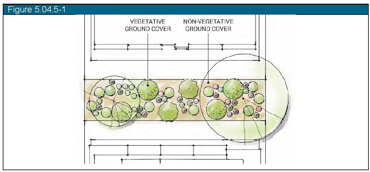
(6)
Up to twenty percent (20%) of required site trees (exclusive of street trees) may be substituted with shrubs or ornamental grasses at a rate of five (5) shrubs or ornamental grasses per one (1) tree.
(7)
Minimum planting sizes on all required landscaping shall be as follows:
a.
Deciduous Trees: two-inch (2") caliper.
b.
Ornamental Trees: one-and-one-half-inch (1.5") caliper.
c.
Evergreen Trees: six-foot (6') tall.
d.
Shrubs: five (5) gallon size.
(8)
Landscaping shall be no more than thirty (30") inches high when located in a sight distance triangle.
(9)
Trees may not be located within five feet (5') of gas, electric, and cable lines.
(10)
Trees shall not be located within ten feet (10') of water and sewer lines.
(11)
Ornamental trees shall not be located within fifteen feet (15') of streetlights.
(12)
Shade trees shall not be located within forty feet (40') of streetlights.
(13)
Trees planted in lawn areas shall include a ring of mulch at the base appropriately sized for the size and type of tree to provide separation between grass thatch and the trunk of the tree.
(14)
No plastic shall be used for weed control barrier under mulches. When used, weed barrier shall be nonwoven polypropylene that allows water and air to penetrate.
(15)
All planting areas shall be mulched to a minimum depth of three inches (3") for mulch material ¾" in size or smaller and a minimum of four inches (4") for material larger than ¾" in size. No planting area shall contain mulch alone without plantings.
(16)
All landscape areas shall be amended with organic compost at a rate of four cubic yards per one thousand square feet (4 cu yds/1,000 sf), tilled into the top eight inches (8") of soil. Areas planted with native grass seed mixes can reduce the compost rate to two cubic yards per one thousand square feet (2 cu yds/1,000 sf).
(17)
Required plant materials shall be grown in a licensed nursery in accordance with proper horticultural practice. Plants shall be healthy, well-branched, vigorous stock with a growth habit normal to the species and variety and free of diseases, insects and injuries.
(18)
All plants shall conform to standards for measurements, grading, branching, quality, ball and burlapping as stated in the American Standard for Nursery Stock, 1990 Edition, American Association of Nurserymen, Inc. (AAN-ASNS) and the Colorado Nursery Act of 1965 (CNA).
(19)
All landscaping shall be irrigated with an efficient, automated underground irrigation system as required for plant establishment and maintenance.
a.
Use of nontreated (non-potable) water for irrigation is required if a permanent, suitable supply is available.
b.
Temporary above ground irrigation may be used to establish native grasses and vegetation but must be removed following the second growing season after installation.
c.
All irrigation systems shall consist of efficient equipment such as:
1.
Controllers tied to a weather application to ensure system efficiency;
2.
Rain sensors; and/or
3.
Efficient spray heads such as the Hunter MP Rotator
d.
Guarantee of installation. Required landscape improvements shall be installed prior to issuance of a certificate of occupancy (CO) for all new construction and redeveloped sites. If weather conditions prevent installation, the developer shall post a financial guarantee for the improvements in an amount equal to one hundred twenty-five percent (125%) of an approved line-item cost estimate. The guarantee shall be released upon completion of the installation of the landscaping and acceptance by the Town.
e.
Maintenance. To provide for the ongoing health and appearance of landscape improvements, all landscaping shall be maintained and replaced by the landowner or occupant as necessary. Unless the Town has specifically agreed in a development agreement to take over maintenance of landscaping, the landowner or occupant is responsible for maintenance.
(f)
Submittal standards for landscape and irrigation plans.
(1)
All land development applications shall be accompanied by a landscape plan prepared by a Colorado-licensed Landscape Architect and shall include the following at a minimum.
a.
Landscape plan showing plant material sizes at maturity.
b.
Detailed plant list identifying common and botanical names of plant species, specified size of plant material, quantity, and water usage based on the water usage types detailed in the Design Manual:
c.
Total water usage calculations in table format similar to below based on the water usage categories detailed in the Design Manual:
1 Xeric includes hardscape and other landscape elements that do not require any supplemental watering.
d.
Detail drawings showing planting techniques for each type of plant material proposed (trees, shrubs, ornamental grasses, perennials)
e.
Standard landscape notes stating the following:
1.
Commitment to install soil amendment, and
2.
General planting and maintenance specifications.
f.
Tree preservation table showing how the development application plans to meet the requirements of Section 15-5-40(n) as applicable.
g.
General installation and maintenance specifications.
(2)
All landscape plans shall be accompanied by an irrigation plan prepared by a Colorado-licensed Landscape Architect or Irrigation Professional to include the following at a minimum:
a.
Irrigation tap calculations;
b.
Layout of all irrigation equipment;
c.
Schedule of all irrigation equipment;
d.
Statement of water saving methodology; and
e.
General installation and maintenance specifications.
(3)
Where non-potable irrigation systems are not available and the Town has approved a connection to the Town's domestic water system, all water taps for irrigation purposes shall be required to be installed and metered separately from any other domestic water tap. Raw water dedication requirements and utility billing charges shall be paid in accordance with a fee schedule adopted by the Town.
(g)
Streetscape Landscape Standards.
(1)
Purpose and Intent: Local streetscapes shall be tree lined and include a waterwise and balanced approach to design of plant material for year-round visual interest. These standards shall comply with the requirements of SB24-005, HB25-1113 and Colorado Revised Statutes.
(2)
Applicability: The following requirements shall apply to all proposed commercial and multi-family development along collector and arterial streets as well as any single-family subdivisions with tree lawns along local streets.
(3)
General Design Standards:
a.
Nonfunctional turf and nonfunctional artificial turf are not permitted for new development and redevelopment. Nonfunctional turf and nonfunctional artificial turf installed prior to January 1, 2026 may be maintained, pursuant to C.R.S. 37-99-103.
b.
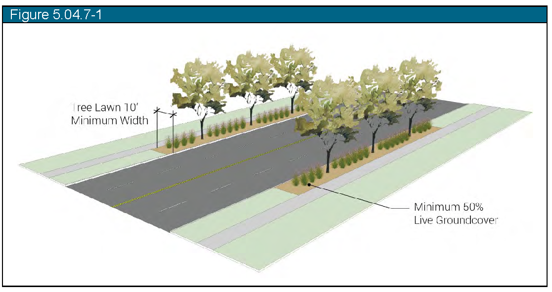
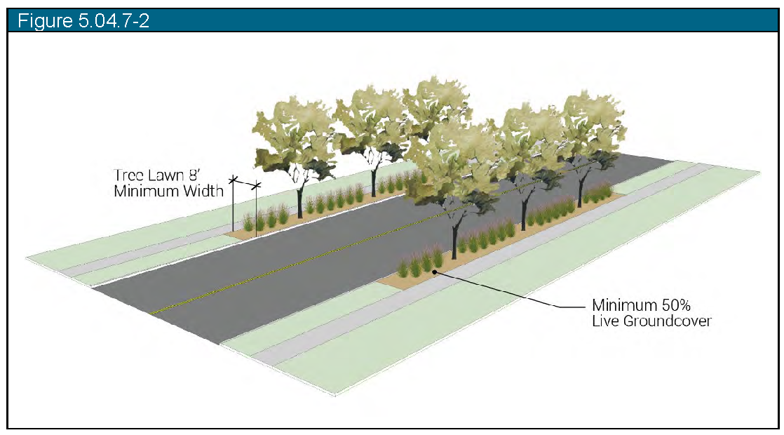
A minimum of one (1) deciduous or ornamental tree is required for every forty (40) linear feet of block frontage or portion thereof. Street trees shall be planted within the tree lawn portion of the right-of-way with adequate spacing per the species to allow for the mature spread of the trees.
1.
Arterial streets shall include a minimum ten foot (10') wide tree lawn to be landscaped with a minimum fifty percent (50%) live ground cover including a combination of trees, perennials, ornamental grasses, and shrubs. clustered into planting beds.
2.
All collector streets shall include a minimum eight foot (8') wide tree lawn to be landscaped with a minimum of fifty percent (50%) live ground cover, including a combination of trees, perennials, ornamental grasses, or shrubs.
3.
If tree lawns are provided on local streets in association with a single-family subdivision, then they shall meet the Collector Street tree lawn requirements in subsection (b) above.
c.
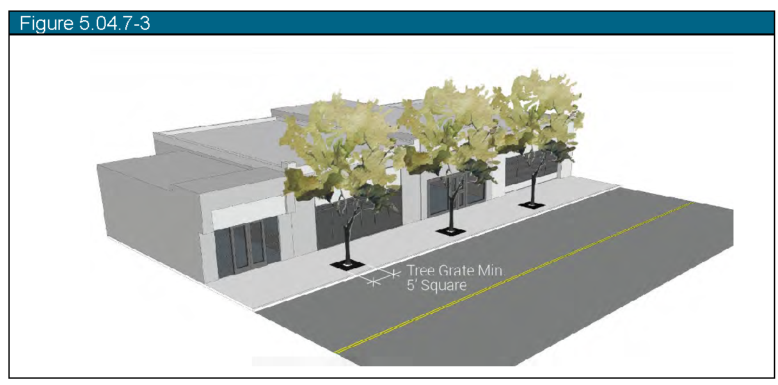
In the Downtown Core, street trees shall be placed in decorative tree grates with a minimum dimension of five (5) feet square. Soil volume shall be equivalent to three (3) times the width of the tree's root ball at time of planting which can be achieved by use of structural cells, suspended pavements, or other methods as approved by the Planning Department.
d.
Street trees shall be aligned in straight rows centered within the tree lawn in groupings of like species. No gap of groupings shall exceed one hundred twenty feet (120') in length.
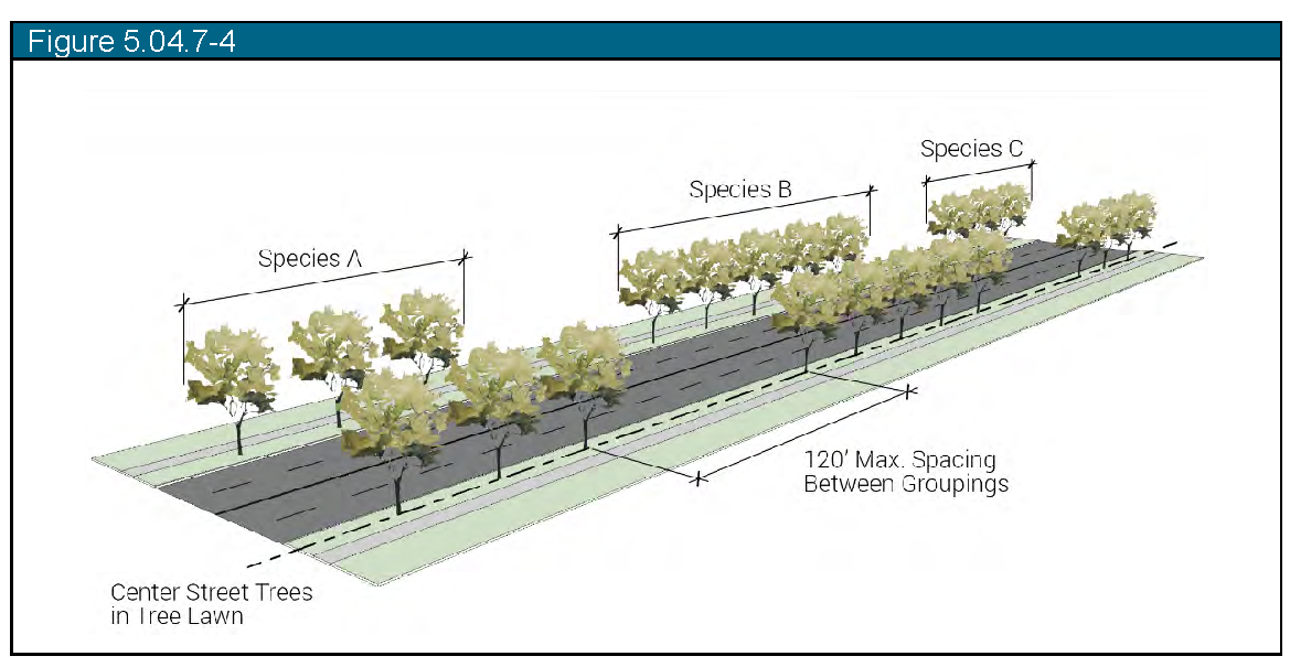
e.
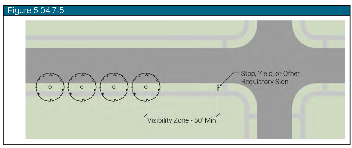
Street trees shall be set back at least fifty feet (50') from the face of stop signs in order to maintain a regulatory sign visibility zone. Street trees shall be set back a minimum of ten feet (10') from all other regulatory traffic control signs as related to the direction of travel.
f.
Street trees shall be limbed up to maintain a minimum eight-foot (8') clearance above all sidewalks.
g.
No street trees more than twenty-five feet (25') in height at maturity shall be planted under or within ten feet (10') of overhead powerlines.
h.
All street trees shall meet the suggested plant species standards detailed in the Design Manual.
i.
All streetscapes shall include an automatic underground irrigation system for all landscaping within the rights-of-way.
j.
Trees installed along streets that will be widened in the future shall take into account plans for future widening of streets so that established trees will not be disturbed during future construction.
k.
Development shall provide a mechanism for long-term maintenance of streetscape landscaping, such as a homeowners' association and covenants.
(h)
Park and Open Space Landscape Standards.
(1)
Purpose and Intent: Landscaping in park and open space areas that are commonly used by the public for passive and active recreation shall be appropriate to the use and function of the area, respectful of water conservation practices, and include trees, shrubs, ground cover, and site furnishings appropriate to the use. These standards shall comply with the requirements of SB24-005, HB25-1113 and Colorado Revised Statutes.
(2)
Applicability: The following requirements shall apply to all new development of public parks, pocket parks, detention ponds, trail connections and common open space areas for both public and HOA use.
(3)
General design standards:
a.
All parks shall be landscaped and programmed to create a balance of plant material with no more than fifty percent (50%) of the total landscaped area comprised of functional turf.
b.
Nonfunctional turf and nonfunctional artificial turf are not permitted for new development and redevelopment. Nonfunctional turf and nonfunctional artificial turf installed prior to January 1, 2026 may be maintained, pursuant to C.R.S. 37-99-103.
c.
All park and open space areas shall include site trees at a rate of a minimum of one (1) tree per one thousand (1,000) square feet of landscaped area, distributed appropriately throughout the site.
d.
Required trees shall be placed in upland areas, above the anticipated high-water mark or floodway of detention ponds or drainage ways.
e.
Only high traffic areas such as sport fields and informal play space adjacent to playgrounds shall contain functional turf or high water turf.
f.
Park periphery and detention pond areas shall consist of low water or native plant material and grass seed mix.
g.
Common open spaces and trail connections shall be landscaped with a balance of low water or native plant material and grass seed mix to reduce the need for supplemental irrigation in hard to reach areas.
h.
The retention of native areas for purposes of maintaining viewsheds or healthy existing ecosystems is highly encouraged.
1.
Existing plant material shall be identified on the Landscape Plan with a statement explaining how the native area will be protected from construction.
2.
These areas shall be excluded from the landscape area used to calculate required site trees per subsection (3)(a) above.
i.
Parking lots shall be landscaped per Section 15-5-40(o).
j.
Development shall provide a mechanism such as a homeowners' association and covenants for long-term maintenance of parks, detention ponds, and common open space, in order to ensure the continued upkeep of the property.
(i)
Standard Lot Detached and Attached Single-Family Residential Development Landscape Standards.
(1)
Purpose and intent: To ensure that single-family residences contain consistently landscaped front yards and are designed with water conservation in mind.
(2)
Applicability: In addition to landscaping the right-of-way tree lawn, detached and attached single-family parcels developed as part of an overall subdivision, shall meet the following standards. Standalone developments that do not require a subdivision or site plan application are exempt from items (3)a. and b. below.
(3)
General design standards:
a.
Landscaping on a single-family lot under one half (½) acre in size shall include no more than fifty percent (50%) of the total landscaped area comprised of high water use plant material such as irrigated turfgrass.
b.
There shall be a minimum of seventy-five percent (75%) live materials between the front of the single-family residential structure and the curb, excluding paved driveway areas.
c.
Each single-family residential owner shall maintain the owner's yard and landscaping within the adjacent road right-of-way.
(j)
Large Lot Single-Family Residential Development Landscape Standards.
(1)
Purpose and intent: To ensure higher water use landscape areas remain close to the perimeter of the residence, therefore preserving the native resources on the outskirts of the property both for purposes of water conservation and preservation of the natural character.
(2)
Applicability: Landscaping of large single-family rural density lots of one-half (½) acre or more in size (R-1 zone district) shall meet the following standards.
(3)
General design standards:
a.
Shall include no more than twenty-five percent (25%) high water use plant material, such as irrigated turfgrass, and no more than one-quarter (¼) acre irrigated, ornamental plant material.
(k)
Multi-Family Residential Development Landscape Standards.
(1)
Purpose and Intent: To ensure that all multi-family developments contain water conscious, consistent landscapes that are designed to enhance the overall appearance and functionality of the development while integrating the project into the surrounding neighborhood. These standards shall comply with the requirements of SB24-005, HB25-1113 and Colorado Revised Statutes.
(2)
Applicability: In addition to right-of-way landscaping, multi-family developments and attached single family developments grouped with common areas and/or streetscape improvements that require a site plan application shall meet the following standards.
(3)
General design standards:
a.
A minimum of thirty percent (30%) of the site (gross) shall be landscaped.
b.
Landscape areas shall include no more than forty percent (40%) of the total landscaped area comprised of functional turf.
c.
Nonfunctional turf and nonfunctional artificial turf are not permitted for new development and redevelopment. Nonfunctional turf and nonfunctional artificial turf installed prior to January 1, 2026 may be maintained, pursuant to C.R.S. 37-99-103.
d.
Plant material shall be arranged to screen utility hardware and mechanical equipment, define entrances, and soften featureless walls.
e.
Building perimeter landscape requirement:
1.
A planting area with a minimum width of six feet (6') shall be provided around the foundation of all.
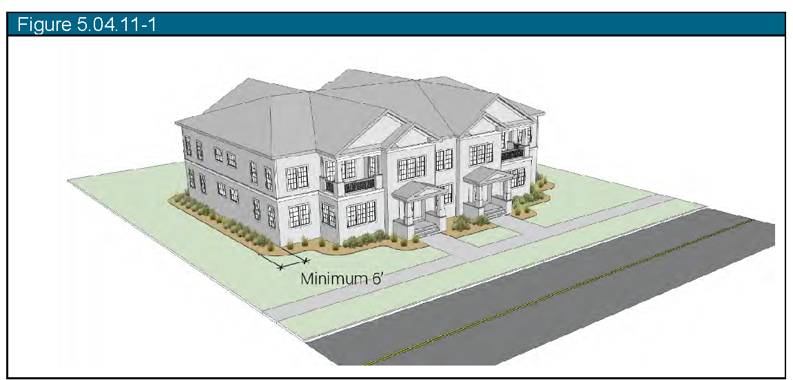
2.
The total number of plants shall equal one (1) plant per four linear feet (4') of building perimeter at the foundation.
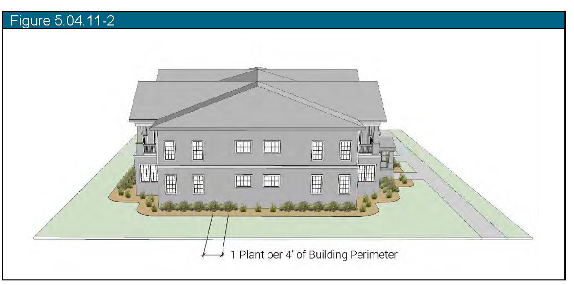
3.
A minimum of five percent (5%) of the building perimeter requirement shall include trees.
4.
Required plants shall contain a mix of trees, shrubs, ornamental grasses, and perennials.
f.
Street right-of-way buffer requirement:
1.
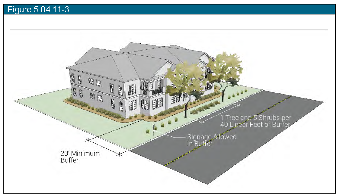
A minimum buffer width of twenty feet (20') shall be provided between multi-family buildings and all arterial and collector streets and shall contain one (1) tree and five (5) shrubs or ornamental grasses per forty lineal feet (40') of required buffer. Signage may be included in this setback.
g.
Site perimeter landscape buffer requirement:
| Adjacent Use | Buffer Yard
Requirement | Example Image |
|---|---|---|
|
Detached or Attached
Single-family, Multi-family |
10' wide
1 tree and 5 shrubs per 40 linear feet | 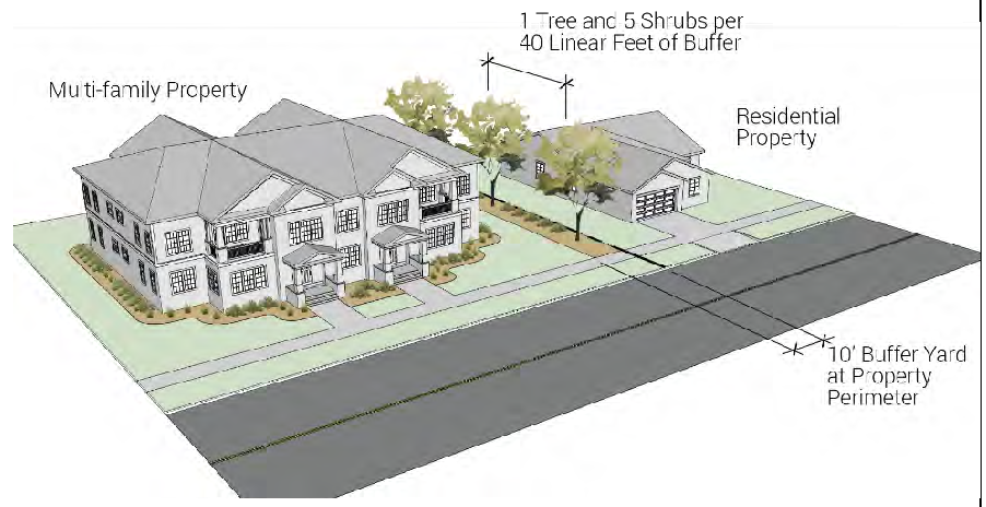 |
| Commercial |
15' wide
1 tree and 5 shrubs per 25 linear feet (50% shall be evergreen) | 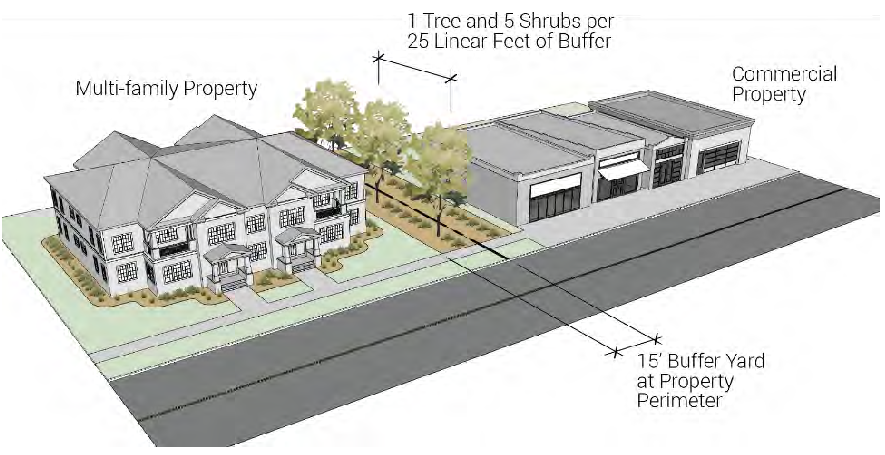 |
| Industrial |
15' wide
6' privacy fence plus 1 tree and 5 shrubs per 25 linear feet (50% shall be evergreen) | 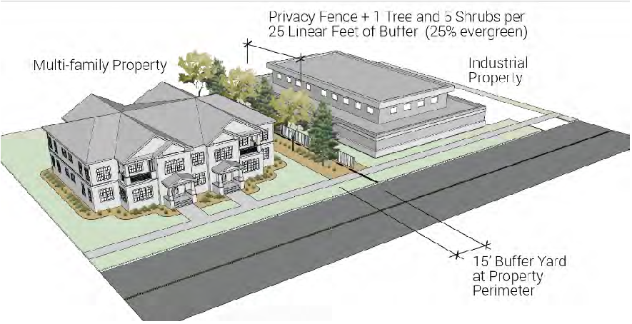 |
h.
Use native grass for areas that will not function as active recreation areas.
i.
Parking lots shall be landscaped per Section 15-5-40(o).
j.
Stormwater detention facilities shall be in accordance with 15-5-40(q).
(4)
The building owner or occupant shall maintain the yard and landscaping within the adjacent road right-of-way.
(l)
Commercial and Mixed-Use Development Landscape Standards.
(1)
Purpose and Intent: To ensure water conscious landscape improvements that are designed to enhance the overall appearance of the development and integrate the project with adjacent land uses and into the surrounding neighborhood. All improvements shall consider the people who will use the site, travel through or by the site and adjacent land uses. These standards shall comply with the requirements of SB24-005, HB25-1113 and Colorado Revised Statutes.
(2)
Applicability: All development in Commercial Zone Districts C1 and C3 shall meet the following standards.
(3)
General design standards:
a.
A minimum of fifteen percent (15%) of the site (gross) shall be landscaped area.
b.
Landscape areas shall include no more than thirty percent (30%) of the total landscaped area comprised of functional turf.
c.
Nonfunctional turf and nonfunctional artificial turf are not permitted for new development and redevelopment. Nonfunctional turf and nonfunctional artificial turf installed prior to January 1, 2026 may be maintained, pursuant to C.R.S. 37-99-103.
d.
Pedestrian walks and other hardscape landscape features and amenities, such as outdoor seating areas, and plazas with recreation and entertainment areas, water features, and public art, and approved permeable pavement may comprise up to fifty percent (50%) of the required landscaped area.
e.
Integrate activities on the subject property with adjacent land uses by utilizing a combination of landscaping, building orientation and appropriate architectural elements.
f.
Landscaping is required around the perimeter of the building along building elevations that face public streets, transportation corridors, public open space, residential neighborhoods, or whenever an entrance door is present.
1.
Building perimeter landscaping shall be located within twenty feet (20') of the face of the building unless prevented by loading docks.
2.
Landscaping may be installed in planting beds with a minimum width of six feet (6') or raised planters.
3.
A minimum of one (1) tree shall be provided for every forty linear feet (40') or building perimeter.
4.
Required plants shall contain a mix of trees, shrubs, ornamental grasses and perennials.
g.
Site perimeter landscape buffer requirement:
| Adjacent Use | Buffer Yard Width and
Quantity | Example Image |
|---|---|---|
| Single-family, townhome, multi-family |
15' wide
1 tree and 5 shrubs per 25 linear feet (50% shall be evergreen) | 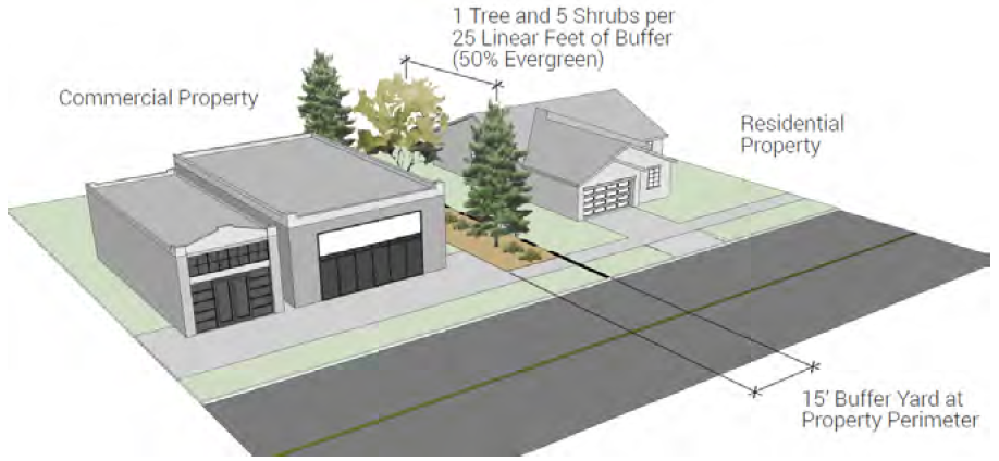 |
| Commercial |
10' wide
1 tree and 5 shrubs per 40 linear feet | 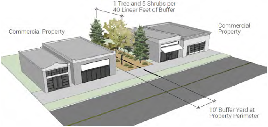 |
| Industrial |
15'
1 tree and 5 shrubs per 25 linear feet (50% shall be evergreen) | 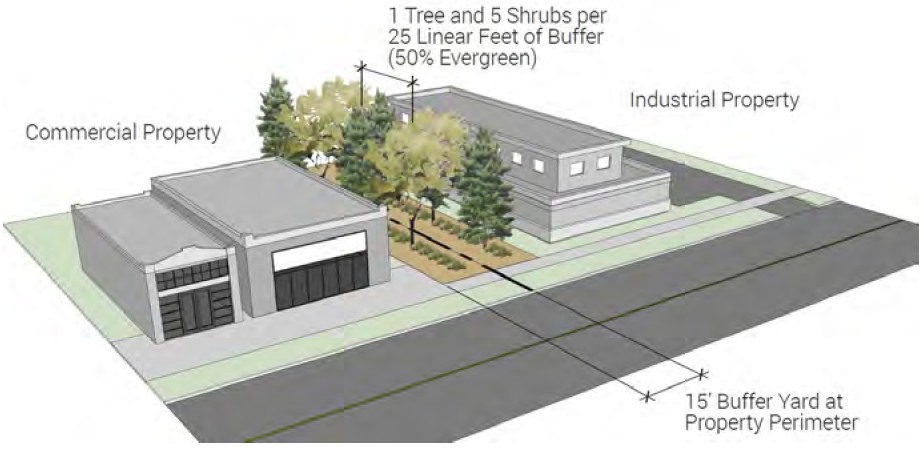 |
h.
Parking lots shall be landscaped per Section 15-5-40(o).
i.
Stormwater detention facilities shall be in accordance with 15-5-40(q).
j.
All service, loading, and storage areas visible from residential property, public right-of-way, or public trails and open space shall be screened by fences, walls, berms, or any combination thereof in addition to landscaping.
1.
No fence or wall shall exceed eight feet (8') in height.
2.
Landscaping along fences or walls shall consist of one (1) tree and ten (10) shrubs or ornamental grasses per forty (40) linear feet.
3.
Required screening shall be approved with a site plan or building permit, as applicable.
4.
Chain link fencing with slats, tires or used building materials are not acceptable screening materials.
(4)
The building owner or occupant shall maintain the yard and landscaping within the adjacent road right-of-way.
(m)
Downtown Core Landscape Standards.
(1)
Purpose and intent: To ensure that pervious areas are incorporated, the urban heat island is mitigated with shade trees, and water conscious landscape design is implemented within the Downtown Core.
(2)
Applicability: All development and redevelopment in the Downtown Core shall meet the following standards.
(3)
General design standards:
a.
Street trees shall be provided per section 15-5-40(g).
b.
Flush mounted or raised landscape planters shall be strategically placed along Cleveland Avenue sidewalk to enhance building entries and provide permeability but shall not block the flow of pedestrian traffic, ADA accessibility requirements, or interfere with utilities or drainage.
(n)
Industrial Development Landscape Standards.
(1)
Purpose and Intent: To ensure landscape improvements are designed primarily at the public facing building entry to be consistent with commercial landscape standards and at the perimeter for purposes of screening industrial activities from the exterior of the property. These standards shall comply with the requirements of SB24-005, HB25-1113 and Colorado Revised Statutes.
(2)
Applicability: All development in Light Industrial (LI) and Industrial (I) Zone Districts shall meet the following standards.
(3)
General design standards:
a.
Landscape areas shall include no more than thirty percent (30%) of the total landscaped area comprised of functional turf.
b.
Nonfunctional turf and nonfunctional artificial turf are not permitted for new development and redevelopment. Nonfunctional turf and nonfunctional artificial turf installed prior to January 1, 2026 may be maintained, pursuant to C.R.S. 37-99-103.
c.
The perimeter of the property shall include landscape area with a minimum width of eight feet (8') to include a pervious surface such as rock mulch and one (1) tree per forty (40) linear feet. A minimum of twenty-five (25%) of the perimeter trees shall be evergreen. Stormwater detention ponds may be included in this landscape requirement.
d.
The area between the primary building façade and the public right of way shall meet the commercial design standards detailed in 15-5-40(l) with all landscape areas including a minimum of seventy-five (75%) live cover.
e.
Parking lots shall be landscaped per Section 15-5-40(o).
f.
Stormwater detention facilities shall be in accordance with 15-5-40(q).
(4)
The building owner or occupant shall maintain the yard and landscaping within the adjacent road right-of-way.
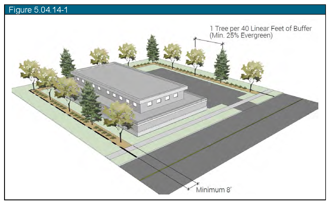
(o)
Parking Lot Standards.
(1)
Purpose and Intent: Parking lot landscaping is intended to break up large expanses of pavement, create shade, buffer views of parking lots from adjacent streets and development, and enhance the overall appearance of each project. These standards shall comply with the requirements of SB24-005, HB25-1113 and Colorado Revised Statutes.
(2)
Applicability: All parking lots with ten (10) spaces or more shall be subject to the following requirements.
(3)
General design standards.
a.
All combined parking lot landscape areas shall include no more than twenty percent (20%) of the total landscaped area comprised of functional turf.
b.
Nonfunctional turf and nonfunctional artificial turf are not permitted for new development and redevelopment. Nonfunctional turf and nonfunctional artificial turf installed prior to January 1, 2026 may be maintained, pursuant to C.R.S. 37-99-103.
c.
Interior parking lot landscape requirement:
1.
A minimum of one (1) landscape island per fifteen (15) parking spaces with a minimum width of nine feet (9').
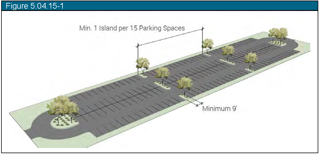
2.
Each island shall contain one (1) shade tree and seventy-five percent (75%) live plant material cover.
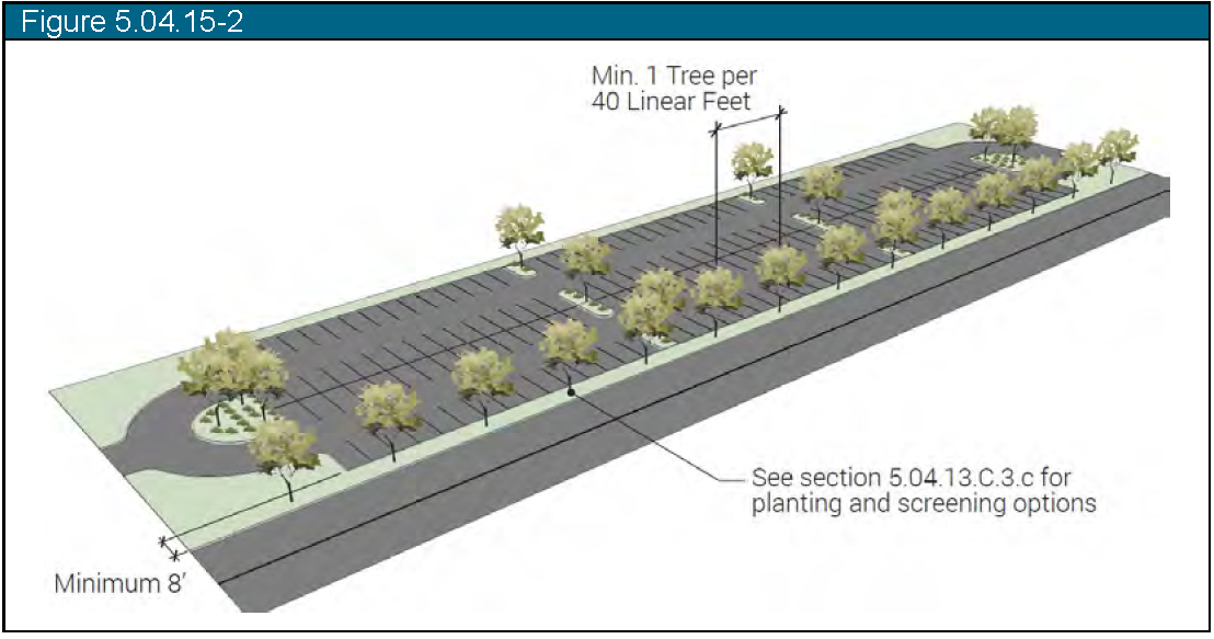
d.
Perimeter parking lot landscape requirement:
1.
A minimum eight-foot (8') wide landscape area shall be provided at the perimeter of surface parking lots abutting any public right-of-way.
2.
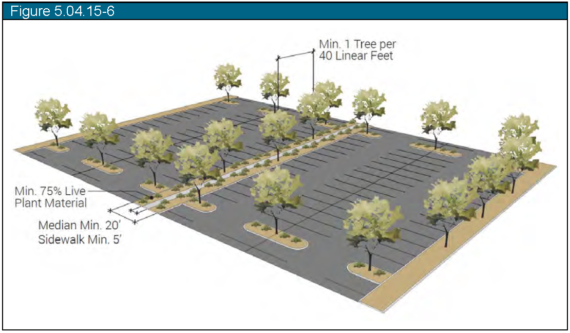
A minimum of one (1) tree per forty (40') linear feet of required perimeter landscape area.
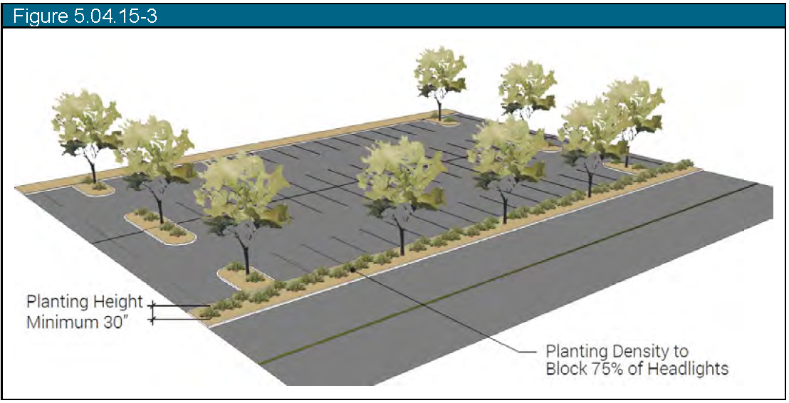
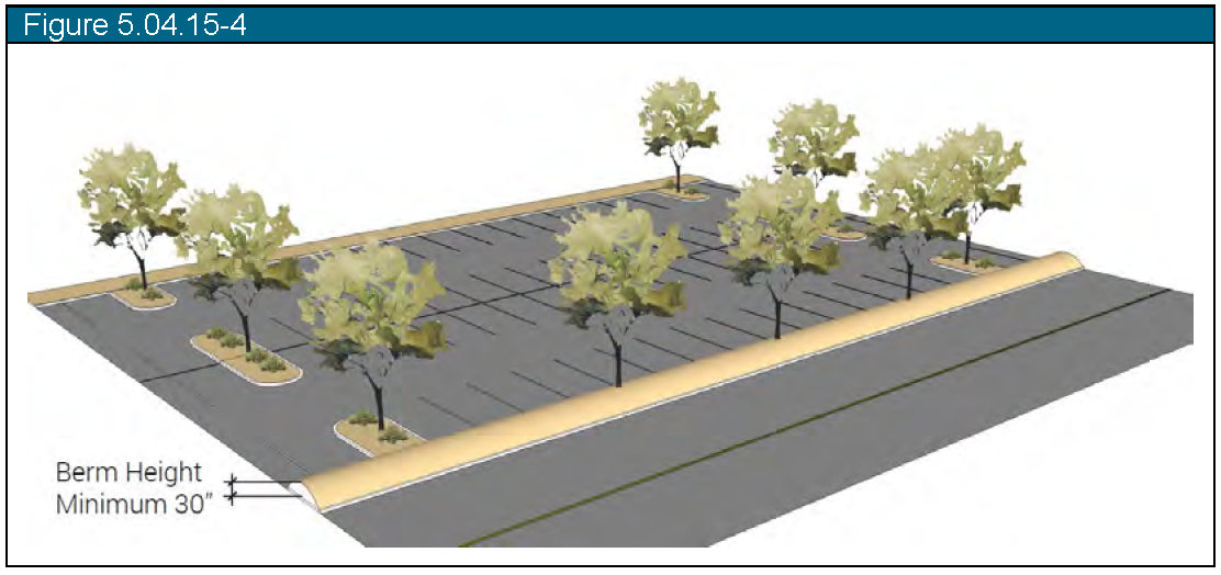
3.
Screen headlights with one (1) of the following options:
i.
A hedge of shrubs and ornamental grasses with a minimum height of thirty inches (30") to screen seventy-five percent (75%) of headlights;
ii.
A berm with a minimum of thirty inches (30") height; or
iii.
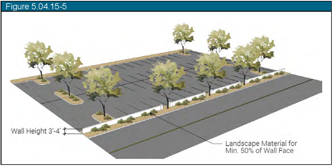
A masonry wall with a height between three and four feet (3-4') paired with landscape material for at least fifty percent (50%) of the length of the landscape area placed on the street side of the wall.
4.
Parking lots of one hundred (100) stalls or more shall provide a twenty foot (20') wide median for pedestrian access and additional shade every fourth row of parking to include the following:
i.
A minimum five foot (5') wide sidewalk
ii.
A minimum of one (1) tree per forty (40') lineal feet of median
iii.
A minimum of seventy-five percent (75%) live plant material cover
e.
Limit areas of irrigated sod to landscape areas with a minimum width of ten (10') feet. Irrigated sod shall not be located within interior parking lot islands.
f.
Irrigation sleeved shall be installed to interior islands prior to paving of parking lots.
g.
All landscaping within and adjacent to parking lots shall be owned and maintained by the landowner or occupant.
h.
The Town may require that an owner requesting development approvals shall provide a mechanism for ensuring that landscape improvements will be maintained in order to ensure the continued upkeep of the property.
(p)
Tree Preservation Standards.
(1)
Purpose and intent: Preserve the urban tree canopy.
(2)
Applicability: All new and infill development and redevelopment.
a.
Any tree that fails to survive within five (5) years of installation, regardless of size, shall be replaced with the same species or a species with similar mature size.
b.
All existing trees six-inch (6") caliper or larger proposed for removal on any new or infill development or redevelopment site shall be mitigated at the following rate:
c.
Street trees shall be replaced at a ratio of one (1) new tree per one (1) removed tree regardless of size.
d.
If it is determined by the Planning Director that the required trees for mitigation will not reasonably fit on the site without crowding out other required site or street trees, then the applicant shall pay a fee in lieu of mitigation in accordance with the Town's adopted fee schedule.
(q)
Storm Drainage Facility Standards.
(1)
Purpose and intent. Stormwater facilities shall be installed to serve a development to promote innovative and effective land and water management techniques that protect and enhance water quality.
(2)
Applicability. All storm drainage facilities shall be appropriately landscaped.
(3)
General design standards:
a.
Storm drainage improvements shall be constructed to serve development and landscaping associated with storm drainage facilities shall be integrated into the overall design of the project.
b.
Landscaping installed to address storm drainage shall enhance the overall appearance of the project, prevent erosion, and improve water quality of stormwater runoff whenever possible.
c.
Storm drainage facilities may function as open space for active recreation, trail corridors, or habitat enhancement areas if they are designed for such use.
d.
The use of planting strips and shallow, landscaped depressions in parking lots and along roads is encouraged to help trap and remove pollutants from stormwater runoff.
(4)
Minimum storm drainage improvements shall be constructed such that:
a.
All facilities shall be seeded to grass appropriate to the function of the area.
b.
Areas to be used for active recreation shall be seeded to a turf-type grass and irrigated with a permanent irrigation system.
c.
Areas to be maintained for habitat enhancement shall be seeded to native grasses and wildflowers.
d.
Development shall establish complete, weed-free grass areas. Trail corridors may be seeded to native grasses if appropriately integrated with adjacent improvements.
e.
The maximum side slope of drainage facilities shall be no more than 4:1 and the minimum slope at the bottom of a drainage facility shall be no more than one-half percent (0.5%) unless otherwise approved by Town Engineer.
f.
Landscape improvements shall be designed to enhance the function of the facility. Subject to water conservation policies, areas designed for recreation shall include clusters of trees to provide shade, located so they do not impair the function of the facility.
g.
Habitat and water quality enhancement, including wetland plantings in low wet areas, is encouraged.
h.
Ownership and maintenance. Easements for drainage facilities shall be dedicated to the Town but not accepted for maintenance and shall be maintained by the landowner or occupant unless otherwise approved by the Town.
i.
Bioswales and similar forms of private storm drainage systems that are integrated into the site shall not be dedicated to the Town.
(r)
Screening and Buffering.
(1)
Purpose and intent. Buffers and screening are intended to minimize conflicts between potentially incompatible, land uses and development on abutting property.
(2)
Applicability. Buffers shall be installed between parcels of different use on the property with the more intense use. For example, a commercial use shall include a buffer on any property line adjacent to a residential use. Additionally, all air-conditioning units, HVAC systems, exhaust pipes or stacks, elevator housing, and telecommunications receiving devices shall be thoroughly screened from view from the public right-of-way and from adjacent properties.
(3)
General design standards:
a.
All required buffers shall be located along the entire property line between the two (2) incompatible uses and entirely on the developing property's side of the required buffer.
b.
A required buffer must not be located within the required setbacks identified in Article 3.
c.
Parking of vehicles and placement of buildings or structures, except for walls, fences, and landscaping, shall not be allowed in the required buffer.
d.
All buffers shall be a minimum of ten feet (10') wide and consist of a mix of evergreen and deciduous trees, shrubs and ornamental grasses at the following rates:
1.
Four (4) trees per one hundred (100) linear feet with at least twenty percent (20%) being evergreen and a minimum height of twenty (20) feet; and
2.
Ten (10) shrubs or ornamental grasses per one hundred (100) linear feet with a minimum height of five (5) feet.
3.
If a six-foot high privacy fence or wall is installed, the shrub and ornamental grass requirement can be reduced by fifty percent (50%).
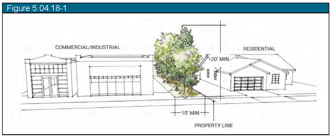
e.
Under no circumstances shall a fence be the only screening material as a buffer between land uses.
(4)
Location and screening of required loading and service areas.
a.
Loading docks, solid waste facilities, recycling facilities and other service areas shall be placed to the rear or side of buildings in visually unobtrusive locations.
b.
Screening and landscaping of loading areas shall prevent direct views of the loading areas and their driveways from adjacent properties or from the public rights-of-way and shall prevent spill-over glare, noise or exhaust fumes.
c.
Screening and buffering of loading and service areas shall be achieved through walls, architectural features and landscaping per Section 15-5-40(r)(3)(C) above and shall be visually impervious. Building recesses or depressed access ramps are suitable options to achieve screening and shall be used in combination with walls and landscaping if they do not achieve the desired screen.
(Ord. No. 07-2022, § 1(5.04), 3-22-22; Ord. No. 13-2025, §§ 1—19, 10-28-25)
Sec. 15-5-50. - Off-street parking and loading.
(a)
Purpose. The purposes of this Section are to:
(1)
Ensure that adequate off-street parking and loading facilities are provided for new land uses and changes in use;
(2)
Minimize the negative environmental and urban design impacts that can result from excessive parking, driveways, and drive aisles within parking lots;
(3)
Ensure that adequate off-street bicycle parking facilities are provided and promote parking that offers safe and attractive pedestrian routes;
(4)
Establish standards and regulations for safe and well-designed parking, unloading, and vehicle circulation areas that minimize conflicts between pedestrians and vehicles within parking lots and surrounding land uses;
(5)
Offer flexible means of minimizing the amount of area devoted to vehicle parking by allowing reductions in the number of required spaces in context-sensitive locations, including for qualifying multi-family dwellings and Accessory Dwelling Units (ADUs);
(6)
Ensure compliance with provisions of the Americans with Disabilities Act (ADA); and
(7)
Minimize the visual impact of off-street parking areas.
(b)
Applicability.
(1)
Any new building, structure, use, redeveloped site, or enlarged or expanded existing building or use, must meet this Section's parking requirements. These developments require permanent parking and off-street loading. Parking spaces may be provided in a garage or properly surfaced open area. In residential districts, public streets designed to accommodate on-street parking may count towards the required minimum parking for a dwelling. One (1) on-street parking space may count towards meeting the parking requirement.
(2)
When a change in intensity of use of any building or structure would increase the required parking by more than ten (10) spaces or ten percent (10%), whichever is greater, through an addition or change in the number of dwelling units, gross floor area, gross leasable area, seating capacity, or other specified units of measurements, the increment of additional required parking is provided in accordance with this Section unless an adjustment is permitted in Section 15-5-50(h) below. If less than ten (10) spaces or ten percent (10%), whichever is greater, are required by a change or series of changes in use, the Director may waive up to the incremental required number of parking spaces after determining that the granting of the waiver will not be detrimental to the public welfare and will be consistent with the Comprehensive Plan.
(c)
Compliance Required.
(1)
Off-Street Parking and Loading Review. Each application for a subdivision, site plan, zoning permit, or certificate of occupancy shall include information as to the location and dimensions of parking and loading space, and the means of ingress and egress to those spaces. This information is in sufficient detail to determine the requirements of this Land Use Code are met and shall contain necessary information required by applicable provisions of this Land Use Code.
(2)
Parking Reduction Procedures. No existing or proposed parking or loading space is reduced or eliminated. Reductions in parking and loading spaces may be permitted where spaces are no longer required by these regulations or alternative spaces meeting the requirements of these regulations are provided.
(d)
Metrics and Interpretations for Computation.
(1)
Square Footage (Floor Area). The gross building square footage, as used in this Section.
(2)
Fraction of a Space. When the calculation of the number of required parking and loading spaces results in a requirement of a fractional space, any fraction up to and including one-half (½) is disregarded, and fractions greater than one-half (½) is interpreted as one (1) whole parking or loading space.
(3)
Minimum. The number of required parking spaces a site must provide.
(4)
Parking Specific Metrics.
a.
Square Footage
1.
Example: 1/1,000 sf
2.
Interpretation: One (1) parking space for each one thousand (1,000) square feet of the building's floor area.
b.
Dwelling Unit
1.
Example: 1/DU
2.
Interpretation: One (1) parking space for each dwelling unit
c.
Bedroom(s)/Guestroom(s)
1.
Example: 1 + (0.75) bedrooms
2.
Interpretation: One (1) parking space plus the number of parking spaces from calculating 0.75 times all bedrooms.
d.
Bedroom Unit
1.
Example: 1/1 BRU
2.
Interpretation: One (1) parking space for a one (1) bedroom apartment unit.
e.
Acres
1.
Example: 1/5 acres.
2.
Interpretation: One (1) parking space for every five (5) acres.
(5)
Additional Rules for Computing Parking Requirements.
(1)
Uses Not Listed. The Director shall have the authority to determine the required parking and loading facilities for uses not specifically listed in the tables established in this Section. This determination by the Director is in writing and is appealable to the Planning Commission.
(2)
Accessory Uses. Areas accessory to the principal use of a building, or portion of a building, are to be included in the calculation of floor area of the principal use, unless noted otherwise.
(3)
Alterations, Expansions, and Changes in Use. For alterations, expansions, or changes in uses, prior to a certificate of occupancy, the Director shall determine in writing, based on information submitted by the applicant, the impact of the proposed change on the parking requirement for the building, and the adequacy of the parking provided.
(f)
General Parking Provisions.
(1)
Adequate Parking. All zoning districts must maintain off-street parking facilities for self-propelled motor vehicles.
(2)
Integrate Parking Lots with Surroundings. Parking lots do not dominate the frontage of pedestrian-oriented streets, interfere with designated pedestrian routes, or negatively impact surrounding neighborhoods. The pedestrian character of streets and buildings is maximized through continuity of buildings and landscape frontage.
(3)
Landscaping. Parking lots shall be landscaped, screened, and buffered.
(4)
Shared Access. Parking lots shall share access drives with adjacent property with similar land uses.
(5)
Lighting. All parking areas are required to provide lighting in accordance with the lighting standards in 15-5-50.
(g)
Off-Street Parking Requirements. Off-street parking shall be provided in accordance with the minimum ratios specified in Table 5.05.7-1.
Table 5.05.7-1: Minimum Parking Requirements
(h)
Adjustments and Reductions to Parking Requirements.
(1)
Procedure. In specific instances established in Paragraphs (2)—(5) below, the Director may approve a reduction in required parking spaces. Applications for a reduction includes the following information:
a.
A parking demand analysis which substantiates the need for a reduced number of spaces.
b.
A plan showing how the parking spaces are provided on the site.
(2)
Shared Off-Street Parking. Shared parking allows parking spaces to be shared among two or more uses that typically experience peak parking demands at different times and is located on the same lot or on nearby lots. Because parking spaces are shared, the total number of parking spaces that would otherwise be required may be reduced. In addition to all other applicable requirements of this Section, the following requirements apply to shared parking:
a.
Authority to Reduce Parking. The Director may reduce the total minimum number of required parking spaces, provided that each use participating in the shared parking experiences peak parking demands at different times. The Director shall base this decision on the circumstances of the application.
b.
Parking Study. The Director may require the applicant to submit a parking study to determine the peak parking demand periods or other information needed to determine the viability of shared parking.
c.
Maximum Reduction. The total number of parking spaces required for all uses participating in shared parking shall not be reduced by more than twenty percent (20%).
(3)
Captive Market. Parking requirements for retail and restaurant uses may be reduced where it can be determined that some portion of the patronage of these businesses comes from other uses (i.e., employees of area offices patronizing restaurants) located within the same building or a maximum walking distance of five hundred (500) feet.
(4)
On-Street Parking.
a.
Generally. On-street parking consists of parking spaces located in a public or private right-of-way. Each parking space that is in a public or private right-of-way abutting the lot may count as required parking space for the purpose of meeting the requirements in Section 15-5-50(g). Each parking space must be on a paved area abutting the street.
b.
Credit for On-Street Parking. The Director may allow on-street parking spaces, located within five hundred (500) feet of the subject principal use, to be credited to meet the off-street parking spaces for a particular development required by Section 15-5-50(g). The site plan must identify the on-street parking credit.
(5)
Availability of Public Parking. Parking requirements may be reduced if a property has available to it a sufficient supply of existing underutilized public parking spaces in both off-street public parking lots and/or on-street public parking spaces, and where the applicant adequately demonstrates that availability will continue in the future.
(i)
EV Charging Site Parking Standards.
(1)
Any automobile parking space served by an EV Charging Port or any automobile parking space used to site an EV Charging Station or Equipment counts as one standard automobile parking space toward applicable off-street parking requirement minimums as defined in Section 15-5-50(g).
(2)
Any van-accessible parking space that is designed to accommodate a person in a wheelchair, is served by an EV Charging Port, and is not reserved for use only by a person with a disability, counts as two standard automobile parking spaces towards applicable off-street parking requirement minimums as defined in Section 15-5-50(g), pursuant to HB23-1233.
(j)
Cleveland Avenue Parking.
(1)
For all new commercial uses located on Cleveland Avenue bounded by Sixth Street on the east, the alley between Cleveland and Harrison Avenues on the north or a projection of those easements east and west of those points, First Street on the west, and the alley between Cleveland and McKinley Avenues on the south or a projection of that easement east and west of those points, parking is required from the east property line to the west property line along the rear setback.
(2)
The rear setback is a minimum of twenty-five (25) feet.
(k)
Downtown Parking.
(1)
Generally. Downtowns require innovative approaches that provide sufficient parking accommodations while maintaining the area's charm and character. This Section provides alternative parking regulatory options to retain the Town's downtown vibrancy. These options may be used to provide relief against the required parking ratios established in Section 15-5-50(g).
(2)
Applicability. These regulatory options only apply to properties within Downtown.
(3)
Parking Ratio Reduction. Any property may apply a twenty percent (20%) reduction to the required ratio established in Section 15-5-50(g).
(4)
Special Parking Plan. Any nonresidential development (including multi-family dwellings) exceeding ten thousand (10,000) square feet may use a Special Parking Plan (SPP) to reduce parking rates. An SPP is a parking study that shows parking demand to reduce single-vehicle occupancy transportation by incorporating alternative transportation modes, flex peak times, and promoting pedestrian activity.
a.
Requirements. An SPP complies with the principles of the Wellington 2021 Comprehensive Plan.
1.
A qualified professional with demonstrated experience in transportation planning, traffic engineering, or comparable field must prepare the SPP.
2.
An SPP must determine:
i.
The anticipated travel demand for the development.
ii.
How the anticipated travel demand for the development will be met on-site or off-site, including:
(a)
Number of on-street parking spaces, off -street parking spaces, or shared parking arrangements.
(b)
Number of bicycle parking spaces.
(c)
Accommodations for pedestrians, cyclists, motorists, transit riders, and the mobility impaired.
iii.
The strategies that will be used to reduce single-occupancy vehicle trips, reduce vehicle miles traveled by site users, and promote transportation alternatives such as walking, bicycling, ridesharing, and transit.
iv.
Clearly defined objectives sought from implementation of the SPP.
b.
Strategies. SPP strategies include the following:
a.
Walking, cycling, ridesharing, and transit promotion and education.
b.
Shared parking arrangements.
c.
Enhanced bicycle parking and services.
d.
Carpooling benefits.
e.
Free or subsidized transit passes, shuttles, or enhanced transit facilities.
f.
Provisions for alternative work schedules.
g.
Roadway improvements adjacent to the site that will help encourage transportation alternatives.
c.
Decision. In making a final decision, the Director must find the following:
a.
The project includes performance objectives to minimize single-occupancy vehicle trips and maximize the utilization of transportation alternatives to the extent practicable, considering the opportunities and constraints of the site and the nature of the development.
b.
The project meets the anticipated transportation demand without adversely impacting public infrastructure, such as transit and on-street parking facilities, and the surrounding neighborhood.
(5)
Design.
a.
All off-street parking must be located on the lot being served, or on a separate lot or parcel no more than five hundred (500) feet from the primary pedestrian entrance of the building that it serves.
b.
Access for off-street parking shall generally be achieved by means of alleys, off-street vehicular connections between adjacent parking lots, and side streets.
c.
Off-street parking in the front of a nonresidential lot is not permitted.
d.
On-street parking applies when available. Additionally, on-street parking must adhere to the following requirements and receive design approval by the Town:
1.
Parallel and angled on-street parking is allowed.
2.
On-street parking must not encompass more than seventy percent (70%) of the block frontage.
3.
On-street parking must be inset into the block with street trees or plantings incorporated between groups of parking spaces.
(l)
ADA Parking.
(1)
ADA parking spaces and related ADA accessibility features are required to be installed in accordance with the current edition of the ADA Standards for Accessible Design (the "ADA Standards") as published by the Department of Justice. Where discrepancies exist between this Land Use Code and the ADA Standards, the ADA Standards shall apply. All required parking shall meet the ADA Standards.
(m)
Parking Design.
(1)
Surface. All off-street parking areas are surfaced with poured in place concrete or asphaltic concrete. All driveway portions within street right-of-way are paved and designed to the standards of the Town Engineer.
(2)
Off-Street Parking Design. Any off-street parking area must have a design so that vehicles exit without backing onto a public street. Off-street parking areas are designed so that parked vehicles do not encroach upon or extend onto public rights-of-way or sidewalks, or strike against or damage any wall, vegetation, utility or other structure.
(3)
Circulation Area Design. Circulation areas must facilitate the safe movement of vehicles without posing a danger to pedestrians or impeding the function of the parking area.
(4)
Location. Nonresidential off-street parking facilities are located within five hundred (500) feet of the building measured from the nearest point of the building or structure.
(5)
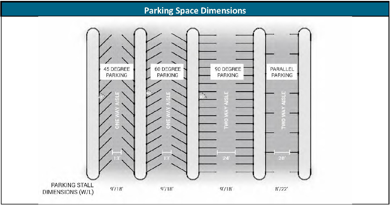
Parking Space Dimensions. Parking spaces must meet the following standards prescribed in. All dimensions represent the minimum requirement for any required parking space.
Table 5.05.12-1: Parking Space Dimensions
(n)
Bicycle Parking. Bicycle parking is required for all new uses to encourage the use of bicycles by providing secure and convenient places to park bicycles. These regulations ensure adequate bicycle parking by different uses.
(1)
Measurements. Bicycle spaces are measured as the ability for a facility to store one (1) bicycle. One (1) bicycle space equals one (1) stored bicycle.
(2)
Minimum Requirements. Bicycle parking totals shall be equivalent to at least two percent (2%) of the required number of vehicle parking spaces, but in no event shall the minimum number of bicycle parking be reduced below two (2) bicycle spaces.
(3)
Standards. These standards ensure that required bicycle parking is designed so people of all ages and abilities can access bicycle parking and securely lock their bicycle without inconvenience.
a.
Dimensions and Bicycle Racks.
1.
Parking Space and Aisle Dimensions.
i.
Each horizontal parking space (a space provided parallel to the ground) must have a minimum length of seventy two (72) inches, a minimum width of eighteen (18) inches, and a minimum height of eighty-four (84) inches. If a U or similar rack is provided, one (1) rack may serve two (2) bicycles if it is installed so that it provides the minimum parking space dimensions on each side.
ii.
A bicycle parking facility must have an access aisle that is a minimum of seventy two (72) inches on at least one (1) side of a row of parked bicycles.
2.
Bicycle Racks. A bicycle rack must:
i.
Allow a bicycle frame and one (1) wheel to be locked to the rack with a high-security lock;
ii.
Allow a bicycle to be securely held with its frame supported in at least one (1) place;
iii.
Be durable and securely anchored;
iv.
Have a locking surface thin enough to allow standard U-locks to be used, but thick enough so the rack cannot be cut with bolt cutter; and
v.
Not include any elements within the interior space.
b.
Location, Access, and Security. Bicycle parking is in publicly accessible, highly visible locations that serve the primary entrance of a building. Parking is visible to pedestrians and bicyclists on the street and is intended for building and site visitors.
1.
Each space must be:
i.
Available to the public;
ii.
Located in a convenient, well-lit area that is clearly visible to both a visitor to the building and a person who is on the sidewalk that accesses the building's primary entrance;
iii.
Within one hundred fifty (150) feet of:
(a)
the primary entrance of each building within the development, and closer than the nearest non-accessible vehicle parking space; or
(b)
at least one (1) primary entrance of a building with more than one (1) primary entrance; unless the applicable deciding body approves an alternative location during the site plan process; and
iv.
Outfitted with a rack to which a bicycle can be locked.
2.
Each parking facility is prohibited from obstructing pedestrian traffic or interfering with the use of the pedestrian area.
3.
Any sidewalk rack that is:
i.
Parallel to the curb must be located so that the nearest vertical component of the rack is a minimum of twenty-four (24) inches from the curb face and twenty-six (26) inches from the building face;
ii.
Perpendicular to the curb must be located so that the nearest vertical component of the rack is a minimum of forty-eight (48) inches from the curb face and forty-two (42) inches from the building face;
iii.
Diagonal to the curb must be located so that the nearest vertical component of the rack is a minimum of forty-eight (48) inches from the curb face, and forty-two (42) inches from the building face, measured in a line parallel to the orientation of the rack.
4.
Each sidewalk rack must be a minimum of ten (10) feet from any standalone fire hydrant.
5.
Each parked bicycle must be accessible without moving another bicycle.
(o)
Excess Weight and Recreational Vehicle Parking.
(1)
Boats, boat trailers, tractors, trailers, motor homes, buses, detached/dismounted campers and excess-weight vehicles are not parked or kept on private property for longer than seventy-two (72) consecutive hours within any one (1) month period, unless otherwise stated in this Subsection.
(2)
Boats, boat trailers, tractors, trailers, motor homes, buses, detached/dismounted campers and excess-weight vehicles may be parked upon a public right-of-way or roadway adjacent to the owner's property, for a maximum total of forty-eight (48) consecutive hours in any one (1) month period.
(3)
All boats, boat trailers, trailers, motor homes, buses, detached/dismounted campers and excess-weight vehicles kept or stored on private residential property for longer than seventy-two (72) consecutive hours during any one (1) month period are kept or stored in a rear yard or interior side yard behind the front yard setback, or within an enclosed building, unless otherwise stated in this Subsection.
(4)
Despite the forgoing provisions of this Subsection, parking of excess weight vehicles in public areas, including streets, is allowed in the following areas where reinforced streets or pads have been constructed.
a.
The west side of First Street from Cleveland Avenue to a point two hundred (200) feet north of Kennedy Avenue.
(p)
Loading.
(1)
Generally. The required number of off-street loading spaces are determined by gross floor area. Outdoor storage, sales, or display areas must be added to gross floor area if these areas contain materials that are received or distributed by trucks. If a development has more than two (2) uses, the off-street loading space requirement is the highest number of spaces required by any one (1) use. Required loading spaces follow the standards prescribed in Table 5.05.15-1.
Table 5.05.15-1: Required Loading
(2)
Standards.
a.
Location. A loading space:
a.
Must be located within the same development as the building or use served;
b.
Is prohibited from projecting into a sidewalk, street, or public right-of-way;
c.
Is prohibited from being located between the front building line and the lot line; and
d.
Is placed to the rear or side of buildings in visually unobtrusive locations.
b.
Dimensions. The size of delivery vehicles intending to serve the site, determine loading space size. The minimum loading space size is:
1.
Ten (10) feet wide, thirty (30) feet long, and fourteen (14) feet high if serving single-unit trucks and similar delivery vehicles; and
2.
Twelve (12) feet wide, fifty-five (55) feet long, and fifteen (15) feet high if serving larger freight vehicles.
c.
Maneuvering. The size of delivery vehicles intending to serve the site, determine maneuvering area size. Each maneuvering area for loading spaces must not conflict with parking spaces or with the maneuvering areas for spaces. A maneuvering area must be located on site and be a minimum of:
1.
Thirty-five (35) feet for spaces serving single-unit trucks and similar delivery vehicles; and
2.
Fifty (50) feet for spaces serving larger freight vehicles.
d.
Design. Each loading space must minimize conflicts with other vehicular, bicycle, and pedestrian traffic.
1.
Loading facilities must maintain a 50-foot minimum distance from any residential property unless completely enclosed by building walls, or a uniformly solid wall, or any combination of the two (2).
2.
Screening and landscaping prescribed in Section 15-5-40 apply to loading facilities and shall prevent direct views of the loading facilities and their driveways from adjacent properties and public right-of-way.
(Ord. No. 07-2022, § 1(5.05), 3-22-22; Ord. No. 08-2025, §§ 13, 14, 4-8-25; Ord. No. 12-2025, §§ 11, 12, 10-28-25)
Sec. 15-5-60. - Parks and open space.
(a)
Purpose. The purpose of this section is to ensure that a comprehensive, integrated network of parks and open space is developed and preserved as the community grows, the Town shall maintain a Park Plan affording varying types of public and private park settings for Town residents' uses.
(b)
Types of parks and open space.
(1)
Plazas. A plaza is typically located in a commercial or industrial area bordered by civic or private buildings to serve as a public gathering place. Plazas may range from very active places with adjacent complimentary uses, such as restaurants and cafes, to quiet areas with only seating, formal landscape plantings and amenities, such as fountains or public art. Developers are responsible for developing and providing the appropriate amenities for each plaza.
(2)
Pocket parks. Pocket parks are public open spaces provided by the developer and maintained by the development or associated homeowner's associate. They are integrated into the overall neighborhood design and can either serve as a neighborhood gathering space such as a pool and/or clubhouse, or be comprised of more public space such as a landscaped seating area, children's play area, contemplative garden area, or similar outdoor recreation opportunities for the neighborhood.
(3)
Neighborhood parks. Neighborhood parks are comprised of open space land provided by the developer to be developed and maintained by the Town for recreation and social gathering. These parks can include multi-use play areas, picnic areas, playground equipment, court game facilities and community gardens.
(4)
Community parks. Community parks are comprised of land purchased and developed by the Town with Park Impact fees to serve the residents of several neighborhoods. Community parks are to be located on or near arterial streets at the edge of residential areas or in nonresidential areas to minimize the impact of organized recreational activities, such as lighted ball fields.
(5)
Regional Parks. Regional parks are comprised of land purchased and developed by the Town to serve residents of the Town and region. Regional Parks are the largest in size of all park types herein and would have multiple form and function including regional sports and recreation facilities and open space to protect sensitive areas.
(6)
Trails. Trail systems shall link neighborhoods, parks, schools, open spaces, employment centers, community facilities and neighboring communities and thus provide important transportation connections as well as recreational opportunities and access. Developers must provide trails in all areas designated "Parks and Trails" on the Comprehensive Public Facilities Map or the Parks and Recreation Master Plan, as well as provide connections to the Town's existing trail system and destinations within the neighborhood.
(7)
Storm drainage facilities. Storm drainage facilities, including stormwater detention and stormwater retention ponds, can be counted toward the required open space dedication but cannot be counted toward park dedication requirements. Storm drainage facilities shall be owned and maintained by the development or associated homeowner's association in a tract separate from any Park land that is dedicated to the Town.
(c)
General provisions.
(1)
All parks and open space shall be designed and located per the Town of Wellington Parks and Recreation Master Plan.
(2)
Open space should serve as the neighborhood focus. Open space, shall be integrated into the overall neighborhood design and used to organize and focus lot, block and circulation patterns and to enhance surrounding development. Street, block, lot and building patterns shall respond to the views, landscape and recreational opportunities provided by the open space.
(3)
Public access. Areas designated as public open space shall be both visibly and physically accessible to the community. Public access shall be provided to all public open space, natural and developed, directly from the public street and trail system. Open space areas, except for pocket parks and plazas, shall be bounded along at least twenty percent (20%) of the perimeter by a street.
(4)
Buildings shall front public open space. Development adjacent to open spaces shall front onto the area as much as possible, so that the areas are not enclosed by back yards.
(5)
Open space uses. Uses designated within the open space shall be appropriate to the context and character of the site and the intensity of the proposed development.
(6)
Environmentally sensitive, archeological and historic resources may be dedicated to the Town and maintained by the Town if approved by the Board of Trustees.
(7)
Stormwater detention and retention areas that function as open space shall be owned and maintained by a homeowners' association or the landowner.
(8)
Areas designated as open space shall be maintained according to the designated function of the area. If the area is to remain in private ownership, a mechanism which will assure maintenance will be funded in perpetuity must be in place at the time of final plat.
(9)
Open space protection. Areas designated as open space shall be dedicated or conveyed to the Town or protected by a deed restriction, conservation easement or other appropriate method to ensure that they cannot be subdivided or developed in the future and that such areas shall remain as open space in perpetuity. Uses of open space may include recreational or agricultural activities.
(d)
Open space requirements.
(1)
Open space includes:
a.
Areas within the community designated for the common use of the residents of an individual development or the community at large;
b.
Areas designated for preservation and protection of environmental resources, including floodplains, natural drainage ways and wetland areas;
c.
Areas designated for agricultural preservation; and
d.
Areas of archeological and historic significance.
(2)
Non-open space. Open space shall not include the following:
a.
Required setback areas around oil and gas production facilities;
b.
Disconnected remnants of land created by division of sites into lots or parcels that do not qualify as functional open space, unless approved by the Board of Trustees;
c.
Private yards;
d.
Tree areas within a street right-of-way; or
e.
Required parking lot landscaping associated with all uses, except parking specifically designated for access to open space areas and within commercial or industrial projects.
(3)
Amount of open space required. The amount of functional open space required in each development will be based on the density of the development, the recreational requirements of the anticipated users and the anticipated opportunities for public recreation within walking distance of the site (one-quarter [¼] mile). All development within the Town shall meet the following open space requirements:
(4)
Single-family subdivisions and multi-family residential developments. Open space for single-family residential development that requires a major subdivision per section 15-2-170 and multi-family developments shall include, at a minimum:
a.
Twenty percent (20%) of the gross land as functional open space to include:
1.
One (1) centrally located pocket park for every two hundred (200) residential units;
2.
The land for one (1) neighborhood park within one-quarter (¼) mile radius of the proposed homes or a fair-share, cash-in-lieu contribution for the cost of the neighborhood park that will serve the development; and
3.
An internal trail system, taking into account trails designated in the Comprehensive Plan and the Parks and Recreation Master Plan.
(5)
Open space and plans. All land development applications, with the exception of plot plan applications for individual single-family residences, shall be accompanied by the appropriate open space plan. The open space plan shall be included with the landscape plans or submitted as a separate map based on direction from the Director.
(e)
Fee in lieu of dedication.
(1)
A developer of property may, with approval by the Board of Trustees, pay fee-in-lieu of park dedication in those cases where dedication of land is not feasible or not desired by the Town. Such payment shall be based on the fair market value of the developed property that otherwise would have been required to be dedicated as park space, to be determined after completion of the platting process. Such payment shall be held by the Board of Trustees for the acquisition of open space sites and land areas by the Town. At the option of the Board of Trustees, a developer may meet open space dedication requirements through a combination of payment of fee-in-lieu of land dedication, impact fees and land dedication.
(f)
Fair contribution for public school sites. All development shall dedicate or convey land for public school purposes to the Poudre School District, or make payment in lieu of land dedication or conveyance in accordance with the intergovernmental agreement between the Town and the Poudre School District.
(Ord. No. 07-2022, § 1(5.06), 3-22-22)
Sec. 15-5-70. - Refuse/trash disposal.
(a)
Purpose. The purpose of this Section is to provide adequate provisions for on-site waste disposal and collection.
(b)
Applicability. This Section applies to all nonresidential development within Town limits. All refuse/trash disposal installed after the effective date of this Land Use Code complies with this Section.
(c)
Standards.
(1)
Generally. A site shall provide refuse/trash disposal that is:
a.
Located to facilitate collection and minimize negative impacts, including to site occupants, neighboring properties, and public rights-of-way; and
b.
Constructed to allow for collection without damage to the development site or the collection vehicle.
(2)
Screening and Visibility. All refuse/trash disposal requires screening to prevent them from being visible to:
a.
Persons located within any dwelling unit on residential property other than that where the refuse/trash disposal is located;
b.
Occupants, customers, or other invitees located within any building on nonresidential property other than that where the refuse/trash disposal is located; and
c.
Persons traveling on any public street, sidewalk, or other public way.
(3)
Design. Screening design shall compliment the materials, colors, and features of the primary building.
(Ord. No. 07-2022, § 1(5.07), 3-22-22)
Sec. 15-5-80. - Signs.
(a)
Purpose and Findings. The purposes of this Section are to:
(1)
Provide a comprehensive and balanced system to regulate signs by physical dimension and placement throughout the Town.
(2)
Protect state and federal constitutional rights to free speech by:
a.
Providing ample opportunities for expression through signs;
b.
Providing content-neutral regulations of signs; and
c.
Providing clear standards for approval of signs.
(3)
Protect public health, safety, and welfare by:
a.
Minimizing visual traffic hazards, distractions, and obstructions for motorists, cyclists, and pedestrians;
b.
Preventing signs that could confuse motorists;
c.
Reducing hazards caused by signs that overhang or project over the public right-of-way;
d.
Encouraging sign users to upgrade, update, or remove poorly maintained and nonconforming signs;
e.
Preventing signs that are potentially dangerous due to structural deficiencies and disrepair; and
f.
Preventing visual clutter or deterioration of the community's appearance and attractiveness that would promote blight.
(4)
Promote the Town's appearance, character, quality, and business climate by:
a.
Encouraging attractive and functional signs;
b.
Encouraging signs that harmonize with the sign's site and buildings and with surrounding buildings and developments; and
c.
Provide sign standards that will promote a vibrant and attractive Downtown Core.
(5)
Implement the goals and policies of the Comprehensive Plan by establishing uniform standards and procedures to regulate the size, type, number, design, placement, illumination, timeframe for display, and maintenance of signs.
(b)
Applicability.
(1)
Generally.
a.
This Section applies to applications for sign permits and to new and existing signs within the Town of Wellington.
b.
Permits Required for Certain Signs. This Section requires sign permit approval before a person may construct, install, operate, display, or otherwise use any sign as specified in the applicable paragraph for each sign type governed by this Section. Repairs, changes of parts, and preventive maintenance of signs do not require a sign permit.
c.
Prohibited Signs. A person shall not construct, install, operate, display, or otherwise use any sign in a time, place, or manner that this Section prohibits.
d.
This Section does not authorize signs prohibited by state or federal law.
e.
Other Requirements Apply. This Section does not supersede the requirements of other regulations of the Municipal Code of the Town of Wellington. A sign permit does not satisfy the requirement for a building permit under Chapter 18: Building Regulations of the Wellington Municipal Code. An applicant must obtain all necessary permits for the construction and installation of a sign.
(2)
Exemptions.
a.
Signs No Larger than One (1) Square Foot. This Section does not apply to signs that do not exceed one (1) square foot in area.
b.
Fences. Signs placed on a fence, other than temporary signs permitted by this section.
c.
Flags. This Section does not apply to flags.
d.
Merchandise. This Section does not apply to merchandise available for purchase if visible through a window or in a window display.
e.
Indoor Signs. This Section does not apply to the placement of a sign inside a structure not visible from any point outside the structure (for example, inside a shopping center mall). For indoor signs, "visible" includes any sign displayed within three (3) feet of a window or other transparent opening and oriented to the window so that a person outside of the building could see the sign.
f.
Signs not Visible Off-Site. This Section does not apply to signs not visible off-site. A sign is considered not visible where it is fully obstructed by natural changes in grade, buildings, or landscaping that provides a complete year-round visual barrier. "Fully obstructed" means that the signs are not visible at ground level from the edge of the public right-of-way or the property line for an adjacent residential property line.
g.
Government Signs.This Section does not apply to signs erected, maintained, or displayed by the State, Federal, County, or Town government and the Poudre School District.
h.
Traffic Control Devices. The Town finds that traffic control devices are needed to protect the health and safety of motorists, pedestrians, and other persons in the public right-of-way, that there are no alternative avenues of communication further this compelling public interest, and that signs other than traffic control devices in the same location can create clutter, confuse motorists and pedestrians, and create a dangerous situation. Therefore, this Section does not apply to traffic control devices on private or public property that the Manual on Uniform Traffic Control Devices adopted by this State requires.
(c)
Prohibited Signs. A person shall not construct, install, operate, display, or use the following types of signs:
(1)
Flashing signs;
(2)
Signs that include motion;
(3)
Billboards;
(4)
Signs attached to a tree or utility pole;
(5)
Signs in the right-of-way of any public street or road; and
(6)
Any other sign not permitted under this Section.
(d)
General Requirements.
(1)
Sign Features.
a.
Lighting. Externally lighted signs must have shielding to prevent the lights from shining directly onto adjacent properties or into the line of vision of the drivers and pedestrians on adjacent roads or sidewalks.
b.
Manual Reader Boards.
1.
Signs may include manual reader boards as indicated in the sign standards for each district. Signs of non-residential uses allowed in residential zone districts may include manual reader boards. Residential uses in residential zone districts may not include reader boards.
2.
The sign standards express the maximum portion of the sign face area that may consist of a reader board as a percentage.
c.
Electronic Reader Boards.
1.
Signs may feature electronic reader boards as indicated in the sign standards for each district. Signs in residential developments may not include electronic reader boards.
2.
The sign standards express the maximum portion of the sign face area that may consist of a reader board as a percentage.
3.
The message must not change more frequently than once per minute.
4.
The message itself and the transition to a new message must not include scrolling, animation, zoom, fade, dissolve, exploding, or any other simulation of movement.
5.
Electronic reader boards must consist of a black or similar dark background.
6.
Electronic reader boards must have ambient light monitors to automatically adjust the brightness of the sign so that it does not exceed five thousand (5,000) nits during daylight hours and five hundred (500) nits from dusk to dawn.
7.
A sign user may not display an electronic reader board within one hundred fifty (150) feet of a dwelling unit.
(2)
Clearance. A sign user shall not install a projecting sign, awning sign, canopy sign, or any other sign extending over a sidewalk or driveway that is less than nine (9) feet above grade.
(3)
Setbacks. Signs may encroach on bufferyards and setbacks required by this Section. However, all signs must comply with the sign setback if provided for the sign types in this Section.
(4)
Measurements.
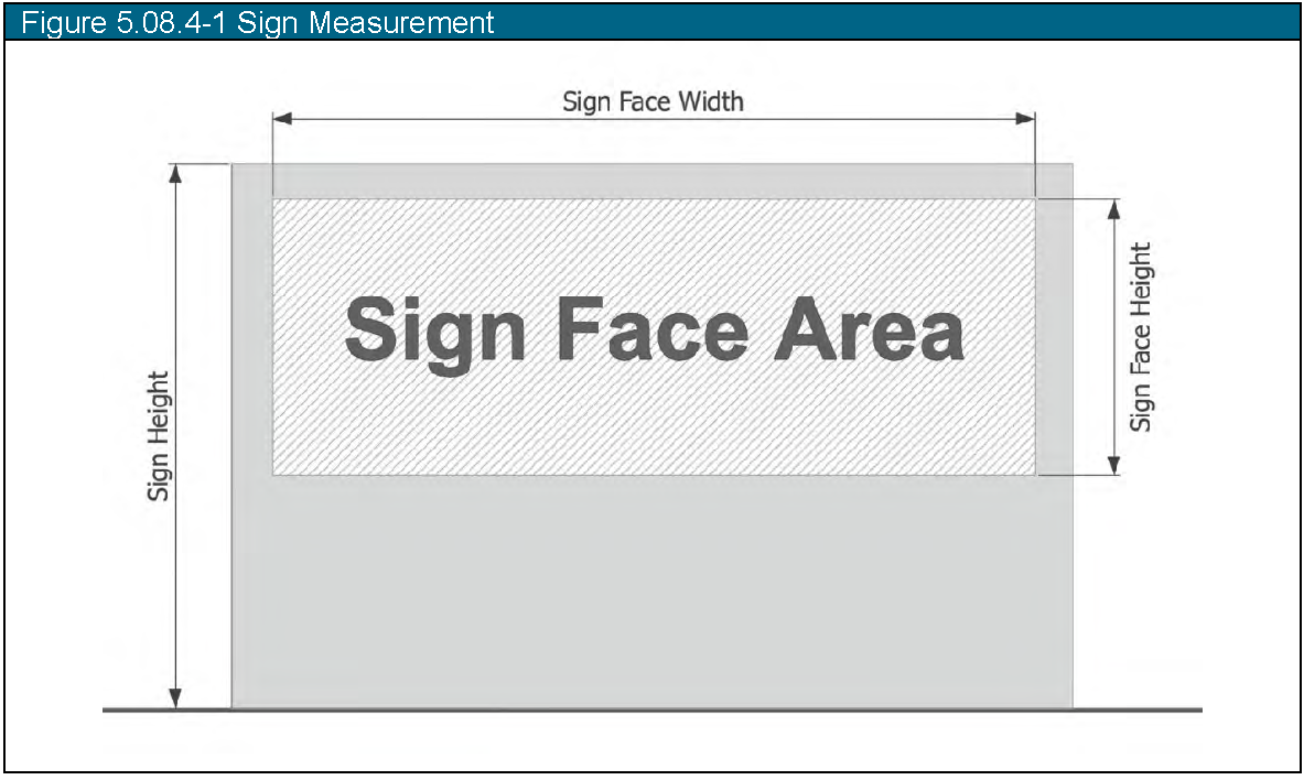
a.
Height of sign. For freestanding signs, height is the distance from the highest point of the sign to the base of the sign at the ground level. Figure 5.08.4-1: Sign Measurements illustrates this measurement. This Section defines a maximum sign height for sign types.
b.
Sign Face Area.
1.
The sign face area, measured in square feet ("sf."), is the width multiplied by the height of a single rectangle, parallel with the ground, that contains all sign copy, decorative embellishments, and internally illuminated or backlit panels, fabric, or similar material that is not an architectural design element of the building. Figure 5.08.4-1: Sign Measurements illustrates this measurement.
2.
For freestanding signs, sign area includes cabinets, background panels, or colors but does not include building architecture or the sign support or base.
3.
The sign face area for an irregularly shaped sign is the sum of separate rectangles that each contain a portion of the sign elements.
4.
For wall signs, sign face area for a single sign includes all related sign elements on the same exterior wall or structure. Related sign elements have similar construction and are no more than five (5) feet apart, measured horizontally or vertically.
5.
Multi-Faced Signs. Figure 5.08.4-1. Measurement of Sign Face Area for Multi-Faced Signs illustrates sign face area measurements for multi-faced signs.
i.
If the faces of a multi-faced sign have the same area, have an interior angle of less than forty-five (45) degrees, and are not more than eighteen (18) inches apart, then the sign face area is the area of one (1) face of the sign.
ii.
Where the faces of a multi-faced sign are not the same size, the interior angle formed by the faces is less than forty five (45) degrees, and the faces are not more than eighteen (18) inches apart, the sign face area is the area of the larger sign face.
iii.
If the interior angle formed by the faces of a multi-faced sign is more than forty five (45) degrees, or if the faces are more than eighteen (18) inches apart, then the sign face area is the cumulative area of all sides of the sign.
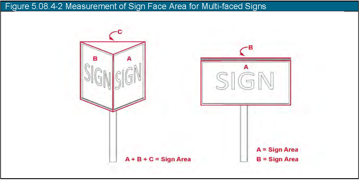
(e)
Sign Districts. This Section regulates sign characteristics by district. Many zoning districts have common characteristics for the purposes of sign regulations, and this Section combines zoning districts into common sign districts. Table 5.08.5-1: Sign Districts designates the zoning districts included in each sign district.
Table 5.08.5-1. Sign Districts
(f)
Primary Signs.
(1)
Applicability. This section applies to any primary sign.
(2)
Primary Sign Allowances by District.
a.
A sign user may display primary signs that comply with the standards shown in Table 5.08.6-1. Primary Sign Standards.
b.
The sign user may allocate the sign face area allowance between attached and freestanding signs, but the total area of all attached and freestanding signs may not exceed the cumulative area allocation for the district.
Table 5.08.6-1. Primary Sign Standards
(3)
Multitenant Developments. Multitenant developments may display primary signs as provided in this Paragraph.
a.
Freestanding Signs.
1.
A multitenant development may display one (1) freestanding sign per frontage on a public way with a sign face area not to exceed one hundred (100) square feet and that is no taller than the height of the principal building.
2.
Multitenant developments must comply with the general standards of Paragraph 0 regardless of the number of tenants or the number of lots in the development. Each tenant or user may not display a separate freestanding sign.
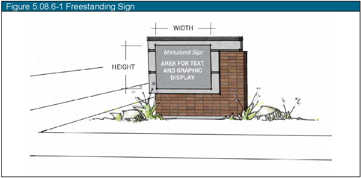
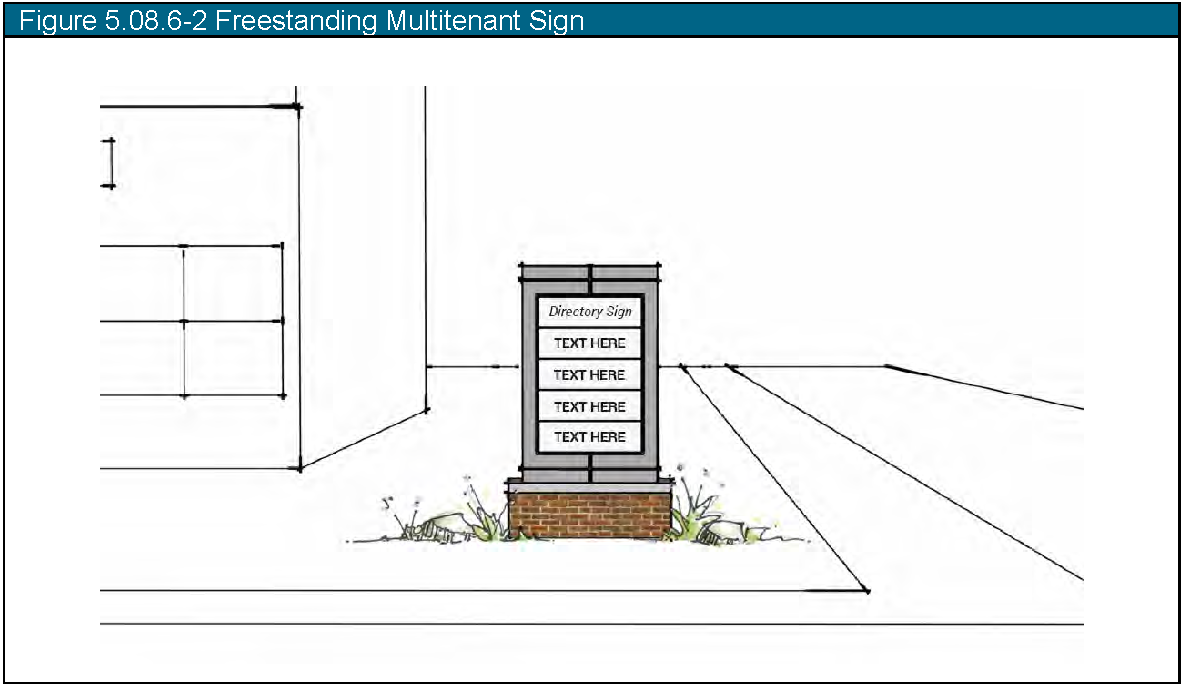
b.
Attached Signs.
1.
A tenant in a multitenant development with separate entrances for each tenant may display one (1) attached sign on the façade for each primary public entrance.
2.
The maximum area for the attached sign is one (1) square foot of sign face area per linear foot of the façade, as measured along the foundation of the building.
(4)
Subdivision Entrance Signs. A residential subdivision may display signs as provided in Table 5.08.6-2. Subdivision Entrance Sign Standards.
a.
Definition. A subdivision entry sign is a freestanding sign located at the entrance to a subdivision in a residential district or a distinct phase of a subdivision in a residential district.
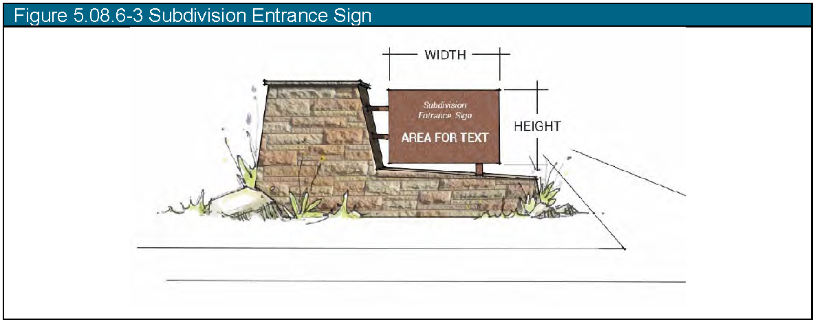
Table 5.08.6-3. Subdivision Entrance Sign Standards
b.
Location Standards. A sign user may locate subdivision entrance signs at the intersection of a public way and an entrance road or private driveway into the development or at the entrance to a separate phase of a development in a residential district. A sign user may install a subdivision entrance sign or signs with one (1) of the following orientations:
1.
Two (2) signs with one (1) sign face each, located on opposite sides of the entrance road or private driveway;
2.
One (1) sign with two (2) faces located within a landscaped area dividing two (2) one-way entrance roads or private driveways; or
3.
One (1) sign with one sign face, located on one (1) side of the entrance road or private driveway.
(5)
Painted Wall Signs in the Downtown Core and Community Commercial Districts.
a.
Applicability. This subsection applies to any painted wall sign.
b.
Location Standard. A sign user may only locate a painted wall sign on a building in the Downtown and Community Commercial Sign District on an exterior wall faces a side or rear property line, including a wall facing an alley.
c.
Sign Area for Painted Wall Signs. A painted wall sign may cover the full dimensions of the wall on which it is located.
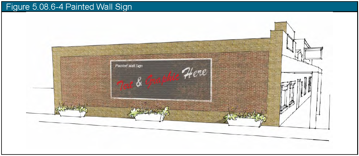
d.
Sign Permit. A sign user must apply for a sign permit to display a painted wall sign. The Building and Planning Department will review an application based on the following factors:
1.
The sign uses durable, exterior grade paints and materials and weatherproof and ultraviolet-protective coatings;
2.
The sign uses colors that coordinate with the colors of the building;
3.
The sign is directed at and scaled to pedestrians;
4.
The sign does not overwhelm or hide character-defining features of a building;
5.
The sign is placed and sized to reinforce the building's architecture and its surroundings; and
6.
The sign is placed at the same height and similar façade locations as adjacent tenants, if possible, to provide an integrated block appearance.
(6)
Signs at Interstate 25 Interchange.
a.
A lot or parcel in the Commercial/Industrial Sign District located within a 750-foot radius of the center of the Interstate 25 and Colorado Highway 1 interchange may display one (1) larger sign under this Paragraph instead of the general standard in Subsections B or C of this Section.
b.
A lot or parcel whose location qualifies for the increased sign allowance under this Paragraph may display one (1) freestanding sign with two (2) parallel faces that is no more than one hundred fifty (150) square feet in sign face area per face and no more than sixty (60) feet in height.
(7)
Window signs.
a.
Applicability. This subsection applies to any window sign.
b.
Location. A sign user may display window signs on a window or door in any district without a permit.
c.
Sign Area. Window signs shall not cover more than 50% of the area of the window on which they are located. The window sign area will not count against the overall allowance for attached and freestanding signs.
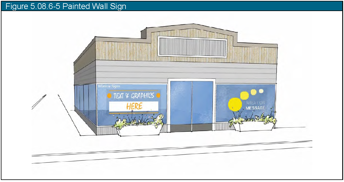
(g)
Secondary Signs.
(1)
Applicability. This section applies to any secondary sign.
(2)
Sign Setback. This Subsection regulates the location and size of secondary signs based on a sign setback that varies by sign district. Figure 5.08.7-1. Secondary Sign Setback illustrates the sign setback for secondary sign locations.
a.
Measurement. The sign setback is the setback from any property line and regulates the location and size of secondary signs. Table 5.08.7-1. Secondary Sign Standards defines the applicable setback for each district. The setback applies to front and side property lines. Setback distance is the horizontal distance from the portion of the sign (base or face) nearest to a road right-of-way or property line.
b.
Perimeter Signs. Perimeter signs are signs located between the property line and the applicable sign setback.
c.
Interior Signs. Interior signs are located within the interior of the lot, further from the property line than the specified sign setback.
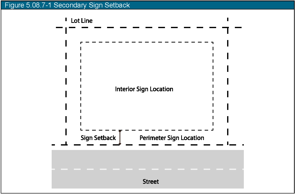
(3)
Number and Location.
a.
Table 5.08.7-4. Secondary Sign Standards defines the maximum number of perimeter secondary signs per entrance to a public way. All perimeter signs must be located within 5 linear feet from an entrance to a public way parallel to the frontage.
b.
Table 5.08.7-4. Secondary Sign Standards defines the maximum limit for interior secondary signs based on the number of signs per acre.
Table 5.08.7-2. Secondary Sign Standards
(h)
Sandwich Boards.
(1)
Applicability. This section applies to any sandwich board in the DCC sign districts.
(2)
Dimension and Location Standards. Table 5.08.8-1. Sandwich Board Standards states the standards for sandwich boards per lot.
(3)
Stability. Sandwich Boards shall be anchored to the ground in a manner sufficient to withstand wind loads established by the Building Code (see Chapter 18 of the Wellington Municipal Code).
Table 5.08.8-2. Sandwich Board Standards
(i)
Temporary Signs.
(1)
Applicability. This section applies to any temporary sign.
(2)
Dimension and Location Standards. Table 5.08.9-1. Temporary Sign Standards states the standards for temporary signs per lot. In addition to the temporary signs allowed by Table 5.08.9-2. Temporary Sign Standards:
a.
In the RUR and RES districts, two (2) additional temporary signs not exceeding six (6) square feet are allowed on private residential property three (3) times per year for up to seventy (70) days.
b.
In all other districts, two (2) additional temporary signs are allowed on private property two (2) times per year for up to seventy (70) days.
(3)
Duration for Display. A sign user may display one (1) temporary sign on each lot without any time limitation. All other temporary signs may only be displayed for ninety (90) days or less per calendar year, measured cumulatively per sign.
Table 5.08.9-3. Temporary Sign Standards
(j)
Nonconforming and Abandoned Signs.
(1)
Nonconforming Signs.
a.
Permanent signs that conformed to appliable standards in effect before the effective date of this Land Use Code, but that no longer comply with this Section 15-5-80, are nonconforming. The sign user may maintain and repair existing nonconforming signs.
b.
The property owner must remove an existing nonconforming sign upon a change in use of the property.
(2)
Abandoned Signs. If a building, structure, or premises is vacant for at least six (6) months: the owner of the premises shall remove any nonconforming permanent signs located on the premises.
(Ord. No. 07-2022, § 1(5.08), 3-22-22)
Sec. 15-5-90. - Site and building design.
(a)
Purpose. To encourage innovative, quality site planning, architecture and landscaping that reflect improvements in the technology of land development.
(b)
Commercial and industrial architecture.
(1)
Elevation and site plans. Dimensioned elevation drawings or renderings, including front, back, and side elevations, shall be submitted with all site plan applications to illustrate conformance with the regulations herein. Elevations shall indicate materials to be installed on all building surfaces.
(2)
Building form. The design of all buildings shall employ textured surfaces, projections, recesses, shadow lines, colors, window patterns, overhangs, reveals, changes in parapet heights and similar architectural features to avoid monolithic shapes and surfaces and to emphasize building entries. Designs shall not contain unbroken flat walls of greater than fifty (50) feet in length. Buildings having single walls exceeding fifty (50) feet in length shall incorporate one (1) or more of the following at a minimum of every fifty (50) feet:
a.
Changes in color, graphical patterning, texture or material;
b.
Projections, recesses and reveals;
c.
Windows and fenestration;
d.
Arcades and pergolas;
e.
Towers;
f.
Gable projections;
g.
Horizontal/vertical breaks; or
h.
Other similar techniques.
(3)
Facade treatment. The architectural treatment of the front facade shall be continued, in its major features, around all visibly exposed sides of a building.
(4)
Screening. All air-conditioning units, HVAC systems, exhaust pipes or stacks, elevator housing and satellite dishes and other telecommunications receiving devices shall be thoroughly screened from view from the public right-of-way and from adjacent properties by using walls, fencing, roof elements and landscaping. In addition, all trash facilities, loading and parking areas shall be properly screened. Screening standards can be found in Section 15-5-40.
(5)
Architectural details. All materials, colors and architectural details used on the exterior of a building shall be compatible with the building's style and with other nearby buildings.
(6)
New buildings and exterior modifications of existing buildings on Cleveland Avenue within the C-2 Downtown Core Commercial District shall comply with the Cleveland Avenue Architectural Guidelines contained in Appendix A to the ordinance codified herein, a copy of which is on file at the Town Clerk's office.
(Ord. No. 07-2022, § 1(5.09), 3-22-22)
Sec. 15-5-100. - Stormwater and sewer.
(a)
Purpose. The intent of this section is to ensure that the stormwater drainage system addresses the broader goals of drainage and flood control problem alleviation, environmental preservation enhancement that considers water quality, water way stability and natural habitat and resource protection, and the long-term maintenance of the Town's drainage systems.
(b)
Excavation, grading, and erosion control.
(1)
Excavation and grading. Excavation and grading shall comply with the adopted building codes and the Town's Standard Design Criteria and Standard Construction Requirements.
(2)
Erosion control. The prevention of soil erosion and transport of sediments during construction is of paramount importance. Development of sites greater than one half (0.5) acre requires an Erosion Control Plan consistent with the State of Colorado's requirements for Stormwater Management Plans (SWMP), and a copy of the stormwater discharge permit obtained from the State of Colorado.
(3)
To the maximum extent feasible, site grading and erosion control techniques shall include, but not be limited to:
a.
Limitation of land disturbance and grading;
b.
Maintenance of natural vegetation;
c.
Minimization of impervious surfaces;
d.
Use of terraces, contoured landscapes, runoff spreaders, grass or rock-lined waterways;
e.
Use of infiltration devices; and/or
f.
Use of recharge basins, seepage pits, dry wells, seepage beds or ditches, porous pavement or sub-drain systems.
(c)
Site drainage.
(1)
General. The standards of this Section are intended to protect properties, both private and public, against flooding, erosion, sedimentation, and other encroachment due to storm waters.
a.
Peak discharge control is required when post-development runoff rates exceed historic one hundred-year base storm runoff rates due to the change in site conditions as a result of the development. Post-development peak discharge for the minor storm event shall not exceed the historic or pre-development conditions for the minor storm event.
b.
The major drainage system that conveys off-site drainage through the development and/or serves as the primary drainage channel for the development and all drainage structures therein must safely convey the base storm peak discharge and maintain them within the confines of public rights-of-way and easements. There is no requirement to provide peak discharge control for the base storm peak discharge.
c.
The minor drainage system that collects on-site drainage and conveys it through the development to primary drainage channels and consists of curb, gutter, inlets, storm drains, culverts, swells, ditches and detention facilities shall be designed to convey flows from the minor storm event and maintain their integrity if overtopped by flows from a base storm event.
d.
Determination of storm runoff shall be made by the methods defined in the following table:
Table 6.3.1: Run-Off Rates Determination Methods
e.
Waivers from peak discharge control requirements must be requested in writing and must include supporting engineering documentation. Waivers may only be granted when:
1.
Residential development is occurring that does not require new subdivision of land. Supporting engineering documentation is not required.
2.
Subdivision will result in a gross residential density of two (2) dwelling units per acre or less. Supporting engineering documentation is not required.
3.
The increase in peak discharge for the minor storm from the subdivision is less than ten percent (10%) over historic levels.
4.
It has been determined and can be demonstrated that natural or manmade detention facilities exist downstream, there is adequate capacity to handle the increased peak discharge, and the subdivider has obtained legal right to utilize the required capacity of the existing facility.
5.
It has been determined that detention will cause a deleterious impact relative to base storm drainage and peak discharge.
6.
Additions to existing structures will not result in a net increase of impervious area of a site by more than twenty-five percent (25%).
(2)
Master Drainage Report. Unless waived by the Town Engineer, the project engineer shall conduct a Master Drainage Report of the area to be developed and adjacent areas that affect the development. The subdivision of a single, previously subdivided lot into no more than two (2) new lots shall be exempt from drainage studies. The report should implement the drainage design and construction in the format described below. Drainage reports shall include:
a.
Off-site flows. Describe the effect of off-site flow rates on the development and how they are affected by the development. Determine the necessary control measures or the proper method of conveyance.
b.
On-site flows. Define the system that will convey the on-site flows (both historic and developed) throughout the development and describe how the flows will be dispersed off-site, based on the methodology shown in the most recent version of the Urban Storm Drainage Criteria Manual, published by the Urban Drainage and Flood Control District.
c.
On-site detention. On-site detention or retention facilities are required to store run-off that represents the difference between the one hundred-year historic run-off and developed storm runoff, and shall limit the rate of runoff from the site to the one hundred-year historic flow rate.
d.
Storm drain system. The design of the interior storm drain system shall follow the standards set forth in the most recent version of the Urban Storm Drainage Criteria Manual, published by the Urban Drainage and Flood Control District. The ten-year storm shall be the criteria for the design of all interior drain systems. The design of cross culverts and bridges of major drainage ways shall accommodate the one hundred-year storm frequency.
(3)
Methodology.
a.
Rainfall and runoff analysis. The analysis of storm runoff shall be based on the rainfall data taken from the National Oceanic and Atmospheric Administration, U.S. Department of Commerce, Atlas 2, "Precipitation Frequency Atlas of the Western United States, Volume III - Colorado." The Storm Run-Off Rates Determination Method Table No. 5-8 shall be used for determining the quantity of storm runoff.
b.
Storage (detention/retention). Requisite detention facility volumes can be determined from the criteria found in the Urban Drainage and Flood Control District detention volume estimating workbook. These volumes are minimum requirements.
c.
Storage release mechanism. The release mechanisms from retention/detention ponds shall accommodate recurrence intervals of ten-year and one hundred-year storms by utilizing a structure which employs both orifice and weir flow control. Other methods of release can be specified as approved by the Town Engineer.
(4)
Procedures. Developments shall be required to submit drainage design plans in conjunction with any application that requires submittal of a drainage report/plan.
a.
Drainage design plans may be submitted at the preliminary plat or review stage as set forth in Section 15-2-170.
b.
Drainage design plans may be submitted at the building permit stage only when subdivision and zoning for the property have already been approved.
(d)
Sanitary sewer.
(1)
All residential, commercial, and industrial uses shall have sanitary sewer facilities designed by a registered professional engineer in accordance with the regulations and standards of the Colorado Department of Public Health and Environment.
(2)
The sanitary sewer system shall be connected to an existing public sanitary sewer system and consist of a closed system of sanitary sewer mains and lateral branch connections to each structure or lot upon which a structure is to be built.
(3)
Sanitary sewer lines are to be of sufficient size and design to collect all sewage from all proposed or portable structures within the subdivision or development and designed per the Town of Wellington Standard Design Criteria and Standard Construction Requirements.
(e)
Potable water.
(1)
Pursuant to C.R.S. 29-20-303, the Town shall not approve an application for development unless it determines in its sole discretion, after considering the application and all of the information provided, that the applicant has satisfactorily demonstrated that the proposed water supply will be adequate. For purposes of this requirement, "adequate" means a water supply that will be sufficient for build-out of the proposed development in terms of quality, quantity, dependability, and availability to provide a supply of water for the type of development proposed, and may include reasonable conservation measures and water demand management measures to account for hydrologic variability.
(2)
All water utilities shall be designed per the Town of Wellington Standard Design Criteria and Standard Construction Requirements.
(Ord. No. 07-2022, § 1(5.10), 3-22-22)
Sec. 15-5-110. - Transportation and connectivity.
(a)
Purpose. The purposes of this Section are to:
(1)
Establish a safe, efficient, attractive transportation system that promotes all modes of transportation and is sensitive to the environment.
(2)
Create sidewalks, pathways, and trails that assures a safe, convenient, and attractive pedestrian/bicycle system that minimizes conflicts between vehicles, bicycles, and pedestrians.
(b)
Applicability. This Section applies to all development within Town limits. All transportation and connectivity measures implemented after the effective date of this Land Use Code complies with this Section.
(c)
Streets. The local street system of any proposed development is designed to be safe, efficient, convenient, and attractive and consider the use by all modes of transportation that will use the system. Streets are an inviting public space and an integral part of community design. Local streets provide for both intra- and inter-neighborhood connections to knit developments together, rather than forming barriers between them. All streets should interconnect to help create a comprehensive network of public areas to allow free movement of cars, bicycles, and pedestrians.
(1)
Street Layout.
a.
All streets are aligned to join with planned or existing streets consistent with the approved Street Master Plan included in the Comprehensive Master Plan.
b.
The street layout forms an interconnected system of streets primarily in a grid or modified pattern adapted to the topography, unique natural features, environmental constraints, and peripheral open space areas.
c.
The street layout emphasizes the location of neighborhood focus points, other internal open space areas, gateways, and vistas.
d.
The use of culs-de-sac and other roadways with a single point of access are minimized.
e.
The integration of traffic-calming features within and adjacent to residential areas are utilized when appropriate.
(2)
Controlling Street Access. A strip of land between a dedicated street and adjacent property is not reserved for the purpose of controlling access to that street from that property.
(3)
Visibility at Intersections.
a.
No shrubs, ground cover, berms, fences, structures or other materials or items greater than thirty (30) inches in height shall be planted, created, or maintained at street intersections within the site distance triangle.
b.
The site distance triangle is described by starting at the point where the flow-line of the two (2) intersecting streets meet. Two (2) of the legs follow down the flow-line of the respective streets thirty (30) feet to a point, with the final leg between these two (2) endpoints.
c.
Trees are not planted in the site distance triangle.
(4)
Pedestrian Crossings at Street Intersections and Mid-block. Pedestrian crossings are accessible to handicapped individuals and mid-block crossings may be required at the time of final plat or site plan approval.
(5)
Street and Path Alignment. Street, path, and sidewalk alignment provides for pedestrian, bicyclist, and motorist safety. The street pattern is the most advantageous to serve the adjoining areas. When possible, proposed streets are continuous and in alignment with existing and proposed streets.
(6)
Access. Access to all subdivisions shall come from a public street. Driveways are not permitted to have direct access to arterial streets. Driveway access to collector streets may be allowed if access is approved at the time of final plat.
(7)
Street Right-of-Way Dedication. The full width of rights-of-way for all streets being platted must be dedicated to the Town. All streets within the Town shall afford public access for emergency services and utilities. In cases where streets form the perimeter of any development have a portion of the proposed right-of-way on an adjacent property, the following standards apply.
a.
The developer shall:
1.
Acquire the other one-half (½) of the proposed right-of-way property for the Town and then dedicate the right-of-way to the Town;
2.
If the landowner of the proposed right-of-way property is unwilling to sell the proposed right-of-way property to the developer, the developer shall pay for the cost of an appraisal for the proposed right-of-way property and legal fees for the Town to evaluate the possibility of acquiring the property in the future; or
3.
Provide for a traffic study establishing that construction of such right-of-way will not be necessary before the likely development of that adjacent property.
b.
The developer shall finalize an agreement with the Town which guarantees the construction of the street to Town standards.
(8)
Street Standards. Rights-of-way are dedicated and streets are designed and constructed to accommodate present and future traffic volumes in accordance with all standards.
(9)
Street Names. Names of new streets comply with the IGA with Larimer County and the Municipalities of Larimer County concerning standardization of street names. New streets which are extensions of, or which are in alignment with, existing streets shall bear the names of those streets.
(d)
Sidewalks, Pathways, and Trails.
(1)
Interconnected Network.
a.
A sidewalk network that interconnects all dwelling units with other dwelling units, nonresidential uses and common open space are provided throughout each development.
b.
Sidewalks are separate and distinct from motor vehicle circulation to the greatest extent possible.
c.
The pedestrian circulation system shall include gathering or sitting areas and provide benches, landscaping, and other street furniture where appropriate.
(2)
Sidewalks Required.
a.
In all zoning districts, except for the R-1, LI and I Districts, sidewalks are required along both sides of a street.
b.
Within the R-1 District, pedestrian movement may be accomplished with trails through common space if approved at the time of final plat approval.
c.
Within the LI and I Districts, sidewalk shall be required where properties are adjacent to arterial streets, collector streets, and to provide sidewalk continuity in areas where existing or proposed sidewalks will connect. Additional sidewalks in the LI and I Districts are determined based on reasonably anticipated pedestrian needs and uses on a case-by-case basis.
(3)
Sidewalk Width. Sidewalk widths comply with the design standards for the category of streets. Sidewalks adjacent to storefronts in commercial areas are a minimum of ten (10) feet in width, or consistent with the average sidewalk width on a block if building in an area with existing sidewalks.
(4)
Sidewalk Location. Sidewalks are located within the right-of-way unless otherwise authorized at the time of final plat approval.
(5)
Accessibility. Sidewalks and plazas are accessible to handicapped individuals as required by the Americans with Disabilities Act (ADA) and related requirements.
(6)
Lighting. All sidewalks and other pedestrian walkways shall have appropriate lighting, using poles and fixtures consistent with the overall design theme for the development.
(7)
Pathways.
a.
Pathways are provided to link internal open space areas with peripheral open space areas and shall connect to pathway routes throughout the Town.
b.
Pathway routes are designated between residential areas and commercial and employment centers and schools.
c.
Pathways on local streets may be delineated by bicycle lanes, bicycle routes, or other bicycle or pedestrian facilities.
d.
All other pathways are constructed in accordance with standards established in the Town Parks and Trails Master Plan.
(8)
Trails.
a.
Trails are provided within and surrounding open space areas and connecting open space areas.
b.
Trails are a minimum of eight (8) feet in width and are constructed of an impervious service concrete. However, for specific uses and circumstances, the Board of Trustees may approve construction of other impervious surfaces.
c.
Unless the Board of Trustees determines the area would not be used, trails are flanked on one (1) side by a soft surface path a minimum of four (4) feet in width. The soft surface path is constructed with a minimum depth of eight (8) inches of compressed gravel, crowned, and compacted with edging to contain the surface material.
(Ord. No. 07-2022, § 1(5.11), 3-22-22)